council development assessment panel - city … · council development assessment panel agenda ......
TRANSCRIPT

F10/188 AR10/10876 14 December 2010
COUNCIL DEVELOPMENT ASSESSMENT PANEL
AGENDA
Meeting #100
Tuesday 14 December 2010 5:30pm
Council Chambers
4 Mackay Street, Port Augusta
Civic Centre: 4 Mackay Street Port Augusta South Australia 5700
Postal Address: PO Box 1704 Port Augusta South Australia 5700
Telephone (08) 8641 9100 Facsimile (08) 8641 0357
[email protected] www.portaugusta.sa.gov.au

F10/188 AR10/10876 14 December 2010
1. WELCOME BY CHAIRPERSON
2. APOLOGY/IES
(To be submitted to Lisa Flynn – 86419131)
3. CONFIRMATION OF PREVIOUS MINUTES Meeting # 99 - held on 09/11/2010 (AR10/8429) 4. DEVELOPMENT APPLICATIONS
4.1 660/85/2010
JLKT PTY LTD LAND DIVISION 12 COATS STREET STRILING NORTH LOT: 2 DP: 75814 CT: 6010/172
4.2 660/274/2010
A C NEYMAN VERANDAH 32 NORTH TERRACE STIRLING NORTH SEC: 881 LT: 205 PLN: 1166 CT: 5277/215
5. GENERAL BUSINESS
6. CLOSE OF MEETING
GREG PERKIN CITY MANAGER

Filename: 660/85/2010
FILE REF: PROP – 12 Coats Street STIRLING NORTH 5710 DATE: 26 November 2010 TO: Presiding Member & Members of the Council Development Assessment Panel FROM: Community Planner SUBJECT: Land Division – 12 Coats Street STIRLING NORTH 5710 Lot: 2 DP:
75814 CT: 6010/172 Application Number 660/85/2010 Date Received 17/03/2010 Proposal Land Division Subject Land 12 Coats Street STIRLING NORTH 5710
Lot: 2 DP: 75814 CT: 6010/172 Applicant JLKT Pty Ltd Owner SA Land Projects Pty Ltd Zone Residential Procedure Consent (neither complying or non-complying) Agency Referrals Not required Public Notification Category 2 – Adjacent owners Key Issues Consent Use & Public Notification Delegation Issues Development is considered to be appropriate but outside of delegations Recommendation Grant Development Plan Consent subject to conditions The proposal The applicant proposed to divide the subject land to create 41 additional allotments and new service roads. The new allotments have size ranging from 1197 – 1425 square metres. Subject land & locality The subject land is located within the newly rezoned Residential Zone in Stirling North. The land is currently vacant and largely covered with vegetation. The land has frontages onto Coats Street and Paltridge Avenue and is approximately 6.137 hectares in size. The locality is characterised by open space and very low density residential development, this is, however, expected to change in the future as land owners take advantage of the recent rezoning to Residential. Agency referral The proposal was referred to a number of agencies and the details are outline below: Development Assessment Commission – Standard response. Sa Water Corporation – Standard response regarding financial requirement for water augmentation. Commissioner of Highways – Comments in relation to stormwater infrastructure. Department for Families and Communities (Affordable Housing/Housing SA) – The proposal complies with the affordable housing requirements. Department for Administrative and Information Services – No comment.

Department for Education and Children Services (DECS) – No comment. Department for Transport, Energy and Infrastructure (Mark Maintenance Section) - – No comment. Public notification The application was subjected Category 2 Public Notification where notifications were sent to adjacent land owners. Council received three representations which supported the proposal but have concerns regarding potential access to adjacent properties and the layout of the new roads. In response to the representations the road layout was modified to include two cul-de-sacs. The adjacent owners have, for some years, been using the site to access the back of their properties and they are concerned that this access will be lost or can only be kept at significant cost. As there is no evidence of any formal agreement regarding the rear access; there is little that can be done by Council to resolve this issue other than encouraging concerned parties to find a suitable solution between them.
Development plan assessment The following are relevant provisions of the Port Augusta Development Plan in considering the proposal: Relevant Provisions of the Development Plan Comments Council Wide
Objective 1: Orderly and economic development. Objective 7: Port Augusta and Stirling North urban area developed in accordance with the Port Augusta - Stirling North Structure Plan, Map PtAu/1 (Overlay 1) Enlargement A. Land Division
The proposed development is considered to be orderly. The proposed development complies with this objective.
Subject Land

Objective 12: Land division that occurs in an orderly sequence allowing efficient provision of new infrastructure and facilities and making optimum use of existing under utilised infrastructure and facilities. Objective 13: Land division that creates allotments appropriate for the intended use. Objective 14: Land division layout that is optimal for energy efficient building orientation. Objective 15: Land division that is integrated with site features, including landscape and environmental features, adjacent land uses, the existing transport network and the availability of infrastructure.
The proposed development complies with this objective. The shape and size of the allotments are considered appropriate for the intended use. The layout of the proposed division makes best use of the shape and orientation of the land where the orientation of future buildings can contribute to the overall energy efficiency. The layout of the proposal has been designed as an extension of the existing residential area to the east and provide linkages to existing road network
PRINCIPLES OF DEVELOPMENT CONTROL 1 Development should be in accordance with the City of Port Augusta Structure Plan, Map PtAu/1 (Overlay 1), and the Port Augusta - Stirling North Structure Plan, Map PtAu/1(Overlay 1) Enlargement A. 7 New housing and other urban development should: (a) form a compact and continuous extension of an existing built-up area; (b) be located so as to achieve economy in the provision of public services; (c) create a safe, convenient and pleasant environment in which to live; (d) not impact on areas of conservation significance; and (e) be designed to facilitate water and energy conservation. 8 Extensions of built-up areas should not be in the form of ribbon development along roads. 9 Development should not be undertaken unless it can be connected to an adequate and permanent water supply suitable for human consumption, and to a satisfactory effluent disposal system. 10 Development should neither interfere with, nor obstruct, watercourses.
The proposed development complies with this Principles of Development Control (PDC). The site of proposed division is an extension of an existing built-up area and is also the first to take advantage of the recent rezoning of the whole area. The proposed development complies with this PDC. Permanent water supply can be connected to the proposed development. The proposed development complies with this PDC.

16 When land is divided: (a) stormwater should be capable of being drained safely and efficiently from each proposed allotment and disposed of from the land in an environmentally sensitive manner (b) a sufficient water supply should be made available for each allotment (c) provision should be made for the disposal of wastewater, sewage and other effluent from each allotment without risk to health (d) proposed roads should be graded, or be capable of being graded to connect safely and conveniently with an existing road or thoroughfare. 17 Land should not be divided if any of the following apply: (a) the size, shape, location, slope or nature of the land makes any of the allotments unsuitable for the intended use (b) any allotment will not have a frontage to one of the following:
(i) an existing road (ii) a proposed public road (iii) access to a public road via an internal roadway in a plan of community division
(c) the intended use of the land is likely to require excessive cut and/or fill (d) it is likely to lead to undue erosion of the subject land or land within the locality (e) the township wastewater treatment plant to which subsequent development will be connected does not have sufficient capacity to handle the additional wastewater volumes and pollutant loads generated by such development (f) the area is unsewered and cannot accommodate an appropriate onsite wastewater disposal system within the allotment that complies with (or can comply with) the relevant public and environmental health legislation applying to the intended use(s) (g) any allotments will straddle more than one zone or policy area. 18 Land divisions should be designed to ensure that areas of native vegetation and wetlands: (a) are not fragmented or reduced in size
Stormwater disposal method for the proposed development is not clear at this stage. The applicant will be required to provide a stormwater disposal scheme to Council satisfaction should the application is approved. The development will reply on individual wastewater control (septic) systems. The new internal roads will be required to meet Council’s standards in design and construction. The proposed development complies with this PDC. No allotment will straddle more than one zone. It is envisaged that native vegetation will be cleared as a consequence of the development.

(b) do not need to be cleared as a consequence of subsequent development. 19 The design of a land division should incorporate: (a) roads, thoroughfares and open space that result in safe and convenient linkages with the surrounding environment, including public and community transport facilities, and which, where necessary, facilitate the satisfactory future division of land and the intercommunication with neighbouring localities (b) safe and convenient access from each allotment to an existing or proposed public road or thoroughfare (c) areas to provide appropriate separation distances between potentially conflicting land uses and/or zones (d) suitable land set aside for useable local open space (e) public utility services within road reserves and where necessary within dedicated easements (f) the preservation of significant natural, cultural or landscape features including State and local heritage places (g) protection for existing vegetation and drainage lines (h) where appropriate, the amalgamation of smaller allotments to ensure coordinated and efficient site development (i) the preservation of significant trees. 20 Land division should facilitate optimum solar access for energy efficiency. 22 Allotments should have an orientation, size and configuration to encourage development that: (a) minimises the need for earthworks and retaining walls (b) maintains natural drainage systems (c) faces abutting streets and open spaces (d) does not require the removal of native vegetation to facilitate that development (e) will not overshadow, dominate, encroach on or
The proposed development complies with this PDC. The orientation of the new allotments , mostly true north-south and some east-west, will allow for dwelling layout to meet this requirement. The proposed development complies with this PDC.

otherwise detrimentally affect the setting of the surrounding locality. 25 The layout of a land division should keep flood-prone land free from development. 26 The arrangement of roads, allotments, reserves and open space should enable the provision of a stormwater management drainage system that: (a) contains and retains all watercourses, drainage lines and native vegetation (b) enhances amenity (c) integrates with the open space system and surrounding area. Roads and Access 27 Road reserves should be of a width and alignment that can: (a) provide for safe and convenient movement and parking of projected volumes of vehicles and other users (b) provide for footpaths, cycle lanes and shared-use paths for the safety and convenience of residents and visitors (c) allow vehicles to enter or reverse from an allotment or site in a single movement allowing for a car parked on the opposite side of the street (d) accommodate street tree planting, landscaping and street furniture (e) accommodate the location, construction and maintenance of stormwater drainage and public utilities (f) provide unobstructed, safe and efficient vehicular access to individual allotments and sites (g) allow for the efficient movement of service and emergency vehicles. 28 The design of the land division should facilitate the most direct route to local facilities for pedestrians and cyclists and enable footpaths, cycle lanes and shared-use paths to be provided of a safe and suitable width and reasonable longitudinal gradient. 29 The layout of land divisions should result in roads designed and constructed to ensure: (a) that traffic speeds and volumes are restricted where appropriate by limiting street length and/or
The site of the proposed development is not located within an identified flood-prone area. Stormwater management is an issue yet to be resolved at this stage. It will be a requirement, if the proposal is approved, that a stormwater management scheme satisfies Council’s requirements. No new open space area is to be provided as a result of this proposal. Therefore an equivalent financial contribution will be required. The design and construction details of the new road will be required to comply with Council’s standard. The design must be submitted to and approved by Council prior to construction. The proposed development complies with this PDC. It is believed that the street layout of the proposal complies with this requirement.
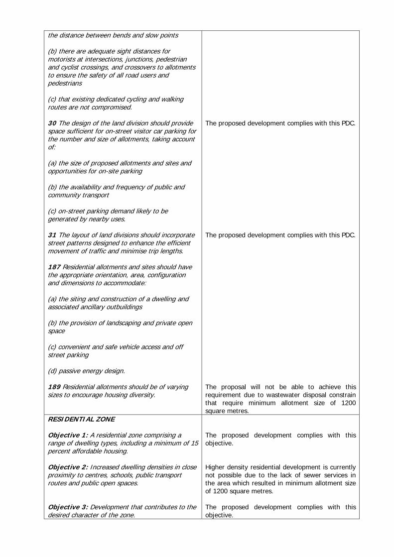
the distance between bends and slow points (b) there are adequate sight distances for motorists at intersections, junctions, pedestrian and cyclist crossings, and crossovers to allotments to ensure the safety of all road users and pedestrians (c) that existing dedicated cycling and walking routes are not compromised. 30 The design of the land division should provide space sufficient for on-street visitor car parking for the number and size of allotments, taking account of: (a) the size of proposed allotments and sites and opportunities for on-site parking (b) the availability and frequency of public and community transport (c) on-street parking demand likely to be generated by nearby uses. 31 The layout of land divisions should incorporate street patterns designed to enhance the efficient movement of traffic and minimise trip lengths. 187 Residential allotments and sites should have the appropriate orientation, area, configuration and dimensions to accommodate: (a) the siting and construction of a dwelling and associated ancillary outbuildings (b) the provision of landscaping and private open space (c) convenient and safe vehicle access and off street parking (d) passive energy design. 189 Residential allotments should be of varying sizes to encourage housing diversity.
The proposed development complies with this PDC. The proposed development complies with this PDC. The proposal will not be able to achieve this requirement due to wastewater disposal constrain that require minimum allotment size of 1200 square metres.
RESIDENTIAL ZONE Objective 1: A residential zone comprising a range of dwelling types, including a minimum of 15 percent affordable housing. Objective 2: Increased dwelling densities in close proximity to centres, schools, public transport routes and public open spaces. Objective 3: Development that contributes to the desired character of the zone.
The proposed development complies with this objective. Higher density residential development is currently not possible due to the lack of sewer services in the area which resulted in minimum allotment size of 1200 square metres. The proposed development complies with this objective.

DESIRED CHARACTER Residential development within the zone will proceed in a staged and planned manner as a logical extension of existing residential areas. Connections to facilities and services both within and outside the zone will be improved through the creation of a local road network based on a modified-grid pattern and the establishment of recreational links along roads, public reserves and stormwater management systems. Pedestrian and vehicular access to schools, shops and places of employment will be enhanced through the creation of reserves and a shared-use recreational trail. When the removal of remnant native vegetation cannot be avoided, environmental benefits will be provided to ‘off-set’ the loss of vegetation. Residential development will be linked to the provision of adequate water and effluent disposal infrastructure and will feature environmental sensitive design techniques to minimise the use of water and respond to local climatic conditions. …………….
PRINCIPLES OF DEVELOPMENT CONTROL 5 Development should not be undertaken unless it is consistent with the desired character for the zone. 6 Development within Stirling North should be in accordance with the Stirling North Structure Plan Map PtAu/1 (Overlay 1) Enlargement B and: (a) should ensure that no additional vehicular access points are created to either National Highway One or the northern side of Range View Road (b) if located north of the Stirling North Primary School, only proceed in association with the provision of a sewer or Community Wastewater Management Scheme (c) should ensure that an attractive and appropriate landscape buffer from the road reserve of National Highway One, Range View Road and the railway lines is provided in association with appropriate noise attenuation measures in order to minimise the transmission of noise and reduce the visual impact of the development (d) should achieve a separation distance of at least 100 metres between dwellings and high voltage electricity powerlines (e) protect significant areas of native vegetation
The proposed development complies with this PDC. The proposed development complies with this PDC.

(f) only proceed following the identification and treatment of any potential contaminants. 12 A dwelling, which is unable to be connected to an SA Water sewer or Community Wastewater Management Scheme, should have a minimum site area of 1200 square metres and a frontage to a public road not less than 20 metres.
The proposed development complies with this PDC even though allotments 40 and 41 are slightly less than the minimum 1200 square metres. It is believed that there will be no impact on the operation of the future wastewater control systems.
Conclusion The proposed division is considered to be appropriate for the Residential Zone and locality. Recommendation It is recommended the Council Development Assessment Panel: 1. Receives the report (660/85/2010) dated 26 November 2010, submitted by the Community Planner,
concerning “Land Division – 12 Coats Street STIRLING NORTH 5710 Lot: 2 DP: 75814 CT: 6010/172”.
2. Resolves that the proposed development is NOT SERIOUSLY at variance with the Development
Plan. 3. Grants Development Plan Consent subject to the following conditions:
3.1 The proposed development shall be undertaken in accordance with the plans and information submitted unless otherwise specified as a condition of consent.
3.2 Dust must be controlled at all times so as to limit nuisance to nearby residents. Options
that need to be considered for settlement of dust nuisance, due to the clearance of land, are, without limitation:
i. Fencing the area with shade cloth type material approximately 1.0 metre in
height.
ii. Have a water truck on call to settle the dust, contact will need to be made with any water carting facilitator.
iii. Plant rye grass type material on the dust related area.
3.3 The financial requirements of the SA Water Corporation must be met for the provision
of water supply. (SA Water No. 90131/09). The necessary easements shall be granted to SA Water Coporation free of cost.
3.4 A certified survey plan must be lodged with the Development Assessment Commission
for Certificate purposes.
3.5 The names assigned to the new roads shall be in acordance with the attached plan.
3.6 The design and construction plans for the new roads (including all relevant infrastructures such as street lights, footpath on both sides of the road, street trees – please consult with Council for suitable species, up-right kerb, crossovers, underground power and stormwater, etc…) must be submitted and endorsed by the Port Augusta City Council prior to the commencement of construction.
3.7 A Stormwater Management Plan must be prepared to the satisfaction of the Port
Augusta City Council and based on the principles of water sensitive design. This plan

must include detailed designs showing the method of collection and management of stormwater and the extent of all earthworks, excavation and filling. It is to be approved prior to the commencement of construction.
3.8 A cheque for $106 354.00 made payable to the Port Augusta City Council to be paid into
the Port Augusta City Council Open Space Fund (41 allotments @$2594/allotment). The cheque must be marked 'Not Negotiable'.
3.9 A copy of encumbrances and/or schedules of endorsement (if any) must be lodged with
the Port Augusta City Council.
TUNG PHAM
Looking at the land from Coats Street

Looking at the land from the corner of Footner Street and Paltridge Avenue
Looking at the land from Paltridge Avenue
Filename: 660/274/2010
FILE REF: PROP – 32 North Terrace STIRLING NORTH 5710 DATE: 25 November 2010 TO: Presiding Member & Members of the Council Development Assessment Panel FROM: Assistant Community Planner SUBJECT: Verandah 32 North Terrace STIRLING NORTH 5710 SEC: 881 LT: 205 CT: CT PL: DP PLN: 1166 CT: 5277/215 Application Number 660/274/2010 Date Received 15/10/2010 Proposal Verandah Subject Land 32 North Terrace STIRLING NORTH 5710
SEC: 881 LT: 205 CT: CT PL: DP PLN: 1166 CT: 5277/215 Applicant A C Neyman Owner A C Neyman & J A Neyman Zone Residential Zone Procedure Neither Complying nor non-complying Agency Referrals Not Required Public Notification Not Required Key Issues Overall Height of the Structure Delegation Issues Delegated power only allows us to assess a structure up to 4m in
overall height, therefore this falls outside of our delegated power. Recommendation Grant Development Plan Consent The proposal The applicant has proposed to construct a new free standing pitched roofed verandah to be used as an entertaining area at the subject property. The verandah will be of steel construction and which consists of galvanised C Section, posts and trusses and colourbond roofing, flushing’s and lattice work to both pitch ends. The proposed free standing pitched roofed verandah has a dimension of 5.4m x 8.572m and a wall height of 3.1 and overall height of 4.386m. The proposed structure does not comply with the design parameters outlined within the Port Augusta City Council Development Plan. The Development Plan states that sheds, garages and similar outbuildings should have a maximum building height (from natural ground level) of 4 meters and a maximum wall height of 3 meters Locality The subject allotment is located in the residential zone of the Stirling North area. The allotment is located on North Terrace, Stirling North and is 1008.74 square metres in area. It is currently being used for residential purposes, the already exists a new dwelling and domestic shed. The area is characterised by its low intensity residential development of detached dwellings. The allotment is located on the out skirts of the residential area of Stirling North. Located directly north is the Stirling North Golf Club which runs along North Terrace. North Terrace is bound by the recreational zone on one side and the residential zone on the other side. The allotment is located within close proximity to some of Stirling North’s essential services, in particular the Stirling North Primary School, the Stirling North Supermarket Fuel and Takeaway and the Travellers Rest Hotel.

Relevant Zoning Map
The subject allotment

Location Map

Aerial Image – Location and amenity of the area
Aerial Image – Location of proposed development
The location of the subject allotment
Stirling North Golf
Course
Stirling North Primary School
The location of the proposed development

Image of front view of the dwelling Agency referral There were no State Government Agency referrals in accordance with Schedule 8 of the Development Regulations 2008. Public Notification The subject application is considered to be a Category 1, form of development Pursuant to Section 38 of the Development Act 1993 and Schedule 9, Part 1 of the Development Regulations 2008. Therefore no public notification process is required. Development plan assessment The following application was lodged on 15 October 2010 and is therefore assessed against the Development Plan consolidated on 15 July 2010. The following are relevant provisions of the Port Augusta City Council Development Plan in considering the proposal :- PORT AUGUSTA (CITY) DEVELOPMENT PLAN ASSESSMENT
COUNCIL WIDE PROVISIONS Form of Development OBJECTIVES ASSESSMENT General Objective 1: Orderly and economic development.
The proposed development is considered to be orderly and economic.
PRINCIPLES OF DEVELOPMENT CONTROL 2 Development should be orderly and economic.

COUNCIL WIDE PROVISIONS Appearance of Land and Buildings OBJECTIVES ASSESSMENT General Objective 17: The amenity of localities not impaired
by the appearance of land, buildings and objects.
The amenity of the locality will not to be adversely impacted by the proposal. The proposal will not be visible from the street at which it fronts.
PRINCIPLES OF DEVELOPMENT CONTROL 36 Development should display a high standard of
design, appearance, amenity and site layout.
The proposed verandah is an indicator of good design and layout.
37 Development should enhance the amenity of
the townscape, public streets and spaces in its locality, and reflect the townscape character sought in the respective areas.
The building is proposed to be setback from the boundary an adequate and acceptable distance dependent of the structures height.
COUNCIL WIDE PROVISIONS Residential PRINCIPLES OF DEVELOPMENT CONTROL ASSESSMENT
Garages, Carports and Outbuildings
197 Garages, carports and outbuildings should have a roof form and pitch, building materials and detailing that complement the associated dwelling.
The proposed garage will be constructed of building materials that will complement that of the associated dwelling however its roof pitch will be higher than what is outline within the design parameter of the residential zone.
RESIDENTIAL ZONE OBJECTIVES ASSESSMENT Objective 3: Development that contributes to the
desired character of the zone.
The verandah is consistent with the desired character of the area and is compatible with the design and appearance of the dwelling on the allotment.
DESIRED CHARACTER
Development within the zone will generally comprise detached and semi-detached dwellings at low densities with slightly higher densities – as well as a wider range of dwelling types – within walking distance of areas of public open space, schools and centres. A sense of openness will be maintained through generous side and rear setbacks and low front fences. While housing will be of contemporary design, the use of verandas, eaves, pitched roofs a mixture of building materials and orientation towards the primary street frontage will ensure that dwellings are attractive, visually interesting and responsive to the local environment.
The proposed verandah is consistent with the desired future character of the relevant zone. However does have a wall height and roof pitched higher then the allowable heights.

PRINCIPLES OF DEVELOPMENT CONTROL Form and Character 5 Development should not be undertaken unless
it is consistent with the desired character for the zone.
The development is consistent with the desired character of the residential zone.
10 Sheds, garages and similar outbuildings should
be designed within the following parameters:
Parameter Value
Maximum floor area 100 square metres Maximum building height (from natural ground
level) 4 metres
Maximum wall height (from natural ground level) 3 metres
Minimum setback from side and rear
boundaries Either 600 millimetres or on the boundary
Minimum setback from a public road or public
open space area 2 metres
The proposed dwelling does not comply with the design parameters outline as follows:-
The area of the verandah is 46.28 square metres which therefore complies with this provision
The overall height of the garages is 4.386
metres which exceeds the maximum allowable height
3.1 metres wall height which exceeds the
maximum allowable height.
Complies
Complies
Discussion The applicant has proposed to construct a verandah/extertaining area at the rear of the property connected to the existing dwelling. The verandah/entertaining area has a wall and overall height that exceeds the recommended allowable height for outbuildings outlined within the design parameters within the Residential Zone. The overall height of the structure will not be higher then the height of the dwelling on the allotment and will not be visible to the street frontage. Conclusion The proposed verandah/entertaining area is considered to be compatible with the associated dwelling on the allotment and is consistent with the desired future character of the area. Recommendation It is recommended the Council Development Assessment Panel :- 1. Receives the report (660/274/2010) dated 25 November 2010, submitted by the Community
Planner, concerning a free standing pitched roofed verandah to be erected at 32 North Terrace STIRLING NORTH.
2. Resolves that the proposal is NOT SERIOUSLY at variance with the Development Plan.

3. Grants Development Plan Consent subject to the following conditions
3.1 The proposed development shall be undertaken in accordance with the plans and information submitted unless otherwise specified as a condition of consent.
3.2 All external materials of the structure shall minimise the visual obtrusiveness by being a
neutral colour, (painted or pre-fabricated), that is non reflective and consistent with the natural surroundings of the amenity.
Y E BURNS ASSISTANT COMMUNITY PLANNER