conway ranch conservation easement management plan · this monitoring will be supported through the...
TRANSCRIPT
October 14, 2014 1
CONWAY RANCH CONSERVATION EASEMENT
MANAGEMENT PLAN
October 2014
TABLE OF CONTENTS
I. INTRODUCTION
(a) Management Plan Purposes and Uses
(b) Protocols for Updating Management Plan
(c) Mono County-ESLT Annual Meeting
(d) Public and Agency Involvement in the Management and Operations Plans
(e) Annual Conservation Easement Monitoring and Enforcement
II. BACKGROUND
(a) Property History
(b) Easement Summary
III. PROPERTY ACTIVITIES AND USES
(a) Management of the property as a sustainable working landscape, compatible with
protection of conservation values
(i) Aquaculture
(ii) Livestock grazing
(iii) Irrigation
(iv) Small-scale organic agriculture
(v) CDFW Streambed Alteration Agreement Requirements
(vi) Noxious plants
(vii) Mono County – Bureau of Land Management Memorandum of
Understanding for Collaborative Management of the property
(viii) Southern California Edison Powerhouse Tailrace and associated
infrastructure
(b) Public access, public recreation, public education, and infrastructure related to such
uses
(i) Mono County Ordinance (Chapter 13.40 Public Use of Conway Ranch)
(c) Protection of historic resources
(d) Any alternate nonprofit or county commercial use of the property other than
aquaculture or grazing compatible with protection of conservation values (proceeds to be
used to support maintenance of the property).
(e) Construction, maintenance, and repair of the property’s roads and trails
(f) Communications with funders, lessees, easement holder, and regulatory agencies
(g) Restoration, enhancement, and study of natural resources
(h) Property restoration upon cessation of aquaculture or livestock grazing operations
(i) Any other activities and uses that the County may wish to include which are not
otherwise expressly addressed in the conservation easement
IV. REFERENCES
(a) Plan Preparers

October 14, 2014 2
(b) Table of NRCS Conservation Practice Standards
(c) Other Resources
V. EXHIBITS
(a) Conservation Easement Map
(b) Conway Ranch Baseline Documentation Report
(c) ESLT Monitoring Policy
(d) ESLT Enforcement Policy
(e) NRCS Conservation Plan
(f) Sheep Grazing Lease
(g) A Memorandum of Understanding between Mono County and the Bureau of Land
Management (BLM) for the cooperative management of Conway Ranch
I. INTRODUCTION
(a) Management Plan Purposes and Uses
The purpose of the Conway Ranch Management Plan is to provide that aquaculture and livestock
grazing operations, natural resource management, and public uses be conducted in a manner and
to an extent that will not impair the Conservation Values and that all uses are consistent with the
terms and purpose of the Conservation Easement (Exhibit A: Map of Conservation Easement).
These activities shall be consistent with the best management practices for the general
geographic area, and consistent with all applicable laws and regulations. This plan is an initial
effort at documenting the current activities that take place on the property and sets forth the
process for determining future management direction.
It is recognized that this property and its water have been manipulated, managed, and utilized by
various owners and lessees since at least 1872 when it was first homesteaded by James Wilson
and Harlan P. Noyes. Natural and human caused changes will inevitably occur on this property
in the future and one goal of this Management Plan is to provide a framework for responding to
those changes with actions that ensure the preservation and function of the protected natural
habitats, scenic vistas, and public access resources.
The process of creating and modifying this plan is based on the concept of collaboration and
cooperation between the landowner and the easement holder. It may be desirable to seek the
expertise of outside agencies, organizations, and consultants to provide technical advice for
improving the condition and functionality of the property. To achieve this outcome, these
agencies, such as the USDA Natural Resources Conservation Service (NRCS), may be invited to
participate in updating the Management Plan.
(b) Protocols for Updating Management Plan
The Conway Ranch Management Plan may be updated and adjusted anytime as necessary, by
mutual agreement of Mono County and Eastern Sierra Land Trust (ESLT) or successor easement
holder. It is anticipated that some adjustments to the Management Plan will be due to the results
of the annual Conservation Easement monitoring. In any case, the Management Plan will be
updated by Mono County and approved by ESLT no less frequently than once every five years.
Requests for changes to the Management Plan shall follow the Notices section (Section 21) of
the Conservation Easement. Mono County and ESLT will make every effort to schedule updates

October 14, 2014 3
and requests for changes to the Management Plan for the Annual Meeting timeframe to facilitate
efficient communications. Written requests or communications may be made by personal
delivery, overnight delivery, regular mail, e-mail, or facsimile transmission, with hard copy by
mail following email or facsimile. Where consent of ESLT is required, approval shall be sought
as described in Section 8a(v) for aquaculture and Section 9 for other approvals of the
Conservation Easement.
If agreement is not reached on updates or changes to the Management Plan, Mono County and
ESLT may mediate the disagreement, as described in Section 11 (Disputes and Remedies), in the
Conservation Easement. If mediation is not successful, legal action may be undertaken.
(c) Mono County-ESLT Annual Meeting
To provide the opportunity for appropriate and timely adaptive management of the property and
to foster good communication, ESLT and Mono County will convene an Annual Meeting each
year prior to April 1. Prior to the Annual Meeting, Mono County will provide an Operations Plan
to ESLT for the year that will address planned sheep grazing and associated irrigation,
commercial aquaculture and associated groundwater extraction, public access activities and
infrastructure improvements, other commercial activities, and any other planned activities on the
property.
ESLT will respond to the Operations Plan based on the following criteria: a) livestock grazing
and irrigation practices shall employ best management practices as determined by the active
Grazing Lease provisions, b) groundwater extraction is consistent with the current Water Study
and Annual Groundwater Monitoring Program and there is no risk of impairing the Conservation
Values, c) public access and infrastructure improvements, and any other planned activities, do
not impair or adversely impact the Conservation Values. The Operations Plan will also include
any desired changes or updates to the Management Plan. This document will become effective
upon the mutual consent of Mono County and ESLT.
ESLT will provide a report on the previous year’s annual monitoring of the Conservation
Easement prior to the Annual Meeting. Updates to the Management Plan based on the results of
the annual monitoring and any desired management changes will be discussed.
(d) Public and Agency Involvement in the Management and Operations Plans
Mono County will provide the annual Operations Plan prior to a public meeting each year in the
Lee Vining area so that interested parties can provide comments and input. Updates and changes
to the Management Plan will also be provided to the public prior to this meeting. Interested
federal and state agencies, including the original grant Funders, will be notified and invited to
participate.
(e) Annual Conservation Easement Monitoring and Enforcement
Annual monitoring is the right and the responsibility of the Conservation Easement holder in
order to determine the efficacy of implementation practices established in the Management Plan
as well as to ensure that the terms of the Conservation Easement are being upheld. ESLT has the
right to enter upon, inspect, observe, and evaluate the property to identify the current condition
of, and uses and practices on, the property to determine whether they are consistent with the
Conservation Easement. The original grant Funders may accompany ESLT on its annual
monitoring visits. This monitoring will be supported through the Baseline Documentation
Report (Exhibit B) and subsequent reviews, using photographs and narrative descriptions, among

October 14, 2014 4
other evaluation tools. Monitoring will consider issues such as changing conditions in the
vicinity of the Property and impacts to Conservation Values, water conditions, weather and
climate conditions, unusual natural events, vegetative variety and quality, and trends in resource
conditions. Details about annual monitoring are located in Section 10 of the Conservation
Easement.
As described in ESLT’s Monitoring Policy (Exhibit C) and in Section 10 of the Conservation
Easement, as landowner, Mono County will be contacted in advance of the proposed monitoring
visit and encouraged to take part in the visit. They will also be given the opportunity to discuss
the easement and any concerns or questions they may have. All contact with the landowner will
be documented and records kept in the permanent and working stewardship files.
ESLT staff shall send at least one written communication to the easement landowner prior to the
visit describing the monitoring visit and schedule, and shall send at least one written
communication following the monitoring that includes the annual monitoring report and
addresses any issues identified in the visit, if applicable.
If questions or concerns arise regarding an activity or use of the property, ESLT will follow the
steps outlined in its Enforcement Policy (Exhibit D).
II. BACKGROUND
(a) Property History
Insert relevant language from Baseline Conditions Report
(b) Easement Summary
Insert summary from final version of the easement
III. PROPERTY ACTIVITIES AND USES
(a) Management of the property as a sustainable working landscape, compatible with
protection of conservation values.
The property has long been utilized for commercial livestock grazing and commercial
aquaculture, pursuant to multi-year leases and licenses with third parties, and Mono County will
continue to interact with, oversee, and, in that way, “manage” those uses of the Property. Some
aspects of these activities are referenced in a Conservation Plan developed for Conway Ranch in
2005 by the National Resources Conservation Service (NRCS), which is incorporated herein by
this reference (Exhibit E). The Plan provides some recommendations, but not requirements, for
management of the Property, some of which the County has already followed or implemented
and some of which it has not. The County may (but shall not be required to) implement or
follow aspects of the Conservation Plan, or future updated plans, as it deems appropriate, in a
manner that does not impair Conservation Values.
(i) Aquaculture
A portion of the Property within the Aquaculture Area has been utilized for commercial fish-
rearing (aquaculture) pursuant to license agreements between the County and a private operator.
As of the date this Management Plan was approved, there was no such agreement in place but it
is possible that a new agreement will be entered into at a future date. Under previous

October 14, 2014 5
agreements, the County has provided the private operator with a nonexclusive license to use the
Property and its fish-rearing facilities, which currently include several improved fish “raceways”
consisting of converted irrigation ditches and concrete “boxes,” and also some ponds. Water for
the fish-rearing comes from use of the County’s adjudicated Mill Creek water rights, which is
conveyed to the Property through Wilson Creek after flowing through the Lundy hydroelectric
plant and released by Southern California Edison. Said water can be diverted from Wilson Creek
to the fish-rearing facilities using two diversion pipelines (the “bell” and “bowl” diversions).
The County has typically interacted with such a private operator regarding its operations to the
extent necessary or appropriate under the license and to ensure compliance with that agreement.
But the County does not typically exert any direct control over those operations or otherwise
manage them. Topics of interaction include, but are not limited to, communications regarding
surface water flows and releases by Southern California Edison into Wilson Creek, and the
stocking of “rent fish” that the operator may be required to provide to the County under the
license agreement as consideration for its use of the Property.
Management Objectives:
Continued use of the property for sustainable commercial aquaculture in a manner that
protects the Conservation Values of the property.
Aquaculture operations will be designed to function primarily on the Mill Creek Adjudicated
Water Rights.
Any proposed pumping or extraction of groundwater for aquaculture purposes or permitted
facilities must be evaluated through a Grantor-funded environmental study (“Water Study”),
including a temporary pump test (if recommended by the geo-hydrologist conducting the
Water Study), and associated monitoring program.
Prior to any expansion of aquaculture operations, Mono County will seek input on
incorporating best practices for water and energy conservation from the appropriate state or
federal agency, or other expert entity.
Noxious plants will be controlled within the Aquaculture Area whether or not there is a
licensee in place to manage the aquaculture operation.
Aquaculture may be prioritized for water use over grazing, however adequate water must be
provided to maintain existing wetlands and associated habitats.
Specific terms and requirements for the expansion of the aquaculture operation and extraction of
groundwater are described in the Conservation Easement. When/if the County receives approval
from ESLT for its expanded aquaculture plans, including the Aquatic Species Recovery Area, it
will provide a proposed update to this Management Plan describing the new operations and the
Water Study and monitoring program. The County will keep the Management Plan updated,
describing any phased construction of the aquaculture expansion and the results of groundwater
monitoring. The annual Operations Plan will include proposed levels of groundwater extraction,
if any, based on the Annual Groundwater Monitoring Program created in the Water Study.
(ii) Livestock-grazing

October 14, 2014 6
Pursuant to the terms of its lease (Exhibit F), the current grazer (F.I.M. Corp) brings sheep onto
the property once sufficient pasture has developed through irrigation utilizing the property’s
surface water rights. (See also Irrigation discussion below.) The northern portion of the
property is irrigated to create pasture using the County’s water rights under the Walker River
decree, specifically through a diversion from Virginia Creek at the top of Conway Summit. That
northern portion is ordinarily the first area to be grazed in any season. The other area grazed
each year, generally later in the season, is Mattly Ranch. Mattly is irrigated for pasture using the
County’s water rights under the Mill Creek decree. This is the same water source utilized for
aquaculture, as described below. The County has the right to make or change arrangements for
sheep grazing with parties other than the current sheep-grazer, subject to the terms of the
conservation easement.
As provided in the currently active Sheep Grazing Lease, the following “Land Use Policies and
Restrictions” shall apply:
Property Management:
(1) Salt or supplements for sheep should not be placed close to water, riparian zones, or known
habitats of sensitive plants or wildlife species.
(2) No fencing shall be constructed without the consent of the Irrigation Specialist (described
below).
(3) Sheep will be herded. Sheep should be moved on the property in a manner that will leave a
minimum of four inches of key forage plant species on the property. Rotation of use areas will be
achieved whenever practicable.
(4) Sheep bedding grounds will not be within 250 feet from any historical structure, spring
sources, natural wetlands, or the creek.
(5) Lessee shall comply with any directive given to it by Lessor made in response to an action
taken or designation made by an agency of the United States. In that event, Lessee may request
Lessor to reduce the rent to be paid by the Lessee for its use of the property.
Water Quality
(1) Spring sources, natural wetlands and creeks should be avoided. Sheep should be kept at least
ten feet away from these areas.
(2) Sheep and herders shall not disturb the fish raceways or other fish rearing facilities and shall
not come within 100 feet of raceway areas.
(3) All irrigation and movement of water will be managed by the Irrigation Specialist (described
below) who will be designated by the County. The sheep grazer shall use their best efforts to
assist the Irrigation Specialist with irrigation issues when the Irrigation Specialist requests such
assistance.
Current best management practices, as defined by the NRCS, will be considered when updating
the Sheep Grazing Lease, and when evaluating the condition of the grazing lands during annual
monitoring. In addition, the County will consider concerns and recommendations of state and
federal fish and wildlife agencies regarding possible impacts of sheep grazing on Sierra Nevada
Bighorn Sheep and sage grouse.
(iii) Irrigation
As noted above, the property is irrigated by surface water from two sources: Virginia Creek (part
of a federal decree governing the Walker River system) and Mill Creek. There is a diversion
structure at the Lundy hydroelectric powerhouse that allows water flow to be directed toward

October 14, 2014 7
Mattly, Wilson Creek, and/or into the “return conveyance” that returns water to Mill Creek. The
primary purpose of all such irrigation is creation of pasture for wildlife and livestock grazing.
The secondary purpose of the irrigation is maintenance of certain irrigated meadows on the
Property. Irrigation has typically been performed by a contractor for the County known as the
“water master” or “irrigation specialist.” Tasks performed by the contractor include coordinating
releases and conveyance of water from their sources to the portions of the Property being
irrigated and, with the prior consent of the County, performing routine maintenance of the
irrigation system. Such maintenance includes, but is not limited to, cleaning out and repairing
ditches and sedimentation basins, managing water flows, and keeping head gates (diversion
structures) in good repair. The contractor may also perform other property maintenance with the
County’s consent, such as fence-mending. At times, the irrigation contractor has also been the
same party engaged in sheep-grazing or aquaculture on the Property. The County has the right
under this Management Plan to make and change any such contractual arrangements for
irrigation as it deems appropriate, subject to the terms of the conservation easement, provided
that the level and nature of such irrigation activities remain consistent with past practices and do
not impair Conservation Values.
Non-routine maintenance and improvements of the irrigation system will be described in the
County’s annual Operations Plan.
(iv) Small-scale Organic Agriculture
Within up to two (2) acres within the Aquaculture Area and on already disturbed areas, the
County may engage or allow others to engage, in limited small scale agriculture, grown using
organic practices, as allowed under the conservation easement.
Fallow areas will be maintained to avoid noxious weed invasion. Any such activity will be
described in the annual Operations Plan and updated Management Plan by the County, along
with appropriate plans for minimizing noxious weeds.
(v) CDFW Streambed Alteration Agreement (1600 Permit) Requirements
As a condition of approving the County’s installation of the Bell diversion pipeline, the
California Department of Fish and Wildlife required the implementation of certain
“compensatory measures” and “reporting measures” which are set forth in a Streambed
Alteration Agreement and related enhancement plan developed by the County and IAG in
conjunction with California Department of Fish and Wildlife (See Notification No. 1600-2012-
0033-R6, incorporated herein by this reference). Such activities include releases of water into
the former Bell diversion ditch for the benefit of willow habitat. The County is also responsible
for creating between 9.5 to 15 acres of wetland, as per Article 3.1 of the Agreement.
(vi) Noxious Plants
Noxious plants are defined by the California Food and Agriculture Code as any species of plant
that is, or is liable to be, troublesome, aggressive, intrusive, detrimental, or destructive to
agriculture, silviculture, or important native species and is difficult to control, or eradicate.
The currently active Sheep Grazing Lease (Exhibit G) addresses weed issues with the following
provisions:
(1) Lessee will confer with Caretaker (who will be designated by Mono County and may change
from time to time) to understand the locations of weed outcroppings on Conway Ranch.
October 14, 2014 8
(2) Avoid driving through weed-infested areas.
(3) Remove weeds from vehicles by washing thoroughly on a paved area or in a car wash.
(4) Avoid disturbing native vegetation or creating seedbeds (open areas) when possible. This
especially applies to sheep bedding areas where weed control will be necessary to reduce the
likelihood that invasion occurs into adjacent stands of native vegetation.
(5) Avoid grazing in areas where weed seed is ripe.
(6) Remove and dispose of weed seeds from stock portion of the plant if grazing accidentally
occurs in a weed infested area.
(7) Carefully check livestock for weed seed and remove it before the animals are transported
onto the Conway Ranch property.
(vii) Mono County – Bureau of Land Management Memorandum of Understanding
for Collaborative Management of the property
A Memorandum of Understanding between Mono County and the Bureau of Land Management
(BLM) for the cooperative management of Conway Ranch was entered into on May 8, 2008 and
continues to be in effect (Exhibit G).
(viii) Southern California Edison Powerhouse Tailrace and associated
infrastructure.
Southern California Edison (SCE) asserts a prescriptive easement for the purposes of
infrastructure on the property related to their Lundy Hydroelectric Project, which include the
Powerhouse tailrace. SCE may desire to maintain, repair, improve, or replace these facilities in
the future, as well as create temporary access for those purposes. County permission may be
sought and/or required for such activities. Any such activity that is expressly permitted by the
County will be described by the County in the annual Operations Plan and updated Management
Plan, along with appropriate plans for minimizing disturbance to the property as well as
restoration of any impacted areas.
(b) Public access, public recreation, public education, and infrastructure related to such
uses.
As described more fully in Chapter 13.40 of the Mono County Code, which is incorporated
herein by this reference, the public has free access to portions of the Property outside of the
“licensed fish-rearing and fishing area” (described in Chapter 13.40). Public recreation is
permitted in those portions of the Property except those activities that are expressly prohibited by
Section 13.40.020. Access into the “licensed fish-rearing and fishing area” requires the express
permission of the County or its authorized agents, employees, contractors, lessees, or licensees;
but with such permission, there has in the recent past been a “pay to fish” form of public
recreation conducted within that area by a nonprofit entity pursuant to a separate agreement with
the County.
There are no formal public education programs or activities managed by the County at this time.

October 14, 2014 9
County shall have the right to continue to authorize any such activities by nonprofit entities that
are consistent with the Conservation Easement, and will include information about such
authorization in the annual Operations Plan.
Public use of the property is governed by a Mono County Ordinance (Chapter 13.40 Public Use
of Conway Ranch), which was enacted June 7, 2011 (Exhibit ___). The prohibitions include:
13.40.020 Prohibitions.
A. Except as set forth below in subdivision (B), the following activities are unlawful and prohibited on Conway Ranch:
1. Entering or occupying the licensed fish-rearing and fishing area without the express permission of the county or its authorized agents, employees, contractors, lessees, or licensees.
2. Creating or using a campfire or any other fire.
3. Shooting, firing, or otherwise discharging a firearm, including but not limited to hunting and target practice, within the licensed fish-rearing and fishing area. Shooting, firing, or otherwise discharging a firearm is also prohibited within a one hundred fifty-yard buffer zone, defined above, around the north, northeastern, and western boundaries of this licensed area.
4. Removing any form of real or personal property, including but not limited to buildings and fixtures or any portions thereof, fences, wood, plants, or artifacts of any kind.
5. Defacing or otherwise damaging any real or personal property, including but not limited to buildings and fixtures.
6. Taunting, vexing, or intentionally worrying any sheep, fish, or other agricultural animals.
7. Driving or riding a vehicle, as defined (including bicycles), except on existing roads and parking areas. This prohibition does not apply to over-the-snow vehicles.
B. Exception. The foregoing prohibitions shall not apply to the county or its authorized agents, employees, contractors, lessees, or licensees, nor shall they be construed as preventing any person from entering, occupying, or utilizing Conway Ranch or the licensed fish-rearing and fishing area in accordance with any permission granted to them by the county or by its authorized agents, employees, contractors, lessees, or licensees.
(c) Protection of historic resources
When funding and other resources are available, the County may engage in activities to restore
one or more of the historic buildings on the Property. Otherwise, there is no formal program for
protection of historic resources. The County will include a description of any proposed
restoration of historic resources in the annual Operations Plan.
(d) Any alternate nonprofit or county commercial use of the property other than
aquaculture or grazing
As noted above under Section 2 (regarding public recreation), there has previously been a “pay
to fish” form of public recreation within that area by a nonprofit entity pursuant to a separate
agreement with the County. The fishing activities have occurred in ponds on the Property.
Temporary buildings have been used in conjunction with such activities. County shall have the
right to continue to authorize any such activities by nonprofit entities that are consistent with the
Conservation Easement.

October 14, 2014 10
Any other commercial activities are required to be non-motorized activities, other than film
production which must utilize existing roads, that do not require any surface alteration or other
development of the land and that do not impair the Conservation Values on the property. Any
monetary proceeds from such commercial activities will be dedicated to the maintenance and
operation of the property. Any proposed other commercial activities will be described in the
annual Operations Plan.
(e) Construction, maintenance, and repair of the property’s roads and trails
The County has no regular program for construction, maintenance, or repair of roads or trails on
the Property. The County may, as necessary, authorize a contractor to perform such tasks in a
manner consistent with the Conservation Easement.
(f) Communications with funders, lessees, easement holder, and regulatory agencies
The County shall designate a staff person to be the lead contact person for communications with
funders, lessees, licensees, the easement holder, and regulatory agencies. That staff person may
utilize other staff persons, including county counsel, to assist with such communications. The
County may change its designated staff person at any time, and shall notify Grantee of any such
change.
(g) Restoration, enhancement, and study of natural resources (if desired or required by the
easement or regulatory agencies)
As discussed above under Section 1(a)(iv), certain enhancement activities are required by a 1600
permit (Streambed Alteration Agreement) with California Fish and Wildlife. From time to time,
upon request, the County has permitted scientists to study natural resources of the Property in a
manner that does not impair Conservation Values. In addition, representatives from regulatory
agencies sometimes access the Property to observe its condition. Other than that, there are no
ongoing activities to restore, enhance, or study natural resources.
(h) Property Restoration Upon Cessation of Aquaculture or Livestock Grazing Operations
In the event that Mono County and ESLT agree that aquaculture and/or livestock grazing operations
on the property have permanently ceased or been significantly downsized, the Conservation
Easement requires that restoration activities be conducted to allow any disturbed or improved
portion of the land where the activity has permanently ceased to return to a natural or semi-natural
condition consistent with the Conservation Values on the remainder of the land. The parties will
work together to create a comprehensive restoration plan that will be funded and implemented by
Mono County, with assistance by the ESLT as possible.
Structures:
All unused sheds, buildings, fences, and aquaculture infrastructure that are not considered
historic or otherwise important should be deconstructed and removed in a timely manner.
Vegetation:
October 14, 2014 11
Following the removal of aquaculture infrastructure and agricultural fences and
structures, the impacted area is to be restored with the goal of enhancing the natural, open
space, and habitat values of the property.
Irrigation:
Mono County will continue to provide irrigation to existing meadows and wildlife
habitat.
(i) Any other activities and uses
From time to time and as deemed necessary, the County may itself, or through contractors,
engage in any of the following property management activities:
Inspect Property perimeter gates, fences, and roads to detect evidence of
trespassing, vandalism, dumping of trash, erosion, and off-road activity.
Maintain perimeter gates and fences in good working order, including but not
limited to mending broken fences as necessary.
Prevent fire hazards on the Property.
Security and safety measures.
Such property management activities will be described in the annual Operations Plan and will be
consistent with the Conservation Easement.
IV. REFERENCES
(a) Plan Preparers
This plan was prepared by Dan Lyster, Mono County Economic Development Director, Marshall
Rudolph, Mono County Counsel, and Karen Ferrell-Ingram, Project Manager with Eastern Sierra
Land Trust. Aaron Johnson, ESLT Lands Director, and Kay Ogden, ESLT Executive Director
also contributed.

October 14, 2014 12
(b) Table of NRCS Conservation Practice Standards
NRCS CONSERVATION PRACTICE STANDARDS
PRACTICE NAME CODE Year
Completed
Fence 382
Fish Raceway or Tank 398
Grade Stabilization Structure 410
Irrigation Water Conveyance, Plastic Underground Pipeline 430EE
Irrigation Water Management 449
Range Planting 550
Access Road 560
Sedimentation Basin 646
Prescribed Grazing – Irrigated Pasture (CA) 528B
Prescribed Grazing – Perennial Rangeland (CA) 528C
Prescribed Grazing – Wetlands 528D
Structure for Water Control 587
Pest Management 595
Water and Sediment Control Basin 638
Improved Water Application 743
(c) Other Resources
NRCS Field Office Technical Guide, detailed descriptions of Conservation Practice Standards
and Specifications: http://www.nrcs.usda.gov/wps/portal/nrcs/main/national/technical/fotg/

CONWAY RANCH CONSERVATION EASEMENT
MANAGEMENT PLAN – EXHIBITS October 2014
Exhibit A-1
Conservation Easement Map

Exhibit A-2
Conservation Easement Map
Exhibit A-3
Conservation Easement Map

Exhibit B
Conway Ranch Baseline Documentation Report
Current version available on Mono County website
[Final version to be included]
Exhibit C
ESLT Monitoring Policy
Eastern Sierra Land Trust Manual of Standards and Practices Appendix 11.C: Easement Monitoring
Policy
1
EASTERN SIERRA LAND TRUST
MONITORING POLICY
Date Adopted: July 6, 2009
APPENDIX 11.C – CONSERVATION EASEMENT MONITORING POLICY
Purpose
Pursuant to the national Land Trust Alliance’s Standards and Practices, Eastern Sierra
Land Trust (ESLT) monitors each of its conservation easements on an annual basis, at a
minimum, in order to ensure that easement lands are being used in accordance with the
terms of the easement and that any violations of the easement are identified as soon as
possible. In addition, ESLT recognizes that regular and consistent monitoring will
enhance ESLT’s relationships with its easement landowner partners through personal
communication and serve to understand and/or discover pending or contemplated actions
by landowners that may impact the conservation easements in the future. Effective and
regular monitoring efforts honor the written commitments made to the original
landowners/donors and to other conservation partners.
ESLT is dedicated to upholding its legal and community oblig ations to preserve the
conservation easements it accepts for as long as such easements exist. In recognition of
the fact that ESLT’s conservation easements are perpetual in duration, ESLT understands
that one of the keys to preserving these easements is i ts commitment to monitor, defend
and enforce the terms of each conservation easement on a consistent basis. Key to these
stewardship services is the process of visiting conserved land and the owners of the land
at least annually. Building relationships wi th and providing services to landowners is the
best immediate and long-term method to guarantee that conservation easements are
upheld.
Regular monitoring prevents gaps in the information concerning the property and its
owners or residents and ensures that owners and residents have knowledge of the
restrictions placed on the use of the land. Through the use of a systematic monitoring of
documented conservation values, compliance with the easement terms can be ensured.
Implementation
Procedures and Handbook
The Lands staff develops monitoring implementation procedures, which are approved by
the Lands Committee and Executive Director. ESLT staff shall adhere to procedures for
landowner contact, monitoring preparation, implementation and follow -up. (Reference:
Handbook 11.C, Monitoring Procedure)
Funding
The Stewardship Fund, at the discretion of the ESLT Board of Directors, may cover
annual monitoring expenses. (Reference: Appendix 11.A, Stewardship Fund Policy).

Eastern Sierra Land Trust Manual of Standards and Practices Appendix 11.C: Easement Monitoring
Policy
2
Frequency of Monitoring: Annual Visits
Each conservation easement held by ESLT shall be monitored at least annually, in person and on the ground to ascertain whether the use of the property is in accordance with the
terms of the easement.
Additional monitoring
More frequent monitoring, including informal drive -by visits of properties with
a greater potential for violation may be appropriate when the easement may be at risk, in
order to identify any actions that may violate the terms of the restrictions as soon as
practicable, and thus reduce the organization’s chances for significant time and expense
in correcting a violation. Examples include the exercise of a reserved right, such as
during construction of structures permitted by the easement, earth moving/grading or
vegetation management activities. If a property has changed hands, a monitoring visit in
addition to the annual monitoring ensures that new owners know the restrictions placed
on the land.
Monitors:
Trained Staff
ESLT recognizes the importance of using trained staff members to monitor its properties,
to provide necessary continuity, positive relations with landowners, and long -term organizational accountability. Prior to commencing monitoring, monitors shall receive
adequate training in the methods and importance of the monitoring process, its relation to ESLT’s overall conservation easement Stewardship Program and how to conduct the
monitoring in a safe and professional manner.
Others:
Volunteers may assist with the monitoring, under the supervision of trained staff.
Unsupervised volunteers will not be used, except in extraordinary circumstances.
Method of Monitoring:
Ground monitoring will be the primary method used, as it provides an opportunity to
closely inspect structures and activities that may not be seen using other methods. All
homestead and homesite monitoring will be done on the ground.
Aerial monitoring or inspection using binoculars from a distance may be used to view
remote or hard to access areas of properties, and for understand ing the overall context of the easement properties and general landscape.
Communications and Monitoring Process
Easement landowners are contacted in writing in advance of the proposed monitoring visit and invited to take part in the visit. They are als o given the opportunity to discuss
their easement and any concerns or questions they may have. All contact with the landowner will be documented and records kept in the permanent and working
stewardship files.

Eastern Sierra Land Trust Manual of Standards and Practices Appendix 11.C: Easement Monitoring
Policy
3
ESLT staff shall send at least one written c ommunication to each easement landowner describing the monitoring visit prior to the visit, and shall send at least one
written communication to each landowner following the monitoring that includes the annual monitoring report and addresses any issues ide ntified in the visit, if applicable.
ESLT staff shall adequately prepare for each monitoring visit by familiarizing themselves
with the conservation easement document, baseline documentation, prior monitoring reports, maps and the monitoring forms. ESL T staff shall, at a minimum, each year visit
or view all areas of the property subject to restrictions on use and any areas of recent
development activity to determine compliance with the terms of the conservation
easement. ESLT staff shall take photograp hs as frequently as specified in the procedures
adopted pursuant to this Policy, and at least when changes to the land or development
activities have occurred on the property that are relevant to the conservation easement
document.
Monitoring Follow-up
Monitoring reports form part of the permanent records ESLT manages for land projects. ESLT staff shall adhere to procedures to assure that any questions that arise during a
monitoring visit or any activities that are identified that may constitute a viola tion of the easement are addressed in a timely and professional manner, and to assure that ESLT
preserves its rights to enforce an easement if it becomes necessary. The procedures shall require that each monitoring visit be represented by a written monito ring report that is
signed by the individual who performed the monitoring visit, and reviewed and signed by the Executive Director. All monitoring reports and any follow -up actions shall be
archived in accordance with ESLT’s Record -keeping Policy (draft Appendix 2.D).
Corrective actions shall be documented in writing and reported to ESLT’s Executive
Director. The Executive Director shall report all non -procedural violations to the
President of ESLT’s Board of Directors in a timely manner (Appendix 11.E, Enforcement
Policy).
ESLT Lands Committee and Board of Directors will be provided with an annual report
summarizing the year’s easement and land monitoring visits.
ESLT Monitoring Policy, As Adopted by ESLT Board of Directors July 6, 2009
(Date adopted)
Exhibit D
ESLT Enforcement Policy
Eastern Sierra Land Trust Manual of Standards and Practices Appendix 11.E: Enforcement Policy
1
EASTERN SIERRA LAND TRUST
ENFORCEMENT POLICY
Date Adopted: July 6, 2009
APPENDIX 11.E – ENFORCEMENT POLICY
Purpose:
Eastern Sierra Land Trust (ESLT) is responsible for enforcing all its conservation
easements through the identification, documentation, and rectification of violations.
ESLT believes that, although it is highly unlikely problems will arise with the original
partners in an agreement, subsequent owners may not fully understand the terms of an
easement. The goal of regular communication and property monitoring is the prevention
and early detection of violations, allowing non -compliance events to be identified and
corrected in a timely manner and on favorable terms.
As a holder of conservation easements, ESLT must enforce the terms of these l egal
agreements for a variety of ethical, legal, and economic reasons. In addition to protecting the conservation values of the land, enforcement is needed to:
· Ensure the continued public benefit of each easement, engender public confidence
in ESLT’s ability to achieve its mission overall, and in its ability to enforce
specific conservation easements.
· Uphold and maintain ESLT’s legal authority to enforce the terms of its
conservation easements. Delayed enforcement of a violation may jeopardize
ESLT’s right to enforce particular provisions.
· Maintain ESLT’s tax-exempt status, and its ability to accept future donations of
conservation easements. Federal regulations specify that the eligibility of an
organization to accept tax-deductible easement gifts requires a “commitment to
protect the conservation purposes of the donation, and … the resources to enforce
the restrictions”. ESLT’s failure to enforce the terms of its conservation
easements could jeopardize its tax-exempt 501(c)(3) status and its ability to
accept tax-deductible easement gifts if it were shown that ESLT relinquished its
enforcement rights to benefit private individuals.
Enforcement Policy:
ESLT utilizes strong landowner communication practices and proactive consultation to
make the prevention of violations the goal. However, when they occur, ESLT follows a
standardized and fair procedure for correcting the violation. Upon discovery, ESLT staff
fully documents the discovery. Staff will then consult with the ESLT Executive Director
to verify the violation. Level II and III violations (see section describing “Level of
Violation”) are immediately reported to the President of the Board of Directors. Finally, a
response to the violation is prepared.
Eastern Sierra Land Trust Manual of Standards and Practices Appendix 11.E: Enforcement Policy
2
Prevention
ESLT recognizes that landowner awareness and communication, not litigation, are the
best immediate and long-term methods to guarantee that conservation easements are
upheld. ESLT works with owners of conserved land to help them understand their
conservation easement and to continue to manage their land in accordance with the terms
of the agreement. Regular communication and property monitoring result in violations
being found and corrected in a timely manner.
Key Principles in Prevention of Violations:
· Maintain good landowner relations . Meet with new landowners to explain
easement terms, monitoring, and review baseline.
· Engage in annual, well-documented monitoring
· Ensure that new owners understand ESLT’s mission, the conservation restrictions
for their property, and the concept and pu rpose of conservation easements in general
· Maintain good relations with local officials
Presumption of Innocence or Misunderstanding
A violation may have been caused by the landowner, an adjacent property owner, or a
trespasser. ESLT will not assume that the landowner is the responsible party. It is also
possible that a misunderstanding of the conservation restrictions has occurred, or that the
restrictions have not been communicated clearly to the party committing the violation.
Complete Documentation upon Discovery
When an apparent violation is discovered, either during a formal monitoring visit or
otherwise, the violation will be documented as completely as possible by the ESLT staff
discovering the violation. Complete documentation includes compre hensive digital
photography, mapping and/or aerial photographs, necessary measurements, and detailed
field notes and reports.
Verification of Violation
A subsequent review of the files may reveal that permission was granted for the act, an
amendment had occurred, or other circumstance resulting in the apparent violation was
present. The review may also present clear evidence that the violation did, in fact, occur,
and that corrective actions are required.
Use of Amendment
In rare instances, ESLT may consider the use of an amendment to resolve a violation. No
amendment to a conservation easement will be agreed to which would adversely affect
any conservation value protected by the original easement. The adoption of any
amendment for this purpose must be done in accordance with the ESLT amendment
policy (Appendix 11.I).
Level of Violation

Eastern Sierra Land Trust Manual of Standards and Practices Appendix 11.E: Enforcement Policy
3
Depending upon the level of the violation, ESLT staff will involve appropriate staff,
board member(s), or legal counsel to decide on the appropriate response. All viol ations,
no matter the level, will be documented and addressed. Refer to Handbook 11.E for
specific descriptions of Level I (minor), II (moderate), and III (major).
The harm caused by the violation will be balanced against the cost/benefit of the selected
enforcement response, while maintaining the most constructive working relationship
possible with the landowner. ESLT’s response to a violation should match the severity of
the violation. The response will be based on the combination of the resource impa ct of
the violation and the mitigating circumstances present. This may result in a unique
response in certain circumstances. However, consistent responses to similar violations
maintain public confidence, and therefore are always a goal in violation resp onse.
Third Party Violations
In the event that a violation of the terms of a conservation easement is determined to have
been caused by the action of a third party, ESLT will engage the cooperation of the
landowner to terminate the action and restore th e property to an appropriate condition.
Notice of violation will be given to the responsible party if possible and reparation of
damages will be sought. If resource damage is significant and the owner is unwilling to
cooperate, then ESLT reserves the rig ht to take legal action to remedy the situation.
ESLT individually, or in concert with the landowner, may employ any remedy available
to the landowner. Steps to enforce easement terms against violations by third parties
must be consistent with the terms of the easement document and approved by the Board
of Directors.
Response Procedures for Violations
Each conservation easement contains language specific to the ‘Enforcement’ or ‘Grantees
Remedies’ for that easement. The procedures noted in Handbook 11. E are generally
compatible with these remedies, however they shall not override or replace the language
written into the individual conservation easements. Refer to Handbook 11.E
(Enforcement) for specific response procedures for violations.
Costs of Enforcement
Enforcement expenses may include extensive staff time, costs of special documentation
materials, legal fees, and reparation costs. All easement deeds are drafted to include the
grantee’s right to recover all costs, including legal costs, from the landowner in case of a
violation by the landowner. In the event that it is impossible to recover costs, ESLT will
draw on existing enforcement funds or raise funds as needed to meet such expenses.
Violation Implications and Follow -up:
Stewardship Experience
What is learned from experiencing violations and feedback from landowners is collected
and discussed with the ESLT Lands Committee, Board of Directors, project staff and
legal staff to improve how ESLT develops projects and writes conservation ease ments.
Stewardship staff will report regularly on these experiences and what is being learned.

Eastern Sierra Land Trust Manual of Standards and Practices Appendix 11.E: Enforcement Policy
4
Notifying LTA and the Land Trust Community
ESLT realizes the implications that violations have for the land trust community and will
seek to share information and experience on this essential topic. Before responding to a
major violation that could require litigation and/or set a national precedent, ESLT will
notify and seek assistance from the Land Trust Alliance and other regional land trust
authorities.
Eastern Sierra Land Trust Enforcement Policy: As adopted by Board of Directors July 6, 2009 (date adopted)

Exhibit E
NRCS Conservation Plan

~ A N~tural Resources Conservation Service J'"\ MindenUS[)
=~~~= 1702 County Road, Suite 1A Minden, NV 89423 (775) 782-3661
Conservation Plan
Dan Lyster P.O. Box 2415, Mammoth, CA 93546
Objective: This plan addresses resource concerns that need improvement, based on current management activities. It is a "Benchmark" that continues current act'ivities under a Resource Manaqement System Plan.
Conway Ranch, including the Mattly Ranch on the west side of Hwy. 395 was acquired by Mono County, California in 1998. This agricultural property was slated for development, and the County purchased the ranch using State mitigation funding to maintain the scenic integrity of the north Mono Basin.
Present management direction is to balance the traditional agriculture uses of irrigated pastureland and sheep grazing, with important wildlife, recreational, and cuitura'i va'lues. Aquaculture is also an established use on Conway Ranch, and is managed by a non-profit group to enhance recreational fisheries throughout Mono County.
Important resource issues under current management include irrigation efficiency, operation and maintenance of structural improvements, soil erosion arising from numerous causes, riparian conditions along Wilson Creek, wildlife habitat conditions for mule deer, sage grouse, neo-tropical migratory birds and other passerine species , fisheries and water quality, noxious weeds , and livestock management and domestic sheep health and nutrition .
Practices are organized by land use (rangeland or pasture) . Both structural and management practices are described.
AI I"'lIA ,., ("""At: p~l('''' 1 ("If Q

GRAlEDRANGE
Tract: 150 CONWAYI :
398 FISH RACEWAY OR TANK Construct a channel or tank with continuous flow of water for high-density fish production. Four existing fish raceways, all for summer use only are located at the southern end of this field. The raceways are part of the irrigation system provided by the Bell Diversion, and are contained in modified irrigation ditches. A one acre pond is adjacent to the raceways, and is used primarily for educational purposes. Regular O&M practices are applied.
Planned Applied Field Amount Month Year Amount Date
41 500.0 ft. I 1 I 1999 500.0 ft. I Jan-1-1999 Total: 1 500.0 ft. I I 500.0 ft . I
410 GRADE STABILIZATION STRUCTURE Install a structure to control the grade and head cutting . Tailwater that returns to Wilson Creek from the Bowl fish runs is headcuUing within the drainage. The headcut is approximately 100 feet south of Wilson Creek, and is 4 feet deep.
Planned Applied Field Amount Month Year Amount Date
41 1.0 no. I 10 I 2006 I Total :1 1'.0 no. I I l
550 RANGE PLANnNG Establish adapted perennial vegetation to restore a plant community similar to historic climax or establish the desired plant community based on land manager's objectives. Two areas should be treated: (1) berms along the fish-rearing runs and (2) the area west of the "S" curve run that is no longer being irrigated.
Field Planned Amount Month Year I
Applied Amount Date
41 1.0 ac. J 11' I 2006 I I Total :l 1.0 ac. l l I I

560 ACCESS ROAD Build a designated route or constructed travelway to be used by vehicles necessary for management of the operation . The road that accesses the water and sediment control basin at the northwest corner of Conway Ranch is eroding and needs drainage improvements.
Planned Applied Field Amount Month Year Amount Date
31 500.0 ft. I 6 I 2006 I Total :1 500.0 ft. I I I
646 SEDIMENT BASIN A basin constructed to collect and store debris or sediment . The existing sediment basin just north of the old ranch house requires regular maintenance to maintain capacity. Excess material removed from the basin may be used for projects elsewhere on Conway Ranch (for example , as base for bedding pipeline).
Planned Applied Field Amount Month Year I Amount Date
31 1.0 no: I 6 J 2006 I Total: I, 1.0 no. I I I
528C PRESCRIBED GRAZING - PERENNI'AL RANGELAND (CA) Controlling grazing, fencing or herding on perennial rangelands.
Field Planned Amount Month Year
Applied Amount Date
3 42.9 ac 6 2006 4 82.8 ac 6 2006
Total : 125.7 ac
12/13/2005 Page 3 of 9

PASTURE Tract: 150 CONWAY
382 FENCE Construct a fence for use as a barrier to wildlife, livestock, or people . *Approximately 1/2 mile of old, woven wire sheep fence in fair to poor condition runs north-south across the irrigated meadow. This fence does not serve any current management purpose and can be removed. Volunteers could likely be utilized to dismantle and remove this fence. *Approximately 1/2 mile of old fencing along the east side of Hwy. 395 is in a state of dis-repair and should be maintained . This fence acted to reduce deer mortalities by funneling deer through an 8 foot high culvert under the highway. CalTrans maintenance responsibility.
Field Planned Amount Month Year I
Applied Amount Date
1 2,640.0 ft. 11 2006 I 1 2,640.0 ft. 10 2007 'I
Total: 5,280.0 ft. I
398 FISH RACEWAY OR TANK Construct a channel or tank with continuous flow of water for high-density fish production . The main winter run for the aquaculture operation is located in "the Bowl", an artificial wetland at the southwest corner of field 1. Three other fish-runs and a storage shed for supplies are also maintained in this area. Normal O&M practices are applied.
Field
I
Planned Amount Month Year
I ~
App'Jied Amount Date
1j 650.0 ft. I 1 I 1999 I Jan-1-1999 Total :l 650.0 ft . l l I
P~m' 4 nf q

410 GRADE STABILIZATION STRUCTURE Install a structure to control the grade and head cutting. A gully has formed in the northwest area from highway runoff. The photo below was taken during a thunderstorm event on June 21, 2002 and shows the release of water collected from Hwy. 395 funneled into the gully. Highway drainage needs to be considered at this point, and grade stabilization is needed within the gully to promote restoration and reduce soil erosion.
Field Planned Amount Month Year
Applied Amount Date
11 1.0 no. I 11 I 2006 1 TotaiJ 1.0 no. 1 1 1
550 RANGE PLANTING Establish adapted perennial vegetation to restore a plant community similar to historic climax or establish the desired plant community based on land manager's objectives . Reseed approximately 2 acres along pipeline route with native species to reduce weed invasion and loss of soil through wind or water erosion . See attactled job sheet for specifications.
Planned Applied Field Amount Month Year Amount Date
11 2.0 ac . 1 11 1 2006 1 Total: 1 2.0 ac. 1 1 l
587 STRUCTURE FOR WATER CONTROL Install a structure to control direction, rate and/or level of water in the system . Protect water outlet on pipeline (Virginia Creek) with a rock outlet structure.
Planned Applied Field Amount Month Year Amount Date
11 1.0 no. II 11 1 2006 I Total': 1 1.0 no. I 1 l
12/13/2005 Page 5 of 9

595 PEST MANAGEMENT Manage infestations of weeds, insects and disease to reduce adverse effects on plant growth, crop production and material resources . Chemically treat small infestation of short whitetop (Cardaria draba) near corrals. May require treatment for multiple years. Treatment based on regular monitoring.
Field Planned Amount Month Year
Applied Amount Date
11 0.1 ac. I 5 II 2006 I Total:1 0.1 ac. J I I
638 WATER AND SEDIMENT CONTROL BASIN Install a structure across the slope to trap sediment and detain water for safe release . Ex:isting basin at the northwest corner of Conway Ranch requires regular maintenance to remove sediment loading. Material can be used elsewhere on property for project work.
Field Planned Amount Month Year
Applied Amount Date
11 1.0 no. I, 10 I 2006 I Total :1 1.0 no. I I
743 IMPROVED WATER APPLICATION Applying irrigation water using a planned conservation irrigation system when operational changes have been made and where definite action has been taken to improve irrigation effectiveness, distribution uniformity or to reduce erosion. This is an interim measure, showing that progress is being made toward achieving irrigation water management, as defined by practice standard 449.
Field Planned Amount Month Year
Applied Amount Date
11 426.0 ac I 5 I 2()06 I Total: I 426.0 ac I L , I
12/13/2005 Page 6 of 9

430EE IRRIGATION WATER CONVEYANCE, PIPELINE, LOW-PRESSURE, UNDERGROUND, PLASTIC Install underground pipeline and appurtenances to reduce erosion and seepage. There are 2 areas showing erosion from the irrigation delivery system. As shown in the photos, below, a combination of steeper gradients and the need to move a larger quantity of water through the system to reach outlying areas results ,in gullying and headcutting in the ditch. As the ditch deepens, it becomes impossible to overflow water onto the adjacent landscape for irrigation. The ditch is then abandoned and a new, parallel ditch becomes necessary. The recommended solution is to install a buried pipeline through these erosive reaches, w:ith risers to gently release the water into lateral contour ditches for irrigation. Old, eroded ditches can be filled with clean fill material obtained from maintaining the sediment basins. This will allow irrigation to be restored to areas that are now dry because of gullying and de-watering from erosion .
Planned Applied Field Amount Month Year Amount Date
1J 1,000.0 ft. il 10 I, 2006 I Total:1 1,000.0 tt. I I' I
449 IRRIGATION WATER MANAGEMENT
Determine and control the rate, amountand timing of irrigation water to minimize soil erosion and control water loss from runoff and deep percolation.
0 Planned Amount Month Year
Applied Amount Date
1 426.0 ac. 5 2008 2 20.5 ac. 5 2006
Total: 446.5 ac.
12/13/2005 Pa e 7 of 9

528B PRESCRIBED GRAZI'NG - IRRIGATED PASTURE (CA) Controlling grazing, fencing, or herding on irrigated pasture.
Planned Applied Field Amount Month Year Amount Date
11 354.2 AC 1 6 1 2006 1 Total :1 354.2 AC 1 1 1
528D PRESCRIBED GRAZING - WETLANDS Controlling grazing, fencing or herding on wetlands.
Planned Applied Field Amount Month Year Amount Date
11 71.8 ac 1 6 1 2006 1 Total: 1 71.8 ac 1 1 1
PASTURE
I Tract: 151 MATTL Y
449 IRRIGATION WATER MANAGEMENT Determine and control the rate, amount and timing of irrigation water to minimize soil erosion and contrdl water loss from runoff and deep percolation .
Planned Applied Fiel'd Amount Month Year Amount Date
11 43.3 ac . 1 5 1 2006 1 Total:1 43. 3 ac. 1 1 1
528B PRESCRIBED GRAZING -IRRIGATED PASTURE (CA) Controlling grazing, fencing, or herding on irrigated pasture.
Field Planned Amount Month Year
~
Applied Amount Date
1 43.3 AC 6 2006 2 20.5 AC 6 2006
Total : 63.8 AC
GRAZED RANGE Tract 151: MATTLY
528c PRESCRIBED GRAZING - PERENNIAL RANGELAND (CA) Controlling grazing, fencing or herding on perennial rangelands .
-
Field Planned Amount Month Year
Applied Amount Date
2A 87.8 AC 6 2006 2B 17.1 AC 6 2006
Total : 104.9 AC
12/13/2005 Pa e 8 of 9

CERTIFICATION OF PARTICIPANTS
Dan Lyster Date
NONDISCRIMINATION STATEMENT The U.S. Department of Agriculture (USDA) prohibits discrimination in all its programs and activities on the basis of race, color, national origin, sex, religion, age, disability, political beliefs, sexual orientation, or marital or family status. (Not all prohibited 'bases apply to all programs.) Persons with disabilities who require altemative means for communication 01 program information (Braille, large print, audiotape, etc.) should contact USDA's TARGET Center at 202-720-2600 (voice and TOO).
To file a complaint of discrimination, write USDA, Director, Office of Civil Rights, Room 326W, Whitten Building, 14th and Independence Avenue, SW, Washington , DC 20250-9410 or call (202) 720-5964 (voice and TOO). USDA is an equal opportunity provider and employer.
12/13/2005 Pa e 9 of 9
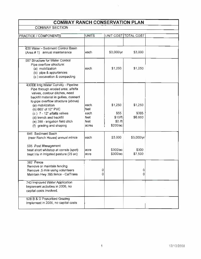
CONWAY RANCH CONSERVATION PLAN CONWAY SECTION
PRACTICE I COMPONENTS UNITS UNIT COST TOTAL COST
638 Water - Sediment Control Basin (Area # 1) annual maintenance each $3,000Iyr $3 ,000
587 Structure for Water Control Pipe overflow structure:
(a) mobilization each $1,250 $1 ,250 (b) pipe & appurtances (c ) excavation & compacting
I 430EE Irrig Water Convey - Pipeline
Pipe through eroded area, alfalfa valves, contour ditches, need backfill material in gullies, connect to pipe overflow structure (above)
(a) mobilization each $1,250 $1,250 (b) 660' of 12" PVC feet (c) 7 - 12" alfalfa valves each $55 $385 (d) trench and backfill feet $10/ft $6,660 (e) 388 - irrigation field ditch feet $2 1ft (f) grading and shaping acres $200/ac
646 Sediment Basin (near Ranch House) annual mtnce each $3,000 $3 ,000Iyr
595 Pest Management treat short whitetop at corrals (spot) acre
I $300/ac $300
treat Iris in irrigated pasture (25 ac) acre $300/ac $7,500
382 Fence Remove or maintain fencing Remove .5 mile using volunteers 0 0 Maintain Hwy 395 fence - CalTrans 0 0
743 Improved Water Application lmplement activities in 2006, no capital costs involved.
528 B & 0 Prescribed Grazing Implement in 2006, no capital costs
12/13/2005

587 Structure for water control (Area "B", eroded ditch system)
587 estimate 1 0 wood checks 388 contour ditches 1,500 feet
(a) mobilization (b) irrig field ditch 1,500 feet ( c) gradin9' and shaping 3 acres
each
each feet acre
$25Q/ea
$1,250 $2 ft
$200 lac
$2,500
$1,250 $3,000
$600
430EE Irrig Water Convey - Pipeline(Area "A", NE of Ranch House)
(a) mobilization (b) 300 ft of 1,2 " PVC pipe (C) 12" alfalfa valves (4) (d) trench and backfill (e) 388 irrig field ditch est 1,000 ft (f) grading and shaping (3 ac)
each
each feet feet acre
$1,250
$55/ea $10/ft $2 1ft
$200/ac
$1,250
$220 $3,000 $2,000
$600
587 Water Control structure (locations throughout Conway area)
(A) wood check structures (est 25) each $500 I ea $12,500
587 Water Control structure (Virginia Creek diversion & ditch)
(a) mobilization (b) 362 - diversion - concreteireinf
each CY
$1 ,250 $250/CY
$1,250
510 Access Road (add drainage structures to road that serves the water - sediment contro f basin)
rolling dips 5 each $350/ea $1,750
Area "E", formerly irrigated by the Lower Conway ditch - evaluate to either re-introduce irrigation (Est. 4,000 feet of 18" or 20" PVC @ $21.60 - $241 FT at a range of $86,400 to $96,000)
OR Evaluate and re-seed 80 acres with drought tolerant native species.
2 12/13/2 05

MATTL Y SECTION I I
587 Structures for Water Control (a) wood check structures 15 each $250/ea $3,750
398 Fish Raceway or Tank (a) mobilization $1,250 (b) fish raceway (per 100 ft raceway foot $10/ft (c) 587 struct for water control , each $1 ,000
3 12113/2005

Exhibit F
Sheep Grazing Lease


Exhibit G
MOU between Mono County and the BLM