convergence of mgnregs and iwmp: a ... - gujarat state...
TRANSCRIPT
CONVERGENCE OF MGNREGS AND IWMP: A COMPREHENSIVE RURAL DEVELOPMENT STRATEGY CASE OF GUJARAT
Ram Kumar, CEO, GSWMA and Suvendu Rout, Professional Expert, GSWMA
1. INTRODUCTION: The policy decision to undertake convergence of different rural development schemes of the Government of India with Mahatma Gandhi National Rural Employment Guarantee Scheme (MGNREGS) is one of the most significant steps towards comprehensive rural development. This will specifically help the Integrated Watershed Management Programme (IWMP) to reach its logical impact level with complementary funds from MGNREGS. Today, MGNREGS is the biggest programme of rural development in terms of scope and fund base. Other sectoral programmes relating to rural development with limited fund base can benefit immensely by converging with MGNREGS and in turn, can help MGNREGS fulfil its stated objective of providing assured wage employment to the rural poor along with creating rural infrastructure.
BOX1 MGNREGS: Important features
Objective:
The basic objective of the Act is to enhance livelihood security in rural areas by providing at least 100 days of guaranteed wage employment in a financial year to every household whose adult members volunteer to do unskilled manual work. This work guarantee can also serve other objectives: generating productive assets, protecting the environment, empowering rural women, reducing rural‐urban migration and fostering social equity, among others. TimeBound Employment:
The Gram Panchayat/Programme Officer shall be responsible for providing wage employment to the applicant within 15 days of the date of receipt of the application. In the case of advance applications, employment will be provided from the date that employment has been sought, or within 15 days of the date of application, whichever is later.
If a worker who has applied for work under NREGA is not provided employment within 15 days from the date on which work is requested, an unemployment allowance shall be payable by the State Government at the rate prescribed in the Act. This entitlement comes into effect as soon as the Act is notified in a particular District or area. Eligibility:
The Rural Employment Guarantee Scheme (REGS) will be open to all rural households in the areas notified by the Central Government. The entitlement of 100 days of guaranteed employment in a financial year is in terms of a household. This entitlement of 100 days per year can be shared within the household; more than one person in a household can be employed (simultaneously or at different times).
Source: Guidelines on convergence with NREGS, MoRD
2. NEED FOR CONVERGENCE:
a) Saturation approach and filling the fund gap: Watershed development involves treatment of natural resource base as well as creating meaningful livelihood opportunities. Thus there is a perceivable gap in demand for and supply of funds. Integrate Watershed Management Programme (IWMP) has been implemented throughout India since 2009‐10 after the commencement of the new watershed guidelines, 2008. Prior to the Integrated Watershed Management Programme (IWMP), unit cost of a watershed project was Rs. 6000 per hectare (approximately Rs.4500 was available for watershed treatment). Under IWMP, it has been increased to Rs. 12,000 ‐ Rs. 15,000 per hectare depending upon the characteristic of the project area (out of the total project cost, 50% is available for watershed treatment, which amounts to Rs. 6000 to Rs. 7500). Though this increase is a great initiative, the amount is still not enough. According to a study conducted by ICRISAT, scientific and holistic development of an area on watershed basis requires at an average Rs. 20,000 per hectare.
BOX2 IWMP in Gujarat: Salient features
With the coming into effect of the new Common Guidelines, 2008, the
individual earlier Watershed Development Programmes like DPAP, DDP and IWDP have been merged together to form one comprehensive programme, namely, Integrated Watershed Management Programme (IWMP).
In Gujarat the State Level Nodal Agency (SLNA) is Gujarat State Watershed Management Agency (GSWMA) under the Rural Development Department.
Objectives:
The main aims of the IWMP are to restore the ecological balance by harnessing, conserving and developing degraded natural resources such as soil, vegetative cover and water. The outcomes are prevention of soil run‐off, regeneration of natural vegetation, rain water harvesting and recharging of the ground water table. This enables multi‐cropping and the introduction of diverse agro‐based activities, which help to provide sustainable livelihoods to the people residing in the watershed area.
New features:
a) Application of Geographic Information System (GIS) in planning, implementation, monitoring & evaluation and impact assessment
b) Centralized Management Information System (MIS) c) Participatory approach at village level d) Consortium approach for capacity building e) Zone wise comprehensive livelihood system
This gap can be filled by convergence with different other schemes of the government, especially, MGNREGS. MGNREGS, after becoming an act, is here to stay and has significantly large fund‐base. Huge amount of fund can be released depending upon the requirement of the village community, and the labour budget. MGNREGS is very much open for convergence purpose; IWMP should take the opportunity and undertake all round development of the projects areas.
b) Covering 100% population of the project area: In earlier watershed
projects, selective households got the benefits of the programme. So, a number of needy households had to be left out due to lack of sufficient funds. This can now be amended by covering all the needy households and all the needy survey numbers (land parcels).
c) Holistic development: A watershed approach can be holistic when it is
undertaken in three stages‐ (i) augmentation/conservation of natural resource base, (ii) building livelihood options based on the natural resource augmentation and then (iii) establishing linkages for sustaining the activities taken up. It requires integration with different agencies working on rural development and convergence with other schemes.
d) To stop duplication of works: Since a number of departments of the
government are working for rural development and carry out similar kinds of activities, it is often observed that works are being duplicated. To stop this duplication, proper convergence of projects should be done at project implementation level.
e) Post project management: For long term benefit from a watershed
development programme, appropriate post‐project management has to be in place. It involves largely repair and maintenance of structures made under the programme. This in turn requires substantial money after the project period. Post‐ project management can be smooth if convergence takes place with a programme like MGNREGS. 3. SCOPE FOR CONVERGENCE: Permitted works under MGNREGS: Schedule I, Para 1 lists permissible works as following
a) Water conservation and water harvesting b) Drought proofing, including afforestation and plantation c) Irrigation canals, including micro and minor irrigation works d) Provision of irrigation to poor households e) Renovation of traditional water bodies f) Land development g) Flood control and protection works h) Rural connectivity
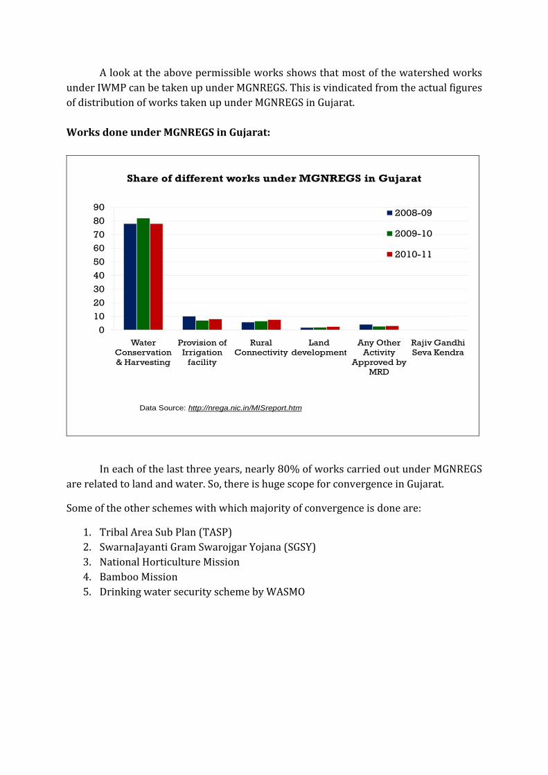
A look at the above permissible works shows that most of the watershed works under IWMP can be taken up under MGNREGS. This is vindicated from the actual figures of distribution of works taken up under MGNREGS in Gujarat. Works done under MGNREGS in Gujarat:
78
106
2 40
82
7 62 3
0.009
78
8 82 3
0.025
0
10
20
30
40
50
60
70
80
90
Water Conservation & Harvesting
Provision of Irrigation
facility
Rural Connectivity
Land development
Any Other Activity
Approved by MRD
Rajiv Gandhi Seva Kendra
Shar
e (%
)
Type of Works
Share of different works under MGNREGS in Gujarat
2008-09
2009-10
2010-11
Data Source: http://nrega.nic.in/MISreport.htm
In each of the last three years, nearly 80% of works carried out under MGNREGS are related to land and water. So, there is huge scope for convergence in Gujarat.
Some of the other schemes with which majority of convergence is done are:
1. Tribal Area Sub Plan (TASP) 2. SwarnaJayanti Gram Swarojgar Yojana (SGSY) 3. National Horticulture Mission 4. Bamboo Mission 5. Drinking water security scheme by WASMO
4. STRATEGY FOR CONVERGENCE IN GUJARAT:
Government of Gujarat has initiated several models of convergence to experiment with the processes before settling down to a particular strategy / policy. The models are discussed in brief below:
For facilitating the process of convergence, committees at different levels (state, district and taluka) representing different departments have been formed. These committees oversee the planning process. Scientific planning as followed by IWMP has been prescribed for the whole state.
The important features of this process are:
• Issuing required circulars • Regular information sharing mechanism • Common workshops and training programmes • Sharing of human resources • Supplying GIS based thematic maps to the functionaries and the villagers • Establishing consortium of institutions
4.1. MGNREGS under IWMP platform (pilot projects):
IWMP in Gujarat has initiated GIS based approach to watershed development. It
involves both scientific and participatory approaches. The planning at village level includes the following steps:
• Preliminary Village Meeting (Gram Sabha) • Provision of GIS based baseline maps and thematic maps to the village
community for making informed decisions • Base line survey that includes:
o Socio‐economic survey (covering each household) o Bio‐physical survey (covering each and every survey number of the
village) o Village infrastructure survey
• Participatory Rural Appraisal (PRA) • Participatory Problem‐ Solution Analysis • Participatory Net Planning (PNP) • Budgeting including Convergence with different schemes • Preparation of Detailed Project Report (DPR) including the Annual Action Plan
and the Action Plan maps
The above process is rigorous and takes stock of the entire problem‐ solution scenario of the village. It estimates the full fund requirement of the village and plans accordingly.
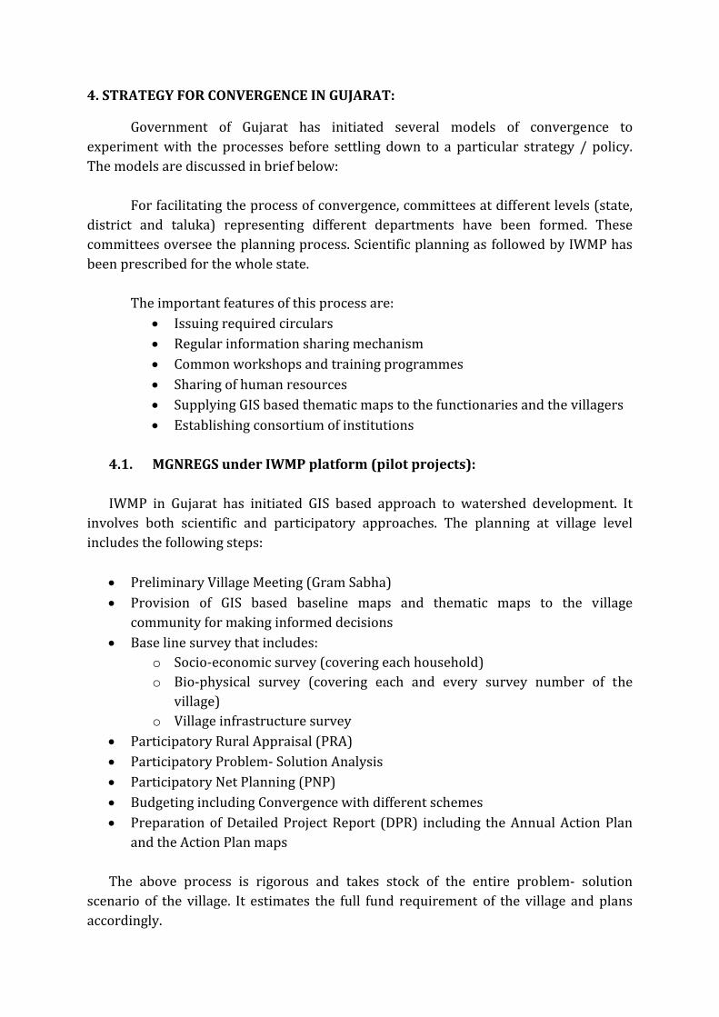
Planning for MGNREGS can be much more comprehensive if done in the above manner. Thus, the Government of Gujarat decided to undertake a number of pilot projects in the state. This has been done in collaboration with the IWMP. IWMP has been implemented in 151 projects across the state at the moment (as sanctioned by the Government of India in 2009‐10). So, the required human resource is already employed in these project areas. The pilot projects of MGNREGS under IWMP platform has thus been taken up adjacent to the 151 project areas, in 640 villages. Geographic distribution of these villages is presented in the map below:
Intensive planning in line with IWMP processes is underway in pilot project areas for review of 5‐year perspective plans and NREGS labour budget 2011‐12. The human resources engaged in IWMP are helping the functionaries of MGNREGS in scientific planning of these pilot projects.
Once these pilot projects are successful, necessary steps will be taken up for up‐scaling it to all the villages of Gujarat in a phased manner.
BOX3 Pilot Project Strategy
Scientific and participatory Planning of 151 micro watersheds covering 640 villages for MGNREGS on pilot basis by GSWMA
Scientific and participatory planning for remaining villages using technological tools.
Capacity building of MGNREGS staff(TAs/ Field Functionaries) Coordinated efforts of GSWMA and MGNREGS teams
4.2. Planning of MGNREGS like IWMP plan throughout Gujarat
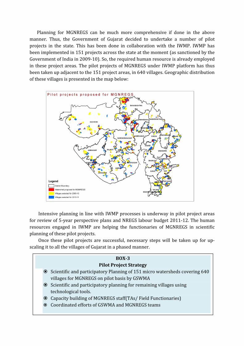
On a less intensive scale, IWMP type planning has been taken up in all the other villages of Gujarat for Labour Budget, 2011‐12. Workshops were conducted in all the districts involving MGNREGS and IWMP functionaries. Both the teams shared their experiences and discussed the strategy for planning. The IWMP teams shared their planning mechanism with the MGNREGS team as well as use of the GIS based thematic maps for scientific planning of works.
The workshops were preceded by providing GIS based thematic maps to the
functionaries (Technical Assistants) of MGNREGS in all the villages of the state. These functionaries carry these maps to the villages and support the Gram Sabha to prepare a technically sound, need based Labour Budget.
BOX4 Implementation Mechanism for MGNREGS on Watershed Platform
Scientific planning by using GIS based Planning Map and Indicative Action Plan Matrix Participatory Planning Approach for MGNREGS on the basis of Watershed Platform Secondary Data Collection‐ Basic Socio‐economic parameters Identification of Priority Works Discuss in Gramsabha ‐ Tentative Labour Budget Approval of Final Labour Budget in Gram sabha Scientific Monitoring & Evaluation using Web‐based GIS
4.3. Convergence planning of MGNREGS with IWMP:
IWMP gives utmost importance to convergence. This has been made mandatory by making convergence an integral part of every Detailed Project Report (DPR). Necessary circulars have been issued to the district levels regarding the same. While preparing the DPR, the project management team has to study the total fund requirement of the village or the project area.
As stated above, the DPR preparation process is comprehensive enough to estimate
the total fund requirement of the village; because it ensures every household and each survey number is surveyed. Once the survey and the net planning are completed, the physical measures required are converted into financial figures. Thus the total financial requirement comes into picture. The gap in fund requirement is calculated by deducting the funds available from the funds required. The Watershed Committee and the Watershed Development Team then identify options for convergence.
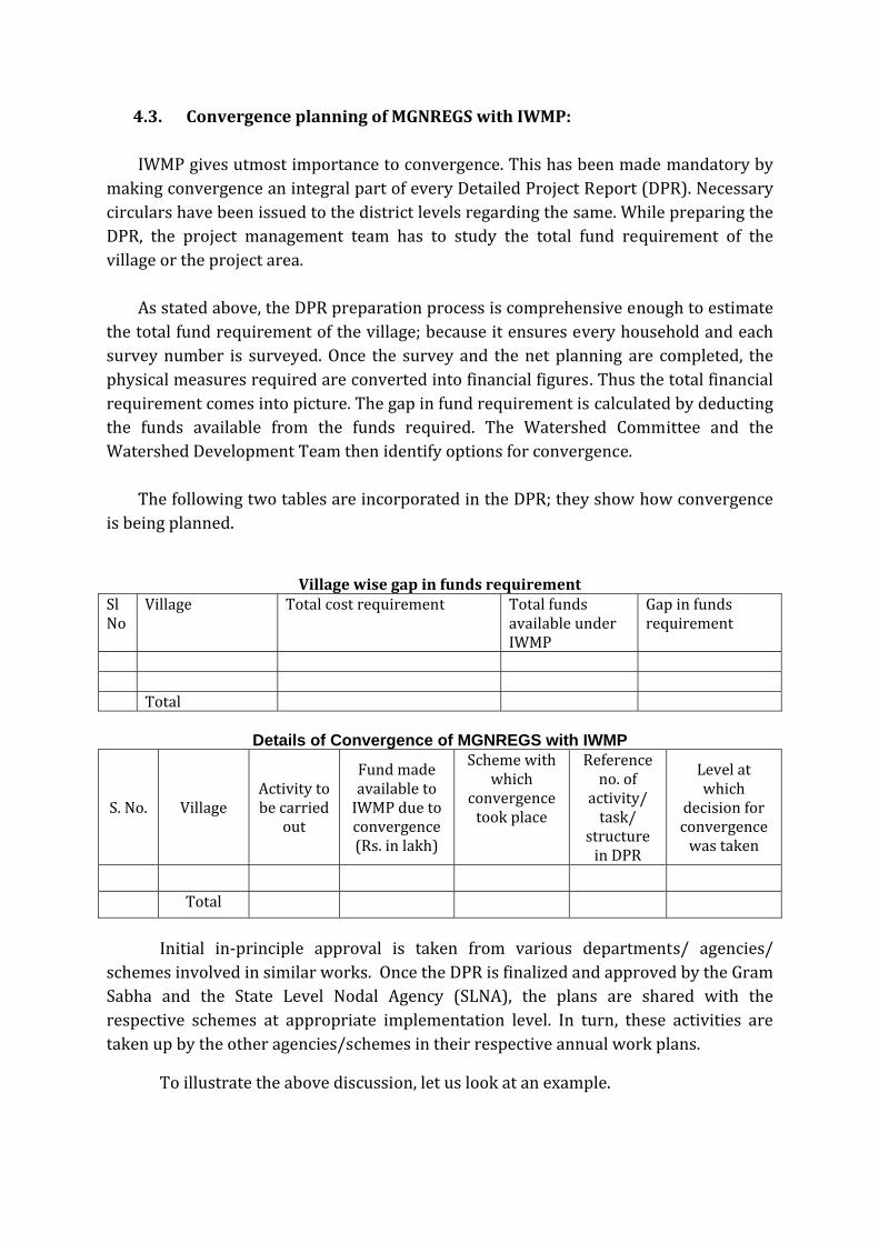
The following two tables are incorporated in the DPR; they show how convergence
is being planned.
Village wise gap in funds requirement Sl No
Village Total cost requirement Total funds available under IWMP
Gap in funds requirement
Total
Details of Convergence of MGNREGS with IWMP
S. No. Village Activity to be carried
out
Fund made available to IWMP due to convergence (Rs. in lakh)
Scheme with which
convergence took place
Reference no. of
activity/ task/
structure in DPR
Level at which
decision for convergence was taken
Total
Initial in‐principle approval is taken from various departments/ agencies/ schemes involved in similar works. Once the DPR is finalized and approved by the Gram Sabha and the State Level Nodal Agency (SLNA), the plans are shared with the respective schemes at appropriate implementation level. In turn, these activities are taken up by the other agencies/schemes in their respective annual work plans.
To illustrate the above discussion, let us look at an example.
4.3.1. Illustration: Padal village, Jhagadia taluka, Bharuch District
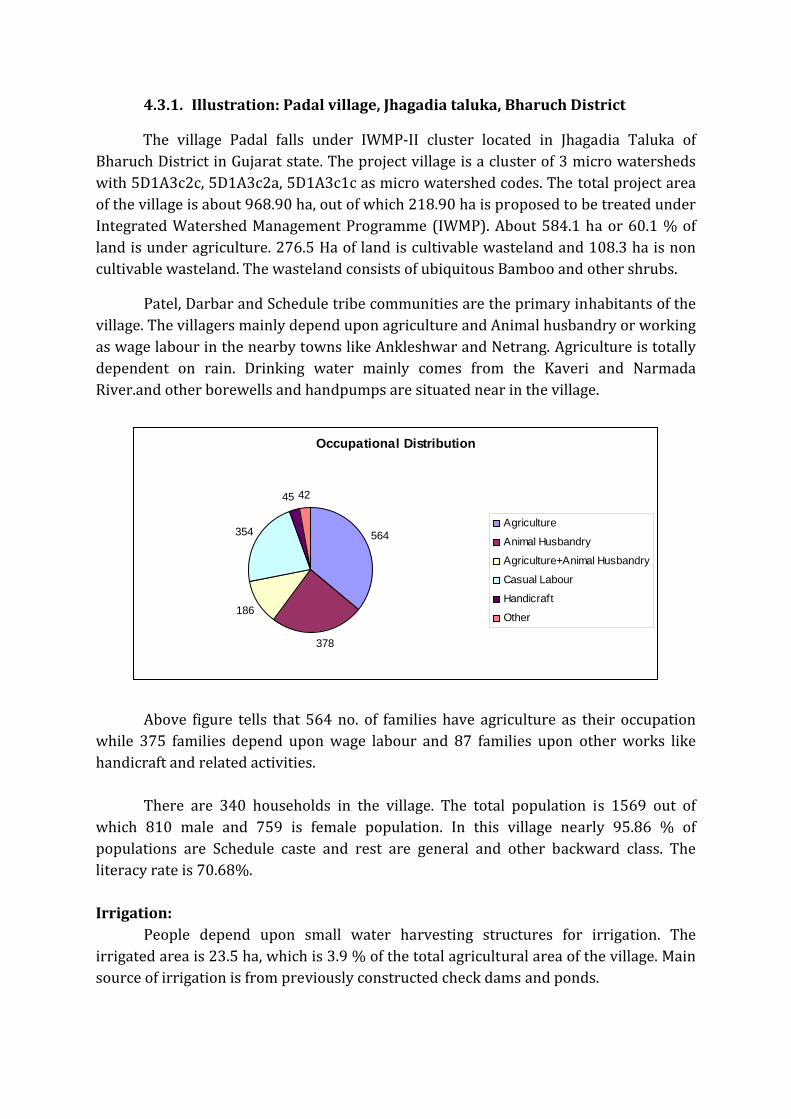
The village Padal falls under IWMP‐II cluster located in Jhagadia Taluka of Bharuch District in Gujarat state. The project village is a cluster of 3 micro watersheds with 5D1A3c2c, 5D1A3c2a, 5D1A3c1c as micro watershed codes. The total project area of the village is about 968.90 ha, out of which 218.90 ha is proposed to be treated under Integrated Watershed Management Programme (IWMP). About 584.1 ha or 60.1 % of land is under agriculture. 276.5 Ha of land is cultivable wasteland and 108.3 ha is non cultivable wasteland. The wasteland consists of ubiquitous Bamboo and other shrubs.
Patel, Darbar and Schedule tribe communities are the primary inhabitants of the village. The villagers mainly depend upon agriculture and Animal husbandry or working as wage labour in the nearby towns like Ankleshwar and Netrang. Agriculture is totally dependent on rain. Drinking water mainly comes from the Kaveri and Narmada River.and other borewells and handpumps are situated near in the village.
Above figure tells that 564 no. of families have agriculture as their occupation
while 375 families depend upon wage labour and 87 families upon other works like handicraft and related activities.
There are 340 households in the village. The total population is 1569 out of
which 810 male and 759 is female population. In this village nearly 95.86 % of populations are Schedule caste and rest are general and other backward class. The literacy rate is 70.68%.
Irrigation:
People depend upon small water harvesting structures for irrigation. The irrigated area is 23.5 ha, which is 3.9 % of the total agricultural area of the village. Main source of irrigation is from previously constructed check dams and ponds.
Occupational Distribution
564
378
186
354
45 42
Agriculture
Animal Husbandry
Agriculture+Animal Husbandry
Casual Labour
Handicraft
Other

Planning process followed: To start with, the Watershed Development Team (WDT) conducted a Gram
Sabha and elaborated the programme and its purpose. A lot of meetings were conducted in that village with people by them. Through this, some people with fully enthusiastism come forward in each meeting and then WDT members started coming to the village regularly for ice breaking with the villagers.
It was followed by detailed Base Line Survey which included a household socio‐economic survey (door to door survey), a survey number wise Bio‐Physical Survey (field survey) and a Village Infrastructure Survey as well as existing structure details with the help of GPS.
In order to understand the social, economic and political aspect of all the village, Participatory Rural Appraisal (PRA) exercise was done with the villagers in Padal. It was really a useful tool to appreciate the village in its totality. The following methods were used: (i) Resource Mapping (ii) Social Mapping (iii) Seasonal Calendar (iv) Tree matrix (v) Cropping Pattern (vi) Income‐Expenditure pot (vii) Ven diagram
The PRA helped the team in identifying the main problems, which are listed below: a) Critical ground water status b) Scarcity of drinking water in summer season c) Low land and agricultural productivity d) Seasonal migration e) Scarcity of fodder in summer season
This was followed by Participatory Net Planning (PNP). The WDT and the farmers went on fields to find out what the possible interventions can be and discussed with the land less & asset‐less regarding their livelihood measures. Budgeting with Convergence (focused on MGNREGS): Once the physical measures were decided, it was time to sit down for the budgeting. The team found out the total funds required for the village as a whole and then estimated the gap between the funds required and funds available under IWMP. This gap was filled up by leveraging funds from MGNREGS and funds of the Forest Department. The details are given in the table below: Sl no: Phase/
Activities Total Fund Requirement
Available under IWMP
Gap Deptt. / Scheme
1 EPA 3.00 1.05 1.95 MGNREGS & WASMO
2 Works 36.796 19.176 17.62 MGNREGA
3 Total 39.796 20.226 19.57
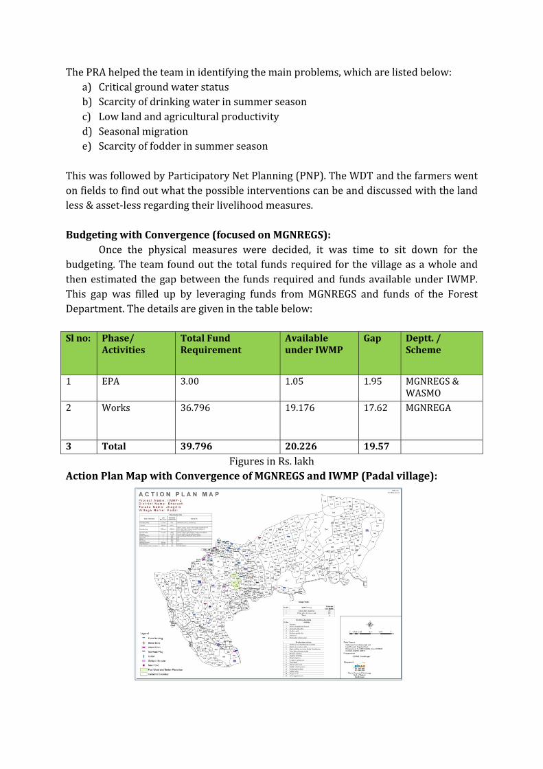
Figures in Rs. lakh Action Plan Map with Convergence of MGNREGS and IWMP (Padal village):