conservation area statement 22 king’s cross
TRANSCRIPT
Conservation Area Statement 22King’s Cross

Kings Cross Team andConservation & Urban Design TeamLondon Borough of CamdenEnvironment DepartmentTown Hall ExtensionArgyle StreetLondon WC1H 8ND Telephone: 020 7974 1944
Produced by Camden Design & Print END204/05 5624 Tel: 020 7974 1985
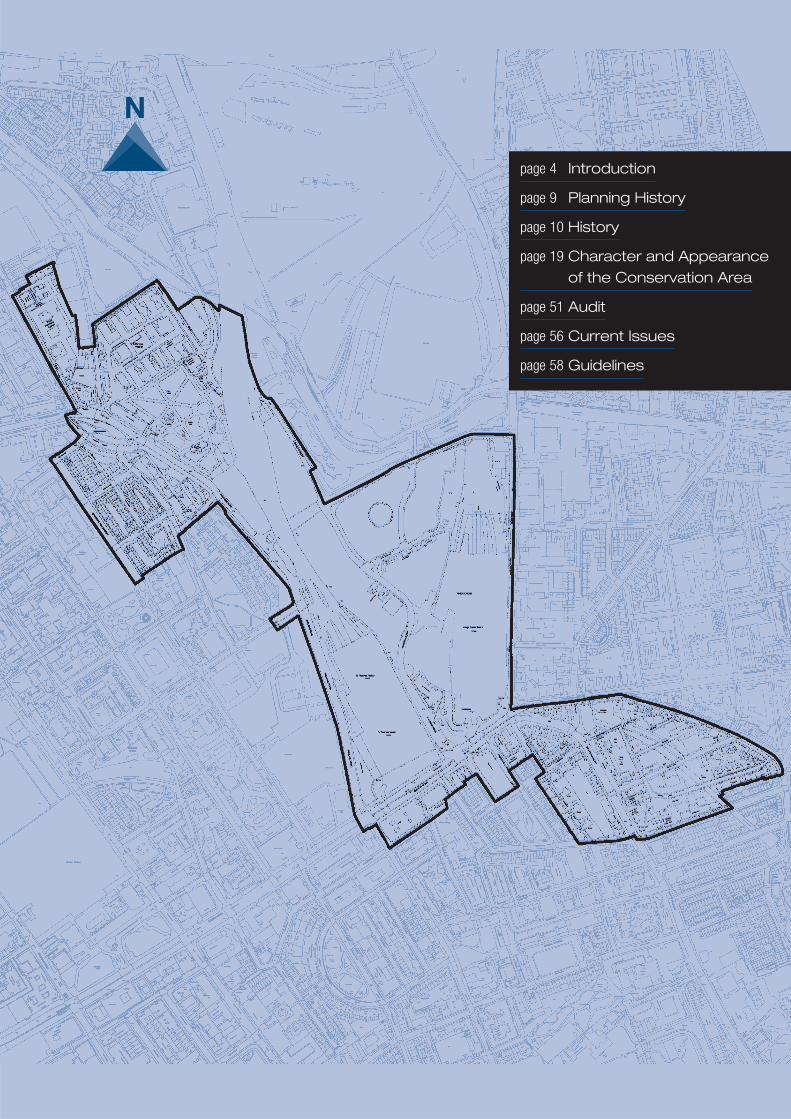
page 4 Introduction
page 9 Planning History
page 10 History
page 19 Character and Appearanceof the Conservation Area
page 51 Audit
page 56 Current Issues
page 58 Guidelines

Conservation Area Statement no. 22CONTENTS1. INTRODUCTION 41.1 General Introduction 41.2 Aims and Methodology 52. PLANNING HISTORY 92.1 Designations and Extensions 92.2 Planning History 93. HISTORY 103.1 Introduction 103.2 Pre-1750 103.3 1750-1820 113.4 1820-1850 113.5 1850-1900 113.6 1900-1945 153.7 1945-1996 153.8 1996-2003 153.9 2003-2007 and beyond 174. CHARACTER AND APPEARANCE OF THECONSERVATION AREA 194.1 Introduction 194.2 Sub Areas 20Sub Area 1: St Pancras Gardens 20Sub Area 2: King's Cross/St Pancras 26Sub Area 3: Euston Road 37Sub Area 4: Gray's Inn Road 405. AUDIT 515.1 Introduction 515.2 Listed buildings 51Sub Area 1: St Pancras Gardens 51Sub Area 2: King's Cross/ St Pancras 51Sub Area 3: Euston Road 51Sub Area 4: Gray’s Inn Road 515.3 Historic Parks and Gardens 525.4 Buildings and groups of buildings that make a
positive contribution to the Conservation Area 52Sub Area 1: St Pancras Gardens 52Sub Area 2: King's Cross/ St Pancras 53Sub Area 3: Euston Road 53Sub Area 4: Gray's Inn Road 535.5 Elements of streetscape that make a positivecontribution to the Conservation Area 535.6 Buildings and features that detract from thecharacter of the Conservation Area 54Sub Area 1: St Pancras Gardens 54Sub Area 2: King's Cross/ St Pancras 54Sub Area 3: Euston Road 55Sub Area 4: Gray's Inn Road 555.7 Opportunity sites 555.8 Conservation Area Boundary 55
6. CURRENT ISSUES 566.1 New Development in Sub-Area 2 566.2 New Development in other Sub-Areas 566.3 Alterations to Existing Buildings 566.4 Changes of Use 576.5 Small scale developments within the
public realm 576.6 Telecommunications 576.7 Traffic 577. GUIDELINES 587.1 Introduction 587.2 Camden Unitary Development Plan Policy and
Supplementary Guidance 587.3 New development 587.4 Design 597.5 Archaeology 597.6 Listed Buildings 607.7 Materials and maintenance 607.8 Demolition 617.9 Change of Use 627.10 Extensions 627.11 Roof extensions 637.12 Roof gardens 647.13 Conservatories 647.14 Façadism 647.15 Fire Escapes 657.16 Disabled Access 657.17 Trees and landscaping 657.18 Shop fronts 657.19 Shop front security 657.20 Advertisements 667.21 Satellite dishes 667.22 Telecommunications 667.23 Ventilation Ducts/Air Handling Equipment 66
Conservation Area Statement approved at ExecutiveCommittee: December 2003.Published: June 2004.
3King’s Cross
KING’S CROSS CONSERVATION AREA STATEMENTLONDON BOROUGH OF CAMDEN
4 Conservation area statement
KING'S CROSSConservation Area Statement
1. INTRODUCTION1.1 General Introduction1.1.1 This Conservation Area contains some of the most important historicbuildings and structures in the country and has areas of great interest and variety.
1.1.2 The King's Cross area has formed a major gateway into central London forover two centuries. The Regent's Canal introduced a major transport system forgoods into and out of the area. The construction of Euston Road was an importantchange. Later, the railways enabled the rapid transportation of people and goodsand materials to, from and through London to meet the demands of industry andthe burgeoning urban population. By the mid-19th Century, King's Cross was thebusiest goods handling area in Britain.
1.1.3 The construction of the King's Cross Goods Station, opened in 1850, King'sCross station in 1852, the Great Northern Hotel in 1854, the Metropolitan Railway(the first underground station in the world) a decade later, St Pancras Station in1865-69 and the Midland Grand Hotel (St Pancras Chambers) in 1868-76 reflectsthe importance of the railway companies and the significance of rail travel in theVictorian age. The two stations represent the finest examples of architecturalexpression of their age, in terms of British railway architecture.
1.1.4 In the same way that the railway superseded the canals as a means ofmass-transporting goods in the 19th Century, the 20th Century saw a shift ingoods movement from rail to road. The goods handling areas between the stationsand to the north became redundant and fell into decline. However, Exel continue tohandle goods in the area.
1.1.5 The passing of the Channel Tunnel Rail Link (CTRL) Act in 1996 began a newchapter in the evolution of the area. Through the extension of St Pancras Station,the King's Cross area will become an international terminus for trains to Europe viathe Channel Tunnel. In addition, the works include adapting the station for theMidland Main Line and a new station for Thameslink services. The Act set upstreamlined planning and heritage procedures. The CTRL works are due forcompletion in 2007.
1.1.6 From 2007, work will commence on the development of the King's CrossOpportunity Area. This extends from Euston Road in the south, to the NorthLondon Line in the north, the Midland Main Line in the west and York Way in theeast. The Opportunity Area is a 'major development opportunity' and is designated

5King’s Cross
in Regional Planning Guidance no.3, Camden's Unitary Development Plan (UDP) and in the Draft London Plan(2002). Sub Area 2 in the Conservation Area forms part of this Opportunity Area. Camden has adopted newplanning policies for this Opportunity Area in the replacement chapter 13 of the UDP adopted in April 2003 (nowsection 9 of the Replacement UDP Deposit Draft of June 2003). Opportunity Area policies seek to promote itscomprehensive redevelopment as a high density, high quality, mixed-use urban quarter. Planning policy emphasistherefore varies across the Conservation Area. Regeneration will revitalise the Opportunity Area with a mix ofrefurbished buildings, new uses and new development.
1.1.7 Regeneration of the area to the east of York Way (within the London Borough of Islington) known as the"Regent Quarter" has commenced, covering three blocks from Wharfdale Road to the Lighthouse block, wherepermission has also been granted for a re-modelling scheme.
1.1.8 The Statement describes the existing character of the Conservation Area and provides an outline of the keyissues within it, for example development pressures. The Statement also refers to the relevant planning policies andguidance that applies to the Conservation Area and includes (in section 7) general guidelines for its conservation,enhancement and maintenance.
1.2 Aims and Methodology1.2.1 Camden Council has a duty under the Planning (Listed Buildings and Conservation Areas) Act 1990: "fromtime to time determine which parts of their area are areas of special architectural or historic interest, the character orappearance of which it is desirable to preserve or enhance" and to "designate these areas as conservationareas."(S. 69(1)). Designation provides the basis for policies designed to preserve or enhance the special interest ofsuch an area. Designation also introduces a general control over the demolition of unlisted buildings.
1.2.2 As a result of the CTRL works, significant changes have been made to the area and will continue to be madeuntil 2006. This has necessitated a revision of the existing Statement. It is anticipated that a further revision will bemade in 2007, when the CTRL works have completed and prior to the commencement of the Opportunity Area'sredevelopment.
1.2.3 The Statement contains a description of the current appearance of the Conservation Area, to informformulation of planning policies for this area and the determination of planning applications.
1.2.4 This Statement comprises Supplementary Planning Guidance (SPG). It replaces the adopted King's CrossConservation Area Statement (1998) and sits alongside the Council's other SPG, most notably the Council's generalSPG document (July 2002) and the King's Cross Opportunity Area Planning & Development Brief (December 2003),which it informed. The Council will have regard to this Statement in determining the effects of proposeddevelopment throughout the King's Cross Conservation Area, including the King's Cross Opportunity Area. Inparticular the Council will adopt the following approach:
• Take into account its duties under Section 54A of the Town and Country Planning Act 1990 which requires theCouncil to have regard to the Development Plan and any other material considerations;
• Consider its statutory duties in respect of listed buildings and/or conservation areas and in particular the need tohave special regard to the desirability of preservation or enhancement so far as the proposal affects a listedbuilding;
• Take into account any other material aspects which should be considered;
• Having had regard to both duties reach a conclusion or, in the event that there is a conflict between these duties,reach a balanced conclusion.
1.2.5 This Statement is for the use of local residents, community groups, businesses, property owners, architectsand developers as an aid to the formulation and design of development proposals and change in this area.
1.2.6 Guidance on the enhancement of the public realm of the area is provided in the Council's 'Streetscape DesignManual' (2000) (currently under review). This describes appropriate surfacing materials, furnishing and lighting andidentification of the special characteristics of smaller areas within it. There is a reference guide for the use of
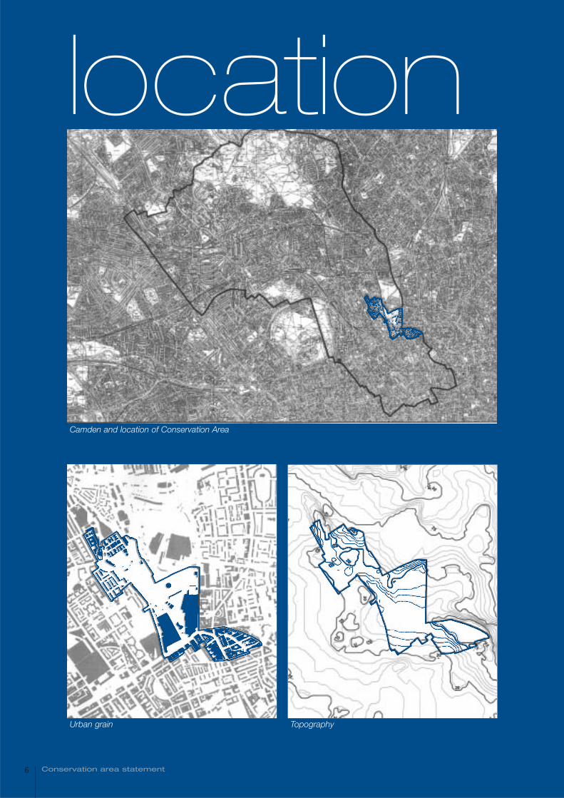
Camden and location of Conservation Area
6 Conservation area statement
Urban grain Topography
location

standard design details, surfacing materials, street furniture and street lighting to be used in engineering, trafficmanagement and other environmental improvement schemes. This includes sample illustrations of best practice,such as for historical and other typical street settings within Conservation Areas. In addition, English Heritage hasproduced 'Streets for All' (2000).
1.2.7 The temporal baseline for the description of the character and appearance of the area is the latter part of2003. The current appearance is the only basis for an empirical description. The emerging works such as the newtrain shed extension to St Pancras station have also been described. In addition, an indication of the finished CTRLand associated works is given.
1.2.8 The methodology has followed the standard guidance available, being English Heritage's 'Conservation AreaPractice' (1995) and 'Conservation Area Appraisals' (1997) (Statements are also referred to as 'appraisals'). TheStatement also follows the form and content of Camden Council's current series of Conservation Area Statements.
1.2.9 The views described are local public views, visible in 2003. Dates given for various submission of planningapplications may be subject to change. Planning Policy Guidance nos. 15 and 16 are currently being reviewed; adraft Planning Policy Statement addressing both conservation of the built environment and archaeology is due forconsultation purposes. The revised document should be consulted in due course.
Listed buildings and buildings which make a positive or negative contribution to the Conservation Area
7King’s Cross
KEY
8 Conservation area statement
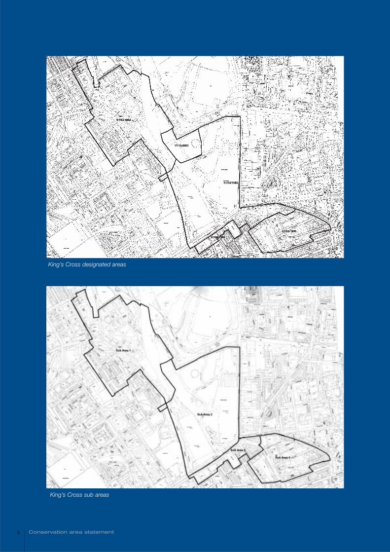
King’s Cross designated areas
King’s Cross sub areas
9King’s Cross
2. PLANNING HISTORY2.1 Designations and Extensions2.1.1 The King's Cross Conservation Area was initially designated by the Greater London Council (GLC) in March1986. The designation straddled the boundary between Camden and Islington and included the Conservation Areato the east of York Way.
2.1.2 The Conservation Area has been enlarged on two occasions since 1986. In 1991, the boundary was extendedto the south of Euston Road to include the area between Judd Street, Argyle Street, Swinton Street and King'sCross Road. The Conservation Area was extended to the north west in 1994 to include the area surrounding StPancras Gardens.
2.1.3 The London Borough of Camden's Conservation Area Statement for King's Cross was first published in 1998.That Statement included an assessment of a part of the Regent's Canal Conservation Area in the vicinity of King'sCross. This King's Cross Statement supersedes the previous Statement published in 1998.
2.2 Planning History2.2.1 The area surrounding King's Cross and St Pancras stations was designated in 1976 by the GLC as an 'ActionArea', whilst the Euston Road frontage was defined as a 'National Set Piece' - a group of buildings, streets, spacesand monuments that contribute to London's role as a capital city. From 1995 to 2003, the area surrounding King'sCross Station was also the subject of a successful Single Regeneration Budget (SRB) bid.
2.2.2 During recent decades, the area has been the subject of major redevelopment proposals. In the early 1990'sthe London Regeneration Consortium submitted an application for the comprehensive redevelopment of the railwaylands. The application was withdrawn in 1994. In November 1994, the Channel Tunnel Rail Link (CTRL) Bill, locatingthe CTRL terminus at St Pancras, was placed on deposit. The Bill became law in December 1996 and includesspecial procedures for dealing with planning, highways, listed buildings, archaeology and conservation matters.Currently, it is expected that work on the CTRL will be completed at the end of 2006. Parts of the Conservation Areafall within areas safeguarded for CTRL and for Crossrail 2.
2.2.3 In November 1994 the London Borough of Camden adopted a Community Planning Brief covering the King'sCross Railway Lands, as Supplementary Planning Guidance. As outlined in 1.2.4 above, this has been supersededby the King's Cross Opportunity Area Planning & Development Brief.
2.2.4 Given the importance of the locality, the Camden Unitary Development Plan (March 2000) devotes an entirechapter to policies for the Opportunity Area (Chapter 13). A revised Chapter 13 (now section 9 of the ReplacementUDP Deposit Draft of June 2003) was adopted by the Council in May 2003 to reflect the changing situation.
2.2.5 It is anticipated that in 2004, a planning application will be submitted for a high density, mixed-usedevelopment at King's Cross. This will comprise the development of the Opportunity Area between the stations andland to the north of the canal following completion of the CTRL works at the end of 2006. Additional planningapplications are anticipated from Network Rail (formerly Railtrack) for an extension to the station, immediately to thewest of King's Cross Station. The 1974 canopy at the front of the station is expected to be removed as part of thisproject, and it is anticipated that this will remain in situ until the new extension is operable.
planning history
10 Conservation area statement 10
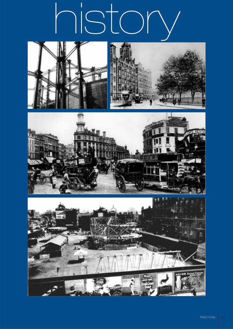
hıstory3. HISTORY
3.1 Introduction3.1.1 The following provides a brief overview ofthe historical development of the area based onthe sources acknowledged within thebibliography.
3.2 Pre-17503.2.1 Although Roman remains have beendiscovered in the vicinity of York Way, there is noevidence of settlement in the King's Cross areauntil the development of the hamlets of StPancras and Battle Bridge during the medievalperiod. The former developed in the vicinity of theSt. Pancras Old Church, which was rebuilt duringthe 12th Century and may have been built on thesite of a 4th Century Pagan temple. It isconsidered to be one of the earliest Christian sitesin the country and was originally built to serve theParish of St Pancras, which covered an areaextending from Hampstead and Highgate in thenorth to Bloomsbury and Tottenham Court Roadto the south. A small settlement developed in thevicinity of the church, which was situated on ahillock overlooking the River Fleet (which wasculverted beneath Pancras Road in 1825). By the13th Century most activities in the parish hadmigrated to the Kentish Town area. There was aCivil War defence south of the Church. St PancrasOld Church remained relatively neglected until itsenlargement and restoration in 1848 by A.D.Gough and R.L. Roumieu.
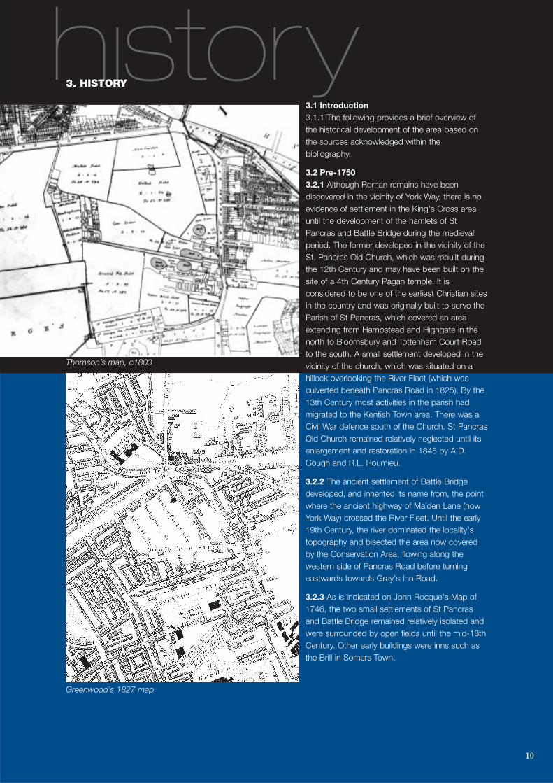
3.2.2 The ancient settlement of Battle Bridgedeveloped, and inherited its name from, the pointwhere the ancient highway of Maiden Lane (nowYork Way) crossed the River Fleet. Until the early19th Century, the river dominated the locality'stopography and bisected the area now coveredby the Conservation Area, flowing along thewestern side of Pancras Road before turningeastwards towards Gray's Inn Road.
3.2.3 As is indicated on John Rocque's Map of1746, the two small settlements of St Pancrasand Battle Bridge remained relatively isolated andwere surrounded by open fields until the mid-18thCentury. Other early buildings were inns such asthe Brill in Somers Town.
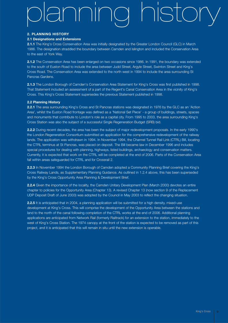
Thomson’s map, c1803
Greenwood’s 1827 map
11King’s Cross
185
0
184
03.3 1750-18203.3.1 The construction of the New Road (now Euston Road) between Paddington and Islington in 1756 acted asone stimulus for urban development and the road rapidly became London's northern boundary. The Act ofParliament that endorsed the development of the New Road however required that no buildings should be erectedwithin 50 feet of it. Accordingly, although it became residential in character, properties were built with long gardensfronting onto the road.
3.3.2 Other developments in the area during this period include the Small Pox Hospital, which was built in 1767 onland north-west of Battle Bridge, now occupied by King's Cross Station, the Fever Hospital constructed next to it in1802, and the Royal Veterinary College in 1791. The College is thought to be the first veterinary college in thecountry and remains within the northern part of the Conservation Area. At the southern end of Pancras Way, aworkhouse was also built in 1809 and rebuilt and its infirmary accommodation much enlarged after 1880. That siteis now occupied by the Hospital for Tropical Diseases (St Pancras Hospital).
3.3.3 The area between the two later stations was developed with residential streets during the late 18th and early19th centuries. In advance of development, the fields were dug over for brick making, while tile kilns and dust yards,where refuse was sifted, added to the pollution of the air. This, and the dampness of the Fleet Valley, discouragedthe building of further houses.
3.3.4 The area to the east of Gray's Inn Road was first developed in 1767 and the road layout survives to thepresent. The area was densely developed with small units, most of which were demolished and redeveloped in thelater 19th century with the existing larger units of a commercial or semi-industrial nature.
3.4 1820-18503.4.1 During the early 19th century, canals provided the primary means of transporting goods. The Regent's Canalwas completed in 1820, connecting the River Thames at Limehouse with the Grand Junction Canal in Paddington.The canal was lined with larger and more frequent lateral basins and wharves than at present and its arrival in King'sCross signalled the area's industrial growth. Several industrial companies, including the Imperial Gas Light and CokeCompany, located in the area during the 1820s.
3.4.2 King's Cross derived its name from the sixty foot high structure which was erected as a memorial to KingGeorge IV in 1830-35. Built at the junction of the New Road (Euston Road), Maiden Lane (York Way) and Gray's InnRoad, this structure was removed within fifteen years.
3.4.3 Residential development in the area intensified during this period. Suffolk Street and Norfolk Street were laidout in the vicinity of the gas works during the early to mid 19th Century, expanding on the late 18th centuryresidential areas. To the south of Euston Road, St Chad's Street, Chesterfield (now Crestfield) Street and Liverpool(now Birkenhead) Street were laid out and standardised late Georgian, "third class" housing, consisting of threestoreys plus a basement level, were developed from the 1820s onwards.
3.4.4 The north western parts of the Conservation Area began to develop during the 1840s. Several streets in SomersTown, to the west of St Pancras Gardens, including MedburnStreet, Goldington Street and Goldington Crescent, were laidout with three-storey terraced houses, some of which havesurvived subsequent redevelopment and Second World Warbombing. The River Fleet, which ran along the west side ofPancras Road, was put into a culvert at the beginning of the19th century.
3.5 1850-19003.5.1 The onset of the industrial revolution had profoundimpacts on the King's Cross area. Given the need for the rapidtransportation of people, goods and materials to, from andthrough London, the dominance of the canal was short-lived
12 Conservation area statement
190
0-19
45
187
6as the railways provided a more efficient mode of transportation. The coming of the railways was the first majorchange to London since the rebuilding after the Great Fire of London. Goods yards were built in the expanse ofopen land to the north of the Regent's Canal and King's Cross became the busiest goods handling complex inBritain. A temporary passenger station was constructed in the Great Northern Railway Company's new goods yardin 1850. However, it was the intention of the Great Northern Railway from the outset, to construct a main line stationfronting onto the New Road.
3.5.2 The reason why both passenger termini were located on the north side of Euston Road was because aParliamentary Commission in 1846 decided that the central London area was not an appropriate location for largesurface railways. The land south of Euston Road had been fully developed by this time and the termini and railwayswould have taken up prime inner-city land.
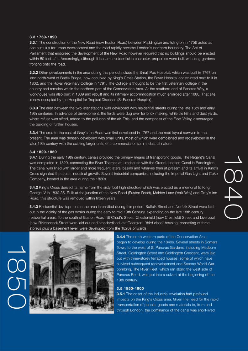
3.5.3 King's Cross Station was designed by Lewis Cubitt, and completed in 1852. When it opened, it was thelargest railway station in Britain. Given that the station was largely built on the garden plots to the west of MaidenLane (later re-named York Way), the development of the station required limited demolition, although the Small PoxHospital and Fever Hospital occupying part of the site were relocated.
3.5.4 The Great Northern Hotel was also designed by Lewis Cubitt, and completed in 1854. It is an early survivingexample of a grand railway hotel, built by the Great Northern Railway for long-distance travellers. It was designed toaddress King's Cross station across a large formal garden between it and the hotel.
3.5.5 In 1859 work began on the Metropolitan Railway, the world's first underground railway, which passed alongthe Euston Road between Paddington and Farringdon stations. The underground railway was constructed using the'cut and cover' method, which required the demolition of several buildings, including those on the triangle of landbetween Gray's Inn Road and Pentonville Road. Following the completion of the railway line, several new propertieswere built during the 1870s to replace the demolished buildings. The most distinctive was the narrow 'Lighthouse'tower building, with its prominent cupola, at the junction between Gray's Inn Road and Pentonville Road.
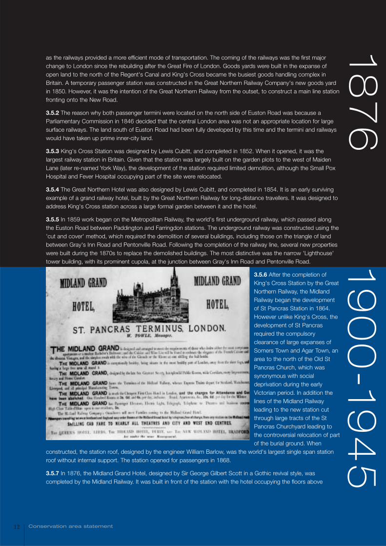
3.5.6 After the completion ofKing's Cross Station by the GreatNorthern Railway, the MidlandRailway began the developmentof St Pancras Station in 1864.However unlike King's Cross, thedevelopment of St Pancrasrequired the compulsoryclearance of large expanses ofSomers Town and Agar Town, anarea to the north of the Old StPancras Church, which wassynonymous with socialdeprivation during the earlyVictorian period. In addition thelines of the Midland Railwayleading to the new station cutthrough large tracts of the StPancras Churchyard leading tothe controversial relocation of partof the burial ground. When
constructed, the station roof, designed by the engineer William Barlow, was the world's largest single span stationroof without internal support. The station opened for passengers in 1868.
3.5.7 In 1876, the Midland Grand Hotel, designed by Sir George Gilbert Scott in a Gothic revival style, wascompleted by the Midland Railway. It was built in front of the station with the hotel occupying the floors above
13King’s Cross
history
14 Conservation area statement
station ground floor facilities. The hotel was developed as direct competition for the Great Northern Hotel. Thebuilding is now known as St Pancras Chambers.
3.5.8 The Midland Railway also built very extensive facilities for goods and coal traffic. These were mostly justoutside the Conservation Area and mostly do not survive, but the coal offices that flank part of Pancras Road, thevaults under St Pancras Station and some stables in St Pancras Way are amongst residual features.
3.5.9 The two rail termini, their associated hotels and freight facilities dominated the area and served as amonument to the industrial power of London and the significance of the King's Cross area during the Victorian era.Their construction stimulated the intensive development of residential, commercial, industrial and leisure premiseswithin the area during the latter half of the 19th Century.
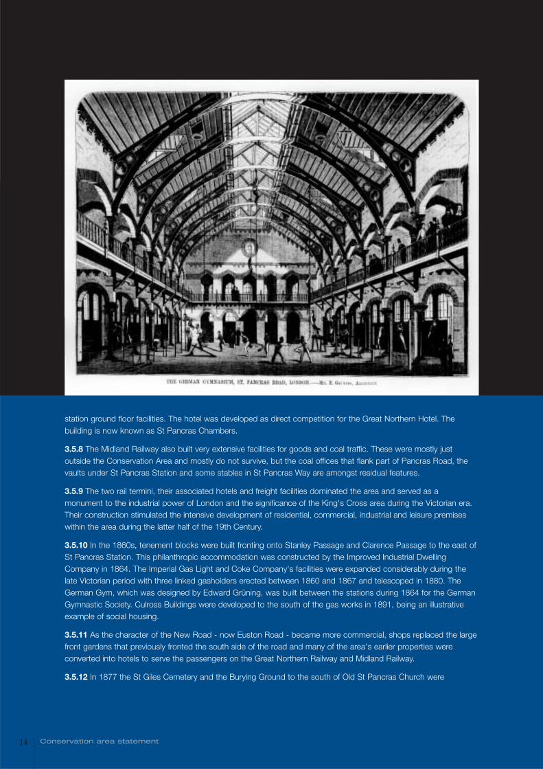
3.5.10 In the 1860s, tenement blocks were built fronting onto Stanley Passage and Clarence Passage to the east ofSt Pancras Station. This philanthropic accommodation was constructed by the Improved Industrial DwellingCompany in 1864. The Imperial Gas Light and Coke Company's facilities were expanded considerably during thelate Victorian period with three linked gasholders erected between 1860 and 1867 and telescoped in 1880. TheGerman Gym, which was designed by Edward Grüning, was built between the stations during 1864 for the GermanGymnastic Society. Culross Buildings were developed to the south of the gas works in 1891, being an illustrativeexample of social housing.
3.5.11 As the character of the New Road - now Euston Road - became more commercial, shops replaced the largefront gardens that previously fronted the south side of the road and many of the area's earlier properties wereconverted into hotels to serve the passengers on the Great Northern Railway and Midland Railway.
3.5.12 In 1877 the St Giles Cemetery and the Burying Ground to the south of Old St Pancras Church were
15King’s Cross
190
0-19
45
combined to form St Pancras Gardens, although the present gardens were not laid out until 1891 - by the Vestryand Midland Railways. At the rear of the gardens is the Coroner's Court, which was built in 1886. The St PancrasVestry Hall (later Town Hall) was situated within the Workhouse site facing Goldington Crescent, from 1848 until thepresent Town Hall in Euston Road was completed in 1937.
3.6 1900-19453.6.1 By the turn of the 20th Century, the principal features that now comprise the King's Cross Conservation Areawere in place. Nonetheless, several isolated developments took place during the first half of the century.
3.6.2 In 1904 the gas works situated on Goods Way were closed, although the gasholders continued in use andremained a dominant feature of the area until the early years of the 21st Century. In 1921, Goods Way wascompleted across the site of the gas works. In 1921 the Scala Cinema, with its prominent stuccoed baroquefrontage was developed at the southern termination of the Caledonian Road. In addition, the Piccadilly and NorthernLines were constructed during the early decades of the 20th Century, although their introduction had little impactabove ground.
3.6.3 In 1935, St Pancras Town Hall (now Camden Town Hall) was constructed on Euston Road opposite StPancras Station to designs by A.J. Thomas. In 1936, the Battle Bridge Flats were constructed as demonstrationproperties by the British Steelwork Association at the junction between Goods Way and Battle Bridge Road. Thefollowing year, the Royal Veterinary College was redeveloped, to designs by H.P.G. Maule and was reopened byKing George IV.
3.6.4 During the Second World War the area covered by the Conservation Area experienced extensive bombdamage, although both King's Cross and St Pancras stations escaped relatively intact. Damage to the west side ofKing's Cross station is still evident in the 'bomb gap' south of the suburban train shed. The most destructive bombdamage was experienced in the streets surrounding St Pancras Gardens and those to the south of Euston Road.During the war, there were several temporary buildings and air raid shelters to the north and south of the GreatNorthern Hotel.
3.7 1945-19963.7.1 The main concentration of development during this period involved the replacement of bomb-damagedproperties in the late 1940s. St Pancras Borough Council built Cecil Rhodes House opposite St Pancras Gardensand developed Chenies Place (designed by Thomas Sibthorpe) to the west of Pancras Road to provide replacementhousing. New flats were also built in Birkenhead Street to the south of Euston Road.
3.7.2 In 1977, Camden Town Hall was extended to the east. During the 20th century, new retail units weredeveloped within, or projecting forward of, existing buildings fronting Euston Road, Pentonville Road, Gray's InnRoad and King's Cross Road. A temporary single storey canopy was installed to accommodate a ticket office andpassenger concourse at the front of King's Cross Station in 1974. Temporary planning permission for 25 years wasgranted in 1971, which has been since renewed.
3.8 1996-20033.8.1 Parliamentary approval of the Channel Tunnel Rail Link Act 1996 enabled the construction of Britain's firstmajor new railway for over a century. When completed, this will comprise a high speed rail line running for 109km(68 miles) between the Channel Tunnel and St Pancras Station. The Act enables significant changes to the stationand its immediate surroundings to be carried out, outside of the usual planning process. The following majorchanges have occurred in connection with the CTRL development:
• Work has commenced on the CTRL terminus adjoining the northern end of the St Pancras Station train shed andtwo new road links have been laid out beneath it, one of which comprises the re-aligned west part of Goods Way;
• The western end of Goods Way has been realigned. It now passes beneath the partly constructed CTRL terminusand connects with Pancras Road to the west. As a consequence, the southern boundary of the Camley StreetNatural Park has been adjusted and the former Great Northern Railway stable buildings, gasworks cottages andan adjacent area with granite setts on Battle Bridge Road have been removed. The walls on the northern side ofGoods Way have also been demolished;
• Pancras Road has been re-routed to pass along the eastern side of the German Gym and Stanley Buildings. Therealigned road forms a gyratory system that passes beneath the station extension and connects to Midland Road,on the western side of the station;
• Midland Road has been adjusted north and south of Brill Place;
• Cheney Road and Weller's Court have been removed (the former Cheney Road alignment is partly used by thenew route of Pancras Road);
• Clarence Passage and Stanley Passage have been truncated to the west;
• The grade II listed triplet of interlocking gasholders located adjacent to Goods Way has been dismantled and theirguide frames and other components placed in storage near Goods Way, adjacent to the remaining no 8.gasholder. The components of the triplets and no. 8 gasholder remain listed. The brickwork tanks and the metaltelescopic bells of the triplets have been demolished. The unlisted group of two telescopic gas holders previouslysituated to the north of Goods Way and the unlisted southern gas holder of the pair located on the southern sideof Goods Way have been demolished. In addition, manual sump pumps, wheels and brackets of the guideframesand wrought iron handrail posts have been set aside for re-use, from the former gasholders;
• The grade II listed steam locomotive water point has been relocated from a site adjoining St Pancras Station, to asite overlooking St Pancras Cruising Club basin; and is now in the Regent’s Canal Conservation Area
• The retaining wall and the arches beneath the Midland Road frontage of St Pancras Station and the ancillarybuildings above them have been demolished to make way for the new Thameslink Station;
• The iron girder road bridges and viaduct carrying the Midland Railway lines north of St Pancras Station, whichincorporated extensive coal drops facing the former Pancras Road are being demolished in stages to make wayfor the new CTRL terminus;
• The northern and southern stable blocks built by the Great Northern Railway previously situated on Battle BridgeRoad have been demolished, as have the remains of the Midland Railway's road-transport depôt in that road;
• The experimental steel-framed Battlebridge Flats of 1937-7 at 1-4 Goods Way have been demolished;
• The blacksmith's forge, which previously abutted the eastern end of Culross Buildings has been demolished;
• The western block of Stanley Buildings (grade II listed) has been demolished, leaving two truncated blocks remaining;
• Alterations have been made to the grade II listed German Gym, including the removal of the main entrance and stair;
• Weller's Court Warehouse, formerly to the south of the German Gym, has been demolished;
• The shops and houses of 22-32 Pancras Road have been demolished;
• The two-storey Victorian goods yard offices and the flank wall of the King's Cross Suburban Station frontingCheney Road have been demolished;
• In the area to the west of the suburban platforms at King's Cross Station, the island platform and canopy, the v-plan milk platforms, the parcel transit area and the cobbled horse wharf platform have been demolished. Adecorated cast iron column and evidence of the hotel curve and cutting have also been removed from this areaand the entrance to the tunnel has been bricked up;
• The red brick single storey British Rail Staff Association (BRSA) building has been demolished. It previouslyoccupied a site to the north of the Great Northern Hotel;
• The porte cochère of 1852 on the western flank of King's Cross Station has been dismantled for the LUL worksand is in storage;
16 Conservation area statement
17King’s Cross
• The 1930s Red Star Parcels office, between King's Cross station and the Great Northern Hotel, has beendemolished;
• A new gas governor was built in 2002, close to the junction between Battle Bridge Road and Pancras Road.
• Miscellaneous items of street furniture have been removed and placed in temporary storage, under the provisionsof the CTRL Act, with the specific intention that they would be re-used in the area (unless parties agree otherwisefor specific items), including: granite setts and kerbstones; stone paving flags; granite and cast iron bollards(including those marked 'GNR' (Great Northern Railway)); Hayward's Patent Self-Locking Plate coal covers; castiron railings (including those marked 'GNR' and some featuring shields embossed with lions); and cast iron markerposts (including those marked S.P.P. [St Pancras Parish] 1854). Extensive archaeological recording of featuresdestroyed as a result of CTRL works has been undertaken, adding to the resource of information that is preservedby record.
3.9 2003 -2007 and beyond3.9.1 By the beginning of 2007, the works associated with the Channel Tunnel Rail Link, the new Thameslink station and the London Underground works (enabled by the CTRL Act) are anticipated to be complete. In essencethese include:
• the further demolition of the undercroft structures and bridges to the north of the existing St Pancras train shed;
• the erection of the St Pancras Station extension to the north of the existing train shed, a structure ofapproximately 19m in height and 100m by 240m in plan form;
• the refurbishment of the existing St Pancras Station to provide platforms and associated passenger facilities forEurostar trains;
• reinstatement of the original roof coverings to the train shed and the cleaning of external brickwork;
• the demolition and development of buildings to the west, Midland Road, side of the station to enable theconstruction of the new Thameslink station box and its fit out;
• the provision of new London Underground ticket halls to the west of King's Cross station and to the south of StPancras Chambers, together with the expansion of the existing ticketing hall. The former will have a directunderground link to the St Pancras Station extension;
• two new Underground entrances immediately south of Euston Road; a new larger entrance on the south-west ofthe concourse; and a large cladded ventilation unit on the concourse, with a smaller cladded unit to the east;
• a temporary ventilation shaft will be constructed in the 'bomb gap' on the western elevation of King's Crossstation, projecting above the parapet of the station; and
3.9.2 It is anticipated that 'Crossrail 2' (formerly the Chelsea-Hackney line) will include a new station on the south side of Euston Road, at a date after 2016; currently, there is uncertainty regarding the funding and timing ofthis project.
3.9.3 It is anticipated that applications plans for the conversion of St Pancras Chambers will be forthcoming in 2004. The Chambers require substantial works to convert them to viable use(s). This may include hotel andresidential uses. The forecourt to Euston Road will be reinstated after the LUL western ticket hall works underneathare completed.
3.9.4 Network Rail and the Strategic Rail Authority are also proposing to remove the 1974 single storey southerncanopy to King's Cross Station, as part of their proposals to provide a new western concourse for the station. This is required as a result of anticipated increased passenger demand. This is currently anticipated to be
18 Conservation area statement
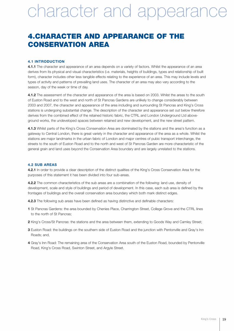
Willing House, Gray’s Inn Road
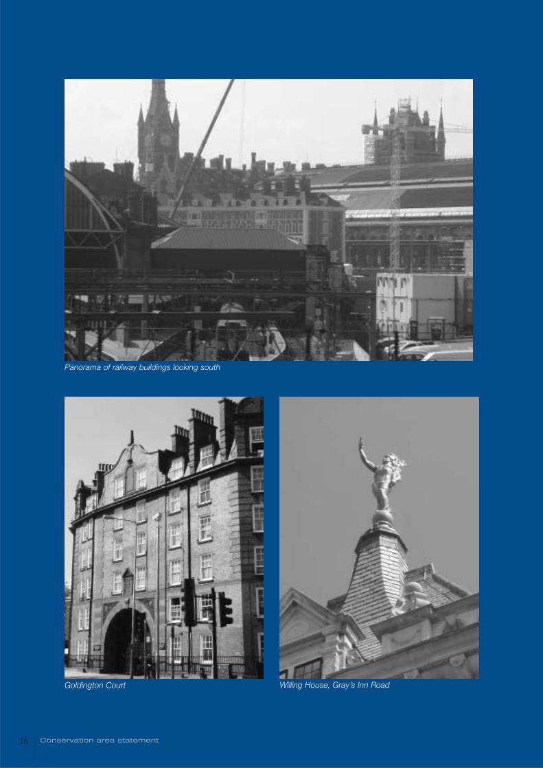
Panorama of railway buildings looking south
Goldington Court
4.CHARACTER AND APPEARANCE OF THECONSERVATION AREA
4.1 INTRODUCTION4.1.1 The character and appearance of an area depends on a variety of factors. Whilst the appearance of an areaderives from its physical and visual characteristics (i.e. materials, heights of buildings, types and relationship of builtform), character includes other less tangible effects relating to the experience of an area. This may include levels andtypes of activity and patterns of prevailing land uses. The character of an area may also vary according to theseason, day of the week or time of day.
4.1.2 The assessment of the character and appearance of the area is based on 2003. Whilst the areas to the southof Euston Road and to the west and north of St Pancras Gardens are unlikely to change considerably between2003 and 2007, the character and appearance of the area including and surrounding St Pancras and King's Crossstations is undergoing substantial change. The description of the character and appearance set out below thereforederives from the combined effect of the retained historic fabric, the CTRL and London Underground Ltd above-ground works, the undeveloped spaces between retained and new development, and the new street pattern.
4.1.3 Whilst parts of the King's Cross Conservation Area are dominated by the stations and the area's function as agateway to Central London, there is great variety in the character and appearance of the area as a whole. Whilst thestations are major landmarks in the urban fabric of London and major centres of pubic transport interchange, thestreets to the south of Euston Road and to the north and west of St Pancras Garden are more characteristic of thegeneral grain and land uses beyond the Conservation Area boundary and are largely unrelated to the stations.
4.2 SUB AREAS4.2.1 In order to provide a clear description of the distinct qualities of the King's Cross Conservation Area for thepurposes of this statement it has been divided into four sub-areas.
4.2.2 The common characteristics of the sub areas are a combination of the following: land use, density ofdevelopment, scale and style of buildings and period of development. In this case, each sub area is defined by thefrontages of buildings and the overall conservation area boundary which both mark distinct edges.
4.2.3 The following sub areas have been defined as having distinctive and definable characters:
1 St Pancras Gardens: the area bounded by Chenies Place, Charrington Street, College Grove and the CTRL linesto the north of St Pancras;
2 King's Cross/St Pancras: the stations and the area between them, extending to Goods Way and Camley Street;
3 Euston Road: the buildings on the southern side of Euston Road and the junction with Pentonville and Gray's InnRoads; and,
4 Gray's Inn Road: The remaining area of the Conservation Area south of the Euston Road, bounded by PentonvilleRoad, King's Cross Road, Swinton Street, and Argyle Street.
19King’s Cross
character and appearance
SUB AREA 1: ST PANCRAS GARDENS4.2.4 This sub area covers the northern section of the Conservation Area and crossesover the tracks of the elevated railway lines to the north of St Pancras Station. It is centredupon St Pancras Gardens and comprises a mix of residential and institutional uses, includingclusters of hospital and educational buildings in the northern part of the area.
St Pancras Gardens4.2.5 St Pancras Gardens occupies a triangular shaped space between Pancras Road andthe elevated railway lines to the north west of the CTRL terminal. The gardens laid out in 1891incorporate the greater part of the former burying grounds that adjoined St Pancras Old Church.Located on a low bluff beside the River Fleet, which was historically culverted below street level,the gardens and church lie above the level of Pancras Road and thus provide a reminder of theancient topography. The gardens are arranged around a radial network of pathways and containvarious sarcophagi, tombs and decorative memorial structures as well as mature trees. The gardens are surrounded by tall, decoratedwrought iron railings with an ornate gate providing an entrance to the gardens from Pancras Road. A gothic marblemonument incorporating a sundial (grade II listed) is situated near the entrance and commemorates the graves thatwere disturbed due to the construction of the Midland Railway. Nearby at a nodal point is a cast-iron drinkingfountain of 1877 in the form of a circular temple of five attenuated Corinthian columns (listed at grade II). The mostprominent of the memorial structures is the grave of Sir John Soane and family (grade I listed), a marble monument,which is set beneath a Portland stone canopy within a low balustrade.
4.2.6 St Pancras Old Church (grade II*listed) is set in its own grounds within St Pancras Gardens and is served by aseparate entrance from Pancras Road. The small church is constructed of coarse stone with a flint eastern façadeand a pantiled and slated roof. Its amalgam of architectural styles and materials reflect several episodes ofrestoration, alteration and extension. The narrow western elevation facing Pancras Road is dominated by an archedentrance surrounded by decoratively carved mouldings and set within a small porch. The porch is flanked by archedlancets and surmounted by a circular window. The Church's northern elevation comprises five windows serving thenave plus a 19th Century extension decorated with Lombard friezes. A projecting tower with round arched lancetsand a half-timbered belfry added during the 20th Century dominates the church's southern flank.
4.2.7 The Gardens are bounded by metal railings, through which buildings are visible on all sides, either within thesite as on the south and east sides, or beyond the boundary on the north and west. These buildings (describedelsewhere) form an intermittent boundary and views through and beyond are afforded on all sides.
4.2.8 Within the gardens are three buildings. The Environmental Health Centre at the north east corner is a twostorey 1960s building with red tiled projecting first floor supported on pillars. The St Pancras Coroner's Court to thesouth is a single storey red brick building with an attic level set within a slate roof. The St Pancras Gardens elevationincludes a large central bay housing an arched sandstone window, which is divided into smaller arched panels. Thiscentral bay is flanked by smaller arched windows, again with sandstone surrounds. Triangular dormer windows areset within the roof of the building, which also incorporates terracotta detailing and tall 'pointed' chimneys. The rearextension to the Coroner's Court, which fronts Camley Street, starkly contrasts with the form and appearance of thebuilding's original St Pancras Gardens elevation, being of two storeys above basement level garages, with an angledtwo-storey bay constructed of grey blocks. In the north west corner is a building of a form that suggests a park
20 Conservation area statement
keeper's cottage, located next to the main entrance. It has three storeys, of yellow stock brick with red dressings,and a tile hung first floor level, prominent white painted eaves and a tall central chimney.
St Pancras Hospital4.2.9 To the north and west of St Pancras Gardens is a collection of buildings comprising the St Pancras (UniversityCollege) Hospital. This is on the site of the former St Pancras Workhouse; the current layout of three sectionsdivided by access roads dates to c1890 when the earliest of the current buildings were erected.
4.2.10 The original Infirmary, which fronts Pancras Road at the west side of St Pancras Gardens and dates tobetween 1880-1895, is five storeys in height, plus a central attic level and is constructed of stock brick with redbrick detailing. It is a substantial example of the workhouse infirmary buildings that were erected in London underthe Metropolitan Poor Act of 1867. The long, imposing Pancras Road façade is subdivided into eight bays, whichare surmounted by tall gables with gothic detailing, and a flat central section. The building is surmounted by acentral brick tower with pitched slated roof, which rises to a height of approximately four storeys above the mainbody of the building and is visible in views from the west beyond the Conservation Area boundary. Smaller towersare arranged symmetrically at each end of the building.
4.2.11 On the main site, the southern section, bordering St Pancras Gardens to the south, comprises a gatehouse, achurch and four blocks, three to the west erected by the 'St Pancras Guardians of the Poor' in 1890 as workhouseaccommodation, and the eastern most (Hospital for Tropical Diseases) built in the 1950s. Fronting St Pancras Way isa three-storey range in yellow stock brick with red brick detailing. This is the southern half of and originallysymmetrical pair of gatehouses dating to c1890. The church dates to the early 20th century, and is a simple form witha nave and single storey aisles on either side. It is in yellow stock brick with red brick dressings to match the adjacentbuildings, and to the rear is a contemporary church hall structure, in matching materials with lancet windows. Both ofthese buildings are now used as offices. To its east, the two interconnected blocks are of five storeys, in yellow stockbrick with red brick to ground floor and detailing above and have tall narrow timber sash windows and pitched slateroofs. Their height and tall narrow form is an imposing element within the site and in views from St Pancras Road. Thethird block is of 3 storeys in similar materials as its neighbours, but has a less imposing appearance. It has chimneyflues expressed on the flank elevations, slated gables above the rear wings and its southern façade incorporates alarge recessed arch. The 1950s block respects the scale, bulk and building line of its neighbours, but is otherwisearchitecturally undistinguished. It is constructed of brown brick with a flat roof, small projecting porch to the mainentrance and an external cranked staircase in rendered concrete on the east elevation.
4.2.12 The central section contrasts in scale and form to the southern section and comprises three blocks. Theeastern two comprise a cluster of 1, 2 and 3 storey buildings in yellow stock with red dressings, contemporary withand matching the Workhouse buildings to the south. Slight variations in roof forms (slate roofs either hipped or withgables), window details (round or square headed) and the presence of simple decoration such as projecting brickcourses at eaves level makes the group attractive and varied yet with a strong consistency of form and materials. Atthe centre of this group are a chimney and a water tower, which are visible in views from Granary Street, and act asa local landmark. The westernmost building is a 2 storey brown brick building of 1980s date, with timber cladding atfirst floor and tiled roofs pitched towards a central courtyard. This sits at a lower level on the site and causes a visualgap and a marked change in scale between it and the tall buildings to the south.
21King’s Cross
4.2.13 The northern section again comprises three blocks which replace 1890s workhouse buildings. To the east isa 1930s two storey block, in yellow and stock brick with brown brick dressings, a pitched tiled roof and timber sashwindows. It has a domestic scale and appearance. To the west are two interconnecting late 20th century blocks, inyellow brick with shallow pitched tiled roofs and metal windows. These respect the scale, form and building line ofthe neighbour to the east but are poorly detailed. The third block is a two storey prefab-type building, whichrespects the prevailing scale and layout, but its design and materials visually detract from the character andappearance of the whole site.
4.2.14 The site is surrounded by a continuous stock brick boundary wall. The northern side, along Granary Street, isof several phases and the earliest parts may belong to the original workhouse of 1890.
Goldington Crescent Gardens and St Pancras Way 4.2.15 Goldington Crescent Gardens forms an elongated oval shaped green space occupied by mature trees andsurrounded by cast iron railings at the junction between Pancras Road, Crowndale Road, Royal College Street and
St Pancras Way. The space serves as a focal pointfor the northern section of the Conservation Area.
4.2.16 To the north of Goldington Crescent Gardens,Goldington Court, a municipal housing estate, issituated at the junction between Pancras Road,Royal College Street and Pancras Way. This is theearliest municipal housing in the borough. Itcomprises five connected blocks with a central court,which is accessed through an arch situated oppositethe gardens. The blocks are five storeys in heightplus an attic storey set within a mansard roof. Theyare constructed of stock brick with red brickwork atground and first floor level and in the staircase bays
which articulate the facades. Decorated gables and tall chimneys contrast with the slate roofs of the blocks. Theentrance arch is decorated with carved brick panels and painted artificial stone voussoir blocks, and is surmountedby a crest.
4.2.17 Goldington Crescent (also Goldington Buildings) (grade II listed) forms a curved block overlooking theGardens. The Crescent comprises a terrace of five storey properties and is constructed of stock brick with orangebrick detailing.
4.2.18 Goldington Crescent Gardens forms an elongated oval shaped green space occupied by tall mature treesand surrounded by modern cast iron railings at the junction between Pancras Road, Crowndale Road, Royal CollegeStreet and St Pancras Way. The space is a nodal point, but because of the busy traffic and linear shape is has notbecome a static space.
4.2.19 To the north of Goldington Crescent Gardens, Goldington Buildings, an early 20th century municipal housingestate, is situated at the junction between Pancras Road, Royal College Street and Pancras Way. It comprises fiveconnected blocks with a central court, which is accessed through an arch situated opposite the gardens, and is aprominent feature in views up Pancras Road. The blocks are five storeys in height plus an attic storey set within amansard roof. They are constructed of stock brick with red brickwork at ground and first floor level. Decoratedgables and tall chimneys contrast with the slate roofs of the blocks. The entrance arch is decorated with terracottapanels and mouldings reading 'Goldington Buildings, AD 1903'.
4.2.20 Goldington Crescent (grade II listed) forms a curved block overlooking the Gardens. The Crescent comprisesa terrace of three-storey properties dated 1849-50 and is constructed of stock brick with orange brick detailing, withstucco to ground floor. The terrace has small front gardens bounded by modern iron railings set on a low brick wall.
4.2.21 A short section of St Pancras Way to the north of Goldington Crescent Gardens is situated within the King'sCross Conservation Area. The buildings within this stretch are diverse, and the streetscape is generally poor, but itdoes include some buildings of architectural or historical value, namely at no.7. Nos. 1-3 is a plain two storey 20th
22 Conservation area statement
century warehouse building with steel framed windows. No. 5 is a plain late 19th century three storey warehousebuildings with painted façade. These three buildings detract from the appearance of St Pancras Way. However, theirrear elevation, which is visible from Royal College Street, is more coherent and intact, and bears paintedadvertisements. At no.7 St Pancras Way are two former Midland Railway stables buildings from the 1860s, theresidue of a large stables complex that formerly extended for 200m northwards. The frontage block is of two storeyswith blind, round arched windows at ground floor and stone lintels at first floor. It bears a painted sign reading'South Stalls' on the St Pancras Way elevation. The entrance way and courtyard are paved in granite setts. The rearblock is similar but a single storey only, with roof ventilators and very tall cast iron pillars internally. The adjacentresidential property at No. 9 St Pancras Way is a large three-storey double fronted dwelling plus basement dating tothe 1860s, which is constructed of red brick of a distinctive north-Midlands type, with cream brick detailing atground floor level. The property has decorated lintels at first floor level and a modern porch surmounting theunadorned front door, and substantial iron railings to a small front area set on a low wall and was probably intendedfor a Midlands Railway manager.
4.2.22 Nos. 7 & 9 St Pancras Way are rare vestiges of the Midland Railway's major goods yard, granary and alestores complex at Agar Town.
The Royal Veterinary College4.2.23 The three large blocks of the Royal Veterinary College form a consistent street elevation on the eastern sideRoyal College Street. The southernmost College building is a three-storey block plus attic level, which wasconstructed in 1924 in red brick. It has an arched central entrance with sandstone surround, which is surmountedby a two-storey hexagonal bay with horizontal bands of windows with sandstone surrounds, above a painted crest.Five dormer windows are set within the slate roof and a chimney set to one side of the entrance bay.
4.2.24 The central block of the Royal Veterinary College consists of four storeys plus an attic level and surroundstwo central courtyards. The building, designed by H.P.G. Maule, was constructed in 1936-37 and is formed ofbrown brick with red brickwork at ground floor level. The prominent central entrance to the building is surrounded bydecorated stonework, which also surrounds the central window at first floor level. The entrance is again surmountedby a coloured crest. Like the adjacent red brick properties, the building is symmetrical in form.
4.2.25 The buildings to the north of the Royal Veterinary College, at the boundary of the Conservation Area, housethe Beaumont Animals' Hospital. The three-storey red brick building fronting Royal College Street is similar in formand origin to the southernmost building of the Royal Veterinary College, though is smaller and less detailed than thelatter. A more recent block, constructed of yellow brick with red brick detailing is situated to the rear of this building,but it is not visible from Royal College Street.
Cecil Rhodes House and Pancras Road 4.2.26 Cecil Rhodes House and The Chenies arelarge blocks of flats, set at an angle on the westernside of Pancras Road overlooking St Pancras OldChurch and St Pancras Gardens. They form adistinctive group of late 1940s municipal housing.Cecil Rhodes House consists of four connectedresidential blocks of eight and ten storeys in height.The blocks are constructed of brown brick andtheir Pancras Road elevation have imposing, fullheight vertical windows constructed of glass bricksset infront of the central stairwells. At their basesare vertical rendered fins, and on either side ateach floor are short curved brick balconies. TheChenies comprise a connected pair of eight-storey
blocks, which are identical to the adjacent blocks of Cecil Rhodes House. From in front of these buildings views ofthe rear of the Barlow Train shed and the spire of St Pancras Station are visible in southerly views.
23King’s Cross
24 Conservation area statement
Charrington Street to Goldington Street4.2.27 At the Conservation Area's western boundary,Charrington Street, Penryn Street, Goldington Streetand Medburn Street are lined with uniform residentialterraces dating from the mid-19th Century. Those onthe latter two streets are grade II listed. The propertieson all of these streets are constructed of London stockbrick with rusticated stucco at ground floor level andshallow butterfly roofs set behind parapet walls. Mostare three storeys in height plus a basement level,although the corner properties in the northern-mostterrace, 44-65 Charrington Street, have a 4th storey.The terraces are largely undecorated, although all havearched entrance surrounds, small cast iron balconies at first floor level and have front areas with modern cast ironrailings. Nos. 18-21, 32-41 and 42-46 Charrington Street also have stucco window surrounds at first floor level. Twoelongated communal green spaces are situated in place of the original rear gardens to Charrington Street,Goldington Street and Penryn Street houses. Views of unaltered rear elevations and butterfly roof lines are visiblealong these terraces from Medburn Street and Platt Street.
4.2.28 The eastern side of Goldington Street and views east along Medburn Street are terminated by the rearelevations to the tall blocks of Cecil Rhodes House and The Chenies. The buildings' rear elevations have similardetailing with use of panels of glass blocks and curved brick balconies. A single storey community hall, which is alsoof 1940s date is situated to the rear of The Chenies. The small building is seen in the context of the much largercylindrical glass block structure, above the entrance bay. The tower of St Pancras Station is visible in viewssouthwards along Goldington Street.
4.2.29 Unity Mews, which is situated to the rear of the buildings fronting Goldington Crescent, is a more recentaddition to the Conservation Area, dating from 1992. The western side of the Mews consists of a three-storey blockflanked by subordinate two-storey terraces. The group of properties is constructed of pale brown brick with slateroofs. The eastern side of the street includes the rear elevation to Nos. 5-16 Goldington Crescent. A metal plaque atthe Chalton Street entrance to the Mews records the site of the Unity Theatre, which occupied the site between1936 and 1975, as does an inscription into the brickwork at first floor level.
4.2.30 The northern side of Platt Street is lined with two short terraces of properties identical to those on adjacentstreets, however the southern side of the street is formed by Somers Close, which comprises late 20th centurythree-storey connected blocks. These blocks, which are accessed via a central courtyard, respect the surroundingbuilt form in terms of scale, form and materials, and are a sensitive addition to the area. They are built in stock brickwith black painted metal railings and gates.
4.2.31 Outside the boundary of the Conservation Area, but contributing visually to the southern end of PancrasRoad (at nos 119-149) is a long line of coal merchants' offices and shops, which are the last remaining feature ofthe Midland Railway's Somers Town Coal Depot of the late 1890s. They have grand red brick gothic arches, withelaborate window joinery in the manner of the undercroft of St Pancras Station. They are a rare survival and arelisted grade II.
character
26 Conservation area statement
SUB AREA 2: KING'S CROSS/ST PANCRAS4.2.32 Sub-area 2 forms the heart of the King's Cross Conservation Area. Itincludes the stations and extends to Midland Road to the west and York Way tothe east, Goods Way to the north and Euston Road to the south. The southernpart of Camley Street to the north of Goods Way is also included in this SubArea.
4.2.33 This part of the King's Cross Conservation Area has experienced, and willcontinue to experience, the greatest degree of change between the passing ofthe CTRL Act and completion of CTRL works at the end of 2006. Some of thebuildings and structures and hard landscaping that contributed to the urban grainbetween the stations have been dismantled or removed and the street layout hasbeen in part altered. This has, in turn, opened up new views.
4.2.34 The sub area juxtaposes:
• monumental Victorian engineering and architecture;
• buildings and structures associated with the railways;
• Victorian workers' housing, now vacant;
• a current construction works site.
4.2.35 Despite the changes that have occurred, the area retains a robust industrial character, mostly Victorian.
4.2.36 The two stations, both grade I listed, form a part of our architectural and historical heritage and are ofnational importance; they form a national set piece. They are the most dominant elements of this area in terms ofscale and use. With their wide train shed roof spans, they are also examples of technological virtuosity. Togetherwith the Great Northern Hotel, this group reflects the power of the Railway age and is of notable historic value. It isthe most important group of railway buildings in Britain. The extension of St Pancras train shed using newtechnology is in keeping with the tradition of that of the railway stations.
4.2.37 Together with the Goods Yard complex in Regent's Canal Conservation Area, the industrial landscape is amajor heritage resource both nationally and internationally. They are a very important area of nineteenth centurycanal, railway industrial, commercial and (former) residential buildings and structures. They have a rarity value, withthe national loss of 19th century industrial buildings. "Nowhere else in London provides such a coherent illustrationof what happened when the railways arrived and the full range of development they engendered" (GLC DesignationReport, GLC HB 744, 12 December 1985) (this observation predates the CTRL works which changed the area).
4.2.38 The uses are commercial, industrial, transport, and temporary work sites. There are a number of temporaryportacabins and kiosks associated with the work sites.
4.2.39 The main building materials are hand-made red and yellow London stock brick with dark blue engineeringbrick; Welsh slate for roofs; limestone and sandstone for lintels, sills and copings, and sandstone for bridgeabutments and tunnel portals; softwood for external doors and windows; stucco, mostly in applied architecturalmouldings, and cast and wrought iron. The external materials for the St Pancras train shed extension are mostlysteel, concrete and glass. Glass is used in the two mainline station roofs.
4.2.40 The buildings are in generally sound condition and where vacant, in the case of the Gym, Culross andStanley buildings and the Great Northern Hotel, they are being monitored and are not considered at risk. The tripletsand the St Pancras Chambers are on English Heritage's 'Buildings at Risk Register'. Although the triplets arestructurally sound and in a secure site, no decision regarding their potential relocation has been made, althoughthere is a legal agreement that provides a mechanism for their re-erection to the north of the canal within theOpportunity Area. Negotiations are in hand regarding the triplets' relocation. Negotiations are in hand regarding thefuture use of the Chambers. The buildings and structures were well constructed and have proved to be durable. Thevacated East Side Buildings to St Pancras station will be converted and refurbished as part of the CTRL works.
27King’s Cross
4.2.41 The historic floorscape is mostly confined to Battle Bridge Road with its traditional granite setts and kerbs.Materials from other historic floorscapes are in store and may be capable of reinstatement in many instances.
St Pancras Chambers4.2.42 St Pancras Chambers (grade I listed) was built to a 1865-67 design by George Gilbert Scott, who won thedesign competition for the project. The Chambers has a flamboyant and towering appearance. It was built from1868-1876. The Chambers dominates its surroundings in scale and decoration and is an important local landmark.It is testament to the area's former and current significance and serves as one of the greatest monuments toLondon's power and affluence during the Victorian period.
4.2.43 The Chambers was built as the Midland Grand Hotel by the Midland Railway in such a form as to make thepresence of the station and hotel highly visible over a wide local area. It has six storeys, two being attic storeys, witha deep basement. The hotel was built in front of the station, with the hotel occupying the floors above the station'sground floor facilities. Because the railway was built over the Regent's Canal, the corresponding height of theplatforms and station was high above street level. It is set back behind the steep vehicle ramp of the forecourt,where vehicles would proceed one-way round a sharp bend. Below the forecourt, also designed by Scott, is a tallwall rising above the pavement, with bays on street level. To the west of the main elevation is the five bay mainentrance to the hotel, with porte-cochère; this bay is aligned straight with the street, whereas the rest of the mainelevation is set at an angle to the street; a curved section joins the left bay with the middle tower. The station,forecourt and shed are all stylistically unified.
4.2.44 It is a very complex and eclectic design comprising various elements of Flemish, Lombardic, Venetian andMilanese Gothic, with details from English and French cathedrals. Building materials are very diverse: the mainmaterial is the deep red 'Gripper's' patent Nottingham brick. The Euston Road façade is variously decorated withterracotta, grey and red granite, limestone and Portland stone. Limestone was from Ancaster and Ketton, sandstonefrom Mansfield, to be a showcase for materials from the Midlands and north of England. The roofs were re-slated in1992-1996 and are covered with Cumbrian slates to the front; the back of the roof is a mixture of salvagedLeicestershire slates from the original covering and Cumbrian slates.
4.2.45 On the ground floor are round arched ground floor openings and two larger vaulted arches. The floors aboveground floor level are decorated with two and three light windows with colonettes, elaborate carving and a Lombard frieze below a deep balustraded parapet. Two rows of gabled windows are set within the building's steeplysloping roof.
4.2.46 The skyline is very varied. From west to east, there is the stepped gable and two turrets to the left, then thelarge western tower over the main entrance is three storeys above the body of the building and consists of a steeppavilion roof, carved arcaded windows, friezes and corner spires. Then there are three stepped gables and two rowsof many dormers. The eastern clock tower is a storey higher, yet is slimmer and in the manner of Big Ben. Thistower is an important local landmark. It incorporates a large oriel with gabled clocks on each face and is decoratedwith pinnacles and a spire.
4.2.47 There are several viewpoints of the Chambers along Euston Road, where the Chambers forms a dominantpart of the street scene. It is an important local landmark, with its rising mass. Other key views are from PentonvilleRoad and Gray's Inn Road. The Chambers forms framed views from other streets including Judd Street and Argyle
28 Conservation area statement
Street. The huge mass of the train shed and the Chambers are prominent in views from Euston Road looking northalong both Midland Road and Pancras Road.
St Pancras Station and the Barlow train shed4.2.48 A significant extent of the huge single-span St Pancras Station train shed (1865-1868) forms the westernedge to the space between the stations. It was designed by the Midland Railway engineer William Barlow, assistedby R M Ordish, with design input by George Gilbert Scott. The shed has a span of 80m and length of 200m long.When built, it had the widest span of any roof in the world. This grade I listed structure is described by Pevsner as"one of the outstanding surviving examples of Victorian functionalism and daring" [op cit, p 365]. It remains one ofthe most impressive train sheds in the world. The wrought iron arch ribs meet to form a slightly pointed apex, whichgives it a more Gothic character. The north gable, with its lattice girdered and glazed windshield, is the mostprominent part of the train shed roof externally, and rises above the new extension roof. Only the uppermost part ofthe roof is glazed. The CTRL works will include its refurbishment. The two-storey red brick East Side Buildings onPancras Road will be refurbished with glazing to the openings at first floor level, providing natural light to offices andground floor level doors and windows to the departures area. The West Side Buildings have been demolished, butwere similar to those on the Chambers and Euston Road frontages. To Midland Road is the Gothic Revival bookinghall (part of Barlow House) of 1869, which has a lower roof than the main buildings.
4.2.49 There is a view looking into the Conservation Area from Brill Place to the Barlow shed. The towers of theChambers are just visible. An extensive view of the St Pancras extension will form a major part of this view and theshed will form a clear edge to the Conservation Area.
Midland Road4.2.50 Midland Road forms the western edge of Sub Area 2. The southern end ofMidland Road is dominated by the British Library to the west, just outside theConservation Area and by St Pancras Chambers. The Library has a long elevation of redbrick. Further north, extensive oblique views of the demolished area of the St PancrasWest Side Buildings and the station extension and worksite are apparent.
King's Cross Station4.2.51 King's Cross Station (grade I listed) was designed by Lewis Cubitt, with theengineer Joseph Cubitt and was built in 1850-1852. It is at the eastern end of EustonRoad and dominates the junction with York Way, Pentonville Road and Gray's Inn Road.The façade of the station addresses Euston Road and is set at an angle to it. The station has a completely different character to St Pancrasstation and Chambers. King's Cross is more restrained,being in a plain Italianate style. The façade reflects theplan of the station and its internal roof arrangement,which St Pancras does not. King's Cross' hotel isseparated from the station by some distance, whereasSt Pancras' hotel is directly in front of its train shed.
4.2.52 With its scale and sense of geometry, theEuston Road elevation has a striking and powerful
façade. 'The Builder' described it thus: 'The building will depend in its effect on the largeness of some of itsfeatures, the fitness of the structure for its purpose, and a characteristic expression of that purpose' [quoted inPevsner, p 362]. The elevation is dominated by two very large, semi circular arches. The façade reflects the plan ofthe station and reveals the cross section of the station's interior, with two round arched train sheds. The form of theroof arches is therefore expressed boldly in the Euston Road elevation. The western shed was originally fordepartures and the eastern shed for arrivals. At the foot of the arches are two plain three-bay arcades withsegmented arches, being access into the station. There are full-height projecting piers to the sides and middle; aplain cornice unifies the elevation. The station is of unadorned yellow London stock brick. The elevation issurmounted by a clock tower in the middle in the Italianate villa style, 120 ft high. The roofs originally had laminatedtimber ribs, replaced by ribs of wrought iron in 1869 and 1887.
4.2.53 On the eastern side of the southern façade, a third, smaller and elliptical, arch marks the covered taxi cabroad for passengers by taxi. Two storeys of yellow brick were added in 1869. The three-storey booking office, ofyellow brick, was the main entrance range and is to the station's western side.
4.2.54 The temporary single storey ticket office and canopy structure to the front of the station southern canopy ofthe station was constructed in 1974 and was designed by British Rail's Regional Architect's Department. It is single-storey with a profiled metal façia, which obstructs full view of the elevation; its removal would create the opportunityfor more extensive views of these. The canopy has an oppressive character. It is anticipated that the concourse willbe removed as part of a proposed western concourse. There is an opportunity for the area immediately in front ofthe station to be a new public space of the highest quality, which integrates the surrounding buildings. The triangularspace will include hard landscaping and will afford views of the façade to King's Cross Station, the flank elevation toSt Pancras Station, the eastern tower to the former Midland Grand Hotel and the flank and rear of the GreatNorthern Hotel. The area between the Great Northern Hotel, St Pancras and the King's Cross modern concourse iscurrently a construction site for the LUL ticket hall and is surrounded by hoardings. Further description of the stationcomplex is given below.
4.2.55 The Great Northern Hotel, King's Cross station and the Chambers are prominent in views from just south-east of the canopy. The main elevation of the station is prominent in views from local streets including Gray's InnRoad, Euston Road, Pentonville Road, Birkenhead Street and Crestfield Street.
The Great Northern Hotel4.2.56 The Great Northern Hotel, also designed by the architect Lewis Cubitt, was opened in 1854. It has five and ahalf storeys with attic storey and basement and was tall for its time. It is built on a curved plan, for the followingreason: the western elevation follows the curved alignment of Old St Pancras Road immediately to the west. Thisroad was realigned to the west to its present location after the hotel was built. The eastern side of the hotel wasdesigned to directly address the western elevation to King's Cross Station, where the projecting booking officeforms the focus of the western range. The central doorway of the former booking office appears to be the geometricfocus of the hotel's curved elevation. There are attached railings to the basement areas at front and back.
4.2.57 The curved form presents a pleasing contrast with the long straight side elevations of the stations. The hotelis Italianate in style; with its classical details, it is more elaborate than its station. It has a hipped slate roof with tallchimneys. It is built of yellow stock brick with stucco details. The eastern elevation has a six-window central bay andfive-window outer bays, separated by staircase bays with tripartite windows, slightly projecting. The ground floor
29King’s Cross
windows are plain and semi circular headed and the windows to the first, second and third floors are squareheaded, with moulded stucco architraves. The fourth floor windows are plain and the dormer windows are havepediments. The treatment of windows to the main elevation therefore is progressively simpler from the 1st floor up.Stucco stringcourses are between the ground, first and second floors and there is a deeply moulded main cornicewith dentil course above the top floor. The west elevation is longer than the east elevation and is similar. It has sevenbays of windows in the central section with five bays to the sides. The rear staircase bays are set forward from thehotel's building line and have rusticated pilasters. The corners have deeply moulded quoins. A single storeyextension and a white painted fire escape on the west elevation detract from the overall quality. The end elevationshave rectangular windows with mouldings.
4.2.58 The hotel is an important component in a group with the stations. It also has its own strong, but not over-bearing, presence. When viewed from areas south east of King's Cross station, including looking west from Gray'sInn Road, the south east elevation can be seen directly. Views of it are also framed between the two stations, forminga strong ensemble. It is also visible in views from streets perpendicular from Euston Road, where this view is framed.
The west side of King's Cross station and the German Gymnasium 4.2.59 The western elevation of King's Cross Station includes - from south to north - the range of three and fourstorey former booking office and waiting rooms, an entrance building with tall Venetian windows, a gap left followingSecond World War bomb damage and an office building. The former booking office and main entrance is a range ofthree to four storeys, with Venetian windows. In the space between the local and the main station is courtyard withtwo-storey offices, with 'Parcels Office' inscribed in stucco on its south end wall.
4.2.60 All of a similar period, the yellow stock brick buildings reflect the design of the main station building. Thewrought iron trussed porte-cochère has been temporarily removed because of the LUL ticket hall constructionworks and is currently in storage. It has a technically interesting wrought iron roof. The removal of other single storeybuildings within the space between the stations has exposed this grand, albeit incomplete, range to view. The LocalStation train shed (now platforms 9 - 11) was re-built for the Great Northern Railway's suburban services, whichextended in 1894-5, with a functional character clearly deriving from its purpose. It has a trussed girder roof withmetal and glass porte-cochère. To the west of the entrance, is an office range of yellow brick with red brickdressings. The stepped red brick detailing is similar to that on the side elevations of the German Gymnasium.
4.2.61 From a point close to the eastern corner of the German Gymnasium looking south, a wide panorama of thespace between the stations has been opened up. This is due to the demolition of various buildings under the CTRLAct, including the Red Star parcels building formerly between King's Cross station and the hotel. This panoramaacross the former London Underground construction site includes the suburban train shed and King's Cross Stationwestern range to the left, the Great Northern Hotel with the eastern tower of St Pancras Chambers appearing aboveit and the eastern frontage of the Barlow train shed and roof, which will be re-glazed. The curved elevation of thehotel in perspective adds to the attractiveness of this view. The view therefore contains a group of buildings ofsignificant heritage importance. Whilst the main frontage to King's Cross Station and St Pancras Chambers primarilyrelate to Euston Road, and are therefore described later, the western range of King's Cross Station and the Barlowtrain shed primarily address the space between the stations to the south of the German Gymnasium.
4.2.62 The grade II listed German Gymnasium (1864-5) to the south of Stanley Buildings Built at the same time asStanley Buildings (1864), it was a unique, purpose-built gym for the German Gymnastic Society and designed byEdward Grüning. The gym is of great historic and aesthetic importance. It was part of the movement towards the
30 Conservation area statement
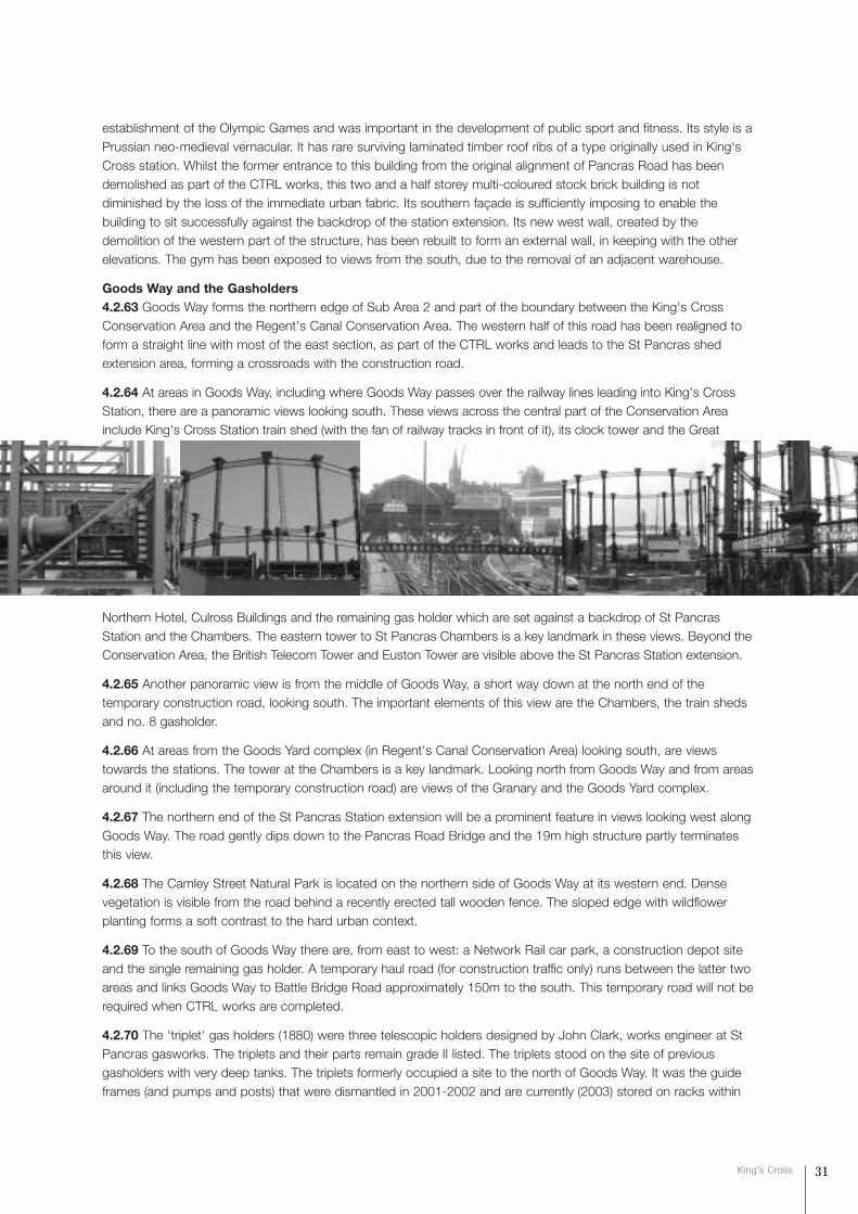
establishment of the Olympic Games and was important in the development of public sport and fitness. Its style is aPrussian neo-medieval vernacular. It has rare surviving laminated timber roof ribs of a type originally used in King'sCross station. Whilst the former entrance to this building from the original alignment of Pancras Road has beendemolished as part of the CTRL works, this two and a half storey multi-coloured stock brick building is notdiminished by the loss of the immediate urban fabric. Its southern façade is sufficiently imposing to enable thebuilding to sit successfully against the backdrop of the station extension. Its new west wall, created by thedemolition of the western part of the structure, has been rebuilt to form an external wall, in keeping with the otherelevations. The gym has been exposed to views from the south, due to the removal of an adjacent warehouse.
Goods Way and the Gasholders4.2.63 Goods Way forms the northern edge of Sub Area 2 and part of the boundary between the King's CrossConservation Area and the Regent's Canal Conservation Area. The western half of this road has been realigned toform a straight line with most of the east section, as part of the CTRL works and leads to the St Pancras shedextension area, forming a crossroads with the construction road.
4.2.64 At areas in Goods Way, including where Goods Way passes over the railway lines leading into King's CrossStation, there are a panoramic views looking south. These views across the central part of the Conservation Areainclude King's Cross Station train shed (with the fan of railway tracks in front of it), its clock tower and the Great
Northern Hotel, Culross Buildings and the remaining gas holder which are set against a backdrop of St PancrasStation and the Chambers. The eastern tower to St Pancras Chambers is a key landmark in these views. Beyond theConservation Area, the British Telecom Tower and Euston Tower are visible above the St Pancras Station extension.
4.2.65 Another panoramic view is from the middle of Goods Way, a short way down at the north end of thetemporary construction road, looking south. The important elements of this view are the Chambers, the train shedsand no. 8 gasholder.
4.2.66 At areas from the Goods Yard complex (in Regent's Canal Conservation Area) looking south, are viewstowards the stations. The tower at the Chambers is a key landmark. Looking north from Goods Way and from areasaround it (including the temporary construction road) are views of the Granary and the Goods Yard complex.
4.2.67 The northern end of the St Pancras Station extension will be a prominent feature in views looking west alongGoods Way. The road gently dips down to the Pancras Road Bridge and the 19m high structure partly terminatesthis view.
4.2.68 The Camley Street Natural Park is located on the northern side of Goods Way at its western end. Densevegetation is visible from the road behind a recently erected tall wooden fence. The sloped edge with wildflowerplanting forms a soft contrast to the hard urban context.
4.2.69 To the south of Goods Way there are, from east to west: a Network Rail car park, a construction depot siteand the single remaining gas holder. A temporary haul road (for construction traffic only) runs between the latter twoareas and links Goods Way to Battle Bridge Road approximately 150m to the south. This temporary road will not berequired when CTRL works are completed.
4.2.70 The 'triplet' gas holders (1880) were three telescopic holders designed by John Clark, works engineer at StPancras gasworks. The triplets and their parts remain grade II listed. The triplets stood on the site of previousgasholders with very deep tanks. The triplets formerly occupied a site to the north of Goods Way. It was the guideframes (and pumps and posts) that were dismantled in 2001-2002 and are currently (2003) stored on racks within
31King’s Cross
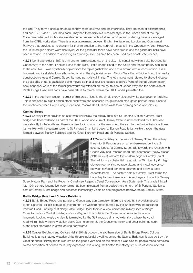
this site. They form a unique structure as they share columns and are interlinked. They are each of different sizesand had 16, 15 and 13 columns each. They had three tiers in a Classical style, in the Tuscan and at the top,Corinthian order. Within this site are also numerous elements of street furniture and surfacing materials salvagedfrom the CTRL works sites. There is a legal agreement between English Heritage and London and ContinentalRailways that provides a mechanism for their re-erection to the north of the canal in the Opportunity Area. However,the un-listed gas holders were destroyed. All the gasholder tanks have been filled in and the gasholder bells havebeen removed. In addition to operating as a storage site, this area has been used as a construction depot.
4.2.71 No. 8 gasholder (1883) is only one remaining standing, on the site. It is contained within a site bounded byGoods Way to the north, Pancras Road to the west, Battle Bridge Road to the south and the temporary haul roadto the east. No. 8 was stylistically copied from the triplet gasholders and has a similar form of construction. It is alandmark and its skeletal form silhouetted against the sky is visible from Goods Way, Battle Bridge Road, the nearbyconstruction sites and Camley Street. Its hand pump is still in situ. The legal agreement referred to above indicatesthe possibility of no. 8 gasholder being moved so that all four are located together. Parts of the tall London stockbrick boundary walls of the former gas works are retained on the south side of Goods Way and the north side ofBattle Bridge Road and parts have been rebuilt to match, where the CTRL works permitted this.
4.2.72 In the southern-western corner of this area of land is the single storey blue and white gas governor building.This is enclosed by high London stock brick walls and accessed via galvanised steel gates painted black close tothe junction between Battle Bridge Road and Pancras Road. These walls form a strong sense of enclosure.
Camley Street4.2.73 Camley Street provides an east-west link below the railway lines into St Pancras Station. Camley Streetbridge has been widened as part of the CTRL works and 70m of Camley Street is now enclosed by it. The roadrises steadily to the north and there is a view looking south of the new shed, the arch to the Barlow train shed beingjust visible, with the eastern tower to St Pancras Chambers beyond. Euston Road is just visible through the gapsformed between Stanley Buildings and the Great Northern Hotel and St Pancras Station.
4.2.74 Immediately to the west of Camley Street, the railwaylines into St Pancras are on an embankment behind a 2msecurity fence. As Camley Street falls towards the junction withGoods Way and Pancras Road, the 'shorebase' (below stationplatform level) will form the western edge of Camley Street.This will form a substantial mass, with a 70m long by 6m highelevation comprising opaque glazing and metal louvres setbetween fairfaced concrete columns and below a deepconcrete beam. The eastern side of Camley Street forms theboundary to the Conservation Area. Beyond this is the Camley
Street Natural Park and the Regent's Canal (see Regent's Canal Conservation Area Statement). The grade II listedlate 19th century locomotive water point has been relocated from a position to the north of St Pancras Station toeast of Camley Street bridge and becomes increasingly visible as one progresses northwards up Camley Street.
Battle Bridge Road and Culross Buildings4.2.75 Battle Bridge Road runs parallel to Goods Way approximately 150m to the south. It provides accessto the Network Rail car park at its eastern end; its western end is formed by the junction with the realignedPancras Road. Looking east along Battle Bridge Road, there is a view across the railway lines of King'sCross to the York Central building on York Way, which is outside the Conservation Area and is a locallandmark. Looking west, the view is terminated by the St Pancras train shed extension, where the coachroad will run below the new station deck. Gas holder no. 8, the Granary complex and other buildings northof the canal are visible in views looking northwards.
4.2.76 Culross Buildings and Culross Hall (1891-2) occupy the southern side of Battle Bridge Road. CulrossBuildings is a multi-storey Victorian philanthropic industrial dwelling, as are the Stanley Buildings. It was built by theGreat Northern Railway for its workers on the goods yard and on the station; it was also for people made homelessby the demolition of houses for railway expansion. It is a long, flat fronted four-storey structure of yellow and red
32 Conservation area statement
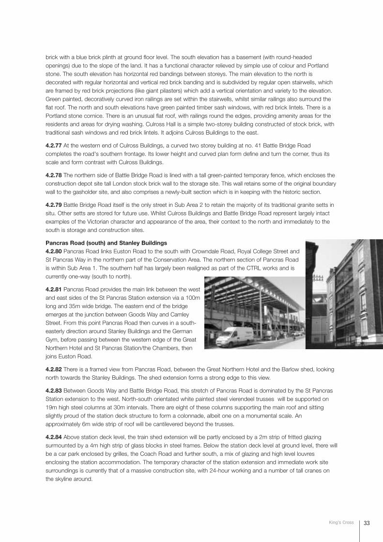
brick with a blue brick plinth at ground floor level. The south elevation has a basement (with round-headedopenings) due to the slope of the land. It has a functional character relieved by simple use of colour and Portlandstone. The south elevation has horizontal red bandings between storeys. The main elevation to the north isdecorated with regular horizontal and vertical red brick banding and is subdivided by regular open stairwells, whichare framed by red brick projections (like giant pilasters) which add a vertical orientation and variety to the elevation.Green painted, decoratively curved iron railings are set within the stairwells, whilst similar railings also surround theflat roof. The north and south elevations have green painted timber sash windows, with red brick lintels. There is aPortland stone cornice. There is an unusual flat roof, with railings round the edges, providing amenity areas for theresidents and areas for drying washing. Culross Hall is a simple two-storey building constructed of stock brick, withtraditional sash windows and red brick lintels. It adjoins Culross Buildings to the east.
4.2.77 At the western end of Culross Buildings, a curved two storey building at no. 41 Battle Bridge Roadcompletes the road's southern frontage. Its lower height and curved plan form define and turn the corner, thus itsscale and form contrast with Culross Buildings.
4.2.78 The northern side of Battle Bridge Road is lined with a tall green-painted temporary fence, which encloses theconstruction depot site tall London stock brick wall to the storage site. This wall retains some of the original boundarywall to the gasholder site, and also comprises a newly-built section which is in keeping with the historic section.
4.2.79 Battle Bridge Road itself is the only street in Sub Area 2 to retain the majority of its traditional granite setts insitu. Other setts are stored for future use. Whilst Culross Buildings and Battle Bridge Road represent largely intactexamples of the Victorian character and appearance of the area, their context to the north and immediately to thesouth is storage and construction sites.
Pancras Road (south) and Stanley Buildings4.2.80 Pancras Road links Euston Road to the south with Crowndale Road, Royal College Street andSt Pancras Way in the northern part of the Conservation Area. The northern section of Pancras Roadis within Sub Area 1. The southern half has largely been realigned as part of the CTRL works and iscurrently one-way (south to north).
4.2.81 Pancras Road provides the main link between the westand east sides of the St Pancras Station extension via a 100mlong and 35m wide bridge. The eastern end of the bridgeemerges at the junction between Goods Way and CamleyStreet. From this point Pancras Road then curves in a south-easterly direction around Stanley Buildings and the GermanGym, before passing between the western edge of the GreatNorthern Hotel and St Pancras Station/the Chambers, thenjoins Euston Road.
4.2.82 There is a framed view from Pancras Road, between the Great Northern Hotel and the Barlow shed, lookingnorth towards the Stanley Buildings. The shed extension forms a strong edge to this view.
4.2.83 Between Goods Way and Battle Bridge Road, this stretch of Pancras Road is dominated by the St PancrasStation extension to the west. North-south orientated white painted steel vierendeel trusses will be supported on19m high steel columns at 30m intervals. There are eight of these columns supporting the main roof and sittingslightly proud of the station deck structure to form a colonnade, albeit one on a monumental scale. Anapproximately 6m wide strip of roof will be cantilevered beyond the trusses.
4.2.84 Above station deck level, the train shed extension will be partly enclosed by a 2m strip of fritted glazingsurmounted by a 4m high strip of glass blocks in steel frames. Below the station deck level at ground level, there willbe a car park enclosed by grilles, the Coach Road and further south, a mix of glazing and high level louvresenclosing the station accommodation. The temporary character of the station extension and immediate work sitesurroundings is currently that of a massive construction site, with 24-hour working and a number of tall cranes onthe skyline around.
33King’s Cross
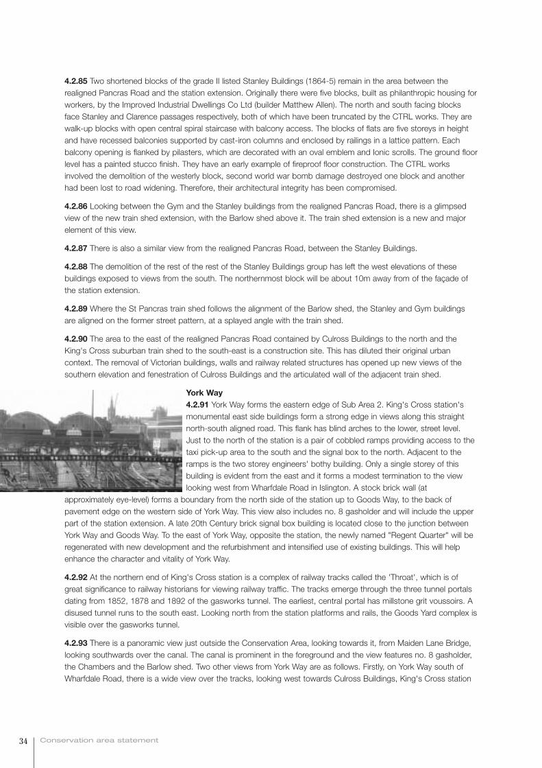
4.2.85 Two shortened blocks of the grade II listed Stanley Buildings (1864-5) remain in the area between therealigned Pancras Road and the station extension. Originally there were five blocks, built as philanthropic housing forworkers, by the Improved Industrial Dwellings Co Ltd (builder Matthew Allen). The north and south facing blocksface Stanley and Clarence passages respectively, both of which have been truncated by the CTRL works. They arewalk-up blocks with open central spiral staircase with balcony access. The blocks of flats are five storeys in heightand have recessed balconies supported by cast-iron columns and enclosed by railings in a lattice pattern. Eachbalcony opening is flanked by pilasters, which are decorated with an oval emblem and Ionic scrolls. The ground floorlevel has a painted stucco finish. They have an early example of fireproof floor construction. The CTRL worksinvolved the demolition of the westerly block, second world war bomb damage destroyed one block and anotherhad been lost to road widening. Therefore, their architectural integrity has been compromised.
4.2.86 Looking between the Gym and the Stanley buildings from the realigned Pancras Road, there is a glimpsedview of the new train shed extension, with the Barlow shed above it. The train shed extension is a new and majorelement of this view.
4.2.87 There is also a similar view from the realigned Pancras Road, between the Stanley Buildings.
4.2.88 The demolition of the rest of the rest of the Stanley Buildings group has left the west elevations of thesebuildings exposed to views from the south. The northernmost block will be about 10m away from of the façade ofthe station extension.
4.2.89 Where the St Pancras train shed follows the alignment of the Barlow shed, the Stanley and Gym buildingsare aligned on the former street pattern, at a splayed angle with the train shed.
4.2.90 The area to the east of the realigned Pancras Road contained by Culross Buildings to the north and theKing's Cross suburban train shed to the south-east is a construction site. This has diluted their original urbancontext. The removal of Victorian buildings, walls and railway related structures has opened up new views of thesouthern elevation and fenestration of Culross Buildings and the articulated wall of the adjacent train shed.
York Way4.2.91 York Way forms the eastern edge of Sub Area 2. King's Cross station'smonumental east side buildings form a strong edge in views along this straightnorth-south aligned road. This flank has blind arches to the lower, street level.Just to the north of the station is a pair of cobbled ramps providing access to thetaxi pick-up area to the south and the signal box to the north. Adjacent to theramps is the two storey engineers' bothy building. Only a single storey of thisbuilding is evident from the east and it forms a modest termination to the viewlooking west from Wharfdale Road in Islington. A stock brick wall (at
approximately eye-level) forms a boundary from the north side of the station up to Goods Way, to the back ofpavement edge on the western side of York Way. This view also includes no. 8 gasholder and will include the upperpart of the station extension. A late 20th Century brick signal box building is located close to the junction betweenYork Way and Goods Way. To the east of York Way, opposite the station, the newly named "Regent Quarter" will beregenerated with new development and the refurbishment and intensified use of existing buildings. This will helpenhance the character and vitality of York Way.
4.2.92 At the northern end of King's Cross station is a complex of railway tracks called the 'Throat', which is ofgreat significance to railway historians for viewing railway traffic. The tracks emerge through the three tunnel portalsdating from 1852, 1878 and 1892 of the gasworks tunnel. The earliest, central portal has millstone grit voussoirs. Adisused tunnel runs to the south east. Looking north from the station platforms and rails, the Goods Yard complex isvisible over the gasworks tunnel.
4.2.93 There is a panoramic view just outside the Conservation Area, looking towards it, from Maiden Lane Bridge,looking southwards over the canal. The canal is prominent in the foreground and the view features no. 8 gasholder,the Chambers and the Barlow shed. Two other views from York Way are as follows. Firstly, on York Way south ofWharfdale Road, there is a wide view over the tracks, looking west towards Culross Buildings, King's Cross station
34 Conservation area statement

shed and no. 8 gasholder. Secondly, there is a panoramic view north of Wharfdale Road, from the cobbled rampadjacent to York Way, looking west and north-west, over the tracks. This encompasses the Goods Way complex inthe Regent's Canal Conservation Area, Culross Buildings and no. 8 gasholder.
Summary & Commentary4.2.94 This part of the King's Cross Conservation Area has experienced significant change. This has resulted in theloss of elements of heritage merit, fragmentation of the urban grain and radical change to the character andappearance of the area. The changes resulting from the CTRL and London Underground works have resulted in thewidening of the settings of most of the principal buildings, mostly those to the south of, and including, the GermanGymnasium. Change has also resulted in some buildings and structures standing alone, comparatively isolated fromtheir former context. For example, Stanley Buildings sit somewhat uncomfortably in the context of the new St PancrasStation extension and the remaining gasholder and Culross Buildings are currently somewhat isolated. Nevertheless,these buildings continue to contribute positively to the character and appearance of the Conservation Area, althoughas a result of the CTRL construction works, they currently do lack a meaningful and coherent visual context.
35King’s Cross
character
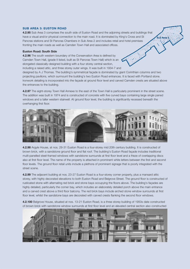
37King’s Cross
SUB AREA 3: EUSTON ROAD 4.2.95 Sub Area 3 comprises the south side of Euston Road and the adjoining streets and buildings thathave a visual and/or physical connection to the main road. It is dominated by King's Cross and StPancras stations and St Pancras Chambers in Sub Area 2 and includes retail and hotel premisesfronting the main roads as well as Camden Town Hall and associated offices.
Euston Road: South Side 4.2.96 The south western boundary of the Conservation Area is defined byCamden Town Hall, (grade II listed, built as St Pancras Town Hall) which is anelongated classically-designed building with a four storey central section,including a raised attic, and three storey outer wings. It was built in 1934-7 anddesigned by A J Thomas. The building's symmetrical façade is dominated by giant Corinthian columns and twoprojecting pavilions, which surmount the building's two Euston Road entrances. It is faced with Portland stone.Ironwork detailing is incorporated into the façade at ground floor level and carved Camden crests are situated abovethe entrances to the building.
4.2.97 The eight-storey Town Hall Annexe to the east of the Town Hall is particularly prominent in the street scene.The addition was built in 1974 and is constructed of concrete with five curved bays containing large single panedwindows and a taller western stairwell. At ground floor level, the building is significantly recessed beneath theoverhanging first floor.
4.2.98 Argyle House, at nos. 29-31 Euston Road is a four-storey mid 20th century building. It is constructed ofbrown brick, with a sandstone ground floor and flat roof. The building's Euston Road façade includes traditionalmulti-panelled steel-framed windows with sandstone surrounds at first floor level and a frieze of overlapping discsalso at first floor level. The name of the property is attached in prominent white letters between the first and secondfloor levels. The ground floor retail units include a plethora of prominent signage that is poorly integrated with thestreet scene.
4.2.99 The adjacent building at nos. 23-27 Euston Road is a four-storey corner property, plus a mansard atticstorey, with highly decorated elevations to both Euston Road and Belgrove Street. The ground floor is constructed ofrusticated stone with alternating red brick and stone bays occupying the floors above. The building's façades arehighly detailed, particularly the corner bay, which includes an elaborately detailed porch above the main entranceand a carved crest above a third floor balcony. The red brick bays include arched stone window surrounds at firstfloor level, whilst the sandstone bays are decorated with carved crests flanking the second floor windows.
4.2.100 Belgrove House, situated at nos. 13-21 Euston Road, is a three storey building of 1950s date constructedof brown brick with sandstone window surrounds at first floor level and an elevated central section also constructed
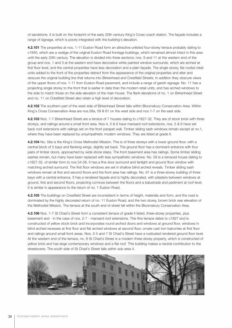
of sandstone. It is built on the footprint of the early 20th century King's Cross coach station. The façade includes arange of signage, which is poorly integrated with the building's elevation.
4.2.101 The properties at nos. 1-11 Euston Road form an attractive unlisted four-storey terrace probably dating toc1840, which are a vestige of the original Euston Road frontage buildings, which remained almost intact in this areauntil the early 20th century. The elevation is divided into three sections: nos. 9 and 11 at the western end of thegroup and nos. 1 and 3 at the eastern end have decorative white painted window surrounds, which are arched atfirst floor level, and the central properties have less decoration and a plain façade. The single storey, flat roofed retailunits added to the front of the properties detract from the appearance of the original properties and alter andobscure the original building line that returns into Birkenhead and Crestfield Streets. In addition they obscure viewsof the upper floors of nos. 1-11 from Euston Road pavement, and include a range of garish signage. No. 11 has aprojecting single storey to the front that is earlier in date than the modern retail units, and has arched windows tothe side to match those on the side elevation of the main house. The flank elevations of no. 1 on Birkenhead Streetand no. 11 on Crestfield Street also retain a high level of decoration.
4.2.102 The southern part of the west side of Birkenhead Street falls within Bloomsbury Conservation Area. WithinKing's Cross Conservation Area are nos.58a, 59 & 61 on the west side and nos 1-7 on the east side.
4.2.103 Nos. 1-7 Birkenhead Street are a terrace of 7 houses dating to c1827-32. They are of stock brick with threestoreys, and railings around a small front area. Nos 4, 5 & 6 have mansard roof extensions, nos. 5 & 6 have setback roof extensions with railings set on the front parapet wall. Timber sliding sash windows remain except at no.1,where they have been replaced by unsympathetic modern windows. They are listed at grade II.
4.2.104 No. 58a is the King's Cross Methodist Mission. This is of three storeys with a lower ground floor, with acentral block of 5 bays and flanking wings, slightly set back. The ground floor has a dominant entrance with fourpairs of timber doors, approached by wide stone steps. The front basement area has railings. Some timber slidingsashes remain, but many have been replaced with less sympathetic windows. No. 59 is a terraced house dating toc1827-32, of similar form to nos 54-58. It has a fine door surround and fanlight and ground floor window withmatching arched surround. The first floor windows are set in shallow blind arched reveals. Timber sliding sashwindows remain at first and second floors and the front area has railings. No. 61 is a three-storey building of threebays with a central entrance. It has a rendered façade and is highly decorated, with pilasters between windows atground, first and second floors, projecting cornices between the floors and a balustrade and pediment at roof level.It is similar in appearance to the return of no. 1 Euston Road.
4.2.105 The buildings on Crestfield Street are inconsistent in terms of height, materials and form, and the road isdominated by the highly decorated return of no. 11 Euston Road, and the two storey, brown brick rear elevation ofthe Methodist Mission. The terrace at the south end of street fall within the Bloomsbury Conservation Area.
4.2.106 Nos. 1-7 St Chad's Street form a consistent terrace of grade II listed, three-storey properties, plusbasement and - in the case of nos. 2-7 - mansard roof extensions. This fine terrace dates to c1827 and isconstructed of yellow stock brick and incorporates round arched doors and windows at ground floor, windows inblind arched recesses at first floor and flat arched windows at second floor, ornate cast iron balconies at first floorand railings around small front areas. Nos. 2-5 and 7 St Chad's Street have a rusticated rendered ground floor level.At the western end of the terrace, no. 8 St Chad's Street is a modern three-storey property, which is constructed ofyellow brick and has large contemporary windows and a flat roof. This building makes a neutral contribution to thestreetscene. The south side of St Chad's Street falls within sub-area 4.
38 Conservation area statement
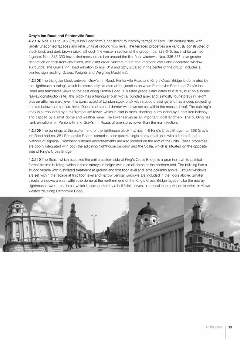
Gray's Inn Road and Pentonville Road4.2.107 Nos. 311 to 345 Gray's Inn Road form a consistent four-storey terrace of early 19th century date, withlargely unadorned façades and retail units at ground floor level. The terraced properties are variously constructed ofstock brick and dark brown brick, although the western section of the group, nos. 323-345, have white paintedfaçades. Nos. 313-333 have blind recessed arches around the first floor windows. Nos. 335-337 have greaterdecoration on their front elevations, with giant order pilasters at 1st and 2nd floor levels and decorated windowsurrounds. The Gray's Inn Road elevation to nos. 319 and 321, situated in the centre of the group, includes apainted sign reading 'Scales, Weights and Weighing Machines'.
4.2.108 The triangular block between Gray's Inn Road, Pentonville Road and King's Cross Bridge is dominated bythe 'lighthouse building', which is prominently situated at the junction between Pentonville Road and Gray's InnRoad and terminates views to the east along Euston Road. It is listed grade II and dates to c1875, built on a formerrailway construction site. This block has a triangular plan with a rounded apex and is mostly four-storeys in height,plus an attic mansard level. It is constructed of London stock brick with stucco dressings and has a deep projectingcornice below the mansard level. Decorated arched dormer windows are set within the mansard roof. The building'sapex is surmounted by a tall 'lighthouse' tower, which is clad in metal sheeting, surrounded by a cast iron balconyand capped by a small dome and weather vane. The tower serves as an important local landmark. The building hasflank elevations on Pentonville and Gray's Inn Roads of one storey lower than the main section.
4.2.109 The buildings at the eastern end of the lighthouse block - at nos. 1-5 King's Cross Bridge, no. 368 Gray'sInn Road and no. 281 Pentonville Road - comprise poor quality, single storey retail units with a flat roof and aplethora of signage. Prominent billboard advertisements are also located on the roof of the units. These propertiesare poorly integrated with both the adjoining 'lighthouse building' and the Scala, which is situated on the oppositeside of King's Cross Bridge.
4.2.110 The Scala, which occupies the entire eastern side of King's Cross Bridge is a prominent white-paintedformer cinema building, which is three storeys in height with a small dome at the northern end. The building has astucco façade with rusticated treatment at ground and first floor level and large columns above. Circular windowsare set within the façade at first floor level and narrow vertical windows are included in the floors above. Smallercircular windows are set within the dome at the northern end of the King's Cross Bridge façade. Like the nearby'lighthouse tower', the dome, which is surmounted by a ball finial, serves, as a local landmark and is visible in viewswestwards along Pentonville Road.
39King’s Cross

SUB AREA 4: GRAY'S INN ROAD4.2.111 This sub area comprises the area bounded byPentonville Road and King's Cross Road to the north and east,Swinton Street to the south and the Birkenhead Street Estateto the west. King's Cross Road and Gray's Inn Road areprincipal roads linking King's Cross to the City of London.These roads are lined with a mix of early 19th century terracesand larger scale institutional buildings. The area between themain roads contains narrow streets paved in granite setts,predominantly lined with later 19th century buildings of formerlight-industrial and commercial uses, as well as housing, andseveral vacant sites currently used for car parking. Thesestreets are bisected by the London Underground Metropolitan Line and Thameslink railway cutting, and, despitepiecemeal re-development, have a characteristic fine urban grain with broad consistency of building heights andmaterials. The blocks of the 1950s Birkenhead Street Estate are located against the west boundary of theConservation Area.
West of Gray's Inn Road4.2.112 The southern side of St Chad's Street is fragmented, with little consistency in style, scale or building line.Nos. 13 and 14 St Chad's Street are grade II listed, three-storey properties, plus basements, dating to c1827, whichhave similar elevational detailing to the terraced buildings on the north side: they have square headed windows andiron balconies at first floor level. To the west of these properties, no. 12 St Chad's Street forms the northernentrance to the depot that runs behind the Gray's Inn Road frontage buildings. The entrance and yard has granitesett paving beyond which is a single storey building of no architectural or historic merit, set behind the buildings onSt Chad's Street. The adjacent property, no. 13 St Chad's Street, is a three-storey building, which is constructed ofstock brick and has a plain façade. At ground floor level, the building has been rendered and large modern windowsand contemporary signage introduced.
4.2.113 The seven storey blocks of the Birkenhead Street Estate are adjacent and occupy the area at the westernboundary of Sub Area 4. The St Chad's Street elevation to the northernmost block includes open balconies andprojecting stairwells, whilst the southern elevation to the slab block fronting Argyle Street is characterised by regularfenestration and recessed balconies. The estate is bounded by a pale orange brick wall with large areas of glazing,and the route of Birkenhead Street through the estate is now a private road.
4.2.114 The building adjacent to the Birkenhead Street Estate on Argyle Street, no. 55, forms the southern entranceto the depot situated to the rear of the Gray's Inn Road frontage buildings. The two-storey mid 20th century buildingis constructed of yellow brick and has a horizontal band of windows at first floor and vertical windows at groundfloor on either side of a wide vehicular entrance, with rendered reveals and mullions.
Gray's Inn Road4.2.115 Gray's Inn Road is a wide, busy street ofone-way northbound traffic connecting King's Crosswith Clerkenwell and Holborn to the south. Thewest side is fronted by a continuous early 19thcentury terrace (nos 251-309) running between StChad's Street and Argyle Street, with some of theoriginal buildings replaced by 20th centurydevelopments. The eastern side of the road is of alarger scale, was largely re-developed post the late19th century, and includes educational and medicalinstitutions.
4.2.116 At the junction of Gray's Inn Road and St Chad's Street, nos. 307-309 Gray's Inn Road are three-storeybuildings, part of the original terrace, with retail units at ground floor level, which are constructed of London stock
40 Conservation area statement
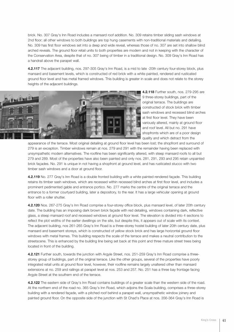
brick. No. 307 Gray's Inn Road includes a mansard roof addition. No. 309 retains timber sliding sash windows at2nd floor; all other windows to both buildings are top hung casements with non-traditional materials and detailing.No. 309 has first floor windows set into a deep and wide reveal, whereas those of no. 307 are set into shallow blindarched reveals. The ground floor retail units to both properties are modern and not in keeping with the character ofthe Conservation Area, despite that of no. 307 being of timber in a traditional design. No. 309 Gray's Inn Road hasa handrail above the parapet wall.
4.2.117 The adjacent building, nos. 297-305 Gray's Inn Road, is a mid to late -20th century four-storey block, plusmansard and basement levels, which is constructed of red brick with a white painted, rendered and rusticatedground floor level and has metal framed windows. This building is greater in scale and does not relate to the storeyheights of the adjacent buildings.
4.2.118 Further south, nos. 279-295 are9 three-storey buildings, part of theoriginal terrace. The buildings areconstructed of stock brick with timbersash windows and recessed blind archesat first floor level. They have beenvariously altered, mainly at ground floorand roof level. All but no. 291 haveshopfronts which are of a poor designquality and which detract from the
appearance of the terrace. Most original detailing at ground floor level has been lost; the shopfront and surround of279 is an exception. Timber windows remain at nos. 279 and 291 with the remainder having been replaced withunsympathetic modern alternatives. The roofline has been significantly altered, with steep mansard roofs to all but279 and 289. Most of the properties have also been painted and only nos. 281, 291, 293 and 295 retain unpaintedbrick façades. No. 291 is unique in not having a shopfront at ground level, and has rusticated stucco with twotimber sash windows and a door at ground floor.
4.2.119 No. 277 Gray's Inn Road is a double fronted building with a white painted rendered façade. This buildingretains its timber sash windows, which are recessed within recessed blind arches at first floor level, and includes aprominent pedimented gable and entrance portico. No. 277 marks the centre of the original terrace and theentrance to a former courtyard building, later a depository, to the rear. It has a large vehicular opening at groundfloor with a roller shutter.
4.2.120 Nos. 267-275 Gray's Inn Road comprise a four-storey office block, plus mansard level, of later 20th centurydate. The building has an imposing dark brown brick façade with red detailing, windows containing dark, reflectiveglass, a steep mansard roof and recessed windows at ground floor level. The elevation is divided into 4 sections toreflect the plot widths of the earlier dwellings on the site, but despite this, it appears out of scale with its context.The adjacent building, nos 261-265 Gray's Inn Road is a three-storey hostel building of later 20th century date, plusmansard and basement storeys, which is constructed of yellow stock brick and has large horizontal ground floorwindows with metal frames. This building respects the scale of the terrace and makes a neutral contribution to thestreetscene. This is enhanced by the building line being set back at this point and three mature street trees beinglocated in front of the building.
4.2.121 Further south, towards the junction with Argyle Street, nos. 251-259 Gray's Inn Road comprise a three-storey group of buildings, part of the original terrace. Like the other groups, several of the properties have poorlyintegrated retail units at ground floor level, however, their roofline remains largely unaltered other than mansardextensions at no. 259 and railings at parapet level at nos. 253 and 257. No. 251 has a three bay frontage facingArgyle Street at the southern end of the terrace.
4.2.122 The eastern side of Gray's Inn Road contains buildings of a greater scale than the western side of the road.At the northern end of the road no. 365 Gray's Inn Road, which adjoins the Scala building, comprises a three-storeybuilding with a rendered façade, with a pitched roof behind a parapet wall, unsympathetic window joinery andpainted ground floor. On the opposite side of the junction with St Chad's Place at nos. 356-364 Gray's Inn Road is
41King’s Cross

Willing House, a fine grade II listed Edwardian former office building designed by Hart and Waterhouse. It wasconverted into a hotel in 2003.
4.2.123 Pioneer House, at nos. 344-348 Gray's Inn Road is a four-storey Edwardian office building with a recentmansard addition. The building is constructed of red brick with buff stone banding at 1st and 2nd floors, and hastimber sash windows. Its façade has a shallowly projecting central entrance bay with stucco rustication at groundfloor level, an arched stone entrance which is surmounted by cast iron balconies at first to third floor level and anarched pediment at roof level. It has modern shopfronts inserted at ground floor level on either side of the centralentrance bay which relate poorly to the existing building in terms of detailing and materials. This building is adjoinedto the south by no. 340 Gray's Inn Road, which is a six-storey, red brick building of mid to late 20th century origin.Its main elevation fronts Britannia Street and the flank elevation to Gray's Inn Road. The frontage consists ofunadorned red brickwork and a double height ground floor retail unit. The building's design seeks to continue thescale and proportion of the adjacent building.
4.2.124 To the south of the junction with Britannia Street, nos. 334 and 336 Gray's Inn Road are three-storeybuildings with white painted façades and prominent attached shutters, and steeply pitched roofs with projectingeaves. These have large picture windows to the projecting commercial space at ground floor level. The buildings areof an incongruous scale and form in relation to the adjacent buildings. A four storey building is currently underconstruction (2003) in the area to the south of nos. 334.
4.2.125 The Royal National Throat, Nose and Ear Hospital is located at no. 330 Gray's Inn Road. The main, three-storey hospital building is in a Classical style with a rusticated stone façade at first and second floor levels withtimber sash windows, a prominent modelled cornice and balustrade above and tiled signage below the cornice. Thebuilding projects beyond the main frontage at ground floor and this element is of 1960s design and date. It ispainted white and incorporates signage within a Portland stone panel and has metal framed windows.
4.2.126 The "Water Rats Theatre Bar", at no. 328 Gray's Inn Road, is an attractive four-storey Public House of late19th century date, which is constructed of stock brick. The façade incorporates decorative painted banding andsash windows with prominent white painted surrounds with columns in the reveals supporting the lintels. 3 smalldormer windows with arched heads are set within the building's slate pitched roof above a projecting eaves cornice.The ground floor has a curved projecting timber frontage.
4.2.127 Swinton House, at nos. 322-326 Gray's Inn Road, is an imposing seven-storey office building, situated atthe junction with Swinton Street. The building is faced with buff sandstone with whiter stone at ground floor level.The Gray's Inn Road elevation includes a central shallowly projecting bay and decorative banding between 1st and2nd floor levels, and a simpler version between 4th and 5th floors. The building's main entrance is set within aprominent portico supported by rusticated stone columns and is surmounted by carved signage. This building andthe adjacent, Water Rats Public House and Royal National Throat, Nose and Ear Hospital form an important andvaried group of buildings, which are of architectural and historical interest.
King's Cross Road4.2.128 The eastern boundary to the Conservation Area runs down the middle of King's Cross Road. The westernside of King's Cross Road is lined with residential terraced buildings with retail units at ground floor level,interspersed with larger office and retail buildings and public houses.
42 Conservation area statement
4.2.129 At the northern end of Sub Area 4, the street frontage to King's Cross Thameslink Station is a single storeybuilding with high fascia signage and large areas of glazing, set back from the building line behind pillars. It is of noarchitectural merit and its low height creates a gap in the streetscape, which reveals the unattractive rear elevation tothe Scala. The station is adjoined to the east by the "Sahara Nights" Public House at nos. 257-259 Pentonville Road,a highly decorated three-storey building with white rendered upper levels, red painted pilasters and intricate detailingabove the entrances, and granite frontage to the ground floor which projects slightly in front of the main building.
4.2.130 At the north western end of King's Cross Road, nos. 207-215 is a large, four storey office building of mid-20th Century date. The building is constructed of red brick with a pale stone ground floor facade, horizontal bandsof windows with rendered reveals and a recessed fifth floor roof extension.
4.2.131 To the east, nos. 187-205 King's Cross Road form a terrace of 10, three-storey buildings of mid to late 19thcentury date. They are constructed of red brick and have suffered from a high degree of poor quality reconstructionfollowing WW2 bomb damage. They have modern windows with concrete lintels and unsympathetic commercialfrontages at ground floor level. The exception is no. 205, which has original window openings, and a good qualitytimber shopfront with a fascia sign of historic interest. Nos. 201 & 203 have had their front elevations reconstructedin very poorly matching brickwork which detracts from the terrace as a whole. The rear of these buildings is visiblefrom St Chad's Place and have hipped, tiled roofs with dormer windows and with a tall chimney on the rearelevation on alternate buildings.
4.2.132 To the north of the junction with Field Street, the building at nos. 183-185 King's Cross Road is a prominentthree-storey building plus attic level, dating to the turn of the 19th/20th centuries, which is constructed of yellowstock brick with red brick detailing. It has a central entrance bay with giant order pilasters and an arched pediment,and a steeply pitched tiled roof with tall chimneys and large dormer windows. It also includes a white painted retailfrontage at ground floor level with large timber framed windows. The building terminates the terrace of properties tothe north west and turns the corner with Field Street.
4.2.133 On the southern side of Field Street nos. 173-181 King's Cross Road form a group of 5 three-storeyterraced buildings with retail units at ground floor level and residential use above. The retail units to all of thebuildings have timber frontages with projecting cornices, large windows and panelled doors with rectangularfanlights. Nos. 173-179 King's Cross Road are grade II listed buildings, formerly known as Field Place, and date to1799. All are constructed of yellow stock brick; 177 & 179 have gauged brick arches and all except 181 have timbersash windows. No. 179 has a steeply pitched mansard roof extension which detracts from the unity of the terraceas a whole. The adjacent unlisted property, no. 181, is of similar form to the adjoining group, but the brickwork hasbeen painted. To the south east of the listed terrace, no. 171a is a three-storey building with metal windows situatedat the corner of Leeke Street. It is taller than the adjacent terrace and has rendered and painted elevations. Itoccupies a prominent corner position in the streetscene.
4.2.134 On the south side of Leeke Street the flank elevation to no. 1 Leeke Street has a frontage on King's CrossRoad. The building rises to three-storeys in height, is constructed of stock brick with a projecting cornice at rooflevel and decorated lintels to 1st and 2nd floor windows, and dates to the mid to late 19th century. It has a retail unitat ground floor level, with a highly subdivided frontage. The adjacent building at nos. 165-167 is an infill property oflate 20th century date. It is of three storeys with a recessed 4th storey, and is constructed of yellow brick with largepanels of glass bricks at ground floor level and poorly detailed modern windows above. To the south "The GoldenLion" Public House at no. 2 Britannia Street, is a three-storey building with a rendered façade at ground floor leveland painted brickwork above, of mid to late 19th century date. Its King's Cross Road elevation comprises a central,slightly projecting, bay with rusticated quoins and a large arched window at first floor and three smaller archedwindows at second floor. On the bays to either side are flat headed windows at each floor. On the splayed corner ithas a projecting decorative iron balcony at second floor level.
4.2.135 The buildings south of Britannia Street at nos. 149-163 King's Cross Road, form a uniform terrace of 8three-storey properties, which are constructed of yellow stock brick with sash windows, rendered window surroundsand a projecting dentilled cornice, of mid to late 19th century date. The ground floor retains original detailing to thefacades (eg fascia, pilasters and corbels) although many have modern shopfronts inserted. Nos. 151 & 153 areparticularly well preserved historic shopfronts. The north end of the terrace (no. 163) has a gentle curve at the corner
43King’s Cross
44 Conservation area statement
into Britannia Street and has rusticated stucco quoins to slightly projecting bays on King's Cross Road and BritanniaStreet. The south end of the terrace (no.149), curves sharply at the end with a similar stucco rustication detailing,and windows on the curved end.
4.2.136 The three buildings to the south of the above terrace, nos. 143-147, are older, mid 19th century, three-storey terraced buildings, which have a smaller scale and are set back from the building line of the adjacent group.The ground floor retail units project slightly to the adjacent building line, and retain original detailing with latershopfronts inserted. Nos.145 and 147 have been painted and have lost original windows, which detracts from their appearance.
4.2.137 The "Northumberland Arms" Public House on the corner of Wicklow Street and the terrace to the southform the south-easternmost corner of the Conservation Area. The "Northumberland Arms" at no.141 King's CrossRoad is a three-storey building with a brown tiled ground floor level with large window openings with small panedwindows. The 1st floor is painted brick with arched windows with decorated window surrounds and pediments,rusticated quoins and a projecting dentil cornice as blocking course. Above this are small round arched windows inthe second floor and a rendered parapet wall. No. 139 is linked architecturally to the Public House and is a 3 storeyred brick house with rusticated quoins and timber sash windows. The buildings at nos. 129-137 date to the mid19th century and are varied in scale and detailing: nos. 133-137 are a terrace of 3 three-storey yellow stock brickhouses with poor quality modern shopfronts inserted into a historic surround. The elevations have bold treatment tothe tripartite windows with triangular pediments at 1st floor and square headed windows at 2nd floor. No. 131 is afour storey yellow stock brick building with a simply detailed elevation. A poor modern shopfront has been insertedinto an earlier surround. No. 129 is of three storeys with one, simply detailed window per floor. A steeply pitchedmansard has been added.
4.2.138 The area between King's Cross Road and Gray's Inn Road is characterised by narrow streets generallypaved with granite setts, lined with former light industrial and commercial buildings. The buildings front directly ontothe back of pavement and therefore create a strong sense of enclosure. The area is divided by the Metropolitan andThameslink railway cutting, which is flanked to the east and west by narrow corridors of vacant land.
4.2.139 The northernmost street in this area, St Chad's Place, is a narrow street surfaced in well laid granite setts.The western end of the street is dominated by Willing House and the rear of buildings lining Gray's Inn Road. At itseastern end the road tapers to form a narrow alley, which turns sharply to the north to emerge on King's CrossRoad between nos. 195 and 197. The bridge over the railway cutting is bordered with a tall corrugated metal barrier,which is unsympathetic to the character of the street. To the south east there are open views over the cutting. Aglimpse of the spire of St Pancras Chambers is afforded from the east end of St Chad's Place.
4.2.140 On the eastern side of the railway cutting, no. 6 St Chad's Place is a single storey former industrial building,which is constructed of London stock brick with black steel-framed windows and circular windows at roof level. Theadjacent building, no. 8 St Chad's Place, is a three-storey building that is constructed of London stock brick withred brick window arches. It is currently in office use and has modern windows and a new entrance. Both are of midto late 19th century date. Further east, the northern side of St Chad's Place is lined with later 19th century, singlestorey buildings also constructed of London stock brick, whilst a part single, part two-storey industrial building issituated on the southern side of the alleyway. From the east end of St Chad's Place the unaltered rear elevations ofproperties fronting King's Cross Road are visible, which adds an additional layer to the complex and dense urbangrain that is characteristic of this sub area.
4.2.141 Field Street is situated to the south of St Chad's Place, and is a short street which formerly connectedKing's Cross Road to Wicklow Street but is now bisected by the railway cutting. On the north side are two andthree-storey buildings of late 19th/early 20th century date and which abut the cutting. They are currently in lightindustrial use. On the south side of the street is an early 20th century single storey building with large metal-framedwindows. The former junction with Wicklow Street is currently marked by a short stretch of road at the eastern endof Field Street, which is lined with a tall wire fence that detracts from the streetscene. Both ends of the street aresurfaced in granite setts which has been unsympathetically repaired in many places with modern materials.
4.2.142 Leeke Street is also a narrow enclosed street surface in granite setts, which connects King's Cross Road
45King’s Cross
and Wicklow Street. To the west of the railway cutting, Leeke Street is fronted by the flank elevations to nos. 40-44and 46-52 Wicklow Street to the north and south respectively. The former building is a recently renovated formerindustrial building constructed of stock brick, highly characteristic of this area, but which has had modern windowsin untraditional materials and design and a tall, unsympathetic mansard roof added which detract from the characterand appearance of the building. Conversely, nos. 46-52 Wicklow Street, which contains the entrance to "Smithy'sBar", represents a successfully renovated former industrial building of end of 19th century date. The two-storeyproperty is constructed of London stock brick with red brick banding and lintels. The building has a contemporaryentrance and retains original steel framed windows. To the east of the building at nos. 46-52 Wicklow Street, theLeeke Street bridge over the railway cutting is lined with traditional stock brick walls.
4.2.143 On the eastern side of the railway cutting, the rear elevation to nos. 1-6 Field Street fronts Leeke Street. It isan undecorated two-storey industrial building, which is constructed of London stock brick and has a wide,prominent blue-painted vehicle entrance. The adjoining building, no. 6-12 Leeke Street is a two-storey early 20thcentury building with an unadorned white rendered and painted façade with large steel-framed windows and acentral gable feature. The northern side of the street is terminated at its eastern end by the building at nos. 2-4Leeke Street, which is a three-storey property with a blue rendered and painted façade. On the southern side ofLeeke Street, a single storey, red brick garage building with two vehicle entrances flanks the railway cutting. Theadjoining properties, nos. 13 and 5 Leeke Street are three-storey buildings of mid to late 19th century date,constructed of yellow stock brick with red brick detailing and timber sliding sash windows above ground floor level.Both buildings have unsympathetic, blue painted vehicle entrance shutters. No. 5 has timber sliding sash windowswhereas no. 13 has modern windows in unsympathetic materials. To the east, the building at nos. 1-3 Leeke Streetis a three-storey property with a brightly painted ground floor retail frontage and residential accommodation above.The building is constructed of yellow stock brick and has a curved corner onto King's Cross Road. The Leeke Streetentrance to the building is surmounted by a triangular panel that bears the date 1890 and includes a microscopeemblem. All of these buildings have simple cornices on parapet walls.
4.2.144 Britannia Street is wider than the adjacent roads and connects King's Cross and Gray's Inn Roads.Accordingly, it forms the main east-west thoroughfare through Sub Area 4. Unlike the adjacent streets which mostlycontain former industrial buildings of mid-late 19th century date, the buildings lining Britannia Street are of varyingages, uses, and architectural form.
4.2.145 On the northern side of the street, at the junction with Gray's Inn Road, the building at nos. 48-50 BritanniaStreet (also no. 342 Gray's Inn Road) is a five-storey red brick property of late 20th century date. The office buildinghas large windows, recessed balconies and double height retail units at ground floor level. The adjoining building tothe east, also set back from the Britannia Street building line is no. 46 Britannia Street, which is the flank elevation toa four-storey mid 20th century building fronting Wicklow Street. On the southern side of Britannia Street, nos. 39and 37 are three-storey buildings of similar date and form to the adjoining buildings at nos 334-336 Gray's InnRoad. They have white painted façades and prominent red shutters. To the east, no. 75 Wicklow Street is a mockgothic building which was constructed in 1872 and formerly housed the Church School of St John. It is constructedof stock brick with red brick banding and stone dressings and has a steeply pitched slate roof. It is listed at Grade II.All of the buildings on the north side of Britannia Street to the east of the junction with Wicklow Street are set backfrom the street which deviates from the sense of enclosure which is characteristic of the area between Gray's InnRoad and King's Cross Road.
4.2.146 To the east of the junction with Wicklow Street, the building at nos. 34-44 Britannia Street is a functionalfive-storey concrete box frame building of 1960s date. It has horizontal bands of metal-framed windows. The officeblock is entirely unsympathetic to the scale and elevational detailing of surrounding buildings, particularly thatadjacent at nos. 28-32 Britannia Street. It is a two-storey building, connected to nos. 48-52 Wicklow Street, datingto the end of the 19th century. It is constructed of London stock brick with red brick projecting string course, andhas an plaque bearing the name 'London General Omnibus Company Limited' over the entrance. At the easternend of the building a narrow four-storey tower with steel-framed windows terminates the block.
4.2.147 On the southern side of the street, nos. 17-27 form a part two, part three-storey building with an unadornedfaçade with elongated 1st floor windows and a set back 3rd storey, which is constructed of stock brick and has a
46 Conservation area statement
flat roof. The main entrance to the building at the junction with Wicklow Street is set on the corner within a four-storey hexagonal tower which includes red brick detailing and circular windows. The entrance is set within a detailedstucco surround which bears the inscription 'Erected A.D.1900 Offices'. This building is adjoined to the east by no.15 Britannia Street, a narrow three-storey building constructed of stock brick with red brick detailing, dating toc1875. The façade incorporates shallow hexagonal bay windows at first and second floor levels and a ground floorvehicle entrance with a prominent white surround.
4.2.148 To the east of the railway cutting, the northern side of Britannia Street is fronted by a large, early to mid20th century, three-storey industrial building, (nos. 4-24) which is constructed of stock brick and has simple, whitepainted pilasters and a projecting cornice on an otherwise unadorned façade. The building has large steel-framedwindows and a prominent blue garage door at its centre. At its western end, no. 26 Britannia Street is a small singlestorey garage building constructed of red brick. The "Golden Lion" Public House (described above) terminates thenorthern side of Britannia Street at its eastern end, turning onto King's Cross Road.
4.2.149 On the southern side of Britannia Street, a small empty plot used as a car park occupies the areaimmediately to the east of the railway cutting. This is adjoined to the east by nos. 7-11 Britannia Street, a three-storey building of early 20th century date which is constructed of red brick and has red painted steel framedwindows. Adjoining this is Derby Lodge, a grade II listed apartment building erected by the Improved IndustrialDwellings Company in 1865. This six-storey building is constructed of grey/buff brick with rusticated stucco atground floor level. The building's recessed open stairwells and ornate cast iron balconies give the frontage depthand interest, which is enhanced by stucco pediments over the windows and decorative iron ventilation grillesbetween the windows on each floor. Derby Lodge is adjoined to the east by nos.1-5 Britannia Street, whichcomprise a terrace of three-storey buildings with commercial units at ground floor level and residentialaccommodation above, of mid to late 19th century date. No. 1 is of red brick with rusticated stucco at ground floorand a vehicle entrance. Nos. 2 and 3 are of yellow stock brick with large modern shopfronts at ground floor andsimple projecting cornices. All have timber sliding sash windows.
4.2.150 Wicklow Street runs from King's Cross Road at its southern end and crosses the railway cutting to thesouth of Britannia Street before turning north to intersect Britannia Street and Leeke Street and terminates at itsnorthern end where it meets St Chad's Place.
4.2.151 At the northern end of the street, the east side is addressed by the rear of Willing House, and by no. 77Wicklow Street/46 Britannia Street), a large four-storey former educational building, now in office and residential use.The building is constructed of red brick and its long Wicklow Street elevation incorporates a white painted groundfloor level, thick banding and large contemporary picture windows on the ground floor.
4.2.152 The eastern side of the northern section of Wicklow Street is lined with former industrial buildings, which areconstructed of stock brick and are of late 19th century date. Nos. 40-44 Wicklow Street is two-storey building withmodern windows and an unsympathetic mansard addition containing roof lights which detracts from the prevailingcharacter of the sub-area. On the corner of Leeke Street and Wicklow Street is no.48 (already referred to above), atwo-storey building in yellow stock brick with red brick banding and lintels, which, together with no. 52 WicklowStreet, formed part of the former 'London General Omnibus Company Limited' building fronting Britannia Street atnos. 28-32. The building has a contemporary entrance and retains original steel framed windows. To the south isflank elevation of the five-storey office building at nos. 34-44 Britannia Street which terminates this section ofWicklow Street.
4.2.153 The southern section of Wicklow Street (south of Britannia Street) is lined with former industrial buildingsand structures to the rear of the hospital fronting Gray's Inn Road and, further east, residential properties. At thewestern end of this section of Wicklow Street, the prominent former church school building (described above)defines the junction with Britannia Street. The building's Wicklow Street elevation incorporates a tall gable, red brickbanding and a shaped, leaded window with a hood mould and trefoil tracery.
4.2.154 To the south of the former church school Wicklow Street is lined with a range of buildings and structuresthat comprise the rears of the Royal National Throat, Nose and Ear Hospital and the Institute of Laryngology andOtology, both of which front Gray's Inn Road. The main hospital building is a part six, part seven-storey building, the
47King’s Cross
Character
streetscape
rear elevation of which is constructed of stock brick with steel-framed windows and a two-storey white painted roofstructure. The rear elevation of this building provides a strong sense of enclosure particularly at the point whereWicklow Street changes orientation to run east towards King's Cross Road, where the larger buildings appear toterminate the street. To the rear of the main hospital building, a single storey, stock brick building with a prominent,and entirely unsympathetic, single storey extension at first floor level fronts Wicklow Street. A late 20th century roofextension includes staggered glazed elevations which are prominent in views along Wicklow Street from both thenorth and east. This building is adjoined to the south by the four-storey Nurses' Home, which is constructed of redbrick and has steel framed windows. A two-storey wooden building with a flat roof is situated to the east, betweenthe Nurses' Home and the railway cutting. This building, which is set back from Wicklow Street within a small carpark, creates a gap in the otherwise consistent street frontage and fails to preserve the sense of scale experiencedelsewhere on Wicklow Street. The rear elevation to the Audiology Centre fronting Swinton Street, as well as adjacentbuildings and structures, are also visible from this section of Wicklow Street.
4.2.155 On the opposite, northern, side of Wicklow Street, the road is lined with the convex flank and rearelevations to the three-storey, stock brick building at nos. 17-27 Britannia Street. This building is adjoined to the eastby the single-storey rear elevation to no. 15 Britannia Street, which dates to 1875. Both buildings retain the street'sconsistent frontage and the sense of scale and enclosure experienced in this section of Wicklow Street.
4.2.156 On the eastern side of the railway cutting, the areas on both sides of Wicklow Street are occupied by small empty plots used as car parks (that on the northern side accessed from Britannia Street), which are variouslyenclosed by poorly maintained walls and fences. These are located above the Metropolitan Line Underground tunnel and a cylindrical red brick air shaft is visible in the car park to the north. To the east of the car park on the southern side of the road is a small play area, which is surrounded by a low brick wall and tall wire fence andcontains young trees.
4.2.157 The northern side of this section of Wicklow Street is lined with the long façade to the southern block ofDerby Lodge, which is a apartment building identical in form to the building situated on Britannia Street, also listedat Grade II. On the southern side of the road, nos. 5-11 Wicklow Street comprise a later 19th century terrace of 4three-storey double fronted dwellings, plus basements, in yellow stock brick and have front areas which areenclosed by cast iron railings and steps to raised front entrances. Their Wicklow Street elevations incorporatetripartite windows with white painted surrounds and recessed arched entrances in a gothic style. The terrace isadjoined to the east by no. 3, which is a two-storey modern infill property plus a mansard level, with a renderedfaçade. The adjacent property, no. 1 Wicklow Street, is a, two-storey later 19th century dwelling, which isconstructed of stock brick with rusticated stucco at ground floor level and a wide vehicular entrance with originaltimber gates and granite sett paving. Wicklow Street is terminated at its eastern end by the flank wall of the"Northumberland Arms" Public House, which is of three storeys with stucco on the upper levels and brown glazedtile to the ground floor.
4.2.158 The southern boundary of this part of the Conservation Area is formed by Swinton Street, a principal roadwhich connects Gray's Inn Road with King's Cross Road. Swinton Street is lined with a range of offices andinstitutional buildings as well as smaller domestic properties. Only the larger buildings on the northern side of thestreet, between Gray's Inn Road and the railway cutting are included within the boundary of the King's CrossConservation Area.
4.2.159 At the western end of Swinton Street, the junction with Gray's Inn Road is defined by Swinton House, a six-storey sandstone building plus a mansard level (described above). A richly decorated five-storey extension, which isconstructed of London stock brick with red brick detailing, adjoins Swinton House to the rear. This property, nos.76-78 Swinton Street, has arched modern windows with red brick surrounds, projecting cornices at third floor androof level, circular windows at fourth floor level and a projecting central entrance bay. It is of notable architecturalinterest, forms a focal point on Swinton Street and makes a valuable contribution to the character of this part of theConservation Area.
4.2.160 To the east of nos. 76-78 Swinton Street, the Nuffield Hearing and Speech Centre is a three-storey red brickbuilding of late 20th Century date, which is of limited architectural value. The Centre is adjoined by a single storeystructure, which is constructed of green corrugated metal and has a detrimental impact on the streetscene.
49King’s Cross

4.2.161 The easternmost building within the Conservation Area on Swinton Street is the four-storey AudiologyCentre, which is situated adjacent to the railway cutting. The centre is constructed of light brown brick and has aprominent dark glazed façade. The contemporary building is both poorly integrated with the nearby buildings withinthe Conservation Area and is unsympathetic to the residential properties elsewhere on Swinton Street. The areabetween the Audiology Centre and the railway cutting is currently vacant and is used for car parking. Like the otherundeveloped sites flanking the railway cutting, the car park creates a gap in the street frontage and has adetrimental impact on the character of the Conservation Area.
50 Conservation area statement
51King’s Cross
5.AUDIT
5.1 Introduction5.1.1 An audit of the fabric of the Conservation Area has been undertaken, to identify listed buildings, unlistedbuildings that contribute to the character and appearance of the Conservation Area. Buildings and streetscape andother elements that detract from its character and appearance are also identified. These are set out on a sub-area basis.
5.2 Listed buildings5.2.1 Within the King's Cross Conservation Area, the following buildings and structures are on the statutory List ofBuildings of Architectural or Historic Interest:
Sub Area 1: St Pancras Gardens
• Camley Street: Coroner's Court (II).
• Chalton Street: Nos. 144-148 (II).
• Charrington Street: Nos. 1-17 (II); nos. 18-41 (II); nos. 42-65. (II).
• Pancras Road: St Pancras Old Church (II*); gates and railings (II); Sir John Soane's tomb (I);fountain and sundial (II); drinking fountain (II); Abraham Woodhead's tomb (II);Mary Basnett tomb (II); Sir Thomas Webb tomb (II); Flaxman tomb (II); WilliamGoodwin tomb (II); unidentified tomb (II); unidentified tomb (II).
• Goldington Crescent: Nos. 5-16 (II); cattle trough (II).
• Goldington Street: Nos. 26-39 (II).
• Medburn Street: Nos. 6-8; 9-19 (II); nos. 20-25 (II); nos. 26-29 (II); nos. 30-31 (II).
Sub Area 2: King's Cross/ St Pancras
• Clarence Passage: Nos. 21-30 Stanley Buildings (II).
• Euston Road: St Pancras Station (I); King's Cross Station (I).
• Stanley Passage: Nos. 11-20 Stanley Buildings (II).
• Goods Way: Triplet Gas Holders (II) [in storage on site]; number 8 Gas Holder (II).
• Pancras Road: Great Northern Hotel (II); no. 26 (German Gymnasium) (II).
Sub Area 3: Euston Road
• Birkenhead Street: Nos, 1-7 (II); no. 59 (II).
• Judd Street: Camden Town Hall (II).
• Gray’s Inn Road: Nos. 378 - 380
• Pentonville Road Nos. 295 -297 (II).
• St Chad's Street: Nos. 1-7 (II).
Sub Area 4: Gray’s Inn Road
• Britannia Street: Derby Lodge, flats 1-48 (II).
• Gray's Inn Road: Nos. 356-364 (Willing House) (II).
• King's Cross Road: Nos. 173-179 (II).
audit

• St Chad's Street: Nos. 13-14 (II).
• Wicklow Street: No. 75 (II); Derby Lodge, flats 49-144 (II).
5.3 Historic Parks and Gardens5.3.1 Goldington Crescent Garden and St Pancras Gardens are protected under the London Squares PreservationAct 1931. St Pancras Gardens has been identified in the Register of Parks and Gardens of Special Interest inGreater London and is graded II.
5.4 Buildings and groups of buildings that make a positive contribution to the Conservation Area5.4.1 In addition to the buildings that are on the statutory list, there are a large number of individual buildings andgroups of buildings that contribute to the character of their immediate surroundings and the Conservation Area as awhole. A number of buildings are notable because of their value as local landmarks, or as particularly goodexamples of the local building traditions. The assessment of whether a building makes a positive contribution to thespecial architectural and historic interest of a Conservation Area is based on guidance provided in English Heritage'spublication 'Conservation Area Appraisals'.
5.4.2 Identification of a building as a positive contributor confers a general presumption in favour of the retention ofthat building (unless it is proved to meet certain tests: see 'Demolition' in section 7 of this document). Buildings thathave been poorly maintained or have had reversible alterations (such as inappropriate painting, roof coverings oradditions such as shutters where they are not part of the original part of the property) have been judged to bepositive where they otherwise form part of the architectural and historic interest of the area.
5.4.3 The unlisted buildings which make a positive contribution to the special character and appearance of the areaare set out below:
Sub Area 1: St Pancras Gardens:
• Pancras Road: The Chenies and Cecil Rhodes House; original St Pancras Hospital; cottageadjacent to St Pancras Hospital.
• Royal College Street: Nos. 1-36 Goldington Court; Royal Veterinary College main building andsouthern annex; Beaumont Animals Hospital.
• St Pancras Way: No7; no. 9; nos. 37-57 Goldington Court.
• St Pancras Hospital: Blocks (on plan as indicated): 3,4,5,7,8,9 & gatehouse
52 Conservation area statement
1 2 3
6 5St PancrasHospital
4 4
7
88 9
10
Hospital forTropical Diseases
Sub Area 2: King's Cross/ St Pancras
• York Way: The engine men's "bothy" building situated adjacent to the cobbled ramps tothe north of King's Cross Station on York Way.
• Battle Bridge Road: Culross Buildings; Culross Hall.
• Pancras Road: Passage between Stanley Buildings.
Sub Area 3: Euston Road
• Euston Road: Nos. 1-11; nos. 23-31.
• Gray's Inn Road: Nos. 311-345; 370-376.
• Pentonville Road: Nos. 283-293; the Scala, 275 - 277 Pentonville Road.
• Birkenhead Street: No. 58a (King's Cross Methodist Mission); no. 61.
Sub Area 4: Gray's Inn Road
• Gray's Inn Road: Nos. 251-259; nos. 277-295; nos. 322-326 (Swinton House); no. 328 (WaterRats); no. 330 (The Royal National Throat, Nose and Ear Hospital); nos. 344-354 (Pioneer House).
• King's Cross Road: Nos. 133-139; no. 141 (Northumberland Arms PH); nos. 143-147; nos. 149-163; no. 171a; no. 181; nos. 183-199; 205.
• St Chad's Place: No. 6; no. 8.
• Leeke Street: Nos. 2-4; nos. 1-3; nos.5-13.
• Britannia Street: No. 2 (Golden Lion PH); nos. 3-5; nos. 7-11; no. 15; nos. 17-27; no. 28-32.
• Wicklow Street: No. 1; nos. 5-11; nos. 40-44; no. 52; Nurses' Home; ground floor of buildingsat rear to the Royal National Throat Nose and Ear Hospital; rear to nos. 15Britannia Street; rear to nos. 17-27 Britannia Street.
• Swinton Street: Nos. 76-78 (Swinton House)
5.5 Elements of streetscape that make a positive contribution to the Conservation Area5.5.1 The character and the appearance of the Conservation Area is not only derived from buildings. Elementswithin the public realm, such as original pavement materials, boundary walls and signage and vegetation and maturetrees, contribute greatly to the area's quality, character and appearance.
Sub Area 1: St Pancras Gardens
• St Pancras Gardens: Steps and cast iron urns; cast iron fence and gates to the east of the gardens;mature London plane trees; unlisted monuments, graves and sarcophagi.
• Goldington Crescent: Granite setts, granite kerbs, cast iron bollards.
• Goldington Street: Granite kerbs.
• Medburn Street: Granite kerbs, raised flower beds.
• Penryn Street: Granite kerbs.
• Charrington Street: Granite kerbs.
• Granary Street The tall stock brick wall enclosing St Pancras Hospital.
• Pancras Road: Cast iron bollards.
53King’s Cross
Sub Area 2: King's Cross/St Pancras
• Goods Way: The gasworks tunnel entrances to the north of King's Cross Station.
• Battle Bridge Road: Granite setts, kerbs.
• York Way: The setted ramps providing access to King's Cross Station eastside taxi ramp,the St Pancras boundary stone situated adjacent to the setted ramps, the cast-iron lintel over the York Road tunnel portal.
Sub Area 3: Euston Road
• Euston Road: Areas of setts in front of the St Pancras Chambers
• Pancras Road: London plane trees at rear of the Great Northern Hotel, fountain and troughadjoining St Pancras dated 1877.
Sub Area 4: Gray's Inn Road
• Gray's Inn Road: Cast iron bollards, cast iron street lamp at junction with St Chad's Street,London plane trees.
• St Chad's Street: Cast iron bollards.
• Argyle Street: Cast iron bollards, London plane trees.
• St Chad's Place: Granite setts, cast iron bollards.
• Field Street: Granite setts.
• Leeke Street: Granite setts; London stock brick walls above railway cutting.
• Britannia Street: Cast iron bollards; London plane trees.
• Wicklow Street: Granite setts; London stock brick walls above railway cutting.
• Swinton Street: London stock brick walls above railway cutting.
5.5.2 In addition to the above, regarding Sub Area 2, items of original street furniture including setts were taken upto facilitate CTRL construction works and are currently in storage, to be reused or reinstated as part of the futureform of the area.
5.6 Buildings and features that detract from the character of the Conservation Area5.6.1 Inevitably, there are buildings that detract from the character and appearance of the Conservation Area.Townscape elements may detract for a number of reasons: scale, discontinuity along a frontage, materials,relationship to the street or due to the impact of alterations and extensions. The degree to which a building isharmful to the character and appearance of the area will depend on its context. A street of uniform character, forinstance, may be more susceptible to alterations that an area of more diverse character and appearance. There maybe gaps in the townscape that impinge on the character and quality of the Conservation Area.
Sub Area 1: St Pancras Gardens
• St Pancras Hospital: Block 1
Sub Area 2: King's Cross/St Pancras
• Battle Bridge Road: Gas Governor.
• York Way/ Goods Way: The late 20th century signal building and the construction office, depot andwork sites and the hoardings and fencing that enclose them.
• Euston Road: King's Cross Station concourse.
54 Conservation area statement
• Various locations: Construction site portacabins and huts.
• Goods Way: Petrol station (in Regent's Canal Conservation Area).
Sub Area 3: Euston Road
• Euston Road: Eastern extension to Camden Town Hall.
• Gray's Inn Road: Nos. 368 and single storey building adjacent to the west.
• Pentonville Road: Nos. 281
• King's Cross Bridge: Nos. 1-5.
Sub Area 4: Gray's Inn Road
• Gray's Inn Road: No. 305.
• Pentonville Road: King's Cross Thameslink Station.
• Field Street: Fenced area at the junction with Wicklow Street.
• Britannia Street: Nos. 34-44; car parking area to the east of railway cutting.
• Wicklow Street: Structures above ground floor level at rear to the Royal National Throat Noseand Ear Hospital. Areas to the east and west of railway cutting.
• Swinton Street: Single storey structure adjoining the Nuffield Hearing and Speech Centre.Audiology Centre. Area to the west of railway cutting.
5.7 Opportunity sites5.7.1 Sub Area 2 is part of King's Cross Opportunity Area. It contains vacant and underused land. There is clearlyscope for comprehensive development in this area, but this must take the existing character into account.
5.7.2 Outside Sub Area 2, there are buildings within the Conservation Area, which detract from the appearance of itand their redevelopment may be considered appropriate, subject to an acceptable replacement coming forward.These primarily include parts of the Hospital site in Sub-Area 1 and areas to the east and west of the railway cuttingon Britannia, Wicklow and Swinton Streets in Sub Area 4.
5.8 Conservation Area Boundary5.8.1 The boundary of the Conservation Area has been reviewed as part of this study. The CTRL works resulted inthe removal of most of the gas holders to enable the construction of the train shed extension and the realignment ofPancras Road and Goods Way. The gas holder sites to the north and south of the former alignment of Goods Wayand the southern half of Camley Street were within the adjacent Regent's Canal Conservation Area. The boundarybetween the two Conservation Areas has been regularised and is now formed by Camley Street and Good Way.
55King’s Cross
56 Conservation area statement
6. CURRENT ISSUES6.1 New Development in Sub-Area 26.1.1 The King's Cross Opportunity Area, of which sub-area 2 forms an important part, is the largest remainingstrategic brownfield development site in inner London. Whilst the area is subject to a wide range of physical andplanning policy constraints, there is an opportunity to regenerate a previously blighted part of London and takeadvantage of the strategic location. The potential therefore exists for development of a very high standard of urbanand architectural design that capitalises upon, and takes into account, the character and appearance of theConservation Area.
6.1.2 The forthcoming plans for a dense, mixed-use development in the Opportunity Area propose a majordevelopment and will result in significant changes to the character and appearance of the central part of the King'sCross Conservation Area.
6.1.3 The key issues which will arise from the development of sub-area 2 are:
• The quality of architectural design;
• The scale and density of development;
• The mix of proposed uses;
• The affect on the character and appearance of the Conservation Area, in particularly its historic, railway relatedheritage interest;
• Proposals affecting listed buildings and the effect on their settings;
• The effect of on views of local landmarks;
• The legibility of the proposed urban form and its integration with the surrounding environment.
6.2 New Development in other Sub-Areas6.2.1 Development pressure is currently highest in sub area 4, but it is anticipated that there will be developmentpressures on all areas around the Opportunity Area, as a result of the major redevelopment of this Area.
6.2.2 Sub Area 1 - because of the various distinct elements that are included in this area, the developmentpressures may vary significantly. A key opportunity site exists at nos. 1-5 St Pancras Way; in addition, there are siteswithin the St Pancras Hospital site that could be further developed.
6.2.3 Sub Area 3 - development in this area mainly takes the form of alterations to shopfronts and potentialredevelopment of the block bounded by Pentonville Road, Gray's Inn Road & King's Cross Bridge. As mentionedabove, the 'Crossrail 2' project will include a new surface station on the south side of Euston Road, at a date after 2016.
6.2.4 Sub Area 4 - significant levels of development activity relating to empty plots or vacant buildings on Field St,Leeke St, Brittania St & Wicklow St; in addition, small scale alterations to shopfronts and at roof level to the terracedhouses within the area.
6.3 Alterations to Existing Buildings6.3.1 Alterations and extensions can have a detrimental impact either cumulatively or individually on the characterand appearance of the area. Examples of inappropriate changes include:
• External painting, cleaning and pointing of brickwork that obscures their original character.
• Extensions which are insensitive to the form of the original building by virtue of their scale, proportions, windowdetailing, roof form and materials.
• Replacement doors and windows in untraditional materials and with detailing and method of opening that doesnot match the original.
current issues
57King’s Cross
• Roof level extensions - where these interrupt the consistency of a uniform roofscape or the prevailing scale andcharacter of a block they can be particularly damaging to its character; over high or steep pitches can dominate abuilding and make it appear top heavy.
• The addition of prominent roof level plant/fire escapes that detract from both the building and character andappearance of the area.
• Replacement shopfront elements that are unsympathetic to the proportions, scale and materials of the building orstreet into which they have been added.
• Loss of original details such as traditional shopfront elements, frontage railings and balconies, cornicing at parapetlevel, chimneys and chimney stacks.
• Signage - unsympathetic to the character of the building in terms of size, extent of projection, materials, methodof illumination.
6.4 Changes of Use6.4.1 The conversion of buildings for new uses, such as from residential to hotel or office, may have implications forthe character and appearance of the area. Examples of inappropriate changes include:
• Unsympathetic amalgamation of terraces to accommodate a larger use, particularly the interruption of the patternof the repeated terraced frontages within the street and the need for plant and servicing.
• Subdivision of houses into flats where this leads to a proliferation of building services.
• Loss of vitality arising from the loss of a mix of small scale uses within an area
6.5 Small scale developments within the public realm6.5.1 Building frontages, roads and pavements are all important elements of the public realm and the cumulativeimpact of small-scale changes can have an overall detrimental impact on the character of the area. Such additionscan include:
• Loss of frontage railings;
• Loss of original streetscape elements;
• Unsympathetic surfacing materials and poor quality repairs;
• Clutter of street furniture; and,
• Visual clutter from excessive signage and flags.
6.6 Telecommunications6.6.1 The increase in the number of mobile phone users is leading to an increased demand by operators fortelecommunications equipment. Masts are frequently mounted on tall buildings and could potentially be prominentwithin the Conservation Area.
6.7 Traffic6.7.1 Euston Road and Gray's Inn Road form a northern boundary to the Congestion Charging Zone. This has notresulted in increased traffic and parking problems within the part of the Conservation Area beyond the charging zone.
guidelines
58 Conservation area statement
7. GUIDELINES
7.1 INTRODUCTION7.1.1 The designation of a Conservation Area gives the Council greater power to control and manage change. It isnot, however, intended to prevent appropriate new development. Some development to single family dwellings doesnot require planning permission from the Council, under the Town & County Planning (General PermittedDevelopment) Order 1995 (GPDO), such as small extensions and changes to windows not in the roof. This is knownas permitted development. However, the Council may impose an Article 4 Direction removing certain permitteddevelopment rights, so that permission is needed.
7.1.2 The majority of development in the Conservation Area is likely to require Planning Permission and/orConservation Area Consent and/or Listed Building Consent; it is advisable to check with the Planning Department atthe Council whether planning permission is required, at an early stage of proposals.
7.2 Camden Unitary Development Plan Policy and Supplementary Guidance 7.2.1 The Borough's principal planning policy document is the Unitary Development Plan (UDP), which was adoptedin March 2000. The UDP devotes an entire chapter (Chapter 13) to the King's Cross Opportunity Area, which isrelevant for the Conservation Area Sub Area 2. Chapter 13 has recently (2003) been revised and adopted, assection 9 within the Replacement Deposit Draft UDP.
7.2.2 This Statement comprises Supplementary Planning Guidance (SPG) and should be read with policies in theUDP and other SPG. For development in the Opportunity Area, it should also be read in conjunction with the King'sCross Opportunity Area Planning and Development Brief (2003), which provides guidance on regeneration, planningand urban design.
7.2.3 Detailed guidance on development is also available in the Council's 'Supplementary Planning Guidance'document of 2002.
7.2.4 Within Conservation Areas, the Council has certain additional duties in relation to conservation of the builtenvironment, and the UDP environment chapter sets out the Council's general policy and approach. In this context,UDP Policy EN31 states; "The Council will seek to ensure that development in Conservation Areas preserves orenhances their special character or appearance, and is of high quality in terms of design, materials and execution.Applicants will be expected to provide sufficient information about the proposed development and its immediatesetting to enable the Council to assess the potential effect of the proposal on the character and appearance of theConservation Area".
7.2.5 A further guidance leaflet giving general advice on works and applications in Conservation Areas is availablefrom Camden Council.
7.2.6 There is also guidance both from Central Government in the form of Planning Policy Guidance no. 15:'Planning and the Historic Environment' and 'London Terrace Houses 1660 to 1860' and 'Conservation AreaPractice' by English Heritage. The Council also produces a separate leaflet on listed buildings that providesguidance on the information that should be submitted as part of a listed building application.
7.3 New development7.3.1 New development should be seen as an opportunity to preserve or enhance the character or appearance ofthe Conservation Area. New development should respect the built form and historic context of the area, local views,existing features such as building lines, roof lines, elevational design, and where appropriate, architecturalcharacteristics, detailing, profile, and materials of adjoining buildings. Proposals should be guided by the UDP interms of appropriate uses.
7.3.2 The Conservation Area includes a variety of building types, ages and styles. Modern development has notalways respected the area's context. Developments which are overtly modern will not be resisted, provided theyhave regard to the layout, height and scale of existing development within the Conservation Area. "What is importantis not that new buildings [in Conservation Areas] should directly imitate earlier styles, but that they should be
59King’s Cross
designed with respect for their context, as part of a larger whole which has a well-established character andappearance of its own." (PPG15, s. 4.17). Regarding the setting of a listed building, PPG15 at 2.16 states: 'Sections16 and 66 of the [LBC] Act require authorities considering applications for planning permission or listed buildingconsent for works which affect a listed building to have special regard to certain matters, including the desirability ofpreserving the setting of the building.'
7.3.3 Regarding the parts of the Conservation Area in the Opportunity Area, the Council's policies on developmentare set out in UDP chapter 13 (section 9 of Deposit Draft UDP, 2003). Together with the Planning and DevelopmentBrief, these documents promote high-density development. UDP policy KC11 on heritage states that the Council willgrant permission for proposals that:
• "preserve listed buildings or structures and their setting";
• "preserve or enhance buildings, structures and other features of character and historic interest, and their setting,within the Conservation Areas"; and
• "preserve remains of significant archaeological importance and their settings".
7.4 Design7.4.1 The predominant architecture of the Conservation Area dates from the 19th century. Successful refurbishmentand modern design should contribute positively to the character of the area. Appropriate design for theConservation Area should complement the appearance, character and setting of the existing buildings, historicparks and gardens (including cemeteries) and the environment as a whole. Building heights should take into accountviews to local landmarks and should take into account other views from within and outside the Conservation Area.There are two Strategic Viewing Corridors from Parliament Hill and Kenwood House to St Paul's Cathedral (as setout in RPG3 and RPG3A). The policy states that the height of development within the viewing corridors should notexceed this development plane. This policy restricts building heights over much of the Opportunity Area to about50m above ground level (this varies slightly as with the development and ground level). In addition, each plane has aWider Setting Consultation Area, and these extend beyond each Viewing Corridor.
7.5 Archaeology7.5.1 Part of the Conservation Area centred on the junction of Gray's Inn Road and King's Cross Bridge, the core of medieval settlement of Battle Bridge, has been designated an Archaeological Priority Area by the Council in theUDP. Policy EN41 of the UDP states: "Within Archaeological Priority Areas and on other sites having archaeologicalpotential, the Council may require an archaeological field evaluation to be carried out before a planning applicationis determined".
7.5.2 Where alteration/demolition of significant archaeology/historic buildings is proposed, appropriate assessmentshould be undertaken to inform the design of the new scheme, in accordance with PPG15 (s. 2.15: "Somebuildings ... are ... of intrinsic archaeological interest. It is important in such cases that there should be appropriateassessment of the archaeological implications of development proposals before applications are determined."
7.5.3 A condition attached to planning consent may be used to secure building recording and analysis. Such acondition should be undertaken by a professional buildings analyst in accordance with an approved project designthat conforms to national guidance. PPG15 (s. 3.23) states: "Local planning authorities should also consider, in allcases of alteration or demolition, whether it would be appropriate to make it a condition of consent that applicantsarrange suitable programmes of recording of features that would be destroyed in the course of the works for whichconsent is being sought."
7.5.4 Outside the Archaeological Priority Area, proposals for new buildings or for excavation of basements may havesome impact on archaeological remains, including up-standing remains, principally of industrial character. TheCouncil will follow the guidance in PPG16 'Archaeology and Planning' and may require a site assessment. If desktopassessments predict the likelihood of significant remains, then some trial excavation may be required to locate them.PPG16 advocates that remains are left in situ and development designed to fit around them. Only in exceptionalcircumstances would the removal of artefacts from the site be appropriate. Consultation with the Greater LondonArchaeological Advisory Service in the London Region of English Heritage will be undertaken on all sites where the
possibility of archaeological remains is suspected. The extensive ground works programmes of CTRL and LUL haverequired desk-top assessment and evaluation of archaeological works and have resulted in an archaeologicalmitigation programme during development site works. The CTRL and LUL works will have significantly cleared thatpart of the Conservation Area between the stations and up to Goods Way of its former archaeological potential.
7.6 Listed Buildings7.6.1 The Planning (Listed Buildings & Conservation Areas) Act 1990 (the LBC Act) establishes the system ofplanning control over, and protection for, listed buildings and Conservation Areas. Listed building consent is requiredfor demolition of a listed building, and for "any works of alteration or extension which would affect its character as abuilding of special architectural or historic interest" (s. 7 of LBC Act; & s. 3.1 of PPG15). The requirement for listedbuilding consent is separate from the need for planning permission. See also 'Demolition' below. The Council has astatutory duty, when considering proposals affecting listed buildings under the LBC Act, to: 'have special regard tothe desirability of preserving the building or its setting or any features of special architectural or historic interestwhich it possesses.' (s. 16 of the Act; s. 3.3 pf PPG15.)
7.6.2 Listed building consent is not normally required for maintenance and like-for-like repairs. If repairs result in lossof historic fabric or change to the appearance of the building, consent would be required. It is an offence to carryout unauthorised works to a listed building and the penalty can be severe - an unlimited fine or up to 12 monthsimprisonment, or both (s. 43 of LBC Act). Cleaning or repainting a façade may require listed building consent. Listedbuildings do not have 'permitted development' rights.
7.6.3 The Council will seek the retention and repair rather than the replacement of structural elements and otheroriginal features are missing or have deteriorated beyond repair, should they be replaced.
7.6.4 Advice on whether listed building consent is needed for works to listed buildings is available from theConservation and Urban Design Team. You are advised to obtain written confirmation that repair work proposeddoes not require listed building consent. The Council's development policies relating to listed buildings are containedin the UDP. Additional guidance is included in Supplementary Planning Guidance and in the Government's PlanningPolicy Guidance Note 15, 'Planning and the Historic Environment'. The issues generally relevant to the considerationof all listed building consent applications are set out in s. 3.5 of PPG15.
7.6.5 Where a listed building is at risk, the Council may serve an urgent works notice on the owner of a listedbuilding that is unoccupied (or for an unoccupied part of a building) where it is suffering damage throughdeterioration (s. 54 of the LBC Act). The Council may also issue a repairs notice, where as a result of neglect,permanent repair is necessary to secure long-term preservation (s. 48 of the LBC Act).
7.7 Materials and maintenance7.7.1 Some of the works below may require prior listed building consent from the Council. For example, matchingrepairs in the same manner do not require consent but other works, such as re-pointing in a different manner, dorequire consent. It is recommended to check whether consent is needed with the Council before works commence.PPG15 in s.7 provides advice on the upkeep and repair of historic buildings.
7.7.2 In all cases, existing/original architectural features and detailing characteristic of the Conservation Area shouldbe retained and kept in good repair, and only be replaced when there is no alternative, or to enhance theappearance of the building through the restoration of missing features. Where retained significantly, original detailingincluding decorative iron balconies, stucco banding and cornicing, door and window surrounds, timber shop frontfaçades, timber-framed sliding sash windows and doors add to the visual interest of properties as well as the street.Where removed in the past, replacement with suitable copies, based on evidence of previous appearance, will beencouraged. Original, traditional materials should be retained wherever possible and repaired if necessary.
7.7.3 Materials should be appropriate to the locality and sympathetic to the existing buildings. The choice of materialsin new work will be an important part and will be considered by the Council as part of the planning process.
7.7.4 Generally routine or regular maintenance such as unblocking of gutters and rainwater pipes, the repair ofdamaged pointing and stucco, and the painting and repair of wood and metal work will prolong the life of a buildingand prevent unnecessary decay and damage. Where replacement is the only possible option, materials should be
60 Conservation area statement
chosen to closely match the original. Generally the use of the original (or as similar as possible) natural materials will be required, and the use of materials such as concrete roof tiles, artificial slate and uPVC windows would not be acceptable.
7.7.5 Carefully detailed brick facades are most important to the existing character. Original brickwork should not bepainted, rendered or clad unless this was the original treatment. Such new work, whilst seldom necessary, can havean unfortunate and undesirable effect on the appearance of the building and Conservation Area and may lead tolong term structural and decorative damage, and may be extremely difficult (if not impossible) to reverse oncecompleted. Re-pointing of brickwork should only be undertaken in exception circumstances owing to the risk ofdamage to the bricks and hence the appearance of the building. Re-pointing if done badly can also drastically alterthe appearance of a building (especially when "fine gauge" brickwork is present), and may be difficult to reverse. Aguide to the pointing of brickwork is available free from English Heritage.
7.7.6 Cleaning should only be undertaken using non-abrasive removal of the protective face of the material, as suchmethods leave the brick skin much more vulnerable to erosion by the weather. The cleaning of stone or brickworkusing large quantities of water can lead to problems of water penetration and some stone buildings cleaned forcosmetic reasons have suffered much more serious damage due to corrosion of iron cramps connecting the stones.The cleaning of listed buildings may need listed building consent and should not be carried out without firstconsulting the Council's Conservation and Urban Design Team. A minority of buildings have been soot-washed togive them an even appearance.
7.7.7 The removal of external plumbing from the rear of buildings is not necessarily an improvement. Especially onlisted buildings, the insertion of services into interiors can be very harmful to original structure and decorativefinishes. Traditionally, external rainwater or sanitary pipework is in cast iron. Replacement in modern materials suchas uPVC is considered harmful to the character and appearance of the Conservation Area and will be resisted.
7.8 Demolition7.8.1 The demolition of listed buildings will not normally be supported. PPG15 in s. 3.17 states that consent for thetotal or substantial demolition of listed buildings should not be given without: "clear and convincing evidence that allreasonable efforts have been made to sustain existing uses or find viable new uses, and these efforts have failed;that preservation in some form of charitable or community ownership is not possible or suitable; or thatredevelopment would produce substantial benefits for the community which would decisively outweigh the lossresulting from demolition. The Secretaries of State would not expect consent to demolition to be given simplybecause redevelopment is economically more attractive to the developer than repair and re-use of a historicbuilding, or because the developer acquired the building at a price that reflected the potential for redevelopmentrather than the condition and constraints of the existing historic building." Sections 3.17- 3.19 of PPG15 sets outthese issues fully, including the considerations to be addressed when proposed works would result in the total orsubstantial demolition of the listed building. UDP policy EN38 states: "There will be a general presumption in favourof the preservation of listed buildings, and all applications for listed building consent will be considered havingspecial regard to the desirability of preserving the building or its setting, or any features of special architectural orhistoric interest which it possesses."
7.8.2 PPG15 (s. 3.5) also sets out the issues to be considered in all listed building applications:
i "the importance of the building, its intrinsic architectural and historic interest and rarity, in both national and local terms";
ii "the particular features of the building (which may include its design, plan, materials or location) which justify itsinclusion in the list: list descriptions may draw attention to features of particular interest or value, but they are not exhaustive and other features of importance (eg interiors) may come to light after the building's inclusion in the list";
iii "the building's setting and contribution to street scene, which may be very important, eg where it forms an
61King’s Cross
element in a group, park, garden or other townscape or landscape, or where it shares particular architectural formsor details with other buildings nearby";
iv "the extent to which the proposed works would bring substantial benefits for the community, in particular bycontributing to the economic regeneration of the area or the enhancement of its environment (including other listed buildings)".
7.8.3 Regarding the demolition of unlisted buildings, UDP policy EN32 states: "The Council will seek the retention ofbuildings which make a positive contribution to the character or appearance of a Conservation Area." PPG15 (s.4.27) states that proposals for the demolition of unlisted buildings in Conservation Areas should be: "assessedagainst the broad criteria as proposals to demolish listed buildings (s. 3.16-3.19 [of PPG15])."
7.8.4 However, regarding the Opportunity Area, in the UDP it states: "Developers will have to demonstrate thebalance between the protection of heritage buildings against other social and economic considerations to fulfil widerpolicy objectives and, as such, to justify any proposals for the removal of heritage buildings and other features in thecontext of PPG15" (UDP 2003 Deposit Draft section 9, 9.68; 13.68 in replacement chapter 13 of 2000 UDP).
7.8.5 All applications should show clearly the extent of demolition works proposed. Within the Conservation Area,total or substantial demolition of an unlisted building will require Conservation Area consent.
7.8.6 Gaps in Conservation Areas as a result of demolition far in advance of redevelopment are to be avoided.PPG15 (s. 49) states: "It will often be appropriate to impose on the grant of consent for demolition a condition undersection 17(3) of the LB Act, as applied by section 74(3), to provide that demolition shall not take place until acontract for the carrying out of works of redevelopment has been made and planning permission for those workshas been granted."
7.8.7 Any archaeological/historic building recording and analysis should be undertaken prior to alteration/demolitionin line with PPG15. This work should be undertaken by a professional buildings analyst in accordance with anapproved project design that conforms to national guidance. PPG15 (s. 3.23) states: "Local planning authoritiesshould also consider, in all cases of demolition, whether it would be appropriate to make it a condition of consentthat applicants arrange suitable programmes of recording of features that would be destroyed in the course of theworks for which consent is being sought."
7.9 Change of Use7.9.1 Proposals should be guided by the UDP (and where relevant, in the King's Cross Opportunity Area Planningand Development Brief) in terms of the appropriate uses and other matters, such as density and parking standards.Changes of use may be permitted where they are consistent with maintaining the viability and historic character orappearance of the area. There are parts of the Conservation Area where the special character of the area is derivedfrom the mixture and balance of uses as well as the physical fabric. The need to safeguard the mixed-use quality ofthese parts of the Conservation Area will be a material consideration in determining development proposals.
7.9.2 The Council will consider a change of use that will preserve the architectural features, original plan form andhistoric value of the building, will not damage its fabric and structural stability or adversely effect its setting.
7.9.3 Applications for change of use that would intensify the use of a site will not be permitted if it would generatelevels of parking, noise or environmental problems which would be detrimental to the character or appearance of the area.
7.10 Extensions7.10.1 Extensions can alter the balance and harmony of a property or of a group of properties by insensitive scale,design or inappropriate materials. Some rear extensions, although not widely visible, so adversely affect the integrityof the building to which they are attached that the character of the Conservation Area is prejudiced. Rear extensionsshould be as unobtrusive as possible and should not adversely affect the character of the building or theConservation Area. In most cases such extensions should be no more than one storey in height but its effect onneighbouring properties and Conservation Area will be the basis of its suitability.
62 Conservation area statement
7.10.2 Extensions should be in harmony with the original form and character of the house and the historic pattern ofextensions within the terrace or group of buildings. The acceptability of larger extensions depends on the particularsite and circumstances.
7.10.3 The opportunity for rear extensions may be limited by amenity considerations of the effect on daylight,sunlight, privacy and outlook. Many King's Cross terrace buildings have existing rear closet wings and have smallunbuilt spaces at the rear in relation to the site area. Particularly on listed buildings, original closet wings or rearextensions of interest should be retained. The infilling of yards and rear spaces between buildings or the substantialreconstruction of rear walls will normally be unacceptable.
7.10.4 Any proposed extension should be clearly subordinate to the main building. In general rear extensions shouldnot extend rearwards beyond the line of any neighbouring extension, or intrude on any garden space or above theheight of neighbouring extensions. Domestic gardens can be important to an area's character. Important landscapefeatures such as walls, railings and trees should be left undisturbed.
7.10.5 Full width extensions are not normally allowed except in some cases at basement level. As a generalguideline, rear extensions should comprise no more than half the width of the house and should not rise higher thanone storey beneath the original main rear eaves or parapet line. Where a distinct rhythm of rear extensions existsany new proposals should follow the existing scale and character.
7.10.6 Extensions should be designed to complement the plan form, period architectural characteristics, materials,and detailing of the original building. New windows, arches, opening and doors should be designed to match theexisting or original detail found on the main building. Brickwork should also match the existing in respect of colour,texture, facebond and pointing.
7.11 Roof extensions7.11.1 Planning permission is required for alterations to the roof, at the front, rear and side, within the ConservationArea. Some alterations at roof level have had a harmful impact on the Conservation Area. Any further extensions inthe roof space should respect the integrity of the original roof form (for example butterfly roofs). Existing originaldetails and materials should be precisely matched.
7.11.2 Windows on the front elevation of a new mansard roof should normally take the form of traditional projectingdormers, which should have timber frames of an appropriate style; usually double hung sashes. In form, scale andpane size they should be subordinate to the floors below. Overall width of the dormer including the side cheeksshould not exceed the width of the sashes of the windows below. They should generally be on the centreline of thewindows below or if there are fewer dormers then they should be arranged symmetrically about the centreline of thebuilding. The top of the dormer should be lower than the line of the first pitch. The slope above the dormer and itscheeks should be finished in a material to match the roof. On rear mansard slopes which are visible from the streetor across open spaces, similar considerations will apply with regard to positioning, size, detail and material ofdormer windows. In the case of other rear slopes, greater freedom may be exercised in the size and type ofwindows, projecting or recessed dormers and skylights, provided that these are carried out in traditional materialsand manner. (See English Heritage guidance leaflets on Mansard Roofs and Dormer Windows.)
7.11.3 The retention or reinstatement of any architecturally interesting features and characteristic elements such asparapets, party walls, cornices and chimney stacks and pots will be encouraged even where internal alterationsmake these features redundant. Where a roof is altered, the chimney stacks should be raised proportionately andchimney pots of a traditional style should be retained or reinstated on altered stacks. Where a roof is altered, partywalls must be carried up in a form similar to the original even where there is no functional requirement. Party wallsshould be raised behind the parapet wall to follow the profile of the roof extension with 375 minimum upstand.
7.11.4 The conversion of roof space will be discouraged if this involves the formation of a separate flat. Generallysuch conversion will only be allowed if it is in conjunction with the flat or house below.
7.11.5 Where the existing roof line of a complete terrace or groups of houses is largely unimpaired by anyextensions or alterations and where it is considered important to retain the integrity of the group as a whole. In
63King’s Cross
exceptional cases where proposals are forthcoming to add appropriate roof extensions to a complete group as partof a co-ordinated design, greater flexibility may be given.
7.11.6 Roof level extensions will be unacceptable where:• Buildings are significantly higher than their neighbours, especially those which have been extended in the past.
• Buildings and terraces are complete compositions and have existing mansards or roof storeys, or where theprovision of a roof extension would throw the proportion of the building into imbalance.
• The existing original roof structure is of specific architectural or historic interest which should be preserved.
• There is serious doubt that the building is structurally capable of carrying an extra storey.
• The roof or party walls are exposed to long views from public spaces and where a roof extension in any formwould have an intrusive impact on that view.
• There are gaps in development that were designed to separate the larger and grander terraces on the principalroads or squares from the lesser terraces on the side streets. The gaps are usually single storey (some two) andprovide a visual break between streets. As they contribute to the character and appearance of the areas, there isnormally a presumption against infilling with an extra floor or roof.
7.11.7 Where a building projects from the established line such as in compositions where the end and middlehouses project, any new mansard roof should normally be on the same line all along the terrace. This would allow awider gutter behind the parapet on the projecting building.
7.12 Roof gardens7.12.1 In many situations a roof terrace may cause amenity problems to adjoining properties, and, particularly onfront elevations be visually disruptive. Roof terraces are not normally considered appropriate on listed buildings.Where a terrace is acceptable it must have a balustrade or rail for safety purposes which is in keeping with the partof the building on which it is located. Roof terraces are unlikely to be acceptable on top of a mansard roof.
7.13 Conservatories7.13.1 Conservatories will normally only be permitted at the rear garden level of buildings. They should be modest insize and relate both to the building to which they are attached and to surrounding spaces. They should not obscureimportant architectural elements of the main building. Proposals for conservatories at high level on existingextensions or on the front or rear of roofs of buildings will normally be inappropriate. The Council would normallyexpect conservatories to be designed using traditional materials and painted finishes consonant with the period styleand detail of the building to which they are fitted. A glazed conservatory extension confined to basement or groundfloor is the only kind of development which the Council may consider appropriate to infill between the closet wingextensions of terrace buildings.
7.14 Façadism7.14.1 The character of the area depends not just on the street frontages but also on their integrity as historicstructures. Views of side and rear elevations from side alleyways and mews can be important elements in thecharacter of the area. The Council will normally not accept proposals to retain only the façade of a listed building.Proposals for reconstruction behind the façades of unlisted buildings will be resisted where their contribution to thecharacter and appearance of the area will be diminished or the proposal will have a detrimental impact on the scaleand grain of the Conservation Area. The retention of principal street elevations of one or more buildings in front of asingle large new structure is almost always unacceptable. New roofs, such as false mansards that run continuouslyacross more than one retained façade, or a mixture of old and new façades are also likely to be unacceptable.Rebuilding behind the frontage of some commercial buildings which have an elaborate street elevation but entirelyutilitarian, framed construction may however, sometimes be achieved without loss of their contribution to thetownscape provided the new construction remains in scale with the street frontage.
64 Conservation area statement

7.15 Fire Escapes7.15.1 Fire escapes, where needed, should be included in the initial planning application. They should preferably bewithin the building envelope or be at the rear between mansard and parapet allowing protected access to adjoiningproperty. External fire escapes on the rear of the building should be avoided.
7.16 Access for People with Disabilities7.16.1 Where alterations are being proposed to buildings of historic or architectural importance in order to provideaccess for disabled people, careful consideration will be given to the impact of proposals on the appearance andoriginal or historic fabric of the building and specific design solutions may be required.
7.17 Trees and landscaping7.17.1 Anybody wishing to do works to a tree in a Conservation Area, such as pruning or felling, must given theCouncil six weeks notice of the works before it is carried out. If a tree is subject to a Tree Preservation Order theCouncil has eight weeks to process the application. Further advice is available from the Tree Officer on 020 79745616. The Council will consider the removal or existing trees only where necessary for safety or maintenancepurposes or as part of a replanting/nature conservation programme.
7.17.2 All trees which contribute to the character or appearance of the Conservation Area should be retained andprotected. Developers will be expected to incorporate any new trees sensitively into the design of any developmentand demonstrate that no trees will be lost or damaged before, during or after development.
7.17.3 All new development should have a high standard of external space (landscape) design, which shouldrespect the character and appearance of the Conservation Area. Where appropriate contributions may be sought forthe management and upkeep of the squares in the area through a Section 106 Agreement.
7.17.4 Applications for development should take into account the possible impact on trees and other vegetation,and state clearly whether any damage/removal is likely and what protective measures are to be taken to ensureagainst damage during and after work. BS 5837: 1991 shall be taken as the minimum required standard forprotection of trees. All trees within 10 metres of a development proposal should be clearly identified. This alsoapplies to underground development.
7.18 Shop fronts7.18.1 The installation of a new shop front and most alterations to the existing shop front will need planningpermission. SPG contains more detailed advice on the design of shop fronts and signage.
7.18.2 There are many historic shop fronts within the Conservation Area. Any shop front of historic interest orarchitectural quality should be retained and if necessary repaired. The loss of historic/ original shop fronts will bestrongly resisted. Proposals for new shop fronts will be expected to preserve or enhance the visual character andappearance of the shopping streets, through respect for the proportions, rhythm and form of the original frontages.Shop fronts that are considered to be out of character with the building or the area generally should be replacedwith new shop fronts that are appropriate to the proportions of the building and original rhythm of the frontage inorder to enhance the appearance of the Conservation Area, when such opportunities arise.
7.19 Shop front security7.19.1 The introduction of security measures can detract from the appearance of the Conservation Area. Theinstallation of external security shutters requires planning permission. The Council will prefer the use of securitymeasures that do not require external shutters or grilles such as:
• the strengthening of shop fronts;
• the use of toughened or laminated glass;
• internal grilles or collapsible gates - these do not normally require planning permission unless they result in amaterial alteration to the external appearance of the shop front, but may require listed building consent;
• improved lighting.
65King’s Cross
7.19.2 There will be a general presumption against the use of external security shutters, grilles or meshes on shopfronts. Applicants would have to demonstrate that the above measures are not feasible for external security shutters,grilles or meshes to be considered. A separate leaflet is available on Shop front Security.
7.20 Advertisements7.20.1 Legislation concerning the display of advertisements is contained principally in the Town & County Planning(Control of Advertisements) regulations 1992 (as amended). The Regulations identify fourteen classes ofadvertisement that have "deemed consent". To be acceptable advertisements must relate to the design of thebuilding where they are displayed in order to ensure that they do not detract from its character or, if free-standing,that they do not compromise its setting or spoil the adjoining area. In this respect significant views within theConservation Area should be respected. For King's Cross, this means that applications will be scrutinised for thepossibility of adverse effects on the significant townscape elements. Advertisements will not normally be grantedconsent on the frontages to squares.
7.20.2 The council may consider temporary advertisements where these are of high quality, where demonstrablelonger-term benefits will arise for the character and appearance of conservation areas directly as a consequence oftheir display. The council will enter into a legal agreement with applicants to secure delivery of benefits. Thetemporary period will not exceed three years.
7.20.3 A profusion of estate agent boards can have a detrimental impact upon the Conservation Area in terms ofvisual clutter. Only one advertisement, of specified dimensions and height, per property to be sold or let has deemedconsent under the Regulations Applications for consent to exceed the deemed consent level will usually be refusedin Camden. The Council will, where appropriate, use its powers to prosecute agents who display boards illegally. Formore information, see the SPG.
7.20.4 Shop signs should be appropriate for the shop front, the building on which it is proposed and character andappearance of the area. The fascia should not be enlarged and alter the proportions of the shop front. It shouldrespect the original property sub-division. Even if two adjacent units are combined, the original fascia length andseparating corbel brackets and/or pilasters should be retained. Fascias should not be internally illuminated andproposals to install internally illuminated box signs on the front of the surviving original fascias will be resisted.External illumination of signs traditionally painted on the fascia is normally the only acceptable advertisement.However, internally illuminated individual letters fixed to the fascia may sometimes be considered. A projecting signwould normally be allowed on a traditional hanging bracket and again external illumination may be permitted. Shopsigns should not normally be above the ground floor. The Council will not normally allow more than one fascia signand one projecting sign per shop in order to avoid visual clutter in the Conservation Area.
7.21 Satellite dishes7.21.1 Dishes are not normally acceptable where they are positioned on the main façade of a building or in aprominent position visible from the street. The smallest practical size should be chosen with the dish kept to the rearof the property, below the ridge line and out of sight if at roof level. Planning permission may be required. Advicefrom the Planning Department should be sought before undertaking such works.
7.22 Telecommunications7.22.1 The location telecommunications equipment within the Conservation Area should be avoided as far aspossible. Consideration will be given to the impact of siting on the character and appearance of the building towhich a proposal relates, views into and around the area from publicly accessible locations and the effect on theroofscape. The fixing of equipment to listed buildings will not generally be appropriate.
7.23 Ventilation Ducts/Air Handling Equipment7.23.1 The erection of all external ventilation ducts and air-handling equipment will require planning permission fromthe Council. The provision of roof level plant outside the building envelope is not normally acceptable where this willbe visible from the surrounding publicly accessible areas. In assessing applications the Council will be concernedabout the siting of the equipment, particularly in visually sensitive locations and in the proximity of residentialaccommodation, to ensure that local amenity is protected. The Council will require full details of mechanical plantand equipment for all A3 (change of use to restaurant, pubs and hot food take-aways) applications.
66 Conservation area statement
BIBLIOGRAPHY
Camden History Society (Various) ‘Camden History Review’.
Cherry, B. & Pevsner, N. (1998) ‘The Buildings of England, London 4’, Penguin.
English Heritage (1995) ‘Conservation Area Practice’
English Heritage (1997) ‘King's Cross Railway Lands Position Statement’.
English Heritage (1998) ‘King's Cross Development Site, An Inventory of Architectural and Industrial Features’.
HMSO (1990) ‘Planning (Listed Buildings & Conservation Areas) Act 1990 ’
Hunter, M. and Thorne, R., (1990) ‘Change at King’s Cross’, Historical Publications.
LB Camden (1997) ‘CTRL Context Report’.
LB Camden (1998) ‘King’s Cross: Conservation Area Statement’.
LB Camden (2000) ‘Adopted Unitary Development Plan’: Chapter 13, revised May 2003; Deposit Draft, June 2003(section 9).
LB Camden (2003) ‘King's Cross Opportunity Area Planning and Development Brief’.
LB Camden (2001) ‘Planning for the Future of King’s Cross’.
LB Camden (2001) ‘Regent’s Canal Conservation Area Statement’.
London County Council, Survey of London, Vol XVII and XIX.
Office of the Deputy Prime Minister (1994) ‘Planning Policy Guidance 15: Planning and the Historic Environment’.
Office of the Deputy Prime Minister (2001) ‘Planning Policy Guidance 16: ‘Archaeology and Planning’.
RPS, IHCM & Arup Economics & Planning (2003) ‘ King’s Cross Central, Heritage and Townscape, Draft HistoricCharacter Assessment’.
Simmons, J. Thorne, R (2003) ‘St Pancras Station’, Historical Publications.
ACKNOWLEDGEMENTSThe consultants Nathaniel Lichfield and Partners, who provided the initial analysis of the area, produced theconsultation draft. This work formed the basis of the statement that was revised, following consultation, by theKing’s Cross Team and by the Conservation and Urban Design Team.
We would like to thank the following for their help in the preparation of the statement: English Heritage, the King’sCross Conservation Area Advisory Committee and Camden Local Studies and Archives Centre.
For further information, contact:
Camden’s Planning Service website: www.camden.gov.uk/planning
For sub-areas 1, 3 & 4:
Conservation & Urban Design Team
London Borough of Camden
Environment Department
Town Hall Extension, Argyle Street
London WC1H 8ND
67King’s Cross
Telephone: 020 7974 1944
e-mail: [email protected]
For sub-area 2:
King’s Cross Team
London Borough of Camden
Environment Department
Town Hall Extension
Argyle Street
London WC1H 8ND
Telephone: 020 7974 5822
e-mail: [email protected]
Useful contacts:
English Heritage
23 Savile Row
London W1S 2ET
www.english-heritage.org.uk
Office of the Deputy Prime Minister (responsible for regional and local government): www.odpm.gov.uk
Local groups and organisations can be contacted via CINDEX, which is available through Camden Libraries,Camden Information Point and by direct internet access at http://cindex.camden.gov.uk
Published: June 2004
68 Conservation area statement