concepts, principles, tools, and challenges in spatially integrated
TRANSCRIPT
PART II
GIS and Society Research
5577-Nyerges-Chap02.indd 235577-Nyerges-Chap02.indd 23 2/9/2011 6:14:17 PM2/9/2011 6:14:17 PM

5577-Nyerges-Chap02.indd 245577-Nyerges-Chap02.indd 24 2/9/2011 6:14:21 PM2/9/2011 6:14:21 PM
SECTION 1
Foundations of GISand Society Research
5577-Nyerges-Chap02.indd 255577-Nyerges-Chap02.indd 25 2/9/2011 6:14:21 PM2/9/2011 6:14:21 PM

5577-Nyerges-Chap02.indd 265577-Nyerges-Chap02.indd 26 2/9/2011 6:14:22 PM2/9/2011 6:14:22 PM
2Concepts, Principles, Tools, and Challenges in Spatially
Integrated Social Science
D o n a l d G . J a n e l l e a n d M i c h a e l F . G o o d c h i l d
INTRODUCTION
The historical legacies of using maps and spatial reasoning in the social sciences date back more than two centuries. However, early examples represent piecemeal applica-tions by comparatively few scholars who saw that spatial context offered important clues to understanding human behavior and to resolving societal problems. A more widespread application of spatial perspec-tives in the social sciences has emerged in the past two decades, with the result that place, regional context, and spatial concepts are now increasingly seen as important contributors to social science theories and models and to empirical analyses about human processes and interactions. The expanded focus on spatial perspective has been made possible by improved computer capabilities for processing and storing large amounts of information, by advances in technologies for acquiring geographically referenced data and for making it accessible
for researchers and policy decision makers, and by the development of new software tools and Internet capabilities to analyze, display, and disseminate spatial information.
This chapter describes how technologies for gathering, processing, analyzing, and displaying geo-referenced information have opened paths for spatial thinking and for the discovery of complex relationships that are revealed most clearly in geographical context. It outlines general principles of spa-tially integrated social science and some of the fundamental concepts of spatial thinking that are of most value to interdisciplinary perspectives on issues in the social sciences (Goodchild and Janelle, 2004). Through analytical cartography, spatial statistics, and geographic information systems (GIS), social scientists integrate theory and empi-rical analyses around five significant exam-ples of spatial reasoning. These include: (1) identifying changes in the uses of, and regional differentiation of, space(s); (2) measuring the physical arrangement and
5577-Nyerges-Chap02.indd 275577-Nyerges-Chap02.indd 27 2/9/2011 6:14:22 PM2/9/2011 6:14:22 PM
THE SAGE HANDBOOK OF GIS AND SOCIETY RESEARCH28
clustering of phenomena to detect spatial patterns; (3) documenting spatial patterns over time to infer processes; (4) studying flows (e.g., migration, trade, and shopping patterns) between specific locations as indicators of spatio-temporal interactions; and (5) measuring spatial associations (and space–time associations) for testing hypotheses.
WHAT IS SPATIALLY INTEGRATED SOCIAL SCIENCE?
An underlying premise of spatially inte-grated social science (SISS) is that theories and problems intrinsic to the social sciences should govern the empirical issues for inves-tigation and the applications of spatial concepts and tools (Goodchild et al., 2000). In the social sciences, primary research themes span problems at local through global scales. They range from the sense of place associated with daily life to the inter-dependences associated with regional and global interconnections. They also reflect needs for descriptive and predictive tools that enhance insights on the meanings of spatial patterns and how they relate to soci-etal processes that impinge on all aspects of social well-being. Nonetheless, the case for embedding geospatial thinking into the foundations of interdisciplinary practice go beyond the application of techniques to a deeper understanding about the spatial patterning of social and environmental processes.
Researchers in anthropology, archaeol-ogy, economics, history, human geography, political science, and sociology, among other disciplines, are turning their attention to geo-referencing practices to capture loca-tional information (e.g., matching a numeric street address with digital latitude–longitude coordinates), which contributes to a more complete understanding of social behavior, refinements in the prediction of human actions, and enhanced knowledge for
addressing societal issues. This was not the case a decade ago but, today, all of these disciplines have examples of pioneer aca-demic departments that include geographic information systems and spatial statistics within their curricula.1
SISS owes its origins to the integration of spatial analytical methods with the theories and thematic problems of the social sciences and to the proposition that many social processes and problems are better under-stood through the mapping of phenomena and the analysis of spatiotemporal patterns. Maps and the application of cartographic visualization principles constitute important media for exploratory analysis and commu-nication. Graphic design, cartographic sym-bolization, thematic mapping of statistical data over space and time, and geographic visualization for spatial data exploration and knowledge construction, are all of potential value to spatial approaches in the social sci-ences (Tufte, 1983). However, it is impor-tant to embed the use of such tools in a framework of basic principles.
PRINCIPLES OF SPATIALLY INTEGRATED SOCIAL SCIENCE
The primary principles of SISS include inte-gration, spatiotemporal context, spatially explicit modeling, and place-based analysis. It is suggested that applications of these principles result in insights that would not be possible without the spatial perspective.
Integration
Spatially aware social science uses descrip-tive and analytic tools to integrate diverse information sources to help capture and understand the complexity of social and environmental processes and interactions across geographic scales. Space is the basis of integration. Location provides an essen-tial link between the variously disparate
5577-Nyerges-Chap02.indd 285577-Nyerges-Chap02.indd 28 2/9/2011 6:14:22 PM2/9/2011 6:14:22 PM
CONCEPTS, PRINCIPLES, TOOLS, AND CHALLENGES 29
forms of information, and between the dis-tinct processes considered by different disciplines. Spatial analysis facilitates under-standing such relationships by means of maps, spatial statistics, and other methods that exploit the representation of information according to the locations and spatial relationships of people, places, and their surroundings. Thus, a map depicting envi-ronmental quality can be overlaid with a map showing human health patterns to examine correlations that may suggest clues for additional data gathering and analysis and might extend future investigations into potential issues of environmental justice.
GIS technologies provide tools to explore complex relationships among interrelated social, economic, and environmental factors. Capitalizing on its representation of the multiple properties of places, GIS conceptu-alizes the world as a series of layers, each mapping a specific property, or class of properties, and allows for correlating and integrating information across layers. The explicit and tangible account of overlapping patterns permits insights on the integration of societal processes, a recognition of the importance of place in these processes, and the opportunity to integrate the perspectives of different disciplines.
The integration of social data by location is a core principle whereby space becomes an important mechanism for linking the analysis and understanding of social proc-esses with data resources. An interesting variant of this is the increasingly widespread practice of posting pictures and information matched with locations on geo-browsers, such as Google EarthTM, for global dissemi-nation. This represents, potentially, a new domain of information for the social sciences that is discussed in this section under place-based analysis.
Spatiotemporal context
The understanding of social processes requires, in principle, an appreciation of all
possible sources of variation and influence from within a spatial setting (place, neigh-borhood, region), from beyond its borders, and across time.
The co-location of economic and social processes may offer valuable perspectives on changes over time. However, the cross-sectional biases of most spatial data are assessed against the longitudinal data needs for investigating changes in social processes over time. General spatial concepts (e.g., distance, location, and adjacency) may serve as useful surrogates for interpreting patterns and processes but there are limits to the util-ity of GIS for capturing social process, and there is a need to structure new exploratory tools for space-time referencing of informa-tion (Anderton, 1996). Space–time represen-tation and analytic approaches await further development in order to facilitate process-oriented analysis in the social sciences, though innovative efforts, such as STARS (Space Time Analysis of Regional Systems, Rey and Janikas [2006], http://regional-analysislab.org/), and the TerraSeer® Space-time Intelligence System™ (http://www.terraseer.com/products_stis.php) point to solutions in certain fields.
In drawing on important historical records (spanning decades or centuries), social scientists frequently confront information resources that are not accessible in digital form, that span multiple changes in the definitions of variables, and that include changes in the levels of temporal and spatial aggregation over time. Such inherent lack of comparability in the quality of data across changes in spatial and temporal scales illus-trates the challenges of embracing a space–time perspective in research.
Conversely, through GPS tracking tech-nologies, researchers can now exploit the technical capability to acquire geo-referenced data in real time at micro levels, including the individual level of trip traces and space–time diaries. In combination with the time-geographic perspective, introduced by Torsten Hägerstrand (1970) and expanded upon through GIS applications by Kwan
5577-Nyerges-Chap02.indd 295577-Nyerges-Chap02.indd 29 2/9/2011 6:14:22 PM2/9/2011 6:14:22 PM
THE SAGE HANDBOOK OF GIS AND SOCIETY RESEARCH30
and Lee (2004), Miller (2005), and others, the linking of GPS locations and diary entries allows researchers to focus speci fically on the behavior represented by the space-time paths of individuals and subpopulations (e.g., the elderly).
Over the past few decades, there have been advances in modeling frameworks to focus directly on processes, especially through agent-based modeling and micro-simulation methods. The argument for micro-simulation spatial modeling and agent-based spatial modeling is certainly a reflection of their utility for thinking in process terms and for surmounting issues associated with data requirements for analy-sis-based research. However, computation requirements aside, cautionary notes about conflating plausible results with verification are at the heart of debate on the merits of simulation approaches (Couclelis, 2001; O’Sullivan, 2004).2
Spatially explicit modeling
Space and spatial perspective, often implicit in the theoretical frameworks adopted in the social sciences, can be made explicit through formalized models that link theory with process. Many such models are grounded in a scientific understanding that reflects the universality of space as a basic dimen-sion of reality. For instance, a feature asso-ciated with micro-simulation models is the assignment of parameter values about pro-pensities for human activities and land use patterns to reflect the influence of spatial attributes on human behavior. Thus, distance and direction, and the impact of spatial barriers, may be assigned central position in descriptive and predictive models of human interactions.
In economics, Krugman (1991) and others have pioneered a New Economic Geography that includes the addition of space to theories about the operation of markets and how they reflect impedance in the flows of infor-mation and the impact of transport costs.
The concept of distance decay in spatial behavior was the basis on which Dr. John Snow reasoned about the role of drinking water in the transmission of cholera in nineteenth-century London (Snow, [1854] 1936; Johnson, 2006). Similarly, the impact of distance is often reflected in models about the propensity to migrate, the out-comes of marketing strategies, the optimiza-tion of public facility locations, the allocation of land resources to enhance income or sustainability, and the space–time diffusion of innovations. All of these are examples where spatial patterns and processes are linked explicitly with the theoretical pers-pectives of the social sciences. Hence, it is argued that the incorporation of spatially explicit modeling adds new knowledge to our understanding of social processes. Recent advances in spatial econometrics have been especially valuable in measuring the independent contribution of space to explaining a broad range of social processes (see Anselin et al., 2004).
Place-based analysis
In spatially integrated social science, places (e.g., a neighborhood, city, county, or some other unit) are seen as natural repositories of the multiple social processes that occur simultaneously and that span the per-spectives of a broad range of disciplines. Scientific knowledge is most usefully applied when it is combined with specific knowledge of local and regional conditions. For example, instances of crime may be better understood when mapped to reflect the order and timing of occurrences exam-ined in relationship to the surrounding neighborhoods in which they occur (Tita and Cohen, 2004). Place-based analysis has been used to reveal hot spots in spatial distributions (e.g., of crimes or cases of dis-ease), and to reason about possible causes. GIS facilitates the understanding of such processes by combining local knowledge in the form of digital maps stored in databases
5577-Nyerges-Chap02.indd 305577-Nyerges-Chap02.indd 30 2/9/2011 6:14:22 PM2/9/2011 6:14:22 PM
CONCEPTS, PRINCIPLES, TOOLS, AND CHALLENGES 31
with general principles in the form of algo-rithms, models, and analytical methods.
A comparatively new twist on place-based analysis is evolving through the insights of volunteered geographic informa-tion and Web 2.0 technologies (Goodchild, 2007). New web services, including geo-tagged entries in Wikipedia, place descrip-tions in Wikimapia, and sites such as OpenStreetMap support volunteer efforts to create public-domain geospatial data layers. Other examples include the geo-tagged photographs of Flickr™, and mashups with Google Earth™ and Google Maps™. Though researchers can learn a lot about places and geographic patterns through such sources, there is a need for rigorous assess-ments of how such information can be synthesized, verified, and integrated into scientific research.3
Aside from being a clue to scientific understanding, geographical location also has value for organizing information and for searching for information resources – often referred to as place-based search. New information resources, such as digital geolibraries (e.g., the Alexandria Digital Library, http://alexandria.sdc.ucsb.edu/) and even more general Internet search tools, increasingly use geographic location to find the data used in spatial analysis and GIS. Location holds one of the keys for integrat-ing qualitative and quantitative information and for reconciling the fragmentation of data resources that are scattered among archives, censuses, and the holdings of individual scholars and public and private institutions.
FROM PRINCIPLES TO BASIC CONCEPTS
Long prior to the development of sophisti-cated software for mapping and analysis, innovative scholars and planners were incorporating the principles of integration, spatiotemporal context, spatially explicit
modeling, and place-based analysis in research. Their theories, models, and descrip-tive analyses often reflected applications of basic spatial concepts to help understand the spatial imprint of human activities. Early applications of spatial concepts help docu-ment the historical legacies of using maps and spatial reasoning to understand social processes and to solve problems. Von Thünen (1826) modeled land use patterns of commodity production based on market locations, rent potentials, and transport costs, an approach replicated and expanded upon in urban economics by Alonso (1964) in the mid-twentieth century to explain land use structures of metropolitan areas.
In the heyday of the Industrial Revolution in Europe and North America, sociologists, such as Charles Booth (see Bales, 1999) and Florence Kelly (1895), were mapping social conditions in urban areas to help identify neighborhoods and regions of poverty and social need, and journalist/criminologist Henry Meyhew (1861) was exploring crime patterns in London and across England for evidence to social well-being. These pio-neers used concepts of distance, location, and neighborhood. Charles Minard (see Robinson, 1967) used an innovative map-ping of flows along invasion routes to depict the movement and attrition over time and space of Napoleon’s troops in Eastern Europe and Russia.
By the mid- twentieth century, political scientist Vladimer Orlando Key (1949) was using maps to depict spatial associations between voting behavior and socioeconomic circumstances across the American South, sociologist Rupert Vance (1936) used maps to depict evidence of cultural and economic variations in regionalism in the South, and linguist Hans Kurath (1949) speculated about migration patterns and regional cultures in the eastern USA based on a mapping of the words that people used to describe features of everyday life (e.g., soda, tonic, or pop; see http://www.popvssoda.com). Zvi Grilches ([1957] 1988), an economist, investigated the diffusion of hybrid corn seed to assess
5577-Nyerges-Chap02.indd 315577-Nyerges-Chap02.indd 31 2/9/2011 6:14:22 PM2/9/2011 6:14:22 PM
THE SAGE HANDBOOK OF GIS AND SOCIETY RESEARCH32
regional patterns of innovation adoption in the agricultural economy. Another eco-nomist, Robert Fogel (1971), employed distance buffers to isolate the impact of nineteenth-century canal development on American economic expansion.
Spatial graphics were also used to describe theoretical constructs about the regional divi-sion of social groups in cities, and maps were a basis for empirical documentation and vali-dation (Park et al., 1925). This interest, extended in the mid-twentieth century with applications of social area analysis (Shevky and Bell, 1955) and factorial ecology (e.g., see Murdie, 1969), helped in the extraction of general patterns of social differentiation from census data at the tract level (and other small areas) for urban centers around the world.
As these early examples illustrate, the social sciences have a rich history of applying maps and spatial thinking to understanding social processes. Implicitly, if not explicitly, these pioneer researchers embraced the prin-ciples of integration, spatiotemporal context, spatially explicit modeling, and place-based analysis, making use of the fundamental con-cepts of location, distance, neighborhood, and region. Often, their work hinted at higher-ordered spatial thought relating to scale effects, spatial associations, networks, spread effects, and spatial dependencies. These more advanced concepts, featured below, achieved significance among researchers in the last half of the twentieth century, coinciding with advancements in general quantitative reason-ing and new computational capabilities in the social sciences.
CONCEPTUAL FOUNDATIONS FOR SPATIAL THINKING
Several scholars have attempted to identify the core geographical concepts of spatial thinking, notably Nystuen (1963) and Golledge (1995, 2002). Cutter et al. (2002) focus on the “big ideas” of geography and
de Smith et al. (2009) expand on these and other earlier discussions, using the formal-isms of contemporary geographic informa-tion science and their expression in GIS. They present a comprehensive set of con-cepts with explicit illustrations of their value for integrative modeling, analysis, and prob-lem solving that are applicable to a cross section of academic disciplines and societal issues.
Table 2.1 presents a synthesis of concepts of value to the geospatial analysis of phe-nomena in the social sciences. This includes the identity of problems associated with each concept, along with suggested tools and measures that may lead to solutions. The references listed in the table provide more complete discussions, including strategies for solving and mitigating problems associ-ated with each concept.
The concepts listed in Table 2.1 are the foundation for practices of spatial reasoning in all branches of knowledge that focus on geo-space. They lie at the heart of the proc-esses by which scientific knowledge emerges from spatial data. Although these concepts are now expressed in the tools of GIS and spatial statistics, a firm understanding of each con-cept is essential if these powerful tools are to be used effectively. Unlike the fourth section, where emphasis was on historical precedents of applying spatial concepts, the sixth section focuses on contemporary applications of the concepts listed in Table 2.1.
CONCEPTS AND ANALYSIS TOOLS FOR SPATIOTEMPORAL REASONING IN THE SOCIAL SCIENCES
Applications of spatial thinking in the social sciences seldom make use of a single con-cept in isolation from others. Rather, applica-tions generally integrate multiple spatial concepts simultaneously to engage general types of spatial reasoning to: (1) detect changes in the uses of, and regional differen-tiation of, space(s); (2) measure the physical
5577-Nyerges-Chap02.indd 325577-Nyerges-Chap02.indd 32 2/9/2011 6:14:22 PM2/9/2011 6:14:22 PM

CONCEPTS, PRINCIPLES, TOOLS, AND CHALLENGES 33
Table 2.1 Foundation Concepts in Spatial Thinking4
Location Understanding formal and informal methods of specifying “where”
Primary concept: Point locations (e.g., street addresses and geographical coordinates) and divisions of the world (often recognized as place names, landmarks, or reporting units (e.g., postal zones, census tracts, counties, and other administrative units)) are the primary means of specifying where something is located.
Subsidiary concepts: Locations may be abstracted within referencing systems as points (e.g., street addresses and coordinates), lines (e.g., polylines), and areas (e.g., polygons, rasters, grid cells, and tessellations). The attributes of places are assigned to such reference units.
Problems: Important technical issues include uncertainty about positional accuracy, the need for planimetrically correct representations of spatial distributions, recognition of how the scale of measurement alters locational information, and assessing the consequences of using alternative mathematical approximations to the shape of the earth (geoid). In human discourse, placenames, prepositions, and movement verbs may reflect different cultures, different practices of land ownership, and different approaches to spatial thinking.
Tools and measurements: Maps, map projections, and coordinate systems are primary tools for assigning location. Measurement and tracking of location through modern global positioning systems (GPS) have supplemented traditional surveying methods. Location is also important as a common key for searching information through Internet-based search tools.
Key references: Hill, 2006
Distance The ability to reason from knowledge of relative position
Primary concept: Distances define relationships between places by measures of proximity.
Subsidiary concepts: Examples include relative distances (e.g., relative location based on Euclidean and non-Euclidean metrics), distances in rasters, buffers, multidimensional scaling, weight matrices, and social distances.
Problems: Accounting for the influence of distance on interaction and spatial behavior. Incorporating distance-decay effects in spatial interaction models and identifying optimum paths based on geodesics, potential fields, and cost surfaces. Specifying weights matrices for applications in spatial analysis and modeling.
Tools and measurements: Metrics of distance on the plane and globe. Measures such as travel cost and travel time transform distances into measures of effort.
Key references: Kimerling, et al., 2005
Neighborhood and Region
Drawing inferences from spatial context
Primary concept: Understanding the situations and neighborhoods of places.
Subsidiary concepts: Definitions of neighborhood based on the spatial behavior of humans and other organisms. Formal and functional regions and concepts of territory.
Problems: Models of region design and political districting. The modifiable areal unit problem and the ecological fallacy.
Tools and measurements: Metrics of fragmentation and shape. Techniques of areal interpolation. Clustering algorithms for aggregating spatial units.
Key references: Montello, et al., 2003; Reibel, 2007
Networks Understanding the importance of connections and flows
Primary concept: Representation of linear networks for transportation, communication, and social interaction.
Subsidiary concepts: Distinctions between planar and non-planar networks, circuits and trees, routes and paths, and networks as graphs and matrices.
5577-Nyerges-Chap02.indd 335577-Nyerges-Chap02.indd 33 2/9/2011 6:14:22 PM2/9/2011 6:14:22 PM

THE SAGE HANDBOOK OF GIS AND SOCIETY RESEARCH34
Table 2.1 Cont’d
Problems: Choosing among alternative ways of defining and weighting network nodes and links. Directional data (e.g., traffic flow) require specialized methods of analysis and may exhibit special characteristics (e.g., anisotropy). Specifying models of network development and design. Choosing alternative measures of connectivity and degrees of separation. Representing networks in spatial databases. Accounting for spatial dependencies in network structures.
Tools and measurements: Many geographic phenomena are limited to the nodes and links of linear networks, such as roads or rivers, and require specialized measures of distance, connectivity, accessibility, and valence. Models of network flow assignment.
Key references: Ahuja et al.,1993; Bialynicki-Birula and Bialynicki-Birula, 2004; Doreian 1990; Okabe et al., 2006
Overlays Inferring spatial associations by comparing mapped variables by locations
Primary concept: superimposing maps to describe and analyze relationships between different features of the same location or geographic space.
Subsidiary concepts: intersections and unions of areas, lines, and points to identify patterns and relationships; mashups of different data registered to the same locations or areal units; merging, aggregating, and disaggregating areas based on joining areal units.
Problems: validating visualized associations among variables, adjusting for boundary mismatch for variables mapped by different spatial units, weighting different layers (attributes) or selecting class intervals to achieve different spatial configurations.
Tools and measurements: geographic information system (GIS); joins and unions.
Key references: McHarg, 1969; O’Sullivan and Unwin, 2002; Reibel, 2007
Scale Understanding spatial scale and its significance
Primary concept: The level of detail of a geographic data set is one of its most important characteristics. Definitions of scale embrace spatial extent and level of resolution.
Subsidiary concepts: Generalization, downscaling, and self-similarity (fractals).
Problems: Scale is related to the uncertainty of how selection of spatial units can affect analytical results and interpretation of processes. The modifiable areal units problem (MAUP) demonstrates how analytic results depend on the sizes and shapes of geographic units chosen for analysis and can be influenced by ecological data.
Tools and measurements: procedures for downscaling, line and surface smoothing, recursive subdivision, variance decomposition, and multi-level analysis.
Key references: Goodchild, 1997; Montello, 2001; Openshaw, 1983; Sheppard, 2004; Sinton, 1978
Spatial Heterogeneity
The implications of spatial variability
Primary concept: The geographic world is fundamentally heterogeneous.
Subsidiary concepts: First-order effects, non-stationarity, and uncontrolled variance.
Problems: Implications of spatial heterogeneity for sampling and statistical inference.
Tools and measurements: As opposed to complete description, spatial sampling is often used to characterize the attributes of geographic spatial units, with the results varying depending on the methods used (e.g., random, systematic, or stratified samples), measurable via landscape metrics (local indicators), place-based analysis, and geographically weighted analysis.
Key references: Anselin, 2000; Forman, 1995; Fotheringham et al., 2002; MacArthur and Wilson, 1967
Spatial Dependence Understanding relationships across space
Primary concept: Attributes of places that are near to each other tend to be more similar than attributes of places that are far apart (Tobler’s First Law).
5577-Nyerges-Chap02.indd 345577-Nyerges-Chap02.indd 34 2/9/2011 6:14:23 PM2/9/2011 6:14:23 PM
CONCEPTS, PRINCIPLES, TOOLS, AND CHALLENGES 35
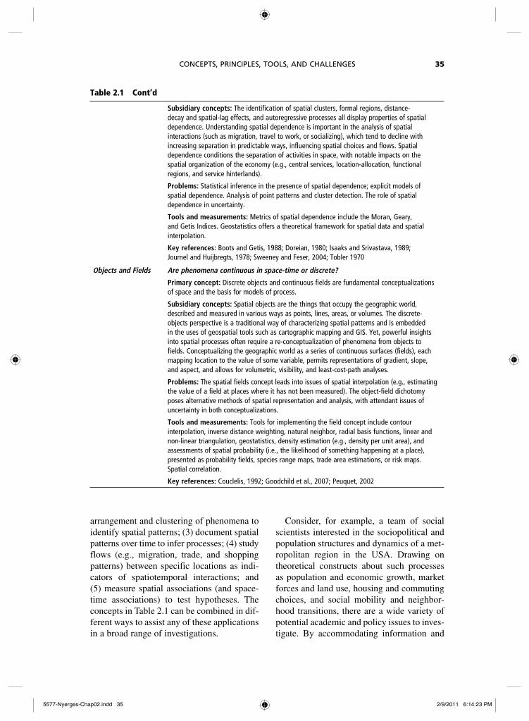
Table 2.1 Cont’d
Subsidiary concepts: The identification of spatial clusters, formal regions, distance-decay and spatial-lag effects, and autoregressive processes all display properties of spatial dependence. Understanding spatial dependence is important in the analysis of spatial interactions (such as migration, travel to work, or socializing), which tend to decline with increasing separation in predictable ways, influencing spatial choices and flows. Spatial dependence conditions the separation of activities in space, with notable impacts on the spatial organization of the economy (e.g., central services, location-allocation, functional regions, and service hinterlands).
Problems: Statistical inference in the presence of spatial dependence; explicit models of spatial dependence. Analysis of point patterns and cluster detection. The role of spatial dependence in uncertainty.
Tools and measurements: Metrics of spatial dependence include the Moran, Geary, and Getis Indices. Geostatistics offers a theoretical framework for spatial data and spatial interpolation.
Key references: Boots and Getis, 1988; Doreian, 1980; Isaaks and Srivastava, 1989; Journel and Huijbregts, 1978; Sweeney and Feser, 2004; Tobler 1970
Objects and Fields Are phenomena continuous in space-time or discrete?
Primary concept: Discrete objects and continuous fields are fundamental conceptualizations of space and the basis for models of process.
Subsidiary concepts: Spatial objects are the things that occupy the geographic world, described and measured in various ways as points, lines, areas, or volumes. The discrete-objects perspective is a traditional way of characterizing spatial patterns and is embedded in the uses of geospatial tools such as cartographic mapping and GIS. Yet, powerful insights into spatial processes often require a re-conceptualization of phenomena from objects to fields. Conceptualizing the geographic world as a series of continuous surfaces (fields), each mapping location to the value of some variable, permits representations of gradient, slope, and aspect, and allows for volumetric, visibility, and least-cost-path analyses.
Problems: The spatial fields concept leads into issues of spatial interpolation (e.g., estimating the value of a field at places where it has not been measured). The object-field dichotomy poses alternative methods of spatial representation and analysis, with attendant issues of uncertainty in both conceptualizations.
Tools and measurements: Tools for implementing the field concept include contour interpolation, inverse distance weighting, natural neighbor, radial basis functions, linear and non-linear triangulation, geostatistics, density estimation (e.g., density per unit area), and assessments of spatial probability (i.e., the likelihood of something happening at a place), presented as probability fields, species range maps, trade area estimations, or risk maps. Spatial correlation.
Key references: Couclelis, 1992; Goodchild et al., 2007; Peuquet, 2002
arrangement and clustering of phenomena to identify spatial patterns; (3) document spatial patterns over time to infer processes; (4) study flows (e.g., migration, trade, and shopping patterns) between specific locations as indi-cators of spatiotemporal interactions; and (5) measure spatial associations (and space-time associations) to test hypotheses. The concepts in Table 2.1 can be combined in dif-ferent ways to assist any of these applications in a broad range of investigations.
Consider, for example, a team of social scientists interested in the sociopolitical and population structures and dynamics of a met-ropolitan region in the USA. Drawing on theoretical constructs about such processes as population and economic growth, market forces and land use, housing and commuting choices, and social mobility and neighbor-hood transitions, there are a wide variety of potential academic and policy issues to inves-tigate. By accommodating information and
5577-Nyerges-Chap02.indd 355577-Nyerges-Chap02.indd 35 2/9/2011 6:14:23 PM2/9/2011 6:14:23 PM
THE SAGE HANDBOOK OF GIS AND SOCIETY RESEARCH36
data at all scales of analysis – at the indivi-dual and household levels, as well as aggre-gations by standard census and political units – options for research topics and ana-lytical methodologies are kept open. This framework permits use of any of the spatial analytic and information display tools, con-cepts, and spatial reasoning processes dis-cussed in this chapter. Readers are invited to consider advanced discussions on specific research topics in leading textbooks and research reviews.5 The examples suggested below are intended as illustrative rather than exhaustive and they are limited to questions about the structure and dynamics of a metro-politan region.
Overlaying maps within a GIS may suggest rela- •tionships to explain variances across space in, for instance, ethnicity, political party allegiance, economic status, and social cohesion.GIS overlays and spatial analysis of neighbor- •hood population characteristics with levels of toxic emissions or proximity to noxious facilities (e.g., a waste incinerator or a brownfield site) may be investigated for evidence of social or environmental injustice (Maantay, 2002).A search for correlates among variables aggre- •gated by census tracts could shed understand-ing about patterns of disease transmission or exposures to environmental hazards.Analysis of spatial dependence in cross-sectional •data can reveal insights into the spatial scale of causal mechanisms in domains as diverse as crime, housing markets, and job access. For example, how do car burglaries and acts of crimi-nal violence relate to distances from clusters of liquor or drug outlets?Evidence of social pathology at community levels •(Shaw and McKay, 1969) may show correlation with environmental factors and population den-sities, but considerations of spatial autocorrela-tions may suggest other forces at play (Loftin and Ward, 1981; Sampson et al., 2002).Researchers may reflect on correlations of indi- •vidual activity behavior (from space–time diaries) with levels of obesity and the presence of park space or land use structures that encourage walking.A mapping of the concentration and cluster- •ing of ethnicity data by census units may help assess how assimilation processes alter the
neighborhood foundations of ethnic groups in a metropolitan area (Logan and Zhang, 2004).Indices of segregation among ethnic and racial •groups based on small-area data (e.g., census block groups) may change over time to reflect trends in social mobility, immigration, or other factors (Reardon and Firebaugh, 2002).Documenting residential moves within and across •regions of the city may reveal if neighborhood demographic transitions respond to changing land markets and to public investments in social infrastructure.The graphic illustration of patterns as con- •tinuous variables over space (fields) makes sense for measures of average daily temperatures but might also be appropriate where theories and models permit the interpolation of values between sampled sites, as, for example, in esti-mating house values or the likelihood of noise exposure to traffic densities.Distance zones provide a basis of estimating a •store’s access to markets or to determine the potential client base for health clinics.Spatial dependencies in party voting tendencies •at the precinct level may reflect the sense of shared community expectations and the spa-tial patterns of interpersonal networks (Eagles et al., 2004).Studying flows between specific locations within •a neighborhood and beyond may reveal networks and spatiotemporal structures that foster interac-tions (e.g., social visits, commutes to work, or financial transactions). For instance, the origins of commodities sold in local markets may signal the level of the region’s integration with national and global economies.
The examples above focus on topics at neighborhood and metropolitan scales, but they could be extended to integrate the micro geographies of households or global patterns of production and commerce, and environ-ment–health interactions. Of course, the realm of social science research is forever unfolding with new hot topics, evolution in explanatory theories, and improved modeling and analysis tools. In addition, there are ongoing changes in infrastructures for com-munication, information retrieval and use, and analysis, all of which will impinge on the continued development of spatially integrated social science.
5577-Nyerges-Chap02.indd 365577-Nyerges-Chap02.indd 36 2/9/2011 6:14:23 PM2/9/2011 6:14:23 PM
CONCEPTS, PRINCIPLES, TOOLS, AND CHALLENGES 37
SPATIAL ANALYSIS SOFTWARE TOOLS
Beyond the many advances in GIS (reviewed by the editors in the introduction to this volume), analytic tools tailor-made for researchers in the social sciences have helped in the last decade to facilitate applications of the principles and practices of spatially inte-grated social science.6 Some of the more easily accessed, affordable, and widely used of these software tools are listed below.
GeoDa™ was released in 2003 as a free and easy- •to-use software package. It provides an explora-tory tool to describe, map, and analyze spatial data. More importantly, it has expanded the capa-bilities for social scientists to account for higher-order geographical effects on social patterns and processes, such as spatial autocorrelation and spatial heterogeneity. Rey and Anselin (2006) review the development and utility of GeoDa.Geographically weighted regression (GWR) •(Fotheringham et al., 2002) recognizes that social processes usually vary depending on where they take place (i.e., spatial non-stationarity). GWR provides a method to account explicitly for localized multivariate spatial relationships in a regression framework, with local parameter esti-mates displayed usually as a continuous surface mapped within a GIS or with other software for data visualization.STARS • (Space Time Analysis of Regional Systems, Rey and Janikas [2006]) is an open-source pack-age for analyzing temporal trends in data aggre-gated by areal units for successive times or periods. It features dynamically linked graphi-cal views to help researchers explore changing space–time relationships.R, • a programming language for statistics and related graphics, features access to a number of specialized spatial analysis packages for point and areal data and cluster analysis (Baddeley and Turner, 2005). These programs provide sig-nificant flexibility for the analyst adept at writing customized scripts.C • rimeStat® is tailored for use in crime analysis and crime mapping (Levine, 2007). It links GIS capabilities with descriptive tools for distance and hot-spot analysis of pattern distributions, spatial interpolation, and travel modeling, all of which are adaptable to a variety of social science applications.
CHALLENGES AND OPPORTUNITIES FOR THE FUTURE OF SPATIAL ANALYSIS IN THE SOCIAL SCIENCES
Applications of spatially integrated thinking in the social sciences reveal how the merger of spatial concepts with the processing power of GIS and other spatial technologies enhances opportunities to communicate results for research and teaching and to pro-vide contextual real-world grounding for community discourse in solving societal problems. Nonetheless, there are impedi-ments to embedding spatial concepts and spatial reasoning as standard practices within the social sciences and for problem solving. There are methodological challenges associ-ated with the informed use of concepts and analytical tools, and with framing modeling approaches from a sound base of theoretical understanding. These are critically important but are treated elsewhere in this handbook and in the references noted in Table 2.1. In this section, the focus is on three interrelated challenges – information, communication, and infrastructure.
Information challenges
Social scientists explore and analyze a wide range of data resources, derived from diverse methodologies – from qualitative to quantita-tive, from field observation to laboratory experimentation, from standardized censuses to customized surveys, and from descriptive analysis to theory and modeling. This work yields thousands of heterogeneous data sources that relate to social and economic behavior around the world, but their unique data formats, customized subject categori-zations, and diverse archival constraints pre-clude the ideal of a one-stop search capability for integrating such information. Even with sophisticated web tools, researchers must search separately and compile results from a multitude of different sources. Another common problem is that data gathered for political units (e.g., counties, states or
5577-Nyerges-Chap02.indd 375577-Nyerges-Chap02.indd 37 2/9/2011 6:14:23 PM2/9/2011 6:14:23 PM
THE SAGE HANDBOOK OF GIS AND SOCIETY RESEARCH38
provinces, or nations) are often not easily integrated with data collected from different underlying geographies (e.g., administra-tively defined regions, watersheds, buffers, or pixels). Furthermore, political and other administrative representations change over time as boundaries shift, units split or merge, or data gathering organizations introduce new techniques that can affect the continuity and quality of time series data. Reibel (2007) describes strategies for coping with such issues in demography, but similar approaches would apply to other social sciences that rely on spatially aggregated data sources.
Although the task for integrating informa-tion for the social sciences is daunting, notable advances have helped to enhance resources in the spatial domain for social science research. The following projects focus on what may be termed re-spatialization (Goodchild et al., 1993) and new analysis tools tailored for broad social science applications, all of which are helpful to advancing the principles of spatially integrated social science.
The National Historical Geographic Information •System (NHGIS) addresses shifts in reporting zones of the US Census since the eighteenth cen-tury, providing aggregate census data and GIS-compatible boundary files for the USA between 1790 and 2000. These cover a wide range of geographies, including blocks, census tracts, counties, metropolitan statistical areas, states, voting districts, zip codes, and many other tabu-lations. Hosted by the University of Minnesota’s Minnesota Population Center, the NHGIS pro-vides important facilitation for historical research on the changing demographic, economic, and social geographies of the United States (see http://www.nhgis.org/).The Gridded Population of the World (GPW) •project, hosted by the Center for International Earth Science Information Network (CIESIN) at Columbia University transforms population data collected for national and subnational administrative units into population totals and densities on a grid defined by lines of lati-tude and longitude (Tobler et al., 1997). This permits researchers to integrate GPW with other gridded datasets (e.g., remote sensing data), to reaggregate population to alternative
spatial units (e.g., watersheds, biomes, or metropolitan regions), and to weight other vari-ables by population characteristics (see http://sedac.ciesin.columbia.edu/plue/gpw). Recent versions of GPW include urban and rural informa-tion that allow new insights on global patterns of human settlement.The Integrated Public Use Microdata Series •(IPUMS) provides individual- and household-level census survey data over several decades in the USA and for several census years in many other countries. The Minnesota Population Center is creating an exceptional resource for cross-national and cross-temporal research (McCaa and Ruggles, 2002), collecting, preserving, har-monizing, disseminating, and documenting such data for the USA and, currently, for 26 other counties (see http://www.pop.umn.edu/data).
These data initiatives are exemplary in their attempts to resolve fundamental prob-lems of linking data across different kinds of boundaries and across periods. Yet the task of embedding the perspectives of spatial analy-sis in the social sciences retains notable hurdles. A recent editorial in Nature (2008) makes the bold (but accurate) assertion that there is no excuse for not linking all survey and research observations with geo-referenced coordinates, whether or not they serve the immediate interests of the researchers. This editorial points to the information challenges that confront the adoption of spatially informed reasoning in all sciences but, also, to critical communication challenges that seem especially poignant for the social sciences.
Communication challenges
A second set of challenges relates to com-munication, manifested in the need to inte-grate social science knowledge with insight from the physical and environmental sci-ences. Increasingly, the social sciences, the natural sciences, and engineering need to exchange and integrate their respective exper-tise in solving problems. Thus, in research on environmental and global change, ecologists and earth scientists need socioeconomic knowledge to understand human influences
5577-Nyerges-Chap02.indd 385577-Nyerges-Chap02.indd 38 2/9/2011 6:14:23 PM2/9/2011 6:14:23 PM
CONCEPTS, PRINCIPLES, TOOLS, AND CHALLENGES 39
on ecological and environmental processes (Chen, 1981; Miller, 1994; NRC, 1992, 1998, 1999). Similarly, engineers need back-ground in socioeconomics to understand how public choices and behavioral patterns might interact with new engineering structures, and seismologists must consider social science perspectives to project natural hazard vulner-abilities and likely human responses (Cutter, 2001). The capacities to integrate data and to communicate across disciplinary boundaries are issues of considerable significance and will be key to the advancement of theory and the conduct of research across fields. The spatial framework and a common set of spa-tial concepts can provide a focus for defining and understanding problems and offer a basis for communication and integration.
Technologies for online collaboration and grid computing for computational support have seen successful, but limited, deployment through projects such as GEON (http://www.geongrid.org) in the geosciences and SEEK (http://seek.ecoinformatics.org) in ecology that distribute data and provide collaboration services and analytical tools in a seamless research environment. Other grid-computing initiatives support collaborative research in high-energy physics (GriPhyN), astronomy (NVO), biomedical applications (BIRN), and earthquake engineering (NEESGrid). Unfortunately, there are no parallel develop-ments serving the social science community. Yet, a compelling task for such cyberinfra-structure in the social sciences would be the development of an interoperable platform to explore many disparate sources simulta-neously in a single search to help uncover knowledge resources that run the gamut from bibliographies and publications to video and audio media, along with geo-spatial resources, data, model runs, tools for data visualization, simulations, and listings of experts.
Infrastructure challenges
The infrastructure challenges for resolving the data and communication needs are key
to making social science more accessible, doable, transparent, and useful. This chal-lenge embraces education and the need to embed the science tradition (including spa-tial awareness) for engaging students at all levels in practices of formulating testable propositions, gathering data, and modeling processes and interactions. Recent national initiatives to build infrastructure for spatial analysis in the social sciences have included the projects mentioned earlier from the Minnesota Population Center and CIESEN (focused on data issues) and from the Center for Spatially Integrated Social Science (CSISS), focused on developing new analytic tools and building expertise and awareness across disciplines.
Recent NSF reports (e.g., Atkins et al. 2003) highlight an infrastructure vision that works at the interfaces of computer sci-ence, communication technologies (using distributed computing resources and network-enabled tools for collaboration), and the social sciences, with outcomes directed to greater automation of routine procedures, easier access to data resources via web inter-faces, and new tools for collaboration, both among social scientists and with researchers in other domains. The added potentials and issues related to web 2.0 technologies and practices highlight problems about validation and empirical verification of new informa-tion sources for use in scientific modeling and for social applications.
Individual institutions, recognizing the importance of building local collaborative efforts in this area, have acted to enhance support for spatial perspectives in research and teaching. Examples include Harvard University’s Center for Geographic Analysis, Brown University’s initiative on Spatial Structures in the Social Sciences, and spa-tial@ucsb – a spatial studies center to pro-mote spatial thinking in all branches of knowledge – at the University of California, Santa Barbara. In addition, applications of GIS and spatial econometrics have figured prominently in some of the population research centers supported through the
5577-Nyerges-Chap02.indd 395577-Nyerges-Chap02.indd 39 2/9/2011 6:14:23 PM2/9/2011 6:14:23 PM
THE SAGE HANDBOOK OF GIS AND SOCIETY RESEARCH40
National Institutes of Health, including the Geographic Information Analysis Core of the Population Research Institute at Pennsylvania State University, the Spatial Analysis Unit of the Carolina Population Center at the University of North Carolina, and the Applied Population Laboratory at the University of Wisconsin Center for Demography and Ecology.
DISCUSSION
Whatever the term, spatially integrated social science, or spatial social science, it is evident that the practice of spatial thinking through application of spatial concepts and the use of spatial data are expanding to help resolve gaps in our understanding of research ques-tions in many disciplines. For instance, Knowles (2000) points to a spatial turn in history, Lobao (2003) makes a similar claim for sociology, and Voss (2007) argues that demography has been (historically), and is, a spatial social science. Academic leaders, including Norm Bradburn (2004) and Rita Colwell (2004), have flagged the importance of geographical perspective across the sci-ences, and Butz and Torrey (2006) suggest that spatial analysis is emerging as a funda-mental growth area in pushing the frontiers of social science research. This momentum of growth, documented more fully by Janelle and Goodchild (2009), is buoyed, as well, by new kinds of geographical data resources and more easily acquired tools. However, many challenges remain, and it is not clear that the transition to spatial awareness in scholarship is keeping pace with societal needs.
The popularization of spatial technologies may be expanding faster than the acquisition of skills in fundamental spatial thinking (e.g., the understanding of geographical scale and the selection of map projections). The drivers of such change include the geovisualization of news in the popular press, new web 2.0 applications for embedding personal and other volunteered information on maps
(e.g., geotagging in Wikimapia and Flikr®), and commercial advertising (e.g., GPS navi-gation). They also include lay participation in the world of maps (e.g., Google Maps™, Google Earth™, and Microsoft’s Bing Maps Interactive™), and reliance on map-based information search tools (e.g., location-based services). Opportunities to engage interac-tively with an integrated global network of producers and users of geographical infor-mation have expanded to the point of ena-bling new geographies of the information society. Foretold by Sheppard, et al. (1999), these new geographies and networking pos-sibilities create demands for social scientists to build trans-disciplinary alliances based on improved spatial awareness to advance inves-tigations of population dynamics, political issues, health problems, and other social concerns.
The National Research Council’s (NRC) (2006) report on Learning to Think Spatially makes a compelling case for expanding the attention given to spatial reasoning and to the use of spatial tools in K–12 education. But, clearly, the rapidity of technological and social changes is so great that this education objective must be elevated and accelerated to reach all cohorts of citizens and scholars. The authors hope that the principles of spatially integrated social science, the concepts of spatial thinking, and the tools for spatial analysis and display, as discussed in this chapter and as summarized in the concluding chapter by the editiors to this handbook, pro-vide guidance in this direction. Nonetheless, the information, communication, and infra-structure challenges, mentioned in the eighth section, are likely to unfold in novel ways. They will pose ever-changing opportunities to employ spatial concepts for enriching our understandings and solutions to scientific and societal problems.
NOTES
1 The Center for Spatially Integrated Social Science (CSISS) maintains a collection of syllabi for
5577-Nyerges-Chap02.indd 405577-Nyerges-Chap02.indd 40 2/9/2011 6:14:23 PM2/9/2011 6:14:23 PM
CONCEPTS, PRINCIPLES, TOOLS, AND CHALLENGES 41
undergraduate and graduate courses about spatial analytic applications for social science disciplines. (See http://www.csiss.org/SPACE/directory/.)
2 A recent specialist meeting investigated issues surrounding the use and evaluation of space–time simulations in research. Access to diverse position statements by experts in the area are available at http://www.ncgia.ucsb.edu/projects/abmcss/.
3 Researchers from the academic, industrial, and governmental sectors met in Santa Barbara, CA in December 2007 to investigate these issues. The meeting was hosted by the National Center for Geographic Information and Analysis (NCGIA) with support from the Los Alamos National Laboratory, the Army Research Office, and the Vespucci Initiative. See http://ncgia.ucsb.edu/projects/vgi/ for copies of position papers and examples of applications of volun-teered geographic information and associated issues.
4 Additional information on spatial concepts is available at http://spatial.ucsb.edu/resources/teach-learn/concepts.php. Since space does not permit a full discussion of the solutions to the problems noted in the table, readers are encouraged to examine the suggested key references.
5 Bailey and Gatrell (1996) provide a thoughtful reference, rich with examples of analytic methods and models for treating point patterns, spatially con-tinuous data, area data, and spatial interaction data. Haining (2003) delves into the theoretical founda-tions of spatial analysis. O’Sullivan and Unwin (2002) integrate GIS capabilities with statistical procedures, and discuss applications of computationally intensive approaches to geo-spatial modeling (e.g., agent-based models, expert systems, and cellular autom-ata). Steinberg and Steinberg (2006) introduce the basics of GIS for social science applications. Castro (2007), Voss, et al. (2006), Voss (2007), and Weeks (2004) review applications of spatial analysis specific to issues in demography; Cromley and McLafferty (2002) explore applications of GIS in public health research; Anselin et al. (2004) feature a selection of contemporary applications in spatial econometrics; and the journal Political Analysis released a special issue on spatial methods in political science (no. 10, 2002). For edited selections of important recent developments and applications in spatial data analysis, see Anselin and Rey (2010) and Fischer and Getis (2010).
6 The software systems described in this section are available at little or no cost and are downloada-ble from the web addresses that follow:
GeoDa™ (http://geodacenter.asu.edu) •Geographically Weighted Regression (http://ncg. •nuim.ie/ncg/GWR)STARS • (Space Time Analysis of Regional Systems, http://regionalanalysislab.org/)
R, downloadable from http://www.r-project.org/), •provides links to download a variety of spatial software to work with its open-source architectureC • rimeStat® (http://www.icpsr.umich.edu/crimestat)Quantum GIS is a free open-source geographic •information system. http://www.qgis.org/
Castro (2007) provides an alternative listing of freely distributed software tools that would be of special interest to demographers. In addition, commercial developers and venders of statistical software have augmented their products with capabilities for spatial analysis, and are recom-mended for consideration. For example, S+SpatialStats® (http://www.insightful.com/prod-ucts/spatial) allows for data analysis and modeling of geostatistical data, point patterns, and lattice data with S-PLUS; SAS/GIS® (http://www.sas.com/products/gis/) provides integration of basic GIS functionality to its SAS statistical and exploratory tools; and TerraSeer® (http://www.terraseer.com)
has a suite of tools for space-time analysis, cluster analysis, boundary analysis, and spatial econometric modeling.
Commercial GIS platforms may include sophisti-cated analytic capabilities for geospatial statistics, data modeling, 3D representations, trend analysis, and decision-support capabilities, either as add-ons to the main GIS platform (e.g., ESRI’s ArcGIS®
http://www.esri.com) or integrated into the platform (e.g., Clark Lab’s IDRISI® http://www.clarklabs.org). Other GIS packages, offering different price points and capabilities, include MapInfo® http://www.mapinfo.com/, Maptitude® http://www.caliper.com/Maptitude, and Manifold® http://www.manifold.net.
REFERENCES
Ahuja, R.K., Magnanti, T.L. and Orlin, J.B. (1993) Network flows: Theory, Algorithms and Applications. Englewood Cliffs, NJ: Prentice Hall.
Alonso, W. (1964) Location and Land Use. Cambridge, MA: Harvard University Press.
Anderton, D.L. (1996) ‘Methodological issues in the spatiotemporal analysis of environmental equity’, Social Science Quarterly, 77: 508–515.
Anselin, L. (2000) ‘GIS, spatial econometrics and social science research’, Journal of Geographical Systems, 2: 11–15.
Anselin, L., Florax, R.J. and Rey, S.J. (eds) (2004) Advances in Spatial Econometrics: Methodology, Tools and Applications. Berlin: Springer.
5577-Nyerges-Chap02.indd 415577-Nyerges-Chap02.indd 41 2/9/2011 6:14:23 PM2/9/2011 6:14:23 PM
THE SAGE HANDBOOK OF GIS AND SOCIETY RESEARCH42
Anselin, L. and Rey, S.J. (eds) (2010) Perspectives on Spatial Data Analysis. Berlin: Springer.
Atkins, D.E., Droegemeier, K.K., Feldman, S.I., Garcia-Molina, H., Klein, M.L., Messerschmitt, D.J., Messina, P., Ostriker, J.P., and Wright, M.H. (2003) Revolutionizing Science and Engineering Through Cyberinfrastructure: Report of the National Science FoundationBlue Ribbon Advisory Panel on Cyberinfrastructure. Washington DC: National Science Foundation. http://www.nsf.gov/od/oci/reports/atkins.pdf (accessed 27 September 2010).
Baddeley, A. and Turner, R. (2005) ‘Spatstat: An R package for analyzing spatial point patterns’, Journal of Statistical Software, 12(6): 1–12. http://www.jstatsoft.org/ (accessed 27 September 2010).
Bailey, T.C. and Gatrell, A.C. (1996) Interactive Spatial Data Analysis. Harlow: Longman.
Bales, K. (1999) ‘Popular reactions to sociological research: the case of Charles booth’, Sociology, 33(1): 153–168.
Bialynicki-Birula, I. and Bialynicki-Birula, I. (2004) Modeling Reality: How Computers Mirror Life. New York: Oxford University Press.
Boots, B.N. and Getis, A. (1988) Point Pattern Analysis. Newbury Park, CA: Sage Publications.
Bradburn, N.M. (2004) ‘Foreword’, in M.F. Goodchild and D.G. Janelle (eds), Spatially Integrated Social Science. New York: Oxford University Press. pp. v–vi.
Butz, W. and Torrey, B.B. (2006) ‘Some frontiers in social science’, Science, 312(5782): 1898–1900.
Castro, M.C. (2007) ‘Spatial demography: An opportu-nity to improve policy making at diverse decision levels’. In P.R. Voss (ed.), Special Issue on Spatial Demography: Population Research and Policy Review, 26: 477–509.
Chen, R.S. (1981) ‘Interdisciplinary research and inte-gration: The case of CO2 and climate’, Climatic Change, 3: 429–447.
Colwell, R. (2004) ‘The new landscape of science: A geographic portal’, Annals of the Association of American Geographers, 94(4): 703–708.
Couclelis, H. (1992) ‘People manipulate objects (but cultivate fields): beyond the raster vector debate in GIS’. In A.U. Frank and I. Campari (eds), Theories and Methods of Spatio-temporal Reasoning in Geographic Space. Berlin: Springer-Verlag, 639: 65–77.
Couclelis, H. (2001) ‘Why I no longer work with agents: a challenge for ABMs of human-environment inter-action’. In D. Parker, T. Berger and S. Manson (eds), Agent-based Models of Land-use and Land-cover Change. LUCC Report Series. 6: 3–5.
Cromley, E.K. and McLafferty, S.L. (2002) GIS and Public Health. New York: Guilford Press.
Cutter, S.L. (2001) ‘Charting a course for the next two decades’. In S. L. Cutter (ed.), American Hazardscapes: The Regionalization of Hazards and Disasters. Washington DC: Joseph Henry Press. pp. 157–65.
Cutter, S.L., Golledge, R.G. and Graf, W.L. (2002) ‘The big questions in geography’, The Professional Geographer, 54(3): 305–17.
de Smith, M.J., Goodchild, M.F. and Longley, P.A. (2009) Geospatial Analysis: A Comprehensive Guide to Principles, Techniques, and Software Tools. Leicester, U.K: The Winchelsea Press, Troubador Publishing, Ltd. (a pdf e-book at http://www.spatialanalysisonline.com/).
Doreian, P. (1980) ‘Linear models with spatially distrib-uted data: spatial disturbances or spatial effects?’, Sociological Methods and Research, 9: 29–60.
Doreian, P. (1990) ‘Network autocorrelation models: problems and prospects’. In D. Griffith (ed.), Spatial Statistics: Past, Present, and Future. Ann Arbor, MI: Institute of Mathematical Geography. pp. 369–389.
Eagles, M., Bélanger, P. and Calkins, H.W. (2004) ‘The spatial structure of urban political discussion networks’. In M.F. Goodchild and D.G. Janelle (eds), Spatially Integrated Social Science. New York: Oxford University Press. pp. 205–218.
Fischer, M.M. and Getis, A. (eds) (2010) Handbook of Applied Spatial Analysis: Software Tools, Methods and Applications. Berlin: Springer.
Fogel, R.W. (1971) The Reinterpretation of American Economic History. New York: Harper & Row.
Forman, R.T. (1995) Land Mosaics: The Ecology of Landscapes and Regions. Cambridge, UK: Cambridge University Press.
Fotheringham, A.S., Brunsdon, C. and Charlton, M. (2002) Geographically Weighted Regression: The Analysis of Spatially Varying Relationships. New York: John Wiley.
Golledge, R.G. (1995) ‘Primitives of spatial knowl-edge’. In T.L. Nyerges, D.M. Mark, R. Laurini and M.J. Egenhofer (eds), Cognitive Aspects of Human–Computer Interaction for Geographic Information Systems. Dordrecht: Kluwer Academic. pp. 29–44.
Golledge, R.G. (2002) ‘The nature of geographic knowledge’, Annals of the Association of American Geographers, 92(1): 1–14.
Goodchild, M.F. (1997) ‘Scale in a digital geographic world’, Geographical and Environmental Modeling, 1: 5–23.
Goodchild, M.F. (2007) ‘Citizens as sensors: the world of volunteered geography’, presentation to
5577-Nyerges-Chap02.indd 425577-Nyerges-Chap02.indd 42 2/9/2011 6:14:24 PM2/9/2011 6:14:24 PM
CONCEPTS, PRINCIPLES, TOOLS, AND CHALLENGES 43
workshop on Volunteered Geographic Information. Santa Barbara CA, 13–14 December. http://ncgia.ucsb.edu/projects/vgi/ (accessed 27 September 2010).
Goodchild, M.F. and Janelle, D.G. (2004) Spatially Integrated Social Science. New York: Oxford University Press.
Goodchild, M.F., Anselin L. and Deichmann, U. (1993) ‘A framework for the areal interpolation of socio-economic data’, Environment and Planning A, 25: 383–397.
Goodchild, M.F., Anselin, L. Appelbaum, R.P. and Harthorn, B.H. (2000) ‘Toward spatially integrated social science’, International Regional Science Review, 23(2): 139–159.
Goodchild, M.F., Yuan, M., and Cova, T. (2007) ‘Towards a general theory of geographic representa-tion in GIS’, International Journal of Geographical Information Science, 21(3): 239–260.
Griliches, Z. ([1957] 1988) ‘Hybrid corn: An exploration of the economics of technological change’, Technology, Education and Productivity: Early Papers with Notes to Subsequent Literature. New York: Basil Blackwell. pp. 27–52.
Hägerstrand, T. (1970) ‘What about people in regional science?’, Papers of the Regional Science Association, 24: 1–12.
Haining, R. (2003) Spatial Data Analysis: Theory and Practice. Cambridge: Cambridge University Press.
Hill, L.L. (2006) Georeferencing: The Geographic Associations of Information. Cambridge, MA: MIT Press.
Isaaks, E.H. and Srivastava, R.M. (1989) Applied Geostatistics. New York: Oxford University Press.
Janelle, D.G. and Goodchild, M.F. (2009) ‘Location across disciplines: reflections on the CSISS experi-ence’. In H.J. Scholten, R. van de Velde and N. van Manen (eds), Geospatial Technology and the Role of Location in Science. Dordrecht: Springer. pp. 15–29.
Johnson, S.B. (2006) The Ghost Map: The Story of London’s most Terrifying Epidemic – and how it Changed Science, Cities, and the Modern World. New York: Riverhead.
Journel, A.G. and Huijbregts, C.J. (1978) Mining Geostatistics. London: Academic Press.
Kelly, F. ([c1895] 1970) Hull-House Maps and Papers: By the Residents of Hull-House. New York: Arno Press.
Key, V.O. (1949) Southern Politics in State and Nation. New York: Knopf.
Kimerling, A.J. and Muehrcke, P. et al. (2005) Map Use: Reading, Analysis, and Interpretation. Madison, WI: JP Publications.
Knowles, A.K. (ed.) (2000) ‘Historical GIS: the spatial turn in social science history’, Social Science History, 24(3): 451–470.
Krugman, P. (1991) Geography and Trade. Cambridge: MIT Press.
Kurath, H. (1949) A Word Geography of the Eastern United States. Ann Arbor, MI: University of Michigan Press.
Kwan, M.-P. and Lee, J. (2004) ‘Geovisualization of human activity patterns using 3D GIS: a time-geographic approach’. In M.F. Goodchild and D.G. Janelle (eds), Spatially Integrated Social Science. New York: Oxford University Press. pp. 48–66.
Levine, N. (2007) CrimeStat: A Spatial Statistics Program for the Analysis of Crime Incident Locations (v 3.1). Houston, TX: Ned Levine & Associates.
Lobao, L. (2003) ‘Rurals sociology and the “spatial turn” across the social sciences’, The Rural Sociologist, 23(2): 1–2.
Loftin, C. and Ward, S.K. (1981) ‘Spatial autocorrela-tion models for Galton’s problem’, Behavior Science Research, 16: 105–128.
Logan, J.R. and Zhang, W. (2004) ‘Identifying ethnic neighborhoods with census data’. In M.F. Goodchild and D.G. Janelle (eds), Spatially Integrated Social Science. New York: Oxford University Press. pp. 113–126.
Maantay, J. (2002) ‘Mapping environmental injustices: Pitfalls and potential of geographic information sys-tems (GIS) in assessing environmental health and equity’, Environmental Health Perspectives, 110(2): 161–171.
McCaa, R, and Ruggles, S. (2002) ‘The census in global perspective and the coming microdata revolution’, Scandinavian Population Studies, 13: 7–30.
McHarg, I. (1969) Design with Nature. Garden City, NJ: Doubleday/Natural History Press.
MacArthur, R.H. and Wilson, E.O. (1967) The Theory of Island Biogeography. Princeton, NJ: Princeton University Press.
Mayhew, H. ([1861] 1967) London Labour and the London Poor: A Cyclopaedia of the Condition and Earnings of those that will Work, Those that Cannot Work, and Those that will not Work. New York: A.M. Kelley.
Miller, H.J. (2005) ‘Necessary space–time conditions for human interaction’, Environment and Planning B: Planning and Design, 32: 381–401.
Miller, R.B. (1994) ‘Interactions and collaboration in global change across the social and natural sci-ences’, AMBIO: A Journal of the Human Environment, 23(1): 19–24.
5577-Nyerges-Chap02.indd 435577-Nyerges-Chap02.indd 43 2/9/2011 6:14:24 PM2/9/2011 6:14:24 PM
THE SAGE HANDBOOK OF GIS AND SOCIETY RESEARCH44
Montello, D.R. (2001) ‘Scale, in geography’, in N.J. Smelser and P.B. Baltes (eds), International Encyclopedia of the Social and Behavioral Sciences. Oxford: Pergamon Press. pp. 13501–4.
Montello, D.R., Goodchild, M.F., Gottsegen, J. and Fohl, P. (2003) ‘Where’s downtown? Behavioral methods for determining referents of vague spatial queries, special issue on spatial vagueness, uncer-tainty, granularity’. In B. Bennett and M. Cristani (eds), Spatial Cognition and Computation, 3: 185–204.
Murdie, R. (1969) ‘Factorial ecology of metropolitan Toronto, 1951–1961’, Research Paper No. 116, Department of Geography, University of Chicago.
National Research Council (NRC) (1992) Global Environmental Change: Understanding the Human Dimensions. Washington, DC: National Academy Press.
National Research Council (NRC) (1998) People and Pixels: Linking Remote Sensing and Social Science. Washington, DC: National Academy Press.
National Research Council (NRC) (1999) Global Environmental Change: Research Pathways for the Next Decade. Washington DC: National Academy Press.
National Research Council (NRC) (2006) Learning to Think Spatially: GIS as a Support System in the K-12 Curriculum. Washington, DC: The National Academies Press.
Nature (2008) ‘A place for everything (editorial)’, Nature, 453: 2.
Nystuen, J.D. (1963) ‘Identification of some funda-mental spatial concepts’, Papers of the Michigan Academy of Science, Arts, Letters, 18: 373–84.
Okabe, A., Okunuki, K. and Shiode, S. (2006) ‘SANET: a toolbox for spatial analysis on a network’, Geographical Analysis, 35: 57–66.
O’Sullivan, D. (2004) ‘Too much of the wrong kind of data: implications for the practice of micro-scale spatial modeling’. In M.F. Goodchild and D.G. Janelle (eds), Spatially Integrated Social Science. New York: Oxford University Press. pp. 95–107.
O’Sullivan, D. and Unwin, D.J. (2002) Geographic Information Analysis. New York: John Wiley.
Openshaw, S. (1983) ‘The modifiable areal unit problem’, Concepts and Techniques in Modern Geography: CATMOG Series. 38. Norwich: GeoBooks.
Park, R., Burgess, E.W. and McKenzie, R.D. (1925) The City. Chicago, IL: University of Chicago Press.
Peuquet, D.J. (2002) Representations of Space and Time. New York: Guilford Press.
Reardon, S.F. and Firebaugh, G. (2002) ‘Measures of multi-group segregation’, Sociological Methodology, 32: 33–67.
Reibel, M. (2007) ‘Geographic information systems and spatial data processing in demography: a review’. In P. R. Voss (ed.), Special Issue on Spatial Demography: Population Research and Policy Review, 26: 601–618.
Rey, S.J. and Anselin, L. (2006) ‘Recent advances in software for spatial analysis in the social sciences’, Geographical Analysis, 38: 1–4.
Rey, S.J. and Janikas, M.V. (2006) ‘STARS: space-time analysis of regional systems’, Geographical Analysis, 38: 67–86.
Robinson, A.H. (1967) ‘The thematic maps of Charles Joseph Minard’, Imago Mundi, 21: 95–108.
Sampson, R.J., Morenoff, J. and Gannon-Rowley, T. (2002) ‘Assessing neighborhood effects: social processes and new directions in research’, Annual Review of Sociology, 28: 443–78.
Shaw, C.R. and McKay, H.D. (1969) Juvenile Delinquency and Urban Areas. Chicago, IL: University of Chicago Press.
Sheppard, E.S. (2004) Scale and Geographic Inquiry: Nature, Society, and Method. Boston, MA: Wiley-Blackwell.
Sheppard, E. Couclelis, H. Graham, S. Harrington, J.W. and Onsrud, H. (1999) ‘Geographies of the informa-tion society’, International Journal of Geographical Information Science, 13(8): 797–823.
Shevky, E. and Bell, W. (1955) Social Area Analysis: Theory, Illustrative Application and Computational Procedures. Stanford, CA: Stanford University Press.
Sinton, D. (1978) ‘The inherent structure of information as a constraint to analysis: mapped thematic data as a case study’. In G. Dutton (ed.), Harvard Papers on Geographic Information Systems. Reading, MA: Addison Wesley, 7: 1–17.
Snow, J. ([1854] 1936) Snow on Cholera. New York: The Commonwealth Fund, Oxford University Press.
Steinberg, S.J. and Steinberg, S.L. (2006) Geographic Information Systems for the Social Sciences: Investigating Space and Place. Thousand Oaks, CA: Sage Publications.
Sweeney, S.H. and Feser, E.J. (2004) ‘Business location and spatial externalities’. In M.F. Goodchild and D.G. Janelle (eds), Spatially Integrated Social Science. New York: Oxford University Press. pp. 239–262.
Tita, G. and Cohen, J. (2004) ‘Measuring spatial diffu-sion of shots fired activity across city neighbor-hoods’. In M.F. Goodchild and D.G. Janelle (eds),
5577-Nyerges-Chap02.indd 445577-Nyerges-Chap02.indd 44 2/9/2011 6:14:24 PM2/9/2011 6:14:24 PM

CONCEPTS, PRINCIPLES, TOOLS, AND CHALLENGES 45
Spatially Integrated Social Science. New York: Oxford University Press. pp. 171–204.
Tobler, W.R. (1970) ‘A computer model simulation of urban growth in the Detroit region’, Economic Geography, 46(2): 234–240.
Tobler, W.R. Deichmann, U. Gottsegen, J. and Maloy, K. (1997) ‘World population in a grid of spherical quadrilaterals’, International Journal of Population Geography, 3: 203–225.
Tufte, E.R. (1983) The Visual Display of Quantitative Information. Cheshire, CT: Graphics Press.
Vance, R.B. ([1936] 1982) ‘The old cotton belt’. In J.S. Reed and D.J. Singal (eds), Regionalism and the South: Selected Papers of Rupert Vance. Chapel Hill, NC: University of North Carolina Press. pp. 86–127.
Von Thünen, J.-H. (1826) Der Isolierte Staat [The isolated state].
Voss, P.R. (2007) ‘Demography as a spatial social science’. In P.R. Voss (ed.), Special Issue on Spatial Demography: Population Research and Policy Review, 26: 457–76.
Voss, P.R., White, K.J.C. and Hammer, R.B. (2006) ‘Explorations in spatial demography’. In W. Kandel and D.L. Brown (eds), The Population of Rural America: Demographic Research for a New Century. Dordrecht: Springer.
Weeks, J.R. (2004) ‘The role of spatial analysis in demographic research’. In M.F. Goodchild and D.G. Janelle (eds), Spatially Integrated Social Science. New York: Oxford University Press. pp. 381–399.
5577-Nyerges-Chap02.indd 455577-Nyerges-Chap02.indd 45 2/9/2011 6:14:24 PM2/9/2011 6:14:24 PM