concept and design for a pilot demonstration ground-based remote icing detection system
DESCRIPTION
Concept and Design for a Pilot Demonstration Ground-based Remote Icing Detection System. Roger. F. Reinking*, Robert A. Kropfli*, Sergey Y. Matrosov**, W.Carroll Campbell*, M.J. Post*, Duane A. Hazen*, Janet S. Gibson*, Kenneth P. Moran*, and Brooks E. Martner* - PowerPoint PPT PresentationTRANSCRIPT
Concept and Design for a Pilot Demonstration Ground-based Remote Icing Detection System
Roger. F. Reinking*, Robert A. Kropfli*, Sergey Y. Matrosov**, W.Carroll Campbell*, M.J. Post*, Duane A. Hazen*, Janet S. Gibson*, Kenneth P. Moran*, and Brooks E. Martner*
*NOAA / OAR / Environmental Technology Laboratory, Boulder, Colorado, USA **CIRES/NOAA-ETL
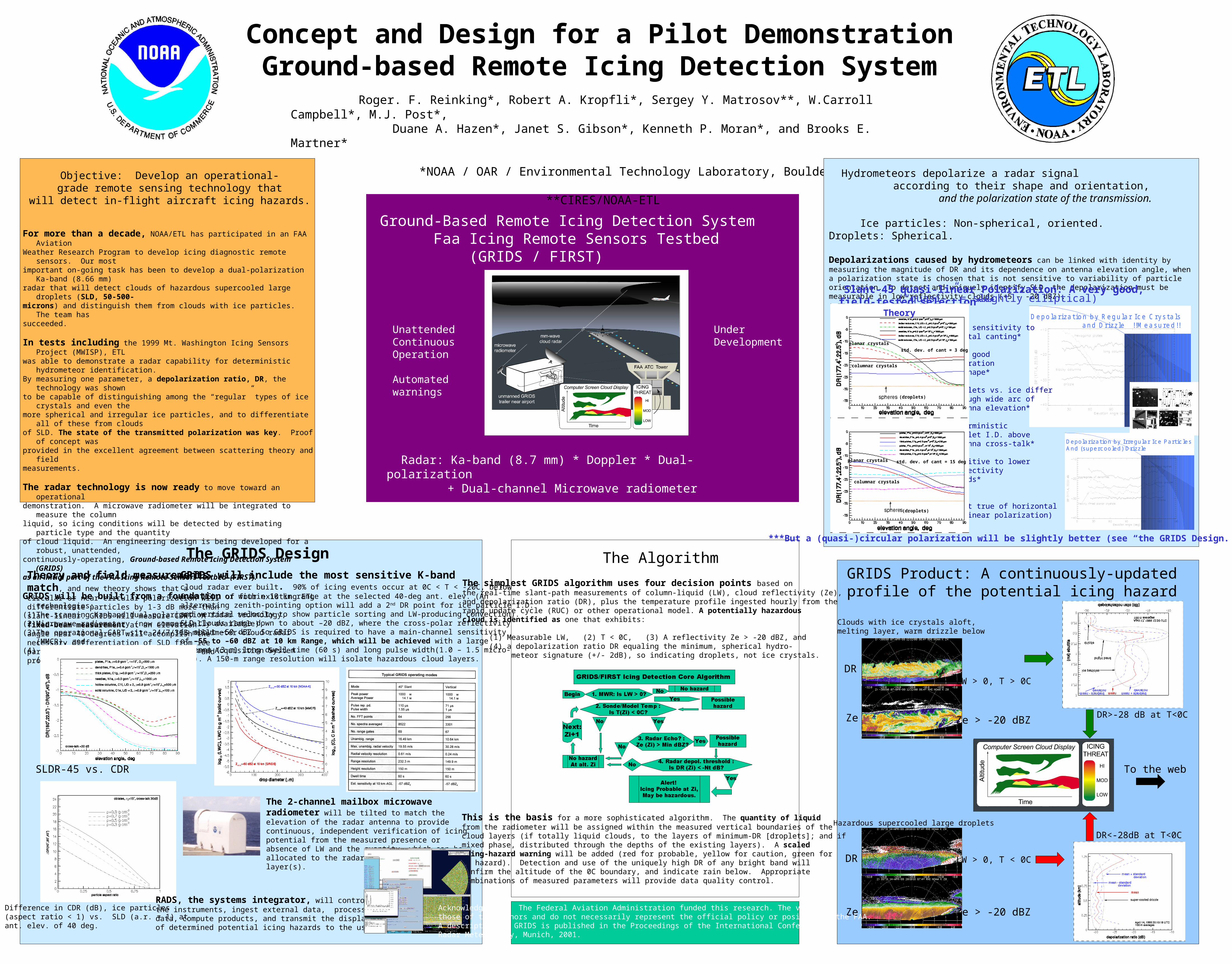
Objective: Develop an operational-grade remote sensing technology that
will detect in-flight aircraft icing hazards.
For more than a decade, NOAA/ETL has participated in an FAA AviationWeather Research Program to develop icing diagnostic remote sensors. Our mostimportant on-going task has been to develop a dual-polarization Ka-band (8.66 mm)radar that will detect clouds of hazardous supercooled large droplets (SLD, 50-500-microns) and distinguish them from clouds with ice particles. The team hassucceeded.
In tests including the 1999 Mt. Washington Icing Sensors Project (MWISP), ETLwas able to demonstrate a radar capability for deterministic hydrometeor identification.By measuring one parameter, a depolarization ratio, DR, the technology was shownto be capable of distinguishing among the “regular” types of ice crystals and even the more spherical and irregular ice particles, and to differentiate all of these from cloudsof SLD. The state of the transmitted polarization was key. Proof of concept wasprovided in the excellent agreement between scattering theory and fieldmeasurements.
The radar technology is now ready to move toward an operational demonstration. A microwave radiometer will be integrated to measure the columnliquid, so icing conditions will be detected by estimating particle type and the quantity of cloud liquid. An engineering design is being developed for a robust, unattended, continuously-operating, Ground-based Remote Icing Detection System (GRIDS) as an initial part of the FAA Icing Remote Sensors Testbed (FIRST).
GRIDS will be built from a foundation of four existing ETL technologies: (1) The scanning Ka-band dual-polarization radar technology,(2) Microwave radiometery (now commercially available),(3) The operational CART-site 24/7/365 millimeter-cloud radar (MMCR), and(4) A state-of-the-art Radar Data and Acquisition System (RADS).
Theory and field measurements match, and new theory shows that a circular or near-circular polarization will differentiate particles by 1-3 dB more than slant-linear. GRIDS will measure CDR. A fixed-beam measurement at an elevation angle near 40 degrees will accomplish the necessary differentiation of SLD from ice particles while minimizing path length and propagation effects.
Ground-Based Remote Icing Detection System Faa Icing Remote Sensors Testbed (GRIDS / FIRST)
UnattendedContinuousOperation
Automatedwarnings
Under Development
Radar: Ka-band (8.7 mm) * Doppler * Dual-polarization + Dual-channel Microwave radiometer
D e p o la r i z a t io n b y R e g u la r I c e C ry s ta l sa n d D r iz z le !!M e a s u re d !!
Hydrometeors depolarize a radar signal according to their shape and orientation,
and the polarization state of the transmission.
Ice particles: Non-spherical, oriented. Droplets: Spherical.
Depolarizations caused by hydrometeors can be linked with identity by measuring the magnitude of DR and its dependence on antenna elevation angle, when a polarization state is chosen that is not sensitive to variability of particle orientation. To detect and uniquely identify SLD, the depolarization must be measurable in low-reflectivity clouds (+5 - -20 dBZ).
Slant-45 quasi-linear Polarization: A very good, field-tested selection***
Min. sensitivity to crystal canting*
Very good separation by shape*
Droplets vs. ice differ through wide arc of antenna elevation*
Deterministicdroplet I.D. above antenna cross-talk*
Sensitive to lower reflectivity clouds*
*(Not true of horizontal linear polarization)
The GRIDS Design The AlgorithmThe simplest GRIDS algorithm uses four decision points based on the real-time slant-path measurements of column-liquid (LW), cloud reflectivity (Ze), and depolarization ratio (DR), plus the temperature profile ingested hourly from the rapid update cycle (RUC) or other operational model. A potentially hazardous cloud is identified as one that exhibits:
(1) Measurable LW, (2) T < 0C, (3) A reflectivity Ze > -20 dBZ, and(4) a depolarization ratio DR equaling the minimum, spherical hydro- meteor signature (+/- 2dB), so indicating droplets, not ice crystals.
This is the basis for a more sophisticated algorithm. The quantity of liquidfrom the radiometer will be assigned within the measured vertical boundaries of the cloud layers (if totally liquid clouds, to the layers of minimum-DR [droplets]; and if mixed phase, distributed through the depths of the existing layers). A scaled icing-hazard warning will be added (red for probable, yellow for caution, green forno hazard). Detection and use of the uniquely high DR of any bright band will confirm the altitude of the 0C boundary, and indicate rain below. Appropriate combinations of measured parameters will provide data quality control.
GRIDS Product: A continuously-updatedprofile of the potential icing hazard
Hazardous supercooled large droplets
Clouds with ice crystals aloft,melting layer, warm drizzle below
GRIDS will include the most sensitive K-band cloud radar ever built. 90% of icing events occur at 0C < T < -20C, below 6 km MSL, or within 10 km range at the selected 40-deg ant. elev. (An alternating zenith-pointing option will add a 2nd DR point for ice particle I.D.and vertical velocity to show particle sorting and LW-producing convection).SLD clouds range down to about –20 dBZ, where the cross-polar reflectivityis about –50 dBZ. So GRIDS is required to have a main-channel sensitivityof –55 to –60 dBZ at 10 km Range, which will be achieved with a large antenna (3 m) long dwell time (60 s) and long pulse width(1.0 – 1.5 micro-sec). A 150-m range resolution will isolate hazardous cloud layers.
(“quasi-” = slightly elliptical)
Difference in CDR (dB), ice particles (aspect ratio < 1) vs. SLD (a.r. = 1) at ant. elev. of 40 deg.
SLDR-45 vs. CDR
DR
Ze
DR
Ze
LW > 0, T > 0C
LW > 0, T < 0C
To the web
RADS, the systems integrator, will control the instruments, ingest external data, process data, compute products, and transmit the displayof determined potential icing hazards to the users.
The 2-channel mailbox microwave radiometer will be tilted to match the elevation of the radar antenna to provide continuous, independent verification of icing potential from the measured presence or absence of LW and the quantity, which can be allocated to the radar-observed cloud layer(s).
Ze > -20 dBZ
Ze > -20 dBZ
Depolarization by I rregular I c e P artic lesA nd (superc ooled) Drizzle
DR<-28dB at T<0C
DR>-28 dB at T<0C
Acknowledgments. The Federal Aviation Administration funded this research. The views arethose of the authors and do not necessarily represent the official policy or position of the FAA.A description of GRIDS is published in the Proceedings of the International Conference on Radar Meteorology, Munich, 2001.
Theory
***But a (quasi-)circular polarization will be slightly better (see “the GRIDS Design.”).
columnar crystals
planar crystals
planar crystals
columnar crystals
std. dev. of cant = 3 deg
std. dev. of cant = 15 deg
(droplets)
(droplets)