community improvement south pasadena, fl 33707 south...
TRANSCRIPT


May 30, 2014
To: Gail Neidinger
Re: Enterprise Marine Stop Work Order
On March 27th
2014 we received an application from Deuel and Associates representing
Harbourside Condominiums which is located at 7911 Sailboat Key Blvd South. The contractor
for this dock project is Enterprise Marine Contractors, Inc. which is located at 911 Jungle
Avenue in St. Petersburg.
On March 31st, 2014 Neal Schwartz reviewed the dock application and had the architect
engineer take the original copy to go and get approval from the County Water Navigation
Authority, which is required of any dock permit. After this has been taken to the County and
approved by the Water Navigation Authority, the permit is then supposed to be brought back into
the CID department to review for any changes that were required by the County. At this time, the
CID director would re-review the application and do the final sign off and then the City permit
would be granted.
On May 20th
, 2014 the CID department called to see what was going on with the permit
and why no one had ever come back for the final sign off. Per the phone conversation a
representative from Enterprise Marine stated that work for the dock was already in progress. The
next morning on May 21st, 2014 a stop work order was issued on the site.
That Friday morning, May 23rd
the president of Enterprise Marine Gary Kalke came into
our office questioning the stop work order and stated that they had already received the permit
from the County that they needed. He was shown the application that was submitted by Deuel
and Associates that still needed final approval by Neal and did not have the stamped approval
from the Water Navigation Authority. So while the permit application did go to the County for
approval, it never was brought back into the CID to get the official approval and permit.
Per Chapter A198 Fees, §83-37 states that the fee for starting working without first
obtaining a required building permit shall be 5 times the adopted fee. The cost of this permit was
City of South Pasadena COMMUNITY IMPROVEMENT
Office Address: Mailing Address: 6940 Hibiscus Ave S 7047 Sunset Dr S South Pasadena, FL 33707 South Pasadena, FL 33707
*PHONE: (727) 343-4192 * FAX: (727) 381-4819*
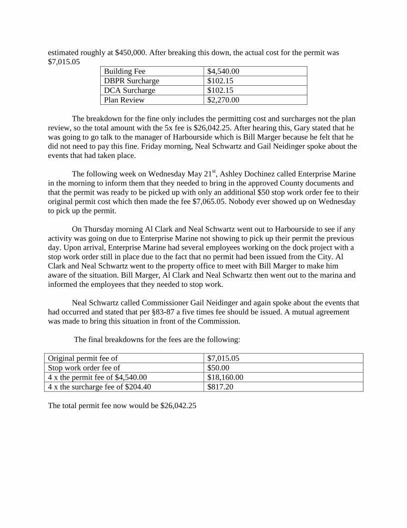
estimated roughly at $450,000. After breaking this down, the actual cost for the permit was
$7,015.05
Building Fee $4,540.00
DBPR Surcharge $102.15
DCA Surcharge $102.15
Plan Review $2,270.00
The breakdown for the fine only includes the permitting cost and surcharges not the plan
review, so the total amount with the 5x fee is $26,042.25. After hearing this, Gary stated that he
was going to go talk to the manager of Harbourside which is Bill Marger because he felt that he
did not need to pay this fine. Friday morning, Neal Schwartz and Gail Neidinger spoke about the
events that had taken place.
The following week on Wednesday May 21st, Ashley Dochinez called Enterprise Marine
in the morning to inform them that they needed to bring in the approved County documents and
that the permit was ready to be picked up with only an additional $50 stop work order fee to their
original permit cost which then made the fee $7,065.05. Nobody ever showed up on Wednesday
to pick up the permit.
On Thursday morning Al Clark and Neal Schwartz went out to Harbourside to see if any
activity was going on due to Enterprise Marine not showing to pick up their permit the previous
day. Upon arrival, Enterprise Marine had several employees working on the dock project with a
stop work order still in place due to the fact that no permit had been issued from the City. Al
Clark and Neal Schwartz went to the property office to meet with Bill Marger to make him
aware of the situation. Bill Marger, Al Clark and Neal Schwartz then went out to the marina and
informed the employees that they needed to stop work.
Neal Schwartz called Commissioner Gail Neidinger and again spoke about the events that
had occurred and stated that per §83-87 a five times fee should be issued. A mutual agreement
was made to bring this situation in front of the Commission.
The final breakdowns for the fees are the following:
Original permit fee of $7,015.05
Stop work order fee of $50.00
4 x the permit fee of $4,540.00 $18,160.00
4 x the surcharge fee of $204.40 $817.20
The total permit fee now would be $26,042.25

Final Draft June 3, 2014
PROPOSED ORDINANCE NO. 2014-_________
AN ORDINANCE OF THE CITY OF SOUTH PASADENA, FLORIDA, AMENDING THE CITY OF SOUTH PASADENA’S COMPREHENSIVE PLAN, PROVIDING FOR AMENDMENT OF THE LAND USE ELEMENT, POLICY 101.102, TO REVISE THE DESCRIPTION OF THE PLANNED REDEVELOPMENT-MIXED USE (OVERLAY) PLAN CATEGORY IN THE GOALS, OBJECTIVES AND POLICIES; PROVIDING FOR THE AMENDMENT OF THE FUTURE LAND USE PLAN MAP TO ADOPT AND PLACE THE PLANNED REDEVELOPMENT-MIXED USE (OVERLAY) PLAN CATEGORY ON THE FUTURE LAND USE MAP; PROVIDING FOR SEVERABILITY; PROVIDING FOR REPEAL OF ORDINANCEES OR PARTS OF ORDINANCES IN CONFLICT HEREWITH; AND PROVIDING FOR AN EFFECTIVE DATE THEREOF.
WHEREAS, the City of South Pasadena Comprehensive Plan was adopted pursuant to Ordinance No. 2007-08; and WHEREAS, the City Comprehensive Plan, Goals, Objectives and Policies was amended by Ordinance No. 2012-03; and WHEREAS, the Ordinance 2012-03 created a new Future Land Use Plan category entitled “Planned Redevelopment – Mixed Use (Overlay); and WHEREAS, the City has considered additional procedures and standards designed to administer and implement the Planned Redevelopment – Mixed Use (Overlay) plan category; and WHEREAS, the additional procedures and standards are set forth in a corresponding and companion amendment to Chapter 130 – Land Development Regulations of the City Code of Ordinances; and
1

Final Draft June 3, 2014
WHEREAS, this Ordinance has been considered by the Local Planning Agency at a duly noticed public hearing and is recommended by the Local Planning Agency to be approved; and WHEREAS, the City Commission has considered the recommendation of the Local Planning Agency and public comment at a duly noticed public hearing; and WHEREAS, the City Commission has determined that the addition of the PR-MU (Overlay) plan category as a redevelopment tool to encourage the long-term betterment of the Pasadena Avenue corridor and the City as a whole is in the public interest. NOW, THEREFORE, BE IT ORDAINED BY THE City Commission of the City of South Pasadena, Florida:
SECTION 1. The Comprehensive Plan, Land Use, Goal 101, Policy 101.102 on pg. 1-1 is amended to read as follows:
“Planned Redevelopment – Mixed Use (Overlay)
Density/Intensity and Other Standards As Set Forth in the City’s Land
Development Regulations, based on the Pasadena Avenue Corridor
Redevelopment Plan and corresponding Special Area Plan as amended, and as
may be required pursuant to the Countywide Plan and Rules
SECTION 2. The Comprehensive Plan, Future Land Use Plan Map, is amended as follows and set forth in attached Exhibit A:
(A) To add the Planned Redevelopment – Mixed Use (Overlay) plan category to the map legend; and
(B) To amend the map to designate said Planned Redevelopment – Mixed Use (Overlay) category as an overlay to the existing plan categories on the map for that area identified in Exhibit A attached hereto which is hereby made a part of this ordinance.
2

Final Draft June 3, 2014
SECTION 3. The provisions of this Ordinance shall be deemed severable. If any part of the Ordinance is deemed unconstitutional, it shall not affect the constitutionality of other portions of the Ordinance.
SECTION 4. All Ordinances or parts of Ordinances in conflict with the provisions of this Ordinance be hereby repealed insofar as the same affect this Ordinance.
SECTION 5. The effective date of this Ordinance and plan amendment shall be 31 days after the state land planning agency notifies the local government that the plan amendment package is complete; or alternatively, if timely challenged, this amendment shall become effective on the date the state land planning agency or the Administration Commission enters a final order determining this adopted amendment to be in compliance.
3

Final Draft June 3, 2014
__________________________ Mayor Dan Calabria ATTEST: ___________________________ Carley Lewis, MMC City Clerk PASSED ON FIRST READING_________________________________________________, 2014 PASSED ON SECOND AND FINAL READING___________________________________, 2014 THIS IS TO CERTIFY THAT I, the undersigned City Clerk, did Cause the noticing of the above Ordinance in accordance with Chapter 160.041 of the Florida Statutes. _____________________________________ Carley Lewis, MMC, City Clerk THIS ORDINANCE HAS BEEN APPROVED AS TO FORM AND CONTENT BY THE CITY ATTORNEY.
4
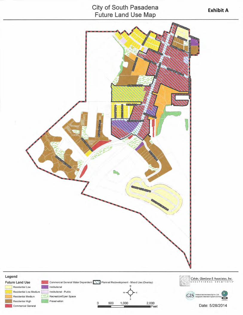
Exhibit A


Final Draft June 3, 2014
ORDINANCE NO. 2014 - ________
AN ORDINANCE OF THE CITY OF SOUTH PASADENA, FLORIDA, AMENDING THE CODE OF THE CITY OF SOUTH PASADENA, PART II, CHAPTER 130, LAND DEVELOPMENT REGULATIONS, PART 1. LAND USE, ARTICLE III ZONING DISTRICTS; PROVIDING FOR A NEW ZONING DISTRICT ENTITLED “PR-PLANNED REDEVELOPMENT”; PROVIDING FOR THE PURPOSE, PROCESS, AND GENERAL CONSIDERATIONS; PROVIDING FOR DEVELOPMENT STANDARDS; PROVIDING FOR DESIGN GUIDELINES; PROVIDING FOR DEVELOPMENT AGREEMENTS; PROVIDING FOR AN APPENDIX ILLUSTRATING THE DESIGN GUIDELINES; PROVIDING FOR SEVERABILITY; PROVIDING FOR REPEAL OF ORDINANCES OR PARTS OF ORDINANCES IN CONFLICT HEREWITH; AND PROVIDING FOR AN EFFECTIVE DATE THEREOF.
WHEREAS, the City of South Pasadena Future Land Use Plan and Land Development Regulations largely reflect the existing land use pattern and do not provide adequately for the future revitalization and redevelopment needs of the City; and
WHEREAS, the City has witnessed in recent years a less robust business climate, vehicular and pedestrian traffic management deficiencies, less than optimum streetscape and landscape treatment, and a lack of new investment along and adjacent to Pasadena Avenue; and
WHEREAS, the City initiated an examination and analysis of the need and opportunity to revitalize the Pasadena Avenue corridor, culminating in the preparation, acceptance and amendment of the first phase of the Pasadena Avenue Corridor Redevelopment Plan; and
WHEREAS, the amended Pasadena Avenue Corridor Redevelopment Plan recommended consideration of amendments to the City’s Comprehensive Plan and Land Development Regulations to facilitate the redevelopment objectives and strategies of the corridor plan; and
WHEREAS, in furtherance of these plan recommendation the City has prepared and adopted a new Future Land Use Map category entitled “Planned Redevelopment-Mixed Use (Overlay) [PR-MU(Overlay)]; and
1

Final Draft June 3, 2014
WHEREAS, the amendments to the Land Development Regulations set forth in this Ordinance have been prepared and considered in furtherance of the implementation and administration of the PR-MU (Overlay) plan category; and
WHEREAS, the PR-MU (Overlay) plan category, and the PR zoning district established in this ordinance, have been prepared in recognition of the updated Pinellas Countywide Plan and the designation therein of Pasadena Avenue as a Primary Multimodal Corridor; and
NOW, THEREFORE, BE IT ORDAINED by the City Commission of the City of South Pasadena, Florida:
Section 1. The Code of the City of South Pasadena, Part II, Chapter 130, Land Development Regulations, Part 1. Land Use, Article III, Zoning Districts, Section 130-5 entitled “Zoning districts enumerated” is amended to add a new zoning district entitled “PR-Planned Redevelopment” to read as follows:
Land Use Category Zoning District “Planned Redevelopment-Mixed Use (Overlay) PR-Planned Redevelopment
Section 2. The Code of the City of South Pasadena, Part II, Chapter 130, Land Development Regulations, Part 1. Land Use, Article III, Zoning Districts is amended to create a new Section 130-18A. entitled “PR-Planned Redevelopment District” to read as follows:
§ 130-18A. PR-Planned Redevelopment District
§ 130-18A-I Purpose, Process and General Considerations
A. Purpose – The purpose of the PR-Planned Redevelopment District is to provide a mechanism for the rezoning of property proposed to be redeveloped pursuant to the Planned Redevelopment-Mixed Use (Overlay) category of the Future Land Use Map, in furtherance of and consistent with the Pasadena Avenue Corridor Redevelopment Plan as amended, and more specifically the provisions set forth herein.
The purpose of the proposed PR – Planned Redevelopment zoning district is essentially two-fold:
(1) To provide a tool to encourage revitalization and redevelopment in the corridor that improves the economic vitality and function of the principal thoroughfare and commercial center of the City; and
2
Final Draft June 3, 2014
(2) To encourage and guide the revitalization of the corridor based on procedures and standards that enable it to be carried out in the manner desired and in harmony with the character and relationship of the corridor to the City as a whole.
B. Process – Application for development or redevelopment within the Planned Redevelopment-Mixed Use (Overlay) Plan category that proposes to utilize the provisions of the Section, shall apply to rezone the property to PR-Planned Redevelopment.
The PR zoning district is available and may be applied only within the PR-MU (Overlay) plan category. The existing zoning districts remain in place until and unless an application is made and approved by the City Commission for zoning map amendment to utilize the PR district.
To amend the zoning map to utilize the PR district requires the following:
(1) An application and public hearing(s) as for any rezoning amendment
(2) An accompanying site plan consistent with the current code provisions for site plan review, and accompanying submission materials and review sufficient to determine the applications consistency with development standards and design guidelines for the district.
(3) A Development Agreement detailing the commitments of the proposed project pursuant to the Florida Local Government Development Agreement Act, the City requirements therefor, and consistent with the requirements of the PR district.
C. General Considerations – The utilization of the PR-Planned Redevelopment zoning district shall require consideration of the following:
(1) The extent to which the proposed project to be developed is consistent with, and furthers the goals, objectives and policies of the City’s Comprehensive Plan.
(2) The extent to which the proposed development is consistent with and furthers the objectives of the Pasadena Avenue Corridor Redevelopment Plan, as amended. In particular, such development shall:
(a) Minimize points of access/curb cuts to Pasadena Avenue by consolidating, reducing the width of, or providing alternative means of access to the property;
3

Final Draft June 3, 2014
(b) Provide for multi-modal access, including pedestrian, bicycle and transit, and any reasonable facilities required to enhance provision for same;
(c) Establish building location and access in relationship to minimum base flood elevations in a manner that encourage and facilitate pedestrian access from the street frontage, and providing for location of drives, parking and loading at the rear of the building;
(d) Include streetscape and landscape treatment consistent with any approved design for Pasadena Avenue.
(e) Address building façade and signage treatments that are consistent with the scale and pedestrian-oriented objectives of the corridor plan.
(3) The Design Criteria set forth for Site Plan review in Sec. 130-26 and the advisory Design Guidelines set forth in Sec. 130-18A-III of this ordinance and illustrated in Appendix A attached hereto.
§ 130-18A-II Development Standards
A. Purpose – This section of the PR-Planned Redevelopment zoning district identifies the development standards that are designed to be employed in the course of encouraging a more vigorous and attractive development pattern in the Pasadena Avenue corridor. The objective is to provide a formula for land use, density/intensity, building height and building setbacks that reflect property size, location and development potential in furtherance of an improved and revitalized corridor.
These standards have been prepared based on current zoning standards, the updated Countywide Plan that designates Pasadena Avenue as a Multimodal Primary Corridor, and in furtherance of the Pasadena Avenue Corridor Redevelopment Plan, as amended, and its implementation through the Planned Redevelopment – Mixed Use (Overlay) Future Land Use plan category.
B. Land Use Characteristics - The uses permitted within the PR-Planned Redevelopment zoning district may include any one or a combination of the following types of land use, subject to the requirements and conditions noted below:
(1) Commercial – Those permitted and special exception retail, entertainment, and business service commercial uses allowed in the Commercial General (CG) zoning district.
4

Final Draft June 3, 2014
(2) Office – Those permitted and special exception professional and business office uses allowed in the Commercial General (CG) zoning district.
(3) Institutional – Those permitted and special exception institutional, public, and public/semi-public uses allowed in the Commercial General (CG) zoning district under the Institutional plan category of the Future Land Use Map.
(4) Temporary Lodging – Those permitted and special exception hotel, motel, and interval ownership tourist lodging uses allowed in the Commercial General (CG) zoning district.
(5) Residential – Those permitted and special exception residential uses allowed in the Multi-Family Residential (RM-10, RM-12.5, and RM-15.5) zoning districts.
The specific type of use(s) proposed within any PR-Planned Redevelopment district shall be identified as part of the application and review process. The City Commission may approve or deny any such specific use(s) as a function of the required accompanying site plan and development agreement consistent with the purpose and requirements of the PR-Planned Redevelopment zoning district, the PR-MU (Overlay) plan category it is designed to implement, and the public interest.
C. Density/Intensity Standards – The maximum density/intensity permitted in the PR-Planned Redevelopment zoning district, based on the type of use and property size, expressed as floor area ratio (FAR), temporary lodging units per acre (TLU/Ac.), dwelling units per acre (DU/Ac.) and impervious surface ratio (ISR), is as follows:
5

Final Draft June 3, 2014
Density/Intensity Standards Proposed Standards
Property Size Density/Intensity1 Impervious Surface Ratio
(1) Commercial: < 1 acre .75 FAR 0.80
1 – 3 acres 1.00 FAR 0.75
> 3 acres 1.25 FAR 0.70
(2) Office: < 1 acre .75 FAR 0.80
1 – 3 acres 1.00 FAR 0.75
> 3 acres 1.25 FAR 0.70
(3) Institutional: < 1 acre .75 FAR 0.80
1 – 3 acres 1.00 FAR 0.75
> 3 acres 1.25 FAR 0.70
(4) Temporary Lodging < 1 acre 50 TLU/Ac. 0.80
1 – 3 acres 60 TLU/Ac. 0.75
> 3 acres 75 TLU/Ac. 0.70
(5) Residential2 < 1 acre 15 DU/Ac. 0.80
1 – 3 acres 20 DU/Ac. 0.75
> 3 acres 25 DU/Ac. 0.70
1 Mixed use projects may be combined based on the maximum density/intensity allowed for each use, calculated on the basis of the proportionate share of the property attributed to each use. 2 Residential use permitted under the PR-Planned Redevelopment district process shall not exceed the total number of residential dwelling units permitted within the PR-MU (Overlay) plan category at the time of adoption of the PR-MU (Overlay) plan map amendment (which number is 235).
6

Final Draft June 3, 2014
D. Building Height and Setback Standards – The maximum permitted building height requirements in the PR-Planned Redevelopment zoning district are as follows:
(1) Building Height: Standards3
Property Size Building Height
< 1 acre Current Standard - 3 stories (36 ft.) plus an additional 10 ft. to a total of 46 ft. for structures with parking beneath the building
1 – 3 acres Current std. plus 1 story; or 10 ft. to max. 4 stories or 46 ft.; or 4 stories over parking beneath building to max. 56 ft.
> 3 acres Current std. plus 2 stories; or 20 ft. to max. 5 stories or 56 ft.; or 5 stories over parking beneath building to max. 66 ft.
(2) Building Setbacks: Standards3
Building Height
< 36 ft. 36 – 46 ft.
46 – 56 ft.
56 – 66 ft.
Front 0 – 25 ft. 25 ft. 50 ft. 75 ft.
Side 10 ft. 15 ft. 20 ft. 25 ft.
Rear 25 ft. 30 ft. 35 ft. 40 ft.
3 Building height and setbacks standards may be adjusted by the Commission under an approved site plan and Development Agreement at the time of rezoning to PR based on the merits of the proposed project design and its relationship to adjoining uses where it is determined to be in the public interest; except that in no case shall building height exceed sixty-six (66) feet.
7

8 Final Draft June 3, 2014
Max. Bldg. Height
D.U. TLU FAR ISR Stories Front Side Rear
Commercial < 1 ac. -- -- 0.75 0.80 3 - 4 0 - 25 10 - 15 25 - 301 - 3 ac. -- -- 1.00 0.75 4 - 5 0 - 50 10 - 20 25 - 35> 3 ac. -- -- 1.25 0.70 5 - 6 0 - 75 10 - 25 25 - 40
Office < 1 ac. -- -- 0.75 0.80 3 - 4 0 - 25 10 - 15 25 - 301 - 3 ac. -- -- 1.00 0.75 4 - 5 0 - 50 10 - 20 25 - 35> 3 ac. -- -- 1.25 0.70 5 - 6 0 - 75 10 - 25 25 - 40
Institutional < 1 ac. -- -- 0.75 0.80 3 - 4 0 - 25 10 - 15 25 - 301 - 3 ac. -- -- 1.00 0.75 4 - 5 0 - 50 10 - 20 25 - 35> 3 ac. -- -- 1.25 0.70 5 - 6 0 - 75 10 - 25 25 - 40
Temporary Lodging < 1 ac. -- 50 -- 0.80 3 - 4 0 - 25 10 - 15 25 - 301 - 3 ac. -- 60 -- 0.75 4 - 5 0 - 50 10 - 20 25 - 35> 3 ac. -- 75 -- 0.70 5 - 6 0 - 75 10 - 25 25 - 40
Residential < 1 ac. 15 -- -- 0.80 3 - 4 0 - 25 10 - 15 25 - 301 - 3 ac. 20 -- -- 0.75 4 - 5 0 - 50 10 - 20 25 - 35> 3 ac. 25 -- -- 0.70 5 - 6 0 - 75 10 - 25 25 - 40
Note: See Individual Development Standards for Detailed Interpretation.
SUMMARY TABLE OF DEVELOPMENT STANDARDS
Use CategoryProperty
Size (Acre)
Max. Density/Intensity Min. Setbacks
DRAFT
8

Final Draft June 3, 2014
§ 130-18A-III Design Guidelines
A. Purpose - An important component of the Planned Redevelopment (PR) zoning district is to identify the design elements that are considered essential to achieving the desired functional and visual character of a revitalized Pasadena Avenue corridor.
These design features are intended to be used by applicants and the City as guidelines in approving redevelopment within the corridor. They describe and illustrate design principles and techniques that articulate what the City wants to achieve in the course of facilitating and guiding changes and improvements to the natural and built environment consistent with the objectives of the plans for corridor revitalization.
While the guidelines are intended to provide flexibility in terms of their application as individual circumstances and site conditions warrant, each application for rezoning using the Planned Redevelopment (PR) zoning district shall consider the extent to, and manner in, which these guidelines have been addressed.
B. Features – Illustrative examples of each of the design features are identified in Appendix A of this ordinance and are hereby made a part thereof.
Design features to be considered include the following:
• Access/Egress and Connectivity • Transit and Pedestrian Enhancements • Parking Location and Design • Streetscape and Landscape Features • Building Orientation / Façade • Neighborhood Compatibility • Sustainability Features
The design features and the guidelines for each project shall include consideration of those listed below:
(1) Access / Egress and Connectivity – The objective is to improve traffic flow and safety for both vehicular and pedestrian movement.
Connectivity refers to the way and extent that the street system, pedestrian routes and transit are interconnected. Good connectivity facilitates efficient vehicular circulation, reduces the emphasis on any single roadway for access, and encourages pedestrian movement, use of public transit and mixed use development. Identifying primary points of access/egress in concert with median design and limiting the number and
9

Final Draft June 3, 2014
extent of random curb cuts can improve both pedestrian and vehicular safety and traffic carrying capacity, as well as to help define a structured, walkable block system that encourages pedestrian utilization.
To this end, the following guidelines shall apply:
(a) Provide for internal circulation and connectivity that consolidates and limits points of access/egress to Pasadena Avenue.
(b) Incorporate median design that is based on a coordinated traffic management plan to provide turning movements in concert with designated points of access/egress.
(c) Establish direct, visible pedestrian connections that encourage pedestrian movement to and from Pasadena Avenue and facilitate access to public transit.
(d) Provide for connection and extension of existing parallel roadways or internal drives to reduce points of conflict with both vehicular and pedestrian movement on Pasadena Avenue.
(2) Transit and Pedestrian Enhancements – The objective is to encourage a pedestrian-friendly experience and expanded use of public transit.
To encourage a more vibrant and prosperous mixed use corridor requires an active and safe pedestrian environment complemented by convenient public transit. The area between the edge of the street and adjacent buildings is referred to as the “public realm” – the sidewalk, landscaping, and open space or plaza areas that establish the character of the street in terms of its safety, appearance and utilization. It is this space that can contribute to its desirability for pedestrian movement, social interaction, connection to transit and enhanced business patronage.
The following guidelines are directed at this objective:
(a) Incorporate safe, convenient and attractive pedestrian connections within a site to the public right of way.
(b) Provide for clear, direct access to connections with the public transit system, including any applicable provision of transit supportive locations and installations.
(c) Include sidewalk treatment designed to integrate the area between the public right of way and the building or project entry features to encourage an attractive, functional public realm.
10

Final Draft June 3, 2014
(d) Identify location of and connection to improved crosswalks that include both safety and design features that facilitate pedestrian and bicycle movement across Pasadena Avenue at key intervals designed in concert with the public transit system.
(3) Parking Location and Design – The objective is to locate and design off-street parking as an integral component of improving the function and appearance of the corridor.
The location and design of off-street parking is a critical component of improved corridor function and utilization. Given the linear nature of Pasadena Avenue and its length, it will be important to minimize interruptions to active building frontage and pedestrian movement by discouraging parking that fronts the street.
Parking facilities should be designed to be accessible to the use they serve, the “public realm” adjacent to that use, and be well landscaped and screened from the public right of way.
To further these objectives, the following guidelines shall apply:
(a) Provide for off-street parking located in the side or rear yard, in a manner that does not separate the building entrance from the public right of way
(b) Limit the extent of side yard parking along the public right of way to discourage open “dead space” on the right of way greater than the width of the building façade to which it is related
(c) Provide direct and convenient access from the parking lot to the public right-of-way and access to the building(s) it serves
(d) Locate and design off-street loading and service areas in relationship to the type of use and anticipated service or delivery vehicles
(e) Include parking lot landscaping on the perimeter and in internal landscape islands consistent with any master corridor landscape plan and city standards.
(f) Ensure that any parking garage is physically and visually integrated with the use(s) it serves. In particular, parking structures will address:
• Setbacks with terraced landscaping elements to soften the appearance of a parking garage.
11

Final Draft June 3, 2014
• Architectural articulation treatment that breaks up the massing of the garage and adds visual interest.
• Design that is complementary with adjacent buildings by using similar building forms, materials, and/or details to enhance garages and the surrounding pedestrian environment.
• Parking garage entries should be designed and sited to complement, not subordinate, the pedestrian entry.
(4) Streetscape and Landscape Features – The objective is to consider how each private redevelopment or revitalization project relates to and provides opportunity to improve the public streetscape.
Perhaps no other component of urban design can set apart and establish the corridor as a unique and attractive place as the provision of a coordinated streetscape and landscape plan. The City can establish either the broad guidelines and typologies to be followed by private development projects, or can be an active partner in the process by designing and initiating certain improvements.
An overall landscape plan can identify the type, location and intensity of plant and hard surface materials to be used based on different applications. Street furnishings can identify lighting, signing, and other street furniture and its preferred placement.
The following guidelines are to be addressed:
(a) Include street furnishings and equipment that are coordinated with an overall streetscape plan and approach for the corridor. Streetscape furnishings should include the appropriate style and location for benches, receptacles, bollards, low-level lighting, outdoor seating and bicycle racks consistent with an overall corridor approach.
(b) Provide landscaping appropriate to the site, and the overall approach to the corridor. In particular a landscaped buffer will be provided between the vehicular travel lanes and sidewalk whenever possible to make the pedestrian space more comfortable, safe and attractive.
(c) Include provision for public open space and public features such as a plaza or street furnishings and enhancements such as public art located between the public right-of-way and building façade that contributes to the character, utility and attraction of the street front.
12

Final Draft June 3, 2014
(d) If determined feasible, place above ground electric, cable and telephone lines below ground as an important public safety, aesthetic and long term maintenance improvement that will be instrumental in improving the character of the corridor.
(e) Minimize the adverse visual, physical and sound impacts of utility and mechanical equipment installations. In particular, loading docks, service bays, solid waste bins, mechanical equipment and utility boxes should be located and screened to be visually and physically unobtrusive
(5) Building Orientation/Façade – The objective is to create a street front that is active, has a pedestrian focus, creates a distinctive character and architectural identity and discourages large expanses of parking that discourage pedestrian connectivity.
Building or site orientation addresses the manner in which a building is located on a site in relationship to the street it faces and the intervening “public realm.” The purpose is to create enclosures along the street that establish a convenient and comfortable human scale. It creates a more accessible environment for the pedestrian and facilitates the use of public transit.
The design of the building face is also of critical importance in establishing visible, prominent points of entry, avoidance of extensive blank walls, and compatible architectural scale and detail.
As building renovation, infill and new construction takes place, the following design guidelines are to be considered:
(a) Minimize building setbacks and provide for the building entrance directly available from the sidewalk, except where a pedestrian oriented, open space plaza is provided between the sidewalk and the building.
(b) Establish that a minimum percentage of the building façade of the ground floor of buildings facing the street shall be transparent.
(c) Within any area between the sidewalk and buildings at or beyond the required setback, include landscaping, except for the hard surface walkway or plaza, that provides screening and shade.
(d) Encourage buildings set back from the right-of-way to provide an extension such as an awning or arcade to provide both shelter from the elements and articulate the entrance.
13

Final Draft June 3, 2014
(e) Orient the primary building façade to the primary street it fronts, and on corner lots treat both facades as primary facades providing a building entrance.
(f) Ensure building facades are designed to vary building height, setback and ornamental architectural detail so as not to present a sterile, uniform unaltered building face.
(g) Identify signage that is integrated with and sized in relationship to the scale of the building face.
(6) Neighborhood Compatibility – The objective of this design consideration is to give adequate consideration to and protection for residential neighborhoods adjacent to the commercial, mixed use corridor.
As revitalization and redevelopment occurs in the corridor, particular attention needs to be given to how it transitions at its interface with existing residential uses. This design feature will address the compatibility of use, the density/intensity, scale and location of use, and provisions for buffering.
The design guidelines that will assist in providing this transition from more intensive mixed use areas to adjoining residential areas include the following:
(a) Consider building scale, height and setback between the mixed use corridor and residential use adjacent to it as a function of proposed redevelopment immediately adjacent to established residential areas.
(b) Take into account the uses and their service features that adjoin a residential area relative to any noise, odor or debris associated with such use as a function of their design and placement.
(c) Consider the incorporation of residential components such as townhomes or courtyard apartments in mixed use projects to assist in the transition from more intensive non-residential to an exclusively single family residential area.
(d) Incorporate open space buffer, landscaping and other means of providing for the transition and appropriate separation between the uses in the corridor and those residential uses immediately adjacent to it in any plan for redevelopment in the corridor.
(7) Sustainability Features – The objective is to encourage reinvestment in those practices and improvements that are both economically and environmentally sustainable.
14

Final Draft June 3, 2014
Any long range plan for improving the function, economy and appearance of the corridor should seek to do so in ways that are both economically and environmentally responsible and sustainable.
There are both individual private project and municipal initiatives that can contribute to sound sustainability practices that can be incorporated in the redevelopment process.
Among the types of design features to be considered are the following:
(a) Utilize drought-tolerant plant materials as part of any landscape improvements.
(b) Incorporate natural light as a way of helping to illuminate courtyards, parking facilities and buildings.
(c) Encourage the use of LEED certified building design, systems and materials.
(d) Encourage the use of solar powered facilities and equipment where practical.
(e) Provide for permeable surface areas when possible to reduce storm water runoff, incorporate other low impact development practices and utilize common detention areas to facilitate better and more efficient individual property design.
§ 130-18A-IV Development Agreements
A. Purpose – The purpose of the Development Agreement process is to enable the detailed review of projects to be considered within the Planned Redevelopment-Mixed Use (Overlay) plan category and pursuant to the PR-Planned Redevelopment zoning district to ensure their compliance with the objectives and standards thereof and the Pasadena Avenue Corridor Redevelopment Plan, as amended, which they are intended to help implement; as well as to comply with the requirements of Section 4.2.7.6 of the Countywide Rules with respect to temporary lodging use standards
B. Submission Requirements – Application for a Development Agreement shall include the information required in Article V, Site Plan Review, Section 130-22 B, any additional information required to determine compliance with or the basis for adjustment of the development standards and design guidelines of this ordinance, and as otherwise determined necessary by the City based on the specific features of the proposed development project.
15

Final Draft June 3, 2014
C. Procedures – The procedures for consideration and action on a Development Agreement shall, at a minimum, be consistent with and meet the requirements of the Florida Local Government Development Agreement Act (Sec. 163.3220-163.3243, F.S.). In particular, the procedure shall include the following:
(1) Public Hearings - Before entering into, amending, or revoking a Development Agreement, the City shall conduct at least two public hearings. At the option of the City Commission, one of the public hearings may be held by the Planning and Zoning Board.
(2) Notice of Intent
(a) Notice of intent to consider a Development Agreement shall be advertised approximately 7 days before each public hearing in a newspaper of general circulation and readership in the county. Notice of intent to consider a Development Agreement shall also be mailed to all affected property owners before the first public hearing. The day, time, and place at which the second public hearing will be held shall be announced at the first public hearing.
(b) The notice shall specify the location of the land subject to the Development Agreement, the development uses proposed on the property, the proposed densities, intensities and building height, and shall specify a place where a copy of the proposed agreement can be obtained.
(3) Commission Action - Upon conclusion of the second public hearing, the City Commission shall approve, approve with conditions, or deny the application to enter into a Development Agreement. If the City Commission proposes a change to the proposed Development Agreement at the second public hearing, the Commission may continue the hearing on a date certain to allow for a written revision of the proposed Development Agreement to be provided to the Commission for its consideration.
(4) Corresponding Relief - The City Commission, in approving a Development Agreement, is authorized, to grant relief from any provision of the Land Development Regulations that is otherwise authorized to be waived, varied, or granted by the Land Development Regulations, except that no such waiver or variance shall be made to the permitted uses or maximum permitted density and/or intensity standards.
(5) Plan Incorporation - All plans, schematics, and conditions approved by the City Commission will become part of, or properly identified and referenced in, the Development Agreement for the project.
16

Final Draft June 3, 2014
D. Content – At a minimum, a Development Agreement shall include the following:
(1) A legal description of the land subject to the agreement, and the names of its legal and equitable owners;
(2) The duration of the agreement;
(3) The development uses permitted on the land, including densities, intensities and building height;
(4) A description of public facilities that will service the development, including who shall provide such facilities; the date any new facilities, if needed, will be constructed; and a schedule to assure public facilities are available concurrent with the impacts of the development;
(5) A description of any reservation or dedication of land for public purposes;
(6) A description of all local development permits approved or needed to be approved for the development of the land;
(7) A finding that the development permitted or proposed is consistent with the City’s Comprehensive Plan and Land Development Regulations;
(8) A description of any conditions, terms, restrictions, or other requirements determined to be necessary by the City for the public health, safety, or welfare of its citizens;
(9) A statement indicating that the failure of the agreement to address a particular permit, condition, term, or restriction shall not relieve the developer of the necessity of complying with the law governing said permitting requirements, conditions, terms, or restriction; and
(10) Such additional information or requirements as the City may determine necessary.
A Development Agreement may provide that the entire development, or any phase thereof, be commenced or completed within a specific period of time.
E. Effect of Subsequent Code Changes – Upon approval and execution of a Development Agreement, the City’s codes and ordinances governing the development of the land at the time of the execution of the Development Agreement shall govern the development of the land for the duration of the Development Agreement. The City may apply subsequently adopted laws and policies to a development that is subject to a Development Agreement only if the City has held a public hearing and determined that one or more of the following apply:
17

Final Draft June 3, 2014
(1) They are not in conflict with the laws and policies governing the Development Agreement and do not prevent development of the land uses, intensities, or densities in the Development Agreement;
(2) They are essential to the public health, safety, or welfare, and expressly state that they shall apply to a development that is subject to a Development Agreement;
(3) They are specifically anticipated and provided for in the Development Agreement;
(4) The City demonstrates that substantial changes have occurred in pertinent conditions existing at the time of approval of the Development agreement; or
(5) The Development Agreement is based on substantially inaccurate information supplied by the developer.
F. Duration, Amendment, Filing – The following shall govern Development Agreements approved pursuant to the Section:
(1) The duration of a Development Agreement may not exceed 30 years, unless it is extended by mutual consent of the City Commission and the developer, subject to public hearings as required for the initial approval.
(2) The City shall review land subject to a Development Agreement at least once every 12 months to determine if there has been demonstrated good faith compliance with the terms of the agreement. If the City finds, on the basis of substantial competent evidence, that there has been a failure to comply with the terms of the Development Agreement, the agreement may be revoked or modified by the City.
(3) A Development Agreement may be amended or canceled by mutual consent of the parties to the agreement or by their successors in interest.
(4) Within 14 days after execution of a Development Agreement, the City shall record the agreement with the Clerk of the Circuit Court. A Development Agreement is not effective until it is properly recorded in the public records of the county. The burdens of the Development Agreement shall be binding upon, and the benefits of the agreement shall inure to, all successors in interest to the parties to the agreement.
(5) If state or federal laws are enacted after the execution of a Development Agreement which are applicable to and preclude the parties’ compliance with the terms of a Development Agreement, such agreement shall be modified or revoked as is necessary to comply with the relevant state or federal laws.
18

Final Draft June 3, 2014
Section 3. The provisions of this Ordinance shall be deemed severable. If any part of the Ordinance is deemed unconstitutional, it shall not affect the constitutionality of other portions of the Ordinance.
Section 4. All Ordinances or parts of Ordinances in conflict with the provisions of this Ordinance be hereby repealed insofar as the same affect this Ordinance.
Section 5. This Ordinance shall become effective immediately upon final passage.
19
Final Draft June 3, 2014
__________________________ Mayor Dan Calabria ATTEST: ___________________________ Carley Lewis, MMC City Clerk PASSED ON FIRST READING _____________________________________________, 2014 PASSED ON SECOND AND FINAL READING ________________________________, 2014 THIS IS TO CERTIFY THAT I, the undersigned City Clerk did cause the noticing of the above Ordinance in accordance with Chapter 166.041 of The Florida Statutes. ___________________________ Carley Lewis, MMC, City Clerk THIS ORDINANCE HAS BEEN APPROVED AS TO FORM AND CONTENT BY THE CITY ATTORNEY
ORD 2014______
20


2

3
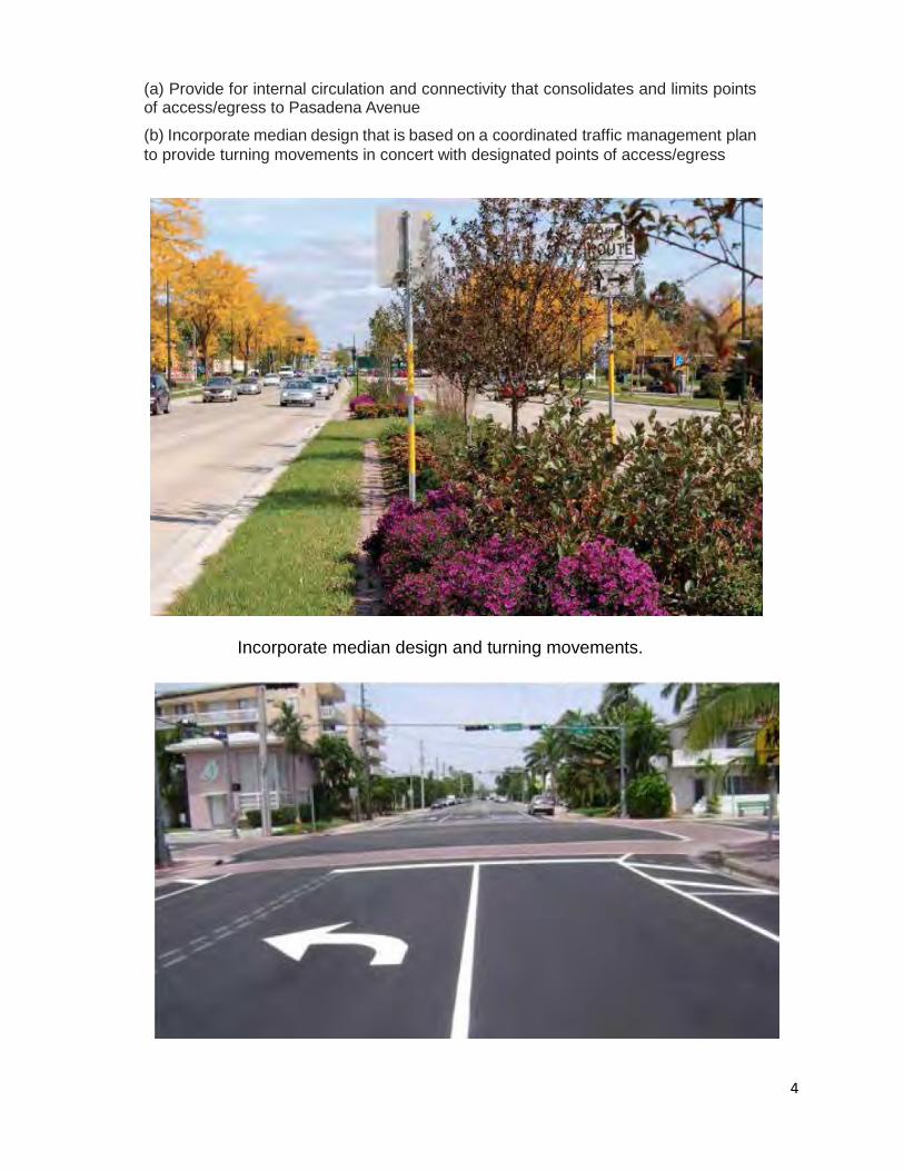
Incorporate median design and turning movements.
(a) Provide for internal circulation and connectivity that consolidates and limits points of access/egress to Pasadena Avenue
(b) Incorporate median design that is based on a coordinated traffic management plan to provide turning movements in concert with designated points of access/egress
4

(c) Establish direct, visible pedestrian connections that encourage pedestrian movement to and from Pasadena Avenue and facilitate access to public transit
(d) Provide for connection and extension of existing parallel roadways or internal drives to reduce points of conflict with both vehicular and pedestrian movement on Pasadena Avenue
Provide for clearly marked, safe pedestrian crossings using markings, pavement treatment and signalization where appropriate
5

Include streetscape features separating vehicular and pedestrian traffic.
6

(a) Incorporate safe, convenient and attractive pedestrian connections within a site to the public right of way.
(a) Incorporate safe, convenient and attractive pedestrian connections within a site to the public right of way.
Provide attractive, direct connections to storefronts from sidewalk.
7
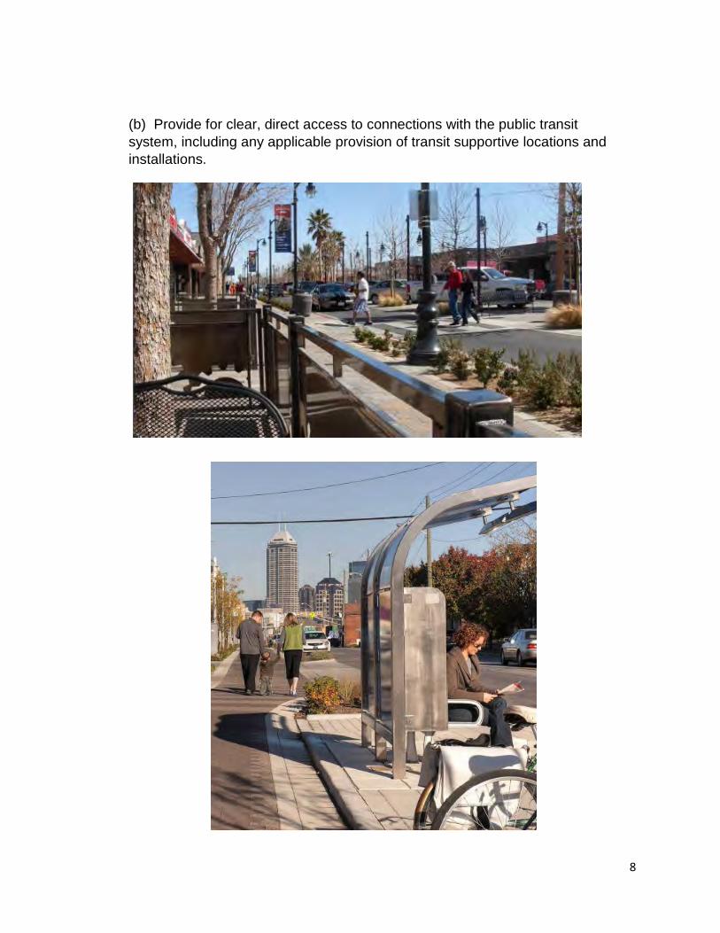
(b) Provide for clear, direct access to connections with the public transit system, including any applicable provision of transit supportive locations and installations.
8

Create attractive public realm between right-of-way and building façade
(c) Include sidewalk treatment designed to integrate the area between the public right of way and the building/project entry features to encourage an attractive, functional public realm.
(d) Identify location of and connection to improved crosswalks that include both safety and design features that facilitate pedestrian / bicycle movement across Pasadena Avenue at key intervals designed in concert with the public transit system.
Identify clear, covered points of entry to buildings.
9

Parking is screened from the street.
10
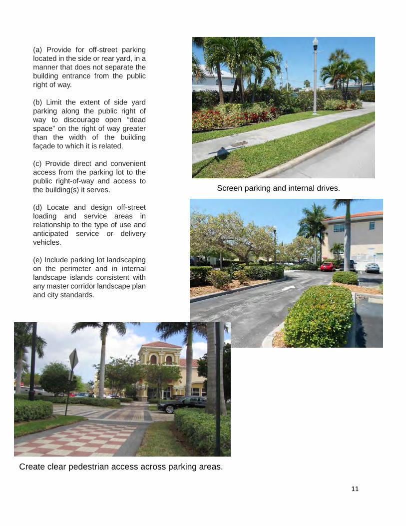
Screen parking and internal drives.
Parking is screened from the street.
(a) Provide for off-street parking located in the side or rear yard, in a manner that does not separate the building entrance from the public right of way.
(b) Limit the extent of side yard parking along the public right of way to discourage open “dead space” on the right of way greater than the width of the building façade to which it is related.
(c) Provide direct and convenient access from the parking lot to the public right-of-way and access to the building(s) it serves.
(d) Locate and design off-street loading and service areas in relationship to the type of use and anticipated service or delivery vehicles.
(e) Include parking lot landscaping on the perimeter and in internal landscape islands consistent with any master corridor landscape plan and city standards.
Create clear pedestrian access across parking areas.
11

(f) Ensure that any parking garage is physically and visually integrated with the use(s) it serves. In particular, parking structures will address:
• Setbacks with terraced landscaping elements to soften the appearance of a parking garage. • Architectural articulation treatment that break up the massing of the garage and add visual
interest. • Design that is complementary with adjacent buildings by using similar building forms,
materials, and/or details to enhance garages and the surrounding pedestrian environment. • Parking garage entries should be designed and sited to complement, not subordinate, the
pedestrian entry.
Wrap parking garages with attractive/functional ground floor space.
12

13

(a) Include street furnishings and equipment that are coordinated with an overall streetscape plan and approach for the corridor. Streetscape furnishings should include the appropriate style and location for benches, receptacles, bollards, low-level lighting, outdoor seating and bicycle racks consistent with overall corridor approach.
An overall approach to the streetscapes include landscaping, pavement treatment, traffic apparatus and street furniture.
14
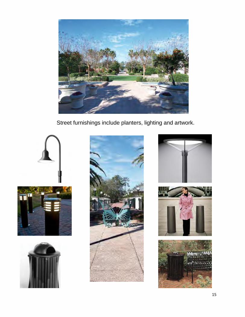
Street furnishings include planters, lighting and artwork.
15

Provide attractive public spaces.
Include provision for public space, plazas, and architectural features.
Provide attractive sidewalk areas between street and building face.
16

Strategically locate, buffer and enclose utility and delivery functions
Screen drive-through and vehicular spaces.
17

18

(a) Minimize building setbacks and provide for the building entrance directly available from the sidewalk, except where a pedestrian oriented, open space plaza is provided between the sidewalk and the building.
(b) Establish that a minimum percentage of the building façade of the ground floor of buildings facing the street shall be transparent.
Building accessed directly from sidewalk
Building façade should be largely transparent at ground level.
19

Include awnings and arcades to provide shade and interest.
20
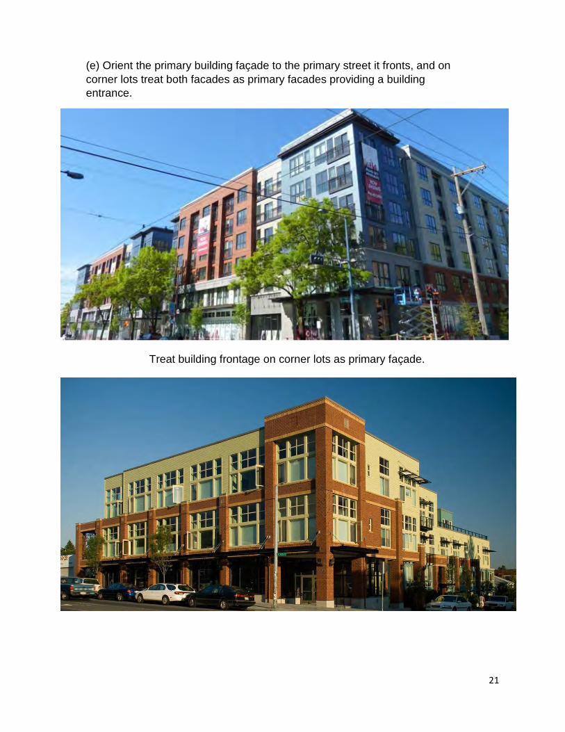
(e) Orient the primary building façade to the primary street it fronts, and on corner lots treat both facades as primary facades providing a building entrance.
Treat building frontage on corner lots as primary façade.
21

Vary building height and setbacks to create interest and depth.
22

Correlate sign size and placement with building design and space.
(g) Identify signage that is integrated with and sized in relationship to the scale of the building face.
23

6. NEIGHBORHOOD COMPATIBILITY
The objective of this design consideration is to give adequate consideration to and protection for residential neighborhoods adjacent to the commercial, mixed use corridor.
As revitalization and redevelopment occurs in the corridor, particular attention needs to be given to hos it transitions at its interface with existing residential uses. This design feature will address the compatibility of use, the density/intensity, scale and location of use, and provisions for buffering.
The design guidelines that will assist in providing this transition from more intensive mixed use areas to adjoining residential areas include the following:
24

Use office and multi-family residential of appropriate scale to transition from commercial to single family residential.
25

Incorporate green walls, roofs and materials that minimize glare and heat island effects.
7. SUSTAINABILITY FEATURES
The objective is to encourage reinvestment in those practices and improvements that are both economically and environmentally sustainable.
Any long range plan for improving the function, economy and appearance of the corridor should seek to do so in ways that are both economically and environmentally sustainable.
There are both individual private project and municipal initiatives that can contribute to sound sustainability practices that can be incorporated in the redevelopment process.
Among the types of design features to be considered are the following:
26
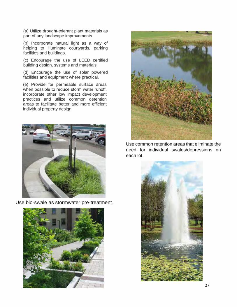
Use bio-swale as stormwater pre-treatment.
(a) Utilize drought-tolerant plant materials as part of any landscape improvements.
(b) Incorporate natural light as a way of helping to illuminate courtyards, parking facilities and buildings.
(c) Encourage the use of LEED certified building design, systems and materials.
(d) Encourage the use of solar powered facilities and equipment where practical.
(e) Provide for permeable surface areas when possible to reduce storm water runoff, incorporate other low impact development practices and utilize common detention areas to facilitate better and more efficient individual property design.
Use common retention areas that eliminate the need for individual swales/depressions on each lot.
27