coastal risk management policy adopted october2012 · coastal risk management guide: incorporating...
TRANSCRIPT

1
Coastal Risk Management Policy
Coastal Risk Management Policy
AUTHOR Genevieve Wilson
DEPARTMENT Environmental Services
DATE CREATED February 2012
DATE REVISED September 2012
DATE ADOPTED BY COUNCIL October 2012

2
Coastal Risk Management Policy
1. Introduction
The coastal zone is subject to both natural (wave, wind and tidal action) processes and human impacts (tourism, residential, commercial and recreational development and use). This results in coastal risks and hazards that require management.
Coastal risks include risks from erosion, inundation and geotechnical instability. Erosion refers to the wearing away of the land by the action of natural forces. Coastal or tidal inundation is the flooding of coastal lands by ocean waters, which is generally caused by large waves and elevated water associated with severe storms and the peak of the high tide. Geotechnical risks in the coastal zone refer to coastal cliff or slope instability.
A Coastal Risks and Hazards Vulnerability Study of the Waverley Local Government Area coastal zone was completed by consultancy, Worley Parsons in December 2011. The Study identifies property lots with coastal inundation and/or geotechnical risks (during both current extreme events and sea level rise scenarios).
This Coastal Risk Management Policy identifies the property lots identified in the Waverley Council Coastal Risks and Hazards Vulnerability Study 2011 as at risk of coastal inundation and/or geotechnical hazards, the basis for this identification and Council’s management response.
2. Objectives
To take into account coastal risks and hazards in managing people and assets (both built and natural) in the coastal zone, particularly through land use planning, development assessment, asset management and Council operations.
3. Policy and legislative framework
The NSW Government has a range of legislation, regulation and policies that relate to coastal risk management as listed below.
Clause 7 Schedule 4 Environmental Planning and Assessment Regulation 2000 -requires that Council have a policy in place and include information on Section 149 Certificates where development controls relating to coastal hazards apply.
Coastal Planning Guideline: Adapting to Sea Level Rise (2010) – provides detail about the consideration of coastal hazard information in land-use planning and development assessment.
Coastal Policy (1997) – requires that climate change be considered in planning and development assessment matters.
Coastal Risk Management Guide: incorporating sea level rise benchmarks in coastal risk assessments (2010) – provides direction about how to incorporate sea level rise benchmarks in coastal hazard assessments.
Coastline Management Manual (1990) – requires consideration of climate change in the preparation of coastal hazard and flood studies and management plans.

3
Coastal Risk Management Policy
Guidelines for Preparing Coastal Zone Management Plans (2010) – provides guidance to councils on the assessment of coastal risks as part of the development of a coastal zone management plan in accordance with Part 4A of the Coastal Protection Act 1979.
Sea Level Rise Policy Statement (2009) – specifies sea level rise planning benchmarks of an increase above 1990 mean sea levels of 40cm by 2050 and 90cm by 2100 and outlines that responsibility for coastal protection works rests with landowners, both public and private.
Section 117 Direction 2.2 Coastal Protection of the Environmental Planning and Assessment Act 1979 – directs that a draft Local Environmental Plan shall include provisions that give effect to and are consistent with the NSW Coastal Policy, the Coastal Design Guidelines for NSW and the Coastline Management Manual.
Standard Instrument: Principal Local Environmental Plan – contains clause 5.5 development within the coastal zone which requires that all development consent authorities within the NSW Coastal Zone consider the effect of coastal processes and coastal hazards and potential impacts, including sea level rise on the proposed development, and arising from the proposed development.
State Environmental Planning Policy 71 Coastal Protection – requires that councils consider the impact of coastal processes and coastal hazards when preparing LEPs and assessment development in the NSW coastal zone.
4. Policy application
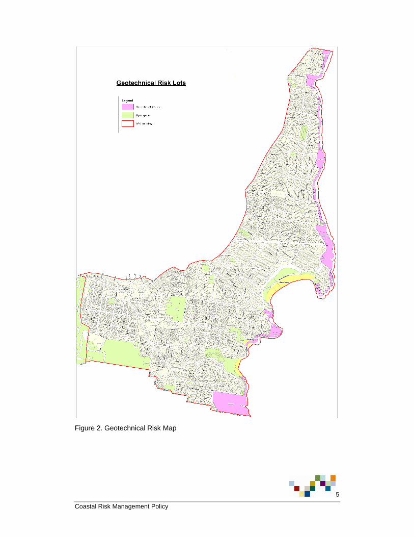
This policy applies to all property lots identified in the coastal inundation risk map (Figure 1) and geotechnical risk map (Figure 2) as having a potential coastal inundation and/or geotechnical risk.

4
Coastal Risk Management Policy
Figure 1. Coastal Inundation Risk Map
5
Coastal Risk Management Policy
Figure 2. Geotechnical Risk Map

6
Coastal Risk Management Policy
5. Basis for identification
In developing the Waverley Coastal Risks & Hazards Vulnerability Study 2011 (the Study), Worley Parsons:
� Reviewed existing studies of the Waverley coastal area and assets;
� Undertook a geotechnical assessment of coastal cliff and slope stability;
� Modelled beach erosion, shoreline recession, and coastal inundation for current conditions and projected 2050 and 2100 conditions (based on the NSW Government Sea Level Rise Policy Statement 2009); and,
� Investigated sand drift and stormwater assets in the coastal areas.
Coastal inundation and geotechnical risks (as outlined below) were identified in the Study as the main issues affecting property in the Waverley coastal zone.
� Coastal inundation may occur in some locations due to still water levels and wave run-up alonei. During storm events, individual waves may result in further temporary water level increases above the still water level due to the processes of wave setup, run-up and overtoppingii.
� Worley Parsons have calculated levels of inundation, taking into account sea level rise, to be 4.4m Australian Height Datum (AHD) for 2011, 5.4m AHD for 2050 and 6.6m AHD for 2100. It is noted in the Study that inundation to buildings is subject to individual floor levels, which could be well above inundation limitsiii.
� Based on modelling of these processes, Worley Parsons identified properties at risk of coastal inundation, as shown in Figure 1.
� Worley Parsons identified the potential geotechnical hazards for the study area as:
1. instability of overhang features, wedges or blocks within sandstone bedrock over the crest of the cliff face, the cliff face and the base of the cliff face;
2. instability of natural soil foreshore slopes;
3. instability of fill foreshore slopes;
4. instability of existing stabilisation measures; and
5. instability of retaining structuresiv.
� Natural processes (by wave and wind erosion) as well as construction processes may detrimentally impact on cliff and slope stability, existing stabilisation measures and retaining structuresv.
� Based on a geotechnical assessment of the Waverley coastal zone, Worley Parsons identified properties with potential geotechnical risks, as shown in Figure 2.

7
Coastal Risk Management Policy
6. Management
As per the recommendations in the Waverley Coastal Risks & Hazards Vulnerability Study, Council will manage coastal risks on property by:
� Making the Waverley Coastal Risks & Hazards Vulnerability Study publicly available to enable an improved understanding of the coastal processes affecting the properties and to inform assessments commissioned by individual property owners;
� Notifying affected property lot owners of the geotechnical and/or coastal inundation risk;
� Annotating Section 149 certificates in accordance with Clause 7 of Schedule 4 of the Environmental Planning and Assessment Regulation 2000 to note whether a property is within a geotechnical and/or coastal inundation risk area;
� For proposed development of new buildings, significant alterations and / or additions to existing buildings and / or new swimming pools on lots identified as having a coastal inundation risk, Council will require as part of the Development Assessment process a coastal assessment prepared by a suitably qualified expert;
� For proposed development of new buildings, significant alterations and / or additions to existing buildings and pools on lots identified as having a potential geotechnical risk, Council will require as part of the Development Assessment process a geotechnical assessment prepared by a suitably qualified expert;
� Updating Council’s relevant planning documents.
7. Glossary
Note all definitions in the glossary are adapted from the Waverley Coastal Risks and Hazards Vulnerability Study (Worley Parsons 2011).
Coastal or tidal inundation - the flooding of coastal lands by ocean waters, which is generally caused by large waves and elevated water associated with severe storms and the peak of the high tide.
Erosion - the wearing away of the land by the action of natural forces including wave action, tidal currents, littoral currents or wind.
Event - an occurrence meeting specified conditions, e.g. damage, a threshold wave height or a threshold water level.
Geotechnical risks in the coastal zone - coastal cliff or slope instability.
New buildings – New building or structure, including those where more than half of the existing external fabric of the building is demolished. The area of the existing external fabric is taken to be the surface area of all the existing external walls, the roof measured in plan and the area of the lowest habitable floor.

8
Coastal Risk Management Policy
Overtopping - water carried over the top of a coastal defence due to wave run-up or surge action exceeding the crest height.
Property lot - a parcel of land with defined borders.
Run-up - the rush of water up a structure or beach on the breaking of a wave. The amount of run-up is the vertical height above stillwater level that the rush of water reaches.
Significant alterations and / or additions to existing buildings – where in the opinion of an authorised Council Officer, the proposed works are of sufficient scale and location to require a coastal assessment and/or geotechnical assessment.
Storm surge - a rise or piling-up of water against shore, produced by strong winds blowing onshore. A storm surge is most severe when it occurs in conjunction with a high tide.
Tide - the periodic rising and falling of the water that results from gravitational attraction of the moon and sun acting upon the rotating earth. Although the accompanying horizontal movement of the water resulting from the same cause is also sometimes called the tide, it is preferable to designate the latter as tidal current, reserving the name tide for the vertical movement.
Undercutting - erosion of material at the foot of a cliff. Ultimately, the overhang collapses, and the process is repeated.
Wave - an oscillatory movement in a body of water manifested by an alternate rise and fall of the surface.
Wave set-up - elevation of the still-water level due to breaking waves.
8. References i Worley Parsons, Waverley Coastal Risks & Hazards Vulnerability Study, 2011, p. 67. ii Worley Parsons, Waverley Coastal Risks & Hazards Vulnerability Study, 2011, p. 68. iii Worley Parsons, Waverley Coastal Risks & Hazards Vulnerability Study, 2011, p. 68. iv Worley Parsons, Waverley Coastal Risks & Hazards Vulnerability Study, 2011, p. 82. v Worley Parsons, Waverley Coastal Risks & Hazards Vulnerability Study, 2011, p. 95.