climate feedback–based provisions for dam design, operations
TRANSCRIPT
Forum
Climate Feedback–Based Provisions for Dam Design,Operations, and Water Management in the 21st Century
Faisal Hossain, A.M.ASCEDept. of Civil and Environmental Engineering, Tennessee TechnologicalUniv., 1020 Stadium Dr., Cookeville, TN 38505 (corresponding author).E-mail: [email protected]
Ahmed M. Degu, S.M.ASCETennessee Technological Univ., Cookeville, TN.
Wondmagegn Yigzaw, S.M.ASCETennessee Technological Univ., Cookeville, TN.
Steve Burian, A.M.ASCEUniv. of Utah, Salt Lake City, UT.
Dev NiyogiPurdue Univ., West Lafayette, IN.
James Marshall ShepherdUniv. of Georgia, Athens, GA.
Roger Pielke Sr.Univ. of Colorado, Boulder, CO.
DOI: 10.1061/(ASCE)HE.1943-5584.0000541
Introduction
As the world’s population increases, the rising demand for waterwill be compounded further by the need to sustain economicgrowth (Vörösmarty et al. 2000). According to one report bythe United Nations Environment Program (UNEP), the stress onfreshwater resources is expected to significantly magnify andspread to other regions of the world by 2025 (see Fig. 1; UNEP2002). Historically, one of the common engineering solutionsto guarantee a steady water supply against a rising demand hasbeen to construct surface water impoundments on rivers. Suchlarge-scale infrastructure, commonly known as dams and artificialreservoirs, trap a sufficiently large amount of water from the localhydrologic cycle to make up for a shortfall when demand exceedsthe variable supply from nature. In other words, dams can be re-garded as a strategic (long-term) solution to resolve the tactical(short-term) challenges of balancing the water deficit compoundedby population growth and economic activity.
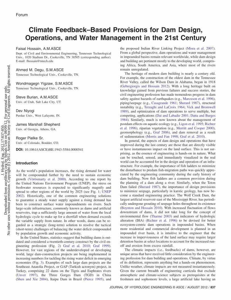
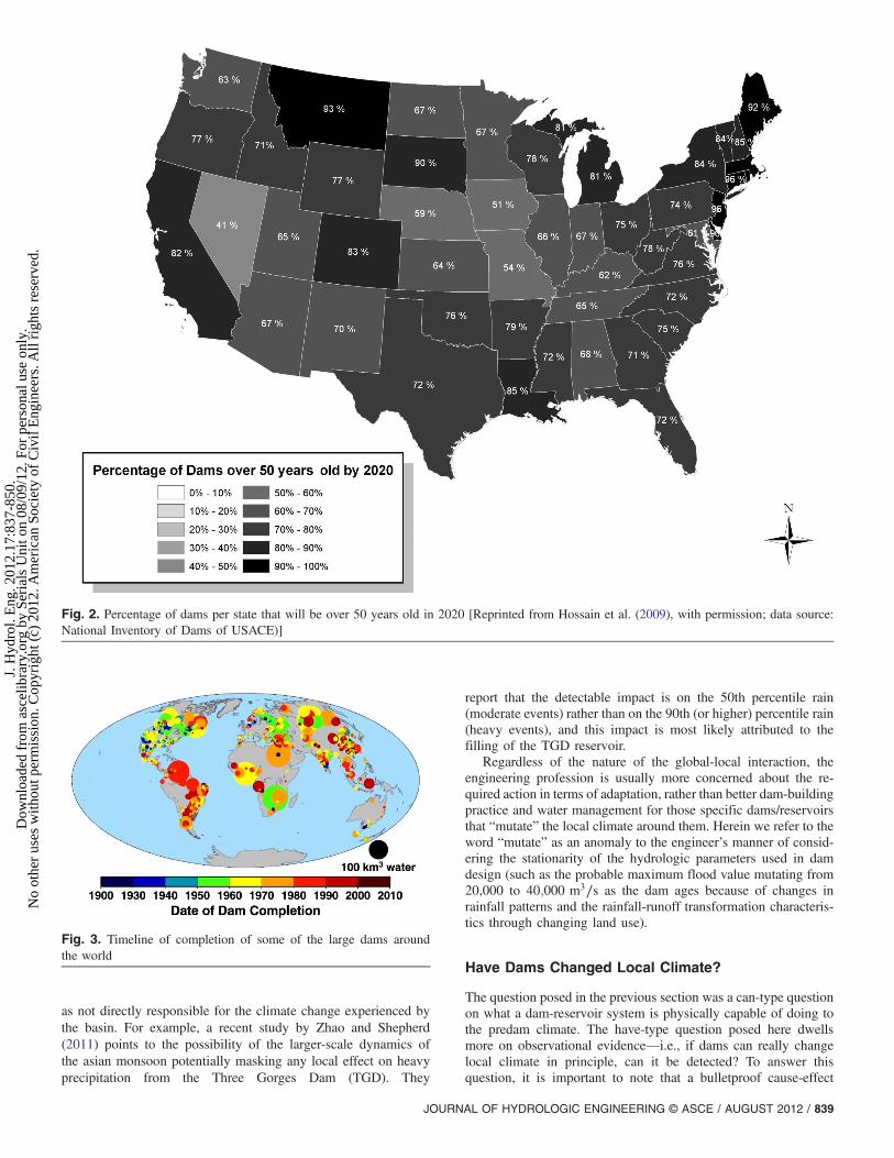
In the United States, statistics suggest that building dams is out-dated and considered a twentieth-century construct by the civil en-gineering profession (Fig. 2) Graf et al. 2010; Graf 1999).However, for vast regions of the underdeveloped or developingworld, large dam-construction projects are being implemented inincreasing numbers for tackling the rising water deficit in emergingeconomies (Fig. 3). Examples of such large dam projects are theSoutheast Anatolia Project, or GAP (Turkish acronym) project, inTurkey, comprising 22 dams on the Tigris and Euphrates rivers(Unver 1997), the Three Gorges Dam (TGD) in China(Shen and Xie 2004), Itaipu Dam in Brazil (Pierce 1995), and
the proposed Indian River Linking Project (Misra et al. 2007).From a global perspective, dam operations and water managementin impounded basins remain relevant worldwide, while dam designand building are pertinent mostly to the developing world, compris-ing Africa, South America, and Asia, where most of the riversremain unregulated.
The heritage of modern dam building is nearly a century old.For example, the construction of the oldest dam in the TennesseeRiver Valley, called the Wilson Dam in Alabama, began in 1918(Gebregiorgis and Hossain 2012). With a long heritage built onknowledge gained from previous failures and success stories, thecivil engineering profession has made tremendous progress in damsafety against hazards of earthquakes (e.g., Marcuson et al. 1996),piping/seepage (e.g., Casagrande 1961; Sherard 1987), structuralinstability (e.g., Terzaghi and LaCroix 1964; Vick and Bromwell1989), and optimization of dam operations to serve multiple, butcompeting, applications (Dai and Labadie 2001; Datta and Burges1984). Similarly, much is now known about the management ofpostdam effects on aquatic ecology (e.g., Ligon et al. 1995; Richteret al. 1996), riparian vegetation (e.g., Merritt and Cooper 2000),geomorphology (e.g., Graf 2006), and dam removal as a resultof sedimentation (Morris and Fan 1998; Graf et al. 2010).
In general, the aspects of dam design and operations that haveimproved during the last century are those that are directly visibleor have instantaneous impact on the land surface. This is not sur-prising, as the essence of engineering is hands-on in nature. Whatcan be touched, sensed, and immediately visualized in the realworld can be accounted for in the design and operation of an infra-structure. For example, the importance of fish ladders to minimizethe disturbance to predam fish-migration paths was quickly appre-ciated by the engineering community during the early history ofdam building. Now fish ladders are a common provision duringthe planning of a dam along a river. Similarly, when the TetonDam failed (Sherard 1987), the importance of design provisionsto minimize seepage, particularly in karstic geology, has now be-come a standard engineering practice. The Wolf Creek Dam, thelargest artificial reservoir east of the Mississippi River, has periodi-cally undergone grouting of seepage holes throughout its existence(Boynton and Hossain 2010). With increased fluctuation of flowsdownstream of dams, it did not take long for the concept ofenvironmental flow (Tharme 2003) and indicators of hydrologicalteration (IHA) (Richter et al. 1996) to be devised for betterecosystem-centric dam operations in impounded basins. Whenmore residential and commercial development is planned in animpounded river basin, it is intuitive to the engineer that theincrease in imperviousness of the land surface may require largerdetention basins at select locations to account for the increased run-off and erosion from excess rainfall.
The climatic impacts (i.e., feedbacks) of dams, however, areunique areas that have received little consideration by the engineer-ing profession for dam building and operations. Climate, by virtueof its definition, represents anything but a hands-on phenomenon.Unlike weather, climate impacts are not measured instantaneously.Given the current breadth of engineering curricula that excludeatmospheric and climate-science subjects as prerequisites at thefreshmen and sophomore levels, a large artificial lake having an
JOURNAL OF HYDROLOGIC ENGINEERING © ASCE / AUGUST 2012 / 837
J. H
ydro
l. E
ng. 2
012.
17:8
37-8
50.
Dow
nloa
ded
from
asc
elib
rary
.org
by
Seri
als
Uni
t on
08/0
9/12
. For
per
sona
l use
onl
y.N
o ot
her
uses
with
out p
erm
issi
on. C
opyr
ight
(c)
201
2. A
mer
ican
Soc
iety
of
Civ
il E
ngin
eers
. All
righ
ts r
eser
ved.

observable effect on local climate (such as a change in surface tem-perature or precipitation) is conceived with difficulty by the conven-tionally trained engineer. Impacts on weather have historicallyreceived minimal consideration for postdam water management.Evaporation is only considered with respect to the resulting lossof water from the impoundment. Yet there is a rich body of research,accumulated independently over the previous few decades, thatshows that the land cover changes typically caused by a dam (suchas irrigation, urbanization, deforestation, and afforestation) can sig-nificantly alter the natural availability ofwater within the impoundedriver basin (Pielke et al. 2009; Cotton and Pielke 2007).
The purpose of this article is to shed light on the need for climatefeedback–based considerations in dam design, operations, andwater management for the 21st century. The next section providesa brief summary of the known impacts on climate caused bychanges in land use and land cover that are typically experiencedafter dam construction is complete. This is followed by recent re-search on the signature of dams on local climate using observation-al evidence. The final section discusses the need for climate-basedprovisions in today’s dam design and operations and in engineeringeducation. The discussion is cast in the context of an overview of adatabase comprising approximately 7,000 large dams worldwideand the need for a dialogue on incorporating additional topicsas prerequisites in the traditional civil engineering curriculum.
Is There a Physically Sound Rationale to SuggestDams Can Change Local Climate?
In current dam-infrastructure literature, the impact of global climatechange (which is popularly perceived as a more planetary-scalephenomenon on the basis of a globally rising temperature trend)
on artificial reservoirs and water supply has been studied at re-gional scales for some time (e.g., Hamlet and Lettenmaier 1999;Christensen et al. 2004). This is also evident from a comprehensiveliterature synthesis published recently by the U.S. Bureau ofReclamation (USBR) on climate-change adaptation (USBR 2009).The converse (impact of reservoirs on local climate via feedbackmechanisms), which is the focus of this paper, has not yet beenexplored in depth (Degu et al. 2011; Hossain et al. 2010).
To understand whether a physical rationale can be constructed tosuggest that dams change the local climate, a broader view of thechange that a dam typically triggers during its lifespan needs to beconsidered. Such a broader view, although obvious, has not re-ceived the necessary attention from the engineering profession, par-ticularly from the dam-building community. At a minimum, a damchanges the preexisting landscape to an open body of water, whichthen leads to a change in surface albedo, surface roughness, andsensible and latent heat fluxes. A flood control or hydropowerdam can also trigger a faster pace of urbanization of the down-stream valley regions, while irrigation dams intensify agriculturalproduction in the vicinity of the reservoir. Global data andsimulation analysis by Biemans et al. (2011) report that artificialreservoirs contribute significantly to irrigation water supply inmany regions around the world. The additional contribution ofreservoirs to irrigation has increased spectacularly from 5%(around 1900 C.E.) to almost 40% in the 21st century (Biemanset al. 2011). When such changes to land cover and land use (LCLU)are assessed in relation to existing knowledge on their impact onclimate (e.g., Pielke 2005; Feddema et al. 2005; Pielke et al. 2007;Ray et al. 2009), it becomes apparent that a typical dam-reservoirsystem can, in principle, change the local climate through a gradualchange in the landscape. Examples of the effect of local landscapechanges on precipitation include Gero et al. (2006), Lei et al.(2008), Shepherd et al. (2010), and Niyogi et al. (2011). There havealso been studies that conclude that there is a global-scale impactfrom irrigation (Puma and Cook 2010), of which a significantfraction of this irrigation is the result of atmospheric moisture madeavailable for vegetation from artificial reservoirs.
The change on local climate near dams is expected to beparticularly noticeable in temperature and precipitation patternsduring the growing season. For example, Mahmood et al. (2004)showed that irrigation in the Great Plains during growing season(May through September) may have caused regional cooling ofgrowing-season mean maximum temperatures by 1.41°C duringthe post-1945 period at irrigated locations. Data and modelingstudies support the notion that atmospheric moisture added byirrigation can also increase rainfall, provided that the mesoscaleconditions are appropriate (Lohar and Pal 1995; Barnston andSchickedanz 1986). DeAngelis et al. (2010) have reported an in-crease of 10–30% of rainfall downwind of the Ogallala aquifer thathas been used for groundwater-based irrigation in the Great Plains.For the most up-to-date and comprehensive review of observationalevidence on the impact of land-cover changes (many of which aretriggered by dams) on climate, readers should refer to Mahmoodet al. (2010). In principle, there exists a defensible rationale thatsuggests that dams can change the local climate in their vicinity.
Having briefly reviewed the potential impact of dams on the lo-cal climate, it is now appropriate to put in context the more widelyreported global climate change from anthropogenic greenhouse-gasemissions. If the climate warms, more water vapor can be held inthe atmosphere and the local effect of dams may interact with theglobal trend and result in the local climate impact being amplified,canceled, or undetectable. Although the focus of this paper is howan impounded basin may be transforming itself climatologically,such global-local interaction may exclude a large number of dams
Fig. 1. Global freshwater stress projected on the basis of a report bythe United Nations [data source: Global Environment Outlook (GEO)-2000,UNEnvironmentalProgram(UNEP)2000,Earthscan,London,1999]
838 / JOURNAL OF HYDROLOGIC ENGINEERING © ASCE / AUGUST 2012
J. H
ydro
l. E
ng. 2
012.
17:8
37-8
50.
Dow
nloa
ded
from
asc
elib
rary
.org
by
Seri
als
Uni
t on
08/0
9/12
. For
per
sona
l use
onl
y.N
o ot
her
uses
with
out p
erm
issi
on. C
opyr
ight
(c)
201
2. A
mer
ican
Soc
iety
of
Civ
il E
ngin
eers
. All
righ
ts r
eser
ved.
as not directly responsible for the climate change experienced bythe basin. For example, a recent study by Zhao and Shepherd(2011) points to the possibility of the larger-scale dynamics ofthe asian monsoon potentially masking any local effect on heavyprecipitation from the Three Gorges Dam (TGD). They
report that the detectable impact is on the 50th percentile rain(moderate events) rather than on the 90th (or higher) percentile rain(heavy events), and this impact is most likely attributed to thefilling of the TGD reservoir.
Regardless of the nature of the global-local interaction, theengineering profession is usually more concerned about the re-quired action in terms of adaptation, rather than better dam-buildingpractice and water management for those specific dams/reservoirsthat “mutate” the local climate around them. Herein we refer to theword “mutate” as an anomaly to the engineer’s manner of consid-ering the stationarity of the hydrologic parameters used in damdesign (such as the probable maximum flood value mutating from20,000 to 40;000 m3∕s as the dam ages because of changes inrainfall patterns and the rainfall-runoff transformation characteris-tics through changing land use).
Have Dams Changed Local Climate?
The question posed in the previous section was a can-type questionon what a dam-reservoir system is physically capable of doing tothe predam climate. The have-type question posed here dwellsmore on observational evidence—i.e., if dams can really changelocal climate in principle, can it be detected? To answer thisquestion, it is important to note that a bulletproof cause-effect
Fig. 2. Percentage of dams per state that will be over 50 years old in 2020 [Reprinted from Hossain et al. (2009), with permission; data source:National Inventory of Dams of USACE)]
Fig. 3. Timeline of completion of some of the large dams aroundthe world
JOURNAL OF HYDROLOGIC ENGINEERING © ASCE / AUGUST 2012 / 839
J. H
ydro
l. E
ng. 2
012.
17:8
37-8
50.
Dow
nloa
ded
from
asc
elib
rary
.org
by
Seri
als
Uni
t on
08/0
9/12
. For
per
sona
l use
onl
y.N
o ot
her
uses
with
out p
erm
issi
on. C
opyr
ight
(c)
201
2. A
mer
ican
Soc
iety
of
Civ
il E
ngin
eers
. All
righ
ts r
eser
ved.

relationship attributing any change solely to a dam is nearly impos-sible, as is the case for any other human activity, because ofnumerous other (nondam-induced) interactions. For example,urbanization (Shepherd et al. 2010) and aerosols from industriali-zation (Rosenfield et al. 2008) are both known to affect localclimate, particularly heavy precipitation patterns. To pinpoint thespecific role of a dam (or dams) and the land-use change that istriggered, an integrative study that separates the other effects isrequired. That is beyond the scope of this forum article. The pur-pose in this section is to highlight the first-order and statisticalunderstanding that climate observations alone allow us to makefor dams, without considering other factors.
We studied 92 dams located in the United States and definedthem as “large” according to the International Commission onLarge Dams (ICOLD) in a manner similar to a recent study byDegu et al. (2011). The database of dams was available from aseries of world-dam registers published by the Global Water Sys-tems Project (GWSP) Digital Water Atlas (GWSP 2008). Thesedams were spread across eight distinct climate zones (Fig. 4).The classification of climate zones shown in Fig. 4 is theKoppen-Geiger scheme (Peel et al. 2007). For the observationalrecord of climate, reanalysis data from the National Center forEnvironmental Prediction (NCEP) North American Regional Rean-alysis (NARR; Mesinger et al. 2006; Rutledge et al. 2006) wasused. NARR provides a quality-controlled, finer-resolution climatedataset over North America. Daily NARR fields spanning the
period of 1979–2009 (30 years) and focusing on the daily averageof the surface convective available potential energy (CAPE; J∕kg)was used as a proxy signature of dams (Pielke 2001). Among themany important factors required for rainfall, CAPE can be consid-ered an important atmospheric indicator of the presence of heavy-rainfall process. The objective was to identify detectable changes inCAPE climatology (available at 32-km spatial scales) in the vicinityof dams for a given climate zone.
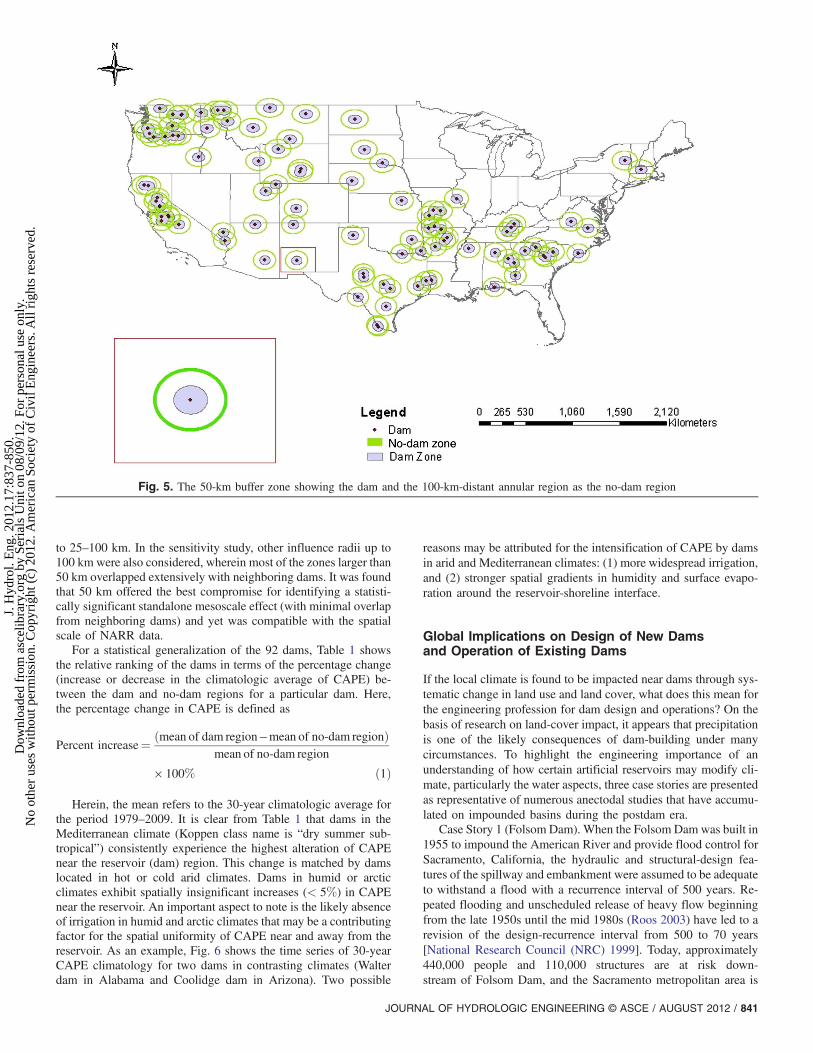
Because the NARR record of CAPE does not date before theconstruction of most large dams in the United States, the ergodicassumption was invoked to answer the “detection” and “have”-typequestion posed in this section. The spatial average of CAPE over aregion distant from dams (referred to as a no-dam region) was con-sidered a substitute for the temporal average of CAPE during thepredam era. In other words, the average CAPE over the no-damregion was used to represent the predam climatology of convectiveatmospheric instability. Similarly, the average CAPE over the damregion was used as a proxy for the postdam climatology. Herein, theno-dam region was defined as the annular region 100 km outside adam’s spillway having the same area as the dam region (Fig. 5). Toattribute the unique and local impact of the dam alone, a dam regionwas defined as a circular area having a 50-km radius around thedam location (Fig. 5). The 50-km influence zone is a statistical,as well as a mesoscale, attribute that was derived from a pre-processing sensitivity study. Mesoscale (or local) impacts ofclimate, which are the focus of this study, are usually confined
Fig. 4. Location of 92 large dams according to the Koppen climate map
840 / JOURNAL OF HYDROLOGIC ENGINEERING © ASCE / AUGUST 2012
J. H
ydro
l. E
ng. 2
012.
17:8
37-8
50.
Dow
nloa
ded
from
asc
elib
rary
.org
by
Seri
als
Uni
t on
08/0
9/12
. For
per
sona
l use
onl
y.N
o ot
her
uses
with
out p
erm
issi
on. C
opyr
ight
(c)
201
2. A
mer
ican
Soc
iety
of
Civ
il E
ngin
eers
. All
righ
ts r
eser
ved.
to 25–100 km. In the sensitivity study, other influence radii up to100 km were also considered, wherein most of the zones larger than50 km overlapped extensively with neighboring dams. It was foundthat 50 km offered the best compromise for identifying a statisti-cally significant standalone mesoscale effect (with minimal overlapfrom neighboring dams) and yet was compatible with the spatialscale of NARR data.
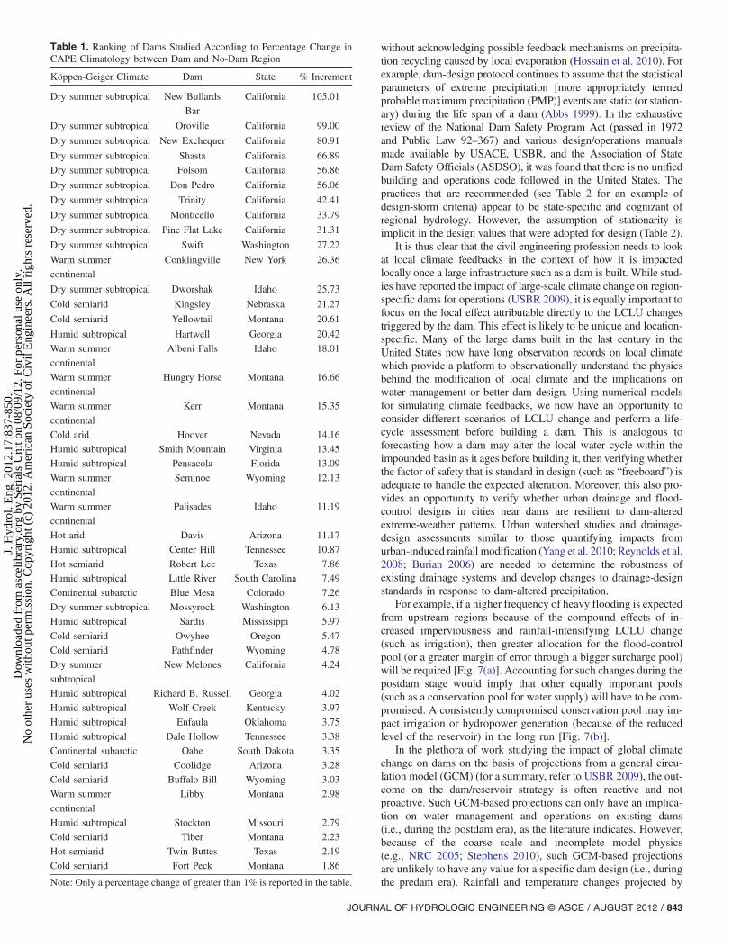
For a statistical generalization of the 92 dams, Table 1 showsthe relative ranking of the dams in terms of the percentage change(increase or decrease in the climatologic average of CAPE) be-tween the dam and no-dam regions for a particular dam. Here,the percentage change in CAPE is defined as
Percent increase¼ ðmean of dam region�mean of no-dam regionÞmean of no-dam region
× 100% ð1Þ
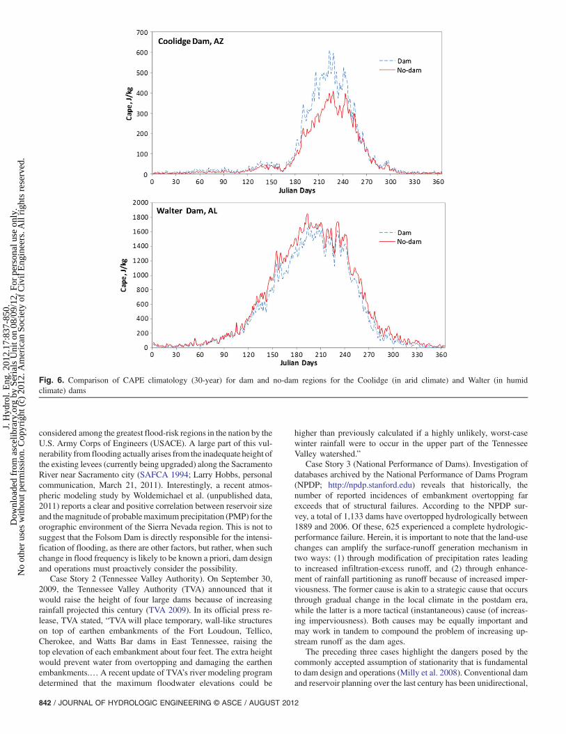
Herein, the mean refers to the 30-year climatologic average forthe period 1979–2009. It is clear from Table 1 that dams in theMediterranean climate (Koppen class name is “dry summer sub-tropical”) consistently experience the highest alteration of CAPEnear the reservoir (dam) region. This change is matched by damslocated in hot or cold arid climates. Dams in humid or arcticclimates exhibit spatially insignificant increases (< 5%) in CAPEnear the reservoir. An important aspect to note is the likely absenceof irrigation in humid and arctic climates that may be a contributingfactor for the spatial uniformity of CAPE near and away from thereservoir. As an example, Fig. 6 shows the time series of 30-yearCAPE climatology for two dams in contrasting climates (Walterdam in Alabama and Coolidge dam in Arizona). Two possible
reasons may be attributed for the intensification of CAPE by damsin arid and Mediterranean climates: (1) more widespread irrigation,and (2) stronger spatial gradients in humidity and surface evapo-ration around the reservoir-shoreline interface.
Global Implications on Design of New Damsand Operation of Existing Dams
If the local climate is found to be impacted near dams through sys-tematic change in land use and land cover, what does this mean forthe engineering profession for dam design and operations? On thebasis of research on land-cover impact, it appears that precipitationis one of the likely consequences of dam-building under manycircumstances. To highlight the engineering importance of anunderstanding of how certain artificial reservoirs may modify cli-mate, particularly the water aspects, three case stories are presentedas representative of numerous anectodal studies that have accumu-lated on impounded basins during the postdam era.
Case Story 1 (Folsom Dam). When the Folsom Dam was built in1955 to impound the American River and provide flood control forSacramento, California, the hydraulic and structural-design fea-tures of the spillway and embankment were assumed to be adequateto withstand a flood with a recurrence interval of 500 years. Re-peated flooding and unscheduled release of heavy flow beginningfrom the late 1950s until the mid 1980s (Roos 2003) have led to arevision of the design-recurrence interval from 500 to 70 years[National Research Council (NRC) 1999]. Today, approximately440,000 people and 110,000 structures are at risk down-stream of Folsom Dam, and the Sacramento metropolitan area is
Fig. 5. The 50-km buffer zone showing the dam and the 100-km-distant annular region as the no-dam region
JOURNAL OF HYDROLOGIC ENGINEERING © ASCE / AUGUST 2012 / 841
J. H
ydro
l. E
ng. 2
012.
17:8
37-8
50.
Dow
nloa
ded
from
asc
elib
rary
.org
by
Seri
als
Uni
t on
08/0
9/12
. For
per
sona
l use
onl
y.N
o ot
her
uses
with
out p
erm
issi
on. C
opyr
ight
(c)
201
2. A
mer
ican
Soc
iety
of
Civ
il E
ngin
eers
. All
righ
ts r
eser
ved.
considered among the greatest flood-risk regions in the nation by theU.S. Army Corps of Engineers (USACE). A large part of this vul-nerability from flooding actually arises from the inadequate height ofthe existing levees (currently being upgraded) along the SacramentoRiver near Sacramento city (SAFCA 1994; Larry Hobbs, personalcommunication, March 21, 2011). Interestingly, a recent atmos-pheric modeling study by Woldemichael et al. (unpublished data,2011) reports a clear and positive correlation between reservoir sizeand themagnitude of probablemaximumprecipitation (PMP) for theorographic environment of the Sierra Nevada region. This is not tosuggest that the Folsom Dam is directly responsible for the intensi-fication of flooding, as there are other factors, but rather, when suchchange in flood frequency is likely to be known a priori, dam designand operations must proactively consider the possibility.
Case Story 2 (Tennessee Valley Authority). On September 30,2009, the Tennessee Valley Authority (TVA) announced that itwould raise the height of four large dams because of increasingrainfall projected this century (TVA 2009). In its official press re-lease, TVA stated, “TVAwill place temporary, wall-like structureson top of earthen embankments of the Fort Loudoun, Tellico,Cherokee, and Watts Bar dams in East Tennessee, raising thetop elevation of each embankment about four feet. The extra heightwould prevent water from overtopping and damaging the earthenembankments.… A recent update of TVA’s river modeling programdetermined that the maximum floodwater elevations could be
higher than previously calculated if a highly unlikely, worst-casewinter rainfall were to occur in the upper part of the TennesseeValley watershed.”
Case Story 3 (National Performance of Dams). Investigation ofdatabases archived by the National Performance of Dams Program(NPDP; http://npdp.stanford.edu) reveals that historically, thenumber of reported incidences of embankment overtopping farexceeds that of structural failures. According to the NPDP sur-vey, a total of 1,133 dams have overtopped hydrologically between1889 and 2006. Of these, 625 experienced a complete hydrologic-performance failure. Herein, it is important to note that the land-usechanges can amplify the surface-runoff generation mechanism intwo ways: (1) through modification of precipitation rates leadingto increased infiltration-excess runoff, and (2) through enhance-ment of rainfall partitioning as runoff because of increased imper-viousness. The former cause is akin to a strategic cause that occursthrough gradual change in the local climate in the postdam era,while the latter is a more tactical (instantaneous) cause (of increas-ing imperviousness). Both causes may be equally important andmay work in tandem to compound the problem of increasing up-stream runoff as the dam ages.
The preceding three cases highlight the dangers posed by thecommonly accepted assumption of stationarity that is fundamentalto dam design and operations (Milly et al. 2008). Conventional damand reservoir planning over the last century has been unidirectional,
Fig. 6. Comparison of CAPE climatology (30-year) for dam and no-dam regions for the Coolidge (in arid climate) and Walter (in humidclimate) dams
842 / JOURNAL OF HYDROLOGIC ENGINEERING © ASCE / AUGUST 2012
J. H
ydro
l. E
ng. 2
012.
17:8
37-8
50.
Dow
nloa
ded
from
asc
elib
rary
.org
by
Seri
als
Uni
t on
08/0
9/12
. For
per
sona
l use
onl
y.N
o ot
her
uses
with
out p
erm
issi
on. C
opyr
ight
(c)
201
2. A
mer
ican
Soc
iety
of
Civ
il E
ngin
eers
. All
righ
ts r
eser
ved.
without acknowledging possible feedback mechanisms on precipita-tion recycling caused by local evaporation (Hossain et al. 2010). Forexample, dam-design protocol continues to assume that the statisticalparameters of extreme precipitation [more appropriately termedprobable maximum precipitation (PMP)] events are static (or station-ary) during the life span of a dam (Abbs 1999). In the exhaustivereview of the National Dam Safety Program Act (passed in 1972and Public Law 92–367) and various design/operations manualsmade available by USACE, USBR, and the Association of StateDam Safety Officials (ASDSO), it was found that there is no unifiedbuilding and operations code followed in the United States. Thepractices that are recommended (see Table 2 for an example ofdesign-storm criteria) appear to be state-specific and cognizant ofregional hydrology. However, the assumption of stationarity isimplicit in the design values that were adopted for design (Table 2).
It is thus clear that the civil engineering profession needs to lookat local climate feedbacks in the context of how it is impactedlocally once a large infrastructure such as a dam is built. While stud-ies have reported the impact of large-scale climate change on region-specific dams for operations (USBR 2009), it is equally important tofocus on the local effect attributable directly to the LCLU changestriggered by the dam. This effect is likely to be unique and location-specific. Many of the large dams built in the last century in theUnited States now have long observation records on local climatewhich provide a platform to observationally understand the physicsbehind the modification of local climate and the implications onwater management or better dam design. Using numerical modelsfor simulating climate feedbacks, we now have an opportunity toconsider different scenarios of LCLU change and perform a life-cycle assessment before building a dam. This is analogous toforecasting how a dam may alter the local water cycle within theimpounded basin as it ages before building it, then verifying whetherthe factor of safety that is standard in design (such as “freeboard”) isadequate to handle the expected alteration. Moreover, this also pro-vides an opportunity to verify whether urban drainage and flood-control designs in cities near dams are resilient to dam-alteredextreme-weather patterns. Urban watershed studies and drainage-design assessments similar to those quantifying impacts fromurban-induced rainfall modification (Yang et al. 2010; Reynolds et al.2008; Burian 2006) are needed to determine the robustness ofexisting drainage systems and develop changes to drainage-designstandards in response to dam-altered precipitation.
For example, if a higher frequency of heavy flooding is expectedfrom upstream regions because of the compound effects of in-creased imperviousness and rainfall-intensifying LCLU change(such as irrigation), then greater allocation for the flood-controlpool (or a greater margin of error through a bigger surcharge pool)will be required [Fig. 7(a)]. Accounting for such changes during thepostdam stage would imply that other equally important pools(such as a conservation pool for water supply) will have to be com-promised. A consistently compromised conservation pool may im-pact irrigation or hydropower generation (because of the reducedlevel of the reservoir) in the long run [Fig. 7(b)].
In the plethora of work studying the impact of global climatechange on dams on the basis of projections from a general circu-lation model (GCM) (for a summary, refer to USBR 2009), the out-come on the dam/reservoir strategy is often reactive and notproactive. Such GCM-based projections can only have an implica-tion on water management and operations on existing dams(i.e., during the postdam era), as the literature indicates. However,because of the coarse scale and incomplete model physics(e.g., NRC 2005; Stephens 2010), such GCM-based projectionsare unlikely to have any value for a specific dam design (i.e., duringthe predam era). Rainfall and temperature changes projected by
Table 1. Ranking of Dams Studied According to Percentage Change inCAPE Climatology between Dam and No-Dam Region
Köppen-Geiger Climate Dam State % Increment
Dry summer subtropical New Bullards
Bar
California 105.01
Dry summer subtropical Oroville California 99.00
Dry summer subtropical New Exchequer California 80.91
Dry summer subtropical Shasta California 66.89
Dry summer subtropical Folsom California 56.86
Dry summer subtropical Don Pedro California 56.06
Dry summer subtropical Trinity California 42.41
Dry summer subtropical Monticello California 33.79
Dry summer subtropical Pine Flat Lake California 31.31
Dry summer subtropical Swift Washington 27.22
Warm summer
continental
Conklingville New York 26.36
Dry summer subtropical Dworshak Idaho 25.73
Cold semiarid Kingsley Nebraska 21.27
Cold semiarid Yellowtail Montana 20.61
Humid subtropical Hartwell Georgia 20.42
Warm summer
continental
Albeni Falls Idaho 18.01
Warm summer
continental
Hungry Horse Montana 16.66
Warm summer
continental
Kerr Montana 15.35
Cold arid Hoover Nevada 14.16
Humid subtropical Smith Mountain Virginia 13.45
Humid subtropical Pensacola Florida 13.09
Warm summer
continental
Seminoe Wyoming 12.13
Warm summer
continental
Palisades Idaho 11.19
Hot arid Davis Arizona 11.17
Humid subtropical Center Hill Tennessee 10.87
Hot semiarid Robert Lee Texas 7.86
Humid subtropical Little River South Carolina 7.49
Continental subarctic Blue Mesa Colorado 7.26
Dry summer subtropical Mossyrock Washington 6.13
Humid subtropical Sardis Mississippi 5.97
Cold semiarid Owyhee Oregon 5.47
Cold semiarid Pathfinder Wyoming 4.78
Dry summer
subtropical
New Melones California 4.24
Humid subtropical Richard B. Russell Georgia 4.02
Humid subtropical Wolf Creek Kentucky 3.97
Humid subtropical Eufaula Oklahoma 3.75
Humid subtropical Dale Hollow Tennessee 3.38
Continental subarctic Oahe South Dakota 3.35
Cold semiarid Coolidge Arizona 3.28
Cold semiarid Buffalo Bill Wyoming 3.03
Warm summer
continental
Libby Montana 2.98
Humid subtropical Stockton Missouri 2.79
Cold semiarid Tiber Montana 2.23
Hot semiarid Twin Buttes Texas 2.19
Cold semiarid Fort Peck Montana 1.86
Note: Only a percentage change of greater than 1% is reported in the table.
JOURNAL OF HYDROLOGIC ENGINEERING © ASCE / AUGUST 2012 / 843
J. H
ydro
l. E
ng. 2
012.
17:8
37-8
50.
Dow
nloa
ded
from
asc
elib
rary
.org
by
Seri
als
Uni
t on
08/0
9/12
. For
per
sona
l use
onl
y.N
o ot
her
uses
with
out p
erm
issi
on. C
opyr
ight
(c)
201
2. A
mer
ican
Soc
iety
of
Civ
il E
ngin
eers
. All
righ
ts r
eser
ved.

GCM scenarios may be used for future planning, but to date nosuch guidelines are available. GCMs also do not provide an esti-mate of design parameters, such as PMP and the correspondingPMF, that are needed for operations and design at a specific basin(Woldemichael et al., unpublished data, 2011).
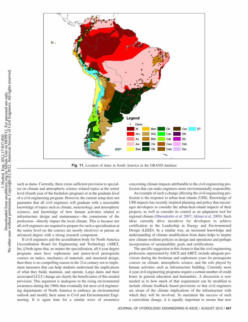
The climate feedback-based provisions that are now neededshould consider the unique climate and surrounding geographicalchanges that the dam can produce using regional-scale models. TheGlobal Reservoir and Dam (GRAND) (Lehner and Doll 2004) da-tabase provides a useful summary on the location and main purposeof the dams. On the basis of 6,862 records of large artificial res-ervoirs archived in GRAND, Table 3 shows the distribution ofdams in various climates. Table 4 summarizes the distributionby continent. While GRAND does not include all of the damsin the world, it provides a reasonable picture of the wide-rangingtypes of climate, locations, and applications with which a dam isassociated. Fig. 8 shows the variability of dam density within agiven Koppen climate class. Close-up maps of the locations of largedams in Africa (Fig. 9), Asia (Fig. 10), and South America (Fig. 11)reveal that a dam needs to be treated uniquely for the requiredclimate-based feedback provisions in its design (for new dams)or management strategy (for existing dams). Such an approachshould be bottom-up by considering the dynamics of change inthe local water cycle (caused by the dam, as well as other factors,such as anticipated rates of urbanization and industrialization) in
Table 2. Recommended Design Storm Criteria for Dam-Building inVarious States of the United States
State or territoryRecommended design
storm criteria
Alaska Intensity duration frequency (IDF)
equal to probable maximum flood
(PMF) or determined on the basis of
incremental damage assessment (IDA)
Arizona, Connecticut,
Oregon, Pennsylvania, South
Carolina, Tennessee, Virginia
0.5 PMF to PMF depending on
persons-at-risk downstream
Colorado, Florida, Indiana,
Iowa, Kentucky, Vermont,
West Virginia
PMP
Georgia 25, 33, 50, 100% PMP on the basis of
height and storage
Idaho Small dam = 100 years;
Intermediate = 0.5 PMF; Large = PMF
Illinois Small = 0.5 PMF; Intermediate = PMF;
Large = PMF
Kansas 40% PMP
Maryland, Minnesota, Nevada,
New Jersey, Puerto Rico,
Texas, Ohio
PMF
Michigan 1∕2 PMF over 40-ft high 200-year;
or flood of record under 40-ft high
Missouri 75% PMP
North Carolina Small = 1∕3 PMP; Medium = 1∕2PMP; Large = 3∕4 PMP;
Extra large = PMP
Oklahoma 50–100% PMF with 1–3 feet freeboardUtah IDF
Washington 3,000-year flood to PMF
Wisconsin 1,000-year
Wyoming PMF or paleoflood data
Fig. 7. (a) Typical pools allocated during dam design, planning, and operations; (b) hydropower generation plant showing how power generation canbe reduced by lowering the reservoir level to make way for other pools
Table 3. Number of Dams in the GRAND Database by Major KoppenClimate Class and Main Dam Purpose
Climate Hydropower Irrigation Others Unknown Total
Arid 2 37 17 22 78
Semiarid 29 358 117 125 629
Tropical 122 268 44 222 656
Temperate 705 925 1,122 991 3,743
Continental 582 190 410 484 1,666
Polar 58 3 2 11 74
844 / JOURNAL OF HYDROLOGIC ENGINEERING © ASCE / AUGUST 2012
J. H
ydro
l. E
ng. 2
012.
17:8
37-8
50.
Dow
nloa
ded
from
asc
elib
rary
.org
by
Seri
als
Uni
t on
08/0
9/12
. For
per
sona
l use
onl
y.N
o ot
her
uses
with
out p
erm
issi
on. C
opyr
ight
(c)
201
2. A
mer
ican
Soc
iety
of
Civ
il E
ngin
eers
. All
righ
ts r
eser
ved.
the context of an underlying larger change (such as global climatechange and socioeconomic factors; Hossain et al. 2011).
Suggested Changes to the BaccalaureateCurriculum for Civil Engineering
A significant change in the baccalaureate curriculum for civilengineering is now required to train the next generation of civilengineers to tackle the aforementioned challenges resulting fromclimate change that is likely attributable to large infrastructures,
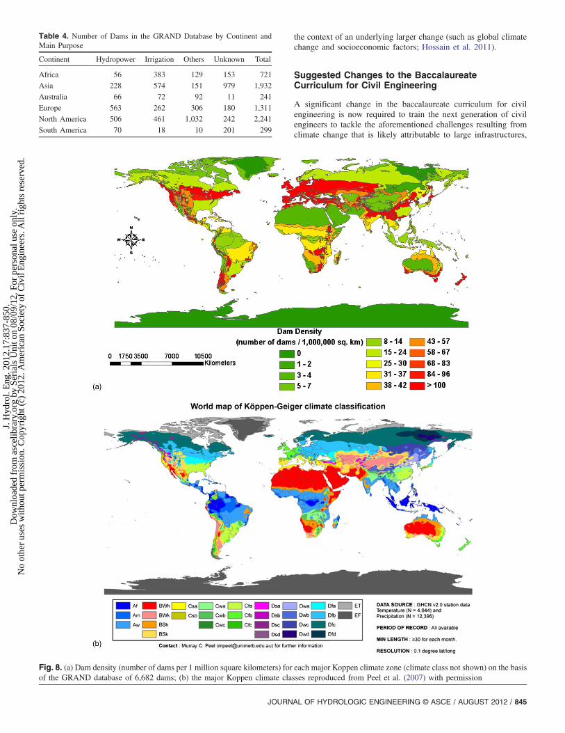
Table 4. Number of Dams in the GRAND Database by Continent andMain Purpose
Continent Hydropower Irrigation Others Unknown Total
Africa 56 383 129 153 721
Asia 228 574 151 979 1,932
Australia 66 72 92 11 241
Europe 563 262 306 180 1,311
North America 506 461 1,032 242 2,241
South America 70 18 10 201 299
Fig. 8. (a) Dam density (number of dams per 1 million square kilometers) for each major Koppen climate zone (climate class not shown) on the basisof the GRAND database of 6,682 dams; (b) the major Koppen climate classes reproduced from Peel et al. (2007) with permission
JOURNAL OF HYDROLOGIC ENGINEERING © ASCE / AUGUST 2012 / 845
J. H
ydro
l. E
ng. 2
012.
17:8
37-8
50.
Dow
nloa
ded
from
asc
elib
rary
.org
by
Seri
als
Uni
t on
08/0
9/12
. For
per
sona
l use
onl
y.N
o ot
her
uses
with
out p
erm
issi
on. C
opyr
ight
(c)
201
2. A
mer
ican
Soc
iety
of
Civ
il E
ngin
eers
. All
righ
ts r
eser
ved.

Fig. 9. Dam locations in Africa in the GRAND database
Fig. 10. Locations of dams in Asia in the GRAND database
846 / JOURNAL OF HYDROLOGIC ENGINEERING © ASCE / AUGUST 2012
J. H
ydro
l. E
ng. 2
012.
17:8
37-8
50.
Dow
nloa
ded
from
asc
elib
rary
.org
by
Seri
als
Uni
t on
08/0
9/12
. For
per
sona
l use
onl
y.N
o ot
her
uses
with
out p
erm
issi
on. C
opyr
ight
(c)
201
2. A
mer
ican
Soc
iety
of
Civ
il E
ngin
eers
. All
righ
ts r
eser
ved.
such as dams. Currently, there exists sufficient provision to special-ize on climate and atmospheric science–related topics at the seniorlevel (fourth year of the bachelors program) or at the graduate levelof a civil engineering program. However, the current setup does notguarantee that all civil engineers will graduate with a reasonableknowledge of topics such as climate, meteorology, and atmosphericsciences, and knowledge of how human activities related toinfrastructure design and maintenance—the cornerstone of theprofession—directly impact the local climate. This is because notall civil engineers are required to prepare for such a specialization atthe senior level (as the courses are mostly electives) or pursue anadvanced degree with a strong research component.
If civil engineers and the accreditation body for North America[Accreditation Board for Engineering and Technology (ABET,Inc.)] both agree that, no matter the specialization, all 4-year degreeprograms must have sophomore and junior-level prerequisitecourses on statics, mechanics of materials, and structural design,then there is no compelling reason in the 21st century not to imple-ment measures that can help students understand the implicationsof what they build, maintain, and operate. Large dams and theirassociated LCLU change are clearly the beneficiaries of this neededprovision. This argument is analogous to the rising environmentalawareness during the 1960s that eventually led most civil engineer-ing departments of North America to embrace an environmentaloutlook and modify their name to Civil and Environmental Engi-neering. It is again time for a similar wave of awareness
concerning climate impacts attributable to the civil engineering pro-fession that can make engineers more environmentally responsible.
An example of such a change affecting the civil engineering pro-fession is the response to urban heat islands (UHI). Knowledge ofUHI impacts has recently inspired planning and policy that encour-ages developers to consider the urban-heat-island impacts of theirprojects, as well as consider its control as an adaptation tool forregional climate (Oberndorfer et al. 2007; Akbari et al. 2009). Suchideas currently drive incentives for developers to achievecertification in the Leadership in Energy and EnvironmentalDesign (LEED). In a similar way, an increased knowledge andunderstanding of climate modification from dams helps to inspirenew climate-resilient policies in design and operations and perhapsincorporation of sustainability goals and certifications.
The specific suggestion in this forum is that the civil engineeringprofession, represented by ASCE and ABET, include adequate pro-visions during the freshman and sophomore years for prerequisitecourses on climate, atmospheric science, and the role played byhuman activities such as infrastructure building. Currently most4-year civil engineering programs require a certain number of credithours in general education and humanities. A discussion is nowneeded as to how much of that requirement can be modified toinclude climate feedback–based provisions so that civil engineersare aware of the climate implications of the infrastructure withwhich they will be involved. To maximize the success of sucha curriculum change, it is equally important to ensure that new
Fig. 11. Location of dams in South America in the GRAND database
JOURNAL OF HYDROLOGIC ENGINEERING © ASCE / AUGUST 2012 / 847
J. H
ydro
l. E
ng. 2
012.
17:8
37-8
50.
Dow
nloa
ded
from
asc
elib
rary
.org
by
Seri
als
Uni
t on
08/0
9/12
. For
per
sona
l use
onl
y.N
o ot
her
uses
with
out p
erm
issi
on. C
opyr
ight
(c)
201
2. A
mer
ican
Soc
iety
of
Civ
il E
ngin
eers
. All
righ
ts r
eser
ved.
courses are taught such that the science of climate and the atmos-phere can be related directly to the real-world infrastructure activ-ities in which students will engage as professional engineers.
Conclusion
The purpose of this article is to shed light on the need for climatefeedback–based considerations in dam design, operations, andwater management for the 21st century. It first overviewed theknown impacts on climate from changes in land use and land coverthat are typically anticipated once a dam is constructed. Recent re-search was presented on the first-order signature around dams onlocal climate using observational evidence. A global overview ofthe location of large dams was presented to highlight the need totreat each dam uniquely according to its location and the larger set-ting. It is now obvious that the observational data associated withcurrent dams, combined with the rich body of research of LCLUimpact on climate, can provide the planning and engineering pro-fessions with insightful guidance for both operations and morerobust dam building in the 21st century as well as modificationsof local design guidelines to account for climate feedback.
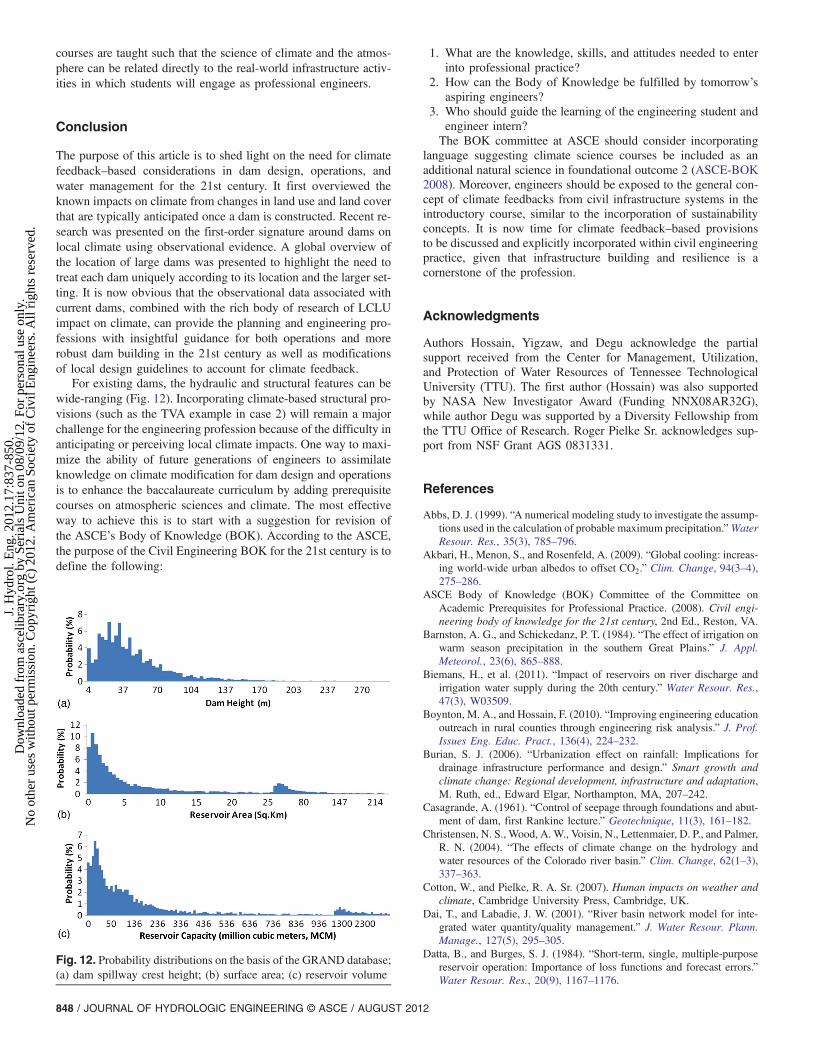
For existing dams, the hydraulic and structural features can bewide-ranging (Fig. 12). Incorporating climate-based structural pro-visions (such as the TVA example in case 2) will remain a majorchallenge for the engineering profession because of the difficulty inanticipating or perceiving local climate impacts. One way to maxi-mize the ability of future generations of engineers to assimilateknowledge on climate modification for dam design and operationsis to enhance the baccalaureate curriculum by adding prerequisitecourses on atmospheric sciences and climate. The most effectiveway to achieve this is to start with a suggestion for revision ofthe ASCE’s Body of Knowledge (BOK). According to the ASCE,the purpose of the Civil Engineering BOK for the 21st century is todefine the following:
1. What are the knowledge, skills, and attitudes needed to enterinto professional practice?
2. How can the Body of Knowledge be fulfilled by tomorrow’saspiring engineers?
3. Who should guide the learning of the engineering student andengineer intern?The BOK committee at ASCE should consider incorporating
language suggesting climate science courses be included as anadditional natural science in foundational outcome 2 (ASCE-BOK2008). Moreover, engineers should be exposed to the general con-cept of climate feedbacks from civil infrastructure systems in theintroductory course, similar to the incorporation of sustainabilityconcepts. It is now time for climate feedback–based provisionsto be discussed and explicitly incorporated within civil engineeringpractice, given that infrastructure building and resilience is acornerstone of the profession.
Acknowledgments
Authors Hossain, Yigzaw, and Degu acknowledge the partialsupport received from the Center for Management, Utilization,and Protection of Water Resources of Tennessee TechnologicalUniversity (TTU). The first author (Hossain) was also supportedby NASA New Investigator Award (Funding NNX08AR32G),while author Degu was supported by a Diversity Fellowship fromthe TTU Office of Research. Roger Pielke Sr. acknowledges sup-port from NSF Grant AGS 0831331.
References
Abbs, D. J. (1999). “A numerical modeling study to investigate the assump-tions used in the calculation of probable maximum precipitation.”WaterResour. Res., 35(3), 785–796.
Akbari, H., Menon, S., and Rosenfeld, A. (2009). “Global cooling: increas-ing world-wide urban albedos to offset CO2.” Clim. Change, 94(3–4),275–286.
ASCE Body of Knowledge (BOK) Committee of the Committee onAcademic Prerequisites for Professional Practice. (2008). Civil engi-neering body of knowledge for the 21st century, 2nd Ed., Reston, VA.
Barnston, A. G., and Schickedanz, P. T. (1984). “The effect of irrigation onwarm season precipitation in the southern Great Plains.” J. Appl.Meteorol., 23(6), 865–888.
Biemans, H., et al. (2011). “Impact of reservoirs on river discharge andirrigation water supply during the 20th century.” Water Resour. Res.,47(3), W03509.
Boynton, M. A., and Hossain, F. (2010). “Improving engineering educationoutreach in rural counties through engineering risk analysis.” J. Prof.Issues Eng. Educ. Pract., 136(4), 224–232.
Burian, S. J. (2006). “Urbanization effect on rainfall: Implications fordrainage infrastructure performance and design.” Smart growth andclimate change: Regional development, infrastructure and adaptation,M. Ruth, ed., Edward Elgar, Northampton, MA, 207–242.
Casagrande, A. (1961). “Control of seepage through foundations and abut-ment of dam, first Rankine lecture.” Geotechnique, 11(3), 161–182.
Christensen, N. S., Wood, A. W., Voisin, N., Lettenmaier, D. P., and Palmer,R. N. (2004). “The effects of climate change on the hydrology andwater resources of the Colorado river basin.” Clim. Change, 62(1–3),337–363.
Cotton, W., and Pielke, R. A. Sr. (2007). Human impacts on weather andclimate, Cambridge University Press, Cambridge, UK.
Dai, T., and Labadie, J. W. (2001). “River basin network model for inte-grated water quantity/quality management.” J. Water Resour. Plann.Manage., 127(5), 295–305.
Datta, B., and Burges, S. J. (1984). “Short-term, single, multiple-purposereservoir operation: Importance of loss functions and forecast errors.”Water Resour. Res., 20(9), 1167–1176.
Fig. 12. Probability distributions on the basis of the GRAND database;(a) dam spillway crest height; (b) surface area; (c) reservoir volume
848 / JOURNAL OF HYDROLOGIC ENGINEERING © ASCE / AUGUST 2012
J. H
ydro
l. E
ng. 2
012.
17:8
37-8
50.
Dow
nloa
ded
from
asc
elib
rary
.org
by
Seri
als
Uni
t on
08/0
9/12
. For
per
sona
l use
onl
y.N
o ot
her
uses
with
out p
erm
issi
on. C
opyr
ight
(c)
201
2. A
mer
ican
Soc
iety
of
Civ
il E
ngin
eers
. All
righ
ts r
eser
ved.
DeAngelis, A., Dominguez, F., Fan, Y., Robock, A., Kustu, M. D., andRobinson, D. (2010). “Evidence of enhanced precipitation due to irri-gation over the Great Plains of the United States.” J. Geophys. Res., 115,D15115.
Degu, A. M., et al. (2011). “The influence of large dams on surroundingclimate and precipitation patterns.” Geophys. Res. Lett., 38(4), L04405.
Feddema, J. J., et al. (2005). “The importance of land cover change insimulating future climates.” Science, 310(5754), 1674–1678.
Gebregiorgis, A. S., and Hossain, F. (2012). “Hydrological risk assessmentof old dams: A case study on Wilson dam of Tennessee River basin.”J. Hydrol. Eng., 17(1), 201–212.
Gero, A. F., Pitman, A. J., Narisma, G. T., Jacobson, C., and Pielke, R. A.,Sr. (2006). “The impact of land cover change on storms in the SydneyBasin.” Glob. Planet. Change, 54(1–2), 57–78.
Graf, W. L. (1999). “Dam nation: A geographic census of American damsand their large-scale hydrologic impacts.” Water Resour. Res., 35(4),1305–1311.
Graf, W. L. (2006). “Downstream hydrologic and geomorphic effects oflarge dams on American rivers.” Geomorphology, 79(3–4), 336–360.
Graf, W. L., Wohl, E., Sinha, T., and Sabo, J. L. (2010). “Sedimentationand sustainability of western American reservoirs.”Water Resour. Res.,46(12), W12535.
GWSP Digital Water Atlas. (2008). Map 41: Dams and capacity of artificialreservoirs (V1.0). ⟨http://www.gwsp.org/85.html⟩ (Sep. 15, 2010).
Hamlet, A. F., and Lettenmaier, D. P. (1999). “Effects of climate change onhydrology and water resources in the Columbia River basin.” J. Am.Water Resour. Assoc., 35(6), 1597–1623.
Hossain, F., Jeyachandran, I., and Pielke, R. Sr. (2009). “Have large damsaltered extreme precipitation patterns?” EOS, Trans. Am. Geophys.Union, 90(48), 453–454.
Hossain, F., Jeyachandran, I., and Pielke, R. A. Sr. (2010). “Dam safetyeffects due to human alteration of extreme precipitation.”Water Resour.Res., 46(3), W03301.
Hossain, F., Niyogi, D., Adegoke, J., Kallos, G., and Pielke, R., Sr. (2011).“Making sense of the water resources that will be available in futureuse.” EOS Forum, 92(17), 143–144.
Lehner, B., and Döll, P. (2004). “Development and validation of a globaldatabase of lakes, reservoirs and wetlands.” J. Hydrol. (Amsterdam),296(1–4), 1–22.
Lei, M., et al. (2008). “Effect of explicit urban land surface representationon the simulation of the 26 July 2005 heavy rain event over Mumbai,India.” Atmos. Chem. Phys. Discussions, 8(3), 8773–8816.
Ligon, F. K., Dietrich, W. E., and Trush, W. J. (1995). “Downstream eco-logical effects of dams: A geomorphic perspective.” BioScience, 45(3),183–192.
Lohar, D., and Pal, B. (1995). “The effect of irrigation on pre-monsoonseason precipitation over southwest Bengal, India.” J. Clim., 8(10),2567–2570.
Mahmood, R., Hubbard, K. G., and Carlson, C. (2004). “Modification ofgrowing-season surface temperature records in the northern Great Plainsdue to land use transformation: Verification of modeling results and im-plications for global climate change.” Int. J. Climatol., 24(3), 311–327.
Mahmood, R., Quintanar, A. I., Conner, G., Leeper, R., and Dobler, S.(2010). “Impacts of land use land cover change on climate and futureresearch priorities.” Bull. Am. Meteorol. Soc., 91(1), 37–46.
Marcuson, W. F., III, Hadala, P. F., and Ledbetter, R. H. (1996). “Seismicrehabilitation of earth dams.” J. Geotech. Eng., 122(1), 7–20.
Merritt, D. M., and Cooper, D. J. (2000). “Riparian vegetation and channelchange in response to river regulation: A comparative study of regulatedand unregulated streams in the Green River Basin, USA.” Regul. RiversRes. Manage., 16(6), 543–564.
Mesinger, F. (2006). “North American regional reanalysis.” Bull. Am.Meteorol. Soc., 87(3), 343–360.
Milly, P. C. D., et al. (2008). “Stationarity is dead: Whither water manage-ment.” Science, 319, 573–574.
Misra, A. K., Saxena, A., Yaduvanshi, M., Mishra, A., Bhauduriya, Y., andTakur, A. (2007). “Proposed river linking project of India: Boon or baneto nature?” Environ. Geol., 51(8), 1361–1376.
Morris, G. L., and Fan, J. J. (1998). Reservoir sedimentation handbooks:Design and management of dams, reservoirs, and watersheds for
sustainable use, McGraw-Hill, New York.National Research Council. (1999). “Improving American river flood
frequency analyses.” Commission of geosciences, environment andresources, National Academies Press, Washington, DC.
National Research Council. (2005). “Radiative forcing of climate change:Expanding the concept and addressing uncertainties.” Committee onRadiative Forcing Effects on Climate Change, Climate Research Com-mittee, Board on Atmospheric Sciences and Climate, Division on Earthand Life Studies, The National Academies Press, Washington, DC,⟨http://www.nap.edu/openbook/0309095069/html/⟩ (May 11, 2011).
Niyogi, D., et al. (2011). “Urban modification of thunderstorms—An ob-servational storm climatology and model case study for the Indianapolisurban region.” J. Appl. Meteorol. Climatol., 50, 1129–1144.
Oberndorfer, E. (2007). “Green roofs as urban ecosystems: Ecologicalstructures, functions, and services.” BioScience, 57(10), 823–833.
Peel, M. C., Finlayson, B. L., and McMahon, T. (2007). “Updated worldmap of the Köppen-Geiger climate classification.” Hydrol. Earth Syst.Sci., 11(5), 1633–1644.
Pielke, R. A., Sr. (2001). “Influence of the spatial distribution of vegeta-tion and soils on the prediction of cumulus convective rainfall.”Rev. Geophys., 39, 151–177.
Pielke, R. A., Sr. (2005). “Land use and climate change.” Science,310(5754), 1625–1626.
Pielke, R. A., Sr., et al. (2007). “An overview of regional land use and landcover impacts on rainfall.” Tellus B, 59(3), 587–601.
Pielke, R., Sr., et al. (2009). “Climate change: The need to consider humanforcings besides greenhouse gases.” EOS, 90(45), 413.
Pierce, F. (1995). “The biggest dam in the world.” New Scientist,145(1962), 25–29.
Puma, M. J., and Cook, B. I. (2010). “Effects of irrigation on global climateduring the 20th century.” J. Geophys. Res., 115, D16120.
Ray, D. K., Pielke, R. A., Sr., Nair, U. S., Welch, R. M., and Lawton, R. O.(2009). “Importance of land use versus atmospheric information veri-fied from cloud simulations from a frontier region in Costa Rica.”J. Geophys. Res., 114, D08113.
Reynolds, S., Burian, S., Shepherd, J. M., and Manyin, M. (2008). “Urbaninduced rainfall modifications on urban hydrologic response.” Chapter7, Reliable modeling of urban water systems, W. James, ed., Computa-tional Hydraulics International, Guelph, Canada, 99–122.
Richter, B. D., Baumgartner, J. V., Powell, J., and Braun, D. P. (1996).“Method for assessing hydrologic alteration within ecosystems.”Conservat. Biol., 10(4), 1163–1174.
Roos, M. (2003). “Extreme precipitation in the American river basin.”California Extreme Precipitation Symposium, American River WatershedInstitute. ⟨http://cepsym.info/Sympro2003/Roos.pdf⟩ (May 29, 2012).
Rosenfield, D., et al. (2008). “Flood or drought: How do aerosols affectprecipitation?” Science, 321(5894), 1309–1313.
Rutledge, G. K., Alpert, J., and Ebuisaki, W. W. (2006). “NOMADS:A climate andweathermodel archive at theNational Oceanic andAtmos-pheric Administration.” Bull. Am. Meteorol. Soc., 87(3), 327–341.
Sacramento Area Flood Control Agency (SAFCA). (1994). “Interimreoperation of Folsom dam and reservoir.” Final environmental impactreport. ⟨http://www.safca.org⟩ (May 11, 2012).
Shen, G., and Xie, Z. (2004). “Three Gorges project: Chance and chal-lenge.” Science, 304(5671), 681.
Shepherd, J. M., Carter, W. M., Manyin, M., Messen, D., and Burian, S.(2010). “The impact of urbanization on current and future coastal con-vection: A case study for Houston.” Environ. Plann., 37(2), 284–304.
Sherard, J. L. (1987). “Lessons from the Teton Dam failure.” Eng. Geol.,24(1–4), 239–256.
Stephens, G. L., et al. (2010). “Dreary state of precipitation in global mod-els.” J. Geophys. Res., 115, D24211.
Terzaghi, K., and LaCroix, Y. (1964). “Mission dam: An earth and rockfilldam on a highly compressible foundation.” Geotechnique, 14(1), 14–50.
Tharme, R. E. (2003). “A global perspective on environmental flow as-sessment: Emerging trends in the development and application of environ-mental flowmethodologies for rivers.” River Res. Appl., 19(5–6), 397–441.
Tennessee Valley Authority (TVA). (2009). “TVA to raise the height of fourdams.” ⟨http://www.tva.gov/news/releases/julsep09/dam_modifications.htm⟩ (May 6, 2011).
JOURNAL OF HYDROLOGIC ENGINEERING © ASCE / AUGUST 2012 / 849
J. H
ydro
l. E
ng. 2
012.
17:8
37-8
50.
Dow
nloa
ded
from
asc
elib
rary
.org
by
Seri
als
Uni
t on
08/0
9/12
. For
per
sona
l use
onl
y.N
o ot
her
uses
with
out p
erm
issi
on. C
opyr
ight
(c)
201
2. A
mer
ican
Soc
iety
of
Civ
il E
ngin
eers
. All
righ
ts r
eser
ved.

United Nations Environment Program (UNEP). (2002). “Renewablefreshwater supplies, per river basin.” UNEP/GRID-Arendal Mapsand Graphics Library. ⟨http://maps.grida.no/go/graphic/renewable_freshwater_supplies_per_river⟩ (May 21, 2011).
Unver, O. H. I. (1997). “South-eastern Anatolia integrated developmentproject (GAP), Turkey: An overview of issues of sustainability.”Int. J. Water Resour. Dev., 13(2), 187–208.
U.S. Bureau of Reclamation (USBR). (2009). “Literature synthesis on cli-mate change implications for Reclamation’s water resources.” USBRTechnical Services Report (Technical Memorandum 86-68210-091),2nd Ed. ⟨http://www.usbr.gov/research/docs/climatechangelitsynthesis.pdf⟩ (May 4, 2011).
Vick, S. G., and Bromwell, L. G. (1989). “Risk analysis for dam design inKarst.” J. Geotech. Eng., 115(6), 819–835.
Vörösmarty, C. J., Green, P., Salisbury, J., and Lammers, R. B. (2000).“Global water resources: Vulnerability from climate change andpopulation growth.” Science, 289, 284–288.
Yang, G., Bowling, L. C., Cherkauer, K. A., Pijanowski, B. C., and Niyogi,D. (2010). “Hydroclimatic response of watersheds to urban intensity—an observational and modeling based analysis for the White RiverBasin, Indiana.” J. Hydrometeorol., 11(1), 122–138.
Zhao, F., and Shepherd, M. J. (2012). “Precipitation changes near ThreeGorges Dam, China. Part I: A spatiotemporal validation analysis.”J. Hydrometeorol., 13(2), 735–745.
850 / JOURNAL OF HYDROLOGIC ENGINEERING © ASCE / AUGUST 2012
J. H
ydro
l. E
ng. 2
012.
17:8
37-8
50.
Dow
nloa
ded
from
asc
elib
rary
.org
by
Seri
als
Uni
t on
08/0
9/12
. For
per
sona
l use
onl
y.N
o ot
her
uses
with
out p
erm
issi
on. C
opyr
ight
(c)
201
2. A
mer
ican
Soc
iety
of
Civ
il E
ngin
eers
. All
righ
ts r
eser
ved.