climate change vulnerability and adaptation in the north ... · pdf fileclimate change...
TRANSCRIPT

United States Department of Agriculture
Forest Service
Pacific Northwest Research Station
General Technical ReportPNW-GTR-892
September 2014
Climate Change Vulnerability and Adaptation in the North Cascades Region, Washington

Non-Discrimination Policy The U.S. Department of Agriculture (USDA) prohibits discrimination against its customers, employees, and applicants for employment on the bases of race, color, national origin, age, disability, sex, gender identity, religion, reprisal, and where applicable, political beliefs, marital status, familial or parental status, sexual orientation, or all or part of an individual’s income is derived from any public assistance program, or protected genetic information in employ-ment or in any program or activity conducted or funded by the Department. (Not all prohibited bases will apply to all programs and/or employment activities.)
To File an Employment Complaint If you wish to file an employment complaint, you must contact your agency’s EEO Counselor (PDF) within 45 days of the date of the alleged discriminatory act, event, or in the case of a personnel action. Additional information can be found online at http://www.ascr.usda.gov/complaint_filing_file.html.
To File a Program Complaint If you wish to file a Civil Rights program complaint of discrimination, complete the USDA Program Discrimination Complaint Form (PDF), found online at http://www.ascr.usda.gov/complaint_filing_cust.html, or at any USDA office, or call (866) 632-9992 to request the form. You may also write a letter containing all of the information requested in the form. Send your completed complaint form or letter to us by mail at U.S. Department of Agriculture, Director, Office of Adjudication, 1400 Independence Avenue, S.W., Washington, D.C. 20250-9410, by fax (202) 690-7442 or email at [email protected].
Persons with Disabilities Individuals who are deaf, hard of hearing or have speech disabilities and you wish to file either an EEO or program complaint please contact USDA through the Federal Relay Service at (800) 877-8339 or (800) 845-6136 (in Spanish).
Persons with disabilities, who wish to file a program complaint, please see information above on how to contact us by mail directly or by email. If you require alternative means of com-munication for program information (e.g., Braille, large print, audiotape, etc.) please contact USDA’s TARGET Center at (202) 720-2600 (voice and TDD).
Supplemental Nutrition Assistance Program For any other information dealing with Supplemental Nutrition Assistance Program (SNAP) issues, persons should either contact the USDA SNAP Hotline Number at (800) 221-5689, which is also in Spanish or call the State Information/Hotline Numbers.
All Other Inquiries For any other information not pertaining to civil rights, please refer to the listing of the USDA Agencies and Offices for specific agency information.
EditorsCrystal L. Raymond is a climate change strategic advisor, City of Seattle, Seattle City Light, 700 5th Avenue, Seattle, WA 98124 (formerly, research biologist, U.S. Department of Agriculture, Forest Service, Pacific Northwest Research Station, Pacific Wildland Fire Sciences Laboratory, Seattle, WA); David L. Peterson is a research biological scientist, U.S. Department of Agriculture, Forest Service, Pacific Northwest Research Station, Pacific Wildland Fire Sciences Laboratory, 400 N 34th Street, Suite 201, Seattle, WA 98103; and Regina M. Rochefort is a science advisor, U.S. Department of the Interior, National Park Service, North Cascades National Park Complex, 2105 State Route 20, Sedro-Woolley, WA 98284.
Cover photo by Victor Mesny

Climate Change Vulnerability and Adaptation in the North Cascades Region, WashingtonCrystal L. Raymond, David L. Peterson, and Regina M. RochefortEditors
U.S. Department of Agriculture, Forest ServicePacific Northwest Research StationPortland, OregonGeneral Technical Report, PNW-GTR-892September 2014

AbstractRaymond, Crystal L.; Peterson, David L.; Rochefort, Regina M., eds. 2014.
Climate change vulnerability and adaptation in the North Cascades region, Washington. Gen. Tech. Rep. PNW-GTR-892. Portland, OR: U.S. Department of Agriculture, Forest Service, Pacific Northwest Research Station. 279 p.
The North Cascadia Adaptation Partnership (NCAP) is a science-management partnership consisting of the U.S. Department of Agriculture Forest Service Mount Baker-Snoqualmie and Okanogan-Wenatchee National Forests and Pacific North-west Research Station; North Cascades National Park Complex; Mount Rainier National Park; and University of Washington Climate Impacts Group. These organizations worked with numerous stakeholders over 2 years to identify climate change issues relevant to resource management in the North Cascades and to find solutions that will facilitate the transition of the diverse ecosystems of this region into a warmer climate. The NCAP provided education, conducted a climate change vulnerability assessment, and developed adaptation options for federal agencies that manage 2.4 million hectares in north-central Washington.
In the Pacific Northwest, the current warming trend is expected to continue, with average warming of 2.1 °C by the 2040s and 3.8 °C by the 2080s; precipitation may vary slightly, but the magnitude and direction are uncertain. This warming will have far-reaching effects on aquatic and terrestrial ecosystems. Hydrologic sys-tems will be especially vulnerable as North Cascades watersheds become increas-ingly rain dominated, rather than snow dominated, resulting in more autumn/winter flooding, higher peak flows, and lower summer flows. This will greatly affect the extensive road network in the North Cascades (longer than 16 000 km), making it difficult to maintain access for recreational users and resource managers. It will also greatly reduce suitable fish habitat, especially as stream temperatures increase above critical thresholds. In forest ecosystems, higher temperatures will increase stress and lower the growth and productivity of lower elevation tree species on both the western and eastern sides of the Cascade crest, although growth of high-elevation tree species is expected to increase. Distribution and abundance of plant species may change over the long term, and increased disturbance (wildfire, insects, and invasive species) will cause rapid changes in ecosystem structure and function across broad landscapes, especially on the east side. This in turn will alter habitat for a wide range of animal species by potentially reducing connectivity and late-successional forest structure.
Coping with and adapting to the effects of an altered climate will become increasingly difficult after the mid-21st century, although adaptation strategies

and tactics are available to ease the transition to a warmer climate. For roads and infrastructure, tactics for increasing resistance and resilience to higher peak flows include installing hardened stream crossings, stabilizing streambanks, design-ing culverts for projected peak flows, and upgrading bridges and increasing their height. For fisheries, tactics for increasing resilience of salmon to altered hydrology and higher stream temperature include restoring stream and floodplain complex-ity, reducing road density near streams, increasing forest cover to retain snow and decrease snow melt, and identifying and protecting cold-water refugia. For vegetation, tactics for increasing resilience to higher temperature and increased disturbance include accelerating development of late-successional forest conditions by reducing density and diversifying forest structure, managing for future range of variability in structure and species, including invasive species prevention strategies in all projects, and monitoring changes in tree distribution and establishment at tree line. For wildlife, tactics for increasing resilience to altered habitat include increas-ing diversity of age classes and restoring a patch mosaic, increasing fuel reduction treatments in dry forests, using conservation easements to maintain habitat connec-tivity, and removing exotic fish species to protect amphibian populations.
The NCAP facilitated the largest climate change adaptation effort on federal lands to date by including many participants from other organizations to promote an all-lands approach to addressing climate change. It achieved specific elements of national climate change strategies for the U.S. Forest Service and National Park Service, providing a scientific foundation for resource management and planning in the North Cascades region. Rapid implementation of adaptation in sustainable resource management will enhance the potential for North Cascades ecosystems to maintain long-term functionality in future decades.
Keywords: Access, adaptation, climate change, fire, forest ecosystems, fisher-ies, hydrology, North Cascade Range, North Cascadia Adaptation Partnership, roads, science-management partnership, vegetation, wildlife.

Contents1 Chapter 1: Introduction Crystal L. Raymond, David L. Peterson, and Regina M. Rochefort
1 Climate Change Responses of the Forest Service and National Park Service
3 Science-Management Partnerships
5 The North Cascadia Adaptation Partnership Process
8 All-Lands Approach to Climate Change Adaptation
10 Literature Cited
15 Chapter 2: Ecological, Biogeographical, and Historical Context of the North Cascade Range Kailey Marcinkowski, Crystal L. Raymond, and Lee K. Cerveny
16 Ecological Setting
17 Cultural History of the North Cascades
18 Geography, History, and Management
18 Mount Baker-Snoqualmie National Forest
19 Okanogan-Wenatchee National Forest
20 Mount Rainier National Park
20 North Cascades National Park Complex
22 Literature Cited
25 Chapter 3: Climate and Climate Change in the North Cascade Range Jeremy S. Littell and Crystal L. Raymond
25 ClimateofthePacificNorthwest
26 HistoricalClimateObservationsandTrendsinthePacificNorthwest
30 FutureClimateinthePacificNorthwest
30 Models, Methods, and Data Used for Climate Projections
33 Projections of Temperature and Precipitation for the Pacific Northwest
40 Uncertainty in Future Climate Projections
41 Acknowledgments
41 Literature Cited
45 Chapter 4: Climate Change, Hydrology, and Access in the North Cascade Range Ronda L. Strauch, Crystal L. Raymond, and Alan F. Hamlet
45 Introduction
48 The Current Context for Access in the North Cascades
48 Current Development and Access Needs

50 Road and Trail Types and Conditions
51 Climate Change Effects Relevant to Access
51 Changing Climate in the Pacific Northwest
53 Climate Change Effects on Flooding and Extreme Low Flows
59 Climate Change Effects on Snow Cover
59 Effects of Changing Soil Moisture and Landslides
64 Sensitive Traits of Roads and Trails in the North Cascades
65 Aging Infrastructure
66 Design and Use Considerations
66 Location and Land Use
67 Maintenance and Management of Roads and Trails
68 Current and Short-Term Climate Exposures to Access in the North Cascades
72 Emerging or Intensifying Exposure in the Short Term
73 Emerging or Intensifying Exposure in the Medium and Long Term
79 Infrastructure and Travel Management in the North Cascades
79 Road and Trail Operations and Maintenance
81 Planning and Projects
83 Adapting Access Management in a Changing Climate
84 AdaptationOptionsforHigherPeakFlowsandFloodRisk
84 Road and Culvert Design and Maintenance
89 Facilities, Structures, and Cultural Resources
92 Trail Maintenance and Design
94 Adaptation Options for Higher Soil Saturation and Landslide Risk
94 Road and Facility Maintenance and Design
94 Trail Maintenance and Design
97 Adaptation Options for Visitor Use Patterns and Public Safety
100 Adaptation Options for Dry-Season Water Availability and Use
102 Acknowledgments
102 Literature Cited
113 Chapter 5: Climate Change and Vegetation in the North Cascade Range Jeremy S. Littell, Crystal L. Raymond, Regina M. Rochefort, and Stephen L. Klein
113 Introduction
115 Current Vegetation in the North Cascades

117 Projected Changes in Regional Climate Relevant to Vegetation
120 Physical Mechanisms for Climatic Effects on Forest Vegetation
123 Climate Change Effects on Biodiversity and Vegetation Distribution
123 Projected Changes in Vegetation Biomes
126 Projected Changes in Climatic Suitability for Tree Species
128 Changes in Distribution of Rare Plant Species
128 Climate Change Effects on Ecological Disturbances
128 Insects
131 Fire Regimes
135 Forest Pathogens
136 Invasive Species
137 Disturbance Interactions
138 Vegetation Management Objectives
139 Mount Baker-Snoqualmie and Okanogan-Wenatchee National Forests
140 North Cascades and Mount Rainier National Parks
141 Vegetation Management Practices
141 Silviculture and Forest Restoration
142 Fire and Hazardous Fuel Management
143 Hazard Tree Management
143 Plant Ecology Programs
144 Invasive Species Management
146 Inventory and Monitoring
146 Adapting Vegetation Management in a Changing Climate
151 Adaptation Options for Managing Ecological Disturbances
156 Adaptation Options for Managing Floods, Wind, and Hazard Trees
159 Adaptation Options for Invasive Species Management
163 Adaptation Options for Managing Alpine and Subalpine Ecosystems
164 Acknowledgments
164 Literature Cited
177 Chapter 6: Climate Change, Wildlife, and Wildlife Habitat in the North Cascade Range Joshua J. Lawler, Crystal L. Raymond, Maureen E. Ryan, Michael J. Case, and Regina M. Rochefort
177 Introduction
178 Vulnerability Assessment for Wildlife and Habitat

180 Effects of Climate Change on Wildlife Species
181 Physiological Effects
182 Phenological Effects
183 Distributional Shifts
184 Interspecific Interactions
185 Interactions With Other Stressors
187 Effects of Climate Change on Wildlife Habitats
187 Alpine and Subalpine Zones
188 Meadows
188 Forests
189 Wetlands
191 Riparian Systems
191 Sensitivity of Selected Wildlife Species to Climate Change
204 Wildlife Management in National Forests and National Parks in the North Cascades
204 Planning and Regulation
206 Management of Wildlife Species in the North Cascades
208 Management of Wildlife Habitat in the North Cascades
209 Monitoring Wildlife and Habitat
210 Adapting Management of Wildlife and Wildlife Habitat in a Changing Climate
211 Adaptation Options for Low-Elevation Maritime Forests on the Western Slopes of the Cascade Range
213 Adaptation Options for East-Side Fire-Adapted Forest Habitat and Associated Species
216 Adaptation Options for Riparian Forest Habitat and Associated Species
218 Adaptation Options for Wetland Habitats and Associated Species
222 Adaptation Options for Alpine and Subalpine Habitats and Associated Species
224 Acknowledgments
224 Literature Cited
235 Chapter 7: Climate Change, Fish, and Fish Habitat in the North Cascade Range Nathan J. Mantua and Crystal L. Raymond
235 Introduction
236 EffectsofClimateChangeonStreamsflows
237 Projected Changes in Streamflow Timing
237 Projected Changes in Stream Temperature
240 Effects of Climate Change on Fish and Fish Habitat
242 Stream Temperature
246 Peak Streamflow
247 Summer Low Streamflow
247 Management of Fish and Fish Habitat in the North Cascades
248 Management of Fish and Fish Habitat on the Mount Baker-Snoqualmie and Okanogan-Wenatchee National Forests
250 Management of Fish and Fish Habitat at Mount Rainier and North Cascades National Parks
251 Adapting Fish Management to Climate Change in the North Cascades
252 Adaptation Options to Reduce Effects of High Peak Streamflows
256 Adaptation Options to Reduce Effects of Lower Low Streamflows
258 Adaptation Options to Reduce Effects of Warmer Stream Temperatures
263 Adaptation Options to Reduce Effects of Sedimentation
265 Acknowledgments
265 Literature Cited
271 Chapter 8: Conclusions Crystal L. Raymond, David L. Peterson, and Regina M. Rochefort
271 Relevance to Agency Climate Change Response Strategies
272 Communication, Education, and Organizational Capacity
273 Partnerships and Engagement
273 Assessing Vulnerability and Adaptation
274 Science and Monitoring
275 Mitigation and Sustainable Operations
275 Next Steps
275 Engagement and Partnerships
275 Vulnerability Assessment and Adaptation Planning
276 Implementing Adaptation Strategies and Tactics
276 A Vision for Adaptation as a Dynamic Process
278 Acknowledgments
278 Literature Cited

1
Climate Change Vulnerability and Adaptation in the North Cascades Region, Washington
1
The U.S. Department of Agriculture Forest Service (USDA FS) Pacific Northwest Research Station and the U.S. Department of the Interior National Park Service (NPS) initiated the North Cascadia Adaptation Partnership (NCAP) in 2010. The NCAP is a science-management collaboration with the goals of increasing climate change awareness, assessing vulnerability, and developing science-based adapta-tion strategies to reduce adverse effects of climate change and ease the transition to new climate states and conditions. Developed in response to the proactive climate change strategies of the Forest Service (USDA FS 2008) and NPS (USDI NPS 2010), the partnership brings together USDA FS scientists, University of Washing-ton scientists, and both USDA FS and NPS resource managers.
Adaptation is defined by the Intergovernmental Panel on Climate Change (IPCC) as “initiatives and measures to reduce the vulnerability of natural and human systems against actual or expected climate change effects.” Mitigation is defined as “implementing policies to reduce greenhouse gas emissions and enhance sinks” (IPCC 2007). Mitigation is critical to reducing atmospheric levels of carbon dioxide (CO2) and thus changes in the climate system. However, adaptation will still be necessary despite the extent and success of mitigation because of the slow response of the climate system to greenhouse gases that have already been emitted. Even if humans stop emitting greenhouse gases today, global temperature would continue to rise because of the response time required for the Earth to equilibrate to new levels of greenhouse gases in the atmosphere (Solomon et al. 2007).
Climate Change Responses of the Forest Service and National Park Service Both the USDA FS and NPS have highlighted climate change as an agency priority and issued direction to administrative units for responding to climate change (USDA FS 2008, USDI NPS 2010). In 2010, the USDA FS provided specific direction to the National Forest System in the form of the National Roadmap for
1 Crystal L. Raymond is a climate change strategic advisor, City of Seattle, Seattle City Light, 700 5th Avenue, Seattle, WA 98124 (formerly biological scientist, U.S. Department of Agriculture, Forest Service, Pacific Northwest Research Station, Pacific Wildland Fire Sciences Laboratory, Seattle, WA); David L. Peterson is a research biological scientist, U.S. Department of Agriculture, Forest Service, Pacific Northwest Research Station, Pacific Wildland Fire Sciences Laboratory, 400 N 34th Street, Suite 201, Seattle, WA 98103; and Regina M. Rochefort is a science advisor, U.S. Department of the Interior, National Park Service, North Cascades National Park Complex, 2105 State Route 20, Sedro-Woolley, WA 98284.
Chapter 1: IntroductionCrystal L. Raymond, David L. Peterson, and Regina M. Rochefort1

2
general technical report pnw-gtr-892
Responding to Climate Change (USDA FS 2010a) and the Performance Scorecard for Implementing the Forest Service Climate Change Strategy (USDA FS 2010b). The goal of the USDA FS climate change strategy is to “ensure our national forests and private working lands are conserved and made more resilient to climate change, while enhancing our water resources” (USDA FS 2010b). The performance score-card outlines four elements for achieving this goal: (1) increasing organizational capacity; (2) partnerships, engagement, and education; (3) adaptation; and (4) mitigation and sustainable consumption. Progress toward accomplishing elements of the scorecard must be reported annually by each national forest and grassland, and all units are expected to accomplish these elements by 2015. National forests in the USDA FS Pacific Northwest Region must also complete climate change action plans that indicate how they will comply with the scorecard elements by 2015.
Similarly, the NPS released the Climate Change Response Strategy in 2010 to provide direction for addressing climate change (USDI NPS 2010). This strategy describes goals and objections associated with four components of an integrated approach: science, mitigation, adaptation, and communication. For the science com-ponent, the agency is directed to conduct scientific research, in coordination with partners, that will assess climate change trends and vulnerability and provide the scientific basis for adaptation, mitigation, and communication. Mitigation efforts focus on reducing the NPS carbon emissions and enhancing carbon sequestration. Adaptation includes developing capacity within the agency to assess climate change scenarios and risks and implementing actions to better manage natural and cultural resources and infrastructure in a changing climate. The strategy also requires the NPS to take advantage of the agency’s history and capacity for interpretation by communicating climate change effects among park staff and to the public. The similarity in scope and direction of the two climate change response strategies facilitates coordination between the NPS and USDA FS.
The NCAP built on several existing efforts to address climate change and put these efforts into a broader regional context by connecting resource managers from different agencies who are working to address climate change. The NPS launched the Climate Friendly Parks (CFP) program in 2002, which is part of the Green Parks Plan (NPS 2012). This plan sets goals for reducing greenhouse gas emis-sions through sustainable operations and is an integral part of the NPS Climate Change Response Strategy. In 2009, North Cascades National Park Complex and Mount Rainier National Park held workshops and became members of the CFP program. Following the workshops, each park conducted a baseline analysis of greenhouse gas emissions and adopted a climate action plan. The climate action

3
Climate Change Vulnerability and Adaptation in the North Cascades Region, Washington
plans outline targets and actions for reducing greenhouse gas emissions, efforts to increase education about climate change among staff and visitors, and priorities for developing adaptation strategies that increase the resilience of natural and cultural resources. The NCAP expands on these efforts by increasing education of park staff and expanding adaptation strategies. Although park managers began the process of adaptation planning through the CFP program, CFP efforts focused primarily on mitigation, whereas NCAP focused on adaptation, making the efforts complemen-tary parts of a larger strategy for addressing climate change at the parks.
The Okanogan-Wenatchee National Forest (OWNF), in collaboration with Colville National Forest, initiated a focus group to increase climate change aware-ness among forest staff and develop strategies to adapt resources and management practices to climate change. Scientists and managers presented current climate science and engaged in facilitated discussions of resource vulnerabilities and oppor-tunities to enable natural resources to adapt to climate change (Gaines et al. 2012). The focus group identified several adaptation strategies for increasing the resilience of natural, social, and economic systems to climate change. Based on the results of this workshop, resource managers considered climate change in the development of the OWNF Forest Restoration Strategy (USDA FS 2012b) and the 2011 Land and Resource Management Plan (USDA FS 2011) revision process. The focus group emphasized that to make adaptation successful, the OWNF needed to increase climate change awareness among employees, collaborate between scientists and resource managers, and plan across jurisdictional boundaries. The NCAP is the next step in expanding employee education, extending the scope of the adaptation planning effort, and increasing partnerships with scientists and other resource management agencies.
Science-Management Partnerships Previous case studies have demonstrated the success of science-management partnerships for increasing climate change awareness among resource managers and adaptation planning on federal lands. The Olympic and Tahoe National Forests initiated the first science-management partnerships for developing adaptation options for individual national forests (Littell et al. 2012). The WestWide Climate Initiative (USDA FS 2007) expanded these initial efforts to develop science man-agement partnerships by establishing three case studies in the Western United States, two of which included national parks adjacent to national forests. The Olympic climate change case study assessed resource vulnerabilities and devel-oped adaptation options for Olympic National Park and Olympic National Forest on the Olympic Peninsula in Washington state (Halofsky et al. 2011). Three land

4
general technical report pnw-gtr-892
management units in California—Tahoe National Forest, Inyo National Forest, and Devils Postpile National Monument—held climate change education workshops and developed the Climate Project Screening Tool to incorporate adaptation into project planning (Morelli et al. 2012). The Shoshone National Forest in northern Wyoming synthesized past climate, future climate projections, and potential effects of climate change on the multiple ecosystems within the forest (Rice et al. 2012). In the largest effort to date in the Eastern United States, the Chequamegon-Nicolet National Forest in northern Wisconsin conducted a vulnerability assessment for natural resources (Swanston et al. 2011) and developed adaptation options in collaboration with stakeholders (Swanston and Janowiak 2012).
Peterson et al. (2011) synthesized the processes, products, and techniques used for these case studies and other climate change efforts on national forests in a guidebook for developing adaptation options for national forests. The guidebook outlines four key steps to facilitate adaption in national forests, and these steps are equally relevant for national parks: (1) become aware of basic climate change sci-ence and integrate that understanding with knowledge of local conditions and issues (review), (2) evaluate sensitivity of natural resources to climate change (rank), (3) develop and implement options for adapting resources to climate change (resolve), and (4) monitor the effectiveness of on-the-ground management (observe) and adjust as needed. The NCAP is an example of the principles and practices outlined in the guidebook and implemented as a place-based demonstration.
Figure 1.1—Project area for the North Cascadia Adaptation Partnership. The Partnership includes two national forests and two national parks for a total land area of 2.4 million ha.

5
Climate Change Vulnerability and Adaptation in the North Cascades Region, Washington
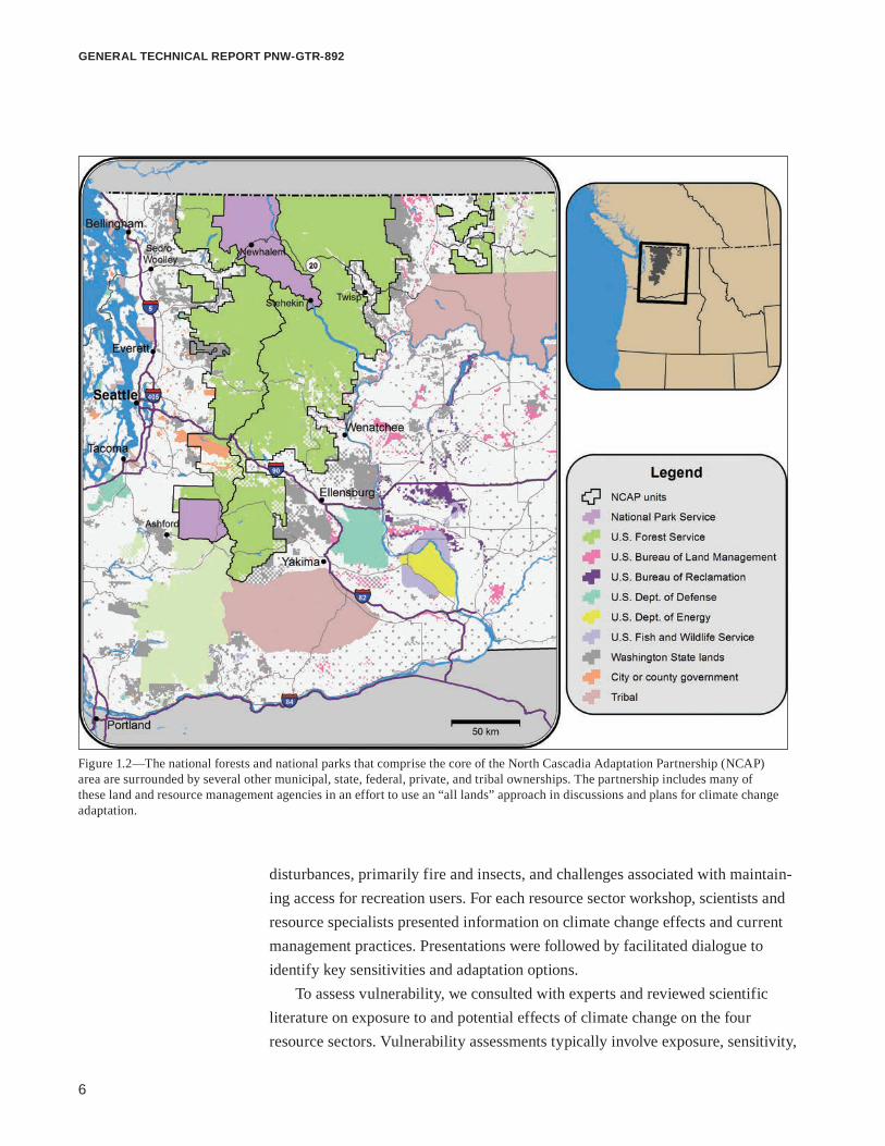
The North Cascadia Adaptation Partnership ProcessThe NCAP expands the methods of the previous case studies to a larger, more ecologically and geographically complex area and extends the approach of science-management partnerships to a broader range of stakeholders. It focuses on vulnerability assessment and adaptation planning for Mount Baker-Snoqualmie National Forest, Okanogan-Wenatchee National Forest, North Cascades National Park Complex, and Mount Rainier National Park, a total land area of 2.4 million ha in Washington (fig 1.1). Although these four administrative units form the core of NCAP, the partnership includes other local, state, and federal resource management agencies, and nongovernmental organizations in the region (fig. 1.2). The NCAP focuses on assessing vulnerability and developing adaptation options to reduce vulnerability. The NCAP process was conducted in four steps: (1) increase climate change awareness among NPS and USDA FS staff and partners; (2) assess vulner-ability of natural and cultural resources and infrastructure; (3) develop adaptation options that the parks, forests, and their partners could potentially implement; and (4) build a continuing partnership of scientists and resource managers engaged in climate change issues in the region.
Educational workshops on climate change, one for each national forest and national park, initiated the NCAP process. Scientists from resource agencies and academic institutions presented the latest scientific information on projected changes in climate and the effects of these changes on natural resources. Work-shops were attended by USDA FS and NPS employees from all sectors of the workforce, providing an opportunity for resource managers to engage in a dialogue with climate change scientists, voice current and future management challenges, and develop a common understanding of how climate change may affect natural resources.
Building on the educational component, the NCAP assessed the vulnerability of natural and cultural resources and infrastructure and developed options for adapting resources and management to a changing climate. This was accomplished through a series of four 2-day workshops focused on specific resource sectors: hydrology and access, vegetation and ecological disturbance, wildlife, and fisheries. These resource sectors were selected based on their importance in the region and current management concerns and challenges. These resources are similar to the resources that were the focus of the Olympic climate change case study (Halofsky et al. 2011), but differed in two ways, reflecting differences in the disturbance ecol-ogy and predominant uses of public lands in the NCAP region. The national forests and national parks in the NCAP emphasized concerns about changes in ecological
6
general technical report pnw-gtr-892
Figure 1.2—The national forests and national parks that comprise the core of the North Cascadia Adaptation Partnership (NCAP) area are surrounded by several other municipal, state, federal, private, and tribal ownerships. The partnership includes many of these land and resource management agencies in an effort to use an “all lands” approach in discussions and plans for climate change adaptation.
disturbances, primarily fire and insects, and challenges associated with maintain-ing access for recreation users. For each resource sector workshop, scientists and resource specialists presented information on climate change effects and current management practices. Presentations were followed by facilitated dialogue to identify key sensitivities and adaptation options.
To assess vulnerability, we consulted with experts and reviewed scientific literature on exposure to and potential effects of climate change on the four resource sectors. Vulnerability assessments typically involve exposure, sensitivity,
7
Climate Change Vulnerability and Adaptation in the North Cascades Region, Washington
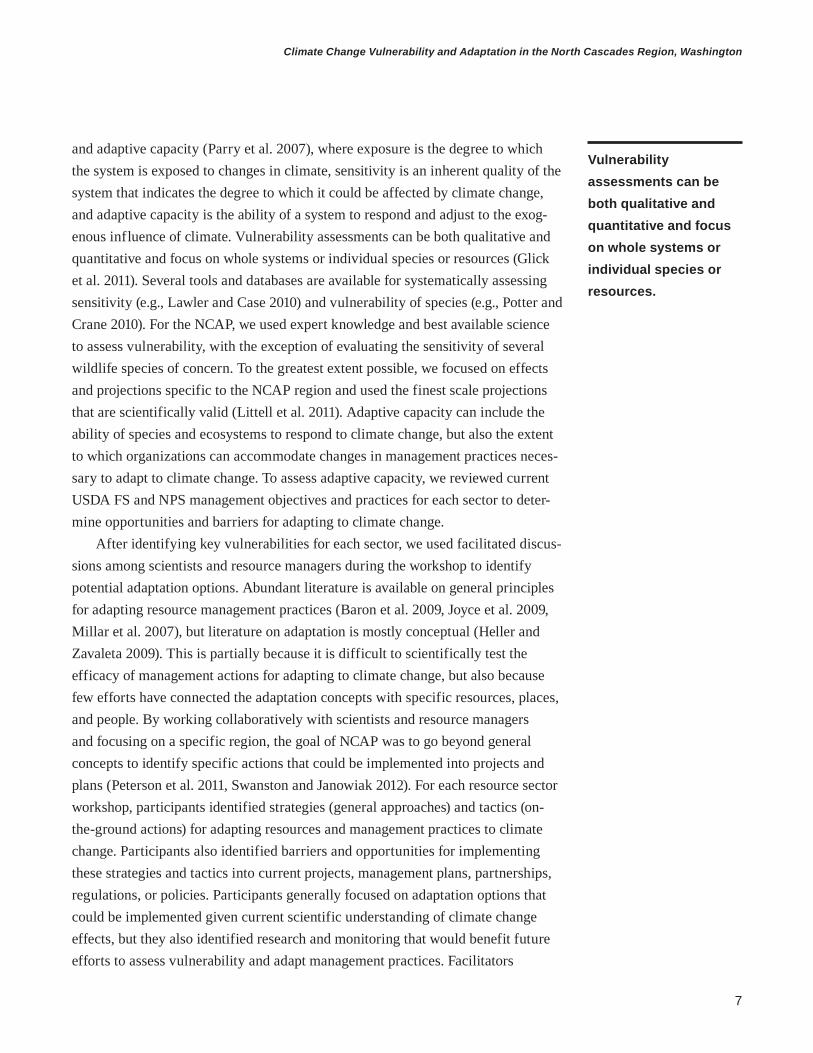
and adaptive capacity (Parry et al. 2007), where exposure is the degree to which the system is exposed to changes in climate, sensitivity is an inherent quality of the system that indicates the degree to which it could be affected by climate change, and adaptive capacity is the ability of a system to respond and adjust to the exog-enous influence of climate. Vulnerability assessments can be both qualitative and quantitative and focus on whole systems or individual species or resources (Glick et al. 2011). Several tools and databases are available for systematically assessing sensitivity (e.g., Lawler and Case 2010) and vulnerability of species (e.g., Potter and Crane 2010). For the NCAP, we used expert knowledge and best available science to assess vulnerability, with the exception of evaluating the sensitivity of several wildlife species of concern. To the greatest extent possible, we focused on effects and projections specific to the NCAP region and used the finest scale projections that are scientifically valid (Littell et al. 2011). Adaptive capacity can include the ability of species and ecosystems to respond to climate change, but also the extent to which organizations can accommodate changes in management practices neces-sary to adapt to climate change. To assess adaptive capacity, we reviewed current USDA FS and NPS management objectives and practices for each sector to deter-mine opportunities and barriers for adapting to climate change.
After identifying key vulnerabilities for each sector, we used facilitated discus-sions among scientists and resource managers during the workshop to identify potential adaptation options. Abundant literature is available on general principles for adapting resource management practices (Baron et al. 2009, Joyce et al. 2009, Millar et al. 2007), but literature on adaptation is mostly conceptual (Heller and Zavaleta 2009). This is partially because it is difficult to scientifically test the efficacy of management actions for adapting to climate change, but also because few efforts have connected the adaptation concepts with specific resources, places, and people. By working collaboratively with scientists and resource managers and focusing on a specific region, the goal of NCAP was to go beyond general concepts to identify specific actions that could be implemented into projects and plans (Peterson et al. 2011, Swanston and Janowiak 2012). For each resource sector workshop, participants identified strategies (general approaches) and tactics (on-the-ground actions) for adapting resources and management practices to climate change. Participants also identified barriers and opportunities for implementing these strategies and tactics into current projects, management plans, partnerships, regulations, or policies. Participants generally focused on adaptation options that could be implemented given current scientific understanding of climate change effects, but they also identified research and monitoring that would benefit future efforts to assess vulnerability and adapt management practices. Facilitators
Vulnerability assessments can be both qualitative and quantitative and focus on whole systems or individual species or resources.

8
general technical report pnw-gtr-892
captured information generated during the workshops with a set of spreadsheets adapted from Swanston and Janowiak (2012). Initial results from the workshops were augmented with a review of the literature and continued dialogue with NPS and USDA FS resource specialists. The following report contains one chapter for each of the four resource sectors with a review of climate change effects, sensitivi-ties, and current management practices (collectively the vulnerability assessment) and results of the adaptation planning discussions.
Resource managers can use this report in several ways. First, the synthesis of projected changes in climate and hydrology in the North Cascades and potential effects on access, infrastructure, vegetation, wildlife, and fish is a state-of-science reference for addressing climate change in planning documents and projects. The report is not a comprehensive synthesis of all literature on climate change effects in the region, but it emphasizes the biggest challenges for these resource sectors. The four resource sectors on which this report focuses were chosen based on their importance in the region and at the request of forest and park managers. Second, resource managers can draw from the adaptation options presented in this report as they begin to implement actions in response to changes in climate and hydrology. We expect that over time, and as needs and funding align, that appropriate adapta-tion options will be incorporated into plans and programs of the parks, forests, and possibly other agencies. Adaptation planning is a gradual and iterative process. Implementation may happen at critical times in the planning process, such as when managers revise USDA FS land and resource management plans or NPS general management plans, or after the occurrence of extreme events (e.g., floods) or ecological disturbances. We focus on adaptation options for the USDA FS and NPS units that are the core of the partnership, but this report provides information that can be used by other resource management agencies in the partnership. Further-more, the NCAP process can be emulated by national forests, national parks, and other organizations in the Pacific Northwest and beyond.
All-Lands Approach to Climate Change AdaptationThe USDA FS and NPS climate change strategies identify the need to build part-nerships and work across jurisdictional boundaries when planning for adaptation. This concept of responding to the challenge of climate change with an “all-lands” approach is frequently mentioned, but a process for doing so is rarely defined. Unique in its effort to implement an all-lands approach to adaptation for a specific region, the NCAP is an inclusive partnership of multiple agencies and organizations

9
Climate Change Vulnerability and Adaptation in the North Cascades Region, Washington
with an interest in managing natural resources in a changing climate. In addition to representatives from the four NCAP forests and parks, several other agencies and organizations participated in the resource sector workshops and are identified in each chapter. This type of partnership enables a coordinated and complementary approach to adaptation that crosses jurisdictional boundaries. NCAP also provides a venue for agencies to learn from the practices of others so that the most effective adaptation strategies can be identified.
The U.S. Department of the Interior Fish and Wildlife Service (USFWS) and the Washington Department of Ecology, both NCAP collaborators, have similar climate change response strategies to those of the USDA FS and NPS. Adaptation strategies, such as promoting resilience and resistance, mitigation options like carbon neutrality, and climate change engagement are the core goals of the USFWS Strategic Plan for Responding to Accelerating Climate Change (USFWS 2010). The Washington Department of Ecology Integrated Climate Response Strategy (Adels-man and Ekrem 2012), which applies to state agencies including the Department of Natural Resources and the Department of Fish and Wildlife, addresses effects, vulnerabilities, and adaptation strategies for different sectors (e.g., human health, water resources, and species habitats). The main goals are to improve scientific knowledge, engage in partnerships and collaborations, expand sustainability and resiliency efforts, and use integrated approaches to climate change management.
These climate change strategies differ among agencies but have many similari-ties. Risks and vulnerabilities resulting from climate change and gaps in scientific knowledge and policy need to be assessed. Adaptation is a focus of each of the strategic plans, with most centering attention on creating resilience in human and natural systems. Communicating climate change information and engaging employ-ees, partners, and the general public in productive discussions is also an integral part of successfully responding to climate change. The need for partnerships and collaborations on climate change issues is also identified in all the plans. Sharing climate change information, vulnerability assessments, and adaptation strategies across administrative boundaries will contribute to the success of climate change responses in the North Cascades.

10
general technical report pnw-gtr-892
Literature CitedAdelsman, H.; Ekrem, J. 2012. Preparing for a changing climate: Washington
state’s integrated climate response strategy. Pub. 12-01-004. Olympia, WA: Washington Department of Ecology. 207 p.
Baron, J.S.; Gunderson, L.; Allen, C.D. [et al.]. 2009. Options for national parks and reserves for adapting to climate change. Environmental Management. 44: 1033–1042.
Gaines, W.L.; Peterson, D.W.; Thomas, C.A.; Harrod, R.J. 2012. Adaptations to climate change: Colville and Okanogan-Wenatchee National Forests. Gen. Tech. Rep. PNW-GTR-862. Portland, OR: U.S. Department of Agriculture, Forest Service, Pacific Northwest Research Station. 34 p.
Glick, P.; Stein, B.A.; Edelson, N.A., eds. 2011. Scanning the conservation horizon: a guide to climate change vulnerability assessment. Washington, DC: National Wildlife Federation. 176 p.
Halofsky, J.E.; Peterson, D.L.; O’Halloran, K.A.; Hoffman, C.H. 2011. Adapting to climate change at Olympic National Forest and Olympic National Park. Gen. Tech. Rep. PNW-GTR-844. Portland, OR: U.S. Department of Agriculture, Forest Service, Pacific Northwest Research Station. 130 p.
Heller, N.E.; Zavaleta, E.S. 2009. Biodiversity management in the face of climate change: a review of 22 years of recommendations. Biological Conservation. 142: 14–32.
Intergovernmental Panel on Climate Change [IPCC]. 2007. Summary for policymakers. In: Parry, M.L.; Canzianai, O.F.; Palutikof, J.P. [et al.], eds. Climate change 2007: impacts, adaptation and vulnerability: a contribution of working group II to the fourth assessment report of the Intergovernmental Panel on Climate Change. Cambridge, United Kingdom: Cambridge University Press: 7–22.
Joyce, L.A.; Blate, G.M.; McNulty, S.G. 2009. Managing for multiple re- sources under climate change: national forests. Environmental Management. 44: 1022–1032.
Lawler,J.;Case,M.2010. Climate change sensitivity database. [Database]. http://climatechangesensitivity.org. (28 August 2012).
11
Climate Change Vulnerability and Adaptation in the North Cascades Region, Washington
Littell, J.S.; Elsner, M.M.; Mauger, G.S. [et al.]. 2011. Regional climate and hydrologic change in the northern U.S. Rockies and Pacific Northwest: internally consistent projections of future climate for resource management. Preliminary project report, USFS JVA 09-JV-11015600-039. Seattle, WA: University of Washington, Center for Science in the Earth System, Joint Institute for the Study of the Atmosphere and Ocean, Climate Impacts Group. http://cses.washington.edu/picea/USFS/pub/Littell_etal_2010/Littell_etal._2011_Regional_Climatic_And_Hydrologic_Change_USFS_USFWS_JVA_17Apr11.pdf. (15 April 2013).
Littell, J.S.; Peterson, D.L.; Millar, C.I.; O’Halloran, K.A. 2012. U.S. national forests adapt to climate change through science-management partnerships. Climatic Change. 110: 269–296.
Millar, C.I.; Stephenson, N.L.; Stephens, S.L. 2007. Climate change and forests of the future: managing in the face of uncertainty. Ecological Applications. 17: 2145–2151.
Morelli, T.L.; Yeh, S.; Smith, N.M. [et al.]. 2012. Climate project screening tool: an aid for climate change adaptation. Res. Pap. PSW-RP-263. Albany, CA: U.S. Department of Agriculture, Forest Service, Pacific Southwest Research Station. 29 p.
Peterson, D.L.; Millar, C.I.; Joyce, L.A. [et al.]. 2011. Responding to climate change in national forests: a guidebook for developing adaptation options. Gen. Tech. Rep. PNW-GTR-855. Portland, OR: U.S. Department of Agriculture, Forest Service, Pacific Northwest Research Station. 109 p.
Potter, K.M.; Crane, B.S. 2010. Forest tree genetic risk assessment system: a tool for conservation decision-making in changing times. Version 1.2. http://www.forestthreats.org/current-projects/project-summaries/genetic-risk-assessment-system. (28 August 2012).
Rice, J.; Tredennick, A.; Joyce, L.A. 2012. Climate change on the Shoshone National Forest, Wyoming: a synthesis of past climate, climate projections, and ecosystem implications. Gen. Tech. Rep. RMRS-GTR-274. Fort Collins, CO: U.S. Department of Agriculture, Forest Service, Rocky Mountain Research Station. 60 p.
Solomon, S.; Qin, D.; Manning, M. [et al.], eds. 2007. Climate change 2007: the physical science basis. Contribution of working group I to the fourth assessment report of the Intergovernmental Panel on Climate Change. Cambridge, United Kingdom: Cambridge University Press. 996 p.

12
general technical report pnw-gtr-892
Swanston,C.;Janowiak,M.;Iverson,L.[etal.].2011. Ecosystem vulnerability assessment and synthesis: a report from the climate change response framework project in northern Wisconsin. Gen. Tech. Rep. NRS-GTR-82. Newtown Square, PA: U.S. Department of Agriculture, Forest Service, Northern Research Station. 142 p.
Swanston,C.W.;Janowiak,M.K.,eds.2012. Forest adaptation resources: climate change tools and approaches for land managers. Gen. Tech. Rep. NRS-GTR-87. Newtown Square, PA: U.S. Department of Agriculture, Forest Service, Northern Research Station. 108 p.
U.S. Department of Agriculture, Forest Service [USDA FS]. 2007. Westwide Climate Initiative: a research management partnership. http://www.fs.fed.us/psw/topics/climate_change/pdf/Apr07hill_westsideCI.pdf. (28 August 2012).
U.S. Department of Agriculture, Forest Service [USDA FS]. 2008. Forest Service strategic framework for responding to climate change. Version 1.0. http://www.fs.fed.us/climatechange/documents/strategic-framework-climate-change-1-0.pdf. (28 August 2012).
U.S. Department of Agriculture, Forest Service [USDA FS]. 2010a. National roadmap for responding to climate change. http://www.fs.fed.us/climatechange/ pdf/roadmap.pdf. (28 August 2012).
U.S. Department of Agriculture, Forest Service [USDA FS]. 2010b. A performance scorecard for implementing the Forest Service climate change strategy. http://www.fs.fed.us/climatechange/pdf/performance_scorecard_final. pdf. (28 August 2012).
U.S. Department of Agriculture, Forest Service [USDA FS]. 2011. Proposed action for forest plan revision, Okanogan-Wenatchee National Forest. Portland, OR: U.S. Department of Agriculture, Forest Service, Pacific Northwest Research Station. 89 p.
U.S. Department of Agriculture, Forest Service [USDA FS]. 2012. The Okanogan-Wenatchee National Forest restoration strategy: adaptive ecosystem management to restore landscape resiliency. 2012 Version. Portland, OR: U.S. Department of Agriculture, Forest Service, Pacific Northwest Region. 119 p.
13
Climate Change Vulnerability and Adaptation in the North Cascades Region, Washington
U.S. Department of the Interior, Fish and Wildlife Service [USFWS]. 2010. Rising to the urgent challenge: strategic plan for responding to accelerating climate change. http://www.fws.gov/home/climatechange/pdf/CCStrategicPlan.pdf. (28 August 2012).
U.S. Department of the Interior, National Park Service [USDI NPS]. 2010. National Park Service climate change response strategy. Fort Collins, CO: National Park Service, Climate Change Response Program. 28 p. http://www.nps.gov/orgs/ccrp/upload/NPS_CCRS.pdf. (28 August 2012).
U.S. Department of the Interior, National Park Service [USDI NPS]. 2012. Green parks plan: advancing our mission through sustainable operations. http://www.nps.gov/greenparksplan/downloads/NPS_2012_Green_Parks_Plan.pdf. (28 August 2012).

14
general technical report pnw-gtr-892

15
Climate Change Vulnerability and Adaptation in the North Cascades Region, Washington
The North Cascadia Adaptation Partnership (NCAP) includes Mount Baker-Sno-qualmie National Forest (MBSNF), Okanogan-Wenatchee National Forest (OWNF), North Cascades National Park Complex (NOCA), and Mount Rainier National Park (MORA), which occupy 2.4 million ha in the North Cascade Range in Washington state (referred to hereafter as the North Cascades). The area is climatologically and ecologically diverse, and each administrative unit has a different cultural history, policy history, legislative mandate, and management objectives. Because the NCAP assessed vulnerability to climate change and developed adaptation options for the North Cascades region as a whole, participants recognized differences in ecology and management objectives, leading to different priorities and adaptation strategies.
Despite differences among the four units, the North Cascades region is united by similarities in climate, ecology, resource use, and management objectives. The abundant snowfall, glaciated volcanoes, and high elevation of the region create a common ecological setting in which glaciers, alpine, and subalpine zones strongly influence ecological processes. Abundant large, glacial-fed rivers throughout the region provide critical habitat for cold-water fish and also serve as an important resource for hydropower and water for nearby urban communities. The proximity of the four units to the Seattle-Tacoma metropolitan area creates a common emphasis on managing for high public visitation and recreation, yet the steep terrain and rugged topography of the region limit access. Protection and conservation of late-successional forest habitat for wildlife species is a common objective for all national forests and national parks. Furthermore, Congressional wilderness designations for large portions of the national forests have increased the similarity between U.S. Department of Agriculture, Forest Service (USDA FS) and National Park Service (NPS) management. Current management objectives are built on a long tradition of dependence on the abundant natural resources of the region that extends back centuries, including the resource dependence of local Native American tribes.
1 KaileyMarcinkowski is a research scientist, Michigan Technological University, School of Forest Resources and Environmental Science, 1400 Townsend Drive, Houghton, MI 49931; Crystal L. Raymond is a climate change strategic advisor, City of Seattle, Seattle City Light, 700 5th Avenue, Seattle, WA 98124 (formerly a research biologist, U.S. Depart-ment of Agriculture, Forest Service, Pacific Northwest Research Station, Pacific Wildland Fire Sciences Laboratory, Seattle, WA 98103); and Lee K. Cerveny is a research social scientist, U.S. Department of Agriculture, Forest Service, Pacific Northwest Research Station, Pacific Wildland Fire Sciences Laboratory, 400 N 34th Street, Suite 201, Seattle, WA 98103.
Chapter 2: Ecological, Biogeographical, and Historical Context of the North Cascade RangeKailey Marcinkowski, Crystal L. Raymond, and Lee K. Cerveny1

16
general technical report pnw-gtr-892
This common ecological, social, and historical context formed the basis of joint discussions on vulnerability to climate change and enabled the NCAP to identify common adaptation strategies that are relevant to the region as whole. It will con-tinue to be important to recognize differences in agency mandates and management objectives, but developing regional adaptation strategies, as was undertaken by the NCAP, is the first step toward implementing an “all lands” approach to adaptation.
Ecological Setting Elevations in the North Cascades extend from 185 m to 4392 m (the peak of Mount Rainier). Diverse geomorphic processes shaped the landscape, resulting in rugged topography and steep elevation gradients with corresponding gradients in tempera-ture and precipitation (Franklin et al. 1988). The North Cascades has two distinct climatic divisions. On the west side of the Cascade Range, a temperate, maritime climate dominates, and annual precipitation ranges from 100 cm to more than 250 cm. On the east side of the Cascade Range, the climate is more continental, and annual precipitation is as high as 130 cm near the Cascade crest and as low as 25 cm near the eastern edge of OWNF. Mean annual temperature is similar for both sides of the Cascade Range, but temperature on the east side is more seasonally variable, with larger differences between annual and seasonal highs and lows. Snow accumulates as early as October and can reach depths greater than 7 m above 1500 m elevation, often persisting into late summer. Mount Baker, located in MBSNF, holds the U.S. seasonal snowfall record of nearly 29 m of snow measured during the 1998–99 season. Mount Rainier was the previous record holder for 28.5 m of snow during the winter of 1971–72 (National Climate Extremes Committee 2012).
In the North Cascades, elevation and climatic gradients create different com-binations of temperature, moisture, and disturbance regimes, giving rise to many different ecosystems (Franklin et al. 1988). Vegetation associations include dry coniferous forests, temperate coniferous rain forests, subalpine forests and mead-ows, riparian forests, and treeless alpine. Western hemlock (Tsuga heterophylla [Raf.] Sarg.), Douglas-fir (Pseudotsuga menziesii [Mirb.] Franco), and western red- cedar (Thuja plicata Donn ex D. Don), dominate low-elevation, west-side forests. Douglas-fir, ponderosa pine (Pinus ponderosa var. ponderosa Douglas ex P. Lawson & C. Lawson), grand fir (Abies grandis [Douglas ex D. Don] Lindl.), and western larch (Larix occidentalis Nutt.) dominate low-elevation east-side forests, and lodgepole pine (P. contorta var. latifolia Engelm. ex S. Watson) is common throughout mid-elevation east-side forests. Vegetation transitions from dry conifer forest to shrub-steppe and grassland toward the eastern edge of OWNF. Hardwood species such as red alder (Alnus rubra Bong.), bigleaf maple (Acer macrophyllum
Mount Baker holds the U.S. seasonal snowfall record of nearly 29 m of snow.

17
Climate Change Vulnerability and Adaptation in the North Cascades Region, Washington
Pursh), and vine maple (A. circinatum Pursh) are common in riparian forests on the west side, and quaking aspen (Populus tremuloides Michx.) is found in riparian and high-elevation forests on the east side. Subalpine forests are dominated by mountain hemlock (Tsuga mertensiana [Bong.] Carrière), Pacific silver fir (Abies amabilis Douglas ex J. Forbes), and subalpine fir (A. lasiocarpa [Hook.] Nutt.) on the west side and by subalpine fir, Engelmann spruce (Picea engelmannii Parry ex Engelm.), and subalpine larch (L. lyallii Parl.) on the east side. The North Cascades supports a high diversity of native plant species; NOCA alone contains 1,630 vascular species, the most of any park in the NPS.
Cultural History of the North CascadesInteractions between native peoples and their environments are an important part of the cultural history of the North Cascades, which supported many Native American tribes: the Skagit, Nooksack, Sauk-Suiattle, Okanogan, Methow, Chelan, Wenatchee, Salish, Nisqually, Puyallup, Muckleshoot, Squaxin Island, Yakama, Cowlitz, and Colville. Many of these tribes have relationships with the parks and forests that are part of the NCAP, and they work collaboratively to protect and manage the natural resources and cultural heritage of the area. Tribal partners were actively involved in the NCAP resource-sector workshops and provided expertise, local knowledge, and input to the adaptation planning process.
Traditional uses of the land include hunting for mountain goat (Oreamnos americanus [de Blainville]), elk (Cervus elaphus L.), black-tailed deer (Odocoileus hemionus columbianus [Rafinesque]), mule deer (O. hemionus [Rafinesque]) hoary marmot (Marmota caligata [Eschscholtz]), black bear (Ursus americanus Pallas) (and formerly grizzly bear [U. arctos L.]), and many bird species, and foraging for a wide range of berries, roots, and mushrooms. Western redcedar and Alaska cedar (Callitropsis nootkatensis [D. Don] D.P. Little) trees were stripped of bark for clothing, baskets, mats, and containers (Burtchard 2003). Salmon was a main food staple for many tribes, so waterways were an important aspect of native life and provided access to trade routes. Trade paths were also established over land, and water and land routes opened up trade between inland and coastal tribes (Mount Baker Foothills Economic Development Association 2004).
The tribes of the North Cascades had various lifestyles. Some, like the Nook-sack and Skagit, settled in permanent villages along rivers, but others lived in camps that moved depending on the season. Dart and arrow points, lithic debris, and other evidence of hunting and residential sites have been found throughout the region (Mierendorf 2004). Hundreds of archaeological sites, including rock shelters between 300 and 1,000 years old, indicate a long history of land use by

18
general technical report pnw-gtr-892
native peoples in the North Cascades (Burtchard 2003). Pictographs on the cliffs surrounding Lake Chelan were drawn by the Chelan tribe, and their creation is part of a tribal legend. Legends also surround the formations of Mount Rainier, Mount Baker, and several large rivers.
Following European discovery of Puget Sound and the North Cascades, set-tlers explored the foothills and rivers, especially trappers engaged in the fur trade. Mining ventures were established throughout the area, and many small settlements became mining boom towns with a large influx of prospectors. The 1858 Fraser River gold rush brought nearly 10,000 of these prospectors into the foothills sur-rounding Mount Baker, and claims to ore deposits still exist today (Thompson 1970). The large trees and extensive forest area of the region became an economic draw for logging operations in the 1870s, mostly in the lowlands along rivers. Railroads reached the Pacific Northwest in the 1890s, and settlements in the area began to expand. Toward the end of the 19th century, the area was first used for recreational purposes, such as mountaineering, and people began to take a greater interest in preserving the natural resources of the North Cascades.
Geography, History, and ManagementMount Baker-Snoqualmie National ForestMount Baker-Snoqualmie National Forest occupies 698 000 ha, extending 225 km on the western side of the Cascade Range from the Canadian border to Snoqualmie Pass and south of MORA. Nine wilderness areas, four of which are shared with the OWNF, comprise 48 percent of the MBSNF area. Among active volcanoes in the contiguous United States, Mount Baker (3286 m) is the fourth highest and most northern. There are 13 glaciers on its slopes. Several large rivers run through the MBSNF, including the Sauk, Suiattle, and Cascade Rivers, which are part of the Skagit River system.
The lands that make up MBSNF have a long history of preservation. Some of the forest area was reserved as part of Pacific Forest Reserve lands in 1893, and in 1908 it was converted to Snoqualmie National Forest (south), and Washington National Forest (north), the latter being renamed Mount Baker National Forest in 1924. After the dissolution of Mount Rainier National Forest, the Snoqualmie National Forest expanded, incorporating four ranger districts into its boundaries. When NOCA was formed, it was excised from Mount Baker National Forest. Mount Baker and Snoqualmie National Forests merged in 1973.
Many areas have been established as wilderness since establishment of current MBSNF boundaries (Washington State Wilderness Act of 1984). Wilderness desig- nations influence management for timber and wildlife habitat. More than 200 km

19
Climate Change Vulnerability and Adaptation in the North Cascades Region, Washington
of river and shoreline have been designated as the Skagit Wild and Scenic River System to protect the flow, water quality, and recreation values of the river (Wild and Scenic Rivers Act 1968). The Skagit Wild and Scenic River System is taken into account when managing for recreation, hydroelectric power, flood control, species populations, and restoration along shorelines.
The MBSNF manages for a broad range of recreational activities. Viewing natural features and wildlife, hiking, viewing wildlife, relaxing, and driving for pleasure are the top five recreational activities in MBSNF, and nearly 60 percent of visitors to the forest hike on established trails. Recreational use has increased from 1,372,000 in 2005 to 1,995,000 in 2010, making MBSNF one of the most visited national forests in the United States. Beyond recreation, MBSNF also manages tim-ber, fire, and sensitive species. These activities are designed to protect, maintain, and enhance the natural resources of the forest. The Wilderness Act (1964), Wild and Scenic Rivers Act (1968), National Environmental Policy Act (1969), Clean Air Act (1970, 1977), and Endangered Species Act (1973), all regulate management activities at MBSNF.
Okanogan-Wenatchee National ForestThe Okanogan-Wenatchee National Forest comprises more than 1.6 million ha on the eastern side of the Cascades from the Canadian border to south of Mount Rainier. The crest of the Cascade Range is the western border of OWNF, and the Okanogan Highlands are the eastern border. Eight wilderness areas, some of which are shared with MBSNF, cover about 40 percent of the land. Waterways are an important part of OWNF, which borders the Columbia River and the Yakima River valley. Cle Elum Lake, Kachess Lake, Keechelus Lake, Rimrock Lake, Lake Wenatchee, and Lake Chelan are all large lakes inside OWNF borders, and the Methow, Twisp, and Entiat Rivers flow through the forest.
The eastern slopes of the Cascade Range and the area surrounding Lake Chelan have been a popular recreation destination since the early 1900s. The need to set aside lands for preservation was recognized early, and the Wenatchee and Chelan National Forests were established separately in 1908. The Okanogan National Forest was established in 1911 and was incorporated into Chelan National Forest several years later. Chelan National Forest boundaries were kept the same, but the area was renamed Okanogan in 1955. Several wilderness areas were established in these national forests over the years, reserving land inside forest boundaries and adding land to expand the boundaries. The forests were combined in 2000 and the name was subsequently changed to Okanogan-Wenatchee National Forest. Management of the OWNF follows similar legislation as MBSNF, with additional emphasis on

20
general technical report pnw-gtr-892
fire and timber. Recreational usage of OWNF has decreased from 1,752,000 visitors in 2005 to 1,368,000 in 2010. Recreation activities include hiking, scenic driving, skiing, hunting, fishing, gathering forest products, and camping.
Mount Rainier National ParkMount Rainier National Park is located on the west side of the Cascade Range, about 100 km southeast of the Seattle-Tacoma area. The park is 96 000 ha, of which 97 percent is designated as wilderness. Several historical areas within the park (about 1 percent) are designated as a National Historic Landmark District. The main attraction of the park is Mount Rainier, the largest peak in Washington state. Mount Rainier is an active volcano with the largest single-peak glacier system in the Pacific Northwest. An abundance of archaeological sites in the park are evidence of a long history of human use in this area.
Lands set aside for the Pacific Forest Reserve in 1893 were combined with land reclaimed from railroads to create the park in 1899, making it the fifth national park in the United States. The first national park to be patrolled solely by rangers (Cat-ton 1996), it was the site of mining operations and fire suppression during its first decade of existence. When the NPS was established in 1916 (NPS 1916), MORA expanded operations, adding engineers, landscape architects, naturalists, and an educated ranger force. As the automobile became more popular and better roads and trails were built into the park, the number of visitors increased, especially for single day trips. The influx of visitors to the park resulted in MORA becoming the first national park, in 1928, to develop a master plan for development of roads and visitor and administration services (Catton 1996). Recreational activities in MORA include climbing, hiking, backpacking, camping, scenic drives, and wildlife and wildflower viewing, and visitation is gradually declining. There were 1,301,103 visitors in 2001, decreasing to 1,038,229 in 2011. During that time, backcountry campers decreased from 64,362 to 39,907.
North Cascades National Park ComplexNorth Cascades National Park Complex spans 279 000 ha from the Canadian border to south of Lake Chelan and includes North Cascades National Park and Ross Lake and Lake Chelan national recreation areas. The Stephen Mather Wilderness covers 93 percent of the park, and there are five research natural areas within the borders. Rugged topography and nearly 3000 m of vertical relief result in diverse biophysi-cal environments and ecosystems. Lake Chelan, the focus of Lake Chelan National Recreation Area, is the third deepest natural lake in the United States. Home to 300 glaciers, NOCA contains over half of all glacial ice mass in the contiguous United
Mount Rainier is an active volcano with the largest single-peak glacier system in the Pacific Northwest.

21
Climate Change Vulnerability and Adaptation in the North Cascades Region, Washington
States. The park also has several large rivers including the Skagit, Nooksack, and Stehekin. Many archaeological sites are found near these rivers and more sites have recently been identified at higher elevations (Mierendorf 2004).
Although NOCA is now recognized for recreational opportunities and preserva-tion of natural resources, the land was originally used for resource extraction. Log-ging operations and mining began in the 1870s. Sheep herding and grazing was also attempted in the northern Cascade Range but was abandoned in the 1940s because of the difficulty of herding sheep in high meadows. The potential for hydroelectric power was also recognized early when Seattle City Light built dams and railroads in the North Cascades in the 1920s and 1930s. Diablo Dam was completed in 1929 and Ross Dam in 1949, and Gorge Dam was built in 1919 and rebuilt in 1950 and 1961 (Thompson 1970). Collectively known as the Skagit River Hydroelectric Project, the facilities associated with these dams generate 711 megawatts of power, about 25 percent of the electrical usage for the Seattle region.
The idea for a national park in the North Cascades was proposed about 75 years before it became official in 1969 (Louter 1998, North Cascades Study Team 1965) because of competition with timber and mining interests in the surrounding region, but the area was still enjoyed for many forms of recreation. The public desire to pre-serve the North Cascades persisted, and the park was created to preserve the natural features and majestic mountain scenery of the region, provide public recreation and enjoyment, and conserve scenic, scientific, and historic values of the land.
Early conflict over management and use at NOCA focused on proposals for road construction, with some people in favor of new roads to provide recreational access, and others in favor or maintaining a remote environment. The North Cascades Highway, which opened in 1972, bisects the park from west to east and is the primary access route for most visitors. The Cascade River Road and Stehekin Valley Road, both unpaved, are the only other major roads in the park. After the North Cascades Highway opened, park visitation increased from 250,000 to 750,000 people, prompting an expansion in campsites and revegetation of subalpine meadows that were being degraded by visitors (Louter 1998). Visitors to NOCA pursue recreation activities including scenic driving on the North Cascades High-way, backpacking, camping, and hiking. Recreational visits to NOCA declined from 27,739 in 2001 to 19,208 in 2011, but backcountry camping remained fairly steady during that time. Recreational visits at Ross Lake National Recreation Area have increased from 331,343 in 2001 to 728,353 in 2011, and recreational visits at Lake Chelan National Recreation Area increased from 25,000 to 43,827 during that time.

22
general technical report pnw-gtr-892
National Park Service management policies (USDI NPS 2006) establish the framework and direction for management decisions in national parks. Park-specific foundation statements and general management plans of NOCA and MORA sum-marize the established purpose for each park, the significance of the resources for which it was established, and provide a shared vision for resource conditions and visitor experiences that fulfill the purpose of each park. General management plans define strategic goals for park management over the next 15 to 20 years, and imple-mentation plans identify short-term (5 years) goals and objectives. The broad goals of the NPS are to understand and protect the inherent integrity of natural resources, processes, systems, and values, while providing meaningful and appropriate oppor-tunities for the public to enjoy the parks (USDI NPS 2006). Management activities at NOCA and MORA are also regulated by the Wilderness Act (1964), Wild and Scenic Rivers Act (1968), National Environmental Policy Act (1969), Clean Air Act (1970), Endangered Species Act (1973), and Clean Water Act (1977).
Literature CitedBurtchard, G.C. 1998 [reprinted 2003]. Environment, prehistory, and
archaeology of Mount Rainier National Park, Washington. http://www.nps.gov/history /history/online_books/mora/archaeology/index.htm. (20 July 2011).
Catton, T. 1996. Wonderland: an administrative history of Mount Rainier National Park. http://www.nps.gov/history/history/online_books/mora /adhi/index.htm. (25 July 2011).
Clean Air Act of 1970, as amended August 1977; 42 U.S.C. s/s 7401 et seq.
Clean Water Act of 1977; 33 U.S.C. s/s 1251 et seq.
Endangered Species Act of 1973; 16 U.S.C. 1531-1536, 1538–1540.
Franklin, J.F.; Moir, W.H.; Hemstrom, M.A. [et al.]. 1988. The forest communities of Mount Rainier National Park. Scientific Monograph Series No. 19. Washington, DC: U.S. Department of the Interior, National Park Service. http://www.nps.gov/history/history/_books/science/19/index.htm. (20 July 2011).
Louter, D. 1998. Contested terrain: North Cascades National Park Complex, Washington, an administrative history. Seattle: National Park Service. 338 p. http://www.nps.gov//history/online_books/noca/adhi/index.htm. (4 August 2011).
Mierendorf, R.R. 2004. Archaeology of the Little Beaver Watershed: North Cascades National Park Complex, Whatcom County, Washington. http://www.nps.gov/history/history/online_books/noca/mierendorf/index.htm. (4 August 2011).

23
Climate Change Vulnerability and Adaptation in the North Cascades Region, Washington
Mount Baker Foothills Economic Development Association. 2004. The Mt. Baker Foothills Chain of Trails concept plan. Bellingham, WA: Whatcom Council of Governments. http://wcog.org/documents/chain-of-trails-concept-plan/. (8 August 2011).
National Climate Extremes Committee. 2012. National Oceanographic and Atmospheric Administration, National Climate Extremes Committee. http://www.ncdc.noaa.gov/extremes/ncec/. (5 September 2012).
National Environmental Policy Act of 1969; 42 U.S.C. 4321 et seq.
National Park Service Organic Act of 1916; 39 Stat. 535; 16 U.S.C. 1–4.
North Cascades Study Team. 1965. The North Cascades: a report to the Secretary of the Interior and the Secretary of Agriculture. Washington, DC: U.S. Department of the Interior and U.S. Department of Agriculture. 190 p.
Thompson, E.N. 1970. North Cascades N.P., Ross Lake N.R.A. & Lake Chelan N.R.A. history basic data. Washington, DC: U.S. Department of the Interior, National Park Service, Office of History and Historic Architecture, Eastern Service Center. 301 p. http://www.nps.gov/history/history/online_books/noca/hbd/index.htm. (August 4 2011).
U.S. Department of the Interior National Park Service [USDI NPS]. 2006. Management policies 2006. Washington, DC: U.S. Government Printing Office. 179 p. http://www.nps.gov/policy/MP2006.pdf. (4 September 2012).
Washington State Wilderness Act of 1984; 98 Stat. 339.
Wild and Scenic Rivers Act of 1968; 16 U.S.C. 1271 et seq.
Wilderness Act of 1964; 16 U.S.C. 1121, 1131–1136.

24
general technical report pnw-gtr-892

25
Climate Change Vulnerability and Adaptation in the North Cascades Region, Washington
Weather is the condition of the atmosphere at a specific place in the short term (minutes to weeks). Climate is the mean weather conditions over a longer period of time (months, seasons, years, or thousands of years) and includes variables such as precipitation and temperature (Intergovernmental Panel for Climate Change [IPCC] 2007). In addition to the mean, extremes and variability are also key features of cli-mate and these statistics of climate are typically described for a 30-year period. In the Pacific Northwest (PNW), annual and decadal variability are important aspects of regional climate that are driven by semipredictable, natural interactions between the ocean and atmosphere. In contrast, climate change, or trends in climate over several decades, is driven by large-scale physical factors that influence regional or global climate (i.e., climate forcings). Climate forcings can be natural (e.g., changes in the Earth’s orbit) or caused by humans (e.g., changes in atmospheric concentra-tions of greenhouse gasses that affect the heat balance of the Earth).
In the following sections, we describe spatial and temporal means, variability, and trends in historical and future climate in the PNW. Climatic variability and trends shape ecological and hydrologic processes with implications for ecosystem services and management of natural resources. These climate data and projections informed the North Cascadia Adaptation Partnership (NCAP) vulnerability assess-ment and adaptation planning process.
Climate of the Pacific NorthwestClimate in the North Cascade Range (defined here as Mount Rainier north to the Canadian border) is driven by the regional climate of the PNW and mediated by local effects of mountainous topography and proximity to the Pacific Ocean. Regionally, most precipitation falls in the winter half of the year (about 70 percent or more of the annual total) and relatively little falls in the summer half of the year (about 30 percent or less). The western slopes of the Cascade Range have a mari-time climate that is greatly influenced by the Pacific Ocean and Puget Sound,
1 Jeremy S. Littell is a research scientist, U.S. Department of the Interior, Alaska Climate Center, 4210 University Drive, Anchorage, AK 99508 (formerly research scientist, Uni-versity of Washington, College of the Environment, Climate Impacts Group, Seattle, WA); and Crystal L. Raymond is a climate change strategic advisor, City of Seattle, Seattle City Light, 700 5th Avenue, Seattle, WA 98124 (formerly research biologist, U.S. Department of Agriculture, Forest Service, Pacific Northwest Research Station, Pacific Wildland Fire Sciences Laboratory, Seattle, WA).
Chapter 3: Climate and Climate Change in the North Cascade RangeJeremy S. Littell and Crystal L. Raymond1

26
general technical report pnw-gtr-892
whereas the eastern slopes of the Cascade Range have a continental climate dominated by the orographic effect of the Cascade Range. The maritime climate of the western Cascades has relatively warm winters and cool summers compared to the eastern Cascades. Diurnal and seasonal temperature ranges (differences between lows and highs) are narrower in the western Cascades than the eastern Cascades. More precipitation falls on the west and southwest (windward) sides of the Cascades, particularly from November to March, than on the eastern slopes of the Cascades (leeward). In the Cascade Range, precipitation and temperature also vary with elevation. Higher elevations receive more precipitation and have lower temperatures, resulting in higher winter snowfall and spring snowpack.
Regional climate varies significantly through time. The proximity of the PNW to the Pacific Ocean means that trends in large-scale interactions between the ocean and atmosphere affect climate of the region. The El Niño-Southern Oscillation (ENSO) originates in the tropical Pacific but influences the winter temperature and precipitation in the PNW. The ENSO cycles between El Niño and La Niña events every few years, with abnormally warm, dry winters more likely during El Niño events and abnormally wet winters more likely during La Niña events. The Pacific Decadal Oscillation (PDO) affects PNW winter climate similarly to ENSO, but it is a longer term (decadal) pattern of variation in the extra-tropical Pacific. Cool phases of the PDO have a similar influence on PNW climate as La Niña events. These features of Pacific Ocean circulation patterns are responsible for much of the temporal variability in the region’s climate over the historical record, which shows warm, dry winters in the early 20th century, followed by cool wet winters in the middle 20th century, and a return to warmer, drier conditions in the 1970s to 1990s.
Historical Climate Observations and Trends in the Pacific NorthwestIn the PNW, several networks of weather stations monitor and record weather. Most analyses of climate (long-term trends in weather) require many decades of complete daily observations to adequately describe the means, variability, and trends in climate at a location. Daily observations of temperature and precipitation are recorded at locations around the United States as part of the National Weather Service Cooperative Observer Network (COOP), and records for the PNW can be found at the Western Regional Climate Center. Hundreds of COOP stations in the PNW, and approximately 25 in the north and central Cascades, record weather data relevant to management units in the NCAP. High-quality data from COOP stations for most of the 20th century (usually starting between 1895 and 1920) are archived as part of the U.S. Historical Climatology Network (HCN), but only the Longmire

27
Climate Change Vulnerability and Adaptation in the North Cascades Region, Washington
(Mount Rainier National Park [MORA]) and Stehekin (North Cascades National Park Complex [NOCA]) records are of sufficient length and quality to be HCN stations.
Based on historical records, mean annual temperature increased 0.8 °C in the PNW between 1920 and 2000 (Mote 2003). The first decade of the 21st century (2001–2010) was tied with the previous decade (1991–2000) for the warmest in the PNW since comprehensive observations began around 1920. An analysis of HCN stations from the PNW and Columbia Basin region shows similar trends for the period of 1950 to 2006, with increases in minimum and maximum temperatures of 0.18 °C per decade for a total of 1.0 °C for the time period (Littell et al. 2011). Dur-ing this time, 84 percent of HCN stations in the PNW showed an increase in annual minimum temperature of 0.5 °C or more, whereas only 1 percent of stations showed a decrease of more than 0.5 °C (Littell et al. 2011). Most stations showed significant increases in minimum (80 percent of stations) and maximum temperature (71 per-cent of stations), whereas decreases were not statistically significant.
The national forests and national parks in the NCAP are at relatively high elevations in the PNW, and few stations in these units have long-term observations. Thus data are limited, making it difficult to determine whether the climate at higher elevations in the north and central Cascades is responding similarly to the rest of the PNW. The two longest and highest quality temperature records are from Long-mire and Stehekin and both stations show increasing temperature trends (fig. 3.1).
In the PNW, annual precipitation increased slightly over the 1920–2000 period (Mote 2003), but precipitation is more variable relative to the mean than is tempera-ture, so trends in precipitation are small compared to interannual variability. Simi-larly, analysis of precipitation trends from all HCN stations in the Columbia Basin for the period of 1950 to 2006 showed high spatial variability. Twenty-one percent of HCN stations showed declines in precipitation greater than 1 cm over the period, whereas 4 percent of stations showed increases in annual precipitation greater than 1 cm (Littell et al. 2011). Most stations that recorded an increase in precipitation were west of the Cascade crest, whereas most stations that recorded a decrease were east of the crest. Few stations in the North Cascades have long-term records of precipitation, but the precipitation record from Stehekin agrees well with the PNW regional trend in terms of interannual variability, although mean precipitation at Stehekin is higher than the regionally averaged mean precipitation (fig. 3.2).
Trends in temperature recorded by the COOP stations in the two national parks in the NCAP give an indication of climate trends at high elevation. The COOP stations recorded temperature in NOCA from 1950 to the present and in MORA from 1970 to the present. Records from most COOP stations show at least modest
Mean annual temperature increased 0.8 °C in the Pacific Northwest between 1920 and 2000.

28
general technical report pnw-gtr-892
Figure 3.1—Annual average temperatures for Longmire, Washington (Mount Rainier National Park [MORA], 1914–2011), and Stehekin, Washington (North Cascades National Park Complex [NOCA], 1917–2011). The trend for Longmire is about 0.1 °C increase per decade, and the trend for Stehekin is about 0.2 °C increase per decade. High-quality National Weather Station Cooperative Observer Net-work data for most of the 20th century (usually starting between 1895 and 1920 in the Northwest) are archived as part the U.S. Historical Climatology Network (HCN). For the North Cascadia Adaptation Partnership region, only the Longmire and Stehekin records are of sufficient length and quality to be HCN stations. (Data: National Climatic Data Center; Menne et al. 2009.)
Figure 3.2—Observed annual precipitation (Washington, Oregon, Idaho—gray line) and precipita-tion recorded at the Stehekin, Washington, station (red line) during the 20th century. The blue line shows the longer term (about 20 years) average precipitation and illustrates the decadal variability characteristic of the Pacific Northwest. The horizontal line represents average conditions during the period of record. (Data: National Climatic Data Center (NCDC). Stehekin data from NCDC and Menne et al. 2009.)

29
Climate Change Vulnerability and Adaptation in the North Cascades Region, Washington
increases in mean temperature across the period of observation, but not all records show increases in maximum temperature. Agreement among stations in NOCA is stronger than agreement among stations in MORA, perhaps because there are more stations to compare in NOCA. However, COOP station records, unlike HCN station records, do not have estimations for missing values, time of observation, or station location biases correction, and therefore are more likely than HCN stations to contain spurious trends.
Snowpack (along with temperature and precipitation) is measured as both snow depth and snow water equivalent (SWE, the amount of water entrained in the snowpack) at automated SNOTEL stations monitored by the U.S. Natural Resources Conservation Service. Snowpack records extend back to the 1930s to 1950s at some sites, but most SNOTEL stations were established between the 1970s and 2000s, so the temporal length of the snowpack record varies greatly within the region.
In the Cascades in Washington, April 1 SWE has declined 15 to 35 percent from the middle of the 20th century to 2006 (Mote et al. 2008). This range is the best estimate based on a combined analysis of historical observations and hydro-logic modeling. This range also reflects different starting times for the analysis (1930 to 1970), which are corrected for the number of observation stations and the elevations of these stations. Cycles of ENSO and PDO contribute to the variability in the observed record of April 1 SWE during the 20th century, but these cycles do not explain the negative trend over the time period. The long-term decline in April 1 SWE is dominated by the increasing trend in temperature over the same period (Mote et al. 2008). The strong influence of warming on the negative trend in SWE is supported by observations of larger declines in SWE at low-elevation stations and smaller declines or increases in SWE at high-elevation stations (Mote et al. 2005), where warming is not sufficient to convert precipitation from snow to rain. Obser-vations of precipitation show an increasing trend for the 20th century (Mote 2003), but variability is high. This variation in precipitation contributes to variability and short-term trends SWE, but the long-term trend is dominated by temperature (Mote et al. 2008).
Stations in the national parks in the NCAP provide an indication of trends in precipitation and snowpack at high elevations. Most stations in MORA and NOCA show no trend in precipitation for 1970 to the present. The NOCA stations show prominent declines in snow depth. The three stations in MORA show a decline, an increase, and a flat trend in snow depth, but the increasing trend in MORA (Long-mire COOP station) is for a shorter time period that begins in 1975, near a lower point in the longer regional snowpack record. Trends in SWE recorded at SNOTEL and snow course stations in MORA and NOCA show high variation; nine stations show a decrease and four stations show a flat trend.

30
general technical report pnw-gtr-892
Future Climate in the Pacific NorthwestModels, Methods, and Data Used for Climate ProjectionsFuture climate in the North Cascades is best described as the expected regional changes in temperature and precipitation and their effects on subregional hydrology. Changes in regional (PNW) climate can be projected using global climate models (GCMs) that combine natural and anthropogenic climate forcings with gridded atmosphere-ocean models that have the capability to resolve climate dynamics affecting large regions (about 100 to 1000 km). The Intergovernmental Panel on Climate Change Fourth Assessment (IPCC AR4) report relied on model results from 15 to 20 GCMs to project a range of potential changes in global climate (model projections are archived and distributed as World Climate Research Pro-gramme Coupled Model Intercomparison Project phase 3 [CMIP3] multimodel dataset) (Meehl et al. 2007). Changes in climate at finer resolution can be estimated by “downscaling” projected regional changes in future climate to local conditions based on historical relationships between coarse- and fine-scale climate.
Scientists from the University of Washington, Climate Impacts Group, and partners developed datasets of downscaled climate and hydrologic projections to support the development of vulnerability assessments and adaptation plans by land and water resource managers in the PNW (box 3.1). Methods and results, as well as archives of the data in grid and summarized forms, are available at http://cses.washington.edu. See box 3.1 for a summary of available datasets and Web links to access the datasets. For this vulnerability assessment, we used two sources of cli-mate data. For projections of most climatic variables, we used the analysis by Littell et al. (2011), which summarizes climate and hydrologic variables for the Western United States. For projections of streamflow, including peak flows and low flows, we used data and information from the Columbia Basin Climate Change Scenarios Project (Hamlet et al. 2010). Hamlet et al. (2010) developed a comprehensive data-base of historical and future hydrologic projections for 297 streamflow locations in the Columbia River basin to support long-range planning for water resources. These two sources of data provide similar projections of future climate and related hydrologic variables for the PNW but differ slightly in the GCMs included in the ensemble means and the statistical methods used to downscale coarse projections from GCMs for regional analyses at finer spatial (about 6 km) and temporal scales.
For scenarios of future climate for the North Cascades, we reviewed down-scaled GCM projections of temperature and precipitation for the PNW/Columbia Basin as developed and analyzed by Littell et al. (2011). Projecting regional climate does not require using all 19 GCMs, and careful selection of GCMs can limit the

31
Climate Change Vulnerability and Adaptation in the North Cascades Region, Washington
Box 3.1—Climate and hydrologic datasets to support vulnerability assessments and adaptation planning for natural resource management
Columbia Basin Climate Change Scenarios project— Hamlet et al. (2010) developed a comprehensive database of simulated hydrologic data incorporating climate change information from the Intergovernmental Panel on Climate Change Fourth Assessment Report to support long-term water resources planning in the Pacific Northwest/Columbia River basin. These projections can be used for vulnerability assessments and adaptation planning for terrestrial, fluvial, and coastal marine ecosystems. The final products include a set of hydrologic databases for 297 streamflow locations in the Columbia River basin and geographic information system layers for hydrologic and meteorological variables. All datasets, available at http://www.hydro.washington.edu/2860, are designed to serve a diverse community of resource managers.
Regional climate and hydrologic change in the northern U.S. Rockies and PacificNorthwest: internally consistent projections of future climate for resource management— Littell et al. (2011) developed consistent historical and future downscaled climate and hydrologic data for four river basins in the Western United States (Columbia River basin, upper Missouri River basin, upper Colorado River basin, and Great Basin). Historical and future hydrologic model output for several variables is available at about 6-km resolution for the extent of the four river basins. The variables were se-lected based on their relevance for vulnerability assessments and adaptation plan-ning for resource management agencies. Variables summarized include temperature, precipitation, snow water equivalent, snow statistics, evapotranspiration, soil mois-ture, and several other hydrologic variables. Data are summarized for Bailey ecosec-tions, Omernik level III ecoregions, and hydrologic unit code levels 4 and 5 basins. Gridded data and summarized data are available at Climate Impacts Group (n.d.[b]) and USDA FS (n.d.). This project builds on the research efforts of the Columbia Basin Climate Change Scenarios project (Hamlet et al. 2010) and Washington Climate Change Impacts Assessment (Elsner et al. 2009).
HistoricalandfutureprojectedchangesinsnowwaterequivalentforOregonand Washington— Mauger et al. (2011) used downscaled climate projections to generate high-resolution (800 m) simulations of snow water equivalent (SWE) for Oregon and Washington. The SWE was simulated using a version of the variable infiltration capacity (VIC) macroscale hydrologic model (Elsner et al. 2010, after Liang et al. 1996), modified to include terrain slope and aspect. The VIC simulations were implemented using up to five subgrid elevation bands within each grid cell, along with interpolated parameter files derived from Hamlet et al. (2010). Fine-scale simulations of SWE were generated for a historical period (1915–2006) and three scenarios for the 2040s using the A1B emissions scenario—an ensemble of the 10 best performing GCMs and two brack-eting models (Littell et al. 2011). Data and methods are available from the Climate Impacts Group (n.d.[a]).

32
general technical report pnw-gtr-892
effect of poorly performing models on projections for a particular region (Littell et al. 2011, Mote and Salathé 2010). Littell et al. (2011) evaluated the performance of the 19 IPCC AR4 GCMs based on fidelity to observed seasonal and annual climate trends and selected a subset of 10 models (an ensemble) that perform well against several metrics focused on the northern and central Rockies. The development of this ensemble is based on rigorously evaluated climate models. The approach rejects models that do not accurately simulate the historical climate (temperature trend, precipitation seasonality, etc.), and the remaining models are assumed to have reasonable regional capability. However, any single model that captures the histori-cal climate is not guaranteed to project future climate accurately. There are likely to be interactions in future climate and decadal variability that limit the performance of a single model. Similarly, models that perform poorly against historical data may, for reasons currently unknown, actually capture future dynamics well.
The mean of the 10-model ensemble averages differences associated with individual GCMs, and this mean reduces the chance that any single model’s unique approach to projecting future climate would lead to a severe bias in downscaled climate for the region. Although most GCMs project similar global trends, their internal dynamics and resolution can lead to substantially different local projec-tions. The ensemble mean can be considered a “robust” estimate of future climate, but it is not necessarily a more likely future than any single model.
Scenarios of greenhouse gas (GHG) emissions over time are required to drive GCM projections of future climate. These emissions scenarios are “story lines” that incorporate scenarios of economic development, population growth, mitigation efforts, and changes in technology to determine potential future emissions of GHGs (Nakicenovic et al. 2000). Commonly used emissions scenarios are B1, A1B, and A2. The scenarios are similar in the mid-21st century, but the A2 scenario produces the most warming by the end of the 21st century.
The A1B scenario has been used in regional analyses for the PNW (Elsner et al. 2009), and we primarily use A1B for this vulnerability assessment for several reasons. The A1B scenario is a medium-high emissions scenario reflecting rapid increases in GHGs in the early 21st century followed by substantial reductions in the second half of the 21st century, which slows the rate of warming. Thus A1B results in more warming than the A2 or B1 scenarios until the 2040s or 2050s, the timeframe relevant to many vulnerability assessments. The A1B scenario, however, should not be considered a “worst case” scenario because the full sensitivity of the climate system could be higher than the temperatures expected under A1B and

33
Climate Change Vulnerability and Adaptation in the North Cascades Region, Washington
because individual climate models project more warming than the ensemble mean (Roe and Baker 2007). The A1B scenario is also most consistent with current GHG emissions (Raupach et al. 2007).
Projections of Temperature and Precipitation for the Pacific NorthwestFor the PNW, the average response of the 10-model ensemble for the A1B emissions scenario is for temperature to continue to increase, with warming on average of 2.1 °C by the 2040s (average of years in the 30-year window from 2030 to 2059), and 3.8 °C by the 2080s (2070–2099) (Littell et al. 2011). This projected increase in temperature would put 2040s average temperatures at the upper end of the historical range and 2080s average temperatures mostly outside of the historical range. Increasing trends in temperature have been attributed, at least partially, to human emissions of GHGs (such as carbon dioxide) (Stott 2003), and as emissions increase, temperature is expected to increase, although interannual variability will be observable.
The seasonality of changes in temperature affects hydrology, snowpack, and ecological processes. Temperature is projected to increase in all seasons, but the biggest increases are projected for summer (June, July, and August) (fig. 3.3). This seasonal difference in future projections differs from the seasonal differences observed in the 20th century warming trend, which indicate greater warming in winter in the PNW (Mote 2003). There are potential feedbacks associated with warming that are seasonally dependent (e.g., reduced snowpack may accelerate warming in winter and lower soil moisture may accelerate warning in summer), but the effect of these feedbacks is uncertain. Furthermore, both historical observations and future projections of temperature by season are highly variable, so differences between seasons are less certain than annual trends.
The range of GCM projections of future precipitation in the PNW is large, and results vary among models with some projecting higher annual precipitation and others projecting lower (Littell et al. 2011). For the A1B scenario, the 10-model ensemble mean is no change in annual precipitation for the 2040s and a 2-percent increase in precipitation for the 2080s (Littell et al. 2011) (table 3.1). The PNW will continue to experience high interannual variability in precipitation, and trends associated with climate change may be difficult to detect against this background of annual and decadal variability. However, seasonal changes in precipitation may be more perceptible and important for understanding effects of changes in precipita-tion on hydrologic process such as streamflow and snowpack. Slight increases in
Air temperature is projected to increase 2.1 °C by the 2040s and 3.8 °C by the 2080s.

34
general technical report pnw-gtr-892
Figure 3.3—Range of projected changes in temperature (relative to 1970–1999) for the Columbia River basin/Pacific Northwest for the 2040s (top) and 2080s (bottom) for each season (letters indicate first letter of the month). In each box-and-whisker trio, the leftmost is for emissions scenario B1, center for A1B, and right for A2; circles are individual model values. Box-and-whisker plots indicate 10th and 90th percentiles (whiskers), 75th percentiles (box ends), and median (solid middle bar) for each season and scenario. White bars indicate mean of deltas for global climate models. (Data source: Littell et al. 2011.)
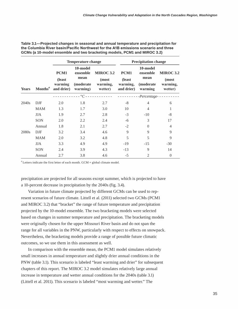
35
Climate Change Vulnerability and Adaptation in the North Cascades Region, Washington
Table 3.1—Projected changes in seasonal and annual temperature and precipitation for the Columbia River basin/Pacific Northwest for the A1B emissions scenario and three GCMs (a 10-model ensemble and two bracketing models, PCM1 and MIROC 3.2)
Temperature change Precipitation change
Years Monthsa
PCM1
(least warming
and drier)
10-model ensemble
mean
(moderate warming)
MIROC 3.2
(most warming, wetter)
PCM1
(least warming, and drier)
10-model ensemble
mean
(moderate warming
MIROC 3.2
(most warming, wetter)
- - - - - - - - - - - - °C - - - - - - - - - - - - - - - - - - - - - -Percentage- - - - - - - - - -
2040s DJF 2.0 1.8 2.7 -8 4 6MAM 1.3 1.7 3.0 10 4 1JJA 1.9 2.7 2.8 -3 -10 -8SON 2.0 2.2 2.4 -6 3 17Annual 1.8 2.1 2.7 -2 0 4
2080s DJF 3.2 3.4 4.6 9 9 9MAM 2.0 3.2 4.8 5 5 9JJA 3.3 4.9 4.9 -19 -15 -30SON 2.4 3.9 4.3 -13 9 14Annual 2.7 3.8 4.6 -5 2 0
a Letters indicate the first letter of each month. GCM = global climate model.
precipitation are projected for all seasons except summer, which is projected to have a 10-percent decrease in precipitation by the 2040s (fig. 3.4).
Variation in future climate projected by different GCMs can be used to rep-resent scenarios of future climate. Littell et al. (2011) selected two GCMs (PCM1 and MIROC 3.2) that “bracket” the range of future temperature and precipitation projected by the 10-model ensemble. The two bracketing models were selected based on changes in summer temperature and precipitation. The bracketing models were originally chosen for the upper Missouri River basin and do not span the range for all variables in the PNW, particularly with respect to effects on snowpack. Nevertheless, the bracketing models provide a range of possible future climatic outcomes, so we use them in this assessment as well.
In comparison with the ensemble mean, the PCM1 model simulates relatively small increases in annual temperature and slightly drier annual conditions in the PNW (table 3.1). This scenario is labeled “least warming and drier” for subsequent chapters of this report. The MIROC 3.2 model simulates relatively large annual increase in temperature and wetter annual conditions for the 2040s (table 3.1) (Littell et al. 2011). This scenario is labeled “most warming and wetter.” The

36
general technical report pnw-gtr-892
Figure 3.4—Range of projected changes in precipitation (relative to 1970–1999) for the Columbia River basin/Pacific Northwest for the 2040s (top) and 2080s (bottom) for each season (letters indicate first letter of the month). In each box-and-whisker trio, the leftmost is for emissions scenario B1, center for A1B, and right for A2; circles are individual model values. Box-and-whisker plots indicate 10th and 90th percentiles (whiskers), 75th percentiles (box ends), and median (solid middle bar) for each season and scenario. White bars indicate mean of deltas for global climate models. (Data source: Littell et al. 2011.)

37
Climate Change Vulnerability and Adaptation in the North Cascades Region, Washington
ensemble mean for annual temperature and precipitation falls within the range of bracketing models (table 3.1) and is labeled “moderate warming.” These scenario labels are based on annual means for the 2040s; some seasonal means of precipita-tion (e.g., winter temperature) do not follow this pattern (table 3.1). For example, despite being a drier annual scenario, PCM1 projects a larger increase in spring (March, April, May) precipitation relative to the ensemble mean or MIROC 3.2. Furthermore, relative differences between the two bracketing models and the ensemble mean differ for projections for the 2080s.
These three scenarios (PCM 1, MIROC 3.2, and the ensemble mean) of changes in temperature and precipitation were downscaled (Littell et al. 2011) and used for hydrologic modeling (Elsner et al. 2010) of additional climatic variables. Regional projections were downscaled to 6-km resolution using a modified delta method, which applies regional changes in temperature and precipitation to historical temperature and precipitation records. This method captures changes in the season-ality and spatial variability in temperature and precipitation, but fine-scale temporal variability is limited to only the variability captured in the historical record. Even at the downscaled resolution of 6 km, individual valleys and mountains within the Cascades cannot be distinguished and thus the influence of microtopography on climate is not represented.
Downscaled climate projections indicate that summer (June-July-August) temperatures are projected to increase throughout the North Cascades with slightly larger increases projected for the eastern Cascades (fig. 3.5). Winter precipitation (October through March) is projected to increase throughout much of the North Cascades with the magnitude of increases varying by GCM (fig. 3.6); the largest increases are projected for the northern and eastern portions of the region.
Elsner et al. (2010) used downscaled climate data as inputs to a macroscale hydrologic model, the Variable Infiltration Capacity (VIC) model, which simulates several hydrologic variables that are relevant to ecological processes such as snow-pack, soil moisture, and water balance deficit. Projections for these variables are presented in subsequent chapters on hydrology (chapter 4) and vegetation (chapter 5) in which their relevance to adapting resource management to climate change is discussed. We focus on projections of these variables for the 2040s because for that timeframe, climate is markedly different in most projections from the current climate, but it is not far enough into the future that uncertainty associated with emissions scenarios is greater than uncertainty associated with changes in regional climate.
We drew from the large database of hydrologic scenarios for the Columbia River basin (Hamlet et al. 2010) for projected changes in streamflow used in the
Summer temperatures and winter precipitation are projected to increase throughout the North Cascades.

38
general technical report pnw-gtr-892
Figure 3.5—Historical and future projections of summer temperature (June, July, and August) in the North Cascades. Projections were made using the A1B emissions scenario and three model configu-rations: an ensemble of 10 GCMs and two bracketing GCMs (one projecting less annual warming and drier conditions [PCM1], and the other projecting more annual warming and wetter conditions than the ensemble mean [MIROC 3.2]) for the 2040s.

39
Climate Change Vulnerability and Adaptation in the North Cascades Region, Washington
vulnerability assessment of hydrology and access (chapter 4) and fish (chapter 7). The methods used to develop downscaled climate data and hydrologic model simu-lations are similar to methods described above. However, these projections were developed specifically for water resources planning in the Columbia River basin, so we use them in this assessment for projected changes in flood magnitude and low streamflow during the dry season. Hamlet et al. (2010) used a 10-model ensemble mean but did not use bracketing models. We include projections of these hydrologic variables for the 2080s, as well as the 2040s, because vulnerability assessments and adaptation planning for roads and infrastructure may benefit from this longer term perspective.
Figure 3.6—Historical and future projections of winter precipitation (October through March) in the North Cascades. Projections were made using the A1B emissions scenario and three model configu-rations: an ensemble of 10 GCMs and two bracketing GCMs (one projecting less annual warming and drier conditions [PCM1], and the other projecting more annual warming and wetter conditions than the ensemble mean [MIROC 3.2]) for the 2040s.

40
general technical report pnw-gtr-892
Uncertainty in Future Climate ProjectionsThe GCMs are a balance between the minimum complexity necessary to character-ize variability in global and regional climate and sufficient complexity to represent climate dynamics at fine spatial and temporal scales. Some aspects of climate and its drivers are less well understood than others (e.g., the role of atmospheric aero-sols), thus climate models are uncertain. Each GCM has its own particular param-eters that control climate dynamics, which may be slightly or substantially different than another model, although both may characterize historical climate well but for different reasons.
Climate is dynamic and complex, so a certain forecast for a future 30-year period cannot be achieved, particularly not at a fine spatial scale (smaller than 10 km). Dynamics, which the climate modeling community can forecast reason-ably well, provide 6 to 12 months of predictive capability. Climate forcings (e.g., anthropogenic GHGs), which the climate modeling community also forecasts well, provide reasonable averages for 30-year periods. Between annual time scales and 30-year future averages, variability is caused by climate dynamics and forcings, which interact in complex ways that are difficult to capture with climate modeling. The uncertainty and limitations of GCMs are unlikely to be resolved soon, so it is not feasible to wait for better models before moving ahead with adaptation. How-ever, we currently have sufficient certainty, knowledge, and data for some aspects of future climate to move ahead with adaptation.
Uncertainty does not apply equally to all variables, and a recognition of which variables are more certain than others is useful for adaptation planning (Peterson et al. 2011). Projections of temperature are more certain than other variables, and projections of means are more certain than extremes. The relative rate and magni-tude of changes in temperature are similar at local scales (e.g., a 6-km pixel within a watershed); for example, a given temperature normal is unlikely to increase 2 °C at Stehekin, Washington, but 10 °C at Leavenworth, Washington. However, the effects of changes in temperature on processes involving thresholds, such as rain versus snow for snowpack development, streamflow, or water balance deficit, require more local information on climate, soils, and vegetation. The capability to understand changes in these variables is better with downscaled climate projections than with regional models alone, but even statistical downscaling does not resolve some changes. For example, projections with regional climate models (dynamical weather forecasting models driven by output from GCMs) show that some areas (mid eleva-tions) are likely to warm faster than the regional average because of local feedbacks (e.g., changes in snow albedo that increase the rate of spring warming).

41
Climate Change Vulnerability and Adaptation in the North Cascades Region, Washington
There are two additional sources of uncertainty external to climate modeling and downscaling that are important considerations for vulnerability assessments and adaptation planning: the sensitivity of the climate system to increases in GHGs and the future trajectory of GHG emissions. Equilibrium climate sensitivity is the amount of change in mean annual global surface air temperature that would result from a doubling of preindustrial atmospheric carbon dioxide. The true sensitivity is unknown, but Roe and Armour (2011) compared climate sensitivity estimated by three separate approaches to the sensitivity in IPCC AR4/CMIP3 GCMs. Their results suggest that the “worst case” (most warming) commonly available GCM and emissions scenario combination is not actually the worst plausible, but the “best case” (least warming) scenarios in the IPCC AR4/CMIP3 are close to the lowest climate sensitivity supported by observations and modeling.
Future emissions could possibly be more or less than the range of emissions scenarios used to force the IPCC AR4 climate models, although more is perhaps more probable than less given recent research and documented emissions (Raupach et al. 2007). Trends in GHG emissions since 2006 are near the high end of emis-sions scenarios used to force climate models for the IPCC AR4, but not above all scenarios (Le Quéré et al. 2009, Manning et al. 2010, Raupauch et al. 2007). Uncer-tainties about climate sensitivity and future emissions suggest that planning for the “worst case” in the IPCC AR4 range of modeled futures is not unreasonable and may not even be sufficient to ensure resilience. Thus it is important to incorporate flexibility in management plans to account for uncertainties in climate, even when planning for the worst case future climate scenario.
AcknowledgmentsWe thank colleagues at the University of Washington, Climate Impacts Group for their assistance with climate data and analysis. Jon Riedel provided a helpful review of this chapter.
Literature CitedClimate Impacts Group. [N.d.(a)]. Historic and future projected change in snow
water equivalent (SWE) for Oregon and Washington. http://cses.washington.edu/data/swe30s.shtml. (15 April 2013).
Climate Impacts Group [N.d.(b)]. Regional climate and hydrologic change: internally consistent future climate projections for resource management. http://cses.washington.edu/data/r1r6.shtml. (15 April 2013).
42
general technical report pnw-gtr-892
Elsner, M.M.; Cuo, L.; Voisin, N. [et al.]. 2010. Implications of 21st century climate change for the hydrology of Washington state. Climatic Change. 102: 225–260.
Elsner, M.M.; Littell, J.; Whitely Binder, L., eds. 2009. The Washington climate change impacts assessment: evaluating Washington’s future in a changing climate. Seattle, WA: University of Washington, Joint Institute for the Study of the Atmosphere and Oceans, Center for Science in the Earth System. 402 p. http://cses.washington.edu/db/pdf/wacciareport681.pdf. (15 April 2013).
Hamlet A.F.; Salathé, E.P.; Carrasco, P. 2010. Final report for the Columbia basin climate change scenarios project. Seattle, WA: University of Washington, Center for Science in the Earth System, Joint Institute for the Study of the Atmosphere and Ocean, Climate Impacts Group.
Intergovernmental Panel on Climate Change [IPCC]. 2007. 2.3 Climate sensitivity and feedbacks. In: Pachauri, R.K.; Reisinger, A., eds. Climate change 2007: synthesis report. Contribution of Working Groups I, II and III to the fourth assessment report of the Intergovernmental Panel on Climate Change. Geneva, Switzerland: Intergovernmental Panel on Climate Change.
Le Quéré, C.; Raupach, M.R.; Canadell, J.G. [et al.]. 2009. Trends in the sources and sinks of carbon dioxide. Nature Geosciences. 2: 831–836.
Liang, X.; Wood, E.F.; Lettenmaier, D.P. 1996. Surface soil moisture parameterization of the VIC-2L model: evaluation and modifications. Global and Planetary Change. 13: 195–206.
Littell, J.S.; Elsner, M.M.; Mauger, G.S. [et al.]. 2011. Regional climate and hydrologic change in the northern U.S. Rockies and Pacific Northwest: internally consistent projections of future climate for resource management. Preliminary project report, USDA FS JVA 09-JV-11015600-039. Seattle, WA: University of Washington, Center for Science in the Earth System, Joint Institute for the Study of the Atmosphere and Ocean, Climate Impacts Group. http://cses.washington.edu/picea/USFS/pub/Littell_etal_2010/Littell_etal._2011_Regional_Climatic_And_Hydrologic_Change_USFS_USFWS_JVA_17Apr11.pdf. (15 April 2013).
Manning, M.R.; Edmonds, J.; Emori, S. [et al.]. 2010. Misrepresentation of the IPCC CO2 emission scenarios. Nature Geoscience. 3: 376–377.

43
Climate Change Vulnerability and Adaptation in the North Cascades Region, Washington
Mauger, G. 2011. Summaries of 30 arc-second (~800m) snow products generated using the variable infiltration capacity (VIC) macroscale hydrologic model. [Database]. Seattle, WA: University of Washington, Center for Science in the Earth System, Joint Institute for the Study of the Atmosphere and Ocean, Climate Impacts Group. http://cses.washington.edu/picea/mauger/VIC_SNOW/pub. (15 April 2013).
Meehl,G.;Covey,C.;Delworth,T.[etal.].2007. The WCRP CMIP3 multi-model dataset: a new era in climate change research. Bulletin of the American Meteorological Society. 88: 1383–1394.
Menne, M.J.; Williams, C.N.; Vose, R.S. 2009. The United States Historical Climatology Network monthly temperature data, version 2. Bulletin of the American Meteorological Society. 90: 993–1107.
Mote, P.W. 2003. Trends in temperature and precipitation in the Pacific Northwest during the twentieth century. Northwest Science. 77: 271–282.
Mote, P.W.; Hamlet, A.F.; Clark, M.P.; Lettenmaier, D.P. 2005. Declining mountain snowpack in western North America. Bulletin of the American Meteorological Society. 86: 39–49.
Mote, P.W.; Hamlet, A.F.; Salathé, E.P. 2008. Has spring snowpack declined in the Washington Cascades? Hydrology and Earth System Science. 12: 193–206
Mote, P.W.; Salathé, E.P. 2010. Future climate in the Pacific Northwest. Climatic Change. 102: 29–50.
Nakicenovic, N.; Alcamo, J.; Davis, G. [et al.]. 2000. Special report on emissions scenarios, working group III, Intergovernmental Panel on Climate Change. Cambridge, United Kingdom: Cambridge University Press. 595 p.
Peterson, D.L.; Millar, C.I.; Joyce, L.A. [et al]. 2011. Responding to climate change in national forests: a guidebook for developing adaptation options. Gen. Tech. Rep. PNW-GTR-855. Portland, OR: U.S. Department of Agriculture, Forest Service, Pacific Northwest Research Station. 109 p.
Raupach, M.R.; Marland, G.; Ciais, P. [et al.]. 2007. Global and regional drivers of accelerating CO2 emissions. Proceedings of the National Academy of Sciences of the United States of America. 104: 10288–10293.

44
general technical report pnw-gtr-892
Roe, G.H.; Armour, K.C. 2011. How sensitive is climate sensitivity? Geophysical Research Letters. 38: L14708. doi:10.1029/2011GL047913.
Roe, G.H.; Baker, M.B. 2007. Why is climate sensitivity so unpredictable? Science. 318: 629–632.
Stott, P.A. 2003. Attribution of regional-scale temperature changes to anthropogenic and natural causes. Geophysical Research Letters. 30: 1728. doi:10.1029/2003GL017324.
U.S. Department of Agriculture, Forest Service [USDA FS]. [N.d.]. Regional climate and hydrological change in the northern US Rockies and Pacific Northwest. http://www.fs.fed.us/wwetac/threat_map/WWide_Climate_Change.html. (15 April 2013).

45
Climate Change Vulnerability and Adaptation in the North Cascades Region, Washington
IntroductionRoads and trails built in the North Cascade Range of Washington over more than a century provided access for mineral prospectors, loggers, hunters, and tourists, bringing them closer to natural resources and recreational opportunities. The national forests and national parks in the North Cascades were created for resource development, protection, and enjoyment by the public. Providing access allowed for these objectives to be met, and access largely determined where these activities historically occurred. Today, reliable and strategic access is critical for people to recreate, extract resources, monitor and manage resources, and respond to emer-gencies. Access to public lands promotes use, stewardship, and appreciation of their value as a vital resource contributing to quality of life (Louter 2006). Access management balances these benefits with a wide range of other ecosystem services.
Climate change is expected to change access to public lands in forests and parks in the North Cascadia Adaptation Partnership (NCAP), which includes North Cascades National Park Complex [NOCA], Mount Rainier National Park [MORA], Mount Baker-Snoqualmie National Forest [MBSNF], and Okanogan-Wenatchee National Forest [OWNF]. Climate change has already affected ecosystems and the built environment in the Pacific Northwest (PNW), and these effects are projected to intensify in future decades. Impaired access to public lands reduces the ability of land managers to preserve, protect, and restore resources and to provide for public use of resources. An understanding of the current vulnerabilities and the pathways through which climate change affects access will enable U.S. Department of the Interior National Park Service (NPS) and U.S. Department of Agriculture Forest Service (USDA FS) land managers to identify and implement adaptation strategies
1 Ronda L. Strauch is a Ph.D. candidate, University of Washington, Department of Civil and Environmental Engineering, Box 352700, Seattle, WA 98195; Alan F. Hamlet is an assistant professor, Department of Civil and Environmental Engineering and Earth Sciences, University of Notre Dame, 257 Fitzpatrick Hall, Notre Dame, IN 46556 (formerly a research assistant professor, University of Washington, Department of Civil and Environ-mental Engineering, Seattle, WA); and Crystal L. Raymond is a climate change strategic advisor, City of Seattle, Seattle City Light, 700 5th Avenue, Seattle, WA 98124 (formerly research biologist, U.S. Department of Agriculture, Forest Service, Pacific Northwest Research Station, Pacific Wildland Fire Sciences Laboratory, Seattle, WA).
Chapter 4: Climate Change, Hydrology, and Access in the North Cascade RangeRonda L. Strauch, Crystal L. Raymond, and Alan F. Hamlet1

46
general technical report pnw-gtr-892
that will maintain functioning ecosystem processes and natural resources in a changing environment, while providing continued and sustainable access for human use.
The NCAP held a workshop on climate change, hydrology, and access that convened more than 40 participants including resource managers, scientists, engineers, and recreation managers. Participants were affiliated with multiple agencies and organizations including NCAP national forests and national parks, USDA FS Pacific Northwest Research Station, University of Washington, Federal Highway Administration, Washington State Department of Transportation, city of Seattle, U.S. Environmental Protection Agency, The Mountaineers, National Parks and Conservation Association, and North Cascades Conservation Council. The workshop had four objectives:
• Identify key sensitivities of roads, trails, and infrastructure to changes in climate and hydrology.
• Review current access and travel management priorities and share manage-ment approaches that already consider climate or climate change.
• Use the latest scientific information on climate change and effects on hydrologic regimes to identify adaptation strategies and tactics.
• Identify opportunities to collaborate with partners to develop adaptation strategies and tactics that cross jurisdictional boundaries.
During the workshop, participants reviewed the latest science on the effects of climate change on snowpack and hydrology in the North Cascades. Box 4.1 describes sources of climate data and vulnerability assessments relevant to hydrol-ogy and access in the PNW, many of which were reviewed during the workshop. Engineers, resource managers, and scientists from each national forest and national park presented information on current practices for transportation and access man-agement (roads, trails, and facilities) in their unit, as well as case studies of flooding vulnerabilities and recent severe flood damage (particularly in MORA in 2006 and MBSNF in 2003 and 2006). Workshop participants worked collaboratively to iden-tify adaptation options to reduce vulnerability to climate change and facilitate the transition to new states. The initial vulnerabilities and associated adaptation options identified in the workshop were refined with further literature review, data, and discussions with scientists and resource managers. The results of this vulnerability assessment and adaptation planning process are described in the sections below.

47
Climate Change Vulnerability and Adaptation in the North Cascades Region, Washington
Box 4.1—Publications relevant to climate change effects and adaptation options for hydrologic regimes and access in the Pacific Northwest
Over the past decade, several publications have discussed vulnerability and adaptation to climate change and many are relevant to access in the Pacific Northwest (box-table 4.1): an assessment of projected changes in cli-mate in Washington (Elsner et al. 2009), current and anticipated impacts on transportation (Halofsky et al. 2011, MacArthur et al. 2012, WSDOT 2011), and adaptation planning guides (Peterson et al. 2011, Snover et al. 2007). These resources discuss climate change impacts on hydrologic regimes, roads, and access in greater detail and provide examples, approaches, and agency priorities.
Climate change vulnerability and adaptation reports with information relevant to hydrologic regimes and access in the Pacific Northwest (PNW)
Title Citation Description
Washington climate change impacts assessment
Elsner et al. (2009) Assessment of climate change impacts to eight sectors in Washington state
Comprehensive hydrologic database incorporating Intergovernmental Panel on Climate Change (IPCC) scenarios to support long-range water planning in the Columbia River basin
Hamlet et al. (2013) Most current simulated hydrologic data and report for PNW, incorporating IPCC’s fourth assessment report emis-sion scenarios
Preparing for climate change: a guidebook for local, regional, and state governments
Snover et al. (2007) Guidebook for agencies to develop a climate change preparedness plan
Responding to climate change in national forests: a guidebook for developing adapta-tion options
Peterson et al. (2011) Guidebook for developing adaptation options for Forest Service lands
National roadmap for responding to climate change
USDA FS (2011a) Plan describing Forest Service priorities for responding to changing climate
National Park Service (NPS) climate change response strategy
USDI NPS (2010a) Provides strategic direction to the agency for addressing impacts of cli-mate change
Climate change, hydrology, and road man-agement at Olympic National Forest and Olympic National Park, chapter 4
Halofsky et al. (2011) Case study on climate change impacts, road management, and adaptation strategies
Potential Impacts of Climate Change on U.S. Transportation
Transportation Research Board (2008)
Synthesis and discussion of consequenc-es of climate change for transportation infrastructure and operations
Climate impacts vulnerability assessment Washington Depart-ment of Transportation (2011)
Test of Federal Highway Administra-tion conceptual climate risk assessment model to transportation in Washington state
Climate change impact assessment for sur-face transportation in PNW and Alaska
MacArthur et al. (2012)
Preliminary vulnerability assessment of surface transportation in PNW and Alaska

48
general technical report pnw-gtr-892
The Current Context for Access in the North Cascades Current Development and Access NeedsThe transportation network in national forests and national parks in the NCAP includes roads, trails, docks, landing fields, and associated facilities. The two national forests and two national parks combined contain about 28 900 km of roads and trails, 98 percent of which are in national forests (table 4.1). The national forests have more kilometers of roads than trails, whereas the national parks have more kilometers of trails than roads. Of the existing roads, 850 km (5 percent) of roads are paved and 17 800 km are gravel. Road density is higher at low elevations and adjacent to major mountain passes, such as the west slopes of Interstate 90 near Snoqualmie Pass and north of Leavenworth on the east side of the Cascade Range (fig. 4.1). Roads and trails cross many streams and rivers because of the rugged topography and wet maritime climate of the western Cascades. Most (96 percent) known water crossings are culverts on the national forests (table 4.1), but many crossings or drainages have not been inventoried. Although most roads are on national forests, visitors often use these roads to access national parks, creating a strong interdependence of the road system (fig. 4.1). Docks and seaplanes provide access to lakes, and lakes and reservoirs are used to transport supplies to the com-munities of Hozomeen and Stehekin. Landing fields and helispots are operated for small planes and helicopters, which are used by visitors, as well as for fire manage-ment and resource monitoring.
Table 4.1—Transportation infrastructure within the boundaries of management units in the North Cascadia Adaptation Partnership (NCAP) region, including roads and trails managed by other jurisdictions
Road Road NCAP administrative unit Roads Trails culvertsa bridgesa
- - - - - - - - - - - Kilometers - - - - - - - - - - -
North Cascades National Park Complex 121 626 190 11Mount Rainier National Park 170 453 739 30Mount Baker-Snoqualmie National Forest 4373 2423 10,382 170Okanogan-Wenatchee National Forest 13 995 6742 11,142 135
a Only culverts and bridges managed by the specified units are included. Data source: U.S. Forest Service, National Park Service, Washington Department of Transportation, and U.S. Federal Highway Administration (2011).
The North Cascade Adaptation Partnership national forests and national parks contain about 28 900 km of roads and trails.

49
Climate Change Vulnerability and Adaptation in the North Cascades Region, Washington
Historically, the primary purpose of the road system in national forests was timber harvest. Reduced harvesting under the Northwest Forest Plan (NWFP) has substantially decreased the need for roads as anticipated in the land and resource management plans (i.e., forest plans) that were written before the NWFP (USDA and USDI 1994a, 1994b). However, population growth has increased demand for access for recreation. For example, recreation demand in the OWNF is now more than double the demand predicted in the 1990 forest plan.2 Hiking and camping
2 Fee, L. 2007. Forest plan revision for the Colville and the Okanogan-Wenatchee national forests. Draft. Available online at: http://www.fs.usda.gov/Internet/FSE_DOCUMENTS/fsbdev3_053376.pdf. (11 November 2012).
Figure 4.1— Distribution of roads and trails within the two national forests and two national parks within the North Cascadia Adaptation Partnership region. The forests and parks cover a contiguous area of over 28 490 km2 (more than 2.4 million ha) and contain approximately 28 900 km of roads and trails. The density of roads is greater at low elevations and within forests, but trails are more common at higher elevations and in parks. Data were acquired from each federal jurisdiction’s geographic information system and includes all categories of roads and trails, except for user-created routes.

50
general technical report pnw-gtr-892
are the most popular activities, but visitors are staying for shorter duration than in the past, often only 1 day. More than 60 percent of trips to national forests last 6 hours or less; short visits concentrate human impacts on areas that are easily acces-sible (USDA FS 2010a). Demand is increasing for trail use by mountain bikes and motorized vehicles and for routes designated for off-highway vehicles, as well as for winter recreation (see footnote 2).
Visitation in all national parks has increased since their establishment and more than 1.8 million visitors traveled to MORA and NOCA in 2011. Fourteen percent of these visits were overnight stays, which is almost three times the national average for all national parks (Cui et al. 2013). Short-duration trips increase demand for easy access and parking, so although the duration of visits is decreasing at MORA and NOCA, these two parks are less affected compared to the national trend. Road building was minimized during park development, so higher visitation has led to traffic congestion, especially at MORA between June and September when 75 percent of visitation occurs (USDI NPS 2001). High seasonal visitation stresses transportation management at MORA. Although all four units maintain some year-round access, many roads and facilities are closed in winter because of snow cover, especially in the two parks because roads are generally at higher elevation.
Road and Trail Types and ConditionsRoads are classified by their designated use and material type. National parks classify roads into six classes by function: principal park road, connector park road, special purpose road, primitive park road, administrative access road, and restricted road. National forests divide roads into six categories (table 4.2). The MBSNF has 4682 km of roads, with most (41 percent) suitable for passenger cars (table 4.2). The OWNF has 13 133 km of roads (excluding decommissioned roads); the majority (68 percent) of roads are suitable for high-clearance cars and trucks or passenger cars.
The national forests and national parks in the NCAP have four major east-west mountain passes: Washington Highway 20 crosses through NOCA, Washington Highways 410 and 123 pass through MORA, Washington Highway 2 passes through the MBSNF at Stevens Pass, and Interstate 90 passes through the MBSNF at Snoqualmie Pass. The first two passes are closed in winter because of snow, and the second two passes are open all year with regular snow and avalanche clearing, providing access to winter ski resorts and corridors for transporting goods and people between the east and west sides of the state.
Access and recreation have a considerable impact on the economy in local communities. In 2011, the 1,038,229 visitors to MORA spent more than $33 million within 100 km of the park (Cui et al. 2013). The 791,388 visitors to NOCA spent

51
Climate Change Vulnerability and Adaptation in the North Cascades Region, Washington
more than $26 million within 100 km of the park complex (Cui et al. 2013), but this is likely an underestimate because many visitors drive through the park on the North Cascade Highway and State Highway 20 without stopping, so they are not counted (Stynes 2011). Access to national forests also provides significant economic benefit to the region. In the past decade, half of visitors live within 80 km, and aver-age visitor spending is $13 billion per year in and near national forests nationwide (USDA FS 2010a).
Climate Change Effects Relevant to AccessChanging Climate in the Pacific NorthwestIn the sections below, we focus on three pathways through which changes in climate and hydrology directly influence access in mountain landscapes: (1) flooding and extreme low flows, (2) changes in snowpack, and (3) elevated winter soil moisture and landslide risk. Although climatic variability is partially predictable based on weather statistics over many years, climate can shift from observed historical patterns to different patterns encountered in only the distant past or potentially entirely new climate regimes (Milly et al. 2008). Projected (i.e., estimated based on models) shifts in temperature and precipitation for the 21st century based on increases in anthropogenic greenhouse gases are presented in chapter 3. Climate change is a global phenomenon, but regional expressions of climate change may differ substantially from global trends because of local factors, particularly over decades (IPCC 2007). Mountain ecosystems are particularly sensitive to climate
Table 4.2—Kilometers of road by maintenance level on national forests in the North Cascadia Adaptation Partnership
Operational maintenance levels Mount Baker- Okanogan- SnoqualmieNational Wenatchee Code Description Forest National Foresta
Kilometers
ML 0 Decommissioned 504 —a
ML 1 Basic custodial care (closed) 835 4259ML 2 High clearance cars/trucks 1434 6370ML 3 Suitable for passenger cars 1706 2042ML 4 Passenger car (moderate comfort) 129 378ML 5 Passenger car (high comfort) 74 84
Total All roads 4682 13 133a Okanogan-Wenatchee National Forest missing information on decommissioned roads.

52
general technical report pnw-gtr-892
change (IPCC 2007), and numerous studies have shown that the PNW is sensi-tive to climate change, and particularly to effects related to loss of snowpack and associated changes in hydrologic response and water temperature (e.g., Abbe et al. 2010, Elsner et al. 2010, Hamlet and Lettenmaier 1999, Mantua et al. 2010, Mote and Salathé 2010. By extension, the mountainous national forests and national parks in the PNW are expected to be sensitive to climate change.
Changes in hydrometeorological variables directly or indirectly affect access. Direct effects are those that physically alter the operation or integrity of transporta-tion facilities. These include effects related to floods, snow, avalanches, landslides, extreme temperatures, and wind. Indirect effects include secondary influences of climate shifts on access, such as reduced water supplies, threats to public safety, and changes in visitor use patterns. For hydrologic extremes such as flooding, the effect on access may appear to be related to weather (e.g., the effects of a single storm) rather than climate, but it is the expansion of future extremes outside the historical range of frequency or intensity that triggers the greatest impacts (e.g., by exceeding current design standards for infrastructure).
Variation in temperature and precipitation ultimately determine the hydrologic behavior of watersheds in the North Cascade Range. Global climate models (GCMs) project future changes in temperature and precipitation (IPCC 2007). The model projections described here use future temperature and precipitation scenarios based on the mean values generated from an ensemble of 10 GCMs and two “bracketing” GCMs based on the A1B greenhouse gas emissions scenario (Nakićenović and Swart 2000) (see chapter 3). The A1B scenario is a medium-high emissions scenario reflecting rapid increases in greenhouse gasses in the early 21st century followed by substantial reductions in emissions in the second half of the 21st century, which slows the rate of warming. In comparison with the ensemble, one bracketing GCM, PCM1, simulates relatively lower annual temperature increases and slightly drier conditions in the PNW for the 2040s. The other bracketing GCM, MIROC 3.2, simulates relatively higher annual temperature increases and wetter conditions (Littell et al. 2011). Based on these projections, PCM1 is a less warm and drier model on an annual basis and MIROC3.2 is a warmer and wetter model compared to the 10-model ensemble over the PNW on an annual basis. Although PCM1 is a cooler model than the ensemble, it projects warmer temperatures than historical annual averages. However, during the cool season (October through March), PCM1 projects the same increase (1.8 °C) in temperature and only slightly drier conditions than the ensemble. The MIROC 3.2 model projects a larger increase in temperature and precipitation by the 2040s compared to the ensemble.
Mountain watersheds are sensitive to loss of snowpack and associated changes in hydrologic response and water temperature.

53
Climate Change Vulnerability and Adaptation in the North Cascades Region, Washington
Projections of temperature and precipitation from these GCMs were applied as monthly changes to meteorological data input into the physically-based Vari-able Infiltration Capacity (VIC) macro-scale hydrologic model (Elsner et al. 2010, Liang et al. 1994). In general, the VIC model acts as a translator between changes in climate and hydrologic effects on riverflows, snowpack, soil moisture, and other ecosystem processes (Elsner et al. 2010, Hamlet et al. 2013, Littell et al 2011, Mote and Salathé 2010). The implementation of the VIC model as used for this assess-ment provides hydrologic information at 1/16th degree resolution (about 5 × 6 km or 30 km2 per grid cell). To provide information at the watershed scale, gridded model output is aggregated up from the native resolution of the hydrologic model to summarize effects for individual watersheds at the 12-digit (6th level) hydrologic unit code (HUC) scale delineated by the U.S. Geological Survey. The snowpack simulations were produced using a special high-resolution version of the VIC model implemented at 800-m resolution.3
Climate Change Effects on Flooding and Extreme Low FlowsClimate change effects in watersheds of the PNW can be broadly characterized by mid-winter temperatures and basin type (Hamlet and Lettenmaier 2007). Rain-dominated basins are above freezing most of the time in winter, and snow accumu-lation is minimal. Rain-dominated basins typically have one peak in streamflows in mid-winter that coincides with peak precipitation. Mixed-rain-and-snow (also sometimes called “transient” or “transitional”) basins are typically found at moder-ate elevations and can collect substantial snowpack in winter (10 to 40 percent of October through March precipitation), but are typically only a few degrees below freezing on average in mid-winter. Mixed-rain-and-snow basins typically have two seasonal streamflow peaks, one in autumn caused by rain, and another in spring caused by snowmelt. Colder basins show a larger peak in spring, warmer basins a larger peak in fall. Snowmelt-dominated basins are relatively cold in winter and capture a relatively large portion (> 40 percent) of their October through March pre-cipitation as snow. Snowmelt-dominated basins typically have relatively low flows in winter and one streamflow peak in spring that coincides with spring snowmelt (Elsner et al. 2010).
In response to warming, shifts from snowmelt-dominant to mixed-rain-and-snow basins, and from mixed-rain-snow to rain-dominant basins are projected by the 2040s in the PNW (Tohver et al. 2013) (fig. 4.2). However, the northern portion
3 Mauger, G. 2011. Meteorological dataset. Unpublished data. Available online at: http://cses.washington.edu/picea/mauger/VIC_SNOW/pub/. (30 October 2012).

54
general technical report pnw-gtr-892
of the North Cascades will retain some snow-dominant basins that may create a refuge of habitat and hydrologic processes in the PNW. In comparison, rain-dom-inant basins at lower elevation are projected to have little change in the timing of streamflow, and monthly hydrographs will likely remain similar to those simulated for historical conditions (Elsner et al. 2010, MacArthur et al. 2012). Mixed-rain-and-snow basins, by comparison, are expected to experience large shifts in the timing of high flows from late spring or early summer snowmelt events to late autumn and early winter peak flows (Elsner et al. 2010). The coldest snowmelt-dominated basins (at the highest elevations in the North Cascades [fig. 4.3]) are expected to continue to experience peak flows in spring, but with smaller and earlier peak flows by the 2040s.
Flooding regimes in the PNW are sensitive to precipitation intensity, tempera-ture effects on freezing elevation (which determines whether precipitation falls as rain or snow), and the effects of temperature and precipitation change on seasonal
Figure 4.2—Projected shift in watershed basin type in the Pacific Northwest by the 2040s (2030–2059). Basins represent the spatial resolution of 10-digit hydrologic unit codes (HUCs), or the 5th-level watershed classification as delineated by the U.S. Geological Survey. Basin types are defined by the ratio of April 1 snow water equivalent (SWE) to cool season (October through March) precipitation, which represents most precipitation falling as snow or rain. Future projections were modeled using the A1B emission scenario and three model configurations, an ensemble of 10 GCMs and two bracketing GCMs (one projecting less warming and drier conditions than the ensemble mean [PCM1] and one projecting more warming and wetter conditions than the ensemble mean [MIROC 3.2]). Black box in first plot is zoomed in on figure 4.3.

55
Climate Change Vulnerability and Adaptation in the North Cascades Region, Washington
snow dynamics (Hamlet and Lettenmaier 2007, Tohver 2013). Floods in the PNW typically occur during the autumn and winter because of heavy rainfall (sometimes combined with melting snow) or in spring because of unusually heavy snowpack and rapid snowmelt (Hamlet and Lettenmaier 2007, Sumioka et al. 1998). At small spatial scales, summer thunderstorms can also cause local flooding, such as near Stehekin (USDI NPS 2012a).
Climate models estimate little change in annual precipitation in the PNW when averaged over multiple models, but the seasonality of precipitation is projected to shift towards greater precipitation in autumn, winter, and spring, and less precipita-tion in summer (MacArthur et al. 2012, Mote and Salathé 2010, Salathé et al. 2010). Annual runoff throughout Washington is projected to increase by 2.5 percent by the 2040s, and 6.2 percent by the 2080s compared to the period 1970 to 1999. Cool season (October through March) runoff is projected to increase even more, up to 20 percent by the 2040s and 34 percent by the 2080s (Elsner et al. 2010). Over the
Figure 4.3—Projected shift in watershed basin type in the North Cascades by the 2040s (2030–2059). Description of classification and models same as stated in caption for figure 4.2. SWE = snow water equivalent.

56
general technical report pnw-gtr-892
Western United States, regional climate models simulate statistically significant increases in the intensity of future extreme winter precipitation events (Dominguez et al. 2012). Increased autumn and winter precipitation, coupled with warmer tem-peratures that raise freezing elevations and effectively increase basin area during storms, is projected to increase autumn and winter flood risk in the Cascade Range (Hamlet and Lettenmaier 2007, Mantua et al. 2010, Tohver et al. 2013).
Extreme flooding, defined here as the 100-year flood (the annual peak flow with a 1 percent probability of being exceeded, or Q100), is projected to increase throughout much of the North Cascades. One exception is in the Pasayten Wilder-ness where peak flows are projected to slightly decrease. The highest increases in Q100 are projected for the leeward (sheltered) side of the mountains east of the Cascade crest (fig. 4.4), where Q100 is projected to be more than double historical levels in some watersheds. Higher runoff in the cool season will also likely cause rivers to become more geomorphically dynamic by creating or enlarging channels, eroding once stable banks, widening flood plains, and generating additional sedi-ment and debris that can fill channels and cause water level to rise. Box 4.2
Figure 4.4—Changing trend in the 100-year flood statistic in watersheds of the North Cascades (at the 12-digit, 6th-level hydrologic unit code watershed scale delineated by the U.S. Geological Survey). Flood level is designated as the annual peak flow with an estimated 100-year return frequency (Q100). The flood statistic represents the ratio of Q100 in 2020s, 2040s, and 2080s to historical (1916–2006) Q100. Ratios greater than 1 indicate increasing peak flows in the future. Ratios less than 1 indicate decreasing peak flows.
Extreme flooding is projected to increase throughout much of the North Cascades.

57
Climate Change Vulnerability and Adaptation in the North Cascades Region, Washington
summarizes projected regional trends in flooding with climate change. These effects may be exacerbated by projected increases in winter soil moisture, which reduce infiltration capacity of the soil and increase runoff.
Flooding can be exacerbated by rain-on-snow (ROS) events, which are contin-gent on the magnitude of precipitation, elevation of the freezing line, and existing snowpack when storms happen (McCabe et al. 2007). Warming affects future flood risk from ROS events differently depending on the importance of these events as a driver of flooding in different basins under the current climate. On the west slopes of the Cascades, for example, the elevation of the freezing line in winter is a key factor. As temperatures warm, the ROS zone will likely move up in eleva-tion. This upward shift in the ROS zone will tend to strongly increase flooding in basins where the current ROS zone is low in the basin with a large snow collection area above because of the effectively expanded drainage area. Increases in winter precipitation exacerbate these effects.
In contrast, in basins in which the ROS zone is higher in the basin, the upward shift in the ROS zone will only modestly increase the contributing basin area, and flooding will increase less severely and primarily because of increases in winter precipitation (Hamlet and Lettenmaier 2007, Tohver et al. 2013). Another important factor is the area of the rain-on-snow zone. As the ROS zone moves to higher elevation, the zone itself shrinks in size, reducing its potential contribution to runoff production. Finally, the probability of ROS events occurring is expected to decrease
Box 4.2—Summary of projected trends in flooding with climate change• The Pacific Northwest is projected to have an increase in flood frequency
throughout the region.• Increased flood frequency will differ by season, but autumn is projected to
experience the largest increase in frequency.• The timing of peak flows is likely to shift earlier in the water year (October
through September), but these shifts will vary by basin type (e.g., earlier in spring for snow-dominated, spring to autumn for mixed-rain-and-snow, little change for rain-dominated).
• Extreme precipitation events are expected to become more frequent, causing localized extreme floods.
• Warming may alter rain-on-snow contribution to flooding depending on the basin and current location of rain-on-snow zone: reductions where zones are already high in the basin and increases where zones are currently lower in the basin, primarily from the expanded drainage area.

58
general technical report pnw-gtr-892
with warmer temperatures because of decreases in snow occurrence and the length of time that snow is on the ground (McCabe et al. 2007). In summary, the incidence and importance of ROS events as a direct cause of flooding may decline in the future (decreased area of ROS zone and less antecedent snow), but rising freezing lines associated with the ROS zone moving up slope tends to increase flood risk by increasing the contributing basin area during storms.
The trend in extreme low flows, defined here as the lowest annual 7-day aver-age flow with a recurrence interval of 10 years (7Q10), is generally opposite of peak flow projections because of reduced snowpack and warmer and drier summers. The west slopes of the Cascade Range are projected to experience substantial declines in low flows by the 2080s compared to historical levels (fig. 4.5). The 7Q10 values on the east slopes of the Cascade Range do not decrease as much as on the west, and a few watersheds in the northeast are projected to have increased low flows over historical levels, presumably because of enhanced sensitivity to increased precipita-tion. The generally reduced sensitivity of low flows on the east slopes is probably because simulated soil moistures are already at very low levels in late summer for
Figure 4.5—Changing trend in the low-flow statistic in watersheds of the North Cascades. Low flow is designated as the 7-day average flow with a recurrence interval of 10 years (7Q10) expressed as a ratio of 7Q10 in 2020s, 2040s, and 2080s to historical (1916–2006) 7Q10. Ratios greater than 1 indicate increased low flows. Ratios less than 1 indicate decreased low flows (i.e., lower low flows). Roads and trails are also shown. Future projections were modeled using the A1B emission scenario and downscaled climate data derived from 10 global climate models (Hamlet et al. 2013).

59
Climate Change Vulnerability and Adaptation in the North Cascades Region, Washington
the current climate, so further increases in drought have relatively little effect on baseflows (Hamlet et al. 2013).
Climate Change Effects on Snow CoverOne common measure of snowpack is snow water equivalent (SWE), which represents the liquid water content of the snowpack. For temporal and spatial comparisons, SWE on April 1 is commonly used because it corresponds to the date of peak SWE in many areas and is correlated with summer water supply in the PNW. April 1 SWE has declined over the 20th century, although decadal climatic variability also affects SWE on shorter time scales (Hamlet et al. 2005, Mote et al. 2008). In near-coastal areas, SWE is more sensitive to warming in winter and spring, whereas SWE in inland areas is more sensitive to precipitation in winter and warming in spring (Hamlet et al. 2005). Snowpack in the North Cascades was modeled at a resolution of 30 arc-seconds of latitude and longitude (about 800 m), a finer resolution than other hydroclimatic variables discussed in this chapter (see footnote 2). Finer resolution allows for more detailed projections of snow across a topographically complex landscape that are useful for comparing spatial patterns of snow with locations of roads and trails.
These fine-scale projections of April 1 SWE indicate substantial decreases by the 2040s compared to historical levels (fig. 4.6). These projections are supported by other studies that report average reductions in April 1 SWE of 46 percent by the 2040s in Washington (Elsner et al. 2010). Reductions in SWE are largest in warmer areas west of the Cascade crest and at low elevations in eastern Washington. Higher elevations will continue to retain snow cover in early summer. Approximately a third of the NCAP area is projected to experience little (±10 percent) change from historical patterns and these areas have a mean elevation of 1740 m, but extend as low as 671 m. The northeast corner of the area (Pasayten Wilderness) may experi-ence slight increases in April 1 SWE because of persistent cold temperatures and increasing precipitation. The date when 90 percent of winter snow melts is pro-jected to be earlier than historical dates, particularly west of the Cascade crest and at the lowest elevations (fig. 4.7). Differences between east and west slopes of the Cascades reflect the influence of a warmer maritime climate to the west and a more continental climate to the east.
Effects of Changing Soil Moisture and LandslidesLandslides, which are the movement of a mass of rock, earth, or debris down a slope (Cruden 1991), are a product of their environment and they also influence the environment (Crozier 1986). Antecedent rainfall or snowmelt (reflecting soil
Projected reductions in snow water equivalent are largest west of the Cascade crest and at low elevations in eastern Washington.

60
general technical report pnw-gtr-892
Figure 4.6—April 1 SWE in the North Cascades in the 2040s (2030–2059) shown as a percentage change from historical levels (1916–2006), calculated as ([future - historical] / historical) × 100. Percentage change indicates the difference between future projections and historical levels. Future projections were modeled using the A1B emission scenario and three model configurations, an ensemble of 10 GCMs and two bracketing GCMs (one projecting less warming and drier conditions than the ensemble mean [PCM1] and one projecting more warming and wetter conditions than the ensemble mean [MIROC 3.2]). Data are resolved at 30 arc-sec (about 800 m) resolution (see footnote 3).

61
Climate Change Vulnerability and Adaptation in the North Cascades Region, Washington
moisture), ground-water, and ground movement rates are controls of landslides. Heavy winter rainfall and excess ground-water increase landslides (Brooks et al. 2004, Crozier 2010, Moore et al. 2010). Water in soil reduces soil shear strength, and increases shear stress, leading to slippage if the shear stress in the soil exceeds the shear strength. Most landslides, including debris flows and torrents, are initiated during intense rain events or during less intense events preceded by persistent rain over a prolonged period (high antecedent soil moisture), rapid snow or ice melt, or low evaporation conditions that increases soil moisture (Baum et al. 1998, Brooks et al. 2004, Crozier 1986).
Figure 4.7—Average change in date at which 90 percent of the snow water equivalent is melted for the 2040s (2030–2059) compared to historical dates (1916–2006). Change indicates the difference in number of days between future projections and historical levels. Future projections were modeled using the A1B emission scenario and three model configurations, an ensemble of 10 GCMs and two bracketing GCMs (one projecting less warming and drier conditions than the ensemble mean [PCM1] and one projecting more warming and wetter conditions than the ensemble mean [MIROC 3.2]). Data are resolved at 30 arc-sec (about 800 m) resolution. (see footnote 3).

62
general technical report pnw-gtr-892
Most landslides in the PNW occur during the rainy season between October and May (Baum et al. 2007), and hundreds of slides may occur in the region during an intense storm (Chatwin et al. 1994). For example, the Washington Department of Natural Resources (WDNR) documented more than 500 slides from a January 2009 storm event (WDNR 2012). In Washington, landslides are more common in areas where average December precipitation is higher than 15 cm, which is primarily west of the Cascade crest (MacArthur et al. 2012), although landslides are common in the southeastern part of the NCAP area as well (fig. 4.8). The steep topography
Figure 4.8—Inventoried historical landslides (i.e., mass wasting events) in the North Cascades, 1940–2005. Inventoried landslides include block fall or topple, debris flow, debris slide or avalanche, deep-seated, hyperconcentrated flow, shallow undifferentiated, and unknown type. (Data from the State of Washington, Department of Natural Resources; Mount Rainier National Park; and North Cascades National Park Complex.)

63
Climate Change Vulnerability and Adaptation in the North Cascades Region, Washington
and intense precipitation, especially in winter, make the PNW particularly suscep-tible to slope stability failures and landslides. Landslides also occur frequently after rapid snowmelt, particularly ROS events in the transient snow zone (Harp et al. 1997, Wu and Merry 1990).
Landslides can increase the resistance of the slope to future slides in the imme-diate area by removing material vulnerable to sliding (Glade and Crozier 2005, Schuster and Highland 2003). However, many landslides occur in approximately the same areas and with the same relative abundance as they did previously (Baum et al. 1998, Crozier 2010). This suggests that mapping previous slide areas is a poten-tially useful tool for predicting future risks. More than 6,500 historical landslides within the NCAP region have been mapped (fig. 4.8).
Landslides have long been a phenomenon in western Washington, including in recent years (Baum et al. 1998, Sarikhan et al. 2008), and projected changes in soil moisture and precipitation form and intensity with climate change may expand landslides in the PNW. Recent slides have closed roads and trails for months, years, or indefinitely, costing millions of dollars for cleanup and repair. Climate projec-tions indicate that the conditions that trigger landslides will increase because (1) more precipitation will fall as rain rather than snow, and (2) more winter precipita-tion will occur in intense storms. These effects will likely differ with elevation because higher elevation areas typically have steeper slopes and more precipitation during storms. Furthermore, reduced snowpack is expected to increase anteced-ent soil moisture in winter (Hamlet et al. 2013). Increasing trends in April 1 soil moisture have been observed in modeling studies as a result of warming, showing that soil moisture recharge is occurring earlier in spring and is now higher on April 1 than it was prior to 1947 (Hamlet et al. 2007).
Elevated soil moisture (and rapid changes in soil moisture or both) can affect the stability of a slope and are responsible for triggering more landslides than any other factor (Crozier 1986). Antecedent moisture is a good predictor of landslides (Kim et al. 1991), so areas with projected increases in antecedent soil moisture (coupled with more intense winter storms) support the hypothesis of increasing landslide risk. Thus, although VIC does not directly simulate slope stability failures or landslides, projections of December 1 total column soil moisture from VIC can be used as an indicator of landslide risk. Higher December 1 soil moisture is projected for the 2040s throughout the North Cascades but particularly at higher elevations and in the east central area (fig. 4.9), suggesting that these areas may become more vulnerable to landslides in winter. The most intense storms west of the Cascades in the PNW typically arrive in late November or early December.
Conditions that trigger landslides will increase because more precipitation will fall as rain rather than snow.

64
general technical report pnw-gtr-892
Higher soil moisture on December 1 is driven by warmer temperatures in Novem-ber, which increase the amount of precipitation that falls as rain rather than snow causing soil moisture recharge for a longer period in late autumn before significant snow accumulation.
Sensitive Traits of Roads and Trails in the North CascadesTo assess vulnerability of access in the national forests and parks in the NCAP, we began by identifying the changes in climate to which the system will be exposed (see above). Next, we assessed the traits of the transportation system that may be sensitive to projected climate changes (box 4.3). These traits include the location, design, and current condition of road and trail infrastructure, as well as recreation
Figure 4.9—Percentage of change in total soil moisture content on December 1 in the North Cas-cades for the 2040s (2030–2059) compared to historical levels (1916–2006), calculated as ([future/historical] / historical) × 100. Future projections were modeled using the A1B emission scenario and three model configurations, an ensemble of 10 GCMs and two bracketing GCMs (one projecting less warming and drier conditions than the ensemble mean [PCM1] and one projecting more warming and wetter conditions than the ensemble mean [MIROC 3.2]).

65
Climate Change Vulnerability and Adaptation in the North Cascades Region, Washington
use and demand. This vulnerability assessment of access can inform transportation management and long-range planning. The section below describes the sensitive traits of the transportation system in the NCAP area.
Aging InfrastructureMany roads and trails were built decades ago, creating sensitivities in the infra-structure because of age. Many infrastructure components are near the end of their design lifespan. For example, culverts typically have a design lifespan of 25 to 75 years, depending on design and material. Culverts remaining after this time have a higher likelihood of structural failure and are less resilient to high streamflows and bed load movement. Aging infrastructure that continues to deteriorate exacerbates sensitivity. As roads and trails age, their surface and subsurface structure weakens.
Box 4.3—Summary of sensitivities of the U.S. Forest Service and National Park Service transportation system in the North Cascades• Aging and deteriorating infrastructure exacerbates sensitivity to climate
impacts, and outdated designs of existing infrastructure decrease resilience to new threats.
• Inadequate maintenance and inspection (e.g., clearing of debris from cul-verts) with limited funding increases the susceptibility to failures in struc-ture and function.
• Abundant roads and trails built on steep topography are more sensitive to landslides and washouts.
• A substantial portion of the transportation system is at high elevation, which increases exposure to weather extremes and increases the costs of repairs and maintenance.
• Many roads were built across or adjacent to waterways, creating sensitivity to high streamflows, stream migration, and sediment movement.
• Limited road redundancy in primary travel corridors, especially in the national parks, increases the likelihood of operational disruptions from climate-related events.
• Multiple management agencies retain jurisdiction over transportation routes, and different management approaches and priorities may create conflicting objectives.
• Funding constraints, insufficient funds, or both limit the ability of agencies to repair damaged infrastructure or take preemptive actions to create a more robust system.
• Design standards or operational objectives that are unsustainable in a new climate regime may increase the frequency of infrastructure failure in the future.

66
general technical report pnw-gtr-892
Consequently, a less-intense storm can cause more damage than a storm of high intensity would have caused when the infrastructure was relatively new.
Design and Use ConsiderationsAdvanced design of materials, alignment, drainage, and subgrade that are required standards today were generally not available when much of the travel network was built in the North Cascades. Consequently, new or replaced infrastructure is likely to be less sensitive to climate change, especially if climate change is considered in the design. New culverts and bridges are often wider than historical structures to meet hydraulic regulations or current design standards. For example, recent improvements to the ferry landing at Stehekin in the eastern portion of NOCA allow access during rapid fluctuations in lake level caused by extreme rain and snow events (USDI NPS 2010b) because the landing was designed to function within a wider range of hydrologic conditions. Although climate change was not the primary motivation for these design changes, the improvements will likely also reduce climate change vulnerability.
Some travel ways, particularly roads on the national forests, were designed for temporary use, which can make them more susceptible to deterioration or damage with sustained use. Many roads and trails on the forests were originally built for uses other than recreation, such as accessing facilities or natural resources, but in recent decades, recreation has increased trail use. Because of these different intended uses, roads and trails were originally constructed to different standards and the effects of design and use on vegetation and aquatic habitat were considered less than they are today.
A lack of redundancy in a transportation system can cause operational sensitiv-ity when damage disconnects the system. The transportation system within the NCAP area, particularly in national parks, lacks redundancy, increasing its sensi-tivity to climate change. Wilderness designations, which exclude roads, preclude some redundancy, as does the potential for unacceptable impacts to ecosystems. Many roads and trails, especially at high elevation, provide sole access to recreation areas, making the network sensitive to disrupted operation if damaged by storms or landslides. The loss of a segment of trail or road can leave large areas inaccessible for long periods depending on the extent of damage and availability of resources for repair. Thus, tradeoffs exist between redundancy in the transportation system and objectives to limit roads and associated impacts and maintenance costs.
Location and Land UseThe location of roads and trails can increase vulnerability to climate change. Many roads and trails were built on steep slopes because of the rugged topography of the
67
Climate Change Vulnerability and Adaptation in the North Cascades Region, Washington
region, so cut slopes and side-cast material have created landslide hazards. Timber harvesting and its associated road network on national forests have contributed to the sensitivity of existing infrastructure by increasing storm runoff and peak flows that can affect road crossing structures (Croke and Hairsine 2006, Schmidt et al. 2001, Swanston 1971). High-elevation terrain further challenges transportation management because of snow, ice, and glacial outwash. The transportation system in the North Cascades is affected by abundant streams and rivers, near and across which roads and trails were often built, making these locations sensitive to changes in streamflow and stream channels (e.g., channel migration in the floodplain). Most stream crossings have culverts rather than bridges, and culverts are built to lower standards than bridges, making the number of culverts a major factor in sensitivity to increasing flood risk. Many roads and trails were constructed in gently sloped areas next to streams, but this cost-saving design has created sensitivity to flood-ing, channel migration, bank erosion, or shifts in alluvial fans and debris cones. Some roads and trails were constructed in abandoned stream channels (e.g., part of Carbon River Road at MORA and part of Colonial Campground Road at NOCA), which have subsequently become reactivated during floods, causing major damage.
Maintenance and Management of Roads and TrailsManagement of roads and trails (planning, funding, maintenance, response) differs by agency and can affect the overall sensitivity of the transportation system. The management priority of one road or trail segment can affect the function of the con-nected segments, which can be challenging when the segments are under different jurisdictions. Major highways within the North Cascades, built to higher design standards and maintained more frequently, will likely be less sensitive to climate change. For example, the major highways through the NCAP are managed by the Washington Department of Transportation and are vital transportation corridors. Consequently, these highways are built to sustain heavy traffic loads and extreme mountainous climate and are inspected and maintained frequently (WSDOT 2011). For similar reasons, most roads and bridges in the Washington highway system are likely more resilient to climate change than their unpaved counterparts built to lower design standards in the national forests and parks.
A lack of funding can limit options for repairing infrastructure, which can affect the short- and long-term vulnerability of the transportation system. For example, replacing a damaged culvert with an “in-kind” culvert that was undersized for the current streamflow conditions leads to continued sensitivity to both the cur-rent flow regime and projected higher flows. Limited funds because of diminishing timber revenue on national forests in the past 20 years have decreased funding for

68
general technical report pnw-gtr-892
adequate maintenance to sustain the full transportation network. Thus, the MBSNF and OWNF have a backlog of maintenance and upgrades to meet current objectives.
Current and Short-Term Climate Exposures to Access in the North CascadesAssessing the vulnerability of the transportation network to changes in climate requires evaluating projected changes in hydrologic processes and exposure of the transportation system to these processes. The integrity and operation of the trans-portation network in the North Cascades may be affected in several ways (fig. 4.10).
Figure 4.10—Climate-related exposures to access in the North Cascades. These exposures can affect both the operation and integrity of the transportation system over short or long time periods.

69
Climate Change Vulnerability and Adaptation in the North Cascades Region, Washington
When integrating this assessment into agency planning, it may be useful to consider the magnitude of projected changes in climate and system responses in three time-frames: current to short term (less than 10 years), medium term (10 to 30 years), and long term (30 to 100 years) (box 4.4).
Changes in climate have already altered hydrologic regimes in the PNW, including decreased snowpack, higher winter streamflow, earlier spring snowmelt, earlier peak spring streamflow, and lower low streamflow in summer (Hamlet et al. 2007, 2010). Damage to infrastructure is likely to be related primarily to fac-tors such as aging infrastructure and mismatches between existing infrastructure designs and the current climate (which reflects cumulative 20th-century trends). Ongoing changes in climate and hydrologic response in the short term are likely to be a complex mix of natural variability combined with ongoing trends related to climate change. High variability of short-term trends is an expected part of the response of the evolving climate system. Natural climatic variability, in the short-term, may exacerbate, compensate for, or even temporarily reverse expected trends in some hydroclimatic variables. For example, in the last 5 years, a series of unusu-ally cool and wet springs have resulted in high spring snowpack in the Cascades, despite continued expectation of declining spring snowpack trends at longer time scales.
Higher streamflow in winter (October through March), in comparison to historical conditions, increase the risk of flooding and impacts to structures, roads, and trails. Many transportation professionals consider flooding and inundation to be the greatest threat to infrastructure and operations because of the damage that standing and flowing water cause to transportation structures (MacArthur et al. 2012, Walker et al. 2011). Floods also transport logs and sediment that block cul-verts or are deposited on bridge abutments. Isolated intense storms can overwhelm the vegetation and soil water holding capacity and concentrate high-velocity flows into channels that erode soils and remove vegetation. During floods, roads and trails can become preferential paths for floodwaters, reducing operational func-tion and potentially damaging infrastructure not designed to withstand inundation (fig. 4.11). For example, intensified flooding and erosion within the lower Stehekin Valley during the past 15 years has impeded travel by damaging roads and facilities (USDI NPS 2012a).
Glacial recession attributed to warming (Granshaw and Fountain 2006, Pelto and Riedel 2001) has already affected transportation systems in the Cascade Range (Beason and Kennard 2007, Walder and Driedger 1994). Receding glaciers leave behind unconsolidated material in steep terrain, which become mobile with precipi-tation and melt water from glaciers (Huggel 2009). With heavy precipitation, this
Higher streamflow in winter will increase the risk of flooding and impacts to structures, roads, and trails.

70
general technical report pnw-gtr-892
Box 4.4—Exposure of access to climate change in the North Cascades
Current and short-term exposures (less than 10 years)—• Roads and trails are damaged by floods and inundation because of mis-
matches between existing designs and current flow regimes.• Landslides, debris torrents, and sediment and debris movement block access
routes and damage infrastructure.• Traffic is affected by temporary closures to clean and repair damaged roads
and trails.• Frequent repairs and maintenance from damages and disruption incur higher
costs and resource demands.
Medium-term exposures (intensifying or emerging in approximately 10 to 30 years)—• Flood and landslide damage will likely increase in late autumn and early
winter, especially east of the Cascade crest and in mixed-rain-and-snow watersheds.
• Current drainage capacities may become overwhelmed by additional water and debris.
• Increases in surface material erosion are expected.• Backlogged repairs and maintenance needs will grow with increasing
damages.• Demand for travel accommodations, such as easily accessible roads and
trails, is projected to increase, which could increase travel management costs.• Increased road damage will challenge emergency response units, making
emergency planning more difficult.
Long-term exposures (emerging in 30 to 100 years)—• Fall and winter storms are expected to intensify, greatly increasing flood
risk and infrastructure damage and creating a greater need for cool-season repairs.
• Higher streamflows will expand channel migration, potentially beyond recent footprints, causing more bank erosion, debris flows, and wood and sediment transport into streams.
• Lower low streamflows associated with declining snowpack are projected.• Changes in hydrologic response may affect visitation patterns by shifting the
seasonality of use. • Shifts in the seasonality of visitation may cause additional challenges to visi-
tor safety, such as increased use in areas and during seasons prone to floods and avalanches.
• Travel management will be challenged to provide adequate flexibility to respond to uncertainty in impacts to access.

71
Climate Change Vulnerability and Adaptation in the North Cascades Region, Washington
material can transform into debris flows that pull in additional material. Deposi-tion of sediment downstream leads to aggradation (rising of the riverbed level) and avulsion (change in river course) of streams and rivers. These phenomena were observed along the Nisqually River in the southwest part of MORA in the extreme flood of November 2006, for example. In MORA, aggradation has caused sections of rivers held back by levees to be a meter or more above adjacent roads, increas-ing flood risk and damage to roads when levees fail (Abbe et al. 2010, Beason and Kennard 2007).
Erosion, mudflows, and landslides caused by intense and persistent rainfall or flooding have become an increasingly common cause of damage to roads and trails, disrupting operations in the North Cascades (fig. 4.12) (MacArthur et al. 2012). For example, a recent landslide at Ross Lake destroyed private and public facilities and cut off sole access to the Ross Dam powerhouse and dam by covering the Ross Dam haul road (USDI NPS 2012c). An intense storm in November 2006 triggered numerous landslides in MORA and contributed, along with flood damage, to a 6-month closure of the park (fig. 4.12). Regional storms such as this can overwhelm response personnel, prolonging delays in reestablishing access after landslides. Landslide risk also increases with timber harvesting on steep terrain because tree removal decreases root cohesion in the soil and increases soil moisture because of more snow accumulation and less evapotranspiration (Istanbulluoglu et al. 2004, Montgomery et al. 2000, Schmidt et al. 2001).
Figure 4.11—Storm damage in Mount Rainier National Park, November 2006: (A) Highway 123, and (B) the Carbon River Road. Damage to transportation infrastructure can also affect utilities located within the roadway prism.
Mou
nt R
aini
er N
atio
nal P
ark
Mou
nt R
aini
er N
atio
nal P
ark
A B

72
general technical report pnw-gtr-892
Emerging or Intensifying Exposure in the Short TermSeveral exposures to climate change are emerging or may be increasingly expressed in the short term (less than 10 years). Warmer temperatures and increasing precipi-tation have increased flood risk in the Cascades in the last 40 years (Hamlet and Lettenmaier 2007). In the short term, increased flooding of roads and trails will likely continue and possibly even intensify, threatening the structural stability of crossing structures and subgrade material. Observed increases in high flows and
A
Mou
nt R
aini
er N
atio
nal P
ark
Mou
nt B
aker
-Sno
qual
mie
Nat
iona
l For
est
Figure 4.12—(A) Storm-triggered landslide covering Stevens Canyon road in Mount Rainier National Park, November 2006, and (B) slump along White Chuck trail in Mt. Baker-Snoqualmie National Forest damaged during a storm, October 2003. The trail switchbacks through the eroded area.
B
73
Climate Change Vulnerability and Adaptation in the North Cascades Region, Washington
winter soil moisture may also increase the amount of large woody debris delivered to streams, further increasing damage to culverts and bridges, and in some cases making roads impassable or requiring road and facility closures. More intense precipitation can also reduce visibility and increase hazardous conditions. Unpaved roads with limited drainage facilities or minimal maintenance are likely to experi-ence increased surface erosion, requiring additional repairs or grading.
Increasing incidence of more intense precipitation and higher soil moisture in autumn or early winter could increase the risk of landslides. Landslides can also contribute to flooding by diverting water, blocking drainage, and filling chan-nels with debris (Chatwin et al. 1994, Crozier 1986, Schuster and Highland 2003). Culverts filled with landslide debris can cause flooding, damage, or complete destruction of roads and trails (Halofsky et al. 2011). Landslides that connect with waterways or converging drainages can transform into more destructive flows (Baum et al. 2007). Roads themselves also increase landslide risk (Swanson and Dyrness 1975, Swanston 1971). In the Western United States, the development of roads increased the rate of debris avalanche erosion by 25 to 340 times the rate found in forested areas without roads (Swanston 1976), and Chatwin et al. (1994) and Montgomery (1994) showed that the number of landslides is directly correlated with total kilometers of roads in an area. Consequently, areas with high road or trail density and projected increases in soil moisture that already experience frequent landslides may be most vulnerable to increased landslide risks (fig. 4.13).
Short-term exposures to changes in climate are likely to affect safe access in the North Cascades. Damaged or closed roads reduce agency capacity to respond to emergencies or provide detour routes during emergencies. Increased flood risk in autumn could make conditions more hazardous for river recreation. More wildfires (see chapter 5) could reduce safe operation of some roads and require additional emergency response to protect recreationists and communities. For example, the Domke Lake Fire of 2007 threatened to cut off the sole access road to Holden Village in the OWNF. Furthermore, damaged and closed roads can reduce agency capacity to respond to wildfires.
Emerging or Intensifying Exposure in the Medium and Long TermMany of the observed exposures to climate change in the short term are likely to expand in the medium and long term. In the medium term, natural climatic vari-ability may continue to substantially affect outcomes in any given decade, whereas
Areas with high road and trail density may be most vulnerable to increased landslide risks.

74
general technical report pnw-gtr-892
in the long term, the cumulative impacts of climate change may become the domi-nant factor, particularly for temperature-related effects. Although uncertainty and decadal variability are important considerations, a long-term perspective can be useful when planning for climate change, because even as regulation and technol-ogy reduce emissions of greenhouse gases, warming will continue for decades because of the long residence time of some greenhouse gases in the atmosphere and positive climatic feedback mechanisms. Thus, conditions thought to be extreme today may be averages in the future, particularly for temperature-related changes (MacArthur et al. 2012).
Flooding in autumn and early winter is projected to continue to intensify in the medium and long term, particularly in mixed-rain-and-snow basins, but direct ROS events may diminish in importance as a cause of flooding (McCabe et al. 2007). At mid to high elevations, more precipitation falling as rain rather than snow will continue to increase winter streamflow. By the 2080s, peak flows are anticipated to increase substantially in magnitude and frequency, especially east of the Cascade crest (fig. 4.4). Throughout the NCAP area, mixed-rain-and-snow watersheds will
Figure 4.13—An area on the eastern slope of the Cascade Range near Leavenworth, Washington, with more than a 10 percent increase (shown in blue-green) in December 1 total soil moisture projected for the 2040s (2030–2059). This area is shown with known historical landslides. Areas with increases in December 1 total soil moisture may have higher risk of landslides, suggesting locations to prioritize for drainage improvements, rerouting, and road decommissioning. These are also areas where wetter soils may require shifts in trail and road surface and subgrade design and maintenance.

75
Climate Change Vulnerability and Adaptation in the North Cascades Region, Washington
increasingly behave as rain-dominated watersheds (Littell et al. 2011, Tohver et al. 2013). In the long term, higher and more frequent peak flows will likely continue to increase sediment and debris transport within waterways, particularly downstream of receding glaciers (see footnote 3). These elevated peak flows, along with land-slide sediment contributions, will affect stream-crossing structures downstream as well as adjacent structures inundated because of elevated stream channels. Even as crossing structures are replaced with wider and taller structures, shifting channel dynamics caused by changes in flow and sediment may affect lower elevation seg-ments adjacent to crossings, such as bridge approaches.
The risk to roads and trails from projected increases in Q100 is apparent when viewing a single watershed where Q100 is projected to more than double by the 2080s (fig. 4.14). In the Tillicum Creek watershed, many roads were built adjacent to and across streams, contributing to their vulnerability. Areas with high road density, such as near Leavenworth, Washington, and northeast of MORA, may be particularly vulnerable to increasing flood risk and channel migration in the long term.
Projected increases in flooding in autumn and early winter will challenge maintenance and repair operations, and shifts in the timing of peak flows will affect the timing of maintenance and repair of roads and trails. More repairs may be necessary during the cool, wet, and dark time of year in response to damage from autumn flooding and landslides, challenging crews to complete necessary repairs before snowfall. If increased demand for repairs cannot be met, access may be restricted until conditions are more suitable for construction and repairs.
Larger declines in low streamflow in summer in the long term, especially west of the Cascade crest (fig. 4.5), may require increased use of more expensive culverts and bridges designed to balance the management of peak flows with providing low flow channels in fish-bearing streams. Design regulations for aquatic habitat will become more difficult to meet as warming temperatures hinder recovery of cold-water fish populations, although some streams may be buffered by inputs from glacial melt or ground water in the medium term.4
Over the long term, increasing winter precipitation and higher winter soil moisture are expected to increase the risk of landslides in early autumn and winter. Landslide risk may increase more in areas with more tree mortality from fire and insect outbreaks because tree mortality reduces soil root cohesion and decreases
4 Reidel, J.L. 2011. Personal communication. Geologist, National Park Service, North Cascades National Park Complex, 810 Star Route 20, Sedro-Woolley, WA 98284.
Projected increases in flooding will challenge maintenance and repair operations.

76
general technical report pnw-gtr-892
interception and evaporation, further increasing soil moisture (Martin 2006, Mont-gomery et al. 2000, Neary et al. 2005, Schmidt et al. 2001). Thus, soils will likely become more saturated and vulnerable to slippage on steep slopes during the wet season. Although floods and landslides will continue to happen near known hazard areas (e.g., because of high forest road density), they may also happen in new areas (e.g., those areas which are currently covered by deep snowpack in mid-winter) (MacArthur et al. 2012). Thus, more landslides at increasingly higher elevations may be a long-term effect of climate change.
Coinciding exposures in space and time may be particularly detrimental to access. Increases in peak flows and soil moisture in mixed-rain-and-snow basins are likely to create dynamic stream channels and unstable soils that will challenge efforts to maintain infrastructure and facilities in place. For example, a large por-tion of the central region of the OWNF with many roads and trails in mixed-rain-and-snow watersheds is projected to have more than 50 percent increase in peak flows and greater than 10 percent increases in soil moisture by the 2040s (fig. 4.15).
Figure 4.14—Roads and streams in the Tillicum Creek watershed in eastern Washington where the magnitude of the 100-year flood (Q100) is expected to more than double by 2080s. In this 57-km2 watershed there are 77 km of roads and trails and 320 km of streams that intersect at 984 locations, likely requiring numerous stream crossing structures. Many roads are also adjacent to the streams, which may create vulnerabilities to stream migration.

77
Climate Change Vulnerability and Adaptation in the North Cascades Region, Washington
Changes in climate may reduce summer water supply because of reduced snowpack and higher evapotranspiration in summer. In remote areas in the national parks, water is often supplied from local sources rather than brought in from com-mercial water suppliers. For example, the Sunrise visitor center and ranger station in MORA are supplied by water from Frozen Lake, which is fed primarily by melting snow and ice in late spring. Reduced snowpack and warmer temperatures
Figure 4.15—Coinciding exposures in mixed-rain-and-snow watersheds within the North Cascadia Adaptation Partnership administrative units. Exposures include Q100 flows repre-senting more than a 50 percent increase over historical levels and soil moisture increase of more than 10 percent over historical levels by 2040s. Red locations indicate where both these exposures coincide within mixed-rain-and-snow basins.

78
general technical report pnw-gtr-892
will reduce summer water availability, although the effects of warming on glacial melt are uncertain. Demand for these locally sourced water supplies may increase as the snow-free season lengthens, enabling a longer season of visitor use. Changes in the amount and timing of stream runoff could affect lake levels and reservoir operations, affecting docks and ramps used by visitors and for delivery of supplies, particularly in late summer.
Climate change effects on access may create public safety concerns for the USDA FS and NPS. A longer snow-free season may extend visitor use in early spring and late autumn at higher elevations (Rice et al. 2012). Lower snowpack may lead to fewer snow-related road closures for a greater portion of the year, allowing visitors to reach trails and camps earlier in the season. However, warmer tempera-tures and earlier snowmelt may encourage use of trails and roads before they are cleared. Trailheads, which start at lower elevations, may be snow-free earlier, but hazards associated with melting snow bridges, avalanche chutes, or frozen snow-fields in shaded areas may persist at higher elevations along trails. Relatively rapid warming at the end of the 20th century coincided with greater variability in cool season precipitation and increased flooding (Hamlet and Lettenmaier 2007). If this pattern continues, early-season visitors may be exposed to more extreme weather than they have encountered historically, creating potential risks to visitors. In sum-mer, white water rafters may encounter unfavorable conditions from lower stream-flows in late summer (Mickelson 2009) and hazards associated with deposited sediment and woody debris from higher winter flows. Warmer winters may shift river recreation to times of year when risks of extreme weather and flooding are higher. These activities may also increase use of unpaved roads in the wet season, which can increase damage and associated maintenance costs.
Despite the adverse effects of climate change, climate change may also benefit access and transportation operations in the North Cascades over the long term. Lower snow cover will reduce the need for and cost of snow removal. The earlier snow-free date projected for the 2040s (fig. 4.7) suggests that low- and mid-elevation areas will be accessible earlier, especially west of the Cascade crest. Earlier access to roads and trails will create opportunities for earlier seasonal maintenance and recreation (fig. 4.16). Temporary trail bridges installed across rivers may be installed earlier in spring as spring flows decline. A longer snow-free season and warmer temperatures may allow for a longer construction season at higher elevations. Less snow may increase access for summer recreation, but it may reduce opportunities for winter recreation particularly at low and moderate eleva-tions (Joyce et al. 2001, Morris and Walls 2009). The northern portion of the North

79
Climate Change Vulnerability and Adaptation in the North Cascades Region, Washington
Cascades may retain relatively more snow and glaciers than other areas of the PNW, which may create higher localized demand for winter recreation and river rafting in summer over the next several decades (see footnote 3).
The exposures described above are associated with changes in the hydrologic regimes. Additional changes in climate associated with extreme temperatures, wind, and ecological disturbances are also likely to affect transportation and access in the PNW (box 4.5).
Infrastructure and Travel Management in the North CascadesRoad and Trail Operations and MaintenanceMany roads in the North Cascades were not built with the intention that they would be permanent, so they were not constructed to design standards promoting longev-ity. Many culverts were designed to withstand only a 25-year flood. Sections of park roads were not built to original design plans (e.g., for drainage) because of inadequate funding (Louter 2006). The condition of trails differs widely from excel-lent to needing total reconstruction. Substantial repairs are still needed for MBSNF trails damaged in the floods of 2003 and 2006. These events created an estimated
Figure 4.16—National forest areas where snow is projected to melt out at least 3 weeks earlier by the 2040s (red color). Some roads and trails may be partially or completely snow-free weeks earlier than the historical mean (1916–2006), providing earlier access for visitors and maintenance crews.

80
general technical report pnw-gtr-892
$3.5 million maintenance backlog, which limits agency capacity to respond to issues of safety and climate change (USDA FS 2011b). Recreational groups, with whom the national forests and national parks have partnerships, provide volunteer trail crews and advocate for political support and additional funding. Contributions of funding and volunteer time from recreational user groups have offset shortfalls in the agency capacity to maintain infrastructure for recreation.
Travel management on the national forests and national parks in the NCAP is complicated by funding mechanisms, multiple jurisdictions, interdependence, competing demands, steep terrain, abundant streams and lakes, and numerous stakeholders. The Washington Department of Transportation (WSDOT) is respon-sible for operations and maintenance of highways and interstate highways (560 km),
Box 4.5—Nonhydrologic exposures to travel management associated with climate change
Extreme temperatures—
• Extreme high temperatures heat pavement exposed to direct sun, and softened pavement leads to rutting and decreases the life expectancy and integrity of roads (TRB 2008).
• Extreme high temperatures dry the surface of dirt roads causing increased dust, which reduces driver visibility.
• Extreme cold temperatures lead to ice forming on roads and bridges, reduc-ing safety for travelers, but this may be mitigated by increased temperatures.
Wind—
• Wind storms can cause trees to fall across roads and trails, hampering travel, especially when soils are saturated. Projected increases in winter soil mois-ture may increase windthrow risks.
• Wind generates dust and transports smoke, which can disrupt safe travel.
Disturbances—
• Tree mortality caused by increasing fire and insect disturbances (see chapter 5) can have subsequent effects by increasing erosion and landslides.
• Loss of forest cover increases streamflows through loss of evapotranspiration.
• Large woody debris can be transported by wind and landslides into streams, contributing to channel migration or direct damage to stream-crossing structures.
• Fire and smoke reduce the usability of roads and trails, sometimes forcing closures.
• Fires can directly consume infrastructure such as bridges, guardrails, and signs.

81
Climate Change Vulnerability and Adaptation in the North Cascades Region, Washington
but within the federal lands, the USDA FS and NPS are generally responsible for signs, hazard tree removal outside the road prism, vista clearing, and litter removal. Road maintenance in national forests is primarily the responsibility of the USDA FS, but county road maintenance crews maintain some roads. The Federal Highway Administration is also involved with the management, design, and funding of roads within the USDA FS and NPS.
Each national forest develops a road maintenance plan for every fiscal year, primarily based on priorities by operational maintenance level, then by category and priority (USDA FS 2011c). Maintenance of forest roads subject to Highway Safety Act standards receive priority for appropriated capital maintenance, road maintenance, or improvement funds over roads maintained for high clearance vehicles. Activities that are critical to health and safety receive priority in decisions about which roads to repair and maintain, but are balanced with demands for access and protection of aquatic habitat (USDA FS 2011c).
Both national forests lack the capacity to maintain the entire road system because of substantial decrease in timber revenue in recent decades, which previ-ously funded road maintenance (USDA FS 2011b). Maintenance cost varies from $420 to $950 per km.5 Given current and projected funding levels, the forests are balancing benefits of access with costs of maintaining and operating a sustainable transportation system that is safe, affordable, and responsive to public needs, and which causes minimal environmental impact. Management actions being imple-mented to meet these sometimes competing objectives include reducing road main-tenance levels, storm-proofing roads, upgrading drainage structures and stream crossings, reconstructing and upgrading roads, decommissioning roads, converting roads to alternative modes of transportation, and developing more comprehensive access and travel management plans (USDA FS 2011b).
Planning and ProjectsFoundation statements and general management plans (GMP) of the national parks identify laws relevant to travel, such as road building limits and special road or trail designations (USDI NPS 1995, 2001, 2011, 2012b). Transportation is not a specific mandate or goal of the parks, but travel management helps the parks to meet objec-tives such as resource protection, recreation, education, and research. Park-specific GMPs provide direction for long-term transportation planning. For example, one
5 Nashida, F. 2011. Personal communication. Assistant forest engineer, U.S. Department of Agriculture, Forest Service, Mount Baker-Snoqualmie National Forest, 2930 Wetmore Ave, Suite 3A, Everett, WA 98201.
National forests lack the capacity to maintain the road system because of decreased timber revenue.

82
general technical report pnw-gtr-892
goal of the GMP for MORA is to improve management of high-season visitation to avoid adverse impacts on park resources and visitor experiences (USDI NPS 2001). Park-specific GMPs often recommend specific transportation objectives, improvements to access and transportation facilities, and partnerships with regional transportation planning efforts. These plans can also include decision triggers, such as converting roads to trails if substantial flooding occurs and rebuilding is no longer feasible. In addition to GMP, large transportation projects have detailed plan-ning assessments, such as the Nisqually to Paradise road rehabilitation (USDI NPS 2012d), Stehekin River corridor study (USDI NPS 2012a), and Ross Powerhouse slide repairs (USDI NPS 2012c).
The NPS is currently developing a 20-year National Long-Range Transporta-tion Plan that is expected to be completed in 2014 and will be updated at least every 5 years. This plan will address sustainable development and operations with work-ing teams on visitor experience, natural resource stewardship, cultural resource stewardship, climate change, livability, law enforcement and safety, asset manage-ment, and funding and financial sustainability. Long-range transportation planning is legally mandated for all federal land management agencies, and climate change is a required component of this planning process (SAFETEA-LU 2005)
Planning for transportation and access on national forests is included in forest-specific land and resource management plans. The NWFP (USDA and USDI 1994a, 1994b), which amended the forest plans (USDA FS 2012a) of the MBSNF and OWNF, included standards and guidelines that apply to road design and maintenance, with the objective of mitigating impacts to aquatic habitat and federally listed species. For example, new stream crossing structures are required to accommodate at least Q100, including associated bed load and debris (USDA and USDI 1994b). The NWFP requires development and implementation of a transpor-tation management plan for each forest, including provisions to mitigate impacts to aquatic habitat.
The 2001 Road Management Rule (36 CFR 212, 261, and 295) requires national forests to use science-based analysis to identify a minimum road system that is ecologically and fiscally sustainable. Both the MBSNF and OWNF are currently identifying a sustainable road network in accordance with the rule. The goals of the minimum roads analysis are to assess the necessity of existing roads, remove damaged or unnecessary roads, and maintain and improve necessary roads without compromising environmental quality. The minimum roads analysis will have four benefits: (1) increased ability to acquire funding for road improvement and decom-missioning, (2) a framework to set annual maintenance costs, (3) improved ability to

83
Climate Change Vulnerability and Adaptation in the North Cascades Region, Washington
meet agreement terms with regulatory agencies, and (4) increased financial sustain-ability and flexibility. The minimum roads analysis does not include trails or other transportation facilities. Consideration of climate change is not currently a formal part of the analysis.
Similar to national parks, major road projects on the national forests must have assessments in compliance with the National Environmental Policy Act (NEPA) of 1969. Examples of projects on the MBSNF with specific plans include the Suiattle Access and Travel Management Plan (USDA FS 2010b) and Granite Creek Road Decommissioning and Road to Trail Project (USDA FS 2012b) environmental assessments. Decommissioning roads is a process of restoring roads to a more natu-ral state by reestablishing drainage patterns, stabilizing slopes, restoring vegetation, blocking road entrances, installing water bars, removing culverts, removing unsta-ble fills, pulling back road shoulders, scattering slash on roadbeds, and completely eliminating roadbeds (36 CFR 212.5; Road System Management; 23 U.S.C. 101). Major projects, such as revisions of roads and trails or decommissioning, require public involvement and an environmental assessment under NEPA.
Adapting Access Management in a Changing Climate During the NCAP workshop on climate change, hydrology, and access, scientists and resource managers worked collaboratively to identify key vulnerabilities of access management to climatic variability and change and adaptation strategies to reduce adverse effects. The workshop included an overview of adaptation principles and regional examples of agency efforts to adapt transportation planning and management to climate change. Scientists and resource managers identified options for adapting access management, as well as potential barriers, opportunities, and research needs for implementing adaptation.
Workshop participants focused on four key sensitivities of roads, trails, and infrastructure that will challenge management efforts to provide safe access and use for recreation and operations: (1) increased damage associated with higher peak flows and more frequent floods; (2) increased damage associated with landslides, erosion, and saturated soils; (3) decreased water availability with lower summer flows; and (4) changes in visitor use patterns that could lead to higher demand on facilities and public safety concerns. In many cases, climate change exacerbates the current sensitivities of access management in the North Cascades. The spatial vari-ability of projected changes in flood risk, peak flows, soil moisture, and landslides as described above can be used to identify locations with the greatest exposure to these changes.

84
general technical report pnw-gtr-892
Adaptation Options for Higher Peak Flows and Flood RiskRoad and Culvert Design and MaintenanceCurrent road design and management are consistent with adapting to climate change in some ways, but changes will likely be necessary (table 4.3). A “no regrets” strategy for climate change adaptation is to continue to upgrade the aging system of roads and stream crossings as required by the NWFP and the 2001 Road Management Rule. These upgrades will increase resilience of roads and stream crossings to higher peak flows and flood frequency (Littell et al. 2012). Engineers at the MBSNF and OWNF are replacing failing culverts and bridges and discon-necting roads from waterways to mitigate impacts on aquatic ecosystems. Current efforts to inventory roads, culverts, and stream crossings for the minimum roads analysis will provide critical information for identifying future repairs, replace-ments, and upgrades. Having this information a priori will enable managers to better respond to more frequent floods and higher peak flows.
Climate change provides a new context for evaluating current practices to upgrade roads and culverts. Engineers may consider prioritizing upgrades of cul-verts and roads in mixed-rain-and-snow basins (Littell et al. 2012) or using a new method for calculating Q100 for sizing culverts that considers future peak flows (Halofsky et al. 2011). Culverts on non-fish-bearing streams are sized for Q100 plus a factor related to expected debris load during floods, but currently Q100 is calcu-lated with equations based on historical flood statistics that do not consider pro-jected changes in peak flows. Engineers may consider using model projections of future Q100 (e.g., from the VIC hydrologic model) or maps of the spatial variability in future flood risk (fig. 4.4) to identify priority areas for increasing culvert capac-ity above historical values (Halofsky et al. 2011). Crossings for fish-bearing streams on national forest lands use stream simulation design standards and requirements of consultation documents for the U.S. Endangered Species Act, resulting in openings that far exceed capacity for a Q100 flow. These culverts greatly increase capacity and will be more robust to higher peak flows in a changing climate. Where these larger structures are needed to restore aquatic habitat, this design choice is a “no regrets” strategy for improving culvert longevity in a changing climate because the performance is relatively insensitive to increasing high flows.
The MBSNF and OWNF have a large backlog of culverts and road segments in need of repair, replacement, or upgrade even under current hydrologic regimes. Limited funding and staff hinder current efforts to upgrade the system to current standards and policies, so the additional cost of upgrades to accommodate future hydrological regimes is a barrier to adaptation. However, extreme floods that
Climate change provides a new context for evaluating current practices to upgrade roads and culverts.

85
Climate Change Vulnerability and Adaptation in the North Cascades Region, Washington
Tabl
e 4.
3—C
limat
e ch
ange
sen
sitiv
ities
of r
oad
desi
gn a
nd m
aint
enan
ce to
incr
easi
ng fl
ood
risk
; ada
ptat
ion
stra
tegi
es a
nd ta
ctic
s to
redu
ce
thes
e se
nsiti
vitie
s
Ada
ptat
ion
tact
ics
Tim
efra
mes
Opp
ortu
nitie
s for
impl
emen
tatio
nB
arri
ers t
o im
plem
enta
tion
Info
rmat
ion
need
s
Sens
itivi
ty: H
ighe
r pea
k fl
ows l
eadi
ng to
incr
ease
d ro
ad d
amag
e at
stre
am c
ross
ings
.
Stra
tegy
: Inc
reas
e re
silie
nce
of st
ream
cro
ssin
gs,
culv
erts
, and
brid
ges t
o hi
gher
pea
k fl
ows.
• Con
tinue
to re
plac
e cu
lver
ts w
ith h
ighe
r cap
acity
cu
lver
ts
• Com
plet
e un
it-w
ide
inve
ntor
y of
cul
vert
s and
br
idge
s, in
clud
ing
GPS
loca
tions
of s
truc
ture
s and
ac
cura
te c
ulve
rt da
ta
• Con
side
r a p
roce
ss fo
r rep
laci
ng c
ulve
rts b
ased
on
proj
ecte
d fu
ture
, rat
her t
han
hist
oric
al, p
eak
flow
s
• Con
side
r prio
ritiz
ing
stru
ctur
e re
plac
emen
t in
high
-ris
k (m
ixed
-rai
n-an
d-sn
ow) w
ater
shed
s
• Rer
oute
road
s out
of f
lood
pla
ins
Opp
ortu
nist
ic,
shor
t ter
mSt
ruct
ure
failu
res a
re a
n op
portu
nity
to
upgr
ade
stre
am c
ross
ings
.
Col
lect
GPS
loca
tions
of s
truct
ures
as
proj
ects
are
com
plet
ed
Lim
ited
fund
ing
Cur
rent
bac
klog
of d
efer
red
mai
nten
ance
and
upg
rade
s to
mee
t cu
rren
t sta
ndar
ds
Larg
e nu
mbe
r of c
ulve
rts a
nd
road
s in
need
of r
epla
cem
ent,
repa
ir, o
r rer
oute
Inco
mpl
ete
culv
ert s
urve
y in
for-
mat
ion
ERFO
lim
itatio
ns o
n re
plac
emen
t of
onl
y cu
rren
t stru
ctur
es
Cen
traliz
ed a
nd st
anda
rdiz
ed
data
base
of p
roje
cts a
nd
upgr
ades
Emer
genc
y R
elie
f for
Fed
er-
ally
Ow
ned
Roa
ds (E
RFO
) ju
stifi
catio
ns fo
r bet
term
ents
Met
hod
for r
anki
ng c
ulve
rts
for r
epla
cem
ent
Alte
rnat
ive
met
hods
for
mod
elin
g ch
ange
s in
futu
re
peak
flow
s
Stra
tegy
: Inc
reas
e re
sist
ance
of r
oad
surf
aces
to
high
er p
eak
flow
s at s
tream
cro
ssin
gs.
• Ins
tall
hard
ened
stre
am c
ross
ings
• Per
form
a b
asin
wid
e as
sess
men
t of c
urre
nt
hydr
olog
ical
inte
ract
ions
with
road
s
• Con
tinue
to u
se g
rade
con
trol s
truc
ture
s, hu
mps
, an
d w
ater
bar
s to
redu
ce v
eloc
ity a
nd re
dire
ct f
low
Shor
t ter
mO
ngoi
ng m
aint
enan
ce, r
epai
r, an
d re
-pl
acem
ent p
roje
cts a
fter fl
ood
even
tsER
FO ju
stifi
catio
ns fo
r be
tterm
ents
Mon
itorin
g to
ass
ess p
erfo
r-m
ance
and
effe
cts o
n hy
dro-
logi
c re
spon
se a
nd a
quat
ic
habi
tat
Effe
cts o
f har
dene
d cr
ossi
ngs
on d
rain
age
path
s and
aqu
atic
re
sour
ces
Stra
tegy
: Fac
ilita
te th
e re
spon
se to
hig
her p
eak
flow
s by
redu
cing
the
road
syst
em a
nd th
us f
lood
ing
of
road
s and
stre
am c
ross
ings
.
• Con
tinue
to d
ecom
mis
sion
road
s with
hig
h ris
k an
d lo
w a
cces
s
• Con
vert
use
to o
ther
mod
es o
f tra
nspo
rtat
ion
(e.g
., fr
om v
ehic
le to
bic
ycle
or f
oot)
• Cha
nge
user
exp
ecta
tions
with
pub
lic e
duca
tion
Opp
ortu
nist
ic,
long
term
Partn
ersh
ips a
nd c
olla
bora
tion
with
ot
her a
genc
ies t
hat a
re a
lso
disc
onne
ct-
ing
road
s fro
m w
ater
way
s
Cur
rent
pla
nnin
g pr
oces
ses:
long
-ran
ge
trans
porta
tion
plan
ning
, tra
vel m
anag
e-m
ent p
lans
, gen
eral
man
agem
ent p
lans
, an
d la
nd a
nd re
sour
ce p
lans
Hig
h co
st o
f dec
omm
issi
onin
g ro
ads
Publ
ic a
nd p
oliti
cal o
ppos
ition
to
road
clo
sure
s and
loss
of a
cces
s
86
general technical report pnw-gtr-892
damage roads and culverts can be opportunities to replace existing structures with ones that are more resilient to higher peak flows. These replacements, called “bet-terments,” can be difficult to fund under current Emergency Relief for Federally Owned Roads (ERFO) program eligibility requirements when used to fix damage from extreme events because the current policy is to only replace in kind. In some cases, matching funds can be raised or betterments can be funded with sufficient justification and documentation of the environmental impacts. Justification for bet-terments based on the latest climate change science would facilitate this approach.
Increasing resilience to higher peak flows will not be possible for all road segments because of limited funding for maintenance and because resilience will become less feasible over time as peak flows continue to increase. Adapting road management to climate change in the long term may require further reductions in the road system for road segments where increasing resilience is not feasible and demand for access is not high. Engineers at the MBSNF and OWNF are reducing the road system by closing, decommissioning, or converting roads to nonvehicular modes of transportation. Road segments that are candidates for decommissioning are typically those with low demand for access, high risks to aquatic habitat, a history of frequent failures, or combinations of the three. Okanogan-Wenatchee National Forest road managers also consider use of roads for fire management (fire suppression, prescribed fire, and hazardous fuel treatments); further reductions in the road system on OWNF may conflict with efforts to manage forest vegetation for increased resilience to climate change (see chapter 5).
Climate change provides a new context for prioritizing roads for decommis-sioning and closure. Engineers may consider emphasizing roads for decommission-ing that are in basins with higher risk of increased flooding and peak flows (figs. 4.3 and 4.4), in flood plains of large rivers, or on adjacent low terraces. Information on locations in the transportation system that currently experience frequent flood damage (box 4.6) can be combined with spatially explicit data on projected changes in flood risk and current infrastructure condition to provide indicators of where damage is most likely to continue and escalate with changes in climate. Optimiza-tion approaches (e.g., linear programming) can be used to balance these multiple, competing objectives and constraints while minimizing the overall costs of the road system.6
Most roads in MORA and NOCA have high demand for access because of the small road network and lack of redundancy, but increasing flood risk may require
6 Strauch, R.; Hamlet, A.F. [N.d.]. Use of linear programming and climate change threats to access in a minimum forest roads analysis in the North Cascades region. On file with: Strauch, R., University of Washington, Civil and Environmental Engineering, Seattle, WA 98195

87
Climate Change Vulnerability and Adaptation in the North Cascades Region, Washington
Box 4.6—Next steps: assessing access vulnerability in the North Cascades
An integrated understanding of climate change exposure and current and expected sensitivities can be used to develop a more quantitative and spatially explicit vulner-ability analysis of the degree to which the transportation system may be affected. One method is to begin by examining the effects observed with past climatic vari-ability, such as locations of “repeat offenders,” segments of the transportation system that have been repeatedly damaged by floods or landslides (see figure). Local land managers have the unique expertise to identify locations of repeat offenders. This information can be combined with the spatial variability of projected changes in cli-mate, snowpack, and hydrologic regimes to develop a quantitative, spatially explicit vulnerability assessment, which can be integrated into other management objectives and used to inform adaptation strategies.

88
general technical report pnw-gtr-892
Tabl
e 4.
4—C
limat
e ch
ange
sen
sitiv
ities
of f
acili
ties,
str
uctu
res,
and
cul
tura
l res
ourc
es to
incr
easi
ng fl
ood
risk
; ada
ptat
ion
stra
tegi
es a
nd ta
ctic
s to
re
duce
thes
e se
nsiti
vitie
s
Ada
ptat
ion
tact
ics
Tim
efra
mes
Opp
ortu
nitie
s for
impl
emen
tatio
n B
arri
ers t
o im
plem
enta
tion
Info
rmat
ion
need
s
Sens
itivi
ty: H
ighe
r pea
k flo
ws l
eadi
ng to
incr
ease
d da
mag
e an
d di
srup
ted
acce
ss to
faci
litie
s and
cul
tura
l and
his
toric
al re
sour
ces.
Stra
tegy
: Inc
reas
e re
sist
ance
of i
nfra
stru
ctur
e an
d cu
ltura
l and
his
toric
al re
sour
ces.
• Sta
biliz
e ba
nks n
ear r
esou
rces
with
rip-
rap
or
vege
tatio
n O
ppor
tuni
stic
, sh
ort t
erm
Rep
air a
nd re
plac
emen
t of p
roje
cts a
fter
flood
eve
nts
Lim
ited
fund
ing
New
des
igns
for s
lope
st
abili
zatio
n• C
onsi
der i
ncre
ased
use
of e
ngin
eere
d lo
gjam
s to
redi
rect
flo
ws
Cur
rent
pla
nnin
g pr
oces
ses:
long
-ran
ge
trans
porta
tion
plan
ning
, Tra
vel M
anag
e-m
ent R
ule,
gen
eral
man
agem
ent p
lans
, la
nd a
nd re
sour
ce m
anag
emen
t pla
ns
Emer
genc
y R
elie
f for
Fed
er-
ally
Ow
ned
Roa
ds re
gula
tions
fo
r rep
laci
ng “
in-k
ind”
vs.
bette
rmen
ts
Mon
itorin
g to
ass
ess p
erfo
rman
ce
and
effe
cts
Map
s of fl
ood
plai
n ch
anne
l m
igra
tion
area
sSt
rate
gy: I
ncre
ase
resi
lienc
e of
the
flood
plai
n.Pu
blic
and
pol
itica
l opp
ositi
on to
ro
ad c
losu
res a
nd lo
ss o
f acc
ess
• Res
tore
nat
ural
func
tion
of th
e fl
oodp
lain
al
low
ing
wat
erw
ays t
o m
igra
teO
ppor
tuni
stic
, lo
ng-te
rm• R
emov
e or
mod
ify
infr
astr
uctu
re a
llow
ing
chan
nels
to m
igra
te w
ithin
the
floo
dpla
in

89
Climate Change Vulnerability and Adaptation in the North Cascades Region, Washington
road closures or changes in use. For example, the Carbon River Road in MORA (fig. 4.11), which is below the current elevation of the river, has been repeatedly damaged by floods and was severely damaged in the flood of November 2006. The road provides sole access to a campground, historic landmark district, and trailhead, yet the high cost to repeatedly repair the road and mitigate impacts to aquatic habitat make it too costly to maintain existing access. Managers worked with recreation groups to develop a plan to convert the road from vehicle use to bike and foot travel. This is an example of a “win-win” adaptation tactic; convert-ing the mode of travel on roads from vehicles to bicycles or foot traffic. Adapting access management to climate change may require more compromises such as this between maintaining access versus high maintenance costs and risks to aquatic habitat and human safety.
Reducing the road system in the national forests and national parks will present both barriers and opportunities (table 4.3). Decommissioning roads or converting roads to trails is expensive and must be done properly to reduce adverse effects on water quality and aquatic habitat. In the case of the Carbon River Road, the road is designated as a National Historic Landmark District, which created an obstacle to changing its use. Furthermore, reductions to the road system are often met with opposition from the public accustomed to using roads for recreational access, but public involvement in road decisions can also be an opportunity to increase aware-ness and develop more “win-win” adaptation options. Thus, one adaptation tactic is to adjust visitation patterns and visitor expectations by actively involving the public in road decisions related to climate change. This has the added benefit of raising political support and funding from external sources to help maintain access. On the other hand, the limited roads for vehicle access in the parks, especially at MORA, may require managers to consider adding new roads and facilities in alternative locations when current access is lost because of infrastructure damage or to accom-modate increased use as population and demand increases. Adding roads or relocat-ing existing roads may require adjustments to wilderness boundaries. Partnerships with recreation groups will be increasingly important for raising public awareness of climate change threats to access and for identifying successful adaptation options.
Facilities, Structures, and Cultural Resources As with roads, the increased risk of flooding with climate change in some basins may require modification to current management of facilities and historical and cultural resources (table 4.4). In addition to higher flood risk, floodplains may expand because of channel aggradation, as has occurred in MORA where several
Decommissioning roads is expensive and must be done properly to reduce adverse effects on water quality and aquatic habitat.

90
general technical report pnw-gtr-892
Tabl
e 4.
5—C
limat
e ch
ange
sen
sitiv
ities
of t
rails
to in
crea
sing
floo
d ris
k; a
dapt
atio
n st
rate
gies
and
tact
ics
to re
duce
thes
e se
nsiti
vitie
s
Ada
ptat
ion
tact
ics
Tim
efra
mes
Opp
ortu
nitie
s for
impl
emen
tatio
nB
arri
ers t
o im
plem
enta
tion
Info
rmat
ion
need
s
Sens
itivi
ty: H
ighe
r pea
k flo
ws a
nd fl
ood
freq
uenc
y m
ay in
crea
se d
amag
e to
trai
ls a
nd b
ridge
s, re
quiri
ng m
ore
mai
nten
ance
, rep
lace
men
ts, o
r clo
sure
s.
Stra
tegy
: Inc
reas
e re
silie
nce
of tr
ail s
yste
m to
hi
gher
pea
k flo
ws b
y re
pairi
ng, r
epla
cing
, and
re-
rout
ing
trails
and
trai
l brid
ges w
ith h
igh
dem
and
for a
cces
s.
• Con
tinue
to u
pgra
de tr
ail b
ridge
s with
st
rong
er ro
t-res
ista
nt m
ater
ials
• Con
tinue
relo
catin
g br
idge
s to
loca
tions
with
st
rong
er p
aren
t mat
eria
l if p
ossi
ble
• Rer
oute
trai
ls a
bove
wat
erw
ays w
ith h
ighe
st
floo
d ris
k• I
ncre
ase
long
-ran
ge p
lann
ing
to p
riorit
ize
trai
l and
brid
ge re
pair,
repl
acem
ent,
and
rero
ute
• Req
uest
add
ition
al fu
ndin
g to
pre
pare
for
mor
e tr
ail a
nd b
ridge
failu
res
• Foc
us o
n ac
quir
ing
fund
ing
for h
igh-
prof
ile
proj
ects
(bas
ed o
n co
-ben
efits
of p
ublic
de
man
d an
d sa
fety
) • C
onsi
der i
ncre
asin
g th
e he
ight
of b
ridge
s ab
ove
wat
erw
ays
• Col
labo
rate
with
hyd
rolo
gist
s to
cons
ider
fu
ture
pea
k fl
ows i
n de
sign
of n
ew tr
ials
and
tr
ial b
ridge
s
Opp
ortu
nist
ic
shor
t ter
m,
long
term
Gra
nts f
or re
pairi
ng d
amag
e to
hig
h-va
lue
trails
Dam
age
to h
igh-
valu
e tra
ils in
crea
ses
oppo
rtuni
ties f
or v
olun
teer
ism
and
pa
rtner
ship
s with
use
r gro
ups
Trai
l fai
lure
s are
an
oppo
rtuni
ty fo
r re
plac
emen
t and
upg
rade
.
Partn
ersh
ips w
ith u
ser g
roup
s can
le
vera
ge fu
ndin
g
Mul
tiage
ncy
coor
dina
tion
thro
ugh
Nor
th C
asca
dia A
dapt
atio
n Pa
rtner
ship
(N
CA
P)
Add
ition
al c
ost o
f rer
outin
g ra
ther
th
an re
build
ing
trails
, stro
nger
ma-
teria
ls fo
r brid
ges a
nd tr
ails
, and
in
crea
sing
the
heig
ht o
f brid
ges
Nat
iona
l Env
ironm
enta
l Pol
icy
Act
co
mpl
ianc
e re
quire
d fo
r rer
outin
g tra
ils
Met
hod
for d
eter
min
ing
high
-ris
k tra
ils a
nd tr
ail b
ridge
s
Met
hod
for m
odel
ing
chan
ges i
n fu
ture
pea
k flo
ws f
or u
se in
brid
ge
loca
tion
and
desi
gn
Pote
ntia
l for
add
ition
al c
limat
e ch
ange
impa
cts t
o tra
il m
aint
enan
ce
such
as w
indt
hrow
Stra
tegy
: Lev
erag
e pa
rtner
ship
s with
recr
eatio
nal
user
gro
ups t
o in
crea
se a
war
enes
s of t
hrea
ts to
ac
cess
and
adj
ust u
ser e
xpec
tatio
ns.
• Im
prov
e ou
treac
h pu
blic
ally
and
inte
rnal
ly• I
ncre
ase
effo
rts t
o co
llabo
rate
with
vo
lunt
eers
and
bui
ld c
apac
ity fo
r tra
il m
aint
enan
ce• C
olla
bora
te w
ith u
ser g
roup
s to
educ
ate
the
publ
ic a
nd in
crea
se p
oliti
cal s
uppo
rt an
d fu
ndin
g to
mai
ntai
n ac
cess
• Coo
rdin
ate
betw
een
agen
cies
for a
con
sist
ent
mes
sage
on
acce
ss a
nd c
limat
e ch
ange
Opp
ortu
nist
ic,
shor
t ter
mC
urre
nt fr
eque
nt c
olla
bora
tion
and
partn
ersh
ips w
ith re
crea
tion
user
gr
oups
Mul
tiage
ncy
coor
dina
tion
thro
ugh
NC
AP

91
Climate Change Vulnerability and Adaptation in the North Cascades Region, Washington
Ada
ptat
ion
tact
ics
Tim
efra
mes
Opp
ortu
nitie
s for
impl
emen
tatio
nB
arri
ers t
o im
plem
enta
tion
Info
rmat
ion
need
s
Stra
tegy
: Red
uce
the
syst
em o
f tra
ils a
nd tr
ail b
ridge
s.
• Aba
ndon
dam
aged
trai
ls w
ith lo
w u
se a
nd
high
flo
od ri
sk• C
ontin
ue to
rero
ute
trai
ls in
loca
tions
that
el
imin
ate
the
need
for t
rail
brid
ges
Opp
ortu
nist
ic,
long
term
Trai
l and
brid
ge fa
ilure
s are
an
oppo
r-tu
nity
to a
band
on o
r rer
oute
trai
lsIn
stitu
tiona
l rel
ucta
nce
to c
lose
tra
ils, e
ven
trails
with
freq
uent
fa
ilure
s
Lim
ited
capa
city
for a
dapt
ive
man
-ag
emen
t
Lim
ited
capa
city
to in
corp
orat
e ne
w
scie
nce
and
mon
itorin
g re
sults
into
lo
ng-te
rm p
lann
ing
Inab
ility
of l
ong-
rang
e pl
anni
ng to
re
spon
d to
shor
t-ter
m n
eeds
Soci
al sc
ienc
e re
sear
ch to
und
er-
stan
d pu
blic
resp
onse
to c
hang
es in
ac
cess
Tabl
e 4.
5—C
limat
e ch
ange
sen
sitiv
ities
of t
rails
to in
crea
sing
floo
d ri
sk; a
dapt
atio
n st
rate
gies
and
tact
ics
to re
duce
thes
e se
nsiti
vitie
s (c
ontin
ued)

92
general technical report pnw-gtr-892
facilities in Longmire, including the emergency operations center and helibase, are threatened by expansion of the Nisqually River floodplain. In most cases, the high cost of relocating buildings and inability to move historic sites from the floodplain will require that adaptation options focus on resistance, preventing flood damage despite increasing risk. Stabilizing banks reduces risk to infrastructure, and using bioengineering rather than rip-rap or other inflexible materials may be a longer term solution that has a lower environmental impact, is more politically acceptable, and is less likely to shift flooding impacts downstream. For example, the NPS is considering increasing the use of engineered logjams in waterways to redirect water away from critical infrastructure. Another tactic for adapting to flood risk is a storm patrol or watch system that identifies threats early, such that rapid response can minimize impacts to life, infrastructure, and moveable property. These approaches would not protect fixed structures, such as buildings, from flooding.
In the long term, protecting infrastructure in place will be more difficult as flood risk continues to increase. Long-term adaptation strategies may require removing (or not rebuilding) infrastructure in the floodplain to allow river chan-nels to migrate and accommodate the changing hydrologic regime within the flood plain. The land and resource management plans of the USDA FS and the general management plans of the NPS are opportunities to implement these long-term adap-tation tactics for the management of facilities and infrastructure because of their long-term planning horizons.
Trail Maintenance and DesignManaging trails in the context of climate change will require increased resilience to higher peak flows and flood frequency (table 4.5). Managers at MBSNF and MORA are currently repairing and replacing trail segments and bridges damaged during the extreme floods of 2003 and 2006. In many cases, current repairs and reroutes of trails and upgrades or elimination of trail bridges are robust actions that will also increase resilience to future hydrologic regimes. For example, trail manag-ers at the MBSNF frequently reroute trails further from streams and rivers and to locations that do not require bridges. Bridges that are replaced are often constructed from more durable and rot-resistant materials, elevated higher above the riverbed, made wider to accommodate expanding flood plains, and located on sites with stronger parent material to prevent future failures. Adapting to climate change may require changes to these practices, such as building trail bridges higher or longer, to accommodate projected future rather than historical peak flows. As with road design, improved design for higher peak flows may require an alternative method
Protecting infrastructure in place will be more difficult as flood risk continues to increase.

93
Climate Change Vulnerability and Adaptation in the North Cascades Region, Washington
for calculating Q100 plus debris, which is also used to determine trail bridge design.The national forests lack funds necessary to fully meet trail management objec-
tives under current hydrologic regimes, so funding additional repairs, replacements, and upgrades to increase resilience to climate change will be challenging. How-ever, as with road maintenance and design, extreme floods that cause widespread damage can provide opportunities to fund upgrades that will increase resilience to current flooding regimes and climate change. Damage to high-profile trails, such as the Pacific Crest Trail that runs north-south through the North Cascades, has motivated public action and political pressure to repair the trail and maintain access. Funding from ERFO, which was historically allocated to repair only roads, was allocated to repair trail segments in the case of this high-profile trail. Upgrades to the trail system to increase resilience will require additional funding, but also creative solutions to funding challenges. Future damage to high-profile trails may provide opportunities to request additional funds, and increase public awareness of the rising cost of maintaining trail access in a changing climate. Many high-use trails in the North Cascades cross national forest and national park boundaries, so the NCAP provides an opportunity to increase coordination and combine resources to reduce impacts to access. Managers may consider increasing efforts to build partnerships with recreational user groups in response to increasing damage to the trail system (table 4.5).
Increasing resilience of the trail system will probably continue to be an appro-priate adaptation strategy for high-demand trails, but in some areas, feasibility of this strategy will decrease with time as hydrologic regimes continue to change. As with roads, managers may need to consider closing or stopping maintenance of low-use, low-resilience trails. Trails and trail bridges repeatedly damaged by floods will become likely candidates for closure. Trail closures that reduce access will often face public and agency opposition, but the long-term planning frameworks of the USDA FS and NPS create opportunities to revise objectives and incorporate these longer term changes in recreation management. On the other hand, these long-term plans can limit the ability to respond to short-term needs triggered by extreme events, so incorporating decision triggers in the long-term planning process may provide managers with the ability to respond to climate-related events with actions already vetted by public review and input. Adaptive management such as this can be used to assess and monitor the trail system as damage frequency increases and allow decisions regarding restoration and closures to evolve as hydrologic regimes evolve.

94
general technical report pnw-gtr-892
Adaptation Options for Higher Soil Saturation and Landslide RiskRoad and Facility Maintenance and DesignAs with increasing flood risk, adapting road and facility management to increased soil saturation in winter landslides risk and may require increasing resilience of the road system (table 4.6). Short-term adaptation tactics may include improving drain-age, stabilizing slopes, restoring vegetation cover, reducing weight on the road, altering road surface type, or accepting higher maintenance costs. In the long term, however, repeated landslides and slope failures may require that highly vulnerable roads and infrastructure be closed and new construction limited in locations with elevated landslide risk. Although we hypothesize that the combination of increasing winter precipitation and soil moisture will increase winter landslide risks (as dis-cussed above), more comprehensive and detailed scientific information is needed on how changes in precipitation, snowpack, vegetation, and ground water will interact to affect the risks of landslides and slope failure.
Trail Maintenance and DesignMore precipitation falling as rain rather than snow at mid elevations and more rapid spring snowmelt may increase soil saturation and create boggy areas around trails, causing more damage to trails and surrounding sensitive vegetation (e.g., meadows). Recreation managers may consider increasing maintenance in locations with projected increases in winter soil moisture (figs. 4.9, 4.12). Some trails may require reroutes to avoid damage to vegetation when users stray off established trails to avoid saturated soils or inundated sections. Climate change increases the importance of considering hydrologic impacts in trail design, such as designs that effectively drain storm runoff without sustaining damage (table 4.7). Monitoring saturated soils around trails will be important for identifying damage and priori-tizing locations for restoration and repair. Monitoring may be more effective and efficient if it focuses on trails in areas with the greatest projected increases in soil moisture (fig. 4.9) and mixed-rain-and-snow basins (fig. 4.3), which are expected to experience the biggest shifts from snow to rain and substantial declines in snow-pack that cause elevated soil moisture in late autumn and early winter.
More saturated soils are expected to increase landslides, erosion, and associ-ated damage to trails. Recreation managers may consider increasing trail resilience by designing and constructing trails with better erosion control using vegetation or physical structures (table 4.7). Training of seasonal trail maintenance crews and volunteers provides opportunities to emphasize the importance of drainage improvement techniques. Trails that experience repeated failures from erosion and

95
Climate Change Vulnerability and Adaptation in the North Cascades Region, Washington
Tabl
e 4.
6—C
limat
e ch
ange
sen
sitiv
ities
of r
oads
and
str
uctu
res
to in
crea
sing
ero
sion
and
land
slid
es; a
dapt
atio
n st
rate
gies
and
tact
ics
to re
duce
th
ese
sens
itivi
ties
Ada
ptat
ion
tact
ics
Tim
efra
mes
Opp
ortu
nitie
s for
impl
emen
tatio
nB
arri
ers t
o im
plem
enta
tion
Info
rmat
ion
need
s
Sens
itivi
ty: I
ncre
ased
land
slid
es le
adin
g to
mor
e ro
ad c
losu
res,
high
er m
aint
enan
ce c
osts
, and
dis
rupt
ed a
cces
s.
Stra
tegy
: Inc
reas
e re
silie
nce
to la
ndsl
ides
by
prot
ectin
g ro
ads a
nd st
ruct
ures
from
hig
her
land
slid
e fr
eque
ncy.
• Inc
reas
e m
aint
enan
ce fr
eque
ncy
• Sta
biliz
e slo
pes m
echa
nica
lly o
r with
ve
geta
tion
• Im
prov
e dr
aina
ge• A
lter r
oad
surf
ace
type
and
gra
de• E
leva
te ro
ads t
o al
low
land
slid
es to
pas
s un
dern
eath
• Com
pens
ate
for l
ands
lides
by
redu
cing
w
eigh
t
Shor
t ter
mSt
ream
lined
Nat
iona
l Env
ironm
enta
l Po
licy
Act
(NEP
A) p
roce
ss w
hen
land
slid
es a
re e
mer
genc
y ev
ents
Partn
ersh
ips (
volu
ntee
r hou
rs, s
hare
lo
cal e
xper
tise
in la
ndfo
rm m
appi
ng,
com
pare
cas
e st
udie
s)
Leve
rage
exi
stin
g re
quire
men
ts fo
r ch
ange
s in
faci
lity
mai
nten
ance
NEP
A c
ost-b
enefi
t ana
lysi
s
ERFO
regu
latio
ns
Lim
ited
staf
f cap
acity
Lim
ited
fund
ing
Enda
nger
ed S
peci
es A
ct re
gula
-tio
ns a
nd li
mita
tions
Site
-spe
cific
stab
ility
ana
lysi
s bas
ed o
n so
il an
d ge
olog
ic in
form
atio
n
Iden
tifica
tion
of a
reas
sens
itive
to
high
er la
ndsl
ide
freq
uenc
y
Stra
tegy
: Allo
w fo
r inc
reas
ed la
ndsl
ide
freq
uenc
y by
relo
catin
g ro
ads a
nd st
ruct
ures
.
• Clo
se a
nd d
ecom
mis
sion
road
s in
area
s of
high
land
slid
e ris
k.• L
ocat
e ne
w c
onst
ruct
ion
or re
rout
e ro
ads
away
from
are
as o
f hig
h la
ndsl
ide
risk.
• Col
labo
rate
with
par
tner
s to
com
pare
da
ta o
f cur
rent
dam
age
with
dat
a on
so
il m
oist
ure
and
land
form
s to
iden
tify
sens
itive
are
as.
Opp
ortu
nist
ic,
long
term
Cur
rent
pla
nnin
g pr
oces
ses:
long
-ra
nge
trans
porta
tion
plan
ning
, Tr
avel
Man
agem
ent R
ule,
gen
eral
m
anag
emen
t pla
ns, l
and
and
reso
urce
m
anag
emen
t pla
ns
Com
petin
g ne
eds o
f aqu
atic
ha
bita
t and
acc
ess
Publ
ic a
nd p
oliti
cal o
ppos
ition
to
road
clo
sure
s
Dis
rupt
ed a
cces
s to
priv
ate
prop
erty
or o
ther
ow
ners
hips
Iden
tifica
tion
of a
reas
sens
itive
to
high
er la
ndsl
ide
freq
uenc
y
Clim
ate
chan
ge a
nd la
ndsl
ide
risk
as-
sess
men
t
Dat
a on
pat
tern
s of h
uman
use
Expe
nse
of c
onve
rting
road
s to
trails
or
deco
mm
issi
onin
g

96
general technical report pnw-gtr-892
Tabl
e 4.
7—C
limat
e ch
ange
sen
sitiv
ities
of t
rails
to in
crea
sing
ero
sion
, lan
dslid
es, a
nd s
atur
ated
soi
ls; a
dapt
atio
n st
rate
gies
and
tact
ics
to re
duce
th
ese
sens
itivi
ties
Ada
ptat
ion
tact
ics
Tim
efra
mes
Opp
ortu
nitie
s for
impl
emen
tatio
nB
arri
ers t
o im
plem
enta
tion
Info
rmat
ion
need
s
Sens
itivi
ty: I
ncre
ased
trai
l fai
lure
s ass
ocia
ted
with
ero
sion
and
land
slid
es.
Stra
tegy
: Inc
reas
e re
silie
nce
of tr
ail s
yste
m to
e
rosi
on.
• Inc
reas
e re
stor
atio
n an
d er
osio
n co
ntro
l w
ith re
vege
tatio
n pr
ojec
ts
• Red
uce
eros
ion
by b
uild
ing
prot
ectio
n in
to
trai
l des
ign
• Inc
reas
e m
onito
ring
of g
roun
d w
ater
to
asse
ss ri
sk o
f lan
dslid
es a
nd sl
ope
failu
res
Opp
ortu
nist
ic,
shor
t ter
m,
Land
slid
es p
rovi
de a
n op
port
unity
to
iden
tify
whe
re a
ctio
n is
nee
ded
Dra
mat
ic la
ndsl
ide
even
ts c
an c
atal
ize
actio
n.
Lead
tim
e re
quire
d fo
r pla
nt su
p-pl
y of
app
ropr
iate
nat
ive
plan
ts
Lim
ited
capa
city
for f
undi
ng,
pers
onne
l, an
d su
pplie
s
Site
-spe
cific
stab
ility
ana
lysi
s ba
sed
on so
il an
d ge
olog
ic
info
rmat
ion
Sens
itivi
ty: I
ncre
ased
soil
satu
ratio
n, w
hich
will
incr
ease
the
need
for t
rail
mai
nten
ance
.
Stra
tegy
: Inc
reas
e re
silie
nce
of tr
ail s
yste
ms t
o s
atur
ated
soils
.
• Inv
ento
ry fr
eque
ntly
satu
rate
d ar
eas a
nd
prio
ritiz
e ch
ange
s in
trai
l loc
atio
ns• L
ocat
e pi
ezom
eter
whe
re th
e gr
eate
st
impa
cts a
re e
xpec
ted
(e.g
., m
ixed
rain
and
sn
ow b
asin
s)• R
erou
te h
igh-
risk
trai
ls th
at e
xper
ienc
ed
post
pro
blem
s with
satu
rate
d so
ils
Cos
t-effe
ctiv
enes
s and
cos
t-be
nefit
ana
lysi
s of p
iezo
met
ers
Iden
tifica
tion
of a
reas
sens
i-tiv
e to
hig
her s
oil m
oist
ure

97
Climate Change Vulnerability and Adaptation in the North Cascades Region, Washington
landslides are good candidates for rerouting or closure, but high-demand, high-use trails that cannot be closed will require planning to accommodate higher mainte-nance costs and more frequent or longer closures for repairs.
Adaptation Options for Visitor Use Patterns and Public SafetyMore frequent failures in the road and trail system may increase risks to public safety. Limited resources and staff make it difficult for national forests and national parks in the NCAP to quickly repair damage, yet the public expects continuous access. In response to climate change, managers may consider implementing and enforcing more restrictions on access to areas where trails and roads are damaged and safe access is uncertain (table 4.8). Greater control of seasonal use, combined with better information about current conditions, especially during the shoulder season (i.e., early spring and late autumn) before and after active maintenance, may help ensure better public safety. Partnerships with recreation groups may generate opportunities to convey this message to a larger audience, thus enhancing public awareness of hazards and the safety of recreation users.
Managers may consider adapting recreation management to changes in visitor use patterns in early spring and late autumn in response to reduced snowpack and warmer temperatures (table 4.8). An expanded visitor season would increase the cost of operating facilities (e.g., visitor centers and campgrounds), but revenue from user fees may also increase. Limitations on staff because of funding or other con-straints may also present obstacles to an expanded visitor season. One adaptation tactic to increase agency capacity to respond to higher visitation and a longer visitor season may be to reduce restrictions on the length of seasonal employment, and fund staff with user fees that respond directly to increased use, rather than fixed budgets. Another adaptation tactic to reduce the impact of higher visitor use is to provide alternative modes of transportation, which is already being implemented in MORA and NOCA. Mount Rainier National Park uses a shuttle service during peak visitation to decrease the demand on visitor facilities and impacts to ecosystems. In the Upper Stehekin Valley, NOCA changed access from shuttle to stock or horse in response to repeated flood damage. General management plans and the long-term transportation planning framework provide opportunities to address anticipated changes in the amount and timing of visitation. Adaptive management can be used to monitor changes in the timing, location, and number of visitors, thus providing data on where management can be modified in response to altered visitor patterns. As discussed above, alternate methods of funding seasonal employees may need to be considered.
More frequent failures in the road and trail system may increase risks to public safety.

98
general technical report pnw-gtr-892
Tabl
e 4.
8—C
limat
e ch
ange
sen
sitiv
ities
of v
isito
r use
and
pub
lic s
afet
y; a
dapt
atio
n st
rate
gies
and
tact
ics
to re
duce
thes
e se
nsiti
vitie
s
Ada
ptat
ion
tact
ics
Tim
efra
mes
Opp
ortu
nitie
s for
impl
emen
tatio
nB
arri
ers t
o im
plem
enta
tion
Info
rmat
ion
need
s
Sens
itivi
ty: I
ncre
ased
risk
to p
ublic
safe
ty a
ssoc
iate
d w
ith tr
ail a
nd tr
ail b
ridge
failu
res.
Stra
tegy
: Min
imiz
e ris
ks to
pub
lic sa
fety
.
• Eva
luat
e an
d m
onito
r tim
ing
of v
isito
r use
re
lativ
e to
hyd
rolo
gic
dyna
mic
sO
ppor
tuni
stic
, sh
ort t
erm
Volu
ntee
r tra
inin
gPu
blic
and
pol
itica
l opp
ositi
on to
lim
itatio
ns a
nd lo
ss o
f acc
ess
Mon
itor v
isito
r res
pons
e to
lim
itatio
ns
and
war
ning
s• L
imit
visi
tor a
cces
s whe
n sa
fety
is a
co
ncer
n Sh
uttle
serv
ices
with
in p
arks
• Coo
rdin
ate
with
recr
eatio
nal u
ser g
roup
s to
edu
cate
the
publ
ic a
bout
safe
ty
conc
erns
ass
ocia
ted
with
incr
ease
d br
idge
an
d tr
ail d
amag
e
Sens
itivi
ty: F
ewer
cam
pgro
unds
, gre
ater
use
of a
ltern
ativ
e ca
mpg
roun
ds, r
educ
ed se
rvic
es, a
nd g
reat
er u
se o
f few
er fa
cilit
ies.
Stra
tegy
: Pre
vent
floo
d da
mag
e to
hig
h us
e ca
mpg
roun
ds.
• Pro
tect
cam
pgro
unds
from
initi
al in
crea
se
in f
lood
risk
• A
ccep
t hig
her m
aint
enan
ce c
osts
ass
oci-
ated
with
mor
e fl
oods
Faci
litie
s with
cul
tura
l sig
nific
ance
hav
e gr
eate
r prio
rity
for p
rote
ctio
nEx
tent
to w
hich
cur
rent
faci
litie
s can
ha
ndle
incr
ease
d vi
sita
tion
(i.e.
, cur
rent
ca
paci
ty)
Shor
t ter
m
Stra
tegy
: Inc
reas
e re
silie
nce
of fa
cilit
y an
d ca
mpg
roun
d sy
stem
to m
aint
ain
acce
ss.
• Aba
ndon
cam
psite
s in
high
er ri
sk
loca
tions
but
add
site
s in
othe
r loc
atio
ns,
cons
ervi
ng th
e to
tal n
umbe
r of s
ites
Long
term
Avai
labi
lity
of a
ltern
ativ
e si
tes t
o re
plac
e cl
osed
cam
pgro
unds
and
fa
cilit
ies
• Edu
cate
the
publ
ic a
bout
how
fund
s are
al
loca
ted
to re
loca
te si
tes b
ut th
e to
tal
num
ber o
f site
s is c
onse
rved
• R
edire
ct, b
ut n
ot re
quire
, cha
nges
in
visi
tor u
se o
f fac
ilitie
s
Stra
tegy
: Acc
ept l
oss o
f cam
pgro
unds
and
ot
her r
ecre
atio
n fa
cilit
ies.
• Clo
se a
nd a
band
on si
tes
• Cha
nge
timin
g or
rout
e of
acc
ess
• Cha
nge
the
natu
re o
f the
acc
ess
mec
hani
sm
Long
term
Publ
ic a
ttach
men
t to
the
site
can
mot
i-va
te c
olla
bora
tion
and
solu
tions
Publ
ic a
nd in
tern
al re
sist
ance
to
chan
ge b
ecau
se o
f atta
chm
ent t
o ce
rtain
site
s and
act
iviti
es a
t tho
se
site
s
Con
flict
s bet
wee
n us
er g
roup
s
Use
rs d
esire
to b
e ne
ar w
ater
Soci
al sc
ienc
e re
sear
ch to
und
erst
and
publ
ic re
spon
se to
thes
e ch
ange
s

99
Climate Change Vulnerability and Adaptation in the North Cascades Region, Washington
Ada
ptat
ion
tact
ics
Tim
efra
mes
Opp
ortu
nitie
s for
impl
emen
tatio
nB
arri
ers t
o im
plem
enta
tion
Info
rmat
ion
need
s
Sens
itivi
ty: I
ncre
ased
dem
and
for a
cces
s with
incr
easi
ng le
ngth
of t
he sn
ow-f
ree
seas
on.
Stra
tegy
: Mai
ntai
n sa
fe a
cces
s at t
he
begi
nnin
g an
d en
d of
the
sum
mer
re
crea
tion
seas
on.
• Edu
cate
the
publ
ic a
bout
risk
s ass
ocia
ted
with
ear
ly- a
nd la
te-s
easo
n ac
cess
• Ope
n tr
ails
, cam
pgro
unds
, and
faci
litie
s ea
rlier
in th
e se
ason
• Lim
it ac
cess
whe
n pu
blic
safe
ty is
a
conc
ern
• Im
plem
ent a
dapt
ive
man
agem
ent—
alte
r m
anag
emen
t as t
he le
ngth
of t
he re
cre-
atio
n se
ason
cha
nges
Long
term
Long
-ran
ge p
lann
ing
(gen
eral
man
age-
men
t pla
ns, l
and
and
reso
urce
man
age-
men
t and
ann
ual o
pera
tion
plan
s)
Lim
itatio
ns o
n se
ason
al h
iring
Cos
t of h
avin
g fa
cilit
ies o
pen
long
er
Loca
tions
of f
utur
e in
crea
ses i
n re
cre-
atio
nal u
se
Tabl
e 4.
8—C
limat
e ch
ange
sen
sitiv
ities
of v
isito
r use
and
pub
lic s
afet
y; a
dapt
atio
n st
rate
gies
and
tact
ics
to re
duce
thes
e se
nsiti
vitie
s (c
ontin
ued)

100
general technical report pnw-gtr-892
Adaptation Options for Dry-Season Water Availability and Use Lower soil moisture and low flows (7Q10) in late summer combined with increas-ing demand for water will likely reduce water availability for aquatic resources, recreation, and operations. Stream crossing structures can be adapted to lower 7Q10 flows by incorporating structures that better maintain low flow channels and stream connectivity. National forests and national parks in the NCAP rely on water for facility operations, visitors, and residences. Adapting to a lower water supply may require tactics that evolve over time (table 4.9). A sufficient water supply for critical operations and facilities can be augmented by constructing new wells; increasing capacity to store water with cisterns, water towers, and reservoirs; developing gray water recycling systems; or importing water from outside the region. However, these are relatively high-cost solutions that may be feasible only in the most high-use areas where maintaining current dry-season water supply is a priority, or in areas where critical uses like fire protection must be supported to protect buildings and other infrastructure.
In the long term, increasing water conservation and reducing user expectations of water availability are relatively inexpensive and complementary adaptation tactics for maintaining adequate water supply. Water conservation can be increased with upgrades to facilities (administrative buildings, housing, visitor centers, and campgrounds) that reduce water use, and through development of gray water recy-cling systems. In areas with the greatest reductions in low summer flows (fig. 4.5), it may no longer be possible to provide water at current levels, requiring that water availability in campgrounds be reduced or that facilities be closed during the dry season or years with low water availability. These tactics will require a shift in user expectations that can be facilitated by increasing public outreach and education.

101
Climate Change Vulnerability and Adaptation in the North Cascades Region, Washington
Tabl
e 4.
9—C
limat
e ch
ange
sen
sitiv
ities
of d
ry-s
easo
n w
ater
ava
ilabi
lity;
ada
ptat
ion
stra
tegi
es a
nd ta
ctic
s to
redu
ce th
ese
sens
itivi
ties
Ada
ptat
ion
tact
ics
Tim
efra
mes
Opp
ortu
nitie
s for
impl
emen
tatio
nB
arri
ers t
o im
plem
enta
tion
Info
rmat
ion
need
s
Sens
itivi
ty: D
ecre
ased
wat
er a
nd p
otab
le w
ater
ava
ilabi
lity
with
redu
ced
snow
pack
, low
er su
mm
er p
reci
pita
tion,
and
incr
ease
d de
man
d in
the
dry
seas
on.
Stra
tegy
: Mai
ntai
n su
ffic
ient
wat
er su
pply
to
mee
t dem
and.
• Attr
ibut
e ca
uses
of p
otab
le w
ater
loss
to
dete
rmin
e ap
prop
riate
resp
onse
• I
nves
tigat
e al
tern
ativ
e w
ater
sour
ces (
e.g.
, gr
ound
wat
er)
• Con
side
r con
stru
ctin
g ne
w w
ells
, cis
tern
s, an
d re
serv
oirs
• Inc
reas
e w
ater
stor
age
with
art
ific
ial s
tora
ge
infr
astr
uctu
re (e
.g.,
wat
er to
wer
s)• I
mpo
rt w
ater
from
oth
er re
gion
s
Shor
t ter
m,
long
term
Partn
er w
ith u
nive
rsiti
es o
r org
aniz
a-tio
ns (e
.g. a
rchi
tect
s-w
ithou
t-bor
ders
, en
gine
ers-
with
out-b
orde
rs) t
o de
velo
p ne
w d
esig
ns o
r ret
ro-fi
ts
Hig
h co
st o
f wat
er st
orag
e
Wel
ls m
ay n
ot b
e pr
oduc
tive
Unc
erta
intie
s in
wat
er su
pply
sy
stem
Iden
tifica
tion
of p
oten
tial l
ocat
ions
of
lim
ited
dry-
seas
on w
ater
ava
il-ab
ility
Attr
ibut
e lo
w w
ater
ava
ilabi
lity
to
redu
ced
snow
pack
or o
ther
cau
ses
Futu
re in
crea
ses i
n w
ater
dem
and
Stra
tegy
: Inc
reas
e re
silie
nce
thro
ugh
wat
er
cons
erva
tion.
• Ins
tall
wat
erle
ss u
rina
ls a
nd lo
w-f
low
, sol
ar,
and
com
post
ing
toile
ts
• Ins
titut
e gr
ay w
ater
recy
clin
g• E
duca
te th
e pu
blic
abo
ut w
ater
shor
tage
s and
co
nser
vatio
n• R
educ
e w
ater
pro
vide
d in
cam
pgro
unds
and
ot
her f
acili
ties
• Cha
nge
user
exp
ecta
tions
of w
ater
ava
ilabi
lity
• Red
uce
cam
pgro
und
capa
city
to d
ecre
ase
wat
er d
eman
d• C
lose
faci
litie
s whe
n w
ater
is n
ot a
vaila
ble
Shor
t ter
m,
long
term
Publ
ic in
tere
st a
nd e
duca
tion
can
mot
i-va
te a
ctio
n
Dro
ught
can
mot
ivat
e ac
tion
Long
-ran
ge p
lann
ing
(gen
eral
man
-ag
emen
t pla
ns a
nd la
nd a
nd re
sour
ce
man
agem
ent p
lans
)
Lim
ited
fund
ing
to in
crea
se w
ater
ef
ficie
ncy
in fa
cilit
ies
Res
tric
tions
on
mod
ific
atio
n to
cu
ltura
l and
his
toric
reso
urce
s

102
general technical report pnw-gtr-892
Acknowledgments We thank members of the natural resource, facilities, and administrative staffs at Mount Baker-Snoqualmie National Forest, Okanogan-Wenatchee National Forest, North Cascades National Park Complex, and Mount Rainier National Park for their expertise and input during workshops and subsequent discussions, includ-ing Jon Reidel, Jack Oelfke, Chip Jenkins, Roger Andrascik, Barbara Samora, Jim Ziolkowski, Eric Walkinshaw, Scott Beason, Amy Lieb, Felix Nishida, Peter Wagner, Gary Paull, and Marjorie Hutchinson. We thank colleagues at the Univer-sity of Washington, Climate Impacts Group for their assistance with climate data and analysis. Chip Jenkins, Jon Reidel, Michael Furniss, and Scott Beason provided helpful reviews of this chapter.
Literature CitedAbbe, T.; Beason, S.R.; Kennard, P.M.; Park, J. 2010. Rivers gone wild:
mountain river response to a warming climate in the Pacific Northwest. Freshwater. 2: 10–13.
Baum, R.; Harp, E.; Highland, L. 2007. Landslide hazards in the Seattle, Washington, area. Fact Sheet 2007-3005. Denver, CO: U.S. Department of the Interior, Geological Survey. 4 p. http://pubs.usgs.gov/fs/2007/3005/pdf/FS07-3005_508.pdf. (30 October 2012).
Baum, R.L.; Chleborad, A.F.; Schuster, R.L. 1998. Landslides triggered by the winter 1996–97 storms in Puget Lowland, Washington. Open File Rep. 98-239. Denver, CO: U.S. Department of the Interior, Geological Survey. http://pubs.usgs.gov/of/1998/ofr-98-239/ofr-98-239.html. (19 October 2012).
Beason, S.R.; Kennard, P.M. 2007. Environmental and ecological implications of aggradation in braided rivers at Mount Rainier National Park. In: Selleck, J., ed. Natural resource year in review—2006. Pub D-1859. Denver, CO: U.S. Department of the Interior, National Park Service: 52–53.
Brooks, S.; Crozier, M.J.; Glade, T.; Anderson, M.G. 2004. Towards establishing climatic thresholds for slope instability: use of a physically-based combined soil hydrology-slope stability model. Pure and Applied Geophysics. 161: 881–905.

103
Climate Change Vulnerability and Adaptation in the North Cascades Region, Washington
Chatwin,S.C.;Howes,D.E.;Schwab,J.W.;Swantson,D.N.1994. A guide for management of landslide-prone terrain in the Pacific Northwest. Land Management Handbook No. 18. 2nd ed. Victoria, BC: Ministry of Forests, Research Program. 10 p.
Croke, J.; Hairsine, P. 2006. Sediment delivery in managed forest: a review. Environmental Reviews. 14: 59–87
Crozier, M.J. 1986. Landslides: causes, consequences, and environment. Dover, NH: Croom Helm, Ltd. 252 p.
Crozier, M.J. 2010. Deciphering the effect of climate change on landslide activity: a review. Geomophology. 124: 260–267.
Cruden, D. 1991. A simple definition of a landslide. Bulletin of the International Association of Engineering Geology. 43: 27–29.
Cui,Y.;Mahoney,E.;Herbowicz,T.2013. Economic benefits to local communi-ties from national park visitation and payroll, 2011. Natural Resour. Rep. NPS/NRSS/EQD/NRR—2013/632. Fort Collins, CO: U.S. Department of the Interior, National Park Service, Natural Resource Stewardship and Science. 28 p.
Dominguez, F.; Rivera, E.; Lettenmaier, D.P.; Castro, C.L. 2012. Changes in winter precipitation extremes for the western United States under a warmer climate as simulated by regional climate models. Geophysical Research Letters. 39: 1–7. doi:10.1029/2011GL050762.
Elsner, M.M.; Cuo, L.; Voisin, N. [et al.]. 2010. Implications of 21st century climate change for the hydrology of Washington state. Climatic Change. 102: 225–260. doi: 10.1007/s10584-010-9855-0.
Elsner, M.M.; Littell, J.; Binder, L.W., eds. 2009. The Washington climate change impacts assessment: executive summary. Seattle, WA: University of Washington, Center, for Science in the Earth System, Joint Institute for the Study of the Atmosphere and Oceans. 1: 20.
Glade, T.; Crozier, M.J. 2005. The nature of landslide hazard and impact. In: Glade, T.; Anderson, M.; Crozier, M., eds. Landslide hazard and risk. Chichester, United Kingdom: Wiley: 43–74.
Granshaw,F.D.;Fountain,A.G.2006. Glacier change (1958–1998) in the North Cascades National Park Complex, Washington, USA. Journal of Glaciology. 52: 251–256.

104
general technical report pnw-gtr-892
Halofsky, J.E.; Shelmerdine, W.S.; Stoddard, R. [et al.]. 2011. Climate change, hydrology, and road management at Olympic National Forest and Olympic National Park. In: Halofsky, J.E.; Peterson, D.L.; O’Halloran, K.A.; Hoffman, C.H., eds. Adapting to climate change at Olympic National Forest and Olympic National Park. Gen. Tech. Rep. PNW-GTR-844. Portland, OR: U.S. Department of Agriculture, Forest Service, Pacific Northwest Research Station: 21–42. Chapter 4.
Hamlet, A.F.; Elsner, M.M.; Mauger, G.S.; Lee, S. Tohver, I.; Norheim, R.A. 2013. An overview of the Columbia Basin climate change scenarios project: approach, methods, and summary of key results. Atmosphere-Ocean. 51(4): 392–415.
Hamlet, A.F.; Lettenmaier, D.P. 1999. Effects of climate change on hydrology and water resources in the Columbia River Basin. Journal of the American Water Resources Association. 35: 1597–1623.
Hamlet A.F.; Lettenmaier, D.P. 2007. Effects of 20th century warming and climate variability on flood risk in the western US. Water Resources Research. 43: W06427.
Hamlet, A.F.; Mote, P.W.; Clark, M.P.; Lettenmaier, D.P. 2005. Effects of temperature and precipitation variability on snowpack trends in the Western United States. Journal of Climate. 18: 4545–4561.
Hamlet, A.F.; Mote, P.W.; Clark, M.P.; Lettenmaier, D.P. 2007. 20th century trends in runoff, evapotranspiration, and soil moisture in the Western U.S. Journal of Climate. 20: 1468–1486.
Hamlet, A.F.; Salathé, E.P.; Carrasco, P. 2010. Statistical downscaling techniques for global climate model simulations of temperature and precipitation with application to water resources planning studies. In: Hamlet, A.F.; Carrasco, P.; Deems, J. [et al.]. Final project report for the Columbia Basin climate change scenarios project. Seattle, WA: University of Washington, Climate Impacts Group. Chapter 4. http://warm.atmos.washington.edu/2860/r7climate/study_report/CBCCSP_chap4_gcm_final.pdf. (29 October 2012).
Harp, E.L.; Chleborad, A.F.; Schuster, R.L. [et al.]. 1997. Landslides and landslide hazards in Washington state due to February 5–9, 1996, storm. Admin. Rep. Reston, VA: U.S. Department of the Interior, Geological Survey. 29 p. http://faculty.washington.edu/kramer/522/USGS1996StormSlides.pdf. (30 October 2012).

105
Climate Change Vulnerability and Adaptation in the North Cascades Region, Washington
Huggel, C. 2009. Recent extreme slope failures in glacier environments: effects of thermal perturbations. Quaternary Science Reviews. 28: 1119–1130.
Intergovernmental Panel on Climate Change [IPCC]. 2007. Summary for policymakers, In: Parry, M.L.; Canziani, O.F.; Palutikof, J.P. [et al.], eds. Climate change 2007: impacts, adaptation and vulnerability. Contribution of Working Group II to the fourth assessment report of the Intergovernmental Panel on Climate Change. Cambridge, United Kingdom, and New York: Cambridge University Press: 7–22.
Istanbulluoglu, E.; Tarboton, D.G.; Pack, R.T.; Luce, C.H. 2004. Modeling of the interactions between forest vegetation, disturbances, and sediment yields, Journal of Geophysical Research. 109: F01009.
Joyce, L.; Abers, J.; McNulty, S. [et al.]. 2001. Potential consequences of climate variability and change for the forests of the United States. In: Melillo, J.; Janetos, A.; Karl, T., chairs. Climate change impacts on the United States: the potential consequences of climate variability and change. Cambridge, United Kingdom: Cambridge University Press: 489–524. Chapter 17.
Kim, S.K.; Hong, W.P.; Kim, Y.M. 1991. Prediction of rainfall-triggered landslides in Korea. In: Bell, D.H., ed. Landslides. Proceedings of the 6th international symposium on landslides. ChristChurch, New Zealand, University of Canterbury. Rotterdam: A.A. Balkema: 2: 989–994.
Liang, X.; Lettenmaier, D.P.; Wood, E.F.; Burges, S.J. 1994. A simple hydrologically based model of land surface water and energy fluxes for GSMs. Journal of Geophysical Research. 99: 14415–14428.
Littell, J.S.; Elsner, M.M.; Mauger, G.S. [et al.]. 2011. Regional climate and hydrologic change in the Northern US Rockies and Pacific Northwest: internally consistent projections of future climate for resource management. Project report. http://cses.washington.edu/picea/USFS/pub/Littell_etal_2010/Littell_etal._2011_Regional_Climatic_And_Hydrologic_Change_USFS_USFWS_JVA_17Apr11.pdf. (30 October 2012).
Littell, J.S.; Peterson, D.L.; Millar, C.I.; O’Halloran, K.A. 2012. U.S. national forests adapt to climate change through science-management partnerships. Climatic Change. 110: 269–296.
Louter, D. 2006. Windshield wilderness: cars, roads, and nature in Washington’s national parks. Seattle, WA: University of Washington Press. 240 p.

106
general technical report pnw-gtr-892
MacArthur, J.; Mote, P.; Ideker, J. [et al.]. 2012. Climate change impact assessment for surface transportation in the Pacific Northwest and Alaska. Research Report WA-RD 772. Olympia, WA: State of Washington, Department of Transportation, Office of Research and Library Services. OTREC-RR-12-01. Salem, OR: Oregon Transportation Research and Education Consortium. 272 p.
Mantua N.; Tohver, I.; Hamlet A.F. 2010. Climate change impacts on stream- flow extremes and summertime stream temperature and their possible consequences for freshwater salmon habitat in Washington state. Climatic Change. 201: 187–223.
Martin, Y.E. 2006. Wildfire disturbance and shallow landsliding in coastal British Columbia over millennial time scales: a numerical modeling study. Catena. 69: 206–219.
McCabe, G.J.; Clark, M.P.; Hay, L.E. 2007. Rain-on-snow events in the western United States. Bulletin of the American Meteorological Society. 88: 319–328.
Mickelson, K.E.B. 2009. Impacts of regional climate change on the Pacific Northwest white water recreation industry. Seattle: University of Washington. 41 p. M.S. thesis.
Milly, P.C.D.; Betancourt, J.; Falkenmark, M. [et al.]. 2008. Stationarity is dead: Whither water management? Science. 319: 573–574.
Montgomery, D.R. 1994. Road surface drainage, channel initiation, and slope instability. Water Resources Research. 30: 1925–1932.
Montgomery, D.R.; Schmidt, K.M.; Greenberg, H.M.; Dietrich, W.E. 2000. Forest clearing and regional landsliding. Geology. 28: 311–314.
Moore, R.; Carey, J.M.; McInnes, R.G. 2010. Landslide behaviour and climate change: predictable consequences for the Ventnor Undercliff, Isle of Wight. Quarterly Journal of Engineering Geology and Hydrogeology. 43: 447–460.
Morris, D.; Walls, M. 2009. Climate change and outdoor recreation resources for the future: background. Washington, DC: Resources for the Future. 26 p. http://www.rff.org/RFF/Documents/RFF-BCK-ORRG_ClimateChange.pdf. (29 October 2012).
Mote, P.W.; Hamlet, A.F.; Salathé, EP. 2008. Has spring snowpack declined in the Washington Cascades? Hydrology and Earth System Science. 12: 193–206.
Mote, P.W.; Salathé, E.P. 2010. Future climate in the Pacific Northwest. Climatic Change. 102: 29–50.

107
Climate Change Vulnerability and Adaptation in the North Cascades Region, Washington
Nakićenović,N.;Swart,R.,eds.2000.Special report on emissions scenarios: a special report of working group III of the Intergovernmental Panel on Climate Change. Cambridge, United Kingdom, and New York: Cambridge University Press. 559 p.
National Environmental Policy Act of 1969 [NEPA]; 42 U.S.C. 4321 et seq.
Neary, D.G.; Ryan, K.C.; DeBano, L.F., eds. 2005. Rev. 2008. Wildland fire in ecosystems: effects of fire on soils and water. Gen. Tech. Rep. RMRS-GTR-42-vol.4. Ogden, UT: U.S. Department of Agriculture, Forest Service, Rocky Mountain Research Station. 250 p.
Pelto, M.S.; Riedel, J. 2001. Spatial and temporal variations in annual balance of North Cascade glaciers, Washington 1984–2000. Hydrological Processes. 15: 3461–3472.
Peterson, D.L.; Millar, C.I.; Joyce, L.A. [et al.]. 2011. Responding to climate change in national forests: a guidebook for developing adaptation options. Gen. Tech. Rep. PNW-GTR-855. Portland, OR: U.S. Department of Agriculture, Forest Service, Pacific Northwest Research Station. 109 p.
Rice, J.; Tredennick, A.; Joyce, L.A. 2012. Climate change on the Shoshone National Forest, Wyoming: a synthesis of past climate, climate projections, and ecosystem implications. Gen. Tech. Rep. RMRS-GTR-274. Fort Collins, CO: U.S. Department of Agriculture, Forest Service, Rocky Mountain Research Station. 60 p.
Safe,Accountable,Flexible,EfficientTransportationEquityActof2005[SAFETEA-LU]; 23 U.S.C. 101 note.
Salathé, E.P.; Leung, L.R.; Qian, Y.; Zhang, Y. 2010. Regional climate model projections for the State of Washington. Climatic Change. 102: 51–75.
Sarikhan, I.Y.; Stanton, K.D.; Contreras, A. [et al.]. 2008. Landslide reconnaissance following the storm event of December 1–3, 2007, in Western Washington. Open File Rep. 2008-5. Seattle: Washington Department of Natural Resources. 16 p. http://www.dnr.wa.gov/Publications/ger_ofr2008-5_dec2007_landslides.pdf. (29 October 2012).
Schmidt, K.; Roering, J.J.; Stock, J.D. [et al.]. 2001. The variability of root cohesion as an influence on shallow landslide susceptibility in the Oregon Coast Range. Canadian Geotechnical Journal. 38: 995–1024.

108
general technical report pnw-gtr-892
Schuster, R.L.; Highland, L.M. 2003. Impact of landslides and innovative landslide-mitigation measures on the natural environment. In: Lee, C.F.; Tham, L.G. Proceedings of the international conference on slope engineering. Hong Kong, China: University of Hong Kong: 64–74.
Snover, A.K.; Whitely-Binder, L.; Lopez, J. [et al]. 2007. Preparing for climate change: a guidebook for local, regional, and state governments. Seattle: University of Washington, Climate Impacts Group; King County; ICLEI–Local Governments for Sustainability.
Stynes, D.J. 2011. Economic benefits to local communities from national park visitation and payroll, 2010. Natural Resour. Rep. NPS/NRSS/EQD/NRR—2011/481. Fort Collins, CO: U.S. Department of the Interior, National Park Service, Natural Resource Stewardship and Science. 42 p. http://www.nature.nps.gov/socialscience/docs/NPSSystemEstimates2010.pdf. (13 August 2013).
Sumioka, S.S.; Kresch, D.L.; Kasnick, K.D. 1998. Magnitude and frequency of floods in Washington. Water-Resources Investigations Rep. 97-4277. Tacoma, WA: U.S. Department of the Interior, Geological Survey. 91 p.
Swanson,F.J.;Dyrness,C.T.1975. Impact of clear-cutting and road construction on soil erosion by landslides in the western Cascade Range, Oregon. Geology. 3: 393–396.
Swanston,D.N.1971. Principal mass movement processes influences by logging, road building and fire. In: Krygier, J.T.; Hall, J.D., eds., Forest land uses and stream environment: proceedings of a symposium. Corvallis, OR: Oregon State University: School of Forestry; Department of Fisheries and Wildlife: 29–40.
Swanston,D.N.1976. Erosion processes and control methods in North America. In: Proceedings: 16. IUFRO World Congress, Div I: Forest environment and silviculture. Aas, Norway: Norwegian IUFRO Congress Committtee: 251–275. http://andrewsforest.oregonstate.edu/pubs/pdf/pub505.pdf. (29 October 2012).
Transportation Research Board [TRB]. 2008. Potential impacts of climate change on U.S. transportation. Transportation Research Board Special Rep. 290. Washington, DC: National Academy of Sciences, National Research Council of the National Academies. http://onlinepubs.trb.org/onlinepubs/sr/sr290.pdf. (29 October 2012).

109
Climate Change Vulnerability and Adaptation in the North Cascades Region, Washington
Tohver, I.; Hamlet, A.F.; Lee, S. [In press]. Impacts of 21st century climate change on hydrologic extremes in the Pacific Northwest region of North America. J. American Water Resources Association.
U.S. Department of Agriculture, Forest Service [USDA FS]. 2010a. National visitor use monitoring results: USDA Forest Service national summary report. http://www.fs.fed.us/recreation/programs/nvum/nvum_national_summary_fy2009.pdf. (30 October 2012).
U.S. Department of Agriculture, Forest Service [USDA FS]. 2010b. Environmental assessment: Suiattle access and travel management: Mt. Baker-Snoqualmie National Forest. http://www.fs.fed.us/nepa/fs-usda-pop.php/?project=24529. (30 October 2012).
U.S. Department of Agriculture, Forest Service [USDA FS]. 2011a. National roadmap for responding to climate change. USDA Forest Service FS-957b. http://www.fs.fed.us/climatechange/pdf/Roadmapfinal.pdf. (30 April 2013).
U.S. Department of Agriculture, Forest Service [USDA FS]. 2011b. Mt. Baker-Snoqualmie national forest fiscal year 2009 monitoring report. http://www.fs.usda.gov/Internet/FSE_DOCUMENTS/stelprdb5339999.pdf. (30 October 2012).
U.S. Department of Agriculture, Forest Service ]USDA FS]. 2011c. Mt. Baker-Snoqualmie National Forest road maintenance plan summary. MBS-RMP-2011. http://www.fs.usda.gov/Internet/FSE_DOCUMENTS/stelprdb5331506.pdf. (30 October 2012).
U.S. Department of Agriculture, Forest Service [USDA FS]. 2012a. Final planning rule for National Forest System land management planning. http://www.fs.usda.gov/detail/planningrule/home/?cid=stelprdb5359471. (30 April 2013).
U.S. Department of Agriculture, Forest Service [USDA FS]. 2012b. Granite Creek Road decommissioning and road to trail project: environmental assessment. Mt. Baker-Snoqualmie National Forest. November 2010. http://www.fs.fed.us/nepa/fs-usda-pop.php/?project=37099. (30 April 2013).
U.S. Department of Agriculture, Forest Service; U.S. Department of the Interior, Bureau of Land Management [USDA and USDI] 1994a. Record of decision for amendments to Forest Service and Bureau of Land Management planning documents within the range of the northern spotted owl. [Place of publication unknown]. 74 p.

110
general technical report pnw-gtr-892
U.S. Department of Agriculture, Forest Service; U.S. Department of the Interior, Bureau of Land Management [USDA and USDI]. 1994b. Standards and guidelines for management of habitat for late-successional and old-growth forest related species within the range of the northern spotted owl. In: Record of decision for amendments to Forest Service and Bureau of Land Management planning documents within the range of the northern spotted owl. [Place of publication unknown]. 74 p. [plus attachment A: standards and guidelines]. Attachment A.
U.S. Department of the Interior, National Park Service [USDI NPS]. 1995. Final general management plan/environmental impact statement for Lake Chelan National Recreation Area. NPS D-174A. Denver, CO: U.S. Department of the Interior, National Park Service, Denver Service Center. 493 p.
U.S. Department of the Interior, National Park Service [USDI NPS]. 2001. Mount Rainier National Park: final general management plan environmental impact statement. http://www.nps.gov/mora/parkmgmt/upload/moragmp.pdf. (30 October 2012).
U.S. Department of the Interior, National Park Service [USDI NPS]. 2010a. National Park Service climate change response strategy. Fort Collins, CO: National Park Service, Climate Change Response Program. 28 p. http://www.nps.gov/orgs/ccrp/upload/NPS_CCRS.pdf. (30 April 2013).
U.S. Department of the Interior, National Park Service [USDI NPS]. 2010b. Lake Chelan National Recreation Area: environmental assessment: Stehekin winter ferry landing improvement project. http://parkplanning.nps.gov/document.cfm?parkID=327&projectID=24737&documentID=32530. (30 April 2013).
U.S. Department of the Interior, National Park Service [USDI NPS]. 2011. Ross Lake National Recreation Area final general management plan and environmental impact statement. North Cascades National Park Complex. http://www.nps.gov/noca/parkmgmt/rlna-gmp.htm. (30 October 2012).
U.S. Department of the Interior, National Park Service [USDI NPS]. 2012a. Final Stehekin River Corridor implementation plan/environmental impact statement for Lake Chelan National Recreation Area. North Cascades National Park Complex. http://parkplanning.nps.gov/projectHome.cfm?projectId=20331. (30 April 2013).

111
Climate Change Vulnerability and Adaptation in the North Cascades Region, Washington
U.S. Department of the Interior, National Park Service [USDI NPS]. 2012b. Foundation document: North Cascades National Park Complex. http://parkplanning.nps.gov/document.cfm?parkID=327&projectID=16940&documentID=35271. (30 October 2012).
U.S. Department of the Interior, National Park Service [USDI NPS]. 2012c. Ross powerhouse rockslide stabilization environmental assessment. 62 p. http://parkplanning.nps.gov/document.cfm?parkID=327&projectID=36936&documentID=46342. (30 April 2013).
U.S. Department of the Interior, National Park Service [USDI NPS]. 2012d. Nisqually to Paradise road rehabilitation project. Mount Rainier National Park. http://parkplanning.nps.gov/projectHome.cfm?projectID=26061. (30 October 2012).
Walder, J.S.; Driedger, C.L. 1994. Rapid geomorphic change caused by glacial outburst floods and debris flows along Tahoma Creek, Mount Rainier, Washington, U.S.A. Arctic and Alpine Research. 26: 319–327.
Walker, L.; Figliozzi, M.; Haire, A.; MacArthur, J. 2011. Identifying surface transportation vulnerabilities and risk assessment opportunities under climate change: case study in Portland, Oregon. Transportation Research Record. Journal of the Transportation Research Board. 2244: 41–49.
Washington State Department of Transportation [WSDOT]. 2011. Climate impacts vulnerability assessment. Report. Olympia, WA: Washington Department of Transportation. http://www.wsdot.wa.gov/NR/rdonlyres/B290651B-24FD-40EC-BEC3-EE5097ED0618/0/WSDOTClimateImpactsVulnerabilityAssessmentforFHWAFinal.pdf. (30 April 2013).
Washington State Department of Natural Resources [WDNR]. 2012. Landslide table from the January 2009 storm event. http://www.dnr.wa.gov/ResearchScience/Pages/PubData.aspx. (30 April 2013).
Wu, T.; Merry, C. 1990. Slope stability in the transient snow zone. TFW-SH15-90-001. Olympia, WA: Washington Department of Natural Resources. 46 p.

112
general technical report pnw-gtr-892

113
Climate Change Vulnerability and Adaptation in the North Cascades Region, Washington
IntroductionIn the Pacific Northwest (PNW), decades of research on the effects of climatic variability and change on vegetation dynamics provide a foundation for understand-ing potential consequences of climate change and options for adapting vegetation management. The effects of climate change on vegetation depend on the magnitude of changes in climate (i.e., exposure), as well as the sensitivity of species and eco-logical processes to these changes. Exposure and sensitivity combined determine vulnerability (Parry et al. 2007) of vegetation to climate change, and this vulner-ability can be reduced depending on the capacity of species to adapt to changes (i.e., adaptive capacity) (Parry et al. 2007). Resource management agencies can reduce vulnerability depending on the extent to which they can adapt vegetation manage-ment practices as climate changes.
The North Cascadia Adaptation Partnership (NCAP) held a 2-day workshop to assess vulnerability of vegetation in the North Cascades to climate change and develop adaptation options to reduce vulnerability. The goal of the workshop was to convene scientists and land managers concerned about climate change effects on vegetation in the NCAP region with a focus on national forests and national parks. More than 35 people participated in the workshop, including resource managers and scientists from the national parks and forests in the NCAP; University of Wash-ington Climate Impacts Group; U.S. Department of Agriculture, Forest Service, Pacific Northwest Research Station; Washington Department of Natural Resources (WADNR); City of Seattle; U.S. Environmental Protection Agency; and U.S. Fish and Wildlife Service (USFWS). The workshop had four objectives:
• Identify key sensitivities of vegetation and ecological disturbances to projected changes in climate.
1 Jeremy S. Littell is a research scientist, U.S. Department of the Interior, Alaska Climate Center, 4210 University Drive, Anchorage, AK 99508 (formerly research scientist, Uni-versity of Washington, College of the Environment, Climate Impacts Group, Seattle, WA); Crystal L. Raymond is a climate change strategic advisor, City of Seattle, Seattle City Light, 700 5th Avenue, Seattle, WA 98124 (formerly research biologist, U.S. Department of Agriculture, Forest Service, Pacific Northwest Research Station, Pacific Wildland Fire Sciences Laboratory, Seattle, WA 98103); Regina M. Rochefort is a science advisor, North Cascades National Park Complex, Sedro-Woolley, WA 98284; and Stephen L. Klein is a research forester, U.S. Environmental Protection Agency, Western Ecology Division, 200 SW 35th Street, Corvallis, OR 97333.
Chapter 5: Climate Change and Vegetation in the North Cascade RangeJeremy S. Littell, Crystal L. Raymond, Regina M. Rochefort, and Stephen L. Klein1

114
general technical report pnw-gtr-892
• Review current vegetation management objectives and practices and share management approaches that already consider climatic variability or change.
• Use the latest scientific information on climate change and its effects on vegetation and ecological disturbances to identify adaptation options that can be implemented in the region.
• Identify opportunities to work collaboratively to develop adaptation options that cross jurisdictional boundaries in the North Cascades.
The workshop included an overview of the latest science on climate change effects on vegetation, fire regimes, insects, pathogens, and invasive species. Resource managers presented information on current management programs and practices for silviculture, forest restoration, fire, invasive species, rare and sensitive species, and inventory and monitoring.
During the workshop, scientists and resource managers worked collaboratively to identify key sensitivities of vegetation and ecological disturbances that will challenge management of vegetation as climate changes. Sensitivities of greatest concern to the workshop participants were those associated with increasing rates of fire, insect, and pathogen disturbances, as well as the potential for increased spread of invasive species. Workshop participants also focused on subalpine and alpine zones because the forests, wetlands, and meadows in these zones are likely to be sensitive to reduced snowpack,2 warmer temperatures, and longer growing seasons. The second day of the workshop focused on adaptation, with an overview of adap-tation principles (Peterson et al. 2011b) and examples of adapting vegetation man-agement at the Olympic National Forest and Olympic National Park (Halofsky et al. 2011). Scientists and resource managers identified options for adapting vegetation management to reduce adverse effects of climate change. The initial vulnerability assessment and adaptation planning in the workshop were refined with further discussions with scientists and resource managers.
In this chapter, we describe current vegetation in the North Cascades, projected changes in climate relevant to vegetation, and pathways through which climate will affect vegetation and disturbances in the North Cascades. We summarize the cur-rent framework for managing vegetation and disturbances in the national parks and
2 Snowpack is measured as snow depth or snow water equivalent (SWE), the water content of the snowpack. For comparisons, SWE on April 1 is commonly used because it corre-sponds to the date of peak SWE in many areas and is correlated with summer water supply in the PNW. Timing of snowmelt in spring can also be an important indicator of wildlife habitat and ecosystem processes (see chapter 4 of this report for a detailed discussion of snowpack).

115
Climate Change Vulnerability and Adaptation in the North Cascades Region, Washington
forests in the NCAP. Lastly, we summarize the potential changes in these manage-ment practices to facilitate adaptation options that were identified by workshop participants.
Current Vegetation in the North CascadesThe current distribution of vegetation in the North Cascades is a function of the biophysical environment, a mix of factors associated with climate, topography, soils, and disturbances. Physiological tolerances of individual tree species to these environmental factors (McKenzie et al. 2003), as well as competition and distur-bances, control the distribution of tree species. Forests are predominantly conifer-ous with deciduous species growing in riparian corridors and as secondary species in the understory (fig. 5.1). Some deciduous species also grow as late-successional species in avalanche paths at high elevations and in low-elevation areas that have been harvested and lack a seed source for conifer species. Mild, maritime climate and limited disturbance at low elevations west of the Cascade crest enable growth of dense forests of long-lived, shade-tolerant coniferous species. At higher eleva-tions, colder winters and more snowpack favor a different mix of coniferous species, and these subalpine forests are generally less dense with smaller trees. At the highest elevations near treeline, tree growth and forest distribution are limited by cold winter temperatures, short growing seasons, and harsh physical conditions (such as avalanches and wind).
Climate east of the Cascade crest transitions from maritime to continental with drier, warmer summers with lower soil moisture and colder winters. At the lowest elevations, fire is frequent and soil moisture in summer is low, so forests are dominated by ponderosa pine (Pinus ponderosa var. ponderosa Douglas ex P. Lawson & C. Lawson) and transition into sagebrush (Artemisia tridentata Nutt.) steppe and grasslands to the east (fig. 5.1). At middle elevations and in the absence of fire, ponderosa pine forests transition to denser, mixed-conifer forests. At higher elevations and in the north-eastern Cascades, subalpine and montane mixed-conifer forests dominate because winters are colder and snow depth and duration are greater. The mix of conifer species growing in these subalpine and montane forests differs from those in high-elevation forests of the western Cascades because sum-mers are drier and fire is more frequent. Moisture availability, as well as persistent snowpack and a short growing season, limit the distribution of some species.
Forest ecosystems dominate much of the North Cascades (fig 5.1), but several nonforest ecosystems are ecologically important for critical habitat and contribute to the character of wilderness and recreational opportunities in the national forests and national parks, particularly in the alpine and subalpine zones. Together, these
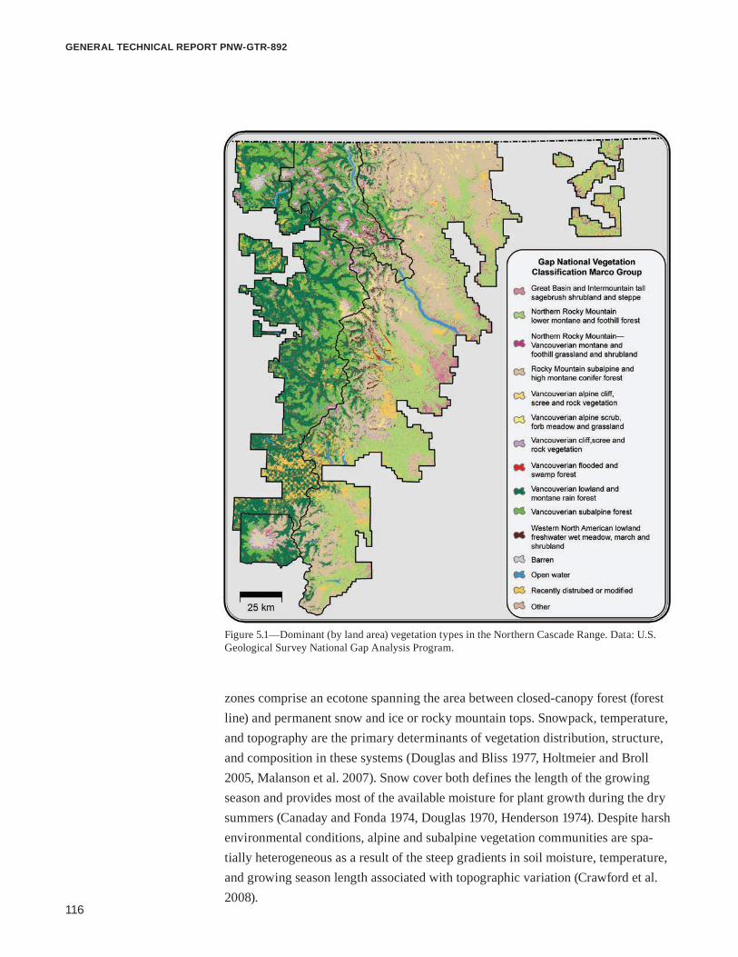
116
general technical report pnw-gtr-892
zones comprise an ecotone spanning the area between closed-canopy forest (forest line) and permanent snow and ice or rocky mountain tops. Snowpack, temperature, and topography are the primary determinants of vegetation distribution, structure, and composition in these systems (Douglas and Bliss 1977, Holtmeier and Broll 2005, Malanson et al. 2007). Snow cover both defines the length of the growing season and provides most of the available moisture for plant growth during the dry summers (Canaday and Fonda 1974, Douglas 1970, Henderson 1974). Despite harsh environmental conditions, alpine and subalpine vegetation communities are spa-tially heterogeneous as a result of the steep gradients in soil moisture, temperature, and growing season length associated with topographic variation (Crawford et al. 2008).
Figure 5.1—Dominant (by land area) vegetation types in the Northern Cascade Range. Data: U.S. Geological Survey National Gap Analysis Program.

117
Climate Change Vulnerability and Adaptation in the North Cascades Region, Washington
The subalpine parkland is a mosaic of tree islands, ericaceous dwarf-shrubs, forbs, and grasses (Douglas 1970, Franklin and Dyrness 1988, Henderson, 1974). Tree species within the zone are similar to the montane forest below. From west to east across the Cascade crest, meadow species composition transitions from lush, continuous cover of forbs and sedges to patchy bunchgrass (e.g., greenleaf fescue [Festuca viridula Vasey]) and forb associations of the drier east slopes. Vegetation in the alpine zone is generally sparsely distributed and includes patches of sedge-turf communities, subshrubs (e.g., heather species), talus slopes, and fellfields (Douglas and Bliss 1977, Edwards 1980). High-elevation wetlands range from small, ephemeral ponds and wet meadows to open water lakes and provide impor-tant habitats for wildlife and ecosystem services such as nutrient cycling, water storage and filtration, and carbon sequestration (IPCC 2007).
Elevations of forest line and tree line vary with latitude and aspect, reflecting differences in mean seasonal temperatures across the rugged topography of the Cascade Range (Körner and Paulsen 2004). In the northern portion of the North Cascades, continuous forest ends at 1280 m on northern slopes and 1580 m on southern slopes (Douglas 1972, Douglas and Bliss 1977). At the southern end of the region, forest line ranges from 1646 m on the southern slopes of Mount Rainier to 1951 m on the drier east side.
Projected Changes in Regional Climate Relevant to VegetationProjected changes in regional temperature and precipitation (chapter 3) (Mote and Salathé 2010) are related to the physical and hydrologic conditions that affect vegetation function and life history (Littell et al. 2010). Changes in temperature and precipitation will interact to affect local snowpack development and timing of snowmelt, but snowpack is likely to decrease and melt earlier, particularly at low elevations where most snow falls close to freezing temperatures (chapter 4). Changes in climate are projected at regional to subregional (smaller than 100 km) scales, but vegetation response at local scales (smaller than 10 km) will also be affected by local factors (e.g., topography, competition, and physical effects of other species). These local factors tend to mediate or exacerbate changes in regional or subregional climate.
Vegetation will experience the integrated effects of changes in temperature, precipitation, and snowpack. Thus when assessing the effects of climate change on vegetation, it can be beneficial to consider climatic variables that integrate tempera-ture, precipitation, and snowpack to provide a better indication of the changes in moisture and energy availability that plants will experience.
Vegetation will experience the integrated effects of changes in temperature, precipitation, and snowpack.

118
general technical report pnw-gtr-892
Soil moisture is one indication of the water available to vegetation. Based on current projections of no increase in summer precipitation, warmer temperatures (chapter 4), and declining snowpack, the North Cascades is expected to experience longer periods of low soil moisture in the dry season. Soil moisture on July 1 is projected to decline throughout most of the North Cascades, with declines of up to 35 percent in much of the region by the 2040s (average of years in the 30-year window from 2030 to 2059) (Elsner et al. 2010) (fig. 5.2).
Another measure that integrates temperature and precipitation to indicate moisture stress experienced by vegetation is water balance deficit. Water balance deficit is a measure of potential vs. actual evapotranspiration of plants. Potential evapotranspiration (PET) is the amount of water that could be evaporated from land and transpired from plants. Actual evapotranspiration (AET) is the amount of water
Figure 5.2—Historical (1916–2006) and future (2030–2059 and 2070–2099) July 1 soil moisture adapted from Elsner et al. (2010). Soil moisture on July 1 decreases over the NCAP domain toward the end of the 21st century.

119
Climate Change Vulnerability and Adaptation in the North Cascades Region, Washington
that is evaporated and transpired and it is an index of simultaneous usable water and energy for plants (Stephenson 1990). When AET exceeds PET, surplus water is typically available for surface runoff or subsurface movement (Stephenson 1990). In contrast, when PET exceeds AET (more water could be transpired than is being transpired), a water balance deficit exists.
An increase in temperature also increases potential evapotranspiration (all other things being equal), and thus water balance deficit. In the North Cascades, water balance deficit in summer is projected to increase east of the Cascade crest, with an average increase of 35 mm for the 2040s in Okanogan-Wenatchee National Forest (OWNF). Increases and decreases in water balance deficit average out to small (-2 to -5 mm) decreases by the 2040s west of the Cascade crest (Elsner et al. 2010) (fig. 5.3). The decrease in water balance deficit (i.e., increase in water supply) is likely a result of increased water availability at high elevations where AET is expected to increase with earlier snowmelt in spring.
Figure 5.3—Historical (1916–2006) and future (2030–2059, and 2070–2099) June-July-August water balance deficit, adapted from Elsner et al. (2010).

120
general technical report pnw-gtr-892
Vegetation is affected by extremes in climate (e.g., windstorms, intense precipi-tation, droughts, extreme fire weather), as well as averages, and current evidence suggests extremes may become more frequent with climate change. Using two regional climate models (essentially weather forecasting models driven by global climate models [GCM]), Salathé et al. (2010) projected an increase of 7 to 20 three-day heat waves (a combined index of heat and humidity greater than 32 °C) for the North Cascades by the 2040s. Extreme precipitation events are also expected to increase, particularly on the western slopes of the Cascades (Salathé et al. 2010), because of the influence of topography and the intensified water cycle expected with climate change. Despite their ecological importance, changes in climatic extremes are difficult to project with simulation models. There are currently no projections of future regional drought (duration or magnitude) or wind for the PNW.
Physical Mechanisms for Climatic Effects on Forest VegetationThe sensitivity of vegetation and the physical mechanisms through which changes in climate will affect vegetation vary by location depending on the historical climate and current climatic limitations on plant growth and species distributions. Direct effects of climate change on vegetation will depend on how climate affects limiting factors for vegetation establishment, growth, productivity, and life history. Climate change will indirectly affect vegetation by also affecting ecological distur-bances and biogeochemistry. Vegetation growth also may be affected by changes in atmospheric concentrations of carbon dioxide (CO2), which can affect water use efficiency and growth (Law et al. 2002, Oren et al. 2001). We do not focus on this mechanism of change in this chapter because of the limited information on this effect in the PNW and for natural systems in general, rather than controlled experiments.
Plant growth can be seasonally or chronically limited by climate (Churkina and Running 1998, Churkina et al. 1999, Nemani et al. 2003). When PET is higher than AET (i.e., water deficit), vegetation productivity is limited by water availability. Water balance deficit (e.g., Churkina et al. 1999, Stephenson 1990) is correlated with the distribution of vegetation (Stephenson 1990). In the PNW, vegetation experiences water limitation seasonally, even in the maritime western Cascades, because the supply of water and energy are asynchronous. More than 75 percent of precipitation falls outside of the growing season (Stephenson 1990, Waring and Franklin 1979). When AET is higher than PET, water is not limiting and vegeta-tion productivity is limited by thermal constraints, such as growing degree days or
Effects of climate change on vegetation will depend on how climate effects limiting factors for vegetation establishment, growth, productivity, and life history.

121
Climate Change Vulnerability and Adaptation in the North Cascades Region, Washington
growing season length (Churkina et al. 1999, Littell et al. 2010). Thermal limita-tions typically occur at locations and times that water availability is sufficient (e.g., maritime PNW forests or tundra), but seasonal water limitations can still limit vegetation productivity in these locations.
It is likely that most low-elevation forests in the North Cascades that currently experience chronic or seasonal water limitation will experience more severe or longer duration water limitation in the future, given projected increases in July 1 soil moisture (fig. 5.2) and summer (June through August) water balance deficit (fig. 5.3) (Littell et al. 2010). In contrast, current energy-limited forests will likely become less energy limited, and the effects of climate change will depend on the degree of seasonal water limitation. Short-term effects on water-limited forests will likely include decreased seedling regeneration and tree growth, increased mortality (especially for seedlings), vulnerability to insects (because of host tree stress), and increased area burned by fire (Littell et al. 2010). Short-term effects on energy- limited forests will likely include increased seedling establishment and tree growth, but also increased area burned by fire and vulnerability to insects because insect ranges are projected to expand into forests with historically unfavorable climate (Littell et al. 2010).
Vegetation in the alpine treeline ecotone is expected to be sensitive to projected changes in climate (Canonne et al. 2007, Holtmeier and Broll 2005, Loarie et al. 2009). Snowpack in the Cascade Range has already declined by 15 to 35 percent since the 1930s (Mote et al. 2005, 2008), and warming temperatures will continue to reduce the duration of snow cover and the April 1 snow water equivalent (SWE), altering the length of the growing season and available soil moisture (Elsner et al. 2010). Increased growing season length, warmer air temperatures, and increased soil moisture will lower environmental constraints on tree establishment in sub-alpine meadows. Expansion of tree islands in the subalpine parkland and rising treelines may be the most visible changes in high-elevation forests. Palaeoecologi-cal studies provide evidence that altitudinal treeline locations have fluctuated throughout the Holocene in response to climate, with advances during warm periods and retreats during cooler climates (Kearney and Luckman 1983, LaMarche 1973, Markgraf and Scott 1981, Rochefort et al. 1994). More recent expansion of tree islands in subalpine areas has also been observed (Bekker 2005, Harsch et al. 2009, Klasner and Fagre 2002, Stueve et al. 2009). Species interactions and micro-topography interact with climate to influence spatial distribution and periodicity of tree establishment (Alftine et al. 2003, Germino et al. 2002, Haugo and Halpern 2010, Malanson et al. 2007). Near the alpine treeline, local physical drivers such as snowpack, wind, radiation, and seasonal desiccation severely limit establishment

122
general technical report pnw-gtr-892
to the most favorable microsites until limiting factors are ameliorated (Smith et al. 2009). The area available for forest expansion upslope in the Cascades is limited either by available land area at higher elevation or by lack of soil development in deglaciating areas.
Shifts in distributions of herbaceous vegetation, shrubs, and sedges, may be less visible than shifts in tree line, but observational studies and manipulative experi-ments suggest significant future changes above tree line (Grabherr et al. 1994, Theurillat and Guisan 2001, Walther et al. 2002). Experimental warming of tundra plant communities in North America have documented increases in height and cover of graminoids and deciduous shrubs and decreased growth of mosses, lichens, and forbs (Arft et al. 1999, Chapin et al. 1995, Harte and Shaw 1995, Walker et al. 2006). Since the 1950s, broad landscape patterns of vegetation in portions of the European Alps have changed similar to those indicated by the warming experi-ments (Cannone et al. 2007). Although there are general trends in the response of functional types across many studies, there are also differences between species, elevations, and localities.
In Europe, vascular plant species richness on mountain summits has increased over the last century as a result of upward plant migrations (Odland et al. 2010, Pauli et al. 2007, Walther et al. 2005). As lower elevation species in the Cascades move up in elevation, species richness in specific areas may increase, but spatial heterogeneity and similarity among summits may decrease, resulting in homogene-ity among peaks (Jurasinksi and Kreyling 2007, Odland et al. 2010). Increased spe-cies diversity may also include nonnative, invasive species that have been limited by abiotic conditions rather than dispersal or disturbance regimes (Pauchard et al. 2009). It is difficult to project the rate of these changes. Some warming studies have documented changes in tundra growth following two seasons of temperature increases of 1 to 3 °C (Walker et al. 2006), but others found that 4 years of warm-ing had no effect on subalpine plant community richness or distribution (Price and Walker 1998, 2000). The range in results from different experiments may typify future changes in the alpine tree line ecotone, because vegetation response is influenced by growth-limiting factors, which differ by species, elevation, slope, and topography (Chapin and Shaver 1985, Klanderud 2008). These limiting factors may also change over time as warmer temperatures increase nutrient availability and alter community structure and dynamics (e.g., competition for light) (Chapin et al. 1995, Klanderud and Totland 2005).

123
Climate Change Vulnerability and Adaptation in the North Cascades Region, Washington
Climate Change Effects on Biodiversity and Vegetation Distribution Projected Changes in Vegetation BiomesDynamic vegetation models simulate the combined effects of climate, plant toler-ances, disturbance, and ecosystem processes (such as hydrology, carbon, and nutrient cycles) on vegetation distributions (e.g., Lenihan et al. 2008). These models typically project changes in coarse vegetation classifications, rather than individual species. Rogers et al. (2011) used the dynamic vegetation model, MC1, to project changes in the area of vegetation biomes (e.g., grasslands, shrublands, temperate coniferous forests, subalpine forests, and alpine tundra) for the western two-thirds of Washington and Oregon, including the North Cascades. The MC1 model projects changes in biomes using future climate data from GCMs. Rogers et al. (2011) used future climate data from three GCMs and the A1B emissions scenario. Projections from MC1 indicate that the distribution of some vegetation biomes may change significantly in the North Cascades over the next century (fig. 5.4). Alpine tundra almost completely disappears, and the area of subalpine forest decreases signifi-cantly across the region for all three climate scenarios (table 5.1). Large areas of existing maritime conifer forest on the west slopes of the Cascades are projected to shift to drier temperate conifer forest (fig. 5.4).
The three MC1 projections agree on these regional trends, but they show differences in what the historical vegetation shifts to. For example, the projections show similar declines in subalpine forest area but differences in the vegetation that replaces it. Differences in future projections are mostly caused by differences in the seasonal climate and magnitude of changes in precipitation and temperature among the three climate scenarios. Projections with climate data from the Hadley CM3 GCM (warmest [+4.5 °C] and drier [-5 percent precipitation] in the 2080s) (see chapter 3) show the largest decline in maritime evergreen needleleaf forest and the largest increase in temperate evergreen needleleaf woodland, temperate evergreen needleleaf forest, and temperate shrubland (table 5.1). Projections with climate data from the CSIRO GCM (least warming [+3.5 °C] and wettest [+15 percent]) show the least change, although substantial areas of maritime and subalpine forest are replaced with temperate needleleaf forest (table 5.1). Projections with climate data from the MIROC 3.2 GCM (warmest future [+5.0 °C] and little precipitation change [-1 percent]) show the smallest increase in temperate needleleaf forest, and much of the subalpine forest is replaced by maritime evergreen forest (table 5.1). The MC1 model assumes an increase in plant water use efficiency with increased atmospheric CO2 (Rogers et al. 2011), which ameliorates the effect of lower water availability

124
general technical report pnw-gtr-892
Figure 5.4—Projected changes in vegetation biomes from the MC1 dynamic global vegetation model. Changes are relative to historical conditions (Küchler potential vegetation) for climate scenarios from three GCMs (MIROC, Hadley CM3, and CSIRO) under a high (A2) greenhouse gas emissions scenario and for the period 2070–2099 (2080s). The CSIRO model is a relatively cooler and wetter scenario, Hadley CM3 is a hotter and drier scenario, and MIROC is a hotter and wetter scenario. Data source: Rogers et al. (2011) and Databasin.

125
Climate Change Vulnerability and Adaptation in the North Cascades Region, Washington
Tabl
e 5.
1(a)
–Pro
ject
ed p
erce
ntag
e ch
ange
in a
rea
of v
eget
atio
n bi
omes
for t
he la
te 2
1st c
entu
ry (2
070–
2099
) with
the
MC
1 dy
nam
ic v
eget
atio
n m
odel
and
clim
ate
data
from
thre
e gl
obal
clim
ate
mod
els,
CSI
RO
, Had
ley
CM
3, a
nd M
IRO
C 3
.2a
MountBaker–SnoqualmieNationalForest
Mou
nt R
aini
er N
atio
nal P
ark
Vege
tatio
n bi
ome
Mod
eled
hi
stor
ical
CSI
RO
bH
adle
y C
M3c
MIR
OC
3.
2dM
odel
ed
hist
oric
alC
SIR
Ob
Had
ley
CM
3cM
IRO
C
3.2d
Tund
ra1.
10.
20.
00.
110
.65.
32.
33.
5Su
balp
ine
fore
st13
.01.
20.
30.
433
.47.
34.
65.
0M
ariti
me
ever
gree
n ne
edle
leaf
fore
st73
.062
.50.
070
.454
.967
.80.
084
.4Te
mpe
rate
eve
rgre
en n
eedl
elea
f for
est
12.9
36.0
95.2
27.5
0.1
19.1
75.2
6.5
Tem
pera
te c
ool m
ixed
fore
st0.
00.
00.
00.
00.
00.
00.
00.
0Te
mpe
rate
war
m m
ixed
fore
st0.
00.
00.
00.
00.
00.
00.
00.
0Te
mpe
rate
eve
rgre
en n
eedl
elea
f woo
dlan
d0.
00.
03.
20.
30.
00.
17.
00.
2Te
mpe
rate
shru
blan
d0.
00.
01.
11.
30.
00.
110
.40.
2
Tabl
e 5.
1(b)
—Pr
ojec
ted
perc
enta
ge c
hang
e in
are
a of
veg
etat
ion
biom
es fo
r the
late
21st
cen
tury
(207
0–20
99) w
ith th
e M
C1
dyna
mic
veg
etat
ion
mod
el a
nd c
limat
e da
ta fr
om th
ree
glob
al c
limat
e m
odel
s, C
SIR
O, H
adle
y C
M3,
and
MIR
OC
3.2
a
Nor
th C
asca
des N
atio
nal P
ark
Com
plex
Oka
noga
n-W
enat
chee
Nat
iona
l For
est
Vege
tatio
n bi
ome
Mod
eled
hi
stor
ical
CSI
RO
bH
adle
y C
M3c
MIR
OC
3.
2dM
odel
ed
hist
oric
alC
SIR
Ob
Had
ley
CM
3cM
IRO
C
3.2d
Tund
ra5.
70.
00.
00.
03.
50.
00.
00.
0Su
balp
ine
fore
st35
.28.
50.
61.
029
.35.
40.
20.
4M
ariti
me
ever
gree
n ne
edle
leaf
fore
st33
.315
.90.
025
.56.
85.
30.
011
.5Te
mpe
rate
eve
rgre
en n
eedl
elea
f for
est
25.6
75.4
83.3
69.6
58.1
89.2
87.2
86.9
Tem
pera
te c
ool m
ixed
fore
st0.
00.
00.
00.
00.
00.
00.
00.
0Te
mpe
rate
war
m m
ixed
fore
st0.
00.
00.
00.
00.
00.
00.
00.
0Te
mpe
rate
eve
rgre
en n
eedl
elea
f woo
dlan
d0.
00.
010
.70.
71.
20.
012
.20.
5Te
mpe
rate
shru
blan
d0.
10.
15.
33.
11.
10.
00.
40.
7a S
ourc
e: R
oger
s et a
l. 20
11.
b The
CSI
RO m
odel
pro
duce
s fut
ure
annu
al c
limat
e w
ith a
3.5
°C in
crea
se in
tem
pera
ture
and
a 1
5 pe
rcen
t inc
reas
e in
pre
cipi
tatio
n (L
ittel
l et a
l. 20
11).
c The
Had
ley
CM
3 m
odel
pro
duce
s fut
ure
annu
al c
limat
e w
ith a
4.5
°C in
crea
se in
tem
pera
ture
and
a 5
per
cent
dec
reas
e in
pre
cipi
tatio
n (L
ittel
l et a
l. 20
11).
d The
MIR
OC
3.2
mod
el p
rodu
ces f
utur
e an
nual
clim
ate
with
a 5
.0 °C
incr
ease
in te
mpe
ratu
re a
nd a
1 p
erce
nt d
ecre
ase
in p
reci
pita
tion
(Litt
ell e
t al.
2011
).

126
general technical report pnw-gtr-892
on projected changes in vegetation distributions. The scientific literature disagrees about the degree to which water use efficiency will increase and offset lower plant productivity associated with lower water availability (Law et al. 2002, Oren et al. 2001).
Projected Changes in Climatic Suitability for Tree Species Both quantitative (correlative) and qualitative (subjective vulnerability indices) have been used to evaluate the potential effects of climate change on forest and nonfor-est species distributions in the PNW. Projected effects of climate change on tree species in the PNW suggest widespread changes in equilibrium vegetation. Vulner-ability assessments using process models (e.g., Coops and Waring 2011) and current factors indicating general biogeographic vulnerability of species (e.g., Aubry et al. 2011) indicate substantial risk for many species. Statistical models of species-climate relationships (e.g., McKenzie et al. 2003) show that tree species have unique climatic tolerances and thus climate change will affect them differently depending on their tolerances (McKenney et al. 2011; Rehfeldt et al. 2006, 2008).
Species-climate relationships have been used to project future favorable climate for species in western North America (McKenney et al. 2007, 2011; Rehfeldt et al. 2006, 2008) and in Washington (e.g., Littell et al. 2010). Climate is projected to become unfavorable for Douglas-fir (Pseudotsuga menziesii [Mirb.] Franco) in more than 32 percent of its current range in Washington (Littell et al. 2010) (fig. 5.5). For pine species in Washington, 15 percent of the current range will remain climatically suitable for all pine species, whereas 85 percent will be outside the cli-matically suitable range for one or more current pine species (Littell et al. 2010) (fig. 5.5). Coops and Waring (2010), using a single GCM (CCSM2) and a process model (3PG), also projected that the range of lodgepole pine (Pinus contorta var. latifolia Engelm. ex S. Watson) will likely decrease in the PNW. Rehfeldt et al. (2006) found comparable changes in future lodgepole pine distribution using multiple models (fig. 5.6). McKenney et al. (2011) summarized species responses across western North America and found that the change in total tree species in the PNW is often near balance (-5 to +10 species) or a loss of 6 to 20 species, but some scenarios have subregional losses of 21 to 38 species.
Modeling species-climate relationships is a useful approach to understand the potential effects of climate change on biogeography, particularly because a focus solely on vegetation biomes may mask important changes in species dominance. The models are useful indicators of where or when climatic variables may begin to exceed species tolerances. However, most statistical models of species-climate rela-tionships assume climate is the primary determinant of species presence or absence
Projected effects of climate change on tree species in the Pacific Northwest suggest widespread changes in vegetation.
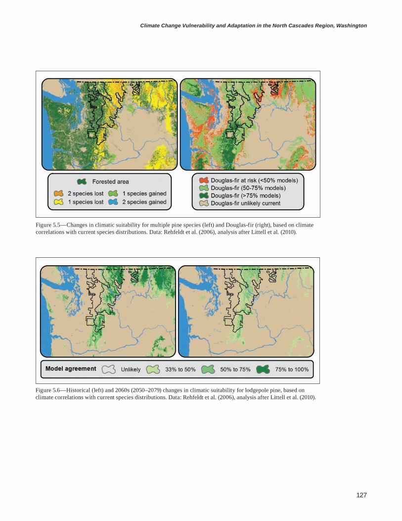
127
Climate Change Vulnerability and Adaptation in the North Cascades Region, Washington
Figure 5.5—Changes in climatic suitability for multiple pine species (left) and Douglas-fir (right), based on climate correlations with current species distributions. Data: Rehfeldt et al. (2006), analysis after Littell et al. (2010).
Figure 5.6—Historical (left) and 2060s (2050–2079) changes in climatic suitability for lodgepole pine, based on climate correlations with current species distributions. Data: Rehfeldt et al. (2006), analysis after Littell et al. (2010).

128
general technical report pnw-gtr-892
and do not incorporate ecological interactions (e.g., competition), disturbance, and species traits (including autecological characteristics) that predispose species vulnerability to climate (Aubry et al. 2011).
Changes in Distribution of Rare Plant Species The North Cascades is home to several rare vascular and nonvascular plants, many of which have common traits that make them vulnerable to climate change. They typically grow under narrow environmental conditions and are often at the margins of their distributions where expansions and contractions are most likely to occur. Several rare plants are growing at the southern extent of their ranges and are more common farther north in southeastern Alaska or Haida Gwaii. Others occupy cold microclimates with wet soils or high-elevation meadows and wetlands, microhabi-tats that could be more susceptible to warmer temperatures, drier summers, and reduced snowpack.
Climate Change Effects on Ecological Disturbances InsectsMost native forest insects cause patchy defoliation or tree mortality when conditions promote insect survival and undermine natural defenses of trees. Recent warming has affected population dynamics of the native mountain pine beetle (Dendrocto-nus ponderosae Hopkins) in colder parts of its range in British Columbia and the Rocky Mountains. Warming has reduced thermal migration barriers and fatally low winter temperatures, and synchronized populations to one life cycle per year in areas where the time required for each generation was longer historically (e.g., Logan and Powell 2001). Increased vulnerability of hosts caused by moisture stress and tree age were also factors driving the widespread outbreaks observed in these regions. The mountain pine beetle has significantly affected forests in the North Cascades, although the outbreaks have not been as large or continuous as in other parts of the Western United States and Canada. In the North Cascades, it is likely that higher winter temperatures have also relaxed thermal limitations on population size, but tree vulnerability resulting from moisture stress and high stand density are also important controls of recent outbreaks. Based on aerial detection surveys by the U.S. Department of Agriculture Forest Service (USDA FS) and Washing-ton Department of Natural Resources, the 30-year trend in mountain pine beetle mortality shows increases in both lodgepole pine and whitebark pine (P. albicaulis Engelm.) forests (fig. 5.7), although surveys in 2010 and 2011 detected decreases (WADNR 2012a). These recent decreases are likely caused by the combined effects

129
Climate Change Vulnerability and Adaptation in the North Cascades Region, Washington
of above-average precipitation, below-average temperatures in spring, and previous mortality of the most vulnerable host trees in affected stands (WADNR 2012a).
Aerial detection surveys between 1980 and 2011 show large areas of mortal-ity from other host-specific bark beetles and defoliators. The eastern slopes of the Cascades are experiencing increases in the area and severity of defoliation by western spruce budworm (Choristoneura occidentalis Freeman) (fig. 5.8), although a 20-year outbreak in the southern Cascade Range of Washington has recently
Figure 5.7—Mountain pine beetle mortality recorded from aerial surveys in the North Cascades from 1980 to 2012. Data: courtesy of A. Dozic, annual aerial survey, Washington Department of Natural Resources, Resource Protection Division, Forest Health; U.S. Forest Service, Forest Health Protec-tion; and Oregon Department of Forestry, Forest Health Management. Map concept from A. Dozic.
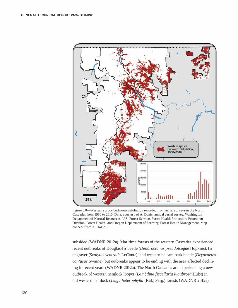
130
general technical report pnw-gtr-892
subsided (WADNR 2012a). Maritime forests of the western Cascades experienced recent outbreaks of Douglas-fir beetle (Dendroctonus pseudotsugae Hopkins), fir engraver (Scolytus ventralis LeConte), and western balsam bark beetle (Dryocoetes confusus Swaine), but outbreaks appear to be ending with the area affected declin-ing in recent years (WADNR 2012a). The North Cascades are experiencing a new outbreak of western hemlock looper (Lambdina fiscellaria lugubrosa Hulst) in old western hemlock (Tsuga heterophylla [Raf.] Sarg.) forests (WADNR 2012a).
Figure 5.8—Western spruce budworm defoliation recorded from aerial surveys in the North Cascades from 1980 to 2010. Data: courtesy of A. Dozic, annual aerial survey, Washington Department of Natural Resources. U.S. Forest Service, Forest Health Protection; Protection Division, Forest Health; and Oregon Department of Forestry, Forest Health Management. Map concept from A. Dozic.

131
Climate Change Vulnerability and Adaptation in the North Cascades Region, Washington
Tree mortality caused by the balsam woolly adelgid (Adelges piceae Ratzeburg), a nonnative insect that affects fir species, has also increased throughout the North Cascades in the last 30 years (WADNR 2012a).
All of these insects have relationships with seasonal weather conditions, but currently only the mountain pine beetle, western spruce budworm, and spruce beetle (Dendroctonus rufipennis Kirby) have well-documented relationships with climate (Bentz et al. 2010, Hicke et al. 2006, Littell et al. 2010). As temperatures increase, habitat that was previously unsuitable for the mountain pine beetle will likely become suitable (Hicke et al. 2006, Littell et al. 2010), exposing pine trees at high elevations to new outbreaks. By the end of the 21st century, the total habitat for the mountain pine beetle in Washington will decline under some scenarios (Hicke et al. 2006), but not before it has had decades to expand its range (Bentz et al. 2010, Littell et al. 2010) (fig. 5.9). The timing of bud break in Douglas-fir and grand fir (Abies grandis [Douglas ex D. Don] Lindl.), which is linked to soil temperature, can greatly affect the survival of western spruce budworm. If bud swelling occurs later in the season and is not synchronized with insect emergence, budworm survival will decline. In addition, survival can be reduced by warmer fall temperatures and atypical fall or spring frosts outside the period of insect dormancy.
Fire RegimesArea burned by wildfire in PNW forests is sensitive to climate (Littell et al. 2009, 2010; McKenzie et al. 2004), but the most important climatic mechanisms and the sensitivity to climate differ by forest type (Littell et al. 2009, 2010). Before Euro-American settlement and in the first half of the 20th century, the area burned both east and west of the Cascade crest was probably much larger than what has been observed in recent decades. Fires of many hundreds of thousands of hectares burned in the western Cascades in the 1700s (Henderson et al. 1992). Generally, warmer and drier summers precondition PNW forests by drying available fuels over large areas (Littell et al. 2010). The occurrence of fire ignitions may be equally related to low spring snowpack (Cansler 2011) in some forests in the North Cascades.
Between 1980 and 2006, the area burned by fire varied by ecoregion (fig. 5.10), and during this period, the relationship between area burned and climate was stronger in the eastern Cascades, where fuels are more likely to dry sufficiently to carry fire. In the western Cascades, the area burned was lower because a rare combination of prolonged drought, high temperature, high wind, and low humidity was required to dry fuels sufficiently to sustain the spread of a large fire.
As temperatures increase, habitat that was previously unsuitable for the mountain pine beetle will likely become suitable.

132
general technical report pnw-gtr-892
5.9—Historical (1971–2000) probability of climatically suitable habitat for the mountain pine beetle in the North Cascades and changes for the 2030s (2001–2030) and 2080s (2071–2100) using SRES A2 emissions and the CNCRM3 global climate model. For the historical period, probability values reflect the product of the probability of adaptive seasonality and cold survival, with high values (closer to 1) indicating climatically more suitable habitat and low values (closer to zero) indicat-ing climatically less suitable habitat. For changes in the 21st century, positive values (red) indicate increases in suitability compared to historical and negative values (green) indicate decreases. Data: Bentz et al. (2010).

133
Climate Change Vulnerability and Adaptation in the North Cascades Region, Washington
Climate change will almost certainly increase area burned by fire (Littell et al. 2010) and biomass consumed in PNW forests (Raymond and McKenzie 2012). Based on statistical climate-fire modeling (average of two GCMs [CGCM3 and ECHAM5] for A1B emissions), area burned by wildfire in the PNW (Washing-ton, Oregon, Idaho, and western Montana) is projected to be 0.3 million ha in the 2020s, 0.5 million ha in the 2040s, and 0.8 million ha in the 2080s (Littell et al. 2010). The probability of exceeding the 95th percentile area burned for the period 1916–2006 increases from 5 to 48 percent by the 2080s (Littell et al. 2010). The area burned is expected to increase on average by a factor of 3.8 in forested ecosystems (Western and Eastern Cascades, Okanogan Highlands, Blue Mountains) compared to 1980–2006 (fig. 5.11). Using the MC1 dynamic vegetation model, Rogers et al. (2011) projected increases in area burned of 76 to 310 percent (fig. 5.12), depend-ing on alternative scenarios for climate and fire suppression. Climate scenarios included data from three GCMs (CSIRO, MIROC 3.2, and Hadley CM3) and a high (A2) emissions scenario.
In addition to annual area burned, the frequency, size, and severity of indi-vidual fires in the North Cascades also could change in a warmer climate. Warmer July temperatures are significantly correlated with increasing severity (Cansler 2011), and burn severity is projected to increase 29 to 41 percent by 2100, compared to 1971–2000 (Rogers et al. 2011). However, relative to annual area burned, less quantitative information is available on how fire severity will respond to changes in climate.
Figure 5.10—Area burned in the western and eastern Cascades (Washington and Oregon), 1980–2009. The data from 2010 were provisional at the time of analysis. Data: Littell and Gwozdz (2011).
Climate change will almost certainly increase area burned by fire and biomass consumed in Pacific Northwest forests.

134
general technical report pnw-gtr-892
Figure 5.11—Expected changes in area burned for scenarios of future climate and hydrology in the western and eastern Cascades (Bailey ecosections). The B1 scenario represents less warming with lower greenhouse gas emissions. The A1B scenario represents more warming with higher greenhouse gas emissions, and is the highest average of the SRES scenarios until the 2040s. The area burned in both ecosections increases substantially, but the rate of increase is higher in the western Cascades than the eastern Cascades. Numbers beneath the box indicate the average annual area burned for the historical period and three future periods (Littell et al. 2010).
Figure 5.12—Changes in cell fraction area burned from the MC1 dynamic global vegetation model. Data: Databasin (Rogers et al. 2011).

135
Climate Change Vulnerability and Adaptation in the North Cascades Region, Washington
The effects of climate change on forest vegetation will also depend on the degree to which fire exclusion has affected forest density and fuels (Hessburg et al. 2005), particularly in forests that had low- to moderate-severity fires regimes before Euro-American settlement. In these forests where tree density and ladder fuels have increased because of fire exclusion, this forest structure will exacerbate climate-driven increases in area burned and severity of burns. In forests where mixed- and high-severity fires with longer fire return intervals (50 to 100 years) dominated the landscape (e.g., lodgepole pine stands, subalpine forests, and west-side Douglas-fir), increases in area burned may lead to larger, more homogeneous patches precondi-tioned for future fires (Perry et al. 2011). Fire return intervals in maritime forests of the western Cascades are long enough (more than 100 years) that fire suppres-sion has not affected forest structure (Agee 1993) and changes in fire regimes will primarily be driven by changes in climate.
Forest PathogensClimate influences pathogen range and survival, host vulnerability, and host- pathogen interactions, but potential effects of climate change on pathogens are uncertain. Root rot pathogens could increase because of stressed host trees (cli-mate or other stressors) (Chmura et al. 2011), and Armillaria in Douglas-fir could increase in a warmer climate (Klopfenstein et al. 2009). Foliage fungi, such as Swiss needle cast (Phaeocryptopus gaeumannii [T. Rhode] Petr.) (Chmura et al. 2011) appear to be affected by spring and summer precipitation. However, making generalizations about climate-pathogen relationships is difficult because those relationships are likely to be species- and host-specific.
Kliejunas (2011) evaluated the relative risk of disease damage in forests of the Western United States by combining the likelihood of increased damage and the consequences of damage for several pathogen species. Risk potential depends on the disease and climate scenario (warmer, wetter vs. warmer, drier). By 2100, Cytospora canker of alder, dwarf mistletoes (Arceuthobium spp.), and Alaska yellow-cedar decline would have high risk. In a warmer, drier climate, Armillaria is expected to have very high risk. In a warmer, wetter climate, Armillaria and dwarf mistletoe are expected to have high risk, and sudden oak death (Phytophthora ramorum Werres et al.) would have very high risk (Kliejunas 2011). The conse-quences of increased white pine blister rust (Cronartium ribicola J.C. Fisch.) would be high (it has caused more damage and cost more to control than any other conifer disease), although its risk potential with climate change is low because it is associ-ated with a cool, moist climate. Therefore, warmer temperatures would not favor blister rust, although more winter and spring precipitation could favor the pathogen (Kliejunas 2011).

136
general technical report pnw-gtr-892
Invasive Species Several hundred nonnative species grow in the North Cascades, but many are not currently invasive. Nonnative species, like native species, will respond individually to changes in climate based on species-specific physiological tolerances. However, many invasive species have common life history traits that distinguish them from native species and may cause them to be favored by a warmer climate and more disturbance of native vegetation. Many invasive species have broad climatic toler-ances, large geographic ranges, and life history traits that facilitate rapid dispersal and growth (e.g., long-distance dispersal, low seed mass, short juvenile periods, and responsiveness to resource availability). Climate change may affect populations of invasive species by altering mechanisms for transport and introduction, reducing climatic constraints on existing populations, and increasing the impact on ecosys-tems by changing competitive interactions with native species (Hellmann et al. 2008). Climate change may link geographic regions that were previously separated by eliminating climatic barriers, thus facilitating the spread of invasive species (Hellmann et al. 2008). Changes in climate could also reduce the range of some currently invasive species, although this is less likely because most invasive species grow over a wide range of environmental conditions, suggesting they will be able to tolerate changes in climate better than native species. Experiments with single species suggest that some invasive species may increase productivity in response to higher atmospheric CO2 and nitrogen deposition, but results are less clear for responses of invasive species growing in diverse plant communities in the natural environment (Dukes and Mooney 1999). More fire and insect outbreaks are likely to increase opportunities for invasive species to establish, because invasive species are typically better adapted than native species to take advantage of rapid availabil-ity of resources.
Cheatgrass (Bromus tectorum L.) is an exotic, invasive species of particular concern for North Cascades National Park (NOCA) and OWNF on the east side of the Cascades. Cheatgrass is an annual grass that is stimulated by fire and can prevent native grasses from successfully reestablishing after fire. Cheatgrass can permanently alter fire regimes if it persists because of its high flammability relative to native grasses (Brooks et al. 2004, Keeley 2006). Analysis of the climatically suitable habitat of cheatgrass throughout the Western United States indicates that climate change may cause a northward shift in its range, making north-central Washington more climatically suitable for cheatgrass (Bradley 2009). Elevated lev-els of atmospheric CO2 increase cheatgrass productivity and biomass (Ziska et al. 2005). Furthermore, more frequent fire could favor existing populations of cheat-grass, creating a positive feedback that further alters fire regimes and decreases the potential for native understory species to regenerate.
Invasive species may be favored by a warmer climate and more disturbance of native vegetation.

137
Climate Change Vulnerability and Adaptation in the North Cascades Region, Washington
Disturbance Interactions The effects of climate change on the interaction of multiple disturbances (insects, fire, pathogens, and invasive species), or at least their combined influence (fig. 5.13), will affect the region in novel ways in the future. For example, Hicke et al. (2012) developed a conceptual model of how insect mortality may affect fire, and concluded that the effects are time and system dependent. Insect mortality may increase the potential for fire occurrence and severity shortly after an outbreak but decrease severity in the long term. Box 5.1 describes another example of climate and disturbance interactions in whitebark pine populations in the North Cascades.
Figure 5.13—Fire perimeters (1984–2008) and aerial detection survey (ADS) insect and disease detection (1997–2008) show the recent disturbance area in the North Cascade Range. The total area affected is a high proportion of the landscape in the eastern Cascades. Data: Monitoring Trends in Burn Severity (MTBS) database, http://www.mtbs.gov.
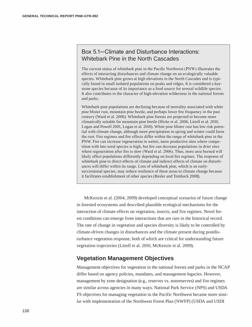
138
general technical report pnw-gtr-892
McKenzie et al. (2004, 2009) developed conceptual scenarios of future change in forested ecosystems and described plausible ecological mechanisms for the interaction of climate effects on vegetation, insects, and fire regimes. Novel for-est conditions can emerge from interactions that are rare in the historical record. The rate of change in vegetation and species diversity is likely to be controlled by climate-driven changes in disturbances and the climate present during postdis-turbance vegetation response, both of which are critical for understanding future vegetation trajectories (Littell et al. 2010, McKenzie et al. 2009).
Vegetation Management ObjectivesManagement objectives for vegetation in the national forests and parks in the NCAP differ based on agency policies, mandates, and management legacies. However, management by zone designation (e.g., reserves vs. nonreserves) and fire regimes are similar across agencies in many ways. National Park Service (NPS) and USDA FS objectives for managing vegetation in the Pacific Northwest became more simi-lar with implementation of the Northwest Forest Plan (NWFP) (USDA and USDI
Box 5.1─Climate and Disturbance Interactions: Whitebark Pine in the North Cascades
The current status of whitebark pine in the Pacific Northwest (PNW) illustrates the effects of interacting disturbances and climate change on an ecologically valuable species. Whitebark pine grows at high elevations in the North Cascades and is typi-cally found in small isolated populations on peaks and ridges. It is considered a key-stone species because of its importance as a food source for several wildlife species. It also contributes to the character of high-elevation wilderness in the national forests and parks.
Whitebark pine populations are declining because of mortality associated with white pine blister rust, mountain pine beetle, and perhaps lower fire frequency in the past century (Ward et al. 2006). Whitebark pine forests are projected to become more climatically suitable for mountain pine beetle (Hicke et al. 2006, Littell et al. 2010, Logan and Powell 2001, Logan et al. 2010). White pine blister rust has low risk poten-tial with climate change, although more precipitation in spring and winter could favor the rust. Fire regimes and fire effects differ within the range of whitebark pine in the PNW. Fire can increase regeneration in wetter, more productive sites where compe-tition with late-seral species is high, but fire can decrease populations in drier sites where regeneration after fire is slow (Ward et al. 2006). Thus, more area burned will likely affect populations differently depending on local fire regimes. The response of whitebark pine to direct effects of climate and indirect effects of climate on disturb-ances will differ within its range. Loss of whitebark pine, which is an early- successional species, may reduce resilience of these areas to climate change because it facilitates establishment of other species (Resler and Tomback 2008).

139
Climate Change Vulnerability and Adaptation in the North Cascades Region, Washington
1994), which shifted vegetation management on national forests from an emphasis on sustained yield and multiple use to an emphasis on ecosystem management. Management objectives also became more similar with an increase in the area of Congressionally designated wilderness and wild and scenic rivers in the national forests. Restrictions on management in reserves in national forests and undeveloped areas in national parks limit options for managing vegetation to increase resilience to climate change, but these large areas of wilderness have been relatively less affected by past management and may have greater ecological capacity to adapt to climate change if ecological processes such as fire are maintained.
Mount Baker-Snoqualmie and Okanogan-Wenatchee National ForestsGeneral objectives for managing vegetation on the national forests are outlined in regional policies and land and resource management plans (i.e., forest plans) of each forest, which have a 15- to 20-year planning timeframe. However, the NWFP amended the forest plans of national forests within the range of the northern spot-ted owl (Strix occidentalis caurina Merriam). The NWFP significantly changed forest management objectives from a focus on sustained yield and multiple uses to a focus on ecosystem management and wildlife habitat. The primary objective of the NWFP is to provide for long-term sustainability of ecosystems and species that inhabit them. Vegetation management under the NWFP focuses on maintaining and protecting late-successional forests habitat for the northern spotted owl and marbled murrelet (Brachyramphus marmoratus Gmelin). The NWFP established a system of reserves that included Congressionally designated reserves (national parks, national monuments, wildernesses, and wild and scenic rivers), late-successional reserves (LSRs), riparian reserves, and administratively withdrawn areas (areas previously reserved from timber harvest by existing plans). Nonreserve areas include managed late-successional areas less than 80 years old, adaptive management areas (AMAs), and matrix (land not otherwise designated). In reserves, commercial timber har-vest is prohibited and only limited silvicultural activities are permitted, so most silvicultural treatments occur in nonreserves. Despite the emphasis of the NWFP on long-term sustainability, the plan did not consider the possible effects of climate change on objectives or the designation of a static system of reserves.
The NWFP applies to the entire Mount Baker-Snoqualmie National Forest (MBSNF), so objectives for forest management on the MBSNF are based on the goals and guidelines of the NWFP. The NWFP shifted the focus of vegetation management on MBSNF from commercial timber harvest to protection of late-successional forest habitat, restoration of previously harvested stands, and surveys
The Northwest Forest Plan changed management focus from sustained yield and multiple uses to ecosystem management and wildlife habitat.

140
general technical report pnw-gtr-892
of key species. Silvicultural treatments are limited to primarily nonreserve areas, which are only 5 percent of the forest area. In addition to silvicultural treatments and forest restoration, vegetation management includes programs for managing and monitoring rare plants, invasive species, fire, and hazard trees.
The primary objective of vegetation management in the OWNF is to restore fire regimes and wildlife habitat by managing ecological processes, stand structure, and species composition of fire-adapted forests that have been altered by past timber harvest and fire exclusion. The NWFP applies to most of the OWNF, except the area east and north of the Chewuch River. The area east and north of the Chewuch River is managed under the East-Side Screens Regional Management Plan (USDA FS 1998). Okanogan-Wenatchee National Forest is currently revising its forest plan, with the final decision planned for spring 2015. The revised forest plan will provide guidance for vegetation management that is consistent with the NWFP but specific to management needs of fire-adapted forests. General guidance for vegetation man-agement on the OWNF is also provided by the Forest Restoration Strategy (USDA FS 2012a). In addition to forest restoration and silviculture, the OWNF manages fire, rare species, invasive species, and hazard trees.
Originally the NWFP included provisions for more active management of LSRs in fire-adapted forests east of the Cascade crest, and it was subsequently revised (USFWS 2008) to reflect an even greater need to manage these fire-adapted forests affected by fire exclusion (Spies et al. 2006). Revisions to the NWFP recognized that the original plan did not adequately reflect the current and potentially increas-ing threat to LSRs of severe wildfires and insect and pathogen outbreaks in the absence of fire and fuels management. Relative to the MBSNF, a greater proportion of the OWNF (60 percent) is not designated as wilderness or reserves under the NWFP, thus active management is more prevalent on the OWNF. The objectives of the East-Side Screens Regional Management Plan are also to protect and restore late-successional wildlife habitat, but by managing for natural range of variation, rather than a system of reserves, and limiting the size of trees that can be harvested.
North Cascades and Mount Rainier National ParksNational Park Service management policies (USDI NPS 2006) focus on the use of natural processes to maintain native plant species, but managers may intervene to (1) manage populations that have been threatened by human influences; (2) accom-modate intensive development in areas designated for developed uses; (3) protect rare, threatened, or endangered species; or (4) protect human safety and property. Given the emphasis on “natural process” and “native” species, one of the biggest challenges to vegetation management in the national parks will be to define what

141
Climate Change Vulnerability and Adaptation in the North Cascades Region, Washington
processes are natural and which species are native as species ranges shift and disturbance rates increase with climate change. Attribution of climate change to human causes may be necessary to justify some interventions under current NPS policies. The NPS recognizes that natural processes and species are dynamic, and successful protection of these processes often requires protection of larger areas than are contained within park boundaries. Toward this end, the NPS collaborates with other agencies to conserve populations and habitats of native species outside of park boundaries and to monitor and collect data for use in plant management programs. Thus interagency collaboration in a regional approach to climate change adaptation is consistent with current NPS policies.
The primary objective of vegetation management in NOCA is to protect the ecological and genetic integrity of plant communities by protecting natural pro-cesses. The park was established to preserve mountain scenery including several aspects of vegetation: (1) diverse and extensive tracts of habitat, (2) dynamic ecosystem processes, (3) wetlands, and (4) diverse plant communities with rare species. Mount Rainier National Park was established to “…provide for the preser-vation from injury or spoliation of all timber, mineral deposits, natural curiosities, or wonders within said park, and their retention in their natural condition.” Similar to NOCA, the General Management Plan for Mount Rainier National Park (MORA) directs managers to protect and maintain plant communities and ecological pro-cesses and to restore plant communities when damaged (USDI NPS 2011a). Subal-pine and alpine meadows are given special protection and are a focus of vegetation management because these systems are critical to the history and character of the park. Subalpine and alpine meadows are iconic ecosystems valued for wildlife habitat, viewing wildflowers, and the general recreation experience of visitors.
Vegetation Management Practices Silviculture and Forest Restoration Most silvicultural treatments on the MBSNF are designed to restore and develop late-successional forest habitat. Commercial harvest and noncommercial thin-ning are used to restore late-successional habitat, with the secondary objectives of producing timber and increasing tree vigor. However, the annual area treated on the MBSNF is currently small. Commercial timber harvest in the MBSNF occurs in several hundred hectares per year and noncommercial thinning in less than 300 ha per year in LSRs less than 80 years old, matrix lands, and AMAs. Common silvicultural prescriptions include variable-density thinning, retention of minor tree species to maintain diversity, and inclusion of some unharvested patches and large openings to promote horizontally diverse stand structure. Current treatments do

142
general technical report pnw-gtr-892
not reflect expected climate-driven changes in species distributions, tree vigor, or disturbance rates.
Current objectives of silvicultural treatments and restoration on the OWNF are to restore natural forest processes, patterns, and function in order to increase forest resilience to changes in climate and disturbance regimes. The area is managed for historical and future range of variability in species composition and stand struc-ture (Gärtner et al. 2008). Specific management goals are to reduce stand density, shade-tolerant fir species, and elevated fuel loads that now cover a greater portion of the forest because of past timber harvesting and fire exclusion. These changes in forest structure and composition have led to an increase in severe wildfire, defoliat-ing insects, dwarf mistletoe, bark beetles, and root diseases (Hessburg et al. 2000). Managers on the OWNF use a landscape planning tool (Ecosystem Management Decision Support framework; Reynolds and Hessburg 2005) to determine priority areas for restoration treatments that will increase forest resilience. After selecting priority areas, specific silvicultural prescriptions are determined and projects are implemented based on site-specific conditions. Forest restoration activities on the OWNF include commercial thinning, noncommercial thinning, and prescribed fire. Approximately 120 000 m3 yr-1 are harvested, but timber harvest is limited by the lack of mills in the region and the high cost of transporting logs to distant mills.
Fire and Hazardous Fuel ManagementHistorically, maritime coniferous forests and subalpine forests that dominate the MBSNF burned infrequently, limiting the need for fuel treatments and prescribed fire. Given the emphasis on historical fire regimes and the objectives of safety and protecting resources, fire management currently focuses on fire suppression. Forests in MORA have a similar historical fire regime, but the park developed a fire management plan in 2005 (revised in 2011) (USDI NPS 2005) with the goals of ensuring firefighter and public safety, protecting natural and cultural resources, and restoring and maintaining natural fire regimes. Suppression is a priority near park administrative facilities, access roads, and developed zones. Elsewhere in the park, managers have the option of managing wildfires to encourage fire as a natural process. The plan recognizes that fire severity and extent may change as climate warms and that park management will need to adapt to these changes in fire regimes. The plan also recognizes that fire is a large-scale process and needs to be managed in collaboration with adjacent landowners.
The OWNF and NOCA actively manage fire and fuels in forests with low- and mixed-severity fire regimes east of the Cascade crest. The OWNF Forest Restora-tion Strategy and revised forest plan recognize fire as an essential process for

143
Climate Change Vulnerability and Adaptation in the North Cascades Region, Washington
maintaining resilient forest and nonforest ecosystems, and support active use of fire. However, protection of human life is the highest priority of fire management, and fire managers set priorities for protecting communities, property, and natural and cultural resources based on the values to be protected, risks to human health and safety, and costs of protection. Fire management activities include using planned and unplanned ignitions for multiple resource objectives. However, air quality associated with smoke emissions often limits the area that can be burned for ecological objectives. Managers use natural and artificial regeneration (i.e., plant-ing seedlings) after harvests and fire, but planting has declined recently because it results in higher tree densities that require subsequent thinning.
The objectives of the NOCA fire management plan (USDI NPS 2007) are to ensure the safety of firefighters and the general public, allow for natural fire processes, use adaptive management to guide future fire management, and educate, inform, consult, and collaborate with stakeholders and adjacent land managers. Fire management activities include suppression, prescribed fire, and mechanical treat-ment of hazardous fuels. Fires are suppressed to protect human life and property and to prevent fires from burning into Canada or causing undesirable effects to threatened and endangered species and their habitats. Prescribed fire and wildfires are managed in both wilderness and developed zones. When conditions allow, lightning-caused fires can be managed to meet multiple objectives in wilderness. North Cascades National Park Complex monitors fire effects of prescribed burns and wildfires. These data are used in an adaptive management process to determine if wildfires and prescribed burns are achieving desired objectives and ecological conditions.
Hazard Tree ManagementAlthough hazard tree management occurs at small scales in local areas, it is an important component of vegetation management because hazard trees present a risk to human life and property. A hazard tree has a detectable defect that could cause it to fall and strike a person or property in a developed area (e.g., campground, building, or parking area). Managers monitor hazard trees when they pose a threat to people or property, and mitigate potential damage through site closure, pruning, reducing tree height, or complete removal of the tree.
Plant Ecology ProgramsPlant ecology programs in MORA and NOCA include nonnative plant management, long-term monitoring, rare plant protection, environmental compliance surveys, and restoration. The condition of plant communities is monitored, and managers miti-gate damage and restore natural vegetation when it is determined that human use

144
general technical report pnw-gtr-892
has degraded an area. Restoration programs focus on areas damaged by recreational use, road construction, or other administrative actions. The majority of restoration projects in MORA are in subalpine forest, and projects in NOCA are concentrated in lower elevation areas associated with exotic plants or erosion control. Restora-tion in MORA has occurred mostly in subalpine meadows that have been damaged by recreational activity, and in areas where construction has damaged vegetation. Restoration in NOCA has occurred mostly in subalpine areas near Cascade Pass, as well as areas near Ross Lake, Diablo Lake, and Lake Chelan.
Both parks maintain greenhouses and propagate the majority of plants used in restoration programs. Seed or propagule collection is conducted adjacent to restoration sites to protect genetic integrity of the plant communities. Roadside revegetation projects often use seed programs conducted by the Natural Resources Conservation Service or private contractors and use a larger seed collection area. Both parks collaborate with the USDA FS to screen whitebark pine for genetic resistance to white pine blister rust.
Federal law requires national forests and parks to protect threatened and endan-gered plant species listed by the USFWS under the federal Endangered Species Act (ESA) of 1973. The national parks also protect plants on the state of Washington, Natural Heritage Program list of rare plants (WADNR 2012b). The national forests also monitor and manage species on the USDA FS Pacific Northwest Region sensitive species list, which includes federally listed species. Regardless of how these sensitive species will be affected by changes in climate and disturbances, the agencies are legally required to protect and maintain current populations of listed species. Thus adaptation planning must consider this current management context.
The MBSNF has 34 species on the PNW sensitive list and also manages 54 species of lichens, bryophytes, fungi, and vascular plants known as “survey and manage” species under the Survey and Manage Settlement Agreement (2011). The OWNF manages 91 plant species on the PNW sensitive species list that grow in a wide range of environments from alpine tundra to low-elevation forests, and has two suspected and two known federally listed plant species, two of which are local endemics. There is only one federal candidate species in NOCA, but the park has 24 vascular plants that are listed by the state of Washington, Natural Heritage Program. There is one species of federal concern, three state sensitive species, four state watch species, and one priority macrofungus species in MORA.
Invasive Species ManagementNational forests and parks in the NCAP already coordinate management of invasive species and collaborate with other agencies in the region. Exotic species are those

145
Climate Change Vulnerability and Adaptation in the North Cascades Region, Washington
that occupy or could occupy lands directly or indirectly as a result of deliberate or accidental human activities. Invasive species are more specifically defined as nonnative species that are aggressive and pose an ecological threat to the integrity of native vegetation (USDI NPS 2006). Both agencies use an “early detection-rapid response” approach to identify potentially problematic invasive species as early as possible, develop a strategy for treatment, and implement timely treatment where eradication or control are feasible.
Direction for management of invasive species on the national forests is given by the Pacific Northwest Region, Invasive Plant Program, Preventing and Managing Invasive Plants Record of Decision (USDA FS 2005), which standardizes invasive plant management. Guided by the region’s environmental impact statement (EIS) for invasive plants, the individual national forests operate under a site-specific EIS or environmental assessment (EA). The forest-level EIS for the OWNF treat 2000 to 4000 ha per year in priority watersheds. The MBSNF is currently operating under an EA, which targets management for 51 nonnative invasive plants, and is developing an EIS to expand treatment procedures and manage invasive species in wilderness areas.
The 2005 USDA FS regional invasive plant program expands invasive plant prevention with more options for treatment and control, and increases emphasis on early detection, monitoring, and restoration of native plant communities. The MBSNF and OWNF both emphasize education for recognizing, reporting, and preventing the spread of invasive species, especially in high-priority areas such as portals to wilderness. The national forests also replant sites previously treated for invasive species with native species to prevent reinvasion. Seed, mulch, and gravel/fill materials are required to be “weed free.”
The MORA contains an estimated 152 nonnative invasive species, approxi-mately 15 percent of the park flora. The NOCA contains 225 known nonnative species, 40 of which are currently deemed invasive and targeted for control (USDI NPS 2011b). The park recently completed an EA for management of invasive non-native plants (USDI NPS 2011b). Both parks utilize an integrated pest management program to eradicate or control invasive species, restore invaded areas, and detect and prevent new invasions. Control methods for invasive species include manual, mechanical, biological, or chemical treatments. Chemical treatments are generally used in limited locations and for species for which this is the only effective control method. Invasive species management also includes inventory and monitoring, restoration of native plant communities, and outreach, education, and collaboration.
Federal agencies use an “early detection-rapid response” approach to identify problematic invasive species, develop a treatment strategy, and implement timely treatment.

146
general technical report pnw-gtr-892
Changes in population dynamics of invasive species will challenge these cur-rent management practices for invasive species. Climate change could challenge the definition of invasive species because some currently invasive species may dimin-ish, some nonnative species that are not currently invasive may become invasive, and native species may experience range shifts and grow in places where they have not historically. Current methods of chemical, biological, and mechanical control of invasive species may become less effective in a changing climate (Hellmann et al. 2008).
Inventory and MonitoringNational forests and parks in the NCAP inventory and monitor vegetation, dis-turbances, and priority ecological indicators. The USDA FS Forest Inventory and Analysis (FIA) program monitors status and trends in forests on both USDA FS and NPS lands (USDA FS 2012b). The FIA program periodically inventories forest vegetation, fuels, and soils. The USDA FS Pacific Northwest Regional Ecology Program also inventories plant communities and monitors tree growth. The USDA FS Health and Monitoring Program is an interagency program that detects and evaluates forest insects and pathogens on all lands through aerial and ground-based surveys (USDA FS 2012c). In Washington, this program conducts annual aerial surveys of forest insects and pathogens in coordination with WADNR. These monitoring programs are not specifically designed to detect trends associated with climate change, but the data collected can be used to assess recent effects of changes in climate.
Long-term monitoring of forest, subalpine, and alpine ecosystems in MORA and NOCA is implemented in partnership with the North Coast and Cascades Network Inventory and Monitoring Program. Forest monitoring focuses on Doug-las-fir/western hemlock forests (600 to 900 m) and cool, dry subalpine forests (1500 to 1800 m). Monitoring includes annual assessment of tree mortality and 5-year reviews of growth and recruitment (Acker et al. 2010). Monitoring of alpine and subalpine ecosystems includes health of whitebark pine stands, trends in composi-tion and structure of subalpine and alpine vegetation, soil temperatures, and snow cover (Rochefort et al. 2012).
Adapting Vegetation Management in a Changing Climate During the NCAP workshop, scientists and managers reviewed the vulnerability of vegetation to changes in climate and disturbances and current vegetation manage-ment practices. Based on this information, workshop participants identified options

147
Climate Change Vulnerability and Adaptation in the North Cascades Region, Washington
Box 5.2─Themes for Adapting Vegetation Management in the North Cascades
Four themes for adapting vegetation management to climate change emerged from the North Cascadia Adaptation Partnership (NCAP) workshop on vegetation and ecological disturbances.
1. Ecosystemmanagementishighlycompatiblewithclimatechangeadaptation. Ecosystem management (Chistensen 1996, USDA and USDI 1994) as the guiding para-digm for management on the Mount Baker-Snoqualmie and Okanogen-Wenatchee National Forests is compatible with adapting vegetation management to climate change. Ecosystem management requires managing for long-term ecological sustainability (guided by historical variability and tempered by climate change) and is based on a sound understanding of ecology, use of ecological models, and recognition that ecosystems are dynamic, all critical components of adaptation planning. Several adaptation options iden-tified in the workshop are consistent with current ecosystem management practices, such as accelerating development of late-successional forests and restoring ecological processes associated with disturbance regimes. However, climate change creates a new context with which to evaluate specific objectives of ecosystem management.
2. Management objectives of the National Park Service for protecting biologically diverse and functioning ecosystems and processes by mitigating adverse effects of humansarehighlycompatiblewithclimatechangeadaptation. Several adaptation options identified in the NCAP workshop focused on reducing existing human-induced threats to vulnerable species and ecosystems. Reducing current human-induced threats can improve the potential for species and ecosystems to naturally adapt to changes in climate. However, as climate continues to change, additional actions will be necessary to maintain resilience of ecosystem function and process.
3. Adaptation options focused on “no regrets” strategies. “No regrets” strategies are robust to uncertainty in future climate, and often include current management practices aimed at restoring ecosystem processes. These strategies require placing greater impor-tance on current management actions that facilitate resilient ecosystems regardless of the exact effects of climate change. Many adaptation strategies identified in the workshop included management practices that are already in place, but participants identified ways that climate change may increase urgency, shift priorities, or require additional resources and collaboration to ensure that current objectives can still be achieved in a changing climate. Given inherent uncertainties in climate change and effects on vegetation, “no regrets” strategies are a conservative way to move forward.
4.Adaptationstrategiesdifferedmorebymanagementzoneandfireregimethanbyagency. Some adaptation strategies differed based on differences in the agency mandates of U.S. Department of Agriculture Forest Service and National Park Service, but adapta-tion strategies differed more based on actions that could be implemented in developed and intensively managed areas vs. reserves and wilderness. Adaptation for managing fire also differed more based on historical fire regimes and past fire management than by agency, with different options identified for fire-adapted forests than for forests with historically infrequent fire. Although, some adaptation options were more applicable to reserves (i.e., late-successional reserves and wilderness) and others to nonreserves (i.e., damaged areas and developed zones in parks; matrix, adaptive management areas, and national forest lands outside of the Northwest Forest Plan area), the coordination between the agencies shows promise for implementing an “all lands approach” to climate change adaptation.

148
general technical report pnw-gtr-892
Tabl
e 5.
2—Se
nsiti
vitie
s of
veg
etat
ion
to c
hang
es in
dis
turb
ance
regi
mes
; ada
ptat
ion
stra
tegi
es a
nd ta
ctic
s to
redu
ce im
pact
s
Ada
ptat
ion
tact
ics
Tim
efra
mes
Impl
emen
tatio
n op
port
uniti
esB
arri
ers t
o im
plem
enta
tion
Info
rmat
ion
need
s
Sens
itivi
ty: R
educ
ed tr
ee v
igor
and
incr
ease
d tre
e su
scep
tibili
ty to
inse
cts a
nd p
atho
gens
.
Stra
tegy
: Inc
reas
e re
silie
nce
of fo
rest
stan
ds to
di
stur
banc
es b
y in
crea
sing
tree
vig
or.
• Thi
n to
acc
eler
ate
deve
lopm
ent o
f lat
e-su
c-ce
ssio
nal f
ores
t con
ditio
ns• H
arve
st to
var
iabl
e de
nsiti
es• T
hin
to d
ecre
ase
stan
d de
nsity
and
incr
ease
tre
e vi
gor
• Red
uce
dens
ity o
f pos
t-dis
turb
ance
arti
ficia
l re
gene
ratio
n on
the
(Oka
noga
n-W
enat
chee
N
atio
nal F
ores
t [O
WN
F])
• Con
side
r usi
ng g
enet
ical
ly im
prov
ed se
ed-
ling
stoc
k• P
lant
resi
stan
t spe
cies
or g
enot
ypes
whe
re
spec
ies-
spec
ific
inse
cts o
r pat
hoge
ns a
re a
co
ncer
n• I
ncre
ase
stan
d-le
vel b
iodi
vers
ity a
nd m
ini-
miz
e m
onoc
ultu
res
• Tre
at e
xist
ing
path
ogen
out
brea
ks w
ith m
ore
aggr
essi
ve m
anag
emen
t
Shor
t ter
m,
long
term
, op
portu
nist
ic
Post
dis
turb
ance
man
agem
ent
Plan
ning
pro
cess
of t
he N
atio
nal
Envi
ronm
enta
l Pol
icy
Act
can
be
an o
ppor
tuni
ty fo
r inc
orpo
ratin
g cl
imat
e ch
ange
ada
ptat
ion
into
pr
ojec
tsC
urre
nt e
cosy
stem
man
agem
ent
para
digm
of U
.S. D
epar
tmen
t of
Agr
icul
ture
For
est S
ervi
ce
(USD
A F
S) m
anag
emen
tLe
arn
from
the
expe
rienc
e of
ot
her p
ublic
and
priv
ate
land
m
anag
emen
t org
aniz
atio
nsIn
crea
se p
ublic
edu
catio
n of
the
need
for a
dapt
atio
n m
anag
emen
tO
WN
F Fo
rest
Res
tora
tion
Stra
tegy
Lim
ited
reso
urce
s to
treat
the
larg
e am
ount
of a
rea
curr
ently
in
nee
d of
trea
tmen
tPu
blic
opp
ositi
on to
act
ive
man
agem
ent i
n so
me
case
s
Info
rmat
ion
to g
uide
sele
c-tio
n of
alte
rnat
ive
spec
ies
and
geno
type
s for
pla
ntin
gEx
perim
enta
l gen
etic
out
-pl
antin
gId
entif
y dr
ough
t res
ista
nt
spec
ies a
nd g
enot
ypes
Gre
ater
eco
logi
cal u
nder
-st
andi
ng o
f the
effe
cts o
f as
sist
ed m
igra
tion
Silv
icul
tura
l pre
scrip
tions
or
rese
arch
to in
form
thin
ning
le
vels
Sens
itivi
ty: I
ncre
ased
pot
entia
l for
larg
e an
d ex
tens
ive
inse
ct a
nd p
atho
gen
outb
reak
s.
Stra
tegy
: Inc
reas
e fo
rest
land
scap
e re
silie
nce
to
larg
e an
d ex
tens
ive
inse
ct o
r pat
hoge
n ou
t bre
aks
(non
rese
rve
land
s).
• Des
ign
fore
st g
aps t
hat c
reat
e es
tabl
ishm
ent
oppo
rtuni
ties
• Inc
reas
e di
vers
ity o
f pat
ch si
zes
• Con
side
r pla
ntin
g de
sire
d sp
ecie
s (as
sist
ed
mig
ratio
n) ra
ther
than
rely
ing
on n
atur
al
rege
nera
tion
and
mig
ratio
n
Shor
t ter
m,
long
term
, op
portu
nist
ic
Ada
ptiv
e m
anag
emen
t are
as a
nd
mat
rix la
nds
Col
labo
ratio
n w
ith p
rivat
e tim
ber c
ompa
nies
Publ
ic o
ppos
ition
to a
ctiv
e m
anag
emen
t in
som
e ca
ses
Act
ive
man
agem
ent i
s pro
hib-
ited
in w
ilder
ness
and
lim
ited
in la
te-s
ucce
ssio
nal r
eser
ves
Lim
ited
abili
ty to
trea
t lar
ge
enou
gh a
rea

149
Climate Change Vulnerability and Adaptation in the North Cascades Region, Washington
Ada
ptat
ion
tact
ics
Tim
efra
mes
Impl
emen
tatio
n op
port
uniti
esB
arri
ers t
o im
plem
enta
tion
Info
rmat
ion
need
s
Sens
itivi
ty: M
ore
fire
(larg
er a
eria
l ext
ent a
nd m
ore
high
-sev
erity
pat
ches
) and
mor
e ar
ea in
rece
ntly
bur
ned
or e
arly
-suc
cess
iona
l sta
ges.
Stra
tegy
: Pla
n an
d pr
epar
e fo
r mor
e fr
eque
nt a
nd
seve
re fi
re a
nd g
reat
er a
rea
burn
ed.
• Inc
orpo
rate
clim
ate
chan
ge in
to fi
re m
anag
e-m
ent p
lans
• Ant
icip
ate
mor
e op
portu
nitie
s to
use
wild
fire
for r
esou
rce
bene
fit• P
lan
post
fire
resp
onse
for l
arge
fire
s (M
ount
B
aker
-Sno
qual
mie
Nat
iona
l For
est)
• Con
side
r usi
ng p
resc
ribed
fire
to fa
cilit
ate
trans
ition
to a
new
fire
regi
me
in d
rier f
or-
ests
(Mou
nt R
aini
er N
atio
nal P
ark
[MO
RA
])
• Con
side
r pla
ntin
g fir
e-to
lera
nt tr
ee sp
e-ci
es p
ost-fi
re in
are
as w
ith in
crea
sing
fire
fr
eque
ncy.
• Man
age
fore
st re
stor
atio
n fo
r fut
ure
rang
e of
va
riabi
lity
(OW
NF)
Shor
t ter
mPr
ovis
ions
in N
orth
Cas
cade
s N
atio
nal P
ark
(NO
CA
) fire
man
-ag
emen
t pla
n fo
r gre
ater
use
of
wild
fire
and
pote
ntia
l to
reig
nite
lig
htin
g-ig
nite
d fir
es th
at h
ave
been
supp
ress
ed a
s pre
scrib
ed
fires
Cur
rent
fire
man
agem
ent d
irec-
tion
incr
ease
s flex
ibili
ty (N
OC
A,
OW
NF)
OW
NF
Fore
st R
esto
ratio
n St
rate
gyU
nit-s
peci
fic fi
re m
anag
emen
t pl
ans
Ris
k of
and
inst
itutio
nal
resi
stan
ce to
usi
ng n
atur
al
igni
tions
Add
ition
al re
sour
ces r
e-qu
ired
to m
anag
e re
igni
ted
wild
fires
as p
resc
ribed
fire
s
Stra
tegy
: Inc
reas
e re
silie
nce
of e
xist
ing
veg
etat
ion
by re
duci
ng h
azar
dous
fuel
s.
• Thi
n an
d pr
escr
ibe
burn
to re
duce
haz
ardo
us
fuel
s in
the
wild
land
-urb
an in
terf
ace
(non
-re
serv
e)• I
ncre
ase
inte
ntio
nal u
se, m
anag
emen
t, an
d re
igni
tion
of li
ghtn
ing-
igni
ted
fires
(NO
CA
)• C
onsi
der u
sing
mor
e pr
escr
ibed
fire
whe
re
scie
ntifi
c ev
iden
ce su
ppor
ts c
hang
e to
mor
e fr
eque
nt fi
re re
gim
e (M
OR
A)
• Con
side
r thi
nnin
g ou
tsid
e of
wild
land
-urb
an
inte
rfac
e if
fire
risk
nece
ssita
tes
• Inc
reas
e in
tera
genc
y co
ordi
natio
n an
d sh
ared
risk
Shor
t ter
mC
urre
nt e
fforts
to a
sses
s fue
ls
on U
SDA
FS
and
Nat
iona
l Par
k Se
rvic
e (N
PS) l
ands
will
faci
li-ta
te tr
eatm
ent p
riorit
izat
ion
Air
qual
ity st
anda
rds a
nd
rest
rictio
ns li
mit
pres
crib
ed
burn
ing
Unc
erta
inty
in th
e ec
olog
i-ca
l effe
cts o
f rei
gnite
d an
d pr
escr
ibed
fire
s
Ada
ptiv
e m
anag
emen
t to
as-
sess
fire
effe
cts a
nd c
hang
es
in fi
re re
gim
es, p
artic
ular
ly
in e
cosy
stem
s tha
t are
cur
-re
ntly
not
fire
-pro
ne
Tabl
e 5.
2—Se
nsiti
vitie
s of
veg
etat
ion
to c
hang
es in
dis
turb
ance
regi
mes
; ada
ptat
ion
stra
tegi
es a
nd ta
ctic
s to
redu
ce im
pact
s (c
ontin
ued)

150
general technical report pnw-gtr-892
Ada
ptat
ion
tact
ics
Tim
efra
mes
Impl
emen
tatio
n op
port
uniti
esB
arri
ers t
o im
plem
enta
tion
Info
rmat
ion
need
sSt
rate
gy: I
ncre
ase
resi
lienc
e th
roug
h po
stfir
e m
anag
emen
t (no
nres
erve
).• C
onsid
er c
limat
e ch
ange
in p
ostf
ire
reha
bilit
atio
n• D
eter
min
e w
here
nat
ive
seed
may
be
need
ed
for p
ostfi
re p
lant
ing
• Ant
icip
ate
grea
ter n
eed
for s
eed
sour
ces a
nd
prop
agat
ed p
lant
s• E
xper
imen
t with
pla
ntin
g na
tive
gras
s spe
-ci
es to
com
pete
with
che
atgr
ass p
ostfi
re• I
ncre
ase
post
fire
mon
itorin
g in
are
as n
ot
curr
ently
mon
itore
d
Long
term
, op
portu
nist
icPl
antin
g af
ter d
istu
rban
ces
Mon
itorin
g af
ter d
istu
rban
ces
Ada
ptiv
e m
anag
emen
t are
as a
nd
mat
rix la
nds
NO
CA
fire
mon
itorin
g pr
ogra
m
coul
d be
em
ulat
ed in
oth
er le
ss
fire-
pron
e ec
osys
tem
s
Lim
itatio
ns o
n st
orin
g na
tive
seed
incr
ease
diffi
culty
of
keep
ing
nativ
e se
ed re
adily
av
aila
ble
Lim
ited
pers
onne
l and
re
sour
ces a
fter d
istu
rban
ces
beca
use
of o
ther
hiri
ng p
riori-
ties a
nd n
eeds
Res
earc
h to
indi
cate
seed
vi
talit
y ov
er ti
me
Info
rmat
ion
to d
eter
min
e pr
iorit
y ar
eas t
o m
onito
r po
stfir
eLa
ck o
f fun
ding
for l
ong-
term
mon
itorin
g
Tabl
e 5.
2—Se
nsiti
vitie
s of
veg
etat
ion
to c
hang
es in
dis
turb
ance
regi
mes
; ada
ptat
ion
stra
tegi
es a
nd ta
ctic
s to
redu
ce im
pact
s (c
ontin
ued)

151
Climate Change Vulnerability and Adaptation in the North Cascades Region, Washington
for adapting management to climate change with the goals of reducing vulnerability and increasing resilience. Workshop participants identified adaptation strategies associated with increasing resistance, resilience, and response (Millar et al. 2007). To move beyond these general concepts, participants also identified specific on-the-ground tactics and appropriate timeframes for implementation. Short-term tactics are those that are already being implemented or could be implemented based on current resources and scientific knowledge. Long-term tactics may be implemented as uncertainty in climate change effects is reduced or as more resources become available for adaptation. Participants also identified barriers, opportunities, and research needs for implementing adaptation strategies and tactics. Four general themes for adapting vegetation management to climate change emerged from the workshop and subsequent discussions with scientists and managers (box 5.2).
Adaptation Options for Managing Ecological Disturbances Managers may consider adapting vegetation management practices to increase both stand and landscape resilience to disturbance as rates of insect, pathogen, and fire disturbances increase (Dale et al. 2001, Littell et al. 2012, Millar et al. 2007). Workshop participants identified several strategies and tactics for increasing stand and landscape resilience to disturbances (table 5.2), starting with existing practices that are already designed to increase resilience to disturbance. These practices will continue to be useful as climate changes, but modifications or new approaches may become increasingly necessary to increase resilience as climate-driven changes in disturbance regimes are realized (Millar et al. 2007).
Current management in MBSNF to thin stands and accelerate development of late-successional habitat can also increase resilience to disturbance by reducing stand density and summer moisture stress, thus increasing tree vigor and reducing susceptibility to insects and pathogens. Current silvicultural prescriptions could be modified to increase resilience by further reducing tree density and creating gaps to favor establishment of drought-tolerant species (Halofsky et al. 2011, Littell et al. 2012). Currently, OWNF and MBSNF managers use artificial regeneration on only a small area each year, but planting practices could be adapted for changes in climate change. In dry fire-adapted forests, resilience to moisture stress could be increased by planting at lower densities, planting more drought-tolerant species and genotypes, or relying on natural regeneration when present. Natural regeneration may result in sufficient densities and prevent future need to burn or thin stands to reduce density. Where species-specific insects or pathogens are likely to increase, stand-scale resilience could be increased by planting resistant species, genotypes, or genetically improved stock to increase biodiversity and prevent the establishment of
Thinning and accelerating development of late-successional habitat can increase resilience to disturbance.

152
general technical report pnw-gtr-892
monocultures, which are more vulnerable to insect and pathogen outbreaks (Littell et al. 2012).
Greater heterogeneity in patch size, stand age, and stand size over large spatial scales can increase resilience by decreasing contagion of insect and pathogen out-breaks and inhibiting the spread of wildfires (Littell et al. 2012, Millar et al. 2007). For example, mountain pine beetle favors mature pine trees, and the homogeneity of the landscape with respect to tree species and age can contribute to extensive outbreaks. Forests in OWNF are more vulnerable to widespread insect outbreaks because past harvesting, fire suppression, and fire exclusion have decreased the area of open stands of large pine trees (Harrod et al. 1999). Management under the NWFP has also decreased the area of structurally diverse early-successional stands (Spies et al. 2006). Fire exclusion in forests with low- and mixed-severity fire regimes has increased the area of forests that have high densities of shade-tolerant species and vertical fuel continuity, which increase susceptibility to more severe fire and insect outbreaks. Reducing the homogeneity of the landscape created by past management can increase landscape resilience to future disturbance, but increasing resilience will require that more area be treated than is currently being treated.
In the short term, most forest management to increase stand and landscape resilience will likely need to be implemented on nonreserve lands, because current policies associated with the NWFP and Wilderness Act (Wilderness Act of 1964) limit thinning in reserves and wilderness. Currently, thinning of forest stands in MBSNF is done only in the matrix, AMAs, and LSRs under 80 years old. In the long term, increasing resilience to climate change may require increasing silvicultural treatments in these areas, but also considering more flexible policies for managing reserves for resilience to disturbance. The OWNF actively manages more land than MBSNF as part of the OWNF Forest Restoration Strategy, which specifically identifies an approach to increasing resilience in fire-adapted forests by focusing on the future, rather than historical, range of variability in stand age and structural classes (Gärtner 2008). Thus the OWNF currently has more opportuni-ties and flexibility to incorporate adaptation into forest restoration, but changes in policy would be required to actively manage additional areas for increased resil-ience to disturbance and climate change.
Adaptation tactics for increasing stand and landscape resilience can be imple-mented at the project level, and the National Environmental Policy Act (NEPA) of 1969 (NEPA 1969) planning process can be an opportunity to incorporate climate change adaptation into projects. This process could be facilitated with research to

153
Climate Change Vulnerability and Adaptation in the North Cascades Region, Washington
identify species and genotypes that are resistant to insects, pathogens, and drought, as well as research on the ecological effects of assisted migration. This information can guide selection processes for artificial regeneration and support decisionmaking under NEPA. The private sector and local and state agencies (e.g., WADNR) that manage more land for timber production may have greater flexibility to experiment with alternative silvicultural prescriptions and planting practices. The NCAP pro-vides an opportunity for agencies to collaborate and share knowledge as practices are modified and tested. Public education about the value of active forest manage-ment in a changing climate would engender public support for adaptation actions.
In addition to increasing stand and landscape resilience, adapting vegetation management in the North Cascades may require addressing increased extent and severity of wildfire. Adaptation strategies for changing fire regimes differ by management zone and will likely need to evolve over time as fire regimes change (table 5.2). Considering climate change in fire management plans will help with the preparation of postfire responses. Accelerating hazardous fuel treatments with prescribed fire and mechanical treatments may be necessary to keep pace with increased area burned and longer fire seasons (Dale et al. 2001, Littell et al. 2012, Peterson et al. 2011b). Climate is an important control on area burned (Littell et al. 2009) and severe fire seasons are more likely as climate changes (Littell et al. 2010). Thus the effectiveness of current fuel treatment prescriptions may decrease as climate changes and additional firefighting capability may be needed to suppress fires that threaten people, property, forest products, and other forest resources.
Planning for postfire recovery may benefit from considering how climate after a fire differs from the climate under which a forest initiated and developed (Littell et al. 2012, Peterson et al. 2011b). More postfire monitoring will be necessary to detect and prevent the establishment of invasive species and to assess regenera-tion success. Access to native seed sources will be increasingly important, as will identifying priority locations for postfire planting to facilitate regeneration of native plants that will be resilient to future climate. Monitoring of postdisturbance plant-ing can ensure drought tolerance and the successful competition of native plants with invasive species (Littell et al. 2012). Postfire rehabilitation and restoration projects are opportunities to affect future forest succession and facilitate adaptation.
Increased wildfire may create more opportunities to manage wildfires burning in wilderness for ecological benefits. Managing fire as a natural process in desig-nated wilderness is consistent with current policies (USDI NPS 2006). Large areas of continuous wilderness in the North Cascades are locations with the potential to restore the natural function of fire (Miller et al. 2011). The NOCA fire management

154
general technical report pnw-gtr-892
Box 5.3─Climate Change and Ecosystem Services in the North Cascades
Multiple services provided by ecosystems of the national forests and parks in the North Cascadia Adaptation Partnership (NCAP) will be affected by changes in veg-etation distributions and ecological disturbances. During the NCAP workshop on cli-mate change, vegetation and ecological disturbances, participants identified several of these ecosystem services. Ecosystem services are defined as the benefits that people receive from natural systems (Smith et al. 2011) and they consist of supporting ser-vices, regulating services, provisioning services, and cultural services (MEA 2005). Supporting services are the functions of natural systems such as nutrient cycling. Regulatory services provide benefits to humans associated with ecosystem processes such as air quality, climate, and water regulation. Provisioning services provide direct products to humans in the form of water, food, and fiber. Cultural services are the ex-periences humans derive from ecosystems including recreation and aesthetic values. Provisioning of fresh water (quality and quantity), cultural (recreational and aesthetic) and biodiversity are three dominant ecosystem services that are vulnerable to climate change in the NCAP region.
Ecosystem services are one way that national forests and parks can expand communi-cation of the benefits and values the public receives from these lands, and how those benefits and values may be affected by climate change. Management goals will need to be modified and reevaluated as climate changes. As social and ecological systems adapt to climate change, changes in these services will affect social perception and support for climate change adaptation (Vose et al. 2012).
Supporting and regulatory services will likely be altered by changes in ecological disturbances and to a lesser degree by changes in vegetation distribution. Increased fire and associated increases in fuel consumption, smoke emissions, and erosion could affect air and water quality. The extensive and highly productive forests in the North Cascades regulate climate and store carbon, and forests in the western Cascades have high annual rates of carbon uptake and contain some of the highest carbon stocks of any temperate forest region in the world (Smithwick et al. 2002). Increased fire, insect, and pathogen disturbances are likely to reduce carbon stores (Kurz et al. 2008, Raymond and McKenzie 2012). Carbon release through disturbance followed by car-bon uptake through vegetation regrowth is a process that balances over long time pe-riods and large spatial scales, creating a carbon-neutral landscape (Ryan et al. 2010). However, altered extent and frequency of disturbances can shift the landscape to act as a carbon sink or source (Raymond and McKenzie 2012). Increased fire and insect disturbances will likely shift the North Cascades towards a carbon source, although the magnitude of this source could be offset partially by forest regrowth following timber harvesting of the 20th century and higher productivity in high-elevation for-ests. An uncertainty in carbon regulation is the contribution of delays in regeneration (Kashian et al. 2006) or conversions to other vegetation types (e.g., Savage and Mast 2005), both of which could further reduce carbon stores. If vegetation regenerates to predisturbance densities, there is no net loss of carbon, but if vegetation is slow to re-generate because of unfavorable climate or competition with invasive species, carbon stores will decline. (continued on next page.)

155
Climate Change Vulnerability and Adaptation in the North Cascades Region, Washington
Box 5.3─Climate Change and Ecosystem Services in the North Cascades (continued)The importance of timber as a provisioning service in north-central Washington has declined in recent decades, but some timber and biomass are harvested on Okanogan-Wenatchee National Forest (OWNF) and, to a lesser degree, on Mount Baker-Snoqualmie National Forest (MBSNF). Douglas-fir and ponderosa pine forests managed for timber on OWNF will likely experience decreased tree growth and productivity because of moisture limitations with warmer summer temperatures and no increase in summer precipitation. However, a greater effect will likely be the loss of forest cover to disturbance. In the low-elevation Douglas-fir forests that are man-aged for timber on MBSNF, changes in forest productivity will likely be minimal and depend on seasonal changes in precipitation and the timing of spring snowmelt. Projections of minimal change or small decreases in summer water balance deficit in these forests suggest that forest productivity will not change substantially except in the driest areas.
Cultural services provided by the national forests and national parks in the NCAP are critical to the character of the parks and forests, as well as local and regional economies. These public lands provide scenic vistas, aesthetic values, and spiritual and recreational opportunities. The parks and wilderness in the national forests are designated as class 1 areas under the 1977 Clean Air Act. More area burned and more severe fire will challenge management to prevent deterioration of visibility and scenic views, an important component of the recreation experience. National forests and parks in the NCAP have high visitation because of their proximity to the Everett-Seattle-Tacoma metropolitan area. More ecological disturbances will reduce access and change the timing of some recreational activities. More tree mortality from in-sects, pathogens, and fire will increase hazard trees in developed areas, creating risks to people and property. More extensive insect outbreaks and fires will create large areas of dead trees and early-successional forests, which could affect the aesthetics and character of the landscape and the experience of visitors. Changes in disturbance regimes may also directly affect access. More fires and associated smoke emissions may cause more road, trail, and facility closures. Warmer, drier conditions, even in the absence of fires, could increase fire precaution levels and thus restrict activities of managers and visitors of the national parks and forests.
Adapting vegetation management for climate change will complement management of some ecosystem services but introduce tradeoffs for others. Many adaptation strate-gies for increasing vegetation resilience that were identified in the NCAP workshop involve protecting and maintaining ecosystem processes, which will enhance regulat-ing and supporting services including biological diversity and water quality. Other adaptation strategies will create tradeoffs with some ecosystem services. Efforts to protect rare and sensitive species and restore native plant communities may require reducing access and visitation. Managing fire as a natural process with prescribed fire and managed natural ignitions could negatively affect air quality, carbon storage, sce-nic views, recreation, and aesthetic values. Mechanical removal of hazardous fuels to increase forest resilience and resistance to fire and insects will decrease carbon stocks and release carbon dioxide to the atmosphere in the short term, but they may reduce carbon emissions and improve air quality in the long term by preventing more severe or extensive disturbances. These treatments also protect timber supplies, enhance pro-ductivity, and can provide a potentially valuable source of fiber.

156
general technical report pnw-gtr-892
plan, which allows previously suppressed lightning-ignited fires to be ignited again, provides an opportunity to implement this strategy. The OWNF fire management does not have a similar provision, but wildfires burning in wilderness do not need to be suppressed if they do not threaten lives and property and if fire suppression efforts would present unnecessary risks to firefighters. Managing fire in this way may facilitate the transition to the more frequent fire regimes expected with climate change (Peterson et al. 2011b). Allowing for a gradual transition by managing wildfires now may prevent more severe wildfires, abrupt transitions, or ecologi-cal thresholds from being crossed that could lead to the conversion of forests to grasslands or shrublands and cause significant loss of ecosystem services. However, managing fire as a natural process will require accepting more short-term risks, consequences, and tradeoffs for managing air quality, carbon, access, invasive spe-cies, and habitat loss (Littell et al. 2012, Millar et al. 2007).
In the long term, additional adaptation strategies may be necessary to facili-tate the response of forests and fire regimes to climate change and prevent the loss of ecosystem services (Millar et al. 2007) (box 5.3). Adaptation may require facilitating the transition to new fire regimes through planting fire-tolerant species and using prescribed fire in forest types that have experienced less frequent fire historically. The fire effects monitoring program at NOCA currently enables adap-tive management by collecting data on fire effects, which can be used to identify changes in the ecological effects of fire as climate changes. This program could be used as a model to monitor additional areas that are not currently monitored for fire effects and to detect changes in the ecological function of fire over time.
Adaptation Options for Managing Floods, Wind, and Hazard TreesProjected changes in the intensity and frequency of windstorms are not yet avail-able, but as atmospheric circulation patterns change (Salathé et al. 2010), the intensity and frequency of wind may increase, creating more windthrow. Woody debris from Douglas-fir provide hosts for Douglas-fir beetles. In nonreserve areas, managers could increase resilience to outbreaks of Douglas-fir beetle by remov-ing wind-killed trees and increasing the use of Douglas-fir beetle antiaggregation pheromones to protect trees. These intensive measures may be most appropriate where hazard trees threaten people or infrastructure, or for socially and ecologically valuable trees. More monitoring could determine where management of Douglas-fir beetle will be most necessary and effective. Projections of changes in wind pat-terns or intensity will help identify areas that will be exposed to increased wind, windthrow, and associated insects.
Allowing some fires to burn in wilderness may prevent more severe wildfires in the future.

157
Climate Change Vulnerability and Adaptation in the North Cascades Region, Washington
Tabl
e 5.
3—Se
nsiti
vitie
s of
veg
etat
ion
to c
hang
es in
floo
d an
d w
ind
dist
urba
nces
; ada
ptat
ion
stra
tegi
es a
nd ta
ctic
s to
redu
ce im
pact
s
Ada
ptat
ion
tact
ics
Tim
efra
mes
Impl
emen
tatio
n op
port
uniti
esB
arri
ers t
o im
plem
enta
tion
Info
rmat
ion
need
s
Sens
itivi
ty: I
ncre
ased
win
d ac
tivity
and
pot
entia
l for
incr
ease
d bl
owdo
wn
and
asso
ciat
ed D
ougl
as-fi
r bee
tle o
r spr
uce
budw
orm
.
Stra
tegy
: Inc
reas
e ve
geta
tion
resi
lienc
e to
win
dsto
rms.
• Mon
itor D
ougl
as-fi
r bee
tle a
ctiv
ity a
fter
win
d st
orm
s • R
emov
e D
ougl
as-fi
r and
spru
ce w
indt
hrow
to
lim
it in
sect
infe
stat
ion
(non
rese
rve)
• Inc
reas
e us
e of
Dou
glas
-fir b
eetle
ant
iag-
greg
atio
n ph
erom
ones
Shor
t ter
mB
low
dow
n ev
ents
can
be
oppo
r-tu
nitie
s to
man
age
succ
essi
on a
nd
spec
ies a
nd g
enet
ic d
iver
sity
Add
ition
al in
form
atio
n on
ho
w w
ind
will
cha
nge
with
cl
imat
e ch
ange
Sens
itivi
ty: I
ncre
ased
floo
ding
and
impa
cts t
o rip
aria
n ve
geta
tion
and
aqua
tic h
abita
t.
Stra
tegy
: Pla
n an
d pr
epar
e fo
r mor
e fr
eque
nt
and
seve
re fl
ood
even
ts.
• Res
tore
nat
ive
plan
t spe
cies
in ri
paria
n ar
eas
• Con
trol i
nvas
ive
plan
t spe
cies
in fl
ood-
pron
e re
ache
s• E
xpan
d cu
rren
t res
tora
tion
proj
ects
to m
iti-
gate
incr
easi
ng fl
ood
risk
• Avo
id c
omm
ittin
g re
sour
ces f
or re
stor
a-tio
n in
are
as w
ith h
igh
flood
risk
; prio
ritiz
e ar
eas w
ith lo
w fl
ood
risk
• Use
nat
ural
floo
d pr
otec
tion
(e.g
., ve
geta
-tio
n or
eng
inee
red
logj
ams)
Shor
t ter
m,
long
term
Floo
d ev
ents
can
be
oppo
rtuni
ties
for r
esto
ratio
n th
at a
ffect
futu
re
vuln
erab
ility
Add
ition
al re
sour
ce a
vaila
bilit
y af
ter fl
oods
can
hel
p ac
com
plis
h ob
ject
ives
of r
esto
ring
the
natu
ral
flood
pla
in
Eval
uatio
n of
exi
stin
g in
va-
sive
spec
ies c
ontro
l in
ripar
-ia
n ar
eas
Iden
tifica
tion
of a
reas
with
in
crea
sing
floo
d ris
k to
prio
ri-tiz
e fo
r res
tora
tion
Add
ition
al p
lann
ing
to a
ntic
i-pa
te p
ostfl
ood
rest
orat
ion
Sens
itivi
ty: I
ncre
ased
haz
ard
trees
that
thre
aten
peo
ple
and
infr
astru
ctur
e.
Stra
tegy
: Pre
vent
the
deve
lopm
ent o
f and
re
duce
risk
s ass
ocia
ted
with
haz
ard
trees
.
• Con
side
r inc
reas
ing
use
of p
hero
mon
e tre
atm
ents
to p
rote
ct tr
ees i
n ca
mpg
roun
ds,
high
-val
ue h
abita
ts, a
nd a
fter fl
oods
• Coo
rdin
ate
with
ent
omol
ogis
ts• I
ncre
ase
inte
rnal
edu
catio
n ab
out i
ncre
as-
ing
haza
rd tr
ee ri
sk• D
evel
op o
ptio
ns, t
rigge
rs, a
nd m
etho
ds fo
r m
ore
aggr
essi
ve m
anag
emen
t of h
azar
d tre
es

158
general technical report pnw-gtr-892
Tabl
e 5.
4—Se
nsiti
vitie
s of
veg
etat
ion
man
agem
ent t
o in
vasi
ve s
peci
es; a
dapt
atio
n st
rate
gies
and
tact
ics
to re
duce
impa
cts
Ada
ptat
ion
tact
ics
Tim
efra
mes
Impl
emen
tatio
n op
port
uniti
esB
arri
ers t
o im
plem
enta
tion
Info
rmat
ion
need
s
Sens
itivi
ty: I
ncre
ased
pot
entia
l for
exo
tic sp
ecie
s est
ablis
hmen
t.
Stra
tegy
: Pre
vent
inva
sive
pla
nts f
rom
est
ablis
h-
ing
afte
r dis
turb
ance
s.
• Inc
lude
inva
sive
spec
ies p
reve
ntio
n st
rate
gies
in
all
proj
ects
• Inv
ento
ry re
gula
rly to
det
ect n
ew p
opul
atio
ns
and
spec
ies
• Coo
rdin
ate
inva
sive
spec
ies m
anag
emen
t, fu
ndin
g, a
nd p
rogr
am su
ppor
t bet
wee
n ag
enci
es
Shor
t ter
mEx
otic
Pla
nt M
anag
emen
t pla
n (N
orth
Cas
cade
s Nat
iona
l Par
k [N
OC
A])
and
U.S
. Dep
artm
ent o
f A
gric
ultu
re F
ores
t Ser
vice
(USD
A
FS) R
egio
n 6
Inva
sive
Spe
cies
M
anag
emen
t Pla
n
Inte
rage
ncy
colla
bora
tion
thro
ugh
Nor
th C
asca
dia A
dapt
ive
Partn
er-
ship
Partn
er w
ith W
ashi
ngto
n W
eed
Man
agem
ent A
reas
, Pac
ific
Nor
th-
wes
t Inv
asiv
e Pl
ant C
ounc
il
Lack
of f
undi
ng a
nd in
stitu
-tio
nal s
uppo
rt fo
r int
egra
ted
inva
sive
spec
ies m
anag
emen
t
Iden
tifica
tion
of lo
catio
ns
that
are
mor
e vu
lner
able
to
inva
sive
spec
ies e
stab
lish-
men
t afte
r dis
turb
ance
s
Stra
tegy
: Pre
vent
wid
espr
ead
outb
reak
s of
inva
sive
spec
ies o
r pat
hoge
ns.
• Pla
n fo
r ext
rem
e ev
ents
and
eve
nts w
ith lo
w
prob
abili
ty
• Mai
ntai
n pe
rmits
for a
ggre
ssiv
e tre
atm
ent o
f in
vasi
ve sp
ecie
s (e.
g., b
urni
ng a
nd h
erbi
cide
)
Shor
t ter
mIn
vasi
ve sp
ecie
s man
agem
ent p
ro-
gram
(NO
CA
)
USD
A F
S R
egio
n 6
inva
sive
spe-
cies
man
agem
ent p
lan
Stra
tegy
: Inc
reas
e re
silie
nce
by p
rom
otin
g na
tive
geno
type
s and
ada
pted
gen
otyp
es o
f nat
ive
spec
ies.
• Con
side
r ass
iste
d m
igra
tion
(non
rese
rve)
• Em
phas
ize
use
of p
lant
spec
ies t
hat w
ill
be ro
bust
to c
limat
e ch
ange
in re
stor
atio
n pr
ojec
ts• P
lant
gen
etic
ally
ada
pted
spec
ies f
rom
ap
prop
riate
seed
zon
es
Long
term
Coo
rdin
atio
n of
seed
sele
ctio
n an
d pr
opag
atio
n fr
om o
ne si
te to
an
othe
r
Inst
itutio
nal r
esis
tanc
e to
as
sist
ed m
igra
tion
(Nat
iona
l Pa
rk S
ervi
ce)
Unc
erta
inty
in th
e ef
fect
s of
impl
emen
ting
assi
sted
mig
ra-
tion
Test
for v
iabi
lity
of u
sing
ra
re p
lant
s in
rest
orat
ion
proj
ects
Res
earc
h on
effe
cts a
nd
met
hods
for a
ssis
ted
mig
ra-
tion,
incl
udin
g no
ntre
e sp
ecie
s

159
Climate Change Vulnerability and Adaptation in the North Cascades Region, Washington
Adapting vegetation management to climate change will require considering the effects of more floods on riparian vegetation (table 5.3). Committing restoration resources to locations that are likely to flood more frequently could be counter-pro-ductive and priorities may need to shift to areas with lower flood risk (Littell et al. 2012). Restoring native vegetation in the floodplain is a complementary adaptation strategy for mitigating flood impacts on roads and infrastructure (see chapter 4) and reducing the effects of warmer stream temperatures on cold-water fish (see chapter 7). More flooding may increase opportunities for invasive species to estab-lish in the floodplain, which could require more aggressive control than is currently used. The additional emergency resources that are available after severe floods may provide resources to implement adaptation strategies for riparian vegetation, if the strategies are identified in management plans developed before the floods.
Increased rates of all forest disturbances may create more hazard trees in developed areas, which can threaten lives and property. Managers may need to plan for more hazard trees and consider increasing use of antiaggregation pheromones to prevent the development of hazardous trees in developed areas after disturb-ances and to protect high-value resources. More coordination with entomologists can increase awareness of the risks associated with hazard trees. Managers may consider revising plans for hazard tree mitigation to include triggers for action and additional options for aggressive treatment of hazard trees.
Adaptation Options for Invasive Species Management Preventing establishment of invasive species after disturbance could be more chal-lenging in a changing climate. Thus increased inventory and monitoring of invasive species and coordination among land management agencies may be necessary (table 5.4). Currently, resources are not sufficient to manage all invasive species, making it necessary to prioritize. Prioritization will be even more important if new invasive species emerge as climate changes, and current priorities may need to change. Adaptation can be facilitated by planning for more severe and widespread outbreaks of currently invasive species and maintaining permits for aggressive treatments including herbicides and burning. The current invasive species management pro-grams in the national forests and national parks provide opportunities to consider climate change in management of invasive species, and the NCAP can facilitate interagency collaboration.
Proactive management may be necessary to prevent the establishment of invasive species that could contribute to vegetation type conversions (e.g., forest to
Restoring native vegetation in the floodplain is a complementary adaptation strategy for mitigating flood impacts on roads and infrastructure.

160
general technical report pnw-gtr-892
Tabl
e 5.
5—Se
nsiti
vitie
s of
sub
alpi
ne a
nd a
lpin
e ec
osys
tem
s to
clim
ate
chan
ge; a
dapt
atio
n st
rate
gies
and
tact
ics
to re
duce
impa
cts
Ada
ptat
ion
tact
ics
Tim
efra
mes
Impl
emen
tatio
n op
port
uniti
esB
arri
ers t
o im
plem
enta
tion
Info
rmat
ion
need
s
Sens
itivi
ty: I
ncre
ased
tree
est
ablis
hmen
t at t
reel
ine,
par
ticul
arly
wes
t of t
he C
asca
de M
ount
ain
cres
t.
Stra
tegy
: Inc
reas
e kn
owle
dge
of ra
tes a
nd p
atte
rns
of tr
ee e
stab
lishm
ent a
nd re
gene
ratio
n fa
ilure
s.
• Det
ect a
nd a
ttrib
ute
hist
oric
al c
hang
es in
tree
di
strib
utio
n at
tree
line
(Mou
nt R
aini
er N
a-tio
nal P
ark
[MO
RA
], N
orth
Cas
cade
s Nat
iona
l Pa
rk [N
OC
A])
• Mon
itor t
ree
esta
blis
hmen
t pat
tern
s• U
se c
limat
e ch
ange
info
rmat
ion
to p
roje
ct
chan
ges i
n re
crea
tion
use
patte
rns i
n th
e al
pine
(M
OR
A, N
OC
A)
• Exp
and
geog
raph
ic sc
ope
or e
nhan
ce si
te
mon
itorin
g
Shor
t ter
mIn
crea
se c
olla
bora
tion
with
rese
arch
Nat
iona
l Par
k Se
rvic
e (N
PS) s
ubal
-pi
ne a
nd a
lpin
e m
onito
ring
prog
ram
Sens
itivi
ty: C
hang
e in
spec
ies c
ompo
sitio
n, re
lativ
e ab
unda
nce,
and
spec
ies d
istri
butio
n pa
ttern
s.
Stra
tegy
: Inc
reas
e kn
owle
dge
of p
atte
rns,
char
acte
ristic
s, an
d ra
tes o
f cha
nge
in sp
ecie
s di
strib
utio
ns.
• Exp
and
long
-term
mon
itorin
g pr
ogra
ms
Shor
t ter
mC
oord
inat
e am
ong
agen
cies
to im
-pr
ove
anal
ysis
of l
ong-
term
cha
nges
in
veg
etat
ion
Lim
ited
reso
urce
s to
sust
ain
long
-term
mon
itorin
g
Sens
itivi
ty: L
oss o
f sub
alpi
ne a
reas
for t
radi
tiona
l use
s of p
lant
spec
ies.
Stra
tegy
: Mai
ntai
n or
incr
ease
the
exte
nt o
f su
balp
ine
area
s.
• Mai
ntai
n hu
ckle
berr
y pr
oduc
tion
thro
ugh
tree
rem
oval
and
pre
scrib
ed fi
re• C
onsu
lt w
ith tr
ibes
to u
nder
stan
d hi
stor
ical
pa
ttern
s and
cur
rent
loca
tions
of h
uckl
eber
ry
habi
tat
Shor
t ter
mC
olla
bora
te w
ith re
sear
ch c
om-
mun
ity a
nd tr
ibes
Col
labo
rate
with
com
mer
cial
huc
k-le
berr
y gr
ower
s
Met
hods
to in
crea
se h
uck-
lebe
rry
prod
uctio
n

161
Climate Change Vulnerability and Adaptation in the North Cascades Region, Washington
Ada
ptat
ion
tact
ics
Tim
efra
mes
Impl
emen
tatio
n op
port
uniti
esB
arri
ers t
o im
plem
enta
tion
Info
rmat
ion
need
s
Sens
itivi
ty: R
educ
tion
in si
ze a
nd h
ydro
perio
d of
wet
land
s and
cha
nges
in n
utrie
nt a
vaila
bilit
y, p
rodu
ctiv
ity, a
nd sp
ecie
s com
posi
tion.
Stra
tegy
: Mai
ntai
n re
silie
nce
of h
igh-
elev
atio
n w
etla
nds.
• Mon
itor f
unct
iona
lity
of e
xist
ing
wet
land
s• R
educ
e di
rect
hum
an im
pact
on
sens
itive
w
etla
nd h
abita
ts• M
onito
r cha
nges
in p
lant
dis
tribu
tion
espe
-ci
ally
rega
rdin
g ex
otic
spec
ies
Shor
t ter
m,
long
term
A g
reat
er u
nder
stan
ding
of
dist
ribut
ion
and
func
tion
of h
igh-
elev
atio
n w
etla
nds
Sens
itivi
ty: I
ncre
ased
whi
teba
rk p
ine
mor
talit
y
Stra
tegy
: Inc
reas
e re
silie
nce
and
resi
stan
ce o
f w
hite
bark
pin
e po
pula
tions
to m
ount
ain
pine
be
etle
and
whi
te p
ine
blis
ter r
ust.
• Stra
tegi
cally
use
ant
iagg
rega
tion
pher
omon
es• P
lant
blis
ter r
ust r
esis
tant
stoc
k• C
ontin
ue to
test
rust
resi
stan
t see
dlin
gs• C
ontin
ue to
est
ablis
h pe
rman
ent m
onito
ring
plot
s and
shar
e da
ta• C
oord
inat
e U
.S. D
epar
tmen
t of A
gric
ultu
re,
Fore
st S
ervi
ce (U
SDA
FS)
and
Nat
iona
l Par
k Se
rvic
e ef
forts
to c
olle
ct c
ones
and
pro
duce
se
edlin
gs
Shor
t ter
mN
PS w
hite
bark
pin
e m
onito
ring
prog
ram
List
ing
of w
hite
bark
pin
e un
der
the
Enda
nger
ed S
peci
es A
ct m
ay
incr
ease
fund
ing
and
man
agem
ent
prio
rity
Lim
ited
fund
ing
for f
acili
ties
for p
rodu
ctio
n of
blis
ter r
ust
resi
stan
t see
dlin
gs
Che
mic
al e
colo
gy o
f m
ount
ain
pine
bee
tle to
de
velo
p m
ore
effe
ctiv
e an
tiagg
rega
te p
hero
mon
es
Tabl
e 5.
5—Se
nsiti
vitie
s of
sub
alpi
ne a
nd a
lpin
e ec
osys
tem
s to
clim
ate
chan
ge; a
dapt
atio
n st
rate
gies
and
tact
ics
to re
duce
impa
cts
(con
tinue
d)

162
general technical report pnw-gtr-892
Ada
ptat
ion
tact
ics
Tim
efra
mes
Impl
emen
tatio
n op
port
uniti
esB
arri
ers t
o im
plem
enta
tion
Info
rmat
ion
need
s
Sens
itivi
ty: P
ossi
ble
loss
of r
elic
t or d
isju
nct p
opul
atio
ns a
nd ra
re sp
ecie
s.
Stra
tegy
: Pre
vent
loss
of r
elic
t pop
ulat
ions
of
vasc
ular
and
non
vasc
ular
spec
ies.
• Inc
reas
e se
ed c
olle
ctio
n an
d se
ed b
anks
(e
x si
tu)
• Ide
ntify
are
as w
here
relic
t pla
nts c
ould
be
esta
blis
hed
Shor
t ter
mC
oord
inat
e w
ith U
nive
rsity
of
Was
hing
ton
Rar
eCar
e pr
ogra
mLa
ck o
f coo
rdin
ated
spec
ial
spec
ies s
tatu
s bet
wee
n N
PS
and
USD
A F
S
Det
erm
ine
the
dist
ribu-
tion
of re
lict o
r dis
junc
t po
pula
tions
Res
earc
h on
gen
etic
var
i-ab
ility
with
in sp
ecie
s, ad
aptiv
e po
tent
ial,
and
the
exte
nt o
f pot
entia
l ran
ges
Sens
itivi
ty: I
ncre
ase
in n
onna
tive
spec
ies w
ith e
ast-s
ide
habi
tats
pot
entia
lly m
ore
susc
eptib
le.
Stra
tegy
: Mai
ntai
n in
tegr
ity o
f nat
ive
plan
t po
pula
tions
and
pre
vent
exo
tic sp
ecie
s inv
asio
ns.
• Ear
ly d
etec
tion,
rapi
d re
spon
se• P
rom
ote
wee
d-fr
ee se
ed• P
reve
nt n
onna
tive
plan
t int
rodu
ctio
ns d
urin
g pr
ojec
ts
• Ens
ure
wee
d-fr
ee fe
ed p
olic
ies a
re in
clud
ed in
pl
anni
ng d
ocum
ents
• Coo
rdin
ate
USD
A F
S an
d N
PS w
eed-
free
seed
st
anda
rds a
nd re
gula
tions
• E
xpan
d w
eed-
free
feed
list
to in
clud
e ad
di-
tiona
l non
nativ
e sp
ecie
s
Shor
t ter
m,
long
-term
Res
tora
tion
proj
ects
are
opp
ortu
ni-
ties t
o m
anag
e an
d pr
even
t inv
asiv
e sp
ecie
s est
ablis
hmen
t and
favo
r na
tive
spec
ies
Wor
k w
ith st
ock
user
gro
ups t
o pr
omot
e us
e of
wee
d-fr
ee fe
ed a
nd
proc
esse
d fe
ed
No
certi
fied
wee
d-fr
ee fe
ed
sour
ces i
n W
ashi
ngto
n
Cur
rent
inve
ntor
y m
onito
ring
prog
ram
s are
not
des
igne
d to
de
tect
smal
l out
lier p
opul
a-tio
ns, w
hich
are
the
easi
est t
o co
ntro
l
Mor
e in
form
atio
n on
cur
-re
nt lo
catio
ns a
nd d
istri
bu-
tions
of n
onna
tive
spec
ies
Tabl
e 5.
5—Se
nsiti
vitie
s of
sub
alpi
ne a
nd a
lpin
e ec
osys
tem
s to
clim
ate
chan
ge; a
dapt
atio
n st
rate
gies
and
tact
ics
to re
duce
impa
cts
(con
tinue
d)

163
Climate Change Vulnerability and Adaptation in the North Cascades Region, Washington
shrub land or grassland), particularly after disturbance when invasive species often have a competitive advantage over native species. Assisted migration and planting genetically adapted tree species from appropriate seed zones could facilitate estab-lishment of native plant species after disturbance (Littell et al. 2012). Currently, these adaptation tactics are more appropriate for nonreserves areas and would require that agencies address current institutional concerns regarding assisted migration and active management in reserves. Additional research is needed to reduce uncertainty associated with assisted migration and to identify and test the viability of planting species better adapted to a warmer climate.
Adaptation Options for Managing Alpine and Subalpine Ecosystems Vegetation monitoring protocols implemented by the NPS will help detect changes in the distribution, composition, and structure of alpine and subalpine plant com-munities in MORA and NOCA (table 5.5). Current monitoring could be expanded to include phenology of focal species, interannual patterns in species abundance, demographics and productivity of high-elevation populations, tracking of species at the extremes of their ranges, assessment of adaptive capacity of high-elevation species (genetic and physiological), as well as greater attention to the causes of shifts in species distributions. This information can be used to prioritize and adapt high-elevation plant restoration projects to be effective in a changing climate and to identify species that may become rare or sensitive and thus require additional pro-tective measures. Additional resources could be allocated to expand the timeframe of monitoring to better detect long-term trends.
Climate change may make it difficult to protect and restore populations of whitebark pine. Current management to increase the resilience and resistance of whitebark pine to mountain pine beetle and blister rust, such as planting blister rust resistant seedlings and using antiaggregation pheromones, will be more important for maintaining populations as climate change exacerbates current threats to the species. Coordination among agencies in the NCAP can ensure that resources are strategically used to protect species throughout the region, rather than only within an individual ownership. Long-term permanent plots to monitor trends in whitebark pine populations and rates of blister rust infection and mortality can be used to detect climate-driven changes in the distribution and vigor of whitebark pine, blister rust, and mountain pine beetle.
Warmer temperatures and reduced snowpack may require additional monitor-ing of high-elevation wetlands that will likely experience changes in hydroperiod
Climate change may make it difficult to protect and restore populations of whitebark pine.

164
general technical report pnw-gtr-892
(i.e., integration of the factors that affect the water budget). Changes in hydroperi-ods have consequences for productivity, phenology, and species composition. Cur-rent efforts to define the extent and distribution of high-elevation wetlands will be important for establishing a baseline and to quantify future changes. Management to reduce current threats from human use could also increase resilience of wetlands to climate change.
In the North Cascades, huckleberry (Vaccinium spp.) is an important food source for wildlife and a traditional resource for Native Americans. More favorable growing conditions for trees at higher elevations may increase tree encroachment into huckleberry habitat. More active management may be required to maintain huckleberry habitat in a changing climate, including tree removal and prescribed fire. Coordination with tribes can increase understanding of historical and current distributions of huckleberry habitat and use throughout the region.
AcknowledgmentsWe thank members of the natural resource staffs at Mount Baker-Snoqualmie National Forest, Okanogan-Wenatchee National Forest, North Cascades National Park Complex, and Mount Rainier National Park for their expertise and input dur-ing workshops and subsequent discussions, including David Kendrick, Karen Kop-per, Laura Martin, Lou Whiteaker, Mignonne Bivin, and Richy Harrod. We thank B. Bentz and J. Régnière for supplying projections from Bentz et al. (2010). We thank B. Rogers and D. Bachelet for making Rogers et al. (2011) data publicly avail-able. We also thank several regional experts for their contributions to the vegetation workshop including, Paul Hessburg, David W. Peterson, Karen Ripley, and Jessica Halofsky. Karen Ripley and Aleksandar Dozic of the Washington Department of Natural Resources reviewed information on insects and pathogens and provided maps and figures (5.7 and 5.8) of data collected during the annual aerial survey. Jessica Halofsky, Becky Kerns, David Kendrick, Connie Mehmel, and Mignonne Bivin provided helpful reviews of this chapter.
Literature CitedAcker,S.A.;Woodward,A.;Boetsch,J.R.[etal.].2010. Forest vegetation
monitoring protocol for the North Coast and Cascades Network. Natural Resource Report NPS/NCCN/NRR—2010/242. Fort Collins, CO: U.S. Department of the Interior, National Park Service. 304 p.
Agee, J.K. 1993. Fire ecology of Pacific Northwest forests. Washington, DC: Island Press. 505 p.

165
Climate Change Vulnerability and Adaptation in the North Cascades Region, Washington
Alftine, K.J.; Malanson, G.P.; Fabre, D.B. 2003. Feed-back driven response to multidecadal climatic variability at an alpine treeline. Physical Geography. 24: 520–534.
Arft, A.M.; Walker, M.D.; Gurevitch, J. [et al.]. 1999. Responses of tundra plants to experimental warming: meta-analysis of the international tundra experiment. Ecological Monographs. 69: 491–511.
Aubry, C.A.; Devine, W.; Shoal, R. [et al.]. 2011. Climate change and forest biodiversity: a vulnerability assessment and action plan for national forests in western Washington. Portland, OR: U.S. Department of Agriculture, Forest Service, Pacific Northwest Region. 130 p. plus appendixes.
Bekker, M.F. 2005. Positive feedback between tree establishment and patterns of subalpine forest advancement, Glacier National Park, Montana, U.S.A. Arctic, Antarctic, and Alpine Research. 37: 97–107.
Bentz, B.J.; Régnière, J.; Fettig, C.J. [et al.] 2010. Climate change and bark beetles of the Western United States and Canada: direct and indirect effects. BioScience. 60: 602–613.
Bradley, B. 2009. Regional analysis of the impacts of climate change on cheatgrass invasion shows potential risk and opportunity. Global Change Biology. 15: 196–208.
Brooks, M.L.; D’Antonio, C.M.; Richardson, D.M. [et al.]. 2004. Effects of invasive alien plants on fire regimes. BioScience. 54: 677–688.
Canaday, B.B.; Fonda, R.W. 1974. The influence of subalpine snowbanks on vegetation pattern, production, and phenology. Bulletin of the Torrey Botanical Club. 101: 340–350.
Canonne, N.; Sgorbati, S.; Guglielmin, M. 2007. Unexpected impacts of climate change on alpine vegetation. Frontiers in Ecology and the Environment. 5: 360–364.
Cansler, C.A. 2011. Drivers of burn severity in the northern Cascade Range, Washington, USA. Seattle: University of Washington. 128 p. M.S. thesis.
Chapin, F.S., III; Shaver, G.R. 1985. Individualistic growth response of tundra plant species to experimental manipulations in the field. Ecology. 66: 564–576.
Chapin, F.S., III; Shaver, G.R.; Giblin, A.E. [et al.]. 1995. Responses of arctic tundra to experimental and observed changes in climate. Ecology. 76: 694–711.

166
general technical report pnw-gtr-892
Chmura,D.J.;Anderson,P.D.;Howe,G.T.[etal.].2011. Forest responses to climate change in the northwestern United States: ecophysiological foundations for adaptive management. Forest Ecology and Management. 261: 1121–1142.
Christensen,N.L.;Bartuska,A.M.;Brown,J.H.[etal.].1996. The report of the Ecological Society of America committee on the scientific basis for ecosystem management. Ecological Applications. 6: 665–691.
Churkina, G.; Running, S.W. 1998. Contrasting climatic controls on the estimated productivity of global terrestrial biomes. Ecosystems. 1: 206–215.
Churkina, G.; Running, S.W.; Schloss, A.L. [et al.]. 1999. Comparing global models of terrestrial net primary productivity (NPP): the importance of water availability. Global Change Biology. 5(suppl.1): 46–55.
Coops, N.C.; Waring, R.H. 2010. A process-based approach to estimate lodgepole pine (Pinus contorta Dougl.) distribution in the Pacific Northwest under climate change. Climatic Change. 105: 313–328.
Coops, N.C.; Waring, R.H. 2011. Estimating the vulnerability of fifteen tree species under changing climate in Northwest North America. Ecological Modelling. 222: 2119–2129.
Crawford,J.2008. Multi-scale investigations of alpine vascular plant species in the San Juan Mountains of Colorado, USA GLORIA target region. Scientific Acta. 2: 65–69.
Dale, V.H.; Joyce, L.A.; McNulty, S. [et al.]. 2001. Climate change and forest disturbances. BioScience. 51: 724–734.
Douglas, G.W. 1970. A vegetation study in the subalpine zone of the western North Cascades, Washington. Seattle: University of Washington. 293 p. M.S. thesis.
Douglas, G.W. 1972. Subalpine plant communities of the western North Cascades, Washington. Arctic and Alpine Research. 4: 147–166.
Douglas, G.W.; Bliss, L.C. 1977. Alpine and high subalpine plant communities of the North Cascades region, Washington and British Columbia. Ecological Monographs. 47: 113–150.
Dukes, J.S.; Mooney, H.A. 1999. Does global change increase the success of biological invaders? Trends in Ecology and Evolution. 14: 135–139.
Edwards,O.M.1980. The alpine vegetation of Mount Rainier National Park: structure, development and constraints. Seattle: University of Washington. 560 p.

167
Climate Change Vulnerability and Adaptation in the North Cascades Region, Washington
Elsner, M.M.; Cuo, L.; Voisin, N. [et al.]. 2010. Implications of 21st century climate change for the hydrology of Washington state. Climatic Change. 102: 225–260.
Endangered Species Act of 1973 [ESA]; 16 U.S.C. 1531–1536, 1538–1540.
Franklin, J.F.; Dyrness, C.T. 1988. Natural vegetation of Oregon and Washington. Corvallis, OR: Oregon State University Press. 464 p.
Gärtner, S.; Reynolds, K.M.; Hessburg, P.F. [et al.]. 2008. Decision support for evaluating landscape departure and prioritizing forest management activities in a changing environment. Forest Ecology and Management. 256: 1666–1676.
Germino, M.J.; Smith, W.K.; Resor, A.C. 2002. Conifer seedling distribution and survival in an alpine-treeline ecotone. Plant Ecology. 162: 157–168.
Grabherr, G.; Gottfried, M.; Pauli, H. 1994. Climate effects on mountain plants. Nature. 369: 448.
Halofsky,J.E.;Peterson,D.L.;O’Halloran,K.A.;HawkinsHoffman,C.2011. Adapting to climate change at Olympic National Forest and Olympic National Park. Gen. Tech. Rep. PNW-GTR-844. Portland, OR: U.S. Department of Agriculture, Forest Service, Pacific Northwest Research Station. 130 p.
Harrod, R.J.; McRae, B.H.; Hart, W.E. 1999. Historical stand reconstruction in ponderosa pine forests to guide silvicultural prescriptions. Forest Ecology and Management. 114: 433–446.
Harsch, M.A.; Hulme, P.E.; McGlone, M.S.; Duncan, R.P. 2009. Are treelines advancing? A global meta-analysis of treeline response to climate warming. Ecology Letters. 12: 1040–1049.
Harte,J.;Shaw,R.1995. Shifting dominance within a montane vegetation community—results of a climate-warming experiment. Science. 267: 876–880.
Haugo, R.D.; Halpern, C.B. 2010. Interactive effects of tree and herb cover on survivorship, physiology, and microclimate of conifer seedlings at the alpine tree-line ecotone. Botany. 88: 488–499.
Hellmann,J.J.;Byers,J.E.;Bierwagen,B.G.;Dunkes,J.S.2008. Five potential consequences of climate change for invasive species. Conservation Biology. 22: 534–543.
Henderson, J.A. 1974. Composition, distribution and succession of subalpine meadows in Mount Rainier National Park. Corvallis, OR: Oregon State University. 163 p. Ph.D. dissertation.

168
general technical report pnw-gtr-892
Henderson,J.A.;Lesher,R.D.;Peterson,D.H.;Shaw,D.C.1992. Field guide to the forested plant associations of the Mt. Baker-Snoqualmie National Forest. Tech. Pap. PNW R6-ECOL-TP-028-91. Portland, OR: U.S. Department of Agriculture, Forest Service, Pacific Northwest Region. 196 p.
Hessburg, P.F.; Agee, J.K.; Franklin, J.F. 2005. Dry forests and wildland fires of the inland Northwest, USA: contrasting the landscape ecology of pre-settlement and modern eras. Forest Ecology and Management. 211: 117–139.
Hessburg, P.F.; Smith, B.G.; Salter, R.B. [et al.]. 2000. Recent changes (1930s–1990s) in spatial patterns of interior northwest forests, USA. Forest Ecology and Management. 136: 53–83.
Hicke, J.A.; Johnson, M.C.; Hayes, J.L.; Preisler, H.K. 2012. Effects of bark beetle-caused tree mortality on wildfire. Forest Ecology and Management. 271: 81–90.
Hicke,J.A.;Logan,J.A.;Powell,J.;Ojima,D.S.2006. Changing temperatures influence suitability for modeled mountain pine beetle (Dendroctonus ponderosae) outbreaks in the Western United States. Journal of Geophysical Research. 111: G02019.
Holtmeier, F.K.; Broll, G. 2005. Sensitivity and response of northern hemisphere altitudinal and polar treelines to environmental change at landscape and local scales. Global Ecology and Biogeography. 14: 395–410.
Intergovernmental Panel on Climate Change [IPCC]. 2007. Summary for policymakers, in climate change 2007: impacts, adaptation and vulnerability. Contribution of working group II to the fourth assessment report of the Intergovernmental Panel on Climate Change. In: Parry, M.L.; Canziani, O.F.; Palutikof, P.J. [et al.]. Cambridge United Kingdom: University. Press: 7–22.
Jurasinski, G.; Kreyling, J. 2007. Upward shift of alpine plants increases floristic similarity of mountain summits. Journal of Vegetation Science. 18: 711–718.
Kashian, D.M.; Romme, W.H.; Tinker, D.B. [et al.]. 2006. Carbon storage on landscapes with stand-replacing fires. Bioscience. 56: 598–606.
Kearney, M.S.; Luckman, B.H. 1983. Holocene timberline fluctuations in Jasper National Park, Alberta. Science. 221: 261–263.
Keeley, J.E. 2006. Fire management impacts on invasive plants in the Western United States. Conservation Biology. 2: 375–384.

169
Climate Change Vulnerability and Adaptation in the North Cascades Region, Washington
Klanderud, K. 2008. Species-specific responses of an alpine plant community under simulated environmental change. Journal of Vegetation Science. 19: 363–372.
Klanderud, K.; Totland, Ø. 2005. Simulated climate change altered dominance hierarchies and diversity of an alpine biodiversity hotspot. Ecology. 86: 2047–2054.
Klasner, F.L.; Fagre, D.B. 2002. A half century of change in alpine treeline patterns at Glacier National Park, Montana, U.S.A. Arctic, Antarctic, and Alpine Research. 34: 49–56.
Kliejunas, J.T. 2011. A risk assessment of climate change and the impact of forest diseases on forest ecosystems in the Western United States and Canada. Gen. Tech. Rep. PSW-GTR-236. Albany, CA: U.S. Department of Agriculture, Forest Service, Pacific Southwest Research Station. 70 p.
Klopfenstein, N.B.; Kim, M.-S; Hanna, J.W. [et al.]. 2009. Approaches to predicting potential impacts of climate change on forest disease: an example with Armillaria root disease. Res. Pap. RMRS-RP-76. Fort Collins, CO: U.S. Department of Agriculture, Forest Service, Rocky Mountain Research Station. 10 p.
Körner, C.; Paulsen, J. 2004. A world-wide study of high altitude treeline temperatures. Journal of Biogeography. 31: 713–732.
Kurz, W.A.; Dymond, C.C.; Stinson, G. [et al.]. 2008. Mountain pine beetle and forest carbon feedback to climate change. Nature. 452: 987–990.
LaMarche, V.C. 1973. Holocene climatic variations inferred from treeline fluctuations in the White Mountains, California. Quaternary Research. 3: 632–660.
Law,B.;Falge,E.;Baldocchi,D.[etal.].2002. Environmental controls over carbon dioxide and water vapor exchange of terrestrial vegetation. Agricultural and Forest Meteorology. 113: 97–120.
Lenihan, J.M.; Bachelet, D.; Neilson, R.P.; Drapek, R. 2008. Simulated response of conterminous United States ecosystems to climate change at different levels of fire suppression, CO2 emission rate, and growth response to CO2. Global and Planetary Change. 64: 16–25.

170
general technical report pnw-gtr-892
Littell, J.S.; Elsner, M.M.; Mauger, G.S. [et al.]. 2011. Regional climate and hydrologic change in the northern U.S. Rockies and Pacific Northwest: internally consistent projections of future climate for resource management. Preliminary project report, USDA FS JVA 09-JV-11015600-039. Seattle, WA: University of Washington, Center for Science in the Earth System, Joint Institute for the Study of the Atmosphere and Ocean, Climate Impacts Group. http://cses.washington.edu/picea/USFS/pub/Littell_etal_2010/Littell_etal._2011_Regional_Climatic_And_Hydrologic_Change_USFS_USFWS_JVA_17Apr11.pdf. (15 April 2013).
Littell,J.S.;Gwozdz,R.2011. Climatic water balance and regional fire years in the Pacific Northwest, USA: linking regional climate and fire at landscape scales. Ecological Studies 213. In: McKenzie, D.; Miller, C.M.; Falk, D.A., eds. The landscape ecology of fire. Dordrecht, The Netherlands: Springer: 117–142. Chapter 5.
Littell, J.S.; McKenzie, D.; Peterson, D.L.; Westerling, A.L. 2009. Climate and wildfire area burned in western U.S. ecoprovinces, 1916–2003. Ecological Applications. 19: 1003–1021.
Littell, J.S.; Oneil, E.E.; McKenzie, D. 2010. Forest ecosystems, disturbance, and climatic change in Washington state, USA. Climatic Change. 102: 129–158.
Littell, J.S.; Peterson, D.L.; Millar, C.; O’Halloran, K.A. 2012. U.S. National Forests adapt to climate change through science-management partnerships. Climatic Change. 110: 269–296.
Loarie, S.R.; Duffy, P.B.; Hamilton, H. [et al.]. 2009. The velocity of climate change. Nature. 462: 24–31.
Logan, J.A.; Macfarlane, W.W.; Wilcox, L. 2010. Whitebark pine vulnerability to climate-driven mountain pine beetle disturbance in the Greater Yellowstone Ecosystem. Ecological Applications. 20: 895–902.
Logan,J.A.;Powell,J.A.2001. Ghost forests, global warming, and the mountain pine beetle (Coleoptera: Scolytidae). American Entomologist. 47: 160–173.
Malanson, G.P.; Butler, D.R.; Fagre, D.B. [et al.]. 2007. Alpine treeline of western North America: linking organism to landscape dynamics. Physical Geography. 28: 378–396.
Markgraf, V.; Scott, L. 1981. Lower timberlines in central Colorado during the last 15,000 yr. Geology. 9: 231–234.

171
Climate Change Vulnerability and Adaptation in the North Cascades Region, Washington
McKenney,D.W.;Pedlar,J.H.;Lawrence,K.[etal.].2007. Potential impacts of climate change on the distribution of North American trees. BioScience. 57: 939–948.
McKenney, D.W.; Pedlar, J.H.; Rood, R.B.; Price, D. 2011. Revisiting projected shifts in the climate envelopes of North American trees using updated general circulation models. Global Change Biology. 17: 2720–2730.
McKenzie, D.; Gedalof, Z.; Peterson, D.L.; Mote, P. 2004. Climatic change, wildfire, and conservation. Conservation Biology. 18: 890–902.
McKenzie, D.; Peterson, D.L.; Littell, J.S. 2009. Global warming and stress complexes in forests of western North America. In: Bytnerowicz, A.; Arbaugh, M.; Andersen, C.; Riebau, A., eds. Developments in Environmental Science 8. Amsterdam, the Netherlands: Elsevier: 319–338.
McKenzie, D.; Peterson, D.W.; Peterson, D.L.; Thornton, P.E. 2003. Climatic and biophysical controls on conifer species distributions in mountain forests of Washington state, USA. Journal of Biogeography. 30: 1093–1108.
Millar, C.I.; Stephenson, N.L.; Stephens, S.L. 2007. Climate change and forests of the future: managing on the face of uncertainty. Ecological Applications. 17: 2145–2151.
Millennium Ecosystem Assessment [MEA]. 2005. Ecosystems and human well-being: synthesis. Washington, DC: Island Press. 137 p.
Miller,C.;Abatzoglou,J.;Brown,T.;Syphard,A.D.2011. Wilderness fire management in a changing environment. Ecological Studies 213. In: McKenzie, D.; Millar, C.M.; Falk, D.A., eds. The landscape ecology of fire. Dordrecht; New York: Springer: 269–294. Chapter 11.
Mote, P.W.; Hamlet, A.F.; Clark, M.P.; Lettenmaier, D.P. 2005. Declining mountain snowpack in western North America. Bulletin of the American Meteorological Society. 86: 39–49.
Mote, P.; Hamlet, A.; Salathé, E. 2008. Has spring snowpack declined in the Washington Cascades? Hydrology and Earth Systems Sciences. 12: 193–206.
Mote, P.W.; Salathé, E.P. 2010. Future climate in the Pacific Northwest. Climatic Change. 102: 29–50.
National Environmental Policy Act of 1969 [NEPA]; 42 U.S.C. 4321 et seq.
172
general technical report pnw-gtr-892
Nemani, R.R.; Keeling, C.D.; Hashimoto, H. [et al.]. 2003. Climate driven increases in terrestrial net primary production from 1982 to 1999. Science. 300: 1560–1563.
Odland, A.; Høitmomt, T.; Olsen, S.L. 2010. Increasing vascular plant richness on 13 high mountain summits in southern Norway since the early 1970s. Arctic, Antarctic, and Alpine Research. 42: 458–470.
Oren,R.;Ellsworth,D.;Johnson,K.[etal.].2001. Soil fertility limits carbon sequestration by forest ecosystems in a CO2-enriched atmosphere. Nature. 411: 469–472.
Parry, M.L.; Canzianai, O.F.; Palutikof, J.P. [et al.], eds. 2007. Climate change 2007: impacts, adaptation and vulnerability—a contribution of working group II to the fourth assessment report of the Intergovernmental Panel on Climate Change. Cambridge, United Kingdom: Cambridge University Press. 976 p.
Pauchard, A.; Kueffer, C.; Dietz, H. [et al.]. 2009. Ain’t no mountain high enough: plant invasions reaching new elevations. Frontiers in Ecology and the Environment. 7: 479–486.
Pauli, H.; Gottfried, M.; Reiter, K. [et al.]. 2007. Signals of range expansions and contractions of vascular plants in the high Alps: observations (1944–2004) at the GLORIA master site Schrankogel, Tyrol, Austria. Global Change Biology. 13: 147–156.
Perry, D.A.; Hessburg, P.I.; Skinner, C.N. [et al.]. 2011. The ecology of mixed severity fire regimes in Washington, Oregon, and Northern California. Forest Ecology and Management. 262: 703–717.
Peterson, D.L.; Halofsky, J.E.; Johnson, M.C. 2011a. Managing and adapting to changing fire regimes in a warmer climate. In: McKenzie, D.; Millar, C.M.; Falk, D.A., eds. The landscape ecology of fire. Dordrecht; New York: Springer: Ecological Studies 213. Chapter 10.
Peterson, D.L.; Millar, C.I.; Joyce, L.A. [et al.]. 2011b. Responding to climate change in national forests: a guidebook for developing adaptation options. Gen. Tech. Rep. PNW-GTR-855. Portland, OR: U.S. Department of Agriculture, Forest Service, Pacific Northwest Research Station. 109 p.
Price, M.V.; Walker, N.M. 1998. Effects of experimental warming on plant reproductive phenology in a subalpine meadow. Ecology. 79: 1261–1271.
Price, M.V.; Walker, N.M. 2000. Responses of subalpine meadow vegetation to four years of experimental warming. Ecological Applications. 10: 811–823.
173
Climate Change Vulnerability and Adaptation in the North Cascades Region, Washington
Raymond, C.L.; McKenzie, D. 2012. Carbon dynamics of forests in Washington, USA: 21st century projections based on climate-driven changes in fire regimes. Ecological Applications. 22: 1589–1611.
Rehfeldt,G.E.;Crookston,N.L.;Warwell,M.V.;Evans,J.S.2006. Empirical analyses of plant-climate relationships for the western United States. International Journal of Plant Sciences. 167: 1123–1150.
Rehfeldt, G.E.; Ferguson, D.E.; Crookston, N.L. 2008. Quantifying the abundance of co-occurring conifers along Inland Northwest (USA) climate gradients. Ecology. 89: 2127–2139.
Resler, L.M.; Tomback, D.F. 2008. Blister rust prevalence in krummholz whitebark pine: implications for treeline dynamics, northern Rocky Mountains, Montana, USA. Arctic, Antarctic, and Alpine Research. 40: 161–170.
Reynolds, K.M.; Hessburg, P.F. 2005. Decision support for integrated landscape evaluation and restoration planning. Forest Ecology and Management. 207: 263–278.
Rochefort, R.; Bivin, M.; Boetsch, J.R. [et al.]. 2012. Alpine and subalpine vegetation monitoring protocol for the North Coast and Cascades Network. Natural Resource Rep. NPS/NCCN/NRR—2012/570. Fort Collins, CO: National Park Service. 328 p.
Rochefort,R.M.;Little,R.L.;Woodward,A.;Peterson,D.L.1994. Changes in the distribution of subalpine conifers in western North America: a review of climate and other factors. The Holocene. 4: 89–100.
Rogers, B.M.; Neilson, R.P.; Drapek, R. [et al.]. 2011. Impacts of climate change on fire regimes and carbon stocks of the U.S. Pacific Northwest. Journal of Geophysical Research. 116: G03037.
Ryan, M.G.; Harmon, M.E.; Birdsey, R.A. [et al.]. 2010. A synthesis of the science on forests and carbon for US forests. Issues in Ecology. 13: 1–17.
Salathé, E.P.; Leung, L.R.; Qian, Y.; Zhang, Y. 2010. Regional climate model projections for the State of Washington. Climatic Change. 102: 51–75.
Savage, M.; Mast, J.N. 2005. How resilient are southwestern ponderosa pine forests after crown fires? Canadian Journal of Forest Research. 35: 967–977.
Smith, N.; Deal, R.; Kline, J. [et al.]. 2011. Ecosystem services as a framework for forest stewardship: Deschutes National Forest overview. Gen. Tech. Rep. PNW-GTR-852. Portland, OR: U.S. Department of Agriculture, Forest Service, Pacific Northwest Research Station. 46 p.

174
general technical report pnw-gtr-892
Smith, W.K.; Germino, M.J.; Johnson, D.M.; Reinhardt, K. 2009. The altitude of alpine treeline: a bellwether of climate change effects. The Botanical Review. 75: 163–190
Smithwick,E.A.H.;Harmon,M.E.;Remillard,S.[etal.].2002.Potential upper bounds of carbon stores in forests of the Pacific Northwest. Ecological Applications. 12: 1303–1317.
Spies, T.A.; Hemstrom, M.A.; Youngblood, A.; Hummel, S. 2006. Conserving old-growth forest diversity in disturbance-prone landscapes. Conservation Biology. 20: 351–362.
Stephenson, N.L. 1990. Climatic control of vegetation distribution: the role of the water balance. American Naturalist. 135: 649–670.
Stueve, K.M.; Cerney, D.L.; Rochefort, R.M.; Kurth, L.L. 2009. Post-fire tree establishment patterns at the alpine treeline ecotone: Mount Rainier National Park, Washington, USA. Journal of Vegetation Science. 20: 107–120.
Survey and Manage Settlement Agreement. 2011. Conservation Northwest v. Sherman, No. 08-CV-1067-JCC. (W.D. Wash.).
Theurillat, J.P.; Guisan A. 2001. Potential impact of climate change on vegetation in the European Alps: a review. Climatic Change. 50: 77–109.
U.S. Department of Agriculture, Forest Service [USDA FS]. 1998. Eastside screens: interim direction for the management of national forest lands within the Pacific Northwest Region. Portland, OR: Pacific Northwest Region.
U.S. Department of Agriculture, Forest Service [USDA FS]. 2005. Pacific Northwest Region invasive plant program: preventing and managing invasive plants: record of decision. Portland, OR: Pacific Northwest Region. 64 p.
U.S. Department of Agriculture, Forest Service [USDA FS]. 2012a. The Okanogan-Wenatchee National Forest restoration strategy: adaptive ecosystem management to restore landscape resiliency. 2012 Version. Portland, OR: Pacific Northwest Region. 119 p.
U.S. Department of Agriculture, Forest Service [USDA FS]. 2012b. Forest inventory and analysis national program. http://www.fia.fs.fed.us/. (8 July 2012).
U.S. Department of Agriculture, Forest Service [USDA FS]. 2012c. Forest health monitoring—West Coast region. http://www.fs.usda.gov/detail/r6/forest-grasslandhealth/insects-diseases/?cid=fsbdev2_027369. (8 July 2012).

175
Climate Change Vulnerability and Adaptation in the North Cascades Region, Washington
U.S. Department of Agriculture, Forest Service; U.S. Department of the Interior, Bureau of Land Management [USDA and USDI]. 1994. Record of decision for amendments to the Forest Service and Bureau of Land Management planning documents within the range of the northern spotted owl. [Place of publication unknown]. 74 p. [plus attachment A: standards and guidelines)].
U.S. Department of the Interior, Fish and Wildlife Service [USFWS]. 2008. Final recovery plan for the northern spotted owl (Strix occidentalis caurina). Portland, OR: Region 1, Ecological Services. 142 p.
U.S. Department of the Interior, National Park Service [USDI NPS]. 2005. Mount Rainier National Park fire management plan environmental assessment. Ashford, WA. 145 p.
U.S. Department of the Interior, National Park Service [USDI NPS]. 2006. Management policies 2006. Washington, DC: U.S. Government Printing Office. 179 p.
U.S. Department of the Interior, National Park Service [USDI NPS]. 2007. North Cascades National Park Complex fire management plan. Rev. 2010. Sedro-Woolley, WA.
U.S. Department of the Interior, National Park Service [USDI NPS]. Mount Rainier National Park final general management plan environmental impact statement. Ashford, WA. 420 p.
U.S. Department of the Interior, National Park Service [USDI NPS]. 2011b. North Cascades National Park Complex invasive nonnative plant management environmental assessment. Sedro-Woolley, WA. 250 p.
Vose, J.M.; Peterson, D.L.; Patel-Weynand, T., eds. 2012. The effects of climatic variability and change on forest ecosystems: a comprehensive science for the U.S. forest sector. Gen. Tech. Rep. PNW-GTR-870. Portland, OR: U.S. Department of Agriculture, Forest Service, Pacific Northwest Research Station. 265 p.
Walker, M.D.; Wahren, H.A.; Hollister, R.D. [et al.]. 2006. Plant community responses to experimental warming across the tundra biome. Proceedings of the National Academy of Sciences of the United States of America. 103: 1342–1346.
Walther, G.-R.; Beissner, S.; Burga, C.A. 2005. Trends in the upward shift of alpine plants. Journal of Vegetation Science. 16: 541–548.

176
general technical report pnw-gtr-892
Walther, G.-R.; Post, E.; Convey, P. [et al.]. 2002. Ecological responses to recent climate change. Nature. 416: 389–395.
Ward, K.; Shoal, R.; Aubrey, C. 2006. Whitebark pine in Washington and Oregon: a synthesis of current studies and historical data. Portland, OR: U.S. Department of Agriculture, Forest Service, Pacific Northwest Region. 40 p.
Waring, R.H.; Franklin, J.F. 1979. Evergreen coniferous forests of the Pacific Northwest. Science. 204: 1380–1386.
Washington Department of Natural Resources [WADNR]. 2012a. Forest health highlights in Washington—2011. Olympia, WA: State of Washington, Department of Natural Resources, Forest Health Program. 36 p.
Washington Department of Natural Resources. 2012b. List of vascular plants tracked by the Washington Natural Heritage Program. http://www1.dnr.wa.gov/nhp/refdesk/lists/plantrnk.html. (18 April 2003).
Wilderness Act of 1964; 16 U.S.C. 1121 (note), 1131–1136.
Ziska, L.H.; Reeves, J.B.; Blank, B. 2005. The impact of recent increases in atmospheric CO2 on biomass production and vegetation retention of cheatgrass (Bromus tectorm): implications for fire disturbance. Global Change Biology. 11: 1325–1332.

177
Climate Change Vulnerability and Adaptation in the North Cascades Region, Washington
IntroductionThe North Cascadia Adaptation Partnership (NCAP) held a 2-day workshop on adapting wildlife and wildlife management to climate change in the North Cas-cades. The objective of the workshop was to convene scientists and land managers concerned about climate change effects on wildlife. Forty-five people participated, including resource managers and scientists from the U.S. Department of Agricul-ture Forest Service (USDA FS), U.S. Department of Interior National Park Service (NPS) and Fish and Wildlife Service (USFWS) (including the Great Northern and North Pacific Landscape Conservation Cooperatives), Washington State Depart-ment of Fish and Wildlife (WDFW), University of Washington, Seattle Public Utilities, Western Transportation Institute, Conservation Northwest, and National Parks and Conservation Association. Workshop objectives were to (1) assess the sensitivity and vulnerability of wildlife species and habitats to projected changes in climate, (2) review current wildlife management priorities and share management approaches that have already considered climatic variability and change, (3) use the latest scientific information on climate change effects on wildlife and habitat to identify adaptation options that can be implemented by the forests and parks, and (4) identify opportunities to build partnerships and develop adaptation options that cross jurisdictional boundaries.
The workshop included presentations on the latest science on climate change effects on species distributions, demography, and phenology. Resource manag-ers and scientists from each of the national forests and national parks in NCAP presented current practices for managing and monitoring wildlife populations and habitat. Representatives from the WDFW and the North Pacific and Great Northern
1 JoshuaJ.Lawler is an associate professor of landscape ecology and conservation, Maureen E. Ryan is a research associate, and Michael J. Case is a Ph.D. candidate, University of Washington, School of Environmental and Forest Sciences, Box 352100, Seattle, WA 98195; Crystal L. Raymond is a climate change strategic advisor, City of Seattle, Seattle City Light, 700 5th Avenue, Seattle, WA 98124 (formerly research biologist, U.S. Forest Service, Pacific Northwest Research Station, Pacific Wildland Fire Sciences Lab, Seattle, WA); and Regina M. Rochefort is a science advisor, North Cascades National Park Complex, 2105 State Route 20, Sedro-Woolley, WA 98284.
Chapter 6: Climate Change, Wildlife, and Wildlife Habitat in the North Cascade RangeJoshua J. Lawler, Crystal L. Raymond, Maureen E. Ryan, Michael J. Case, and Regina M. Rochefort1

178
general technical report pnw-gtr-892
Landscape Conservation Cooperatives presented current efforts within their agencies to adapt management to a changing climate. Presentations on the second day focused on current research in the region on wildlife habitats that are likely to be affected by a changing climate including wetlands, fire-adapted forests, and habitat connectivity (Washington Wildlife Habitat Connectivity Working Group [WHCWG] 2011).
Vulnerability Assessment for Wildlife and HabitatVulnerability to climate change can be defined as the likelihood that a system or species will experience a change of state as a result of projected changes in climate. For an ecological system, such a change could be altered species composition, ecosystem function, or a change in a disturbance regime. For a species, a change of state could be a change in population growth rate, abundance, or distribution. Vulnerability is a function of exposure, sensitivity, and adaptive capacity (Glick et al. 2011) (see chapter 1). Exposure is a measure of the degree to which the climate will change. Sensitivity is a measure of how much of a change in climate a species or system can endure before changing state. Adaptive capacity is an estimate of the ability of a species or system to change in such a way that allows it to persist as the climate changes. Ultimately, information gathered through a vulnerability assess-ment can be used to inform adaptation planning.
In its simplest form, exposure is a measure of how much climatic conditions will likely change. Thus, projected changes in temperature and precipitation as described in chapter 3 provide a basic indication of the likely exposure of species and habitats in the NCAP region. However, for a given species or ecological system, some climate-related factors will be more important for exposure than others. For example, for the wolverine (Gulo gulo L.), a species for which snow is important, snowpack is a critical component of exposure and thus projected changes in snowpack are useful for assessing its vulnerability (e.g., McKelvey et al. 2011).2 For amphibian species, higher temperature and lower summer precipitation may be less important than changes in wetland hydroperiod that they produce. Thus, some aspects of exposure are more nuanced, and projecting them involves looking beyond projected changes in temperature and precipitation. Chapter 4 describes
2 Snowpack is measured as snow depth or snow water equivalent (SWE), the water content of the snowpack. For comparisons, SWE on April 1 is commonly used because it corre-sponds to the date of peak SWE in many areas and is correlated with summer water supply in the PNW. Timing of snowmelt in spring can also be an important indicator of wildlife habitat and ecosystem processes (see chapter 4 of this report for a detailed discussion of snowpack).

179
Climate Change Vulnerability and Adaptation in the North Cascades Region, Washington
projected changes in snowpack and hydrology, some of which are relevant for wildlife species and habitat.
Sensitivity is an inherent measure of how much climate change a species or system can tolerate. For any species, sensitivity is a function of many factors including physiology, life history traits, and trophic and competitive relationships. For example, some species can function under a wide range of temperatures—these species are likely to be less sensitive to climate change than are species that can tolerate only a narrow range of temperatures. Species that have short generation times, produce many offspring, and have low parental investment are thought to recover quickly from large environmental changes. Thus, these species may be less sensitive to climate change than species with long generation times, few offspring, and high parental investment. In addition, species that are specialists with respect to habitat or food requirements will likely be more sensitive to climate change than species that are able to use a wider variety of environments and food resources. The sections below describe general climate change effects on species and habitats in the North Cascades, integrating components of sensitivity and exposure. Additional information on the inherent sensitivity of species of concern in the region was gathered during the workshop.
Adaptive capacity can be difficult to assess. The factors that define adaptive capacity can be considered (1) inherent or (2) contextual or external. Inherent adaptive capacity is determined by the inherent capacity of the species or habitat to change in response to altered climatic conditions. This capacity is affected by dispersal ability (the ability to move to track changing conditions), phenotypic plasticity (the ability to change behavior or morphology in response to changing conditions), and evolutionary capacity (the ability to evolve in the face of climate change). Contextual or external aspects of adaptive capacity include landscape pat-terns and conditions that facilitate or serve as barriers to movement, as well as the capacity of managers to improve the ability of species or habitat to adapt to climate change. For example, the influence of nonclimatic stressors is one component of adaptive capacity—species or habitats with fewer nonclimatic stressors are likely to have a greater capacity to adapt to changes in climate. An assessment of current wildlife management objectives and practices describes another component of adaptive capacity by indicating (1) how current management practices can improve the ability of species or habitats to adapt, and (2) which objectives may be difficult to achieve in a changing climate. We also discuss barriers and opportunities for implementing adaptation strategies, which indicates another component of adap-tive capacity, namely the institutional adaptive capacity of the national forests and national parks in the NCAP.
For any species, sensitivity is a function of many factors including physiology, life history traits, and trophic and competitive relationships.

180
general technical report pnw-gtr-892
Effects of Climate Change on Wildlife SpeciesClimate change is already affecting wildlife in multiple ways. Many species are shifting their distributions in directions and at rates that are consistent with recent changes in climate, and some species are experiencing shifts in the timing of ecological events (e.g., migration, breeding, or hatching) (Parmesan 2006). Species are likely to be physiologically affected by climate change in other ways as well, including changes in metabolic and growth rates, altered reproductive output, and changes in the frequency of heat stress or cold-related injuries or mortality (Schnei-der et al. 2002).
As climate changes, species will also be more or less indirectly affected by cli-mate change. Climate change will alter interspecific interactions, potentially chang-ing predator-prey dynamics, competitive relationships, the effects of parasites and diseases, and facilitative interactions (Kareiva et al. 1993, Schneider et al. 2002). Climate change will also alter plant species distributions, plant communities, and in turn habitat for many species. Climate-induced changes in fire and hydrologic regimes will have additional effects on habitat, food resources, and hence reproduc-tion and mortality rates of many species. In addition, many wildlife species will likely be affected by other nonclimatic stressors that themselves will be affected by climate change. For example, many invasive species are expected to benefit from climate change, potentially resulting in increased effects on native species (Dukes and Mooney 1999). There may also be more subtle effects of climate change on wildlife including increases in human-wildlife interactions as people change their behavior (e.g., more visits to higher elevation parks as summer temperatures rise).
Not all species will respond to climate change in the same way or even in perceptible ways. Some species will be less vulnerable to climate change because they are generalists, can more easily disperse to new locations, occupy habitats that are likely to be more resilient to climate change, have the evolutionary potential or the phenotypic plasticity to adapt to changes, or are less physiologically sensitive to changes in temperature and moisture. On the other hand, species that are special-ists, limited to narrow climatic niches or rare habitats, limited in their dispersal abilities, lacking in phenotypic plasticity, tightly tied to a particular disturbance regime (e.g., fire return interval), or heavily affected by other stressors are likely to be more vulnerable to climate change.
181
Climate Change Vulnerability and Adaptation in the North Cascades Region, Washington
Physiological EffectsMany of the species in the North Cascades region are adapted to relatively cool, moist environments and, in particular, cold wet winters and warm dry summers. This basic climatic pattern will not change, and may be reinforced by projected increases in winter precipitation and decreases in summer precipitation (see chapter 3), and the higher temperature projected for the North Cascades, coupled with drier summers, will directly affect many species in the region.
Although relatively few species in the North Cascades exist at the warm or dry extreme of their physiological limits, several species are physiologically limited by warm temperatures and dry summer conditions. For example, the American pika (Ochotona princeps Richardson) is sensitive to warm temperatures and has recently disappeared from several lower elevation sites in parts of its range outside of the North Cascades (Beever et al. 2003). Many amphibian species are likely to be sensitive to increases in temperature and the drier conditions that are projected for summer months (Blaustein et al. 2010). Amphibians, in general, are expected to be some of the most sensitive species to climate change because of their permeable skins and moisture requirements, as well as their biphasic life histories requiring water for breeding and upland habitats for other activities. Several cases of changes in climate affecting amphibians have been documented in other areas (e.g., warm-ing and drying in tropical ecosystems), including suspected population and spe-cies extinctions (Pounds and Crump 1994, Pounds et al. 1999). Lower spring and summer precipitation, coupled with higher temperature, could shorten hydroperiods for many smaller ponds and wetlands. Such changes will reduce the availability of habitat for many amphibians, potentially fragmenting and isolating populations.
In general, higher temperature has the potential to increase metabolic rates, alter reproductive output, and affect animal behavior. As temperatures rise, some species, such as the pika, may be more restricted in the times that they can for-age (Smith 1974). Decreased snowpack may also affect the pika by providing less insulation while they are in their burrows in the winter (Smith 1978). Pika popula-tions have been extirpated from some low-elevation habitats in the Great Basin because of climatic stresses (Beever et al. 2003, 2010), but the effects of climate change on other populations are likely to vary with elevation and latitude within the geographic range of the species (Erb et al. 2011, Simpson 2009). Other species, such as grizzly bears (Ursus arctos horribilis Ord), may have shortened hibernation periods and thus spend more time out of the den and potentially in contact with people (Haroldson et al. 2002).
Many amphibian species are likely to be sensitive to higher temperature and drier conditions in the summer.

182
general technical report pnw-gtr-892
Phenological EffectsMany aspects of phenology (the timing of ecological events) are closely tied to climate. For animals, the timing of migration, emergence from hibernation, and breeding, nesting, and hatching (for insects) can all be tied to climatic triggers. For plants, bud burst, fruiting, and the loss of leaves in the fall can all be linked to climatic conditions.
Increasing temperatures over the last half century have led to a shift in sea-sonality in some regions, including spring events occurring earlier in the year (Schwartz et al. 2006). These events include amphibians breeding, birds returning from migration, leaf out, and insects hatching (Parmesan and Yohe 2003, Root et al. 2003). In general, these events are occurring approximately 1 day earlier per decade in the Northern Hemisphere (Schwartz et al. 2006) and 1.5 days earlier per decade in the Western United States. There is mounting evidence that these shifts in phenology are not likely to be well synchronized, that is, not all events are shifting in time at the same rates.
This lack of synchrony has the potential to decouple ecological relationships. For example, if insect hatching advances at a faster rate than flowering or leaf out, crashes in insect populations may occur. Likewise, if birds return from migration before key insects hatch, bird reproduction or survival may decrease, and bird population might decline (Visser et al. 2011). In Colorado, yellow-bellied marmots (Marmota flaviventris Audubon & Bachman) emerged from hibernation 23 days earlier in 1999 than they did in 1975; however, there was not a similar shift in plant phenology because of high precipitation and snowpack during the same period (Inouye et al. 2000). Mismatches in the timing of breeding and availability of food resources may be more problematic for longer lived mammals because photope-riodic cueing for the onset of seasonal breeding is more common in these species than in shorter lived mammals (Bronson 2009). In the North Cascades, projected increases in temperature and decreases in snowpack may prevent the type of decoupling of food availability and emergence of hibernation that was seen in the Rocky Mountains. However, it is likely that there will be other mismatches in the timing of breeding, migration, hibernation, food resources, and other phenological characteristics.
For species with complex life cycles, such as amphibians and invertebrates, changes in the temperature and hydrology of wetlands may have substantial effects on phenology, recruitment, and life history selection (Matthews et al. 2010, McCaffery and Maxell 2010, Wellborn et al. 1996). Wetland habitats and species are already experiencing threats from habitat loss and fragmentation, disease, and

183
Climate Change Vulnerability and Adaptation in the North Cascades Region, Washington
pollution (Stuart et al. 2004), all of which are likely to worsen with climate change (Corn 2005). The combined effects of warmer summer temperatures, changes in the seasonality of precipitation, and reduced snowpack may cause earlier drying of ephemeral streams and ponds and recession of shorelines (Corn 2005). Lower elevation populations may breed earlier in spring and experience increased variance in wetland depth and water quality.
At higher elevations, reproduction depends on wetland hydroperiod and ice-free access. Earlier snowmelt in subalpine and alpine wetlands may increase access, but cool early-season temperatures may reduce the benefits of earlier access because of temperature-dependent embryonic growth and lags in primary productivity associated with temperature and day length that limit basal resources supporting aquatic food webs. Warmer summer temperatures could speed up larval develop-ment but could also increase embryonic and larval mortality if thermal tolerances are exceeded (Duarte et al. 2012). Altered hydroperiods will act as strong life history filters, particularly in higher elevation regions where many invertebrate and salamander species require multiple years for larval development (Stebbins 2003, Wellborn et al. 1996). Fast-developing species such as western toads (Bufo boreas Baird & Girard) and ranid frogs may also experience increased larval mortality if ponds dry before tadpoles can metamorphose. Reduced exposure to severe winter conditions may enhance juvenile and adult survival in some regions (McCaffery and Maxell 2010). On the other hand, altered hydroperiod may increase the frequency of winter mortality in ponds or eliminate critical seep and spring overwintering habitats. Loss of insulating snowpack could also increase exposure to extreme temperatures or raise energetic costs of interrupted hibernation, causing negative effects on condition and survival (Hillman et al. 2009).
Distributional ShiftsSome animal species appear to be moving in response to recent changes in climate (Parmesan 2006). In general, species are moving poleward in latitude and upward in elevation, and these movements are typically occurring at rates that correspond with changes in temperature. However, not all species are moving and not all are moving in ways that align with recent changes in climate (e.g., Moritz et al. 2008). Recent summaries of range shifts have found that these shifts have occurred approximately two to three times faster than those reported in previous studies (Chen et al. 2011), and that some plants and animals have moved upward in eleva-tion at a rate of 11 m per decade and poleward in latitude at a rate of 16.9 km per decade.

184
general technical report pnw-gtr-892
Many studies have also projected shifts in species distributions in response to projected changes in climate, and some species are projected to shift their distri-butions hundreds of kilometers by the end of the 21st century. These projections have been used to assess the potential degree of change in biotic communities. For example, across European ecoregions, averages of 45 to 63 percent change in the flora have been projected (Thuiller et al. 2005). Similarly, changes in fauna in the Western Hemisphere have been projected to be between 25 and 38 percent in any given location by the end of the 21st century (Lawler et al. 2009). These changes mean that in some places there will likely be different plant and animal communi-ties in the future, and some places may see new communities with no historical analogs (Stralberg et al. 2009).
These modeling efforts have their limitations. They may not account for lags in animal species movements associated with physical barriers or lack of suitable habitat. In some cases, plants will not move in response to climate change at the same rate as animals. For many forest-dependent animal species moving upward in elevation in the North Cascades, the ability to expand their distributions into elevations currently occupied by subalpine and alpine vegetation will be limited by the rate at which trees are able to move into these areas.
The North Cascades will likely serve as a refuge for many species attempting to move to higher elevations in search of cooler climates. Removing barriers to move-ment or otherwise fostering movement through the landscape to the more protected USDA FS and NPS lands will likely be an important strategy for protecting wildlife as temperatures rise.
Interspecific InteractionsClimate-induced changes in phenologies and shifts in distributions have the poten-tial to result in altered interspecific interactions. Because species have different temperature and moisture tolerances, different habitat needs, and different life histories, they will respond individualistically to climate change. Thus, a change in the distribution of a plant species will not necessarily be consistent with a similar shift in the distribution of its pollinators. Some species will likely be released from competitive relationships, whereas others will encounter new competitors. Still other species will likely experience changes in predation pressure and prey abundance.
Climate change is likely to affect many of the basic interactions that regulate ecological systems. For example, increases in atmospheric carbon dioxide (CO2) concentrations and rising temperatures may disrupt mutualisms involving plants (e.g., pollination and seed dispersal), intensify pathogen infection rates, and
The North Cascades will likely serve as a refuge for many species attempting to move to higher elevations in search of cooler climates.

185
Climate Change Vulnerability and Adaptation in the North Cascades Region, Washington
enhance insect herbivory (Parmesan 2006, Traill et al. 2010, Tylianakis et al. 2008). In particular, parasite and disease outbreaks will likely become more frequent in a changing climate (Brooks and Hoberg 2007, Canto et al. 2009), partially because the ability of parasites and disease vectors to overwinter requires a specific range of climatic conditions (Garrett et al. 2006). As temperature increases, more of these parasites and their vectors will be able to survive through winter and thus may expand into areas in which they have previously been absent or at low densities. In addition, higher temperature and precipitation often correspond with greater diversity of diseases and higher disease transmission rates (Froeschke et al. 2010, Lafferty 2009).
Amphibians are especially susceptible to disease outbreaks. Batrachochytrium dendrobatidis (Bd, chytrid fungus) (Kilpatrick et al. 2010), a fungal pathogen that is reducing amphibian populations globally (Stuart et al. 2004), is a particular concern for some amphibian species in the Pacific Northwest (Pearl et al. 2007). Although common in the Pacific Northwest, some amphibian populations survive despite high prevalence of Bd (Pearl et al. 2009), and the fungal pathogen has, to date, had limited impact in Washington state. Climatic associations with Bd pathogenicity are not yet well understood, with inconsistent impacts among regions and spe-cies (Blaustein et al. 2005, Ouellet et al. 2005). Susceptibility of aquatic larvae to Saprolegnia, other common fungal and bacterial infections, and aquatic parasites may increase at higher temperatures (Marcogliese 2001, Rohr et al. 2011).
Interactions With Other StressorsAs climate changes, many species will continue to face other stressors, some of which will make species more or less susceptible to the effects of climate change. Some of these stressors will themselves be affected by climate change and thus may become more intense or, conversely, have less of an effect as a result of climate change. These stressors include invasive species, land use change, disturbance, contaminants, and human activity.
Invasive species are expected to have an increasing effect on native species as climate changes (Dukes and Mooney 1999) because invasive species often outcompete native species in a changing climate (Verlinden and Nijs 2010, Willis et al. 2010). Many characteristics of invasive species that make them good invaders will also allow them to readily (or more readily than many native species) adapt to changing climates. For example, invasive species tend to be better able to change their phenologies than do native species, allowing invasive species to persist in a variety of climates (Willis et al. 2010). Good dispersal capability, high population growth rates, short generation times, and ability to tolerate a wide range of climatic

186
general technical report pnw-gtr-892
conditions will likely allow invasive species to track rapid changes in temperature and other climatic features (Hellmann et al. 2008, Schweiger et al. 2010). However, as with native plants, the distributions of some invasive species may also be limited by climate change (e.g., Bradley 2009).
In the North Cascades, climate change is likely to exacerbate the effects of invasive species in high-elevation wetlands.3 Introduced fish exclude many amphib-ians and invertebrates from lakes and ponds, shifting their distributions into shal-lower habitats where risks associated with climate change are disproportionately high (Bahls 1992, Hoffman et al. 2004, Knapp 1996, Knapp et al. 2001, Lacan et al. 2008). Changing thermal and hydrologic conditions may naturally eliminate some populations of introduced fish; however, fish removals may be necessary in some cases to maintain adequate climate-resistant habitat for native amphibian species (Hoffman et al. 2004, Lacan et al. 2008).
Land use change may exacerbate the effects of climate change on wildlife. Land use change can reduce habitat availability, fragment habitat, and reduce connectiv-ity among wildlife populations. In the North Cascades, a legacy of past timber harvest, road building, and development of human settlements and infrastructure may reduce the ability of some species to move across the landscape to track chang-ing climates. In addition, populations that are reduced because of habitat loss may be more susceptible to climate change.
Climate-driven changes in disturbance regimes also have the potential to affect wildlife. The potential for increased area burned by wildfire and increased wildfire severity as temperatures continue to rise (Littell et al. 2009, Nitschke and Innes 2008) (see chapter 5) in the North Cascades would indirectly affect wildlife by altering habitat and food resources. Increased area burned may catalyze projected changes in vegetation, as well as increase the area of forest in early-successional stages. This broad-scale modification of the landscape will increase habitat for species associated with early-successional habitat and decrease habitat for species associated with late-successional habitat.
Climate change has the potential to affect the delivery and availability of contaminants in some systems, particularly nutrients. For example, rain and fluxes of snowmelt transport nutrients from terrestrial landscapes into wetlands and other water bodies, where they drive the growth of periphyton and phytoplankton on which wetland food webs depend. In lakes and deeper wetlands, productivity may
3 Ryan, M.E.; Palen, W.J.; Adams, M.J. [N.d.]. Wetland ecosystems, climate change, and climate adaptation in the Pacific Northwest. On file with: M. Ryan, Rocky Mountain Research Station, 240 Prospect Road, Fort Collins, CO 80526.

187
Climate Change Vulnerability and Adaptation in the North Cascades Region, Washington
decline if thermal stratification weakens the water layer turnover that currently brings nutrients to the surface. In contrast, increased temperature may trigger algal blooms where nutrients are not limiting, with detrimental effects on oxygen avail-ability for aquatic larvae or fish. Nutrient inputs and primary productivity affect the spectral characteristics of wetlands and ultraviolet radiation (UV) exposure to aquatic organisms (Calfee et al. 2006) although Pacific Northwest wetland species are currently well buffered from negative impacts of UV (Palen and Schindler 2010). A greater risk is the mobilization and concentration of atmospherically deposited and soil-bound contaminants as glaciers melt, patterns of precipitation change, and summer water volume drops. High contaminant loads have been observed in wetlands in other alpine regions, and studies in the Cascade Range are underway (Hansen and Hoffman 2011).4 Because temperature and pH affect the toxicity of contaminants and rates of biological uptake, interactions between contamination and climate may affect wetland animals, and contaminant exposure may also increase susceptibility to disease.
Climate change may indirectly affect wildlife by altering human activities in national forests and national parks. For example, higher elevation systems with cooler climates may experience higher visitation rates in the future and poten-tially the need for additional infrastructure, resulting in more of human-animal interactions.
Effects of Climate Change on Wildlife Habitats Alpine and Subalpine ZonesIncreasing temperatures will result in reduced snowpack and earlier snowmelt in alpine and subalpine regions of the North Cascades. These changes have the poten-tial to alter vegetation, with higher tree density in the subalpine zone and potential movement of trees into the alpine zone in the long term. Projections of the MC1 dynamic global vegetation model indicate reductions in much of the alpine tundra in NCAP national forests and national parks, except Mount Rainier National Park (MORA), and reductions in the area of subalpine forest by 2100 (see chapter 5). If future warming and lower snowpack lead to higher diversity of grasses and forbs, lower abundance of mosses and lichens, more invasive species, and increased height of trees, forage quantity and quality in the summer ranges for elk (Cervus elaphus L.) may be altered.
4 Samora, B. 2011. Personal communication. Research coordinator, North Coast and Cascades Science Learning Network, Mount Rainier National Park, 55210 238th Avenue East, Ashford, WA 98304.

188
general technical report pnw-gtr-892
Lower soil moisture caused by lower snowpack and summer precipitation may also lead to reduced huckleberry (Vaccinium spp.) production and hence reduced food resources for wildlife including grizzly bears and black bears (Ursus america-nus Pallas). Tree encroachment may also contribute to reduced area of huckleberry habitat. The rate of change in productivity, tree encroachment, and change in the composition and structure of vegetation in general will likely be quite variable given different species-specific growth-limiting factors, plant growth strategies, and topographies (see chapter 5).
MeadowsWet montane meadows in the North Cascades, maintained by snowpack in the winter and short growing periods in the summers, will likely decrease in extent as lower snowpack and a longer growing season encourage tree establishment on meadow perimeters (see chapter 5). Although drier meadows in the North Cascades may also experience tree encroachment, these meadows may be maintained by higher fire occurrence. Loss of meadows would reduce habitat for American pikas, hoary marmots (Marmota caligata Eschscholtz), Cascade red foxes (Vulpes vulpes cascadensis Merriam), and other species associated with montane meadows.
ForestsProjected changes in climate are likely to lead to significant changes in forests of the North Cascades. As mentioned above, closed-canopy forest may replace por-tions of the subalpine and alpine zones (see chapter 5). In addition, model simula-tions project a potential transition from wetter maritime forests to drier temperate forests typical of the east slope of the Cascades. However, correlative models (see chapter 5) indicate that changes in forest composition may not simply involve a westward shifting of east-side species as drier conditions develop. These models project a loss in the area of potentially suitable climates for lodgepole pine (Pinus contorta var. latifolia Engelm. ex S. Watson) and potentially other pine species across much of their current range in the North Cascades.
Model projections for the region also forecast an increase in wildfire area burned and wildfire severity (see chapter 5), resulting in more dynamic forest landscapes, fewer areas with older trees and mature forest structures, and more open areas. Higher temperature has also been linked to higher frequency and severity of outbreaks of some insects, such as mountain pine beetle (Dendroctonus ponderosae Hopkins). Insect outbreaks may synergistically interact with wildfire to produce even more dynamic landscapes and younger forests. These changes will benefit species that are well adapted to fire-prone habitat, but will reduce habitat
Closed-canopy forest may replace portions of the subalpine and alpine zones.

189
Climate Change Vulnerability and Adaptation in the North Cascades Region, Washington
for species such as the northern spotted owl (Strix occidentalis caurina Merriam) and marbled murrelet (Brachyramphus marmoratus Gmelin) that require late-successional forests.
Wetlands The North Cascades contains thousands of wetlands that differ in size (less than 10 m2 to more than 10 000 m2) and structure (e.g., wet meadow, riparian, marsh, bog, swamp, ephemeral and permanent ponds, lakes), from tiny ephemeral alpine ponds to extensive valley complexes. Because wetland hydrology, structure, and function respond to changes in temperature and precipitation, wetlands are con-sidered among the most sensitive ecosystems to climate change (Carpenter et al. 1992, Parry et al. 2007). A diversity of animals such as pond-breeding amphibians, invertebrates, predatory birds and waterfowl, mammals, reptiles, and fish rely on these wetlands either directly or indirectly. The lack of empirical data and modeling resources specific to wetland dynamics makes it difficult to project climate effects on wetlands and their wildlife in the North Cascades. However, studies are cur-rently underway to understand climate change effects on wetland dynamics through enhanced monitoring and modeling.5
Climate and hydrologic models downscaled for the North Cascades region agree on several key projected changes likely to affect wetlands and the wildlife that rely on them (Elsner et al. 2010, Mote 2003, Mote and Salathé 2010).6 First, temperature increases in all seasons will affect thermal conditions, evaporation rates, and evapotranspiration rates that influence wetland depth and hydroperiod (timing and duration of inundation). Second, projected changes in the timing and form of precipitation (rain vs. snow) (see chapter 4) will alter wetland hydrology. Hydrologic changes are complex: shifts in precipitation from snow to rain, in addi- tion to higher precipitation in all seasons except summer, are expected to result in earlier soil moisture recharge in winter, earlier filling of riparian overflow wet-lands, and earlier high-water levels (see footnote 6). Extreme weather events and loss of snowpack may also affect sediment deposition, with implications for wetland structure, connectivity, and associated vegetation and substrate characteristics.
5 Hamlet, A. 2011. Personal communication. Research associate professor, University of Washington, Civil and Environmental Engineering, Box 352700, Seattle, WA 98195.6 Lee. S.-Y.; Hamlet, A.F.; Ryan, M.E. [et al.]. [N.d.]. Modeling wetland response to climate change in the Pacific Northwest. On file with: S.-Y. Lee, University of Washington, Civil and Environmental Engineering, Box 352700, Seattle, WA 98195.

190
general technical report pnw-gtr-892
Lower snowpack, lower precipitation in summer, earlier soil moisture recession, and resulting increases in the frequency of summer drought are projected to cause transitions in wetland composition (e.g., from permanent to ephemeral ponds); shortened hydroperiods in ephemeral ponds, seeps, and springs; and the complete loss of some shallow habitats such as lake edges, wet meadows, and ponds (Poff et al. 2002). In contrast, recession of glaciers and snowfields is already creating new wetlands at higher elevations. Changes in vegetation and altitudinal treeline are also likely to influence wetland hydrology through effects on snow deposition, shading, and rates of evapotranspiration. Models generally project higher wetland water levels in winter and early spring from elevated soil moisture, more rapid recession of water levels in spring, and reduced water levels in summer compared to current conditions (see footnote 6).
Changes in wetland temperature and hydrology will directly affect wildlife through habitat and food availability, population dynamics, and life history selec-tion. Wetland inhabitants such as pond-breeding amphibians, freshwater inverte-brates, waterfowl, semiaquatic mammals, and fish will be directly affected, with cascading effects on the mammals, birds, and reptiles that feed on them. Pond-breeding amphibians are of particular concern because of their reliance on wetlands (Bates et al. 2008, Blaustein and Wake 1990, Lawler et al. 2010, Stuart et al. 2004). Many studies have demonstrated a correlation between wetland abundance or size, and species richness for a variety of taxa (Richter and Azous 2001a, 2001b, 2001c; Tiner 2003; Williams 2006). Waterfowl and migratory songbirds use temporary and permanent wetlands as food sources and nesting habitat. Semiaquatic or wetland-associated rodents such as beaver (Castor canadensis Kuhl), mountain beaver (Aplodontia rufa Rafinesque), muskrat (Ondatra zibethicus L.), northern bog-lemmings (Synaptomys borealis Richardson), mesopredators (e.g., striped skunk [Mephitis mephitis Schreber], American mink [Neovison vison Schreber], river otter [Lontra canadensis Schreber]), and shrews (Sorex spp.) rely heavily on wetlands for core habitat. Habitat generalists such as deer, elk, mountain goats (Oreamnos americanus de Blainville), and large carnivores rely on wetlands for water sources.
Although many species will be affected by climate-induced wetland loss, some mammals may also contribute to the maintenance of wetlands in a changing climate. For example, beavers have been described as “mountain sponges” because of their ecosystem engineering traits that create wetlands (Hansen and Hoffman 2011). Gray wolf (Canis lupus L.) recolonization may also promote maintenance and recovery of riparian wetland habitats through their effects on the behavior of herbivorous prey (Beschta and Ripple 2012, Naiman and Rogers 1997), with impli-cations for a wide variety of amphibians, birds, invertebrates, and fishes. Changing
Changes in wetland temperature and hydrology will affect amphibians, freshwater invertebrates, waterfowl, semiaquatic mammals, and fish.

191
Climate Change Vulnerability and Adaptation in the North Cascades Region, Washington
hydrology and water quality will affect lake- and wetland-reliant native fish species at lower elevations such as sockeye salmon (Oncorhynchus nerka Walbaum in Artedi), as well as introduced fishes in formerly fishless high-elevation regions.
Across the North Cascades, the cumulative effects of altered wetland hydrology on the availability, suitability, connectivity, and resource provisioning of different types of wetlands are likely to affect wildlife population persistence and function of coexistence mechanisms that influence regional patterns of diversity (Amarasek-are 2003, Chesson 2000) (see footnote 5). The probability of drying will vary, as does the distribution and composition of wetland habitats and the distribution of nonclimatic stressors such as contaminants and introduced fish. Wetland species differ considerably in their mobility, so effects of shifting wetland distributions and connectivity on metapopulation dynamics will be species specific.
Riparian SystemsRiparian habitats provide critical resources for many species. Projected changes in the timing and volume of streamflow (see chapter 4) have the potential to profoundly affect salmon and fish habitat in general, as discussed in chapter 7. In addition, increased high flows and flooding have the potential to make some ripar-ian systems more dynamic. Shifting stream channels and the periodic removal of riparian vegetation may reduce the suitability of riparian areas as habitat for some species. For amphibians that breed in riparian wetlands or streams, higher peak flows could produce scouring events that remove eggs and individuals as has been observed when flow regimes are altered by dams (Kupferberg et al. 2012). Projected lower low flows and more frequent periodic droughts in the dry season in Wash-ington (Mantua et al. 2010) also have the potential to alter riparian vegetation and affect riparian wetlands and breeding habitat for amphibians.
Sensitivity of Selected Wildlife Species to Climate ChangeScientists and managers assessed the sensitivity of wildlife species of concern using the Climate Change Sensitivity Database,7 which summarizes different factors that affect species sensitivity to climate change and assigns a relative sensitivity score of 0 through 100 and a value for the confidence in this score based on input data and expert opinion. Workshop participants reviewed and discussed the rankings for
7 Climate Change Sensitivity Database. 2013. A collaboration of the University of Wash-ington, The Nature Conservancy, and state and federal resource agencies in the Pacific Northwest. http://climatechangesensitivity.org. (8 November 2013).

192
general technical report pnw-gtr-892
several species of concern for which data had already been entered in the database. Participants also used the database to enter information for an additional five species of concern: American pika, hoary marmot, yellow-pine chipmunk (Tamias amoenus J.A. Allen), Cascade red fox, and western toad.
Sensitivity differed among the 11 species reviewed (fig. 6.1). Below, we summa-rize some components of the assessments that led to the rankings in fig. 6.1. Boxes 6.1 through 6.5 contain additional information on the sensitivity of the five species that were assessed during the workshop. Although these are generally assessments of sensitivity, we include an evaluation of dispersal ability and barriers to dispersal, which could be considered to be components of adaptive capacity. The assessment process in the workshop focused on the North Cascades, although in many cases, the assessments likely apply to the species throughout their ranges. The assessments are based on expert opinion provided in the NCAP workshop and from other expert workshops. Additional references and information for the assessments of specific species can be found in the Climate Change Sensitivity Database. The 11 species
Text continues on page 198
Figure 6.1—The relative sensitivity to climate change of 11 wildlife species found in the North Cascades. Sensitivity scores (black bars) were derived from an index that integrates information about physiological tolerances, habitat use, interspecific interactions, dispersal abilities, nonclimatic stressors, and other stressors. Information on these specific factors was provided by experts in the North Cascadia Adaptation Partnership workshop and other expert workshops. The gray bars represent confidence of the experts in their assessment of sensitivity. Higher bars represent higher levels of confidence.

193
Climate Change Vulnerability and Adaptation in the North Cascades Region, Washington
Box 6.1—Sensitivity assessment for the American pikaFor the American pika, the overall sensitivity score was 63 (scale of 1 through 100) and confidence in this score by experts populating the Climate Change Sensitivity Database* was 80 (scale of 1 through 100). Sensitivity and confidence by sensitivity factor are shown in the following table.
Confidence Sensitivity factor Sensitivity in sensitivityGeneralist/specialist 7 5Physiology 7 5Life history 3 5Sensitive habitats 7 4Dispersal distance 5 5Dispersal barriers 4 5Disturbance regimes 2 3Ecology 3 4Nonclimatic 3 3Other 1 3
Overall 63 80Below we describe the expert information that contributed to the score for each fac-tor; additional information can be found in the database.
Generalist/specialist: Although some references indicate specific food requirements, the pika is primarily a generalist in terms of forage requirements. However, it does require high-elevation rock fields that are in proximity to meadows for foraging, mak-ing it a habitat specialist.
Physiology: It needs a moderate amount of snow to provide insulation from cold tem-peratures in the winter. Some colonies may be sensitive to thermal stress.
Life history: It can breed after one year and reproduce twice a year with litters of two to six kits.
Sensitive habitats: Generally it relies on subalpine and alpine habitats and montane meadows. These habitats are likely to be highly sensitive to climate change. However, some populations are found at lower elevations around lava tubes, freeway shoulders, and lava beds.
Dispersal distance: Its maximum annual dispersal is estimated to be 20 km for juve-niles, but is usually less than 10 km.
Dispersal barriers: Roads; agriculture; residential, rural, and urban development; rivers; arid lands; and lower elevations act as dispersal barriers.
Disturbance regimes: The pika is not tightly linked to particular disturbance re-gimes, although changes in the frequency of drought and the intensity of wind may affect food resources and dehydration.
Ecology: Changes in temperature and precipitation may affect forage.
Nonclimatic: Habitat loss and degradation have the potential to exacerbate the impacts of climate change.
Other: A new predator could cause significant impacts as could the emergence of nonanalog communities and changes in the plant community.
* http://climatechangesensitivity.org

194
general technical report pnw-gtr-892
Box 6.2—Sensitivity assessment for the hoary marmotFor the hoary marmot, the overall sensitivity score was 64 (scale of 1 through 100) and confidence in this score by experts populating the Climate Change Sensitivity Database* was 60 (scale of 1 through 100). Sensitivity and confidence by sensitivity factor are shown in the following table.
Confidence Sensitivity factor Sensitivity in sensitivityGeneralist/specialist 5 4Physiology 4 2Life history 5 4Sensitive habitats 7 5Dispersal distance 5 3Dispersal barriers 2 3Disturbance regimes 5 4Ecology 4 3Nonclimatic 3 4Overall 64 60Below we describe the expert information that contributed to the score for each factor; additional information can be found in the database.
Generalist/specialist: The hoary marmot is a habitat specialist that requires subalpine meadows for habitat, but it is a generalist with respect to forage.
Physiology: It may be moderately physiologically sensitive to changes in precipitation and temperature, but little is known.
Life history: It breeds after three years, and then breeds once per year having be-tween two and five young in each litter.
Sensitive habitats: It depends on subalpine meadows, which are sensitive to climate change.
Dispersal distance: Its maximum annual dispersal is estimated to be between 5 and 25 km.
Dispersal barriers: Rivers and geologic features act as barriers to dispersal.
Disturbance regimes: It is not linked to particular disturbance regimes, although changes in snowpack will affect the persistence of subalpine meadows (as noted above under sensitive habitats).
Ecology: Predation pressure may increase for hoary marmots if coyotes (Canis latrans Say) move up in elevation as the duration or extent of snowpack decreases. Hibernation patterns may be altered by changing snowpack duration, earlier snow-melt, longer drier summers, and changes in forage species.
Nonclimatic: Habitat loss and degradation, recreational killing, and resource develop-ment and mining all have the potential to exacerbate the impacts of climate change on the marmot.
* http://climatechangesensitivity.org

195
Climate Change Vulnerability and Adaptation in the North Cascades Region, Washington
Box 6.3—Sensitivity assessment for the yellow-pine chipmunkFor the yellow-pine chipmunk, the overall sensitivity score was 55 (scale of 1 through 100) and confidence in this score by experts populating the Climate Change Sensitivity Database* was 60 (scale of 1 through 100). Sensitivity and confidence by sensitivity factor are shown in the following table.
Confidence Sensitivity factor Sensitivity in sensitivityGeneralist/specialist 3 4Physiology 2 3Life history 4 5Sensitive habitats 7 5Dispersal distance 6 3Dispersal barriers 5 4Disturbance regimes 4 5Ecology 3 4Nonclimatic 2 3
Overall 55 60Below we describe the expert information that contributed to the score for each fac-tor; additional information can be found in the database.
Generalist/specialist: The yellow-pine chipmunk is a generalist with respect to food and habitat.
Physiology: It is not likely to be physiologically sensitive to changes in temperature or precipitation.
Life history: It breeds after one year and breeds once per year having between one and three young in each litter.
Sensitive habitats: It depends on open ponderosa pine forests that will be affected by changes in moisture and disturbance regimes.
Dispersal distance: Its maximum annual dispersal is estimated to be between 1 and 5 km.
Dispersal barriers: Roads, agriculture, industrial and urban development, rivers, arid lands, mountains, and geologic features can act as barriers to dispersal.
Disturbance regimes: Increased frequency of wind events could lead to increased blow down, which would create more favorable habitats. Increased high-severity fire could negatively affect habitat quality. Droughts could affect truffle abundance.
Ecology: Climate change could exacerbate competition with other chipmunk species.
Nonclimatic: Habitat loss and degradation and high-severity fire are factors that could exacerbate the impacts of climate change and interact with climate change.
* http://climatechangesensitivity.org

196
general technical report pnw-gtr-892
Box 6.4—Sensitivity assessment for the Cascade red foxFor the Cascade red fox, the overall sensitivity score was 66 (scale of 1 through 100) and confidence in this score by experts populating the Climate Change Sensitivity Database* was 60 (scale of 1 through 100). Sensitivity and confidence by sensitivity factor are shown in the following table.
Confidence Sensitivity factor Sensitivity in sensitivityGeneralist/specialist 2 3Physiology 2 1Life history 5 4Sensitive habitats 7 5Dispersal distance 4 3Dispersal barriers 5 3Disturbance regimes 4 3Ecology 5 4Nonclimatic 5 3Other 5 3
Overall 66 60Below we describe the expert information that contributed to the score for each factor; additional information can be found in the database.
Generalist/specialist: The Cascade red fox is a generalist, although it depends upon alpine and subalpine habitats and the prey species associated with them (see sensitive habitats below).
Physiology: It is not likely to be physiologically sensitive to changes in temperature or precipitation, although there is little information on this assumption.
Life history: It breeds after one year, and breeds once per year having up to four young in each litter.
Sensitive habitats: It depends on alpine and subalpine meadows that will be sensitive to climate change.
Dispersal distance: Its maximum annual dispersal is estimated to be between 25 and 50 km.
Dispersal barriers: Low-elevation forest may act as dispersal barriers because the species is not commonly found below 900 m.
Disturbance regimes: Fire and drought have the potential to affect alpine and subal-pine habitats and prey species.
Ecology: Temperature and precipitation have the potential to affect prey species abun-dance.
Nonclimatic: Invasive species, competition, and direct human interactions will likely increase sensitivity to climate change. Additional concerns include already low popu-lations and the potential expansion of coyotes (Canis latrans Say) and introduced red fox (Vulpes vulpes L.) to higher elevations.
Other: Genetic ramifications of small population sizes are a concern; research on this topic is ongoing.
* http://climatechangesensitivity.org

197
Climate Change Vulnerability and Adaptation in the North Cascades Region, Washington
Box 6.5—Sensitivity assessment for the western toadFor the western toad, the overall sensitivity score was 91 (scale of 1 through 100) and confidence in this score by experts populating the Climate Change Sensitivity Database* was 88 (scale of 1 through 100). Sensitivity and confidence by sensitivity factor are shown in the following table.
Confidence Sensitivity factor Sensitivity in sensitivityGeneralist/specialist 4 4Physiology 6 5Life history 2 5Sensitive habitats 7 5Dispersal distance 6 4Dispersal barriers 5 4Disturbance regimes 7 5Ecology 7 5Nonclimatic 7 5Other 7 5
Overall 92 88Below we describe the expert information that contributed to the score for each fac-tor; additional information can be found in the database.
Generalist/specialist: The western toad is a specialist because it requires shallow breeding habitat.
Physiology: The western toad, like many amphibians, is physiologically sensitive to changes in temperature, precipitation, pH, and dissolved carbon dioxide.
Life history: Although it breeds only after 3 to 5 years and only once per year, it produces about 12,000 eggs per clutch.
Sensitive habitats: It relies on seasonal streams, shallow wetlands, vernal pools, seeps and springs, and alpine and subalpine areas.
Dispersal distance: Its maximum annual dispersal is estimated to be between 1 and 5 km.
Dispersal barriers: Roads, agriculture, suburban and rural residential development, clearcuts, rivers, dams, mountains, and geologic features act as barriers. Trails may be barriers to juveniles.
Disturbance regimes: It is likely to be highly sensitive to changes in flooding, dis-ease dynamics, drought, and potentially fire.
Ecology: Changes in temperature, precipitation, and pH have the potential to affect a wide array of factors including hydroperiod, food resources, competition, predator-prey relationships, and disease dynamics.
Nonclimatic: Invasive species, direct human conflict (recreational uses and roads), pollution, habitat loss and degradation, and disease will likely increase sensitivity to climate change.
Other: In general, this species is rapidly declining across its range. Such a decline is likely to make the species more susceptible to climate change.
* http://climatechangesensitivity.org

198
general technical report pnw-gtr-892
reviewed and assessed during the workshop are not necessarily the most sensitive species in the North Cascades. Many other species are likely to be as sensitive or more sensitive to climate change; similar assessments of more species can be found in the Climate Change Sensitivity Database.
The rankings provided by the Climate Change Sensitivity Database provide one indication of sensitivity and are a tool for comparing sensitivity among species, but the specific aspects of a species’ life history and habitat that make it sensitive to climate change provide more information than rankings alone. Below we summa-rize some aspects that the species and their habitats contribute to the ranking. This information can inform adaptation actions, as well as focus additional monitoring and research to better understand species’ responses to climate change.
American pika— Physiological factors and habitat requirements make the American pika (fig. 6.2) very sensitive to climate change. Its inability to tolerate high temperatures and de-pendence on a moderate amount of snow cover limit its distribution to higher eleva-tions. Although it does not specialize on particular grasses or forbs, it has relatively specific habitat requirements because it needs rock fields in proximity to montane meadows. Montane meadows themselves may be sensitive to higher temperature and lower snowpack.
Figure 6.2—The American pika is a small lagomorph that inhabits boulder fields at higher elevations. Pikas are particularly sensitive to warm temperatures in the summer and to cold temperatures in the winter.
Hoary marmot— The hoary marmot (fig. 6.3) is likely to be very sensitive to climate change. Similar to the pika, the hoary marmot depends on higher elevation habitats, particularly alpine and subalpine meadows, which may decline in area because of tree encroach-ment. Although the marmot does not share the physiological sensitivities of the pika, it will be sensitive to the loss of alpine and subalpine vegetation and reduced area of montane meadows.
The hoary marmot will be sensitive to the loss of alpine and subalpine vegetation and reduced area of montane meadows.

199
Climate Change Vulnerability and Adaptation in the North Cascades Region, Washington
Cascade red fox— The Cascade red fox is likely to be very sensitive to climate change because of its dependence on alpine and subalpine areas and high-elevation meadows. In addition, the fox may be limited in its ability to disperse to other high-elevation areas and will likely be sensitive to climate-driven changes in prey abundance.
Yellow-pinechipmunk— The yellow-pine chipmunk (fig. 6.4) is likely to be moderately sensitive to climate change. In the North Cascades, the chipmunk is a habitat specialist, inhabiting only open ponderosa pine (Pinus ponderosa Douglas ex P. Lawson & C. Lawson) forests. An increase in fire frequency in these forests may reduce habitat available for the chipmunk, and droughts have the potential to reduce food abundance. Dispersal for the chipmunk is relatively limited, particularly because of barriers such as roads, which increases its sensitivity.
Figure 6.3—The hoary marmot is a large ground squirrel that lives at higher elevations. Marmots feed on grasses and forbs and live near treeline.
Eem
eli H
aver
inen
Figure 6.4—The yellow-pine chipmunk is a small rodent that inhabits drier forests of the Pacific Northwest.
Dam
ean
Kuh
n

200
general technical report pnw-gtr-892
Western toad— The western toad (fig. 6.5) is likely to be sensitive to climate change because the species life history depends on intermittent and permanent habitats such as streams, seeps, wetlands, vernal pools, ponds, and lakes (Bull 2009) that are sensitive to changes in precipitation and hydrologic regimes. Western toad survival is also af-fected by disease such as chytridiomycosis, avian predation, desiccation, habitat alteration, and fire (Bull 2009, Guscio et al. 2007). Western toad survival is highly correlated with having adequate water sources for reproduction, dispersal, and rehy-dration (Bull 2009). Desiccation and water loss in streams and pools along dispersal routes can limit dispersal and create barriers to movement (Bull 2009).
Figure 6.5—The western toad is a large toad with a range that extends from Alaska to California and east to Utah and Colorado.
Wal
ter S
iegm
und
Northernspottedowl— The northern spotted owl (fig. 6.6) is likely to be very sensitive to climate change. First, the owl is a specialist with respect to both habitat and food resources. It will be sensitive to climate-driven changes in the distribution and abundance of prey species, as well as climate-driven changes in the prevalence of late-successional forest area and structural components. Second, the species is currently threatened by reduced habitat and interactions with the barred owl. Bioclimatic envelope mod-els indicate that as climate changes in the spotted owl’s range, higher elevation late-successional reserves may become particularly important for preserving the species (Carroll 2010).
Western toad survival requires adequate water for reproduction, dispersal, and rehydration.
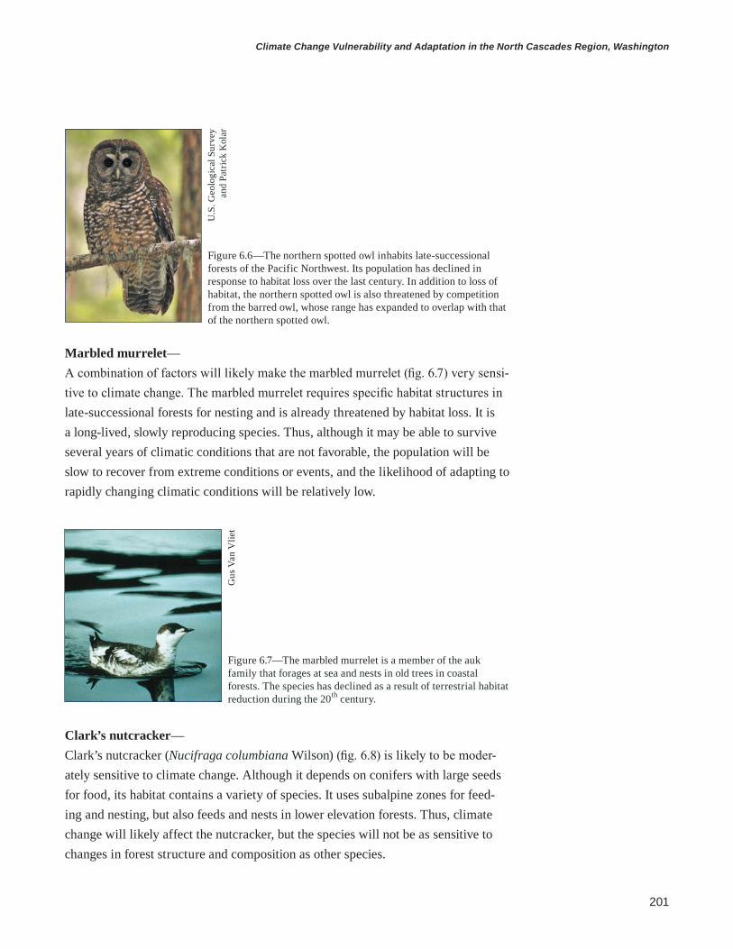
201
Climate Change Vulnerability and Adaptation in the North Cascades Region, Washington
Marbled murrelet— A combination of factors will likely make the marbled murrelet (fig. 6.7) very sensi-tive to climate change. The marbled murrelet requires specific habitat structures in late-successional forests for nesting and is already threatened by habitat loss. It is a long-lived, slowly reproducing species. Thus, although it may be able to survive several years of climatic conditions that are not favorable, the population will be slow to recover from extreme conditions or events, and the likelihood of adapting to rapidly changing climatic conditions will be relatively low.
Figure 6.6—The northern spotted owl inhabits late-successional forests of the Pacific Northwest. Its population has declined in response to habitat loss over the last century. In addition to loss of habitat, the northern spotted owl is also threatened by competition from the barred owl, whose range has expanded to overlap with that of the northern spotted owl.
U.S
. Geo
logi
cal S
urve
y an
d Pa
tric
k K
olar
Figure 6.7—The marbled murrelet is a member of the auk family that forages at sea and nests in old trees in coastal forests. The species has declined as a result of terrestrial habitat reduction during the 20th century.
Gus
Van
Vlie
t
Clark’s nutcracker— Clark’s nutcracker (Nucifraga columbiana Wilson) (fig. 6.8) is likely to be moder-ately sensitive to climate change. Although it depends on conifers with large seeds for food, its habitat contains a variety of species. It uses subalpine zones for feed-ing and nesting, but also feeds and nests in lower elevation forests. Thus, climate change will likely affect the nutcracker, but the species will not be as sensitive to changes in forest structure and composition as other species.

202
general technical report pnw-gtr-892
White-tailed ptarmigan— The white-tailed ptarmigan (Lagopus leucura Richardson) (fig. 6.9) depends on alpine and subalpine habitats, so it is likely to be very sensitive to climate change. Ptarmigans are also more limited in their dispersal ability than other birds and thus may have trouble tracking climatic changes that require movements between distant mountain ranges.
Figure 6.8—The Clark’s nutcracker is a corvid that feeds primarily on large pine seeds. Its use of whitebark pine (Pinus albicaulis Engelm.) seeds may make this species sensitive to climate change because that resource is decreasing as a result of whitebark pine mortality from white pine blister rust (Cronartium ribicola A. Dietr.) and mountain pine beetle outbreaks at higher elevations.
U.S
. Fis
h an
d W
ildlif
e Se
rvic
e, a
nd
Dav
e M
enke
Figure 6.9—The white-tailed ptarmigan is a small grouse species that inhabits alpine and subalpine habitat. Its dependence on cool, high-elevation habitats makes this species particularly sensitive to a changing climate.
John
Hill
Elk— Elk (fig. 6.10) are likely to be relatively insensitive to climate change. The species could be affected by changes in climate, but elk are habitat and forage generalists, so they have more potential food sources even if vegetation distribution and abun-dance change. They can move long distances and tolerate a large range of climatic conditions, which also decreases sensitivity.

203
Climate Change Vulnerability and Adaptation in the North Cascades Region, Washington
Northern red-legged frog— The northern red-legged frog (fig. 6.11) is well adapted to the cool and wet climate of the western Pacific Northwest (PNW). This species inhabits and requires aquatic habitats with stable water levels (such as extensive wetlands, shallow ponds, and slow-moving streams with marshy edges) for the successful completion of its life history (Leonard and McAllister 2005). This species could be sensitive to climate change because of its dependence on these habits that are sensitive to changes in precipitation and hydrologic regimes. Current threats to survival include wetland destruction, habitat degradation and fragmentation, urbanization and residential development, drought, and the introduction of exotic fish and bullfrogs. Climate change has been hypothesized as a potential threat to the survival of the red-legged frog, but present declines are more consistent with other threats (Davidson et al. 2001). Like other amphibians, the northern red-legged frog may experience a change in susceptibility or exposure to diseases such as the chytrid fungus, which is sensitive to temperature (Berger et al. 2004). Movement of the species may be fur-ther restricted if changes in climate lead to drier forest conditions.
Figure 6.10—Elk are one of the largest land mammals in North America. They use a diversity of habitats including low-elevation pastures and high-elevation meadows and forests.
Figure 6.11—The northern red-legged frog inhabits the coastal region from California north to British Columbia.
Wal
ter S
iegm
und

204
general technical report pnw-gtr-892
Wildlife Management in National Forests and National Parks in the North CascadesPlanning and RegulationWildlife management in the national forests and national parks in the NCAP reflects both “fine filter” and “coarse filter” approaches. Fine filter approaches focus on managing individual species whereas coarse filter approaches focus on managing habitat for multiple species by maintaining ecosystem processes and functions. Direction and objectives for managing wildlife and habitat on the national parks and forests are based on a mix of national, regional, and unit-level policies, plans, and programs. Wildlife management practices include (1) manag-ing threatened, endangered, sensitive, and iconic species; (2) monitoring wildlife populations and habitat; and (3) protecting and restoring wildlife habitat.
Direction and objectives for managing wildlife on the Mount Baker-Snoqualmie (MBSNF) and Okanogan-Wenatchee (OWNF) National Forests are based on regional plans and strategies, as well as forest-specific land and resource manage-ment plans (i.e., forest plans). In 1994, the forest plans of both national forests were amended by the Northwest Forest Plan (NWFP) (USDA and USDI 1994). Motivated by litigation associated with the listing of the northern spotted owl as a threatened species under the Endangered Species Act (ESA) of 1973 (ESA 1973), the NWFP provides direction for managing wildlife habitat and surveying critical species within the range of the northern spotted owl, which includes all of the MBSNF and the OWNF north and west of the Chewuch River. The objective of the plan is to provide for the long-term sustainability of forests, including the wildlife species that inhabit them, by establishing late-successional reserves and standards and guidelines for protection and monitoring of late-successional habitat and dependent wildlife species. Despite its emphasis on long-term sustainability, the NWFP did not consider potential effects of climate change on wildlife species or climate-driven changes in disturbance regimes on habitat and late-successional reserves (Mawdsley et al. 2009).
Regional direction for wildlife management in the area of OWNF not covered by the NWFP is provided by the East-Side Screens (the decision notice for the revised continuation of interim management direction establishing riparian, eco-system and wildlife standards for timber sales). Similar to the NWFP, the East-Side Screens directs the OWNF to manage ecosystem processes and functions, but it emphasizes the natural range of variability in ecosystem structure, rather than a system of reserves. Management objectives in the East-Side Screens do not consider climate change and assume static disturbance regimes.

205
Climate Change Vulnerability and Adaptation in the North Cascades Region, Washington
The USDA FS Pacific Northwest Region provides direction to both national for-ests for managing wildlife habitat with the Terrestrial Restoration and Conservation Strategy (TRACS) (USDA FS 2012a). This strategy identifies regional priorities for species, habitats, and watersheds with the greatest need for conservation, restora-tion, and habitat enhancement. Conservation protects and maintains a healthy func-tioning wildlife habitat, restoration improves degraded habitats, and enhancement augments habitat components for featured species. Included in TRACS is a list of species and habitats that are threatened by climate change, and climate change (drought and extreme temperatures) is one factor in prioritizing a species or habitat. The strategy encourages collaboration and integration with external partners to manage wildlife across administrative boundaries and responding to climate change impacts is highlighted as an opportunity for collaboration.
In addition to these regional plans, specific objectives and direction for wildlife management are given in forest plans. The OWNF forest plan, currently under revision, seeks to increase the consistency of objectives in forest-level planning with that of the regional plans. The primary objective of wildlife management in OWNF is to recover and maintain viable populations of native wildlife species, but this objective is balanced with maintaining access for recreation, fire manage-ment, and forest restoration. The revised OWNF forest plan modifies the previous management focus on specific wildlife species with an approach that focuses more on managing ecosystems processes to create diverse landscapes, a key factor in enhancing resiliency of wildlife and vegetation to climate change.
The primary objective for wildlife management at MBSNF is to maintain and restore wildlife resources to ensure the use of these resources and the maximum benefit for the forest, its other resources, and associated communities. Restoration actions for wildlife habitat are prioritized first for species with the highest political and ecological significance and second for species for which actions will result in substantial improvements to habitat and populations.
Direction and objectives for managing wildlife in the national parks are given by the NPS Organic Act (NPS 1916), management policies (USDI NPS 2006b), and individual park foundation statements and general management plans. The NPS management policies direct park managers to maintain the natural abundance, diversity, and genetic and ecological integrity of native wildlife species. Generally, the NPS relies on natural processes to maintain ecosystem functions and compo-nents, but managers can intervene with individuals or populations of native spe-cies when intervention will not cause unacceptable effects on the species or other components and processes of the ecosystem. Furthermore, managers can intervene only to (1) protect unnaturally low or high population levels, (2) protect cultural
The Forest Service has identified regional priorities for species, habitats, and watersheds.

206
general technical report pnw-gtr-892
resources, (3) accommodate development in areas designated for development, (4) protect human health and safety, or (5) protect property when it is not possible to change the pattern of human activities. Shifts in species distributions driven by climate change may challenge policy definitions of native species. Furthermore, these criteria by which managers can intervene to manage populations suggest that attributing climate change to human causes may be necessary to justify interven-tion to maintain current native species that are threatened by climate change.
Management of Wildlife Species in the North CascadesAll NCAP units are home to state or federally listed (sensitive, threatened, and endangered) or candidate species, and managers are required to collaborate with the USFWS and WDFW and participate in species recovery plans. The ESA (1973) requires all federal agencies to conserve threatened and endangered species and prohibits agencies from authorizing, funding, or carrying out any action that would harm a listed species or its habitat.
The MBSNF is home to 3 threatened species and 1 endangered species, as well as an additional 15 sensitive species, species of concern, or management indica-tor species, which include large and small mammals, birds, and amphibians. The national forest participates in recovery plans, and management for these species focuses on monitoring populations and increasing late-successional habitat under the NWFP.
The OWNF participates in recovery plans for several sensitive and listed species including grizzly bear, Canada lynx (Lynx canadensis Kerr), gray wolf, wolverine, fisher (Martes pennanti Erxleben), and the northern spotted owl. Man-agement goals for these species differ but generally focus on reducing negative impacts of roads on habitat quality and connectivity, protecting critical habitats, and restoring late-successional forest conditions and structural components (e.g., large, old trees and large snags). The OWNF participates in the grizzly bear recovery plan (Servheen 1997), which has a goal of “no net loss” of high-quality grizzly bear habitat. The recovery plan limits construction of new roads and trails and seeks to reduce bear-human interactions. The forest plan for OWNF includes provisions to increase habitat for grizzly bears while enhancing safety for humans with vegeta-tion treatments and management of human access, road densities, and recreation facilities. Canada lynx habitat is managed in accordance with the Lynx Conserva-tion Assessment and Strategy, an interagency science-based assessment (Ruediger et al. 2000). Managers protect den sites for the gray wolf. Management of wolverine and fisher, which are listed as sensitive species for the USDA FS Pacific Northwest Region and candidate species for listing under the ESA (1973), will be based on the regional assessment of habitat needs for landscape connectivity.

207
Climate Change Vulnerability and Adaptation in the North Cascades Region, Washington
Climate change provides a new context through which to assess the feasibility of goals and objectives of species-specific recovery plans, given potential effects on populations and habitats. Management of the northern spotted owl on the OWNF provides an example of the consequences of considering only static ecosystems in recovery plans. The OWNF manages for northern spotted owl by restoring the his-torical range of variability of late-successional habitat, but considerable habitat has been lost to extensive, high-severity wildfire. This loss of habitat promoted a shift towards managing for future range of variability. A revised goal of forest restora-tion is to determine the extent and arrangement of late-successional habitat that is sustainable now, but that will also be resilient to climate change and sustainable in a warmer climate with more fire (USDA FS 2012b).
The NPS management policies (USDI NPS 2006b) direct managers to par-ticipate in the recovery planning process; undertake active management programs to inventory, monitor, restore, and maintain habitat for listed species; control detrimental nonnative species; manage detrimental visitor access; and reestablish extirpated populations as necessary. The national parks are required to manage designated critical habitat, essential habitat, and recovery areas to maintain and enhance their value for recovery of threatened and endangered species.
Wildlife ecology programs of the NPS include compliance and inventory, monitoring, research, and protection of threatened and endangered species. Mount Rainier National Park is home to 163 bird species, 55 mammals, 5 reptiles, and 14 amphibians, 2 of which (northern spotted owl and marbled murrelet) are federally listed threatened and endangered species. Another 12 federal species of concern and state-listed species occur or are likely to occur in the park. North Cascades National Park Complex (NOCA) is home to 210 bird species, 78 mammals, 10 reptiles, and 12 amphibians. Of these species, 7 are federally listed species, 2 are federal can-didates, and 16 are state listed. Wildlife managers inventory distributions of listed species and comply with National Environmental Policy Act requirements to protect species from all park activities associated with managing roads, trails, and facilities (NEPA 1969). Both parks are potential sites for an experimental USFWS program to remove barred owls (Strix varia Barton) with the goals of evaluating linkages between northern spotted owl and barred owl populations and investigating the feasibility of barred owl removal as a conservation tool. Mount Rainier National Park includes 10 000 ha of suitable nesting habitat for the marbled murrelet, and management of the species includes radar surveys of populations. The park also has one of three populations of the Cascade red fox, which is a candidate species for state listing.

208
general technical report pnw-gtr-892
A primary focus of wildlife management in MORA and NOCA is to reduce human impacts to wildlife from management and recreational activities. Managers seek to reduce impacts associated with vehicle collisions and human feeding and habituation. Increased visitation associated with warmer temperatures and a longer snow-free season could increase human-wildlife interactions, although increased visitation would likely be concentrated in areas that already have high use. Wildlife managers minimize and mitigate impacts of construction; all newly constructed or rehabilitated facilities are built to avoid critical habitat corridors, nesting, and denning sites, and construction activities are timed to avoid sensitive periods of wildlife activity. These considerations will become more important with increases in construction associated with more flood and landslide damage in a changing climate (see chapter 4).
Management of Wildlife Habitat in the North CascadesIn addition to fine filter approaches focused on listed species, wildlife managers on the national forests and national parks in NCAP protect and maintain ecosystem functions and processes associated with diverse, high-quality habitat for native species. Management for wildlife habitat on the MBSNF focuses on protecting and restoring late-successional habitat in areas outside of wilderness and reserves desig-nated by the NWFP. Habitat management includes commercial and precommercial thinning of 400 to 800 ha per year with the goal of accelerating development of late-successional habitat for old-growth-dependent species.
Management for wildlife habitat in the revised OWNF Land and Resource Management Plan (USDA FS 2011) and Restoration Strategy (USDA FS 2012b) includes objectives for restoring and improving habitat, habitat effectiveness, and core areas on approximately 100 000 ha over the next 15 years. In addition to restoration projects designed for specific species, restoration projects will be designed for groups of species with similar habitat requirements. The restoration strategy shifts management from a focus on commodity production to a focus on ecosystem restoration and resiliency. It focuses on restoring wildlife habitat in dry fire-adapted forests that have been affected by selective harvesting and fire exclu-sion, and it highlights the importance of maintaining forest structures for wildlife such as snags, down woody debris, and large old trees. Currently, the extent of late-successional habitat is below the natural range of variability in several forest types in OWNF because of past management and recent severe fires. Restoration of large trees, snags, and late-successional forest structure will increase the area of late-successional habitat. The forest plan and restoration strategy also emphasize the need for habitat connectivity given the increasing fragmentation of habitat sur-rounding the OWNF.

209
Climate Change Vulnerability and Adaptation in the North Cascades Region, Washington
National Park Service managers focus on protecting and mitigating impacts to ecological processes to preserve populations of native species. Thus manage-ment for wildlife habitat focuses on actions by park staff and visitors rather than habitat modifications. Examples of actions to mitigate impacts on wildlife habitat include (1) restricting helicopter use by season or time of day, (2) restricting trail use because of wildlife use, and (3) prescribing trail density and recreation activi-ties (such as distances between cooking and camping areas) based on impacts to wildlife habitat. Park managers also work cooperatively with the USDA FS and other adjacent land management agencies to protect ecosystem habitat and wildlife corridors.
Monitoring Wildlife and HabitatMonitoring as part of adaptive management is a key component of effective restora-tion and management of wildlife habitat identified by USDA FS policies. To inform their adaptive management program, wildlife managers on the OWNF monitor habitat and wildlife population dynamics, including snag abundance and avian and small mammal response to vegetation treatments. Wildlife managers on the MBSNF monitor populations of northern spotted owls, mountain goats, and winter-ing bald eagles (Haliaeetus leucocephalus L.) in the Skagit River valley. Wildlife managers on both forests survey and manage critical species as required by the NWFP. Currently, wildlife monitoring on the national forests does not emphasize climate change, but monitoring and adaptive management will become increasingly important for detecting effects of climate change on wildlife.
Inventory and monitoring of wildlife species and habitats in MORA and NOCA is conducted at both the park level and at the regional level as part of the North Cascades and Coast Network (NCCN) inventory and monitoring program. Wildlife monitoring by NCCN includes long-term surveys to determine trends in land bird, bat, and forest carnivore populations. Elk are a biologically and politically important species at MORA, so NCCN monitors elk populations there. The park-level inventory and monitoring program in MORA monitors northern spotted owl demography, human impacts to the Cascade fox population, and distributions of butterflies, American pika, amphibians, and harlequin duck (Histrionicus histri-onicus L.). The park-level inventory and monitoring program at NOCA periodically monitors marmots and annually monitors mountain goats, bald eagles, peregrine falcons (Falco peregrinus Tunstall), and butterflies. Wildlife research at NOCA currently includes studies of the western gray squirrel (Sciurus griseus Ord), mountain goat, American pika, grizzly bear, and wolverine. Both parks are under consideration for the reintroduction of fishers.
Monitoring and adaptive management will be important for detecting effects of climate change on wildlife.

210
general technical report pnw-gtr-892
Adapting Management of Wildlife and Wildlife Habitat in a Changing ClimateDuring the NCAP wildlife workshop, participants collaboratively identified adapta-tion options for managing wildlife and wildlife habitat given projected effects of climate change. Participants reviewed basic principles of adaptation and recom-mendations for adapting management of wildlife and biodiversity to a changing climate. In their review of adaptation literature, Heller and Zavaleta (2009) found that research on climate change adaptation has been mostly conceptual and that 70 percent of recommendations in the scientific literature can be classified as general principles rather than specific actionable tactics. Furthermore, because of the dif-ficulties associated with developing experiments to test the effectiveness of adapta-tion actions, many recommendations are based on general ecological principles rather than specific research or empirical data (Heller and Zavaleta 2009).
The adaptation strategies and tactics for wildlife management identified in the NCAP workshop reflect this current state of the science, but participants attempted to increase specificity by identifying on-the-ground actions (i.e., tactics) in addition to general strategies. Adaptation strategies and tactics reflect a mix of fine filter approaches aimed at management of individual species and coarse filter approaches aimed at management of habitats and ecosystem processes, reflecting the mixed model with which wildlife is managed in the region. The adaptation strategies are also a mix of resistance, resilience, and response strategies (see chapter 1 for definitions); the relevance of each approach will likely change with time as climate change effects are realized.
Scientists and managers identified adaptation strategies and tactics for five habitats and associated species: (1) low-elevation maritime forests on the western slopes of the Cascade Range, (2) low-elevation dry forests on the eastern slopes of the Cascade Range, (3) riparian forests, (4) subalpine and alpine ecosystems, and (5) wetlands. In several cases, adaptation strategies identified for management of wildlife habitat are similar or complementary to adaptation strategies identified for vegetation management (see chapter 5), indicating the importance of multidisci-plinary coordination. The similarities of these strategies provide an opportunity to identify “win-win” adaptation strategies for both wildlife and vegetation (Littell et al. 2012).

211
Climate Change Vulnerability and Adaptation in the North Cascades Region, Washington
Adaptation Options for Low-Elevation Maritime Forests on the Western Slopes of the Cascade Range Low-elevation forests on the western slopes of the Cascade Range were considered by managers to be the least sensitive of the five habitats, but participants identified adaptation strategies and tactics to minimize adverse effects of shifts in species distributions and increases in fire and insect disturbances (table 6.1). Ranges of native tree species are likely to shift (Rogers et al. 2011), but forest managers may be able to allow these shifts if the habitat structure and composition continue to support viable populations of threatened and endangered species. However, more wildfire and insect outbreaks will likely decrease the area of late-successional forest habitat and increase habitat fragmentation for species that depend on large areas of late-successional forests. This will challenge forest management under the NWFP, particularly in MBSNF, where management focuses on protecting a static system of late-successional reserves and large areas of contiguous habitat.
In the long term, increasing the resilience of low-elevation maritime forests to fire and insects may be necessary to prevent the loss of critical late-successional habitat (Dale et al. 2001, Millar et al. 2007). At large spatial scales, increasing the diversity of forest structure and age classes can decrease susceptibility and spread of severe and extensive disturbances, thus increasing resilience (Hessburg et al. 2005, Spies et al. 2006). At smaller spatial scales, resilience of individual stands can be increased with vegetation treatments designed to increase tree vigor, accel-erate development of late-successional structure, increase species diversity, and protect critical habitat structures such as nest trees and snags (Halofsky et al. 2011). These treatments can be prioritized in areas projected to have the largest increases in drought stress. Monitoring of insects can detect infestations before outbreaks become extensive, potentially creating triggers for management action to increase forest resilience to insect outbreaks. These tactics are consistent with current man-agement of the matrix, adaptive management areas, and developed zones of national forests, and thus do not represent significant departures from current management. However, managers may consider adjusting priority locations for treatment or prescriptions based on projected changes in species distributions and drought stress.
In the long-term, climate change may motivate managers to consider changes in management that are more significant departures from current practices. For example, managing vegetation in reserves and increasing the use of prescribed fire in ecosystems not historically adapted to fire may increase resilience to more frequent disturbances. This would require a review of the current reserve system and restrictions on management in reserves under the NWFP to increase manage-ment options (Spies et al. 2006). The NWFP and late-successional reserves were
More wildfire and insect outbreaks will decrease the area of late-successional forest and increase habitat fragmentation for some species.
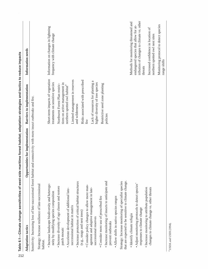
212
general technical report pnw-gtr-892
Tabl
e 6.
1—C
limat
e ch
ange
sen
sitiv
ities
of w
est-
side
mar
itim
e fo
rest
hab
itat;
adap
tatio
n st
rate
gies
and
tact
ics
to re
duce
impa
cts
Ada
ptat
ion
tact
ics
Opp
ortu
nitie
s for
impl
emen
tatio
nB
arri
ers t
o im
plem
enta
tion
Info
rmat
ion
need
s
Sens
itivi
ty: I
ncre
asin
g lo
ss o
f lat
e-su
cces
sion
al fo
rest
hab
itat a
nd c
onne
ctiv
ity w
ith m
ore
inse
ct o
utbr
eaks
and
fire
.
Stra
tegy
: Inc
reas
e re
silie
nce
of la
te-s
ucce
ssio
nal
habi
tat.
• Inc
reas
e la
ndsc
ape
biod
iver
sity
and
het
erog
e-ne
ity b
y m
odify
ing
spec
ies c
ompo
sitio
n• I
ncre
ase
dive
rsity
of a
ge c
lass
es a
nd re
stor
e pa
tch
mos
aic
• Acc
eler
ate
deve
lopm
ent o
f add
ition
al la
te-
succ
essi
onal
hab
itat i
n m
atrix
• Inc
reas
e pr
otec
tion
of c
ritic
al h
abita
t stru
ctur
es
(e.g
., sn
ags a
nd n
est t
rees
)• C
onsi
der p
olic
y ch
ange
s to
allo
w m
ore
man
-ag
emen
t and
ada
ptiv
e m
anag
emen
t in
late
-su
cces
sion
al re
serv
es• C
onsi
der m
ore
use
of p
resc
ribed
fire
• I
ncre
ase
mon
itorin
g of
inse
cts t
o an
ticip
ate
and
prev
ent o
utbr
eaks
• Allo
w sh
ifts i
n na
tive
spec
ies r
ange
s
Shor
t-ter
m im
pact
s of v
eget
atio
n tre
atm
ents
on
sens
itive
spec
ies
Nor
thw
est F
ores
t Pla
n re
stric
-tio
ns o
n ac
tive
man
agem
ent i
n no
rther
n sp
otte
d ow
l hab
itata
Lim
ited
man
agem
ent i
n re
serv
es
and
wild
erne
ss
Ris
ks a
ssoc
iate
d w
ith p
resc
ribed
fir
e
Lack
of r
esou
rces
for p
lant
ing
a hi
gher
div
ersi
ty o
f tre
e sp
ecie
s
Res
trict
ive
seed
zon
e pl
antin
g po
licie
s
Info
rmat
ion
on c
hang
es in
ligh
tnin
g fr
eque
ncy
with
clim
ate
chan
ge
Stra
tegy
: Inc
reas
e m
onito
ring
of sp
ecia
list s
peci
es
that
are
exp
ecte
d to
be
sens
itive
to c
limat
e ch
ange
.
• Ide
ntify
clim
ate
refu
gia
• Adj
ust m
onito
ring
prot
ocol
s to
dete
ct sp
ecie
s’ re
spon
ses t
o cl
imat
e ch
ange
• Inc
reas
e m
onito
ring
to a
ttrib
ute
popu
latio
n ch
ange
s to
clim
ate
chan
ge v
s. ot
her t
hrea
ts
Met
hods
for m
onito
ring
thre
aten
ed a
nd
enda
nger
ed sp
ecie
s tha
t allo
w fo
r at-
tribu
tion
of c
hang
es to
clim
ate
vs. o
ther
th
reat
s
Incr
ease
d co
nfide
nce
in lo
catio
n of
no
rther
n sp
otte
d ow
l nes
t site
s
Mon
itorin
g pr
otoc
ol to
det
ect s
peci
es
rang
e sh
ifts
a U
SDA
and
USD
I (19
94).
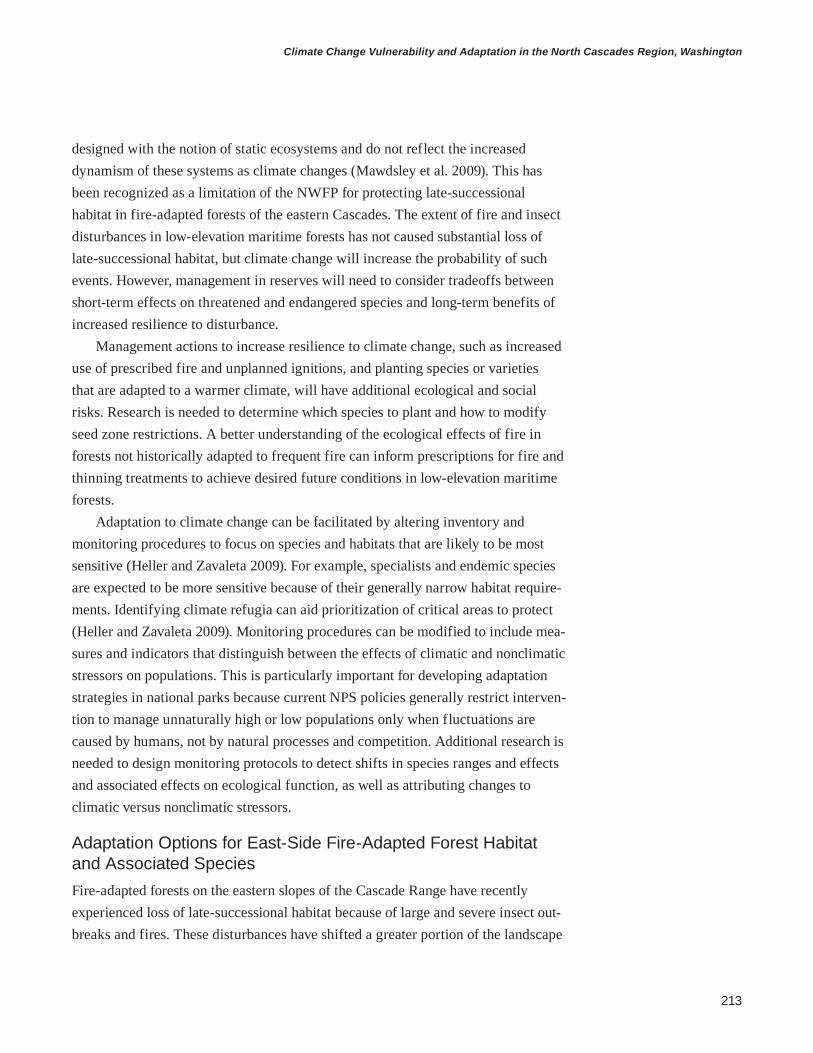
213
Climate Change Vulnerability and Adaptation in the North Cascades Region, Washington
designed with the notion of static ecosystems and do not reflect the increased dynamism of these systems as climate changes (Mawdsley et al. 2009). This has been recognized as a limitation of the NWFP for protecting late-successional habitat in fire-adapted forests of the eastern Cascades. The extent of fire and insect disturbances in low-elevation maritime forests has not caused substantial loss of late-successional habitat, but climate change will increase the probability of such events. However, management in reserves will need to consider tradeoffs between short-term effects on threatened and endangered species and long-term benefits of increased resilience to disturbance.
Management actions to increase resilience to climate change, such as increased use of prescribed fire and unplanned ignitions, and planting species or varieties that are adapted to a warmer climate, will have additional ecological and social risks. Research is needed to determine which species to plant and how to modify seed zone restrictions. A better understanding of the ecological effects of fire in forests not historically adapted to frequent fire can inform prescriptions for fire and thinning treatments to achieve desired future conditions in low-elevation maritime forests.
Adaptation to climate change can be facilitated by altering inventory and monitoring procedures to focus on species and habitats that are likely to be most sensitive (Heller and Zavaleta 2009). For example, specialists and endemic species are expected to be more sensitive because of their generally narrow habitat require-ments. Identifying climate refugia can aid prioritization of critical areas to protect (Heller and Zavaleta 2009). Monitoring procedures can be modified to include mea-sures and indicators that distinguish between the effects of climatic and nonclimatic stressors on populations. This is particularly important for developing adaptation strategies in national parks because current NPS policies generally restrict interven-tion to manage unnaturally high or low populations only when fluctuations are caused by humans, not by natural processes and competition. Additional research is needed to design monitoring protocols to detect shifts in species ranges and effects and associated effects on ecological function, as well as attributing changes to climatic versus nonclimatic stressors.
Adaptation Options for East-Side Fire-Adapted Forest Habitat and Associated SpeciesFire-adapted forests on the eastern slopes of the Cascade Range have recently experienced loss of late-successional habitat because of large and severe insect out-breaks and fires. These disturbances have shifted a greater portion of the landscape

214
general technical report pnw-gtr-892
to earlier successional forests relative to the historical range of variability (Hessburg et al. 2005), and large areas of late-successional habitat set aside as reserves under the NWFP have been lost. The extent and connectivity of late-successional habitat are also threatened by development and land use change. Increasing the resistance and resilience of fire-adapted forests can limit habitat loss to insect outbreaks and fire, especially if these concepts are incorporated in management plans (Dale et al. 2001, Mawdsley et al. 2009). Actions to increase resilience include thinning dense forests, removing accumulated surface fuels (e.g., with prescribed fire), and allowing wildfire to burn in areas where it can beneficially increase diversity in forest structure (table 6.2). The forest restoration and fire programs in fire-adapted forests in OWNF and NOCA currently manage fire as a natural ecosystem process. The OWNF Restoration Strategy and revised forest plan emphasize the additional threat to late-successional habitat associated with more disturbances in a changing climate. Recent modifications to the NWFP recognize the need to manage late-successional habitat in fire-adapted forests as a dynamic system (Spies et al. 2006). Maintaining late-successional habitat in fire-adapted forests will be most successful with a large-scale approach to restoration and protection that recognizes the need to protect critical remnant habitat in some locations while accepting short-term loss in other locations with treatments to increase resilience in the long-term.
Habitat fragmentation caused by urban development limits the ability of species to migrate and shift their ranges as climate changes (Noss 2001). Thus, increas-ing habitat connectivity is the most commonly recommended adaptation strategy for wildlife (Heller and Zavaleta 2009) and managers identified connectivity as a critical adaptation strategy for many species in east-side fire-adapted forests (table 6.2). Climate change provides a new context with which to evaluate current objec-tives and practices for increasing connectivity. Increasing connectivity requires approaches that are tailored to specific species or groups of species. In a changing climate, managers may consider focusing efforts on species with limited dispersal abilities or species that are sensitive to climate change. For these species, the cor-ridors and core habitats designated under current climate may not be as effective in the future as climate, vegetation, and hydrologic regimes change. Furthermore, climate change increases the importance of working across jurisdictions to increase connectivity because it will not be possible to preserve all species in all places. Managing connectivity will require an “all lands” approach that coordinates management among ownerships to protect existing habitat in reserves and increase the permeability of the matrix and unprotected lands so that species can migrate (Hannah et al. 2002).
Resilience in dry forests can be increased by thinning, removing surface fuels, and allowing wildfire to burn in areas where it can diversify forest structure.

215
Climate Change Vulnerability and Adaptation in the North Cascades Region, Washington
Tabl
e 6.
2—C
limat
e ch
ange
sen
sitiv
ities
of e
ast-
side
fire
-ada
pted
fore
sts
habi
tat;
adap
tatio
n st
rate
gies
and
tact
ics
to re
duce
impa
cts
Ada
ptat
ion
tact
ics
Opp
ortu
nitie
s for
impl
emen
tatio
nB
arri
ers t
o im
plem
enta
tion
Info
rmat
ion
need
s
Sens
itivi
ty: L
oss o
f lat
e-su
cces
sion
al fo
rest
hab
itat a
nd g
reat
er h
abita
t fra
gmen
tatio
n be
caus
e of
inc
reas
e in
wild
fire
area
.
Stra
tegy
: Inc
reas
e re
silie
nce
of la
te-
succ
essi
onal
fore
sts a
nd su
rrou
ndin
g ha
bita
t in
dry
fire-
adap
ted
fore
sts.
• Inc
reas
e re
silie
nce
of su
rrou
ndin
g fo
rest
s w
ith th
inni
ng a
nd p
resc
ribed
bur
ning
• Inc
reas
e fu
el re
duct
ion
treat
men
ts in
ur
ban
grow
th b
ound
arie
s• I
ncre
ased
use
of w
ildfir
e fo
r eco
logi
cal
bene
fits
Oka
noga
n-W
enat
chee
Nat
iona
l For
est
(OW
NF)
rest
orat
ion
stra
tegy
a and
re
vise
d fo
rest
pla
n b
New
and
exi
stin
g la
ndsc
ape
rest
ora-
tion
colla
bora
tions
Lack
of a
dapt
ive
man
agem
ent
Lack
of a
mar
ket f
or b
iom
ass
and
mat
eria
ls h
arve
sted
in
treat
men
tsA
ir qu
ality
rest
rictio
nsPu
blic
ave
rsio
n to
smok
eR
estri
ctio
ns o
n m
anag
ing
natu
ral i
gniti
ons o
utsi
de o
f w
ilder
ness
Effe
cts o
f veg
etat
ion
treat
men
ts o
n fo
cal s
peci
esQ
uant
ifica
tion
of sm
oke
emis
sion
s and
ex
posu
re fr
om w
ildfir
e vs
. pre
scrib
ed
fire
Stra
tegy
: Inc
reas
e re
sist
ance
of l
ate-
su
cces
sion
al fo
rest
hab
itat i
n fir
e-ad
apte
d fo
rest
s stra
tegi
cally
acr
oss t
he re
gion
.
• Pro
tect
rem
nant
hab
itat f
rom
fire
and
in
sect
out
brea
ks• M
anag
e an
d pl
an g
row
th in
the
wild
land
-ur
ban
inte
rfac
e• I
ncre
ase
man
agem
ent o
f hum
an ig
nitio
n so
urce
s• I
ncre
ase
use
of c
onse
rvat
ion
ease
men
ts
OW
NF
rest
orat
ion
stra
tegy
a an
d re
vise
d fo
rest
pla
n,b
New
and
exi
stin
g la
ndsc
ape
rest
ora-
tion
colla
bora
tions
Lack
of p
ublic
acc
epta
nce
of
clim
ate
chan
ge
Sens
itivi
ty: S
hifts
in sp
ecie
s ran
ges a
nd lo
ss o
f spe
cies
func
tiona
l typ
es (e
.g.,
polli
nato
rs).
Stra
tegy
: Inc
reas
e ha
bita
t con
nect
ivity
and
pe
rmea
bilit
y.
• Inc
reas
e us
e of
con
serv
atio
n ea
sem
ents
• Inc
reas
e ro
ad c
losu
res a
nd re
stric
tions
on
acce
ss in
crit
ical
hab
itats
• Acc
ept l
oss o
f som
e fa
cets
of e
cosy
stem
to
pro
tect
oth
ers
Res
earc
h fr
om th
e W
ashi
ngto
n W
ild-
life
Hab
itat C
onne
ctiv
ity W
orki
ng
Gro
up (W
HC
WG
)O
WN
F re
stor
atio
n st
rate
gy a
and
re
vise
d fo
rest
pla
nb
Exiti
ng b
arrie
rs to
con
nect
iv-
ity (e
.g.,
road
s)Pr
ivat
e la
ndow
ner r
esis
tanc
eR
esis
tanc
e to
land
acq
uisi
tion
Com
pete
s with
hum
an a
cces
s
Fine
-sca
le a
naly
ses o
f the
stat
ewid
e pr
oduc
ts fr
om th
e W
HC
WG
a USD
A F
S (2
012b
).b U
SDA
FS
(201
1).

216
general technical report pnw-gtr-892
Habitat connectivity and permeability of the matrix can be increased through conservation easements, planning and management of urban growth boundar-ies, restrictions on human use, and road closures to protect critical areas. New and existing landscape restoration efforts that involve multiple agencies provide an opportunity to address habitat connectivity across jurisdictional boundar-ies. National forests and national parks in the NCAP are part of the Washington Wildlife Habitat Connectivity Working Group, which is researching critical cor-ridors and migration pathways that will allow species to shift ranges as climate changes (WHCWG 2011). A fine-scale analysis for specific species and habitats could inform adaptation tactics and priority locations for corridors and core habitat protection.
Although increasing connectivity is a critical adaptation strategy, potential tradeoffs will need to be considered. Increasing connectivity for native species of concern may also increase the spread of invasive species, particularly those that will benefit from a warmer climate with more disturbances. Actions to increase connectivity and permeability in the matrix may compete with human access and development and could be met with public opposition, particularly where skepticism about climate change exists. An “all-lands” approach to managing for habitat con-nectivity is likely to be more successful if it includes public outreach and education on the effects of climate change on wildlife and habitat.
Adaptation Options for Riparian Forest Habitat and Associated SpeciesChanges in hydrologic regimes will affect riparian habitats and riparian obligate species in forests on both the west and east sides of the Cascade Range. More fre-quent floods and higher peak flows could reduce riparian habitat in forests on the western slopes, particularly areas in mixed rain-and-snow basins that will experi-ence the biggest shift in winter precipitation falling as rain rather than snow (see chapter 4). In these basins, adaptation tactics that increase water storage in uplands to regulate runoff can be considered (table 6.3). One tactic is to manage for larger beaver populations that create functional wetlands that store water. Beavers that build dams that destroy roads and trails could be relocated rather than eliminated.
Drier forests on the eastern slopes of the Cascades are also likely to experience changes in hydrologic regimes that will affect riparian habitats and species. Lower snowpack, water availability in the summer, and summer streamflows (see chapter 4) will reduce the function of riparian habitat in drier forests. Similar to the west side, it may be desirable to increase water storage on the landscape in winter to maintain summer water availability and streamflow, and again, maintaining higher beaver populations and the wetland habitats they create would be a useful tactic.
Habitat connectivity for wildlife can be increased through conservation easements, planning for urban growth boundaries, and restrictions on human use and access.
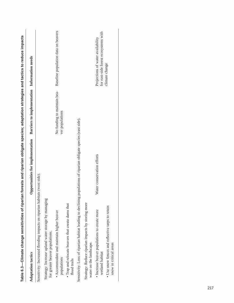
217
Climate Change Vulnerability and Adaptation in the North Cascades Region, Washington
Tabl
e 6.
3—C
limat
e ch
ange
sen
sitiv
ities
of r
ipar
ian
fore
sts
and
ripar
ian
oblig
ate
spec
ies;
ada
ptat
ion
stra
tegi
es a
nd ta
ctic
s to
redu
ce im
pact
s
Ada
ptat
ion
tact
ics
Opp
ortu
nitie
s for
impl
emen
tatio
nB
arri
ers t
o im
plem
enta
tion
Info
rmat
ion
need
s
Sens
itivi
ty: I
ncre
ased
floo
ding
impa
cts o
n rip
aria
n ha
bita
ts (w
est s
ide)
.
Stra
tegy
: Inc
reas
e up
land
wat
er st
orag
e by
man
agin
g f
or g
reat
er b
eave
r pop
ulat
ions
.
• Acc
omm
odat
e an
d m
aint
ain
high
er b
eave
r po
pula
tions
• Tra
p an
d re
loca
te b
eave
rs th
at c
reat
e da
ms t
hat
flood
trai
ls
No
fund
ing
to m
aint
ain
bea-
ver p
opul
atio
nsB
asel
ine
popu
latio
n da
ta o
n be
aver
s
Sens
itivi
ty: L
oss o
f rip
aria
n ha
bita
t lea
ding
to d
eclin
ing
popu
latio
ns o
f rip
aria
n ob
ligat
e sp
ecie
s (ea
st si
de).
Stra
tegy
: Red
uce
ripar
ian
impa
cts b
y st
orin
g m
ore
wat
er o
n th
e la
ndsc
ape.
• Inc
reas
e be
aver
pop
ulat
ions
to c
reat
e m
ore
wet
land
hab
itat
• Use
snow
fenc
es a
nd re
flect
ive
tarp
s to
reta
in
snow
in c
ritic
al a
reas
Wat
er c
onse
rvat
ion
effo
rtsPr
ojec
tions
of w
ater
ava
ilabi
lity
for e
ast-s
ide
fore
st e
cosy
stem
s with
cl
imat
e ch
ange

218
general technical report pnw-gtr-892
Another tactic in areas where snowpack is critical is to use reflective tarps or other devises to retain snow. Funding for such intensive management is not currently available, but if riparian systems become severely compromised by climate change, it may be possible to justify this investment.
Adaptation Options for Wetland Habitats and Associated SpeciesWetlands in the North Cascades are likely to experience changes in hydroperiods as the climate changes. Wetlands provide critical habitat for wildlife, including many amphibian species that are likely to be sensitive to climate change. Workshop participants identified adaptation strategies and tactics to reduce adverse impacts on wetland habitats and species in general and specifically for the western toad (table 6.4). Increasing resilience and resistance of populations of wetland obligate species in response to changes in breeding habitat and survival rates would facili-tate adaptation to climate change (Corn 2005). Additional research on the current distribution of wetlands, changes in wetland hydrology, and methods to reduce climate change effects will facilitate implementation of adaptation strategies.
Reducing nonclimatic stressors is a commonly identified adaptation strategy because it is robust to a range of future climate scenarios and is often consistent with current ecosystem management practices (Heller and Zavaleta 2009, Peterson et al. 2011). Existing efforts in NOCA to reduce introduced fish species in high-ele-vation lakes exemplify how reducing a nonclimatic stressor can increase resilience to climate change (USDI NPS 2006a). Reducing the threat posed by introduced fish species to mountain lake and wetland community dynamics is a low-risk, robust strategy for increasing resilience (Hoffman et al. 2004). Restoration of wetland habitats following timber harvest can improve habitat quality. Some wetlands in the region have been adversely affected by the high density of roads and trails and heavy recreation use. Limiting visitation and closing roads and trails near sensitive wetlands can increase resilience. In many cases, reducing nonclimatic stressors can increase resilience to climate change, but simply continuing current conservation and ecosystem management practices without explicit consideration of climate change will likely be insufficient.
Higher water temperature in lakes and streams may increase rates of disease and fungal and bacterial infections (Blaustein et al. 2010). Closing roads and trails, limiting human access, and educating the public about the sensitivity of wetland communities may reduce the spread of pathogens. Intensive management, such as managed relocation of wetland species, may be necessary to protect high-value rare and sensitive species or populations over the long term (Mawdsley et al. 2009).

219
Climate Change Vulnerability and Adaptation in the North Cascades Region, Washington
Climate change will likely alter phenology and species interactions, thus changing community dynamics in wetlands (Blaustein et al. 2010). Maintaining biological diversity within these systems is one strategy to increase resilience of ecological functions and allow the systems to better respond to changes in climate (Mawdsley et al. 2009). Increased monitoring of population trends and habitat conditions can inform prioritization of critical regions, locations, and species to manage as the climate changes. Adaptive management protocols can be useful for periodically reviewing and adjusting management priorities and objectives as population changes are measured. Resource managers in NCAP national forests and national parks are seeking opportunities to coordinate priorities, monitoring, and management across jurisdictional boundaries, so that biodiversity is maintained in a regional context, rather than separately for each unit (Lawler et al. 2009).
Adaptation strategies for the western toad, an aquatic breeding amphibian spe-cies, are similar to those for wetland habitats and species in general, but additional measures can be taken to facilitate adaptation of this species (table 6.4). Maintain-ing wetland hydrology by managing snowpack with fences and water levels in systems linked to reservoirs can protect aquatic breeding habitat. Using wetland vegetation to increase shade can reduce temperature and moisture stress and protect microhabitats within wetlands (Shoo et al. 2011). Habitat enhancement with woody debris can increase microhabitat structures for climate refugia and egg deposition, thus increasing breeding sites and reproduction (Shoo et al. 2011).
Survival in all life stages can be enhanced with actions to minimize disease spread, manage toadlet migration, and increase invertebrate prey resources. The spread of fungi and pathogens between ponds can be reduced with decontamina-tion, visitor education (e.g., advising swimmers to swim in one pond per visit), and microbial treatments of amphibians at small scales (Harris et al. 2009). Populations can be protected with road or campground closures during critical periods of toadlet migration. Removing exotic fish from ponds and lakes may also increase inver-tebrate prey resources for native amphibians (Knapp et al. 2001). Although many of these actions are already taken at small scales, increasing stress on amphibian populations because of climate change may require that these actions be taken in more locations or more often to ensure population resilience.
Current national forest and national park management objectives for wetlands and associated species present both barriers and opportunities to implementing these adaptation strategies (table 6.4). National Park Service policies limit intensive management of species and habitat components such as vegetation or snowpack, but the policies direct managers to mitigate adverse impacts of human actions. Thus, NPS managers have the authority to manage trails, roads, infrastructure, and
Removing exotic fish species from ponds and lakes may increase invertebrate prey for native amphibians.

220
general technical report pnw-gtr-892
Tabl
e 6.
4—C
limat
e ch
ange
sen
sitiv
ities
of w
etla
nd h
abita
t and
wet
land
obl
igat
e sp
ecie
s; a
dapt
atio
n st
rate
gies
and
tact
ics
to re
duce
im
pact
s
Ada
ptat
ion
tact
ics
Opp
ortu
nitie
s for
impl
emen
tatio
nB
arri
ers t
o im
plem
enta
tion
Info
rmat
ion
need
s
Sens
itivi
ty: R
educ
ed e
mbr
yoni
c an
d la
rval
surv
ival
bec
ause
of c
hang
es in
bre
edin
g ha
bita
t.
Stra
tegy
: Inc
reas
e po
pula
tion
resi
lienc
e an
d re
sist
ance
.
• Red
uce
nonc
limat
ic th
reat
s• R
emov
e ex
otic
fish
• Fac
ilita
te re
cove
ry fr
om p
ast m
anag
emen
t w
ith h
abita
t man
ipul
atio
n• R
eloc
ate
spec
ies a
s nec
essa
ry
Fish
rem
oval
and
ada
ptiv
e m
anag
e-m
ent u
nder
exi
stin
g N
orth
Cas
cade
s M
ount
ain
Lake
s Fis
hery
Man
agem
ent
Plan
/env
ironm
enta
l im
pact
stat
emen
ta
Post
-har
vest
wet
land
reco
very
pro
ject
s
Publ
ic o
ppos
ition
to in
tens
ive
man
agem
ent a
nd u
sing
pes
ti-ci
des i
n la
kes
Iden
tifica
tion
of p
riorit
y si
tes
for fi
sh re
mov
als
Sens
itivi
ty: I
ncre
ased
pre
vale
nce
of d
isea
se a
nd fu
ngal
and
bac
teria
l inf
ectio
ns w
ith a
ssoc
iate
d m
orta
lity.
Stra
tegy
: Inc
reas
e re
silie
nce
to d
isea
se
and
path
ogen
s.
• Use
dev
ices
to re
tain
snow
pack
nea
r sen
sitiv
e ha
bita
t• E
duca
te th
e pu
blic
abo
ut d
isea
se se
nsiti
vitie
s• M
anag
e or
lim
it re
crea
tion
and
othe
r use
th
roug
h cl
osur
es o
r oth
er m
eans
Educ
atio
nal p
artn
ersh
ips w
ith a
mph
ib-
ian
and
rept
ile c
onse
rvat
ion
grou
psLi
mite
d op
portu
nitie
s for
Na-
tiona
l Par
k Se
rvic
e (N
PS) a
ctiv
e m
anag
emen
t of s
now
pack
and
ve
geta
tion
Lim
ited
fund
ing
Sens
itivi
ty: C
hang
es in
phe
nolo
gy a
nd sp
ecie
s int
erac
tions
(e.g
., pr
edat
ion,
com
petit
ion)
of w
etla
nd o
blig
ate
spec
ies.
Stra
tegy
: Inc
reas
e re
silie
nce
by p
rese
rvin
g bi
odiv
ersi
ty.
• Ide
ntify
impo
rtant
hab
itat m
anip
ulat
ions
ba
sed
on m
onito
ring
• Pro
tect
crit
ical
are
as
Wild
erne
ss p
olic
ies l
imit
inte
n-si
ve m
anag
emen
t
Stra
tegy
: Mon
itor a
nd p
riorit
ize
regi
ons f
or
wet
land
s man
agem
ent
• Prio
ritiz
e ha
bita
ts fo
r act
ive
man
agem
ent a
nd
prot
ectio
n ac
ross
juris
dict
iona
l bou
ndar
ies
• Foc
us m
onito
ring
on se
nsiti
ve h
abita
ts a
nd
spec
ies i
n pr
iorit
y re
gion
s• P
erio
dica
lly re
view
and
revi
se p
riorit
ies
Age
ncy
man
date
s for
ada
ptiv
e m
an-
agem
ent
Post
harv
est w
etla
nd re
cove
ry p
roje
cts
Lim
ited
fund
ing
for m
onito
ring
prog
ram
sC
umul
ativ
e ef
fect
s of g
ener
al-
ized
stre
ss o
n en
docr
ine
func
-tio
n in
am
phib
ians

221
Climate Change Vulnerability and Adaptation in the North Cascades Region, Washington
Ada
ptat
ion
tact
ics
Opp
ortu
nitie
s for
impl
emen
tatio
nB
arri
ers t
o im
plem
enta
tion
Info
rmat
ion
need
s
Stra
tegy
: Inc
reas
e po
pula
tion
resi
lienc
e by
r
educ
ing
nonc
limat
ic th
reat
s.
• Man
age
road
, tra
il, a
nd re
crea
tion
impa
cts
• Mai
ntai
n hy
drol
ogy
of c
ritic
al h
abita
ts• I
ncre
ase
habi
tat c
onne
ctiv
ity a
nd
hete
roge
neity
Met
hods
for m
aint
aini
ng h
y-dr
olog
y of
wet
land
s
Stra
tegy
: Inc
reas
e re
silie
nce
to c
hang
es in
t
empe
ratu
re a
nd h
ydro
perio
d by
enh
anci
ng
bre
edin
g si
tes.
• Use
veg
etat
ion
to in
crea
se sh
adin
g of
wet
-la
nds a
nd m
icro
habi
tats
• R
etai
n w
ater
leve
ls in
wet
land
s whe
n co
n-tro
lled
by re
serv
oir s
yste
ms
• Inc
reas
e m
icro
habi
tat s
truct
ures
(e.g
., w
oody
de
bris
) for
mic
rocl
imat
e re
fugi
a, n
estin
g ha
bita
t, an
d eg
g de
posi
tion
stru
ctur
es
Diff
eren
t age
ncy
man
date
s (e.
g.,
NPS
vs.
U.S
. Dep
artm
ent o
f Ag-
ricul
ture
For
est S
ervi
ce);
NPS
ne
eds t
o pr
ove
hum
an in
fluen
ce
to ju
stify
act
ive
man
agem
ent
Incr
ease
d un
ders
tand
ing
of
mic
roha
bita
t req
uire
men
ts fo
r am
phib
ians
Sens
itivi
ty: F
luct
uatin
g nu
trien
t lev
els,
epis
odic
aci
dific
atio
n, e
xace
rbat
ed d
isea
se d
ynam
ics,
and
decr
ease
d pr
ey fo
r Buf
o bo
reas
.
Stra
tegy
: Mai
ntai
n an
d en
hanc
e ha
bita
t qua
lity
to
boos
t sur
viva
l of a
ll lif
e st
ages
.
• Use
dec
onta
min
atio
n pr
oced
ures
and
con
side
r m
icro
bial
trea
tmen
ts• P
rovi
de d
ispe
rsal
cov
er b
etw
een
aqua
tic a
nd
upla
nd h
abita
ts• M
aint
ain
burr
owin
g m
amm
al h
abita
ts• M
anag
e fo
r toa
dlet
mig
ratio
n• I
ncre
ase
inve
rtebr
ate
prey
reso
urce
s
Req
uire
d m
anag
emen
t to
prot
ecte
d sp
ecie
s lis
ted
unde
r the
End
ange
red
Spec
ies A
ctb
Res
earc
h on
met
hods
for i
n-cr
easi
ng p
rey
reso
urce
s
Ecol
ogic
al e
ffect
s of m
icro
bial
tre
atm
ents
Popu
latio
n tra
ject
orie
s for
bur
-ro
win
g m
amm
als
a USD
I NPS
200
6a.
b ESA
197
3.
Tabl
e 6.
4—C
limat
e ch
ange
sen
sitiv
ities
of w
etla
nd h
abita
t and
wet
land
obl
igat
e sp
ecie
s; a
dapt
atio
n st
rate
gies
and
tact
ics
to re
duce
im
pact
s (c
ontin
ued)

222
general technical report pnw-gtr-892
recreational uses that are reducing wetland habitat extent and quality and spreading diseases. Similarly, NPS managers have the authority to remove exotic species and intervene to protect state and federally listed species. In the case of direct effects of climate change on wetlands and species, attributing these changes to human-caused climate change would provide NPS with the authority to mitigate the effects. The NPS can intervene to protect threatened and endangered species, so the ESA (1973) provides an opportunity to implement adaptation strategies designed to increase resilience of threatened and endangered species to climate change. The USDA FS policies provide more options to actively manage habitat outside of wilderness and reserves. Current wetland restoration plans following timber harvests provide an opportunity to evaluate the likelihood of achieving desired objectives given pro-jected changes in climate.
Adaptation Options for Alpine and Subalpine Habitats and Associated SpeciesIncreased monitoring of alpine and subalpine habitats and associated wildlife spe-cies will be needed to quantify the effects of climate change. Monitoring can detect changes in the distribution and abundance of alpine and subalpine habitat. Monitor-ing specifically designed to detect effects of climate change on subalpine and alpine habitats could measure tree encroachment in meadows, changes in upper treeline, soil development, and establishment of herbaceous species in areas that were previ-ously occupied by perennial snow or glaciers (table 6.4).
Intervention could be deemed necessary to protect critical habitat and species. Adaptation tactics for increasing habitat resilience include intensive management to remove trees from meadows with fire or mechanical treatments (table 6.4). Some subalpine and alpine ecosystems in the region are experiencing nonclimatic threats associated with trails and human use. Access to these areas can be restricted to increase habitat resilience. Summer range for elk includes subalpine habitats, but the winter range of elk at lower elevations is often outside the boundaries of national forests and national parks. This example illustrates that climate change may require greater collaboration between resource management agencies and in some cases private landowners to mitigate effects on species with large ranges (Hannah et al. 2002). USDA FS and NPS managers will explore opportunities to increase collaborative efforts with other agencies and landowners to identify and protect winter habitat for elk in an effort to decrease the effects of reduced summer habitat on elk populations.
Adaptation strategies focused on alpine and subalpine habitat may be needed to protect some species that are typically associated with high-elevation vegetation (table 6.5). Limited connectivity between isolated alpine and subalpine habitats
Collaboration between agencies and in some cases private landowners will be needed to mitigate climate change effects on species with large ranges.
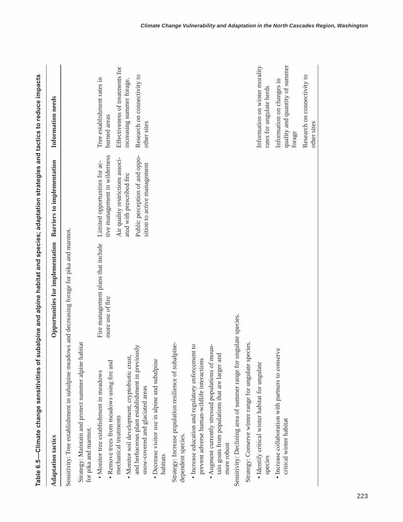
223
Climate Change Vulnerability and Adaptation in the North Cascades Region, Washington
Tabl
e 6.
5—C
limat
e ch
ange
sen
sitiv
ities
of s
ubal
pine
and
alp
ine
habi
tat a
nd s
peci
es; a
dapt
atio
n st
rate
gies
and
tact
ics
to re
duce
impa
cts
Ada
ptat
ion
tact
ics
Opp
ortu
nitie
s for
impl
emen
tatio
nB
arri
ers t
o im
plem
enta
tion
Info
rmat
ion
need
s
Sens
itivi
ty: T
ree
esta
blis
hmen
t in
suba
lpin
e m
eado
ws a
nd d
ecre
asin
g fo
rage
for p
ika
and
mar
mot
.
Stra
tegy
: Mai
ntai
n an
d pr
otec
t sum
mer
alp
ine
habi
tat
for p
ika
and
mar
mot
.
• Mon
itor t
ree
esta
blis
hmen
t in
mea
dow
s• R
emov
e tre
es fr
om m
eado
ws u
sing
fire
and
m
echa
nica
l tre
atm
ents
• Mon
itor s
oil d
evel
opm
ent,
cryp
tobi
otic
cru
st,
and
herb
aceo
us p
lant
est
ablis
hmen
t in
prev
ious
ly
snow
-cov
ered
and
gla
ciat
ed a
reas
• Dec
reas
e vi
sito
r use
in a
lpin
e an
d su
balp
ine
habi
tats
Fire
man
agem
ent p
lans
that
incl
ude
mor
e us
e of
fire
Lim
ited
oppo
rtuni
ties f
or a
c-tiv
e m
anag
emen
t in
wild
erne
ss
Air
qual
ity re
stric
tions
ass
oci-
ated
with
pre
scrib
ed fi
re
Publ
ic p
erce
ptio
n of
and
opp
o-si
tion
to a
ctiv
e m
anag
emen
t
Tree
est
ablis
hmen
t rat
es in
bu
rned
are
as
Effe
ctiv
enes
s of t
reat
men
ts fo
r in
crea
sing
sum
mer
fora
ge.
Res
earc
h on
con
nect
ivity
to
othe
r site
s
Stra
tegy
: Inc
reas
e po
pula
tion
resi
lienc
e of
suba
lpin
e-
depe
nden
t spe
cies
.
• Inc
reas
e ed
ucat
ion
and
regu
lato
ry e
nfor
cem
ent t
o pr
even
t adv
erse
hum
an-w
ildlif
e in
tera
ctio
ns
• Aug
men
t cur
rent
ly st
ress
ed p
opul
atio
ns o
f mou
n-ta
in g
oats
from
pop
ulat
ions
that
are
larg
er a
nd
mor
e ro
bust
Sens
itivi
ty: D
eclin
ing
area
of s
umm
er ra
nge
for u
ngul
ate
spec
ies.
Stra
tegy
: Con
serv
e w
inte
r ran
ge fo
r ung
ulat
e sp
ecie
s.
• Ide
ntify
crit
ical
win
ter h
abita
t for
ung
ulat
e sp
ecie
s • I
ncre
ase
colla
bora
tion
with
par
tner
s to
cons
erve
cr
itica
l win
ter h
abita
t
Info
rmat
ion
on w
inte
r mor
ality
ra
tes f
or u
ngul
ate
herd
s
Info
rmat
ion
on c
hang
es in
qu
ality
and
qua
ntity
of s
umm
er
fora
ge
Res
earc
h on
con
nect
ivity
to
othe
r site
s

224
general technical report pnw-gtr-892
decreases the ability of species to migrate. In the case of species with high social, political, or ecological value, managers may need to consider assisted migration or preserving species ex situ. Human-wildlife interactions such as feeding, habitu-ation, and traffic accidents adversely affect populations. Reducing nonclimatic threats from human-wildlife interactions through greater public education and enforcement can increase population resilience and help maintain some species. Some populations of a species may be more affected by climate change than others, thus long-term management could include augmenting declining populations with individuals from thriving populations elsewhere in the region. For example, moun-tain goat populations in some areas of the North Cascades are well below historical levels, and wildlife managers are considering augmenting these populations, an effort that would require a regional focus to climate change adaptation.
AcknowledgmentsWe thank members of the natural resource staffs at Mount Baker-Snoqualmie National Forest, Okanogan-Wenatchee National Forest, North Cascades National Park Complex, and Mount Rainier National Park for their expertise and input during workshops and subsequent discussions, including Andrea Lyons, Barbara Samora, Bill Gaines, Bob Kuntz, Jesse Plumage, Mason Reid, and Phyllis Reed. We also thank several regional experts for their contributions to the vegetation work-shop including John Lehmkuhl and Meade Krosby. Robert Hoffman, Patty Glick, and Jesse Plumage provided helpful reviews of this chapter.
Literature CitedAmarasekare, P. 2003. Competitive coexistence in spatially structured
environments: a synthesis. Ecology Letters. 6: 1109–1122.
Bahls, P. 1992. The status of fish populations and management of high mountain lakes in the Western United States. Northwest Science. 66: 183–193.
Bates,B.C.;Kundzewicz,Z.W.;Wu,S.;Palutikof,J.P.,eds.2008. Climate change and water. Technical Paper IPCC VI. Geneva, Switzerland: Intergovernmental Panel on Climate Change. 210 p.
Beever, E.A.; Brussard, P.F.; Berger, J. 2003. Patterns of apparent extirpation among isolated populations of pikas (Ochotona princeps) in the Great Basin. Journal of Mammalogy. 84: 37–54.
Beever, E.A.; Ray, C.; Mote, P.W.; Wilkening, J.L. 2010. Testing alternative models of climate-mediated extirpations. Ecological Applications. 20: 164–178.

225
Climate Change Vulnerability and Adaptation in the North Cascades Region, Washington
Berger, L.; Speare, R.; Hines, H.B. [et al.] 2004. Effect of season and temperature on mortality in amphibians due to chytridiomycosis. Australian Veterinary Journal. 82: 434–439.
Beschta, R.L.; Ripple, W.J. 2012. The role of large predators in maintaining riparian plant communities and river morphology. Geomorphology. 157–158: 88–98.
Blaustein, A.R.; Romansic, J.M.; Scheessele, E.A. [et al.]. 2005. Interspecific variation in susceptibility of frog tadpoles to the pathogenic fungus Batrachochytrium dendrobatidis. Conservation Biology. 19: 1460–1468.
Blaustein, A.R.; Wake, D.B. 1990. Declining amphibian populations: A global phenomenon? Trends in Ecology and the Environment. 5: 203–204.
Blaustein, A.R.; Walls, S.C.; Bancroft, B.A. [et al.]. 2010. Direct and indirect effects of climate change on amphibian populations. Diversity. 2: 281–313.
Bronson, F.H. 2009. Climate change and seasonal reproduction in mammals. Philosophical Transactions of the Royal Society B: Biological Sciences. 364: 3331–3340.
Brooks, D.R.; Hoberg, E.P. 2007. How will global climate change affect parasite-host assemblages? Trends in Parasitology. 23: 571–574.
Bradley, B.A. 2009. Regional analysis of the impacts of climate change on cheatgrass invasion shows potential risk and opportunity. Global Change Biology. 15: 196–208.
Bull, E. 2009. Dispersal of newly metamorphosed and juvenile western toads (Anaxyrus boreas) in northeastern Oregon, USA. Herpetological Conservation and Biology. 4: 236–247.
Calfee, R.D.; Bridges, C.M.; Little, E.E. 2006. Sensitivity of two salamander (Ambystoma) species to ultraviolet radiation. Journal of Herpetology. 40: 35–42.
Canto, T.; Aranda, M.A.; Fereres, A. 2009. Climate change effects on physiology and population processes of hosts and vectors that influence the spread of hemipteran-borne plant viruses. Global Change Biology. 15: 1884–1894.
Carpenter, S.R.; Fisher, S.G.; Grimm, N.B. 1992. Global change and freshwater ecosystems. Annual Review of Ecology and Systematics. 23: 119–139.
Carroll, C. 2010. Role of climatic niche models in focal-species-based conservation planning: assessing potential effects of climate change on northern spotted owl in the Pacific Northwest, USA. Biological Conservation. 143: 1432–1437.

226
general technical report pnw-gtr-892
Chen, I.C.; Hill, J.K.; Ohlemueller, R. [et al.]. 2011. Rapid range shifts of species associated with high levels of climate warming. Science. 333: 1024–1026.
Chesson, P. 2000. General theory of competitive coexistence in spatially varying environments. Theoretical Population Biology. 58: 211–237.
Corn, P.S. 2005. Climate change and amphibians. Animal Biodiversity and Conservation. 28: 59–67.
Dale, V.H.; Joyce, L.A.; McNulty, S. [et al.]. 2001. Climate change and forest disturbances. BioScience. 51: 723–734.
Davidson, C.; Shaffer, H.B.; Jennings, M.R. 2001. Declines of the California red-legged frog: climate, UV-B, habitat, and pesticides hypotheses. Ecological Applications. 11: 464–479.
Duarte, H.; Tijedo, M.; Katzenberger, M. [et al.]. 2012. Can amphibians take the heat? Vulnerability to climate warming in subtropical and temperate larval amphibian communities. Global Change Biology. 18: 412–421.
Dukes, J.S.; Mooney, H.A. 1999. Does global change increase the success of biological invaders? Trends in Ecology and Evolution. 14: 135–139.
Elsner, M.M.; Cuo, L.; Voisin, N. [et al.]. 2010. Implications of 21st century climate change for the hydrology of Washington state. Climatic Change. 102: 225–260.
Endangered Species Act of 1973 [ESA]; 16. U.S.C. 1531-1536, 1538-1540.
Erb, L.P.; Ray, C.; Guralnick, R. 2011. On the generality of a climate-mediated shift in the distribution of the American pika (Ochotona princeps). Ecology. 92: 1730–1735.
Froeschke, G.; Harf, R.; Sommer, S.; Matthee, S. 2010. Effects of precipitation on parasite burden along a natural climatic gradient in southern Africa–implications for possible shifts in infestation patterns due to global changes. Oikos. 119: 1029–1039.
Garrett, K.A.; Dendy, S.P.; Frank, E.E. [et al.]. 2006. Climate change effects on plant disease: genomes to ecosystems. Annual Review of Phytopathology. 44: 489–509.
Glick, P.; Stein, B.A.; Edelson, N.A., eds. 2011. Scanning the conservation horizon: a guide to climate change vulnerability assessment. Washington, DC: National Wildlife Federation. 168 p.

227
Climate Change Vulnerability and Adaptation in the North Cascades Region, Washington
Guscio, G.C.; Hossack, B.R.; Eby, L.A.; Corn, P.S. 2007. Post-breeding habitat use by adult boreal toads (Bufo boreas) after wildfire in Glacier National Park, USA. Herpetological Conservation and Biology. 3: 55–62.
Halofsky, J.E.; Peterson, D.L.; O’Halloran, K.A.; Hoffman, C.H. 2011. Adapting to climate change at Olympic National Forest and Olympic National Park. Gen. Tech. Rep. PNW-GTR-844. Portland, OR: U.S. Department of Agriculture, Forest Service, Pacific Northwest Research Station. 130 p.
Hannah, L.; Midgley, G.F.; Millar, D. 2002. Climate change-integrated conservation strategies. Global Ecology and Biogeography. 11: 485–495.
Hansen, L.J.; Hoffman, J.R. 2011. Climate savvy: adapting conservation and resource management to a changing world. Washington, DC: Island Press. 256 p.
Haroldson,M.A.;Ternent,M.A.;Gunther,K.A.;Schwartz,C.C.2002. Grizzly bear denning chronology and movements in the Greater Yellowstone Ecosystem. Ursus. 13: 29–37.
Harris, R.N.; Lauer, A.; Simon M.A. [et al.]. 2009. Addition of antifungal skin bacteria to salamanders ameliorates the effects of chytridiomycosis. Diseases of Aquatic Organisms. 83: 11–16.
Heller, N.E.; Zavaleta, E.S. 2009. Biodiversity management in the face of climate change: a review of 22 years of recommendations. Biological Conservation. 142: 14–32.
Hellmann,J.J.;Byers,J.E.;Bierwagen,B.G.;Dukes,J.S.2008.Five potential consequences of climate change for invasive species. Conservation Biology. 22: 534–543.
Hessburg, P.F.; Agee, J.K.; Franklin, J.F. 2005. Dry forests and wildland fires of the inland Northwest, USA: contrasting the landscape ecology of pre-settlement and modern eras. Forest Ecology and Management. 211: 117–139.
Hillman,S.;Withers,P.;Drewes,R.;Hillyard,S.2009. Ecological and environmental physiology of amphibians. Oxford, United Kingdom: Oxford University Press. 464 p.
Hoffman, R.L.; Larson, G.L.; Samora, B. 2004. Responses of Ambystoma gracile to the removal of introduced nonnative fish from a mountain lake. Journal of Herpetology. 38: 578–585.

228
general technical report pnw-gtr-892
Inouye, D.W.; Barr, B.; Armitage, K.B.; Inouye, B.D. 2000. Climate change is affecting altitudinal migrants and hibernating species. Proceedings of the National Academy of Sciences of the United States of America. 97: 1630–1633.
Kareiva, P.; Kingsolver, J.G.; Huey, R.B. 1993. Biotic interactions and global change. Sunderland, MA: Sinauer Associates, Inc. 480 p.
Kilpatrick A.M.; Briggs, C.J.; Daszak, P. 2010. The ecology and impact of chytridiomycosis: an emerging disease of amphibians. Trends in Ecology and Evolution. 25: 109–118.
Knapp, R.A. 1996. Nonnative trout in natural lakes of the Sierra Nevada: an analysis of their distribution and impacts on native aquatic biota. In: Sierra Nevada Ecosystem Project: final report to Congress. Volume III. Davis, CA: University of California, Davis, Centers for Water and Wildland Resources: 363–407.
Knapp,R.A.;Matthews,K.R.;Sarnelle,O.2001. Resistance and resilience of alpine lake fauna to fish introductions. Ecological Monographs. 71: 401–421
Kupferberg, S.J.; Palen, W.J.; Lind, A.J. [et al.]. 2012. Effects of flow regimes altered by dams on survival, population declines, and range-wide losses of California river-breeding frogs. Conservation Biology. 26: 513–524.
Lacan,I.;Matthews,K.;Feldman,K.2008. Interaction of an introduced predator with future effects of climate change in the recruitment dynamics of the imperiled Sierra Nevada yellow-legged frog (Rana sierrae). Herpetological Conservation and Biology. 3: 211–223.
Lafferty, K.D. 2009. The ecology of climate change and infectious diseases. Ecology. 90: 888–900.
Lawler,J.J.;Shafer,S.L.;Bancroft,B.A.;Blaustein,A.R.2010. Projected climate impacts for the amphibians of the Western Hemisphere. Conservation Biology. 24: 38–50.
Lawler,J.J.;Shafer,S.L.;White,D.[etal.].2009. Projected climate-induced faunal change in the western hemisphere. Ecology. 90: 588–597.
Leonard, W.P.; McAllister, K.R. 2005. Oregon spotted frog, Rana pretiosa, Baird and Girard. In: Jones, L.L.C.; Leonard, W.P. Leonard; Olson, D.H., eds. Amphibians of the Pacific Northwest. Seattle, WA: Seattle Audubon Society: 210–213.

229
Climate Change Vulnerability and Adaptation in the North Cascades Region, Washington
Littell, J.S.; McKenzie, D.; Peterson, D.L.; Westerling, A.L. 2009. Climate and wildfire area burned in western U.S. ecoprovinces, 1916–2003. Ecological Applications. 19: 1003–1021.
Littell, J.S.; Peterson, D.L.; Millar, C.I.; O’Halloran, K.A. 2012. U.S. national forests adapt to climate change through science-management partnerships. Climatic Change. 110: 269–296.
Mantua, N.; Tohver, I.; Hamlet, A. 2010. Climate change impacts on streamflow extremes and summertime stream temperature and their possible consequences for freshwater salmon habitat in Washington state. Climatic Change. 102: 187–223.
Marcogliese, D.J. 2001. Implications of climate change for parasitism of animals in the aquatic environment. Canadian Journal of Zoology. 79: 1331–1352.
Matthews,J.H.;Funk,W.C.;Ghalambor,C.K.2010. Demographic approaches to assessing climate change impact: an application to pond-breeding frogs and shifting hydropatterns. In: Brodie, J.F.; Post, E.; Doak, D., eds. Wildlife conservation in a changing climate. Chicago, IL: University of Chicago Press: 58–85.
Mawdsley,J.R.;O’Malley,R.;Ojima,D.S.2009. A review of climate-change adaptation strategies for wildlife management and biodiversity conservation. Conservation Biology. 5: 1080–1089.
McCaffery, R.M.; Maxell, B.A. 2010. Decreased winter severity increases viability of montane frog population. Proceedings of the National Academy of Sciences of the United States of America. 10: 8644–8649.
McKelvey,K.S.;Copeland,J.P;Schwartz,M.K.[etal.].2011. Climate change predicted to shift wolverine distributions, connectivity, and dispersal corridors. Ecological Applications. 21: 2882–2897.
Millar, C.I.; Stephenson, N.L.; Stephens, S.L. 2007. Climate change and forests of the future: managing in the face of uncertainty. Ecological Applications. 17: 2145–2151.
Moritz, C.; Patton, J.L.; Conroy, C.J. [et al.]. 2008. Impact of a century of climate change of small-mammal communities in Yosemite National Park, USA. Science. 322: 261–264.
Mote, P.W. 2003. Trends in snow water equivalent in the Pacific Northwest and their climatic causes. Geophysical Research Letters. 30: 1601–1604.

230
general technical report pnw-gtr-892
Mote, P.W.; Salathé, E.P.J. 2010. Future climate in the Pacific Northwest. Climatic Change. 102: 29–50.
Naiman, R.J.; Rogers, K.H. 1997. Large animals and system-level characteristics in river corridors. BioScience. 47: 521–529.
National Environmental Policy Act of 1969 [NEPA]; 42 U.S.C. 4321 et seq.
National Park Service Organic Act of 1916 [NPS]; 39 Stat. 535; 16 U.S.C. 1,2,3, and 4.
Nitschke, C.R.; Innes, J.L. 2008. Climatic change and fire potential in south- central British Columbia, Canada. Global Change Biology. 14: 841–855.
Noss, R.F. 2001. Beyond Kyoto: forest management in a time of rapid climate change. Conservation Biology. 15: 578–590.
Ouellet, M.; Mikaelian, I.; Pauli, B.D. [et al.]. 2005. Historical evidence of widespread chytrid infection in North American amphibian populations. Conservation Biology. 19: 1421–1440.
Palen, W.J.; Schindler, D.E. 2010. Water clarity, maternal behavior, and physiology combine to eliminate UV radiation risk to amphibians in a montane landscape. Proceedings of the National Academy of Sciences, USA. 107: 9701–9706.
Parmesan, C. 2006. Ecological and evolutionary responses to recent climate change. Annual Review of Ecology Evolution and Systematics. 37: 637–669.
Parmesan, C.; Yohe, G. 2003. A globally coherent fingerprint of climate change impacts across natural systems. Nature. 421: 37–42.
Parry, M.L.; Canzianai, O.F.; Palutikof, J.P. [et al.], eds. 2007. Climate change 2007: impacts, adaptation, and vulnerability; contribution of working group II to the fourth assessment report of the Intergovernmental Panel on Climate Change. Cambridge, United Kingdom: Cambridge University Press. 976 p.
PearlC.A.;BowermanJ.;Adams,M.J.;Chelgren,N.D.2009. Widespread occurrence of the chytrid fungus Batrachochytrium dendrobatidis on Oregon spotted frogs (Rana pretiosa). Ecohealth. 6: 209–218.
Pearl, C.A.; Bull, E.L.; Green, D.E. [et al.]. 2007. Occurrence of the amphibian pathogen Batrachochytrium dendrobatidis in the Pacific Northwest. Journal of Herpetology. 41: 145–149.

231
Climate Change Vulnerability and Adaptation in the North Cascades Region, Washington
Peterson, D.L.; Millar, C.I.; Joyce, L.A. [et al.]. 2011. Responding to climate change in national forests: a guidebook for developing adaptation options. Gen. Tech. Rep. PNW-GTR-855. Portland, OR: U.S. Department of Agriculture, Forest Service, Pacific Northwest Research Station. 109 p.
Poff, N.L.; Brinson, M.M.; Day, J.W., Jr. 2002. Aquatic ecosystems and global climate change: potential impacts on inland freshwater and coastal wetland ecosystems in the United States. Arlington, VA: Pew Center on Global Climate Change. 45 p.
Pounds, A.J.; Crump, M.L. 1994. Amphibian declines and climate disturbance: the case of the golden toad and the harlequin frog. Conservation Biology. 8: 72–85.
Pounds, J.A.; Fogden, M.P.L.; Campbell, J.H. 1999. Biological response to climate change on a tropical mountain. Nature. 398: 611–615.
Richter, K.O.; Azous, A.L. 2001a. Amphibian distribution, abundance, and habitat use. In: Azous, A.L.; Horner, R.R., eds. Wetlands and urbanization: implications for the future. New York: Lewis Publishers: 143–166. Chapter 5.
Richter, K.O.; Azous, A.L. 2001b. Bird distribution, abundance, and habitat use. In: Azous A.L.; Horner, R.R., eds. Wetlands and urbanization: implications for the future. New York: Lewis Publishers: 167–200. Chapter 6.
Richter, K.O.; Azous, A.L. 2001c. Terrestrial small mammal distribution, abundance, and habitat use. In: Azous A.L.; Horner, R.R., eds. Wetlands and urbanization: implications for the future. New York: Lewis Publishers: 201–220. Chapter 7.
Rogers, B.M.; Neilson, R.P.; Drapek, R. [et al.]. 2011. Impacts of climate change on fire regimes and carbon stocks of the U.S. Pacific Northwest. Journal of Geophysical Research—Biosciences. 116: G03037.
Rohr, J.R.; Dobson, A.P.; Johnson, P.T.J. [et al.]. 2011. Frontiers in climate change-disease research. Trends in Ecology and Evolution. 26: 270–277.
Root, T.L.; Price, J.T.; Hall, K.R. [et al.]. 2003. Fingerprints of global warming on wild animals and plants. Nature. 421: 57–60.
Ruediger, B.; Claar, J.; Gniadek, S. [et al.]. 2000. Canada lynx conservation assessment and strategy. R1-00-53. 2nd ed. Missoula, MT: U.S. Department of Agriculture, Forest Service; U.S. Department of the Interior, Fish and Wildlife Service, Bureau of Land Management, and National Park Service. 142 p.

232
general technical report pnw-gtr-892
Schneider, S.H.; Root, T.L.; Van Putten, M. 2002. Wildlife responses to climate change: North American case studies. Washington, DC: Island Press. 350 p.
Schwartz,M.D.;Ahas,R.;Aasa,A.2006. Onset of spring starting earlier across the Northern Hemisphere. Global Change Biology. 12: 343–351.
Schweiger,O.;Biesmeijer,J.C.;Bommarco,R.[etal.].2010. Multiple stressors on biotic interactions: how climate change and alien species interact to affect pollination. Biological Reviews. 85: 777–795.
Servheen, C. 1997. Grizzly bear recovery plan: North Cascades ecosystem recovery plan chapter. Supplement. Missoula, MT: U.S. Department of the Interior, Fish and Wildlife Service. 24 p.
Shoo, L.P.; 0lson, D.H.; McMenamin, S.K. [et al.]. 2011. Engineering a future for amphibians under climate change. Journal of Applied Ecology. 48: 487–492.
Simpson, W.G. 2009. American pikas inhabit low-elevation sites outside the species’ previously described bioclimatic envelope. Western North American Naturalist. 69: 243–250.
Smith, A.T. 1974. The distribution and dispersal of pikas: influences of behavior and climate. Ecology. 55: 1368–1376.
Smith, A.T. 1978. Comparative demography of pikas (Ochotona): effect of spatial and temporal age-specific mortality. Ecology. 59: 133–139.
Spies, T.A.; Hemstrom, M.A.; Youngblood, A.; Hummel, S. 2006. Conserving old-growth forest diversity in disturbance-prone landscapes. Conservation Biology. 20: 351–362.
Stebbins, R.C. 2003. A field guide to Western reptiles and amphibians. 3rd ed. New York: Houghton Mifflin Harcourt. 560 p.
Stralberg,D.;Jongsomjit,D.;Howell,C.A.[etal.].2009. Re-shuffling of species with climate disruption: A no-analog future for California birds? PLoS ONE. 4: e6825.
Stuart, S.N.; Chanson, J.S.; Cox, N.A. [et al.]. 2004. Status and trends of amphibian declines and extinctions worldwide. Science. 306: 1783–1786.
Thuiller, W.; Lavorel, S.; Araújo, M.B. [et al.]. 2005. Climate change threats to plant diversity in Europe. Proceedings of the National Academy of Sciences, USA. 102: 8245–8250.
Tiner, R.W. 2003. Geographically isolated wetlands of the United States. Wetlands. 23: 494–516.

233
Climate Change Vulnerability and Adaptation in the North Cascades Region, Washington
Traill,L.W.;Lim,M.L.;Sodhi,N.S.;Bradshaw,C.J.A.2010. Mechanisms driving change: altered species interactions and ecosystem function through global warming. Journal of Animal Ecology. 79: 937–947.
Tylianakis, J.M.; Didham, R.K.; Bascompte, J.; Wardle, D.A. 2008. Global change and species interactions in terrestrial ecosystems. Ecology Letters. 11: 1351–1363.
U.S. Department of Agriculture, Forest Service [USDA FS]. 2011. Proposed action for forest plan revision, Okanogan-Wenatchee National Forest. Portland, OR: U.S. Department of Agriculture, Forest Service, Pacific Northwest Research Station. 89 p.
U.S. Department of Agriculture, Forest Service [USDA FS]. 2012a. Region 6 terrestrial restoration and conservation strategy [TRACS]. Portland, OR: U.S. Department of Agriculture, Forest Service, Pacific Northwest Region. 63 p.
U.S. Department of Agriculture, Forest Service [USDA FS]. 2012b. The Okanogan-Wenatchee National Forest restoration strategy: adaptive ecosystem management to restore landscape resiliency. 2012 Version. Portland, OR: U.S. Department of Agriculture, Forest Service, Pacific Northwest Region. 119 p.
U.S. Department of Agriculture, Forest Service; U.S. Department of the Interior, Bureau of Land Management [USDA and USDI]. 1994. Record of decision for amendments to Forest Service and Bureau of Land Management planning documents within the range of the northern spotted owl. [Place of publication unknown]. 74 p. [plus attachment A: standards and guidelines].
U.S. Department of the Interior, National Park Service [USDI NPS]. 2006a. Mountain lakes fishery management plan/EIS. http://parkplanning.nps.gov/projectHome.cfm?projectID=10007. (9 April 2013).
U.S. Department of the Interior, National Park Service [USDI NPS]. 2006b. Management policies: the guide to managing the National Park System. http://www.recpro.org/assets/Library/Agency_Recreation_Resources/nps_policies2006. (9 April 2013).
Verlinden, M.; Nijs, I. 2010. Alien plant species favoured over congeneric natives under experimental climate warming in temperate Belgian climate. Biological Invasions. 12: 2777–2787.
Visser, M.E.; te Marvelde, L.; Lof, M.E. 2011. Adaptive phenological mismatches of birds and their food in a warming world. Journal of Ornithology. 153: 75–84.

234
general technical report pnw-gtr-892
Washington Wildlife Habitat Connectivity Working Group [WHCWG]. 2011. Washington connected landscapes project: climate-gradient corridors report. Olympia, WA: Washington Department of Fish and Wildlife, Washington Department of Transportation. http://www.waconnected.org/wp-content/themes/whcwg/docs/Final%20Climate%20Gradient%20Corridors%20Report%20August%202011.pdf. (17 April 2013).
Wellborn, G.A.; Skelly, D.K.; Werner, E.E. 1996. Mechanisms creating community structure across a freshwater habitat gradient. Annual Review of Ecology and Systematics. 27: 337–363.
Williams, D.D. 2006. The biology of temporary waters. Oxford, United Kingdom: Oxford University Press. 337 p.
Willis, C.G.; Ruhfel, B.R.; Primack, R.B. [et al.]. 2010. Favorable climate change response explains nonnative species’ success in Thoreau’s Woods. PLoS ONE. 5: e8878.

235
Climate Change Vulnerability and Adaptation in the North Cascades Region, Washington
IntroductionThe North Cascadia Adaptation Partnership (NCAP) held a 2-day workshop to assess vulnerability and adaptation options for the management of fish and fish habitat in the North Cascade Range (the area in Washington state from Mount Rainier north to the Canadian border). The workshop brought together regional scientists, fish biologists, and aquatic ecologists. Scientists from the University of Washington Climate Impacts Group, National Oceanic and Atmospheric Adminis-tration (NOAA) Northwest Fisheries Science Center, U.S. Department of Agricul-ture Forest Service (USDA FS) Pacific Northwest Research Station, Seattle City Light, and Tulalip Tribes presented the latest science on climate change effects on fish species and habitats. Fish biologists and aquatic ecologists from national forests and national parks in the NCAP presented an overview of current practices for fish management and aquatic habitat restoration. The goals of the workshop were to (1) identify the key sensitivities of fish and habitat to climate change, (2) review and share current management practices that increase resilience to climate change, (3) use the latest scientific information on climate change effects on fish to identify options for adapting management practices, and (4) identify opportunities to coordi-nate a regional approach to adaptation.
During the first day of the workshop, participants focused on four key sensi-tivities of fish and fish habitat: (1) higher flood frequency and magnitude of peak flows, (2) lower low streamflows, (3) warmer stream temperatures, and (4) higher sedimentation. Here we synthesize the latest scientific information on these sen-sitivities of fish and fish habitat based on information presented in the workshop, subsequent discussions with scientists and managers, and the scientific literature. The second day of the workshop focused on adaptation planning. After reviewing current practices for managing fish in the North Cascades, scientists and managers worked collaboratively to identify adaptations to these management practices to reduce detrimental effects associated with these sensitivities. Results of this adapta-tion planning effort are summarized below.
1 Nathan J. Mantua is a research scientist, National Oceanic and Atmospheric Adminis-tration, Southwest Fisheries Science Center, 3333 North Torrey Pines Court, La Jolla, CA 92037; and Crystal L. Raymond is a climate change strategic advisor, City of Seattle, Seattle City Light, 700 5th Avenue, Seattle, WA 98124 (formerly a research biologist, U.S. Department of Agriculture, Forest Service, Pacific Northwest Research Station, Pacific Wildland Fire Sciences Laboratory, Seattle, WA).
Chapter 7: Climate Change, Fish, and Fish Habitat in the North Cascade RangeNathan J. Mantua and Crystal L. Raymond1

236
general technical report pnw-gtr-892
Effects of Climate Change on StreamflowsGlobal climate model (GCM) simulations are typically used to project future climate for different greenhouse gas emission scenarios. In this assessment of the vulnerability of fish and fish habitat to climate change, we used future temperature and precipitation from monthly mean values generated from 10 GCMs under the A1B emission scenario and downscaled to the Pacific Northwest (PNW). See chapters 3 and 4 for more detail about these data and modeling approach. See box 7.1 for a summary of data and tools used to assess the vulnerability of fish and fish habitat to climate change.
A warming climate, by itself, substantially affects the hydrology of watersheds in the North Cascade Range. Among the key hydrologic changes projected under all scenarios for the 2040s and beyond are a higher fraction of annual precipitation that
Box 7.1—Key datasets and analysis tools that can be used to assess the vulnerability of fish and fish habitat in the North Cascades to climate change• Comprehensivehydrologicdata for long-range water planning in the
Columbia River basin. Includes projections based on Intergovernmental Panel on Climate Change scenarios. Developed by the University of Washington Climate Impacts Group Access at http://www.hydro.washington.edu/2860.
• Streamtemperaturedata for the North Cascade Range. Includes simu-lated weekly average maximum stream temperatures for summer. Developed by University of Washington Climate Impacts Group (Mantua et al. 2010, Snover et al. 2010).
• Fine-scalemonthlyclimatechangedata for the Pacific Northwest. Includes data for monthly meteorological forcings (precipitation, maximum tempera-ture, minimum temperature) at 30 arc-seconds. Developed by University of Washington Climate Impacts Group (Mauger 2011). Access at http://cses.washington.edu/data/met30s.shtml.
• Historicalandprojectedfuturechangesinsoilwaterequivalent (SWE) for Oregon and Washington. Includes simulated SWE data at 30 arc-seconds. Developed by University of Washington Climate Impacts Group (Mauger 2011). Access at http://cses.washington.edu/data/swe30s.shtml.
• Hydroclimatechangeprojections for U.S. Forest Service lands in Oregon and Washington. Includes summaries for Bailey ecosections, Omernik level III ecoregions, and Hydrologic Unit Code (HUC) levels 4 and 5 basins. Developed by University of Washington Climate Impacts Group (Mauger 2011). Access at http://cses.washington.edu/data/ USDA FS_orwa.shtml.
• NetMapcommunitywatersheddatabaseand tools. Includes data devel-oped by users of NetMap and shared analysis tools. Developed by Benda et al. (2007). Access at http://www.netmaptools.org.

237
Climate Change Vulnerability and Adaptation in the North Cascades Region, Washington
falls as rain rather than snow, earlier snowmelt, lower springtime snowpack, higher runoff and streamflow in winter and early spring, lower runoff and streamflow in summer, an extended summer low-flow period, and overall reductions in summer streamflow. These trends are expected for monthly average flows and for stream-flow extremes at a shorter time scale. In addition, substantial increases in high flows (e.g., 20-year return interval flows) are projected for autumn and winter, and substantial reductions in 7-day average summer low flows are projected for most locations in the North Cascades.
Projected Changes in Streamflow TimingHistorical runoff in subbasins of the North Cascades can be classified as either snow dominant or transitional (meaning there are large contributions to cool season streamflow from both rain-fed and snowmelt runoff). Simulations of future runoff indicate a trend away from snow-fed runoff to more rain-fed runoff (Tohver et al., in press). By the 2080s, no snow-dominant subbasins will exist in the North Cascades, and most watersheds will be in the transitional classification (see chapter 4).
Simulated hydrographs for the Sauk River at Sauk, Washington, show the peak runoff in this basin to occur with snowmelt in May and June, whereas in the future, snowmelt runoff will be lower in late spring and early summer, and runoff will be higher in autumn, winter, and early spring (fig. 7.1). The period of annual low flows that historically occurred in September in the Sauk River may become a feature of August and September monthly average flows as early as the 2020s, and this kind of extended and amplified period of summer low flows could be common in most of the watersheds in the North Cascades (Tohver et al., in press) (see chapter 4). The largest reductions in the lowest annual 7-day average flow with a recur-rence interval of 2 years (7Q2) are projected for streams on the west slopes of the Cascades, although reductions of 20 to 40 percent are also widespread for streams on the east slopes of the Cascades in the 2040s and 2080s (fig. 7.2). Peak flows are also projected to increase substantially for many watersheds in the North Cascades (see chapter 4), and 20-year return interval flows are projected to increase 10 to 50 percent for many watersheds for the 2040s, with even larger increases for the 2080s (fig. 7.3).
Projected Changes in Stream TemperaturePeak stream temperatures in summer have been modeled using nonlinear regres-sions between 7-day averages for observed stream and air temperatures, where historical stream temperature records are available (Mantua et al. 2010, Snover et al. 2010). Figure 7.4 shows historical and 2040s August air temperatures and annual maximum of weekly average water temperatures for select locations in Washington

238
general technical report pnw-gtr-892
Figure 7.1—Simulated hydrographs for the Sauk River near Sauk, Washington (U.S. Geological Survey gage 12189500). The x-axis shows a hydrologic year, from October (O) to September (S). The y-axis shows combined monthly average total runoff and baseflow over the entire basin expressed as average water depth (centimeters), a primary component of the simulated water balance and one of the primary determinants of streamflow. Blue lines show simulated historical values; light red bands show the range of different scenarios for the future time period and A1B emission scenario; dark red lines show the ensemble average scenario. From Climate Impacts Group (2010).
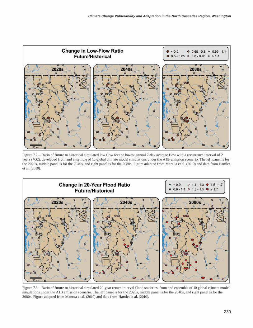
239
Climate Change Vulnerability and Adaptation in the North Cascades Region, Washington
Figure 7.2—Ratio of future to historical simulated low flow for the lowest annual 7-day average flow with a recurrence interval of 2 years (7Q2), developed from and ensemble of 10 global climate model simulations under the A1B emission scenario. The left panel is for the 2020s, middle panel is for the 2040s, and right panel is for the 2080s. Figure adapted from Mantua et al. (2010) and data from Hamlet et al. (2010).
Figure 7.3—Ratio of future to historical simulated 20-year return interval flood statistics, from and ensemble of 10 global climate model simulations under the A1B emission scenario. The left panel is for the 2020s, middle panel is for the 2040s, and right panel is for the 2080s. Figure adapted from Mantua et al. (2010) and data from Hamlet et al. (2010).

240
general technical report pnw-gtr-892
under the multimodel climate change ensemble with the A1B scenario. A number of sites on the west slope of the North Cascades show warming that is large enough to move from “favorable” to “stressful” categories of thermal rearing habitats for salmonids, and a few sites remain within the favorable category (with annual maximum weekly average stream temperature below 17 °C under this scenario for the 2040s).
Snover et al. (2010) applied the same stream temperature modeling approach to a different set of stream temperature records from the Skagit River basin (fig. 7.5). Most modeled locations in the upper Skagit basin have projected temperatures remaining below 13 °C even for the 2080s, which is favorable for salmon and trout spawning and incubation, and all locations had projected temperatures below 17 °C in the 2080s, which is favorable for rearing habitat. These results suggest that some headwater streams in the North Cascades are likely to remain favorable cold-water habitat for salmonids even under significant warming in the 21st century.
Effects of Climate Change on Fish and Fish HabitatMost salmon populations can respond favorably to altered habitat if changes are comparable to those experienced in the past (Waples et al. 2008). This refers primarily to disturbances that affect relatively small patches of habitat compared
Figure 7.4—Color shading shows mean surface air temperatures for August, and shaded circles show the simulated mean of the annual maximum for weekly water temperatures (average, not transient) at select locations. Historical (1970–1999) reference period data are in the left panel, and the average future scenario for an ensemble of 10 global climate models under the A1B emissions scenario for the 2040s is shown in the right panel. The color scheme used here is tailored to three general catego-ries for thermal rearing habitats for salmonids: greens indicate favorable, yellows indicate stressful, and reds indicate fatal.
Many areas on the west slope of the North Cascades will be stressful for rearing habitats for salmonids.

241
Climate Change Vulnerability and Adaptation in the North Cascades Region, Washington
to the much larger spatial extent of evolutionarily significant population groups influenced by physiographic features. It is unknown if salmon populations in the North Cascades can adapt through phenological, phenotypic, or evolutionary mechanisms fast enough to survive a combination of climate change, altered habi-tat, and other stresses in the future (Crozier et al. 2008). However, it should be noted that genetic variants of some salmon species can in some cases adapt to changing
Figure 7.5—August mean surface air temperature and maximum weekly average water temperatures for select locations in the Skagit River basin. The color scheme used here is tailored to three general categories for thermal rearing habitats for salmonids. For mean air temperature, greens indicate favorable, yellows indicate stressful, and reds indicate fatal. The color scheme for stream temperature is associated with criteria for salmonids: green indicates temperatures below 17 °C.

242
general technical report pnw-gtr-892
environmental conditions (Quinn and Unwin 1993), at least in the short term and if conditions are not extreme.
If salmon cannot adapt to rapidly changing habitat conditions, then higher stream temperature, altered streamflow, and other limiting factors will result in reduced quality and quantity of freshwater habitat (box 7.2). Effects on fish and fish habitats related to stream temperature, high flows, summer low flows, and sedi-mentation are summarized below.
Stream TemperatureWater temperature is a key aspect of water quality for salmonids, and excessively high water temperature affects their distribution, migration, and health (Farrell et al. 2008, McCullough 1999, Richter and Kolmes 2005, U.S. Environmental Protec-tion Agency [EPA] 2007). Excessively warm water can inhibit salmon migration and breeding patterns and reduce cold-water refugia and connectivity. When aver-age water temperature is higher than 15 °C, salmon can suffer increased predation and competitive disadvantages with other native and nonnative warm-water fish (EPA 2007). Water temperatures higher than 21 to 22 °C can prevent migration (Goniea et al. 2006, High et al. 2006, Hyatt et al. 2003, McCullough 1999). Fur- thermore, adult salmon become more susceptible to disease and the transmission
Box 7.2—Existing and emerging threats to fish and fish habitat in the North Cascades • Reduced summer low flows, in some cases related to irrigation withdrawals,
diminish and degrade available spawning habitat, rearing habitat, and migra-tion corridors.
• Extreme peak flows scour redds while eggs are incubating.• Invasive fish species perform better in warmer water and compete with or
prey on native cold-water fish.• Debris torrents are more frequent and intense in aggrading river channels.• Floodplain connectivity is reduced, limiting off-channel habitats and habitat
complexity that provide thermal buffers, thermal habitat diversity, and slow-water refugia from extreme high-flow events.
• Culverts, dams, natural falls, and logjams provide significant barriers to fish passage.
• Roads and related infrastructure, including hardened and engineered stream-banks, degrade fish habitat.
• Maximum summer stream temperatures exceed key ecological thresholds for salmonids, contributing to adult migration barriers and increased susceptibil-ity to pathogens.
Excessively high water temperature affects the distribution, migration, and health of salmonids.

243
Climate Change Vulnerability and Adaptation in the North Cascades Region, Washington
of pathogens in warmer water, and prolonged exposure to stream temperature above around 21 °C (although this varies by species) can be lethal for juveniles and adults (McCullough 1999). However, in some cases, adult salmon can migrate upstream through unfavorable temperatures by moving to areas with cool groundwater inputs, giving the impression that they tolerate high temperatures when in fact they are taking advantage of local thermal variation (Berman and Quinn 1991). Some species such as rearing coho (Oncorhynchus kisutch Walbaum) can tolerate stream temperatures as high as 29 °C for brief durations, as observed following the 1980 eruption of Mount St. Helens, as long as food is plentiful (Bisson et al. 2005).
Stream temperature modeling projects significant increases in water tempera-ture and thermal stress for salmon in portions of the North Cascades for both the A1B and B1 scenarios (Mantua et al. 2010, Snover et al. 2010). Projected water temperature patterns indicate there will be increases in the number of locations that are stressful for salmon in summer (where water temperature is higher than 18 °C) (figs. 7.4 and 7.5). Summer air temperatures higher than 18 °C will become increasingly common for western Washington by the 2040s when only the higher elevations of the Cascades have surface air temperatures like those characteristic of the western Washington lowlands in the 1980s (figs. 7.4 and 7.5).
Climate change is also projected to increase the frequency and persistence of thermal migration barriers and thermally stressed waters for salmon. Weeks with water temperature higher than 21 °C will increase considerably for the warmer streams in western Washington, such as the Stillaguamish River at Arlington, Washington, where in recent years these conditions existed for a maximum of a few weeks each summer. For this station, the period with water temperature higher than 21 °C persists up to 13 weeks by 2100 and is centered on the first week of August under the composite A1B scenario (Mantua et al. 2010) (fig. 7.6). The upper reaches of North Cascades watersheds are likely to remain much cooler than lower reaches (e.g., Stillaguamish River at Arlington). The lower reaches are typically key migration corridors for summer-running adult salmon on their spawning migration, indicating that thermal migration barriers and thermal stress will increase in at least some salmon populations in North Cascades watersheds with especially warm lower reaches.
Projected increases in water temperature will proceed at about an equal pace on both sides of the Cascade Range, although shifts to increasingly stressful thermal regimes for salmon will be highest for low elevations and the east side where the historic baseline for water temperatures are typically warmer than those at higher elevations. It is also likely that a warmer climate will reduce the availability of cold-water refugia in some North Cascades watersheds, although additional research

244
general technical report pnw-gtr-892
Figure 7.6—Simulated number of weeks each year that stream water tem-perature exceeds 21 °C (average, not transient) (top panel), and chronological weeks in each simulated year in which water temperature exceeds 21 °C (bot-tom panel) for the Stillaguamish River at Arlington, Washington. All points (historical and future) are from a simulation based on a regression between observed air temperature and the annual maximum of weekly average stream temperature, based on air temperature observations for 1916–2006, and the 10-model average A1B emission scenario for 2007–2100. Historical simula-tions had no years with more than 3 weeks of water temperature higher than 21 °C, but this thermal threshold is consistently exceeded starting in the 2030s. Multiple points for a given year represent multiple weeks with water temperature higher than 21 °C. Week 30 is approximately the last week of July. From Mantua et al. (2010).

245
Climate Change Vulnerability and Adaptation in the North Cascades Region, Washington
is needed to determine the spatial extent of this effect. The effects of glaciers, and their projected decrease in mass balance, on streamflow and temperature in different watersheds is poorly quantified, although one would expect that smaller, high-elevation streams in basins with significant coverage of glaciers would be more responsive to glacial meltwater than larger, low-elevation streams. Tributaries that face east have a higher contribution of glacial melt than west-facing streams (Snover et al. 2010) and may therefore be more sensitive to variation in glacial melt.
Limiting environmental factors differ for different stocks and species of Pacific salmon, which have a diversity of life history and habitat characteristics. For example, the most important factors for juvenile coho survival in freshwater are (1) in-stream temperature during the first summer, combined with the avail-ability of deep pools to mitigate high temperatures, and (2) temperature during the second winter, combined with the availability of beaver (Castor canadensis Kuhl.) ponds and backwater pools to serve as refuges from cold temperatures and high streamflow (Beechie et al. 1994, Reeves et al. 1989). Consequently, a combination of higher summer water temperature, lower summer streamflow, and higher winter flows and will create unfavorable conditions for coho salmon.
The effects of warming streams will differ for different fish populations. Sig-nificant increases in stream temperature alone will create thermal stress for salmon populations that have a stream-type life history that puts them in freshwater during summer for spawning, rearing, spawning migrations, or seaward smolt migrations. In the absence of thermal cues for initiating spawning migrations, temperature effects on adult spawning migrations are projected to be most severe for stocks with summertime migrations. These stocks include summer-run steelhead (Oncorhyn-chus mykiss Walbaum), sockeye (O. nerka Walbaum), bull trout (Salvelinus confluentus Suckley), and summer chinook (O. tshawytscha Walbaum in Artedi) populations. Higher stream temperatures pose risks to the quality and quantity of favorable rearing habitat for stream-type chinook and coho salmon, steelhead (sum-mer and winter run), and bull trout, because these stocks spend at least one summer (and for Washington steelhead typically two summers) rearing in freshwater. Lower summer and autumn low flows in transient and rainfall-dominated basins might also reduce the availability of spawning habitat for salmon and bull trout popula-tions that spawn early in the autumn (e.g., Healey 1991).
Warmer water in streams in winter and spring may result in longer growing seasons for vegetation, increased productivity of aquatic food webs, and faster juvenile salmon growth and development in the freshwater life cycle (Beer and Anderson 2011, Schindler and Rogers 2009). It is possible that this could increase overall life-cycle productivity for some salmonids, such that positive effects
Increased stream teperature will create thermal stress for salmon populations that have a stream-type life history.

246
general technical report pnw-gtr-892
outweigh negative effects of climate change. For example, warmer stream tempera-tures benefited coho salmon adjacent to areas harvested for timber on Vancouver Island, British Columbia (Holtby 1988). Logging increased stream temperature (0.7 °C in December and over 3 °C in August), which in turn contributed to higher growth in juvenile coho, acceleration of its freshwater life history, and higher overwinter survival rates for rearing juveniles. However, these apparent benefits were balanced by reduced marine survival rates through earlier smolt migrations to the ocean that may have been mismatched with ocean prey and predator avail-ability. Warmer stream temperatures increased the full life-cycle coho production in this system by approximately 9 percent (Holtby 1988). The potential for positive effects of stream warming is highest in the coldest streams, such as those found on the west side and at high elevations in the North Cascades.
Peak StreamflowSeasonal and daily streamflow variations are limiting factors for freshwater salmon habitat (Beechie et al. 2006, Rand et al. 2006). For chinook salmon in the Skagit River, annual flood magnitude was a significant predictor of freshwater survival rates (larger floods caused lower survival rates) (Seiler et al. 2003) and total life-cycle return rates (Greene et al. 2005). These effects may be caused by several mechanisms linking peak incubation flows to early freshwater life-stage survival rates for salmon. Extreme flows during egg incubation periods can limit egg-to-fry survival rates by scouring redds, crushing eggs with mobilized gravels (De Vries 1997, Holtby and Healy 1986, Montgomery et al. 1996), depositing fine sediments on redds that reduce available oxygen (Lotspeich and Everest 1981), and reducing populations of interstitial invertebrates. Peak flows can also reduce availability of slow-water habitats, which can flush rearing juveniles downstream from preferred habitats and subsequently reduce freshwater survival rates (Latterell et al. 1998).
Of all potential effects of climate change on the reproductive success of ocean-type chinook salmon in the Snohomish River basin, projected increases in extreme high flows were the most damaging (Battin et al. 2007). Projected increases in the intensity and frequency of winter flooding in the transient runoff basins of the North Cascades will likely reduce egg-to-fry survival rates for pink (Oncorhynchus gorbuscha Walbaum), chum (O. keta Walbaum in Artedi), sockeye, chinook, and coho salmon because of increased intensity and frequency of redd and egg scour-ing. However, the effects of more winter flooding will likely differ across species and populations because redd depth is a function of fish size (deeper redds will be

247
Climate Change Vulnerability and Adaptation in the North Cascades Region, Washington
less vulnerable to scouring and the deposition of fine sediments). Parr-to-smolt sur-vival will likely decrease for coho and stream-type chinook salmon and steelhead because higher peak flows reduce availability of slow-water habitat and increase the displacement of rearing juveniles downstream, although in some cases, high flows may provide access to floodplain habitats that might not otherwise be accessible. Lower spring snowmelt may reduce smolt migrations from snowmelt dominant and transient streams in which seaward migration has evolved to match the timing of peak flows from snowmelt.
Summer Low StreamflowEarlier snowmelt and higher evaporation in most North Cascades river basins will reduce streamflow in summer and early autumn, resulting in an extended period of summer low flows, and rainfall-dominant basins are projected to have substantially lower base flows. In combination with higher summer stream temperature, reduced summer flow will limit rearing habitat for salmon with stream-type life histories (in which juveniles rear in freshwater for one or more years) and increase mortality during spawning migrations for summer-run adults.
Management of Fish and Fish Habitat in the North CascadesThe two national forests and two national parks in the NCAP manage for threat-ened fish species and naturally occurring riparian processes and aquatic habitat. Fish are managed under the direction of multiple federal, regional, and unit-level policies and guidelines. Many watersheds in the North Cascades provide critical habitat for anadromous fish species and bull trout listed under the federal Endan-gered Species Act (ESA) of 1973. Although management objectives for fish differ among the national forests and national parks based on agency mandates and past management, management on all four units focuses on recovering populations of listed anadromous fish and bull trout and protecting and restoring natural aquatic processes that create high-quality habitat for fish and other aquatic organisms.
In the North Cascades, the USDA FS, the National Park Service (NPS), other resource management agencies, local utilities, municipal watersheds, watershed councils, and many tribes collaborate to manage fish populations concurrently with objectives for recreation, hydroelectric power generation, roads and infrastructure, and cultural resources. Current management reduces nonclimatic threats to fish populations including diseases, nonnative fish species, fish passage barriers, and adverse effects caused by roads, infrastructure, and recreation.
Earlier snowmelt and higher evaporation will reduce streamflow in summer and early autumn.
248
general technical report pnw-gtr-892
Management of Fish and Fish Habitat on the Mount Baker-Snoqualmie and Okanogan-Wenatchee National ForestsThe Mount Baker-Snoqualmie National Forest (MBSNF) and Okanogen-Wenatchee National Forest (OWNF) manage for fish and aquatic habitat under the direction of the Northwest Forest Plan (NWFP) Aquatic Conservation Strategy (USDA and USDI 1994) and Pacific Northwest Region Aquatic Restoration Strategy (USDA FS 2005). Two additional plans apply to fish habitat in OWNF only—the Interim Strategy for Managing Anadromous Fish-Producing Watersheds in Eastern Oregon and Washington, Idaho and Portions of California (USDA and USDI 1995) and the Interim Strategy for Managing Fish-Producing Watersheds in Eastern Oregon and Washington, Idaho, Western Montana, and Portions of Nevada (USDA FS 1995). All of MBSNF and OWNF west and north of the Chewuch River are within the jurisdiction of the NWFP Aquatic Conservation Strategy. The objective of the plan is to prevent further degradation of aquatic habitat and restore and maintain aquatic process on USDA FS and Bureau of Land Management lands within the range of the northern spotted owl (Strix occidentalis caurina Merriam) (USDA and USDI 1994). The long-term (100 years) goal of the strategy is to develop a network of functioning watersheds that can support populations of native fish and other aquatic organisms (Reeves et al. 2006). The aquatic conservation strategy achieves this goal through (1) watershed analysis, (2) riparian reserves with harvesting restricted to that necessary for desired vegetation conditions for aquatic habitat, (3) designa-tion of key watersheds, (4) watershed restoration, and (5) standards and guidelines for management activities that could affect aquatic habitats.
Management direction for fish and aquatic habitat in the portion of OWNF not covered by the NWFP is directed by the strategies PACFISH (USDA and USDI 1995) and INFISH (USDA FS 1995). PACFISH provides direction for protecting and restoring watersheds in the western Pacific Northwest that support anadro-mous fish. INFISH provides direction for maintaining aquatic habitat for native fish species on national forest lands in the eastern PNW. The primary objective of these regional strategies is to maintain and restore aquatic habitat and protect listed fish species by reducing current threats associated with timber harvesting, roads, recreation, fish passage barriers, and loss of stream channel complexity. Although objectives of the regional strategies are similar, differences in terminology and requirements create a complex policy and regulatory environment for managing fish and aquatic habitat.
Additional direction for managing fish and aquatic habitat in the national for-ests is provided by forest-specific land and resource management plans (e.g., forest plan). The OWNF forest plan (currently in revision) consolidates direction provided

249
Climate Change Vulnerability and Adaptation in the North Cascades Region, Washington
by the multiple regional strategies into one common strategy for managing aquatic habitat. Direction for restoring aquatic habitats is also included in the forest restora-tion strategy. The goal of the forest plan and forest restoration strategy is to protect aquatic habitat by reducing existing threats and restoring habitat that has been adversely affected by past management, especially threats associated with roads.
Managers identify roads and road segments with the highest impact on aquatic habitat based on hydrologic connectivity, fish distribution, slope and soil stability, and stream channel confinement. Site-specific restoration plans are developed, including several possible practices such as relocation, reconstruction, storm proofing, upsizing culverts, and road closure and decommissioning. The OWNF is currently taking the following actions to reduce current threats: (1) prioritizing roads for closure and decommissioning, (2) removing culverts to reduce sediment input, (3) modifying stream crossing surfaces, (4) installing drainage crossings, and (5) reducing storm damage. Human-caused confinement of stream channels is reduced by replacing culverts with bridges that span the active channel, relocating roads from active flood plains, upsizing stream crossings to reduce channel con-striction, and reconstructing road segments that contain berms. Large woody debris are placed in and near streams to modify waterflow, provide habitat, and increase the complexity of stream channels where past management has reduced input of large woody debris. In addition to these actions to restore habitat, the OWNF coor-dinates with other state and federal agencies to manage fish species listed under ESA and participate in species-specific recovery plans. The OWNF is home to four federally listed threatened and endangered species, five species of concern, and critical habitat for two additional species. Management of aquatic habitat must meet objectives of the recovery plans for chinook salmon, steelhead, and bull trout in the Upper Columbia and Yakima River basins, and for bull trout in the Washington state recovery plan.
The MBSNF forest plan was amended by the NWFP aquatic conservation strategy in 1994, and a new forest plan has not been completed since then. Fish management focuses on (1) maintaining or improving aquatic and riparian areas with both active and passive restoration of watershed conditions and (2) protecting and restoring aquatic habitats for the benefit of fish resources. Managers on the MBSNF implement a range of actions to accomplish these goals with an emphasis on restoring natural aquatic processes. Fish biologists work with recreation special-ists and engineers to reduce detrimental impacts to aquatic habitat associated with roads and trails. The MBSNF is completing a forestwide roads analysis and water-shed analysis to identify priorities and locations for restoration. Ongoing inventories will evaluate baseline conditions, opportunities for restoration, and effectiveness of

250
general technical report pnw-gtr-892
restoration, including a survey of current road conditions and fish passage barriers. Managers work to restore aquatic habitat in partnership with other resource man-agement agencies and tribes and collaborate on species-specific recovery plans.
Management of Fish and Fish Habitat at Mount Rainier and North Cascades National ParksNational Park Service management policies (USDI NPS 2006) direct park managers to preserve and restore native fish species by preserving and restoring the natural abundances, diversities, dynamics, and distributions of native populations; restoring native populations when they have been extirpated by past human-caused actions; and minimizing human impacts on native species, ecosystems, and the processes that sustain them. Native species are defined as species that “have occurred, now occur, or may occur as a result of natural processes” (USDI NPS 2006). Exotic species are those that occupy national park lands directly or indirectly as the result of human activities, and are not considered to be a natural component of the ecosys-tem. Native species are maintained primarily through natural processes, but active management is used when intervention will not cause unacceptable effects and is required to maintain populations affected by humans.
Park-specific general management plans (GMP) guide management of fish and aquatic habitat. The Mount Rainier National Park (MORA) GMP (USDI NPS 2001) directs managers to preserve or restore natural aquatic habitats and the natural abundance and distribution of native aquatic species, and provides the authority to manage exotic fish species when they threaten park resources or public health and when control is feasible. The park conserves all federally threatened and endan-gered species and their critical habitats. MORA is home to eight species of native fish, two of which are listed as threatened under ESA (1973) (chinook salmon and bull trout) and another two are proposed for listing (coho salmon and coastal cut-throat trout [O. clarkii clarkii Richardson]). Several rivers in the park are currently blocked to anadromous fish passage by dams outside park boundaries. Managers work collaboratively with other state, federal, local, and tribal resource management agencies to restore native resident and anadromous fish species.
Direction for management of fish and aquatic habitat at North Cascades National Park Complex (NOCA) is provided by the NOCA foundational statement and the GMPs of North Cascades National Park, Ross Lake National Recreation Area, and Lake Chelan National Recreation Area. Aquatic habitats are managed primarily by protecting ecological processes such as the natural movement of streams (stream meandering), rather than by managing for specific species or biophysical features. For example, the Stehekin River has changed course naturally
251
Climate Change Vulnerability and Adaptation in the North Cascades Region, Washington
over time in response to flooding and other river dynamics, thus, the management goal for the river is to maintain the natural movement of the channel whenever possible and to control river movements only where it is necessary to protect facili-ties or human health and safety. Individual species are managed only if they are classified as threatened or endangered. Park managers collaborate with NOAA, the U.S. Fish and Wildlife Service, and other agencies to ensure that listed species and their habitat are protected by actively participating in recovery plans. Managers also inventory and monitor listed species and critical habitat.
Most lakes in NOCA do not naturally contain fish, but many lakes have been stocked with exotic fish (salmonids) through a Washington Department of Fish and Wildlife (WDFW) program that maintains a recreational fishery. In 2009, NOCA developed the Mountain Lakes Fishery management plan (USDI NPS 2009) in coordination with WDFW in order to conserve native biological integrity while providing recreational fishing opportunities. Focused on 91 naturally fishless lakes, the plan includes authority and guidelines for removing reproducing populations of exotic fish that have achieved high densities, followed by monitoring the recovery of native species. Some lakes will continue to be stocked by WDFW with fish spe-cies that are not capable of reproduction.
Management of fish and aquatic habitat in the two recreational areas within NOCA emphasizes recreation associated with boating and fishing. Fishing is permitted in Ross Lake and Lake Chelan National Recreation Areas in accordance with federal and Washington state laws. Ross Lake is a popular fishing resort with a naturally reproducing fishery. In the recreational areas, fish management must balance the demands of recreation with preservation and protection of the fisheries resource. In addition to managing fisheries for recreation, the recreational areas also protect habitat for fish by protecting shoreline areas that provide spawn-ing, feeding, and rearing habitats for fish, and support rare aquatic plant species. Managers have the authority to use occasional or seasonal closures of specific areas when drought or other conditions warrant additional resource protection. The recreational areas also preserve genetic resources by maintaining the abundance of unique populations to achieve desired levels of genetic variability.
Adapting Fish Management to Climate Change in the North CascadesMany of the adaptation options identified in the workshop were similar to current practices for restoring fish habitat that are used in recovery plans for listed species because many of the listed species in the North Cascades are cold-water fish whose habitat is likely to be affected by warmer stream temperatures. In addition, many

252
general technical report pnw-gtr-892
of the adaptation strategies that focus on increasing resilience of fish habitat to changes in climate also increase resilience to habitat fragmentation, habitat loss, and migration barriers. Some adaptation strategies overlap with those identified for other resource sectors; for example, strategies that address impacts on fish habitat that are exacerbated by roads (higher peak flows and sedimentation) are similar to adaptation strategies identified for reducing impacts of higher peak flows on access and infrastructure (table 7.1) (see chapter 4).
Adaptation Options to Reduce Effects of High Peak Streamflows Climate change may motivate managers to alter practices for managing fish and restoring aquatic habitats to account for increased frequency and magnitude of peak streamflows. Higher peak flows will affect multiple life stages including egg incubation, stream rearing, and river entry of fall spawning salmon and steelhead (Mantua et al. 2010). One adaptation strategy to increase resilience of fish popula-tions is to improve habitat quality and increase spawning habitat for fall-spawning salmon and overwintering populations by restoring natural hydrologic processes and flood plain dynamics (table 7.2). Removing natural or artificial barriers to fish migration can directly increase spawning habitat (Beechie et al. 2012). Efforts to survey and map alternative spawning habitat that will be robust to higher peak flows will facilitate protection of spawning habitat in a changing climate. Resilience can also be increased by restoring the natural complexity of the stream channel and flood plain enabling stream channels to buffer the effects of high peak flows. For example, engineered logjams are a means for directing streamflow and protecting infrastructure without the use of artificial flood control structures that may negatively affect downstream fish habitat.
Roads and infrastructure in the floodplain exacerbate the effects of higher peak flows on aquatic habitats by increasing runoff and contributing to the flashi-ness of floods. Higher peak flows in winter will challenge current efforts to bal-ance restoration of fish habitat and protection of infrastructure in the floodplain. Climate change may increase the desirability of restoring natural floodplains and hydrological processes by disconnecting roads from streams, reducing road density, removing infrastructure, and increasing the capacity of culverts and other stream crossing structures. Managers in the North Cascades are already working to restore natural floodplain processes. The minimum roads analysis, a process underway at each national forest, is designed to identify and manage a sustainable road network. One criterion used to determine which roads should be closed or decommissioned is the risk posed by road segments to aquatic habitat. Increases in peak flows will be especially high in mixed rain-and-snow basins where more winter precipitation
Many adaptation strategies also increase resilience to habitat fragmentation, habitat loss, and migration barriers.

253
Climate Change Vulnerability and Adaptation in the North Cascades Region, Washington
Table 7.1—Summary of restoration actions and their ability to ameliorate climate change effects, and to increase the resilience of salmon populations
Category Commontechniques
Ameliorates temperature
increase a
Ameliorates baseflowdecrease
Ameliorates peakflowincrease
Increases salmon
resilience
Longitudinal connectivity (barrier removal)
Removal or breaching of dam
Barrier or culvert replacement/removal
+
0
+
0
0
0
+
+
Lateral connectivity (flood plain reconnection)
Levee removal
Reconnection of flood plain features (e.g., channels, ponds)
Creation of new flood plain habitats
+
+
+
0
0
0
+
+
+
+
+
+
Vertical connectivity (incised channel restoration)
Reintroduce beaver (dams increase sediment storage)
+ + + +
Remove cattle (restored vegetation stores sediment)
+ + + 0
Install grade controls + + + 0Streamflow regimes Restoration of natural flood regime + + 0 C
Reduce water withdrawals, restore summer baseflow
+ + 0 0
Reduce upland grazing 0 C C 0Disconnect road drainage from
streams0 0 + 0
Natural drainage systems, retention ponds, other urban stormwater techniques
0 C + 0
Erosion and sediment delivery
Road resurfacing 0 0 0 0
Landslide hazard reduction (side-cast removal, fill removal)
0 0 0 0
Reduced cropland erosion (e.g., no-till seeding)
0 0 0 0
Reduced grazing (e.g., fencing livestock away from streams
C 0 0 0
Riparian functions Grazing removal, fencing, controlled grazing
+ 0 0 0
Planting (trees, other vegetation) + 0 0 0Thinning or removal of understory 0 0 0 0Remove nonnative plants C C 0 0

254
general technical report pnw-gtr-892
Category Commontechniques
Ameliorates temperature
increase a
Ameliorates baseflowdecrease
Ameliorates peakflowincrease
Increases salmon
resilience
Instream rehabilitation Re-meandering of straightened stream, channel realignment
C 0 0 C
Addition of log structures, logjams C 0 0 0Boulder weirs and boulders C 0 0 0Brush bundles, cover structures 0 0 0 0Gravel addition 0 0 0 0
Nutrient enrichment Addition of organic and inorganic nutrients
0 0 0 0
a Actions are grouped by major processes or functions they attempt to restore. Effects are positive (+), none (0), or context-dependent (C). From Beechie et al. (2012).
Table 7.1—Summary of restoration actions and their ability to ameliorate climate change effects, and to increase the resilience of salmon populations (continued)

255
Climate Change Vulnerability and Adaptation in the North Cascades Region, Washington
Tabl
e 7.
2—C
limat
e ch
ange
sen
sitiv
ities
of fi
sh a
nd a
quat
ic h
abita
t to
incr
ease
d flo
od fr
eque
ncy
and
mag
nitu
de in
aut
umn
and
win
ter;
ad
apta
tion
stra
tegi
es a
nd ta
ctic
s to
redu
ce im
pact
s
Ada
ptat
ion
tact
ics
Opp
ortu
nitie
s for
impl
emen
tatio
nB
arri
ers t
o im
plem
enta
tion
Info
rmat
ion
need
s
Sens
itivi
ty: I
ncre
ased
floo
d fr
eque
ncy
and
high
er p
eak
flow
s may
redu
ce e
gg-f
ry su
rviv
al fo
r fal
l spa
wne
rs a
nd y
earli
ng p
arr w
inte
r sur
viva
l.
Stra
tegy
: Inc
reas
e sp
awni
ng h
abita
t res
ilien
ce b
y re
stor
ing
stre
am a
nd fl
ood-
plai
n st
ruct
ure
and
proc
esse
s.
• Res
tore
stre
am a
nd fl
ood-
plai
n co
mpl
exity
• Inc
reas
e pr
otec
tion
of a
ltern
ativ
e sp
awni
ng
habi
tat
• Con
side
r rem
ovin
g na
tura
l bar
riers
to in
crea
se
spaw
ning
hab
itat
• Inc
reas
e us
e of
eng
inee
red
logj
ams w
here
fe
asib
le
List
ed sp
ecie
s inc
reas
e op
portu
ni-
ties f
or fu
ndin
g an
d m
anag
emen
tA
ctio
ns c
an b
e re
stric
ted
in
habi
tat f
or li
sted
spec
ies
Iden
tify
and
map
alte
rnat
ive
spaw
ning
loca
tions
Stra
tegy
: Inc
reas
e ha
bita
t res
ilien
ce b
y re
duci
ng th
reat
s fro
m ro
ads a
nd in
fras
truct
ure
in th
e flo
od p
lain
.
• Des
igna
te a
nd re
stor
e na
tura
l floo
d pl
ain
boun
darie
s • I
ncre
ase
flood
-pla
in h
abita
t• R
emov
e in
fras
truct
ure
from
floo
d pl
ains
• Dis
conn
ect r
oads
from
stre
ams
• Red
uce
road
den
sity
nea
r stre
ams
• Inc
reas
e cu
lver
t cap
acity
• Red
uce
flash
ines
s of p
eak
flow
s
USD
A F
ores
t Ser
vice
min
imum
ro
ads a
naly
sis i
s an
oppo
rtuni
ty
to id
entif
y ro
ads t
hat p
rese
nt h
igh
risks
to a
quat
ic h
abita
t
Nat
iona
l Par
k Se
rvic
e G
ener
al
Man
agem
ent P
lan
dire
ctio
n to
re
mov
e in
fras
truct
ure
from
the
flood
pla
in
Coo
rdin
ate
with
par
tner
s thr
ough
re
gion
al tr
ansp
orta
tion
plan
ning
Con
stra
ints
on
clos
ing
road
s be
caus
e of
acc
ess n
eeds
and
hi
stor
ic la
ndm
ark
desi
gna-
tions
Con
stra
ints
on
relo
catin
g ro
ads o
win
g to
wild
erne
ss
boun
darie
s

256
general technical report pnw-gtr-892
will fall as rain rather than snow. Thus, it may be necessary to reevaluate the risks of roads on aquatic habitat in these mixed rain-and-snow basins. National parks in the NCAP are responding to current flood threats to aquatic habitat by mitigating the impacts of roads and infrastructure in the floodplain, although mitigation must consider the historical landmark designation of some roads and needs for access.
Higher peak flows will challenge current efforts to protect listed fish species in the North Cascades. The presence of listed species restricts the types of actions that can be used to restore floodplain processes. Given projected increases in peak flows, it will be helpful to reevaluate the potential benefits of long-term restoration efforts in aquatic ecosystems versus detrimental short-term effects on species. The presence of listed species can also create opportunities for increasing political and public support and funding for adaptation.
Adaptation Options to Reduce Effects of Lower Low StreamflowsReduced streamflow in summer and extended periods of low flow will likely require additional measures to protect rearing habitat for salmon with stream-type life histories and spawning habitat for summer-run steelhead (table 7.3) (Mantua et al. 2010). Lower summer flows will be most pronounced in rain-dominated and mixed rain-and-snow basins that have less spring runoff from snowpack (Elsner et al. 2010). Adapting fish management practices to mitigate the impacts of lower summer flows may require shifting habitat restoration priorities to off-channel habitats or to channels that are fed by wetlands because these channels typically maintain higher summer flows and will be important habitat for life stages sensitive to the magnitude of summer flows.
Mapping off-channel habitats, wetland-fed streams, and significant springs to prioritize habitats for protection and restoration will be useful, particularly where projects are planned to protect infrastructure from flooding that alter waterflow from wetlands to streams. Restoring mid- and high-elevation wetlands where hydrology has been altered by past management can increase water storage and run-off to streams during low flow periods in summer (Beechie et al. 2012). Increasing forest cover at mid to high elevations, areas most susceptible to decreasing snow, may help retain snowpack later in spring and increase fog interception (Harr 1982). However, higher forest cover could increase evapotranspiration in summer and decrease runoff and introduce tradeoffs with managing lower density vegetation to increase resilience to drought and disturbance (see chapter 5). These changes in restoration priorities can be incorporated into existing vegetation and aquatic resto-ration projects and strategies. Although funding for restoration is limited, it may be feasible to initially focus on small projects for which funding may be available.
Adapting fish management to mitigate for lower summer flows may require shifting restoration priorities to off-channel habitats.

257
Climate Change Vulnerability and Adaptation in the North Cascades Region, Washington
Tabl
e 7.
3—C
limat
e ch
ange
sen
sitiv
ities
of fi
sh a
nd a
quat
ic h
abita
t to
low
er lo
w s
trea
mflo
w; a
dapt
atio
n st
rate
gies
and
tact
ics
to re
duce
impa
cts
Ada
ptat
ion
tact
ics
Opp
ortu
nitie
s for
impl
emen
tatio
nB
arri
ers t
o im
plem
enta
tion
Info
rmat
ion
need
s
Sens
itivi
ty: L
ower
low
flow
s will
redu
ce fi
sh h
abita
t qua
lity.
Stra
tegy
: Inc
reas
e aq
uatic
hab
itat r
esili
ence
to
low
sum
mer
flow
s.
• Inc
reas
e of
f-ch
anne
l hab
itat a
nd p
rote
ct
refu
gia
in si
de c
hann
els a
nd c
hann
els f
ed b
y w
etla
nds
• Pro
tect
wet
land
-fed
stre
ams w
hich
mai
ntai
n hi
gher
sum
mer
flow
s
Exis
ting
aqua
tic h
abita
t res
tora
tion
plan
sIn
suffi
cien
t fun
ding
Inve
ntor
y cu
rren
t wet
land
-fed
st
ream
s and
wet
land
hab
itats
Map
off-
chan
nel h
abita
t, es
peci
ally
whe
re in
fras
truct
ure
prot
ectio
n pr
ojec
ts a
re p
lann
ed
Stra
tegy
: Man
age
upla
nd v
eget
atio
n to
reta
in
wat
er a
nd sn
ow in
ord
er to
slow
sprin
g sn
owm
elt
and
runo
ff.
• Inc
reas
e fo
rest
cov
er to
reta
in sn
ow a
nd d
e-cr
ease
snow
mel
t• R
esto
re m
id- a
nd h
igh-
elev
atio
n w
etla
nds t
hat
have
bee
n al
tere
d by
pas
t man
agem
ent
Inco
rpor
ate
adap
tatio
n in
to c
urre
nt
vege
tatio
n re
stor
atio
n pr
ogra
ms a
nd
plan
s
Smal
l res
tora
tion
proj
ects
are
mor
e lik
ely
to b
e fu
nded
Sens
itivi
ty: L
ower
low
flow
s will
incr
ease
pre
-spa
wn
mor
talit
y fo
r sum
mer
run
and
stre
am-ty
pe sa
lmon
and
stee
lhea
d.
Stra
tegy
: Inc
reas
e in
-stre
am fl
ows w
ith d
ry-s
easo
n w
ater
con
serv
atio
n to
redu
ce w
ithdr
awal
s.
• Inc
reas
e ef
ficie
ncy
of ir
rigat
ion
tech
niqu
es• R
educ
e su
mm
er w
ithdr
awal
s on
U.S
. Dep
art-
men
t of A
gric
ultu
re F
ores
t Ser
vice
(USD
A F
S)
and
Nat
iona
l Par
k Se
rvic
e (N
PS) l
ands
• Con
side
r alte
rnat
ive
wat
er su
pplie
s for
USD
A
FS a
nd N
PS o
pera
tions
to re
tain
in-s
tream
flo
ws
• Coo
rdin
ate
with
dow
nstre
am p
artn
ers o
n w
ater
co
nser
vatio
n ed
ucat
ion
Coo
rdin
atio
n w
ith w
ater
shed
pla
n-ni
ng g
roup
s
Coo
rdin
atio
n w
ith m
unic
ipal
and
pr
ivat
e w
ater
supp
liers
to in
crea
se
wat
er c
onse
rvat
ion
effo
rts

258
general technical report pnw-gtr-892
Climate change may require changes in water use and additional conservation measures to maintain in-stream flows and mitigate the effects of reduced sum-mer flows on fish habitat (Beechie et al. 2012). Managing for in-stream flows will need to be balanced with demand for multiple uses of water during the dry season (Mantua et al. 2010). Although most withdrawals and water use for irrigation occur outside of federal boundaries, national forests and national parks in the NCAP do withdraw water for some operations. During seasonal low flows and years that are drier than average, water availability can be enhanced by reducing water use and withdrawals for facilities, operations, and recreation, as well as considering alterna-tive water supplies. Coordinating with adjacent landowners, municipal and private water suppliers, watershed planning groups, and downstream water users will provide opportunities to increase water conservation and mitigate the impact of low streamflows.
Adaptation Options to Reduce Effects of Warmer Stream TemperaturesWarmer water temperatures associated with warmer air temperatures and lower low flows will increase thermal stress on cold-water fish and require additional actions to protect and restore fish populations and habitat for spawning (Mantua et al. 2010). Protecting and increasing cold-water refugia in side channels, particularly those that are fed by wetlands, can create more habitat for fish when temperatures are high in the wider main channels. Streams fed by wetlands can have higher low flows during the dry season and contribute colder water to the side and main channels (table 7.4). Additional actions to increase resilience of spawning habitat to warmer temperatures include reconnecting floodplains, restoring natural structure and heterogeneity of stream channels, and removing dikes and levees to restore natural streamflows that can buffer against warming temperatures (Beechie et al. 2012). Restoring riparian vegetation where it has been reduced or removed can increase shading of streams and may also help maintain cooler water temperatures (Beechie et al. 2012).
Existing aquatic restoration strategies and species-specific recovery plans provide an opportunity to implement actions to mitigate the impacts of warmer stream temperatures. Many of the actions for increasing resilience to warmer stream temperatures are similar to actions taken as part of existing restoration plans to reduce nonclimatic threats. Existing roads and other infrastructure in the flood-plain affect natural hydrologic processes and functions in some areas, and roads and infrastructure damaged by floods provide an opportunity for restoring natural hydrologic processes and floodplains. Climate change creates a new context in
Climate change may require changes in water use and additional conservation measures to maintain in-stream flows.

259
Climate Change Vulnerability and Adaptation in the North Cascades Region, Washington
Tabl
e 7.
4—C
limat
e ch
ange
sen
sitiv
ities
of fi
sh a
nd a
quat
ic h
abita
t to
war
mer
str
eam
tem
pera
ture
s; a
dapt
atio
n st
rate
gies
and
tact
ics
to
redu
ce im
pact
s
Ada
ptat
ion
tact
ics
Opp
ortu
nitie
s for
impl
emen
tatio
nB
arri
ers t
o im
plem
enta
tion
Info
rmat
ion
need
s
Sens
itivi
ty: W
arm
er st
ream
tem
pera
ture
s will
redu
ce th
erm
al h
eter
ogen
eity
in st
ream
s and
incr
ease
ther
mal
stre
ss o
n su
mm
er ru
n an
d st
ream
-type
sa
lmon
and
stee
lhea
d.
Stra
tegy
: Inc
reas
e ha
bita
t res
ilien
ce fo
r col
d-
wat
er fi
sh b
y re
stor
ing
stru
ctur
e an
d fu
nctio
n of
stre
ams.
• Inc
reas
e ha
bita
t and
refu
gia
in si
de
chan
nels
• Pro
tect
wet
land
-fed
stre
ams w
hich
mai
n-ta
in h
ighe
r sum
mer
flow
s• R
esto
re st
ruct
ure
and
hete
roge
neity
of
stre
am c
hann
els
• Rec
onne
ct fl
oodp
lain
s • R
emov
e di
kes a
nd le
vees
• Res
tore
and
pro
tect
ripa
rian
vege
tatio
n
Aqu
atic
hab
itat r
esto
ratio
n pl
ans
Roa
ds o
r inf
rast
ruct
ures
that
hav
e be
en d
amag
ed b
y flo
ods a
re o
ppor
tu-
nitie
s to
rest
ore
natu
ral p
roce
sses
Insu
ffeci
ent f
undi
ng
Priv
ate
prop
erty
enc
roac
h-m
ent a
nd e
xist
ing
infr
astru
c-tu
re in
the
flood
pla
in
Inve
ntor
y cu
rren
t wet
land
-fed
stre
ams
and
wet
land
hab
itats
Map
off-
chan
nel h
abita
t, es
peci
ally
in
area
s whe
re in
fras
truct
ure
prot
ectio
n is
pl
anne
d
A b
ette
r und
erst
andi
ng o
f nat
ural
floo
d-pl
ain
proc
esse
s
Stra
tegy
: Inc
reas
e un
ders
tand
ing
of th
erm
al
tole
ranc
es o
f fish
spec
ies.
• Con
duct
fiel
d ex
perim
ents
of fi
sh-te
mp-
erat
ure
rela
tions
hips
for m
ultip
le sp
ecie
s an
d re
gion
s• M
onito
r cha
nges
in st
ream
tem
pera
ture
fis
h di
strib
utio
ns• R
eeva
luat
e an
d up
date
wat
er te
mpe
ratu
re
stan
dard
s (bo
th v
alue
s and
indi
ces)
Col
labo
ratio
n w
ith E
nviro
nmen
tal
Prot
ectio
n A
genc
y (E
PA) o
n w
ater
te
mpe
ratu
re st
anda
rds
Fiel
d-ba
sed
info
rmat
ion
on fi
sh-te
mpe
r-at
ure
rela
tions
hips

260
general technical report pnw-gtr-892
Ada
ptat
ion
tact
ics
Opp
ortu
nitie
s for
impl
emen
tatio
nB
arri
ers t
o im
plem
enta
tion
Info
rmat
ion
need
s
Stra
tegy
: Inc
reas
e un
ders
tand
ing
of th
erm
al
hete
roge
neity
in st
ream
s and
col
d-w
ater
refu
gia.
• Ide
ntify
and
inve
ntor
y co
ld w
ater
refu
gia,
sp
rings
, and
gro
undw
ater
inpu
t to
stre
ams
• Ide
ntify
seas
onal
refu
gia
(win
ter a
nd
sum
mer
)• R
esea
rch
the
influ
ence
of l
akes
, res
-er
voirs
, and
gro
undw
ater
on
stre
am
tem
pera
ture
s
• Res
earc
h fis
h us
e of
ther
mal
refu
gia
Tem
pera
ture
mon
itorin
g te
chno
logy
is
impr
ovin
g an
d co
st is
dec
linin
g
Coo
rdin
atio
n am
ong
agen
cies
(e.g
., B
onne
ville
Pow
er A
dmin
istra
tion
and
law
enf
orce
men
t age
ncie
s) to
mak
e us
e of
tech
nolo
gy n
ot b
eing
use
d
Sens
itivi
ty: W
arm
er st
ream
tem
pera
ture
s may
favo
r non
nativ
e fis
h sp
ecie
s.
Stra
tegy
: Inc
reas
e re
silie
nce
of n
ativ
e fis
h sp
ecie
s by
redu
cing
bar
riers
to n
ativ
e sp
ecie
s an
d re
mov
ing
nonn
ativ
e sp
ecie
s.
• Sur
vey
and
map
non
nativ
e sp
ecie
s• C
ombi
ne n
onna
tive
map
ping
with
info
r-m
atio
n on
mig
ratio
n ba
rrie
rs• C
onsi
der i
nfor
mat
ion
from
surv
eys o
f w
arm
er b
asin
s far
ther
sout
h as
indi
cato
rs
of v
ulne
rabi
lity
• Rem
ove
or c
ontro
l non
nativ
e fis
h sp
ecie
s
• Ass
ess m
igra
tion
barr
iers
and
pot
entia
l ha
bita
t for
nat
ive
spec
ies
• Rem
ove
barr
iers
to fi
sh p
assa
ge w
here
th
is w
ill n
ot in
crea
se th
reat
s fro
m n
onna
-tiv
e sp
ecie
s • M
aint
ain
or c
onst
ruct
bar
riers
to p
reve
nt
spre
ad o
f non
nativ
e sp
ecie
s
Cur
rent
Nat
iona
l Par
k Se
rvic
e an
d U
.S. D
epar
tmen
t of A
gric
ultu
re F
ores
t Se
rvic
e (U
SDA
FS)
pro
gram
s for
con
-tro
l and
rem
oval
of n
onna
tive
spec
ies
Exis
ting
USD
A F
S st
ream
surv
eys
Shar
e su
rvey
dat
a am
ong
partn
ers
(e.g
., Se
attle
City
Lig
ht, W
ashi
ngto
n D
epar
tmen
t of F
ish
and
Wild
life)
Stam
p fe
es fo
r war
m-w
ater
fish
with
fe
es a
pplie
d to
rem
oval
and
con
trol
effo
rts
Exis
ting
data
base
s suc
h as
the
Salm
on
and
Stee
lhea
d H
abita
t Inv
ento
ry a
nd
Ana
lysi
s Pro
ject
and
Net
Map
Gen
eral
pub
lic su
ppor
t for
rem
oval
of
nonn
ativ
e sp
ecie
s
Fund
ing
for n
onna
tive
re-
mov
al e
fforts
Trad
eoffs
bet
wee
n m
igra
tion
barr
iers
for n
onna
tive
spe-
cies
and
bar
riers
for n
ativ
e sp
ecie
s
Opp
ositi
on fr
om th
e re
cre-
atio
nal fi
shin
g co
mm
unity
to
rem
oval
of n
onna
tive
spec
ies
A la
ck o
f war
m-w
ater
fish
ery
mar
kets
Lim
itatio
ns o
f cur
rent
surv
eys:
cov
er
only
are
as u
pstre
am to
ana
drom
ous fi
sh
barr
iers
and
focu
s on
only
one
or t
wo
spec
ies
Tabl
e 7.
4—C
limat
e ch
ange
sen
sitiv
ities
of fi
sh a
nd a
quat
ic h
abita
t to
war
mer
str
eam
tem
pera
ture
s; a
dapt
atio
n st
rate
gies
and
tact
ics
to
redu
ce im
pact
s (c
ontin
ued)

261
Climate Change Vulnerability and Adaptation in the North Cascades Region, Washington
Ada
ptat
ion
tact
ics
Opp
ortu
nitie
s for
impl
emen
tatio
nB
arri
ers t
o im
plem
enta
tion
Info
rmat
ion
need
s
Sens
itivi
ty: W
arm
er st
ream
tem
pera
ture
s may
cre
ate
mor
e fa
vora
ble
cond
ition
s for
dis
ease
s and
par
asite
s. St
rate
gy: I
ncre
ase
popu
latio
n re
silie
nce
by
incr
easi
ng fi
sh h
ealth
.• I
ncre
ase
publ
ic e
duca
tion
to e
limin
ate
dise
ase
vect
ors
• Dire
ct tr
eatm
ent o
r rem
oval
of i
nfec
ted
fish
• Sur
vey
fish
heal
th c
ondi
tions
• C
olla
bora
te a
nd st
anda
rdiz
e he
alth
surv
ey
met
hods
am
ong
agen
cies
• C
onsi
der c
hang
es in
hat
cher
y pr
actic
es
Col
labo
ratio
n w
ith h
atch
erie
s to
col-
lect
info
rmat
ion
on d
isea
se tr
ansm
is-
sion
rate
s
USD
A F
S W
ild F
ish
Hea
lth S
urve
y pr
ogra
m
Lack
of s
tand
ardi
zatio
n fo
r pr
evio
usly
col
lect
ed d
ata
col-
lect
ion
Res
earc
h on
rela
tions
hips
am
ong
stre
am
tem
pera
ture
, the
rmal
stre
ss, a
nd fi
sh
heal
th in
the
natu
ral e
nviro
nmen
t.
Sens
itivi
ty: W
arm
er su
mm
er st
ream
tem
pera
ture
s may
alte
r aqu
atic
food
web
s.St
rate
gy: M
onito
r cha
nges
in a
quat
ic fo
od
web
dyn
amic
s. • A
sses
s foo
d w
ebs f
or b
asel
ine
data
• M
onito
r foo
d w
eb d
ynam
ics f
or c
hang
es
with
war
min
g
Aqu
atic
and
Rip
aria
n Ef
fect
iven
ess
Mon
itorin
g Pl
an a
nd E
PA E
nviro
n-m
enta
l Mon
itorin
g an
d A
sses
smen
t Pr
ogra
m st
udie
s of a
mph
ibia
ns, fi
sh,
inve
rtebr
ates
and
tem
pera
ture
dat
a
Res
earc
h co
llabo
ratio
ns w
ith st
ate
agen
cies
and
uni
vers
ities
Col
labo
ratio
n w
ith sc
ient
ists
stud
ying
ef
fect
s of a
gric
ultu
ral c
hem
ical
s on
aqua
tic fo
od w
ebs
Prev
ious
rese
arch
has
fo-
cuse
s on
smal
l stre
ams
Lack
of i
nfor
mat
ion
on
nong
ame
spec
ies t
hat a
re
impo
rtant
to th
e fo
od w
eb
No
cent
ral c
lear
ingh
ouse
for
data
on
aqua
tic fo
od w
ebs
Info
rmat
ion
on fo
od w
eb d
ynam
ics i
n la
rger
stre
ams a
nd ri
vers
Tabl
e 7.
4—C
limat
e ch
ange
sen
sitiv
ities
of fi
sh a
nd a
quat
ic h
abita
t to
war
mer
str
eam
tem
pera
ture
s; a
dapt
atio
n st
rate
gies
and
tact
ics
to
redu
ce im
pact
s (c
ontin
ued)

262
general technical report pnw-gtr-892
which to evaluate the objectives of current restoration plans relative to projections for higher stream temperature. Some locations and fish stocks may become more difficult to protect and maintaining all species in all locations will not be possible (Lawler 2009), making it advisable to prioritize and allocate resources for restora-tion accordingly (Beechie et al. 2008a).
Additional research on temperature tolerances of fish and thermal heterogeneity in streams will provide critical information to increase the effectiveness of strate-gies for adapting fish management and restoration to a warmer climate. Field-based experiments can increase scientific understanding of temperature relationships for multiple fish species and life histories and among different geographical regions. As stream temperatures warm, it will be important to monitor changes in fish distribu-tions to determine priority areas for restoration and inform where restoration will be feasible and effective in a warmer climate. Monitoring and research will also be important for informing policies on water temperature standards. National forests and national parks in the NCAP can work collaboratively with the U.S. Environ-mental Protection Agency to determine appropriate water temperature standards. It will be important to increase understanding of thermal regimes of streams and to identify microhabitats such as cold water refugia and locations of ground water input and how fish use these microhabitats. Coordination among agencies in the North Cascades can optimize resources available for these research and monitoring needs.
Warmer stream temperatures may favor nonnative species that typically tolerate a wider range of stream temperatures. One adaptation strategy is to increase the resilience of native fish species by reducing barriers to fish migration and removing nonnative fish. Removing barriers to native fish migration must be balanced with the potential to increase the distribution of nonnative species. Additional monitor-ing is needed to assess barriers to native fish migration and where these barriers can be removed to increase native fish migration without increasing nonnative fish migration. Existing fish surveys and monitoring programs can be leveraged for this assessment. Where appropriate, exotic fish species can be removed or barriers can be constructed to prevent the movement of these species. The current nonnative fish removal program at NOCA is already removing nonnative species, although adapta-tion efforts like this one may be met with opposition from user groups. It would also be valuable to evaluate data from watersheds in the southern Cascades that may indicate how native and nonnative fish species interact in warmer lakes and streams. Multiple agencies in the North Cascades currently survey native and non-native fish. Increased coordination and data sharing will improve efforts to adapt
Warmer stream temperatures may favor nonnative species that typically tolerate a wider range of stream temperatures.

263
Climate Change Vulnerability and Adaptation in the North Cascades Region, Washington
fish management in a changing climate by providing a broad spatial perspective for data collection, restoration strategies, and optimal allocation of limited resources for active management.
Warmer water temperatures may create more favorable conditions for diseases and parasites, making fish health a higher priority. Resilience to diseases and parasites can be improved by certifying that hatchery outplantings are disease-free and increasing public education to eliminate pathways for the spread of diseases. Increasing population resilience by protecting fish health will require collaboration among multiple agencies which can coordinate monitoring, standardize methodolo-gies, and increase data sharing on disease spread. Working with hatchery managers may also be important for altering hatchery practices that contribute to the spread of diseases and parasites.
Warmer water temperatures in cool seasons may increase productivity and alter aquatic food webs. Baseline conditions can be established by understanding current food web dynamics and monitoring how these dynamics change as water temperatures warm. Several opportunities exist for coordinating between agen-cies and universities to increase data and understand aquatic food webs. Previous research has generally focused on only small streams and not provided information on nonharvested species, which are also critical to aquatic ecosystems. Increasing efforts to share these data among agencies will facilitate planning for restoration and adaptation.
Adaptation Options to Reduce Effects of SedimentationIncreased sedimentation in streams may be a significant stress on fish habitat in some locations. Climate change is likely to increase sediment input from (1) more frequent and severe flooding of roads and culverts, (2) receding glaciers and exposure of loose moraine debris, and (3) erosion from wildfires that are likely to burn more area and reduce vegetation cover (Littell et al. 2010). This may make it necessary to increase efforts and reassess priorities for replacing culverts, decom-missioning roads, and relocating roads away from stream channels (table 7.5). Several current assessments and projects in NCAP national forests and national parks are opportunities to alter sediment dynamics in road management, includ-ing the minimum roads analysis currently underway in both national forests and current road restoration projects in the Stehekin Valley (NOCA) and Carbon River areas (MORA) (see chapter 4). Many adaptation strategies and tactics for reducing the vulnerability of fish to climate change are similar to those for reducing threats to access and infrastructure (see chapter 4). These strategies can be explored for their combined benefits and potential “win-win” outcomes.

264
general technical report pnw-gtr-892
Tabl
e 7.
5—Se
nsiti
vitie
s of
fish
hab
itat t
o in
crea
sed
sedi
men
tatio
n; a
dapt
atio
n st
rate
gies
and
tact
ics
to re
duce
impa
cts
Ada
ptat
ion
tact
ics
Opp
ortu
nitie
s for
impl
emen
tatio
nB
arri
ers t
o im
plem
enta
tion
Info
rmat
ion
need
s
Sens
itivi
ty: I
ncre
ased
sedi
men
tatio
n in
stre
ams w
ith in
crea
sed
flood
ing
of ro
ads a
nd c
ulve
rts.
Stra
tegy
: Man
age
and
redu
ce
sedi
men
t gen
erat
ed b
y ro
ads.
• Eva
luat
e ro
ad sy
stem
for s
edi-
men
t inp
ut• R
educ
e se
dim
ent i
nput
to st
ream
s by
repl
acin
g cu
lver
ts, a
nd re
-lo
catin
g an
d de
com
mis
sion
ing
road
s
U.S
. Dep
artm
ent o
f Agr
icul
ture
Fo
rest
Ser
vice
(USD
A F
S) m
inim
um
road
s ana
lysi
s
Cur
rent
Nat
iona
l Par
k Se
rvic
e (N
PS)
road
repl
acem
ent a
nd re
stor
atio
n pr
ojec
ts (e
.g.,
Steh
ekin
Val
ley
and
Car
bon
Riv
er ro
ads)
Sens
itivi
ty: I
ncre
ased
sedi
men
tatio
n in
stre
ams f
rom
ero
sion
with
incr
ease
s in
fire
area
and
fire
seve
rity.
Stra
tegy
: Red
uce
sedi
men
tatio
n as
soci
ated
with
ero
sion
and
fire
.
• Inc
lude
clim
ate
chan
ge p
roje
c-tio
ns in
iden
tifica
tion
of p
oten
tial
area
s for
stre
am b
ank
and
upla
nd
eros
ion
• Inv
ento
ry d
istu
rbed
are
as fo
r ca
ndid
ate
site
s for
ripa
rian
and
upla
nd v
eget
atio
n re
stor
atio
n• M
anag
e fir
e an
d fu
els w
ith th
in-
ning
and
pre
scrib
ed fi
re to
redu
ce
fire
seve
rity
and
exte
nt
Ong
oing
NPS
and
USD
A F
S re
stor
a-tio
n pr
ojec
ts (e
.g.,
Steh
ekin
Riv
er
ripar
ian
rest
orat
ion)
Oka
noga
n-W
enat
chee
Nat
iona
l Fo
rest
Res
tora
tion
Stra
tegy
Col
labo
ratio
n w
ith ri
ver c
ounc
ils to
re
stor
e an
d pr
otec
t ent
ire w
ater
shed
s
Partn
ersh
ips w
ith B
urne
d A
rea
Emer
genc
y R
espo
nse
for f
undi
ng o
f po
stfir
e er
osio
n co
ntro
l
Iden
tify
loca
tions
that
are
like
ly to
be
vul
nera
ble
to in
crea
sed
eros
ion

265
Climate Change Vulnerability and Adaptation in the North Cascades Region, Washington
Increased area burned and more high-severity fire combined with higher winter rainfall will probably increase erosion of soil particles into streams. Projec-tions of altered fire regimes and hydrologic regimes can be incorporated into the prioritization of locations for streambank stabilization and upland erosion control. Increased monitoring of burned areas for erosive potential will help identify areas where mitigation activities could prevent erosion. Current road restoration strate-gies provide opportunities to plan for the interacting effects of climate change, fire, and erosion on fish habitat. Complementary adaptation strategies for increasing vegetation resilience to disturbance, such as prescribed fire and fuel treatments, can reduce fire severity and erosion potential after fire. Interdisciplinary efforts that consider restoration of terrestrial and aquatic components of ecosystems are likely to have the greatest benefit for increasing resilience of fish and fish habitat to climate change.
AcknowledgmentsWe thank members of the natural resource staffs at Mount Baker-Snoqualmie National Forest, Okanogan-Wenatchee National Forest, North Cascades National Park Complex, and Mount Rainier National Park for their expertise and input during workshops and subsequent discussions, including Barbara Samora, Ashley Rawhouser, Loren Everest, Amy Leib, and Emily Johnson. Pete Bisson and Loren Everest provided helpful reviews of this chapter. We also thank several regional experts for their contributions to the fish workshop including Ed Conner, Kit Rawson, Pete Bisson, Christian Torgerson, Karl Polivka, and Tim Beechie.
Literature CitedBattin, J.; Wiley, M.W.; Ruckelshaus, M.H. [et al.]. 2007. Projected impacts
of climate change on salmon habitat restoration. Proceedings of the National Academy of Sciences of the United States of America. 104: 6720–6725.
Beechie, T.; Imaki, H.; Greene, J. [et al.]. 2012. Restoring salmon habitat for a changing climate. River Research and Applications. doi: 10.1002/rra.2590.
Beechie T.; Pess G.; Roni, P.; Giannico, G. 2008a. Setting river restoration priorities: a review of approaches and a general protocol for identifying and prioritizing actions. North American Journal of Fisheries Management. 28: 891–905.
Beechie, T.J.; Beamer, E.; Wasserman, L. 1994. Estimating coho salmon rearing habitat and smolt production losses in a large river basin, and implications for habitat restoration. North American Journal of Fish Management. 14: 797–811.
Road restoration strategies provide opportunities to plan for the interacting effects of climate change, fire, and erosion on fish habitat.

266
general technical report pnw-gtr-892
Beechie, T.J.; Buhle, E.; Ruckelshaus, M. [et al.]. 2006. Hydrologic regime and the conservation of salmon life history diversity. Biological Conservation. 130: 560–572.
Beer, W.N.; Anderson, J.J. 2011. Sensitivity of juvenile salmonid growth to future climate trends. River Research and Applications. 27: 663–669.
Benda, L.E.; Miller, D.J.; Miller, K. [et al.]. 2007. NetMap: a new tool in support of watershed science and resource management. Forest Science. 53: 206–219.
Berman, C.; Quinn, T.P. 1991. Behavioural thermoregulation and homing by spring chinook salmon, Oncorhynchus tshawytscha Walbaum, in the Yakima River. Journal of Fish Biology. 39: 301–312.
Bisson, P.A.; Crissafulli, C.M.; Fransen, B.R. [et al.]. 2005. Responses of fish to the 1980 eruption of Mount St. Helens. In: Dale, V.H.; Swanson, F.R.; Crisafulli, C.M., eds. Ecological responses to the 1980 eruption of Mount St. Helens. New York, NY: Springer: 163–182.
Climate Impacts Group [CIG]. 2010. Site-specific data, Sauk River near Sauk. http://www.hydro.washington.edu/2860/products/sites/?site=6020. (9 November 2012).
Crozier, L.G.; Zabel, R.W.; Hamlet, A. 2008. Predicting differential effects of climate change at the population level with life-cycle models of spring chinook salmon. Global Change Biology. 14: 236–249.
Elsner, M.M.; Cuo, L.; Voisin, N. [et al.]. 2010. Implications of 21st century climate change for the hydrology of Washington state. Climatic Change. 102: 225–260.
Endangered Species Act of 1973 [ESA]. 16 U.S.C. 1531–1536, 1538–1540.
Farrell, A.P.; Hinch, S.G.; Cooke, S.J. [et al.]. 2008. Pacific salmon in hot water: applying aerobic scope models and biotelemetry to predict the success of spawning migrations. Physiological and Biochemical Zoology. 81: 697–708.
Goniea, T.M.; Keefer, M.L.; Bjornn, T.C. [et al.]. 2006. Behavioral thermoregulation and slowed migration by adult fall chinook salmon in response to high Columbia River water temperatures. Transactions of the American Fisheries Society. 135: 408–419.

267
Climate Change Vulnerability and Adaptation in the North Cascades Region, Washington
Greene, C.M.; Jensen, D.W.; Beamer, E. [et al.]. 2005. Effects of environmental conditions during stream, estuary, and ocean residency on chinook salmon return rates in the Skagit River, Washington. Transactions of the American Fisheries Society. 134: 1562–1581.
Hamlet A.F.; Salathé, E.P.; Carrasco, P. 2010. Statistical downscaling techniques for global climate model simulations of temperature and precipitation with application to water resources planning studies. In: Final report for the Columbia Basin climate change scenarios project. Seattle, WA: University of Washington, Center for Science in the Earth System, Joint Institute for the Study of the Atmosphere and Ocean, Climate Impacts Group. 27 p. Chapter 4.
Harr, R.D. 1982. Fog drip in the Bull Run municipal watershed, Oregon. Water Resources Bulletin. 18: 785–789.
Healey, M.C. 1991. Life history of chinook salmon (Oncorhynchus tshawytscha). In: Groot, C.; Margolis, L., eds. Pacific salmon life histories. Vancouver, BC: University of British Columbia Press: 313–393.
High, B.; Perry, C.A.; Bennett, D.H. 2006. Temporary staging of Columbia River summer steelhead in cool-water areas and its effect on migration rates. Transactions of the American Fisheries Society. 135: 519–528.
Holtby, L.B. 1988. Effects of logging on stream temperatures in Carnation Creek, British Columbia, and associated impacts on the coho salmon (Oncorhynchus kisutch). Canadian Journal of Fisheries and Aquatic Sciences. 45: 502–515.
Holtby, L.B.; Healey, M.C. 1986. Selection for adult size in female coho salmon (Oncorhynchus kisutch). Canadian Journal of Fisheries and Aquatic Sciences. 43: 1946–1959.
Hyatt,K.D.;Stockwell,M.M.;Rankin,D.P.2003. Impact and adaptation responses of Okanagan River sockeye salmon (Oncorhynchus nerka) to climate variation and change effects during freshwater migration: stock restoration and fisheries management implications. Canadian Water Resources Journal. 28: 689–713.
Latterell,J.L.;Fausch,K.D.;Gowan,C.;Riley,S.C.1998. Relationship of trout recruitment to snowmelt runoff flows and adult trout abundance in six Colorado mountain streams. Rivers. 6: 240–250.
Lawler,J.J.2009. Climate change adaptation strategies for resource management and conservation planning. Annals of the New York Academy of Science. 1162: 79–98.

268
general technical report pnw-gtr-892
Littell, J.S.; Oneil, E.E.; McKenzie, D. [et al.]. 2010. Forest ecosystems, disturbance, and climatic change in Washington state, USA. Climatic Change. 102: 129–158.
Lotspeich, F.B.; Everest, F.H. 1981. A new method for reporting and interpreting textural composition of spawning gravel. Res. Note PNW-369. Portland, OR: U.S. Department of Agriculture, Forest Service, Pacific Northwest Forest and Range Experiment Station. 11 p.
Mantua, N.; Tohver, I.; Hamlet, A.F. 2010. Climate change impacts on streamflow extremes and summertime stream temperature and their possible consequences for freshwater salmon habitat in Washington state. Climatic Change. 102: 187–223.
Mauger, G. 2011. Summaries of 30 arc-second (~800m) snow products generated using the variable infiltration capacity (VIC) macroscale hydrologic model. [Database]. Seattle, WA: University of Washington, Center for Science in the Earth System, Joint Institute for the Study of the Atmosphere and Ocean, Climate Impacts Group. http://cses.washington.edu/picea/mauger/VIC_SNOW/pub. (15 April 2013).
McCullough, D.A. 1999. A review and synthesis of effects of alterations to the water temperature regime on freshwater life stages of salmonids, with special reference to chinook salmon. EPA 910-R-99-010. Seattle, WA: U.S. Environmental Protection Agency, Region 10. 291 p.
Montgomery,D.R.;Buffington,J.M.;Peterson,N.P.[etal.].1996. Streambed scour, egg burial depths, and the influence of salmonid spawning on bed surface mobility and embryo survival. Canadian Journal of Fisheries and Aquatic Sciences. 53: 1061–1070.
Quinn,T.P.;Unwin,M.J.1993. Variation in life history patterns among New Zealand chinook salmon (Oncorhynchus tshawytscha) populations. Canadian Journal of Fisheries and Aquatic Sciences. 50: 1414–1421.
Rand, P.S.; Hinch, S.G.; Morrison, J. [et al.]. 2006. Effects of river discharge, temperature, and future climates on energetics and mortality of adult migrating Fraser River sockeye salmon. Transactions of the American Fisheries Society. 135: 655–667.

269
Climate Change Vulnerability and Adaptation in the North Cascades Region, Washington
Reeves, G.H.; Everest, F.H.; Nickelson T.E. 1989. Identification of physical habitats limiting the production of coho salmon in western Oregon and Washington. Gen. Tech. Rep. PNW-GTR-245. Portland, OR: U.S. Department of Agriculture, Forest Service, Pacific Northwest Research Station. 18 p.
Reeves, G.H.; Williams, J.E.; Burnett, K.M. [et al.] 2006. The aquatic conservation strategy of the Northwest Forest Plan. Conservation Biology. 20: 319–329.
Richter, A.; Kolmes, S.A. 2005. Maximum temperature limits for chinook, coho, and chum salmon, and steelhead trout in the Pacific Northwest. Reviews in Fisheries Science. 13: 23–49.
Schindler, D.E.; Rogers, L.A. 2009. Responses of salmon populations to climate variations in freshwater ecosystems. In: Krueger, C.C.; Zimmerman, C.E., eds. Pacific salmon: ecology and management of western Alaska’s populations. American Fisheries Society Symposium 70. Bethesda, Maryland: American Fisheries Society: 1127–1142.
Seiler, D.; Neuhauser, S.; Kishimoto, L. 2003. 2002 Skagit River wild 0+ chinook production evaluation: annual report. Olympia, WA: Washington Department of Fish and Wildlife. 51 p.
Snover, A.K.; Hamlet, A.F.; Lee, S-Y. [et al.]. 2010. Seattle City Light climate change analysis: climate change impacts on regional climate, climate extremes, streamflow, water temperature, and hydrologic extremes. Seattle, WA: University of Washington, Center for Science in the Earth System, Joint Institute for the Study of the Atmosphere and Ocean, Climate Impacts Group. 79 p.
Tabor R.A.; Celedonia, M.T.; Mejia F. [et al.]. 2004. Predation of juvenile chinook salmon by predatory fishes in three areas of the Lake Washington basin. Lacey, WA: U.S. Fish and Wildlife Service, Western Washington Fish and Wildlife Office. 78 p.
Tohver, I.; Hamlet, A.F.; Lee, S-Y. [In press]. Impacts of 21st century climate change on hydrologic extremes in the Pacific Northwest region of North America. Journal of the American Water Resources Association.
U.S. Department of Agriculture, Forest Service [USDA FS]. 1990. Land and resource management plan for Olympic National Forest. Washington, DC: U.S. Government Printing Office. 370 p.

270
general technical report pnw-gtr-892
U.S. Department of Agriculture, Forest Service [USDA FS]. 1995. Inland native fish strategy: environmental assessment: Decision notice and finding of no significant impact. Interim strategies for managing fish-producing watersheds in eastern Oregon and Washington, Idaho, western Montana, and portions of Nevada. [Place of publication unknown]: Intermountain, Northern, and Pacific Northwest regions.
U.S. Department of Agriculture, Forest Service [USDA FS]. 2005. Pacific Northwest Region aquatic conservation strategy. [Place of publication unknown]. 28 p.
U.S. Department of Agriculture, Forest Service; U.S. Department of the Interior, Bureau of Land Management [USDA and USDI]. 1994. Record of decision for amendments to Forest Service and Bureau of Land Management planning documents within the range of the northern spotted owl. [Place of publication unknown]. 74 p. [plus attachment A: standards and guidelines].
U.S. Department of Agriculture, Forest Service; U.S. Department of the Interior, Bureau of Land Management [USDA and USDI]. 1995. Decision notice/decision record: finding of no significant impact: environmental assessment for the interim strategies for managing anadromous fish-producing watersheds in eastern Oregon and Washington, Idaho, and portions of California. Washington, DC. 305 p.
U.S. Department of the Interior, National Park Service [USDI NPS]. 2001. Mount Rainier National Park general management plan. Ashford, WA: Mount Rainier National Park. 448 p.
U.S. Department of the Interior, National Park Service [USDI NPS]. 2006. Management policies 2006. Washington, DC: U.S. Government Printing Office. 168 p.
U.S. Department of the Interior, National Park Service [USDI NPS]. 2009. Final mountain lakes fishery management plan/environmental impact statement. Washington, DC.
U.S. Environmental Protection Agency [EPA]. 2007. Biological evaluation of the revised Washington water quality standards. Seattle, WA: Region 10. 197 p.
Waples, R.S.; Pess, G.R.; Beechie, T. 2008. Evolutionary history of Pacific salmon in dynamic environments. Evolutionary Applications. 1: 189–206.

271
Climate Change Vulnerability and Adaptation in the North Cascades Region, Washington
The North Cascadia Adaptation Partnership (NCAP) made significant progress on the climate change response of national forests and national parks in the partner-ship, contributed a synthesis of scientific information and potential management solutions, and catalyzed a collaboration of land management agencies and stake-holders seeking to address climate change in north-central Washington. The vulner-ability assessment and adaptation options in this report, as well as the process used to develop them, enabled the national forests to accomplish several components of the U.S. Department of Agriculture Forest Service (USDA FS) climate change response strategy as outlined in the National Roadmap for Responding to Climate Change (USDA FS 2010a) and the Performance Scorecard for Implementing the Forest Service Climate Change Strategy (USDA FS 2012b), a tool for documenting unit-level progress. The goal of the agency is for all national forests and grasslands to accomplish all elements of the scorecard by 2015. The NCAP process contributed to the ability of participating forests to respond with “yes” to scorecard questions for three of the four dimensions: organizational capacity, engagement, and adapta-tion. Similarly, the NCAP process enabled participating national parks to make progress towards implementing several components of the National Park Service (NPS) Climate Change Response Strategy (CCRS) (USDI NPS 2010) by addressing communication, science, and adaptation goals.
Relevance to Agency Climate Change Response StrategiesHere we summarize the relevance of the NCAP process to the climate change strategies of each agency and the accomplishments of participating national for- ests and parks. The scientific information in this report is also relevant for other land management agencies and stakeholders in the region. The NCAP process can potentially be implemented by any organization, and many of the adaptation options in this report are applicable throughout the Pacific Northwest and beyond, providing a starting point for adaptation planning in other locations. Similar to past
1 Crystal L. Raymond is a climate change strategic advisor, City of Seattle, Seattle City Light, 700 5th Avenue, Seattle, WA 98124 (formerly, research biologist, U.S. Department of Agriculture, Forest Service, Pacific Northwest Research Station, Pacific Wildland Fire Sciences Laboratory, Seattle, WA); David L. Peterson is a research biological scientist, U.S. Department of Agriculture, Forest Service, Pacific Northwest Research Station, Pacific Wildland Fire Sciences Laboratory, 400 N 34th Street, Suite 201, Seattle, WA 98103; and Regina M. Rochefort is a science advisor, U.S. Department of the Interior, National Park Service, North Cascades National Park Complex, 2105 State Route 20, Sedro-Woolley, WA 98284.
Chapter 8: ConclusionsCrystal L. Raymond, David L. Peterson, and Regina M. Rochefort1

272
general technical report pnw-gtr-892
adaptation efforts (e.g., Halofsky et al. 2011), a strong science-management partner-ship was critical to the success of the NCAP, and we encourage others to emulate this approach as a foundation for increasing climate change awareness, assessing vulnerability, and developing adaptation plans.
Communication, Education, and Organizational CapacityOrganizational capacity, one of the dimensions in the USDA FS performance scorecard, requires training and education to build institutional capacity at the unit level, so that resource managers can better respond to climate change. The NCAP process built organizational capacity by providing training at two levels. One-day workshops provided basic education on applied climate change science and effects on natural resources at a level that was accessible to all employees. The workshops were well attended and strongly supported by unit supervisors, greatly contributing to successful outcomes. The 2-day workshops for each of the four resource sectors further built organizational capacity by providing indepth information on climate change effects on specific resources. These workshops introduced principles, tools, and processes for assessing vulnerability and planning for adaptation. Resource specialists who attended these workshops increased their capacity to address climate change in planning and project management. Climate change coordinators for each unit can also benefit from and continue to use the information generated during these workshops and summarized in this report.
Communication and education are two components of the NPS CCRS. The strategy directs NPS staff to increase climate change knowledge and understanding among employees and to communicate this information to the public, along with information on actions taken by the NPS to respond to climate change. In addition to increasing climate change awareness among NPS staff, information gathered through the NCAP workshops will have cascading effects and raise awareness beyond those who attended the workshops. Through the NCAP process, participants shared information on additional tools and methods that could be used to assess vulnerability in greater depth or to assess vulnerability of resources and systems not included in this initial assessment. Climate change education for the public was beyond the scope of the NCAP, but knowledge generated through this process could be used for outreach and interpretive materials. The NCAP did engage a larger public audience in the workshop on hydrology and access by including several user groups, which was important for this issue because of its direct relevance to the public. During this workshop, participants discussed the potential to work with user groups to deliver information on the additional threats that climate change poses to access and the efforts that the USDA FS and NPS are taking to mitigate these effects.

273
Climate Change Vulnerability and Adaptation in the North Cascades Region, Washington
Partnerships and EngagementIn developing the NCAP, we focused on the partnership and process as much as the products because of the importance of partnerships in successful agency responses to climate change. Halofsky et al. (2011) identified as a “next step” of the Olympic climate change case study the need to include partners from other organizations and agencies in the planning process. We achieved this by building an inclusive partnership of scientists and managers from multiple agencies, organizations, and universities.
The USDA FS performance scorecard elements on engagement include (1) building partnerships between managers and scientists and (2) incorporating climate change considerations into existing partnerships. The NPS CCRS empha-sizes prioritizing the process, as well as products, and the need for interpersonal interactions and engagement as part of the process. Thus, participation in the NCAP increased unit-level compliance with the performance scorecard elements on engagement and the NPS CCRS. Resource managers interacted with scientific experts on climate change and its effects on natural resources, as well as with managers from other agencies that are working on similar challenges.
The NCAP process strengthened interaction and engagement between the USDA FS and NPS, increasing capacity for a coordinated regional response to cli-mate change. A regional response is important in the North Cascades because of the diversity of adjoining land ownerships. In this region, the USDA FS and NPS have collaborated on many issues in the past, and the NCAP increased awareness of the importance of a collaborative response to climate change. The NCAP also increased awareness among resource managers of differences in agency missions and objec-tives that may require different responses, as well as similarities that may provide opportunities for a coordinated approach. The science-management partnership will continue to be important in ongoing efforts to coordinate regional research on climate change and adaptation planning across jurisdictional boundaries.
Assessing Vulnerability and AdaptationAdaptation is included in the climate change response strategy of both the USDA FS and NPS. The adaptation dimension of the USDA FS performance scorecard includes (1) assessing vulnerability of human communities and ecosystems, and (2) conducting adaptation actions that reduce these vulnerabilities. The NCAP vulner-ability assessment used the best available science to identify infrastructure, species, habitats, and ecosystems processes that are vulnerable to changes in climate. This information was then used to identify a “menu” of adaptation options that can be incorporated into existing programs and plans for each resource sector. The
The NCAP process strengthened interaction between the Forest Service and National Park Service, increasing capacity for a regional response to climate change.

274
general technical report pnw-gtr-892
science-management dialogue identified management practices that, in their current form or with slight modifications, are useful actions for increasing resilience, as well as new management practices for adaptation. Implementing all of these options may not be feasible, but resource managers can draw from this menu of options as needed and when resources permit. Several options are sufficiently defined that they could be implemented within the timeframe of the scorecard (by 2015), but the implementation of others may require policy changes or more resources and greater institutional capacity. Many options may be best implemented when management plans are revised or as threats emerge, although it will be important to consider these options before the effects of climate change are fully realized.
Although the NCAP did not specifically follow the adaptation planning process as described in the NPS CCRS, the NCAP process did use many of the same prin-ciples and accomplished several of the goals for assessing vulnerability and plan-ning for adaptation. The NPS CCRS recommends that units implement adaptation in all levels of planning to promote ecosystem resilience and enhance restoration, conservation, and preservation of resources (USDI NPS 2010). The strategy specifi-cally requires adaptation to increase the resilience and sustainability of facilities, infrastructure, and cultural resources by identifying ways to incorporate climate change science into design and maintenance. Progress toward this goal was made through the analysis of climate change effects on hydrology and access. The NPS CCRS emphasizes that adaptation planning be conducted across disciplines and jurisdictional boundaries, as was initiated through the NCAP.
Science and MonitoringMonitoring is an element of the USDA FS performance scorecard, and the NPS CCRS stresses the importance of science, research, and monitoring. The NCAP addressed monitoring by identifying current monitoring programs that provide useful information for detecting effects of climate change, as well as new indicators and priority ecosystems and species requiring additional monitoring. Cross-juris-dictional connections that were initiated or strengthened through the NCAP may increase opportunities for collaborative monitoring of climate change effects and adaptation effectiveness at a regional scale. Many of the adaptation options inspired discussions of research needs for detecting changes, attributing changes to climate, and assessing the effectiveness of adaptation. Throughout the process, we used the best available science on projected changes in climate and effects on natural resources at the finest resolution that is scientifically valid. National forests and national parks in the region work closely with scientists from several agencies and universities to conduct research. Discussions between these scientists and managers
275
Climate Change Vulnerability and Adaptation in the North Cascades Region, Washington
during the NCAP workshops have already led to additional research collaborations to meet information needs of land managers.
Mitigation and Sustainable OperationsIt was beyond the scope of the NCAP to address elements of the USDA FS score-card and NPS CCRS pertaining to carbon assessments, mitigation, and sustainable operations. The USDA FS is engaged in efforts to assess carbon and increase the sustainability of operations within many forest units. The two national parks in the NCAP participated in the Climate Friendly Parks Initiative, which emphasized mitigation and reducing emissions from park operations.
Next StepsEngagement and PartnershipsThe NCAP expanded on previous science-management partnerships by creating an inclusive forum through which local and regional stakeholders could discuss cross-boundary issues related to vulnerability and adaptation, but more work is needed to truly achieve an “all lands” approach to adaptation. The agencies involved have dif-ferent missions and objectives and are at different stages in the process of respond-ing to climate change. These differences allowed agencies to share approaches and learn from the experiences of others, but they presented challenges for the develop-ment of collaborative adaptation plans. The NCAP national forests and national parks collaborate with partners on many issues, and it was difficult to determine the appropriate partners to include in this process. An all-lands approach may be more effectively achieved by considering climate change in existing partnerships that already focus on a single issue or a narrow range of issues. Another potential approach is to develop partnerships around specific resources identified by this report as being highly sensitive to climate change. Interactions through the NCAP process, both among agencies and between scientists and managers, have already led to new collaborative research and adaptation planning efforts.
Vulnerability Assessment and Adaptation PlanningThe scope of this vulnerability assessment was intended to be broad and cover a range of natural resources. By exploring four resource areas in detail—hydrology and access; vegetation; wildlife; and fish—participants identified several species, ecosystems, and ecosystem processes that are sensitive to climate change. In the future, more detailed, quantitative, and spatial vulnerability assessments would improve adaptation options summarized in this report by increasing specificity of adaptation tactics and prioritizing locations for implementation.

276
general technical report pnw-gtr-892
The vulnerability assessment could be expanded to cover additional systems and ecosystem processes. The effects of climate change on natural resources in the NCAP national forests and national parks will likely have implications for the economies of adjacent communities. Assessing the vulnerability of social and economic systems is an important next step for the North Cascades region. It will also be beneficial to integrate carbon assessments with vulnerability assessments of ecosystem processes. Although carbon assessments are a separate element in the USDA FS scorecard, climate change effects on carbon stocks and sequestration could be integrated into ecosystem vulnerability assessments. Integrating these concepts would improve evaluation of tradeoffs and “win-win” situations for both adaptation and mitigation actions. For example, one could assess how thinning prescriptions and fire management plans adapted for a changing climate affect carbon sequestration.
Implementing Adaptation Strategies and TacticsThe most important and potentially most challenging next step is to implement adaptation strategies and tactics in resource management plans and projects. We anticipate that implementation will occur gradually over time, with major advances occurring as specific needs arise or in response to disturbances, extreme events, plan and program revisions, and changes in policies and regulations. The assess-ment of implementation opportunities summarized in each chapter can be used to identify pathways and partnerships for implementing options into the current management framework. As with the initial planning process, implementation will require collaboration among multiple landowners and management agencies in the region.
A Vision for Adaptation as a Dynamic ProcessIn some cases, similar adaptation options were identified for more than one resource sector, suggesting a need to synthesize and integrate adaptation planning across disciplines. Examples include coordinating adaptation of vegetation manage-ment with that of wildlife habitat, and coordinating adaptation of infrastructure design with management of aquatic habitat. Adaptation options that provide ben-efits to more than one resource are likely to have the greatest effect and are thus more likely to be implemented (Halofsky et al. 2011). Conversely, some adaptation options involve tradeoffs (e.g., some actions may enable adaptation for one resource at the expense of another) that could be explored in greater detail to prevent unin-tended consequences. The NCAP resource sector workshops included specialists
The most important and challenging next step is to implement adaptation in resource management plans and projects.

277
Climate Change Vulnerability and Adaptation in the North Cascades Region, Washington
from related disciplines, and integrative concepts were discussed and explored, but an important next step is to develop interdisciplinary teams to explore tradeoffs and benefits.
Just as with a recent national perspective on the role of climate change adapta-tion in federal agencies (Peterson et al. 2011), we are optimistic about how the adaptation process will evolve in north-central Washington. In the future, we anticipate that:
• Climate change will be incorporated in planning, projects, and on-the-ground activities similar to how other stressors such as fire, insects, and human activities are currently addressed in resource management.
• Assessments of the effects of climate change and other natural and human factors on ecosystems will be periodically developed, including updated scientific documentation.
• Monitoring activities will include indicators that detect the effects of cli-mate change on species and ecosystems, and monitoring data will be used to make periodic adjustments in planning and project management.
• Agency planning processes will be sufficiently flexible that climate change assessments and management objectives will be used to identify opportuni-ties for managing across boundaries.
• Effects of climate change on ecosystem services will be examined to determine if near-term management options can reduce undesirable future effects.
• Restoration activities will be designed and implemented in the context of the potential influence of climate change on the success of those activities.
• Management of carbon will be coordinated with adaptation planning.• Institutional capacity for adaptation will increase within federal agencies
as resource managers acquire technical expertise on climate change and increasingly communicate with scientists to implement “climate smart” management.
The USDA FS and NPS are in transition from viewing climate as unchang-ing to viewing climate as dynamic and mediating changes in the environment (Halofsky et al. 2011, Peterson et al. 2011, Swanston and Janowiak 2011). Evolving science and climate policy, combined with near-term changes in ecosystems will necessitate iterative evaluation of adaptation options for land management. We are currently being deluged by new information about the effects of a changing climate on ecosystems. Resource managers are observing changes in weather and ecologi-cal disturbances and responding to those changes on the ground, thus learning

278
general technical report pnw-gtr-892
about adaptation. This report provides a foundation for selecting and implementing adaptation practices, which can be continually revisited as part of adaptive manage-ment in the broadest sense of the term, facilitating the functionality of ecosystem processes in preparation for a warmer world.
AcknowledgmentsWe thank leadership and resource managers of Mount Baker-Snoqualmie National Forest, Okanogan-Wenatchee National Forest, North Cascades National Park Complex, and Mount Rainier National Park for their support of the North Cascadia Adaptation Partnership (NCAP). We thank all participants in NCAP workshops on education, vulnerability assessment, and adaptation for their enthusiasm and contributions. Numerous reviewers, mentioned in the acknowledgments of indi-vidual chapters, provided insightful comments that greatly improved this publica-tion. Ellen Eberhardt provided outstanding editorial assistance with all aspects of manuscript preparation. Funding was provided by the U.S. Forest Service Pacific Northwest Research Station; we are particularly grateful to Dr. Cynthia West for her support. Robert Norheim produced the maps in this publication. Our hope is that the NCAP will maintain an ongoing dialogue about climate change in the years ahead, catalyzing activities that promote sustainability in the remarkable ecosys-tems of the North Cascades region.
Literature CitedHalofsky, J.E.; Peterson, D.L.; O’Halloran, K.A.; Hoffman, C.H. 2011.
Adapting to climate change at Olympic National Forest and Olympic National Park. Gen. Tech. Rep. PNW-GTR-844. Portland, OR: U.S. Department of Agriculture, Forest Service, Pacific Northwest Research Station. 130 p.
Peterson, D.L.; Millar, C.I.; Joyce, L.A. [et al.]. 2011. Responding to climate change in national forests: a guidebook for developing adaptation options. Gen. Tech. Rep. PNW-GTR-855. Portland, OR: U.S. Department of Agriculture, Forest Service, Pacific Northwest Research Station. 109 p.
Swanston,C.W.;Janowiak,M.K.,eds.2011.Forest adaptation resources: climate change tools and approaches for land managers. Gen. Tech. Rep. NRS-GTR-87. Newtown Square, PA: U.S. Department of Agriculture, Forest Service, Northern Research Station. 108 p.
279
Climate Change Vulnerability and Adaptation in the North Cascades Region, Washington
U.S. Department of Agriculture, Forest Service [USDA FS]. 2010a. National roadmap for responding to climate change. http://www.fs.fed.us/climatechange/pdf/roadmap.pdf. (28 August 2012).
U.S. Department of Agriculture, Forest Service [USDA FS]. 2010b. A performance scorecard for implementing the Forest Service climate change strategy. http://www.fs.fed.us/climatechange/pdf/performance_scorecard_final.pdf. (28 August 2012).
U.S. Department of the Interior, National Park Service [USDI NPS]. 2010. National Park Service climate change response strategy. Fort Collins, CO: Climate Change Response Program. 28 p. http://www.nps.gov/orgs/ccrp/upload/NPS_CCRS.pdf. (28 August 2012).

Pacific Northwest Research Station
Web site http://www.fs.fed.us/pnwTelephone (503) 808-2592Publication requests (503) 808-2138FAX (503) 808-2130E-mail [email protected] address Publications Distribution PacificNorthwestResearchStation P.O. Box 3890 Portland,OR97208-3890

U.S. Department of Agriculture Pacific Northwest Research Station 1220 SW 3rd Ave., Suite 1400 P.O. Box 3890 Portland, OR 97208-3890
Official Business Penalty for Private Use, $300