city of johannesburg land use scheme, 2018 i. of johannesburg... · 4. powers of the council...
TRANSCRIPT

___________________________________________________________________________________________________
City of Johannesburg Land Use Scheme, 2018 i.

TABLE OF CONTENTS
TTAABBLLEE OOFF CCOONNTTEENNTTSS ................................................................................................................................................................................ II
LLIISSTT OOFF TTAABBLLEESS ................................................................................................................................................................................................ IIIIII
CCIITTYY OOFF JJOOHHAANNNNEESSBBUURRGG LLAANNDD UUSSEE SSCCHHEEMMEE,, 22001188 .......................................................................... 11
PART 1: PREAMBLE ..................................................................................................... 1
1. AREA OF THE LAND USE SCHEME .......................................................................... 1
2. LAND USE SCHEME STATUS ..................................................................................... 1
3. COMMENCEMENT AND VALIDITY ......................................................................... 2
4. POWERS OF THE COUNCIL ..................................................................................... 3
5. GENERAL PURPOSE OF THE LAND USE SCHEME .................................................. 3
6. ARRANGEMENTS AND LEGALITY OF LAND USE SCHEME COMPONENTS ....... 4
7. BUILDING PLANS AND OTHER PARTICULARS........................................................ 5
8. COMPONENTS OF THE LAND USE SCHEME .......................................................... 5
9. SHORT TITLE ................................................................................................................ 6
SSEECCTTIIOONN 11:: LLAANNDD DDEEVVEELLOOPPMMEENNTT RRIIGGHHTTSS ............................................................................................................ 77
PART II: DEFINITIONS ................................................................................................. 7
PART III: USE OF LAND AND BUILDINGS ................................................................. 35
10. ERECTION AND USE OF LAND AND BUILDINGS ................................................. 35
11. PROTECTION OF EXISTING BUILDINGS ................................................................. 35
12. COUNCIL’S CONSENT DEEMED TO HAVE BEEN GRANTED ............................. 35
13. USE OF BUILDINGS OR LAND FOR DIFFERENT PURPOSES ................................. 36
14. GENERAL CONDITIONS APPLICABLE TO ALL ERVEN ........................................ 36
15. CONVERSION OF USE OF A BUILDING ................................................................ 49
16. CONDITIONS APPLICABLE TO PUBLIC GARAGES ............................................. 49
17. APPLICATION FOR CONSENT USE ........................................................................ 49
18. APPLICATION FOR WRITTEN CONSENT ............................................................... 50
19. SPAZA / HOUSE SHOP ............................................................................................ 50
20. HOME ENTERPRISES FOR PROFESSION AND/OR OCCUPATION ..................... 51
21. SUBSIDIARY DWELLING UNIT.................................................................................. 53
22. CONDITIONS FOR CHILD CARE CENTRES AND EARLY CHILHOOD
DEVELOPMENT CENTRES ON RESIDENTIAL ERVEN ............................................ 54
23. CONDITIONS RELATING TO RELIGIOUS PURPOSES ............................................ 54
24. CONDITIONS RELATING TO AGRICULTURAL HOLDINGS AND FARM LAND .. 55
25. ERVEN AFFECTED BY SERVITUDES ......................................................................... 56
26. CONSOLIDATION AND SUBDIVISION OF ERVEN ............................................... 56

SSEECCTTIIOONN 22:: MMAANNAAGGEEMMEENNTT OOFF LLAANNDD DDEEVVEELLOOPPMMEENNTT RRIIGGHHTTSS ...................................... 5588
PART 1V: LAND DEVELOPMENT REQUIREMENTS ..................................................... 58
27. DENSITY DEVELOPMENT REQUIREMENTS ............................................................ 58
28. HEIGHT DEVELOPMENT REQUIREMENTS .............................................................. 60
29. GROUND STOREY AND BASEMENT STOREYS ...................................................... 62
30. THE 59º HEIGHT LINE LIMITATION .......................................................................... 62
31. COVERAGE DEVELOPMENT REQUIREMENTS ..................................................... 62
32. FLOOR AREA RESTRICTIONS .................................................................................. 64
33. ADDITIONAL FLOOR AREA .................................................................................... 64
PART V: BUILDING RESTRICTION AREAS .................................................................. 66
34. BUILDING LINES AND BUILDING RESTRICTION AREAS ....................................... 66
35. CONSENT TO BUILD IN THE BUILDING RESTRICTION AREA ............................... 66
PART VI: PARKING AND LOADING ......................................................................... 68
36. PARKING DEVELOPMENT REQUIREMENTS .......................................................... 68
37. ALTERNATIVES TO THE PROVISION OF ON-SITE PARKING ................................ 74
38. LOADING AND OFF-LOADING ............................................................................. 75
PART VII: LAND DEVELOPMENT ADMINISTRATION ................................................. 76
39. SITE DEVELOPMENT PLANS .................................................................................... 76
40. CONSENT OF THE COUNCIL ................................................................................. 77
41. WRITTEN CONSENT APPLICATION PROCESS ...................................................... 78
42. TEMPORARY CONSENT .......................................................................................... 78
43. CONTRAVENTIONS / ILLEGAL LAND USES .......................................................... 79
44. SCHEDULE ................................................................................................................ 79
45. ANNEXURE ............................................................................................................... 80
PART VIII: SPECIAL MECHANISMS FOR LAND DEVELOPMENT ............................... 81
46. SPECIAL DEVELOPMENT ZONES ........................................................................... 81
47. INCLUSIONARY HOUSING ..................................................................................... 82
PART IX: GENERAL LAND DEVELOPMENT MECHANISMS ........................................ 83
48. HERITAGE ................................................................................................................. 83
49. ENVIRONMENTAL CONSIDERATIONS .................................................................. 84
50. PROMOTION OF ENERGY EFFICIENCY GUIDELINES .......................................... 85
51. AESTHETICS MANAGEMENT WITHIN PRECINCT PLANS WHERE ..........................
URBAN DESIGN GUIDELINES HAVE BEEN DETERMINED .................................... 85
___________________________________________________________________________________________________
City of Johannesburg Land Use Scheme, 2018 iv.
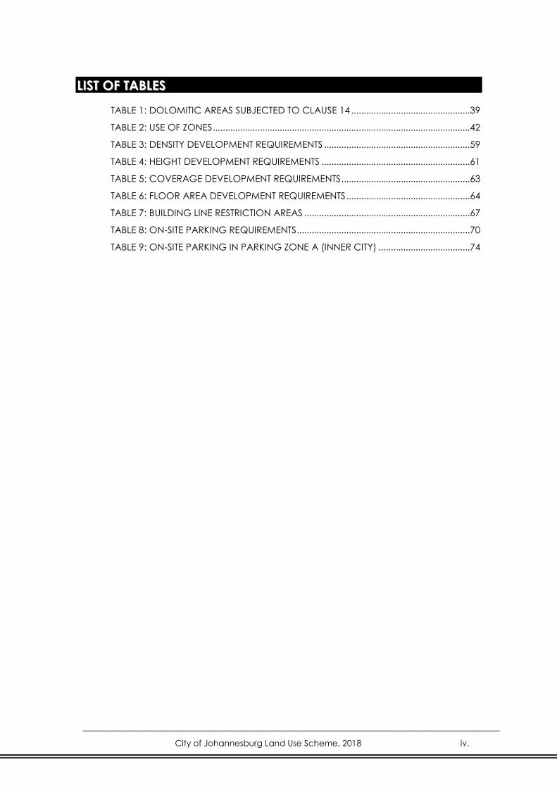
LLIISSTT OOFF TTAABBLLEESS
TABLE 1: DOLOMITIC AREAS SUBJECTED TO CLAUSE 14 ................................................ 39
TABLE 2: USE OF ZONES ........................................................................................................ 42
TABLE 3: DENSITY DEVELOPMENT REQUIREMENTS ........................................................... 59
TABLE 4: HEIGHT DEVELOPMENT REQUIREMENTS ............................................................ 61
TABLE 5: COVERAGE DEVELOPMENT REQUIREMENTS .................................................... 63
TABLE 6: FLOOR AREA DEVELOPMENT REQUIREMENTS .................................................. 64
TABLE 7: BUILDING LINE RESTRICTION AREAS ................................................................... 67
TABLE 8: ON-SITE PARKING REQUIREMENTS ...................................................................... 70
TABLE 9: ON-SITE PARKING IN PARKING ZONE A (INNER CITY) ..................................... 74

___________________________________________________________________________________________________
City of Johannesburg Land Use Scheme, 2018 1.
CITY OF JOHANNESBURG
LAND USE SCHEME, 2018
PART 1: PREAMBLE
1. AREA OF THE LAND USE SCHEME
The Land Use Scheme applies to all properties within the municipal boundaries of
the City of Johannesburg, as determined by the Municipal Demarcation Board.
2. LAND USE SCHEME STATUS
This Land Use Scheme is prepared in terms of Section 24(1) of the Spatial
Planning and Land Use Management Act, 2013 (Act 16 of 2013), and is subject
to the provisions of Clause 3.(3.) of this Scheme, in substitution of the following
Town Planning Schemes previously in operation in the above-mentioned area in
so far as it relates to the area of jurisdiction of the City of Johannesburg
Metropolitan Municipality:
Johannesburg Town Planning Scheme, 1979 (The clauses only )
Halfway House and Clayville Town Planning Scheme, 1976 (The clauses
only)
Sandton Town Planning Scheme, 1980 (The clauses only)
Roodepoort Town Planning Scheme, 1987 (The clauses only)
Randburg Town Planning Scheme, 1976 (The clauses only)
Lenasia South East Town Planning Scheme, 1998 (The clauses only)
Modderfontein Town Planning Scheme, 1994 (The clauses only)
Peri-urban Areas Town Planning Scheme, 1975 (The clauses only)
Southern Johannesburg Region Town Planning Scheme, 1979 (The clauses
only)
Walkerville Town Planning Scheme, 1994 (The clauses only)
Annexure F as per the Black Communities Development Act, Act 4 of 1984
Lethabong Town Planning Scheme, 1998 (The clauses only)
Westonaria Town Planning Scheme, 1981 (The clauses only)
Alberton Town Planning Scheme, 1979 (The clauses only)

Edenvale Town Planning Scheme, 1980 (The clauses only)
Krugersdorp Town Planning Scheme, 1980 (The clauses only)
And any other parts of Town Planning Schemes of neighbouring
municipalities that may have been included as a result of demarcation
changes.
3. COMMENCEMENT AND VALIDITY
The Land Use Scheme shall come into effect from the date that notice of
adoption is published in the Provincial Gazette.
(1.) The City of Johannesburg Metropolitan Municipality shall be the authority
responsible for enforcing and carrying into effect the provisions of this
Land Use Scheme.
(2.) Any consent granted, approved or any land use right permitted in terms
of a Town Planning Scheme in force or other applicable land use
legislation for the erection/use of buildings or for the use of land or any
rights legally exercised in terms of such scheme or legislation prior to the
commencement of this Land Use Scheme, shall be deemed to be a
consent, approval or land use right of this Land Use Scheme: provided
that any such consent, approval or land use right shall lapse unless
exercised within twenty four (24) months from the date of coming into
operation of this land use scheme, as envisaged in Sub-clause 0 above.
(3.) Any Annexure or Schedule promulgated in terms of any of the former
Town Planning Schemes mentioned in Clause 2. or other Land Use
Legislation shall remain in force and the provisions of that Annexure or
Schedule shall remain in force for the lifetime of that Annexure or
Schedule. The Scheme Maps A and B series or any other cadastral map
indicating land use of all listed schemes and legislation under Part 1,
Clause 2. remain in force.
(4.) Any land use application submitted to and pending before Council
immediately prior to the commencement of this Land Use Scheme, shall
be dealt with in terms of the relevant Scheme that governs such
application at the time of submission, as far as it is not in conflict with
this Land Use Scheme.
(5.) Where the provisions of this Land Use Scheme are in conflict with any
municipal By-law in operation in the City of Johannesburg, the provisions
of the Land Use Scheme shall prevail. In respect of outdoor advertising
signs, the prevailing outdoor advertising By-laws shall apply and such
advertising signs, cellular masts and telecommunication masts will not be
regarded as a land use matter.

4. POWERS OF THE COUNCIL
Nothing in this Land Use Scheme shall prevent the Council from maintaining or
using any building, or doing construction work or using any land in its area of
jurisdiction for any other purpose permitted under any other law, unless the
consent procedure as outlined in the City of Johannesburg Municipal Planning
By-law, 2016, is followed and such uses are of a temporary nature not exceeding
thirty-six (36) months.
5. GENERAL PURPOSE OF THE LAND USE SCHEME
The Land Use Scheme adopted and approved in terms of the City of
Johannesburg Municipal Planning By-law, 2016 shall give effect to the City’s
municipal spatial development framework and determine the use and
development of land within the City’s area of jurisdiction in order to promote:
a. Economic growth;
b. Social inclusion;
c. Efficient land development;
d. Minimal impact on public health, the environment and natural
resources;
e. Guarantee the right to sustainable cities, understood as the right to
urban land, housing, environmental management, urban infrastructure
and service delivery, transportation and public services, to work and
leisure for current and future generations;
f. Democratic administration by means of participation of both the
individual property owner and representative associations of the various
segments of the community in the formulation, execution and
monitoring of urban development projects, plans and programmers;
g. Cooperation between governments, private initiative and other sectors
of society in the urbanization process, in service of the social and
economic interest;
h. Planning and sustainable development of the Municipality, through the
management and coordinated promotion of growth across the City
along with desirable development, in order to correct the distortions of
historical planning systems and their negative effects on the
environment, without negating the complexities of the City;
i. Supply of urban and community equipment, transportation and public
services adequate for the interests and needs of the population and the
local characteristics;
j. Management of land use, in order to enable and facilitate:
(i) Efficient, effective and compatible urban development that is
desirable and also accommodates the identified socio-economic
needs of the City;

(ii) The coordination of urban growth, which includes land use
change, new development and subdivisions, with the availability of
infrastructure and social amenities;
(iii) An accessible, responsive environment that is integrated with the
transportation network and promotes public transportation;
(iv) The upgrading and rejuvenation of certain areas in the City
through innovative developmental scenarios;
(v) Effective environmental management in support of the strategic
direction of the City.
k. Fair distribution of the benefits and burdens resulting from the
urbanization process;
l. Adaptation of tools of economic, tax and financial policy and of public
spending to the objectives of urban development, in order to give
priority to investments that generate well-being and the fruition of the
goods by different social segments;
m. Simplification of the legislation concerning subdivisions, land use,
occupation and building regulations, in order to permit a reduction in
costs and increase in the supply of erven and housing units;
n. Equality of conditions for public and private agents in the promotion of
developments and activities related to the urbanization process, serving
the social and economic interest.
6. ARRANGEMENTS AND LEGALITY OF LAND USE SCHEME
COMPONENTS
(1.) The City of Johannesburg Land Use Scheme has been arranged into three
main sections, in order to ensure ease of reference and to incorporate the
promotion philosophy of this Scheme, namely:
SECTION 1:
LAND DEVELOPMETN RIGHTS
SECTION 2:
MANAGEMENT OF LAND DEVELOPMETN RIGHTS
SECTION 3:
PROMOTION OF LAND DEVELOPMENT
(2.) Arrangements and legality of the Maps, Clauses, Tables, Schedules and
Annexures of the Land Use Scheme
(a.) The maps, clauses and tables of the Land Use Scheme have been
arranged so that those maps, clauses and tables of general
applicability are contained in Parts I – VIII and those which are

applicable solely to a specific erf or site are contained in the
Schedule or Annexure.
(b.) The Schedule and Annexure in form an integral part of the Land Use
Scheme and have the same legality as the rest of the Land Use
Scheme: Provided that in the event of there being a conflict
between the provisions of a clause contained in Parts I to VIII and
any provision contained in an Annexure or Schedule in the Annexure
or Schedule shall prevail: Provided further that the requirements
contained in Parts I to VI relating to the possible relaxation of
requirements in respect of building lines, building restriction areas,
height, coverage, floor area, parking and loading are applicable to
those erven or sites referred to in a Schedule or Annexure unless they
are expressly excluded in such Schedule or Annexure.
7. BUILDING PLANS AND OTHER PARTICULARS
The erection, structural changes, alterations or conversion of a building to an
alternative use shall not commence until the Council has approved of the
building plans as required in terms of the National Building Regulations and
Building Standards Act, Act 103 of 1977, or any amendment or review thereof, in
respect of the erection, structural changes, alterations or conversion of such
building: Provided that floor area and coverage calculations, parking
requirements and a parking layout, where applicable, shall be indicated on
such building plans.
8. COMPONENTS OF THE LAND USE SCHEME
The City of Johannesburg Land Use Scheme comprises three (3) sections and
nine (9) parts as detailed below:
1. Part I : Preamble, including reference to Maps A and B,
Annexures and Schedules
SECTION 1 : LAND DEVELOPMENT RIGHTS
2. Part II : Definitions
3. Part III : Use of Land and Buildings

SECTION 2 : MANAGEMENT OF LAND DEVELOPMENT RIGHTS
4. Part IV : Land Development Requirements
5. Part V : Building Restriction Areas
6. Part VI : Parking and Loading
7. Part VII : Land Development Administration
SECTION 3 : PROMOTION OF LAND DEVELOPMENT
8. Part VIII : Special Mechanisms for Land Development
9. Part IX : General Land Development Mechanisms
9. SHORT TITLE
This Land Use Scheme shall be known as the City of Johannesburg Land Use
Scheme, 2018.

SECTION 1:
LAND DEVELOPMENT RIGHTS
Section 1 of the City of Johannesburg Land Use Scheme deals with the
allocation of land use rights to all erven or sites across the Municipality’s area of
jurisdiction. This Section, which includes the definitions and the Use Zones, has
been streamlined in order to accommodate the urban complexities, facilitate
development and promote equality and integration.
PART II: DEFINITIONS
Term Definition
“abattoir” Means the use of a building/s and/or land where livestock
or poultry is slaughtered and prepared for distribution.
“agricultural
purposes”
Means purposes normally associated with the use of a
building/s and/or land for farming / agricultural purposes
and it includes only dwelling units necessary for and
related to the bona fide agricultural use of the property.
This also includes the use of the property for urban
agricultural purposes; plant nursery; the sale of produce
solely cultivated or bred from the site; animal care centre;
stable, horse riding facilities and related schooling uses, but
shall not include sporting and recreation purposes or a
race course.
A second dwelling house / unit may be permitted (written
consent) but shall not be sectionalized.
“airport” Means the use of a building/s and/or land designed and
used for the landing and taking off of aircraft, airways
control, aircraft hangers and all uses normally associated
with the proper functioning of an airport to the satisfaction
of the Council.
“ancillary use” When used in the context of an associated use or purpose,
means a use, purpose, building or activity, which is
ancillary and subservient (less than 30%) to the lawful
dominant use of the property.

Term Definition
“animal care
center”
Means the use of a building/s and/or land for the care of
domestic pets and animals, operated on either a
commercial or welfare basis and includes boarding
kennels, catteries and pet training centers.
“applicant” Means any registered owner of land, whether a natural
person or a juristic body, or anybody duly authorised by
such owner, who makes an application as provided for in
the Spatial Planning and Land Use Management Act, 2013
(Act 16 of 2013) and/or the City of Johannesburg
Municipal Planning By-law, 2016, and/or this Land Use
Scheme or any amendments thereof.
“application” Means a complete application made in terms of the
provisions of the Spatial Planning and Land Use
Management Act, 2013 (Act 16 of 2013) and/or the City of
Johannesburg Municipal Planning By-law, 2016, and/or this
Land Use Scheme or any amendments thereof.
“application
register”
Means a record of all applications submitted and
considered in terms of the provisions of the City of
Johannesburg Municipal Planning By-law, 2016, and/or this
Land Use Scheme or any amendments thereof.
“approval” Means any approval granted by the Council in writing with
or without conditions.
“area” Means the defined municipal boundaries of the City of
Johannesburg and the area across which this Land Use
Scheme is applicable.
“basement” Means the space in a building between the floor and
ceiling which is partly or completely below the natural
ground level; Provided that a basement shall be counted
as a storey for the purpose of a height measurement
where any portion extends more than 1,5 metres above
the lowest level of the natural ground level immediately
contiguous to the building.
Refer to Clause 28 for further details in this regard.

Term Definition
“bed and
breakfast”
Means a building/s in which the resident manager provides
lodging and meals for compensation to transient guests
who have permanent residence elsewhere provided that:
(i) The number of rooms/suites may not exceed ten (10)
without the written consent of the Council in addition
to the accommodation of the resident manager
(ii) The buildings may include self-catered suites
(iii) No buildings may be converted into dwelling units or
be sectionalized.
“boarding house” Means a dwelling house where the habitable rooms are
rented out for an extended period by the resident owner /
occupant to unrelated persons and communal facilities
such as the kitchen, lounge, dining room and bathrooms
are shared by the boarders.
boundary” In relation to a land unit means the cadastral line
separating such land unit from another land unit or from a
public street.
“builders yard” Means the use of a building/s and/or land for the storage
of material and equipment which:
(i) Is normally required for or used for construction work
and/or building operations;
(ii) Resulting from demolition or excavation operations;
or
(iii) Is normally used for land improvements, such as
materials used for building roads, installing essential
services, or for any other construction work, whether
for public or private purposes; and
(iv) Land or buildings used for the preparation for use of
any of the aforementioned materials; provided that it
does not include any builder’s yard established for
the purpose or temporary storing any of the
aforementioned materials in connection with and for
the duration of construction or building works in the
vicinity of such builder’s yard, or the storage of
building material supplies for a hardware shop.

Term Definition
“building” Means a structure erected on land, irrespective of the
materials used in the erection or construction thereof.
“building line” Means a line that is a fixed distance from the boundary of
an erf or property abutting a public and/or private street
or any other boundary of an erf or property and may
include a floodwater mark where indicated on the Zoning
Maps, Schedule or Annexure.
“building material
storage”
Means the use of a building/s and/or land for the
storage/sale of building material/equipment that relate to
a hardware shop.
“building
restriction area”
Means an area of an erf or portion of land on which no
buildings may be erected, save as allowed in this Land Use
Scheme, and which is bounded on one side by a building
line and/or street boundary or any other boundary of an
erf or property, or which is subject to flooding as indicated
by a flood water mark or designated by a flood line
boundary.
“business
purposes”
Means the use of a building/s and/or land from which
business is conducted and the related use of buildings
including offices, restaurants, motor showrooms,
showrooms, medical consulting rooms, domestic service
industries, self-storage; funeral parlours, call centers,
financial institutions, dry cleaners, launderettes and
buildings for similar uses not elsewhere defined as well as
uses which are ancillary, directly related to and subservient
to the main use such as caretakers accommodation, but
does not include uses such as places of assembly,
institutions, public garages, industries, noxious trades or
places of amusement.
“by-laws” Means the By-laws or regulations of the Municipality in
force in the area other than the City of Johannesburg
Municipal Planning By-law, 2016.
“cadastral line” Means a line representing the official boundary of a land
unit or portion as registered in the Deeds Office.
“canopy” Means a cantilevered or suspended roof, slab or covering
(not being the floor or a balcony) projecting from the wall
of a building and not being enclosed.

Term Definition
“canteen” Means a building or part of a building used for providing
food and liquid refreshments for the exclusive benefit of
persons employed by an undertaking which owns and
operates or controls such undertaking and includes the
area for preparation of such foods and liquid refreshments.
This use is an ancillary right on all non-residential Use Zones
contained in this Land Use Scheme but excludes a
restaurant.
“caravan” Means a vehicle which has been equipped or converted
for living or sleeping purposes and which is towed.
“caravan park” Land used for the parking of caravans for transient
camping purposes.
“car sales lot” Means land, which is used mainly for the open air display
and sale of motor vehicles, motor vehicle trailers, caravans
and heavy-duty vehicles and may include ancillary offices,
but excludes a scrap yard and a public garage.
“cemetery” Means a place, including land and/or buildings, used for
burials, and such activities and which can include all uses
ancillary such as a crematorium, chapel, prayer area,
funeral parlour, wall of remembrance and a convenience
shop.
“child care centre” Means the use of a building/s and/or land as a child care
centre, including a day care centre, crèche, preschool,
playgroup, after school care centre or early childhood
development centre for taking care of children according
to compulsory educational and health requirements /
standards.
“clinic” Means a place for the diagnosis and treatment of human
illness or the improvement of human health, which has
limited facilities and an emphasis on outpatients, with no
overnight facilities. A clinic includes medical consulting
rooms, outpatients’ center and a wellness center with
associated uses.
“commencement
date”
Means the date on which this Land Use Scheme came into
operation.
“commercial Means the use of a building/s and/or land designed for

Term Definition
purposes” distribution centers, wholesale trade, warehouses, storage,
computer centers, removal and transport services, people
/ commuter transport, laboratories, cash management
centers, builders yards, coal yards, building material
storage and all uses which are ancillary, directly related to
or subservient to the main use such as a caretaker’s
accommodation.
“common
boundary”
In relation to land means a boundary common with the
adjoining land other than a street boundary.
“commune” Means a dwelling house where the habitable rooms are
rented out for an extended period to unrelated persons
and who share the communal facilities such as the kitchen,
lounge, dining room and bathrooms and may not exceed
eight (8) occupants.
“community body” Means a body, organization or institution of whatever
nature that represents the interests of a community or
segment of a community.
“complete
application”
Means an application as described in Section 57(1) of the
City of Johannesburg Municipal Planning By-law, 2016.
“consent” Means permission granted by the Council, after due
consideration of all relevant facts and after following the
provisions of the City of Johannesburg Municipal Planning
By-law, 2016, in terms of which a specific aspect of land
management is permitted, in addition to the primary use
rights applicable to the property concerned, i.e. Clause 40.
“consent use” Means the additional land use right that may be permitted
in terms of the provision in a particular zone, only with the
consent of the Council as contemplated in Clause 40.
Term Definition
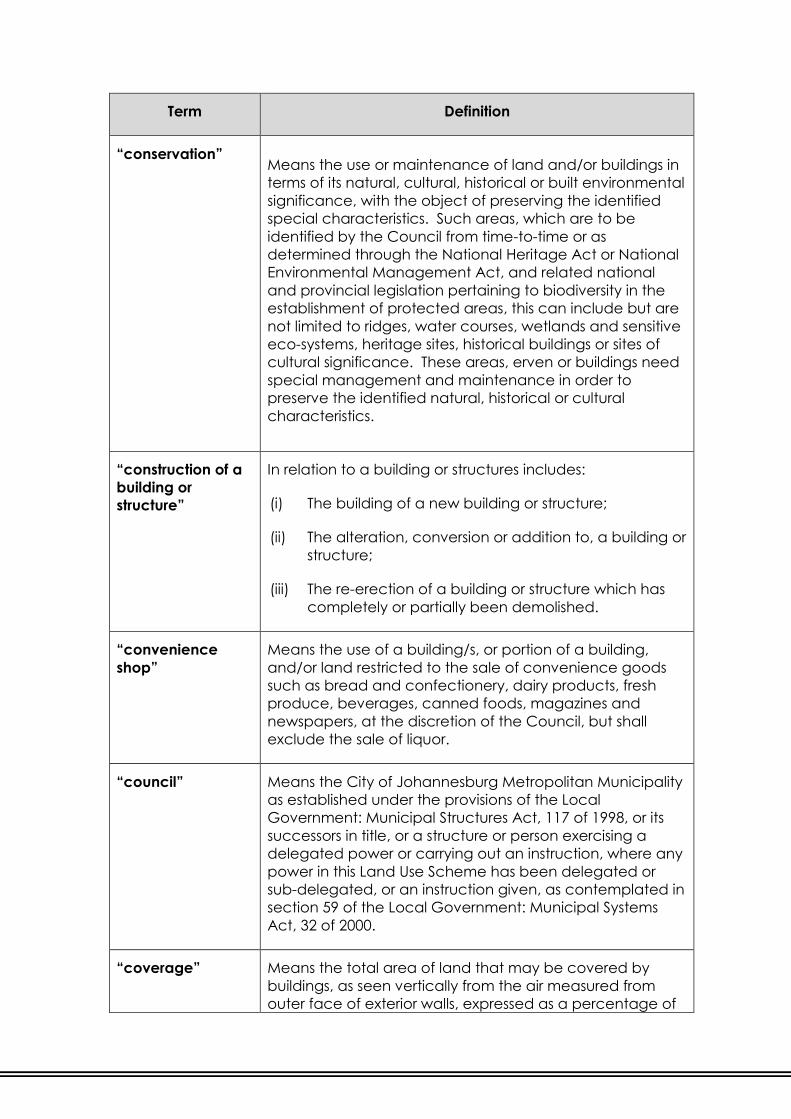
“conservation” Means the use or maintenance of land and/or buildings in
terms of its natural, cultural, historical or built environmental
significance, with the object of preserving the identified
special characteristics. Such areas, which are to be
identified by the Council from time-to-time or as
determined through the National Heritage Act or National
Environmental Management Act, and related national
and provincial legislation pertaining to biodiversity in the
establishment of protected areas, this can include but are
not limited to ridges, water courses, wetlands and sensitive
eco-systems, heritage sites, historical buildings or sites of
cultural significance. These areas, erven or buildings need
special management and maintenance in order to
preserve the identified natural, historical or cultural
characteristics.
“construction of a
building or
structure”
In relation to a building or structures includes:
(i) The building of a new building or structure;
(ii) The alteration, conversion or addition to, a building or
structure;
(iii) The re-erection of a building or structure which has
completely or partially been demolished.
“convenience
shop”
Means the use of a building/s, or portion of a building,
and/or land restricted to the sale of convenience goods
such as bread and confectionery, dairy products, fresh
produce, beverages, canned foods, magazines and
newspapers, at the discretion of the Council, but shall
exclude the sale of liquor.
“council” Means the City of Johannesburg Metropolitan Municipality
as established under the provisions of the Local
Government: Municipal Structures Act, 117 of 1998, or its
successors in title, or a structure or person exercising a
delegated power or carrying out an instruction, where any
power in this Land Use Scheme has been delegated or
sub-delegated, or an instruction given, as contemplated in
section 59 of the Local Government: Municipal Systems
Act, 32 of 2000.
“coverage” Means the total area of land that may be covered by
buildings, as seen vertically from the air measured from
outer face of exterior walls, expressed as a percentage of

Term Definition
the land area, and shall include all roofed areas; provided
that the following portions of buildings shall be disregarded
in the calculation of coverage:
(i) Unroofed areas such as a stoep, entrance steps and
landing;
(ii) Projecting balconies, open on all vertical sides.
(iii) Retractable awnings or pergolas, with or without
louvres and areas covered by permeable material;
(iv) Cornices, chimneys, water pipes, drain pipes and
minor decorative features not projecting more than
500mm from the building wall;
(v) Eaves and canopies not projecting more than 1,0m
from the wall of the building;
(vi) A canopy erected on the street frontage of a shop;
(vii) Electrical high and low tension chambers;
(viii) The area covered by open air swimming pools;
Basements are dealt with and are subject to the provisions
of Clause 29 of this Land Use Scheme.
“days” As defined in the City of Johannesburg Municipal Planning
By-law, 2016.
“Means a calendar day, and when any number of days is
prescribed in terms of this By-law for the doing of any act, it
must be calculated by excluding the first day and
including the last day, provided that, if the last day falls on
a Sunday, Saturday or public holiday, the number of days
must be calculated by excluding the first day and also the
Sunday, Saturday or public holiday and if the date on
which any notice must appear in any media or Provincial
Gazette such notice may not appear on a Sunday,
Saturday or public holiday and shall for purposes of
calculation be excluded.”
“deprivation area”
Means a spatial area, as defined in the City of
Johannesburg Spatial Development Framework.

Term Definition
“development” Means the development of land, changes in the use of
land or intensification of that use and includes any matter
in relation to land for which a development application is
required.
“domestic service
industry”
Means the repair and sale of spare parts for domestic
equipment and appliances, garden services, including the
repair and sale of spare parts for lawn-mowers, irrigation
systems and swimming-pool equipment, property
maintenance services and any other service that is
ancillary to such an industry. Such uses shall fall under the
auspices of business purposes.
“dwelling house” Means a detached self-contained inter-connected suite of
rooms containing a kitchen and the applicable ablutions,
used for the living accommodation and housing of one
household, together with such outbuildings and subsidiary
dwelling units as is ordinarily permitted therewith, as long as
the subsidiary dwelling units complies with the requirements
stipulated in this Land Use Scheme in Use Zone “Residential
1” (refer to Clause 21.). A second kitchen may be provided
with the written consent of the Council.
An entertainment, reception and/or living area within a
dwelling house or part of a reasonably required and
ancillary outbuilding (See “outbuilding” definition), may
include a wash-up area used exclusively for that purpose.
“dwelling unit” An inter-connected suite of rooms, designed for human
habitation that shall contain a kitchen and with the
appropriate ablutions; irrespective of whether the dwelling
unit is a single building or forms part of a building
containing two (2) or more dwelling units.
“environmental
control area”
An area defined by the Council within which any
development shall be subject to a Site Development Plan
or any other requirement as determined by the Council.
“erf” Means land as defined as erf” in the City of Johannesburg
Municipal Planning By-law, 2016.
“Land in an approved township registered in a deeds
registry as an erf, lot, plot or stand or as a portion or the
remainder of any erf, lot, plot or stand or land indicated as
such on the general plan of an approved township, and

Term Definition
includes any particular portion of land laid out as a
township.”
“existing building” Means a building erected in accordance with building
plans approved by the Council and which is otherwise
lawful and the construction of which was:
(i) Completed on or before the fixed date;
(ii) Begun before but completed after the fixed date; or
(iii) Completed in accordance with the terms of any
permission granted by the Council during the
preparation and until the coming into operation of
this Land Use Scheme.
“existing use” Means a use carried out or in operation on an erf or site
that was permitted in terms of the previous planning
legislation and lawful in terms of the National Building
Regulations but which is contrary to this Land Use Scheme.
It shall remain an existing use right unless the said use is
altered in any way or ceases to be carried out for a period
of twelve (12) months.
“farm portion”
Means a portion of land which is not an erf, agricultural
holding or road and which is registered as a separate unit
in the Deeds Office. Such portion is land that has not been
the subject of township establishment.
“fixed date” This is the date that this Land Use Scheme came into
operation via a promulgation notice.
“flood water mark” Means the flood lines as contemplated in Section 169(1)(a)
of the Water Act, No 54 of 1956 as amended from time-to-
time.
“floor area” Means the sum of the gross area covered by the building
at the floor level of each storey, provided that the area
reasonably required for the purposes detailed below may
be excluded from the calculations of the floor area, which
calculations shall be clearly indicated on the building
plans. Floor area shall be measured from the outer face of
the exterior walls or similar supports of such building, and
where the building consists of more than one storey, the
total floor space shall be the sum of the floor area of all the
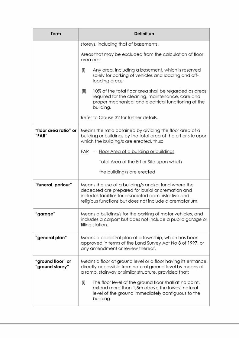
Term Definition
storeys, including that of basements.
Areas that may be excluded from the calculation of floor
area are:
(i) Any area, including a basement, which is reserved
solely for parking of vehicles and loading and off-
loading areas;
(ii) 10% of the total floor area shall be regarded as areas
required for the cleaning, maintenance, care and
proper mechanical and electrical functioning of the
building.
Refer to Clause 32 for further details.
“floor area ratio” or
“FAR”
Means the ratio obtained by dividing the floor area of a
building or buildings by the total area of the erf or site upon
which the building/s are erected, thus:
FAR = Floor Area of a building or buildings
Total Area of the Erf or Site upon which
the building/s are erected
“funeral parlour” Means the use of a building/s and/or land where the
deceased are prepared for burial or cremation and
includes facilities for associated administrative and
religious functions but does not include a crematorium.
“garage” Means a building/s for the parking of motor vehicles, and
includes a carport but does not include a public garage or
filling station.
“general plan” Means a cadastral plan of a township, which has been
approved in terms of the Land Survey Act No 8 of 1997, or
any amendment or review thereof.
“ground floor” or
“ground storey”
Means a floor at ground level or a floor having its entrance
directly accessible from natural ground level by means of
a ramp, stairway or similar structure, provided that:
(i) The floor level of the ground floor shall at no point,
extend more than 1,5m above the lowest natural
level of the ground immediately contiguous to the
building.

Term Definition
Refer to Clause 28 for further details.
“guest house”
Means a converted dwelling house or dwelling unit
whereby the resident household / person lets out individual
rooms for temporary residential accommodation, with or
without meals, with the proviso that all amenities and the
provision of meals and beverages shall be for the sole
benefit of bona fide guests and the resident
household/person. The premises shall not be used for
functions such as conferences, promotions and/or
receptions.
“habitable room” Means a room designed or used for human habitation in
accordance with standards prescribed by the By-law but
excludes a storeroom, bathroom / toilet, kitchen or other
spaces defined for a particular purpose on the building
plan.
“height” Means the vertical dimensions of the building from the
natural ground level to the highest point of the building
measured in meters or in number of storeys; provided that:
(i) The height restriction which refers to storeys does not
apply to roofs, domes, chimneys, flues, masts and
antennae; and
(ii) Elevator motor rooms, satellite dishes, ventilation
shafts, water tanks, air conditioning plant and
equipment on top of a building, shall be regarded as
a storey, unless enclosed within the roof or hidden
behind parapet walls, not exceeding 2,0 metres in
height, in which case it shall be counted as part of
the top storey.
“helipad” Means land and/or buildings used and designed for
landing and taking off of helicopters and may include a
terminal for passengers. This use is permitted in all Use
Zones other than “Residential 1, 2, 3, 4 and 5” with the
consent of the Council.
“heritage
resource”
Any place or object of cultural and/or historical
significance.
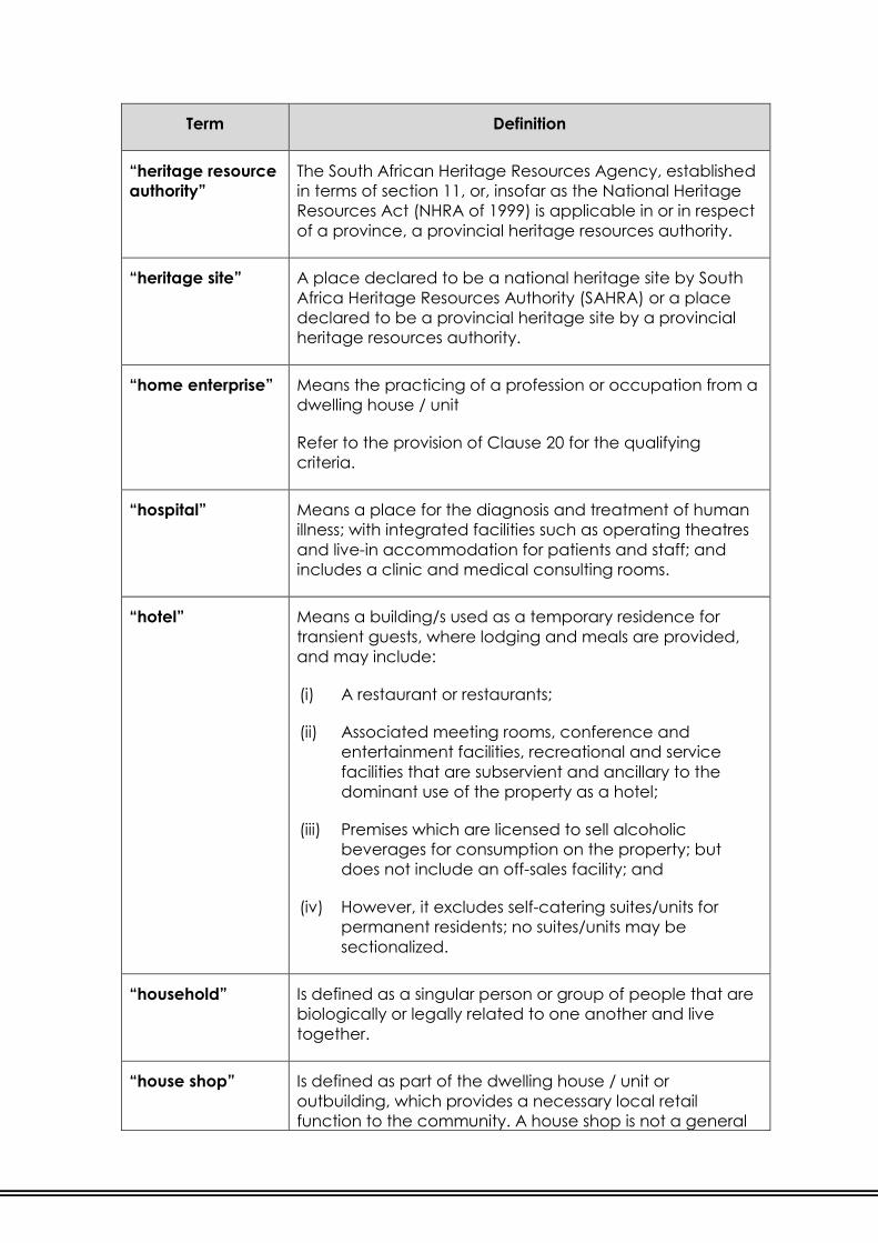
Term Definition
“heritage resource
authority”
The South African Heritage Resources Agency, established
in terms of section 11, or, insofar as the National Heritage
Resources Act (NHRA of 1999) is applicable in or in respect
of a province, a provincial heritage resources authority.
“heritage site” A place declared to be a national heritage site by South
Africa Heritage Resources Authority (SAHRA) or a place
declared to be a provincial heritage site by a provincial
heritage resources authority.
“home enterprise” Means the practicing of a profession or occupation from a
dwelling house / unit
Refer to the provision of Clause 20 for the qualifying
criteria.
“hospital” Means a place for the diagnosis and treatment of human
illness; with integrated facilities such as operating theatres
and live-in accommodation for patients and staff; and
includes a clinic and medical consulting rooms.
“hotel” Means a building/s used as a temporary residence for
transient guests, where lodging and meals are provided,
and may include:
(i) A restaurant or restaurants;
(ii) Associated meeting rooms, conference and
entertainment facilities, recreational and service
facilities that are subservient and ancillary to the
dominant use of the property as a hotel;
(iii) Premises which are licensed to sell alcoholic
beverages for consumption on the property; but
does not include an off-sales facility; and
(iv) However, it excludes self-catering suites/units for
permanent residents; no suites/units may be
sectionalized.
“household” Is defined as a singular person or group of people that are
biologically or legally related to one another and live
together.
“house shop” Is defined as part of the dwelling house / unit or
outbuilding, which provides a necessary local retail
function to the community. A house shop is not a general

Term Definition
business or retail function on a residential erf and the
residential component remains the main use of the erf.
Refer to Clause 19 for further details.
“industrial
purposes”
Means the use of a building/s and/or land or part thereof
as a factory and in which an article or part of such article is
made, manufactured, produced, built, assembled,
compiled, printed, ornamented, processed, treated,
adapted, repaired, renovated, rebuilt, altered, painted
(including spray painting), polished, finished, cleaned,
dyed, washed, broken up, disassembled, sorted, packed,
chilled, frozen or stored in cold storage; including offices,
caretaker’s quarters or other uses which are subservient
and ancillary to the use of the property as a factory; and
includes a warehouse, the generation of electricity; the
developing or processing of photographs, films or tapes;
refuse disposal sites; recycling and abattoir but does not
include a noxious trade or risk activity.
“informal trading” Means the legal selling of products in areas demarcated
by the Council specifically for these purposes, such as
markets and/or other demarcated areas, with the written
consent of the Council.
“institution” Means a welfare or charitable facility such as home for the
aged, indigent or handicapped; a hospital, clinic or
nursing home, a sanatorium; or any other institution
whether public or private and includes all uses ancillary,
directly related to and subservient to the main use, but
excludes primary office and administrative functions.
“interested party /
person”
As defined in the City of Johannesburg Municipal Planning
By-law, 2016.
“Means any person or group of persons, legal entity or
body that can demonstrate their interest in any land
development application as contemplated in section
52(1) of the City of Johannesburg Municipal Planning By-
law, 2016.”
“kitchen” Means a room or part of a room equipped for preparing
and/or cooking meals and/or wash-up area and/or
scullery.

Term Definition
“land”
As defined in the City of Johannesburg Municipal Planning
By-law, 2016.
“Means any erf, agricultural holding, sectional title
scheme-land or farm portion and includes any
improvement or building on land and any real right in
land.”
“landscaping” Means the placement of plants, contoured features, water
features, paving, street furniture and other soft and hard
elements, for the purposes of enhancing aesthetic appeal,
environmental management, amenity and value of a
property.
“line of no access” Means a line along any street, erf or site boundary or
portion thereof prohibiting any vehicular access.
“loading bay” Means an area which is clearly demarcated for loading
and off-loading.
Refer to Clause 38 for more details.
“local authority” Refer to the definition of “council”.
“medical
consulting rooms”
Means a building/s designed for use or a building/s and/or
land which are used for consulting practices associated
with restoring or preserving health but excluding overnight
or operating facilities. This use falls under the ambit of
business purposes unless separately defined.
“mezzanine” Means an intermediate storey not exceeding 25% of the
floor below it and is included in the total floor area in the
calculation of floor area.

Term Definition
“mining purposes” Means building/s and/or land:
(i) That were previously excluded from any town
planning scheme by virtue of the provisions of section
21(1) of Ordinance 15 of 1986; or
(ii) that are used for mining operations in terms of the
provisions of the Mineral and Petroleum Resources
Development Act, 28 of 2002; or
(iii) in respect of which a mining right or prospecting right
has been granted; or
(iv) on which operations are carried out to extract raw
materials from the earth, whether by means of
surface or underground methods and includes, but is
not limited to, the removal of stone, sand, clay,
kaolin, ores, minerals, gas and precious stones and
also includes the processing of such materials and re-
processing of mine dumps and all operations to
rehabilitate, restore, maintain, reinstate, re-establish
and preserve such land.
“mobile dwelling
unit”
A transportable structure constructed in accordance with
the requirements of the S.A.B.S. specification for Mobile
Homes, with the necessary service connections, and
designed as a permanent dwelling unit.
“motor
showrooms”
Means the use of a building/s for the display and sale of
new and/or used motor vehicles and accessories, ancillary
offices and workshops, all of which shall be within an
enclosed building.
“motor workshop
and services”
Means the use of a building/s and/or land for the repair,
maintenance and servicing of motor vehicles including the
installation of parts and accessories, all of which shall be
contained within an enclosed building.
“municipality” Refer to the definition of “council”.
“municipal
purposes”
Such purposes as the municipality may be authorised to
carry out in terms of its powers and functions and shall
include all municipal land uses as well as such uses as
sewerage works and reservoirs and their related buildings.

Term Definition
“municipal
systems act”
As per definition in the City of Johannesburg Municipal
Planning By-law, 2016.
“Means the Local Government: Municipal Finance
Management Act, 2003 (Act 56 of 2003)”.
“national building
regulations”
The National Building Regulations made in terms of section
17 of the National Building Regulations and Building
Standards Act No.103 of 1977, or any amendment or
review thereof.
“natural ground
level”
Means the level of the land surface in its unmodified state
as established from a contour plan.
“nature reserve” Means a national park or environmental conservation area
that has been declared as a nature reserve in terms of
legislation, whether in public or private ownership, for the
purpose of conserving and managing wild life, flora and
fauna in their natural habitat; it includes conservation use
but does not include tourist facilities or tourist
accommodation. Refer to “Conservation” and “Public
Open Space”.
“neighbour” Means the owner of the erf or site which is contiguous to
the application erf or site, even though it may be
separated by a road or panhandle, except if indicated
differently by the Council.

Term Definition
“noxious industry” Means an activity where any one or more of the following
activities are carried out: Blood boiling; tallow melting; fat
melting or extracting; soap boiling; bone boiling; tripe
boiling or cleaning; skin storing; bone storing; fell
mongering; skin curing; blood drying; gut scraping; leather
dressing; tanning; glue making; size making; charcoal
burning; brick burning; lime burning; manure making;
manure storing; parchment making; malt making; yeast
making; cement works; coke ovens; salt glazing; sintering
of sulphur-bearing materials; viscose works; smelting of ores
and minerals; calcining; puddling and rolling or iron and
other metals; conversion of pig-iron into wrought iron; re-
heating; annealing; hardening; forging; converting and
carburizing iron and other metals; works for the production
of or which employ carbon disulphide, cellulose lacquers,
cyanogens or its compounds, hot pitch or bitumen,
pulverized fuel, pyridine, liquid or gaseous sulphur dioxide,
sulphur chlorides; works for the production of amyl
acetate, aromatic esters, butyric acid, caramel enameled
wire, glass, hexamine, iodoform, lamp-black, B-naphthol,
resin products, salicylic acid, sulphonated organic
compounds, sulphur dyes, ultramarine, zinc chloride, zinc
oxide; and all refining and works dealing with the
processing or refining of petrol or oil or their products;
Provided that where the Council adds to the list of noxious
trades, such additions shall also be deemed to be
included in the above definition and that all Health
requirements are complied with.
“occupant” or
“occupier”
Means any person who permanently and physically
inhabits or occupies a property.
“offices” Means the use of a building/s and/or land for the
conducting of an enterprise primarily concerned with
administrative, clerical, financial or professional services,
and includes medical consulting rooms and financial
institutions.

Term Definition
“outbuilding” Means a structure, whether attached or separate from the
main building, which is ancillary and subservient to the
main building on a land unit, and includes a building which
is designed to be normally used for the garaging of motor
vehicles, and any other normal activities in so far as these
are usually and reasonably required in connection with the
main building.
In respect of a dwelling house / unit, notwithstanding the
above, outbuildings may also include small store areas,
garden sheds, external toilets.
“owner” As per definition in the City of Johannesburg Municipal
Planning By-law, 2016.
“Means the person registered in a deeds registry as the
owner of land or beneficial owner in law and includes any
organ of state and the City of Johannesburg itself, a
person acting as the duly authorised agent of the owner of
the land concerned, a person to whom the land
concerned has been made available for development in
writing by any owner of land or such person’s duly
authorised agent or a service provider responsible for the
provision of infrastructure, utilities or other related services.”
“panhandle erf” As per definition in the City of Johannesburg Municipal
Planning By-law, 2016.
“For purposes of this Land Use Scheme shall mean an area
of land which is either part of the subdivided portion or is
notarially tied thereto, is at least four (4) metres and at
most eight (8) metres wide and is used as access to a
public street.”
“parking bay” Means an area measuring not less than 5,0 metres x 2,5
metres for perpendicular or angled parking and 6,0
metres x 2,5 metres for parallel parking, which is clearly
outlined and demarcated for the parking of one motor
vehicle and which is accessible to the satisfaction of the
Council.
“parking lot or
parking garage”
Means the use of a building/s and/or land, excluding a
road, street and on-site parking associated with a primary
or consent use that is used for parking of motor vehicles by
the public, with or without a fee, and may include parking
within a building and any ancillary use.

Term Definition
“pedestrian mall” Means the use of a building/s and/or land as a
thoroughfare for pedestrians, for restricted vehicular
activities as the Council may determine and for structures
erected on, above or below it.
“place of
amusement”
Means the use of a building/s and/or land as a theatre,
cinema, music hall, concert hall, billiards saloon, sports
arena, skating rink, dance hall, casino, bingo halls, race
courses, buildings for the purposes of exhibitions of trade or
industry or other recreational purposes, amusement park,
and also includes such uses as are ancillary, directly
related to and subservient to the main use. It also includes
discos, night clubs, sports bar and places of live music
entertainment or establishments where adult
entertainment is provided.
“place of
assembly”
Means the use of a building/s and/or land which has a
civic function to serve the social and community needs of
an area, which may attract people in relatively large
numbers and which is not predominantly a commercial
enterprise, but does not include a place of entertainment
or conference facility.
“place of
instruction”
Means the use of a building/s and/or land for education at
pre-school, and/or school and/or post school levels,
including a crèche, nursery school, child care centre, early
childhood development centre, primary school, secondary
school, college, technical institute, university, research
institute, lecture hall; or a civic facility for the promotion of
knowledge to the community such as a public library,
public art gallery, museum; and associated uses such as
boarding hostels, monastery, convent and all uses which
are ancillary, directly related to and subservient to the
main use.
Refer to Clause 22 for more details on Child Care Centres
and Early Childhood Development Centres on Residential
erven.
“previous scheme” Means a town planning scheme or similar provision that
governed and controlled the use of land prior the
promulgation of this Land Use Scheme.

Term Definition
“primary use” In relation to land and/or buildings means any use
specified in this Land Use Scheme as a primary use, being
a use that is permitted without the need first to obtain the
Council’s consent (written or otherwise).
“private open
space”
Means the use of a building/s and/or land, with or without
access control and which can be used as a private
ground for sports, play, rest and recreation, or as an
ornamental garden; pleasure ground; golf course; or for
buildings reasonably required in connection with such uses.
“private parking
area”
Means the use of a building/s and/or land for the provision
of parking which is required or allowed in terms of the
provisions of this Land Use Scheme for another building or
site or part thereof. Provided that on land zoned
“Residential 1, 2, 3, 4 or 5”, “private parking area” shall
mean the use of the land and not a building.
“private access /
street”
Means the use of land reserved for the passage or parking
of motor vehicles and right-of-way, which is privately
owned and does not vest in the Council which is exclusive
and ancillary to the adjoining use for obtaining access and
can include access control facilities, including a
guardhouse, boom or gate.
“property” Means land and all buildings and structures on a
cadastral-demarcated and determined erf or site.

Term Definition
“public garage” Means the use of a building/s and/or land for gain or
reward for any one of the following purposes:
(i) Storage and retail selling of motor fuel and lubricants
(filling station);
(ii) All ancillary uses, including the parking and storing of
motor vehicles; the sale of spare parts and
accessories, car wash facilities; and automatic bank
teller machines;
(iii) A convenience shop, a take-away or sitting down
facility or drive-through facility which does not
exceed 30% of the total built floor area or 150m2,
whichever is the lesser;
(iv) Maintenance and repair of vehicles excluding panel
beating and spray painting activities.
Refer to Clause 16 for more details.
“public nuisance”
Means any act, emission or condition which, in the
Council’s opinion is offensive, injurious or dangerous to
health, materially interferes with the ordinary comfort,
convenience, peace or quiet of the public, or which
adversely affects the safety of the public, having regard
to:
(i) The reasonableness of the activities in question in the
area concerned, and the impacts which result from
these activities; and
(ii) The ambient noise level of the area concerned.
“public open
space”
Means the use of a building/s and/or land which is under
the ownership of the Council or other public authority, with
or without access control, and which is set aside for the
public as an open space for recreation, place of
assembly, games, sport or cultural activity; including a
park, playground, public square, picnic area, public
garden, nature reserve, outdoor or indoor sports stadium,
and includes associated buildings and uses as permitted
by the Council, including restaurants, cafés, golf course,
and any apparatus, facility, structure or building which in
the opinion of the Council is necessary or expedient for the
purposes of such open space.

Term Definition
“public parking
area”
Means the use of a building/s and/or land, whether or not
for gain or reward, for the provision of parking not related
to the parking requirements or provisions of the scheme for
another building or site or part thereof.
“public place”
As defined in the City of Johannesburg Municipal Planning
By-law, 2016.
“Means any open or enclosed place, park, street, road or
thoroughfare or other similar area of land shown on a
general plan or diagram which is for the use and benefit of
the general public and is owned by or vests with the City,
and includes a public open space and a servitude for any
similar purposes in favour of the general public as
contemplated in the SPLUMA and section 63 of the Local
Government Ordinance, 1939 (Ordinance 17 of 1939).”
“public road” Means any road, street or thoroughfare shown on the
General Plan of a township, Agricultural Holding or other
division of land of which the public has acquired a right of
way.
“recreation resort” Means the use of a building/s and/or land, due to their
natural or human made attractions, for nature, natural
beauty, water, socio-historical, cultural and/or sport and
recreation activities. It may include swimming pools, water
slides, braai facilities, camping, caravanning and wedding
chapel. Such facilities can include temporary
accommodation as well as uses ancillary to and
subservient of such facilities, including restaurant, place of
refreshment, conference and business-related activities
and function facilities.
“religious
purposes”
Means the use of a building/s and/or land for a church,
synagogue, mosque, temple, oratory meeting house,
chapel, cathedral or other place for practicing a faith or
religion, and includes associated uses such as the official
residence registered in the name of the said religious
community, which is occupied by an office bearer of that
community and who officiates at services held by the
community, an ancillary office and place for religious
instruction, but does not include a funeral parlour,
cemetery or crematorium.
Refer to Clause 23 for further details.

Term Definition
“residential
building”
Means the use of a building/s, excluding a dwelling house
and/or dwelling unit, that contains habitable rooms, with or
without common ablution facilities and with common
kitchen-, dining- and/or lounge facilities such as hostels
and dormitories. Such definition includes but is not
restricted to hostels, hotels, dormitories, communes,
boarding houses, guest houses (excluding converted
dwelling houses and/or dwelling units), bed and breakfast
and old age homes that may or may not include ancillary
frail care facilities.
“restaurant” Means the use of a building/s and/or land for the service
and consumption on the site of food and liquid
refreshments for the general public excluding a canteen
and a place of amusement.
“scrap yard” Means the use of a building/s and/or land for one or more
of the following purposes:
(i) Storing, depositing, collecting or sale of junk or scrap
material or articles the value of which depends
mainly or entirely on the material used in the
manufacture thereof;
(ii) The dismantling or storage of scrap metals, second
hand vehicles or machines to recover components
or material; and
(iii) The storing or sale of second hand parts, poles, steel,
wire, lumber yards, tyres, bricks, containers or other
articles which are suitable to be left in the open
without any serious damage being incurred
“second storey” Means the storey above the ground floor.
“self-storage” Means the use of a building/s for the purposes of small
scale, non-business related storing of domestic goods.

Term Definition
“shebeen” Means a residential building or dwelling unit or part thereof
constructed, designed or adapted for the sale of liquor,
but shall not include the use for social gatherings and/or
the consumption of liquor on the site and/or the
preparation and consumption of food; provided that the
dominant use shall remain residential for the occupant of
the said dwelling and subject to the compliance of health
and safety by-laws.
Refer to Clause 14.(12.) for further details.
“shop” Means the use of a building/s and/or land for the retail sale
and accompanying storage of goods and services to the
public, including a retail concern where goods which are
sold in such a concern are manufactured or repaired;
provided that the floor space relating to such manufacture
or repair shall not comprise more than 30% of the floor
space of the shop; “shop” does not include an industry,
service trade, public garage or restaurant.
“showrooms”
Means the use of a building/s and/or land for the display of
large goods, such as but not limited to tiles, bathroom and
kitchen displays and furniture.
“site” As defined in the City of Johannesburg Municipal Planning
By-law, 2016.
“In relation to land, may include more than one erf or
portion of land, if such erven or portions of land are
contiguous and have been notarially tied to the
satisfaction of the City or have been consolidated.”
“social hall” Means the use of a building/s and/or land for social
meetings, gatherings and recreation, and includes a
Masonic temple but does not include a place of
amusement.
“spaza shop” See “house shop”.
“special building” Means the use of a building/s and/or land for any use
other than one of the uses for which the buildings herein
defined are designed or used. A special building should
be seen as the exception rather than the rule, an example
of which could be a greenhouse.

Term Definition
“special
development
zone”
Means a clearly defined geographical area that the
Council has delineated for focused planning and
development intervention and investment. A Special
Development Zone (SDZ) will have a specific urban
management focus that can include heritage resources,
environment, transportation, urban renewal, housing and
economic development related focuses. Such Special
Development Zones can be added to, amended or
removed in terms of Council resolution and official
publication. A Special Development Zone will be indicated
in terms of an Annexure / Schedule.
“sport and
recreation club”
Means a privately owned facility that is utilized for both
passive and/or active recreation by the owners and
patrons of such facility and may include ancillary uses such
as shop, restaurant and bar. This can include a private golf
course, health and fitness centre, social hall or private
gardens. This however excludes any unrelated retail
functions or business activities.
“storey” Means that portion of a building included between the
surface of any floor and the surface of the next floor
above, or if there is no floor above the ceiling, provided
that:
(i) A basement does not constitute a storey;
(ii) A roof, or dome which forms part of a roof, shall not
constitute a separate storey unless the space within
the roof or dome is designed for, or used for, human
occupation, in which case it is counted as a storey;
and
(iii) The maximum height of the ground storey shall not
exceed 6,0 meters and every additional 4, meters in
height or portion thereof, shall be counted as an
additional storey.
(iv) The maximum height of any other storey shall not
exceed 4,5 meters and every additional 4,5 meters in
height or part thereof shall be counted as an
additional storey.
(v) The height limitations are indicated in Table 4.
“subdivision” As outlined in Sections 33 and 35 of the City of
Johannesburg Municipal Planning By-law, 2016.

Term Definition
“surveyor general” Means the Surveyor General as defined in Section 8 of the
Land Survey Act, No 8 of 1997 or any amendments thereof.
“systems act” Means the Local Government: Municipal Systems Act, 2000
(Act 32 of 2000) or any amendments thereof.
“tavern” Means a residential building or dwelling unit or part thereof
constructed, designed or adapted for use for social
gatherings and for the consumption of liquor on the site
and may include the preparation and consumption of
food, but shall not include the sale of any of the aforesaid
items for consumption off the site, provided that the
dominant use shall remain residential for the occupant of
the said dwelling and subject to the compliance of health
and safety by-laws.
Refer to Clause 14.(12.) for further details.
“township” As defined in the City of Johannesburg Municipal Planning
By-law, 2016.
“Means an area of land divided into erven which may be
combined with public places and roads as indicated on a
general plan, which is used and developed mainly for
residential, business, commercial, industrial, institutional,
educational or other similar purposes as contained in a
land use scheme, or is intended to be so used and
developed.”
“transitional
residential
settlement area”
Means defined land upon which informal settlements are
established by the occupation of land and provision of
residential accommodation in the form of self-help
structures and some ancillary non-residential uses and
regulated by the applicable Annexure. (Annexure 9999.)
“transport
facilities”
Means a transport undertaking based on the provision of a
transport service and includes a public private undertaking
such as an airport or aerodrome, helistop and heliport;
railway purposes, stations and related facilities; bus depot,
termini and related facilities; metered and minibus taxi rank
and related facilities; intermodal transfer site; and
associated ancillary purposes including convenience
shops, ancillary offices, customs, restaurants, security and
police functions, medical facilities.

Term Definition
“urban agriculture” Means the cultivation of crops and rearing of small
numbers of livestock, on relatively small areas within the
city, for own consumption or sale in neighbouring markets.
“use zone” Means that part of this Land Use Scheme, which has been
shown on the Zoning Map by means of a specific notation
or bordering or any other distinguishing manner, in order to
identify the permitted use of the land.
“warehouse” Means a building/s used primarily for the storage of goods,
except those that are offensive or dangerous, and
includes property used for business of a predominantly
wholesale nature.
“wall of
remembrance”
Means a structure where containers with the ashes of the
deceased are inserted in openings or niches in the
structure and thereafter sealed and/or on which
appropriate commemorative plaques can be attached.
Such uses are part of a cemetery and/or religious sites.
“wholesale” Means the use of a building/s and/or land primarily for the
bulk distribution of goods to retailers.
“workshop” Means the use of a building/s and/or land for services
regarding goods that are wholly or partially manufactured,
processed, mounted or repaired on the property including
ancillary retail and in each case a building that is not
described as a factory under the Factories, Machinery and
Building Works Act of 1941 or any amendments thereof.
“written consent” Consent applied for in writing and does not involve an
advertising process as set out in Clause 41.
“zoning” When used as a noun, means the set of requirements
regulating the development of land and setting out the
purposes for which the land may be used; and the land
use or development requirements applicable in respect of
the said land use, as determined by this Land Use Scheme.
“zoning map” Means an approved map or maps (A and B series)
showing the erven / sites within the Council’s area of
jurisdiction and applicable use / height and density
requirements.

PART III: USE OF LAND AND BUILDINGS
10. ERECTION AND USE OF LAND AND BUILDINGS
The purpose –
(1.) for which buildings may be erected and used and for which land may be
used;
(2.) for which buildings may be erected and used, and for which land may be
used, only with the consent of the Council; and
(3.) or which buildings may not be erected and used and for which land may
not be used.
In each of the Use Zones specified in Table 2 the above-mentioned categories
are shown in the third, fourth and fifth columns of Table 2 and in the Schedules.
11. PROTECTION OF EXISTING BUILDINGS
Save that alterations or additions to existing buildings shall be carried out in
compliance with the provisions of this Land Use Scheme; legally existing buildings
shall not be affected by the provisions of this Land Use Scheme which would
otherwise have rendered such buildings illegal.
12. COUNCIL’S CONSENT DEEMED TO HAVE BEEN GRANTED
(1.) If, in terms of any town planning scheme or other planning legislation
substituted by this Land Use Scheme, the purpose for which a building has
been lawfully erected and used without the consent of the Council is a
purpose which, in terms of this Land Use Scheme, requires the consent of
the Council, the Council’s consent to the erection and use of such
building for such purpose shall be deemed to have been granted on the
fixed date.
(2.) The provisions of this Land Use Scheme are applicable to any consent
contemplated in Sub-clause (1.).
(3.) With regard to areas previously covered by ANNEXURE F, with regard to
spaza / house shops, this use may be exercised within twenty four (24)
months of the fixed date by the submission and approval of a building
plan. Thereafter the provisions for spaza / house shops as contained in this
Land Use Scheme shall prevail.

13. USE OF BUILDINGS OR LAND FOR DIFFERENT PURPOSES
Where a building, erf or site is used for different purposes the provisions of this
Land Use Scheme relating to parking requirements, loading and off-loading,
height, floor area and coverage, are applicable separately to the respective
areas used for such purposes.
14. GENERAL CONDITIONS APPLICABLE TO ALL ERVEN
(1.) Save with the written consent of the Council and subject to such
conditions it may impose:
(a.) neither the owner nor any other person shall have the right, save
and except to prepare the erf for building purposes, to excavate
therefrom any materials;
(b.) neither the owner nor any other person shall sink any wells or
boreholes thereon or abstract any subterranean water therefrom:
Provided that this condition is not applicable to dolomitic areas as
detailed in Sub-clause (14.) below.
(c.) neither the owner nor any other person shall have the right to make
or permit to be made upon the erf for any purposes whatsoever any
tiles or earthenware pipes or other articles of a like nature: Provided
that this condition is not applicable to erven zoned “Industrial 1 or 2”.
(d.) No land shall be used for the purpose of refuse tipping, sewerage
disposal or the removal of soil, sand or gravel for the purposes of
sale.
(2.) Where, in the opinion of the Council, it is impracticable for storm water to
be drained from higher lying erven direct to a road, the owner of the
lower lying erf shall be obliged to accept and/or permit the passage
over the erf of such storm water: Provided that the owners of any higher
lying erven, the storm water from which is discharged over any lower
lying erf, shall be liable to pay a proportionate share of the cost of any
pipe line or drain which the owner of such lower lying erf may find
necessary to lay or construct for the purpose of conducting the water
so discharged over the erf.
(3.) The positioning of all buildings, including outbuildings erected on the erf,
and ingress to and egress from the erf shall be to the satisfaction of the
Council.
(4.) The following land uses shall be regarded ancillary uses:
(a.) Guardhouse:
All Use Zones.
(b.) Caretakers unit:
All Use Zones except “Residential 1, 2, 3, 4 & 5”.

(c.) Canteen and Auto Teller Machines:
All Use Zones except “Residential 1 and 2”.
(5.) If an erf or site abuts a provincial road or a national road, a fence shall be
erected along the boundary between the erf or site and such road
in accordance with the standards laid down by the relevant Provincial /
National Department.
(6.) All erven shall be fenced and maintained if and when required, to the
satisfaction of the Council. Boundary walls in excess of 1,8 metres in
height require the written consent of the Council. All fencing and/or
walling shall be completed and finished off on both sides to the
satisfaction of the Council.
(7.) The owner is responsible for the maintenance of the entire property in
compliance with all relevant Council By-laws.
(8.) The extraction of minerals by underground working or by surface working,
or the erection of any buildings or the carrying out of any work which is
incidental thereto on land which is not included in a proclaimed township
or an agricultural holding shall be prohibited.
(9.) The use of land, or buildings on land, 9ha or more in extent and which is in
one ownership or in joint ownership, for agricultural purposes or in
connection with a plant nursery shall be permitted: provided that where
land is less than 9ha in extent, such buildings may only be erected and
such land used with the consent of the Council, provided further that in
the case of agricultural holdings laid out under the Agricultural Holdings
(Transvaal) Registration Act, 1919, zoned “Agricultural” or “Undetermined”
such consent need not be obtained.
(10.) The main building which shall be a completed building and not one partly
erected and to be completed at a later date, shall be erected
simultaneously with or before the outbuildings.
(11.) Where buildings are to be erected within two (2) meters from any
boundary of an erf or site in any Use Zone, the clearance from the
relevant service departments of the Council shall be obtained.
(12.) Where buildings are to be erected on a “Residential 1” zoned erf or site at
a height of more than one (1) storey, a distance of two (2) meters from
any boundary other than a street boundary shall be maintained unless
the consent is obtained as per provisions of the City of Johannesburg
Municipal Planning By-law, 2016.
(13.) The following guidelines shall apply for consent of Taverns / Shebeen by
the occupant of a dwelling house / unit:
(a.) The residential character of the site shall be maintained to the
satisfaction of the Council and the predominant land use shall
remain residential.
(b.) The Tavern / Shebeen shall not cause an interference with the
amenities of the neighborhood.
(c.) The display of a non-luminous notice or sign on the boundary fence
or building, to indicate only the name, business logo and telephone

number/s of such a permanent resident, shall be permitted in
compliance with the prevailing outdoor advertising By-laws.
(d.) The storing or keeping on the site of such dwelling unit of anything
whatsoever which, in the opinion of the Council, is unsightly or
undesirable shall be prohibited. No amusement machines of any
kind shall be permitted on the premises.
(e.) Application for the Councils consent for a Tavern / Shebeen, shall be
considered in terms of the Councils prevailing policies in respect of
these land uses and parking shall be provided to the satisfaction of
the Council.
(14.) The following conditions are applicable to erven or sites and/or townships
as indicated in Table 1, as well as all other erven or sites that contain
restrictive conditions in their Deeds of Title relating to the underlying
presence of dolomite limestone rocks. The Council reserves the right to
add to the list of Townships and related erven from time-to-time as more
information becomes available :
(a.) Only wells or boreholes, which may be required by the Department
of Water Affairs and/or the Council for Geoscience, may be sunk on
the erf.
(b.) No French Drains, nor any other type of soak-away, nor any type on
unlined pond, are allowed on the erf;
(c.) Sewers and storm water pipes must be of durable material and
provided with flexible sealing joints to the satisfaction of the Council.
(d.) The owner of the erf must make the necessary arrangements to the
satisfaction of the Council to ensure that drain pipes convey water
away from the foundations of buildings;
(e.) Water shall not be permitted to collect on the erf and the erf shall be
drained to the satisfaction of the Council.
(f.) Proposals to overcome detrimental soil conditions to the satisfaction
of the Council shall be contained in all building plans submitted for
approval and all buildings shall be erected in accordance with the
precautionary measures accepted by the Council.
(g.) A soils/dolomite stability report drawn up by a qualified person,
acceptable to the Council, indicating the soil conditions of the
property and recommendations as to suitable founding methods
and depths or any relevant aspect, shall be submitted to the Council
simultaneously with the submission of building plans prior to the
commencement of any building operations on the property.
(h.) Trenches and excavations for foundations, pipes, cables or for any
other purpose shall be properly refilled with damp soil in layers not
thicker than 150mm, and shall be compacted, to the satisfaction of
the Council, until the same grade of compaction as that of the
surrounding materials is obtained.
(i.) All pipes, which carry water, shall be watertight and shall be
provided with watertight flexible couplings, to the satisfaction of the
Council.

TABLE 1: DOLOMITIC AREAS SUBJECTED TO CLAUSE 14
DESCRIPTION OF PROPERTY
Abmarie Agricultural Holdings
Alewynspoort Agricultural Holdings
Allen’s Nek Extension 2
Allen’s Nek Extension 3
Anchorville and all Extensions
Bambayi
Bram Fischerville and Extensions 1, 2, 3, 4, 5 & 6
Chiawelo and Extensions 1, 2, 3, 4 & 5
Constantia Kloof Extension 13
Devland
Dlamini
Dobsonville, Dobsonville Gardens
Doornkop and Extensions 1 & 2
Doornkop Agricultural Holdings
Dube
Eikenhof
Eikenhof Agricultural Holdings
Eldorado Park and Extension 8, 9 & 10,
Eldorado Estate
Emdeni
Fleurhof
Florida Park Extension 9
Groblerpark Extensions 6, 20, 21, 26, 28, 29, 31, 32, 33 & 34
Helderkruin Extensions 13, 16 & 18
Ivory Park and Extensions 9, 12 &13
Jabulani
Jabavu

DESCRIPTION OF PROPERTY
Klipriviersoog and Extension 1
Klipriviersoog Estate
Klipspruit,
Klipspruit Extensions 1 & 2
Klipspruit West Extension 1
Lenasia and all Extensions
Lenasia South Extensions 6 & 7
Lindhaven Extension 4
Maokeng
Mapetla
Meadowlands Zones 1, 2, 3, 4, 5, 6, 7, 8, 9 & 10
Meadowlands Extensions 11, 12 & 13
Meadowlands West Zones 9 & 10
Misgund Agricultural Holdings
Mmesi Park
Mofolo South, North, Central
Molapo
Moletsane
Moroka
Naledi and Extensions 1 & 2
Nancefield and Extension 1
Orlando West
Phiri
Pimville and Zones 1, 2, 3, 4, 5, 6 & 7
Protea, Protea South and all Extensions
Protea North
Protea Glen and all Extensions
Protea Gardens
Slovo Park

DESCRIPTION OF PROPERTY
Stesa Agricultural Holdings
Stormill Extensions 2 & 3
Thembalihle
Thulani
Tladi
Weltevreden Park Extension 28
Weltevreden Park Extensions 29, 30 & 31
Weltevreden Park Extension 34
Weltevreden Park Extension 36
Weltevreden Park Extensions 38, 41 & 45
Wibsey Dip
Wilgeheuwel
Wilgeheuwel Extension 3
Winford Agricultural Holdings
Winnie Mandela and Extension 4
Witpoortjie Extension 18
Witpoortjie Extension 19
Witpoortjie Extensions 23, 24, 27 & 28
Witpoortjie Extension 37
Zola
Zondi

TABLE 2: USE OF ZONES ZO
NE
NU
MB
ER
(1)
USE ZONE
(2)
NOTATION
(3)
PRIMARY
LAND USE RIGHTS
(4)
SECONDARY
LAND USE RIGHTS
(5)
PROHIBITED
LAND USES
1 RESIDENTIAL 1
Dwelling house
Religious purposes, place of instruction, child
care centre, social halls, institutions, residential
buildings (excluding hotels), special buildings,
sport and recreation clubs, public or private
parking areas, medical consulting rooms,
tavern/shebeen, guest house.
Uses not in columns
(3) and (4)
2 RESIDENTIAL 2
Dwelling units
Residential buildings, religious purposes, places
of instruction, child care centre, social halls,
institutions, special buildings, sport and
recreation clubs, public or private parking
areas, medical consulting rooms, guest house,
tavern/shebeen
Uses not in columns
(3) and (4)
3 RESIDENTIAL 3
Dwelling units, residential
buildings
Religious purposes, places of instruction, child
care centre, social halls, institutions, special
buildings, sport and recreation clubs, public or
private parking areas, medical consulting
rooms, guest house, tavern/shebeen
Uses not in columns
(3) and (4)
4 RESIDENTIAL 4
Dwelling units, residential
buildings
Religious purposes, places of instruction, child
care centre, social halls, institutions, special
buildings, sport and recreation clubs, public or
private parking areas, medical consulting
rooms, guest house, tavern/shebeen
Uses not in columns
(3) and (4)

ZO
NE
NU
MB
ER
(1)
USE ZONE
(2)
NOTATION
(3)
PRIMARY
LAND USE RIGHTS
(4)
SECONDARY
LAND USE RIGHTS
(5)
PROHIBITED
LAND USES
5 RESIDENTIAL 5
Dwelling units, mobile dwelling
units, residential buildings Uses not in columns (3) and (5) Noxious industries
6 BUSINESS 1
Business purposes, shops,
residential buildings, place of
instruction, social halls,
restaurant, car sales lot, motor
showrooms, showrooms. offices,
public or private parking area,
institutions, religious purposes,
dwelling units, warehouse
Uses not in columns (3) and (5)
Noxious industries,
scrap yards, panel
beaters, spray
painting
7 BUSINESS 2
Shops, dwelling units, residential
buildings, places of instruction,
business purposes, car sales lots,
institutions
Uses not in columns (3) and (5)
Noxious industries,
scrap yards, panel
beaters, spray
painting
8 BUSINESS 3
Shops, offices, restaurants,
drycleaners and launderettes Uses not in columns (3) and (5)
Noxious industries,
scrap yards, panel
beaters, spray
painting
9 BUSINESS 4
Offices
Place of instruction, place of amusement,
dwelling units, religious purposes, shops,
restaurants, car sales lot, motor showrooms,
special building, public or private parking area,
residential buildings, child care centre.
Uses not in columns
(3) and (4)

ZO
NE
NU
MB
ER
(1)
USE ZONE
(2)
NOTATION
(3)
PRIMARY
LAND USE RIGHTS
(4)
SECONDARY
LAND USE RIGHTS
(5)
PROHIBITED
LAND USES
10 SPECIAL
Only uses as stipulated in the
applicable Schedule / Annexure
Only uses as stipulated in the applicable
Schedule / Annexure
Uses not in Columns
(3) and (4)
11 INDUSTRIAL 1
Industrial purposes, public
garages, public or private
parking areas, shops, business
purposes, commercial purposes,
builders yard, building material
storage.
Uses not in columns (3) and (5) Noxious industries
12 INDUSTRIAL 2
Industrial purposes, noxious
industries, public garages, public
or private parking areas, shops,
business purposes, commercial
purposes, builders yard, building
material storage.
Uses not in columns (3) and (5)
Residential
buildings, dwelling
houses, dwelling
units
13 INDUSTRIAL 3
Industrial purposes, commercial
purposes, business purposes,
builders yard, building material
storage.
Uses not in columns (3) and (5) Noxious industries
14 COMMERCIAL 1
Commercial purposes, builders
yard, building material storage. Uses not in columns (3) and (5) Noxious industries

ZO
NE
NU
MB
ER
(1)
USE ZONE
(2)
NOTATION
(3)
PRIMARY
LAND USE RIGHTS
(4)
SECONDARY
LAND USE RIGHTS
(5)
PROHIBITED
LAND USES
15 COMMERCIAL 2
Commercial purposes, builders
yard, business purposes, building
material storage.
Uses not in columns (3) and (5) Noxious industries
16 INSTITUTIONAL
Institutions, place of instruction,
social halls, religious purposes
Medical consulting rooms, dwelling units,
residential buildings, sport and recreation clubs,
public or private parking areas
Uses not in columns
(3) and (4)
17 EDUCATIONAL
Institutions, place of instruction,
social halls, religious purposes
Medical consulting rooms, dwelling units,
residential buildings, sport and recreation clubs,
public or private parking areas
Uses not in columns
(3) and (4)
18 AMUSEMENT
Place of amusement, recreation
resort, social halls Uses not in columns (3) and (5) Noxious industries
19 MUNICIPAL
Municipal purposes, transport
facilities Uses not in column (3) None
20 UNDETERMINED
Agricultural purposes, dwelling
house, urban agriculture (See Clause 24.)
Uses not in columns
(3) and (4)
21 AGRICULTURAL
Agricultural purposes, dwelling
house, urban agriculture (See Clause 24.)
Uses not in columns
(3) and (4)

ZO
NE
NU
MB
ER
(1)
USE ZONE
(2)
NOTATION
(3)
PRIMARY
LAND USE RIGHTS
(4)
SECONDARY
LAND USE RIGHTS
(5)
PROHIBITED
LAND USES
22 PUBLIC GARAGE
Public garages, public or private
parking areas, car sales lot,
motor showrooms, motor
workshops and services
Shops, restaurants, special building, workshops
for panel beating and spray painting
Uses not in columns
(3) and (4)
23 PARKING
Public or private parking areas,
restrooms, public toilet facilities,
parking lot, parking garages
Flea market, recycling container facility, place
of amusement
Uses not in columns
(3) and (4)
24 GENERAL
Any use other than noxious
industry None Noxious industries
25 PUBLIC OPEN
SPACE Public open space None
Uses not in column
3
26 PRIVATE OPEN
SPACE Private open spaces
Sport and recreation clubs, agricultural
purposes, urban agriculture, recreation resort
Uses not in columns
(3) and (4)
27 CEMETERY
Cemeteries and ancillary uses None Uses not in columns
(3) and (4)
28 SEWAGE FARM
Sewage works / farm Agricultural purposes Uses not in columns
(3) and (4)
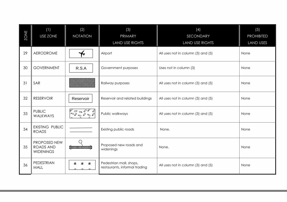
ZO
NE
NU
MB
ER
(1)
USE ZONE
(2)
NOTATION
(3)
PRIMARY
LAND USE RIGHTS
(4)
SECONDARY
LAND USE RIGHTS
(5)
PROHIBITED
LAND USES
29 AERODROME
Airport All uses not in column (3) and (5) None
30 GOVERNMENT
Government purposes Uses not in column (3) None
31 SAR
Railway purposes All uses not in column (3) and (5) None
32 RESERVOIR
Reservoir and related buildings All uses not in column (3) and (5) None
33 PUBLIC
WALKWAYS Public walkways All uses not in column (3) and (5) None
34 EXISTING PUBLIC
ROADS
Existing public roads None. None
35
PROPOSED NEW
ROADS AND
WIDENINGS
Proposed new roads and
widenings None. None
36 PEDESTRIAN
MALL
Pedestrian mall, shops,
restaurants, informal trading All uses not in column (3) and (5) None
Reservoir
R.S.A

ZO
NE
NU
MB
ER
(1)
USE ZONE
(2)
NOTATION
(3)
PRIMARY
LAND USE RIGHTS
(4)
SECONDARY
LAND USE RIGHTS
(5)
PROHIBITED
LAND USES
37 MINING
Mining purposes (See Clause 24.) Uses not in columns
(3) and (4)
PROVISOS:
In respect of ANNEXURE F for the purposes of this Land Use Scheme
USE ZONE :
Where land was excluded from the
previous Town Planning Schemes and/or
had No Zoning, it shall be deemed to be
classified under the Use Zone “Mining” in
this Land Use Scheme.
“Residential” shall be “Residential 3”
“Business” shall be “Business 1”
“Industrial” shall be “Industrial 1”
“Community Facility” shall be “Institutional”
“Municipal” shall be “Municipal”
“Undetermined” shall be “Undetermined”

15. CONVERSION OF USE OF A BUILDING
If the use of a building which has been approved, erected and used for a
specific purpose is to be changed, the use for such different purpose shall not
be commenced with until the provisions of this Land Use Scheme relating to
such different purpose have been complied with, including the submission of an
amended building plan and/or Site Development Plan.
16. CONDITIONS APPLICABLE TO PUBLIC GARAGES
Where public garages are to be erected the following land use conditions shall
be complied with in addition to any other applicable environmental legislation:
(1.) No material of any kind whatsoever shall be stored or stacked to a height
greater than a screen wall as indicated on an approved Site
Development Plan;
(2.) No repairs to vehicles or equipment of any kind may be carried on
outside the garage buildings or screen wall; and
(3.) No vehicle may be parked or material or equipment of any kind stored or
stacked outside the garage building or the screen wall: Provided that
petrol pumps and/or oil and fuel installations may be placed outside the
building and/or screen wall to the satisfaction of the Council.
17. APPLICATION FOR CONSENT USE
(1.) Any owner intending:
(a.) to erect and use a building in any Use Zone for a purpose for which
such building may only be erected, and used in such Use Zone with
the consent of the Council; or
(b.) to use land in any Use Zone for a purpose for which such land may
only be used with the consent of the Council,
must apply to the Council for the necessary consent as stipulated in terms
of the provisions of the City of Johannesburg Municipal Planning By-law,
2016.
(2.) Clause 40 shall apply mutatis mutandis to applications in terms of Sub-
clause (1.).

18. APPLICATION FOR WRITTEN CONSENT
Where the written consent of the Council is required (that includes terminology
such as permission or written consent) the application procedure as stipulated
on the appropriate application form or indicated as part of this Land Use
Scheme shall apply to the satisfaction of the Council.
19. SPAZA / HOUSE SHOP
Notwithstanding the provisions of the land development requirements
applicable to erven zoned “Residential 1, 2, 3 or 4”, as contained in the Land
Use Scheme:
(1.) The Council may grant its written consent to the establishment upon an
erf or site upon which a dwelling house or dwelling unit has been erected
for use as a spaza / house shop, provided that :
(a.) The written consent application shall include the notification of the
neighbours along the street frontage of the subject erf and all other
owners / occupants on the same subject erf, if applicable, informing
the neighbours of the intent of the owner; indicating that any
objections / representations shall be made to the Council and the
owner in writing within 28 days from the date of notification.
(b.) The sale and supply of essential pre-packed and / or pre-wrapped
items and / or foodstuff as well as the sale of airtime and telephone
kiosks may be permitted from the spaza / house shop.
(c.) The sale and consumption of liquor shall not be permitted.
(d.) The sale of meat shall not be permitted.
(e.) No amusement machines of any kind shall be permitted in the spaza
/ house shop whatsoever.
(f.) The exercising of the spaza / house shop shall exclusively be for the
owner / occupant residing in the dwelling house / unit.
(g.) The number of staff employed in the house-shop on the erf shall not
without the written consent of the Council exceed two employees.
(h.) The maximum extent of the spaza / house shop that the Council
may grant is restricted to 36m².
(i.) The spaza / house shop shall be conducted from a fixed structure for
which building plans have been approved. (It may include a
container/s)
(j.) In developments governed by sectional title or Home Owners
associations, such spaza / house shop shall be accommodated
subject to approval of the relevant Body Corporate / Home Owners
Association.

(k.) The Council may impose such conditions and requirements as it may
deem fit upon approval of the written consent for a spaza / house
shop.
(l.) The spaza / house shop shall not disturb or cause an interference
with the amenities of the neighborhood at the sole discretion of the
Council.
(m.) The residential character of the site shall be maintained to the
satisfaction of the Council and the predominant land use shall
remain residential.
(n.) The storing or keeping on the site of such dwelling unit of anything
whatsoever which, in the opinion of the Council, is unsightly or
undesirable shall be prohibited.
(o.) All relevant legislation and Council’s By-laws shall be complied with
to the satisfaction of the Council.
(p.) Any condition of this consent may be altered or any new condition
added thereto by the Council if it is of the opinion that owing to a
change in the circumstances or for any other reason such alteration
or addition is necessary or desirable from a town planning point of
view.
(q.) This consent shall be subject to termination by the Council if, after
affording the owner of the land to which this consent relates a
hearing, it is of the opinion that owing to a change of circumstances
or for any other reason it is undesirable for the consent to remain in
force.
20. HOME ENTERPRISES FOR PROFESSION AND/OR
OCCUPATION
Without prejudice to any of the powers of the Council under the provisions of this
Land Use Scheme or any other law, nothing in the provisions of this part of the
Land Use Scheme shall be construed as prohibiting or restricting or enabling the
Council to prohibit or restrict the practice by any permanent occupant of a
dwelling house / unit of a home enterprise / profession/s or occupation/s or use
of a dwelling house / unit for the purpose of a Home Enterprise, provided that:
(1.) The dwelling house / unit shall not be used for a public garage, motor
sales, motor workshop, heavy mechanical repairs (e.g. grinding, welding,
sanding, etc.), car wash, industrial / commercial purposes, noxious
industries, scrap yard, spray painting, panel beating, shop (retail outlet),
spaza / house shop, tavern / shebeen, restaurant, coffee shop, tea
garden, place of amusement, place of instruction, institution, guest
house, bed and breakfast, boarding house, commune, hotel, funeral
parlour, undertaker, pet salon or any such other uses as the Council may
determine.

(2.) Not more than 25% of the built floor area of the dwelling house / unit or
50m² may be used for non-residential purposes in total, whichever is the
lesser.
(3.) The principal of the non-residential activity shall be the permanent
occupant on the site.
(4.) A maximum of two (2) other persons additional to the members of the
household who permanently reside on the site and who own and operate
the business from the home may be taken into partnership on the site in
relation to the home enterprise / profession/s or occupation/s exercised
from the site.
(5.) The home enterprise / profession/s or occupation/s should not negatively
impact on any infrastructure services greater than normally required for
domestic use.
(6.) Parking, as well as loading and off-loading activities directly related to the
home enterprise / profession/s or occupation/s shall be to the satisfaction
of the Council.
(7.) The display of a non-luminous notice or sign on the boundary fence or
building, to indicate only the name, profession / occupation, business
logo and telephone number/s of such a permanent resident, shall be
permitted in compliance with the prevailing outdoor advertising by-laws.
(8.) A home enterprise / profession/s or occupation/s of such a nature that
would cause an undue increase in traffic in the neighbourhood or the
passing of heavy vehicles through the neighbourhood, neither the
congregating of workers in relation to the home enterprise / profession/s
or occupation/s from the dwelling house / unit shall not be permitted.
(9.) Interference, in the opinion of the Council, with the amenities of the
neighbourhood by means of noise, smell, dust, aesthetic appearance or
any other manner, shall not be permitted.
(10.) The storing or keeping on the site of anything whatsoever which, in the
opinion of the Council, is unsightly or undesirable or a risk to the safety
and security of residents, such as ammunition, weapons, fire arms,
explosives, fireworks, chemicals and waste or something which cannot be
accommodated by the ordinary design of a dwelling house or dwelling
unit shall not be permitted.
(11.) Should the permanent occupant wish to practice a home enterprise /
profession/s or occupation/s from a non-permanent (for example tents,
gazebo and caravans) structure on the site, such practice shall be
subject to permission being granted by the written consent of the Council
accompanied by a plan indicating the nature, size and position of the
container or non-permanent structure on the site. This written consent
may be subject to the submission of a building plan.
(12.) In developments governed by Sectional Title or Home Owners
Associations, such home enterprise / profession/s or occupation/s shall be
accommodated subject to approval of the relevant Body Corporate /
Home Owners Association.
(13.) All relevant legislation and Council’s By-laws shall be complied with to the
satisfaction of the Council.

21. SUBSIDIARY DWELLING UNIT
Notwithstanding the provisions of the land development requirements of the erf,
as contained in the Land Use Scheme:
(1.) An owner may erect and use a maximum of two subsidiary dwelling units
on an erf zoned ”Residential 1”, subject to the following conditions:
(a.) In the event of a subsidiary dwelling unit/s being in excess of one
storey, the written consent of the Council shall be required; such
written consent shall include the notification of the neighbours;
informing the neighbours of the intent of the owner; indicating that
any objections / representations shall be made to the Council and
the owner in writing within twenty-eight (28) days from the date of
notification.
(b.) The two (2) subsidiary dwelling units shall be inclusive of staff
accommodation;
(c.) The total combined floor area of the subsidiary dwelling units shall
not exceed 160m² or 90% of the main dwelling house whichever is
the lesser;
(d.) A subsidiary dwelling unit may only be erected in relation to an
existing dwelling house;
(e.) A subsidiary dwelling unit may be attached to or detached from the
main dwelling house but in the former instance may not be
interconnected;
(f.) A subsidiary dwelling unit may consist of interconnected rooms or
unconnected rooms.
(i.) The unconnected rooms may be self-contained or may share
communal ablution and/or kitchen facilities.
(ii.) In an interconnected subsidiary dwelling unit, the unit may be
rented out to a household or three (3) bedrooms may be
rented to individual persons.
(iii.) In an unconnected subsidiary unit, rentable rooms, the
minimum size of a habitable space shall not be less than 9m²,
excluding ablutions and kitchens, or 6m² per person for more
than one person.
(iv.) Rentable rooms may be self-contained (including ablutions
and kitchens) provided that the room may not exceed 25m².
(v.) A subsidiary dwelling unit is equivalent to three (3) rentable
rooms which may share a kitchen and/or ablution facilities or
three (3) self-contained rentable rooms.
(g.) Parking shall be provided to the satisfaction of the Council;
(h.) No outbuildings may be erected in relation to the subsidiary dwelling
units other than a garage/s;
(i.) The access, positioning and design of the subsidiary dwelling units
shall be to the satisfaction of the Council;

(j.) The screening of the subsidiary dwelling units shall be to the
satisfaction of the Council;
(k.) The amenity of the area shall not be disturbed at the sole discretion
of the Council;
(l.) Where an owner of a “Residential 1” property exercised the right of
a subsidiary dwelling unit, neither the subsidiary dwelling unit nor the
dwelling house may be sectionalized;
(m.) In the event of subdivision in accordance with the prevailing density
guidelines a newly created portion may contain the detached
subsidiary dwelling unit, which may now be re-defined as an existing
dwelling house;
(n.) When an owner exercises the right for the subsidiary dwelling units,
engineering services contributions in terms of the prevailing policies
for engineering services, may be payable on submission of the
building plan as determined by the Council.
22. CONDITIONS FOR CHILD CARE CENTRES AND EARLY
CHILHOOD DEVELOPMENT CENTRES ON RESIDENTIAL ERVEN
(1.) Subject to the provisions of Sub-clause (1.) the Council may grant its
consent to the erection upon an erf or site upon which a dwelling house
or dwelling unit has been erected or to a building for use as a place of
instruction for a child care centre.
(2.) The Council shall not grant its consent in terms of Sub-clause (1.) unless
there is sufficient area on site for the activities connected with the
proposed child care centre including the necessary parking requirements
to the satisfaction of the Council as well as the provision of areas for the
dropping off and collecting of children. Where necessary such
application shall be accompanied by a Traffic Management Plan to
address peak hour operations.
(3.) No consent is required if six (6) or less children are accommodated on the
erf.
23. CONDITIONS RELATING TO RELIGIOUS PURPOSES
(1.) The Council shall not grant its consent to any religious purposes where
there is any interference with the amenities of the neighbourhood with
regard to noise, parking, traffic, etc.
(2.) All applications shall be accompanied by a Traffic Management Plan to
address peak hour operations.
(3.) No Religious Purposes shall be permitted within residential complexes.

24. CONDITIONS RELATING TO AGRICULTURAL HOLDINGS AND
FARM LAND
The flowing is applicable with regard to consent use applications on agricultural
holdings and farm land:
(1.) No development that generate the need for the upgrade of municipal
services, (roads, electricity, water, sewerage and storm water). If any
detailed engineering investigations are required in order to establish
whether any external services upgrading will be required, then these
investigations should be done upfront prior to submission of any consent
use application.
(2.) The Council reserves the right to call for any necessary additional
information required during evaluation of an application, including inter-
alia, a geotechnical investigation report, flood line investigations /
certification, traffic studies and services outline scheme reports.
(3.) Only one land use shall be permitted. (This does not include an existing
dwelling house.)
(4.) The property may not be subdivided.
(5.) A Site Development Plan shall be submitted for approval prior to approval
of building plans.
(6.) These shall include specific land uses such as:
(a.) Guest house / bed and breakfast for 15 rooms / suites.
(b.) Places of Instruction for a maximum of 100 learners.
(c.) Tea gardens and restaurants with seating for 80 patrons.
(d.) Conference facilities for a maximum of 80 delegates.
(e.) Religious Purposes for 100 worshippers.
(f.) Sports grounds for existing adjacent or nearby Places of Instruction.
(g.) Green energy installations for renewable energy provision.
(h.) Show jumping and riding events related to horse stables and riding
schools
(i.) Sporting and recreation facilities such as but not limited to golf
courses, paintball, go-cart racing and zip lining.
(j.) Institutions such as but not limited to orphanages for 50 people.
(k.) Veterinary services with not more than two veterinary practitioners
and restricted to 250m2.
(l.) Day Spa limited to 250m2.
(m.) Self-storage limited to 1 000m2 or 20%, whichever is the lesser.

25. ERVEN AFFECTED BY SERVITUDES
The provisions of floor area, coverage, height and building lines shall not be
affected by the indications of servitudes over an erf or site.
26. CONSOLIDATION AND SUBDIVISION OF ERVEN
(1.) Subject to the provisions of Section 33 of the City of Johannesburg
Municipal Planning By-law, 2016, the Council may grant its approval to
the subdivision of any erf or consolidation of erven, subject to such
conditions as it may deem fit and in accordance with the density
guidelines as per Clause 27 and the applicable Council policy.
(2.) In considering an application for its approval for consolidation and/or
subdivision as contemplated in Sub-clause (1.)the Council shall, in
addition to any other relevant factors, have regard to:
(a.) Whether the said consolidation and/or subdivision is necessary and
desirable in relation to the location of buildings on the erf to be
subdivided and/or consolidated;
(b.) Whether there is adequate and unhindered access to and from the
erven or sites; where a panhandle erf or site is created through
subdivision the width of the panhandle shall be to the satisfaction of
the Council which shall not be less than four (4) metres.
(c.) Where the major vegetation and/or prominent natural features are
positioned on the erf or site that the owner retains such as far as
possible.
(3.) No consolidation of two (2) or more erven with different Use Zones or
Schedules / Annexures shall be permitted unless appropriately rezoned.
(3.) Erven that have been developed with semi’s (two (2) dwelling units under
one (1) roof), in accordance with the provisions of previous town planning
schemes, may be subdivided in accordance with the provisions of this
Land Use Scheme.
(4.) The Council may grant approval to:
(a.) the subdivision of an erf zoned “Residential 1”, one dwelling house
per erf;
(b.) the subdivision of an erf zoned “Residential 1”, which would have
the effect of creating an erf or erven smaller in size than the
minimum area specified in Table 3.
(c.) If an erf is subdivided in terms of the general Council Policy of 20
units per hectare and/or other specific density policy and/or
guideline in place, not more than four (4) portions may be created
in terms of the provisions of Sub-clause (a.) and (b.).

(d.) If an erf is subdivided in terms of Sub-clause (4.)(a.), (b.) or (c.) to 20
units per hectare or less, each subdivided portion shall have direct
access to a public road.
(5.) The Council may grant its approval to the subdivision of an erf zoned
“Residential 2, 3 or 4”, whether or not a density is indicated in terms of
Table 3, in accordance with an approved Development Plan with
proposed divisions as contemplated in Clause 39.
(6.) Such approval for subdivision is subject to time limitations as contained in
Section 33 (10) and (11) of the City of Johannesburg Municipal Planning
By-laws, 2016.
(7.) Upon the approval of a subdivision the following conditions shall be
included as conditions of title of each and every subdivided portion :
(h.) The erf is subject to a servitude, two (2) metres wide, in favour of
the local authority, for sewerage and other municipal purposes,
along any two boundaries other than a street boundary and in
the case of a panhandle erf, an additional servitude for
municipal purposes two (2) metres wide across the access
portion of the erf, if and when required by the local authority:
Provided that the local authority may dispense with any such
servitude.
(i.) No building or other structure shall be erected within the
aforesaid servitude area and no large-rooted trees shall be
planted within the area of such servitude or within two (2)
metres thereof.
(8.) The local authority shall be entitled to deposit temporarily on the land
adjoining the aforesaid servitude such material as may be excavated by
it during the course of the construction, maintenance or removal of such
sewerage mains and other works as it, in its discretion may deem
necessary and shall further be entitled to reasonable access to the said
land for the aforesaid purpose subject to any damage done during the
process of the construction, maintenance or removal of such sewerage
mains and other works being made good by the local authority.
The Council shall attach the conditions of the approved subdivision to the
zoning information of all the newly created erven concerned. In the
event of the cancellation or lapsing of such subdivision the Council may
remove such conditions and do the appropriate adjustments.
(9.) Upon the approval of a subdivision application all the conditions of
approval shall :
(a.) Be in addition to the general conditions, restrictions and other
provisions of this Land Use Scheme
(b.) Should there be conflict with any such other conditions, restrictions
or provisions in this Land Use Scheme including the provisions and
conditions contained in an Annexure or Schedule applicable to the
erf, the most restrictive conditions shall prevail.

SECTION 2:
MANAGEMENT OF LAND DEVELOPMENT
RIGHTS
This Section of the City of Johannesburg Land Use Scheme contains all of the
general land development rights associated and connected with the Use Zones
as detailed in Section 1, including height, coverage, floor area and density
requirements. It also elaborates on building restrictions and parking
requirements. The overall purpose of this Section is to determine the land
development and administration processes that the Council has at its disposal to
manage the urban form in a sustainable and innovative way.
PART IV: LAND DEVELOPMENT REQUIREMENTS
27. DENSITY DEVELOPMENT REQUIREMENTS
(1.) The number of dwelling houses or dwelling units that may be erected on
an erf or site shall be in accordance with Table 3.
(2.) In all Use Zones other than “Residential 1, 2, 3, 4 and 5” (or where
specified in an Annexure / Schedule) where residential use is permitted,
dwelling houses, dwelling units, mobile dwelling units and residential
buildings shall only be erected in accordance with the provisions relating
to height, coverage and floor area ratio applicable to the erf or site
concerned.
(3.) If an erf or site is situated in more than one Use Zone, buildings may be
erected without subdivision of the erf or site, in accordance with purposes
permitted in each Use Zone on the various parts of such erf or site.
(4.) In the event of a cluster development (Free Hold Title) on “Residential 2, 3
and 4” the density shall be restricted to a maximum of 30 dwelling units
per hectare.

TABLE 3: DENSITY DEVELOPMENT REQUIREMENTS
Reference to B-
series Map
(Notation)
Number of dwelling
houses per erf
Minimum area of erf
in square meters
(m²)
1 -
1 100
1 200
1 300
1 400
1 500
1 700
1 800
1 1 000
1 1 250
1 1 500
1 2 000
1 2 500
1 3 000
1 4 000
1 6 000
1 8 000

28. HEIGHT DEVELOPMENT REQUIREMENTS
(1.) The number of storeys, excluding basement storeys that may be
contained in a building shall be determined by a designated Height Zone
detailed in Table 4.
(2.) Save with the consent of the Council and/or the relevant controlling
authority, no building shall exceed a height of 1950m above mean sea
level. For the purpose of this clause the height exclusions in terms of the
height definitions shall not apply.
(3.) Subject to the provisions of this Part of the Land Use Scheme, no building
shall be erected so as to contain a number of storeys in excess of the
number specified in Sub-clause (1.): Provided that an additional storey
may be permitted with the consent of the Council.
(4.) In considering applications for the Council’s consent in terms of Sub-
clause (2.), the Council shall, in addition to any other relevant factors
have regard to:
(a.) The location and topography of the erf or site;
(b.) Whether, for example, the additional open space resulting from a
building containing more than four storeys is more desirable than
that which would result from a four storey building;
(c.) The effect on the surrounding area with particular emphasis on the
possible obstruction of view, overshadowing or breaking of the
natural skyline; and
(d.) The desirability of creating a focal point on the site.

TABLE 4: HEIGHT DEVELOPMENT REQUIREMENTS
(1) (2) (3)
Height
Zone
Number
of
storeys
Jo
ha
nn
esb
urg
Sa
nd
ton
Ro
od
ep
oo
rt
Ra
nd
bu
rg
Len
asi
a
Mo
dd
erf
on
tein
Wa
lke
rville
Ed
en
va
le
Peri-Urban
Halfway House
Annexure F
Lethabong
Westonaria
Southern
Jhb Region
A 3
0 0 0 0 0 0 0 3 0
6 2 4 3 1 1 1 4
7 3 5 2 2 2 5
8 4 6 3 3 3 6
5 7 4 4 4 7
6 8 5 5 5 8
7 9 6 6 6 9
8 10 7 7 7 10
9 11 8 8 8 11
10 12 9 9 9
11 10
B 5 5 1 3 2
C As per
Clause
30
1 1 1 0
2 2 1
3 2
4

29. GROUND STOREY AND BASEMENT STOREYS
(1.) A building shall have only one (1) ground storey and, save for a building
consisting of only one (1) storey, the building plans of a building shall
indicate which the ground storey is.
(2.) All storeys below the ground storey shall be indicated as basement
storeys on building plans and shall comply with the provisions as set out in
the definition of basement.
(3.) Basement storeys shall not be taken into account in the determination of
the permissible number of storeys in a building as per definition of
basement; however, if basements are used for any other purpose other
than parking, such areas shall be included as floor area.
30. THE 59º HEIGHT LINE LIMITATION
(1.) Any building erected in Height Zone C shall not project above a line
drawn at an angle of 59˚ to the horizontal from a point at street level on
the street boundary opposite to the street boundary onto which the site
fronts.
(2.) The Council may grant its consent in terms of a Site Development Plan as
detailed in Clause 39 to the erection of a building governed by Height
Zone C, which will project above the 59˚ height line referred to in Sub-
clause (1.), subject to such conditions as it may deem fit.
31. COVERAGE DEVELOPMENT REQUIREMENTS
(1.) No building shall be erected so as to cover a greater proportion of its erf
than is permitted in terms of Table 5.
(2.) The provisions of Sub-clause (1.) shall apply to every storey in a building,
including any basement storey.
(3.) The Council may grant its written consent:
(a.) To any basement storey which is below natural ground level being
constructed so as to exceed the coverage permissible in terms of
Sub-clause (1.).
(b.) To the area covered by private parking garages so as to exceed
the coverage permissible in terms of Sub-clause (1.).
(c.) In considering an application for its consent in terms of Sub-clause
(2.)(a.) the Council shall in addition to any other relevant factors
have regard to the likely effect upon plant life, possible future road
improvements and the location of essential services.
(4.) The Council may grant its written consent to the coverage being
increased:

(a.) In respect of an erf or site fronting onto a pedestrian mall;
(b.) On any Use Zone to an additional maximum of 10%.
(c.) In considering an application for its consent in terms of Sub-clause
(3.)(c.)(a.) the Council shall in addition to any other relevant factors
have regard to the likely effect upon plant life, possible future road
improvements and the location of essential services
(d.) On Residential 1 zoned erven, smaller than 500m² the coverage for
a single storey building may be 60%.
(5.) The coverage as reflected in Table 5 shall not be applicable to residential
cluster / group housing (freehold) development, in which instance the
coverage shall be determined in terms of an approved Site Development
Plan.
(6.) The coverage as reflected in Table 5 shall not be applicable to the,
“Agricultural” and “Undetermined” Use Zones, developed for a dwelling
house only, in which instance the coverage shall not exceed 30%.
TABLE 5: COVERAGE DEVELOPMENT REQUIREMENTS
(1)
Height
Zone
(2)
Dwelling Houses,
Dwelling Units,
Residential Buildings
(3)
Shops, Business
Purposes, Institutional-,
Educational Facilities
(4)
Industrial
Purposes
(5)
Other
Uses
A
50% for one storey
50% for two storeys
40% for three storeys
50% 70% 70%
B
Residential 1: 60%
Residential 2: 70%
Residential 3: 80%
70% 85% 60%
C 100% 100% 100% 100%
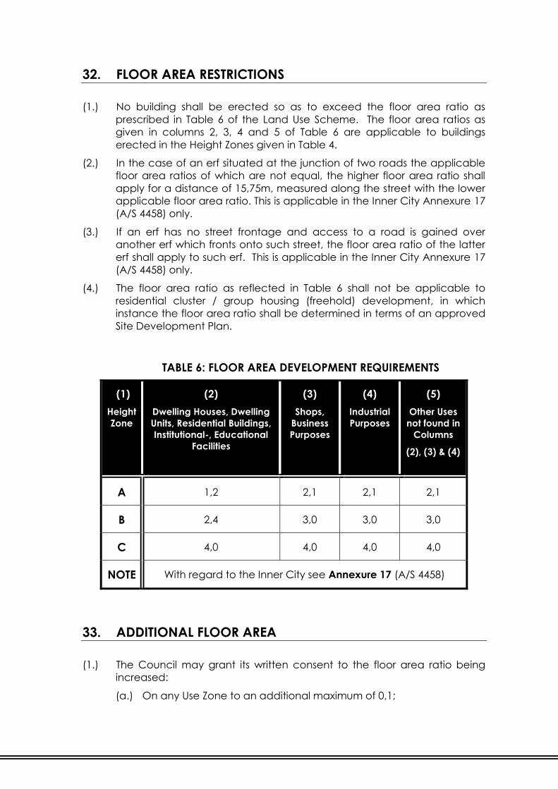
32. FLOOR AREA RESTRICTIONS
(1.) No building shall be erected so as to exceed the floor area ratio as
prescribed in Table 6 of the Land Use Scheme. The floor area ratios as
given in columns 2, 3, 4 and 5 of Table 6 are applicable to buildings
erected in the Height Zones given in Table 4.
(2.) In the case of an erf situated at the junction of two roads the applicable
floor area ratios of which are not equal, the higher floor area ratio shall
apply for a distance of 15,75m, measured along the street with the lower
applicable floor area ratio. This is applicable in the Inner City Annexure 17
(A/S 4458) only.
(3.) If an erf has no street frontage and access to a road is gained over
another erf which fronts onto such street, the floor area ratio of the latter
erf shall apply to such erf. This is applicable in the Inner City Annexure 17
(A/S 4458) only.
(4.) The floor area ratio as reflected in Table 6 shall not be applicable to
residential cluster / group housing (freehold) development, in which
instance the floor area ratio shall be determined in terms of an approved
Site Development Plan.
TABLE 6: FLOOR AREA DEVELOPMENT REQUIREMENTS
(1)
Height
Zone
(2)
Dwelling Houses, Dwelling
Units, Residential Buildings,
Institutional-, Educational
Facilities
(3)
Shops,
Business
Purposes
(4)
Industrial
Purposes
(5)
Other Uses
not found in
Columns
(2), (3) & (4)
A 1,2 2,1 2,1 2,1
B 2,4 3,0 3,0 3,0
C 4,0 4,0 4,0 4,0
NOTE With regard to the Inner City see Annexure 17 (A/S 4458)
33. ADDITIONAL FLOOR AREA
(1.) The Council may grant its written consent to the floor area ratio being
increased:
(a.) On any Use Zone to an additional maximum of 0,1;

(b.) In considering an application for its consent in terms of Sub-clause
(1.) the Council shall in addition to any other relevant factors have
regard to the likely effect upon plant life, possible future road
improvements and the location of essential services.
(2.) The Council may with the written consent increase the floor area in
respect of erven in the Inner City as per Annexure 17 (A/S 4458) in Height
Zone C.
(3.) The Council may with the written consent increase the floor area in
respect of an erf or site fronting onto a pedestrian mall.

PART V: BUILDING RESTRICTION AREAS
34. BUILDING LINES AND BUILDING RESTRICTION AREAS
(1.) Building lines applicable to street boundaries are given in Table 7.
(2.) Subject to the provision of Sub-clause (3.) and Clause 35, no building shall
be erected in a building restriction area.
(3.) Sub-clause (2.) is not applicable to boundary fences; garden walls;
garden fences; garden ornaments; garages and carports with indirect
access and associated single storey domestic outbuildings related to
dwelling houses; dwelling units and residential buildings; electrical high
and low tension chambers; pergolas; guard houses; antenna; satellite
dishes; or swimming pools: Provided that such exemption does not apply
along any provincial or national road in so far as it would be contrary to
the requirements of the controlling authority.
(4.) Due to the existence of omnibus servitudes and municipal services
situated on properties, any / all such services shall be indicated on the
building plan and where a building/s, whether such structure/s is on or
above surface or below surface, or any building works (retaining walls,
etc.), is closer than two (2) metres from any boundary, the specific
clearance from all the services departments shall be obtained.
35. CONSENT TO BUILD IN THE BUILDING RESTRICTION AREA
(1.) The Council may consent to the erection of buildings :
(a.) In the building restriction area between the building line and street
boundary;
(b.) In the case of structures below ground level or mainly below ground
level, in the building restriction area between the building line and
the street boundary;
(c.) Buildings may be erected between the building line and the
boundary of a sanitary lane if it is not in conflict with the Council’s
by-laws.
(d.) Such consent may not be granted along any provincial or national
road where such consent would be contrary to the requirements of
the controlling authority.
(2.) A consent granted in terms of Sub-clause (1.) shall be valid for the life of
the building in respect of which such consent was granted, or for any
shorter period that may be specified by the Council as a condition of its
consent.

(3.) In considering an application for its consent in terms of Sub-clause (1.) the
Council shall, in addition to any other relevant factors, have regard to:
(a.) The possibility of future road improvements;
(b.) The location of the building in relation to surrounding sites and
buildings;
(c.) The slope of the land comprising the erf or site in relation to the slope
of surrounding land;
(d.) The arrangement of the buildings on the erf;
(e.) All existing and/or future servitudes for engineering services;
(f.) Any factor indicating the compliance with the building line would
unreasonably interfere with the development of the erf.
(g.) If an erf or site abuts a provincial road or a national road, a building
restriction shall be applicable in accordance with the standards laid
down by the relevant Provincial Department or controlling body.
TABLE 7: BUILDING LINE RESTRICTION AREAS
(1)
Use Zone and/or
Land
(2)
Size of Erf or Site
or Height Zone
(3)
Minimum Distance in
meters between building
line and street boundary
Residential
1, 2, 3, 4 & 5
Erven of 500m² or less
Erven larger than 500m²
1,0 m
3,0 m
Agricultural
Holdings &
farm portions
Less than 9ha
9ha and greater
9,0 m
30,0 m
All other
Use Zones
Height Zones A and B
Height Zone C
3,0 m
1,5 m

PART VI: PARKING AND LOADING
36. PARKING DEVELOPMENT REQUIREMENTS
(1.) The provisions for parking in this Part of the Land Use Scheme shall not
apply to land or land and buildings where such land or buildings, or both,
are used exclusively for public or private parking areas: Provided that in a
building to be used or erected and used, partly for a public parking area
and partly for other uses, this Part shall apply to that part of said land or
building used or erected and used for such other uses; parking shall not
be used for the exclusive use of tenants. If parking is demarcated /
reserved, it shall be over and above the standard requirement.
(2.) For the purposes of calculating the number of parking bays that can be
provided, it shall be deemed that one parking bay is equal to an area of
30m²; should taxi bays be provided on-site, one (1) taxi bay shall be the
equivalent of eight (8) parking bays; two (2) motorbike bays shall be
equivalent to one (1) parking bay; should non-motorised facilities be
provided, five (5) non-motorised facilities shall be the equivalent of one
(1) parking bay; drop-off zones for busses at any educational facility will
be the equivalent of three (3) parking bays; provided that a maximum of
10% of the total number of parking bays required may be replaced by
the afore-mentioned parking modes. (This percentage may be further
increased on submission of a written consent application.)
(3.) Subject to the provisions of Sub-clause (5.) parking shall be provided in a
manner satisfactory to the Council in respect to buildings and use of land
on erven or sites, which shall be the number of bays specified in Table 8 or
Table 9, applied according to the locality of the erven or sites, which will
fall in one of the following three (3) parking zones :
(a.) Parking Zone A : being the Johannesburg Inner City
In this parking zone, parking may be provided as per the ratios in
Table 9. (Annexure 17.)
(b.) Parking Zone B : for areas as defined in the Spatial Development
Framework (SDF) Sub-clause
(c.) Parking - Remainder of City : the area of jurisdiction, not defined
under Zones A and B above
(4.) Areas covered by Zone B include the following :
(a.) Public Transport priority areas: areas located within 500 meters
walking distance from PRASA rail stations, Gautrain and Bus Rapid
Transport (BRT) stations.
(b.) Areas within the priority Transit Oriented Development Corridors.
(c.) Deprivation areas, as defined in the Spatial Development
Framework of the City of Johannesburg.

(d.) Transit Oriented Development (TOD) Metropolitan and Regional
nodes.
(5.) The Council, when considering a written consent application for
deviation of the parking requirements in Zone B and the Remainder of the
City shall, where the minimum required parking as per Table 8 cannot be
provided, in addition to any other relevant factors, take the following into
account :
(a.) The areas listed under Sub-clause (4.)
(b.) The total parking provision (private / public) in the area where the
proposed development is located.
(c.) If public transport facilities are provided and maintained on site by
the applicant / owner, at the owner’s own cost.
(d.) Availability of off-street parking in the vicinity of the site.
(e.) The possible impact of shared-parking utilization in mixed land use
developments located within reasonable walking distances on the
same site.
(f.) The number of staff members and customers related to the use of
the land or building on site.
(g.) the socio-economic structure and density of the population that is
served by the development.
(h.) the size and nature of the proposed development on the site and
the size or type of vehicles likely to be used in connection with the
land use conducted on the site.
(i.) the likelihood of a reduction in parking provision causing injury to the
amenity of the area in which it is or will be situated including, without
prejudice to the generality of the foregoing, increased traffic and
parking difficulties.
(6.) Retail shopping centres in excess of 5 000m² floor area shall provide
public transport facilities and associated informal trading facilities and
ablutions, the extent of which shall be to the satisfaction of the Council.
(7.) Open air land uses are to be included as floor area for the purpose of
calculating parking requirements for all land uses.
(8.) In all Use Zones, excluding “Residential 1”, where dwelling units are
developed, at least one (1) covered parking bay shall be provided for
each dwelling unit.
(9.) On “Residential 1” zoned sites, parking shall be to the satisfaction of the
Council.

TABLE 8: ON-SITE PARKING REQUIREMENTS
LAND USE
CATEGORY REMAINDER OF CITY
PARKING ZONE B
TOD CORRIDORS & NODES /
PRASA, GAUTRAIN & BRT
STATIONS / DEPRIVATION
AREAS / ECONOMIC NODES
RESIDENTIAL
Up to three habitable
rooms
1,0 bay per unit plus 1,0 bay
per three units for visitors
0,5 bays per unit plus 1,0 bay
per three units for visitors
Four or more
habitable rooms
2,0 bays per unit plus 1,0 bay
per three units for visitors
1,0 bay per unit plus 1,0 bay per
three units for visitors
Boarding houses,
hostels, communes 0,5 bays per room 0,3 bays per room
Residential hotels, bed
& breakfast, guest
houses
1,0 bay per room 0,5 bays per room
Social/Inclusionary
housing 0,75 bays per unit 0,5 bays per unit
Licensed hotels,
motels
1,0 bay per bedroom plus 25,0
bays per 100 m2 public rooms
0,5 bays per bedroom plus 10,0
bays per 100 m2 public rooms
RELIGIOUS PURPOSES
With seating provision 0,4 bays per seat 0,2 bays per seat
Without seating
provision
25,0 bays per 100 m2 of net
prayer/meditation area
10,0 bays per 100 m2 of net
prayer/meditation area
EDUCATIONAL / INSTRUCTIONAL
Primary and
secondary schools
1,0 bay per classroom plus 0,1
bay per learner and 1,0 bay
per additional teacher/trained
administrator or staff
1,0 bay per classroom plus 0,1
bays per learner and 1,0 bay
per additional teacher/trained
administrator or staff
Nursery schools,
crèches, day care
centres
0,2 bays per child plus 1,0 bay
per classroom
0,1 bays per child plus 1,0 bay
per classroom
Universities, colleges,
adult education,
advanced technical
education and other
full-time education
0,4 bays per student plus 1,0
bay per classroom and 1,0 bay
per additional trained /
administration staff
0,2 bays per student plus 1,0 bay
per classroom and 1,0 bay per
additional trained /
administration staff

LAND USE
CATEGORY REMAINDER OF CITY
PARKING ZONE B
TOD CORRIDORS & NODES /
PRASA, GAUTRAIN & BRT
STATIONS / DEPRIVATION
AREAS / ECONOMIC NODES
Under 18 part-time
instruction
0,5 bays per learner plus 1,0
bay per trained staff
0,2 bays per learner plus 1,0 bay
per trained staff
Medical schools
0,8 bays per student plus 1,0
bay per classroom and 1,0 bay
per additional trained /
administration staff
0,4 bays per student plus 1,0 bay
per classroom and 1,0 bay per
additional trained /
administration staff
SOCIAL / RECREATIONAL/ INSTITUTIONAL
Convalescent homes,
Old age homes,
geriatric, homes with
medical care,
sanatoriums,
charitable institutions
1,0 bay per bed plus 1,0 bay
per trained / administration
staff
1,0 bay per bed plus 1,0 bay
per trained / administration staff
Bowling alleys, indoor
shooting club, billiard
saloons
6,0 bays per 100 m2 3,0 bays per 100 m2
Sports clubs 0,7 bays per player and staff
plus 0,5 bays per spectator
0,4 bays per player and staff
plus 0,2 bays per spectator
Sports stadium 0,7 bays per player and staff
plus 0,5 bays per spectator
0,4 bays per player and staff
plus 0,2 bays per spectator
Swimming pools
20,0 bays per 100 m2 for whole
enclosed area or 0,7 bays per
seat, whichever is the greater
10,0 bays per 100 m2 for whole
enclosed area or 0,2 bays per
seat, whichever is the greater
Squash courts 4,0 bays per court 2,0 bays per court
Social clubs, youth
clubs, community
centres
4,0 bays per 100 m2 2,0 bays per 100 m2
Show grounds,
amusement parks,
fairs, snake parks, etc.
15,0 bays per 100 m2 of total
site area excluding parking
area
10,0 bays per 100 m2 of total site
area excluding parking area
Zoos, parks,
nature/flower parks
10,0 bays per 100 m2 of total
site area excluding parking
area
5,0 bays per 100 m2 of total site
area excluding parking area
Sport and recreation
facilities
10,0 bays per 100 m2 or 0,25
bays per seat
5,0 bays per 100 m2 or 0,25 bays
per seat

LAND USE
CATEGORY REMAINDER OF CITY
PARKING ZONE B
TOD CORRIDORS & NODES /
PRASA, GAUTRAIN & BRT
STATIONS / DEPRIVATION
AREAS / ECONOMIC NODES
Gymnasium/Health
Clubs
10,0 bays per 100 m2 plus 1,0
bay per trainer
5,0 bays per 100 m2
Institution 1,5 bays per 100 m² 0,75 bays per 100 m²
PUBLIC GARAGES AND MOTOR RELATED USES
Workshops,
convenience shop,
take-aways, Drive-
throughs
6,0 bays per 100 m2 3,0 bays per 100 m2
Lubrication, tune-up
bays, car wash 4,0 bays per wash/tune-up bay 2,0 bays per wash/tune-up bay
Related spares and
sales 2,0 bays per 100 m2 1,0 bay per 100 m2
Related motor
showroom 3,0 bays per 100 m2 1,5 bays per 100 m2
Stand-alone Filling
Station 2,0 stacking bays per pump 2,0 stacking bays per pump
Used car sales lots 3,0 bays per 100 m2 1,0 bay per 100 m2
MEDICAL USES
Hospital, Clinics, Step-
down facilities
2,0 bays per bed plus 6,0 bays
per 100 m2 for the medical
consulting rooms
1,0 bay per bed plus 3,0 bays
per 100 m2 for the medical
consulting rooms
Veterinary hospitals
and consulting rooms 6,0 bays per 100 m2 3,0 bays per 100 m2
Medical consulting
rooms 6,0 bays per 100 m2 3,0 bays per 100 m2
BUSINESS USES
Offices 4,0 bays per 100 m2 2,0 bays per 100 m2

LAND USE
CATEGORY REMAINDER OF CITY
PARKING ZONE B
TOD CORRIDORS & NODES /
PRASA, GAUTRAIN & BRT
STATIONS / DEPRIVATION
AREAS / ECONOMIC NODES
Restaurants 6,0 bays per 100 m2 3,0 bays per 100 m2
Motor Showrooms 6,0 bays per 100 m2 3,0 bays per 100 m2
Showrooms 3,0 bays per 100 m2 1,5 bays per 100 m2
Shops 6,0 bays per 100 m2 3,0 bays per 100 m2
Shops (Shopping
centres < 5 000 m2) 6,0 bays per 100 m2 3,0 bays per 100 m2
Shops (Shopping
centres < 10 000 m2) 5,0 bays per 100 m2 3,0 bays per 100 m2
Shops (Shopping
centres > 10 000 m2) 4,0 bays per 100 m2 3,0 bays per 100 m2
Cinemas/theatre (in
shopping centres) 0,2 bays per seat 0,2 bays per seat
Cinemas/theatres 0,5 bays per seat 0,2 bays per seat
Exhibition halls 30,0 bays per 100 m2 15,0 bays per 100 m2
Halls for
entertainment,
conferences (with
seats)
0,4 bays per seat 0,2 bays per seat
Halls for
entertainment,
conferences (without
seats)
40,0 bays per 100 m2 20,0 bays per 100 m2
Libraries, museums,
galleries and other
cultural buildings
5,0 bays per 100 m2 2,5 bays per 100 m2
Funeral Parlors 2,0 bays per 100 m2 1,0 bay per 100 m2
Place of amusement 10,0 bays per 100 m2 or 0,25
bays per seat
5,0 bays per 100 m2 or 0,15 bays
per seat
Industrial, commercial
& warehousing uses 2,0 bays per 100 m² 1,0 bay per 100 m²
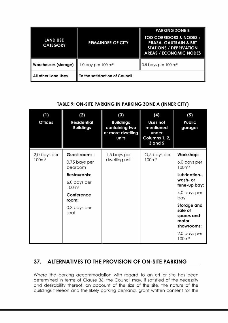
LAND USE
CATEGORY REMAINDER OF CITY
PARKING ZONE B
TOD CORRIDORS & NODES /
PRASA, GAUTRAIN & BRT
STATIONS / DEPRIVATION
AREAS / ECONOMIC NODES
Warehouses (storage) 1,0 bay per 100 m² 0,5 bays per 100 m²
All other Land Uses To the satisfaction of Council
TABLE 9: ON-SITE PARKING IN PARKING ZONE A (INNER CITY)
(1)
Offices
(2)
Residential
Buildings
(3)
Buildings
containing two
or more dwelling
units
(4)
Uses not
mentioned
under
Columns 1, 2,
3 and 5
(5)
Public
garages
2,0 bays per
100m²
Guest rooms :
0,75 bays per
bedroom
Restaurants:
6,0 bays per
100m²
Conference
room:
0,3 bays per
seat
1,5 bays per
dwelling unit
O,5 bays per
100m²
Workshop:
6,0 bays per
100m²
Lubrication-,
wash- or
tune-up bay:
4,0 bays per
bay
Storage and
sale of
spares and
motor
showrooms:
2,0 bays per
100m²
37. ALTERNATIVES TO THE PROVISION OF ON-SITE PARKING
Where the parking accommodation with regard to an erf or site has been
determined in terms of Clause 36, the Council may, if satisfied of the necessity
and desirability thereof, on account of the size of the site, the nature of the
buildings thereon and the likely parking demand, grant written consent for the

provision of the required number of parking bays elsewhere than on the site of
the building / development concerned.
With regard to the obligation to provide parking accommodation on a site, the
Council has, in terms of this Land Use Scheme or in terms of similar provisions in
any town planning scheme previously administered by the Council, granted
such consent, then the arrangement thus consented to as an alternative to the
provision of parking on site shall be taken into account in the form of a credit
against any parking accommodation, which has to be provided where erecting
any building on the site following such consent.
38. LOADING AND OFF-LOADING
Loading and off-loading facilities for goods and passengers shall be provided on
an erf or site to the satisfaction of the Council, provided that the Council may
relax this requirement on submission of a written application for consent,
accompanied by a Site Development Plan.
PART VII: LAND DEVELOPMENT ADMINISTRATION
The Council, when considering any application for its consent for the erection
and use of a building, or for the use of land, shall, in addition to other factors
which it must take into account, have regard to whether such use or building is
likely to cause injury to the amenity of the area in which it is or will be situated
including, without prejudice to the generality of the foregoing, increased traffic,
parking difficulties, and in the case of an industrial building, injury caused by the
emission of noise, air or water emissions and pollution.
39. SITE DEVELOPMENT PLANS
Site Development Plans are required by the Council:
(1.) A condition of an application, including consent use applications, as and
when required by the Council; or
(2.) On all Use Zones other than erven zoned “Residential 1” or land that is
developed with a dwelling house only; or
(3.) For the development of any structures by any party on erven or sites with
a “Public Open Space” use in terms of the Land Use Scheme; or
(4.) All erven within a registered Special Development Zone; or
(5.) On erven in an Environmental Control Area; or
(6.) Where required in any other part of the Land Use Scheme.
(7.) Such Site Development Plan shall be drawn at a scale of 1:500 or such
other scale as may be required by the Council, and shall be approved by
the Council before any building plan in connection with the proposed
development may be considered by the Council.
(8.) Unless the Council requires less information, a Site Development Plan shall
show at least the following:
(a.) The siting, height, floor area and coverage of all buildings; specific
detailed floor plans for residential developments;
(b.) Children’s play areas;
(c.) Pedestrian and vehicular entrances and exits to the erf or site;
(d.) If the erf or site is to be subdivided, the proposed subdivision lines;
(e.) Pedestrian access to buildings and parking areas and to and from
the erf or site;
(f.) Building restriction areas (if any), boundary walls, fences, screening;
(g.) All servitudes and/or existing municipal services and/or any
proposed engineering services affecting the erf shall be accurately
indicated, including boreholes;
(h.) Parking and maneuvering areas, and where required by the
Council, circulation of vehicular and pedestrian traffic;
(i.) Elevational treatment of all buildings;
(j.) If it is not proposed to develop the whole erf or site simultaneously,
the grouping of the dwelling units and the programming of the
development thereof, must be clearly indicated on the plan;
(k.) Steps to be taken to control storm water runoff in compliance with
the storm water by-laws;
(l.) Landscaping including existing, mature vegetation on the site or erf;
(m.) Contours;
(n.) Surrounding developments and their relation with the proposed
development.
(o.) Open spaces and landscaping of the site shall include but not be
limited to :
(i) All landscaping and existing mature vegetation.
(ii) A minimum of 10% of the site shall be landscaped.
(iii) A minimum of one (1) tree per three (3) parking bays shall be
provided.
(iv) All hydrological features including such as, but not limited to,
pans, ponds, dams, drainage features and wetlands.
(v) Natural environmental features such as, but not limited to,
special geological formations and grassland.
(p.) Energy efficiency measures.
(q.) And any other additional information if so required by the Council.
(9.) Public transport, metered taxis and pedestrians (including ‘kiss-and-ride’
drop-off) should be given priority over private vehicles on layouts of
developments on Site Development Plans. Walking distances to drop-off
areas should be kept to a minimum from the entrances to the
developments. Thus, development layouts / Site Development Plans
could also encompass a drop-off area for public transport and metered
taxis, as well as ‘kiss-and-ride’ drop-off facilities (where there is a need for
private vehicles to drop off people without parking).
40. CONSENT OF THE COUNCIL
(1.) Application to the Council for any consent which, in terms of this Land
Use Scheme it is empowered to grant or refuse, shall be made by the
owner as defined to which the application relates in terms of the City of
Johannesburg Municipal Planning By-law, 2016.
(2.) Any condition imposed in terms of a consent shall have the same force
and effect as if it were a clause of this Land Use Scheme.

(3.) A consent granted by the Council in terms of this Land Use Scheme may
be subject to termination by the Council if any breach of a condition
upon which such consent was granted is not remedied in compliance
with a notice served by the Council upon the owner or occupier of the erf
or site concerned after affording the applicant an opportunity for a
hearing.
(4.) The notice referred to in Sub-clause (2.) shall require that the breach be
remedied within a specified period.
41. WRITTEN CONSENT APPLICATION PROCESS
(1.) If a provision in this Land Use Scheme requires the written consent of the
Council, the applicant shall, submit a written motivation detailing the
nature of such application and shall be accompanied by such
supporting documents as may be required and any applicable fees.
(2.) Any condition imposed in terms of a written consent shall have the same
force and effect as if it were a clause of this Land Use Scheme.
(a.) A written consent granted by the Council in terms of this Land Use
Scheme may be subject to termination by the Council if any breach
of a condition upon which such written consent was granted is not
remedied in compliance with a notice served by the Council upon
the owner or occupier of the erf or site concerned after affording
the applicant an opportunity for a hearing.
(b.) The notice referred to in Sub-clause (a.) above shall require that the
breach be remedied within a specified period.
42. TEMPORARY CONSENT
Notwithstanding anything to the contrary contained in this Land Use Scheme, it
shall be competent for the Council to consent to the temporary use of any land
or building within any Use Zone, for the following:
(1.) Where the Use Zone permits the proposed use, the written consent of the
Council is required.
(2.) The occasional use of buildings or land for uses such as concerts, fairs,
circuses, exhibitions, bazaars, public gatherings, celebrations, religious
purposes, institutions, place of instruction, social halls, place of
amusement; with the written consent of the Council not exceeding three
(3) days. Should more than thee (3) days but less than thirty (30) days be
required, the full procedure as per City of Johannesburg Municipal
Planning By-law, 2016, for consent of the Council shall be applied for.
(3.) The Council is entitled to withdraw the approval given in terms of Sub-
clause (1) and (2), should the land use in respect of which approval /
consent was given be misused or if the use of the buildings or land for the

approved purpose is detrimental to the amenity of the area at the sole
discretion of the Council.
43. CONTRAVENTIONS / ILLEGAL LAND USES
Any person who:
(1.) Contravenes or fails to comply with any provision of this Land Use
Scheme; or
(2.) Contravenes or fails to comply with any requirements set out in a notice
issued and served in terms of this Land Use Scheme; or
(3.) Contravenes or fails to comply with any condition set out in terms of any
provision of this Land Use Scheme; or
(4.) Knowingly makes a false statement in connection with any provision of
this Land Use Scheme;
shall be guilty of an offence and shall be prosecuted accordingly and may be
liable on conviction to a fine or imprisonment as outlined in Sections 62 and 63 of
the City of Johannesburg Municipal Planning By-law, 2016.
This Land Use Scheme does not absolve any compliance with any other relevant
legislation.
44. SCHEDULE
(1.) The portions of land described in a Schedule, which is identified as an “S”
on the Zoning Map, are subject to the restrictions, conditions and
obligations and are entitled to the rights as set out in Columns 1, 3, 4, 5, 6,
7, 8, 9, 10, 11, 12 and 13.
(2.) Columns 1 to 14 of the Schedule respectively contain the following:
Column 1 : The Use Zone, corresponding with a Use Zone as
indicated in Column 1 of Table 2, within which the
portion of land falls;
Column 2 : Description of the portion of land.
Column 3 : The purposes for which buildings may be erected and
used or for which land may be used.
Column 4 : The purposes for which buildings may be erected and
used or for which land may be used only with the
consent of the Council.
Column 5 : The purpose for which buildings may not be erected
and used and for which land may not be used.
Column 6 : The width of the servitude areas of those servitudes
which have to be registered by the owner of the land
in favour of the Council free of any cost to the Council
indicated in metres.
Column 7 : The permissible height of buildings in storeys or metres.
Column 8 : The permissible coverage.
Column 9 : The floor area ratio or “FAR”.
Column 10 : Parking provisions.
Column 11 : Density provisions.
Column 12 : Building line provisions.
Column 13 : General provisions.
Column 14 : The Amendment Scheme Number.
(3.) Whenever an L appears thus: L, it indicates that vegetation of the open
areas of the site must be undertaken and maintained by or on behalf of
the owner to the satisfaction of the Council.
(4.) Wherever an asterisk appears thus: *, it indicates that the general
provisions of this Land Use Scheme, relating to the subject matter in the
respective column, apply unless specifically excluded.
45. ANNEXURE
(1.) Special rights, conditions and restrictions, which may apply to any
property / township / area within any Use Zone, may be indicated in an
Annexure to this Land Use Scheme.
(2.) The special conditions and restrictions referred to in Sub-clause (1.) shall:
(a.) Be in addition to the general conditions, restrictions and other
provisions of this Land Use Scheme
(b.) Prevail should they conflict with any such other condition, restriction
or provision in this Land Use Scheme.
(3.) An Annexure contemplated in Sub-clause (1.) consists of:
(a.) A sheet upon which is inscribed the number of such Annexure, a
description of the property / township / area to which it applies, the
special rights, conditions and restrictions applying to the property,
and the number and name of the relevant Amendment Scheme in
terms of which the Annexure was prepared.
(b.) A diagram of the property concerned, which diagram shall accord
with the layout shown on the Map.
(c.) The number of the relevant Annexure is inscribed inside a double
circle within or next to the figure of the relevant property on the A-
Series of the Map and if it be inscribed next to such figure. It shall be
joined to the figure by means of a line.

SECTION 3:
PROMOTION OF LAND DEVELOPMENT
The purpose of Section 3 of the Land Use Scheme is to elaborate on innovative
mechanisms that can be utilised in the land development process to further a
specific vision as identified by the City of Johannesburg. These tools, which can
be either incentives or disincentives, promote the new perspective of good
urban management and strategic planning with the aim of achieving a
sustainable and responsive urban form.
PART VIII:
SPECIAL MECHANISMS FOR LAND DEVELOPMENT
46. SPECIAL DEVELOPMENT ZONES
For the purposes of strategic intervention in the land development and
investment process, the Council may, from time-to-time designate a Special
Development Zone, which includes a number of erven or sites with their
individual land use zonings. The Special Development Zone, which will need to
be approved and advertised, shall have a specific function and include a
number of developmental tools so as to achieve desired objectives. The Special
Development Zone shall comprise the following, in order to be advertised:
(1.) A geographical delineation of the Special Development Zone, ensuring
that the boundaries are cadastrally based or geographically identifiable;
(2.) Statement of policy and intention that elaborates on the given
developmental perspective and which will be used by the Council in the
assessment of land development applications within the Special
Development Zone;
(3.) A consultation result, which elaborates on the consultation process with
interested and affected parties within the proposed Special
Development Zone, as well as their response and uptake;
(4.) Background information, development standards and proposed land
management tools that will be in force in the Special Development Zone;
(5.) A monitoring and assessment mechanism along with the Council’s
investment commitment for the public areas and facilities within and
supporting the Special Development Zones, including proposed
achievement timeframes.

A resolution adopting a Special Development Zone containing the minimum
elements detailed in Sub-clause (1.) - (5.) above shall be passed at a meeting of
the Council and follow the process detailed below:
(6.) After the passing of a resolution by the Council, the Special Development
Zone shall be advertised in the Provincial Gazette and the Local
Newspaper and shall simultaneously be open for inspection at the
Council office during normal working hours for not less than twenty eight
(28) days;
(7.) Further, the Council shall notify all land owners within the Special
Development Zone on or before the date of advertisement;
(8.) Representations, comments or objections on the said Special
Development Zone or any proposal contained therein may be lodged, in
writing, with the Council on or before a certain date. Such date shall not
be less than twenty-eight (28) days after the date of the closure of the
advertisement period in Sub-clause (6.) above;
(9.) The Council shall consider each representation, comment or objection
received within the stipulated period and approve or amend the Special
Development Zone, stipulating the date of commencement via a notice
in the Provincial Gazette;
(10.) The Council may at any time amend a Special Development Zone,
subject to compliance with the procedures set out in Sub-clauses (6.), (7.),
(8.) and (9.) of this Clause;
(11.) After a Special Development Zone has been approved by Council it shall
be deemed to be the overriding process for the erven falling within its
boundaries;
(12.) The Council may revoke a Special Development Zone by passing a
Council resolution.
47. INCLUSIONARY HOUSING
Inclusionary Housing shall be provided in terms of the provisions of the Spatial
Planning and Land Use Management Act, 2013 (Act 16 of 2013) and the City of
Johannesburg Municipal Planning By-law, 2016, as set out further in the Spatial
Development Framework (SDF) / detailed policy to be fully determined by the
Council, which shall be addressing the methodology for levying Inclusionary
Housing contributions and/or the provision of inclusionary dwelling units.
PART IX:
GENERAL LAND DEVELOPMENT MECHANISMS
48. HERITAGE
All properties are subject to the National Heritage Resources Act (NHRA of 1999).
In checking for heritage controls which may be applicable, the following factors
should be considered:
(1.) In terms of the National Heritage Resources Act: No person may destroy,
damage, deface, excavate, alter, remove from its original position,
subdivide or change the planning status of any heritage site without a
permit issued by the heritage resources authority responsible for the
protection of such site.
(2.) The National Heritage Resources Act provides for the designation of
heritage areas by a planning authority together with the provincial
heritage resources authority. Such properties are either gazette or part of
a heritage area or an individual heritage site.
(3.) In terms of the National Heritage Resources Act: No person may alter or
demolish any structure or part of a structure which is older than 60 years
without a permit issued by the relevant provincial heritage resources
authority.
(4.) Development shall meet the following criteria set out in the National
Heritage Resources Act :
(a.) The construction of a road, wall, powerline, pipeline, canal or other
similar form of linear development or barrier exceeding 300m in
length;
(b.) The construction of a bridge or similar structure exceeding 50 metres
in length;
(c.) Any development or other activity which will change the character
of a site -
(i) exceeding 5 000 m² in extent; or
(ii) involving three or more existing erven or subdivisions thereof; or
(iii) involving three or more erven or divisions thereof which have
been consolidated within the past five years; or
(iv) the costs of which will exceed a sum set in terms of regulations
by South Africa Heritage Resources Authority (SAHRA) or a
provincial heritage resources authority; or
(v) the rezoning of a site exceeding 10 000 m2 in extent; or

(vi) any other category of development provided for in regulations
by South Africa Heritage Resources Authority (SAHRA) or a
provincial heritage resources authority.
(5.) In terms of the Act 'must at the very earliest stages of initiating such a
development, notify the responsible heritage resources authority and
furnish it with details regarding the location, nature and extent of the
proposed development’. The heritage resources authority will then advise
whether an impact assessment report is required.
49. ENVIRONMENTAL CONSIDERATIONS
(1.) Open space Use Zones and Definitions
It is recognized that land for passive and active recreational activities is
not the same as land which is reserved / preserved as open space for the
protection of ecologically sensitive systems or for the intrinsic ecosystem
services which it provides.
For the above reason the following land uses within the “Public Open
Space” and “Private Open Space” Use Zones shall be defined.
The following environmental / open spaces have been defined:
(a.) Social Open Space : Open space for parks / landscaped /
horticulturally transformed areas, and
for active and passive recreation
activities.
(b.) Ecological Open Space : Open space for the conservation
and/or protection of natural areas.
(c.) Protected Area : Formally proclaimed areas in terms of
the National Environmental
Management Act.
When a site is rezoned or a township is established the appropriate open
space category as defined above must be allocated to the applicable
open space Use Zone.
Recycling facilities are not permitted within any “Open Space” Use Zones.
If any structure is permitted in any “Open Space” Use Zone, these can
only be erected in terms of an approved Site Development Plan as per
Clause 39.
(2.) Environmental Control Areas
An Environmental Control Area is an area defined by the Council within
which any development shall be subject to a Site Development Plan or
any other requirement as determined by the Council.
(3.) Catchment Management and Wetland Protection
(a.) Flood line information :

Any information in relation to flood lines, wetlands and riparian zones
shall be taken into consideration during the development of a site.
Such information shall be clearly indicated on the Site Development
Plan.
(b.) Restrictions on development within floodplains, riparian zones and
wetlands
No development shall be permitted within the area which is subject
to flooding by a 1:100 year flood or within the riparian zone and a
buffer area of thirty (30) metres from the edge of the riparian zone or
river bank where this is clearly identifiable, whichever is the greater.
50. PROMOTION OF ENERGY EFFICIENCY GUIDELINES
The assessment of applications shall be done in accordance with the policy
guidelines and criteria as adopted by the Council. Developers should be
encouraged to consider alternative forms of energy, renewable sources of
energy and building design paradigm that embraces energy efficiency.
The visual impact of the energy efficiency measures shall be indicated on the
Site Development Plan and the design materials / screening shall be specified.
51. AESTHETICS MANAGEMENT WITHIN PRECINCT PLANS WHERE
URBAN DESIGN GUIDELINES HAVE BEEN DETERMINED
(1.) The owner of any land upon which a building is to be erected shall, prior
to the commencement of the erection of the building, submit to the
Council for its approval of the external appearance of the building:
(c.) drawings or any similar indication sufficient to enable the Council to
consider the proposed external appearance;
(d.) a description of the materials to be used in relation to the external
appearance;
(c.) a plan to a scale of 1:500 showing the position of buildings on the
site, and the relationship between such buildings and buildings on
adjoining sites.
(2.) In considering particulars submitted to it for approval in terms of Sub-
clause (1.) the Council shall have regard to whether, on account of the
character of the locality or of the buildings erected, or to be erected,
thereon, the external appearance of the building would adversely affect
the visual aspect of the environment.
(3.) The Council shall either approve or disapprove of the proposed external
appearance of the building, in accordance with the stipulated standards
detailed where Urban Design guidelines have been determined.