city of boardman transportation system plan
TRANSCRIPT

City of Boardman Transportation System Plan
Boardman, Oregon
June 1999 Update June 2001

City of Boardman Transportation
System Plan
Boardman, Oregon
Prepared For:
City of Boardman P.O. BOX' 229
Boardman, Oregon 9781 8 (541 ) 481 -9252
Prepared By: Kittelson & Associates. Inc.
61 0 SW Alder, Suite 700 Portland, OR 97205
(503) 228-5230
In association with: Cogan Owens Cogan. Inc.
and Murase Associates
June 1999
Project No. 2899
Updated: TriLand Design Group, Inc.
10260 SW Nimbus Avenue, M4 Tigard, OR 97223
(503) 968-6589
June 2001

Table of Contents
Page
Section 1 Introduction .......................................................................................................................... 1
.......................................................................................................................................... Study Area 3
Public Involvement And Study Goals ................................................................................................. 5
................................................... Transportation System Plan Study Methodology and Organization 6
.............................................................................................................. Section 2 Existing Conditions 8
Introduction ......................................................................................................................................... 9
Land Use ............................................................................................................................................. 9
........................... Transportation Facilities .......... ............................................................. 11
............................................................................................. Travel ModesIConnectivity of Modes 13
........................................................................................................... Public Transportation System 15
................................................................................................................ Air Transportation System 16
....................................................................................................... Railroad Transportation System 16
.......................................................................................................... Marine Transportation System 17
Pipeline Transportation System ........................................................................................................ 17
.............................................................................................................. Traffic Operations Analysis 17
Traffic Safety ................................................................................................................................... 21
..................................................................... Other Identified Existing Transportation Deficiencies 22
Summary .......................................................................................................................................... 24
................................................................................................ Section 3 Future Conditions Analysis 25
Introduction ..................................................................................................................................... 26
................................................................................................................... Transportation Demand 2 6
............................................................................................. Planned Transportation Improvements 28
................................................................................. Forecast Future Traffic Volumes/Deficiencies 28
........................................................................................................................................... Summary 32
Section 4 Alternatives Analysis .......................................................................................................... 33
Introduction ..................................................................................................................................... 345
Land Use Alternatives/Transportation System Relationship .......................................................... 345
Operational Improvement Needs ...................................................................................................... 40
Transportation Improvement Alternatives Evaluation ...................................................................... 43
Zoning Code Revisions ..................................................................................................................... 43
Enhanced Pedestrian, Bicycle, and Vehicular Access Across Interstate 84 ..................................... 45
Update June 200 1 Preface City of Boardman Transportation System Plan
......................................................................................... Enhancement of East-West Connectivity 48
Main StreetIWilson Road Intersection .............................................................................................. 50
Main Street Improvements ................................................................................................................ 51
Access Management ......................................................................................................................... 56
Transportation Demand Management ............................................................................................... 57
........................................................................................................................................... Summary 58
................................................................................................ Section 5 Transportation System Plan 59
Introduction ....................................................................................................................................... 60
Preferred Land Use Plan ................................................................................................................... 60
Roadway System Plan ..................................................................................................................... 63
...................................................................................................... Roadway Improvement Program 72
Access Management Strategies ......................................................................................................... 72
Pedestrian System Plan ........................................................................... ;.: ....................................... 78
Public Transportation System Plan ................................................................................................... 81
Marine System Plan .......................................................................................................................... 83
Rail Transportation System Plan ...................................................................................................... 83
Air Transportation System Plan ........................................................................................................ 83
Pipeline System Plan ....................................................................................................................... 83
Evacuation Plan ................................................................................................................................ 83
......................................................................................................................... Implementation Plan 84
Summary ........................................................................................................................................... 84
.............................................................................................. Section 6 Transportation Funding Plan 85
Introduction ..................................................................................................................................... 86
City of Boardman Funding History .................................................................................................. 86
........................................................................................... Oregon Transportation Funding History 87
Potential Transportation Funding Sources ........................................................................................ 90
Section 7 Policies and Land Use Ordinance Modifications ............................................................... 93
......................... Section 8 Transportation Planning Rule Compliance : .............................................. 95
Section 9 References ........................................................................................................................ 102
Appendix A Plan and Policy Review
Appendix B Description of Level-of-Service Methods and Criteria
Appendix C Employment and Population Forecast Methodology
Appendix D Boardman Downtown Concept
Appendix E Supplemental Funding Information
Kitteson & Associates. lnc .

Update June 200 7 Preface City of Boardman Transportation System Plan
List Of Figures
Figure 1 Study Area Map ................................................................................................................. 4
....................................................................................... Figure 2 City of Boardman Zoning Map 10
........................................................................................... Figure 3 Existing Roadway Network 12
......................................................................... Figure 4 Existing Pedestrian and Bicycle System 14
............................................ Figure 5 Existing Lane Configurations and Traffic Control Devices 18
........................................................ Figure 6 Existing Traffic Voumes, Weekday PM Peak Hour 20
....................................................................... Figure 7 Historic Growth Trends on Highway 730 29
.............................................. Figure 8 Forecast 2020 Traffic Volumes Weekday PM Peak Hour 30
............................................................................................... Figure 9 Improvement Alternatives 46
............................................................. Figure 10A Conceptual Main Street Improvement Projects 53
Figure 10B Conceptual Main Street Improvement Projects .................................... ... ....................... 54
.............................................. Figure 11 Roadway Network and Functional Classification System 64
Figure 12 Street Cross-Sections ....................................................................................................... 69
.................... Figure 13 Example of Crossover Easements and Conditional Access Policy/Process 77
Figure 14 Pedestrian and Bicycle System Plan ................................................................................ 79
List Of Tables
Table 1
Table 2
Table 3
Table 4
Table 5
Table 6
Table 7
Table 8
Table 9
Table 9A
Table 10
Table 11
Table 12
1998 Existing PM Peak Hour Level of Service. Unsignalized Intersections ..................... 21
Study Intersection Accident Rates ..................................................................................... 22
Population Projections ....................................................................................................... 26
Employment Projections .................................................................................................... 27
.................................. 2020 Future Forecast Level of Service. Unsignalized Intersections 31
................................................ Summary of Improvement Alternative Recommendations 58
Street Design Standards ..................................................................................................... 67
Roadway Improvements ..................................................................................................... 72
Interstate Highway Access Management Standards .......................................................... 73
Minimum Spacing Standards Applicable to Freeway Interchanges with Two-Lane .......................................................................................... Crossroads 74
Minimum Intersection Spacing Standards ......................................................................... 75
Private Access Driveway Width Standards ........................................................................ 76
Pedestrian And Bicycle System Improvements ................................................................. 81
Kittelson & Associates. Inc . iii

Preface

Update June 200 1 Preface City of Boardman Transpartation System Plan
Preface
This project is partially h d e d by a grant from the Transportation Growth Management (TGM) Program, a joint program of the Oregon Department of Transportation and the Oregon Department of Land Conservation and Development. TGM grants rely on federal Intermodal Surface Transportation Efficiency Act and Oregon Lottery funds. The contents of this document do not necessarily reflect the views or policies of the state of Oregon.
The progress of this plan was guided by the Management Team, Transportation Advisory Committee, Community Stakeholders, and the Consultant Team identified below.
Management Team
Tamra Mabbott Cheryl Jarvis-Smith Morrow County Planning Department Oregon Department of Transportation
Kathy Moore Manager, City of ~oardman
George Ruby Oregon Department of Transportation
Transportation Advisory Committee
Glaya Baker Hugh Homer
Robert Boss, M.D. John Prag
Grant Chapman Carolyn Skaubo
Sim Ten Eyck Debra Watson
Advisory Committee members devoted a substantial amount of voluntary time and effort to the development of the Transportation System Plan, and their participation was instrumental in the development of the recommendations that are presented in this report. In addition, Community Stakeholders provided critical guidance in developing the Transportation System Plan and are recognized on the following page. The Consultant Team and Management Team believe that the City of Boardman's future transportation system will be better because of their commitment.
Consultant Team
Kittelson & Associates, Inc.
Julia Kuhn, P.E.
Wayne Kittelson, P.E.
Marc Butorac, P.E.
Chris Brehmer
Cogan Owens Cogan, Inc.
Linda Davis, AICP
Kirstin Greene
Matt Hastie
Murase Associates
Steve Shapiro
Kittelson & Associates, lnc. Update June 2007 by TriLand Design Group, Inc.

Update June 200 7 Preface City of Boardrnan Transportation System Plan
Community Stakeholders List
Art Kegler, American West Properties
Bank of Eastern Oregon
Boardman Auto Care
Boardrnan Chamber of Commerce
Karen Pettigrew, Boardman Park & Recreational District
Raymond Michael, Boardman Pharmacy and Hardware
Marc Rogelstad, Chief, Boardman Rural Fire Protection District
Boardman Texaco
Jack Bozarth, C&D Drive-In
Devin Oil Company
Joseph Tatone, Dodge City Inn
Inland Empire Bank
Gary Maughan
Kathy McGowen
Morrow County School District
Rich Cappotto, Nomad Restaurant
Nugget Inn
Oregon Trail Library District
Port of Morrow
Don Russell, Russell Oil Company
Kittelson & Associates, lnc. Update June 2007 by TnLand Design Group, lnc.

Section 1
Introduction

Update June 200 1 Introduction City of Boardman Transportation System Plan Section I
lntroduction
The City of Boardman, in conjunction with Morrow County and the Oregon Department of Transportation (ODOT), initiated a study of the city's transportation system during the summer of 1998. The purpose of this study was two-fold: to guide the management and development of appropriate transportation facilities; and to incorporate the vision of the community into a land use and transportation system that addresses both the potential for infill and redevelopment strategies and the multimodal needs of the community.
Several community-specific issues that needed to be addressed as part of the study process were identified at the project inception stage. The Boardman urban growth boundary (UGB) contains sufficient land for at least a 20-year period. Because such a large amount of land exists, there is a potential for continued low-density development and inefficient development patterns, which could make it difficult to provide utilities and services cost-effectively and efficiently. Low-density development could also consume more land than necessary and cause a need to expand the UGB earlier than might otherwise be necessary. Boardman also lacks an established downtown commercial core and has needs for additional, concentrated commercial development. How and where future commercial development occurs will be important in terms of helping Boardman establish a stronger identity and .character and will also affect the transportation system and needs. The analysis, findings, and recommendations of this report incorporate a diverse spectrum of vehicular, pedestrian, bicycle, and other multi-modal circulation and connectivity solutions.
This study was prepared as part of a Transportation Growth Management Grant and is formatted to provide the necessary elements for the City of Boardman to assemble its Comprehensive Plan. In addition, this document provides Morrow County and ODOT with recommendations for incorporation with their respective planning efforts.
State of Oregon guidelines stipulate that the TSP must be based on the current comprehensive plan land use map and must provide a transportation system that accommodates the expected 20-year growth in population and employment that will result from implementation of the land use plan. Oregon Revised Statute 197.7 12 and the Land Conservation and Development Commission (LCDC) administrative rule known as the Transportation Planning Rule (TPR) require that all jurisdictions develop the following:
a road plan for a network of arterial and collector streets;
a public transit plan;
a bicycle and pedestrian plan;
an air, rail, water, and pipeline plan;
a transportation finance plan; and,
policies and ordinances for implementing the transportation system plan.
The TPR requires that alternative travel modes be given equal consideration and that reasonable effort be applied to the development and enhancement of the alternative modes in providing the future transportation system. In addition, the TPR requires that local jurisdictions adopt land use and subdivision ordinance amendments to protect transportation facilities and to provide bicycle and pedestrian facilities between residential, commercial, and employment~institutional areas. It is further stipulated that local communities coordinate their respective plans with county and state transportation plans.
Kittelson & Associates, Inc. Update June 2001 by TriLand Design Group, lnc.

Update June 200 7 Introduction City of Boardman Transportation System Plan Section 7
STUDY AREA The City of Boardman is located along the southern shore of the Columbia River in northern Morrow County, Oregon, as shown in Figure 1. The city currently benefits from several easily accessible modes of transportation. Boardman has convenient access to Interstate 84 via two grade-separated interchanges located near the downtown and the Port of Morrow, respectively. In addition, the city has convenient access to the Columbia River through the Port of Morrow. The city also enjoys rail service provided by Union Pacific Railroad.
Home to an estimated population of 2,795 persons (1998 census estimate), Boardman's development pattern was defined in a master planning effort that guided the city's relocation to high ground as dams were built on the Columbia River. According to the city's Comprehensive Plan, the master plan that was developed during the relocation of the city platted commercial and residential lots with mobile homes allowed only on certain selected lots in the original plat. The downtown area contains a mix of commercial, residential, and public land uses, with the major employers of the area located in the Port of Morrow.
Large residential lots north of the freeway and west of Main Street were developed to acquire land from the railroad and a 3 1-acre campus was reserved for the Riverside High School. The City of Boardman's growth patterns that followed relocation were driven by the creation of thousands of acres of new farmland through center pivot irrigation, construction of the Portland General Electric coal-fired power plant at the Port of Morrow, and development of agri-business facilities at the Port. The transportation' network was constructed with these developments in mind.
Kittelson & Associates, lnc. Update June 2001 by TriLand Design Group, lnc.

STUDY AREA MAP

Update June 200 1 Introduction City of Boardman Transportation System Plan Section 1
PUBLIC INVOLVEMENT AND STUDY GOALS The TSP planning process provided the citizens of Boardman with the opportunity to identify their priorities for future growth and development. Expressing their vision for the future in terms of goals and objectives for the TSP was a central element of the public involvement process. The goals and objectives identified by the community were used as guidelines for developing and evaluating alternatives, selecting a preferred transportation plan, and prioritizing improvements.
Three committees were formed to guide the planning process: the Management Team, the Transportation Advisory Committee (TAC), and the Community Stakeholders. The Management Team was composed of representatives of the City of Boardman, Morrow County, ODOT, and the consultant team. The Transportation Advisory Committee involved members of the City of Boardman Planning Commission. The Community Stakeholders included several members of the community with a specific interest in transportation and land use planning in Boardman.
The committees convened at several key junctures of the project including: project inception, completion of the existing conditions analysis, presentation of the future conditions and alternatives analysis findings, and presentation of the draft TSP. Through these meetings, the local transportation planning process evolved such that a general consensus was achieved and maintained among all parties in attendance.
Given the city's Comprehensive Plan, and through the direction provided by the TSP committees and the public hearing process, a series of transportation system goals and objectives evolved that provided the planning process with direction as well as evaluation criteria. Those goals and objectives are listed below.
Goal 1
Promote a balanced, safe, and efficient transportation system.
Objectives
1. Develop a multi-modal transportation system that avoids reliance upon one form of transportation as well as minimizes energy consumption and air quality impacts.
2. Protect the qualities of neighborhoods and the community.
3. Provide for adequate street capacity and optimum efficiency.
4. Promote adequate transportation linkages between residential, commercial, public, and industrial land uses.
5. Examine the function of the freeway interchanges and establish land use and transportation policies that will maximize capacity and minimize conflict among uses.
6. Identify a preferred location for long term development of a central business district that can tie the north and south sides of the city together with a transportation system of streets, sidewalks, and bike paths.
7. Examine the location and mix of residential densities, including infill potential, to determine the most efficient pattern of residential development to maximize the use of existing and planned infrastructure and reduce vehicle miles for internal trips as well as make the most efficient use of the city's land supply.
Kittellson & Associates, Inc. Update June 2001 by TriLand Design Group, lnc.

Update June 200 1 Introduction City of Boardman Transportation System Plan Section 7
Goal 2
Ensure the adequacy of the roadway network in terms of function, capacity, level of service, and safety.
Objectives
Develop a functional classification system that addresses all roadways within the study area.
In conjunction with the functional classification system, identify corresponding street standards that recognize the unique attributes of the local area.
Identify existing and potential future capacity constraints and develop strategies to address those constraints, including potential intersection improvements, future roadway needs, and future street connections.
Evaluate the need for modifications to andlor the addition of traffic control devices.
Identify access spacing standards adjacent to state highway facilities that conform to the Oregon Highway Plan.
Provide an acceptable level of service at a11 intersections in the city, recognizing the rural character of the area. Intersection operations on state highways should conform to the level of service and volume/capacity ratio requirements identified in the Oregon Highway Plan.
Identify existing and potential future safety concerns as well as strategies to address those concerns.
Goal 3
Promote alternative modes of transportation.
Objectives
1. Develop a comprehensive system of pedestrian and bicycle routes that link major activity centers within the study area.
2. Encourage the continued use of public transportation services.
Goal 4
Identify and prioritize transportation improvement needs in the City of Boardman, and identify a set of reliable funding sources that can be applied to these improvements.
Objectives
1. Develop a prioritized list of transportation improvement needs in the study area.
2. Develop construction cost estimates for the identified projects.
3. Evaluate the adequacy of existing funding sources to serve projected improvement needs.
4. Evaluate new innovative funding sources for transportation improvements.
TRANSPORTATION SYSTEM PLAN STUDY METHODOLOGY AND ORGANIZATION
The development of the City of Boardman's Transportation System Plan began with an inventory of the existing transportation system and a review of the local, regional, and statewide plans and policies that guide land use and transportation planning in the city (Appendix "A" contains the plans and policies review). The system inventory included documentation of all transportation-related facilities within the
Kittelson & Associates, lnc. Update June 2007 by TiiLand Design Gmup, lnc.
Update June 200 1 Introduction City of Boardman Transportation System Plan Section 1
study area and allowed for an objective assessment of the current system's physical characteristics, operational performance, safety, deficiencies, and general function. A description of the inventory process, as well as documentation of the existing conditions analyses and their implications, is presented in Section 2 of this report. The findings of the existing conditions analysis were presented to and verified by the TSP committees.
Upon completion of the existing conditions analysis, the focus of the project shifted to forecasting future travel demand and the corresponding long-term future transportation system needs. Development of long- term (year 2020) transportation system forecasts relied heavily on population and employment growth projections for the study area and review of historical growth in the area. Through the city's Comprehensive Plan and land use projections provided by the consultant team, reasonable assumptions could be drawn as to the potential for and location of future development activities. Section 3 of this report, Future Conditions Analysis, details the development of anticipated long-term future transportation needs within the study area.
Section 4 of this report, Alternatives Analysis, documents the development and prioritization of alternative measures to mitigate identified safety and capacity deficiencies, as well as projects that would enhance the multi-modal features of the local transportation system. The process by which future transportation system projects were identified and prioritized included extensive cooperation with the TSP committees. The impact of each of the identified alternatives was considered on the basis of individual merits, conformance with the existing transportation and land use system, as well as potential conflicts to implementation and integration with the surrounding transportation and land use system components. Ultimately, a preferred plan was developed that reflected a consensus as to which elements should be incorporated into the city's long-term transportation system.
Having identified a preferred set of alternatives, the next phase of the TSP planning process involved presenting and refining the individual elements of the transportation system plan through a series of decisions and recommendations. The recommendations identified in Section 5, Transportation System Plan, include a Roadway Network and Functional Classification Plan, a Pedestrian Plan, a Bikeway Plan, a Public Transportation Plan, and other multi-modal plans.
Section 6, Transportation Funding Plan, provides an analysis and summary of the alternative funding sources available to finance the identified transportation system improvements.
The city's existing comprehensive plan and zoning ordinances were limited and did not allow the city to develop the type of transportation system desired. In an effort to rectify this situation and ensure compliance with the TPR, several comprehensive plan and zoning ordinance modifications have been developed. Development review guidelines were also drafted. The recommended modifications presented in Section 7, Policies and Land Use Ordinance ModiJications, address major land use and transportation issues identified through development of the TSP and reflect the desire to enhance all modes of the transportation system.
Finally, Section 8, Transportation Planning Rule Compliance, lists the requirements and recommendations of the Oregon Transportation Planning Rule (OAR 660 Division 12) and identifies how the City of Boardman TSP satisfies that criterion.
Kittelson & Associates, lnc. Update June 2001 by TriLand Design Group, lnc.

Section 2
Existing Conditions

Update June 200 7 misting Conditions City of Boardman Transportation System Plan Section 2
Existing Conditions
INTRODUCTION The development of this transportation system plan began with an assessment of the existing land use and transportation system conditions. This section describes existing land uses and conditions for all transportation modes that the transportation system plan will address, including cars, trucks, bicycles, pedestrians, transit, air, and marine facilities. The purpose of this section is to provide an inventory description of existing facilities while setting the stage for a basis of comparison to future conditions.
LAND U S E Boardman was incorporated in 1927. With construction of the John Day dam down river in the early l96O's, the town was relocated from its original site on the Columbia River to higher ground. The dam provided irrigation to open vast tracts of dry land to major agricultural enterprises. This in turn allowed the Port of Morrow to capitalize on the agricultural production and provide processing and shipping of agricultural products at the Port's facilities in Boardman. Railroad and marine facilities serve the Port of Morrow making it one of the largest in volume in the Columbia River basin. The Port also owns and operates an airport west of town, outside the UGB.
As will be documented later in the Future Conditions Analysis section of this report, the 1990's have been a period of phenomenal growth for Boardman. During the past decade Boardman has been one of the fastest growing communities in the state, growing from 1,387 people in 1990 to 2,795 by 1998, an increase of 102 percent or 13 percent per year on average. Growth has been and continues to be stimulated by a number of regional economic development forces including industrial development at the Port of Morrow. Growth is projected by year 2020 to be 4,523 persons in the city and 5,129 within the urban growth area.
The city has an abundance of developed and vacant industrial land north of the freeway that has coveted access to rail, surface and water transportation to move goods to national and international destinations. The majority of this land is owned by the Port of Morrow and leased to industries; most of the rest has been sold by the Port to industries that have located in the Port industrial district. This industrial land provides several hundred jobs to residents as well as others who commute to the city. Boardman is becoming an economic hub of regional significance. Transportation facilities have a major influence on Boardman's economic growth and its development pattern. Interstate 84 splits the community roughly one-third to the north and two-thirds to the south. The freeway has two interchanges. The interchange at the west-end of town provides access to commercial services and residential areas and the other, at the east-end, predominantly serves the Port of Morrow and industrial development. Figure 2 identifies zoning within the City of Boardman.
Commercial services are located both north and south of the freeway. The city has over 200 acres of vacant commercially-zoned land, more than will be needed within the next 20 years. Most of the vacant land is south of the freeway. The commercial district to the north, which includes City Hall, service stations, some restaurants, two motels and other miscellaneous commercial businesses, as well as the high school, is substantially built-out. Some redevelopment is occurring on the north side and the potential exists for more redevelopment in the future.
About 90 percent of the city's future residential development will occur south of the freeway based on the city's vacant land inventory. At least a 20-year supply of land exists for both single family and multi-
Kittelson & Associates, Inc. Update June 2007 by Tn'Land Design Group, lnc.

City of BOARDMAN
Urban Growth Boundary City Limits Taxlots
Zoning
C1 FR2 R1
C2 ; IND R2
c3 MG R3 CFU PI SC
EFU PUB SF40
SRI
Scale = 1 :20000
Date : 6/28/99
Geographic Information Systems

Update June 200 1 City of Boardman Transportation System Plan
Existing Conditions section 2
single family housing. Affordable housing is generally plentiful but the city lacks higher income housing. One of the goals of the Strategic Plan is to promote a variety of housing and neighborhoods for all economic and age groups. Sidewalks are required in new subdivisions and there are several bikelpedestrian paths.
The 1997 buildable lands analysis found that new residential subdivision development is occurring at reasonable densities. However, the abundance of residential land and readily available city sewer and water facilities throughout the city have produced a disconnected residential development pattern south of the freeway where most new development is occurring. In addition, many newer residential developments are relatively distant from commercial services. These factors produce heavy reliance on autos for traveling within the community.
TRANSPORTATION FACILITIES The City of Boardman's transportation system includes facilities that serve several different modes. All of these facilities are identified and discussed in detail in the remainder of this section.
Roadway Facilities
All public roadways within the City of Boardman are operated and maintained under the auspices of one of three jurisdictions -the Oregon Department of Transportation (ODOT), Morrow County, andlor the city. The following paragraphs highlight the existing roadway network, which is illustrated in Figure 3.
State Facilities
Interstate 84
The City of Boardman is conveniently located adjacent to Interstate 84, providing the local community with a high-speed facility to travel to adjacent communities such as Hermiston, Umatilla, and Pendleton. Interstate 84 is a major trucking route and has, in part, facilitated employment growth associated with industrial and shipping activities through the Port of Morrow and the city in general.
Interstate 84 is maintained by ODOT, which classifies the roadway as being of an Interstate Level of Importance as described in ODOTYs 1991 Oregon Highway Plan (Reference 1) . The primary function of an Interstate Highway is to provide connections and links to major cities, regions of the state, and other states. Interstate 84 has a four-lane cross section and a 65 mile per hour posted speed limit.
Two grade-separated interchanges provide access to Boardman at opposite ends of the city. One interchange serves Main Street while the other provides access to the Port of Morrow via Laurel Lane. Interstate 84 disrupts the continuity of the city as it divides the city into two distinct geographic areas. In addition, the manner in which properties have developed require residents to cross the interstate, primarily on Main Street, on a daily basis. Most of the residential lands are located to the south of the interstate. The majority of the employment opportunities and services are located to the north of the interstate.
City of Boardman Facilities
The City of Boardman's roadway system is comprised of a number of streets that collectively feed the two Interstate 84 interchanges. The east-west orientation of the Columbia River, Interstate 84, the BPA Easement, and the Union Pacific Railroad right-of-way all limit the number and extent of north-south connections through the city and have shaped the local roadway network.
Kittefson & Associates, lnc. Update June 2001 by TflLand Design Group, Inc.

..".. . , , (NOT TO SCALE)
LEGEND
URBAN GROWTH BOUNDARY w=w"""rsu*. CITY LIMITS ING ROADWAY NETWORK - . . - . . . .
BOARDMAN, OREGON 2RTATION SYSTEM PLAN R

Update June 200 1 Existing Conditions City of Boardman Transportation System Plan Section 2
The City of Boardman Comprehensive Plan, through Chapter 12, identifies the need to develop an interim and ultimate street classification system. The intent of the interim plan is to provide adequate capacity and reasonable levels of service for low volume conditions through use of relatively narrow streets and simplified traffic control devices. The intent of the ultimate plan is to provide for a more robust roadway network capable of handling increased traffic volumes through a system of arterials and intersection improvements. The comprehensive plan does not, however, present a functional classification system for roadways within the city.
On-Street Parking
Limited striped on-street parking is provided along Front Street on both the north and south sides of Interstate 84.On-street parking is also provided on both sides of First Street near the post office. Within the residential areas, several homeowners appear to park on the shoulders of local roads, though parking spaces are not striped.
TRAVEL MODES/CONNECTIVIM OF MODES
An inventory of the existing street system was conducted within the urban growth boundary with the intent of identifying the locations of sidewalks, bike lanes, on-street parking, pavedlunpaved roadways, traffic control devices and signing, and posted speed limits. The findings of that inventory are summarized in the following paragraphs
Pedestrian System
The City of Boardman's existing pedestrian network system includes sidewalks along many of the local roads and a multi-use path along Main Street and Wilson Road. Figure 4 illustrates the roadways within the city that currently have multi-use paths or sidewalks on one or both sides of the street.
As is typical with many rural cities, the existing pedestrian system in the city is relatively complete in some core areas and virtually non-existent in others. The majority of the sidewalks are provided within residential areas. While the multi-use paths along Main Street and Wilson Road have significantly enhanced the city's pedestrian network, there is still a lack of sidewalks and pedestrian crossings along several key roadway facilities in the study area.
Bicycle System
The City of Boardman currently has two designated bicycle facilitieslmulti-use paths. As indicated in Figure 4, one of the paths provides connections from Marine Drive south to Front Street on the north side of Interstate 84. Currently, the path is not continuous, with the most notable break dictated by the narrow bridge carrying Main Street over the Union Pacific Railroad right-of-way. The second path travels from a point south of Interstate 84 to Wilson Road and then along Wilson Road between Faler Road and Anderson Road. It is the city's desire to ultimately provide bike routes to all areas of the town while avoiding vehicular conflicts where possible.
The City of Boardman has been recently notified that it has been awarded an Enhancement grant from the federally h d e d Transportation Efficiency Act for the 2 1" Century (TEA-2 1) program. These funds will enable the city to provide pedestrian and bicycle facilities on the Main Street bridge over the Union Pacific railroad right-of-way and continuous sidewalks and bicycle lanes along Main Street from the bridge to Interstate 84.
Kittelson & Associates, lnc. Update June 200 1 by TriLand Design Group, lnc.

3 - STATE
LEGEND
I URBAN GROWTH BOUNDARY I X I P B ~ ~ R ( C I N LIMITS
SIDEWALK -------- MULTI-USE PATH
ING PEDESTRIAN AND 'LE SYSTEM BOARDMAN, OREGON
)RTATION SYSTEM PLAN 3 \

Update June 200 7 Existing Conditions City of Boardrnan Transportation System Plan Section 2
PUBLIC TRANSPORTATION SYSTEM
Limited public transportation serves within the City of Boardman are available through the county, the local school district, the RSVPICAPECO program, and Greyhound.
Morrow County Special Transportation Program
Morrow County provides two public transportation programs that serve the City of Boardman. A senior bus service is available to groups by appointment and provides service for seniors, disabled persons, and low-income persons. Other users are welcome as long as they do not displace the primary users (i.e., seniors, the disabled, and the disadvantaged). A dial-a-ride service is also available by appointment to serve the same audience. Both programs are funded through a tobacco tax and rely on a volunteer pool of drivers. While increased usage of these services is desirable, there are no current or pending plans to expand public transportation services to the area.
Relevant Information
* Program Contact: John Wenholz, County Commissioner, Phone (541) 922-3941
Program Coordinator: Barbara Hayes, Phone (54 1) 676-5667
Ride Scheduling Contact: Boardman Senior Center, Phone (541) 481-3257
Scheduling Hours: Monday-Friday 9:00 a.m. to 5:00 p.m.
Service Area: The Morrow County Special Transportation Program serves all of Morrow County and has provided trips out of county for medical services including trips to the Tri-Cities area of Washington State. Because there are no vans in Boardman, no individual trips are provided as they are in other parts of the county.
EquipmentIFacilities in Boardman (As of March 3 1, 1999):
1. 1987 Ford 14 Passenger Van - 60,075 miles (Handicapped accessible)
2. 1991 Ford 14 Passenger Van - 62,8 12 miles (Handicapped accessible)
Other Services
Boardman has intercity bus service provided by Greyhound Lines, Inc. Currently, Lines 5547, 5535, and 5549 depart from Boardman daily for Portland at 6:25 a.m., 1150 a.m., and 3:35 p.m., respectively. Route 5530 departs Portland at 1250 p.m. daily and makes a scheduled stop in Boardman at 4:10 p.m. with continuing service to Boise, Idaho and Salt Lake City, Utah.
The local school district provides school bus service within portions of the city and to the neighboring community of Irrigon (Irrigon students are bused to Riverside High School in Boardman and Boardman students are bused to the Columbia Middle School in Irrigon) on school days.
Finally, the RSVPICAPECO program based in Pendleton provides one additional transportation option. Under the RSVPICAPECO program, qualified drivers are reimbursed for transporting others in personal vehicles when the local county transportation service is unavailable. This program requires an initial application process and authorization prior to persons being qualified for reimbursement. Reimbursement is then available for qualified trips on a per mile basis. The RSVP Program Contact is Don Thorndike, phone (541) 278-5669.
Kittelson & Associates, lnc. Update June 2007 by TriLand Design Group, Inc.

Update June 200 1 Existing Conditions City of Boardman Transportation System Plan Section 2
General Comments
Discussions with local agency staff and TAC members indicated that, with the exception of school bus and Greyhound service, the public transportation services available are not as well used as they could be. A commonly repeated theme was the notion that there is a need to create greater awareness of the programs among community members. Community input stressed the need for convenient access to public transit service for the elderly. It was further observed that the population under the driving age is particularly under-served and, as the community grows in geographic size, their overall accessibility will be diminished. Although enhanced service is desired, no segment of the city's population was specifically identified as being without transportation service.
Aside from the aforementioned services, for most of the city's residents, private transportation is the only available option to get to the local medical, social, and retail services and the educational and employment opportunities located in adjacent communities.
AIR TRANSPORTATION SYSTEM
The City of Boardman has access to several airport facilities. The nearest airfield is the Boardman Airport located five miles west of Boardman, but it serves only small aircraft and U.S. Navy operations at this time. The airport, which is owned by the Port of Morrow, was originally designed to service heavy bombers and large commercial aircraft, suggesting that future expansion of the airport's operations to include larger aircraft is feasible. The airport's runway is 4,200 feet long and serves as a focal point for a growing airport industrial park. The airport has medium intensity runway lighting and in 1998 there were three aircraft based at the airport and an estimated 1,500 aircraft operations annually.
Regional freight cargo and air passenger services are provided at the Eastern Oregon Regional Airport at Pendleton, located approximately 45 miles southeast of Boardman via Interstate 84, and at the Tri- Cities Airport located approximately 55 miles to the north in Pasco, Washington. Both the Eastern Oregon Regional Airport and the Tri-Cities airport provide regional passenger air service, connecting to national and international air service at the Portland International Airport. In addition, the City of Hermiston owns and operates a general aviation airport that offers charter service.
RAILROAD TRANSPORTATION SYSTEM
Freight rail service is available via the Union Pacific Railroad. The Union Pacific mainline, which roughly parallels Interstate 84, serves 30 to 40 trains daily pending local and regional shipping needs and market fluctuations. According to ODOT's Rail Section, the rail line carries approximately 35 million tons of freight annually - the equivalent of nearly 1 million tractor trailer loads of freight.
Union Pacific's track is classified as being in Federal Railroad Administration Class IV condition, permitting freight trains speeds of 60 miles per hour and passenger trains speeds up to 79 miles per hour. ODOT's Rail Section identified four rail shippers in Boardman: Boardman Farms, Lamb-Weston, Oregon Potato, and the Port of Morrow.
The rail line through Morrow County was serviced by passenger trains in the past. When the passenger train was operating between Portland, Boise and points east, approximately 12,000 passengers annually boarded at Oregon stations outside Portland. By comparison, the Portland-Eugene Willarnette Valley Rail Corridor serves over 140,000 passengers a year. Arntrak passenger service has been discontinued and the last passenger train operated over the line on May 10, 1997. When passenger service was operated, Morrow County was served from the station at the Hinkle railyards, which is located one mile south of Hermiston. There was no passenger stop in Morrow County.
Kitteson & Associates, lnc. Update June 2001 by TrlLand Design Group, lnc.

Update June 200 1 Existing Conditions City of Boardman Transportation System Plan Section 2
ODOT's Rail Section had no record of any grade crossing problems on the segment of track in the City of Boardman. All of the major roadways crossings were grade separated with the remainder being very low volume local roads. It was further noted that the Port of Morrow has narrow bridge over the tracks in Boardman that provides port access. Ultimately, the Port would like this structure replaced.
There are no railroad branch lines in the City of Boardman. Further, according to ODOT, no trackage in Morrow County needs rehabilitation.
MARINE TRANSPORTATION SYSTEM
Marine transportation is available to the City of Boardman though the Port of Morrow. Within the Port, Tidewater Terminal maintains a large container terminal and additional docking facilities are available that support transfer of wood chips, aggregates, and grain. Overall, the Port of Morrow maintains six docks, two berths for barges, and two overhead cranes for loading purposes. Four large companies serving the Port of Morrow handle approximately 2,000 containers at the docks each month (Reference 2).
PIPELINE TRANSPORTATION SYSTEM
There is an U.S. Transmission natural gas pipeline serving the co-generation plant located in the Port of Morrow. The residential areas of the community have natural gas service provided by Cascade Natural Gas. No other major pipelines within the City of Boardman were identified at the time the TSP was prepared.
TRAFFIC OPERATIONS ANALYSIS
Ten intersections within the city were selected for operational analysis under 1998 existing conditions. Those intersections include:
Marine DriveIMain Street Front StreetIMain Street
Columbia Avenuemain Street Interstate 84 Westbound Rampmain Street
Olson RoadIColumbia Avenue Interstate 84 Eastbound RampMain Street
Laurel LaneIColumbia Avenue Front StreetISouth Main Street
Boardman Avenue/Main Street Wilson RoadISouth Main Street
Traffic Control
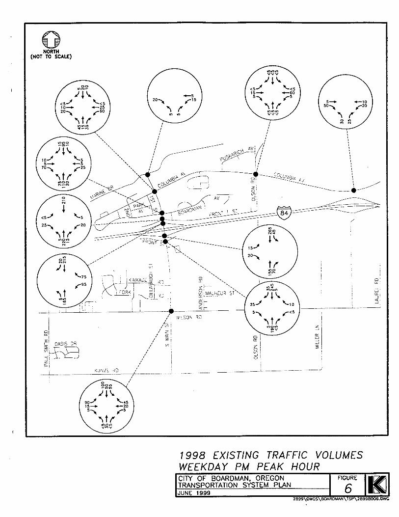
All of the study intersections within the City of Boardman are currently unsignalized. Figure 5 illustrates the existing lane configurations and traffic control devices at each of the study intersections. Traffic operations at each of the intersections were examined during the weekday p.m. peak hour. The p.m. peak period represents the worst case condition for traffic operations on the transportation system. Travel patterns during this weekday time period typically combine commuting, shopping, and recreational trips, thus generating higher traffic volumes on the transportation system than during any other time period or day of the week.
Traffic Volumes
Weekday p.m. peak hour manual traffic volume counts at the intersections were conducted in November 1998. Manual turning movement traffic counts were conducted between 4:00 p.m. and 5:30 p.m. on a mid-week day. The highest one-hour flows during these periods were used in this study.
Kittekon & Associates, lnc. Update June 2001 by TriLand Design Group, lnc.

1 EXISTING LANE CONFIGURATIONS AND
- APPROACH LANE, INDICATING ALLOWED MOVEMENTS

Update June 200 7 Existing Conditions City of Boardman Transportation System Plan Section 2
Based on the turning movement counts conducted at study area intersections, the system-wide p.m. peak hour of traffic on a typical weekday afternoon was estimated to occur between 4:00 and 5:00 p.m. Existing weekday p.m. peak hour traffic volumes are shown in Figure 6 . Traffic volumes have been rounded to the nearest five vehicles per hour.
It should be noted that the community also identified congestion concerns occurring on weekdays between 3:00 and 3:45 p.m. Specifically, the intersections of Boardman Avenuemain Street and Columbia Avenuemain Street were identified as areas of concern during this time period. The congestion is related to the near-simultaneous release of students from the Riverside High School and the change of shifts at a major local employer. Subsequent field study of this condition determined that the weekday p.m. peak hour represented worst-case conditions and, accordingly, no further analysis of the 3:00 p.m. time period was completed.
Level of Service Analysis
Using the weekday p.m. peak hour turning movement volumes shown in Figure 6, an operational analysis was conducted at each of the study area intersections to determine existing levels of service. All level of service analyses described in this study were conducted in accordance with the 1994 Highway Capacity Manual, published by the Transportation Research Board (Reference 3). Appendix "B" summarizes the level of service concept.
To ensure that this analysis was based on a reasonable worst case scenario, the peak 15 minute flow rate during the weekday p.m. peak hour was used in the evaluation of all intersection level of service analyses. For this reason, the analyses reflect conditions that are only likely to occur for 15 minutes out of each average weekday p.m. peak hour. Traffic conditions during all other weekday periods will likely operate under better conditions than those described in this report. (It should be noted that peak seasonal traffic conditions typically occurs during the summer harvest season, hence Design Hour Volumes may be up to 25 percent higher than the peak hour analyzed in the TSP.)
Kittelson & Associates, lnc. Update June 2001 by TriLand Design Group, lnc.
1998 EXISTING TRAFFIC VOLUMES WEEKDAY PM PEAK HOUR C I N OF BOARDMAN, OREGON TRANSPORTATION SYSTEM PLAN JUNE 1999
2899\OWCS\BOARDMAN\TSP\2899B006.DWC

Update June 200 1 Existing Conditions City of Boardman Transportation System Plan Section 2
Unsignalized Intersections
For unsignalized two-way stop-controlled (TWSC) intersections, level of service (LOS) is based on an intersection's capacity to accommodate the worst, or critical, movement. Typically, the left-turn from the stop-controlled approach is the most difficult movement for drivers to complete at a TWSC intersection. This is due to this movement being exposed to the greatest potential number of conflicting, higher-priority movements at the intersection. Available gaps in the through traffic flow of the uncontrolled approach(es) are used by all other conflicting movements before the side-street left-turn can be negotiated. Therefore, the number of available gaps for the side street left-turn to negotiate its movement safely is likely .to be substantially lower than any other movement. As a result, the side-street left-turn typically experiences the highest delays and the worst level of service. For the Interstate 84 corridor through the City of Boardman, ODOT stipulates that major street level of service "A" through "C" are considered acceptable. Table 1 summarizes the level of service results for the unsignalized study intersections.
As Table 1 indicates, all of the unsignalized study area intersections operate at acceptable levels of service under existing weekday p.m. peak hour conditions.
TABLE 1 1998 MISTING PM PEAK HOUR LEVEL OF SERVICE,
UNSIGNALIZED INTERSECTIONS
TRAFFIC SAFETY
Another important aspect of the transportation system is safety. The safety analysis described in the following section focuses on the accident history for the study intersections within the City of Boardman urban growth boundary.
lntersection Accident Analysis
The accident history of the study intersections was examined for potential and existing safety problems. ODOT accident data for the period January 1993 through June 1998 were used for this analysis. In addition, the ODOT District 12's 1996- 1998 Safety Priority Index System (SPIS) lists were reviewed. The SPIS lists identify locations with relatively high accident rates and locations that have been the site of one or more fatal accidents.
Intersection
Marine DriveIMain Street
Columbia Avenuemain Street
Boardman Avenuemain Street
Front StreettNorth Main Street
1-84 Westbound Rampmain Street
1-84 Eastbound RampIMain Street
Front StreetlSouth Main Street
Wilson RoadISouth Main Street
Olson RoadIColumbia Avenue
Laurel LaneIColumbia Avenue
Klttelson & Associates, lnc. Update June 2001 by TriLand Design Group, lnc.
Legend: LOS = Level of Service, V/C = VolumeICapacity Ratio
Critical Movement
LOS
A
A
B
B
B
B
B
A
A
A
Critical Movement
Westbound
Westbound
Westbound
Westbound
Westbound
Eastbound
Eastbound
Southbound
Southbound
Westbound Left
Major Street LOS
A
A
A
A
A
A
A
A
A
A
V/C
0.02
0.1 3
0.06
0.06
0.23
0.05
0.07
0.24 0.01 0.03
Average ~ e l a y (sechre h)
3.7
5.0
6.0
7.2
8.4
8.7
7.5
4.8
3.6
4.3

Update June 200 1 Existing Conditions City of Boardman Transportation System Plan Section 2
Review of the three respective annual SPIS lists indicates that no SPIS sites are located within the City of Boardman. Table 2 presents accident rates for the individual study intersections. Accident rates for intersections are calculated by relating the total entering volume of traffic at the intersection, on an average daily basis, to the number of reported accidents for a given period of time. The accident rate for intersections is expressed as the number of accidents per million entering vehicles (acclmev).
TABLE 2 STUDY INTERSECTION ACCIDENT RATES
1-84 Eastbound Ramp/Main Street 1 0.09 1 1 11 Front StreetJSouth Main Street 1 0.20 1 2 11 Wilson Road/South Main Street I 1.06 I 9 11
As shown in Table 2, the Wilson RoadSouth Main Street intersection was the only study intersection that had more than two reported accidents over the 5.5-year analysis period. The Wilson RoadSouth Main Street, which had an accident rate of 1.06 accidentslmev, was the site of nine reported accidents over the 5.5-year analysis period, including one fatal accident. The majority of the accidents were attributed to traffic on South Main Street not yielding the right-of-way to vehicles on Wilson Road (the Main Street approaches are stop-controlled; drivers on Wilson Road do not have to stop at the intersection). Four of the nine accidents occurred during inclement weather, two during icy conditions and two during wet weather. All but one of the accidents occurred during daylight conditions and one of the accidents resulted in a westbound vehicle that had been travelling on Wilson Road being overturned. The single fatal accident (which did not involve the overturned vehicle) was attributed to drunken driving and excessive speed.
Olson Road/Columbia Avenue
Laurel Lane/Columbia Avenue
The remainder of the accident data did not reveal any specific safety problems or discernable patterns amongst the accident type, suggesting that the intersections are not exhibiting geometric or safety deficiencies that are leading to accidents. The accidents at the Front StreetNorth Main Street intersection, Interstate 84 Eastbound RampNain Street, and the Olson RoadIColumbia Avenue intersection were attributed to adverse environmental conditions such as ice or snow. Of the two accidents at the Interstate 84 Westbound RampMain Street intersection, one was attributed to adverse weather and the second was a rear-end accident resulting from a driver following another car too closely. The single accident at the North Main StreetColumbia Avenue intersection was attributed to a young driver who failed to yield the right-of-way.
OTHER IDENTIFIED MISTING TRANSPORTATION DEFICIENCIES As an extension of the existing conditions analysis, different aspects of the transportation system with existing deficiencies were identified. A description of the deficiencies and potential improvements
'ODOT Accident data search period of 1993 - 1998
0.54
0.0
Kittelson & Associates, Inc. Update June 2001 by TriLand Design Group, lnc.
1
0

Update June 200 1 Ciiy of Boardman Transportation System Plan
Existing Conditions Section 2
follows. The summary is based on field data/observations and inforrnatiodsuggestions that were made by members of the respective transportation agencies and the general public.
Wilson Roadmain Street Intersection
The accident data analysis indicated that there is an existing safety deficiency at the Wilson RoadMain Street intersection. Community comments also indicated concerns with the safety of the Wilson RoadfMain Street intersection. The location of the intersection between residential housing and the elementary school was noted to generate pedestrian demand (along the multi-use path) across Main Street. Community comments indicated a desire to ensure the safety of school children and other persons walking through the intersection. In addition, it was noted that a fire station is located west of the intersection on Wilson Road. Hence, it was the community's desire that any form of mitigation at the Wilson Road/Main Street intersection consider both the safety of pedestrians and the ability to allow for unimpeded emergency response from the fire station.
Field inspection of the Wilson RoadIMain Street intersection revealed a vertical curve on Wilson Road east of the intersection that limits sight distance. Further, the curb radius of the intersection allows for high speed turns from Wilson Road westbound onto Main Street that affects the safety of pedestrians crossing the intersection.
North Main Street
Members of the Boardman community raised several concerns regarding the cross-section and function of Main Street, particularly north of Interstate 84. These issues reflect both vehicular and pedestrianlbicycle access concerns and are summarized below.
The current lack of separate pedestrian or bicycle facilities along Main Street north of Interstate 84 raises safety concerns amongst community members. Several agency staff members and citizens noted that, although there is a striped multi-use path along the western edge of North Main Street, no physical barrier separates the path from travel lanes. Instead, vehicles routinely cross the striped path to access businesses along North Main Street. Similarly, there are no sidewalks on Main Street south of Interstate 84 until the multi-use path begins (refer to Figure 4), thus forcing pedestrians onto roadway shoulders and parking lots along the commercial business frontage located south of the interstate.
The lack of access management along North Main Street in conjunction with growing traffic volumes on the roadway impact community mobility, making access to Main Street from side streets increasingly difficult.
There is a perception among local residents that drivers' speeds along the Main Street are too fast.
The parking of large trucks along the shoulders of Main Street (and to a lesser extent, cars) near the Interstate 84 interchange was noted to obstruct visibility for drivers at adjacent intersections.
North Main Street Bridge
The existing North Main Street bridge over the Union Pacific Railroad right-of-way is a narrow two-lane structure. There are no sidewalk or bicycle facilities on the existing structure, though pedestrians and bicyclists routinely use the bridge to access recreational activities along the Columbia River shore. The city has recently received federal funding to add sidewalks and bicycle lanes to the existing bridge structure.
Kittelson & Associates, lnc. Update June 2001 by TriLand Design Group, Inc.

Update June 200 7 Existing Conditions City of Boardman Transportation System Plan Section 2
System Connectivity
During the TAC meeting process, it was noted that Interstate 84 and the Union Pacific Railroad both serve as barriers to north-south travel. Accordingly, there is a continuing need to provide strategic north-south multi-modal connections across both the interstate and the railroad line. Similarly, there is a need to ensure that the city provides adequate east-west facilities parallel to Interstate 84 such that the community does not become entirely dependent on interstate access to facilitate local trips. In addition, with the large amount of residential development occurring on the south side of the city, there is a need to review the layout of the city's roads to ensure that reasonable connectivity is preserved.
SUMMARY Through an inventory of existing conditions, several key findings were identified. Those findings are summarized below.
The City of Boardman was redefined through a master planning effort undertaken prior to relocation of the city in conjunction with dam construction along the Columbia River.
The city is located at the crossroads of the Columbia River, Interstate 84, and the Union Pacific Railroad, thereby offering many modal opportunities.
The city is limited in north-south growth and connectivity due to local topographical constraints such as Interstate 84, the Union Pacific Railroad right-of-way, and the Columbia River. While these facilities will continue to present constraints to both growth and transportation connectivity, they are essential components of the city's livelihood.
Sidewalk facilities are concentrated in residential areas throughout the city. Two multi-use paths, one along Main Street, and one along Wilson Road, serve as backbones linking the north and south sides of the city. Many other local roads tend to exhibit disjointed or nonexistent sidewalks.
Public transit service is available in the form of a senior bus and dial-a-ride service provided through Morrow County. Greyhound bus service is also available.
The city has convenient access to both rail and marine shipping alternatives available though the Port of Morrow. Within the Port, a large container terminal and other docking facilities are available that support transfer of wood chips, aggregates, and grain.
On a typical weekday afternoon, the transportation system experiences its peak roadway traffic demand between 4:00 and 5:00 p.m. During this peak period, the transportation system operates well within established standards.
The Wilson RoadISouth Main Street intersection had nine reported accidents during the period of January 1993 through June 1998. The history of accidents at this intersection suggests that mitigation measures should be considered. Potential mitigation measures should address both pedestrian accessibility and ease of access for emergency vehicles responding from the fire station located on Wilson Road.
Review of historical ODOT accident data did not reveal safety deficiencies at any of the remaining study intersections.
The city has recently obtained funding to add sidewalks and bicycle lanes to the existing Main Street bridge over the Union Pacific Railroad right-of-way.
Kittelson & Associates, lnc. Update June 200 7 by Tn'Land Design Group, lnc.

Section 3
Future Conditions Analysis
Update June 200 1 Ci& of Boardman Transporfation System Plan
Future Conditions Analysis Section 3
Future Conditions Analysis
INTRODUCTION
This section presents estimates of long-term future travel conditions within the TSP study area. The long- term future transportation needs for the City of Boardman were examined based on available employment and population forecasts, identified development activities, results from the operational analysis of the existing street system, and extensive discussions with regional transportation personnel and representatives from the City of Boardman.
TRANSPORTATION DEMAND
Future transportation demand within the City of Boardman was estimated based on expected growth in the study area population, employment, and traffic traveling through the study area for the horizon year 2020. Future growth estimates were developed based on historical traffic volume trends in the study area as well as consideration of the unique trip making characteristics of residential and employment-based activities. The estimation included a review of the land use mix proposed in the city's Comprehensive Plan.
Land UseIDemographics
Year 2020 traffic volumes on the City of Boardman's transportation system were forecast based on population and employment estimates developed by the State of Oregon for Morrow County and the city. These estimates were compared against recent development trends, planned developments, and forecast growth rates provided by local agencies to verifL their appropriateness. The 20-year planning horizon was chosen to ensure compliance with the Transportation Planning Rule.
Population and Employment Projections
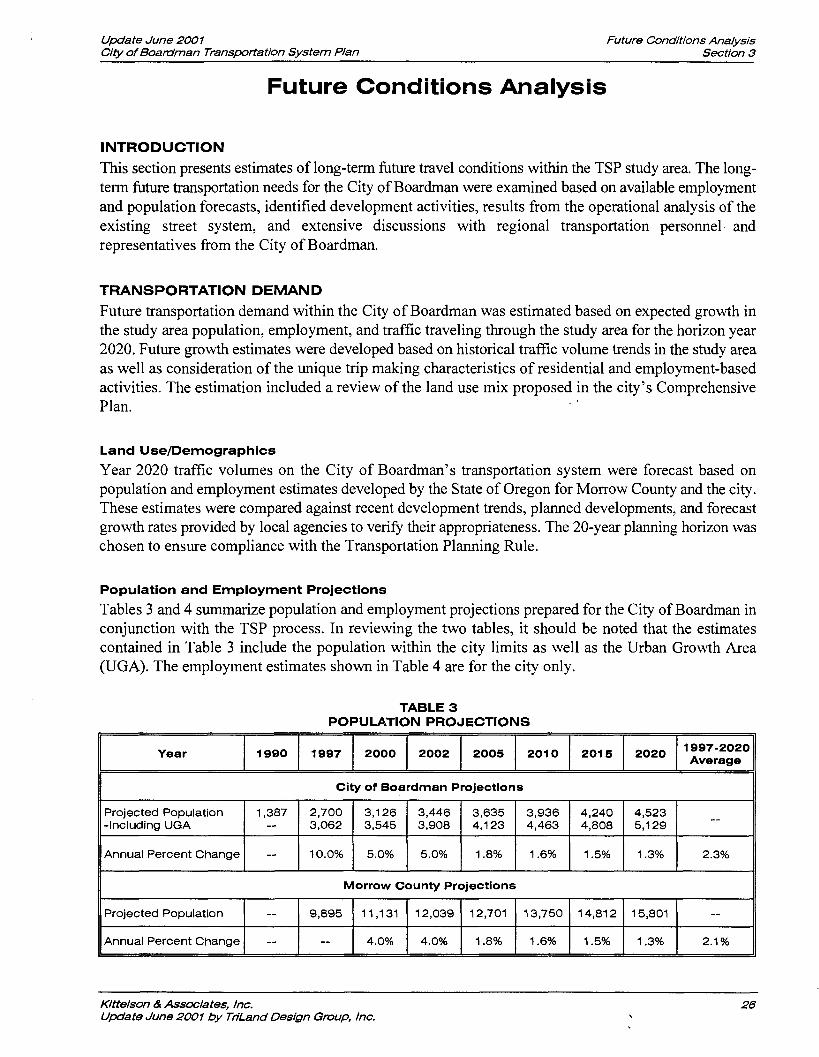
Tables 3 and 4 summarize population and employment projections prepared for the City of Boardman in conjunction with the TSP process. In reviewing the two tables, it should be noted that the estimates contained in Table 3 include the population within the city limits as well as the Urban Growth Area (UGA). The employment estimates shown in Table 4 are for the city only.
TABLE 3 POPULATION PROJECTIONS
II Morrow County Projections II
Year
City of Boardman Projections
1997 1990
Klttelson & Associates, lnc. Update June 2001 by THLand Design Group, lnc.
ProjectedPopulation -Including UGA
Annual Percent Change
Projected Population
Annual Percent Change
2,700 3,062
10.0%
1,387 --
--
2000
--
--
2015
3,126 3,545
5.0%
2002
9,895
--
2020 2005 1997-2020 Average
3,446 3,908
5.0%
11,131
4.0%
2010
3,936 4,463
1.6%
3,635 4,123
1.8%
12,039
4.0%
4,240 4,808
1.5%
12,701
1.8%
4,523 5,129
1.3%
--
2.3%
13,750
1.6%
14,812
1.5%
15,801
1.3%
--
2.1 %
Update June 200 1 City of Boardman Transportation System Plan
Future Conditions Analysis Section 3
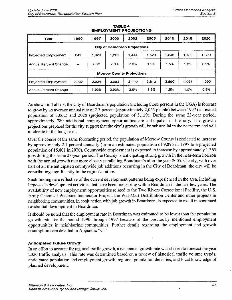
TABLE 4 EMPLOYMENT PROJECTIONS
Year 1 1990 1 1997 1 2000 1 2002 1 2005 1 2010 1 2015 1 2020 11
II Morrow County Projections II
City of Boardman Projections
As shown in Table 3, the City of Boardman's population (including those persons in the UGA) is forecast to grow by an average annual rate of 2.3 percent (approximately 2,065 people) between 1997 (estimated population of 3,062) and 2020 (projected population of 5,129). During the same 23-year period, approximately 780 additional employment opportunities are anticipated in the city. The growth projections prepared for the city suggest that the city's growth will be substantial in the near-term and will moderate in the long-term.
Projected Employment
Annual Percent Change
Over the course of the same forecasting period, the population of Morrow County is projected to increase by approximately 2.1 percent annually (from an estimated population of 9,895 in 1997 to a projected population of 15,801 in 2020). Countywide employment is expected to increase by approximately 1,365 jobs during the same 23-year period. The County is anticipating strong growth in the near-term horizon with the annual growth rate more closely paralleling Boardman's after the year 2005. Clearly, with over half of all the anticipated countywide job additions occurring in the City of Boardman, the city will be contributing significantly to the region's future.
1,261
7.0%
Such findings are reflective of the current development patterns being experienced in the area, including large-scale development activities that have been transpiring within Boardman in the last few years. The availability of new employment opportunities related to the Two Rivers Correctional Facility, the U.S. Army Chemical Weapons Incinerator Project, the Wal-Mart Distribution Center and other projects in neighboring communities, in conjunction with job growth in Boardman, is expected to result in continued residential development in Boardman.
641
--
3,613
1.9%
3,449
2.5%
Projected Employment
Annual Percent Change
It should be noted that the employment rate in Boardman was estimated to be lower than the population growth rate for the period 1990 through 1997 because of the previously mentioned employment opportunities in neighboring communities. Further details regarding the employment and growth assumptions are detailed in Appendix "C."
1,444
7.0%
1,029
7.0%
Anticipated Future Growth
In an effort to account for regional traffic growth, a net annual growth rate was chosen to forecast the year 2020 traffic analysis. This rate was determined based on a review of historical traffic volume trends, anticipated population and employment growth, regional population densities, and local knowledge of planned development.
3,890
1.5%
2,232
--
Kittelson & Associates, lnc. Update June 2001 by TriLand Design Group, lnc.
1,528
1.9%
4,097
1 .O%
2,924
3.93%
1,646
1.5%
4,290
0.9%
3,283
3.93%
1,730
1 .O%
1,809
0.9%

Update June 200 1 Future Conditions Analysis City of Boardman Transportation System P Ian Section 3
Historical Growth
Based on discussions with regional Oregon Department of Transportation (ODOT) staff, no historical traffic volume data could be identified for the City of Boardman. A review of local traffic volume data on nearby Highway 730 indicated a historical 0.6 percent growth rate between 1960 and 1996 (Refer to Figure 7). Considering only the past five years and using additional data available for Interstates 82 and 84, the annual traffic growth rate was approximately three percent.
Using this information in conjunction with local populationlemployment estimates and insights gained through TSPs prepared for the neighboring cities of Irrigon and Umatilla, the addition of new residents and jobs in the region over the next 20 years is expected to result in a growth in traffic of approximately 2.9 percent annually. The traffic growth can be expected to parallel population growth; hence the near- term growth in traffic volumes is expected to be more substantial than the long-term growth rate.
PLANNED TRANSPORTATION IMPROVEMENTS
One planned roadway improvement project was identified within the City of Boardman urban growth boundary at the time the TSP was prepared as discussed below.
North Main Street PedestrianIBicycle Enhancements
As noted in the Existing Conditions Section, the North Main Street bridge structure that carries Main Street traffic over the Union Pacific Railroad (located between Columbia Avenue and Marine Drive) has been identified as deficient. The existing bridge structure is too narrow and does not provide any pedestrian or bicycle amenities.
At the time this TSP was prepared, the city had been notified that it had qualified for federal funding through Transportation Efficiency Act for the 2 1' Century (TEA-2 1). This funding will be used to widen the existing bridge structure to accommodate pedestrian and bicycle facilities.
No other planned improvement projects were identified.
FORECAST FUTURE TRAFFIC VOLUMESIDEFICIENCIES
The transportation needs and travel demand patterns of Boardman will change with time. It is generally understood that as smaller rural communities grow in population and employment they become more self- sufficient entities and better able to serve the full needs of their population. Citizens are able to find employment and services desired within the community instead of having to travel to large urban areas located nearby. The benefit to the transportation system is in the potential for some of these trips (now local as opposed to long distance) to be made via modes other than the automobile; thus reducing demand on the overall network. The future traffic volume forecast presented in this report reflects the anticipated benefits of a more multi-modal transportation system as well as the changing character of travel demand.
Future traffic conditions within the City of Boardman were forecast by applying the 2.9 percent annual growth rate assuming a "no-build" condition (i.e., no new roadways would be constructed in the 23-year horizon) to the 1998 existing intersection traffic counts (refer to Figure 6). The future conditions analysis also included the introduction of additional traffic to select side street locations (most notably near the Port of Morrow and on the south end of South Main Street). The additional traffic was estimated in an effort to gauge the likely impact of residential and commercial development activities in areas that local officials indicated are likely to develop in the coming years. Figure 8 summarizes the forecast year 2020 weekday p.m. peak hour traffic volumes at the study intersections under the no-build condition.
Kittelson & Associates, Inc. Update June 2001 by Tn'Land Design Group, lnc.

Year
Source: Oregon Department of Transportation Traffic Volume Tables
HISTORIC GROWTH TRENDS ON HIGHWAY 730 CITY OF BOARDMAN, OREGON TRANSPORTATION SYSTEM PLAN JUNE 1999
2899\DWGS\BOARDMAN\TSr'2899B007.DWG

FORECAST 2020 TRAFFIC VOLUMES WEEKDAY PM PEAK HOUR
> ' GIN OF BOARDMAN, OREGON TRANSPORTATION SYSTEM PLAN JUNE 1999
O W G S \ B O A R D M A N \ ~ ~ ~ ~ B O Q ~
"KE

Update June 200 1 Future Conditions Analysis City of Boardman Transportation System Plan Section 3
Level of Service Analysis
As previously stated, ODOT stipulates that intersection major street levels of service "A" through "C" are considered acceptable on the Interstate 84 corridor through the City of Boardman. To ensure that the local study area intersections will continue to operate at an acceptable level of service, the forecast future traffic volumes were analyzed. The findings of this analysis are summarized in Table 5.
As Table 5 indicates, all of the unsignalized study area intersections are forecast to continue operating at acceptable levels of service under year 2020 weekday p.m. peak hour conditions except for the intersections of Interstate 84 ramps at Main Street. The Interstate 84 Westbound RampNain Street intersection is forecast to operate at level of service "F" and the Interstate 84 Eastbound RampNain Street intersection is forecast to operate at level of service "D."
TABLE 5 2020 FUTURE FORECAST LEVEL OF SERVICE, UNSIGNALIZED INTERSECTIONS
The poor level of service at the two Interstate 84 ramps reflects delay to the left-turning ramp traffic; major street turning and through movements at the two intersections are forecast to operate at level of service "A." It should be stressed that, although the left-turning vehicles will experience long delays, there is adequate capacity for left-turn movements (as evidenced by the volume/capacity ratio of 0.82).
Intersection
Marine DriveIMain Street
Columbia Avenuemain Street
Boardman Avenuemain Street
Front StreetlNorth Main Street
1-84 Westbound RampIMain Street
1-84 Eastbound RampNain Street
Front StreetJSouth Main Street
Wilson RoadISouth Main Street
Olson RoadIColumbia Avenue
Laurel LaneIColumbia Avenue
Potential Capacity Improvements
Given the poor level of service forecast at the Interstate 84 Westbound RampIMain Street, the potential need for signalization of the intersection was examined based on the forecast future traffic volumes. Preliminary signal warrant analysis results suggest that a traffic signal may be warranted at the intersection within the 20-year planning horizon. The analysis further indicated that a northbound left-turn lane would be warranted at the intersection and that the westbound ramp may require widening to accommodate separate left- and right-turn lanes.
The decision to install a traffic signal at the Interstate 84 Westbound RarnpIMain Street intersection will be subject to several variables. Signalization alone is not likely to fully address the capacity needs of the interchange and adjacent intersections. Further, development of left-turn lanes at the interchange would require widening of the existing bridge deck, potentially necessitating a new interchange altogether. The
Legend: LOS = Level of Service, VIC = VolumeICapacity Ratio
Critical Movement
Westbound
Westbound
Westbound
Westbound
Westbound
Eastbound
Eastbound
Southbound
Southbound
Westbound Left
Kittelson & Associates, Inc. Update June 2001 by TriLand Design Group, lnc.
V/C
0.05
0.37
0.1 7
0.27
0.82
0.20
0.28
0.75
0.21
0.1 7
Average Delay
(sectveh)
3.9 10.2
11.1 17.4
> 45
24.9
19.0
17.0
5.3 6.0
Critical Movement
LOS
A
C
C
C
F
D
C
C
B
B
Major Street LOS
A
A
A
A
A
A
A
A
A
A

Update June 200 1 Future Conditions Analysis City of Boardman Transportation System Plan Section 3
effect of signalizing the Interstate 84 Westbound RampJMain Street intersection must also consider the impact signalization will have on adjacent intersections.
Further, while the initial level of service analysis results suggest that the intersections of North Main Streewront Street and South Main StreetIFront Street will operate acceptably, the analysis results should not be interpreted as suggesting that no operational problems will be encountered. Given the close spacing between the Interstate 84 ramps and the two respective frontage roads, it is expected that several geometric changes will be required to accommodate future traffic volume growth. Stated simply, the existing intersections are too closely spaced and will not function efficiently as traffic volumes grow. The lack of access management along Main Street further complicates intersection operations.
The potential need for, and placement of, geometric improvements and a traffic signal at the Interstate 84fMain Street interchange within the 20-year planning horizon will be further discussed in Section 4, Alternatives Analysis. That discussion will include consideration of north-south connectivity needs within the city, the potential affects of access management andlor geometric improvements, and signalization issues, as well as overall safety for both vehicles and pedestrians.
Finally, as discussed previously, many of the homes are located on the south side of the interstate whereas the majority of employment opportunities and services are located on the north side. This results in city residents having to cross the interstate on a daily basis, primarily at MainStreet. If growth continues to occur as it has in the past, this problem will be exacerbated in the future and will further impact the operations at the Interstate 84Main Street and Main Streewront Street intersections. Alternative land use scenarios to address this problem and the need for a cohesive "downtown" in Boardman will be discussed further in Section 4, Alternatives Analysis.
With the exception of improvements to the Interstate 84Main Street interchange area and the previously identified improvement needs at the Wilson RoadIMain Street intersection, no additional roadway capacity-related mitigation measures are anticipated. The next section of the TSP presents an analysis of potential improvement alternatives that address existing and future forecast traffic conditions.
SUMMARY Several significant findings were identified through the future conditions analysis, most notably:
The City of Boardman's population (including those persons in the UGA) is forecast to grow by an average annual rate of 2.3 percent (approximately 2,065 people) between 1997 (estimated population of 3,062) and 2020 (projected population of 5,129). Approximately 780 additional employment opportunities are anticipated in the city over the course of the 23-year horizon period.
The population of Morrow County is projected to increase by an average annual rate of approximately 2.1 percent from an estimated population of 9,895 in 1997 to a projected population of 15,801 in 2020.
The growth projections prepared for both the city and county suggest that the forecast growth will be substantial in the near-term and will moderate in the long-term.
Growth in traffic volumes will require improvements to the City of Boardman's existing roadway, pedestrian, and bicycle network. Areas identified for further investigation primarily involve the Interstate 841Main Street interchange and the Main Street corridor.
There are several connectivity and access issues that should be planned for and addressed. Enhancements to the city's roadway, pedestrian, bicycle, and public transit systems are desirable and will be reviewed in Section 4, Alternatives Analysis.
Kittelson & Associates, Inc. Update June 2001 by TdLand Design Group, lnc,

Section 4
Alternatives Analysis

Update June 200 1 City of Boardman Transportation System Plan
Alternatives Analysis Section 4
Alternatives Analysis
INTRODUCTION
This section presents a summary of future land use and transportation improvement alternatives that could be implemented to mitigate existing and projected future transportation system deficiencies. The remainder of this section is organized into three parts. First, land use issues and alternatives are presented. Based on the land use discussion, an overview of transportation improvement needs and associated ramifications is presented. A discussion of specific improvement alternatives, including estimated costs, and recommendations for implementation then follows.
As potential deficiency mitigation projects were developed, consideration was given to how a multi- modal approach could contribute to individual projects. Thus, while the primary impetus for a given mitigation alternative may center on increasing vehicular capacity, provision of appropriate bicycle and pedestrian amenities was given equal consideration. Special effort was provided in considering and recommending improvements to the pedestrian and bicycle systems. Recommendations were developed that create direct linkage to all identified pedestrian/bicycle generators and provide for a core pedestrian and bicycle transportation system. The alternative analysis and subsequent recommendations process were handled separately to ensure that a complete system for each mode was identified without constraint.
It should be noted that, in this section, formal alternatives development and analysis have only been presented for the roadway network and its components. Other elements of the transportation system such as pedestrian access, bicycle access, etc. currently exist at a level such that an entire network needs to be developed. The Transportation System Plan section of this report contains the recommended improvements to all of the modal systems.
LAND USE ALTERNATIVESITRANSPORTATION SYSTEM RELATIONSHIP
The existing and future land uses within the City of Boardman have a substantial impact on the local transportation system. As a result, the city's transportation system will continue to reflect a strong relationship to local land use well into the future. The following discussion focuses on the transportation impact associated with various land uses and the implications associated with future land use alternatives.
Background
As stated in the Existing Conditions section, approximately 90 percent of the city's future residential development will occur south of the freeway based on the city's vacant land inventory. Further, at least a 20-year supply of land exists for both single family and multi-family residential development.
As such, land use alternatives in Boardman primarily relate to infill and redevelopment of future commercial development. The large supply of commercial land, relative to the current and projected population base of Boardman and its market area, is a challenge to manage efficiently. In 1997, there were 37 acres of developed commercial land and 237 acres of vacant commercial land within the Boardman urban growth boundary.
Commercial uses are scattered among four different areas of the city: 1) North Main Street area; 2) Front Street between North Main and Olson Road; 3) South Main at the 1-84 interchange; and 4) on South Main Street between Interstate 84 and Wilson Road. A fifth area between South Main Street and Olson Road along the south side of Interstate 84 is also planned for commercial development but does not currently have street access.
Kitteson & Associates, lnc. Update June 2001 by TiiLand Design Group, lnc.
Update June 200 1 Alternatives Analysis City of Boardman Transportation System Plan Section 4
The community lacks a focal point or center for commercial development. When a visitor to Boardman exits the freeway at Main Street, a decision needs to be made about whether one turns left or right to find the center of town. Even after finding needed commercial services, there is an uncertainty about whether you are in "the center". Upon driving around, the uncertainty remains - there is the nagging feeling that you are missing something that might or might not be there, if only you knew where to turn. Without the distinctive commercial core that marks most communities, even very small towns, the community appears very disconnected and dysfunctional. This problem, if perceived as such by the community, cannot be cured if the existing pattern of scattered commercial development continues.
Scattered commercial development has these disadvantages:
increased auto-dependency and the difficulty of creating pedestrian-oriented commercial districts; auto-dependency increases vehicle trips and can disadvantage those who cannot drive automobiles to access needed services;
the inability to create synergistic effects where businesses can benefit themselves and the community through co-location such as customer patronage and increased sales, shared parking and signage, landscaping, managed access, etc;
the difficulty in establishing a strong business district identity that in turn can attract more businesses;
the difficulty in establishing a strong community identity that contributes to the community's social fabric and sense of well being;
auto-dependent land use and site design, large parking lots with excessive parking and disconnected development; and
over-building of infrastructure to address potential build-out demands at all locations.
The excess commercial land contributes to the diffksed pattern of commercial development and detracts from the objective to create a focal point such as a downtown. While it would seem that the city is attractive for commercial development because it has such a large supply, the opposite can actually be the case to achieve long-term, stable business development. Commercial businesses may be able to obtain land inexpensively, a plus for emerging small businesses, but they face a high risk in choosing ,a location that will have long-term viability and stability. Most businesses do better in an environment with other similar uses. If they are spread-out, they do not benefit from the synergy that businesses within more compact centers can achieve. This is why shopping centers have been so successful in America's retail history. While Boardman may not be able to attract major shopping centers because of its small population, it can create a similar synergistic environment through planning a center that promotes small independent businesses.
With a large supply of commercial land, the city runs a risk that property owners will eventually request either a zone change or change to allow other uses within commercial zones. For example, if the city's supply of multi-family housing runs in short supply relative to commercial, there may be requests to rezone it to multi-family. This puts the city in a reactive mode based on the opportunity that a property owner has rather than what might be best for the community as a whole. If these requests are granted on a piecemeal basis, it can result in an even more incoherent development pattern.
Boardman has the opportunity to create a downtown or main street. Traditionally, downtowns and main streets have these characteristics:
grid system of streets;
Kittellson & Associates, Inc. Update June 2001 by Tn'Land Design Group, lnc.

Update June 200 1 Alternatives Analysis City of Boardman Transportation System Plan Section 4
200' - 300' blocks;
wide sidewalks;
combination of on-street and off-street parking;
shallow front yard set-backs;
zero side yard setbacks with attached buildings;
rear alleys and loading areas; and
mix of uses - retail, services, public buildings and residential (often above retail businesses).
Many, but not all downtowns and main streets, have landscaping, distinctive street fixtures such as lighting and design themes. Main streets usually consist of one major retail street whereas downtowns are larger retail business districts that incorporate a larger range of uses.
Most downtowns and main streets were established when the original townsites were platted. It is rare for a community to create a downtown in a contemporary situation and it will be a challenge to create a new downtown or main street in Boardman. However, there are essentials that urban designers strive for in "neo-traditional" commercial centers: street design that comfortably accommodates pedestrians and autos; pedestrian-oriented building design at street level; compact development; and on-street and off- street parking (preferably shared). These are characteristics not usually typical of freestanding retail centers.
The existence of a downtown or main street for retail business is important to cities, regardless of size, for a variety of reasons, as summarized below.
It performs an important economic function. A downtown provides a center where businesses can congregate and mutually support each other, providing a stronger benefit to each other and the community than when they are separated.
It provides a convenient, central location where the community can obtain a variety of goods and services.
It performs a social function, especially if civic buildings are located in the downtown, by bringing people together with a sense of pride and ownership in the community.
It provides an organizing element to the physical growth and developments of the community, helping establish logical arrangements of land use that are mutually supportive.
It helps a community establish its identity.
Whether in a downtown or main street, public investment is often a critical factor in creating successful new centers or revitalizing older ones. The location of post offices, city halls, libraries, public safety buildings and other similar facilities helps create the environment of community activity and supports retail businesses. These also help downtowns and main streets be more interesting places, become centers of community life and contribute to the community's identity and self-image.
Land Use Alternatives
The abundant land supply, while presenting problems and challenges, is also an opportunity: it presents the community with several possible choices in how to develop its commercial areas. Not many communities have such a range of choices.
Kittelson & Associates, lnc. Update June 200 1 by TriLand Design Group, lnc.

Update June 200 1 Alternatives Analysis City of Boardman Transportation System Plan Section 4
This analysis presents three alternatives for consideration by the community: 1) a multi-center alternative; 2) a main street alternative; and 3) a downtown alternative.
Land Use Alternative I : Multi-Center Development
The multi-center development alternative reflects a continuation of the existing trend for development at four to five locations. Commercial development would continue to locate based on land availability and market forces without community intervention. If the trend continues, the city can expect to see commercial development expand in all commercial areas, including the new area south of the freeway. However it will be hard to predict where development will occur, when and how much will occur at each location. A center may be proposed by a property owner, one could evolve over time or perhaps no one location would become the center, it would be left to chance. The city would react to development proposals on a case-by-case. As with the private market, the city and other public and non-profit organizations would locate their facilities without necessarily trying to focus them in any one area or along with retail uses.
Advantages of multi-center development include:
allows market to operate freely, generally unconstrained;
allows both sides of the freeway to serve local residents in different ways;
multiple property owners;
requires limited commitment by city to promote or regulate;
plenty of area for expansion; and
spreads out traffic impacts associated with commercial development.
Disadvantages include:
continues disconnected, confusing development pattern;
not conducive to pedestrian access; requires extensive driving to access the range of commercial services;
development unrelated to residential development pattern;
may be difficult to attract quality commercial development; and
spreads out development making it virtually impossible to achieve a downtown character in any one area.
Land Use Alternative 2: Main Street Concept
The "Main Street Concept" alternative would focus future main street-type development on Boardman Avenue or other appropriate streets. Because land in this area is limited and constrained by needs of the street system to get traffic on and off the freeway, other commercial sites would continue to play a major role in providing services. Land-extensive retail, such as supermarkets, would continue to locate where large sites are available with ample parking, such as on Front Street (north or south side) or on South Main Street. Freeway-oriented services for travelers would continue to be located primarily south of the freeway interchange at the South Main Street exit. Location of public buildings may or may not occur on in the business district.
Advantages of "main street" development on Boardman Avenue include:
Kittellson & Associates, lnc. Update June 2001 by Tn'Land Design Group, lnc.
Update June 200 1 City of Boardman Transportation System Plan
Alternatives Analysis Section 4
creates a small, tight area as a commercial focus;
builds on what is already developed;
stimulates redevelopment activity;
close to the industrial area, high school and riverfront; and
provides the ability to achieve somewhat of a main street concept with pedestrian accessibility.
Disadvantages include:
development pattern could cause traffic conflicts between freeway access, industrial traffic and local circulation needs;
limited area for expansion over long period of time;
existing development may not fit plan; and,
locates commercial center on side of freeway away from most future residents, which will further exacerbate capacity constraints on the overpass.
While Boardman Avenue was chosen to demonstrate the Main Street alternative north of the freeway, the concept could be employed in other locations where both sides of a major street can be developed to meet the goals of a main street concept. Riverside High School is located on the north side of Boardman Avenue and is not zoned for commercial use. However, there might be enough land area to create a shallow tier of storefronts and still adequate provide access to the high school. Instead of Boardman Avenue, a new street could be created between Boardman Avenue and Front Street. A significant part of the commercial land between these streets is vacant and it appears that there is room to provide a street with commercial uses on both sides. The Main Street concept does not work well on a street where only one side can be developed for retail use, such as along Front Street.
Land Use Alternative 3: Downtown Concept
Under Land Use Alternative 3, a downtown would be created on South Main Street. The amount of vacant commercial land in this area would allow more uses with a range of site requirements and has adequate land to allow expansion for well beyond a 20-year planning horizon. A large public square or park would be the centerpiece. It could incorporate mixed use, including major public buildings, surrounded by a higher density area of multi-family housing within easy walking distance. While the central retail area would be developed on a 200-foot grid system, this would increase to 400 feet on the outer blocks for larger retail uses and multi-family housing. Commercial land north and south of the freeway exit on Main Street would continue to cater to travelers so that the new downtown could be oriented primarily to residents, thereby minimizing traffic conflicts on the freeway overpass.
Advantages of this alternative include:
locates major services where most of future population will reside;
reduces potential conflicts of industrial, freeway-oriented and residential traffic;
large parcels are located along South Main Street that can be master-planned "from scratch" to adequately address development needs and different modes of transportation;
potential to create a "close to traditional" downtown; and
adequate area to expand over a long period of time.
Disadvantages include:
Kittelson & Associates, lnc. Update June 2001 by TriLand Design Group, lnc.

Update June 200 1 Alternatives Analysis City of Boardman Transportation System Plan Section 4
would be located away from the older, established part of the community;
development is dependent on one or two property owners to work with city to create; and
requires strong public-private partnership and long-term commitment.
Land Use Alternatives Evaluation
Commercial development historically has been focused on the north side of 1-84 since the town's relocation in the 1960's. Riverside High School, City Hall, the Post Office, Library and several commercial establishments are located in the North Main Street and Front Street area. A partially developed commercial business park is located on both sides of Columbia Avenue, west of Olson Road and near the Port of Morrow industrial area. The north side is constrained for future commercial development by residential uses on the west and north toward the river, industrial uses to the north and east, and the freeway on the south.
The previous discussion identified on- and off-ramps from 1-84 to Main Street as a current location of pedestrian and traffic safety issues. The proximity of commercial development to the ramps coupled with the lack of definition of the roadways, driveways and parking areas cause driver confusion and safety problems for both vehicles and pedestrians. In addition, the two lane Main. Street overpass is limited in its capacity for fiiture traffic growth and has conflicts between its use for'local traffic and for access to and from the freeway.
Alternative 1, "Multi-Center Development", which is a continuation of the existing development trends, is not a desirable pattern for future commercial development. Accordingly, it is recommended that either Alternative 2, "Main Street Concept," or Alternative 3, "Downtown Concept," be given further consideration.
Alternative 2 could only work if part of the Riverside High School site along Boardman Avenue could be utilized for commercial development, which would require relocating the existing driveway entrance and main parking lot to the school. Even if feasible, land area for future commercial development is limited and the ability of the North Main Street alternative to serve as a downtown for the community would probably suffice for only about 20 years. During that period, auto and truck traffic will increase causing more traffic safety issues and making the north side more inaccessible for the growing number of residents to the south of the freeway.
There has also been some interest in future commercial development along the north side of Front Avenue, perhaps transforming this area into the city's downtown. Its visibility to the freeway could be beneficial to commercial development, especially travelers. However, without developable land on both sides of the street, it will be impossible to develop an attractive pedestrian-oriented commercial area. Furthermore, freeway-related traffic and circulation in the vicinity of Main Street and Front Street will make this area increasingly difficult to access. Current safety and auto-truck conflicts could be seriously exacerbated by encouraging high trip-generating commercial uses along Front Street. Therefore, it is recommended that this commercial area be de-emphasized as an area for future intensive commercial activity.
Preferred Land Use Alternative
For all of the reasons discussed, the Downtown Concept (Land Use Alternative 3) is the recommended preferred alternative. The downtown should develop on commercial land on both sides of South Main Street, some of which is already developed for commercial use. The primary benefits of the Downtown Concept at this location are:
- -
Kittelson & Associates, lnc. 40 Update June 200 1 by Tn'Land Design Group, lnc.

Update June 200 7 City of Boardman Transportation System Plan
Alternatives Analysis Section 4
sufficient vacant and redevelopable commercial land for well over 20 years of community growth in retail and service needs;
proximity to future residential development that will change the "center of population" of the community from the north side of the freeway to the south side over the next 20 years;
the capacity of the current and future street system to accommodate growth of commercial and residential development over a long period of time;
the ability to develop a grid system pattern of streets within and surrounding the downtown that will disperse traffic and promote the use of alternative modes of travel;
the ability to incorporate and surround the downtown with public uses, mixed use and multi- family development within walking distance of commercial services;
the ability to provide a range of parcelhlock sizes to promote a variety of commercial uses;
the distance from freeway on- and off-ramps to avoid conflicts with interchange traffic, including trucks that are accessing the industrial area;
large parcels that allow platting in a grid pattern of blocks and streets;
the potential to establish a strong identity for the city that will foster community cohesion and pride; and,
improvement of Boardman as an economic center and residential community.
Section 5 of this TSP, Transportation System Plan, provides additional information on the implementation of the preferred land use alternative.
There are also several transportation improvements that will also be necessary in the future. The remainder of this section provides an overview of improvement alternatives that could be implemented to mitigate existing and anticipated transportation system deficiencies.
OPERATIONAL IMPROVEMENT NEEDS
The need for mitigation of existing and future roadwaylintersection operations is interrelated with pedestrian and bicycle infrastructure needs as well as access management issues. The existing and long- term future forecast conditions analyses identified several specific capacity-related roadway and intersection deficiencies. In addition, several issues related to traffic operational improvements were identified by community members and the project team. These issues are discussed below.
North Main Street Improvement Needs
North Main Street is in need of several improvements that would benefit vehicular, pedestrian, and bicycle modes of travel. The need for these improvements is directly impacted by the operations of Front Street, the Interstate 84 Interchange, Boardman Avenue, and the location of existing and future land use development in the city. Access management and pedestrianhicycle infrastructure needs also dictate the need for improvements, as discussed below.
Front Street/Interstate 84 Interchange Operational Issues Analysis of year 2020 future forecast volumes revealed that the Interstate 84 Westbound Ramphlain Street intersection would require capacity improvements to restore intersection operations to an acceptable level of service. The forecast year 2020 analysis results described in Section 3 further noted that, as a result of the close spacing between the Interstate 84 ramps and the two respective frontage roads (North Front Street and South Front Street), it is expected that several geometric changes will be required to accommodate future traffic volume growth.
Kittelson & Associates, lnc. 40 Update June 2007 by TdLand Design Group, lnc.

Update June 200 1 Alternatives Analysis City of Boardman Tmnsportation System Plan Section 4
There are several interrelated factors that will determine whether, and how, the capacity of the Interstate 84 interchange and Main Street can be ensured. These issues include:
Intersection Spacing. The existing intersections of Main StreetNorth Front Street, Main Streeanterstate 84 Westbound Ramp, Main Streeanterstate 84 Eastbound Ramp, Main StreetISouth Front Street are too closely spaced and will not function efficiently as traffic volumes grow. Overlapping functional areas of intersections make it especially difficult for drivers on side streets (such as Front Street) to safely enter Main Street because of the numerous conflicting vehicle movements that must be simultaneously monitored. For example, a driver trying to turn left fiom North Front Street onto Main Street must find an adequate gap in the Main Street traffic stream while also coordinating with vehicles entering Main Street fiom the Westbound Interstate 84 ramp, Boardman Avenue, and any number of adjacent commercial properties.
Circulation Patterns. Ill-defined circulation patterns along North and South Front Streets, in conjunction closely spaced intersections, make minor street turning operations at intersections difficult for drivers.
Access Management. The lack of access management along Main Street complicates intersection operations as drivers are able to make turns onto and off of Main Street at virtually any location. The lack of access management results in a multitude of cut-through'trips that create safety issues in parking lots. The situation is especially evident when Riverside High School students are released and drivers cut through local commercial parking lots to avoid queuing at the North Main Street/Boardman Avenue intersection.
North-South Connectivity. The lack of alternative north-south connections across Interstate 84, which focuses the majority of north-south travel through the city via Main Street and the Interstate 84 interchange, further complicates intersectiodinterchange operations. The lack of continuity is further exacerbated by the existing development pattern in Boardman that funnels many of the residences across the interstate at Main Street on a daily basis to access employment and service centers.
In addition to these issues, the existing pedestrian and bicycle facilities in this area are inadequate. Given the large demand for north-south pedestrian facilities, especially along Main Street, any improvement project(s) should incorporate improved pedestrianhicycle facilities.
Front Street~lnterstate 84 Interchange Improvement Needs
There are several potential improvements that could be made to the Interstate 84 interchange to increase capacity as identified below:
signalize the north leg of the interchange;
provide a left-turn lane across the Interstate 84 Interchange;
widen the eastbound and westbound Interstate 84 ramps to accommodate separate left- and right- turn lanes; or
enhance circulation on the north and south sides of the interchange.
The decision to implement one or more of the improvements identified above is subject to several considerations. It is especially important to consider a system perspective in evaluating these alternatives. For example, signalization alone will not hlly address the capacity needs of the interchange and adjacent intersections. Further, development of left-turn lanes at the interchange would require widening of the existing bridge deck, potentially necessitating a new interchange altogether. The effect of signalizing the
Kittelson & Associates, lnc. 4 1 Update June 2001 by TriLand Design Group, lnc.
Update June 200 1 Alternatives Analysis City of Boardman Transportation System Plan Section 4
Interstate 84 Westbound Ramph4ain Street intersection must also consider the impact signalization will have on adjacent intersections.
Considering a more global system perspective, if alternative links across Interstate 84 can be implemented in conjunction with access management and circulation improvements along Main Street, it is conceivable that future traffic volume demands at the existing interchange can be accommodated. There are also issues as to how the interchange will operate in the future with respect to the frontage roads located on either side of the interchange. The following paragraphs highlight some of the other issues that need to be considered.
Circulation Improvements
The City of Boardman's roadway system is comprised of a number of streets that collectively feed the two Interstate 84 interchanges. The east-west orientation of the Columbia River, Interstate 84, the Union Pacific Railroad right-of-way, and the Bonneville Power Administration's right-of-way all limit the number and extent of north-south connections through the city and have shaped the local roadway network.
As more properties develop in the southern and northeast quadrants of the city, the city needs to ensure that adequate facilities are provided such that the city does not become entirely dependent on any one roadway to facilitate local trips. As properties develop in the these parts of the city, careful consideration should be given to the type and locations of connections to the existing street system, and to connectivity and access issues within any new subdivisions. It is essential to provide pedestrian, bicycle, and vehicular access both to and within new developments and to provide a sense of linkage to and continuity with the existing developments in town. Care should also be taken to avoid "cul-de-sac" developments in these and other residential areas that may be developed in town.
North-South Connectivity
There are several potential opportunities to strengthen north-south connectivity within the City of Boardman. Ideally, roadway circulation alternatives should provide routes for local trips while accommodating industrialheavy vehicle traffic destined to the Port and other locations on separate facilities. Opportunities to strengthen north-south connectivity include:
provision of a new interchange or overpass on the west side of Boardman; andor,
extension of Olson Road across Interstate 84.
East- West Connectivity
In addition to improving north-south connectivity, there is also a need to ensure that the city develops adequate east-west facilities parallel to Interstate 84 such that these facilities provide access to local commercial and residential properties in a safe and efficient manner. It will be especially important to ensure that convenient east-west connectivity is preserved such that the city does not become entirely dependent on interstate access to facilitate local east-west trips. In addition, with the large amount of development occurring on the south side of the city, there is a need to ensure that the city's east-west roads are connected in a logical manner. Potential opportunities to strengthen east-west connectivity within the City of Boardman include:
extension of South Front Street between South Main Street and Olson Road; andor,
construction of "Future Boulevard," a proposed east-west roadway along the BPA easement, to provide additional east-west connectivity south of the Interstate 84.
Kittelson & Associates, Inc, Update June 200 1 by TriLand Design Group, lnc,

Update June 200 1 Alternatives Analysis City of Boardman Transportation System Plan Section 4
In addition to connectivity enhancements, the city should also consider development of access management techniques to fbrther circulation needs. These techniques should provide for the consolidation of access points along collector and arterial level roadways as property develops or redevelops and allow for more focused crossings of roadways in areas outside of the downtown as discussed below.
Access Management and Safety
The spacing of access points along roadways impacts the capacity, safety, and overall performance of a given facility. Accordingly, access locations on roadway sections need to be properly located to ensure safe and efficient travel along roadway corridors. Access locations should be placed appropriately to limit potential conflicting turning movements, weaving maneuvers over short distances, and congestion along facilities.
In general, as the number and proximity of access points along a given road increases, there is an increase in the number of potential conflicting turning movements into and out of those access points. These turning maneuvers ultimately can adversely affect the operations of traffic on the roadway itself.
TRANSPORTATION IMPROVEMENT ALTERNATIVES EVALUATION
The following discussion presents specific improvement alternatives that were considered for inclusion as part of the recommended City of Boardman Transportation System Plan. Each of the alternatives has been identified by number for reference purposes, with the relative location of each improvement identified in Figure 9.
It should be noted that the order in which the alternatives are presented is not intended to convey the relative rank or significance of the respective projects. Further, the identified improvement alternatives were evaluated based on construction costs and ability to meet identified transportation needs. Other factors, including potential environmental impacts, were not specifically considered. Some environmental impacts that could occur have the potential to increase costs or require project modifications. The required modifications or increased costs could be significant enough to make the project impractical.
ZONING CODE REVISIONS
Alternative #l - Reduce Vehicular Reliance Through Zoning and Development Code Revisions
In part, Oregon's Transportation Planning Rule seeks to reduce the reliance on personal vehicles as a mode of travel through the creation of environments that foster alternative modes of transportation. Local land uses can have a significant impact on the form of transportation necessary to travel from one location to another. Specifically, by carefully structuring local zoning and development codes, development activities can be focused such that a more self-contained community can be achieved. Construction of mixed-use developments, the location of commercial and service businesses in the vicinity of residential land uses, and the provision of employment opportunities near residential areas are all means by which the need for travel by personal automobile can be reduced.
In relatively rural areas such as Boardman, the need to travel long distances to employment, commercial, and service opportunities fosters a travel environment dependent on personal automobiles. Implementation of the "Downtown Concept" land use alternative will help reduce the need for vehicular reliance.
Kittelson 81 Associates, Inc. Update June 200 1 by Tn'Land Design Group, Inc.

NOTE: FUTURE ROADWAY ALIGNMENTS ARE CONCEPT IS REQUIRED TO DETERMINE FEASIBLE ALIGNMENT A
ADDITIONAL IMPROVEMENT ALTERNATIVES NTERNATWE # 1 : REDUCE VEHICULAR REILIANCE THROUGH
ZONING AND DEVELOPMENT CODE RMSIONS.
ALTERNATIVE # 13: PROMOTE ACCESS MANAGEMFNT -
ALTERNATIVE 11 4: IMPLEMENT TRANSPORTATION D W N D MANAGEMENT MEASURFS
iVEMENT ALTERNATIVES BOARDMAN, OREGON
'RTATION SYSTEM PlAN \
2899~0WGS\~0A~DM~N\TSP\28998009

Update June 200 1 Alternatives Analysis City of Boardman Transportation System Plan Section 4
Zoning Recommendation
Implementation of the preferred land use alternative, the "Downtown Concept," is recommended. Provision of appropriate zoning and development code revisions should be made by the city. Examples of appropriate revisions are summarized in Section 7.
ENHANCED PEDESTRIAN, BICYCLE, AND VEHICULAR ACCESS ACROSS INTERSTATE 84
Alternative #2 - Develop a Split-Diamond Interchange along lnterstate 84
As a means by which to mitigate the existing and forecast future congestion at the Main Streethterstate 84 interchange and to provide additional pedestrian, bicycle and vehicular access between the land uses north and south of the freeway, consideration was given to developing a new split-diamond interchange in Boardman. The split diamond concept would include ramps at Olson Road (westbound off-ramp and eastbound on-ramp) and Main Street (eastbound off-ramp and westbound on-ramp) connected by a frontage road along North Front Street and South Front Street. In concept, the new interchange would provide an alternative north-south crossing of Interstate 84 as well as a capacity improvement that would relieve the existing Interstate 84 interchange. Further, North Front Street and South Front Street could be developed to capitalize on a frontage road concept that would, in part, serve local access and land use needs.
Further analysis of the concept revealed that the split-diamond interchange concept would not meet ODOT's access spacing standards and would likely foster "strip commercial development" along the frontage roads. For these reasons, the concept was abandoned. No cost estimated was prepared for this improvement alternative.
Alternative #3 - Extend Olson Road across lnterstate 84
Olson Road originally linked the north and south sides of Boardman but the connection was severed during the construction of Interstate 84. Conceptually, the extension of Olson Road could be constructed with or without access to Interstate 84; however, provision of another interchange with Interstate 84 in close proximity to the existing Main Street interchange would violate ODOT access spacing standards.
Assuming that no access was provided to Interstate 84, Olson Road could be expected to serve as a major local trip and commuter route between the north and south sides of the city. This in turn would provide an alternate route to Main Street and could be expected to relive congestion at the Interstate 84Nain Street interchange. An overpass at Olson Road could serve as an essential connection between the Port of Morrow, other industrial areas, and the southern residential areas. This connection would be desirable both for the convenience of access between these two areas and the fact that truck traffic would not be expected to use this route heavily (assuming no access were provided to Interstate 84). Limited truck activity would minimize potential conflicts between heavy truck movements destined for the industrial areas and local pedestrian, bicycle, and vehicular traffic. The Olson Road extension would be expected to relieve some of the existing concerns with respect to shift changes at the Port affecting operations of Main Street, specifically during the time Riverside High School classes end for the day.
It should be noted that the potential extension of Olson Road across Interstate 84 would likely impact potential wetland areas and that the environmental impacts of creating the roadway link will need to be evaluated as part of a project-specific design and engineering study.
Estimated cost for this improvement is $8- 10 million.
Kittelson & Associates, lnc. Update June 2001 by TflLand Design Gmup, lnc.

Update June 200 1 Alternatives Analysis City of Boardman TransporCation System Plan Section 4
Alternative #4 - Provide a New Interchange or Overpass West of Main Street
Some community comments indicated that a north-south connection across Interstate 84 on the west-side of the city would be desirable to serve local neighborhood traffic. This alternative, while potentially feasible, may be undesirable for a number of reasons, as summarized below.
The northwestern portion of the city has previously been developed; hence the new connection would not necessarily facilitate access to developing areas on the north side of Interstate 84.
Ideally, it would be desirable to create new north-south connections that link residential areas with service and employment areas to offer congestion relief to the existing Main Street overpass; however, the proposed connection serves only as a link between residential areas to the north and south of the interstate.
Provision of a new interchange is not likely to serve the community well given ODOT's access spacing standards.
There are several issues relating to obtaining access through the wildlife refuge located between Faler Road and Paul Smith Road that would need to be addressed.
Given the number of issues related to such a project, no cost estimated was prepared for this improvement alternative.
Enhanced Access Across Interstate 84 Recommendation
Based on a review of the preferred land use alternative, environmental and design issues, pedestrian and bicycle needs, and projected traffic operations at the existing Main Street interchange, it is recommended that Olson Road overpass is implemented in the mid- to long-term future. (NOTE: The addition to or modzjkation of any ODOT facility requires the approval of the State Tra@c Engineer. IdentiJication and documentation of the need in this TSP does not guarantee the provision or modrfication will occur).
The split diamond concept was not recommended for implementation as it would be contrary to the objectives of the preferred land use alternative and would not satisfy ODOT access spacing standards. An overpass to the west of Main Street is not recommended because of the "fatal flaws" related to land use, environmental, concerns, and access needs identified above.
ENHANCEMENT OF EAST-WEST CONNECTIVITY
Alternative #5 - Extend South Front Street Between South Main Street and Olson Road
Assuming the future extension of Olson Road across Interstate 84 as recommended in Alternative #3, the extension of South Front Street between South Main Street and Olson Road was considered as an opportunity to enhance the city's east-west connectivity for pedestrians, bicyclists, and motorists. Based on a field visit, it was noted that such an extension would likely impact wetland areas and that the environmental impacts of creating the roadway link could be significant.
The potential extension of South Front Street was felt to conflict with the preferred land use alternative as it would likely result in the creation of a "strip" commercial center along the new frontage road. While the area's visibility to the freeway could be beneficial to commercial development, without developable land on both sides of the street it would be impossible to develop an attractive pedestrian-oriented commercial area. The east-west connectivity offered by a potential extension of South Front Street would also be expected to result in additional traffic at the Interstate 84 interchange, potentially exacerbating an already congested location.
- -
Kittelson & Associates, lnc. Update June 2001 by TriLand Design Group, lnc.
Update June 200 1 Alternatives Analysis City of Boardman Transportation System Plan Section 4
Alternative east-west roadway alignments located to the south of South Front Street were considered to offer more potential benefits than the extension of South Front Street. Given the negative land use impacts associated with this project, no cost estimate was prepared for this alternative.
Alternative #6 - Construct Future Boulevard Along the BPA Easement
Alternative #6 involves the construction of "Future Boulevard" along the BPA easement to provide additional east-west connectivity south of the Interstate 84. Potentially, this roadway would extend from Paul Smith Road east to Olson Road. Again, assuming the future extension of Olson Road across Interstate 84 as identified in Alternative #3, such an east-west roadway would be expected to benefit the Interstate 84/Main Street interchange while also providing relief to the Main StreedWilson Road intersection. Given that most of the traffic originating in or destined to the south part of town currently must pass through the Main StreetWilson Road intersection, provision of an alternative east-west conduit could avert the need to provide major mitigation measures at the Main StreedWilson Road intersection. In addition, the construction of Future Boulevard would serve as an essential east-west link into and through the proposed downtown located along South Main Street, as prescribed in the preferred land use alternative.
Estimated cost for this improvement is $3.5 million.
Alternative #7 - Extend NE Boardman Avenue to Olson Road
The extension of Boardman Avenue east to Olson Road would enhance the city's east-west connectivity while permitting more direct pedestrian and bicycle access between Riverside High School and the residential areas to the east. This connection would further facilitate east-west circulation if Olson Road is extended across Interstate 84, as recommended in Alternative #3.
Estimated cost for this improvement is $420,000.
East- West Connectivity Recommendations
To enhance east-west connectivity for pedestrians, bicyclists, and motorists in Boardman, two projects are recommended for implementation, as summarized below.
The construction of Future Boulevard along the BPA easement is recommended in the mid-term and as properties develop. As part of this alternative, care should be taken to integrate the new roadway with the development of the downtown along South Main Street and to provide pedestrian and bicycle-friendly amenities along the street.
The extension of Boardman Avenue to Olson Road is recommended for implementation in the mid- to long-term future and should be coordinated with any future development activity in the area.
Finally, in the future as properties develop, care should be taken to provide pedestrian, bicycle, and vehicular connections between the new development and the existing infrastructure within the City of Boardman. Several recent residential developments have incorporated cul-de-sacs or other street configurations that do not allow for connections to the existing street and pathway system.
Kittelson & Associates, lnc. Update June 2001 by TdLand Design Group, lnc.

Update June 200 1 Alternatives Analysis City of Boardman Transpoflation System Plan Section 4
MAIN STREETIWILSON ROAD INTERSECTION
Alternative #8 - Revise Traffic Control Devices and Improve Pedestrian Crossings at the South Main StreetDVilson Road Intersection
The South Main Street/Wilson Road intersection is currently stop-controlled on the northbound and southbound approaches. This intersection was identified in the Existing Conditions Analysis as having a higher than average accident history that has previously been identified as being of concern to the community. Several geometric features contribute to the accident history of the intersection. These features include a vertical curve on Wilson Road east of the intersection that obstructs intersection sight distance and the intersection's curb radius (the existing curb returns allow for high speed turns from Wilson Road westbound onto Main Street which in turn affect the safety of pedestrians at the intersection).
The past accident history of the intersection and its ability to safely and efficiently accommodate future travel demand and safe pedestrian and bicycle movements is of significant importance to the city because of the many adjacent land uses that the intersection serves. The location of the intersection between residential housing and the school building generates pedestrian demand (along the multi-use path) across Main Street and it is a top priority of the city to ensure the safety of school children and other persons walking through the intersection. In addition, there is a fire station located west of the intersection on Wilson Road. Accordingly, any form of mitigation at the South Main StreetIWilson Road intersection needs to consider both the safety of pedestrians and the ability to allow for unimpeded emergency response from the fire station.
Potential Improvements
The South Main StreetJWilson Road intersection was reviewed to determine whether geometric improvements and/or traffic control devices modifications at the intersection could enhance both the efficiency and the safety of the intersection. Based on this analysis, it is recommended that the intersection be signed as all-way stop-control. In conjunction with this change, appropriate "Stop Sign Ahead" signing should be provided at the intersection.
This form of traffic control should enhance the safety of the intersection for both vehicles and pedestrians, while allowing for the efficient movement of traffic. Emergency vehicle access to the intersection is not expected to be significantly impeded by all-way stop control.
In addition to changing traffic control devices, curb extensions could be provided on the north side of the intersection (South Main Street) to link the existing multi-use pathway on either side of the street and to reduce the exposed crossing distance pedestrians must walk. The curb extensions would also serve as a "traffic calming" tool, resulting in reduced turning speeds at the intersection.
Long-Term Operations
Under long-term year 2020 forecast conditions, the intersection is expected to be approaching capacity. Further analysis determined that the intersection could be mitigated to maintain an acceptable level-of- service using all-way stop control by providing a free southbound right-turn. Installation of a free southbound right-turn would impact pedestrian crossings of South Main Street and would require geometric changes to the intersection.
Should future development drastically increase the number of left-turns at the intersection, left-turn lanes could be added at the intersection along with appropriate vehicle storage to increase intersection capacity. Based on the year 2020 traffic volume forecast, the eastbound and southbound approaches to the South
Kittelson & Associates, Inc. Update June 2001 by TriLand Design Group, lnc.

Update June 200 1 Altema tives Analysis City of Boardman Transportation System Plan Section 4
Main StreetIWilson Road intersection are those that are the most likely to require left-turn lanes. The need for developing left-turn lanes at the intersection can be better evaluated in the future as land use and development proposals are initiated.
In lieu of providing a free southbound right-turn or some other form of mitigation measure that can successfully be implemented, it may be necessary to signalize the intersection in the long-term future. A review of the forecast future year 2020 traffic volumes determined that the traffic volumes may warrant installation of a traffic signal. Signalization of the intersection would include installation of pedestrian signals, thereby enhancing safety for both vehicles and pedestrians crossing South Main Street and Wilson Road. It should, however, be reiterated that mitigation of the intersection through provision of a free southbound right-turn would eliminate the need for a traffic signal on a level of service criteria basis. The key to any intersection design that is investigated is to provide better definition of vehicular movements and facilitate the ease of pedestrian crossings at the intersection.
Main StreetMilson Road Recommendation
Several improvements are recommended at the Wilson RoadIMain Street intersection, as summarized below.
All-way stop-control should be implemented at the intersectiqn in the near-term future. Appropriate "Stop Sign Ahead" signing should also be provided at the intersection at the time the traffic control change is made. Estimated cost for this improvement is: $1,000.
Curb extensions should be provided on the north side of the intersection (South Main Street) to link the existing multi-use pathway on either sides of the street and to reduce the exposed crossing distance pedestrians must walk. The curb extensions would also serve as a "traffic calming" tool, resulting in reduced turning speeds at the intersection. This project is recommended for completion in the near-term future. Estimated cost for this improvement is: $5,000.
Long-term intersection operations should be monitored to ensure the intersection continues to operate safely and efficiently into the long-term future as development activities occur in the area. Appropriate mitigation measures may include construction of a southbound right-turn lane, left- turn lanes, signalization, or other traffic control measures. Costs of the improvement should be determined at the time an appropriate mitigation measure is identified.
MAIN STREET IMPROVEMENTS As discussed in the existing conditions section of the Transportation System Plan, there are several conflicts between the multiple functions that Main Street serves. As a result, the following objectives need to be considered as part of the alternatives development for Main Street improvements:
provide safe pedestrian and bicycle movements between Marine Drive and Wilson Road;
provide better delineation of the travel lanes, pedestrianways, and adjacent property parking areas;
provide access to adjacent parcels and the proposed downtown;
provide efficient access tolfrom the Interstate;
protect the northhouth connectivity provided by Main Street;
provide safe access to the schools;
provide access to freeway-oriented uses along the corridor for both vehicles and heavy trucks; and,
minimize cut-through traffic through private properties.
Kittelson & Associates, lnc. Update June 2001 by TiiLand Design Group, lnc.

Update June 200 1 City of Boardman Transportation System Plan
Alternatives Analysis Section 4
With these objectives in mind, several alternatives were developed and discussed with affected stakeholders in the community.
Alternative #9: Re-stripe Main Street to a 3-lane Section and Provide Pedestrian and Bicycle Facilities in the Corridor
To minimize turning movement conflicts along Main Street, the existing roadway could be restriped to a 3-lane section, including one through lane in each direction and a continuous two-way left-turn lane between intersections. This improvement will not require widening of the roadway and will begin to provide better delineation of the roadway within the corridor. The current shoulders would require reconstruction to support the additional traffic loading.
In addition, the City of Boardman has recently been awarded grant funding from the TEA-21 program to construct sidewalks and bicycle lanes along Main Street from just south of SW Front Street to Marine Drive. As properties redevelop to an urban intensity along Main Street south of SW Front Street, the multi-use path that currently exists could be replaced with sidewalks and bicycle lanes. Pedestrian amenities such as curb extensions could be used in the corridor to provide shorter roadway crossing distances and a more pedestrian friendly character. Other amenities such as textured and/or striped crosswalks and additional street lighting to enhance visibility of pedestrians at night could also be provided.
This improvement will provide clear definition between the roadway, pedestrian space, and adjacent property uses. Figures 10A and 10B illustrate the proposed location of private driveways, the proposed lane geometries, and proposed sidewalk locations.
The plan shown in Figures 10A and 10B was developed based on the constraints and opportunities associated with the existing land uses and transportation system in the corridor and represents a consensus amongst property owners in the corridor. The intent of this alternative was to define access locations to local businesses, minimize conflict points, and preserve the capacity of the existing interchange. This plan focuses solely on the area located within 750 feet of the interchange terminals on Main Street and one block to the east and west of Main Street on South Front Street, North Front Street, and Boardman Avenue.
It is estimated that this improvement will cost approximately $200,000. This cost includes provision of bicycle and pedestrian facilities, reconstruction of the shoulders, and restriping of the roadway 750 feet to the north and south of the 1-84 interchange at Main Street.
Alternative #10 - Interchange Management on Main Street if Olson Road Overpass is Constructed
To manage interchange operations over the long-term, even if the Olson Road overpass is constructed, a number of improvements will likely be necessary in the Main Street corridor adjacent to Interstate 84. These improvements will likely include:
provision of appropriately spaced curb cuts along North Main Street;
reconstruction of East 1 st Street and West 1 st Street to a three-lane cross section to provide access to adjacent commercial properties and circulation between North First Street, Boardman Avenue, and North Main Street;
off-street parking should be provided for businesses along Main Street on the respective commercial properties (as appropriate); all businesses should provide adequate parking for all modes of travel, including trucks;
Kittelson & Associates, Inc. Update June 2001 by TriLand Design Group, lnc.
Update June 200 1 Alternatives Analysis City of Boardman Transportation System Plan Section 4
on-street diagonal parking stalls should be provided along North and South Front Streets; use of on- street angled parking spaces (striped to a 60-degree angle) would allow for large trucks to maneuver into and out of the on-street parking stalls and would ensure that adequate sight distance is available for passenger vehicles in the vicinity of the maneuvering trucks;
on-street parking should be prohibited within 20 feet of an intersection to preserve sight distance at the intersection, enhance truck turning movements, and allow for a better defined crossing space for pedestrians;
signalization of the both of the Main Streethterstate 84 ramp terminals;
provision of a left-turn lane across the Main Street overpass; the future conditions analysis indicated that both a northbound and southbound left-turn lane would be warranted at the interchange and the existing bridge deck does not have adequate width to accommodate a left-turn lane; and,
widening the eastbound and westbound Interstate 84 ramps to accommodate separate left- and right- turn lanes; provision of separate left- and right-turn lanes would reduce delay to vehicles on the ramps and, consequently, would reduce queuing on the ramps; separate turn lanes would be especially valuable in enhancing the operations of a traffic signal at the Main Streethterstate 84 Westbound ramp intersection.
Alternative #I 1 - Ultimate Reconstruction of Main Street if Olson Road Overpass is Not Constructed
If the Olson Road overpass is not constructed in the next 20 years, significant reconstruction will be required on Main Street to meet the future travel demand. This reconstruction will likely occur gradually at first on a parcel by parcel basis but at some point in the future will require significant public investment to widen the Main Street overpass and restrict public and private access to key locations along the corridor.
If future travel demands necessitate this improvement, the following measures, in addition to those listed in Alternative #lo, will likely need to be implemented:
conversion of the west approach of the North Main StreetfNorth Front Street intersection to right-in, right-out operations (even if such changes were not implemented, traffic volumes on North Main Street will ultimately preclude safely making a left-turn from North Front Street onto North Main Street simply by virtue of increased traffic volumes on North Main Street);
conversion of the east approach of the North Main StreetNorth Front Street intersection to right-in operations;
the existing South Front Street intersection could be modified to prohibit left-turns into or out of South Front Street; these turning movements could be accommodated by a new east-west access to South Main Street located south of the existing commercial developments (i.e., the BP Gas station, truck parking, restaurants, etc.);
the provision of a north-south access road to link South Front Street with a new east-west access road, providing for continued access and efficient circulation; and,
the ultimate widening of Main Street to a 5-lane facility
Main Street Recommendations
Main Street should be restriped to include two travel lanes and a center left-turn lane. Sidewalks and bicycle lanes should be provided on Main Street between Marine Drive and 750 feet to the south of
Kittelson & Associates, lnc. Update June 2001 by TFiLand Design Group, Inc.

Update June 200 1 Alternatives Analysis City of Boardman Transportation System Plan Section 4
Interstate 84. The recommended driveway locations and intersection geometries corresponding to this improvement are shown in Figures 10A - 10B.
As properties develop to an urban-scale on South Main Street, the city should replace the multi-use path with sidewalks and bicycle lanes. In addition, when the sidewalks and curbing are installed, the city should strive to maintain appropriate spacing between private driveways and public roadways that intersect South Main Street. Recommended access spacing is summarized in Section 5, Transportation System Plan.
In the mid- to long-term, the city should continue to monitor operations along Main Street to determine if any of the improvements identified in Alternatives #10 and #11 are required, especially if the Olson Road overpass is not constructed and the travel demand exceeds the capacity of Main Street.
LOCAL STREET CONNECTIVITY
Alternative #12 - Provide Strategic Roadway Extensions
In reviewing the local roadway system, several gaps in the roadway network were identified. Recognizing the need to provide convenient roadway connections, the following roadways could be extended andlor connected as shown in Figure 9:
Third Street between Boardman Avenue and North Front Street;
Second Street between Boardman Avenue and Marshal Loop;
Chaperell Drive between Kinkade Road and Faler Road;
Kinkade Road extension to Wilson Road;
East Kinkade Road extension from Main Street to Anderson Road; and
Anderson Road north to the Future Boulevard along the BPA easement.
The need for the facilities identified in Figure 9 will be driven by future development. Accordingly, provision of one or more of these new roadway connections is likely to be completed in conjunction with development activities. The cost of the new roadway connections could be borne by a partnership between adjacent development activities and the city. It should be stressed that the locations of the potential new roadways as shown in Figure 9 are approximate and that the actual roadway alignments will need to be determined based on identiJied constraints and specijc development plans for individual areas.
Local Street Connectivity Recommendation
The identified roadway extensions should be implemented as local development activities warrant. The City of Boardman should ensure that, as future development activities occur, roadways are oriented in an east-wednorth-south grid orientation and appropriate connections are made. Cul-de-sacs and other roadway configuration that do not lend themselves to future connectivity should be avoided in instances where a grid network of roadways can be developed.
ACCESS MANAGEMENT
Alternative # I 3 - Promote Access Management
From an operational perspective, the City of Boardman should consider implementing access management measures to limit the number of redundant access points along roadways. Such measures will be
Kittelson & Associates, lnc. Update June 2001 by TnLand Design Group, Inc.

Update June 200 1 Alternatives Analysis City of Boardman Transportation System Plan Section 4
especially valuable in developed areas such as the commercial portion of Main Street and other developing locales.
Recommendation
Access Management should be implemented in the immediate hture. No specific construction need is evident to implement this improvement as it simply promotes compliance with existing roadway policy. No immediate land use actions would be required either. Instead, as property along city streets is developed or redeveloped, appropriate action should be taken by local and state agencies to ensure that the relevant access spacing standards are reasonably enforced. Section 5, Transportation System Plan, includes a full access management plan and corresponding implementation strategy complete with typical spacing standards, driveway widths, etc.
TRANSPORTATION DEMAND MANAGEMENT
Alternative #14 - Implement Transportation Demand Management Measures
Transportation Demand Management (TDM) measures identify opportunities to reduce the impact of trips generated by various land uses. Specifically, TDM techniques typically seek to reduce reliance on single- occupant vehicle trips and promote the use of alternative travel modes by persons accessing a given area or facility. The Transportation Planning Rule encourages the evaluation of TDM measures as part of the TSP development process.
TDM strategies often focus on major employers or other sources of traffic that can be influenced through scheduling changes, alternative transit opportunities such as carpools and buses, and other means. Oftentimes, financial disincentives are included in programs as a revenue generator to support other elements of an overall program. The success of fee parking and other commonly used disincentives is dependent on the environment in which a given employer is located.
Given the rural nature of Eastern Oregon and the City of Boardman, the TDM measures available to the city are limited in scope as compared to larger metropolitan areas. One of the most promising options available to the city is the provision of a carpool or vanpool service for people who live in Boardman and work at employers within the Port of Morrow or in neighboring communities such as Umatilla and Hermiston. Coordination of a vanpool and/or carpool(s) to the major employers in the area (such as the industries within the Port of Morrow, the Two Rivers Correctional Facility in Umatilla, the Wal-Mart Distribution Center in Hermiston, Union Pacific's Hinkle Railyards in Hermiston, and the U.S. Army Chemical Weapons Incinerator at the Umatilla Depot) could help to reduce the number of single occupant vehicle commute trips from Boardman and help the community to achieve transportation demand management objectives.
Provision of a park-and-ride facility at a key location(s) within the community is another means by which the use of non-auto dependent travel can be encouraged. Further, the city could also promote carpooling to out-of-town employers through education.
The cost of implementing a TDM program is dependent on the type and variety of measures selected. Facilitation of carpools, vanpools, or a park-and-ride facility could be completed through a volunteer
network and/or coordination with major employers at minimal cost.
TDM Recommendation
It is recommended that the City of Boardman focus TDM efforts on supporting carpools andlor vanpools to major employers through education, coordination with employers, and provision of appropriate facilities such as park-and-ride areas.
-
Kittelson & Associates, Inc. Update June 2001 by TriLand Design Group, lnc.

Update June 200 7 Alternatives Analysis City of BoanYman Transportation System Plan Section 4
The cost of implementing a TDM program is dependent on the type and variety of measures selected.
SUMMARY This section has presented the alternatives that have been developed and evaluated to address the near- term and long-range transportation deficiencies within the City of Boardman urban growth boundary. Table 6 summarizes the potential improvement alternatives. Section 5, which follows, incorporates the recommended improvements for each transport mode into the city's transportation system.
TABLE 6 SUMMARY OF IMPROVEMENT ALTERNATIVE RECOMMENDATIONS
Estimated Improvement Description Cost*
Reduce Vehicular Reliance Through Zoning Administrative and Development Code Revisions
Develop a Split-Diamond lnterchange along lnterstate 84 Not Estimated
Extend Olson Road across Interstate 84 $8-1 0 million
Provide a new lnterchange or Overpass Not Estimated West of Main Street
Extend South Front Street between South Not Estimated Main Street and Olson Road
Construct Future Boulevard $3.5 million
Extend NE Boardman Avenue to Olson Road 1 $420.000
Revise Traffic Control Devices and Improve Pedestrian Crossings at the South Main $6,000
Re-stripe Main Street to a 3-lane Section and provide pedestrian and bicycle facilities $200,000
lnterchange Management at Main Street with the construction of the Olson Road Not Estimated Overpass
Ultimate Reconstruction of Main Street without the Olson Road Pverpass Not Estimated
Provide Strategic Roadway Extensions Not Estimated
I
Promote Access Management Administrative
Implement Transportation Demand Management Measures Administrative
I
:ed costs are in 1999 dollars and do not include right-of-way acquisition
Implementation Responsible Timeline Jurisdiction
As appropriate I city
id-tb'long-term future I CityiODOT
Not recommended -
for implementation
Not recommended -
for implementation
Mid-to long-term I Private future
Concurrent with local Private
development
Short-term I city
Short-term I city
Long-Term I City
Long-Term if Olson Road isn't
constructed
Concurrent with local Private
As appropriate City I
As appropriate I City
- - - - -
Kittelson & Associates, lnc. 56 Update June 2007 by TriLand Design Group, lnc.

Section 5
Transportation System Plan
Updete June 200 7 City of Boardman Transportation System Plan
Transportation System Plan section 5
Transportation System Plan
INTRODUCTION This section describes the individual elements of the City of Boardman Transportation System Plan. The preferred alternative presented in this TSP consists of those transportation and land use improvements necessary to support the City of Boardman's Comprehensive Land Use Plan. The TSP addresses several components for development of the future transportation network including:
Preferred Land Use Alternative
Roadway System Plan
Pedestrian System Plan
Bicycle System Plan
e Public Transportation System Pian
Marine System Plan
AirIWaterlPipeline System Plan
Access Management Plan
Implementation Plan
The individual plans and policies presented in this section were developed specifically to address the requirements of Oregon's Transportation Planning Rule. Projects associated with each plan element have been identified and costs have been estimated as described herein. The recommendations set forth by this plan reflect the findings of the existing and forecast future conditions analyses, the alternatives analysis, and the concerns expressed by both the citizens of Boardman and the public agencies that serve them.
PREFERRED LAND USE PLAN
Desirable Elements of the Preferred Alternative
A concept plan has been drawn that depicts how the preferred alternative downtown might develop. To gain the community benefits of the downtown at this location, the following are desirable elements that should be explored in its planning and design, preferably through a comprehensive master plan. These elements have been found to be the keys to success of traditional downtowns and are being emulated in mixed-use developments throughout the United States today:
development of 200 foot blocks in the central part of the downtown with an outer ring of 300 to 400 foot blocks;
key access points from all sides of the downtown via the collector and arterial street system, including, at a minimum, Wilson Road, Main Street, the extension of Kinkade Road through the center of downtown, and the construction of Future Boulevard;
sidewalks throughout, with particular emphasis on wide sidewalks along both sides of Main Street and an interior "main street;"
a mix of on-street and off-street parking, including shared parking arrangements; to maintain the required mobility on the arterial street system, on-street parking should not be permitted on Main Street, rather on adjacent parcels and collector and local street grid in the downtown;
Kittelson & Associates, Inc. Update June 2001 by Tn'Land Deslgn Group, lnc.

Update June 200 1 Transpotiation System Plan City of Boardman Transportation System Plan Section 5
the development of a public square or park as a central focal point;
the inclusion of public buildings to help anchor the downtown, such as City Hall, Library and the Post Office;
mixed use and multi-family development including senior housing;
two story retail including housing over retail uses (see inset depiction below);
Downtown Building Styles With Housing on Second Story
community facilities and services such as day care centers and health clinics; county and state offices should also be encouraged to locate in the downtown;
carehl arrangement of buildings, parking, and access points that will promote a compact, pedestrian-oriented design;
shallow front yard setback of buildings (0 - 5 feet) with windows oriented to the street; and,
parking on-street, along the side or in the rear of buildings; large parking lots in front of buildings should be prohibited.
There may be other opportunities that the community identifies in a master plan that can help provide more definition and excitement to the downtown concept and that would be unique for Boardman.
Development Potential on South Main Street
One of the key reasons to locate the downtown on South Main Street is because of the large supply of relatively undeveloped commercial land that is still in large parcels. Other commercial lands in the city could be used for other types of commercial development that would not be appropriate to the downtown, such as uses that cater to travelers.
The 1997 Buildable Lands Study found that Boardman would need about 61 acres of commercial land by 2017 to meet projected needs, based on projected income. The 61 acres is for all types of commercial uses - land need data for just the downtown is not available.
The acreage available on South Main Street was examined to determine its capacity to meet projected commercial land needs. The city is in the process of obtaining the right-of-way and constructing Future Boulevard. This will take some of the C-1 zoned land along South Main and create separate parcels on the north and south of the boulevard. The land area to the south of Future Boulevard would be the downtown. The commercial land north of the boulevard could be developed for other types of commercial uses.
Appendix D contains graphical illustrations of the downtown concept, including the construction of the Future Boulevard and the extension of Kinkade Road to the east. The downtown would consist of
Klttelson & Associates, Inc. Update June 2001 by TdLand Design Group, lnc.

Update June 200 1 Transportation System Plan City of Boardman Transportation System Plan Section 5
commercial blocks on the east and west sides of South Main Street, developed on a grid of 200 to 300 foot blocks, with the more intensive area on the east side of South Main Street.
Based on a review of available land and potential commercial uses, the amount of land available on South Main for the downtown is more than adequate for 20 years of growth, especially considering commercial land elsewhere in the community that can serve other kinds of commercial needs. If two story buildings are constructed in the downtown, land area needs would be less and ensure that the land supply would be adequate for a much longer period. Two story buildings should be encouraged at least on the east side of South Main Street.
Implementation
The creation of a new downtown in a location where almost none of the elements exist today will be challenging and require considerable commitment, perseverance and patience by the community. A partnership between the city and property owners to plan and implement the downtown, including establishing appropriate zoning and development regulations, will be a necessity to make such an effort successful. The city and property owners should seek technical and financial assistance from state and federal agencies to conduct the planning and help with implementation. Involvement by the citizens of the community in planning, design and financing of the downtown will also be beneficial to the city's ability to sustain a commitment over a long period of time.
PublidPrivate Partnerships
There are many examples in Oregon where private landowners and city governments have worked together to create developments that meet public objectives and make a profit for the property owner and developer. In some cases, a public agency has provided all of the funding, in others the property owner has provided all of the funding and in a number of others, contributions have been made from both the public and private sectors. The TGM program in Oregon has been a beneficial source of funding for this type of activity in recent years. The Department of Land Conservation and Development (DLCD) could assist the city to identify models of publidprivate partnerships that have worked in other communities.
Another possible source of assistance could be one of the state's universities. Students within urban planning, architecture and landscape architecture schools are often seeking challenging projects as part of work/study degree requirements. A group of students may find developing a downtown concept for Boardman a challenging and rewarding project.
Development Regulations
The establishment of a regulatory framework to accomplish the city's objectives will be extremely important. Regulations also assist the developer and property owner in at least three ways:
1) eliminate potentially competitive sites that can diffuse the market for downtown development sites;
2) prevent "suburban-style" development that will preclude the development of a downtown on a grid system of block and streets; and,
3) ensure a compatible mix of commercial and residential uses that will foster investment.
The DLCD is in the process of developing a model zoning ordinance for small communities (those with a population of less than 10,000) that can assist the city to establish appropriate regulations. The city should consider adoption of a new zoning ordinance that incorporates processes and standards that will promote downtown development.
Kittelson & Associates, Inc. Update June 2001 by TdLand Design Group, lnc.

Update June 200 1 Transportation System Plan City of Boardrnan Transportation System Plan Section 5
Platting
To achieve the appropriate development pattern for downtown, the most important zoning regulation that the city could adopt is a requirement that the C-1 zone be subdivided in a grid pattern of streets and blocks to prevent partitioning of parcels into odd sizes or shapes that would prevent the most desirable downtown development design. This should be done as soon as possible to deter "suburban style" commercial development, which usually occurs as large irregularly shaped parcels with broad setbacks and large amounts of parking in the front yards. This could be accomplished by amending the Zoning Ordinance to include the following:
1) establish a minimum parcel size of five acres for partitioning in C-1 zoning, prior to the adoption of a master plan;
2) require a master plan to permit partitioning of less than five acres; and,
3) establish standards for block sizes and all streets serving the downtown through a master plan.
ROADWAY SYSTEM PLAN
Based on the identified existing and anticipated operational and circulation needs, the roadway system plan was developed. The city's roadway system plan provides guidance as to how to best facilitate travel within the city by addressing two key issues:
a roadway functional classification system and corresponding roadway design standards, and
roadway connectivity, including new and improved streets to meet future capacity, circulation, and safety needs.
Functional Classification
The purpose of classifying roadways is to create a mechanism through which a balanced transportation system can be developed that facilitates mobility for all modes of transportation. A given roadway's functional classification determines its intended purpose, the amount and character of traffic that it is expected to carry, commitment to serve and promote non-auto travel, and its design standards.
The classification of a given street is intended to convey the requirements, capabilities, and capacity of each respective roadway while recognizing that roadway's contribution to the overall transportation system. It is imperative that the classification of streets is considered in relation to adjacent properties, the land uses that they serve, and the modes of transportation that can be accommodated. Further, each street must be appropriately designed so as to accommodate local travelers (i.e., passenger cars, heavy trucks, pedestrians, and bicycles). The public right-of-way must also provide sufficient space for utilities to serve adjacent land uses.
The City of Boardman Comprehensive Plan, through Chapter 12, identified the need to develop an interim and ultimate roadway classification system. The intent of the interim plan was to provide adequate capacity and reasonable levels of service for low volume conditions through use of relatively narrow streets and simplified traffic control devices. The intent of the ultimate plan was to provide for a more robust roadway network capable of handling increased traffic volumes through a system of arterials and intersection improvements. The comprehensive plan did not, however, present a functional classification system for roadways within the city.
The City of Boardman Transportation System Plan incorporates five functional categories: freeways, arterials, minor collectors, neighborhood collectors, and local streets.
Klttelson & Assodates, Inc. Update June 2001 by TriLand Design Group, lnc.
Update June 200 1 City of Boardman Transportation System Plan
Transportation System Plan Section 5
Freeways
Freeways are limited-access facilities that primarily serve motorized vehicle traffic travelling through an area for statewide or interstate travel purposes. Freeways offer the highest level of mobility and, consequently, tend to be high-speed facilities with widely spaced access points (in the form of interchanges), medians, and limited or no access for pedestrians and bicyclists.
Arterials
Arterials are roadways that are primarily intended to serve traffic entering and leaving the urban area. Arterials tend to carry significant intra-urban travel between downtown areas and outlying residential areas. While arterials may provide access to adjacent land, that function is subordinate to the travel service provided to major traffic movements. Arterials are the longest distance, highest volume roadways within the urban growth boundary. Although focused on serving longer distance trips, pedestrian andlor bicycle activities often are associated with the arterial streetscape.
Minor Collectors
Collector facilities link arterials with the local street system. As implied by their name, collectors are intended to collect traffic from local streets and sometimes from direct land access, and channel it to arterial facilities. Collectors are shorter than arterials and tend to have moderate speeds.
For the purposes of TPR compliance, all collector facilities in this TSP are considered to be Minor Collectors. (The TPR requires that sidewalks and bikelanes be provided on all Major Collectors within a given Urban Growth Boundary).
Neighborhood Collectors
Neighborhood collector facilities are a subset of collectors serving the objective of penetrating local neighborhoods to provide direct land access service and traffic circulation. These facilities tend to carry lower traffic volumes at slower speeds than typical collectors. On-street parking is more prevalent and bike facilities may be exclusive or shared roadways.
Local Streets
Local streets are primarily intended to provide access to abutting land uses. Local street facilities offer the lowest level of mobility and consequently tend to be short, low-speed facilities. As such, local streets should primarily serve passenger cars, pedestrians, and bicyclists; heavy truck traffic should be discouraged. On-street parking is common and sidewalks are typically present.
Using the five roadway designations described, all current and future streets within the city have been designated in the Functional Classification Plan presented in Figure 1 1. As identified in Figure 1 1, the major roadway designations are summarized below.
Freeways
Interstate 84
Arterials Main Street (between Columbia Avenue Olson Road (between Marine Drive and and Kunze Road) Kunze Road)
Columbia Avenue (between North Main Laurel Road (from curve south of Street and urban growth boundary) interchange ramp north to Columbia Ave.)
Wilson Road
Kittelson & Associates, lnc. Update June 2001 by TrlLand Design Group, lnc.

NORTH (NOT TO SCALE)
?E CONCEPTUAL. FURTHER ENGINEERING \LIGNMENT ALTERNATIVES.
, , ,LL..r, , I - - - - ARTERIAL URBAN GRC' NETWORK AND -
LIM"S JA L CLASSlFlCA TlON PLAN ! 0000000 COLLECTOR
LOCAL STREET FUTURE R o ~ ~ ~ ~ ~ , OREGON 1 ION SYSTEM PLAN I

Update June 200 1 Transportation System Pian City of Boardman Transportation System Plan Section 5
Minor Collectors
Marine Drive
North Front Street
North Main Street (between Columbia Avenue and Marine Drive)
West 1st Street (between North Front Street and Boardman Avenue)
Neighborhood Collectors
Paul Smith Road (south to Kunze Road)
Faler Road (between the future east-west roadway and Wilson Road)
* Willow Fork Drive
* Kinkade Road
Locust Road
Local Streets
East 1st Street (between North Front Street and Boardman Avenue)
Future Boulevard (between Smith Road and Olson Road)
Laurel Road (south from the curve located south of the interchange ramp)
Anderson Road
Kunze Road
Boardman Avenue
Puskarich Avenue
Columbia Avenue (west of North Main Street)
The remaining roads in the city are designated as local streets.
New Roadways
As part of the TSP development process, conceptual alignments for future collector roadways were identified as shown in Figure 11. The purpose of identifying these potential future roadways was to:
provide for appropriate future roadway infrastructure to serve areas with future development potential;
increase the connectivity of future development with respect to existing neighborhoods and infrastructure;
provide access to property through multiple locations; and,
provide the city with guidelines for roadway alignments as future development occurs.
The need for the facilities identified in Figure 11 will be driven by future development within the city's urban growth boundary. It should be stressed that the location of the potential new roadways is approximate and that the actual roadway alignment will need to be determined based on identified constraints and speclfic development plans for individual areas.
Street Design Standards
Street design standards are based on the functional and operational characteristics of streets such as travel volume, capacity, operating speed, and safety. They are necessary to ensure that the system of streets, as it develops, will be capable of safely and efficiently serving the traveling public while also accommodating the orderly development of adjacent lands.
Kittelson & Associates, lnc. Updete June 2001 by THLand Design Group, lnc.

Update June 200 1 Transportation System pian City of Boardman Transportation System Plan Section 5
Figure 12 presents typical cross sections for the various roadways identified in the functional classification system. The typical roadway cross sections comprise the following elements: right-of-way, number of travel lanes, bicycle and pedestrian facilities, drainage, and optional amenities such as landscape strips. The cross sections illustrated in Figure 12 are intended for planning and design purposes for new road construction as well as for those locations where it is physically and economically feasible to improve existing streets.
The typical cross sections present standards for roadways that allow for flexibility in defining the actual roadway width through optional features such as landscape strips and on-street parking. The use of on- street parking and planter strips would be subject to the discretion of the City of Boardman which would determine whether such amenities are required on a given street (in the case of the Interstate 84 interchange area, appropriate representatives from ODOT would have ultimate authority over the roadway design).
Table 7 summarizes the street design standards for the different roadway classifications.
TABLE 7 STREET DESIGN STANDARDS
Collector - City Developed Alternative
Local Street - Option 1
11 Multi-Use Path I -- ( 8-10 feet I No I No ( 8-10 feet I 8-10 feet I No I No 11
Local Street - Option 2
Alleys
The optional availability of streetscape treatments such as landscape strips, pedestrian refuges and bike lanes may be valuable to the city in the future as an instrument by which the character of roadways can be influenced. The City of Boardman would also have the prerogative of allowing narrower local streets in their development projects, thereby creating an ability to reduce impervious surface and provide site- specific standards for roadway improvement projects that reflect local conditions. Narrower streets may also be desirable in some neighborhood areas for use as a deterrent to through or speeding traffic on local streets. It should be noted that ODOT would have the ultimate authority as to which improvements are made along Main Street in the area of the Interstate 84 interchange.
Classification
Arterial - Main Street
Arterial - City Developed Alternative
Downtown Collector
On-Street Parking
No
No
7 feet
2 lanes
2 lanes
(a) Turn lanes at intersections utilizing the 28' median (21' for collector) that includes turns lanes, 8' multi-use path, and 10' stormwaterlutility strip on both sides of multi-use pathway.
(b) 5 foot paverlplanter strip. (c) 5 foot stormwaterlutility strip on outside of sidewalk (at edge of ROW)
Kittelson & Associates, Inc. 65 Update June 2001 by TnLand Design Group, Inc.
R O W
60-80 feet
80 feet
60-80 feet
Cross Section
2 lanes
2 lanes
2 lanes
Landscape Strip
12 feet
No
4-5 feet (b)
2 lanes
1-2 lane
75 feet
60 feet
Turn Lanes
12 feet
Yes(a)
No
60 feet
20 feet
Yes(a)
No
Travel Lanes
12 feet
14 feet
11 -1 2 foot
No
No
12 feet
10 feet
Bike Lane
No
8 feet(a)
5-6 feet
9 feet
15-20'
Side'- walks
10 feet
10 feet
6-9 feet
8 feet (a)
No
No
No
5 feet
6 feet
6 feet
No
7 feet
8 feet
No
5 feet (c)
7 feet
No
6.5 feet (c)
No

Update June 200 1 Transportation System plan City of Boardman Transportation System Plan Section 5
Under the street standards, arterial streets will have a right-of-way requirement of 80 feet. The street cross-section will consist of two 12-foot travel lanes, an optional center left-turn lane, and appropriate pedestrian and bicycle facilities as identified in the Pedestrian and Bicycle System Plan presented later in this section. Provision of landscape strips will be made at the discretion of the city.
Minor collector streets will have a right-of-way requirement of 70 feet and a required cross-section consisting of two 12-foot wide travel lanes and an optional center left-turn lane. Sidewalks and bike lanes will not be required where a multi-use path is available, in accordance with the Pedestrian and Bicycle System Plan presented later in this section. Optional landscape strips and on-street parking may also be required at the discretion of the city. It should be noted that a minimum ten-foot landscape strip will be required on one side of the road in conjunction with each multi-use path.
-
Kittelson & Associates, Inc. Update June 2001 by TiiLand Design Group, lnc.

i - 10' 12' 12' 12' 12' 12' 10' , '\ SIDEWALK ' PLANER TRAKL LANE CENER LANE/ ' TRAML LANE ' PLANER
MEDIAN SIDEWALK
80' ROW ' \
ARTERIAL -SOUTH MAIN STREET STANDARD
L 80' ROW
AR TERIAL - CITY DEVELOPED AL TERNA nVE
10' 10' 6' IRA ML LANE ' IRA ML LANE ' MUL n-USE PATH
(EITHER SIDE OF STREET)
ARTERIAL -NORTH MAIN STREET RAIL 0 VERPA SS STANDARD
DESIGN STANDARDS BOARDMAN TSP
PREPARED FOR: CITY OF BOARDMAN BOARDMAN, OREGON

I I BOARDMAN STREET DESIGN STANDARDS
6'-9' 4'-5' . 7'-8' 5 ' 4 ' 1 1 - 1 2 I - 11'-12' 1 5'-6' 1 7 ' 4 ' 1 4'-5' 6'-9' SIDEWALK 'PLANER' PARALLEL 'BIKE LANE' TRAVEL LANE ' I R A K L LANE BIKE LANE' PARALLEL PLANE@ SIDEWALK-
PARKING OPTIONAL 60' - 80' ROW
OPnONAL PARKING - DOWNTOWN COLLECTORS
I 80' ROW I COLLECTOR - ClT Y DEVELOPED AL TERNA TWE
5' 6' 1' 8' 10' 10' 8' 1' 6' 5' STORM- SIDEWALK PARALLEL PARKING TRA VEL LANE TRA E L LANE PARALLEL P A R K I F SIDEWALK STORM- WA E R / u TILI TIES WA E R /
c 60' ROW UTILITIES 1
6.5' 6' 1.5' 7' 9' 9' 7' 1.5' 6' 6.5' STORM- SIDEWALK PARALLELPARKING TRAVELLANE TRAVEL LANE PARALLEL PARKING WA E R /
SIDEWALK STORM-
u ~ L I n ~ s WA TER/ 60' ROW UTILITIES
LOCAL S TREETS-OPTION 2
15' TO 20' PAVED
20' ROW
10' PA VED
10' ROW
BOARDMAN TSP PREPARED FOR:
CITY OF BOARDMAN BOARDMAN, OREGON

Update June 200 7 Ci& of Boardman Transportation System Plan
Transportation System Plan Section 5
Neighborhood collector streets will have a right-of-way requirement of 60 feet and a required cross- section consisting of two 12-foot wide travel lanes. No bike lanes will be required; however, landscape strips and on-street parking will be required at the discretion of the city.
Local streets will have a right-of-way requirement of 50 feet, a 32-foot wide paved cross section, and five- foot wide sidewalks. Requirement of adjacent landscape strips may be made at the discretion of the city.
Requirement of adjacent landscape strips will be made at the discretion of the city. The landscaping strips are located between street and sidewalk on arterial and collector facilities to provide a buffer between cars and pedestrians. The provision of a landscaping strip between the street and sidewalk will allow for an area with no obstructions or impediments that would prevent or discourage pedestrian movements. Further, the landscape strips can be used for the location of street signs, power poles, utility easements, etc. to provide for unimpeded pedestrian movements.
Comments from the City of Boardman revealed that, for maintenance purposes, it is desirable to place landscape strips next to the adjacent property line rather than between the roadway and the sidewalks. The adjacent resident maintains the landscaping as part of their property (e.g., lawns, etc.). Further, city comments revealed that a minimal amount of impeding objects will occur on local streets. For this reason, landscaping strips will be placed behind sidewalks.
Guidelines for Arterial/Collector Intersection Improvements
In addition to roadway cross-section standards, the city should adopt standards for intersection improvements. As intersection improvements are made at arterial/collector intersections in the city, the following general guidelines are suggested for consideration:
maintain adequate signing of side-streets (stop signs and visible street signs);
provide street lighting at intersections to increase visibility; and,
provide proper channelization (striping, raised medians, etc.) of movements to/from the arterial.
Relation to Development Activities
At the time development activities are proposed, the City of Boardman, when appropriate, will require half-street improvements as part of a given project's conditions of approval. The conditions of approval should require that roadways adjacent to development activities be constructed to comply with the street standards presented in this TSP. Section 7, Policies and Land Use Modifications, provides sample development review guidelines that are recommended for adoption by the city.
Relation to County Facilities
The Morrow County Transportation System Plan (Reference 3) identified roadway standards for county facilities. The county's right-of-way requirement for Rural Access Roadways is 60 feet as compared to the 50 foot requirement identified for local streets in this TSP. Although the county's Rural Access Roadways may be applicable to some roadways within the City of Boardman Urban Growth Area, the roadway standards contained in the City of Boardman TSP do not conflict with the county's standards. The county's Rural Access Roadway standards are intended for roads that do not exhibit substantial traffic volumes now but may be expected to expand in the future, hence the additional right-of-way requirement. By comparison, the 50 foot right-of-way required on city roads designated as being local streets reflects the expectation that these roadways will not require additional widening in the long-term future. The city's neighborhood collector designation would be an appropriate counterpart to the county's Rural Access Roadway designation.
Kittelson & Associates, lnc. Update June 2001 by TriLand Design Group, lnc.

Update June 200 1 City of Boardman Transportation System Plan
Transportation System Plan Section 5
Parking Restrictions
To ensure adequate intersection sight distance, curbside parking should be prohibited within 20 feet of the edge of a given intersection.
Access spacing standards for the respective roadway classifications are presented later within this section.
ROADWAY IMPROVEMENT PROGRAM
The required transportation improvements in the City of Boardman over the next 20 years, to meet both short- and long-term needs, are listed below in Table 8. The projects are listed in priority order and have been divided into three time periods; 0 to 5 years, 5 to 10 years, and 10 to 20 years.
11 Near-Term, High Priority Projects (0-5 years) 11
TABLE 8 ROADWAY IMPROVEMENTS
Improvement Description
Railroad Overpass (to Marine Drive)
Revise Traffic Control Devices and Improve Pedestrian Crossings at the South Main StreetlWilson Road intersection
Re-stripe Main Street to a 3-lane Section and provide pedestrian and bicycle facilities in the Main Street Corridor
Main Street Realignment
1 $3.5 million I city 11
Estimated Cost*
11 Mid-Term Projects (5-1 0 years) 11
Responsible Jurisdiction
- . $6,000
$200,000
$380,000
11 Construct Oregon Trail Boulevard along the BPA Easement $3.5 million private 11
City
City
City
11 Extend NE Boardman Avenue to Olson Road 1 $420,000 1 Private 11
As AppropriateIConcurrent with Local Development
ACCESS MANAGEMENT STRATEGIES
As the City of Boardman continues to develop, the arterial/collector/local street system will become more heavily relied upon for a variety of travel needs. As such, it will become increasingly important to manage access on the existing and future arterial/collector street system as new development occurs. Access locations on roadway sections need to be properly located to ensure safe and efficient travel along a given transportation facility. Access locations should be placed appropriately to limit potential conflicting turning movements, weaving maneuvers over short distances, and congestion along facilities.
The Oregon Transportation Planning Rule (TPR) defines access management as a set of measures regulating access to streets, roads, and highways, from public roads and private driveways. The TPR requires that new connections to arterials and state highways be consistent with designated access
Kittelson & Associates, lnc. 70 Update June 2001 by TriLand Design Group, inc.
city
Extend Olson Road across Interstate 84 (will not include Interstate ramps)
Reduce Vehicular Reliance Through Zoning and Development Code Revisions
Provide Strategic Roadway Extensions as Identified in Alternative #12 (extension of Third Street, Second Street, Chaperell Drive, Kinkade Road, and Anderson Road)
Promote Access Management
Implement Transportation Demand Management Measures
$8-1 0 million
Administrative
*Estimated costs are in 1999 dollars and do not include right-of-way acquisition
Not Estimated
Administrative
Administrative
Private
City
City

Update June 200 1 Transporlation System plan City of Boardman Transportation System Plan Section 5
management categories. One objective of the Boardman TSP was to develop an access management policy that maintains and enhances the integrity (capacity, safety, and level-of-service) of the city's streets. From a policy perspective, the Oregon Department of Transportation has legal authority to regulate access points along Interstate 84 within the city's urban growth boundary. The City of Boardman will manage access on other collector and local streets within its jurisdiction to ensure the efficient movement of traffic and enhance safety.
Access management standards vary depending on the functional classification and purpose of a given roadway. Roadways in the upper echelon of the functional classification system (i.e. arterials) tend to have stringent spacing standards, while facilities ranked lower in the functional classification system allow more closely spaced access points. The following discussion presents the hierarchical access management system for roadways in Boardman.
ODOT Access Management Standards
The 1999 Oregon Highway Plan specifies an access management classification system for state facilities and has classified Interstate 84 as being of an Interstate Level of Importance. The recently adopted update to the Oregon Highway Plan did not change the Interstate designation. Although Boardman may designate state highways as arterial roadways within their transportation system, the access management categories for these facilities should generally follow the guidelines of the Oregon Highway Plan.
Impact on Local Development Activities
Future developments along Interstate 84 (zone changes, comprehensive plan amendments, redevelopment, andlor new development) will be required to meet the 1999 Oregon Highway Plan Level of Importance and Access Management policies and standards.
To protect the function of the 1-84 Interchange, access management will need to evaluated in the future. This should include evaluation of access spacing, turning movements, turning movements within !4 mile of the interchange, and opportunities for consolidating existing access.
As shown in Table 9, within urban or urbanizing areas, a new development will need to maintain a 3-mile spacing (centerline-to-centerline) between interchanges and no private access points or traffic signals will be allowed. Full median control is required on the interstate.
TABLE 9 INTERSTATE HIGHWAY ACCESS MANAGEMENT STANDARDS*
Classification
Kiftelson & Associates, lnc. Update June 2001 by TriLand Design Group, lnc.
- - - -
Interstate Interchange
Intersection
'Source: 1999 Oregon Highway Plan, Appendix C, Table 12
- -
3 miles None
Signal Spacing
Public Road
TY Pe Spacing Median Control
Private Drive
I ?Pe Spacing - --
Not Applicable --
None -
Full
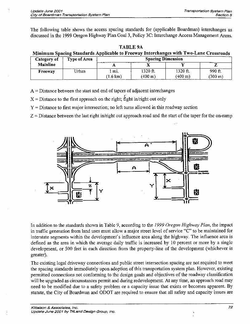
Update June 200 1 Citv of Boardman Transmfiation System Plan
Transpotfation System Plan Section 5
The following table shows the access spacing standards for (applicable Boardman) interchanges as discussed in the 1999 Oregon Highway Plan Goal 3, Policy 3C: Interchange Access Management Areas.
A = Distance between the start and end of tapers of adjacent interchanges
TABLE 9A Minimum Spacing Standards Applicable to Freeway Interchanges with Two-Lane Crossroads
X = Distance to the first approach on the right; kght idright out only
Y = Distance to first major intersection; no left turns allowed in this roadway section
Z = Distance between the last right idright out approach road and the start of the taper for the on-ramp
In addition to the standards shown in Table 9, according to the 1999 Oregon Highway Plan, the impact in traffic generation from land uses must allow a major street level of service "C" to be maintained for interstate segments within the development's influence area along the highway. The influence area is defined as the area in which the average daily traffic is increased by 10 percent or more by a single development, or 500 feet in each direction from the property-line of the development (whichever is greater).
Category of Mainline Freeway
The existing legal driveway connections and public street intersection spacing are not required to meet the spacing standards immediately upon adoption of this transportation system plan. However, existing permitted connections not conforming to the design goals and objectives of the roadway classification will be upgraded as circumstances permit and during redevelopment. At any time, an approach road may need to be modified due to a safety problem or a capacity issue that exists or becomes apparent. By statute, the City of Boardman and ODOT are required to ensure that all safety and capacity issues are
Type of Area
Urban
Spacing Dimension
Kittelson & Associates, lnc. Update June 2001 by TiiLand Design Group, lnc.
A 1 mi.
(1.6 km)
X 1320 ft. (400 m)
Y 1320 tt. (400 m)
Z 990 ft.
(300 m)

Update June 200 1 Transportation System plan City of Boardrnan Transportation System Plan Section 5
addressed. Proposed land use actions that do not comply with the designated access spacing policy will be required to apply for an access variance from the City of Boardman and/or ODOT.
Variance Process
Access variances may be provided to parcels whose highway frontage, topography, or location would otherwise preclude issuance of a conforming permit and would either have no reasonable access or cannot obtain reasonable alternate access to the public road system. In such a situation, a conditional access permit may be issued by ODOT and the City of Boardman for a single connection to a property that cannot be accessed in a manner that is consistent with the spacing standards.
The permit may carry a condition that the access may be closed at such time that reasonable access becomes available to a local public street. Approval conditions might also require a given land owner to work in cooperation with adjacent land owners to provide either joint access points, front and rear cross- over easements, or a rear-access upon future redevelopment. In addition, approval of a conditional permit might require ODOT-approved turning movement design standards to ensure safety and managed access. Under special circumstances, ODOT may purchase property in order to prevent safety conflicts.
City Standards
Table 10 identifies the minimum public street intersection and private access spacing standards for the City of Boardman roadway network as they relate to new development and redevelopment. Table 11 identifies standards for private access driveway widths. In cases where physical constraints or unique site characteristics limit the ability for the access spacing standards listed in Tables 10 and 11 to be met, the City of Boardman should retain the right to grant an access spacing variance. County facilities within the city's urban growth boundary should be planned and constructed in accordance with these street design standards.
/I ~ollector I 300 I 75 11
TABLE 10 MINIMUM INTERSECTION SPACING STANDARDS*
11 Neighborhood Collector 1 200 1 50
Functional Classification
Arterial
Kiftelson & Associates, lnc. 73 Update June 2001 by TriLand Design Group, lnc.
Public Street (feet)
600**
Local
Private Access Drive (feet)
300
*Spacing measured from centerline to centerline ** To promote circulation in the downtown, public streets can be spaced at 200-feet intervals.
150 15

Update June 200 1 Transportation System P/an City of Boardman Transportation System Plan Section 5
TABLE 1 1 PRIVATE ACCESS DRIVEWAY WIDTH STANDARDS
11 Land Use 1 Minimum (feet) 1 Maximum (feet) 11 )I Single Family Residential 1 12 1 24 11 1 Multi-Family Residential I 24 1 30 11 11 ~ommercial I 30 I 40 11
Management Techniques
From an operational perspective, the City of Boardman should consider implementing access management measures to limit the number of redundant access points along roadways. This will enhance roadway capacity and benefit circulation. Improvements that should be considered include:
Industrial
o planning for and developing intersection improvement programs in order to regularly monitor intersection operations and safety problems;
purchasing right-of-way and closing driveways; and
30
installing positive channelization and driveway access controls as necessary.
40
Enforcement of the access spacing standards should be complemented with the availability of alternative access points. Purchasing right-of-way and closing driveways without a parallel road system and/or other local access could seriously effect the viability of the impacted properties. Thus, if an access management approach is taken, alternative access should be developed prior to "land-locking" a given property. Specifically, provision of key collector facilities as identified in Figure 11 would provide alternative access to land adjacent to major roadways such as Interstate 84 and Main Street; thereby reducing or eliminating the need to provide new direct highway access to multiple properties.
As part of every land use action, the City of Boardrnan should evaluate the potential need for conditioning a given development proposal with the following items, in order to maintain andlor improve traffic operations and safety along the arterial and collector roadways.
Crossover easements should be provided on all compatible parcels (considering topography, access, and land use) to facilitate future access between adjoining parcels. Figure 13 illustrates how this process would, in the long run, facilitate compliance with access management objectives.
Conditional access permits should be issued to developments having proposed access points that do not meet the designated access spacing policy and/or have the ability to align with opposing driveways. The actual access spacing policy will be developed later as part of the TSP process.
Right-of-way dedications should be provided to facilitate the future planned roadway system in the vicinity of proposed developments.
Half-street improvements (sidewalks, curb and gutter, bike laneslpaths, and/or travel lanes) should be provided along site frontages that do not have full-buildout improvements in place at the time of development.
Kjttelson & Associates, lnc. Update June 2001 by TriLand Design Group, lnc.

Proposed Access Management Strategy
Joint and Crossover Easement Access Management Strategy
I LOTA I LOTB I LOTC I LOTD I
- Joint and Crossover Easement Access Management Strategy
LOTA I LOTB I LOTC I LOTD
Step I Step 2
Joint and Crossover Easement Access Management Strategy
LOTA I LOTB I LOTC I LOTD
F n i a n d Crossover Easement Access Management Strategy I I LOTA I L O T B . ' I LOTC I LOTD I
Step 3 Step 4
Joint and Crossover Easement Access Management Strategy
LOTA I LOT B I LOT C I LOT D
Step 5
Joint and Crossover Easement Access Management Strategy
I LOTA I LOTB I LOTC I LOT D I
Complete
Step 6
EXAMPLE OF CROSS-OVER EASEMENTS AND CONDITIONAL ACCESS POLICYIPROCESS C I N OF BOARDMAN, OREGON TRANSPORTATION SYSTEM PLAN JUNE 1999 '
DWGS\BOARDMAMTSR2899FOl3 CDR
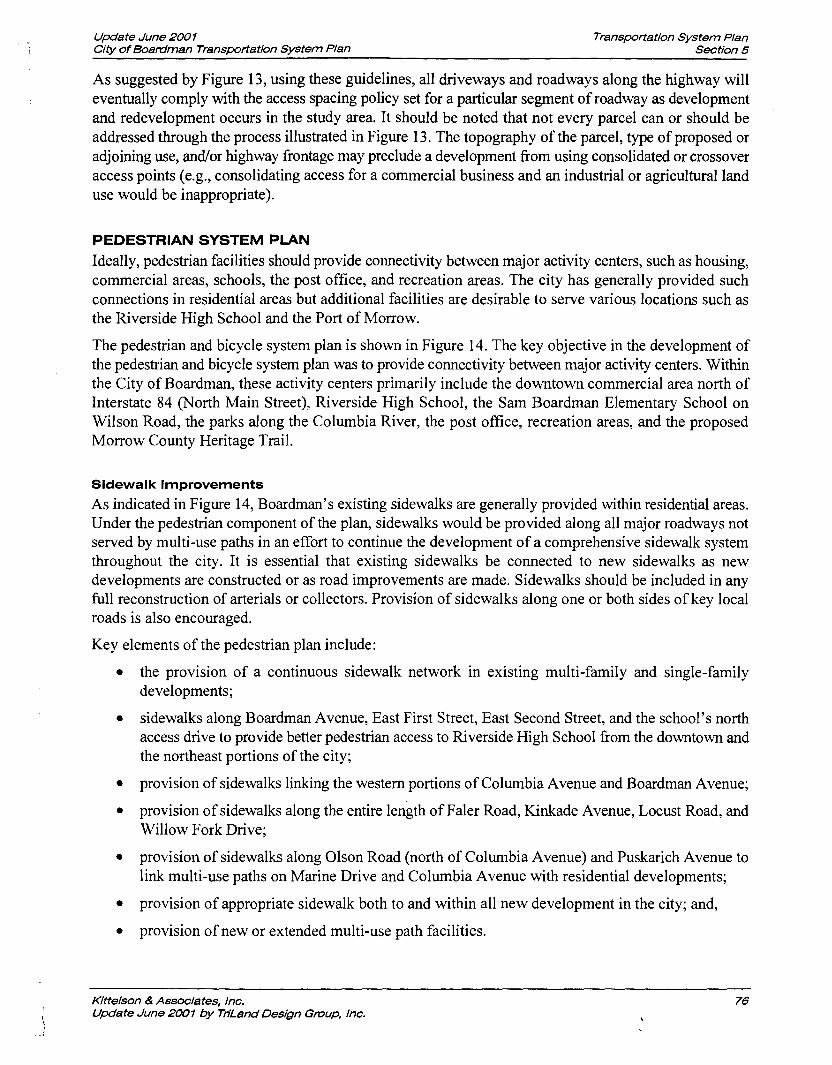
Update June 200 1 Transportation System Plan City of Boadman Transportation System Plan Section 5
As suggested by Figure 13, using these guidelines, all driveways and roadways along the highway will eventually comply with the access spacing policy set for a particular segment of roadway as development and redevelopment occurs in the study area. It should be noted that not every parcel can or should be addressed through the process illustrated in Figure 13. The topography of the parcel, type of proposed or adjoining use, andlor highway frontage may preclude a development fiom using consolidated or crossover access points (e.g., consolidating access for a commercial business and an industrial or agricultural land use would be inappropriate).
PEDESTRIAN SYSTEM PLAN
Ideally, pedestrian facilities should provide connectivity between major activity centers, such as housing, commercial areas, schools, the post office, and recreation areas. The city has generally provided such connections in residential areas but additional facilities are desirable to serve various locations such as the Riverside High School and the Port of Morrow.
The pedestrian and bicycle system plan is shown in Figure 14. The key objective in the development of the pedestrian and bicycle system plan was to provide connectivity between major activity centers. Within the City of Boardman, these activity centers primarily include the downtown commercial area north of Interstate 84 (North Main Street), Riverside High School, the Sam Boardman Elementary School on Wilson Road, the parks along the Columbia River, the post office, recreation areas, and the proposed Morrow County Heritage Trail.
Sidewalk Improvements
As indicated in Figure 14, Boardman's existing sidewalks are generally provided within residential areas. Under the pedestrian component of the plan, sidewalks would be provided along all major roadways not served by multi-use paths in an effort to continue the development of a comprehensive sidewalk system throughout the city. It is essential that existing sidewalks be connected to new sidewalks as new developments are constructed or as road improvements are made. Sidewalks should be included in any full reconstruction of arterials or collectors. Provision of sidewalks along one or both sides of key local roads is also encouraged.
Key elements of the pedestrian plan include:
the provision of a continuous sidewalk network in existing multi-family and single-family developments;
sidewalks along Boardman Avenue, East First Street, East Second Street, and the school's north access drive to provide better pedestrian access to Riverside High School fiom the downtown and the northeast portions of the city;
provision of sidewalks linking the western portions of Columbia Avenue and Boardman Avenue;
provision of sidewalks along the entire length of Faler Road, Kinkade Avenue, Locust Road, and Willow Fork Drive;
provision of sidewalks along Olson Road (north of Columbia Avenue) and Puskarich Avenue to link multi-use paths on Marine Drive and Columbia Avenue with residential developments;
provision of appropriate sidewalk both to and within all new development in the city; and,
provision of new or extended multi-use path facilities.
Kitteison & Associates, lnc. Update June 2007 by Tn'Land Design Group, lnc.
1
?T OF RROW
NORTH (NOT TO SCALE)
~ND/OR BIKELANES CAN BE SUBSTITUTED WITH ID 10-FOOT MULTI-USE PATH ON ONE SIDE OF AND BICYCLE SYSTEM PLAN IN THE NEAR TERM. HE PATHS SHOULD BE REPLACED WITH ?lATE, BICYCLE LANES.
I LEGEND EXISTING SIDEWALK - . . . . . . . . . . . . . 1- EXISTING MULTI-USE PATH
mmmm..mm FUTURE SIDEWALK o o o FUTURE MULTI-USE PATH 'STRIAN AND BICYCLE SYSTEM PLAN . . . * o . . FUTURE SIDEWALK & BIKELANES F BOARDMAN, OREGON A A A A A FUTURE MORROW COUNIY HERITAWTATION SYSTEM PLAN
1 9 9 ~ ~ ~ ~ \ D w C S \ B O A R O M A N \ T S P \ Z B ~ ~ B O FiT R! 1 4

Update June 200 1 City of Boardman Transportation System Plan
Transportation System Plan Section 5
Multi-Use Facilities
Multi-use paths located along Main Street and Wilson Road have significantly enhanced the city's pedestrian and bicycle network; however, there is still a lack of sidewalks and pedestrian crossings along several key roadway facilities in the study area. As illustrated in Figure 14, in addition to maintaining the existing path network, the multi-use path system is to be extended to serve areas including Wilson Road, South Main Street, Paul Smith Road, Olson Road, North Front Street, Columbia Avenue, and Laurel Road. Further, as the alignment of the proposed Morrow County Heritage Trail is better defined, connections should be made with this facility to provide pedestrian/bicycle access along the Columbia River.
By extending the multi-use path system to encompass the areas designated in Figure 14, a strong base network of pedestriadbicycle connections will be available to the community. This base network can then be tapped by local sidewalk facilities to provide a more complete pedestrian and bicycle system in an environment free of vehicular traffic. The cross sections of these multi-use pathways would consist of 10- foot wide paved paths separated from the roadway by a minimum of 10-feet (accomplished through use of a 10-foot wide landscaping strip would provide the necessary separation).
It should be noted that multi-use paths are especially effective in undeveloped areas. As properties develop/redevelop at urban densities in Boardman, the city should consider replacing the multi-use paths with sidewalks on all streets and bicycle lanes on arterial and collector streets. In addition, sidewalks and bicycle lanes, where appropriate, should be provided on all facilities in the downtown as it develops along South Main Street.
Other Pedestrian Amenities
In addition to providing the pedestrian system components, there are several other potential enhancements that should be considered along arterial and collector streets, including:
provision of additional street lighting to provide clear visibility of pedestrians at night;
provision of curb extensions that reduce the exposed crossing distance pedestrians must walk; and
use of median treatments that provide pedestrians with a "safe-haven" at a mid-crossing.
Provision of sidewalks along both sides of key collector and local roads not specifically identified in this plan is also encouraged.
Table 12 provides a summary of pedestrian and bicycle system projects.
Many of the sidewalk and multi-use facilities presented in Table 12 could be completed incrementally as part of local development projects. Creating "partnership programs" with landowners and businesses to construct such facilities would be one method by which individual projects could be brought to h i t ion in a timely manner. The pedestrian facilities could be constructed as adjacent properties develop, thereby ensuring alternative modes of access to various land uses. The city would however, need to develop a reasonably equitable methodology of assessing the extent of facilities that individual developers would be required to provide.
Kittelson & Associates, lnc. Update June 200 I by TdLand Design Group, lnc.

Update June 200 1 City of Boadman Transportation System Plan
Transportation System Plan Section 5
TABLE 12 PEDESTRIAN AND BICYCLE SYSTEM IMPROVEMENTS
General Alignment
Near-Term, High Priority Projects (0-5 years)
Project StartEnd Point
Main Street
Future Boulevard
Marine Drive
Columbia Ave.
Second Street I Boardman Avenue to Front Street I Sidewalk I private I Estimated
Concurrent with Local Development
Improvement Description
Mid-Term Projects (5-1 0 years)
Interstate 84 to Marine Drive
Paul Smith Road to Olson Road
Main Street to Olson Road
Main Street to east UGB
Boardman Ave.
Front Street
Third Street
Wilson Road
PUBLIC TRANSPORTATION SYSTEM PLAN
Transit service provides mobility to community residents who do not have access to automobiles and provides an alternative to driving for those who do. Transit service should meet the needs both of travelers within the city and those of travelers making trips outside of the community.
The 1997 Oregon Public Transportation Plan identifies minimum level of service standards for rural and frontier communities such as the City of Boardman (Reference 4). Under the 1997 Oregon Public Transportation Plan, public transportation in small communities and rural areas in the year 201 5 (under Level 3-Respond to State and Federal Mandates and Goals) should:
Provide public transportation service to the general public based on locally established service and fbnding priorities;
Provide an accessible ride to anyone requesting service;
Provide a coordinated centralized scheduling system in each county and at the state level;
Provide phone access to the scheduling system at least 40 hours weekly between Monday and Friday; and
Respond to service requests within 24 hours (not necessarily provide a ride within 24 hours).
Estimated Cost*
Sidewalk and Bicycle Lanes
Sidewalk and Bike Lanes
Multi-use Path
Multi-use Path
Riverside High School to Olson Road
West of W. First Street to Olson Road
Smith Road
Kittelson & Associates, lnc. Update June 2007 by THLand Design Group, lnc.
- Responsible Jurisdiction
Boardman Avenue to Front Street
West of Faler Road and East of Anderson
$46,000
Included in cost of new
street
$27,500
$56,000
Sidewalk
Sidewalk
Estimated costs are in 1999 dollars and do not include right-of-way acquisition
Future Boulevard to Kunze Road
City
Private
City
City
Sidewalk
Multi-use Path
$60,000
$80,000
Sidewalk or Multi- use Path
Private
Private
Not Estimated
$21,500
7
Private
Private
$25,000 Private

Update June 200 1 City of Boardman Transportation System Plan
Transportation System Plan Section 5
Service Enhancements
Overall, the City of Boardman should continue to monitor the adequacy of the transit service provided to the community and work with the county to extend service as necessary. The local transit program should also seek to meet the 2015 minimum level of service standards identified in the 1997 Oregon Public Transportation Plan. Three improvement strategies are identified below for further consideration.
Increase Public Awareness
Both the city and the county should promote a greater public awareness of the available public transit services and the need for additional volunteer dispatchers and drivers. Greater awareness of the service and its needs will likely result in increased usage and availability. Provision of better recognition for drivers and/or driver meetings would be an additional avenue by which to encourage more volunteer participation in the program.
Coordinate Trips
Consideration should be given to coordinating trip requests to other neighboring communities and areas outside the county such as Hermiston or the Tri-Cities. For example, a given day of the week could be designated for out-of-town trips. This would then allow the city's residents to visit specialized medical service providers or satisfy other needs on a scheduled basis. similarly, weekly shopping trips to Hermiston or other communities could be established to allow community members to purchase commodities not available through local commercial and service providers.
A recent survey conducted by transportation provider staff suggests that coordination of medical visits could be difficult due to the unpredictable nature of office visits, though the need for such a service should be more closely examined. Assuming that the demand for such a service exists, a scheduled weekly service would lend itself to greater coordination with service providers in the neighboring communities of Irrigon and Umatilla.
Close coordination between the City of Boardman and adjacent communities is also encouraged and should increase ridership and efficiency through better use of the resources available. Such coordination could prove to be especially Eruitful if the weekly trips previously discussed are established as a joint community service. Coordinated trips to local community events would likely generate significant interest. Ultimately, if an increased demand for service can be established and documented, additional resources (i.e. funding, equipment) may be successfully pursued through grant applications or other alternative financing sources.
Provide Commuter Service
It is recommended that a carpool or vanpool service be provided for people who live in Boardman and work in neighboring communities. Provision of a vanpool andlor carpools to major employers in the area could help to reduce the number of single occupant vehicle commute trips from Boardman and help the community to achieve transportation demand.management (TDM) objectives.
Vehicle Replacement
The Morrow County Special Transportation Program replaces vehicles on an as-needed basis. No specific plans to replace the current vehicles in use in the City of Boardman are in place. The county has budgeted to replace one vehicle in 1999 though that will not necessarily affect the vehicles in Boardman. The county is pursuing additional funding for vehicles and has, through the Region 5 Public Transit Division, submitted a grant application that would allow the program to purchase a new modified van in 200 1 and a small bus in 2003. In addition, a new bus barn would be built somewhere in the county if the grant were
Kittelson & Associates, lnc. 80 Update June 2001 by Tn'Land Deslgn Group, lnc.

Update June 200 1 Transportation System Plan City of Boardman Tmnsporlation System Plan Section 5
to be approved. The City of Boardman should support the Morrow County Special Transportation Program in its pursuit of additional vehicles and funding.
MARINE SYSTEM PLAN As previously noted in the Existing Conditions section, the Columbia River borders the City of Boardman to the north and serves as a means of both recreational and freight transportation. The city's public marine facility and the Port of Morrow are capable of accommodating future expansion and can be expected to continue to grow with the surrounding community, though no formal expansion plans have been identified to date. The City of Boardman should actively support the continued presence and operation of both the Port and the recreational boat launch as effective means of transportation. The creation of multi-use paths and other facilities that promote the multi-modal use of the recreational areas along the shore of the Columbia River should be encouraged.
RAIL TRANSPORTATION SYSTEM PLAN Freight rail service will continue to be a prominent component of the city's transportation system. Union Pacific's main line through the city is expected to serve as a major western fieight hub for the foreseeable future. Given that it is highly unlikely that the Union Pacific's mainline between the Pacific Northwest and Chicago would be abandoned; there is no potential for rail banking or alternative uses.
Future development in the Port of Morrow's industrial area should be planned to interface with the adjacent rail system to promote the safe and efficient transportation of freight. It should be noted that although the Port of Morrow has currently rail spurs, the rail line does not serve the port's barge container facility located north of the tracks. According to ODOT's Rail Section, the port plans to extend a spur line into the container facility. This extension would require the reconstruction of the existing bridge that connects the city to the container and wood chip facilities because there is insufficient space under the existing structure to accommodate the access track.
There is some potential for passenger service to be reinstated sometime in the future if funding resources can be found to support the train. At the time this TSP was prepared Amtrak and the Union Pacific Railroad had no plans to reintroduce passenger service on this line in the foreseeable future. If new service were to be introduced, it would probably be operated by a long distance train running between Portland and Salt Lake City, Denver or Chicago. A new passenger train might be configured as a packagelexpress train carrying a few passenger coaches.
AIR TRANSPORTATION SYSTEM PLAN Existing regional air service for passengers and freight is provided via a full service commercial airport in neighboring Pendleton and also at the Tri-Cities Airport located in Pasco, Washington. Air transport charter service is also available through the Port of Morrow's airport near Boardman and the Hermiston Municipal Airport. The continued use and appropriate expansion of these facilities is recommended.
PIPELINE SYSTEM PLAN Existing pipeline facilities should be maintained and enhanced as necessary.
EVACUATION PLAN The Morrow County Planning Department, in conjunction with several local and state agencies, has developed response plans in the unlikely event of an incident at the Umatilla Ordinance Depot. According
Klttelson & Associates, Inc. Update June 2001 by Tn'Land Design Group, lnc.

Update June 2001 Transportation System Plan City of Boardman Transportation System Plan section 5
to county officials, in the event of an incident at the ordinance depot, area residents will be notified of the event and will have two response options.
The first response option will be to shelter in place. Planning officials indicate that sheltering in place, by sealing up a room, may be safer than trying to evacuate in some instances. If, however, a decision is made by emergency coordinators to initiate an evacuation, the second response option is to conduct an orderly exodus from affected areas. County planning staff note that it is important for persons in an evacuation area not to enter into an "mindset" with only one course of action because specific evacuation routes are subject to change based on the nature of the emergency and climatic conditions such as temperature and wind speed.
If an evacuation were to be necessary, appropriate directions would be provided by local alarms, changeable message signs, and tone-alert radio. The directions would then instruct persons to a safe destination, potentially involving reception areas that have been designated in the Dalles, Heppner, and Pendleton.
IMPLEMENTATION PLAN
This section has outlined specific transportation system improvement recommendations as well as a corresponding tirneline for implementation of the identified improv&ents. The sequencing plan presented is not detailed to the point of a schedule identifying specific years when infrastructure should be constructed, but rather ranks projects to be developed over 0 to 5 year, 5 to 10 year, and 10 to 20 year horizon periods. In this manner, the implementation of identified system improvements has been staged to spread investment in this infrastructure over the 20-year life of the plan.
The construction of roads, water, sewer, and electrical facilities in conjunction with local development activity should be coordinated if the City of Boardman is to develop in an orderly and efficient way. Consequently, the plans presented in the TSP should be considered in light of developing infrastructure sequencing plans, and may need to be modified accordingly.
SUMMARY The adoption and implementation of this Transportation System Plan will enable the City of Boardman to rectify existing transportation system deficiencies while also facilitating growth in the study area population and employment levels assumed in this study.
Kitteison & Associates, lnc. Update June 2001 by Tn'Land Design Group, lnc.

Section 6
Transportation Funding Plan

Update June 200 1 Transportation Funding Plan City of Boatriman Transportation System Plan Section 6
analysis is completed and, for commercial and subdivision proposals, a site review team is assembled to review the proposed development.
The City of Boardrnan currently does not have a transportation system development charge (SDC), which would be assessed to developers. This charge could be implemented by the city, with both a "reimbursement fee" and an "improvement fee" element built into its structure. The reimbursement fee places a value on the amount of capacity on an existing street that is utilized by new site development traffic. The improvement fee is an assessment for the added traffic impact associated with new development that triggers new roadway improvements. As a follow up to the Boardman TSP study, it is recommended that the city undertake a study to consider the appropriateness of a transportation SDC structure that would further facilitate the development of a multi-modal charge where funds could be spent on pedestrian, bicycle, transit improvements, and street improvements.
OREGON TRANSPORTATION FUNDING HISTORY
Road-Related Funding
The most significant portion of Oregon's highway user taxes and fees come from federal fuel and vehicle taxes, state taxes, and general motor vehicle fees. These categories account for 32 percent, 34 percent, and 25 percent, respectively, of all highway user taxes and fees collected in the state. Through the fiscal year 1996, the matching ratio in Oregon for Interstate Funds was: Federal 92.22 percent and State 7.78 percent (Reference 7).
During the 1980rs, Oregon's transportation budget was bolstered by a series of two-cent annual gas tax increases. At the same time, the Federal Government was increasing investment in highways and public transportation. The situation is different today. The last three Oregon Legislatures failed to increase the gas tax and federal budget cuts are reducing transportation funding available to Oregon. The State Highway Fund is further losing buying power because the gas tax is not indexed to inflation, and increased fuel efficiency of vehicles reduces overall consumption. Nevertheless, fuel taxes are the largest single source of highway revenues at approximately $390 million annually (Reference 7). Weight-miles taxes are the second largest source of revenue to the Highway Fund, at approximately $215 million annually (Reference 7).
Oregon Highway Trust Fund revenues are distributed among State (60.05 percent), County (24.38 percent) and City (1 5.57 percent) governments to fund their priority road needs. Under the 1997- 1999 legislatively adopted Department of Transportation budget, a total of $2,284 million revenue dollars was identified. Of the total available revenue, approximately $3 17 million dollars was allocated to counties and $185 million to cities (Reference 8).
Oregon law allows local government, in addition to receiving state highway trust fund revenues, to levy local fuel taxes for street related improvements. Multnomah and Washington Counties, and some small cities (Tillatnook, The Dalles, Woodbum) have used this authorization. Several attempts have been made by other jurisdictions, but have not been supported by the local electorate. As few local governments have implemented this option, non-user road revenues tend to be relied upon to supplement the funds received from state and federal user revenues. Other local funding sources have included property tax levies, local improvement district assessments, bonds, traffic impact fees, road user taxes, general fund transfers, receipts from other local governments, and other miscellaneous sources.
Oregon's current fee for cars and other light vehicles weighing 8,000 pounds or less is $30 biennially (Reference 7). Oregon law permits local governments (counties) and governmental entities to impose local option vehicle registration fees. To date, no county has implemented this tax.
Kittelson & Associates, Inc. Update June 2007 by Tn'Land Design Group, lnc,

Update June 200 1 City of Boardman Transportation System Plan
Transportation Funding Plan Section 6
grow significantly, if serious efforts were put into intercity transportation improvements. Local governments provide local transit and airport support, in addition to providing maintenance, preservation, and construction for local roads, streets, and bridges. The Federal Intermodal Surface Transportation Efficiency Act of 1991 (ISTEA) began moving decision-making for federal programs to states and this program and other state policies incorporated in the Oregon Transportation Plan (OTP) encourage reassessment of responsibilities and obligations for funding. The Transportation Equity Act for the 21 st
Century (TEA21), passed in 1998, has continued the efforts first initiated by ISTEA.
These changing relationships have resulted in two significant issues for State and local governments. First, there is no clear definition of State responsibility. At one time, the State operated on an informal consensus that it should provide one-half the match on federally funded, local, and other projects that served statewide needs. No similar consensus seems to exist today. The State's responsibility for transit, airports, and other local transportation infrastructure and services is not clear. The question of regional equity is raised in considering especially high-cost project needs, such as the Bend Parkway or the Portland area light rail program. Regional equity will probably require consideration of all modes together, because different regions may have different modal needs and financial arrangements.
Given this dynamic transportation funding environment, it is clear that local governments need to reassess traditional methods of funding projects and look creatively at ways to meet public expectations of high quality transportation services.
Transit Funding
Transit service in Oregon has evolved from private development and reliance on user fees for operating revenue, to public ownership with public subsidy for operations. No clear philosophy of the State role in providing transit services is evident and the State is discussing how it should raise revenue in support of transit. The State has used general funds, lottery funds, cigarette tax revenue, and other funds at various times to support transit service. These efforts have largely been targeted towards supplying half the required match to federal capital improvement grants. To date, the State has provided no operating funds for transit, other than the elderly and disabled program. The State role has been one of granting authority to local governments to raise locally-generated operating revenue.
While the state's role in transit funding is limited, the ODOT Public Transit Section does currently administer three public transit funding sources. These include Small City and Rural Transit Assistance (Section 18), the Special Transportation Fund (STF), and Section 16.
The Small City and Rural Transit Assistance program is a federally funded initiative that provides capital to operate and acquire vehicles for public transportation systems in cities with populations of less than 50,000 and rural areas. This assistance program is funded annually through an appropriation from the Federal Transit Administration (FTA) to each state with funds allocated to eligible providers based on a three-part formula. Fifty percent of the funds are distributed based on population, 25 percent are based on ridership, and 25 percent are based on service hours. There is a 50 percent local match requirement for operating costs and a 20 percent match for capital costs. The program stipulates that service must be marketed as "public transit": exclusive transportation services such as those limited strictly to senior citizens or employers are not eligible for funding under this program. Additional funding details, application information, and general assistance with the Small City and Rural Transit Assistance is available through ODOTYs Public transit Division.
The Special Transportation Fund is intended for elderly and disabled citizens and is funded through the State cigarette tax. Funding for the purchase of vehicles and equipment for special transportation
Kittelson & Associates, lnc. Update June 2001 by Tn'Land Design Group, lnc,

Update June 200 7 Transpotiation Funding Plan City of Boardrnan Transportation System Plan Section 6
State Funding
Due to funding limitations, ODOT is currently in a preservatiodmaintenance funding mode. The only roadway facility that ODOT operates and maintains in the City of Boardman is Interstate 84. The interstate does, however, impact the local transportation system, especially with respect to north-south connectivity and interchange operations. Although limited, state and federal funds administered through ODOT will be the primary sources of funding for improvements to Interstate 84 and its interchanges. Further, most Federal fimding is passed through ODOT to local jurisdictions. While improvement projects affecting ODOT facilities are documented in this TSP, the inclusion of such projects in the TSP does not obligate ODOT to finance them.
A good working relationship with ODOT Region 5 planning staff and the Region Manager will be important to ensure that major roadway improvement projects on state facilities within the city are included in ODOT's State Transportation Improvement Plan (STIP) when it is updated. The city and Morrow County should take an active role in jointly representing the transportation priorities of Boardman to ODOT during its process of formally incorporating priorities into the STIP. For its part, the City of Boardman's Transportation System Plan will provide ODOT with highway-related transportation projects of importance to the city and should be used as a basis for discussion with ODOT.
Local fimding participation in projects on state facilities may enable the ODOT to accelerate the priority of an improvement identified in the STIP. While not normally a requirement of project funding, local participation does demonstrate a strong commitment to ODOT and the local funds may be used to leverage state funds.
Local Funding
The City of Boardman should continue to pursue federal, state, and county transportation funds for transportation projects. Given the high level of annual expenditures needed for construction of the transportation projects identified, existing sources of transportation revenue are not expected to be adequate to meet the demand for new projects. To meet the additional funding needs, the city may wish to consider additional revenue-generating options such as systems development charges, local improvement districts, and street maintenance fees as discussed below. It should be noted that, even with increased funding, it may prove difficult to fund all of the projects identified in this TSP within the 20- year planning horizon. Accordingly, the city should review the identified improvement projects on a periodic basis to prioritize local transportation system funding such that it most appropriately reflects current and projected needs.
Transportation System Development Charge
The City of Boardman does not currently have a transportation system development charge, which would be assessed to developers. This charge could be implemented by the city, with both a "reimbursement fee" and an "improvement fee" element built into its structure. The reimbursement fee places a value on the amount of capacity on an existing street that is utilized by new site development traffic. The improvement fee is an assessment for the added traffic impact associated with new development that triggers new roadway improvements. The City of Pendleton has successfully implemented a SDC for transportation improvements.
As a follow up to the Boardman TSP, it is recommended that the city undertake a study to consider the appropriateness of a transportation SDC structure that would further facilitate the development of a multi- modal charge where funds could be spent on pedestrian, bicycle, transit improvements, and street improvements. The study should determine the feasibility of implementing SDC fees, particularly with respect to evaluating equitability with neighboring cities both in economic and political terms.
Klttelson & Associates, lnc. Update June 2001 by Tn'Land Design Group, lnc.

Section 7
Transportation Planning Rule Ordinances and Policies for the City
of Boardman

Update June 200 1 Policies and Land Use Ordinance Modifications City of Boardman Transportation System Plan Section 7
APPROVAL PROCESSES FOR TRANSPORTATION FACILITIES
Section 660-12-045(1) of the Transportation Planning Rule requires that cities and counties amend their land use regulations to conform with the jurisdiction's adopted Transportation System Plan. This section of the Transportation Planning Rule is intended to clarify the approval process for transportation-related projects.
Recommended Policies for Approval Process
r The Transportation System Plan is an element of the Boardman Comprehensive Plan. It idenhfies the general location of transportation improvements. Changes in the speczjic alignment of proposed public road and highway projects that shall be permitted without plan amendment i f the new alignment falls within a transportation corridor idenhfied in the Transportation System Plan.
r Operation, maintenance, repair, and preservation of existing transportation facilities shall be allowed without land use review, except where spec@cally regulated.
r Dedication of right-of-way, authorization of construction and the construction of facilities and improvements, for improvements designated in the Transportation System Plan, the classijkation of the roadway and approved road standards shall be allowed without land use review.
r Changes in the frequency of transit, rail and airport services that are consistent with the Transportation System Plan shall be allowed without land use review.
r For State projects that require an Environmental Impact Study (EIS) or Environmental Assessment (EA), the draft EZS or EA shall serve as the documentation for local land use review, if local review is required.
(1) Where the project is consistent with the Transportation System Plan, formal review of the draft EIS or EA and concurrent or subsequent compliance with applicable development standards or conditions;
(2) Where the project is not consistent with the Transportation System Plan, formal review of the draft EIS or EA and concurrent completion of necessary goal exceptions or plan amendments.
Recommended Ordinances for Approval Process
. Standards for Transportation Improvements --
. . --- Uses Permitted Outright. Except where otherwise speczfically regulated by this ordinance, the following improvements are permitted outright:
-- --
Kittelson & Associates, lnc. Update June 2001 by Tn'Land Design Group, Inc.

Update June 200 7 Citv of Boardman Transportation System Plan
Policies and Land Use Ordnance Modifications Section 7
B. I f review under this Section indicates that the use or activity is inconsistent with the Transportation System Plan, the procedure for a plan amendment shall be undertaken prior to or in conjunction with the conditional permit review.
. . --- Time Limitation on Transportation-Related Conditional Use Permits
C. Authorization of a conditional use shall be void after a period speciJied by the applicant as reasonable and necessary based on season, right-of-way acquisition, and other pertinent factors. This period shall not exceed three years.
Kittelson & Associates, lnc. Update June 2007 by TtiLand Design Group, lnc.

Update June 200 1 Policies and Land Use Ordinance Modifications City of Boardman Transportation System Plan Section 7
This ordinance shall apply to all arterials and collectors within City of Boardman and to all properties that abut these roadways.
Section 3. Conformance with Plans, Regulations, and Statutes
This ordinance is adopted to implement the access management policies of the City of Boardman as set forth in the Transportation System Plan.
Section 4. Definitions
I . Access. A way or means of approach to provide pedestrian, bicycle, or motor vehicular entrance or exit to a property.
2. Access ClassiJcation. A ranking system for roadways used to determine the appropriate degree of access management. Factors considered include functional classification, the appropriate local government Is adopted plan for the roadway, subdivision of abutting properties, and existing level of access control.
3. Access Connection. Any driveway, street, turnout or other means of providing for the movement of vehicles to or from the public roadway system.
4. Access Management. The process of providing and managing access to land development while preserving the regional pow of trafic in terms of safety, capacity, and speed.
5. Accessway. A walkway that provides pedestrian and bicycle passage either between streets or from a street to a building or other destinatr'on such as a school, park, or transit stop. Accessways generally include a walkway and additional land on either side of the walkway, often in the form of an easement or right-of-way, to provide clearance and separation between the walkway and adjacent uses. Accessways through parking lots are generally physically separated from adjacent vehicle parking or parallel vehicle trafic by curbs or similar devices and include landscaping, trees, and lighting. Where accessways cross driveways, they are generally raised, paved, or marked in a manner that provides convenient access for pedestrians.
6. Comer Clearance. The distance from an intersection of a public or private road to the nearest access connection, measuredfrom the closest edge of the pavement of the intersecting road to the closest edge of the pavement of the connection along the traveled way.
7. Cross Access. A service drive providing vehicular access between two or more contiguous sites so the driver need not enter the public street system.
Kittelson & Associates, lnc. Update June 2007 by Tn'Land Design Group, Inc.

Update June 200 1 Policies and Land Use Ordinance Modifications City of Boardman Transportation System Plan Section 7
22. Private Road. Any roadway for vehicular travel which is private& owned and maintained and which provides the principal means of access to abutting properties.
23. Public Road. A road under the jurisdiction of a public body that provides the principal means of access to an abutting property.
24. Reasonable Access. m e minimum number of access connections, direct or indirect, necessary to provide safe access to andfrom the roadway, as consistent with the purpose and intent of this ordinance and any applicable plans and policies of the City of Boardman.
25. Right-of-way. Land resewed, used, or to be used for a highway, street, alley, walkway, drainage facility, or other public purpose.
26. Signijkant Change in Trip Generation. A change in the use of the property, including land, structures or facilities, or an expansion of the size of the structures or facilities causing an increase in the trip generation of the property exceeding: ( I ) local: 10 percent more trip generation (either peak or daily) and 100 vehicles per day more than the existing use for all roadr under local jurisdiction; or (2) State exceeding 25 percent more trip generation (either peak or daily) and 100 vehicles per day more than the existing use for all roads under state jurisdiction.
27. Stub-out (Stub-street). A portion of a street or cross access drive used as an extension to an abutting property that may be developed in the future.
28. Substantial Enlargements or Improvements. A 10 percent increase in existing square footage or 50percentage increase in assessed valuation of the structure.
Section 5. Comer Clearance
I . Comer clearance for connections shall meet or exceed the minimum connection spacing requirements for that roadway.
2. New connections shall not be permitted within the functional area of an intersection or interchange as deBned by the connection spacing standard of this ordinance, unless no other reasonable access to the property is available.
3. Where no other alternatives exist, the @emitting department) may allow construction of an access connection along the property line farthest from the intersection. In such cases, directional connections (i. e. right idout, right in only, or right out only) may be required.
Section 6. Joint and Cross Access
Kittelson & Assoclates, Inc. Update June 2001 by Tn'Land Design Group, Inc.

Update June 200 1 City of Boardman Tiansportation System Plan
Policies and Land Use Ordinance Modifications Section 7
c. The property owner enters into a written agreement with the City of Boardman, recorded with the deed, that pre-existing connections on the site will be closed and eliminated aBer construction of each side of the joint use driveway.
6. The City of Boardman may modzfy or waive the requirements of this section where the characteristics or layout of abutting properties would make a development of a un@ed or shared access and circulation system impractical.
Section 7. Access Connection and Driveway Design
1. Driveways shall meet the following standards:
a. If the driveway is a one way in or one way out drive, then the driveway shall be a minimum width of 10 feet and shall have appropriate signage designating the driveway as a one way connection.
b. For two-way access, each lane shall have a minimum width of 10 feet.
2. Driveway approaches must be designed and located to provide an exiting vehicle with an unobstructed view. Construction of driveways along acceleration or deceleration lanes and tapers shall be avoided due to the
potential for vehicular weaving conflicts.
3. The length of driveways shall be designed in accordance with the anticipated storage length for entering and exiting vehicles to prevent vehicles from backing into the flow of trafic on the public street or causing unsafe conflicts with on-site circulation.
Section 8. Requirements for Phmed Development Plans
1. In the interest of promoting unijed access and circulation systems, development sites under the same ownership or consolidated for the pulposes of development and comprised of more than one building site shall be reviewed as single properties in relation to the access standards of this ordinance. The number of access points permitted shall be the minimum number necessary to provide reasonable access to these properties, not the m i m u m avaihble for that frontage. All necessary easements, agreements, and stipulations shall be met. This shall also apply to phased development plans. The owner and all lessees within the afected area are responsible for compliance with the requirements of this ordinance and both shall be cited for any violation.
2. All access must be internalized using the shared circulation system of the principal development or retail center. Driveways shall be designed to avoid queuing across surrounding parking and driving aisles.
Section 9. Nonconforming Access Features
Kitteson & Associates, Inc. Update June 2001 by Tn'Land Deslgn Group, lnc.

Update June 200 7 Policies and Land Use Ordnance Modifications City of Boardman Transportation System Plan Section 7
Section 12. Lot Width-to-Depth Ratios
1. To provide for proper site design and prevent the creation of irregularly shaped parcels, the depth of any lot or parcel shall not exceed 3 times its width (or 4 times its width in rural areas) unless there is a topographical or environmental constraint or an existing man-made feature such as a railroad line.
Section 13. Shared Access
I . Subdivisions with frontage on the state highway system shall be designed into shared access points to and from the highway. Normally a maximum of two accesses shall be allowed regardless of the number of lots or businesses served. If access off of a secondary street is possible, then access should not be allowed onto the state highway. If access off of a secondary street becomes available, then conversion to that access is encouraged, along with closing the state highway access.
2. New direct accesses to individual one and two family dwellings shall be prohibited on all but Distrkt-level State High ways.
Section 14. Connectivity
I . The street system of proposed subdivisions shall be designed to connect with existing, proposed, and planned streets outside of the subdivision as provided in this Section.
2. Wherever a proposed development abuts unplatted land or a m r e development phase of the same development, street stubs shall be provided to provide access to abutting properties or to logically extend the street system into the surrounding area. All street stubs shall be provided with a temporary turn-around unless speczjically exempted by City OjjkiaLs, and the restoration and extension of the street shall be the responsibility of any future developer of the abutting land.
3. Minor collector and local residential access streets shall connect with surrounding streets to permit the convenient movement of t r m c between residential neighborhooak or facilitate emergency access and evacuation. Connections shall be designed to avoid or minimize through traflc on local streets. Appropriate design and
traflc control such as four-way stops and trafic calming measures are the preferred means of discouraging through traflc.
4. In order to maintain the existing grid street system and street connectivity, the perimeter length of one block shall not exceed 880 square feet.
Kittelson & Associates, Inc. Update June 2001 by TriLand Design Group, Inc.
Update June 200 7 Transportation Planning Rule Ordinances and Policies for the City of Boardman Uty or ~oarwman I ransporrat~on system rBn secuon /
Section 16. Site Plan Review Procedures for Access Management
I . Applicants shall submit a preliminary site plan for review by the City of Boardman. At a minimum, the site plan shall show:
a. Location of existing and proposed access point(s) on both sides of the road where applicable;
b. Distances to neighboring constructed access points, median openings (where applicable), trafic signals (where applicable), intersections, and other transportation features on both sides of the property;
c. Number and direction of lanes to be constructed on the driveway plus striping plans;
d. All planned transportation features (such as sidewalks, bikeways, auxiliary lanes, signals, etc.);
e. Parking and internal circulation plans including walkways and bikeways;
$ A detailed description of any requested variance and the reason the variance is requested.
2. Subdivision and site plan review shall address the following access criteria:
a. All proposed roads shall follow the natural topography and preserve natural features of the site as much as possible. Alignments shall be planned to minimize grading.
b. Access shall be properly placed in relation to sight distance, driveway spacing, and other related considerations, including opportunities for joint and cross access.
c. The road system shall provide adequate access to buildings for residents, visitors, deliveries, emergency vehicles, and garbage collection.
d. An internal pedestrian system of sidewalks or paths shall provide connections to parking areas, entrances to the development, and open space, recreational, and other community facilities associated with the development. Streets shall have sidewalks on both sides. Pedestrian linkages shall also be provided to the peripheral street
system.
e. The access shall be consistent with the access management standards adopted in the Transportation System Plan.
3. Any application that involves access to the State Highway System shall be reviewed by the Oregon Department of Transportation for conformance with state access management standards.
Kittelson & Associates, inc. Update June 200 1 by TrlLand Design Group, lnc.

Update June 200 1 Transmation Planning Rule Ordinances and Policies for the City of Boardman u ; / r y or m a n m a n ~ransporrar~on system r ~ a n mcr~on I
PROCESS FOR COORDINATED REVIEW OF LAND USE DECISIONS
Recommended Policies for Coordinated Review
H The City of Boardman shall coordinate with the Department of Transportation to implement the highway improvements listed in the Statewide TransportQtion Improvement Program (STTP) that are consistent with the Transportation System Plan and comprehensive plan.
H The City of Boardrnan shall consider the jindings of ODOT's draft Environmental Impact Statements and Environmental Assessments as integral parts of the land use decision-making procedures. Other actions required, such as a goal exception or plan amendment, will be combined with review of the draft EA or EIS and land use approval process.
Process for Applying Conditions to Development Proposals
8 The proposed use shall impose an undue burden on the public transportation system. For developments that are likely to generate more than 200 average daily motor vehicle nips (ADTs), the applicant shall provide adequate informatl'on, such as a trafic impact study or trafic counts, to demonstrate the level of impact to the surrounding street system. The developer shall be required to mitigate impacts attributable to the project.
fl The determination of impact or effect and the scope of the impact study should be coordinated with the provider of the affected transportation facility.
H Dedication of land for streets, transit facilities, sidewalks, bikeways, paths, or accessways shall be required where the existing transportation system will be impacted by or is inadequate to handle the additional burden caused by the proposed use.
H Improvements such as paving, curbing, installation or contribution to trafic signals, construction of sidewalks, bikeways, accessways, paths, or streets that serve the proposed use where the existing transportation system may be burdened by the proposed use.
Regulations to Provide Notice to Public Agencies
Information required with development proposals to be conveyed to reviewers:
I Project location.
H Proposed land use action.
Location of project access point(s).
Kltteson & Associates, Inc. Update June 2001 by TriLand Design Group, lnc,

Update June 200 7 Transportation Planning Rule Ordinances and Policies for the City of Boardman Ll ry or tloamman I ransporrar~on system rlan secr~on /
d. Would reduce the level of service of the facility below the minimum acceptable level idenwed in the Transportation System Plan.
H Amendments to the comprehensive plan and land use regulations which signijicantly afect a transportation facility shall assure that allowed land uses are consistent with the finction, capacity, and level of service of the facility identijied in the Transportation System Plan. This shall be accomplished by one of the following:
(a) Limiting allowed land uses to be consistent with the plannedfunction of the transportation facility;
(b) Amending the Transportation System Plan to ensure that existing, improved, or new transportation facilities are adequate to support the proposed land uses consistent with the requirement of the Transportation Planning Rule; or,
(c) Altering land use designations, densities, or design requirements to reduce demand for automobile travel and meet travel needs through other modes.
Kittelson & Associates, lnc. Update June 2007 by Tn'Land Design Group, lnc. ,

Update June 2001 Transportation Planning Rule Ordinances and Policies for the City of Boardman ww or ~oamman lransporrar~on system rlan secrlon /
H Bicycle parking facilities shall be provided at all new residem'al rnulft@mily developments of four units or more, commercial, industrial, recreational, and institutional facilities.
H A citizens advisory committee shall be established to protect and promote bicycle and pedestrian transportation within the Urban Growth Boundary.
Recommended Ordinances for Bicycle Parking
H A minimum of 2 bicycle parking spaces per use (one sheltered and one unsheltered) shall be required.
H The following Special Minimum Standards shall be considered as supplemental requirements for the number of required bicycle parking spaces.
- Multi-Familv Residences. Every residential use of four (4) or more dwelling units shall provide at least one sheltered bicycle parking space for each unit. Sheltered bicycle parking- spaces may be located within a garage, storage shed, basement, utility room or similar area. In those instances in which the residential complex has no garage or other easily accessible storage unit, the required bicycle parking spaces shall be sheltered under an eave, overhang, an independent structure, or similar cover.
- Parking Lots. All public and commercial parking lots and parking structures shall provide a minimum of one bicycle parking space for every 10 motor vehicle parking spaces.
- Schools. Elementary and middle schools, both private and public, shall provide one bicycle parking space for every 10 students and employees. High schools shall provide one bicycle parking space for every 5 students and employees. All spaces shall be sheltered under an eave, overhang, independent structure, or similar cover.
- Colleaes. Colleges, universities, and trade schools shall provide one bicycle parking space for every 10 motor vehicle spaces plus one space for every dormitory unit. F@y percent of the bicycle parking spaces shall be sheltered under an eave, overhang, independent structure, or similar cover.
- Downtown Areas. In downtown areas with on-street parking, bicycle parking for customers shall be provided along the street at a rate of at least one space per use. Spaces may be clustered to serve up to six (6) bicycles; at least one cluster per block shall be provided. Bicycle parking spaces shall be located in front of the stores along the street, either on the sidewalks in specially constructed areas such as pedestrian curb extensions. Inverted "U" style racks are recommended. Bicycle parking shall not intelfere with pedestrian passage, leaving a clear area of at least 5 feet. Customer spaces are not required to be sheltered. Sheltered parking (within a building, or under an eave, overhang, or similar structure) shall be provided at a rate of one space per 10 employees, with a minimum of one space per store.
- Rural Schools, Service Centers, and Industrial Parks. Where a school, service center, or industrial park is located 5 or more miles from the closest urban area or rural residential subdivision with a density of more than one dwelling unit per 20 acres, a minimum of two bicycle parking spaces per use shall be required.
Kittelson & Associates, Inc. Update June 2001 by TMand Design Group, lnc.

Update June 200 1 Transportation Planning Rule Ordnances and Policies for the City of Boardman Uty or tcoatwman ~ransporrar~on sysrem rmn secrlon /
e. Multi-use Trail. An unpaved path that accommodates all-terrain bicycles; typically shared with pedestrians.
Pedestrian Facilities. A general term denoting improvements and provisions made to accommodate or encourage walking, including sidewalks, accessways, crosswalks, ramps, paths, and trails.
Neighborhood Activity Center. An attractor or destination for residents of surrounding residential areas. Includes, but is not limited to existing or planned schools, parks, shopping areas, transit stops, employment areas.
Reasonably direct. A route that does not deviate unnecessarily from a straight line or a route that does not involve a signzjkant amount of out-ofdirection travel for likely users.
Safe and convenient. Bicycle and pedestrian routes that are:
a. Reasonably free from hazards, and
b. Provides a reasonably direct route of travel between destinations, considering that the optimum travel distance is one-half mile for pedestrians and three miles for bicyclists.
9. Walkway. A hard-su@aced area intended and suitable for pedestrians, including sidewalks and the sulfaced portions of accessways.
Required elements for a site plan:
I . Bicycle Parking. The development shall include the number and type of bicycle parking facilities required in the m-Street Parking and Loading section of this Title. m e location and design of bicycle parking facilities shall be indicated on the site plan.
2. Pedestrian Access and Circulation.
a) Internal pedestrian circulation shall be provided in new commercial, ofice, and multi-family residential developments through the clustering of buildings, construction of hard sugace walkways, lanhcaping, accessways, or similar techniques.
3. Commercial Development Standards.
a) New commercial buildings, particularly retail shopping and ofices, shall be oriented to the street, near or at the setback line. A main entrance shall be oriented to the street. For lots with more than two front yards, the building@) shall be oriented to the two busiest streets.
K/ttelson & Associates, lnc. 113 Update June 200 1 by TnLand Deslgn Group, lnc,
Update June 200 1 Transportation Planning Rule Ordinances and Policies for the City of Boardman Ury or troamman I ransporrar~on system wan sect~on I
d) The Hearings Body or Planning Director may determine, based upon evidence in the record, that an accessway is impracticable. Such evidence may include but is not limited to:
i) Physical or topographic conditions make an accessway connection impractical. Such conditions include but are not limited to freeways, railroads, extremely steep slopes, wetlands, or other bodies of water where a connection cannot reasonable be provided.
ii) Buildings or other existing development on adjacent l anh physically preclude a connection now or in the future, considering potential for redevelopment.
iii) Where accessways would violate provisions of leases, easements, covenants, restrictions, or other agreements existing as of May 1, 1995 that preclude a required accessway connection,
-- - --
Kittelson & Associates, lnc. Update June 2001 by TriLand Design Group, lnc.

Section 8
Transportation Planning Rule Compliance

Update June 200 7 Transporlation Planning Rule Compliance City of Boardman Ti-anspo/tation System Plan Section 8
Review Existing Plans, Policies, Standards, and Laws
Review and evaluate existing comprehensive The following plans were reviewed as part of the plan. development of the TSP: 1991 Oregon Highway
Plan, (June, 1991); 1996 Oregon Bicycle Plan; City of Boardman Comprehensive Plan, (1 991 ); Draft Statewide Transportation Improvement Program (2000-2003).
Land use analysis - existing land usehacant In developing the forecast of transportation lands inventory. needs, an analysis was conducted of current land
use designations and land status within the project area to determine the capacity for growth, which would increase demand for transportation services. Population and employment forecasts were prepared for the year 2020 that reflect regional growth prospects and the city's economic role in the regjon. Estimates of needed housing, commercial,' and employment lands were derived from these forecasts. An inventory of vacant buildable lands within the city was also conducted.
Review existing ordinances - zoning, subdivision, engineering standards.
Review existing significant transportation studies.
Review existing capital improvements programs/public facilities plans.
Existing City Subdivision Ordinances, Zoning Ordinances, and Comprehensive Plan engineering standards were reviewed for adequacy in the development of the City of Boardman TSP.
Significant transportation studies reviewed as part of the City of Boardman TSP include the above mentioned comprehensive plans and their associated transportation elements, and the Morrow County TSP.
The City of Boardman CIP, Morrow County CIP, and the State TIP were reviewed as part of City of Boardman TSP development.
Americans with Disabilities Act requirements. The ADA requirements were reviewed and acknowledged as part of the City of Boardman TSP development.
Kittelsdn & Associates, lnc. Update June 2007 by Tn'Land Design Group, lnc.

Update June 200 1 Transportation Planning Rule Compliance City of Boardman Transportation System P Ian Section 8
Determine Transportation Needs
Forecast population and employment
Determination of transportation capacity needs (cumulative analysis, transportation gravity model).
Other roadway needs (safety, bridges, reconstruction, operationlmaintenance).
Freight transportation needs.
Public transportation needs (special transportation needs, general public transit needs).
Bikeway needs. Pedestrian needs.
Population and employment forecasts were prepared for the year 2020 that reflect regional growth prospects and City of Boardman's economic role. This information is summarized in Section 3: Future Conditions.
Travel demand forecasts were undertaken as part of this project. The methodology for travel forecasting and assumptions used in the transportation model are contained in Section 3: Future Conditions, which presents an analysis of future transportation conditions and identifies capacity needs.
Non-capacity related transportation needs are identified and recommended for implementation in Section 5: Transportation System Plan.
Freight transportation needs are adequately met via motor carrier freight services.
Public transportation needs are documented in Section 5: Transportation System Plan
Future bicycle and pedestrian improvements are to be made in conjunction with roadway improvements to provide cyclists and pedestrians with full accessibility to City of Boardman's street system. Plans for these facilities are shown in Figure 14 of Section 5: Transportation System Plan.
Kittelson & Associates, lnc. Updete June 2001 by TriLand Design Group, Inc.

Update June 200 1 Transportation Planning Rule Compliance City of Boardman TranspcWation System Plan Section 8
Airport element (land use compatibility, future The airport element is outlined in Section 5: improvements, accessibility1 Transportation System Plan. connectionslconflicts with other modes).
Freight rail element (terminals, safety). The rail element is outlined in Section 5: Transportation System Plan.
Water transportation element (terminals). The water transportation element is outlined in Section 5: Transportation System Plan
Produce a Transportation System Plan (Continued)
TSM element not applicable per OAR Transportation System Management element 660-12-020(2)(f) and (g). (TS M) .
Transportation Demand Management element TDM ehnent not applicabl@ Per OAR (TD M). 660-1 2-020(2)(f) and (g).
lmplementation of a Transportation System Plan
Plan Review and Coordination
Consistent with ODOT and other applicable plans.
Adoption
Is it adopted?
lmplementation
Ordinances (facilities, services and improvements; land use or subdivision regulations).
Transportation financinglcapital improvements program.
See Section 7: Policies and Land Use Ordinance Modifications
To follow.
Included in Section 7: Policies and Land Use Ordinance Modifications.
The transportation finance plan is summarized in Section 6: Transportation Funding Plan.
Kittellson &Associates, lnc. Update June 2001 by TriLand Design Group, lnc.

Update June 200 7 Cily of Boardman Transportation System Plan
References Section 9
References
Oregon Department of Transportation. Oregon Highway Plan. 199 1.
KCM, Inc. Morrow County Transportation System Plan Final Report. March 1998.
Transportation Research Board. Highway Capacity Manual, Special Report No. 209. 1994.
Oregon Department of Transportation. 1997 Oregon Public Transportation Plan. April 1997.
Oregon Department of Transportation. State Transportation Fiscal and Statistical Data for 1997. September 1998.
Oregon Department of Transportation. Financial Services Website, http://www. odot.state. or. us/ fspublic. May 1999
Kittelson & Associates, Inc. Update June 2007 by Tn'Land Design Group, lnc.

Update June 200 1 Plan and Policy Review City of Boardman Transportation System Plan Appendix A
Plans and Policies Review
Existing plan policies and other actions will influence the analysis of land use and transportation issues and the alternatives to address these issues as well as other community objectives.
Boardman's Comprehensive Plan and implementing regulations were acknowledged by the Land Conservation and Development Commission (LCDC) in 1978. They were amended in 199 1 as part of the city's first periodic review. In March 1998, the city completed a strategic plan to guide community and economic development activities in the coming years. The city is currently undertaking its second periodic review that will incorporate the results of the strategic plan as well a number of planning efforts.
JOINT MANAGEMENT AGREEMENT BElWEEN CITY OF BOARDMAN AND MORROW COUNTY Morrow County and the City of Boardman adopted a new agreement for management of the urban growth boundary (UGB) in April 1997. The agreement provides that the City shall have responsibility for the comprehensive plan, implementing ordinances and implementation within the city limits and the County, for the urban growth area (UGA is defined as the area outside .the city limits within the UGB). The agreement has a number of provisions related to' coordination of land useprocesses. There are several provisions with particular relevance to this project:
[Section] 5. Public Facility Planning
5.3 The City and County shall jointly prepare and amend the transportation and storm water management elements of the public facility plan, with the County having primary responsibility for the UGA, and the City for the area within the city limits. Transportation plans shall be coordinated and consistent in road classification and construction standards.
[Section] 9. Road Jurisdiction and Standards
9.1. The City and County agree to adopt a joint standard for non-arterial roads equivalent to the County's Rural Collector I1 standard developed for the County's Transportation System Plan (TSP). All future non-arterial roads within the Urban Growth Boundary (UGB) will be constructed and maintained to this standard unless housing densities warrant a higher standard. In such cases, roads will be constructed and maintained to the County's Rural Collector I standard, also adopted by both the City and the County. Estimates of average daily traffic, based on number of proposed housing units served by a given road, will be used to determine whether the Rural Collector I or I1 standard will be required. Road standards subject to this agreement are shown in Exhibit C and the County Road Classification Map is shown as Exhibit D.
9.2. If any future arterials are constructed within the UGA the County and City will develop and adopt a joint arterial road standard for construction and maintenance.
9.3. Upon annexation, the City will assume jurisdiction and ownership of any county road improved to at least the minimum standards described above.
9.4. These provisions do not prevent the City or County from improving any road within the UGB to a higher standard, as needed or appropriate, subsequent or prior to annexation.
Kitteson & Associates, lnc.

Update June 200 1 Plan and Policy Review Ci& of Boardman Transportation System Plan Appendix A
One housing policy addresses the relation of housing to arterial streets:
Locate high-density multiple-family developments in areas to offer a buffer between single-family residential and commercial or industrial uses, close to schools and shopping, and with quick access to arterial streets.
The Transportation Chapter makes the following findings:
Because transportation is not restricted to a single mode, the City has a key advantage for economic development.
Because of Boardman's small population, a mass transit system is not currently feasible.
An interim and ultimate master arterial street plan has been adopted and implemented by the City. This plan provides for the safe movement of large traffic volumes connecting the central business district with residential areas and provides through traffic access fiom residential areas to the Port of Morrow industrial area, according to the plan. The interim plan provides for 36-foot wide street widths in residential areas and 44-foot wide streets in commercial, industrial and high-density residential areas. The concept of the interim versus ultimate plan is that the City would gain widening to the ultimate plan when streets are overlaid.
Bike paths are needed for transportation alternatives to the automobile and for recreation. The City has constructed several bike paths.
Transportation policies include:
Adopt an interim and ultimate master arterial street plan, including provisions for bicycles and pedestrians.
The City shall allow for street oversizing, intersections, and traffic control.
Sidewalks shall be required (as part of the subdivision process) along all City streets as per City standards. Property already subdivided and developed without sidewalks shall be encouraged to add sidewalks.
The following is a policy from the Energy Chapter:
Consider alternative modes of travel to automobiles, such as bike paths.
Urbanization policies within the Plan are important in this analysis:
Encourage orderly conversion of rural land in a pattern to assure economical extension of municipal services.
Avoid sprawl and leapfrog development.
Provide for a variety of residential housing types, tourist and business, commercial, light and heavy-industrial uses.
The land use plan will provide for controlled growth and separation of incompatible uses.
The City MAY, on a case by case basis and upon approve of the City Council, extend utilities (water, sewer, storm drainage) outside the city limits. Normally, extension of facilities will be only within the Urban Growth Boundary; however, the City Council may provide utilities for special projects outside the UGB. The utilities shall be sized to only serve the identified project.
Kitteson & Associates, lnc. A-3

Update June 200 1 City of Soadman Transportation System Plan
Plan and Policy Review Appendix A
Strategy: Develop community facilities in partnership with local and public financial resources.
Statement: Business District Plan
GOAL: Effectively manage land use and transportation needs.
Strategy: Establish transportation and facility standards.
Project: Community Development Program
Project: Street Improvement Program
Strategy: Promote and support development which is consistent with a comprehensive growth and development plan.
Project: Community Development Program
GOAL: Promote and foster a high quality of life
Strategy: Develop and support programs which promote personal and property health and safety.
Project: Street Improvement Program
The Community Development Program referenced in the plan is described to include the TSP, an infill and redevelopment strategy and the identification of a central downtown area. The Street Improvement Program includes the paving and redevelopment of Locust Road, widening, sidewalks, curbs and gutters on West Columbia Avenuek3oardman Avenue and improvement of the Marine Drive overpass to include pedestrian and bike facilities.
KiCteson & Associates, lnc.

Appendix B - --
Description of Level-of-Service Methods and Criteria

Update June 200 7 Description of Level-of-Sewice Methods and Criteria City of Boardman Transportation System Plan Appendix B
Appendix B
LEVEL OF SERVICE CONCEPT Level of service (LOS) is a concept developed to quantifL the degree of comfort (including such elements as travel time, number of stops, total amount of stopped delay, and impediments caused by other vehicles) afforded to drivers as they travel through an intersection or roadway segment. Six grades are used to denote the various LOS from A to F.'
SIGNALIZED INTERSECTIONS
The six LOS grades are described qualitatively for signalized intersections in Table B 1. Additionally, Table B2 identifies the relationship between level of service and average stopped delay per vehicle. Using this definition, LOS D is generally considered to represent the minimum acceptable design standard.
Table B1 Level of Service Definitions (Signalized Intersections)
Average Delay per Vehicle
Very low average stopped delay, less than five seconds per vehicle. This occurs when progressiors is extremely favorable, and most vehicles arrive during the green phase. Most vehicles do not stop at all. Short cycle lengths may also contribute to low delay.
Average stop delay is in the range of 5.1 to 15.0 seconds per vehicle. This generally occurs with good progression and/or short cycle lengths. More vehicles stop than for a LOS A, causing highe, levels of average delay.
Average stop delay is in the range of 15.1 to 25.0 seconds per vehicle. These higher delays ma)' result from fair progression and/or longer cycle lengths. Individual cycle failures may begin tc appear at this level. The number of vehicles stopping is significant at this level, although many stil pass through the intersection without stopping.
Average stopped delays are in the range of 25.1 to 40.0 seconds congestion becomes more noticeable. Longer delays may result unfavorable progression, long cycle length, or high volume/capacity ratios. Many vehicles stop, an the proportion of vehicles not stopping declines. lndividual cycle failures are noticeable.
Average stop delay is in the range of 40.1 to 60.0 seconds per vehicle. This is considered to be thd limit of acceptable delay. These high delay values generally indicate poor progression, long cycle lengths, and high volume/capacity ratios. lndividual cycle failures are frequent occurrences.
Average stop delay is in excess of 60 seconds per vehicle. This is considered to be unacceptable! to most drivers. This condition often occurs with oversaturation. It may also occur at higl- volume/capacity ratios below 1.0 with many individual cycle failures. Poor progression and long cycle lengths may also contribute to such high delay values.
in this appendix i s adapted from the Transportation Research Board, Highway Capacity Manual, Special Report 209 (1994).
Kittelson & Associates, Inc.

Update June 200 1 Description of Level-of-Sentice Methods and Criteria City of Boadman Transportation System Plan Appendix 6
Table B2 Level of Service Criteria for Signalized Intersections
1 I 11 Level of Service I Stopped Delay per Vehicle (Seconds) ]I
UNSIGNALIZED INTERSECTIONS
Unsignalized intersections include two-way stop-controlled (TWSC) and all-way stop-controlled (AWSC) intersections. The 1994 Highway Capacity Manual provides new models for estimating total vehicle delay at both TWSC and AWSC intersections. Unlike signalized intersections, where LOS is based on stopped delay, unsignalized intersections base LOS on total vehicle delG. A qualitative description of the various service levels associated with an unsignalized intersection is presented in Table B3. A quantitative definition of LOS for unsignalized intersections is presented in Table B4. Using this definition, LOS E is generally considered to represent the minimum acceptable design standard.
Table 83 Level of Service Criteria for Unsignalized lntersections
Level of Service
A
Average Delay per Vehicle to Minor Street
0 Nearly all drivers find freedom of operation. Very seldom is there more than one vehicle in queue. Some drivers begin to consider the delay an inconvenience. Occasionally there is more than one vehicle in queue. Many times there is more than one vehicle in queue. Most drivers feel restricted, but not objectionably so. Often there is more than one vehicle in queue. Drivers feel quite restricted.
Represents a condition in which the demand is near or equal to the probable maximum number of vehicles that can be accommodated by the movement. There is almost always more than one vehicle in queue. Drivers find the delays approaching intolerable levels. Forced flow.
Represents an intersection failure condition that is caused by geometric and/or operational constraints external to the intersection.
Kittelson & Associates, lnc. 8-2

Update June 200 1 Description of Level-of-Senhe Methods and Criteria City of Boardman Transportation System Plan Appendix B
Table 84 Level of Service Criteria for Unsignalized Intersections
It should be noted that the LOS criteria for unsignalized intersections are somewhat different than the criteria used for signalized intersections. The primary reason for this difference is that drivers expect different levels of performance from different kinds of transportation facilities. The expectation is that a signalized intersection is designed to carry higher traffic volumes than an unsignalized intersection. Additionally, there are a number of driver behavior considerations that. combine to make delays at signalized intersections less onerous than at unsignalized intersections. For example, drivers at signalized intersections are able to relax during the red interval, while drivers on the minor street approaches to TWSC intersections must remain attentive to the task of identifying acceptable gaps and vehicle conflicts. Also, there is often much more variability in the amount of delay experienced by individual drivers at unsignalized intersections than signalized intersections. For these reasons, it is considered that the total delay threshold for any given LOS is less for an unsignalized intersection than for a signalized intersection. While overall intersection LOS is calculated for AWSC intersections, LOS is only calculated for the minor approaches and the major street left turn movements at TWSC intersections. No delay is assumed to the major street through movements. For TWSC intersections, the overall intersection LOS is defined by the movement having the worst LOS (typically a minor street left turn).
Level of Service
A
Kittelson & Assoclates, Inc. 8-3
Average Total Delay per Vehicle (Seconds)
< 5.0

Appendix C
Employment and Population Forecast Methodology

COGAN OWENS PLANNING,
320 WOODLARK BUILDING COMMUNICA?IONS, 8 13 SW ALDER STREET
COGAN GOVERNMENTAL AND
PORTLAND, OREGON 97205-3 11 1 COMNUNllY RELATIONS, 503/225-0192 FAX 503/2254224 - ENVIRONMENTAL STUDLES
MEMORANDUM
DATE: February 3,1999
TO: Julie Kuhn
FROM: Matt Hastie @.#. RE: Morrow County Population =d Employment Projections
We have completed projections to be incorporated in Technical Memorandum #3 for the Morrow County TSP project. This memo outlines the methodology and assumptions used to develop projections for the cities of Boardman, Heppner, Ione, Irrigon and Lexington. For Boardman and Irrigon, we have estimated future population for the City and urban growth area (area between the existing city limits and urban growth boundary (UGB)). For the other cities, we have provided projections for the city limits only. All employment projections are for the cities only.
Population
The Oregon Office of Economic Analysis (OEA) has developed population and employment forecasts through the year 2040for each county in Oregon. These are recognized as the official projections to be used by state agencies and local jurisdictions for planning purposes. Counties are responsible for allocating population to their cities and unincorporated areas. For the purposes of buildable lands and other planning studies, local jurisdictions may modify the OEA projections if agreed to by the appropriate coordinating state agency. In 1997, Morrow County, in coordination with the Oregon Department of Land Conservation and Development @LCD) and the cities of Boardman and Irrigon, agreed to a modified set of 1997 population estimates zgtd future projections. These projections assumed a higher rate of growth than forecast by the OEA through the year 2002 and incorporate the OEA growth rates from 2002 through 2020. The higher growth rates are based on substantial recent/ ongoing population and employment growth in the region. In addition, growth rates for specific ' cities are assumed to fluctuate from the county average in the near term.
We used these. 1997 estimates and modified growth rates in our projections. In addition,, we estimated the number of people within the uban growth areas of Boardman and Irrigon (based on the number of dwelling units and the average number

of people per dwelling unit in Morrow County) to estimate and project the population . within the UGB for these two cities.
Employment
Current estimates of employment for individual cities are not available through the County, state or any of the individual jurisdictions involved in this project. As noted above, the state has developed county-wide employment projections for non- agricultural employment which can be used to estimate futue growth rates for the county. In estimating current and future empIoyment, we assumed the following:
Between 1990 and 1997, employment growth rates mirrored those for population growth with these exceptions: - The rate of employment growth was slightly lower than population growth in
Boardman, where employnent growth was high but population growth was likely higher, due to sigru£ic& employment growth in Umatilla County (i.e., some new Boardman residents in the workforce work in Umatilla County).
- The rate in Lrrigon was significantly lower than the rate of population growth, given Irrigon's %edroom community" characteristics and the high rate of population growth there.
Between 1997 and 2002, we also estimate a somewhat higher rate of employment growth than the original OEA projections, following the same logic used to develop population estimates, as well as the assumptions stated above.
For 2002 - 2020, as with the population estimates, we assumed the employment growth rates projected by the OEA.
The attached tables show the projections.
POPULATION PROJECTIONS
CountyICity 1997 2000 2002 % change 2005 % change 2010 % change 201 5 % change 2020 X change
OEA Morrow 9,895 9,828 11,179 2.5% 10,723 1.8% 11,594 1.6% 12,463 1.5% 13,322 1.3%
Adjusted Morrow 9,895 11131 12,039 4.0% 12,701 1.8% 13,750 1.6% 14,812 1.5% 15,801 1.3%
Boardman City and 2700 3,126 3,446 5.0% 3,635 1.8% 3,936 1.6% 4,240 1.5% 4,523 1.3%
City and UGA 3062 3,545 3,908 5.0% 4,123 1.8% 4,463 1.6% 4,808 1.5% 5,129 1.3%
Heppner City and 1480 1,502 1.517 0.5% 1,601 1.8% 1,733 1.6% 1,867 1.5% 1,992 1.3%
City and UGA - 0.5% - 13% - 1.6% 1.5% 1.3%
. lone City and 31 0 319 . ,326 1.0% 344 1.8% , 372 1.6% 401 1.5% 428 1.3%
City and UGA 1.0% - 1.8% 1.6% - 1.5% 1.3%
lrrlgon Ciiyand 1200 1,470 1,683 7.0% 1,776 1.8% 1,922 1.6% 2,071 1.5% 2,209 1.3%
CItyandUGA 1444 1,769 ' 2,025 7.0% 2,137 1.8% 2,313 1.6% 2,492 1.5% 2,658 1.3%
Lexington City and 290 294 ' 297 0.5% 325 1.8% 352 1.6% 379 1.5% 404 1.3%
City and UGA - 0.5% - 13% - 1.6% - 1.5% 1.3%
EMPLOYMENT PROJECTIONS
1997 2000 % change 2002 % change 2005 % change 2010 % change 2015 % change 2020 % change - OEA Morrow Co. Proj. 2232 2,924 3,283 3.9% 3,449 2.5% 3,613 1.9% - 3,890 1.5% 4,097 1.0% 4,290 0.9%
Boardman 641 1,029 1.261 7.0% 1,444 7.0% 1,528 1.9% 1,646 1.5% 1,730 1.0% 1,809 0.9%
Heppner 580 601 61 0 0.7% 616 . 0.5% 652 1.9% 702 1.5% 738 1.0% 772 0.9%
lone 121 125 1 27 0.6% 128 0.5% 336 1.9%' 146 1.5% 154 1.0% 161 0.9%

Appendix D
Boardman Downtown Concept
DMAN URBAN DESIGN CONCEPTS J
BOARDMAN, OREGON RTATION SYSTEM P l A N
I 2899\OWCS\BMROMAN\TSP\2899CONC.DWC

DMAN DOWNTOWN ALTERNATIVtS

DMA N DOWNTOWN STREETSCA PE BOARDMAN, OREGON
SRTATION SYSTEM PLAN D
Appendix E
Supplemental Funding Information

Table El Boardman Area Transportation System Plan
Summary of Road-Related Transportation Funding Programs: Federal Sources 11 I 11
Program Name I Description
Community Development block Grants (CDBG)
Community Development Block Grants (CDBG) are administered by the Department of Housing and Urban Development (HUD) and potentially be used for transportation improvements in eligible areas.

Program Name
state Highway Fund
Special PuMic Works Fund ( S P W
Transpatation Access Charges
Immediate m n i t y Fund (IOF)
OR Transportation Infiastmcture Bank
Traffic Contrd Projects
Table E-1 (Continued) Boardman Area Transportation System Plan
Summary of Road-Related Transportation Funding Programs: State Level Description
The State Highway Fund composed of gas taxes, vehicle registration fees, and weightmile taxes assessed on freight caner. In 1994, the state gs tax was $3.24pergallon. Vehicleregistration fees wre$15 annually. Revenues a e divided as follow: 15.57 percent tocities, 24.38 percenttocounties, and60.05 percent toODOT. The city share of the Stde Highway Fund is allocated W on poplation.
ORS 366.5 14 requires at least om percent of the State Highway Fund received by ODOT, counties and cities be experded for the develqxnent of footp&s and bikeways. ODOT administas the bicycle funds, handles bikeway planning, design, engineering md construction, and povides technical assistance and advice to local gowmmts concaning bikeways.
The Stae of Ckegm allocates a portion of revenus frcm the stae lottey for economicdevelopnent. The CXegcn Emanic Development Depatment povides gmts and loam throughthe SPWFprograrn toccnstmd, impove and repir infrastructure to suppat local econanicdevelopnmt ard createnewjobs. The SPWFprovidesamaximum want of $500,000 for proiects that will help create a minimum of 50 iobs.
7he most faniliar form of a transportation access charge is a bridge or highway toll. Transpamion access charges are most appropriate for high-speed, limited access ccrridors; service in highdenrand midors; ard bypass facilities to avoid congested areas.
Congestion pricing where drivers are chaged electrcnicilly for the trip they rrake based on location and time of day, is the most efficient policy for dealillg with urban congestion. It not only generdes revenue for maintenance ard improvements; h t also decreases congestion ard the need for capital improvements by increasillg the cost of trips during peak periods.
The Ckegon Revised Statutes allow ODOT to construct tdl bridges to connect state highways and irnpove safety and capxity. The Status also allow pivate dewlopent of tdl bridges. Recent actions by theOregon legislature provide authority for developingtoll roads. Stateauthority for congestion picing doesnot exist; new leg islation would be required.
Financed at a level of $5 million per yea to a maximum of $40 million through FY96. The fund is tosupport specific economic developments in Oregon through the constmctiond imrovementofmads md isrestricted for use in situationsthdr~uuea~uickremonseardmitment offids. ~ t i s a n ~ c i ~ a t e d t h a t t h e ~ m m o u ~ awilable for a sin& poject is $500,000 or 10 percent of the annudl pogram level. This'fund mky be usedonly when otha sowces of f i k d a l support are umvailable or imficient and a e not a replacement or substitute for other funding sources.
As apilot pogram for t k USDOT, the Oregon Transportation Commission has nrade$10 millionavd;lable fromprojects that will not becontracted in FY 1996. The OTIB will make loans for transportdim projects and will offer a wiety of credit enbcements. Initial loans must be for improvements on federal aid highways, repayments go into m account that will be ma& available for any mode. Ability to repay will be a key factor in all lorns.
The State nraidains apdicy of sharing installation, rraintenm, and opelational costs for traffic signalsand luminaire units at intersections between State highway and city streets (or county roads). Intersections invdvinga State highway and a city street (or county rad) which a e included on the state-wide priority list are eiigible to paticipate in the cost sharingpdicy.
ODOT establishes a statewide priority list for traffic sigral installations on the State Highway System. The priority system is based on wrants outlined in the Manual for Uniform TMIC Control Devices. Local agenaes are respcnsible for cdinat ing the statewide signal priority list with local road requirements.

Table El (Continued) Boardman Area Transportation System Plan
Summary of Road-Related Transportation Funding Programs: State Level 11
OR Transportation Infrastructure Bank
Traffic Control Projects
Description
As a pilot program for the USDOT, the Oregon Transportation Commission has made $10 million available from projects that will not becontracted in FY 1996. The OTIB will make loans for transportation projects and will offer a variety of credit enhancements. Initial loans must be for improvements on federal aid highways, repayments go into an account that will be made available for any mode. Ability to repay will be a key factor in all loans.
The State maintains apolicy ofsharing installation, maintenance, and operational costs for traffic signals and luminaire units at intersections between State highway and city streets (or county roads). Intersections involving a State highway and a city street (or county road) which are included on the state-wide priority list are eligible to participate in the cost sharing policy.
ODOT establishes a statewide priority list for traffic signal installations on the State Highway System. The priority system is based on warrants outlined in the Manual for Uniform Traffic Control Devices. Local agencies are responsible for coordinating the statewide signal priority list with local road requirements.

Summary of Roa
Program Name
Special Assessments/Local Improvements Districts
Table El (Continued) lardman Area Transportation System Plan
Systems Development Charges (Impact Fees)
Local Gas Tax
Local Parking Fees
I-Related Transportation Funding Programs: Local Sources
Description
Special assessments are charges levied on property owners for neighborhood public facilities and services, with each property assessed a portion of total project cost. They are commonly used for such public works projects as street paving, drainage, parking facilities and sewer lines. The justification for such levies is that many of these public works activities provide services to or directly enhance the value of nearby land, thereby providing direct andlor financial benefit to its owners.
Local Improvement Districts (LIDS) are legal entities established by the City to levy special assessments designed to fund improvements that have local benefits. Through a local improvement district (LID), streets or other transportation improvements are constructed and a fee is assessed to adjacent property owners.
Systems Development Charges (SDCs) are fees paid by land developers intended to reflect the increased capital costs incurred by a municipality or utility as a result of a development. Development charges are calculated to include the costs of impacts on adjacent areas or services, such as increased school enrollment, parks and recreation use, or traffic congestion.
Numerous Oregon cities and counties presently use SDCs to fund transportation capacity improvements. SDCs are authorized and limited by ORS 223.297 - 223.3 14.
A local gas tax is assessed at the pump and added to existing state and federal taxes. Tillatnook, The Dalles and Woodburn are Oregon cities that have a local gas tax. Multnomah and Washington Counties also have gas taxes.
- -
Parking fees are a common means of generating revenue for public parking maintenance and development. Most cities have some public parking and many charge nominal fees for use of public parking. Cities also generate revenues from parking citations. These fees are generally used for parking-related maintenance and improvements.
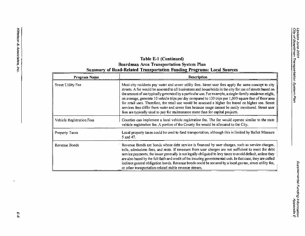
Summary of Ro: l r
II Program Name
I/ Vehicle Registration Fees
Property Taxes
Revenue Bonds
Table El (Continued) Boardman Area Transportation System Plan
CRelated ~rans~ortation ~ u n d i k Programs: Local Sources
Description
Most city residents pay water and sewer utility fees. Street user fees apply the same concept to city streets. A fee would be assessed to all businesses and households in the city for use of streets based on the amount of use typically generated by a particular use. For example, a single-family residence might, on average, generate 10 vehicle trips per day compared to 130 trips per 1,000 square feet of floor area for retail uses. Therefore, the retail use would be assessed a higher fee based on higher use. Street services fees differ from water and sewer fees because usage cannot be easily monitored. Street user fees are typically used to pay for maintenance more than for capital projects.
Counties can implement a local vehicle registration fee. The fee would operate similar to the state vehicle registration fee. A portion of the county fee would be allocated to the City.
Local property taxes could be used to hnd transportation, although this is limited by Ballot Measure 5 and 47.
Revenue Bonds are bonds whose debt service is financed by user charges, such as service charges, tolls, admissions fees, and rents. If revenues from user charges are not sufficient to meet the debt service payments, the issuer generally is not legally obligated to levy taxes to avoid dehult, unless they are also based by the hll kith and credit ofthe insuring governmental unit. In that case, they are called indirect general obligation bonds. Revenue bonds could be secured by a local gas tax, street utility fee, or other transportation-related stable revenue stream.

Table E-2 Currently Used Revenue Sources For Cities (millions of 1995 dollars)
I,
General Fund Transfers
Facility
StreetslBridges/ Sidewalks/ Bike h t t s
Special Property Tax 5% or $7. Increasing, only used by about May be used for purpose Varies widely. Levies 18 cities. desuibed in election.
Revenue Source
Oregon Highway Trust Fund
Varies but assume growth @ 3%lyr. But not used by all cities.
Improvement District 7% or $12.5. Assessments
Varies but increases when local May be used for construction Varies with construction development increases. of adjacent streets-sidewalks. cost & local ordinances.
Importance (not 100%)
51% of total road or $89.
May be used for any purpose.
Systems Development I 4% or $7. ChargedTnffic Impact
Varies widely.
Fees I
3-Year Trend
Growing about 1.75% per year.
Utility Franchise Fees 3% or $4.
Dedication
Constitutionally limited to funding activities that benefit autos & trucks.
Varies but increases when local development increases, only used by about 2 dozen cities.
II I Interest Earnings I 4% or $6.
Rate
24Qlgal. for gas; $3O/biennium registntion fee.
May be used for construction of new streets.
I Local Gas Tax I 0.44% or $0.7
Varies with construction cost & local ordinances. Rates generally higher in Portland Metm area.
Grows roughly w/population and inflation.
Varies wlcurrent interest rates.
Unchanged. Have same Constitutional Used by Tilamook, The limits as Highway Fund. Dalles, and Woodburn.
Is a general revenue used by some cities for streets.
Have same Constitutional limits as Highway Fund.
Statutory limit of 5% of utility gross receipts.
Used as general street revenue.
Private Contributions 3% or $4.3 Varies widely. Usually contributions are related to specific development street impacts.
Negotiated individually.

Facility
Off-street Bike Paths
Table E-2: (Continued) Currently Used Revenue Sources For Cities (millions
Revenue Source
Misc. - permit fees, finds, fines, parking, Motel Tax, other
Federal - FH WA+HUD
Misc. State Revenues - mainly Lottery funds.
Misc, general funds & ISTEA
Importance (not 3-Year Trend 1 00%)
8% or $14.5. Gradual growth.
Relatively stable
2% or $3. Varies, no trend. ---I--- ?? Varies from year to year.
)f 1995 dollars)
Dedication Rate
General revenues Varies widely by used for streets. City.
Used mainly for new Based on federal construction wlsome allocation to rehab. Oregon.
Used mainly for Specific grants to economic individual cities development capital each year. improvements.
Funds used for to year. construction, General Funds used for maintenance & repair.

I COGAN 320 WOODLARKBUILDING 813 SW ALDER STREET
! 'ORTLAND, OREGON 97205-3111 i03fW-0192 FAX 503/ W-0224
OWENS COGAN
F L A W COMMUNICATIOA
GOVERNMENTAL A N L COMMUNITY RELATIONS,
ENVIRONMENTAL STUDIES
MEMORANDUM
DATE: June 16,1999
TO: City of Boardman
FROM: Linda Davis, COC
RE: Infi l l and Redevelopment Alternative
This memorandum describes infill and redevelopment, including potential benefits, techniques, plan and ordinance provisions for implementation; an evaluation of the potential for infill and redevelopment in Boardman; and conclusions and recommendations about the value of selecting an infill and redevelopment alternative.
Infill refers to development of small vacant lots or additional development on lots that have an existing dwelling but could accommodate additional units given current or modified zoning regulations.
Redevelopment refers to additional or new commercial or industrial development on land that is already developed but has the capacity for additional or more intensive development because there is available land on the site or it is economical to demolish existing structures and build new structures with a higher value.
WHY ARE INFILL AND REDEVELOPMENT IMPORTANT?
Infill and redevelopment of land within a City's existing urban area provide a number of benefits:
Reduce pressure on expanding an urban growth boundary
Reduce pressure on valuable farm and forest land in possible expansion areas
Utilize existing sewer and water lines, roads and other public facilities
COGAN OWENS COGAN IS A LIMITED L1ABILII"Y COMPANY
1

Table E-3 Boardman Area Transportation System Plan Currently Used Revenue Sources in Oregon
I, / / Transit Service TypelFunction Funding Source Status
Urban Public Transportation 1. Local Payroll Tax - operating 1. Major Source - $100 millionlyr. Growing - (Portland & Eugene) 2. Federal grants - capital Sensitive to Economic Conditions (operating & capital) 3. Federal grants - operating 2. Major source - $10 milliodyr - Stable
4. Fares & advertising 3. Minor source - $5 millionlyr - Declining 4. Minor source - Growing wlridership
Urban Public Transportation 1. Property tax (typically a taxbase or stand-alone 1. Major Source - Growing Slowly (Salem, Corvallis, Medford, K-Falls) levy wlin $ 1 0 cap for local gov't services) 2. Major Source - $2 milliodyr. - Stable
2. Federal grants - capital 3. Major Source - $2 milliodyr. - Declining 3. Federal grant - operating 4. Minor Source - Growing wlridership 4. Fares & advertising
Small City & Rural I. Federal grants - capital &operating 1. Major Source - Declining (Astoria, Union County, etc.) 2. Local Property Tax (typically wlin city or 2. Major Source - Stable (operating & capital) county operating levy) 3. Minor Source - Stable
3. Fares, donations & advertising
Mobility for Seniors & People with 1. Special Transportation Fund (2$ state cigarette 1. Major Source - $5 milliodyr. - Declining Disabilities - (operating & capital) tax) - operating & capital 2. Major Source - Declining
2. Social Service Agency grants I contracts - 3. Minor Source - Stable operating 4. Major Source - Declining
3. Local Property Tax (typically w/in city or '. 5. Minor - Stable county operating levy)
4. Federal grants - capital & operating
I/ 5. Fares, donations advertising
Intercity Bus I . Major Interstate Routes: Fares I. Sole Source - Declining (operating & capital) 2. Branch & feeder routes: Private capital, Fares 2. Private
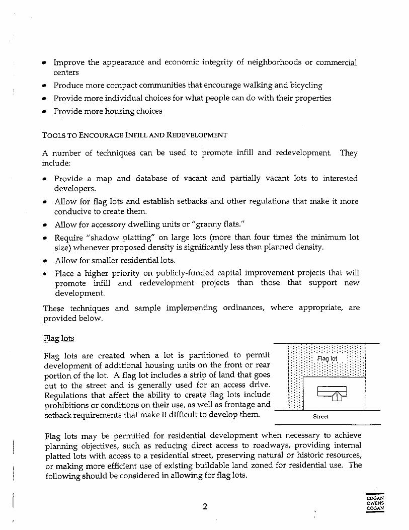
Improve the appearance and economic integrity of neighborhoods or commercial centers
Produce more compact communities that encourage walking and bicycling
Provide more individual choices for what people can do with their properties
Provide more housing choices
TOOLS TO ENCOURAGE INFILL AND REDEVELOPMENT
A number of techniques can be used to promote infill and redevelopment. They include:
Provide a map and database of vacant and partially vacant lots to interested developers.
Allow for flag lots and establish setbacks and other regulations that make it more conducive to create them.
Allow for accessory dwelling units or "granny flats."
Require "shadow platting" on large lots (more than four times the minimum lot size) whenever proposed density is significantly less than planned density.
Allow for smaller residential lots.
0 Place a higher priority on publicly-funded capital improvement projects that will promote infill and redevelopment projects than those that support new development.
These techniques and sample implementing ordinances, where appropriate, are provided below.
Flag lots r . . . . . . .......... . .:.:-. t:::::::::::.:.:.:.:.:.: .....:i
Flaglots are created w h e n a l o t i s partitioned to pe-t :.........""""'."""" ..::.:I i : : : : : : : : : Flaglot :::::::;
. . . . . . develovment of additional housing units on the front or rear :::::::::::::;::::-:.:.:.:-:-;! . . . . . . . . . . . . . . ;;;;:;:;:;:;:::;:;::.:.:.:.::I ..:...... portioA of the lot. A flag lot incluies a strip of land that goes , f . : . : . . . . . : t
out to the street and is generally used for an access drive. ; : i ; : i Regulations that affect the ability to create flag lots include 1 j ; i ; i prohibitions or conditions on their use, as well as frontage and 1 j j j t
setback requirements that make it difficult to develop them. Street
Flag lots may be permitted for residential development when necessary to achieve planning objectives, such as reducing direct access to roadways, providing internal platted lots with access to a residential street, preserving natural or historic resources, or making more efficient use of existing buildable land zoned for residential use. The following should be considered in allowing for flag lots.
- COCAN OWENS COC AN 7
Require appropriate widths of and separation between flag lot driveways.
Limit the total number or percentage of flag lots in comparison to the total number of platted residential lots.
Limit the number of flag lots permitted per private right-of-way or access easement.
Revise setbacks and frontage requirements as needed to allow for flag lots. For example, if the minimum lot size is 6,000 square feet, with a minimum driveway width of 20 feet and minimum frontage requirement of 50 feet then a flag lot cannot be created on a 60 foot wide 6,000 square foot lot. The minimum frontage requirement would have to be reduced to 40 feet to allow for creation of a flag lot on ari existing lot of this size
Accessory Dwelling Units
Accessory dwelling units, also sometimes referred to as "granny flats" are small housing units, usually the size of a studio apartment, permitted on.existing lots to serve as secondary homes for one or two people. They also can be units located above or in conjunction with a retail use. By allowing these units, a jurisdiction can promote more compact development, provide more housing choices for elderly or other residents, promote housing affordability by allowing families with a secondary source of (rental) income, and reduce the cost to serve new development.
When permitting accessory dwelling units (ADUs), the following requirements are recommended.
Specify which residential zones will allow for ADUs. It may be appropriate to allow them in all zones or only selected (e.g., higher density) zones.
Structures should comply with the Oregon Structural Specialty Code.
Typically, the primary residence should be occupied by the owner or another family member who is the care-taker of the principal house and manager of the ADU.
A maximum of one accessory dwelling should be allowed per lot.
Specify a maximum floor area for all ADUs or require that the maximum floor area shall be less than the primary dwelling.
Require that ADUs comply with lot and setback standards established for single- f arnily dwellings.
Require that parking spaces be provided for each ADU.
Shadow Platting
Shadow platting is used to specify the location of future roads, subdivision boundaries, natural features, and other uses. This could be required for large lots approved for development when the proposed development is sigruficantly less than dense than would be allowed under current zoning regulations. A re-division plan can require -
COGAN OWENS COGAN 7

consistency with the shadow-plat at the time of future land divisions or partitions. Siting standards should be based on relevant community plans for land use, public facilities, natural resources, and other factors.
The following should be considered in requiring shadow-platting.
Require shadow-platting on parcels larger than a certain size ( e g , parcels larger than two acres or parcels that are four times the minimum lot size allowed by the base zone if the proposed number of dwelling units is equal to or less than a certain percentage of the number allowed in the zone).
Require that shadow plats specify the proposed location of additional lots for future dwelling units, future roads and other infrastructure needed to serve the dwelling units, and connections to existing roads and other infrastructure.
Spec* that relevant community plans for land use, public facilities, natural resources, and other factors shall be considered in developing shridow plats.
Ensure that future subdivision plans for the property are consistent with the shadow plat.
Smaller Lots
Allowing smaller lots (e.g., 5,000 square feet), while not technically an infill or redevelopment technique, can promote more efficient use of land within the urban area. Smaller lots can be allowed in all or specific residential zones.
Map and Database of Infill and Redevelopable Proverties
Providing information to prospective developers about vacant properties already served by existing services or those that can accommodate additional development can help encourage infill and redevelopment. Ideally, parties should receive a map of such 1ands.and information about parcel size, ownership, zoning, access, existing municipal services and any constraints to future development.
POTENTIAL FOR RESIDENTIAL INFILL IN BOARDMAN
In 1997, Morrow County, Boardman and Irrigon received a Transportation and Growth Management Grant to conduct a buildable lands study. As part of that study, the number of potential infill lots were determined. Redevelopment separate from infill for residential use was not examined.
Infill parcels have an existing use but are large enough to physically support additional housing units. To identify all possible infill parcels, the county's GIs department provided maps of all parcels larger than double the minimum lot size in each residential zone. After subtracting completely vacant parcels and those with existing uses already
- COC AN OWENS COCAN -

built to maximum densities (e.g., apartments or duplexes), the resulting list of theoretical infill parcels included 106 parcels, totaling 306 acres.
! Field checks were conducted to assess the likelihood or prospect for infill development on all' parcels identified as determined by possible constraints to future subdivision and development, including:
Shape - some parcels were too narrow or otherwise oddly shaped to accommodate additional units.
Location of existing use - in many cases, the existing home is located in such as way as to prevent siting of additional housing units (e.g., in the center of the lot, without sufficient room to accommodate more homes).
Access limitations - in some cases, there is not enough space to provide access to units that could otherwise be accommodated on the lot; other lots are landlocked with access possible only if adjoining property owners grant easements or sell right- of-way.
Character of existing use - given the value of some homes and improvements (e.g., landscaping) infill on the lot within the planning period is highly unlikely; other p&cels contain uses such as churches that will preclude development of all or a significant portion of the lot.
Infill parcels were separated into two categories: 1) small lots, generally less than two acres in size, able to accommodate a small number of lots, as well as a few larger parcels with existing uses such as churches that preclude development on a sigruficant portion of the lot; and 2) larger lots, mostly located within the area between the city limits and UGB, referred to as the urban growth area (UGA), and typically able to accommodate more development. For small lots, the number of additional housing units that could be accommodated was estimated based on observations and assessments of constraints. For large lots, it was estimated that a certain portion of each parcel (1.5 acres) would be reserved by the owner and not partitioned, subdivided or developed during the planning period; the remainder of the lot would be available for development. The total infill potential was estimated at 161 additional housing units on small lots, plus 159.5 acres of land available for future development on large lots (Table 1).
- COG A N OWENS COGAN -

Table 1: Buildable Land Supply within the Boardman UGB
Zoning Vacant Inf ill Total
Category Platted lots Additional Dwelling Acreage on Platted lots Additional vacant units on large lots or dwelling acreage on acreage small lots units on large/ un-
small lots platted lots R-1 111 72.4 37 0.0 148 72.4
Total 188 750.4 162 151.1 351 901.5
Comprehensive Plan We evaluated the City's Comprehensive Plan, and Zoning and Subdivision ordinances to identify policies or ordinance provisions that could inhibit infill of residential land. We did not identify any'specific provisions that would discourage these practices.
Comprehensive plan: The comprehensive plan does not contain any policies concerning residential development.
Zoning Ordinance The City has one residential single family zone (R-1). This zone, with a minimum of 8,000 square feet per lot, allows one single family detached dwelling per lot. While there are setback requirements, there are no specific dimensional standards for lots such as a minimum front lot width (frontage). Therefore, the potential number of infill lots identified in the 1997 inventory could probably be accommodated without changes to the existing ordinances through a simple partitioning process.
In regard to flag lots, one could infer that flag lots are permitted as long as the dwellings on both lots could meet all setback standards. There is no evidence that indicates specific flag lot provisions are needed to accommodate the infill potential. Minimum driveway width standards are proposed to implement transportation standards; these can apply to flag lots as well as other driveways.
The ordinance does not permit accessory dwelling units except in the following circumstances:
7
COCAN OWENS COCAN -

Above commercial uses on zone. In conjunction with farm employee of the owner or operation.
the ground floor in a General Commercial (C-1)
use, one manufactured home or trailer for an an immediate family member engaged in farm
The minimum 8,000 square feet per lot is large by some urban standards but relatively small by rural standards. There may be some areas in Boardman that could benefit by the allowance of small lot sizes to retain housing affordability. The provision of smaller lots could potentially increase the number of infill opportunities.
Subdivision Ordinance
Boardman's subdivision ordinance was adopted in 1964. Except for amendments that were made in recent years to provide for planned unit developments and master plans, the ordinance has not been changed in its basic provisions. Many procedural and technical provisions do not comply with current state laws and a number of other provisions do not reflect more current practice concerning subdivision design.
The subdivision ordinance contains lot standards for residential subdivision lots. The ordinance requires a minimum width of 80 feet for any residential lot, or a median of 90 feet. The average depth is required to be at least 100 feet, or not more than 11/2 times the width. The subdivision ordinance also states that the minimum lot size is 10,000 square feet, which is in conflict with the Zoning Ordinance, for lots on public sewer and water. Access points upon a street other than an alley must be at least 25 feet.
The subdivision ordinance provides for the possibility of "oversized lots and plans that will allow for repartitioning. This provision applies only to areas where public water and sewer services are not immediately available. However, it is the policy of the City to require these services at the time of development, and subdivisions are generally platted at close to the minimum lot size, too small to require "shadow-platting".
CONCLUSIONS AND RECOMMENDATIONS
There are no provisions of the comprehensive plan or zoning ordinance that inhibit infill (or redevelopment) of residential areas. However, there are provisions in the subdivision ordinance related to lot sizes and dimensions that could. In particular, flag lots could be difficult to impossible for all but the largest residential parcels. It is unusual to find these types of standards in a subdivision ordinance.
The City has expressed concern permit or require residential infill
with adoption of policies or regulations that would for the following reasons:
- COGAN OWENS COGAN -

Housing affordability is not an issue today. In fact, the contrary is a problem. The city has difficulty attracting executives to live in the community due to lack of an area or zone for higher income housing.
Specific provision for flag lots and accessory dwelling units could be counter to the city's efforts to improve the quality of residential areas because these provisions could allow more low quality mobile or manufactured homes.
Residents live in Boardman because of its rural quality. Current lot sizes are considered the minimum to maintain this value.
Some areas of the city may not have the infrastructure capacity to permit a large number of additional dwelling units.
The City has concern about infrastructure capacity for additional lots. The buildable lands analysis considered infill under existing zoning standards (minimum lot size of 8,000 square feet). Infrastructure capacity under these conditions may not be an issue but should probably be examined as part of the City's update of sewer and water master plans. Specific areas that can accommodate infill could be identified, and conversely, areas that might be suitable but have constraints could be identified as potential capital improvement areas.
The City recognizes that its zoning and subdivision ordinances are out of date and looks forward to the review of DLCD's model zoning ordinance for small cities as a starting place for a new zoning ordinance. As part of that review, as well as a more complete review of the City's Comprehensive Plan and ordinances during periodic review, the City might want to consider some plan policies and ordinances that would promote infill in certain sections of the City that have the infrastructure capacity. The subdivision ordinance needs to be replaced with more current standards that comply with state law and accepted professional practice and standards.
- COCAN OWENS COCAN -