cheltenham badlands - brucetrail.org · the badlands also lie within the inglewood slope...
TRANSCRIPT

Cheltenham Badlands
Management Planning Background Information
Updated October 2012
Primary changes between November 2008 and October 2012:
• Updated maps • Updated Ecological Information • Inclusion of 2009 Erosion Study • Inclusion of Thanksgiving 2011 Public Use Study

The Bruce Trail Conservancy Cheltenham Badlands Background Information
Updated October 2012 Page i
TABLE OF CONTENTS 1. Introduction ............................................................................................................................................. 1 2. Regional Context/Land History/Land Use ........................................................................................... 1
2.1 Overview .................................................................................................................................. 1 2.2 Regional Context ..................................................................................................................... 2 2.3 Land Classification ................................................................................................................... 4
2.3.1 Ecology ...................................................................................................................................... 4 2.3.2 Niagara Escarpment Plan ........................................................................................................... 5
2.4 Land Tenure ............................................................................................................................. 7 2.4.1 Previous Ownership ................................................................................................................... 7 2.4.2 Summary of Acquisition ............................................................................................................ 7 2.4.3 Current Uses .............................................................................................................................. 8
2.5 Climate ..................................................................................................................................... 9 2.6 Earth Science Features ......................................................................................................... 10 2.7 Geomorphology ..................................................................................................................... 10 2.8 Surface Water, Drainage and Groundwater .......................................................................... 12 2.9 Soils ....................................................................................................................................... 12 2.10 Life Science Features ............................................................................................................ 13
2.10.1 Biotic Conditions ..................................................................................................................... 13 2.10.2 Wildlife .................................................................................................................................... 17 2.10.3 Federally, Provincially and Regionally Rare Species .............................................................. 19 2.10.4 Aquatic Resources ................................................................................................................... 21
3. Market Analysis .................................................................................................................................... 21
3.1 Public Use Study – March 2000 to April 2002 ....................................................................... 21 3.2 Public Use Study – Thanksgiving Weekend 2011 ................................................................. 23
4. Issues ..................................................................................................................................................... 25 5. References ............................................................................................................................................ 28 Appendix A Assessment of Erosion at the Cheltenham Badlands, Peel Region, Ontario Appendix B List of Observed Flora and Fauna Appendix B 2005 OBBA Summary for Cheltenham Badlands Area
List of Figures
Figure 1 Regional Map of Cheltenham Badlands Area ........................................................................ 2 Figure 2 Shale Slopes of the Cheltenham Badlands ............................................................................. 4 Figure 3 Aerial Photograph of the Cheltenham Badlands (looking south) ............................................. 6 Figure 4 Cheltenham Badlands Site Map .............................................................................................. 8 Figure 5 Soil Units on the Cheltenham Badlands Property ................................................................. 13 Figure 6 Badlands Property Vegetation Communities ......................................................................... 17 Figure 7 Cars on Olde Base Line Road – Thanksgiving Weekend 2011 ............................................ 24 Figure 8 Site Traffic Conditions During October 2011 Thanksgiving Weekend .................................. 25

The Bruce Trail Conservancy Cheltenham Badlands Background Information
Updated October 2012 Page ii
List of Tables
Table 1 Cheltenham Badlands Physical Location ................................................................................ 9 Table 2 Brampton's Average Climate (Source: www.brampton.ca) ................................................... 10 Table 3 Herpetofaunal Species Sited in the Cheltenham Badlands Area ......................................... 18 Table 4 NHIC records of Species at Risk and provincially rare species on the Badlands property ... 20 Table 5 Summary of Results from Badlands Visitor Monitoring Program ......................................... 22 Table 6 Summary of Traffic Data for Thanksgiving Weekend 2011 ................................................... 24 Table 7 Summary and Status of Recommendations from 2001 Stewardship Plan ........................... 26

The Bruce Trail Conservancy Cheltenham Badlands Background Information
Updated October 2012 Page 1
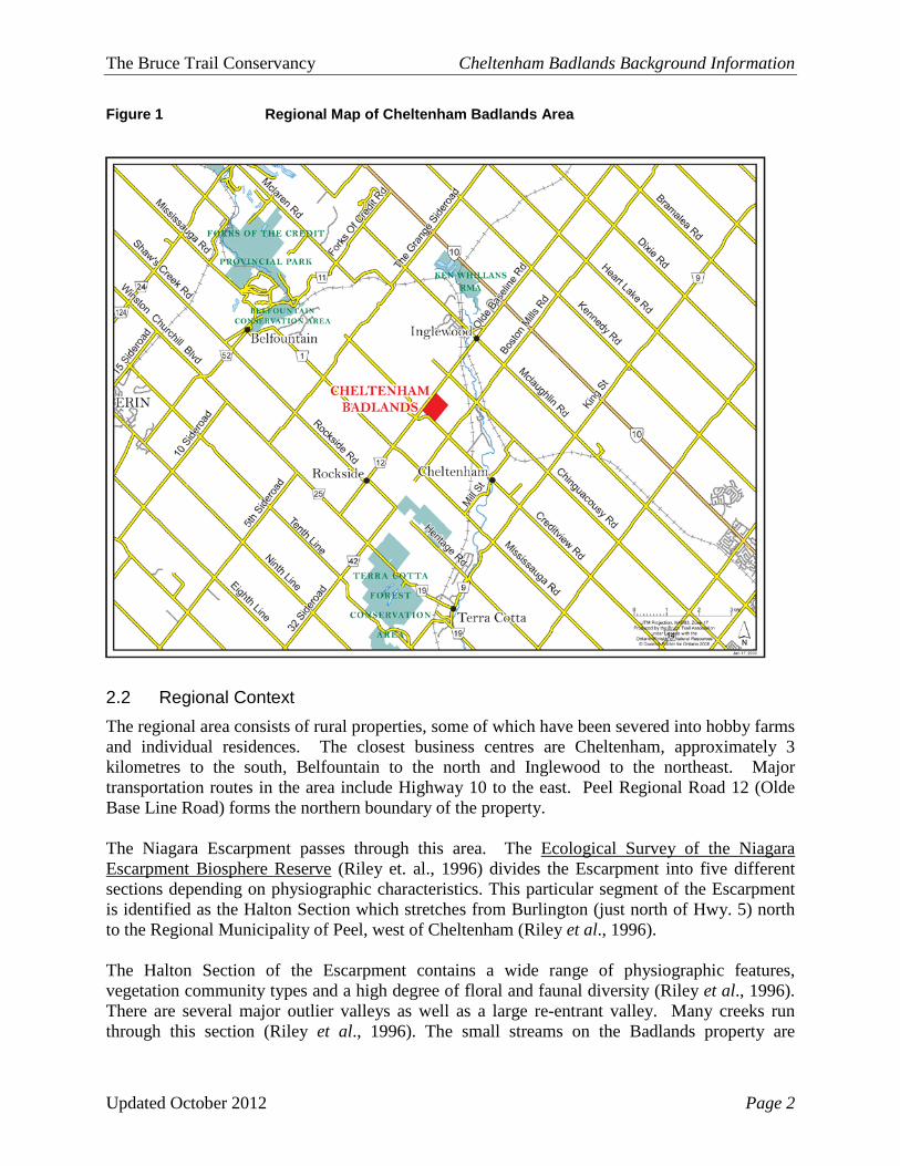
1. Introduction The Cheltenham Badlands property is located on the Niagara Escarpment northwest of Brampton, near the villages of Inglewood and Cheltenham. The Badlands are a popular tourist destination due to the unique topography of the area, and its relative proximity to major urban areas. In 2000 the 36.6-hectare property containing the Badlands was purchased for inclusion in the Niagara Escarpment Parks and Open Spaces System (NEPOSS) with Ministry of Natural Resources (MNR) funding. The Ontario Heritage Trust (OHT) holds title and the Bruce Trail Conservancy (BTC) manages the lands. Acquisition of the property ensured public ownership of this Provincially Significant Earth Science ANSI (Area of Natural and Scientific Interest) and secured 1.4 km of the Bruce Trail optimum route. Under the Niagara Escarpment Plan, a management plan must be developed for the property, which will give guidance to the landowner, land managers and the planners on how the property should be used. Over the course of the management planning process a series of documents are produced, which include the Terms of Reference, Background Information, Preliminary Management Plan and Final Management Plan. This document provides the Background Information in support of the Management Planning Process. As work progresses on the project, additional background material has been added to the document. The first version of the Background Information document was provided in November 2008. This current version represents information acquired as of September 2012. 2. Regional Context/Land History/Land Use 2.1 Overview The Cheltenham Badlands (also referred to as the Inglewood Badlands) are located approximately 2 km west of Highway 10 on Olde Base Line Road, near the villages of Inglewood and Cheltenham (Figure 1). Major transportation routes in the area include Highway 10. Peel Regional Road 12 (Olde Base Line Road) forms the northern boundary of the property. The Badlands are part of Ontario’s Niagara Escarpment, which was designated a UNESCO (United Nations Educational, Scientific and Cultural Organization) World Biosphere Reserve in 1990. The property contains one of the best examples of “badlands topography” development in southern Ontario, and has been designated a provincially significant Earth Science Area of Natural and Scientific Interest (ANSI) by the Ministry of Natural Resources. Badlands topography is rare in Ontario because in most areas the shale is protected from erosion by overlying hard rock (limestone, dolostone or sandstone), sand or gravel. In this area, the unprotected shale has eroded into a series of striking ridges and gullies, which are a popular tourist draw. The Badlands also lie within the Inglewood Slope Environmentally Sensitive Area (ESA), which is an important groundwater discharge area. The coldwater stream on the property at the foot of the badlands is a tributary of the Credit River.
The Bruce Trail Conservancy Cheltenham Badlands Background Information
Updated October 2012 Page 2
Figure 1 Regional Map of Cheltenham Badlands Area
2.2 Regional Context The regional area consists of rural properties, some of which have been severed into hobby farms and individual residences. The closest business centres are Cheltenham, approximately 3 kilometres to the south, Belfountain to the north and Inglewood to the northeast. Major transportation routes in the area include Highway 10 to the east. Peel Regional Road 12 (Olde Base Line Road) forms the northern boundary of the property. The Niagara Escarpment passes through this area. The Ecological Survey of the Niagara Escarpment Biosphere Reserve (Riley et. al., 1996) divides the Escarpment into five different sections depending on physiographic characteristics. This particular segment of the Escarpment is identified as the Halton Section which stretches from Burlington (just north of Hwy. 5) north to the Regional Municipality of Peel, west of Cheltenham (Riley et al., 1996). The Halton Section of the Escarpment contains a wide range of physiographic features, vegetation community types and a high degree of floral and faunal diversity (Riley et al., 1996). There are several major outlier valleys as well as a large re-entrant valley. Many creeks run through this section (Riley et al., 1996). The small streams on the Badlands property are

The Bruce Trail Conservancy Cheltenham Badlands Background Information
Updated October 2012 Page 3
tributaries of the Credit River, one of the cold-water streams in the Dufferin Section of the Escarpment. Historically, the primary land use in the area has been agriculture, and quarrying for sandstone and limestone. Clearing of forests has been extensive due to the relative absence of major natural barriers such as major Escarpment slopes which acted as impediments to agriculture along other sections of the Escarpment. In most cases, the soil along the Escarpment proved too poor for crops, so grazing of livestock became a major agricultural land use with considerable grazing of unfenced woodlands. In recent years, large portions of marginal agricultural lands have been retired and allowed to regenerate, and improved farming practices such as stream and woodlot fencing have resulted in significant decreases in woodland grazing. Recent selective logging has also been light. Most forests date back to the period of extensive logging in the area 70 to 100 years ago. No logging has occurred on the Badlands property for at least 50 years, but the removal of trees prior to that in an attempt at agriculture initiated the erosion of the Badlands. The Halton Section has probably faced greater environmental pressures from development, resource-extraction and recreation than the other sections of the Escarpment, particularly over the past few decades (Riley et al., 1996). One of the major trends in residential development in the Halton Section is low-density estate housing, which has occurred adjacent to natural areas throughout this section. Associated impacts included cutting firewood, ‘clean-up’ of decaying logs, introduction of invasive plant species, and the construction of on-line artificial ponds which raises water temperatures thus negatively impacting cold-water fish species (Riley et al., 1996). These pressures are a serious concern particularly since the Halton Section includes some of the most intact natural areas along the Niagara Escarpment. These large woodland-wetland complexes provide suitable habitat for a high diversity of species requiring large tracts of forest to maintain viable populations. These corridors permit the movement of animals that require a variety of habitats to survive. The Badlands property lies on the periphery of the largest corridor (20 km long, covering 40 km2) that runs from Limehouse, north to the Forks of the Credit in the Dufferin Section of the Escarpment (Riley et al., 1996). The Badlands property is located at the toe of the Niagara Escarpment, just west of Inglewood village. It fronts onto the south side of Olde Base Line Road as well as the east side of Creditview Road in the Town of Caledon (formerly Chinguacousy Township). The property is generally surrounded by forested areas to the north and west, intensive agriculture to the south and rural residential areas to the east. A sandstone quarry is also located on the northern side of Olde Base Line Road. The property has a fairly hilly topography with exposed clay hills and two large ravines. The largest of the exposed clay hills are called the Cheltenham Badlands, Queenston shale that has been exposed and has eroded over time (Figure 2). The property is located immediately south of the Escarpment and contains two steep valley ridges, tableland, swales, thicket, mature and young forest, and the Badlands. The skyline of Toronto and the Peel Plain are visible from the

The Bruce Trail Conservancy Cheltenham Badlands Background Information
Updated October 2012 Page 4
southern portion of the Badlands area. The property is a provincially significant geological site and a popular tourist spot due to the Badlands. 2.3 Land Classification
2.3.1 Ecology The Cheltenham Badlands are contained within the boundaries of the Badlands property. The significance of this unique feature has resulted in its designation as an Earth Science Area of Natural and Scientific Interest (ANSI). The Badlands property also lies within the Inglewood Slope Environmentally Significant Area, as designated by Credit Valley Conservation. Life Science and Earth Science ANSIs are identified by the Ministry of Natural Resources (MNR) and are given provincial, regional, or local significance. They are chosen as areas of land and water containing natural landscapes or features that have been identified as having values related to protection, natural heritage appreciation, scientific study, or education. Life Science ANSIs consist of landscapes, environments and biological communities representative of thirteen site regions found in Ontario. Earth Science ANSIs consist of rock types, fossil assemblages and associations of landforms found in these areas and are representative of Ontario's past and present geological environments. Life Science ANSI's along the Niagara Escarpment are protected within the policies of the Niagara Escarpment Plan (NEP), as well as within some Municipal and/or Regional Official Plans. The Badlands property contains the best example of ‘badlands topography’ in southern Ontario. The erosion began when a portion of the property was cleared of trees in the early 20th century. This property clearly illustrates the process of erosion of shale. Once this type of erosion becomes established, it continues fairly rapidly, particularly if the land is over-used such as by over-grazing or large numbers of people traversing the area. The Badlands are well known but little research has been done on the site. Figure 2 Shale Slopes of the Cheltenham Badlands
The Bruce Trail Conservancy Cheltenham Badlands Background Information
Updated October 2012 Page 5
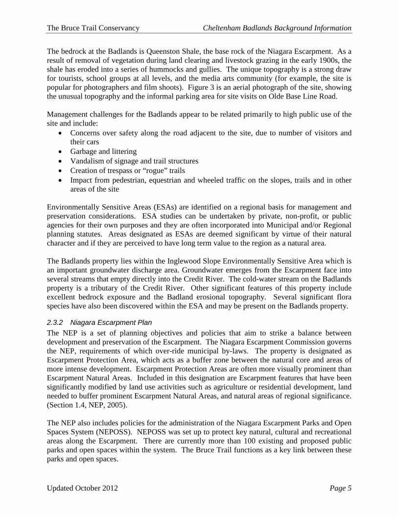
The bedrock at the Badlands is Queenston Shale, the base rock of the Niagara Escarpment. As a result of removal of vegetation during land clearing and livestock grazing in the early 1900s, the shale has eroded into a series of hummocks and gullies. The unique topography is a strong draw for tourists, school groups at all levels, and the media arts community (for example, the site is popular for photographers and film shoots). Figure 3 is an aerial photograph of the site, showing the unusual topography and the informal parking area for site visits on Olde Base Line Road. Management challenges for the Badlands appear to be related primarily to high public use of the site and include:
• Concerns over safety along the road adjacent to the site, due to number of visitors and their cars
• Garbage and littering • Vandalism of signage and trail structures • Creation of trespass or “rogue” trails • Impact from pedestrian, equestrian and wheeled traffic on the slopes, trails and in other
areas of the site Environmentally Sensitive Areas (ESAs) are identified on a regional basis for management and preservation considerations. ESA studies can be undertaken by private, non-profit, or public agencies for their own purposes and they are often incorporated into Municipal and/or Regional planning statutes. Areas designated as ESAs are deemed significant by virtue of their natural character and if they are perceived to have long term value to the region as a natural area. The Badlands property lies within the Inglewood Slope Environmentally Sensitive Area which is an important groundwater discharge area. Groundwater emerges from the Escarpment face into several streams that empty directly into the Credit River. The cold-water stream on the Badlands property is a tributary of the Credit River. Other significant features of this property include excellent bedrock exposure and the Badland erosional topography. Several significant flora species have also been discovered within the ESA and may be present on the Badlands property.
2.3.2 Niagara Escarpment Plan The NEP is a set of planning objectives and policies that aim to strike a balance between development and preservation of the Escarpment. The Niagara Escarpment Commission governs the NEP, requirements of which over-ride municipal by-laws. The property is designated as Escarpment Protection Area, which acts as a buffer zone between the natural core and areas of more intense development. Escarpment Protection Areas are often more visually prominent than Escarpment Natural Areas. Included in this designation are Escarpment features that have been significantly modified by land use activities such as agriculture or residential development, land needed to buffer prominent Escarpment Natural Areas, and natural areas of regional significance. (Section 1.4, NEP, 2005). The NEP also includes policies for the administration of the Niagara Escarpment Parks and Open Spaces System (NEPOSS). NEPOSS was set up to protect key natural, cultural and recreational areas along the Escarpment. There are currently more than 100 existing and proposed public parks and open spaces within the system. The Bruce Trail functions as a key link between these parks and open spaces.

The Bruce Trail Conservancy Cheltenham Badlands Background Information
Updated October 2012 Page 6
Figure 3 Aerial Photograph of the Cheltenham Badlands (looking south)
Photo courtesy of Jan Hannah

The Bruce Trail Conservancy Cheltenham Badlands Background Information
Updated October 2012 Page 7
The Badlands Property has been classified as an Escarpment Access park under the NEP; access parks as described as follows:
These areas will compliment the larger, and in some cases, more developed parks or open space areas, by providing opportunities for public access to the Niagara Escarpment at appropriate points along the Escarpment. These areas will normally be small and may provide modest facilities to support day use activities at view points, rest areas, trailheads, picnic sites, scenic areas, fishing areas, beaches, or other points of interest. New Escarpment Accesses may be established by the Ministry of Natural Resources, conservation authorities, or on the initiative of local municipalities or organizations such as service clubs. NEP 2005
The Niagara Escarpment was designated a World Biosphere Reserve in 1990 by the United Nations Educational, Scientific and Cultural Organization (UNESCO) through their Man and the Biosphere Program because of the policies in the Niagara Escarpment Plan. A Biosphere Reserve is an area that has successfully balanced conservation and preservation of a significant ecosystem with surrounding development. 2.4 Land Tenure
2.4.1 Previous Ownership The Historical Atlas of Peel County notes that the property was purchased in 1870 by George Wilson, who owned it until at least 1877. The next identifiable owner was Russell Cooper, who purchased the property in 1929. During the early 1900s agriculture was the main land use, and the main activity was cattle pasture. A section of hardwood forest in the northwest corner was fenced off from the cattle, and some timber and fuel wood had been cut in this corner over the years. The farming ceased around 1931 and natural regeneration began to occur. In 1931 a small area south of the junction of the streams was planted with Scots pine which has since self seeded in several areas of the property.
2.4.2 Summary of Acquisition The BTC first became aware of the property in 1989 when the Cooper family indicated an interest to sell. The property was later included on the 1999 list for acquisition through the Natural Areas Protection Program (NAPP). At that time an agreement could not be reached to purchase the property, although a handshake agreement was reached for the Trail to cross the property. The landowner assisted in the route selection for the Trail. The Trail crossed the property through a handshake agreement before the property was acquired in 2000. At the time of acquisition discussions, the BTC was considering severing a lot along Creditview Road to recoup some of the cost of the property. The Niagara Escarpment Commission (NEC) suggested that there may be development potential as the property was over 80 acres and can be accessed by two roadways. However the Town of Caledon had designated it as part of the ‘Environmental Protection Area’ and concluded that no development could occur. The NEC

The Bruce Trail Conservancy Cheltenham Badlands Background Information
Updated October 2012 Page 8
suggested locating a developable lot on the property was possible even with this designation. However, it was decided to not pursue the severance for the additional lot. The property was ultimately acquired in 2000 for $550,000 by the Province of Ontario (Management Board Secretariat). Title to the property was transferred to the Ontario Heritage Trust (OHT) in 2002 and the BTC retained management responsibility. The Caledon Countryside Alliance committed to assisting with the management of the property with the intent to focus on public education of the Badlands.
2.4.3 Current Uses The main Bruce Trail currently crosses the property in a south – north direction primarily in the eastern area. Between 2001 and 2007 the Russell Cooper side trail (named for the former owner of the property) linked the main trail to the unofficial viewing area at the top of the shale slopes by Olde Base Line (Figure 4). This trail has since been closed. Figure 4 Cheltenham Badlands Site Map

The Bruce Trail Conservancy Cheltenham Badlands Background Information
Updated October 2012 Page 9
While the property is visited by hikers who cross through on the main Bruce Trail, the overwhelming majority of visits to the site occur at the unofficial viewing area adjacent to Olde Base Line. The site is a very popular stop off for weekend tourists driving through the area. The Badlands Property is located at the very start of the Caledon Hills Bruce Trail Club section and can be found on Map 14 in the Bruce Trail Reference Guide, Edition 27, starting at kilometre 0.0. The main Trail enters the property from the southern corner, travels along the eastern border than veering westward exiting near the northern corner. The Olde Baseline Sidetrail breaks off from the main trail a short distance in and travels west exiting near the western corner onto Olde Baseline Road. There are 983 metres of Main Trail and 710 metres of Sidetrail. The Bruce Trail has been on the property since 1989, when permission for passage was received from the previous landowner. Until 2007 a side trail allowed access from the main trail up to an unofficial Badlands viewing area by the road. This trail was closed in 2007 due to concerns over erosion of the treadway and maintenance issues (see significant issues Section 4). 2.5 Climate The City of Brampton lies approximately 15 km south of the Badlands and provides the closest community for which climate data is available. A comparison of the physical locations for the Badlands and the City of Brampton is provided in Table 1.
Table 1 Cheltenham Badlands Physical Location Most of Southwestern Ontario, generally in the range of 39°N to 44°N latitude, has a moderate humid continental climate (Koppen climate classification Dfa: very warm summer subtype), similar to that of the inland Mid-Atlantic States and the lower Great Lakes portion of the U.S. Midwest. The region has hot, humid summers and cold winters. It is considered a temperate climate when compared with most of Canada. Precipitation increases the further eastward in this zone and is less seasonally uniform in the west. In the summer, the air masses often come out of the southern United States, due to stronger Bermuda High Pressure ridges that move into the North American continent, which draw warm, humid air northward from the Gulf of Mexico. Throughout the year, but especially in the fall and winter, temperatures are moderated somewhat by the lower Great Lakes, making it considerably milder than the rest of the provinces and allowing for a longer growing season than areas at similar latitudes in the continent's interior. Both spring and fall are generally pleasantly mild, with cool nights. Annual precipitation ranges from 750 mm (30 inches) to 1000 mm (40 inches) and is well distributed throughout the year with a summer peak1. Table 2 provides Bramptons’ Average Climate. 1 Source: http://en.wikipedia.org/wiki/Ontario#Climate and http://en.wikipedia.org/Humid_continental_climate
Community Latitude Longitude Elevation Brampton 42º 42’ North 79º 46’ West 221 m Badlands 43° 96' North 79° 97' West 340 m

The Bruce Trail Conservancy Cheltenham Badlands Background Information
Updated October 2012 Page 10
Table 2 Brampton's Average Climate (Source: www.brampton.ca)
Of greatest interest climatically is precipitation and the affect it has on the Cheltenham Badlands property. The exposed shale is very soft and readily turns to thick, sticky clay with rain or melt water, and it stays wet much longer than other sites. After a day of rain, the land takes two to three days to dry out. Human use of the site during these conditions is a concern. The clay is disturbed and is often tracked off-site. No significant microclimates have been identified on the property. 2.6 Earth Science Features The Halton Section of the Niagara Escarpment contains many landform features including cliffs, crevices, rims and slopes, major outlier valleys, re-entrant valleys, small incised gorges and broad bedrock-based terraces (Riley et al., 1996). Several outlier valleys including the Milton Outlier Valley and the Silver Creek Valley characterize this section of the Escarpment. Bronte Creek Valley is the large re-entrant valley in the section. Shale plains, slopes and valleys are most extensive at the southern and northern ends of the section which includes the Badlands property. At the base of the main Escarpment slopes there are often extensive shale slopes of the Queenston Formation. Because the shale is soft and easily eroded, the slopes often have steep, narrow valleys, occasionally with small bottomland features. Compared with the Dufferin and Grey Sections, only minor representation of till plains and of moraines occurs in this section (Riley et al., 1996). The majority of the property is flat to gently rolling, with a slight slope to the south. The northwestern section of the property, close to Olde Base Line Road has the hummocky rills and gullies of the Badlands as well as two steep ravines to the southwest of the Badlands. The caprock of the Niagara Escarpment lies to the north of the property. 2.7 Geomorphology Red shale of the Queenston formation outcrops over a large area near the base of the Niagara Escarpment. The gray bands within the Badlands are also shale with a different chemistry. The badlands topography is a result of extensive erosion of the shale slopes. Once erosion of the relatively soft shale becomes established, it continues quickly. Although erosion sites are normally stabilized, the Cheltenham Badlands site offers interpretive and aesthetic value, and as such it is important to control and monitor.
Average Annual… Rainfall 68.82 cm Humidity 75% Sunshine 2,045 hrs Snowfall (November – March) 130.00 cm Wind Prevailing Direction North and west Average Velocity 15.4 km/hr Sea Level Pressure 101.6 kpa Mean Daily Temperatures
Minimum Maximum Average January -11.7° C -3.4° C -7.3° C July 13.7° C 26.5° C 19.8° C

The Bruce Trail Conservancy Cheltenham Badlands Background Information
Updated October 2012 Page 11
A study was conducted by the University of Toronto in 1992, headed by Dr. Joe Desloges, which indicated the rate of vertical erosion of the badlands is 2.8 cm/year (Desloges and Smith, 1994). The study did not indicate what proportion of the erosion results from human activity at the site. With funding from the Ontario Heritage Trust, the BTC solicited a more comprehensive study by Dr. Desloges, which was carried out in 2009. Six permanent benchmarks were installed in and around the Badlands. In addition, 11 cross-sections, three longitudinal profiles and two high-resolution 3-D survey plots were surveyed and tied into the local benchmarks. It was intended that at least four cross-sections would serve as control for future surveys. A copy of the study is provided in Appendix A; the researchers’ conclusions were as follows:
• Between 1973 and 2009, maximum lowering (degradation) in the main portion of the property was up to 3.2 metres.
• Average annual rates of lowering vary spatially between 0.7 and 2.5 cm per year. The largest value compares favourably with other studies.
• The illite and chlorite rich clay-shales of the Badlands are subject to moderate swelling and then shallow surface cracking during dry conditions. Over a single season a surface crust forms that is weakened by freeze-thaw and is then subject to raindrop impact and by one or more mass movement processes.
• Cross-section results in the steeper upper slope areas point towards a pattern of gullies deepening at a greater rate than ridge tops when averaged across a complete section. It is the opposite case for the lower cross-section site where infilling of gullies reduces the lowering rate.
• Longitudinal profiles in three main gully channels confirm the results derived from cross-section profiles. Slopes remain steep in the upslope areas but have become more concave. Gradient has decreased downslope as a result of infilling by efficient transport and deposition of eroded materials.
• Measurements in this study show that between 1973 and 2009 the average volumetric rate of sediment removal was around 40 to 66 m3 per year. There is no strong evidence to show rates prior to 1973, but the gully forms suggest high rates throughout development of the Badlands over the last 100 years. Gullies in lower gradient areas of the main site are becoming stabilized as they become filled.
• With the exception of the low gradient divide of the main Badlands site near the parking area, foot traffic is not a major factor in increasing the shear strength of the clay-shales, thus does not appear to reduce erosion.
• Human foot traffic (sliding, etc.) in the heavily visited main site may account for up to 10% of the annual sediment loss, and thus denudation, in that area. Repeat surveys of disturbed and control cross-sections will provide for more definitive results on human impact and the effects of management strategies.
• Specific sediment yield at the Badlands is equivalent to about 24,000 to 31,000 tonnes per km2 per year, or at least two orders of magnitude larger than “normal” rates for this region of southern Ontario.
The final points specifically provide important information for the management planning

The Bruce Trail Conservancy Cheltenham Badlands Background Information
Updated October 2012 Page 12
process: 1) compression of the soil by foot traffic is not reducing erosion (as had been postulated by some), and 2) foot traffic including sliding on the ridges and gullies accounts for up to 10 percent of the sediment that is eroded from the site each year. While the study also notes that the amount of sediment eroded from the site is at least 100 times greater than “normal” rates for this region of southern Ontario, the data for the “normal” rates includes all land surfaces and not just surfaces similar to the Queenston Shale. Further study of the erosion rates at the benchmarks in the heavily visited areas and the non-visited areas will help quantify the amount of sediment being eroded due to human impact. 2.8 Surface Water, Drainage and Groundwater The Halton Section is noteworthy for extensive areas of shallow-soiled bedrock plain. In the depressions between ridges wetlands are common and organic deposits are widespread. Beaver-flooding is frequent in these wetlands, which in many cases form the headwaters of tributaries of major streams (Riley et al., 1996). In addition, there are numerous creeks in this section. The Badlands property is part of the Credit River Watershed which is comprised of 1,000 square kilometers of land, drained by the Credit River and its 1,500 kilometers of tributaries. The property is in the central area of the Forks of the Credit to Churchville subwatershed within the boundaries of the watersheds managed by Credit Valley Conservation. The stream that runs through the property is used as a summer refuge by creek chub, dace and Atlantic Salmon / Brown Trout. The portion of the stream flowing close to the Badlands most likely does not support fish due to, according to CVC, instream barriers which could be related to naturally high gradients and the relatively low flow. (Sampling of the stream would be needed to confirm this conclusion.) However, it does contribute to the fishery. Care must be taken not to generate sediment, particularly before July. A wetland area lies immediately east of the stream and helps to reduce the amount of sediment entering the stream. The sediment is, however, remaining in this wetland area and may be having an adverse affect on its vegetation. 2.9 Soils According to provincial soil mapping, the soil types covering the Badlands property are Oneida Clay Loam, Bottomland and Lockport Clay (Figure 5). The majority of the property is covered by Lockport Clay which have formed over the red shale of the Queenston formation. This soil group is shallow in nature and have good drainage patterns and is prone to severe erosion if the vegetative layer is removed. The low lying areas encompassing the creeks and wetlands are classified as Bottomland which is an immature soil and shows little horizon differentiation. The drainage varies but is usually poor. A small portion of the southern corner is classified as Oneida Clay Loam which is a grey – brown coloured soil with good drainage but is susceptible to erosion (Hoffman and Richards, 1953). The slopes range from variable in the bottomland to steep on other areas of the property. Generally, the soils on the property contain few stones.

The Bruce Trail Conservancy Cheltenham Badlands Background Information
Updated October 2012 Page 13
Figure 5 Soil Units on the Cheltenham Badlands Property
In 2009 an assessment of the erosion at the Badlands was prepared for the BTC by the geography department of the University of Toronto. It involved a scientific study of the erosion processes and rates at that time as well as a framework for future monitoring at the site. The results of this study showed that the erosion rates at the site are much higher than other typical land surfaces in the area and that human foot traffic may account for up to 10% of the annual sediment loss and denudation (the long-term sum of processes that cause the wearing away of the earth’s surface leading to a reduction in elevation and relief of landforms and landscapes) on the Badlands themselves. 2.10 Life Science Features
2.10.1 Biotic Conditions An initial biophysical inventory was completed for this property by BTC staff in 2000 and a natural heritage inventory was performed in 2009 by staff of Credit Valley Conservation. BTC staff revisited the property in 2011 and 2012 to perform an update to the ecological inventory of the property. Vegetation surveys were conducted between October 25, 2011 to May 9, 2012. A complete list if flora identified on the property can be found in Appendix B. Vascular plant species were documented according to the Ontario species list of the NHIC (NHIC, 2008), and their status was verified using NHIC and OMNR rankings. The vegetation communities on the

The Bruce Trail Conservancy Cheltenham Badlands Background Information
Updated October 2012 Page 14
property were classified according to the Ecological Land Classification System for Southern Ontario (Lee et al., 2008).2 The ELC system is a tool for classifying natural heritage features and it provides a standardized sampling method for ecosystem description, inventory and interpretation that is applicable across Ontario. An ecological approach is used that is based on the most stable and consistent characteristics of ecosystems. The ELC system can be used to classify land at various spatial scales. For the purposes of this management plan, the polygons are described down to the vegetation type where the description is related to more detailed information about the dominant species in the plant community, according to relative cover. For example, a Cultural Thicket on a mineral substrate is described at the ecosite level as a “Mineral Cultural Thicket Ecosite” (CUT1), however at the vegetation type level it might be described as a “Gray Dogwood Cultural Thicket Type” (CUT1-4). Field data for the vegetation communities was recorded on standardized data sheets that contain sufficient fields to characterize the general biophysical conditions, disturbance history and dominant species in the canopy, sub canopy, understorey, and ground layers. The data sheets were designed so that the data collected could be used to classify each identified polygon according to the ELC system for Southern Ontario (Lee et al. 1998).There are 11 distinct vegetation communities (Figure 6). Vegetation Communities Community 1: Dry – Fresh Sugar Maple Deciduous Forest – FODM5-1 The mature forest community in the northwest corner of the property has a thick canopy dominated by Sugar Maple (Acer saccharum) with associates of White Ash (Fraxinus americana), American Basswood (Tilia americana), American Beech (Fagus grandifolia) and Hemlock (Tsuga canadensis). The average age of the trees in this forest is approximately 40 years, however, there are a few old maple trees that could be 100 years old. The subcanopy mirrors the overlying layer with the exception of Hemlock and the moderate shrub layer is comprised of Chokecherry (Prunus virginianum) and Alternate Leaved Dogwood (Cornus alternifolia) mixed with ash and beech saplings. The ground layer is a carpet of Trout Lily (Erythronium americanum), Blue Cohosh (Caulophyllum thalictroides) and White Trillium (Trillium grandifolia) in the Spring being replaced later in the year by Enchanters Nightshade (Circaea lutetiana), Zigzag Goldenrod (Solidago flexicaulis) and Large Leaved Aster (Eurybia macrophylla). Invading species, especially Garlic Mustard (Alliaria petiolata), are spreading through the community. Community 2: Mixed Forb Mineral Meadow Marsh – MAMM2-4 This wetland area lies at the bottom of the southern slope of community 1 and follows the creek which crosses the property from the south western edge. After a few hundred metres from entering it narrows down to only a few metres adjacent from both sides of the creek. A lush covering of True Forget-me-not (Myosotis scorpioides) and Meadow Horsetail (Equisetum pratense) lies beneath taller forbs such as Spotted Joe Pyeweed (Eupatorium maculatum),
2 Community descriptions include the distinctions between the following forest layers (Lee et al., 1998): Canopy: Highest layer of vegetation; receives direct sunlight Sub-canopy: Vegetation layer under the canopy; does not, for the most part, receive direct sunlight Understorey: Vegetation layer intermediate in height between the canopy and ground layer (shrubs and saplings) Ground : Vegetation layer that is nearest to the substrate surface

The Bruce Trail Conservancy Cheltenham Badlands Background Information
Updated October 2012 Page 15
Spotted Touch-me-not (Impatiens capensis) and American Germander (Teucrium canadense). Patches of Red Osier Dogwood (Cornus sericea) are scattered throughout and towering above are tall Black Willow (Salix nigra) and a few White Elm (Ulmus americana) and Green Ash (Fraxinus pennsylvanica). Community 3: Native Deciduous Regeneration Thicket – THDM4-1 This wooded area is quite young compared to the deciduous forest of Community 1. The density of trees in some areas is quite high while patchy in other areas. The community is dominated by White Ash and White Elm. There are several seasonally wet drainage swales in this community. A few snags (trees that are dead and standing) are also present in this community. This area was pasture field until the early 1930s at which time the land was left fallow and natural regeneration began. Sugar Maple, Black Cherry (Prunus serotina) and White Cedar (Thuja occidentalis) are naturally appearing throughout the subcanopy with the numerous Apple (Malus pumila) and Hawthorn (Crataegus spp.) trees. The wild apple and pear trees provide excellent wildlife food and cover. Non native species dominate the ground cover with White Clover (Trifolium repens), Red Clover (Trifolium pratense) and Ox-Eye Daisy (Leucanthemum vulgare) growing alongside Canada Goldenrod (Solidago canadense), Virginia Strawberry (Fragaria virginiana) and grasses. Community 4: Dry – Fresh Scots Pine Naturalized Coniferous Plantation – FOCM6-3 This ecosite is situated below Community 1 and is dominated by Scots Pine (Pinus sylvestris) that were planted over 50 years ago. In addition to the Scots pine there are many maples and White Ash trees beginning to grow up through the subcanopy as the pines are dying. The Scots Pine has formed a dense canopy allowing very little sunlight through resulting in a sparse shrub layer of a few Chokecherry and ash saplings and a limited ground cover of Common Speedwell (Veronica officinalis),Enchanters Nightshade and King Devil (Hieracium piloselloides) . The pines are beginning to spread throughout the property and into neighbouring areas and should be thinned to control this invasive species. Community 5: Fresh – Moist Elm Deciduous Woodland – WODM5-2 This area lies along the northern boundary of community 11 and is a transition zone from the wetland to the dryer landscape of the Badlands. The canopy is very open with a few elms and ash overlying a thicker shrub layer with apple, young ash, cedar and Downy Serviceberry (Amelanchier arborea). Cow Vetch (Vicca cracca), Canada Goldenrod, Ox-Eye Daisy, King Devil and Mouseear Hawkweed (Pilosella officinarum) cover the ground. Community 6: Fresh – Moist White Cedar – Hardwood Mixed Forest – FOMM4-3 Lying between the cattail marsh and the Badlands is a small hill with a distinct canopy of cedar mixed with deciduous trees of maple and ash. This is a young community and was probably established after the area was cleared. The ground layer is unique as a substantial population of

The Bruce Trail Conservancy Cheltenham Badlands Background Information
Updated October 2012 Page 16
Barren Strawberry (Waldsteinia fragarioides) grows here among woodland sedges and grasses. This is the only area where these strawberries grow. Community 7: Mixed Mineral Meadow marsh – MAMM3-1 This community follows the dominant eastern watercourse in the north eastern corner of the property. It is dominated by Dark Green Bulrush (Scirpus atrovirens), Grass Leaved Goldenrod (Euthamia graminifolia) and sedges, mainly Fox Sedge (Carex vulpinoidea). There are no trees in this small ecosite however a number of dead elm trees are present. A few scattered Red Osier Dogwood are found throughout. Community 8: Dry – Fresh Sugar Maple – Red Oak Deciduous Forest – FODM5-3 The mature forest from the neighbouring property to the northeast spills over onto the Badlands site in this linear community where Sugar Maple and Red Oak (Quercus rubra) dominate the closed canopy with lesser numbers of Basswood and White Ash. The subcanopy is also dominated by maples and oak with the addition of Black Cherry and some Beech. The understory is of moderate cover with young ash, Common Buckthorn (Rhamnus cathartica) and Hawthorns along the edge. The ground layer is sporadic with clumps of Large Leaved Aster and Long Stalked Sedge (Carex pedunculata) growing among seedlings of Buckthorn and ash. Community 9: Dry – Fresh White Ash – Hardwood Deciduous Forest – FODM4-2 A young forest of White Ash and White Elm runs along the eastern boundary for the length of the property. Canopy cover is much thicker here than the regenerating area covering the majority of the property. The ground cover is more representative of an older forest as disturbance loving species are replaced by Enchanters Nightshade, Virginia Creeper (Parthenocissus quinquefolia), Agrimony (Agrimonia gryposepala) and Rough Avens (Geum laciniatum). Community 10: Badlands The Badlands area is almost entirely denuded of vegetation. The surface substrate has been eroded away to form the badlands. Vegetation from the adjacent communities surrounds this community. A few White Elm dot the landscape as do Mouse Ear Hawkweed, Common Dandelion (Taraxicum officinale) and King Devil. Community 11: Cattail Graminoid Mineral Meadow Marsh – MAMM1-2 Broad Leaved Cattail dominates this wetland surrounding the creek in the south western corner. Other forbs include Yellow Sedge (Carex flava), Fox Sedge, Soft Rush (Juncus effuses), Jointed Rush (Juncus articulates), Dark Green Bulrush, Meadow Horsetail and Reed Canary Grass (Phalaris arundinacea). A few isolated Black Willow tower above with smaller Trembling Aspen (Populus tremuloides) and Green Ash. Clumps of Red Osier Dogwood are also found throughout. Invasive species such as Purple Loosestrife (Lythrum salicaria) and Phragmites (Phragmites australis) have moved into the wetland area.

The Bruce Trail Conservancy Cheltenham Badlands Background Information
Updated October 2012 Page 17
Figure 6 Badlands Property Vegetation Communities
2.10.2 Wildlife A list of all wildlife records from the biophysical inventories undertaken on the property can be found in Appendix B. The Halton section has species from both northern and southern elements due to its location as a transition between forest regions (Riley, 1996). Birds 57 species of bird were observed on the property (See Appendix A). Though no formal bird species inventories were conducted, occurrences are based on incidental wildlife observations made during ecological inventory surveys. Most of the species recorded on the property are common or abundant in southern Ontario, however three species, the Chimney Swift, Bobolink and Eastern Meadowlark are designated as Species at Risk due to observed population declines (see section 2.10.3). The breeding bird community includes a variety of forest, edge, field and early successional associated species. These labels describe the habitat or area of the vegetative community that is preferred by specific species recorded on the property.

The Bruce Trail Conservancy Cheltenham Badlands Background Information
Updated October 2012 Page 18
Area sensitive species are those that are generally found only in larger tracts of habitat whether it be forest, meadow, marsh or thicket. These species have experienced a decline in southern Ontario due to habitat fragmentation associated with urbanization. Of the bird species that were recorded, eleven are considered to be area sensitive. These are: White-breasted Nuthatch, Veery, Scarlet Tanager, Pileated Woodpecker, Ovenbird, Hermit Thrush, Hairy Woodpecker, Eastern Meadowlark, Broad Winged Hawk, Bobolink and Black and White Warbler. For the purposes of the Ontario Breeding Bird Atlas3 (OBBA), the Badlands property lies in study square #17NJ84. The summary from the second OBBA, completed in 2005, indicates the presence of 100 species in the area (see Appendix C for a summary). None of the aquatic species will be found on the Badlands property due to the lack of permanent open water. Amphibians Amphibians are another faunal group that can be used to assess the quality of available habitat, and are much more readily surveyed than groups such as reptiles and mammals. Though no formal bird species inventories were conducted, occurrences are based on incidental wildlife observations made during ecological inventory surveys. Four species of amphibian were observed on the property (see Appendix B). The Ontario Herpetofaunal Summary Database indicates that 15 species of reptiles and amphibians have been sited in the region of the Badlands property. The small wetland area on the property is probably a breeding site for at least some of the species listed in Table 3. Table 3 Herpetofaunal Species Sited in the Cheltenham Badlands Area
Latin Name Common Name
Bufo americanus American Toad Chelydra serpentina serpentina Common Snapping Turtle Thamnophis sirtalis sirtalis Eastern Garter Snake Lampropeltis triangulum tirangulum Eastern Milk Snake Rana clamitans Green Frog Hyla versicolor Grey Treefrog Chrysemys picta marginata Midland Painted Turtle Rana pipiens Northern Leopard Frog Plethodon cinereus Northern Red-backed Salamander (or Eastern Red-backed Salamander) Storeria occipitomaculata occipitomacula Northern Redbelly Snake
Pseudacris crucifer Northern Spring Peeper Notophthalmus viridescens Red Spotted Newt (or Eastern Newt) Ambystoma maculatum Spotted Salamander Pseudacris triseriata Western Chorus Frog Rana sylvatica Wood Frog
2The Ontario Breeding Bird Atlas is a five-year project undertaken to develop an up-to-date and accurate picture of the status and distribution of breeding birds in Ontario. The original project ran from 1981-1985. Designed to build on its predecessor’s success, the Second OBBA gathered data from 2001-2005. Jointly managed by the Federation of Ontario Naturalists, Bird Studies Canada, Canadian Wildlife Service, Ontario Ministry of Natural Resources and Ontario Field Ornithologists, the project enlists volunteers to monitor 100m squares within a 10km grid square. Summaries of what has been found in these squares is available on-line at www.birdsontario.org.

The Bruce Trail Conservancy Cheltenham Badlands Background Information
Updated October 2012 Page 19
Mammals Eight species of mammal were observed on the property (See Appendix B). Though no formal mammalian species inventories were conducted, occurrences are based on incidental wildlife observations made during ecological inventory surveys. No federally or provincially listed species were observed on the property although there is significant habitat to support a number of species. All species observed on the property are relatively common. Reptiles Two species of reptile were observed on the property (See Appendix B). Though no formal reptile species inventories were conducted, occurrences are based on incidental wildlife observations made during ecological inventory surveys. A dead specimen of a Milksnake was found on the property. It is rated as S3 by the NHIC and as Special Concern provincially. It is likely that more individuals are in the area as significant habitat is present on the property. Lepidoptra and Odonota 21 species of Lepidoptra and Odonota were observed on the property (See Appendix B). Though no formal species inventories were conducted, occurrences are based on incidental wildlife observations made during ecological inventory surveys. No federally or provincially listed species were observed on the property although there is significant habitat to support a number of species. All species observed on the property are relatively common. This is one of only two sites during CVC fieldwork (2008, 2009), where Beaverpond Baskettail (Epitheca canis) was observed (CVC,1999). Inventories that will include a survey of breeding amphibians and nesting birds should be conducted as part of the preparation of the management plan.
2.10.3 Federally, Provincially and Regionally Rare Species The Committee for the Status of Species at Risk in Ontario (COSSARO) and the Committee on the Status of Endangered Wildlife in Canada (COSEWIC) are responsible for determining if a species should be considered at risk. Classifications within this list are Extinct, Extirpated, Endangered, Threatened and Special Concern, which are afforded varying levels of protection under the federal Species at Risk Act (2002) and the provincial Endangered Species Act (2007). The purpose of the Species at Risk Act (SARA) is to prevent the loss of indigenous species through extinction or extirpation and to provide a framework for the recovery of endangered and threatened species. SARA also encourages the management of other species to prevent them from becoming at risk (Government of Canada, 2009). Under the Endangered Species Act (ESA), no one can willfully “kill, injure, interfere with or take or attempt to kill, injure, interfere with or take any species of fauna or flora”, or “destroy or interfere with or attempt to destroy or interfere with the habitat of any species of fauna or flora, declared in the regulations to be threatened with extinction.”4 The penalties for contravention of this act are a fine of up to $ 250,000.00, up to one year in prison, or both. As soon as a species is listed under the ESA it is automatically protected from harm and within one year of being listed a Recovery Strategy is implemented. These strategies identify what 4 Endangered Species Act, 2007: Ministry of Natural Resources. Available: http://www.e-laws.gov.on.ca/html/statutes/english/elaws_statutes_07e06_e.htm#BK41 [July 12, 2010]

The Bruce Trail Conservancy Cheltenham Badlands Background Information
Updated October 2012 Page 20
needs to be done to stop or reverse the decline of a species. Each recovery strategy sets goals and objectives, identifies critical habitat, and describes the research and management activities that are needed and are prepared in cooperation and consultation with provincial and territorial governments, wildlife management boards, Aboriginal organizations and stakeholders.
The Natural Heritage Information Centre (NHIC) tracks Species at Risk as well as provincially rare species, and a geographic query of their database can be made to determine if any of these species have been recorded in a particular area. The database does not give specific locations but rather a general area for each record. The NHIC database can be accessed at (http://nhic.mnr.gov.on.ca). According to the Ministry of Natural Resources Natural Heritage Information Centre, the following tracked species have been recorded in the general area of the Badlands property but not necessarily on the property itself (NHIC, 2008) (Table 4). Table 4 NHIC records of Species at Risk and provincially rare species on the Badlands property5
Species Scientific Name Common Name COSEWIC MINR S-RANK Ambystoma hybrid population 1 (jeffersonianum genome dominates)
Jefferson X Blue-spotted Salamander, Jefferson genome dominates
S2
Clinostomus elongatus Redside Dace SC THR S3 Myotis leibii Small-footed Bat S2S3 Pipistrellus subflavus Eastern Pipistrelle S3? Crotalus horridus Timber Rattlesnake EXP EXP SX Stylurus scudderi Zebra Clubtail S3 Mesodon sayanus Spike-lip Crater NAR NAR S3 Triodopsis tridentata Northern Threetooth S3S4 Juglans cinerea Butternut END END S3? Asplenium scolopendrium var. americanum
American Hart's-tongue Fern SC SC S3
One of these species was identified on the property. Four Butternut trees were located in the deciduous forest communities. This species typically occurs in low numbers in open canopy deciduous forests, along forest edges and in open fields and hedgerows. Although still a somewhat commonly occurring species, the Butternut has been listed as S3/Endangered provincially and nationally due to recent dramatic declines throughout its range due to infection by the fungal Butternut Canker. In Ontario, the Forest Gene Conservation Association (FGCA), Ontario Ministry of Natural Resources (OMNR) and several other organizations are working together on a Butternut recovery strategy that seeks to find trees with high resistance to the disease in order to develop healthy disease resistant seedlings. All trees exhibit some evidence of the canker but look relatively healthy.
5 S2= Imperiled in the province because of rarity due to very restricted range, very few populations (often 20 or fewer), steep declines, or other factors making it very vulnerable to extirpation from the province S3= Vulnerable in the province due to a restricted range, relatively few populations (often 80 or fewer), recent and widespread declines, or other factors making it vulnerable to extirpation NAR=Not Applicable - a conservation status rank is not applicable because the species is not a suitable target for conservation activities. THR=Designated Threatened by COSEWIC or MNR , SC=Special Concern by COSEWIC or MNR , END=Endangered by COSEWIC or MNR EXP=Extripated from the province(MNR,2009)

The Bruce Trail Conservancy Cheltenham Badlands Background Information
Updated October 2012 Page 21
Eastern Meadowlarks were observed in 2009 during the CVC Natural Areas Inventory (NAI). Although still rather abundant, being ranked S4B by the NHIC, this species was recently listed at Threatened by COSSARO due to observed population declines. These declines have been attributed to grassland habitat loss both in Ontario and in their southern wintering grounds. This species was not observed in inventories. The Bobolink is a grass nesting bird that was listed as Threatened by the Ministry of Natural Resources in 2010 due to significant population decline. Bobolinks were observed on the Badlands property in 2009 during the CVC NAI. This species was not observed in inventories. The Chimney Swift is an aerial forager that was also recently designated as Threatened both provincially and nationally. This bird was observed flying over the property during the 2009 CVC NAI. A patch of Prairie Sundrops were identified in 2012 by BTC ecologists in community 2. They are listed as S2 by the NHIC in Ontario. A dead specimen of a Milksnake was found on the property in 2011 during the BTC biological inventory. They are found throughout Ontario but uncommon and are designated as Special Concern provincially and nationally. Regionally rare species are those that are considered to have a low frequency of abundance in a particular geographic region. Yellow Sedge (Carex flava), Loose Flowered Sedge (Carex laxiflora), Silky Dogwood (Cornus amomum), Hitchcock’s Sedge (Carex hitchcockiana), Cleavers (Galium aparine), Canada Rush (Juncus canadensis), Eastern Red Cedar (Juniperus virginiana), Whorled Loosestrife (Lysimachia quadrifolia), Tufted Loosestrife (Lysimachia thyrsiflora), Black Willow (Salix nigra), Strict Blue Eyed Grass (Sisyrinchium montanum), Peach Leaved Willow (Salix amygdaloides), Giant Blue Cohosh (Caulophylum giganteum), White Heath Aster (Symphyotrichum pilosum var. pilosum) and Rock Elm (Ulmus thomasii) are considered to be regionally rare in the area according to CVC (CVC, 2002).
2.10.4 Aquatic Resources No information on the aquatic species on the property has been collected. 3. Market Analysis 3.1 Public Use Study – March 2000 to April 2002 A focused monitoring program to characterize public use of the Badlands was implemented over a 2-year period, from March 2000 to April 2002. During the program, volunteers recorded standardized counts of the number of vehicles and visitors to the Badlands. Information regarding visitor activities, origin, and duration of stay was also recorded in a more ad hoc manner. The quantitative and qualitative data from this monitoring effort provide a reasonable understanding of the nature of use of the Badlands by the visiting public.

The Bruce Trail Conservancy Cheltenham Badlands Background Information
Updated October 2012 Page 22
During a total of 62 hours of monitoring time, a total of 1,234 visitors to the Badlands were recorded. The average number of visitors observed per hour was 20. However, there was great variability in the intensity of visitation, with the number of visitors being greatest during the non-winter months (April to October), especially on holiday weekends. The maximum rate of visitation for the monitoring periods on record was 184 people per hour (April, 2001). Monitoring of the Badlands during winter months often resulted in a zero count of visitors. The number of vehicles was essentially proportional to the number of visitors and followed the same seasonal trends (i.e., few vehicles in winter, most vehicles in non-winter months). An average rate of 6.2 vehicle arrivals per hour was recorded, with a maximum rate of 63 cars per hour. Among the monitoring information was an incidental one-time observation of heavy vehicular visitation to the Badlands on the Thanksgiving weekend in 2001. A count of 89 parked cars was reported, and the total number of visitors on the Badlands at that time was estimated to be greater than 200. The survey revealed that the majority of vehicles stopping at the Badlands were personal automobiles (362 observed in total during the program). During summer months, a small number of motorcycles (18 in total) visited the Badlands. Buses were not frequently observed (3 in total), but accounted for approximately 11% (i.e., 141 people) of the visitor total. Table 5 provides data on number of visits and modes of transportation over time. The records generated during the Badlands visitor monitoring program reveals certain aspects of site use, many of which confirm the commonly held understanding. In summary, the monitoring program suggests the following general aspects of public visits to the Badlands; The majority of visitors arrive by automobile, although organized bus tours can
contribute significantly to public presence at the Badlands. Very few visitors arriving on foot or on bicycle
Badlands visits are most frequent and intense on fair-weather weekends, particularly holiday weekends. At peak rates, use of the Badlands can be described as intense.
Observations suggests that the duration of visits is generally short (typically less than15 minutes), and visitors are often looking for other places to visit or explore in the area.
Records suggest that a large number of Badlands visitors are from Peel Region (Brampton, Mississauga), with a considerable number specifically from Caledon (Bolton, Cheltenham, Inglewood, Caledon East).
More than half of all visitors do venture onto the exposed shale to some extent. The public is much less inclined to walk on exposed area during wet conditions.
A significant proportion of visitors do read the information plaque. Photography is a common activity. Visitors often express their appreciation of the area, and a desire to preserve it for future
visitation. Table 5 Summary of Results from Badlands Visitor Monitoring Program
Year Month effort (hrs) cars buses motorcycles total visitors 2000 March 1 6 20 2000 July 0.5 0

The Bruce Trail Conservancy Cheltenham Badlands Background Information
Updated October 2012 Page 23
2000 August 1 4 5 13 2000 September 7 28 1 110 2000 October 3 >15 1 144 2000 November 7.5 25 48 2000 December 3 3 5 2001 January 1 0 1 2001 February 1.5 1 2 2001 March 5 6 24 2001 April 7 63 184 2001 May 3 29 3 68 2001 June 5 36 1 162 2001 July 2 21 69 2001 August 3 2 6 26 2001 September 2 18 2 75 2001 October 2 55 2 151 2001 December 1 0 0 2002 January 1 6 17 2002 March 2 28 77 2002 April 3 16 38
Totals 61.5 362 3 18 1234 3.2 Public Use Study – Thanksgiving Weekend 2011 On October 8, 9 and 10, 2011 – Thanksgiving Weekend – Region of Peel staff conducted a study of public visitation to the Badlands site. Specifically, the researchers counted the number of cars within the “Study Area” at 15-minute intervals, starting at 11:00 am and ending at 6:45 pm; the “Study Area” is the area of the road stretching from the east end of the Cheltenham Badlands property to the west. The researchers differentiated between the number of cars that were new compared to the previous time interval, and the number of cars that were the same i.e. had been there during the previous count; this data was used to determine the total number of cars that visited the site over the study period. Researchers also noted the arrival of buses and made other observations.
Figure 7 and Table 6 provide the results of the study, which are summarized as follows:
• The maximum number of cars present on the site at any one time over the Thanksgiving Weekend was 79, 101 and 162, on October 8, 9 and 10, respectively. This peak occurred at roughly between 3:30 and 4:15 pm each day.
• The researchers counted the number of new cars on the site during the 15 minute intervals. This data was used to determine how many cars visited the site over the entire day. The data revealed that on October 8, 9 and 10, the total numbers of individual cars visiting the site between 11:00 am and 6:45 pm were 331, 431 and 992, respectively. Assuming an average of 2 people per car, roughly 2000 people visited the site on the Thanksgiving Monday between 11:00 am and 6:45 pm.

The Bruce Trail Conservancy Cheltenham Badlands Background Information
Updated October 2012 Page 24
0
20
40
60
80
100
120
140
160
180
11:00
11:15
11:30
11:45
12:00
12:15
12:30
12:45
13:00
13:15
13:30
13:45
14:00
14:15
14:30
14:45
15:00
15:15
15:30
15:45
16:00
16:15
16:30
16:45
17:00
17:15
17:30
17:45
18:00
18:15
18:30
18:45
Number of Cars Present
Time of Day
Number of Cars Parked on North and South Side Olde Base Line Road at the BadlandsOctober 8 to 10, 2012 11:00 am to 6:45 pm
8-Oct
9-Oct
10-Oct
Figure 7 Cars on Olde Base Line Road – Thanksgiving Weekend 2011
Table 6 Summary of Traffic Data for Thanksgiving Weekend 2011 Date October 8, 2012 October 9, 2012 October 10, 2012 Maximum Number of Cars at the Site at any one time
79 101 162
Time when maximum number of cars present 3:30 to 3:45 pm 4:00 to 4:15 pm 3:45 to 4:00 pm
Total number of cars at the site between during the study period
331 431 992
Other Observations
South Side (eastbound): • School bus arrived 11:23, departed
12:24; 23 adults 14 children • Bus arrived 14:00, departed 14:18;
47 adults • School bus arrived 14:40, departed
15:25; 29 adults 3 children • School bus arrived 14:50, departed
15:27; 52 adults • School bus arrived 14:50, departed
15:27; 48 adults North Side (westbound): • School bus arrived 15:17,departed
15:27; 48 adults
South Side (eastbound): • School bus arrived
12:29, departed 13:00; 11 adults
North Side (westbound): • School bus arrived 11:40
am, departed 12:15 pm; 10 adults
Photographs of the site during the study period are provided in Figure 8 below. The researchers also provided the following general observations:
• On some days cars parked along the road extended beyond the borders outlined for the study purposes

The Bruce Trail Conservancy Cheltenham Badlands Background Information
Updated October 2012 Page 25
• The North side of Olde Base Line Rd has “no stopping” signs posted, yet many people still parked there
• There were 2 parking enforcement officers issuing tickets to those parking on the North side
• Many motorists were upset receiving the tickets indicating they did not see the signs • Cars, slowing down to park along the road or pulling out onto the road on either side,
were forcing vehicles on the road to slow down • Buses pulling over and pulling out created traffic problems • Many visitors indicated they would like to see washrooms installed at the site • Some visitors notified surveyors that many people took rocks from the site as souvenirs.
They would like warning signs to be posted prohibiting this practice. Figure 8 Site Traffic Conditions During October 2011 Thanksgiving Weekend
4. Issues The bedrock at the Badlands is Queenston Shale, the base rock of the Niagara Escarpment. As a result of removal of vegetation during land clearing and livestock grazing in the early 1900s, the shale has eroded into a series of hummocks and gullies. The unique topography is a strong draw for tourists, school groups at all levels, and the media arts community (for example, the site is popular for photographers and film shoots). Most “Day Trip” tourists will visit only for fairly short lengths of time, however anecdotal observations are that on some weekends hundreds of people visit the site. There is no formal parking area for the site, although there is space adjacent to the road on the south side for parking. An interpretive sign had been placed at the apex of the Badlands to provide information about the Badlands formation and management. Due to considerable vandalism this sign was removed in Fall 2012.

The Bruce Trail Conservancy Cheltenham Badlands Background Information
Updated October 2012 Page 26
Table 6 provides recommendations that were included in the 2001 Land Stewardship Plan created for the property. Where more than one name is listed under "Responsibility", the first name listed will be responsible for the initiation of the recommendation. Some of the recommendations have been carried out while others are pending. A column has been added to the table to provide an update as of Fall 2012. Table 7 Summary and Status of Recommendations from 2001 Stewardship Plan Priority Ranking High - Address issues immediately and/or make them a primary consideration in all
property management decisions. Medium - Address issues when time and resources are available, but urgency is less than
those slotted as 'high'. Low - Although these issues are important for the care and stewardship of the property,
they are not urgent. Ongoing - Use to help guide the long term stewardship of the property. Recommendation from 2001 Stewardship Report
Priority Responsibility Status as of Fall 2012
Create an interpretive sign which describes the Badlands and the significance of the site.
High BTC staff, Caledon Countryside Alliance, BTC Environment Committee with assistance from the Credit Valley Conservation.
A 2’ x 3’ five-colour Interpretive sign on a steel pedestal bolted to a concrete plug was erected in July 2003. This sign has been removed due to vandalism; a new sign will be created with updated information, branding, etc.
Determine if the high numbers of visitors are having an adverse impact on the site and if access should be controlled.
High Research teams, BTC staff, Caledon Countryside Alliance.
The CCA created a visitor monitoring program, staffed by volunteers, that recorded numbers and types of visitors. Additional studies have been carried out by the Region of Peel
Do not undertake projects around the stream that would generate excess sediment, particularly before July.
High Land Steward, Trail Director No projects have been undertaken in this area.
Organize a cleanup party to remove the garbage from the site.
High, Ongoing
Land Steward In the first few years of acquisition, cleanup was ongoing by the members of the CCA, the Land Steward and other interested BTC and Club volunteers. In 2003 garbage receptacles were erected at the unofficial parking area. Due to increased garbage that was beyond the capacity of the volunteers to address, a contractor was hired in Summer 2012 to pick up garbage at the site on a regular basis.
Investigate the possibility of having the property brought into the Niagara Escarpment Parks and Open Spaces System and consider this option.
Medium BTC staff and Board of Directors
Property was brought into NEPOSS as an Access Park.

The Bruce Trail Conservancy Cheltenham Badlands Background Information
Updated October 2012 Page 27
Monitor the spread of invasive species and undertake control methods following the BTC’s Vegetation Policy.
Medium Land Steward Pending outcome of management planning process
Determine if methods are available to collect the sediment from the Badlands before it enters the stream.
Medium Land Steward, Caledon Countryside Alliance, with assistance from the BTC Environment Committee and Credit Valley Conservation.
Pending outcome of management planning process
Contact a local forester to determine the best method for thinning the Scots pine.
Medium Land Steward, BTC staff
Investigate the possibility of restoring the wetland area.
Medium Land Steward, Caledon Countryside Alliance with assistance from the BTC Environment Committee
Pending outcome of management planning process
Investigate the aquatic species on the property with the assistance of Credit Valley Conservation.
Medium Land Steward, Caledon Countryside Alliance
Aquatic species identified
Close unauthorized trails. Medium Trail Director, Trail Captain, Land Steward
Unauthorized trails were closed within a few years of acquisition, however in recent years the unauthorized trail use has increased, and new unauthorized trails have been created.
Complete the side trail to the Badlands with a link to the main Trail.
Medium Trail Director, Trail Captain, Land Steward
The Side Trail was created, but closed in 2007 due to concerns over erosion of the treadway and surrounding vegetation.
Evaluate the property for the need and practical implementation of an official BTC parking lot.
Medium L.S. Director Trail Director L.S. Committee
The issue of the parking lot is being investigated in the context of the management planning process.
Contact the Ministry of Citizenship, Culture and Recreation to determine if any archaeological sites are registered on the property.
Medium BTC staff The OHT reported that while there are three registered sites within 3 km of the property, there are no registered archaeological sites on the property itself. Some investigation has been done by the OHT archaeological staff on site historical features.
Post ‘Permitted Uses’ and ‘No Campfires’ signs and monitor the area for further activity.
Medium Land Steward Signs have been posted but are often ignored and/or vandalized.
Construct a well-marked trail around the Badlands to limit the impact of visitors to the site.
Low Trail Director, Trail Captain, Land Steward
Work had begun on a marked trail highlighting features of interest, but was not completed. The side trail was closed down due to erosion issues.
Contact the neighbouring landowners or local historians to inquire as to their knowledge of the stone fence, its age and relevance to past landuse in the area.
Low Land Steward Some investigation has been done by the OHT archaeological staff on site historical features.
Management challenges for the Badlands appear to be related primarily to high public use of the site and include, but may not be limited to:

The Bruce Trail Conservancy Cheltenham Badlands Background Information
Updated October 2012 Page 28
• Concerns over safety along the road adjacent to the site, due to number of visitors and their cars
• Garbage and littering • Vandalism of signage and trail structures • Creation of trespass or “rogue” trails • Impact from pedestrian, equestrian and wheeled traffic on the slopes, trails and in other
areas of the site 5. References The following documents or materials, among others, will guide and support the planning project. The list is not comprehensive and other materials may be consulted as they are identified. Anderson, D., L. Dupuis, and H. Duthie, 1995. An Environmental Inventory of the Bruce Trail,
The Bruce Trail Association, Hamilton, Ontario. Baker, J., 2000. Environmental Site Assessment - Cooper Property. The Bruce Trail Association,
Hamilton, Ontario. The Bruce Trail Association, 1991. Bruce Trail Comprehensive Plan, The Bruce Trail
Association, Hamilton, Ontario. The Bruce Trail Association, 2002, Cooper Property, Bruce Trail Property Number 54-008,Land
Stewardship Plan, The Bruce Trail Association, Hamilton, Ontario. The Bruce Trail Association, 2006. Trail Reference Guide, 24th Edition. The Bruce Trail
Association, Hamilton, Ontario. BTC Files (Property Acquisition folder, user surveys, other correspondence) Bruce Trail Conservancy. 2012.
The Bruce Trail Reference: Trail Guide and Maps. “Map 14.” 27th ed. Hamilton: The Bruce Trail Conservancy.
Credit Valley Conservation (CVC). Natural Areas Inventory,1999. Credit Valley Conservation (CVC), Plants of the Credit River Watershed. 2002. Government of Canada, 2002. Species at Risk Act. 101p. Halton Region Conservation Authority, 1998. Flood Plain & Headwater Area Regulations,
Halton Conservation Authority, Milton, Ontario.

The Bruce Trail Conservancy Cheltenham Badlands Background Information
Updated October 2012 Page 29
Hoffman D.W. and N.R. Richards. 1953. Soil Survey report No. 18. Soil Survey of Peel County, Ontario. Ottawa, Experimental Farms Service, Canada Department of Agriculture.
Knuston, F. and R.W. Hendren. 1999. Limited Appraisal in a Summary Report of Russell
Cooper Estate - W1/2 Part Lot 34, Concession 3, WHS, former Chinguacousy Township, Caledon, Ontario. Hendren Mitchell Real Estate Appraisals Ltd.
Lee, H.T., W.D. Bakowsky, J. Riley, J. Bowles, M. Puddister, P. Uhlig and S. McMurray. 1998.
Ecological Land Classification for Southern Ontario: First Approximation and Its Application. Ontario Ministry of Natural Resources. SCSS Field Guide FG-02.225 pp.
Lee, H.T. 2008. Ecological Land Classification for Southern Ontario: Ecosystem Tables
(version 2) Natural Heritage Information Centre. 2008. Ministry of Natural Resources, Natural Heritage
League, Nature Conservancy of Canada. http://nhic.mnr.gov.on.ca/nhic_.cfm. Accessed June 17, 2012.
Niagara Escarpment Commission, 2005. The Niagara Escarpment Plan, Ministry of Natural
Resources, Toronto, Ontario Niagara Escarpment Commission, 2012. Niagara Escarpment Parks and Open Spaces System
Manual, Ministry of Natural Resources, Georgetown, Ontario. Ontario Ministry of Natural Resources, 1975. Earth Science Candidate Nature Reserves in the
Niagara Escarpment Planning Area, Ministry of Natural Resources, Division of Parks System Planning Branch.
Riley, J. & J. Jalava, and S. Varga, 1996. Ecological Survey of the Niagara Escarpment
Biosphere Reserve, Ontario Ministry of Natural Resources, Southcentral Region. Tovell, Dr. W.M., 1992. Guide to the Geology of the Niagara Escarpment, Niagara Escarpment
Commission, Ashton-Potter Limited, Concord, Ontario. Walker, C., R. Wood, D. Harvey, D. Pugsley, 1997. Bruce Trail Association 1997 Trail Audit,
The Bruce Trail Association, Hamilton, Ontario.

The Bruce Trail Conservancy Cheltenham Badlands Background Information
Updated October 2012
Appendix A
Assessment of Erosion at the Cheltenham Badlands, Peel Region, Ontario

The Bruce Trail Conservancy Cheltenham Badlands Background Information
Updated October 2012
Appendix B List of Observed Flora and Fauna
List of Observed Flora
A total of 256 species of vascular plants were recorded on the Badlands property representing 52 families and 151 genera. 32% of the plant community is made up by non-native species.
Key to Status
MNR Natural Heritage
Information Centre
(NHIC 2008)
Provincial Ranking
S1 Critically Imperiled
Critically imperiled in the province because of extreme rarity (often 5 or fewer occurrences) or because of some factor(s) such as very steep declines making it especially vulnerable to extirpation from the province.
S2 Imperiled Imperiled in the province because of rarity due to very restricted range, very few populations (often 20 or fewer), steep declines, or other factors making it very vulnerable to extirpation from the province.
S3 Vulnerable Vulnerable in the province due to a restricted range, relatively few populations (often 80 or fewer), recent and widespread declines, or other factors making it vulnerable to extirpation.
S4 Apparently Secure
Uncommon but not rare; some cause for long-term concern due to declines or other factors.
S5 Secure Common, widespread, and abundant in the province SX Presumed
Extirpated Species or community is believed to be extirpated from the nation or state/province. Not located despite intensive searches of historical sites and other appropriate habitat, and virtually no likelihood that it will be rediscovered.
SNA Not Applicable
A conservation status rank is not applicable because the species is not a suitable target for conservation activities or is not believed to be a native component of Ontario's flora..
S? Not Ranked Yet
Or if following a ranking, Rank Uncertain (e.g. S3?). S? species have not had a rank assigned.
Species Highlighted Red are considered Species at Risk (provincially and nationally rare) Species highlighted in Green are considered rare within the CVC watershed
Scientific name Common Name COSEWIC S-Rank Family Acer saccharinum Silver Maple S5 Aceraceae Acer saccharum var. saccharum
Sugar Maple S5 Aceraceae
Achillea millefolium Yarrow S5 Asteraceae Ageratina altissima White Snakeroot S5 Asteraceae Agrimonia gryposepala Tall Hairy Groovebur S5 Rosaceae Agrostis gigantea Redtop SNA Poaceae Agrostis stolonifera Creeping Bentgrass S5 Poaceae Alliaria petiolata Garlic Mustard SNA Brassicaceae Ambrosia artemisiifolia Annual Ragweed S5 Asteraceae Amelanchier arborea Downy Serviceberry S5 Rosaceae Amelanchier laevis Smooth Serviceberry S5 Rosaceae Anemone virginiana var. virginiana
Virginia Anemone S5 Ranunculaceae
Antennaria neglecta Field Pussytoes S5 Asteraceae Apocynum cannabinum Indian Hemp S5 Apocynaceae Aquilegia canadensis Wild Columbine S5 Ranunculaceae Arctium lappa Greater Burdock SNA Asteraceae

The Bruce Trail Conservancy Cheltenham Badlands Background Information
Updated October 2012
Scientific name Common Name COSEWIC S-Rank Family Arctium minus Lesser Burdock SNA Asteraceae Arisaema triphyllum Jack-in-the-pulpit S5 Araceae Asclepias syriaca Common Milkweed S5 Asclepiadaceae Asparagus officinalis Garden Asparagus-fern SNA Liliaceae Athyrium filix-femina var. angustum
Lady Fern S5 Dryopteridaceae
Barbarea vulgaris Yellow Rocket SNA Brassicaceae Betula papyrifera Paper Birch S5 Betulaceae Bidens frondosa Devil's Beggar-ticks S5 Asteraceae Bromus inermis Awnless Brome SNA Poaceae Caltha palustris Marsh Marigold S5 Ranunculaceae Cardamine diphylla Two-leaf Toothwort S5 Brassicaceae Cardamine pensylvanica Pennsylvania Bitter-
cress S5 Brassicaceae
Carex aurea Golden-fruited Sedge S5 Cyperaceae Carex bebbii Bebb's Sedge S5 Cyperaceae Carex blanda Woodland Sedge S5 Cyperaceae Carex communis Fibrous-root Sedge S5 Cyperaceae Carex cristatella Crested Sedge S5 Cyperaceae Carex flava Yellow Sedge S5 Cyperaceae Carex gracillima Graceful Sedge S5 Cyperaceae Carex granularis Meadow Sedge S5 Cyperaceae Carex hitchcockiana Hitchcock's Sedge S5 Cyperaceae Carex hystericina Porcupine Sedge S5 Cyperaceae Carex laxiflora Loose-flowered
Sedge S5 Cyperaceae
Carex pensylvanica Pennsylvania Sedge S5 Cyperaceae Carex radiata Stellate Sedge S4 Cyperaceae Carex retrorsa Retrorse Sedge S5 Cyperaceae Carex rosea Rosy Sedge S5 Cyperaceae Carex spicata A Sedge SNA Cyperaceae Carex stipata Stalk-grain Sedge S5 Cyperaceae Carex vulpinoidea Fox Sedge S5 Cyperaceae Carya cordiformis Bitter-nut Hickory S5 Juglandaceae Carya ovata Shag-bark Hickory S5 Juglandaceae Caulophyllum giganteum
Giant Blue Cohosh S4? Berberidaceae
Caulophyllum thalictroides Blue Cohosh S5 Berberidaceae Cerastium fontanum Common Mouse-ear
Chickweed SNA Caryophyllaceae
Cichorium intybus Chicory SNA Asteraceae Circaea canadensis Broad-leaved
Enchanter's Nightshade S5 Onagraceae
Cirsium arvense Canada Thistle SNA Asteraceae Cirsium vulgare Bull Thistle SNA Asteraceae Clinopodium vulgare Field Basil S5 Lamiaceae Convallaria majalis European Lily-of-the-
valley SNA Liliaceae
Conyza canadensis Fleabane S5 Asteraceae

The Bruce Trail Conservancy Cheltenham Badlands Background Information
Updated October 2012
Scientific name Common Name COSEWIC S-Rank Family Cornus alternifolia Alternate-leaf Dogwood S5 Cornaceae Cornus amomum Silky Dogwood S5 Cornaceae Cornus sericea Red-osier Dogwood S5 Cornaceae Crataegus mollis Downy Hawthorn S5 Rosaceae Crataegus monogyna English Hawthorn SNA Rosaceae Cynanchum rossicum European Swallow-wort SNA Asclepiadaceae Dactylis glomerata Orchard Grass SNA Poaceae Danthonia spicata Poverty Oatgrass S5 Poaceae Daucus carota Wild Carrot SNA Apiaceae Dianthus armeria Deptford-pink SNA Caryophyllaceae Digitalis grandiflora Yellow Foxglove SNA Scrophulariaceae Dipsacus sylvestris Common Teasal SNA Asteraceae Dryopteris carthusiana Spinulose Shield Fern S5 Dryopteridaceae Dryopteris marginalis Marginal Wood-fern S5 Dryopteridaceae Eleocharis erythropoda Bald Spikerush S5 Cyperaceae Elymus virginicus var. virginicus
Virginia Wild Rye S5 Poaceae
Epifagus virginiana Beechdrops S5 Orobanchaceae Epilobium hirsutum Great-hairy Willow-herb SNA Onagraceae Epilobium parviflorum Small-flower Willow-
herb SNA Onagraceae
Epipactis helleborine Eastern Helleborine SNA Orchidaceae Equisetum pratense Meadow Horsetail S5 Equisetaceae Erigeron annuus White-top Fleabane S5 Asteraceae Erigeron philadelphicus Philadelphia Fleabane S5 Asteraceae Erigeron strigosus Daisy Fleabane S5 Asteraceae Erysimum cheiranthoides Worm-seed Mustard SNA Brassicaceae Erythronium americanum Yellow Trout-lily S5 Liliaceae Eupatorium perfoliatum Common Boneset S5 Asteraceae Eurybia macrophylla Large-leaf Wood-aster S5 Asteraceae Euthamia graminifolia Flat-top Fragrant-
golden-rod S5 Asteraceae
Eutrochium maculatum var. maculatum
Spotted Joe-pye Weed S5 Asteraceae
Fagus grandifolia American Beech S4 Fagaceae Festuca arundinacea Tall fescue SNA Poaceae Festuca pratensis Meadow Fescue SNA Poaceae Fragaria vesca Woodland Strawberry S5 Rosaceae Fragaria virginiana Virginia Strawberry S5 Rosaceae Fraxinus americana White Ash S4? Oleaceae Fraxinus pennsylvanica Green Ash S5 Oleaceae Galium aparine Catchweed Bedstraw S5 Rubiaceae Galium triflorum Sweet-scent Bedstraw S5 Rubiaceae Geranium robertianum Herb-robert SNA Geraniaceae Geum aleppicum Yellow Avens S5 Rosaceae Geum canadense White Avens S5 Rosaceae Geum fragarioides Barren Strawberry S5 Rosaceae Geum laciniatum Rough Avens S4 Rosaceae

The Bruce Trail Conservancy Cheltenham Badlands Background Information
Updated October 2012
Scientific name Common Name COSEWIC S-Rank Family Glyceria grandis American Mannagrass S4S5 Poaceae Glyceria striata Fowl Manna-grass S5 Poaceae Grindelia squarrosa Broadleaf Gumweed SNA Asteraceae Hamamelis virginiana American Witch-hazel S5 Hamamelidaceae Hesperis matronalis Dame's Rocket SNA Brassicaceae Hieracium lachenalii Common Hawkweed SNA Asteraceae Hydrophyllum virginianum John's Cabbage S5 Hydrophyllaceae Hypericum perforatum Common St. John's-
wort SNA Clusiaceae
Impatiens capensis Spotted Jewel-weed S5 Balsaminaceae Inula helenium Elecampane Flower SNA Asteraceae Juglans cinerea Butternut END S3? Juglandaceae Juglans nigra Black Walnut S4 Juglandaceae Juncus articulatus Jointed Rush S5 Juncaceae Juncus canadensis Canada Rush S5 Juncaceae Juncus dudleyi Dudley's Rush S5 Juncaceae Juncus effusus Soft Rush S5 Juncaceae Juncus nodosus Knotted Rush S5 Juncaceae Juncus tenuis Path Rush S5 Juncaceae Juniperus virginiana Eastern Red Cedar S5 Cupressaceae Lactuca canadensis Canada Lettuce S5 Asteraceae Lactuca serriola Prickly Lettuce SNA Asteraceae Lapsana communis Common Nipplewort SNA Asteraceae Leersia oryzoides Rice Cutgrass S5 Poaceae Leonurus cardiaca Common Mother-wort SNA Lamiaceae Leucanthemum vulgare Oxeye Daisy SNA Asteraceae Lithospermum officinale European Gromwell SNA Boraginaceae Lonicera tatarica Tartarian Honeysuckle SNA Caprifoliaceae Lotus corniculatus Birds-foot Trefoil SNA Fabaceae Lycopus americanus American Bugleweed S5 Lamiaceae Lycopus uniflorus Northern Bugleweed S5 Lamiaceae Lysimachia ciliata Fringed Loosestrife S5 Primulaceae Lysimachia quadrifolia Whorled Loosestrife S4 Primulaceae Lysimachia thyrsiflora Water Loosestrife S5 Primulaceae Lythrum salicaria Purple Loosestrife SNA Lythraceae Maianthemum canadense Wild-lily-of-the-valley S5 Liliaceae Maianthemum racemosum
False Solomon's-seal S5 Liliaceae
Malus pumila Common Apple SNA Rosaceae Matteuccia struthiopteris Ostrich Fern S5 Dryopteridaceae Medicago lupulina Black Medic SNA Fabaceae Melilotus albus White Sweet Clover SNA Fabaceae Melilotus altissimus Tall Yellow Sweetclover SNA Fabaceae Mentha arvensis Corn Mint S5 Lamiaceae Myosotis laxa Small Forget-me-not S5 Boraginaceae Myosotis scorpioides True Forget-me-not SNA Boraginaceae Nasturtium microphyllum One-row Water-cress SNA Brassicaceae

The Bruce Trail Conservancy Cheltenham Badlands Background Information
Updated October 2012
Scientific name Common Name COSEWIC S-Rank Family Nasturtium officinale True Watercress SNA Brassicaceae Oenothera biennis Common Evening-
primrose S5 Onagraceae
Oenothera pilosella Prairie Sundrops S2 Onagraceae Onoclea sensibilis Sensitive Fern S5 Dryopteridaceae Oryzopsis asperifolia White-grained
Mountain-ricegrass S5 Poaceae
Ostrya virginiana Eastern Hop-hornbeam S5 Betulaceae Parthenocissus inserta Virginia Creeper S5 Vitaceae Persicaria amphibia Water Smartweed S5 Polygonaceae Persicaria hydropiperoides
Mild Water-pepper S5 Polygonaceae
Persicaria maculosa Lady's Thumb SNA Polygonaceae Phalaris arundinacea Reed Canary Grass S5 Poaceae Phleum pratense Meadow Timothy SNA Poaceae Phragmites australis ssp. australis
European Reed SNA Poaceae
Picea glauca White Spruce S5 Pinaceae Pilosella aurantiaca Orange Hawkweed SNA Asteraceae Pilosella officinarum Mouseear SNA Asteraceae Pinus resinosa Red Pine S5 Pinaceae Pinus strobus Eastern White Pine S5 Pinaceae Pinus sylvestris Scotch Pine SNA Pinaceae Plantago lanceolata English Plantain SNA Plantaginaceae Plantago major Nipple-seed Plantain S5 Plantaginaceae Platanthera aquilonis Leafy Northern Green
Orchid S5 Orchidaceae
Poa compressa Canada Bluegrass SNA Poaceae Poa nemoralis Woods Bluegrass SNA Poaceae Poa pratensis ssp. pratensis
Kentucky Bluegrass S5 Poaceae
Populus balsamifera Balsam Poplar S5 Salicaceae Populus grandidentata Large-tooth Aspen S5 Salicaceae Populus tremuloides Trembling Aspen S5 Salicaceae Potentilla recta Sulphur Cinquefoil SNA Rosaceae Prunella vulgaris ssp. lanceolata
Self-heal S5 Lamiaceae
Prunus avium Sweet Cherry SNA Rosaceae Prunus serotina Wild Black Cherry S5 Rosaceae Prunus virginiana Choke Cherry S5 Rosaceae Pyrus communis Common Pear SNA Rosaceae Quercus alba White Oak S5 Fagaceae Quercus rubra Northern Red Oak S5 Fagaceae Ranunculus abortivus Kidney-leaved
Buttercup S5 Ranunculaceae
Ranunculus acris Tall Butter-cup SNA Ranunculaceae Ranunculus recurvatus Hooked Crowfoot S5 Ranunculaceae Rhamnus cathartica Buckthorn SNA Rhamnaceae Rhus typhina Staghorn Sumac S5 Anacardiaceae

The Bruce Trail Conservancy Cheltenham Badlands Background Information
Updated October 2012
Scientific name Common Name COSEWIC S-Rank Family Ribes cynosbati Prickly Gooseberry S5 Grossulariaceae Ribes americanum Wild Black Currant S5 Grossulariaceae Ribes triste Swamp Red Currant S5 Grossulariaceae Robinia pseudoacacia Black Locust SNA Fabaceae Rosa blanda Smooth Rose S5 Rosaceae Rosa rubiginosa Sweet Briar SNA Rosaceae Rubus allegheniensis Allegheny Blackberry S5 Rosaceae Rubus idaeus ssp. strigosus
Wild Red Raspberry S5 Rosaceae
Rubus occidentalis Black Raspberry S5 Rosaceae Rubus odoratus Purple Flowering
Raspberry S5 Rosaceae
Rumex crispus Curly Dock SNA Polygonaceae Salix alba White Willow SNA Salicaceae Salix amygdaloides Peach-leaved Willow S5 Salicaceae Salix bebbiana Bebb's Willow S5 Salicaceae Salix discolor Pussy Willow S5 Salicaceae Salix eriocephala Heart-leaved Willow S5 Salicaceae Salix fragilis Crack Willow S5 Saliaceae Salix nigra Black Willow S4? Salicaceae Schoenoplectus tabernaemontani
Soft-stem Club-rush S5 Cyperaceae
Scirpus atrovirens Dark-green Bulrush S5 Cyperaceae Scirpus microcarpus Red-tinge Bulrush S5 Cyperaceae Sisyrinchium montanum Strict Blue-eyed-grass S5 Iridaceae Solanum dulcamara Climbing Nightshade SNA Solanaceae Solidago altissima ssp. Altissima
Tall Goldenrod S5 Asteraceae
Solidago caesia Blue-stemmed Goldenrod
S5 Asteraceae
Solidago canadensis var. canadensis
Canada Goldenrod S5 Asteraceae
Solidago flexicaulis Broad-leaved Goldenrod
S5 Asteraceae
Solidago nemoralis var. nemoralis
Gray Goldenrod S5 Asteraceae
Sonchus asper Spiny-leaf Sowthistle SNA Asteraceae Sonchus oleraceus Common Sowthistle SNA Asteraceae Sorbus aucuparia European Mountain-
ash SNA Rosaceae
Stellaria graminea Little Starwort SNA Caryophyllaceae Symphyotrichum cordifolium
Heart-leaf Aster S5 Asteraceae
Symphyotrichum ericoides var. ericoides
White Heath Aster S5 Asteraceae
Symphyotrichum lanceolatum ssp. lanceolatum
Panicled Aster S5 Asteraceae
Symphyotrichum lateriflorum
Calico Aster S5 Asteraceae

The Bruce Trail Conservancy Cheltenham Badlands Background Information
Updated October 2012
Scientific name Common Name COSEWIC S-Rank Family Symphyotrichum novae-angliae
New England Aster S5 Asteraceae
Symphyotrichum pilosum var. pilosum
White Heath Aster S5 Asteraceae
Symphyotrichum puniceum
Swamp Aster S5 Asteraceae
Taraxacum officinale Brown-seed Dandelion SNA Asteraceae Teucrium canadense American Germander S5 Lamiaceae Thalictrum dioicum Early Meadowrue S5 Ranunculaceae Thuja occidentalis Eastern White Cedar S5 Cupressaceae Tilia americana American Basswood S5 Tiliaceae Toxicodendron rydbergii Rydberg's Poison Ivy S5 Anacardiaceae Tragopogon dubius Meadow Goat's-beard SNA Asteraceae Tragopogon pratensis Meadow Goat's-beard SNA Asteraceae Trifolium aureum Yellow Clover SNA Fabaceae Trifolium pratense Red Clover SNA Fabaceae Trifolium repens White Clover SNA Fabaceae Trillium grandiflorum White Trillium S5 Liliaceae Tsuga canadensis Eastern Hemlock S5 Pinaceae Tussilago farfara Colt's Foot SNA Asteraceae Typha angustifolia Narrow-leaved Cattail SNA Typhaceae Typha latifolia Broad-leaf Cattail S5 Typhaceae Ulmus americana American Elm S5 Ulmaceae Ulmus thomasii Rock Elm S4? Ulmaceae Urtica dioica ssp. dioica Stinging Nettle SNA Urticaceae Veronica americana American Speedwell S5 Scrophulariaceae Veronica officinalis Gypsy-weed SNA Scrophulariaceae Veronica peregrina ssp. peregrina
Purslane Speedwell S5 Scrophulariaceae
Veronica serpyllifolia Thyme-leaved Speedwell
SNA Scrophulariaceae
Vibernum opulus European Highbush Cranberry
SE4 Caprifoliaceae
Viburnum lentago Nannyberry S5 Caprifoliaceae Vicia cracca Tufted Vetch SNA Fabaceae Vicia tetrasperma Lentil Vetch SNA Fabaceae Vitis riparia Riverbank Grape S5 Vitaceae

The Bruce Trail Conservancy Cheltenham Badlands Background Information
Updated October 2012
List of Observed Fauna during all Field Visits Species Highlighted Red are considered Species at Risk (provincially and nationally rare)
Common Name Taxonomy Status Notes
Green Frog AMPHIBIAN S5 CVC NAI/2009 Northern Leopard Frog AMPHIBIAN S5 CVC NAI/2009 Red Backed Salamander AMPHIBIAN S5 Observed May 14/2012 Wood Frog AMPHIBIAN S5 Observed May 14/2012 Alder Flycatcher BIRD S5 CVC NAI/2009 American Crow BIRD S5 Observed October 25/2011 American Goldfinch BIRD S5 Vocalization May 14/2012 American Robin BIRD S5 Observed October 25/2011 American Woodcock BIRD S5 CVC NAI/2009,June 26/2012 Belted Kingfisher BIRD S5 CVC NAI/2009 Black and White Warbler BIRD S5 Vocalization May 9/2012 Black Billed Cuckoo BIRD S5 CVC NAI/2009 Black Capped Chickadee BIRD S5 Observed May 14/2012 Black Throated Blue Warbler
BIRD S5 Observed May 14/2012
Blue Jay BIRD S5 Observed May 14/2012,2000 Blue Winged Warbler BIRD S5 Observed May 14/2012 Bobolink BIRD S4B/THR/THR CVC NAI/2009 Broad Winged Hawk BIRD S5 Observed June 26/2012,CVC NAI/2009 Brown Headed Cowbird BIRD S5 CVC NAI/2009 Brown Thrasher BIRD S5 CVC NAI/2009 Cedar Waxwing BIRD S5 CVC NAI/2009 Chimney Swift BIRD S4B/THR/THR CVC NAI/2009 Chipping Sparrow BIRD S5 CVC NAI/2009 Common Grackle BIRD S5 CVC NAI/2009 Common Yellowthroat BIRD S5 Vocalization May 9/2012 Downy Woodpecker BIRD S5 Vocalization May 14/2012 Eastern Kingbird BIRD S5 CVC NAI/2009 Eastern Meadowlark BIRD S4B/THR CVC NAI/2009 Eastern Phoebe BIRD S5 CVC NAI/2009 Eastern Towhee BIRD S5 Pair observed May 14/2012 collecting nest
material Eastern Wood Pewee BIRD S5 CVC NAI/2009 European Starling BIRD S5 CVC NAI/2009 Field Sparrow BIRD S5 Vocalization May 14/2012 Golden Crowned Kinglet BIRD S5 Observed October 25/2011

The Bruce Trail Conservancy Cheltenham Badlands Background Information
Updated October 2012
Common Name Taxonomy Status Notes Gray Catbird BIRD S5 CVC NAI/2009 Great Crested Flycatcher BIRD S5 Vocalization May 14/2012 Hairy Woodpecker BIRD S5 CVC NAI/2009 Hermit Thrush BIRD S5 Vocalization May 9/2012 House Wren BIRD S5 CVC NAI/2009 Indigo Bunting BIRD S5 CVC NAI/2009 Mourning Dove BIRD S5 CVC NAI/2009 Nashville Warbler BIRD S5 CVC NAI/2009 Northern Cardinal BIRD S5 CVC NAI/2009 Northern Flicker BIRD S5 Vocalization May 14/2012 Ovenbird BIRD S5 Vocalization May 14/2012 Pileated Woodpecker BIRD S5 CVC NAI/2009 Red Bellied Woodpecker BIRD S5 Vocalization May 14/2012 Red Eyed Vireo BIRD S5 Vocalization May 14/2012 Red Tailed Hawk BIRD S5 CVC NAI/2009 Red Winged Blackbird BIRD S5 CVC NAI/2009 Rose Breasted Grosbeak BIRD S5 Observed May 14/2012 Ruffed Grouse BIRD S5 CVC NAI/2009, BTC NAI/2000 Scarlet Tanager BIRD S5 CVC NAI/2009 Song Sparrow BIRD S5 Vocalization May 14/2012 Turtle Dove BIRD S5 Observed May 14/2012 Veery BIRD S5 Vocalization June 26/2012 Warbling Vireo BIRD S5 CVC NAI/2009 White Breasted Nuthatch BIRD S5 Observed October 25/2011 Woodthrush BIRD S5 Observed October 25/2011 Yellow Bellied Flycatcher BIRD S5 CVC NAI/2009 Banded Purple LEPIDOPTRA S5 CVC NAI/2009 Cabbage White LEPIDOPTRA S5 Observed May 14/2012 Comma Butterfly LEPIDOPTRA S5 Observed May 14/2012 Common Ringlet LEPIDOPTRA S5 CVC NAI/2009 Eastern Tailed Blue LEPIDOPTRA S5 CVC NAI/2009 European Skipper LEPIDOPTRA S5 CVC NAI/2009 Hobomonk Skipper LEPIDOPTRA S5 CVC NAI/2009 Juvenals Duskywing LEPIDOPTRA S5 CVC NAI/2009 Little Wood Satyr LEPIDOPTRA S5 CVC NAI/2009 Long Dash Skipper LEPIDOPTRA S5 CVC NAI/2009 Morning Cloak LEPIDOPTRA S5 Observed May 14/2012 Northern Cloudywing LEPIDOPTRA S5 CVC NAI/2009

The Bruce Trail Conservancy Cheltenham Badlands Background Information
Updated October 2012
Common Name Taxonomy Status Notes Northern Crescent LEPIDOPTRA S5 CVC NAI/2009 Pearly Crescentspot LEPIDOPTRA S5 Observed May 14/2012 Question Mark Butterfly LEPIDOPTRA S5 Observed May 14/2012 Red Admiral LEPIDOPTRA S5 Observed May 14/2012 Silvery Blue LEPIDOPTRA S5 CVC NAI/2009 Spring Azure LEPIDOPTRA S5 Observed May 14/2012 Summer Azure LEPIDOPTRA S5 CVC NAI/2009 Tiger Swallowtail LEPIDOPTRA S5 Observed May 14/2012 White Admiral LEPIDOPTRA S5 Observed June 26/2012 Coyote MAMMAL S5 CVC NAI/2009 Eastern Cottontail MAMMAL S5 Observed May 14/2012 Porcupine MAMMAL S5 Dead individual observed December 1/2011 Raccoon MAMMAL S5 CVC NAI/2009 Red Squirrel MAMMAL S5 Observed October 25/2011 White Tailed Deer MAMMAL S5 Tracks observed May 14/2012 Beaverpond Baskettail ODONATA S5 CVC NAI/2009 Common Whitetail ODONATA S5 CVC NAI/2009 Ebony Jewelwing ODONATA S5 CVC NAI/2009 Lancet Clubtail ODONATA S5 CVC NAI/2009 Twelve Spotted Skimmer ODONATA S5 CVC NAI/2009 Widow Skimmer ODONATA S5 Observed June 26/2012 Eastern Garter Snake REPTILE S5 CVC NAI/2009 Milk Snake REPTILE S3/SC Dead young individual observed October
25/2011 Turkey Vulture BIRD S5 BTC NAI/2000 Eastern Gray Squirrel MAMMAL S5 BTC NAI/2000 Chipmunk MAMMAL S5 BTC NAI/2000

The Bruce Trail Conservancy Cheltenham Badlands Background Information
Updated October 2012
Appendix C 2005 OBBA Summary for Cheltenham Badlands Area
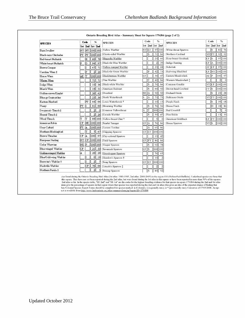
The Bruce Trail Conservancy Cheltenham Badlands Background Information
Updated October 2012