mineral resources of the badlands wilderness study area ... · the badlands wilderness study area...
TRANSCRIPT
Mineral Resources of the Badlands Wilderness Study Area and the Badlands Wilderness Study Area Additions, Crook and Peschutes Counties,
:on
U.S. GEOLOGICAL SURVEY BULLETIN 1 744-B
AVAILABILITY OF BOOKS AND MAPS OF THE U.S. GEOLOGICAL SURVEY
Instructions on ordering publications of the U.S. Geological Survey, along with prices of the last offerings, are given in the cur rent-year issues of the monthly catalog "New Publications of the U.S. Geological Survey." Prices of available U.S. Geological Sur vey publications released prior to the current year are listed in the most recent annual "Price and Availability List" Publications that are listed in various U.S. Geological Survey catalogs (see back inside cover) but not listed in the most recent annual "Price and Availability List" are no longer available.
Prices of reports released to the open files are given in the listing "U.S. Geological Survey Open-File Reports," updated month ly, which is for sale in microfiche from the U.S. Geological Survey, Books and Open-File Reports Section, Federal Center, Box 25425, Denver, CO 80225. Reports released through the NTIS may be obtained by writing to the National Technical Information Service, U.S. Department of Commerce, Springfield, VA 22161; please include NTIS report number with inquiry.
Order U.S. Geological Survey publications by mail or over the counter from the offices given below.
BY MAIL
Books
Professional Papers, Bulletins, Water-Supply Papers, Techniques of Water-Resources Investigations, Circulars, publications of general in terest (such as leaflets, pamphlets, booklets), single copies of Earthquakes & Volcanoes, Preliminary Determination of Epicenters, and some mis cellaneous reports, including some of the foregoing series that have gone out of print at the Superintendent of Documents, are obtainable by mail from
U.S. Geological Survey, Books and Open-File ReportsFederal Center, Box 25425
Denver, CO 80225
Subscriptions to periodicals (Earthquakes & Volcanoes and Preliminary Determination of Epicenters) can be obtained ONLY from the
Superintendent of DocumentsGovernment Printing Office
Washington, D.C. 20402
(Check or money order must be payable to Superintendent of Docu ments.)
Maps
For maps, address mail orders to
U.S. Geological Survey, Map DistributionFederal Center, Box 25286
Denver, CO 80225
Residents of Alaska may order maps from
Alaska Distribution Section, U.S. Geological Survey,New Federal Building - Box 12
101 Twelfth Ave., Fairbanks, AK 99701
OVER THE COUNTER
Books
Books of the U.S. Geological Survey are available over the counter at the following Geological Survey Public Inquiries Offices, all of which are authorized agents of the Superintendent of Documents:
WASHINGTON, D.C.-Main Interior Bldg., 2600 corridor, 18th and CSts..NW.
DENVER, Colorado-Federal Bldg., Rm. 169.1961 Stout St. LOS ANGELES, California-Federal Bldg.. Rm. 7638,300 N.
Los Angeles St. MENLO PARK, California-Bldg. 3 (Stop 533), Rm. 3128.
345MiddlefieldRd. RESTON, Virginia-503 National Center, Rm. 1C402,12201
Sunrise Valley Dr. SALT LAKE CITY, Utah-Federal Bldg., Rm. 8105,125
South State St. SAN FRANCISCO, California-Customhouse, Rm. 504,555
Battery St. SPOKANE, Washington-U.S. Courthouse, Rm. 678. West
920 Riverside Ave.. ANCHORAGE, Alaska-Rm. 101,4230 University Dr. ANCHORAGE, Alaska-Federal Bldg, Rm. E-146,701 C St.
MapsMaps may be purchased over the counter at the U.S. Geologi
cal Survey offices where books are sold (all addresses in above list) and at the following Geological Survey offices:
ROLLA, Missouri-1400 Independence Rd. DENVER, Colorado-Map Distribution, Bldg. 810, Federal
Center FAIRBANKS, Alaska-New Federal Bldg.. 101 Twelfth Ave.

Chapter B
Mineral Resources of the Badlands Wilderness Study Area and the Badlands Wilderness Study Area Additions, Crook and Deschutes Counties, Oregon
By JOEL R. BERGQUIST, HARLEY D. KING, RICHARD J. BLAKELY, and DON L. SAWATZKY U.S. Geological Survey
JERRY E. OLSON U.S. Bureau of Mines
U.S. GEOLOGICAL SURVEY BULLETIN 1744
MINERAL RESOURCES OF WILDERNESS STUDY AREAS: CENTRAL AND FAR WESTERN OREGON
U.S. DEPARTMENT OF THE INTERIOR
MANUEL LUJAN, JR., Secretary
U.S. GEOLOGICAL SURVEY
Dallas L. Peck, Director
Any use of trade, product, or firm namesin this publication is for descriptive purposes onlyand does not imply endorsement by the U.S. Government
UNITED STATES GOVERNMENT PRINTING OFFICE, WASHINGTON : 1990
For sale by theBooks and Open-File Reports SectionU.S. Geological SurveyFederal Center, Box 25425Denver, CO 80225
Library of Congress Cataloging-in-Publication Data
Mineral resources of the Badlands Wilderness Study Area and the BadlandsWilderness Study Area additions, Crook and Deschutes Counties, Oregon /by Joel R. Bergquist...[et al.].
p. cm. (Mineral resources of wilderness study areas central and far western Oregon : ch. B) (U.S. Geological Survey bulletin ; 1744-B)
Includes bibliographical references.Supt. of Docs, no.: I 19.3:1744-81. Mines and mineral resources Oregon Badlands Wilderness. 2. Mines
and mineral resources Oregon Badlands Additions Wilderness. 3. Badlands Wilderness (Or.) 4. Badlands Additions Wilderness (Or.) I. Bergquist, Joel R. II. Series. III. U.S. Geological Survey bulletin : 1744-B.QE75.B9 no. 1744-B 557.3 s dc20 90-13982 [TN24.07] [553'.09795'83] CIP
STUDIES RELATED TO WILDERNESS
Bureau of Land Management Wilderness Study Areas
The Federal Land Policy and Management Act (Public Law 94-579, October 21,1976) requires the U.S. Geological Survey and the U.S. Bureau of Mines to conduct mineral surveys on certain areas to determine the mineral values, if any, that may be present. Results must be made available to the public and be submitted to the President and the Congress. This report presents the results of a mineral survey of the Badlands Wilderness Study Area (OR-005-021) and the Badlands Wilderness Study Area Additions (also OR- 005-021), Crook and Deschutes Counties, Oregon.

CONTENTS
Summary BlAbstract Bl Character and setting BlMineral resource potential and identified resources Bl
Introduction B3Location and area description B3 Previous investigations B3 Present investigations B3
Appraisal of identified resources B4 Assessment of mineral resource potential B4
Geology B4 Geochemical studies B6
Methods B6 Results B6
Geophysical studies B7Aerial gamma-ray spectroscopy B7Analysis of linear features shown on Landsat satellite imagery B7 Gravity and magnetics B7
Mineral and energy resource potential B7 References cited B9 Appendixes fill
Definition of levels of mineral resource potential and certainty ofassessment B12
Resource/reserve classification B13 Geologic time chart B14
FIGURES
1. Index map showing location of Badlands and Badlands Additions Wilderness Study Areas, Crook and Deschutes Counties, Oregon B2
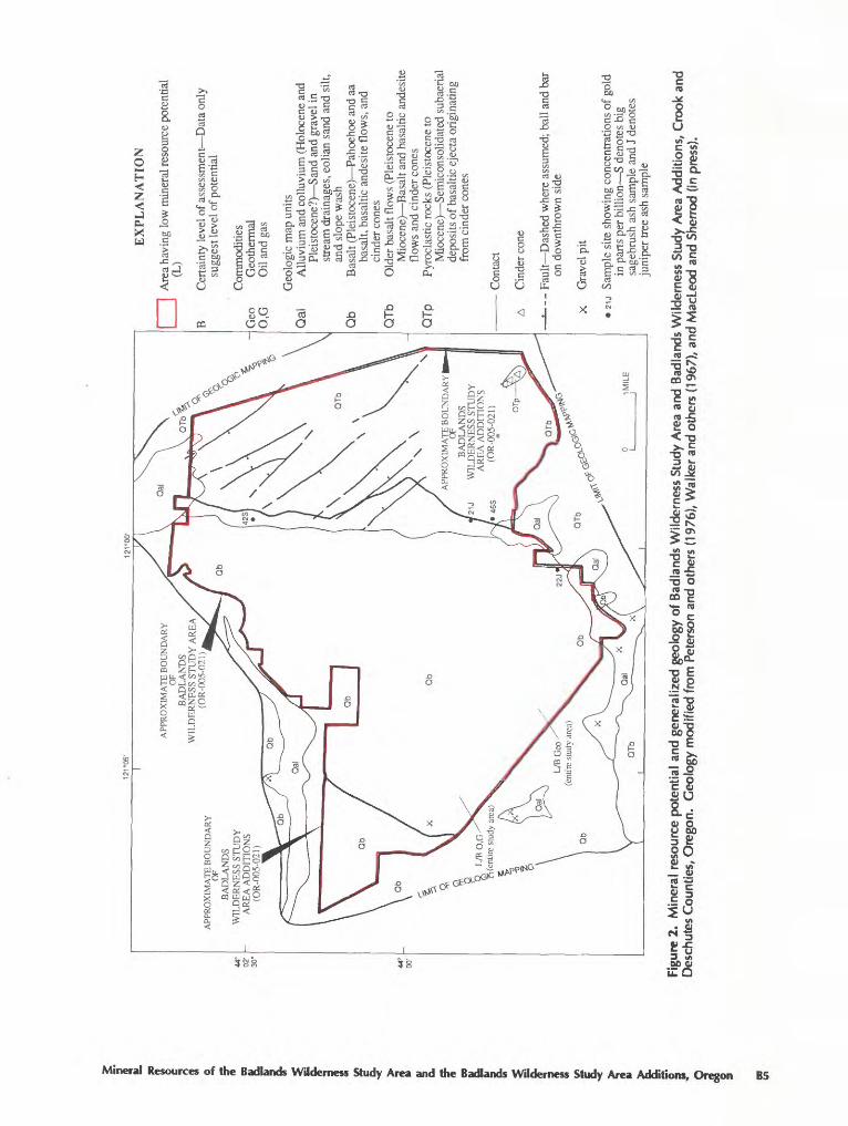
2. Map showing mineral resource potential and generalized geology of Badlands and Badlands Additions Wilderness Study Areas, Crook and Deschutes Counties, Oregon B5
3. Aeromagnetic map of the region including Badlands and Badlands Additions Wilderness Study Areas, Crook and Deschutes Counties, Oregon B8
Contents

Mineral Resources of the Badlands Wilderness Study Area and the Badlands Wilderness Study Area Additions, Crook and Deschutes Counties,Oregon
By Joel R. Bergquist, Harley D. King, Richard J. Blakely, and Don L Sawatzky U.S. Geological Survey
Jerry E. OlsonU.S. Bureau of Mines
SUMMARY
Abstract
At the request of the Bureau of Land Management, 20,727 acres of the Badlands Wilderness Study Area and 11,303 acres of the Badlands Wilderness Study Area Additions (OR-005- 021) in Crook and Deschutes Counties, central Oregon, were evaluated for identified mineral resources (known) and mineral resource potential (undiscovered). The original study area and the subsequent additions are considered together in this report. Throughout this report, "study area" refers to the entire 32,030 acres for which a mineral survey was requested. Fieldwork for this report was carried out in 1986-88. There are no identified resources in the study area, and no areas of mineralized or altered rock were found. Sand and gravel occur in the study area, but other sources are closer to existing markets. Basalt is abundant in the study area and has a number of uses. However, basalt is widespread in the region and the basalt found in the study area has no characteristics that make it more useful than basalt found elsewhere. There is a low potential for geothermal resources and for oil and gas in the study area.
center of Oregon. The study area is located in the northern part of the High Lava Plains physiographic province in an area of basaltic lava flows that cover the nose of the Blue Mountains anticlinorium, which extends northeast The High Lava Plains province extends generally west, south, and southeast of the study area and consists of relatively undeformed lava flows, playas, lava buttes, and scattered cinder cones. Topographic relief in the province is gener ally moderate. Most of the tributary streams are seasonal and most of the drainages are interior. Most of the region consists of lava-capped rolling hills with abundant blocky or platy outcrops of basalt flows. A number of the interior basins contain ephemeral lakes Malheur and Harney Lakes are good examples. Two notable volcanic features in the region are the scenic Newberry Crater caldera 20 mi south west of the study area and the large number of lava tubes many of which are found in the northern part of the study area in an area known as the Badlands.
Climate in this high desert area is arid to semiarid. Vegetation consists mostly of juniper trees, sagebrush, bit- terbrush, rabbit brush, and bunchgrass.
Character and Setting
The Badlands Wilderness Study Area is about 9 mi southeast of Bend (fig. 1) and lies close to the geographic
Manuscript approved for publication, August 27, 1990.
Mineral Resource Potential and Identified Resources
Geological, geochemical, and geophysical studies re vealed no evidence of altered or mineralized rock or anomalies that would indicate the presence of undiscovered mineral deposits. The study area has low potential for geo thermal, oil, and gas resources.
Mineral Resources of the Badlands Wilderness Study Area and the Badlands Wilderness Study Area Additions, Oregon B1
121° 15' 121° 00'
APPROXIMATE BOUNDARYOF
| BADLANDS Alfalfa I WILDERNESS STUDY
AREA ADDITIONS (OR-005-021)
APPROXIMATE BOUNDARYOF
BADLANDSWILDERNESS STUDY AREA ADDITIONS
(OR-005-021)
L ^"^ CROOK CODESCHUTES CO
APPROXIMATE BOUNDARYOF
BADLANDSWILDERNESS STUDY AREA
(OR-005-021)
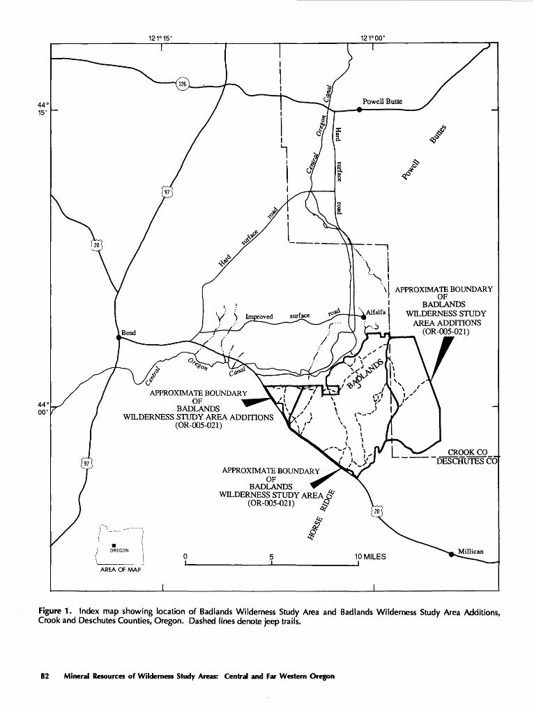
Figure 1. Index map showing location of Badlands Wilderness Study Area and Badlands Wilderness Study Area Additions, Crook and Deschutes Counties, Oregon. Dashed lines denote jeep trails.
B2 Mineral Resources of Wilderness Study Areas: Central and Far Western Oregon
There are no identified resources in the Badlands Wilderness Study Area or Badlands Wilderness Study Area Additions (herein, Badlands Additions).
INTRODUCTION
This mineral evaluation was requested by the U.S. Bureau of Land Management and is the result of a coopera tive effort by the U.S. Geological Survey and the U.S. Bu reau of Mines. An introduction to the wilderness review process, mineral survey methods, and agency responsibili ties was provided by Beikman and others (1983). The U.S. Bureau of Mines evaluates identified resources at individual mines and known mineralized areas by collecting data on current and past mining activities and through field exami nation of mines, prospects, claims, and mineralized areas. Identified resources are classified according to the system described by the U.S. Bureau of Mines and the U.S. Geo logical Survey (1980). Studies by the U.S. Geological Sur vey are designed to provide a reasonable scientific basis for assessing the potential for undiscovered mineral resources by determining geologic units and structures, possible envi ronments of mineral deposition, presence of geochemical and geophysical anomalies, and applicable ore-deposit models. Mineral assessment methodology and terminology as they apply to these surveys were discussed by Goudarzi (1984). See the "Appendixes" for definitions of levels of mineral resource potential and certainty of assessment and for the resource/reserve classification.
Location and Area Description
The Badlands Wilderness Study Area consists of 20,727 acres, and the Badlands Additions consist of another 11,303 acres, for a combined area of 32,030 acres, or about 50 mi2. Most of the study area is in the eastern part of Deschutes County and approximately one-fourth is in western Crook County. Relief in the study area is relatively low, with elevations ranging from 3,360 ft in the northern part to about 3,900 ft at the top of a group of three small cinder cones in the southeastern part. The Badlands, in the northern part of the study area, is characterized by extremely rugged topogra phy, although relief is only on the order of 100 ft
The study area is underlain mostly by Miocene (see "Appendixes" for geologic time chart) and younger basalt flows that are largely overlain by a discontinuous, thin ve neer of sand and silt. Lava flow features such as pressure ridges, pressure domes (tumuli), lava tubes, and collapse features are common in the study area. Northwest-trending small-displacement normal faults cut the older basalt flows in the eastern part of the study area but do not extend into the younger basalt flows that cover the western two-thirds of the
study area. There are no mines or prospects in the study area, and no areas of altered or mineralized rock were identified.
Stream drainages are poorly developed in the study area, though a few seasonal streams drain the southern part. The Central Oregon Canal (fig. 1) runs along part of the northwest boundary of the study area and supplies water to irrigate nearby farms.
Access to the study area is provided by a network of unpaved roads that lead from Oregon Highway 20, which extends southeast from Bend (fig. 1). Graded roads around the perimeter of the study area are well maintained and can be used by 2-wheel-drive vehicles. The interior jeep roads are not as good, and 4-wheel-drive vehicles are required on many of them. The roads in and around the study area are generally open year-round.
Previous Investigations
Most geologic investigations of the study area have been conducted as part of regional reconnaissance mapping (Williams, 1957; Walker and others, 1967; Swanson, 1969; Peterson and others, 1976; MacLeod and Sherrod, in press). More detailed studies mention the volcanic features, geo- thermal resources, and tectonics (Lowry, 1940; Greeley, 1971; Brown and others, 1980; Hawkins and others, 1989). MacLeod and others (1982) mapped the southwestern part of the study area at a scale of 1:62,500 for their study of Newberry volcano. Peterson and others (1976) discussed the identified resources and resource potential of slab lava throughout Deschutes County (including the Badlands area), and Olson (1987,1989) discussed more fully the identified resources of the Badlands and Badlands Wilderness Study Area Additions in particular. The U.S. Bureau of Land Management (1983, 1985) published reports that contain information on their mineral-resource investigations of the study area.
Present Investigations
Fieldwork by the U.S. Geological Survey during the 1986, 1988, and 1989 field seasons included geochemical sampling and checking of existing geologic maps. Geo physical data were obtained from several sources and inter preted to help evaluate mineral resource potential of the study area. Geochemical samples of rocks, stream sedi ments, and plants were obtained from the study area and analyzed in U.S. Geological Survey laboratories. The ana lytical results are from H.D. King, U.S. Geological Survey, Denver, Colo. (written commun., 1990).
The mineral investigation by the U.S. Bureau of Mines included collection of information related to current and past mining activity in the region. A library search was
Mineral Resources of the Badlands Wilderness Study Area and the Badlands Wilderness Study Area Additions, Oregon B3

made for information on mines and prospects located in and near the study area. This search included checking U.S. Bureau of Land Management mining claim recordation indices, the Crook and Deschutes Counties mining claim records, and the U.S. Bureau of Mines Mineral Industry Location System (MILS). U.S. Bureau of Land Management land status and land use records as well as U.S. Bureau of Mines files and production records were also examined.
Because no mines, prospects, or claims were identified by the U.S. Bureau of Mines in the pre-field studies, field- work in the spring of 1986 consisted of a general reconnais sance of the area for sites possibly overlooked in the mining records and literature. Sand and gravel occurrences were identified in the study area, though no resources or mineral ized sites were found, and few samples were collected.
APPRAISAL OF IDENTIFIED RESOURCES
By Jerry E. Olson U.S. Bureau of Mines
No mineral resources were found within or adjacent to the study area. Sand and gravel in the western and eastern parts of the study area may be suitable for local road aggregate or other purposes, but other sources have sufficient quantities for projected needs (U.S. Highway De partment, written commun., 1986). An unknown quantity of slab lava, commonly found in young lava flows in the region, has been removed intermittently on a noncommer cial basis from the study area (U.S. Bureau of Land Man agement, written commun., 1986). The quality and quan tity of stone in the study area is generally less than that required to be of commercial value.
ASSESSMENT OF MINERAL RESOURCE POTENTIAL
By Joel R. Bergquist, Harley D. King, Richard J. Blakely, and Don L. Sawatzky U.S. Geological Survey
Geology
The oldest rocks in the study area are Miocene and Pliocene basalt flows that fringe the southeast and east mar gins. Horse Ridge, a shield volcano just south of the study area (MacLeod and Sherrod, in press), yielded a potassium- argon (K-Ar) age of 7.61±0.08 Ma (million years before present) (Fiebelkom and others, 1983). Basalt lava north of
the study area yielded K-Ar ages of 8.8311.36 and 5.96±2.08 Ma (Evans and Brown, 1981).
Most of the area, however, is covered by Pleistocene basalt and basaltic andesite that was erupted from the north flank of Newberry volcano. All the lava flows in the Bad lands were probably tube fed from vents higher up on Newberry volcano, and the broad mound about 1 mi in diameter that forms the southwestern pan of the Badlands Wilderness Study Area is probably a rootless vent, the de bouching point for lava that built up a small lava fan there (N.S. MacLeod and DR. Sherrod, U.S. Geological Survey, written commun., 1990). Evidence for this origin of the mound is that the Skeleton Cave and Arnold Ice Cave lava- tube systems lead away from Newberry volcano in the di rection of the mound. The lava that forms the mound is degassed, which also supports the interpretation that it was tube fed and was not erupted from a proximal vent. Greeley's (1971, pi. 3) map, however, suggests a vent at the mound, as does the map by Peterson and others (1976). If the mound were a small shield volcano, there should be a magnetic anomaly centered over it In fact the broad mag netic anomaly shown in figure 3 is centered about 2.5 mi southeast of the mound, and the magnetic contours strike across the mound with no deflection. This evidence supports the idea of the mound as a rootless vent rather than a shield volcano (D.R. Sherrod, written commun., 1990).
The Pleistocene lava flows of the study area com monly have youthful flow features such as tumuli, pressure ridges, ropy surface texture, lava tubes, and collapse fea tures. The flows are locally blanketed by the Mazama ash bed and older windblown sand and silt The Mazama ash was erupted about 7,500 years ago (Bacon, 1983) from Mt. Mazama, a large volcano, about 85 mi southwest of the study area in Crater Lake National Park.
Unconsolidated Pleistocene and Holocene deposits of sand and lesser amounts of silt and gravel mantle large parts of the study area. At higher elevations, eolian sands predominate, but in the lower elevations, sheetwash and fluvial deposits are more prevalent
In the southeastern part of the study area, three rela tively small basaltic cinder cones, as high as 150 ft, are aligned in a northwest direction (fig. 2). The cones consist of scoriaceous basaltic cinders, are rounded from erosion, and are mantled with reddish, cindery soil.
The study area is broken by a series of subparallel, northwest-trending normal faults of the Brothers fault zone (Lawrence, 1976). In the southern and eastern parts of Oregon, hot-spring gold mineralization is associated with similar northwest-trending fault zones (Rytuba, 1989). The faults are well developed in the eastern part of the study area (the Badlands Additions) but are not evident in the Badlands proper, which includes most of the study area west of long 121°. This distribution indicates that the fault ing largely predates the youngest flows that formed the Badlands area. Within the study area, vertical offsets along
B4 Mineral Resources of Wilderness Study Areas: Central and Far Western Oregon
2: [A
PPR
OX
IMA
TE
BO
UN
DA
RY
OF
BA
DLA
ND
SW
ILD
ER
NE
SS S
TU
DY
AR
EA
(OR
-005
-021
)A
PPR
OX
IMA
TE
BO
UN
DA
RY
OF
BA
DLA
ND
SW
ILD
ER
NE
SS S
TU
DY
AR
EA
AD
DIT
ION
S(O
R-0
05-0
21)
APP
RO
XIM
AT
E B
OU
ND
AR
Y
BA
DLA
ND
SW
ILD
ER
NE
SS S
TUD
YA
RE
A A
DD
ITIO
NS
(OR
-005
-021
)L
/BO
.G(e
ntire
stu
dy a
rea)
\
EX
PL
AN
AT
ION
nA
rea
havi
ng lo
w m
iner
al re
sour
ce p
oten
tial
(L)
B
Cer
tain
ty l
evel
of a
sses
smen
t Dat
a on
ly
sugg
est l
evel
of p
oten
tial
Com
mod
ities
G
eo
Geo
ther
mal
O
,G
Oil
and
gas
Geo
logi
c m
ap u
nits
Allu
vium
and
col
luvi
um (
Hol
ocen
e an
dP
leis
toce
ne?)
San
d an
d gr
avel
inst
ream
dra
inag
es, e
olia
n sa
nd a
nd s
ilt,
and
slop
e w
ash
Bas
alt (
Plei
stoc
ene)
Pah
oeho
e an
d aa
basa
lt, b
asal
tic a
ndes
ite fl
ows,
and
cind
er c
ones
O
lder
bas
alt f
low
s (P
leis
toce
ne to
Mio
cene
) B
asal
t and
bas
altic
and
esite
flow
s an
d ci
nder
con
es
Pyro
clas
tic r
ocks
(Pl
eist
ocen
e to
Mio
cene
) Se
mic
onso
lidat
ed s
ubae
rial
depo
sits
of b
asal
tic e
ject
a or
igin
atin
gfr
om c
inde
r con
es
Con
tact
Cin
der c
one
«- -
- F
ault
Das
hed
whe
re a
ssum
ed;
ball
and
bar
on d
ownt
hrow
n si
de
X
Gra
vel p
it
2U
Sa
mpl
e si
te s
how
ing
conc
entr
atio
ns o
f gol
d in
par
ts p
er b
illi
on S
den
otes
big
sa
gebr
ush
ash
sam
ple
and
J de
note
s ju
nipe
r tre
e as
h sa
mpl
e
Figu
re 2
. M
iner
al r
esou
rce
pote
ntia
l an
d ge
nera
lized
geo
logy
of
Bad
land
s W
ilder
ness
Stu
dy A
rea
and
Bad
land
s W
ilder
ness
Stu
dy A
rea
Add
ition
s, C
rook
and
D
esch
utes
Cou
ntie
s, O
rego
n.
Geo
logy
mod
ified
from
Pet
erso
n an
d ot
hers
(19
76),
Wal
ker
and
othe
rs (
1967
), an
d M
acLe
od a
nd S
herr
od (
in p
ress
).
the faults are generally measured in tens of feet or less in the Pleistocene lava flows, whereas on Horse Ridge, less than 2 mi south of the study area, vertical offsets are as much as 200 ft on faults in Miocene and Pliocene flows.
Geochemical Studies
Methods
A reconnaissance geochemical survey was conducted in the study area during the summers of 1986, 1988, and 1989. Rock and vegetation samples were used as sample media in this survey. Stream-sediment and heavy-mineral concentrate sampling was not done because very few stream drainages in the study area contain suitable sediment. Geo chemical samples were collected from 126 sites and include 60 samples of rock, 64 of big sagebrush (Artemesia tridentata Nutt), 45 of western juniper (Juniperus occidentalism and 3 of rabbit brush (Chrysothamnus sp.). One soil sample was collected from each of the eight big sagebrush sample sites to aid in evaluating analytical data from the vegetation samples of big sagebrush. All except one of the 60 rock samples were from sites where no other samples were taken. The juniper samples were taken from sites where either big sagebrush or rabbit brush samples were collected. The vegetation samples were taken chiefly in the east half of the study area, where much of the ground surface consists of unconsolidated clastic deposits, largely eolian (windblown) sand of undetermined source. These samples were taken to test for mineralized rock underlying the surficial deposits. The basalt flows, pyroclastic rocks, and cinder cones were examined in the field, but no indica tions of alteration or mineralization were found. The 60 rock samples were taken from outcrops, faults, and cinder cones to supplement field examinations and to provide in formation on possible concealed mineralized rock.
Samples of big sagebrush and rabbit brush were col lected by clipping new growth, including stems, from three to six healthy plants within an area about 30 ft in diameter. The sampled plants were typically about 3 ft tall but ranged from 1.5 to 6 ft tall. For juniper samples, stems with at tached leaves were clipped from several sides of two adja cent juniper trees. To maintain uniformity of samples, stems greater than about one-eighth inch diameter were excluded. Samples were taken from juniper trees with trunk diameters ranging from about 1 to 4 ft and averaging about 2 ft
Plant samples were washed in tap water, dried in an oven at 40 °C and then pulverized in a Wiley mill. Splits of the dry, pulverized plant material were ashed in a muffle furnace during a 24-hour period with a maximum tempera ture of 450 °C. The rock samples were crushed and pulver ized to 0.15 mm using ceramic plates. The soil samples were sieved with an 80-mesh (0.18 mm) stainless steel sieve and the minus-80-mesh fraction was used for analysis.
All plant ash samples were analyzed for 40 elements by inductively coupled plasma-atomic emission spectrom- etry (ICP-AES) (Lichte and others, 1987). The plant-ash samples were also analyzed by another ICP-AES method (Motooka, 1988) for arsenic, gold, silver, bismuth, cadmium, copper, molybdenum, lead, zinc, and antimony to obtain lower limits of determination. Gold was also analyzed in the plant ash samples by flameless atomic-absorption spec- trophotometry with graphite-furnace atomizer, using a slightly modified version of the method described in O'Leary and Meier (1986). This method provided a lower limit of determination of 0.001 ppm (parts per million) gold.
The rock and soil samples were analyzed by a semi- quantitative, direct-current arc emission spectrographic method (Grimes and Marranzino, 1968). Rocks collected during the early part of the study were analyzed for 31 elements; rocks and the soils collected later were analyzed for those and an additional four elements. The rock and soil samples also were analyzed by ICP-AES for antimony, arsenic, bismuth, cadmium, and zinc; and by atomic ab sorption for gold and mercury using methods described by Crock and others (1987).
Results
Anomalous concentrations of elements were deter mined by visual inspection of the raw data. Histograms and map plots of gold in vegetation samples also were examined. In evaluating data for big sagebrush, the baseline concentra tions the expected or central 95 percent range of the con centration data given by Gough and Erdman (1983) for big sagebrush from the Western United States were consulted. A study using big sagebrush in the Gold Run mining district, near Winnemucca, Nevada (Erdman and others, 1988) was consulted in evaluating the data from plant samples from the study area. The data for this study were compared with those from a study of seasonal variation of element contents of vegetation ash from ponderosa pine and white fir taken from the Quartz Mountain, Oregon, hot-spring type dis seminated gold deposit (Ashton and Riese, 1989).
Four samples of plant ash contain anomalous concen trations of gold. Two big sagebrush ash samples taken from adjacent sites in a wide area of unconsolidated valley fill in the south-central part of the study area (fig. 2) con tain gold concentrations of 46 and 42 ppb (parts per bil lion). Examination of histograms of geochemical data from the study area suggests that these values are anomalous. The highest anomalous concentrations of gold were found in western juniper ash samples taken 0.5 mi north of a big sagebrush sample site that contains 31 ppb gold (21 ppb in juniper), and about 1 mi southwest of a big sagebrush sample site that contains 31 ppb gold (22 ppb in juniper). Another anomalous gold concentration of 26 ppb was detected in a
B6 Mineral Resources of Wilderness Study Areas: Central and Far Western Oregon
big sagebrush sample collected near Dry River in the north- central part of the study area (fig. 2).
No other elements, including those typically found in association with gold such as arsenic and antimony, were found in anomalous concentrations in any plant sample. The anomalous gold values in plant samples from the study area are considered weak and do not necessarily indicate gold mineralization at or near the surface. The gold values may be the result of leakage upward along fractures or faults and may be derived from mineralized rock at some unknown depth. Alternatively, the anomalous values may come from fine-grained placer gold washed down Dry River during Pleistocene glacial periods from an undetermined upstream location, possibly from the silicic domes in the John Day Formation to the northeast The absence in veg etation samples of anomalous concentrations of elements commonly associated with gold mineralization decreases the likelihood of gold mineralization in the study area. Fur thermore, no anomalous concentrations of gold or associ ated elements were found in any of the rock or soil samples from the study area. There is not enough evidence of gold mineralization to indicate even low potential.
Geophysical Studies
Aerial Gamma-Ray Spectroscopy
Analysis of aerial gamma-ray spectroscopy by J.S. Duval (U.S. Geological Survey, written commun., 1985) shows that the Badlands Wilderness Study Area has overall moderate radioactivity with values of 2-3 percent potas sium (K), 2.5 to 4 ppm equivalent uranium (eU), and 12 to 16 ppm equivalent thorium (eTh). The data were collected as part of the National Uranium Resource Evaluation (NURE) program, and the quadrangles covering the area that includes the study area are referenced in Bendix Field Engineering Corp. (1983). No potassium or uranium anomalies have been found in the study area or immediate vicinity. A weak thorium anomaly is present in the north ern part of the study area. Although uranium occurrences have been found in the region (Ferns and Huber, 1984), the radioactivity data for the study area are typical of the region, may be related to underlying rocks of the John Day Forma tion, and probably do not indicate any undiscovered min eral resources.
eral resource potential that could not be discerned on con ventional aerial photographs or by geologic field methods. The satellite imagery revealed that linear features are poorly expressed over the western part of the study area. A weak concentration of northeast-trending linear features lies southeast of the study area, and a local concentration of northwest-trending linear features is contiguous to the southeastern part of the study area. The northwest-trending linear features correspond to faults in the Brothers fault zone, which extends southeast from the study area. The analysis of linear features provides little new information with which to assess mineral resource potential.
Gravity and Magnetics
Regional aeromagnetic maps that include the study area (Couch and others, 1978; Connard and others, 1983) show magnetic signatures typical of young basaltic terrane. The only magnetic anomaly of note is south of the study area over Horse Ridge at about lat 43°53' N., long 121°05' W. (fig. 3). The anomaly is negative and, because of the widespread distribution of basaltic lava flows in the region, suggests that Horse Ridge has a strong reversed magnetiz ation and therefore that the lavas in this locality were erupted during a time of reversed magnetic polarity. Because this anomaly is due to reversed magnetic polarity and not to mineralization, it provides no indication of mineral resource potential.
There is a broader positive anomaly north of Horse Ridge, centered at about lat 43°57'30" N. and long 121°02'30" W. (fig. 3). The broad gradients associated with this anomaly indicate that its source may be below the surface. On regional aeromagnetic compilations, however, this anomaly appears fairly typical for central Oregon.
The study area is located along a very long, linear northeast-trending gravity anomaly that extends from the northeast corner of Oregon to central Oregon and may con tinue to the Klamath Mountains. The anomaly is probably related to pre-Cenozoic rocks of the Blue Mountains and Klamath Mountains, and was recently interpreted by Riddihough and others (1986) to reflect a pre-Tertiary con tinental margin. Although of interest from a tectonic point of view, this gravity anomaly does not indicate any particu lar favorability for mineral resources.
Analysis of Linear Features Shown on Landsat Satellite Imagery
Linear features shown in Landsat multispectral scan ner (MSS) images (scale, 1:800,000) were mapped by pho- togeologic interpretation for part of central Oregon that in cludes the study area to elucidate features bearing on min-
MINERAL AND ENERGY RESOURCE POTENTIAL
Potential for oil and gas in the wilderness study area was determined to be low by Fouch (1983) on the basis of the exploration and production history of the region, the lack of data on thermal maturation levels, and the results of drilling in Neogene strata in the region. The volcanic and volcani-
Mineral Resources of the Badlands Wilderness Study Area and the Badlands Wilderness Study Area Additions, Oregon B7

clastic sedimentary rocks exposed at the surface to the north east may project under the Pleistocene volcanic units of the study area. These sedimentary units are permissible for small deposits of hydrocarbon resources. A number of local basins elsewhere in eastern Oregon contain coaly beds or lignite (Fouch, 1983), and a number of oil shows have been found in eastern Oregon (Deacon and Benson, 1971). How ever, there is no geologic evidence of a sedimentary basin underlying the study area. As of 1984, there were three oil and gas leases encompassing 8,500 acres in the eastern part of the study area (U.S. Bureau of Land Management, 1985). Though there are no indications of oil or gas in or near the study area, and there is no evidence that the rocks in the subsurface are particularly favorable for oil and gas, local
APPROXIMATE BOUNDARY
BADLANDSWILDERNESS STUDY AREA
ADDITIONS (OR-005-021)
APPROXIMATE BOUNDARYOF
BADLANDSWILDERNESS STUDY AREA
(OR-005-021)-100
APPROXIMATE BOUNDARYOF
BADLANDSWILDERNESS STUDY AREA
ADDITIONS (OR-005-021)
Figure 3. Aeromagnetic map of the region including Bad lands Wilderness Study Area and Badlands Wilderness Study Area Additions, Crook and Oeschutes Counties, Oregon (modified from Couch and others, 1978). Residual magnetic contour interval 50 nanoteslas; flight elevation 9,000 ft. Ha- chures indicte area of closed low.
occurrences of oil and gas are present elsewhere in the region and the terrane underlying the study area may be permissible for small deposits of oil or gas. Without additional data, the potential for oil and gas in the study area can be rated only as low, certainty level B.
The geothermal potential of the Western United States is discussed on a regional basis in Muffler (1979), which indicates no particular favorability for geothermal resources in the study area or immediate vicinity. No thermal springs or thermal wells are reported in or near the study area by Riccio (1978) or Muffler (1979). The nearest area having demonstrated geothermal resource potential is around Powell Buttes, about 7 mi north of the study area. At Powell Buttes, there is potential for 100 °C (212 °F) temperatures at depths of approximately 3,300 feet (Brown and others, 1980). The location of geologically recent (late Tertiary to Quaternary) volcanic centers and cones in the region to gether with the geothermal resource potential at Powell Buttes indicate a regional permissibility for geothermal re sources. However, the lack of evidence for geothermal resources in the study area and surrounding proximal areas indicates only low potential for geothermal resources, cer tainty level B.
Evidence of alteration or mineralization that might indicate potential for metallic resources was not found in the study area. Analysis of plant samples revealed a few locali ties with weakly anomalous gold concentrations of as much as 46 parts per billion (ppb). Because the gold anomalies are weak relative to background levels, they probably do not indicate gold mineralization at or near the surface. These anomalous gold concentrations may result from migration of gold upward from more mineralized rock along faults firom unknown depths, or from fine-grained placer gold transported firom outside the study area. Areas of gold mineralization typically have anomalous concentrations of other associated elements. No such anomalous concentrations of pathfinder or associated elements were found in any samples from the study area, and this greatly decreases the likelihood of gold mineralization. Field examinations, sample analyses, and evaluation of geophysical data revealed no indications of any alteration or mineralization, and there are no data that would indicate potential for gold or other metallic mineral resources in or near the study area.
Slab lava is found in the study area and can be used for facing or building stone. An unknown quantity of this material has been removed at random firom the Badlands Additions, but most of the basalt in the study area is not of commercial grade (Olson, 1989). Peterson and others (1976) report that only the top few feet of the Badlands lavas are jointed in such a way that they break into usable slab stone and that these lavas are of marginal quality for crushed stone because of vesicularity, the lack of closely spaced jointing, and limited local supply. Furthermore, basalt is exceedingly abundant and accessible in the region. Basalt has a number of commercial uses other than as building
B8 Mineral Resources of Wilderness Study Areas: Central and Far Western Oregon

stone; it also can be used as a source of mineral fiber. Though the basalt in the study area has an oxide content that makes it suitable for the manufacture of mineral fiber (Olson, 1989), similar basalt is widespread in the region; there are no characteristics that differentiate the basalt found in the study area to make it more desirable than other basalt in the region.
Sand and gravel are abundant in the study area, but other sources are closer to existing markets. The sand and gravel in the study area have no characteristics that would make them preferable to that from other known sources in the region.
REFERENCES CITED
Ashton, L.W., and Riese, W.C., 1989, Seasonal variation of gold and arsenic in biogeochemical samples from a disseminated gold deposit in the Northern Cordillera: Journal of Geo- chemical Exploration, v. 31, no. 2, p. 171-184.
Bacon, C.R., 1983, Eruptive history of Mount Mazama and Crater Lake caldera, Cascade Range, U.S.A.: Journal of Volcanol- ogy and Geothermal Research, v. 18, p. 57-115.
Beikman, H.M., Hinkle, M.E., Frieders, Twila, Marcus, S.M., and Edward, J.R., 1983, Mineral surveys by the Geological Sur vey and the Bureau of Mines of Bureau of Land Management Wilderness Study Areas: U.S. Geological Survey Circular 901,28 p.
Bendix Field Engineering Corp., 1983, Index of Open-File Re ports from the Department of Energy, Grand Junction Area Office: U.S. Department of Energy Preliminary Map PM- 35.
Brown, D.E., Black, G.L., and McLean, G.D., 1980, Preliminary geology and geothermal resources of the Powell Buttes area, Oregon: Oregon Department of Geology and Mineral Indus tries Open-File Report 0-80-8,117 p., map scale 1:62,500.
Connard, G., Couch, R.W., and Gemperle, N., 1983, Analysis of aeromagnetic measurements from the Cascade Range in cen tral Oregon: Geophysics, v. 48, no. 3, p. 376-390.
Couch, R.W., Gemperle, N., and Connard, G., 1978, Total field aeromagnetic anomaly map, Cascade Mountain Range, cen tral Oregon: Oregon Department of Geology and Mineral Industries Geological Map Series, GMS-9, scale 1:125,000.
Crock, J.G., Griggs, P.H., Jackson, L.L., and Lichte, F.E., 1987, Analytical methods for the analysis of stream sediments and rocks from wilderness study areas: U.S. Geological Survey Open-File Report 87-84,35 p.
Deacon, R.J., and Benson, G.T., 1971, Oil and gas potential of eastern Oregon and Washington and Snake River basin of Western Idaho, in Cram, I.H., ed., Future Petroleum Prov inces of the United States Their Geology and Potential: American Association of Petroleum Geologists Memoir 15, v. 1, p. 355-359.
Erdman, J.A., Cookro, T.M., O'Leary, R.M., and Harms, T.F^, 1988, Gold and other metals in big sagebrush (Artemisia tri- dentata Nutt) as an exploration tool, Gold Run district, Hum- boldt County, Nevada: Journal of Geochemical Exploration, v. 30, no. 3, p. 287-308.
Evans, S.H., and Brown, F.H., 1981, Summary of potassium/ar gon dating 1981: Department of Energy Division of Geo thermal Energy ID-12079-45,29 p.
Ferns, M.L., and Huber, D.F., 1984, Mineral resources map of Oregon: Oregon Department of Geology and Mineral Indus tries Geological Map Series GMS-36, scale 1:500,000.
Fiebelkorn, R.B., Walker, G.W., MacLeod, N.S., McKee, E.H., and Smith, J.G., 1983, Index to K-Ar age determinations for the state of Oregon: Isochron/West, no. 37, p. 3-60.
Fouch, T.D., 1983, Petroleum potential of wilderness lands in Oregon, in Petroleum potential of wilderness lands in the western United States: U.S. Geological Survey Circular 902- J.p.Jl-JS.
Goudarzi, G.H., 1984, Guide to preparation of mineral survey reports on public lands: U.S. Geological Survey Open-File Report 84-787, 51 p.
Gough, L.P., and Erdman, J.A., 1983, Baseline elemental concen trations for big sagebrush from western U.S.A.: Journal of Range Management, v. 36, no. 6, p. 718-722.
Greeley, Ronald, 1971, Geology of selected lava tubes in the Bend area, Oregon: Oregon Department of Geology and Mineral Industries Bulletin 71,47 p.
Grimes, D.J., and Marranzino, A.P., 1968, Direct-current arc and alternating-current spark emission spectrographic field meth ods for the semiquantitative analysis of geologic materials: U.S. Geological Survey Circular 591, 6 p.
Hawkins, F.F., LaForge, R.C., and Gilbert, J.D., 1989, Seismotectonic study for Wickiup and Crane Prairie dams, Deschutes Project, Oregon: U.S. Bureau of Reclamation, Denver, Seismotectonic Report 89-2,38 p.
Lawrence, R.D., 1976, Strike-slip faulting terminates the Basin and Range province in Oregon: Geological Society of America Bulletin, v. 87, p. 846-850.
Lichte, F.E., Golightly, D.W., and Lamothe, P.J., 1987, Induc tively coupled plasma-atomic emission spectrometry, in Baedecker, P.A., ed., Methods for geochemical analysis: U.S. Geological Survey Bulletin 1770, p. B1-B10.
Lowry, W.D., 1940, The geology of the Bear Creek area, Crook and Deschutes Counties, Oregon: Oregon State College, Corvallis, Masters Thesis, 78 p.
MacLeod, N.S., and Sherrod, D.R., in press, Reconnaissance geo logic map of the west half of the Crescent 1° x 2° sheet, Deschutes, Klamath, Lake, and Lane Counties, Oregon: U.S. Geological Survey Miscellaneous Geologic Investigations Series Map 1-2215, scale 1: 250,000.
MacLeod, N.S., Sherrod, D.R., and Chitwood, L.A., 1982, Geo logic map of Newberry volcano, Deschutes, Klamath, and Lake Counties, Oregon: U.S. Geological Survey Open-File Report 82-847, scale 1:62,500.
Motooka, J.M., 1988, An exploration geochemical technique for the determination of preconcentrated organometallic halides by ICP-AES: Applied Spectroscopy, v. 42, no. 7, p. 1293- 1296.
Muffler, L.J.P., ed., 1979, Assessment of geothermal resources of the United States 1978: U.S. Geological Survey Circular 790,163 p.
O'Leary, R.M., and Meier, A.L., 1986, Analytical methods used in geochemical exploration, 1984: U.S. Geological Survey Circular 948,48 p.
Olson, J.E., 1987, Mineral resources of the Badlands Study Area,
Mineral Resources of the Badlands Wilderness Study Area and the Badlands Wilderness Study Area Additions, Oregon B9
Deschutes and Crook Counties, Oregon: U.S. Bureau of Mines Mineral Land Assessment Open File Report MLA 36-87, 6 p.
Olson, I.E., 1989, Mineral resources of the Badlands Study Area Additions, Crook and Deschutes Counties, Oregon: U.S. Bureau of Mines Mineral Land Assessment Open File Report MLA 8-89,10 p.
Peterson, N.V., Groh, E.A., Taylor, E.M., and Stensland, D.E., 1976, Geology and mineral resources of Deschutes County, Oregon: Oregon Department of Geology and Mineral Indus tries Bulletin 89,66 p., map scale 1:192,308.
Riccio, J.F., 1978, Preliminary geothermal resource map of Or egon: Oregon State Department of Geology and Mineral Resources, Geological Map Series map, GMS-11, scale 1:500,000.
Riddihough, Robin, Finn, Carol, and Couch, Richard, 1986, Kla- math-Blue Mountain lineament, Oregon: Geology, v. 14, no. 6, p. 528-531.
Rytuba, J.J., 1989, Volcanism, extensional tectonics, and epither- mal mineralization in the northern Basin and Range province, California, Nevada, Oregon, and Idaho, in Schindler, K.S., ed., USGS research on mineral resources program and ab stracts Fifth Annual V.E. McKelvey Forum on Mineral and Energy Resources: U.S. Geological Survey Circular 1035, p. 59-61.
Swanson, D.A., 1969, Reconnaissance geologic map of the east half of the Bend Quadrangle, Crook, Wheeler, Jefferson, Wasco, and Deschutes Counties, Oregon: U. S. Geological
Survey Miscellaneous Geologic Investigations Map 1-568, scale 1:250:000.
U.S. Bureau of Land Management, 1983, Badlands GEM Resource Area (OR-5-21), Deschutes and Crook Counties, Oregon: U.S. Bureau of Land Management, Oregon State Office, unpub. report, lip. [available from U.S. Bureau of Land Management, Oregon State Office, 825 NE Multnomah, Portland, OR 97208]
U.S. Bureau of Land Management, 1985, Badlands Wilderness Study Area (OR-5-21), in Draft Oregon Wilderness Environ mental Impact Statement: U.S. Bureau of Land Manage ment, Oregon State Office, v. 2, p. 247-264. [available from U.S. Bureau of Land Management, Oregon State Office, 825 NE Multnomah, Portland, OR 97208]
U.S. Bureau of Mines and U.S. Geological Survey, 1980, Prin ciples of a resource/reserve classification for minerals: U.S. Geological Survey Circular 831, 5 p.
Walker, G.W., Peterson, N.V., and Greene, R.C., 1967, Reconnais sance geologic map of the east half of the Crescent quadrangle, Lake, Deschutes, and Crook Counties, Oregon: U.S. Geological Survey Miscellaneous Geologic Investigations Map 1-493, scale 1:250,000.
Williams, Howel,1957, A geologic map of the Bend (30-minute) quadrangle, Oregon, and a reconnaissance geologic map of the central portion of the high Cascade Mountains: Oregon Department of Geology and Mineral Industries, scales 1:125,000, and 1:250,000.
BIO Mineral Resources of Wilderness Study Areas: Central and Far Western Oregon

APPENDIXES
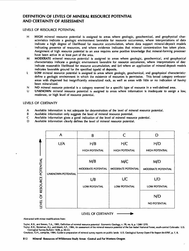
DEFINITION OF LEVELS OF MINERAL RESOURCE POTENTIAL AND CERTAINTY OF ASSESSMENT
LEVELS OF RESOURCE POTENTIAL
H HIGH mineral resource potential is assigned to areas where geologic, geochemical, and geophysical char acteristics indicate a geologic environment favorable for resource occurrence, where interpretations of data indicate a high degree of likelihood for resource accumulation, where data support mineral-deposit models indicating presence of resources, and where evidence indicates that mineral concentration has taken place. Assignment of high resource potential to an area requires some positive knowledge that mineral-forming processer have been active in at least part of the area.
M MODERATE mineral resource potential is assigned to areas where geologic, geochemical, and geophysical characteristics indicate a geologic environment favorable for resource occurrence, where interpretations of datr indicate reasonable likelihood for resource accumulation, and (or) where an application of mineral-deposit models indicates favorable ground for the specified type(s) of deposits.
L LOW mineral resource potential is assigned to areas where geologic, geochemical, and geophysical characteristic- define a geologic environment in which the existence of resources is permissive. This broad category embrace: areas with dispersed but insignificantly mineralized rock, as well as areas with little or no indication of having been mineralized.
N NO mineral resource potential is a category reserved for a specific type of resource in a well-defined area.U UNKNOWN mineral resource potential is assigned to areas where information is inadequate to assign a low,
moderate, or high level of resource potential.
LEVELS OF CERTAINTY
A Available information is not adequate for determination of the level of mineral resource potential.B Available information only suggests the level of mineral resource potential.C Available information gives a good indication of the level of mineral resource potential.D Available information clearly defines the level of mineral resource potential.
h-
LLJ
5QL
otouu
o_J uu
A
U/A
UNKNOWN POTENTIAL
B
H/B
HIGH POTENTIAL
M/B
MODERATE POTENTIAL
L/B
LOW POTENTIAL
C
H/C
HIGH POTENTIAL
M/C
MODERATE POTENTIAL
iycLOW POTENTIAL
D
H/D
HIGH POTENTIAL
M/D
MODERATE POTENTIAL
L/D
LOW POTENTIAL
N/D
NO POTENTIAL
LEVEL OF CERTAINTY
Abstracted with minor modifications from:
Taylor, R.B., and Steven, T.A., 1983, Definition of mineral resource potential: Economic Geology, v. 78, no. 6, p. 1268-1270.Taylor, R.B., Stoneman, R.J., and Marsh, S.P., 1984, An assessment of the mineral resource potential of the San Isabel National Forest, south-central Colorado: U.S.
Geological Survey Bulletin 1638, p. 40-42. Goudarzi, G.H., compiler, 1984, Guide to preparation of mineral survey reports on public lands: U.S. Geological Survey Open-File Report 84-0787, p. 7, 8.
B12 Mineral Resources of Wilderness Study Areas: Central and Far Western Oregon

RESOURCE/RESERVE CLASSIFICATION
ECONOMIC
MARGINALLY ECONOMIC
SUB-
ECONOMIC
IDENTIFIED RESOURCES
Demonstrated
Measured Indicated
i Reserves
1I
Marginal Reserves
Demonstrated Subeconomic
Resourcesi
Inferred
Inferred Reserves
Inferred Marginal Reserves
Inferred Subeconomic
Resources
UNDISCOVERED RESOURCES
Probabili
Hypothetical
ty Range
Speculative
i
i
Major elements of mineral resource classification, excluding reserve base and inferred reserve base. Modified from McKelvey, V.E., 1972, Mineral resource estimates and public policy: American Scientist, v. 60, p. 32-40; and U.S. Bureau of Mines and U.S. Geological Survey, 1980, Principles of a resource/reserve classification for minerals: U.S. Geological Survey Circular 831, p. 5.
Mineral Resources of the Badlands Wilderness Study Area and the Badlands Wilderness Study Area Additions, Oregon 613

GEOLOGIC TIME CHARTTerms and boundary ages used by the U.S. Geological Survey in this report
EON
Phanerozoic
Proterozoic
Archean
ERA
Cenozoic
Mesozoic
Paleozoic
Late Proterozoic
Middle Proterozoic
Early Proterozoic
Late Archean
Middle Archean
Early Archean
PERIOD
Quaternary
Neogene Subperiod
Tertiary PaleogeneSubperiod
Cretaceous
Jurassic
Triassic
Permian
Pennsylvania!! Carboniferous
Periods
Mississippian
Devonian
Silurian
Ordovician
Cambrian
It ar\nt\
EPOCH
Holocene
Pleistocene
Pliocene
Miocene
Oligocene
Eocene
Paleocene
Late Early
Late Middle
Early
Late Middle
Early
Late Early
Late Middle
Early
Late Early
Late Middle
Early
Late Middle
Early
Late Middle
Early
Late Middle
Early
pre-Archean2
AGE ESTIMATES OF BOUNDARIES IN
MILLION YEARS (Ma)
0.010
1.7
5
o o
55
66
96
205
M JA(\
290
~TTfl
410
"T J J
J\J\J
***J/U
JW
1600
2500
3000
JTv/v/
'Rocks older than 570 Ma also called Precambrian, a time term without specific rank. 'Informal time term without specific rank.
B14 Mineral Resources of Wilderness Study Areas: Central and Far Western Oregon
SELECTED SERIES OF U.S. GEOLOGICAL SURVEY PUBLICATIONS
PeriodicalsEarthquakes & Volcanoes (issued bimonthly). Preliminary Determination of Epicenters (issued monthly).
Technical Books and ReportsProfessional Papers are mainly comprehensive scientific reports of
wide and lasting interest and importance to professional scientists and en gineers. Included are reports on the results of resource studies and of topographic, hydrologic, and geologic investigations. They also include collections of related papers addressing different aspects of a single scien tific topic.
Bulletins contain significant data and interpretations that are of last ing scientific interest but are generally more limited in scope or geographic coverage than Professional Papers. They include the results of resource studies and of geologic and topographic investigations; as well as collections of short papers related to a specific topic.
Water-Supply Papers are comprehensive reports that present sig nificant interpretive results of hydrologic investigations of wide interest to professional geologists, hydro legists, and engineers. The series covers investigations in all phases of hydrology, including hydrogeology, availability of water, quality of water, and use of water.
Circulars present administrative information or important scientific information of wide popular interest in a format designed for distribution at no cost to the public. Information is usually of short-term interest.
Water-Resources Investigations Reports are papers of an interpre tive nature made available to the public outside the formal USGS publi cations series. Copies are reproduced on request unlike formal USGS publications, and they are also available for public inspection at depositories indicated in USGS catalogs.
Open-File Reports include unpublished manuscript reports, maps, and other material that are made available for public consultation at depositories. They are a nonpermanent form of publication that may be cited in other publications as sources of information.
Maps
Geologic Quadrangle Maps are multicolor geologic maps on topographic bases in 71/2- or 15 -minute quadrangle formats (scales main ly 1:24,000 or 1:62,500) showing bedrock, surficial, or engineering geol ogy. Maps generally include brief texts; some maps include structure and columnar sections only.
Geophysical Investigations Maps are on topographic or planimetric bases at various scales; they show results of surveys using geophysical techniques, such as gravity, magnetic, seismic, or radioactivity, which reflect subsurface structures that are of economic or geologic significance. Many maps include correlations with the geology.
Miscellaneous Investigations Series Maps are on planimetric or topographic bases of regular and irregular areas at various scales; they present a wide variety of format and subject matter. The series also in cludes 71/2-minute quadrangle photogeologic maps on planimetric bases which show geology as interpreted from aerial photographs. Series also includes maps of Mars and the Moon.
Coal Investigations Maps are geologic maps on topographic or planimetric bases at various scales showing bedrock or surficial geol ogy, stratigraphy, and structural relations in certain coal-resource areas.
Oil and Gas Investigations Charts show stratigraphic information for certain oil and gas fields and other areas having petroleum potential.
Miscellaneous Field Studies Maps are multicolor or black-and- white maps on topographic or planimetric bases on quadrangle or ir regular areas at various scales. Pre-1971 maps show bedrock geology in relation to specific mining or mineral-deposit problems; post-1971 maps are primarily black-and-white maps on various subjects such as environmental studies or wilderness mineral investigations.
Hydrologic Investigations Atlases are multicolored or black-and- white maps on topographic or planimetric bases presenting a wide range of geohydrologic data of both regular and irregular areas; principal scale is 1:24,000 and regional studies are at 1:250,000 scale or smaller.
CatalogsPermanent catalogs, as well as some others, giving comprehen
sive listings of U.S. Geological Survey publications are available under the conditions indicated below from the U.S. Geological Survey, Books and Open-File Reports Section, Federal Center, Box 25425, Denver, CO 80225. (See latest Price and Availability List)
11 Publications of the Geological Survey, 1879-1961" may be pur chased by mail and over the counter in paperback book form and as a set of microfiche.
"Publications of the Geological Survey, 1962-1970" may be pur chased by mail and over the counter in paperback book form and as a set of microfiche.
"Publications of the U.S. Geological Survey, 1971-1981" may be purchased by mail and over the counter in paperback book form (two volumes, publications listing and index) and as a set of microfiche.
Supplements for 1982,1983,1984,1985,1986, and for subsequent years since the last permanent catalog may be purchased by mail and over the counter in paperback book form.
State catalogs, "List of U.S. Geological Survey Geologic and Water-Supply Reports and Maps For (State)," may be purchased by mail and over the counter in paperback booklet form only.
"Price and Availability List of U.S. Geological Survey Publica tions," issued annually, is available free of charge in paperback book let form only.
Selected copies of a monthly catalog "New Publications of the U.S. Geological Survey" available free of charge by mail or may be obtained over the counter in paperback booklet form only. Those wishing a free subscription to the monthly catalog "New Publications of the U.S. Geological Survey" should write to the U.S. Geological Survey, 582 National Center, Reston, VA 22092.
Note. Prices of Government publications listed in older catalogs, announcements, and publications may be incorrect. Therefore, the prices charged may differ from the prices in catalogs, announcements, and publications.