chapter 9 family friendly routes - cobbcounty.org · rs&h, peq, & peds chapter 9 family...
TRANSCRIPT
Prepared by
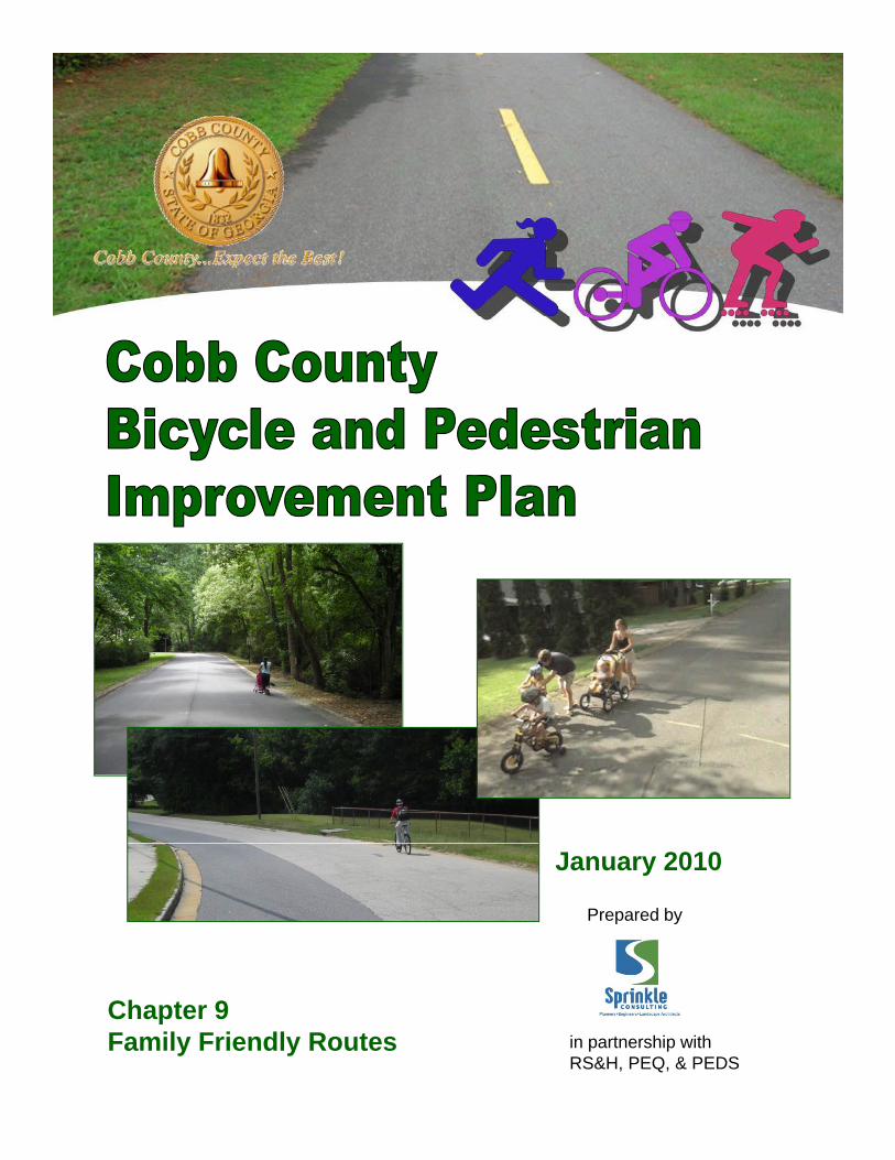
January 2010
in partnership with RS&H, PEQ, & PEDS
Chapter 9 Family Friendly Routes


9-1 T:\08\8183-08 Cobb County Bike_Ped Improvement Plan\task 4\FINALfeb10\Ch 9 Doc.doc
Table of Contents
CHAPTER 9: FAMILY FRIENDLY ROUTES
9.1 Introduction ........................................................................................................................................ 9-3 9.1.1 SELECTION OF AREAS ..................................................................................................................... 9-3 9.1.2 GENERAL APPROACH TO BICYCLING ROUTES ................................................................................... 9-4 9.1.3 PEDESTRIAN CONDITIONS ................................................................................................................ 9-5
9.2 Area A: East Marietta ......................................................................................................................... 9-6 9.2.1 SEWELL PARK TO EAST COBB MIDDLE SCHOOL ................................................................................ 9-7
Sewell Park ................................................................................................................................... 9-7 Hunting Creek Court ..................................................................................................................... 9-8 Worthington Drive ......................................................................................................................... 9-9 Lower Roswell Road ..................................................................................................................... 9-9 Pioneer Trail ................................................................................................................................ 9-10 Weatherstone Parkway ............................................................................................................... 9-12 Woodmere Drive ......................................................................................................................... 9-12 Willow Glenn Drive ...................................................................................................................... 9-14 Holt Road .................................................................................................................................... 9-15 Club Valley Drive ........................................................................................................................ 9-22
9.2.2 EAST COBB MIDDLE SCHOOL TO FULLER PARK .............................................................................. 9-22 Club Valley Drive ........................................................................................................................ 9-22 Beverly Hills Drive ....................................................................................................................... 9-22 Okawanna Drive.......................................................................................................................... 9-23 Pinestream Drive ........................................................................................................................ 9-24 Sope Creek Drive ........................................................................................................................ 9-24 Old Canton Road ........................................................................................................................ 9-25 Indian Hills Drive ......................................................................................................................... 9-26 Greenfield Drive .......................................................................................................................... 9-27 Creekwood Drive ........................................................................................................................ 9-27 Robinson Road ........................................................................................................................... 9-28 Robinson Road Park Property .................................................................................................... 9-31 Fullers and East Cobb Parks ...................................................................................................... 9-32
9.3 Area B: South Mableton .................................................................................................................. 9-32 9.3.1 WALLACE PARK TO LINDLEY MIDDLE SCHOOL ................................................................................ 9-33
Wallace Park ............................................................................................................................... 9-33 Orris Lane ................................................................................................................................... 9-36 Britt Road .................................................................................................................................... 9-36 Kenneth Lane .............................................................................................................................. 9-37 Beverly Drive ............................................................................................................................... 9-38 Boggs Road ................................................................................................................................ 9-38 Mableton Parkway ....................................................................................................................... 9-38 Hilltop Circle Extension/ Hilltop Circle ......................................................................................... 9-41 Austin Drive ................................................................................................................................. 9-42 Linda Lane .................................................................................................................................. 9-42 Dodgen Road Crossing ............................................................................................................... 9-43 Sheraton Way ............................................................................................................................. 9-43 Brookdale Lane ........................................................................................................................... 9-43

9-2 T:\08\8183-08 Cobb County Bike_Ped Improvement Plan\task 4\FINALfeb10\Ch 9 Doc.doc
Brook Way ................................................................................................................................... 9-44 Kitchens Road ............................................................................................................................. 9-45 Crossing Veterans’ Memorial Parkway ....................................................................................... 9-46
9.3.2 ROUTE TOWARDS LUCIUS B CLAY ELEMENTARY SCHOOL, LIONS PARK, AND SOUTH COBB COMMUNITY
CENTER ................................................................................................................................................. 9-47 Vera Lane .................................................................................................................................... 9-48 Burney Drive ............................................................................................................................... 9-48 Florrie Drive ................................................................................................................................. 9-49 Boggs Road ................................................................................................................................ 9-50 Milam Drive ................................................................................................................................. 9-50 Old Powder Springs Road .......................................................................................................... 9-51 Mableton Parkway ....................................................................................................................... 9-51 Old Gordon Road ........................................................................................................................ 9-52 Ridge Avenue .............................................................................................................................. 9-53 Glore Drive (south of Veterans’ Memorial Highway) ................................................................... 9-54 Cross Veterans’ Memorial Highway ............................................................................................ 9-54 Glore Drive (north of Veterans’ Memorial Highway) ................................................................... 9-55 Lions’ Club Drive ......................................................................................................................... 9-55
9.3.3 ROUTE TOWARDS THE BARTLETT PROPERTY .................................................................................. 9-56 Beverly Drive ............................................................................................................................... 9-56 Factory Shoals Drive ................................................................................................................... 9-57 Factory Shoals Road ................................................................................................................... 9-57
9.3.4 ROUTE CONNECTING TO HARMONY LELAND ELEMENTARY SCHOOL ................................................. 9-60 Dodgen Road .............................................................................................................................. 9-60 Kitchens Road ............................................................................................................................. 9-61 Park Road ................................................................................................................................... 9-61
9-3 T:\08\8183-08 Cobb County Bike_Ped Improvement Plan\task 4\FINALfeb10\Ch 9 Doc.doc
Chapter 9:
Family Friendly
Routes
9.1 INTRODUCTION
The Scope of Work for the Cobb County Bicycle and Pedestrian Improvement Plan calls for the evaluation of two specific corridors in the county with an emphasis on identifying their potential development as “Family Friendly” routes. Specifically, the Scope calls for the routes’ evaluation with respect to the following factors:
Accommodation of nonmotorized travel– The consultant will evaluate the priority corridors for their current level of accommodation of NMT. This will involve an analysis of the current Bicycle and Pedestrian LOS for the on-roadway facilities and an analogous methodology for off-roadway facilities.
Connections to existing sidewalks, routes, lanes, or trails and greenways.
Access to public lands.
Potential for on- and off-road improvements.
Potential for “Family-Friendly” improvements.
The routes descriptions found in this are intended to serve as pilot studies. The recommendations contained here, if followed by County staff, should bring about a “Family Friendly” experience for residents and visitors along these particular roadways. But the value of this report is also that the approaches applied to these two study areas can be replicated in neighborhoods throughout the county. The challenges found in these two study areas are fairly common for Cobb County. There are certainly areas where similar opportunities will present themselves after thoughtful application of the approaches demonstrated in these pilot studies. These general approaches include: identification of through connections via existing local street networks; maximizing connectivity non-motorized through publicly owned property; identification of potential easements on strategically selected private property (pending agreement of property owners) on undeveloped or large institutional parcels; and careful consideration of crossing and locations and treatments when Major thoroughfares must be crossed.
9.1.1 SELECTION OF AREAS
The consultant team reviewed a variety of sources to identify the study areas chosen for these pilot studies. The results of the Latent Demand analysis performed earlier in Task 2 were used to narrow the search to areas with high potential for biking and walking. School enrollment statistics were consulted to identify larger schools around the

9-4 T:\08\8183-08 Cobb County Bike_Ped Improvement Plan\task 4\FINALfeb10\Ch 9 Doc.doc
county. Aerial photos, street maps and parcel maps of areas identified with these methods were then visually scanned for potential connections between important community destinations, including schools, parks, activity centers, and libraries. Once connections potential connections were identified, the selected areas were approved by County staff for field investigation and final identification of potential routes. The selected areas are in east Marietta (linking Sewell Park, East Cobb Park, and other destinations) and south Mableton (linking Wallace Park and Lindley Middle School and other destinations). The consultant team conducted on-bike assessments of the study areas and made note of a variety of conditions and compared potential connecting routes. The observations from those field visits are described in the route narratives below.
9.1.2 GENERAL APPROACH TO BICYCLING ROUTES
In each area, the consultant team identified several key destinations and looked for connections between them that maximized the use of local roads. Several destinations types, including parks and schools, often sit on large parcels with frontage or connections on multiple sides; the consultants were careful to look for connection opportunities through these publicly held properties as well. All potential connections identified in this report will of course require close consolidation
with the agencies responsible for the operation of these parcels to ensure the compatibility of these connections with their safety, security, and maintenance obligations.
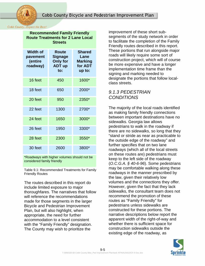
The local roads identified in the route descriptions below were all observed to have relatively low traffic volumes at the times of the field reviews – which were weekdays in the summertime. Traffic counts were not conducted as part of this study. The narrative descriptions include recommendations for enhanced treatments to the roadways if traffic volumes are found to exceed certain thresholds for specific roadway widths. These thresholds are based on the Bicycle Level of Service Model, which was also used to evaluate the County’s Major Thoroughfare network in the evaluation of existing conditions. Roadways with volume and width combinations that result in a Bicycle Level of Service grade of “A” are able to be marked as “Family Friendly” routes in their existing condition. It is recommended that roadways with traffic volumes that result in a Bicycle Level of Service grade of “B” will be augmented with SHARED LANE MARKINGS (also known as “Sharrows”) , which are described in the Design Guidelines (Chapter #6) section of this plan. (Please see Table 9.1, which illustrates the recommended family friendly route signage and marking treatments.) It is not recommended that Family Friendly Routes be designated on roadways with traffic volumes that result in a Bicycle Level of Service Grade of “C” or below unless an off-street facility, such as a sidepath trail, can be constructed there.
9-5 T:\08\8183-08 Cobb County Bike_Ped Improvement Plan\task 4\FINALfeb10\Ch 9 Doc.doc
Table 9.1: Recommended Treatments for Family Friendly Routes The routes described in this report do include limited exposure to major thoroughfares. The narratives that follow will reference the recommendations made for those segments in the larger Bicycle and Pedestrian Improvement Plan, but will also highlight, when appropriate, the need for further accommodation to a level consistent with the “Family Friendly” designation. The County may wish to prioritize the
improvement of these short sub-segments of the study network in order to facilitate the completion of the Family Friendly routes described in this report. These portions that run alongside major roads will likely require some sort of construction project, which will of course be more expensive and have a longer implementation time frame than the signing and marking needed to designate the portions that follow local-class streets.
9.1.3 PEDESTRIAN CONDITIONS The majority of the local roads identified as making family friendly connections between important destinations have no sidewalks. Georgia law allows pedestrians to walk in the roadway if there are no sidewalks, so long that they “stand or stride as near as practicable to the outside edge of the roadway” and further specifies that on two lane roadways (which all of the local streets on these routes are) pedestrians must keep to the left side of the roadway (O.C.G.A. § 40-6-96). Some pedestrians may be comfortable walking along these roadways in the manner prescribed by the law, given their relatively low volumes and the connections they offer. However, given the fact that they lack sidewalks, the consultant team does not recommend the promotion of these routes as “Family Friendly” for pedestrians unless sidewalks are constructed for these portions. The narrative descriptions below report the apparent width of the right-of-way and whether there is sufficient space for construction sidewalks outside the existing edge of the roadway, as
Recommended Family Friendly Route Treatments for 2 Lane Local
Streets
Width of pavement
(entire roadway)
Route Signage Only for ADT up
to:
Shared Lane
Marking for ADT up to:
16 feet 450 1600*
18 feet 650 2000*
20 feet 950 2350*
22 feet 1300 2700*
24 feet 1650 3000*
26 feet 1950 3300*
28 feet 2300 3550*
30 feet 2600 3800*
*Roadways with higher volumes should not be considered family friendly

9-6 T:\08\8183-08 Cobb County Bike_Ped Improvement Plan\task 4\FINALfeb10\Ch 9 Doc.doc
observed from the overlay of parcel boundaries and aerial photos on the County’s GIS website. Any possible sidewalk opportunity will need to be verified with an actual boundary survey.
9.2 AREA A: EAST
MARIETTA
Location: Generally northeast of Marietta, roughly bounded by Marietta Parkway, Roswell Road, and Clubland Parkway.
Destinations Served: East Cobb Park, Fullers Park, Sewell Park, East Marietta
Library, East Cobb Middle School, Wheeler High School. (See Figure 9.1 for areas mentioned.)
Also nearby: Activity centers along Marietta Parkway, Roswell Road, and Lower Roswell Road including East Lake Shopping Center, Pavilions at East Lake, East Marietta Shopping Center, Indian Hills Country Club, Sope Creek.
Figure 9.1: Map showing Area ‘A’
9-7 T:\08\8183-08 Cobb County Bike_Ped Improvement Plan\task 4\FINALfeb10\Ch 9 Doc.doc
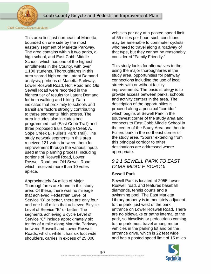
This area lies just northeast of Marietta, bounded on one side by the most easterly segment of Marietta Parkway. The area contains within it two parks, a high school, and East Cobb Middle School, which has one of the highest enrollments in the County, with over 1,100 students. Thoroughfares in this area scored high on the Latent Demand analysis; portions of Marietta Parkway, Lower Roswell Road, Holt Road and Old Sewell Road were recorded in the highest tier of results for Latent Demand for both walking and biking. Data indicates that proximity to schools and transit are factors strongly contributing to these segments’ high scores. The area includes also includes one programmed trail (East Cobb Trail) and three proposed trails (Sope Creek A, Sope Creek B, Fuller’s Park Trail). The study network segments in this area received 121 votes between them for improvement through the various inputs used in the planning process, including portions of Roswell Road, Lower Roswell Road and Old Sewell Road which received more than 10 votes apiece. Approximately 34 miles of Major Thoroughfares are found in this study area. Of these, there was no mileage that achieved Pedestrian Level of Service “B” or better, there are only four and one-half miles that achieved Bicycle Level of Service “B” or better. The segments achieving Bicycle Level of Service “C” include approximately six tenths of a mile along Marietta Parkway, between Roswell and Lower Roswell Roads, which, while it has six foot wide shoulders, carries in excess of 25,000
vehicles per day at a posted speed limit of 55 miles per hour; such conditions may be amenable to commuter cyclists who need to travel along a roadway of that type, but they cannot be reasonably considered “Family Friendly.”
This study looks for alternatives to the using the major thoroughfares in the study area, opportunities for pathway connections including the use of local streets with or without facility improvements. The basic strategy is to provide access between parks, schools and activity centers in the area. The description of the opportunities is proceed along a principal “corridor” which begins at Sewell Park in the southwest corner of the study area and connects to East Cobb Middle School in the center of the Study Area and then to Fullers park in the northeast corner of the study area. “Spurs” extending from this principal corridor to other destinations are addressed where appropriate.
9.2.1 SEWELL PARK TO EAST COBB MIDDLE SCHOOL
Sewell Park
Sewell Park is located at 2055 Lower Roswell road, and features baseball diamonds, tennis courts and a swimming pool. The East Marietta Library property is immediately adjacent to the park, just west of the park entrance on Lower Roswell Road. There are no sidewalks or paths internal to the park, so bicyclists or pedestrians coming to the park must travel among motor vehicles in the parking lot and on the entrance drive, which is 22 feet wide and has a posted speed limit of 15 miles
9-8 T:\08\8183-08 Cobb County Bike_Ped Improvement Plan\task 4\FINALfeb10\Ch 9 Doc.doc
per hour. There are currently speed tables on the park drive. These speed tables are of a design that is broad and flat across the top, and so are relatively, “bicycle friendly.” However, some users may find them problematic. The County should consider modifying them to include a “notch” for bicycle travel on both ends, perhaps in conjunction with the next resurfacing of the drive and parking lot area. A pathway could be developed on either side of the park driveway for internal circulation; the west side of the drive is generally flatter and therefore may be better suited for trail development. A desirable way to get from the park to East Cobb Middle School involves passing through the neighborhood to the northeast of the park. The Park property borders 25 parcels in this neighborhood, along Pioneer Trail and Hunting Creek Dr, but does not touch county property or right of way in this direction. Unless the county could obtain an easement for a pathway connection from one of these property owners, there is no direct connection to these neighborhood streets; a connection must be made to Pioneer Trail by first heading east along Lower Roswell Road.
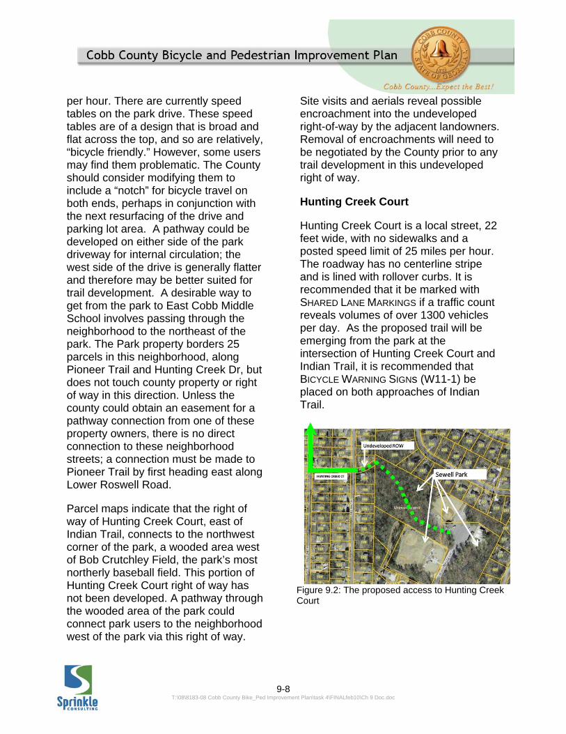
Parcel maps indicate that the right of way of Hunting Creek Court, east of Indian Trail, connects to the northwest corner of the park, a wooded area west of Bob Crutchley Field, the park’s most northerly baseball field. This portion of Hunting Creek Court right of way has not been developed. A pathway through the wooded area of the park could connect park users to the neighborhood west of the park via this right of way.
Site visits and aerials reveal possible encroachment into the undeveloped right-of-way by the adjacent landowners. Removal of encroachments will need to be negotiated by the County prior to any trail development in this undeveloped right of way.
Hunting Creek Court
Hunting Creek Court is a local street, 22 feet wide, with no sidewalks and a posted speed limit of 25 miles per hour. The roadway has no centerline stripe and is lined with rollover curbs. It is recommended that it be marked with SHARED LANE MARKINGS if a traffic count reveals volumes of over 1300 vehicles per day. As the proposed trail will be emerging from the park at the intersection of Hunting Creek Court and Indian Trail, it is recommended that BICYCLE WARNING SIGNs (W11-1) be placed on both approaches of Indian Trail.
Figure 9.2: The proposed access to Hunting Creek Court

9-9 T:\08\8183-08 Cobb County Bike_Ped Improvement Plan\task 4\FINALfeb10\Ch 9 Doc.doc
County GIS records indicate that the right of way for Hunting Creek Drive is 40 feet wide, leaving room for sidewalks to be constructed, if deemed appropriate.
The consultants observed that the seam between the gutter pan and the edge of pavement along Hunting Creek Court was not flush. This could cause some instability for some cyclists.
Worthington Drive
Worthington Drive is a local street, 22 feet wide with no sidewalks and a posted speed limit of 25 miles per hour. The roadway has no centerline stripe and is lined with rollover curbs. It is recommended that it be marked with SHARED LANE MARKINGS if a traffic count reveals volumes of over 1300 vehicles per day.
Figure 9.3: A view of pedestrians utilizing Worthington Drive County GIS records indicate that the right of way for Hunting Creek Drive is 40 feet wide, leaving room for sidewalks to be constructed, if deemed appropriate. The image shown on Figure 9.4 is taken from the Street View Feature on Google Earth at around 166
Worthington Drive—in the block just south of the segment proposed for this route. It captures a family walking in the street. The mother is pushing a baby in a stroller while the father helps two other children ride bicycles with training wheels.
The consultants observed that the seam between the gutter pan and the edge of pavement along Worthington Drive was not flush.
At the north end of Worthington Drive is the Worthington Property, a proposed future park already owned by the county. A path connection through the Worthington Property could connect to the eastern side of Marietta Parkway at a point approximately 550 feet south of the intersection with Roswell Road. There appears to be approximately 60 feet between the exit ramp from northbound Marietta Parkway to Roswell Road. Such a route would connect Sewell Park and the East Marietta Library to Roswell Road, bypassing almost one mile of travel along Lower Roswell Road and Marietta Parkway.
Figure 9.4: The proposed access through the Worthington Property
9-10 T:\08\8183-08 Cobb County Bike_Ped Improvement Plan\task 4\FINALfeb10\Ch 9 Doc.doc
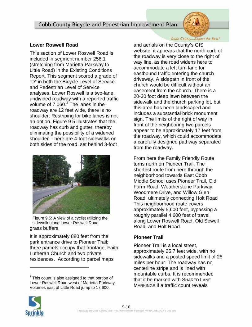
Lower Roswell Road
This section of Lower Roswell Road is included in segment number 258.1 (stretching from Marietta Parkway to Little Road) in the Existing Conditions Report. This segment scored a grade of “D” in both the Bicycle Level of Service and Pedestrian Level of Service analyses. Lower Roswell is a two-lane, undivided roadway with a reported traffic volume of 7,060.1 The lanes in the roadway are 12 feet wide, there is no shoulder. Restriping for bike lanes is not an option. Figure 9.5 illustrates that the roadway has curb and gutter, thereby eliminating the possibility of a widened shoulder. There are 4-foot sidewalks on both sides of the road, set behind 3-foot
grass buffers.
It is approximately 880 feet from the park entrance drive to Pioneer Trail; three parcels occupy that frontage, Faith Lutheran Church and two private residences. According to parcel maps
1 This count is also assigned to that portion of Lower Roswell Road west of Marietta Parkway. Volumes east of Little Road jump to 17,600,
and aerials on the County’s GIS website, it appears that the north curb of the roadway is very close to the right of way line, as the road widens here to accommodate a left turn lane for eastbound traffic entering the church driveway. A sidepath in front of the church would be difficult without an easement from the church. There is a 20-30 foot deep lawn between the sidewalk and the church parking lot, but this area has been landscaped and includes a substantial brick monument sign. The limits of the right of way in front of the neighboring two parcels appear to be approximately 17 feet from the roadway, which could accommodate a carefully designed pathway separated from the roadway.
From here the Family Friendly Route turns north on Pioneer Trail. The shortest route from here through the neighborhood towards East Cobb Middle School uses Pioneer Trail, Old Farm Road, Weatherstone Parkway, Woodmere Drive, and Willow Glen Road, ultimately connecting Holt Road This neighborhood route covers approximately 5,600 feet, bypassing a roughly parallel 4,600 feet of travel along Lower Roswell Road, Old Sewell Road, and Holt Road.
Pioneer Trail
Pioneer Trail is a local street, approximately 25.7 feet wide, with no sidewalks and a posted speed limit of 25 miles per hour. The roadway has no centerline stripe and is lined with mountable curbs. It is recommended that it be marked with SHARED LANE
MARKINGS if a traffic count reveals
Figure 9.5: A view of a cyclist utilizing the sidewalk along Lower Roswell Road

9-11 T:\08\8183-08 Cobb County Bike_Ped Improvement Plan\task 4\FINALfeb10\Ch 9 Doc.doc
volumes of over 1650 vehicles per day. As it is the first local street encountered upon turning off a major thoroughfare, it is recommended that the BICYCLE
WARNING SIGN (W11-1), supplemented with a SHARE THE ROAD plaque (W16-1), be installed facing the northbound side of Pioneer Trail, shortly after the intersection with Lower Roswell Road. There is some evidence that Pioneer Trail is being used as a bike routes, as ad hoc pavement markings, of the type used by bike clubs to mark routes, can be found at the intersection of Pioneer Trail and Lower Roswell Road.2 See Figure 9.6. The right of way for Pioneer Trail appears to be approximately 50 feet, leaving room for sidewalks to be constructed if deemed appropriate. Approximately 400 feet north of Lower Roswell Road, Pioneer Trail intersects with Old Farm Road. The recommended route proceeds by turning left onto eastbound Old Farm Road.
Old Farm Road
Old Farm road is a local street, approximately 26 feet wide, with no sidewalks and a posted speed limit of 25 miles per hour. The roadway has no
2 These markings trace a different route through this neighborhood, seemingly intended to maximize the length of the trip on local roads for recreational cyclists on training rides. Because the objective of these Family Friendly routes is more focused on providing connections between destinations, routing decisions were based on finding the shortest trips through the neighborhoods; families may well enjoy exploring other roadways within the neighborhood at their leisure.
centerline stripe and is lined with mountable curbs. It is recommended that it be marked with SHARED LANE
MARKINGS if a traffic count reveals volumes of over 1950 vehicles per day.
The roadway currently includes four speed tables between Pioneer Trail and Weatherstone Parkway. These speed tables are of a design that is broad and flat across the top, and so are relatively, “bicycle friendly.” However, some users may find them problematic. The County should consider modifying them to include a “notch” for bicycle travel on both ends, perhaps in conjunction with the next resurfacing of the roadway.
The right of way for Old Farm Road appears to be 50 feet wide on the County’s online GIS display, leaving
Figure 9.6: An example bike club route marking along Pioneer Trail

9-12 T:\08\8183-08 Cobb County Bike_Ped Improvement Plan\task 4\FINALfeb10\Ch 9 Doc.doc
room for the addition of sidewalks if deemed appropriate.
Although the pavement condition along Old Farm Drive is generally good, the consultants noted some areas of pavement buckling and cracking on the eastbound edge just east of the intersection with Pioneer Trail.
After approximately 375 feet, Old Farm Road makes a sharp 90 degree turn northward. Approximately 2200 feet farther, Old Farm Road intersects with Weatherstone Parkway. The recommended Family Friendly Route turns right onto eastbound on Weatherstone Parkway. Another possible route was considered, which continues north on Old Farm Road to Willow Glenn Road. This alternative has a longer steep grade (approximately 6% for 1000 feet) and is about 500 feet longer than the recommended route via Weatherstone Parkway and Woodmere Drive.
Weatherstone Parkway
Weatherstone Parkway is a local street, approximately 24 feet wide, with no sidewalks and a posted speed limit of 25 miles per hour. The roadway has no centerline stripe and is lined with mountable curbs. It is recommended that it be marked with SHARED LANE
MARKINGS is a traffic count reveals volumes of over 1650 vehicles per day.
The right of way for Weatherstone Parkway appears to be 50 feet wide, leaving room for the addition of sidewalk if deemed appropriate.
Weatherstone Parkway bends towards the south. After approximately 900 feet, Weatherstone Parkway intersects with Woodmere Drive. The recommended Family Friendly Route turns left onto eastbound Woodmere Drive.
The pavement condition along Weatherstone Parkway is somewhat compromised, as the consultants noted some large areas of cracked pavement and rough seams along patched areas. The seam between the gutter pan and the edge of pavement was not flush, and estimated to exceed 1 ½ inches in some places (see Figure 9.7).
Weatherstone Parkway features some substantial changes in grade, dropping approximately 30 feet over 450 feet (6.5%), and then climbing 20 feet over approximately 250 feet (8%).
Woodmere Drive Woodmere Drive is a local street, approximately 24 feet wide, and no sidewalks and a posted speed limit of 25
Figure 9.7: An illustration of the current condition of pavement along Weatherstone Parkway

9-13 T:\08\8183-08 Cobb County Bike_Ped Improvement Plan\task 4\FINALfeb10\Ch 9 Doc.doc
miles per hour. The roadway has no centerline stripe and is lined with mountable curbs. It is recommended that it be marked with SHARED LANE
MARKINGS if a traffic count reveals volumes of over 1650 vehicles per day. The right of way for Woodmere drive appears to be 50 feet wide, leaving room for the addition of a sidewalk if deemed appropriate. The consultants observed that the seam between the gutter pan and the edge of pavement along Woodmere Drive was not flush. Woodmere Drive features some substantial changes in grade, dropping approximately 50 feet over 700 feet (7.2%). After approximately 1,000 feet, Woodmere Drive intersects with Willow Glen Dr. The recommended Family Friendly Route turns right onto Southbound Willow Glen Drive.
Alternative Alignment: It is possible however that an alternative alignment could be investigated by crossing Willow Glenn Drive and pursuing an easement to connect to county-owned property behind the parcels immediately opposite the end to Woodmere Drive. The parcel immediately opposite Woodmere drive is an undeveloped, privately owned parcel approximately 1.3 acres in size (120 Willow Glenn Dr, PIN16117500190.) The parcel immediately southeast is the 3.3 acre property of the Weatherstone Swim and Racquet Club (125 Willow Glenn Rd, PIN 16120200010). The boundary between these two parcels is offset approximately 20 feet from an extension of the centerline of Woodmere Drive. See Figure 9.8. The County could investigate the possibility of an easement from either or both parcels along this boundary, to allow a trail connection to an 8.5 acre, undeveloped County-owned property (PIN 16117500350) behind these parcels. A trail connection into this parcel could in turn provide access to the back side of Wheeler High School, via the additional parcels owned by the Cobb County Board of Education. This connection could also provide a “short cut” connection to the continuation of the Family Friendly Route down Club Valley Drive, limiting exposure along Holt Road. Such a connection could reduce the distance from Woodmere Drive to Club Valley drive by about half—from approximately 1800 feet to approximately 900 feet.

9-14 T:\08\8183-08 Cobb County Bike_Ped Improvement Plan\task 4\FINALfeb10\Ch 9 Doc.doc
Figure 9.8: The proposed concept of the Woodmere 'Alternate Alignment'
This connection would also reduce the exposure to travel along Holt Road by about 75%, from approximately 1,100 feet to approximately 275 feet. The connection could be further shortened and exposure on Holt Road reduced to zero with an easement through or partial acquisition of an undeveloped parcel (PIN 16117500010) that is situated immediately opposite the T-intersection of Club Valley Drive and Holt Rd. Either way, a crossing would have to be developed across Holt Rd at the T-intersection with Club Valley Drive. The
trail connection described above would require a crossing of Sope Creek near the boundary between the Racquet Club property and the 8.5 acre County property.
Willow Glenn Drive
Willow Glenn Drive is a local street, approximately 24 feet wide, with a sidewalk on the east side, and a posted speed limit of 25 miles per hour. The roadway has no centerline stripe and is lined with mountable curbs. It is recommended that it be marked with

9-15 T:\08\8183-08 Cobb County Bike_Ped Improvement Plan\task 4\FINALfeb10\Ch 9 Doc.doc
SHARED LANE MARKINGS if a traffic count reveals volumes of over 1650 vehicles per day. The right of way for Willow Glenn Drive appears to be 50 feet wide. The existing sidewalk which is 5 feet wide behind a 3-foot buffer, should accommodate pedestrians at Pedestrian Level of Service “B” up to a volume of 5,500 vehicles per day.
The consultants observed that the seam between the gutter pan and the edge of pavement along Willow Glenn Drive was not flush. The lip between the pavement and the gutter was in excess of 3.5 inches in some places (see Figure 9.9).
Willow Glenn Drive bends slightly towards the east, and after approximately 333 feet intersects with Holt Road. As it is the first local street encountered upon turning off a major thoroughfare (in the direction opposite this narrative description), it is recommended that the BICYCLE
WARNING SIGN (W11-1), supplemented with a SHARE THE ROAD plaque (W16-1), be installed facing the westbound side of Willow Glenn Drive, shortly after the intersection with Holt Road.
The recommended Family Friendly Route turns left onto northbound Holt Road.
Holt Road
Holt Road is a Major Collector road according to the County’s Major Thoroughfare Plan. The segment that is part of this Family Friendly Route is covered by segment 206.1 in the Bicycle and Pedestrian Improvement Plan. The Existing Conditions Report assigned this segment a Bicycle Level of Service Score of “D” and a Pedestrian Level of Service Score of “C”. The two lane roadway is approximately 23.5 feet wide. The County reports a daily traffic volume of 10,500 vehicles, operating at a posted speed limit of 35 miles per hour. These conditions do not allow for inclusion of a bike lane in the existing cross section. The recommendation of the Bicycle and Pedestrian Improvement Plan is for a sidepath trail in this section; such a facility would be consistent with the Family Friendly designation of this segment.
The right of way appears to be 80 feet wide, with approximately 25 feet outside
Figure 9.9: The seams along the gutter pan on Willow Glenn Drive pose a hazard to its users
9-16 T:\08\8183-08 Cobb County Bike_Ped Improvement Plan\task 4\FINALfeb10\Ch 9 Doc.doc
the edge of pavement on the west side of the roadway, and approximately 28 feet available on the east side.
Approximately 250 feet north of the intersection of Holt Road and Willow Glen Drive is a bridge over Sope Creek. South of the bridge, there is curb and gutter on the west side of the road and an open shoulder on the east side. Both sidewalks are set behind 1.5-foot grass buffers. The roadway has 3.5-4-foot wide shoulders on the bridge deck; sidewalks on the bridge are approximately 6 feet wide. North of the bridge the west side sidewalk is 6 feet wide and adjacent to the back of the curb; the east side sidewalk is only four feet wide but is set behind a 21-foot buffer that includes a significant swale.
Either side of the roadway has sufficient room for a 10-12-foot pathway separated from the roadway by a five foot buffer. Either side will also require a creek crossing: either a bike/pedestrian bridge adjacent to the existing bridge, a cantilevered widened side deck off the existing bridge, or a sidewalk/path
widened into the shoulder area on either side. The west side may be more feasible, due to the fact that is has no driveway crossings and impacts only two private parcels, whereas the east side would require six driveway crossings and potential impacts to private parcels. Both sides will require earthwork and significant drainage engineering to deal with swales within the right of way.
Figure 9.11: An existing sidewalk along Holt Road, set behind a wide buffer A pathway on the west side of Holt Road would require a crossing at the intersection of Holt Road and Club Valley Road; a pathway on the east side would require a crossing at the intersection of Holt Road and Willow Glen Drive. An enhanced crossing treatment, such as the RECTANGULAR
RAPID FLASHING BEACON (RRFB) described in the Design Guidelines (Chapter 6) section of the Bicycle and Pedestrian Improvement Plan, should be installed at the crossing of Holt Road by the Family friendly Route. Again the west side trail option may be preferable in that the signalized intersection of Holt
Figure 9.10: View showing the entry monument and vegetation close to the west side of Holt Road at Willow Glen Drive

9-17 T:\08\8183-08 Cobb County Bike_Ped Improvement Plan\task 4\FINALfeb10\Ch 9 Doc.doc
Road and Old Sewell Road is only 325 feet south of Willow Glen Drive, while the crossing at Club Valley Drive would be over 1400 feet from that signal.
When placing these crossings, it is important to consider the placement of the enhanced crossings. Both the Willow Glen and Club Valley intersections are “T” intersections, so that there is no potential conflict between bicyclists and oncoming left turning motorists. If the crossing is installed at the intersection of Willow Glen Drive and Holt Road, then a marked crosswalk should be installed across Willow Glen and an enhanced crossing treatment, such as the RECTANGULAR RAPID FLASHING BEACON (RRFB) described in the Design Guidelines (Chapter #6) developed with this Plan, should be placed across the northern side of Holt Road. If the
Approximately 775 feet north of the Sope Creek Bridge, Holt Road comes to an intersection with Club Valley Drive. Regardless of which side of Holt Road the trail is built, the recommended family friendly route turns right and continues as an on-street route on eastbound Club Valley Drive.
9-18 T:\08\8183-08 Cobb County Bike_Ped Improvement Plan\task 4\FINALfeb10\Ch 9 Doc.doc
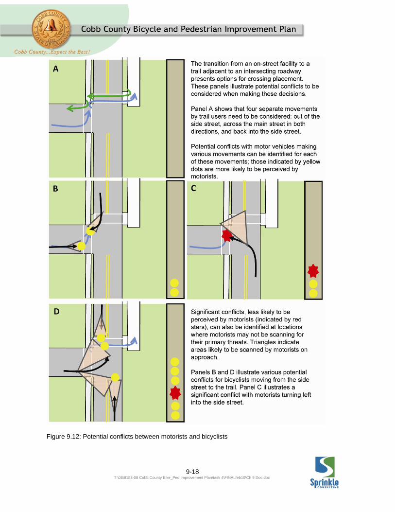
Figure 9.12: Potential conflicts between motorists and bicyclists

9-19 T:\08\8183-08 Cobb County Bike_Ped Improvement Plan\task 4\FINALfeb10\Ch 9 Doc.doc
Figure 9.13: Potential conflicts between motorists and bicyclists (Continued)

9-20 T:\08\8183-08 Cobb County Bike_Ped Improvement Plan\task 4\FINALfeb10\Ch 9 Doc.doc
Figure 9.14: Potential conflicts between motorists and bicyclists (Continued)

9-21 T:\08\8183-08 Cobb County Bike_Ped Improvement Plan\task 4\FINALfeb10\Ch 9 Doc.doc
Figure 9.15: Potential conflicts between motorists and bicyclists (Continued)

9-22 T:\08\8183-08 Cobb County Bike_Ped Improvement Plan\task 4\FINALfeb10\Ch 9 Doc.doc
Club Valley Drive
Club Valley Drive is a local street, approximately 24.5 feet wide, with no sidewalk, and a posted speed limit of 25 miles per hour. The roadway has no centerline stripe and is lined with mountable curbs. It is recommended that it be marked with SHARED LANE
MARKINGS if a traffic count reveals volumes of over 1650 vehicles per day. As it is the first local street encountered upon turning off a major thoroughfare, it is recommended that the BICYCLE
WARNING SIGN (W11-1), supplemented with a SHARE THE ROAD plaque (W16-1), be installed facing the eastbound side of Club Valley, shortly after the intersection with Holt Road.
The right of way for Club Valley Drive appears to be 50 feet wide, leaving room for the addition of sidewalk if deemed appropriate.
Club Valley Drive features some substantial changes in grade, climbing approximately 42 feet over 440 feet (9.5%), and then dropping again, approximately 18 feet over 220 feet (8.1%) .
Club Valley Drive bends to the north after approximately 650 feet, and after approximately another 625 feet intersects with Beverly Hills Drive. The recommended Family Friendly Route to East Cobb Middle School continues north on Club Valley Drive. A second Family Friendly Route towards Fuller’s Park turns right onto eastbound Beverly Hills Drive.
A connection to East Cobb Middle School can be made by continuing
approximately 1200 feet northbound on Club Valley Drive into the south entrance of the school. Roadway conditions on this section of Club Valley Drive are similar to those described above. There are some substantial changes in grade including a climb of 8 feet over approximately 150 feet (5.3%) on the approach to the intersection with Club Way, and a climb of 20 feet over approximately 315 feet (6.3%) as Club Valley Drive becomes the school driveway.
9.2.2 EAST COBB MIDDLE SCHOOL TO FULLER PARK
Club Valley Drive
This section is the same as described above between Beverly Hills Drive and East Cobb Middle School, only in the opposite direction
Beverly Hills Drive
Beverly Hills Drive is a local street, approximately 25 feet wide, with no sidewalk, and a posted speed limit of 25 miles per hour. The roadway has no centerline stripe and is lined with mountable curbs. It is recommended that it be marked with SHARED LANE
MARKINGS if a traffic count reveals volumes of over 1650 vehicles per day.
The right of way for Beverly Hills Drive appears to be 50 feet wide, leaving room for the addition of sidewalk if deemed appropriate.
The consultants observed that the seam between the gutter pan and the edge of
9-23 T:\08\8183-08 Cobb County Bike_Ped Improvement Plan\task 4\FINALfeb10\Ch 9 Doc.doc
pavement along Beverly Hills Drive was not flush.
Beverly Hills Drive features a substantial change in grade immediately east of the intersection with Club Valley Drive, dropping approximately 12 feet over 160 feet (7.5%).
Beverly Hills Drive intersects with Okawanna Drive approximately 1250 feet. The recommended Family Friendly Route turns left onto northbound Okawanna Drive.
Okawanna Drive
Okawanna Drive is a local street, approximately 24 feet wide, with no sidewalk, and a posted speed limit of 25 miles per hour. The roadway has no centerline stripe and is lined with mountable curbs. It is recommended that it be marked with SHARED LANE
MARKINGS if a traffic count reveals volumes of over 1650 vehicles per day.
The right of way for Okawanna Drive appears to be 50 feet wide, leaving room for the addition of sidewalk if deemed appropriate.
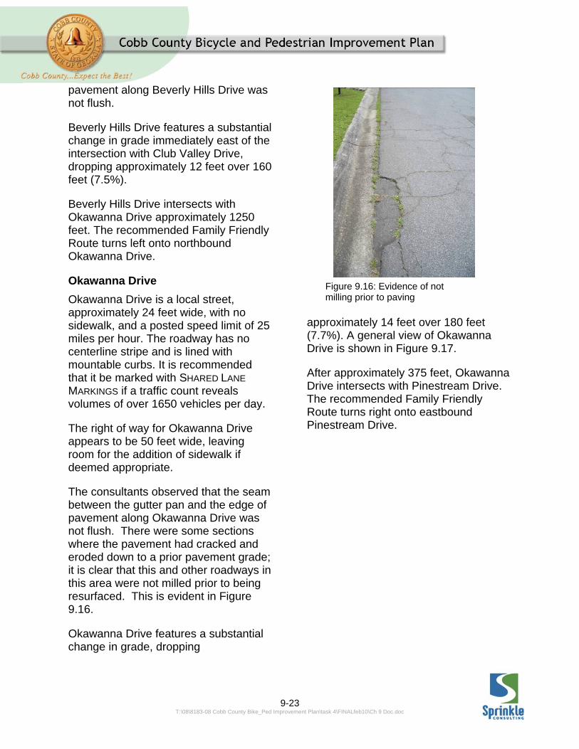
The consultants observed that the seam between the gutter pan and the edge of pavement along Okawanna Drive was not flush. There were some sections where the pavement had cracked and eroded down to a prior pavement grade; it is clear that this and other roadways in this area were not milled prior to being resurfaced. This is evident in Figure 9.16.
Okawanna Drive features a substantial change in grade, dropping
approximately 14 feet over 180 feet (7.7%). A general view of Okawanna Drive is shown in Figure 9.17.
After approximately 375 feet, Okawanna Drive intersects with Pinestream Drive. The recommended Family Friendly Route turns right onto eastbound Pinestream Drive.
Figure 9.16: Evidence of not milling prior to paving

9-24 T:\08\8183-08 Cobb County Bike_Ped Improvement Plan\task 4\FINALfeb10\Ch 9 Doc.doc
Pinestream Drive
Pinestream Drive is a local street, approximately 24 feet wide, with no sidewalk, and a posted speed limit of 25 miles per hour. The roadway has no centerline stripe and is lined with mountable curbs. It is recommended that it be marked with SHARED LANE
MARKINGS if a traffic count reveals volumes of over 1650 vehicles per day.
The right of way for Pinestream Drive appears to be 50 feet wide, leaving room for the addition of sidewalk if deemed appropriate.
The consultants observed that the seam between the gutter pan and the edge of pavement along Pinestream Drive was not flush.
Pinestream Drive features a substantial change in grade, dropping approximately 18 feet over 300 feet (6%).
Pinestream Drive bends to the north after approximately 325 feet, and bends sharply to the east after another 250 feet, and after approximately another 200 feet changes into Sope Creek Drive, as it crosses a small stream. The recommended Family Friendly Route continues straight onto eastbound Sope Creek Drive.
Sope Creek Drive
Sope Creek Drive is a local street, approximately 24 feet wide, with no sidewalk, and a posted speed limit of 25 miles per hour. The roadway has no centerline stripe and is lined with mountable curbs. It is recommended that it be marked with SHARED LANE
MARKINGS if a traffic count reveals volumes of over 1650 vehicles per day.
The right of way for Sope Creek Drive appears to be 50 feet wide, leaving room for the addition of sidewalk if deemed appropriate. The consultants observed a woman pushing a baby in a stroller down Sope Creek Drive towards Pinestream Drive, indicating that at least some local residents feel comfortable walking in the roadway here as shown in Figure 9.18.
Sope Creek Drive features a substantial change in grade, dropping approximately 20 feet over 390 feet (5.1%).
Figure 9.17: A view of Okawanna Drive

9-25 T:\08\8183-08 Cobb County Bike_Ped Improvement Plan\task 4\FINALfeb10\Ch 9 Doc.doc
Sope Creek Drive runs approximately 1450 feet to the east, where it ends at a T-intersection with Old Canton Road. As it is the first local street encountered upon turning off a major thoroughfare (in the direction opposite this narrative description), it is recommended that the BICYCLE WARNING SIGN (W11-1), supplemented with a SHARE THE ROAD plaque (W16-1), be installed facing the westbound side of Sope Creek Drive, shortly after the intersection with Old Canton Road.
The recommended Family Friendly Route turns right onto northbound Old Canton Road.
Old Canton Road
Old Canton road is an Arterial road according to the County’s Major Thoroughfare Plan. The segment that is part of this Family Friendly Route is covered by segment 322.1 in the Bicycle and Pedestrian Improvement Plan. The Existing Conditions Report assigned this segment a Bicycle Level of Service Score of “E” and a pedestrian Level of
Service Score of “D”. The two lane roadway is approximately 24 feet wide, and the County reports a daily traffic volume of 13,400 operating at a posted speed limit of 35 miles per hour. The segment has 5-foot wide sidewalks on both sides, both set behind 2-foot wide grass buffers, adjacent to the curbed-and-guttered roadside. These conditions do not allow for the inclusion of a bike lane in the existing cross section. The recommendation of the Bicycle and Pedestrian Improvement Plan is for a sidepath trail in this section; such a facility would be consistent with the Family Friendly designation of this segment.
The right of way for Old Canton Road appears to be approximately 80 feet
Figure 9.18: A local resident utilizing Sope Creek Drive for an afternoon walk
Figure 9.19: Comparison of Right of Way width and potential conflict along Old Canton Road

9-26 T:\08\8183-08 Cobb County Bike_Ped Improvement Plan\task 4\FINALfeb10\Ch 9 Doc.doc
wide, with approximately 35 feet available outside the curb on the west side and 15 feet available on the east side. This is illustrated in Figure 9.19 above. The east side, while narrower is adjacent to the backs of residences and encounters no driveways between Sope Creek Drive and Indian Hills Drive. A trail on the west side would probably require some sort of positive barrier to ensure proper separation between the trail and the roadway. A trail on the west side of the roadway would cross seven driveways between Sope Creek Drive and Indian Hills Drive and would also cross Maria Lane, a local street that intersects with Canton Road in this stretch.
A pathway on the west side would require a crossing of Old Canton Road at the intersection with Indian Hills Drive; a pathway on the east side would require a crossing at the intersection with Sope Creek Drive. In either case, an enhanced crossing treatment, such as the RECTANGULAR RAPID FLASHING
BEACON (RRFB) described in the Design Guidelines (Chapter #6) section of the Bicycle and Pedestrian Improvement Plan, should be installed at the crossing of Old Canton Road by the Family friendly Route, along with marked crosswalks across Sope Creek Drive and Indian Creek Drive. As was the case with the Holt Road intersections described above, the crossings should be placed to minimize conflicts with turning vehicles: across the north side of the intersection if at Sope Creek Drive, and across the south side of the intersection if at Indian Hills Drive.
If the crossing is placed at Indian Hills Drive, then the sidewalk across the median/entry monument at the west end of Indian Hills Drive should be modified to be meet the requirements of a shared use path adjacent to the roadway, as described in the Design Guidelines (Chapter 6).
The recommended Family Friendly Route turns right, onto eastbound Indian Hills Drive.
Indian Hills Drive
Indian Hills Drive is a Minor Collector street, approximately 24.5 feet wide, with no sidewalk, and a posted speed limit of 25 miles per hour. The segment that is part of this Family Friendly Route is covered by segment 215.0 in the Bicycle and Pedestrian Improvement Plan. The Existing Conditions Report assigned this segment a Bicycle Level of Service Score of “B” and a pedestrian Level of Service Score of “C”. The roadway has a centerline stripe and is lined with mountable curbs. The County reports daily traffic volumes of 1,700 vehicles per day.
Because it is operating at Bicycle Level of Service “B”, no improvement to bicycling conditions was recommended for Indian Hills Drive in the overall Bicycle and pedestrian Improvement Plan. However, for this short section of Indian Hills Drive to serve as a portion of a “Family Friendly Route,” it is recommended that it be marked with SHARED LANE MARKINGS, due to the fact that it is operating at Bicycle Level of Service “B”. As it is the first street with on-street “Family Friendly” traffic

9-27 T:\08\8183-08 Cobb County Bike_Ped Improvement Plan\task 4\FINALfeb10\Ch 9 Doc.doc
encountered upon turning off a major thoroughfare, it is recommended that the BICYCLE WARNING SIGN (W11-1), supplemented with a SHARE THE ROAD plaque (W16-1), be installed facing the eastbound side of Indian Hills Drive, shortly after the intersection with Old Canton Road.
The right of way for Indian Hills Drive appears to be 50 feet wide, leaving room for the addition of sidewalk if deemed appropriate. There is a brief section of divided roadway at the intersection with Old Canton Road, where the right of way widens to accommodate a landscaped median; the right of way for Indian Hills Road where it meets Old Canton Road is approximately 144 feet. This section appears to have over 10 feet between the back of curb and the right of way line, as measured from online County Aerials and GIS data.
The consultants observed that tree branches and shrubs encroached over the edge of the roadway in front of some residences along both sides of Indian Hills Drive between Old Canton Road and Greenfield Drive.
Indian Hills Drive features a substantial change in grade, dropping approximately 22 feet over 280 feet (7.8%).
Indian Hills Drive intersects with Greenfield Drive after approximately 475 feet. The recommended Family Friendly Route turns right onto northbound Greenfield Drive.
Greenfield Drive
Greenfield Drive is a local street, approximately 24 feet wide, with no sidewalk, and a posted speed limit of 25 miles per hour. The roadway has no centerline stripe and is lined with mountable curbs. It is recommended that it be marked with SHARED LANE
MARKINGS if a traffic count reveals volumes of over 1650 vehicles per day.
The right of way for Greenfield Drive appears to be 50 feet wide, leaving room for the addition of sidewalk if deemed appropriate.
Greenfield Drive features some substantial changes in grade, dropping approximately 20 feet over 210 feet (9.5%).
Greenfield Drive bends to the northeast after approximately 200 feet, and after approximately another 475 feet, bends again to the east. After a total length of approximately 1,800 feet, Greenfield Drive intersects with Creekwood Drive. The recommended Family Friendly Route turns left onto eastbound Creekwood Drive.
Creekwood Drive
Creekwood Drive is a local street, approximately 24.7 feet wide, with no sidewalk, and a posted speed limit of 25 miles per hour. The roadway has no centerline stripe and is lined with mountable curbs. It is recommended that it be marked with SHARED LANE
MARKINGS if a traffic count reveals volumes of over 1650 vehicles per day.
The right of way for Creekwood Drive appears to be 50 feet wide, leaving

9-28 T:\08\8183-08 Cobb County Bike_Ped Improvement Plan\task 4\FINALfeb10\Ch 9 Doc.doc
room for the addition of sidewalk if deemed appropriate.
The consultants observed that the seam between the gutter pan and the edge of pavement along was not flush, and asphalt had “slopped” over the edge into the area of the gutter pan.
Creekwood Drive bends through an S- curve, offsetting the roadway to the east, beginning about 130 feet north of the intersection with Greenfield Drive. Creekwood Drive passes under a six power lines (see Figure 9.20) approximately 625 feet north of the intersection with Greenfield Drive. These power lines were considered as a possible trail corridor in this study, but were determined to be infeasible after review of parcel maps showed that they did not occupy an independent right of way, but are most likely spanning
easements gained from each individual property owner.
After a total run of approximately 1350 feet, Creekwood Drive intersects with Robinson Road. As Creekwood Drive is the first local street encountered upon turning off a major thoroughfare (in the direction opposite this narrative description), it is recommended that the BICYCLE WARNING SIGN (W11-1), supplemented with a SHARE THE ROAD plaque (W16-1), be installed facing the westbound side of Creekwood Drive, shortly after the intersection with Robinson Road.
The recommended Family Friendly Route turns right onto eastbound Robinson Road.
Robinson Road
Robinson Road is a Major Collector according to the County’s Major Thoroughfare Plan. The segment that is a part of this Family Friendly Route is covered by segment 398.1 in the in the Bicycle and Pedestrian Improvement Plan. The existing conditions report assigned this segment a Bicycle level of Service grade of “D” and a Pedestrian Level of Service grade of “C”. The two lane roadway is approximately 24 feet wide. The County reports a daily traffic volume of 7,400 vehicles, operating at a posted speed limit of 35 miles per hour. These conditions do not allow for the inclusion of a bike lane at in the existing cross section. The recommendation of the Bicycle and Pedestrian Improvement Plan is for a sidepath trail in this section; such a facility would be consistent with
Figure 9.20: An illustration of power lines present along Creekwood Drive

9-29 T:\08\8183-08 Cobb County Bike_Ped Improvement Plan\task 4\FINALfeb10\Ch 9 Doc.doc
the Family Friendly designation of this segment.
Figure 9.21: An existing sidewalk along Robinson Road The right of way for Robinson Road appears to be 55 feet wide just east of the intersection with Creekwood Drive; the right of way widens to approximately 60 feet approximately 135 feet to the
east, and then widens to approximately 85 feet as it crosses Mill Creek another 250 feet to the east. The right of way narrows again to 50 feet just after the intersection with Robinson Farms Drive. It appears that immediately east of the intersection with Creekwood Drive that the right of way is only 13 feet wide outside the roadway on the south side and only 3 feet wide outside the roadway on the north side, due to the addition of a right turn lane for eastbound traffic into Barn Owl Drive.

9-30 T:\08\8183-08 Cobb County Bike_Ped Improvement Plan\task 4\FINALfeb10\Ch 9 Doc.doc
Figure 9.22: Robinson Road and its surrounding area
Figure 9.23: An illustration of East Cobb Park

9-31 T:\08\8183-08 Cobb County Bike_Ped Improvement Plan\task 4\FINALfeb10\Ch 9 Doc.doc
This places the right of way line in the middle of the north side sidewalk according to the aerials on the County’s GIS website. An eight foot high stone wall, which is part of the entry monument for the High Gate Neighborhood, sits only 13 feet from the back of the curb. On the south side, there is apparently only 16 feet of right of way from the back of curb.
While either side of the roadway will be tightly constrained for trail construction, the north side may be preferable if an easement could be gained from the property owner of the parcel at the northeast corner of Barn Owl Drive and Robinson Road. This is because there is a 6.3 acre County-owned greenspace parcel approximately 225 feet east of the intersection, which in turn adjoins a Park District-owned property that is connected. If the requirements of the greenspace dedication allow for a trail, then the trail could pull away from the roadway relatively quickly, improving the users’ experience.
The crossing of Mill Creek on the existing bridge is also very constrained. The existing sidewalks are only approximately four feet wide. A bike/pedestrian bridge adjacent to the existing bridge or a cantilevered widened side deck off the existing bridge may be necessary to carry trail users. If the trail can go into the greenspace parcel, then a crossing could be made on a dedicated trail bridge farther removed from the property.
This section of Robinson Road has also been indicated as a possible alignment for the proposed Fullers Park Trail on the County’s Trail Map. The proposed Fullers Park Trail runs along Robinson Road from the intersection with Old Canton Road and then turns into the main entry of Fullers Park and ultimately connects with East Cobb Park on the North Side of Fullers Park.
Robinson Road Park Property
On the east bank of Mill Creek, opposite Robinson Farms Drive, is an 8.5 acre parcel owned by the Cobb County Department of Parks and Recreation. The southern portion of the parcel contains an athletic field apparently used by the East Cobb Vikings Football and Cheerleading Association.
Figure 9.24: Gated entry to the Robinson Road Park property The field is service by a paved parking lot with approximately 50 spaces. The drive aisle for the parking lot turns into a dirt access road on the north side of the parcel, and appears to serve a sewer easement along the creek.

9-32 T:\08\8183-08 Cobb County Bike_Ped Improvement Plan\task 4\FINALfeb10\Ch 9 Doc.doc
A trail could be constructed through this parcel to access Fullers Park, or some other alignment using the sewer easement north of this parcel, as may be suggested by the general alignment for the Sope Creek Trail (B), a future recreation trail shown on the County’s Trail Map.
Fullers and East Cobb Parks
Once access is gained To Fullers Park, a site study could determine the best route to connect to the East Cobb Park, the East Cobb trail and existing and programmed sidepaths along Roswell Road.
Figure 9.25: A pedestrian utilizing a path through Fullers Park
9.3 AREA B: SOUTH
MABLETON
Location: Area roughly bounded by Mableton Parkway, Dodgen Road, South Gordon Road, Dillon Road and James Road.
Destinations Served: Wallace Park, Bartlett Property, Lions Park, South
Cobb Community Center, Lucius Clay Elementary School, Skyview Elementary School, Lindley Middle School, Pebblebrook High School, Chattahoochee Technical College (South Cobb Campus).
Also nearby: Activity centers along Mableton Parkway, Veterans’ Memorial Highway
9-33 T:\08\8183-08 Cobb County Bike_Ped Improvement Plan\task 4\FINALfeb10\Ch 9 Doc.doc
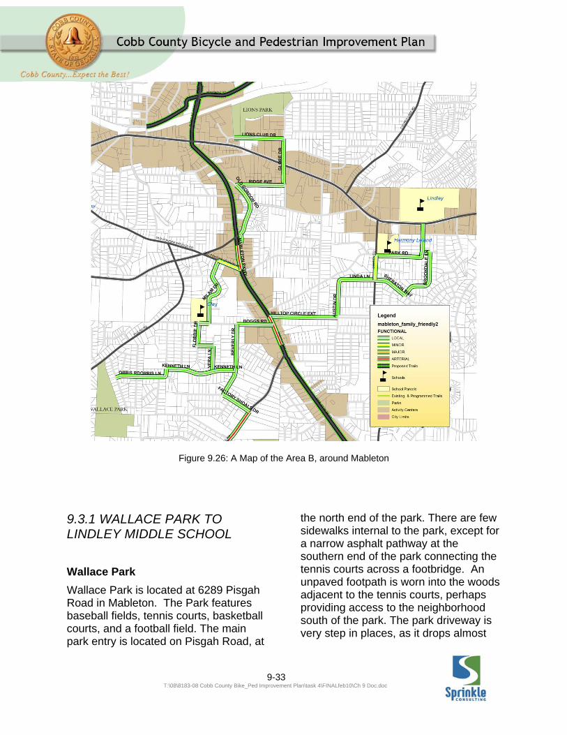
Figure 9.26: A Map of the Area B, around Mableton
9.3.1 WALLACE PARK TO LINDLEY MIDDLE SCHOOL
Wallace Park
Wallace Park is located at 6289 Pisgah Road in Mableton. The Park features baseball fields, tennis courts, basketball courts, and a football field. The main park entry is located on Pisgah Road, at
the north end of the park. There are few sidewalks internal to the park, except for a narrow asphalt pathway at the southern end of the park connecting the tennis courts across a footbridge. An unpaved footpath is worn into the woods adjacent to the tennis courts, perhaps providing access to the neighborhood south of the park. The park driveway is very step in places, as it drops almost

9-34 T:\08\8183-08 Cobb County Bike_Ped Improvement Plan\task 4\FINALfeb10\Ch 9 Doc.doc
100 feet from the North end of the property to the south end of the property; in the first 625 feet south from the park entrance, the driveway drops
50 feet over approximately 625 feet, an average slope of 8.0%. There are narrow, sharp speed bumps across the park driveway in several locations.
Figure 9.27: The Family Friendly Route From Wallace Park to Lindley Middle School (portion west of Mableton Parkway)
9-35 T:\08\8183-08 Cobb County Bike_Ped Improvement Plan\task 4\FINALfeb10\Ch 9 Doc.doc
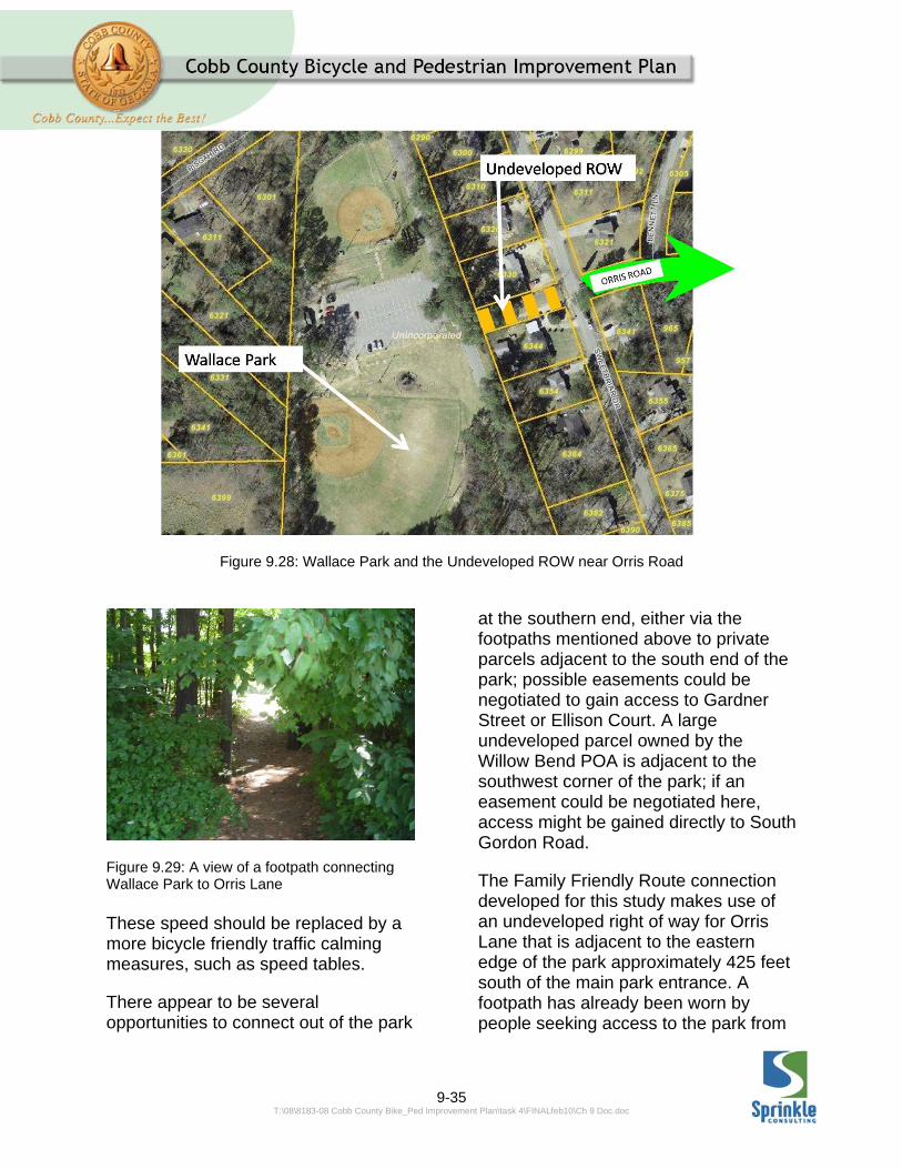
Figure 9.28: Wallace Park and the Undeveloped ROW near Orris Road
Figure 9.29: A view of a footpath connecting Wallace Park to Orris Lane These speed should be replaced by a more bicycle friendly traffic calming measures, such as speed tables.
There appear to be several opportunities to connect out of the park
at the southern end, either via the footpaths mentioned above to private parcels adjacent to the south end of the park; possible easements could be negotiated to gain access to Gardner Street or Ellison Court. A large undeveloped parcel owned by the Willow Bend POA is adjacent to the southwest corner of the park; if an easement could be negotiated here, access might be gained directly to South Gordon Road.
The Family Friendly Route connection developed for this study makes use of an undeveloped right of way for Orris Lane that is adjacent to the eastern edge of the park approximately 425 feet south of the main park entrance. A footpath has already been worn by people seeking access to the park from
9-36 T:\08\8183-08 Cobb County Bike_Ped Improvement Plan\task 4\FINALfeb10\Ch 9 Doc.doc
this location. Development of a path connection at this point would provide the beginnings of a Family Friendly Route towards Lucius B. Clay Elementary School, Lindley Middle School and the other nearby destinations described above.
Figure 9.30: A view from Orris Lane connection to Wallace Park
Orris Lane
Orris Lane is a local street, approximately 21 feet wide, with no sidewalk, and a posted speed limit of 25 miles per hour. The roadway has no centerline stripe and has no curbs. It is recommended that it be marked with SHARED LANE MARKINGS if a traffic count reveals volumes of over 950 vehicles per day.
The right of way for Orris Lane appears to be 50 feet wide, leaving room for the addition of sidewalk if deemed appropriate.
Orris Lane features a substantial change in grade, dropping approximately 12 feet over 155 feet (7.7%).
The consultants observed some accumulated vegetative debris along the eastbound edge of Orris Lane, just east of the intersection with Sweetbriar Drive.
Orris Lane intersects with Britt Road after approximately 1400 feet. The recommended Family Friendly Route turns left onto northbound Britt Road.
Britt Road
Britt Road is a local street, approximately 18.2 feet wide, with no sidewalk, and a posted speed limit of 25 miles per hour. The roadway has no centerline stripe and no curbs. It is recommended that it be marked with SHARED LANE MARKINGS if a traffic count reveals volumes of over 650 vehicles per day.
The right of way for Britt Road appears to be 50 feet wide, leaving room for the addition of sidewalk if deemed appropriate.
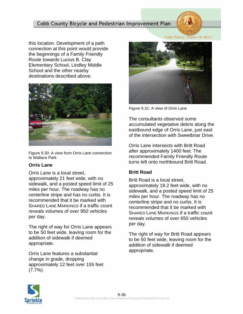
Figure 9.31: A view of Orris Lane

9-37 T:\08\8183-08 Cobb County Bike_Ped Improvement Plan\task 4\FINALfeb10\Ch 9 Doc.doc
Britt Road bends intersects with Kenneth Lane after approximately 190 feet. The recommended Family Friendly Route turns right onto eastbound Kenneth Lane.
Kenneth Lane Kenneth Lane is a local street, approximately 18.5 feet wide, with no sidewalk, and a posted speed limit of 25 miles per hour. The roadway has no centerline stripe and no curbs. It is recommended that it be marked with SHARED LANE MARKINGS if a traffic count reveals volumes of over 650 vehicles per day.
The right of way for Kenneth Lane appears to be 50 feet wide, leaving room for the addition of sidewalk if deemed appropriate.
The consultants observed several patches of very rough pavement on Kenneth Lane, with cracks spreading across the width of the roadway. Kenneth Lane features a substantial change in grade, dropping
approximately 22 feet over 267 feet (8.2%).
Kenneth Lane bends through a gradual curve to the south and then back north. After approximately 2000 feet, Kenneth Lane intersects with Beverly Drive. The recommended Family Friendly Route turns right onto northbound Beverly Drive. (An alternate route towards the Clay Elementary School and Lions Club Park turns left onto northbound bound Vera Lane; see section 9.3.3 below. An alternate route towards the Bartlett Property turns right onto southbound Beverly Drive; see section 9.3.4 below.)
Figure 9.32: Looking down Britt Road
Figure 9.33: Existing rough pavement present along Kenneth Lane

9-38 T:\08\8183-08 Cobb County Bike_Ped Improvement Plan\task 4\FINALfeb10\Ch 9 Doc.doc
Beverly Drive
Beverly Drive is a local street, approximately 20 feet wide, with no sidewalk, and a posted speed limit of 25 miles per hour. The roadway has no centerline stripe and no curbs. It is recommended that it be marked with SHARED LANE MARKINGS if a traffic count reveals volumes of over 950 vehicles per day.
The right of way for Beverly Drive appears to be 50 feet wide, leaving room for the addition of sidewalk if deemed appropriate.
After approximately 1300 feet, Beverly Drive comes to an intersection with Boggs Road. The recommended Family Friendly Route turns right onto eastbound Boggs Road.
Boggs Road
Boggs Road is a local street, approximately 21 feet wide, with sidewalk the north side only, and a posted speed limit of 25 miles per hour. The roadway has double yellow center stripe and is lined with mountable curbs
on the north side. There is a drainage ditch immediately adjacent to the south side. It is recommended that it be marked with SHARED LANE MARKINGS if a traffic count reveals volumes of over 950 vehicles per day. Boggs road was observed to have more traffic than most local streets in the area; it may be functioning as a neighborhood collector. If traffic counts reveal more than 2350 vehicles per day, it may become necessary to divert the route away from Boggs Road or examine the possibility of widening the roadway for bike lanes or constructing a trail alongside Boggs Road.
The right of way for Boggs Road appears to be 50 feet wide, leaving room widening or trail construction, if deemed appropriate.
Boggs Road intersects with Mableton Parkway approximately 975 feet east of Beverly Drive. As Boggs Road is the first local street encountered upon turning off a major thoroughfare (Mableton Parkway, from the east), it is recommended that the BICYCLE
WARNING SIGN (W11-1), supplemented with a SHARE THE ROAD plaque (W16-1), be installed facing the westbound side of Boggs Road, shortly after the intersection with Mableton Parkway. The recommended Family Friendly Route crosses Mableton Parkway.
Mableton Parkway
Mableton Parkway is an Arterial road according to the County’s Major Thoroughfare Plan. The segment that is part of this Family Friendly Route is covered by segment 262.0 in the Bicycle and Pedestrian Improvement Plan. The
Figure 9.34: A view of Kenneth Lane

9-39 T:\08\8183-08 Cobb County Bike_Ped Improvement Plan\task 4\FINALfeb10\Ch 9 Doc.doc
Existing Conditions Report assigned this segment a Bicycle Level of Service Score of “E” and a pedestrian Level of Service Score of “D”. The roadway is four lanes plus a two-way left turn lane, totaling approximately 62 feet wide, and
the County reports a daily traffic volume of 21,630 operating at a posted speed limit of 45 miles per hour. The segment has five foot wide sidewalks on both sides, both set behind two foot wide grass buffers, adjacent to the curbed-
Figure 9.35: The proposed Family Friendly Route crossing of Mableton Parkway

9-40 T:\08\8183-08 Cobb County Bike_Ped Improvement Plan\task 4\FINALfeb10\Ch 9 Doc.doc
Figure 9.36: The Family Friendly Route The Family Friendly Route From Wallace Park to Lindley Middle School (portion west of Mableton Parkway)
and-guttered roadside. These conditions do not allow for the inclusion of a bike lane in the existing cross section. The recommendation of the Bicycle and Pedestrian Improvement Plan is for a sidepath trail in this section; such a facility would be consistent with the Family Friendly designation of this segment.The continuation of the Family Friendly Route towards Lindley Middle School only requires a crossing of Mableton Parkway and a brief jog north for approximately 200 feet to where it continues east along Hilltop Extension. Some short of midblock crossing treatment, such as the PEDESTRIAN
HYBRID SIGNAL, should be considered to facilitate the crossing of the Family Friendly route across the northern approach of Mableton Parkway to this intersection, along with as marked
crosswalks across both Boggs Road and Hilltop Extension at their intersections with Mableton Parkway. A crossing of the northern approach will present fewer serious conflicts than a crossing of the southern approach (for a more detailed discussion, see figures 9.12 through 9.15, earlier in this Chapter). A median refuge may be able to be installed in the space of the two-way left turn lane (which was measured to be approximately 13.5 feet wide), to help facilitate this crossing; such a median must be carefully designed to minimize impacts to southbound left turn access to the commercial property at 6135 Mableton Parkway. It appears from review of aerials that a crossing with median refuge could possible fit in across the north approach while preserving access to this driveway.
9-41 T:\08\8183-08 Cobb County Bike_Ped Improvement Plan\task 4\FINALfeb10\Ch 9 Doc.doc
The recommended Family Friendly Route crosses Mableton Parkway, continues north for approximately 200 feet, then turns right onto eastbound Hilltop Extension.
Hilltop Circle Extension/ Hilltop Circle
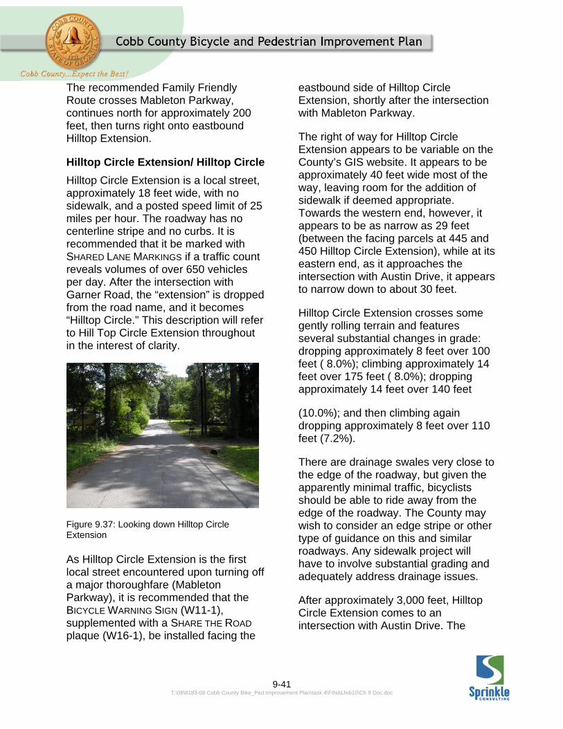
Hilltop Circle Extension is a local street, approximately 18 feet wide, with no sidewalk, and a posted speed limit of 25 miles per hour. The roadway has no centerline stripe and no curbs. It is recommended that it be marked with SHARED LANE MARKINGS if a traffic count reveals volumes of over 650 vehicles per day. After the intersection with Garner Road, the “extension” is dropped from the road name, and it becomes “Hilltop Circle.” This description will refer to Hill Top Circle Extension throughout in the interest of clarity.
Figure 9.37: Looking down Hilltop Circle Extension As Hilltop Circle Extension is the first local street encountered upon turning off a major thoroughfare (Mableton Parkway), it is recommended that the BICYCLE WARNING SIGN (W11-1), supplemented with a SHARE THE ROAD plaque (W16-1), be installed facing the
eastbound side of Hilltop Circle Extension, shortly after the intersection with Mableton Parkway.
The right of way for Hilltop Circle Extension appears to be variable on the County’s GIS website. It appears to be approximately 40 feet wide most of the way, leaving room for the addition of sidewalk if deemed appropriate. Towards the western end, however, it appears to be as narrow as 29 feet (between the facing parcels at 445 and 450 Hilltop Circle Extension), while at its eastern end, as it approaches the intersection with Austin Drive, it appears to narrow down to about 30 feet.
Hilltop Circle Extension crosses some gently rolling terrain and features several substantial changes in grade: dropping approximately 8 feet over 100 feet ( 8.0%); climbing approximately 14 feet over 175 feet ( 8.0%); dropping approximately 14 feet over 140 feet
(10.0%); and then climbing again dropping approximately 8 feet over 110 feet (7.2%).
There are drainage swales very close to the edge of the roadway, but given the apparently minimal traffic, bicyclists should be able to ride away from the edge of the roadway. The County may wish to consider an edge stripe or other type of guidance on this and similar roadways. Any sidewalk project will have to involve substantial grading and adequately address drainage issues.
After approximately 3,000 feet, Hilltop Circle Extension comes to an intersection with Austin Drive. The

9-42 T:\08\8183-08 Cobb County Bike_Ped Improvement Plan\task 4\FINALfeb10\Ch 9 Doc.doc
recommended Family Friendly Route turns left onto northbound Austin Drive.
Austin Drive
Austin Drive is a local street, approximately 18.5 feet wide, with no sidewalk, and a posted speed limit of 25 miles per hour. The roadway has no centerline stripe and no curbs. It is recommended that it be marked with SHARED LANE MARKINGS if a traffic count reveals volumes of over 650 vehicles per day.
The right of way for Austin Drive appears to be 40 feet wide, leaving room for the addition of sidewalk if deemed appropriate.
Austin Drive features substantial changes in grade, dropping approximately 22 feet over 400 feet (5.5%), and then dropping another 22 feet over 350 feet (6.3%).
Figure 9.38: A view of Austin Drive Austin Drive drops very sharply to drainage swales on both sides, but given the apparently light traffic, bicyclists should be able to keep away
from the road edge. The County may wish to consider an edge stripe or other type of guidance on this and similar roadways. Any sidewalk project will have to involve substantial grading and adequately address drainage issues.
After approximately 1075 feet, Austin Drive comes to an intersection with Linda Lane. The recommended Family Friendly Route turns right onto eastbound Linda Lane.
Linda Lane
Linda Lane is a local street, approximately 18 feet wide, with no sidewalk, and a posted speed limit of 25 miles per hour. The roadway has no centerline stripe and no curbs. It is recommended that it be marked with SHARED LANE MARKINGS if a traffic count reveals volumes of over 650 vehicles per day.
The right of way for Linda Lane appears to be 40 feet wide, leaving room for the addition of sidewalk if deemed appropriate.
After approximately 1000 feet, Linda Lane comes to an intersection with Dodgen Road.
As Linda Lane is the first local street encountered upon turning off a major thoroughfare (Dodgen Road), it is recommended that the BICYCLE
WARNING SIGN (W11-1), supplemented with a SHARE THE ROAD plaque (W16-1), be installed facing the westbound side of Linda lane, shortly after the intersection with Dodgen Road.
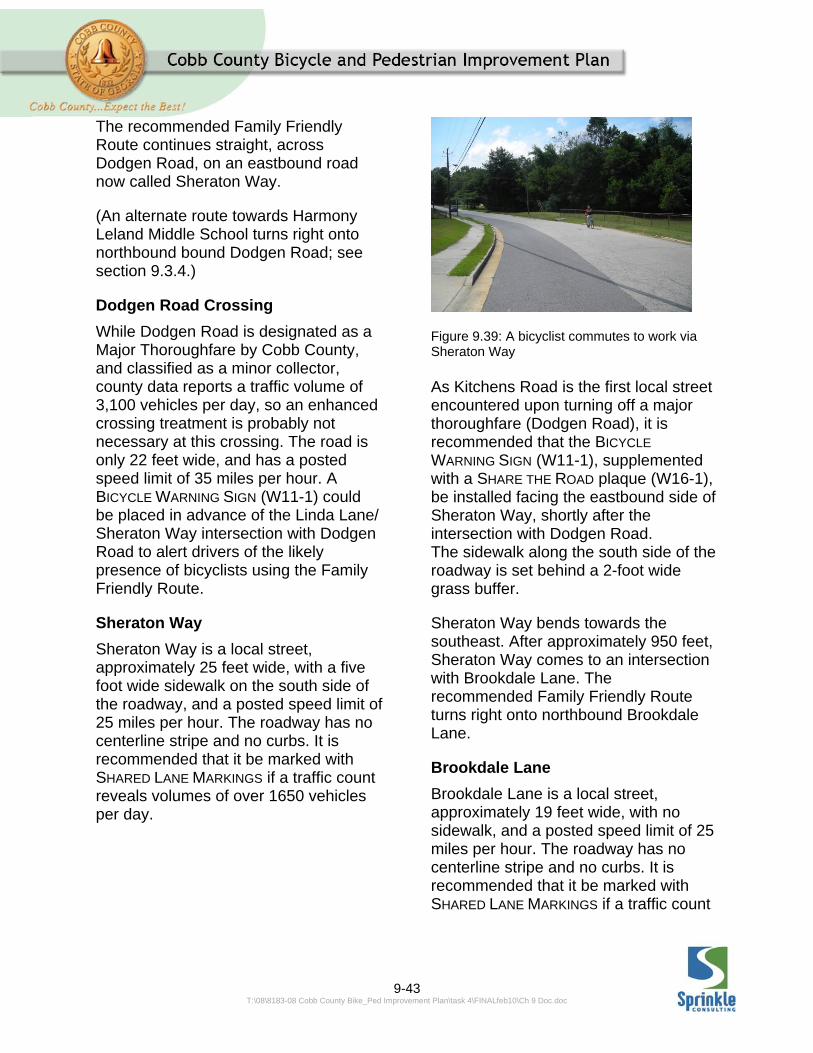
9-43 T:\08\8183-08 Cobb County Bike_Ped Improvement Plan\task 4\FINALfeb10\Ch 9 Doc.doc
The recommended Family Friendly Route continues straight, across Dodgen Road, on an eastbound road now called Sheraton Way.
(An alternate route towards Harmony Leland Middle School turns right onto northbound bound Dodgen Road; see section 9.3.4.)
Dodgen Road Crossing
While Dodgen Road is designated as a Major Thoroughfare by Cobb County, and classified as a minor collector, county data reports a traffic volume of 3,100 vehicles per day, so an enhanced crossing treatment is probably not necessary at this crossing. The road is only 22 feet wide, and has a posted speed limit of 35 miles per hour. A BICYCLE WARNING SIGN (W11-1) could be placed in advance of the Linda Lane/ Sheraton Way intersection with Dodgen Road to alert drivers of the likely presence of bicyclists using the Family Friendly Route.
Sheraton Way
Sheraton Way is a local street, approximately 25 feet wide, with a five foot wide sidewalk on the south side of the roadway, and a posted speed limit of 25 miles per hour. The roadway has no centerline stripe and no curbs. It is recommended that it be marked with SHARED LANE MARKINGS if a traffic count reveals volumes of over 1650 vehicles per day.
Figure 9.39: A bicyclist commutes to work via Sheraton Way As Kitchens Road is the first local street encountered upon turning off a major thoroughfare (Dodgen Road), it is recommended that the BICYCLE
WARNING SIGN (W11-1), supplemented with a SHARE THE ROAD plaque (W16-1), be installed facing the eastbound side of Sheraton Way, shortly after the intersection with Dodgen Road. The sidewalk along the south side of the roadway is set behind a 2-foot wide grass buffer.
Sheraton Way bends towards the southeast. After approximately 950 feet, Sheraton Way comes to an intersection with Brookdale Lane. The recommended Family Friendly Route turns right onto northbound Brookdale Lane.
Brookdale Lane
Brookdale Lane is a local street, approximately 19 feet wide, with no sidewalk, and a posted speed limit of 25 miles per hour. The roadway has no centerline stripe and no curbs. It is recommended that it be marked with SHARED LANE MARKINGS if a traffic count

9-44 T:\08\8183-08 Cobb County Bike_Ped Improvement Plan\task 4\FINALfeb10\Ch 9 Doc.doc
reveals volumes of over 650 vehicles per day.
Figure 9.40: Looking down Brookdale Lane The right of way for Brookdale Lane appears to be 50 feet wide, leaving room for the addition of sidewalk if deemed appropriate.
Brookdale Lane features several substantial changes in grade: dropping approximately 8 feet over 125 feet (6.4%); climbing approximately 22 feet over 250 feet (8.8%); and climbing approximately 14 feet over 285 feet (5.1%).
Brookdale Lane drops very sharply to drainage swales on both sides, but given the apparently light traffic, bicyclists should be able to keep away from the road edge. The County may wish to consider an edge stripe or other type of guidance on this and similar roadways. Any sidewalk project will have to involve substantial grading and adequately address drainage issues.
The consultant team observed some cracking along the edge of pavement as
well as areas of heavy leaf accumulation and other vegetative debris.
The consultant team observed a young girl playing in the street in her grandfather’s mobility scooter, an anecdotal indication that the some residents of Brookdale Lane are comfortable with the traffic conditions of the roadway.
Brookdale Lane is a winding road, bending first to the east and then back to the north. After a total run of approximately 1500 feet, Brookdale Lane comes to an intersection with Brook Way. The recommended Family Friendly Route turns left onto northbound Brook Way.
Brook Way
Brook Way is a local street, approximately 20 feet wide, with no sidewalk, and a posted speed limit of 25 miles per hour. The roadway has no centerline stripe and no curbs. It is recommended that it be marked with SHARED LANE MARKINGS if a traffic count reveals volumes of over 950 vehicles per day.
The right of way for Brook Way appears to be 40 feet wide, leaving room for the addition of sidewalk if deemed appropriate.
Brook Way features a very steep change in grade, dropping approximately 22 feet over 150 feet (14.6%). A controlled descent of this grade and a successful turn onto Brookdale Lane will be very difficult for most bicyclists.
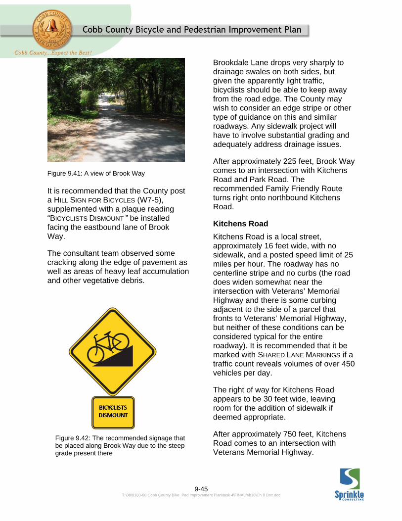
9-45 T:\08\8183-08 Cobb County Bike_Ped Improvement Plan\task 4\FINALfeb10\Ch 9 Doc.doc
Figure 9.41: A view of Brook Way It is recommended that the County post a HILL SIGN FOR BICYCLES (W7-5), supplemented with a plaque reading “BICYCLISTS DISMOUNT ” be installed facing the eastbound lane of Brook Way.
The consultant team observed some cracking along the edge of pavement as well as areas of heavy leaf accumulation and other vegetative debris.
Brookdale Lane drops very sharply to drainage swales on both sides, but given the apparently light traffic, bicyclists should be able to keep away from the road edge. The County may wish to consider an edge stripe or other type of guidance on this and similar roadways. Any sidewalk project will have to involve substantial grading and adequately address drainage issues.
After approximately 225 feet, Brook Way comes to an intersection with Kitchens Road and Park Road. The recommended Family Friendly Route turns right onto northbound Kitchens Road.
Kitchens Road
Kitchens Road is a local street, approximately 16 feet wide, with no sidewalk, and a posted speed limit of 25 miles per hour. The roadway has no centerline stripe and no curbs (the road does widen somewhat near the intersection with Veterans’ Memorial Highway and there is some curbing adjacent to the side of a parcel that fronts to Veterans’ Memorial Highway, but neither of these conditions can be considered typical for the entire roadway). It is recommended that it be marked with SHARED LANE MARKINGS if a traffic count reveals volumes of over 450 vehicles per day.
The right of way for Kitchens Road appears to be 30 feet wide, leaving room for the addition of sidewalk if deemed appropriate.
After approximately 750 feet, Kitchens Road comes to an intersection with Veterans Memorial Highway.
Figure 9.42: The recommended signage that be placed along Brook Way due to the steep grade present there

9-46 T:\08\8183-08 Cobb County Bike_Ped Improvement Plan\task 4\FINALfeb10\Ch 9 Doc.doc
As Kitchens Road is the first local street encountered upon turning off a major thoroughfare (Veterans’ Memorial Highway, from the north), it is recommended that the BICYCLE
WARNING SIGN (W11-1), supplemented with a SHARE THE ROAD plaque (W16-1), be installed facing the southbound side of Pioneer Trail, shortly after the intersection with Veterans’ Memorial Highway.
The recommended Family Friendly Route turns crosses Veterans’ Memorial Highway to Lindley Middle School.
Crossing Veterans’ Memorial Parkway
An enhanced crossing treatment will be necessary to get Family Friendly Route users across Veterans’ Memorial Parkway to Lindley Middle School. The school likely has crossing guards at this location at arrival and dismissal times when school is in session; however a PEDESTRIAN HYBRID SIGNAL may be necessary to assist with crossing at other times. Veterans’ Memorial Highway is an Arterial roadway according to the Major Thoroughfare Plan, and at this location is comprised of four through lanes, a two way left turn lane and a right turn lane on the north side of the road. County data reports a traffic volume of 19,200 vehicles per day, travelling at a posted speed of 45 miles per hour. An enhanced crossing treatment would have to be installed on the east approach to the intersection with Kitchens Road due in order to accommodate left turns into the school driveway from eastbound Veterans’ Memorial Highway.

9-47 T:\08\8183-08 Cobb County Bike_Ped Improvement Plan\task 4\FINALfeb10\Ch 9 Doc.doc
Figure 9.43: Veterans Memorial Highway at Kitchens Road
9.3.2 ROUTE TOWARDS LUCIUS B CLAY ELEMENTARY SCHOOL, LIONS PARK, AND SOUTH COBB COMMUNITY CENTER
Lucius B Clay Elementary School connected to the network of Family Friendly Routes from the south via Vera Lane, Burney Lane, and Florrie Drive, as described below. Access to Clay Elementary from the west can be gained via Boggs Road. The description and recommendation for Boggs Road between Clay Elementary and Beverly Drive is the same as the descriptions
and recommendations for the remainder of Boggs Road described above.
Continuing past Clay Elementary, a connection can be made to Lions Park and the South Cobb Community Center via Milam Drive, Old Powder Springs Road, Mableton Parkway, Old Gordon Road, Ridge Avenue, Glore Drive and Lions Club Drive.
The Family Friendly Route connection to Clay Elementary School, Lions Park, and South Cobb Community Center begins at the intersection of Kenneth Lane and Vera Lane. This route turns left onto northbound Vera Lane.

9-48 T:\08\8183-08 Cobb County Bike_Ped Improvement Plan\task 4\FINALfeb10\Ch 9 Doc.doc
Vera Lane
Vera Lane is a local street, approximately 18 feet wide, with no sidewalk, and a posted speed limit of 25 miles per hour. The roadway has no centerline stripe and no curbs. It is recommended that it be marked with SHARED LANE MARKINGS if a traffic count reveals volumes of over 650 vehicles per day.
Figure 9.44: A view of Vera Lane
The right of way for Vera Lane appears to be 50 feet wide, leaving room for the addition of sidewalk if deemed appropriate.
Vera Lane features a substantial change in grade, dropping approximately 14 feet over 175 feet (8.0%).
The consultants observed several patches of very rough pavement on Vera Lane, with cracks spreading across the width of the roadway
After approximately 725 feet, Vera Lane comes to an intersection with Burney Drive. The recommended Family Friendly Route turns left onto westbound Burney Drive.
Figure 9.45: The Family Friendly Route to Lions Park Burney Drive
Burney Drive is a local street, less than 16 feet wide, with no sidewalk, and a posted speed limit of 25 miles per hour. The roadway has no centerline stripe and no curbs. It is recommended that it be marked with SHARED LANE MARKINGS

9-49 T:\08\8183-08 Cobb County Bike_Ped Improvement Plan\task 4\FINALfeb10\Ch 9 Doc.doc
if a traffic count reveals volumes of over 350 vehicles per day.
Figure 9.46: An accumulation of pine needles and other vegetative debris are present in this photo of Burney Drive The right of way for Burney Drive appears to be 50 feet wide, leaving room for the addition of sidewalk if deemed appropriate. Burney Drive features a substantial change in grade, climbing approximately 8 feet over 135 feet (5.9%), and then climbing another 6 feet over 90 feet (6.7%).
The consultant team observed heavy degradation of the edge of pavement and heavy accumulation of pine needles and other vegetative debris along Burney Drive. Because the entire longitudinal extent of the roadway is visible from both ends, it is likely that vehicles use the center of the roadway when no oncoming traffic is present.
After approximately 440 feet, Burney Drive comes to an intersection with Florrie Lane. The recommended Family Friendly Route turns right onto northbound Florrie Lane.
Florrie Drive
Florrie Drive is a local street, approximately 19 feet wide, with no sidewalk, and a posted speed limit of 25 miles per hour. The roadway has no centerline stripe and no curbs. It is recommended that it be marked with SHARED LANE MARKINGS if a traffic count reveals volumes of over 650 vehicles per day.
The right of way for Florrie Drive appears to be 50 feet wide, leaving room for the addition of sidewalk if deemed appropriate.
The consultants observed some cracking on the pavement of Florrie Lane. It was also observed that a resident has positioned a basketball goal at the edge of the roadway, an anecdotal indication that residents are comfortable with the traffic conditions of the roadway.
Figure 9.47: Looking down Florrie Drive After approximately 650 feet, Drive Lane comes to an intersection with Boggs Road. Access to Clay Elementary is immediately across Boggs road. The Family Friendly Route
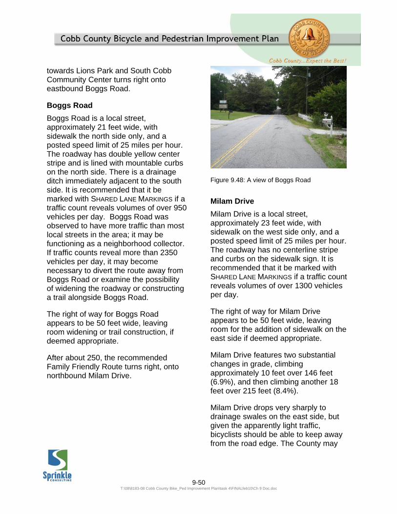
9-50 T:\08\8183-08 Cobb County Bike_Ped Improvement Plan\task 4\FINALfeb10\Ch 9 Doc.doc
towards Lions Park and South Cobb Community Center turns right onto eastbound Boggs Road.
Boggs Road
Boggs Road is a local street, approximately 21 feet wide, with sidewalk the north side only, and a posted speed limit of 25 miles per hour. The roadway has double yellow center stripe and is lined with mountable curbs on the north side. There is a drainage ditch immediately adjacent to the south side. It is recommended that it be marked with SHARED LANE MARKINGS if a traffic count reveals volumes of over 950 vehicles per day. Boggs Road was observed to have more traffic than most local streets in the area; it may be functioning as a neighborhood collector. If traffic counts reveal more than 2350 vehicles per day, it may become necessary to divert the route away from Boggs Road or examine the possibility of widening the roadway or constructing a trail alongside Boggs Road.
The right of way for Boggs Road appears to be 50 feet wide, leaving room widening or trail construction, if deemed appropriate.
After about 250, the recommended Family Friendly Route turns right, onto northbound Milam Drive.
Figure 9.48: A view of Boggs Road
Milam Drive
Milam Drive is a local street, approximately 23 feet wide, with sidewalk on the west side only, and a posted speed limit of 25 miles per hour. The roadway has no centerline stripe and curbs on the sidewalk sign. It is recommended that it be marked with SHARED LANE MARKINGS if a traffic count reveals volumes of over 1300 vehicles per day.
The right of way for Milam Drive appears to be 50 feet wide, leaving room for the addition of sidewalk on the east side if deemed appropriate.
Milam Drive features two substantial changes in grade, climbing approximately 10 feet over 146 feet (6.9%), and then climbing another 18 feet over 215 feet (8.4%).
Milam Drive drops very sharply to drainage swales on the east side, but given the apparently light traffic, bicyclists should be able to keep away from the road edge. The County may

9-51 T:\08\8183-08 Cobb County Bike_Ped Improvement Plan\task 4\FINALfeb10\Ch 9 Doc.doc
wish to consider an edge stripe or other type of guidance on this and similar roadways. Any sidewalk project on this side will have to involve substantial grading and adequately address drainage issues.
After approximately 2000 feet, Milam Drive comes to an intersection with Old Powder Springs Road, which is designated a minor collector in the County’s Major Thoroughfare Plan. As Milam Drive is the first local street encountered upon turning off a major thoroughfare (Old Powder Springs Road, from the north), it is recommended that the BICYCLE
WARNING SIGN (W11-1), supplemented with a SHARE THE ROAD plaque (W16-1), be installed facing the southbound side of Milam Drive, shortly after the intersection with Old Powder Springs Road.
The recommended Family Friendly Route turns right onto eastbound Old Powder Springs Road.
Old Powder Springs Road
Old Powder Springs Road is a Minor Collector road according to the County’s Major Thoroughfare Plan. The segment that is part of this Family Friendly Route is covered by segment 337.0 in the Bicycle and Pedestrian Improvement Plan. The Existing Conditions Report assigned this segment a Bicycle Level of Service Score of “D” and a Pedestrian Level of Service Score of “C”. The roadway is two lanes wide, totaling approximately 26 feet wide, and the County reports a daily traffic volume of 4,300 operating at a posted speed limit of 35 miles per hour. The segment has
five foot wide sidewalks on the eastbound side only, set immediately adjacent to the curbed-and-guttered roadside. These conditions do not allow for the inclusion of a bike lane in the existing cross section. The recommendation of the Bicycle and Pedestrian Improvement Plan is for a sidepath trail in this section; such a facility would be consistent with the Family Friendly designation of this segment.
The right of way for Old Powder Springs Road appears to be just 40 feet wide, with both the boundary roughly an equal distance from the road on both sides. For ease of crossing Mableton Parkway (see below) it may be preferable to construct any trail connection on the eastbound side of Old Powder Springs Road. If a trail is developed on the westbound side, then a crosswalk should be installed across the east approach of Old Powder Springs Road at the intersection with Mableton Parkway.
After about 650 feet, Old Powder Springs Road comes to an intersection with Mableton Parkway. The recommended Family Friendly Route turns left onto northbound Mableton Parkway.
Mableton Parkway
Mableton Parkway is an Arterial road according to the County’s Major Thoroughfare Plan. The segment that is part of this Family Friendly Route is covered by segment 262.0 in the Bicycle and Pedestrian Improvement Plan. The Existing Conditions Report assigned this segment a Bicycle Level of Service

9-52 T:\08\8183-08 Cobb County Bike_Ped Improvement Plan\task 4\FINALfeb10\Ch 9 Doc.doc
Score of “E” and a pedestrian Level of Service Score of “D” The roadway is four lanes plus a two-way left turn lane, totaling approximately 62 feet wide, and the County reports a daily traffic volume of 21,630 operating at a posted speed limit of 45 miles per hour. The segment has five foot wide sidewalks on both sides, both set behind two foot wide grass buffers, adjacent to the curbed-and-guttered roadside. These conditions do not allow for the inclusion of a bike lane in the existing cross section. The recommendation of the Bicycle and Pedestrian Improvement Plan is for a sidepath trail in this section; such a facility would be consistent with the Family Friendly designation of this segment.
Because the recommended Family Friendly route connects to Old Gordon Road just 650 feet north of the signalized intersection with Old Powder Springs Road, it would be preferable for the purposes of this to construct a trail on the east side of Mableton Parkway; an engineering study for such a Mableton Parkway trail may reveal better feasibility for the west side, in which case an alternate crossing will need to be investigated.
A crossing to a trail connection on the east side of Mableton Parkway could make use of an existing signalized intersection at Old Powder Springs Road, which includes a crosswalk across the north approach. A trail connection would also benefit from expanded pads at the northeast and northwest corners of the intersection, to allow Family Friendly Route users more
room to negotiate turns and wait for the signal to change.
There appears to be just over 15 feet of right of way available outside the existing curb line of Mableton Parkway on both sides of the road, indicating no obvious preference for either side. In the interest of connectivity to the Family Friendly Routes, the east side is preferable, because a connection to the dead end of Old Gordon Road can be made approximately 500 feet north of the intersection with Old Powder Springs Road, whereas connecting to via the traffic signal at Old Alabama Road would include over 850 feet of busy Mableton Parkway frontage.
After approximately 500 feet, right of way for Mableton Parkway opens up to include the truncated dead end of Old Gordon Road. The recommended Family Friendly Route continues north along the Old Gordon Road.
Old Gordon Road
Old Gordon Road is a local street, approximately 18 feet wide, but with some wider areas around the intersection with Lee Road. There is approximately 425 feet of sidewalk and curbing on the east side of Old Gordon Road in the stretch between Police station and Lee Road. The posted speed limit on Old Gordon Road is 25 miles per hour. The roadway has no centerline stripe. It is recommended that it be marked with SHARED LANE
MARKINGS if a traffic count reveals volumes of over 650 vehicles per day.

9-53 T:\08\8183-08 Cobb County Bike_Ped Improvement Plan\task 4\FINALfeb10\Ch 9 Doc.doc
Figure 9.49: A view along Old Gordon Road After about 450 feet, Old Gordon Road intersects with Old Alabama Road. Old Gordon Road intersects with Old Alabama Road in such a way that the flow of traffic from Old Alabama Road comes into Old Gordon Road. Given that Old Alabama Road is a Major Collector according to the Major Thoroughfares Plan, and also that that the intersection of Old Gordon and Old Alabama is only 75 feet from the intersection with Mableton Parkway (an arterial roadway), and that Old Gordon connects these two roadways to the adjacent neighborhood, it is very likely that Old Gordon Road sees considerable traffic volume. If counts reveal traffic greater than 2000 vehicles a day, more significant facility improvements will need to be investigated.
As Old Gordon is the first local street encountered upon turning off a major thoroughfare (Old Alabama Road, from the south), it is recommended that the BICYCLE WARNING SIGN (W11-1), supplemented with a SHARE THE ROAD plaque (W16-1), be installed facing the northbound side of Old Gordon, shortly
after the intersection with Old Alabama Road. The right of way for Old Gordon Road appears to be 50 feet wide, leaving room for the addition of sidewalk if deemed appropriate.
Approximately 1600 feet beyond the intersection with Old Alabama Road, Old Gordon Road comes to an intersection with Ridge Avenue. This point is just 300 feet short of an intersection with Mableton Parkway, an arterial roadway on the Major Thoroughfare Plan. Because of the proximity of this point with Mableton Parkway, it is recommended that the BICYCLE WARNING SIGN (W11-1), supplemented with a SHARE THE ROAD plaque (W16-1), be installed facing the southbound side of Old Gordon, shortly after the intersection with Mableton Parkway.
The recommended Family Friendly Route, however, turns right onto eastbound Ridge Avenue.
Ridge Avenue
Ridge Avenue is a local street, approximately 18 feet wide, with no sidewalk, and a posted speed limit of 25 miles per hour. The roadway has no centerline stripe; there is a stretch of curbing that runs approximately 400 feet long the north side of the road near the crest of the hill. It is recommended that it be marked with SHARED LANE MARKINGS if a traffic count reveals volumes of over 650 vehicles per day.
The right of way for Ridge Avenue appears to be 50 feet wide, leaving room for the addition of sidewalk if deemed appropriate.

9-54 T:\08\8183-08 Cobb County Bike_Ped Improvement Plan\task 4\FINALfeb10\Ch 9 Doc.doc
Ridge Avenue features a substantial change in grade, climbing approximately 20 feet over 250 feet (8%).
Ridge Avenue drops very sharply to drainage swales on the south side, but given the apparently light traffic, bicyclists should be able to keep away from the road edge. The County may wish to consider an edge stripe or other type of guidance on this and similar roadways. Any sidewalk project on this side will have to involve substantial grading and adequately address drainage issues.
After approximately 1350 feet, Ridge Avenue comes to an intersection with Glore Drive. The recommended Family Friendly Route turns left onto northbound Glore Drive.
Glore Drive (south of Veterans’ Memorial Highway)
Glore Drive is a local street, approximately 18 feet wide, with no sidewalk, and a posted speed limit of 25 miles per hour. The roadway has no centerline stripe and no curbs. It is recommended that it be marked with SHARED LANE MARKINGS if a traffic count reveals volumes of over 650 vehicles per day. Glore Drive meets Veterans’ Memorial Highway—an arterial roadway on the County’s Major Thoroughfare plan and also designated as U.S. Highway 278 –at at a signalized intersection. The presence of this signal and the fact that it connects the adjacent neighborhood to an arterial roadway makes it a possibility that Glore Drive may see a substantial volume of traffic; if counts reveal traffic greater than 2000
vehicles a day, more significant facility improvements will need to be investigated.
Figure 9.50: Looking down Glore Drive Because Glore Drive is the first local roadway encountered after turning off of Veteran’s Memorial Highway it is recommended that the BICYCLE
WARNING SIGN (W11-1), supplemented with a SHARE THE ROAD plaque (W16-1), be installed facing the southbound side of Glore Drive, shortly after the intersection with Mableton Parkway. The right of way for Glore Drive appears to be 50 feet wide, leaving room for the addition of sidewalk if deemed appropriate.
After approximately 525 feet, Glore Drive comes to an intersection with Veterans’ Memorial Highway. The recommended Family Friendly Route crosses Veterans’ Memorial Highway at this signalized intersection and continues again on Glore Drive.
Cross Veterans’ Memorial Highway
The Glore Drive intersection with Veteran’s Memorial Highway is currently
9-55 T:\08\8183-08 Cobb County Bike_Ped Improvement Plan\task 4\FINALfeb10\Ch 9 Doc.doc
signalized, however no crosswalk is marked on the west approach across Veterans’ Memorial Highway. A crossing with pedestrian signal heads should be installed across this approach to facilitate southbound traffic along the Family Friendly Route. The curb ramps and pads on all corners of this intersection should be enlarged to accommodate the Family Friendly Route users - which may well include bicycles with trailers and groups of cyclists.
Glore Drive (north of Veterans’ Memorial Highway)
Glore Drive is a local street, approximately 18 feet wide, with no sidewalk, and a posted speed limit of 25 miles per hour. The roadway has no centerline stripe and no curbs. It is recommended that it be marked with SHARED LANE MARKINGS if a traffic count reveals volumes of over 650 vehicles per day. Glore Drive meets Veterans’ Memorial Highway—an arterial roadway on the County’s Major Thoroughfare plan and also designated as U.S. Highway 278 –at at a signalized intersection. The presence of this signal and the fact that it connects the adjacent neighborhood to an arterial roadway makes it a possibility that Glore Drive may see a substantial volume of traffic; if counts reveal traffic greater than 2000 vehicles a day, more significant facility improvements will need to be investigated.
Because Glore Drive is the first local roadway encountered after turning off of Veteran’s Memorial Highway it is recommended that the BICYCLE
WARNING SIGN (W11-1), supplemented with a SHARE THE ROAD plaque (W16-1),
be installed facing the northbound side of Glore Drive, shortly after the intersection with Mableton Parkway.
Glore Drive features a substantial change in grade, climbing approximately 24 feet over 315 feet (7.6%).
Glore Drive drops very sharply to drainage swales on the south side, but given the apparently light traffic, bicyclists should be able to keep away from the road edge. The County may wish to consider an edge stripe or other type of guidance on this and similar roadways. Any sidewalk project on this side will have to involve substantial grading and adequately address drainage issues.
The right of way for Glore Drive appears to be 50 feet wide, leaving room for the addition of sidewalk if deemed appropriate.
After approximately 725 feet, Glore Drive comes to an intersection with Lions’ Club Drive. The recommended Family Friendly Route turns left onto westbound Lions’ Club Drive.
Lions’ Club Drive
Lions’ Club Drive is a local street, approximately 18 feet wide, with no sidewalk, and a posted speed limit of 25miles per hour. The roadway has no centerline stripe and no curbs. It is recommended that it be marked with SHARED LANE MARKINGS if a traffic count reveals volumes of over 650 vehicles per day.
The right of way for Lions’ Club Drive appears to be 40 feet wide, leaving

9-56 T:\08\8183-08 Cobb County Bike_Ped Improvement Plan\task 4\FINALfeb10\Ch 9 Doc.doc
room for the addition of sidewalk if deemed appropriate.
Lions’ Club Drive features a substantial change in grade, climbing approximately 14 feet over 250 feet (9.3%) as it approaches the South Cobb Community Center and Lions Park.
After approximately 1150 Lions’ Club Drive comes to the entrance of the South Cobb Community Center; 150 feet further west is the entrance to Lions Park. The recommended Family Friendly Route ends at Lions Park. This point is just 450 feet short of an intersection with Veterans’ Memorial Highway, an arterial roadway on the Major Thoroughfare Plan. Because of the proximity of this point with Mableton Veterans’ Memorial Highway, it is recommended that the BICYCLE
WARNING SIGN (W11-1), supplemented with a SHARE THE ROAD plaque (W16-1), be installed facing the eastbound side of Lions’ Club Drive, at appoint just north of the intersection with Veterans’ Memorial Highway .
9.3.3 ROUTE TOWARDS THE BARTLETT PROPERTY
The Bartlett Property is a County-owned parcel that may be developed into a future park. Access to the Bartlett Property could be integrated into the Mableton Area network of Family Friendly Routes by via Beverly Drive, Factory Shoals Drive, and Factory Shoals Road, as described below.
Figure 9.51: A view of the route towards the Bartlett Property
The Family Friendly Route towards the Bartlett Property begins at the intersection of Kenneth Lane and Beverly Drive. This route turns right on Beverly Drive.
Beverly Drive
Beverly Drive is a local street, approximately 20 feet wide, with no sidewalk, and a posted speed limit of 25 miles per hour. The roadway has no centerline stripe and no curbs. It is recommended that it be marked with SHARED LANE MARKINGS if a traffic count reveals volumes of over 950 vehicles per day.

9-57 T:\08\8183-08 Cobb County Bike_Ped Improvement Plan\task 4\FINALfeb10\Ch 9 Doc.doc
Figure 9.52: A view of Beverly Drive The right of way for Beverly Drive appears to be 50 feet wide, leaving room for the addition of sidewalk if deemed appropriate.
Kenneth Lane features a substantial change in grade, dropping approximately 8 feet over 125 feet (6.4%).
After approximately 775 feet, Beverly Drive comes to an intersection with Factory Shoals Drive. The recommended Family Friendly Route turns left onto eastbound Factory Shoals Drive.
Factory Shoals Drive
Factory Shoals Drive is a local street, approximately 22 feet wide, with no sidewalk, and a posted speed limit of 25 miles per hour. The roadway has no centerline stripe and no curbs. It is recommended that it be marked with SHARED LANE MARKINGS if a traffic count reveals volumes of over 1300 vehicles per day.
The right of way for Factory Shoals Drive appears to be 40 feet wide,
leaving room for the addition of sidewalk if deemed appropriate.
Factory Shoals Drive features a substantial change in grade, climbing approximately 44 feet over 750 feet (5.8%).
After approximately 800 feet, Factory Shoals Drive comes to an intersection with Factory Shoals Road.
Figure 9.53: Looking along Factory Shoals Drive
Factory Shoals Road
Factory Shoals Road is an Arterial road according to the County’s Major Thoroughfare Plan. The segment that is part of this Family Friendly Route is covered by segment 150.0 in the Bicycle and Pedestrian Improvement Plan. The Existing Conditions Report assigned this segment a Bicycle Level of Service Score of “E” and a Pedestrian Level of Service Score of “C”. The roadway is four lanes wide, totaling approximately 50 feet wide, and the County reports a daily traffic volume of 15,000 operating at a posted speed limit of 40 miles per hour. The segment has five foot wide sidewalks on both sides, both set behind two foot wide grass buffers, adjacent to

9-58 T:\08\8183-08 Cobb County Bike_Ped Improvement Plan\task 4\FINALfeb10\Ch 9 Doc.doc
the curbed-and-guttered roadside. These conditions do not allow for the inclusion of a bike lane in the existing cross section. The recommendation of the Bicycle and Pedestrian Improvement Plan is for a sidepath trail in this section; such a facility would be consistent with the Family Friendly designation of this segment.
Figure 9.54: A view of the sidewalk along Factory Shoals Road The continuation of the Family Friendly Route towards the Bartlett Property requires a crossing of Factory Shoals Road to a potential easement connection to the Bartlett Property. Some short of midblock crossing treatment, such as the PEDESTRIAN
HYBRID SIGNAL, should be considered to facilitate the crossing of the Family Friendly route across the northern approach of Factory Shoals Road to this intersection, along with a marked crosswalk across Factory Shoals Drive at its intersection with Factory Shoals
Road. A crossing of the northern approach will present fewer serious conflicts than a crossing of the southern approach (for a more detailed discussion, see Figures 9.12 through 9.15, printed earlier in this document).
Alternatively, an enhanced crossing may be installed at a midblock location, if the ultimate alignment of a possible connection into the Bartlett Property makes such a crossing more convenient (see below). It appears from field visits that the right of way for Factory Shoals Road is 80 feet wide, with roughly equal width available (perhaps 12 feet) on each side. This extra width is probably not sufficient for construction of a trail adjacent to the roadway without some sort of vertical barrier to separate the trail from the roadway, or acquisition of an easement to allow greater separation and construction of a wider trail. The adjacent terrain on the west side of the road falls away very sharply, while the terrain on the east side of the road is relatively level and at a grade close to that of the roadway; the east side, then may be better suited for a trail for reasons of constructability. The east side of the road is also where a potential connection to the Bartlett Property may be developed if an easement agreement can be reached with one of the large church parcels on the east side of Factory Shoals Road.
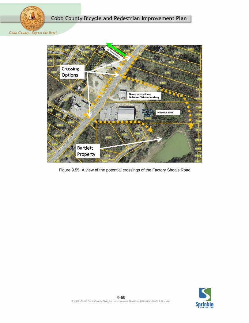
9-59 T:\08\8183-08 Cobb County Bike_Ped Improvement Plan\task 4\FINALfeb10\Ch 9 Doc.doc
Figure 9.55: A view of the potential crossings of the Factory Shoals Road
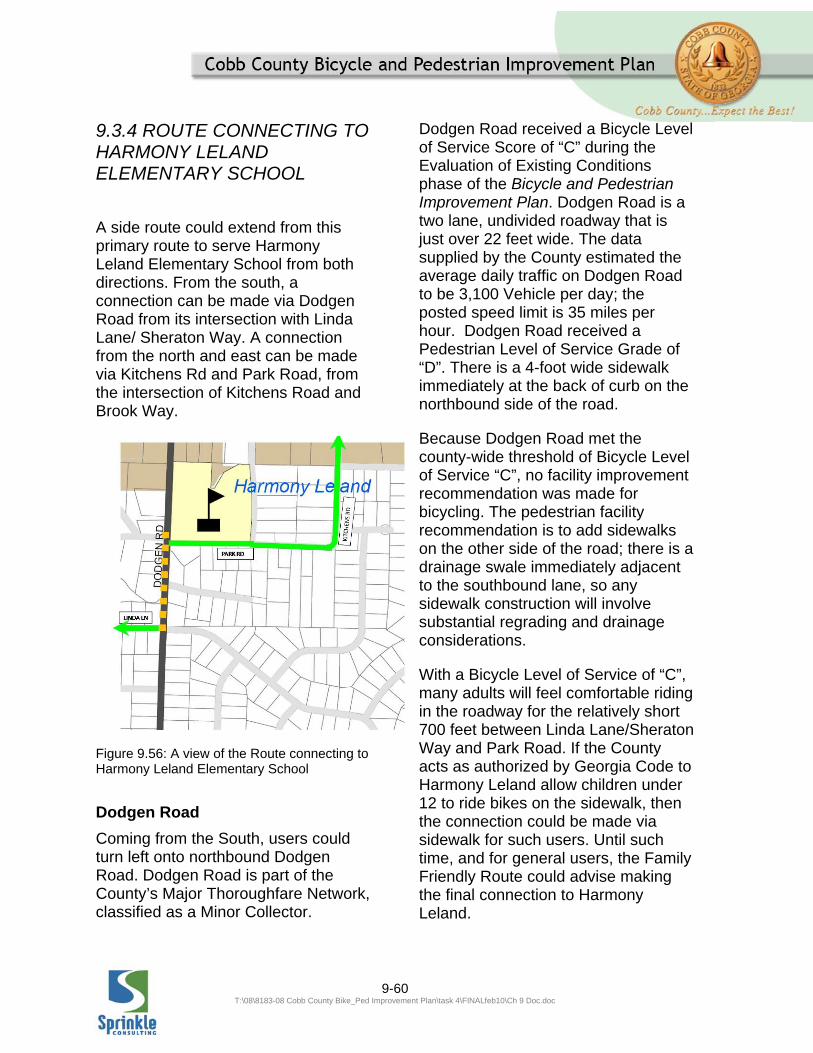
9-60 T:\08\8183-08 Cobb County Bike_Ped Improvement Plan\task 4\FINALfeb10\Ch 9 Doc.doc
9.3.4 ROUTE CONNECTING TO HARMONY LELAND ELEMENTARY SCHOOL
A side route could extend from this primary route to serve Harmony Leland Elementary School from both directions. From the south, a connection can be made via Dodgen Road from its intersection with Linda Lane/ Sheraton Way. A connection from the north and east can be made via Kitchens Rd and Park Road, from the intersection of Kitchens Road and Brook Way.
Figure 9.56: A view of the Route connecting to Harmony Leland Elementary School
Dodgen Road
Coming from the South, users could turn left onto northbound Dodgen Road. Dodgen Road is part of the County’s Major Thoroughfare Network, classified as a Minor Collector.
Dodgen Road received a Bicycle Level of Service Score of “C” during the Evaluation of Existing Conditions phase of the Bicycle and Pedestrian Improvement Plan. Dodgen Road is a two lane, undivided roadway that is just over 22 feet wide. The data supplied by the County estimated the average daily traffic on Dodgen Road to be 3,100 Vehicle per day; the posted speed limit is 35 miles per hour. Dodgen Road received a Pedestrian Level of Service Grade of “D”. There is a 4-foot wide sidewalk immediately at the back of curb on the northbound side of the road.
Because Dodgen Road met the county-wide threshold of Bicycle Level of Service “C”, no facility improvement recommendation was made for bicycling. The pedestrian facility recommendation is to add sidewalks on the other side of the road; there is a drainage swale immediately adjacent to the southbound lane, so any sidewalk construction will involve substantial regrading and drainage considerations.
With a Bicycle Level of Service of “C”, many adults will feel comfortable riding in the roadway for the relatively short 700 feet between Linda Lane/Sheraton Way and Park Road. If the County acts as authorized by Georgia Code to Harmony Leland allow children under 12 to ride bikes on the sidewalk, then the connection could be made via sidewalk for such users. Until such time, and for general users, the Family Friendly Route could advise making the final connection to Harmony Leland.
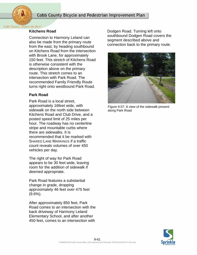
9-61 T:\08\8183-08 Cobb County Bike_Ped Improvement Plan\task 4\FINALfeb10\Ch 9 Doc.doc
Kitchens Road
Connection to Harmony Leland can also be made from the primary route from the east, by heading southbound on Kitchens Road from the intersection with Brook Lane, for approximately 150 feet. This stretch of Kitchens Road is otherwise consistent with the description above on the primary route. This stretch comes to an intersection with Park Road. The recommended Family Friendly Route turns right onto westbound Park Road.
Park Road
Park Road is a local street, approximately 16feet wide, with sidewalk on the north side between Kitchens Road and Club Drive, and a posted speed limit of 25 miles per hour. The roadway has no centerline stripe and mountable curbs where there are sidewalks. It is recommended that it be marked with SHARED LANE MARKINGS if a traffic count reveals volumes of over 450 vehicles per day.
The right of way for Park Road appears to be 30 feet wide, leaving room for the addition of sidewalk if deemed appropriate. Park Road features a substantial change in grade, dropping approximately 46 feet over 475 feet (9.6%). After approximately 850 feet, Park Road comes to an intersection with the back driveway of Harmony Leland Elementary School, and after another 450 feet, comes to an intersection with
Dodgen Road. Turning left onto southbound Dodgen Road covers the segment described above and connection back to the primary route.
Figure 9.57: A view of the sidewalk present along Park Road