chapter 7 blackhall rocks to south beach, blyth (block · pdf filechapter 7 blackhall rocks to...
TRANSCRIPT

121
CHAPTER 7
Blackhall Rocks to South Beach, Blyth (Block 3 NMP)
7.1 Introduction The area covered extends from Blackhall Rocks on the Durham Heritage Coast to South Beach, Blyth in Northumberland. It falls into two major topographical units, the magnesian limestone cliffs of County Durham and the southern part of Tyne and Wear and the coastal lowlands of Northumberland, punctuated by the lower parts of the valleys of the rivers Wear and Tyne. Accordingly, this survey of the heritage assets has been undertaken with reference to the Historic Environment Records (HERs) maintained by Durham County Council, Tyne and Wear and Northumberland County Council. This existing base of data has been enhanced by the transcription of aerial photographs held by the National Monuments Record and carried out to the standards of the National Mapping Programme (NMP). This work is referred to as the Air Photograph Transcription Exercise (APTE). A substantial part of the coastline from Blackhall Rocks to Salterfen Rocks, south of Sunderland has been designated as ‘Heritage Coast’, a major interruption occurring in the vicinity of Seaham. In addition, sections of the foreshore have been designated as SSSIs. Castle Eden Dene is a National Nature Reserve while The National Trust manages sections of coast between Horden and Nose’s Point. North of Sunderland most of the foreshore as far as South Shields is also a SSSI. The National Trust manages a section of coast from Souter Point to Trow Point. The whole length of the foreshore from the Tyne to the northern boundary of Block 3 is a SSSI. Substantial sections of the coastal zone in Block 3 are extensively built up, which clearly has implications for the survival of heritage assets. 7.1.1 Soils and landuse The solid geology of this section of the coast is described in Chapter 3 though throughout most of the coastal zone this solid geology is mantled by varying thicknesses of glacial drift and other superficial deposits of Pleistocene and Holocene age. It is these superficial deposits that give rise to the principal soil types found along this section of the coast.
Table 7.1 Soil and landuse in Block 3
Deep loam Stock rearing and dairying with some cereals
Seasonally wet deep red clay Dairying on permanent grassland with some cereals in drier districts
Seasonally wet deep loam to clay Grassland in moist lowlands with some arable in drier areas
Seasonally wet deep clay Winter cereals, sugar beet, potatoes and field vegetables
Dune sand Recreation and some coniferous woodland
Loam over limestone Cereals, sugar beet and potatoes with some short term grassland

122
The patterns of landuse that characterise these soil types are an important consideration in evaluating the survival of heritage assets and the degree of threat arising from normal farming practices. Clearly, ploughing for arable cultivation will have had a major bearing on the survival of, and the extent to which, once levelled, sites can be identified on aerial photographs. Plough damage to archaeological sites is not a recent phenomenon but before the Medieval period the scale and intensity of ploughing cannot be considered significant. However, the development of ridge-and-furrow cultivation in the open fields of the Medieval and post-Medieval periods was on a sufficient scale to pose a serious threat to existing features. It is also necessary to bear in mind that extensive areas of Block 3 have been built over for housing and by industrial development and few heritage assets can be expected to have survived within these areas, irrespective of their soil type.
7.1.2 Coastal erosion The coast extending north from Blackhall Rocks to Salterfen Rocks is characterised by magnesian limestone cliffs varying in height from 20m to 40m fronted in places by a wide wave cut platform exposing the solid geology, though this is often obscured by colliery waste. After the low lying zones of Wearmouth and Seaburn the cliffs resume from Whitburn to Trow Point on the outskirts of South Shields. North of the Tyne the cliff line continues as far as Whitley Bay but from this point based on the solid geology of the Coal Measures. The cliffs north of the Tyne are generally lower than those to the south, rarely exceeding 23m in height. Farther north are the low lying coastal zones of Whitley and Hartley Links, fronted by broad sandy beaches but punctuated by a 1km length of low cliffs between St Mary’s Island and Seaton Sluice. The section of the coast is covered by two Shoreline Management Plans (SMPs). That south of the Tyne falls within Cells 1b to 1d of SMP2, produced by Royal Haskoning in 2007 while that to the north of the Tyne lies within Cell 1a and is covered by SMP1 produced by Posford Duvivier in 1998. South of the Tyne Block 3 spans SMP2 Management Areas 1 to 10 while to the north it spans SMP1 Management Units 42-48. The authors of the SMP2 have produced estimates of baseline erosion rates at various points. These are based on existing evidence and may be expected to increase with sea level rise. Accordingly, the figures presented in Table 7.2 should be taken as a minimum. The maps accompanying the SMP2 use these data to predict the position of the coastline at 20, 50 and 100 year intervals. A number of responses have been proposed on the basis of these predictions (7.3a). Such data predictions are not offered in the SMP1 document which confined itself to policy options (Table 7.3b). Coastal erosion poses two kinds of threat to the historic environment: 1. The erosion of the coast itself caused by the action of the sea leading to the destruction
or truncation of assets. 2. Damage to assets caused by various mitigation strategies.

123
Table 7.2 Rates of coastal erosion in Block 3 recorded in the SMP
Location NGR
(approximate) Rate per year
Herd Sands NZ377677 0.2m
Trow Point NZ384666 0.2m
Frenchman’s Bay NZ388661 0.1m - 0.2m
Marsden Bay NZ396654 0.1m - 0.2m
Lizard Point NZ409642 0.1m
Souter Bay NZ414627 0.2m
Whitburn NZ411619 0.1m
Whitburn Bay NZ406601 0.4m
Parson’s Rocks NZ407597 0.4m Salterfen NZ415541 0.1m
Pincushion NZ420524 0.4m Seaham North NZ425502 0.3m Seaham South NZ435485 0.5m
Chourdon Point NZ442464 0.3m
Five main types of mitigation are proposed: 1. ‘Hold the Line’ entailing construction works such as the provision of rock armour at the
foot of eroding cliffs and the construction of sea defences (HTL). 2. Advance the line (A). 3. Managed Realignment (MR). 4. Hold the line on a retreated alignment (HR). 5. Retreat (R) The alternative to these approaches is ‘No Active Intervention’ (NAI) or ‘Do Nothing’ (DN).

124
Figure 7.1 Rock armour at the base of cliffs north of Seaham (author)
Table 7.3a SMP2 proposed responses to predicted coastal change in Block 3 south of the Tyne
Location SMP Unit 2025 2055 2105
South Groyne, S.Shields 1.1 HTL HTL HTL Little Haven, S.Shields 1.2 MR HR HR South Pier, S.Shields 1.3 HTL HTL HTL Herd Sands, (north) 2.1 HTL HTL R Herd Sands, (south) 2.2 HTL MR HR
Trow Point 2.3 R MR HR Trow Point, (south) 3.1 R MR HR
Trow Quarry 3.2 HTL MR MR Lizard Point (north) 4.1 R R NAI
Lizard Point 4.2 NAI NAI NAI Harbour Quarry 5.1 HTL R R
5.1 to Souter Point 5.2 NAI NAI NAI Whitburn Cliffs 6.1 NAI NAI NAI
The Bents 6.2 MR MR HR Parson’s Rocks 6.4 HTL HTL R
Marine Walk, Sunderland 6.5 HTL HTL MR Harbour Pier, Sunderland 7.1 HTL HTL HTL
North Harbour, Sunderland 7.2 HTL HTL HTL South Harbour, Sunderland 7.3 HTL HTL HTL

125
East Bay, Sunderland Harbour 8.1 HTL HTL HTL South face, Sunderland Harbour 8.2 HTL HTL HTL
Hendon Seawall 8.3 HTL HTL HTL Hendon to Pincushion 8.4 R MR MR Pincushion to Seaham 9.1 NAI NAI NAI
Seaham North Promenade 9.2 HTL HTL HTL Red Acre Cliffs 9.3 R HR HR
Seaham Harbour 9.4 HTL HTL HTL Seaham South 9.5 HTL HTL HTL Dawdon Beach 9.6 NAI NAI NAI
Blast Beach 9.7 NAI NAI NAI Blackhall Rocks 10.1 NAI NAI NAI
Table 7.3b SMP1 proposed responses to predicted coastal change in Block 3 north of the
Tyne
Location SMP Unit Policy
South Beach, Blyth 42 HTL
Hartley Links 43 HTL
Seaton Sluice 44 DN
Whitley Sands 45 HTL
Whitley Bay 46 HTL
Cullercoats-Long Sands 47 HTL
Tynemouth 48 HTL
It can be seen from the above table that ‘Hold the Line’ is the preferred recommendation for a significant part of this section of coast, ‘HTL’ or ‘MR’ being the recommended response in 26 policy units out of 39. This no doubt reflects the fact that this part of the coast is extensively developed and that coastal change poses a significant threat to a large population and several major ports. ‘Holding the Line’ or ‘Managing Retreat’ is likely to involve a range of mitigation strategies many of which may have implications for heritage assets and the situation needs to be kept under review as strategies are developed. An additional factor on this section of the coast is erosion of colliery waste. The collieries of the Durham coast made a practice of dumping waste on the beaches adjacent to the mines. This waste was eroded by the sea but while the collieries remained in production was constantly replenished. With the closure of collieries this replenishment has ceased and the erosion of the remaining waste is exposing the original beach. The long-term implications of this will only emerge through time but two issues are immediately apparent. First, the erosion of the colliery waste is exposing pre-existing features at the head of the beaches and at the foot of the cliffs, including caves and rock fissures which

126
may well be of archaeological significance. Secondly, the removal of the colliery waste is likely to have a bearing on the rate of erosion at the foot of the cliffs. Coupled with rising sea level the rate of 0.3m per year may well be a significant under-estimate.
Figure 7.2 Eroding colliery waste at Hawthorn Hive, County Durham (author)
7.2 Terrestrial Landscapes
7.2.1 Early Prehistory Although Block 3 lay within the realm of Palaeolithic settlement, at least during the Late Upper Palaeolithic Period, no finds of this date have been recorded in the coastal zone. The earliest evidence for a human presence belongs to the Mesolithic period. 7.2.2 The Mesolithic Period The Durham HER has 26 records of flint scatter sites in Block 3 of which 18 have been ascribed to the Mesolithic period. However, with two exceptions these records refer to single or small groups of finds collected during field walking over a wide area. The exceptions are the assemblages from Blackhills Gill and from Easington Colliery. The former site lay at about 15m OD towards the foot of the limestone cliff and about 600m north of the mouth of Castle Eden Dene. This assemblage was first discovered by Trechmann and published by him in 1912 but further work was undertaken by Gibbs and Raistrick in the 1930s. It is said to consist of over 550 flakes and blades but includes two microliths (Trechmann 1912; Raistrick 1933a). The assemblage from Easington colliery consists of a single microlith, a core and 58 unreduced blades and flakes. It is the largest collection of flints from the area although material, in smaller quantities, is recorded from six other locations within the colliery. Eight fields on the Durham coast were also examined as part of the Turning the Tide project

127
undertaken by ASUD in 1998. Field walking was undertaken systematically and density values per hectare are quoted. In each case these values fall below the nine items per 1000m2
quoted in Chapter 5 as the critically density for the identification of a flint scatter sites. The finds recovered include Mesolithic and later items. Moving north, the Tyne and Wear HER has records of 24 flint scatter sites within the coastal zone but only six are ascribed to a particular period. Of these four are recorded as Mesolithic but no details are provided as to the quantities of material recovered. However, some details can be gleaned Wymer (1977) who notes three sites in the Ryhope area, one with two finds, another with 20 and a third with an unrecorded total, which may suggest that they were quite numerous (Coupland 1923 and 1925; Preston 1933; Raistrick 1933a and 1933b; Wymer 1977). The NGRs quoted by Wymer are general estimates and his records cannot be directly related to those found in the HER which also has records of three collections of Mesolithic flints in the Ryhope area. The next collection recorded is that from Monkwearmouth. Wymer (1977) records this assemblage as consisting of 379 blades and flakes, 26 cores and three scrapers. This site is situated at about 25m OD overlooking the Wear estuary to the SE. Between the Wear and the Tyne the HER records 17 locations where prehistoric flints have been found while Wymer lists eight, all on the magnesian limestone uplands between Whitburn and Marsden. The Northumberland HER has no records of Mesolithic flint scatters within Block 3. In addition to the above records the excavations at the South Shields Roman Fort have lead to the recovery of a significant assemblage of stone tools, some of which have been identified as Mesolithic (Hodgson et al 2001). The assemblages at Blackhills Gill, Easington Colliery, Ryhope, Monkwearmouth and South Shields, and the other occasional finds, testify to the presence of Mesolithic groups on the limestone uplands of the Durham coast and should be seen as part of the same pattern of activity as that represented by the assemblages at Crimdon Dene and Filpoke Beacon in Block 1. The only dating for any of this material is the Filpoke Beacon C14 date, but on typological grounds it can all be regarded as Late Mesolithic. Although these assemblages come from the coastal zone there is no indication, one way or the other, as to whether they represent activity with a specifically coastal focus. Indeed, the larger assemblages appear to reflect industrial activity and their locations will have been determined by the availability of raw material. Suitable material may have been available on the foreshore but was equally available inland and these assemblages have been treated as part of the terrestrial landscape. One find of Mesolithic date does reflect a specifically coastal/maritime focus. This is the barbed point from the foreshore at Whitburn, and will be discussed below in the section dealing with coastal/maritime landscapes.

128
Table 7.4 Mesolithic flint scatter sites in Block 3.
NGR Name HER SMP Importance Risk NZ45304120 Blackhills Gill Durham 105 10.1 Low Medium NZ44504440 Easington Colliery Durham 81 10.1 Low Medium NZ41725206 Ryhope T&W 227 9.1 Low Medium NZ41755282 Ryhope T&W 226 8.4 Low Medium NZ41715299 Ryhope T&W 225 8.4 Low Medium NZ40045796 Monkwearmouth T&W 49 n/a Low Low
The Mesolithic sites at Blackhills, Easington Colliery and Ryhope are on a section of actively eroding coast, the rate quoted for Chourdon Point being 0.3m/per year while at Pincushion this is 0.4m/per year. This is also an area where colliery waste on the foreshore is now being actively eroded. The policy recommended in the SMP is one of either R or NAI and the status of early prehistoric sites on this section of the coast needs to be kept under review.
7.2.3 The Neolithic Period Apart from occasional finds of stone tools the only evidence for the Neolithic Period in Block 3 consists of the putative remains of a causewayed enclosure. Causewayed enclosures are rare north of the River Trent but a site at Hastings Hill in County Durham, outside the coastal zone, has been accepted as a likely northern example. The site in Block 3 consists of two ditch segments underlying the remains of the Roman Fort at South Shields. The complete ditch segment measured 8.5m in length and 4.1m in width. It survived to a depth 0.5m and had square terminals at either end. Some 6.4m to the SW lay the terminal of a similar feature 5.4m wide and 0.53m deep. The farther terminal lay outside the area of the excavation but the exposed length of this segment was 5m. No direct dating was obtained for either segment but higher deposits were dated to the late 4th millennium cal BC, thus providing a terminus ante quem for the ditch segments. Whether these features are part of a causewayed enclosure in the usual sense of the term or part of some other Early Neolithic activity cannot be established on the present evidence. The overlying, dated, deposits contained stone tools indicating continuing activity on the site during the later Neolithic and in the Bronze Age (Hodgson et al 2001). A cropmark site at Lookout Farm, Seaton Sluice (NZ32707680, NH 11968) was initially published as another causewayed enclosure but this has not been confirmed by the APTE and the feature is regarded as a Late Prehistoric farmstead enclosure (Newman 1976; Burgess 1984, 140). The HER records a putative henge monument at Whitley Bay (NZ36187016, T&W 1918) based on a rather indistinct aerial photograph dating from the 1950s. This identification has not been confirmed by the APTE and the site is now built over.

129
7.2.4 The Bronze Age The Bronze Age is also sparsely represented in Block 3. Apart from occasional records of Bronze Age flints the Durham HER records only a single site, the round barrow at Hawthorn (NZ43324682, Durham 61). This mound, situated at about 65m OD, is recorded as being 22.9m in diameter and 2.5m high. A depression near the top may indicate that it has been disturbed in the past but there are no records of any finds. The Tyne and Wear HER has records of five inhumations, at least three of which are probably of Bronze Age date. Two of these were found in the northern outskirts of Sunderland (NZ39835949, T&W 2 and NZ39635955, T&W 372) each being accompanied by a pottery urn and T&W 372 was found in a stone cist.. At Trow Rocks (NZ3836671, T&W 832) an inhumation in a cist is recorded from within a barrow.
Table 7.5 Bronze Age sites in Block 3.
NGR Name HER SMP Importance Risk NZ39835949 Sunderland T&W 2 6.5 Low Low NZ39635955 Sunderland T&W 372 6.5 Low Low NZ38366671 Trow Rocks T&W 832 3.1 Medium High
An erosion rate of 0.2m/per year has been recorded at Trow Point and the SMP policy recommendation is to allow the cliff face to retreat. Clearly, if any of the Trow Point site survives, this should be investigated before it is totally lost.
The two other inhumations (NZ40736262, T&W 848 and NZ39656488, T&W 884) recorded may also date from the Bronze Age. Apart from a bronze axe head found on the foreshore at Blyth (NZ32087975, NH 11983) the Northumberland HER has no Bronze Age records in Block 3. 7.2.5 The Iron Age and Romano-British Period The terrestrial landscapes of the Iron Age and Romano-British Periods are represented in Block 3 by what appear to be the remains of settlement sites. The Northumberland HER has records of three rectilinear farmstead enclosures identified as crop marks on aerial photographs. The APTE has added four further sites to this group. At Hartley a site consisting of two, concentric rectilinear enclosures, has been identified from crop marks. The outer enclosure measures 92m by 89m and the inner enclosure 49m by 46m. Both enclosures have an entrance on the SE side. Another crop mark site lies about 500m inland from the foreshore at Hartley Links. Only three sides of this enclosure have been recorded giving a measurement of 70m by >90m with an entrance on the east side. Two further enclosures have been identified at Newsham South Farm, Blyth. The larger site is 73m by 53m with a small 25m by 15m enclosure in the NE corner. The second site lies about 35m to the north and is incomplete. It measures 30m by at least 40m. Both sites are connected to linear features that are probably part of a field system. Rectilinear farmstead enclosures are widespread outside the upland areas of Northumberland and excavated examples have been dated to the Iron Age and Romano-British Periods.

130
Table 7.6 Iron Age and Roman-British farmstead enclosures in Block 3
NGR Name HER SMP Importance Risk NZ31997760 n/a NH 11994 43 Medium Low NZ33377552 n/a NH 11969 44 Medium Low NZ31807770 n/a NH 11988 43 Medium Low NZ33637598 Hartley NMR 26650 43 Medium Low NZ32417752 Hartley Links NMR 1464848 43 Medium Low NZ31487892 Newsham South Farm 1 NMR 1465425 43 Medium Low NZ31487892 Newsham South Farm 2 NMR 1465425 43 medium Low
Farmstead enclosures usually included a number of round buildings that provided accommodation for the farmer, his family and their stock (Jobey 1966). Such buildings rarely show up on aerial photographs but excavations at two sites in Tyne and Wear have revealed traces of the kind of structures to be expected. In the winter of 1963 George Jobey carried out an excavation on the headland at Tynemouth within the perimeter of the Medieval castle and priory (Jobey 1967). During the course of these excavations traces of two round buildings were exposed. The larger building was about 12m in diameter and had an external wall set into a wall trench dug into the underlying bedrock. It had internal supports for a conical roof and an outer ring of eaves supports, while the entrance faced SE. Substantial buildings of this kind are typical of the Iron Age and Roman pottery from deposits overlying the wall trench enable a pre-Roman date to be suggested. The second building was much smaller, being only 3.7m in diameter and may be of a later date as the maximum concentration of Romano-British pottery was found on this part of the site (T&W 119). These two buildings are unlikely to have existed in isolation and Jobey speculated that they may have been part of a larger settlement on the headland. It is likely that the natural defences of the headland would have been supplemented on the landward side by a ditch, bank or palisade making the site a promontory fort. However, all trace of such works has been removed by the Medieval and later developments. Limited evidence was recovered from the Iron Age and Roman-British deposits for the economy of this community in that the bones of sheep and pig were present as were numerous shellfish remains, chiefly limpets, periwinkles and mussels. These latter probably imply the adventitious use of a handy resource rather than a specifically coastal or maritime focus for the Tynemouth site. Across the mouth of the Tyne the excavations at the Roman Fort of Arbeia have revealed traces of a similar Iron Age round house. This building was represented by a continuous wall-slot defining an area 8.75m in diameter surrounded by an eaves-drip gully. Although part of the building lay outside the excavated area sufficient of the wall-slot was exposed to show that the entrance lay on the east side. To the SW of the house lay an area of arable cultivation, demarcated on the west by a ditch and bank. This episode of activity at South Shields has been dated to the middle period of the Iron Age, between 390 and 170 cal BC and came to an end when the house burnt down (Hodgson et al 2001).
131
At Sunderland, excavations on the site of the former Vaux Brewery have reportedly found traces of a late prehistoric enclosure (T&W 7111) and this site is to be investigated further. It was noted in considering the evidence from Block 1 that querns, or rotary handmills, should be taken into account in trying to identify Iron Age and Romano-British activity. The Durham HER has a record of two querns found along with Roman pottery at Seaham (NZ42464880, Durham 75) (Petch 1925, 27). 7.2.6 The Roman Period Apart from the Roman fort at South Shields, which will be considered in the context of coastal/maritime landscapes, most of the evidence for Roman activity in Block 3 consists of occasional finds of items of metal work and Roman coins. A number of such coins have been found within the built-up area of Sunderland and the likelihood of a Roman site of some sort here seems a distinct possibility. The HER records an alleged Roman fort on the site of the Vaux Brewery but investigations at the site have yet to produce any supporting evidence (Heslop pers.comm.) However, a Roman pottery kiln is recorded at NZ40915765 (T&W 82).
7.2.7 The Early Medieval Period The coast of NE England is justifiably well known for an important number of Early Medieval sites and mention has already been made of the Anglo-Saxon monastery on the Headland at Hartlepool. The coastal zone in Block 3 also boasts several major sites belonging to this period. The most southerly is the Early Christian and Anglo-Saxon cemetery at Seaham (NZ42285063, Durham 4713 and 6731). The cemetery lies to the north of St Mary’s church and is believed to be about 180m by 100m in extent. Human remains have been reported since the middle of C18 but excavations in 1997 recovered some 10 inhumations, aligned east-west. Radiocarbon dates suggest that the cemetery was in use from the middle of the C7 to the latter part of the C9. Further excavations in 1999 exposed a further 26 inhumations of which 15 were exhumed for further analysis.
This cemetery lies about 130m from the cliff edge on a section of the coast where erosion rates of 0.3m to 0.4m/per year have been recorded. The SMP recommended policy here is one of NAI and although the B1287 lies between the cemetery and the cliff, the long term status of the site should be kept under review.
The church of St Mary (NZ42255050, Durham 762) is itself a partly Anglo-Saxon structure, the nave dating from the C7 or early C8 with the chancel and tower having been added in the C13, while the village of Seaham itself is first recorded in AD 933. One of the most important and well known early medieval sites on the NE coast is the Anglo-Saxon monastery of St Peter at Monkwearmouth, twinned with that of St Paul at Jarrow. The Monkwearmouth (NZ40185778, T&W 421, 89-99, 402-415 and 417) site was established in 674. It originally consisted of two separate churches, St Peter’s and St Mary’s, and thrived for a little over a century before being sacked by the Vikings in 794. It was
132
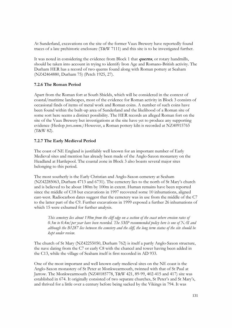
refounded in 1075 and became a cell of Durham Priory in 1083. It is situated at 15m OD on a level terrace above the north bank of the River Wear. The only feature visible at the site is the church, though extensive remains of the monastic site have been recorded by excavation. Of the surviving fabric, it has been suggested that the west wall of the nave and the lowest stage of the tower represent the earliest remains and date from the late C7, with further stages being added to the tower circa 700 and at the end of the C10. The rest of the church represents a C13 rebuilding. The pre-Conquest monastic buildings were replaced by a standard conventual layout in the late C11 but excavations have shown that the earlier arrangements were more haphazard and similar to those identified at Hartlepool (Pevsner 1983, 465-467). Monkwearmouth monastic settlement is a Scheduled Ancient Monument.
Figure 7.3 St Peter’s Church, Monkwearmouth (author) The promontory at Tynemouth, occupied in the Iron Age, was also the site of an important Anglo-Saxon monastery (NZ37276938, T&W 123) and the burial place of King Oswine. Excavations in the 1960 and 1980s revealed the footings of a number of timber buildings (Jobey 1967; Fairclough 1983). The monastery was sacked by the Vikings in 800 and the History of the Church of Durham records that the Viking army under Healfdene occupied the site in the 870s. The third early medieval site in this group, the monastery at Jarrow, lies outside the study area. 7.2.8 The Medieval Period The most important Medieval site in Block 3 is the priory and castle on the headland at Tynemouth. In 1085, Robert Mowbray, Earl of Northumberland, founded a Benedictine Priory on the site of the earlier Anglo-Saxon monastery. The main upstanding element of the priory is the church which exhibits two main phases of development, in the late C11 and the early C13. The cloistral buildings, most of which do not survive above foundation level, lay

133
to the south while the monks cemetery was situated to the south and east of the church. Tynemouth Priory was dissolved in 1539. The remains of the priory are situated within the walls of an enclosure castle, the origins of which also lie in the late C11. Early documents record that the castle at Tynemouth was besieged in 1095 during the rebellion of Robert Mowbray against William Rufus and it has been suggested that the remains of this early castle may survive in the large earth mound, known at the Mount, situated at the SW corner of the headland. This early castle would have been of the motte and bailey type. However, in 1296 the Prior of Tynemouth was granted a licence to crenellate and work began on the construction of walls and towers around a circuit of nearly 1000m, one of the largest castles in England at the time. The visible remains are mainly of C13 and C14 date and include the massive gatehouse and barbican, the main strong point of the castle. After the dissolution of the priory the castle remained in use as part of Henry VIII’s scheme of coastal defence and this aspect will be considered below. Tynemouth Priory and Castle is a Scheduled Ancient Monument. Although the priory and castle at Tynemouth have an evident coastal situation their raison d’etre was not primarily coastal, and the choice of site was governed by considerations of defence. Nevertheless, the possibility of being re-supplied by sea in the event of a siege was probably an important consideration and the small bay immediately to the south of the headland is known as Prior’s Haven. There are few other records of specifically Medieval features in Block 3. The Durham HER has just two records, the site of a putative medieval fire beacon at Beacon Hill (NZ44184544, Durham 3846) and Seaham village (NZ42255052, Durham 4935) which first appears in historical records in the late C10. The Tyne and Wear HER has rather more entries but individual details of each site are not available and several are only known from historical sources and cannot be precisely located. These include the record of a C13 coal mine (T&W 733) worked by the monks at Tynemouth and represents the first occurrence of what was to become a major industry within Block 3. The most widespread feature of medieval date in Block 3 is ridge-and-furrow . The NERCZA assessment is on the transcriptions produced by the APTE. With the exception of the belts of dune sand backing the foreshore, traces of ridge-and-furrow are virtually ubiquitous outside the built-up areas and those disturbed by mining and quarrying. Detailed documentary analysis should make it possible to associate some of these furlongs with specific areas of common fields and with the centres of population which lay at their focus. 7.2.9 The Industrial Period The main industry on the coastline of County Durham in Block 3 has been coal mining, four major mining sites being represented within the area. The history of the Durham Coalfield is one of migration from west to east as the mines followed the increasingly deeper strata, eventually winning coal from far under the North Sea. Accordingly, the collieries in the coastal zone mainly represent a late phase in the history of the industry, production having

134
began in the late C19. The most southerly was Horden Colliery. To the north was Easington Colliery which began production in 1899 and continued for 94 years. The shafts had been sealed and, with the exception of the power house and colliery office, the above ground buildings had been cleared by 1994. North of Easington was the Dawdon Colliery, which occupied the site of the former Seaham Iron Works (Durham 8308). Shafts were sunk at Dawdon between 1894 and 1907. Dawdon ceased production in 1992 with the site being cleared by 1997. The most northerly of the group is the Vane Tempest, or Seaham, Colliery where the first shafts were sunk in the 1850s. Like the other collieries along this coast closure came in 1992 and the site had been cleared by 1994.
As indicated above, these collieries had all closed by the end of the C20 and their sites had been cleared to make way for other developments. However, the works underground have mainly been capped and are vulnerable to exposure as the cliff face erodes. The SMP policy south of Seaham is one of NAI which, if implemented, may have implications for the underground works of the Horden, Easington and Dawdon Collieries.
Table 7.7 Collieries in Block 3
NGR Name HER SMP Importance Risk
NZ441418 Horden Durham 8312 10.1 Low Low NZ437441 Easington Durham 3843 10.1 Low Low NZ432475 Dawdon Durham 3844 9.6 Low Low NZ423502 Vane Tempest Durham 3841 & 4809 9.2 Low Low NZ364707 Cullercoats T&W 1196 4.7 Low Low NZ393579 Monkwearmouth T&W 2743 n/a Low Low NZ409537 Ryhope T&W 2947 8.4 Low Low NZ409633 Whitburn T&W 2493 5.2 Low Low NZ373668 Westoe T&W 5110 n/a Low Low NZ355718 Whitley T&W 1192 46 Low Low
The Northumberland HER has seven records which all refer to the pits associated with Old Hartley Colliery.
Table 7.8 HER records of pits at Old Hartley Colliery
NGR Name NH HER SMP Importance Risk
NZ33357571 Old Fortitude 20793 44 Low Low NZ33787573 Old Engine 20975 44 Low Low NZ33537591 June 20794 44 Low Low NZ32997600 Bloom 20899 44 Low Low NZ33207599 Swallow 20800 44 Low Low NZ33787624 Whin 20797 44 Low Low NZ33557639 Mill 12004 44 Low Low
Other large scale industries recorded are a chemical and a bottle works, both at Seaham (Durham 8306 and 8305), Ambrose Crowley’s Iron Works (T&W 4437), a bottle glass factory (T&W 4409) at Sunderland, an alkali works (T&W 4594) at South Shields and the

135
Hartley Bottle Works (NZ336765, NH 12006) at Seaton Sluice, while smaller scale activity is represented by numerous lime kilns. The APTE has recorded a number post-Medieval ironstone mines on Whitley Links (NZ353729, NMR 11465181). 7.3 Coastal/maritime Landscapes 7.3.1 The Mesolithic Period The only unequivocal indication of coastal/maritime exploitation strategies during the Mesolithic period in Block 3 is provided by the barbed point picked up on the foreshore at Whitburn in 1852. This item, which appears to be made out of a segment of red deer antler, has been fully described by Mellars (1970). It measures 87mm long and varies in width from 14mm to 4mm. It has three barbs on each side, although the distal pair are very worn and almost vestigial. There is an oval hole for the attachment of a line at the broad, proximal end which suggests that this item should be classified as a harpoon. Flat, barbed points, either
Figure 7.4 The Whitburn barbed point, ventral view (Museum of Antiquities) uniserial or biserial, are characteristic of the Late Mesolithic in northern Britain, directly dated specimens belonging to the 6th,5th and 4th millennia cal BC. All other examples come from the west coast with a concentration on sites of the so called ‘Obanian’ group in Argyll, though an example from Cumstoun on the coast of Dumfries and Galloway is of a similar latitude to the Whitburn harpoon. No details are known about the provenance of the Whitburn harpoon other than the approximate location and date of the find. In his report Mellars refers to submerged forest beds being exposed in Whitburn Bay, about 1km south of the village of Whitburn. These deposits are said to be similar to those studied between Hartlepool and Seaton Carew described in Chapter 6 and a flint blade was recovered from this deposit in 1993 (T&W 1997). The Whitburn Bay deposits were also studied by Trechmann (1936, 166-167) and these deposits offer a likely source for the Whitburn harpoon.
An annual erosion rate of 0.4m has been recorded at Whitburn Bay. The bay lies within SMP Policy Unit 6.2 for which the recommendation is MR. Accordingly, it may be necessary to consider the long term implications of this policy for the off-shore submerged forest beds.
Harpoons are generally interpreted as evidence for the hunting of marine mammals. Seal are endemic creatures of the NE coast and whales are frequent visitors. The Whitburn barbed point offers an interesting insight into the economic lives of the early inhabitants otherwise mainly represented by mute assemblages of stone tools.

136
There is an absence of evidence for coastal/maritime activity on this section of the coast during the rest of the prehistoric period. Whether this reflects a genuine lack of interest or simply a lack of evidence is unclear. 7.3.2 The Roman Period The principal Roman site in Block 3 is the fort at South Shields (NZ36506793, T&W 914), known by its ancient name as Arbeia. This site is situated at 25m OD on Law Top, a flat topped hill overlooking the mouth of the Tyne on the south side. Excavations over more than a century have shown this to be a complex, multi-period site involving several phases of rebuilding between the earlier C2 and late C4 (Hodgson et al 2001). The first fort, dating from circa AD129, was part of the Hadrian’s Wall system, although it is situated 6.5km east of the end of the Wall at Wallsend on the north bank of the Tyne. The South Shields fort was garrisoned by units of cavalry and it is assumed that it guarded a small port at the mouth of the Tyne. The original earth and timber fort was replaced in stone circa AD160 but a more major reorganisation occurred in the first decade of the C3 when the fort was turned into a supply base both for the garrison of Hadrian’s Wall and for military operations north of the frontier. This involved subdividing the fort into northern and southern portions and extending the southern portion by 45m. The barracks in the northern portion were demolished and replaced by 18 granaries. The garrison at this time consisted of units of infantry. Further reorganisation occurred circa AD230 when more granaries were added. The fort appears to have been abandoned at the end of the C3 but was reoccupied at the end of the C4 with activity in the post-Roman and Early Medieval periods being recorded.
Figure 7.5 The reconstructed gate at South Shields Roman Fort (author) An inscription records the presence of river boatmen from the Tigris, and the name Arbeia has been interpreted as ‘Place of the Arabs’. These boatmen presumably crewed lighters that

137
transported commodities upstream and between the shore and seagoing ships in the offing. It follows from this that there must have been port facilities (T&W 910) at South Shields, but no trace of these survived the development of the river in the C19. However, the HER records a possible Roman shipwreck at NZ36716829 (T&W 4672), immediately below the fort. Over the centuries a substantial civilian settlement or vicus grew up outside the fort on the level ground to the west and south. Arbeia is included within the Hadrian’s Wall World Heritage Site and is a Scheduled Ancient Monument. 7.3.3 The Early Medieval Period Little is known of coastal activity in Block 3 during the Early Medieval Period. However, with Anglo-Saxon monasteries at Monkwearmouth and Tynemouth it can be assumed that the coast and river systems formed part of their infra-structures. It is also the case that both were sacked by Viking raiders, in AD794 and AD800 respectively. 7.3.4 The Medieval Period The small bay to the south of the Tynemouth headland is known as Prior’s Haven and it is recorded that in 1544 the Earl of Hertford made Tynemouth the base for the English fleet during the invasion of Scotland. The Tyne and Wear HER records a medieval port (T&W 1989) on the south bank of the River Wear opposite St Peter’s monastery while a medieval ferry is recorded a short distance upstream (T&W 76). Other records, for which locational details are not available, include a medieval salmon yare or fish trap in the Tyne at South Shields (T&W 4485) and a medieval shipyard at Hendon (T&W 81). This latter facility is known from a document of 1346 which records that a Thomas Menvil occupied a site at Hendon “for the building of ships, paying to the Bishop an annual rent of two shillings.” (Sunderland Museum and Art Gallery 1965) A feature of the ports of the NE coast, mainly in the C19 and C20, were the coal staiths, facilities specifically designed for the loading of colliers. Coal is first recorded as having been exported from Sunderland in 1396 and there is a C15 record of a coal staith at Wearmouth (T&W 75) for which the Benedictine monks received an annual rent in 1415-1417, while a William Salter is recorded as the tenant of a coal staith in 1470. Shipbuilding was to become a major industry on the rivers Wear and Tyne but another industry which is first recorded in the Middle Ages is the production of salt from sea water. In considering data from Block 1 it was noted that salt production in the Teesmouth area generally involved the extraction of salt from the salt-encrusted surface of the inter-tidal silts, a process known as sleeching. Farther north the direct boiling process was employed. This method involved accumulating sea water in a reservoir then pumping it up to the saltworks where the water was simply boiled off in iron pans. The fuel used was coal and direct boiling is recorded on Tyneside in the C15 (Cranstone, pers.comm.). Medieval salt pans are recorded at three locations in North Shields (NZ35906826, NZ36306822 both recorded as T&W 4552 and NZ36646901, T&W 736) and at Seaton Sluice, Northumberland (NZ337768, NH 11958). Although there are no surface remains the

138
evaporation of brine to produce salt is recorded at Seaton Sluice from C13 (Telford 1974, 181-193). 7.3.5 The Industrial Period 7.3.5.1 Salt making Salt making is recorded in the C16 at Wearmouth (NZ399574, T&W 80), ten salt pans being referred to in a document of 1587 (Mitchell 1919, 53-54), and in the C17 and C18 at Cullercoats where a lease of 1677 records a saltworks with two pans being situated near the pier. The Cullercoats salt pans used coal from the local mines and by 1705 there were 19 pans around the harbour. However, by 1722 the easily worked coal had been exhausted and the pits closed thus denying the salt works its source of fuel and salt making at Cullercoats ceased in 1726, six of the pans being removed to Blyth and the rest abandoned (Mitchell 1919; Linsley 2005, 196-198). Production continued at Seaton Sluice until the C18 (NZ339768, T&W 11958). Five salt pans are recorded in production at Hartley, the village of Seaton Sluice, in 1600. Production had ceased by 1798 (Ellis 1980; Linsley 2005 172-189). 7.3.5.2 Harbours The development of coastal trade from the middle of the C18, particularly the shipment of coal from north to south, led to a considerable increase in shipping and an increase in the facilities to service this traffic. These facilities were many and varied and ranged from simple navigation aids to the provision of major harbours such those built at Seaham, Sunderland and on the Tyne in the C19, many of which remain in use. Seaham Harbour was founded by the Marquess of Londonderry in 1828 as an outlet for coal from his collieries. The harbour was planned by William Chapman and at first consisted of what survives today as the Inner Harbour (NZ43504947, Durham 12602) and is a Grade II Listed Building. The exploitation of coastal coal reserves from the mid C19 led to the major expansion of Seaham Harbour between 1898 and 1905.
Figure 7.6 Seaham Harbour, County Durham (author)

139
The harbour works at the mouth of the River Wear date from the C18 and C19. The South Pier (NZ410582,T&W 2867) was built between 1726 and 1759 and the North Pier (NZ410583,T&W 2715) added between 1788 and 1802, though both were modified and extended between 1804 and 1842 and the South Pier was demolished in 1982. The North Dock (NZ406584, T&W 2717) was built between 1834 and 1837 to a design by Isambard Kingdom Brunel. It had an area of 2.5ha (6 acres) and a 0.6ha (1.5 acres) tidal basin. It is regarded a significant structure by one of the greatest engineers of the C19 (C orfe 1983, 18) and its remains are a Grade II Listed Building. An illustration of 1849 by Thomas Meik shows the North Dock full of ships.
Figure 7.7 Thomas Meik’s 1849 illustration of North Dock, Sunderland The South Dock (NZ410573, T&W 2874) was added to the complex between 1846 and 1868 (Pevsner 1983, 449). By the latter part of the C19 it was realised that the harbour mouth needed more extensive protection than that provided by the C18 North and South Piers and two new piers, or

140
breakwaters were added extending 600m out into the North Sea. The northern outer breakwater, Roker Pier (NZ412588, T&W 4800), was constructed between 1885 and 1903 to a design by Sir John Coode modified by Henry Hay Wake and is a Grade II Listed Building. Wake also began work on an outer south pier, The New South Pier (NZ414580, T&W 4973) but this was abandoned in 1907 and was left uncompleted. The 1st edition of the OS Map for 1855 records small quays at Byer’s Hole, Whitburn (NZ41116386, T&W 2425) and Marsden Bay (NZ39786559, T&W 859). The extant harbour works at the mouth of the Tyne are mainly late C19 in date. The two piers, North and South, (NZ378691, T&W 2065 and NZ378682, T&W 2429) were finished by 1895. Work is recorded as having begun in 1854 but both are shown under construction on a chart of The Entrance to the River Tyne dated 1838-1849i. They replaced earlier structures, remains of which can still be identified adjacent to the North Pier and are shown on Admiralty Chart 1934. Some rebuilding to these piers was required in 1909 after storm damage. The South Groyne (NZ368682, T&W 2428) was built between 1861 and 1867. The first phase of the tiny harbour at Cullercoats can be dated to the late C17 when in 1676 what is described as ‘pier’ was constructed at Cullercoats for the shipment of coal from the local mines and salt from the salt works, though it is evident that this ‘pier’ was actually a stone built structure. It was partly destroyed by a storm in 1710 and over a century was to pass before the harbour was restored; plans drawn up by Smeaton in the mid C18 being regarded as too costly. The present north pier (NZ364713, T&W 5056) was built in 1848, partly on the remains of the C17 pier (Linsley 2005, 195-203), while the south pier is a C20 structure. There has been a small harbour at the mouth of the Seaton Burn from at least the mid C17 (NZ337768, T&W 11980) and by 1676 it was protected by a small pier built by Sir Ralph Delaval. In order to address the problem of silting Sir Ralph had a sluice built about 200m upstream behind which the water of the burn could be impounded. When released, this water scoured the harbour and it is from this feature that Seaton Sluice takes its name. The main commodities shipped from the harbour consisted of coal from the local mines, bottles from the Royal Hartley Bottle Works (NZ33657659, T&W 12006) situated to the south of the burn, and salt from the salt pans on the headland. By the mid C18 the little harbour at the mouth of the burn was found to be inadequate and a supplementary, artificial harbour was constructed between 1761 and 1764. This consisted of a rock-cut channel running from the mouth of the burn eastwards to the sea, thus cutting off the headland (NZ338768, T&W 13972). It was 275m long, 9.1m wide and 15.8m deep with lock gates at either end (Pevsner 1992, 564-565).

141
Figure 7.8 Seaton Sluice harbour; the sluice is below the road bridge (author)
Figure 7.9 The rock-cut, artificial harbour at Seaton Sluice (author) 7.3.5.3 Shipbuilding The NE of England is world famous for its shipbuilding heritage and those sections of the banks of both the River Wear and the River Tyne within the NERCZA study area are lined with shipyards, while those on the Tyne extended upstream virtually as far as the tidal limit at Newburn. Shipbuilding in the Sunderland area has been traced back to the C14 while the shipyards on the Tyne date back to at least the C17. In 1642 a House of Commons

142
Committee designated Newcastle as “the nursery of shipbuilding” (Parry 2006, 32). The HER records an C18 shipyard at North Shields (NZ36266850, T&W 11970) where John Hearn was carrying out ship repairs in 1779 and built 23 ships between 1787 and 1806 (Clarke 1997, 28). The main shipyards recorded in the Tyne and Wear HER are listed in the following table.
Table 7.9 Shipyards in Block 3 recorded in the Tyne and Wear HER
NGR Name HER
NZ391576-NZ405581 Monkwearmouth Shipyard 2744,2754, 2733, 2722, 2720 NZ393575 Sir John Priestman & Co 4692
NZ398573-NZ402573 Bishopwearmouth Shipyard 2864 and 2866 NZ410578 Bartram and Sons Ltd 4694 NZ413571 Iliff & Mounsey 4695 NZ363681 South Shields Shipyard 2334
A detailed appraisal of this aspect of the region’s heritage is beyond the scope of the present project. Although these shipyards had all closed by the end of the C20, their sites have been subject to redevelopment and all lie within densely built up areas. The scope of the SMP did not extend to the lower reaches of either river but it may be assumed that the policy adopted to deal with sea level rise in these areas will be one of ‘Hold the Line’. In addition to the shipyards, a number of support industries are also recorded in the HER such as the site of an C18 ropewalk at Monkwearmouth (NZ403577, T&W 4482). 7.3.5.4 Aids to Navigation and Safety at Sea Lighthouses The C18 North and South Piers at Sunderland were both provided with lighthouses, that on the North Pier, a masonry structure, (NZ41145842, T&W 4974) was built by Johnathan Pickernell in 1802 (Hague and Christie 1977, 222), though it was moved in 1841 to the end of the extended pier. That on the South Pier (NZ41105827, T&W 4966), an 1856 wrought iron structure with a cast iron dome (Pevsner 1983, 453) was moved to Roker (NZ 40745978) when the pier was demolished in 1982. It is a Grade II* Listed Building. The new North, or Roker Pier, built at the end of the C19, was also provided with a lighthouse (NZ41605870, T&W 4975). This is built of Aberdeen granite and is a Grade II Listed Building. The lighthouse at Souter Point (NZ40806416, T&W 2489) was designed by Sir James Douglass in 1871 and was one of the first to employ electricity. It is a Grade II* Listed Building.

143
Figure 7.10 The Grade II* South Pier Lighthouse, Sunderland re-sited at Roker (author)
Figure 7.11 The Grade II* Lighthouse at Souter Point (author)
The earliest record of a lighthouse on this section of the coast is the provision by the monks at Tynemouth of a light to be shown in on one of the two turrets at the east end of the priory church, to act as a guide to mariners entering the Tyne. This monastic ‘lighthouse’

144
collapsed in 1659 and was replaced in 1664 by a purpose built structure at the NE corner of the headland, which employed a coal fired brazier to provide a light. This lighthouse was rebuilt in 1775 and the earlier coal brazier was replaced by an oil lamp in 1802. It was finally demolished in 1898 (Saunders 1993, 39) when it was made obsolete by the construction of the lighthouses at the end of the North Pier and on St Mary’s Island, to the north (Hague and Christie 1977, 76-78). The North Pier lighthouse (NZ38286904, T&W 7347) was built as part of the construction of the North Pier, which was completed in 1895. It is a Grade II Listed Building. While the South Pier was not provided with a lighthouse, one had already been erected on the South Groyne at the mouth of the river in the 1860s (NZ36926831, T&W 2431). This is an unusual structure consisting of a hexagonal iron and wood cabin raised on six struts. The cabin is approached by a flight of stairs and surmounted by a lantern chamber.
Figure 7.12 The South Groyne Lighthouse, Tynemouth with the North Pier and Lighthouse in the distance (author)
St Mary’s Island is a tidal reef 6.7km north of Tynemouth and the lighthouse was built 1897-1898 (NZ35257538, T&W1037). However, earlier the island was the site of chapel dedicated to St Helen and a recorded endowment provides for the chapel to show a light (Craster 1909, 120; Hague and Christie 1977, 18), though whether this was for navigation purposes is not explicit.

145
Figure 7.13 St Mary’s Island and Lighthouse (author)
Seamarks The remains of four posts (NZ44504285, Durham 8290) on the cliff at Hordon, County Durham, have been interpreted as the remains of a navigation aid. In this situation they are unlikely to have been leading marks and may simply have been provided to enable coasting vessels to fix their position. The simplicity of the arrangement at Hordon may be contrasted with the complexities necessitated by the situation at the mouth of the Tyne. Entry to the River Tyne was made hazardous both by the reef known as The Black Middens lying on the Tynemouth side and a series of sandbanks, the position and extent of which was constantly changing. In 1536 the Guild of the Holy Trinity of Newcastle obtained from Henry VIII a charter to erect two ‘embattled’ towers in order to provide leading marks for vessels entering the river, the alignment of the two towers indicating the main channel. These structures appear to have been of wood and were illuminated by candles. They needed to be moved from time to time owing to the movement of the sandbanks and were mounted on wheeled carriages. A chart of the course of the Tyne from Newcastle to Tynemouth dated 1639 shows two structures on the north bank down stream from North Shields. They are unlikely to be the original towers. The one nearest the mouth is shown as a rectangular structure with a pitched roof and labelled ‘The Lowe Leight House’. The other, labelled ‘The Heigh Leight House’, is shown as a cylindrical tower surmounted by what appears to be a lanternii. These structures were eventually replaced in stone by pairs of lighthouses, the High and Low Lights. The first to be erected, in 1727, was the Old Low Light (NZ36306848, T&W 4557). It was situated within the confines of Clifford’s Fort, a C17 artillery fort at the mouth of the Tyne (see below), and was converted into almshouses in 1830 once it became obsolete. The other component in this arrangement was the Old High Light (NZ36116845, T&W 4556), situated on the higher ground about 200m to the west. This also dates from 1727 and is a Grade II Listed Building. By the early C19 movement of the sandbanks at the river mouth

146
necessitated the provision of two new towers, a New Low Light (NZ36296844) and a New High Light (NZ36056838, T&W 2129). Both the New Lights are Grade II Listed Buildings.
Figure 7.14 The ‘New’ High and Low Lights at North Shields (author) A similar, though less complex arrangement was provided on the South Shields side where the West and East Lawe Beacons (NZ36546806, T&W 2347 and NZ36596808, T&W 2346) provided a leading line on the south side of the river mouth. These structures are both brick built obelisks on stone bases with stone caps. They date from 1832 and are Grade II Listed Buildings.
Figure 7.15 The East Lawe Beacon, South Shields (author)

147
A far more basic arrangement of leading marks is provided at Cullercoats Harbour where two vertical poles with lamps and surmounted by baskets mark the bearing of 256o True required for a safe entry. Volunteer Life Brigades’ Watch House and Rocket Sites Rescue facilities along the coastline of Block 3 can be divided into those provided for the various volunteer life brigades and the lifeboat stations . The brigades generally operated from the shore and used rockets to carry a rescue line to stranded vessels. The facilities usually consisted of a lookout, accommodation for members of the brigade when on duty and the mountings for, and storage of, the rocket apparatus, though these latter are rare survivals. Several of these brigades are still in existence, and their premises often incorporate small museums documenting their history.
Figure 7.16 The Seaton Sluice Brigade mustering with their rocket apparatus
The Durham HER records two rocket apparatus stations for ship-to-shore rescue (NZ44204585, Durham 3850 and NZ44094584, Durham 3851) at Hawthorn Hive. The Sunderland Volunteer Life Brigade Watch House is situated at Pier View Roker (NZ40854868) and the South Shields Volunteer Life Brigade Watch House (NZ373678, T&W 2430) is situated at the end of the South Pier. It was built in 1867 and is a Grade II Listed Building. The watch house (NZ37366903, T&W 1978) of the Tynemouth Volunteer Life Brigade is situated within the area occupied by the Spanish Battery. The original structure was built about 1865 and was replaced by the existing building in 1887 (T&W 2214). This consists of a hall, now a museum, and a lookout tower. It is a Grade II Listed Building. The Rocket House (NZ36307140, T&W 5059) at Cullercoats was where the Cullercoats Life Brigade stored its rocket apparatus. This building, now the Rocket Garage, was built in 1867 and is also a Grade II Listed Building. The brigade’s Lookout House (NZ36407140, T&W

148
5057), built 1877-79, is situated on the cliff overlooking the harbour. The Watch House at Seaton Sluice (NZ38366862, NH 13976) is situated on the headland known as Rocky Island. It is a brick built structure dating from 1880. Like the others mentioned above, it is a Grade II Listed Building. The Watch House is supplemented by a timber lookout built on the cliff edge in 1925.
Figure 7.17 The Seaton Sluice Volunteer Life Brigade Watch House (author) Lifeboat Stations The history of lifeboats on the River Wear begins in 1800 with the first operational lifeboat station in Great Britain, absorbed into the RNLI in 1865. There have been 12 lifeboat stations on the lower Wear, with four in operation between 1873 and 1887. The Tyne and Wear HER records a C19 lifeboat house at Hendon (NZ40995661, T&W 2892) and Monkwearmouth (NZ40795856, T&W 2712) both of which appear on the 1st edition OS map for circa 1855, while the site of the C19 lifeboat house at Whitburn (NZ40806125, T&W 2575) has been recorded from the 2nd edition OS map of 1899. The Tyne and Wear HER records the site of a C18 lifeboat house at North Shields (NZ36406859, T&W 1972). This was located adjacent to Clifford’s Fort and housed the lifeboat Northumberland in 1798. This was the first of six lifeboat stations, the second (NZ37306915, T&W 1982) being built in Prior’s Haven in 1862. This is represented today by a roadway (NZ37416918,T&W 1983) cut into the rock and visible at low tide. A third station, Tynemouth No.2, (NZ37246898, T&W 1977) was added at Black Middens in 1865 and closed in 1905. The next was built at North Shields (NZ36406850, T&W 8000). This was destroyed by a bomb in 1941 but was in operation again by the end of the year. A new station was built in 1948 and this remained in service until the present station was opened in 1997.

149
There has been a lifeboat at Cullercoats since 1852 and the present lifeboat house (NZ36407140) was built in 1896 at the head of the strand inside the harbour. 7.3.5.5 Shipwrecks As was the case with Block 1, shipwrecks are also a feature of the coastal/maritime landscape. Large numbers of shipwrecks are recorded in the HERs and in the NMR, but most of these are in deep water beyond LAT. However, a number are recorded between LAT and MHWS and these are listed in the following tables. Most of these records have been taken from historical sources such as the Lloyds Registers and the local press and therefore the existence of a record does not necessary imply that remains are still visible on the foreshore.
Table 7.10 Shipwrecks between MHWS and LAT in Block 3 recorded in County Durham
NGR Name of vessel Date lost HER SMP
NZ45014199 Barquentine Sirius 1901 6572 10.1
NZ444439 Dover Excursion 1821 10285 10.1 NZ444439 Unidentified vessel 1901 10276 10.1 NZ444439 Dido 1821 10284 10.1
NZ44304600 Schooner Miss Thomas 1864 6571 9.7 NZ44214619 Brig Rainbow 1835 277 9.7 NZ436486 Steamship Lillian 1903 285 9.5 NZ436486 Steamship Terlings 1889 278 9.5
NZ42995002 Steamship Aurora 1885 282 9.3 NZ420520 Brig Gitana 1974 281 9.1
NZ43005000 Steamship Norman 1881 280 9.3 NZ432496 Barque Excelsior 1876 279 9.3
Apart from the putative Roman shipwreck at South Shields the Tyne and Wear HER does not systematically record shipwrecks and data comparable to that for County Durham have been obtained from the NMR.
Table 7.11 Shipwrecks between MHWS and LAT in Block 3 recorded in Tyne and Wear
NGR Name of vessel Date lost NMR SMP
NZ41125818 Sailing vessel Molito 1830 1406252 7.3
NZ40975848 Orion ? 908710 7.2
NZ40056535 Unidentified steel vessel ? 908641 4.1
NZ37846740 Unidentified sailing vessel 1703 1366333 2.1
NZ37846740 Unidentified vessel 1854 1366333 2.1
NZ36156878 British Officer 1940 908748 1.2

150
NZ37526854 Unidentified vessel ? 908652 1.2
NZ37306854 HMS Southsea 1941 908746 1.2
NZ36776836 Thomas 1833 1434819 1.2
NZ36776836 Unidentified vessel 1750 1438910 1.2
NZ36776836 Roseberry 1819 971596 1.2
NZ37566948 Hope 1803 973326 1.1
NZ37566948 Petrel 1831 1387150 1.1
NZ36437133 Steamer Sjovik 1916 1371831 47
NZ36777173 Steamer Butetown 1917 1380514 47
NZ35227539 Unidentified vessel ? 908667 45
7.4 Military Coastal Defence 7.4.1 C16 to the C19 After the dissolution of Tynemouth Priory in 1539, Tynemouth Castle became part of Henry VIII’s scheme of coastal defence and was converted into an artillery castle. The eminent military engineer Sir Richard Lee, designer of the defences at Berwick-upon-Tweed, was sent to Tynemouth in 1545. The medieval walls of the castle were reinforced and the main front was replaced by stone revetted earthworks providing artillery platforms. These C16 modifications were part of a larger system designed to command the entrance to the Tyne. The view of the river mouth from the castle had always been somewhat impeded by a lower promontory to the south on the far side of Prior’s Haven. To address this issue it was decided to extend the earthworks of the castle behind Prior’s Haven to cut off the small promontory to the south, where further guns would be sited, with a clear field of fire across the river mouth. This became known as the Spanish Battery, after the Spanish mercenaries employed to garrison it. Lee undertook further work at Tynemouth in 1560. One of his original plans survives and the intention appears to have been to construct a battery on the lower headland and connect it with the castle by a system of walls. It is unclear to what extent this plan was carried out in full and the evidence on the promontory has been obscured by later developments. Jobey (1967, 96) records that these defences had been largely destroyed by the late C19 but a chart of the mouth of the Tyne dated 1838-49 shows substantial remains surviving at that timeiii. These appeared to consist of a lozenge-shaped bastion at the SW corner from which a length walling ran north towards the castle interrupted by a semi-circular bastion and fronted by a deep ditch. Jobey was able to identify some fragments of the Tudor defences. On the promontory itself, the chart shows other works but these are likely to be later in date than the C16 and it is recorded that the battery was in commission during the Civil War (Craster 1907, Plate XII; Adamson 1896).

151
During the English Civil War Tynemouth Castle constantly changed hands between Royalist and Parliamentarian forces. With the Restoration of Charles II, Sir Edward Villiers became governor and it is recorded that a programme of repairs was initiated in 1663.
By the late C17 the defence of the river mouth provided by Tynemouth Castle and the Spanish Battery were considered inadequate and a new artillery battery was established about 1.2km upstream at North Shields (NZ36336851, T&W 150). This became known as Clifford’s Fort, probably named in honour of Thomas Clifford, Charles II Lord High Treasurer and a veteran of campaigns against the Dutch (Kear 1986). Clifford’s Fort was designed by the Swedish engineer Martin Backman and built in 1672. It consists of an irregular, sub-rectilinear enclosure 150m N-S and 57m E-W. The long, eastern side faces the open river. The original armament consisted of thirty 18 pdr culverins and ten 9 pdr demi-culverins, or ten 24 pdrs. By the mid C18 this had been reduced to eighteen 18 pdrs facing the river and nine 9 pdrs facing towards the land and it was in this phase that the ashlar faced seaward curtain wall with its multiple embrasures was built. Buildings within the enclosure consisted of accommodation for the gunners and stores. As a gun battery Clifford’s Fort became obsolete at the end of the C19 when the construction of the outer piers of the harbour made the guns redundant. In 1888 it became the headquarters of the Tyne Division Royal Engineers (Volunteers) Submarine Miners. Nevertheless some armament remained at the fort and Dobinson (200a, 227) records the presence of two 6 pdr quick firing guns in 1902. A chart of circa 1700 by Captain Greenvile Collins, Charles II Hydrographer, depicts a gun battery (NZ33807687, NH 11956) on the promontory commanding the entrance to the harbour at Seaton Sluice. This is the Delaval Battery established sometime before 1670 by Sir Ralph Delaval. It apparently saw action in 1667 when warning shots were fired at a Dutch privateer harassing a small vessel trying to enter the harbour (Linsley 2005, 174-175; Craster 1909, 127) There are no surface remains and the site is activity eroding. The Roker Battery (NZ40675935, T&W 86) was situated on the cliff edge about 1km north of the mouth of the River Wear. The surviving remains and those plotted as part of the APTE date from WWII and are referred to below. However, the HER suggests that there may have been a battery here in the later C18, as the northern of two batteries reportedly built at Sunderland in 1779. An C18 plan of Sunderland marks the positions of a number of gun batteries on the south side of the river mouth and these are also recorded in the Tyne and Wear HER. Jockey Dyke Nook and South Dock Batteries apparently mounted four guns in the 1740s while Coney Warren Battery mounted six in 1783. These gun batteries have all been destroyed, either by coastal erosion or during the development of the docks. A map of 1826 by the engineer John Rennie depicts a large rectangular enclosure in this area marked ‘Barracks’ (Sunderland Museum and Art Gallery 1965). The earliest extant coastal defence at Wearmouth is the late C19 gun battery situated immediately SW of the old South Pier and known as the Wave Basin Battery. The War Office obtained this site in 1860 and the battery was established by 1873. It consists of a mole projecting into the harbour and mounted four rifle muzzle loading (RML) 80 pdr guns

152
Table 7.12 C18 gun batteries at Sunderland
NGR Location/Name Date T&W HER
NZ40675935 Roker 1779 86 NZ40965697 Town Moor C18 4419 NZ41015751 Jockey Dyke Nook c1745-1780 4418 NZ40395764 South Dock 1742 4417 NZ41065775 Flag Staff Battery C18-1808 4420 NZ41025777 Coney Warren Battery C1783-1848 4416 NZ40925783 John Paul Jones or Black
Cat Battery 1770 4415
in four emplacements. Number 1 Gun was sited at the outer, rounded end of the mole while nos. 2 and 3 fired through splayed openings in the seaward, east, side of the battery. No. 4. Gun was sited at the landward end of the mole. This is the one surviving example of an RML battery between the Humber and the Tweed. It is an important illustration of the transition from cannon to modern artillery, and also illustrates the methods used to defend mercantile ports in the years after the Crimean War and the production of iron-clad warships. It is shown on an 1875 official plan of Hudson Docks and is a Grade II Listed Building. In 1882 a government committee proposed the establishment of a battery of two 10.4 inch breach loading guns at Frenchman’s Point, on the coast at South Shields. This was revised in 1888 to two 6 inch guns but nothing was done until 1900-1903 when a battery with a single 9.2 inch and two 6 inch guns was established (NZ387663, T&W 869). This site saw service in both WWI and WWII. A further late C19 venture was the establishment of an experimental ‘floating platform’ gun emplacement at Trow Rock (NZ38366667, T&W 870, NMR 1314370). This was designed by Hiram Maxim and used a system of hydraulics to raise and lower a standard naval gun from a concealed position. The site is a Grade II Listed Building (Clarke and Rudd 1989, 7-8). In the late C18 Tynemouth Castle was provided with a battery of seven 18 pdr guns overlooking the harbour mouth and at the height of the Napoleonic Wars this was increased to thirty-two 10 pdrs, eight 12 pdrs and eleven 9 pdrs. By 1841 the batteries had been reduced to 18 guns but by 1881 this had been increased again to 20, of which six were modern rifled pieces. Most of these earthwork batteries were for muzzle-loading guns and had been replaced by 1893 by emplacements for two 6 inch guns mounted on hydro-pneumatic carriages (Saunders 1993, 36-39). The guns at Tynemouth Castle were supplemented in 1897 by a searchlight emplacement (NZ37286930, T&W 1572) designed to help the guns fire at night. It is reported that remains of this site survive on the north side of the pier road.

153
7.4.2 World War I The Roker Battery (NZ40675935, T&W 86) was situated on the cliff edge about 1km north of the mouth of the River Wear. This battery mounted two 4.7 inch guns (Dobinson 2000a, 227). The APTE has been able to plot the position of two emplacements and various ancillary buildings, but as this battery also saw service in WWII it is unclear to which period these remains belong. Although not built over, the site is now a public open space and has been landscaped. The Kitchener Battery at Marsden (NZ40276402, NMR1403278) was one of a pair of ambitious coastal defence batteries installed towards the end of the war and known as the Tyne Turrets. This project, which was proposed in 1916, involved the mounting of two, twin 12 inch gun turrets from the guardship HMS Illustrious on land. The Kitchener Battery at Marsden was the more southerly of the pair while the Roberts Battery at Hartley complimented it to the north. Work began in 1917 but was not completed until 1921, when the guns were test fired and then closed down. The dismantling of the guns was underway by 1926. The Kitchener Battery has now been completely destroyed by quarrying but it is recorded on photographs taken before this. The main feature can be seen to be a circular gun emplacement about 18m in diameter with various ancillary buildings, all approached by a track way. The command post lay 600m to the SW at Lizard Lane (NZ402636, T&W 1835). Frenchman’s Battery at South Shields, established in the early C20 (see above) also saw service during WWI and WWII when it mounted the same armament as was deployed in 1905. That is, two 6 inch and one 9.2 inch guns.
The magnesian limestone cliffs from the Trow Point to Whitburn are actively eroding at a rate of between 0.1m and 0.2m/per year. The SMP recommended policy for this section of the coast is mainly one of NAI or R, HTL being proposed at two quarry sites. As was mentioned in the case of the Bronze Age remains at Trow Point, the adoption of this policy will have implications for the remains of C19 and C20 coastal defences at Trow Point and Frenchman’s Battery.
Following the recommendations of the Inspector General of Fortifications, by 1905 the armament at Tynemouth Castle consisted of one 9.2 inch gun, two 6 inch guns and two quick-firing 12 pdrs. With the exception of the 12 pdrs, which were removed in 1910, this constituted the armament during both World Wars and it is the remains of these facilities that can be seen on the site today (Saunders 1993, 16-19 and 38-39). The Inspector General also recommended that one 9.2 inch gun and two smaller guns be mounted on Spanish Battery. In the event, the armament deployed in both WWI and WWII consisted of two 6 inch guns (Dobinson 2000a, 227-228) while Kear (1986, 121) records that in 1914 the Royal Marines established a three gun battery outside Clifford’s Fort to cover the harbour mouth. Roberts Battery at Hartley (NZ343762, NMR 1465610) was the northern of the Tyne Turrets, complementing Kitchener Battery to the south. This project involved the mounting of a twin 12 inch gun turret from the guardship HMS Illustrious on land. Work began in 1917 but was not completed until 1921, when the guns were test fired and then closed down. The dismantling of the guns was underway by 1926. The gun emplacement is recorded from

154
aerial photographs as a circular feature about 17m in diameter. The site has been cleared but it is reported that access to some of the underground facilities can be gained from the cliff face, 70m to the east. Some of the ancillary structures survive and include the command post and officers accommodation, now Fort House, a water tower and a combined latrine and pillbox inserted in the perimeter wall. The remains of Roberts Battery are a Grade II* Listed Building.
Figure 7.18 The water tower at Robert’s Battery, a Grade II* Listed Building (author) For range finding the battery had two transmitting and two receiving cells. Both receiver posts have been demolished as has the northern transmitter. However, the southern transmitter post does survive as a tall, seven story tower at the north end of Percy Gardens, Tynemouth (NZ37046988, NMR 1414437). A gun emplacement on the roof was probably for a light anti-aircraft gun and is likely to be of WWII date. This structure is a Grade II Listed Building.
Roberts Battery is situated on a section of eroding cliff line, as accounts of access to some of the under ground facilities through the cliff face indicate. The SMP recommendation for this section of the coast is ‘Do Nothing’. Accordingly the situation need to be kept under review as the cliff line erodes.
Construction of Coulson Battery at Blyth Links (NZ32087930, NH 11976) began in 1916 and was completed in 1918. Its prime purpose was to protect the port of Blyth and the submarine depot ship Titania, and to operate in conjunction with the defences of the Tyne. During WWI the battery mounted two quick-firing 6 inch guns controlled from a command post situated within an enclosure. The emplacements are semi-circular and seaward facing. During WWI they were unroofed. The WWI command post is a two storey, flat roofed tower with the original metal range finder housing on the roof. Other buildings in the complex include ammunition stores, workshops and accommodation for the gun crews. The whole complex had a defended perimeter of barbed wire with pillboxes at the northern and

155
southern limits. Further accommodation lay outside the perimeter in the area between the battery and the searchlight emplacements (see below). In 1925 the battery became incorporated within the development of the South Beach, only to be brought back into service in WWII (see below). Coulson Battery is a Scheduled Ancient Monument.
Figure 7.19 Coulson Battery, Blyth; the southern gun emplacement (author)
Figure 7.20 Coulson Battery, Blyth; WWI and WWI command posts (author) A further WWI feature on this section of the coast is the pair of searchlights, formally Defence Electric Light (D.E.L.) emplacements, and their associated engine house at Blyth Links (NZ32057968, NH 11977). The emplacements are well preserved and are constructed of concrete, steel and brick. They are semi-octagonal in plan and have a curving projection on the seaward side provided with shutters which were drawn back when the light was exposed. The searchlight emplacements are Scheduled Ancient Monuments while the engine

156
house lying 50m to the west is a Grade II Listed Building. This D.E.L. emplacement operated in conjunction with the Coulson Battery 300m to the south.
Coulson Battery and the D.E.L. Searchlight emplacements are situated in the dunes at the head of South Beach, Blyth. The SMP recommendation for this section of the coast is ‘Hold the Line’. The threat posed to these assets is likely to arise from mitigation strategies rather than erosion.
7.4.3 World War II The majority of coastal/maritime features in Block 3 date from WWII and the approach followed here is that set out in Chapter 5 of NERCZA. Major sites which survive whole or in part are described in detail with minor, ephemeral and destroyed sites being recorded in tabular form. The WWII military features in the coastal zone can be divided into two groups according to whether their role was mainly to defend against bombardment, from the sea or from the air, or to confront a possible invasion, although the two categories are not mutually exclusive. 7.4.3.1 Coastal Defence Batteries Dobinson (2000a, 297) and the Durham HER (5695) record an Emergency Coastal Defence Battery at Seaham Harbour, Dobinson citing an NGR of NZ430498. It mounted two 6 inch guns. Although this site was demolished after WWII the HER reports that parts of the foundations were still eroding from the cliff in August 2007. Barrons Battery at Sunderland was unusual in that it consisted of two 12 pdr Quick Firing (QF) guns, one situated at the end of the inner North Pier and the other situated at the end of the inner South Pier (NZ41125843, T&W 85), which must have led to command and control problems. It is recorded as having been established in 1940 as an Emergency Coastal Defence Battery. The WWI Roker Battery (NZ40675935, T&W 86) was brought back into service in WWII. It mounted two 6 inch guns and the APTE has been able to plot the position of two emplacements and various ancillary buildings, but it is unclear to which period these features belong. Although not built over, the site is now a public open space and has been landscaped. Dobinson (2000a 114, 297) records the establishment of an Emergency Coastal Defence Battery at Whitburn in 1940. This site, which mounted two 6 inch guns, has been identified by the APTE at NZ40866138 (NMR 1462995). Frenchman’s Battery at South Shields, established in the early C20 (see above), also saw service during WWII when it mounted three 7.5 inch and two 6 inch guns. The transcription of aerial photographs during the APTE has enabled the plotting of three identical gun emplacements, presumably for the 7.5 inch guns (NMR 1314370). Various other structures on the site have been plotted but the emplacements for the 6 inch guns have not been identified. The site is now a public open space and the emplacements have been destroyed though some earthworks remain

157
The magnesian limestone cliffs from the Trow Point to Whitburn are actively eroding at a rate of between 0.1m and 0.2m/per year. The SMP recommended policy for this section of the coast is mainly one of NAI or R, HTL being proposed at two quarry sites. As was mentioned in the case of the Bronze Age remains at Trow Point the adoption of this policy will have implications for the remains of C19 and C20 coastal defences at Whitburn and Frenchman’s Battery.
Park Battery, South Shields (NZ368678, T&W 966) was established in 1940 and mounted two 6 inch guns between 1940 and 1943 and three 5.25 inch guns from 1944 until 1956. The transcription of aerial photographs during the APTE has plotted three identical gun emplacements, presumably for the 5.25 inch guns. The site is now a public open space and the emplacements have been destroyed. During WWII the battery within Tynemouth Castle, added a 4 inch gun to its existing compliment of two 6 inch and one 9.2 inch guns, while Spanish Battery mounted two, seaward facing 6 inch guns and two 12 pdrs were mounted at Clifford’s Fort. An Emergency Coastal Defence Battery is recorded by Dobinson (2000a 114, 297) to have been established in 1940 at Gloucester Farm (NZ32357844, NH 19956) mounting two 6 inch guns. Coulson Battery at Blyth Links (NZ32087930, NH 11976), having been abandoned at the end of WWI was brought back into service in WWII. By March 1940 it mounted two 6 inch breach loading MK7 guns. The WWI emplacements were reused but provided with flat roofs in order to protect the guns from aerial attack. The WWI command post was superseded by a new Battery Observation Post in 1940 situated immediately north of its predecessor. It is a rectangular, flat-roofed tower of two storeys (fig. 7.17). Other buildings in the complex include ammunition stores, workshops and accommodation for the gun crews. The whole complex had a defended perimeter of barbed wire with pillboxes at the northern and southern limits. Further accommodation lay outside the perimeter in the area between the battery and the searchlight emplacements to the north, but it is not known to what extent these facilities should be dated to WWI or WWII. In 1944 it was placed on a care-and-maintenance basis and finally closed in 1956. Coulson Battery is a Scheduled Ancient Monument.
Coulson Battery, the D.E.L. Searchlight emplacements and the Gloucester Farm Emergency Coastal Battery are situated in the dunes at South Beach, Blyth. The SMP recommendation for this section of the coast is ‘Hold the Line’. The threat posed to these assets is likely to arise from mitigation strategies rather than erosion.
7.4.3.2 Anti-aircraft defences The Tyne and Wear HER and the APTE have recorded several heavy anti-aircraft batteries in Block 3. The Ryhope heavy anti-aircraft battery (NZ40525401, T&W 5506) is of the standard, ‘clover-leaf’, pattern with four octagonal emplacements for 4.5 inch guns arranged in an arc to the SE of the command post. There are also ammunition stores and an adjacent army camp. This site has been built over but has been plotted by the APTE (NMR 1462351).

158
Immediately to the north is an octagonal ‘chicken-wire’ false datum enclosure which presumably surrounded a gun laying radar platform. The Southwick heavy anti-aircraft battery at Sunderland (NZ39045879, T&W 5510, NMR 1463068)) had four rectangular gun emplacements of the type usually associated with the 3.7 inch MK11C guns. This weapon was not introduced until 1943, which may imply that this battery is later than the 4.5 inch batteries elsewhere along the coast. There is also a command post and accommodation for the gun crews. This site currently occupies an open space but the gun battery has been removed. The Tyne and Wear HER records an anti-aircraft rocket, or ’Z’, battery at Seaburn (T&W 5512). The precise location of this unit is not recorded and in any case ‘Z’ batteries were ephemeral features. The Lizard Farm heavy anti-aircraft battery (NZ40066368, T&W 1795) is a complex site similar to the one at Ryhope and has also been transcribed by the APTE (NMR 1403288). It is of the standard, ‘clover-leaf’, pattern with four octagonal emplacements for 4.5 inch guns arranged in an arc to the east of the command post. However, unlike Ryhope, Lizard Farm also has two rectangular emplacements for 3.7 inch guns similar to those noted at Southwick and implying the modification of the battery during the course of the war. Other facilities noted include ammunition stores and accommodation for the gun crews.
Figure 7.21a Lizard Farm Heavy Anti-Aircraft Battery (NMR 1403288) (RAF 540/1381 F21 0213 07-AUG-1954 © English Heritage (NMR) RAF Photography)

159
Figure 7.21b Transcription of Lizard Farm aerial photograph (©English Heritage)
A further heavy anti-aircraft battery is recorded at Horsley Hill, Sunderland (NZ381659, T&W 5493, NMR 1401052). Aerial photographs show this to be of the standard ‘clover-leaf’ pattern with four circular emplacements for 4.5 inch guns arranged in an arc to the east of a command building, while accommodation for the guns crews lay to the north and west. The site has now been built over. The Broadway site at Tynemouth (NZ36117024, T&W 1919, NMR 1465240) mounted four 4.5 inch guns. Aerial photographs taken in the 1950s show four concrete, octagonal gun emplacements arranged in an east facing arc around a command post. To the SW lay a gun laying radar platform within an octagonal ‘chicken-wire’ false datum enclosure while accommodation for the gun crews lay to the west. A further heavy anti-aircraft battery was established at Sharpness Point (NZ373699, T&W 5514).
This battery is situated on a section of eroding cliff line. The SMP recommendation for this section of the coast is ‘Hold the Line’. The threat posed to these assets is likely to arise from mitigation strategies rather than erosion.
The Tyne and Wear HER records an anti-aircraft rocket, or ’Z’, battery at Tynemouth (NZ360705, T&W 5492). Another heavy anti-aircraft battery was established at Whitley Bay (NZ344747, T&W 5508, NMR1414464). This site consists of the usual ‘clover-leaf’ arrangement of four octagonal gun emplacements set in an arc focused on the command post. However, this site also has two rectangular gun emplacements set at the southern end of the arc, designed to accommodate the 3.7 inch MK11C gun, installed on anti-aircraft artillery sites from 1943

160
onwards. As at Lizard Farm to the south, this might be taken to indicate some modification of the battery during the course of the war. The APTE has also recorded a gun laying radar platform to the NW within an octagonal ‘chicken-wire’ false datum enclosure and accommodation for the gun crews to the SW. The site is now occupied by a caravan park. The Gloucester Lodge heavy anti-aircraft battery (NZ32007855, NH 11979) is one of the best preserved sites of this type in the North of England. It is of the standard ‘clover-leaf’ plan with four octagonal gun emplacements arranged in an arc focused on the command post. Rectangular emplacements for 3.7 inch MK11C guns, installed from 1943 onwards, survive at either end of the arc, and as at other sites where this occurred might imply some modification of the battery during the course of the war. Other structures nearby include ammunition stores, accommodation and a gun laying radar ramp within a hexagonal ‘chicken-wire’ false datum enclosure. The anti-aircraft batteries were supported by the use of barrage balloons. These were mainly intended to make enemy aircraft fly higher or divert them from their targets. In order to deter under flying, in addition to the main tether, barrage balloons also supported a series of wires anchored to the ground. These leave a characteristic pattern and a number have been recorded by the APTE (Table 7.18). 7.4.3.3 Searchlight emplacements One of the WWI Defence Electric Light (D.E.L.) emplacements at Blyth Links (NZ32057968, NH 11977) was brought back into commission in WWII. This D.E.L. emplacement operated in conjunction with the Coulson Battery 300m to the south.
Table 7.13 WWII Searchlight batteries recorded in the Tyne and Wear in Block 3
NGR Location HER SMP Importance Risk
NZ4153 Ryhope T&W 5568 8.3 Low Low
NZ406602 Seaburn T&W 5540 6.4 Low Low
NZ409627 Whitburn T&W 5539 6.1 Low Low
NZ3864 Marsden Hall T&W 5565 n/a Low Low
NZ389662 Frenchman’s Bay T&W 5538 4.1 Low Low
NZ373699 Tynemouth T&W 5526 48 Medium Medium
NZ361710 Cullercoats T&W 5558 47 Low Low
NZ35687043 Marden NMR 1465222 47 Low Low
NZ34157601 Hartley NMR 1465372 44 High Medium
NZ32857716 Seaton Sluice NMR 1465579 43 Low Low
NZ32057968 Blyth NH 11977 42 High High

161
7.4.3.4 Bombing decoys Although a number of bombing decoys were established in the Tyne and Wear area only one lay within Block 3 close to the cliffs between Seaham and Ryhope (NZ418517, NMR 1414288). This was a civil, C series Type QL Starfish site. This site is reported by Dobinson (2000b, 178, 280) to have been deployed in October 1942, but failed to draw any enemy bombs. It has been transcribed by the APTE as an irregular series of earthwork features extending over an area of about 400m by 129m, linked by trackways and surrounded by a barbed wire enclosure. When the anti-aircraft batteries failed to hit their targets and the bombing decoys failed to deceive, the population retreated to air-raid shelters, numerous examples of which have been recorded in the APTE (Table 7.19). 7.4.3.5 Beach Defence Batteries Broad sandy beaches likely to be attractive as potential landing sites are not a conspicuous feature of Block 3 and the APTE has identified only a single, possible example of a beach defence battery. This consists of the earthwork traces of an emplacement for two guns at Bents Farm (NZ40766104, NMR 1463000), at the north end of Whitburn Bay.
The rate of erosion recorded at Whitburn Bay is 0.4m/per year and the SMP policy recommendation is one of MR. This site is situated between the A183 and the beach and should be considered vulnerable to erosion.
Beach defence batteries were a major component in the anti-invasion defences which formed an almost continuous barrier along the low lying sections of the coast. In addition further strong points were provided by concrete pillboxes tactically sited along lines of obstacles designed to impede the movement of tanks and other armoured fighting vehicles. The most common obstacle still encountered today are concrete anti-tank blocks although the APTE has also recorded a range of other barriers such as earthwork ditches and banks and minefields surrounded by strands of barbed wire. Weapons pits were more ad hoc facilities designed to meet local tactical needs such as the defence of a gun emplacement or the perimeter of an army camp. While many pillboxes and numerous anti-tank blocks survive most of the weapons pits and earthwork barriers have been levelled and the minefields cleared. For this reason no attempt is made to provide an exhaustive account of this material, although the full data are retained in files accompanying the APTE and tables are presented below of the main types recorded.
7.4.3.6 Anti-glider obstacles The APTE has recorded several groups of anti-glider obstacles within Block 3. These consist of simple arrangements of earthworks and concrete blocks arranged in parallel rows or as a lattice pattern.

162
Table 7.14 Anti-glider obstacles in Block 3
NGR Location Type NMR SMP Importance Risk
NZ431478 Seaham Harbour parallel 1456315 9.4 Low Low
NZ415525 Ryhope parallel 1462361 8.3 Low Low
NZ413542 Grangetown parallel 1462362 8.3 Low Low
NZ410626 Whitburn lattice 1462987 5.2 Low Low
NZ397643 Marsden lattice 1403238 4.2 Low Low
NZ357708 Marden lattice 1465219 47 Low Low
NZ341737 Whitley Bay parallel 1464899 45 Low Low
NZ348742 Hartley parallel 1464908 45 Low Low
NZ348749 Hartley lattice 1464911 45 Low Low
NZ346751 Hartley lattice 1465317 44 Low Low
NZ320773 Seaton lattice 1465466 43 Low Low
7.4.3.7 Radar Stations The Tyne and Wear HER has recorded two radar stations at Marsden. Site T&W 5523 has also been transcribed by the APTE (NZ 402643, NMR 1462950). The second station, 559m to the NW (NZ399649, T&W 5887), has been identified as the Chain Home Low (CHL) M-Series number M39. The CHL sites were developed from 1943 onwards to identify low flying aircraft and ships at sea. A second CHL station has been identified at Hartley (NZ43297613m, NMR 1314414) close to the site of the Robert’s Battery.
Roberts Battery is situated on a section of eroding cliff line, as accounts of access to some of the underground facilities through the cliff face indicate. The SMP recommendation for this section of the coast is ‘Do Nothing’. Accordingly, as with Roberts’ Battery the situation needs to be kept under review as the cliff line erodes.
The APTE recorded a large number of other features for which basic details are provided in the following tables.
Table 7.15 Pill boxes in Block 3 identified on aerial photographs
OS Sheet Eastings Northings NMR HER SMP Unit NZ 37 NE 35221 75395 1418909 T&W 44 NZ 37 NW 32014 78495 1413842 NH 43 NZ 37 NW 3221 7879 1421533 NH 43 NZ 37 NW 3235 7864 1421534 NH 43 NZ 37 NW 343 762 1427370 NH 44 NZ 37 NW 3331 7717 1427373 NH 43 NZ 37 NW 3282 7778 1427379 NH 43 NZ 37 NW 332 774 1427380 NH 43 NZ 37 NW 3355 7690 1427383 NH 43,44

163
NZ 37 NW 3306 7758 1427385 NH 43 NZ 37 NW 332 775 1427389 NH 43 NZ 37 NW 32035 79673 1442170 NH 42 NZ 37 NW 3497 7512 1465324 T&W 45 NZ 37 NW 3390 7671 1465595 NH 44 NZ 37 SE 3514 7348 1465171 T&W 45 NZ 37 SE 3527 7316 1465175 T&W 45 NZ 37 SE 3547 7280 1465183 T&W 46 NZ 37 SE 3644 7111 1465217 T&W 47 NZ 37 SE 360 703 1465240 T&W 47 NZ 37 SE 3681 7002 1465247 T&W 47 NZ 37 SE 3651 7078 1465250 T&W 47 NZ 44 SE 4526 4091 1461953 Durham 10.1 NZ 44 SW 4420 4431 1461910 Durham 10.1 NZ 44 SW 4440 4373 1461915 Durham 10.1 NZ 44 SW 4477 4162 1461946 Durham 10.1 NZ 45 NW 4092 5815 956440 T&W 7.1 NZ 45 NW 4108 5563 1462620 T&W 8.3 NZ 45 NW 4144 5753 1462996 T&W 8.1 NZ 45 NW 4098 5835 1463013 T&W 7.1 NZ 45 NW 4071 5979 1463040 T&W 6.4 NZ 45 SW 4058 5404 1462351 T&W 8.3,8.4 NZ 46 SW 405 606 1454847 T&W 63 NZ 46 SW 402 644 1462950 T&W 4.1 NZ 46 SW 4095 6407 1462979 T&W 5.1 NZ 46 SW 411 625 1462987 T&W 5.2,6.1 NZ 46 SW 408 613 1462995 T&W 6.1 NZ 46 SW 406 609 1463000 T&W 6.2,6.3 NZ 46 SW 411 633 1463014 T&W 5.2
Table 7.16 Anti-tank obstacles in Block 3 identified on aerial photographs
OS Sheet Eastings Northings NMR HER SMP Unit NZ 44 SE 4551 4083 1421118 Durham 10.1 NZ 37 NW 3331 7717 1427373 NH 43 NZ 37 NW 3267 7821 1427377 NH 43 NZ 37 NW 3282 7778 1427379 NH 43 NZ 37 NW 3306 7758 1427385 NH 43 NZ 37 NW 3234 7880 1427391 NH 42,43 NZ 37 NW 32035 79673 1442170 NH 42 NZ 44 SW 4477 4022 1461966 Durham 10.1 NZ 44 SE 4541 4051 1461969 Durham 10.1 NZ 45 NW 4140 5743 1462991 T&W 8.1 NZ 46 SW 408 613 1462995 T&W 6.1 NZ 37 SE 3502 7392 1464909 T&W 45 NZ 37 SE 3507 7485 1465044 T&W 45 NZ 37 SE 3627 7210 1465187 T&W 46 NZ 37 SE 3652 7076 1465255 T&W 47

164
NZ 37 NW 3242 7846 1465492 NH 43 NZ 37 NE 3510 7515 1465658 T&W 45
Table 7.17 Minefields in Block 3 identified on aerial photographs
OS Sheet Eastings Northings NMR HER SMP Unit NZ 37 NW 3306 7758 1427385 NH 43
Table 7.18 Barrage balloon moorings in Block 3 identified on aerial photographs
OS Sheet Eastings Northings NMR HER SMP Unit NZ 45 NW 4087 5524 1462609 T&W 8.3 NZ 45 NW 4081 5636 1462634 T&W 8.2 NZ 45 NW 4073 5707 1462657 T&W 8.1 NZ 45 NW 4072 5763 1462983 T&W 7.1
Table 7.19 Air raid shelters in Block 3 identified on aerial photographs
OS Sheet Eastings Northings NMR HER SMP Unit NZ 45 NW 406 593 1429211 T&W 6.5 NZ 46 SW 405 606 1454847 T&W 6.3 NZ 45 SW 4025 5497 1462319 T&W 8.3 NZ 45 SW 4069 5474 1462332 T&W 8.3 NZ 45 SW 4058 5404 1462351 T&W 8.3,8.4 NZ 45 SW 4111 5371 1462372 T&W 8.4 NZ 45 SW 405 530 1462405 T&W 8.4 NZ 45 SW 4128 5290 1462409 T&W 8.4 NZ 45 SW 4222 5080 1462466 T&W 9.1 NZ 45 NW 4078 5507 1462612 T&W 8.3 NZ 45 NW 4060 5573 1462615 T&W 8.2 NZ 45 NW 4078 5598 1462622 T&W 8.2 NZ 45 NW 4079 5602 1462623 T&W 8.2 NZ 45 NW 4053 5618 1462626 T&W 8.2 NZ 45 NW 4073 5630 1462628 T&W 8.2 NZ 45 NW 4017 5651 1462643 T&W 8.2 NZ 45 NW 4082 5660 1462644 T&W 8.2 NZ 45 NW 4055 5684 1462650 T&W 8.2 NZ 45 NW 4078 5699 1462656 T&W 8.1,8.2 NZ 45 NW 4031 5715 1462943 T&W 7.1,8.1 NZ 45 NW 4044 5712 1462944 T&W 8.1 NZ 45 NW 4001 5727 1462955 T&W 7.1 NZ 45 NW 4035 5732 1462956 T&W 7.1 NZ 45 NW 4051 5736 1462959 T&W 7.1,8.1 NZ 45 NW 4065 5742 1462962 T&W 7.1,8.1 NZ 45 NW 4066 5748 1462963 T&W 7.1,8.1 NZ 45 NW 4072 5750 1462980 T&W 7.1,8.1 NZ 45 NW 40741 57580 1462982 T&W 7.1 NZ 45 NW 4071 5766 1462988 T&W 7.1 NZ 45 NW 4085 5759 1462989 T&W 7.1,8.1

165
NZ 45 NW 4085 5739 1462990 T&W 8.1 NZ 46 SW 408 613 1462995 T&W 6.1,6.2 NZ 45 NW 4009 5775 1463003 T&W 7.1 NZ 45 NW 4031 5797 1463006 T&W 7.1 NZ 45 NW 4072 5876 1463021 T&W 7.1 NZ 45 NW 4050 5892 1463031 T&W 6.5 NZ 45 NW 4011 5983 1463032 T&W 6.4 NZ 45 NW 4055 5988 1463033 T&W 6.4 NZ 45 NW 4058 5942 1463046 T&W 6.5 NZ 37 SW 3495 7217 1464890 T&W 46 NZ 37 SW 3482 7297 1464891 T&W 45
i The Entrance of the River Tyne by Edward Killwick Calver Master of HMS Porcupine, 1838-1849 (UKHO) ii PRO MPF1/287 iii The Entrance of the River Tyne by Edward Killwick Calver Master of HMS Porcupine, 1838-1849 (UKHO)