blyth scoping report final 09may - gas & electricity … may 2007 1 proposed new generating...
TRANSCRIPT

ENV/210/2007 May 2007
1
Proposed New Generating Units at Blyth May 2007
Blyth Power Station Environmental Assessment Scoping Report

ENV/210/2007 May 2007
2
Copyright © 2007 RWE npower All pre-existing rights reserved. This document is supplied on and subject to the terms and conditions of the Contractual Agreement relating to this work, under which this document has been supplied, in particular: Confidentiality This document is unrestricted. Liability In preparation of this document RWE npower has made reasonable efforts to ensure that the content is accurate, up to date and complete for the purpose for which it was contracted. RWE npower makes no warranty as to the accuracy or completeness of material supplied by the client or their agent. Other than any liability on RWE npower detailed in the contracts between the parties for this work RWE npower shall have no liability for any loss, damage, injury, claim, expense, cost or other consequence arising as a result of use or reliance upon any information contained in or omitted from this document. Any persons intending to use this document should satisfy themselves as to its applicability for their intended purpose. The user of this document has the obligation to employ safe working practices for any activities referred to and to adopt specific practices appropriate to local conditions. RWE npower
Environment Windmill Hill Business Park Whitehill Way, Swindon Wiltshire, England, SN5 6PB
Telephone : 44 (0)1793 877777 Fax : 44 (0)1793 892525 Website:http://www.rwenpower.com
Registered Office: RWE npower Windmill Hill Business Park Whitehill Way Swindon SN5 6PB
Registered in England & Wales: No. 3892782

ENV/210/2007 May 2007
3
Preface RWE npower is proposing to develop a coal-fired power station on the old Blyth A and Blyth B Power Station Site in Northumberland. The two power stations were demolished in 2003. Proposals are currently at a very early stage and this Scoping Report sets out the proposed environmental evaluations that will be carried out to establish the baseline conditions for the site and to enable design and development of the new station in a way that minimises its environmental impact. Comments on these proposals are welcomed to ensure that the environmental evaluation is comprehensive and to ensure that all of the likely potential impacts can be considered fully and evaluated effectively by the relevant competent authorities and regulators. The proposed plant will consist of three 800 megawatts (MW) high efficiency supercritical coal-fired units, giving a total station capacity of 2400MW. The station will have an efficiency of up to 46%, which equates to a reduction in carbon dioxide (CO2) of about 23% per unit of electricity generated, compared to conventional subcritical coal fired plants (Dti, January 2006). The plant will be built to Best Available Techniques (BAT), which require significant pollution abatement and gas cleaning systems to be installed. The station will also be configured to allow for the installation of Carbon Capture and Storage technology when this becomes technically and commercially viable. The old Blyth Power Station Site presents an ideal location for the proposed plant because of the range of amenities and features accessible to the site. These include the close proximity of the National Grid and port and rail facilities for transporting coal and materials to and from the site. There is ample cooling water and process water available for the station. The site is also near to the North Sea, which has the potential for future CO2 storage sites. This Environmental Assessment Scoping Report has been submitted to the Department of Trade and Industry, and has been produced in accordance with the requirements of the Electricity Works Environmental Impacts Assessment (England and Wales) Regulations
2000. Scoping is an early stage in the Environmental Impact Assessment (EIA) process and is designed to ensure that the environmental studies undertaken provide all the relevant information required for the assessment. This Scoping Report sets out the key environmental issues and the likely surveys and assessments that will be undertaken in the development and design of the proposed new power station. Once the full EIA has been undertaken, an application for the proposed development will be made to the Secretary of State for Trade and Industry under Section 36 of the Electricity Act 1989. It is currently anticipated that this application will be made in the autumn of 2008. A wide ranging consultation programme will be undertaken with local communities, regulators and other stakeholders to inform them of the proposals as they develop and to obtain feedback. If consent is obtained it is anticipated that site enabling works for the construction of the new units would commence in 2010, with the station fully commissioned by the end of 2014. This scoping report can be downloaded from the reports section of the following website http://www.npowermediacentre.co.uk/imagelibrary. Paper copies can be requested by writing to RWE npower using the contact details below: Robert Rustage RWE npower Windmill Hill Business Park Whitehill Way Swindon SN5 6PB
ENV/210/2007 May 2007
4
Table of Contents 1. Introduction 5 1.1. Background Information on RWE npower 6 2. The Need for the Development 8 2.1. The UK Energy Policy 8 2.2. UK Generation Capacity 8 3. Legislation and Consent Requirements 9 3.1. Section 36 Consent 9 3.2. Pollution Prevention and Control 9 3.3. Other Relevant Legislation 10 4. The Proposed Development 10 4.1. Location 10 4.2. The Proposed Plant 10 4.3. Emissions Control 11 4.4. Materials Handling 12 4.5. Biomass Co-firing 12 4.6. Carbon Capture Ready 12 4.7. Combined Heat and Power (CHP) 12 4.8. Timeline 13 5. Existing Environment 15 5.1. Site Location 15 5.2. Surrounding Land Use 15
5.3. Development History of the Site 16 6. Proposed Scope of the Environmental Impact Assessment 17 6.1. General Approach 17 6.2. Consultation Process 17 6.3. Planning Context 17 6.4. Air Quality 18 6.5. Water Quality 19 6.6. Ecology 20 6.7. Noise 24 6.8. Transport and Navigation 24 6.9. Waste Materials 25 6.10. Landscape and Visual Amenity 25 6.11. Cultural Heritage 28 6.12. Hydrology, Geology and Ground Conditions 28 6.13. Flood Risk 29 6.14. Socio-economic Effects 30 6.15. Cumulative Impacts 30 6.16. Health Safety and Security 30 7. Conclusion 31 8. References 32

ENV/210/2007 May 2007
5
1. Introduction RWE npower is proposing to build a new plant on the old Blyth A and B Power Station Site. The new plant will be an advanced supercritical steam coal fired design, and will have three 800MW units giving a total generating capacity of approximately 2400MW. The proposed site comprises of four distinct areas of land – the Coal Station Site, Ash Dock, Coal Stocking Yard and Coastal Land. These areas are shown in Figure 1. An initial site layout is shown in Figure 2. Supercritical steam technology is far more efficient than that of a conventional subcritical coal fired power station, and once built, the proposed plant will be one of the most efficient coal-fired power plants of its size in the UK fleet. The plant will be designed, constructed and operated to comply with stringent environmental standards and will meet all the required legislative limits. The emission controls will include Selective Catalytic Reduction (SCR) for removal of nitrogen oxides (NOx) and Flue Gas Desulphurisation (FGD) for removal of sulphur dioxide (SO2). The plant will also be built taking into consideration the capability of installing Carbon Capture and Storage (CCS) when this technology becomes commercially and technically viable. The former Blyth Power Station Site has several features that make it an ideal location for investing in the new plant. These features include good sea and rail links for bringing in fuel and transporting ash; access to seawater for plant cooling; existing infrastructure for connection with the grid; and close proximity to oil and gas fields in the North Sea for potential long term storage of CO2, when CCS becomes viable. The new plant will require an application for consent to the Secretary of State for Trade and Industry under Section 36 of the Electricity Act 1989. This Scoping Report has been produced in accordance with the requirements of the Electricity Works (Environmental Impact Assessment) (England and Wales) Regulations 2000. Planning is at an early stage, and
this report sets out the proposals that RWE npower have for characterising the existing environment and assessing the potential impacts of the development. This will ensure that the plant can be designed, built and operated in a way that minimises its environmental impact. We welcome any comments on the proposed scope and content of the EIA, so that all relevant issues can be considered fully.
Figure 1: Areas of Land within the Old Power Station Site

ENV/210/2007 May 2007
6
1.1. Background Information on RWE npower RWE npower, a division of the RWE Group since 2002, is a leading vertically integrated UK energy company. npower is one of the UK’s largest energy suppliers with around 6 million customer accounts. npower retail supplies gas and electricity to residential and business customers, with four of the key offices and call centres located in the north east, including those at Newcastle-upon-Tyne and Team Valley (Gateshead). RWE npower currently operates a portfolio of 9.7 gigawatts (GW) of fossil-fuel fired plant (coal, gas and oil) in England and Wales. The coal-fired generation (Aberthaw, Didcot A and Tilbury) account for just over 4.5GW. RWE npower Renewables, a subsidiary company of RWE npower, currently operates a wind power portfolio of over 400MW and a hydro portfolio of approximately 60MW. Within the north east region, RWE npower renewables has a regional office at Barnard Castle and operates Tow Law Wind Farm in County Durham. There are a further three wind farms proposed for the county of Northumberland all of which are currently within the planning process. RWE npower also operates the 6MW hydro-electric station at Kielder Water. RWE npower Cogen is the combined heat and power division of RWE npower, with 14 plants in the UK and Republic of Ireland and a capacity of more than 2000MW . Two Cogen sites are located in the North East region at Seal Sands near Middlesbrough.

ENV/210/2007 May 2007
7
Figure 2: Initial Site Layout Plan
ENV/210/2007 May 2007
8
2. The Need for the Development 2.1. The UK Energy Policy In November 2005 the Prime Minister announced a major review of the country’s energy policy. The Review, launched by Alan Johnson and led more recently by Alistair Darling, the Secretary of State for Trade & Industry, concluded with the publication of ‘The Energy Challenge’, Energy Review Report in July 2006. This will be followed by a White Paper during 2007. In the Review, the Government set out its four long-term goals for energy policy:
• To put the UK on a path to cut CO2 emissions by 60% by 2050, with real progress by 2020;
• To maintain reliable energy supplies; • To promote competitive markets in the UK and beyond, helping to
raise the rate of sustainable economic growth and to improve UK productivity; and
• To ensure that every home is adequately and affordably heated. The Government believes that coal has a role to play in the UK generating mix and in the Energy Review it is stated that: ‘To have a long-term future, coal needs to tackle its heavy carbon emissions. But coal-fired generation technology is becoming cleaner and Carbon Capture and Storage (CCS) offers the promise of genuinely low carbon electricity generation from fossil fuels’. In view of the need to ensure that coal fired-generation continues to play a part in the UK’s energy mix, the Government also stated in the review that it will convene a coal forum to bring together coal-fired generators, coal producers and suppliers, power plant suppliers, trade unions, small businesses and other parties in order to help them to find solutions to secure the long-term future of coal-fired power generation and UK coal production. The forum will work towards a framework which is consistent with government energy policy goals to secure the long-term contribution of coal-fired power generation.
A cross-Government task force is also working to develop a regulatory regimen for Carbon dioxide Capture and Storage, which will enable CO2 to be legally and safely stored in oil and gas wells and saline aquifers. 2.2. UK Generation Capacity A large number of existing coal, oil and nuclear power plants will close in the near future as they reach the end of their operational life and will be unable to achieve the stringent new environmental standards that are being introduced. One of the main environmental legislative drivers for coal and oil fired plants is the Large Combustion Plant Directive (LCPD), which requires large combustion plants, such as power stations, to meet more stringent environmental standards by the end of 2015, or if the can not be upgraded to meet these standards by then , they have to close. Against this background of plant closures, it is anticipated that the demand for electricity will continue to increase despite efforts made to improve energy efficiency and reduce demand. In total the UK is likely to need around 25 gigawatts (GW1) of new electricity generation capacity by 2025, equivalent to more than 30% of today’s existing capacity (Dti, 2006).This is shown in Figure 3, which also illustrates the reduction in generating capacity from existing coal fired power stations by the end of 2015. The UK currently benefits from a diverse electricity generation mix; 37% is generated by gas-fired power stations, 34% from coal, 20% from nuclear, 5% from renewables and the remainder from other sources. It is anticipated that the UK is set to become more reliant on imported natural gas with supplies contributing to 80 – 90% of expected consumption by 2020. This dependency on a single fuel type makes UK electricity prices vulnerable to price spikes, especially as a consequence of volatility in world markets, and this makes it increasingly important to ensure that we can continue to generate electricity from a diverse range of energy sources, maintaining a secure electricity supply.
1 1gigawatt = 1000megawatts

ENV/210/2007 May 2007
9
Figure 3: UK Generation Capacity
Climate change is also recognised as a key issue and is an important driver in the design of the new plant. CO2 emissions will be minimised, firstly by ensuring that the plant is designed and operated as efficiently as possible so that it generates more electricity per tonne of coal (thus reducing CO2 emissions per kW of electricity generated); and secondly by enabling the plant to be carbon capture ready. This ensures that coal-fired generation can continue to play an important role in the UK’s energy mix, and that its environmental impact is managed effectively. 3. Legislation and Consent Requirements 3.1. Section 36 Consent The new power station will be subject to an application for consent to the Secretary of State for Trade and Industry under Section 36 of the Electricity Act 1989. This consent is a requirement for any power station with a generating capacity greater than 50MW and needs to have been obtained before construction can begin. In support of this application an EIA will be prepared, which will consider the potential environmental effects and any works that we can do to minimise these impacts. The assessment will consider both the construction of the
station, its operational life and eventual de-commissioning. The Environmental Statement will include:
• A description of the proposals • A description of the surrounding environment • An outline of the baseline surveys and impact assessment
methodologies adopted • The results of the assessment of environmental impacts. The topics
to be addressed will include: o Air Quality o Water Quality o Ecology (Terrestrial and Aquatic) o Noise o Transport and Navigation o Waste Materials o Landscape and Visual Amenity o Cultural Heritage o Hydrology, Geology and Ground Conditions o Flood Risk o Socio-economic Effects
• Proposals for mitigation and monitoring where appropriate for each of the above topics; and,
• A non technical summary The EIA will be subject to full public consultation. 3.2. Pollution Prevention and Control A Pollution Prevention and Control (PPC) permit from the Environment Agency will be required under the Pollution Prevention and Control (England and Wales) regulations 2000. The regulations require that the process is operated to ensure that there is a high level of protection given to the environment as a whole. The conditions set by the Environment Agency are based on the use of the “Best Available Techniques” (BAT), which determines the choice of technology used, as well as the way the plant is operated and maintained. The regulations also require an integrated approach, so that emissions to air, water (including discharges to sewer), noise and vibration and land, plus a range of other environmental effects, are considered together. PPC aims to prevent emissions and waste
0
10
20
30
40
50
60
70
80
90
100
2006
2008
2010
2012
2014
2016
2018
2020
Cap
acity
, GW
Potential New BuildNew Build RequirementOther RenewablesNuclearCoalCCGT
New build requirement: Between 20GW and
40GW by 2020 (dependant on demand
assumptions)
Source: RWE Analysis

ENV/210/2007 May 2007
10
production and where that is not practicable, reduce them to acceptable levels. PPC requires that consideration is also given right through to the restoration of the site when the activity ceases by establishing the condition of the land before npower begins operations and has a plan for returning the site to a satisfactory condition when the plant is decommissioned. Any water discharges will either be controlled by conditions set in the PPC permit, or by separate consents under the Water Resources Act 1991. 3.3. Other Relevant Legislation The Large Combustion Plant Directive (LCPD) sets stringent limits values for emissions from large combustion plants over 50MW. For coal fired plant the Directive sets limits for emissions of sulphur dioxide (SO2), nitrogen oxides (NOx) and particulates which are more stringent than previously required and will force the closure of several existing plant across the UK. The proposed new power station will be designed, built and operated to ensure that these limits are met. The Habitats Directive was transposed in to UK Law by the Conservation (Natural Habitats &c) Regulations 1994, as amended (Habitats Regulations). This requires an Appropriate Assessment to be conducted by the ‘competent authority’ before a plan or project that is likely to have a significant effect on designated or candidate Special Protection Areas (SPA) or Special Areas of Conservation (SAC) can be given consent, permission or other authorisation. The Appropriate Assessment of the implications for the site must be undertaken in view of that site’s conservation objectives. Consent will be required under Section 34 of the Coast Protection Act 1949 in respect of works carried out below high water mark. This may include the cooling water intake and outfall and any dredging works required associated with the proposed development. Under Section 5 of the Food and Environment Protection Act 1985, a licence is required from the Secretary of State for the Environment, Food and Rural Affairs for the placing of materials in the marine environment during construction and related actions. The primary objectives of the legislation are to protect both the marine ecosystem and human health, and to
minimise interference and nuisance to other legitimate users of the sea. If structures are required to be erected in a watercourse forming part of a designated main river, consent will be required from the Environment Agency under Section 109 of the Water Resources Act 1991.This will be a requirement if there are works associated with the ash dock during the development of the new station. Also under the Water Resources Act, a licence is required from the Environment Agency for the abstraction of water from any sources of supply. 4. The Proposed Development This section provides a high level description of the proposed project based on the information available at the time of writing. It should be noted that the design process for the station is at a very early stage, and therefore many of the detailed parameters of the project are yet to be determined. 4.1. Location The old Blyth Power Station Site presents an ideal location for the new power station and offers several benefits, including the close proximity of port and rail facilities for transporting coal, raw materials and solid by-products to and from the site. The site has good access to cooling water and process water from the North Sea and the Blyth Estuary, as well as being in close proximity to grid connections. It is anticipated that National Grid will provide a connection to the system at 400kV. In addition, the site’s close proximity to the North Sea means that this is a potential location for pipeline access to North Sea oil and gas wells, and saline aquifers, which are currently thought to be the most likely locations for storage of carbon dioxide when the technology has been developed. The development is also likely to deliver benefits to the area which will include employment and support service jobs and increased spending in the local economy. 4.2. The Proposed Plant The proposed new plant will consist of three 800MW high efficiency supercritical coal-fired units, giving a total capacity of 2400MW. Supercritical conditions are generated when the boiler pressure increases above a pressure of 221.2 bar. Above this pressure the two phases of steam and

ENV/210/2007 May 2007
11
water are replaced by a single supercritical fluid. The current design of supercritical boilers has the potential to operate at cycle efficiencies up to 46%. As a result of the increased efficiency, less fuel is consumed per kilowatt-hour (kWh) which in turn results in a corresponding reduction in emissions per kWh. There are currently no supercritical coal fired units which are operational in the UK. The current fleet of coal fired power stations are typical of the large sub-critical turbine plants built between the 1960s and 1980s. Newer supercritical plants that have been constructed in Europe and Asia are known to achieve efficiencies in the range of 42-46% compared to the 35-38% currently achieved by UK plant. An initial layout of the new supercritical plant is shown in Figure 2. The layout shown is for indicative purposes only. If consent is obtained it is anticipated that site enabling works for the construction of the new units would commence in 2009, with the main construction commencing in 2010. The first of the three new units would then start generating at the end of 2013 with the station fully commissioned for commercial operation by the end of 2014. 4.3. Emissions Control The atmospheric emissions from the proposed plant will be compliant with the requirements of the Pollution Prevention and Control Act 1999 and the Large Combustion Plants Directive (LCPD) 2001/80/EC. The aim of the LCPD is to reduce acidification, ground level ozone and particulates throughout Europe by controlling emissions of sulphur dioxide, oxides of nitrogen and dust from large combustion plants. The proposed plant will employ flue gas cleaning equipment, utilising the Best Available Technology (BAT) to ensure that emissions are reduced to the required level. A schematic showing the proposed plant is shown in Figure 5. It is proposed that particulate emissions are controlled through use of electrostatic precipitators (ESP) which would have the capability of removing approximately 99.7% of particulates from the flue gas stream, or other appropriate methods. In the ESP process particulate laden flue gases are passed horizontally between collecting plates where an electrical field creates a charge on the particles. The particles are then attracted towards the collecting plates, where they accumulate and are removed from the gas
stream. Where practical the fly ash collected by the ESPs will be utilised in the production of construction materials such as cement. NOx emissions will be controlled through use of a Selective Catalytic Reduction (SCR) system applied to the flue gas stream. Ammonia vapour is used as the reducing agent and is injected into the flue gas stream, passing over a catalyst, reducing the NOx to nitrogen and water. Emission reductions of up to 90% can be achieved using this process. There are three possible positions for the SCR reactor ”high dust” between the economiser and the air heater; “low dust” between the electrostatic precipitators (ESP) and the FGD; and, “tail-end” after the FGD plant. It is anticipated that the high dust SCR configuration will be the selected option for the new plant, though the detailed proposals have not yet been developed. The flue gas will also be treated using Flue Gas Desulphurisation (FGD) to control SO2 emissions and there are two possible alternatives being considered for the site. One option is the seawater process, which uses the inherent properties of seawater to absorb and neutralise SO2 in flue-gases. The flue-gas is fed to an absorber where it comes into contact with a controlled proportion of the seawater used for cooling in the condenser. The SO2 in the flue gas is absorbed into the water and the absorber effluent is later mixed with additional sea water to ensure that the pH of the water is optimal for the process, and air is introduced to initiate the process. The water will be nearly saturated with oxygen and the pH value will be restored to neutral before the seawater is discharged back to the sea. The seawater process does not involve any import or export of raw materials or solid by-products. It only uses seawater that has already been used in the power generation process as cooling water. A further option will comprise of a limestone gypsum wet cleaning process where the alkali (limestone slurry) removes and neutralises the SO2 to form a gypsum product. The warm flue gas enters the absorber and the gas is mixed with the recirculating limestone slurry to remove SO2 from the flue gas. The reaction is completed by sparging air into the base of the absorber to convert the product into gypsum. The cleaned flue gas is passed through demisters prior to discharge via the stack. During normal operation there is a

ENV/210/2007 May 2007
12
build up of impurities in the process liquor, and the system is therefore purged with water to reduce these impurities. Liquid effluents from the process will be treated to a high standard before being discharged. The gypsum produced will be of high quality and can be sold commercially for use in plasterboard manufacture. At this stage no decision has been taken on which alternative is suitable for this development, and each option offers different benefits and impacts. This will be one of the evaluations undertaken in the development of the scheme and the statutory agencies will be consulted on these proposals. 4.4. Materials Handling It is anticipated that coal supplies for the new station could be delivered both by rail and by ship through the Port of Blyth or a combination of the two. A feasibility study will be undertaken and will consider the possibility of improving the local infrastructure for both options. The Port of Blyth is limited to ships of approximately 20,000 tonnes, however rail allows for the delivery of coal in larger ships to neighbouring ports and subsequent delivery to the station. It is anticipated that on-site coal storage will require a minimum of 45 days supply. The resultant Pulverised Fuel Ash (PFA) from the power station’s combustion activities will be collected and stored on site prior to sale. Improvements in boiler performance mean that the quality of the PFA produced from the proposed boilers should be high, with less than 7% carbon in ash. Thus there should be good potential to market and sell all of the PFA produced to the construction materials sector. The majority of PFA would therefore be removed from site in a dry form in dry dust tankers. It is possible that any unsold PFA would be transported by road to landfill offsite, although options for further disposal on-site or adjacent to the site will be explored. Furnace Bottom Ash (FBA) is principally used in block manufacture and it is anticipated that the vast majority of FBA produced from the new units would be sold into this market. If limestone gypsum FGD is selected, the alternatives of ship, rail and road will be considered for transportation of limestone and gypsum to and from
site. The gypsum will be transported in enclosed containers. UK and European markets for gypsum sales will be explored with any remaining by-products disposed of in a licensed landfill. The materials handling systems will be designed and operated to minimise the dust blow associated with any materials handling to, from and around the plant. 4.5. Biomass Co-firing As part of the proposed development RWE npower will investigate the use of biomass as part of the fuel mix. The actual level of biomass used will depend on the design of the system and the outcome of the review of the Renewables Obligation currently being undertaken by the Government. There are a wide range of carbon neutral biomass fuels that could be used to co-fire a new supercritical boiler plant. Biomass fuels such as sawdust, wood pellets, palm kernel expeller, olive, shea and wheat straw and liquid biomass could all be possible fuels. Each has its own combustion characteristics which need to be considered when designing and configuring the boiler. 4.6. Carbon Capture Ready It is recognised that technological progress and developments in the regulatory framework are likely to occur within the lifetime of the development. One of the most significant changes that is anticipated is the need to adopt carbon dioxide capture and storage. As a minimum, the new plant will be designed so that it is ‘carbon capture ready’. As such, the station will be configured to ensure that CO2 capture equipment can be installed when this technology becomes technically and commercially viable. The site's close proximity to the North Sea means that this is a potential location for pipeline access to North Sea oil and gas wells, and saline aquifers, which are currently thought to be the most likely locations for storage of CO2 when the technology has been developed. 4.7. Combined Heat and Power (CHP) In developing the proposal, opportunities for using the heat from the power station for beneficial use will be explored. RWE npower understands the importance of utilising this heat wherever possible and agrees with the

ENV/210/2007 May 2007
13
Government that this is highly preferable, from a climate change and fuel efficiency perspective. When carrying out these investigations we will follow the guidance issued by the Secretary of State for Trade and Industry under section 14(1) of the Energy Act 1976 and/or section 36 of the Electricity Act 1989. 4.8. Timeline The projected timescale for carrying out the investigations and developing the project is set out in Figure 4 below.
Figure 4: Projected Timescale for the Development
Anticipated Determination Period
2014
Full Commercial Operation
Construction
Design & Procurement
Environmental Impact Assessment
Scoping Activities
Functional Design
20152013201220112010200920082007

ENV/210/2007 May 2007
14
Figure 5: Schematic of the proposed Super Critical Power Station at Blyth (3 x 800MW units)

ENV/210/2007 May 2007
15
5. Existing Environment 5.1. Site Location The old Blyth Power Station Site is located in the south of Wansbeck District along the Cambois peninsula, and within the county of Northumberland. The site is approximately 1.5km north of Blyth town centre and north of Blyth estuary. Ashington, Bedlington, and Stakeford are 5km, 1km and 3km away respectively. The site covers approximately 176 hectares and can be divided into four areas; the former coal station site, ash dock, coal stocking yard and an area of coastal land. The land as a whole is known as the old Blyth Power Station Site. Before demolition, the Blyth A and Blyth B station buildings occupied the southern part of the site, and the area to the north was used predominantly as a coal stocking yard. Coal Station Site All of the power station buildings were demolished by December 2003, however much of the below ground level infrastructure remains. There are two grid substations on land leased from npower to the south of the site which operate at 275kV and 66kV. Overhead electricity pylons enter the site in the south-west and terminate at these substations. The former power station site still has the old access roads, areas of hard standing and relic foundation slabs from the power stations. Fenced-off openings indicate the presence of flooded former cable tunnels and cooling water tunnels. Large heaps of stockpiled rubble remain on site from demolition of the old power stations. To the south of the former power station buildings and south of the substations is a small area of land which forms part of the Northumberland Shore Site of Special Scientific Interest (SSSI). This area is discussed in more detail in the Ecology section. Ash Dock To the east of the Coal Station Site is the ash dock, where ash was loaded onto ships for disposal at sea until approximately 1992.
Coal Stocking Yard The coal stocking yard has areas of hard standing, various foundations for previous structures and the old Pulverised Fuel Ash (PFA) and Furnace Bottom Ash (FBA) lagoons. Areas of hard standing and concrete roads are present around the site and gravel ballast covers the area of the former railway sidings. There are also ash mounds which were the former registered landfill sites in the north of the site. The northernmost (Phase II) mound is uncapped and covered with self cultivated grass, and the Phase 1 mound is covered by established vegetation. Two streams enter the coal stocking yard from the west and these are culverted through the majority of the site to re-emerge again to the east. These streams are the Maw Burn and Cow Gut and discharge into the North Sea and the River Blyth respectively. Coastal Land The coastal land comprises sand dunes and beach. The site is bound by railway sidings to the west, the North Sea to the east, open beach to the south and sand dunes and an outfall to the north. The above ground shoreline section of the cooling water outfall to the south of the site was removed during the power stations demolition works and sealed. The section of coast where the outfall structure was forms part of the Northumberland Shore SSSI, which is designated for its wintering bird interest. 5.2. Surrounding Land Use The power station site is bounded by the River Blyth and the tidal basin to the south, green fields and Sleek Burn to the west, Battleship Warf and the coast in the east and the railway line to the north. The closest residential areas to the station site are Cambois, East Sleekburn and North Blyth. The nearest town is Blyth which is located on the south side of the estuary. There are a number of national and European designated ecology sites in the surrounding area. The Northumberland Shore SSSI extends along the county’s coastline between the Scottish border and the Tyne Estuary. It comprises sandy bays and rocky headlands, and the estuarine intertidal mudflats and saltmarshes of the River Blyth and Wansbeck estuaries. The SSSI is primarily designated for its wintering bird interest. Fragmented parts of

ENV/210/2007 May 2007
16
the coastline in Northumberland are also designated RAMSAR and Special Protection Area (SPA) for their bird interest. Those designations within 10km of the site together with local and national nature reserves are shown on Figure 6. The surrounding area is also largely industrial. South of the coal station site is the Port of Blyth which operates on both sides of the Blyth estuary. The port handles over one million tonnes of cargo each year including unitised cargo, forest products, metals, coal, other bulks and a wide range of other commodities. Warehousing is utilised for shipping and non shipping related use. There is an operational railway line which runs adjacent to the northern most extent of the coal stocking yard and terminates at the Port of Blyth on the north side of the estuary. Adjacent to the north-west of the coal stocking yard is an area of warehousing, and to the east of the site are two wind farms. Blyth offshore Wind Farm is located 1km offshore near the harbour, and comprises of two wind turbines measuring 93m to tip height which are not currently operational. In addition there are nine smaller wind turbines in a row along the East Pier each with 300KW capacity which are operational. Immediately to the north-east of the coal stocking yard is the former Vald Birn Factory which is now closed. There are also old colliery pithead buildings which are utilised by small enterprises. Further to the north near Ashington is Alcan Smelting and Power UK who operate Lynemouth Power Station and an aluminium smelting works. The power station is 420MW and provides electricity to the smelting works which has a rated annual output of 200,000 tonnes of aluminium. 5.3. Development History of the Site Ordnance Survey map records dating back to 1865 show that both the coal station site and coal stocking yard were originally open farmland, comprising fields of various shapes and sizes (Parsons Brinckerhoff, 2006). No major changes were present until the mid twentieth century. During the second half of the twentieth century the site was used for coal-fired electricity generation. The site hosted two coal-fired power stations,
Blyth A and Blyth B, and when both were fully operational they had a combined generating capacity of 1730MW. Ministerial consent for the building of Blyth A was given in February 1955. The first unit was commissioned in December 1958 and all four units at the station were fully commissioned by June 1960. The first unit of Blyth B was commissioned in December 1962 and all units of the station followed by September 1966. During the operational life of the power stations, coal was brought in primarily by rail from UK coal stocks and during the latter years more frequently by road. Electricity generation on the site ceased on the 31st March 2000 and closure of the site was announced on the 31st May 2000. The site’s Integrated Pollution Control (IPC) Authorisation number AA2496 was surrendered on the 31st January 2001. The old stations were both conventional sub-critical pulverised fuel steam turbine plants. The two stations were housed separately and each had two chimney stacks. Direct cooling was used for both stations with water abstracted from the North Sea. The cooling water intake was situated within the ash dock in Blyth estuary and the outfall discharged directly into the North Sea just off the beach. Furnace bottom ash (FBA) and pulverised fly ash (PFA) were by-products of the combustion process. The ash dock which lies to the north of the tidal basin and to the east of the Old A and B stations site, was used to load ash into barges for disposal at sea. This ceased in 1992 when the International Convention for the Prevention of Pollution from Ships (MARPOL) prevented further disposal into the North Sea. After this time FBA was mainly sold, and PFA was transferred to silos from where it was out-loaded conditioned or dried for sales, or disposed of at a licensed landfill on-site. Demolition of the site commenced in 2001 and was completed in December 2003. The stacks, buildings and major structures were removed down to ground level. The on-site, underground infrastructure and foundations remain in place, as do large mounds of construction by-products.

ENV/210/2007 May 2007
17
6. Proposed Scope of the Environmental Impact
Assessment 6.1. General Approach The Electricity Works (Environmental Impact Assessment) (England and Wales) Regulations 2000 state that an Environmental Statement is required for an application to develop a generating station, the construction (or operation) of which will require a Section 36 consent, and which is a non-nuclear generating station with a heat output of 300 MW or more. The Environmental Statement will provide a factual description of the development and will be prepared based on the relevant techniques and knowledge available at the time. The following information will be included in the Environmental Statement:
• A description of the proposed development including information on the site, design and size of the development.
• A description of the environmental aspects likely to be significantly
affected by the development, including direct and indirect effects, and secondary and cumulative effects; and the data required to identify and assess the main effects. The aspects considered will include the following and the inter-relationship between them:
− Flora − Fauna − Soil − Water − Air − Landscape − Cultural Heritage − Population − Climate
• A description of the measures proposed to reduce, prevent or
where possible, offset any significant adverse effects on the environment.
• A non technical summary of the main findings of the ES.
6.2. Consultation Process Consultation with a wide range of statutory and non-statutory agencies will be undertaken at key stages throughout the EIA process. The first of these stages is the scoping process. Scoping is an early stage in the environmental impact assessment process and is designed to ensure that the environmental studies undertaken provide all the relevant information required for the assessment. Prior to the submission of this report, pre-scoping meetings have been held with representatives from the Environment Agency (Newcastle Office), Natural England (Newcastle Office), Wansbeck District Council, Northumberland County Council and Blyth Valley Borough Council. Members of the public will also be fully consulted on the proposals. A series of public exhibitions will be undertaken in various locations in the nearby area. In addition, a visitor centre, either on-site or close-by will be manned at regular intervals. The aim is to give people in the local community the opportunity to discuss the proposals with npower representatives. The proposed scope of studies which form the basis of consultation during the scoping process, and will form the main chapters of the Environmental Statement are discussed in sections 6.3 to 6.16 below. 6.3. Planning Context The Power Station site is situated on the southern boundary of Wansbeck and falls within the administrative area of Wansbeck District Council. Blyth Valley Borough Council has administrative authority for land on the south of the Blyth Estuary. The County Council for the area is Northumberland. A detailed review of the planning policy context relating to the proposed Blyth Power Station will be completed during the EIA. This will enable an understanding of how the proposed development may impact upon relevant planning policies. This review will assess policy at a national, regional and local level, and will include, but not be restricted to the following:

ENV/210/2007 May 2007
18
National Policy The national level Planning Policy Guidance Notes (PPG’s) provide the main source of policy guidance. The most recent revisions to PPG’s are provided by Planning Policy Statements (PPS’s). In considering the re-use of the site for power generating uses, the proposals will need to have specific regard to:
• PPS 1: Sustainable Development • Supplement to PPS 1: Planning and Climate Change: • PPG 4: Industrial, Commercial Development and Small Firms • PPS 9: Bio-Diversity and Geological Conservation • PPS 10: Planning for Sustainable Waste Management • PPG 13: Transport • PPG 16: Archaeology and Planning • PPG 20: Coastal Planning • PPS 23: Planning and Pollution Control • PPG 24: Planning and Noise • PPS 25: Development and Flood Risk
Regional Policy Regional Planning Guidance for the North East (RPG 1) was adopted in November 2002. It became the statutory Regional Spatial Strategy (RSS) in September 2004 after the Planning and Compulsory Purchase Act came into force. It currently forms part of the statutory development plan for the site. RSS sets out the long term strategy (2016) for the spatial development of the North East. By necessity, the policies of the RSS are broadly worded and are largely based on criteria against which local planning will be judged. The main challenge for the region, identified in the RSS, is one of sustainable development. There are four key principles to achieving this aim including the need to maintain economic growth, to achieve social progress, the protection of the environment and the prudent use of natural resources. Structure Plan The Northumberland County Council and National Park Joint Structure
Plan (adopted 2005) is relevant to the power station proposal, although the policies in the Plan will only be saved until February 2008. After this time the RSS will be the key strategic policy document for Northumberland. Local Policy The Wansbeck District Local Plan, adopted in 1994, has recently undergone a period of review. Until a time when the re-deposited version of the plan is formally adopted (expected in 2007), the policies contained within the adopted plan remain of relevance. Following the adoption of the Replacement Plan, its policies will be saved for a period of three years during which time the District Council will bring forward local development plan documents to replace the local plan. The Re-deposit Draft of the Replacement Wansbeck District Local Plan (DRLP) was published in August 2005. There are eleven objectives of the DRLP, which provide the framework for the policies within the document. Aside from the specific policies, those objectives which are of relevance to the power station site and its proposed development include:
• To contribute towards economic regeneration and to support the development of a range of employment generating uses
• To protect and improve the quality of the environment • To conserve and enhance the diversity of wildlife species and
habitats Given the proximity of the site to the district of Blyth Valley, it is appropriate to consider those relevant policies for Blyth Valley Borough Council when assessing proposals for redevelopment. 6.4. Air Quality Atmospheric emissions from the new units for the proposed new Blyth Power Station will be compliant with the new plant standards as stipulated in the Large Combustion Plant Directive (LCPD) and with the requirements of the PPC Permit.
ENV/210/2007 May 2007
19
The LCPD new plant standards are as follows:
• Nitrogen Oxides (NOX) : 200mg/Nm3 (as NO2 equivalent, dry, @6% O2)
• Sulphur Dioxide (SO2) : 200mg/Nm3 (dry, @6%O2) • Particulate emissions : 30 mg/Nm3 (dry, @6%O2)
It is currently proposed that atmospheric emissions from the three new 800MW units will be discharged via three stacks, one servicing each of the units. Atmospheric dispersion modelling will be used to determine a stack height that ensures that ground level concentrations of SO2, NOx and Particulate Matter (PM) are fully compliant with the requirements of the UK’s Air Quality Strategy, taking into account existing background levels. This modelling will be performed using the ADMS dispersion model, and will use five years of representative, local meteorological data. The performance of the ADMS dispersion model has been thoroughly evaluated, by comparing predictions against measurements collected around UK Power Stations. Modelling for the proposed new station at Tilbury (Essex) which is of similar design indicates that the height of the stacks is likely to be between 165m and 225m. The assessment of atmospheric emissions will also consider acidification and eutrophication effects due to the deposition of SO2 and NOx, in order to determine any potential effects on protected nature conservation sites, such as Natura 2000 sites and SSSIs. It will also take into account any possible impact on the existing Blyth Air Quality Management Area. 6.5. Water Quality During the initial design phase of the development, key decisions will be made regarding the technology employed and the way in which it is intended to be operated. These in turn will influence the potential aquatic impacts of the power station, both in construction and operation. However, at present, the preferred option is to utilise water from the sea for ‘direct’ cooling of the power station because of the greater overall efficiency this form of cooling offers. It is also assumed that water abstracted from the River Blyth Estuary will be used for operational processes including the operation of the Flue Gas Desulphurisation plant.
The assessment of potential impacts on the aquatic environment will ensure that the plant is designed to use water efficiently and that the abstraction of the water resource is environmentally acceptable. It will also ensure that the equipment and operation constitute site specific BAT such that they minimise emissions as far as practicable and that any residual environmental impacts are acceptable. An assessment of the potential impacts on water quality will commence with a review of available literature sources for the water body. Following consultation with key stakeholders appropriate modelling will be undertaken to determine the potential for impact on the aquatic environment associated with the proposed development. It is possible that the modelling will include:
• Water levels, currents, and evaluation of shear stresses • Thermal (plume and long term accumulation of heat) • Dilution assessment • Suspended solids • Metals and polycyclic aromatic hydrocarbons
Numerous data sets will need to be interrogated to gain the level of detailed information required for the model definition. Where appropriate data is not available it may be necessary to undertake some field work specifically for the assessment of the proposed development. The boundaries for the modelling will be defined to ensure that key receptor locations which are potentially impacted by the new station development are included in the assessment. The output of the aquatic modelling will be used to assess any potential impacts on both water quality and key ecological features. A baseline understanding of the aquatic ecology surrounding the proposed power station will be developed and where appropriate, dedicated field surveys will be undertaken. Consultation with the relevant stakeholders will be undertaken to ensure that the model parameters are appropriate for the assessment.

ENV/210/2007 May 2007
20
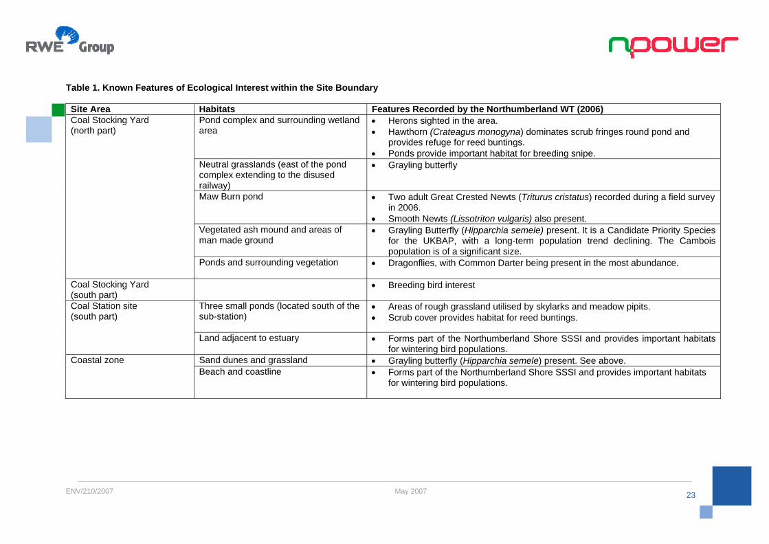
6.6. Ecology Two areas of land within the site boundary form part of the Northumberland Shore SSSI. These areas are shown on Figure 7 and comprise the southern edge of the Power Station site along Blyth estuary and the area of land along the coastline. The SSSI extends along the entire Northumberland coastline and includes sandy bays, rocky headlands, and the Wansbeck and Blyth estuaries. The SSSI is designated for providing important wintering grounds for shore birds. Six of these are of international or national significance, and include purple sandpiper, turnstone, sanderling, golden plover, ringed plover and redshank. The SSSI was reported to be in favourable condition in 1992 when the citation was prepared by Natural England (formerly English Nature). Those sections of the Northumberland Shore SSSI comprising rocky headlands are designated at a European level as the Northumbria Coast Special Protection Area (SPA) and RAMSAR site. These headlands are also designated for their wintering bird interest. The Blyth Estuary and lower stretch of the Sleek Burn are also designated as a Site of Nature Conservation Importance (SNCI) for their ornithological interest and estuarine habitats. The power station site itself is also located within the South East Northumberland Biodiversity Area. Those ecology sites designated at a national and European level within 10km of the site are shown in Figure 6. Figure 7 shows the proximity of the Northumberland Shore SSSI and Northumbria Coast SPA and RAMSAR site in more detail. The Cambois peninsula was the subject of an ecology study carried out by the Northumberland Wildlife Trust on behalf of South East Northumberland – North Tyneside Regeneration Initiative (SENNTRi) in 2006. The study area included the old Blyth Power Station Sites, and Table 1 below describes those features of interest recorded on-site in 2006.
Terrestrial Ecology The baseline ecological environment will be assessed in detail as part of the EIA. A full desk study and Extended Phase 1 Habitat Survey will be completed in spring 2007, and the results will be used to determine what further ecology work is required in consultation with statutory agencies. The desk study will be completed, with information being obtained from Natural England, Royal Society for the Protection of Birds (RSPB), British Trust for Ornithology (BTO), Wildlife Trusts, Groundwork Trust, SENNTRi (South East Northumberland – North Tyneside Regeneration Initiative), and local wildlife groups and recorders, where available. The old Blyth Power Station Site is in close proximity to the Northumberland Shore SSSI designated for its bird interest; primarily wintering birds. Bird surveying will commence in 2007 with a breeding bird survey comprising four visits between April and June. The survey area will take place in land owned by npower. Surveying will continue during the summer and autumn, and a full wintering bird survey will be carried out over winter 07/08, the scope and methodology of which will be agreed with Natural England. One year’s bird data will be recorded prior to the consent application. Where appropriate, the new development will be planned and landscaped so as to be beneficial to wildlife. Land management practices relating to landscape features of major wildlife importance will be encouraged. In addition, it is proposed that a new purpose built Energy and Environment Centre will be constructed as part of the new station development. The location of this will be determined in conjunction with the finalisation of the site layout. Mitigation and enhancement measures will be proposed where appropriate such that the ecological interest of the site can be at least maintained, if not improved.

ENV/210/2007 May 2007
21
Figure 6: Designated Ecology Sites within 10km of the site

ENV/210/2007 May 2007
22
Figure 7: npower's Ownership Boundary and Nearby Designated Site
ENV/210/2007 May 2007
23
Table 1. Known Features of Ecological Interest within the Site Boundary Site Area Habitats Features Recorded by the Northumberland WT (2006)
Pond complex and surrounding wetland area
• Herons sighted in the area. • Hawthorn (Crateagus monogyna) dominates scrub fringes round pond and
provides refuge for reed buntings. • Ponds provide important habitat for breeding snipe.
Neutral grasslands (east of the pond complex extending to the disused railway)
• Grayling butterfly
Maw Burn pond • Two adult Great Crested Newts (Triturus cristatus) recorded during a field survey in 2006.
• Smooth Newts (Lissotriton vulgaris) also present. Vegetated ash mound and areas of man made ground
• Grayling Butterfly (Hipparchia semele) present. It is a Candidate Priority Species for the UKBAP, with a long-term population trend declining. The Cambois population is of a significant size.
Coal Stocking Yard (north part)
Ponds and surrounding vegetation • Dragonflies, with Common Darter being present in the most abundance.
Coal Stocking Yard (south part)
• Breeding bird interest
Three small ponds (located south of the sub-station)
• Areas of rough grassland utilised by skylarks and meadow pipits. • Scrub cover provides habitat for reed buntings.
Coal Station site (south part)
Land adjacent to estuary • Forms part of the Northumberland Shore SSSI and provides important habitats for wintering bird populations.
Sand dunes and grassland • Grayling butterfly (Hipparchia semele) present. See above. Coastal zone Beach and coastline • Forms part of the Northumberland Shore SSSI and provides important habitats
for wintering bird populations.

ENV/210/2007 May 2007
24
Aquatic Ecology The thermal discharge associated with three 800MW units will need to be assessed in relation to the potential impacts on the surrounding environment. Relevant water quality standards and objectives will be considered when evaluating any potential impacts on key ecological features. The former power stations relied upon direct cooling, and had a cooling water intake within the estuary and an outfall in the sea just off the coast. The marine ecology in the area includes the benthic and epibenthic habitats and species associated with the intertidal and subtidal areas, in both the estuary and off the coastline in the North Sea. A series of fieldwork surveys including plankton and fish will be undertaken over a 12 month period. Where appropriate all baseline fieldwork will be conducted in accordance with recognised methodologies and best practice guidance, and within optimal survey periods. In addition, the assessments of significance will follow recognised best practice guidance such as the Institute of Ecology and Environmental Management’s Guidelines for Ecological Impact Assessment. The surveys will be designed in consultation with the statutory agencies, and will be used to collect baseline data for the purposes of the EIA so that an assessment of the potential impacts can be made. 6.7. Noise To minimise noise disturbance during operation of the Power Station, careful attention will be given to the acoustic design of the plant, with particular emphasis on sound insulation. An important factor when assessing noise impacts is the amount by which the new noise exceeds the background noise level. Therefore, baseline noise measurements will be undertaken against which the noise predictions for the plant can be assessed. Both construction and operational noise impacts will be considered during the EIA. The methods specified in British Standard BS 4142 (1997), Method for evaluating industrial noise affecting mixed residential and industrial areas, will be used to assess the potential noise impacts during the operation of the new station. The guidance offered in Planning Policy Guidance Note 24 (PPG24) will also be taken into account during the assessment of potential noise impacts associated with the development. The methodology for such an assessment and the noise monitoring locations will be agreed with the
Local Planning Authority. Construction noise, including traffic, vibration, and piling where appropriate, will also be assessed. The relevant recommendations given in BS 5228, Noise Control on Construction and Open Sites will be adhered to for the assessment of noise during construction. Standard construction site noise minimisation techniques will be applied to minimise noise and this will entail setting maximum noise limits and restriction of certain noisy activities to reasonable times of day. 6.8. Transport and Navigation The intention during operation of the plant is to make maximum use of the port and rail facilities so as to minimise the impact of road traffic. This may be possible for both coal and raw material deliveries, and for some of the movements of by-product materials off site. To maximise the use of rail and the port, various assessments will be carried out to evaluate the feasibility of using each route. For the rail route, there will be a need to build a new dedicated coal handling facility to receive the coal. Opportunities to configure the rail access, in a loop which would smooth the operation of the coal yard and reduce noise and disturbance from shunting, will be explored. There may also be a need to upgrade access from the port. An assessment of the potential impact on navigation will be undertaken as part of the EIA. This will take into account the potential increase in vessel movements associated with the operation of the new power station and consideration will also be given to other potential direct and indirect impacts. The approach for the assessment will be developed following consultation with relevant stakeholders. It is anticipated that the increase in road traffic associated with development of the new station will peak during the construction phase. There may also be a requirement to remove materials by road during the operation of the plant because some customers for gypsum and PFA are limited to receiving their deliveries by road. To manage any impacts from the development, an assessment of the current traffic flows in the vicinity of the development will be made to determine a baseline against which the potential impacts during

ENV/210/2007 May 2007
25
construction and operation can be made. The approach will follow standard guidelines such as the ‘Guidelines for Traffic Impact Assessment’ (Institution of Highways and Transportation), and relevant policies within the Northumberland Local Transport Plan 2006-11 will be referred to where appropriate. The approach for the assessment and the requirement for any mitigation measures due to the increase in traffic flow will be agreed with Northumberland County Council and Wansbeck District Council. 6.9. Waste Materials A range of waste materials and by-products will be generated from the proposed power station. These include Pulverised Fuel Ash (PFA) and may include high grade gypsum. It is anticipated that PFA would be of high quality and that there would be a good potential to sell it all. The majority of PFA would therefore be removed from site in a dry form in dry dust tankers for transportation to customers. It is likely that any unsold PFA would be transported by road to landfill offsite, although options for disposal on or adjacent to the site will be evaluated. If the limestone gypsum FGD process is chosen, it is believed that there will be a suitable market for the gypsum by-product as it can be used in the manufacture of plasterboard. This would be used as an alternative to mined or imported gypsum. It is anticipated that gypsum is transported away from site via road in enclosed containers, and any surplus materials will be disposed of in a licensed landfill. 6.10. Landscape and Visual Amenity There are no national landscape designations in close proximity to the site. The Northumberland Coast Area of Outstanding Natural Beauty (AONB) stretches from Berwick-upon-Tweed south in a narrow coastal strip to its most southerly point at Amble, which is 12 miles away from Cambois. The Northumberland National Park is located just over 16 miles away. A Landscape Character Assessment of South East Northumberland was carried out in 2000 as part of work on the Northumberland Coalfield Environmental Enhancement Strategy. The Wansbeck District Local Plan Re-deposit Draft, August 2005 describes the landscape character in the district:
Wansbeck falls within two broad landscape character tracts identified as part of the assessment work – the Wansbeck and Blyth River Valleys and the South East Northumberland Coastal Fringe. The assessment confirms that the Wansbeck landscape is dominated by urban settlements and large scale industry with limited tracts of countryside between. Urban fringe character applies to a large part of the area and there is a general lack of relief and mature woodland.
The study suggests that the most positive and distinctive character areas are the watercourses and the coast. The vast majority of deciduous woodland is found in the river valleys which allow green spaces to penetrate the main areas of settlement and provide habitat diversity. The coastal zone contains a range of habitats including sandy beaches, cliffs, rocky shores and mudflats and is accessible to local communities.
The power station site is located in a largely industrial setting. To the north the stacks at the Alcan aluminium smelter and associated power station are clearly visible. Approximately 1km off the coast to the east are two wind turbines at Blyth Offshore Wind Farm, each 93m to tip height. There are a further nine smaller wind turbines on the pier within Blyth Harbour. Immediately adjacent to the NW of the site is an area of warehousing and a sewage treatment works. To the south-east is the Port of Blyth and Battleship Warf located on the north bank of the River Blyth. A line of electricity pylons cross down the western side of the coal stocking yard, ending at the substation on the southern coal station site. The potential visual impact of the development will be determined through both desk and field based assessments. The extent of the survey area and location of viewpoints to be assessed will be agreed following consultation with the Local Authority and Natural England. Indicative photomontages will be produced from key viewpoints determined throughout the assessment to provide a representation of the anticipated impacts of the proposed development. Relevant policies relating to landscape character and amenity within the Wansbeck District Council and Blyth Valley Borough Council will be considered during the assessment process. A photograph of the site after the completion of demolition in 2003 is shown in Figure 8. An indicative photomontage of the proposed three units at Blyth is shown in Figure 9.

ENV/210/2007 May 2007
26
Figure 8: Photograph showing the Power Station Site (post demolition of the old stations)

ENV/210/2007 May 2007
27
Figure 9: Photomontage showing the Proposed New Units at Blyth Power Station

ENV/210/2007 May 2007
28
6.11. Cultural Heritage There are no Scheduled Ancient Monuments (SAM) in close proximity to Cambois. There is one SAM of national importance in Wansbeck District and this is Woodhorn Colliery located near Ashington. Details of National Monuments Records and the local historic heritage will be obtained as part of the assessment. Three Conservation Areas have been designated in the District of Wansbeck. These are located some distance from Cambois, at Bedlington, Newbiggin-by-the Sea and Bothal. A desk based assessment will be undertaken to evaluate the potential for archaeological and cultural heritage features within the area of the proposed development. This will also include the cooling water outfall in the North Sea. Information will be requested from English Heritage, National Monuments Records and the Hydrographic Office. The methodology for the environmental impact assessment will be defined following consultation with English Heritage and the relevant officer at the Local Authority. 6.12. Hydrology, Geology and Ground Conditions During the demolition of the old power stations in 2003 all of the buildings and structures above ground were removed. The structural foundations and below ground structures including culverts, flooded cable tunnels and flooded cooling water tunnels were left largely in-situ. A number of natural and man-made water bodies and ponds are present on-site, in both the coal station site and coal stocking yard. Two streams, the Maw Burn and Cow Gut enter the coal stocking yard from the west and are culverted through the majority of the site. They discharge into the North Sea and the River Blyth respectively. To the south of the coal station site, the banks of the Sleek Burn and the River Blyth form the western and southern boundaries of the site. The hydrogeology under the site was recorded by Parsons Brinckerhoff (2006) as comprising Coal Measures which are classified as a minor
multi-layer aquifer. It is not characterised as a source of high quality groundwater due to the history of mining activity in the Northumberland area. The geology within the site comprises made ground down to 3.5m depth, underlain by soft to very stiff Glacial Till (boulder clay) with pockets / layers of sand and gravel as summarised by Parsons Brinckerhoff (2006). There is also evidence of there being coal seams underlying the area, and the last known date that these seams might have been worked was 1967. The Blyth Power Station Site has a history of past heavy industrial use. During the demolition the majority of known contaminant sources were removed from the site, including areas of contaminated ground. There is the potential for contaminated ground to still be present in some areas. As part of the evaluation, an assessment will be undertaken to determine the potential for any existing land contamination and to identify the need for any remediation requirements. The EIA will also take account of the policies and recommendations set out in PPS 23 (Planning and Pollution Control). The impacts of the proposed development on hydrology, hydrogeology and geology will be assessed within the EIA. Data will be collected from published sources which will include the Environment Agency, Local Councils and British Geological Survey. This will enable the existing water environment to be evaluated including rivers, streams, lakes, groundwater resources, wetlands and other water features. The scope of the assessment will be agreed with the Environment Agency, and is likely to assess the impacts of the development on sensitive water features and watercourses, and impacts to groundwater. There is also a need to establish the baseline conditions so that we can ensure that we can return the site to a satisfactory state at the end of the life of the power station to satisfy the requirements of the Pollution Prevention and Control regulations. A flood risk assessment will also be carried out (see below).

ENV/210/2007 May 2007
29
6.13. Flood Risk The Environment Agency has produced indicative flood plain maps for the area (Figure 10) which identify areas where there is a chance of flooding if a river rises above its banks, or high tides and stormy seas cause flooding in coastal areas. The dark blue shading shows the area that could be affected by flooding, either from rivers or the sea, if there were no flood defences. This area could be flooded: • from the sea by a flood that has a 0.5% (1 in 200) or greater chance
of happening each year or • from a river by a flood that has a 1% (1 in 100) or greater chance of
happening each year. The light blue shaded area on the map shows the possible extent of an extreme flood event from rivers or the sea. These areas are likely to be affected by a major flood, with up to a 0.1% (1 in 1000) chance of occurring each year. The map shows that there is a small chance of flooding for the southern part of the site, and a more detailed assessment of the site will be undertaken to determine the extent of this potential risk of flooding. The scope of this assessment will be agreed with the Environment Agency and will take into consideration the requirements of PPG25: Development and Flood Risk. The findings of the Blyth Strategic Flood Risk Assessment Report prepared by SENNTRi (November 2006) will also be considered in the assessment.
Figure 10: Environment Agency Flood Map for the Power Station site

ENV/210/2007 May 2007
30
6.14. Socio-economic Effects There will be a significant number of jobs created during the construction phase of the plant. With a project of this size, there are likely to be over 1000 contractors employed at some times during construction. One of the benefits of the project will be the effects on employment and economic activity in the local area during construction, where local businesses are often best placed to secure contracts. During the operational phase of the plant, there will be a requirement for craftsmen, technicians, engineers and managers to work at the plant. These are highly skilled roles and the average salaries of the workforce are likely to be above the national average. Many of these jobs will be sourced locally if the skills are available. There are also likely to be knock-on effects on the local economy, for example, as a result of greater utilisation of the port, improvements to the road and rail links and the ongoing requirement for ancillary services such as security, catering, maintenance contractors and support workers. As well as these direct benefits, local businesses and services are also likely to realise benefits as a result of increased spending from employees and contractors in the area. The detailed study carried out in support of the EIA will evaluate the social and economic impacts on the area and will include both the positive and the negative impacts of the development. It will cover the potential impacts on the local economy, recreation, amenity and the impact on existing plans for regeneration in the wider area. The scope of the study will be discussed in detail with both the District Council and County Council to ensure that their concerns are captured in the study. 6.15. Cumulative Impacts The potential for cumulative impacts will be assessed during the EIA process and consideration will be given to existing or reasonably foreseeable future developments. The combined effect of individual impacts, e.g. noise, dust and visual, from one development on a particular receptor will also be considered where appropriate. The developments or activities to be considered will be agreed by extensive and ongoing consultation with statutory and non-statutory consultees throughout the assessment.
6.16. Health Safety and Security RWE npower strongly believes that the protection of the public, employees, business partners and customers from ill health or injury are fundamental to its business philosophy. RWE npower take such responsibilities very seriously and is committed to providing a safe, secure and healthy working environment for everyone involved in its business. The workplace will be used to promote a high standard of overall health and well-being for all those employed. The design, procurement, construction, commissioning and operation of the new Blyth Power Station will include processes and modern best practices that will ensure the statutory responsibilities of the company for the health and safety of all its employees and others affected by its activities are maintained. Plant and equipment will be kept in a condition which is safe and without risk to health and be examined and tested in accordance with statutory requirements.

ENV/210/2007 May 2007
31
7. Conclusion The production of this Scoping Report is an early stage in the environmental impact assessment process and is designed to ensure that the environmental studies undertaken provide all the relevant information required for the full Environmental Statement which will be submitted in support of the Section 36 application. The full Environmental Impact Assessment for the new Power Station will cover the following topic areas;-
• Air Quality • Water Quality • Ecology • Noise • Transport and Navigation • Landscape and Visual Amenity • Geology, Hydrogeology, Ground Conditions • Flood Risk • Socio Economic Effects • Cumulative Impacts, and • Health Safety and Security
The detailed requirements of these studies will be agreed with the regulatory bodies during the development of the full Environmental Impact Assessment and any feedback and comments received will be considered throughout the development of the assessment process. The final Environmental Statement will be published as part of a wide ranging consultation programme which will inform the local community, the regulators and other stakeholders of the proposed development.

ENV/210/2007 May 2007
32
8. References Dti (July 2006), The Energy Challenge Energy Review Report 2006. Dti (2000), Guidance on the Electricity Works (Environmental Impact Assessment) (England and Wales) Regulations) 2000 Dti (December 2006), Guidance on Background Information to Accompany Section 14(1) of the Energy Act 1976 and Applications under Section 36 of the Electricity Act 1989 Dti (January 2006), Advanced Power Plant Using High Efficiency Boiler/Turbine – Best Practice Brochure. Natural England (1992) Northumberland Shore SSSI Citation, Available from http://www.english-nature.org.uk/Special/sssi/sssi_details.cfm?sssi_id=2000134 Northumberland Wildlife Trust (November 2006), Cambois Ecological Survey and Management Brief, First Draft Parsons Brinckerhoff (November 2006), Former Blyth Power Station, Northumberland, Review of Previous Desk Studies and Site Investigations; Phase 1 Study. SENNTRi (South East Northumberland – North Tyneside Regeneration Initiative), (2006), Blyth Strategic Flood Risk Assessment, Draft Stage 1 Report SENNTRi (South East Northumberland – North Tyneside Regeneration Initiative), (January 2005), Blyth Estuary Development Framework Plan Wansbeck District Council (August 2005), Wansbeck District Local Plan Re-deposit Draft WS Atkins (November 2000), Blyth Power Station Phase I Environmental Appraisal Report (for the old station)