chapter 6: running water and groundwater chapter 6 ...isite.lps.org/mgeist/n-ge-u3.pdfchapter 6:...
TRANSCRIPT

Chapter 6: Running Water andGroundwater
• Running Water
Chapter 6: Running Water and Groundwater
Section 6.1Running Water
Chapter 6: Running Water and Groundwater-- Section 6.1: Running Water --
Water moves between all “spheres” of Earth.– Atmosphere: water evaporates into this sphere– Biosphere: life consumes water– Geosphere: water moves between Earth’s cracks– Hydrosphere: definition of this sphere (water)
• Water cycle– The constant movement of water among the oceans,
atmosphere, geosphere, and biosphere– Steps of the water cycle
• Evaporation– Vaporization that occurs at the surface of a liquid that
is not boiling– From the ocean and from land
Chapter 6: Running Water and Groundwater-- Section 6.1: Running Water --
– Winds transport the moisture in the air until conditions allow the particles to condense into liquid water again.
• Condensation– Water changing from a vapor/gas to a liquid– Formation of rain
• Precipitation– Any form of water that falls from a cloud– Includes over land and water
• Infiltration– The movement of surface water into rock or soil
through cracks and pore spaces– This water eventually seeps into lakes, streams, and
oceans.

Chapter 6: Running Water and Groundwater-- Section 6.1: Running Water --
• Runoff– Water that flows over the land surface rather than
seeping into the ground– Water that flows over the land into streams, rivers, and
lakes– Occurs when the rate of rainfall is greater than Earth’s
ability to absorb it– Much of the water from the runoff returns to the
atmosphere because of evaporation from soil, streams, and lakes.
• Transpiration– Release of water into the atmosphere by organisms– Another source of water entering the atmosphere
Chapter 6: Running Water and Groundwater-- Section 6.1: Running Water --
The WaterCycle
Chapter 15: Ocean Water and Ocean Life
• The Composition of Seawater
Chapter 15: Ocean Water and Ocean Life
Section 15.1The Composition of Seawater

Chapter 15: Ocean Water and Ocean Life-- Section 15.1: The Composition of Seawater --
Salinity– The proportion of dissolved salts to pure water, usually
expressed in parts per thousand– Salts are not all the same (i.e., not all sodium chloride).– Most of the salt in seawater and ocean water is sodium
chloride (table salt).– Sources of sea salts
• Chemical weathering of rocks on the continents– Transferred by runoff from rivers and streams– Deposits about 2.3 billion metric tons per year
• Earth’s interior– Volcanic eruptions– Introduction of chlorine, bromine, sulfur, and boron
Chapter 15: Ocean Water and Ocean Life-- Section 15.1: The Composition of Seawater --
Sea water composition
Chapter 15: Ocean Water and Ocean Life-- Section 15.1: The Composition of Seawater --
– Processes affecting salinity• Icebergs melting (decreasing salinity)• Runoff from land (decreasing salinity)• Sea ice melting (decreasing salinity)• Evaporation and from land and freshwater sources and
precipitation (decreasing salinity)• Evaporation from the ocean (increasing salinity)• Formation of sea ice (increasing salinity)
• Ocean temperature variation causes– Latitude
• Amount of solar radiation received based on different latitudes results in different ocean temperatures.
• Lower latitudes = higher ocean temperatures
Chapter 15: Ocean Water and Ocean Life-- Section 15.1: The Composition of Seawater --
– Depth• Temperature typically decreases as depth increases
because of difficulty of sunlight to get through depths.• Thermocline
– A layer of water in which there is a rapid change in temperature with depth
– Layer of ocean water between 300 meters and 1000 meters
– Very important structure in the ocean in that it separates different types of marine life
– No thermocline at high altitudes» Isothermal (same heat/temperature)» No rapid change in temperature

Chapter 15: Ocean Water and Ocean Life-- Section 15.1: The Composition of Seawater --
Chapter 15: Ocean Water and Ocean Life-- Section 15.1: The Composition of Seawater --
• Ocean density variation causes– Density
• Mass per unit volume• Density = Mass / Volume• More dense water sinks; less dense water floats.• Determines the water’s vertical position in the ocean• Types of water
– Seawater: high-density– Freshwater: low-density
– Factors affecting ocean density• Salinity
– Increases seawater density– More salts create higher density (more mass per
volume).
Chapter 15: Ocean Water and Ocean Life-- Section 15.1: The Composition of Seawater --
• Temperature– Colder water = higher density
» Colder particles means less particle movement, resulting in particles getting closer together.
» Cold water with high salinity (as in the Arctic Ocean) is even more dense.
– Warmer water = lower density» Warmer particles means more particle movement,
resulting in particles getting further apart.» Least dense water near the equator
• Depth– Pycnocline
» Layer of water in which there is a rapid change of density with depth
Chapter 15: Ocean Water and Ocean Life-- Section 15.1: The Composition of Seawater --
» Occurs between 300 meters and 1000 meters» Barrier to mixing the low-density water above and
the high-density water below» Not present in high latitudes

Chapter 15: Ocean Water and Ocean Life-- Section 15.1: The Composition of Seawater --
Chapter 15: Ocean Water and Ocean Life-- Section 15.1: The Composition of Seawater --
• Ocean layering– Layering of the ocean due to density
• Surface zone• Transition zone• Deep zone
– Surface zone• Warmest layer because it receives the most solar energy• Mixed zone
– Area of the ocean surface with uniform temperatures created by the mixing of water by waves, currents, and tides
– Usually 300 meters deep, although some are as deep as 450 meters
– 2% of ocean water
Chapter 15: Ocean Water and Ocean Life-- Section 15.1: The Composition of Seawater --
– Transition zone• Barrier between warm surface layer above and cold deep
zone below• Includes the thermocline and pycnocline• 18% of ocean water
– Deep zone• Too deep to receive sunlight• Water temperatures slightly above freezing• Constant and high water density• 80% of ocean water
• The three layers do not exist at high latitudes (due to cold and consistent density).
• Vertical mixing in high latitudes as a result, causing deep-ocean currents.
Chapter 16: The Dynamic Ocean
• Ocean Circulation• Waves and Tides
Chapter 16: The Dynamic Ocean
Section 16.1Ocean Circulation
Chapter 16: The Dynamic Ocean-- Section 16.1: Ocean Circulation --
Surface circulation– Ocean currents
• Masses of ocean water that flow from one place to another• Masses can be large or small.• Currents can be at the surface of deep below.
– Surface currents• Movements of water that flow horizontally in the upper
part of the ocean’s surface• Develop from friction between the ocean and wind that
blows across the surface• Affected by local, seasonal, and circulation patterns of the
atmosphere
Chapter 16: The Dynamic Ocean-- Section 16.1: Ocean Circulation --
– Gyres• Large circular surface current patterns found in each
ocean• Five major ocean gyres
– North Pacific Gyre– South Pacific Gyre– North Atlantic Gyre– South Atlantic Gyre– Indian Ocean Gyre
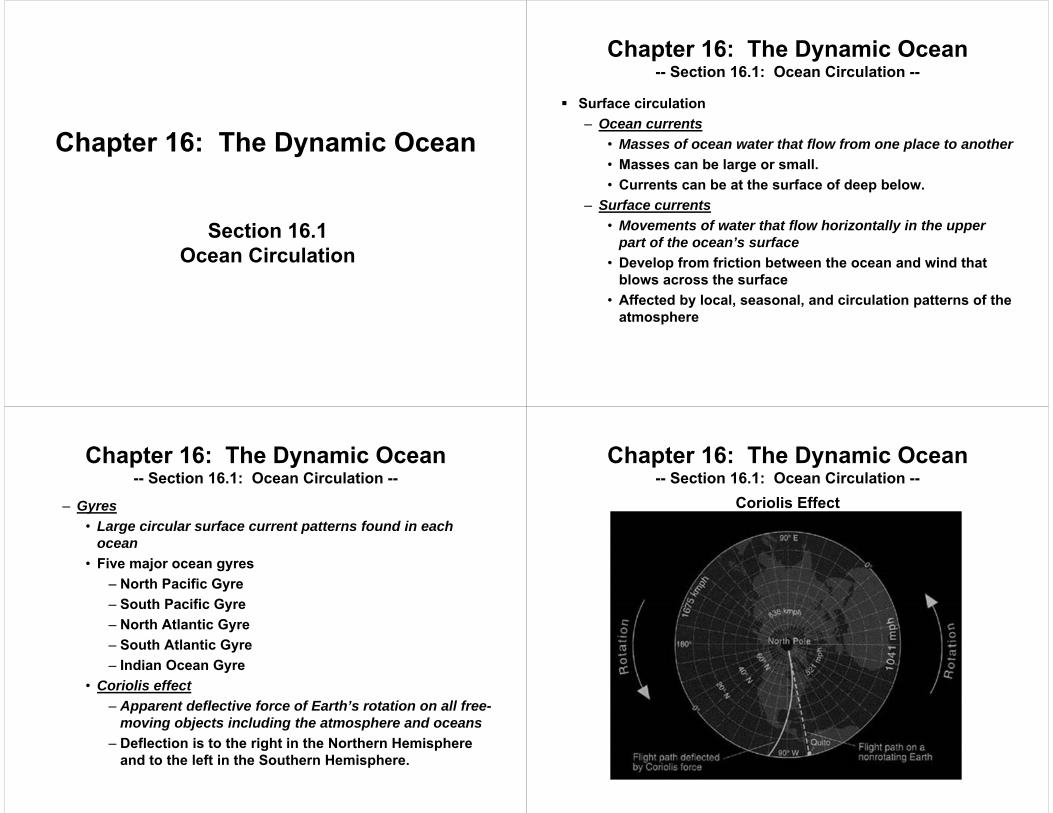
• Coriolis effect– Apparent deflective force of Earth’s rotation on all free-
moving objects including the atmosphere and oceans– Deflection is to the right in the Northern Hemisphere
and to the left in the Southern Hemisphere.
Coriolis Effect
Chapter 16: The Dynamic Ocean-- Section 16.1: Ocean Circulation --

Coriolis Effect
Chapter 16: The Dynamic Ocean-- Section 16.1: Ocean Circulation --
North Atlantic Gyre
Chapter 16: The Dynamic Ocean-- Section 16.1: Ocean Circulation --
North Pacific Gyre
Chapter 16: The Dynamic Ocean-- Section 16.1: Ocean Circulation --
Satellite Footage of Gyre
Chapter 16: The Dynamic Ocean-- Section 16.1: Ocean Circulation --
Chapter 16: The Dynamic Ocean-- Section 16.1: Ocean Circulation --
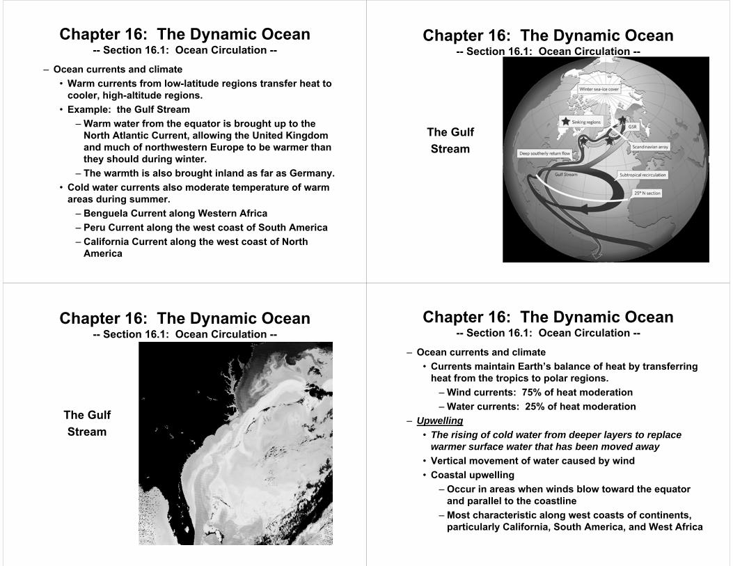
– Ocean currents and climate• Warm currents from low-latitude regions transfer heat to
cooler, high-altitude regions.• Example: the Gulf Stream
– Warm water from the equator is brought up to the North Atlantic Current, allowing the United Kingdom and much of northwestern Europe to be warmer than they should during winter.
– The warmth is also brought inland as far as Germany.• Cold water currents also moderate temperature of warm
areas during summer.– Benguela Current along Western Africa– Peru Current along the west coast of South America– California Current along the west coast of North
America
Chapter 16: The Dynamic Ocean-- Section 16.1: Ocean Circulation --
The Gulf Stream
Chapter 16: The Dynamic Ocean-- Section 16.1: Ocean Circulation --
The Gulf Stream
Chapter 16: The Dynamic Ocean-- Section 16.1: Ocean Circulation --
– Ocean currents and climate• Currents maintain Earth’s balance of heat by transferring
heat from the tropics to polar regions.– Wind currents: 75% of heat moderation– Water currents: 25% of heat moderation
– Upwelling• The rising of cold water from deeper layers to replace
warmer surface water that has been moved away• Vertical movement of water caused by wind• Coastal upwelling
– Occur in areas when winds blow toward the equator and parallel to the coastline
– Most characteristic along west coasts of continents, particularly California, South America, and West Africa

Chapter 16: The Dynamic Ocean-- Section 16.1: Ocean Circulation --
– Along with the Coriolis effect, cause surface water to move away from the coast and replaces with water that upwells from below the surface
– Brings water from 50 to 300 meters deep that is cooler to result in lower surface water temperatures near the shoreline
– Bring nutrients, such as nitrates and phosphates, to the surface of the ocean» Plankton feed on these nutrients.» Fish feed on plankton.
Chapter 16: The Dynamic Ocean-- Section 16.1: Ocean Circulation --
Upwelling
Chapter 16: The Dynamic Ocean-- Section 16.1: Ocean Circulation --
Upwelling
Chapter 16: The Dynamic Ocean-- Section 16.1: Ocean Circulation --
• Deep-ocean circulation– Density currents
• Currents of ocean water that result from density differences among water masses
• REMEMBER: Dense water sinks and spreads out, less dense water “floats”
• Causes for density changes– Decrease in temperature– Increase in salinity
» Evaporation and formation of sea ice» Important in very high latitudes since water
temperature remains relatively the same– Most water involved in these currents begin in high latitudes
at the surface.

Chapter 16: The Dynamic Ocean-- Section 16.1: Ocean Circulation --
– High latitudes• #1: Surface water becomes cold.• #2: Salinity increases as sea ice forms.• #3: More dense water sinks, starting deep-ocean density
currents.• Scientists map this and can show the slow circulation of
the water mass through the ocean.• In Antarctica, deep waters will not reappear at the surface
for an average of 500 to 20000 years.– Evaporation
• More evaporation occurs than precipitation in the Mediterranean Sea, leaving salt behind and causing salinity to increase.
• Flows to the Atlantic Ocean where it sinks from greater density
Chapter 16: The Dynamic Ocean-- Section 16.1: Ocean Circulation --
– Earth’s “conveyor belt”• The cycle
– Warm water in ocean’s upper layers flow to the poles.– Temperature drops, salinity increases, it becomes
more dense and sinks, moving toward the equator.– Water returns to the equator as cold, deep water that
upwells.• Global climate is influenced by converting warm water to
cold water and releasing the heat to the atmosphere.
Chapter 16: The Dynamic Ocean-- Section 16.1: Ocean Circulation --
Circulation of warm and cold ocean water
Chapter 16: The Dynamic Ocean
Section 16.2Waves and Tides
Chapter 16: The Dynamic Ocean-- Section 16.2: Waves and Tides --
• Waves– Energy transferring through a medium– Wave characteristics
• Most ocean waves get their energy and movement from the wind.
• Parts of a wave– Crests: tops of the waves– Troughs: bottoms of the waves– Wave height: vertical distance between the crest and
trough– Wavelength: horizontal distance between two
consecutive troughs or crests– Wave period: time it takes one full wave (wavelength)
to pass a fixed point
Chapter 16: The Dynamic Ocean-- Section 16.2: Waves and Tides --
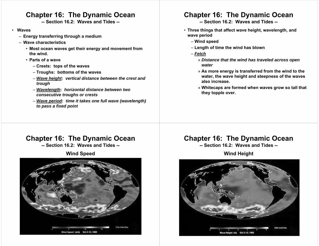
• Three things that affect wave height, wavelength, and wave period– Wind speed– Length of time the wind has blown– Fetch
» Distance that the wind has traveled across open water
» As more energy is transferred from the wind to the water, the wave height and steepness of the waves also increase.
» Whitecaps are formed when waves grow so tall that they topple over.
Chapter 16: The Dynamic Ocean-- Section 16.2: Waves and Tides --
Wind Speed
Chapter 16: The Dynamic Ocean-- Section 16.2: Waves and Tides --
Wind Height
Chapter 16: The Dynamic Ocean-- Section 16.2: Waves and Tides --
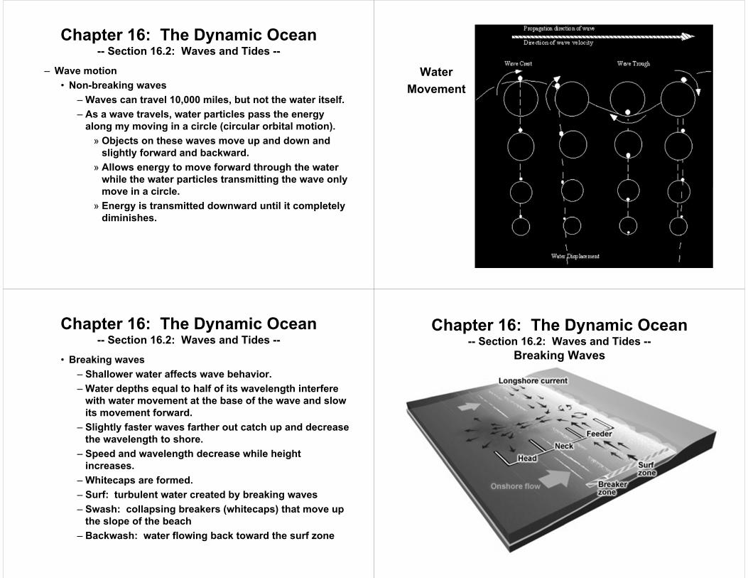
– Wave motion• Non-breaking waves
– Waves can travel 10,000 miles, but not the water itself.– As a wave travels, water particles pass the energy
along my moving in a circle (circular orbital motion).» Objects on these waves move up and down and
slightly forward and backward.» Allows energy to move forward through the water
while the water particles transmitting the wave only move in a circle.
» Energy is transmitted downward until it completely diminishes.
WaterMovement
Chapter 16: The Dynamic Ocean-- Section 16.2: Waves and Tides --
• Breaking waves– Shallower water affects wave behavior.– Water depths equal to half of its wavelength interfere
with water movement at the base of the wave and slow its movement forward.
– Slightly faster waves farther out catch up and decrease the wavelength to shore.
– Speed and wavelength decrease while height increases.
– Whitecaps are formed.– Surf: turbulent water created by breaking waves– Swash: collapsing breakers (whitecaps) that move up
the slope of the beach– Backwash: water flowing back toward the surf zone
Chapter 16: The Dynamic Ocean-- Section 16.2: Waves and Tides --
Breaking Waves

Chapter 16: The Dynamic Ocean-- Section 16.2: Waves and Tides --
• Tides– Daily changes in the elevation of the ocean surface– Result from differences in the gravitational attraction exerted
upon different parts of Earth’s surface by the moon and a bit less by the sun
– Cause of tides• The moon
– Makes one complete revolution around Earth every 29.5 days
– For the side of Earth closest to the moon, the moon’s gravity pills the oceans more than solid Earth, causing water to flow to the attracted area to create a tidal bulge called “high tide”.
– Two high tides and two low tides each day (typically).
Chapter 16: The Dynamic Ocean-- Section 16.2: Waves and Tides --
Tidal Cycle
Chapter 16: The Dynamic Ocean-- Section 16.2: Waves and Tides --
– Tidal cycle• Sun’s influence (less than 46% of the moon’s influence)
produces smaller tidal bulges.– Most near new and full moons when sun and moon are
aligned– Higher tidal bulges (higher high tides)– Lower tidal troughs (lower low tides)– Tidal range
» Difference in height between successive high and low tides
» Different kinds of tides have different tidal ranges
Chapter 16: The Dynamic Ocean-- Section 16.2: Waves and Tides --
• Types of tides– Spring tides
» Highest tidal range that occurs due to the alignment of Earth, the moon, and the sun
» Experienced during new and full moons– Neap tides
» Lowest tidal range that occurs near the times of the first-quarter and third-quarter phases of the moon
» When the gravitational forces of the moon and sun act on Earth at right angles
– Each month, there are two spring tides and two neap tides.
– Each tide is about one week apart.

Chapter 16: The Dynamic Ocean-- Section 16.2: Waves and Tides --
Chapter 16: The Dynamic Ocean-- Section 16.2: Waves and Tides --
– Tidal patterns• Affected by many causes
– Shape of the coastline– Structure of ocean basins– Water depth
• Tidal patterns best determined by actual observation• Three main tidal patterns
– Diurnal tidal pattern» Single high tide and single low tide each tidal day» Consistent crests and troughs» Example: northern shore of the Gulf of Mexico
– Semidiurnal tidal pattern» Two high tides and two low tides each tidal day» Consistent crests and troughs
Chapter 16: The Dynamic Ocean-- Section 16.2: Waves and Tides --» Example: Atlantic Coast of the United States
– Mixed tidal pattern» Large inequality in crests and troughts or both» Usually two high tides and two low tides each tidal
day» Example: Pacific Coast of the United States

Chapter 17: The Atmosphere: Structure and Temperature
• Atmospheric Characteristics• Heating the Atmosphere Section 17.1
Atmosphere Characteristics
Chapter 17: The Atmosphere: Structure and Temperature
• Atmosphere– Thick blanket of gases surrounding Earth – Aspects studied of the atmosphere
• Weather– General condition of the atmosphere at a particular
time and place– Includes temperature, air movements, and moisture
content• Climate
– General weather conditions over many years– Includes average monthly precipitation amounts,
average monthly temperatures, etc.
Chapter 17: The Atmosphere-- Section 17.1: Atmosphere Characteristics --
• Composition of the atmosphere– Most abundant elements in the atmosphere
• Nitrogen• Oxygen• Argon
– Most abundant compounds in the atmosphere• Nitrogen gas (N2)• Oxygen gas (O2)• Carbon dioxide (CO2)• Water vapor (H2O)
– Varies greatly under different conditions– Added to air by evaporation – Given off by plants during transpiration– Absorbs heat given off by Earth and some solar energy
Chapter 17: The Atmosphere-- Section 17.1: Atmosphere Characteristics --

– Can comprise anywhere from less that 1% to as much as 4% of Earth’s atmosphere
– Ozone• Form of atmospheric oxygen that has three atoms per
molecule• Formula: O3• Present in very small amounts in Earth’s atmosphere• Important because it protects organisms on Earth from
ultraviolet radiation• Has been broken down from chlorofluorocarbons (CFCs)
released from aerosol cans, coolants, and hydrocarbons from the burning of supersonic aircraft fuel
Chapter 17: The Atmosphere-- Section 17.1: Atmosphere Characteristics --
– Atmospheric dust • Tiny solid particles • Soil from winds, ash from fires, volcanic dust,
microscopic organisms, particles from meteors, salt from evaporated ocean water
– Oxygen in the atmosphere • Amount of oxygen in the atmosphere is the result of
natural processes that maintain the chemical balance of the atmosphere.
• Oxygen used by animals, bacteria, fires, and weathering• Oxygen produced by photosynthesis from plants (after
using carbon dioxide, water, and sunlight)
Chapter 17: The Atmosphere-- Section 17.1: Atmosphere Characteristics --
Oxygen Cycle
Chapter 17: The Atmosphere-- Section 17.1: Atmosphere Characteristics --
– Nitrogen in the atmosphere• Amount of nitrogen is maintained in the atmosphere• Nitrogen cycle
– Process in which nitrogen moves from the air to the soil to animals and back to the air
– Steps of the nitrogen cycle» Nitrogen is removed from the air by nitrogen-fixing
bacteria.» Bacteria chemically change nitrogen gas into
nitrogen compounds, which are used in the growth of plants.
» Animals eat plants, and the nitrogen compounds enter their bodies.
Chapter 17: The Atmosphere-- Section 17.1: Atmosphere Characteristics --

» Dead organisms or waste products return the nitrogen to the atmosphere.
– Similar process for the nitrogen cycle takes place among water-swelling animals and plants
Chapter 17: The Atmosphere-- Section 17.1: Atmosphere Characteristics --
• Atmospheric pressure– Ratio of the weight of the air to the area of the surface on
which it presses– Due to gravity and why most gases are found extremely close
to the earth (within 32 km of Earth’s surface)– Less atmospheric pressure at higher altitudes– “Popping of the ears” occurs when air pressure on one side
of the eardrum and atmospheric pressure are not the same.– Barometer
• Instrument that measures atmospheric pressure• Types of barometers
Chapter 17: The Atmosphere-- Section 17.1: Atmosphere Characteristics --
– Mercurial barometer» Atmospheric pressure pushes on the liquid
mercury and causes it to go up a tube. » The greater the pressure, the more the mercury
rises.» Measured in millimeters mercury (mm Hg), inches
Hg (inches Hg), millibars (mb), or atmospheres (atm)
» Standard atmospheric pressure• The atmospheric pressure measured at
sea level• 760 mm Hg = 1000 mb = 1 atm
– Aneroid barometer» Type of barometer that is used today
Chapter 17: The Atmosphere-- Section 17.1: Atmosphere Characteristics --
» Sealed metal container with no air inside that bends inward when pressure increases and bends outward when pressure decrease
» Movement of container causes pointer to adjust and continually record changes in pressure.
» Can be used as an altimeter, although it must be corrected for local weather conditions
• Layers of the atmosphere– Based on temperature changes in the layers of the
atmosphere– No sharp pressure changes are present to separate the
atmosphere into layers
Chapter 17: The Atmosphere-- Section 17.1: Atmosphere Characteristics --
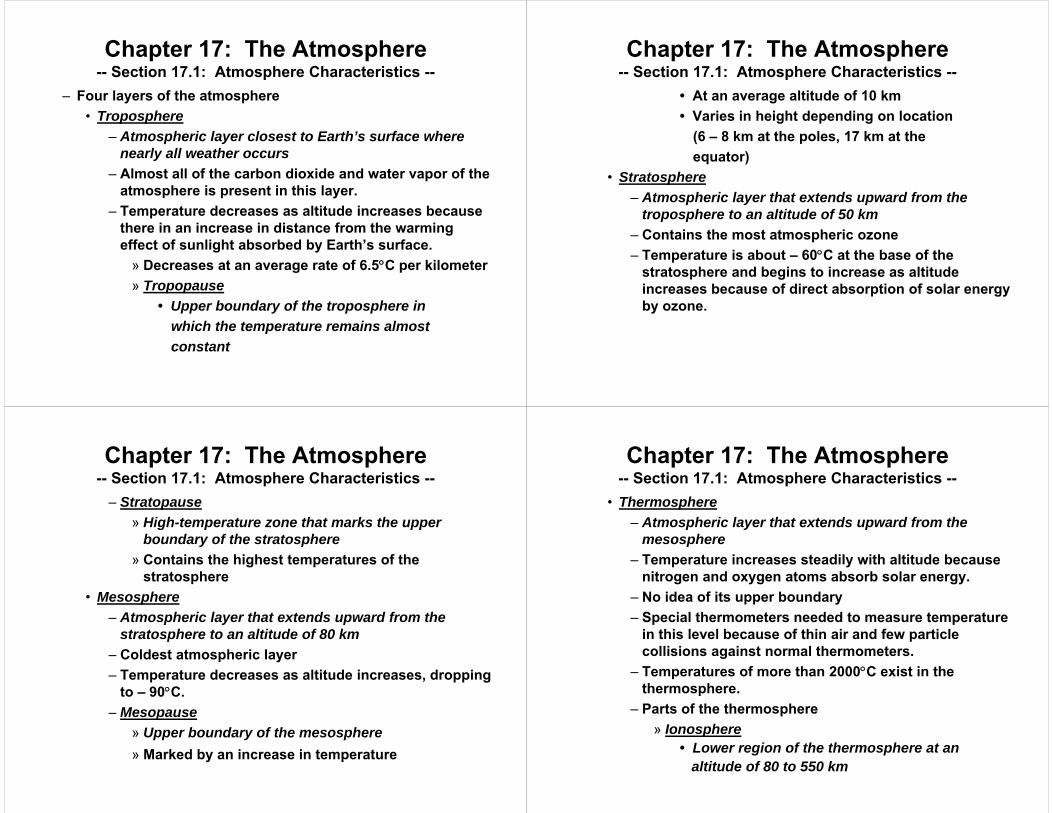
– Four layers of the atmosphere• Troposphere
– Atmospheric layer closest to Earth’s surface where nearly all weather occurs
– Almost all of the carbon dioxide and water vapor of the atmosphere is present in this layer.
– Temperature decreases as altitude increases because there in an increase in distance from the warming effect of sunlight absorbed by Earth’s surface.» Decreases at an average rate of 6.5C per kilometer» Tropopause
• Upper boundary of the troposphere in which the temperature remains almost constant
Chapter 17: The Atmosphere-- Section 17.1: Atmosphere Characteristics --
• At an average altitude of 10 km• Varies in height depending on location
(6 – 8 km at the poles, 17 km at the equator)
• Stratosphere– Atmospheric layer that extends upward from the
troposphere to an altitude of 50 km– Contains the most atmospheric ozone– Temperature is about – 60C at the base of the
stratosphere and begins to increase as altitude increases because of direct absorption of solar energy by ozone.
Chapter 17: The Atmosphere-- Section 17.1: Atmosphere Characteristics --
– Stratopause» High-temperature zone that marks the upper
boundary of the stratosphere» Contains the highest temperatures of the
stratosphere• Mesosphere
– Atmospheric layer that extends upward from the stratosphere to an altitude of 80 km
– Coldest atmospheric layer– Temperature decreases as altitude increases, dropping
to – 90C.– Mesopause
» Upper boundary of the mesosphere» Marked by an increase in temperature
Chapter 17: The Atmosphere-- Section 17.1: Atmosphere Characteristics --
• Thermosphere– Atmospheric layer that extends upward from the
mesosphere– Temperature increases steadily with altitude because
nitrogen and oxygen atoms absorb solar energy. – No idea of its upper boundary– Special thermometers needed to measure temperature
in this level because of thin air and few particle collisions against normal thermometers.
– Temperatures of more than 2000C exist in the thermosphere.
– Parts of the thermosphere» Ionosphere
• Lower region of the thermosphere at an altitude of 80 to 550 km
Chapter 17: The Atmosphere-- Section 17.1: Atmosphere Characteristics --

• Solar rays are absorbed by atmospheric gases and cause these atoms to gasesto lose electrons and produce ions andfree electrons.
• Layers of free electrons reflect radio waves back to Earth and can reflect further distances of these waves atnight.
» Exosphere• Upper region of the thermosphere that
merges with interplanetary space• Zone of indefinite altitude that extends
for thousands of kilometers above Earth
Chapter 17: The Atmosphere-- Section 17.1: Atmosphere Characteristics --
Layers of the Atmosphere
Chapter 17: The Atmosphere-- Section 17.1: Atmosphere Characteristics --
• Earth-Sun relationships– Solar energy is not distributed evenly over Earth’s surface
• Causes of variation– Latitude– Time of day– Season
• Creates winds and drives the ocean currents– Earth’s motions
• Rotation: spinning of Earth on its axis• Revolution: movement of Earth in its orbit around the sun
– Elliptical orbit– Speed of 113,000 km/hr around the sun
Chapter 17: The Atmosphere-- Section 17.1: Atmosphere Characteristics --
Chapter 17: The Atmosphere-- Section 17.1: Atmosphere Characteristics --
– Earth’s orientation• Earth it tilted 23.5
from the perpendicular
• Seasonal changes occur because Earth’s position relative to the sun continually changes as it travels along its orbit.

– Sun’s apparent path• Different sun angles for different locations• Varies with season
– The seasons• Summer solstice
– Most sunlight received by Earth in southern hemisphere on December 21 or 22 and in the northern hemisphere on June 21 or 22
– Results from the tilt of the Earth toward the sun• Autumnal equinox
– Equal amounts of sunlight and night received by Earth in southern hemisphere on March 21 or 22 and in the northern hemisphere on September 22 or 23
– Not tilted toward or away from sun
Chapter 17: The Atmosphere-- Section 17.1: Atmosphere Characteristics --
• Winter solstice– Least sunlight received by Earth in southern
hemisphere on June 21 or 22 and in the northern hemisphere on December 21 or 22
– Results from the tilt of the Earth toward the sun• Spring equinox
– Equal amounts of sunlight and night received by Earth in southern hemisphere on September 22 or 23 and in the northern hemisphere on March 21 or 22
– Not tilted toward or away from sun– Length of daylight
• Higher latitudes have more significant changes in daylight received.
• Also affects amount of daylight
Chapter 17: The Atmosphere-- Section 17.1: Atmosphere Characteristics --
Angles and Spread of Sunlight
Chapter 17: The Atmosphere-- Section 17.1: Atmosphere Characteristics --
Section 17.2Heating the Atmosphere
Chapter 17: The Atmosphere: Structure and Temperature

• Heat– The energy transferred from one object to another as a result
of a difference in their temperatures– Objects of the same temperature can differ in the thermal
energy they contain.• Temperature
– Average kinetic energy of the individual atoms or molecules in a substance
– Measured in degrees Celsius, degrees Fahrenheit, or Kelvins• Three ways to transfer heat
– Radiation– Conduction– Convection
Chapter 17: The Atmosphere-- Section 17.2: Heating the Atmosphere --
• Radiation– Transfer of energy in the form of electromagnetic waves– ALL OBJECTS AT ANY TEMPERATURE EMIT RADIANT
ENERGY.– Primarily responsible for heating the lower atmosphere– Includes light, x-rays, radio waves, gamma rays, infrared
rays, etc.– Travels at 300,000 kilometers per second (km/s)– Common parts of waves
• Wavelength– Distance between one point on a wave and the nearest
point just like it– Measured in meters (m)– Variable: (Greek letter lambda)
Chapter 17: The Atmosphere-- Section 17.2: Heating the Atmosphere --
• Frequency– Number of wavelengths that pass a fixed point each
second– Measured in hertz (Hz = 1/s)– Variable:
Chapter 17: The Atmosphere-- Section 17.2: Heating the Atmosphere --
– Wavelengths shorter than those of visible light include ultraviolet rays, X-rays, and gamma rays.
– Wavelengths longer than those of visible light include radio waves and infrared waves.
– Electromagnetic spectrum• Complete range of wavelengths of radiation• Include all waves previously discussed• Do NOT include sound waves
Chapter 17: The Atmosphere-- Section 17.2: Heating the Atmosphere --

Electromagnetic Spectrum
Chapter 17: The Atmosphere-- Section 17.2: Heating the Atmosphere --
– Almost all energy reaching Earth from the sun is in the form of electromagnetic waves / radiation. (Some is carried by particles.)
– How energy is moves or is taken in by the atmosphere• Nitrogen and oxygen atoms in the mesosphere and
thermosphere absorb X-rays, gamma rays, and ultraviolet rays.
• Ultraviolet rays are absorbed in the stratosphere and act upon oxygen molecules to become ozone.
• Most longer wavelength radiation does make it to Earth’s surface.
– Scattering• Reflecting and bending of rays
Chapter 17: The Atmosphere-- Section 17.2: Heating the Atmosphere --
• 30% of sun’s rays is scattered back into space.• Caused by clouds, dust, and gas molecules in the
atmosphere• Causes some radiation to go back into space while the
rest goes to Earth’s surface• Makes the sky appear blue and makes the sun appear red
at sunrise and sunset since shorter wavelength visible light rays, like blue, scatter more than longer wavelength visible light rays, like red. This also gives the sun its apparent red color.
– Reflection• Bounced back from Earth’s surfaces• Albedo
– Percent of solar radiation reflected by a surface
Chapter 17: The Atmosphere-- Section 17.2: Heating the Atmosphere --
– Albedo of Earth is 0.3 (30%)– Albedo of the moon is 0.07 (7%)
• Absorption and infrared energy– Infrared energy
• The warmth you feel from the sun that gets through the upper atmosphere and causes things to be heated
• Has longer wavelengths than visible light, allowing it to pass through
• Mostly absorbed by water vapor and carbon dioxide– Greenhouse effect
• Process by which the atmosphere traps infrared rays over Earth’s surface
• Prevents heat from escaping back into space• Heated mostly in the troposphere
Chapter 17: The Atmosphere-- Section 17.2: Heating the Atmosphere --

• Burning of fossils fuels has increased carbon dioxide in the troposphere, causing more heat to be trapped in recent years and therefore become warmer.
– Variations in temperature• Radiation from the sun does not heat Earth equally in all
places.• Latitude is the primary factor that determines temperature.• Elevation is another factor that influences temperature.• Water moderates temperature because of its high specific
heat capacity, hence why the west and east coasts have more moderate temperatures that those inside the United States.
• Seasons affect temperature.
Chapter 17: The Atmosphere-- Section 17.2: Heating the Atmosphere --
• Conduction– Type of energy transfer in which vibrating molecules pass
heat along to other vibrating molecules by direct contact– Metals are good conductors.– Best in solid substance because of closeness of particles.– Air is a poor conductor of heat because of great distance
between particles.• Convection
– Transfer of heat through the movement of fluid material– Can occur in liquids or gases (both fluids) when heated
unevenly– Hotter substances have less density and will therefore rise;
become cooler as they rise and then become more dense, sinking back to the surface.
Chapter 17: The Atmosphere-- Section 17.2: Heating the Atmosphere --
– Helps warm the surface of Earth evenly– Because heated air is less dense than cool air, it exerts less
pressure on Earth than the same volume of cooler air does.– These pressure differences caused by convection create
winds.• Other notes
– Heating is delayed, therefore causing the hottest temperatures during mid-afternoon.
– Occurs as a result of a delay of the ground absorbing heat and reradiating it to heat up the atmosphere
Chapter 17: The Atmosphere-- Section 17.2: Heating the Atmosphere --
Chapter 17: The Atmosphere-- Section 17.2: Heating the Atmosphere --
Section 17.3Temperature Controls
Chapter 17: The Atmosphere: Structure and Temperature
• Temperature control– Any factor that causes temperature to change from one
location to another– Factors
• Latitude (already discussed)– Angle of the sun’s rays– Length of daylight– Seasons
• Land and water• Altitude• Geographic position• Cloud cover• Ocean currents
Chapter 17: The Atmosphere-- Section 17.3: Temperature Controls --
Chapter 17: The Atmosphere-- Section 17.3: Temperature Controls --
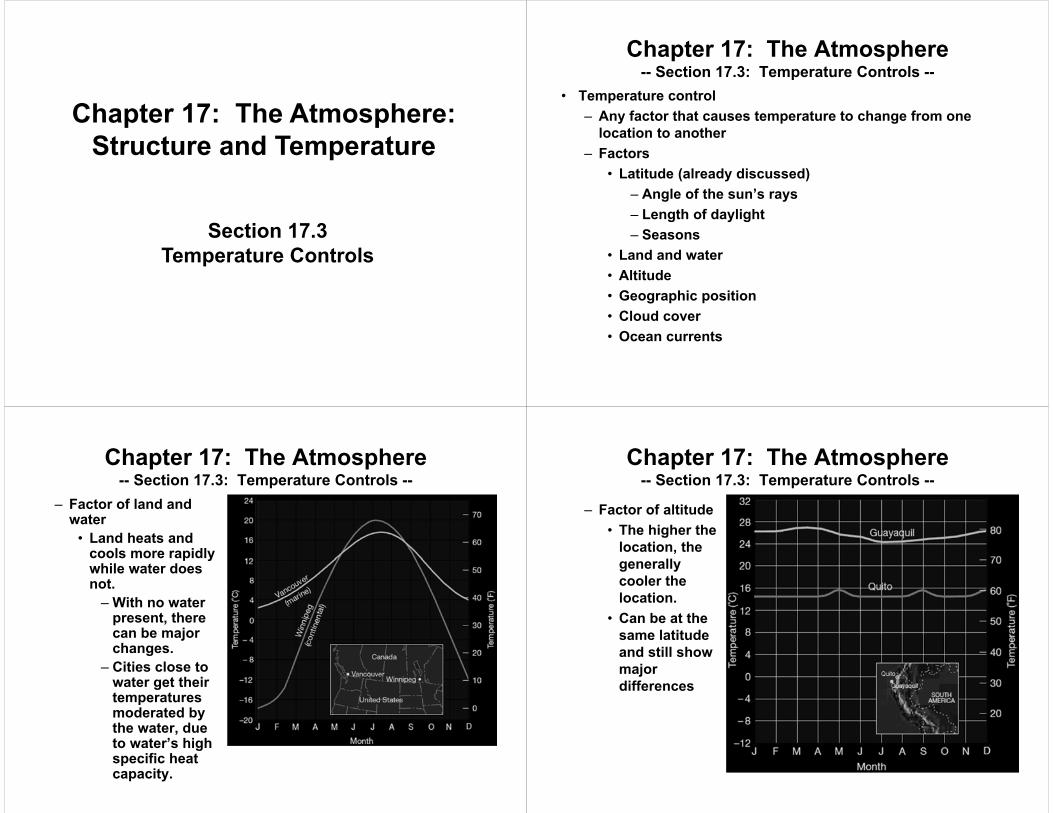
– Factor of land and water• Land heats and
cools more rapidly while water does not.– With no water
present, there can be major changes.
– Cities close to water get their temperatures moderated by the water, due to water’s high specific heat capacity.
Chapter 17: The Atmosphere-- Section 17.3: Temperature Controls --
– Factor of altitude• The higher the
location, the generally cooler the location.
• Can be at the same latitude and still show major differences

Chapter 17: The Atmosphere-- Section 17.3: Temperature Controls --
– Factor of geographic position• Winds from the
ocean versus winds from the coast
• Leeward (coastal) winds don’t moderate temperature as well as windward (from the oceans) winds do.
Chapter 17: The Atmosphere-- Section 17.3: Temperature Controls --
• Mountains can serve as a barrier to winds that moderate.
• Mountains block the moderating effect from the ocean.
– Factor of cloud cover• Albedo
– Fraction of total radiation reflected by a surface– Expresed as a decimal– Many clouds have a high albedo.
» Reflect light during the day» Reradiate energy back to Earth at night to insulate
• Isotherms– Lines connecting points of equal temperature– Show that latitude is the biggest factor of temperature
Chapter 17: The Atmosphere-- Section 17.3: Temperature Controls --
Isothermal Map
Chapter 17: The Atmosphere-- Section 17.3: Temperature Controls --
Chapter 19: Air Pressure and Wind
• Understanding Air Pressure• Pressure Centers and Winds• Regional Wind Systems
Section 19.1Understanding Air Pressure
Chapter 19: Air Pressure and Wind
• Air pressure– The force exerted by the weight of a column of air over a
given location– Exerted in all directions– Air pressure pushing down on an object is balanced by air
pressure pushing up on an object– Average air pressure at sea level: 1 kg/cm2
– Less atmospheric pressure at higher altitudes– Use a barometer to measure pressure (see previous notes)
• Most commonly use the “millibar” (mb) as a unit for measurement
• Types of barometers: aneroid and mercurial (see previous notes)
Chapter 19: Air Pressure and Wind-- Section 19.1: Understanding Air Pressure --
• Factors affecting wind– Pressure differences
• Air flows from areas of higher pressure to areas of lower pressure.
• HINT: Think of walking through school doors in the morning, or spraying hair spray.
• The greater the pressure difference, the greater the wind speed.
• Discovered using barometers at several locations• Create a map with isobars (lines on a map connecting
places of equal pressure)• Pressure gradient
– The amount of pressure change occurring over a given distance
– Has both magnitude (shown by isobars) and direction
Chapter 19: Air Pressure and Wind-- Section 19.1: Understanding Air Pressure --

Chapter 19: Air Pressure and Wind-- Section 19.1: Understanding Air Pressure --
• The closer the isobars, the greater the pressure gradient and speed of winds.
• The more spaced out the isobars, the lower the pressure gradient and speed of winds.
Chapter 19: Air Pressure and Wind-- Section 19.1: Understanding Air Pressure --
– Coriolis effect (see previous notes to review)• Apparent deflective force of Earth’s rotation on all free-
moving objects, including the atmosphere and oceans• Deflect winds to the right in the Northern Hemisphere;
deflects winds to the left in the Southern Hemisphere• Notes about wind deflection
– Always directed at right angles to the direction of air flow
– Affects only wind direction, NOT wind speed– Is affected by wind speed
» The stronger the wind, the greater the deflection» The weaker the wind, the less the deflection
– Strongest at the poles and weakest at the equator
Chapter 19: Air Pressure and Wind-- Section 19.1: Understanding Air Pressure --
– Friction• Affects wind speed and direction• Acts to slow air movement• When above the friction layer
– Pressure gradient causes air to move across the isobars
– Coriolis effect acts at right angles to this motion– The faster the wind, the greater the deflection– Balance in high-altitude air, causing wind to flow
parallel to the isobars– Jet streams
» High-altitude winds» Near the tropopause and moving 120 – 240 km/hr» Do not blow steadily but do change speed and
position
Chapter 19: Air Pressure and Wind-- Section 19.1: Understanding Air Pressure --
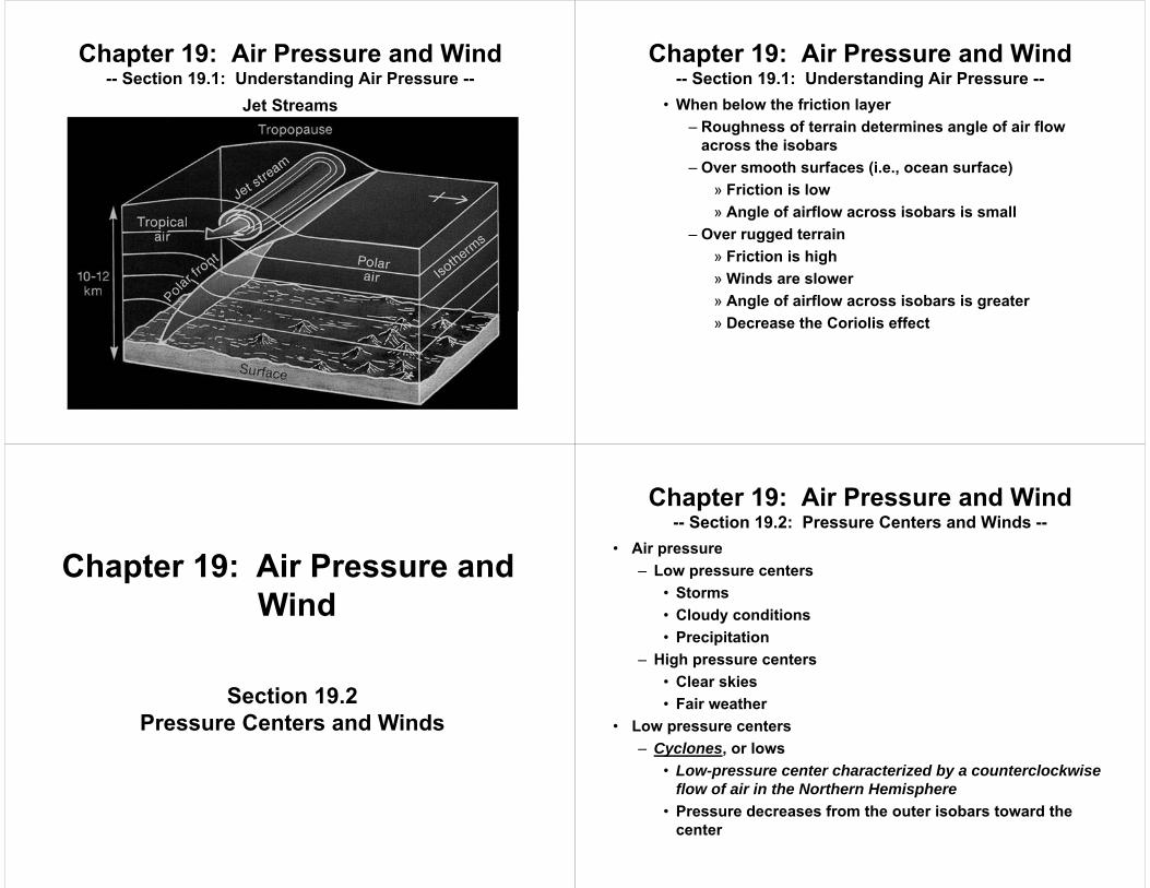
Jet Streams
Chapter 19: Air Pressure and Wind-- Section 19.1: Understanding Air Pressure --
• When below the friction layer– Roughness of terrain determines angle of air flow
across the isobars– Over smooth surfaces (i.e., ocean surface)
» Friction is low» Angle of airflow across isobars is small
– Over rugged terrain» Friction is high» Winds are slower» Angle of airflow across isobars is greater» Decrease the Coriolis effect
Chapter 19: Air Pressure and Wind-- Section 19.1: Understanding Air Pressure --
Section 19.2Pressure Centers and Winds
Chapter 19: Air Pressure and Wind
• Air pressure– Low pressure centers
• Storms• Cloudy conditions• Precipitation
– High pressure centers• Clear skies• Fair weather
• Low pressure centers– Cyclones, or lows
• Low-pressure center characterized by a counterclockwise flow of air in the Northern Hemisphere
• Pressure decreases from the outer isobars toward the center
Chapter 19: Air Pressure and Wind-- Section 19.2: Pressure Centers and Winds --

– Anticyclones, or highs• High-pressure center characterized by a clockwise flow of
air in the Northern Hemisphere• Pressure increases from the outer isobars toward the
center• Cyclonic and anticyclonic winds
– Two most significant factors of wind• Coriolis effect• Pressure gradient
– Northern hemisphere (affected by Coriolis effect and pressure gradient)• Winds blow counterclockwise around a low.• Winds blow clockwise around a high.
Chapter 19: Air Pressure and Wind-- Section 19.2: Pressure Centers and Winds --
– Southern hemisphere (affected by Coriolis effect and pressure gradient)• Winds blow clockwise around a low.• Winds blow counterclockwise around a high.
– Friction always causes a net flow of air inward around a cyclone and a net flow of air outward around an anticyclone (because of pressure gradients).
Chapter 19: Air Pressure and Wind-- Section 19.2: Pressure Centers and Winds --
Chapter 19: Air Pressure and Wind-- Section 19.2: Pressure Centers and Winds --
Chapter 19: Air Pressure and Wind-- Section 19.2: Pressure Centers and Winds --
• Weather and air pressure– A low pressure center accumulates air because of surface
convergence, causing the air to rise and spread out high above (diverges).
– The air comes together above (converges) and then sinks to the ground, at which point it experiences surface divergence.
Chapter 19: Air Pressure and Wind-- Section 19.2: Pressure Centers and Winds --
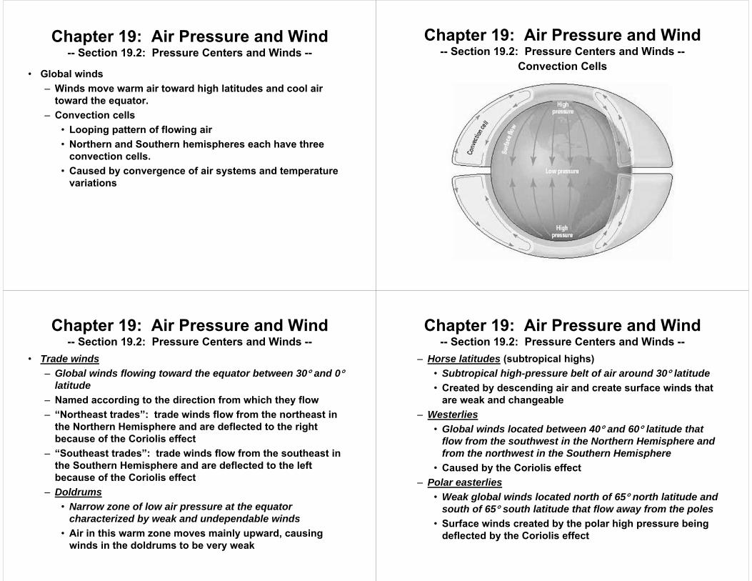
• Global winds– Winds move warm air toward high latitudes and cool air
toward the equator.– Convection cells
• Looping pattern of flowing air• Northern and Southern hemispheres each have three
convection cells.• Caused by convergence of air systems and temperature
variations
Convection Cells
Chapter 19: Air Pressure and Wind-- Section 19.2: Pressure Centers and Winds --
• Trade winds– Global winds flowing toward the equator between 30 and 0
latitude– Named according to the direction from which they flow– “Northeast trades”: trade winds flow from the northeast in
the Northern Hemisphere and are deflected to the right because of the Coriolis effect
– “Southeast trades”: trade winds flow from the southeast in the Southern Hemisphere and are deflected to the left because of the Coriolis effect
– Doldrums• Narrow zone of low air pressure at the equator
characterized by weak and undependable winds• Air in this warm zone moves mainly upward, causing
winds in the doldrums to be very weak
Chapter 19: Air Pressure and Wind-- Section 19.2: Pressure Centers and Winds --
– Horse latitudes (subtropical highs)• Subtropical high-pressure belt of air around 30 latitude• Created by descending air and create surface winds that
are weak and changeable– Westerlies
• Global winds located between 40 and 60 latitude that flow from the southwest in the Northern Hemisphere and from the northwest in the Southern Hemisphere
• Caused by the Coriolis effect– Polar easterlies
• Weak global winds located north of 65 north latitude and south of 65 south latitude that flow away from the poles
• Surface winds created by the polar high pressure being deflected by the Coriolis effect
Chapter 19: Air Pressure and Wind-- Section 19.2: Pressure Centers and Winds --
• Polar easterlies are strongest where they flow off Antarctica.
• When they meet warm air from the westerlies, a stormy region is generated called a “polar front” (zone separating cold air masses of polar origin from warm air masses of tropical origin)– Subpolar lows
» Belt of low pressure at about 60 north and 60south latitude
» Result from warm air moving toward the poles from when the subtropical high is lifted by cold polar air moving toward the equator, in which the descending cold air creates areas of high pressure
Chapter 19: Air Pressure and Wind-- Section 19.2: Pressure Centers and Winds --
Chapter 19: Air Pressure and Wind-- Section 19.2: Pressure Centers and Winds --
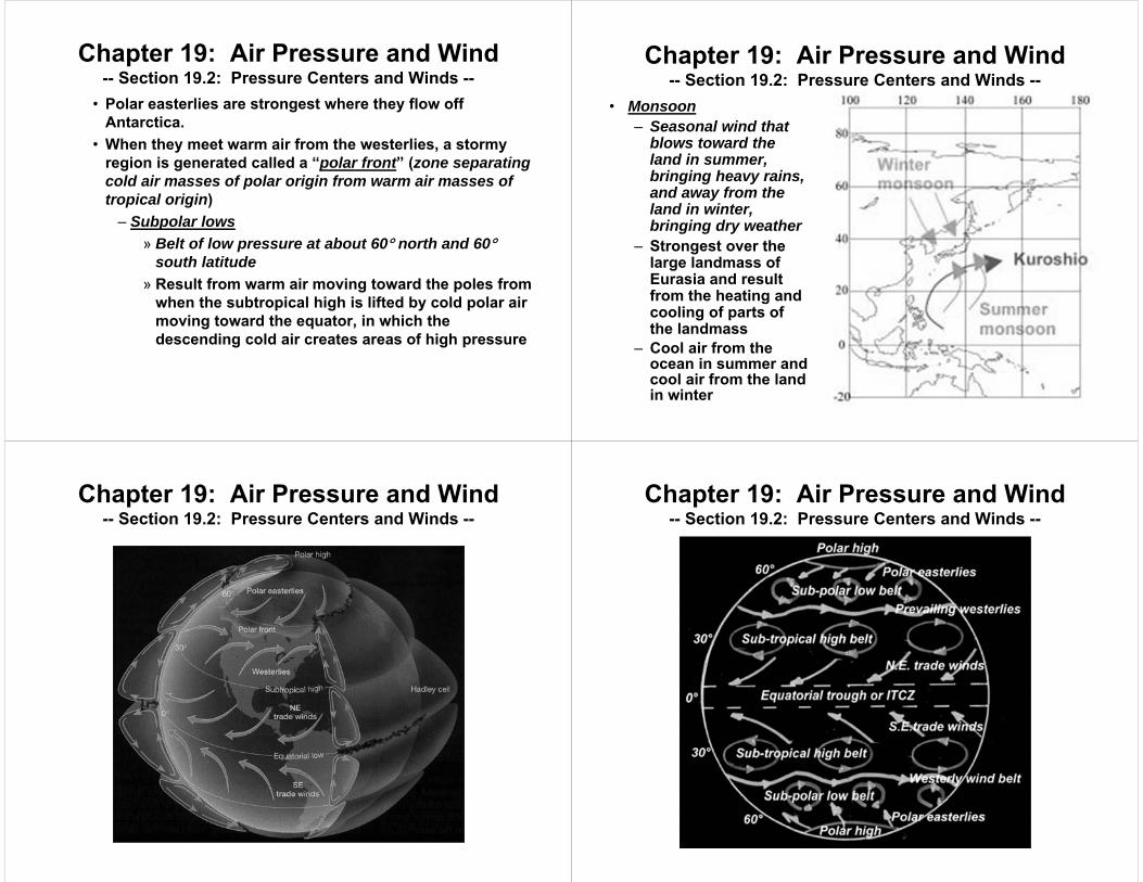
• Monsoon– Seasonal wind that
blows toward the land in summer, bringing heavy rains, and away from the land in winter, bringing dry weather
– Strongest over the large landmass of Eurasia and result from the heating and cooling of parts of the landmass
– Cool air from the ocean in summer and cool air from the land in winter
Chapter 19: Air Pressure and Wind-- Section 19.2: Pressure Centers and Winds --
Chapter 19: Air Pressure and Wind-- Section 19.2: Pressure Centers and Winds --

Section 19.3Regional Wind Systems
Chapter 19: Air Pressure and Wind
• Local winds causes– Topographic effects (land features)– Variations in surface composition
• Breezes– Gentle winds that extend over differences of less that 100 km– Types of local winds
• Land and sea breezes– Land heats up faster than water because of lower
specific heat capacity.– Sea breeze: cool wind moving from water to land
because of temperature differences beginning in the afternoon
– Land breeze: breeze flowing from cooler land to warmer water at night
Chapter 19: Air Pressure and Wind-- Section 19.3: Regional Wind Systems --
Land and Sea Breezes During Daytime
Chapter 19: Air Pressure and Wind-- Section 19.3: Regional Wind Systems --
Land and Sea Breezes During Nighttime
Chapter 19: Air Pressure and Wind-- Section 19.3: Regional Wind Systems --

• Mountain and valley breezes– Valley breeze: gentle wind that blows up mountain
slopes during daylight– Mountain breeze: cold air flowing down a slope
toward the warmer valley at night because of mountains cooling down more quickly
Chapter 19: Air Pressure and Wind-- Section 19.3: Regional Wind Systems --
Mountain and Valley Breezes
Chapter 19: Air Pressure and Wind-- Section 19.3: Regional Wind Systems --
• How wind is measured– Wind direction
• Wind is named based on the direction from which it blows.– Example: westerlies are winds that blow from the west– Wind vanes help determine this.
• Prevailing wind– Wind that consistently blows from one direction more
than from another– Example: Westerlies
– Wind speed• Measured using an anemometer• Typically measured in miles per hour
Chapter 19: Air Pressure and Wind-- Section 19.3: Regional Wind Systems --
• El Niño– Name given to the periodic warming of the ocean that occurs
in the central and eastern Pacific Ocean– Can cause extreme weather in many parts of the world– Irregular intervals of 3 to 7 years– Warm countercurrents become unusually strong and replace
normally cold offshore waters with warm equatorial waters– Block upwelling of colder, nutrient-filled water, starving fish– Affects rainfall inland as well as increased inland
temperatures as far as mountains
Chapter 19: Air Pressure and Wind-- Section 19.3: Regional Wind Systems --

Chapter 19: Air Pressure and Wind-- Section 19.3: Regional Wind Systems --
Normal Conditions
Chapter 19: Air Pressure and Wind-- Section 19.3: Regional Wind Systems --
El Niño Conditions
• La Niña– Opposite of El Niño– Surface temperatures in the eastern Pacific are colder than
average while other temperatures are changed.• Blows colder than normal air over the Pacific Northwest
and northern Great Plains• Warms much of the rest of the United States
– Can increase hurricane activity• Factors that affect global precipitation
– Moisture content of the air– Distribution of land and water
Chapter 19: Air Pressure and Wind-- Section 19.3: Regional Wind Systems --
Chapter 20: Weather Patterns and Severe Storms
• Air Masses• Fronts

Section 20.1Air Masses
Chapter 20: Weather Patterns and Severe Storms
• Air mass– Large body of air that is characterized by similar
temperatures and amounts of moisture at any given altitude– Can be 1600 kilometers or more across and several
kilometers thick– May take several days to move over an area
• Movement of air masses– Carries temperature and moisture conditions with it– As an air mass moves, the characteristics of the air mass
change and so does the weather in the area over which the air mass moves.
Chapter 20: Weather Patterns-- Section 20.1: Air Masses --
• Classifying air masses– Polar air masses
• Classified with a “P”• Cold air masses formed at high latitudes toward Earth’s
poles– Tropical air masses
• Classified with a “T”• Warm air masses formed at low latitudes
– Classifications of air masses according to surfaces over which they form• Continental air masses
– Classified with a “c”– Air masses formed over land– Likely to be dry
Chapter 20: Weather Patterns-- Section 20.1: Air Masses --
• Maritime air masses– Classified with a “m”– Air masses formed over water– Likely to be humid
• Five main types of air masses– Continental tropical (cT)
• Warm and dry• Least influence on the weather of North America• Begin in the southwestern United States and Mexico
during the summer• When a cT air mass does move from its source region, it
can cause extremely hot, droughtlike conditions in the Great Plains in summer.
• Causes “Indian summers” in the Great Lakes region
Chapter 20: Weather Patterns-- Section 20.1: Air Masses --

– Maritime tropical (mT)• Warm and moist and usually unstable• Dominant influence on the weather of North America• Source of most of the precipitation received in the eastern
two-thirds of the United States• Begin in the Caribbean Sea and the Gulf of Mexico• When a mT air mass does move from its source region, it
can cause extremely hot, humid conditions in the central and Eastern United States in summer.
– Continental polar (cP)• Cold and dry in winter and cool and dry in summer• Brings relatively cooler weather in the summer and clear
skies and cold temperatures during winter• Not associated with heavy precipitation
Chapter 20: Weather Patterns-- Section 20.1: Air Masses --
• Helps to cause “lake-effect snow” from the air mass being large and cold and coming into contact with heat and moisture of lakes, causing instability and resulting in heavy snow
– Maritime polar (mP)• Relatively mild, humid, unstable air• Come from the North Pacific and North Atlantic off the
coast of Eastern Canada• If from the North Pacific, accompanied by low clouds and
showers as it arrives at the western shore of North America, and uplift of the air over the western mountains produces heavy rain or snow on the windward slopes of the mountains
• If from the North Atlantic, counterclockwise winds draw in maritime polar air from the passing low-pressure center, producing snow and cold known as a “nor’easter”.
Chapter 20: Weather Patterns-- Section 20.1: Air Masses --
Section 20.2Fronts
Chapter 20: Weather Patterns and Severe Storms
• Front– Boundary between two adjoining air masses having
contrasting characteristics– Often associated with precipitation– Narrow (15 to 200 km wide)
• How fronts work– Above Earth’s surface, the frontal surface slopes at a low
angle so that warmer, less dense air is on top of cooler, denser air.
– Some air masses on both sides of a front move in the same direction and at the same speed, so the front is just a barrier.
– In other cases, the distribution of pressure across a front causes one air mass to move quicker than the other, so some mixing of air occurs.
Chapter 20: Weather Patterns-- Section 20.2: Fronts --

• Front classifications are based on the temperature of the advancing front.– Warm front
• Front formed when warm air moves into an area previously covered by cooler air
• Weather map: warm front is shown by a red line with red semicircles that point toward the cooler air
• Slope of the warm front is very gradual.• As warm air rises, it cools to produce clouds and
precipitation.• Usually produce light-to-moderate precipitation over a
large area for a long while because of slow rate of movement and low slope
• Gradual increase in temperature occurs.• Wind shift from the east to the southwest
Chapter 20: Weather Patterns-- Section 20.2: Fronts --
Chapter 20: Weather Patterns-- Section 20.2: Fronts --
Warm front
Chapter 20: Weather Patterns-- Section 20.2: Fronts --
Warm front
Chapter 20: Weather Patterns-- Section 20.2: Fronts --
Warm front

– Cold front• Front formed when cold dense air moves into an area
covered by warmer air• Weather map: cold front is shown by a blue line with blue
triangles that point toward the warmer air mass• Slope of the warm front is very steep, and cold front
advances more rapidly, which is why more violent weather is attributed to cold fronts.
• Heavy downpours and gusty winds due to forceful lifting of air along a cold front
• Decrease in temperature and wind shifts once cold front has passed
• Weather clears after a cold front passes because of cold air mass left behind.
Chapter 20: Weather Patterns-- Section 20.2: Fronts --
Chapter 20: Weather Patterns-- Section 20.2: Fronts --
Cold front
– Stationary front• Front formed in which the surface position of the front
does not move• The flow on either side of the front is nearly parallel to the
position of the front.• Weather map: stationary front is shown by blue triangles
on one side of the front and red semicircles on the other side
• Sometimes, gentle to moderate precipitation occurs.
Chapter 20: Weather Patterns-- Section 20.2: Fronts --
Chapter 20: Weather Patterns-- Section 20.2: Fronts --
Stationary front
– Occluded front• Front formed when a cold front overtakes a warm front• Happens as advancing cold air wedges the warm front
upward• Major variations in what to expect
Chapter 20: Weather Patterns-- Section 20.2: Fronts --
Chapter 21: Climate
• Climatology– Study of Earth’s climate in order to understand and predict
climatic change– Factors of climatology
• Past and previous variations in temperature• Precipitation• Wind• Other weather variables
– Data used to describe an area’s climate• Normal
– Standard value for a location– Factors
» Rainfall» Windspeed
Chapter 21: Climate

» Temperatures– Based on meteorological records compiles from at
least the past 30 years– Averages based on a monthly or yearly basis– Disadvantages
» Weather conditions often differing from normals» Sources creating issues (i.e., airports)» Variations resulting from topography
Chapter 21: ClimateNormals
Chapter 21: Climate
• Causes of climate– Latitude
• Result from tilt of Earth• Closer to the equator = More solar radiation received• Specific latitudes
– Tropics» Between 23.5N and 23.5S» Area of Earth that receives the most solar radiation» Generally warm year-round
– Temperature zones» Between 23.5N and 66.5N or between 23.5S and
66.5S» Have moderate temperatures and experience
seasons
Chapter 21: Climate– Polar zones
» Above 66.5N and below 66.5S» Sun strikes these regions at low angles» Generally very cold year-round
– Topographic effects• Water nearby (previously discussed)
– Related to specific heat capacity of water– Comparison of water to land
• Mountains nearby (previously discussed)– Windward side: wet and cool– Leeward side: dry and warm
» Why deserts are common on leeward side» Moisture stopped by mountains
Chapter 21: Climate
– Air masses• mT, cT, mP, cP• See previous notes.
– Related to specific heat capacity of water– Comparison of water to land
• Climatic change causes– Ice ages
• Periods of extensive glacial coverage• Produce long-term climatic changes• Advanced and retreated during the past two million years• 5C average global temperature decrease• Ice ages alternating with interglacial intervals (which we
are currently experiencing)• Last ice age: 10,000 years ago
Chapter 21: Climate– El Niño
• Produce short-term climatic changes• See previous notes.
– Solar activity• Produce short-term climatic changes• Maunder minimum
– Period of very low sunspot activity that occurred between 1645 and 1716 and closely corresponded to a climatic episode known as the “Little Ice Age”
– Time when Europe experienced extremely cold winders and below-normal temperature for the entire year
– Increased solar activity = Warmer than normal temperatures
Chapter 21: Climate
Maunder minimumChapter 21: Climate
– Earth’s orbit• Changes between circular and elliptical orbits over a
100,000-year cycle– Elliptical
» Orbit elongates» Earth gets closer to the sun» Temperatures increase
– Circular» Orbit stays the same» Earth gets further from the sun» Temperatures decrease
Chapter 21: Climate

Earth’s orbitChapter 21: Climate
– Earth’s tilt• Over 41,000-year cycle, fluctuation of tilt from 22.1 to
24.1• Current tilt: 23.5• Changes in seasons cause seasons to become more
severe– Decrease in angle might cause a decrease in
temperature difference between winter and summer (winters warmer and summers cooler)
– Possible source of glacial coverage» Ice ages» Not enough warmth to melt snow from the poles
Chapter 21: Climate
– Earth’s wobble• Every 26,000 years, Earth wobbles as it spins on its axis• Currently
– Points toward Polaris– Winter occurs in the northern hemisphere when Earth
is closest to the sun– Summer occurs in the northern hemisphere when
Earth is farthest from the sun• In 14,000 years
– Points toward Vega– Winter occurs in the northern hemisphere when Earth
is farthest from the sun– Summer occurs in the northern hemisphere when
Earth is closest to the sun
Chapter 21: ClimateEarth’s orbit
Chapter 21: Climate
– Volcanic activity• Dust released into the atmosphere• Dust remaining in the atmosphere for several years• Blocks incoming solar radiation• Lowering of global temperatures
Chapter 21: Climate– The human factor
• The greenhouse effect– Natural heating of Earth’s surface by certain
atmospheric gases– Helps keep Earth warm enough to sustain life– Can change heating of Earth the wrong way (too hot or
too cold)– Primary greenhouse gas: carbon dioxide (CO2)
» Increase in CO2 = increased absorption of solar radiation
» Cause of global warming
Chapter 21: Climate
• Global warming– Rise in global temperatures and a phenomenon related
to the greenhouse effect– Potential causes in global warming from increase in
atmospheric CO2
» Deforestation (not as many plants take in CO2)» Burning of fossil fuels
– Environmental efforts» Conserving energy (related to fossil fuels)» Conserving materials (related to deforestation)
Chapter 21: Climate