chapter 455 land use and transportation · chapter 455 land use and transportation ... be...
TRANSCRIPT

WSDOT Environmental Manual M 31-11.17 Page 455-1 June 2017
Chapter 455 Land Use and Transportation
455.01 Land Use, Transportation and Practical Solutions455.02 Requirements for Land Use Analysis455.03 Requirements for Transportation Analysis455.04 Coordination with Federal Agencies other than FHWA455.05 DocumentingLandUseAnalysisforLegalSufficiencyunderNEPA455.06 Bicycling and Pedestrian Facilities455.07 Transit455.08 Farmland455.09 Resource Conservation Areas455.10 Recreational Land Conversions Section 6(f)455.11 Wild and Scenic Rivers455.12 Statutes and Regulations455.13 Abbreviations and Acronyms455.14 Glossary
455.01 Land Use, Transportation and Practical SolutionsPractical Solutions is a two-part strategy that includes least cost planning and practical design,asdefinedinWSDOTExecutiveOrderE1090 and described in detail in Section 300.02 and Division 11 of the Design Manual M 22-01.
The land use and transportation analysis is a core element, providing the basis for modal choice, alternative development and selection of design elements. The process resemblestheNEPAprocessandeveryeffortshouldbemadetominimizere-workbydocumentingthePracticalDesignprocessinenoughdetailtofulfilltheNEPAdocumentation requirements.
TheBasisofDesign(BOD)isusedtodocumenttheoutcomesofapplyingtheseproceduralsteps.ABODisrequiredforallprojectsthatrequireanEnvironmentalAssessment(EA)oranEnvironmentalImpactStatement(EIS).TheBODshouldserveasthefoundationfortheenvironmentaldocumentationforthesetypesofprojects
SimpleprojectsthatareCategoricallyExcludedandCategoricallyExempt(CEsasdefinedinSections300.04 and 300.05) usually need minimal analysis for environmental documentationoflanduseandtransportationimpacts.Insuchcases,document:• Thepotentialdirectprojectimpactstoresourcelands(criticalareas,shorelines,forest/timberlands,mineralresourcelands,farmland,andparksandrecreationlands)bycompletingtheappropriatesectionoftheERS/ECSformand/oraSEPAChecklist.
• ThetemporaryconstructionimpactstotransportationandwaystominimizethoseimpactsintheERS/ECSform(seeDesign Manual Chapter 1010) or by completion ofaSEPAchecklist.Iftheprojecthassignificantconstructionimpactstotraffic,asdefinedinDesign Manual Chapter 1010, attach a copy of the Transportation ManagementPlantotheECSform.
• CompletionofaBODisnotrequiredforPreservationProjects(seeDesign Manual Chapter 1120).
Land Use and Transportation Chapter 455
Page 455-2 WSDOT Environmental Manual M 31-11.17 June 2017
(1) Advisory Team Roles and ResponsibilitiesAs a member of the Advisory Team established in Step 1 of the Practical Design Process, environmentalstaff:• Researchandprovideinformationdescribingtheenvironmentalcontextfortheproject
commensurate with the level of design detail provided and the potential environmental impactsoftheproject(e.g.RightsizetheresearchandanalysisusingGISdata,windshieldsurveys,coordinationwithsubjectmatterexperts,orsitespecificanalysisas appropriate).
• Communicate environmental information to the team so that potential budget, schedule andpermittingissuesareclearlyunderstoodandtakenintoconsiderationthroughoutthe process.
• WorkwiththeprojectteamtoensurethatthePracticalDesignprocessisdocumentedintheprojectinsufficientdetailtosupporttheadministrativerecordand environmental documentation.
455.02 Requirements for Land Use AnalysisThe Code of Federal Regulations (40 CFR 1502.16(c))requiresthatEAsandEISsincludeadiscussionofpossibleconflictsbetweentheproposedactionandthefederal,tribal,regional,state,andlocallanduseplansobjectives,policies,controlsandregulations.Thegoaloftheanalysisistohelpdecisionmakersunderstandtheeffectthetransportationprojecthasonlanduseanddevelopmentpatterns.Theanalysismust:• Describeanydirectprojectimpactsresultingfromtheconversionoflandto
transportation uses. The analysis should include a discussion of the temporary (construction)impactsandlongterm(operational)impacts.Itisbesttoincludeamapshowingtheexistingandproposedrightofwaylines,existinglanduse(asdescribedin the adopted comprehensive plan) and acreage to be converted to transportation uses in support of the analysis.
• Determineiftheprojectisconsistentwiththeexistingadoptedcomprehensiveplansanddevelopmentpolicies.InWashingtonState,landuseiscontrolledbycityandcounty governments through the comprehensive planning process under the Growth ManagementAct.ThestateLocalProjectReviewActof2001precludesWSDOTfrom revisiting land use decisions included in the adopted comprehensive plan during projectreview.InordertoreceiveFederalfunding,atransportationprojectmustbeconsistentwithlocalplanning(i.e.thegoalsandobjectivesoftheprojectshouldmatchthegoalsandobjectivesstatedinthecomprehensiveplan).
• Describedevelopmenttrendsinthestudyareaandanyindirectprojectimpactscausedbydevelopmentoccurringinresponsetotheproject.Indirectlanduseeffectsinvolvepotentialdevelopment,orredevelopmentofbuildablelandswithintheinfluenceareaofthetransportationproject.ThesechangesaredrivenandconstrainedbysocialandeconomicfactorsbeyondWSDOTorthelocalpublicagency’scontrol.Sucheffectsaredifficulttopredictandoftencontroversial.Projectsthatdonotincreasecapacity,changethelevelofservice,orsignificantlyreducetraveltimeareunlikelytochangeland use.
• Discussactionsthatweretakentoavoid,minimizeormitigatedirectlanduseimpacts.Potential or recommended mitigation measures for indirect impacts should also be described. The discussion should include the party responsible for such mitigation and thelikelihoodofimplementationofsuchmeasures.

Chapter 455 Land Use and Transportation
WSDOT Environmental Manual M 31-11.17 Page 455-3 June 2017
• Evaluateandcomparethepotentialimpactforallalternatives,includingthenobuild.Theresultsofthisanalysisshouldinformtheindirecteffectsanalysisconductedforotherdisciplinesandsupportthecumulativeeffectsanalysis.
Thelevelofeffortshouldbecommensuratewiththecomplexityandscopeoftheproject.Morerobustanalysismaybeneededforcomplexprojects:• Withsubstantialdirectlanduseeffects(positiveornegative)despiteproposedmitigation(e.g.,aprojectwithalargenumberofrightofwayacquisitionsordisplacements).
• Withsubstantialindirecteffects(positiveornegative)onlandusedespiteproposedmitigation(e.g.,aprojectthatwouldcausesizablechangesinplanneddevelopmentwithinthestudyarea,oraprojectfoundtobeinconsistentwithplannedgrowth).
• Infastgrowingareaswithsignificantamountsofundevelopedland,whereadditionalanalysisisneededtodetermineprobableeffects.(e.g.,constructionofanewinterchange in a rural area).
ProjectsclassifiedasCategoricalExclusions/CategoricalExemptions(CE–seeSections300.04 and 300.05) typically do not require analysis for potential land use impacts under 23 CFR 771.117(a)because,bydefinition,theseprojects:• Donotinducesignificantimpactstoplannedgrowthorlanduse.• Donotrequirerelocationofsignificantnumbersofpeople.• Donothavesignificantimpactsontravelpatterns.• Donothavesignificantenvironmentalimpacts.
455.03 Requirements for Transportation AnalysisTransportationprojectsaredesignedtoimprovetheoveralltransportationnetworkforallmodesoftravel.ThePracticalSolutionsinitiativewasadoptedtoenablemoreflexibleandsustainabletransportationinvestmentdecisions,including,butnotlimitedto:operationalimprovements,off-systemsolutions,transportationdemandmanagement,andincrementalstrategic capital solutions.
Thepotentialeffectsofprojectsontransit,pedestrians,bicycles,railcrossings,ferryoperations,airportsafetyzones,parking,andvehicletrafficonadjacentandconnectingroadwaysneedtobeevaluatedanddiscussedintheenvironmentaldocument.Theeffectscan be positive or negative, temporary or long-term. Mitigation for unavoidable impacts, especially construction impacts, should also be discussed.
Section24ofFHWA’sTechnicalAdvisoryTA6640.8Arequirestheanalysistoinclude:• A review of the local comprehensive transportation and land use plans (see Design
Manual Chapter 1102). • Anevaluationoftheproposedproject’sconsistencywithtrafficrequirementsgeneratedbyplannedlanduse.Thediscussionshouldincludeeffects(bothpositiveandnegative)onsafety,vehicles,transit,freight,bicycles,pedestrians,andparking.
• Adiscussionofhowtheproject’sshort-termimpactsanduseofresourcescontributetotheenhancementofthearea’slong-termproductivity.
InNEPA,thetransportationanalysissupportsthePurposeandNeedbyprovidingquantitativemeasuresthatdemonstratetheeffectivenessoftheproposedproject.Itmay also provide a method of comparing and contrasting the relative merits of the
Land Use and Transportation Chapter 455
Page 455-4 WSDOT Environmental Manual M 31-11.17 June 2017
alternatives.FHWATechnicaladvisoryTA6640.8Aemphasizestheneedtoconsiderpotentialconstructionandoperationalimpactstopedestrianandbicycletrafficduringtheenvironmental review process.
InSEPA,transportationisconsideredtobeanelementofthebuiltenvironment(WAC 197-11-444).Theanalysismustconsiderimpactsto:• Transportation System• Vehiculartraffic• Parking• Safetyandtraffichazards• Waterborne,rail,andairtraffic• Movement/circulationofpeopleorgoods
The Practical Design process described in Division 11 of the Design Manual is consistent with these requirements. • Chapter 1101NeedsIdentification• Chapter 1102ContextIdentification• Chapter 1104 Alternatives Analysis
Compliance with FHWA’sInterimGuidanceontheApplicationofTravelandLandUseForecastinginNEPA(March2010)isrecommended,butnotrequiredforprojectsthatusea travel demand model.
455.04 Coordination with Federal Agencies other than FHWAFederalagenciesmaintaintheirownuniqueNEPAproceduresinCFR and may have differentdocumentationandproceduralrequirementsforcomplyingwithNEPA.Ifyourprojecthasafederalnexuswithmorethanonefederalagency,itiscriticallyimportanttomeetwitheachofthefederalleadagenciesinvolvedintheprojectanddeterminehowtoproceed.Insomecasesthefederalagenciesmayagreetoco-leadtheNEPAprocess.Inothers,oneagencymayserveasleadandtheotherasacooperatingagency.Thisdecision needs to be made very early in the process to ensure timely approval of your environmentaldocument.Theexactrequirementwillvarydependingonthenatureoftheproject,federalpermitsandapprovalsrequired,andindividualcircumstances.Commonexamplesofprojectsthatrequirecoordinationwithmorethanonefederalagencyare:• AnFHWAfundedprojectthatcrossesfederallyownedormanagedlands.• AprojectthatreceivesFederalHighwayAdministrationandFederalTransit
Administration funding.• AnyhighwayprojectinvolvingFederalRailroadAdministrationorFederalAviation
Administration.• AnFHWAfundedprojectthatrequiresanArmyCorpsofEngineersIndividualPermit.
(1) Waterborne Navigation and Ferry FacilitiesFerry Terminals are typically located in navigable waters within the corporate limits of cities where harbor lines have been established by the state Harbor Lines Commission. According to the State Constitution, harbor areas are “forever reserved for landings, wharves, streets, and other conveniences of navigation and commerce.”

Chapter 455 Land Use and Transportation
WSDOT Environmental Manual M 31-11.17 Page 455-5 June 2017
TheWashingtonStateDepartmentofNaturalResourcesmanagestheuseofharborareasin accordance with the Aquatic Lands Act (RCW 79.105).Theseareasarealsosubjecttolocallanduseregulations,includingshoreline,criticalarea,andzoningregulations.
U.S. Homeland Security regulations (33 CFR 165)imposesecurityzonesatferryterminalsandaroundvessels.A25yardseparationzoneisrequiredwhenvesselsareatthedock,anda100yardseparationzoneisrequiredwhenthevesselisinroute.Potentialimpactstothesesecurityzonesshouldbeaddressedinthelanduseanalysis.
FerryTerminalprojectsoftenreceiveFederalTransitAdministrationfunds,and/orthefacilitiesmayhavereceivedFTAfunding.WSFprojectsmayalsobesubjecttoFederalTransit Administration requirements. FTA procedures are described on their website and inthepolicydocument:EnvironmentalImpactandRelatedProcedures(23 CFR 771) EffectiveApril23,2009.
Roadprojectstypicallyhavelittleimpactonwaterbornenavigation.However,rivercrossingsmayaffectshippingroutesoraccesstoportfacilities.Section11ofFHWATechnical Advisory TA 6640.8A requires an analysis of potential impacts to waterborne navigationandadiscussionofmitigationforadverseimpacts.AnyprojectthatrequiresaSection 9 permit must also show evidence of coordination with the U.S. Coast Guard in accordance with the FHWA/U.S.CoastGuardMOA.Earlycoordinationisrequiredduringtheprojectplanningphase,priortoformalprojectinitiation(seethetableinSectionVforspecificrequirements).WherethepreferredalternativerequiresaSection9permit,theNEPAdocumentationshouldincludeanexhibitshowingthehorizontalandverticalnavigational clearances for each permit activity.
Highwayprojectsadjacenttoferryterminalsmayaffectferryloadingandunloadingprocedures,transitaccess,orparking.CoordinationwithWSFterminaloperationsstaffandadiscussionoftheaffects(bothbeneficialandadverse)toferryoperationsshouldbeincluded in the environmental document. Signal timing, turning movements, access to parking,transitstops,pedestrianflowandbicycleconnectionsmaybeimportantfactors.
Theenvironmentaldocumentmustevaluatetheeffectofproposedferryoperationsontheadjacentstreetsystemforvehiculartraffic,pedestrianflowandbicycleaccess.
(2) Rail FacilitiesUnlikehighways,mostrailfacilitiesareprivatelyowned.However,therearesituationswhenatransportationprojectincludesworkon,over,oradjacenttorailfacilities.Typesofprojectsincludegradecrossingimprovements,nearbyroadwayintersectionimprovements,and infrastructure improvements to support passenger rail service. When FHWA is the sole lead federal agency, apply the Design Manual Chapter 1350 policies and procedures forcoordinatinghighwayandrailprojects.Italsoincludesrequirementsforconductingasafetyanalysisforat-gradecrossingsandsignalizedintersectionsinthevicinityofrail crossings.
IfFRAisthefederallead,theEA/EISmustassessthedirect,indirect,andcumulativeimpacts on both passenger and freight transportation, by all modes, including bicycles and pedestrians. The analysis should address local, regional, national, and international perspectives and include a discussion of construction and long-term impacts on vehicular trafficcongestion.FormoreinformationonassessingenvironmentalimpactsrefertoFRA ProceduresforConsideringEnvironmentalImpacts.TodetermineiftheprojectqualifiesasaCEseeFRA’sCategoricalExclusionWorksheetguidance.

Land Use and Transportation Chapter 455
Page 455-6 WSDOT Environmental Manual M 31-11.17 June 2017
The Surface Transportation Board (STB) is an economic-regulatory agency and has jurisdictionoverrailrelatedproposalsthatincludeconstructionofnewraillinesandconnectingtrack,raillineabandonments,aswellasdiscontinuingrailservice.ThesetypesofprojectsaregenerallyproposedbyfreightrailroadsanddonottypicallyinvolveWSDOT.STB’senvironmentalrulescanbefoundat49 CFR 1105. The environmental rulesimplementvariousenvironmentalstatutesthatincludeNEPA,theNationalHistoricPreservationAct,theCoastalZoneManagementAct,andtheEndangeredSpeciesAct.
(3) Aviation FacilitiesAny proposed highway construction or alteration in the vicinity of a public or military airportwillrequireearlycoordinationwithWSDOT’sAviation Planning Division.Projectslocated within 3.8 miles of an airport may require an obstruction evaluation and must comply with FAA regulations to ensure that airway highway clearances are adequate for thesafemovementofairandhighwaytraffic(23 USC 318 and 23 CFR 620 Subpart A, HighwayImprovementsintheVicinityofAirports).
Theguidanceaddresses:• Theeffectofairportsonadjacentlanduseandappropriateenvironmental
documentation of proposed airport actions.• Thekindsofinformationonexistingandplannedlandusethatshouldbeprovidedinanenvironmentaldocumentforhighwayprojectswithin3.8milesofanairport,including“significancethresholds”forvariouslanduserelatedtopics.
Review of the Aviation Stormwater Design Manual M 3041 is recommended to evaluate potential impacts from the construction and operation of stormwater detention facilities in closeproximitytoairports.
IfFAAistheleadfederalagency,theenvironmentaldocumentmustevaluatetheeffectofairportexpansionorrehabilitationprojectsonthelocaltransportationnetwork,includingeffectonparking,transit,vehiclecongestion,traveltime,andtrafficpatterns.FAAguidanceonhowlandusecompatibilityshouldbeaddressedinairportplanningandNEPAdocumentsisfoundinFederalAviationAdministrationOrders1050.1E and 5050.4B. See theWSDOTEnvironmentalPermitting web page for FAA public notice requirements. ContacttheWSDOTAviationDivisionforassistance.
455.05 Documenting Land Use Analysis for Legal Sufficiency under NEPALarge,complex,and/orenvironmentallycontroversialprojectswillneedmorerobustdocumentationofthelanduseanalysis.Becausethelanduseanalysisinfluencesmanyother disciplines (transportation, noise, air quality, visual, and social) it is important to thoroughly document the participants, assumptions, methodologies, results, and uncertaintiestominimizetheriskofasuccessfullegalchallenge.Thismaybedoneinatechnicalappendixtotheenvironmentaldocument(perCEQ40 CFR 1502.18) to ensure thisinformationisincludedintheproject’sadministrativerecord.Fourkeyareasshouldbedocumentedintheproject’sadministrativerecord.
1. Identifyandexplainkeyunderlyingassumptions(suchasgrowthrates)andexplainhow those assumptions were made.
2. Describethemethodsusedtodevelopforecastresults.Explainingtheinherentadvantages and limitations in the analysis process and data sources can be especially useful in establishing a “reasoned basis” for the methodology.

Chapter 455 Land Use and Transportation
WSDOT Environmental Manual M 31-11.17 Page 455-7 June 2017
3. Summarizeandexplaintheresultsincludinganexplanationofpatternsinthedata,causalrelationships,andanomalousorunexpectedresults.
4. Systematically review assumptions, data and results to ensure internal consistency across related disciplines (transportation noise, air quality, visual quality, and social) to makesuretheydonotcontradictresultsofthelanduseanalysis.
455.06 Bicycling and Pedestrian FacilitiesThe FHWA Bicycle and Pedestrian Program requires that pedestrian bicycle facilities be considered as equals with other modes of transportation, ensuring that transportation choicesexistforpeopleofallagesandabilities.Inurbanareas,bicycleandpedestrianwaysmustbeestablishedinnewconstructionandreconstructionprojectsunlessoneormoreofthefollowingconditionsaremet:• Bicyclistsandpedestriansareprohibitedbylawfromusingtheroadway.Inthisinstanceagreatereffortmaybenecessarytoaccommodatebicyclistsandpedestrianselsewhere within the right of way or within the same transportation corridor.
• Thecostofestablishingbikewaysorwalkwayswouldbeexcessivelydisproportionatetotheneedorprobableuse.Excessivelydisproportionateisdefinedascostsexceeding20percentofthelargertransportationprojectbudget.
• Wherelowpopulationlevelsmakeitunlikelythefacilitywillbeusedbybicyclistsand/orpedestrians.
FHWA Technical Advisory T 6640.8A(October1987)requiresthattheenvironmentaldocument discuss current and anticipated use of the bicycle and pedestrian facility, potential impacts, and measures to avoid or reduce adverse impacts. This requirement appliestoformaltrailsandinformalpathwayswithidentifiedusebybicyclistsandpedestrians.Ifthepreferredalternativewouldseveranexistingmajorroutefornon-motorizedtransportationtraffic,theproposedprojectneedstoprovideareasonablealternativerouteordemonstratethatsucharouteexists(23 USC 109(m)).
Whennewbicycleandpedestrianfacilitiesareproposedaspartofahighwayproject,theenvironmentaldocumentshould:• Includesufficientinformationtoexplainthebasisforprovidingthefacilities(e.g.,proposedbicyclefacilityisalinkinthelocalplan,orsidewalkswillreduceprojectaccess impact to the community).
• Identifythefacilitiestobeincludedinthepreferredalternative.
1. Safe Routes to Schools–In2011,theWashingtonLegislaturefundedagrantprogramforSafeRoutestoSchoolsandSafeRoutestoTransit.Proposedprojectswithinone mile of a school may impact the Safe Routes to Schools and need to coordinate withtheschool.Schoolsarerequiredtoidentifywalkingroutes,provideamap,anddescribeidentifiedhazards.MapsofroutesareavailableontheWSDOTSafe Routes to Schoolswebpage.Effortstoavoid,minimize,ormitigateadverseimpactsandcoordinatewithschoolofficialsshouldbediscussedintheenvironmentaldocument.
2. National Trails System Act–TheNationalTrailsSystemAct1968(16 USC 1241-1251) requires federal agencies that abandon roadways, utility right of way, or other propertiessuitableforimprovingorexpandingthenationaltrailssystemtoconsiderthepossibilityofusingtheabandonedrightofwaytoextendthenationaltrailsystem.

Land Use and Transportation Chapter 455
Page 455-8 WSDOT Environmental Manual M 31-11.17 June 2017
455.07 TransitHighwayprojectshavethepotentialtobenefitandimpacttransitoperationsbychangingtrafficflowandtravelpatterns.Projectsmayaffecttraveltime,relocateorremovetransitstops, or change pedestrian access to transit stops by adding median barriers or relocating ofcrosswalks.Theenvironmentaldocumentshoulddiscuss:• Potentialbenefitsandopportunitiesforgreaterintegrationoftransitinthecorridor.
Potential construction impacts, particularly detours and temporary route closures. • Howchangesintrafficpatternsaffecttransitoperations.• Proposed mitigation for both construction impacts and operational impacts
The environmental document should include a discussion of potential impacts of the transitimprovementonthetransportationsystem.Areasofconcernincludetheeffectonexistingtransitoperations(areaandfrequencyofservice,traveltime,andpatronage),changesintrafficdistribution,localcirculationpatterns,andparking.FormoreinformationonassessingenvironmentalimpactsfortransitprojectsrefertotheFTATransportationImpactswebpage.
455.08 FarmlandThe Federal Farmland Protection Policy Act(FPPA)isintendedtominimizetheextentto which federal activities contribute to the conversion of farmland to nonagricultural uses. 7 CFR 658.2(a)givesgeneraldirectionsthatWSDOThasinterpretedtomeanthatsoil types not suitable for crops (such as sand dunes), farmland already committed to urban development (land within the adopted Urban Growth Area), and farmland that has alreadybeenconvertedtoindustrial,commercial,residential,orrecreationaluseisexemptfrom analysis.
TheFPPArequiresagenciestoexaminetheimpactoftheirprogramsandprojectsbeforetheyapproveanyactivitythatwouldconvertfarmlandtootheruses.WSDOTcomplieswiththisrequirementbysubmittingtheappropriateformstotheNaturalResourcesConservationService(NRCS).TheproceduresforcomplyingwithFPPArequirementscanbefoundontheWSDOTNEPA/SEPASupport web page.
NRCSrecognizesthreecategoriesoffarmlandbasedontheirsoiltypes:• Prime Farmland.• Unique Farmland.• Farmland of statewide or local importance.
Because the rating is based on soil type - timber land, vacant land, and open space, which hasneverbeenfarmed,maybedesignatedasprimefarmland.Therefore,theWSDOTprojectofficeshouldcompleteandsubmittheformtoNRCSforallprojects.TheNRCSwillperformaLandEvaluationandSiteAssessmentandreturnaFarmlandConversionImpactRating(FCIR)scoreforeachalternativedescribedontheform.Ascoreof160or greater is considered to be a substantial impact. Completed forms should be returned toNRCS.
IftheprojectisaCE,documentresultsintheERS/ECS.IfanEA/EISisrequired,summarizetheresultsofearlyconsultationwiththeNRCSandappropriatestateandlocal agricultural agencies where farmlands are directly or indirectly impacted by anyalternative.IncludeacopyoftheFCIRformandamapshowingthelocationofallfarmlandsintheprojectarea,thetype,andlocationofimpactbyalternative.The

Chapter 455 Land Use and Transportation
WSDOT Environmental Manual M 31-11.17 Page 455-9 June 2017
EA/EISshoulddiscussalternativestoavoidfarmlandimpactsforanyalternativewithascoreof160orgreater.Ifavoidanceisnotpossible,measurestominimizeorreduceimpacts should be evaluated and included in the proposed action.
(1) Farmland and Mitigation SitesRCW 47.01.305directsWSDOTtousepubliclandsbeforeusinglanddesignatedasagriculturallandoflong-termcommercialsignificance(asdefinedinRCW 36.70A) for highwayprojects.Ifpubliclandsareunavailable,WSDOTisdirectedtomakeeveryeffortto avoid any net loss of agricultural lands.
InanAugust2007letter,GovernorGregoiredirectedWSDOTtonotifytheGovernor’sChiefofStaffwhenWSDOTisseriouslyconsideringusingeminentdomainforacquiringagricultural resource land pursuant to the Growth Management Act (RCW 36.70A.170(a)) forwetlandmitigationpurposes.WSDOT’spolicyistocomplywiththesedirectivesbyavoiding the use of designated agricultural resource lands for mitigation sites whenever possible.Ifnoothersuitablesitesareavailable,WSDOTwillworkwithlocaljurisdictionstoavoidconflictwithpoliciesandregulationsprotectingagriculturallands.WSDOTRealEstateServicesOfficetracksconversionsofagriculturalresourcelandstotransportationpurposesforWSDOTprojects.TheWSDOTDirectorofEnvironmentalServiceswillensurethatWSDOTprovideswrittennoticetotheGovernor’sOfficeatleasttwoweekspriortofilinganyformalactiontocondemnorpurchasedesignatedagriculturalresourcelandsforenvironmentalmitigationpurposesasfollows:• For condemnation of designated agricultural lands for wetland mitigation sites, amandatorynoticewillbesenttotheGovernor’sChiefofStaff.(Thisrequirementdoesnotapplytolocalagencyprojects.)
• For condemnations of designated agricultural lands for other environmental mitigation purposes,acourtesynoticewillbesenttotheGovernor’sOfficestaff.Thisrequirementdoesnotapplytolocalagencyprojects.
(2) State Conservation Commission Memorandum of UnderstandingsThisMOUbetweentheWashingtonStateConservationCommissionandWSDOT(September, 1982) aims to enhance cooperation to preserve agricultural and forest lands. ItrequirescoordinationbetweenWSDOTandappropriateWashingtonStateConservationCommissionandConservationDistrictpersonneltoassurethatroadwayprojectsminimizeagriculturallandconversions.AcopyoftheMOUisavailableinAppendixB.
455.09 Resource Conservation AreasResourceConservationAreashavepreviouslybeencalledBeautificationAreas,LandscapeAreas,LandscapeorConservationEasements,orEnvironmentalCommitmentAreasonRightofWayPlansandRealEstateServicesMaps.Theyarenaturalareas,outsideoflimitedaccess,thatwerepurchasedorsetasidetoprovideanatural,vegetatedbufferbetweenthehighwayandadjacentlanduses.Theyserveahighwaypurpose,whichisdefinedinRCW 47.40.010. 23 U.S.C. 752.2,statingthat“preservationofvaluableadjacentscenic lands is a necessary component of highway development.”
ItisFHWAandWSDOTpolicythatimpactsmustbeavoided.However,duetotheconstrained,linearcharacterofhighwayfacilities,projectimpactsmaybeunavoidable.Ifimpactsareunavoidable,theymustbeminimizedandmitigated.See the Roadside Policy Manual M 3110 for more information.

Land Use and Transportation Chapter 455
Page 455-10 WSDOT Environmental Manual M 31-11.17 June 2017
455.10 Recreational Land Conversions Section 6(f)Projectsthatimpactrecreationallandsrequirespecialconsideration.Chapter 457 describes USDOTspecificrequirements(i.e.,Section4(f)oftheDepartmentofTransportationAct of 1966) for considering impacts to recreation and resource lands. However, there are a number of federal and state grants given to recreation managers that require some type of compensation when lands are converted and can no longer be used for recreational purposes.
(1) Section 6(f) Reviews The Land and Water Conservation Fund (1965) is a federal grant program which helps pay for the acquisition of outdoor recreation sites and facilities. Grants are awarded to cities, counties,NativeAmericanTribes,stateagencies,andparkandschooldistricts.Section6(f) of the act prohibits the conversion of property acquired or developed with these grantstoanon-recreationalpurposewithouttheapprovaloftheDepartmentofInterior’sNationalParkService(NPS).InWashingtonStatetheRecreationandConservationOffice(RCO) oversees many grant programs including the Land and Water Conservation Fund andrepresentstheinterestsoftheNationalParksServicetoensurecompliancewithfederal requirements.
IfpropertypurchasedorimprovedthroughLWCFisimpactedbyaprojectthepropertyowner (grant sponsor) is responsible for compliance with all 6(f) requirements even if the impactiscausedbyanotherparty,suchasWSDOT.Therefore,conversionofaSection6(f)propertytotransportationusesrequiresearlycoordinationwithRCOandthepropertyowner(grantsponsor)toensure:• All practical alternatives to property conversion have been evaluated and no reasonable alternativeexiststotheconversionthatwouldmeettheproject’spurposeandneed.
• A mutually acceptable replacement property is found. The replacement property is reasonablyequivalentinusefulnessandlocation,andfulfillsthesamerecreationalfunctions as the original property.
• Thereplacementpropertyhasanequalorgreaterfairmarketvaluethantheoriginal property.
• The public has been informed of the proposed conversion, been given a minimum of 30 days to comment on the change and their comments have been considered and adequatelyaddressedbyRCO/NPS.
• The replacement property is not designated-recreation land owned by another public agency(i.e.;youcannotreplaceaparkwithanexistingparkandtherebyreducethetotal amount of recreation land available to the community).
• Apartialconversionwillnotadverselyaffecttherecreationalfunctionoftheremainder.Iftheremainderisnotviable,thewholeparcelmustbereplaced.
• NEPA,ESA,Section106andallotherFederalapprovalrequirementshavebeensatisfactorilycompletedfortheprojectaswellastheconversion.Remember:theenvironmental approvals must include review of the portion of the recreation land to be converted and the proposed replacement site (LWCF State Assistance Program Manual Section8(E)(3)(g)).

Chapter 455 Land Use and Transportation
WSDOT Environmental Manual M 31-11.17 Page 455-11 June 2017
The Federal regulations stipulate that the environmental review be conducted in a neutral andfactualmannerandshouldnotincludestatementsthatpromoteorjustifytheactionprecipitatingtheconversion.CoordinationwithRCOisrequiredassoonasthepossibilityofconversionisdiscoveredtominimizeprojectdelaybyensuring:• Agreementontheextentofimpactcausedbytheproject.• Thereplacementproperty(ifproposed)isdeterminedacceptablebyRCOpriortoexpenditureonappraisalsorenvironmentalreview.
DiscoveryofanunauthorizedconversionrequiresRCOtonotifytheprojectsponsoroftheviolation.ThroughRCO’snoticeitwillrequirethattheprojectceaseimmediatelyuntiltheconversionprocessissatisfactorilycompleted.TheconversionprocessforunauthorizedactivitiesrequiresadditionaldocumentationusedbyRCOtoconsiderthefactsoftheconversion. Details could include discussion of alternatives considered and a description oftheworkthatrequiredtheuseofaSection6(f)propertywithoutpriornotificationandcoordinationwithRCO.StandardproceduresforworkingwithRCOaredescribedintheirmanual(RCOManual 7 Section 3(6)).
Conversion approval is normally done by the Recreation and Conservation Funding Board (RCFB).Schedulingaconversionapprovalmaytaketimeandneedstobeconsideredintheoveralltimelineofthetransportationproject.RCOadvisesthatanyrequestforaconversionapprovalbepursuedassoonasapotentialconversionisidentified.RCOmustcompleteanumberofadministrativetaskstogetaproposalinfrontoftheRCFB. Furthermore, the RCFB meets on a quarterly schedule, and the proposal must bereceivedatleastsixweeksinadvanceofadecisionbytheRCFB.Furtherdetailsregarding the approval process and document requirements should be sought from an RCOGrantManager.
Small conversions of less than 5 acres or 10 percent of the Section 6(f) property (whicheverissmaller)maybeaccomplishedunderalesscomplexprocess.Toqualify,theconversionmustmeetspecificminimumsizeandcostrequirements.CoordinationwithRCOisstillrequiredforsmallconversions.SizeandcostrequirementandthereviewprocessaredescribedonRCO’swebsiteinManual 7 Section 3).
Because properties purchased with Land and Water Conservation Funds are to be used for recreation, LWCF properties (Section 6(f) properties) qualify as Section 4(f) properties. AlthoughallSection6(f)propertiesareSection4(f)properties,twodifferentprocessesareneededtoassessaproject’simpactstosatisfyfederalrequirements.Herearesomethingstokeepinmindabout4(f)and6(f)properties:• Section 6(f) applies only to properties acquired or improved with Land and Water Conservationfunds.Section4(f)appliestoallpubliclyownedparks,recreationareasand wildlife and waterfowl refuges regardless of the funding source.
• Section 6(f) applies to all programs and policies for all federal agencies. Section 4(f) onlyappliestoUSDOTprogramsandpolicies.
• Mitigation for impacts to Section 6(f) requires replacement with land of equal value, location, usefulness and function as the impaired property. Mitigation for Section 4(f) impactsismuchmoreflexibleandmaynotrequirereplacement.
Land Use and Transportation Chapter 455
Page 455-12 WSDOT Environmental Manual M 31-11.17 June 2017
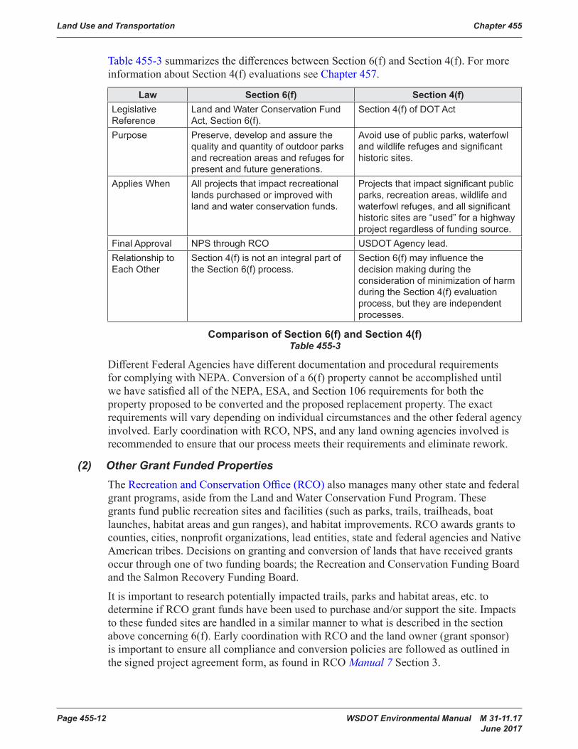
Table 455-3summarizesthedifferencesbetweenSection6(f)andSection4(f).Formoreinformation about Section 4(f) evaluations see Chapter 457.
Law Section 6(f) Section 4(f)Legislative Reference
Land and Water Conservation Fund Act, Section 6(f).
Section 4(f) of DOT Act
Purpose Preserve, develop and assure the quality and quantity of outdoor parks and recreation areas and refuges for present and future generations.
Avoid use of public parks, waterfowl and wildlife refuges and significant historic sites.
Applies When All projects that impact recreational lands purchased or improved with land and water conservation funds.
Projects that impact significant public parks, recreation areas, wildlife and waterfowl refuges, and all significant historic sites are “used” for a highway project regardless of funding source.
Final Approval NPS through RCO USDOT Agency lead.Relationship to Each Other
Section 4(f) is not an integral part of the Section 6(f) process.
Section 6(f) may influence the decision making during the consideration of minimization of harm during the Section 4(f) evaluation process, but they are independent processes.
Comparison of Section 6(f) and Section 4(f)Table 455-3
DifferentFederalAgencieshavedifferentdocumentationandproceduralrequirementsforcomplyingwithNEPA.Conversionofa6(f)propertycannotbeaccomplisheduntilwehavesatisfiedalloftheNEPA,ESA,andSection106requirementsforboththepropertyproposedtobeconvertedandtheproposedreplacementproperty.Theexactrequirements will vary depending on individual circumstances and the other federal agency involved.EarlycoordinationwithRCO,NPS,andanylandowningagenciesinvolvedisrecommendedtoensurethatourprocessmeetstheirrequirementsandeliminaterework.
(2) Other Grant Funded PropertiesThe RecreationandConservationOffice(RCO) also manages many other state and federal grant programs, aside from the Land and Water Conservation Fund Program. These grantsfundpublicrecreationsitesandfacilities(suchasparks,trails,trailheads,boatlaunches,habitatareasandgunranges),andhabitatimprovements.RCOawardsgrantstocounties,cities,nonprofitorganizations,leadentities,stateandfederalagenciesandNativeAmerican tribes. Decisions on granting and conversion of lands that have received grants occur through one of two funding boards; the Recreation and Conservation Funding Board and the Salmon Recovery Funding Board.
Itisimportanttoresearchpotentiallyimpactedtrails,parksandhabitatareas,etc.todetermineifRCOgrantfundshavebeenusedtopurchaseand/orsupportthesite.Impactsto these funded sites are handled in a similar manner to what is described in the section aboveconcerning6(f).EarlycoordinationwithRCOandthelandowner(grantsponsor)is important to ensure all compliance and conversion policies are followed as outlined in thesignedprojectagreementform,asfoundinRCOManual 7 Section 3.
Chapter 455 Land Use and Transportation
WSDOT Environmental Manual M 31-11.17 Page 455-13 June 2017
455.11 Wild and Scenic RiversThe Wild and Scenic Rivers Act (PL 90-542, 16 USC Chapter 28) designates certain rivers (orriversegments)forspecialprotectiontopreservetheminafree-flowingconditionforthebenefitandenjoymentofpresentandfuturegenerations.Theactalsoidentifiesvarious“study rivers” for possible inclusion in the Wild and Scenic Rivers System. Currently, all of the designated Wild and Scenic Rivers in Washington State are administered by the U. S. Forest Service in accordance with 36 CFR 297.
A comprehensive management plan is in place for all designated rivers. The plan describes the use and type of construction allowed in each segment of the river. River segments designatedforrecreationaluse,segmentsinpubliclyownedpublicparks,recreationareas, or wildlife and waterfowl refuges, and segments with historic or archeological sites, aresubjecttoSection4(f).Segmentsthatareprivatelyowned(exceptforhistoricandarcheological sites on private land) and segments on publicly owned lands not open to the generalpublic(e.g.militarybases,IndianReservations,etc.)andwhoseprimarypurposeisnotaSection4(f)use,arenotsubjecttoSection4(f).Ifthemanagementplandoesnotidentifyaspecificfunctionfortheriversegment,thenSection4(f)doesnotapply.
CloseexaminationofthemanagementplanandcoordinationwiththeappropriateU.S.ForestServiceofficeisessentialearlyintheenvironmentalreviewanddesignprocess.ProjectsinadesignatedorstudywildandscenicriverthatrequireaSection404permitfromtheArmyCorpsofEngineersalsorequirecompletionofawrittenESASection7determination by the U. S. Forest Service.
FederallydesignatedWildandScenicRiverswithinWashingtoninclude:• SkagitRiverfromthepipelinecrossingatSedro-WooleyupstreamtoandincludingthemouthofBaconCreekandtributariesaslistedbelow:– TheCascadeRiverfromitsmouthtothejunctionofitsNorthandSouthForks.– TheSouthForktotheboundaryoftheGlacierPeakwildernessArea.– TheSuiattleRiverfromitsmouthtotheboundaryoftheGlacierPeakWildernessAreaatMilkCreek.
– TheSaukRiverfromitsmouthtoitsjunctionwithElliotCreek.– TheNorthForkoftheSaukRiverfromitsjunctionwiththeSouthForkoftheSaultotheboundaryoftheGlacierPeakWildernessArea.
• KlickitatRiverfromWheelerCreektotheconfluencewiththeColumbiaRiver,classifiedasarecreationalriver.
• WhiteSalmonRiverfromtheconfluenceofGilmerCreek(nearthetownofBZCorner)totheconfluencewithBuckCreek;classifiedasapartwildandpartscenic river.
FederallydesignatedStudyRiverswithinWashingtonStateinclude:• SkagitRiverfromMountVernontoandincludingthemouthofBaconCreek,plusadditionalsegmentsoftheSauk,Suiattle,andCascadetributaries.
• KlickitatRiverupstreamoftheconfluenceoftheLittleKlickitatRivertotheYakamaIndianReservationboundary.
• SnakeRiverfromthetownofAsotintotheOregonstateline.• WhiteSalmonRiverupstreamoftheconfluencewithGilmerCreek.

Land Use and Transportation Chapter 455
Page 455-14 WSDOT Environmental Manual M 31-11.17 June 2017
(1) National Rivers InventoryThe 1979 Presidential Directive requires federal agencies to protect and manage rivers intheNationwideRiversInventory(NRI)thataresuitableforinclusionintheWildand Scenic Rivers System as part of their normal planning and environmental review process.Thedirective,alistingofNRIriversinWashingtonState,andtheprocedureforconsultingonprojectsthatmayaffecttheseriversisavailableontheNationalParkServiceNRI website.
(2) Washington State Scenic River SystemRCW 79A.55 established a scenic river system in Washington State. The system is managedbytheStateParksandRecreationCommissionto“protectandpreservethenatural character of rivers with outstanding natural, scenic, historic, ecological, and recreational values”. The protected lands include river and publicly owned or leased landsuptoonequartermileoneachsideoftheriver.TheStateParksCommissionhasdeveloped and adopted management policies for the public lands along designated rivers. RCW 79A.55.040 requires that the management policies be integrated into local Shoreline Management Master Plans.
StatedesignatedScenicRiversinclude:
1. TheSkykomishRiverfromthejunctionofthenorthandsouthforksoftheSkykomish(withinthejurisdictionofSnohomishCounty):
a. DownstreamapproximatelyfourteenmilestothejunctionoftheSultanRiver.
b. UpstreamapproximatelytwentymilesonthesouthforktothejunctionoftheTyeandFossrivers(withinthejurisdictionofKingCounty).
c. UpstreamapproximatelyelevenmilesonthenorthforktoitsjunctionwithBearCreek(withinthejurisdictionofSnohomishCounty).
2. TheBecklerRiverfromitsjunctionwiththesouthforkoftheSkykomishRiverupstreamapproximatelyeightmilestoitsjunctionwithRapidRiver(withinthejurisdictionofKingCounty).
3. TheTyeRiverfromitsjunctionwiththesouthforkoftheSkykomishRiverapproximatelyfourteenmilestoTyeLake(withinthejurisdictionofKingCounty).
4. TheLittleSpokaneRiverfromtheupstreamboundaryofthestateparkboatputinsitenearRutterParkwayanddownstreamtoitsconfluencewiththeSpokaneRiver(withinthejurisdictionofSpokaneCounty).
455.12 Statutes and RegulationsFederallawsthatspecificallyregulatelanduseinclude:• Rivers and Harbors Act–Section10oftheRiversandHarborsAct(33USC410etseq.)isadministeredbytheArmyCorpsofEngineers.
• Farmland Protection Policy Act (FPPA)–of1981(7 USC 4201 et seq.)Implementingregulationsarein 7 CFR 658isadministeredbytheNaturalResourcesConservation Service.
• Section 6(f) –LandandWaterConservationFundActcodifiedat16 USC 4601-8(f). InWashingtonState,theRecreationandConservationOfficeadministersthefundinaccordance with WAC 286-40.
Chapter 455 Land Use and Transportation
WSDOT Environmental Manual M 31-11.17 Page 455-15 June 2017
• National Trails System Act 16 USC 1241-1251• Wilderness Act 16 USC 1131-1136• Wild and Scenic Rivers Act PL 90-542, 16 USC Chapter 28
Statelawsthataffectlanduseinclude:• Scenic River System Act RCW 79A.55 • Aquatic Lands Act RCW 79.105.DNRsimplementingregulationsareinWAC 332-30• Farmland Preservation ExecutiveOrder80-01
Federallawsthatspecificallyregulatetransportationinclude:• USDOT Bicycle and Pedestrian Policy Statement –BasedonthefollowingCFR
Title 23 Highways, Title 42 The Public Health and Welfare, Title 49 Transportation.• Section 10 of the River and Harbors Act–(1899)33 USC 403• General Bridge Act –33 USC Section 525 (formerly Section 9 of the Rivers and
Harbors Act) and implementing regulations 33 CFR Parts 114-115• National Trails System Act–(16 USC 1241-1251) • FAA Regulations –14 CFR Part 77 (January 1975), 23 USC 318, and 23 CFR 620
Subpart A• FRA Regulations– 64 Fed. Reg. 28545 (May 26, 1999)• FHWA and FTA Regulations–40 CFR 1500-1508
Statelawsthatspecificallyregulatetransportationinclude:• Aviation–RCW 14.12, RCW 36.70A.510, and RCW 36.70.547• Bicycle/Pedestrian Traffic–RCW 47.30.020 and RCW 47.30.030• City Streets as Part of State Highways –RCW 47.24• Design Standards–WAC 468-18-040• State Environmental Policy Act (SEPA) –WAC 197-11 and WAC 468-12(WSDOT)• Transportation Facilities and Services of Statewide Significance–RCW 47.06.140• Vehicular Traffic – Essential Public Facilities –(GMA)RCW 36.70A• WDNR Easements–RCW 47.12grantsWSDOTauthoritytoobtainaneasementfromDNRhighway,ferry,railandotherstatetransportationprojects.
• Ifaprojectprovides,removes,orrelocatesparking,thelocaljurisdiction’szoning,roadstandards,andoffstreetparkingregulationsmayapply.Linkstoappropriatecityand county regulations can be found from the MRSC website.
455.13 Abbreviations and AcronymsAASHTO AmericanAssociationofHighwayandTransportationOfficialsBOD BasisofDesignCE CategoricalExclusion(NEPA)CategoricalExemption(SEPA)CEQ CouncilforEnvironmentalQualityCFR Code of Federal RegulationsEA EnvironmentalAssessmentEIS EnvironmentalImpactStatementEO ExecutiveOrder
Land Use and Transportation Chapter 455
Page 455-16 WSDOT Environmental Manual M 31-11.17 June 2017
ERS/ECS EnvironmentalReviewSummary/EnvironmentalClassificationSummaryESA EndangeredSpeciesActFAA Federal Aviation AdministrationFCIR FarmlandConversionImpactRatingformFHWA Federal Highway AdministrationFPPA Farmland Protection Policy ActFRA Federal Rail AdministrationFTA Federal Transit AdministrationGMA Growth Management ActHOV HighOccupantVehicleLOS LevelofServiceLWCF Land and Water Conservation Fund (1965)MOA MemorandumofAgreementMRSC Municipal Research and Services Center of WashingtonNEPA NationalEnvironmentalPolicyActNCHRP NationalCooperativeHighwayResearchProgramNRCS NaturalResourcesConservationServiceNRI NationalRiversInventoryNPS NationalParkServiceRCO WashingtonStateRecreationandConservationOfficeRCW Revised Code of WashingtonRCFB Recreation and Conservation Funding BoardSEPA StateEnvironmentalPolicyActSOV SingleOccupantVehicleUSC United States CodeUSFS United States Forest ServiceTSM/TDM TransportationSystemManagement/TransportationDemandManagementUSC United States CodeUSDOT UnitedStatesDepartmentofTransportationWAC Washington Advisory CodeWSF Washington State Ferries
455.14 GlossaryThesedefinitionsprovidecontextfortheLandUseanalysis.Sometermsmayhaveothermeaningsinadifferentcontext.
Concurrency–AsdefinedunderGMA,concurrencyrequiresadequatepublicfacilitiesandservicesareavailablewhentheimpactsofdevelopmentoccur,orwithinaspecifiedtimethereafter.Forlocallyownedtransportationfacilities,themaximumspecifiedtimeissixyearsfromthetimeofdevelopment.

Chapter 455 Land Use and Transportation
WSDOT Environmental Manual M 31-11.17 Page 455-17 June 2017
Direct Effects–TheCouncilonEnvironmentalQuality(CEQ)statesthatdirecteffectsarethose“causedbytheactionandoccuratthesametimeandplace”(CEQ1978).Agoodexampleofadirectlanduseimpactofahighwayprojectisacquisitionofrightofway.
Essential Public Facilities–AsdefinedunderGMA,essentialpublicfacilitiesthataretypicallydifficulttosite,includingairports,stateorregionaltransportationfacilities,andservicesofstatewidesignificanceasdefinedinRCW 47.06.140 (including improvements tosuchfacilitiesandservicesidentifiedinthestatewidemultimodalplan)andotherpublicfacilitiesthataretypicallydifficulttosite.
Farmland of Statewide or Local Importance–AsdefinedintheFarmlandProtectionPolicy Act, farmland of statewide or local importance is land used for the production of food,feed,fiber,forage,oroil, seed crops, as determined by the state or local government agency or agencies, using U.S. Department of Agriculture guidelines.
Federal Nexus–Adeterminationthatatleastonefederalagencyisinvolvedasaproponentofaspecifiedproposaland/orasanagencythatneedstoactonafederalpermit,license, or other entitlement (such as a request to use federal funds or federal land) needed toimplementtheproposal.Afederalnexus(evenonanotherwisenon-federalproposal)typically triggers the need for the federal agency or agencies to comply with various federalstatutesinclude,butnotlimitedto,NEPA,Section106oftheHistoricPreservationAct, Section 4(f) of the Department of Transportation Act, Section 6(f) of the Land and WaterConservationfundAct,andSection7oftheEndangeredSpeciesAct.
Indirect Effects–Theindirectlanduseeffectsinvolvepotentialdevelopment,orredevelopmentofbuildablelandswithintheinfluenceofthetransportationproject.ThesechangesaredrivenandconstrainedbysocialandeconomicfactorsbeyondWSDOTorthelocalpublicagency’scontrol.Sucheffectsaredifficulttopredictandoftencontroversial.Projectsthatdonotincreasecapacity,changethelevelofservice,orsignificantlyreducetraveltimeareunlikelytochangelanduse.
Level of Service–Anestablishedminimumcapacityofpublicfacilitiesorservicesthat must be provided per unit of demand or other appropriate measure of need. For transportation facilities and services, level of service may be measured at an intersection, roadsegment,trafficcorridororzone,andmaybebasedontrafficvolumecomparedtofacility capacity, travel time, or multiple variables (e.g., distance traveled, road conditions, orsafetyhazards).Themethodforcalculatinglevelofservicevariesdependingonthetransportationmode.LevelofserviceisusuallydesignatedbyfivelettergradeswithLOSArepresentingthebestservice(freeflowconditionsofvehiculartraffic)andLOSFrepresenting the worst service (stop and go conditions).
Navigable Waters or Navigable Waters of the United States –AsdefinedbytheArmyCorpsofEngineersarethosewatersoftheUnitedStatesincludingtheterritorialseasthataresubjecttotheebbandflowofthetideand/orarepresentlyused,orhavebeenusedin the past, or may be susceptible for use to transport interstate or foreign commerce. A determination of navigability, once made, applies laterally over the entire surface of the waterbody,andisnotextinguishedbylateractionsoreventswhichimpedeordestroynavigable capacity. (33 USC 1362(7) and 33 CFR 329.4)

Land Use and Transportation Chapter 455
Page 455-18 WSDOT Environmental Manual M 31-11.17 June 2017
Prime Farmland –AsdefinedintheFarmlandProtectionPolicyAct,islandthathasthe best combination of physical and chemical characteristics for producing food, feed, fiber,forage,oil,seed,andotheragriculturalcropswithminimuminputsoffuel,fertilizer,pesticides, and labor, and without intolerable soil erosion. Prime farmland includes land that possesses the above characteristics and may include land currently used as cropland, pastureland,rangeland,orforestland.Itdoesnotincludelandalreadyinorcommittedtourban development or water storage.
Resource Conservation Areas –arenaturalareasoutsideofthelimitedaccesshachuresthatwerepurchasedorsetasidetoprovideanatural,vegetatedbufferbetweenthehighwayandadjacentlanduses.Theyserveahighwaypurpose,whichisdefinedinRCW 47.40.010.23U.S.C.752.2statesthat“preservationofvaluableadjacentsceniclands is a necessary component of highway development. These areas were previously calledBeautificationAreas,LandscapeAreas,LandscapeorConservationEasements,orEnvironmentalCommitmentAreasonRightofWayPlansandRealEstateServicesMaps.Refer to the Roadside Policy Manual M 3110 for more information.
Section 6(f) Property–Anypropertyacquiredordevelopedwithfinancialassistanceunder Section 6(f) of the federal Land and Water Conservation Fund Act.
Transportation System Management/Transportation Demand Management (TSM/TDM) –Actionsthatimprovetheoperationandcoordinationoftransportationservicesandfacilitiestomakethemostefficientuseoftheexistingtransportationsystem.Demandmanagement strategies, such as ramp meters, are a type of TSM action.
Transportation Facilities and Services of Statewide Significance–DefinedinRCW 47.06.140 to include the interstate highway system, interregional state principal arterials including ferry connections that serve statewide travel, intercity passenger railservices,intercityhigh-speedgroundtransportation,majorpassengerintermodalterminalsexcludingallairportfacilitatesandservices,thefreightrailroadsystem,theColumbia/Snakenavigablerifersystem,marineportfacilities,andservicesthatarerelatedsolelytomarineactivitiesaffectinginternationalandinterstatetrade,andhighcapacitytransportationsystemsservingregionsasdefinedinRCW 81.104.015.
Unique Farmland –AsdefinedintheFarmlandProtectionPolicyAct,islandotherthanprimefarmlandthatisusedforproductionofspecifichighvaluefoodandfibercrops.Ithasthespecialcombinationofsoilquality,location,growingseason,andmoisturesupplyneededtoeconomicallyproducesustainedhighqualityorhighyieldsofspecificcropswhentreatedandmanagedaccordingtoacceptablefarmingmethods.Examplesof such crops include lentils, nuts, annually cropped white wheat, cranberries, fruits, and vegetables.
Urban Growth Area –asdefinedintheGrowthManagementAct,arethoseareasdesignated by a county pursuant to the Washington State Growth Management Act, which areplannedtosupporturbantypedevelopmentanddensitieswithinthenext20years.