chapter 3 : land use, zoning and public policy
TRANSCRIPT
3-1
Chapter 3 : LAND USE, ZONING AND PUBLIC POLICY
Under 2014 City Environmental Quality Review (CEQR) Technical Manual guidelines, a land use analysis evaluates the uses and development trends in the area that may be affected by a Proposed Action and determines whether the Proposed Action is compatible with those conditions or may affect them. Similarly, the analysis considers the Proposed Action’s compliance with, and effect on, the area’s zoning and other applicable public policies.
The Proposed Action would modify and replace existing text, add new text, and reorganize and renumber various sections of the Zoning Resolution regarding definitions, use, bulk, parking, special permits and special districts. The proposal would affect zoning regulations on a citywide basis, and would result in changes to the use, bulk, and parking regulations for multi-family residential, inclusionary housing, affordable senior housing and long term care facilities. As discussed above in the Purpose and Need section of Chapter 1, Project Description, these proposed zoning text changes are intended to promote the creation of higher quality and lower cost housing throughout the city by removing barriers that constrain housing production and raise costs, while encouraging better quality buildings that contribute to the fabric of neighborhoods. The land use impacts relate to the size, density, and parking requirements for general housing, inclusionary housing, and senior housing in moderate and high density residential districts. By addressing these barriers, the Proposed Action is expected to have beneficial effects with respect to land use that would increase the supply of affordable housing throughout the city, and would not result in significant adverse impacts to land use, zoning and public policy.
However, under CEQR, even when there is little potential for an action to be inconsistent with land use or zoning, a description of these issues is generally provided to establish conditions and provide information needed in other technical areas of the CEQR review. The land use analysis characterizes the uses and development trends in the area directly affected by the Proposed Action. This analysis is used to determine whether the Proposed Action would affect these uses and trends and whether it would be compatible with them. Similarly, a zoning analysis considers an action's effect on zoning in the area directly affected by the Proposed Action.
A description of the existing zoning regulations and the proposed changes to them is presented in Chapter 1, Project Description, and the likely effects of the proposed changes on future development are described in detail in Chapter 1G Potential Development and Likely Effects. The proposed zoning text is presented in its entirety in Appendix F. Graphics showing the areas of the City that would be affected by the Proposed Action are presented in Appendix A.
The Proposed Action is a citywide action and is not intended to facilitate a specific development or project. Accordingly, the analysis presented in this chapter is not site-specific, but instead, to the extent practicable, considers the types of developments that could occur as a result of the Proposed Action.
The following land use, zoning and public policy assessment provides a general description of the zoning districts affected by the Proposed Action and the predominant land use patterns within those zoning districts. Also, a description of any recent, relevant zoning actions and public policies that apply to the Proposed Action is provided. Following this description, the potential for the Proposed Action to result in impacts to land use, zoning and public policy is assessed.
No significant adverse impacts on land use, zoning, or public policy are anticipated in the future with the Proposed Action. The Proposed Action would not directly displace any land uses in any of the affected zoning districts so as to adversely affect surrounding land uses, nor would it generate land uses that would be incompatible with land uses, zoning, or public policy. As the Proposed Action would not change the underlying zoning and permitted uses, it would not create land uses or structures that would be incompatible with the underlying zoning or conflict with public policies applicable to the affected districts or surrounding neighborhoods.
3-2
The Proposed Action would result in an overall increase in residential and community facility uses throughout the city, dispersed across the affected districts, when compared to conditions in the future without the Proposed Action. The Proposed Action would modify zoning regulations related to building envelopes, parking, and, in limited instances FAR, in a manner that is intended to promote affordable housing development, improve housing quality, and create pedestrian-friendly streets.
Consistent with CEQR Technical Manual guidelines, the Proposed Action is analyzed in this EIS as a “generic action,” because there are no known developments that are projected and, due to its broad applicability, it is difficult to predict the sites where development would be facilitated by the Proposed Action. According to the CEQR Technical Manual, generic actions are programs and plans that have wide application or affect the range of future alternative policies. Usually these actions affect the entire city or an area so large that site-specific description or analysis is not appropriate. To produce a reasonable analysis of likely effect of the Proposed Action, 27 representative development prototypes have been identified (See Section 2E).
The CEQR Technical Manual also notes that for some actions, where the build-out depends on market conditions and other variables, the build year cannot be determined with precision. In these cases, a ten year build year is generally considered reasonable as it captures a typical cycle of market conditions and generally represents the outer timeframe within which predictions of future development may usually be made without speculation. Therefore, an analysis year of 2025 has been identified for this environmental review.
Development affected by the proposal is projected based on trends since 2000. While projections are typically modeled after trends of the previous decade, the look-back period here is extended to 15 years to capture a broader sample of affordable and senior housing developments across the city. Accordingly, unless otherwise noted, development assumptions in the future with and without the action mirror recent historical development patterns.
As described in the CEQR Technical Manual, generic analyses are conducted using the following methodology:
• Identify Typical Cases: provide several descriptions similar to those in a localized action for cases that can reasonably typify the conditions and impacts of the entire proposal.
• Identify a Range of Conditions: A discussion of the range of conditions or situations under which the action(s) may take place, so that the full range of impacts can be identified.
The With-Action scenario therefore identifies the amount, type, and location of development that is expected to occur by 2025 as a result of the Proposed Action. The No- Action scenario identifies similar development projections for 2025 absent the Proposed Action. The incremental difference between the two scenarios serves as the basis for the impact analyses.
Since the Proposed Action is a generic action applicable citywide, prototypical assumptions and groupings of information were prepared to better understand the extent of the physical effect of the action, instead of lot-by-lot descriptions typical of site-specific actions. Development projections consider lot the incremental increase in development facilitated by the action, and the prevalence and location of affected zoning districts across the city. Because very little of the Proposed Action is expected to induce development that would not have otherwise occurred in the future without the Proposed Action, the identification of soft sites is irrelevant.
New York City Zoning Maps and the Zoning Resolution of the City of New York (ZR) were consulted to describe existing zoning districts in the study areas and provided the basis for the zoning evaluation of the future No-Action and With-Action conditions. Applicable public policies were identified, and a public policy analysis was prepared to determine the potential for the Proposed Action to alter or conflict with applicable public policies.

3-3
Existing Conditions
Land Use and Zoning
No adverse impacts related to land use, zoning or public policy are anticipated. In general, the proposed actions are expected to result in changes that are compatible with and supportive of the current land use trends, zoning and public policies. However, even though the proposal did not trigger environmental impacts on land use, zoning, or public policy on the CEQR form, analysis has been included in order to provide the background contextual information necessary to understand the overall effects of the proposal.
The proposed zoning text amendments would result in changes to the use, bulk and parking regulations included in the Zoning Resolution with regard to residential uses and long term care facilities. The proposal would affect zoning regulations on a citywide basis in all zoning districts, with some exceptions to be noted in this discussion, and would result in as of right changes to bulk in multifamily zoning districts: R3-2, R4, R5, and R6 through R10 districts and their commercial equivalents. Therefore, the directly affected area consists of the zoning districts listed above, which are the focus of this analysis.
As discussed in the Description of the Proposed Action, certain Special Districts are unaffected by the components of this proposal, where the intent of the Special District directly conflicts with any changes proposed as part of this action. For example, where height limits are fundamental to a Special District’s goals and objectives, height changes as part of this proposal would not affect that Special District.
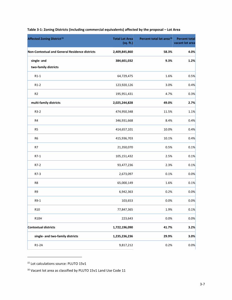
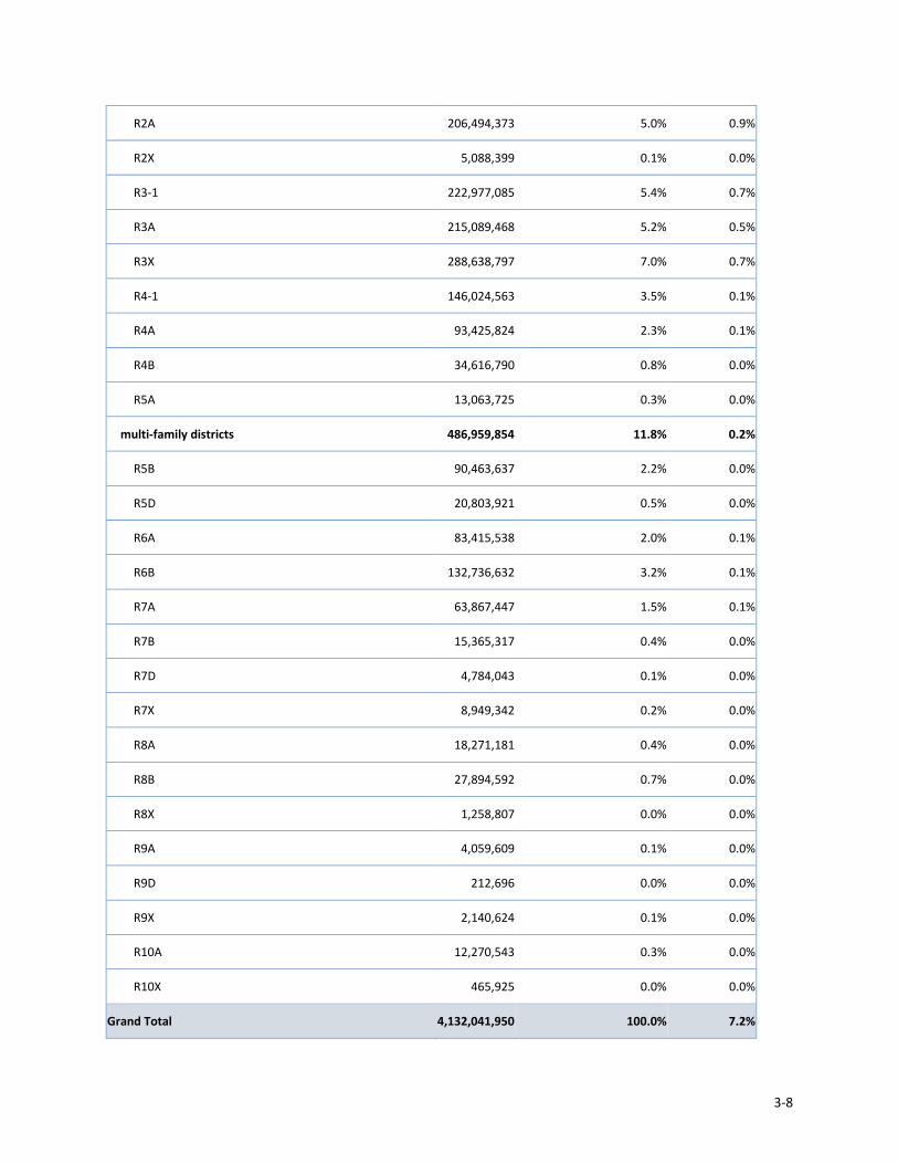
A breakdown of land area by affected zoning district is shown in Table 3-1 below. This table includes only those districts where changes as part of this proposal would apply, and excludes any land area not covered by this proposal.
Residence Districts
R1 and R2 districts are limited to single-family detached residences and have limited applicability to this proposal, which focuses on multifamily residential development. R3A, R3X, R3-1, R4A, R4B, R4-1 and R5A are low-density districts that mix single and two-family residence districts, while R3-2, R4, and R5 through Rl0 districts permit multiple dwellings (three units and larger). All residence districts permit residential and community facilities such as schools, libraries, houses of worship, medical offices, and hospitals. The Proposed Action has the most applicability in R3-2 districts and above. The Proposed Action does not change land use or the location of any zoning district, but modifies components of the use, bulk and parking regulations that pertain, to various degrees, to each residential zoning district.
Residence districts with A, B and X suffixes, as well as R3-1 and R4-1 districts, are categorized as "contextual" districts. These districts have relatively restrictive height and setback regulations and are intended to replicate the residential building types that commonly characterize different types of neighborhoods in the City, while allowing the same overall bulk and density as the non-contextual districts to which they are related. In the lower-density (R3 through R5) contextual districts, the restrictive zoning envelopes do not apply to community facilities.
R3-2
R3-2 districts are general residence districts that allow a variety of housing types, including low-rise attached houses, small multifamily apartment houses, and detached and semi-detached one- and two-family residences. It is the lowest density zoning district in which multiple dwellings are permitted. Because of their flexibility, R3-2 districts are mapped widely in all boroughs except Manhattan.
R4
R4 districts allow all types of housing at a slightly higher density than permitted in R3-2 districts. The floor area ratio (FAR) of 0.75, plus an attic allowance of up to 20% for inclusion of space under the pitched roof common to these districts, usually produces buildings with three stories instead of the two-story homes characteristic of R3 districts. Much of the residential development in North Corona in Queens and Arden Heights in Staten Island is typical of R4 districts.

3-4
R5
R5 districts allow a variety of housing at a higher density than permitted in R3-2 and R4 districts. The floor area ratio (FAR) of 1.25 typically produces three-and four-story attached houses and small apartment houses. R5 districts provide a transition between lower- and higher-density neighborhoods and are widely mapped in Brooklyn, Queens and the Bronx. Portions of Windsor Terrace and Ocean Parkway in Brooklyn are R5 districts.
R5A
R5A contextual districts, mapped in the northeast Bronx neighborhoods of Olinville and Williamsbridge, permit only one- and two-family detached residences with a maximum 1.1 floor area ratio (FAR). Similar to R4A districts, R5A districts are characterized by houses with two stories and an attic beneath a pitched roof, but the greater FAR and higher perimeter wall allow for somewhat larger buildings.
R5B
Although an R5B contextual district permits detached and semi-detached buildings, it is primarily a three-story row house district typical of such neighborhoods as Windsor Terrace and Bay Ridge in Brooklyn. The traditional quality of R5B districts is reflected in the district’s height and setback, front yard and curb cuts regulations that maintain the character of the neighborhood.
R5D
R5D contextual districts, designed to encourage residential growth along major corridors in auto-dependent areas of the city, are mapped in portions of the Jamaica and Rockaway Park neighborhoods in Queens and on Williamsbridge Road in the northeast area of the Bronx.
R6
R6 zoning districts are widely mapped in built-up, medium-density areas in Brooklyn, Queens and the Bronx. The character of R6 districts can range from neighborhoods with a diverse mix of building types and heights to large-scale “tower in the park” developments such as Ravenswood in Queens and Homecrest in Brooklyn. Developers can choose between two sets of bulk regulations. Standard height factor regulations, introduced in 1961, produce small multifamily buildings on small zoning lots and, on larger lots, tall buildings that are set back from the street. Optional Quality Housing regulations produce high lot coverage buildings within height limits that often reflect the scale of older, pre-1961 apartment buildings in the neighborhood.
R6A
R6A is a contextual district where the Quality Housing bulk regulations are mandatory. These regulations produce high lot coverage, six- or seven-story apartment buildings set at or near the street line. Designed to be compatible with older buildings found in medium-density neighborhoods, R6A districts are mapped in the Bronx, Brooklyn and Queens. Parts of Kingsbridge in the Bronx and Williamsburg in Brooklyn are typical R6A areas.
R6B
R6B districts are often traditional row- house districts, which preserve the scale and harmonious streetscape of neighborhoods of four-story attached buildings developed during the 19th century. Many of these houses are set back from the street with stoops and small front yards that are typical of Brooklyn’s “brownstone” neighborhoods, such as Park Slope, Boerum Hill and Bedford Stuyvesant.
R7
R7 districts are medium-density apartment house districts mapped in much of the Bronx as well as the Upper West Side in Manhattan and Brighton Beach in Brooklyn. The height factor regulations for R7 districts encourage lower apartment buildings on smaller zoning lots and, on larger lots, taller buildings with less lot coverage. As an alternative, developers may choose the optional Quality Housing regulations to build lower buildings with greater lot coverage. Regulations for residential development in R7-1 and R7-2 districts are essentially the same except that R7-2 districts, which are mapped primarily in upper Manhattan, have lower parking requirements.
R7A

3-5
The contextual Quality Housing regulations, which are mandatory in R7A districts, typically produce high lot coverage, seven- and eight-story apartment buildings, blending with existing buildings in many established neighborhoods. R7A districts are mapped along Prospect Park South and Ocean Parkway in Brooklyn, Jackson Heights in Queens, and in Harlem and along the avenues in the East Village in Manhattan.
R7B
In contextual R7B districts, the mandatory Quality Housing regulations are similar to those of R6B districts but the higher floor area ratio (FAR) and height limit generally produce six- to seven-story apartment buildings rather than the row houses typical of R6B districts. There are R7B districts in Brooklyn and throughout Queens, including portions of Rego Park. Parts of the East Village in Manhattan are also mapped R7B.
R7D
R7D districts promote new contextual development along transit corridors. Portions of Fulton Street and the Special Coney Island District in Brooklyn are mapped as R7D districts. Blocks that are mapped C4-5D have an R7D residential district equivalent.
R7X
R7X districts are also governed by contextual Quality Housing bulk regulations but the substantially higher floor area ratio (FAR) and maximum building height typically produce taller, bulkier buildings than in R7A and R7B districts. The flexibility of the R7X regulations is exemplified by the nine- to 13-story apartment buildings in the R7X districts mapped along major thoroughfares in Harlem in Manhattan and Jackson Avenue in Long Island City in Queens.
R8
Apartment buildings in R8 districts can range from mid-rise, eight- to ten-story buildings to much taller buildings set back from the street on large zoning lots. This high density residential district is mapped along the Grand Concourse in the Bronx and on the edge of Brooklyn Heights. R8 districts are also widely mapped in Manhattan neighborhoods, such as Washington Heights. New buildings in R8 districts may be developed under either height factor regulations or the optional Quality Housing regulations that often reflect the older, pre-1961 neighborhood streetscape.
R8A
The contextual Quality Housing bulk regulations, which are mandatory in R8A districts, typically result in high lot coverage 10- to 12-story apartment buildings, set at or near the street line. Limitations on the base height and maximum building height of new buildings ensure compatibility with existing buildings on the street. Parts of DUMBO in Brooklyn and West Chelsea in Manhattan are R8A districts.
R8B
R8B contextual districts are governed by Quality Housing bulk regulations. These districts are often traditional row- house districts, which preserve the scale and harmonious streetscape of neighborhoods of four- to seven -story attached buildings developed during the 19th century. Many of these houses are set back from the street with stoops and small front yards that are typical of the Upper East and Upper West Sides in Manhattan.
R8X
R8X contextual districts are governed by Quality Housing bulk regulations. R8X districts are similar to R8A districts but permit a higher building height that typically produces 14- to 16-story apartment buildings that replicate the building envelope of the older, traditional buildings in Prospect Heights and Park Slope that surround Grand Army Plaza.
R9
In R9 districts, which are mapped along several major thoroughfares in Manhattan, such as West 96th Street, new buildings can be developed under height factor regulations or the optional Quality Housing regulations as in R6 through R8 districts. The optional Quality Housing regulations in R9 districts are the same as the R9A regulations. Designed in part for institutional purposes (mainly hospitals), most R9 height factor buildings are developed pursuant

3-6
to the tower rules, which are applicable only in the city’s higher-density areas, and commercial districts with an R9 residential district equivalent (C1-8, C2-7 and C6-3).
R9A
The contextual Quality Housing regulations, mandatory in R9A districts, typically result in high lot coverage, 14- to 15-story buildings set at or near the street line. Typical R9A buildings can be found in higher density Manhattan neighborhoods such as Chelsea and Tribeca. Often mapped as C1-8A or C2-7A commercial districts, which have an R9A residential district equivalent, these districts usually have apartments above one or two floors of retail and office uses.
R9D
Created to accommodate towers facing elevated rail lines, R9D districts produce tall buildings set back from the street line to minimize train noise for occupants of the buildings and maximize light and air for pedestrians at street level. Portions of the River Avenue corridor around 161st Street in the Bronx are mapped C6-3D which has an R9D residential district equivalent.
R9X
R9X contextual districts (and C1-8X, C2-7X and C6-3X districts with an R9X residential district equivalent), mapped only in Manhattan, are governed by Quality Housing regulations. With a floor area ratio (FAR) and height limit substantially higher than other R9 districts, R9X regulations produce the taller, bulkier 16- to 18-story apartment buildings characteristic of Chelsea and Murray Hill in Manhattan.
R10
R10 districts are mapped along portions of Fifth and Park Avenues in Manhattan; however, most buildings that conform to the R10 building envelope are found in commercial districts with a residential district equivalent of R10, the highest residential density in the city. Much of Midtown, Lower Manhattan and major avenues in Manhattan, as well as parts of Downtown Brooklyn and Long Island City, are mapped at R10 density. The floor area ratio (FAR) is 10.0. Developers may choose between Quality Housing regulations or tower regulations; height factor regulations are not applicable.
R10A
The Quality Housing contextual regulations, mandatory in R10A districts, typically produce the substantial apartment buildings set on the avenues and wide streets of Manhattan, such as West End Avenue and Broadway on the Upper West Side. Commercial districts which are R10A residential district equivalent, such as C4-6A districts on Broadway and C2-8A districts on some blocks of East 96th Street, are lined with large apartment houses with street level stores. Towers are not permitted in R10A districts.
R10X
R10X districts, and C6-4X districts which have an R10X residential district equivalent, are subject to Quality Housing regulations but instead of a maximum height, the portion of the building above the required setback is subject to tower regulations. A C6-4X district is mapped along Sixth Avenue in Chelsea.
3-7
Table 3-1: Zoning Districts (including commercial equivalents) affected by the proposal – Lot Area
Affected Zoning District15 Total Lot Area (sq. ft.)
Percent total lot area16 Percent total vacant lot area
Non-Contextual and General Residence districts 2,409,845,860 58.3% 4.0%
single- and
two-family districts
384,601,032 9.3% 1.2%
R1-1 64,729,475 1.6% 0.5%
R1-2 123,920,126 3.0% 0.4%
R2 195,951,431 4.7% 0.3%
multi-family districts 2,025,244,828 49.0% 2.7%
R3-2 474,950,348 11.5% 1.1%
R4 346,931,668 8.4% 0.4%
R5 414,657,101 10.0% 0.4%
R6 415,936,703 10.1% 0.4%
R7 21,350,070 0.5% 0.1%
R7-1 105,151,432 2.5% 0.1%
R7-2 93,477,236 2.3% 0.1%
R7-3 2,673,097 0.1% 0.0%
R8 65,000,149 1.6% 0.1%
R9 6,942,363 0.2% 0.0%
R9-1 103,653 0.0% 0.0%
R10 77,847,365 1.9% 0.1%
R10H 223,643 0.0% 0.0%
Contextual districts 1,722,196,090 41.7% 3.2%
single- and two-family districts 1,235,236,236 29.9% 3.0%
R1-2A 9,817,212 0.2% 0.0%
15 Lot calculations source: PLUTO 15v1 16 Vacant lot area as classified by PLUTO 15v1 Land Use Code 11
3-8
R2A 206,494,373 5.0% 0.9%
R2X 5,088,399 0.1% 0.0%
R3-1 222,977,085 5.4% 0.7%
R3A 215,089,468 5.2% 0.5%
R3X 288,638,797 7.0% 0.7%
R4-1 146,024,563 3.5% 0.1%
R4A 93,425,824 2.3% 0.1%
R4B 34,616,790 0.8% 0.0%
R5A 13,063,725 0.3% 0.0%
multi-family districts 486,959,854 11.8% 0.2%
R5B 90,463,637 2.2% 0.0%
R5D 20,803,921 0.5% 0.0%
R6A 83,415,538 2.0% 0.1%
R6B 132,736,632 3.2% 0.1%
R7A 63,867,447 1.5% 0.1%
R7B 15,365,317 0.4% 0.0%
R7D 4,784,043 0.1% 0.0%
R7X 8,949,342 0.2% 0.0%
R8A 18,271,181 0.4% 0.0%
R8B 27,894,592 0.7% 0.0%
R8X 1,258,807 0.0% 0.0%
R9A 4,059,609 0.1% 0.0%
R9D 212,696 0.0% 0.0%
R9X 2,140,624 0.1% 0.0%
R10A 12,270,543 0.3% 0.0%
R10X 465,925 0.0% 0.0%
Grand Total 4,132,041,950 100.0% 7.2%
3-9
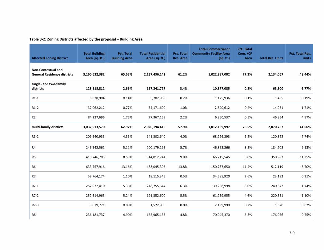
Table 3-2: Zoning Districts affected by the proposal – Building Area
Affected Zoning District Total Building
Area (sq. ft.) Pct. Total
Building Area Total Residential
Area (sq. ft.) Pct. Total Res. Area
Total Commercial or Community Facility Area
(sq. ft.)
Pct. Total Com. /CF
Area Total Res. Units Pct. Total Res.
Units
Non-Contextual and General Residence districts 3,160,632,382 65.63% 2,137,436,142 61.2% 1,022,987,082 77.3% 2,134,067 48.44%
single- and two-family districts 128,118,812 2.66% 117,241,727 3.4% 10,877,085 0.8% 63,300 6.77%
R1-1 6,828,904 0.14% 5,702,968 0.2% 1,125,936 0.1% 1,485 0.19%
R1-2 37,062,212 0.77% 34,171,600 1.0% 2,890,612 0.2% 14,961 1.71%
R2 84,227,696 1.75% 77,367,159 2.2% 6,860,537 0.5% 46,854 4.87%
multi-family districts 3,032,513,570 62.97% 2,020,194,415 57.9% 1,012,109,997 76.5% 2,070,767 41.66%
R3-2 209,540,933 4.35% 141,302,640 4.0% 68,226,293 5.2% 120,822 7.74%
R4 246,542,561 5.12% 200,179,295 5.7% 46,363,266 3.5% 184,208 9.13%
R5 410,746,705 8.53% 344,012,744 9.9% 66,715,545 5.0% 350,982 11.35%
R6 633,757,916 13.16% 483,045,393 13.8% 150,757,650 11.4% 512,119 8.70%
R7 52,764,174 1.10% 18,115,345 0.5% 34,585,920 2.6% 23,182 0.31%
R7-1 257,932,410 5.36% 218,755,644 6.3% 39,258,998 3.0% 240,672 1.74%
R7-2 252,514,963 5.24% 191,352,600 5.5% 61,259,955 4.6% 220,531 1.10%
R7-3 3,679,771 0.08% 1,522,906 0.0% 2,139,999 0.2% 1,620 0.02%
R8 236,181,737 4.90% 165,965,135 4.8% 70,045,370 5.3% 176,056 0.75%
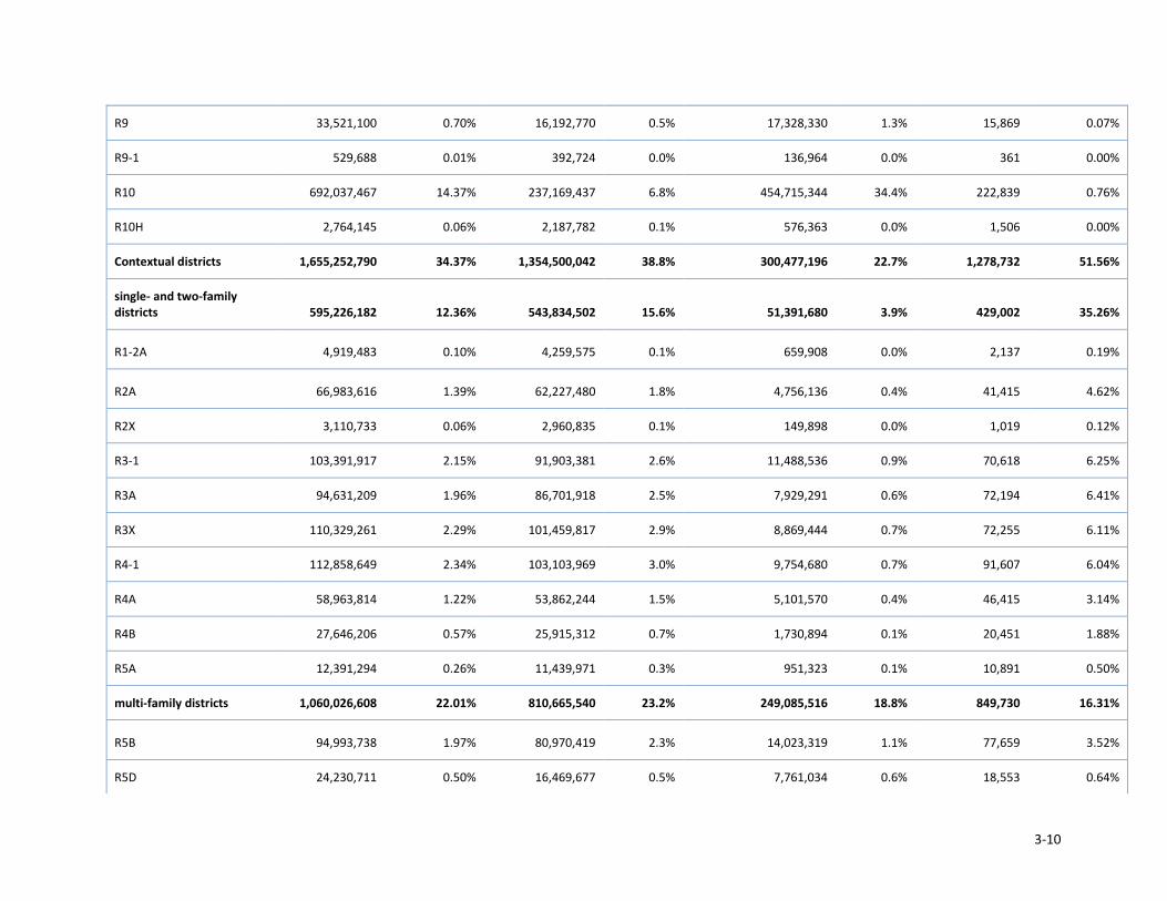
3-10
R9 33,521,100 0.70% 16,192,770 0.5% 17,328,330 1.3% 15,869 0.07%
R9-1 529,688 0.01% 392,724 0.0% 136,964 0.0% 361 0.00%
R10 692,037,467 14.37% 237,169,437 6.8% 454,715,344 34.4% 222,839 0.76%
R10H 2,764,145 0.06% 2,187,782 0.1% 576,363 0.0% 1,506 0.00%
Contextual districts 1,655,252,790 34.37% 1,354,500,042 38.8% 300,477,196 22.7% 1,278,732 51.56%
single- and two-family districts 595,226,182 12.36% 543,834,502 15.6% 51,391,680 3.9% 429,002 35.26%
R1-2A 4,919,483 0.10% 4,259,575 0.1% 659,908 0.0% 2,137 0.19%
R2A 66,983,616 1.39% 62,227,480 1.8% 4,756,136 0.4% 41,415 4.62%
R2X 3,110,733 0.06% 2,960,835 0.1% 149,898 0.0% 1,019 0.12%
R3-1 103,391,917 2.15% 91,903,381 2.6% 11,488,536 0.9% 70,618 6.25%
R3A 94,631,209 1.96% 86,701,918 2.5% 7,929,291 0.6% 72,194 6.41%
R3X 110,329,261 2.29% 101,459,817 2.9% 8,869,444 0.7% 72,255 6.11%
R4-1 112,858,649 2.34% 103,103,969 3.0% 9,754,680 0.7% 91,607 6.04%
R4A 58,963,814 1.22% 53,862,244 1.5% 5,101,570 0.4% 46,415 3.14%
R4B 27,646,206 0.57% 25,915,312 0.7% 1,730,894 0.1% 20,451 1.88%
R5A 12,391,294 0.26% 11,439,971 0.3% 951,323 0.1% 10,891 0.50%
multi-family districts 1,060,026,608 22.01% 810,665,540 23.2% 249,085,516 18.8% 849,730 16.31%
R5B 94,993,738 1.97% 80,970,419 2.3% 14,023,319 1.1% 77,659 3.52%
R5D 24,230,711 0.50% 16,469,677 0.5% 7,761,034 0.6% 18,553 0.64%
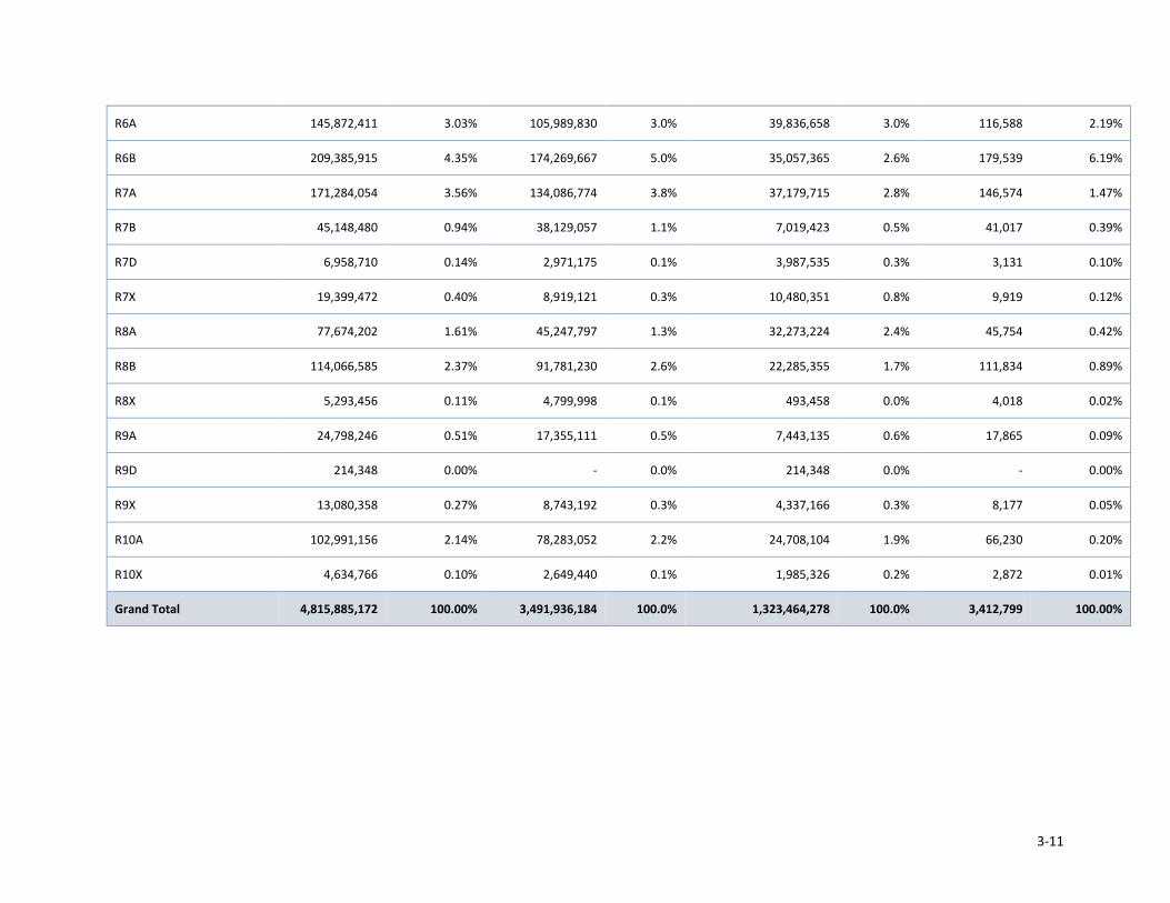
3-11
R6A 145,872,411 3.03% 105,989,830 3.0% 39,836,658 3.0% 116,588 2.19%
R6B 209,385,915 4.35% 174,269,667 5.0% 35,057,365 2.6% 179,539 6.19%
R7A 171,284,054 3.56% 134,086,774 3.8% 37,179,715 2.8% 146,574 1.47%
R7B 45,148,480 0.94% 38,129,057 1.1% 7,019,423 0.5% 41,017 0.39%
R7D 6,958,710 0.14% 2,971,175 0.1% 3,987,535 0.3% 3,131 0.10%
R7X 19,399,472 0.40% 8,919,121 0.3% 10,480,351 0.8% 9,919 0.12%
R8A 77,674,202 1.61% 45,247,797 1.3% 32,273,224 2.4% 45,754 0.42%
R8B 114,066,585 2.37% 91,781,230 2.6% 22,285,355 1.7% 111,834 0.89%
R8X 5,293,456 0.11% 4,799,998 0.1% 493,458 0.0% 4,018 0.02%
R9A 24,798,246 0.51% 17,355,111 0.5% 7,443,135 0.6% 17,865 0.09%
R9D 214,348 0.00% - 0.0% 214,348 0.0% - 0.00%
R9X 13,080,358 0.27% 8,743,192 0.3% 4,337,166 0.3% 8,177 0.05%
R10A 102,991,156 2.14% 78,283,052 2.2% 24,708,104 1.9% 66,230 0.20%
R10X 4,634,766 0.10% 2,649,440 0.1% 1,985,326 0.2% 2,872 0.01%
Grand Total 4,815,885,172 100.00% 3,491,936,184 100.0% 1,323,464,278 100.0% 3,412,799 100.00%

3-12
Public Policy
This section describes public policies that are relevant to the Proposed Action, and the potential for the Proposed Action to result in significant adverse impacts to those public policies is assessed. Generally, the proposal supports and is driven by recent public policies such as Housing New York and One City Built to Last.
Public policies that apply to the Proposed Action are Housing New York, One City Built to Last, OneNYC, the City's Local Waterfront Revitalization Program (LWRP) and New York City Landmarks Law. No other public policies that apply to, or would be affected by, the Proposed Action have been identified.
Future No Action Condition
In the future without the action, the zoning districts and public policies described above in the existing conditions section would continue to apply to development in the areas affected by the Proposed Action. No changes in public policy are anticipated.
Future With Action Condition
Land Use and Zoning
Zoning establishes limits on the use, size, and shape of buildings, with numerous zoning districts mapped in the city’s diverse neighborhoods to reflect their varying density and character. These limits help give shape to neighborhoods and predictability to their future. But sometimes they also have unintended consequences, discouraging the very types of outcomes they were intended to encourage. This proposal aims to address several ways in which these regulations, drafted a generation ago, have in practice discouraged the affordability and quality of recent buildings.
Affordability:
• Make it easier to provide the range of affordable senior housing and care facilities needed to meet the varied needs of an aging population, and to help seniors remain in their communities
• Enable Inclusionary Housing buildings, which provide mixed-income housing, to construct quality buildings that fit the full amount of housing they are allowed under zoning today
• Reduce unnecessarily high costs of building transit-accessible affordable housing, and make taxpayer dollars go further toward meeting our affordable housing goals
Quality:
• Change rules that lead to flat, dull apartment buildings, to accommodate and encourage façade articulation, courtyards, and other elements that provide visual variety and make the pedestrian experience more interesting
• Encourage better ground-floor retail spaces and residential units with adequate ceiling heights • Maintain rules that work well today, including the essential rules of “contextual” zoning districts and lower-
density zoning districts
The proposed changes to the current zoning regulations are discussed in Chapter 1: Description of the Proposed Action and their likely effects on future development are described in detail in Chapter 2: Projected Development/Likely Effects of the Proposed Action.
In the future with the Proposed Action, the effects of the proposal on high- and medium density districts, acting in combination with one another, are expected to facilitate more housing units in conjunction with other major city initiatives aimed and housing production. The Proposed Action would not result in the rezoning of any block or lot or facilitate a change in land uses that would not otherwise be permitted in the future without the Proposed Action. Any development facilitated by the Proposed Action would be expected to be compatible with existing land uses and consistent with existing development trends. Overall, the Proposed Action would not result in any significant adverse impacts to land use. The Proposed Action would have a positive effect on land use by facilitating vibrant streetscapes, better quality buildings, and more cost-effective housing development enabling more units that can
3-13
accommodate a population at a broad array of incomes. The following components have the potential to result in a modest shift in land uses in the future with the Proposed Action:
Higher Density Residential and Residential Equivalent Districts R5D, R6-R10
• Revise certifications and special permits for Long-Term Care Facilities: Given growing demand for this facility type, and increased funding to support development, it is anticipated that, with the Proposed Action in concert with other city initiatives, a modest increase in development over historical trends would occur. The effect of this may be a slight increase in the number of Long-Term Care facilities in the future with the Proposed Action, where other residential uses might otherwise be expected to occur absent the Proposed Action.
• Permit residential accessory uses on ground floors in rear yards for affordable developments in an IHDA mapped area, or an affordable independent residence for seniors: In the future with the Proposed Action, Quality Housing developments would be able to include residential accessory space on the ground floor in the rear yard area, extending the privilege currently given to community facility space and accessory parking, as well as commercial space, where permitted. Such uses would therefore be allowed within the rear yard, encouraging the provision of these spaces in a more attractive and functional configuration than is possible under current zoning. The effect of this may be a slight increase in residential square footage allocated in rear yards in the future with the Proposed Action, where other parking or community facility uses might otherwise be expected to occur absent the Proposed Action.
• Adjust Height Controls for Affordable Independent Residences for Seniors and Long-Term Care Facilities: In the future with the action, a more flexible building envelope would permit utilization of the full allowable FAR for these developments. Developments would be able to utilize new height controls and therefore would be able to construct their permitted floor area in a more efficient manner, resulting in slightly taller buildings with desirable floor to ceiling heights and more appealing ground floor retail spaces. Funding would remain a constraint on the overall amount of affordable senior housing that is built, but the achievement of the full permitted FAR is likely to happen in a greater percentage of cases. The effect of this may be a slight increase in the number of Affordable Independent Residences for Seniors or Long-Term Care facilities in the future with the Proposed Action, where other residential uses might otherwise be expected to occur absent the Proposed Action.
• Create a new higher-density non-contextual building envelope for Affordable Independent Residences for Seniors and Long Term Care Facilities on zoning lots adjacent to certain types of infrastructure: In the future with the Proposed Action, Affordable Independent Residences for Seniors in high-density non-contextual zoning lots adjacent to elevated rail lines or other elevated infrastructure would have a second building envelope option beyond the current Quality Housing building regulations, which would provide more overall flexibility to locate the building to minimize the effect of the adjoining infrastructure on residents. The effect of this may be a slight increase in the number of Affordable Independent Residences for Seniors or Long-Term Care facilities in the future with the Proposed Action, where other residential uses might otherwise be expected to occur absent the Proposed Action.
• Update distance between buildings regulations to conform to regulations defined by the Multiple Dwelling Law. The Proposed Action is expected to make it marginally easier to provide infill development on sites with the capacity for additional development. The effect of this may, very occasionally, result in new uses that could not otherwise be accommodated on the site in the future without the Proposed Action. The uses may include residential, commercial, or community facility, and would have to comply with all underlying zoning regulations.
• Eliminate parking requirements for qualifying affordable housing and Affordable Independent Residences for Seniors within the Transit Zone: The Transit Zone is an area characterized by good access to transit and low levels of car ownership. The elimination of parking requirements for new affordable housing units within the Transit Zone has the potential to result in the development of additional dwelling units over the No-Action scenario. The effect of this may be a slight increase in the amount of open space, amenity space, or the number of Affordable Independent Residences for Seniors in the future with the Proposed Action, where surface parking uses would otherwise be expected to occur absent the Proposed Action.
3-14
• Eliminate existing and previous requirements for parking, as of right within the Transit Zone, or by discretionary action elsewhere, for non-profit residences for the elderly or dwelling units for the elderly: By allowing for the redevelopment of existing underutilized parking facilities associated with non-profit residences for the elderly within the Transit Zone, there may be a slight increase in the amount of open space, amenity space, or the number of Affordable Independent Residences for Seniors in the future with the Proposed Action.
Medium Density Residential and Residential Equivalent Districts R3-2, R4, R5, R5B
• Revise certifications and special permits for Long-Term Care Facilities: Given growing demand for this facility type, and increased funding to support development, it is anticipated that, with the Proposed Action in concert with other city initiatives, a modest increase in development over historical trends would occur. The effect of this may be a slight increase in the number of Long-Term Care facilities in the future with the Proposed Action, where other residential uses might otherwise be expected to occur absent the Proposed Action.
• Create new lower-density bulk envelope for Affordable Independent Residences for Seniors and long-term care facilities: In the future with the Proposed Action, developments in these zoning districts providing Affordable Independent Residences for Seniors would be able to develop their full permitted floor area with an as-of-right zoning envelope. In most instances, this would eliminate the need for the development to seek a discretionary approval from the City Planning Commission and therefore make this form of housing easier and less costly to build. The effect of this may be a slight increase in the number of Affordable Independent Residences for Seniors or Long-Term Care facilities in the future with the Proposed Action, where other residential uses might otherwise be expected to occur absent the Proposed Action.
• Make FARs for Affordable Independent Residences for Seniors and long-term care facilities consistent with that for general residences, and remove density factors for Affordable Independent Residences for Seniors: In the future with the Proposed Action, developers of this type of housing would be better able to build units that meet the needs of their specific populations in the most efficient way. The effect of this may be a slight increase in the number of Affordable Independent Residences for Seniors or Long-Term Care facilities in the future with the Proposed Action, where other residential uses might otherwise be expected to occur absent the Proposed Action.
• Eliminate parking requirements for qualifying affordable housing and Affordable Independent Residences for Seniors within the Transit Zone: The Transit Zone is an area characterized by good access to transit and low levels of car ownership. The elimination of parking requirements for new affordable housing units within the Transit Zone has the potential to result in the development of additional dwelling units over the No-Action scenario. The effect of this may be a slight increase in the amount of open space, amenity space, or the number of Affordable Independent Residences for Seniors in the future with the Proposed Action, where surface parking uses would otherwise be expected to occur absent the Proposed Action.
• Eliminate existing and previous requirements for parking, as of right within the Transit Zone, or by discretionary action elsewhere, for non-profit residences for the elderly or dwelling units for the elderly: By allowing for the redevelopment of existing underutilized parking facilities associated with non-profit residences for the elderly within the Transit Zone, there may be a slight increase in the amount of open space, amenity space, or the number of Affordable Independent Residences for Seniors in the future with the Proposed Action.
Low Density Single- and Two-family Residential Districts
The Proposed Action is not expected to have a substantive effect on single-family zoning districts. As-of-right changes are extremely limited, and discretionary actions would be subject to their own independent environmental review with each application. The following components have the potential to result in a modest shift in land uses in the future with the Proposed Action:
• A Special Permit is created for Long-Term Care Facilities in R1 and R2 districts. , where such a special permit exists today for nursing homes. Under the proposed definitions, long -Term Care Facilities include state-licensed nursing homes, assisted living facilities and continuing care retirement communities. The effect of this may be a

3-15
slight decrease in the number of Long-Term Care facilities in the future with the Proposed Action, although the extent to which they are developed in these districts today is slight.
• A CPC Authorization is proposed to permit the development of a Continuing Care Retirement Community on a site of ten or more acres in an R1 or R2 district. As explained in the Conceptual Analysis in Appendix B, approval of any such development pursuant to authorization would be contingent upon completion of a separate environmental review. The effect of this may be a very modest increase in the number of CCRCs in the future with the Proposed Action, where other residential uses might otherwise be expected to occur absent the Proposed Action.
• In two-family lower density contextual districts (R3A, R3X, R3-1, R4A, R4B, R4-1, R5A) Long-Term Care Facilities are proposed to be as-of-right without additional certification or special permit processes that may apply today, with no change to community facility bulk regulations, which limit such facilities to the residential floor area ratio as-of-right. Few facilities are built in these districts, and even fewer in the small number of Community Boards with a high concentration. Nevertheless, given growing demand for this facility type, it is anticipated that, with the Proposed Action in concert with other city initiatives, a modest increase in development over historical trends would occur.
Conclusion – Zoning and Land Use
Future development facilitated by the Proposed Action would be expected to be compatible with existing land uses and consistent with existing development trends. The effects of the proposal, acting in combination with one another, are expected to facilitate more housing units spread widely across the city in conjunction with other major city initiatives aimed at encouraging housing production. The Proposed Action facilitates vibrant streetscapes, better quality buildings, and more cost-effective housing development enabling more units that can accommodate a population at a broad array of incomes.
Public Policy
NEW YORK CITY LANDMARKS LAW
The Landmark Preservation Commission (LPC) was created in 1965 under the New York City Landmarks Law, and is responsible for identifying and protecting the City's historic resources, which encompass districts, building, structures, sites and objects of historical, aesthetic, cultural, and archaeological importance. Resources which are designated as New York City Landmarks or are located in designated Historic Districts require LPC review and approval before any alteration can occur.
NEW YORK CITY LOCAL WATERFRONT REVITALIZATION PROGRAM
According to the CEQR Technical Manual, actions located within the designated boundaries of NYC Coastal Zone require an assessment of the action’s consistency with the City’s Local Waterfront Revitalization Program (WRP). The LWRP consistency review includes consideration and assessment of other local, state and federal laws and regulations governing disturbance and development within the Coastal Zone.
For generic or programmatic actions, the potential locations likely to be affected within the coastal zone boundary should be considered. Since the Proposed Action would be applicable to all zoning districts and boroughs, sites that are or would become subject to the provisions may be located in the boundaries of NYC Coastal Zone. Consequently, the Proposed Action’s consistency with the WRP has been evaluated. The completed NYC WRP Consistency Assessment Form (Appendix D), was completed to identify the extent to which the Proposed Action may have an effect on the achievement of particular WRP policies and, ultimately, whether it is consistent with the WRP.
Based on the preliminary assessment, it was determined that the policies and sub-policies outlined below are applicable to the Proposed Action. Following is a discussion of the consistency of the Proposed Action with these policies. In summary, the Proposed Action would not substantially hinder the achievement of any of the applicable policies, and it is therefore consistent with the NYC Waterfront Revitalization Program.
Policy 1: Support and facilitate commercial and residential development in areas well-suited to such development.
3-16
1.1 Encourage commercial and residential redevelopment in appropriate coastal zone areas.
Although the Proposed Action is not expected to induce development on a lot where development would not also be expected to occur as part of the No Action scenario, it would facilitate more efficient and less costly development of all types of housing, particularly affordable housing, in areas where development potential already exists. As described in Chapter 1, “Project Description,” current zoning regulations limit housing production and make housing production onerously costly and inefficient. By making it easier and more cost effective to develop under the existing zoning framework, ZQA is expected to support and facilitate existing development patterns, including residential redevelopment in coastal zone areas. The proposal is also expected to support and facilitate commercial development in the city’s commercial zoning district equivalents. Therefore, the Proposed Action would support the achievement of Policy 1.
Policy 2: Support Water-Dependent and Industrial Uses in New York City Coastal Areas that are Well-Suited to their Continued Operation
Although it is difficult to predict the sites where development would be facilitated by the Proposed Action, the proposal would be applicable to all zoning districts and boroughs, including residential and commercial zoning districts in the designated Significant Maritime and Industrial Areas (SMIA). Despite the Proposed Action’s potential implications on SMIAs, it is not expected to disrupt or hinder the continued operations of Water-Dependent and Industrial Uses in Coastal Areas. Under the text amendment, underlying zoning districts would not be changed and the marketability of a building in any single zoning district over another would not be affected. By reforming outdated zoning regulations, the Proposed Action would only facilitate the construction of residential and commercial uses where they are already permitted under current zoning districts. Since the general market forces in these areas would not be altered (with the exception of allowing as-of-right development over certain existing parking lots for affordable senior housing), it is expected that the proposal would not disrupt operations of these uses. The Proposed Action would therefore not hinder the achievement of Policy 2.
Policy 3: Promote the Use of City’s Waterways for Commercial and Recreational Boating and Water-Dependent Transportation
The Proposed Action is expected to facilitate the development of residential and commercial uses by reforming currently outdated zoning regulations. Under the text amendment, underlying zoning districts would not be changed and the marketability of a building in any single zoning district over another would not be affected. The Proposed Action would only facilitate the construction of residential and commercial uses where permitted under current zoning districts and would therefore not hinder the achievement of Policy 3.
Policy 4: Protect and Restore the Quality and Function of Ecological Systems Within the New York City Coastal Area
4.1 Protect and restore the ecological quality and component habitats and resources within the Special Natural Waterfront Areas
Since the Proposed Action has citywide applicability, sites that are subject to the provisions of the text amendment may be located in Special Natural Waterfront Areas. The proposed provisions would not change any of the existing protections, and the New York City Coastal Area would continue to be protected by State and Federal wetlands laws, including the NYS Freshwater Wetlands Act, the NYS Tidal Wetlands Act, and NYS Stream Protection Act, as well as the Federal Water Pollution Control Act (Clean Water Act) Section 401 Water Quality Certification, and the Federal Water Resources Development Act. The Proposed Action would therefore not facilitate new development that would adversely impact the ecological quality and component habitats and resources within the Special Natural Waterfront Areas. The Proposed Action is not expected to hinder the achievement of Policy 4.1.
4.2 Protect and restore the ecological quality and component habitats and resources within the Ecologically Sensitive Maritime and Industrial Area.
Since the Proposed Action has citywide applicability, sites that are subject to the provisions of the text amendment may be located within the Ecologically Sensitive Maritime and Industrial Area. The proposed provisions would not change any of the existing protections and the New York City Coastal Area would continue to be protected by State and Federal wetlands laws, including the NYS Freshwater Wetlands Act, the NYS Tidal Wetlands Act, and NYS Stream Protection Act, as well as the Federal Water Pollution Control Act (Clean Water Act) Section 401 Water Quality

3-17
Certification, and the Federal Water Resources Development Act. The Proposed Action would therefore not facilitate new development that would adversely impact the ecological quality and component habitats and resources within the Ecologically Sensitive Maritime and Industrial Area. The Proposed Action is not expected to hinder the achievement of Policy 4.2.
4.3 Protect designated Significant Coastal Fish and Wildlife Habitats
Since the Proposed Action has citywide applicability, sites that are subject to the provisions of the text amendment may be located near Significant Coastal Fish and Wildlife Habitats. The proposed provisions would not change any of the existing protections and the New York City Coastal Area would continue to protected by State and Federal wetlands laws, including the NYS Freshwater Wetlands Act, the NYS Tidal Wetlands Act, and NYS Stream Protection Act, as well as the Federal Water Pollution Control Act (Clean Water Act) Section 401 Water Quality Certification, and the Federal Water Resources Development Act. The Proposed Action would therefore not facilitate new development that could potentially destroy habitat through direct physical alteration, disturbance, pollution, or impairment of the viability of these habitats. The Proposed Action is not expected to hinder the achievement of Policy 4.3.
Policy 5: Protect and Improve Water Quality in the New York City Coastal Area.
5.1 Manage direct or indirect discharges to waterbodies.
The Proposed Action would modernize rules that shape buildings in the city through various updates and refinements to the Zoning Resolution, including the removal of density factors and changes to floor area ratio maximum for affordable independent residences for seniors, modifications to height, setback and lot coverage restrictions, and the elimination of parking requirements for affordable housing and affordable independent residences for seniors within the Transit Zone. These components of the text amendment are not expected to cause any direct or indirect impacts on water discharges, and would also not increase the amount of impervious surface significantly. In addition, the Proposed Action would not affect a property owner’s responsibility to comply with regulations for discharge of wastewater into surface or groundwater set forth by the NYS Department of Environmental Conservation under the State Pollutant Discharge Elimination System (SPDES). The proposal would therefore not hinder the achievement of Policy 5.1.
Policy 6: Minimize loss of life, structures, infrastructure, and natural resources caused by flooding and erosion, and increase resilience to future conditions created by climate change
Since the Proposed Action has citywide applicability, sites that are subject to the provisions of the text amendment may be located in a federally designated flood hazard area or state-designated erosion hazards area. The proposed provisions would not change any of the existing protections and development in a federally designated flood hazard area would continue to follow floodplain management statutes and regulations guiding construction and renovation of residential and non-residential structures, including the New York City Administrative Code, Title 28, Article 10: General Limitations on Occupancy and Construction within Special Flood Hazard Areas, §27-316 and §27:317. The Proposed Action would also not affect a property owner’s responsibility to comply with the New York State Coastal Erosion Hazard Area statutes and regulations. The proposal would therefore not hinder the achievement of Policy 6.
6.2 Integrate consideration of the latest New York City projections of climate change and sea level rise (as published by the NPCC, or any successor thereof) into the planning and design of projects in the city’s Coastal Zone.
With climate change, the current floodplain is likely to expand in the future and the height of flooding to increase. In addition, very low-lying areas of the city may be exposed to more regular tidal flooding. Since the Proposed Action has citywide applicability, sites that are subject to the provisions of the text amendment may be located in future flood zones or areas that may be exposed to future tidal flooding. By making it easier and more cost effective to develop under the existing zoning framework, ZQA is expected to support and facilitate existing development patterns, including redevelopment in areas exposed to current and future flooding. While the proposed text amendments would result in changes to the height, bulk, and parking regulations for multi-family residential, inclusionary housing, affordable senior housing and long term care facilities which may facilitate new development, these changes would not hinder the ability of these developments to incorporate future adaptive strategies to mitigate future flood risks. In addition it is unlikely that such increases in density would significantly increase overall

3-18
densities of residential uses or senior housing in areas likely to be exposed to future tidal flooding. Therefore the proposed action would not hinder the achievement of Policy 6.2.
Policy 7: Minimize environmental degradation and negative impacts on public health from solid waste, toxic pollutants, hazardous materials, and industrial materials that may pose risks to the environment and public health and safety.
7.2 Prevent and remediate discharge of petroleum products.
While the Proposed Action itself is not expected to induce development on sites where development would not have otherwise been possible (with some exceptions), more development is expected to occur citywide which has the potential to result in additional in- ground disturbance which could result in a hazardous materials impact if subject sites are contaminated by petroleum products. While, the Proposed Action has the potential to hinder the achievement of this policy because of potential hazardous materials impacts, this would not be a considered a substantial hindrance due to the limited extent of the potential impact, and the fact that the Proposed Action itself is not expected to induce development on coastal Brownfields. In addition, the Proposed Action would not affect a property owner’s responsibility to comply with soil cleanup objectives set forth by Title 6 of the New York Codes, Rules and Regulations (6NYCRR) Part 375-6. Developments would also continue to follow additional Brownfield assistance programs, including the NYS Department of State’s Brownfield Opportunity Areas Program and the NYC Mayor’s Office of Environmental Remediation’s NYC Brownfield Cleanup Program. The Proposed Action would therefore not substantially hinder the achievement of Policy 7.2.
Policy 8: Provide Public Access To, From, And Along New York City's Coastal Waters.
8.1 Preserve, protect, maintain and enhance physical, visual and recreational access to the waterfront.
While the Proposed Action would affect zoning regulations citywide and result in changes to the height and bulk regulations, it is not expected to have significant adverse impacts on physical, visual and recreational access to the waterfront. Under the text amendment, there would be no changes to underlying waterfront zoning requirements, and new development would continue to be consistent with the existing scale and design, preserve visual access to the waterfront, and protect visual corridors provided or defined by mapped streets that terminate at the shoreline. The Proposed Action would therefore not hinder the achievement of Policy 8.1.
8.2 Incorporate public access into new public and private development where compatible with proposed land use and coastal location.
The Proposed Action would not change the underlying zoning districts, and waterfront zoning regulations which require the provision of public access would continue to apply to private waterfront development. The Proposed Action would only facilitate the construction of residential and commercial uses where permitted under current zoning districts and would therefore not hinder the achievement of Policy 8.2.
8.3 Provide visual access to the waterfront where physically practical.
The Proposed Action would not introduce incompatible visual or atmospheric elements to the waterfront. While the Proposed Action would affect zoning regulations citywide and result in changes to the height and bulk regulations, it is not expected to have significant adverse impacts on visual access to the waterfront. Under the text amendment, there would be no changes to underlying waterfront zoning requirements, and new development would continue to respect the scale, design and location of public projects and lands, preserve visual access to the waterfront, and protect visual corridors provided or defined by mapped streets that terminate at the shoreline. An assessment of incremental shadow impacts provided in Chapter 7, Shadows, concluded that the Proposed Action could potentially result in incremental shadows being cast on sunlight sensitive features of existing open spaces, including open spaces located on the water, which may hinder the achievement of Policy 8.3. However, the duration and coverage of incremental shadows would be limited as described in Chapter 7, and therefore, the potential for the Proposed Action to hinder the achievement of this policy would not be substantial.
Policy 9: Protect Scenic Resources That Contribute To The Visual Quality Of The New York City Coastal Area.
9.1 Protect and improve visual quality associated with New York City's urban context and the historic and working waterfront.
3-19
The Proposed Action is not expected to have significant adverse contextual or visual impacts on existing historic resources. As mentioned above, the Proposed Action would affect zoning regulations citywide and result in changes to the height, bulk and parking requirements. Although, developments resulting from the proposed changes could alter the setting or visual context of existing historic resources, these alterations is not expected to result in significant adverse impacts. The Proposed Action would not alter the relationship of architectural resources to the streetscape, or change or obstruct public views of architectural resources. All significant elements of existing architectural resources would remain visible in view corridors on public streets. Further, no incompatible visual, audible, or atmospheric elements would be introduced by the Proposed Action to any historic resources. As such, the Proposed Action would not hinder the achievement of Policy 9.1.
9.2 Protect and enhance scenic values associated with natural resources.
Under the Proposed Action, visual quality and scenic resources would continue to be protected through historic preservation, natural resource protection, parks and open space planning and acquisition, zoning special districts, waterfront zoning (Article 6, Chapter 2 of the Zoning Resolution) controls on over-water development, areas for public viewing, and urban design standards that shape new development. The Proposed Action would therefore not facilitate new development that could potentially have adverse impacts on the scenic values associated with natural resources, and is not expected to hinder the achievement of Policy 9.2.
Policy 10: Protect, Preserve, And Enhance Resources Significant To The Historical, Archaeological, Architectural, And Cultural Legacy Of The New York City Coastal Area.
Since the Proposed Action has citywide applicability, sites that are subject to the provisions of the proposed Action may be located on or in close proximity to historical, archaeological, architectural and cultural resources in the Coastal Areas. Under the proposed provisions, all projects involving historical and cultural resources would continue to comply with national, state, and local laws and regulations regarding designated historical resources, specifically New York City Administrative Code §25-303, as well as those pertaining to the discovery, investigation, and recovery of archaeological resources. While the archaeological resources assessment provided in Chapter 8, Historic and Cultural Resources, found that the Proposed Action could result in some additional in-ground disturbance on sites where archaeological resources exist, the assessment concluded that the extent of the potential impact would be limited. The Proposed Action itself is not expected to induce development on sites where development would not have otherwise been possible (with the exception of one component allowing as-of-right development on certain existing parking lots for affordable senior housing which would limit the potential for additional in-ground disturbance). Further, the architectural resources assessment provided in Chapter 8 concluded that the Proposed Action would not result in any physical impacts on architectural resources. Therefore, even though, the Proposed Action has the potential to hinder the achievement of Policy 10, as described above, since the extent of the potential impact would be limited and not significant, the Propose Action would not substantially hinder the achievement of this policy.
HOUSING NEW YORK
Housing New York: A Five Borough Ten Year Plan, released in May 2014, is the Mayor’s five-borough, ten-year plan to build and preserve affordable housing throughout New York City. The plan lays out a set of strategies to preserve and create 200,000 units of affordable housing. Among the issues it identifies is the need to modernize zoning regulations that are outdated and often impede the production of new affordable housing. The Proposed Action is directly implementing public policy goals established in the Housing New York Plan, and is therefore consistent with the overall strategy of Housing New York initiatives.
SUSTAINABILITY AND PLANYC
PlaNYC, the City’s long-term sustainability plan, was adopted in 2007 and updated in April 2011. It was again updated in May 2015 and renamed OneNYC.
OneNYC

3-20
In April 2015, Mayor Bill de Blasio released OneNYC, a comprehensive plan for a sustainable and resilient city for all New Yorkers that speaks to the profound social, economic, and environmental challenges faced. OneNYC is the update to the sustainability plan for the City started under the Bloomberg administration, previously known as PlaNYC. Growth, sustainability, and resiliency remain at the core of OneNYC – but with the poverty rate remaining high and income inequality continuing to grow, the de Blasio administration added equity as a guiding principle throughout the plan. In addition to the focuses of population growth; aging infrastructure; and global climate change, OneNYC, brings new attention to ensuring the voices of all New Yorkers are heard and to cooperating and coordinating with regional counterparts. Since the 2011 and 2013 updates of PlanNYC, the City has made considerable progress towards reaching original goals and completing initiatives. OneNYC includes updates on the progress towards the 2011 sustainability initiatives and 2013 resiliency initiatives and also sets additional goals and outlines new initiatives under the organization of four visions- growth, equity, resiliency and sustainability.
Goals of the plan are to make New York City:
• A Growing, Thriving City by fostering industry expansion and cultivation, promoting job growth, creating and preserving affordable housing, supporting the development of vibrant neighborhoods, increasing investment in job training, expanding high-speed wireless networks, and investing in infrastructure.
• A Just and Equitable city by raising the minimum wage, expanding early childhood education, improving health outcomes, making streets safer, and improving access to government services.
• A Sustainable City by reducing greenhouse gas emissions, diverting organics from landfills to attain Zero Waste, remediating contaminated land, improving access to parks.
• A Resilient City by making buildings more energy efficient, making infrastructure more adaptable and resilient, strengthening coastal defenses.
As the CEQR Technical Manual has yet to be updated to address the approach of OneNYC, the PlaNYC sustainability assessment, as described below, would continue to be utilized on large publicly-sponsored projects.
PlaNYC
In 2011, the Mayor’s Office of Long Term Planning and Sustainability released an update to PlaNYC: A Greener, Greater New York. PlaNYC represents a comprehensive and integrated approach to planning for New York City’s future. It includes policies to address three key challenges that the City faces over the next twenty years: population growth; aging infrastructure; and global climate change. In the 2011 update, elements of the plan were organized into ten categories—housing and neighborhoods, parks and public space, brownfields, waterways, water supply, transportation, energy, air quality, solid waste, and climate change—with corresponding goals and initiatives for each category. As stated in the CEQR Technical Manual, a project is generally considered consistent with PlaNYC’s goals if it includes one or more of the following elements:
• Land Use: pursue transit-oriented development; preserve and upgrade current housing; promote walkable destinations for retail and other services; reclaim underutilized waterfronts; adapt outdated buildings to new uses; develop underused areas to knit neighborhoods together; deck over rail yards, rail lines, and highways; extend the Inclusionary Housing Program in a manner consistent with such policy; preserve existing affordable housing; and redevelop brownfields.
• Open Space: complete underdeveloped destination parks; provide more multi-purpose fields; install new lighting at fields; create or enhance public plazas; plant trees and other vegetation; upgrade flagship parks; convert landfills into parkland; increase opportunities for water-based recreation; and conserve natural areas.
• Water Quality: expand and improve wastewater treatment plants; protect and restore wetlands, aquatic systems, and ecological habitats; expand and optimize the sewer network; build high level storm sewers; expand the amount of green, permeable surfaces across the City; expand the Bluebelt system; use “green” infrastructure to manage stormwater; be consistent with the Sustainable Stormwater Management Plan; build systems for on-site management of stormwater runoff; incorporate planting and stormwater management within parking lots; build green roofs; protect wetlands; use water-efficient fixtures; and adopt a water conservation program.
• Transportation: promote transit-oriented development; promote cycling and other sustainable modes of transportation; improve ferry services; make bicycling safer and more convenient; enhance pedestrian access and

3-21
safety; facilitate and improve freight movement; maintain and improve roads and bridges; manage roads more efficiently; increase capacity of mass transit; provide new commuter rail access to Manhattan; improve and expand bus service; improve local commuter rail service; and improve access to existing transit.
• Air Quality: promote mass transit; use alternative fuel vehicles; install anti-idling technology; use retrofitted diesel trucks; use biodiesel in vehicles and in heating oil; use ultra-low sulfur diesel and retrofitted construction vehicles; use cleaner-burning heating fuels; and plant street trees and other vegetation.
• Energy: exceed the energy code; improve energy efficiency in historic buildings; use energy efficient appliances, fixtures, and building systems; participate in peak load management systems, including smart metering; repower or replace inefficient and costly in-City power plants; build distributed generation power units; expand the natural gas infrastructure; use renewable energy; use natural gas; install solar panels; use digester gas for sewage treatments plants; use energy from solid waste; and reinforce the electrical grid.
• Natural Resources: plant street trees and other vegetation; protect wetlands; create open space; minimize or capture stormwater runoff; and redevelop brownfields.
• Solid Waste: promote waste prevention opportunities; increase the reuse of materials; improve the convenience and ease of recycling; create opportunities to recover organic material; identify additional markets for recycled materials; reduce the impact of the waste systems on communities; and remove toxic materials from the general waste system.
Conclusion – Public Policy
The Proposed Action is most closely related to the initiatives related to preserving and creating affordable housing, as have been articulated in detail in Housing New York and OneNYC. Other initiatives are less relevant to the Proposed Action, and, as discussed below and elsewhere in the EIS, the Proposed Action would not adversely affect Open Space, Natural Resources, Infrastructure, Energy, Construction, Transportation, Greenhouse Gas Emissions, and Air Quality, which are areas that relate to PlaNYC initiatives. Therefore, the Proposed Action is consistent with the overall strategy of PlaNYC’s initiatives.