chapter 2 backgroundthesis.library.caltech.edu/1864/3/wildmanchapter2.pdf2000), whereas the north...
TRANSCRIPT
2 - 1
Chapter 2
BACKGROUND
2.1. Hydrology and Water Quality of the Colorado River
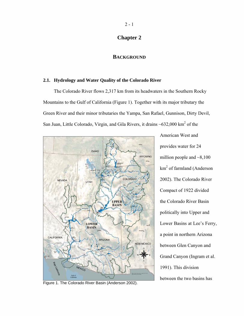
The Colorado River flows 2,317 km from its headwaters in the Southern Rocky
Mountains to the Gulf of California (Figure 1). Together with its major tributary the
Green River and their minor tributaries the Yampa, San Rafael, Gunnison, Dirty Devil,
San Juan, Little Colorado, Virgin, and Gila Rivers, it drains ~632,000 km2 of the
American West and
provides water for 24
million people and ~8,100
km2 of farmland (Anderson
2002). The Colorado River
Compact of 1922 divided
the Colorado River Basin
politically into Upper and
Lower Basins at Lee’s Ferry,
a point in northern Arizona
between Glen Canyon and
Grand Canyon (Ingram et al.
1991). This division
between the two basins has Figure 1. The Colorado River Basin (Anderson 2002).
2 - 2
shaped scientific investigations into the water resources of the region.
Precipitation falls mostly as winter snow in the Upper Colorado Basin (Spahr et al.
2000), whereas the North American monsoon brings the majority of the precipitation in
the Lower Basin (Webb et al. 2004). However, these contributions are quite unequal;
most of the flow in the Colorado River comes from snowmelt in the Upper Basin, 60% of
which lies above 2,000 m above sea level (asl) as compared to 16% of the Lower Basin
(Bales et al. 2008). Precipitation is highly variable on multi-year time scales, leading to
corresponding variability in Colorado River flows. Climate change is adding to this
variability, leading to more precipitation as rain and earlier snowmelt (Barnett et al.
2008).
Flows past Lee’s Ferry have historically been used to judge the amount of water in
the river. Since the 1963 creation of Lake Powell, a reservoir just upstream from Lee’s
Ferry (see section 2.2), the estimated inflow to the reservoir has been used as the
theoretical unregulated flow at Lee’s Ferry. Thus, flow on the Colorado River as
measured by the historical record at Lee’s Ferry (dating to 1895) ranges from 4.7 km3 yr-1
(3.8 million acre-feet (MAF) yr-1) to 27.4 km3 yr-1 (22.2 MAF yr-1). The estimated mean
is 15.3 km3 yr-1 (12.4 MAF yr-1), although if consumptive use in the Upper Basin were
excluded, the flow would be about 18.5 km3 yr-1 (15 MAF yr-1; Webb et al. 2004).
While the effect of the Pacific Decadal Oscillation and the El Niño Southern
Oscillation are incompletely understood, these climate patterns commonly influence
precipitation and river flow across the entire Colorado River Basin (Webb et al. 2004,
Kurtzman and Scanlon 2007). Extended droughts (i.e., > 10 years) are a realistic
possibility (Meko and Woodhouse 2005). From 1999 to the present, the Colorado River
2 - 3
Basin has experienced a severe drought, with only 2 years of slightly above-average flow
during this period and all other years markedly below average. Dendrochronologic
reconstructions of streamflow at Lee’s Ferry since 1490 indicate that this is the most
severe, extended dry period since 1850, although three periods were identified during
which there is a ≥ 25% probability of lower flow than in the current drought (Woodhouse
et al. 2006).
Estimated flow of the Colorado River at Lee’s Ferry from 1895 to the present
shows a decreasing trend (Webb et al. 2004) that can be attributed to several factors. First,
the highest flows in the last 500 years occurred in the initial three decades of this time
series (Woodhouse et al. 2006). Second, consumptive water use in the Upper Basin has
steadily increased since the mid-1900s (Webb et al. 2004). Third, climate change appears
to be shifting arid subtropical climatic patterns toward higher latitudes, leading to drier
conditions on the Colorado Plateau (Seager et al. 2007). Together, these three phenomena
may severely limit the water available for consumptive use, possibly leading to the
draining of both major reservoirs on the Colorado River (Lake Powell and Lake Mead) in
the coming decades (Barnett and Pierce 2008).
Water quality in the Colorado River can be impaired by high salinity, which results
from evaporation, diversion of high-quality water, irrigation return flows, and dissolution
of minerals from sedimentary rocks (Gloss et al. 1981). Salinity increases dramatically
when the Colorado River leaves the Southern Rocky Mountains and enters the Colorado
Plateau (Spahr et al. 2000), and it generally increases downstream, except when affected
by flow through reservoirs (USBR 2008b). Mining in the Rocky Mountains contributes
trace metals like copper, lead, zinc, and cadmium (Spahr et al. 2000), and these elements
2 - 4
are transported downstream in association with suspended sediment (Horowitz et al.
2001). Selenium, which can be leached out of the Mancos Shale formation of the
Colorado Plateau and transported to the river by agricultural return flows, has warranted
special attention (Engberg 1999, Naftz et al. 2005).
2.2. Hydrology and Water Quality of Lake Powell
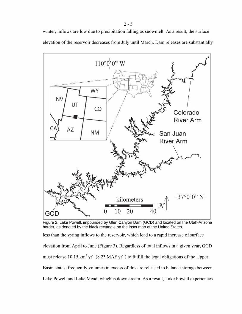
Lake Powell (Figure 2) is the second-largest reservoir in the United States and the
second reservoir constructed on the mainstem of the Colorado River, after Lake Mead
which is further downstream. Located 24 km upriver from Lee’s Ferry and 17 km
downstream from the confluence of the Green and Colorado Rivers, it fills Glen Canyon
and lies between Canyonlands National Park and Grand Canyon National Park. It was
formed by the completion of Glen Canyon Dam (GCD) in 1963 to generate hydroelectric
power and to ensure that the Upper Basin could reliably deliver water to the Lower Basin
as required by the Colorado River Compact (Farmer 1999). When full, its surface
elevation is 1128 m asl, its length is 299 km, and its depth is 178 m. The tortuous shape
of Glen Canyon gave rise to a long, narrow reservoir with > 95 “side canyons” that
extend off the original channel of the Colorado River. The reservoir is a major recreation
destination, welcoming ~2 million visitors per year for camping, fishing, and a variety of
water sports (Granet and Anderson 2005; Potter and Drake 1989).
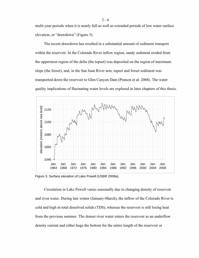
Releases from GCD do not match inflows to Lake Powell on either a yearly or
multi-year time scale. In order to maximize hydropower revenue, releases from GCD are
highest during the summer months, when demand for electricity is greatest. In the fall and
2 - 5
winter, inflows are low due to precipitation falling as snowmelt. As a result, the surface
elevation of the reservoir decreases from July until March. Dam releases are substantially
less than the spring inflows to the reservoir, which lead to a rapid increase of surface
elevation from April to June (Figure 3). Regardless of total inflows in a given year, GCD
must release 10.15 km3 yr-1 (8.23 MAF yr-1) to fulfill the legal obligations of the Upper
Basin states; frequently volumes in excess of this are released to balance storage between
Lake Powell and Lake Mead, which is downstream. As a result, Lake Powell experiences
Figure 2. Lake Powell, impounded by Glen Canyon Dam (GCD) and located on the Utah-Arizona border, as denoted by the black rectangle on the inset map of the United States.
2 - 6
multi-year periods when it is nearly full as well as extended periods of low water surface
elevation, or “drawdown” (Figure 3).
The recent drawdown has resulted in a substantial amount of sediment transport
within the reservoir. In the Colorado River inflow region, sandy sediment eroded from
the uppermost region of the delta (the topset) was deposited on the region of maximum
slope (the forset), and, in the San Juan River arm, topset and forset sediment was
transported down the reservoir to Glen Canyon Dam (Pratson et al. 2008). The water
quality implications of fluctuating water levels are explored in later chapters of this thesis.
1040
1060
1080
1100
1120
Jan.1964
Jan.1968
Jan.1972
Jan.1976
Jan.1980
Jan.1984
Jan.1988
Jan.1992
Jan.1996
Jan.2000
Jan.2004
Jan.2008
elev
atio
n (m
eter
s ab
ove
sea
leve
l)
Figure 3. Surface elevation of Lake Powell (USBR 2008a).
Circulation in Lake Powell varies seasonally due to changing density of reservoir
and river water. During late winter (January-March), the inflow of the Colorado River is
cold and high in total dissolved solids (TDS), whereas the reservoir is still losing heat
from the previous summer. The denser river water enters the reservoir as an underflow
density current and either hugs the bottom for the entire length of the reservoir or

2 - 7
becomes an interflow current when it reaches a depth of similar density. Deep water in
the path of the underflow current is pushed upward when it reaches the dam, and it then
exits in the withdrawal current that passes through the dam. As a result, stagnant, deep
water in Lake Powell is freshened and oxygenated not by convective mixing with surface
water, but by advective transport of inflow water (Johnson and Merritt 1979, Potter and
Drake 1989).
The spring snowmelt, which is warmer and more dilute than the wintertime river,
and low summer inflows, which warm in response to summertime temperature increases
more rapidly than the reservoir water, enter the reservoir as overflow density currents.
These, coupled with intense summertime stratification characterized by a distinct
thermocline ~20 m below the water surface, lead to several months of flow across the
surface of the reservoir and stagnation at depth (Johnson and Merritt 1979). In the late
autumn and early winter (November-December), convective circulation overturns the
water column to a depth of ~60 m (Gloss et al. 1980) and the cooler river enters the
reservoir as an interflow current (Johnson and Merritt 1979).
Nearly all water enters GCD through a combination of eight penstocks, located at
1058 m asl (70 m below the water surface when the reservoir is full), and exits through
hydroelectric turbines (Hueftle and Stevens 2001). This depth is usually below the depth
of summertime convective mixing, and, during fall overturn, the withdrawal current
prevents overturn near the dam below a depth of 1020 m asl (Johnson and Merritt 1979).
Epilimnetic and hypolimnetic water can be discharged through the spillway intakes (1114
m asl) and river outlet works (1029 m asl), respectively. While rarely used, releases from
2 - 8
the spillway and river outlet works can accelerate overflow and underflow circulation
patterns (Hueftle and Stevens 2001).
Water in Lake Powell is generally very low in trace metals and anthropogenic
organic chemicals (Hart et al. 2004). Concentration gradients may exist between the head
and the mouth of a side canyon, although the basis for these has not been rigorously
investigated. Gradients persist because side canyons are generally quiescent (Hart et al.
2004). Precipitation of calcite is an important summertime process that is more likely to
occur in the lower region of the reservoir due to inhibition by organic compounds that are
present in the inflow region (Reynolds 1978). In the inflow region of Lake Powell,
sorption reactions between water and sediment limit the range of dissolved phosphorus (P)
concentrations, yet silica varies in a range outside that predicted by laboratory sorption
experiments (Mayer and Gloss 1980). The circulation patterns described above are very
important for the dynamics of P, the limiting nutrient in the reservoir. When P enters in
an underflow current, it bypasses the photic zone and does not contribute to primary
productivity, but when it enters as an overflow current, it contributes to summer
phytoplankton blooms (Gloss et al. 1980). Sediment resuspension during drawdown can
double suspended sediment concentrations and may release additional nutrients into the
water column (Vernieu 1997).
Storing water in Lake Powell affects water quality downstream. Precipitation of
calcite offsets the increase of TDS that occurs due to evaporation such that there is no net
change in TDS concentration (Gloss et al. 1981). An important additional consequence of
storage in Lake Powell is the moderation of annual variability in TDS (USBR 2008b),
which facilitates management of salinity downstream. Furthermore, Lake Powell retains

2 - 9
> 90% of total P, > 70% of dissolved P, > 20% of total nitrogen, and > 10% of total silica
that enters from all sources (Gloss et al. 1981). Releases from Glen Canyon Dam, which
draws water from the middle of the water column, are clear and cold, and this significant
difference from historical conditions has damaged sensitive ecological habitat
immediately downstream in Grand Canyon. Additionally, reservoir processes that are not
completely understood can lead to seasonal plumes of anoxic water within Lake Powell
(Vernieu et al. 2005), and, under certain hydrologic conditions, these can pass through
the dam and impair water quality in the Colorado River (Williams 2007).
2.3. Early Diagenesis and its Implications for Inorganic Contaminants
Early diagenesis, the quantitative description of chemical changes during sediment
deposition before lithification occurs, is characterized by chemical reactions that are
generally a result of microbial metabolism of organic matter. During aerobic respiration,
organic matter acts as an electron donor and is oxidized to carbon dioxide. Oxygen is the
most thermodynamically favorable electron acceptor for this process. In most sediment,
deposition of organic matter is such that diffusion of oxygen from surface water into
porewater is insufficient to support microbial respiration. In this case, the concentration
of dissolved oxygen in sediment porewater decreases with depth below the sediment-
water interface, and, where it approaches zero, microbial respiration uses other electron
acceptors in a sequence determined by their reduction potential. Reduction of nitrate
(NO3-) to N2 is the most favorable anaerobic process and an important means of reducing
NO3- contamination in groundwater (e.g., Domagalski et al. 2008). When NO3
- is
depleted, manganese (Mn), iron (Fe), and sulfate (SO42-) are reduced (Berner 1980,

2 - 10
Stumm and Morgan 1996, Froelich et al. 1979). Importantly, a single microbial species
does not carry out each reaction. Rather, different species dominate the microbial
population as the geochemical conditions change with depth. Furthermore, environmental
conditions may change the relative availability or energetic yield of different electron
acceptors, and thus the sequence of reduction described here may not always be clearly
observed due to overlap of electron acceptor utilization (McGuire et al. 2002).
Redox reactions can control partitioning between the solid and the dissolved phase.
The environmentally-important reduced species Mn(II) and Fe(II) can occur in solution
as Mn2+ and Fe2+ ions, whereas their oxidized forms, Mn(III/IV) and Fe(III), generally
occur in solids with very low solubilities (Morel and Hering 1993). Thus, the absence of
oxygen and NO3- in sediment porewater leads to the reductive dissolution of Mn and Fe
(Froelich et al. 1979, Kneebone et al. 2002). These elements can be removed from
porewater by oxygenation, which leads to the precipitation of Mn(III/IV)-oxide and
Fe(III)-oxide minerals, or by precipitation of reduced carbonate (e.g., siderite (FeCO3) or
rhodocrocite (MnCo3)), sulfide (e.g., pyrite (FeS) or albandite (MnS)), or phosphate (e.g.,
vivianite (Fe3(PO4)2)) solids. Sulfide (S2-) produced during sulfate reduction can lead to
precipitation of pyrite, which is more likely than that of albandite, since S2- and Fe2+ react
preferentially (Canfield 1989, Báez-Cazull et al. 2007) and undersaturation of albandite is
generally observed in sulfidic porewater (Naylor et al. 2006). Isomorphic substitution of
Mn2+ during vivianite (Fe3(PO4)2) precipitation can reduce dissolved Mn2+ concomitantly
with PO43- (Taylor and Boult 2007).
Trace elements and P commonly sorb to the surfaces of Fe- and Mn-oxide minerals
(Belzile et al. 2000, Dixit and Hering 2003, Lee et al. 2002, Tonkin et al. 2004, Gächter
2 - 11
and Müller 2003). Thus, reductive dissolution of these minerals can also release trace
elements into sediment porewater (Kneebone et al. 2002, Campbell et al. 2008).
Furthermore, some trace elements, such as arsenic and uranium, are redox active and will
thus respond to the redox state of sediment porewater determined by the major redox
species of a system (Campbell et al. 2006, Finneran et al. 2002).
2.4. Reservoir Sedimentation and Transport of Sediment-Bound Elements
Globally, sedimentation in reservoirs traps 20% of sediment transported by rivers;
Lake Powell, which traps > 99% of the sediment that enters it, far exceeds global
averages for its continent, ocean basin, climate, and elevation (Syvitski et al. 2005, Potter
and Drake 1989). The ability of flowing water to entrain and transport particles depends
principally on fluid density, fluid viscosity, and flow velocity. The first two of these
remain approximately constant when a river is impounded; a decrease in flow velocity
decreases particle transport (Prothero and Schwab 2004). As sediment particles in a river
enter a reservoir, they will settle according to Stokes’s law, which implies that, as the
river flow slows, coarse particles will settle before fine ones. Specifically,
2p 18
v pDg⋅⋅
∆=
νρρ
where vp is the sinking velocity (in m s-1), ∆ρ is the density difference between particles
and water (in kg m-3), ρ is the density of water (≈ 1000 kg m3), g is the gravitational
acceleration (= 9.81 m s-2), ν is the viscosity of water (≈ 1-1.5 · 10-6 m2 s-1), and Dp is the
particle diameter (in m) (Friedl and Wüest 2002). As the energy of a river decreases upon
reaching the flat surface of a lake, its turbulent upwelling will decrease in velocity and
will fail to counteract the higher sinking velocity of large particles. The slowing river will
2 - 12
carry fine particles further into the reservoir and deposit them as it continues to slow.
Thus, sediment deltas are usually deposited in gradients of particle size, with coarse
particles closest to the river and fine particles deepest into a lake (Prothero and Schwab
2004). In a narrow lake, such as a reservoir that has filled a narrow valley, the shape of
the sediment delta can lead to a clear gradient in sediment particle size. Sedimentation in
the inflow region of a reservoir is derived from allochthonous sources, whereas, in the
part of a reservoir that resembles a lake, sedimentation is autochthonous as in natural
lakes (Friedl and Wüest 2002). Only deposition of river sediment will be reviewed briefly
here.
Gradients of particle size in sediment deltas have been observed in several
reservoirs most clearly when sediment deltas do not reach the dam (e.g., Riggsbee et al.
2007, Cheng and Granata 2007). Large deltas will be strongly influenced over time by
changes in reservoir level, with decreases in water level allowing the river to mobilize
coarse sediment from the upper region of the delta further into the reservoir, and
subsequent increases in water level depositing fine sediment on top of coarse sediment
(Snyder et al. 2006). Thus, vertical variations in sediment particle size will be closely tied
to the management history of a reservoir.
Trace elements are generally enriched in particles < 0.125 mm in size. Small
particles are high in both organic carbon and clay minerals, so it is not clear which of
these phases contributes most to trace element sorption (Horowitz and Elrick 1987).
Reservoirs have been observed to retain both inorganic contaminants, especially when
downstream from mines (Castelle et al. 2007, Lee et al. 2008), and nutrients (Teodoru
and Wehrli 2005) in their sediment. While the concentration of chemicals in reservoir
2 - 13
sediment is a means of purifying downstream river water, this sedimentation is an
important sink for organic carbon (Downing et al. 2008). Both the rapid sedimentation of
organic matter and the submergence of riparian biomass lead to greenhouse gas emissions
(i.e., nitrous oxide and methane) from reservoirs that are much higher than those from
lakes or undammed rivers (Guérin et al. 2008, 2006, Kemenes et al. 2007).
2.5. Phosphorus in Lakes
The bioavailability of P has long been understood to limit primary productivity in
freshwater ecosystems, an assertion most recently stated by Schindler et al. (2008). The
amount of P in the water column of a lake is dependent on input from land, rivers, and
sediment diagenesis, loss to sedimentation and outflow, and consumption by primary
productivity (Müller et al. 2007). The quantity of dissolved P in a lake has generally been
thought to depend on lake depth and flushing rate, but recent research suggests that P
input and water residence time may be more important (Brett and Benjamin 2008).
In unpolluted rivers, the vast majority of P is transported in particulate form
(Meybeck 1982, Horowitz et al. 2001), and, once in a lake, several processes can move
the remaining dissolved P into the solid phase as well. Phosphorus sorbs abiotically to
Fe-oxide minerals, aluminum-oxide minerals, and carbon (Arias et al. 2006, Novak et al.
2006). Sorption characteristics change with salinity; increasing the salinity of freshwater
to a range of 5-12 salinity units induces P desorption (Spiteri et al. 2008). Apatite
precipitation or scavenging during calcite precipitation may be important in some lakes
(Kleiner and Stabel 1989). Most importantly, uptake by biomass decreases dissolved P
concentrations. If this biomass dies and degrades in surface water, then P re-enters the
2 - 14
dissolved pool. However, settling of dead biomass to sediment retains it in the solid phase
for a much longer time (Kalff 2002).
To contribute to primary productivity, P must be in the photic zone of a lake.
Bioavailable P that reaches the photic zone is generally taken up by biomass growth
rapidly, and thus concentrations of P are often higher in bottom water than in surface
waters. P can reach bottom waters by transport by underflow density currents (Gloss et al.
1980), diffusion from sediment porewater (Gächter and Müller 2003), or decay of sinking
particulate organic matter (Kalff 2002). In this case, convective overturn of the water
column is an important step that leads to primary productivity in surface waters, and the
depth of overturn determines the extent to which hypolimnetic P reaches surface water
(e.g., Baldwin et al. 2008, Kalff 2002). The importance of overturn events is magnified in
reservoirs that release water from the middle or bottom of the water column, since
advective circulation allows hypolimnetic P to exit the reservoir without entering the
photic zone when overturn does not bring it to surface waters (Matzinger et al. 2007).
Once in sediment, chemical processes enrich P concentrations in porewater so that
it diffuses back into bottom waters. Dissolution of Fe-oxides is generally cited as the
main mechanism for this process. When water near the sediment-water interface is anoxic,
Fe reduction can occur in surface sediment, liberating both Fe2+ and P to the dissolved
phase. If these reach an oxic region of the water column, Fe will precipitate and scavenge
P. However, if S2- is present, it can sequester Fe2+ as FeS and allow P to accumulate in
the water column (Baldwin and Mitchell 2000, Berner and Rao 1994, Jordan et al. 2008).
Internal loading of a water body in this manner can maintain high dissolved P
concentrations even if external loading is decreased (Ahlgren et al. 2006). Microbial
2 - 15
decomposition of organic matter in sediment can also contribute P to sediment porewater,
where it will either sorb to particles or diffuse into overlying water. Sediment-associated
calcite may be less likely to release P to the water column, but the implications of this
have not been adequately determined.
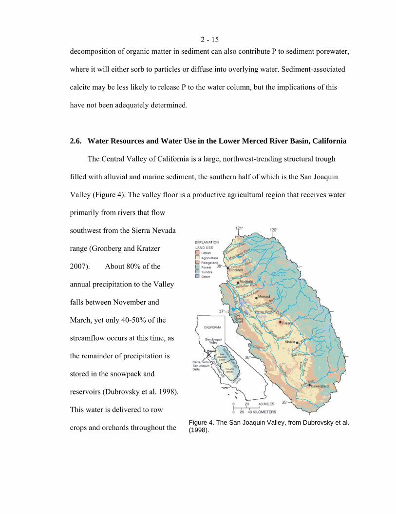
2.6. Water Resources and Water Use in the Lower Merced River Basin, California
The Central Valley of California is a large, northwest-trending structural trough
filled with alluvial and marine sediment, the southern half of which is the San Joaquin
Valley (Figure 4). The valley floor is a productive agricultural region that receives water
primarily from rivers that flow
southwest from the Sierra Nevada
range (Gronberg and Kratzer
2007). About 80% of the
annual precipitation to the Valley
falls between November and
March, yet only 40-50% of the
streamflow occurs at this time, as
the remainder of precipitation is
stored in the snowpack and
reservoirs (Dubrovsky et al. 1998).
This water is delivered to row
crops and orchards throughout the Figure 4. The San Joaquin Valley, from Dubrovsky et al. (1998).
2 - 16
summer growing season by an extensive network of irrigation canals (Gronberg and
Kratzer 2007).
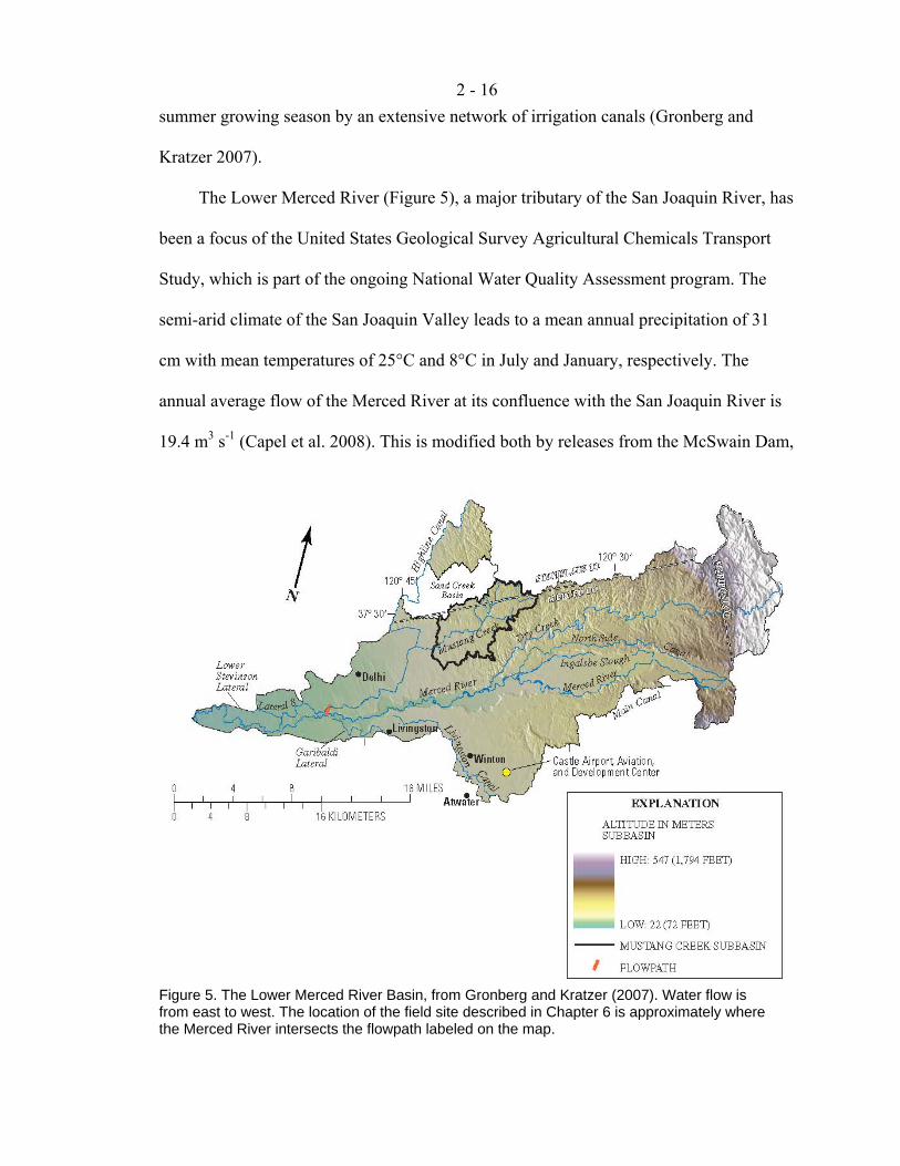
The Lower Merced River (Figure 5), a major tributary of the San Joaquin River, has
been a focus of the United States Geological Survey Agricultural Chemicals Transport
Study, which is part of the ongoing National Water Quality Assessment program. The
semi-arid climate of the San Joaquin Valley leads to a mean annual precipitation of 31
cm with mean temperatures of 25°C and 8°C in July and January, respectively. The
annual average flow of the Merced River at its confluence with the San Joaquin River is
19.4 m3 s-1 (Capel et al. 2008). This is modified both by releases from the McSwain Dam,
Figure 5. The Lower Merced River Basin, from Gronberg and Kratzer (2007). Water flow is from east to west. The location of the field site described in Chapter 6 is approximately where the Merced River intersects the flowpath labeled on the map.
2 - 17
which is just upstream of the boundary that defines the Lower Merced River basin, and
five major irrigation and drainage canals that discharge to the river (Gronberg and
Kratzer 2007). In this reach, the river is underlain by an unconfined aquifer that is
bounded beneath by the Corcoran Clay formation, which is 28-85 m below ground
surface (Capel et al. 2008).
More than half (55%) of the Lower Merced River Basin is used for agriculture,
mostly almond orchards, with some corn and grain fields and vineyards (Capel et al.
2008). Irrigation seasonally raises the water table, inducing a gradual flow to the Merced
River (Phillips et al. 2007). As a result, in the reach studied in Chapter 6, the Merced
River usually gains water from the local aquifers, except when high river stage pushes
water into the subsurface (Essaid et al. 2008). Groundwater-surface water exchange is
minor, however, due to small differences in hydraulic head across the sediment-water
interface, which may be due to the location of the study reach just downstream from a
transition from a losing stream to a gaining stream, to negligible surface water slope, and
to a wide channel for groundwater discharge (Essaid et al. 2008, Puckett et al. 2008).
Furthermore, the residence time of groundwater in the streambed between the sediment-
water interface and a depth of 3 m is on the order of 2 months (Puckett et al. 2008).
In addition to irrigation water, 1 million kg of pesticides, 7.3 million kg of nitrogen,
and 1.3 million kg of phosphorus were applied to crops in 2003 in the Lower Merced
River Basin (Capel et al. 2008). Pesticides generally degrade in soil and aquifer material,
with atrazine and metolachlor occurring in lower concentrations in groundwater than
their degradates (Steele et al. 2008). Denitrification removes most fertilizer-derived
nitrate as groundwater flows through the riparian zones into the river subsurface, most
2 - 18
likely due to substantially more reducing conditions in the riverbed subsurface than in the
nearby aquifer (Domagalski et al. 2008, Puckett et al. 2008).
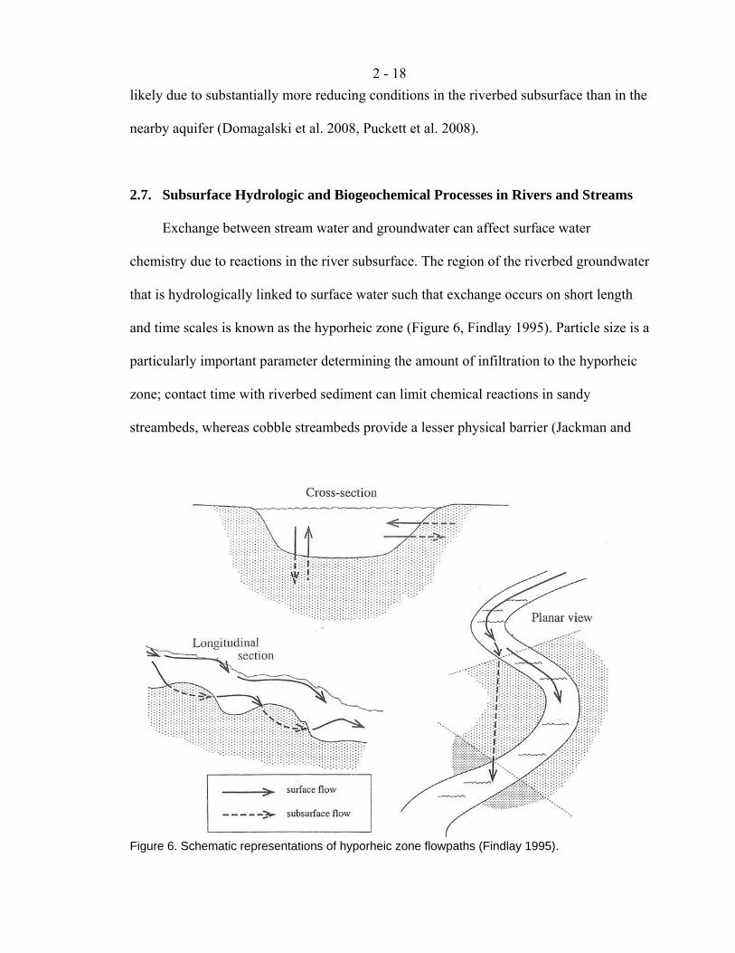
2.7. Subsurface Hydrologic and Biogeochemical Processes in Rivers and Streams
Exchange between stream water and groundwater can affect surface water
chemistry due to reactions in the river subsurface. The region of the riverbed groundwater
that is hydrologically linked to surface water such that exchange occurs on short length
and time scales is known as the hyporheic zone (Figure 6, Findlay 1995). Particle size is a
particularly important parameter determining the amount of infiltration to the hyporheic
zone; contact time with riverbed sediment can limit chemical reactions in sandy
streambeds, whereas cobble streambeds provide a lesser physical barrier (Jackman and
Figure 6. Schematic representations of hyporheic zone flowpaths (Findlay 1995).
2 - 19
Ng 1986). A coarse “armor” layer on top of finer sediment has been observed to have no
effect on the advection of water into the river subsurface (Marion et al. 2008), yet
streamflow does, with more surface-subsurface exchange occurring at lower streamflow
than at higher streamflow (Harvey et al. 1996). The extent of infiltration is a master
variable that controls the residence time of water in a river reach, which, in turn, is often
the best explanation for observed differences in biogeochemical activity (Findlay 1995,
Valett et al. 1996).
Interaction of solutes within the hyporheic zone depends on both the contact time of
river water with the riverbed matrix and the type of solute. The mechanism of retention is
generally believed to be chemical, often ion exchange or sorption, as injection
experiments demonstrate that the downstream advection of inorganic solutes (Kennedy et
al. 1984) or nutrients (Valett et al. 1996, Haggard et al. 2005) is retarded relative to a
conservative tracer. Due to infiltration by stream water, the hyporheic zone is generally
oxic, although pockets of reducing zones can exist where sediment is less permeable
(Salehin et al. 2004). Thus, organic matter degradation is common, and this acts as a
source of nutrients to surface water (Findlay 1995). Contact with sediment surfaces can
also promote redox reactions: loads of dissolved Mn in a contaminated stream have been
observed to decrease due to subsurface oxidation (Harvey and Fuller 1998).
2.8. References Ahlgren, J., K. Reitzel, L. Tranvik, A. Gogll, and E. Rydin. (2006) Degradation of
organic phosphorus compounds in anoxic Baltic Sea sediments: A 31P nuclear magnetic resonance study. Limnology and Oceanography 51(5): 2341-2348.
Anderson, D.L. Utah’s Perspective: The Colorado River. Utah Department of Natural Resources: Salt Lake City, 2002.
2 - 20
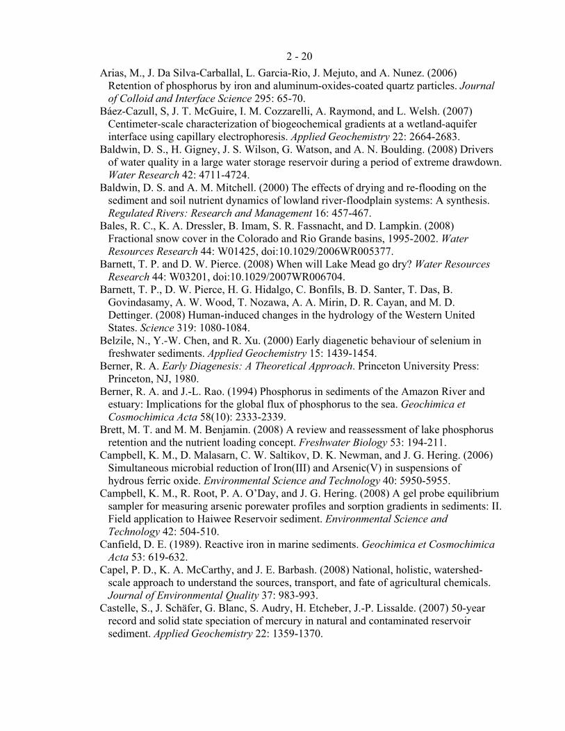
Arias, M., J. Da Silva-Carballal, L. Garcia-Rio, J. Mejuto, and A. Nunez. (2006) Retention of phosphorus by iron and aluminum-oxides-coated quartz particles. Journal of Colloid and Interface Science 295: 65-70.
Báez-Cazull, S, J. T. McGuire, I. M. Cozzarelli, A. Raymond, and L. Welsh. (2007) Centimeter-scale characterization of biogeochemical gradients at a wetland-aquifer interface using capillary electrophoresis. Applied Geochemistry 22: 2664-2683.
Baldwin, D. S., H. Gigney, J. S. Wilson, G. Watson, and A. N. Boulding. (2008) Drivers of water quality in a large water storage reservoir during a period of extreme drawdown. Water Research 42: 4711-4724.
Baldwin, D. S. and A. M. Mitchell. (2000) The effects of drying and re-flooding on the sediment and soil nutrient dynamics of lowland river-floodplain systems: A synthesis. Regulated Rivers: Research and Management 16: 457-467.
Bales, R. C., K. A. Dressler, B. Imam, S. R. Fassnacht, and D. Lampkin. (2008) Fractional snow cover in the Colorado and Rio Grande basins, 1995-2002. Water Resources Research 44: W01425, doi:10.1029/2006WR005377.
Barnett, T. P. and D. W. Pierce. (2008) When will Lake Mead go dry? Water Resources Research 44: W03201, doi:10.1029/2007WR006704.
Barnett, T. P., D. W. Pierce, H. G. Hidalgo, C. Bonfils, B. D. Santer, T. Das, B. Govindasamy, A. W. Wood, T. Nozawa, A. A. Mirin, D. R. Cayan, and M. D. Dettinger. (2008) Human-induced changes in the hydrology of the Western United States. Science 319: 1080-1084.
Belzile, N., Y.-W. Chen, and R. Xu. (2000) Early diagenetic behaviour of selenium in freshwater sediments. Applied Geochemistry 15: 1439-1454.
Berner, R. A. Early Diagenesis: A Theoretical Approach. Princeton University Press: Princeton, NJ, 1980.
Berner, R. A. and J.-L. Rao. (1994) Phosphorus in sediments of the Amazon River and estuary: Implications for the global flux of phosphorus to the sea. Geochimica et Cosmochimica Acta 58(10): 2333-2339.
Brett, M. T. and M. M. Benjamin. (2008) A review and reassessment of lake phosphorus retention and the nutrient loading concept. Freshwater Biology 53: 194-211.
Campbell, K. M., D. Malasarn, C. W. Saltikov, D. K. Newman, and J. G. Hering. (2006) Simultaneous microbial reduction of Iron(III) and Arsenic(V) in suspensions of hydrous ferric oxide. Environmental Science and Technology 40: 5950-5955.
Campbell, K. M., R. Root, P. A. O’Day, and J. G. Hering. (2008) A gel probe equilibrium sampler for measuring arsenic porewater profiles and sorption gradients in sediments: II. Field application to Haiwee Reservoir sediment. Environmental Science and Technology 42: 504-510.
Canfield, D. E. (1989). Reactive iron in marine sediments. Geochimica et Cosmochimica Acta 53: 619-632.
Capel, P. D., K. A. McCarthy, and J. E. Barbash. (2008) National, holistic, watershed-scale approach to understand the sources, transport, and fate of agricultural chemicals. Journal of Environmental Quality 37: 983-993.
Castelle, S., J. Schäfer, G. Blanc, S. Audry, H. Etcheber, J.-P. Lissalde. (2007) 50-year record and solid state speciation of mercury in natural and contaminated reservoir sediment. Applied Geochemistry 22: 1359-1370.
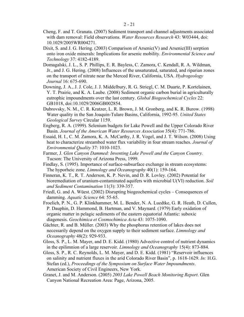
2 - 21
Cheng, F. and T. Granata. (2007) Sediment transport and channel adjustments associated with dam removal: Field observations. Water Resources Research 43: W03444, doi: 10.1029/2005WR004271.
Dixit, S. and J. G. Hering. (2003) Comparison of Arsenic(V) and Arsenic(III) sorption onto iron oxide minerals: Implications for arsenic mobility. Environmental Science and Technology 37: 4182-4189.
Domagalski, J. L., S. P. Phillips, E. R. Bayless, C. Zamora, C. Kendall, R. A. Wildman, Jr., and J. G. Hering. (2008) Influences of the unsaturated, saturated, and riparian zones on the transport of nitrate near the Merced River, California, USA. Hydrogeology Journal 16: 675-690.
Downing, J. A., J. J. Cole, J. J. Middelbury, R. G. Striegl, C. M. Duarte, P. Kortelainen, Y. T. Prairie, and K. A. Laube. (2008) Sediment organic carbon burial in agriculturally eutrophic impoundments over the last century. Global Biogeochemical Cycles 22: GB1018, doi:10.1029/2006GB002854.
Dubrovsky, N. M., C. R. Kratzer, L. R. Brown, J. M. Gronberg, and K. R. Burow. (1998) Water quality in the San Joaquin-Tulare Basins, California, 1992-95. United States Geological Survey Circular 1159.
Engberg, R. A. (1999). Selenium budgets for Lake Powell and the Upper Colorado River Basin. Journal of the American Water Resources Association 35(4): 771-786.
Essaid, H. I., C. M. Zamora, K. A. McCarthy, J. R. Vogel, and J. T. Wilson. (2008) Using heat to characterize streambed water flux variability in four stream reaches. Journal of Environmental Quality 37: 1010-1023.
Farmer, J. Glen Canyon Dammed: Inventing Lake Powell and the Canyon Country. Tucson: The University of Arizona Press, 1999.
Findlay, S. (1995). Importance of surface-subsurface exchange in stream ecosystems: The hyporheic zone. Limnology and Oceanography 40(1): 159-164.
Finneran, K. T., R. T. Anderson, K. P. Nevin, and D. R. Lovley. (2002) Potential for bioremediation of uranium-contaminated aquifers with microbial U(VI) reduction. Soil and Sediment Contamination 11(3): 339-357.
Friedl, G. and A. Wüest. (2002) Disrupting biogeochemical cycles – Consequences of damming. Aquatic Science 64: 55-65.
Froelich, P. N., G. P. Klinkhammer, M. L. Bender, N. A. Luedtke, G. R. Heath, D. Cullen, P. Dauphin, D. Hammond, B. Hartman, and V. Maynard. (1979) Early oxidation of organic matter in pelagic sediments of the eastern equatorial Atlantic: suboxic diagenesis. Geochimica et Cosmochimica Acta 43: 1075-1090.
Gächter, R. and B. Müller. (2003) Why the phosphorus retention of lakes does not necessarily depend on the oxygen supply to their sediment surface. Limnology and Oceanography 48(2): 929-933.
Gloss, S. P., L. M. Mayer, and D. E. Kidd. (1980) Advective control of nutrient dynamics in the epilimnion of a large reservoir. Limnology and Oceanography 15(4): 873-884.
Gloss, S. P., R. C. Reynolds, L. M. Mayer, and D. E. Kidd. (1981) “Reservoir influences on salinity and nutrient fluxes in the arid Colorado River Basin”, p. 1618-1629. In: H.G. Stefan (ed.), Proceedings of the Symposium on Surface Water Impoundments. American Society of Civil Engineers, New York.
Granet, J. and M. Anderson. (2005) 2003 Lake Powell Beach Monitoring Report. Glen Canyon National Recreation Area: Page, Arizona, 2005.
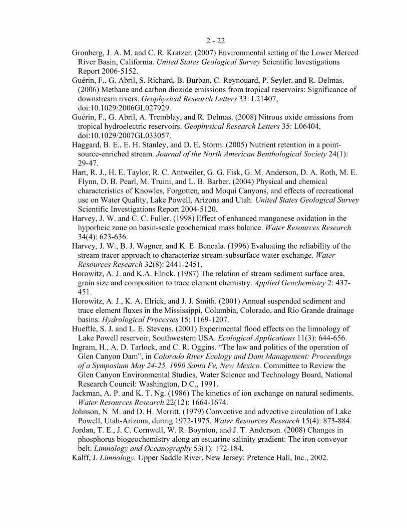
2 - 22
Gronberg, J. A. M. and C. R. Kratzer. (2007) Environmental setting of the Lower Merced River Basin, California. United States Geological Survey Scientific Investigations Report 2006-5152.
Guérin, F., G. Abril, S. Richard, B. Burban, C. Reynouard, P. Seyler, and R. Delmas. (2006) Methane and carbon dioxide emissions from tropical reservoirs: Significance of downstream rivers. Geophysical Research Letters 33: L21407, doi:10.1029/2006GL027929.
Guérin, F., G. Abril, A. Tremblay, and R. Delmas. (2008) Nitrous oxide emissions from tropical hydroelectric reservoirs. Geophysical Research Letters 35: L06404, doi:10.1029/2007GL033057.
Haggard, B. E., E. H. Stanley, and D. E. Storm. (2005) Nutrient retention in a point-source-enriched stream. Journal of the North American Benthological Society 24(1): 29-47.
Hart, R. J., H. E. Taylor, R. C. Antweiler, G. G. Fisk, G. M. Anderson, D. A. Roth, M. E. Flynn, D. B. Pearl, M. Truini, and L. B. Barber. (2004) Physical and chemical characteristics of Knowles, Forgotten, and Moqui Canyons, and effects of recreational use on Water Quality, Lake Powell, Arizona and Utah. United States Geological Survey Scientific Investigations Report 2004-5120.
Harvey, J. W. and C. C. Fuller. (1998) Effect of enhanced manganese oxidation in the hyporheic zone on basin-scale geochemical mass balance. Water Resources Research 34(4): 623-636.
Harvey, J. W., B. J. Wagner, and K. E. Bencala. (1996) Evaluating the reliability of the stream tracer approach to characterize stream-subsurface water exchange. Water Resources Research 32(8): 2441-2451.
Horowitz, A. J. and K.A. Elrick. (1987) The relation of stream sediment surface area, grain size and composition to trace element chemistry. Applied Geochemistry 2: 437-451.
Horowitz, A. J., K. A. Elrick, and J. J. Smith. (2001) Annual suspended sediment and trace element fluxes in the Mississippi, Columbia, Colorado, and Rio Grande drainage basins. Hydrological Processes 15: 1169-1207.
Hueftle, S. J. and L. E. Stevens. (2001) Experimental flood effects on the limnology of Lake Powell reservoir, Southwestern USA. Ecological Applications 11(3): 644-656.
Ingram, H., A. D. Tarlock, and C. R. Oggins. “The law and politics of the operation of Glen Canyon Dam”, in Colorado River Ecology and Dam Management: Proceedings of a Symposium May 24-25, 1990 Santa Fe, New Mexico. Committee to Review the Glen Canyon Environmental Studies, Water Science and Technology Board, National Research Council: Washington, D.C., 1991.
Jackman, A. P. and K. T. Ng. (1986) The kinetics of ion exchange on natural sediments. Water Resources Research 22(12): 1664-1674.
Johnson, N. M. and D. H. Merritt. (1979) Convective and advective circulation of Lake Powell, Utah-Arizona, during 1972-1975. Water Resources Research 15(4): 873-884.
Jordan, T. E., J. C. Cornwell, W. R. Boynton, and J. T. Anderson. (2008) Changes in phosphorus biogeochemistry along an estuarine salinity gradient: The iron conveyor belt. Limnology and Oceanography 53(1): 172-184.
Kalff, J. Limnology. Upper Saddle River, New Jersey: Pretence Hall, Inc., 2002.
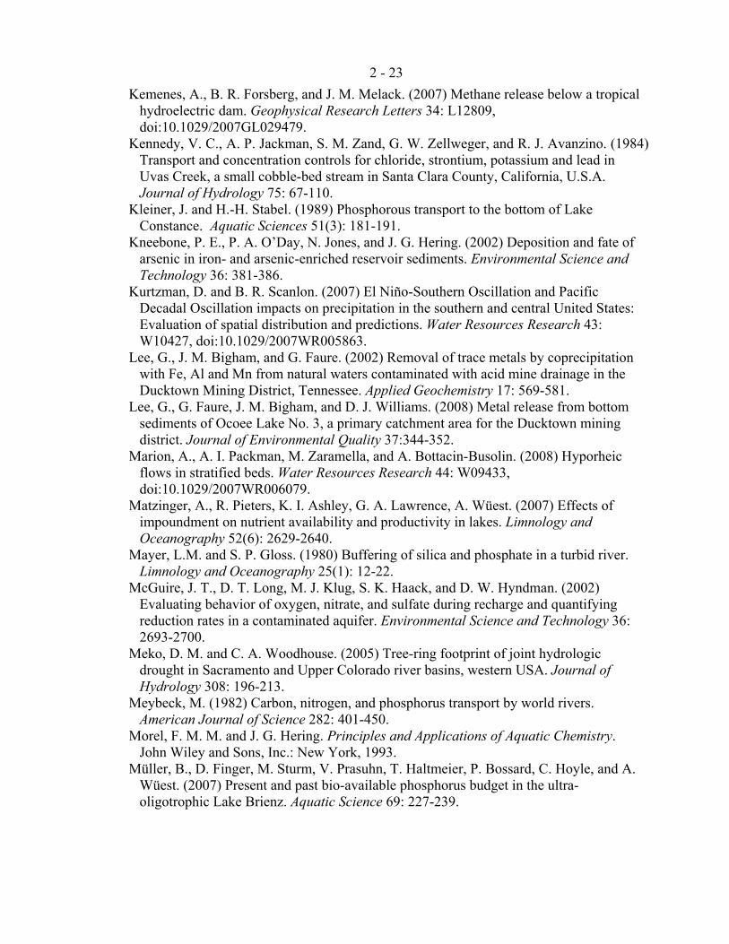
2 - 23
Kemenes, A., B. R. Forsberg, and J. M. Melack. (2007) Methane release below a tropical hydroelectric dam. Geophysical Research Letters 34: L12809, doi:10.1029/2007GL029479.
Kennedy, V. C., A. P. Jackman, S. M. Zand, G. W. Zellweger, and R. J. Avanzino. (1984) Transport and concentration controls for chloride, strontium, potassium and lead in Uvas Creek, a small cobble-bed stream in Santa Clara County, California, U.S.A. Journal of Hydrology 75: 67-110.
Kleiner, J. and H.-H. Stabel. (1989) Phosphorous transport to the bottom of Lake Constance. Aquatic Sciences 51(3): 181-191.
Kneebone, P. E., P. A. O’Day, N. Jones, and J. G. Hering. (2002) Deposition and fate of arsenic in iron- and arsenic-enriched reservoir sediments. Environmental Science and Technology 36: 381-386.
Kurtzman, D. and B. R. Scanlon. (2007) El Niño-Southern Oscillation and Pacific Decadal Oscillation impacts on precipitation in the southern and central United States: Evaluation of spatial distribution and predictions. Water Resources Research 43: W10427, doi:10.1029/2007WR005863.
Lee, G., J. M. Bigham, and G. Faure. (2002) Removal of trace metals by coprecipitation with Fe, Al and Mn from natural waters contaminated with acid mine drainage in the Ducktown Mining District, Tennessee. Applied Geochemistry 17: 569-581.
Lee, G., G. Faure, J. M. Bigham, and D. J. Williams. (2008) Metal release from bottom sediments of Ocoee Lake No. 3, a primary catchment area for the Ducktown mining district. Journal of Environmental Quality 37:344-352.
Marion, A., A. I. Packman, M. Zaramella, and A. Bottacin-Busolin. (2008) Hyporheic flows in stratified beds. Water Resources Research 44: W09433, doi:10.1029/2007WR006079.
Matzinger, A., R. Pieters, K. I. Ashley, G. A. Lawrence, A. Wüest. (2007) Effects of impoundment on nutrient availability and productivity in lakes. Limnology and Oceanography 52(6): 2629-2640.
Mayer, L.M. and S. P. Gloss. (1980) Buffering of silica and phosphate in a turbid river. Limnology and Oceanography 25(1): 12-22.
McGuire, J. T., D. T. Long, M. J. Klug, S. K. Haack, and D. W. Hyndman. (2002) Evaluating behavior of oxygen, nitrate, and sulfate during recharge and quantifying reduction rates in a contaminated aquifer. Environmental Science and Technology 36: 2693-2700.
Meko, D. M. and C. A. Woodhouse. (2005) Tree-ring footprint of joint hydrologic drought in Sacramento and Upper Colorado river basins, western USA. Journal of Hydrology 308: 196-213.
Meybeck, M. (1982) Carbon, nitrogen, and phosphorus transport by world rivers. American Journal of Science 282: 401-450.
Morel, F. M. M. and J. G. Hering. Principles and Applications of Aquatic Chemistry. John Wiley and Sons, Inc.: New York, 1993.
Müller, B., D. Finger, M. Sturm, V. Prasuhn, T. Haltmeier, P. Bossard, C. Hoyle, and A. Wüest. (2007) Present and past bio-available phosphorus budget in the ultra-oligotrophic Lake Brienz. Aquatic Science 69: 227-239.
2 - 24
Naftz, D. L., J. Yahnke, J. Miller, and S. Noyes. (2005) Selenium mobilization during a flood experiment in a contaminated wetland: Stewart Lake Waterfowl Management Area, Utah. Applied Geochemistry 20: 569-585.
Naylor, C., W. Davison, M. Motelica-Heino, G. A. van Den Berg, L. M. van Der Heijdt. (2006) Potential kinetic availability of metals in sulphidic freshwater sediments. Science of the Total Environment 357: 208-220.
Novak, J. M. and D. W. Watts. (2006) Phosphorus sorption by sediments in a Southeastern coastal plain in-stream wetland. Journal of Environmental Quality 35: 1975-1982.
Phillips, S. P., C. T. Green, K. R. Burow, J. L. Shelton, and D. L. Rewis. (2007) Simulation of multiscale ground-water flow in part of the Northeastern San Joaquin Valley, California. U.S. Geological Survey Scientific Investigations Report 2007-5009.
Potter, L. D. and C. L. Drake. Lake Powell: Virgin Flow to Dynamo. University of New Mexico Press, Albuquerque, 1989.
Pratson, L., J. Hughes-Clarke, M. Anderson, T. Gerber, D. Twichell, R. Ferrari, C. Nittrouer, J. Beaudoin, J. Granet, and J. Crockett. (2008) Timing and patterns of basin infilling as documented in Lake Powell during a drought. Geology 36(11): 843-846.
Prothero, D. R. and F. Schwab. Sedimentary Geology, second edition. New York: W.H. Freeman and Company, 2004.
Puckett, L. J., C. Zamora, H. Essaid, J. T. Wilson, H. M. Johnson, M. J. Brayton, and J. R. Vogel. (2008) Transport and fate of nitrate at the ground-water/surface-water interface. Journal of Environmental Quality 37: 1034-1050.
Reynolds, Jr., R. C. (1978) Polyphenol inhibition of calcite precipitation in Lake Powell. Limnology and Oceanography 23(4): 585-597.
Riggsbee, J. A., J. P. Julian, M. W. Doyle, and R. G. Wetzel. (2007) Suspended sediment, dissolved organic carbon, and dissolved nitrogen export during the dam removal process. Water Resources Research 43: W09414, doi: 10.1029/2006/WR005318.
Salehin, M., A. I. Packman, and M. Paradis. (2004) Hyporheic exchange with heterogeneous streambeds: Laboratory experiments and modeling. Water Resources Research 40: W11504, doi: 10.1029/2003WR002567.
Schindler, D. W., R. E. Hecky, D. L. Findlay, M. P. Stainton, B. R. Parker, M. J. Paterson, K. G. Beaty, M. Lyng, and S. E. M. Kasian. (2008) Eutrophication of lakes cannot be controlled by reducing nitrogen input: Results of a 37-year whole-ecosystem experiment. Proceedings of the National Academy of Sciences of the USA 105(32): 11254-11258.
Seager, R., M. Ting, I. Held, Y. Kushnir, J. Lu, G. Vecchi, H.-P. Huang, N. Harnik, A. Leetmaa, N.-C. Lau, C. Li, J. Velez, and N. Naik. (2007) Model profjections of an imminent transition to a more arid climate in Southwestern North America. Science 316: 1181-1184.
Snyder, N. P., S. A. Wright, C. N. Alpers, L. E. Flint, C. W. Holmes, and D. M. Rubin. (2006) Reconstructing depositional processes and history from reservoir stratigraphy: Englebright Lake, Yuba River, northern California. Journal of Geophysical Research 111: F04003, doi:10.1029/2005JF000451.
Spahr, N. E., L. E. Apodaca, J. R. Deacon, J. B. Bails, N. J. Bauch, C. M. Smith, and N. E. Driver. (2000) Water quality in the Upper Colorado River Basin, Colorado, 1996-98. U.S. Geological Survey Circular 1214.
2 - 25
Spiteri, C., P. van Cappellen, and P. Regnier. (2008) Surface complexation effects on phosphate adsorption to ferric iron oxyhydroxides along pH and salinity gradients in estuaries and coastal aquifers. Geochimica et Cosmochimica Acta 72: 3431-3445.
Steele, G. V., H. M. Johnson, M. W. Sandstrom, P. D. Capel, and J. E. Barbash. (2008) Occurrence and fate of pesticides in four contrasting agricultural settings in the Untied States. Journal of Environmental Quality 37: 1116-1132.
Stumm, W. and J. J. Morgan. Aquatic Chemistry, 3rd edition. New York: John Wiley and Sons, Inc., 1996.
Syvitski, J. P. M., C. J. Vörösmarty, A. J. Kettner, and P. Green. (2005) Impact of humans on the flux of terrestrial sediment to the global coastal ocean. Science 308: 376-380.
Taylor, K. G. and S. Boult. (2007) The role of grain dissolution and diagenetic mineral precipitation in the cycling of metals and phosphorus: A study of a contaminated urban freshwater sediment. Applied Geochemistry 22: 1344-1358.
Teodoru, C. and B. Wehrli. (2005) Retention of sediments and nutrients in the Iron Gate I Reservoir on the Danube River. Biogeochemistry 76: 539-565.
Tonkin, J. W., L. S. Balistrieri, and J. W. Murray. (2004) Modeling sorption of divalent metal cations on hydrous manganese oxide using the diffuse double layer model. Applied Geochemistry 19: 29-53.
United States Bureau of Reclamation. (2008a) Bureau of Reclamation: Upper Colorado Region Historic Data. Webpage viewed at http://www.usbr.gov/uc/crsp/GetSiteInfo on 21 December 2008.
United States Bureau of Reclamation. (2008b) Untitled Document. Webpage viewed at http://www.usbr.gov/uc/progact/salinity/pdfs/CRBannual_salinity_data.pdf on 6 January 2009.
Valett, H. M., J. A. Morrice, C. N. Dahm, and M. E. Campana. (1996) Parent lithology, surface-groundwater exchange, and nitrate retention in headwater streams. Limnology and Oceanography 41(2): 333-345.
Vernieu, W. S. (1997). Effects of reservoir drawdown on resuspension of deltaic sediments in Lake Powell. Journal of Lake and Reservoir Management 13(1): 67-78.
Vernieu, W. S., S. J. Hueftle, and S. P. Gloss. (2005) Water quality in Lake Powell and the Colorado River. In State of the Colorado River Ecosystem in Grand Canyon (S. P. Gloss, J. E. Lovich, and T. S. Melis, eds.). Reston, Virginia: United States Geological Survey, 2005.
Webb, R. H., G. H. McCabe, R. Hereford, and C. Wilkowske. (2004) Climate fluctuations, drought, and flow in the Colorado River Basin. U.S. Geological Survey Fact Sheet 2004-3062.
Williams, N. T. (2007) Modeling dissolved oxygen in Lake Powell using CE-QUAL-W2. Masters Thesis, Brigham Young University.
Woodhouse, C. A., S. T. Gray, and D. M. Meko. (2006) Updated streamflow reconstructions for the Upper Colorado River Basin. Water Resources Research 42: W05415, doi:10.1029/2005WR004455.