central north fire management area fire protection plan … · central north fire protection plan...
TRANSCRIPT
Central North Fire Protection Plan 2017 1
Central North Fire Management Area
Fire Protection Plan
2017
Central North Fire Protection Plan 2017 2
Document Control
Document History
Version Date Author Section
1.0 19 October 2016 M Lorang Draft
2.0 21 December 2016 C Moore Final
Central North Fire Management Area Committee Members
Agency Name
Devonport City Council Kylie Lunson
Central Coast Council Tony King (Chair)
Meander Valley Council Michael Kelly
Kentish Council/Latrobe Council Gerald Monson
Latrobe Council Jonathan Magor
Tasmania Fire Service Phillip Harvey
Tasmania Fire Service Neville Bingham
TasNetworks Michael Philpott
TasNetworks David Inglis
Hydro Tasmania Craig Emmett
Tas Parks & Wildlife Eddie Staier
Tas Water Louise McConachie
Forestry Tasmania Bob Knox
Forestry Tasmania Peter Rowlands
Tasmania Farmers and Graziers Andrew Craigie
SES Wayne Richards
Document Endorsement
FMAC Chair – Tony King
Date: 21/12/2016
Accepted by State Fire Management Council
SFMC Chair – Ian Sauer
Date: 16 February 2017
Central North Fire Protection Plan 2017 3
Table of Contents
Document Control ............................................................................................................ 2
Document History ......................................................................................................... 2
Central North Fire Management Area Committee Members ......................................... 2
Document Endorsement ............................................................................................... 2
Glossary .......................................................................................................................... 6
Acronyms......................................................................................................................... 8
Chapter 1 Introduction ................................................................................................. 9
1.1 Background ........................................................................................................ 9
1.2 Aim and Objectives ............................................................................................ 9
1.3 Context ............................................................................................................ 10
1.4 Tenure- blind fire management approach ........................................................ 11
1.5 Policy, Standards and Legislation .................................................................... 12
Standards ............................................................................................................... 12
Legislation ............................................................................................................... 12
Chapter 2 Establishing the Context ............................................................................ 13
2.1 Description of the Central North Fire Protection Plan Area .............................. 13
2.1.1 Location and Boundaries ........................................................................... 13
2.1.2 Population and Demographics .................................................................. 15
2.1.3 Land Tenure .............................................................................................. 16
2.2 Climate and Bushfire Season ........................................................................... 18
Weather Observations ............................................................................................ 18
Summary Climate Statistics – Central North FMA ................................................... 19
Temperature and rainfall ......................................................................................... 19
Wind ....................................................................................................................... 20
Bushfire season ...................................................................................................... 20
2.3 Vegetation ........................................................................................................ 21
Non native vegetation types occurring within the planning area include: ................ 21
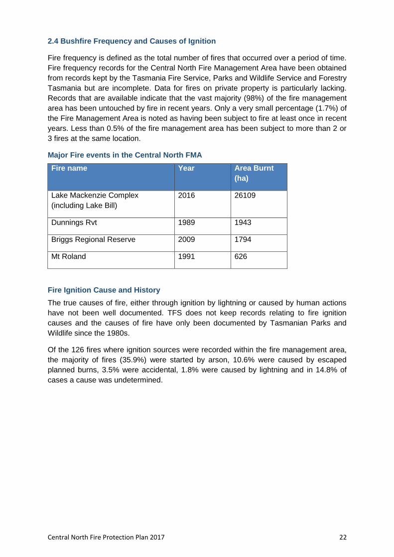
2.4 Bushfire Frequency and Causes of Ignition .......................................................... 22
Major Fire events in the Central North FMA ............................................................ 22
Fire Ignition Cause and History ............................................................................... 22
Chapter 3 Analysing and Evaluating Bushfire Risk .................................................... 24
3.1 Analysing Bushfire Risk ................................................................................... 24
3.2 Likelihood ......................................................................................................... 24
3.3 Consequence (values at risk) ........................................................................... 25
Central North Fire Protection Plan 2017 4
3.4 Overall Risk ...................................................................................................... 25
3.5 Risk Analysis for the Central North Fire Management Area ............................. 25
Vulnerable Groups .................................................................................................. 30
3.8 Areas of strategic importance within the Central North FMA ............................ 33
Turners Beach to Leith Flood Debris....................................................................... 33
3.9 Strategic Fuel Management ............................................................................. 33
Strategic Fire Trails ................................................................................................. 34
Chapter 4 Bushfire Risk Treatment ............................................................................ 36
4.1 Region Wide Controls ...................................................................................... 36
4.2 Asset Specific Treatment Strategies ................................................................ 36
4.3 Planned burning – treatable and untreatable locations: ................................... 36
4.4 Treatment options other than burning .............................................................. 37
4.5 Bushfire risk mitigation programs – other agencies .......................................... 38
Other fire related management programs and reports: ........................................... 38
4.6 Treatment Selection and Priorities ................................................................... 39
4.7 Annual Implementation Program ...................................................................... 39
4.8 Implementation ................................................................................................ 39
Chapter 5 Monitoring and Review .............................................................................. 40
5.1 Review ............................................................................................................. 40
5.2 Monitoring ........................................................................................................ 40
5.3 Reporting ......................................................................................................... 40
References .................................................................................................................... 41
Appendices .................................................................................................................... 42
Appendix 1 – Map of Central North Fire Management Area Boundary ....................... 43
Appendix 2 – Population distribution map – Central North Fire Management Area .... 44
Appendix 3 – Tenure map and Tables........................................................................ 45
Appendix 4 – Vegetation Map and TasVeg community descriptions .......................... 48
Appendix 6 - BRAM (Bushfire Risk Assessment Model) explanation ......................... 56
Appendix 7 – NERAG risk assessment approach ...................................................... 61
Appendix 8 – BRAM Risk Assessment Maps – Likelihood, Consequence, Risk ........ 66
Appendix 9 – Phoenix ignition points map .................................................................. 69
Appendix 10 – TFS Community Fire Safety Division Programs and Plans ................. 70
1. Community Bushfire Response Plan ................................................................... 70
2. Community Bushfire Protection Plan ................................................................... 70
3. Community Bushfire Mitigation Plan ................................................................... 70
Appendix 11 – Treatability of land within the Central North FMA ................................ 72

Central North Fire Protection Plan 2017 5
Appendix 12 - List of fire management related documents for the Central North Fire
Management Area ...................................................................................................... 75
Appendix 13 – Annual Implementation Program – Central North FMA 2016/17 ......... 77

Central North Fire Protection Plan 2017 6
Glossary
Asset
A term used to describe anything valued by the community that may be adversely impacted by bushfire. This may include residential houses, infrastructure, agriculture, industry, environmental and heritage sites.
Asset Zone The geographic location of asset(s) of high value or importance and the physical boundary immediately around the asset.
Asset Protection Zone
An area of high strategic importance to protect values in the asset zone. Regular fuel reduction should be undertaken in the vicinity of specific assets. (Up to 1km wide around the asset).
Strategic Fuel Reduction Zone
Area of management that will increase the likelihood of controlling a bushfire within or the forward spread through the area. Located strategically in fuel types of high or greater flammability. Fuel to be managed by prescribed burning. Between 1km and 6km from a human settlement area.
Land
Management
Zone
An area that is managed to meet the objectives of the relevant land
manager, which can be planned fire for fuel reduction, biodiversity
conservation or forest regeneration.
BRAM Bushfire Risk Assessment Model – A computer based modelling tool that uses a series of inputs to assess the risk of bushfire to a specific area. The BRAM has a capacity to produce a series of outputs. It was developed and is managed by Tasmanian Parks & Wildlife Service.
Bushfire Unplanned vegetation fire. A generic term which includes grass fires, forest fires and scrub fires both with and without a suppression objective.1
Bushfire hazard The potential or expected behaviour of a bushfire burning under a particular set of conditions, i.e. the type, arrangement and quantity of fuel, the fuel moisture content, wind speed, topography, relative humidity, temperature and atmospheric stability.
Community Bushfire Mitigation Plan
A strategic plan that focuses on addressing bushfire hazards, and
improving the survivability of communities and assets. The Bushfire
Mitigation Plan identifies key areas for fuel management, and
provides tactical guidance regarding prescribed burning, fuel
treatment, fire management infrastructure, and asset protection
work.
Bushfire risk management
A systematic process to coordinate, direct and control activities relating to bushfire risk; with the aim of limiting the adverse effects of bushfire on the community.
Community
Bushfire
Protection Plan
A bushfire plan for community members that provides local,
community-specific information to assist with bushfire preparation
and survival. The focus of the Bushfire Protection Plan is on
bushfire safety options, and the intent of the plan is to support the
1 Australasian Fire and Emergency Service Authorities Council 2012, AFAC Bushfire Glossary, AFAC Limited, East Melbourne, Australia
Central North Fire Protection Plan 2017 7
development of personal Bushfire Survival Plans.
Community Bushfire Response plan
An Emergency Management Plan for emergency managers and
responders. The Bushfire Response Plan aims to better protect
communities and their assets during bushfire emergencies, through
the identification of protection priorities and critical operational
information. These plans make firefighting resources safer and
more effective.
Consequence The outcome or impact of a bushfire event.
Fire
management
Zoning
Classification system for the area to be managed. The zoning
system indicates the primary fire management purposes for an
area of land.
Human Settlement Area
Term given for the GIS (Geographic Information Systems) dataset used to define where people live and work. The dataset was developed for the purpose of risk modelling and was created using a combination of building locations, cadastral information and ABS data. Includes seasonally populated areas and industrial areas.
Likelihood The chance of something occurring.
Risk The effect of uncertainty on objectives.2 (Note: Risk is often expressed in terms of a combination of the consequences of an event and the associated likelihood of occurrence.)
Risk acceptance The informed decision to accept a risk, based on the knowledge gained during the risk assessment process.
Risk analysis The application of consequence and likelihood to an event in order to determine the level of risk.
Risk assessment The systematic process of identifying, analysing and evaluating risk.
Risk criteria Standards (or statements) by which the results of risk assessments can be assessed. They relate quantitative risk estimates to qualitative value judgements about the significance of the risks. They are inexact and should be seen as guidelines rather than rules.3
Risk evaluation The process of comparing the outcomes of risk analysis to the risk criteria in order to determine whether a risk is acceptable or tolerable.
Risk identification
The process of recognising, identifying and describing risks.
Risk treatment A process to select and implement appropriate measures undertaken to modify risk.
2 Standards Australia 2009, Risk management – Principles and guidelines, AS/NZS 31000:2009, Standards Australia, Sydney, Australia 3 Emergency Management Australia 1998, Australian Emergency Manuals Series – Manual 3 Australian Management Glossary, Emergency Management Australia, Dickson, Australia
Central North Fire Protection Plan 2017 8
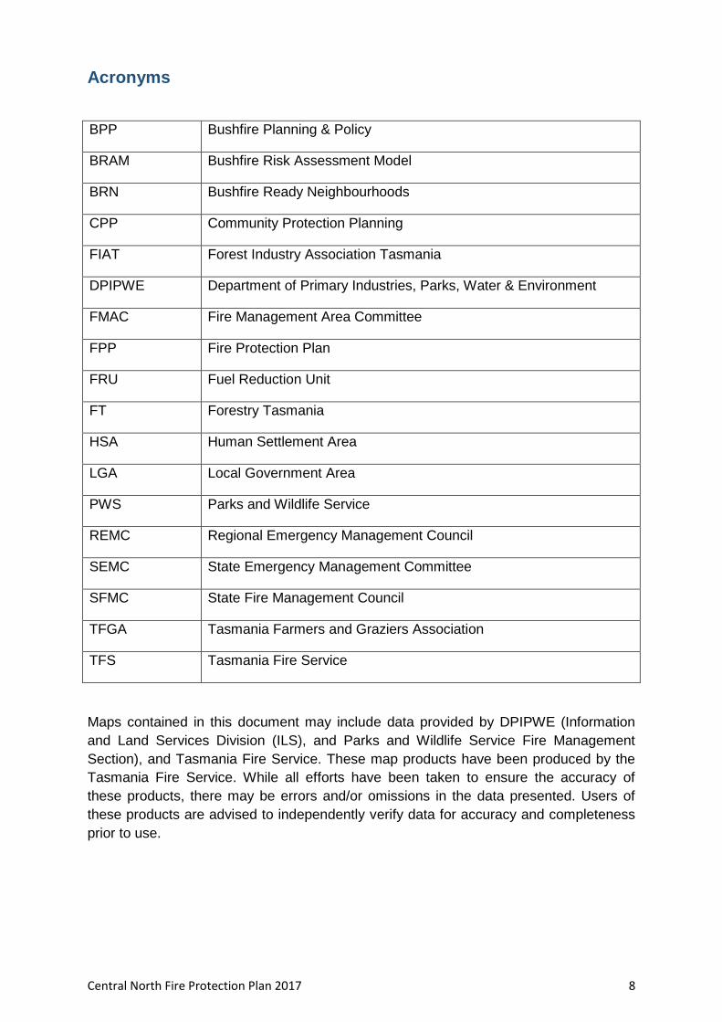
Acronyms
BPP Bushfire Planning & Policy
BRAM Bushfire Risk Assessment Model
BRN Bushfire Ready Neighbourhoods
CPP Community Protection Planning
FIAT Forest Industry Association Tasmania
DPIPWE Department of Primary Industries, Parks, Water & Environment
FMAC Fire Management Area Committee
FPP Fire Protection Plan
FRU Fuel Reduction Unit
FT Forestry Tasmania
HSA Human Settlement Area
LGA Local Government Area
PWS Parks and Wildlife Service
REMC Regional Emergency Management Council
SEMC State Emergency Management Committee
SFMC State Fire Management Council
TFGA Tasmania Farmers and Graziers Association
TFS Tasmania Fire Service
Maps contained in this document may include data provided by DPIPWE (Information
and Land Services Division (ILS), and Parks and Wildlife Service Fire Management
Section), and Tasmania Fire Service. These map products have been produced by the
Tasmania Fire Service. While all efforts have been taken to ensure the accuracy of
these products, there may be errors and/or omissions in the data presented. Users of
these products are advised to independently verify data for accuracy and completeness
prior to use.
Central North Fire Protection Plan 2017 9
Chapter 1 Introduction
1.1 Background
Under Section 20 of the Fire service Act 1979, fire management area committees are
required to submit to SFMC, on an annual basis, a fire protection plan for its fire
management area commencing on 1 October 2014. The submission date was changed
to the 31 December 2016 and beyond
It is a requirement of the fire protection plan that it is consistent with the State Fire
Protection Plan and the State Vegetation Fire Management Policy.
1.2 Aim and Objectives
The management of bushfire related risk is not the sole responsibility of any one land
manager but is a collective responsibility of the whole community. All members within a
community have a responsibility to assist with the management of bushfire risk.
The aim of this FPP is to document the cross tenure process of identifying and treating
bushfire-related risk within the Central North Fire Management Area.
The objective of this FPP is to effectively manage bushfire related risk within the Central
North Fire Management Area in order to protect human life, critical infrastructure assets
and environmental values.
In the first instance, the main objective of fire protection plans is to identify risk and
provide actions for the protection of communities at risk from bushfire. Risk based
planning places the highest priority on protection of human life followed by protecting
infrastructure and environmental values.
Specifically, the objectives of this plan are to:
Guide and coordinate a tenure blind bushfire risk management program over a
five (5) year period;
Document the process used to identify, analyse and evaluate risk, determine
priorities and develop a plan to systematically treat risk;
Facilitate the effective use of the financial and physical resources available for
bushfire risk management activities;
Integrate bushfire risk management into the business processes of Local
Government, land managers and other agencies;
Ensure integration between stakeholders;
Clearly and concisely communicate risk in a format that is meaningful to
stakeholders and the community; and
Monitor and review the implementation of the Plan, to ensure enhancements are
made on an on-going basis.
Central North Fire Protection Plan 2017 10
1.3 Context
South eastern Australia, including Tasmania, is particularly prone to fire and is regarded
as one of the most bushfire-affected regions in the world. Whilst bushfires are part of the
natural ecosystem processes of Tasmania and are essential for the maintenance of
biodiversity, its affects can be catastrophic if uncontrolled. Tasmania has experienced
periodic bushfire events that have caused devastating loss to life and property. In the
aftermath of recent catastrophic bushfire events a heightened focus has been placed on
bushfire risk identification and mitigation.
In recognition of the fact that bushfire is a landscape scale problem, the management of
which is a shared responsibility across all levels of government and both the public and
private arena, changes were made to the Fire Service Act 1979 that align the
administrative responsibility for the management of bushfire fuels across the State. The
fire management area committee (FMAC) structure, membership and committee
boundaries were reviewed and there are now 10 fire management areas for the State.
This reflects a broader landscape approach and strategic focus that is required to
effectively manage and mitigate the risk of bushfire.
The following organisations are represented on Fire Management Area Committees:
Local Councils
Forestry Tasmania
Tasmania Fire Service
Tasmanian Parks and Wildlife
Tasmanian Farmers and Graziers Association
Tasmanian Networks
Hydro Tasmania
Forico
TasWater
Tasmanian Land Conservancy
State Emergency Service
Department of Defence
State Fire Management Council
Natural Resource Management (NRM) organisations
The principal aim of the FMAC’s is to bring together the various stakeholders that
manage land use across the State, to work together to effectively manage vegetation
fuels for the mitigation of bushfires. The principle responsibility of a FMAC is to prepare
a fire protection plan for its Fire Management Area.
Central North Fire Protection Plan 2017 11
1.4 Tenure- blind fire management approach
Recent bushfire events across south eastern Australia have shown the importance of
strategic fuel management regardless of land tenure. The fact that bushfires move
through the landscape with no regard to property boundaries or tenure means that
cooperation is needed across property boundaries between land management agencies
and private property owners and occupiers in order to adequately address the threat of
bushfires in Tasmania.
Over time the focus of fire management activities has largely ended up with government
agencies managing public land. It is evident from recent fire events that focusing
mitigation efforts on public land alone will not be effective in addressing the risk of
bushfires. Managing the risks associated with bushfires will necessitate improving
community understanding and acceptance of the need to use prescribed burning
(together with a range of other treatment options) appropriately on private as well as
public lands.
Central North Fire Protection Plan 2017 12
1.5 Policy, Standards and Legislation
The following policy, standards and legislation were considered to be applicable to the
development and implementation of the FPP:
Tasmanian Emergency Management Plan
State Fire Protection Plan
State Vegetation Fire Management Policy
State Strategic Fuel Management Report
Northern Regional Emergency Management Plan
Municipal Emergency Management Plans
Standards
AS/NZS ISO 31000:2009 - Risk Management – Principles and Guidelines
National Emergency Risk Assessment Guidelines (NERAG)
Legislation
Aboriginal Relics Act 1975
Fire Service Act 1979
Emergency Management Act 2006
National Parks and Reserve Management Act 2002
Nature Conservation Act 2002
Crown Lands Act 1976
Forestry Act 1920 and Tasmanian Forests Agreement Act 2013
Threatened Species Protection Act 1995
Environmental Management and Pollution Control Act 1994
Local Government Act 1993
Forest Practices Act 1985 and Forest Practices Code 2000
Tasmanian Electricity Code
Central North Fire Protection Plan 2017 13
Chapter 2 Establishing the Context
2.1 Description of the Central North Fire Protection Plan Area
2.1.1 Location and Boundaries
The Central North Fire Management Area is located the central north of
Tasmania and covers an area of 550,464 ha. The FMA extends westwards along
the north coast from Badger Head to Heybridge. The southern part of the FMA
extends westward from Golden Valley to the middle of Walls of Jerusalem
National Park.
It encompasses the regional centres of Devonport and Ulverstone in the north,
Sheffield and Deloraine in the southern part of the FMA. Devonport is the
southern terminus for the Spirit of Tasmania ferries which link Tasmania to
Melbourne and is an arrival point for a large number of visitors to Tasmania each
year.
The fire management area contains a mix of fertile agricultural land, wineries,
dispersed rural communities and large areas of national park (including Mole
Creek Karst caves and The Walls of Jerusalem National Park which is part of the
Tasmanian Wilderness World Heritage Area).
The Mersey/Forth valley area (in the central north of the FMA, surrounding the
banks of the Mersey River) produces 40% of Tasmania's vegetable crop with
large areas of land covered by fields of vegetables including onions, potatoes,
peas, carrots and beans and orchard fruits. Other important crops are poppies
(grown for the pharmaceutical industry) and pyrethrum (a botanical insecticide).
A map of the Central North Fire Management Area is contained in Appendix 1.
Central North Fire Protection Plan 2017 14
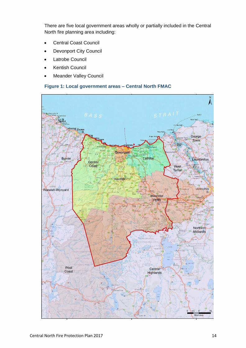
There are five local government areas wholly or partially included in the Central
North fire planning area including:
Central Coast Council
Devonport City Council
Latrobe Council
Kentish Council
Meander Valley Council
Figure 1: Local government areas – Central North FMAC
Central North Fire Protection Plan 2017 15
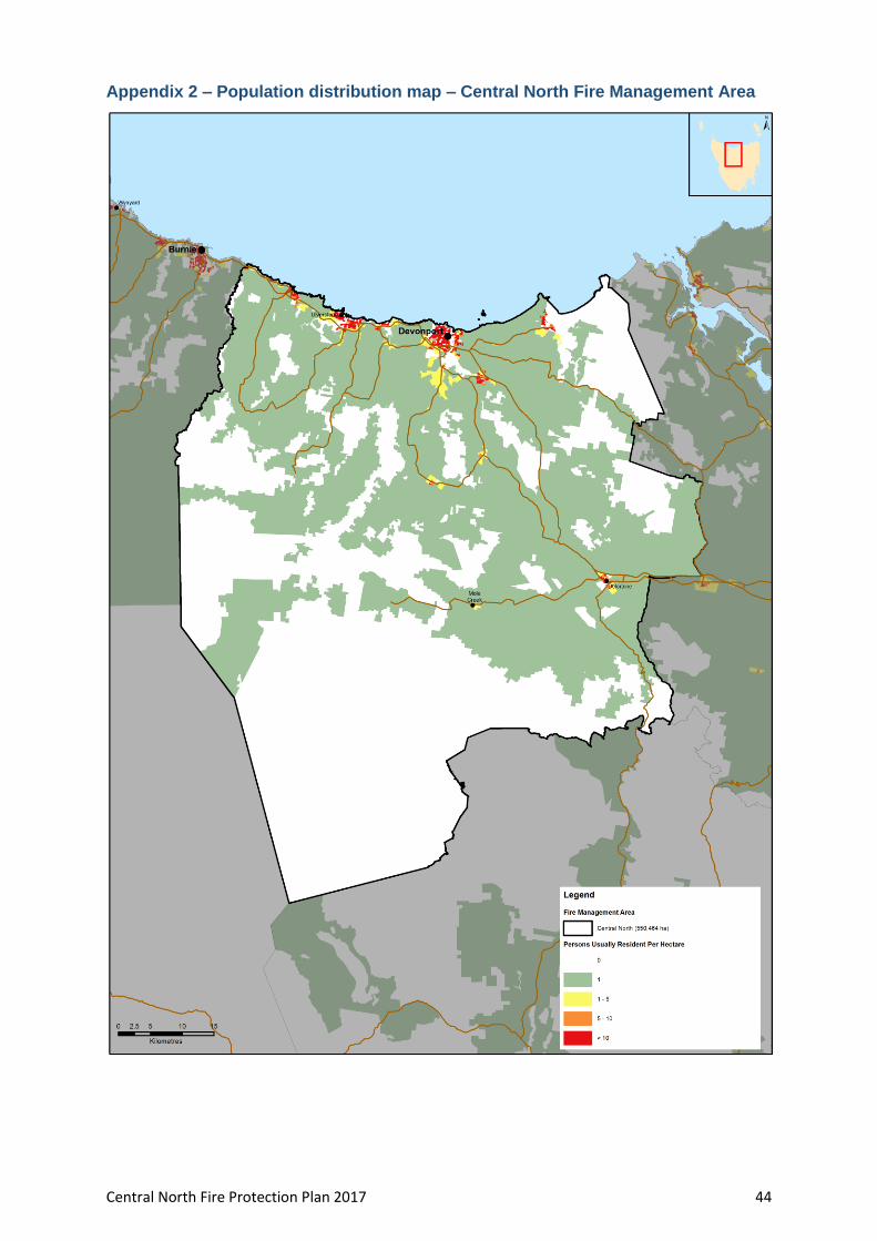
2.1.2 Population and Demographics
The Central North Fire Planning Area has an estimated residential population of
82 000 people.
Devonport, with a population of 24,600 is the major regional centre within the
FMA and the surrounding region. Other significant population centres within the
FMA include:
Ulverstone (population 6,300)
Penguin (population 3,900)
Deloraine (population 2,750)
A map showing the population distribution of the Central North Fire Management
Area is contained in Appendix 2.
Development across the fire management area is centred in the northern
(coastal) areas of the FMA. The rugged topography along the coast has resulted
in ribbon development patterns of settlement east-west along the coast and
inland, north-south along the ridge lines. Significant growth areas in the region
include;
Port Sorell, Shearwater and Hawley areas in Latrobe Council
Latrobe and Devonport have been identified by the Australian Bureau of
Statistics as experiencing population growth. Latrobe was the fastest-growing
Tasmanian LGA in 2010-11, with an increase of 2.3%.
Key industries in the area providing employment include manufacturing, retail,
agriculture, aquaculture, fishing, food and beverages industry. Secondary
industries include:
processing of agricultural products
Tourism is also an important industry.
Significant built infrastructure assets in the region include;
Origin Energy’s LPG Operation at Devonport
the Alinta gas pipeline into Tasmania at Westbury
Central North Fire Protection Plan 2017 16
2.1.3 Land Tenure
Within the Central North FMA, approximately 58% of land is public land and 42%
is private/freehold land. The management of fire risk on private land is a
considerable challenge for the Central North FMA.
A map showing land tenure within the FMA, together with a table containing a
breakdown of land tenure in the Central North Fire Management Area is
contained in Appendix 3.
Land tenure is important when considering how to manage bushfire risk on a
landscape scale. Government agencies responsible for management of the
State’s public land generally have arrangements in place for mitigating bushfire
risk together with the resources and necessary skills for planning for and
responding to bushfire emergencies. Many private property land owners do not
have the resources, skills, knowledge or experience to safely and effectively
manage fire risk on their land. Further compounding the complex issue of
managing fire risk on private land is the fact that it is not co-ordinated or carried
out in a strategic manner.
Management of fire risk on private property
Under the Fire Service Act 1979 private landowners/occupiers in Tasmania, have a number of legal responsibilities in relation to fire management, including undertaking fire maintenance activities to ensure fuels on their property do not pose a risk to neighbouring properties. Privately owned land represents a considerable challenge to the effective management of fire because there are currently some major barriers that limit the extent to which landholders undertake planned burns. These include:
the risk of fire escapes. Privately owned land tends to be where the highest value risk (human lives) are concentrated;
potential liability of property owners from fire escapes;
poor access to good weather/local forecast information;
lack of fire management knowledge, skills and experience;
lack of labour to manage the burn;
lack of appropriate equipment to safely manage the burn;
Absentee land owners - many properties now have owners but not occupiers, for example hobby farms and holiday shack communities.

Central North Fire Protection Plan 2017 17
Other (Tasmania wide) issues:
De-stocking of rural areas - land where fuels were once managed by grazing or occasional burning, are left fallow and weeds or native vegetation fuels accumulate.
Over time, fire preparedness and damage mitigation has given way to a suppression-oriented approach. Communities have become reliant on fire management agencies suppressing fire however suppression is unlikely in extreme bushfire events.
There is an inconsistent approach amongst local Councils in relation to enforcing fire abatement notices and provisions on private property.
There appears to be some concern and confusion in the community about a range of fire related legal issues including vegetation clearing laws, fire permit requirements, backyard burning restrictions and threatened species permit requirements.
Population mobility and ageing. The number of people choosing to live in bush-fire prone areas is increasing. As the population moves in and out of rural areas the knowledge and awareness of people living in bush-fire prone areas diminishes.
Land use planning issues – in some areas residential development continues to be permitted in locations with potentially extreme fire risk.
Central North Fire Protection Plan 2017 18
2.2 Climate and Bushfire Season
The climate of the Central North Fire Management Area can be classified as temperate
and is characterised by warm summers and cold winters in the northern coastal parts of
the fire management area, together with mild summers and cold winters in the southern
parts of the fire management area.
Weather Observations
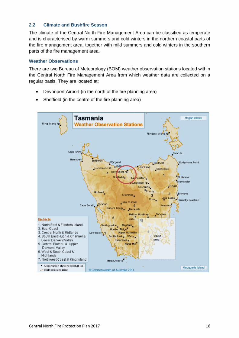
There are two Bureau of Meteorology (BOM) weather observation stations located within
the Central North Fire Management Area from which weather data are collected on a
regular basis. They are located at:
Devonport Airport (in the north of the fire planning area)
Sheffield (in the centre of the fire planning area)

Central North Fire Protection Plan 2017 19
Summary Climate Statistics – Central North FMA
Mean Annual rainfall Ranges from 778mm at Devonport Airport in the northern
part of the fire management area to 1179mm in Sheffield in
the central part of the fire management area.
Wettest months Winter. Devonport receives a July average of 95mm with Sheffield recording a July average of 157mm of rain.
Driest Months Summer. Devonport receives a February average of 37mm of rain with Sheffield recording a January mean rainfall of 52mm.
Windiest Months Summer
Months of least wind June
Cloudiest Month May. Devonport has a mean number of 14 cloudy days in May and Sheffield has a mean number of 13 cloudy days in May
Temperature and rainfall
Average maximum daily temperatures within the FMA range from 21.5⁰ at Sheffield in
February to 21.6⁰ in February at Devonport Airport.
Devonport has an average minimum temperature of 4.1⁰ in July with Sheffield having
an average minimum of 2.5⁰ in July.
The fire management area has a winter dominant seasonal rainfall pattern with wet
winters and low summer rainfall. Average monthly rainfall within the FMA ranges from a
low of 36mm in January in Devonport to a high of 158 mm average monthly rainfall in
Sheffield in July. The peak of the rainfall cycle in the central north occurs through
autumn to winter. The north receives shorter duration rainfall events than the west, in
mid to late autumn from moist north-easterly airstreams. Winter is the wettest season
due to the influence of passing cold frontal systems on the area.
The area has low thunderstorm and lightning activity with an average of 5 thunder days
annually.

Central North Fire Protection Plan 2017 20
Figure 2: Mean annual rainfall across Tasmania Fire Management Areas.
Source: Map provided by Ian Barnes-Keogan, Bureau of Meteorology, Hobart
Wind
The prevailing winds for the area are generally from the west and northwest. Summer is
the windiest season with winds from the northwest increasing in the afternoons.
Bushfire season
A fire season is defined as the period of time in which fires are most likely to occur. Fire
seasons can vary geographically and temporally. Bushfires in Tasmania are most
commonly associated with dry conditions during summer and autumn extreme fire
conditions are not uncommon during seasons dominated by drought. Equally, fires may
occur after a short period of extreme bushfire weather that follows generally dry
conditions. The fire season in the northern region of Tasmania extends from August to
April. The fire season of the study area is generally considered to be from September to
March.
The bushfire threat for the Central North Fire Management Area increases in late December with December/January generally being the driest and hottest months when bushfires are more difficult to control.
Central North Fire Protection Plan 2017 21
2.3 Vegetation
The vegetation within a large portion of the Central North FMA has been highly modified
for agriculture resulting in the dominant vegetation type consisting of non-native
agricultural, urban and exotic vegetation. The second most common vegetation type
within the FMA consists of highly flammable dry eucalypt forest and woodland.
The main vegetation associations in Tasmania have been mapped by the TasVeg
mapping program. For the purposes of fire management, the complex vegetation
associations used in TasVeg have been simplified into 21 types and fire-attributes (fire
sensitivity and flammability ratings) have been developed for each type.
The broad native vegetation types and native forest communities occurring within the planning area include:
Dry eucalypt forest and woodland;
Wet eucalypt forest and woodland;
Rainforest and related scrub;
Highland and treeless vegetation;
Non eucalypt forest and woodland;
Other natural environments;
Scrub, heathland and coastal complexes;
Moorland, sedgeland, rushland and peatland;
Native grassland;
Satlmarsh and wetland
Non native vegetation types occurring within the planning area include:
Agricultural, urban and exotic vegetation.
Broad Vegetation Group (TasVeg 3, 2013)
(ha) % in FMA Veg Flammability
Agricultural, urban and exotic vegetation 190152 34.6 Medium
Dry eucalypt forest and woodland 129957 23.7 Medium -High
Wet eucalypt forest and woodland 107994 19.7 Medium
Rainforest and related scrub 39323 7.2 Low
Highland and Treeless Vegetation 19708 3.6 High
Non eucalypt forest and woodland 17596 3.2 High
Other natural environments 14288 2.6 N/A
Scrub, heathland and coastal complexes 12641 2.3 High – very high
Moorland, sedgeland, rushland and peatland
10715 2.0 Low – very high
Native grassland 6472 1.2 High
Saltmarsh and wetland 649 0.1 Low
Total 549496 100
A description of each of the broad vegetation community types contained in the
TASVEG mapping dataset and found in the Central North FMA is contained in Appendix
4.
Central North Fire Protection Plan 2017 22
2.4 Bushfire Frequency and Causes of Ignition
Fire frequency is defined as the total number of fires that occurred over a period of time.
Fire frequency records for the Central North Fire Management Area have been obtained
from records kept by the Tasmania Fire Service, Parks and Wildlife Service and Forestry
Tasmania but are incomplete. Data for fires on private property is particularly lacking.
Records that are available indicate that the vast majority (98%) of the fire management
area has been untouched by fire in recent years. Only a very small percentage (1.7%) of
the Fire Management Area is noted as having been subject to fire at least once in recent
years. Less than 0.5% of the fire management area has been subject to more than 2 or
3 fires at the same location.
Major Fire events in the Central North FMA
Fire name Year Area Burnt
(ha)
Lake Mackenzie Complex
(including Lake Bill)
2016 26109
Dunnings Rvt 1989 1943
Briggs Regional Reserve 2009 1794
Mt Roland 1991 626
Fire Ignition Cause and History
The true causes of fire, either through ignition by lightning or caused by human actions
have not been well documented. TFS does not keep records relating to fire ignition
causes and the causes of fire have only been documented by Tasmanian Parks and
Wildlife since the 1980s.
Of the 126 fires where ignition sources were recorded within the fire management area,
the majority of fires (35.9%) were started by arson, 10.6% were caused by escaped
planned burns, 3.5% were accidental, 1.8% were caused by lightning and in 14.8% of
cases a cause was undetermined.
Central North Fire Protection Plan 2017 23
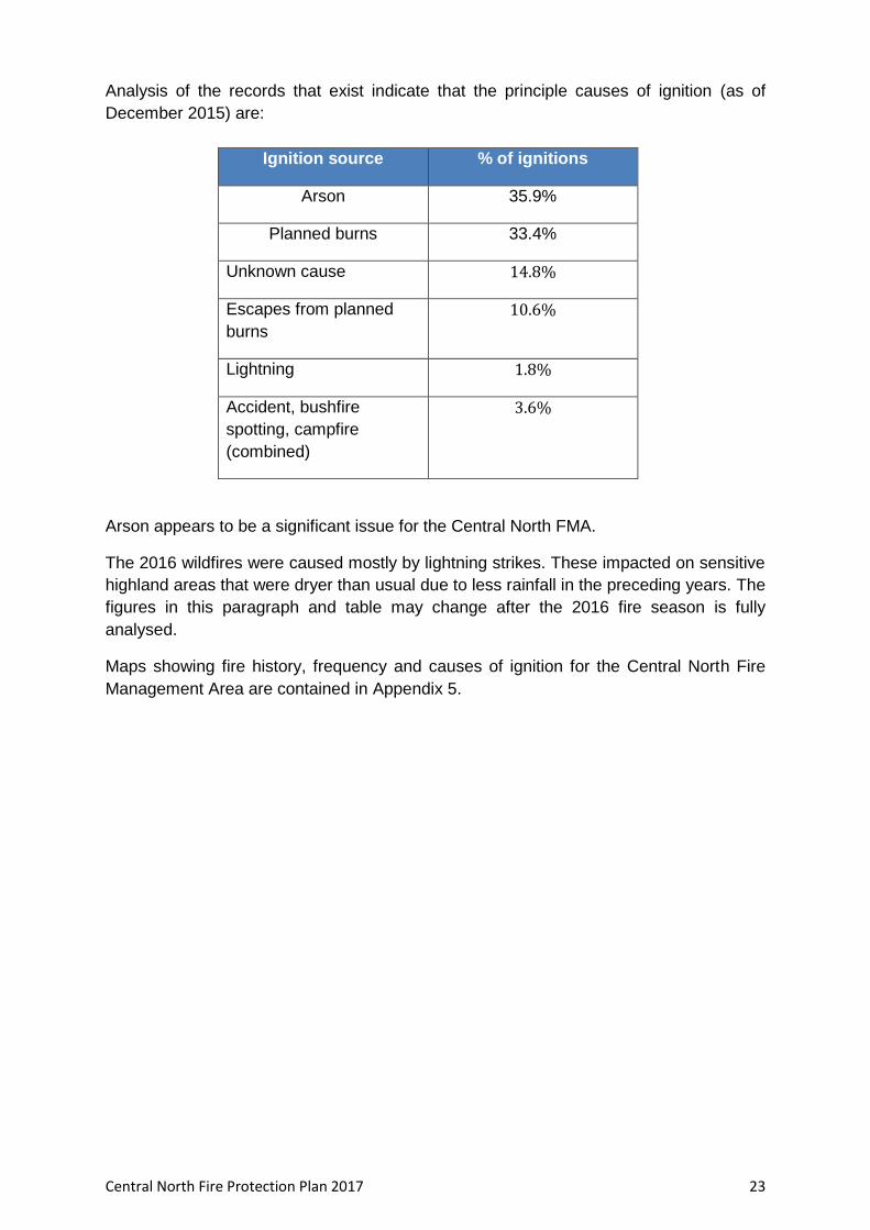
Analysis of the records that exist indicate that the principle causes of ignition (as of
December 2015) are:
Ignition source % of ignitions
Arson 35.9%
Planned burns 33.4%
Unknown cause 14.8%
Escapes from planned
burns
10.6%
Lightning 1.8%
Accident, bushfire
spotting, campfire
(combined)
3.6%
Arson appears to be a significant issue for the Central North FMA.
The 2016 wildfires were caused mostly by lightning strikes. These impacted on sensitive
highland areas that were dryer than usual due to less rainfall in the preceding years. The
figures in this paragraph and table may change after the 2016 fire season is fully
analysed.
Maps showing fire history, frequency and causes of ignition for the Central North Fire
Management Area are contained in Appendix 5.
Central North Fire Protection Plan 2017 24
Chapter 3 Analysing and Evaluating Bushfire Risk
3.1 Analysing Bushfire Risk
Following the Australian Standard of risk (ISO 3100) bushfire risk has been considered
spatially, assessing a combination of likelihood and consequence (PWS 2011). The
Bushfire Risk Assessment Model (BRAM), model data run of November 2013 was used
to analyse the landscape level risk for this plan. For a full analysis of the model, see
Appendix 6.
To determine overall risk the NERAG (National Emergency Risk Assessment Guidelines
August 2010) document (see Appendix 7) was used. The level of risk is determined by
combining consequences and likelihood (see Appendix 7).
It must be noted that the BRAM and therefore the consequences, likelihood and risk
outputs are based on available spatial data. The analysis has been undertaken on a
statewide basis, and maps are presented as complete for Tasmania. There are however
gaps in the data inside and outside areas of public land. This includes fire history
information, particularly on private land, which contributes to ignition potential
information (likelihood), and many of the agricultural values have not been well captured
(consequence). Notwithstanding these limitations, the model does provide an objective
spatial analysis of bushfire risk in a landscape context.
3.2 Likelihood
Likelihood is defined as a qualitative method to assess the likelihood rating to the
consequences occurring. The likelihood of an event was generated by calculating
ignition potential, suppression capabilities and fire behaviour potential, followed by
assigning these output values to categories in a likelihood matrix. This is taken to mean
the likelihood of a fire occurring in a specific area which surpasses the ability of the fire
agencies to contain within the first 24 hours.206
Central North Fire Protection Plan 2017 25
3.3 Consequence (values at risk)
Consequences are defined as a qualitative rating of damage from fire to values. The
consequences were taken directly from the output generated through the Values at Risk
spatial layer output in BRAM.
Values at Risk
Agricultural values of particular significance to the Central North FMA:
seed crops such as cereals, pulses, oil seed and small seeds (i.e. pasture and vegetable seed crops) become flammable as they ripen, and the closer to harvest the worse the fire danger becomes
orchards and vineyards although not normally regarded as flammable, can be severely damaged if the weather and fire are sufficiently hot. They can be considered high risk due to the time and investment required to establish an orchard or vineyard to production stage and subsequently the time required to re-establish following destruction or damaging fire events.
vineyards can be subject to smoke taint which seriously de-values wine and can render it unsaleable.
Other values that need to be understood when examining risk include the critical
infrastructure present.
Critical infrastructure within the Central North FMA includes:
Radio Communications Towers at Kelcey Tier, Mt Claude and Dazzler Range
TasNetworks feeder lines at Woolnorth and Pieman
Orica storage facilities at Heybridge and Dulverton
Assets of particular importance to the community include:
Cradle Mountain Lodge and Village (iconic tourism location which generates a significant source of income for the region and for Tasmania)
Weegena Community hall (a central meeting place for the community)
Historic mountain huts in the Western Tiers
Petuna Seafood plant at Parramatta Creek
3.4 Overall Risk
A representation of risk (see Appendix 6) is developed when you combine the factors of
likelihood and consequence. The BRAM generated output map of risk shows qualitative
areas of risk, not areas of perceived risk.
The model assists in objectively defining areas where genuine risk is present. In-depth
analysis will indicate what factor is driving the risk for a given area.
3.5 Risk Analysis for the Central North Fire Management Area
The bushfire risk model BRAM was utilised to examine risk across the fire management
area. The results of this risk analysis are contained in a series of maps (BRAM - Bushfire
Risk Assessment Model Maps) showing likelihood of ignition, consequences and overall
risk within the Central North FMA in Appendix 8. The BRAM overall risk analysis results
for the Central North FMA are shown overleaf in Figure 3.
Central North Fire Protection Plan 2017 26
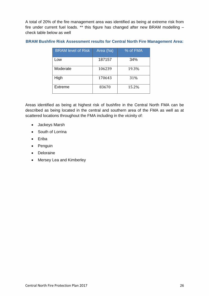
A total of 20% of the fire management area was identified as being at extreme risk from
fire under current fuel loads. ** this figure has changed after new BRAM modelling –
check table below as well
BRAM Bushfire Risk Assessment results for Central North Fire Management Area:
BRAM level of Risk Area (ha) % of FMA
Low 187157 34%
Moderate 106239 19.3%
High 170643 31%
Extreme 83670 15.2%
Areas identified as being at highest risk of bushfire in the Central North FMA can be
described as being located in the central and southern area of the FMA as well as at
scattered locations throughout the FMA including in the vicinity of:
Jackeys Marsh
South of Lorrina
Eriba
Penguin
Deloraine
Mersey Lea and Kimberley

Central North Fire Protection Plan 2017 27
Figure 3 – BRAM Overall Risk analysis results – Central North FMA

Central North Fire Protection Plan 2017 28
3.6 Phoenix Ignition Points Modelling
In addition to BRAM modelling, Phoenix Rapidfire, a bushfire simulator, developed by
the University of Melbourne (Kevin Tolhurst and Derek Chong, 2008) was used to model
the risk of fires impacting on communities present in the FMA. An understanding of the
location of potential ignition points that may impact on communities is crucial. This
modelling was done as part of the state wide strategic fuel management assessment.
The process involved modelling potential ignition points, incorporating worst case
scenario weather patterns and examining fire behaviour based on current fuel loads to
identify the potential impact on human settlement areas.
A map showing the location of potential ignition points that may impact on communities
in the Central North FMA under current fuel loads is contained in Appendix 9.
The Phoenix modelling indicates that within the Central North FMA ignition points of
potential concern (and possibly requiring risk mitigation activities) are located:
South of Forth
West of Spreyton
South of Meander
South west and north west of Deloraine
North East of West Pine
East and south of Devonport
It must be understood that such analysis has many limitations but does provide an
indication of where communities may be under risk as well as identify areas where
strategic burning will assist in changing fire behaviour.
Central North Fire Protection Plan 2017 29
3.7 Community Risk Assessment
Strategic assessment tools (including BRAM and Phoenix computer modelling) have
been used to conduct a broad scale assessment across the Central North Fire
Management Area to identify communities vulnerable to bushfire. A more detailed
assessment using more locally specific processes was then conducted by members of
the FMAC.
Tools that were used by the FMAC to identify communities vulnerable to bushfire include:
Consultation of Council and Emergency Services Risk Registers
Mersey District Bushfire Treatment Strategy
Local knowledge obtained from Tas Fire Service District Officers and Brigades
BRAM Risk rating for Central North Human Settlement Areas
Phoenix modelled impacts
Consultation with Tasmania Fire Service Community Protection Planners and Community Development Officers
Expert opinion of fire practitioners
Identification and consideration of existing and past fire management actions and plans
Communities nominated in 2014 by the Tasmania Fire Service District Officer as being high risk within the fire management area included:
Heybridge
Squeaking Point
Summer Hill Park (Port Sorell)
Lorinna
Rubicon
Clayton Valley Stubbs Rd. (Turners Beach)
Pitcairn Reserve (Port Sorell)
Cradle Valley
Don Reserve (Devonport)
Kelcey Tier (Devonport)
Priorities identified in the Mersey District Bushfire Strategy include:
• Don Reserve (Devonport)
• Kelcey Tier (Devonport)
• Sykes Sanctuary/Railton Urban Interface
• Lorinna
• Squeaking Point
• Dooley’s Hill
Central North Fire Protection Plan 2017 30
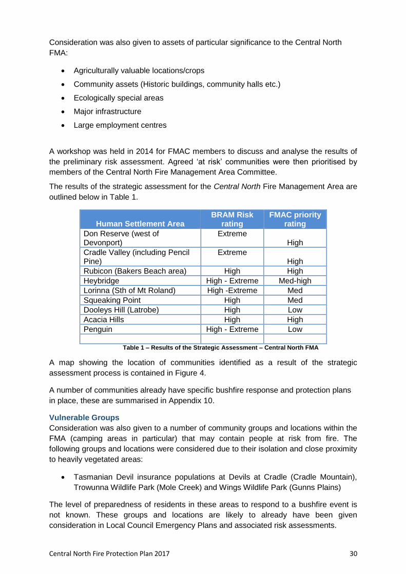
Consideration was also given to assets of particular significance to the Central North
FMA:
Agriculturally valuable locations/crops
Community assets (Historic buildings, community halls etc.)
Ecologically special areas
Major infrastructure
Large employment centres
A workshop was held in 2014 for FMAC members to discuss and analyse the results of
the preliminary risk assessment. Agreed ‘at risk’ communities were then prioritised by
members of the Central North Fire Management Area Committee.
The results of the strategic assessment for the Central North Fire Management Area are
outlined below in Table 1.
Human Settlement Area BRAM Risk
rating FMAC priority
rating
Don Reserve (west of Devonport)
Extreme High
Cradle Valley (including Pencil Pine)
Extreme High
Rubicon (Bakers Beach area) High High
Heybridge High - Extreme Med-high
Lorinna (Sth of Mt Roland) High -Extreme Med
Squeaking Point High Med
Dooleys Hill (Latrobe) High Low
Acacia Hills High High
Penguin High - Extreme Low
Table 1 – Results of the Strategic Assessment – Central North FMA
A map showing the location of communities identified as a result of the strategic
assessment process is contained in Figure 4.
A number of communities already have specific bushfire response and protection plans
in place, these are summarised in Appendix 10.
Vulnerable Groups
Consideration was also given to a number of community groups and locations within the
FMA (camping areas in particular) that may contain people at risk from fire. The
following groups and locations were considered due to their isolation and close proximity
to heavily vegetated areas:
Tasmanian Devil insurance populations at Devils at Cradle (Cradle Mountain),
Trowunna Wildlife Park (Mole Creek) and Wings Wildlife Park (Gunns Plains)
The level of preparedness of residents in these areas to respond to a bushfire event is
not known. These groups and locations are likely to already have been given
consideration in Local Council Emergency Plans and associated risk assessments.

Central North Fire Protection Plan 2017 31
Figure 4 – Areas Identified in FPPs for Mitigation Activities

Central North Fire Protection Plan 2017 32
Figure 5 – Communities identified during strategic assessment process - Central North FMA
Central North Fire Protection Plan 2017 33
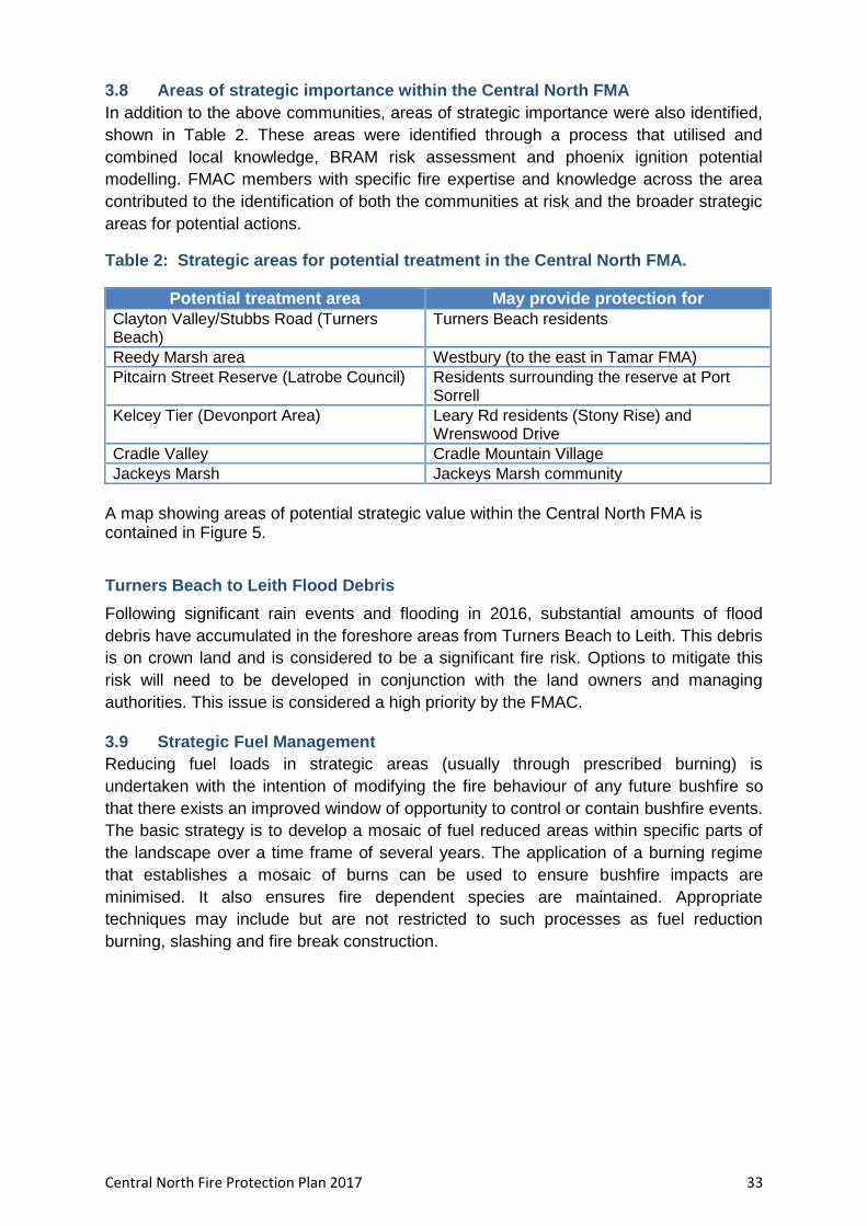
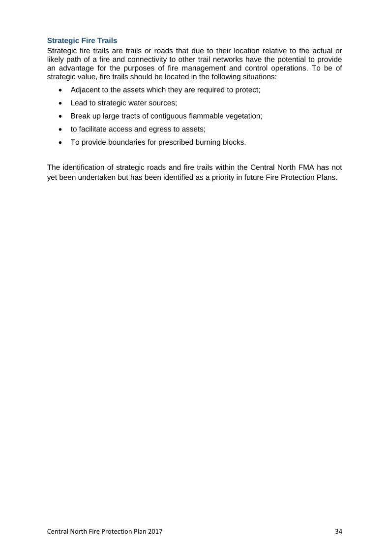
3.8 Areas of strategic importance within the Central North FMA
In addition to the above communities, areas of strategic importance were also identified,
shown in Table 2. These areas were identified through a process that utilised and
combined local knowledge, BRAM risk assessment and phoenix ignition potential
modelling. FMAC members with specific fire expertise and knowledge across the area
contributed to the identification of both the communities at risk and the broader strategic
areas for potential actions.
Table 2: Strategic areas for potential treatment in the Central North FMA.
Potential treatment area May provide protection for
Clayton Valley/Stubbs Road (Turners Beach)
Turners Beach residents
Reedy Marsh area Westbury (to the east in Tamar FMA)
Pitcairn Street Reserve (Latrobe Council) Residents surrounding the reserve at Port Sorrell
Kelcey Tier (Devonport Area) Leary Rd residents (Stony Rise) and Wrenswood Drive
Cradle Valley Cradle Mountain Village
Jackeys Marsh Jackeys Marsh community
A map showing areas of potential strategic value within the Central North FMA is contained in Figure 5.
Turners Beach to Leith Flood Debris
Following significant rain events and flooding in 2016, substantial amounts of flood
debris have accumulated in the foreshore areas from Turners Beach to Leith. This debris
is on crown land and is considered to be a significant fire risk. Options to mitigate this
risk will need to be developed in conjunction with the land owners and managing
authorities. This issue is considered a high priority by the FMAC.
3.9 Strategic Fuel Management
Reducing fuel loads in strategic areas (usually through prescribed burning) is
undertaken with the intention of modifying the fire behaviour of any future bushfire so
that there exists an improved window of opportunity to control or contain bushfire events.
The basic strategy is to develop a mosaic of fuel reduced areas within specific parts of
the landscape over a time frame of several years. The application of a burning regime
that establishes a mosaic of burns can be used to ensure bushfire impacts are
minimised. It also ensures fire dependent species are maintained. Appropriate
techniques may include but are not restricted to such processes as fuel reduction
burning, slashing and fire break construction.
Central North Fire Protection Plan 2017 34
Strategic Fire Trails
Strategic fire trails are trails or roads that due to their location relative to the actual or likely path of a fire and connectivity to other trail networks have the potential to provide an advantage for the purposes of fire management and control operations. To be of strategic value, fire trails should be located in the following situations:
Adjacent to the assets which they are required to protect;
Lead to strategic water sources;
Break up large tracts of contiguous flammable vegetation;
to facilitate access and egress to assets;
To provide boundaries for prescribed burning blocks.
The identification of strategic roads and fire trails within the Central North FMA has not
yet been undertaken but has been identified as a priority in future Fire Protection Plans.
Central North Fire Protection Plan 2017 35
Figure 6 – Areas of potential strategic value for mitigation activities – Central North FMA

Central North Fire Protection Plan 2017 36
Chapter 4 Bushfire Risk Treatment
4.1 Region Wide Controls
The following controls are currently in place across the Central North Fire Management
Area to assist in the strategic management of bushfire related risk:
Legislative controls – including abatements, fire restrictions etc.
Public education campaigns and the use of TFS and SFMC state-wide programs tailored to suit local needs; (eg Private land burning; Community Protection Planning; Bushfire Ready Neighbourhoods)
State-wide arson prevention programs developed in conjunction with TAS Police and TFS;
Setting of appropriate land subdivision and building standards in line with State Bushfire Prone Area Building Standards;
Performance monitoring and reporting of FPP outcomes to the relevant Emergency Management Council and State Fire Management Council as required by the Tasmanian Emergency Management Plan and the Fire Service Act
4.2 Asset Specific Treatment Strategies
There are five broad asset specific treatment strategies that have been used to manage
the bushfire risks identified in the Community Risk Assessment. They include:
Fuel management – Treatments include the reduction / modification of bushfire fuels through manual, chemical and prescribed burning methods;
Ignition management - Treatments aim to reduce the occurrence of human induced ignitions in the landscape;
Preparedness – Treatments focus on providing suitable access and water supply arrangements that will assist with firefighting operations;
Planning – Treatments relate to the development of plans that will improve the ability of firefighters and the community to respond to bushfire; and
Community Engagement – Treatments seek to build relationships, raise awareness and change behaviours relating to the management of bushfire related risks within the community.
4.3 Planned burning – treatable and untreatable locations:
Strategic fuel reduction burning is one treatment option with the potential to reduce risk
to some communities throughout the FMA.
In Tasmania, only certain types of vegetation are suitable for planned burning, for
example dry eucalypt forest, scrub, heathland and button grass. These are what can be
called ‘treatable’ vegetation types. Other vegetation types are unsuitable for planned
burning either because they are too wet to burn (such as sphagnum, swamp and
wetland), are extremely fire sensitive (rainforest, alpine/sub alpine coniferous heathland)
or have other characteristics such as land which is unvegetated or vegetation growing in

Central North Fire Protection Plan 2017 37
urban areas which make them unsuitable for planned burning. These unsuitable
vegetation types are considered ‘non-treatable’ for planned burning purposes.
Agricultural lands, whilst susceptible to the impact of bushfire, are also considered ‘non -
treatable’ due to the land use priority for these vegetation types. This does not preclude
these areas from burning however it means this area of land use type is not being
included in the analysis of treatable and untreatable vegetation.
The main vegetation associations in Tasmania have been mapped by the TasVeg
mapping program. For the purposes of fire management, the complex vegetation
associations used in TasVeg have been simplified into 21 types and fire-attributes have
been developed for each type.
Approximately 41% of the area of Tasmania (or 2,760,222 ha) is covered by vegetation
types suitable for planned burning.
Within the Central North Fire Planning Area a total of 121,005 ha (or 22% of the total
area) has been categorised as Treatable. The remaining 76% of the fire planning area
(417,928 ha) has been classified as untreatable.
Fuel Reduction Burning Treatability in Central North FMAC Area
(ha) (%)
Treatable 121005 22
Un-treatable 285240 51.8
Agricultural Land* (Untreatable by fire) 132687 24.1
Water 10325 1.9
Not Mapped 1206 0.2
100.0 * Classified in TASVEG2 as 'FAG' (agricultural landscapes where there are crops, pasture or orchards)
A map and summary table showing treatability of land within the Central North FMA is
contained in Appendix 11.
4.4 Treatment options other than burning
In areas classified as untreatable by planned burning the risk of fire may still be mitigated through a range of other activities including:
Mechanical fuel removal (slashing and mulching, mowing, trittering, poison spraying)
Fire trail maintenance and construction of strategic fire breaks (grading/dozing)
Intensive or ‘crash’ grazing of blocks by livestock including goats
Weed control
The creation of fuel modified zones (fuel reduced zones) around structures and assets
Planning conditions and restrictions in areas adjoining heavily vegetated land
Bushfire resistant building design and construction materials for new developments
Individual property bushfire readiness preparation prior to each fire season

Central North Fire Protection Plan 2017 38
4.5 Bushfire risk mitigation programs – other agencies
A number of land management agencies including Parks and Wildlife Service Tasmania,
Forestry Tasmania, local Councils and private enterprises such as Forico have annual
planned burning programs, including joint tenure burns and operations.
A map showing planned burning operations for 2016/17 on PWS and Forestry Tasmania
managed estate within the FMA is provided in Figure 6.
Many other planned burns have not been captured in the current Fire Protection Plan
process. Landscape-scale based fire planning and management will become more
effective when all of these planned burns are documented and mapped for use in future
Fire Protection Plans.
In addition, other organisations including local councils, TasNetworks, Hydro Tasmania
and TasWater have annual or cyclic programs which aim to mitigate risk from fire
through activities including line trimming, mowing, slashing and fire trail and fire break
maintenance.
A comprehensive map showing the location of the entire range of mitigation activities
currently carried out or planned for the future within the FMA will assist in developing a
co-ordinated approach to landscape scale fire risk mitigation in future Fire Protection
Plans.
Other fire related management programs and reports:
A number of current and historic fire management plans and fire related reports have
already been prepared for use within the Central North FMA. A list of these plans is
contained in Appendix 12 but the list is incomplete.

Central North Fire Protection Plan 2017 39
4.6 Treatment Selection and Priorities
Following identification and agreement upon priority communities and potential strategic areas for fire mitigation treatment within the Central North FMA an annual implementation program was developed. The Implementation Program identifies proposed treatment strategies and actions to be undertaken within the Central North FMA for:
Priority communities
Potential Strategic fuel management blocks
Important community assets
Strategic fire trails
The Implementation Program also identifies priority locations and actions that are
currently unfunded but that could potentially reduce fire risk within the FMA should
funding become available.
The implementation program contains proposed treatment strategies and actions to be
undertaken within the 12 months following submission of the Fire Management Plan to
the State Fire Management Council.
The Implementation Program for the Central North FMA is contained in Appendix 13.
4.7 Annual Implementation Program
The 2016/17 Implementation Program for the Central North FMA is identified in Appendix 13. The implementation program will be coordinated by the Fire Management Area Committee (FMAC) which will also liaise with relevant land managers (including private property owners) to implement the risk mitigation strategies. The FMAC will liaise with the State Fire Management Council to develop a strategy to address funding and resourcing requirements for works associated with the identified risk mitigation actions and program. 4.8 Implementation
When the treatments identified in this FPP are implemented there are a number of issues that need to be considered by the responsible agencies and land owners including;
environmental impact
prescribed burn plans and approvals
smoke management
Community consultation
Community partnerships

Central North Fire Protection Plan 2017 40
Chapter 5 Monitoring and Review
Monitoring and review processes are in place to ensure that the FPP remains current
and valid. These processes are detailed below to ensure outcomes are achieved in
accordance with the Implementation Program.
5.1 Review
Fire Protection Plans, including appendices are to be submitted annually for each fire
management area and will be subject to a comprehensive review every five (5) years
from the date of approval, unless significant circumstances exist to warrant earlier
review. This would include:
Changes to the FPP area, organisational responsibilities or legislation;
Changes to the bushfire risk in the area; or
Following a major fire event.
The Community Risk Assessments contained in this FPP should be reviewed annually.
5.2 Monitoring
The Implementation Program at Appendix 13 is a living document and progression
towards completion of the treatments will be monitored and reviewed at least every six
(6) months, during FMAC meetings. The Implementation Program will be updated as
treatments are progressed and completed.
5.3 Reporting
A report detailing progress towards implementation of this FPP will be provided annually.

Central North Fire Protection Plan 2017 41
References Parks and Wildlife Service (unpublished). Bushfire Risk Assessment Model Project
Business Process Model (2008). Department of Primary Industries, Parks, Water and
Environment, Hobart.
Parks and Wildlife Service (unpublished). Tasmanian Bushfire Risk User Guide (2010).
Department of Primary Industries, Parks, Water and Environment, Hobart.
Parks and Wildlife Service (unpublished). Tasmanian Bushfire Risk Assessment Model
V (2013). Department of Primary Industries, Parks, Water and Environment, Hobart.
National Emergency Management Committee (2010), National Risk Assessment
Guidelines, Emergency Tasmanian State Emergency Service, Hobart.
Forest Practices Authority (2005). Forest Botany Manual. Forest Practices Authority,
Tasmania.
Harris, S and Kitchener, A (2013). From Forest to Fjaeldmark: Descriptions of
Tasmania's Vegetation. (Edition 2) Department of Primary Industries, Parks, Water and
Environment, Printing Authority of Tasmania. Hobart.
Taylor, D and Wallace, L (2011) Bushfire Risk Assessment Model. AFAC & Bushfire
CRC Conference paper.
Marsden-Smedley JB 2009. Planned Burning in Tasmania: operational guidelines and
review of current knowledge. Fire Management Section, Parks and Wildlife Service,
Department of Primary Industries, Parks, Water and Environment, Hobart, Tasmania.
Parks and Wildlife Service (2009) Northern Region Strategic Fire Management Plan.
Department of Primary Industries, Parks, Water and Environment, Hobart.
Tolhurst, K.G., Shields, B.J. and Chong, D.M (2008) PHOENIX: development and
application of a bushfire management tool. Australian Journal of Emergency
Management, 23 (4), 47 -57.
State Fire Management Council (2014). Bushfire in Tasmania: A New Approach to
Reducing Our Statewide Relative Risk. Department of Police and Emergency
Management, Hobart.

Central North Fire Protection Plan 2017 42
Appendices
Appendix 1 Map of Central North Fire Management Area Boundary
Appendix 2 Population distribution map – Central North Fire Management Area
Appendix 3 Tenure map and Tables
Appendix 4 Vegetation Map and TasVeg community descriptions
Appendix 5 Fire Frequency, History and Ignition Causes maps
Appendix 6 BRAM (Bushfire Risk Assessment Model) explanation
Appendix 7 NERAG risk assessment approach
Appendix 8 Bushfire Risk Assessment Maps – Likelihood, Consequence, Overall
Risk
Appendix 9 Phoenix Ignition Points
Appendix 10 Community with specific plans already in place
Appendix 11 Treatability of land within the Central North FMA
Appendix 12 List of fire management related documents for the Central North Fire
Management Area
Appendix 13 Annual Implementation Program – Central North

Central North Fire Protection Plan 2017 43
Appendix 1 – Map of Central North Fire Management Area Boundary
Central North Fire Protection Plan 2017 44
Appendix 2 – Population distribution map – Central North Fire Management Area

Central North Fire Protection Plan 2017 45
Appendix 3 – Tenure map and Tables

Central North Fire Protection Plan 2017 46

Central North Fire Protection Plan 2017 47
Total FMAC Area (ha) 550464
Public (ha) (%)
Authority Crown 271 0.0
Authority Freehold 649 0.1
Casement 5699 1.0
Commonwealth 8 0.0
Conservation Area 30409 5.5
Conservation Covenant 3124 0.6
Crown Land 2554 0.5
Crown Lease or Licence 534 0.1
Forest Reserve 23429 4.3
HEC Conservation Area 672 0.1
Hydro-Electric Corporation 3472 0.6
LGA Conservation Area 6 0.0
Local Government 1126 0.2
Local Government Act Reserve 68 0.0
National Park 87708 15.9
Nature Recreation Area 9154 1.7
Nature Reserve 255 0.0
Public Reserve 1686 0.3
Regional Reserve 12690 2.3
State Forest 130141 23.6
State Reserve 3201 0.6
No Tenure 2656 0.5
Total Public 319512 58
Private (ha) (%)
Private Freehold 230502 41.9
Private Nature Reserve 341 0.1
Private Sanctuary 109 0.0
Total Private 230952 42

Central North Fire Protection Plan 2017 48
Appendix 4 – Vegetation Map and TasVeg community descriptions

Central North Fire Protection Plan 2017 49
Description of each of the broad vegetation community types contained in the TASVEG
mapping dataset and found in the Central North Fire Management Area:
Agricultural, urban and exotic vegetation:
This broad vegetation group is mainly non-native vegetation and includes agricultural
land, marram grassland, Spartina marshland, plantations for silviculture, regenerating
cleared land, urban areas and weed infested areas. It also includes Pteridium
esculentum fernland which is dominated by the native bracken fern, and Permanent
easements, which may be occupied by native vegetation.
Dry sclerophyll (eucalypt) forest and woodland:
Dry sclerophyll forests and woodlands are typically dominated by eucalypts under 40 m
in height, and have a multi-layered understorey dominated by hard-leaved shrubs,
including eucalypt regeneration. Dry sclerophyll forests are mainly found on dry, infertile
and exposed sites and are largely confined to coastal areas.
Wet Sclerophyll Forest communities:
Wet sclerophyll forests are typically dominated by eucalypts and have an understorey
dominated by broad-leaved (soft-leaved) shrubs. Trees in mature forest generally
exceed 40 m in height. Wet sclerophyll forests typically contain only one or two eucalypt
age classes - these relate to period since fire or other major disturbance (including
intensive logging and regeneration burning). Often only one species of eucalypt is
present. The shrub understorey is dominated by broad-leaved shrubs and is generally
dense, preventing continuous regeneration of shade-intolerant species such as
eucalypts. Ferns are often prominent in the ground layer. Wet sclerophyll forest in the
region includes some of Tasmania's most commercially valuable eucalypt forests.
Rainforest and related scrub:
This vegetation unit describes scrub forming vegetation with a prominent component of
rainforest species. Rainforest occurs from sea level to about 1 200 m.
Tasmanian rainforest is structurally and floristically variable and it is defined by the
presence of species of any of the genera Nothofagus, Atherosperma, Eucryphia,
Athrotaxis, Lagarostrobos, Phyllocladus or Diselma. The floristic structure of rainforest
varies according to location and is influenced by altitude and proximity to the coast.
Rainforest communities may be found from coastal areas, to highland and subalpine
environments.
Overall rainforest and related scrubs are adapted to low disturbance levels and are self-
sustaining only under natural levels of localised disturbance, such as tree fall and insect
attack. Fire is a significant threat with many rainforest species being killed outright by,
even, low- intensity fire. Other species may re-sprout; however, repeated fires, even
decades apart, will result in significant change in the vegetation, which will take from
decades to centuries to recover.
Central North Fire Protection Plan 2017 50
Highland and Treeless vegetation:
Highland treeless vegetation communities occur within the alpine zone where growth of
trees is impeded by climatic factors. The altitude above which trees cannot survive
varies between 700m in the south west of Tasmania to over 1400m in the north-east
highlands.
Alpine vegetation is generally treeless, although there may be some widely scattered
trees, generally less than two metres high. Other highland treeless vegetation includes
grasslands, herbfields and sedgy grasslands.
Fire is, at present, the most serious threat to Highland treeless vegetation in Tasmania.
Very few of the plant communities in this section can recover after firing. Some take
hundreds to thousands of years to recover, if they recover at all (Balmer 1991).
Historically, large areas of the Tasmanian alpine zone have been burnt and are now
vegetated with comparatively species–poor heaths.
Non- Eucalypt forest and Woodland:
These forest and woodland communities are grouped together either because they are
native forests and woodlands not dominated by eucalypt species or because they do not
fit into other forest groups. Dominant species within these communities include species
of the genera Acacia, Allocasuarina, Banksia and Leptospermum.
Some of these communities have been referred to as “dry rainforests”. The understorey
in all these communities is generally sparse.
All the communities in the Non-eucalypt forest and woodland section may be maintained
by episodic fire. Many of the communities typically regenerate episodically following fire
and thus form even-aged stands.
Other natural environments:
This mapping unit includes land which is largely bare of vegetation such as sand, mud,
water, or sea. Natural rocky areas such as scree slopes, boulders and exposed bedrock
(and associated lichen species) are also included in this broad vegetation community
type.
Scrub, heathland and coastal complexes:
Scrubs, heathlands and the diverse complexes that they may form are, with a few
notable exceptions, dominated by extremely woody (drought resistant) species with hard
leaves. Dominant genera within this vegetation unit include Leptospermum, Melaleuca
and Acacia. The canopy structure of the woody plants in these communities varies from
30 to 100% solid crown cover and is usually 5 m or less in height.
Scrub and heathland communities typically have only two strata; a dominant layer of
shrubs comprising one to many species; and a ground layer of herbs, orchids, prostrate
shrubs, ferns and occasionally grasses and/or sedges. The ground layer is often sparse
in vegetation cover and species richness, although it may be diverse and/or dense in the
more open-canopy communities.
Central North Fire Protection Plan 2017 51
Fire is a significant management issue for heathlands and scrubs that rely on it to
maintain species diversity and a short-structure (i.e. especially those away from the
coast and below the high altitude tree-line).
Moorland, sedgeland, grassland and peatland:
This group containing moorland, rushland, sedgeland and peatland is found
predominantly on low-fertility substrates in high rainfall areas. Most communities within
this vegetation unit are treeless.
Tasmanian buttongrass moorlands cover more than a million hectares, chiefly in the cool
wet western region of Tasmania below the alpine zone. Buttongrass moorland is a
unique vegetation type in a global context: it is the only extensive vegetation type
dominated by hummock-forming tussock sedge (Gymnoschoenus sphaerocephalus).
Buttongrass moorland is highly variable in structure, ranging from low closed sedgeland,
through heathland and low open scrub to open woodland.
Sedgelands and rushlands typically grow on oligotrophic soils (soils poor in plant
nutrients) and are adapted to extreme environmental conditions such as drought,
waterlogging, fire and low nutrients. Areas with frequent fire are commonly occupied by
sedgeland or grassland. Fire is a defining factor for the ecological vegetation
communities in this section: both its intensity and frequency largely dictates the form of
the vegetation.
Fires can burn in this vegetation after as little as one or two rain-free days, even in
winter. At some sites, the peat soils on which these communities occur can dry out and
burn, leaving bare rock; after such an event, regeneration is very slow (Balmer 1991).
Sphagnum peatlands can take many hundreds to thousands of years to develop, and
after fire may take equally long to recover.
Native grassland:
Native grasslands are defined as areas of native vegetation dominated by native
grasses with few or no emergent woody species. Different types of native grassland can
be found in a variety of habitats, including coastal fore-dunes, dry slopes and valley
bottoms, rock plates and subalpine flats. The lowland temperate grassland types have
been recognised as some of the most threatened vegetation communities in Australia.
Threatened species are a significant component of native grasslands. At the national
level there are about 25 species associated with grasslands listed as threatened under
the Environmental Protection and Biodiversity Conservation Act 1999 (EPBC).
Some areas of native grassland are human-induced and exist as a result of heavy
burning, tree clearing or dieback of the tree layer in grassy woodlands.
Fire is considered to be an important management tool for native grassland as it
impedes the establishment of woody species and provides disturbance that maintains
high species diversity.
Central North Fire Protection Plan 2017 52
Source:
1. Forest Practices Authority (2005). Forest Botany Manual. Forest Practices
Authority, Tasmania:
2. http://dpipwe.tas.gov.au/conservation/vegetation-of-tasmania/from-forest-to-
fjaedlmark-descriptions-of-tasmanias-vegetation-(edition-2)

Central North Fire Protection Plan 2017 53
Appendix 5 – Fire Frequency, History and Ignition Causes maps
Fire Frequency
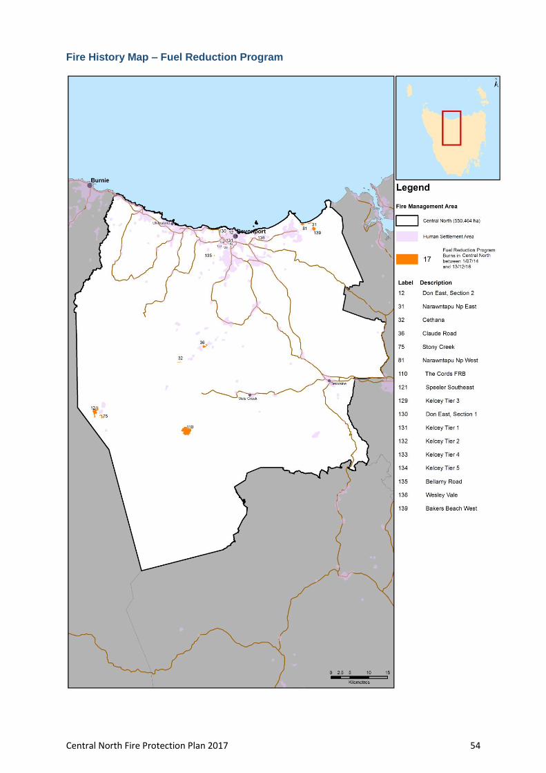
Central North Fire Protection Plan 2017 54
Fire History Map – Fuel Reduction Program

Central North Fire Protection Plan 2017 55
Ignition Cause
Central North Fire Protection Plan 2017 56
Appendix 6 - BRAM (Bushfire Risk Assessment Model) explanation
Background
The Bushfire Risk Assessment Model (BRAM) is a software product that was developed
by the Fire Management Section of the Parks and Wildlife Service (Department of
Primary Industries, Parks, Water and Environment). The aim of the model is identify
bush fire risk at a strategic level as well as to identify the elements driving actual bush
fire risk.
A stakeholder group was set up to oversee the process. Stakeholders involved in
developing the process included:
Parks and Wildlife Service;
Tasmania Fire Service;
Forestry Tasmania;
Tasmanian Farmers and Graziers Association;
State Emergency Service:
Forest Industries Association of Tasmania;
Local Government Association of Tasmania;
Resource management and conservation , DPIPWE;
NRM ;
Tasmanian Aboriginal land and Sea Council;
Additional working groups were set up to advise on specialist areas such as values at
risk, suppression capabilities, ignition potential, and fire behaviour.
The process is aligned to the Australian/New Zealand Standard AS/NZS 4360:2004
Australian Standard Risk Management and the updated standard AS/NZS ISO
31000:2009 Risk management – Principles and guidelines. Risk is defined as the”
effect of uncertainty on objectives” with a focus of the effect on the objectives
The process
The model is built in a geographic information system that utilizes various spatial
orientated data, fire behaviour and fuel accumulation models and climate records. The
data and values were developed by consensus of a range of stakeholders
The process applies the same set of assessment rules to the data contained in the
model, thus it can be applied across the state. The process is tenure blind
The BRAM identifies the likelihood and consequence of a fire at a particular point.
The risk is determined through the use of a qualitative risk matrix incorporating likely
hood and values at risk (consequences). The process identifies the actual risk at that
point not the perceived risk. The output is in the form of layers identifying the likelihood,
values at risk and actual risk
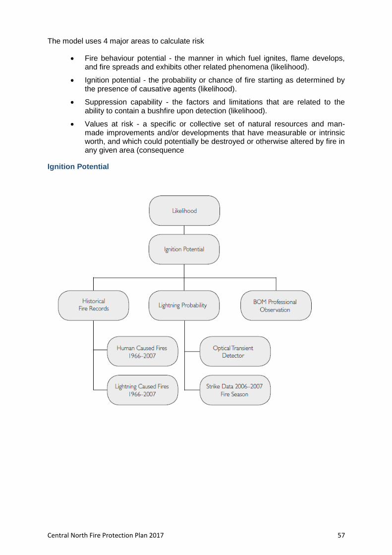
Central North Fire Protection Plan 2017 57
The model uses 4 major areas to calculate risk
Fire behaviour potential - the manner in which fuel ignites, flame develops, and fire spreads and exhibits other related phenomena (likelihood).
Ignition potential - the probability or chance of fire starting as determined by the presence of causative agents (likelihood).
Suppression capability - the factors and limitations that are related to the ability to contain a bushfire upon detection (likelihood).
Values at risk - a specific or collective set of natural resources and man-made improvements and/or developments that have measurable or intrinsic worth, and which could potentially be destroyed or otherwise altered by fire in any given area (consequence
Ignition Potential

Central North Fire Protection Plan 2017 58
Suppression Capabilities

Central North Fire Protection Plan 2017 59
Fire Behaviour Potential

Central North Fire Protection Plan 2017 60
Values at Risk

Central North Fire Protection Plan 2017 61
Limitation of the process
BRAM does not incorporate the likelihood and consequence at the same point from a fire occurring in an adjacent area.
BRAM does not display the risks posed by an area adjacent to a particular point.
Mitigation works undertaken on adjacent areas do not change the risk at a particular point.
The process is based on available data, there are significant gaps in data e.g. fire history on private lands,
Untested assumptions – may over/underestimate risk
Appendix 7 – NERAG risk assessment approach
(Derived from the National Emergency Management Committee (2010), National Emergency Risk Assessment Guidelines, Tasmanian State Emergency Service, Hobart)
The NERAG provide a methodology to assess risks from emergency events and are
principally concerned with risk assessment. The NERAG methodology was utilised in
development of the BRAM to develop the final risk profile
The guidelines are not intended to address the entire risk management framework or the
risk management process as outlined in AS/NZS ISO 31000:2009. However, because
they focus on the assessment of risks from emergency events, they ultimately direct the
management of emergency risks in line with the international standards for risk
management.
The guidelines aim to provide a risk assessment methodology that:
enables focus on risks in small (e.g. municipal) or large (e.g. regional and/or state and/or national) areas
is useable for both risk ‘from’ and risk ‘to’ (e.g. risk from bushfire, risk to infrastructure from all or specific sources of risk)
uses a scenario-based approach
samples risk across a range of credible consequence levels
identifies current risk under existing controls and residual risk assuming implementation of additional controls or control improvements
provides base-line qualitative risk assessments and triggers for more detailed analysis
allows risk evaluation at varying levels of confidence
Provides outputs that are comparable, which rate risk and suggests means to reduce risk.
Risk analysis is the element in the process through which the level of risk and its nature
is determined and understood. Information from risk analysis is critical to rank the
seriousness of risks and to help decide whether risks need to be treated or not. In this
phase, control opportunities are also identified. The analysis involves consideration of
possible consequences, the likelihood that those consequences may occur (including
the factors that affect the consequences), and any existing control that tends to reduce
risks. During this phase the level of confidence in the analysis is assessed by
considering factors such as the divergence of opinion, level of expertise, uncertainty,

Central North Fire Protection Plan 2017 62
quality, quantity and relevance of data and information, and limitations on modelling. At
the conclusion of this step, all identified risks are categorised into risk levels and given a
risk rating, and statements concerning existing controls and their adequacy are made.
NERAG takes an all hazards approach and provides a method that is suitable for
considering other sources of risk beside fire.
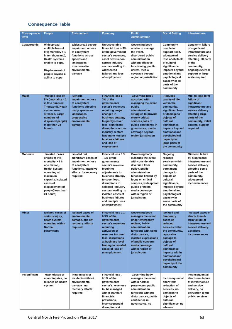
Central North Fire Protection Plan 2017 63
Consequence Table
Consequence
level
People Environment Economy Public
Administration
Social Setting Infrastructure
Catastrophic Widespread
multiple loss of
life( mortality > 1
in ten thousand),
Health systems
unable to cope,
Displacement of
people beyond a
ability to cope
Widespread severe
impairment or loss
of ecosystem
functions across
species and
landscapes,
irrecoverable
environmental
damage
Unrecoverable
financial loss > 3%
of the government
sector’s revenues,
asset destruction
across industry
sectors leading to
widespread
failures and loss
of employment
Governing body
unable to manage
the event,
disordered public
administration
without effective
functioning, public
unrest, media
coverage beyond
region or jurisdiction
Community
unable to
support itself,
widespread
loss of obj3ects
of cultural
significance,
impacts beyond
emotional and
psychological
capacity in all
parts of the
community
Long term failure
of significant
infrastructure and
service delivery
affecting all parts
of the
community,
ongoing external
support at large
scale required
Major Multiple loss of
life ( mortality > 1
in 0ne hundred
Thousand), Heath
system over
stressed, Large
numbers of
displaced people(
more than 24
hours)
Serious
impairment or loss
of ecosystem
functions affecting
many species or
landscapes,
progressive
environmental
damage
Financial loss 1-
3% of the
governments
sector’s revenues
requiring major
changes in
business strategy
to (partly) cover
loss, significant
disruptions across
industry sectors
leading to multiple
business failures
and loss of
employment
Governing Body
absorbed with
managing the event,
public
administration
struggles to provide
merely critical
services, loss of
public confidence in
governance, media
coverage beyond
region jurisdiction
Reduces
quality of life
within the
community,
significant loss
or damage to
objects of
cultural
significance,
impacts beyond
emotional and
psychological
capacity in
large parts of
the community
Mid- to long term
failure of
significant
infrastructure and
service delivery
affecting large
parts of the
community, initial
external support
required
Moderate Isolated cases
of loss of life (
mortality > 1 in
one million),
Health system
operating at
maximum
capacity, isolated
cases of
displacement of
people( less than
24 hours)
Isolated but
significant cases of
impairment or loss
of ecosystem
functions, intensive
efforts for recovery
required
Financial loss 0.3
– 1% of the
governments
sector’s revenue
requiring
adjustments to
business strategy
to cover loss,
disruptions to
selected industry
sectors leading to
isolated cases of
business failures
and multiple loss
of employment
Governing body
manages the event
with considerable
diversion from
policy, public
administration
functions limited by
focus on critical
services, widespread
public protests,
media coverage
within region or
jurisdiction.
Ongoing
reduced
services within
community,
permanent
damage to
objects of
cultural
significance,
impacts beyond
emotional and
psychological
capacity in
some parts of
the community
Mid-term failure
of( significant)
infrastructure and
service delivery
affecting some
parts of the
community,
widespread
inconveniences
Minor Isolated cases of
serious injury,
heath system
operating within
Normal
parameters
Isolated cases of
environmental
damage, one off
recovery efforts
required
Financial loss 0.1-
0.3% of the
governments
sector’s revenues
requiring
activation of
reserves to cover
loss, disruptions
at business level
leading to isolated
cases of loss of
unemployment
Governing body
manages the event
under emergency
regime, Public
administration
functions with some
disturbances,
isolated expressions
of public concern,
media coverage
within region or
jurisdiction
Isolated and
temporary
cases of
reduced
services within
the community,
repairable
damage to
objects of
cultural
significance,
impacts within
emotional and
psychological
capacity of the
community
Isolated cases of
short– to mid-
term failure of
infrastructure and
service delivery.
Localised
inconveniences
Insignificant Near misses or
minor injuries, no
reliance on health
system
Near missis or
incidents without
environmental
damage , no
recovery efforts
required
Financial loss ,
0.1% of the
governments
sector’s revenues
to be managed
within standard
financials
provisions,
inconsequential
disruptions at
Governing body
manages the event
within normal
parameters, public
administration
functions without
disturbances, public
confidence in
governance, no
Inconsequential
short-term
reduction of
services, no
damages to
objects of
cultural
significance, no
adverse
Inconsequential
short-term failure
of infrastructure
and service
delivery, no
disruption to the
public services

Central North Fire Protection Plan 2017 64
business level media attention emotional and
psychological
impacts
Impact Category Definitions
Impact Category Definitions
People Relates to the direct impacts of the emergency on the physical health of people/ individuals
and emergency services( i.e. health systems) ability to manage
Mortality defined as the ration of deaths in a an area of the population to the population of
that area; expressed as per 1000 per years
Environment Relates to the impacts of the emergency and its effects on the ecosystem of the area,
including fauna and flora
Economy Relates to the economic impacts of the emergency on the governing body as reported in the
annual operating statement for the relevant jurisdiction, and industry sectors as defined by
the Australian Bureau of statistics
Public Administration Relates to the impacts of the emergency on the governing body’s ability to govern
Social setting Relates to the impacts of the emergency on society and its social fabric, including its cultural
heritage, resilience of community
Infrastructure Relates to the impacts of the emergency on the areas infrastructure/ lifelines/utilities and its
ability to service the community
Long term failure = repairs will take longer than 6 months
Mid-to long term failure = repairs may be undertaken in 3 to 6 months
Mid-term failure = repairs may be undertaken in 3 to 6 months
Short to mid term failure = repairs may be undertaken in 1 week to 3 months
Short-term failure = repairs may be undertaken in less than 1 week
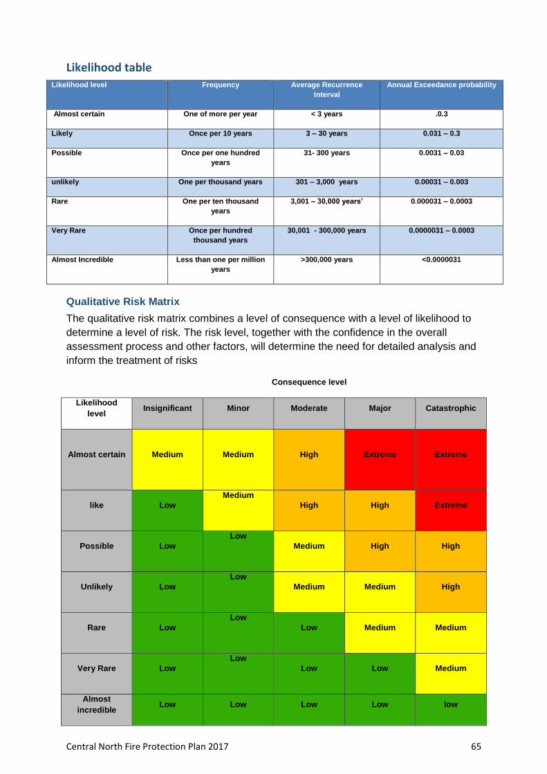
Central North Fire Protection Plan 2017 65
Likelihood table Likelihood level Frequency Average Recurrence
Interval
Annual Exceedance probability
Almost certain One of more per year < 3 years .0.3
Likely Once per 10 years 3 – 30 years 0.031 – 0.3
Possible Once per one hundred
years
31- 300 years 0.0031 – 0.03
unlikely One per thousand years 301 – 3,000 years 0.00031 – 0.003
Rare One per ten thousand
years
3,001 – 30,000 years’ 0.000031 – 0.0003
Very Rare Once per hundred
thousand years
30,001 - 300,000 years 0.0000031 – 0.0003
Almost Incredible Less than one per million
years
>300,000 years <0.0000031
Qualitative Risk Matrix
The qualitative risk matrix combines a level of consequence with a level of likelihood to
determine a level of risk. The risk level, together with the confidence in the overall
assessment process and other factors, will determine the need for detailed analysis and
inform the treatment of risks
Consequence level
Likelihood
level Insignificant Minor Moderate Major Catastrophic
Almost certain Medium
Medium
High Extreme Extreme
like Low
Medium
High High Extreme
Possible Low
Low
Medium High High
Unlikely Low
Low
Medium Medium High
Rare Low
Low
Low Medium Medium
Very Rare Low
Low
Low Low Medium
Almost
incredible Low Low Low Low low

Central North Fire Protection Plan 2017 66
Appendix 8 – BRAM Risk Assessment Maps – Likelihood, Consequence, Risk
BRAM Likelihood – Central North
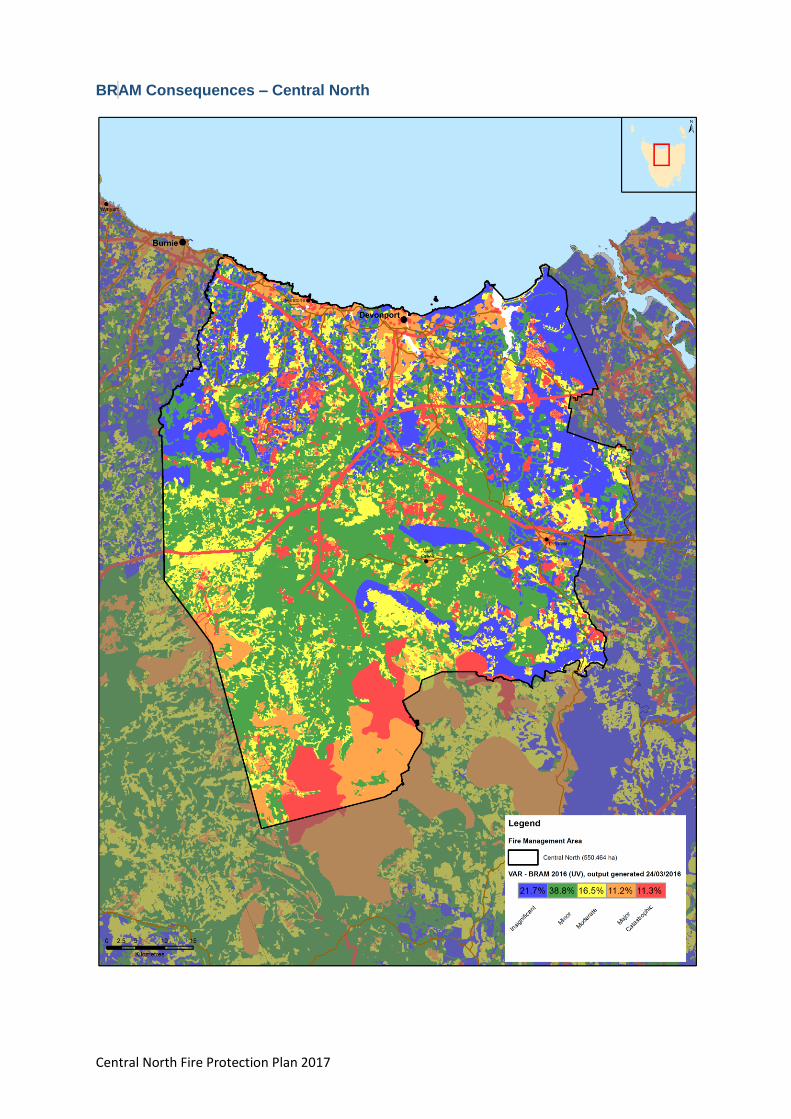
Central North Fire Protection Plan 2017 67
BR AM Consequences – Central North
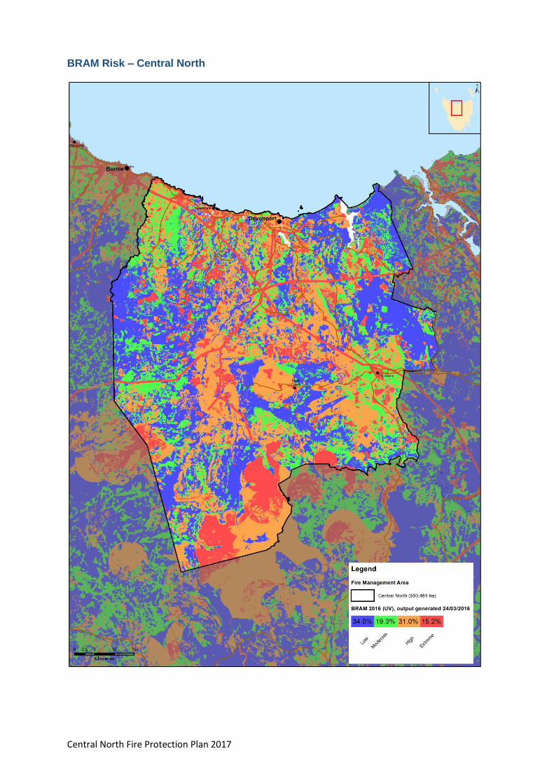
Central North Fire Protection Plan 2017 68
BRAM Risk – Central North
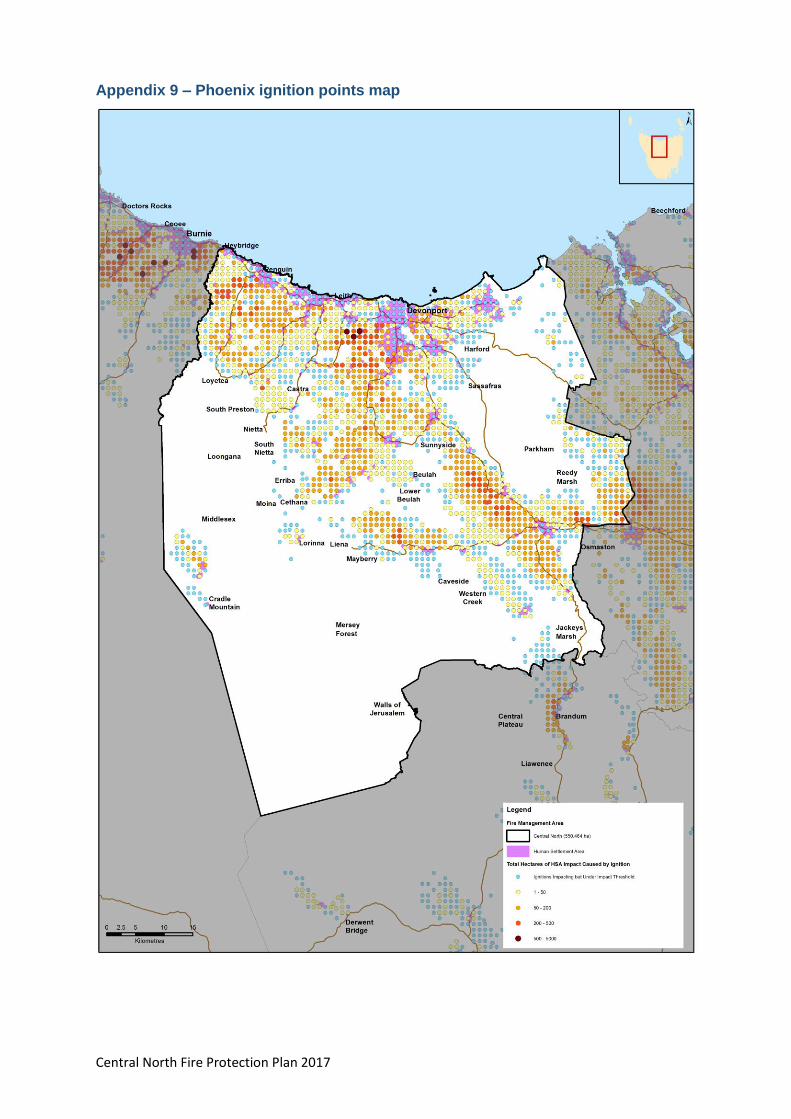
Central North Fire Protection Plan 2017 69
Appendix 9 – Phoenix ignition points map

Central North Fire Protection Plan 2017 70
Appendix 10 – TFS Community Fire Safety Division Programs and Plans
Tasmania Fire Service (TFS) Community Protection Planning Officers are responsible
for preparing a range of community specific fire plans for communities. There are three
types of plans, each with a different purpose:
1. Community Bushfire Response Plan
The purpose of a Community Bushfire Response Plan, (CBRP) is for emergency
management agencies to better protect communities and their assets during bushfire
emergencies.
2. Community Bushfire Protection Plan
The purpose of a Community Bushfire Protection Plan, (CBPP) is for community
members to be provided with local information to assist with bushfire preparation and
survival.
3. Community Bushfire Mitigation Plan
The purpose of a Community Bushfire Mitigation Plan is to provide guidance regarding
bushfire fuel management; to increase community bushfire safety and provide protection
to important community assets.
A number of approved TFS Community Bushfire Protection Plans and Community
Bushfire Response Plans are already in place for communities within the Central North
Fire Management Area as at 2016 including:
Claude Rd Area
Cradle Valley Area
Lorrina Area
Jackeys Marsh
Meander
Golden Valley
For the 2016/17 fire season, Community Bushfire Protection Plans and Community
Bushfire Response Plans are proposed for:
Port Sorell – Summerhill Drive Area (2017/18)
Squeaking Point (2017/18)
Community Bushfire Mitigation Plans are planned for:
Lorrina Area (2018/19)
Port Sorell – Summerhill Drive Area (2017/18)
Squeaking Point (2017/18)

Central North Fire Protection Plan 2017 71
Bushfire Ready Neighbourhoods Program - Tasmania Fire Service
A Community Development Coordinator and regionally based Community Development
Officers (Hobart, Launceston and Burnie) have identified 22 communities/areas state-
wide which are being targeted by the Bushfire-ready neighbourhoods program as part of
round 2 (2016 to 2018) of the program. The program takes a community development
(‘grass roots’) approach and recognises that there isn’t a one size fits all approach to
bushfire preparedness, highlighting that ‘we all play a part’ ( individuals, TFS,
communities). Specifically the program takes a community led approach providing local
community members in higher bushfire risk areas community engagement activities for
preparing for and preventing bushfire/s. The program is facilitated by accessing existing
community networks and resources and developing localised strategies in bushfire
preparedness. Some of the planned community engagement activities include;
community forums, information sessions for communities and brigades alike, workshops,
property assessments, field days, focussed group activities and establishment of
Bushfire-ready neighbourhood groups.
For more information about the Bushfire-Ready Neighbourhoods Program visit:
fire.tas.gov.au/brn
Within the Central North FMA, Bushfire Ready Neighbourhood programs have been
conducted at:
Wegeena
Golden Valley
For the 2016/17 fire season, Bushfire Ready Neighbourhood programs are planned for:
• Jackey’s Marsh
• Squeaking Point/Port Sorell

Central North Fire Protection Plan 2017 72
Appendix 11 – Treatability of land within the Central North FMA
Treat Agriculture
Treatability by Tenure

Central North Fire Protection Plan 2017 73
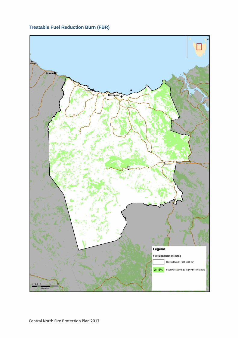
Central North Fire Protection Plan 2017 74
Treatable Fuel Reduction Burn (FBR)

Central North Fire Protection Plan 2017 75
Appendix 12 - List of fire management related documents for the Central North
Fire Management Area
A number of fire related plans have already been prepared for use within the Central North Fire Management Area including:
Tasmanian Emergency Management Plan (Department of Police and Emergency Management, 2013)
Northern Region Emergency Management Plan (SES)
Interagency Fire Management Protocol
Roland Fire Management Area Fire Protection Plan (2008). Roland Fire Management Area Committee. ( A 5 part plan which includes Mt Roland Bushfire Risk Assessment (2006), Cradle Valley Emergency Management Plan (2007), Cradle Valley Fire Management Plan (2008), Gog Range, Badger Range Bushfire Risk Assessment, Middlesex and Moina Bushfire Risk Assessment).
Barrington Fire Management Area: Fire Protection Plan (2003).
Municipal Emergency Management Plans:
Mersey Leven and Meander Valley Council Municipal Emergency Management Plans (2014)
Tasmanian Lifelines Project: Tasmania North West Region Project Report. (1996)
Devonport City Council:
Fire Management Plan, Kelcey Tier Greenbelt (2005) AVK Environmental Management and Renaissance Forestry, Sandford, Tas.
Fire Management Plan, Don Reserve (2005) AVK Environmental Management and Renaissance Forestry, Sandford, Tas.
Updated Mersey District Wildfire Treatment Plan
Parks and Wildlife Service Tasmania:
Parks and Wildlife Service Tasmania Northern Region Strategic Fire Management Plan (2009) and Northern West Region Strategic Fire Management Plan (2012).
Cradle Valley Fire Prevention Plan (2008) Report prepared for Parks and Wildlife Service by Environs Group, Ferntree Gully, VIC. On behalf of Mt Roland Fire Management Area Committee.
Draft Dial Range Bushfire Response Plan (Feb 2008) – Parks and Wildlife Service Tasmania.
Mt Roland Conservation Area and Regional Reserve Draft Fire Management Plan – June 2014, Parks and Wildlife Service Tasmania.
Walls of Jerusalem National Park and Central Plateau Conservation Area Fire Management Plan 1997
Central North Fire Protection Plan 2017 76
TasNetworks
Transmission Line Easements Asset Management Plan (D03/5593) Issue 5.0, Transend, May 2014.
Barrington easement slashing program and Lemontyne
Forestry Tasmania
Bass Forest District Tactical Fire Management Plan (Sept 2013), Forestry Tasmania.
Salisbury Hill Forest Operational Plan (Beaconsfield Map sheet), 2014. Forestry Tasmania
Forestry Tasmania. Fuel reduction burns are planned for Lemontyne and Virginstowe (east of Latrobe) 2014/15.
Hydro Tasmania
Bushfire Risk Assessment and Management Plan for Hydro Assets (August 2013). Prepared for Hydro Tasmania, by AVK Environmental Management, Sandford.
Other maps and/or data available:
Taswater Dams and Catchments, Trunk Main easements, Storage reservoirs.
Annual slashing program for Narwantapu National Park, Parks and Wildlife Service Tasmania.
City of Devonport, Roadside Mowing Contract map.
Central Coast Council roadside slashing program map.
Hydro Tasmania, state-wide vegetation management plan, annual programs.
Central North Fire Protection Plan 2017 77
Appendix 13 – Annual Implementation Program – Central North FMA 2016/17
Location Issue Owner Previous Treatment Action required Who to take action
Resource/Funding Source
Timeframe for completion
FMAC Priority rating
Burn Plan Status
Prep Work Status
COMMUNITIES
Cradle Valley (including Pencil Pine)
Numerous resorts represent a high value asset for the region - vital for tourism in Tasmania. High daily visitor numbers (up to 1500/day) with only one access road in/out. Large areas of fire prone and flammable buttongrass plains to the west. Fires in buttongrass move rapidly and the creation of firebreaks is not possible due to underlying/boggy marshes. There are minimal defendable places at Cradle Mt Village and only very low water pressure. The fire brigade at Cradle is very transient and the nearest brigade for assistance is 50 mins away at Wilmot.
PWS There have been a high number of (planned) buttongrass fires to the west in the past. The buildings at Cradle Mt village have previously triaged by TFS. The Cradle Valley Emergency Management Plan (March 2015) is a sub-plan under the Mersey-Leven Emergency Management Plan and adds to work previously coordinated by PWS. There is a contingency plan to engage services of Tas helicopters to water bomb in an emergency. This plan was renewed and finalised in the last 12 months. A Community Bushfire Response Plan has been prepared for this area (2013). Stony Creek burn completed October 2015. The Stony Creek burn south of the Interpretation Centre and Ranger Station was completed in spring 2015.
1. PWS has hazard reduction burning program burns scheduled for Quailes Hill in 2017 (south-east of Interpretation Centre and Ranger Office), Speeler Southeast in Autumn 2017 and Speeler NW in 2017. 2. Actions identified in the emergency plan/mitigation plan for this area need to be implemented. Council has leading role in implementation.
Jonathan Magor Eddie Staier
PWS - for Hazard reduction burning. Additional support sought from FRU
Autumn 2016 High Community Protection and Response Plans completed (TFS). • PWS burn at Speeler Southeast planned for Autumn 2017. Plan not started.
Unbounded burns, prep not required.

Central North Fire Protection Plan 2017 78
Location Issue Owner Previous Treatment Action required Who to take action
Resource/Funding Source
Timeframe for completion
FMAC Priority rating
Burn Plan Status
Prep Work Status
Claude Rd (Mt Roland)
There are about 70 houses scattered on the slopes of Mt. Roland. Most of these are only accessible by single lane one way in one way out roads with very few turning points for fire trucks. Large areas of standing wet forest preclude hazard reduction burning in Forestry managed area. There is a history of arson in the area.
Mix of private property and Parks
Risk assessment and Draft fire management plan has been developed by Parks. Structural survival assessment and community engagement conducted by TFS about 6 years ago. Community protection plan developed. Community has been engaged with Community Education Program. 2 burns completed in autumn 2015.
FMAC group acknowledges members of this community have knowingly chosen to live/build in a high bush fire risk area. Investigate suitability for a burn program (on PWS tenure). Review of access roads required for emergency access. Three burns have been planned for the Claude Road area.
Eddie Staier/Linda Walker (PWS) Paul Hill and Jonathan Magor
FRU can provide planning and operational support. Other funding to be sourced to upgrade trails.
PWS burns planned for autumn 2017
High Community Protection and Response Plans completed (TFS). 1 PWS burn plan completed, 3 burns planned for 2017
Underway (PWS)
Central North Fire Protection Plan 2017 79
Location Issue Owner Previous Treatment Action required Who to take action
Resource/Funding Source
Timeframe for completion
FMAC Priority rating
Burn Plan Status
Prep Work Status
Don Reserve (West of Devonport)
Council reserve with a history of frequent fires. Considered a potentially major threat to Don College & surrounding residents located uphill of the fuel load. A very high risk Hazard reduction operation is required. High ecological values. Identified in Mersey bushfire Treatment Strategy. Resourcing the actions identified in the fire plan for this reserve is the issue.
Current land tenures in and near the reserve comprise: • land at the northern and southern parts of the reserve that are owned by DCC • crown land in the centre of the reserve that includes the Don Aquatic Centre and Parks Depot • crown land near the river • Don College (administered by the Education Department) • The railway corridor, which is leased until 2051 from DCC for use as a railway heritage tourist attraction by the Don River Historic Railway The balance of the reserve, including the area occupied by the Don Aquatic Centre and the parks depot is public land administered by DCC
Last burnt 4 to 5 years ago (TFS resourced). A fire plan for Don Reserve has been prepared for Council. Council maintains fire trail. Burn has been completed in 2 parts.
Fire plan for Don Reserve requires updating.
Kylie Lunson DCC 2017 High Operational burn plan completed (TFS)
Burn COMPLETED
Central North Fire Protection Plan 2017 80
Location Issue Owner Previous Treatment Action required Who to take action
Resource/Funding Source
Timeframe for completion
FMAC Priority rating
Burn Plan Status
Prep Work Status
Summerhill Drive area, Port Sorell
Located on the western side of Hawley. At risk of fire from the northwest. Lots of residential development in amongst the scrub. Area has a history of repeated fires (before the houses were built). Fire is likely to be difficult to control.
Predominantly private property.
none known Recommend this location for a community education program as well as a program of Structural Assessments from TFS. Needs to be incorporated into a bigger mitigation plan. BPP to develop Community Bushfire Protection Plans for this community.
Paul Hill to communicate with Suzette BRN
TFS, CPP and PWS Nov-16 high There are approved burn plans for Northdown Rd and Browns Lookout Rd
Not done Lyell Dean (BPP Unit of TFS) to prepare mitigation plan 2016/17
Squeaking Point Areas of private property with limited building protection potentially putting the wider area at risk. Dwellings are closely surrounded by volatile scrub and large blocks covered with heavy ground litter layer. Large tract of vegetated land to the NW presents greatest risk. Crown land foreshore with reserve area behind administer by P&W and with firebreak. Community has a varying level of awareness of the risks and appropriate level of protection. Also identified as a priority in Mersey bushfire Treatment strategy.
Mixed tenure. Private property & Crown land foreshore with reserve area behind (administered by PWS) and with firebreak.
No history of fires in this area. A fire break across crown land has been identified and constructed in this area.
This community is to be included in the 2016/18 Bushfire Ready Neighbourhoods program. CPP to investigate feasibility of developing a Community Bushfire Mitigation Plan. BPP to develop Community Bushfire Protection Plans for this community.
BPP for private land, Chris Emms PWS, Paul Hill to communicate with Suzette BRN who ran an Information Meeting on 8/11/16
Unfunded Nov-16 High Not done. Local Mitigation Plan and Response plans scheduled for 2017/18 (Lyell Dean TFS BPP Unit)
not commenced

Central North Fire Protection Plan 2017 81
Location Issue Owner Previous Treatment Action required Who to take action
Resource/Funding Source
Timeframe for completion
FMAC Priority rating
Burn Plan Status
Prep Work Status
Marana Drive and Eagle Point area - Bakers Beach (east of Rubicon Estuary)
Isolated population located in highly flammable vegetation. Properties on Marana Drive and Eagle Point are at risk. Has a history of fires to the northwest. Fire is most likely to originate from the bushland block located in the township itself. Local brigade is not strong and nearest additional assistance is 35 minutes away minimum. Blocks in centre of town area are privately owned.
Private, forestry and P&W
The area has been identified for a strategic burn previously. Forestry Tasmania maintains firebreaks to the northwest on Timberland property.
1. Planned burn required for blocks in centre of town. 2. Develop a mitigation plan by November 2016. 3. Letter required from FRU to FT requesting interest in burning.
Paul Hill (TFS) and Brad Williams (FRU) Chris Emms
Unfunded Plan by Dec 2016
High Bakers beach has a signed burn plan in place
Not done
Heybridge The community at Heybridge together with the Central Coast Council is concerned about the risk to the community at this location from fire. Heybridge is ranked as the highest priority in the Mersey district. There is a history of fires in the area. Heybridge is located on a steep bank, with new residential development upslope from the vegetation/fuel risk. The greatest risk is from people lighting up at the bottom of the hill and burning out those at the top of the hill. Access for firefighting vehicles is only possible from the bottom (risky). Exit for those fleeing this area is on to a busy highway which presents extra risk if people are panicking.
PWS, Reserve/Crown land
Fires have occurred in this area in 1998 and 2006 and Chasm Creek in 2000. Last controlled burn was about 12 years ago. Structural Survival assessments have been done by TFS at Round Hill (after the Round Hill fires).
• A hazard reduction burn is planned by PWS for the scout camp area in autumn 2017. • This community is to be included in the Community Development Unit program from 2018/20. • Future planned burning to be considered on other interface area with FRU taking the lead
Eddie and Linda (PWS) Paul Hill (TFS) and FRU Brad Williams
Joint burn operation between PWS and TFS. FRU can provide planning and operational support. Additional resourcing/assistance may be required from TFS to conduct Structural Survival Assessments.
1/06/2016 ongoing •2016/2018 • 1/6/2016
Med -High
In progress (PWS)
Underway (PWS)
Central North Fire Protection Plan 2017 82
Location Issue Owner Previous Treatment Action required Who to take action
Resource/Funding Source
Timeframe for completion
FMAC Priority rating
Burn Plan Status
Prep Work Status
Lorinna Isolated community with a small local brigade. The nearest additional response unit is 40 minutes away. Single access road in and out - surrounded by heavily vegetated land. History of major fires in the area in the past. If leaving early - residents can retreat to cleared area in the south towards the lake. If leaving late - very high risk of fallen trees blocking only exit road. Identified as a priority in Mersey bushfire Treatment strategy. Residents have been informed not to leave if there is a fire in the area and have been informed of nearby safer location at Bob Robinson's place next to the lake.
Vegetated area is a mostly PWS tenure. Some FT plantations.
There have been 2 major fires in the area in the past. Forestry Tasmania assisted with control operations. PWS completed a fuel reduction burn off Cockatoo Road in 2013. Community meetings have been held for this community by TFS and PWS in the past. A Community Protection Plan has been prepared for this area and a community engagement program has commenced. A burn at Cethana was completed by PWS in 2015. The emergency track from Wilks Rd to Olivers Road is now open. This track has been constructed to a good standard and will provide a 2nd exit for Lorinna.
Linda Walker to investigate potential to burn to the north of Lorinna. Map/record on GPS the old dozer track on private property for future emergency use only. PWS planned burn at Cethana will provide partial protection to Lorinna. PWS are planning another burn adjacent to Claude Road.
Eddie Staier, Linda Walker (PWS) and Paul Hill (TFS)
FRU can provide planning and operational support
Sep-16 Medium Community Protection and Response Plans completed (TFS). Local Mitigation Plan scheduled for 2018/19 (TFS BPP)
Plan not started
Central North Fire Protection Plan 2017 83
Location Issue Owner Previous Treatment Action required Who to take action
Resource/Funding Source
Timeframe for completion
FMAC Priority rating
Burn Plan Status
Prep Work Status
Dooleys Hill Dooleys Hill is part of a continuance of a hillside range that is heavily vegetated but has limited development. Poses a risk to the town of Latrobe , particularly from ember attack. The area is surrounded by wet forest (untreatable) vegetation in the River Road area. Identified in Mersey bushfire Treatment strategy as a priority.
Latrobe Council/Private
Latrobe Council has developed a Fire Mitigation Strategy breaking the area into different vegetation types and identifying cyclic fuel reduction burns in the dry forest area behind houses. Peter Dawson (Latrobe Council) has a draft plan for fuel reduction in the dry forest behind the houses. A track was put in under previous fire mitigation funding which joins an existing walking track.
The desired action for this location is to establish a cyclic burning program and ensure the trail is maintained to an acceptable standard by Latrobe Council. A burn plan has been done for this block. FRU will incorporate this burn into their program. FMAC to periodically check status and need for further burns. An ongoing program of smaller burns will be undertaken commencing this spring, with larger burns in autumn and ongoing burns beyond this.
Jonathan Magor (Latrobe Council) and FRU staff (Burn Coordinator)
Funding not required, could be used as a group exercise.
Nov-16 Medium to high
Plan for Dooleys Hill completed (Latrobe Council) Mitigation plan not required – treat individual fuel management units instead
Burn not done
Penguin Community feels unsafe/ concern about Dial Range. Penguin ranked highly in Phoenix and BRAM rankings but there is no history of fire in the area. The only assets at risk within the Dial Range are communications towers.
PWS Bob Knox from forestry has investigated the area and determined that the vegetation is mostly wet forest with only 2 patches that are potentially burnable (due to previous fire activity). Further burning would likely only promote pyrogenic (fire loving) vegetation. The mid to upper slopes of Mt Montgomery are potentially burnable but are of no strategic value. A hazard reduction burn at Mount Montgomery is planned by PWS for autumn 2017. No date set.
PWS planned burns should reduce the level of risk in this area.
Action not required once PWS burns have been completed
PWS 3 stage burn planned by PWS. One stage has been completed, second stage planned for autumn 2017 and third stage (east of Mt Montgomery motorbike track) for autumn 2018.
Low 3 stage plan Done
Not done
Central North Fire Protection Plan 2017 84
Location Issue Owner Previous Treatment Action required Who to take action
Resource/Funding Source
Timeframe for completion
FMAC Priority rating
Burn Plan Status
Prep Work Status
Acacia Hills Houses on the side of the hill are hard up against vegetation in a bushfire prone area with high fuel loads. Acacia Hills has the biggest fire potential in the area and it is dry with a lack of available water for firefighting. Many private properties are overgrown with vegetation.
Significant tracts of private land holdings.
Some burning has been conducted on private properties in the area. A large area behind the Nook was logged in 2013.
Further investigation required as to what can be done to mitigate the risk in this area - identification of burn blocks/strategic trails etc. FRU to advise on procedures for burning on private property. Mitigation plan required. Low priority based on preliminary inspection by FRU & TFS
FRU/TFS staff
FRU can provide planning and operational support
Nov-17 Low Mitigation plan not done
Not done
Turners Beach to Leith Foreshore
Following significant
rain events and
flooding in 2016,
substantial amounts of
flood debris have
accumulated in the
foreshore areas from
Turners Beach to
Leith. This debris is on
crown land and is
considered to be a
significant fire risk.
Options to mitigate
this risk will need to
be developed in
conjunction with the
land owners and
managing authorities.
This issue is
considered a high
priority by the FMAC.
Crown Land None Options to mitigate this risk will need to be developed in conjunction with the land owners and managing authorities.
FMAC None 2017 High
Central North Fire Protection Plan 2017 85
POTENTIAL BURN BLOCKS
Reedy Marsh area
A fire in this area poses a high risk to Westbury to the south east (in Tamar FMAC)
The majority of land between Reedy Marsh and Westbury to the SE is Private freehold. Land to the north of Reedy Marsh is Permanent Timber Production Zone Land, Conservation Area and some conservation covenant. Stuart (DPIPWE) has contacts for covenant land owners.
Unknown FT previously had burn plans in place but encountered resistance from the locals. Much of the land has changed tenure from FT and been passed over to PWS.
PWS have identified a block for a hazard reduction burn. FMAC to investigate option for identifying areas to Councils indicating high risk places where people should be discouraged from building (such as Reedy Marsh). Mitigation plan required, FRU to undertake.
FRU staff and PWS (Chris Emms)
Unfunded - FRU can provide planning and operational support
Spring 2016 High PWS burn plan in progress Mitigation plan not done
not done
Clayton Valley/Stubbs Road (Turners Beach)
A vegetated block with houses amongst steep and heavily vegetated terrain. A long history of fires in the area. At risk of fire from multiple directions.
Private property?
Paul Hill (TFS) has been asked previously to conduct a hazard reduction burn but does not have the resources. Small 2ha burn planned for autumn 2015 but more is required.
Further investigate the potential of this block for hazard reduction burning. 3 potential burn areas were originally planned, is now one area as one has been cleared and another is no longer available for burning. Possible burn for autumn 2017.
Fuel Reduction Unit staff
Unfunded - FRU can provide planning and operational support
2017
Medium Mitigation Plan not required – individual treatment units planned. A signed burn plan is in place for Stubbs Road.
not done
Pitcairn Bushland Reserve (Port Sorrell)
This reserve contains volatile vegetation and has been subject to regular arson attacks. It is located beside a new school.
Latrobe Council The reserve has previously been divided into block suitable for hazard reduction burning (by Peter Dawson) and fire breaks were put in some years ago. A section of this was burnt 2014.
No immediate action required. Keep on list as a low to medium priority for a hazard reduction burn in the Central North FMAC. (Will need to liaise with Rotary club active in this reserve). One burn planned for autumn 2017
Latrobe Council, FRU and TFS
FRU Autumn 2017 Low Local Mitigation Plan scheduled for 2017/18 (Lyell Dean TFS BPP Unit)
Use existing plan

Central North Fire Protection Plan 2017 86
ASSETS
Sykes sanctuary/Railton Urban Interface
40 acre reserve in behind Railton. A fire in the reserve has the potential to impact upon Railton. High fuel levels in the reserve at present. The reserve has tracks all through it and it will burn in the right conditions.
Council/private Tracks have been created with the reserve. There is no history of fire in the area.
A burn plan is required for this reserve. Kentish Council requires FRU assistance to write a burn plan for as well as resource this burn. FRU to put into program and write burn plan.
Kentish Council, FRU (Brad Williams) and TFS (Paul Hill)
FRU can provide planning and operational support
Plan to be completed by 1/11/2017
low Not done Not done
PROPOSED HAZARD REDUCTION BURNING
Jackeys Marsh Alternative lifestyle community - Isolated and dispersed community within a valley surrounded on all sides by heavily forested land. Winding access roads overhung with trees. Surrounded by World Heritage Area. Lots of wet forest (untreatable).
Mixed tenure. Lots of conservation covenants.
A Community Protection Plan and Community Response Plan has been completed for Jackeys Marsh.
BRN is currently engaging with the community as part of the 2014-2016 program. Community members are very engaged and have been attending forums and information sessions. Warners Sugarloaf needs some fuel reduction burning. PWS are investigating opportuntities for burning to the west of Jackeys Marsh in the Warners Sugarloaf area. Mitigation Plan required.
PWS/FRU Chris Emms
FRU can provide planning and operational support
High A Community Protection Plan and Community Response Plan has been completed for Jackeys Marsh (TFS).
Not done
Central North Fire Protection Plan 2017 87
Kelcey Tier HR (Devonport area)
There is a strong history of fires in the area. Potential to impact heavily upon Stoney Rise, Tugrah, Spreyton, Wrenswood Drive,Durkins Road, Williams reservoir and comms tower on top of the hill. Only one road in or out on the eastern side of the range. Fire usually starts on the Tugrah side from escaped agricultural burns.
Devonport Council and private property.
Burn Plans were prepared and some fuel reduction activities were conducted in spring 2014 & autumn 2015 Devonport City Council has prepared a new plan for the area.
Develop Community Bushfire Mitigation Plan – Lyell Dean (TFS) 2016/17
BPP unit (TFS)
FRU can provide planning and operational support
High Devonport City Council has a plan for this area. Another burn is planned for the northern side of Durkins Road in autumn 2017.
Some burn units in Kelcey Tier completed autumn 2016
Stony Rise - subdivisions adjacent to Kelcey Tier greenbelt
The subdivision along Leary Ave has resulted in houses being built hard up against the northern boundary of the heavily vegetated Kelcey Tier Green Belt. A fire from the quarry within the Green belt has the potential to head south and impact on the Wrenswood Drive housing development.
Council, TasWater and some private ownership
A firebreak is needed between Kelcey Tier and the Leary Avenue/McCall Terrace (also across to Tugrah Road) subdivision properties along its northern boundary. A mitigation plan will be required. The nearby Devonfield burn has been 50% completed.
Done Council are developing a Mitigation Plan -2016/17
Autumn 2016 medium Not commenced – Plan scheduled for 2016/17 fire season
Not commenced
Dulverton Landfill site & Organic Recycling Facility (DORF)
Landfill is surrounded by natural vegetation to the south and west, an access road the north and east (both with a thin strip of native vegetation along the roadside). Neighbouring land includes pine plantations, native vegetation and small farm holdings. The landfill site poses a fire risk to the mushroom compost operation adjoining the landfill site.
Dulverton Waste Management
TFS and DWM have had meetings regarding fire prevention and an Environmental Management Plan has been developed for the landfill and organic recycling facility
A fire mitigation plan is required for the area surrounding the landfill site. FRU staff to investigate and advise how to proceed with burning on private property.
Dulverton Waste Management Authority (and reps from member Councils). Paul Hill (TFS) in discussions with site managers.
Dulverton Waste Management Authority (Councils)
Autumn 2018 for mitigation plan to be done
low Not done Not done
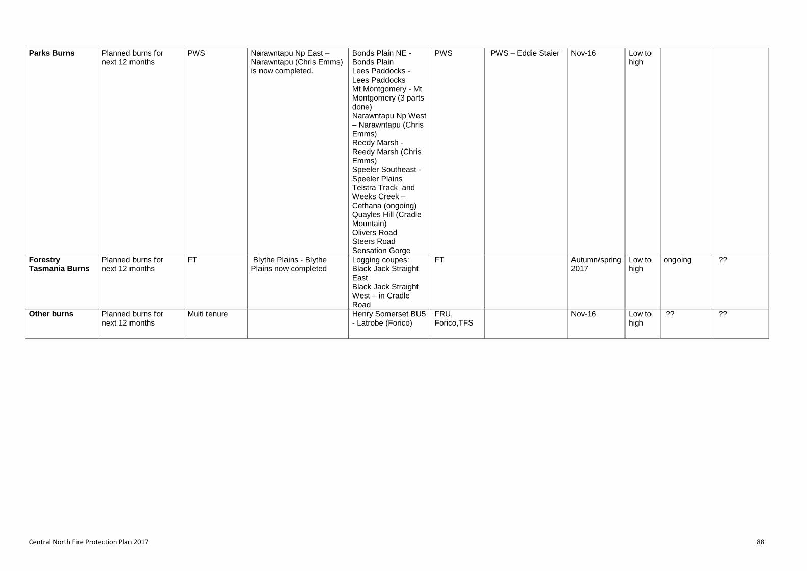
Central North Fire Protection Plan 2017 88
Parks Burns Planned burns for next 12 months
PWS Narawntapu Np East – Narawntapu (Chris Emms) is now completed.
Bonds Plain NE - Bonds Plain Lees Paddocks - Lees Paddocks Mt Montgomery - Mt Montgomery (3 parts done) Narawntapu Np West – Narawntapu (Chris Emms) Reedy Marsh - Reedy Marsh (Chris Emms) Speeler Southeast - Speeler Plains Telstra Track and Weeks Creek – Cethana (ongoing) Quayles Hill (Cradle Mountain) Olivers Road Steers Road Sensation Gorge
PWS PWS – Eddie Staier Nov-16 Low to high
Forestry Tasmania Burns
Planned burns for next 12 months
FT Blythe Plains - Blythe Plains now completed
Logging coupes: Black Jack Straight East Black Jack Straight West – in Cradle Road
FT Autumn/spring 2017
Low to high
ongoing ??
Other burns Planned burns for next 12 months
Multi tenure Henry Somerset BU5 - Latrobe (Forico)
FRU, Forico,TFS
Nov-16 Low to high
?? ??