catawba annual report 2010 annual report on interbasin transfers from the catawba river basin north...
TRANSCRIPT

2010 Annual Report on Interbasin Transfers from the Catawba River Basin
North Carolina Division of Water Resources
Department of the Environment and Natural Resources
August, 2011

INTRODUCTION This report has been prepared in accordance with the Settlement Agreement signed on December 3, 2010 reached between the States of South Carolina, North Carolina, Duke Energy Carolinas LLC, and the Catawba River Water Supply Project. As a condition of that agreement, “each State shall prepare an annual report of the average daily transfer amounts for each entity holding an IBT certificate and provide it to the other State.” Therefore this annual report is intended to be a summary of interbasin transfers (IBTs) to and from the Catawba River Basin, that are performed by IBT certificate holders. BACKGROUND: IBT LAW IN NORTH CAROLINA In 1993, the North Carolina Legislature enacted General Statute G.S. §143‐215.22I as part of An Act to Regulate Interbasin Transfers (Session Law 1993‐348). This law regulated large surface water transfers between river basins by requiring a certificate from the Environmental Management Commission (EMC). In general, a transfer certificate is required for new transfers of 2 million gallons per day (MGD) or more. Due to the fact that the Surface Water Transfer Act was first adopted in 1993, many of the IBT rules and requirements reference a system’s daily flows and capacity at that time. Facilities that were in existence prior to 1993 are said to have Grandfathered Transfers up to either 25% above their average daily flow at that time, their maximum system capacity at that time, or 2 MGD ‐ whichever is greater. If a facility existed or was under construction by July 1, 1993, a certificate is not required up to the full capacity of that facility to transfer water, regardless of the transfer amount. An important point in NC’s IBT law is that it creates its own, specific definition of a “river basin”. According to G.S. §143‐215.22G, there are 38 designated river basins. An IBT certificate is required for any transfer, meeting the statutorily defined thresholds, between any of these defined river basins. Figure 1 illustrates the designated river basins.

Figure 1: Designated Interbasin Transfer River Basins As defined in G.S. §143-215.22G
BASIN NAME BASIN NAME BASIN NAME 1-1 Broad River 7-1 Little Tennessee River 15-1 Tar River 7-2 Tuskasegee River 15-2 Fishing Creek 2-1 Haw River 15-3 Pamlico River & Sound 2-2 Deep River 8-1 Savannah River 2-3 Cape Fear River 2-4 South River 9-1 Lumber River 16-1 Watauga River 2-5 Northeast Cape Fear River 9-2 Big Shoe Heel Creek 2-6 New River 9-3 Waccamaw River 17-1 White Oak River 9-4 Shallotte River 3-1 Catawba River 18-1 Yadkin River 3-2 South Fork Catawba River 10-1 Neuse River 18-2 South Yadkin River 10-2 Contentnea Creek 18-3 Uwharrie River 4-1 Chowan River 10-3 Trent River 18-4 Rocky River 4-2 Meherrin River 11-1 New River 5-1 Nolichucky River 5-2 French Broad River 12-1 Albemarle Sound 5-3 Pigeon River 13-1 Ocoee River 6-1 Hiwassee River 14-1 Roanoke River

The procedure for obtaining an Interbasin Transfer Certificate is specifically laid out in G.S. §143‐215.22L. The full process can take three to five years (or more), requires local and interstate notification, and offers a number of opportunities for public comment and review. The full text of G.S. §143‐215.22L is included in Appendix C to this report. As of August 2011, The North Carolina Environmental Management Commission has issued interbasin transfer certificates for five water systems. Two of these certificates directly affect the Catawba River Basin. Those two certificates, for Charlotte Mecklenburg Utilities and the Cities of Concord and Kannapolis, are further discussed in this report. The Division of Water Resources also estimates that there are more than 100 grandfathered systems performing smaller IBTs throughout the State. Up to 80% of these systems transfer less than 2 MGD on a maximum daily basis. These grandfathered systems fall below the statutory thresholds and are not required to submit daily transfer estimates. Since these systems are not required to obtain an IBT certificate, they are not discussed in this document.

CHARLOTTE MECKLENBURG UTILITIES Charlotte Mecklenburg Utilities (CMU) has held an interbasin transfer certificate since March 14, 2002. The certificate allows CMU to transfer up to 33 million gallons per day (MGD) from the Catawba River Basin to the Rocky River Basin. Figure 2 illustrates CMUs two water intakes in the Catawba River Basin, and five wastewater treatment plants throughout the Catawba and Rocky River Basins. The utility pursued this certificate in order to meet projected demands through 2030 in eastern Mecklenburg County. Specific details of CMU’s water treatment facilities and a further description of its transfer is included in Appendix A: Charlotte Mecklenburg Utilities’ 2010 Annual Report. Figure 2: Charlotte Mecklenburg Utilities Service Area
CMU provides water to retail customers in the Rocky River Basin, as well as customers in the City of Concord and Town of Harrisburg, in neighboring Cabarrus County. However water is only provided to Concord as an emergency backup to Concord’s primary supply consisting of Lake Howell and several smaller reservoirs. All of these reservoirs are

within the Rocky River basin. Concord received an IBT Certificate in January 2007 for the transfer of up to 10 mgd from the Catawba River basin to the Rocky River basin. Therefore water sold to Concord is not applied to CMU’s IBT amount. Charlotte Mecklenburg Utilities’ IBT calculation methodology was approved by NC DWR in June, 2006. Per the certificate, CMU reports the maximum daily IBT amounts annually to NC DWR until such time as the transfer amount exceeds 80% of the authorized amount. Once that amount is exceeded, Utilities is required to report monthly. To date, CMU has not exceeded 80% of the authorized IBT amount. In 2010 CMU reported a maximum daily transfer of 18.22 MGD from the Catawba River Basin to the Rocky River Basin. This is 55% of the amount authorized in the certificate. The average daily transfer for 2010 was 13.45 MGD, 41% of the authorized maximum daily value. CMU’s full 2010 IBT annual report is included in Appendix A. Annual reports from 2002‐2010 are available on the Division’s website at http://www.ncwater.org/Permits_and_Registration/Interbasin_Transfer/ .

CONCORD AND KANNAPOLIS The Cities of Concord and Kannapolis (the Cities) have held an interbasin transfer certificate since January 2007. This certificate authorizes the transfer of up to 10 MGD from the Catawba River Basin to the Rocky River Basin and 10 MGD from the Yadkin River Basin to the Rocky River Basin. This amount was authorized based on the Cities’ needs through 2035 and an analysis of the yield of available water sources. In addition, the Cities have a grandfathered transfer capacity (based on infrastructure in place prior to 1993) of 6 MGD for transfers from the South Yadkin River Basin to the Rocky River Basin. Figure 3 illustrates the Cites Service area and interbasin transfers. Specific details of the Cities’ service area and sales are included in Appendix B, Concord and Kannapolis’ 2010 IBT Annual Report. Figure 3: Concord and Kannapolis Service Area
In 2010 the Cities reached a settlement in a lawsuit filed by the Catawba River Foundation, Inc. and the Protect the Catawba Coalition. While this does not affect the IBT Certificate, its conditions, or required reporting in any way, the Cities did agree to several operational conditions in the Catawba River Basin during drought. Until July 1,

2015, the Cities have agreed to transfer no more than 3.0 MGD (on a maximum day basis) from the Catawba River Basin. Thereafter, the Cities must first transfer 5.0 MGD from the Yadkin River Basin before exceeding an IBT of 3.0 MGD from the Catawba River Basin. During designated droughts beyond July 1, 2015, following either Low Inflow Protocol (LIP) or Drought Management Advisory Council (DMAC) Drought Stage declaration, the Cities have agreed to limit the Catawba River Basin IBT so that it corresponds to water use reduction goals. Further details about this agreement, including the water use reduction goals after July 2015, can be found in Appendix B. The Cities’ IBT certificate requires an annual report listing the maximum daily transfer for the calendar year. The average daily and maximum daily transfers for 2010 are summarized below in Table 1. Table 1: Concord and Kannapolis 2010 Interbasin Transfers
Interbasin Transfer Authorized Transfer (MGD)
2010 Maximum Daily Transfer (MGD)
2010 Average Daily Transfer (MGD)
Catawba to Rocky 10.0 1 0.007 2 0.005 2
Yadkin to Rocky 10.0 0.3 3 0.3 3
South Yadkin to Rocky 6.0 ‐0.5 4 ‐0.2 4
Notes: 1. Amount authorized by IBT certificate. The Cities have additionally agreed not to exceed 3.0 MGD from the
Catawba until July 1, 2015. 2. Based on purchases from Charlotte Mecklenburg Utilities. This purchase provides water to a single
neighborhood within the Cities’ service area. 3. The average and maximum daily transfer from the Yadkin was the same each day due to a contract
agreement between Kannapolis and Salisbury. 4. The 6 MGD grandfathered capacity is based Kannapolis’ ability to pump raw water to Kannapolis Lake.
This did not occur in 2010 due to pump maintenance and electrical improvements. Kannapolis’ sale to the Town of Landis did occur, however, which created a net transfer in the opposite direction (Rocky to South Yadkin).
Based on the information provided above, Concord and Kannapolis transferred an average of 0.005 MGD from the Catawba River Basin in 2010. The full 2010 annual report is included in Appendix B. Annual reports from 2007‐2010 are available on the Division’s website at http://www.ncwater.org/Permits_and_Registration/Interbasin_Transfer/ . CONCLUSION Based on the information previously discussed in this report, North Carolina estimates that approximately 13.455 MGD was transferred from the Catawba River Basin on an average daily basis by IBT certificate holders in 2010. Approximately 18.227 MGD was transferred on a maximum daily basis. This amounts to 42% (on a max day) of the total amount authorized to be removed from the basin by IBT certificates. For any questions concerning these IBTs please contact Toya Ogallo with the NC Division of Water Resources at (919)715‐0289. Further information can also be found on our website at http://www.ncwater.org/Permits_and_Registration/Interbasin_Transfer/ .

Appendix A: Charlotte Mecklenburg Utilities 2010 IBT Annual Report

Page 2 of 6
Charlotte-Mecklenburg Utilities
Annual Report on Interbasin Transfer Calendar Year 2010
The North Carolina Environmental Management Commission (EMC) approved Charlotte Mecklenburg Utilities’ (Utilities’) petition to increase the amount of water transferred from the Catawba basin to the Rocky River basin and an interbasin transfer (IBT) Certificate was issued on March 14, 2002. The Certificate authorizes Utilities to transfer up to 33 million gallons per day (mgd) from the Catawba River basin to the Rocky River basin. The IBT Certificate requires Utilities to report maximum daily IBT amounts annually to the North Carolina Division of Water Resources (NC DWR) until such time as the transfer amount exceeds 80% of the authorized amount. Once that amount is exceeded, Utilities is required to report monthly. To date, Charlotte-Mecklenburg Utilities has not exceeded 80% of the authorized IBT amount. System Overview The Utilities operates the water and wastewater systems that serve Charlotte, Cornelius, Davidson, Huntersville, Mint Hill, Matthews, Pineville, and much of the unincorporated areas of Mecklenburg County. This system is divided between two river basins designated by NC General Statutes for regulation of IBT water. The western portion of the system is within the Catawba River basin and the eastern portion is within the Rocky River basin. Water transferred from the Catawba River basin to the Rocky River basin that is not returned to the Catawba is regulated IBT. Water for distribution to Utilities’ customers is withdrawn from the Catawba River basin at two locations. An intake at Lake Norman sends water to the Lee S. Dukes Water Treatment Plant. A second intake at Mountain Island Lake sends water to the Walter M. Franklin Water Treatment Plant and to the Vest Water Treatment Plant. Potable water from these three plants is delivered through an interconnected distribution system to retail customers throughout Utilities’ service area in Mecklenburg County and in small areas of Iredell, Cabarrus, and Union Counties. The Utilities also provides wholesale water to municipal systems for Resale including: City of Concord (NC), Town of Harrisburg (NC), Union County (NC), York County Water & Sewer Authority (SC), and Lancaster County Water and Sewer District (SC). Utilities treats wastewater at five advanced wastewater treatment plants (WWTP’s) which discharge into small streams in Mecklenburg County. Four of the streams are tributary to the Catawba River basin and one (Mallard Creek) is tributary to the Rocky River basin. Utilities also conveys wastewater generated in portions of Mecklenburg County to the Rocky River Regional Wastewater Treatment Plant (RRRWWTP) operated by the Water and Sewer Authority of Cabarrus County (WSACC). The RRRWWTP discharges treated effluent to the Rocky River.
Appendix A: Charlotte Mecklenburg Utilities 2010 IBT Annual Report

Page 3 of 6
IBT Monitoring Water supplied to Utilities’ retail customers in the Rocky River Basin, that is not returned to the Catawba basin, is included in the reported IBT amounts. Water provided to municipalities with service areas in the Rocky River basin include the City of Concord and the Town of Harrisburg. Utilities can transfer treated potable water to the City of Concord through three metered connections to their water system. All of Concord’s service area is within the Rocky River basin, so any water purchased by them becomes an IBT. Water service is only provided as an emergency back-up to Concord’s routine supply which is Lake Howell and several smaller reservoirs. All of these reservoirs are within the Rocky River basin. Wastewater from Concord is treated at the RRRWWTP. Utilities’ agreement with Concord is that water will be supplied to them subject to availability and subject to regulatory constraints including IBT and Federal Energy Regulatory Commission (FERC) limitations. Concord received an IBT Certificate in January 2007, for the transfer of up to 10 mgd from the Catawba River basin to the Rocky River basin. NC DWR advised Utilities that water sold to Concord should not be applied to Utilities’ IBT amount. Concord did not purchase any potable water from Utilities in calendar year 2010, so the IBT amounts reported do not include sales to Concord. Utilities can transfer treated potable water to the Town of Harrisburg through two metered connections to their water system. All of Harrisburg’s service area is within the Rocky River basin and is included in the Utilities’ IBT amounts. Table 1 below summarizes actual IBT amounts for calendar years 2002 through 2010 (all calculated using the methodology approved by NC DWR in June of 2006). The table considers the daily amounts of water transferred from the Catawba basin to customers within the Rocky River basin that is not returned to the Catawba basin. The data indicates that the maximum amount of IBT for year 2010 occurred in August, and was 18.22 mgd, less than 56% of the authorized maximum day value of 33 mgd. The average IBT for 2010 was 13.45 mgd, which is approximately 41% of the authorized maximum day value. In addition to the amount of actual IBT reported in Table 1, Utilities has committed to provide additional IBT to development that has been proposed but not yet activated in the Rocky River basin. As of December 31, 2010, 1.16 mgd was committed to permitted donated projects (subdivisions) that had not been activated and 0.50 mgd was committed to master meter connections (generally commercial or multi-family developments) that had not been activated, both based on maximum day estimates. This brings the total of the actual and outstanding IBT in 2010 to 19.88 mgd, or less than 61% of the authorized maximum day value.
Appendix A: Charlotte Mecklenburg Utilities 2010 IBT Annual Report

Page 4 of 6
Table 1. Actual IBT Summary
Calendar Year Avg. Annual IBT (mgd) Max. Day IBT (mgd) 2002 6.74 11.97 2003 6.91 9.82 2004 7.79 12.56 2005 8.66 13.79 2006 9.56 14.35 2007 9.96 17.22 2008 11.39 17.42 2009 12.04 16.00 2010 13.45 18.22
Compliance with Certificate Conditions Condition 1 of Utilities’ IBT certificate requires Mecklenburg County to summarize progress in implementation of watershed management approaches of the Surface Water Improvement and Management Program (S.W.I.M. program). This summary follows:
The watershed management approaches of the Surface Water Improvement and Management (SWIM) Program continued to be implemented during calendar year 2010. Efforts continued to focus on McDowell and Goose Creeks as in 2007, 2008 and 2009 as well as the South Prong and West Branch of the Rocky River in Davidson as initiated in 2009. During calendar year 2010, the following work was completed in the three (3) watersheds:
a) Survey and design were initiated on the restoration of 1,000 feet of stream and the retrofit of 5 rain gardens within the North Mecklenburg Park Property in the McDowell Creek watershed. In addition to the water quality benefits of the project, it will act as an educational destination for property owners potentially affected by future stream restoration and BMP retrofit projects.
b) Since 2002 Goose Creek has been listed by the N.C. Department of Environment and
Natural Resources (NCDENR) as impaired due to elevated levels of fecal coliform bacteria. The predominant sewer treatment system in the watershed is private septic systems; therefore, it was assumed that malfunctioning septic systems were a primary source of the elevated bacteria levels. In 2008, Mecklenburg County initiated a program to complete an inspection of all the septic systems in the watershed in order to identify deficiencies and take the necessary actions to ensure correction. This effort was completed in 2010 with the inspection of 1,422 septic systems resulting in the correction of 13 deficiencies that could contribute to elevated bacteria levels in Goose Creek. Following the completion of this project, NCDENR data documented a reduction in fecal coliform bacteria levels and Goose Creek was removed from the list of impaired waters.
Appendix A: Charlotte Mecklenburg Utilities 2010 IBT Annual Report

Page 5 of 6
c) Mecklenburg County continues to partner with Creek ReLeaf, environmental
organizations and local schools to plant trees along the banks of streams in Mecklenburg County. The purpose of this effort is to restore the water quality buffer and floodplain. During 2010, over 2,200 trees were planted by more 400 volunteers along the floodplain of Little Sugar Creek.
d) Construction of the restoration of 10,000 linear feet of Torrence and Torrence Tributary #2 was nearly completed in 2010. This project is expected to reduce the overall sediment load in the McDowell Creek watershed by as much as 7%.
e) In 2010, Mecklenburg County requested that the Army Corps of Engineers include the
Rocky River watershed in Mecklenburg County into their 206 Program for restoration. As a result, the Corps selected the watershed for inclusion in Program.
f) Mecklenburg County applied for two Clean Water Management Trust Fund Grants for the restoration of an additional 10,000 feet of stream in the McDowell Creek Watershed.
Condition 2 of Utilities’ IBT certificate required a stakeholder process to investigate, develop, adopt, and implement storm water ordinances that control water quantity from single-family development and water quality for all development until completed. The requirements of Condition 2 were completed in 2007.
Condition 3 of the IBT Certificate removes the Goose Creek subbasin from the area to be served by the IBT, and imposes a moratorium on the installation of new IBT water lines (water lines crossing the ridgeline) into Goose Creek subbasin until the impacts of additional growth on the endangered species are fully evaluated.
The Utilities has requested the NC Division of Water Resources (DWR) to prepare an Environmental Assessment (EA) of new development in the Goose Creek basin (Mint Hill area), impacts to water quality, and measures required to protect the Carolina Heelsplitter.
Condition 4 of the IBT Certificate provides that the Environmental Management Commission may reopen the Certificate under certain circumstances. This did not occur in 2010.
Appendix A: Charlotte Mecklenburg Utilities 2010 IBT Annual Report

Page 6 of 6
Condition 5 of the IBT Certificate requires Utilities to develop a compliance and monitoring plan for reporting maximum daily transfer amounts, compliance with certificate conditions, and progress on mitigation measures, and drought management activities. Utilities’ monitoring plan and reporting format were approved in June of 2006 by NC DWR and continue to be used for 2010.
Charlotte Mecklenburg Utilities monitored water treatment plant pump rates, streamflow and lake storage indicators, the US Drought Monitor, and other factors in accordance with the Utilities Water Shortage Response Plan. Measurements were assessed monthly to identify designated triggers that could indicate developing drought conditions. All appropriate planning, communication and preparation were in place to respond as needed to changing conditions.
In coordination with 15 other utilities in the Catawba-Wateree river basin, Charlotte-Mecklenburg participated in regional drought response planning and response activities as directed by the FERC- approved Low Inflow Protocol.
Summary The actual maximum day amount of water transferred from the Catawba River basin to the Rocky River basin was 18.22 mgd, less than 56% of the authorized maximum day value of 33 mgd. The total of actual and outstanding IBT was 19.88 mgd, less than 61% of the authorized maximum day value. Utilities is in full compliance with IBT authorizations and compliance conditions for calendar year 2010.
Appendix A: Charlotte Mecklenburg Utilities 2010 IBT Annual Report

2010 Annual Report on Interbasin Transfers for
The Cities of Concord and Kannapolis
Prepared for
City of Concord City of Kannapolis
Submitted to:
North Carolina Division of Water Resources
January 2011
Prepared By:
11301 Carmel Commons Boulevard
Suite 304 Charlotte, NC 28226
Appendix B: Concord and Kannapolis 2010 IBT Annual Report

Executive Summary
The 2010 Annual Report on Interbasin Transfers (IBTs) for the Cities of Concord and Kannapolis (Cities) includes monitoring data for daily tracking of IBT amounts and documentation of compliance with all IBT Certificate conditions. Annual reports were previously prepared for calendar years 2007, 2008, and 2009 and are available on the North Carolina Division of Water Resources (NCDWR) website.
The North Carolina Environmental Management Commission (EMC) approved the Cities’ IBT Certificate in January 2007 authorizing transfers of up to 10 million gallons per day (mgd) from the Catawba River Basin to the Rocky River Basin and 10 mgd from the Yadkin River Basin to the Rocky River Basin. Additionally, a grandfathered IBT of 6 mgd authorizes transfer from Second Creek, located in the South Yadkin River Basin, to the Rocky River Basin. The terms “Cities” and “Certificate Holders” are used interchangeably herein.
In 2010, the Certificate Holders complied with all conditions of their IBT Certificate. The Cities of Concord and Kannapolis purchased small amounts of water from Charlotte-Mecklenburg Utilities (CMU) from the Catawba River Basin during 2010. The maximum daily transfer from the Yadkin River Basin was 0.3 mgd.
In 2010, the City of Kannapolis did not pump water from Second Creek to Kannapolis Lake under its South Yadkin River Basin grandfathered IBT. Water sales to Landis averaging 0.20 mgd resulted in an IBT to Second Creek (South Yadkin River Basin) during 2010. The maximum day transfer to the South Yadkin River Basin was 0.54 mgd. IBT amounts for 2010 are provided in Table ES-1. The 2010 IBT daily transfers for Concord and Kannapolis are shown in Figure ES-1.
In addition, a settlement was reached in 2010 on a lawsuit filed by the Catawba River Foundation, Inc. and the Protect the Catawba Coalition. While this does not change the IBT Certificate or required reporting in any way, the Cities did agree to some operational conditions regarding the Catawba River Basin during times of drought.
Appendix B: Concord and Kannapolis 2010 IBT Annual Report

TABLE ES-1 2010 IBT Average Annual & Maximum Day Demands for Concord and Kannapolis Service Areas Annual Report on Interbasin Transfers for the Cities of Concord and Kannapolis
Catawba River Basin Yadkin River Basin Second Creekd
(South Yadkin River Bas in)
Year
Water Purchase
(mgd)a
IBT as % of
Certificateb
Water Purchase
(mgd) IBT as % of Certificatec,d
Water Transfer (mgd)
IBT as % of Grand-fathered Amounte
Average Annual
Max. Day Max. Day
Average Annual
Max. Day Max. Day
Average Annual
Max. Day Max. Day
2010 0.005 - 0.0% 0.3 0.3 3.0% 0.20 0.54 27.1% a Concord purchases water from CMU for a residential neighborhood. Only monthly total volume purchased quantities are available. b Maximum Day IBT of 10 mgd from the Catawba River Basin. c Maximum Day IBT of 10 mgd from the Yadkin River Basin. d The grandfathered 6-mgd Maximum Day IBT limit from Second Creek (South Yadkin River Basin) into the Rocky River Basin is not included in the 10-mgd Maximum Day IBT limit for the Yadkin River Basin. e Second Creek was not used as a water source in 2010. No transfer from the South Yadkin River Basin to the Rocky River Basin occurred. Water sales to Landis resulted in a positive water transfer to the South Yadkin River Basin.
Appendix B: Concord and Kannapolis 2010 IBT Annual Report

FIGURE ES-1 2010 Daily Interbasin Transfers by Basin
0.000
0.050
0.100
0.150
0.200
0.250
0.300
0.350
2010 Daily IBT Per Basin (mgd)
Yadkin Catawba
Notes: - Permitted maximum IBT for the Catawba River Basin is 10 mgd
and the maximum IBT for the Yadkin River Basin is 10 mgd. - Daily IBT for the Catawba River Basin includes purchase from
CMU of 0.005 mgd annual average daily flow.
Appendix B: Concord and Kannapolis 2010 IBT Annual Report
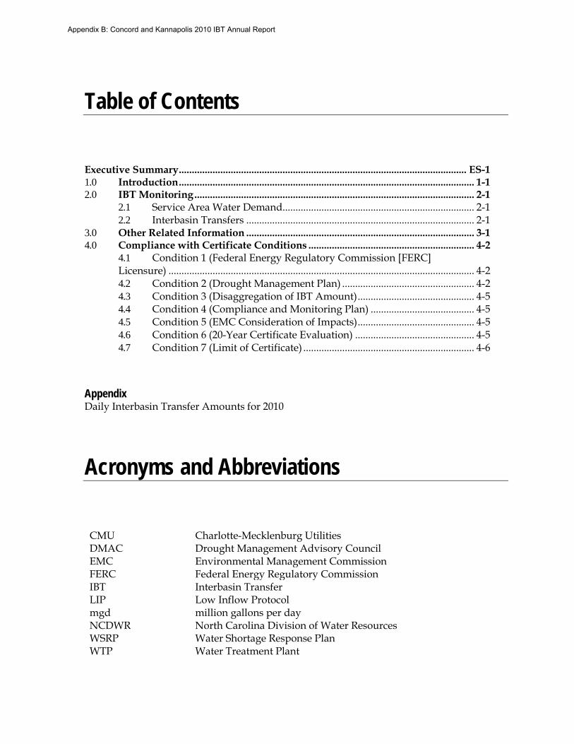
Table of Contents
Executive Summary ............................................................................................................... ES-1 1.0 Introduction .................................................................................................................. 1-1 2.0 IBT Monitoring ............................................................................................................ 2-1
2.1 Service Area Water Demand .......................................................................... 2-1 2.2 Interbasin Transfers ........................................................................................ 2-1
3.0 Other Related Information ........................................................................................ 3-1 4.0 Compliance with Certificate Conditions ................................................................ 4-2
4.1 Condition 1 (Federal Energy Regulatory Commission [FERC] Licensure) ...................................................................................................................... 4-2 4.2 Condition 2 (Drought Management Plan) ................................................... 4-2 4.3 Condition 3 (Disaggregation of IBT Amount) ............................................. 4-5 4.4 Condition 4 (Compliance and Monitoring Plan) ........................................ 4-5 4.5 Condition 5 (EMC Consideration of Impacts) ............................................. 4-5 4.6 Condition 6 (20-Year Certificate Evaluation) .............................................. 4-5 4.7 Condition 7 (Limit of Certificate) .................................................................. 4-6
Appendix Daily Interbasin Transfer Amounts for 2010
Acronyms and Abbreviations
CMU Charlotte-Mecklenburg Utilities DMAC Drought Management Advisory Council EMC Environmental Management Commission FERC Federal Energy Regulatory Commission IBT Interbasin Transfer LIP Low Inflow Protocol mgd NCDWR WSRP
million gallons per day North Carolina Division of Water Resources Water Shortage Response Plan
WTP Water Treatment Plant
Appendix B: Concord and Kannapolis 2010 IBT Annual Report

1.0 Introduction
The Cities of Concord and Kannapolis (Cities) received an interbasin transfer (IBT) Certificate, which was originally approved on January 10, 2007, and signed into effect on January 25, 2007. The North Carolina Environmental Management Commission (EMC) has authorized transfers of up to 10 million gallons per day (mgd) from the Catawba River Basin to the Rocky River Basin and 10 mgd from the Yadkin River Basin to the Rocky River Basin. As a condition of the IBT Certificate, the Cities are required to produce an Annual Report that documents transfers over the past year. Annual reports were also prepared for calendar years 2007, 2008, and 2009 and are available on the North Carolina Division of Water Resources (NCDWR) website.
The Cities provide water to each other, various municipalities in the area (including: Mount Pleasant, Midland, Harrisburg, and Landis), and unincorporated areas of Cabarrus County. Concord owns and operates the water distribution system used by the Town of Midland. Charlotte-Mecklenburg Utilities (CMU) and the City of Salisbury currently have contracts to provide water to the Cities from the Catawba and Yadkin River Basins, respectively. Kannapolis has an agreement in place with the City of Salisbury to purchase 0.3 mgd of finished water on a daily basis; the Cities are also in the process of constructing an interconnection with the City of Albemarle, which is located in the Yadkin River Basin. Currently, Concord purchases finished water from CMU for a small residential area.
The terms “Cities” and “Certificate Holders” are used interchangeably herein. Figure 1-1 illustrates the ability to transfer water among the Certificate Holders and all municipalities served by the Certificate Holders.
Appendix B: Concord and Kannapolis 2010 IBT Annual Report

FIGURE 1-1 Water Connections of the Certificate Holders and All Municipalities Served by the Certificate Holders
Appendix B: Concord and Kannapolis 2010 IBT Annual Report

2.0 IBT Monitoring
2.1 Service Area Water Demand Table 2-1 presents 2010 annual average water production for the Certificate Holders based on finished water produced at the Hillgrove, Coddle Creek, and Kannapolis Water Treatment Plants (WTPs). It also shows finished water purchases from CMU and the City of Salisbury, if they occurred. Additionally, Table 2-1 presents the 2010 annual average IBT (or water purchases) from each basin covered by the IBT Certificate and from Second Creek, from which transfers are authorized by a grandfathered IBT. In 2010, finished water production averaged 12.58 mgd and purchased IBT finished water averaged 0.30 mgd for the Yadkin River Basin. The City of Concord purchased small amounts of water from CMU, whose water source is from the Catawba River Basin, during 2010. The combined 2010 annual average water use for the Certificate Holders was 12.89 mgd.
TABLE 2-1 2010 Water Production or Purchases by River Basin Annual Report on Interbasin Transfers for the Cities of Concord and Kannapolis
2010
Certificate Holders
Annual Average Finished Water
Produceda
(mgd)
Annual Average Purchased Water (mgd)
Annual Average Combined Water
Use (mgd)
Catawba River
Basinb
Yadkin River Basin
Second Creekc
Concord & Kannapolis 12.58 0.005 0.30 0.00 12.89 a Water produced within Rocky River Basin; may include water from Second Creek transferred directly into Kannapolis Lake (none in 2010). b Concord purchases water from CMU for a residential neighborhood. Only monthly total volume purchased quantities are available. c In 2010, no water was transferred from the Second Creek raw water pump station to Kannapolis Lake.
2.2 Interbasin Transfers Daily IBT amounts for the Certificate Holders are included in the Appendix. Data are provided for the period January 1, 2010 through December 31, 2010. There was a small IBT from the Catawba River Basin during the calendar year 2010 averaging 0.005 mgd. The maximum day IBT from the Yadkin River Basin during the calendar year 2008 was 0.3 mgd, which was consistent daily throughout 2010 due to contract agreements between Salisbury and Kannapolis. This represents 3.0 percent of the permitted maximum day, 10-mgd IBT from the Yadkin River Basin under the Certificate approved by the EMC in January 2007. There were no transfers of raw water from Second Creek due to pump maintenance and electrical improvements in this system. Table 2-2 shows the IBT use for the Certificate Holders and the percentage of use from the Catawba and Yadkin River Basins.
Appendix B: Concord and Kannapolis 2010 IBT Annual Report

TABLE 2-2 2010 IBT Average Annual & Maximum Day Demands for Concord and Kannapolis Service Areas Annual Report on Interbasin Transfers for the Cities of Concord and Kannapolis
Catawba River Basin Yadkin River Basin Second Creekd
(South Yadkin River Bas in)
Year
Water Purchase
(mgd) a
IBT as % of
Certificateb
Water Purchase
(mgd) IBT as % of Certificatec,d
Water Transfer (mgd)
IBT as % of
Certificatee
Average Annual
Max. Day Max. Day
Average Annual
Max. Day Max. Day
Average Annual
Max. Day Max. Day
2010 0.005 - 0.0% 0.3 0.3 3.0% 0.20 0.54 27.1% a Concord purchases water from CMU for a residential neighborhood. Only monthly total volume purchased quantities are available. b Maximum Day IBT of 10 mgd from the Catawba River Basin. c Maximum Day IBT of 10 mgd from the Yadkin River Basin. d The grandfathered 6-mgd Maximum Day IBT limit from Second Creek (South Yadkin River Basin) into the Rocky River Basin is not included in the 10-mgd Maximum Day IBT limit for the Yadkin River Basin. e Second Creek was not used as a water source in 2010. No transfer from the South Yadkin River Basin to the Rocky River Basin occurred. Water sales to Landis resulted in a positive water transfer to the South Yadkin River Basin.
Figure 2-1 displays the daily IBT amounts for water purchases from the Catawba and Yadkin River Basins.
FIGURE 2-1 Daily IBT Amounts by Basin
0.000
0.050
0.100
0.150
0.200
0.250
0.300
0.350
2010 Daily IBT Per Basin (mgd)
Yadkin Catawba
Notes: - Permitted maximum IBT for the Catawba River Basin is
10 mgd and the maximum IBT for the Yadkin River Basin is 10 mgd.
- Daily IBT for the Catawba Basin shows purchase from CMU of 0.005 mgd annual average daily flow.
Appendix B: Concord and Kannapolis 2010 IBT Annual Report

3.0 Other Related Information
In 2010, a settlement was reached in a lawsuit filed by the Catawba River Foundation, Inc. and the Protect the Catawba Coalition. While this does not affect the IBT Certificate, its conditions, or required reporting in any way, the Cities did agree to some operational conditions regarding the Catawba River Basin during times of drought.
Until July 1, 2015, the Cities have agreed to transfer no more than 3.0 mgd (maximum day) from the Catawba River Basin. Thereafter, the Cities must first transfer 5.0 mgd from the Yadkin River Basin before exceeding an IBT of 3.0 mgd from the Catawba River Basin.
During designated droughts beyond July 1, 2015, following either Low Inflow Protocol (LIP) or Drought Management Advisory Council (DMAC) Drought Stage declaration, the Cities have agreed to limit the Catawba River Basin IBT so that it corresponds to water use reduction goals. A summary of this agreement is presented in Table 3-1.
TABLE 3-1 Catawba River Basin IBT during Drought Conditions Annual Report on Interbasin Transfers for the Cities of Concord and Kannapolis
LIP Stage or DMAC Drought Stage Maximum Day Transfer (mgd)
0 / Abnormally Dry 10.0
1 / Moderate Drought 9.0
2 / Severe Drought 8.5
3 / Extreme Drought 7.0
4 / Exceptional Drought 6.0
Appendix B: Concord and Kannapolis 2010 IBT Annual Report

4.0 Compliance with Certificate Conditions
A summary of the conditions of the IBT Certificate approved on January 10, 2007 along with the current status of compliance for each is provided below. Language from the certificate is followed by 2010 actions for each condition.
4.1 Condition 1 (Federal Energy Regulatory Commission [FERC] Licensure)
If at any time any legal requirement that (a) governs the operation of the hydroelectric facilities in the Catawba River Basin currently licensed as Federal Energy Regulatory Commission (FERC) Project No. P-2232 or in the Yadkin Pee-Dee River Basin currently licensed as FERC Project Nos. P-2206 and P-2197 and (b) governs or affects water use and/or quality, substantially differs from the actual or anticipated FERC license conditions or other legal requirement upon which the analysis underlying this Certificate is based, such as changes to minimum flow requirements or drought mitigation measures, the Commission may reopen and modify this Certificate.
This condition requires no action by the Certificate Holders.
4.2 Condition 2 (Drought Management Plan) Each Certificate Holder shall prepare a Drought Management Plan. The Cities shall implement measures corresponding to the most severe level of drought conditions in either the Catawba or Yadkin River Basins. The Cities shall not transfer any water to any other jurisdictions unless that jurisdiction agrees to be bound by this condition in full.
The Cities submitted the Drought Management Plan on July 31, 2007; comments were received on November 11, 2007, and the revised plan was submitted on January 8, 2008. The Drought Management Plan was incorporated into an updated Water Shortage Response Plan (WSRP) in 2010. The WSRP, prepared as a joint document for the Certificate Holders, is available on the NCDWR website at the following web address: http://www.ncwater.org/Water_Supply_Planning/Water_Shortage_Response_Plans/plan
Table 4-1 shows Normal and Drought Stages 0-4, the names of each, the date the Catawba River Basin managers implemented Draft LIP actions in response to drought monitoring, the Yadkin-Pee Dee River Basin drought monitor, and the associated actions taken by the Cities.
Beginning in the winter of 2008, drought conditions in the state began to decrease, permitting an easing of drought restrictions for both the Catawba and Yadkin River Basins. In April 2009, the Cities adopted a restricted irrigation schedule which allows irrigation on Tuesdays, Thursdays, and Saturdays only. This modified Level 0, Normal Responsible Water Use, was in place throughout 2010 (Figure 4-1). Other outdoor water use conservation measures are encouraged but not required. Both the Catawba and Yadkin River Basins began the year with Normal water levels. For brief periods during the spring and early summer, the drought level has switched to Stage 1 Abnormally Dry and back to Normal. In
Appendix B: Concord and Kannapolis 2010 IBT Annual Report

the fall, rainfall decreased and both basins moved to Abnormally Dry. The Catawba River Basin progressed to D1, Moderate Drought, in October and fluctuated between Abnormally Dry and Moderate Drought for the remainder of the year, ending in Moderate Drought.
During the year, Drought Monitor stages and the minimum state reduction goals never reached the water conservation measures the Cities have in place; hence the Cities have remained in their Normal Responsible Water Use Level 0. The Cities issued a joint press release on October 8, 2010 to remind customers of the irrigation limitations and promote conservation efforts.
Figure 4-1 The Cities’ Water Restriction Levels The Cities have agreements in place that include enforcement policies with other systems that purchase water from them.
Appendix B: Concord and Kannapolis 2010 IBT Annual Report

TABLE 4-1 Concord and Kannapolis 2010 Normal and Drought Stages Annual Report on Interbasin Transfers for the Cities of Concord and Kannapolis
Drought Stage
Drought Monitor
Classification
2010 Period of Drought
Cities’ Actions Taken Catawba River Basina
(Draft LIP) Yadkin River Basinb
(NC Drought Monitor) Action by Cities
Normal January 1 – July 6; August 17 – September 14
January 1 – April 4; May 18 - September 14; October 5 – October 12
Level 0 on April 11, 2009 c
Lawn irrigation allowed only on Tuesday, Thursday, & Saturday. Other voluntary conservation efforts encouraged.
0 Abnormally Dry
July 6 – August 17; September 14 – October 19; November 2 – November 23
April 4 - May 18; September 14 – September 28;
October 12 – December 31
Level 0 on April 11, 2009 c
Lawn irrigation allowed only on Tuesday, Thursday, & Saturday. Other voluntary conservation efforts encouraged.
1 Moderate Drought
October 19 – November 2; November 23 – December 31
- Level 0 on April 11, 2009 c
Lawn irrigation allowed only on Tuesday, Thursday, & Saturday. Other voluntary conservation efforts encouraged.
2 Severe Drought
- -
3 Extreme Drought - -
4 Exceptional Drought
- -
a The Catawba River Basin is listed as the highest classification within the basin at a given date. Portions of the basin may be in a lower category. b The Yadkin River Basin is listed as the highest classification within the basin at a given date. Portions of the basin may be in a lower category.
c Level 0 Normal Responsible Water Use as defined by the Cities includes mandatory irrigation restrictions, limiting watering to 3 days per week. These restrictions continued from 2009 through 2010.
Appendix B: Concord and Kannapolis 2010 IBT Annual Report

4.3 Condition 3 (Disaggregation of IBT Amount) If the Certificate Holders discontinue their cooperative service agreement, then the permitted IBT amount will be allocated amongst the Certificate Holders based on their projected 2030 needs.
The cooperative service agreement between the Certificate Holders remained in effect throughout 2010.
The Cities and local municipalities cooperatively and effectively communicate and manage their respective water distribution systems. The Cities sell water to each other and reconcile billing monthly. Additionally, Concord owns and operates the water distribution system for Midland, providing water service to all Midland customers. Harrisburg purchases water from Concord, measured by five meters. Concord also provides water service to unincorporated areas of Cabarrus County. Mount Pleasant did not purchase water from the City of Concord in 2010. Further emphasizing the interconnected nature of the Cities and local municipalities, Kannapolis provides water to Landis, located in the South Yadkin River Basin, which is not subject to this IBT Certificate.
4.4 Condition 4 (Compliance and Monitoring Plan) In cooperation with the Division of Water Resources, the Certificate Holders shall develop an IBT Compliance and Monitoring Plan.
The Cities submitted the Compliance and Monitoring Plan on July 31, 2007. This plan was finalized in December 2007.
4.5 Condition 5 (EMC Consideration of Impacts) The EMC may reopen the Certificate and adjust existing or require new conditions to ensure detrimental impacts are mitigated if environmental impacts are found to be substantially different from those projected in the EMC’s Findings of Fact.
This condition requires no action by the Certificate Holders. The EMC did not take action on this condition in 2010.
4.6 Condition 6 (20-Year Certificate Evaluation) In twenty years from the date of the Certificate, the Cities shall submit a written report to the EMC to include: (a) summary of transfers for the previous twenty years, (b) discussion of any changes to the environmental impacts assessment from IBT transfers, (c) summary of all actions to address actual or potential drought conditions, (d) recommendations for any changes to the Certificate, (e) details on consultation with interested stakeholders, and (f) certification of compliance with Certificate. This will continue at 20-year intervals.
The IBT Certificate was approved on January 10,, 2007 and signed into effect on January 25, 2007; therefore, the first 20-year certificate evaluation report will be completed in 2027.
Appendix B: Concord and Kannapolis 2010 IBT Annual Report

4.7 Condition 7 (Limit of Certificate) The Certificate does not exempt the Cities from compliance with any other requirements of law.
This condition requires no action by the Cities.
Appendix B: Concord and Kannapolis 2010 IBT Annual Report

APPENDIX
Daily Interbasin Transfer Amounts for 2010
Appendix B: Concord and Kannapolis 2010 IBT Annual Report

Compliance & Monitoring Plan for the Cities of Concord & Kannapolis
2007 Concord-Kannapolis IBT TrackingCalculated Fields
Condition of IBT Certificate (January 25, 2007)Maximum day transfer from the Catawba River Basin ## MGDMaximum day transfer from the Yadkin Pee-Dee River Basin ## MGDMaximum day transfer from the South Yadkin River Basin (grandfather) ## MGDMaximum day transfer to the South Yadkin River Basin (cannot exceed transfer from South Yadkin by more than 1.99 MGD)
Water Sales (MGD)
Map Code Salisbury 1 Albemarle 1 CMU 1-3Source Basin South Yadkin Yadkin Yadkin Catawba South Yadkin South Yadkin Yadkin Catawba
DATE
Raw Water to Kannapolis Lake
from Second Creek
Salisbury Finished water
Interconnection with Kannapolis
Albemarle Finished water Interconnection with Concord
CMU Finished water
Interconnections with Concord2
Kannapolis Finished water sales to Landis
Total IBT from South Yadkin
to Rocky River 1
Total IBT from Yadkin to
Rocky River
Total IBT from Catawba to Rocky River
from Catawba
% of Permitted MDD Transfer from Yadkin
% of Permitted
MDD Transfer
Grandfathered IBT from Rocky River
Basin to South Yadkin River Basin
% of Permitted MDD Transfer
IBT from Yadkin to South Yadkin River Basin
% of Permitted MDD Transfer
1/1/2010 0.000 0.300 0.004 0.126 -0.126 0.300 0.004 0.004 0.036% 0.300 3.000% -0.126 -2.100% -0.126 -6.332%1/2/2010 0.000 0.300 0.004 0.128 -0.128 0.300 0.004 0.004 0.036% 0.300 3.000% -0.128 -2.133% -0.128 -6.432%1/3/2010 0.000 0.300 0.004 0.172 -0.172 0.300 0.004 0.004 0.036% 0.300 3.000% -0.172 -2.867% -0.172 -8.643%1/4/2010 0.000 0.300 0.004 0.196 -0.196 0.300 0.004 0.004 0.036% 0.300 3.000% -0.196 -3.267% -0.196 -9.849%1/5/2010 0.000 0.300 0.004 0.216 -0.216 0.300 0.004 0.004 0.036% 0.300 3.000% -0.216 -3.600% -0.216 -10.854%1/6/2010 0.000 0.300 0.004 0.226 -0.226 0.300 0.004 0.004 0.036% 0.300 3.000% -0.226 -3.767% -0.226 -11.357%1/7/2010 0.000 0.300 0.004 0.228 -0.228 0.300 0.004 0.004 0.036% 0.300 3.000% -0.228 -3.800% -0.228 -11.457%1/8/2010 0.000 0.300 0.004 0.179 -0.179 0.300 0.004 0.004 0.036% 0.300 3.000% -0.179 -2.983% -0.179 -8.995%1/9/2010 0.000 0.300 0.004 0.180 -0.180 0.300 0.004 0.004 0.036% 0.300 3.000% -0.180 -3.000% -0.180 -9.045%
1/10/2010 0.000 0.300 0.004 0.180 -0.180 0.300 0.004 0.004 0.036% 0.300 3.000% -0.180 -3.000% -0.180 -9.045%1/11/2010 0.000 0.300 0.004 0.180 -0.180 0.300 0.004 0.004 0.036% 0.300 3.000% -0.180 -3.000% -0.180 -9.045%1/12/2010 0.000 0.300 0.004 0.179 -0.179 0.300 0.004 0.004 0.036% 0.300 3.000% -0.179 -2.983% -0.179 -8.995%1/13/2010 0.000 0.300 0.004 0.179 -0.179 0.300 0.004 0.004 0.036% 0.300 3.000% -0.179 -2.983% -0.179 -8.995%1/14/2010 0.000 0.300 0.004 0.185 -0.185 0.300 0.004 0.004 0.036% 0.300 3.000% -0.185 -3.083% -0.185 -9.296%1/15/2010 0.000 0.300 0.004 0.181 -0.181 0.300 0.004 0.004 0.036% 0.300 3.000% -0.181 -3.017% -0.181 -9.095%1/16/2010 0.000 0.300 0.004 0.140 -0.140 0.300 0.004 0.004 0.036% 0.300 3.000% -0.140 -2.333% -0.140 -7.035%1/17/2010 0.000 0.300 0.004 0.153 -0.153 0.300 0.004 0.004 0.036% 0.300 3.000% -0.153 -2.550% -0.153 -7.688%1/18/2010 0.000 0.300 0.004 0.178 -0.178 0.300 0.004 0.004 0.036% 0.300 3.000% -0.178 -2.967% -0.178 -8.945%1/19/2010 0.000 0.300 0.004 0.172 -0.172 0.300 0.004 0.004 0.036% 0.300 3.000% -0.172 -2.867% -0.172 -8.643%1/20/2010 0.000 0.300 0.004 0.179 -0.179 0.300 0.004 0.004 0.036% 0.300 3.000% -0.179 -2.983% -0.179 -8.995%1/21/2010 0.000 0.300 0.004 0.169 -0.169 0.300 0.004 0.004 0.036% 0.300 3.000% -0.169 -2.817% -0.169 -8.492%1/22/2010 0.000 0.300 0.004 0.150 -0.150 0.300 0.004 0.004 0.036% 0.300 3.000% -0.150 -2.500% -0.150 -7.538%1/23/2010 0.000 0.300 0.004 0.152 -0.152 0.300 0.004 0.004 0.036% 0.300 3.000% -0.152 -2.533% -0.152 -7.638%1/24/2010 0.000 0.300 0.004 0.148 -0.148 0.300 0.004 0.004 0.036% 0.300 3.000% -0.148 -2.467% -0.148 -7.437%1/25/2010 0.000 0.300 0.004 0.175 -0.175 0.300 0.004 0.004 0.036% 0.300 3.000% -0.175 -2.917% -0.175 -8.794%1/26/2010 0.000 0.300 0.004 0.144 -0.144 0.300 0.004 0.004 0.036% 0.300 3.000% -0.144 -2.400% -0.144 -7.236%1/27/2010 0.000 0.300 0.004 0.185 -0.185 0.300 0.004 0.004 0.036% 0.300 3.000% -0.185 -3.083% -0.185 -9.296%1/28/2010 0.000 0.300 0.004 0.134 -0.134 0.300 0.004 0.004 0.036% 0.300 3.000% -0.134 -2.233% -0.134 -6.734%1/29/2010 0.000 0.300 0.004 0.135 -0.135 0.300 0.004 0.004 0.036% 0.300 3.000% -0.135 -2.250% -0.135 -6.784%1/30/2010 0.000 0.300 0.004 0.139 -0.139 0.300 0.004 0.004 0.036% 0.300 3.000% -0.139 -2.317% -0.139 -6.985%1/31/2010 0.000 0.300 0.004 0.125 -0.125 0.300 0.004 0.004 0.036% 0.300 3.000% -0.125 -2.083% -0.125 -6.281%2/1/2010 0.000 0.300 0.004 0.161 -0.161 0.300 0.004 0.004 0.045% 0.300 3.000% -0.161 -2.683% -0.161 -8.090%2/2/2010 0.000 0.300 0.004 0.157 -0.157 0.300 0.004 0.004 0.045% 0.300 3.000% -0.157 -2.617% -0.157 -7.889%2/3/2010 0.000 0.300 0.004 0.157 -0.157 0.300 0.004 0.004 0.045% 0.300 3.000% -0.157 -2.617% 0.157 7.889%2/4/2010 0.000 0.300 0.004 0.172 -0.172 0.300 0.004 0.004 0.045% 0.300 3.000% -0.172 -2.867% 0.157 7.889%2/5/2010 0.000 0.300 0.004 0.170 -0.170 0.300 0.004 0.004 0.045% 0.300 3.000% -0.170 -2.833% 0.172 8.643%2/6/2010 0.000 0.300 0.004 0.175 -0.175 0.300 0.004 0.004 0.045% 0.300 3.000% -0.175 -2.917% 0.170 8.543%2/7/2010 0.000 0.300 0.004 0.175 -0.175 0.300 0.004 0.004 0.045% 0.300 3.000% -0.175 -2.917% 0.175 8.794%2/8/2010 0.000 0.300 0.004 0.198 -0.198 0.300 0.004 0.004 0.045% 0.300 3.000% -0.198 -3.300% 0.175 8.794%2/9/2010 0.000 0.300 0.004 0.189 -0.189 0.300 0.004 0.004 0.045% 0.300 3.000% -0.189 -3.150% 0.198 9.950%
2/10/2010 0.000 0.300 0.004 0.160 -0.160 0.300 0.004 0.004 0.045% 0.300 3.000% -0.160 -2.667% 0.189 9.497%2/11/2010 0.000 0.300 0.004 0.156 -0.156 0.300 0.004 0.004 0.045% 0.300 3.000% -0.156 -2.600% 0.160 8.040%2/12/2010 0.000 0.300 0.004 0.155 -0.155 0.300 0.004 0.004 0.045% 0.300 3.000% -0.155 -2.583% 0.156 7.839%2/13/2010 0.000 0.300 0.004 0.149 -0.149 0.300 0.004 0.004 0.045% 0.300 3.000% -0.149 -2.483% 0.155 7.789%2/14/2010 0.000 0.300 0.004 0.153 -0.153 0.300 0.004 0.004 0.045% 0.300 3.000% -0.153 -2.550% 0.149 7.487%
Interbasin TransferNOTE: All Wastewater discharge is to the Rocky River
from RRRWWTP, excluding water sales to Landis (subtracted from Total South Yadkin IBT).
IBT Totals Per BasinWater Transfer (MGD) to Rocky River Basin
Appendix B: Concord and Kannapolis 2010 IBT Annual Report

Maximum day transfer to the South Yadkin River Basin (cannot exceed transfer from South Yadkin by more than 1.99 MGD)
Water Sales (MGD)
Map Code Salisbury 1 Albemarle 1 CMU 1-3Source Basin South Yadkin Yadkin Yadkin Catawba South Yadkin South Yadkin Yadkin Catawba
DATE
Raw Water to Kannapolis Lake
from Second Creek
Salisbury Finished water
Interconnection with Kannapolis
Albemarle Finished water Interconnection with Concord
CMU Finished water
Interconnections with Concord2
Kannapolis Finished water sales to Landis
Total IBT from South Yadkin
to Rocky River 1
Total IBT from Yadkin to
Rocky River
Total IBT from Catawba to Rocky River
from Catawba
% of Permitted MDD Transfer from Yadkin
% of Permitted
MDD Transfer
Grandfathered IBT from Rocky River
Basin to South Yadkin River Basin
% of Permitted MDD Transfer
IBT from Yadkin to South Yadkin River Basin
% of Permitted MDD Transfer
Interbasin TransferNOTE: All Wastewater discharge is to the Rocky River
from RRRWWTP, excluding water sales to Landis (subtracted from Total South Yadkin IBT).
IBT Totals Per BasinWater Transfer (MGD) to Rocky River Basin
2/15/2010 0.000 0.300 0.004 0.172 -0.172 0.300 0.004 0.004 0.045% 0.300 3.000% -0.172 -2.867% 0.153 7.688%2/16/2010 0.000 0.300 0.004 0.175 -0.175 0.300 0.004 0.004 0.045% 0.300 3.000% -0.175 -2.917% 0.172 8.643%2/17/2010 0.000 0.300 0.004 0.174 -0.174 0.300 0.004 0.004 0.045% 0.300 3.000% -0.174 -2.900% 0.175 8.794%2/18/2010 0.000 0.300 0.004 0.169 -0.169 0.300 0.004 0.004 0.045% 0.300 3.000% -0.169 -2.817% 0.174 8.744%2/19/2010 0.000 0.300 0.004 0.177 -0.177 0.300 0.004 0.004 0.045% 0.300 3.000% -0.177 -2.950% 0.169 8.492%2/20/2010 0.000 0.300 0.004 0.172 -0.172 0.300 0.004 0.004 0.045% 0.300 3.000% -0.172 -2.867% 0.177 8.894%2/21/2010 0.000 0.300 0.004 0.173 -0.173 0.300 0.004 0.004 0.045% 0.300 3.000% -0.173 -2.883% 0.172 8.643%2/22/2010 0.000 0.300 0.004 0.171 -0.171 0.300 0.004 0.004 0.045% 0.300 3.000% -0.171 -2.850% 0.173 8.693%2/23/2010 0.000 0.300 0.004 0.151 -0.151 0.300 0.004 0.004 0.045% 0.300 3.000% -0.151 -2.517% 0.171 8.593%2/24/2010 0.000 0.300 0.004 0.150 -0.150 0.300 0.004 0.004 0.045% 0.300 3.000% -0.150 -2.500% 0.151 7.588%2/25/2010 0.000 0.300 0.004 0.180 -0.180 0.300 0.004 0.004 0.045% 0.300 3.000% -0.180 -3.000% 0.150 7.538%2/26/2010 0.000 0.300 0.004 0.160 -0.160 0.300 0.004 0.004 0.045% 0.300 3.000% -0.160 -2.667% 0.180 9.045%2/27/2010 0.000 0.300 0.004 0.155 -0.155 0.300 0.004 0.004 0.045% 0.300 3.000% -0.155 -2.583% 0.160 8.040%2/28/2010 0.000 0.300 0.004 0.152 -0.152 0.300 0.004 0.004 0.045% 0.300 3.000% -0.152 -2.533% 0.155 7.789%3/1/2010 0.000 0.300 0.003 0.166 -0.166 0.300 0.003 0.003 0.034% 0.300 3.000% -0.166 -2.767% 0.166 8.342%3/2/2010 0.000 0.300 0.003 0.167 -0.167 0.300 0.003 0.003 0.034% 0.300 3.000% -0.167 -2.783% 0.167 8.392%3/3/2010 0.000 0.300 0.003 0.151 -0.151 0.300 0.003 0.003 0.034% 0.300 3.000% -0.151 -2.517% 0.151 7.588%3/4/2010 0.000 0.300 0.003 0.189 -0.189 0.300 0.003 0.003 0.034% 0.300 3.000% -0.189 -3.150% 0.189 9.497%3/5/2010 0.000 0.300 0.003 0.165 -0.165 0.300 0.003 0.003 0.034% 0.300 3.000% -0.165 -2.750% 0.165 8.291%3/6/2010 0.000 0.300 0.003 0.150 -0.150 0.300 0.003 0.003 0.034% 0.300 3.000% -0.150 -2.500% 0.150 7.538%3/7/2010 0.000 0.300 0.003 0.149 -0.149 0.300 0.003 0.003 0.034% 0.300 3.000% -0.149 -2.483% 0.149 7.487%3/8/2010 0.000 0.300 0.003 0.155 -0.155 0.300 0.003 0.003 0.034% 0.300 3.000% -0.155 -2.583% 0.155 7.789%3/9/2010 0.000 0.300 0.003 0.193 -0.193 0.300 0.003 0.003 0.034% 0.300 3.000% -0.193 -3.217% 0.193 9.698%
3/10/2010 0.000 0.300 0.003 0.159 -0.159 0.300 0.003 0.003 0.034% 0.300 3.000% -0.159 -2.650% 0.159 7.990%3/11/2010 0.000 0.300 0.003 0.150 -0.150 0.300 0.003 0.003 0.034% 0.300 3.000% -0.150 -2.500% 0.150 7.538%3/12/2010 0.000 0.300 0.003 0.145 -0.145 0.300 0.003 0.003 0.034% 0.300 3.000% -0.145 -2.417% 0.145 7.286%3/13/2010 0.000 0.300 0.003 0.147 -0.147 0.300 0.003 0.003 0.034% 0.300 3.000% -0.147 -2.450% 0.147 7.387%3/14/2010 0.000 0.300 0.003 0.130 -0.130 0.300 0.003 0.003 0.034% 0.300 3.000% -0.130 -2.167% 0.130 6.533%3/15/2010 0.000 0.300 0.003 0.159 -0.159 0.300 0.003 0.003 0.034% 0.300 3.000% -0.159 -2.650% 0.159 7.990%3/16/2010 0.000 0.300 0.003 0.153 -0.153 0.300 0.003 0.003 0.034% 0.300 3.000% -0.153 -2.550% 0.153 7.688%3/17/2010 0.000 0.300 0.003 0.159 -0.159 0.300 0.003 0.003 0.034% 0.300 3.000% -0.159 -2.650% 0.159 7.990%3/18/2010 0.000 0.300 0.003 0.136 -0.136 0.300 0.003 0.003 0.034% 0.300 3.000% -0.136 -2.267% 0.136 6.834%3/19/2010 0.000 0.300 0.003 0.140 -0.140 0.300 0.003 0.003 0.034% 0.300 3.000% -0.140 -2.333% 0.140 7.035%3/20/2010 0.000 0.300 0.003 0.145 -0.145 0.300 0.003 0.003 0.034% 0.300 3.000% -0.145 -2.417% 0.145 7.286%3/21/2010 0.000 0.300 0.003 0.123 -0.123 0.300 0.003 0.003 0.034% 0.300 3.000% -0.123 -2.050% 0.123 6.181%3/22/2010 0.000 0.300 0.003 0.148 -0.148 0.300 0.003 0.003 0.034% 0.300 3.000% -0.148 -2.467% 0.148 7.437%3/23/2010 0.000 0.300 0.003 0.170 -0.170 0.300 0.003 0.003 0.034% 0.300 3.000% -0.170 -2.833% 0.170 8.543%3/24/2010 0.000 0.300 0.003 0.176 -0.176 0.300 0.003 0.003 0.034% 0.300 3.000% -0.176 -2.933% 0.176 8.844%3/25/2010 0.000 0.300 0.003 0.155 -0.155 0.300 0.003 0.003 0.034% 0.300 3.000% -0.155 -2.583% 0.155 7.789%3/26/2010 0.000 0.300 0.003 0.150 -0.150 0.300 0.003 0.003 0.034% 0.300 3.000% -0.150 -2.500% 0.150 7.538%3/27/2010 0.000 0.300 0.003 0.151 -0.151 0.300 0.003 0.003 0.034% 0.300 3.000% -0.151 -2.517% 0.151 7.588%3/28/2010 0.000 0.300 0.003 0.146 -0.146 0.300 0.003 0.003 0.034% 0.300 3.000% -0.146 -2.433% 0.146 7.337%3/29/2010 0.000 0.300 0.003 0.151 -0.151 0.300 0.003 0.003 0.034% 0.300 3.000% -0.151 -2.517% 0.151 7.588%3/30/2010 0.000 0.300 0.003 0.143 -0.143 0.300 0.003 0.003 0.034% 0.300 3.000% -0.143 -2.383% 0.143 7.186%3/31/2010 0.000 0.300 0.003 0.137 -0.137 0.300 0.003 0.003 0.034% 0.300 3.000% -0.137 -2.283% 0.137 6.884%4/1/2010 0.000 0.300 0.005 0.137 -0.137 0.300 0.005 0.005 0.049% 0.300 3.000% -0.137 -2.283% 0.137 6.884%4/2/2010 0.000 0.300 0.005 0.140 -0.140 0.300 0.005 0.005 0.049% 0.300 3.000% -0.140 -2.333% 0.140 7.035%4/3/2010 0.000 0.300 0.005 0.138 -0.138 0.300 0.005 0.005 0.049% 0.300 3.000% -0.138 -2.300% 0.138 6.935%4/4/2010 0.000 0.300 0.005 0.124 -0.124 0.300 0.005 0.005 0.049% 0.300 3.000% -0.124 -2.067% 0.124 6.231%4/5/2010 0.000 0.300 0.005 0.175 -0.175 0.300 0.005 0.005 0.049% 0.300 3.000% -0.175 -2.917% 0.175 8.794%4/6/2010 0.000 0.300 0.005 0.324 -0.324 0.300 0.005 0.005 0.049% 0.300 3.000% -0.324 -5.400% 0.324 16.281%4/7/2010 0.000 0.300 0.005 0.149 -0.149 0.300 0.005 0.005 0.049% 0.300 3.000% -0.149 -2.483% 0.149 7.487%4/8/2010 0.000 0.300 0.005 0.155 -0.155 0.300 0.005 0.005 0.049% 0.300 3.000% -0.155 -2.583% 0.155 7.789%
Appendix B: Concord and Kannapolis 2010 IBT Annual Report

Maximum day transfer to the South Yadkin River Basin (cannot exceed transfer from South Yadkin by more than 1.99 MGD)
Water Sales (MGD)
Map Code Salisbury 1 Albemarle 1 CMU 1-3Source Basin South Yadkin Yadkin Yadkin Catawba South Yadkin South Yadkin Yadkin Catawba
DATE
Raw Water to Kannapolis Lake
from Second Creek
Salisbury Finished water
Interconnection with Kannapolis
Albemarle Finished water Interconnection with Concord
CMU Finished water
Interconnections with Concord2
Kannapolis Finished water sales to Landis
Total IBT from South Yadkin
to Rocky River 1
Total IBT from Yadkin to
Rocky River
Total IBT from Catawba to Rocky River
from Catawba
% of Permitted MDD Transfer from Yadkin
% of Permitted
MDD Transfer
Grandfathered IBT from Rocky River
Basin to South Yadkin River Basin
% of Permitted MDD Transfer
IBT from Yadkin to South Yadkin River Basin
% of Permitted MDD Transfer
Interbasin TransferNOTE: All Wastewater discharge is to the Rocky River
from RRRWWTP, excluding water sales to Landis (subtracted from Total South Yadkin IBT).
IBT Totals Per BasinWater Transfer (MGD) to Rocky River Basin
4/9/2010 0.000 0.300 0.005 0.155 -0.155 0.300 0.005 0.005 0.049% 0.300 3.000% -0.155 -2.583% 0.155 7.789%4/10/2010 0.000 0.300 0.005 0.156 -0.156 0.300 0.005 0.005 0.049% 0.300 3.000% -0.156 -2.600% 0.156 7.839%4/11/2010 0.000 0.300 0.005 0.223 -0.223 0.300 0.005 0.005 0.049% 0.300 3.000% -0.223 -3.717% 0.223 11.206%4/12/2010 0.000 0.300 0.005 0.195 -0.195 0.300 0.005 0.005 0.049% 0.300 3.000% -0.195 -3.250% 0.195 9.799%4/13/2010 0.000 0.300 0.005 0.213 -0.213 0.300 0.005 0.005 0.049% 0.300 3.000% -0.213 -3.550% 0.213 10.704%4/14/2010 0.000 0.300 0.005 0.158 -0.158 0.300 0.005 0.005 0.049% 0.300 3.000% -0.158 -2.633% 0.158 7.940%4/15/2010 0.000 0.300 0.005 0.227 -0.227 0.300 0.005 0.005 0.049% 0.300 3.000% -0.227 -3.783% 0.227 11.407%4/16/2010 0.000 0.300 0.005 0.136 -0.136 0.300 0.005 0.005 0.049% 0.300 3.000% -0.136 -2.267% 0.136 6.834%4/17/2010 0.000 0.300 0.005 0.169 -0.169 0.300 0.005 0.005 0.049% 0.300 3.000% -0.169 -2.817% 0.169 8.492%4/18/2010 0.000 0.300 0.005 0.201 -0.201 0.300 0.005 0.005 0.049% 0.300 3.000% -0.201 -3.350% 0.201 10.101%4/19/2010 0.000 0.300 0.005 0.233 -0.233 0.300 0.005 0.005 0.049% 0.300 3.000% -0.233 -3.883% 0.233 11.709%4/20/2010 0.000 0.300 0.005 0.151 -0.151 0.300 0.005 0.005 0.049% 0.300 3.000% -0.151 -2.517% 0.151 7.588%4/21/2010 0.000 0.300 0.005 0.151 -0.151 0.300 0.005 0.005 0.049% 0.300 3.000% -0.151 -2.517% 0.151 7.588%4/22/2010 0.000 0.300 0.005 0.16 -0.160 0.300 0.005 0.005 0.049% 0.300 3.000% -0.160 -2.667% 0.160 8.040%4/23/2010 0.000 0.300 0.005 0.158 -0.158 0.300 0.005 0.005 0.049% 0.300 3.000% -0.158 -2.633% 0.158 7.940%4/24/2010 0.000 0.300 0.005 0.165 -0.165 0.300 0.005 0.005 0.049% 0.300 3.000% -0.165 -2.750% 0.165 8.291%4/25/2010 0.000 0.300 0.005 0.142 -0.142 0.300 0.005 0.005 0.049% 0.300 3.000% -0.142 -2.367% 0.142 7.136%4/26/2010 0.000 0.300 0.005 0.166 -0.166 0.300 0.005 0.005 0.049% 0.300 3.000% -0.166 -2.767% 0.166 8.342%4/27/2010 0.000 0.300 0.005 0.17 -0.170 0.300 0.005 0.005 0.049% 0.300 3.000% -0.170 -2.833% 0.170 8.543%4/28/2010 0.000 0.300 0.005 0.165 -0.165 0.300 0.005 0.005 0.049% 0.300 3.000% -0.165 -2.750% 0.165 8.291%4/29/2010 0.000 0.300 0.005 0.165 -0.165 0.300 0.005 0.005 0.049% 0.300 3.000% -0.165 -2.750% 0.165 8.291%4/30/2010 0.000 0.300 0.005 0.179 -0.179 0.300 0.005 0.005 0.049% 0.300 3.000% -0.179 -2.983% 0.179 8.995%5/1/2010 0.000 0.300 0.005 0.181 -0.181 0.300 0.005 0.005 0.055% 0.300 3.000% -0.181 -3.017% 0.181 9.095%5/2/2010 0.000 0.300 0.005 0.182 -0.182 0.300 0.005 0.005 0.055% 0.300 3.000% -0.182 -3.033% 0.182 9.146%5/3/2010 0.000 0.300 0.005 0.170 -0.170 0.300 0.005 0.005 0.055% 0.300 3.000% -0.170 -2.833% 0.170 8.543%5/4/2010 0.000 0.300 0.005 0.241 -0.241 0.300 0.005 0.005 0.055% 0.300 3.000% -0.241 -4.017% 0.241 12.111%5/5/2010 0.000 0.300 0.005 0.233 -0.233 0.300 0.005 0.005 0.055% 0.300 3.000% -0.233 -3.883% 0.233 11.709%5/6/2010 0.000 0.300 0.005 0.243 -0.243 0.300 0.005 0.005 0.055% 0.300 3.000% -0.243 -4.050% 0.243 12.211%5/7/2010 0.000 0.300 0.005 0.539 -0.539 0.300 0.005 0.005 0.055% 0.300 3.000% -0.539 -8.983% 0.539 27.085%5/8/2010 0.000 0.300 0.005 0.181 -0.181 0.300 0.005 0.005 0.055% 0.300 3.000% -0.181 -3.017% 0.181 9.095%5/9/2010 0.000 0.300 0.005 0.155 -0.155 0.300 0.005 0.005 0.055% 0.300 3.000% -0.155 -2.583% 0.155 7.789%
5/10/2010 0.000 0.300 0.005 0.253 -0.253 0.300 0.005 0.005 0.055% 0.300 3.000% -0.253 -4.217% 0.253 12.714%5/11/2010 0.000 0.300 0.005 0.201 -0.201 0.300 0.005 0.005 0.055% 0.300 3.000% -0.201 -3.350% 0.201 10.101%5/12/2010 0.000 0.300 0.005 0.198 -0.198 0.300 0.005 0.005 0.055% 0.300 3.000% -0.198 -3.300% 0.198 9.950%5/13/2010 0.000 0.300 0.005 0.200 -0.200 0.300 0.005 0.005 0.055% 0.300 3.000% -0.200 -3.333% 0.200 10.050%5/14/2010 0.000 0.300 0.005 0.220 -0.220 0.300 0.005 0.005 0.055% 0.300 3.000% -0.220 -3.667% 0.220 11.055%5/15/2010 0.000 0.300 0.005 0.225 -0.225 0.300 0.005 0.005 0.055% 0.300 3.000% -0.225 -3.750% 0.225 11.307%5/16/2010 0.000 0.300 0.005 0.218 -0.218 0.300 0.005 0.005 0.055% 0.300 3.000% -0.218 -3.633% 0.218 10.955%5/17/2010 0.000 0.300 0.005 0.147 -0.147 0.300 0.005 0.005 0.055% 0.300 3.000% -0.147 -2.450% 0.147 7.387%5/18/2010 0.000 0.300 0.005 0.172 -0.172 0.300 0.005 0.005 0.055% 0.300 3.000% -0.172 -2.867% 0.172 8.643%5/19/2010 0.000 0.300 0.005 0.178 -0.178 0.300 0.005 0.005 0.055% 0.300 3.000% -0.178 -2.967% 0.178 8.945%5/20/2010 0.000 0.300 0.005 0.300 -0.300 0.300 0.005 0.005 0.055% 0.300 3.000% -0.300 -5.000% 0.300 15.075%5/21/2010 0.000 0.300 0.005 0.352 -0.352 0.300 0.005 0.005 0.055% 0.300 3.000% -0.352 -5.867% 0.352 17.688%5/22/2010 0.000 0.300 0.005 0.225 -0.225 0.300 0.005 0.005 0.055% 0.300 3.000% -0.225 -3.750% 0.225 11.307%5/23/2010 0.000 0.300 0.005 0.225 -0.225 0.300 0.005 0.005 0.055% 0.300 3.000% -0.225 -3.750% 0.225 11.307%5/24/2010 0.000 0.300 0.005 0.243 -0.243 0.300 0.005 0.005 0.055% 0.300 3.000% -0.243 -4.050% 0.243 12.211%5/25/2010 0.000 0.300 0.005 0.199 -0.199 0.300 0.005 0.005 0.055% 0.300 3.000% -0.199 -3.317% 0.199 10.000%5/26/2010 0.000 0.300 0.005 0.145 -0.145 0.300 0.005 0.005 0.055% 0.300 3.000% -0.145 -2.417% 0.145 7.286%5/27/2010 0.000 0.300 0.005 0.140 -0.140 0.300 0.005 0.005 0.055% 0.300 3.000% -0.140 -2.333% 0.140 7.035%5/28/2010 0.000 0.300 0.005 0.143 -0.143 0.300 0.005 0.005 0.055% 0.300 3.000% -0.143 -2.383% 0.143 7.186%5/29/2010 0.000 0.300 0.005 0.141 -0.141 0.300 0.005 0.005 0.055% 0.300 3.000% -0.141 -2.350% 0.141 7.085%5/30/2010 0.000 0.300 0.005 0.104 -0.104 0.300 0.005 0.005 0.055% 0.300 3.000% -0.104 -1.733% 0.104 5.226%5/31/2010 0.000 0.300 0.005 0.113 -0.113 0.300 0.005 0.005 0.055% 0.300 3.000% -0.113 -1.883% 0.113 5.678%
Appendix B: Concord and Kannapolis 2010 IBT Annual Report

Maximum day transfer to the South Yadkin River Basin (cannot exceed transfer from South Yadkin by more than 1.99 MGD)
Water Sales (MGD)
Map Code Salisbury 1 Albemarle 1 CMU 1-3Source Basin South Yadkin Yadkin Yadkin Catawba South Yadkin South Yadkin Yadkin Catawba
DATE
Raw Water to Kannapolis Lake
from Second Creek
Salisbury Finished water
Interconnection with Kannapolis
Albemarle Finished water Interconnection with Concord
CMU Finished water
Interconnections with Concord2
Kannapolis Finished water sales to Landis
Total IBT from South Yadkin
to Rocky River 1
Total IBT from Yadkin to
Rocky River
Total IBT from Catawba to Rocky River
from Catawba
% of Permitted MDD Transfer from Yadkin
% of Permitted
MDD Transfer
Grandfathered IBT from Rocky River
Basin to South Yadkin River Basin
% of Permitted MDD Transfer
IBT from Yadkin to South Yadkin River Basin
% of Permitted MDD Transfer
Interbasin TransferNOTE: All Wastewater discharge is to the Rocky River
from RRRWWTP, excluding water sales to Landis (subtracted from Total South Yadkin IBT).
IBT Totals Per BasinWater Transfer (MGD) to Rocky River Basin
6/1/2010 0.000 0.300 0.005 0.170 -0.170 0.300 0.005 0.005 0.046% 0.300 3.000% -0.170 -2.833% 0.170 8.543%6/2/2010 0.000 0.300 0.005 0.280 -0.280 0.300 0.005 0.005 0.046% 0.300 3.000% -0.280 -4.667% 0.280 14.070%6/3/2010 0.000 0.300 0.005 0.253 -0.253 0.300 0.005 0.005 0.046% 0.300 3.000% -0.253 -4.217% 0.253 12.714%6/4/2010 0.000 0.300 0.005 0.230 -0.230 0.300 0.005 0.005 0.046% 0.300 3.000% -0.230 -3.833% 0.230 11.558%6/5/2010 0.000 0.300 0.005 0.225 -0.225 0.300 0.005 0.005 0.046% 0.300 3.000% -0.225 -3.750% 0.225 11.307%6/6/2010 0.000 0.300 0.005 0.231 -0.231 0.300 0.005 0.005 0.046% 0.300 3.000% -0.231 -3.850% 0.231 11.608%6/7/2010 0.000 0.300 0.005 0.222 -0.222 0.300 0.005 0.005 0.046% 0.300 3.000% -0.222 -3.700% 0.222 11.156%6/8/2010 0.000 0.300 0.005 0.231 -0.231 0.300 0.005 0.005 0.046% 0.300 3.000% -0.231 -3.850% 0.231 11.608%6/9/2010 0.000 0.300 0.005 0.230 -0.230 0.300 0.005 0.005 0.046% 0.300 3.000% -0.230 -3.833% 0.230 11.558%
6/10/2010 0.000 0.300 0.005 0.237 -0.237 0.300 0.005 0.005 0.046% 0.300 3.000% -0.237 -3.950% 0.237 11.910%6/11/2010 0.000 0.300 0.005 0.182 -0.182 0.300 0.005 0.005 0.046% 0.300 3.000% -0.182 -3.033% 0.182 9.146%6/12/2010 0.000 0.300 0.005 0.208 -0.208 0.300 0.005 0.005 0.046% 0.300 3.000% -0.208 -3.467% 0.208 10.452%6/13/2010 0.000 0.300 0.005 0.181 -0.181 0.300 0.005 0.005 0.046% 0.300 3.000% -0.181 -3.017% 0.181 9.095%6/14/2010 0.000 0.300 0.005 0.197 -0.197 0.300 0.005 0.005 0.046% 0.300 3.000% -0.197 -3.283% 0.197 9.899%6/15/2010 0.000 0.300 0.005 0.245 -0.245 0.300 0.005 0.005 0.046% 0.300 3.000% -0.245 -4.083% 0.245 12.312%6/16/2010 0.000 0.300 0.005 0.215 -0.215 0.300 0.005 0.005 0.046% 0.300 3.000% -0.215 -3.583% 0.215 10.804%6/17/2010 0.000 0.300 0.005 0.373 -0.373 0.300 0.005 0.005 0.046% 0.300 3.000% -0.373 -6.217% 0.373 18.744%6/18/2010 0.000 0.300 0.005 0.220 -0.220 0.300 0.005 0.005 0.046% 0.300 3.000% -0.220 -3.667% 0.220 11.055%6/19/2010 0.000 0.300 0.005 0.218 -0.218 0.300 0.005 0.005 0.046% 0.300 3.000% -0.218 -3.633% 0.218 10.955%6/20/2010 0.000 0.300 0.005 0.227 -0.227 0.300 0.005 0.005 0.046% 0.300 3.000% -0.227 -3.783% 0.227 11.407%6/21/2010 0.000 0.300 0.005 0.320 -0.320 0.300 0.005 0.005 0.046% 0.300 3.000% -0.320 -5.333% 0.320 16.080%6/22/2010 0.000 0.300 0.005 0.296 -0.296 0.300 0.005 0.005 0.046% 0.300 3.000% -0.296 -4.933% 0.296 14.874%6/23/2010 0.000 0.300 0.005 0.223 -0.223 0.300 0.005 0.005 0.046% 0.300 3.000% -0.223 -3.717% 0.223 11.206%6/24/2010 0.000 0.300 0.005 0.261 -0.261 0.300 0.005 0.005 0.046% 0.300 3.000% -0.261 -4.350% 0.261 13.116%6/25/2010 0.000 0.300 0.005 0.306 -0.306 0.300 0.005 0.005 0.046% 0.300 3.000% -0.306 -5.100% 0.306 15.377%6/26/2010 0.000 0.300 0.005 0.246 -0.246 0.300 0.005 0.005 0.046% 0.300 3.000% -0.246 -4.100% 0.246 12.362%6/27/2010 0.000 0.300 0.005 0.203 -0.203 0.300 0.005 0.005 0.046% 0.300 3.000% -0.203 -3.383% 0.203 10.201%6/28/2010 0.000 0.300 0.005 0.306 -0.306 0.300 0.005 0.005 0.046% 0.300 3.000% -0.306 -5.100% 0.306 15.377%6/29/2010 0.000 0.300 0.005 0.202 -0.202 0.300 0.005 0.005 0.046% 0.300 3.000% -0.202 -3.367% 0.202 10.151%6/30/2010 0.000 0.300 0.005 0.282 -0.282 0.300 0.005 0.005 0.046% 0.300 3.000% -0.282 -4.700% 0.282 14.171%7/1/2010 0.000 0.300 0.006 0.192 -0.192 0.300 0.006 0.006 0.062% 0.300 3.000% -0.192 -3.200% 0.192 9.648%7/2/2010 0.000 0.300 0.006 0.205 -0.205 0.300 0.006 0.006 0.062% 0.300 3.000% -0.205 -3.417% 0.205 10.302%7/3/2010 0.000 0.300 0.006 0.204 -0.204 0.300 0.006 0.006 0.062% 0.300 3.000% -0.204 -3.400% 0.204 10.251%7/4/2010 0.000 0.300 0.006 0.204 -0.204 0.300 0.006 0.006 0.062% 0.300 3.000% -0.204 -3.400% 0.204 10.251%7/5/2010 0.000 0.300 0.006 0.229 -0.229 0.300 0.006 0.006 0.062% 0.300 3.000% -0.229 -3.817% 0.229 11.508%7/6/2010 0.000 0.300 0.006 0.301 -0.301 0.300 0.006 0.006 0.062% 0.300 3.000% -0.301 -5.017% 0.301 15.126%7/7/2010 0.000 0.300 0.006 0.302 -0.302 0.300 0.006 0.006 0.062% 0.300 3.000% -0.302 -5.033% 0.302 15.176%7/8/2010 0.000 0.300 0.006 0.276 -0.276 0.300 0.006 0.006 0.062% 0.300 3.000% -0.276 -4.600% 0.276 13.869%7/9/2010 0.000 0.300 0.006 0.239 -0.239 0.300 0.006 0.006 0.062% 0.300 3.000% -0.239 -3.983% 0.239 12.010%
7/10/2010 0.000 0.300 0.006 0.227 -0.227 0.300 0.006 0.006 0.062% 0.300 3.000% -0.227 -3.783% 0.227 11.407%7/11/2010 0.000 0.300 0.006 0.186 -0.186 0.300 0.006 0.006 0.062% 0.300 3.000% -0.186 -3.100% 0.186 9.347%7/12/2010 0.000 0.300 0.006 0.199 -0.199 0.300 0.006 0.006 0.062% 0.300 3.000% -0.199 -3.317% 0.199 10.000%7/13/2010 0.000 0.300 0.006 0.228 -0.228 0.300 0.006 0.006 0.062% 0.300 3.000% -0.228 -3.800% 0.228 11.457%7/14/2010 0.000 0.300 0.006 0.263 -0.263 0.300 0.006 0.006 0.062% 0.300 3.000% -0.263 -4.383% 0.263 13.216%7/15/2010 0.000 0.300 0.006 0.247 -0.247 0.300 0.006 0.006 0.062% 0.300 3.000% -0.247 -4.117% 0.247 12.412%7/16/2010 0.000 0.300 0.006 0.202 -0.202 0.300 0.006 0.006 0.062% 0.300 3.000% -0.202 -3.367% 0.202 10.151%7/17/2010 0.000 0.300 0.006 0.203 -0.203 0.300 0.006 0.006 0.062% 0.300 3.000% -0.203 -3.383% 0.203 10.201%7/18/2010 0.000 0.300 0.006 0.178 -0.178 0.300 0.006 0.006 0.062% 0.300 3.000% -0.178 -2.967% 0.178 8.945%7/19/2010 0.000 0.300 0.006 0.251 -0.251 0.300 0.006 0.006 0.062% 0.300 3.000% -0.251 -4.183% 0.251 12.613%7/20/2010 0.000 0.300 0.006 0.183 -0.183 0.300 0.006 0.006 0.062% 0.300 3.000% -0.183 -3.050% 0.183 9.196%7/21/2010 0.000 0.300 0.006 0.293 -0.293 0.300 0.006 0.006 0.062% 0.300 3.000% -0.293 -4.883% 0.293 14.724%7/22/2010 0.000 0.300 0.006 0.232 -0.232 0.300 0.006 0.006 0.062% 0.300 3.000% -0.232 -3.867% 0.232 11.658%7/23/2010 0.000 0.300 0.006 0.225 -0.225 0.300 0.006 0.006 0.062% 0.300 3.000% -0.225 -3.750% 0.225 11.307%
Appendix B: Concord and Kannapolis 2010 IBT Annual Report

Maximum day transfer to the South Yadkin River Basin (cannot exceed transfer from South Yadkin by more than 1.99 MGD)
Water Sales (MGD)
Map Code Salisbury 1 Albemarle 1 CMU 1-3Source Basin South Yadkin Yadkin Yadkin Catawba South Yadkin South Yadkin Yadkin Catawba
DATE
Raw Water to Kannapolis Lake
from Second Creek
Salisbury Finished water
Interconnection with Kannapolis
Albemarle Finished water Interconnection with Concord
CMU Finished water
Interconnections with Concord2
Kannapolis Finished water sales to Landis
Total IBT from South Yadkin
to Rocky River 1
Total IBT from Yadkin to
Rocky River
Total IBT from Catawba to Rocky River
from Catawba
% of Permitted MDD Transfer from Yadkin
% of Permitted
MDD Transfer
Grandfathered IBT from Rocky River
Basin to South Yadkin River Basin
% of Permitted MDD Transfer
IBT from Yadkin to South Yadkin River Basin
% of Permitted MDD Transfer
Interbasin TransferNOTE: All Wastewater discharge is to the Rocky River
from RRRWWTP, excluding water sales to Landis (subtracted from Total South Yadkin IBT).
IBT Totals Per BasinWater Transfer (MGD) to Rocky River Basin
7/24/2010 0.000 0.300 0.006 0.228 -0.228 0.300 0.006 0.006 0.062% 0.300 3.000% -0.228 -3.800% 0.228 11.457%7/25/2010 0.000 0.300 0.006 0.231 -0.231 0.300 0.006 0.006 0.062% 0.300 3.000% -0.231 -3.850% 0.231 11.608%7/26/2010 0.000 0.300 0.006 0.204 -0.204 0.300 0.006 0.006 0.062% 0.300 3.000% -0.204 -3.400% 0.204 10.251%7/27/2010 0.000 0.300 0.006 0.203 -0.203 0.300 0.006 0.006 0.062% 0.300 3.000% -0.203 -3.383% 0.203 10.201%7/28/2010 0.000 0.300 0.006 0.234 -0.234 0.300 0.006 0.006 0.062% 0.300 3.000% -0.234 -3.900% 0.234 11.759%7/29/2010 0.000 0.300 0.006 0.204 -0.204 0.300 0.006 0.006 0.062% 0.300 3.000% -0.204 -3.400% 0.204 10.251%7/30/2010 0.000 0.300 0.006 0.224 -0.224 0.300 0.006 0.006 0.062% 0.300 3.000% -0.224 -3.733% 0.224 11.256%7/31/2010 0.000 0.300 0.006 0.221 -0.221 0.300 0.006 0.006 0.062% 0.300 3.000% -0.221 -3.683% 0.221 11.106%8/1/2010 0.000 0.300 0.006 0.230 -0.230 0.300 0.006 0.006 0.056% 0.300 3.000% -0.230 -3.833% 0.230 11.558%8/2/2010 0.000 0.300 0.006 0.219 -0.219 0.300 0.006 0.006 0.056% 0.300 3.000% -0.219 -3.650% 0.219 11.005%8/3/2010 0.000 0.300 0.006 0.234 -0.234 0.300 0.006 0.006 0.056% 0.300 3.000% -0.234 -3.900% 0.234 11.759%8/4/2010 0.000 0.300 0.006 0.237 -0.237 0.300 0.006 0.006 0.056% 0.300 3.000% -0.237 -3.950% 0.237 11.910%8/5/2010 0.000 0.300 0.006 0.227 -0.227 0.300 0.006 0.006 0.056% 0.300 3.000% -0.227 -3.783% 0.227 11.407%8/6/2010 0.000 0.300 0.006 0.210 -0.210 0.300 0.006 0.006 0.056% 0.300 3.000% -0.210 -3.500% 0.210 10.553%8/7/2010 0.000 0.300 0.006 0.207 -0.207 0.300 0.006 0.006 0.056% 0.300 3.000% -0.207 -3.450% 0.207 10.402%8/8/2010 0.000 0.300 0.006 0.220 -0.220 0.300 0.006 0.006 0.056% 0.300 3.000% -0.220 -3.667% 0.220 11.055%8/9/2010 0.000 0.300 0.006 0.225 -0.225 0.300 0.006 0.006 0.056% 0.300 3.000% -0.225 -3.750% 0.225 11.307%
8/10/2010 0.000 0.300 0.006 0.227 -0.227 0.300 0.006 0.006 0.056% 0.300 3.000% -0.227 -3.783% 0.227 11.407%8/11/2010 0.000 0.300 0.006 0.235 -0.235 0.300 0.006 0.006 0.056% 0.300 3.000% -0.235 -3.917% 0.235 11.809%8/12/2010 0.000 0.300 0.006 0.248 -0.248 0.300 0.006 0.006 0.056% 0.300 3.000% -0.248 -4.133% 0.248 12.462%8/13/2010 0.000 0.300 0.006 0.251 -0.251 0.300 0.006 0.006 0.056% 0.300 3.000% -0.251 -4.183% 0.251 12.613%8/14/2010 0.000 0.300 0.006 0.244 -0.244 0.300 0.006 0.006 0.056% 0.300 3.000% -0.244 -4.067% 0.244 12.261%8/15/2010 0.000 0.300 0.006 0.240 -0.240 0.300 0.006 0.006 0.056% 0.300 3.000% -0.240 -4.000% 0.240 12.060%8/16/2010 0.000 0.300 0.006 0.220 -0.220 0.300 0.006 0.006 0.056% 0.300 3.000% -0.220 -3.667% 0.220 11.055%8/17/2010 0.000 0.300 0.006 0.222 -0.222 0.300 0.006 0.006 0.056% 0.300 3.000% -0.222 -3.700% 0.222 11.156%8/18/2010 0.000 0.300 0.006 0.227 -0.227 0.300 0.006 0.006 0.056% 0.300 3.000% -0.227 -3.783% 0.227 11.407%8/19/2010 0.000 0.300 0.006 0.218 -0.218 0.300 0.006 0.006 0.056% 0.300 3.000% -0.218 -3.633% 0.218 10.955%8/20/2010 0.000 0.300 0.006 0.190 -0.190 0.300 0.006 0.006 0.056% 0.300 3.000% -0.190 -3.167% 0.190 9.548%8/21/2010 0.000 0.300 0.006 0.181 -0.181 0.300 0.006 0.006 0.056% 0.300 3.000% -0.181 -3.017% 0.181 9.095%8/22/2010 0.000 0.300 0.006 0.179 -0.179 0.300 0.006 0.006 0.056% 0.300 3.000% -0.179 -2.983% 0.179 8.995%8/23/2010 0.000 0.300 0.006 0.232 -0.232 0.300 0.006 0.006 0.056% 0.300 3.000% -0.232 -3.867% 0.232 11.658%8/24/2010 0.000 0.300 0.006 0.249 -0.249 0.300 0.006 0.006 0.056% 0.300 3.000% -0.249 -4.150% 0.249 12.513%8/25/2010 0.000 0.300 0.006 0.220 -0.220 0.300 0.006 0.006 0.056% 0.300 3.000% -0.220 -3.667% 0.220 11.055%8/26/2010 0.000 0.300 0.006 0.213 -0.213 0.300 0.006 0.006 0.056% 0.300 3.000% -0.213 -3.550% 0.213 10.704%8/27/2010 0.000 0.300 0.006 0.175 -0.175 0.300 0.006 0.006 0.056% 0.300 3.000% -0.175 -2.917% 0.175 8.794%8/28/2010 0.000 0.300 0.006 0.180 -0.180 0.300 0.006 0.006 0.056% 0.300 3.000% -0.180 -3.000% 0.180 9.045%8/29/2010 0.000 0.300 0.006 0.242 -0.242 0.300 0.006 0.006 0.056% 0.300 3.000% -0.242 -4.033% 0.242 12.161%8/30/2010 0.000 0.300 0.006 0.215 -0.215 0.300 0.006 0.006 0.056% 0.300 3.000% -0.215 -3.583% 0.215 10.804%8/31/2010 0.000 0.300 0.006 0.199 -0.199 0.300 0.006 0.006 0.056% 0.300 3.000% -0.199 -3.317% 0.199 10.000%9/1/2010 0.000 0.300 0.006 0.274 -0.274 0.300 0.006 0.006 0.060% 0.300 3.000% -0.274 -4.567% 0.274 13.769%9/2/2010 0.000 0.300 0.006 0.231 -0.231 0.300 0.006 0.006 0.060% 0.300 3.000% -0.231 -3.850% 0.231 11.608%9/3/2010 0.000 0.300 0.006 0.199 -0.199 0.300 0.006 0.006 0.060% 0.300 3.000% -0.199 -3.317% 0.199 10.000%9/4/2010 0.000 0.300 0.006 0.191 -0.191 0.300 0.006 0.006 0.060% 0.300 3.000% -0.191 -3.183% 0.191 9.598%9/5/2010 0.000 0.300 0.006 0.243 -0.243 0.300 0.006 0.006 0.060% 0.300 3.000% -0.243 -4.050% 0.243 12.211%9/6/2010 0.000 0.300 0.006 0.189 -0.189 0.300 0.006 0.006 0.060% 0.300 3.000% -0.189 -3.150% 0.189 9.497%9/7/2010 0.000 0.300 0.006 0.254 -0.254 0.300 0.006 0.006 0.060% 0.300 3.000% -0.254 -4.233% 0.254 12.764%9/8/2010 0.000 0.300 0.006 0.263 -0.263 0.300 0.006 0.006 0.060% 0.300 3.000% -0.263 -4.383% 0.263 13.216%9/9/2010 0.000 0.300 0.006 0.199 -0.199 0.300 0.006 0.006 0.060% 0.300 3.000% -0.199 -3.317% 0.199 10.000%
9/10/2010 0.000 0.300 0.006 0.215 -0.215 0.300 0.006 0.006 0.060% 0.300 3.000% -0.215 -3.583% 0.215 10.804%9/11/2010 0.000 0.300 0.006 0.219 -0.219 0.300 0.006 0.006 0.060% 0.300 3.000% -0.219 -3.650% 0.219 11.005%9/12/2010 0.000 0.300 0.006 0.203 -0.203 0.300 0.006 0.006 0.060% 0.300 3.000% -0.203 -3.383% 0.203 10.201%9/13/2010 0.000 0.300 0.006 0.270 -0.270 0.300 0.006 0.006 0.060% 0.300 3.000% -0.270 -4.500% 0.270 13.568%9/14/2010 0.000 0.300 0.006 0.275 -0.275 0.300 0.006 0.006 0.060% 0.300 3.000% -0.275 -4.583% 0.275 13.819%
Appendix B: Concord and Kannapolis 2010 IBT Annual Report

Maximum day transfer to the South Yadkin River Basin (cannot exceed transfer from South Yadkin by more than 1.99 MGD)
Water Sales (MGD)
Map Code Salisbury 1 Albemarle 1 CMU 1-3Source Basin South Yadkin Yadkin Yadkin Catawba South Yadkin South Yadkin Yadkin Catawba
DATE
Raw Water to Kannapolis Lake
from Second Creek
Salisbury Finished water
Interconnection with Kannapolis
Albemarle Finished water Interconnection with Concord
CMU Finished water
Interconnections with Concord2
Kannapolis Finished water sales to Landis
Total IBT from South Yadkin
to Rocky River 1
Total IBT from Yadkin to
Rocky River
Total IBT from Catawba to Rocky River
from Catawba
% of Permitted MDD Transfer from Yadkin
% of Permitted
MDD Transfer
Grandfathered IBT from Rocky River
Basin to South Yadkin River Basin
% of Permitted MDD Transfer
IBT from Yadkin to South Yadkin River Basin
% of Permitted MDD Transfer
Interbasin TransferNOTE: All Wastewater discharge is to the Rocky River
from RRRWWTP, excluding water sales to Landis (subtracted from Total South Yadkin IBT).
IBT Totals Per BasinWater Transfer (MGD) to Rocky River Basin
9/15/2010 0.000 0.300 0.006 0.240 -0.240 0.300 0.006 0.006 0.060% 0.300 3.000% -0.240 -4.000% 0.240 12.060%9/16/2010 0.000 0.300 0.006 0.237 -0.237 0.300 0.006 0.006 0.060% 0.300 3.000% -0.237 -3.950% 0.237 11.910%9/17/2010 0.000 0.300 0.006 0.250 -0.250 0.300 0.006 0.006 0.060% 0.300 3.000% -0.250 -4.167% 0.250 12.563%9/18/2010 0.000 0.300 0.006 0.248 -0.248 0.300 0.006 0.006 0.060% 0.300 3.000% -0.248 -4.133% 0.248 12.462%9/19/2010 0.000 0.300 0.006 0.254 -0.254 0.300 0.006 0.006 0.060% 0.300 3.000% -0.254 -4.233% 0.254 12.764%9/20/2010 0.000 0.300 0.006 0.250 -0.250 0.300 0.006 0.006 0.060% 0.300 3.000% -0.250 -4.167% 0.250 12.563%9/21/2010 0.000 0.300 0.006 0.245 -0.245 0.300 0.006 0.006 0.060% 0.300 3.000% -0.245 -4.083% 0.245 12.312%9/22/2010 0.000 0.300 0.006 0.320 -0.320 0.300 0.006 0.006 0.060% 0.300 3.000% -0.320 -5.333% 0.320 16.080%9/23/2010 0.000 0.300 0.006 0.204 -0.204 0.300 0.006 0.006 0.060% 0.300 3.000% -0.204 -3.400% 0.204 10.251%9/24/2010 0.000 0.300 0.006 0.227 -0.227 0.300 0.006 0.006 0.060% 0.300 3.000% -0.227 -3.783% 0.227 11.407%9/25/2010 0.000 0.300 0.006 0.219 -0.219 0.300 0.006 0.006 0.060% 0.300 3.000% -0.219 -3.650% 0.219 11.005%9/26/2010 0.000 0.300 0.006 0.143 -0.143 0.300 0.006 0.006 0.060% 0.300 3.000% -0.143 -2.383% 0.143 7.186%9/27/2010 0.000 0.300 0.006 0.207 -0.207 0.300 0.006 0.006 0.060% 0.300 3.000% -0.207 -3.450% 0.207 10.402%9/28/2010 0.000 0.300 0.006 0.198 -0.198 0.300 0.006 0.006 0.060% 0.300 3.000% -0.198 -3.300% 0.198 9.950%9/29/2010 0.000 0.300 0.006 0.197 -0.197 0.300 0.006 0.006 0.060% 0.300 3.000% -0.197 -3.283% 0.197 9.899%9/30/2010 0.000 0.300 0.006 0.188 -0.188 0.300 0.006 0.006 0.060% 0.300 3.000% -0.188 -3.133% 0.188 9.447%10/1/2010 0.000 0.300 0.007 0.212 -0.212 0.300 0.007 0.007 0.066% 0.300 3.000% -0.212 -3.533% 0.212 10.653%10/2/2010 0.000 0.300 0.007 0.203 -0.203 0.300 0.007 0.007 0.066% 0.300 3.000% -0.203 -3.383% 0.203 10.201%10/3/2010 0.000 0.300 0.007 0.127 -0.127 0.300 0.007 0.007 0.066% 0.300 3.000% -0.127 -2.117% 0.127 6.382%10/4/2010 0.000 0.300 0.007 0.213 -0.213 0.300 0.007 0.007 0.066% 0.300 3.000% -0.213 -3.550% 0.213 10.704%10/5/2010 0.000 0.300 0.007 0.206 -0.206 0.300 0.007 0.007 0.066% 0.300 3.000% -0.206 -3.433% 0.206 10.352%10/6/2010 0.000 0.300 0.007 0.204 -0.204 0.300 0.007 0.007 0.066% 0.300 3.000% -0.204 -3.400% 0.204 10.251%10/7/2010 0.000 0.300 0.007 0.261 -0.261 0.300 0.007 0.007 0.066% 0.300 3.000% -0.261 -4.350% 0.261 13.116%10/8/2010 0.000 0.300 0.007 0.195 -0.195 0.300 0.007 0.007 0.066% 0.300 3.000% -0.195 -3.250% 0.195 9.799%10/9/2010 0.000 0.300 0.007 0.193 -0.193 0.300 0.007 0.007 0.066% 0.300 3.000% -0.193 -3.217% 0.193 9.698%
10/10/2010 0.000 0.300 0.007 0.158 -0.158 0.300 0.007 0.007 0.066% 0.300 3.000% -0.158 -2.633% 0.158 7.940%10/11/2010 0.000 0.300 0.007 0.260 -0.260 0.300 0.007 0.007 0.066% 0.300 3.000% -0.260 -4.333% 0.260 13.065%10/12/2010 0.000 0.300 0.007 0.287 -0.287 0.300 0.007 0.007 0.066% 0.300 3.000% -0.287 -4.783% 0.287 14.422%10/13/2010 0.000 0.300 0.007 0.173 -0.173 0.300 0.007 0.007 0.066% 0.300 3.000% -0.173 -2.883% 0.173 8.693%10/14/2010 0.000 0.300 0.007 0.198 -0.198 0.300 0.007 0.007 0.066% 0.300 3.000% -0.198 -3.300% 0.198 9.950%10/15/2010 0.000 0.300 0.007 0.200 -0.200 0.300 0.007 0.007 0.066% 0.300 3.000% -0.200 -3.333% 0.200 10.050%10/16/2010 0.000 0.300 0.007 0.190 -0.190 0.300 0.007 0.007 0.066% 0.300 3.000% -0.190 -3.167% 0.190 9.548%10/17/2010 0.000 0.300 0.007 0.140 -0.140 0.300 0.007 0.007 0.066% 0.300 3.000% -0.140 -2.333% 0.140 7.035%10/18/2010 0.000 0.300 0.007 0.238 -0.238 0.300 0.007 0.007 0.066% 0.300 3.000% -0.238 -3.967% 0.238 11.960%10/19/2010 0.000 0.300 0.007 0.210 -0.210 0.300 0.007 0.007 0.066% 0.300 3.000% -0.210 -3.500% 0.210 10.553%10/20/2010 0.000 0.300 0.007 0.210 -0.210 0.300 0.007 0.007 0.066% 0.300 3.000% -0.210 -3.500% 0.210 10.553%10/21/2010 0.000 0.300 0.007 0.191 -0.191 0.300 0.007 0.007 0.066% 0.300 3.000% -0.191 -3.183% 0.191 9.598%10/22/2010 0.000 0.300 0.007 0.155 -0.155 0.300 0.007 0.007 0.066% 0.300 3.000% -0.155 -2.583% 0.155 7.789%10/23/2010 0.000 0.300 0.007 0.149 -0.149 0.300 0.007 0.007 0.066% 0.300 3.000% -0.149 -2.483% 0.149 7.487%10/24/2010 0.000 0.300 0.007 0.176 -0.176 0.300 0.007 0.007 0.066% 0.300 3.000% -0.176 -2.933% 0.176 8.844%10/25/2010 0.000 0.300 0.007 0.208 -0.208 0.300 0.007 0.007 0.066% 0.300 3.000% -0.208 -3.467% 0.208 10.452%10/26/2010 0.000 0.300 0.007 0.188 -0.188 0.300 0.007 0.007 0.066% 0.300 3.000% -0.188 -3.133% 0.188 9.447%10/27/2010 0.000 0.300 0.007 0.186 -0.186 0.300 0.007 0.007 0.066% 0.300 3.000% -0.186 -3.100% 0.186 9.347%10/28/2010 0.000 0.300 0.007 0.182 -0.182 0.300 0.007 0.007 0.066% 0.300 3.000% -0.182 -3.033% 0.182 9.146%10/29/2010 0.000 0.300 0.007 0.179 -0.179 0.300 0.007 0.007 0.066% 0.300 3.000% -0.179 -2.983% 0.179 8.995%10/30/2010 0.000 0.300 0.007 0.184 -0.184 0.300 0.007 0.007 0.066% 0.300 3.000% -0.184 -3.067% 0.184 9.246%10/31/2010 0.000 0.300 0.007 0.137 -0.137 0.300 0.007 0.007 0.066% 0.300 3.000% -0.137 -2.283% 0.137 6.884%11/1/2010 0.000 0.300 0.005 0.178 -0.178 0.300 0.005 0.005 0.047% 0.300 3.000% -0.178 -2.967% 0.178 8.945%11/2/2010 0.000 0.300 0.005 0.170 -0.170 0.300 0.005 0.005 0.047% 0.300 3.000% -0.170 -2.833% 0.170 8.543%11/3/2010 0.000 0.300 0.005 0.164 -0.164 0.300 0.005 0.005 0.047% 0.300 3.000% -0.164 -2.733% 0.164 8.241%11/4/2010 0.000 0.300 0.005 0.190 -0.190 0.300 0.005 0.005 0.047% 0.300 3.000% -0.190 -3.167% 0.190 9.548%11/5/2010 0.000 0.300 0.005 0.192 -0.192 0.300 0.005 0.005 0.047% 0.300 3.000% -0.192 -3.200% 0.192 9.648%11/6/2010 0.000 0.300 0.005 0.150 -0.150 0.300 0.005 0.005 0.047% 0.300 3.000% -0.150 -2.500% 0.150 7.538%
Appendix B: Concord and Kannapolis 2010 IBT Annual Report

Maximum day transfer to the South Yadkin River Basin (cannot exceed transfer from South Yadkin by more than 1.99 MGD)
Water Sales (MGD)
Map Code Salisbury 1 Albemarle 1 CMU 1-3Source Basin South Yadkin Yadkin Yadkin Catawba South Yadkin South Yadkin Yadkin Catawba
DATE
Raw Water to Kannapolis Lake
from Second Creek
Salisbury Finished water
Interconnection with Kannapolis
Albemarle Finished water Interconnection with Concord
CMU Finished water
Interconnections with Concord2
Kannapolis Finished water sales to Landis
Total IBT from South Yadkin
to Rocky River 1
Total IBT from Yadkin to
Rocky River
Total IBT from Catawba to Rocky River
from Catawba
% of Permitted MDD Transfer from Yadkin
% of Permitted
MDD Transfer
Grandfathered IBT from Rocky River
Basin to South Yadkin River Basin
% of Permitted MDD Transfer
IBT from Yadkin to South Yadkin River Basin
% of Permitted MDD Transfer
Interbasin TransferNOTE: All Wastewater discharge is to the Rocky River
from RRRWWTP, excluding water sales to Landis (subtracted from Total South Yadkin IBT).
IBT Totals Per BasinWater Transfer (MGD) to Rocky River Basin
11/7/2010 0.000 0.300 0.005 0.123 -0.123 0.300 0.005 0.005 0.047% 0.300 3.000% -0.123 -2.050% 0.123 6.181%11/8/2010 0.000 0.300 0.005 0.224 -0.224 0.300 0.005 0.005 0.047% 0.300 3.000% -0.224 -3.733% 0.224 11.256%11/9/2010 0.000 0.300 0.005 0.137 -0.137 0.300 0.005 0.005 0.047% 0.300 3.000% -0.137 -2.283% 0.137 6.884%
11/10/2010 0.000 0.300 0.005 0.173 -0.173 0.300 0.005 0.005 0.047% 0.300 3.000% -0.173 -2.883% 0.173 8.693%11/11/2010 0.000 0.300 0.005 0.140 -0.140 0.300 0.005 0.005 0.047% 0.300 3.000% -0.140 -2.333% 0.140 7.035%11/12/2010 0.000 0.300 0.005 0.144 -0.144 0.300 0.005 0.005 0.047% 0.300 3.000% -0.144 -2.400% 0.144 7.236%11/13/2010 0.000 0.300 0.005 0.195 -0.195 0.300 0.005 0.005 0.047% 0.300 3.000% -0.195 -3.250% 0.195 9.799%11/14/2010 0.000 0.300 0.005 0.160 -0.160 0.300 0.005 0.005 0.047% 0.300 3.000% -0.160 -2.667% 0.160 8.040%11/15/2010 0.000 0.300 0.005 0.194 -0.194 0.300 0.005 0.005 0.047% 0.300 3.000% -0.194 -3.233% 0.194 9.749%11/16/2010 0.000 0.300 0.005 0.202 -0.202 0.300 0.005 0.005 0.047% 0.300 3.000% -0.202 -3.367% 0.202 10.151%11/17/2010 0.000 0.300 0.005 0.200 -0.200 0.300 0.005 0.005 0.047% 0.300 3.000% -0.200 -3.333% 0.200 10.050%11/18/2010 0.000 0.300 0.005 0.149 -0.149 0.300 0.005 0.005 0.047% 0.300 3.000% -0.149 -2.483% 0.149 7.487%11/19/2010 0.000 0.300 0.005 0.219 -0.219 0.300 0.005 0.005 0.047% 0.300 3.000% -0.219 -3.650% 0.219 11.005%11/20/2010 0.000 0.300 0.005 0.200 -0.200 0.300 0.005 0.005 0.047% 0.300 3.000% -0.200 -3.333% 0.200 10.050%11/21/2010 0.000 0.300 0.005 0.148 -0.148 0.300 0.005 0.005 0.047% 0.300 3.000% -0.148 -2.467% 0.148 7.437%11/22/2010 0.000 0.300 0.005 0.248 -0.248 0.300 0.005 0.005 0.047% 0.300 3.000% -0.248 -4.133% 0.248 12.462%11/23/2010 0.000 0.300 0.005 0.136 -0.136 0.300 0.005 0.005 0.047% 0.300 3.000% -0.136 -2.267% 0.136 6.834%11/24/2010 0.000 0.300 0.005 0.176 -0.176 0.300 0.005 0.005 0.047% 0.300 3.000% -0.176 -2.933% 0.176 8.844%11/25/2010 0.000 0.300 0.005 0.175 -0.175 0.300 0.005 0.005 0.047% 0.300 3.000% -0.175 -2.917% 0.175 8.794%11/26/2010 0.000 0.300 0.005 0.180 -0.180 0.300 0.005 0.005 0.047% 0.300 3.000% -0.180 -3.000% 0.180 9.045%11/27/2010 0.000 0.300 0.005 0.190 -0.190 0.300 0.005 0.005 0.047% 0.300 3.000% -0.190 -3.167% 0.190 9.548%11/28/2010 0.000 0.300 0.005 0.186 -0.186 0.300 0.005 0.005 0.047% 0.300 3.000% -0.186 -3.100% 0.186 9.347%11/29/2010 0.000 0.300 0.005 0.188 -0.188 0.300 0.005 0.005 0.047% 0.300 3.000% -0.188 -3.133% 0.188 9.447%11/30/2010 0.000 0.300 0.005 0.195 -0.195 0.300 0.005 0.005 0.047% 0.300 3.000% -0.195 -3.250% 0.195 9.799%12/1/2010 0.000 0.300 0.004 0.308 -0.308 0.300 0.004 0.004 0.044% 0.300 3.000% -0.308 -5.133% 0.308 15.477%12/2/2010 0.000 0.300 0.004 0.190 -0.190 0.300 0.004 0.004 0.044% 0.300 3.000% -0.190 -3.167% 0.190 9.548%12/3/2010 0.000 0.300 0.004 0.187 -0.187 0.300 0.004 0.004 0.044% 0.300 3.000% -0.187 -3.117% 0.187 9.397%12/4/2010 0.000 0.300 0.004 0.198 -0.198 0.300 0.004 0.004 0.044% 0.300 3.000% -0.198 -3.300% 0.198 9.950%12/5/2010 0.000 0.300 0.004 0.160 -0.160 0.300 0.004 0.004 0.044% 0.300 3.000% -0.160 -2.667% 0.160 8.040%12/6/2010 0.000 0.300 0.004 0.176 -0.176 0.300 0.004 0.004 0.044% 0.300 3.000% -0.176 -2.933% 0.176 8.844%12/7/2010 0.000 0.300 0.004 0.170 -0.170 0.300 0.004 0.004 0.044% 0.300 3.000% -0.170 -2.833% 0.170 8.543%12/8/2010 0.000 0.300 0.004 0.190 -0.190 0.300 0.004 0.004 0.044% 0.300 3.000% -0.190 -3.167% 0.190 9.548%12/9/2010 0.000 0.300 0.004 0.188 -0.188 0.300 0.004 0.004 0.044% 0.300 3.000% -0.188 -3.133% 0.188 9.447%
12/10/2010 0.000 0.300 0.004 0.185 -0.185 0.300 0.004 0.004 0.044% 0.300 3.000% -0.185 -3.083% 0.185 9.296%12/11/2010 0.000 0.300 0.004 0.165 -0.165 0.300 0.004 0.004 0.044% 0.300 3.000% -0.165 -2.750% 0.165 8.291%12/12/2010 0.000 0.300 0.004 0.185 -0.185 0.300 0.004 0.004 0.044% 0.300 3.000% -0.185 -3.083% 0.185 9.296%12/13/2010 0.000 0.300 0.004 0.198 -0.198 0.300 0.004 0.004 0.044% 0.300 3.000% -0.198 -3.300% 0.198 9.950%12/14/2010 0.000 0.300 0.004 0.200 -0.200 0.300 0.004 0.004 0.044% 0.300 3.000% -0.200 -3.333% 0.200 10.050%12/15/2010 0.000 0.300 0.004 0.195 -0.195 0.300 0.004 0.004 0.044% 0.300 3.000% -0.195 -3.250% 0.195 9.799%12/16/2010 0.000 0.300 0.004 0.202 -0.202 0.300 0.004 0.004 0.044% 0.300 3.000% -0.202 -3.367% 0.202 10.151%12/17/2010 0.000 0.300 0.004 0.176 -0.176 0.300 0.004 0.004 0.044% 0.300 3.000% -0.176 -2.933% 0.176 8.844%12/18/2010 0.000 0.300 0.004 0.210 -0.210 0.300 0.004 0.004 0.044% 0.300 3.000% -0.210 -3.500% 0.210 10.553%12/19/2010 0.000 0.300 0.004 0.176 -0.176 0.300 0.004 0.004 0.044% 0.300 3.000% -0.176 -2.933% 0.176 8.844%12/20/2010 0.000 0.300 0.004 0.173 -0.173 0.300 0.004 0.004 0.044% 0.300 3.000% -0.173 -2.883% 0.173 8.693%12/21/2010 0.000 0.300 0.004 0.214 -0.214 0.300 0.004 0.004 0.044% 0.300 3.000% -0.214 -3.567% 0.214 10.754%12/22/2010 0.000 0.300 0.004 0.180 -0.180 0.300 0.004 0.004 0.044% 0.300 3.000% -0.180 -3.000% 0.180 9.045%12/23/2010 0.000 0.300 0.004 0.181 -0.181 0.300 0.004 0.004 0.044% 0.300 3.000% -0.181 -3.017% 0.181 9.095%12/24/2010 0.000 0.300 0.004 0.146 -0.146 0.300 0.004 0.004 0.044% 0.300 3.000% -0.146 -2.433% 0.146 7.337%12/25/2010 0.000 0.300 0.004 0.140 -0.140 0.300 0.004 0.004 0.044% 0.300 3.000% -0.140 -2.333% 0.140 7.035%12/26/2010 0.000 0.300 0.004 0.201 -0.201 0.300 0.004 0.004 0.044% 0.300 3.000% -0.201 -3.350% 0.201 10.101%12/27/2010 0.000 0.300 0.004 0.163 -0.163 0.300 0.004 0.004 0.044% 0.300 3.000% -0.163 -2.717% 0.163 8.191%12/28/2010 0.000 0.300 0.004 0.153 -0.153 0.300 0.004 0.004 0.044% 0.300 3.000% -0.153 -2.550% 0.153 7.688%12/29/2010 0.000 0.300 0.004 0.209 -0.209 0.300 0.004 0.004 0.044% 0.300 3.000% -0.209 -3.483% 0.209 10.503%
Appendix B: Concord and Kannapolis 2010 IBT Annual Report
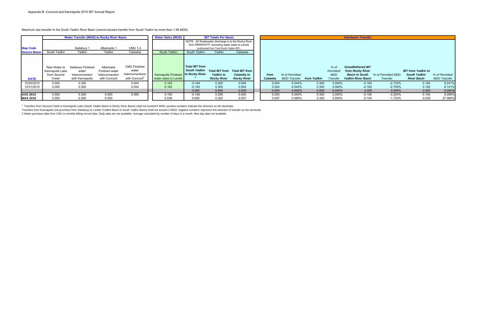
Maximum day transfer to the South Yadkin River Basin (cannot exceed transfer from South Yadkin by more than 1.99 MGD)
Water Sales (MGD)
Map Code Salisbury 1 Albemarle 1 CMU 1-3Source Basin South Yadkin Yadkin Yadkin Catawba South Yadkin South Yadkin Yadkin Catawba
DATE
Raw Water to Kannapolis Lake
from Second Creek
Salisbury Finished water
Interconnection with Kannapolis
Albemarle Finished water Interconnection with Concord
CMU Finished water
Interconnections with Concord2
Kannapolis Finished water sales to Landis
Total IBT from South Yadkin
to Rocky River 1
Total IBT from Yadkin to
Rocky River
Total IBT from Catawba to Rocky River
from Catawba
% of Permitted MDD Transfer from Yadkin
% of Permitted
MDD Transfer
Grandfathered IBT from Rocky River
Basin to South Yadkin River Basin
% of Permitted MDD Transfer
IBT from Yadkin to South Yadkin River Basin
% of Permitted MDD Transfer
Interbasin TransferNOTE: All Wastewater discharge is to the Rocky River
from RRRWWTP, excluding water sales to Landis (subtracted from Total South Yadkin IBT).
IBT Totals Per BasinWater Transfer (MGD) to Rocky River Basin
12/30/2010 0.000 0.300 0.004 0.164 -0.164 0.300 0.004 0.004 0.044% 0.300 3.000% -0.164 -2.733% 0.164 8.241%12/31/2010 0.000 0.300 0.004 0.162 -0.162 0.300 0.004 0.004 0.044% 0.300 3.000% -0.162 -2.700% 0.162 8.141%
0.000 0.000 0.000 0.000 0.000% 0.000 0.000% 0.000 0.000% 0.000 0.000%AVG 2010 0.000 0.300 0.000 0.005 0.195 -0.195 0.299 0.005 0.005 0.050% 0.300 3.000% -0.195 -3.254% 0.165 8.289%MAX 2010 0.000 0.300 0.000 0.539 0.000 0.300 0.007 0.007 0.066% 0.300 3.000% -0.104 -1.733% 0.539 27.085%
1 Transfers from Second Creek to Kannapolis Lake (South Yadkin Basin to Rocky River Basin) shall not exceed 6 MGD; positive numbers indicate this direction as the dominate.Transfers from Kannapolis (via purchase from Salisbury) to Landis (Yadkin Basin to South Yadkin Basin) shall not exceed 2 MGD; negative numbers represent this direction of transfer as the dominate. 2 Water purchase data from CMU is monthly billing record data. Daily data are not available. Average calculated by number of days in a month. Max day data not available.
Appendix B: Concord and Kannapolis 2010 IBT Annual Report

G.S. 143-215.22L Page 1
§ 143-215.22L. Regulation of surface water transfers. (a) Certificate Required. – No person, without first obtaining a certificate from
the Commission, may: (1) Initiate a transfer of 2,000,000 gallons of water or more per day from
one river basin to another. (2) Increase the amount of an existing transfer of water from one river
basin to another by twenty-five percent (25%) or more above the average daily amount transferred during the year ending 1 July 1993 if the total transfer including the increase is 2,000,000 gallons or more per day.
(3) Increase an existing transfer of water from one river basin to another above the amount approved by the Commission in a certificate issued under G.S. 162A-7 prior to 1 July 1993.
(b) Exception. – Notwithstanding the provisions of subsection (a) of this section, a certificate shall not be required to transfer water from one river basin to another up to the full capacity of a facility to transfer water from one basin to another if the facility was in existence or under construction on 1 July 1993.
(c) Notice of Intent to File a Petition. – An applicant shall prepare a notice of intent to file a petition that includes a nontechnical description of the applicant's request and an identification of the proposed water source. Within 90 days after the applicant files a notice of intent to file a petition, the applicant shall hold at least one public meeting in the source river basin upstream from the proposed point of withdrawal, at least one public meeting in the source river basin downstream from the proposed point of withdrawal, and at least one public meeting in the receiving river basin to provide information to interested parties and the public regarding the nature and extent of the proposed transfer and to receive comment on the scope of the environmental documents. Written notice of the public meetings shall be provided at least 30 days before the public meetings. At the time the applicant gives notice of the public meetings, the applicant shall request comment on the alternatives and issues that should be addressed in the environmental documents required by this section. The applicant shall accept written comment on the scope of the environmental documents for a minimum of 30 days following the last public meeting. Notice of the public meetings and opportunity to comment on the scope of the environmental documents shall be provided as follows:
(1) By publishing notice in the North Carolina Register. (2) By publishing notice in a newspaper of general circulation in:
a. Each county in this State located in whole or in part of the area of the source river basin upstream from the proposed point of withdrawal.
b. Each city or county located in a state located in whole or in part of the surface drainage basin area of the source river basin that also falls within, in whole or in part, the area denoted by one of the following eight-digit cataloging units as organized by the United States Geological Survey:
Appendix C

G.S. 143-215.22L Page 2
03050105 (Broad River: NC and SC); 03050106 (Broad River: SC); 03050107 (Broad River: SC); 03050108 (Broad River: SC); 05050001 (New River: NC and VA); 05050002 (New River: VA and WV); 03050101 (Catawba River: NC and SC); 03050103 (Catawba River: NC and SC); 03050104 (Catawba River: SC); 03010203 (Chowan River: NC and VA); 03010204 (Chowan River: NC and VA); 06010105 (French Broad River: NC and TN); 06010106 (French Broad River: NC and TN); 06010107 (French Broad River: TN); 06010108 (French Broad River: NC and TN); 06020001 (Hiwassee River: AL, GA, TN); 06020002 (Hiwassee River: GA, NC, TN); 06010201 (Little Tennessee River: TN); 06010202 (Little Tennessee River: TN, GA, and NC); 06010204 (Little Tennessee River: NC and TN); 03060101 (Savannah River: NC and SC); 03060102 (Savannah River: GA, NC, and SC); 03060103 (Savannah River: GA and SC); 03060104 (Savannah River: GA); 03060105 (Savannah River: GA); 03040203 (Lumber River: NC and SC); 03040204 (Lumber River: NC and SC); 03040206 (Lumber River: NC and SC); 03040207 (Lumber River: NC and SC); 03010205 (Albemarle Sound: NC and VA); 06020003 (Ocoee River: GA, NC, and TN); 03010101 (Roanoke River: VA); 03010102 (Roanoke River: NC and VA); 03010103 (Roanoke River: NC and VA); 03010104 (Roanoke River: NC and VA); 03010105 (Roanoke River: VA); 03010106 (Roanoke River: NC and VA); 06010102 (Watauga River: TN and VA); 06010103 (Watauga River: NC and TN); 03040101 (Yadkin River: VA and NC); 03040104 (Yadkin River: NC and SC); 03040105 (Yadkin River: NC and SC); 03040201 (Yadkin River: NC and SC); 03040202 (Yadkin River: NC and SC).
Appendix C

G.S. 143-215.22L Page 3
c. Each county in this State located in whole or in part of the area of the source river basin downstream from the proposed point of withdrawal.
d. Any area in the State in a river basin for which the source river basin has been identified as a future source of water in a local water supply plan prepared pursuant to G.S. 143-355(l).
e. Each county in the State located in whole or in part of the receiving river basin.
(3) By giving notice by first-class mail or electronic mail to each of the following: a. The board of commissioners of each county in this State or the
governing body of any county or city that is politically independent of a county in any state that is located entirely or partially within the source river basin of the proposed transfer and that also falls within, in whole or in part, the area denoted by one of the eight-digit cataloging units listed in sub-subdivision b. of subdivision (2) of this subsection.
b. The board of commissioners of each county in this State or the governing body of any county or city that is politically independent of a county in any state that is located entirely or partially within the receiving river basin of the proposed transfer and that also falls within, in whole or in part, the area denoted by one of the eight-digit cataloging units listed in sub-subdivision b. of subdivision (2) of this subsection.
c. The governing body of any public water supply system that withdraws water upstream or downstream from the withdrawal point of the proposed transfer.
d. If any portion of the source or receiving river basins is located in another state, all state water management or use agencies, environmental protection agencies, and the office of the governor in that state upstream or downstream from the withdrawal point of the proposed transfer.
e. All persons who have registered a water withdrawal or transfer from the proposed source river basin under this Part or under similar law in an another state.
f. All persons who hold a certificate for a transfer of water from the proposed source river basin under this Part or under similar law in an another state.
g. All persons who hold a National Pollutant Discharge Elimination System (NPDES) wastewater discharge permit for a discharge of 100,000 gallons per day or more upstream or downstream from the proposed point of withdrawal.
h. To any other person who submits to the applicant a written request to receive all notices relating to the petition.
Appendix C

G.S. 143-215.22L Page 4
(d) Environmental Documents. – The definitions set out in G.S. 113A-9 apply to this section. The Department shall conduct a study of the environmental impacts of any proposed transfer of water for which a certificate is required under this section. The study shall meet all of the requirements set forth in G.S. 113A-4 and rules adopted pursuant to G.S. 113A-4. An environmental assessment shall be prepared for any petition for a certificate under this section. The determination of whether an environmental impact statement shall also be required shall be made in accordance with the provisions of Article 1 of Chapter 113A of the General Statutes; except that an environmental impact statement shall be prepared for every proposed transfer of water from one major river basin to another for which a certificate is required under this section. The applicant who petitions the Commission for a certificate under this section shall pay the cost of special studies necessary to comply with Article 1 of Chapter 113A of the General Statutes. An environmental impact statement prepared pursuant to this subsection shall include all of the following:
(1) A comprehensive analysis of the impacts that would occur in the source river basin and the receiving river basin if the petition for a certificate is granted.
(2) An evaluation of alternatives to the proposed interbasin transfer, including water supply sources that do not require an interbasin transfer and use of water conservation measures.
(3) A description of measures to mitigate any adverse impacts that may arise from the proposed interbasin transfer.
(e) Public Hearing on the Draft Environmental Document. – The Commission shall hold a public hearing on the draft environmental document for a proposed interbasin transfer after giving at least 30 days' written notice of the hearing in the Environmental Bulletin and as provided in subdivisions (2) and (3) of subsection (c) of this section. The notice shall indicate where a copy of the environmental document can be reviewed and the procedure to be followed by anyone wishing to submit written comments and questions on the environmental document. The Commission shall prepare a record of all comments and written responses to questions posed in writing. The record shall include complete copies of scientific or technical comments related to the potential impact of the interbasin transfer. The Commission shall accept written comment on the draft environmental documents for a minimum of 30 days following the last public hearing.
(f) Determination of Adequacy of Environmental Document. – The Commission shall not act on any petition for an interbasin transfer until the Commission has determined that the environmental document is complete and adequate. A decision on the adequacy of the environmental document is subject to review in a contested case on the decision of the Commission to issue or deny a certificate under this section.
(g) Petition. – An applicant for a certificate shall petition the Commission for the certificate. The petition shall be in writing and shall include all of the following:
(1) A description of the facilities to be used to transfer the water, including the location and capacity of water intakes, pumps, pipelines, and other facilities.
Appendix C

G.S. 143-215.22L Page 5
(2) A description of all the proposed consumptive and nonconsumptive uses of the water to be transferred.
(3) A description of the water quality of the source river and receiving river, including information on aquatic habitat for rare, threatened, and endangered species; in-stream flow data for segments of the source and receiving rivers that may be affected by the transfer; and any waters that are impaired pursuant to section 303(d) of the federal Clean Water Act (33 U.S.C. § 1313(d)).
(4) A description of the water conservation measures used by the applicant at the time of the petition and any additional water conservation measures that the applicant will implement if the certificate is granted.
(5) A description of all sources of water within the receiving river basin, including surface water impoundments, groundwater wells, reinjection storage, and purchase of water from another source within the river basin, that is a practicable alternative to the proposed transfer that would meet the applicant's water supply needs. The description of water sources shall include sources available at the time of the petition for a certificate and any planned or potential water sources.
(6) A description of water transfers and withdrawals registered under G.S. 143-215.22H or included in a local water supply plan prepared pursuant to G.S. 143-355(l) from the source river basin, including transfers and withdrawals at the time of the petition for a certificate and any planned or reasonably foreseeable transfers or withdrawals by a public water system with service area located within the source river basin.
(7) A demonstration that the proposed transfer, if added to all other transfers and withdrawals required to be registered under G.S. 143-215.22H or included in any local water supply plan prepared by a public water system with service area located within the source basin pursuant to G.S. 143-355(l) from the source river basin at the time of the petition for a certificate, would not reduce the amount of water available for use in the source river basin to a degree that would impair existing uses, pursuant to the antidegradation policy set out in 40 Code of Federal Regulation § 131.12 (Antidegradation Policy)(1 July 2006 Edition) and the statewide antidegradation policy adopted pursuant thereto, or existing and planned consumptive and nonconsumptive uses of the water in the source river basin. If the proposed transfer would impact a reservoir within the source river basin, the demonstration must include a finding that the transfer would not result in a water level in the reservoir that is inadequate to support existing uses of the reservoir, including recreational uses.
(8) The applicant's future water supply needs and the present and reasonably foreseeable future water supply needs for public water systems with service area located within the source river basin. The
Appendix C

G.S. 143-215.22L Page 6
analysis of future water supply needs shall include agricultural, recreational, and industrial uses, and electric power generation. Local water supply plans prepared pursuant to G.S. 143-355(l) for water systems with service area located within the source river basin shall be used to evaluate the projected future water needs in the source river basin that will be met by public water systems.
(9) The applicant's water supply plan prepared pursuant to G.S. 143-355(l). If the applicant's water supply plan is more than two years old at the time of the petition, then the applicant shall include with the petition an updated water supply plan.
(10) Any other information deemed necessary by the Commission for review of the proposed water transfer.
(h) Settlement Discussions. – Upon the request of the applicant, any interested party, or the Department, or upon its own motion, the Commission may appoint a mediation officer. The mediation officer may be a member of the Commission, an employee of the Department, or a neutral third party but shall not be a hearing officer under subsections (e) or (j) of this section. The mediation officer shall make a reasonable effort to initiate settlement discussions between the applicant and all other interested parties. Evidence of statements made and conduct that occurs in a settlement discussion conducted under this subsection, whether attributable to a party, a mediation officer, or other person shall not be subject to discovery and shall be inadmissible in any subsequent proceeding on the petition for a certificate. The Commission may adopt rules to govern the conduct of the mediation process.
(i) Draft Determination. – Within 90 days after the Commission determines that the environmental document prepared in accordance with subsection (d) of this section is adequate or the applicant submits its petition for a certificate, whichever occurs later, the Commission shall issue a draft determination on whether to grant the certificate. The draft determination shall be based on the criteria set out in this section and shall include the conditions and limitations, findings of fact, and conclusions of law that would be required in a final determination. Notice of the draft determination shall be given as provided in subsection (c) of this section.
(j) Public Hearing on the Draft Determination. – Within 60 days of the issuance of the draft determination as provided in subsection (i) of this section, the Commission shall hold public hearings on the draft determination. At least one hearing shall be held in the affected area of the source river basin, and at least one hearing shall be held in the affected area of the receiving river basin. In determining whether more than one public hearing should be held within either the source or receiving river basins, the Commission shall consider the differing or conflicting interests that may exist within the river basins, including the interests of both upstream and downstream parties potentially affected by the proposed transfer. The public hearings shall be conducted by one or more hearing officers appointed by the Chair of the Commission. The hearing officers may be members of the Commission or employees of the Department. The Commission shall give at least 30 days' written notice of the public hearing as provided in subsection (c) of this section. The Commission shall accept written comment on the draft
Appendix C
G.S. 143-215.22L Page 7
determination for a minimum of 30 days following the last public hearing. The Commission shall prepare a record of all comments and written responses to questions posed in writing. The record shall include complete copies of scientific or technical comments related to the potential impact of the interbasin transfer.
(k) Final Determination: Factors to be Considered. – In determining whether a certificate may be issued for the transfer, the Commission shall specifically consider each of the following items and state in writing its findings of fact and conclusions of law with regard to each item:
(1) The necessity and reasonableness of the amount of surface water proposed to be transferred and its proposed uses.
(2) The present and reasonably foreseeable future detrimental effects on the source river basin, including present and future effects on public, industrial, economic, recreational, and agricultural water supply needs, wastewater assimilation, water quality, fish and wildlife habitat, electric power generation, navigation, and recreation. Local water supply plans for public water systems with service area located within the source river basin prepared pursuant to G.S. 143-355(l) shall be used to evaluate the projected future water needs in the source river basin that will be met by public water systems. Information on projected future water needs for public water systems with service area located within the source river basin that is more recent than the local water supply plans may be used if the Commission finds the information to be reliable. The determination shall include a specific finding as to measures that are necessary or advisable to mitigate or avoid detrimental impacts on the source river basin.
(3) The cumulative effect on the source major river basin of any water transfer or consumptive water use that, at the time the Commission considers the petition for a certificate is occurring, is authorized under this section, or is projected in any local water supply plan for public water systems with service area located within the source river basin that has been submitted to the Department in accordance with G.S. 143-355(l).
(4) The present and reasonably foreseeable future beneficial and detrimental effects on the receiving river basin, including present and future effects on public, industrial, economic, recreational, and agricultural water supply needs, wastewater assimilation, water quality, fish and wildlife habitat, electric power generation, navigation, and recreation. Local water supply plans prepared pursuant to G.S. 143-355(l) that affect the receiving river basin shall be used to evaluate the projected future water needs in the receiving river basin that will be met by public water systems. Information on projected future water needs that is more recent than the local water supply plans may be used if the Commission finds the information to be reliable. The determination shall include a specific finding as to measures that are
Appendix C

G.S. 143-215.22L Page 8
necessary or advisable to mitigate or avoid detrimental impacts on the receiving river basin.
(5) The availability of reasonable alternatives to the proposed transfer, including the potential capacity of alternative sources of water, the potential of each alternative to reduce the amount of or avoid the proposed transfer, probable costs, and environmental impacts. In considering alternatives, the Commission is not limited to consideration of alternatives that have been proposed, studied, or considered by the applicant. The determination shall include a specific finding as to why the applicant's need for water cannot be satisfied by alternatives within the receiving basin, including unused capacity under a transfer for which a certificate is in effect or that is otherwise authorized by law at the time the applicant submits the petition. The determination shall consider the extent to which access to potential sources of surface water or groundwater within the receiving river basin is no longer available due to depletion, contamination, or the declaration of a capacity use area under Part 2 of Article 21 of Chapter 143 of the General Statutes. The determination shall consider the feasibility of the applicant's purchase of water from other water suppliers within the receiving basin and of the transfer of water from another sub-basin within the receiving major river basin. Except in circumstances of technical or economic infeasibility or adverse environmental impact, the Commission's determination as to reasonable alternatives shall give preference to alternatives that would involve a transfer from one sub-basin to another within the major receiving river basin over alternatives that would involve a transfer from one major river basin to another major river basin.
(6) If applicable to the proposed project, the applicant's present and proposed use of impoundment storage capacity to store water during high-flow periods for use during low-flow periods and the applicant's right of withdrawal under G.S. 143-215.44 through G.S. 143-215.50.
(7) If the water to be withdrawn or transferred is stored in a multipurpose reservoir constructed by the United States Army Corps of Engineers, the purposes and water storage allocations established for the reservoir at the time the reservoir was authorized by the Congress of the United States.
(8) Whether the service area of the applicant is located in both the source river basin and the receiving river basin.
(9) Any other facts and circumstances that are reasonably necessary to carry out the purposes of this Part.
(l) Final Determination: Information to be Considered. – In determining whether a certificate may be issued for the transfer, the Commission shall consider all of the following sources of information:
(1) The petition.
Appendix C

G.S. 143-215.22L Page 9
(2) The environmental document prepared pursuant to subsection (d) of this section.
(3) All oral and written comment and all accompanying materials or evidence submitted pursuant to subsections (e) and (j) of this section.
(4) Information developed by or available to the Department on the water quality of the source river basin and the receiving river basin, including waters that are identified as impaired pursuant to section 303(d) of the federal Clean Water Act (33 U.S.C. § 1313(d)), that are subject to a total maximum daily load (TMDL) limit under subsections (d) and (e) of section 303 of the federal Clean Water Act, or that would have their assimilative capacity impaired if the certificate is issued.
(5) Any other information that the Commission determines to be relevant and useful.
(m) Final Determination: Burden and Standard of Proof; Specific Findings. – The Commission shall grant a certificate for a water transfer if the Commission finds that the applicant has established by a preponderance of the evidence all of the following:
(1) The benefits of the proposed transfer outweigh the detriments of the proposed transfer. In making this determination, the Commission shall be guided by the approved environmental document and the policy set out in subsection (t) of this section.
(2) The detriments have been or will be mitigated to the maximum degree practicable.
(3) The amount of the transfer does not exceed the amount of the projected shortfall under the applicant's water supply plan after first taking into account all other sources of water that are available to the applicant.
(4) There are no reasonable alternatives to the proposed transfer. (n) Final Determination: Certificate Conditions and Limitations. – The
Commission may grant the certificate in whole or in part, or deny the certificate. The Commission may impose any conditions or limitations on a certificate that the Commission finds necessary to achieve the purposes of this Part including a limit on the period for which the certificate is valid. The conditions and limitations shall include any mitigation measures proposed by the applicant to minimize any detrimental effects within the source and receiving river basins. In addition, the certificate shall require all of the following conditions and limitations:
(1) A water conservation plan that specifies the water conservation measures that will be implemented by the applicant in the receiving river basin to ensure the efficient use of the transferred water. Except in circumstances of technical or economic infeasibility or adverse environmental impact, the water conservation plan shall provide for the mandatory implementation of water conservation measures by the applicant that equal or exceed the most stringent water conservation plan implemented by a community water system, as defined in G.S. 143-355(l), that withdraws water from the source river basin.
Appendix C

G.S. 143-215.22L Page 10
(2) A drought management plan that specifies how the transfer shall be managed to protect the source river basin during drought conditions or other emergencies that occur within the source river basin. Except in circumstances of technical or economic infeasibility or adverse environmental impact, this drought management plan shall include mandatory reductions in the permitted amount of the transfer based on the severity and duration of a drought occurring within the source river basin and shall provide for the mandatory implementation of a drought management plan by the applicant that equals or exceeds the most stringent water conservation plan implemented by a community water system, as defined in G.S. 143-355(l), that withdraws water from the source river basin.
(3) The maximum amount of water that may be transferred on a daily basis, and methods or devices required to be installed and operated that measure the amount of water that is transferred.
(4) A provision that the Commission may amend a certificate to reduce the maximum amount of water authorized to be transferred whenever it appears that an alternative source of water is available to the certificate holder from within the receiving river basin, including, but not limited to, the purchase of water from another water supplier within the receiving basin or to the transfer of water from another sub-basin within the receiving major river basin.
(5) A provision that the Commission shall amend the certificate to reduce the maximum amount of water authorized to be transferred if the Commission finds that the applicant's current projected water needs are significantly less than the applicant's projected water needs at the time the certificate was granted.
(6) A requirement that the certificate holder report the quantity of water transferred during each calendar quarter. The report required by this subdivision shall be submitted to the Commission no later than 30 days after the end of the quarter.
(7) Except as provided in this subdivision, a provision that the applicant will not resell the water that would be transferred pursuant to the certificate to another public water supply system. This limitation shall not apply in the case of a proposed resale or transfer among public water supply systems within the receiving river basin as part of an interlocal agreement or other regional water supply arrangement, provided that each participant in the interlocal agreement or regional water supply arrangement is a co-applicant for the certificate and will be subject to all the terms, conditions, and limitations made applicable to any lead or primary applicant.
(o) Administrative and Judicial Review. – Administrative and judicial review of a final decision by the Commission on a petition for a certificate under this section shall be governed by Chapter 150B of the General Statutes.
Appendix C

G.S. 143-215.22L Page 11
(p) Certain Preexisting Transfers. – In cases where an applicant requests approval to increase a transfer that existed on 1 July 1993, the Commission may approve or disapprove only the amount of the increase. If the Commission approves the increase, the certificate shall be issued for the amount of the preexisting transfer plus any increase approved by the Commission. A certificate for a transfer approved by the Commission under G.S. 162A-7 shall remain in effect as approved by the Commission and shall have the same effect as a certificate issued under this Part. A certificate for the increase of a preexisting transfer shall contain all of the conditions and limitations required by subsection (m) of this section.
(q) Emergency Transfers. – In the case of water supply problems caused by drought, a pollution incident, temporary failure of a water plant, or any other temporary condition in which the public health, safety, or welfare requires a transfer of water, the Secretary of Environment and Natural Resources may grant approval for a temporary transfer. Prior to approving a temporary transfer, the Secretary shall consult with those parties listed in subdivision (3) of subsection (c) of this section that are likely to be affected by the proposed transfer. However, the Secretary shall not be required to satisfy the public notice requirements of this section or make written findings of fact and conclusions of law in approving a temporary transfer under this subsection. If the Secretary approves a temporary transfer under this subsection, the Secretary shall specify conditions to protect other water users. A temporary transfer shall not exceed six months in duration, but the approval may be renewed for a period of six months by the Secretary based on demonstrated need as set forth in this subsection.
(r) Relationship to Federal Law. – The substantive restrictions, conditions, and limitations upon surface water transfers authorized in this section may be imposed pursuant to any federal law that permits the State to certify, restrict, or condition any new or continuing transfers or related activities licensed, relicensed, or otherwise authorized by the federal government. This section shall govern the transfer of water from one river basin to another unless preempted by federal law.
(s) Planning Requirements. – When any transfer for which a certificate was issued under this section equals or exceeds eighty percent (80%) of the maximum amount authorized in the certificate, the applicant shall submit to the Department a detailed plan that specifies how the applicant intends to address future foreseeable water needs. If the applicant is required to have a local water supply plan, then this plan shall be an amendment to the local water supply plan required by G.S.143-355(l). When the transfer equals or exceeds ninety percent (90%) of the maximum amount authorized in the certificate, the applicant shall begin implementation of the plan submitted to the Department.
(t) Statement of Policy. – It is the public policy of the State to maintain, protect, and enhance water quality within North Carolina. It is the public policy of this State that the reasonably foreseeable future water needs of a public water system with its service area located primarily in the receiving river basin are subordinate to the reasonably foreseeable future water needs of a public water system with its service area located primarily in the source river basin. Further, it is the public policy of the State that the cumulative impact of transfers from a source river basin shall not result in a violation of
Appendix C
G.S. 143-215.22L Page 12
the antidegradation policy set out in 40 Code of Federal Regulations § 131.12 (1 July 2006 Edition) and the statewide antidegradation policy adopted pursuant thereto.
(u) Renewal of Certificate. – A petition to extend or renew a certificate shall be treated as a new petition. (1993, c. 348, s. 1; 1997-443, ss. 11A.119(a), 15.48(c); 1997-524, s. 1; 1998-168, s. 4; 2001-474, s. 28; 2007-484, s. 43.7C; 2007-518, s. 3; 2008-125, s. 1; 2008-198, s. 11.5.)
Appendix C