case studies gcse
TRANSCRIPT
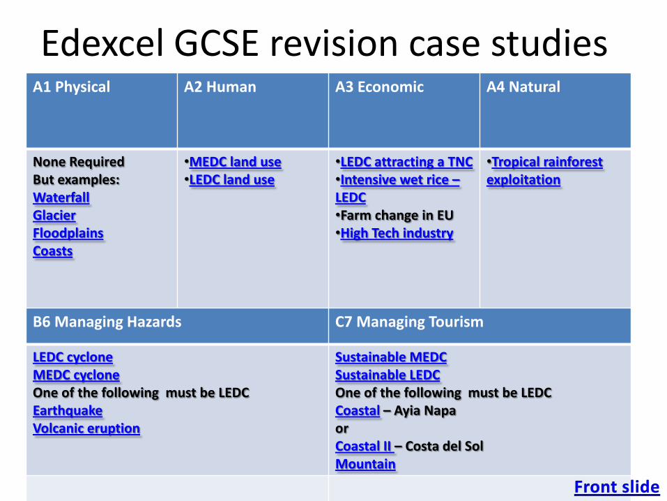
Edexcel GCSE revision case studiesA1 Physical A2 Human A3 Economic A4 Natural
None RequiredBut examples:WaterfallGlacierFloodplainsCoasts
•MEDC land use•LEDC land use
•LEDC attracting a TNC•Intensive wet rice –LEDC•Farm change in EU•High Tech industry
•Tropical rainforestexploitation
B6 Managing Hazards C7 Managing Tourism
LEDC cycloneMEDC cycloneOne of the following must be LEDCEarthquakeVolcanic eruption
Sustainable MEDCSustainable LEDCOne of the following must be LEDCCoastal – Ayia NapaorCoastal II – Costa del SolMountain
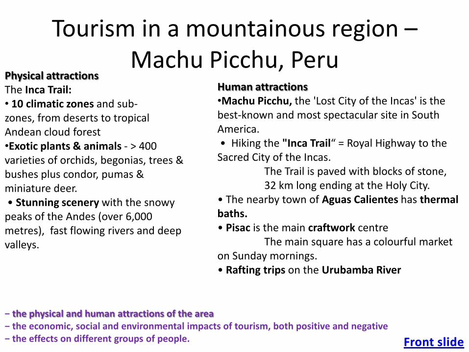
Tourism in a mountainous region –Machu Picchu, Peru
− the physical and human attractions of the area− the economic, social and environmental impacts of tourism, both positive and negative− the effects on different groups of people.
Physical attractionsThe Inca Trail:• 10 climatic zones and sub-zones, from deserts to tropical Andean cloud forest •Exotic plants & animals - > 400 varieties of orchids, begonias, trees & bushes plus condor, pumas & miniature deer.• Stunning scenery with the snowy peaks of the Andes (over 6,000 metres), fast flowing rivers and deep valleys.
Human attractions•Machu Picchu, the 'Lost City of the Incas' is the best-known and most spectacular site in South America. • Hiking the "Inca Trail“ = Royal Highway to the Sacred City of the Incas.
The Trail is paved with blocks of stone, 32 km long ending at the Holy City.
• The nearby town of Aguas Calientes has thermal baths.• Pisac is the main craftwork centre
The main square has a colourful market on Sunday mornings.• Rafting trips on the Urubamba River

− the physical and human attractions of the area− the economic, social and environmental impacts of tourism, both positive and negative− the effects on different groups of people.
Tourism in a mountainous region – Machu Picchu, Peru
Benefits Costs
Social • outside dollars to support community facilities. • ↑ civic involvement and pride. • Cultural exchange• Preservation & celebration of local culture• Facilities &infrastructure supported by tourism (e.g. the railway)• Encourages the learning of new skills.
• visitors may conflict with the community's. • May change family relationships. • Overloading of porters• ↓ traditional values and culture through imitation• Crowding & congestion• Tourists compete with residents for available services and facilities• ↑ in crime in the area. • Desecration of the Indian spiritual heritage.
Environmental • Fosters conservation and preservation of natural, cultural and historical resources. • Could be considered a clean industry.
• 2,000 visit the Machu Picchu daily – erosion • eroded by heavy rains /landslides - recovery of the terraces, stabilises slopes – conservation at a price.• Wood cutting for fuel/cooking threatened Machu• Plans for a road from Cuzco + cable car • Visitors 6,000 in 1984 to 82,000 in 2000. Litter • Urban ↑- human waste direct into the Urubamba river. • Helicopters –↓peace & damaging sites/fauna – Andean Condor
Economic • High-spending tourists = higher socio-economic groups. • Governments gain taxes - accommodation /restaurant, airport, sales, entrances , income tax - $6 mil pa for Peru,+ $3 mil pa for Machu Picchu Management.• Local jobs & businesses : direct related to tourism (hotel and tour services) + indirectly(such as food production and housing construction). • The multiplier effect • Is labour-intensive. • Earns valuable foreign exchange.
• Inflates property values & prices • Employment tends to be seasonal. • Tourist numbers vary affected by events beyond the control of the destination e.g. terrorism, economic recession. This is a problem in Peru for the country is over-dependent upon tourism. • leakage- money used to pay for imports required by tourists. • The jobs provided are usually poorly paid.
− the physical and human attractions of the area− the economic, social and environmental impacts of tourism, both positive and negative− the effects on different groups of people.
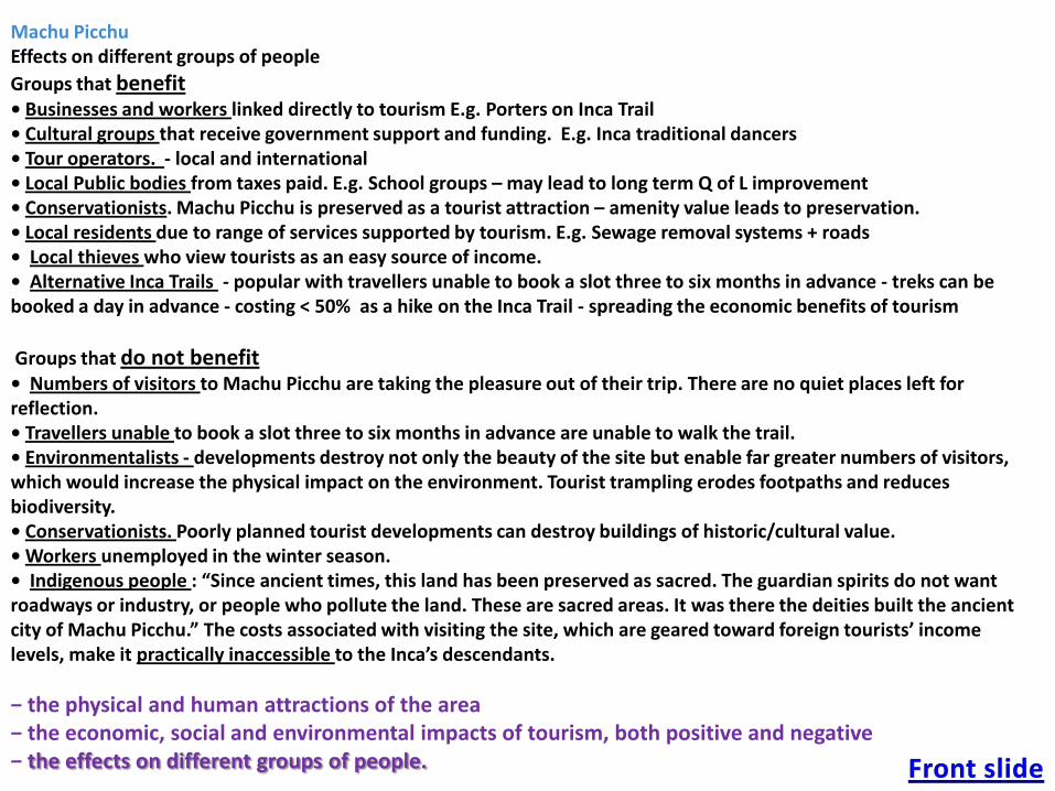
Machu PicchuEffects on different groups of people
Groups that benefit • Businesses and workers linked directly to tourism E.g. Porters on Inca Trail• Cultural groups that receive government support and funding. E.g. Inca traditional dancers• Tour operators. - local and international• Local Public bodies from taxes paid. E.g. School groups – may lead to long term Q of L improvement• Conservationists. Machu Picchu is preserved as a tourist attraction – amenity value leads to preservation.• Local residents due to range of services supported by tourism. E.g. Sewage removal systems + roads• Local thieves who view tourists as an easy source of income.• Alternative Inca Trails - popular with travellers unable to book a slot three to six months in advance - treks can be booked a day in advance - costing < 50% as a hike on the Inca Trail - spreading the economic benefits of tourism
Groups that do not benefit • Numbers of visitors to Machu Picchu are taking the pleasure out of their trip. There are no quiet places left for reflection. • Travellers unable to book a slot three to six months in advance are unable to walk the trail.• Environmentalists - developments destroy not only the beauty of the site but enable far greater numbers of visitors, which would increase the physical impact on the environment. Tourist trampling erodes footpaths and reduces biodiversity. • Conservationists. Poorly planned tourist developments can destroy buildings of historic/cultural value.• Workers unemployed in the winter season.• Indigenous people : “Since ancient times, this land has been preserved as sacred. The guardian spirits do not want roadways or industry, or people who pollute the land. These are sacred areas. It was there the deities built the ancient city of Machu Picchu.” The costs associated with visiting the site, which are geared toward foreign tourists’ income levels, make it practically inaccessible to the Inca’s descendants.
− the physical and human attractions of the area− the economic, social and environmental impacts of tourism, both positive and negative− the effects on different groups of people.
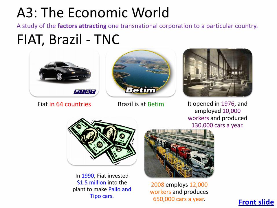
A3: The Economic WorldA study of the factors attracting one transnational corporation to a particular country.
FIAT, Brazil - TNC
Fiat in 64 countries Brazil is at Betim It opened in 1976, and employed 10,000
workers and produced 130,000 cars a year.
In 1990, Fiat invested $1.5 million into the
plant to make Palio and Tipo cars.
2008 employs 12,000 workers and produces
650,000 cars a year.
Why did Fiat locate in Brazil?A study of the factors attracting one transnational corporation to a particular country.
The Brazilian Government wanted a car industry = offered incentives to Large TNCs (Trans-National-Companies).
Betim in Minas Gerais - Fiat located there because the state gave them 50% of the start up costs.
Brazil’s increasing market for cars.
1970 – 255,000
2000 – 2,800,000
Cheap labour: $7 an hour. (cf UK $18)
Ltd Union strength :strikes are very unlikely so no production time would be lost
Fiat expanded in 1990 – Why?:
The state of Minas Gerais gave Fiat $135 million = new factory – >50% of costs. Fiat are expecting a large increase in local demand. If they are in the country, they will save money on transport costs and import duties.
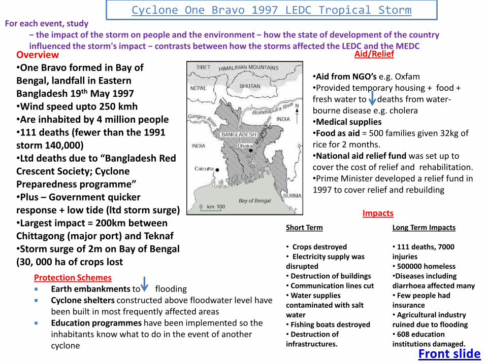
Short Term
• Crops destroyed• Electricity supply was disrupted• Destruction of buildings• Communication lines cut• Water supplies contaminated with salt water• Fishing boats destroyed• Destruction of infrastructures.
Impacts
Long Term Impacts
• 111 deaths, 7000 injuries• 500000 homeless•Diseases including diarrhoea affected many• Few people had insurance• Agricultural industry ruined due to flooding• 608 education institutions damaged.
Cyclone One Bravo 1997 LEDC Tropical Storm
•Aid from NGO’s e.g. Oxfam•Provided temporary housing + food + fresh water to deaths from water-bourne disease e.g. cholera •Medical supplies •Food as aid = 500 families given 32kg of rice for 2 months.•National aid relief fund was set up to cover the cost of relief and rehabilitation.•Prime Minister developed a relief fund in 1997 to cover relief and rebuilding
Aid/Relief
Protection Schemes Earth embankments to flooding Cyclone shelters constructed above floodwater level have
been built in most frequently affected areas Education programmes have been implemented so the
inhabitants know what to do in the event of another cyclone
Overview•One Bravo formed in Bay of Bengal, landfall in Eastern Bangladesh 19th May 1997•Wind speed upto 250 kmh•Are inhabited by 4 million people•111 deaths (fewer than the 1991 storm 140,000)•Ltd deaths due to “Bangladesh Red Crescent Society; Cyclone Preparedness programme”•Plus – Government quicker response + low tide (ltd storm surge)•Largest impact = 200km between Chittagong (major port) and Teknaf•Storm surge of 2m on Bay of Bengal (30, 000 ha of crops lost
For each event, study − the impact of the storm on people and the environment − how the state of development of the country influenced the storm's impact − contrasts between how the storms affected the LEDC and the MEDC
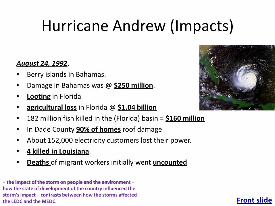
Hurricane Andrew (Impacts)
August 24, 1992.
• Berry islands in Bahamas.
• Damage in Bahamas was @ $250 million.
• Looting in Florida
• agricultural loss in Florida @ $1.04 billion
• 182 million fish killed in the (Florida) basin = $160 million
• In Dade County 90% of homes roof damage
• About 152,000 electricity customers lost their power.
• 4 killed in Louisiana.
• Deaths of migrant workers initially went uncounted
− the impact of the storm on people and the environment − how the state of development of the country influenced the storm's impact − contrasts between how the storms affected the LEDC and the MEDC.
• Evacuations were ordered, residents throughout the region of Bahamas and Florida were warned to take precautions to protect life and property.
• 1500 National Guard troops were deployed to Florida to prevent looting.
• Sandbag walls were created in the in New Orleans. Floodgates were also closedthroughout New Orleans Levees. Sandbags for the public ran out. Planes headed to and from New Orleans were cancelled.
• About 6,200 people had to be housed in 36 separate shelters. The Salvation Army sent in 37 mobile food storage faculties,
• slow response of federal aid in Florida, President Bush crumbles under pressure; mobile tents and kitchens are supplied.
• Federal aid generators and pre-packaged meals sent to Louisiana. 1,279 National Guard were deployed to Louisiana, to cook to patrol.
• Louisiana imposed a curfew from 6 p.m. to 6 a.m. Alcohol sales were also bannedimmediately after the storm
Precautions and Responses
− the impact of the storm on people and the environment − how the state of development of the country influenced the storm's impact − contrasts between how the storms affected the LEDC and the MEDC.

The Cubbon Park, officially known as Sri. ChamarajendraPark, is an historic park, located in the heart of city in the Central Administrative Area. CBD = skyscrapers of companies
such as Sun Microsystems + Mahatma Gandhi Road (MG Road) runs through the middle of it
Pre 1940, Bangalore built around a fort, with two main roads: Chickkapētē Street, which ran E-W, & DoddapētēStreet, which ran N-S. Their intersection formed the Doddapētē Square — the heart of Bangalore.
Bangalore boom in 1980s & 90s, spurred by capital investors from within India converted large plots & colonial bungalows to multi-storied apartments. 1985, Texas Instruments became the first TNCl to set up in Bangalore. Other IT companies followed = by the end of the 20th century, Bangalore had firmly established itself as the Silicon Valley of India.
In 1947, India gained Independence from Britain. After this, Bangalore expanded substantially, owing to the influx of immigrants from northern Karnataka. Bangalore now 6th largest city in India.
Industry is BIG in Bangalore, owing to the cheap labour, the fleet of trained personnel ready to work, and the rate of unemployment
Because poverty is so high in Bangalore, shanty towns have sprung up throughout the city –communities of lean-to constructions which are often bulldozed by the government. Inhabited by (usually unemployed) poor people.
describe and explain the characteristics and locations of the CBD, twilight zone, industrial
areas and different residential zones.

Waterfalls
Niagara Falls
-Niagara river, between Ontario & New York State.
-Most powerful waterfall in North America,
-Two distinct areas, the Horseshoe Falls (57m) and American Falls (55m)
-Formed 12,000 BP by glacial retreat
-Tourism plays a massive part in its upkeep, attracting millions per annum.

Floodplains
Definition
-A flat, undulating terrain subject to
periodic overbanking.
-Deposition of load occurs in the
floodplain, creating levees.
The River Nile
-Floods seasonally and fertilizes
land for farming. “Gift of the
Nile”.
-So large, it is discernable from
space.
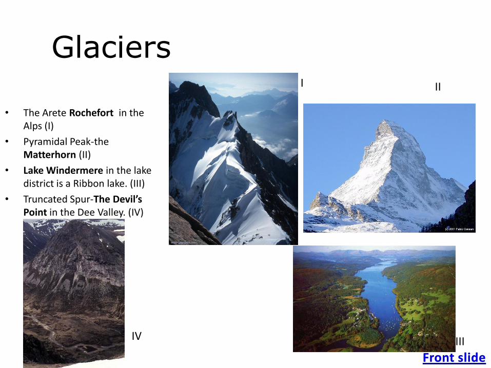
Glaciers
• The Arete Rochefort in the Alps (I)
• Pyramidal Peak-the Matterhorn (II)
• Lake Windermere in the lake district is a Ribbon lake. (III)
• Truncated Spur-The Devil’s Point in the Dee Valley. (IV)
III
IIIIV

CoastsBays and headlands at San Sébastian in Spain (right)
Old Harry is a stack in Dorset (below)
In the bottom right is a wave cut platform at Southerndown in Wales

CBD1
Suburb “Whitely”3
Inner City area2 “New Town”
describe and explain the characteristics and locations of the CBD, twilight zone, industrial
areas and different residential zones.
Commuter zone “Lower Early”4
Edge of town4

Region Land Uses + Properties
CBD 1
Central / Zone of constant renewal and development / Tall buildings (Bid-Rent) / Most important shops, offices and public facilities. /
All public transport converges in CBD.
E.G. COMMERCE/INDUSTRY Oracle redevelopment – leisure plus retail – VUE cinema, House of Fraser plus bars and
nightclubs
HOUSING – Brownfield site, apartments inside IDR, next to Kennet & Avon canal
Inner city
area2
High density housing (mainly built 1850-1914 – industrial era) / Grid iron road structure – workers homes. Quick to build, max
density, easy access and all lead on to arterial route ways. Built near industrial areas (East of main city) allowing quick commute.
Uniform terraced houses, cramped roads, no off street parking therefore traffic management – one way streets
E.G. HOUSING “New Town”, large Asian migrant community inc. Sikh temple & Halal butchers, plus student
accommodation.
INDUSTRY “Sutton Business Park” – small industrial units built in late 1980s for lightweight distribution, packaging and
business start ups – close to centre cheap start up cost – on site of old gas works
Suburbs3
Lower density, semi detached housing built from 1914 onwards. / Not for industrial workers as influx of industries had stopped.
Big houses for cheaper prices / Gardens owing to lower density and garages / Green spaces: Parks, communal greens, schools and
hospitals.
E.G. HOUSING “Whitley” – crescent shaped road patterns, front and back gardens, uniform housing, some council
housing – after redevelopment of inner city in 1950s, some infilling
INDUSTRY - “Gillette” assembly plants taking advantage of the access road from CBD to M4 junctions, light
manufacturing, more space than inner city location
Commute
r zone4
Higher priced, detached housing / Housing for commuters into London (excellent road –M4, A4 and rail connections. Only 40 miles
from London) / Garages and gardens / Out of town shopping centres have appeared in the last decade on Green Field sites
E.G. HOUSING - “Earley” private housing, mix of styles, cul de sacs, front and back gardens, detached housing,
INDUSTRY – modern business parks (“Green Park”) with high quality working environments and good access to M4 plus
Retail/Leisure (“Madejski”) inc stadium, hotel, nightclub, retail parks inc PC World
Moving away from central Reading
Characteristics of an urban area in a MEDC
Reading
describe and explain the characteristics and locations of the CBD, twilight zone, industrial
areas and different residential zones.
Ecotourism in the Galapagos
• The archipelago of the volcanic Galapagos Islands is located to the West of Ecuador in the Pacific Ocean.
It is home to 30000 people and is one of the few places in the world lacking an indigenous population.
The Galapagos receive 100000 visitors every year which cause several issues.
• Issues
1. Visitors introduce new animals such as cats and dogs which affect the food chains and disrupt the ecological balance by eating endangered animals such as iguanas.
2. Only 3% of the islands are set aside for human settlement and there is continuously new immigration from Ecuador resulting in overcrowding. The population has increased by 400% over the past decade.
3. Apart from the tourist industry, the only practical profession is fishing (sharks and sea cucumber) which damages marine fauna and creates conflict between fishermen and conservationalists.
4. Unwanted by-products of tourism: oil spills, boat paint/engine pollution, overused sites and water supply.
5. Tourists leave litter in on the islands and also the many hotels use vast amounts of electricity and waste is carelessly released into the sea damaging marine life.
6. Tourists pick flowers, sometimes rare and scare animals which may be endangered. 60% of 1880 plant species in the Galapagos are now endangered.
− the physical and human attractions of the area− the economic, social and environmental impacts of tourism, both positive andnegative− the effects on different groups of people.
• Solutions
In order to protect the Galapagos, measures have been taken, most notably the introduction of ecotourism.
1. President Correa decided to limit tourist traffic, overhead flights and residence permits.
2. Legal protection of flora and fauna extended by the government in 1986.
3. Galapagos Marine Resource Reserve placed limits on the number, size and location of fish caught by fishermen.
4. Rules enforced by park rangers and naturalist guides banning drinking alcohol, eating and smoking on the islands. Also they are asked to refrain from touching, feeding, chasing or using flash photography to take pictures of the animals.
5. Water skiing and jet skiing forbidden to prevent marine damage.
6. Voluntary organisations such as Galapagos ICE educate locals about how to protect the local wildlife and work towards sustainability.
7. Initiatives by ICE tourism to develop hotels and transport on the islands to return money to the economy rather that it escaping to the mainland.
− the physical and human attractions of the area− the economic, social and environmental impacts of tourism, both positive andnegative− the effects on different groups of people.
History• Originally part of a sugar plantation.
• In 1996 was given to Casiendo under the Land Reform Act
Rice farming in Asia
Maximo Casiendo’s Farm
Barangay Busay, Negros Occidental, Philippines
Physical Characteristics
• Receives 1800 mm of rain a year
• 70 m above sea level
• Average temperature of 25°, mostly between June and December
• Produces 2 (sometime three) crops a year
Management
• Worked on by Casiendo and his 7 children
• Owns a rice thresher, charges villagers to use it
• Hires water buffalos when needed (£28 /hect.)
• Uses 8 bags of nitrogen, 3 bags of NPK, 2 bags of PK, all per hect.
• Uses 2 litres of pesticides per hectare used 3 days after sowing
• Uses 30 litres of diesel per hectare for the thresher.
Produce
• Produces 2500 kg of rice per hectare per harvest
• Produces 26 tonnes of rice per year
• Mostly for the families consumption (subsistence), but in good years some can be sold
to consider changes affecting farm systems.

Kobe Earthquake – 5.46 am 17th January 1995
• Precautions: – many of the buildings were built to 1960s earthquake standards and they collapsed or were heavily damaged in the earthquake
• Impacts and Effects: – 7.3 on the Richter Scale
– 6,434 dead
– High density of the population in the suburbs led to far worse loss of life there
– Older structures with heavy wooden roofs collapsed this led to around 4,000 of the deaths
– Power plants collapsed causing power loss to 900,000 people, reduced to 400,000 the next day
– Running water cut off, returned the next day
– Telephone communications lost
– Transport links were destroyed (these led to fires reigning unchecked long after the earthquake)
– Wide scale loss of homes
– Emergency shelters were set up
– Japanese government refused medicine from other countries as it had not passed through the correct channels this led to secondary deaths
– Large scale unemployment due to loss of infrastructure
• Aid:– $200 (US) billion provided by Japanese government
– Motorola provided free telephone communications the next day
– Local people helped with recovery effort
– Aid was slow to reach certain people due to poor response by emergency services and how they struggled to reach people in the city
• Recovery/Management/Relief:– Some buildings torn down and rebuilt to fit modern standards of earthquake safety
– Buildings were retro fitted with bas isolators
– Destroyed buildings rebuilt without wooden supports and heavy roofs
– Gas pipes made rubber not metal
– 6 months after the earthquake train links restored
– In 4 years majority of housing rebuilt (it took until 2004 for all the homeless to be returned to their houses)
− evaluate measures to predict and take precautions, including reasons for the decisions made − study short-term responses and long-term recovery − contrast the responses in the chosen LEDC and MEDC − evaluate the sources of aid.

The Amazon Rainforest covers over 5 million square kilometres. Up to 3,000 square kilometres a day are being lost. As the world becomes richer, more meat is consumed. As oil prices rise, people increasingly turn to biofuels e.g. sugar cane.
Interest Group Interest in the rainforest Impact
Indigenous people •220,000 people from more than180 nations.
•Hunter-gatherer and subsistence farming
Traditionally low impact
Brazil has so many landless and poor people that it cannot afford
to provide indigenous people with their rights
Landless settlers •From drought-ridden NE of Brazil. Given land by
government - must farm to attract subsidies.
•To get the money, these settlers clear forest using slash-
and-burn techniques. Little understanding of traditional
farming methods
Medium impact
Farmers not familiar with climate or traditional farming
methods/crops/seed-type. Much land returns to secondary forest
– not productive. Many work in near-slavery conditions on sugar
cane plantations (biofuels)
Loggers •Timber for construction + hardwoods (e.g. mahogany) for
furniture.
•Also require roads (e.g. Trans-Amazonian Highway) to get
goods to market
High impact
Mostly illegal – take out high-value hardwoods. Burn everything
else in path. Do not replace trees
Miners •Resources can be extracted from rainforest, such as
bauxite, iron and gold.
•Also require roads (e.g. Trans-Amazonian Highway) to get
goods to markets. Road opens up area and causes damage
High impact
Open-cast mining impacts highly on environment. Large projects
(Carajas) are sustainable. Smaller, illegal ones are not
Soya farmers •Soya is a valuable cash crop mainly used for animal feed.
•Also require ports (e.g. Santarem) to get Soya to
international markets
High impact
Large areas cleared for Soya cultivation. Controlled by
multinationals. Quickly exhausts soil. As world food prices rise,
so does world price of Soya, increasing cultivation of Soya
Cattle ranchers •Raising beef to be sold as processed meat to the rest of the
world
High impact
Land cleared quickly erodes. New pastures needed. Rising food
prices since 2007 mean more land cleared
Government •Balance required between resources to meet needs of
growing population below poverty line and preserving
rainforest to maintain biodiversity, reduce greenhouse effect
and safeguard interests of future generations
Negligible
In developing country government lacks resources to police
means of preventing illegal loggers, miners, Soya farmers and
cattle ranches
International community •Other countries want Brazil to reduce its level of
deforestation to reduce global warming by the greenhouse
effect and to keep a variety of plant species potentially useful
for medical research
Variable
2004 - Greenpeace persuade McDonalds to halt buying of
Amazon Soya-fed chickens for Chicken McNuggets. However,
not sustainable whilst global population increases and world
food prices rise
the ideas of conservation, exploitation and sustainable development, and the roles of different interest groups and the conflicts between them.
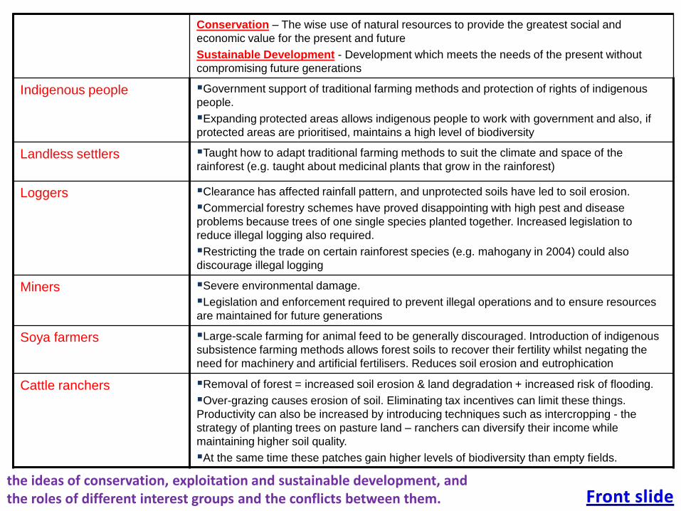
Conservation – The wise use of natural resources to provide the greatest social and
economic value for the present and future
Sustainable Development - Development which meets the needs of the present without
compromising future generations
Indigenous people Government support of traditional farming methods and protection of rights of indigenous
people.
Expanding protected areas allows indigenous people to work with government and also, if
protected areas are prioritised, maintains a high level of biodiversity
Landless settlers Taught how to adapt traditional farming methods to suit the climate and space of the
rainforest (e.g. taught about medicinal plants that grow in the rainforest)
Loggers Clearance has affected rainfall pattern, and unprotected soils have led to soil erosion.
Commercial forestry schemes have proved disappointing with high pest and disease
problems because trees of one single species planted together. Increased legislation to
reduce illegal logging also required.
Restricting the trade on certain rainforest species (e.g. mahogany in 2004) could also
discourage illegal logging
Miners Severe environmental damage.
Legislation and enforcement required to prevent illegal operations and to ensure resources
are maintained for future generations
Soya farmers Large-scale farming for animal feed to be generally discouraged. Introduction of indigenous
subsistence farming methods allows forest soils to recover their fertility whilst negating the
need for machinery and artificial fertilisers. Reduces soil erosion and eutrophication
Cattle ranchers Removal of forest = increased soil erosion & land degradation + increased risk of flooding.
Over-grazing causes erosion of soil. Eliminating tax incentives can limit these things.
Productivity can also be increased by introducing techniques such as intercropping - the
strategy of planting trees on pasture land – ranchers can diversify their income while
maintaining higher soil quality.
At the same time these patches gain higher levels of biodiversity than empty fields.
the ideas of conservation, exploitation and sustainable development, and the roles of different interest groups and the conflicts between them.
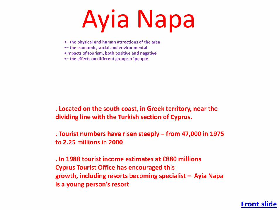
Ayia Napa
. Located on the south coast, in Greek territory, near the dividing line with the Turkish section of Cyprus.
. Tourist numbers have risen steeply – from 47,000 in 1975 to 2.25 millions in 2000
. In 1988 tourist income estimates at £880 millionsCyprus Tourist Office has encouraged this growth, including resorts becoming specialist – Ayia Napa is a young person’s resort
•− the physical and human attractions of the area•− the economic, social and environmental•impacts of tourism, both positive and negative•− the effects on different groups of people.
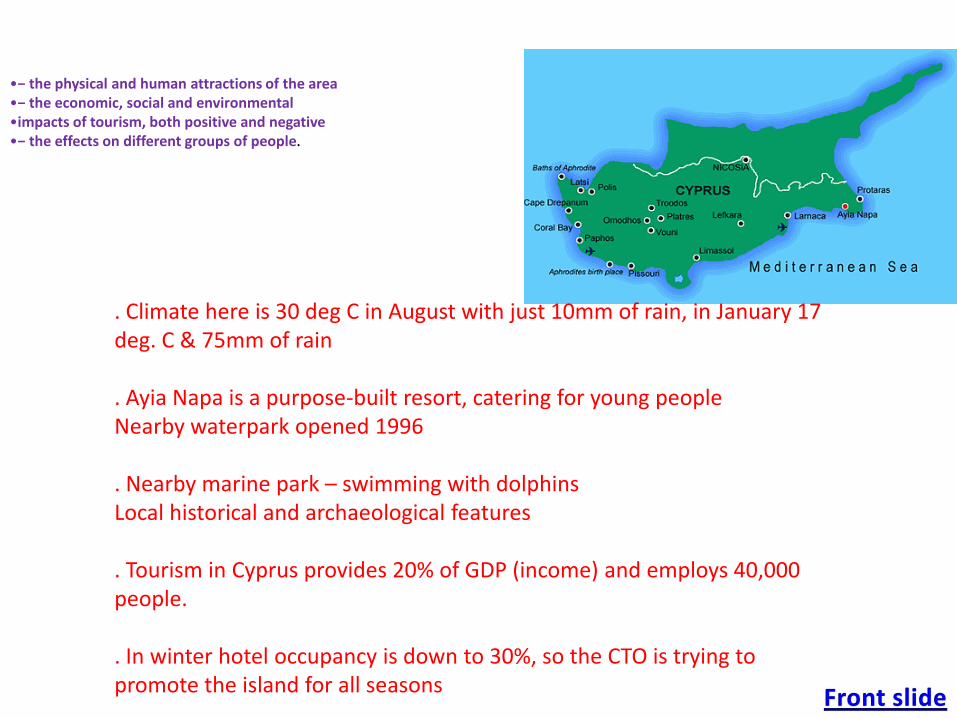
. Climate here is 30 deg C in August with just 10mm of rain, in January 17 deg. C & 75mm of rain
. Ayia Napa is a purpose-built resort, catering for young peopleNearby waterpark opened 1996
. Nearby marine park – swimming with dolphinsLocal historical and archaeological features
. Tourism in Cyprus provides 20% of GDP (income) and employs 40,000 people.
. In winter hotel occupancy is down to 30%, so the CTO is trying to promote the island for all seasons
•− the physical and human attractions of the area•− the economic, social and environmental•impacts of tourism, both positive and negative•− the effects on different groups of people.
Effects and Results on Local People and Wild Life
• Local people have moved away from the noise and bad behaviour to a site at the top of the hill – leaving their home village to the tourists
• Massive building programmes have changed the nature of the area and put a strain on services, such as sewage and electricity
• Developments have threatened beach turtle habitats and they have moved away
• CTO trying to market island for agro-tourism (sustainable), golfing. Conference and business destinations, upmarket resorts and are building marinas
•− the physical and human attractions of the area•− the economic, social and environmental•impacts of tourism, both positive and negative•− the effects on different groups of people.
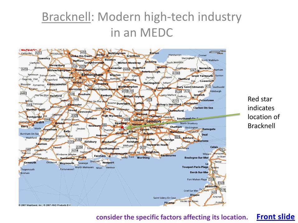
Bracknell: Modern high-tech industry in an MEDC
Red star indicates location of Bracknell
consider the specific factors affecting its location.
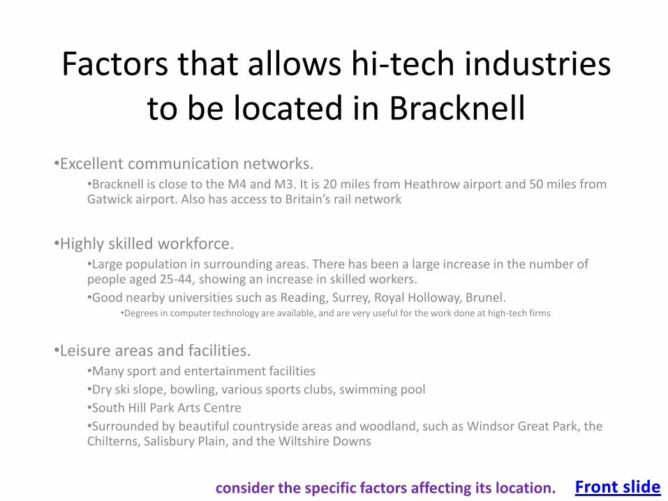
Factors that allows hi-tech industries to be located in Bracknell
•Excellent communication networks. •Bracknell is close to the M4 and M3. It is 20 miles from Heathrow airport and 50 miles from Gatwick airport. Also has access to Britain’s rail network
•Highly skilled workforce. •Large population in surrounding areas. There has been a large increase in the number of people aged 25-44, showing an increase in skilled workers.
•Good nearby universities such as Reading, Surrey, Royal Holloway, Brunel. •Degrees in computer technology are available, and are very useful for the work done at high-tech firms
•Leisure areas and facilities.•Many sport and entertainment facilities
•Dry ski slope, bowling, various sports clubs, swimming pool
•South Hill Park Arts Centre
•Surrounded by beautiful countryside areas and woodland, such as Windsor Great Park, the Chilterns, Salisbury Plain, and the Wiltshire Downs
consider the specific factors affecting its location.
More useful points
• High-tech firms in Bracknell include:– Hewlett Packard, Siemens, Dell, Panasonic, Honeywell.
• Office complexes with car parking
• Many hotels to cater for company executives and to offer conference rooms
consider the specific factors affecting its location.
Costa Del Sol, unsustainable?
• Mass tourism has been brought upon the Costa del Sol for several reasons:
• It has a favorable climate,
• huge sandy beaches
• land access to France
• a government scheme which encourages tourism and holiday resorts
• regional modern airports
• mass invasion of large scale developers and the package holiday industry.
• However, this has led to problems:
• Serious marine pollution
• physical degradation
• congestion of human and economic resources
• high crime rates
• competition for water resources causing other industries to suffer e.g the farming industry.
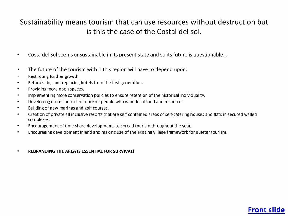
Sustainability means tourism that can use resources without destruction but is this the case of the Costal del sol.
• Costa del Sol seems unsustainable in its present state and so its future is questionable…
• The future of the tourism within this region will have to depend upon:• Restricting further growth.
• Refurbishing and replacing hotels from the first generation.
• Providing more open spaces.
• Implementing more conservation policies to ensure retention of the historical individuality.
• Developing more controlled tourism: people who want local food and resources.
• Building of new marinas and golf courses.
• Creation of private all inclusive resorts that are self contained areas of self-catering houses and flats in secured walled complexes.
• Encouragement of time share developments to spread tourism throughout the year.
• Encouraging development inland and making use of the existing village framework for quieter tourism,
• REBRANDING THE AREA IS ESSENTIAL FOR SURVIVAL!
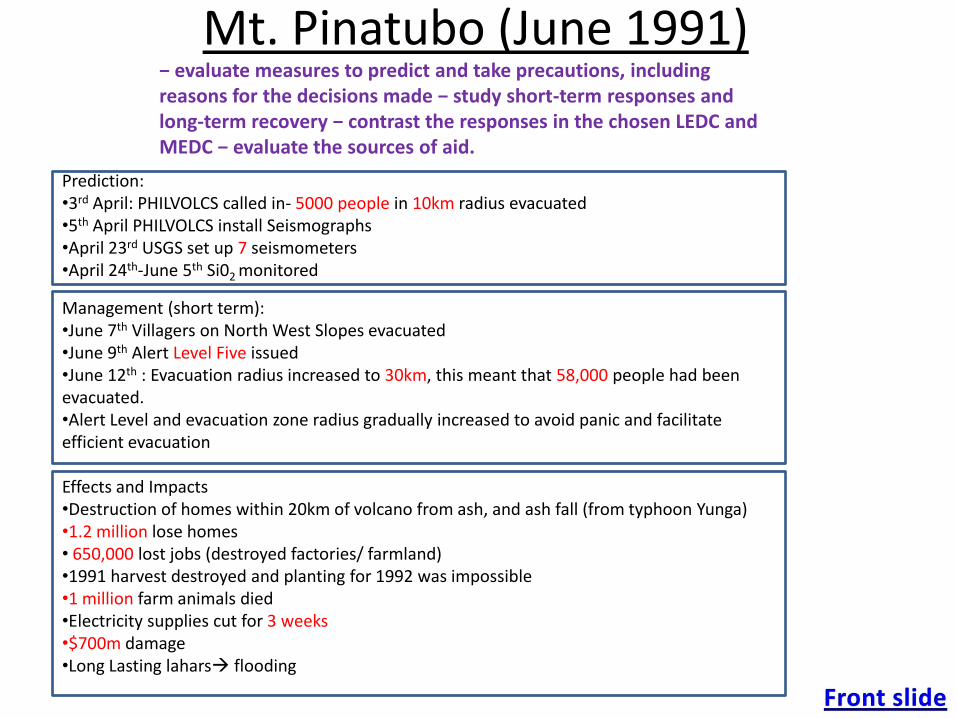
Mt. Pinatubo (June 1991)
Prediction:•3rd April: PHILVOLCS called in- 5000 people in 10km radius evacuated•5th April PHILVOLCS install Seismographs•April 23rd USGS set up 7 seismometers•April 24th-June 5th Si02 monitored
Management (short term):•June 7th Villagers on North West Slopes evacuated•June 9th Alert Level Five issued•June 12th : Evacuation radius increased to 30km, this meant that 58,000 people had been evacuated. •Alert Level and evacuation zone radius gradually increased to avoid panic and facilitate efficient evacuation
Effects and Impacts•Destruction of homes within 20km of volcano from ash, and ash fall (from typhoon Yunga)•1.2 million lose homes• 650,000 lost jobs (destroyed factories/ farmland)•1991 harvest destroyed and planting for 1992 was impossible•1 million farm animals died•Electricity supplies cut for 3 weeks•$700m damage•Long Lasting lahars flooding
− evaluate measures to predict and take precautions, including reasons for the decisions made − study short-term responses and long-term recovery − contrast the responses in the chosen LEDC and MEDC − evaluate the sources of aid.
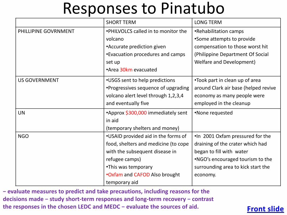
Responses to PinatuboSHORT TERM LONG TERM
PHILLIPINE GOVRNMENT •PHILVOLCS called in to monitor the
volcano
•Accurate prediction given
•Evacuation procedures and camps
set up
•Area 30km evacuated
•Rehabilitation camps
•Some attempts to provide
compensation to those worst hit
(Philippine Department Of Social
Welfare and Development)
US GOVERNMENT •USGS sent to help predictions
•Progressives sequence of upgrading
volcano alert level through 1,2,3,4
and eventually five
•Took part in clean up of area
around Clark air base (helped revive
economy as many people were
employed in the cleanup
UN •Approx $300,000 immediately sent
in aid
(temporary shelters and money)
•None requested
NGO •USAID provided aid in the forms of
food, shelters and medicine (to cope
with the subsequent disease in
refugee camps)
•This was temporary
•Oxfam and CAFOD Also brought
temporary aid
•In 2001 Oxfam pressured for the
draining of the crater which had
began to fill with water
•NGO’s encouraged tourism to the
surrounding area to kick start the
economy.
− evaluate measures to predict and take precautions, including reasons for the decisions made − study short-term responses and long-term recovery − contrast the responses in the chosen LEDC and MEDC − evaluate the sources of aid.