carrowkeel early med cemetery (volume 1)
DESCRIPTION
The enclosure site at Carrowkeel , approximately 7 km from Loughrea, was situated on the western brow of an east/west ridge of higher ground in a landscape of gently undulating hills.It was excavated in advance of the N6 Galway to Ballinasloe road scheme, by Headland Archaeology (Ireland) Ltd on behalf of Galway County Council and the National Roads Authority. It can be found at NGR 159326/223949; OD 45 m; Ministerial direction number A024/001. The site was 150 m from an area of early medieval settlement (RMP: GA097-068), consisting of cashels, a souterrain, house sites and a field system, surviving as substantial upstanding earthworks. The enclosure had been identified on the first edition OS map dated to 1838 (sheet 72), though not on subsequent map surveys, indicating that it had been ploughed away or levelled during agricultural improvement in the 19 th century. A geophysical survey prior to test trenching identified a series of anomalies interpreted as potential ditches, and a large open area of topsoil was removed to assess their extent and character. This revealed a multiperiod enclosure and cemetery site, the main phase of which was represented by a large V-shaped ditch that measured 65 m (east/west) by 47 m. Further inspection revealed the remnants of a substantial internal bank, some of which was fortuitously preserved beneath a 19 th century dry stone field boundary. The interior south-east quadrant of the enclosure had been used as a cemetery and four separate phases of burial activity were recognised. A cemetery area partly enclosed by an internal double-ditch, was also identified in the south-east corner of the enclosure and 132 individuals were excavated. The majority of graves were suppine west-east burials, although grave cuts were difficult to determine due to the shallow depth of deposition. One of the earliest burials recorded in the assemblage, Skeleton 72 dating to (UB-7423) cal AD 682-872, was a crouched inhumation placed within the partly silted terminus of the double ditch. The cemetery was in use for approximately 700 years, a period of time when wider changes were taking place in society as a whole, in particular the adoption of Christianity and the increasing dominance of the church.TRANSCRIPT

Date: January 2009 Client: Galway County Council Project code: NGB05
N6 Galway to Ballinasloe Scheme, Contract 2. Final Report on archaeological investigations at Site E2046, an enclosure ditch and cemetery in the townland of Carrowkeel, Co. Galway Volume I By: Brendon Wilkins and Susan Lalonde Excavation no.: E2046 Director: Brendon Wilkins NGR: 159326/223949 RMP No.: GA097‐066

0
Date: January 2009 Client: Galway County Council Project code: NGB05
N6 Galway to Ballinasloe Scheme, Contract 2. Final Report on archaeological investigations at Site E2046, an enclosure ditch and cemetery in the townland of Carrowkeel, Co. Galway Volume I By: Brendon Wilkins and Susan lalonde Excavation no.: E2046 Director: Brendon Wilkins NGR: 159326/223949 RMP No.: GA097‐066

Headland Archaeology Ltd: N6 Galway to Ballinasloe Scheme, Contract 2, E2046 Final Report
1
CONTENTS PAGE Vol I. 1 Summary 4 2 Introduction 4 3 Site description and location 5 4 Aims and methodology 5 5 Results 5 The natural deposits 6 Phase 1: features pre‐dating the main enclosure and cemetery 6 Phase 1 ditches 6 Phase 1 discrete features 7
Phase 2: the main enclosure and associated features 7 (excluding the cemetery) Phase 2: the cemetery 14 Cemetery Phase 1 (c.650 – 850) 14 Cemetery Phase 2 (c.850 – 1050) 15
Cemetery Phase 3 (c.1050 – 1250) 15 Cemerty Phase 4 (c.1340 – 1450) 16
Phase 3: Linear cultivation, later agricultural and natural 16 features
6 Discussion
Settlement/cemeteries 16 Funerary practices 18 Segregated burial in the early medieval period 19
7 Archive 20 8 References 21

Headland Archaeology Ltd: N6 Galway to Ballinasloe Scheme, Contract 2, E2046 Final Report
2
List of Figures Figure 1 Location map of the excavation enclosure site at Carrowkeel E2046 Figure 2 RMP extract of GA097‐066 indicating the enclosure site at Carrowkeel Figure 3 Overall site plan of the enclosure site at Carrowkeel E2046 Figure 4 Sections of the main enclosure ditch feature (1023) Figure 5 Section of Phase 1 enclosure ditch feature (1015) Figure 6 Section and plan of post‐hole feature (1051) Figure 7 Section and plan of kiln feature (1292) Figure 8 Sections of cemetery ditch features (1260) and (1359) Figure 9 Sections of cemetery ditch feature (1260) and (1359) Figure 10 Section of Phase 1 enclosure ditch feasture (1020) Figure 11 Metal artefacts Figure 12 Local medieval pottery List of Plates Plate 1 North‐facing section of ditch feature (1020) with fill 1021, Slot 2 Plate 2 Southeast facing section of ditch feature (1020) showing additional deposites (1369)
and (1370) slot 1 Plate 3 North facing section of pit feature (1050) Plate 4 Southeast facing section of cooking pit feature (1292) Plate 5 East facing section of main enclosure ditch feature (1023) Slot 1 Plate 6 South facing section of main enclosure ditch feature (1023) Slot 8 Plate 7 North facing section of main enclosure ditch feature (1023) showing considerable
slumping, Slot 8 Plate 8 Southeast facing section of main enclosure ditch feature (1023) truncating ditch
feature (1015) Slot 5 Plate 9 East facing baulk showing buried soil horizon and leaching in bank Plate 10 Ditch feature (1023) and bank, Slot 16 Plate 11 West facing section of ditch feature (1260) Slot 6 and (1359) Slot 5 Plate 12 East facing section of ditch feature (1475) Slot 1 Plate 13 Working shot of modern pit feature (1375) Plate 14 Working shot of possible furrow feature Plate 15 main enclosure ditch featue (1023) and modern pit feature (1375) Plate 16 Modern pit feature (1375) Plate 17 Working shot, main enclosure ditch (1023), facing north Plate 18 Working shot, main enclosure ditch (1023), facing north Plate 19 Aerial view of northern ditches Plate 20 Aerial view of northern ditches Plate 21 Skeleton 27 Plate 22 Skeleton 49, with quartz Plate 23 Skeleton 119 Plate 24 Skeleton 126 Plate 25 Skeleton 72, within 1260 Plate 26 Skeleton 82, tightly crouched Plate 27 Skeleton 52 Plate 28 Skeleton 107

Headland Archaeology Ltd: N6 Galway to Ballinasloe Scheme, Contract 2, E2046 Final Report
3
List of Tables Table 1: Main enclosure ditch (1023) described by ditch slot number Appendices
PAGE
Appendix 1 Context Register 23 Appendix 2 Finds Registers 55 Appendix 3 Sample Register 60 Appendix 4 Bone Sample Register 64 Appendix 5 Photographic Register 70 Appendix 6 Drawing Register 82 Appendix 7 The Lithic Assemblage by Torben Bjarke Ballin 90 Appendix 8 Pottery Report by Niamh Doyle 94 Appendix 9 Soil Sample Assessment by Susan Lyons 96 Appendix 10 Human Remains Report by Susan Lalonde 99 Appendix 11 Phased skeletal catalogue 150 Appendix 12 Point‐Biserial Correlation for Sexual Diamorphism 155 Appendix 13 Different Diagnosis 156 Vol II. Appendix 14 Faunal Remains Report by Auli Tourunen 160 Appendix 15 Faunal Remains Data 201 Appendix 16 Radiocarbon Dates 297 Appendix 17 General Site Matrix Appendix 18 Cemetery Matrix Appendix 19 Enclosure Ditch Matrix

Headland Archaeology Ltd: N6 Galway to Ballinasloe Scheme, Contract 2, E2046 Final Report
4
1 Summary This report presents the results of archaeological investigations carried out on behalf of Galway County Council as part of Contract 2 Archaeological investigations prior to the commencement of construction on the N6 Galway to Ballinasloe Scheme. The work was undertaken under Ministerial Direction number A024 in the Townland of Carrowkeel, Co. Galway. Contract 2 pre‐construction testing on this site in 2005 (Wilkins 2006) located the enclosure ditch that was listed as RMP site GA097‐066 and identified on an archaeological geophysical survey (ArchaeoPhysica 2004). This was undertaken by machine stripping 2000 square metres and it was ascertained that the enclosure ditch was of considerable depth and of high archaeological potential. The bank associated with the ditch was also discovered to be partly preserved under an upstanding drystone field wall in the south‐west sector of the enclosure. Other discrete and linear features suggested the site warranted full archaeological excavation. Full archaeological excavation was conducted on this site between September 2005 and January 2006. A further 1500 square metres was stripped of topsoil by machine. Subsequent excavation revealed a multiperiod enclosure and cemetery site, the main phase of which was represented by a large ditch approximately 65 m x 47 m with remnants of a substantial internal bank, some of which was fortuitously preserved beneath a 19 th‐century drystone field boundary. The interior south‐east quadrant of the enclosure had been used as a cemetery and four separate phases of burial activity were recognised. Though much less substantial than the main enclosure ditch, an earlier phase of enclosure was represented by a sequence of ditches forming what appeared to be an entranceway leading onto the brow of the hill. A number of discrete pits, one of which produced three pieces of late Neolithic struck chert, were also identified in the northern part of the site and could be associated with this phase. A later phase of plough furrows was recorded across the site. 2 Introduction Works were carried out along the route of the proposed N6 Galway to East of Ballinasloe national road scheme, between the townlands of Doughiska in County Galway and Beagh in County Roscommon. The proposed road will consist of approximately 56 km of dual carriageway, a 7 km link road from Carrowkeel to Loughrea and approximately 23 km of side roads. There will be four grade‐separated junctions, 36 bridges and a toll plaza, located at Cappataggle. The main archaeological investigations were divided into four contracts, based on four sectors of approximately equal extent. The work described here was undertaken under Archaeological Investigations Contract 2. Contract 2 covered a stretch of road development of approximately 13.2 km of dual carriageway and 7 km of single carriageway, and passed to the south of Athenry and Kiltullagh in a generally east‐west direction. The project was funded by the Irish Government and the European Union under the National Development Plan 2000—2006. Headland Archaeology Ltd was commissioned by Galway County Council to undertake the works. RPS compiled an Environmental Impact Survey of the route in 2005 and an aerial survey was also undertaken. A geophysical survey was conducted by Archaeophysica in 2004. On the basis of findings from this work Contract 2 Investigations commenced in September 2005.

Headland Archaeology Ltd: N6 Galway to Ballinasloe Scheme, Contract 2, E2046 Final Report
5
3 Site description and location The site was situated on the western brow of a long, low, east/west ridge in a landscape of gently undulating low glacial hills. The site overlooked a valley to the west along which the road route runs. It was located at NGR 159326/223949, in the townland of Carrowkeel, 7 km from Loughrea, at chainage 25550—25620. It was recorded in the Sites and Monuments Record (GA097‐066) as an enclosure, and it featured clearly on the First Edition OS map (sheet 72), but had since been subject to extensive ploughing and was no longer visible as an upstanding earthwork. The site was less than 1 km from an extensive early medieval settlement complex (GA097‐068) also in the townland of Carrowkeel, and 2 km from medieval churchyards at Kiltullagh to the northwest (GA097‐114) and Tooloobaun to the south (GA097‐148). 4 Aims and methodology The objective of the work was the preservation by record of any archaeological features or deposits in advance of the proposed road construction. Topsoil stripping of the site was conducted using a 360° tracked machine fitted with a 1.9 m wide ditching (toothless) bucket under archaeological supervision. A total area of 3500 square metres was exposed. The resulting surface was cleaned and all potential features investigated by hand. Archaeological contexts were recorded by photograph and on record sheets. Plans and sections were drawn at an appropriate scale. Context, finds, sample, bone, photograph and drawing registers are provided in the Appendix. Ordnance Datum levels and feature locations were recorded using penmap and an EDM. Environmental samples were taken on any deposits suitable for analysis or dating. Three main phases of activity were recognised: an early sequence of ditches and discrete cut features possibly of prehistoric date (Phase 1), the main enclosure and associated cemetery (Phase 2) and a phase of linear cultivation features outside the enclosure (Phase 3). These are discussed in sequence below. 5 Results The main enclosure at Carrowkeel comprised a large ditch and remnants of a substantial internal bank, probably constructed in the seventh or eighth centuries and attributed to Phase 2. Originally the enclosure probably encircled the brow of the hill, but approximately one third of it and an unknown portion of the cemetery remained beyond the limit of the excavation. A small number of post‐holes were identified in the north‐west of the enclosure but these could not be unequivocally assigned to the main phase of enclosure and probably pre‐dated its construction (Phase 1). In the absence of clear structural evidence associated with the main enclosure, general indicators of settlement included a large animal bone assemblage, pits, two cooking pits, and iron slag recovered from ditch features. Near the centre of the enclosure, but in its eastern half, was a cemetery which had probably been used from the seventh to the fifteenth centuries. This was attributed to Phase 2 and although a general continuity was observed in the burial evidence, a separate sequence of four cemetery sub‐phases was defined on the basis of grave cut truncation and radiocarbon dating. A total number of 132 skeletons were excavated but as the incidence of burials increased towards the edge of the excavation, it is safe

Headland Archaeology Ltd: N6 Galway to Ballinasloe Scheme, Contract 2, E2046 Final Report
6
to assume that the cemetery originally extended beyond the limit of excavation, possibly extending over the brow of the hill. The natural deposits The site was situated on a limestone ridge, covered with a limestone derived till consisting of calcareous silts, stony sand and clays with a highly mixed and variable character. A number of areas of dense silty clay and clay were uncovered during topsoil stripping. These were examined and determined to be naturally occurring, constituting variations in the glacial till. The orange colouration of the silty‐clays and clays suggests that these deposits contain more iron or have iron in a higher oxidation state than the majority of the surround till. The topsoil soil in the cemetery area was extremely shallow. Some loss of topsoil in this area can be accounted for by soil creep and plough wash, but the depth also reflects the fact that these graves were originally topsoil burials placed just below the contemporary ground surface. This also accounts for why many burials often have no identifiable grave cut, and in other cases only a slight cut into the sub‐soil was observed. The absence of grave cuts is explicable in terms of ongoing processes of reworking in the topsoil, particularly through earthworm activity. Phase 1: features pre‐dating the main enclosure and cemetery Though much less substantial than the main enclosure ditch, an earlier phase was represented by a sequence of ditches. A number of discrete pits, one of which produced three pieces of undiagnostic but possibly late Neolithic struck chert (Ballin 2007), were also identified in the northern part of the enclosure and could be associated with this phase. These artefacts could also have been residual finds indicative of a general ‘background noise’ of prehistoric activity, and although the sequence of Phase 1 ditches were truncated by the main enclosure, this could have occurred soon after silting, in which case both phases may be early medieval.
Phase 1: Ditches The early ditches (1015), (1020) and (1022) were located to the north of the main enclosure ditch. Ditches (1015) and (1020) may represent an enclosure ditch forming an entrance onto the brow of the hill, and ditch (1022) was possibly associated with this phase of enclosure, forming a secondary barrier to the entrance ditches. The full extent of ditch (1015) was uncertain within the interior of the main Phase 2 enclosure (1023), but it was clearly truncated by it. It may originally have extended further south, but if so this section may have been shallower due to outcropping of bedrock at the top of the hill and may subsequently have been adversely affected by the relatively deep plough truncation in this area. It measured 1.95 m wide, 0.67 m deep and 11 m long. Two primary deposits of red brown silt were noted at the base (1016 and 1018). The main fill was a mid to dark brown silt (1017) with inclusions of approximately 35% small stones. A small gully (1535), 1.2 m long, 0.6 m wide and 0.32 m deep, was associated with this ditch. It was filled by orange‐brown silty clay (1536) of moderate compaction. In conjunction with (1015) just described, ditch (1020) formed a possible entrance onto the brow of the hill. It was V‐shaped in plan, 1.8 m wide and 0.6 m deep, and extended east‐west for 12 m before turning sharply to run north‐south for 10 m. It was filled by a mid‐brown silty sand (1021) containing a large quantity of stones, animal bones and charcoal. A weathered piece of medieval pottery (E2046:1302:001) of a local, oxidized fine orange fabric was recovered from this feature, but its abraded nature and position close to the surface of the feature suggested it was residual. Ditch feature (1020) appeared to be truncated by the Phase 2 main enclosure ditch (1023) although at this point it was very shallow and the area was disturbed by a large modern pit (1375). This modern pit truncated the inside edge of the main enclosure but extended no further.

Headland Archaeology Ltd: N6 Galway to Ballinasloe Scheme, Contract 2, E2046 Final Report
7
Linear feature (1022) was L‐shaped in plan and was located to the north‐east of (1020) and (1015), running west‐east for 15 metres before turning south and continuing in that direction for 7 metres. It had sloping sides and a concave base that was almost V‐shaped in section to the western end but flattened out considerably towards the eastern end. Deposit (1316) was light brown silty clay within ditch (1022) and contained small stones, charcoal and animal bone inclusions. It contained an iron strap (E2046:1315:001) and during environmental processing of the samples, a small blue glass bead was retrieved. A small linear feature (1372) extended east‐west on the northern side of the main enclosure ditch (1023), although its precise relationship with earlier ditches could not be determined due to similarities of deposits. It had sloping sides and a flat base and was 0.6 m wide and 0.15 m deep. It was filled by deposit (1373) which comprised a mid grey‐brown sandy silt of firm compaction with animal bone and stone inclusions.
Phase 1: Discrete features A linear arrangement of six cut features was identified in the northwest quadrant of the main (Phase 2) enclosure on the brow of the hill. These features are described below in sequence. Due to their shallow nature these features could not be characterised as either post‐holes or pits, although their linear arrangment suggests the former. Moving from north to south, the first sub‐circular cut feature (1051) was 0.75 m long, 0.63 m wide and 0.23 m deep. It was filled by mid‐brown sandy silt (1052), with a moderate quantity of stone inclusions up to 0.2 m in size. A sub‐circular cut feature (1049) was excavated south of this. It was 0.5 m in diameter and 0.06 m deep with shallow sides and a flat base. It was filled by a deposit of black‐grey silty clay (1050), with occasional charcoal flecks and small fragments of chert inclusions. A sub‐circular cut (1047) had steep sides and a concave base. It was 0.6m in diameter and 0.11m deep, and was filled by black‐grey silty clay (1048) with inclusions of small stones, frequent charcoal flecks and burnt bone. An irregular sub‐circular cut (1057) with irregular shallow sides and a concave base was excavated adjacent to this feature. It was 0.5m in diameter and 0.11 m deep and filled by black‐grey silty clay (1058). Cut feature (1045) was sub‐rectangular with shallow sides and a flat base. It was uneven and only 0.05 m in depth and 0.4 m in diameter. It was interpreted as a post‐hole in alignment with other features even though it was rectangular, uneven and very shallow. It was filled by a dark grey silty clay (1046) of moderate compaction with stones and occasional charcoal flecks. A sub‐oval cut (1053) was in alignment with these features, but was likely to have been a natural feature. Three pieces of black chert were recovered from a sub‐circular cut feature (1051). These artefacts were not strictly diagnostic, but were the product of a well‐controlled flake industry supporting a date in the late Neolithic (See Ballin Appendix 7). These included a secondary hard‐hammer flake, with an untrimmed platform edge (30 x 28 x 8 mm), a proximal section of tertiary hard‐hammer flake (23 x 23 x 4 mm), and a tertiary irregular or multi‐directional core (24 x 19 x 19 mm). Although all these features were assigned to Phase 1, they could equally be contemporary with the main enclosure, with chert incorporated into earlier fills as residual material. A rim fragment characteristic of Carrowkeel ware (E2046:1001:001) was also recovered from the topsoil (Doyle 2006). It consisted of a reduced buff‐grey coloured fabric, with frequent black and red small stone and occasional mica inclusions, and may also be indicative of generalised low level Neolithic activity. Phase 2: The main enclosure and associated features (excluding the cemetery) The main enclosure ditch (1023) was truncated by the line of the proposed road and continued around the contour of the hill. There were three main sub‐phases recognized in the ditch and bank sections (Phases 2a, 2b and 2c). In the eastern portion of the enclosure three contemporary ditches, (1260, 1359, 1475), served to partially delineate the cemetery area, separating it from the rest of the site. The similarity of the fills of these features, their parallel construction and the lack of truncation

Headland Archaeology Ltd: N6 Galway to Ballinasloe Scheme, Contract 2, E2046 Final Report
8
suggested that they were contemporary rather than successive phases of recut. A number of discrete but undated features were also identified as most likely belonging to the occupation phase of the enclosure. The main feature of Phase 2 was a U‐shaped ditch (1023) with the partial remnants of an internal upcast bank (Fig. 2, Pl. 2). It measured approximately 65m by 47m and was situated in a commanding position at the top of the hill overlooking a valley and the surrounding landscape. The enclosure continued around the brow of the hill and was truncated by the line of the proposed road scheme, with approximately a third of the enclosed area beyond the limit of excavation. The enclosure ditch was on average 1.5m deep and 3m wide at the top and was excavated by a series of 16 slots 2m in width (slots are described sequentially below in Table 1). There were no breaks in the ditch indicating an entrance, although this may lie in the unexcavated part of the site. The upcast bank was partly preserved by a much later drystone field wall that respected the line of the bank for a short distance in the southern part of the site. The main deposits filling ditch (1023) were fairly uniform and variations were accounted for by changes in the natural subsoil through which the ditch had been cut (Fig. 2). The three main sub‐phases recognized in the ditch and bank sections are as follows. After the construction of the ditch (Phase 2a), a thin layer of silt and unconsolidated natural subsoil was washed into its base (Phase 2b). The primary silting began soon after construction, as the upcast bank began to slump back into the ditch. The presence of slump material on both sides of the ditch indicates that unconsolidated material eroded from the sides of the ditch as well as from the internal bank. Following this initial slumping the ditch stabilized into an S‐shaped profile, consolidated by a possible vegetation layer (Phase 2b). This was followed by a final phase when the ditch was deliberately backfilled with large stones and boulders, probably as a result of field clearance (Phase 2c).A series of small, isolated, burnt patches was identified in the upper topsoil deposits filling the ditch but proved too diffuse to section properly. They were often discovered against, or near to, the outside of the ditch cut, particularly around the north and northeastern parts of the ditch. These features were interpreted as temporary hearths located within the depression formed by the partially silted ditch, which may have been chosen because it would act as a windbreak. Ditch Slot No.
Deposits Dimensions: Length (L) Width (W) Depth (D)
Description Interpretation
1 1076 1091 1090 1092 1093 1029
D 0.2 m D 0.17 m D 0.15 m D 0.9 m D 0.45 m D 0.53 m
Dark grey brown silty sand Orange brown sandy silt. Dark orange brown sandy silt. Mid grey brown sandy silt. Grey brown sandy silt. Grey brown sandy silt.
Phase 2a: primary silting. Phase 2b; internal slump. Phase 2b; internal slump. Phase 2b; external slump. Phase 2b; disturbed, possible animal burrowing.Phase 2c; backfill.
1a 1402 1401 1400 1399 1398
D 0.3 m D 0.15 m D 0.30 m D 0.55 m
Mid brown grey silt. Light grey brown silty clay. Light brown silty clay. Mid brown silty clay. Mid brown silty clay.
Phase 2a; primary silting. Phase 2b; external slump. Phase 2b; internal slump. Phase 2c; backfill. Phase 2c; backfill.

Headland Archaeology Ltd: N6 Galway to Ballinasloe Scheme, Contract 2, E2046 Final Report
9
Ditch Slot No.
Deposits Dimensions: Length (L) Width (W) Depth (D)
Description Interpretation
2 1024 1027 1038 1025 1029 1031 1030
D 0.2 m D 0.3 m D 0.3 m D 0.3 m D 0.7 m D 0.27 m D 0.29 m
Light brown grey sandy clay. Dark yellow brown sandy clay. Dark grey sandy clay. Dark brown/yellow silty clay. Grey brown sandy silt. Grey brown silty sand. Mid grey brown sandy silt.
Phase 2a; primary silting. Pnase 2b; internal slump. Phase 2b; internal slump. Phase 2b; external slump. Phase 2c; backfill. Phase 2c; backfill. Phase 2c; backfill.
3 1024 1110 1099 1111 1114 1113 1029 1112 1031
D 0.15 m D 0.20 m D 0.1 m D 0.4 m D 0.09 m D 0.17 m D 0.55 m D 0.12 m D 0.17 m
Black brown silty sand. Dark brown/yellow clay sand. Light grey brown silty clay. Dark brown yellow clay sand. Mid brown silty clay Light grey brown sandy clay. Dark brown/black silty gravel. Dark black brown silty clay. Yellow brown silty sand.
Phase 1a; primary silting. Phase 2b; internal slump. Phase 2b; external slump. Phase 2b; external slump. Phase 2b; wxternal slump. Phase 2b; external slump. Phase 2c; backfill. Phase 2c; internal slump. Phase 2c; backfill.
4 1024 1026 1027 1025 1029
D 0.49 m D 0.16 m D 0.29 m D 0.4 m D 0.79 m
Dark brown silty sand. Dark brown silty sand. Orange brown silty sand. Orange brown silty sand. Dark orange grey silt.
Phase 2a; primary silting. Phase 2b; internal slump. Phase 2b; internal slump. Phase 2b; external slump. Phase 2c; backfill.
5 1024 1026 1029 1027 1031 1030
D 0. 1 m D 0.16 m D 0.38 m D 0.16 m D 0.2 m D 0.16 m
Dark brown silty sand. Dark brown silty sand. Dark brown/black silty gravel. Orange brown silty sand. Dark brown/black silty sand. Dark brown silty sand.
Phase 2a; primary silting. Phase 2b; internal slump. Phase 2c; backfill. Phase 2c; internal slump. Phase 2c; backfill. Phase 2c; backfill.

Headland Archaeology Ltd: N6 Galway to Ballinasloe Scheme, Contract 2, E2046 Final Report
10
Ditch Slot No.
Deposits Dimensions: Length (L) Width (W) Depth (D)
Description Interpretation
6 1037 1036 1035 1034 1033 1032 1029 1455 1454 1453 1031 1030
D 0.15 m D 0.25 m D 0.15 m D 0.6 m D 0.07 m D 0.40 m D 0.75 m W 1.1 m; D 0.7 m W 1.1 m; D 0.7 m W 1.1 m; D 0.7 m D 0.2 m D 0.25 m
Light grey silty clay. Mid brown coarse sand. Mid brown clay sand. Dark brown clay silt. Light brown silty sand. Mid brown silty sand. Brown black coase sand. Sub‐circular pit. Stone lining of pit. Dark brown silty clay. Dark brown/black silty sand. Dark brown silty sand.
Phase 2a; primary silting. Phase 2b; internal slump. Phase 2b; internal slump. Phase 2b; internal slump. Phase 2b; external slump. Phase 2b; external slump. Phase 2c; backfill. Phase 2c; pit feature. Phase 2c; pit feature. Phase 2c; pit feature. Phase 2c; backfill. Phase 2c; backfill.
7 1076 1094 1103 1102 1024 1029 1096 1101 1095 1097
D 0.15 m D 0.1 m D 0.06 m D 0.16 m D 0.3 m D 0.1 m D 0.1 m D 0.2m D 0.3 m
Light blue/brown clay sand. Light yellow/grey silt. Mid brown clay sand. Light yellow brown silty sand. Yellow brown silty sand. Yellow grey silt. Light yellow brown clay sand. Light yellow brown silty sand.
Phase 2a; primary silting. Phase 2a; internal slump. Phase 2b; internal slump. Phase 2b; external slump. Phase 2b; main slump. Phase 2c; backfill. Phase 2c; internal slump. Phase 2c; backfill. Phase 2c; backfill. Phase 2c; backfill.
8 1076 1077 1075 1074 1079 1078 1029 1073
D 0.6 m D 0.2 m D 0.16 m D 0.4 m D 0.15 m D 0.2 m D 0.3 m D 0.3 m
Grey brown sandy silt. Light grey brown silt. Grey brown sandy silt. Light brown/grey sandy clay. Light brown grey sandy clay. Dark grey/brown sandy clay. Grey brown sandy silt. Dark grey brown clay silt.
Phase 2a; primary silting. Phase 2b; internal slump. Phase 2b; internal slump. Phase 2b; internal slump. Phase 2b; external slump. Phase 2b; external slump. Phase 2c; backfill. Phase 2c; backfill.

Headland Archaeology Ltd: N6 Galway to Ballinasloe Scheme, Contract 2, E2046 Final Report
11
Ditch Slot No.
Deposits Dimensions: Length (L) Width (W) Depth (D)
Description Interpretation
9 1076 1120 1122 1121 1123 1124 1029 1030
D 0. 3 m D 0.1 m D 0.2 m D 0.1 m D 0.2 m W 0.4 m; D 0.6 m W 0.4 m; D 0.6 m D 0.4 m
Grey brown sandy silt. Orange brown sandy silt. Orange brown sandy silt. Brown grey sabdy silt. Ornage brown sandy silt. Sub‐circular post‐hole feature. Post‐hole fill. Dark brown grey silty sand.
Phase 2a; primary silting. Phase 2b; internal slump. Phase 2b; internal slump. Phase 2b; internal slump. Phase 2b; internal slump. Phase 2c; post‐hole. Phase 2c; post‐hole fill. Phase 2c; backfill.
10 1178 1191 1180 1179 1181 1182 1184 1183 1191 1179 1192 1190 1189 1188 1029 1185 1186
D 0.19 m D 0.26 m D 0.1 m D 0.2 m D 0.23 m D 0.2 m D 0.18 m D 0.9 m D 0.26 m D 0.2 m D 0. 11 m D 0.2 m D 0.23 m D 0.7 m D 0.19 m D 0.19 m
Mid grey silt gravel. Mid/light grey silt gravel. Mid/light brown sandy clay. Light brown sandy silt. Light brown grey gravel silt. Mid brown silty clay. Mid/dark brown silty clay. Mid brown silty clay. Mid/light grey silty gravel. Light grey brown silty gravel. Light brown silty clay. Mid/dark brown silty gravel. Mid brown clay silt. Light/mid brown clay silt. Black/brown silty clay. Light brown silty clay. Dark brown silty clay.
Phase 1a; primary silting. Phase 1a; primary silting. Phase 2b; external slump. Phase 2b; internal slump. Phase 2b; slump. Phase 2b; external slump. Phase 2b; external slump. Phase 2b; internal slump. Phase 1a; primary silting. Phase 2a; internal slump. Phase 2b; external slump. Phase 2c; backfill. Phase 2c; backfill. Phase 2c; backfill. Phase 2c; backfill. Phase 2c; backfill. Phase 2c; backfill.
11 1209 1210 1212 1214 1213 1215 1207 1208
D 0.23 m D 0.14 m D 0.15 m D 0.19 m D 0. 2 m D 0.44 m D 0.34 m D 0.29 m
Light brown grey silty gravel. Light brown silty clay. Light/mid brown clay silt. Light/mid brown silty clay. Light/mid brown silty clay. Dark brown sandy silt. Dark brown clay silt. Dark brown sandy silt.
Phase 2a; primary silting. Phase 2b; internal slump. Phase 2b; external slump. Phase 2b; internal slump. Phase 2b; external slump. Phase 2c; backfill. Phase 2c; backfill. Phase 2c; backfill.

Headland Archaeology Ltd: N6 Galway to Ballinasloe Scheme, Contract 2, E2046 Final Report
12
Ditch Slot No.
Deposits Dimensions: Length (L) Width (W) Depth (D)
Description Interpretation
12 1221 1234 1219 1220 1218 1231 1217
D 0.2 m D 0.25 m D 0.2 m D 0.15 m D 0.4 m D 0.30 m D 0.5 m
Light brown silty clay. Mid brown silty clay. Light brown silty clay. Mid redish brown silty clay. Mid brown silty sand. Mid brown silty sand. Dark brown silty sand.
Phase 2a; primary silting. Phase 2b; internal slump. Phase 2b; internal slump. Phase 2b; external slump. Phase 2c; backfill. Phase 2c; backfill. Phase 2c; backfill
13 1201 1199 1200 1198 1197 1196
D 0.2 m D 0.1 m D 0.08 m D 0.40 m D 0.30 m D 0.30 m
Light grey sandy silt. Light /mid orange brown silty clay. Light orange brown silt. Light grey brown. Dark grey brown silt. Mid grey brown silt
Phase 2a; primary silting. Phase 2b; internal slump. Phase 2b; external slump. Phase 2c; backfill. Phase 2c; backfill. Phase 2c; backfill.
14 1201 1199 1239 1200 1238 1237 1236 1235 1196
D 0.8 m D 0.2 m D 0.25 m D 0.20 m D 0.30 m D 0.30 m D 0.11m D 0.3 m D 0.45 m
Light grey sandy silt. Mid orange brown silty clay. Mid greyish brown silt. Mid/light orange brown. Mid grey brown sandy silt. Dark grey brown silt. Yellow brown sandy silt. Mid grey brown silt. Grey brown silty sand.
Phase 2a; primary silting. Phase 2b; internal slump. Phase 2b; internal slump. Phase 2b; external slump. Phase 2c; backfill. Phase 2c; backfill. Phase 2c; backfill. Phase 2c; backfill. Phase 2c; backfill.
15 1037 1036 1039 1072 1029 1031 1030
D 0.2 m D 0.1 m D 0.18 m D 0.2 m D 0.35 m D 0.45 m D 0.2 m
Light grey silty clay. Mid brown coarse sand. Mid grey brown sandy silt. Dark grey brown sandy silt. Grey brown sandy silt. Dark brown/black silty sand. Dark brown grey silty sand.
Phase 2a; primary silting. Phase 2a; primary silting. Phase 2b; internal slump. Phase 2b; external slump. Phase 2c; backfill. Phase 2c; backfill. Phase 2c; backfill.

Headland Archaeology Ltd: N6 Galway to Ballinasloe Scheme, Contract 2, E2046 Final Report
13
Ditch Slot No.
Deposits Dimensions: Length (L) Width (W) Depth (D)
Description Interpretation
16 1005 1006 1007 1008 1010 1009 1011
D 0.26 m D 0.19 m D 0.10 m D 0.34 m D 0.34 m D 0.18 m D 0.24 m
Light brown sandy clay. Light white/brown sandy clay. Light brown sandy clay. Light orange brown sandy clay. Mid brown silty clay. Light brown sandy clay. Orange brown silty clay
Phase 2a; primary silting. Phase 2b; slump deposit. Phase 2b; slump deposit. Phase 2b; slump deposit. Phase 2c; external slump. Phase 2c; internal slump. Phase 2c; backfill.
Table 1: Main enclosure ditch (1023) described by ditch slot number The evidence for Phase 2 occupation is quite limited, comprising a few discrete features which do not seem to belong to Phase 1 or Phase 3. These included a sub‐rectangular pit (1292) with steep sides and a flat base that was located outside the enclosure near the north end of the excavated area. It was interpreted as a cooking pit due to its alternating fills of charcoal and silt indicating in situ burning. The burning was concentrated at the north end of the pit where there was also evidence of burnt clay in the base of the pit. It was 2.7 m long, 1.2 m wide and 0.65 m deep. Pit feature (1346) identified to the north of the site was also interpreted as a cooking feature. Soil analysis of samples recovered high concentrations of charcoal, a small quantity of unidentified burnt animal bone but no charred cereal grain. Feature (1351) was sub‐rectangular, aligned north‐south with gentle sides that were steeper on the north and south ends. The base was concave and dropped to a deeper north end where most of the burnt bone was found. It was lined with medium sized stones and was 3.02 m in length, 2.50 m in width, with a maximum depth of 0.35 m. The animal bone assemblage from Carrowkeel provided much better evidence for domestic occupation (See Tourunen Appendix 11). The total assemblage comprised 13,631 specimens characteristic of domestic waste, consisting of both high and low utility skeletal elements. No wild mammal specimens relating to subsistence were recovered. Cattle were the dominant species, followed by sheep, pig and horse, and these derive mainly from the main enclosure ditch. The animal bones were characteristic of domestic waste, consisting of butchery remains, food debris and discarded dead animals like cats and dogs or stillborn calves, piglets and lambs.
House mice bones (Mus Musculus) were recovered from processed soil samples originating from a context in the main enclosure ditch at the interface between Phase 2b and 2c. They were radiocarbon dated to cal. AD 860 –1020 (GU‐15327) and cal. AD 670 – 890 (GU‐15326). Because mice are burrowing animals it cannot be assumed that these ranges accurately date Phases 2b and 2c, but this possibility is strongly supported by the fact that these date ranges are broadly contemporary with Cemetery Phases 2 (below). The house mouse tends to live near to human population and do not dig deeply into the ground, so there is every possibility that these bones derive from animals contemporary with the main phase of occupation within the enclosure. In addition, these ranges are of intrinsic significance. The arrival of this species in Ireland was assumed to date to the Norman period making the Carrowkeel mice the earliest securely dated example (See Appendix 11).

Headland Archaeology Ltd: N6 Galway to Ballinasloe Scheme, Contract 2, E2046 Final Report
14
Phase 2: the cemetery A clearly defined cemetery area was excavated in the eastern half of the large enclosure. It was partially delimited by three slightly curving parallel ditches, (1260, 1359, 1475), which (within the excavated area) extended from the south side of the cemetery to its eastern end. Here they terminated leaving the north‐east and north‐west sides of the cemetery unenclosed. These ditches bounded the cemetery in an area where the underlying topography took a pronounced slope. The division of this area from the rest of the enclosure indicates an internal separation of activities, with no burials extending beyond these ditches to the south‐east. Two discrete features were excavated in the cemetery area, which could have been structural, although no clear pattern could be discerned. An oval post‐hole (1229) was recorded adjacent to the limit of excavation, truncated by the Cemetery Phase 2 burial of Skeleton 32. It contained a single bird talon, but no other finds. Close to this a second oval post‐hole (1279) was recorded, truncated on the south side by the Cemetery Phase 1 burial of Skeleton 49. These features were identified close to the limit of excavation, and they raise the possibility that there was a structure in this area during Cemetery Phase 2. The human remains assemblage represented a total of 158 individuals; a minimum number calculated from both articulated burials (132 individuals) and disarticulated bone (26 individuals). The burials can be split into four cemetery phases over 800 years from the seventh to fifteenth centuries. Phasing of the cemetery was undertaken using a combination of stratigraphic analysis and radiocarbon dating of 40 individuals. Table 1 shows the distribution of adults and non‐adults across the cemetery population. In this case, ‘Juvenile’ covers age categories from younger child to adolescent, 6 to 18 years at death (Appendix 4). Cemetery Phase 1 (c.650 – 850) At sometime between c. AD 650 and 770, ditch (1260) was dug at the eastern extent of the burial ground, forming a curving boundary to this part of the cemetery. This was the largest of the three ditches delimiting the cemetery area, with steep sides and a concave base, a maximum width of 2.46 m and maximum depth of 1 m. A consistent deposit sequence was observed although slight variation in the composition of fills was recorded. The primary fill (1368) was identified in all sections. It was rapidly deposited soon after construction as the sides of the freshly cut ditch weathered. This was followed by secondary deposit (1353) that had gradually accumulated through the natural silting of the ditch and surrounding ground surface over time. The carcasses of at least eleven sheep were buried within the basal fill (1368). The colouration of the ends of long bones indicates that they were articulated when buried, probably placed longitudinally, although there was some degree of post‐depositional disturbance (Appendix 1). Any cutting of the bodies prior to deposition was likely intended to make the bodies easier to transport rather than for consumption. The adolescent remains of Skeleton 72 were also interred within ditch (1260), deposited as the feature was beginning to silt‐up. The burial was partially cut into the silting deposit (1353) and the north‐western section of the ditch terminus. This burial also cut the interface between this ditch and the smaller ditch (1359). This individual was buried in a flexed position and dated to cal. AD 676 – 870 (UB‐7425) . Following this burial, the ditch continued to silt and Skeleton 33 (cal. AD 857 – 991 (UB‐7482)) was interred directly above the south‐western end. Other Cemetery Phase 1 burials (Skeletons 42 and 52) were also interred over both ditches (1260) and (1359). Cemetery Phase 2 Skeleton 13, 14, and 71 also utilised the ditch area once both ditches had fallen out of use. However, even then the remnants of the ditches were probably visible and continued to be perceived as the boundary of the cemetery for no interments took place outside the southeast edge of ditch (1260).

Headland Archaeology Ltd: N6 Galway to Ballinasloe Scheme, Contract 2, E2046 Final Report
15
A smaller ditch (1359) ran parallel to ditch (1260) (Fig. 1). It had steep sides with a concave base and a maximum depth of 0.44 m. The function of this ditch was difficult to determine, as it was very close to the larger ditch feature (1260) and comparatively very narrow. One possibility is that it formed the foundation trench for a palisade fence, although no post‐holes were discovered within it. Ditch feature (1475) was located 3 m south of these two ditches and further down slope. It also terminated at the eastern end of the cemetery. It had a V‐shaped profile, was 1 m wide and 0.5 m deep, and the primary deposit (1477) had accumulated as a consequence of slumping of upcast material and colluvial erosion. The secondary deposit (1476) was likely to be the result of stones and gravel accumulating at the base of the plough soil in the depression of the ditch, probably due to bioturbation and worm action. The similarity of fills and the lack of intercutting stratigraphy made the relationships between these three ditches difficult to determine. The presence of Cemetery Phase 2 burials directly above ditches (1359) and (1260) suggests that these ditches may be contemporary. It is possible that ditch (1475) is a replacement cemetery boundary, dating to Cemetery Phase 2, but this is not supported by any dating evidence. The Cemetery Phase 1 assemblage totals 37 individuals (28% of the whole), 22 of which were radiocarbon dated. Just over 70% of the individuals from Cemetery Phase 1 are non‐adults. This group can be further subdivided into foetus (14%), perinate (8%), infant (16%), younger child (16%), older child (11%) and adolescent (5%). Of the adults at Carrowkeel, Cemetery Phase 1 has 61% of the total number, and almost 90% of the females. Of those burials for which it could be assessed, the majority (76% n= 28) were orientated northeast‐southwest. Body position was recorded for 31 individuals; 71% (n=22) were supine extended while the remaining 29% (n=9) were found to be flexed. The majority of the flexed burials were non‐adults, aside from Skeleton 51 and Skeleton 119, both adult females. Cemetery Phase 2 (c.850 – 1050) The second cemetery phase dates from the mid‐ninth to the mid‐eleventh century. The largest part of the assemblage, this cemetery phase contains 75 individuals, 93% (n=73) of which are non‐adult. The only adult remains present were Skeleton 90 and Skeleton 105, both male. Cemetery Phase 2 contains the largest proportion of very young children. Of these, 64% were below one year of age at death (foetus 27%, perinate 7%, neonate 4% and infant 27%). Younger children made up 16%, and 12% were older children. The excavated portion of the cemetery appears to be used almost exclusively for the burial of non‐adults in this period. Body position was more varied than in Cemetery Phase 1. This is probably linked to the higher number of non‐adults, who show more differention in their burial positions than the adults. In total, 44% (n=33) were buried supine extended, 1% (n=1) crouched and 21% (n=16) flexed. One infant, Skeleton 50, was buried flexed and prone, the only burial of its type in the cemetery. The crouched burial of a younger child, Skeleton 84, is also unique in the assemblage. As in Cemetery Phase 1, the majority of burials were orientated northeast‐southwest. Four individuals, Skeletons 10, 17, 18, and 34, were truncated by later agricultural activity in the form of an east‐west furrow. Cemetery Phase 3 (c.1050 – 1250) It appears that the cemetery began to fall out of use during the latter part of Cemetery Phase 3, dating from the mid‐eleventh to the mid‐thirteenth century (Table 4; Fig. 7). Only 18 individuals were recovered from this phase, with a more even spread of age categories than in the previous cemetery phases. This may indicate a shift in use of this portion of the cemetery towards a more ‘normal’ burial population. Non‐adults still account for 78% (n = 14) of the Cemetery Phase 3, but they are older than in Cemetery Phase 2, with only 44% (n = 8) below one year of age at death (foetus 17%, infant 28%). No perinates, neonates or adolescents were recovered in this period. Burial orientation followed the

Headland Archaeology Ltd: N6 Galway to Ballinasloe Scheme, Contract 2, E2046 Final Report
16
same broad pattern as Cemetery Phases 1 and 2, with 67% (n=12) orientated northeast‐southwest. Body position was more uniform in this phase. Supine extended burials account or 50% (n=9) of the group and 17% were flexed. The remaining 33% (n = 6) were disarticulated. East‐west furrow (1169) also truncates two individuals in this period, Skeletons 46 and 47. Skeleton 46 was recovered disarticulated within the furrow itself. Cemetery Phase 4 (c.1340 – 1450) Only two individuals belong to the final cemetery phase. One dates to the fourteenth century, while the other dates to the fifteenth century. This may indicate a move away from this portion of the cemetery, the discontinuation of use of the burial ground as a whole, or later burials unconnected with the earlier cemetery phases. The very young age of both burials suggest that in this period the site was used as a cillín. Phase 3: Linear cultivation and later agricultural and natural features A large oval pit (1375) truncated the main enclosure ditch during the final stages of silting. It had concave sides and was 1m deep and 5m wide. The primary fill was predominantly silt and the secondary fill was predominantly cobbles and large stones, the probable result of field clearance. A series of parallel north‐south oriented linear cultivation features was identified outside the enclosure to the north. They were generally 0.48 m wide and 0.08 m deep and 16 m long, with a concave profile filled with orange‐brown silty clay. They respected the course of the main enclosure running up to ditch but not continuing into the interior. The enclosure had been identified on the first edition OS map dated to 1838 (sheet 72), though not on subsequent map surveys. These furrows repect the enclosure and represent cultivation when the enclosure was still extant, sometime prior to the early nineteenth century. 6 Discussion The first phase of activity at Carrowkeel was represented by a sequence of ditches truncated by the main enclosure ditch and a series of discrete pits. The ditches formed what appeared to be an earlier enclosure, with an enterance onto the brow of the hill. One pit (1015) attributed to this phase contained three lithics and they appeared to be from a secure context, with other chert finds recoverd from the main enclosure ditch. The lithics were assessed by Torben Bjarke Ballin of Lithic Research and comprised one concave scraper, two flakes, one multi‐directional core and two pieces with edge retouch. They were of black chert which was of good quality, fine grained and with few planes of weakness, resulting in excellent flaking properties. Black chert would have been local to Carrowkeel although there was no evidence to suggest any working took place on site. The concave scraper (E2046:1009:001) could possibly be dated to the Neolithic period. It should also be noted that lithics were also recovered from the upper fill of the main enclosure ditch, although these are likely to be residual finds indicative of a general background noise of prehistoric ativity. These artefacts could also have been residual finds indicative of a general ‘background noise’ of prehistoric activity. Although the sequence of Phase 1 ditches were truncated by the main enclosure, this could have occurred soon after silting, in which case both phases may be early medieval. The presence of the finds within the topsoil does, however, suggest Neolithic occupation here or at a nearby location.

Headland Archaeology Ltd: N6 Galway to Ballinasloe Scheme, Contract 2, E2046 Final Report
17
Settlement/Cemeteries The main enclosure at Carrowkeel (Phase 2) was probably constructed in the seventh or, less likely, the eighth century. At this time a great number of enclosed settlements were being constructed in Ireland. Most of them fall into one of two categories: ringforts and cashels which are secular farmsteads of circular plan and ecclesiastical settlements, which often have larger, less regular but usually curvilinear enclosures (e.g. Stout 1997, 14, 100; Swan 1983). Carrowkeel cannot be assigned to either of these categories. Though structural evidence was limited, the large animal bone assemblage suggests that it served as a settlement for a considerable period. Some 13631 specimens of faunal remains were analysed by Auli Tourunen of Headland Archaeology Ltd. Bones were recovered by hand‐picking during excavation, but the wealth of small animal information was recovered from bones retrieved from the environmental soil sample processing. This highlighted the necessity to sieve contexts containing faunal remains to avoid biases in the assemblage caused by hand picking the bones. The faunal remains overwhelmingly pointed to a domestic occupation of the site. It represented a typical early medieval farmstead assemblage where cattle dominated the economy, although sheep and pigs were also reared. Horse bones were also identified on the site, and a single goat core. There were no signs of further carcass processing besides for consumption, and the low number of young sheep and pigs may indicate animals were transported elsewhere. Carrowkeel did not have any tannering or bone working, nor did it include any evidence of professional slaughtering. A pattern was observed in the age range of cattle mandibles between Phase 1 and Phase 2. In Phase 1 the mandibles derive from young and old animals, in Phase 2 all mandibles are from young animals. Pigs and sheep were also more prevalent in Phase 2, along with more high utility skeletal elements and more carnivore gnawing marks. One explanation of this data is that Phase 2 marked an increase in wool production. A general change in subsistence strategy could have reflected the settlement growing in complexity. The gnawing marks could be related to a higher number of dogs being kept. Or the differences may just be changes in the locations of certain activities, as much of the enclosure remained unexcavated. Given that under two thirds of the enclosure was excavated, a question remains as to how representative the recovered evidence is. A significant portion of the site lay beyond the line of the proposed road scheme, and the location of possible structures in this area, especially towards the brow of the hill, should not be ruled out. However, its overall morphology and the presence of a cemetery rule out its classification as a ringfort. Its somewhat irregular shape is more reminiscent of an ecclesiastical enclosure, and the position of its cemetery in the eastern half of the enclosure is also paralleled in the majority ecclesiastical sites. Swan (1983, 274) defined ecclesiastical sites on the basis of eleven attributes: evidence of enclosure, a burial area, normally in the southeast corner, a place‐name with an ecclesiastical element, structural remains, a nearby holy well, a bullaun stone, a carved or decorated stone cross or slab, a townland boundary forming part of the enclosure, a souterrain, a pillar stone, a founders tomb, and a traditional ritual or folk custom. He further specified that at least five of these are required. On this basis Carrowkeel would not qualify as an ecclesiastical site. The absence of evidence for a church in particular means that it cannot be definitively classified as ecclesiastical, though it is possible that a church stood in the unexcavated part of the enclosure. Alternatively, Carrowkeel may belong to a group of sites recently recognised as a result of pre‐development archaeology which are generally referred to as settlement/cemeteries (e.g. Clarke 2002; Seaver 2006; O’Sullivan and Harney, 2008, 78‐84). In many respects these are similar to ecclesiastical settlements but they appear to lack church buildings. The possibility that they were not ecclesiastical sites is supported by documentary evidence which indicates that until at least the eighth century some communities were not bringing their dead for churchyard burial, but continued to bury them in non‐ecclesiastical family burial grounds (OʹBrien 1984; O’Brien 1999, 52). Compilers of the early

Headland Archaeology Ltd: N6 Galway to Ballinasloe Scheme, Contract 2, E2046 Final Report
18
eighth‐century Collectio Canonum Hibernensis were sympathetic to the continuing use of ancestral burial grounds. It justifies the practice by citing the example of Jacob and Joseph who requested that their bones be carried back from Egypt to the land of Canaan in order that they might be buried in the tomb of their ancestors. However, increasingly monks, ecclesiastical tenants and sections of the wider population were being encouraged to have their affiliation recognised in death through burial at ecclesiastical sites (OʹBrien 1999, 52). Some ancestral burial grounds were unenclosed or partially enclosed sites dedicated purely to burial, but others, the so‐called settlement/cemeteries, like Johnstown, Raystown and Carrowkeel are within larger enclosures that were used for occupation as well as burial. To date the vast majority of these have been identified in Leinster. Carrowkeel is particularly significant as it is the first possible example excavated west of the Shannon. The cemetery at Carrowkeel remained in use until the fifteenth century. The social conditions in which the cemetery was established were very different to those that led to its eventual abandonment. Both founding and abandonment represent breaks with tradition: a significant initial investment in a new cemetery and an active decision not to continue to place the dead in the usual site of disposal (Parker Pearson 1999). To focus discussion on the foundation of the site, Chrisitianity had already become established as the dominant belief system by 600 AD (Edwards 1990, 99), so religious reasons were unlikely to have been the only, or indeed the principal, motivation for the founding of Carrowkeel. Possibly it was founded as a result of a family lineage breaking away from a larger kin group. The prominence of Carrowkeel on a hill overlooking an area of known early medieval and prehistoric activity (RMP: GA097‐068), may have influenced the choice of location for the main enclosure. Another factor may have been the presence of earlier ditches and discrete features predating the main enclosure, though the date, duration and character of this earlier phase of activity remain unclear. Notwithstanding the trend towards burial at ecclesiastical sites, it seems that a group at Carrowkeel continued to bury their dead, or at least some of their dead, in a non‐ecclesiastical burial ground throughout the early medieval period and beyond. They may have had pragmatic reasons for doing so. The founding of the cemetery and its enduring use as a formal burial area was a deliberate strategy by a group bound by familial and kinship ties to perpetuate their relationship with their ancestors. The act of burial makes the remains of the dead a fixed part of the landscape, thereby legitimizing the rights of the living to it (Parker Pearson 1999, 125). In a predominantly pastoral economy based on a transhumance model of summer grazing (Kelly 2000, 43), the settlement enclosure would also have helped to secure tenure of the surrounding land, and a seasonal habitation may also explain the lack of substantial structural remains. Funerary practices The extent to which pagan or Christian religious beliefs can be seen to dictate burial custom at Carrowkeel throughout this period is uncertain. The role of Christian ideology in the Irish early medieval period can be usefully separated into two phases: an expansion period when the faith was still a minority practice and not fully integrated, and a consolidation period when Christianity was the dominant (but not exclusive) belief system (Mytum 1992, 60). The positioning of the body as a supine west‐east inhumation is usually regarded as a Christian practice. This reflects the Christian Belief that the dead will rise again, and an alignment with the orientation of the rising sun during Eastertide (mid to late April) was preferred. A lack of grave goods is also interpreted as a changing conception of the afterlife from a pagan to a Christian worldview. Cross‐cultural surveys of burial practice also advise caution when applying generalizations: because of the diverse nature of mortuary rites there will usually be divergences from the norm (Ucko 1969, 262). An analysis of the Irish excavation evidence indicates that Roman burial customs were adopted

Headland Archaeology Ltd: N6 Galway to Ballinasloe Scheme, Contract 2, E2046 Final Report
19
independently of Christianity, so there must be other supporting evidence to determine the religion of an individual (Raftery 1981; Raftery 1984). The Carrowkeel burials were almost all uniformly simple in nature with little evidence of lining of graves, grave markers or grave goods. Burial was in accordance with Christian rites in a roughly east‐west orientation, although there were some startling departures from the general pattern. Unusual burials included the flexed adolescent found at the terminus of ditch (1260) from Cemetery Phase 1 (Fig. 4, Pl. 3), the tightly crouched adolescent from Cemetery Phase 2 and the highly unorthodox ‘akimbo’ female burial, also from Cemetery Phase 2 (Fig. 4). The placement of these individuals in deliberately different burial positions may indicate that some funerary rituals were the site of contested meaning, although the reasons why they were accorded such treatment was not evident. No patterning in either age, sex or temporal and spatial distribution could be identified, and no pathological conditions could be determined that would singled these individuals out as different. River‐rolled quartz and some animal bone were also found in a number of burials, which may represent older non‐Christian practices retained by the population, though quartz pebbles are commonly found in burials at early ecclesiastical sites (Cardy 1997, 556; White Marshall and Walsh 2005, 81) The pattern of quartz deposition does not vary greatly between the cemetery phases, nor does there seem to be a significant trend in the inclusion of quartz with male, female or non‐adult burials. The significance of the stone to Irish burial culture is not certain; quartz may symbolize the soul of the dead, or light the way into the next world. Excavations in Wales have also found quartz placed in graves dating from the early medieval period, and it has been suggested that the practice is linked to a passage from Revelations which states ‘…give him a white stone, and in the stone a new name written, which no man knoweth saving he that receiveth it’ (Revelations 2:17, quoted in Holbrook 2004). Segregated burial in the early medieval period The cemetery consisted of four distinct sub‐phases, identified through stratigraphic analysis and a programme of radiocarbon dating. The majority of burials (n = 75) were found in Phase 2 of the cemetery, from 850 AD – 1050 AD. This is distinct in character from the earlier and later use of this section of the cemetery, and seems to provide evidence for the deliberate spatial segregation of children. Cillíní are essentially children’s burial grounds, common throughout Ireland but mainly focussed in the Western counties such as Kerry and Galway (Dennehy 1997). They are known to have been in use during the medieval and post‐medieval periods, but their origins remain obscure. Often sited in visible monuments such as abandoned ringforts, tower houses and ecclesiastical ruins, they have been described as a physical embodiment of limbo within the landscape. The development of this practice is assumed to coincide with the twelfth century Church reformations, leading to the establishment of the doctrine of limbo infantus (Finlay 2000, 408‐409). Archaeologically, cillíní are recognised through the seemingly disorganised burial of very young children within older monuments, often overlying more organised and formal burials. During excavation it was assumed that the cluster of young children buried at Carrowkeel represented the later, probably post‐medieval re‐use of the site as a cillín. The extensive programme of radiocarbon dating undertaken on the remains showed this not to be the case, and generated questions about the origin of the cillín tradition and how this may relate to the spatial segregation of children within early medieval cemetery populations. It is possible that the separate burial of children in the early medieval period was a common phenomnon across Britain and Ireland, one which had an influence on the Irish tradition of cillín burial in later centuries. While the separate burial of children in cillíní has been well‐documented for the later and post‐medieval period in Ireland (Finlay 2000), there has been little evidence for the segregation of children

Headland Archaeology Ltd: N6 Galway to Ballinasloe Scheme, Contract 2, E2046 Final Report
20
in the early medieval period, although in recent years, excavations at the Rock of Cashel and Raystown, Co. Meath (Hodkinson 2003; Seaver 2006), have found separate clusters of non‐adults within larger cemeteries. Clusters of child burials are often found within Anglo‐Saxon cemeteries, and there does appear to be a Christian trend in early medieval Britain for the separation of young children within cemeteries such as Raunds Furnells in Northamptonshire and Whithorn Priory in Galloway (Boddington 1987; Cardy 1997). The pattern is also seen at other ecclesiastical sites in Europe from the period ‐ Trondheim and Hamar Cathedrals in Norway for example (Lewis 2007, 30‐33). The segregated burial of children has also been recognised at the Late Roman site of Cazzanello in central Italy where a small group of perinate burials was found within the remains of a 4th century AD bathhouse. This seems to form part of a wider Etruscan pattern which has been suggested as precursor to the modern Italian practice of separate burial for foreigners and very young children (Becker 2007, 290). There is evidence for the segregation of certain groups during the medieval and post‐medieval period at sites such as Relignaman, Co. Tyrone (Hamlin & Foley 1983) and St Ronan’s, Iona (O’Sullivan et al 1994), where the separate burial of women is connected to the presence of convents or chapels dedicated to the Virgin. Defining conceptual divisions between the dead, therefore, may be a common European practice which in some areas, especially in Ireland and Italy, develops into the practice of establishing totally separate burial grounds for certain sections of society. The Carrowkeel assemblage provides a securely dated example of the spatial segregation of children in an Irish context. This spatial segregation of children in one section of the cemetery may be a precursor to the later and post‐medieval cillín tradition which is now becoming better understood but whose origins remain obscure (Finlay 2000). Recent excavations at Cloncowan II, Co.West Meath (Baker 2007, 72) revealed an earlier ditched enclosure reused between the tenth‐ to thirteenth century as a possible cillin. This corresponds to Carrowkeel cemetery Phase 3, and suggests an emerging pattern. The work reported here should highlight the importance of extensive radiocarbon dating of cemeteries, or areas within cemeteries, dominated by infant remains for it shows that we cannot assume that these are post medieval cillín assemblages. Rather, like the Carrowkeel assemblage, they may provide important new insights into the complex and potentially early origins of this phenomenon.
7 Archive
The site archive is comprised of the following materials:
Item Quantities sheets At least 600 Sample sheets 158 Registers 57 Photos 637 Plans 76 Sections 71 The archive material is contained within one box. Storage of the archive in a suitable format and location is required in order to provide for any future archaeological research. The archive is currently stored in the offices of Headland Archaeology, Unit 1, Wallingstown Business Park, Little Island, Co. Cork. It is proposed that following completion of post‐excavation the archive is deposited with Galway County Council Archives.

Headland Archaeology Ltd: N6 Galway to Ballinasloe Scheme, Contract 2, E2046 Final Report
21
9 References ArchaeoPhysica Ltd. 2004. Archaeological Geophysical Survey Report. Unpublished report submitted to Galway County Council. Boddington, A. 1987. Raunds, Northamptonshire: analysis of a country churchyard World Archaeology 18 (3):411 ‐ 425. Becker, M. J. 2007. Childhood among the Etruscans: mortuary programs at Tarquina as the indicator of the transition to adult status. In: Cohen, A. & Rutter, J. B. (ed.) The Construction of Childhood in Ancient Greece and Italy. Athens. 281 – 292. Cardy, A .1997. The human bones. In: Hill, P. (ed.) Whithorn and St Ninian: the excavation of a monastic town 1984 – 1991. Stroud. 519 ‐ 592. Clarke, L. 2002. An early medieval enclosure and burials, Johnstown, Co. Meath Archaeology Ireland, 16 13‐15. Dennehy, E. 1997. The ceallunaigh of County Kerry: an archaeological perspective. Unpublished MA thesis, University College Cork. Edwards, N. 1990. The Archaeology of Early Medieval Ireland. London: Routledge. Finlay, N. 2000. Outside of life: traditions of infant burial in Ireland from cíllín to cist. World Archaeology. 31 (3): 407 – 422. Hodkinson, B.J. 2003. First draft final report on the Excavations at Cormac’s Chapel, Cashel 1992 and 1993. http://homepage.tinet.ie/~dunamase/Dunamase.html Accessed 23.05.07. Lewis, M. 2007. The Bioarchaeology of Children: Perspectives from Biological and Forensic Anthropology .Cambridge. Mytum, H. 1992. The Origins of Early Christian Ireland. London. O’Brien, E. 1984. Late Prehistoric‐Early Historic Ireland: the burial evidence reviewed. Unpublished M.Phil. Thesis, National University of Ireland, University College Dublin. O’Brien, E. 1999. Post‐Roman Britain to Anglo Saxon England: burial Practices Reviewed. BAR British Series 289. Oxford: Archeopress. O’Sullivan, A. and Harney, L. 2008. EMAP: Investigating the Character of Early Medieval Archaeological Excavations 1970‐2002. Report for the Heritage Council. Downloaded from www.ucd.ie/t4cms/emap_report_january_2008.pdf. Parker Pearson, M. 1999. The Archaeology Of Death And Burial. Stroud: Sutton. Raftery, B. 1981. Iron Age Burials in Ireland. In O’Corrain, D. (ed.) Irish Antiquity. Cork. 173‐204. Raftery, B. 1984. La Tene Ireland: problems of origin and chronology. Marburg.

Headland Archaeology Ltd: N6 Galway to Ballinasloe Scheme, Contract 2, E2046 Final Report
22
Seaver, M. 2006. Through the mill – excavation of an early medieval settlement at Raystown, County Meath. In O’Sullivan, J. & Stanley, M. (eds.) Settlement , Industry and Ritual. Archaeology and the National Roads Authority Monograph Series 3. Dublin. 73 – 88. Stout, M. 1997. The Irish Ringfort. Cornwall: Hartnolls Swan, L. 1983. Enclosed ecclesiastical sites and their relevance to settlement patterns of the first millennium A.D. In Landscape Archaeology in Ireland. Reeves‐Smyth, T. and Hamond, F. (ed). BAR British Series 116. 269‐280. Oxford: Archaeopress. Ucko, P. J. 1969. Ethnography and the archaeological interpretation of funerary remains. World Archaeology 1: 262‐90. White Marshall, J. and Walsh, C. 2005 Illaunloughan Island: An Early Medieval Monastery in County Kerry. Dublin. Wilkins, B. 2006. N6 Galway to Ballinasloe Scheme, Contract 2. Preliminary Report on archaeological investigations at Site A024/1, an enclosure ditch and cemetery in the townland of Carrowkeel, Co. Galway. Unpublished technical report by Headland Archaeology Ltd. for Galway County Council.

Athenry
Galway
Figure 1 - N6 Galway to Ballinasloe Scheme, Co. Galway, Contract 2: Carrowkeel E2046 Location of excavation area
Reproduced from 2002 Ordnance Survey of Ireland 1:50,000 Discovery Series no 46,C Ordnance Survey of Ireland, Government of Ireland. Licence No. EN 0008105
= CPO
N
0 100 m
C Ordnance Survey of Ireland and Government of Ireland. Licence No. EN 0008105
E2046

Figure 2 - N6 Galway to Ballinasloe Scheme, Co. Galway, Contract 2: Carrowkeel E2046 Location of excavation area and RMP extract
N
0 250 m
= CPO
= Excavated Area
Reproduced from 1933 Ordnance Survey of Ireland, Second Edition, Six Inch to One Mile map, Galway Sheet 96C Ordnance Survey of Ireland and Government of Ireland. Licence No. EN 0008105

cemetery
post-holes
Phase 1enclosure ditch
Phase 2enclosure ditch
cooking pit
Figure 3 - N6 Galway to Ballinasloe Scheme, Co. Galway, Contract 2: Carrowkeel E2046 Overall site plan
N
0 25 m
1292
1375 1023
1372
1359
1260
1475
1301
1022
1020
1015
1535
1053
1051
10491047
1057
Phase 3Phase 3linear cultivation featureslinear cultivation featuresPhase 3linear cultivation features
N
0 4 mEnlarged schematic representation of cemetery
cemetery
1359
1260

0 1 m
1029 bone
1033
1032
1071
1030
1029
1037
1030
10291077
1076
1078
10791073
1036
1035
1034
1034
burrow
Figure 4 - N6 Galway to Ballinasloe Scheme, Co. Galway, Contract 2: Carrowkeel E2046 Sections of main enclosure ditch 1023
E
NE SW
W
EW
N S N S
1024
1030
1073
1029
1076
10751074
1207 1211
1210
1212
1208
1209
1026 1023 1023
1023
1023
1023
Section 85
Section 33
Section 27
Section 36
Section 30
1025
Section 85
Section 33
Section 27
Section 36
Section 30
N
0 10 m
= Location of sections (triangles point to face of section)
Phase 2c
Phase 2cPhase 2b
Phase 2b
Phase 2a
Phase 2a

NE SW
10161018
10171015
Section 21
0 1 m
Figure 5 - N6 Galway to Ballinasloe Scheme, Co. Galway, Contract 2: Carrowkeel E2046 Section of Phase 1 enclosure ditch 1015
Section 21
N
0 10 m
= Location of sections (triangles point to face of section)

NE SW
10511052
Section 80 0.5 m
Figure 6 - N6 Galway to Ballinasloe Scheme, Co. Galway, Contract 2: Carrowkeel E2046Section and plan of post-hole 1051 containing chert
1051
0 0.5 m
N
Section 8
N
0 10 m
= Location of sections (triangles point to face of section)

= Location of sections (triangles point to face of section)
NE SW
1293
12941295
1297
1299
1296 charcoal layer 1298 charcoal layer
1292
1292
Section 123
0 1 m
0 0.5 m
Figure 7 - N6 Galway to Ballinasloe Scheme, Co. Galway, Contract 2: Carrowkeel E2406 Plan and section of cooking pit 1292
N

0 0.5 m
Figure 8 - N6 Galway to Ballinasloe Scheme, Co. Galway, Contract 2: Carrowkeel E2046 Sections of cemetery enclosure ditches 1260 and 1359
NS
N S
1359
1260
1260
1359
1176
11761253
1360
1261
1353
1368
1388
1360
1367
1353
1368
1098
1261
1367
1098
1098
1388
Section 182
stone
animal bone
charcoal
key
Section 181
Section 181Section 182N
0 10 m
= Location of sections (triangles point to face of section)

0 0.5 m
Figure 9 - N6 Galway to Ballinasloe Scheme, Co. Galway, Contract 2: Carrowkeel E2046 Sections of cemetery enclosure ditches 1260 and 1359
NW
NW
SE
SE
1359
1359
1360
1260
1260
1367
1367
1261
1261
1353
1353
1388
1098
1098
1360
stone
animal bone
charcoal
key
Section 169
Section 170
1368
1368
Section 170Section 169
N
0 10 m
= Location of sections (triangles point to face of section)

N S
1020
1021
1370
1369
Section 150
0 0.5 m
Figure 10 - N6 Galway to Ballinasloe Scheme, Co. Galway, Contract 2: Carrowkeel E2046 Section of Phase 1 enclosure ditch 1020
bone
Section 150
N
0 10 m
= Location of sections (triangles point to face of section)

0 5 cm
E2046:1076:001Iron fragment
E2046:1437:001Metal fragment
E2046:1315:001Metal knife
E2046:1315:001Metal Pin
E2046:1029:001Metal Fragment
E2046:1029:002Copper ring
Figure 11 - N6 Galway to Ballinasloe Bypass, Co. Galway, Contract 2: Carrowkeel E2046 Metal artefacts
E2046:1303:001Local Medieval sherd
E2046:1243:001Local Medieval sherd
E2046:1001:001Local Medieval rimsherd
0 5 cm
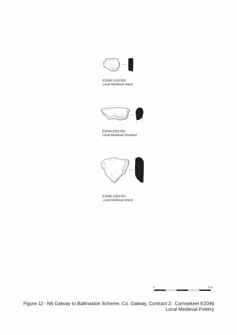
Figure 12 - N6 Galway to Ballinasloe Scheme, Co. Galway, Contract 2: Carrowkeel E2046Local Medieval Pottery

Plate 1 - North-facing section of Phase 1 ditch 1020, with fill 1021, Slot 2
Plate 2 - Southeast-facing section of Phase 1 ditch 1020, showing additional deposits 1369 and 1370, Slot 1

Plate 3 - North-facing section of pit 1050
Plate 4 - Southeast-facing section of kiln1292

Plate 5 - East-facing section of main enclosure ditch 1023, Slot 1
Plate 6 - South-facing section of main enclosure ditch 1023, Slot 8

Plate 7 - North-facing section of main enclosure ditch 1023, showing considerable slumping, Slot 8
Plate 8 - Southeast-facing section of main enclosure ditch 1023, truncating Phase 1 ditch 1015, Slot 5

Plate 9 - East-facing baulk showing buried soil horizon and leaching in bank
Plate 10 - main enclosure ditch 1023 and modern field wall overlying remnant of internal enclosure bank, Slot 16

Plate 11 - West-facing section of cemetery ditches 1260, Slot 6 and 1359, Slot 5
Plate 12 - East-facing section of cemetery ditch 1475, Slot 1
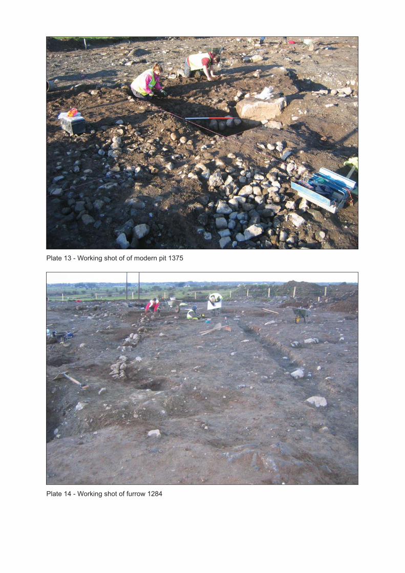
Plate 13 - Working shot of of modern pit 1375
Plate 14 - Working shot of furrow 1284

Plate 15 - North-facing view of main enclosure ditch 1023 truncated by modern pit 1375
Plate 16 - Southeast facing view of modern pit feature 1375

Plate 17 - Working shot of main ditch 1023, looking North
Plate 18 - Working shot of main ditch 1023, looking North

Plate 19 - Aerial view of northern ditches 1020, 1023, 1330, 1022 and 1284, facing North
Plate 20 - Aerial view of northern ditches, 1020, 1015, 1023, 1022 and furrows, facing North

Plate 21 - Skeleton 27
Plate 22 - Skeleton 49, with quartz

Plate 23 - Skeleton 119, legs akimbo
Plate 24 - Skeleton 126

Plate 25 - Skeleton 72, within 1260
Plate 26 - Skeleton 82, tightly crouched

Plate 27 - Skeleton 52
Plate 28 - Skeleton 107

Headland Archaeology Ltd: N6 Galway to Ballinasloe Scheme, Contract 2, E2046 Final Report
23
Appendix 1: Context Register Context Type Description Interpretation 1000 Deposit Brown silty clay, including sod. Topsoil. 1001 Deposit Mid‐brown silty sand. Subsoil. 1002 Deposit Grey‐white stony sandy clay. Natural. 1003 Cut Diameter 0.70m, Depth 0.15m.
Irregular in plan, irregular sides, irregular base. Feature is in/under the bank of ditch (1023), probable burrow except the fill (1004) contained large amounts of charcoal.
Probable burrow. Phase 3.
1004 Fill Singular fill of probable burrow (1003). Grey silty sand, few stones, frequent charcoal, very loose compaction.
Fill of probable burrow. Phase 3.
1005 Fill Fill of enclosure ditch (1023). Green‐brown sandy clay, <5% stones, moderate compaction. Basal fill. Found in slot 16.
Fill of main enclosure ditch.
1006 Fill Fill of enclosure ditch (1023). Pale white‐brown sandy clay, no stones, moderate compaction. Internal slump. Found in slot 16.
Fill of main enclosure ditch.
1007 Fill Fill of enclosure ditch (1023). Pale green‐brown sandy clay, <5% stones, moderate compaction. Internal slump. Found in slot 16.
Fill of main enclosure ditch.
1008 Fill Fill of enclosure ditch (1023). Pale brown‐orange sandy clay, large stones, moderate compaction. Internal slump. Found in slot 16.
Fill of main enclosure ditch.
1009 Fill Fill of enclosure ditch (1023). Light brown stony silty clay, 80% stones, chert, moderate compaction. Main fill. Found in slot 16.
Fill of main enclosure ditch.
1010 Fill Fill of enclosure ditch (1023). Mid brown stony silty clay, 80% stones, moderate compaction. Main fill. Found in slot 16.
Fill of main enclosure ditch.
1011 Fill Fill of enclosure ditch (1023). Orange‐brown silty clay, few stones, soft compaction. Upper deposit. Found in slot 16.
Fill of main enclosure ditch.
1012 Fill Bank associated with enclosure ditch (1023). Grey‐brown silty clay, very few stones, animal bone, soft to moderate compaction. Below bank.
Bank associated with main enclosure. Phase 3.
1013 Fill Bank associated with enclosure ditch (1023). Pale orange sandy clay, occasional stones, moderate compaction. Upcast material for bank.
Bank associated with main enclosure. Phase 2A.
1014 Fill Bank associated with enclosure ditch (1023). White sandy clay, stones, moderate compaction. Upcast material for bank.
Bank associated with main enclosure. Phase 2A.

Headland Archaeology Ltd: N6 Galway to Ballinasloe Scheme, Contract 2, E2046 Final Report
24
Context Type Description Interpretation 1015 Cut Depth 0.67m.
Linear in plan north/west‐south/east, 45° sides, flat base. Filled by (1016), (1017), (1018).
Linear enclosure ditch abutting ditch (1019). Phase I.
1016 Fill Fill of linear (1015). Mid brown silty sand, <10% stones, animal bone, loose compaction. ‘Silting’ fill on west side.
Fill of linear enclosure ditch. Phase I.
1017 Fill Fill of linear (1015). Mid brown silty sand, 35% stones, animal bone, loose compaction. Possible ‘backfill’.
Fill of linear enclosure ditch. Phase I.
1018 Fill Fill of linear (1015). Pale brown clayey sand, <5% stones, animal bone, loose compaction. ‘Slumping’ fill on east side.
Fill of linear enclosure ditch. Phase I.
1019 Cancelled. 1020 Cut Width 1.3m, Depth 0.50m.
Curvi‐linear in plan west‐east, 45° sides, flat to concave base. Filled by (1021), (1369), (1370). Also known as (1302).
Ditch joining main enclosure ditch. Phase I.
1021 Fill Fill of ditch (1020). Dark brown silty sand, stones, some charcoal, animal bone, loose compaction. Possible deliberate backfill.
Fill of ditch joining main enclosure. Phase I.
1022 Cut Duplicated as (1317). 1023 Cut Width 3m, Depth 1.5m.
Enclosure, steep sides, pointed base. Filled by (1005), (1006), (1007), (1008,) (1009), (1010), (1011), (1012), (1013), (1014), (1024), (1025), (1026), (1027), (1028), (1029), (1030), (1031), (1032), (1033), (1034), (1035), (1036), (1037), (1038), (1073), (1074), (1075), (1076), (1077), (1078), (1079), (1090). (1091), (1092), (1093), (1094), (1095), (1096), (1099), (1101), (1102), (1103), (1110), (1111), (1112), (1113), (1120), (1121), (1122), (1123), (1178), (1179), (1180), (1181), (1182), (1183), (1184), (1185), (1186), (1188), (1189), (1190), (1191), (1192), (1196), (1197), (1198), (1199), (1200), (1201), (1207), (1208), (1209), (1210), (1211), (1212), (1213), (1214), (1215), (1217), (1218), (1219), (1220), (1231), (1232), (1233), (1234), (1235), (1236), (1237), (1238), (1239).
Main enclosure ditch. Phase 2A.

Headland Archaeology Ltd: N6 Galway to Ballinasloe Scheme, Contract 2, E2046 Final Report
25
Context Type Description Interpretation 1024 Fill Fill of enclosure ditch (1023).
Yellow‐brown to grey‐brown to black‐brown sandy clay to silty sand or gravel, 45% stones, pebbles, occasional charcoal, animal bone, moderate compaction. Basal fill. Found in slot 2, 3, 4, 5, 7.
Fill of main enclosure ditch.
1025 Fill Fill of enclosure ditch (1023). Dark brown‐yellow to orange‐brown silty clay to silty sand to clayey sand, pebbles, stones, animal bone, occasional charcoal, firm compaction. External slump. Found in slot 2, 4, 7.
Fill of main enclosure ditch.
1026 Fill Fill of enclosure ditch (1023). Mid‐dark brown silty sand, occasional stones, loose compaction. Internal slump. Found in slot 4, 5.
Fill of main enclosure ditch.
1027 Fill Fill of enclosure ditch (1023). Dark brown‐yellow to orange‐brown sandy clay to silty sand, pebbles, stones, occasional charcoal, loose compaction. Internal slump. Found in slot 2, 4, 5.
Fill of main enclosure ditch.
1028 Cancelled. 1029 Fill Fill of enclosure ditch (1023).
Brown‐grey or orange‐grey to brown‐black sandy silt to silty sand or gravel and silty clay, pebbles, 40% stones, boulders, animal bone, loose compaction. Main fill. Found in slot 1, 2, 3, 4, 5, 6, 8, 9, 10, 15.
Fill of main enclosure ditch.
1030 Fill Fill of enclosure ditch (1023). Yellow –brown or grey‐brown to brown‐black sandy silt to silty sand, frequent stones, animal bone, loose to moderate compaction. Upper deposit. Found in slot 2, 3, 5, 6, 8, 9, 15.
Fill of main enclosure ditch.
1031 Fill Fill of enclosure ditch (1023). Grey‐brown or yellow‐brown to dark brown silty sand or gravel, pebbles, frequent stones, animal bone, loose to moderate compaction. Upper deposit. Found in slot 1, 2, 3, 5, 6, 15.
Fill of main enclosure ditch.
1032 Fill Fill of enclosure ditch (1023). Mid brown silty sand, charcoal flecks, stones, moderate compaction. External slump. Found in slot 6.
Fill of main enclosure ditch.

Headland Archaeology Ltd: N6 Galway to Ballinasloe Scheme, Contract 2, E2046 Final Report
26
Context Type Description Interpretation 1033 Fill Fill of enclosure ditch (1023).
Light brown silty sand, charcoal flecks, moderate compaction. External slump. Found in slot 6.
Fill of main enclosure ditch.
1034 Fill Fill of enclosure ditch (1023). Dark brown clayey silt to silty sand, 20% stones, charcoal flecks, moderate compaction. Internal slump. Found in slot 6.
Fill of main enclosure ditch.
1035 Fill Fill of enclosure ditch (1023). Mid brown clayey sand, occasional charcoal, stones, soft compaction. Internal slump. Found in slot 6.
Fill of main enclosure ditch.
1036 Fill Fill of enclosure ditch (1023). Mid‐brown sand, stones, moderate compaction. Internal slump. Found in slot 6, 15.
Fill of main enclosure ditch.
1037 Fill Fill of enclosure ditch (1023). Light grey to dark grey‐brown silty clay, pebbles, shell, stones, moderate compaction. External slump or basal fill. Found in slot 2, 6, 15.
Fill of main enclosure ditch.
1038 Fill Fill of enclosure ditch (1023). Dark brown‐grey sandy clay, pebbles, gravel. Upper deposit, possible burrow. Only found in slot 2.
Fill of main enclosure ditch.
1039 Fill Fill of enclosure ditch (1023). Internal slump. Found in slot 15.
Fill of enclosure.
1040 Cut Length 0.80m (truncated), Width 0.55m, Depth 0.20m. Grave cut containing Skeleton 1 knees to feet (truncated by machine), sub‐rectangular in plan, steep sides, slightly concave base. Filled by (1042), (1106) Skeleton 1.
Grave cut of Sk. 1.
1041 Fill Knees to feet of adult skeleton. Skeleton 1. Cemetery phase I.
1042 Fill Fill of grave cut (1040). Skeleton 1. Mid brown silty sand, <20% stones, loose compaction.
Grave fill around SK 1.
1043 Cut Diameter 0.75m, Depth 0.23m. Sub‐circular in plan, irregular shallow S side, steep north side, concave base. Probably natural silting of depression. Filled by (1044).
Natural depression. Phase 3.
1044 Fill Singular fill of pit (1043). Mid brown sandy silt, frequent stones, loose compaction.
Fill of natural depression. Phase 3.
1045 Cut Diameter 0.40m, Depth 0.05m. Sub‐rectangular in plan, shallow sides, flat base. Filled by (1046).
Post‐hole aligned with (1051)(1049) and (1047). Phase I.
1046 Fill Singular fill of post‐hole (1045). Dark grey silty clay, occasional charcoal flecks, stones, moderate compaction.
Fill of post‐hole. Phase I.
1047 Cut Diameter 0.60m, Depth 0.11m. Sub‐circular in plan, steep sides, concave base. Filled by (1048).
Post‐hole aligned with group (1045)(1051) and (1049). Phase I.

Headland Archaeology Ltd: N6 Galway to Ballinasloe Scheme, Contract 2, E2046 Final Report
27
Context Type Description Interpretation 1048 Fill Singular fill of post‐hole (1047).
Black‐grey silty clay, frequent charcoal flecks, stones, moderate compaction.
Fill of post‐hole.
1049 Cut Diameter 0.50m, Depth 0.06m. Sub‐circular in plan, shallow sides, flat base. Filled by (1050).
Post‐hole aligned with (1045)(1047) and (1051). Phase I.
1050 Fill Singular fill of post‐hole (1049). Black‐grey silty clay, one large stone, small stones, occasional charcoal flecks, moderate compaction.
Fill of post‐hole. Phase I.
1051 Cut Length (north‐south) 0.75m, Width (east‐west) 0.63m, Depth 0.23m. Sub‐circular in plan, steep sides, concave base. Filled by (1052).
Pit aligned with (1045)(1047) and (1049). Phase I.
1052 Fill Singular fill of pit (1051). Mid brown sandy silt, moderate stones, animal bone, 3 pieces of chert, loose compaction.
Fill of pit. Phase I.
1053 Cut Length 1.84m, Width 0.96m, Depth 0.30m. Sub‐oval in plan, steep sides, flat base. Filled by (1054), (1055), (1056).
Natural feature. Phase 3.
1054 Fill Primary fill of probable natural pit (1053). Grey gravel, many pebbles, very loose compaction.
Fill of natural feature. Phase 3.
1055 Fill Secondary fill of probable natural pit (1053). Orange‐brown gravel, many pebbles, loose compaction.
Fill of natural feature. Phase 3.
1056 Fill Tertiary fill of probable natural pit (1053). Brown‐orange silt, many stones, loose compaction.
Fill of natural feature. Phase 3.
1057 Cut Diameter 0.50m, Depth 0.11m. Irregular sub‐circular in plan, shallow sides, concave base. Filled by (1058).
Pit. Phase 3.
1058 Fill Singular fill of pit (1057). Black‐dark grey silty clay, charcoal flecks, stones, loose compaction.
Fill of pit. Phase 3.
1059 Cut Grave cut containing Skeleton 2. Filled by (1061), (1060) Skeleton 2.
Grave cut containing Sk. 2.
1060 Fill Juvenile or neonatal skeleton. Skeleton 2. Cemetery phase I
1061 Fill Fill of grave cut (1059). Skeleton 2. Grave fill around Sk. 2. 1062 Cut Length 0.85m, Width 0.67m, Depth 0.35m.
Sub‐oval in plan, shallow to vertical sides, concave base. Filled by (1063). Truncates enclosure ditch (1023).
Natural depression. Phase 3.
1063 Fill Singular fill of natural depression (1062). Mid brown silty clay, many stones.
Fill of natural depression. Phase 3.

Headland Archaeology Ltd: N6 Galway to Ballinasloe Scheme, Contract 2, E2046 Final Report
28
Context Type Description Interpretation 1064 Cut Length 1.6m, Width 1m, Depth 0.20m‐0.30m.
Oval in plan, sloping sides, concave base. Filled by (1065).
Natural depression. Phase 3.
1065 Fill Singular fill of natural depression (1064). Mid brown silty clay, many stones, loose compaction.
Fill of natural depression. Phase 3.
1066 Cut Diameter 0.65m, Depth 0.10m. Sub‐circular in plan, shallow sides, uneven convex base. Filled by (1067).
Pit. Phase 3.
1067 Fill Singular fill of pit (1066). Dark brown‐black silty sand, 4 large stones, charcoal, loose compaction.
Fill of pit. Phase 3.
1068 Cut Filled by (1069). Pit. Phase 3. 1069 Fill Singular fill of (1068). Charcoal rich. Fill of pit. Phase 3. 1070 Cut Grave cut containing Skeleton 26. Filled by
(1071). Grave cut containing Sk. 26. Cemetry phase 2.
1071 Fill Fill of grave cut (1070). Skeleton 26. Grave fill around Sk. 26. 1072 Fill Fill of enclosure ditch (1023).
External slump. Found in slot 15. Fill of enclosure.
1073 Fill Fill of enclosure ditch (1023). Light brown‐black sandy clay, gravel, animal bone, loose compaction. Upper deposit. Found in slot 8.
Fill of main enclosure ditch.
1074 Fill Fill of enclosure ditch (1023). Light brown‐grey sandy clay, stones, pebbles, loose compaction. Internal slump. Found in slot 8.
Fill of main enclosure ditch.
1075 Fill Fill of enclosure ditch (1023). Mid grey‐brown sandy silt, pebbles, stones, firm compaction. Internal slump. Found in slot 8.
Fill of main enclosure ditch.
1076 Fill Fill of enclosure ditch (1023). Dark grey‐brown to light blue‐brown silt or sandy silt to clayey sand, stones, moderate compaction. Basal fill. Found in slot 1, 7, 8, 9.
Fill of main enclosure ditch.
1077 Fill Fill of enclosure ditch (1023). Light brown‐grey clayey silt, 80% pebbles, firm compaction. Internal slump. Found in slot 8.
Fill of main enclosure ditch.
1078 Fill Fill of enclosure ditch (1023). Dark grey‐brown clayey silt, 50% pebbles, firm compaction. External slump. Found in slot 8.
Fill of main enclosure ditch.
1079 Fill Fill of enclosure ditch (1023). Light brown‐grey sandy clay, loose compaction. External slump. Found in slot 8.
Fill of main enclosure ditch.

Headland Archaeology Ltd: N6 Galway to Ballinasloe Scheme, Contract 2, E2046 Final Report
29
Context Type Description Interpretation 1080 Cut Grave cut containing Skeleton 3. Filled by
(1081). Grave cut of Sk. 3. Cemetery phase 1.
1081 Fill Fill of grave (1080). Skeleton 3. Grave fill around Sk. 3. 1082 Cut Grave cut containing Skeleton 9. Filled by
(1083). Grave cut of Sk. 9. Cemetery phase 2.
1083 Fill Fill of grave (1082). Skeleton 9. Grave fill around Sk.9. 1084 Cut Grave cut containing Skeleton 6. Filled by
(1085). Grave cut of Sk 6. Cemetery phase 2.
1085 Fill Fill of grave (1084). Skeleton 6. Grave fill around Sk. 6. 1086 Cut Grave cut containing Skeleton 7. Filled by
(1087). Grave cut of Sk. 7. Cemetery phase 2.
1087 Fill Fill of grave (1086). Skeleton 7. Grave fill around Sk. 7. 1088 Cut Grave cut containing Skeleton 32. Filled by
(1089). Grave cut of Sk. 32.
1089 Fill Fill of grave (1088). Skeleton 32. Grave fill around Sk. 32. 1090 Fill Fill of enclosure ditch (1023).
Orange‐brown sandy silt, stones, moderate compaction. Internal slump. Found in slot 1.
Fill of main enclosure ditch.
1091 Fill Fill of enclosure ditch (1023). Orange‐brown sandy silt, stones, moderate compaction. Internal slump. Found in slot 1.
Fill of main enclosure ditch.
1092 Fill Fill of enclosure ditch (1023). Mid grey‐brown sand, few stones, moderate compaction. External slump. Found in slot 1.
Fill of main enclosure ditch.
1093 Fill Fill of enclosure ditch (1023). Mid grey‐brown sandy silt, large stones, animal bone, moderate compaction. External slump. Found in slot 1.
Fill of main enclosure ditch.
1094 Fill Fill of enclosure ditch (1023). Light yellow‐grey silty sand, occasional stones, loose compaction. Internal slump. Found in slot 7.
Fill of main enclosure ditch.
1095 Fill Fill of enclosure ditch (1023). Light yellow‐brown clayey sand, occasional large stones, moderate compaction. Upper deposit. Found in slot 7.
Fill of main enclosure ditch.
1096 Fill Fill of enclosure ditch (1023). Mid yellow‐grey silty sand, occasional stones, soft compaction. Internal slump. Found in slot 7.
Fill of main enclosure ditch.
1097 Fill Fill of enclosure ditch (1023). Light yellow brown silty sand, stones, soft compaction. Upper deposit. Found in slot 7.
Fill of main enclosure ditch.

Headland Archaeology Ltd: N6 Galway to Ballinasloe Scheme, Contract 2, E2046 Final Report
30
Context Type Description Interpretation 1098 Deposit Dark brown silty sand, moderate compaction.
Same as subsoil (1001). Subsoil in the cemetry area.
1099 Fill Fill of enclosure ditch (1023). Light grey‐brown silty clay, pebbles, stones, loose compaction. External slump. Found in slot 3.
Fill of main enclosure ditch.
1100 Fill Duplicated as (1110). 1101 Fill Fill of enclosure ditch (1023).
Mid yellow‐brown silty sand, frequent stones, moderate compaction. Upper deposit. Found in slot 7.
Fill of main enclosure ditch.
1102 Fill Fill of enclosure ditch (1023). Light yellow‐brown silty sand, some stones, charcoal, moderate compaction. External slump. Found in slot 7.
Fill of main enclosure ditch.
1103 Fill Fill of enclosure ditch (1023). Mid brown clayey sand, animal bone, charcoal flecks, soft compaction. Internal slump. Found in slot 7.
Fill of main enclosure ditch.
1104 Fill Neonatal skeleton. Skeleton 6. Cemetery phase 2.
1105 Fill Neonatal skeleton. Skeleton 4. Cemetery phase 2.
1106 Fill Adult skeleton. Skeleton 3. Cemetery phase 1.
1107 Fill Neonatal skeleton. Skeleton 9. Cemetery phase 2.
1108 Fill Juvenile skeleton. Skeleton 7. Cemetery phase 2.
1109 Fill Juvenile skeleton. Skeleton 8. Cemetery phase 2.
1110 Fill Fill of enclosure ditch (1023). Dark grey‐brown silty clay, stones, pebbles, firm compaction. Internal slump. Found in slot 3.
Fill of main enclosure ditch.
1111 Fill Fill of enclosure ditch (1023). Dark brown‐yellow clayey sand, pebbles, loose compaction. External slump. Found in slot 3.
Fill of main enclosure ditch.
1112 Fill Fill of enclosure ditch (1023). Dark brown‐black silty clay, animal bone, soft compaction. Upper deposit. Found in slot 3.
Fill of main enclosure ditch.
1113 Fill Fill of enclosure ditch (1023). Light grey‐brown sandy clay, pebbles, stones, loose compaction. External slump. Found in slot 3.
Fill of main enclosure ditch.
1114 Fill Unused.

Headland Archaeology Ltd: N6 Galway to Ballinasloe Scheme, Contract 2, E2046 Final Report
31
Context Type Description Interpretation 1115 Cut Grave cut containing Skeleton 5. Filled by
(1116). Grave cut of Sk. 5.
1116 Fill Fill of grave (1115). Skeleton 5. Grave fill around Sk. 5. 1117 Fill Skeleton. Skeleton 5. Cemetery
phase 2. 1118 Fill Skeleton. Skeleton 15. Cemetery
phase 4. 1119 Fill Skeleton. Skeleton 16. Cemetery
phase 2. 1120 Fill Fill of enclosure ditch (1023).
Mid orange‐brown sandy silt, pebbles. Internal slump. Found in slot 9.
Fill of main enclosure ditch.
1121 Fill Fill of enclosure ditch (1023). Light grey‐brown sand, large stones, loose compaction. External slump. Found in slot 9.
Fill of main enclosure ditch.
1122 Fill Fill of enclosure ditch (1023). Mid orange‐brown, stones, loose compaction. Internal slump. Found in slot 9.
Fill of main enclosure ditch.
1123 Fill Fill of enclosure ditch (1023). Mid orange‐brown sandy silt, stones, moderate compaction. External slump. Found in slot 9.
Fill of main enclosure ditch.
1124 Cut Diameter 0.40m, Depth 0.60m. Circular in plan, 45°‐80° sides. Filled by (1125). Cut into enclosure ditch (1023) at slot 9.
Post‐hole in main enclosure ditch. Phase 2C.
1125 Fill Singular fill of post‐hole (1124). Dark brown, charcoal at base, loose compaction.
Fill of post‐hole. Phase 2C.
1126 Fill Unused. 1127 Cancelled. 1128 Cancelled. 1129 Fill Infant skeleton. Skeleton 17. Cemetery
phase 2. 1130 Cancelled. 1131 Cancelled. 1132 Fill Infant skeleton, truncated at ribs. Skeleton 10. Cemetery
phase 2. 1133 Fill Neonatal skeleton. Skeleton 19. Cemetery
phase 2. 1134 Cancelled. 1135 Cancelled. 1136 Cancelled. 1137 Fill Neonatal skeleton. Skeleton 21. Cemetery
phase 2. 1138 Fill Adult skeleton. Skeleton 22. Cemetery
phase 1. 1139 Cancelled.

Headland Archaeology Ltd: N6 Galway to Ballinasloe Scheme, Contract 2, E2046 Final Report
32
Context Type Description Interpretation 1140 Cancelled. 1141 Cancelled. 1142 Fill Pelvis and femur. Skeleton 12. Cemetery
phase 2. 1143 Cut Grave cut containing Skeleton 25. Filled by
(1144). Grave cut of Sk. 25.
1144 Fill Fill of grave (1143). Skeleton 25. Grave fill around Sk. 25. 1145 Fill Infant skeleton. Skeleton 25. Cemetery
phase 2. 1146 Fill Infant skeleton. Skeleton 26. Cemetery
phase 2. 1147 Fill Skeleton. Skeleton 27. Cemetery
phase 1. 1148 Fill Skeleton. Skeleton 20. Cemetery
phase 2. 1149 Fill Skeleton. Skeleton 24. Cemetery
phase 2. 1150 Fill Neonatal skeleton. Skeleton 13. Cemetery
phase 2. 1151 Fill Skeleton. Skeleton 14. Cemetery
phase 2. 1152 Cancelled. 1153 Cancelled. 1154 Cut Grave cut containing Skeleton 22. Filled by
(1155). Grave cut of Sk. 22.
1155 Fill Fill of grave (1154). Skeleton 22. Grave fill around Sk. 22. 1156 Fill Partial cranium. Skeleton 28. Cemetery
phase 2. 1157 Fill Non‐adult skeleton. Skeleton 18. Cemetery
phase 2. 1158 Fill Neonatal skeleton. Skeleton 11. Cemetery
phase 2. 1159 Fill Neonatal skeleton. Skeleton 23. Cemetery
phase 2. 1160 Cut Grave cut containing Skeleton 18. Filled by
(1161). Grave cut of Sk. 18.
1161 Fill Fill of grave (1160). Skeleton 18. Grave fill around Sk. 18. 1162 Cut Grave cut containing Skeleton 11. Filled by
(1163). Grave cut of Sk. 11.
1163 Fill Fill of grave (1162). Skeleton 11. Grave fill around Sk 11. 1164 Cancelled. 1165 Cancelled. 1166 Fill Infant skeleton. Skeleton 30. Cemetery
phase 2. 1167 Cut Grave cut containing Skeleton 30. Filled by
(1168). Grave cut of Sk. 30.
1168 Fill Fill of grave (1167). Skeleton 30. Grave fill around Sk 30.

Headland Archaeology Ltd: N6 Galway to Ballinasloe Scheme, Contract 2, E2046 Final Report
33
Context Type Description Interpretation 1169 Cut North‐south agricultural cut truncating
Skeleton 10, 17, 18, 34, 46, 47. Filled by (1244). Agricultural furrow.
1170 Deposit Yellow silty sand, some stones, loose compaction. Appears in bands throughout skeleton area, probably a redeposit of natural. Above (1264).
Natural in skeleton area.
1171 Cut Length 0.70m, Width0.30m, Depth 0.30m. Sub‐circular in plan, steep sides, flat base. Filled by (1172). Probably a natural feature.
Pit. Phase 3.
1172 Fill Singular fill of pit (1171). Mid grey‐brown silty sand, some stones, moderate compaction.
Fill of pit. Phase 3.
1173 Fill Infant skeleton. Skeleton 31. Cemetery phase 2.
1174 Fill Infant skeleton. Skeleton 32. Cemetery phase 2.
1175 Fill Juvenile skeleton. Skeleton 33. Cemetery phase 2.
1176 Cut Grave cut containing Skeleton 33. Filled by (1177).
Grave cut of Sk. 33.
1177 Fill Fill of grave (1176). Skeleton 33. Grave fill around Sk. 33. 1178 Fill Fill of enclosure ditch (1023).
Mid grey silty gravel, frequent stones, firm compaction. Base fill. Found in slot 10.
Fill of main enclosure ditch.
1179 Fill Fill of enclosure ditch (1023). Light brown to grey‐brown sandy silt to silty gravel, moderate stones, moderate compaction. Internal slump. Found in slot 10.
Fill of main enclosure ditch.
1180 Fill Fill of enclosure ditch (1023). Mid to light brown sandy clay, occasional stones, moderate compaction. External slump. Found in slot 10.
Fill of main enclosure ditch.
1181 Fill Fill of enclosure ditch (1023). Light brown‐grey gravely silt, frequent stones, shell, moderate compaction. Main fill. Found in slot 10.
Fill of main enclosure ditch.
1182 Fill Fill of enclosure ditch (1023). Mid brown silty clay, occasional stones, moderate compaction. External slump. Found in slot 10.
Fill of main enclosure ditch.
1183 Fill Fill of enclosure ditch (1023). Mid brown silty clay, occasional pebbles, moderate compaction. Internal slump. Found in slot 10.
Fill of main enclosure ditch.

Headland Archaeology Ltd: N6 Galway to Ballinasloe Scheme, Contract 2, E2046 Final Report
34
Context Type Description Interpretation 1184 Fill Fill of enclosure ditch (1023).
Mid to dark brown silty clay, occasional stones, moderate compaction. External slump. Found in slot 10.
Fill of main enclosure ditch.
1185 Fill Fill of enclosure ditch (1023). Light brown silty clay, occasional stones, moderate compaction. Upper deposit. Found in slot 10.
Fill of main enclosure ditch.
1186 Fill Fill of enclosure ditch (1023). Dark brown silty clay, occasional stones, moderate compaction. Upper deposit. Found in slot 10.
Fill of main enclosure ditch.
1187 Fill Infant skeleton. Skeleton 34. Cemetery phase 2.
1188 Fill Fill of enclosure ditch (1023). Light to mid brown clayey silt, occasional pebbles, moderate compaction. Upper deposit. Found in slot 10.
Fill of main enclosure ditch.
1189 Fill Fill of enclosure ditch (1023). Mid brown clayey silt, frequent stones, animal bone, moderate compaction. Upper deposit. Found in slot 10.
Fill of main enclosure ditch.
1190 Fill Fill of enclosure ditch (1023). Mid to dark brown silty gravel, frequent stones, animal bone, loose compaction. Main fill. Found in slot 10.
Fill of main enclosure ditch.
1191 Fill Fill of enclosure ditch (1023). Mid to light grey silty gravel, frequent stones, moderate compaction. Basal fill. Found in slot 10.
Fill of main enclosure ditch.
1192 Fill Fill of enclosure ditch (1023). Light brown silty clay, occasional stones, moderate compaction. External slump. Found in slot 10.
Fill of main enclosure ditch.
1193 Cancelled. 1194 Fill Partial infant skeleton. Skeleton 35. Cemetery
phase 2. 1195 Fill Partial infant skeleton. Skeleton 36. Cemetery
phase 2. 1196 Fill Fill of enclosure ditch (1023).
Mid grey‐brown, very few stones, loose compaction. Upper deposit. Found in slot 13, 14.
Fill of main enclosure ditch.
1197 Fill Fill of enclosure ditch (1023). Dark grey‐brown silt, several large stones, animal bone & teeth, loose compaction. Upper deposit. Found in slot 13.
Fill of main enclosure ditch.

Headland Archaeology Ltd: N6 Galway to Ballinasloe Scheme, Contract 2, E2046 Final Report
35
Context Type Description Interpretation 1198 Fill Fill of enclosure ditch (1023).
Light grey‐brown sand, stones, boulders, frequent animal bone & teeth, shell, loose compaction. Main fill. Found in slot 13.
Fill of main enclosure ditch.
1199 Fill Fill of enclosure ditch (1023). Orange brown, stones, burnt bone, animal bone, shell, loose compaction. Internal slump. Found in slot 13, 14.
Fill of main enclosure ditch.
1200 Fill Fill of enclosure ditch (1023). Orange‐brown, stones, animal bone, shell, loose compaction. External slump. Found in slot 13, 14.
Fill of main enclosure ditch.
1201 Fill Fill of enclosure ditch (1023). Grey sand, many stones, loose compaction. Basal fill. Found in slot 13, 14.
Fill of main enclosure ditch.
1202 Deposit Orange sandy clay, few stones, moderate to hard compaction. Appears in patches above (1002).
Natural. Phase 3.
1203 Fill Partial neonatal skeleton. Skeleton 37. Cemetery phase 2.
1204 Fill Partial neonatal skeleton. Skeleton 38. Cemetery phase 2.
1205 Cut Grave cut containing Skeleton 51. Filled by (1206).
Grave cut of Sk. 51.
1206 Fill Fill of grave (1205). Skeleton 51. Grave fill around Sk. 51. 1207 Fill Fill of enclosure ditch (1023).
Mid to dark brown clayey silt, moderate stones, moderate compaction. Upper deposit. Found in slot 11.
Fill of main enclosure ditch.
1208 Fill Fill of enclosure ditch (1023). Mid to dark brown sandy silt, frequent stones, occasional animal bone, loose compaction. Main fill. Found in slot 11.
Fill of main enclosure ditch.
1209 Fill Fill of enclosure ditch (1023). Light brown‐grey silty gravel, frequent stones, occasional shell, firm compaction. Base fill. Found in slot 11.
Fill of main enclosure ditch.
1210 Fill Fill of enclosure ditch (1023). Light to mid brown silty clay, occasional pebbles, moderate compaction. Internal slump. Found in slot 11.
Fill of main enclosure ditch.
1211 Fill Fill of enclosure ditch (1023). Mid brown clayey silt, occasional pebbles, moderate compaction. Internal slump. Found in slot 11.
Fill of main enclosure ditch.

Headland Archaeology Ltd: N6 Galway to Ballinasloe Scheme, Contract 2, E2046 Final Report
36
Context Type Description Interpretation 1212 Fill Fill of enclosure ditch (1023).
Light to mid brown clayey silt, occasional pebbles, moderate compaction. External slump. Found in slot 11.
Fill of main enclosure ditch.
1213 Fill Fill of enclosure ditch (1023). Light to mid brown silty clay, occasional pebbles, moderate compaction. External slump. Found in slot 11.
Fill of main enclosure ditch.
1214 Fill Fill of enclosure ditch (1023). Light to mid brown silty clay, occasional pebbles, moderate compaction. Internal slump. Found in slot 11.
Fill of main enclosure ditch.
1215 Fill Fill of enclosure ditch (1023). Mid to dark brown sandy silt, frequent large stones, occasional shell, occasional animal bone, loose compaction. Main fill. Found in slot 11.
Fill of main enclosure ditch.
1216 Fill Partial neonatal skeleton. Skeleton 39. Cemetery phase 2.
1217 Fill Fill of enclosure ditch (1023). Dark brown silty sand, 5‐10% large stones, charcoal flecks, nail, slag, firm compaction. Upper deposit. Found in slot 12.
Fill of main enclosure ditch.
1218 Fill Fill of enclosure ditch (1023). Mid brown silty sand, 5% stones, charcoal flecks, firm compaction. Main fill. Found in slot 12.
Fill of main enclosure ditch.
1219 Fill Fill of enclosure ditch (1023). Light brown silty clay, stones, charcoal flecks, light compaction. Internal slump. Found in slot 12.
Fill of main enclosure ditch.
1220 Fill Fill of enclosure ditch (1023). Mid brown‐red sandy silt, stones, charcoal flecks, firm compaction. External slump. Found in slot 12.
Fill of main enclosure ditch.
1221 Fill Fill of enclosure ditch (1023). Light brown clay, stones, charcoal flecks, soft compaction. Basal fill. Found in slot 12.
Fill of main enclosure ditch.
1222 Fill Neonatal skeleton. Skeleton 40. Cemetery phase 2.
1223 Cut Grave cut containing Skeleton 87. Filled by (1224).
Grave cut of Sk. 87.
1224 Fill Fill of grave (1223). Skeleton 87. Grave fill around Sk.87. 1225 Fill Infant skeleton. Skeleton 41. Cemetery
phase 2. 1226 Fill Neonatal skeleton. Skeleton 43. Cemetery
phase 1.

Headland Archaeology Ltd: N6 Galway to Ballinasloe Scheme, Contract 2, E2046 Final Report
37
Context Type Description Interpretation 1227 Fill Neonatal skeleton. Skeleton 42. Cemetery
phase 1. 1228 Fill Juvenile skeleton. Skeleton 44. Cemetery
phase 3. 1229 Cut Length 0.36m, Width 0.32m, Depth 0.24m.
Oval in plan, vertical to sloping sides, concave base. Filled by (1230). Truncated by grave cut (1088) Skeleton 32.
Post‐hole. Phase 3.
1230 Fill Singular fill of post‐hole (1229). Mid brown silty sand, stones, bird talon, loose compaction.
Fill of post‐hole. Phase 3.
1231 Fill Fill of enclosure ditch (1023). Mid brown silty sand, large stones, charcoal flecks, animal bone, firm compaction. Main fill. Found in slot 12.
Fill of main enclosure ditch.
1232 Fill Fill of enclosure ditch (1023). Mid brown silty clay, charcoal flecks, soft compaction. Main fill. Found in slot 12.
Fill of main enclosure ditch.
1233 Fill Fill of enclosure ditch (1023). Light brown silty clay, large stones, charcoal flecks, soft compaction. Main fill. Found in slot 12.
Fill of main enclosure ditch.
1234 Fill Fill of enclosure ditch (1023). Mid brown silty clay, charcoal flecks, soft compaction. Internal slump. Found in slot 12.
Fill of main enclosure ditch.
1235 Fill Fill of enclosure ditch (1023). Mid grey‐brown silt, stones, loose compaction. Upper deposit. Found in slot 14.
Fill of main enclosure ditch.
1236 Fill Fill of enclosure ditch (1023). Yellow‐brown sandy silt, stones, firm compaction. Upper deposit. Found in slot 14.
Fill of main enclosure ditch.
1237 Fill Fill of enclosure ditch (1023). Dark grey‐brown silt, frequent stones, animal bone, shell, loose compaction. Upper deposit. Found in slot 14.
Fill of main enclosure ditch.
1238 Fill Fill of enclosure ditch (1023). Mid grey‐brown sandy silt, frequent stones, animal bone, shell, loose compaction. Main fill. Found in slot 14.
Fill of main enclosure ditch.
1239 Fill Fill of enclosure ditch (1023). Mid grey‐brown silt, few stones, shell, loose compaction. Internal slump. Found in slot 14.
Fill of main enclosure ditch.
1240 Fill Neonatal skeleton. Skeleton 45. Cemetery phase 2.
1241 Fill Neonatal skeleton. Skeleton 46. Cemetery phase 3.

Headland Archaeology Ltd: N6 Galway to Ballinasloe Scheme, Contract 2, E2046 Final Report
38
Context Type Description Interpretation 1242 Fill Juvenile skeleton. Skeleton 47. Cemetery
phase 3. 1243 Fill Infant skeleton. Skeleton 48. Cemetery
phase 2. 1244 Fill Fill of agricultural cut (1169). Fill of furrow. 1245 Cut Grave cut containing Skeleton 44. Filled by
(1246). Grave cut of Sk. 44.
1246 Fill Fill of grave (1245). Skeleton 44. Grave fill around Sk. 44. 1247 Fill Neonatal skeleton. Skeleton 50. Cemetery
phase 2. 1248 Cut Grave cut containing Skeleton 50. Filled by
(1249). Grave cut of Sk. 50.
1249 Fill Fill of grave (1248). Skeleton 50. Grave fill around Sk. 50. 1250 Fill Adult skeleton. Skeleton 51. Cemetery
phase 1. 1251 Fill Juvenile skeleton. Skeleton 52. Cemetery
phase 1. 1252 Fill Neonatal skeleton. Skeleton 53. 1253 Cut Grave cut containing Skeleton 52. Filled by
(1254). Grave cut.
1254 Fill Fill of grave (1253). Skeleton 52. Grave fill. 1255 Fill Neonatal skeleton. Skeleton 54. Cemetery
phase 4. 1256 Fill Neonatal skeleton. Skeleton 55. Cemetery
phase 1. 1257 Fill Neonatal skeleton. Skeleton 56. Cemetery
phase 1. 1258 Fill Adult skeleton. Skeleton 57. Cemetery
phase 1. 1259 Fill Infant skeleton. Skeleton 58. Cemetery
phase 1. 1260 Cut Width 2.10m‐2.46m, Depth 0.68m‐1m.
Curvi‐linear in plan, steep sides, flat base of 1.10m width to concave base of 0.30m width. Filled by (1261), (1269), (1353), (1367), (1368), (1415), (1416), (1417), (1420), (1421), (1422), (1423), (1478), (1479). Associated with grave cut (1327). Parallel to (1359).
Ditch. Phase 2A.

Headland Archaeology Ltd: N6 Galway to Ballinasloe Scheme, Contract 2, E2046 Final Report
39
Context Type Description Interpretation 1261 Fill Fill of ditch (1260).
Thickness 0.20m‐0.70m. Dark to mid brown sandy silt, <30% stones including large rocks, charcoal, animal bone, Fe slag, loose to moderate compaction. Possible field clearance backfill with silting.
Fill of ditch.
1262 Cut Grave cut containing Skeleton 57. Grave cut of Sk. 57. 1263 Cancelled. 1264 Deposit Light grey sandy gravel, frequent stones,
loose compaction. Possibly redeposited natural. Below (1098).
Natural in skeleton area.
1265 Cancelled. 1266 Cancelled. 1267 Cancelled. 1268 Cancelled. 1269 Fill Fill of ditch (1260).
Thickness 0.35m. Light brown sandy silt, rare stones, charcoal flecks, loose compaction. ‘Slip’ fill on S side.
Fill of ditch. Phase 2C.
1270 Fill Duplicated as (1360). 1271 Fill Neonatal skeleton. Skeleton 60. Cemetery
phase 2. 1272 Fill Neonatal skeleton. Skeleton 61. Cemetery
phase 2. 1273 Fill Neonatal skeleton. Skeleton 62. 1274 Fill Skeleton. Skeleton 63. Cemetery
phase 2. 1275 Fill Skeleton. Skeleton 49. Cemetery
phase 1. 1276 Cut Grave cut containing Skeleton 49. Filled by
(1277). Grave cut of Sk. 49.
1277 Fill Fill of grave (1276). Skeleton 49. Grave fill around Sk. 49. 1278 Fill Neonatal skeleton. Skeleton 64. Cemetery
phase 2. 1279 Cut Length 0.39m, Width 0.34m, Depth 0.32m‐
0.43m. Oval in plan, vertical sides, flat base becoming concave to E. Filled b (1280). S side truncated by grave cut (1276) Skeleton 49.
Post‐hole. Phase 3.
1280 Fill Singular fill of post‐hole (1279). Mid brown silty sand, frequent stones, loose compaction.
Fill of post‐hole. Phase 3.
1281 Cut Grave cut containing Skeleton 64. Filled by (1282).
Grave cut of Sk. 64.
1282 Fill Fill of grave (1281). Skeleton 64. Grave fill around Sk. 64. 1283 Cut Grave cut containing Skeleton 63. Grave cut of Sk. 63.

Headland Archaeology Ltd: N6 Galway to Ballinasloe Scheme, Contract 2, E2046 Final Report
40
Context Type Description Interpretation 1284 Cut Width 1m, Depth 0.20m.
Linear in plan in the same orientation of other furrows, shallow sides, flat base. Filled by (1285). Cuts (1317).
Shallow ditch. Phase 3.
1285 Fill Singular fill of shallow ditch (1284). Contains stones that are part of (1378).
Fill of shallow ditch. Phase 3.
1286 Cut Width 0.75m, Depth 0.30m. Linear in plan west‐east, steep sides, flat base. Filled by (1287). Parallel to (1291).
Furrow. Phase 3.
1287 Fill Singular fill of furrow (1286). Light brown‐grey sandy clay, stones, loose compaction.
Fill of furrow. Phase 3.
1288 Cut Linear in plan, sides shallow, concave base. Filled by (1289).
Furrow. Phase 3.
1289 Fill Singular fill of furrow (1288). Yellow‐brown sandy silt, stones, loose compaction.
Fill of furrow. Phase 3.
1290 Fill Singular fill of furrow (1291). Dark red‐brown silty clay, stones, medium compaction.
Fill of furrow. Phase 3.
1291 Cut Length 30m (approx.), Width 0.66m, Depth 0.20m. Linear in plan north/west‐south/east, sloping to vertical sides, flat base. Filled by (1290). Parallel to (1286).
Furrow. Phase 3.
1292 Cut Length 2.7m, Width 1.20m, Depth 0.65m. Sub‐rectangular in plan, steep sides, flat base. Filled by (1293), (1294), (1295), (1296), (1297), (1298), (1299).
Cooking pit. Phase 2C.
1293 Fill Seventh and final fill of cooking pit (1292). Thickness 0.30m. Dark grey‐brown silt, few stones, animal bone & teeth, soft compaction. Probably a much later fill.
Fill of cooking pit. Phase 2C.
1294 Fill Sixth fill of cooking pit (1292). Pale yellow‐brown clay, stones, animal bone, loose compaction. ‘Slump’ from south/east side.
Fill of cooking pit. Phase 2C.
1295 Fill Fifth fill of cooking pit (1292). Mid grey sand, stones, animal bone, loose compaction. ‘Slump’ from north/west side.
Fill of cooking pit. Phase 2C.
1296 Fill Fourth fill of cooking pit (1292). Charcoal layer representing lastCemetery phase of burning within pit.
Fill of cooking pit. Phase 2C.
1297 Fill Third fill of cooking pit (1292). Pale yellow brown, possible ash, stones, loose compaction.
Fill of cooking pit. Phase 2C.

Headland Archaeology Ltd: N6 Galway to Ballinasloe Scheme, Contract 2, E2046 Final Report
41
Context Type Description Interpretation 1298 Fill Second fill of cooking pit (1292).
Charcoal layer representing firstCemetery phase of burning within pit.
Fill of cooking pit. Phase 2C.
1299 Fill Primary fill of cooking pit (1292). Dark pink sand, stones, very loose compaction. Possibly heat affected natural in base of pit.
Fill of cooking pit. Phase 2C.
1300 Fill Singular fill of modern pit (1301). Dark brown‐black silty clay, frequent stones including boulders, animal bone, burnt bone, charcoal, moderate compaction.
Fill of modern pit. Phase 3.
1301 Cut Length 2.50m, Width 1.60m, Depth 0.48m. Sub‐oval in plan, shallow sides, concave base. Filled by (1300).
Cut of modern pit. Phase 3.
1302 Cut Width 1m, Depth 0.55m‐0.60m. Curvi‐linear in plan, steep sides, concave to flat base. Filled by (1303), (1304). Also known as (1020).
Ditch. Phase I.
1303 Fill Primary fill of ditch (1302). Thickness 0.30m. Mid brown silty clay, 40% stones, animal bone, loose compaction. Deliberate backfill.
Fill of ditch. Phase I.
1304 Fill Secondary fill of ditch (1302). Thickness 0.20m. Mid brown silty clay, some stones, loose compaction. Topsoily fill.
Fill of ditch. Phase I.
1305 Cut Width 0.60m, Depth 0.15m. Linear in plan west‐east, shallow sides, flat base of 0.10m width.
Furrow. Phase 3.
1306 Fill Singular fill of furrow (1305). Mid orange brown silty sand, occasional stones, loose compaction.
Fill of furrow. Phase 3.
1307 Fill Infant skeleton. Skeleton 65. Cemetery phase 2.
1308 Fill Neonatal skeleton. Skeleton 66. Cemetery phase 2.
1309 Cut Grave cut containing Skeleton 66. Filled by (1310).
Grave cut of Sk. 66.
1310 Fill Fill of grave (1309). Skeleton 66. Grave fill around Sk. 66. 1311 Cut Width 1.20m, Depth 0.20m.
Linear in plan north/west‐south/east, steep north side, shallow S side, base is flat. Filled by (1312). Parallel to (1286).
Furrow. Phase 3.
1312 Fill Singular fill of furrow (1311). Light brown grey silty sand, gravel, rare charcoal, loose compaction.
Fill of furrow. Phase 3.
1313 Fill Non‐adult skeleton, truncated at the knees. Skeleton 67. 1314 Fill Non‐adult skeleton, truncated. Skeleton 68. Phase 2.

Headland Archaeology Ltd: N6 Galway to Ballinasloe Scheme, Contract 2, E2046 Final Report
42
Context Type Description Interpretation 1315 Fill Secondary fill of ditch (1317).
Dark brown silty clay, stones, animal bone, charcoal, Fe knife, loose compaction.
Fill of ditch. Phase 1.
1316 Fill Primary fill of ditch (1317). Light brown silty clay, stones, charcoal, animal bone, Fe strap, loose compaction
Fill of ditch. Phase 1.
1317 Cut Width 1.20m, Depth 0.50m. L‐shaped linear in plan, sloping sides, concave base. Filled by (1315), (1316). Same as (1022).
Equivalent with ditch feature (1022)
1318 Fill Human skeleton. Skeleton 69. Phase 1. 1319 Cut Grave cut containing Skeleton 69. Filled by
(1320). Grave cut of Sk. 69.
1320 Fill Fill of grave (1319). Skeleton 69. Grave fill of Sk. 69. 1321 Fill Juvenile skeleton. Skeleton 70. Phase 1. 1322 Fill Juvenile skeleton. Skeleton 71. Phase 2 1323 Cut Width 0.58m, Depth 0.14m.
Linear in plan west‐east, shallow sides, flat base. Filled by (1324).
Furrow. Phase 3.
1324 Fill Singular fill of furrow (1323). Orange brown silty clay, pebbles, medium compaction.
Fill of furrow. Phase 3.
1325 Fill Fill of grave (1326). Skeleton 70. Grave fill around Sk. 70. 1326 Cut Grave cut containing Skeleton 70. Filled by
(1325). Grave cut of Sk. 70.
1327 Cut Grave cut containing Skeleton 72. Filled by (1328).
Grave cut of Sk. 72.
1328 Fill Fill of grave (1327). Skeleton 72. Grave fill around Sk. 72. 1329 Fill Singular fill of furrow (1330).
Mid brown silty clay, many stones, animal bone.
Fill of linear. Phase 3.
1330 Cut Length 25m (approx.), Width 0.47m, Depth 0.17m. Linear in plan north/west‐south/east, shallow sides, concave base. Filled by (1329). Cut by (1020)/(1302). Possible furrow.
Linear. Phase 3.
1331 Fill Singular fill of furrow (1332). Mid brown silty clay, stones.
Fill of furrow. Phase 3.
1332 Cut Length 16m (approx.), Width 0.79m, Depth 0.19m. Linear in plan north/north/west‐south/south/east, shallow to steep sides, concave base. Filled by (1331).
Furrow. Phase 3.
1333 Fill Singular fill of furrow (1334). Mid brown silty clay, stones.
Fill of furrow. Phase 3.

Headland Archaeology Ltd: N6 Galway to Ballinasloe Scheme, Contract 2, E2046 Final Report
43
Context Type Description Interpretation 1334 Cut Length 16m (approx.), Width 0.48m, Depth
0.08m. Linear in plan, shallow sides, concave base. Filled by (1333). Parallel to (1332).
Furrow. Phase 3.
1335 Fill Infant skeleton. Skeleton 73. Cemetery phase 2.
1336 Fill Neonatal skeleton. Skeleton 74. Cemetery phase 3
1337 Fill Juvenile skeleton. Skeleton 75. Cemetery phase 2.
1338 Fill Infant skeleton. Skeleton 76. Cemetery phase 3.
1339 Cut Grave cut containing Skeleton 74. Filled by (1371).
Grave cut of Sk. 74.
1340 Fill Adult skeleton, truncated. Skeleton 77. Cemetery phase 3.
1341 Cut Grave cut containing Skeleton 75. Filled by (1342).
Grave cut of Sk. 75.
1342 Fill Fill of grave (1341). Skeleton 75. Grave fill around Sk. 75. 1343 Fill Singular fill of furrow (1344).
Orange‐brown silty clay, stones. Fill of furrow. Phase 3.
1344 Cut Length 20m at least, Width 0.26m, Depth 0.07m. Linear in plan, shallow sides, concave base. Filled by (1343).
Furrow. Phase 3.
1345 Fill Human skeleton. Skeleton 78. Cemetery phase 3.
1346 Cut Length 3.02m, Width 2.50m, Depth 0.35m. Sub‐rectangular in plan, steep sides, concave base. Filled by (1347), (1348), (1349), (1350), (1351), (1352). Possibly a cooking pit.
Burnt pit. Phase 2C.
1347 Fill Sixth and final fill of burnt pit (1346). Thickness 0.04m‐0.09m. Mid brown sandy clay, occasional burnt, occasional animal bone, moderate concentrations charcoal, stones, medium compaction.
Fill of burnt pit. Phase 2C.
1348 Fill Fifth fill of burnt pit (1346). Thickness 0.06m‐0.10m. Orange‐yellow silty clay, occasional burnt bone, occasional animal bone, medium compaction. Possibly a redeposited natural.
Fill of burnt pit. Phase 2C.
1349 Fill Fourth fill of burnt pit (1346). Thickness 0.04m. Black silty clay, charcoal rich, burnt bone, medium compaction.
Fill of burnt pit. Phase 2C.

Headland Archaeology Ltd: N6 Galway to Ballinasloe Scheme, Contract 2, E2046 Final Report
44
Context Type Description Interpretation 1350 Fill Third fill of burnt pit (1346).
Thickness 0.05m. Grey‐yellow silty clay, ash, burnt bone, medium compaction.
Fill of burnt pit. Phase 2C.
1351 Fill Second fill of burnt pit (1346). Thickness 0.05m‐0.10m. Black silty clay, frequent charcoal, burnt bone, animal bone, medium compaction.
Fill of burnt pit. Phase 2C.
1352 Fill Primary fill of burnt pit (1346). Thickness 0.06m. Orange‐red sandy gravel, occasional charcoal flecks, stones, medium compaction.
Fill of burnt pit. Phase 2C.
1353 Fill Fill of ditch (1260). Thickness 0.18m‐0.53m. Grey‐brown silty sand, 5‐20% stones, charcoal, animal bone, quartz, loose compaction. Washing‐in of natural‐like material, incorporating charcoal and bone.
Fill of ditch. Phase 2B.
1354 Fill Infant skeleton. Skeleton 79. Cemetery phase 3.
1355 Fill Infant skeleton. Skeleton 80. Cemetery phase 3.
1356 Cancelled. 1357 Fill Crouched juvenile skeleton. Skeleton 82.Cemetery
phase 2. 1358 Fill Neonatal skeleton. Skeleton 83.Cemetery
phase 1. 1359 Cut Width 0.50m‐0.76m, Depth 0.28m‐0.44m..
Curvi‐linear in plan, steep sides, concave base. Filled by (1360, (1388). Associated with ditch (1260), possible palisade footing trench for ditch (1260).
Ditch. Phase 2A.
1360 Fill Fill of ditch (1359). Orange‐brown silty sand, 20‐40% stones, charcoal, animal bone, loose to moderate compaction.
Fill of ditch. Phase 2B.
1361 Fill Infant skeleton. Skeleton 84. Cemetery phase 2.
1362 Deposit Length 5.70m, Width 1.38m, Depth 0.35m‐0.50m. Sub‐rectangular patch of light brown‐grey stony sand, gravel & pebbles, very firm compaction. Cuts furrow (1284). Likely to be modern redeposited material.
Modern material. Phase 3.
1363 Cut Length 0.27m, Width 0.22m, Depth 0.30m. Circular in plan, vertical sides, concave base. Filled by (1364). Cut through (1170) to (1264).
Post‐hole. Phase 3.

Headland Archaeology Ltd: N6 Galway to Ballinasloe Scheme, Contract 2, E2046 Final Report
45
Context Type Description Interpretation 1364 Fill Singular fill of post‐hole (1363).
Mid brown sandy silt, stones, polished bone, stone flake, human bone, charcoal, loose compaction.
Fill of post‐hole. Phase 3.
1365 Cut Length 0.45m, Width 0.39m, Depth 0.12m. Sub‐circular in plan, vertical W side, 40° E side, flat base. Filled by (1366).
Pit. Phase 3.
1366 Fill Singular fill of pit (1365). Mid brown sandy silt, pebbles, human bone, charcoal, moderate compaction.
Fill of pit. Phase 3.
1367 Fill Fill of ditch (1260). Dark brown sandy silt, 20% stones, charcoal, animal bone, loose compaction.
Fill of ditch.
1368 Fill Fill of ditch (1260). Orange‐brown to grey‐brown gritty silty sand, 50% stones, very loose compaction.
Fill of ditch. Phase 2A.
1369 Fill Fill of ditch (1020). Thickness 0.03m‐0.08m. Mid grey‐brown silt, stones, soft compaction.
Fill of ditch. Phase 1.
1370 Fill Fill of ditch (1020). Thickness 0.07m. Mid grey brown sandy silt, stones, soft compaction.
Fill of ditch. Phase 1.
1371 Fill Fill of grave (1339). Skeleton 74. Grave fill around Sk. 74. 1372 Cut Width 0.60m (truncated by (1023)), Depth
0.15m. Linear in plan, shallow sides, flat base. Filled by (1373).
Gully. Phase 1.
1373 Fill Singular fill of gully (1372). Mid brown‐grey sandy silt, animal bone, stones & pebbles, firm compaction.
Fill of gully. Phase 3.
1374 Fill Fill of ditch (1317). Light brown‐grey sandy clay, many stones & pebbles, loose compaction.
Fill of ditch. Phase 3.
1375 Cut Diameter 5m, Depth 1m. Oval in plan, steep sides, concave base. Filled by (1376), (1377), (1396), (1397), (1464), (1465), (1466), (1467), (1468), (1469), (1470), (1471), (1472), (1473), (1474). Cuts (1023).
Pit. Phase 3.
1376 Fill Uppermost fill of pit (1375). Thickness 0.60m. Stones of 0.10m‐0.20m Diametermeter, little or no soil between them, galvanised metal bucket, leather shoe. Probably field clearance.
Fill of pit. Phase 3.

Headland Archaeology Ltd: N6 Galway to Ballinasloe Scheme, Contract 2, E2046 Final Report
46
Context Type Description Interpretation 1377 Fill Fill of pit (1375).
Thickness 0.20m. Mid brown silt, rare stones, loose compaction. Band of silt below (1376), probably as a result of soil washing down through the stones.
Fill of pit. Phase 3.
1378 Structur Stones. Possible remains of field boundary wall but not very convincing. Within (1284) but also spreads to north into (1406).
Possible wall. Phase 3.
1379 Cut Grave cut containing Skeleton 82. Filled by (1380).
Grave cut of Sk. 82.
1380 Fill Fill of grave (1379). Skeleton 82. Grave fill around Sk.82. 1381 Fill Human skeleton. Skeleton 85. 1382 Fill Human skeleton. Skeleton 86. 1383 Cut Grave cut containing Skeleton 85/86. Filled by
(1384). Grave cut of Sk. 85 & Sk. 86
1384 Fill Fill of grave (1383). Skeleton 85/86. Grave fill around Sk. 85 & Sk. 86.
1385 Fill Human skeleton. Skeleton 87. Cemetery phase 1.
1386 Fill Human skeleton. Skeleton 89. Cemetery phase 3.
1387 Fill Human skeleton. Skeleton 90. Cemetery phase 2.
1388 Fill Primary fill of ditch (1359). Thickness 0.20m‐0.44m. Grey‐brown silty sand, 50% stones, loose compaction.
Fill of ditch. Phase 2A.
1389 Cut Grave cut containing Skeleton 89. Filled by (1390).
Grave cut of Sk. 89.
1390 Fill Fill of grave (1389). Skeleton 89. Grave fill around Sk. 89. 1391 Fill Neonatal skeleton, disturbed. Skeleton 91. Cemetery
phase 2. 1392 Cut Grave cut containing Skeleton 91. Filled by
(1393). Grave cut of Sk. 91.
1393 Fill Fill of grave (1392). Skeleton 91. Grave fill around Sk. 91. 1394 Cut Grave cut containing Skeleton 79. Filled by
(1395). Grave cut of Sk. 79.
1395 Fill Fill of grave (1394). Skeleton 79. Grave fill around Sk. 79. 1396 Fill Fill of pit (1375).
Thickness 0.60m. Mid brown silty clay, frequent stones, gravel, snail shell, animal bone, loose compaction.
Fill of pit. Phase 3.
1397 Fill Fill of pit (1375). Thickness 0.20m. Dark brown silty clay, frequent stones, gravel, animal bone, loose compaction.
Fill of pit. Phase 3.

Headland Archaeology Ltd: N6 Galway to Ballinasloe Scheme, Contract 2, E2046 Final Report
47
Context Type Description Interpretation 1398 Fill Upper fill of enclosure ditch (1023).
Mid‐brown silty clay, 50% stones, loose compaction. Truncated by pit (1375).
Fill of main enclosure ditch.
1399 Fill Main fill of enclosure ditch (1023). Mid brown silty clay, 30‐40% stones including boulders, loose compaction. Deliberate backfill of enclosure ditch (1023).
Fill of main enclosure ditch.
1400 Fill Internal slump fill of enclosure ditch (1023). Light brown silty clay, 10% gravel & sand, loose compaction.
Fill of main enclosure ditch.
1401 Fill External slump of enclosure ditch (1023). Light brown‐grey silty clay, sand & gravel, loose compaction.
Fill of main enclosure ditch.
1402 Fill Base fill of enclosure ditch (1023). Mid brown‐grey silty clay, sand & gravel, large boulders, loose compaction.
Fill of main enclosure ditch.
1403 Fill Neonatal skeleton. Skeleton 92. Cemetery phase 2.
1404 Fill Infant skeleton. Skeleton 93. Cemetery phase 1.
1405 Fill Neonatal skeleton. Skeleton 94. Cemetery phase 1.
1406 Deposit Orange‐yellow clay patches above (1002) in the north/west of the site. Possibly ditch upcast.
Natural.
1407 Fill Human skeleton. Skeleton 88. Cemetery phase 1.
1408 Cut Grave cut containing Skeleton 88. Filled by (1409).
Grave cut of Sk. 88.
1409 Fill Fill of grave (1408). Skeleton 88. Grave fill around Sk. 88. 1410 Cut Grave cut containing Skeleton 90. Filled by
(1411). Grave cut of Sk. 90.
1411 Fill Fill of grave (1410). Skeleton 90. Grave fill around Sk. 90.
1412 Fill Infant skeleton. Skeleton 95. Cemetery phase 2.
1413 Cut Grave cut containing Skeleton 95. Filled by (1414).
Grave cut of Sk. 95.
1414 Fill Fill of grave (1413). Skeleton 95. Grave fill around Sk. 95. 1415 Fill Fill of ditch (1260).
Mid brown sandy silt, <10% stones, loose compaction.
Fill of ditch.
1416 Fill Fill of ditch (1260). Grey‐brown gritty silt, <40% grit, <5% stones, loose compaction.
Fill of ditch. Phase 2B.

Headland Archaeology Ltd: N6 Galway to Ballinasloe Scheme, Contract 2, E2046 Final Report
48
Context Type Description Interpretation
1417 Fill Fill of ditch (1260). Grey sandy silt, <5% stones, occasional charcoal flecks, loose compaction.
Fill of ditch. Phase 2B.
1418 Cancelled.
1419 Cancelled. 1420 Fill Fill of ditch (1260).
Mid brown silty sand, <5% stones, loose compaction.
Fill of ditch. Phase 2C.
1421 Fill Fill of ditch (1260). Pale brown silty sand, <5% stones, loose compaction.
Fill of ditch. Phase 2C.
1422 Fill Fill of ditch (1260). Grey sand, <10% stones, loose compaction.
Fill of ditch. Phase 2B.
1423 Fill Fill of ditch (1260). Grey‐brown coarse sand, <5% stones, loose compaction.
Fill of ditch. Phase 2B.
1424 Fill Infant skeleton. Skeleton 97. Cemetery phase 2.
1425 Cancelled. 1426 Cancelled. 1427 Fill Juvenile skeleton. Skeleton 96. Cemetery
phase 1. 1428 Deposit Mid brown sandy silt, gravel, <10% stones,
human remains, moderate compaction. Below (1098), possibly variation of (1098).
Subsoil in the skeleton area.
1429 Cut Grave cut containing Skeleton 97. Filled by (1430).
Grave cut of Sk. 97.
1430 Fill Fill of grave (1429). Skeleton 97. Grave fill around Sk. 97. 1431 Cancelled. 1432 Cancelled. 1433 Cancelled. 1434 Fill Juvenile skeleton. Skeleton 99. Cemetery
phase 2. 1435 Fill Infant skeleton. Skeleton 100. Cemetery
phase 1. 1436 Cut Grave cut containing Skeleton 100. Filled by
(1437). Grave cut of Sk. 100.
1437 Fill Fill of grave (1436). Skeleton 100. Grave fill around Sk. 100. 1438 Fill Neonatal skeleton. Skeleton 102. Cemetery
phase 1. 1439 Cut Grave cut containing Skeleton 102. Filled by
(1440). Grave cut of Sk.102.
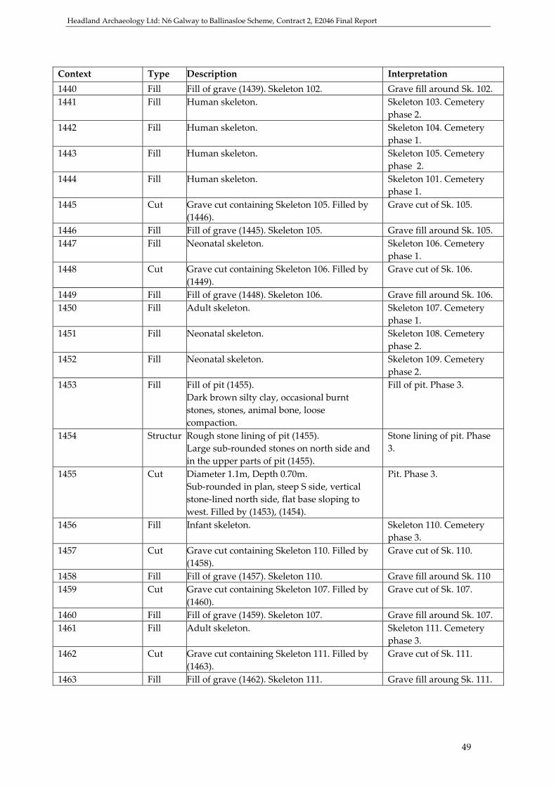
Headland Archaeology Ltd: N6 Galway to Ballinasloe Scheme, Contract 2, E2046 Final Report
49
Context Type Description Interpretation 1440 Fill Fill of grave (1439). Skeleton 102. Grave fill around Sk. 102. 1441 Fill Human skeleton. Skeleton 103. Cemetery
phase 2. 1442 Fill Human skeleton. Skeleton 104. Cemetery
phase 1. 1443 Fill Human skeleton. Skeleton 105. Cemetery
phase 2. 1444 Fill Human skeleton. Skeleton 101. Cemetery
phase 1. 1445 Cut Grave cut containing Skeleton 105. Filled by
(1446). Grave cut of Sk. 105.
1446 Fill Fill of grave (1445). Skeleton 105. Grave fill around Sk. 105. 1447 Fill Neonatal skeleton. Skeleton 106. Cemetery
phase 1. 1448 Cut Grave cut containing Skeleton 106. Filled by
(1449). Grave cut of Sk. 106.
1449 Fill Fill of grave (1448). Skeleton 106. Grave fill around Sk. 106. 1450 Fill Adult skeleton. Skeleton 107. Cemetery
phase 1. 1451 Fill Neonatal skeleton. Skeleton 108. Cemetery
phase 2. 1452 Fill Neonatal skeleton. Skeleton 109. Cemetery
phase 2. 1453 Fill Fill of pit (1455).
Dark brown silty clay, occasional burnt stones, stones, animal bone, loose compaction.
Fill of pit. Phase 3.
1454 Structur Rough stone lining of pit (1455). Large sub‐rounded stones on north side and in the upper parts of pit (1455).
Stone lining of pit. Phase 3.
1455 Cut Diameter 1.1m, Depth 0.70m. Sub‐rounded in plan, steep S side, vertical stone‐lined north side, flat base sloping to west. Filled by (1453), (1454).
Pit. Phase 3.
1456 Fill Infant skeleton. Skeleton 110. Cemetery phase 3.
1457 Cut Grave cut containing Skeleton 110. Filled by (1458).
Grave cut of Sk. 110.
1458 Fill Fill of grave (1457). Skeleton 110. Grave fill around Sk. 110 1459 Cut Grave cut containing Skeleton 107. Filled by
(1460). Grave cut of Sk. 107.
1460 Fill Fill of grave (1459). Skeleton 107. Grave fill around Sk. 107. 1461 Fill Adult skeleton. Skeleton 111. Cemetery
phase 3. 1462 Cut Grave cut containing Skeleton 111. Filled by
(1463). Grave cut of Sk. 111.
1463 Fill Fill of grave (1462). Skeleton 111. Grave fill aroung Sk. 111.

Headland Archaeology Ltd: N6 Galway to Ballinasloe Scheme, Contract 2, E2046 Final Report
50
Context Type Description Interpretation 1464 Fill Fill of pit (1375).
Thickness 0.15m. Grey‐yellow silty sand, gravel, few stones, loose compaction. Basal deposit.
Fill of pit. Phase 3.
1465 Cut Diameter 1m, Depth 0.50m. Circular/oval in plan, steep sides, flat base. Filled by (1466). Small re‐cut within large pit (1375).
Re‐cut of pit. Phase 3.
1466 Fill Singular fill of small re‐cut (1465) within large pit (1375). Mid brown silty clay, 50% stones, loose to moderate compaction.
Fill of re‐cut pit. Phase 3.
1467 Cut Diameter 1.5m, Depth 0.50m. Circular/oval in plan, sloping sides, concave base. Filled by (1468). Small re‐cut within large pit (1375).
Re‐cut of pit. Phase 3.
1468 Fill Singular fill of small re‐cut (1467) within large pit (1375). Mid brown clayey silt, 50% stones, nail, possible ceramic, moderate compaction.
Fill of re‐cut pit. Phase 3.
1469 Cut Diameter 2‐3m, Depth 0.80m. Circular in plan, steep sides, concave base. Filled by (1470). Small re‐cut within large pit (1375). Truncates re‐cut (1467).
Re‐cut of pit. Phase 3.
1470 Fill Primary fill of small re‐cut (1469) within large pit (1375). Thickness 0.20m. Grey‐yellow sandy gravel, few stones, loose compaction.
Fill of re‐cut pit. Phase 3.
1471 Fill Secondary fill of small re‐cut (1469) within large pit (1375). Thickness 0.25m. Mid brown stony sandy clay, 40% stones, loose to moderate compaction.
Fill of re‐cut pit. Phase 3.
1472 Fill Tertiary fill of small re‐cut (1469) within large pit (1375). Thickness 0.60m. Yellow‐brown to mid brown silty clay, 2‐5% stones, gravel, animal bone, loose compaction.
Fill of re‐cut pit. Phase 3.
1473 Cut Diameter 0.40m, Depth 0.70m. Circular in plan, vertical sides, not bottomed. Filled by (1474). Cut into base of pit (1375), could be natural (geological or burrowing).
Post‐hole in pit. Phase 2C.

Headland Archaeology Ltd: N6 Galway to Ballinasloe Scheme, Contract 2, E2046 Final Report
51
Context Type Description Interpretation 1474 Fill Singular fill of post‐hole (1473) cut into base
of large pit (1375). Yellow‐grey silty sand, gravel, few stones, loose compaction.
Fill of post‐hole. Phase 2C.
1475 Cut Width 1m, Depth 0.5m. Curvi‐linear in plan, 40°‐55° sides, concave base of 0.15‐0.20m width. Associated with ditch (1260). Filled by (1476), (1477).
Ditch. Phase 2A.
1476 Fill Upper fill of ditch (1475). Thickness 0.10m‐0.20m. Mid brown silty clay, gravel, stones, moderate compaction.
Fill of ditch. Phase 2B.
1477 Fill Primary fill of ditch (1475). Thickness 0.30m‐0.40m. Light yellow‐brown silty clay, 5‐10% stones, moderate compaction.
Fill of ditch. Phase 2A.
1478 Fill Fill of ditch (1260). Grey‐brown slightly silty sand, 5% stones, charcoal, gravel, very loose compaction.
Fill of ditch. Phase 2C.
1479 Fill Fill of ditch (1260). Mid‐brown slightly silty sand, 5% stones, gravel, very loose compaction.
Fill of ditch. Phase 2C.
1480 Cut Diameter 0.50m, Depth 0.13m. Sub‐circular in plan, irregular sides, irregular concave base. Filled by (1481).
Post‐hole. Phase 3.
1481 Fill Singular fill of post‐hole (1480). Dark black‐brown silty sand, many stones, occasional pebbles, moderate compaction.
Fill of post‐hole. Phase 3.
1482 Cut Length 0.50m, Width 0.25m, Depth 0.10m. Sub‐oval in plan, shallow sides, concave base. Filled by (1483).
Pit. Phase 3.
1483 Fill Singular fill of pit (1482). Dark brown silty sand, quartz pebble, burnt bone, stones, loose compaction.
Fill of pit. Phase 3..
1484 Fill Human skeleton. Skeleton 112. Cemetery phase 1.
1485 Cut Diameter 0.55m, Depth 0.05m‐0.10m. Sub‐circular in plan, irregular shallow sides, irregular concave base. Filled by (1486).
Post‐hole. Phase 3.
1486 Fill Singular fill of post‐hole (1485). Dark black‐brown silty sand, many stones, occasional pebbles, animal bone, moderate compaction.
Fill of post‐hole. Phase 3.
1487 Cut Length 0.41m, Width 0.24m, Depth 0.10m. Oval in plan, sloping sides, flat base. Filled by (1488).
Pit. Phase 3.

Headland Archaeology Ltd: N6 Galway to Ballinasloe Scheme, Contract 2, E2046 Final Report
52
Context Type Description Interpretation 1488 Fill Singular fill of pit (1487).
Mid brown silty sand, animal bone, occasional stones, loose compaction.
Fill of pit. Phase 3.
1489 Fill Juvenile skeleton. Skeleton 113. 1490 Cut Grave cut containing Skeleton 113. Filled by
(1491). Grave cut of Sk.113.
1491 Fill Fill of grave (1490). Skeleton 113. Grave fill around Sk.113. 1492 Cut Diameter 1.03m, Depth 0.17m.
Sub‐circular in plan, steep sides, concave base. Filled by (1493). Burrowing (1504) in base.
Pit. Phase 3.
1493 Fill Singular fill of pit (1492). Dark brown sandy silt, <10% stones, nail, whetstone, charcoal, possible daub, loose compaction. Filled by (1493).
Fill of pit. Phase 3.
1494 Cut Length 0.20m, Width 0.20m, Depth 0.05m. Sub‐triangular in plan, stepped sides, concave base. Filled by (1495).
Post‐hole. Phase 3.
1495 Fill Singular fill of post‐hole (1494). Mid brown silty sand, frequent stones, loose compaction.
Fill of post‐hole. Phase 3.
1496 Cut Length 0.28m, Width 0.26m, Depth 0.03m. Sub‐circular in plan, shallow sides, concave base. Filled by (1497).
Post‐hole. Phase 3.
1497 Fill Singular fill of post‐hole (1496). Light brown‐grey sand, frequent stones, loose compaction.
Fill of post‐hole. Phase 3.
1498 Cut Length 0.20m, Width 0.12m, Depth 0.03m. Sub‐circular in plan, shallow sides, concave base.
Post‐hole. Phase 3..
1499 Fill Singular fill of post‐hole (1498). Mid brown silty sand, frequent stones, animal bone, loose compaction.
Fill of post‐hole. Phase 3.
1500 Cut Length 0.39m, Width 0.26m, Depth 0.12m. Oval in plan, stepped sides, concave base.
Post‐hole. Phase 3.
1501 Fill Singular fill of post‐hole (1500). Light brown‐grey silty sand, frequent pebbles, loose compaction.
Fill of post‐hole. Phase 3.
1502 Cut Diameter 0.30m, Depth 0.13m. Circular in plan, irregular sides, concave base.
Post‐hole. Phase 3.
1503 Fill Singular fill of post‐hole (1502). Mid brown silty sand, frequent pebbles, occasional rocks, rare charcoal, loose compaction.
Fill of post‐hole. Phase 3.
1504 Cut Burrowing in base of pit (1492). Burrow. Phase 3. 1505 Fill Fill of burrow in base of pit (1492). Fill of burrow. Phase 3.

Headland Archaeology Ltd: N6 Galway to Ballinasloe Scheme, Contract 2, E2046 Final Report
53
Context Type Description Interpretation 1506 Fill Adult skeleton. Skeleton 114. Cemetery
phase 1. 1507 Cut Grave cut containing Skeleton 114 &
disarticulated neonatal skeleton. Filled by (1508).
Grave cut of Sk. 114.
1508 Fill Fill of grave (1507). Skeleton 114. Grave fill around Sk. 114. 1509 Fill Adult skeleton. Skeleton 115. Cemetery
phase 1. 1510 Fill Juvenile skeleton. Skeleton 72. 1511 Cut Grave cut containing Skeleton 115. Filled by
(1512). Grave cut of Sk. 115.
1512 Fill Fill of grave (1511). Skeleton 115. Grave fill around Sk. 115. 1513 Fill Disarticulated neonatal skeleton in (1507). Skeleton 1514 Fill Human skeleton. Skeleton 59. 1515 Fill Fill of grave (1283). Skeleton 63. Grave fill around Sk.63. 1516 Fill Human skeleton. Skeleton 116. Cemetery
phase 3. 1517 Cut Grave cut containing Skeleton 116. Filled by
(1518). Grave cut of Sk. 116.
1518 Fill Fill of grave (1517). Skeleton 116. Grave fill around Sk. 116. 1519 Fill Human skeleton. Skeleton 117. Cemetery
phase 3. 1520 Fill Neonatal skeleton. Skeleton 118. Cemetery
phase 2. 1521 Fill Adult skeleton, truncated. Skeleton 119. Cemetery
phase 1. 1522 Cut Grave cut containing Skeleton 119. Filled by
(1523). Grave cut of Sk. 119.
1523 Fill Fill of grave (1522). Skeleton 119. Grave fill around Sk. 119. 1524 Fill Disarticulated neonatal skeleton. Skeleton 120. Cemetery
phase 1. 1525 Fill Juvenile skeleton. Skeleton 121. Cemetery
phase 2. 1526 Fill Adult skeleton. Skeleton 122. Cemetery
phase 1. 1527 Cut Grave cut containing Skeleton 122. Filled by
(1528). Grave cut of Sk. 122.
1528 Fill Fill of grave (1527). Skeleton 122. Grave fill of Sk. 122. 1529 Cancelled. 1530 Cut Grave cut containing Skeleton 121. Filled by
(1531). Grave cut of Sk. 121.
1531 Fill Fill of grave (1530). Skeleton 121. Grave fill around Sk. 121. 1532 Cancelled. 1533 Fill Singular fill of ditch (1534).
Ornage‐brown silty clay, frequent stones, one boulder, moderate compaction.
Fill of ditch. Phase 1.

Headland Archaeology Ltd: N6 Galway to Ballinasloe Scheme, Contract 2, E2046 Final Report
54
Context Type Description Interpretation
1534 Cut Length 1.20m, Width 0.60m, Depth 0.32m. Linear in plan, sloping sides, uneven flat base sloping towards (1015). Filled by (1533). Associated with (1015) & (1023).
Ditch. Phase 1.
1535 Cut Length 1.20m, Width 0.60m, Depth 0.32m. Linear in plan, shallow to steep sides, uneven flat base. Filled by (1536). Parallel with (1015).
Gully. Phase 1.
1536 Fill Singular fill of gully (1535). Brown‐orange silty clay, moderate stones, moderate compaction.
Fill of gully. Phase 1.
1537 Fill Juvenile skeleton. Skeleton 123. Cemetery phase 2.
1538 Cut Grave cut containing Skeleton 123. Filled by (1539).
Grave cut of Sk. 123.
1539 Fill Fill of grave (1538). Skeleton 123. Grave fill around Sk. 123. 1540 Fill Neonatal skeleton, truncated. Skeleton 124.Cemetery
phase 2. 1541 Fill Neonatal skeleton. Skeleton 125. Cemetery
phase 1. 1542 Cut Grave cut containing Skeleton 125. Filled by
(1543). Grave cut of Sk. 125.
1543 Fill Fill of grave (1542). Skeleton 125. Grave fill around Sk. 125. 1544 Fill Juvenile skeleton. Skeleton 126. Phase 2. 1545 Cut Grave cut containing Skeleton 126. Filled by
(1546). Grave cut of Sk. 126.
1546 Fill Fill of grave (1545). Skeleton 126. Grave fill around Sk. 126. 1547 Fill Neonatal skeleton. Skeleton 127. Phase 1. 1548 Fill Neonatal skeleton associated with Skeleton
121. Skeleton 128. Cemetery phase 2.
1549 Fill Neonatal skeleton associated with Skeleton 97.
Skeleton 129. Cemetery phase 2.
1550 Fill Neonatal skeleton associated with Skeleton 84.
Skeleton 130. Cemetery phase 2.
1551 Fill Neonatal skeleton associated with Skeleton 113.
Skeleton 131. Cemetery phase 2.
1552 Fill Neonatal skeleton associated with Skeleton 57.
Skeleton 132. Cemetery phase 1.
1553 Fill Neonatal skeleton associated with Skeleton 116.
Skeleton 133. Cemetery phase 3.
1554 Fill Neonatal skeleton associated with Skeleton 89.
Skeleton 134. Cemetery phase 3.
1555 Fill Neonatal skeleton associated with Skeleton 105.
Skeleton 135. Cemetery phase 2.

Headland Archaeology Ltd: N6 Galway to Ballinasloe Scheme, Contract 2, E2046 Final Report
55
Appendix 2: Finds Register Ceramic
Find No.
Material Type Id. Description Habitat Quantity
E2046:1001:001 Ceramic Rim Small abraded rim sherd Headland 1 E2046:1303:001 Pottery Small fragment of plain
earthenware pot, no inclusions
Headland 1
E2046:1001:003 Pottery Modern pottery sherd Headland 1 E2046:1243:001 Pottery Pottery associated with
Skeleton 48 Headland 1
E2046:1098:013 Pottery Post‐med Post‐med pottery Headland 1 E2046:1098:015 Pottery Post‐med Post‐med pottery Headland 1 E2046:1098:016 Pottery Post‐med Post‐med pottery Headland 1
Stone
Find No.
Material Type Id. Description Habitat Quantity
E2046:1000:001 Stone Loom weight
5cm Diametermeter, circular Headland 1
E2046:1175:001 Stone Quartz pebble
Quartz pebble associated with skeleton 33
Headland 1
E2046:1175:002 Stone Quartz pebble
Quartz pebble associated with skeleton 33
Headland 1
E2046:1175:003 Stone Quartz pebble
Quartz pebble associated with skeleton 33
Headland 1
E2046:1175:004 Stone Quartz pebble
Quartz pebble associated with skeleton 33
Headland 1
E2046:1175:005 Stone Quartz pebble
Quartz pebble associated with skeleton 33
Headland 1
E2046:1052:001 Stone Chert Scraper 3cm in length, chert scraper Headland 1 E2046:1052:002 Stone Chert 2.5cm in length, worked
chert Headland 1
E2046:1052:003 Stone Chert 2cm in length, worked chert Headland 1 E2046:1030:001 Stone Chert Scraper? 4cm in length, slot 8 Headland 1 E2046:1030:002 Stone Chert Worked chert, slot 2 Headland 1 E2046:1009:001 Stone Chert 3‐4cm in length, poss.
worked chert Headland 1
E2046:1254:001 Stone Quartz pebble
Quartz pebble associated with skeleton 52
Headland 1
E2046:1254::002 Stone Quartz pebble
Quartz pebble associated with skeleton 52
Headland 1
E2046:1254:003 Stone Quartz pebble
Quartz pebble associated with skeleton 52
Headland 1
E2046:1258:001 Stone Quartz pebble
Quartz pebble associated with skeleton 57
Headland 1

Headland Archaeology Ltd: N6 Galway to Ballinasloe Scheme, Contract 2, E2046 Final Report
56
Find No.
Material Type Id. Description Habitat
Quantity
E2046:1138:001 Stone Quartz pebble
Quartz pebble associated with skeleton 22
Headland 1
E2046:1271:001 Stone Quartz pebble
Quartz pebble associated with skeleton 60
Headland 1
E2046:1242:001 Stone Quartz pebble
Quartz pebble associated with skeleton 47
Headland 1
E2046:1307:001 Stone Quartz pebble
Quartz pebble associated with skeleton 65
Missing Missing
E2046:1338:001 Stone Quartz pebble
Quartz pebble associated with articulated leg
Missing Missing
E2046:1364:002 Stone Flake Stone flake Missing Missing E2046:1403:001 Stone Quartz
pebble Quartz associated with
skeleton 92 Headland 1
E2046:1353:001 Stone Quartz pebble
Quartz pebble from (1260) Missing Missing
E2046:1434:001 Stone Quartz pebble
Quartz pebble associated with skeleton 99
Headland 1
E2046:1434:002 Stone Quartz pebble
Quartz pebble associated with skeleton 99
Headland 1
E2046:1444:001 Stone Quartz pebble
Quartz pebble associated with skeleton 101
Headland 1
E2046:1261:003 Stone Whet‐stone 2 slabs of flat stone Headland 1 E2046:1492:002 Stone Whet‐stone 1 large, long sharpening
stone Headland 1
E2046:1458:001 Stone Quartz pebble
Quartz pebble associated with skeleton 110
Headland 1
E2046:1463:002 Stone Quartz pebble
Quartz associated with skeleton 111
Headland 1
E2046:1483 :001 Stone Quartz pebble
Quartz from pit Headland 1
E2046:1489:001 Stone Quartz pebble
Quartz pebble associated with skeleton 113
Missing Missing
E2046:1489:002 Stone Quartz pebble
Quartz associated with skeleton 113
Missing Missing
E2046:1506:001 Stone Quartz pebble
Quartz pebble associated with skeleton 114
Headland 1, bagged together
E2046:1506:002 Stone Quartz pebble
Quartz pebble associated with skeleton 114
Headland 1, bagged together
E2046:1506:003 Stone Quartz pebble
Quartz pebble associated with skeleton 114
Headland 1, bagged together
E2046:1506:004 Stone Quartz pebble
Quartz pebble associated with skeleton 114
Headland 1, bagged together
E2046:1506:005 Stone Quartz pebble
Quartz pebble associated with skeleton 114
Headland 1, bagged together
E2046:1506:006 Stone Quartz pebble
Quartz pebble associated with skeleton 114
Headland 1, bagged together

Headland Archaeology Ltd: N6 Galway to Ballinasloe Scheme, Contract 2, E2046 Final Report
57
Find No.
Material Type Id. Description Habitat Quantity
E2046:1506:007 Stone Quartz pebble
Quartz pebble associated with skeleton 114
Headland 1, bagged together
E2046:1506:008 Stone Quartz pebble
Quartz pebble associated with skeleton 114
Headland 1, bagged together
E2046:150:009 Stone Quartz pebble
Quartz pebble associated with skeleton 114
Headland 1, bagged together
E2046:1506:010 Stone Quartz pebble
Quartz pebble associated with skeleton 114
Headland 1, bagged together
E2046:1174:001 Stone Quartz pebble
Quartz pebble associated with skeleton 32
Headland 1
E2046:1539:001 Stone Quartz pebble
Quartz pebble associated with skeleton 123
Headland 1
E2046:1157:001 Stone Quartz pebble
Quartz pebble associated with skeleton 18
Headland 1
E2046:1098:006 Stone Quartz pebble
2 quartz pebble associated with disarticulated bone
Headland 2 in 1 bag
E2046:1001:001 Stone Quartz pebble
Quartz pebble Headland 1
E2046:1277:001 Stone Quartz pebble
Two quartz pebbles associated with skeleton 49
Headland 2 in 1
Metal
Find No.
Material Type Id. Description Habitat Quantity
E2046:1217:001 Metal Fe Nail Rusted nail Headland 1 E2046:1217:002 Slag Fe Possibly
smelting slag
5cm Diametermeter ‘honeycomb’ Fe slag, possibly smelting
Headland 1
E2046:1098:001 Metal Fe 3cm x 2cm iron fragment Headland 1 E2046:1098:002 Metal Fe Nail Rusted nail Headland 1 E2046:1098:003 Metal Fe Nail Rusted nail Headland 1 E2046:1098:004 Metal Fe Nail Part of an iron nail Headland 1 E2046:1324:001 Metal Fe Nail Iron nail Headland 1 E2046:1030:002 Metal Strap Strap fragment with curved
end and possible rivet Headland 1
E2046:1261:001 Slag Fe Slag Headland 1 E2046:1261:002 Metal Fe Corroded Fe 7cm x 4cm
chunk & smaller chunk Headland 2 in 1 bag
E2046:1315:001 Metal Knife 15cm x2cm, corroded possible knife
Headland 1
E2046:1029:001 Metal Fragment Headland 1 E2046:1029:002 Metal Cu Ring Polished finger ring.
Diameter. 25mm, int. Diameter. 18mm
Headland 1

Headland Archaeology Ltd: N6 Galway to Ballinasloe Scheme, Contract 2, E2046 Final Report
58
Find No.
Material Type Id. Description Habitat Quantity
E2046:1316:001 Metal Fe Strap Metal strap, curved at one end with possible rivets. 10cm x 1cm x 2mm
Headland 1
E2046:1437:001 Metal Metal object beneath legs of Skeleton 100
Headland 1
E2046:1024:001 Metal Fe Metal fragment, 15mm x 15mm x 3mm
Headland 1
E2046:1076:001 Metal Fe 3cm x 1.7 cm coiled iron fragment
Headland 1
E2046:1468:001 Metal Fe Nail Rusted nail with head Headland 1 E2046:1029:003 Metal Fe 12mm x 60m fragment Headland 1 E2046:1029:004 Metal Fe Nail 10cm long, tapered nail Headland 1 E2046:1493:001 Metal Fe Nail 5cm long Headland 1 E2046:1518:001 Metal Pin Possible shroud/dress pin
associated with skeleton 116 Headland 1
E2046:1376:001 Metal & leather
Cu, Fe & leather
Shoe Fragment of a shoe with copper and iron nails
Headland 1
E2046:1098:007 Metal Metal Metal fragment Headland 1 E2046:1098:008 Metal Fe Nail Fe nail Headland 1 E2046:1098:009 Metal Metal Metal fragment Headland 1 E2046:1098:010 Metal Metal Metal fragment Headland 1 E2046:1098:011 Slag Fe Two pieces of slag Headland 2 in 1 bag E2046:1098:012 Metal Metal Metal fragment Headland 1 E2046:1001:002 Metal Fe Knife Fe knife Headland 1
Bone
Find No. Material Type Id. Description Habitat QuantityE2046:1364:001 Bone Polished bone Headland 2 in 1 bag E2046:1377:001 Bone Comb Broken bone comb, could
well actually be from topsoil Headland 1
E2046:1261:004 Bone Pin 6cm long possible shroud/dress pin, broken point
Headland 1
Glass
Find No. Material Type Id. Description Habitat QuantityE2046:1001:002 Glass Jar Complete post‐med glass Headland 1
E2046:3016:002 Glass Bead Blue glass bead Headland 1 CTP
Find No. Material Type Id. Description Habitat QuantityE2046:1098:005 CTP Pipe Clay pipe stem Headland 1 E2046:1098:014 CTP Pipe Clay pipe stem Headland 1

Headland Archaeology Ltd: N6 Galway to Ballinasloe Scheme, Contract 2, E2046 Final Report
59
Clay Find No. Material Type Id. Description Habitat QuantityE2046:1468:002 Clay Oxidised clay fragments Headland 1
Shell
Find No. Material Type Id. Description Habitat QuantityE2046:1463:001 Shell Mollus Seashell Near right leg of Skeleton
111 Headland 1

Headland Archaeology Ltd: N6 Galway to Ballinasloe Scheme, Contract 2, E2046 Final Report
60
Appendix 3: Sample Register Sample Number
Context Number Amount Description
01 1052 Fill of pit (1051) 02 1048 Fill of posthole (1047) 03 1046 Fill of posthole (1045) 04 1050 Fill of posthole (1049) 05 1058 Fill of pit (1057) 06 1067 10L Fill of pit with burning (1066) 07 1024 Primary fill of ditch (1023) slot 4 08 1037 Primary fill of ditch (1023) slot 6 09 1073 10L Fill of ditch (1023) slot 8 10 CANCELLED 11 CANCELLED 12 CANCELLED 13 1073 Charcoal rich fill of ditch (1023) slot 8 14 1076 Primary fill of ditch (1023) slot 8 15 1042 10L Grave fill, mid brown sand 16 1037 Shells from ditch (1023) slot 2 17 1024 Primary fill of ditch (1023) slot 2 18 1024 Primary fill of ditch (1023) slot 2 19 1125 Fill of post‐hole cut into ditch (1023) slot
9 20 1004 10L Fill of (1003), probable burrow but with
charcoal, in bank of (1023) 21 1189 Animal bone from ditch (1023) 22 1190 Animal bone from ditch (1023) 23 1191 Animal bone from ditch (1023) 24 1098 Fill from around infant Skeleton 5 25 1243 2L Grave fill Skeleton 46 26 1261 15L Main fill linear (1260) slot 3 27 1076 10L Fill of ditch (1023) slot 1 28 1090 10L Fill of ditch (1023) slot 1 29 1091 10L Fill of ditch (1023) slot1 30 1092 10L Fill of ditch (1023) slot 1 31 1093 10L Fill of ditch (1023) slot 1 32 1029 10L Fill of ditch (1023) slot 1 33 1031 10L Fill of ditch (1023) slot 1 34 1024 10L Fill of ditch (1023) slot 2 35 1027 10L Fill of ditch (1023) slot 2 36 1038 10L Fill of ditch (1023) slot 2 37 1037 10L Fill of ditch (1023) slot 2 38 1025 10L Fill of ditch (1023) slot 2 39 1024 10L Fill of ditch (1023) slot 3 40 1100 10L Fill of ditch (1023) slot 3 41 1099 10L Fill of ditch (1023) slot 3 42 1111 10L Fill of ditch (1023) slot 3

Headland Archaeology Ltd: N6 Galway to Ballinasloe Scheme, Contract 2, E2046 Final Report
61
Sample Number
Context Number Amount Description
43 1113 10L Fill of ditch (1023) slot 3 44 1024 10L Fill of ditch (1023) slot 4 45 1026 10L Fill of ditch (1023) slot 4 46 1027 10L Fill of ditch (1023) slot 4 47 1025 10L Fill of ditch (1023) slot 4 48 1029 10L Fill of ditch (1023) slot 4 49 1024 10L Fill of ditch (1023) slot 5 50 1026 10L Fill of ditch (1023) slot 5 51 1027 10L Fill of ditch (1023) slot 5 52 1037 10L Fill of ditch (1023) slot 6 53 1036 10L Fill of ditch (1023) slot 6 54 1035 10L Fill of ditch (1023) slot 6 55 1034 10L Fill of ditch (1023) slot 6 56 1033 10L Fill of ditch (1023) slot 6 57 1032 10L Fill of ditch (1023) slot 6 58 1076 10L Fill of ditch (1023) slot 7 59 1103 10L Fill of ditch (1023) slot 7 60 1102 10L Fill of ditch (1023) slot 7 61 1076 10L Fill of ditch (1023) slot 8 62 1077 10L Fill of ditch (1023) slot 8 63 1074 10L Fill of ditch (1023) slot 8 64 1075 10L Fill of ditch (1023) slot 8 65 1079 10L Fill of ditch (1023) slot 8 66 1078 10L Fill of ditch (1023) slot 8 67 1076 10L Fill of ditch (1023) slot 9 68 1120 10L Fill of ditch (1023) slot 9 69 1122 10L Fill of ditch (1023) slot 9 70 1121 10L Fill of ditch (1023) slot 9 71 1123 10L Fill of ditch (1023) slot 9 72 1029 10L Fill of ditch (1023) slot 9 73 1126 10L Fill of ditch (1023) slot 9 74 1030 10L Fill of ditch (1023) slot 9 75 1191 10L Fill of ditch (1023) slot 10 76 1179 10L Fill of ditch (1023) slot 10 77 1192 10L Fill of ditch (1023) slot 10 78 1209 10L Fill of ditch (1023) slot 11 79 1210 10L Fill of ditch (1023) slot 11 80 1214 10L Fill of ditch (1023) slot 11 81 1213 10L Fill of ditch (1023) slot 11 82 1221 10L Fill of ditch (1023) slot 12 83 1219 10L Fill of ditch (1023) slot 12 84 1234 10L Fill of ditch (1023) slot 12 85 1220 10L Fill of ditch (1023) slot 12 86 1201 10L Fill of ditch (1023) slot 13 87 1199 10L Fill of ditch (1023) slot 13 88 1200 10L Fill of ditch (1023) slot 13 89 1198 10L Fill of ditch (1023) slot 13

Headland Archaeology Ltd: N6 Galway to Ballinasloe Scheme, Contract 2, E2046 Final Report
62
Sample Number
Context Number Amount Description
90 1197 10L Fill of ditch (1023) slot 13 91 1196 10L Fill of ditch (1023) slot 13 92 1201 10L Fill of ditch (1023) slot 14 93 1199 10L Fill of ditch (1023) slot 14 94 1239 10L Fill of ditch (1023) slot 14 95 1200 10L Fill of ditch (1023) slot 14 96 1037 10L Fill of ditch (1023) slot 15 97 1036 10L Fill of ditch (1023) slot 15 98 1039 10L Fill of ditch (1023) slot 15 99 1072 10L Fill of ditch (1023) slot 15 100 1005 10L Fill of ditch (1023) slot 16 101 1006 10L Fill of ditch (1023) slot 16 102 1007 10L Fill of ditch (1023) slot 16 103 1008 10L Fill of ditch (1023) slot 16 104 1125 10L Fill of post‐hole cut into ditch (1023) slot
9 105 1098 2L Fill around Skeleton 67, sampled for
charcoal 106 1329 2L Fill of linear (1330) 107 1021 10L Fill of ditch (1020) slot 1 108 1364 5L Fill of post‐hole (1363) 109 1021 10L Fill of ditch (1020) slot 2 110 1364 0.5L Charcoal from post‐hole (1363) 111 1351 Charcoal rich primary fill of cooking pit
1346) 112 1349 Charcoal sample from cooking pit (1346) 113 1366 1L Fill of pit (1365) with human remains
and charcoal 114 1315 10L Fill of ditch (1317) slot 1 115 1316 10L Fill of ditch (1317) slot 1 116 1170 10L Orange silty sand deposit, possibly re‐
deposited natural 117 1303 10L Fill of ditch (1302), it is also ditch (1020)
lot 3 118 1316 10L Primary fill of ditch (1317) slot 2 119 1315 10L Fill of ditch (1317) slot 2 120 1369 10L Fill of ditch (1020) slot 1 121 1370 10L Fill of ditch (1020) slot 1 122 1373 Fill of linear (1372) 123 1021 10L Fill of ditch (1020) slot 4 124 1329 10L Fill of ditch/furrow (1330) 125 1315 4L Fill of ditch (1317) slot 3 126 1316 4L Fill of ditch (1317) slot 3 127 1374 10L Fill of ditch (1317) slot 4 127 dup. 1384 Charcoal from grave fill Skeleton 85 128 1390 Grave fill, abdominal area and unusual
bone 129 1295 5L Fill of pit (1292)

Headland Archaeology Ltd: N6 Galway to Ballinasloe Scheme, Contract 2, E2046 Final Report
63
Sample Number
Context Number Amount Description
130 1296 1/2L Fill of pit (1292) 131 1297 1/2L Fill of pit (1292) 132 1298 1/2L Fill of pit (1292) 133 1299 1/4L Fill of pit (1292) 134 1437 Grave fill Skeleton 100 135 1360 Fill of linear (1359) 136 1453 Animal bone from pit (1455) 137 1353 Primary fill of ditch (1260) slot 3 138 1397 2.5 L Fill of pit cluster (1375) 139 1396 2.5 L Fill of pit cluster (1375) 140 1468 2.5 L Fill of pit cluster (1375) 141 1377 2.5 L Fill of pit cluster (1375) 142 1472 2.5 L Fill of pit cluster (1375) 143 1464 2.5 L Fill of pit cluster (1375) 144 1471 2.5 L Fill of pit cluster (1375) 145 1466 2.5 L Fill of pit cluster (1375) 146 1493 5L Fill of pit (1492) 147 1503 1L Fill of post‐hole (1502) 148 1528 2L Grave fill with charcoal 149 1533 Fill of gully (1534) 150 1477 2L Fill of ditch (1475) slot 1 151 1477 2L Fill of ditch (1475) slot 2 152 1016 5L Fill of ditch (1015) North/west terminus 153 1017 3L Fill of ditch (1015) North/west terminus 154 1018 3L Fill of ditch (1015) North/west terminus 155 1477 2L Primary fill of ditch (1475) slot 3 156 1543 Charcoal Skeleton 125 157 1539 Charcoal Skeleton 123 158 1125 1/2L Charcoal, fill of posthole

Headland Archaeology Ltd: N6 Galway to Ballinasloe Scheme, Contract 2, E2046 Final Report
64
Appendix 4: Bone Sample register Sample no.
Context no.
Description Bags
1 (1052) Animal bone from pit (1051) Missing 2 (1048) Slightly burnt bone from post‐hole (1047) 1 3 (1037) Bone from basal fill of ditch (1023) slot 6 Missing 4 (1027) Bone from fill of ditch (1023) slot 5 1 5 (1017) Bone from fill of ditch (1015) 1 6 (1018) Bone from fill of ditch (1015) 1 7 (1016) Bone from fill of ditch (1015) 1 8 (1029) Bone from fill of ditch (1023) slot 6 1 9 (1036) Animal bone from fill of ditch (1023) slot 6 1 10 (1031) Animal bone from fill of ditch (1023) slot 6 Missing 11 (1024) Animal bone from fill of ditch (1023) slot 5 1 12 (1029) Animal bone from fill of ditch (1023) slot 5 1 13 (1031) Animal bone from fill of ditch (1023) slot 5 1 14 (1030) Animal bone from fill of ditch (1023) slot 8 1 15 (1076) Animal bone from fill of ditch (1023) slot 8 Missing 16 (1073) Animal bone from fill of ditch (1023) slot 8 1 17 (1030) Animal bone from fill of ditch (1023) slot 2 1 18 (1031) Animal bone from fill of ditch (1023) slot 2 1 19 (1024) Animal bone from fill of ditch (1023) slot 2 1 20 (1001) Human bone recovered from machine disturbance 1 21 (1031) Animal bone from fill of ditch (1023) slot 1 1 22 (1098) Human & animal bone scattered within deposit 1 23 (1042) Human & animal bone from grave fill 1 24 (1031) Animal bone from fill of ditch (1023) slot 3 1 25 (1112) Animal bone from fill of ditch (1023) slot 3 Missing 26 (1130) Animal bone from fill of ditch (1023) slot 3 Missing 27 (1029) Animal bone from fill of ditch (1023) slot 3 Missing 28 (1041) Complete skeleton within (1040) Skeleton 1 Not with
animal bones
29 (1060) Fragmented infant skeleton within (1059) Skeleton 2 Not with animal bones
30 (1109) Fragmented juvenile skeleton within (1088) Skeleton 8 Not with animal bones
31 (1106) Complete skeleton within (1080) Skeleton 3 Not with animal bones
32 (1105) Fragmented neonate skeleton within (1070) Skeleton 4 Not with animal bones

Headland Archaeology Ltd: N6 Galway to Ballinasloe Scheme, Contract 2, E2046 Final Report
65
Sample no.
Context no.
Description Bags
33 (1117) Very fragmented neonate skeleton Skeleton 5 Not with animal bones
34 (1107) Very fragmented neonate skeleton Skeleton 9 Not with animal bones
35 (1029) Animal bone from fill of ditch (1023) slot 7 1 36 (1024) Animal bone from fill of ditch (1023) slot 7 1 37 (1101) Animal bone from fill of ditch (1023) slot 7 1 38 (1103) Animal bone from fill of ditch (1023) slot 7 1 39 (1029) Animal bone from fill of ditch (1023) slot 9 1 40 (1030) Animal bone from fill of ditch (1023) slot 9 1 41 (1029) Cat bone & teeth from fill of ditch (1023) slot 9 1 42 (1076) Dog lower jaw & teeth from ditch (1023) slot 9 1 43 (1012) Animal bone from bank associated ditch (1023) 16 1 44 (1011)
(1010) Animal bone from fill of ditch (1023) slot 16 1
45 (1098) Animal bone from grid square 105E/110N 1 46 (1098) Animal bone, unknown grid square 1 47 (1197) Animal bone from fill of ditch (1023) slot 13 1 48 (1198) Animal bone from fill of ditch (1023) slot 13 1 49 (1199) Animal bone from fill of ditch (1023) slot 13 1 50 (1200) Animal bone from fill of ditch (1023) slot 13 1 51 (1098) Animal bone from grid square 105E/105N 3 52 (1236) Animal bone from fill of ditch (1023) slot 14 1 53 (1237) Animal bone from fill of ditch (1023) slot 14 1 54 (1238) Animal bone from fill of ditch (1023) slot 14 1 55 CANCELLED 56 (1098) Animal bone from grid square 105E/110N 1 57 (1199) Shell from fill of ditch (1023) slot 14 1 58 (1200) Shell from fill of ditch (1023) slot 14 1 59 (1098) Animal bone, unknown grid square 1 60 (1230) Bird bone (talon) from fill of post‐hole (1229) 1 61 (1098) Animal bone, surface finds 1 62 (1098) Animal bone from grid square 100E/100N 1 63 (1254) Animal bone from grave fill Skeleton 52 Missing 64 (1098) Animal bone from grid square 105E/110N 1 65 (1261) Animal bone from fill of ditch (1260) slots 1,2, 3 4 66 (1300) Animal bone from pit (1301) 1 67 (1300) Burnt bone from pit (1301) 1 68 (1300) Charcoal from pit (1301) 1 69 (1304) Animal bone from fill of ditch (1302) 1 70 (1293) Animal bone & teeth from fill of pit (1292) 1 71 (1294) Animal bone from fill of pit (1292) 1 72 (1295) Animal bone from fill of pit (1292) 1

Headland Archaeology Ltd: N6 Galway to Ballinasloe Scheme, Contract 2, E2046 Final Report
66
Sample no.
Context no.
Description Bags
73 (1315) Animal bone from fill of ditch (1317) Missing 74 (1098) Animal bone from grid square 105E/110N 1 75 (1320) Animal bone associated with Skeleton 69 (1318) 1 76 (1021) Animal bone from fill of ditch (1020) slot 2 1 77 (1337) Animal bone from grave fill of Skeleton 75 1 78 (1328) Animal bone from grave fill of Skeleton 72 1 79 (1338) Animal tooth associated with Skeleton 76 Missing 80 (1329) Animal bone from fill of linear (1330) 1 81 (1360) Animal bone from fill of linear (1359) 1 82 (1364) Human bone from fill of post‐hole (1363) 1 83 (1350)
(1351) Animal bone from fill of cooking pit (1346) 1
84 (1349) Burnt bone from fill of cooking pit (1346) 1 85 (1021) Animal bone from fill of ditch (1020) slot 1 1 86 (1370) Animal bone from fill of ditch (1020) slot 1 1 87 (1021) Animal bone from fill of ditch (1020) slot 2 1 88 (1316) Animal bone from fill of ditch (1317) slot 2 1 89 (1373) Animal bone from fill of linear (1372) 1 90 (1021) Animal bone from fill of ditch (1020) slot 1 1 91 (1315) Animal bone from fill of ditch (1317) slot 1 1 92 (1353) Animal bone from fill of ditch (1260) slot 2 1 93 (1367) Animal bone from fill of ditch (1260) slot 2 1 94 (1329) Animal bone from fill of furrow (1330) 2 95 (1329) Horns from fill of furrow (1330) 1 96 (1021) Animal bone from ditch (1020) between 1 & 2 1 97 (1315) Large amount of shell from fill of ditch (1317) Missing 98 (1315) Animal bone from fill of ditch (1317) slot 3 1 99 (1098) Animal bone over grave cut (1383) Skeleton 85/86 1 100 (1384) Animal bone from grave fill Skeleton 85/86 1 101 (1390) Animal bone from grave fill Skeleton 89 1 102 (1367) Animal bone from fill of ditch (1260) slot 5 1 103 (1261) Animal bone from fill of ditch (1260) slot 5 1 104 (1353) Animal bone from fill of ditch (1260) slot 5 1 105 (1360) Animal bone from fill of linear (1359) 1 106 (1315)
(1316) Animal bone from fill of ditch (1317) 1
107 (1374) Animal bone from fill of ditch (1317) slot 4 1 108 (1353) Animal bone from fill of ditch (1260) slot 4 1 109 (1261) Animal bone from fill of ditch (1260) slot 4 1 110 (1367) Animal bone from fill of ditch (1260) slot 4 1 111 (1360) Animal bone from fill of linear (1359) slot 3 1 112 (1409) Animal bone from grave fill Skeleton 88 1 113 (1430) Animal bone from grave fill Skeleton 97 1 114 (1261) Animal bone from ditch (1260) between 2 & 3 1 115 (1367) Animal bone from ditch (1260) between 2 & 3 1 116 (1353) Animal bone from ditch (1260) between 2 & 3 1

Headland Archaeology Ltd: N6 Galway to Ballinasloe Scheme, Contract 2, E2046 Final Report
67
Sample no.
Context no.
Description Bags
117 (1261) Animal bone from ditch (1260) between 3 & 4 1 118 (1367) Animal bone from ditch (1260) between 3 & 4 1 119 (1353) Animal bone from ditch (1260) between 3 & 4 1 120 (1261) Animal bone from ditch (1260) between 4 & 5 1 121 (1367) Animal bone from ditch (1260) between 4 & 5 1 122 (1353) Animal bone from ditch (1260) between 4 & 5 3 123 (1437) Animal bone from grave fill Skeleton 100 1 124 (1440) Animal bone from grave fill Skeleton 102 1 125 (1449) Animal bone from grave fill Skeleton 106 1 126 (1449) Burnt bone from grave fill Skeleton 106 Missing 127 (1098) Animal bone from grid square 105E/110N 1 128 (1367) Top fill of ditch (1260) slot 6 1 129 (1261) Middle fill of ditch (1260) slot 6 1 130 (1353) Bottom fill of ditch (1260) slot 6 1 131 (1458) Animal teeth from grave fill Skeleton 110 1 132 (1472) Animal bone from base of fill of pit (1469) 2 133 (1397) Animal bone from fill of pit cluster (1375) 1 134 (1396) Animal bone from fill of pit cluster (1375) 1 135 (1000) Animal bone from grid square 100E/110N 1 136 (1098) Animal bone from grid square 100E/110N 1 137 (1483) Burnt bone from fill of pit (1482) 1 138 (1486) Animal bone from fill of post‐hole (1485) 1 139 (1488) Animal bone from fill of pit (1487) 1 140 (1499) Animal bone from fill of post‐hole (1498) 1 141 (1508) Animal bone associated with Skeleton 114 (1506) 1 142 (1472) Fragment human tibia from pit cluster (1375) Not with
animal 143 (1508) Animal bone associated with Skeleton 116 (1513) Missing 144 (1098) Animal bone from grid square 100E/110N 1 145 (1512) Animal bone associated with Skeleton 115 (1509) 1 146 (1098) Animal bone from grid square 100E/110N 1 147 (1000) Animal bone from grid square 100E/111N 1 148 (1531) Animal bone from grave fill Skeleton 121 1 149 (1477) Animal bone from fill of ditch (1475) slot 2 1 150 (1477) Animal bone from fill of ditch (1475) slot 3 1 151 (1017) Animal bone from ditch (1015), North/west terminus 1 152 (1543) Animal bone from grave fill Skeleton 125 1 153 (1539) Animal bone from grave fill Skeleton 123 1 154 (1477) Animal bone from fill of ditch (1475) slot 4 1 155 Skeleton Associated animal bone Skeleton 95 1
156 Skeleton Associated animal bone Skeleton 107 1

Headland Archaeology Ltd: N6 Galway to Ballinasloe Scheme, Contract 2, E2046 Final Report
68
Sample no.
Context no.
Description Bags
157 Skeleton Associated animal bone Skeleton 105 1
158 Skeleton Associated animal bone Skeleton 115 (1509) 1
159 Skeleton Associated animal bone Skeleton 89 (1386) 1
160 Skeleton Associated animal bone Skeleton 79 1
161 Skeleton Associated animal bone Skeleton 113 1
162 Skeleton Associated animal bone Skeleton 108/109 1
163 (1098) Animal bone from (1098) 1 164 Skeleton Associated animal bone Skeleton 84 1
165 Skeleton Associated animal bone Skeleton 91 1
166 Skeleton Associated animal bone Skeleton 116 1
167 Skeleton Associated animal bone Skeleton 90 1
168 Skeleton Associated animal bone Skeleton 90 1
169 Skeleton Associated animal bone Skeleton 90 1
170 Skeleton Associated animal bone Skeleton 52 1
171 Skeleton Associated animal bone Skeleton 18 1
172 Skeleton Associated animal bone Skeleton 36 1
173 Skeleton Associated animal bone Skeleton 35 1
174 Skeleton Associated animal bone Skeleton 42 1
175 Skeleton Associated animal bone Skeleton 39 1
176 Skeleton Associated animal bone Skeleton 44 1
177 Skeleton Associated animal bone Skeleton 47 1
178 Skeleton Associated animal bone Skeleton 49 1
179 (1098) Animal bone from (1098) 1 180 (1098) Disarticulated human bone from (1098) 1

Headland Archaeology Ltd: N6 Galway to Ballinasloe Scheme, Contract 2, E2046 Final Report
69
Sample no.
Context no.
Description Bags
181 Skeleton Associated animal bone Skeleton 71 1
182 Skeleton Associated animal bone Skeleton 44 1
183 Skeleton Associated animal bone Skeleton 68 1
184 Skeleton Associated animal bone Skeleton 3 1
185 Skeleton Associated animal bone Skeleton 17 1
186 Skeleton Associated animal bone Skeleton 31 1
187 n/a Animal bone from the skeleton area 1 188 (1098) Animal bone from (1098) 1 189 (1029) Shell from fill of ditch (1023) slot 14 1 190 (1198) Shell from fill of ditch (1023) slot 14 1

Headland Archaeology Ltd: N6 Galway to Ballinasloe Scheme, Contract 2, E2046 Final Report
70
Appendix 5: Photo Register
Photo Direction facing
Description Initials/date
1 North Ditch section field 3 (1015) T.D. 19.09.05 2 North Ditch section field 3 (1020) T.D. 19.09.05 3 South General shot of field 3 stripped area T.D. 19.09.05 4 North/west General shot of (1023) field 3 T.D. 19.09.05 5 North/east Hand dug trench 2a T.D. 20.09.05 6 West Crew hand digging trench 6a T.D. 20.09.05 7 North General shot of trench with skeletons T.D. 27.09.05 8 North General shot of trench with skeletons T.D. 27.09.05 9 West Remains of skeleton 3 T.D. 27.09.05 10 South General shot of trench with skeletons T.D. 27.09.05 11 South General shot of trench showing skeletons 1, 2 &
3 T.D. 27.09.05
12 East Skeleton 3 T.D. 27.09.05 13 East Skeleton 3 T.D. 27.09.05 14 West Skeleton 1 (1041) T.D. 28.09.05 15‐19 Working Shots T.D. 28.09.05 20 North Pit (1050) T.D. 28.09.05 21 North South‐facing section of cut (1053) M.H. 29.09.05 22 South North‐facing section of posthole (1045) S.B. 29.09.05 23 South/west North/east‐facing section of posthole (1047) S.B. 29.09.05 24 South/west North/east‐facing section of posthole (1049) S.B. 29.09.05 25 South/west North/east‐facing section of pit (1057) S.B. 29.09.05 26 South North‐facing section of pit (1066) S.C. 29.09.05 27 South North‐facing section terminus of (1015) slot 2 S.C. 29.09.05 28 South North‐facing section of (1015) slot 3 S.C. 29.09.05 29 East West‐facing section of pit (1062) Z.M. 29.09.05 30 North/east South/West‐facing section of pit (1064) Z.M. 29.09.05 31 East Post‐excavation of posthole (1045) S.B. 29.09.05 32 East Post‐excavation of posthole (1047) S.B. 29.09.05 33 North/east Post‐excavation of posthole (1049) S.B. 29.09.05 34 North/east Post‐excavation pf pit (1057) S.B. 29.09.05 35 West East‐facing section of (1015) slot 5 J.W. 29.09.05 36 East West‐facing section of ditch (1023) slot 2 M.H. 29.09.05 37 +38 East West‐facing section of (1023) slot 5 D.R. 30.09.05 39 East West‐facing section of possible fire Z.M. 04.10.05 40 Void T.D. 04.10.05 41‐ 46 West East‐facing section of baulk showing bank D.R. 04.10.05 47 + 48 West East‐facing section of baulk showing bank from
slot 16 D.R. 04.10.05
49 West East‐facing section of baulk showing bank further away
D.R. 04.10.05
50 West East‐facing section of baulk showing bank closer up
D.R. 04.10.05
51 West East‐facing section of (1023) slot 2 J.W. 07.10.05 52 East West‐facing section (1023) slot 2 J.W. 07.10.05 53 West East‐facing section (1023) slot 4 T.D. 07.10.05

Headland Archaeology Ltd: N6 Galway to Ballinasloe Scheme, Contract 2, E2046 Final Report
71
Photo Direction facing
Description Initials/date
54 South North‐facing section of (1023) slot 8 T.D. 07.10.05 55 + 56 North South‐facing section of (1023) slot 8 T.D. 07.10.05 57 South/east North/west‐facing section of (1023) slot 5 T.D. 07.10.05 58 South/east North/west‐facing section of (1023) slot 5,
showing cut of ditch (1015) T.D. 07.10.05
59 + 61 East West‐facing section of (1023) slot 6 T.D. 07.10.05 60 + 62 West East‐facing section of (1023) slot 6 T.D. 07.10.05 63 North/west South/east‐facing section of (1015) slot 4 S.C. 06.10.05 64 East West‐facing section of (1023) slot 5 S.C. 06.10.05 65 +66 East West‐facing section of (1023) slot 15 T.D. 06.10.05 67 ‐69 Vertical Skeleton 6 D.R. 06.10.05 70 Vertical Skeleton 4 Z.M. 07.10.05 71 East West‐facing section of (1023) slot 2 Z.M. 07.10.05 72 West East‐facing section of (1023) slot 2 Z.M. 07.10.05 73 Vertical Lower legs of skeleton 1 S.C. 07.10.05 74 Vertical Skeleton 9 T.D. 07.10.05 75 +76 Vertical Skeleton 3 D.H. 07.10.05 77 East Skelton 4 Z.M. 10.10.05 78 +79 Vertical Skeleton 7 S.C. 10.10.05 80 Vertical Skeleton 8 Z.M. 10.10.05 81 + 82 Section of (1023) slot 7 S.O’D 12.10.05 83 + 84 Section face slot 3 M.H. 13.10.05 85 Vertical Post‐excavation plan of (1023) slot 3 M.H. 13.10.05 86 East Skeleton 15 Z.M. 14.10.05 87 Vertical Skeletons 15 & 16 Z.M. 14.10.05 88 + 89 Vertical Skeleton 17 D.R. 14.10.05 90 +91 East West‐facing section of (1023) slot 1 T.D. 18.10.05 92 North/west South/east‐facing section of (1023) slot 10 J.W. 17.10.05 93 South/east North/west‐facing section of (1023) slot 10 J.W. 17.10.05 94 + 95 Vertical Skeleton 16 Z.M. 18.10.05 96 Vertical Skeleton 16 shown truncated by skeleton 15 Z.M. 18.10.05 97 +98 Vertical Skeleton 10 S.C. 19.10.05 99 Vertical Skeletons 10 and 18 showing N‐S truncation S.C. 19.10.05 100 + 101
Vertical Skeleton 19 T.D. 19.10.05
102 Vertical Skeleton 16 Z.M. 19.10.05 103 + 104
Vertical Skeleton 13 S.C. 19.10.05
105 Vertical Skeleton 12 S.C. 19.10.05 106 Vertical Skeleton 21 S.K. 20.10.05 107 Vertical Skeletons 20 & 24 Z.M. 21.10.05 108 Vertical Skeleton 24 Z.M. 21.10.05 109 + 110
Vertical Skeleton 27 S.B. 21.10.05
111 Vertical Skeleton 25 Z.M. 24.10.05 112 Vertical Skeleton 26 & part of skeleton 25 Z.M. 24.10.05

Headland Archaeology Ltd: N6 Galway to Ballinasloe Scheme, Contract 2, E2046 Final Report
72
Photo Direction
facing Description Initials/date
113 + 114
Vertical Skeleton 14 D.R. 24.10.05
115 + 116
Vertical Skeleton 5 S.B. 25.10.05
117 + 119
Vertical Skeleton 22 S.K. 26.10.05
118 Vertical Skeleton 18 S.K. 26.10.05 120 Vertical Skeleton 28 S.B. 26.10.05 121 ‐ Vertical Skeletons 11, 23 & 18 S.C. 26.10.05
124 ‐ Vertical Mid‐excavation shot of skeleton 11 S.C. 26.10.05
128 + 129
Vertical Skeleton 26 Z.M. 27.10.05
130 + 131
Vertical Skeleton 29 D.R. 28.10.05
132 + 133
Vertical Grave cut of skeleton 26 Z.M. 01.11.05
134 + 135
Vertical Skeleton 30 S.B. 01.11.05
136 North South‐facing section of (1171) 01.11.05 137 + 138
Crew shot 01.11.05
139 + 140
North/west Shot of site 01.11.05
141 + 142
West Animal burrow (1003) adjacent to (1023) slot 16 B.C. 01.11.05
143 North South‐facing section of (1023) slot 9 N.W. 01.11.05 144 South North‐facing section of (1023) slot 9 N.W. 01.11.05 145 ‐ Vertical Skeleton 31 S.B. 02.11.05
148 + 149
Vertical Skeleton 33 D.R. 03.11.05
150 + 151
South North‐facing section of (1023) slot 11 N.W. 03.11.05
152 Vertical Mid‐excavation shot of skeleton 33 D.R. 03.11.05 153 Vertical Skeleton 34 S.K. 03.11.05 154 Vertical Skeleton 4 Z.M. 03.11.05 155 Vertical Skeletons 4 & 33 Z.M. 03.11.05 156 Vertical Skeleton 32 Z.M. 03.11.05 157 South/east North/west‐facing section of (1023) slot 11 S.O’D. 03.11.05 158 North/west South/east‐facing section of (1023) slot 11 S.O’D. 03.11.05 159 Vertical Skeleton 35 S.B. 04.11.05 160 + 161
Vertical Skeleton 36 S.B. 04.11.05
162 South/east North/west‐facing section of (1023) slot 12 S.O’D. 03.11.05

Headland Archaeology Ltd: N6 Galway to Ballinasloe Scheme, Contract 2, E2046 Final Report
73
Photo Direction
facing Description Initials/date
163 + 164
North/west South/east‐facing section of (1023) slot 12 S.O’D. 03.11.05
165 South North‐facing section of (1023) slot 13 N.K. 07.11.05 166 North South‐facing section of (1023) slot 13 N.K. 07.11.05 167 South East‐facing section of slot 16 & extension, baulk
and ditch B.C. 07.11.05
168 South/west East‐facing section of (1023) slot 16 & extension, baulk and ditch
B.C. 07.11.05
169 ‐ South East‐facing section of (1023) slot 16, ditch B.C. 07.11.05
176 Vertical Skeleton 65 S.B. 24.11.05 177 + 178
South East‐facing section of (1023) slot 16, bank B.C. 07.11.05
179 South Bank and wall on west‐facing section of (1023) slot 16
B.C. 07.11.05
180 + 181
North Remains of bank and ditch (1023) slot 16 B.C. 07.11.05
182 West (1023) slot 16 B.C. 07.11.05 183 East East side of ditch showing bio‐turbation B.C. 07.11.05 184 ‐ South (1023) slot 16 B.C. 07.11.05
187 North (1023) slot 16 B.C. 07.11.05 188 South (1023) slot 16 B.C. 07.11.05 189 + 190
South North‐facing section (1023) slot 16 B.C. 07.11.05
191 + 192
South Bank of (1023) slot 16 B.C. 07.11.05
193 ‐ North Working shot of (1023) slots and bank B.C. 08.11.05
204 West Working shot of skeleton 39 D.D. 08.11.05 205 + 206
Vertical Skeletons 37 & 38 S.B. 08.11.05
207 Vertical Skeleton 38 S.B. 08.11.05 208 Vertical Skeleton 40 Z.M. 08.11.05 209 West Skeleton 39 D.D. 08.11.05 210 South North‐facing section of (1023) slot 13 N.K. 08.11.05 211 North South‐facing section of (1023) slot 13 N.K. 08.11.05 212 Vertical Skeleton 38 S.B. 09.11.05 213 + 214
North South‐facing section of (1023) slot 16 B.C. 09.11.05
215 Vertical Skeleton 40 Z.M. 09.11.05 216 Vertical Skeleton 43 D.R. 10.11.05 217 Vertical Skeleton 43 D.R. 10.11.05 218 + 219
Vertical Skeleton 42 S.C. 10.11.05
220 South North‐facing section of (1023) slot 14 N.K. 10.11.05 221 ‐223 North South‐facing section of (1023) slot 14 N.K. 10.11.05

Headland Archaeology Ltd: N6 Galway to Ballinasloe Scheme, Contract 2, E2046 Final Report
74
Photo Direction
facing Description Initials/date
224 West Skeleton 44 D.D. 10.11.05 225 Vertical Skeleton 45 Z.M. 10.11.05 226 South Skeletons 46 & 47 S.K. 11.11.05 227 ‐ East Testing trench LH/TD 11.11.05
239 Vertical Skeleton 41 D.D. 14.11.05 240 Vertical Skeleton 44 D.D. 14.11.05 241 Vertical Skeleton 48 Z.M. 14.11 05 242 ‐ North Testing trench LH/TD 11.11.05
248 + 249
Vertical Disarticulated bones overlaying skeleton 49 Z.M. 115.11.05
250 West Skeleton 50 S.K. 15.11.05 251 Working shot D.R. 16.11.05 252 + 253
Vertical Skeleton 52 D.R. 16.11.05
254 Vertical Skeleton 53 S.B. 16.11.05 255 Vertical Skeleton 54 S.B. 16.11.05 256 Vertical Skeleton 55 G.C. 16.11.05 257 East Skeleton 56 S.K. 16.11.05 258 + 259
Vertical Skeleton 51 S.B. 17.11.05
260 Vertical Skeleton 49 Z.M. 17.11.05 261 Vertical Skeleton 58 G.C. 17.11.05 262 Vertical Skeleton 59 G.C. 17.11.05 263 + 264
Vertical Skeleton 49 Z.M. 17.11.05
265 South/west Skeleton 57 S.K. 17.11.05 266 Vertical Skeleton 59 G.C. 17.11.05 267 ‐ 272
Vertical Skeleton 49 Z.M. 17.11.05
273 + 274
West East‐facing section of (1260) slot 1 S.C. 17.11.05
275 + 276
Vertical Skeleton 61 S.B. 18.11.05
277 + 279
Vertical Skeleton 60 D.R. 18.11.05
280 Vertical Skeleton 62 G.C. 18.11.05 281 Vertical Grave cut of skeleton 49 Z.M. 21.11.05 282 West Grave cut of skeleton 57 S.K. 21.11.05 283 + 284
West East‐facing section of (1260) slot 2 S.C. 21.11.05
285 + 286
West Grave cut of skeleton 51 S.B. 21.11.05
287 Vertical Skeleton 64 S.B. 21.11.05 288 Vertical Skeleton 63 D.D. 22.11.05 289 East West‐facing section of (1284)

Headland Archaeology Ltd: N6 Galway to Ballinasloe Scheme, Contract 2, E2046 Final Report
75
Photo Direction facing
Description Initials/date
290 West East‐facing section of North/west‐south/east furrow in west of site
J.W. 22.11.05
291 + 293
East West‐facing section of (1286) M.H. 22.11.05
292 Vertical Grave cut of skeleton 63 D.D. 22.11.05 294 Vertical Post‐excavation shot of grave cut of skeleton 49 Z.M. 22.11.05 295 Vertical Post‐excavation shot of grave cut for skeleton 49
showing posthole (1279) Z.M. 22.11.05
296 + 297
South North‐facing section of ditch (1302) M.H. 22.11.05
298 North South‐facing section of pit M.H. 23.11.05 299 + 301
North/west South/east‐facing section of (1292) N.K. 23.11.05
300 Vertical Skeleton 2 D.D. 23.11.05 302 Vertical Skeleton 66 Z.M. 23.11.05 303 + 304
East West‐facing section of (1311) M.H. 23.11.05
305 South/west Skeleton 67 S.K. 23.11.05 306 Vertical Skeleton 2 D.D. 23.11.05 307 Vertical Skeleton 68 D.D. 23.11.05 308 South/east North/west‐facing section of (1291) E.J. 24.11.05 309 ‐ Vertical Skeleton 69 D.R. 24.11.05
315 ‐ Vertical Skeleton 65 S.B. 24.11.05
319 Vertical Skeleton 70 G.C. 24.11.05 320 Vertical Skeleton 71 D.D. 24.11.05 321 Vertical Grave cut of skeleton 66 Z.M. 24.11.05 322 ‐ Vertical Skeleton 72 S.C. 25.11.05
326 ‐ Vertical Skeleton 73 S.B. 28.11.05
329 Vertical Skeleton 74 D.D. 28.11.05 330 Vertical Working shot Z.M. 28.11.05 331 South/east North/west‐facing section of (1317) B.C. 28.11.05 332 North/west South/east‐facing section of (1020) N.K. 28.11.05 333 Vertical Skeleton 75 G.C. 28.11.05 334 Vertical Grave cut of skeleton 70 G.C. 28.11.05 335 South/east North/west‐facing section of furrow (1329) K.M. 28.11.05 336 South/sout
h/east North/north/west‐facing section of furrow (1331)
K.M. 28.11.05
337 North/north west
South/south/east‐facing section of furrow (1333)
K.M. 28.11.05
338 Vertical Skeleton 76 Z.M. 28.11.05 339 + 340
Vertical Articulated leg besides skeleton 76 Z.M. 29.11.05
341 Vertical Grave cut of skeleton 75 G.C. 29.11.05 342 Vertical Grave cut of skeleton 74 D.D. 29.11.05

Headland Archaeology Ltd: N6 Galway to Ballinasloe Scheme, Contract 2, E2046 Final Report
76
Photo Direction facing
Description Initials/date
343 Vertical Skeleton 78 D.D. 29.11.05 344 Vertical Mid‐excavation shot of skeleton 79 S.B. 29.11.05 345 Vertical Grave cut of skeleton 64 S.B. 29.11.05 346 Vertical Skeletons 80 & 82 S.K. 29.11.05 347 Vertical Skeleton 80 S.K. 29.11.05 348 Vertical Skeleton 83 G.C. 29.11.05 349 + 350
South North‐facing section of (1346) N.W. 30.11.05
351 + 352
South North‐facing section of grave cut of skeleton 72 within bank of (1260)
S.C. 30.11.05
353 + 354
East West‐facing section of linear (1260) & (1359) S.C. 30.11.05
355 Vertical Skeleton 79 S.B. 30.11.05 356 ‐ South/west North/east‐facing section of (1020) slot 2 A.B. 30.11.05
359 + 360
North/east Natural like deposit truncating (1284) M.H. 30.11.05
361 Vertical Scattered cranium within grave fill of skeletons 85 & 86
Z.M. 30.11.05
362 Vertical Pit (1365) G.C. 30.11.05 363 + 364
South/east North/west‐facing section of (1020) slot 1 N.K. 30.11.05
365 Vertical Posthole (1363) D.D. 30.11.05 366 Vertical Skeleton 79 S.B. 30.11.05 367 Vertical Skeleton 82 G.C. 01.12.05 368 South/east South/east‐facing section of (1317) slot 2 M.H. 01.12.05 369 South/west North/east‐facing section of (1020) slot 3 A.B. 01.12.05 370 South Skeleton 79 S.B. 01.12.05 371 ‐ Vertical Skeleton 79 S.B. 01.12.05
374 south Skeleton 79 S.B. 01.12.05 375 + 376
East West‐facing section of (1375) B.C. 01.12.05
377 North ‘Cobbled’ area to north of pit (1375) B.C. 01.12.05 378 North Working shot of pit (1375) B.C. 01.12.05 379 North/east Working shot of pit (1375) B.C. 01.12.05 380 South Working shot of pit (1375) B.C. 01.12.05 381 + 382
Vertical Stones overlaying skeleton 85 & around grave cut of skeleton 44
Z.M. 01.12.05
383 Section of ditch (1317) K.M. 01.12.05 384 ‐ Working shot of pit K.M. 01.12.05
387 North/north/west
Working shot of a possible wall taken from the south/south/east
K.M. 01.12.05
388 North/north/west
Working shot of a possible wall & (1288) taken from the south/south/east
K.M. 01.12.05
389 South/east Working shot of a possible wall taken from the north/west
K.M. 01.12.05

Headland Archaeology Ltd: N6 Galway to Ballinasloe Scheme, Contract 2, E2046 Final Report
77
Photo Direction facing
Description Initials/date
390 South North‐facing section of (1020) slot 4 N.K. 01.12.05 391 North South‐facing section of (1020) slot 4 N.K. 01.12.05 392 South North‐facing section of (1020) slot 4 N.K. 01.12.05 393 North South‐facing section of (1020) slot 4 N.K. 01.12.05 394 Vertical Skeleton 87 Z.M. 02.12.05 395 Vertical Skeletons 85 & 86 Z.M. 02.12.05 396 Vertical Skeleton 86 Z.M. 02.12.05 397 + 398
Vertical Skeleton 85 Z.M. 02.12.05
399 Vertical Skeleton 85, 86 & 87 Z.M. 02.12.05 400 Vertical Skeleton 85 & 86 Z.M. 02.12.05 401 South/west North/east‐facing section of (1330) meeting
(1020) A.B. 02.12.05
402 South/west North/east‐facing section of (1330) meeting (1020)
A.B. 02.12.05
403 North/west South/east‐facing section of (1317) slot 4 M.H. 02.12.05 404 + 405
North/west Possible stone wall (1378) K.M. 02.12.05
406 South/east Possible stone wall (1378) K.M. 02.12.05 407 No description in register 408 North Working shot of ‘cobbles’ in top of (1375) B.C. 02.12.05 409 North Ditch (1023) and pit (1375) B.C. 02.12.05 410 Brian 411 + 412
West East‐facing section of (1260) & (1359) slot 3 S.C. 05.12.05
413 + 414
East West‐facing section of (1260) & (1359) slot 3 S.C. 05.12.05
415 + 416
South/west East‐facing section of slot 1(1372) R.W. 05.12.05
417 Vertical Skeleton 89 G.C. 06.12.05 418 East West‐facing section of (1023) & (1375) B.C. 06.12.05 419 South North‐facing section of (1023) & (1375) B.C. 06.12.05 420 Vertical Skeleton 87 Z.M. 06.12.05 421 Vertical Skeleton 87 Z.M. 06.12.05 422 Vertical Skeleton 87 Z.M. 06.12.05 423 + 426
South North‐facing section of (1023) & (1375) B.C. 06.12.05
427 West Skeleton 91 S.K. 06.12.05
1 ‐ 3 North/ north/ west
North‐facing section K.M. 07.12.05
4 ‐ 9 Working shot K.M. 07.12.05 10 Vertical Mid‐excavation shot of skeleton 84 S.B. 07.12.05 11 Vertical Skeleton 92 S.K. 07.12.05 12 Vertical Grave cut of skeleton 89 G.C. 07.12.05 13 Vertical Brave cut of skeleton 87 Z.M. 07.12.05 14 Vertical Grave cut of skeletons 85, 86 & 87 Z.M. 07.12.05

Headland Archaeology Ltd: N6 Galway to Ballinasloe Scheme, Contract 2, E2046 Final Report
78
Photo Direction
facing Description Initials/date
15 ‐ 17 West East‐facing section of (1260) slot 4 D.R. 08.12.05 18 + 19 East West‐facing section of (1260) slot 4 D.R. 08.12.05 20 + 21 West East‐facing section of (1359) slot 4 D.R. 08.12.05 22 +23 East West‐facing section of (1260) slot 4 D.R. 08.12.05 24 Vertical Skeleton 90 D.D. 08.12.05 25 Vertical Skeleton 90 D.D. 08.12.05 26 West Skeleton 90 D.D. 08.12.05 27 Vertical Working shot of skeleton 93 Z.M. 08.12.05 28 Vertical Working shot of skeleton 93 Z.M. 08.12.05 29 Vertical Skeleton 84 S.B. 08.12.05 30 Vertical Skeleton 84 S.B. 08.12.05 31 Vertical Skeleton 93 Z.M. 08.12.05 32 South Post‐excavation shot of (1292) N.K. 08.12.05 33 North/west South/east‐facing section of (1284) A.B. 09.12.05 34 North/west South/east‐facing section of (1284) A.B. 09.12.05 35 Vertical Skeletons 88 & 94 Z.M. 09.12.05 36 Vertical Skeleton 94 Z.M. 09.12.05 37 West East‐facing section of (1260) slot 5 S.C. 12.12.05 38 West East‐facing section of (1260) slot 5 S.C. 12.12.05 39 East West‐facing section of (1260) slot 5 S.C. 12.12.05 40 East West‐facing section of (1260) slot 5 S.C. 12.12.05 41 ‐ 45 Vertical Skeleton 88 Z.M. 12.12.05 46 West Grave cut of skeleton 90 D.D. 12.12.05 47 West Skeleton 97 S.K. 12.12.05 48 Vertical Skeletons 95 & 96 G.C. 12.12.05 49 Vertical Skeleton 96 S.K. 12.12.05 50 Vertical Skeleton 95 S.K. 12.12.05 51 Vertical Skeleton 97 S.K. 12.12.05 52 Vertical Grave cut of skeleton 88 Z.M. 13.12.05 53 Vertical Grave cut of skeleton 97 G.C. 12.12.05 54 South (1029) between slots 6 & 7 (1023) N.K. 14.12.05 55 South North‐facing section of (1375) & (1023) B.C. 14.12.05 56 East North‐facing section of (1375) & (1023) B.C. 14.12.05 57 Removed from sequence 59 Vertical Skeleton 99 S.B. 14.12.05 60 Vertical Skeleton 99 S.B. 14.12.05 61 ‐ 63 Vertical Skeleton 100 Z.M. 14.12.05 64 South‐east Grave cut of skeleton 95 S.K. 14.12.06 65 ‐ 67 Working shot 68 West (1023) between slots 6 & 7 N.K. 15.12.05 69 Vertical Skeleton 101 D.D. 15.12.05 70 Vertical Grave cut of skeleton 100 Z.M. 15.12.05 71 Vertical Skeleton 102 Z.M. 15.12.05 72 Vertical Skeletons 103 & 104 G.C. 15.12.05 73 South Mid‐excavation shot of (1260) between slots 4 &
5 S.C. 15.12.05

Headland Archaeology Ltd: N6 Galway to Ballinasloe Scheme, Contract 2, E2046 Final Report
79
Photo Direction facing
Description Initials/date
74 North Mid‐excavation shot of (1260) between slots 4 & 5
S.C. 15.12.05
75 Vertical Post‐excavation shot of skeleton 101 D.D. 15.12.05 76 +77 South/sout
h/east Possible feature cut into (1029) & (1034) K.M. 15.12.05
78 ‐ 79 East/south/east
Between slots 5 & 6 also showing (1372) K.M. 15.12.05
80 South‐west Skeleton 105 S.K. 19.12.05 81 Vertical Skeleton 106 Z.M. 19.12.05 82 Vertical Grave cut of skeleton 106 Z.M. 19.12.05 83 North Post (1261) pre (1353) between slots 4 & 5 of
(1260) S.C. 19.12.05
84 South Post (1261) pre (1353) between slots 4 & 5 of (1260)
S.C. 19.12.05
85 East Post (1261) pre (1353) between slots 4 & 5 of (1260)
S.C. 19.12.05
86 West Post (1261) pre (1353) between slots 4 & 5 of (1260)
S.C. 19.12.05
87 No description in register 88 ‐ 95 Vertical Skeleton 107 S.B. 19.12.05 96 West (1023) between slots 6 & 7 E.P. 19.12.05 97 Vertical Skeleton 104 G.C. 19.12.05 98 Pit cut (1455) K.M. 19.12.05 99 South/west Grave cut of skeleton 105 S.K. 20.12.05 100 Vertical Skeleton 110 G.C. 20.12.05 101 Vertical Grave cut of skeleton 110 G.C. 20.12.05 102 + 103
West East‐facing section of (1260) & (1359) slot 5 S.C. 20.12.05
104 + 105
North (1406) A.B. 21.12.05
106 Vertical Skeleton 111 S.K. 21.12.05 107 ‐ North/west South/east‐facing section of (1375) B.C. 21.12.05
111 Vertical Grave cut of skeleton 107 S.B. 22.12.05 112 Vertical Grave cut of skeletons 107 & 79 S.B. 22.12.05 1 ‐ 8 Void 9 West Grave cut of skeleton 111 D.D. 04.01.06 10 South North‐facing section of pit (1482) Z.M. 04.01.06 11 South/east North/west‐facing section of posthole (1480) S.B. 04.01.06 12 Vertical Post‐excavation shot of posthole (1480) S.B. 04.01.06 13 Vertical Post‐excavation shot of pit (1482) Z.M. 04.01.06 14 Vertical Skeleton 112 D.D. 04.01.06 15 North South‐facing section of posthole (1485) S.B. 04.01.06 16 South/east North/west‐facing section of pit (1487) Z.M. 04.01.06 17 + 18 Vertical Post‐excavation of posthole (1485) S.B. 04.01.06 19 Vertical Post‐excavation of pit (1487) Z.M. 04.01.06 20 South/east North/west‐facing section of posthole (1494) Z.M. 05.01.06 21 Vertical Post‐excavation of posthole (1494) Z.M. 05.01.06

Headland Archaeology Ltd: N6 Galway to Ballinasloe Scheme, Contract 2, E2046 Final Report
80
Photo Direction facing
Description Initials/date
22 North/west South/east‐facing section of posthole (1496) Z.M. 05.01.06 23 Vertical Post‐excavation of posthole (1496) Z.M. 05.01.06 24 South North‐facing section of pit (1492) with posthole S.C. 06.01.06 25 North No description in register 26 North South‐facing section of posthole (1498) Z.M. 06.01.06 27 Vertical Post‐excavation of posthole (1498) Z.M. 06.01.06 28 Vertical Post‐excavation of posthole (1500) Z.M. 06.01.06 29 South/east North/west‐facing section of posthole (1502) Z.M. 06.01.06 30 Vertical Post‐excavation of posthole (1502) Z.M. 06.01.06 31 Vertical Skeletons 114 & 116 S.K. 09.01.06 32 Vertical Skeleton 120 S.K. 09.01.06 33 Vertical Skeletons 114 & 119 S.K. 09.01.06 34 Vertical Skeleton 112 L.C. 09.01.06 35 West Skeletons 116 & 117 D.D. 10.01.06 36 South/west Grave cut of skeleton 115 L.C. 10.01.06 37 North Grave cut of skeleton 116 D.D. 10.01.06 38 ‐ 40 South/west North/east‐facing section of (1475) slot 2 Z.M. 11.01.06 41 No description in register Z.M. 11.01.06 42 Vertical Post‐excavation of (1475) slot 2 Z.M. 11.01.06 43 ‐ 46 North/east South/west‐facing section of (1475) slot 2 Z.M. 11.01.06 47 Vertical Plan of disarticulated bones overlaying skeleton
121 Z.M. 12.01.06
48 Vertical Metal bucket in pit (1375) B.C. 12.01.06 49 Vertical Plan of bones overlaying skeleton 121 Z.M. 12.01.06 50 South/west Skeleton 112 L.C. 13.01.06 51 South/west Grave cuts of skeletons 114 & 119 S.K. 13.01.06 52 South/west Grave cut of skeleton 114 S.K. 13.01.06 53 South/west Grave cut of skeleton 119 S.K. 13.01.06 54 ‐ 57 North/west Ditch (1020) truncating ditch (1023) N.W. 13.01.06 58 Vertical Plan of neonate skeleton overlaying skeleton
121 Z.M. 13.01.06
59 ‐ 64 Vertical Skeleton 121 Z.M. 13.01.06 65 South‐west Grave cut of skeleton 113 L.C. 13.01.06 66 + 67 West East‐facing section of (1475) slot 1 S.C. 16.01.06 68 + 69 West East‐facing section of (1475) slot 2 S.C. 16.01.06 70 + 71 East West‐facing section of (1475) slot 2 S.C. 16.01.06 72 + 73 Vertical Grave cut of skeleton 121 Z.M. 16.01.06 74 South‐west Skeleton 122 S.K. 16.01.06 75 ‐ 78 Vertical Skeleton 123 Z.M. 17.01.06 79 + 80 North/west South/east‐facing section of terminus of (1015) N.K. 17.01.06 81 North South view of terminus of (1015) meeting (1023) N.K. 17.01.06 82 North/west South/east‐facing section of (1475) slot 3 B.C. 17.01.06 83 South/west North/east‐facing section of (1475) slot 3 B.C. 17.01.06 84 North/west Post‐excavation shot of (1475) slot 3 B.C. 17.01.06 85 South/west Grave cut of skeleton 122 S.K. 17.01.06 86 Vertical Skeleton 124 S.K. 17.01.06 87 Vertical Grave cut of skeleton 123 Z.M. 18.01.06

Headland Archaeology Ltd: N6 Galway to Ballinasloe Scheme, Contract 2, E2046 Final Report
81
Photo Direction facing
Description Initials/date
88 90 Vertical Skeleton 125 Z.M. 18.01.06 91 + 92 North/east South/west‐facing section of (1475) slot 4 A.B. 18.01.06 93 + 94 South/west North/east‐facing section of (1475) slot 4 A.B. 18.01.06 95 North/west (1475) Slot 4 A.B. 18.01.06 96 South (1475) & (1260) A.B. 18.01.06 97 South/west Skeleton 126 S.K. 19.01.06 98 South/west Grave cut of skeleton 126 S.K. 19.01.06

Headland Archaeology Ltd: N6 Galway to Ballinasloe Scheme, Contract 2, E2046 Final Report
82
Appendix 6: Drawing Register Drawing no.
Drawing type
Description Scale Initials/date
1 Section South‐facing section of north/south linear, intersection of (1015)
1:10 S.C. 19.09.05
2 Section East‐facing section of linear (1020) 1:10 S.C. 19.09.05 3 Plan Pre‐excavation plan of site 1:100 M.H. 19.09.05 4 Section East‐facing section of (1023) slot 4 1:10 D.R. 20.09.05 5 Plan Pre‐excavation plan of site 1:100 M.H. 19.09.05 6 Plan Pre‐excavation plan of site 1:100 M.H. 19.09.05 7 Section East‐facing section of pit (1043) 1:10 D.R. 20.09.05 8 Section South‐facing section of posthole (1051) 1:10 G.C. 28.09.05 9 Section South‐facing section of pit (1053) 1:10 M.H. 28.09.05 10 Section South‐facing section of posthole (1045) 1:10 S.B. 28.09.05 11 Section South‐facing section of posthole (1047) 1:10 S.B. 28.09.05 12 Plan Post‐excavation plan of pit (1043) 1:20 D.R. 29.09.05 13 Section South/west‐facing section of posthole (1049) 1:10 S.B. 29.09.05 14 Section South/west‐facing section of posthole (1057) 1:10 S.B. 29.09.05 15 Section East‐facing section of pit (1062) 1:10 Z.M. 29.09.05 16 Section North/east‐facing section of pit (1064) 1:10 Z.M. 29.09.05 17 Section North/east‐facing section of burnt pit (1066) 1:10 S.C. 29.09.05 18 Section South/east‐facing section of (1015) terminus slot
2 1:10 S.C. 29.09.05
19 Plan Post‐excavation plan of (1015) terminus slot 2 1:20 S.C. 29.09.05 20 Section South/east‐facing section of (1015) slot 3 1:10 S.C. 29.09.05 21 Section North‐facing section of (1015) slot 3 1:10 S.C. 29.09.05 22 Plan Post‐excavation plan of (1015) slot 3 1:20 S.C. 29.09.05 23 Plan Post‐excavation plan of (1064) 1:20 Z.M. 30.09.05 24 Section West‐facing section of (1023) slot 15 1:10 M.H. 30.09.05 25 Plan Post‐excavation plan of (1062) 1:20 Z.M. 30.09.05 26 Plan Post‐excavation plan of pit (1066) 1:20 S.C. 03.10.05 27 Section West‐facing section of (1023) slot 4 1:10 D.R. 03.10.05 28 Plan Post‐excavation plan of (1023) slot 4 1:20 D.R. 03.10.05 29 Section East‐facing section of a possible fire 1:10 Z.M. 04.10.05 30 Section West‐facing section of (1023) slot 6 1:10 S.B. 05.10.05 31 Section East‐facing section of (1023) slot 6 1:10 S.B. 05.10.05 32 Plan Post‐excavation plan of (1023) slot 6 1:20 S.B. 05.10.05 33 Section North‐facing section of (1023) slot 8 1:10 M.H. 05.10.05 34 Section Sections of (1023) & (1015) slots 4 & 5 1:10 S.C. 06.10.05 35 Plan Post‐excavation plan of (1023) & (1015) slots 4 &
5 1:20 S.C. 06.10.05
36 Section South‐facing section of (1023) slot 8 1:10 M.H. 06.10.05 37 Plan Post‐excavation plan of (1023) slot 8 1:20 M.H. 06.10.05 38 Section East‐facing section of (1023) slot 2 1:10 J.W. 07.10.05 39 Plan Plan of grave cut (1040) skeleton 1 1:20 S.C. 07.10.05 40 Section West‐facing section of (1023) slot 2 1:10 J.W. 10.10.05 41 Plan Post‐excavation plan of (1023) slot 2 1:20 J.W. 10.10.05

Headland Archaeology Ltd: N6 Galway to Ballinasloe Scheme, Contract 2, E2046 Final Report
83
Drawing no.
Drawing type
Description Scale Initials/date
42 Profile Profile of grave cut (1084) skeleton 6 1:10 D.R. 11.10.05 43 Plan Plan of grave cut (1084) skeleton 6 1:20 D.R. 11.10.05 44 Section North/west‐facing section of (1023) slot 1 1:10 J.W. 12.10.05 45 Section South/east‐facing section of (1023) slot 1 1:10 N.K. 12.10.05 46 Plan Post‐excavation plan of postholes (1045), (1047),
(1049) & (1057) 1:20 S.B. 12.10.05
47 Plan Post‐excavation plan of (1023) slot 1 1:20 N.K. 12.10.05 48 Section North/west‐facing section of (1023) slot 7 1:10 B.C. & S.O’D.
0.05 49 Plan Post‐excavation plan of (1023() slot 3 1:20 M.H. 13.10.05 50 Section West‐facing section of (1023) slot 3 1:10 M.H. 13.10.05 51 Section East‐facing section of (1023) slot 3 1:10 M.H. 13.10.05 52 Section South/east‐facing section of (1023) slot 7 1:10 B.C. & S.O’D.
0.05 53 Profile Profile of grave cut (1086) skeleton 7 1:10 S.C. 14.10.05 54 Plan Post‐excavation plan of grave cut (1086)
skeleton 7 1:20 S.C. 14.10.05
55 Section South/east‐facing section of (1023) slot 9 1:10 N.K. 18.10.05 56 Section North/west‐facing section of (1023) slot 9 1:10 N.K. 18.10.05 57 Plan Post‐excavation plan of (1023) slot 9 1:20 N.K. 18.10.05 58 Profile Profile of grave cut (1143) skeleton 25 1:10 Z.M. 26.10.05 59 Plan Post‐excavation plan of grave cut (1143)
skeleton 25 1:20 Z.M. 26.10.05
60 Section Steve Lancaster, slot 1 1:10 S.L. 26.10.05 61 Section Steve Lancaster, slot 3 1:10 S.L. 26.10.05 62 Section Steve Lancaster, slot 6 1:10 S.L. 26.10.05 63 Section Steve Lancaster, slot 7 1:10 S.L. 26.10.05 64 Plan Post‐excavation plan of grave cut (1160)
skeleton 18 1:10 S.C. 27.10.05
65 Profile Profile of grave cut (1160) skeleton 18 1:10 S.C. 27.10.05 66 Profile Profile of grave cut (1154) skeleton 22 1:10 S.K. 27.10.05 67 Removed from sequence 68 Profile Profile of grave cut (1070) skeleton 26 1:10 Z.M. 01.11.05 69 Plan Post‐excavation plan of grave cut (1070)
skeleton 26 1:20 Z.M. 01.11.05
70 Profile Lateral profile of grave cut (1160) skeleton 18 1:10 S.C. 01.11.05 71 Profile Profile of grave cut (1162) skeleton 11 1:10 S.C. 01.11.05
72 Profile Lateral profile of grave cut (1162) skeleton 11 1:10 S.C. 01.11.05 73 Plan Pre‐excavation plan of intercutting skeletons 11,
18 & 23 1:10 D.R. 01.11.05
74 Profile Profile of grave cut (1154) skeleton 22 1:10 D.R. 01.11.05 75 Plan Post‐excavation plan of grave cut (1154)
skeleton 22 1:20 D.R. 01.11.05
76 Section Section of pit (1171) 1:10 M.J. 01.11.05 77 Section East‐facing section of (1023) slot 10 1:10 N.W. 01.11.05

Headland Archaeology Ltd: N6 Galway to Ballinasloe Scheme, Contract 2, E2046 Final Report
84
Drawing no.
Drawing type
Description Scale Initials/date
78 Section West‐facing section of (1023) slot 10 1:10 N.W. 01.11.05 79 Plan Post‐excavation plan of grave cut (1176),
skeleton 33 1:10 S.C. 04.11.05
80 Profile Lateral profile of grave cut (1176), skeleton 33 1:10 S.C. 04.11.05 81 Profile Profile of grave cut (1176), skeleton 33 1:10 S.C. 04.11.05 82 Profile Profile of grave cut of skeleton 32 1:10 Z.M. 04.11.05 83 Plan Post‐excavation plan of grave cut of skeleton 32 1:20 Z.M. 04.11.05 84 Section North‐facing section of (1023) slot 16 1:10 A.B. 07.11.05 85 Section South/east‐facing section of (1023) slot 11 1:10 S.O’D. 08.11.05 86 Plan Post‐excavation plan of (1023) slot 10 1:20 N.W. 08.11.05 87 Section South/east‐facing section of (1023) slot 11 1:10 B.O’D. & N.W.
.05 88 Section South‐facing section of (1023) slot 16 1:10 A.B. 08.11.05 89 Section South/east‐facing section of (1023) slot 12 1:10 B.P.C. 08.11.05 90 Section South‐facing section of (1023) slot 13 1:10 N.K. 08.11.05 91 Section North‐facing section of (1023) slot 13 1:10 N.K. 08.11.05 92 Plan Post‐excavation plan of (1023) slot 13 1:20 N.K. 08.11.05 93 Plan Post‐excavation plan of (1023) slot 16 1:20 B.C. 09.11.05 94 Profile Profile of posthole (1229), below skeleton 32 1:10 Z.M. 10.11.05 95 Plan Post‐excavation plan of posthole (1229) 1:10 Z.M. 10.11.05 96 Plan Post‐excavation plan of (1023) slot 7 1:20 N.K. 10.11.05 97 Plan Post‐excavation plan of (1023) slot 11 1:20 N.K. 10.11.05 98 Section North/west‐facing section of (1023) slot 11 1:10 B.P.C. 10.11.05 99 Plan Post‐excavation plan of slot 12 1:20 B.C. 10.11.05 100 Section North‐facing section of (1023) slot 14 1:10 J.W. 11.11.05 101 Section South‐facing section of (1023) slot 14 1:10 N.K. 11.11.05 102 Plan Mid‐excavation plan of skeletons 18 & 23 1:10 S.C. 11.11.05 103 Plan Post‐excavation plan of slot 14 1:20 N.K. 14.11.05 104 Plan Mid‐excavation plan of grid square 105n/105e 1:20 S.C. 14.11.05 105 Profile Profile of grave cut (1245) skeleton 44 1:10 D.D. 15.11.05 106 Profile Profile of grave cut (1248) skeleton 50 1:10 S.K. 16.11.05 107 Plan Post‐excavation plan of grave cut (1253)
skeleton 52 1:10 D.R. 17.11.05
108 Profile Profile of grave cut (1253) skeleton 52 1:10 D.R. 17.11.05 109 Removed from sequence 110 Removed from sequence 111 Profile Profile of grave cut (1205) skeleton 51 1:10 S.B. 18.11.05 112 Profile Profile of grave cut (1202) skeleton 57 1:10 S.K. 21.11.05 113 Plan Post‐excavation plan of grave cut (1276)
skeleton 49 and posthole (1279) 1:10 Z.M. 22.11.05
114 Profile Profile of grave cut (1276) skeleton 49 1:10 Z.M. 22.11.05 115 Profile Profile of grave cut (1276) and posthole (1279) 1:10 Z.M. 22.11.05 116 Profile Profile of posthole (1279) 1:10 Z.M. 22.11.05 117 Profile Profile of grave cut (1271) skeleton 60 1:10 S.B. 22.11.05 118 Profile Profile of grave cut (1271) skeleton 60 1:10 S.B. 22.11.05

Headland Archaeology Ltd: N6 Galway to Ballinasloe Scheme, Contract 2, E2046 Final Report
85
Drawing no.
Drawing type
Description Scale Initials/date
119 Section Section of (1286) 1:10 M.H. 22.11.05 120 Section East‐facing section of (1288) 1:10 J.W. 22.11.05 121 Section South‐facing section of pit (1301) 1:10 J.W. 22.11.05 122 Section North/east‐facing section of ditch (1302) 1:10 B.C. 23.11.05 123 Section North/west‐facing section of (1292) 1:10 N.K. 23.11.05 124 Plan Post‐excavation plan of (1292) 1:20 N.K. 23.11.05 125 Section East‐facing section of (1311) 1:10 M.H. 23.11.05 126 Section West‐facing section of (1305) 1:10 S.O’D. 23.11.05 127 Section West‐facing section of (1284) 1:10 B.C. 23.11.05 128 Section North/west‐facing section of (1291) 1:10 E.J. 23.11.05 129 Section North/north/west‐facing section of (1317) 1:10 P.J. 23.11.05 130 Profile Profile of grave cut (1309) skeleton 66 1:10 Z.M. 24.11.05 131 Plan Post‐excavation plan of grave cut (1309)
skeleton 66 1:10 Z.M. 24.11.05
132 Profile Profile of grave cut (1167) skeleton 30 1:10 S.B. 25.11.05 133 Section North‐facing section of furrow (1323) 1:10 N.W. 25.11.05 134 Profile Profile of grave cut (1326) skeleton 70 1:10 G.C. 25.11.05 135 Section North/west‐facing section of furrow (1330) 1:10 K.M. 25.11.05 136 Section North/west‐facing section of furrow (1330) 1:10 K.M. 28.11.05 137 Section North/west‐facing section of furrow (1330) 1:10 K.M. 28.11.05 138 Section North/west‐facing section of (1317) truncated by
(1288) 1:10 B.P.C. 28.11.05
139 Section North/west‐facing section of (1020) 1:10 N.K. 28.11.05 140 Profile Profile of grave cut (1339) skeleton 74 1:10 D.D. 28.11.05 141 Plan Post‐excavation plan of grave cut (1337)
skeleton 72 1:20 D.R. 29.11.05
142 Plan Post‐excavation plan of grave cut (1319) skeleton 69
1:20 D.R. 29.11.05
143 Profile Profile of grave cut (1319) skeleton 69 1:10 D.R. 29.11.05 144 Profile Profile of grave cut (1341) skeleton 75 1:10 G.C. 29.11.05 145 Section North‐facing section of burnt pit (1346) 1:10 N.W. 29.11.05 146 Section East‐facing section of linear features (1260) &
(1359) slot 1 1:10 S.C. 30.11.05
147 Plan Post‐excavation plan of (1020) slot 2 1:20 A.B. 30.11.05 148 Profile Profile of pit (1365) 1:10 G.C. 30.11.05 149 Section North/west‐facing section of (1317) 1:10 M.H. 01.12.05 150 Section North/west‐facing section of (1020) slot 1 1:10 N.K. 01.12.05 151 Plan Post‐excavation plan of (1020) slot 1 1:20 N.K. 01.12.05 152 Plan Post‐excavation plan of burnt pit (1346) 1:20 N.W. 01.12.05 153 Plan Post‐excavation plan of (1020) slot 3 1:20 A.B. 01.12.05 154 Plan Post‐excavation plan of (1317) slot 2 1:20 M.H. 01.12.05 155 Plan Post‐excavation plan of (1317) slot 1 1:20 S.C. 01.12.05 156 Section North/east‐facing section of (1330) & (1020) 1:10 A.B. 02.12.05 157 Plan Post‐excavation plan of (1330) & (1020) 1:20 A.B. 02.12.05 158 Section Section of (1317) slot 4 1:10 M.H. 02.12.05

Headland Archaeology Ltd: N6 Galway to Ballinasloe Scheme, Contract 2, E2046 Final Report
86
Drawing no.
Drawing type
Description Scale Initials/date
159 Section North‐facing section of (1020) slot 4 1:10 N.K. 02.12.05 160 Section South‐facing section of (1020) slot 4 1:10 N.K. 02.12.05 161 Plan Post‐excavation plan of (1020) slot 4 1:20 N.K. 02.12.05 162 Plan Post‐excavation plan of (1317) slot 4 1:20 M.H. 02.12.05 163 Section North/east‐facing section of (1372) slot 1 1:10 R.McM.
2.05 164 Plan Post‐excavation plan of (1372) slot 1 1:20 R.McM.
2.05 165 Section North/west‐facing section of (1317) slot 3 1:10 S.C. 01.12.05 166 Plan Post‐excavation plan of (1317) slot 3 1:20 S.C. 01.12.05 167 Section Section of (1372) & (1023) 1:10 R.McM.
2.05 168 Plan Post‐excavation plan of (1372) & (1023) 1:20 R.McM.
2.05 169 Section East‐facing section of (1260) & (1369) slot 3 1:10 S.C. 05.12.05 170 Section West‐facing section of (1260) & (1369) slot 3 1:10 S.C. 05.12.05 171 Profile Profile of grave cut (1379) skeleton 82 1:10 S.K. 06.12.05 172 Plan Linear stone feature (1278) 1:20 O.L. 06.12.05 173 Section North‐facing section of pit (1375) & (1023) 1:10 B.C. 07.12.05 174 Section West‐facing section of pit (1375) & (1023) 1:10 B.C. 07.12.05 175 Profile Profile of grave cut (1389) skeleton 89 1:10 G.C. 07.12.05 176 Profile Profile of grave cuts (1223) skeleton 87 & (1383)
skeletons 85 & 86 1:10 Z.M. 07.11.05
177 Profile Profile of grave cuts (1223) skeleton 87 & (1383) skeletons 85 & 86
1:10 Z.M. 07.12.05
178 Profile Profile of grave cuts (1223) skeleton 87 1:10 Z.M. 07.12.05 179 Plan Plan of grave cuts (1223) skeleton 87 & (1383)
skeletons 85 & 86 1:20 Z.M. 07.12.05
180 Profile Profile of grave cuts (1408) skeleton 88 & (1383) skeleton 85
1:10 Z.M. 13.12.05
181 Section West‐facing section of (1260) & (1359) slot 4 1:10 D.R. 08.12.05 182 Section East‐facing section of (1260) & (1359) slot 4 1:10 D.R. 08.12.05 183 Section South/east‐facing section of (1378) & (1284) 1:10 A.B. 09.12.05 184 Section East‐facing section of (1260) slot 5 1:10 S.C. 09.12.05 185 Section West‐facing section of (1260) slot 5 1:10 S.C. 09.12.05 186 Profile Profile of grave cut (1410) skeleton 90 1:10 D.D. 12.12.05 187 Profile Profile of grave cut (1429) skeleton 97 1:10 G.C. 13.12.05 188 Profile Profile of grave cuts (1408) skeleton 88 & (1245)
skeleton 44 1:10 Z.M. 13.12.05
189 Profile Profile of grave cut (1408) skeleton 88 1:10 Z.M. 13.12.05 190 Profile Profile of grave cut (1413) skeleton 95 1:10 S.K. 14.12.05 191 Profile Profile of grave cut (1394) skeleton 79 1:10 S.B. 14.12.05 192 Profile Profile of grave cut (1445) skeleton 105 1:10 S.K. 20.12.05 193 Profile Profile of grave cut (1457) skeleton 110 1:10 G.C. 20.12.05 194 Plan Pre‐excavation plan of pit (1455) 1:20 K.M. 20.12.05 195 Plan Post‐excavation plan of pit (1455) 1:20 K.M. 20.12.05 196 Profile Profile of pit (1455) 1:20 K.M. 20.12.05

Headland Archaeology Ltd: N6 Galway to Ballinasloe Scheme, Contract 2, E2046 Final Report
87
Drawing no.
Drawing type
Description Scale Initials/date
197 Section East‐facing section of (1260) & (1359) slot 6 1:10 S.C. 21.12.05 198 Profile Profile of grave cut (1459) skeleton 107 1:10 S.B. 21.12.05

Headland Archaeology Ltd: N6 Galway to Ballinasloe Scheme, Contract 2, E2046 Final Report
88
Drawing no.
Drawing type
Description Scale Initials/date
199 Section West‐facing section of pit (1465) 1:10 R.McM. 2.05
200 Profile Profile of grave cuts (1448) skeleton 106 & (1439) skeleton 102
1:10 Z.M. 15.12.05
201 Profile Profile of grave cuts (1436) skeleton 100 & (1439) skeleton 102
1:10 Z.M. 15.12.05
202 Section East‐facing section of (1475) 1:10 G.C. 04.01.06 203 Profile Profile of grave cut (1462) skeleton 111 1:10 204 Section West‐facing section of (1260) & (1359) slot 6 1:10 S.C. 04.01.06 205 Plan Post‐excavation plan of (1260) & (1359) 1:20 S.C. 04.01.06 206 Section East‐facing section of (1260) previously
undercut 1:10 S.C. 04.01.06
207 Profile East‐facing section of (1260) & (1359) slot 1, fully excavated
1:10 S.C. 04.01.06
208 Section South‐facing section of pit (1482) 1:10 Z.M. 04.01.06 209 Plan Post‐excavation plan of pit (1482) 1:10 Z.M. 04.01.06 210 Section West‐facing section of posthole (1480) 1:10 S.B. 04.01.06 211 Plan Post‐excavation plan of posthole (1480) 1:10 S.B. 04.01.06 212 Section West‐facing section of (1475) 1:10 G.C. 04.01.06 213 Section South‐facing section of posthole (1485) 1:10 S.B. 04.01.06 214 Plan Post‐excavation plan of posthole (1485) 1:10 S.B. 04.01.06 215 Section Section of pit (1486) 1:10 Z.M. 04.01.06 216 Plan Post‐excavation plan of pit (1486) 1:10 Z.M. 04.01.06 217 Section Section of posthole (1494) 1:10 Z.M. 05.01.06 218 Plan Post‐excavation plan of posthole (1494) 1:10 Z.M. 05.01.06 219 Section Section of posthole (1496) 1:10 Z.M. 05.01.06 220 Plan Post‐excavation plan of posthole (1496) 1:10 Z.M. 05.01.06 221 Section North‐facing section of posthole (1498) 1:10 Z.M. 06.01.06 222 Plan Post‐excavation plan of posthole (1498) 1:10 Z.M. 06.01.06 223 Section East‐facing section of posthole (1500) 1:10 Z.M. 06.01.06 224 Plan Post‐excavation plan of posthole (1500) 1:10 Z.M. 06.01.06 225 Section Section of pit (1492) 1:10 S.C. 06.01.06 226 Section South/east‐facing section of posthole (1502) 1:10 Z.M. 06.01.06 227 Plan Post‐excavation plan of posthole (1502) 1:10 Z.M. 06.01.06 228 Plan Plan of pit to south of skeletons 1:20 S.C. 09.01.06 229 Profile Profile of grave cut (1517) skeleton 116 1:10 D.D. 11.01.06 230 Plan Post‐excavation plan of (1023) slot 10 1:20 N.K. 11.01.06 231 Profile Profile of grave cut of skeleton 115 1:10 L.C. 11.01.06 232 Profile Profile of grave cut (1507) skeleton 114 1:10 S.K. 13.01.06 233 Profile Profile of grave cut (1522) skeleton 119 1:10 S.K. 13.01.06 234 Profile Profile of grave cut (1490) skeleton 113 1:10 L.C. 13.01.06 235 Section East‐facing section of (1475) slot 2 1:10 S.C. 16.01.06 236 Section West‐facing section of (1475) slot 2 1:10 S.C. 16.01.06 237 Section North/west‐facing section of grave cut (1530)
skeleton 121 1:10 Z.M. 16.01.06
238 Plan Post‐excavation plan of grave cut (1530) skeleton 121
1:10 Z.M. 16.01.06

Headland Archaeology Ltd: N6 Galway to Ballinasloe Scheme, Contract 2, E2046 Final Report
89
Drawing no.
Drawing type
Description Scale Initials/date
239 Plan North/west‐facing section of (1015) terminus 1:10 N.K. 17.01.06 240 Plan Post‐excavation plan of terminus of (1015) 1:20 N.K. 17.01.06 241 Section South/west‐facing section of ditch (1475) 1:10 B.C. 17.01.06 242 Section North/east‐facing section of ditch (1475) 1:10 B.C. 17.01.06 243 Profile Profile of grave cut (1527) skeleton 122 1:10 S.K. 17.01.06 244 Section West‐facing section of ditch (1475) slot 2 1:10 Z.M. 18.01.06 245 Section East‐facing section of ditch (1475) slot 2 1:10 Z.M. 18.01.06 246 Section South/west‐facing section of (1475) slot 4 1:10 A.B. 18.01.06 247 Section North/east‐facing section of (1475) slot 4 1:10 A.B. 18.01.06 248 Section North‐facing section of graves (1538) skeleton
123 & (1542) skeleton 125 1:10 Z.M. 19.01.06
249 Plan Post‐excavation plan of grave cuts (1538) skeleton 123 & (1542) skeleton 125
1:10 Z.M. 19.01.06
250 Profile Profile of grave cut (1545) skeleton 126 1:10 S.K. 19.01.06 251 Plan Post‐excavation plan of area beneath (1378) &
(1406) 1:20 A.B. 20.01.06

Headland Archaeology Ltd: N6 Galway to Ballinasloe Scheme, Contract 2, E2046 Final Report
90
Appendix 7: The lithic assemblage By Torben Bjarke Ballin Introduction In 2005, Headland Archaeology Ltd carried out pre‐construction testing on a site in the townland of Carrowkeel, Co. Galway (Wilkins 2006). During this work, an enclosure ditch was located, as had been indicated by a previous archaeological geophysical survey by Archaeophysica (2004). This was undertaken by machine stripping 2000 sqm, and it was concluded that the ditch was of considerable depth and of high archaeological potential. The bank associated with the ditch had been partly preserved by an upstanding drystone field wall. The site also included other discrete and linear features. A full archaeological excavation was carried out on the site between September 2005 and January 2006, and a further 1500 sqm were machine stripped. It was revealed that the inside of the enclosure had been used as a cemetery, and later as a cillín. Ditches pre‐dating the enclosure ditch suggest the presence of an older enclosure system. Below, the site is generally referred to as Carrowkeel. During the investigation of the site, six pieces of worked chert were recovered. One piece was found in (1009) and two pieces were found in (1030), fills of the main enclosure ditch (1023), whereas the remaining three pieces were found in (1052), the fill of pit (1051), which was associated with the earlier enclosure system. The purpose of the present report is to characterise and, to the degree this is possible, date and interpret the lithic finds. The evaluation of the lithic assemblage is based upon a detailed catalogue of all the lithic finds from Carrowkeel, and the artefacts in this report are referred to by their number (CAT no.) in the catalogue. Basic terminology The definitions of the main lithic categories are as follows: Chips: All flakes and indeterminate pieces the greatest dimension (GD) of which is ≤ 10 mm. Flakes: All lithic artefacts with one identifiable ventral (positive or convex) surface, GD > 10 mm and L
< 2W (L = length; W = width). Indeterminate pieces: Lithic artefacts which cannot be unequivocally identified as either flakes or cores.
Generally the problem of identification is due to irregular breaks, frost‐shattering or fire‐crazing. Chunks are larger indeterminate pieces, and in, for example, the case of quartz, the problem of identification usually originates from a piece flaking along natural planes of weakness rather than flaking in the usual conchoidal way.
Blades and microblades: Flakes where L ≥ 2W. In the case of blades W > 8 mm, in the case of microblades W ≤ 8 mm.
Cores: Artefacts with only dorsal (negative or concave) surfaces – if three or more flakes have been detached, the piece is a core, if fewer than three flakes have been detached, the piece is a split or flaked pebble.
Tools: Artefacts with secondary retouch (modification).

Headland Archaeology Ltd: N6 Galway to Ballinasloe Scheme, Contract 2, E2046 Final Report
91
Characterisation (catalogue) The assemblage includes the following six lithic objects: Context 1009 (fill of enclosure ditch C. 1023) CAT 1. Concave scraper on tertiary hard‐hammer flake, black chert (36 x 24 x 10 mm). The platform‐edge of the flake has been trimmed. The distal notch was formed by inverse retouch, and the chord of the concavity is 14 mm. SF 001. Context 1030 (fill of enclosure ditch C. 1023) CAT 2. Secondary hard‐hammer flake with edge‐retouch, black chert (44 x 38 x 12 mm). The platform‐edge of the flake is untrimmed. The piece has regular blunting along the right lateral side, distal end, and sporadic retouch along the left lateral side, proximal end. Denticulation along the left lateral side is probably use‐wear from cutting. SF 001. CAT 3. A secondary indeterminate piece with edge‐retouch, black chert (37 x 24 x 10 mm). Most likely, this is an inner piece – the apparent cortex may be coating of the cherts inherent planes of weakness. Half of one lateral side has been retouched; the other lateral side has full, alternating retouch. Irregular edges. Function unknown. SF 002. Context 1052 (fill of pit C. 1051) CAT 4. Secondary hard‐hammer flake, black chert (30 x 28 x 8 mm). The platform‐edge of the flake is untrimmed. SF 001. CAT 5. Proximal section of tertiary hard‐hammer flake, black chert (23 x 23 x 4 mm). The platform‐edge of the flake has been trimmed. SF 002. CAT 6. Tertiary irregular, or multi‐directional, core, black chert (24 x 19 x 19 mm). Unprepared. One corner has broken off. SF 003. Summary and discussion In total, the assemblage from Carrowkeel includes six lithic artefacts, all of which are in black chert. This small assemblage embraces: two flakes (CAT 4, 5), one irregular (multi‐directional) core (CAT 6), one concave scraper (CAT 1), and two pieces with edge‐retouch (CAT 2, 3). The concave scraper is based on a robust flake, and the two edge‐retouched pieces on a robust flake and an indeterminate piece, respectively.

Headland Archaeology Ltd: N6 Galway to Ballinasloe Scheme, Contract 2, E2046 Final Report
92
Table 1. Worked chert.
Debitage Flakes 2 Total debitage 2 Cores Irregular cores 1 Total cores 1 Tools Concave scrapers 1 Pieces w edge‐retouch 2 Total tools 3 TOTAL 6
In general, Irish black chert occurs in a number of qualities, with some being relatively fine‐grained and some more coarse‐grained. Some cherts are homogeneous, whereas others are riddled with intersecting planes of weakness, with the latter causing the raw material to flake in an uncontrollable manner. The chert from the present site is generally of good quality: it is fine‐grained, with relatively few planes of weakness, and, in the main, it has excellent flaking properties. The Irish chert is associated with the island’s Carboniferous limestone, explaining its total dominance at Carrowkeel. The western part of Co. Galway has a relatively mixed geology, consisting of a sequence of sedimentary, igneous and metamorphic rock forms, whereas the geology east of Lough Corrib is almost exclusively Carboniferous limestone, with the occasional occurrence of chert (Sevastopulo & Jackson 2001). As mentioned in the Introduction, the chert artefacts derive from two main contexts, namely a pit associated with the site’s oldest enclosure system, and the ditch of the later enclosure. As it is not possible to establish whether the pieces were deposited in the pit and the ditch during the construction/use of these contexts, or simply as part of the backfilling or later silting‐up of the features, it is not possible to determine on stratigraphical grounds whether the cherts are contemporary with, or earlier, than the enclosure systems. The assemblage does not include any strictly diagnostic pieces, but the concave scraper (CAT 1) probably dates to the transition between the Early and Late Neolithic periods. In Ballin (2003, 33) it was suggested to distinguish between hollow scrapers and concave scrapers as more or less diagnostic variants of the same tool type. Hollow scrapers, which are strictly from the later part of the Early Neolithic and from the Late Neolithic, are based on specialised flakes (discussed in Woodman et al. 1992; also Nelis 2004), whereas concave scrapers, which are mainly from the later part of the Early Neolithic and from the Late Neolithic, but occur in other chronological contexts also, are based on ordinary flakes. The scraper‐edges of Irish hollow scrapers are usually acute, and most of the hollow scrapers from the Three Towns flint hoard, Co. Antrim, are described as having edge‐angles ‘in the region of 45°’ or ‘in excess of 45°’ (Flanagan 1966). The present scraper has a relatively acute working‐edge, with an angle of only c. 50°. The assemblage appears to be the product of a well‐controlled flake industry, which supports a date in the later part of the Irish Neolithic (compare, for example, the later Neolithic assemblages from Townleyhall in Co. Louth (Eogan 1963), and Windy Ridge in Co. Antrim (Woodman 1992)). As Irish

Headland Archaeology Ltd: N6 Galway to Ballinasloe Scheme, Contract 2, E2046 Final Report
93
prehistoric enclosure systems appear to be a phenomenon largely associated with the island’s later Neolithic period (O’Kelly 1989, 65), it is quite likely that the chert assemblage is contemporary with one or more of the enclosures of the Carrowkeel site. Bibliography Ballin, T.B. 2003: The Lithic Artefact Assemblage in B. Ballin Smith: The Excavation of Two Bronze
Age Roundhouses at Townparks, Antrim Town. Ulster Journal of Archaeology 62, 30‐36. Eogan, G. 1963: A Neolithic Habitation‐Site and Megalithic Tomb in Townleyhall Townland, Co.
Louth. Journal of the Royal Society of Antiquaries of Ireland XCIII, 37‐81. Flanagan, L.N.W. 1966: An unpublished flint hoard from the Braid Valley, Co. Antrim. Ulster Journal
of Archaeology 29, 82‐90. Nelis, E. 2004: Neolithic Flint‐Work from the North of Ireland: Some Thoughts on Prominent Tool
Types and Their Production in A. Gibson & A. Sheridan: From Sickles to Circles. Britain and Ireland at the Time of Stonehenge, 155‐175. Stroud: Tempus.
OʹKelly, M.J. 1989: Early Ireland. An Introduction to Irish Prehistory. Cambridge: Cambridge University
Press. Sevastopulo, G.D., & Wyse Jackson, P.N. 2001: Carboniferous (Dinantian) in C.H. Holland (ed.): The
Geology of Ireland, 241‐288. Edinburgh: Dunedin Academic Press. Wilkins, B. 2006: N6 Galway to Ballinasloe Scheme, Contract 2. Preliminary report on archaeological
investigations at Site A024/001, an enclosure ditch and cemetery in the Townland of Carrowkeel, Co. Galway. Headland Archaeology Ltd., unpublished report.
Woodman, P.C., Doggart, R., & Mallory, J.P. 1992: Excavations at Windy Ridge, Co. Antrim, 1981‐82.
Ulster Journal of Archaeology 54‐55, 13‐35.

Headland Archaeology Ltd: N6 Galway to Ballinasloe Scheme, Contract 2, E2046 Final Report
94
Appendix 8: Pottery Report By Niamh Doyle 1 Introduction The assemblage from Carrowkeel consists of six sherds. The fragments are extremely weathered with little of the original surface remaining, but appear to represent local medieval wares. Methodology These fragments were identified visually in accordance with existing typologies. A brief description of fabric and decoration is given. The different types of pottery are presented in tabular form. Medieval vessel types and styles of manufacture were identified in accordance with the Medieval Pottery Research Group’s classification of ceramic forms (1998). Both medieval and post medieval types were identified based on information from published excavations in Ireland and existing typologies. Dating Date ranges for the pottery types are based on published dates for the production and distribution of pottery excavated from archaeological sites in Ireland.
Figure 1 ‐ Catalogue of pottery from excavations at Carrowkeel, County Galway E2046
Discussion The assemblage contains sixfragments of pottery, all of which are abraded and weathered so that little of the original surface remains. The subsoil contained a rim fragment (1001:1) that consists of a reduced buff‐grey coloured fabric, with frequent black and red small stone inclusions and occasional mica inclusions. The high number of inclusions and coarse nature of the pottery is similar to Waddell’s description of Carrowkeel Ware, the fabric of which is described as ’usually hard and invariable relatively thick and coarse with large grits of crushed pebble or shell‘ (Waddell 2000, 44). Carrowkeel Ware occurs in a decorated bowl form and is one of several types of pottery identified from the fourth millennium BC in Ireland (Waddell 2000, 42). The remaining two fragments of pottery from Carrowkeel are most likely to be medieval in date. The body fragment from grave fill (1243) is extremely worn, indicating it has been exposed to wear and tear through weather or water action or agricultural activity. The fabric is red‐orange fired clay with occasional stone inclusions. The third fragment of pottery in this assemblage (1303:1) is from the base of a vessel and consists of fine, clean red‐orange clay with occasional very small inclusions of mica.
Feature Number
Find Number
Context Description
Type Part Origin
1001 1 subsoil Pottery. Local Medieval. Buff‐grey reduced fabric. Multiple stone inclusions. Weathered
Rim fragment
Local
1243 1 Grave fill. Skeleton 48
Pottery. Local Medieval. Oxidised pink fabric. Multiple inclusions. Very weathered
Body fragment
Local
1303 1 Primary fill of ditch C.1302
Pottery. Local Medieval. Oxidised fine orange fabric. Weathered
Base fragment
Local

Headland Archaeology Ltd: N6 Galway to Ballinasloe Scheme, Contract 2, E2046 Final Report
95
A variety of fabrics representing local medieval wares were identified during analysis of the pottery from excavations in Galway city (McCutcheon 2004, 374). The fragment of fine ware is possibly a local medieval type manufactured in the surrounding area. Similar medieval fine ware was found during excavations at Farranablake East (Doyle 2007a) and Clogharevaun Castle (Doyle 2007b). Local medieval fine wares similar to this have been found associated with Irish towns and cities, including Dublin (Papazian 1989); (McCutcheon 1006) and Drogheda (Doyle 2004) and are dated to the 13th ‐ 14th century. Bibliography Doyle, N. 2004. An Analysis of Drogheda Ware and its origins. UCC. Unpublished MA thesis. Doyle, N. 2007a. Pottery from Farranablake East, County Galway. In Janes, T. N6 Galway to Ballinasloe Scheme, Contract 2. Final Report on archaeological investigations at Site A024/4, a Cashel in the townland of Farranablake East, Co. Galway. Headland Archaeology Doyle, N. 2007b. Pottery from Clougharevaun Castle, County Glaway. In Wilkins, B. N6 Galway to Ballinasloe Scheme, Contract 2. Final Report on archaeological investigations at Site A024/19, a burnt mound and medieval/ post medieval field system in the townland of Clougharevaun, Co. Galway. Headland Archaeolog y McCutcheon, C. 2004. Pottery of the high medieval period. Archaeological Investigations in Galway City, 1987‐1998. Wordwell. Spain. McCutcheon, C. 2006. Medieval pottery from Wood Quay, Dublin: The 1974‐6 Waterfront Excavations. Royal Irish Academy. Dublin Medieval Pottery Research Group. 1998. A Guide to the Classification of Medieval Ceramic Forms. BAS Printers. Great Britain. Papazian, C. 1989. The medieval pottery from the Dublin castle excavations. UCC. Unpublished MA thesis. Waddell, J. 2000. The Prehistoric Archaeology of Ireland. Wordwell. Ireland

Headland Archaeology Ltd: N6 Galway to Ballinasloe Scheme, Contract 2, E2046 Final Report
96
Appendix 9: Soil Sample Assessment By Susan Lyons Background The archaeological excavations at Carrowkeel (A024/1, E2046) were carried out in advance of the N6 Galway – Ballinasloe Road Scheme, on behalf of Galway County Council. The site was located in the townland of Carrowkeel, 7 km from Loughrea. The excavation revealed an enclosure ditch, the interior of which was used as a cemetery and later as a cillín. Ditches predating the enclosure ditch suggest a previous system of enclosure. Pit and linear features were also identified associated with the activity surrounding these ditches. A large pit filled with stones and assumed to be related to field clearance was also recorded. A comprehensive sampling strategy was employed, where a total of 158 bulk soil samples were taken representing all significant fills and deposits. Methodology for sample assessment In total 143 soil samples were selected for the recovery of palaeobotanical remains and small finds. Each sample was subjected to a system of flotation in a Siraf style flotation tank. The floating debris (flot) was collected in a 250 μm sieve and, once dry, scanned using a binocular microscope. Any remaining material in the flotation tank (retent) was wet‐sieved through a 1mm mesh and air‐dried. This was then sorted by eye and any material of archaeological significance removed. An assessment of each sample was made to determine whether it would benefit from any more detailed analysis. The results from this are presented in Tables 1 and 2. Results The botanical remains were preserved by charring in all cases. Wood charcoal –All samples contained wood charcoal in low to high concentrations. A higher concentration of wood charcoal (+++ and ++++) was recorded from samples associated with the excavation of ditch features (1023 & 1317), pit/linear features (1066, 1260, 1359), postholes (1047 & 1363) and deposits associated with skeletal remains (SK123 & SK125). Samples identified with an asterisk (*) in Table 1 contain sufficient quantities of charcoal for obtaining a radiocarbon date. Carbonised cereal remains Cereal grain ‐ Seventeen features contained evidence for cereal remains; (1021) fill of ditch (1020), four grave fills (1042, 1098, 1243, 1528) , a post hole (1048), (1121, 1179, 1213) fill of ditch (1023), natural redeposit (1170) , (1261) fill of linear (1260), (1295, 1351, 1396) fills of pits (1292, 1346 & 1375), (1315 and 1353) fills of ditches (3117, 1260) and 1364 (fill of post‐hole 1363). The grains of barley (Hordeum sp.), wheat (Triticum sp.) and oat (Avena sp.) were identified however the preservation quality of the grain hindered any further species identification. Vesicular and eroded grains identified from eight of the samples appear in the tables as indeterminate grain. The vesicular character could be indicative of the grain having been charred at high

Headland Archaeology Ltd: N6 Galway to Ballinasloe Scheme, Contract 2, E2046 Final Report
97
temperatures, that the grain was damp when burnt or that this material had degraded due to redeposition and exposure. Cereal chaff –A fragment of cereal chaff was identified from a grave fill (1042). The material was very fragmented, but tentatively identified as part of a barley rachis internode. Carbonised weed seeds – Low concentrations of weed seeds were recorded from (1048, 1098 and 1170). Knotgrass (Polygonum sp.) and fat hen (Chenopodium sp.) were both identified, which are plant species common to waste places and disturbed areas. Carbonised hazelnut shell – Just two contexts contained very small fragments of carbonised hazelnut shell, these were (1092) from ditch (1023) and (1315 ) from ditch (1317). Due to the low concentration of material from these features, it is most likely that it entered these features inadvertently, beyond this, no further interpretation of the material can be made. Unburnt bone The majority of the samples contained unburnt bone. High concentrations (+++ and ++++) were identified from fills associated with ditch (1023, 1260, 1317), linear features (1359, 1372), pit cluster (1375) and deposits associated with grave fills (1098, 1243). (Please refer the Faunal remains Report and Osteological Report for further discussion). Burnt bone – Burnt bone was recovered from many of samples in relatively low concentrations. A slightly higher concentration was recorded from 1315 (fill of ditch 1317) and 1351 (fill of cooking pit 1346). (Please refer to the Faunal Remains Report for further discussion) Mollusca – Low to moderate concentrations of molluscs were recorded from the majority of the samples, with the fills associated with the enclosure ditch (1203) containing a very high concentration of mollusca species. Flint –Flint was retrieved in low quantities from many of the samples. Those fills associated with ditch (1023) contained the most significant amounts of flint fragments. These will be assessed in the lIthics Report Chert – Fragments of chert were recovered in very high concentrations. The majority was recorded from the enclosure ditch (1015, 1023, 1475), while a significant amount was also identified from pits (051, 1057, 1375, 1492), post‐holes (1049, 1363, 1502), linear features (1260, 1330, 1372) and grave fill deposits (1243, 1528). Evidence for secondary workings were noted from some of the fragments. Quartz– Quartz was recovered from the majority of the samples however, whether this material has any archaeological significance is difficult to ascertain. Glass bead – A single blue glass bead, with a diameter of 3mm, was recovered from 1316 (fill of ditch 1317). Discussion

Headland Archaeology Ltd: N6 Galway to Ballinasloe Scheme, Contract 2, E2046 Final Report
98
The soil sample assessment from Carrowkeel contained a mixed assemblage of archaeological and archaeobotanical material reflecting the domestic material associated with occupational debris. Charcoal is a common occurrence on archaeological sites and is likely to reflect a) the use of hearths in and around the site and b) the cleaning out and dumping of this burnt debris into nearby open features. The presence of carbonised cereal grain in some of the samples from this site indicates that a degree of domestic activity may have been carried out in or around the site. Much of the grain was abraded and proved difficult to identify further. Barley, wheat and oat were all identified and are all crops collectively cultivated since the early medieval period. The grain, which was altogether recorded in small numbers, were randomly scattered across the site in ones and twos and was not associated with any conflagration deposits. This suggests that the material is the result of secondary even tertiary deposition of crop processing debris, which would have entered structural deposits and grave fills via local water channels, through wind and human activity, or during infilling of open features. Cereal waste in the form of cereal chaff is usually indicative of crop processing (ie winnowing, sieving etc.) being carried out nearby. However, it is difficult to make any assumptions about the use of crops and crop processing techniques employed at Carrowkeel based on a single chaff fragment and a small cache of cereal grain.

Headland Archaeology Ltd: N6 Galway to Ballinasloe Scheme, Contract 2, E2046 Final Report
99
Appendix 10: Human Remains Report By Susan Lalonde List of figures Figure 1 Location of excavation area Figure 2 Location of area and RMP extract Figure 3 Overall site plan Figure 3 Phase 1 burials plan Figure 4 Orientation of individuals from Phase 1 Figure 5 Phase 2 burials plan Figure 6 Orientation of individuals from Phase 2 Figure 7 Phases 3 and 4 burials plan Figure 8 Orientation of individuals from Phase 3 Figure 9 Preservation levels of the human remains Figure 10 Relative survival of skeletal elements from adults and subadults Figure 11 Level of completeness of the human remains Figure 12 Non‐adult age at death distribution of the assemblage presented as percentage of individuals by phase Figure 13 Distribution of adult age categories in the assemblage presented as percentage of individuals by phase and sex Figure 14 Distribution of fetal deaths by phase compared to modern stillbirth and livebirth rates (after Mays 1998) Figure 15 Patterns of non‐adult mortality presented by phase and in comparison with the expected trend (after Lewis 2007). Figure 16 Estimation of sex of adult human remains Figure 17 Stature estimation of the assemblage, by phase Figure 18 The point‐biserial correlation Figure 19 Cranial non‐metric traits displayed by the adult sample, providing the expression of a trait as a percentage of the possible expressions within the phase. Figure 20 Crude Prevalence rates of Cribra Orbitalia and Porotic Hyperostosis by phase Figure 21 Crude prevalence rate of teeth affected by dental enamel hypoplasia presented by phase Figure 22 Crude prevalence rates of non‐specific stress indicators in the assemblage by phase Figure 23 Total Prevalence rates (TPR %) of dental disease in the assemblage presented by phase Figure 24 Distribution of extra‐spinal joint disease in the assemblage Figure 25 Skeleton 41 showing box details of lesions suggestive of child abuse Figure 26 Illustrating the anterior‐posterior compression of the chest associated with the shaking of an infant (after Reece 2006) Figure 27 Distribution of body position within the cemetery, excluding crouched and prone burials Figure 28 Body positions of the assemblage presented by phase Figure 29 Plans of Skeletons 49 and 119 (Phase 1) Figure 30 Plans of Skeletons 72 (Phase 1) and 82 (Phase 2) Figure 31 Plans of Skeletons 85, 86 and 87 (Phase 1)

Headland Archaeology Ltd: N6 Galway to Ballinasloe Scheme, Contract 2, E2046 Final Report
100
LIST OF PLATES Plate 1. Lumbar vertebrae from Skeleton 69. Young adult male from Phase 1 showing degradation and expansion of the vertebral body surface Plate 2. Os acromiale of the right scapula, Skeleton 90 a middle adult male, (Phase 3) Plate 3. View of calvarium of Skeleton 107 Phase 1 middle adult male (radiocarbon dated to cal. AD 768 – 897). Proliferative new bone growth stretches from the mid‐point of the saggital suture to bregma. Possible case of accidental scalping. Plate 4. Radiograph of rib from infant Skeleton 41, showing raised area of callus formation and superior‐inferior fracture line Plate 5. Ulnae of Skeleton 17, a child aged 4 to 6 years (Phase 2), showing severe destructive lesions to the proximal articulating surfaces Plate 6. Left ulna of Skeleton 17, showing the highly aggressive lytic lesions on the proximal articulating surface Plate 7. The left proximal femur and illium of Skeleton 51 (Phase 1, radiocarbon dated to cal. AD 761 ‐ 884), showing reactive new bone production, especially notable below the anterior inferior illiac spine Plate 8. Proximal joint surface of the tibia and femoral condyles (left) showing early stage of osteochondritis dessicans – circular lesion to the centre of the picture. Skeleton 105, young adult male Phase 2. Plate 9. The femora of older child Skeleton 126 (Phase 2), showing proximal focal deficiency of the right femur. Note the lack of femoral caput and considerable atrophy of the right limb. Plate 10. Middle adult female Skeleton 57 (Phase 1) with quartz placed at right shoulder LIST OF TABLES Table 1. Number of individuals in the assemblage from Carrowkeel, by phase and age category Table 2. Radiocarbon dating results from Phase 1 individuals Table 3. Radiocarbon dating results from Phase 2 individuals Table 4. Radiocarbon dating results from Phase 3 individuals Table 5. Phase 4 burials Table 6. Discrepancies between skeletal and dental age exhibited by some juveniles Table 7. Life Table calculated for the assemblage Table 8. Primary non‐metric traits (after Buikstra & Ubelaker 1994) Table 9. Incidence and crude prevalence rate of metabolic skeletal disorders in Phases 1 ‐ 3. The ‘total’ column provides the total number of parietals, frontals and dentitions present in the phase assemblage. Table 10. Crude and total prevalence rates for dental disease in Phases 1 ‐ 3 Table 11. Crude and total prevalence rates for periodontal disease in Phases 1 ‐ 3 Table 12. Prevalence rate of spinal joint disease in adults Table 13. Prevalence rates of vertebral DJD presented by phase Table 14. Prevalence of Schmorl’s nodes in adults Table 15. Prevalence rate of extra‐spinal joint disease in the Phase 1 adult sample Table 16. Trauma rates presented by phase Table 17. Summary of infectious disease rates presented by phase Table 18. Disarticulated bone Table 19. Distribution of quartz pebbles in the burials from Carrowkeel Table 20. Burials from Carrowkeel with associated animal bone

Headland Archaeology Ltd: N6 Galway to Ballinasloe Scheme, Contract 2, E2046 Final Report
101
SUMMARY During the winter of 2005‐06, the enclosure site at Carrowkeel, Co. Galway, was excavated by Headland Archaeology Ltd in advance of the N6 Galway to Ballinasloe PPP Scheme; Contract 2 Newford to Knocknadaula. Phase 2 excavations identified an area of skeletal remains within the enclosure. Human remains were localised in an area measuring 15 m by 20 m but extended beyond the limit of excavation. A total of 132 individuals, ranging from foetus to adult, were recovered from within the Excavated area. The remains were examined at Headland Archaeology by Susan Lalonde, adhering to internationally agreed standards of processing, recording and storage. The burials could be split into four phases, over 800 years, from the 7th to 15th centuries. It is not evident that the assemblage represented a single family, although non‐metric analysis suggested some degree of relatedness within the assemblage. The average life expectancy was calculated to be 55 years of age. The assemblage was majority non‐adult, with a very high proportion of infant and fetal remains. These represented normal child death and the mortality pattern did not suggest infanticide. Carrowkeel appears to represent the spatial marginalisation of non‐adults within a normal cemetery population, while only a small portion of the cemetery may have used as a cíllín which are common in the later and post medieval period especially in the west of Ireland. However, this marginalisation may be a precursor to this uniquely Irish tradition.
Introduction
This document is submitted as a report on the osteological analysis of human remains excavated from the enclosure at Site E2046, Carrowkeel, Co. Galway. The excavation was undertaken by Headland Archaeology Ltd, on behalf of Galway County Council in compliance with Ministerial Directions issued for the N6 Galway to Ballinasloe PPP Scheme; Contract 2 Newford to Knocknadaula, under the National Monuments Amendment Act 2004. Excavations were directed by Brendon Wilkins from September 2005 to January 2006. Archaeological testing, undertaken by Headland Archaeology Ltd, confirmed the presence of an enclosure previously listed as an RMP site and later identified through geophysical survey.
Archaeological excavations identified an area of skeletal remains within the enclosure. Human remains were localised in an area measuring 15 m by 20 m and extended beyond the limit of excavation, with 132 individuals ranging from foetus to adult recovered from within the excavated area. Four phases of activity were recognised within the cemetery, dating from the 6th to 15th centuries. The majority of burials (n = 75) were found in the second phase, from AD 850 – AD 1050.
Methodology The adult burials were assessed using a range of morphological and metrical analyses, according to internationally agreed standards.
• A visual and written inventory was created for all surviving bone (Brickley 2004). Preservation levels were recorded following McKinley (2004).
• The dentition was recorded using Buikstra & Ubelaker (1994) to record presence/absence, attrition and dental pathology.

Headland Archaeology Ltd: N6 Galway to Ballinasloe Scheme, Contract 2, E2046 Final Report
102
• Cranial and post‐cranial metrics were taken at a standard 78 landmarks, (where possible), as described by Buikstra and Ubelaker (1994); post‐cranial metrics were also employed in the assessment of sex and stature (Trotter & Gleser 1952, 1958).
• Sex was assessed using diagnostic criteria of the cranium and pelvis (Buikstra and Ubelaker 1994).
• Age at death was assessed using morphological changes in the pelvis (Brooks & Suchey 1990; Lovejoy et al. 1985), cranial suture closure (Buikstra & Ubelaker 1994) and dental attrition (Brothwell 1981; Miles 1962).
• Cranial and post‐cranial non‐metric traits as described by Berry & Berry (1967), and Finnegan (1978) were recorded.
• Pathology was recorded using guidelines set down by Roberts & Connell (2004). Assessments of joint disease followed Rogers et al. (1987).
Adult individuals were placed into one of five age categories
• Younger adult: 18 – 25 years • Younger middle adult: 25 – 35 years • Older middle adult: 35 – 45 years • Older adult: 45+ years.
Analysis of the subadult remains necessarily followed different criteria for some categories. As with the adult remains, a full inventory of skeletal and dental material was created for each individual (Brickley 2004; McKinley 2004); dental pathology and skeletal measurements were taken using Buikstra & Ubelaker (1994). It is generally agreed by most authors that the accurate assessment of sex is not possible in subadult remains, as sexual dimorphism of the skeleton only becomes clear after puberty (Scheuer & Black 2000). Assessment of the juvenile remains, therefore, concentrated on the accurate assessment of age at death, using the following techniques:
• diaphysis length (Maresh et al. 1970; Scheuer & Black 2000) • regression equations of diaphyseal length (Scheuer et al. 1980) • epiphyseal fusion and primary ossification centres (Buikstra & Ubelaker 1994; Scheuer &
Black 2000) • dental eruption and development ( Ubelaker 1978 & Moorrees et al. 1963)
There are several systems used in the categorisation of non‐adult remains. In this case, they were placed into one of seven age categories, as used by skeletal biologists and clinicians (Scheuer & Black 2000).
• Foetus: 3rd fetal month until birth • Perinate: around the time of birth • Neonate: Birth – 2 months • Infant: Birth – 1 year • Younger child: 1 – 6 years • Older child: 7 – 12 years • Adolescent: 13 – 17 years
The disarticulated material was assessed following protocol devised by McKinley (2004); recording all fragments for:
• element represented

Headland Archaeology Ltd: N6 Galway to Ballinasloe Scheme, Contract 2, E2046 Final Report
103
• preservation level • fragmentation • ancient modification • pathology • metrical assessment.
Results Cemetery phasing
Four cemetery phases have been identified on the basis of grave cut truncation and radiocarbon dating of 40 individuals, although a general continuity was observed. The full phase list can be found in the appendices (Appendix 1), a summary list can be found in Table 1 showing the distribution of adults, and non‐adults across the cemetery population. In this case, ‘Juvenile’ covers age categories from younger child to adolescent, 6 to 18 years at death.
Phase Period (cal. AD)
Foetus Infant Juvenile Adult Male Adult Female Total
Phase 1 650 – 850 8 6 12 3 7 37 Phase 2 850 – 1050 24 23 25 2 ‐ 75 Phase 3 1050– 1250 3 5 5 2 1 18 Phase 4 1250 – 1450 2 ‐ ‐ ‐ ‐ 2 Total 37 34 42 7 8 132
Table 1. Number of individuals in the assemblage, by phase and age category
Phase 1 AD 650 – 850, Figure 1 The Phase 1 assemblage totals 37 individuals (28% of the total), 22 of which were radiocarbon dated (Table 2). Just over 70% of the individuals from Phase 1 are non‐adults. This group can be further subdivided into foetus (14%), perinate (8%), infant (16%), younger child (16%), older child (11%) and adolescent (5%). Of the adults, Phase 1 has 61% of the total number, and almost 90% of the females. Of those burials for which it could be assessed, the majority (76% n= 28) were orientated NE‒SW (Figure 4). Body position was recorded for 31 individuals; 71% (n=22) were supine (face up, lying on the back) and extended (laid out in approximately straight line) while the remaining 29% (n=9) were flexed (leg joints bent < 90°). The majority of the flexed burials were non‐adults, aside from Skeleton 51 and Skeleton 119, both adult females.

Headland Archaeology Ltd: N6 Galway to Ballinasloe Scheme, Contract 2, E2046 Final Report
104
3% 3%3%
16%
75%
NE-SWN-SE-WSE-NWDisarticulated
Figure 4. Orientation of individuals from Phase I At some point prior to the mid 7th century, a ditch (1260) was dug at the eastern extent of the burial ground, forming a curvilinear boundary to this part of the cemetery. Parallel to this was a smaller ditch (1359) which may have contained some kind of palisade or other fencing structure. The carcasses of at least eleven sheep were buried within the basal fill of the first ditch (Tourunen 2007). The adolescent remains of Skeleton 72 were also interred within this ditch, as the feature was beginning to silt up. The radiocarbon dates and lab codes for Phase 1 are presented in Table 2. The burial is in a flexed position and is situated at the northern terminus of the ditch. The ditch must have fallen out of use quickly after this burial, as Skeleton 1 was interred directly above it.
Lab Code
Skeleton No. δ13C Radiocarbon
age BP
Calibrated AgeRanges (1 σ)
Relative probability
(1 σ)
Calibrated Age Ranges (2 σ)
Relative probability
(2 σ)
UB‐7448
1 ‐19.0 1249 +/‐ 31 AD 688‐754 AD 758‐779 AD 794‐801
0.718 0.223 0.059
AD 678‐832 AD 836‐869
0.907 0.093
UB‐7412
22 ‐22.0 1186 +/‐ 32 AD 781‐791 AD 807‐885
0.120 0.880
AD 721‐741 AD 770‐899 AD 918‐952 AD 959‐960
0.028 0.904 0.066 0.001
UB‐7414
27 ‐21.0 1156 +/‐ 31
AD 783‐788 AD 814‐844 AD 858‐899 AD 919‐952 AD 959‐960
0.037 0.222 0.419 0.315 0.007
AD 779‐794 AD 798‐906 AD 911‐971
0.066 0.605 0.329
UB‐7417
51 ‐21.0 1228 +/‐ 31 AD 717‐743 AD 768‐828 AD 839‐865
0.244 0.536 0.220
AD 689‐752 AD 761‐884
0.303 0.697
UB‐7418
53 ‐19.0 1214 +/‐ 31 AD 774‐871 1.000 AD 693‐748 AD 765‐890
0.164 0.836
UB‐7420
57 ‐21.0 1264 +/‐ 31 AD 689‐753 AD 760‐773
0.835 0.165
AD 667‐783 AD 787‐823 AD 841‐861
0.897 0.074 0.029
UB‐7423
69 ‐22.0 1244 +/‐ 32 AD 688‐754 AD 759‐781 AD 790‐808
0.647 0.216 0.137
AD 682‐872 1.000

Headland Archaeology Ltd: N6 Galway to Ballinasloe Scheme, Contract 2, E2046 Final Report
105
UB‐7424
70 ‐22.0 1182 +/‐32 AD 781‐791 AD 807‐887
0.107 0.893
AD 726‐737 AD 771‐900 AD 918‐964
0.014 0.890 0.097
UB‐7425
72 ‐23.0 1250 +/‐ 34 AD 687‐779 AD 793‐802
0.942 0.058
AD 676‐870 1.000
UB‐7430
85 ‐21.0 1185 +/‐ 31 AD 781‐791 AD 807‐886
0.112 0.888
AD 723‐740 AD 770‐899 AD 918‐951
0.022 0.912 0.065
UB‐7431
86 ‐24.0 1193 +/‐ 34 AD 779‐793 AD 803‐881
0.149 0.851
AD 710‐746 AD 766‐899 AD 919‐949
0.062 0.888 0.050
UB‐7432
87 ‐22.0 1261 +/‐ 33 AD 688‐754 AD 757‐775
0.803 0.197
AD 668‐827 AD 839‐864
0.950 0.050
UB‐7434
93 ‐22.0 1215 +/‐ 32 AD 773‐873 1.000 AD 692‐749 AD 764‐890
0.182 0.818
UB‐7435
100 ‐21.0 1203 +/‐ 32 AD 778‐870 1.000
AD 694‐701 AD 707‐747 AD 765‐895 AD 926‐936
0.008 0.092 0.890 0.011
UB‐7436
107 ‐19.0 1193 +/‐ 31 AD 780‐792 AD 805‐880
0.135 0.865
AD 716‐743 AD 768‐897 AD 921‐943
0.044 0.922 0.034
UB‐7483
112 ‐20.0 1227 +/‐ 31 AD 718‐743 AD 769‐828 AD 838‐866
0.224 0.550 0.226
AD 689‐752 AD 761‐884
0.291 0.709
UB‐7439
113 ‐21.0 1168 +/‐ 32 AD 781‐790 AD 808‐894 AD 928‐934
0.082 0.861 0.057
AD 775‐903 AD 915‐968
0.800 0.200
UB‐7440
114 ‐20.0 1301 +/‐ 31 AD 667‐711 AD 746‐766
0.683 0.317
AD 660‐772 1.000
UB‐7441
115 ‐21.0 1182 +/‐ 31 AD 781‐790 AD 808‐887
0.100 0.900
AD 728‐736 AD 771‐900 AD 918‐962
0.010 0.902 0.088
UB‐7443
119 ‐24.0 1305 +/‐ 34 AD 665‐710 AD 746‐766
0.699 0.301
AD 658‐773 1.000
UB‐7445
122 ‐25.0 1196 +/‐ 35 AD 779‐794 AD 801‐880
0.167 0.833
AD 694‐701 AD 707‐747 AD 765‐898 AD 920‐946
0.006 0.078 0.874 0.042
UB‐7446
124 ‐23.0 1223 +/‐ 33 AD 723‐740 AD 770‐832 AD 836‐869
0.141 0.575 0.284
AD 689‐752 AD 761‐887
0.258 0.742
UB‐7447
125 ‐22.0 1193 +/‐33 AD 780‐793 AD 803‐881
0.142 0.858
AD 712‐745 AD 767‐898 AD 920‐947
0.056 0.901 0.044
Table 2. Radiocarbon dating results from Phase 1 individuals
Phase 2 AD 850 – 1050 The second phase of use of the Carrowkeel cemetery dates from the mid 9th to 11th century (Table 3). The largest part of the assemblage, this phase contains 75 individuals, 93% of which are non‐adult. The only adult remains present were Skeletons 90 and 105, both male. Phase 2 contains the largest proportion of very young children. Of these, 64% were assessed to be below a year of age at death (foetus 27%, perinate 7%, neonate 4% and infant 27%). Younger children made up 16%, and 12% were

Headland Archaeology Ltd: N6 Galway to Ballinasloe Scheme, Contract 2, E2046 Final Report
106
older children. This portion of the cemetery appears to be used almost exclusively for the burial of non‐adults in this period (see ‘Funerary practices’). Body position was more varied than in Phase 1. This is probably linked to the higher number of non‐adults, who show more variation in their burial positions than the adults. In total, 44% (n=33) were supine and extended, 1% (n=1) crouched (leg joints bent by > 90°), 21% (n=16) flexed. One infant, Skeleton 50, was buried flexed and prone (face down, lying on the front), the only burial of its type in the cemetery. The crouched burial of a younger child, Skeleton 84, is also unique in the assemblage. As in Phase 1, the majority of burials were orientated NE‒SW (Figure 6). Four individuals, Skeletons 10, 17, 18, and 34, were truncated by later agricultural activity in the form of an east‐west furrow (1169).
4% 1% 4%
23%
68%
NE-SWN-SS-NE-WDisarticulated
Figure 6. Orientation of individuals from Phase 2
Lab Code
Skeleton No. δ13C Radiocarbon
age BP
Calibrated AgeRanges (1 σ)
Relative probability
(1 σ)
Calibrated Age Ranges (2 σ)
Relative probability
(2 σ) UB‐7449
16 ‐20.0 1113 +/‐ 32 AD 894‐927 AD 935‐974
0.443 0.557
AD 832‐836 AD 869‐1015
0.003 0.997
UB‐7411
17 ‐20.0 1129 +/‐ 31 AD 888‐904 AD 912‐970
0.208 0.792
AD 782‐788 AD 812‐845 AD 857‐989
0.009 0.054 0.936
UB‐7413
24 ‐20.0 1148 +/‐ 31
AD 785‐786 AD 828‐838 AD 866‐903 AD 915‐968
0.006 0.066 0.370 0.559
AD 780‐792 AD 804‐975
0.041 0.959
UB‐7482
33 ‐22.0 1127 +/‐ 32 AD 889‐905 AD 912‐971
0.203 0.797
AD 782‐788 AD 812‐845 AD 857‐991
0.009 0.055 0.936
UB‐7416
41 ‐20.0 1125 +/‐ 31 AD 890‐904 AD 912‐970
0.187 0.813
AD 793‐788 AD 814‐844 AD 859‐991
0.005 0.040 0.955
UB‐7429
82 ‐20.0 1104 +/‐ 31 AD 896‐923 AD 940‐981
0.396 0.604
AD 885‐999 AD 1002‐1013
0.974 0.026
UB‐7444
121 ‐21.0 1113 +/‐ 32 AD 894‐927 AD 935‐974
0.443 0.557
AD 832‐836 AD 869‐1015
0.003 0.997
Table 3. Radiocarbon dating results from Phase 2 individuals

Headland Archaeology Ltd: N6 Galway to Ballinasloe Scheme, Contract 2, E2046 Final Report
107
Phase 3 AD 1050 – 1250, Figure 7 It appears that the cemetery begins to fall out of use during this later phase, dating from the mid 11th to mid 13th centuries (Table 4). Only 18 individuals were recovered from this period, with a more even spread of age categories than in the previous phases. This may indicate a shift in use of this portion of the cemetery towards a more ‘normal’ burial population (see ‘Funerary practices’). Non‐adults still account for 78% (n = 14) in Phase 3, but they are older than in Phase 2, with only 44% (n = 8) below one year of age at death (foetus 17%, infant 28%). No perinates, neonates or adolescents were recovered in this phase. Burial orientation followed the same broad pattern as Phases 1 and 2, with 67% (n=12) orientated NE‒SW (Figure 8). Body position is more uniform. Supine extended burials account for 50% (n=9) of the group and flexed 17%. The remaining 33% (n = 6) were disarticulated. An east‒west furrow (1169) also truncates two individuals in this phase, Skeletons 46 and 47. Skeleton 46 was recovered disarticulated within the furrow itself.
6% 28%
66%
NE-SWN-SDisarticulated
Figure 8. Orientation of individuals from Phase 3
Lab Code
Skeleton No. δ13C
Radiocarbon age BP
Calibrated AgeRanges (1 σ)
Relative probability
(1 σ)
Calibrated Age Ranges (2 σ)
Relative probability
(2 σ) UB‐7422
60 ‐20.0 815 +/‐ 31 AD 1211‐1261 1.000 AD 1169‐1269 1.000
UB‐7426
74 ‐20.0 830 +/‐ 31 AD 1186‐1201 AD 1205‐1254
0.215 0.784
AD 1159‐1265 1.000
UB‐7427
77 ‐22.0 940 +/‐ 31 AD 1034‐1052 AD 1080‐1129 AD 1132‐1153
0.204 0.567 0.229
AD 1024‐1161 1.000
UB‐7428
79 ‐21.0 906 +/‐ 31 AD 1045‐1097 AD 1119‐1142 AD 1147‐1170
0.557 0.217 0.226
AD 1038‐1208 1.000
UB‐7433
89 ‐21.0 954 +/‐ 31 AD 1026‐1050 AD 1083‐1124 AD 1136‐1151
0.296 0.521 0.183
AD 1022‐1156 1.000
UB‐7437
110 ‐22.0 949 +/‐ 32 AD 1028‐1051 AD 1081‐1126 AD 1135‐1152
0.272 0.541 0.188
AD 1023‐1158 1.000
UB‐7438
111 ‐21.0 935 +/‐ 31 AD 1039‐1053 AD 1079‐1153
0.165 0.835
AD 1024‐1165 1.000
UB‐ 116 ‐21.0 907 +/‐ 30 AD 1045‐1097 0.560 AD 1037‐1192 0.964

Headland Archaeology Ltd: N6 Galway to Ballinasloe Scheme, Contract 2, E2046 Final Report
108
7442 AD 1119‐1142 AD 1147‐1168
0.221 0.219
AD 1196‐1207 0.036
Table 4. Radiocarbon dating results from Phase 3 individuals
Phase 4 AD 1250 – 1450, Figure 7 Only two individuals were assessed to be part of the final phase of use (Table 5). Both individuals were radiocarbon dated, providing 14th to 15th century dates for this phase. This may indicate a move away from this portion of the cemetery, the discontinuation if use of the burial ground as a whole, or later burials unconnected with the earlier phases. The very young age of both burials may indicate use of the burial ground as a cíllín (see ‘Funerary practice’).
Lab Code
Skeleton No.
δ13C Radiocarbon age BP
Calibrated AgeRanges (1 σ)
Relative probability
(1 σ)
Calibrated Age Ranges (2 σ)
Relative probability
(2 σ) UB‐7410
15 ‐19.0 499 +/‐ 29 AD 1415‐1436 1.000 AD 1400‐1447 1.000
UB‐7419
54 ‐20.0 638 +/‐ 30 AD 1293‐1315 AD 1355‐1388
0.394 0.606
AD 1284‐1329 AD 1340‐1396
0.426 0.574
Table 5. Phase 4 burials
Preservation
Levels of preservation were assessed using categories outlined below (McKinley 2004): 0: Surface morphology clearly visible with fresh appearance 1: Slight and patchy surface erosion 2: Extensive surface erosion 3: General morphology maintained but detail masked by erosion 4: All of bone surface affected by erosive action 5: Heavy erosion across whole surface, masking normal surface morphology 5+: Extensive penetrating erosion resulting in modification of profile.

Headland Archaeology Ltd: N6 Galway to Ballinasloe Scheme, Contract 2, E2046 Final Report
109
0
5
10
15
20
25
30
35
40
45
50
% In
divi
dual
s
Phase 1 Phase 2 Phase 3 Phase 4
Preservation Category
Preservation Level 0Preservation Level 1Preservation Level 2Preservation Level 3Preservation Level 4
Figure 9. Preservation levels of the human remains
Figure 9 demonstrates the generally well‐preserved nature of the Carrowkeel assemblage. All phases show variable rates of preservation, with the majority of individuals classed as well or moderately preserved (i.e. levels 1 and 2). There were no cases of heavy or penetrative erosion within the assemblage. Non‐adult remains are often said to preserve less well than adult bones. Buckberry (2000) suggests that non‐adult bones are more liable to decay as they are more porous and smaller than adult elements. In contrast, Lewis believes ‘the histological structure of infant bones can be excellent given the right burial circumstances’ (Lewis 2007, 20). Children can skeletonise in as little as six days, and can become disarticulated more easily than adult remains. Levels of completeness were investigated through element survival in both adults and subadults. The differential survival and retrieval of certain elements creates problems in osteological and paleopathological studies (Waldron 1987). Taking into account the limited nature of this study, the relative survival of skeletal elements was recorded through a simple ‘presence / absence’ system. While it is acknowledged that this methodology is not detailed enough for a full discussion of skeletal survival and differential preservation, it is hoped that some wider trends will be highlighted (Figure 10).

Headland Archaeology Ltd: N6 Galway to Ballinasloe Scheme, Contract 2, E2046 Final Report
110
0
10
20
30
40
50
60
70
80
90
100
Cran
ium
Mand
ible
Cervi
cal
Thor
acic
Lumb
ar
Sacru
m
Pelvi
s
L. Sh
oulde
r
R. S
hould
er
Ster
num
L. Ri
bs
R. R
ibs
L. Ar
m
R. A
rm
L. Le
g
R. Le
g
L. Ha
nd
R. H
and
L. Fo
ot
R. F
oot
Anatomical Region
% o
f Exp
ecte
dAdult Subadult
Figure 10. Relative survival of skeletal elements from adults and subadults
Figure 10 demonstrates the differential preservation within the Carrowkeel assemblage. Although overall preservation and completeness levels are good, subadults suffer from a lower level of element survival. This is most clearly seen in areas such as the sternum (which in subadults is made of three or four separate bones), as well as the smaller bones of the hands and feet. This may be due to recovery processes: the sternum often slips into the rib cage and can be missed, it is also very fragile and tends to crumble easily. Figure 5 shows the good survival rate of adult bones, with the majority at almost 90% survival. A combination of the recovery process, taphonomy and the more fragile nature of subadult bones may explain the poor representation of many elements from the subadult sample. Figure 11 shows the high level of completeness within the assemblage, with the majority of individuals in all phases more than 75% complete. It should be noted that as Phase 4 only contains two individuals and both are above 75%, the data is slightly skewed.

Headland Archaeology Ltd: N6 Galway to Ballinasloe Scheme, Contract 2, E2046 Final Report
111
0
10
20
30
40
50
60
70
80
90
100
% o
f Ind
ivid
uals
<25% ~50% ~75% >75%
Level of Completeness
Phase 1Phase 2Phase 3Phase 4
Figure 11. Level of completeness of the human remains
Age at death
Age at death was assessed using a variety of morphological and metrical methods. The distribution of age at death for each phase is presented in Figures 12 and 13. Phase IV data is skewed due to the small number of individuals (n=2) and thus has been excluded.
0
5
10
15
20
25
30
% o
f Ind
ivid
uals
Phase 1 Phase 2 Phase 3
Phase
FoetusPerinateInfantYounger ChildOlder ChildAdolescent
Figure 12. Non‐adult age at death distribution presented as a percentage of individuals
The assemblage contains a very high percentage of non‐adults, almost 90%. This is unusual in archaeological populations. The implications of this demographic trend are discussed in detail below (see ‘Demography’ and ‘Funerary practice’)

Headland Archaeology Ltd: N6 Galway to Ballinasloe Scheme, Contract 2, E2046 Final Report
112
0
10
20
30
40
50
60
Phase 1Male
Phase 1Female
Phase 2Male
Phase 3Male
Phase 3Female
Phase
% o
f Ind
ivdi
dual
s Younger AdultYounger Mid AdultOlder Mid Adult
Figure 13. Distribution of adult age categories
The reader should note the lack of older adults (individuals over 65) in the assemblage. The data from Figures 12 and 13 show a more ‘normal ‘age distribution for the assemblage in Phase 1, when almost every age category is represented. The character of the assemblage undergoes a shift during Phase 2 when young non‐adults begin to dominate. This may be linked to a change in the spatial organisation of the cemetery during this period (see ‘Funerary practice’). Using regression formulae developed by Scheuer et al. (1980), it was possible to further refine the age estimation of the foeti through limb bone measurements. Age estimation data was then compared to information on modern still and live births. Phases 3 (n=3) and 4 (n=2) were not included in this analysis due to their small sample size. Fetal age distribution follows the ‘flat’ pattern of modern stillbirths suggesting normal losses through premature birth or miscarriage rather than infanticide practised at birth (Figure 14). If the latter were true, we might expect a peak of fetal deaths around 38 – 40 weeks, following the live birth pattern (Mays 1998).
0
10
20
30
40
50
60
70
23 -
25
26 -
28
29 -
31
32 -
34
35 -
37
38 -
40
41 -
43
Gestational Weeks
% o
f Ind
ivid
uals
Modern StillbirthsModern LivebirthsPhase 1Phase 2
Figure 14. Distribution of fetal deaths compared to modern stillbirth and livebirth rates

Headland Archaeology Ltd: N6 Galway to Ballinasloe Scheme, Contract 2, E2046 Final Report
113
(after Mays 1998) A number of juvenile remains showed discrepancies between dental and skeletal age. This has been interpreted as evidence of nutritional stress within the assemblage. It is generally agreed that dentition provides more accurate age estimations of chronological age than the skeleton, which is subject to a wider range of environmental stressors, such as poor nutrition or a period of illness, which can disrupt skeletal growth and maturation (Scheuer & Black 2000). Table 6 lists those juveniles from the Carrowkeel sample that show a discrepancy between skeletal and dental age. In all cases the dental age was taken as the most accurate assessment of chronological age. Table 6 highlights the difference in years between the two estimates. As age estimates can only ever give a range of years, in this study the midpoint of these estimates is provided for the sake of clarity. The average difference is 3.5 years, a large gap in the growing years of a child. Almost 82% of the juveniles in the table also show some form of nutritional deficiency. It is clear that a proportion of individuals in this population were suffering from considerable nutritional stress to stunt their growth. Although 58% of the table are Phase 2 individuals make up only 9% of the Phase 2 individuals. The Phase 1 individuals represent almost 14% of their phase. This suggests that Phase 1 may be the more physiologically stressed.

Headland Archaeology Ltd: N6 Galway to Ballinasloe Scheme, Contract 2, E2046 Final Report
114
Skeleton No. Phase Dental Age (yrs)
‐ midpoint Skeletal Age (yrs)
‐ midpoint Difference(yrs) Stress Indicators
17 2 4 2 2 Cribra orbitalia, dental enamel hypoplasia (DEH)
49 1 14.5 9.5 6 DEH 33 2 7.5 4 3.5 Cribra orbitalia 52 1 8.5 3.5 5 Cribra orbitalia, Porotic hyperostosis 70 1 8.5 5.5 3 ‐ 75 2 9.5 6 3.5 Cribra orbitalia 87 1 5 2 3 DEH, Cribra orbitalia 88 1 6.5 3 3.5 ‐ 95 2 4 1.5 2.5 DEH, Cribra orbitalia 97 2 4 1.5 2.5 Cribra orbitalia 99 2 5.5 1.5 4 DEH 121 2 8.5 5 3.5 DEH
Table 6. Discrepancies between skeletal and dental age exhibited by some juveniles Non‐Adult Mortality High infant mortality is a common feature of past populations when for the first year of life children were particularly vulnerable. In a review of 42 assemblages and 9658 individuals, Lewis (2007) found a second peak of mortality during the weaning period, a highly dangerous time due to bacterial infections from feeding bottles and a lack of nutrition provided by weaning ‘paps.’ The Carrowkeel assemblage does not follow the expected trend of non‐adult mortality (Figure 15). In contrast to the expected peak between 10 to 19 years, all phases from Carrowkeel experience a fall. This may have more to do with spatial uses of the excavated portion of the cemetery than an actual mortality pattern. Certainly we do see a peak in infant losses and again in the 5 to 9 age group. The age at which children enter the adult world can also sometimes be recognised in the archaeological record with an increase in deaths around the age of 10 to 19 years as they are exposed to the dangers of the wider world (Lewis 2007). It is possible that the children of the Carrowkeel population are entering the adult world at this stage, being expected to help with domestic and agricultural task and suffering fatal accidents while undertaking these duties. This peak in the mortality of older children has been found at later medieval sites in Yorkshire such as Wharram Percy, St‐Helen‐on‐the‐Walls, Fishergate and Jewbury (Lewis 2007).

Headland Archaeology Ltd: N6 Galway to Ballinasloe Scheme, Contract 2, E2046 Final Report
115
0
10
20
30
40
50
60
0 - 1 0 - 4 5 - 9 10 - 19
Age Cohort (yrs)
% o
f non
-adu
lts in
eac
h ag
e co
hort
Phase 1Phase 2Phase 3Expected Trend
Figure 15. Patterns of non‐adult mortality in comparison with the expected trend (after Lewis 2007
Life tables are used by paleoanthropologists to determine the life expectancy of archaeological populations. Data from the Carrowkeel assemblage was used to create a life table (Table 7) following a method outlined by Williams (1992). Table 7 shows the estimation of life expectancy in the Carrowkeel assemblage, where: x: age group a: range of age group (yrs) dʹ (x) : number of deaths in x d (x): relative number of deaths in x (%) l (x): relative number of survivors in x (%) q (x): probability of dying in x L (x): total number of years lived between age intervals x and x+1 T (x): total number of years still to live e (x): average life expectancy in x The final column provides the calculated life expectancy. We can see that the Carrowkeel assemblage had a minimum life expectancy of 28.5 years. This increases slowly throughout childhood, and once an individual attained 10 years of age, life expectancy rises suddenly by 10 years to 46.1.

Headland Archaeology Ltd: N6 Galway to Ballinasloe Scheme, Contract 2, E2046 Final Report
116
Table 7. Life Table calculated for the assemblage
Estimation of sex A combination of morphological and osteological metrical assessments were applied to the adult sample (see ‘Methods’, above). Figure 16 shows the distribution of estimated sex by cemetery phase in absolute numbers of adults. Females predominate in both Phases 1 and 3. No adult remains were found in Phase 5.
0
1
2
3
4
5
6
7
Num
ber o
f ind
ivid
uals
Phase 1 Phase 2 Phase 3
Phase
MaleFemale
Figure 16. Estimation of sex of adult human remains
It is not possible to provide an accurate assessment of sex for juvenile remains, as testosterone, which controls the development of sexually diagnostic features, only begins to affect development during puberty. Until this process is complete it is generally agreed that any attempts to sex individuals will be skewed (Scheuer & Black 2000; Lewis 2007).
x a dʹ (x) d (x) l (x) q (x) L (x) T (x) e (x) Life Expectancy
(yrs)
0‒1 1 41 42.27 100 0.422 95.88 2849.36 28.5 28.5
1‒2 1 8 8.25 91.75 0.09 90.2 2753.48 30 31
2‒3 1 3 3.09 88.66 0.035 87.12 2663.28 30 32
3‒4 1 3 3.09 85.57 0.036 82.96 2576.16 30.1 33
4‒5 1 5 5.15 80.42 0.064 71.14 2493.2 31 34
5‒10 5 18 18.56 61.86 0.274 301.58 2422.06 39.2 35
10‒15 5 3 3.09 58.77 0.053 286.13 2120.48 36.1 46.1
15‒20 5 3 3.09 55.68 0.055 273.7 1834.35 33 48
20‒25 5 2 2.06 53.8 0.038 250.95 1560.65 29 49
25‒35 10 7 7.22 46.58 0.155 450.85 1309.7 28.1 53.1
35‒45 10 3 3.09 43.49 0.071 431.25 858.85 19.7 54.7
45‒65 20 1 1.03 42.76 0.024 427.6 427.6 10 55

Headland Archaeology Ltd: N6 Galway to Ballinasloe Scheme, Contract 2, E2046 Final Report
117
Metrical analyses Estimation of Stature Stature could be calculated for fourteen individuals, using lower limb bone measurements after Trotter & Gleser (1958). The male mean was estimated to be 168 cm (5’5”), with a female mean of 164 cm (5’4”) (Figure 17). While the male height appears short for modern and historical standards, the female is around the modern average, although both are in the ‘short‘class, at below 170 cm (Roberts & Manchester 1998). It has been found that in nutritionally stressed populations, males and females will often achieve a similar attained stature.
100
110
120
130
140
150
160
170
180
Pha
se 1
Mal
e
Pha
se 1
Fem
ale
Pha
se 2
Mal
e
Pha
se 3
Mal
e
Pha
se 3
Fem
ale
Indiviudals by Phase
Ave
rgae
Sta
ture
(cm
)
Figure 17. Stature estimation by phase
In order to fully investigate the possible lack of sexual dimorphism displayed by the assemblage, data on attained stature was used in a point‐biserial correlation (rpb) test (Figure 18). This equation examines the level of dimorphism between two groups, and provides a level of statistical significance (Lewis 1997).
Figure 18. The point‐biserial correlation (rpb) where M1 is the mean value on the continuous variable X for all data points in group 1, M0 is the mean value on the continuous variable X for all data points in group 2. In addition, n1 is the number of data points in group 1, n0 is the number of data points in group 2 and n is the total sample size. Data from the assemblage was used in the online statistic calculator provided by Vassar College, New York, USA at http://faculty.vassar.edu/lowry/pbcorr.html. A result of no significant difference was found. (Appendix 2).

Headland Archaeology Ltd: N6 Galway to Ballinasloe Scheme, Contract 2, E2046 Final Report
118
Non‐metric traits Non‐metric, or discontinuous, traits are classed as non‐pathological variants in bone morphology, such as the presence of an extra foramen on the anterior mandible, ossicles within cranial sutures or the presence of a third trochanter on the femur. There is some argument in the literature as to the cause and significance of these traits, and several studies have used them as marker of biodistance between populations and within samples (Bondioli et al. 1986; Ossenberg 1976). The relationship between trait expression and age is controversial; trait expression is not necessarily an indicator of familial relationships. Many infra‐cranial traits may be related to physiological rather than genetic factors (Tyrrell 2000).
0
5
10
15
20
25
30
35
40
45
50
CPR
%
Sup
raor
bita
lN
otch
Sup
raor
bita
lFo
ram
ina
Par
ieta
lFo
ram
ina
Man
dibu
alr
Tori
Sep
tal
Ape
ture
Non-Metric Trait
Phase 1 (n = 20)Phase 2 (n =15)Phase 3 (n = 7)
Figure 19. Cranial non‐metric traits displayed by the adult sample, providing the expression of a trait as a percentage of the possible expressions within the phase. Definitions of each trait can be found in Table 8.
The Carrowkeel sample was assessed for 45 traits in total, 28 cranial and 17 postcranial. Primary traits (Buikstra & Ubelaker 1994) that were expressed by more than one individual were plotted into Figure 19. Phases 1 and 2 show an increase in the parietal foramina and mandibular tori. The septal aperture is only found in Phase 1. This trait is reliably genetically linked, and is often expressed only by females. It is likely that it only appears in Phase 1 due to the high number of females in this phase. The absence of the trait in the later phases does not indicate a change in population. The positive expression of mandibular tori is thought to have a genetic cause (Gorsky 1998). The consistent presence of this trait in the assemblage may indicate a familial relationship between some of the individuals. However, the general low level of trait expressions and the partial nature of the assemblage mean any trends within the data may not be reliable.

Headland Archaeology Ltd: N6 Galway to Ballinasloe Scheme, Contract 2, E2046 Final Report
119
Primary Trait Description Supraorbital Notch Notch present at the supraorbital margin of the frontal bone Supraorbital Foramina
Foramen present at the supraorbital margin of the frontal bone
Parietal Foramina Foramen located on the parietal bone within or near the suture at obelion
Mandibular Tori Body ridge or series of nodules developed near the lingual aspect of the mandible near the premolars and canines
Septal Apeture Perforation between the olecaranon fossa and coronoid fossa of the distal humerus
Table 8. Primary non‐metric traits (after Buikstra & Ubelaker 1994) Health and disease Diseases of the skeleton and dentition were assessed using macromorphological methods and internationally recognised criteria (see ‘Methods’). Probably due to the small number of adults, the level of disease in the assemblage was deemed to be low. Disorders associated with nutritional deficiencies and joint disease were the most common. The fracture rate was very low, as was the rate of infectious disease. The crude prevalence rate (CPR) is a useful tool in examining pathological conditions such as cribra orbitalia. By providing the percentage of affected elements by the number of elements actually present, this method avoids the skewing of data, which often occurs when prevalence rates are presented by the number of individuals in an assemblage. Metabolic disorders Cribra Orbitalia and Porotic Hyperostosis Sufficient levels of iron in the diet are essential for the maintenance of bodily systems. Adult males require between 10 mg and 18 mg of iron a day, adult females need 18 mg or more and up to 60 mg during pregnancy. Children require around 10 mg to 15 mg a day. Iron‐rich foods include red meat, sea food and poultry, as well as legumes and leafy green vegetables. A lack of iron during the crucial early years can lead to iron‐deficiency anaemia. Infants normally gain sufficient iron form breast milk for the first months of life. If the mother herself is anaemic, or during the weaning period, iron levels in the diet may fall to such an extent that the bone marrow expands to increase hemoglobin production (Aufderheide & Rodríguez‐Martin 1998). This response is seen in the cranium as porotic hyperostosis of the vault or cribra orbitalia in the orbits. Possible causes of anaemia within archaeological populations include poor maternal nutrition, poor general nutrition and parasitic infection (Grauer 1993). Figure 20 displays the CPR of cribra orbitalia and porotic hyperostosis in the Carrowkeel assemblage, by phase. While the rate of cribra orbitalia remains stable throughout the phases, the prevalence of porotic hyperostosis clearly rises in the Phase 3, from 2% to 33%. This could indicate a drop in nutrition and general health of the population during this period. The higher rate of cribra orbitalia follows a general European trend, where cribra orbitalia is more frequent than in North American archaeological populations (Lewis 2000). Neither pathology was noted in Phase 4.

Headland Archaeology Ltd: N6 Galway to Ballinasloe Scheme, Contract 2, E2046 Final Report
120
0
5
10
15
20
25
30
35
40
45
50
CP
R%
of A
ffect
ed In
divd
uals
Phase 1 Phase 2 Phase 3
Phase
Cribra OrbitaliaPorotic Hyperstosis
Figure 20. Crude Prevalence Rates of Cribra Orbitalia and Porotic Hyperostosis displayed by the Carrowkeel assemblage by phase
Dental Enamel Hypoplasia The growth of dental enamel is incremental. Traumatic events in childhood such as a drop in nutrition, or acute illness, cause the deposition of the enamel to halt until the body is in equilibrium again. Dental enamel hypoplasia occurs most commonly between the ages of 2 and 4 years. During this period the enamel is developmentally weak and more susceptible to dietary and environmental stressors. Previous studies linking this peak of defect formation to weaning are beginning to be discredited (Lewis 2007). Stressors can cause a noticeable defect in the otherwise smooth enamel, in the form of lines or pitting. In the majority of paleopathological cases, it is not possible to ascribe a definite aetiology to the defects, but they are a permanent record of childhood environmental stress of one kind or another. The CPR of DEH in an assemblage is calculated from the number of teeth present, rather than the number of individuals (Figure 21). It is also possible to calculate the age range during which the defect formed, thus providing a record of childhood stressors from birth to around 12 years (Lewis 2000). Figure 21 shows the steady increase in the prevalence of dental enamel hypoplasia during the active period of the Carrowkeel cemetery. This increase is not as marked as the increase noted in porotic hyperostosis, only 3% from Phase 1 to Phase 3, however it may still indicate a decline in general health and nutrition in the population. The pathology was not noted in Phase 4.

Headland Archaeology Ltd: N6 Galway to Ballinasloe Scheme, Contract 2, E2046 Final Report
121
0123456789
10
CP
R%
Tee
th A
ffect
ed
Phase 1 Phase 2 Phase 3 Phase 4
Phase
Figure 21. Crude prevalence rate of teeth affected by dental enamel hypoplasia presented by phase
Levels of Physical Stress Non‐specific stress indicators such as dental enamel hypoplasia, porotic hyperostosis and cribra orbitalia can provide useful information on the general health of a population. The prevalence as well as the CPR of non‐specific stress indicators is provided in Tables 9.
Pathology Phase Total Affected Male Female Juvenile CPR% Cribra Orbitalia 1 18 7 2 1 4 22
2 32 9 1 ‐ 8 28 3 13 4 ‐ 1 3 31
Porotic Hyperostosis 1 20 1 ‐ ‐ 1 5 2 58 1 ‐ ‐ 1 2 3 9 3 ‐ ‐ 3 33
Dental Enamel Hypoplasia 1 29 7 3 2 2 24 2 45 10 ‐ ‐ 10 22 3 11 5 1 1 3 45
Table 9. Incidence and crude prevalence rate of metabolic skeletal disorders in Phases 1‐ 3.
The ‘total’ column provides the total number of parietals, frontals and dentitions present in the phase assemblage.
A summary of the information provided in Tables 9 can be found in Figure 22. This graph shows the increase in non‐specific stress indicators during Phase 3, suggestive of a fall in general levels of health and nutrition during this period.

Headland Archaeology Ltd: N6 Galway to Ballinasloe Scheme, Contract 2, E2046 Final Report
122
0
5
10
15
20
25
30
35
40
45
CP
R%
in P
hase
Cribra Orbitalia Porotic Hyperstosis DEH
Non-Specific Stress Indicator
Phase 1
Phase 2
Phase 3
Figure 22. Crude prevalence rates of non‐specific stress indicators by phase
Dental disease Dental disease is the most immediate form of evidence for diet in the past. The presence of caries, calculus and the level of wear all provide information on the kind of food consumed, as well as levels of hygiene and the general health of a population. In general, medieval populations tend to have better oral health than later peoples. This is closely linked to the wholesale arrival of sugar in the 18th century, first as a luxury and then as a staple, as import duty was gradually removed during the 19th century (Mays 1998). The incidence of caries appears to be sex‐linked, with a higher rate among females. This is thought to be liked to the denigration of tooth enamel which occurs during pregnancy (Hillson 1986). The low number of affected individuals from Carrowkeel precluded the investigation of caries prevalence by sex. Periodontal disease is a consequence of plaque and calculus deposition. When plaque is present, the gums become inflamed, leading to gingivitis. Contributing factors are a soft, carbohydrate diet, dental anomalies such as crowding and malocclusion, and nutritional deficiencies such as scurvy which case general problems with epithelial tissues (Hillson 1986). If left untreated this can cause the gum and alveolar bone of the jaw to recede. Eventually this will lead to tooth loss. Table 10 provides the prevalence rates of dental disease throughout the assemblage, by age group and phase. Table 11 displays the results for periodontal disease. The phase prevalence trends can be seen in Figure 23. No evidence for dental disease was found in Phase 4 individuals.

Headland Archaeology Ltd: N6 Galway to Ballinasloe Scheme, Contract 2, E2046 Final Report
123
Dental
Pathology Phase Total Individuals
AffectedIndividuals CPR% Male Female Juvenile Teeth Affected TPR
% Calculus 1 37 21 57 3 7 11 575 237 41
2 75 17 23 3 0 14 569 154 27 3 18 6 33 1 2 3 252 92 36.5
Caries 1 37 4 11 1 3 0 575 9 2 2 75 1 1.3 1 0 0 569 2 0.3 3 18 3 17 2 0 1 252 5 2
Abscesses 1 37 1 3 0 1 0 575 3 0.5 2 75 0 0 0 0 0 569 0 0 3 18 1 5.5 1 0 0 252 1 0.4
Table 10. Crude and total prevalence rates for dental disease in Phase 1
Phase Total Individuals
Affected Individuals CPR% Male Female Juvenile Sockets Affected TPR%
1 37 19 51 3 5 11 269 207 77 2 75 10 13 2 0 8 172 82 48 3 18 6 33 2 1 3 57 51 89
Table 11. Crude and total prevalence rates for periodontal disease in Phases 1 ‐ 3
0102030405060708090
100
TPR
%
Cal
culu
s
Perio
dont
alD
isea
se
Car
ies
Abce
ss
Dental Pathology
Phase 1Phase 2Phase 3
Figure 23. Total Prevalence rates (TPR %) of dental disease by phase
Figure 23 shows the prevalence of dental disease within the Carrowkeel assemblage. Rates of calculus and periodontal disease are high in all phases, while caries and abscesses are rare throughout the sample. This suggests the assemblage’s diet probably did not contain a lot of cariogenic foods such as sugar and refined carbohydrates. The pattern of calculus deposition suggests oral hygiene was poor. Phase 2 sees a clear reduction in all types of dental disease. This is probably due to the high number of infants and fetal remains with unerupted dentition.

Headland Archaeology Ltd: N6 Galway to Ballinasloe Scheme, Contract 2, E2046 Final Report
124
Joint disease
Joint disease is primarily a pathology born of increasing age and activity. There are exceptions, such as rheumatoid arthritis, which is an immunological problem and is thought to be a modern disease (Aufderheide & Rodríguez‐Martin 1998). The Carrowkeel sample shows very low levels of joint disease. This could be due to the low number of adults in the sample, and their relatively young age at death. The degenerative joint change which is present is focused primarily in the vertebral column, with little evidence for extra‐spinal manifestations of joint degeneration. There were no cases of osteoarthritis – which requires eburnation for a positive diagnosis (Rogers et al. 1987). The majority of joint degradation manifested as osteophytic lipping of the articular surface, some porosity of the joint surface and Schmorl’s nodes (Plate 1). Tables 12 and 13 show the prevalence rates of spinal joint disease in the assemblage. Only adults were assessed for these pathologies. The tables are presented by spinal region, as different loads and movements are required to produce bony reactions at different levels in the vertebral column. The total prevalence rates are provided in Table 12, and are separated by sex. No evidence for spinal degradation was found in Phase 2. This is probably due to the small sample size (n= 2).
Vertebrae Total No No Affected CPR% Male Female Cervical 87 12 14 7 5 Thoracic 151 46 30 27 19 Lumbar 67 30 45 16 14 Total 305 88 29 50 38
Table 12. Prevalence rate of spinal joint disease in the adults
A total of 29% of the present vertebrae are affected to some degree. The table is separated by sex, with males clearly showing more signs of vertebral degradation than females. This is more noticeable in the thoracic region of the spine, and may be related to higher levels of activity.
Vertebrae Phase Total Adults
AffectedIndividuals CPR% Male Female Vertebrae Affected TPR%
Cervical 1 11 3 27 1 2 65 8 12 3 4 1 25 1 0 20 4 20
Thoracic 1 11 8 73 3 5 109 31 0.4 3 4 2 50 2 0 30 11 0.4
Lumbar 1 11 7 64 3 4 53 28 11 3 4 7 25 1 11 11 2 4
Table 13. Prevalence rates of vertebral DJD by phase
When the TPR% for each phase is calculated, Phase 1 has 29.5% of vertebrae affected with some form of DJD, while 28% of Phase 3 vertebrae are affected. These figures suggest that the activities being undertaken by individual’s remains constant throughout the life of the cemetery, with no increase in wear and tear of the vertebral column.

Headland Archaeology Ltd: N6 Galway to Ballinasloe Scheme, Contract 2, E2046 Final Report
125
Plate 1. Lumbar vertebrae from Skeleton 69. Young adult male from Phase 1 showing degradation and expansion of the vertebral body surface
Schmorl’s nodes form on the body surface of the vertebrae when the intervertebral disc herniates, causing a depression on the bone surface. They are common features of archaeological populations, and are activity‐related. Lifting heavy objects, for instance, can cause this type of injury. Table 14 shows their prevalence in the Carrowkeel sample. As they are related to weight‐bearing activity, they are necessarily only found in the lower regions of the spinal column – the thoracic and lumbar vertebrae, and often increase in severity downwards through the column. Male and female prevalence rates for Schmorl’s nodes are similar in Phases 1 and 3. The lack of female data from Phase 3 may be due to a small sample size rather than a true trend.
Phase Total Adults
AffectedIndividuals CPR% Male Female Vertebrae Affected TPR%
1 11 7 64 4 3 162 32 20 3 4 2 50 2 0 41 11 27
Table 14. Prevalence of Schmorl’s nodes in adults from Carrowkeel
Extra spinal joint disease occurs at a very low rate in this population. It is only found in the adults from Phase 1 This could be due to a difference in physical activity during this phase, or more likely, is attributable to the more balanced adult sample from this phase. This is likely due to the young age at death of the majority of adults, as extra spinal joint degradation is closely connected to ageing or trauma, which also has low incidence in the assemblage as illustrated below (Table 16).

Headland Archaeology Ltd: N6 Galway to Ballinasloe Scheme, Contract 2, E2046 Final Report
126
Joint Total No Affected CPR% Males Females Tempromandibular 13 3 23 2 1 Sternoclavicular 14 1 7 ‐ 1 Acromioclavicular 15 1 6 ‐ 1 Elbow 16 1 6 ‐ 1 Wrist 16 1 6 ‐ 1
Table 15. Prevalence rate of extra‐spinal joint disease in the Phase 1 adult sample
Figure 24. Distribution of extra‐spinal joint disease in the Carrowkeel assemblage
Trauma Trauma covers any kind of injury, sustained through accident or interpersonal violence. The latter is difficult to interpret accurately in paleopathology, although this can sometimes be possible. The Carrowkeel assemblage displays a very low rate of traumatic injury. As with much of the pathology shown by this collection, this low rate could be due to the small number of adults within the sample. Fractures Skeleton 1, a younger adult female (Phase 1 cal. AD 678 – 832), shows distortion of the lower left tibia shaft. This is likely due to a spiral fracture which has healed well, with the formation of a callus made up of dense cortical bone. Spiral tibial fractures are usually the result of sudden, violent, rotating movements, such as twisting the leg during a fall. The injury this individual sustained appears to have been a simple one, although some medical care has obviously been received due to the small level of displacement. Skeleton 57, a younger adult female (Phase 1 cal. AD 667 – 783), displays a compression fracture of the 11th thoracic vertebrae. This type of injury is more commonly associated with older, post‐

Headland Archaeology Ltd: N6 Galway to Ballinasloe Scheme, Contract 2, E2046 Final Report
127
menopausal women, who suffer vertebral fractures as a result of osteoporosis and the subsequent loss of bone density. In a younger woman like this individual the aetiology is almost certainly traumatic. This ‘telescoping’ deformity, causing the anterior portion of the vertebral body to be compressed, appears to be the result of a forward‐shearing stress of vertical compressive force – for instance, landing on one’s feet from a height (Aufderheide & Rodríguez‐Martin 1998). This individual also shows evidence for severe Schmorl’s’ nodes throughout the lumbar spine. As discussed above, these lesions occur as the result of weight‐bearing action, such as heavy lifting. When combined, the vertebral fracture and severe degenerative joint disease suggest a highly active individual. Os acromiale Non‐fusion of the acromiale to the scapula was thought to be developmental in origin for many years. Work by Stirland (2001) on the crew of the Mary Rose suggested that the condition was more likely to be activity based. Os acromiale is thought to be the result of strenuous movements of the shoulder during an individual’s period of growth. Regarded as a rare anomaly today, it is largely seen in professional sports people such as baseball players. There is thought to be an especially strong connection with the trait and over‐arm movements, as seen on the archers aboard the Mary Rose. The relatively high incidence of the trait in medieval populations is thought to be linked to the higher demands of activity which would have been placed on the developing skeleton. (Knüsel 2000) The Carrowkeel assemblage shows two instances of bilateral os acromiale; Skeleton 90 (Phase 3), a middle adult male (Figure 21), and Skeleton 57 (Phase 2), a younger adult female radiocarbon dated to cal. AD 667 ‐ 783. The bilateral nature of these pathologies suggests an activity‐related origin, and could be related to high levels of strenuous activity while adolescent.
Plate 2. Os acromiale of the right scapula, Skeleton 90 a middle adult male, Phase 3 Soft‐tissue injury

Headland Archaeology Ltd: N6 Galway to Ballinasloe Scheme, Contract 2, E2046 Final Report
128
Plate 3. View of calvarium of Skeleton 107 Phase 1 middle adult male (cal. AD 768 – 897). Proliferative new bone growth stretches from the mid‐point of the saggital suture to bregma. Possible case of accidental scalping.
Skeleton 107 (Phase 1), a middle adult male, displays unusual cranial pathology. Radiocarbon dated to cal. AD 768 – 897, proliferative new bone extends from the posterior of the frontal bone (bregma) to the mid‐point of the saggital suture (Figure 17). The focus appears to be a tear‐shaped area of porosity approximately 55 mm by 30 mm to the right of the saggital suture (Figure 22). The porosity combined with new bone production is suggestive of soft‐tissue injury, and the lesion does not extend into the inner table as may be expected with an infective pathology. Although no cut marks are evident, it is hypothesised that this injury was sustained as the result of an accidental scalping. Non‐accidental injury (NAI) Healing fractures were noted at the right and left 3rd ribs of an infant, aged 3 to 9 months at death. The area of fracture was identified through soft callus formation made up of woven bone at the angle of the ribs (Figure 25, Plate 4). Woven bone was also noted throughout the rib cage and on the limb bone shafts, with the right femur and radius being most heavily affected. Grey deposits of woven bone were also noted on the endo‐cranial surface. These lesions could have several aetiologies. A differential diagnosis of this case is provided below, and discusses possibilities of infantile scurvy, oetogenesis imperfecta fetalis (brittle bone disease) and traumatic origins (Appendix 3). Infantile scurvy Primates, including humans and guinea pigs, are some of the few animals who cannot produce Vitamin C. Instead, we must ingest ascorbic acid with our food which allows for the uptake of this essential vitamin (Aufderheide & Rodriguez‐Martin 1998). Vitamin C is required for the synthesis of

Headland Archaeology Ltd: N6 Galway to Ballinasloe Scheme, Contract 2, E2046 Final Report
129
collagen. A deficiency in ascorbic acid can lead to a weakening of collagen structure, resulting in haemorrhaging of defective connective tissues. In infants, symptoms appear around 4 to 10 months after the deficiency begins (Lewis 2007). Minor traumas can lead to subperiosteal haemorrhaging at long bone joints, hypertrophic lesions of the exocranial surface as the marrow expands, orbital porosity following retinal haemorrhaging, tooth loss, vertebral fracture and rib fractures at the costochondral junction (Aufderheide & Rodriguez‐Martin 1998; Lewis 2007). The infant shows cranial lesions, although they are endocranial and appear to be made up of new bone formation rather than porosity. Bilateral porosity is noted in the upper orbit. This may be a result of retinal haemorrhaging. The rib fractures found in Skeleton 41 are at the posterior aspect, not the costochondral junction. Woven bone is found on the diaphysis of the limb bones, not at the epiphyses or metaphyses. There is some woven bone on the body of the scapula. The metaphyses appear normal and not widened. The remains are too young to assess vertebral fracture or any dental developments. It is not felt that the remains represent a case of infantile scurvy. Ostegenica imperfecta fetalis Ostegenica Imperfecta Fetalis, or Brittle Bone Disease, is a genetic condition affecting between 1 in 30,000 to 1 in 60, 000 live births in the USA today. Four forms of the condition exist. The infantile (Type II) is considered the most severe and leads to intrauterine fractures before birth. Individuals suffer birth trauma in the form of more fractures. Paleopathologically, the disease is recognised through multiple and repeated fractures, leading to shortened limbs. Bone quality can be seen to be poor radiologically, with a thinned cortex and sparse trabecular structure. Ossification in the cranium can be affected, leading to cranial deformities (Aufderheide & Rodríguez‐Martin 1998). Infant Skeleton 41 displays fractured ribs, but no breaks in the remainder of the skeleton. Radiographs show the bone structure to be normal. It is not felt that the remains represent a case of ostegenica imperfecta fetalis. Non‐accidental injury (NAI) Battered‐Baby Syndrome, or Non‐Accidental Injury, was first clinically described by French physician Ambrose Tardieu in 1860, although it was not until the 1960s that his work began to find acceptance in the medical community. Current estimates suggest that 20,000 children are physically abused each year in the United States, 2500 of these children will die from their injuries (Lewis 2007). The combination of fractures at different stages of healing and periostisis on the limb bones of Skeleton 41 is suggestive of non‐accidental injury. Limb bones are often used as ‘handles’ by abusers, in order to grip or shake the child, resulting in diaphyseal woven bone production from the heavily bruised soft tissues (Walker 2001). The shaking movement also results in the subdural haematomas, which could cause endocranial lesions and orbital porosity (Lewis 2004; 2007). Infant bones are substantially more elastic than adult bones, and take considerable force to break. The force exerted on the rib cage during anterior‐posterior compression, when combined with the shaking movement, is one of the few mechanisms liable to cause this kind of injury (Figure 26). Posterior rib fractures are considered by modern clinicians ‘to be quite specific for abuse’ (Bulloch et al. 2000, 7). Periostisis (woven bone) formation occurs between 4 and 14 days after the incident.

Headland Archaeology Ltd: N6 Galway to Ballinasloe Scheme, Contract 2, E2046 Final Report
130
Figure 26. Anterior‐posterior compression of the chest associated with the shaking of an infant (after Reece 2006) 1: Posterior angle, 2: Neck
Radiographically, the remains show two rib fractures at different stages of healing (Plate 4). The fracture of the left rib was assessed to be around 3 to 6 months old, with the injury to the right rib older. It was not felt that this injuries could be ascribed to birth trauma, and were felt by the consulting radiologist to be ’highly suggestive of non‐accidental injury’ (O’Keefe pers. comm.). The implications of this will be discussed further below. Trauma rates for the assemblage are summarised in Table 16.
Phase Fracture (n)
Os Acromiale(n)
Soft‐Tissue(n)
NAI(n)
CPR%
1 2 0 1 0 8 2 1 1 0 1 4 3 0 1 0 0 5.5
Total 3 2 1 1 6
Table 16. Trauma rates in the Carrowkeel assemblage presented by Phase
Plate 4. Radiograph of rib from infant Skeleton 41, showing raised area of callus formation and superior‐inferior fracture line

Headland Archaeology Ltd: N6 Galway to Ballinasloe Scheme, Contract 2, E2046 Final Report
131
Infectious Disease Tuberculosis Mycobacterium tuberculosis usually enters its host through droplet infection, settling in the lungs and causing the classic pulmonary form of the disease which leads to violent coughing, lethargy and low grade fever. Ingestion of milk from infected cows causes lesions in the intestinal tract and infection of the lymph nodes (Bullen 2003). Skeletal involvement only occurs in the second phase of the disease and indicates a robust immune system which has been able to stave off serious infection for some time. Skeletal lesions only occur in 7% of modern cases (ibid.), thus the true level of infection in a population will likely not be visible archaeologically. Tubercular skeletal lesions are recognisable by their overwhelmingly destructive nature – forming lytic areas of reaction with little or no evidence of healing or remodelling. They are normally focussed in the vertebral column, followed by the hip and knee. However, virtually any bone and joint can be affected. Skeleton 75, an older child aged 7 to 11 years (Phase 2), shows evidence for some kind of pleural infection, through woven bone on the anterior pleural surface of the right ribs. This may be indicative of droplet‐infection tuberculosis. Skeleton 17, a younger child aged 4 to 6 years (Phase 2), display unusual lesions of the proximal ulna which may also relate to tuberculosis. Tuberculosis of the elbow accounts for up to 8% of all reported cases (Dahl 2001). Plates 5 and 6 show the aggressive bilateral lesions on the proximal ulnae of Skeleton 17. The lesions have caused medio‐lateral expansion with apparent necrosis of the joint surface. Radiographic examination showed an intra‐articular infective process, possibly leading to olecranon bursitis. Tubercular infection was thought to be the most likely aetiology (O’Keefe, pers. comm.). They were active at the time of death, suggesting that they had a role to play in the demise of this individual. Bilateral tuberculosis of the elbow is unusual, but not unknown. In their presentation of a modern clinical case from Pakistan, Ali et al. (2004), describe aggressive lytic lesions of the proximal ulna, caused by the granulomatous lesions of tuberculosis. They point out that although bilateral cases of the disease are rare; it is more likely to occur in the epiphyses and metaphyses of the growing child. Once infected, the joint becomes inflamed and produces granulation tissue, which begins to erode the joint and produces the lytic lesions seen in Skeleton 17 (Dahl 2001).

Headland Archaeology Ltd: N6 Galway to Ballinasloe Scheme, Contract 2, E2046 Final Report
132
Plate 5. Ulnae of Skeleton 17, a child aged 4 to 6 years (Phase 2), showing severe destructive lesions to the proximal articulating surfaces
Plate 6. Left ulna of Skeleton 17, showing the highly aggressive lytic lesions on the proximal articulating surface.

134
Non‐specific infection Osteomyelitis and periostisis are symptoms of the body’s reaction to chronic and acute infections. Osteomyelitis occurs most commonly through a primary blood infection by a pyogenic bacterium, which then metastasises to the bone marrow. The most common sites of involvement are the femur, tibia, humerus and radius. In its acute form, infection can also occur as a result of a compound fracture where the bone breaks the skin. The resulting infection can lead to suppurating lesions from the medullary cavity, necrosis of bone, the formation of a sequestrum and active disorganised new bone production. This new bone can eventually form a sheath known as an involcrum around the affected area. Periostisis has a much broader aetiology. Striated new bone is produced when the periosteum surrounding the bone is inflamed. The tibia is the most commonly affected element, and inflammation can occur as a result of infection or a physical blow (Aufderheide & Rodríguez‐Martin 1998). Skeleton 51, an older adult female (Phase 1, cal. AD 761‒884), shows evidence of possible osteomyeltis of the left femur and pelvis. Although the femoral head is missing, the subtrochanteric area of the shaft displays active formation of irregular new bone. The left illium is also fragmented, but the sciatic notch is filled by an irregular tumor‐like mass of new bone (Plate 7). The aetiology of chronic infective osteomyeltis is suggested, metastasised from the pelvis to femur. Healing periostisis of the anterior tibia shaft suggests the infection may have spread into the lower leg. Skeleton 90, a middle adult male (Phase 3), also had evidence for infection through bilateral periostisis affecting his anterior tibiae. A summary of infectious disease rates is provided in Table 17.
Phase Tuberculosis Osteomyelitis Periostisis CPR%1 0 1 0 2.7 2 2 0 0 2.6 3 0 0 1 5.5
Total 2 2 1 3.7
Table 17. Summary of infectious disease rates in the assemblage

135
Plate 7. The left proximal femur and illium of Skeleton 51 (Phase 1, cal. AD 761‒884), showing reactive new bone production, especially notable below the anterior inferior illiac spine
Circulatory Disorders Osteochondrosis dessicans is primarily a disorder of the young, affecting individuals between the ages of 10 and 25 years. Usually of traumatic origin, it occurs when the blood flow to an area of bone within a diathrodial joint is disrupted. The bone subsequently dies and detaches. The detached piece of bone is sometimes retained within the joint space, and is described as a ’joint mouse’. Skeleton 105, a young adult male (Phase 2), shows the classic form of the condition with a small, circular lesion of the left femoral condyle. The lesion is in its early stages, with necrosis having taken place but no detachment of bone (Plate 8)

Headland Archaeology Ltd: N6 Galway to Ballinasloe Scheme, Contract 2, E2046 Final Report
136
Plate 8. Proximal joint surface of the tibia and femoral condyles (left) showing early stage of osteochondritis dessicans – circular lesion to the centre of the picture. Skeleton 105, young adult male, Phase 2.
Congenital Conditions Congenital failure of any limb to form is known as aplasia. Skeleton 126 (Phase 2) is an older child aged 7 – 10 years, showing evidence of femoral aplasia. The right femoral caput and acetabulum have failed to form, and there is congenital fusion of the 4th and 5th thoracic vertebrae. The femur is considerably smaller than its partner, the diaphysis measuring some 20 mm less. There is a small degree of anterior‐posterior shaft rotation, with no evidence for trauma, infection or new bone production (Plate 9).

Headland Archaeology Ltd: N6 Galway to Ballinasloe Scheme, Contract 2, E2046 Final Report
137
Plate 9. The femora of older child Skeleton 126 (Phase 2), showing proximal focal deficiency of the right femur. Note the lack of femoral caput and considerable atrophy of the right limb.
Proximal femoral focal deficiency is considered to be rare by modern clinicians, and describes the developmental failure of the proximal femur; it is unilateral in 90% of cases (Aufderheide & Rodríguez‐Martin 1998). Although a congenital defect, the condition has no known genetic cause (Ozkan et al. 2005). It is likely in the case of Skeleton 126 that the failure of the hip to develop correctly has caused instability of the axial skeleton, leading to the fusion of the thoracic vertebrae.
Disarticulated Material Only a small amount of disarticulated bone was present in the collection, likely representing contemporary disturbance caused by the placing of new graves into the cemetery. The two contexts which produced the largest amount of disarticulated material are topsoil (1002) and the general cemetery soil (1098).

Headland Archaeology Ltd: N6 Galway to Ballinasloe Scheme, Contract 2, E2046 Final Report
138
Context Total Frag No.
Axial Upper Limb
Lower Limb
MNI Adult
MNI Subadult
1002 638 518 82 38 3 3 1021 1 1 ‐ ‐ ‐ 1 1098 106 63 38 5 4 6 1173 51 39 2 7 2 3 1261 1 ‐ ‐ 1 1 ‐ 1365 30 23 1 6 1 1 1367 1 ‐ ‐ 1 ‐ 1 Total 828 644 123 58 11 15
Table 18. Disarticulated bone
The minimum number of individuals represented by this material is 26 ‐ 11 adults and 15 subadults. This brings the MNI of the excavated part of the cemetery to 158, 27 adults and 131 subadults (Table 18) Funerary Practice
0
10
20
30
40
50
60
70
% o
f Bur
ial P
ositi
on w
ithin
Age
C
ateg
ory
Foetus Infant Child Adolescent Adult
Age Category
ExtendedFlexedDisarticulated
Figure 27. Distribution of body position within Carrowkeel cemetery, excluding crouched and prone burials, which only occurred once within the assemblage.
Burial and funerary practices appear to have undergone little change during the period of use at Carrowkeel. The majority of burials were interred in the traditional Christian manner, supine extended and orientated NE‒SW. Body position appears to be related to the age of an individual, rather than the phase to which they belong. Figure 27 shows that older children, adolescents and adult burials were more likely to be interred in the traditional supine extended position, while the infant and fetal remains not only have a tendency to be buried in a flexed position but are also more likely to become disarticulated.

Headland Archaeology Ltd: N6 Galway to Ballinasloe Scheme, Contract 2, E2046 Final Report
139
0
10
20
30
40
50
60
% o
f In
divi
dual
s
Ext
ende
d
Flex
ed
Cro
uche
d
Pro
ne
Dis
artic
ulat
ed
Body Position
Phase IPhase IIPhase IIIPhase IV
Figure 28. Body positions by phase
Figure 28 shows a consistency in body position trends throughout the active period of the cemetery. Phase 1 has the highest percentage of extended burials, this is probably linked to the high number of adults in this phase. An unusual deviation from the normal burial practice was found in burial 119. The remains of a younger adult female, aged 25 to 35 (cal. AD 658 – 773) were discovered to be in an unusual flexed position (Figure 29). Cut by the burial of Skeleton 114 (cal. AD 660 – 772), which removed the left leg (found with the grave cut of Skeleton 114); this individual has been placed with her legs in a tightly flexed and lateral position. The position of the left foot indicates that the left leg too, was placed in an outwardly flexed position. No pathology was found which may have necessitated this position. Few individuals were buried crouched or prone. Skeleton 82 (cal. AD 885 – 999) was found in a tightly crouched position, with its hands wrapped around the knees (Figure 30). A single perinate from Phase 2 (Skeleton 56) was found prone within a relatively deep grave cut of 15 cm. The burial was also situated in an unusual north‐south orientation. The only examples of stone linings for graves were found in the non‐adult sample. Four partly stone lined graves were found, for Skeletons 49 and 70, (Phase 1, Figure 29) and Skeletons 97 and 121 (Phase 2). These were older children and adolescents, and had been placed in the southern part of the excavated area

Headland Archaeology Ltd: N6 Galway to Ballinasloe Scheme, Contract 2, E2046 Final Report
140
Grave goods There were few examples of grave goods. A number of skeletons were found with river‐rolled quartzite pebbles, and these were placed in a variety of positions around the body (Plate 10). The pattern of quartz deposition does not vary greatly between the phases, nor does there seem to be a significant trend in the inclusion of quartz with male, female or non‐adult burials (Table 19). Quartz has significance in Irish historical burial practice, especially in the medieval period at church cemeteries such as Ballyshannon, Co. Donegal, where quartz pebbles were found with many burials (Ó Donnchadha 2007) and Relickoran on Inishmurray (O’Sullivan & Ó Carragáin 2008). The outstanding example is Knockea, Co. Limerick (O’Kelly 1967) where there were c. 35 quartz pebbles in a ‘tribal’ cemetery of extended burials within a palisaded bank, with no entrance. The significance of the stone to Irish burial culture is not certain; quartz may symbolize the soul of the dead, or light the way into the next world. Excavations in Wales have also found quartz placed in graves dating from the early medieval period, and it has been suggested that the practice is linked to a passage from Revelations which states ‘give him a white stone, and in the stone a new name written, which no man knoweth saving he that receiveth it’ (Revelations 2:17, quoted in Holbrook 2004).
Animal bone was also found associated with many of the burials, although deliberate placing was hard to identify in most cases. Due to the generally high level of disturbance within the cemetery, it is probable that this material was placed into graves during the burial process, or found its way there during the later burial phase and subsequent disturbance of earlier graves. However, in some cases it is possible to ascertain deliberate placement. The majority of these were in Phase 2 (Table 20). Skeleton 52, an older child aged 6 to 10 years, appeared to be holding a piece of animal bone in its hand, although as yet the species and significance of this is unknown. In addition, pigs’ teeth were placed either side of the cranium of several skeletons; see Table 20, below.
Plate 10. Middle adult female Skeleton 57, (Phase 1) with quartz placed at right
shoulder

Headland Archaeology Ltd: N6 Galway to Ballinasloe Scheme, Contract 2, E2046 Final Report
141
Skeleton No. Phase Age Category No. Quartz Pieces Position of Quartz 18 2 Older child 1 Lower left leg
22 1 Middle Adult 1 Upper right leg
32 2 Younger Child 1 Between knees
33 2 Older Child 5 Not recorded
47 3 Younger Child 1 Left shoulder
49 1 Adolescent 2 Torso and between legs
52 1 Older child 3 Right arm, knee, between legs
57 1 Middle Adult 1 Right shoulder
60 3 Foetus 1 Not recorded
65 2 Adolescent 1 Feet
92 2 Foetus 1 Feet
99 2 Younger Child 1 Right lower leg
101 2 Infant 1 Not recorded
110 3 Infant 1 Cranium
111 3 Middle Adult 1 Not recorded
113 1 Younger Child 2 Torso
114 1 Middle Adult 10 Torso
123 2 Older Child 1 Torso
Table 19. Distribution of quartz pebbles in the burials from Carrowkeel
Skeleton No. Phase Age Category Animal Bone Location 17 2 Younger Child Pigs teeth Cranium 31 2 Perinate Pigs teeth Cranium 36 2 Infant Unknown Cranium 76 3 Older Child Unknown Cranium & hand
90 2 Middle Adult Horse molar, cattle molar and ribs Cranium
Table 20. Showing burials from Carrowkeel with associated animal bone
Multiple burials The only confirmed multiple burial is that of Skeletons 85 and 86 from Phase 1 (Figure 31). Skeleton 85 is an older child of 7 to 9 years, while 86 represents a much younger individual of around 1 to 2 years. They were dated to cal. AD 770 – 899 and cal. AD 766 – 899 respectively. The older child (Skeleton 85) showed no evidence for disease or malnutrition; the younger child (Skeleton 86) did have evidence of nutritional deficiency in the form of cribra orbitalia on both orbits. The burial cut that of Skeleton 87, dated to cal. AD 668 – 827 (Phase I). This individual represents a younger child of around 4 to 6 years of age. The burials lie within a cluster of non‐adult burials in this Phase.

Headland Archaeology Ltd: N6 Galway to Ballinasloe Scheme, Contract 2, E2046 Final Report
142
Discussion The excavated assemblage represents only a proportion of the individuals buried at Carrowkeel. The lack of a complete cemetery population limits the usefulness of this study in many ways. The inherent skew in the data must be kept in mind during all discussions of the assemblage’s character, demography and meaning. The Development of the Cemetery Radiocarbon dates suggest that the cemetery at Carrowkeel was in use from at least the 7th to 15th centuries. A span of 800 years or more, this shows a strong tradition and continuation of use for the site. It is not known whether the same population used the site for the whole of this period, and the later burials (Phase 4) may be completely unrelated in both familial and cultural terms to the remainder of the assemblage. The earliest phase is characterised by adult burials, both male and female (although predominately female), interred in NW‐SE orientated rows. There is a cluster of non‐adult burials towards the centre of the excavated area, made up two infants, two neonates and four juveniles. This cluster may be the beginning of the spatial dominance of non‐adult burials seen in Phase 2, when the character of the cemetery changes markedly. One of the earliest burials in this part of the cemetery is Skeleton 72, an adolescent dated to AD 676 – 870. This individual was buried in a flexed position at the terminus of the ditch (1260) that provides a rough southwestern boundary for the burial ground. Pre‐dating this burial, the ditch had also become the final resting place for at least 11 sheep, laid at its base. The ditch was falling out of use when Skeleton 72 was interred within it. There appears to be no pressure of space on the cemetery at this time, and the reason why this individual was buried within the ditch is unclear. There may have been a social message behind the action, or it could have been the use of a ‘grave’ already partly dug in the form of the silting‐up ditch. The ditch was soon obliterated and more burials placed on top, like young adult female Skeleton 01, dated AD 678 – 832 who was buried to the west of the terminus. Phase 2 saw a big increase in the number of non‐adults buried in this part of the cemetery. The separate burial of children in cíllíní has been well documented for the later and post‐medieval period in Ireland (Finlay 2000). There has been little evidence for the marginalization of children in the early medieval period. Clusters of child burials are found within Anglo‐Saxon cemeteries, and there does appear to be an early Christian trend for the separation of young children within cemeteries in Britain such as Raunds Furnells, Northamptonshire (Boddington & Cadman 1981), Whithorn St Nininan, Scotland (Hill 1997), Jarrow, Tyneside (Cramp 1969), Winchester, Hampshire (Hawkes & Grainger 2003) and Fishergate, York (Spall & Toop 2005). The pattern is also seen at sites in Europe such as Trondheim and Hamar Cathedral in Norway as well as Lugano and Cazzanello in Italy (Becker 1995; Lewis 2007). The majority of these sites are ecclesiastical and early medieval in date. Carrowkeel provides evidence for this kind of spatial organization in an Irish context. It is likely that had the whole cemetery been excavated, the assemblage would have resembled a ‘normal’ population, with a more balanced number of adults. Phase 3 continued the pattern seen in Phase 2, with a high number of non‐adult burials, although much less than previously. This period may represent the gradual disuse of the cemetery, or a change in its spatial organization. Phase 4, dated to the 14th – 15th centuries, may represent the use of the cemetery as a cíllín. Cíllíní were often sited in earlier religious sites or areas with local significance such as ringforts or prehistoric monuments (Finlay 2000). The late date of both burials, and their very young ages (both are fetuses)

Headland Archaeology Ltd: N6 Galway to Ballinasloe Scheme, Contract 2, E2046 Final Report
143
suggests that Carrowkeel may have been in use as a clandestine burial ground in the later medieval period. The Character of the Assemblage The calculation of a life table provided an estimated life expectancy of 55 years for the assemblage. The contributing population size was estimated to be 379 for the part of the population relating to the excavated assemblage, and not for the cemetery as a whole. As discussed above, the assemblage was characterised by young children; there was a large proportion of fetuses and newborns. It s felt that this reflects the spatial organization of the cemetery, rather than the totally separate burial of children as in a cíllín. Had the entire cemetery been excavated the assemblage may have resembled a normal population with an even distribution of age categories. The health of the assemblage remained stable throughout the three phases for which it could be ascertained. In general, the sample appears to be healthy with low rates of infectious disease and trauma. Prevalence rates of congenital conditions were also low. Pathological conditions that were noted were linked to poor nutrition and physical activity. Poor levels of nutrition were also seen in metrical analyses. Estimations of attained adult stature showed close male and female means. Often stressed populations will not achieve their full genetic potential, especially in adult stature levels. Males tend to be more affected than females, with the result that there is less sexual dimorphism in stature level (Lewis 1997). The male and female stature means showed only a 4 cm difference. A point‐biserial correlation test was applied, which determined that there was no statistically significant difference in stature. This supported the pathological observations of a population under environmental stress. Levels of general health appear to have fallen in the later phases. This can be seen through the increasing rates of dental enamel hypoplasia, porotic hyperostosis and cribra orbitalia in Phases 2 and 3. These increases could be linked to a genuine fall in the levels of nutrition and general health of the population, or they could be connected to the shift in focus of the cemetery towards more child burials. If the section of the population being buried in this part of the cemetery is different, we may expect a difference in rate of general health indicators. Although fracture rates were low, the assemblage clearly derives from an active population. Non‐adult mortality rates showed a peak at around 5 to 9 years, suggesting that this was the age children began to enter the adult world and thereby increased their exposure to dangerous activities (Lewis 2007, 86‐87). The presence of Os acromiale also indicates an active non‐adult population. This defect in the scapula is known to occur during adolescence due to strenuous activity. Examples in the Carrowkeel assemblage are found in Phases 2. Only the adult sample was assessed for degenerative joint disease. The rate of vertebral degradation remained constant at 28%‒29% from Phase 1 to Phase 3. Males showed higher rates of degradation probably linked to more strenuous activity. While DJD was a constant in the adult sample, cases were mild and restricted to osteophytic lipping of joint surface. There were no cases of osteoarthritis, which requires eburnation (polishing of the joint surface) for a positive diagnosis. Extra‐spinal joint degradation was only found in Phase 1. This is probably due to the low number of adults in the later phases, and their younger age profile. Research into early medieval cemeteries in Ireland suggests that they may be used by single families over generations as tribal burial grounds (OʹBrien 1984; O’Brien 1999, 52). Due to the partial nature of the assemblage and the dominance of non‐adults; it is not possible to ascertain if the Carrowkeel cemetery represents a family or kin group. However, some work was done to try to ascertain familial groupings within the cemetery. The prevalence of non‐metric traits in the assemblage was examined, but the results were felt to be inconclusive. Spatial grouping of several traits also proved to be

Headland Archaeology Ltd: N6 Galway to Ballinasloe Scheme, Contract 2, E2046 Final Report
144
inconclusive. The prevalence of the septal aperture and mandibular torus were plotted onto the site plan. Although very loose groupings for both traits could be seen, it was not felt that the data supported a familial relationship between the individuals concerned. Funerary Practice and Burial Ritual The burials at Carrowkeel were almost uniformly simple in nature. There was little evidence of lining of graves, grave markers and little variety in body position. Flexed and crouched burials were more likely to be non‐adult. Unusual burials included the flexed adolescent found at the terminus of a ditch (1260) from Phase 1, the tightly crouched adolescent from Phase 2, and the highly unorthodox ‘akimbo’ female burial also from Phase 2. Unfortunately the meaning behind these variations in burial rite cannot be explained as no patterning in their temporal and spatial distribution, sex, age or pathological conditions could be found. In general, the individuals forming this assemblage are in accordance with Christian rites in a roughly east‐west orientation and lacking grave goods. River‐rolled quartz and some animal bone were found in a number of burials, which may represent older non‐Christian practices retained by the population. Phase 2 sees the most dramatic change in the nature of the cemetery, as the assemblage becomes dominated by non‐adults. This spatial margialiastion of children in one section of the cemetery has British and European parallels for the early medieval period, and may be a precursor to the later and post‐medieval cíllín tradition. It is hoped that more radiocarbon dating work can be undertaken on early medieval skeletal populations, some of which may have been wrongly assumed to be cíllín assemblages simply due to the high number of infants. Evidence for Child Abuse The mistreatment of children is a highly emotive subject. There is little concrete evidence for child abuse in the archaeological record; some researchers to conclude that it is a modern phenomenon (Walker 2001). Often diagnosis of abuse in modern forensic cases can prove extremely difficult; when only the dry bones are laid before us it may seem almost impossible. Battered‐child syndrome requires multiple fractures in different stages of healing to be positively identified. Walker (1997) has used paleopathological methods to diagnose abuse in several forensic cases, but has never found an archaeological case. There may be several reasons for this. Firstly, non‐adults are usually under‐represented in archaeological populations, from lack of preservation, problems with recovery, or separate burial practices. Secondly, it is rare for osteoarchaeologists to examine material using radiographs. These are essential in any case of possible abuse when the timing and pattern of fractures and other injuries need to be examined in detail. Finally, researchers are often unwilling to consider abuse as an aetiology for traumatic injures in non‐adult remains. Walker (2001) suggests that battered children are a result of modern isolation and the decline in community support networks. One of the only paleopathologically recognised cases was described by Blondiaux et al. (2002). The remains of a two year old female child, from 4th‐century Lisieux in Northern France, displayed signs of rickets as well as skeletal trauma. A series of cranial fractures associated with chipped dental enamel and plaque‐like deposits of new bone on the endocranial surface suggested the injuries were as a result on non‐accidental trauma. The combination of trauma and vitamin deficiency provided compelling evidence for abuse and neglect of this young girl. Her sex was determined using PCR

Headland Archaeology Ltd: N6 Galway to Ballinasloe Scheme, Contract 2, E2046 Final Report
145
amplification; the authors feel that sex determination in such cases is vital in order to properly understand the social implications behind abuse. It is felt that the evidence from Carrowkeel provides important positive evidence for child abuse in the past. Multiple rib fractures, as this child sustained, are thought by modern clinicians to be indicative of abuse. It is hoped that future researchers will examine the possibility of abuse when undertaking differential diagnoses of non‐adult trauma from the archaeological record. Conclusions An assemblage of 132 individuals was excavated from a medieval cemetery at Carrowkeel, Co. Galway. The burials could be split into four phases over 800 years from the 7th to 15th centuries. It is not believed that the assemblage represented a single family, although non‐metric analysis suggested some degree of relatedness within the assemblage. The average life expectancy was calculated to be 55 years of age. The assemblage was majority non‐adult, with a very high proportion of infant and fetal remains. It is believed that these represented normal child death and the mortality pattern did not suggest infanticide. Carrowkeel appears to represent the spatial marginalisation of non‐adults within a normal cemetery population, and is not felt to be a cíllín, a type of site which is common in the later and post‐medieval periods, especially in the West of Ireland. However, this marginalisation may be a precursor to this uniquely Irish tradition. The health of the assemblage was deemed to be good, with very low rates of trauma, infectious and congenital disease. However, the reader is once again cautioned that as the assemblage is a sub‐sample; the true disease prevalence within the cemetery population can not be known from present, limited evidence. Metabolic and degenerative joint disease were common, but were not severe. Evidence for nutritional stress in the population was also seen in the lack of sexual dimorphism between the adult sample and the stunted growth pattern of some non‐adults. Of most interest was evidence for non‐accidental injury of an infant aged between 3 and 9 months from Phase 2. This individual was radiocarbon dated to AD 859 – 991 and is felt to be one of the first cases of child abuse to be reported paleopathologically. The bioarchaeology of childhood is an area of research which is becoming more widespread and better understood. Sites such as Carrowkeel provide an excellent opportunity to investigate the lives of children in early medieval Ireland, their ways of life and death, and how they were viewed and treated by society. It is hoped that future research will examine the assemblage in yet more detail in order to fully understand this population and their context.
6. Acknowledgments The author would like to acknowledge the help received from Jerry O’Sullivan of the National Roads Authority in the production of this report. Thanks are also due to Ruaridh Allen and Dr David O’Keefe of the Radiology Department, University College Hospital, Galway, for their assistance in the examination of skeletal remains.

Headland Archaeology Ltd: N6 Galway to Ballinasloe Scheme, Contract 2, E2046 Final Report
146
7. Bibliography Acsadi, G & Nemeskéri, J 1970 History of Human Lifespan and Mortality Akadémi Kiadó: Budapest. Ali, M Raza, A & Jamal, B ‘Symmetrical lytic lesions on ulna: unusual presentation of multifocal osteoarticular tuberculosis’ Journal of Pakistan Medical Association 54 (6): 339 – 40 http://www.jpma.org.pk/jpma/6June04/fulltext15.htm Accessed 19.05.06 Aufderheide, A C & Rodríguez‐Martin, C 1998 The Cambridge Encyclopaedia of Human Paleopathology Cambridge University Press: Cambridge. Becker, M J 1995 ‘Children’s cemeteries: early Christianity, not disease’ Paleopathology Newsletter 80:10‐11 Berry, A C & Berry, R J 1967 ‘Epigenetic variation in the human cranium’ Journal of Anatomy 101:361‐379. Blondiaux, G Blondiaux, J Secousse, F Cotten, A Danze, P & Flipo R 2002 ‘Rickets and child abuse: the case of a two year old girl from the 4th century in Lisieux (Normandy)’ International Journal of Osteoarchaeology 12: 209 ‐ 215 Boddington, A & Cadman, G 1981 ʹRaunds, An interim Report on Excavations 1977‐80ʹ, 103‐22 in D. Brown, J. Campbell and S. Chadwick‐Hawkes (eds.), Anglo‐Saxon Studiesin Archaeology andHistory, 2 (Oxford, British Archaeological Reports, British Series 92). Bondioli, L Corruccini R S & Macchiarelli, R 1986’ Familial segregation in the Iron Age community of Alfedena, Abruzzo Italy, based on osteodontal trait analysis’ American Journal of Physical Anthropology 71: 393 – 400 Brickley, M 2004 ‘Compiling a skeletal inventory: articulated human bone ‘ in Brickley, M & Mckinley, J I (eds) Guidelines to the Standards for Recording Human Remains Institute of Field Archaeologists Paper NO 7, 6‐7. BABAO: Southampton. Brooks, S T & Suchey, J M 1990 ‘Skeletal age determination based on the os pubis: a comparison of the Acsádi‐Nemeskéri and Suchey‐Brooks methods’ Human Evolution 5:227‐238. Brothwell, D R 1981 Digging up Bones 3rd ed Cornell University Press: New York. Buckberry, J 2000 ‘Missing, presumed buried? Bone diagenesis and the under‐representation of Anglo‐Saxon children’ http://www.ads.ahds.ac.uk/catalogue/adsdata/assemblage/html/5/buckberr.html Accessed 18.8.06 Buikstra, J E & Ubelaker, D H (eds) 1994 Standards for Data Collection from Human Skeletal Remains Arkansas Archaeological Survey Research Series NO 44 Arkansas Archaeological Survey: Fayetteville, Arkansas. Bullen, L 2003 How Tuberculosis Affects the Skeleton: Regional and Sex Differences in the Distribution and Severity of the Lesions Unpublished MA Thesis George Washington University: Washington DC Bulloch, B W Schubert C J Brophy, P D Johnson, N Reed, M H Shapiro, R A 2000 ‘Causes and clinical characteristics of rib fractures in infants’ Pediatrics 105 (4) http://www.pediatrics.aapublications.org/cgi/content/full/105/4/e48 Accessed 10.4.06

Headland Archaeology Ltd: N6 Galway to Ballinasloe Scheme, Contract 2, E2046 Final Report
147
Cramp, R 1969 ‘Excavations at Saxon monastic sites of Wearmouth and Jarrow, Co. Durham: an interim report’, Medieval Archaeology, 13, 21‐67. Dahl, C S 2001 ‘Physical therapist management of tuberculosis arthritis of the elbow’ Physical Therapy 81 (6) http://www.ptjournal.org/PTJournal/June2001/v81n6p1253.cfm Accessed 19.5.06 Edwards, N 1990 The Archaeology of Early Medieval Ireland Routledge: London Finlay, N 2000 ‘Outside of life: traditions of infant burial in Ireland from cíllín to cist ‘World Archaeology 31 (3): 407 – 422 Finnegan, M 1978 ‘Non‐metric variation of the infracranial skeleton’, Journal of Anatomy, 125, 25‐37. Gorsky, M Bukai, A and Shohat, M 1998’ Genetic influence on the prevalence of torus platanius’ American Journal of Medical Genetics, 75 (2), 138 – 140 Grauer, A L 1993 ’Patterns of anaemia and infection from medieval York, England’ American Journal of Physical Anthropology 91: 203 – 213 Hawkes, S C & Grainger, G 2003 The Anglo‐Saxon Cemetery at Worthy Park, Kingsworthy, near Winchester, Hampshire, Oxford: Oxford University University School of Archaeology. Holbrook, N 2004 ‘Llandough early medieval cemetery’ http://www.walespast.com/article‐print.shtml?id=23 Accessed 18.08.06 Hill, P 1997 Whithorn and St. Ninian: The Excavation of a Monastic Town 1984‐91, Stroud: Sutton Publishing/Whithorn Trust. Hillson, S 1986 Teeth Cambridge University Press: Cambridge Knüsel, C 2000 ‘Activity‐related skeletal change’ in Fiorato, A Knüsel, C & Boylston A (eds) Blood Red Roses: The Archaeology of a mass grave from the Battle of Towton AD 1461 Oxbow: Oxford Lewis, M 2000 ‘Non‐adult paleopathology: current status and future research’ in Cox, M & Mays S (eds) Human Osteology in Archaeology and Forensic Science GMM London Lewis, M 2004 ‘Endocranial lesions in non‐adult skeletons: understanding their aaetiology’ International Journal of Osteoarchaeology 14: 82 ‐ 97 Lewis, M 2007 The Bioarchaeology of Children Perspectives from Biological and Forensic Anthropology Cambridge University Press: Cambridge Lewis, S 1997 ‘A simple procedure for investigating differences on sexual dimorphism between populations’ in Anderson, S and Boyle, K Computing and Statistics in Osteoarchaeology Oxbow: Oxford Lovejoy, C O, Meindl, R S, Pryzbeck, T R & Mensforth, R P 1985 ‘Chronological metamorphosis of the auricular surface of the illium: a new method for the determination of age at death’ American Journal of Physical Anthropology 68:15‐28. Mays, S 1998 The Archaeology of Human Bones Routledge London

Headland Archaeology Ltd: N6 Galway to Ballinasloe Scheme, Contract 2, E2046 Final Report
148
Maresh, M M 1970 ‘Measurements from roentgenograms’ in McCammon, R W (ed) Human Growth and Development 157‐200 C C Thomas Springfield Illinois McKinley, J I 2004a ‘Compiling a skeletal inventory: disarticulated and co‐mingled remains’ in Brickley, M & Mckinley, J I (eds) Guidelines to the Standards for Recording Human Remains Institute of Field Archaeologists Paper NO 7, 14‐17. BABAO: Southampton. Miles, A E W 1962 ‘Assessment of the ages of a population of Anglo‐Saxons from their dentitions’ Proceedings of the Royal Society of Medicine 55:881‐886. Moorrees, C F A Fanning, E A & Hunt, E E 1963 ‘Age variation of formation stages for ten permanent teeth’ Journal of Dental Research 42: 1490‐1502 O’Brien, E. 1984. Late Prehistoric‐Early Historic Ireland: the burial evidence reviewed. Unpublished M.Phil. Thesis, National University of Ireland, University College Dublin.
O’Brien, E. 1999. Post‐Roman Britain to Anglo Saxon England: burial Practices Reviewed. BAR British Series 289. Oxford: Archeopress.
Ó Donnchadha, B 2007 ‘The oldest church in Ireland’s ‘oldest town’’ Archaeology Ireland Spring: 8‐10. O’Kelly, M J 1967 ‘Knockea, Co. Limerick’, In Rynne, E (ed.), North Munster Studies, 72–101. Limerick: Thomond Archaeological Society. Oral, R 2003’ Intentional head trauma in infants: shaken baby syndrome’ http://www.nh.org/pediatric/provider/pediatrics/shakenimpactsyndrome Accessed 26.07.06 Ossenberg, N S 1976 ‘Within and between race distances in population studies based on discrete traits of the human skull’ American Journal of Physical Anthropology 45: 701 – 716 O’Sullivan, J & Ó Carragáin, T 2008 Inishmurray: Monks and Pilgrims in an Atlantic Landscape (Archaeological Survey and Excavations), Cork: Collins Press. Ozkan, K Kocaoglu, M Erlap, L & Yagmurlu F 2005 ‘Van nes rotationplasty in two patients with congenital femoral deficiency ‘Acta Orthopaedica et Traumatologica Turcica 39 (4):369‐374 Reece, R M 2006 ‘What the literature tells us about rib fractures in infancy’ http://www.dontshake.com/Audience.aspx?categoryID=8&PageName=RibFractures.htm Accessed 26.07.06 Roberts, C & Connell, B 2004 ‘ Guidance on recording paleopathology’ in Brickley, M & Mckinley, J I (eds) Guidelines to the Standards for Recording Human Remains Institute of Field Archaeologists Paper NO 7, 34‐39. BABAO: Southampton. Roberts, C & Manchester, K 1998 The Archaeology of Disease (2nd Ed.) Tempus: Stroud Rogers, J Waldron, T Dieppe, P & Watt, I 1987 ‘Arthropathies in paleopathology: the basis of classification according to most probable cause’ Journal of Archaeological Science 14:179‐183. Spall, C A & Toop, N J (eds.) 2005 Blue Bridge Lane & Fishergate House, York. Report on Excavations: July 2000 to July 2002 http://www.archaeologicalplanningconsultancy.co.uk/mono/001/

Headland Archaeology Ltd: N6 Galway to Ballinasloe Scheme, Contract 2, E2046 Final Report
149
Scheuer, L & Black, S 2000 Developmental Juvenile Osteology Academic Press: London. Scheuer, J L Musgrave, J H & Evans S P 1980 ‘The estimation of late fetal and perinatal age from limb bone length by linear and logarithmic regression’ Annals of Human Biology 7:257‐265 Stirland, A J 2001 Raising the dead the Skeleton crew of King Henry VIIIʹs great ship, the Mary Rose Wiley: Chichester Tourunen, A 2007 The Faunal Remains from Carrowkeel, Co Galway Unpublished Technical Report Trotter, M & Gleser 1958 ‘A re‐evaluation of estimation of stature based on measurements taken during life and long‐bones after death’ American Journal of Physical Anthropology 16:79 ‐ 123 Tyrrell, A 2000 ‘Skeletal non‐metric traits and the assessment of inter‐ and intra‐population diversity: past problems and future potential’ in Cox, M 7 Mays S (eds) Human Osteology in Archaeology and Forensic Science GMM London Ubelaker, D H 1978 Human Skeletal Remains: Excavation, Analysis and Interpretation. Smithsonian Institution Press: Washington Waldron, T 1987 ‘The relative survival of the human skeleton: implications for paleopathology’ in Boddington, A Garland, A N & Jananway, R C Death, Decay and Reconstruction. Approaches to Archaeology and Forensic Science Manchester University Press: Manchester Walker, P Collins Cook, D & Lambert P 1997 ‘Skeletal evidence for child abuse: a physical anthropological perspective’ Journal of Forensic Sciences 42 (2):196 ‐ 207 Walker, P 2001 ‘Is battered – child syndrome a modern phenomenon?’ Proceedings of the 10th European Meeting of the Paleopathology Association http://www.anth.ucsb.edu/faculty/walker/publications/plw%20battered%20child.syndrom.pdf Accessed 10.04.06 Williams, J T 1992 ‘Life tables in paleodemography: a methodological note’ International Journal of Osteoarchaeology (2): 131 ‐ 138 Personal Communications Dr David O’Keefe, Consultant Radiologist, University College Hospital Galway

Athenry
Galway
Figure 1 - N6 Galway to Ballinasloe Bypass, Co. Galway, Contract 2: Carrowkeel A024/1E2046 Location of excavation area
Reproduced from 2002 Ordnance Survey of Ireland 1:50,000 Discovery Series no 46,C Ordnance Survey of Ireland, Government of Ireland. Licence No. EN 0008105
= CPO
N
0 100 m
C Ordnance Survey of Ireland and Government of Ireland. Licence No. EN 0008105
SITE A024/1E2046

cemetery
1292
1288
12841362
1346
13231330
1334
1332
1375
1023
1023
1015
1378
1406
1015
1372 1284
1359
1260
1475
1284 1344
1305 1291
1286
1301
13111022
1020
Figure 2 - N6 Galway to Ballinasloe Bypass, Co. Galway, Contract 2: Carrowkeel A024/1 E2046 Overall site plan
N
0 25 m
N
0 4 mEnlarged schematic representation of cemetery
cemetery
1359
1260

Adult Female
Legend
Adult Male
Juvenile
Foetus
Infant
114
107
69
22
119
113
27
100
88
72
70
96
49
52
87
8685
102
106
125125
57
122
115
4243
112
1
2
3
51
9394
104
53
83
0 2.5 m
N
Figure 3 - N6 Galway to Ballinasloe Bypass, Co. Galway, Contract 2:Carrowkeel A024/1 E2046 Cemetery Phase 1 650 - 850 AD

Adult Female
Legend
Adult Male
Juvenile
Foetus
Infant
0 2.5 m
N
108
109
101
103
97
12
18
10
82
65
34
62
95
59
75
90
105
23
11
50
56
31
39
61
36
37
8499
126
121
123
32 16
8
124
30
29
7338
41
21
91
45
66
48
20
9
5817
33
71
4
40
2825
5
24
26
7
63
6
1413
19
35
92
Figure 5 - N6 Galway to Ballinasloe Bypass, Co. Galway, Contract 2: Carrowkeel A024/1 E2046 Cemetery Phase 2 850 - 1050 AD

Adult Female
Legend
Adult Male
Juvenile
Foetus
Infant
0 2.5 m
N
Figure 7 - N6 Galway to Ballinasloe Bypass, Co. Galway, Contract 2: Carrowkeel A024/1 E2046 Cemetery Phase 3 1050 - 1250 AD and Phase 4 1250 - 1450 AD
46
116117
80
74
77
110
60
76
79
111
44
67
89
47
78
15 (Phase 4)
54 (Phase 4)

0 12.5 cm
Figure 25 - N6 Galway to Ballinasloe Bypass, Co. Galway, Contract 2: Carrowkeel A024/1 E2046Skeleton 41 showing box details of lesions suggestive of ‘shaken baby’ syndrome
detail of orbit
detail of limb
detail of ribs
N
0 8 m
Schematic representation of cemetery
cemetery
4141

Figure 29 - N6 Galway to Ballinasloe Bypass, Co. Galway, Contract 2: Carrowkeel A024/1 E2046 Plans of skeletons 49 and 119, Phase 1 650 - 850 AD
Skeleton 119 Adult female, flexed0 0.5 m
N
Skeleton 49 Juvenile, extended
quartz
quartz animal bone
0 0.5 m
N
N
0 8 m
Schematic representation of cemetery
cemetery
49
119

Figure 30 - N6 Galway to Ballinasloe Bypass, Co. Galway, Contract 2: Carrowkeel A024/1 E2046 Plans of skeletons 72 (Phase 1) and 82 (Phase 2)
Skeleton 82 Juvenile, crouched0 0.5 m
N
82
N
0 8 m
Schematic representation of cemetery
cemetery
7282
Skeleton 72 Juvenile, flexed0 0.5 m
N

Figure 31 - N6 Galway to Ballinasloe Bypass, Co. Galway, Contract 2: Carrowkeel A024/1 E2046 Plans of skeletons 85, 86 and 87, Phase 1 650 - 850 AD
Skeletons 85, 86, 87 Juvenile, extended
85
86
87
0 0.5 m
N
N
0 8 m
Schematic representation of cemetery
cemetery
8685
8687
85

Headland Archaeology Ltd: N6 Galway to Ballinasloe Scheme, Contract 2, E2046 Final Report
150
Appendix 11 Phased skeletal catalogue
SK No. Context No. Phase Age Sex Stature (m) Comments 1 1041 1 16 - 18 yrs F? 1.73 Healed tibia fracture (left) 2 1060 1 1 year - - - 3 1106 1 40 - 45 yrs F? - Calculus / Caries / Vertebral DJD 4 1105 2 32 - 34 fetal wks - - - 5 1117 2 39 fetal wks - - - 6 1104 2 33 - 34 fetal wks - - - 7 1108 2 Birth - 1 year - - - 9 1107 2 6 - 12 months - - -
10 1132 2 4 - 6 yrs - - Calculus 11 1158 2 Birth - 1 month - - - 12 1142 2 12 - 24 months - - - 13 1150 2 40 fetal wks - Birth - - - 14 1151 2 36 - 38 fetal weeks - - - 15 1118 4 38 - 40 fetal weeks - - - 16 1119 2 6 - 9 yrs - - - 17 1129 2 4 - 6 yrs - - Cribra Orbitalia / DEH / Calculus / Extraspinal TB 18 1157 2 10 - 11 yrs - - - 19 1133 2 38 - 40 fetal weeks - - - 20 1148 2 8 - 16 months - - - 21 1137 2 Birth - 1 year - - - 22 1138 1 35 - 40 yrs M - Cribra Orbitalia / DEH / Calculus / Extraspinal DJD / Vertebral DJD 23 1159 2 < 1 year - - - 24 1149 2 38 - 40 fetal weeks - - - 25 1145 2 6 - 12 months - - - 26 1146 2 38 - 40 fetal weeks - - - 27 1147 1 4 - 6 yrs - - Calculus 28 1156 2 Birth - 1 year - - - 29 1164 2 Birth - 2 months - - -

Headland Archaeology Ltd: N6 Galway to Ballinasloe Scheme, Contract 2, E2046 Final Report
151
SK No. Context No. Phase Age Sex Stature (m) Comments 30 1166 2 6 - 7 months - - - 31 1173 2 Birth +/- 2 months - - - 32 1174 2 12 - 16 months - - DEH 33 1175 2 5 - 6 yrs - - Cribra Orbitalia / Caluclus / Periodontal Disease 34 1187 2 Birth - 2 yrs - - - 35 1194 2 25 - 26 fetal weeks - - - 36 1195 2 2 - 6 months - - - 37 1203 2 Birth - 2 yrs - - - 38 1204 2 6 - 12 months - - - 39 1216 2 30 - 38 fetal weeks - - - 40 1222 2 38 - 40 fetal weeks - - - 41 1225 2 3 - 9 months - - Rib fracture (bilateral) / Woven bone (limbs) / Cribra Orbitalia 42 1227 1 38 - 40 fetal weeks - - - 43 1226 1 34 - 36 fetal weeks - - - 44 1228 2 7 - 9 yrs - - Caluclus / Periodontal Disease 45 1240 2 Birth +/- 2 months - - - 46 1241 3 34 fetal weeks - - - 47 1242 3 3 - 4 yrs - - Porotic Hyperostosis / Cribra Orbitalia / DEH 48 1243 2 6 - 12 months - - - 49 1275 1 14 - 15 yrs - - Calculus / Periodontal Disease / DEH 50 1247 2 Birth +/- 2 months - - - 51 1250 1 45 - 60+ F 1.53 Calculus / Caries / Extraspinal & Vertebral DJD / Osteomyelitis / Periostisis 52 1251 1 6 - 10 yrs - - Cribra Orbitalia / Porotic Hyperostosis / Periostisis / Calculus / Periodontal Disease 53 1252 1 2 - 3 months - - - 54 1255 4 38 - 40 fetal weeks - - - 55 1256 3 - - - - 56 1257 2 37 fetal weeks - - - 57 1258 1 25 - 30 yrs F 1.59 Os Acromiale / Compression fracture T11 / Cribra Orbitalia / Calculus / Periodontal Disease 58 1259 2 1 -2 yrs - - Porotic Hyperostosis 59 1514 2 8 - 10 yrs - - - 60 1271 3 32 - 36 fetal weeks - - -

Headland Archaeology Ltd: N6 Galway to Ballinasloe Scheme, Contract 2, E2046 Final Report
152
SK No. Context No. Phase Age Sex Stature (m) Comments 61 1272 2 2 -3 months - - - 62 1273 2 < 1 year - - - 63 1274 2 37 - 38 fetal weeks - - - 64 1278 2 Birth - 2 months - - - 65 1307 2 12 - 13 yrs - - Caluclus / Periodontal Disease 66 1308 2 3 - 9 months - - - 67 1313 3 1 - 1.5 yrs - - - 68 1314 2 7 - 8 yrs - - Periodontal Disease / Calculus / DEH 69 1318 1 20 - 25 yrs M 1.66 Periodontal Disease / Calculus / DEH / Vertebral DJD / Periostisis 70 1321 1 8 - 9 yrs - - Caluclus / Periodontal Disease 71 1322 2 2 - 3 yrs - - - 72 1510 1 12 - 14 yrs - - Caluclus / Periodontal Disease 73 1335 2 Birth - 2 months - - - 74 1336 3 2 - 3 months - - Porotic Hyperostosis / Cribra Orbitalia 75 1337 2 7 - 11 yrs - - Pleural infection / Cribra Orbitalia / Periodontal Disease / Calculus 76 1338 3 <13 yrs - - - 77 1340 3 > 18 yrs F? - - 78 1345 3 26 - 38 fetal weeks - - - 79 1354 3 35 - 45 yrs M? 1.67 Schmorl's Nodes / Calculus / Caries / Periodontal Disease 80 1355 3 8 months - 1 year - - - 82 1357 2 6 - 10 yrs - - Cribra Orbitalia / Periodontal Disease / Calculus 83 1358 1 Birth +/- 2 months - - - 84 1361 2 2 - 4 yrs - - - 85 1381 1 7 - 9 yrs - - Calculus / Periodontal Disease / DEH 86 1382 1 1 - 2 yrs - - Cribra Orbitalia 87 1385 1 4 - 6 yrs - - Cribra Orbitalia / Calculus / Periodontal Disease / DEH 88 1407 1 4 - 8 yrs - - Periodontal Disease 89 1386 3 17 - 21 yrs F 1.59 Cribra Orbitalia / Calculus / Periodontal Disease / DEH 90 1387 2 25 - 35 yrs M 1.81 Os Acromiale / Periostisis / Cribra Orbitalia / Calculus / Periodontal Disease 91 1391 2 38 - 40 fetal weeks - - - 92 1403 2 34 - 36 fetal weeks - - -

Headland Archaeology Ltd: N6 Galway to Ballinasloe Scheme, Contract 2, E2046 Final Report
153
SK No. Context No. Phase Age Sex Stature (m) Comments 96 1424 1 7 - 7.5 yrs - - - 97 1427 2 3 - 5 yrs - - Cribra Orbitalia / Periodontal Disease 99 1434 2 5 - 6 yrs - - DEH
100 1435 1 18 months - 2 yrs - - Cribra Orbitalia 101 1444 2 Birth - 6 months - - - 102 1438 1 Birth +/- 2 months - - - 103 1441 2 38 - 40 fetal weeks - - - 104 1442 1 1 - 3 months - - - 105 1443 2 17 - 21 yrs M 1.67 Osteochondrosis Dessicans (distal left femur) 106 1447 1 38 - 40 fetal weeks - - - 107 1450 1 25 - 35 yrs M 1.68 Soft tissue cranial injury / Caries / Calculus / Periodontal Disease / Vertebral & Xspinal DJD 108 1451 2 36 - 38 fetal weeks - - - 109 1452 2 34 - 36 fetal weeks - - - 110 1456 3 1 yr - - Cribra Orbitalia / Porotic Hyperostosis 111 1461 3 30 - 35 yrs Calculus / Periodontal Disease / Abscess (maxillary) / Vertebral DJD 112 1484 1 36 - 38 fetal weeks - - - 113 1489 1 2 - 4 yrs - - Calculus / Periodontal Disease 114 1506 1 25 - 35 yrs M? 1.5 Cribra Orbitalia / Calculus / Periodontal Disease / DEH / Vertebral DJD 115 1509 1 18 - 29 yrs F 1.79 Calculus / Vertebral DJD 116 1516 3 5 - 6 yrs - - Calculus / Periodontal DJD 117 1519 3 7 - 9 yrs - - Calculus / Periodontal Disease / Caries / DEH 118 1520 2 29 - 30 fetal wks - - - 119 1521 1 25 - 35 yrs F? 1.63 Calculus / Periodontal Disease / Vertebral DJD 121 1525 2 7 - 9 yrs - - Calculus / DEH / Periodontal Disease 122 1526 1 18 - 25 yrs F? 1.62 Calculus / Periodontal Disease / DEH / Caries / Vertebral DJD 123 1527 2 6 - 8 yrs - - Calculus / Periodontal Disease / Cribra Orbitalia 124 1540 1 3 months - - - 125 1541 1 Birth - - - 126 1544 2 7 - 10 yrs - - Prox. Femoral Focal Deficiency / Congenital fusion T4 & T5 127 1547 1 26 - 28 fetal weeks - - - 128 1548 2 Birth - - -

Headland Archaeology Ltd: N6 Galway to Ballinasloe Scheme, Contract 2, E2046 Final Report
154
SK No. Context No. Phase Age Sex Stature (m) Comments 129 1549 2 3 - 9 months - - - 130 1550 2 7 - 12 yrs - - - 131 1551 2 Birth - 2 months - - - 132 1552 1 Birth - I year - - - 133 1553 3 3 - 6 months - - Porotic Hyperostosis 134 1554 3 8 - 12 months - - Porotic Hyperostosis 135 1555 2 37 - 39 fetal wks - - - 136 1556 2 22 - 24 fetal wks - - -

Headland Archaeology Ltd: N6 Galway to Ballinasloe Scheme, Contract 2, E2046 Final Report
155
Appendix 12 Point‐Biserial Correlation for Sexual Dimorphism (Vassar Statistics. Package)
Where M1 is the mean value on the continuous variable X for all data points in group 1 (male stature) and M0 is the mean value on the continuous variable X for all data points in group 2 (female stature). Further, n1 is the number of data points in group 1, n0 is the number of data points in group 2 and n is the total sample size.
For M=0 For M=1
173.47 152.88 158.97 159.39 178.96 163.01 161.89
166.51 166.7 181.94 167.37 167.68 178.98 149.79
Summary Data
M=0 M=1 Total
n 7 7 14
‐ Y 1148.5700000000001 1178.97 2327.54
‐ Y2 188948.0821 199216.81749999998 388164.8996
SSY 489.0757 649.6374 1204.7245
meanY 164.0814 168.4243 166.2529
rpb t df
+0.23 +0.83 12
P one‐tailed 0.211372
two‐tailed 0.422744

Headland Archaeology Ltd: N6 Galway to Ballinasloe Scheme, Contract 2, E2046 Final Report
156
Appendix 13 Differential Diagnosis of Skeleton 41
Pathology Age Group Symptoms Present Absent Unknown (n/a)
Infantile Scurvy 6 months – 2 yrs Bilateral hypertrophic lesions on the exocranial surface affecting: x
(Cranial lesions most common 3 – 7 yrs) Vault x
Greater wing of sphenoid x
Orbits x
Maxilla x
Zygomatic x
Palate x x
Endocranial lesions x
Woven bone at limb epiphyses x
Woven bone on scapula x
Widening of limb metaphyses x
Distortion of costochondral rib end (fracture) x
Vertebral fracture & collapse x
Dental caries x
Tooth loss x Osteogenica Imperfecta
Fetalis Fetal > onwards Intrauterine fetal fractures x
(Brittle Bone Disease) Often fatal by early childhood Multiple transverse rib fractures x
Multiple limb fractures x
Shortened extremities x
Cranial abnormalities x
Thinned cortex and sparse cancellous bone
Delayed deciduous dentition x
Non‐Accidental Injury Below 12 months, peak age 3 months Endocranial woven bone x
(Shaken Baby Syndrome) Orbital Porosity x
Multiple bilateral rib fractures x
Woven bone on limbs x