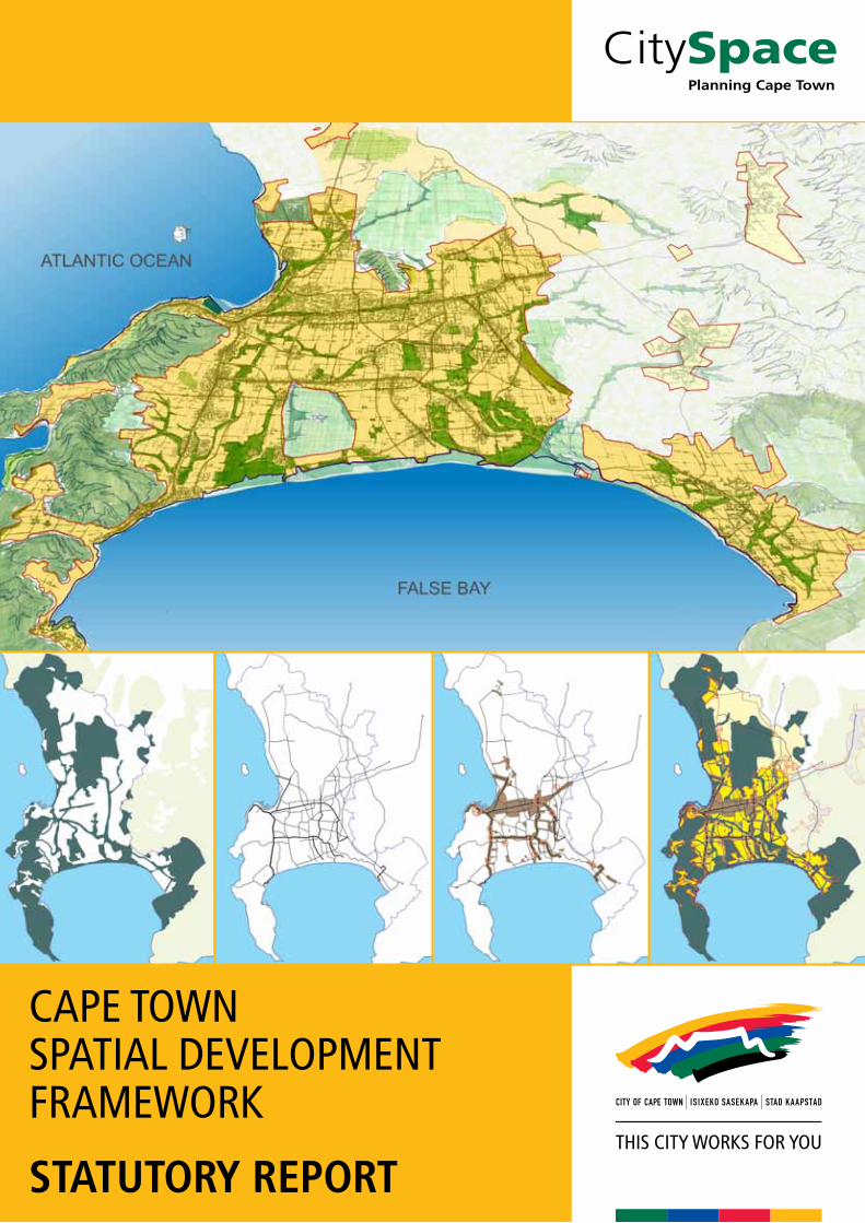
cape town spatial development framework · map 6.1 cape town spatial development framework 85 map...
TRANSCRIPT
CAPE TOWN SPATIAL DEVELOPMENT FRAMEWORK
STATUTORY REPORT


1CTSDF STATUTORY REPORT 2012
CONTENTS
1 INTRODUCTION 8
1.1 Purpose of the Spatial Development Framework 8
1.2 Strategic starting points 8
1.2.1 Cape Town 2040 Vision 8
1.2.2 Spatial Development Goals 9
1.2.3 Spatial Development Principles 9
1.3 Towards a rationalised, policy-driven land use management system 10
1.4 Legal status of the Cape Town Spatial Development Framework 12
1.5 Overview of the Cape Town Spatial Development Framework preparation process 13
2 DEVELOPMENT AND POLICY CONTEXT 14
2.1 Global development context 14
2.2 Legislative context 14
2.3 Strategy and policy context 16
3 DRIVERS OF URBAN GROWTH 18
3.1 Key drivers of urban growth in Cape Town 18
3.1.1 Urbanisation 18
3.1.2 Natural and cultural environment and resource capacity 22
3.1.3 The economy 23
3.2 Spatial growth scenarios 26
3.3 Implications for spatial planning 26
3.3.1 Urbanisation 26
3.3.2 The economy 26
3.3.3 The natural environment 27
3.4 Identifying spatial structuring elements 27
4 LONG-TERM METROPOLITAN SPATIAL STRUCTURE 29
4.1 Resilience and adaptability 29
4.2 A city within a region 29
4.3 Natural assets 30
4.4 The multidirectional accessibility grid 30
4.5 Areas of land use intensification 32
4.6 Urban growth management informants 35
4.7 Destination places 36
4.8 Synthesis: Conceptual framework 36
5 STRATEGIES, POLICY STATEMENTS AND POLICY GUIDELINES 38
5.1 Key strategy 1: Plan for employment, and improve access to economic opportunities 39
5.1.1 Promote inclusive, shared economic growth and development 40
P1 MaintainandenhancethefeaturesofCapeTownthatattractinvestors,visitorsandskilledlabour
P2 Supportinvestorsthroughimprovedinformation,cross-sectoralplanningandremovalofredtape
P3 Introducelandusepoliciesandmechanismsthatwillsupportthedevelopmentofsmallbusiness(bothinformalandformal)
P4 Encourageareaspecialisationandthedevelopmentofadiverse,mutuallysupportivesystemofeconomicareas
P5 Encouragetheuseofavailableeconomicincentives
P6 Promoteregionaleconomicplanning
5.1.2 Address spatial economic imbalances 42
P7 Unlockemployment-generatingopportunitieswithintheMetroSoutheastandAtlantis
P8 Supportprivate-sectordevelopmentinitiativesinlocationsthatareeasilyaccessiblefromtheMetroSoutheast
P9 ImprovepublictransportlinksbetweentheMetroSoutheastandthemaineconomicnodesofthecity
5.1.3 Establish an integrated, citywide public transport system that supports the accessibility grid 44
P10 Createahierarchyofintegratedpublictransportservicesrelatedtotheaccessibilitygrid
P11 Ensurethatnewurbandevelopmentissupportedbyappropriatepublictransportinfrastructureandservices
P12 Lobbyfortheintroductionand/orexpansionofpassengerrailservices
P13 Includewalkingandcyclingasessentialcomponentsoflanduseplanning
P14 Introduceparkingpoliciestoencourageuseofthemostcontext-specificandappropriatemodaltravelchoice
5.1.4 Integrate land use, economic and transport planning 49
P15 Reinforceandenhancemetropolitandevelopmentcorridors
P16 Encouragemediumtohigher-densityformsofurbandevelopmenttolocateonoradjacenttoactivityroutes,developmentroutesandactivitystreets

2 CTSDF STATUTORY REPORT 2012
5.1.5 Support the rationalisation, upgrade and/or development of economic gateways, and manage land uses around them appropriately 50
P17 Supportthedevelopmentofanintegratedsystemofairportsandappropriatesurroundinglanduses
P18 Createandmanageafunctionalinterfacebetweenports/harboursandtheirsurroundingareas
5.2 Key strategy 2: Manage urban growth, and create a balance between urban development and environmental protection 52
5.2.1 Facilitate urban development 53
P19 Supportpropertydevelopersbyidentifyingthelocationspotentiallysuitedtourbandevelopment
P20 Facilitateurbandevelopmentanddirectthephasingofurbangrowththroughthedeliberateandintegrateduseofplanning,infrastructureprovision,andtheregulatoryandfiscalauthorityofallspheresofgovernment
5.2.2 Support incremental development processes 55
P21 PutinplaceaLUMSthatsupportsasteppedapproachtohousingandtenure,andthedevelopmentofasinglepropertymarket
5.2.3 Encourage a more compact form of development 56
P22 Promoteappropriatelanduseintensification
P23 Containthedevelopmentfootprintofthecityandprotectnatural,rural,urbanandheritageassetswithdevelopmentedges:UrbanandCoastalEdge
5.2.4 Appropriately protect the citizens of Cape Town from hazardous areas/activities 59
P24 Directurbangrowthawayfromhazardousareas/activities
5.2.5 Appropriately manage urban development impacts on natural resources and critical biodiversity networks 61
P25 Increaseeffortstoprotectandenhancebiodiversitynetworksatalllevelsofgovernment
P26 Reducetheimpactofurbandevelopmentonriversystems,wetlands,aquifers,aquiferrechargeareasanddischargeareas
P27 Manageurbandevelopmentalongthecoastinasustainableandprecautionarymanner
P28 Protectvaluableagriculturalareas,existingfarmedareasandhorticulturalareasfromurbanencroachmentandsupporturbanagriculture
P29 Adoptaproactiveplanningapproachtominingresourcemanagement
5.2.6 Make efficient use of non-renewable resources 67
P30 Promoteacultureofsustainabledevelopmentandliving
5.2.7 Protect and enhance the city’s rural environment 67
P31 Preventurbandevelopmentfromintrudingintotheruralenvironment
P32 Supportappropriatedevelopmentandactivitiesinruralareas,andinandarounduniqueandculturallysignificantruralsettlements
P33 Rationaliseandproactivelymanagesmallholdings
P34 Developandmanageruralgateways
5.3 Key strategy 3: Build an inclusive, integrated vibrant city 69
5.3.1 Transform the apartheid city 70
P35 Redressexistingimbalancesinthedistributionofdifferenttypesofresidentialdevelopment,andavoidcreatingnewimbalances
P36 Transformtownshipsandinformalsettlementsintoeconomicallyandsociallyintegratedneighbourhoods
P37 Encouragepublic/privatepartnershipstodevelopintegratedhumansettlementsanddiversifyhousingdelivery
5.3.2 Proactively support publicly led land reform and new housing delivery 71
P38 Identifylandforlandreformandpubliclyledhousingdeliveryprogrammes
5.3.3 Encourage integrated settlement patterns 73
P39 Generallysupportdevelopment,rezoning,sub-divisionandsimilarapplicationsthatpromoteagreatermixoflanduses,peopleand/ordensities
P40 Ensurethatlandusesandbuiltformwithinpredominantlyresidentialareassupportthedailyfunctioningofthoseareas,andcontributetotheiroverallcharacterandwell-being
P41 Ensurethatdevelopmentproposalsprovideanadequateandequitabledistributionofsocialfacilities,recreationalspaceandpublicinstitutions
5.3.4 Enhance the unique sense of space and the quality of the built form of Cape Town 76
P42 Promotegoodcontextualurbandesignfit,andorderingoftherelationshipbetweenpeople,urbanspaceandtheenvironment(builtandnatural)
5.3.5 Enhance the value of heritage resources and scenic routes 76
P43 Identify,conserveandmanageheritageresources,includingculturallandscapes
P44 Ensureaccessto,andprovideinformationabout,publicheritageresources
P45 Createanenablingenvironmentforurbanregenerationthatallowsbuildingsandsitesofhistoricalandarchitecturalsignificancetomakeapositivecontributiontotheeconomyandqualityofurbanlife
P46 CelebrateandreinforceCapeTown’sdiversehistoricallegaciesthroughurbanform,architecturaldesign,signageandwhereappropriate,artwork.
P47 Providepositivespacesforculturalandsocialceremoniesandlife-relatedevents
P48 Carefullymanagelandusesandinterventionsalongidentifiedscenicroutes,andinplacesofscenicandvisualquality
P49 Identifyadditionalscenicroutes
5.3.6 Promote accessible citywide destination places 80
P50 Develophigh-quality,accessibledestinations&publicspacesinnewlydevelopedandneglectedareas
3CTSDF STATUTORY REPORT 2012
6. THE CAPE TOWN SPATIAL DEVELOPMENT FRAMEWORK 81
6.1 Spatial Planning Categories (SPCs) 81
6.2 Transport infrastructure 82
6.3 Major land extensive precautionary areas 82
6.4 Development edges 83
6.5 Conceptual designation(s) 83
7. THE WAY FORWARD 87
7.1 Put the building blocks of the policy-driven land use management system in place 87
7.1.1 Tasks arising out of the policy statements and their prioritisation 87
7.2 Review of the Cape Town Spatial Development Framework and related policies 89
7.3 Prepare a 15-year Growth Management Plan 89
LIST OF MAPS
Map 3.1 Major infrastructure risk areas within development areas 21
Map 3.2 Spatial implications of urban growth drivers and trends 28
Map 4.1 Conceptual development framework 37
Map 5.1 Route designation: Land use functionality 46
Map 5.2 Economic activity 47
Map 5.3 Areas potentially suited to urban development 54
Map 5.4 Major land-extensive precautionary areas 60
Map 5.5 Biodiversity network 63
Map 5.6 Aquatic network 64
Map 5.7 Agricultural areas to be protected 66
Map 5.8 Destination places, scenic routes, tourism, development areas, significant cultural landscapes, world heritage sites & gateways 77
Map 6.1 Cape Town Spatial Development Framework 85
Map 7.1 Transport & roads priority action areas 91
Map 7.2 Infrastructure and housing priority action areas 92
Map 7.3 Social facilities & recreational open space priority action areas 94
LIST OF APPENDICES
A List of planning documents to be withdrawn 95
B Summary of related sector legislation, policies and studies that have informed the SIA and CTSDF 96
C (i) Relationship between MOSS, CBA and the Provincial Bio-Regional Planning Categories 102
C (ii) Relationship between the CTSDF route designation, the National Department of Transport road classification system, the PSDF (2009) and the City’s hierarchical road network classification system 103
D Strategic Impact Assessment summary 104
E Overview of Environmental Impact Management Zones 106
F Summary of the draft guidelines and standards for the planning of City of Cape Town social facilities and recreational spaces 107
G Record of amendments 110

4 CTSDF STATUTORY REPORT 2012

5CTSDF STATUTORY REPORT 2012
ACRONYMSANDABBREVIATIONS
TERM DEFINITION
ASGISAACSAATNS
AcceleratedandSharedGrowthInitiativeofSouthAfricaAirportsCompanySouthAfricaAirTrafficNavigationServices
BRTBNG
BusRapidTransitBreakingNewGround
CBACBDCDSCESACMACoCTCPDCPPNECTIACTSDFCTZS
CriticalBiodiversityAreaCentralBusinessDistrictCityDevelopmentStrategyCriticalEcologicalSupportAreaCapeMetropolitanAreaCityofCapeTownCityParksDepartmentCapePeninsulaProtectedNaturalEnvironmentCapeTownInternationalAirportCapeTownSpatialDevelopmentFrameworkCapeTownZoningScheme
DMRDOEDoTDEA&DP
DFAdu/ha
DepartmentofMineralResourcesDepartmentofEnergyNationalDepartmentofTransportWesternCapeDepartmentofEnvironmentalAffairsandDevelopmentPlanningDevelopmentFacilitationAct(No67of1995)dwellingunitsperhectare
EAEDEESPCO
EIA EIMZEIPEMP
EMFEMTERMD
EconomicAreaEconomicDevelopmentDepartmentEconomicEnvironmentandSpatialPlanningPortfolioCommitteeEnvironmentalImpactAssessmentEnvironmentalImpactManagementZoneEnvironmentalImplementationPlanEnvironmentalManagementPlan(intermsofSection11ofNEMA)EnvironmentalManagementFrameworkExecutiveManagementTeamEnvironmentalResourceManagementDepartment
GDPGIS
GrossDomesticProductGeographicInformationSystem
HSDHWC
HumanSettlementsDirectorateHeritageWesternCape
ICMAIMEPICTIDPIDZIEMIPTNIRTITP
IntegratedCoastalManagementAct(No24of2008)IntegratedMetropolitanEnvironmentalPolicy(2001)InformationCommunicationTechnologyIntegratedDevelopmentPlan(intermsoftheMSA)IndustrialDevelopmentZoneIntegratedEnvironmentalManagementIntegratedPublicTransportNetworkIntegratedRapidTransitIntegratedTransportPlan
KNEPKNPS
KoebergNuclearEmergencyPlanKoebergNuclearPowerStation
LGTALUMSLUPO
LocalGovernmentTransitionAct(No61of1995)LandUseManagementSystemLandUsePlanningOrdinance(No15of1985)
TERM DEFINITION
MOSSMSAMSDF
MetropolitanOpenSpaceSystemMunicipalSystemsAct(No32of2000)MetropolitanSpatialDevelopmentFramework(Redraft2001)
NEMA NEMBA
NGONLTANHRANMTNNRNPANSDP
NationalEnvironmentalManagementAct(No107of1998)NationalEnvironmentalManagementBiodiversityAct(Act10of2004)non-governmentalorganisationNationalLandTransportAct(No5of2009)NationalHeritageResourcesAct(No25of1999)Non-MotorisedTransportNationalNuclearRegulatorNationalPortsAuthorityNationalSpatialDevelopmentPerspective
OECD OESA
OrganisationforEconomicCooperationandDevelopmentOtherEcologicalSupportArea
P&BDMPAZPEPCOPGWCPGDSPIIFPOSPRASAPSDFPTP
PlannnigandBuildingDevelopmentManagmentDepartmentPrecautionaryActionzonePlanningandEnvironmentPortfolioCommitteeProvincialGovernmentWesternCapeProvincialGrowthandDevelopmentStrategyPublicInfrastructureInvestmentFrameworkPublicOpenSpacePassengerRailAgencyofSouthAfricaProvincialSpatialDevelopmentFramework(2009)PublicTransportPlan
SANDFSANRALSANPARKSSAHRASDFSDPSEASIASMMESPCSPUDSOESRS&RD
SouthAfricanNationalDefenceForceSouthAfricanNationalRoadsAgencyLtdSouthAfricanNationalParksSouthAfricanHeritageResourcesAgencySpatialDevelopmentFrameworkSpatialDevelopmentPlanStrategicEnvironmentalAssessmentStrategicImpactAssessment(intermsoftheMSA)Small,MediumandMicroEnterprisesSpatialPlanningCategorySpatialandUrbanDesignDepartmentStateOwnedEnterprisesScenicRouteSportsandRecreationDepartment
TPCTMNPTR&S
Town-PlanningCompliantTableMountainNationalParkTransport,RoadsandStormwaterDepartment
UDZ
UPZUSD
UrbanDevelopmentZone(intermsofIncomeTaxActNo58of1962)UrgentProtectiveActionZoneUtilityServicesDirectorate
VPADDVPUU
VoluntaryProactiveDealDrivenViolencePreventionthroughUrbanUpgradingProgramme
WSUDWWTW
Water-SensitiveUrbanDesignwastewatertreatmentworks
6 CTSDF STATUTORY REPORT 2012
TERM DEFINITION
Cultural landscape
Sitesandlandscapesofhistoricalsignificance,areasofscenicbeautyandplacesofspiritualand/orculturalimportance.
Densification Increaseduseofspace,bothhorizontallyandvertically,withinexistingresidentialareas/propertiesandnewdevelopments,accompaniedbyanincreasednumberofunitsand/orpopulationthreshold.
Destination place AplacethatformsasignificantlandmarkorareaofattractionandispartoftheuniqueidentityofCapeTown.
Development corridor
Developmentcorridorsarebroadareasofhigh-intensityurbandevelopmentfocusedpredominantlyonactivity/developmentroutesservicedbymassrapidpublictransportservices(i.e.railorBRT).
Development edge
Ademarcatededgelinedefiningtheouterlimitsofurbandevelopmentforadeterminedperiodoftime;therearetwotypesofedgelines,namelyUrbanEdgelinesandCoastalEdgelines,–theformerbeingamedium-tolong-termedgeline,wherethelinehasbeendemarcatedinapositiontophaseurbangrowthappropriately,ortoprotectnaturalresources.
Ecological buffer Stripoflandadjacenttoawatercourse,wetlandorvlei,requiredfortheprotectionandenhancementofaquaticandriparianecosystemintegrityandfunctioning.
Ecological footprint
Totalextentoftheimpactofthecity’soperations(metabolism)onthenaturalenvironment.
Ecological services
Servicesthatindirectlyaccruefromthenaturalenvironment,anddonothavedirectmarketvalues,suchasfloodattenuation,naturaldrainageanderosionprevention,wastewatermanagementthroughbiologicaltreatment,airqualitymanagementandfiltration,carbonsequestration,andbiodegradablewastedisposal.
Gap housing HousingforhouseholdswithamonthlyincomeofbetweenR3 500andR10 000,whofalloutsidethegovernmenthousingsubsidyincomelimitofR3 500permonth,andfinditdifficulttoaccesshousingintheprivatemarket.
Gross base density
Averagedensityofalllandwithinthebuiltareaofthecityorsomeotherdefinedparcelofland.
Floodline Alineonamapdepictingwaterlevelslikelytobereachedbyafloodhavingaspecifiedrecurrenceinterval.
Fair share Equitabledistribution.
Heritage resource Anyplaceorobjectofculturalsignificance;accordingtotheNHRA,unique,non-renewableandpreciouslocations;includessitesandlandscapesofhistoricalsignificance,areasofscenicbeauty,andplacesofspiritualand/orculturalimportance.
Incremental densification
Small-scaledensificationthatisalmostinvisible,e.g.subdivisionsandseconddwellings.
Land redistribution
Landredistributiontothelandlesspoor,labourtenants,farmworkers,andemergingfarmersforresidentialandproductiveusestoincreaselivelihoodsandimprovequalityoflife.
TERMSANDDEFINITIONS
TERM DEFINITION
Accessibility grid Thegridofstructuringroutes(developmentandactivityroutesandactivitystreets)thatfacilitatesconvenientpublictransportaccessandmultidirectionalmovementbetweenthedistrictandotherpartsofthecityandwithinthedistrict.
Aquifer Areaidentifiedasreflectingphysicalextentofwater-bearinglayerofsoil,sand,gravelorrockthatwillyieldsignificantusablequantitiesofwater.
Biodiversity Biologicalwealthofaspecifiedgeographicregion:includingthedifferentmarine,aquaticandterrestrialecosystems,communitiesoforganismswithinthese,andtheircomponentspecies,numberandgeneticvariation.
Biodiversity network
Themapofprotectedandcriticalbiodiversityareas(includingnaturalvegetationremnantsandwetlands)forthecity,basedonthefine-scalesystematicconservationplan,inaccordancewiththelegalrequirements.
Bioregion Ageographicregionorareacontainingwholeornestedecosystemsandthatischaracterisedbyitslandforms,vegetationcover,humancultureandhistory;andisdeclaredbytheMinisterintermsofNEMBA(Act10of2004).
Bioregional plan Alegislatedbiodiversityplan,aimedatassistingwiththemanagementandconservationofSouthAfrica’sbiologicaldiversity,declaredintermsofChapter3ofNEMBA(Act10of2004).Theaimoftheplanistoprovideamapofbiodiversityprioritieswithaccompanyingland-usedecisionmakingguidelines.
Civic precinct Concentrationofpublicfacilities(e.g.schools,clinics,hospitals,parks,cityhall,courthouses,postoffices,etc.)locatedincloseproximity.
Coastal Edge Demarcatedareaaroundthecoast,primarilytoprotectcoastalresources,andtoavoidhazardsandfinancialriskspertainingtoareasatriskofflooding.
Coastal edge management zone
ManagementzonebetweentheseaandtheCoastalEdge.
Coastal node Concentrateddevelopmentataspecificcoastallocation.
Coastal processes Naturalprocessesoferosionandaccretion,dunemigration,andbeachsedimentdynamics.
Critical Biodiversity Area
CriticalBiodiversityAreasareterrestrialandaquaticfeaturesinthelandscapethatarecriticalforconservingbiodiversityandmaintainingecosystemfunctioning,andthatarerequiredtomeetbiodiversitytargets(forbiodiversitypatternsandecologicalprocessfeatures).
Critical Ecological Support Area
Naturalandruralareaswithbiodiversityimportancewhichareessentialformanagementconsolidation,connectivityandviabilityofbiodiversityinCBAsandprotectedareas.ThesearenotessentialformeetingbiodiversitytargetsbutplayanimportantroleinsupportingtheecologicalfunctioningofCBAsand/orindeliveringecosystemservices.

7CTSDF STATUTORY REPORT 2012
TERM DEFINITION
Land reform Encompassesthreeinterrelatedcomponents,namelylandrestitution,landtenureandlandredistribution.
Land use intensification
Referstoachievingagreaterspectrumofmixeduses(commercial,industrialandresidential)throughtheincreaseduseofspace,bothhorizontallyandvertically,withinexistingareasorpropertiesandnewdevelopments,accompaniedbyanincreasednumberofunitsand/orpopulationthresholds,inaccessible,high-opportunitylocations.
Mixed land use Areaofexistingorproposedhorizontaland/orverticalintegrationofsuitableandcompatibleresidentialandnon-residentiallanduseswithinthesameareaoronthesameparcelofland;impliescontextuallyappropriateintensityoflandusesthatshouldfacilitateefficientpublictransportandavibrantlocalurbanenvironment.
Metropolitan open space system
Interconnectedandmanagedopenspacenetworkthatsupportsinteractionsbetweensocial,economicandecologicalactivities,sustainingandenhancingbothecologicalprocessesandhumansettlements;includesnaturalareasandactiveandpassiverecreationareassuchassportsfields,parks,andsquaresbutalsocemeteries,detentionponds,servitudes,rivercorridorsandroadreservestopromoteinterconnectionandmulti-use.
Mobility Theeasewithwhichpeoplecantravelwithminimaldelayonaroute.
Multifunctional Thecombinationofdifferentyetcompatiblefunctionswithinonephysicalframeworktoserveavarietyofsocialandcommunitygroups;allowforawiderrangeoffacilitiesthatreinforceoneanotherincloseproximity,offeringgreateraccesstopotentialusers.Differentiationinactivitymaybephysical(differentactivitiesondifferentfloorsorpremisesofthesamebuilding)orintime(usingthesamefacilityfordifferentactivities,butatdifferenttimes).
New development area
Anareaearmarkedforfuturedevelopment.
Non-motorised transport
Transportmodesthatarenotmotorised,e.g.walkingandcycling.
Nodal development
Significantandconcentrateddevelopmentintermsofscale,location,impact,diversityandagglomerationoffunctions(facilities,servicesandeconomicactivities).
Noxious Industry Industrythatispotentiallyharmfulorinjurioustothehealthoflivingthings.
Package of plans Consistingofanintegratedsetofhierarchicalplansshowingthelinkbetweenstrategyandimplementation,whichmayincludeadevelopmentframework,precinctplans,subdivisionplansandbuildingplans.
Priority action zones
Alocationrequiringintervention/actionbytheCity,otherspheresofgovernmentandstateownedenterprises. Theinterventionsmaytakeavarietyofformse.g.dealingwith“crimeandgrime”,investinginbulkinfrastructureandsocialfacilities,improvementstothequalityofthebuiltenvironmentandtheintroductionofdevelopmentincentives
TERM DEFINITION
Public open space Landzonedasopenspace,andaccessibletothegeneralpublic
Public transport interchange
Supportsthetransferofpublictransportusersbetweenmodes(rail/bus/taxi)butalsofunctionstosupporteconomicactivity.
Risk Activity/Noxious Industry
Thesecomprisehazardousandnoxiouslandusesintermsofsmell,product,wasteorotherobjectionableconsequencesofoperation,oronesthatcarryahighriskintheeventoffireoraccident.
Rural living estates
Extensivelandunits(ranginginsize)locatedinsidetheurbanedge.
Smallholdings Extensivelandunits(ranginginsize)locatedoutsidetheurbanedge.
Strip development Mixed-usedevelopmentusuallylocatedalongactivityroutesandactivitystreetsandsomedevelopmentalroutes.
Subsidised housing
HousingsuppliedintermsoftheNationalDepartmentofHousing’shousingsubsidyscheme.
Urban development
Buildingsandinfrastructurewitharesidentialpurposeaswellasoffices,shops,communityfacilitiesandotherassociatedbuildings,infrastructureandpublicopenspacenecessarytoprovideforproperfunctioningofurbanareasandamenityandrecreation.Theterm‘urbandevelopment’includesgolfestates,vineyardestateswitharesidentialcomponent,equestrianestateswitharesidentialcomponent,rurallivingestates,eco-estates,gatedcommunitiesandregionalshoppingcentres.Urbandevelopmentexcludesnoxiousindustryandgenerallyexcludeslandforindustrialpurposes.However,servicetradesthatarecompatiblewithmixed-usedevelopmentandthatgeneratealowimpactonsurroundingurbanusesmaybepermissibleifthenatureandtypeofindustryisdeemedtoformanintegralpartofanareademarcatedforurbandevelopmentpurposes.
Urban Edge management zone
ZoneorbufferareaoneithersideoftheUrbanEdge,wherelandusesaretobemanagedtoprotecttheintegrityoftheurbanedgeline.
Urban footprint Thetotalextentofexistingurbandevelopment.
Urban Development Zone
TheUrbanDevelopmentZoneisanareademarcatedinaccordancewiththeIncomeTaxAct(No58of1962)asamendedbytheRevenuesLawsAmendmentAct(No45of2003).Intermsofthisincentive,taxpayerswhoconstruct,improveorpurchaseabuildingorpartofabuildingfromadeveloperwithinthisareawillbeallowedtoclaimforareductionintaxableincome.
Urban restructuring zone
AwelllocatedareawheretheNationalHousingDepartmentsubsidy,asdefinedintermsoftheSocialHousingAct(No16of2008),applies.
Water-sensitive urban design
Minimisesdisruptionofthenaturalwatercyclebyreducingrunoff,attenuatingflooding,andtreatingrunoffbeforedischargeintothereceivingwaters,whilstatthesametimeincreasingtheamenityvalueofwatersystems,andreducingthecostofwaterinfrastructure.
Zoning scheme Aschemeconsistingofschemeregulationsandaregisterwith(orwithout)azoningmap.
8 CTSDF STATUTORY REPORT 2012
1 INTRODUCTION
Planning for the future begins with an understanding of the way things are right now: the place, the people and the social, economic and environmental forces underlying the trends that are shaping Cape Town’s development.
City change and growth are inevitable, and development pressures are a given. Nevertheless, a city with foresight and insight can guide and manage public and private development to ensure the best possible outcome for its inhabitants. This best possible outcome includes the protection and enhancement of the city’s key economic, social and environmental resources and assets, and the extension of these economic, social and environmental opportunities to everyone in the city.
The overall intention of the Cape Town Spatial Development Framework (CTSDF) is to guide and manage urban growth, and to balance competing land use demands, by putting in place a long-term, logical development path that will shape the spatial form and structure of Cape Town. In the context of climate change and resource depletion, including finite oil resources, the future growth path needs to underline the importance of sustainable future growth. This proposed development path must be flexible and adaptive, and therefore does not include fixed deadlines and timetables, as economic, environmental and social forces are unpredictable, and it is impossible to determine accurately how fast the city will grow. The proposals set out below may take decades to realise, and will need to be reviewed from time to time to ensure that they remain relevant, realistic and informed by changing dynamics and local, national and global events.
‘City’ vs. ‘city’
The CTSDF refers to the City of Cape Town municipality as ‘the City’, and to the municipal area as ‘the city’.
Table 1.1 summarises the content of the CTSDF. It starts by providing an overview of the contextual factors that need to be addressed. It then discusses the desired future Cape Town, and outlines the principles that will guide the choices that need to be made, the strategic interventions that are required, and the policies and implementation strategies that will be used to steer development towards the desired outcome.
Table 1.1: The content of the CTSDF
CAPE TOWN NOW FUTURE CAPE TOWN HOW WE PLAN TO GET THERE
• Strategy & policy context
• Drivers of development
• Trends
• Spatial implications
• Vision
• Spatial development goal
• Spatial principles
• Spatial strategies
• Spatial building blocks
• Policy statements and development guidelines
• Implementation approach
1.1 Purpose of the Spatial Development Framework
The CTSDF is a long-term (±20-year) plan to manage growth and change in Cape Town. It:
• provides a long-term vision of the desired spatial form and structure of Cape Town;
• aligns the City’s spatial development goals, strategies and policies with relevant national and provincial spatial principles, strategies and policies;
• guides the proposals contained in the more detailed District Spatial Development Plans (SDPs) which cover a shorter planning time frame (10 + years), and the preparation of Local Spatial Plans;
• helps spatially coordinate, prioritise and align public investment in the City’s five-year Integrated Development Plan (IDP);
• directs private investment by identifying areas that are suitable for urban development, areas where the impacts of development need to be managed, and areas that are not suited for urban development;
• identifies strategies to prevent indiscriminate loss and degradation of critical biodiversity areas, and to ensure the necessary level of protection for the remaining areas;
• provides policy guidance to direct decision making on the nature, form, scale and location of urban development, land use change, infrastructure development, disaster mitigation and environmental resource protection; and
• will not create any land use or building rights, nor exempt anyone from their rights and obligations in terms of the zoning scheme or any other legislation.
1.2 Strategic starting points 1.2.1 Cape Town 2040 Vision
The future spatial (re)organisation and development of Cape Town needs to be guided by a vision of the city we are hoping to realise in the longer term. The vision’s role is to provide shared purpose and direction as well as inspiration and motivation for decision makers, leaders and residents of Cape Town to work together to attain it. The draft vision for Cape Town that the City is putting
9CTSDF STATUTORY REPORT 2012
forward for consideration by the citizens of Cape Town as part of the public engagement process for Cape Town’s long-term City Development Strategy is as follows:
To,by2040,turnCapeTownintooneoftheworld’sgreatestcitiesinwhichtoliveandlearn,work,investanddiscover–aplaceofpossibilityandinnovation,withadiverseurbancommunityandalltheopportunitiesandamenitiesofcitylife,withinanaturalenvironmentthatsupportseconomicvibrancyandinspiresasenseofbelonginginall.
1.2.2 Spatial Development Goals
From a spatial perspective, the City aims to achieve this vision through creating a sustainable and equitable city.
Sustainability is the capacity to sustain or support indefinitely. In the city context, it means offering an economic future to our children and to our children’s children, while ensuring the preservation of the city’s unique biodiversity and cultural heritage, and, at the same time, meeting the sustenance needs of current residents. Sustainability must therefore address service and infrastructure provision as much as it must address biodiversity protection.
To achieve a sustainable economy, we need inclusive and equitable shared economic growth to turn around local poverty and reduce the growing income gap between rich and poor. Better-quality green and public open spaces, such as the city’s biodiversity network and coastal areas, and well-maintained, City-owned attractions and tourism precincts will enhance people’s quality of life, and contribute to investment and tourism. In addition, the source of inputs and destination of outputs, including goods, ecological services, products and waste, need to be considered in order to achieve the goal of environmental sustainability. A sustainable society implies that basic services, amenities and education must be available to everyone. The City needs to promote greater equity of access to these, improve the quality of living environments, and reduce the levels of crime. The City has a responsibility to achieve institutional sustainability through planning development and making wise investment decisions that directly contribute to a sustainable future for Cape Town and its residents.
Equity refers to life equality, meaning that people have access to a broadly similar range of opportunities, resources and amenities, and that the public good prevails over private, sectional interests. A city that works for every resident, especially the poor, children, the disabled and the elderly, is more likely to be an equitable city.
For Cape Town to be sustainable, the City needs to embrace sustainability in all its daily operations, and employ sustainability and equity principles in all its planning and decision making. Spatial planning is an important way in which the City is able to do so, by mapping the desired patterns of living and investment, and managing current and future development in an integrated fashion.
1.2.3 Spatial Development Principles
The following principles flow from national legislation (particularly the Development Facilitation Act, (Act 67 of 1995)), and international and national best practice for successful city planning and management.
• The public good should prevail over private interests.
• All residents should have equal protection and benefits, and no unfair discrimination should be allowed.
• Work harmoniously with nature, reduce the city’s ecological footprint, and introduce sustainable disaster risk reduction measures.
• Adopt a precautionary approach to the use of resources, switch to sustainable patterns of resource use, and mitigate negative development impacts.
• Encourage local, national and international connectivity.
• Improve urban efficiency, and align planned growth with infrastructure provision.
• Offer maximum access to the city’s opportunities, resources and amenities, and redress spatial imbalances in this regard as far as possible.
• Be responsive to the basic needs of communities by providing a stronger link between regulatory processes (zoning schemes) and spatial plans and policies.
• Create safe, high-quality living environments that accommodate a range of lifestyles and offer a vibrant mix of land uses.
• Promote cross-sectoral planning, budgeting and growth management approaches.

10 CTSDF STATUTORY REPORT 2012
1.3 Towards a rationalised, policy-driven land use management system
The City’s current planning framework comprises outdated plans with inconsistent status and conflicting development objectives. The City is updating and rationalising all aspects of the current planning framework, guided by the Municipal Systems Act (MSA) (Act 32 of 2000), new draft national planning law, the Provincial Spatial Development Framework (PSDF) (2009) and the Provincial Government of the Western Cape’s law reform project, which is reviewing the Land Use Planning Ordinance (LUPO) (No 15 of 1985).
These initiatives promote a more responsive, flexible and policy-driven approach to land use management, in which a broader range of instruments and policies set the guidelines against which all land use decision making takes place. The CTSDF will become one of the tools for evaluating applications for new or enhanced land use rights.
The intention is to put in place a land use management framework that is flexible and promotes consistent and predictable decision making.
Figure 1.1: Existing situation and future land use management system
It is envisaged that the updated land use management system (LUMS) will:
• integrate existing, separate and diverse land use management systems, policies and approaches into a single, harmonious system with a clear hierarchy of plans;
• achieve a closer link between zoning control and forward spatial planning;
• put in place policies and guidelines to guide predictable and informed discretionary decision making within the regulatory framework;
• be based on standardised and uniform business processes, procedures and systems, to ensure legal compliance and administrative efficiency;
• be user-friendly and easily accessible to City officials and external users; and
• include mechanisms to monitor compliance with policies, and the prioritisation of public investment in terms of the CTSDF and District SDPs or related plans.

11CTSDF STATUTORY REPORT 2012
The Cape Town Zoning Scheme (CTZS)
Zoning is a method of development management that designates property for a particular development or use category or zone. Within each zone, there are provisions and rules setting out the purposes for which property may be used, and the manner in which it may be developed. In addition, zoning should work in conjunction with, and be linked to, policy plans and other tools in the LUMS, to enable Council to proactively manage land and development in the city, and in so doing, implement the vision set out in the CTSDF, District SDPs and local area or sector plans. The CTZS introduces new planning techniques in the form of the overlay zoning category, whereby policy guidelines (such as those contained in the CTSDF) may be translated into development rules after following a prescribed process.
An overlay zone will apply in addition to the base zone of a property. An overlay zone may be imposed if it complies with the rules set out in the CTZS, and, as the City aims to establish a policy-driven LUMS, it must as far as possible be preceded by local planning policies initiated at district plan level in the first instance. In addition, it may not be introduced for the purposes of promoting, causing or facilitating social exclusion and separation. It is important to note that the introduction of overlay zones is not an inevitable consequence of local area planning initiatives identified through the District SDPs, but needs to be considered carefully, based on the strength of individual motivation of the need for (more or less restrictive) development rules, in addition to the underlying zone or base-zone requirements. Overlay zones are a tool that would be employed on an exceptional basis, when it is critical and strategic that actual land use rights are managed to achieve the vision for Cape Town.
The hierarchy and role of plans, policies and guidelines that form the cornerstone of the rationalised, policy-driven LUMS are outlined in Table 1.2. It is envisaged that the CTSDF and District SDPs will replace, or lead to the withdrawal of, selected metropolitan and submetropolitan-scale spatial plans. The affected plans are listed in Appendix A. Central to the policy-rationalisation effort will be the retention of a number of local development plans and policies that continue to provide detailed direction to development in parts of the metropolitan area. These will be reviewed over time and supplemented by new local plans in areas that are selected as priorities for local area planning.
Table 1.2: Hierarchy of spatial plans and policies
SPATIAL PLAN/POLICY
PURPOSE WHAT IT IS REPLACING OR ADDING TO WHO APPROVESLEGISLATION OR POLICY THAT GUIDES APPROVAL
CTSDF Long-term(20+years)citywidespatialstructuringelementsandplans,andoverarchingpolicyframework.
GuidePlans,MetropolitanSpatialDevelopmentFrameworksandsubregionalplansapprovedintermsofsection4(6)ofLUPO.
PGWCCouncil
MSALUPO(section4(6))NHRAWorldHeritageAct
DistrictSDP Medium-term(10+years)district-levelspatialdevelopmentplanswhichindicateproposedlandusesinnewdevelopmentareas,urbanrestructuringandupgradeinterventions.
Districtandlocalstructureplansapprovedintermsofsection4(6)and4(10)ofLUPO.
Council LUPO(section4(10))–provisiononthelapsingofstructureplansafteraspecifiedtimeframe;NHRA,WorldHeritageAct
City’ssystemofdelegations
LocalSpatialPlans DetailedSDFrelatedto,forexample,themanagementoflanduses,anddetailedlocal-levelplanningsuchasdensityplan
Districtandlocalstructureplansapprovedintermsofsection4(6)and4(10)ofLUPO.
Council LUPO(section4(10))
City’ssystemofdelegations
NHRAStrategy/policydocuments
Detailedissue/land-use-specificpolicyparametersthatshoulddeterminelandusedecisions,suchasdensification,urbanedge,guesthouseandbed-and-breakfast(B&B)policy.
Willreplaceorcomplementexistingpolicies. Economic,EnvironmentandSpatialPlanningPortfolioCommittee(EESPCO)and/orCouncil
City’ssystemofdelegations
Developmentguidelines Detailedguidelinesthatshouldinformlandusedecisions,suchasfireprotectionguidelinesandurbandesignguidelines(forexampletallbuildingsguidelines).
Willreplaceorcomplementexistingguidelines. EESPCO(ifitdoesnotaffectothersectors)
Council,ifothersectorsareaffected
City’ssystemofdelegations

12 CTSDF STATUTORY REPORT 2012
1.4 Legal status of the Cape Town Spatial Development Framework
The CTSDF has had a dual approval process: as part of the IDP, in terms of the Municipal Systems Act (Act 32 of 2000), and also as a Land Use Planning Ordinance (No 15 of 1985, section 4(6)) structure plan.
The CTSDF was approved by Council as a sectoral component of the IDP in terms of the MSA on 8 June 2011.
The CTSDF replaces two guide plans, being the Peninsula and the Hottentots Holland Basin Plans, and portions of the Atlantis and Environs Plan. All three plans were promulgated in terms of the Physical Planning Act (Act 88 of 1967), and have been approved as Urban Structure Plans in terms of LUPO.
The CTSDF also replaces certain approved and awaiting-approval section 4(6) LUPO structure plans, and downgrades certain other existing approved local-scale plans, from section 4(6) to section 4(10) of LUPO structure plans (so that a clear hierarchy of plans can be implemented), as listed in appendix A.
In terms of section 5(3) of LUPO, a structure plan shall not confer or take away any right in respect of land. Therefore, the statutory approval of the CTSDF does not confer new development rights, or limit development rights. No guidelines, policies or any other provisions in respect of land use that result from the CTSDF shall create any rights, or exempt anyone from their obligations in terms of any other legislation.
The statutory components of the CTSDF in terms of section 4(6) of LUPO will include:
(1) Chapter 5: Strategies, Policy Statements and Policy Guidelines (see highlighted columns only)
(2) Chapter 6: The Cape Town Spatial Development Framework and accompanying Map 6.1: The Cape Town SDF
The request for an amendment of the CTSDF will therefore only relate to cases in which the competent authority deems that there is a conflict between a development proposal and the statutory components of the CTSDF (refer points (1) and (2) above). The other maps, figures and text in the CTSDF are included for illustrative purposes and are intended to broaden the general understanding of the CTSDF and to act as informants to the interpretation of the statutory components of the CTSDF. The preparation of spatial plans and the assessment of development applications must therefore be guided by due consideration of these informants when interpreting the statutory components of the CTSDF.
In cases where an amendment of the CTSDF is approved, a simultaneous amendment to the District SDP will be deemed to have been effected.
As legally required in terms of the NHRA, the City has compiled an inventory of the heritage resources that fall within its area of jurisdiction, and has submitted this inventory to the relevant provincial heritage resources authority.
The CTSDF will be implemented in accordance with the consistency principle that applies to the plans and policies of different spheres of government, and within the local sphere of government. In terms of the consistency principle, lower-order spatial plans and policies must be consistent with higher-order spatial plans and policies. The CTSDF, approved as a structure plan in terms of section 4(6) of LUPO and Section 34 of MSA, is deemed to be consistent with the Provincial Spatial Development Framework. Should the provisions of plans of a lower order in the hierarchy (including District SDPs and existing local-scale structure plans) be deemed to be inconsistent with the CTSDF, the CTSDF will take precedence.
A register of amendments to the statutory components of the CTSDF is to be kept by the competent authority, and this register is to be reflected in Appendix G of the CTSDF.
Determining policy compliance and measuring consistency between plans
In line with the consistency principle and hierarchical system of plans, a development proposal (or proposal contained in a lower-order framework plan) must be measured for consistency against the statutory components of the PSDF and the CTSDF.
The findings of such an assessment must be weighed as follows:
(1) The statutory designation and/or text of the PSDF and/or CTSDF provides for the proposal (and is generally in line with land development proposals);
(2) The statutory designation and/or text of the PSDF and/or CTSDF does not explicitly provide for the proposal; but on the other hand, the proposal is not necessarily clearly in conflict with the intent and purpose of the designation and/or text concerned;
(3) The proposal is in conflict with the statutory designation and/or text of the PSDF and/ or CTSDF
These three findings lead to different planning and procedural outcomes:
• In the case of (1), the proposal is deemed to be consistent and evaluated further;
• In the case of (2), a consistency ruling must be made. If it is positive, the development proposal can be further evaluated or considered;
• In the case of (3), consideration may be given to amending the framework or plan against which the proposal was measured as provided for in terms of section 3(4)(b) of the Municipal Planning and Performance Management Regulations of MSA and section 4(7) of LUPO (or subsequent provisions in legislation that may replace it). The amendment of the affected framework or plan should occur prior to or simultaneous with any other applications in terms of LUPO. Should this amendment not be approved in terms of both LUPO and the MSA, the proposal is not supported and may not go ahead.

13CTSDF STATUTORY REPORT 2012
Figure 1.2: Procedural steps followed in terms of the MSA and LUPO in the preparation of the CTSDF
1.5 Overview of the Cape Town Spatial Development Framework preparation process
The process for compiling a Metropolitan Spatial Development Framework (MSDF, 1996) – as a long-term spatial plan to guide the growth of metropolitan Cape Town – was initiated in response to perceived inadequacies in the Guide Plans (now known as Urban Structure Plans) for Cape Town. However, this was never formalised by statute; instead, the then Cape Metropolitan Council adopted an interim MSDF redraft as policy in 2001.
In 2005, the City reviewed the successes and failures of the previous MSDF and metropolitan spatial planning initiatives, and identified the development trends facing Cape Town.
In 2006, the City embarked on a process of preparing Future Cape Town, an internal document that put forward proposals regarding the strategic direction of the CTSDF. Following this, a strategic impact assessment (SIA) of the environmental and heritage impacts of the Future Cape Town strategy document was undertaken, and District SDPs incorporating environmental management frameworks (EMFs) were prepared for the City’s eight planning districts.
The CTSDF and District SDP planning exercise also included a 2006 review of the content and status of all local, district and metropolitan area-wide plans and policies. The CTSDF promotes the spatial integration and restructuring of the Cape Town metropolitan area and aims to replace the outdated set of Guide Plans, which are no longer considered to meet the city’s development requirements.
A rigorous and inclusive public engagement process was critical for the successful preparation of the CTSDF and District SDPs, to secure PGWC’s approval, as well as for the withdrawal of the outdated structure plans. The public participation process comprised three phases:
Phase 1: The purpose was to launch the process, elicit the views of the public and other stakeholders on the development issues facing Cape Town, and identify the principles and goals that were applicable to the preparation of the CTSDF and District SDPs.
Phase 2: The draft CTSDF Technical Report was advertised for public comment, with the purpose of discussing the citywide spatial concept and policy statements, proposals contained in the District SDPs, and draft development edge and densification policies. The revised CTSDF and the public participation report were submitted to PGWC for provisional inspection at the conclusion of Phase 2. PGWC indicated their general satisfaction with the content of the CTSDF and the public participation process, and confirmed that the City could proceed with the third and final round of public participation.
Phase 3: The Final Draft CTSDF which incorporated the findings of subsequent, more in-depth studies and comments received from the public as part of phase 2 was advertised for comment and public hearings were held in January 2011. The in-depth studies included the Evaluation of Developable Land within the Urban Edge, the Analysis of Cape Town’s Space Economy, and medium- to long-term growth options work.
This document is based on the outcome of the Phase 3 public participation process and is the approved CTSDF document.

14 CTSDF STATUTORY REPORT 2012
2 DEVELOPMENTANDPOLICYCONTEXT
2.1 Global development contextWorldwide, cities are associated with large numbers of people, resources, services and infrastructure, and are therefore the drivers of, or gateways to national and international economies. Cities are also part of, and affected by, the cyclical performance of global, regional and national economies, and must take global economic influences into account when planning for sustained growth and resilience. Globalisation is encouraging cities across the world to adopt a city-region approach in order to strengthen their global positioning and support their development. South Africa’s global position as the southern gateway to Africa has the potential to increase investment in Cape Town and drive sectors of the regional economy.
The complex patterns of cities are partly a result of urbanisation, which is considered to be a major phenomenon in the developing world in this century. The developing world forms the locus of this rural/urban demographic transformation, and relies on the massive economic, social, political and cultural opportunities that cities have to offer.
Cities are also required to deal with the rising threats of climate change and dwindling resources. These constraints mean that cities that do not plan adequately will face higher costs to residents, a decline in welfare, and reduced economic competitiveness. Preparations for these circumstances typically require decades of forward-thinking development guidance.
Cape Town is still a developing city; it is therefore also required to manage high levels of poverty and unemployment, and service and infrastructure backlogs, while recognising the interdependencies between ecological and economic sustainability, and emphasising the importance of natural assets in providing a range of ecosystem services. It is not the only city that has to deal with these challenges. Many developing cities are not able to deliver the most basic infrastructure and services required for healthy, safe living environments.
These challenges will undoubtedly have a profound impact on the form and functioning of cities in the future, raising questions about (i) the sustainability of the economic and spatial structure of cities; (ii) the balance between formal and informal development processes; and (iii) how urbanisation is accommodated.
2.2 Legislative contextThe CTSDF must align with the following key legislation:
The Constitution of the Republic of South Africa (Act 108 of 1996)
The Constitution sets out the rights and duties of the citizens of South Africa and defines the structure and the responsibilities of the spheres of government, including local government: namely, to promote social and economic development of the community.
The Municipal Systems Act (MSA) (Act 32 of 2000)
The MSA requires the preparation of an IDP, of which an SDF is a component. The requirements of an SDF are listed in the Local Government: Municipal Planning and Performance Regulations (2001), and include the following longer-term, medium-term and shorter-term products:
• A citywide, longer-term spatial plan/policy/strategy, guiding the direction, nature and extent of longer-term growth and development
• Guidelines for the LUMS
• A Public Infrastructure Investment Framework (PIIF), indicating the spatial locations towards which investment will be directed
• A strategic impact assessment (SIA), evaluating the impact of the citywide and/or district-level plans
The citywide, longer-term spatial plan and SIA are the primary focus of this report.
The MSA prescribes a much stronger link between spatial plans (forward planning) and land use management. However, it does not prescribe a process or requirements in this regard. The National Department of Rural Development and Land Reform has recognised this shortcoming, and is preparing a new national planning law that will replace all the existing land use regulatory laws in the country, giving effect to the provisions of the MSA.
In terms of the MSA, the CTSDF (as part of the IDP) prevails over any other plan as defined in Section 1 of the Physical Planning Act (Act 125 of 1991).
The PIIF is an integral component of the long-term CTSDF and proposed 15-year growth management plan; and informs the preparation of the IDP. The PIIF must be regularly reviewed. The future land use and development projections contained in the CTSDF and District SDPs are critical informants of the PIIF review.
In terms of the MSA, the IDP is the principal planning instrument, which guides and informs all planning and development. The CTSDF is a cross-sectoral plan of the IDP. As a cross-sectoral plan, the CTSDF must inform and be informed by a cross-sectoral, citywide strategy to direct and coordinate public investment spatially through the five-year IDP.
The Development Facilitation Act (DFA) (Act 67 of 1995)
Chapter 1 of the DFA, which applies to the Western Cape, prescribes development principles for all land development, and is therefore of particular relevance to the CTSDF. According to the DFA, land development should:
• perform positively in terms of convenience, equitability, efficiency and attractiveness;
• be focused on the promotion of sustainable economic growth, facilitating higher densities in appropriate locations, and thereby containing sprawl. The creation of people-scaled development and good public spaces as well as land use, spatial and social integration should be core objectives of land development;
15CTSDF STATUTORY REPORT 2012
• work harmoniously with nature, avoiding hazards, respecting natural uniqueness, and recognising ecological interdependencies. Land development should be based on designing with nature, promoting ecological sustainability, respecting natural landscapes, and creating a sense of place;
• accelerate the pace of development (overcoming line function fragmentation and conflict resolution); and
• promote security of tenure (individual ownership, collective ownership, and rental or communal ownership).
The National Environmental Management Act (NEMA) (Act 107 of 1998)
NEMA requires that its principles be applied by municipalities and used to guide Environmental Impact Assessments (EIAs) and prepare Environmental Management Frameworks (EMFs). The key principles require environmentally, socially and economically sustainable development; the protection of natural resources, and the maintenance of natural systems; equitable access to resources; and environmental management that puts people and their needs first. NEMA requires that the City supports international agreements. This is of particular importance as Cape Town has two World Heritage Sites, an extensive coastline and is situated within the Cape Floral Kingdom.
The National Environmental Management Biodiversity Act (NEMBA) (Act 10 of 2004)
Among other outcomes, NEMBA seeks to provide for the management and conservation of biological diversity within South Africa. To do this, the Act has introduced several new legislated planning tools to assist with the management and conservation of South Africa’s biological diversity. These include the declaration of ‘bioregions’ and the publication of ‘bioregional plans’. These are provided for in Chapter 3 of NEMBA.
Section 48(2) of NEMBA stipulates that any organ of state must prepare an Environmental Implementation Plan or Environmental Management Plan in terms of Section 11 of NEMA. In addition, a municipality, which must adopt an IDP in terms of the MSA, must:
(a) align its plan with any applicable bioregional plan;
(b) incorporate into that plan those provisions of a bioregional plan that specifically apply to it; and
(c) demonstrate in its plan how any applicable bioregional plan may be implemented by the organ of state or municipality.
NEMBA also provides for other mechanisms for managing and conserving biodiversity, such as the listing of ecosystems that are threatened or in need of protection to ensure the maintenance of their ecological integrity, and the listing of species that are threatened or in need of protection to ensure their survival in the wild.
The National Heritage Resources Act (NHRA) (Act 25 of 1999)
The NHRA and the Provincial Heritage Regulations (PN 336, October 2002; PN 298, August 2003) promulgated in terms thereof empower local authorities, on certain conditions, to formulate by-laws for managing local heritage resources or other higher-order heritage resources where a responsibility may be delegated. There are numerous sections in the NHRA that state clearly what a local authority shall, must or may do to protect valuable heritage resources.
This includes an obligation to identify or audit heritage resources and heritage areas across the metropolitan area at the time of preparing a Spatial Plan, and to make provision in a City bylaw or zoning scheme for the protection and management of the heritage sites. The City manages an ongoing Heritage Inventory and has formulated a Heritage Overlay Zone in terms of the proposed Cape Town Zoning Scheme.
The National Land Transport Act (NLTA) (Act 5 of 2009)
The NLTA replaces the National Land Transport Transition Act (Act 22 of 2000). This legislation drives the preparation of the City’s annual Integrated Transport Plan (ITP), which in turn provides input from a transport and roads perspective for the City’s IDP. A key focus area of the NLTA is the integration of land development and land use with transport planning (section 31).The NLTA also provides the institutional structure within which the responsibilities of national, provincial and local government are defined. According to the NLTA, the City, in its capacity as a planning authority, is responsible for a host of functions relating to the preparation of transport policy and plans, financial planning and the implementation and management of intermodal transport networks.
The Land Use Planning Ordinance (LUPO) (No 15 of 1985)
LUPO regulates development in the Western Cape, and provides for matters incidental thereto. Section 4(6) of LUPO makes provision for the preparation and submission of structure plans to the provincial authority, for approval. The general purpose of a structure plan is to lay down guidelines for the future development of the area to which it relates (including urban renewal, urban design and the preparation of development plans), in such a way as will most effectively promote the order of the area as well as the general welfare of the community concerned. The legal status and approval process for the CTSDF are described in Sections 1.4 and 1.5 of this document.

16 CTSDF STATUTORY REPORT 2012
Future settlement and economic development opportunities are directed towards growth centres (such as Cape Town), and the activity corridors that link the growth centres.
The Comprehensive Plan for Development of Sustainable Human Settlements (Breaking New Ground) (BNG) (2004)
BNG was introduced in 2004 to address poverty and underdevelopment, and to improve the quality of life of the poorest communities. To achieve this, BNG introduced a number of new programmes to enhance the process of social cohesion and allow municipalities to play a far greater role in creating sustainable human settlements. Municipalities are to take the lead in moving away from a supply-driven framework towards a more demand-driven process. Municipalities are further required to facilitate economic and spatial restructuring through negotiating the location of different housing typologies, developing social and economic infrastructure, and promoting densification and integration.
The Western Cape Growth and Development Strategy (PGDS) (2008)
The development vision put forward by the PGDS is a sustainable “Home for All”. Through broadening economic participation, investing in ‘connectivity infrastructures’, improving public transport and non-motorised transport (NMT) systems, creating integrated living environments, introducing social interventions, and improving governance, the PGDS aims to achieve shared growth and integrated development.
The Western Cape Spatial Development Framework (PSDF) (2009)
The Western Cape Provincial Spatial Development Framework (PSDF) was approved as a structure plan in terms of Section 4(6) of LUPO on 24 June 2009. The PSDF was compiled with the intention of:
• acting as the spatial component of the PGDS;
• guiding municipal IDPs and SDFs;
• coordinating inter-municipal development objectives;
• prioritising and aligning the investment and infrastructure plans of other provincial departments, as well as the plans and programmes of national departments and parastatals in the province;
• providing clear signals to the private sector about desired development directions, and increasing predictability in the development environment; and
• redressing the spatial legacy of apartheid.
As its starting point the PSDF has the goal of sustainable development, and defines the three pillars of sustainability as:
• environmental integrity;
• social equity; and
• economic efficiency.
2.3 Strategy and policy context A broad range of national and provincial strategies and policies need to shape the CTSDF. Some of the most significant strategies and policies are the following: The Accelerated and Shared Growth Initiative for South Africa (ASGISA) (2006)
National Government initially set itself the target of halving poverty and unemployment by 2014. To meet this target, an average growth rate of 6% of gross domestic product (GDP) is required. In light of current global economic volatility, Government has had to revise these targets, but remains committed to ASGISA’s objectives. Infrastructure programmes, sector investment strategies, skills and education initiatives, second-economy interventions, and macro-economic and public administration adjustments are the vehicles by which it hopes to attain its targets.
The National Strategy for Sustainable Development and Action Plan 2010–2014 (draft 2010)
This strategy provides the roadmap for the development path that needs to be followed in South Africa in order to achieve the vision of a sustainable society. It is intended to provide guidance to public- and private-sector organisations for their own long-term planning, and to the development of sector or subject-specific strategies and action plans, which must all be consistent with the National Strategy for Sustainable Development.
Three key elements have been identified to shift South Africa onto a new development path. These are:
• Directing the development path towards sustainability;
• Changing behaviour, values and attitudes; and
• Restructuring the governance system, and building capacity.
The National Climate Change Response Strategy (2004)
The strategies outlined in this document are designed to address issues that have been identified as priorities for dealing with climate change in South Africa. Whereas the national strategy must recognise international realities, including the growing pressure for quantified commitments of some kind by developing countries (including South Africa), this must be seen within the context of the present economic realities of the country, and the inequitable distribution of global wealth. Thus, the point of departure reflected in this strategy is the achievement of national and sustainable development objectives, while also responding to climate change.
The National Spatial Development Perspective (NSDP) (2006)
The NSDP highlights the challenge of urbanisation for cities, especially metropolitan cities, and seeks to direct social and infrastructure investment spatially between the three spheres of government. On a national scale, it advocates capital investment in areas of growth and potential, with an emphasis on providing basic services, access to social services and human resource development in areas of need and less potential.
17CTSDF STATUTORY REPORT 2012
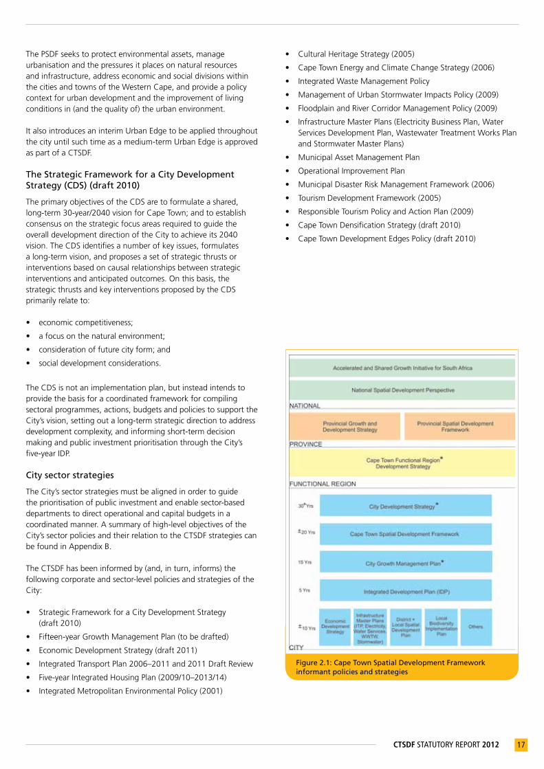
Figure 2.1: Cape Town Spatial Development Framework informant policies and strategies
The PSDF seeks to protect environmental assets, manage urbanisation and the pressures it places on natural resources and infrastructure, address economic and social divisions within the cities and towns of the Western Cape, and provide a policy context for urban development and the improvement of living conditions in (and the quality of) the urban environment.
It also introduces an interim Urban Edge to be applied throughout the city until such time as a medium-term Urban Edge is approved as part of a CTSDF.
The Strategic Framework for a City Development Strategy (CDS) (draft 2010)
The primary objectives of the CDS are to formulate a shared, long-term 30-year/2040 vision for Cape Town; and to establish consensus on the strategic focus areas required to guide the overall development direction of the City to achieve its 2040 vision. The CDS identifies a number of key issues, formulates a long-term vision, and proposes a set of strategic thrusts or interventions based on causal relationships between strategic interventions and anticipated outcomes. On this basis, the strategic thrusts and key interventions proposed by the CDS primarily relate to: • economic competitiveness;
• a focus on the natural environment;
• consideration of future city form; and
• social development considerations.
The CDS is not an implementation plan, but instead intends to provide the basis for a coordinated framework for compiling sectoral programmes, actions, budgets and policies to support the City’s vision, setting out a long-term strategic direction to address development complexity, and informing short-term decision making and public investment prioritisation through the City’s five-year IDP.
City sector strategies
The City’s sector strategies must be aligned in order to guide the prioritisation of public investment and enable sector-based departments to direct operational and capital budgets in a coordinated manner. A summary of high-level objectives of the City’s sector policies and their relation to the CTSDF strategies can be found in Appendix B.
The CTSDF has been informed by (and, in turn, informs) the following corporate and sector-level policies and strategies of the City:
• Strategic Framework for a City Development Strategy (draft 2010)
• Fifteen-year Growth Management Plan (to be drafted)
• Economic Development Strategy (draft 2011)
• Integrated Transport Plan 2006–2011 and 2011 Draft Review
• Five-year Integrated Housing Plan (2009/10–2013/14)
• Integrated Metropolitan Environmental Policy (2001)
• Cultural Heritage Strategy (2005)
• Cape Town Energy and Climate Change Strategy (2006)
• Integrated Waste Management Policy
• Management of Urban Stormwater Impacts Policy (2009)
• Floodplain and River Corridor Management Policy (2009)
• Infrastructure Master Plans (Electricity Business Plan, Water Services Development Plan, Wastewater Treatment Works Plan and Stormwater Master Plans)
• Municipal Asset Management Plan
• Operational Improvement Plan
• Municipal Disaster Risk Management Framework (2006)
• Tourism Development Framework (2005)
• Responsible Tourism Policy and Action Plan (2009)
• Cape Town Densification Strategy (draft 2010)
• Cape Town Development Edges Policy (draft 2010)

18 CTSDF STATUTORY REPORT 2012
3 DRIVERSOFURBANGROWTH
3.1 Key drivers of urban growth in Cape TownAs a fast-growing metropolitan area in South Africa, Cape Town is faced with a number of developmental challenges and trends, which inform the way the city grows and functions. These challenges and trends can be best understood by examining the key drivers of future growth and development in the city – urbanisation and economic growth – as well as the influences and constraints imposed by the natural environment. This section will examine these key drivers and constraints, the main trends underpinning each of them, and their implications for spatial forward planning. It should be noted that a shift in any of these implies a different future growth scenario. Therefore, the section concludes with various future growth scenarios based on changes in the key drivers behind growth, as well as their implications for spatial planning.
1 CityofCapeTown(2011)OverviewofDemographicandSocio-economicCharacteristicsofCapeTown,StrategicDevelopmentInformationandGISDepartment.
2 Ibid.3 Ibid.4 Dorrington,R(2005)ProjectionofthePopulationoftheCityofCapeTown2001–2021and
Dorrington,R(2000)ProjectionofthePopulationoftheCapeMetropolitanArea1996–2031.5 CityofCapeTown(2011)OverviewofDemographicandSocio-economicCharacteristicsof
CapeTown,StrategicDevelopmentInformationandGISDepartment.
Figure 3.1: Cape Town population trends and projections: 1996–20315
5 400
5 200
5 000
4 800
4 600
4 400
4 200
4 000
3 800
3 600
3 400
3 200
3 000
2 800
2 600
2 400
Dorrington 1999 - high Dorrington 1999 - medium Dorrington 2005 - high Dorrington 2005 - medium Population
1996 2000 2004 2008 2012 2016 2020 2024 2028 2032
POPU
LATI
ON
(th
ou
san
ds)
3.1.1 Urbanisation
Population growth
Cape Town is experiencing rapid urbanisation as a result of both natural growth and in-migration. The city’s population expanded by 36,4% between 1999 and 2007,1 and growth in 2010 was estimated at 3% per annum.2 Similar to other metropolitan cities in South Africa, it is expected that urbanisation will remain an important trend for a number of years. The city’s population is expected to continue to grow significantly each year, both from natural growth (although at a slower rate, with fertility levels declining) as well as from in-migration. The largest unknown variable in future growth projections is the nature and extent of in-migration, both internal and transnational. The estimated population for Cape Town in 2010 is 3,7 million;3 this could increase to close to five million people by 2030. Figure 3.1 illustrates different population growth scenarios as projected by the ‘Dorrington reports’.4
Urbanisation is a positive global phenomenon that allows for the development of productive, urban-based, modern economies, and is associated with sustained improvements in standards of living. However, it also brings challenges such as congestion, crime, informality and inadequate living conditions. It is thus important that the negative aspects of urbanisation are managed while the benefits of urban living (including greater economic, educational, health, social and cultural opportunities) are maximised and made accessible to all communities. If planned for and managed, urbanisation can contribute towards the building of an economically, environmentally and socially sustainable city.
19CTSDF STATUTORY REPORT 2012
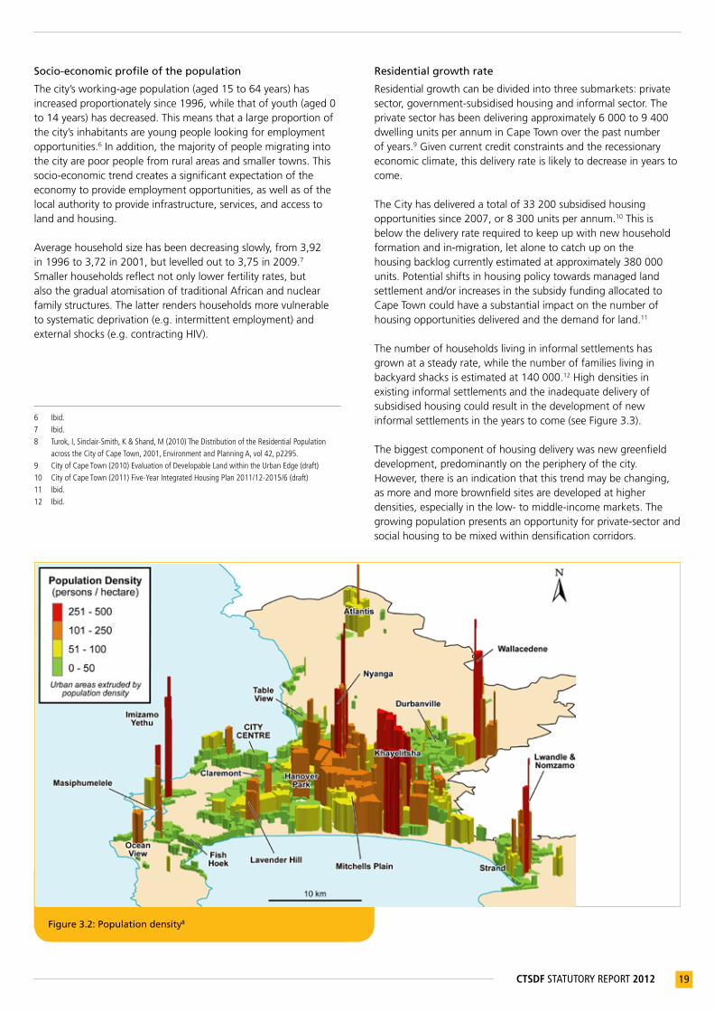
Figure 3.2: Population density8
Socio-economic profile of the population
The city’s working-age population (aged 15 to 64 years) has increased proportionately since 1996, while that of youth (aged 0 to 14 years) has decreased. This means that a large proportion of the city’s inhabitants are young people looking for employment opportunities.6 In addition, the majority of people migrating into the city are poor people from rural areas and smaller towns. This socio-economic trend creates a significant expectation of the economy to provide employment opportunities, as well as of the local authority to provide infrastructure, services, and access to land and housing.
Average household size has been decreasing slowly, from 3,92 in 1996 to 3,72 in 2001, but levelled out to 3,75 in 2009.7 Smaller households reflect not only lower fertility rates, but also the gradual atomisation of traditional African and nuclear family structures. The latter renders households more vulnerable to systematic deprivation (e.g. intermittent employment) and external shocks (e.g. contracting HIV).
6 Ibid.7 Ibid.8 Turok,I,Sinclair-Smith,K&Shand,M(2010)TheDistributionoftheResidentialPopulation
acrosstheCityofCapeTown,2001,EnvironmentandPlanningA,vol42,p2295.9 CityofCapeTown(2010)EvaluationofDevelopableLandwithintheUrbanEdge(draft)10 CityofCapeTown(2011)Five-YearIntegratedHousingPlan2011/12-2015/6(draft)11 Ibid.12 Ibid.
Residential growth rate
Residential growth can be divided into three submarkets: private sector, government-subsidised housing and informal sector. The private sector has been delivering approximately 6 000 to 9 400 dwelling units per annum in Cape Town over the past number of years.9 Given current credit constraints and the recessionary economic climate, this delivery rate is likely to decrease in years to come.
The City has delivered a total of 33 200 subsidised housing opportunities since 2007, or 8 300 units per annum.10 This is below the delivery rate required to keep up with new household formation and in-migration, let alone to catch up on the housing backlog currently estimated at approximately 380 000 units. Potential shifts in housing policy towards managed land settlement and/or increases in the subsidy funding allocated to Cape Town could have a substantial impact on the number of housing opportunities delivered and the demand for land.11
The number of households living in informal settlements has grown at a steady rate, while the number of families living in backyard shacks is estimated at 140 000.12 High densities in existing informal settlements and the inadequate delivery of subsidised housing could result in the development of new informal settlements in the years to come (see Figure 3.3).
The biggest component of housing delivery was new greenfield development, predominantly on the periphery of the city. However, there is an indication that this trend may be changing, as more and more brownfield sites are developed at higher densities, especially in the low- to middle-income markets. The growing population presents an opportunity for private-sector and social housing to be mixed within densification corridors.

20 CTSDF STATUTORY REPORT 2012
Location and form of past growth
The inequitable and inefficient city form of the former apartheid regime is still entrenched in Cape Town. Existing and past growth in Cape Town has been characterised by greenfield, medium- to higher-income residential developments located on the periphery of the city, for example Parklands, Kraaifontein, Somerset West and Strand (see Figure 3.4). This kind of development has happened without consideration to socio-economic integration or functionality. The densities associated with these developments remain too low to contribute to more efficient public transport and infrastructure provision.14
The highest concentrations of new subsidised housing have been in peripheral areas, such as Somerset West, Delft, Blue Downs, Macassar, Du Noon, Bloekombos, Wallacedene and Mitchells Plain. In the Metro Southeast (Khayelitsha, Mitchells Plain and surrounds), developments have largely focused on the upgrade and de-densification of informal settlements. Lower-income and subsidised-housing developments have been similarly mono-functional, and generally do not display the qualities of an integrated human settlement. Public facilities are unequally distributed throughout the city, with many areas characterised by an undersupply of social infrastructure.
Informal dwelling growth and the establishment of backyard dwellings occur largely in the Metro Southeast, as well as in areas where subsidised housing has been delivered.
13 CityofCapeTown(2010)EvaluationofDevelopableLandwithintheUrbanEdge(draft).14 CityofCapeTown(2010)DensificationPolicy(draft)15 CityofCapeTown(2010)16 RiskrelatingtotransportinfrastructurenotincludedinMap3.1
Figure 3.3: Existing informal dwellings in Cape Town, and different growth scenarios13
Low estimate High estimate
Medium estimate Informal dwelling counts
240 000
220 000
200 000
180 000
160 000
140 000
120 000
100 000
80 000
60 000
40 000
20 000
Jan
93
Jan
95
Jan
97
Jan
99
Jan
01
Jan
03
Jan
05
Jan
07
Jan
09
Jan
11
Jan
13
Jan
15
Jan
17
Jan
19
Jan
21
Figure 3.4: Location of new residential growth within Cape Town: 2002–200715
Infrastructure supply and maintenance
The provision of new infrastructure services to greenfield developments has taken place at the expense of the maintenance and upgrade of infrastructure services in existing urban areas.
The City has now reached a point at which it can no longer disregard the urgent need for infrastructure maintenance and upgrades in its older urban areas (see Map 3.1 indicating infrastructure16 risk areas). The High Risk Electricity and High Risk Wastewater categories are concentrated along a band stretching from the Cape Town central business district (CBD) to Bellville. This area is well serviced by rail. When the necessary service infrastructure upgrades are undertaken, this area will have a high development/land use intensification potential.

21CTSDF STATUTORY REPORT 2012
Jan
93
Jan
95
Jan
97
Jan
99
Jan
01
Jan
03
Jan
05
Jan
07
Jan
09
Jan
11
Jan
13
Jan
15
Jan
17
Jan
19
Jan
21
Map 3.1 Major infrastructure risk areas within development areas

22 CTSDF STATUTORY REPORT 2012
Availability of land
The spatial extent of the city has increased rapidly, by an estimated 650 hectares per annum,17 though there are signs of the rate of land consumption slowing. The current pattern of urban development will consume most of the land suited to urban development in the next 50 to 60 years, and agricultural and biodiversity resources will be threatened (see Figure 3.5). The City delimited an urban edge in order to phase and manage the development of land suitable to urban development over the medium to long term. Figure 3.6 illustrates that the amount of land beyond the existing urban edge is not significantly more than that inside the urban edge. This is based on estimates for land that is both suitable for and available for development. The availability of land and the rate of land consumption in the city, coupled with the projected population growth scenarios in Figure 3.1, illustrate the extent of the scarcity of land as a resource.
Another factor that limits land availability is the presence of hazardous land uses within the municipal area. The Koeberg Nuclear Power Station and the Cape Town International Airport, as well as a number of large landfill sites, consume a substantial amount of land; not only for their operation, but also in buffering areas where potentially hazardous land uses limit residential and other uses.
3.1.2 Natural and cultural environment and resource capacity
Biodiversity
Critical biodiversity areas, wetlands, watercourses and agricultural areas are being lost or degraded by uncontrolled urban encroachment and pollution, and need to be actively protected. The ecological goods and services they provide are being severely compromised. The growing demand for greenfield development places natural resources under threat, and contributes to the degradation of natural assets, many of which form the basis of the tourism economy and what makes Cape Town a desirable place to live. The loss of open space and surface connectivity between wetlands, rivers and the surrounding land has had a major impact on the biodiversity value and ecological functioning of freshwater ecosystems. The city also contains parts of the proclaimed Cape Floral Kingdom and two World Heritage sites.
Water supply
Cape Town shares its water sources with neighbouring towns as well as the agricultural sector. The recently completed Berg River Dam has increased the volume of water available to the region – however, it is estimated that it will only cater for the demand up to between 2016 and 2019. Water demand management is essential to ensure that existing resources are used efficiently and to delay the need for new water sources. Water from groundwater sources (especially the Table Mountain Group Aquifer, located to the east of the Cape Fold Mountains), water recycling, and sea water desalination are potential ways of accommodating future water demand.
Water and air quality
Cape Town’s rivers and coastal waters have deteriorated significantly during recent years, mainly due to increased human intervention and development pressure on or close to these resources. Increased urbanisation and a fast-growing population, many of whom are settling informally in close proximity to the city’s valuable natural assets, are contributing to the declining quality of water resources. At the same time, an ever-growing dependency on fossil fuels (especially by road-based transport) increases air pollution and the associated ‘brown haze’ phenomenon.
Climate change
While the increase in CO2 emissions is a global phenomenon, its
impacts are local and will vary across South Africa. An increase in the average annual temperature of at least 1 °C is expected by 2050, with the potential of a 3 to 5 °C increase by 2100.20 It is also anticipated that there will be an increase in the severity and frequency of natural events such as storms and flooding, as Cape Town’s rainfall patterns are likely to change. Current research suggests that there may be an increase in summer rain and thunderstorms within the city, followed by prolonged periods of drought.
17 CityofCapeTown(2010)EvaluationofDevelopableLandwithintheUrbanEdge(draft).18 Ibid.19 Ibid.20 ProvincialGovernmentoftheWesternCape(2008)WesternCapeClimateChangeResponse
StrategyandActionPlan.
Figure 3.5: City growth18
40 000
35 000
30 000
25 000
20 000
15 000
10 000
5 000
0
1860
1880
1900
1920
1940
1960
1980
2000
2020
NET
T H
ECTA
RES
18621900
1945
1977
19881993
19961998
20022005
2007
Figure 3.6: Developable land available in the Cape Town municipal area19
20 000
15 000
10 000
5 000
0
Inside the urban edge Outside the urban edge
LOW HIGH
NET
T H
ECTA
RES
23CTSDF STATUTORY REPORT 2012
The anticipated effect of sea-level rise as a consequence of climate change means that many areas throughout the city may become high flood-risk areas as a result of the increase in intensity of storm surges and river flooding. There are numerous instances of inappropriately located development, resulting in exposure to flood risks, as well as instances where the development itself has caused a change in the flood regime, either increasing river velocity or flood levels.
Though the nature, scale and time frames of climate change are unclear, other anticipated effects include:21
• an increase in conditions that promote wildfires (hotter, drier and windier conditions);
• reduced rainfall in the western portion of the Western Cape (resultant reduction in water supply);
• decreased soil moisture resulting from less rain and higher temperatures;
• temperature impacts on agricultural activities; and
• a possible increase in the presence of disease vectors (such as malaria) in areas that were previously relatively disease-vector-free.
In view of these anticipated effects of climate change, as well as the heavy rains and flooding experienced during the last five years, the City needs to plan for and prioritise Disaster Risk Management efficiently, in anticipation of these natural events.
Hydrological and hydraulic impacts
Through development and the associated hardening of surfaces (such as the paving of lawns and construction of carports), hydrological catchment areas are becoming increasingly impervious to water, resulting in increasing stormwater runoff and flood risks in certain catchment areas.
Energy supply and consumption
The demand for electricity provision increases at a faster rate than the population growth rate of the city, and, with limited supply, it becomes more expensive to sustain present and expected rates of consumption. In addition, electricity supply is largely reliant on unsustainable, resource-intensive and polluting fossil fuels.
Peak oil
The city is heavily reliant on private vehicles and fossil fuels and is thus highly vulnerable to increased energy prices associated with peak oil. The average ratio of private vehicle use to public transport is approximately 48:52.22
Road networks are becoming increasingly congested as the number of private vehicles grows exponentially and freight movement becomes more road-based. Public transport in Cape Town is characterised by its declining quality in terms of service infrastructure, reliability and frequency. Cape Town’s public transport services are financially unsustainable, mainly due to severe public financial constraints as well as a range of institutional problems relating to the provision of public transport, not least of which is the absence of capital investment in the rail network. There is also a lack of coordination between the different spheres of government regarding the different areas of
responsibility for capital funding of public transport; while the Integrated Rapid Transit (IRT) system will provide a trunk and feeder/distribution service controlled by the City, rail remains a national responsibility, and taxi and bus services are provincial responsibilities. The spatial form and structure of the city further constrains movement. The spatial fragmentation of Cape Town’s urban areas and low population densities do not create viable thresholds for the successful operation of an integrated public transport system. Furthermore, the radial development of public transport linkages has historically emphasised east-west movement, but fails to adequately recognise the more recent north-south movement patterns.
Food security
The loss of productive agricultural land to urban development threatens food security in the city. This, together with the risk posed by peak oil, further contributes to food insecurity, especially in light of the loss of well-located agricultural land closer to urban markets.
Heritage and cultural resources
The city’s multi-faceted history is threatened as more and more cultural and heritage resources come under pressure for redevelopment. Cultural, heritage and natural assets (such as Groot Constantia, Robben Island and Kirstenbosch Botanical Gardens) contribute to the city’s status as a popular tourist destination, and are important in terms of celebrating diverse cultures and creating a sense of belonging.
3.1.3 The economy
City within a region
The economy does not operate within municipal boundaries. Cape Town’s economy is interdependent with that of the province, and more specifically, the cities and towns that are within a 50 km radius of Cape Town. A territorial review conducted in 2008 by the OECD defines a broad area (including Saldanha, Malmesbury, Paarl, Stellenbosch and Hermanus) as the city’s functional region. Key regional economic interdependencies include a commuting labour force, shared consumer catchment area, transport infrastructure, and a second port located at Saldanha, as well as the agricultural and tourism areas surrounding the city.23
As the regional market is relatively small in global terms, linkages to national and international markets are important for city firms. These connections and the efficiency of the port, airport and other city logistics systems are thus critical for economic growth. External freight movement is dominated by land-based freight to and from Gauteng. Approximately ten times more freight enters or leaves the city along the N1 corridor than along the N2 or N7 corridors.
Key strategic regional infrastructure is located within the Cape
21 Ibid.22 CityofCapeTown(2010)IntegratedTransportPlan2006-2011.23 CityofCapeTown(2010)AnalysisoftheCapeTownSpatialEconomy(draft)

24 CTSDF STATUTORY REPORT 2012
Town Functional Region. The Cape Town Port is set to undergo a major expansion following many years of underinvestment. Its counterpart at Saldanha, which has the potential to be a catalyst for further large-scale industrial development, may need to develop in a way that complements Cape Town’s port in the longer term.
Other major regional infrastructure in Cape Town includes Cape Town International Airport (CTIA). As the airport becomes busier and expands its capacity, the demand it places on infrastructural land-side support systems is increasing, and its environmental health implications for surrounding land uses may become cause for concern. For these reasons, plans for further expansion of the airport on the existing site are being discussed with Airports Company South Africa (ACSA). The formulation of longer-term plans for the development of a system of airports in Cape Town is becoming essential.
Sector trends
The drivers of Cape Town’s space economy are not only individual industries and firms, but also the spatial concentrations of business relationships in industry clusters and the value chains that link these. In general, the city’s economy is shifting towards services and value-added manufacturing that is clean and can be accommodated in mixed-use areas. The location preferences of Cape Town’s economic subsectors can be summarised as follows:24
• Tourism and hospitality: Access to well-located accommodation, entertainment, natural amenities, cultural attractions, transport and visitor information services
• Business and financial services: Corporate offices, large warehouse structures, business process outsourcing
• Media, film and knowledge industries: Small office space and small workshop/design spaces, proximity/clustering, affinity groups
• Warehousing, distribution, freight logistics: Highway, major road and intermodal terminal access
• Trade (wholesale and retail): Transport/consumer access, market visibility, customer density and buying power
• Food and agro-processing: Proximity to agro-processing input and output markets and transport logistics
• Industrial/manufacturing: Ground-based, large, secure sites with good exposure and freight and client access (links to major road networks, parking, turning areas), in which clustering can occur
• Office: Flexible, secure, accessible, often stand-alone premises that are close to suburbs, clients and services
• Retail: Points of high accessibility, visibility and security, that facilitate agglomeration
The finance, insurance and business services sector is clustered in
the CBD and other large commercial centres, including Bellville/Tygervalley, Century City and Claremont/Newlands. The overall growth pattern is that of further concentration in these areas. Further analysis shows that insurance and financial services are mainly clustered in large centres, while the business services sector is more dispersed. The wholesale and retail sector is more concentrated in the northern suburbs, where incomes are relatively high. High-value residential development has also fuelled strong growth along the West Coast and in Somerset West. Small businesses, especially in the retail sector, have suffered from the dramatic growth in shopping malls; these have become more common, to the detriment of smaller retailers. Economic growth in the Metro Southeast has mainly been confined to the retail sector. Shopping malls have been developed in Gugulethu, Mitchells Plain, Khayelitsha and Athlone/Vanguard.
Manufacturing is shifting from central industrial areas to more peripheral areas, which offer cheaper land and less congestion. This shift is being driven by relocations as well as by new growth. Manufacturing is generally found to be declining in centrally located industrial areas, where it is being displaced by wholesale and retail as well as finance, insurance and business services sector activities.
A greater number of vacant industrial sites are available in peripheral locations. New industrial development has occurred primarily in more peripheral areas, such as Somerset West, Saxenburg Park (Blackheath), Killarney Gardens and Capricorn Park, while most central areas are now fully developed.25
The economy in space
24 CityofCapeTown(2010)CapeTownMedium&Long-termGrowthConcepts(draft)25 Ibid.26 CityofCapeTown(2011)CapeTown’sEconomy:ABriefOverview
Figure 3.7: Cape Town’s top value-adding sectors26
70
60
50
40
30
20
10
0
2000 2010
Man
ufa
ctu
rin
g
Trad
e &
h
osp
ital
ity
Fin
ance
&
bu
sin
ess
serv
ices
Co
mm
un
ity
serv
ices
&
go
vern
men
t
GR
OSS
VA
LUE
AD
DED
, C
ON
STA
NT
2005
PR
ICES
, R B
ILLI
ON
S

25CTSDF STATUTORY REPORT 2012
Figure 3.8: Distribution of economic activity, based on company turnover 27
27 CityofCapeTown(2010)AnalysisoftheCapeTownSpatialEconomy(draft)28 QuantecDatabase.
Cape Town has a functional and growing CBD. Although a large number of businesses relocated to suburban nodes, the CBD has since recovered, and currently attracts significant investment, having been bolstered by World Cup-related investment. The area has also benefited from an active Central City Improvement District partnership.
Cape Town’s CBD remains the city’s premier business, tourism and cultural centre, but is growing at a much slower rate than nodes such as Tygervalley and Century City. The Bellville CBD has been affected by the shift of A-grade office accommodation and high-end retail activity to Tygervalley. It remains the second most important concentration of service sector activities and public institutions (such as Home Affairs), although parts of it are in need of an upgrade. Despite large sums of government capital investment in infrastructure and facilities during the last two decades, private investors have continued to avoid the southeastern areas of the city, such as Philippi, Khayelitsha and Delft.
Cape Town has both nodal and linear elements to its spatial-economic structure. Linear elements or ‘urban corridors’ include Voortrekker Road, Durban Road in the Tygervalley area, and Main Road running through the southern suburbs. However, Figure 3.8 shows that the pattern of economic activity is more nodal than linear.
Informal economy
Formal urban areas are generally not supportive of the informal sector and small businesses. Formal residential and business areas are highly regulated, and provide few opportunities for the informal sector. Therefore, the informal sector is excluded from the main wealth of the city, and largely confined to the overtraded low-income areas. It is essential that the informal sector and small business are supported through innovative management practices.
Employment
Unemployment and the mismatch between available and needed skills remain the key economic challenges in the city. Population densities are highest in the metro southeast, where more than a third of the city’s population is concentrated (see Figure 3.2). This is the least economically developed part of the city, accounting for only a fraction of the total formal economy, and the area where most of the city’s poor live. Consequently, a large portion of the city’s workforce commute long distances to employment centres. This is highly inefficient and has substantial economic and social costs. This starkly unequal pattern has been reinforced in the post-apartheid era by rapid population growth and in-migration in the southeast, and is contributing to the widening gap between rich and poor in the city.
Formal employment is largely concentrated in a broad band between the Cape Town and Bellville CBDs. Other significant concentrations are in the southern suburbs and, to a lesser extent, along the West Coast. The manufacturing, construction, wholesale and retail, community and personal services sectors (including government) provide the most employment opportunities (see Figure 3.9). The informal sector employs 11% of the labour force, while employment in private households (including domestic workers) accounts for 7% of Cape Town jobs.
Figure 3.9: Employment by sector28
350 000
300 000
250 000
200 000
150 000
100 000
50 000
0
Manufacturing
Construction
Trade & hospitality
Finance & business services
Community services & general govt.
Official unemployment rate
2000 2007 2010%
UN
EMPL
OY
MEN
T
30%
25%
20%
15%
10%
5%
0%

26 CTSDF STATUTORY REPORT 2012
It is expected that a great proportion of unemployment will be absorbed by the small, medium and micro-enterprise (SMME) sector, and the City should therefore ensure that it supports the development of this sector.29
3.2 Spatial growth scenariosScenarios are creative devices used to shed light on the impact of today’s strategic decisions on future outcomes. Four possible scenarios for future growth in Cape Town have been developed, based on different population and economic growth rates (see Figure 3.10).
The city is presently positioned somewhere between the ‘high population growth and low economic growth’ and “low economic growth quadrants. Economic growth is relatively slow, and resources for accommodating population growth and in-migration are limited, resulting in increasing levels of informal development.
A ‘high economic growth’ scenario coupled with a low population growth rate will ensure that the city is well resourced. This scenario is also likely to result in smaller household sizes. ‘High economic and population growth’ is likely to result in urban sprawl if not actively managed.
Different scenarios will require different strategic choices and land use management decision making. In respect of the different scenarios, the current projections suggest that the population will continue to increase, which will result in an increasing demand for land and resources. No matter whether this situation is coupled with a fast or slow growing economy, it is essential that the city manages growth appropriately, prevents sprawl, and exploits opportunities created by economic growth appropriately.
29 CityofCapeTown(2010)AnalysisoftheCapeTownSpatialEconomy(draft)
Figure 3.10: City growth scenarios
High Economic Growth
High Economic and Population Growth
Low Economic Growth
High Population Growth and Low Economic Growth
ECONOMIC GROWTH
POPULATION GROWTH
MEDIUM/HIGHLOW
HIGH
Form
al D
evel
op
men
t
Informal Development
3.3 Implications for spatial planningThe interplay of the urban growth drivers reviewed in the preceding section has spatial implications for the way in which future spatial planning takes place in the city (see Map 3.2). The following section provides a summary of these implications for forward planning.
3.3.1 Urbanisation
Further urbanisation is inevitable, and it is critical that this anticipated growth is planned for in a sustainable way in order to maximise benefits for people, the environment and the economy. City policies should be pro-poor and accommodate newly urbanised communities and the urban poor. An approach accommodating new growth needs to ensure a city dynamic that is resilient and can adapt to changing local and global circumstances.
Cape Town remains characterised by social exclusion, and needs to integrate different income levels and create environments that provide a greater mix of land uses. The City must therefore promote integrated settlement patterns in existing and new residential areas to accommodate Cape Town’s growing population and to redress social and land use fragmentation.
Recognising that informal development will remain part of Cape Town’s urban fabric for the foreseeable future, the City must find ways of accommodating formal and informal development processes in a creative and positive way.Given the legacy of apartheid, the transformation of townships and informal settlements into integrated residential neighbourhoods will not take place without a well-formulated plan of action supported by public investment. The City must therefore prioritise incrementally improving the living conditions and sense of citizenship of the most marginalised residents of Cape Town, the homeless and the poorly housed.
The availability and accessibility of basic services, social facilities and public open spaces to everyone form the cornerstone of an inclusive city. The City needs to promote equal opportunities, improve the quality of living environments, and reduce crime.
3.3.2 The economy
A lack of employment-generating opportunities, specifically in areas with large population concentrations, remains the key challenge to the city’s economically active population. In order to address inequalities, the City must promote inclusive, shared economic growth and development, support the informal economy, and improve people’s access to economic opportunities and urban amenities. The City must direct public investment towards and encourage private investment in marginalised areas, and focus on improving public transport systems.
The City must ensure that it remains competitive, and capitalises on existing and developing sectoral comparative advantages. Spatial planning will have a limited impact on economic growth and development, unless the key drivers of growth are understood and land and infrastructure are made available to guide and support economic investment as well as to facilitate specialisation in desirable city locations.

27CTSDF STATUTORY REPORT 2012
The City must adopt an integrated approach to land use planning, economic development and transport operations. It must align public transport service provision with a logical spatial structure, which is supportive of land use intensification and a concentration of economic and employment-generating land uses.
The integration of land use and transport planning must be promoted, with one of the objectives being the identification and formation of activity nodes of varying intensities within rail and other transport corridors.
The development of regional infrastructure is critical in order to sustain the economy and enhance logistics and freight distribution. The City must therefore support the rationalisation, upgrade and development of port systems, airports and freight movement.
There is an urgent need for expansion and improvement of rail infrastructure in light of increased transport costs resulting from peak oil and its benefits in terms of reduced impact on road networks.
3.3.3 The natural environment
It is important that all forward spatial planning initiatives recognise that Cape Town’s natural environment and the uniqueness and amenity that it offers are critical components of the city’s competitive advantage and its service sector-based economy. The protection of the city’s natural environment is therefore not purely a conservation effort, but also a way of ensuring continued investment in the city.
To put Cape Town on a more sustainable growth path, the impacts of urban development on biodiversity and the city’s natural and ecological services must be managed. New urban development should be directed towards locations where its impact on critical biodiversity areas, water bodies and agricultural areas will be minimised. The value of maintaining well-functioning ecological systems must be recognised. In order to reduce the City’s unsustainable rate of land consumption, a more compact and efficient form of urban development must be promoted.
The City must contain Cape Town’s development footprint in order to protect natural, rural and heritage assets with development edges, and promote densification in appropriate locations, in order to encourage more sustainable use of resources, improve economies of scale, and increase thresholds required for public transport.
The development of areas suited for urban development must be facilitated in order to avoid development in hazardous areas.
The planning of new development areas in Cape Town should be informed by existing infrastructure capacity, as well as by the City’s infrastructure planning.
3.4 Identifying spatial structuring elements
From the abovementioned conclusions it becomes clear that the City will need to identify a long-term metropolitan spatial structure within which it can formulate strategies and interventions to achieve a desired city form and function. Based on the analysis of key drivers of growth in Cape Town and their spatial implications, the following are considered to be the spatial structuring elements from which to plan a more sustainable city:
• Adopting an approach to urban growth that promotes a city that is resilient and adaptive;
• Recognising that the City functions within a broader region;
• Protecting natural assets and biological diversity;
• Planning for a multidirectional accessibility grid that facilitates more equitable access to urban economic opportunities;
• Identifying areas of land use intensification that encourage the concentration of economic activities in more accessible locations;
• Putting in place urban growth informants that will manage the city’s growth and form in a more sustainable and beneficial way; and
• Protecting and enhancing the city’s collection of unique cultural landscapes and recreational assets, which face intense development pressure. These assets include major tourist destinations and some of the most sought-after environments in the country.

28 CTSDF STATUTORY REPORT 2012
Map 3.2 Spatial implications of urban growth drivers and trends

29CTSDF STATUTORY REPORT 2012
4 LONG-TERMMETROPOLITANSPATIALSTRUCTURE
The long-term metropolitan spatial structure envisioned for Cape Town is based on a system of interrelated structuring elements that have been developed to provide overall direction to the future spatial form, structure and development of the city. The identification and active promotion of structuring elements is fundamental to the implementation of Cape Town’s 2040 vision and spatial development goals.
4.1 Resilience and adaptability In the long term, Cape Town’s sustainability and prosperity will be determined by the city’s ability to respond to change – rapid urbanisation, contrasting wealth and poverty, high unemployment, infrastructure and service backlogs, resource scarcity, depleting oil reserves, energy and water supply constraints, and climate change. The spatial organisation of Cape Town will therefore need to be resilient and adaptable, and the City will constantly have to balance competing agendas for the provision of basic needs, social services and utilities against the stimulation of economic development and employment, the management of city growth, and the protection of environmental resources and systems.
New growth must be directed towards appropriate locations, and the spatial structure of the city must be flexible so as to adapt appropriately to market trends, such as shifts in the demand for industrial, commercial and residential property. Conversely, the market must be incentivised to respond to the spatial structuring elements and policy directives identified by the CTSDF. To maximise gains, while strategically protecting natural resources, this symbiotic relationship will need to be mutually beneficial. The City must therefore be simultaneously proactive and precautionary in the way it prepares for change and manages competing land use demands.
4.2 A city within a regionCape Town should not become a sprawling conurbation that absorbs all the surrounding towns in its growth path in an unplanned and uncoordinated manner. It is important to understand that the future of Cape Town and the futures of its neighbours are interdependent. The diverse identities, functions and growth opportunities of the towns and rural settlements surrounding Cape Town (such as Stellenbosch, Malmesbury, Klapmuts and Paarl) must be preserved and their functional interrelationships recognised, respected and enhanced (Figure 4.1 conceptually indicates the functional interrelationships between Cape Town and its surrounding towns).
Coordinated planning, budgeting and management of the region’s infrastructural development and water, energy and biodiversity resources are critical. In addition, greater coordination is required to enhance the region’s tourism assets, cultural and natural character, and the economic positioning of the cities and towns in relation to each other as well as collectively, within a provincial, national and global context.
Figure 4.1: A city within a region
Figure 4.2: Conceptual representation of Cape Town’s natural assets
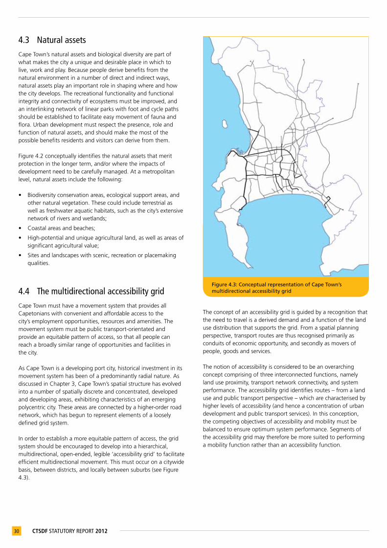
30 CTSDF STATUTORY REPORT 2012
4.3 Natural assetsCape Town’s natural assets and biological diversity are part of what makes the city a unique and desirable place in which to live, work and play. Because people derive benefits from the natural environment in a number of direct and indirect ways, natural assets play an important role in shaping where and how the city develops. The recreational functionality and functional integrity and connectivity of ecosystems must be improved, and an interlinking network of linear parks with foot and cycle paths should be established to facilitate easy movement of fauna and flora. Urban development must respect the presence, role and function of natural assets, and should make the most of the possible benefits residents and visitors can derive from them.
Figure 4.2 conceptually identifies the natural assets that merit protection in the longer term, and/or where the impacts of development need to be carefully managed. At a metropolitan level, natural assets include the following:
• Biodiversity conservation areas, ecological support areas, and other natural vegetation. These could include terrestrial as well as freshwater aquatic habitats, such as the city’s extensive network of rivers and wetlands;
• Coastal areas and beaches;
• High-potential and unique agricultural land, as well as areas of significant agricultural value;
• Sites and landscapes with scenic, recreation or placemaking qualities.
4.4 The multidirectional accessibility gridCape Town must have a movement system that provides all Capetonians with convenient and affordable access to the city’s employment opportunities, resources and amenities. The movement system must be public transport-orientated and provide an equitable pattern of access, so that all people can reach a broadly similar range of opportunities and facilities in the city.
As Cape Town is a developing port city, historical investment in its movement system has been of a predominantly radial nature. As discussed in Chapter 3, Cape Town’s spatial structure has evolved into a number of spatially discrete and concentrated, developed and developing areas, exhibiting characteristics of an emerging polycentric city. These areas are connected by a higher-order road network, which has begun to represent elements of a loosely defined grid system.
In order to establish a more equitable pattern of access, the grid system should be encouraged to develop into a hierarchical, multidirectional, open-ended, legible ‘accessibility grid’ to facilitate efficient multidirectional movement. This must occur on a citywide basis, between districts, and locally between suburbs (see Figure 4.3).
The concept of an accessibility grid is guided by a recognition that the need to travel is a derived demand and a function of the land use distribution that supports the grid. From a spatial planning perspective, transport routes are thus recognised primarily as conduits of economic opportunity, and secondly as movers of people, goods and services.
The notion of accessibility is considered to be an overarching concept comprising of three interconnected functions, namely land use proximity, transport network connectivity, and system performance. The accessibility grid identifies routes – from a land use and public transport perspective – which are characterised by higher levels of accessibility (and hence a concentration of urban development and public transport services). In this conception, the competing objectives of accessibility and mobility must be balanced to ensure optimum system performance. Segments of the accessibility grid may therefore be more suited to performing a mobility function rather than an accessibility function.
Figure 4.3: Conceptual representation of Cape Town’s multidirectional accessibility grid
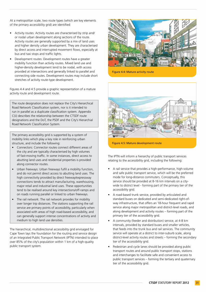
31CTSDF STATUTORY REPORT 2012
At a metropolitan scale, two route types (which are key elements of the primary accessibility grid) are identified:
• Activity routes: Activity routes are characterised by strip and/or nodal urban development along sections of the route. Activity routes are generally supported by a mix of land uses and higher density urban development. They are characterised by direct access and interrupted movement flows, especially at bus and taxi stops and traffic lights.
• Development routes: Development routes have a greater mobility function than activity routes. Mixed land use and higher-density development tend to be nodal, with access provided at intersections and generally linked to parallel and connecting side routes. Development routes may include short stretches of activity route-type development.
Figures 4.4 and 4.5 provide a graphic representation of a mature activity route and development route.
The route designation does not replace the City’s Hierarchical Road Network Classification system, nor is it intended to run in parallel as a duplicate classification system. Appendix C(ii) describes the relationship between the CTSDF route designations and the DoT, the PSDF and the City’s Hierarchial Road Network Classification System.
The primary accessibility grid is supported by a system of mobility links which play a key role in reinforcing urban structure, and include the following: • Connectors: Connector routes connect different areas of
the city and are typically characterised by high volumes of fast-moving traffic. In some instances, direct access to abutting land uses and residential properties is provided along connector routes.
• Urban freeways: Urban freeways fulfil a mobility function, and do not permit direct access to abutting land uses. The high connectivity provided by direct freeway/expressway connections tends to attract manufacturing, warehousing, major retail and industrial land uses. These opportunities tend to be realised around key intersections/off-ramps and on roads running parallel or linked to urban freeways.
• The rail network: The rail network provides for mobility over longer trip distances. The stations supporting the rail service are primary points of accessibility, particularly when associated with areas of high road-based accessibility, and can generally support intense concentrations of activity and medium to high land use densities.
The hierarchical, multidirectional accessibility grid envisaged for Cape Town lays the foundation for the routing and service design of an Integrated Public Transport Network (IPTN) intended to place over 85% of the city’s population within 1 km of a high-quality public transport system.
The IPTN will inform a hierarchy of public transport services relating to the accessibility grid, including the following:
• A rail service that provides a high-performance, high-volume and safe public transport service, which will be the preferred mode for long-distance commuters. Conceptually, this service should be provided at 8-16 km intervals on a city-wide to district level - forming part of the primary tier of the accessibility grid.
• A road-based trunk service, provided by articulated and standard buses on dedicated and semi-dedicated right-of-way infrastructure, that offers an 18-hour frequent and rapid service along major metropolitan and district-level roads, and along development and activity routes – forming part of the primary tier of the accessibility grid.
• A community (feeder and distribution) service, at 4-8 km intervals, provided by standard buses and smaller vehicles, that feeds into the trunk bus and rail services. The community service will operate at a district to inter-suburb scale, along district-level activity routes and streets – forming the secondary tier of the accessibility grid.
• Pedestrian and cycle lanes should be provided along public transport routes and around public transport stops, stations and interchanges to facilitate safe and convenient access to public transport services – forming the tertiary and quaternary tier of the accessibility grid.
Figure 4.5: Mature development route
Figure 4.4: Mature activity route
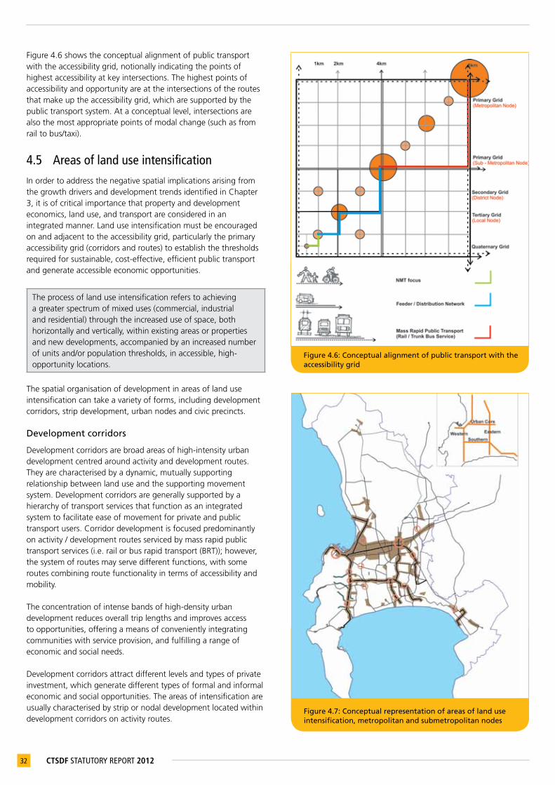
32 CTSDF STATUTORY REPORT 2012
Figure 4.6 shows the conceptual alignment of public transport with the accessibility grid, notionally indicating the points of highest accessibility at key intersections. The highest points of accessibility and opportunity are at the intersections of the routes that make up the accessibility grid, which are supported by the public transport system. At a conceptual level, intersections are also the most appropriate points of modal change (such as from rail to bus/taxi).
4.5 Areas of land use intensificationIn order to address the negative spatial implications arising from the growth drivers and development trends identified in Chapter 3, it is of critical importance that property and development economics, land use, and transport are considered in an integrated manner. Land use intensification must be encouraged on and adjacent to the accessibility grid, particularly the primary accessibility grid (corridors and routes) to establish the thresholds required for sustainable, cost-effective, efficient public transport and generate accessible economic opportunities.
The process of land use intensification refers to achieving a greater spectrum of mixed uses (commercial, industrial and residential) through the increased use of space, both horizontally and vertically, within existing areas or properties and new developments, accompanied by an increased number of units and/or population thresholds, in accessible, high-opportunity locations.
The spatial organisation of development in areas of land use intensification can take a variety of forms, including development corridors, strip development, urban nodes and civic precincts.
Development corridors
Development corridors are broad areas of high-intensity urban development centred around activity and development routes. They are characterised by a dynamic, mutually supporting relationship between land use and the supporting movement system. Development corridors are generally supported by a hierarchy of transport services that function as an integrated system to facilitate ease of movement for private and public transport users. Corridor development is focused predominantly on activity / development routes serviced by mass rapid public transport services (i.e. rail or bus rapid transport (BRT)); however, the system of routes may serve different functions, with some routes combining route functionality in terms of accessibility and mobility.
The concentration of intense bands of high-density urban development reduces overall trip lengths and improves access to opportunities, offering a means of conveniently integrating communities with service provision, and fulfilling a range of economic and social needs.
Development corridors attract different levels and types of private investment, which generate different types of formal and informal economic and social opportunities. The areas of intensification are usually characterised by strip or nodal development located within development corridors on activity routes.
Figure 4.6: Conceptual alignment of public transport with the accessibility grid
Figure 4.7: Conceptual representation of areas of land use intensification, metropolitan and submetropolitan nodes
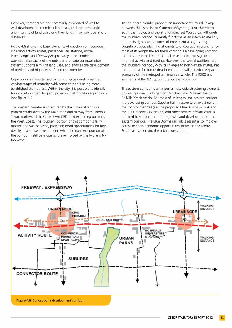
33CTSDF STATUTORY REPORT 2012
However, corridors are not necessarily comprised of wall-to-wall development and mixed land uses, and the form, scale and intensity of land use along their length may vary over short distances.
Figure 4.8 shows the basic elements of development corridors, including activity routes, passenger rail, stations, modal interchanges and freeways/expressways. The combined operational capacity of the public and private transportation system supports a mix of land uses, and enables the development of medium and high levels of land use intensity.
Cape Town is characterised by corridor-type development at varying stages of maturity, with some corridors being more established than others. Within the city, it is possible to identify four corridors of existing and potential metropolitan significance (see figure 4.7).
The western corridor is structured by the historical land use pattern established by the Main road and railway from Simon’s Town, northwards to Cape Town CBD, and extending up along the West Coast. The southern portion of this corridor is fairly mature and well serviced, providing good opportunities for high-density mixed-use development, while the northern portion of the corridor is still developing. It is reinforced by the M3 and N7 freeways.
Figure 4.8: Concept of a development corridor
The southern corridor provides an important structural linkage between the established Claremont/Wynberg area, the Metro Southeast sector, and the Strand/Somerset West area. Although the southern corridor currently functions as an intermediate link, it attracts significant volumes of movement along its length. Despite previous planning attempts to encourage investment, for most of its length the southern corridor is a developing corridor that has attracted limited ‘formal’ investment, but significant informal activity and trading. However, the spatial positioning of the southern corridor, with its linkages to north-south routes, has the potential for future development that will benefit the space economy of the metropolitan area as a whole. The R300 and segments of the N2 support the southern corridor.
The eastern corridor is an important citywide structuring element, providing a direct linkage from Mitchells Plain/Khayelitsha to Bellville/Kraaifontein. For most of its length, the eastern corridor is a developing corridor. Substantial infrastructural investment in the form of road/rail (i.e. the proposed Blue Downs rail link and the R300 freeway extension) and other service infrastructure is required to support the future growth and development of the eastern corridor. The Blue Downs rail link is essential to improve access to socio-economic opportunities between the Metro Southeast sector and the urban core corridor.

34 CTSDF STATUTORY REPORT 2012
The urban core corridor is the most accessible and mature corridor in the city. The urban core is concentrated along a broad band from Cape Town CBD to Bellville CBD, attracting a range of investment and development opportunities along its length, and accommodating a significant percentage of the city’s employment opportunities – with the potential to grow and intensify this role. Although Cape Town CBD and Bellville CBD exhibit different attraction levels, and movement between them is not of equal magnitude, these nodes play a pivotal role in the existing economic structure of the city and the development of the urban core area between them. The urban core is located in the physical centre of the municipal area, and therefore has the potential to balance the spatial distribution of economic activity, ‘integrating’ the southern and northern parts of the city. Figure 4.9 shows conceptually the urban core corridor in relation to the economic activity that it supports.
Strip development
Strip development generally comprises mixed uses (commercial, industrial and residential), and is often located along portions of activity routes/streets and development routes. Depending on the intensity of development, the width of the strip could range from half a street block to two or more blocks. The mix of activity along these strips may vary, with some areas having a stronger commercial/retail focus, while others may be characterised by dense residential development.
Urban nodes
Urban nodes are characterised by the intensity, mix and clustering of activities or land uses (including commercial and business development and associated employment opportunities and higher-order services) at points of maximum accessibility, exposure, convenience and urban opportunity.
Table 4.1: The alignment and hierarchy of the accessibility grid with areas of intensification.
ACCESSIBILITY GRID
SPANASSOCIATED NODAL DEVELOPMENT
SCALE OF OPERATION
AREAS OF LAND USE INTENSIFICATION
Primary 8-16kmMetropolitannode
Citywide
Corridor/stripdevelopment/urbannodes/civicprecinct
Primary 4-8kmSub-metropolitannode
Regional
Corridor/stripdevelopment/urbannodes/civicprecinct
Secondary 2-4km DistrictnodeInter-districtsignificance
Stripdevelopment/urbannodes/civicprecinct
Tertiary 1-2km Localnode Inter-suburbUsuallyurbannodes/civicprecinct
Quaternary 0,5-1kmNeighbourhoodcentre
Suburb Usuallynodal
Figure 4.9: The urban core corridor shown on Cape Town’s distribution of economic activity (based on 2005 Regional Service Council data indicating company turnover)31
31 CityofCapeTown(2010)AnalysisoftheCapeTownSpatialEconomy(Draft).
Urban nodes are identified as areas within the city suitable for further land use intensification, clustering and reinforcing economic land uses, public services and high-density residential development. The generative capacity of an urban node is generally a function of the mix of land uses that it supports and its position in the accessibility grid (see table 4.1). The role and function of urban nodes are differentiated in terms of scale (metropolitan, sub metropolitan, district, local) based upon its structural position within the accessibility grid and the intensity and mix of land use it supports.
Civic precincts
Social facilities and public institutions should be clustered in civic precincts, at points of highest accessibility (the intersections of the grid). The hierarchy of the civic precincts will be determined by the hierarchy of the accessibility grid (see Table 4.1). The civic precincts that are of citywide significance are generally located at the intersections of the primary grid, such as Bellville and Wynberg. The civic precinct should be a focus of public investment, and will create opportunities for private-sector investment in commercial, mixed-use and higher-density residential development. From a spatial structuring perspective, civic precincts will therefore be closely associated with urban nodes.

35CTSDF STATUTORY REPORT 2012
4.6 Urban growth management informantsThe spatial growth of the city will be managed through the use of development edges, and the identification of the future growth direction of the city. Two types of development edges will be used to manage urban development: the Urban Edge and the Coastal Edge.
The Urban Edge is a medium- to long-term edge line, where the line has been demarcated in such a position as to phase urban growth appropriately, or to protect natural resources. Spatial growth in the medium term (10–15 years) should be prioritised within the Urban Edge. In the longer term (15–50 years), the City will need to provide more undeveloped land for urban development, and the edge line will be adjusted on the basis of the city’s growth direction(s) (see figure 4.10).
The Coastal Edge has been established to avoid hazards and mitigate natural disasters, protect coastal resources and ecological processes, and maintain the coastline as a public amenity (see figure 4.11).
The growth directions indicate the location of large-scale future urban development opportunities. The identification of the north-eastern and north-western city growth directions is informed by the scale of land suitable for urban development within the municipal boundary, based on topography, biodiversity and natural resources, valuable agricultural areas, heritage sites, cultural features and significant landscapes (see figure 4.12).
Figure 4.10 Illustrates the urban edge concept Figure 4.11 Illustrates the coastal edge concept
Figure 4.12: Conceptual representation of Cape Town’s development edges and growth direction(s)

36 CTSDF STATUTORY REPORT 2012
Figure 4.13: Conceptual representation of Cape Town’s destination places
Figure 4.14: Durbanville winelands Figure 4.15: False Bay coastal node
4.7 Destination placesA destination place is a node, landmark or location that forms a significant point or area of attraction, and is part of the unique identity of Cape Town. High-order destinations are very well-known public places, while at a local level, destination places can include public spaces such as squares, parks and sports facilities.
Table 4.2: Types of destination places
DESTINATION PLACE EXAMPLESNature-based TableMountain,CapePoint,TygerbergHills,
Built/heritage-based KalkBayHarbour,Winelands,V&AWaterfront
Coastal-based Strandfontein,Tableview,Gordon’sBay
Specialculturallandscape Constantia,Durbanville,SomersetWest
A graphic illustration of some of the city’s destination places is provided in Figures 4.14 and 4.15.
4.8 Synthesis: Conceptual frameworkThe conceptual framework combines the structural elements discussed in this chapter and provides a long term (50 year) growth vision of the conceptual spatial structure for Cape Town (see Map 4.1). The conceptual framework is included for illustrative purposes, notionally indicating how the city will relate to its hinterland and surrounding system of towns. It is not considered possible to accurately forecast long-term growth and development patterns due to the high levels of uncertainty regarding the pace of growth and impacts of climate change, peak oil and potential resource scarcity. The city’s growth directions are therefore indicated notionally in the form of arrows.

37CTSDF STATUTORY REPORT 2012
Map 4.1: Conceptual development framework
38 CTSDF STATUTORY REPORT 2012
5 STRATEGIES,POLICYSTATEMENTSANDPOLICYGUIDELINES
The key strategies, together with the spatial structuring elements outlined in Chapter 4, will guide the preparation of sector plans, lower-order spatial plans, detailed policies, guidelines and implementation plans, and will be used to assess development applications. The policy guidelines will also be used by PGWC to assess appeals lodged in terms of section 44 of LUPO against decisions taken by the City. Property developers should therefore take the key strategies, policies and policy guidelines into account when submitting development applications, while public-sector decision-makers should be guided by them when considering such applications.
The key strategies are summarised below, followed by a detailed explanation of each of the substrategies and policies informing each key strategy.
As indicated in section 1.4 of this report, the statutory components of the CTSDF in terms of section 4(6) of LUPO and section 34 of MSA includethe following:
(1) Chapter 5: Strategies, Policy Statements and Policy Guidelines (see highlighted columns only);(2) Chapter 6: The Cape Town Spatial Development Framework and accompanying Map 6.1: The Cape Town SDF
A request for an amendment of the CTSDF will therefore only relate to cases in which the competent authority deems that there is a conflict between a development proposal and the statutory components of the CTSDF (refer points (1) and (2) above). The other maps, figures and text in the CTSDF are included for illustrative purposes, and are intended to broaden the general interpretation of the CTSDF and act as informants to the interpretation of the statutory components of the CTSDF. The preparation of spatial plans and the assessment of development applications must therefore be guided by due consideration of these informants when interpreting the statutory components of the CTSDF.
Until the CTSDF is updated, any relevant plans, policies and legislation that have been updated, replaced or superseded need to be considered to aid the interpretation of the CTSDF strategies, policies and policy guidelines.
This chapter establishes strategies, policy statements and policy guidelines that are intended to ensure that land use is managed consistently in line with the City’s 2040 vision and spatial goals, and contributes to the achievement of the long-term metropolitan spatial structure.
The following key strategies have been identified:
Key Strategy 1: Plan for employment, and improve access to economic opportunities
Key Strategy 2: Manage urban growth, and create a balance between urban development and environmental protection
Key Strategy 3: Build an inclusive, integrated, vibrant city
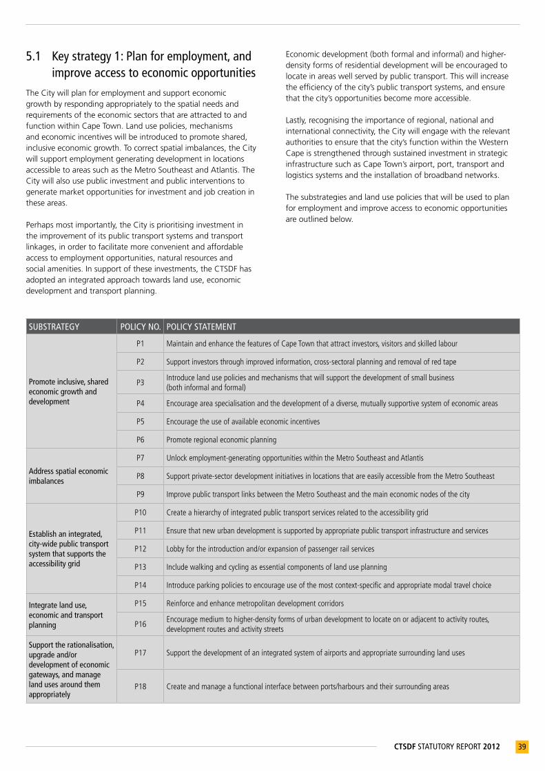
39CTSDF STATUTORY REPORT 2012
5.1 Key strategy 1: Plan for employment, and improve access to economic opportunities
The City will plan for employment and support economic growth by responding appropriately to the spatial needs and requirements of the economic sectors that are attracted to and function within Cape Town. Land use policies, mechanisms and economic incentives will be introduced to promote shared, inclusive economic growth. To correct spatial imbalances, the City will support employment generating development in locations accessible to areas such as the Metro Southeast and Atlantis. The City will also use public investment and public interventions to generate market opportunities for investment and job creation in these areas.
Perhaps most importantly, the City is prioritising investment in the improvement of its public transport systems and transport linkages, in order to facilitate more convenient and affordable access to employment opportunities, natural resources and social amenities. In support of these investments, the CTSDF has adopted an integrated approach towards land use, economic development and transport planning.
Economic development (both formal and informal) and higher-density forms of residential development will be encouraged to locate in areas well served by public transport. This will increase the efficiency of the city’s public transport systems, and ensure that the city’s opportunities become more accessible.
Lastly, recognising the importance of regional, national and international connectivity, the City will engage with the relevant authorities to ensure that the city’s function within the Western Cape is strengthened through sustained investment in strategic infrastructure such as Cape Town’s airport, port, transport and logistics systems and the installation of broadband networks.
The substrategies and land use policies that will be used to plan for employment and improve access to economic opportunities are outlined below.
SUBSTRATEGY POLICY NO. POLICY STATEMENT
Promote inclusive, shared economic growth and development
P1 MaintainandenhancethefeaturesofCapeTownthatattractinvestors,visitorsandskilledlabour
P2 Supportinvestorsthroughimprovedinformation,cross-sectoralplanningandremovalofredtape
P3Introducelandusepoliciesandmechanismsthatwillsupportthedevelopmentofsmallbusiness(bothinformalandformal)
P4 Encourageareaspecialisationandthedevelopmentofadiverse,mutuallysupportivesystemofeconomicareas
P5 Encouragetheuseofavailableeconomicincentives
P6 Promoteregionaleconomicplanning
Address spatial economic imbalances
P7 Unlockemployment-generatingopportunitieswithintheMetroSoutheastandAtlantis
P8 Supportprivate-sectordevelopmentinitiativesinlocationsthatareeasilyaccessiblefromtheMetroSoutheast
P9 ImprovepublictransportlinksbetweentheMetroSoutheastandthemaineconomicnodesofthecity
Establish an integrated, city-wide public transport system that supports the accessibility grid
P10 Createahierarchyofintegratedpublictransportservicesrelatedtotheaccessibilitygrid
P11 Ensurethatnewurbandevelopmentissupportedbyappropriatepublictransportinfrastructureandservices
P12 Lobbyfortheintroductionand/orexpansionofpassengerrailservices
P13 Includewalkingandcyclingasessentialcomponentsoflanduseplanning
P14 Introduceparkingpoliciestoencourageuseofthemostcontext-specificandappropriatemodaltravelchoice
Integrate land use, economic and transport planning
P15 Reinforceandenhancemetropolitandevelopmentcorridors
P16Encouragemediumtohigher-densityformsofurbandevelopmenttolocateonoradjacenttoactivityroutes,developmentroutesandactivitystreets
Support the rationalisation, upgrade and/or development of economic gateways, and manage land uses around them appropriately
P17 Supportthedevelopmentofanintegratedsystemofairportsandappropriatesurroundinglanduses
P18 Createandmanageafunctionalinterfacebetweenports/harboursandtheirsurroundingareas

Note:Thedateofendorsement/approvalofCitypolicieshasbeenusedratherthanthedateoftheirproduction,andlegislationandpoliciesreferredtointheCTSDFwillbesupersededbyfuturerevisionsandupdates.
40 CTSDF STATUTORY REPORT 2012
5.1.1 Promote inclusive, shared economic growth and development
PROMOTE INCLUSIVE, SHARED ECONOMIC GROWTH AND DEVELOPMENTPOLICY STATEMENT WHAT THIS MEANS/REQUIRES POLICY GUIDELINES RELATED LEGIS. / POLICIES
Policy 1
Maintain and enhance the features of Cape Town that attract investors, visitors and skilled labour
SupportthepositioningofCapeTownasaglobalinnovationandcreativitycentre,andtheeconomicvisionascontainedintheCity’sEconomicDevelopmentStrategy. CapeTown’slandusemanagementpracticesshouldensurethatthecity’sinherenteconomicopportunitiesareprotectedandenhanced(i.e.thescenicbeautyandattractivebuiltandnaturalenvironmentofthecity). Inaddition,theCityshouldensurethatstrategiceconomicinfrastructureisinplace;touristattractionsareprotectedandenhanced,andthatthedevelopmentof,andsynergybetween,high-qualityschools,universitiesandotherinstitutionsofhigherlearningareappropriatelysupported.
P1.1 ProtectandenhanceCapeTown’sscenicbeauty,coastline,biologicaldiversityandothernaturalassets.
P1.2 ProtectandenhanceCapeTown’sheritage,culturalandtourismassets.
• NationalEnvironmentalManagementAct(No107of1998)
• NationalEnvironmentalManagement:BiodiversityAct(No10of2004)
• NationalHeritageResourcesAct(No25of1999)
• City’sEconomicDevelopmentStrategy(draft2011)
• City’sCulturalHeritageStrategy(2005)
• City’sTourismDevelopmentFramework(2005)
• City’sIntegratedMetropolitanEnvironmentalPolicy(2001)
Policy 2
Support investors through improved information, cross-sectoral planning and removal of red tape
TheCitywillfacilitateprivateinvestmentby:• providingimprovedstrategicinformationand
planning;• establishingpartnershipswiththeprivatesector
andothereconomicagencies;• proactivelysupportingthedevelopmentof
prioritisedeconomicareas;and• supportingtheroll-outofbroadbandtechnology
andpromotingtheuseofthistechnology.
Specific action(s)• PrepareandregularlyupdateanEconomicAreas
Plan(EAPlan)(seeTable5.1).• Streamlinelanduseplanningprocesses,
includingintegrationwithenvironmentalandheritageprocesses/improvesupportandadvicerelatedtoland-usemanagementpoliciesandprocessingof/proceduresfordevelopmentapplications.
• City’sEconomicAreasPlan(tobeprepared)
• City’sEconomicDevelopmentStrategy(draft2011)
Policy3Introducelandusepoliciesandmechanismsthatwillsupportthedevelopmentofsmallbusinesses(bothinformalandformal)
TheCitywillsupportthedevelopmentofsmallbusinesses(bothformalandinformal)by:• introducingappropriatelandusemanagement
policiesandmechanisms;• developingpolicyanddesignguidelinesfor
largecommercialdevelopmentsthatsupportthedevelopmentofsmallbusinesses;
• ensuringthatsufficient,well-locatedandappropriatelydesignedformalandinformaltradingfacilitiesareprovidedinformaleconomicareasaswellasothersuitablepublicassemblypoints,suchastransportinterchanges,publicspaces,parkingareasandroadreserves(whereappropriate);and
• ensuringtheavailabilityofanappropriaterangeofwell-pricedCity-ownedland(throughleaseorsale)forinformalandsmallbusinessuse.
P3.1 Encouragelargecommercialdevelopmentsto:• makeprovisionfortradingspaces
forsmallbusinesses(formalandinformal);
• consideramixedpackageoflanduserightstoleveragetheprovisionofinformaltradingspaceandfacilitiesinprivatedevelopments;and
• establishafunctionalandaccessible,pedestrian-friendlyinterfacebetweenformalandinformalactivities.
P3.2 Localplansandurbanupgradinginitiativesincommercialareasshouldbeencouragedtoaccommodatetheneedsoftheinformalsectori.e.throughappropriateurbandesign.
• City’sEconomicDevelopmentStrategy(draft2011)
• City’sInformalTradingPolicyandManagementFramework(2004)
• City’sInformalTradingBylaw(2009)
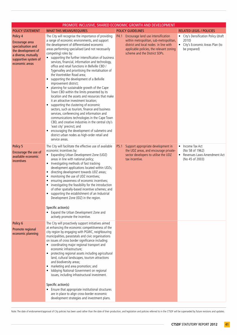
Note:Thedateofendorsement/approvalofCitypolicieshasbeenusedratherthanthedateoftheirproduction,andlegislationandpoliciesreferredtointheCTSDFwillbesupersededbyfuturerevisionsandupdates.
41CTSDF STATUTORY REPORT 2012
PROMOTE INCLUSIVE, SHARED ECONOMIC GROWTH AND DEVELOPMENTPOLICY STATEMENT WHAT THIS MEANS/REQUIRES POLICY GUIDELINES RELATED LEGIS. / POLICIES
Policy 4
Encourage area specialisation and the development of a diverse, mutually supportive system of economic areas
TheCitywillrecognisetheimportanceofprovidingarangeofeconomicenvironments,andsupportthedevelopmentofdifferentiatedeconomicareasperformingspecialised(andnotnecessarilycompeting)rolesby:• supportingthefurtherintensificationofbusiness
services,financial,informationandtechnology,officeandretailfunctionsinBellvilleCBD/TygervalleyandprioritisingtherevitalisationoftheVoortrekkerRoadarea;
• supportingthedevelopmentofaBellvilleimprovementdistrict;
• planningforsustainablegrowthoftheCapeTownCBDwithinthelimitspresentedbyitslocationandtheassetsandresourcesthatmakeitanattractiveinvestmentlocation;
• supportingtheclusteringofeconomicsectors,suchastourism,financeandbusinessservices,conferencingandinformationandcommunicationstechnologiesintheCapeTownCBD,andcreativeindustriesinthecentralcity’s‘eastcity’precinct;and
• encouragingthedevelopmentofsubmetroanddistricturbannodesashigh-orderretailandserviceareas.
P4.1 Encouragelanduseintensificationwithinmetropolitan,sub-metropolitan,districtandlocalnodesinlinewithapplicablepolicies,therelevantzoningschemeandtheDistrictSDPs.
• City’sDensificationPolicy(draft2010)
• City’sEconomicAreasPlan(tobeprepared)
Policy 5
Encourage the use of available economic incentives
TheCitywillfacilitatetheeffectiveuseofavailableeconomicincentivesby:• ExpandingUrbanDevelopmentZone(UDZ)
areasinlinewithnationalpolicy;• Investigatingmethodsoffasttracking
developmentapplicationslocatedwithinUDZs;• directingdevelopmenttowardsUDZareas;• monitoringtheuseofUDZincentives;• ensuringawarenessofeconomicincentives;• investigatingthefeasibilityfortheintroduction
ofotherspatially-basedincentiveschemes;and• supportingtheestablishmentofanIndustrial
DevelopmentZone(IDZ)intheregion.
Specific action(s)• ExpandtheUrbanDevelopmentZoneand
activelypromotetheincentive.
P5.1 SupportappropriatedevelopmentintheUDZareas,andencourageprivate-sectordeveloperstoutilisetheUDZtaxincentive.
• IncomeTaxAct(No58of1962)
• RevenuesLawsAmendmentAct(No45of2003)
Policy 6
Promote regional economic planning
TheCitywillproactivelysupportinitiativesaimedatenhancingtheeconomiccompetitivenessofthecityregionbyengagingwithPGWC,neighbouringmunicipalities,parastatalsandcivicorganisationsonissuesofcrossbordersignificanceincluding:• coordinatingmajorregionaltransportand
economicinfrastructure;• protectingregionalassetsincludingagricultural
land,culturallandscapes,tourismattractionsandbiodiversityareas;
• marketingandareapromotion;and• lobbyingNationalGovernmentonregional
issues,includinginfrastructuralinvestment.
Specific action(s)• Ensurethatappropriateinstitutionalstructures
areinplacetoaligncross-bordereconomicdevelopmentstrategiesandinvestmentplans.
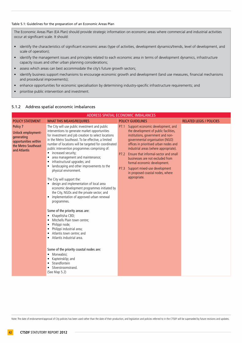
Note:Thedateofendorsement/approvalofCitypolicieshasbeenusedratherthanthedateoftheirproduction,andlegislationandpoliciesreferredtointheCTSDFwillbesupersededbyfuturerevisionsandupdates.
42 CTSDF STATUTORY REPORT 2012
Table 5.1: Guidelines for the preparation of an Economic Areas Plan
The Economic Areas Plan (EA Plan) should provide strategic information on economic areas where commercial and industrial activities occur at significant scale. It should:
• identify the characteristics of significant economic areas (type of activities, development dynamics/trends, level of development, and scale of operation);
• identify the management issues and principles related to each economic area in terms of development dynamics, infrastructure capacity issues and other urban planning considerations;
• assess which areas can best accommodate the city’s future growth sectors;
• identify business support mechanisms to encourage economic growth and development (land use measures, financial mechanisms and procedural improvements);
• enhance opportunities for economic specialisation by determining industry-specific infrastructure requirements; and
• prioritise public intervention and investment.
5.1.2 Address spatial economic imbalances
ADDRESS SPATIAL ECONOMIC IMBALANCESPOLICY STATEMENT WHAT THIS MEANS/REQUIRES POLICY GUIDELINES RELATED LEGIS. / POLICIES
Policy 7
Unlock employment-generating opportunities within the Metro Southeast and Atlantis
TheCitywillusepublicinvestmentandpublicinterventionstogeneratemarketopportunitiesforinvestmentandjobcreationtoselectlocationsintheMetroSoutheast.Tobeeffective,alimitednumberoflocationswillbetargetedforcoordinatedpublicinterventionprogrammescomprisingof:• increasedsecurity;• areamanagementandmaintenance;• infrastructuralupgrades;and• landscapingandotherimprovementstothe
physicalenvironment. TheCitywillsupportthe:• designandimplementationoflocalarea
economicdevelopmentprogrammesinitiatedbytheCity,NGOsandtheprivatesector;and
• implementationofapprovedurbanrenewalprogrammes.
P7.1 Supporteconomicdevelopment,andthedevelopmentofpublicfacilities,institutions,governmentandnon-governmentalorganisation(NGO)officesinprioritisedurbannodesandindustrialareas(whereappropriate).
P7.2 Ensurethatinformal-sectorandsmallbusinessesarenotexcludedfromformaleconomicdevelopment.
P7.3 Supportmixed-usedevelopmentinproposedcoastalnodes,whereappropriate.
Some of the priority areas are:• KhayelitshaCBD;• MitchellsPlaintowncentre;• Philippinode;• Philippiindustrialarea;• Atlantistowncentre;and• Atlantisindustrialarea.
Some of the priority coastal nodes are:• Monwabisi;• Kapteinsklip;and• Strandfontein• Silverstroomstrand.(SeeMap5.2)
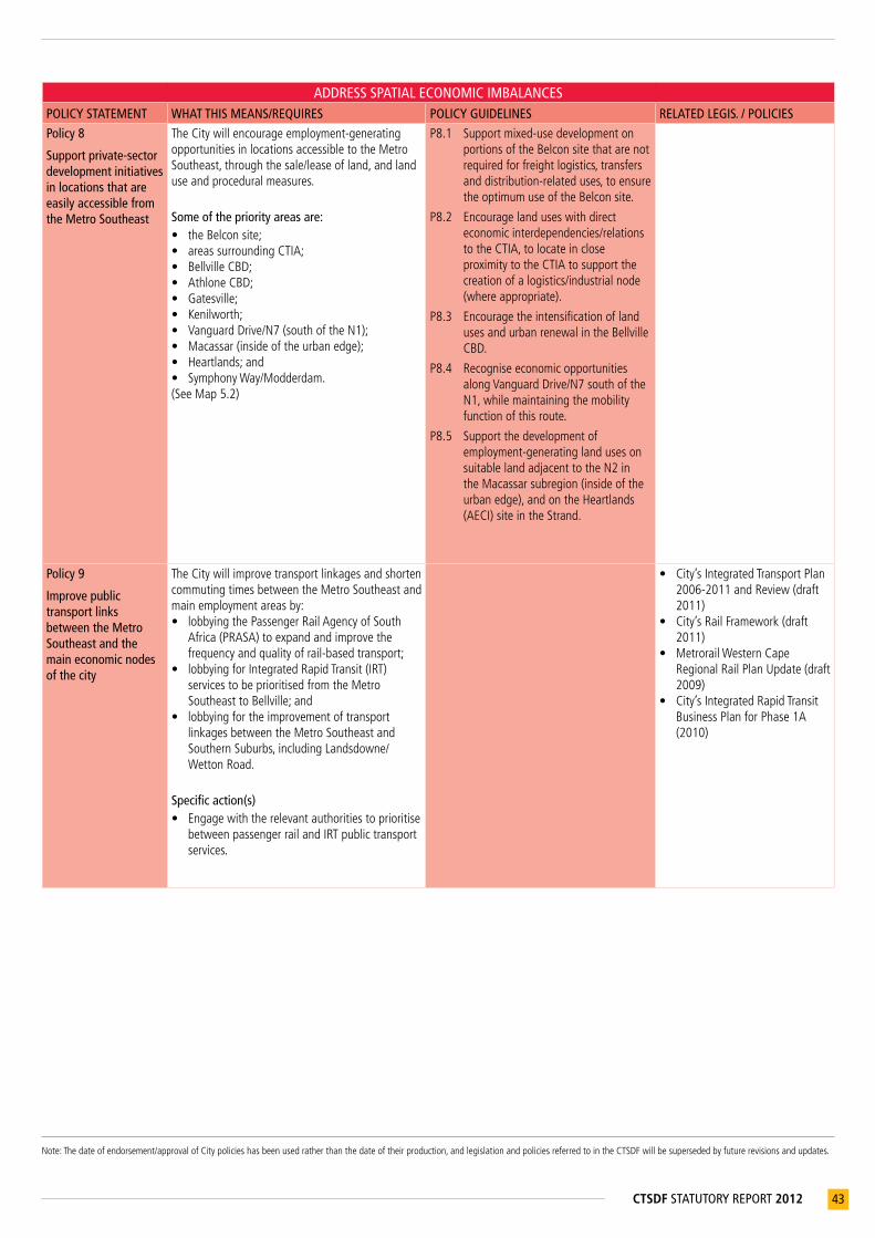
Note:Thedateofendorsement/approvalofCitypolicieshasbeenusedratherthanthedateoftheirproduction,andlegislationandpoliciesreferredtointheCTSDFwillbesupersededbyfuturerevisionsandupdates.
43CTSDF STATUTORY REPORT 2012
ADDRESS SPATIAL ECONOMIC IMBALANCESPOLICY STATEMENT WHAT THIS MEANS/REQUIRES POLICY GUIDELINES RELATED LEGIS. / POLICIES
Policy 8
Support private-sector development initiatives in locations that are easily accessible from the Metro Southeast
TheCitywillencourageemployment-generatingopportunitiesinlocationsaccessibletotheMetroSoutheast,throughthesale/leaseofland,andlanduseandproceduralmeasures.
Some of the priority areas are:• theBelconsite;• areassurroundingCTIA;• BellvilleCBD;• AthloneCBD;• Gatesville;• Kenilworth;• VanguardDrive/N7(southoftheN1);• Macassar(insideoftheurbanedge);• Heartlands;and• SymphonyWay/Modderdam.(SeeMap5.2)
P8.1 Supportmixed-usedevelopmentonportionsoftheBelconsitethatarenotrequiredforfreightlogistics,transfersanddistribution-relateduses,toensuretheoptimumuseoftheBelconsite.
P8.2 Encouragelanduseswithdirecteconomicinterdependencies/relationstotheCTIA,tolocateincloseproximitytotheCTIAtosupportthecreationofalogistics/industrialnode(whereappropriate).
P8.3 EncouragetheintensificationoflandusesandurbanrenewalintheBellvilleCBD.
P8.4 RecogniseeconomicopportunitiesalongVanguardDrive/N7southoftheN1,whilemaintainingthemobilityfunctionofthisroute.
P8.5 Supportthedevelopmentofemployment-generatinglandusesonsuitablelandadjacenttotheN2intheMacassarsubregion(insideoftheurbanedge),andontheHeartlands(AECI)siteintheStrand.
Policy 9
Improve public transport links between the Metro Southeast and the main economic nodes of the city
TheCitywillimprovetransportlinkagesandshortencommutingtimesbetweentheMetroSoutheastandmainemploymentareasby:• lobbyingthePassengerRailAgencyofSouth
Africa(PRASA)toexpandandimprovethefrequencyandqualityofrail-basedtransport;
• lobbyingforIntegratedRapidTransit(IRT)servicestobeprioritisedfromtheMetroSoutheasttoBellville;and
• lobbyingfortheimprovementoftransportlinkagesbetweentheMetroSoutheastandSouthernSuburbs,includingLandsdowne/WettonRoad.
Specific action(s)• Engagewiththerelevantauthoritiestoprioritise
betweenpassengerrailandIRTpublictransportservices.
• City’sIntegratedTransportPlan2006-2011andReview(draft2011)
• City’sRailFramework(draft2011)
• MetrorailWesternCapeRegionalRailPlanUpdate(draft2009)
• City’sIntegratedRapidTransitBusinessPlanforPhase1A(2010)
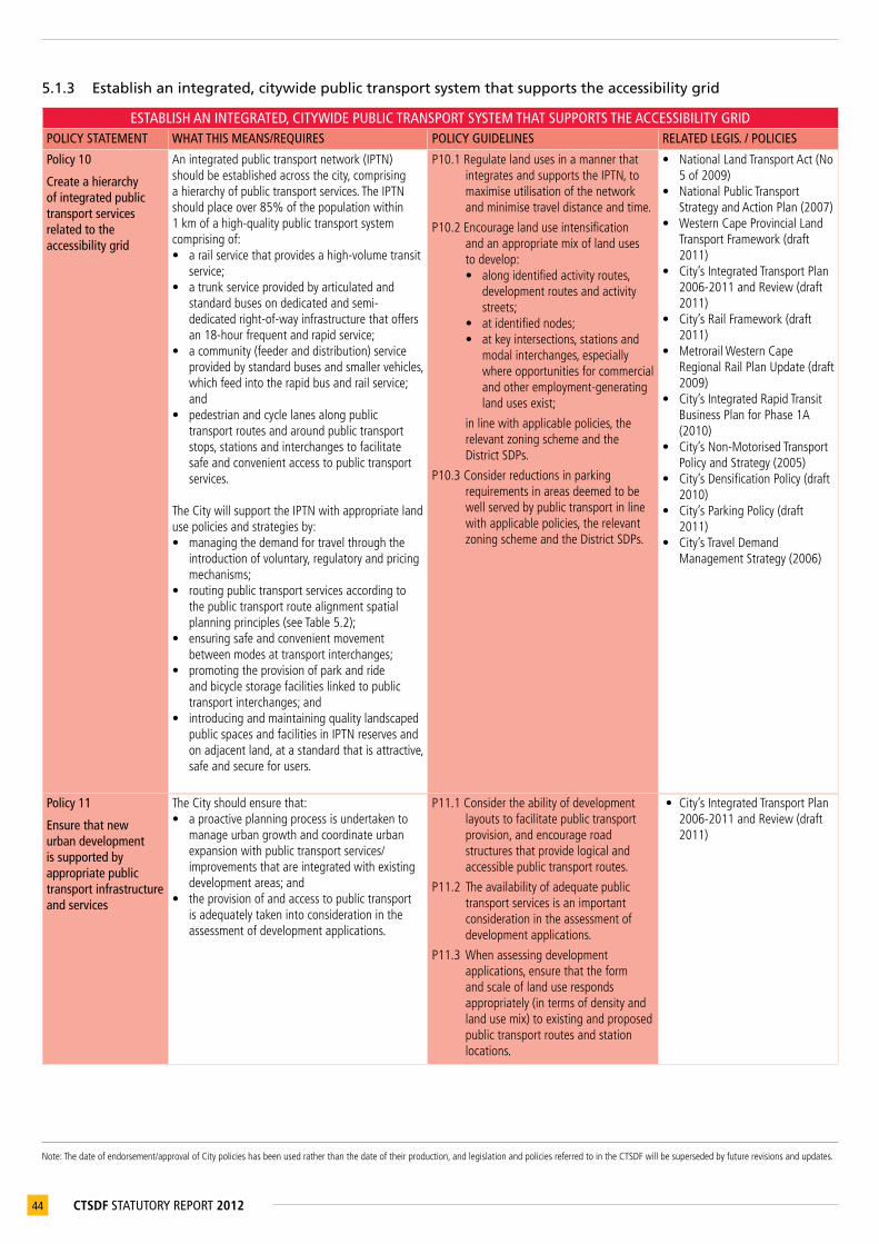
Note:Thedateofendorsement/approvalofCitypolicieshasbeenusedratherthanthedateoftheirproduction,andlegislationandpoliciesreferredtointheCTSDFwillbesupersededbyfuturerevisionsandupdates.
44 CTSDF STATUTORY REPORT 2012
5.1.3 Establish an integrated, citywide public transport system that supports the accessibility grid
ESTABLISH AN INTEGRATED, CITYWIDE PUBLIC TRANSPORT SYSTEM THAT SUPPORTS THE ACCESSIBILITY GRIDPOLICY STATEMENT WHAT THIS MEANS/REQUIRES POLICY GUIDELINES RELATED LEGIS. / POLICIES
Policy 10
Create a hierarchy of integrated public transport services related to the accessibility grid
Anintegratedpublictransportnetwork(IPTN)shouldbeestablishedacrossthecity,comprisingahierarchyofpublictransportservices.TheIPTNshouldplaceover85%ofthepopulationwithin1kmofahigh-qualitypublictransportsystemcomprisingof:• arailservicethatprovidesahigh-volumetransit
service;• atrunkserviceprovidedbyarticulatedand
standardbusesondedicatedandsemi-dedicatedright-of-wayinfrastructurethatoffersan18-hourfrequentandrapidservice;
• acommunity(feederanddistribution)serviceprovidedbystandardbusesandsmallervehicles,whichfeedintotherapidbusandrailservice;and
• pedestrianandcyclelanesalongpublictransportroutesandaroundpublictransportstops,stationsandinterchangestofacilitatesafeandconvenientaccesstopublictransportservices.
TheCitywillsupporttheIPTNwithappropriatelandusepoliciesandstrategiesby:• managingthedemandfortravelthroughthe
introductionofvoluntary,regulatoryandpricingmechanisms;
• routingpublictransportservicesaccordingtothepublictransportroutealignmentspatialplanningprinciples(seeTable5.2);
• ensuringsafeandconvenientmovementbetweenmodesattransportinterchanges;
• promotingtheprovisionofparkandrideandbicyclestoragefacilitieslinkedtopublictransportinterchanges;and
• introducingandmaintainingqualitylandscapedpublicspacesandfacilitiesinIPTNreservesandonadjacentland,atastandardthatisattractive,safeandsecureforusers.
P10.1RegulatelandusesinamannerthatintegratesandsupportstheIPTN,tomaximiseutilisationofthenetworkandminimisetraveldistanceandtime.
P10.2Encouragelanduseintensificationandanappropriatemixoflandusestodevelop:• alongidentifiedactivityroutes,
developmentroutesandactivitystreets;
• atidentifiednodes;• atkeyintersections,stationsand
modalinterchanges,especiallywhereopportunitiesforcommercialandotheremployment-generatinglandusesexist;
inlinewithapplicablepolicies,therelevantzoningschemeandtheDistrictSDPs.
P10.3Considerreductionsinparkingrequirementsinareasdeemedtobewellservedbypublictransportinlinewithapplicablepolicies,therelevantzoningschemeandtheDistrictSDPs.
• NationalLandTransportAct(No5of2009)
• NationalPublicTransportStrategyandActionPlan(2007)
• WesternCapeProvincialLandTransportFramework(draft2011)
• City’sIntegratedTransportPlan2006-2011andReview(draft2011)
• City’sRailFramework(draft2011)
• MetrorailWesternCapeRegionalRailPlanUpdate(draft2009)
• City’sIntegratedRapidTransitBusinessPlanforPhase1A(2010)
• City’sNon-MotorisedTransportPolicyandStrategy(2005)
• City’sDensificationPolicy(draft2010)
• City’sParkingPolicy(draft2011)
• City’sTravelDemandManagementStrategy(2006)
Policy 11
Ensure that new urban development is supported by appropriate public transport infrastructure and services
TheCityshouldensurethat:• aproactiveplanningprocessisundertakento
manageurbangrowthandcoordinateurbanexpansionwithpublictransportservices/improvementsthatareintegratedwithexistingdevelopmentareas;and
• theprovisionofandaccesstopublictransportisadequatelytakenintoconsiderationintheassessmentofdevelopmentapplications.
P11.1Considertheabilityofdevelopmentlayoutstofacilitatepublictransportprovision,andencourageroadstructuresthatprovidelogicalandaccessiblepublictransportroutes.
P11.2Theavailabilityofadequatepublictransportservicesisanimportantconsiderationintheassessmentofdevelopmentapplications.
P11.3Whenassessingdevelopmentapplications,ensurethattheformandscaleoflanduserespondsappropriately(intermsofdensityandlandusemix)toexistingandproposedpublictransportroutesandstationlocations.
• City’sIntegratedTransportPlan2006-2011andReview(draft2011)

Note:Thedateofendorsement/approvalofCitypolicieshasbeenusedratherthanthedateoftheirproduction,andlegislationandpoliciesreferredtointheCTSDFwillbesupersededbyfuturerevisionsandupdates.
45CTSDF STATUTORY REPORT 2012
ESTABLISH AN INTEGRATED, CITYWIDE PUBLIC TRANSPORT SYSTEM THAT SUPPORTS THE ACCESSIBILITY GRIDPOLICY STATEMENT WHAT THIS MEANS/REQUIRES POLICY GUIDELINES RELATED LEGIS. / POLICIES
Policy 12
Lobby for the introduction and/or expansion of passenger rail services
Newpassengerrailservicesshouldbeintroducedand/orexistingservicesexpandedaspassengervolumesincrease. Prioritisedrailinvestmentsinclude:• anewpassengerraillinkfromKhayelitshavia
BlueDownstoKuilsRiver;• animprovedpassengerserviceonthe
Malmesburyrailwayline,withservicesbetweenFisantekraalandKraaifonteinasthefirstphase;and
• anewpassengerserviceontheAtlantisrailwayline,withservicesbetweenDuNoonandCapeTownasthefirstphase.
(SeeMap5.1)
Specific action(s)• TheCitywillengagewithPRASAtoprioritise
improvementstothepassengerrailservice.
• City’sIntegratedTransportPlan2006-2011andReview(draft2011)
• City’sRailFramework(draft2011)
• MetrorailWesternCapeRegionalRailPlanUpdate(draft2009)
Table 5.2: Public transport route alignment: Spatial planning principles
The following spatial planning considerations should inform public transport routing alignments to ensure that maximum development intensity can be achieved along identified routes and around selected stations.
1. Ensure consistency with spatial planning policy.
2. Ensure that the land use potential along public transport routes can be maximised in terms of residential density and mixed-use intensification.
3. Take long-term growth potential into account when determining short to medium-term public transport routes.
4. Assess public transport route potential for city restructuring.
Based on these spatial planning principles, public transport services should:
• reinforce the city’s envisaged long-term spatial structure, and contribute towards establishing a multidirectional, grid-based movement system;
• accommodate multi-directional origin-to-destination travel patterns; and facilitate efficient transportation between different economic locations/nodes in the city;
• be used as a tool to restructure the city and integrate previously disadvantaged areas by improving access to economic areas;
• consider the ability of land uses to respond to the flows/opportunities created along public transport routes and at identified station locations;
• reinforce/complement existing nodal and corridor development along and adjacent to development routes, activity routes and activity streets, where the public transport service is fulfilling an accessibility function; and
• take a long-term perspective in transport modelling scenarios, and consider growth projections for identified new development areas, especially in the city’s growth path.

46 CTSDF STATUTORY REPORT 2012
Map 5.1: Route designation: Land use functionality

47CTSDF STATUTORY REPORT 2012
Map 5.2: Economic activity

Note:Thedateofendorsement/approvalofCitypolicieshasbeenusedratherthanthedateoftheirproduction,andlegislationandpoliciesreferredtointheCTSDFwillbesupersededbyfuturerevisionsandupdates.
48 CTSDF STATUTORY REPORT 2012
Policy 13
Include walking and cycling as essential components of land use planning
TheCitywillmakewalkingandcyclinginCapeTownanattractivemodalchoicebyensuringthatsafeandwellmaintainedNMTinfrastructureandfacilitiesareprovided.
P13.1 Whenassessingdevelopmentapplications,NMTinfrastructureshouldbeconsideredasanessentialcomponentoftheIPTN,andprioritisedinthefollowinglocations:• alongrouteswithhighpedestrian
andcyclevolumes;• aroundpublictransport
interchanges(busandrail)andpublicfacilities,suchasschools,clinics,hospitalsandparks;
• alongactivityroutesandactivitystreets,alongdevelopmentroutes,incivicprecincts,andinurbanandcoastalnodes;and
• wheretherearesufficientlyhighpedestrianvolumestowarranttheclosureofroads,andthecreationofpedestrianzonesonapermanentbasis(suchasStGeorge’sMall),andonatemporarybasis(suchasthefanwalktoCapeTownStadium).
• City’sNon-MotorisedTransportPolicyandStrategy(2005)
Policy 14
Introduce parking policies to encourage use of the most context-specific and appropriate modal travel choice
The City will introduce parking policies that:• addresstheprovision,management,control,
enforcementandpricingofparking;• setstandardstoinfluencevehicleusageto
promotepublictransport;and• manageparkingsupplybyintroducingparking
ratiosbasedontheavailablemodesofpublictransport(proximity,frequency,quality),spatialplanningobjectives(nodes,corridors,routes)andsocio-economiccharacteristics(carownershiplevels).
P14.1ParkingprovisionshouldbeguidedbythestandardsprescribedintheCTZS.DeparturesfromtheCTZSshouldbeguidedbytheCity’sParkingPolicy.
P14.2Considerreductionsinparkingrequirementsinurbannodes,mixeduseareas,developmentcorridors,activityroutes,developmentroutes,activitystreetsandotherareasdeemedtobewellservedbypublictransportinlinewiththerelevantzoningscheme,theDistrictSDPsandotherapplicablepolicies.
P14.3Encouragebuildingdesignthatprovidesalandscaped/activestreetlevelinterfacewheretheprovisionofgroundfloorparkingcannotbeavoided.
P14.4Exploitopportunitiesforunderutilisedparkingareastobeusedaspark-and-ridefacilitieswhereaccessibletopublictransportservices.
P14.5Encouragethedesignofparkingareastobesufficientlyflexibletoallowforconversionofparkingareastoalternativeusesovertime.
P14.6Allparkingareasandtransportdepotsshouldcomplywithwater-sensitiveurbandesign(WSUD)principles.
• CapeTownZoningScheme(draft2010)
• City’sParkingPolicy(draft2011)
• City’sManagementofUrbanStormwaterImpactspolicy(2009)

Note:Thedateofendorsement/approvalofCitypolicieshasbeenusedratherthanthedateoftheirproduction,andlegislationandpoliciesreferredtointheCTSDFwillbesupersededbyfuturerevisionsandupdates.
49CTSDF STATUTORY REPORT 2012
5.1.4 Integrate land use, economic and transport planning
INTEGRATE LAND USE, ECONOMIC AND TRANSPORT PLANNINGPOLICY STATEMENT WHAT THIS MEANS/REQUIRES POLICY GUIDELINES RELATED LEGIS. / POLICIES
Policy 15
Reinforce and enhance metropolitan development corridors
TheCitywillsupportthedevelopmentofmetropolitandevelopmentcorridorsby:• investigatinglanduse,proceduralandfinancial
incentives;• unlockingthedevelopmentpotentialofvacant
andpartiallydevelopedlandthroughproactiverezoningand/orinstitutingprocessesrequiredtoremoverestrictiveconditionsoftitle;
• prioritisingcoordinatedinvestmentinpublictransportinfrastructure(appropriatemodefortrunkservices,adequatecommunityserviceandNMT)andoperationalcapacitycommensuratewiththedesiredlandusedensities;and
• increasinginvestorandpropertyownerconfidenceinwell-locatedbutdecliningareasthrough:- improvedurbanmanagement;- prioritisingpublicinvestmentin
infrastructure,transportandthepublicenvironment;
- identifying,designinganddevelopingessentialinfrastructureandsocialamenities;and
- creatinganinterlinkedpublicopenspacesystemandenhancingthenetworkofparks.
(SeeFigures4.7-4.9)
Specific action(s)• Lobbyfortheinitiationofaprocesstosupport
/revitalisedecliningareasoftheurbancorecorridor,includingBellvilleCBD,Parow,Maitland,Epping.
• LobbytherelevantauthoritiestoprioritiseinvestmentinpublictransportservicestosupporttheeasterncorridorbetweenMitchellsPlain/KhayelitshaandBellville.
P15.1 Supporttheintensificationoflandusesinappropriatelocationsalongmetropolitandevelopmentcorridorsinlinewiththerelevantzoningscheme,theDistrictSDPsandotherapplicablepolicies.
P15.2 Appropriatelysupporttripattractingandtripgeneratinglandusesalongdevelopmentcorridorstoencouragemultidirectionalmovementpatterns.
P15.3Considerreductionsinparkingrequirementsinlinewiththerelevantzoningscheme,theDistrictSDPsandotherapplicablepolicies.
• WesternCapeRoadAccessGuidelines(2001)
• City’sRoadNetworkHierarchicalClassification(2010)
• City’sDensificationPolicy(draft2010)
• City’sParkingPolicy(draft2011)
• City’sEconomicAreasPlan(tobeprepared)
Policy 16
Encourage medium to higher-density forms of urban development to locate on or adjacent to activity routes, development routes and activity streets
TheCitywillsupportthedevelopmentofactivityroutes,developmentroutesandactivitystreets.Theroutedesignationsareintendedtoberecognisedasaninformantforlanduseplanninganddevelopmentinrecognitionof:• thehigherlevelsofaccessibilityprovidedbythe
accessibilitygrid;• thelandusedistribution,mixandintensity
alongparticularroutes;and• thestructuralpositioningofrouteswithin
theurbanfabricandtheperceivedlongtermpotentialandgeneraldesirabilityfordevelopmentalongaparticularroute.
(SeeMap5.1andTable5.3)
TheCitywillencourageeconomicactivitytolocateinestablishedeconomicareas,especiallyinidentifiednodes.Thedevelopmentofmajornew‘offgrid’economicactivitiesshouldbeavoided.
P16.1Encouragemixedland-useintensificationonoradjacenttoactivityroutes,developmentroutesandactivitystreetsandaroundnodes,highorderstationsandmodalinterchangesinlinewiththerelevantzoningscheme,theDistrictSDPsandotherapplicablepolicies.
P16.2Considerreductionsinparkingrequirementsinlinewiththerelevantzoningscheme,theDistrictSDPsandotherapplicablepolicies.
P16.3Discouragemajoreconomicdevelopment(suchasdistrict-metroscaleretailcentresandbusinesscomplexes)thatarenotlocatedonorimmediatelyadjacenttoactivityroutes,developmentroutesandactivitystreetsandoutsideofestablishedurbannodes.
• WesternCapeRoadAccessGuidelines(2001)
• City’sRoadNetworkHierarchicalClassification(2010)
• City’sDensificationPolicy(draft2010)
• City’sParkingPolicy(draft2011)
• City’sEconomicAreasPlan(tobeprepared)

Note:Thedateofendorsement/approvalofCitypolicieshasbeenusedratherthanthedateoftheirproduction,andlegislationandpoliciesreferredtointheCTSDFwillbesupersededbyfuturerevisionsandupdates.
50 CTSDF STATUTORY REPORT 2012
Table 5.3: Route designations
The route designation indicated on Map 5.1 does not replace the City’s Hierarchical Road Network Classification system, nor is it intended to run in parallel as a duplicate classification system. Appendix C(ii) describes the relationship between the CTSDF route designations and the National Department of Transport, the PSDF and the City’s hierachial road network classification system.
It is anticipated that the CTSDF route designation indicating land use functionality will encourage an appropriate level of development and more intense mixed land uses to locate on or adjacent to the accessibility grid. This will contribute towards establishing the thresholds required for sustainable and cost effective public transport. It is important to note that opportunities along routes can also be linked to parallel streets and side roads in line with applicable policies, the relevant zoning scheme, and district and local plans. Routes exhibit different characters, and do not represent a uniform mix and density of land uses along their length. It is for these reasons that the route designations are indicated as a conceptual designation on the CTSDF (Map 6.1).
5.1.5 Support the rationalisation, upgrade and/or development of economic gateways, and manage land uses around them appropriately
SUPPORT THE RATIONALISATION, UPGRADE AND/OR DEVELOPMENT OF ECONOMIC GATEWAYS, AND MANAGE LAND USES AROUND THEM APPROPRIATELY
POLICY STATEMENT WHAT THIS MEANS/REQUIRES POLICY GUIDELINES RELATED LEGIS. / POLICIES
Policy 17
Support the development of an integrated system of airports and appropriate surrounding land uses
Mediumtolong-termaviationplanningwillbeguidedbythefollowingconsiderations:• anintegratedsystemofairportsshouldbe
developedtoserveCapeTown’scommercialandgeneralaviationrequirements;and
• themetropolitanarearequiresanintegratedairspacemanagementapproach.
(SeeMap5.1)
Required engagements• NationalDepartmentofTransport,Provincial
GovernmentoftheWesternCape(DEA&DP,DepartmentofTransportandPublicWorks),SouthAfricanCivilAviationAuthority,AirportsCompanySouthAfrica(ACSA),AirTrafficNavigationServices(ATNS)andtheSouthAfricanNationalDefenceForce(SANDF).
P17.1 TheCTIAwillcontinuetoprovidethenationalandinternationalaviationfunctiontoalimitthatisdeterminedbyitsimpactonsurroundinglanduses(noiseimpacts)andthecapacityofland-sidesupportsystems(roadinfrastructure,publictransportinfrastructureandserviceprovision,utilityservicesandstormwatermanagement).
P17.2 AllgeneralaviationfromFisantekraalandothergeneralaviationsitesinthegreaterCapeTownmetropolitanareashouldberelocatedtoamoresuitablelocation,possiblytheproposedairportsouthofAtlantis.
P17.3Managelandusesaroundthesiteidentifiedforthepotentialnew/additionalairportsouthofAtlantisontheassumptionthatitmaybeneededinthelongtermasageneraland/ornationalandinternationalcivilaviationairport.
• NationalLandTransportAct(No5of2009)
• WhitePaperonNationalPolicyonAirportsandAirspaceManagement(1997)
• NationalAirportsDevelopmentPlan(draft2007)
• City’sIntegratedTransportPlan2006-2011andReview(draft2011)
• City’sTourismDevelopmentFramework(2005)
• City’sEconomicDevelopmentStrategy(draft2011)

Note:Thedateofendorsement/approvalofCitypolicieshasbeenusedratherthanthedateoftheirproduction,andlegislationandpoliciesreferredtointheCTSDFwillbesupersededbyfuturerevisionsandupdates.
51CTSDF STATUTORY REPORT 2012
SUPPORT THE RATIONALISATION, UPGRADE AND/OR DEVELOPMENT OF ECONOMIC GATEWAYS, AND MANAGE LAND USES AROUND THEM APPROPRIATELY
POLICY STATEMENT WHAT THIS MEANS/REQUIRES POLICY GUIDELINES RELATED LEGIS. / POLICIES
Policy 18
Create and manage a functional interface between ports/harbours and their surrounding areas
TheCitywill:• engagewiththeNationalPortsAuthority(NPA)
aboutitslong-termplansforthedevelopmentoftheCapeTownandSaldanhaports,andconsidertheeconomic,landuseandtransportimplicationsthishasforCapeTownandsurroundingareas;
• engagewithotherrelevantauthoritiesaboutthemanagementof,andlong-termplanningfor,harboursandportstoestablishasharedview,and,collaborateonjointplanningrequiredtointegratelanduse,port,freight,railandpipelineplanningoverthemediumtolongterm;
• encouragetheincreaseduseofrailforthetransportoffreightintoandoutofthePortofCapeTowntorelievethecongestionandinefficienciesassociatedwithroadbasedfreight;
• identifyand,whereappropriate,retainsidings,sitesandroutes(bothexistingandpotential),whichcouldbecriticalforthemovementoffreight;and
• engagewithTransnetwithrespecttolong-termplanningforstrategicallyownedsites,including,butnotlimitedto,theTransnetmarshallingyards(Belcon),Culemborg,andKraaicon.
Required engagements• NationalDepartmentofPublicWorks,Transnet,
DepartmentofEnvironmentalAffairs,SANavy,andVictoriaandAlfredWaterfront
Specific action(s)• AssisttheDepartmentofTransport,Roadsand
Stormwatertoprepareafreightmanagementplan.
P18.1 EnsurethatfuturedevelopmentaroundthePortofCapeTownandtheBelconsiteismanagedappropriatelytoavoidunnecessarilycompromisingfreightlogisticsanddistribution.
P18.2Encourageanappropriateinterfacetodevelopbetweentheportandadjacentlanduses,particularlyontheCulemborgsite.
• NationalLandTransportAct(No5of2009)
• NationalPortsAct(No12of2005)
• NationalPortsDevelopmentPlan(2003)

52 CTSDF STATUTORY REPORT 2012
5.2 Key strategy 2: Manage urban growth, and create a balance between urban development and environmental protection
The City will manage the future growth and development of Cape Town in a way that balances growth, human benefit and the environment, and addresses the impacts of climate change on livelihoods, urban infrastructure and biodiversity.
The CTSDF seeks to assist property developers to make informed investment decisions and develop in appropriate locations, by identifying the areas that are most suited to urban development, and those that should be avoided for environmental reasons or for the hazards or risks they create for residents. It highlights the importance of cross-sectoral forward planning and the spatial alignment of interventions, and provides broad guidelines for the phasing of the growth of the city. It recommends that cross-sectoral growth management plans such as the IDP and proposed 15-year Growth Management Plan be used to guide the city’s growth and development, and provide information on the City’s bulk infrastructure delivery plans.
To manage the urbanisation challenges and pressures facing Cape Town, the City plans to accommodate incremental responses to the need for secure tenure and housing, and to build bridges between informal and formal development processes.
Housing delivery approaches such as managed land settlement, site-and-service, starter housing, in situ upgrading of informal settlements, and the servicing and formalisation of front and backyard dwellings are to be supported where appropriate, and included in a single land use management system.
The CTSDF proposes that the future form of urban development should be more compact and that higher densities be encouraged in targeted locations in order to promote the more sustainable use of resources, support the development of a low-carbon city, and make more effective and efficient use of existing infrastructure, public transport systems, social facilities and amenities.
Lastly, it is advocated that development impacts on natural resources be appropriately managed. The biodiversity network, aquatic network and agricultural areas to be protected must be taken into consideration when planning for new development, and national biodiversity targets should be pursued. More efficient use needs to be made of non-renewable resources, and the protection and maintenance of existing surface water and groundwater resources and the sustainable sourcing and use of existing and future water supplies are critical. Alternative sources of energy also need to be investigated, and the City needs to encourage the use of green technology and the development of energy-efficient buildings.
The substrategies and land use policy guidelines that will be used to manage urban growth and create a balance between urban development and environmental protection are outlined below.
SUBSTRATEGY POLICY NO. POLICY STATEMENT
Facilitateurbandevelopment
P19 Supportpropertydevelopersbyidentifyingthelocationspotentiallysuitedtourbandevelopment
P20Facilitateurbandevelopmentanddirectthephasingofurbangrowththoughthedeliberateandintegrateduseofplanning,infrastructureprovision,andtheregulatoryandfiscalauthorityofallspheresofgovernment
Supportincrementaldevelopmentprocesses
P21PutinplaceaLUMSthatsupportsasteppedapproachtohousingandtenure,andthedevelopmentofasinglepropertymarket
Encourageamorecompactformofdevelopment
P22 Promoteappropriatelanduseintensification
P23Containthedevelopmentfootprintofthecity,andprotectnatural,rural,urbanandheritageassetswithdevelopmentedges:UrbanandCoastalEdge
AppropriatelyprotectthecitizensofCapeTownfromhazardousareas/activities
P24 Directurbangrowthawayfromhazardousareasoractivities
Appropriatelymanageurbandevelopmentimpactsonnaturalresourcesandcriticalbiodiversitynetworks
P25 Increaseeffortstoprotectandenhancebiodiversitynetworksatalllevelsofgovernment
P26Reducetheimpactofurbandevelopmentonriversystems,wetlands,aquifers,andaquiferrechargeareasanddischargeareas
P27 Manageurbandevelopmentalongthecoastinasustainableandprecautionarymanner
P28 Protectvaluableagriculturalareas,existingfarmedareasandhorticulturalareasfromurbanencroachment,andsupporturbanagriculture
P29 Adoptaproactiveplanningapproachtominingresourcemanagement
Makeefficientuseofnon-renewableresources
P30 Promoteacultureofsustainabledevelopmentandliving
Protectandenhancethecity’sruralenvironment
P31 Preventurbandevelopmentfromintrudingintotheruralenvironment
P32Supportappropriatedevelopmentandactivitiesinruralareas,andinandarounduniqueandculturallysignificantruralsettlements
P33 Rationaliseandproactivelymanagesmallholdings
P34 Developandmanageruralgateways

Note:Thedateofendorsement/approvalofCitypolicieshasbeenusedratherthanthedateoftheirproduction,andlegislationandpoliciesreferredtointheCTSDFwillbesupersededbyfuturerevisionsandupdates.
53CTSDF STATUTORY REPORT 2012
5.2.1 Facilitate urban development
FACILITATE URBAN DEVELOPMENTPOLICY STATEMENT WHAT THIS MEANS/REQUIRES POLICY GUIDELINES RELATED LEGIS./POLICIES
Policy 19
Support property developers by identifying the locations potentially suited to urban development
Map5.3indicatestheundeveloped/partiallydevelopedareaspotentiallysuitedtourbandevelopmentintheshorttomediumterm,andareastowardswhichdevelopmentcouldbedirectedinthelongerterm(15to50years)iftheneedarisesandtheinfrastructureisinplacetosustainsuchgrowth. Privateandpublic-sectordevelopersneedtonotetheselocationswhenpurchasinglandandplanningdevelopments.
• NationalEnvironmentalManagementAct(No107of1998)
• NationalHeritageResourcesAct(No25of1999)
Policy 20
Facilitate urban development and direct the phasing of urban growth through the deliberate and integrated use of planning, infrastructure provision, and the regulatory and fiscal authority of all spheres of government
Forgrowthtobedirectedandmanagedappropriately:• thephasingofurbandevelopmentshouldbeguided
by:- thelong-termCDSandCTSDF;- spatialplanningandinfrastructureimperatives
andlogics,asarticulatedinamedium-termcross-sectoralgrowthmanagementplan(tobedrafted)and5-yearIDP;
- theCity’scapitalbudgetprioritisationcriteria;and
- bulktake-upoflandwithintheurbanedge;• futureurbanexpansionshouldbebulkinfrastructure
ledwithinasetframeworktoaddresstheshelterandtenureneedsofthelower-incomemarket,balancedbyanappropriatemixoflandusesandincomegroupstofacilitatethecreationofsustainablesettlementsandlivelihoods;and
• cross-sectoralgrowthmanagementplanningwithintheCityandbroaderfunctionalregionmustensurethatinfrastructureplanningandinvestmentalignswiththeagreedphasingofdevelopment.Theappropriateinstitutionalarrangementsmustbeputinplacetofacilitatethis.
Specific action(s)• Preparea15-yearGrowthManagementPlanto
guidepublicinvestmentinutilityservices,housingandeconomicandsocialdevelopment.
• Puttheappropriateinstitutionalstructure(s)inplacetomanagethecity’sgrowthandfacilitatethealignmentofcrossbordergrowthmanagementstrategies.
P20.1 UseMap5.3tohelpdeterminewhenitwouldbeappropriatetodevelopaparticulararea.
P20.2 UrbangrowthinCapeTownshouldbeguidedasfollows:• intheshortterm(<5years),
theoutwardexpansionoftheexistingurbanfootprintshouldberestrictedtoaddressexistinginfrastructurecapacityconstraintsandcurrentmaintenancechallenges;
• inthemediumterm(<15years),newurbandevelopmentshouldideallytakeplacewithintheexistingurbanedge;and
• higherdensitiesandagreatermixoflandusesmustbepromotedinappropriatelocationswithintheurbanedgeandbeguidedbytheDistrictSDPandlocalplansandtheCapeTownDensificationPolicy(Draft2010).
• MunicipalSystemsAct(No32of2000)
• CityDevelopmentStrategy(draft2010)
• City’sCapeTownDensificationPolicy(draft2010)
• City’sIntegratedDevelopmentPlans
• City’s15-yeargrowthmanagementplan(tobedrafted)
• City’sCapeTownDensificationPolicy(draft2010)

54 CTSDF STATUTORY REPORT 2012
Map 5.3: Areas potentially suited to urban development

Note:Thedateofendorsement/approvalofCitypolicieshasbeenusedratherthanthedateoftheirproduction,andlegislationandpoliciesreferredtointheCTSDFwillbesupersededbyfuturerevisionsandupdates.
55CTSDF STATUTORY REPORT 2012
5.2.2 Support incremental development processes
SUPPORT INCREMENTAL DEVELOPMENT PROCESSESPOLICY STATEMENT WHATTHISMEANS/REQUIRES POLICYGUIDELINES RELATEDLEGIS./POLICIES
Policy 21
Put in place a LUMS that supports a stepped approach to housing and tenure, and the development of a single property market
Giventhescaleofthechallengesfacingthecity,itisrecognisedthatcreativeformalandincrementaldevelopmentoptionsthataccommodateinformaldevelopmentareneeded. The implications are that:• managedlandsettlement,site-and-service,
starterhousingandinsituupgradesofinformalsettlementsarelikelytobecomemoreprevalent;
• theformalisationoffrontandbackyarddwellings,wheresustainable,willberequired;and
• thelikelydevelopmentofseconddwellingsshouldbetakenintoaccountwhenservicingnewareasandpositioninghousesonindividualerven.
Specific action(s)• TheCityneedstodevelopamorein-depth
understandingofthediverseformalandinformallandmarkets(asillustratedinTable5.4).
• TheCityshouldlobbyprovincialandnationaldepartmentsresponsibleforplanninglawreformtoapplytheabovementionedapproachinplanninglawreformprocesses.
P21.1 Whenassessingdevelopmentapplicationsrelatedtoincrementaldevelopment,considerationshouldbegiventohowthelayout/developmentcouldbeconvertedintoaformalresidentialarea.Examplesincludehousingextensionsandvehicleaccessandparkingprovisions.
• CapeTownZoningScheme(draft2010)
Table 5.4: Diverse urban land markets
The incremental improvement of living conditions in informal settlements, site-and-service and starter housing schemes should be supported by a stepped tenure system and LUMS. This system should build bridges between informal and formal development processes, and create the conditions necessary for the poor to improve their living conditions incrementally and, over time, access mortgage finance from private-sector financial institutions. In addition, it should facilitate the improvement of informal/incremental residential areas, and make it possible for property owners in these areas to realise the formal market value of their properties. The figure below identifies some of the critical ‘rungs’ (submarkets) on the housing and tenure ladder that need to be supported by a stepped LUMS. The design of a tenure system and LUMS that can accommodate these steps will require a more in-depth understanding of how the different submarkets operate, followed by the development of more nuanced policy interventions.
Sou
rce:
Bas
ed o
n d
iag
ram
pre
par
ed b
y U
rban
Lan
d M
ark
(200
7)
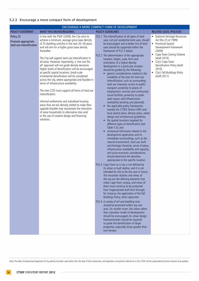
Note:Thedateofendorsement/approvalofCitypolicieshasbeenusedratherthanthedateoftheirproduction,andlegislationandpoliciesreferredtointheCTSDFwillbesupersededbyfuturerevisionsandupdates.
56 CTSDF STATUTORY REPORT 2012
5.2.3 Encourage a more compact form of development
ENCOURAGE A MORE COMPACT FORM OF DEVELOPMENTPOLICY STATEMENT WHAT THIS MEANS/REQUIRES POLICY GUIDELINES RELATED LEGIS. /POLICIES
Policy 22
Promote appropriate land use intensification
InlinewiththePSDF(2009),theCityaimstoachieveaminimum,averagegrossbasedensityof25dwellingunits/hainthenext20–30years,andwillaimforahighergrossbasedensitythereafter. TheCitywillsupportlanduseintensificationinallareas.However,importantly,a‘onesizefitsall’approachwillnotguidedensitydecisions. Higherlevelsofdensificationwillbeencouragedatspecificspatiallocations.Small-scaleincrementaldensificationwillbeconsideredacrossthecity,whereappropriateandfeasibleintermsofinfrastructureavailability. ThenewCTZSmustsupportallformsoflanduseintensification. Informalsettlementsandsubsidisedhousingareasthataretoodenselysettledtomaketheirupgradefeasiblemaynecessitatetherelocationofsomehouseholdstoalternativesitesand/ortheuseofcreativedesignandfinancingsolutions.
P22.1 Theintensificationofalltypesoflanduses,notjustresidentiallanduses,shouldbeencouraged,andabettermixoflandusesshouldbesupportedwithintheframeworkofP22.2below.
P22.2 Thedeterminationoftheappropriatelocation,height,scale,formandorientationofahigher-densitydevelopmentinaparticularlocationshouldbeguidedbythefollowing:• genericconsiderationsrelatedtothe
suitabilityoftheareaforlanduseintensification,suchassurroundinglandusecharacter,accesstopublictransport,proximitytoplacesofemployment,servicesandcommunity/socialfacilities,proximitytopublicopenspace,andinfrastructureavailability(existingandplanned);
• theapplicablepolicyframeworks,namelytheCTSDF,DistrictSDPsandlocalspatialplans,densityplans,urbandesignandarchitecturalguidelines;
• thespatiallocationstargetedfordifferenttypesofdensification(seeTable5.5);and
• contextualinformantsrelatedtothedevelopmentapplicationanditsimmediatesurroundings,suchasthenaturalenvironment,landuse,builtandheritagecharacter,senseofplace,infrastructureavailabilityandcapacity,andsocio-economicconsiderations,shoulddeterminethedensitiesappropriatetothespecificlocation.
P22.3 CapeTownasacityisnotdefinedbyitsurbanorbuiltskyline,anditisnotintendedforthistobethecaseinfuture.ThemountainskylinesandviewsoftheseaarethedefiningelementsthatmakeCapeTownunique,andviewsofthemmustcontinuetobeprotectedfrominappropriatebuiltformthrough,forinstance,theapplicationoftheTallBuildingsPolicy,whenapproved.
P22.4 Avarietyoferfanddwellingsizesshouldbepromotedwithinanyonearea.Onsmallererven,theurbanratherthansuburbanmodelofdevelopmentshouldbeencouraged.Anurbandesignframework/planshouldberequiredtoguidethedensificationoflargerproperties,especiallythosegreaterthanonehectare.
• NationalHeritageResourcesAct(No25of1999)
• ProvincialSpatialDevelopmentFramework(2009)
• CapeTownZoningScheme(draft2010)
• City’sCapeTownDensificationPolicy(draft2010)
• City’sTallBuildingsPolicy(draft2011)
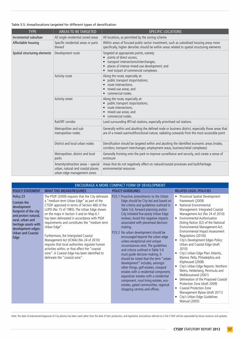
Note:Thedateofendorsement/approvalofCitypolicieshasbeenusedratherthanthedateoftheirproduction,andlegislationandpoliciesreferredtointheCTSDFwillbesupersededbyfuturerevisionsandupdates.
57CTSDF STATUTORY REPORT 2012
Table 5.5: Areas/locations targeted for different types of densification
TYPE AREAS TO BE TARGETED SPECIFIC LOCATIONSIncremental suburban Allsingle-residentialzonedareas Alllocations,aspermittedbythezoningscheme
Affordable housing Specificresidentialareasorpartsthereof
Withinareasoffocusedpublic-sectorinvestment,suchassubsidisedhousingareasmorespecifically,higherdensitiesshouldbewithinareasrelatedtospatialstructuringelements
Spatial structuring elements
Developmentroute
Targetedatappropriatepoints,namely:• pointsofdirectaccess;• transportintersections/interchanges;• placesofintensemixed-usedevelopment;and• nextto/partofcommercialcomplexes.
Activityroute
Alongtheroute,especiallyat:• publictransportstops/stations;• routeintersections;• mixed-useareas;and• commercialnodes.
Activitystreet
Alongtheroute,especiallyat:• publictransportstops/stations;• routeintersections;• mixed-useareas;and• commercialnodes.
Rail/IRTcorridor LandsurroundingIRT/railstations,especiallyprioritisedrailstations
Metropolitanandsub-metropolitannodes
Generallywithinandabuttingthedefinednodeorbusinessdistrict,especiallythoseareasthatareofamixed-use/multifunctionalnature,radiatingoutwardsfromthemostaccessiblepoint
Districtandlocalurbannodes Densificationshouldbetargetedwithinandabuttingtheidentifiedeconomicareas(nodes,corridors,transportinterchanges,employmentareas,business/retailcomplexes)
Metropolitan,districtandlocalparks
Generallyfrontingontotheparktoimprovesurveillanceandsecurity,andcreateasenseofenclosure
Amenity/attractionareas–specialurban,naturalandcoastalplaces;urbanedgemanagementzones
Areasthatdonotnegativelyaffectonnatural/coastalprocessesandbuilt/heritageenvironmentalresources
ENCOURAGE A MORE COMPACT FORM OF DEVELOPMENTPOLICY STATEMENT WHAT THIS MEANS/REQUIRES POLICY GUIDELINES RELATED LEGIS. /POLICIES
Policy 23
Contain the development footprint of the city and protect natural, rural, urban and heritage assets with development edges: Urban and Coastal Edge
ThePSDF(2009)requiresthattheCitydelineatea“mediumtermUrbanEdge”aspartoftheCTSDFapprovedintermsofSection4(6)oftheLUPO(No15of1985).TheUrbanEdgeshownonthemapsinSection5andonMap6.1hasbeendelineatedinaccordancewithPSDFrequirementsandconstitutesthe“mediumtermUrbanEdge”.
Furthermore,theIntergratedCoastalManagementAct(ICMA)(No24of2010)requiresthatlocalauthoritiesregulatehumanactivitieswithin,orthataffectthe“coastalzone”.ACoastalEdgehasbeenidentifiedtodelineatethe“coastalzone”.
P23.1ProactiveamendmentstotheUrbanEdgeshouldbeCity-ledandbasedonthecriteriaandguidelinesoutlinedinTable5.6,forwardplanningand/orCityinitiatedfive-yearlyUrbanEdgereviews.Avoidthenegativeimpactsassociatedwithpiecemealdecisionmaking.
P23.2Nourbandevelopmentshouldbeencouragedbeyondtheurbanedgeunlessexceptionalanduniquecircumstancesexist.TheguidelinesandcriteriaoutlinedinTable5.6mustguidedecisionmaking.Itshouldbenotedthattheterm“urbandevelopment”includes,amongstotherthings,golfestates,vineyardestateswitharesidentialcomponent,equestrianestateswitharesidentialcomponent,rurallivingestates,eco-estates,gatedcommunities,regionalshoppingcentresandoffices.
• ProvincialSpatialDevelopmentFramework(2009)
• NationalEnvironmentalManagement:IntegratedCoastalManagementAct(No24of2010)
• EnvironmentalAuthorisation(listingNotice3(2)oftheNationalEnvironmentalManagementAct:EnvironmentalImpactAssessmentRegulations(2010))
• City’sDevelopmentEdgesPolicy:UrbanandCoastalEdge(draft2010)
• City’sUrbanEdgePlan:Atlantis,Mamre,Pella,PhiladelphiaandKlipheuwel(2008)
• City’sUrbanEdgeReports:NorthernMetro,Helderberg,PeninsulaandMelkbosstrand(2001)
• DelineationoftheProposedCoastalProtectionZone(draft2009)
• CoastalProtectionZoneManagementBylaw(draft2011)
• City’sUrbanEdgeGuidelinesManual(2005)
Note:Thedateofendorsement/approvalofCitypolicieshasbeenusedratherthanthedateoftheirproduction,andlegislationandpoliciesreferredtointheCTSDFwillbesupersededbyfuturerevisionsandupdates.
58 CTSDF STATUTORY REPORT 2012
ENCOURAGE A MORE COMPACT FORM OF DEVELOPMENTPOLICY STATEMENT WHAT THIS MEANS/REQUIRES POLICY GUIDELINES RELATED LEGIS. /POLICIES
Specific action(s)• AlignandupdatetheCouncilapproved
(2001)landuseguidelinesfortheUrbanEdgemanagementzonesoneithersideoftheUrbanEdgeshownonMap6.1.
• FinaliseCoastalProtectionZoneManagementByLawtomanagelanduseswithintheCoastalProtectionZone(i.e.ontheseasideoftheCoastalEdge)
• DraftCoastalDevelopmentFramework.• ReviewthealignmentoftheUrbanEdge
aroundCore1andCore2sitescurrentlylocatedinsidetheUrbanEdge(seeMap6.1)aspartofthenextfiveyearlyreviewoftheUrbanEdgealignment.
P23.3ManagementoflanduseswithintheUrbanEdgeandCoastalEdgemanagementzonesshouldbeguidedbytheUrbanEdgepolicyapplicabletoaspecificarea(e.g.NorthernMetro,Helderberg,PeninsulaandMelkbosstrandUrbanEdgeReports(2001tobeupdated),theUrbanEdgeGuidelinesManual(2004)andCoastalProtectionZoneManagementBylaw,whenapproved.
Table 5.6: Criteria and guidelines for the review of the development edges
• A City-led, proactive review of portions of the Urban Edge line must take place a minimum of every five years or more frequently if the City deems it necessary. Amendments must be guided by the generic delineation criteria for development edges and policies and the guidelines in this table. They must also be guided by the City’s urban growth management strategies, development trends, the availability of bulk infrastructure inside and outside the Urban Edge, new information related to, for example, natural, cultural and heritage resources, and the take-up of land inside the Urban Edge.
• The Urban Edge is aimed at managing uncontrolled horizontal spatial expansion so that effective and efficient use is made of undeveloped land and existing infrastructure within the existing urban edge. Decision making must therefore be consistent with achieving a more compact metropolitan urban form, whilst noting the land and zoning limitations within the current urban footprint, coupled with the need to address the complexities of the less formal areas and urbanisation within the city, as well as the various environmentally sensitive areas within the existing footprint that limit internal expansion. Amendments should be a logical extension of the Urban Edge, and based on the City’s forward planning imperatives and the City’s desired phasing of development.
• As a general guideline, where the Urban Edge line has been accurately delineated to protect natural resources (core bioregional spatial planning categories) it should not be amended.
• The Coastal Edge has made provision for development opportunities at strategically located new coastal nodes such as Silwerstroomstrand, Strandfontein, Mnandi and Monwabisi. Provision is made for the refinement of the Coastal Edge in these areas once feasibility studies have been undertaken, by allowing a limited ‘margin of leeway’.
• Valuable view corridors, undeveloped ridge lines, heritage assets and existing vistas should not be compromised by any development proposal or cumulative impact of development proposals. The proportion of urban development up the slope of a prominent hill or mountain should not degrade its aesthetic/ visual value.
• The existence of soils with a low agricultural potential is not a sufficient condition to consider amending the urban edge. • A development application’s alignment with the areas identified as potentially suitable for urban development in Cape Town’s growth path
does not justify support for an Urban Edge amendment.• Reactive amendments to the Urban Edge, requiring bulk infrastructure investment not forming part of the City’s infrastructure investment plans
cannot be approved without absolute clarity and approval of both the cost of installing the infrastructure and the impact of the development on the City’s operating costs. It should however also be noted that the availability of bulk infrastructure or the ability to provide infrastructure by a private developer does not justify support for an Urban Edge amendment.
• The cumulative impact of all known proposed developments should be considered together, within the context of the City’s overall infrastructure plans to ensure that bulk infrastructure capacity available for developments within the Urban Edge is not allocated to developments outside the Urban Edge
• The Urban Edge line should not be compromised while development opportunities for similar property markets still exist within the immediate surrounding urban areas (approximately a 5 km radius).
• Given the popularity of Cape Town as an area of immigration, coupled with the scale and nature of the demand for government-subsidised and gap housing (and the potential shortage and cost of land available for this type of housing), the City recognises that, where it is a logical extension to existing urban development in terms of the CTSDF, IDP and 15 year Growth Management Plan (to be drafted), a proactive amendment of the Urban Edge may be required to accommodate the needs of this market. It also recognises that feasible development applications, that propose that at least 50% of the net residential area be targeted at households qualifying for the National Department of Human Settlement’s housing subsidies as well as housing serving the gap market, and are a logical extension to existing urban development in the growth paths in terms of the CTSDF, IDP and 15 Year Growth Management Plan (to be drafted) merit support and justify an amendment to the Urban Edge. In this instance, the approval of the project should be linked to a signed, written agreement between the developer in question and the City’s Housing Department regarding: (i) the number of households that will qualify for the housing subsidy, and the number of houses to be built for the gap market; (ii) the provisions made for the proposed subsidised units on the City’s three-year capital budget; and (iii) the requisite infrastructure.
• The desired long-term urban form, land uses and densities in the future growth path of the City must be taken into account in current decision-making.
• Precedent will not be used as a criterion for development application assessment.• The positive, unique character of an area must be retained where an amendment to the urban edge is proposed.• Consideration should be given to the availability of public transport.

Note:Thedateofendorsement/approvalofCitypolicieshasbeenusedratherthanthedateoftheirproduction,andlegislationandpoliciesreferredtointheCTSDFwillbesupersededbyfuturerevisionsandupdates.
59CTSDF STATUTORY REPORT 2012
5.2.4 Appropriately protect the citizens of Cape Town from hazardous areas/activities
APPROPRIATELY PROTECT THE CITIZENS OF CAPE TOWN FROM HAZARDOUS AREAS/ACTIVITIESPOLICY STATEMENT WHAT THIS MEANS/REQUIRES POLICY GUIDELINES RELATED LEGIS. /POLICIES
Policy 24
Direct urban growth away from hazardous areas/activities
Hazardousareasareeitheralreadydeterminedthroughproclamationsorspecialiststudies,orwillbedeterminedasarequirementofadevelopmentapplicationprocess,whereappropriate(seeMap5.4).
Inthemediumtolongterm,theCitywouldliketoreducethedevelopmentimpedimentsandsafetyrisksassociatedwithKoebergNuclearPowerStation(KNPS).
Specific action(s)• TheCity,inconjunctionwithEskom
HoldingsSOCLimitedandthePGWC,mustupdatetheIntegratedKoebergNuclearEmergencyPlan(KNEP)asrequired.
• TheCity,inconjunctionwithEskomHoldingsSOCLimitedandthePGWC,mustcontinuetooptimise,withaviewtosustainability,therequirementsinrespectoftheKNEP.
• TheCitymustreviewandupdatethetownplanningassessmentcriteria(November,2006)toensurethattheprocessingandassessmentofdevelopmentapplicationswithintheKNPSemergencyplanningzonesdoesnotcompromisetheeffectiveimplementationoftheKNEP.
P24.1Noinappropriateurbandevelopmentshouldbepermittedinminingblastingzones,servitudes(powerlines,road,rail,etc.),heavy/noxiousindustrialzones,solidwastedisposalandwastewatertreatmentsitesandtransfersites,incemeteriesorareassubjecttoregularfloodingorfloodrisk,orrelatedbufferareas.Existingdevelopmentsintheaboveareasmayrequiremitigationmeasuresandlimitsontheenhancementofdevelopmentrights.
P24.2AllurbandevelopmentthattakesplaceinthevicinityoftheCTIAandotherairportswithinthemetropolitanareamustbewithintheframeworkofrestrictionsontheuseoflandinthenoiseconesofairportsaswellasanyapplicableheightrestrictionsimposedondevelopmentinthevicinityofairports.(NotethatMap5.4indicatestheexistingairportnoisecones.Futurerunwayrealignmentand/ortheconstructionofnewrunwaysmay,subjecttoobtainingthenecessaryapprovals,causeashiftintheairportnoisecones).
P24.3Avoiddevelopmentatorclosetoanairportorairfieldthatisincompatiblewithanyexistingorpotentialfutureaviationrights
P24.4AlldevelopmentwithinKNPSexclusionzones(5kmand16kmradius)mustcomplywiththedevelopmentcontrolsinTable5.7.
P24.5AnynewnuclearpowerstationbeingdevelopedinCapeTownmustbelocatedontheEskomHoldingsSOCLimitedcontrolledareaattheKoebergsite,anditsexclusionzonesmustbesmallerorequaltotheexistingKNPS’s5kmexclusionzone(thePAZ).
• NationalNuclearRegulatorAct(No47of1999)
• National‘RegulationsontheDevelopmentintheFormalEmergencyPlanningZoneoftheKoebergNuclearPowerStation(Draft2011)
• WesternCape‘NoiseControlRegulations’(ProvincialNotice627of1998)
• IntegratedKoebergNuclearEmergencyPlan(latestapprovedversion)
• City’sFloodplainandRiverCorridorManagementPlan(2009)
• City’sVeldFireRelatedPlanningGuidelines(2005)
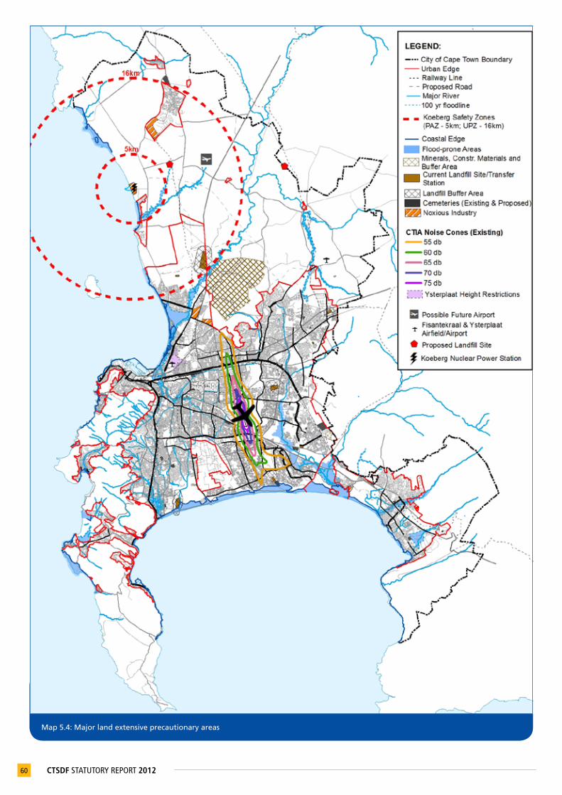
60 CTSDF STATUTORY REPORT 2012
Map 5.4: Major land extensive precautionary areas

61CTSDF STATUTORY REPORT 2012
31 WG584TransverseMercator
Note:thedateofendorsement/approvalofCitypolicieshasbeenusedratherthanthedateoftheirproductionandlegislationandpoliciesreferredtointheCTSDFwillbesupersededbyfuturerevisionsandupdates.
Table 5.7: Development controls on development surrounding Koeberg Nuclear Power Station (KNPS)
All urban development within the KNPS Precautionary Action Zone (PAZ) (area within a 5 km radius of the Koeberg nuclear reactors (X = -52727.4000, Y = -3727966.6500)) and Urgent Protective action planning Zone (UPZ) (area within a 5 km – 16km radius of the Koeberg nuclear reactors (X = -52727.4000, Y = -3727966.6500))31 must conform to the following restrictions necessary to ensure the viability of the Koeberg Nuclear Emergency Plan (KNEP):• No new development is permissible within the PAZ (as defined above) other than development that is directly related to the siting,
construction, operation and decommissioning of the KNPS or that is a result of the exercising of existing zoning rights. On this basis, no application for enhanced development rights (rezoning, subdivision, departure from land use, or Council’s consent, including application for a guesthouse or second dwelling) that will increase the transient or permanent resident population, and that is not directly related to the siting, construction, operation and decommissioning of the KNPS, can be approved. Furthermore, the projected population within the PAZ must be evacuated within four hours from the time that an evacuation order is given, as demonstrated by means of a traffic evacuation model approved by Council and acceptable to the National Nuclear Regulator (NNR).
• New development within the UPZ (as defined above) may only be approved subject to demonstration that the proposed development will not compromise the adequacy of disaster management infrastructure required to ensure the effective implementation of the KNEP (version approved by the NNR). Specifically, within the UPZ area, an evacuation time of 16 hours of the projected population, within any 67,5° sector, must be demonstrated by means of a traffic (evacuation) model approved by Council and acceptable to the NNR. The evacuation time must be measured from the time that the evacuation order is given.
These development controls will be superseded by the National ‘Regulations on Development in the Formal Emergency Planning Zone of the KNPS, when approved.
5.2.5 Appropriately manage urban development impacts on natural resources and critical biodiversity networks
Table 5.8: Environmental impact management zones (see Appendix E)
At a more detailed level of planning, each of the eight District SDPs identifies and describes the environmental constraints, opportunities and management priorities in that district. The implications of these constraints and opportunities for making land use and environmental authorisation decisions will be described in terms of environmental impact management zones (EIMZs). These include the following areas:• Hydrological zone rivers, estuaries and wetlands
• Coastal and dune zone
• Conservation and biodiversity priority zone
• Cultural and recreational resources zone
• Urban uses and utilities zone
• Natural economic resources zone
Within each EIMZ, undesirable activities or land uses will be identified, as well as the types of activities that could be desirable, but first need to undergo an environmental assessment process to assess their impacts. (See Appendix E)

Note:Thedateofendorsement/approvalofCitypolicieshasbeenusedratherthanthedateoftheirproduction,andlegislationandpoliciesreferredtointheCTSDFwillbesupersededbyfuturerevisionsandupdates.
62 CTSDF STATUTORY REPORT 2012
APPROPRIATELY MANAGE URBAN DEVELOPMENT IMPACTS ON NATURAL RESOURCES AND CRITICAL BIODIVERSITY NETWORKSPOLICY STATEMENT WHAT THIS MEANS/REQUIRES POLICY GUIDELINES RELATED LEGIS. / POLICIES
Policy 25
Increase efforts to protect and enhance biodiversity networks at all levels of government
TheCitywillleadbyexamplebyprotectingandenhancingitsbiodiversity(seemap5.5)forcurrentandfuturegenerationsby:• seekingtomeetnationalbiodiversitytargets;• seekinginnovativesolutionsforachieving
biodiversityconservationincriticalbiodiversityareaswheredevelopmentrightsalreadyexist;
• introducingacriticalbiodiversitynetworkoverlayzonethroughtheCTZS,onceapproved;
• proclaimingvaluablebiodiversityareasascontractnaturereserves,basedonthefollowingcriteria:- priorityareasadjacenttoorlinkingexisting
statutoryreserves;- areasofasufficientsizetobeself-contained
ecosystemsorwatercatchments;and- criticallyimportantandthreatenedsites;
• supportingtheconsolidationofTableMountainNationalParkascustodianofthePeninsulamountainchainandassociatedconservationland;and
• addressingthemanagementanderadicationofalienandinvasivefaunaandflorathroughappropriatemechanisms.
Specific action(s)• PrepareaBioregionalPlanInaccordancewith
NEMBA(Act10of2004)
P25.1 Carefullyassesstheimpactofproposeddevelopmentoncriticalbiodiversityareasandendangeredspecies,andmakedecisionsrelatedtothecity’sbiodiversitynetworkbasedonthedevelopmentguidelinesintherelevantDistrictSDP,otherrelevantpoliciesandthemostup-to-datemappingofthecity’sbiodiversitynetwork.
P25.2 Supporttheconsolidationofexistingconservationareasandprotectedareas.
P25.3 Biodiversityareasshouldbeconnected(wherepossible)andexistinglinkagesprotected,maintainedandimproved.
• NationalEnvironmentalManagementAct(No107of1998)
• NationalEnvironmentalManagement:BiodiversityAct(No10of2004)
• EnvironmentalAuthorisation(listingNotice3(2)oftheNationalEnvironmentalManagementAct:EnvironmentalImpactAssessmentRegulations(2010))
• TableMountainNationalParkContextualDevelopmentFramework(includingPolicy,StrategicManagementPlanandHeritageResourcesManagementPlan)(2001)
Policy 26
Reduce the impact of urban development on river systems, wetlands, aquifers, aquifer recharge areas and discharge areas
TheCitywillensurethatthewaterflowregimesandqualityofriversystemsandwetlands,aswellastheirabilitytosupporttheirnaturalfloraandfauna,arenotundulycompromised,by:• identifyingadequatefloodlinesandecological
buffers/setbacklinestopermitthefullrangeofflowregimesandfloodattenuation,andprotecttheintegrityandfunctioningofadjacentaquaticecosystems;
• identifyingadequatemeasurestoreduceimpactssuchasqualityimpairmentanderosiontoallreceivingsurfaceandgroundwatersystems;
• promotethesustainableuseandsourcingofwatersupply;
• mappingallaquiferrechargeareas;and• policingofillegalwaterextraction.
(seeMap5.6)
P26.1 AlllandusemanagementdecisionsshouldbeguidedbythedevelopmentguidelinesintherelevantDistrictSDP.
P26.2LandusemanagementdecisionsshouldtakethefollowingWSUDprinciplesintoaccount:• maintainthenaturalhydrological
behavioursofcatchments;• protectwaterqualityofsurfaceand
groundwatersystems;• minimisedemandonthepotable
watersupplysystem;• minimisesewagedischargesintothe
naturalenvironment;and• integratewaterwiththelandscape
toenhancevisual,social,culturalandecologicalvalues.
P26.3 Developmentshouldnotcompromisethefreshwaterecosystems,especiallyhighproductivityaquifersandtheirabilitytobeutilisedaswatersources.
• NationalWaterAct(No36of1998)
• WaterServicesAct(No108of1997)
• NationalEnvironmentalManagementAct(No107of1998)
• NationalEnvironmentalManagement:BiodiversityAct(Act10of2004)
• City’sFloodplainandRiverCorridorManagementPlan(2009)
• City’sManagementofStormwaterImpactsPolicy(2009)
• City’scatchmentandriverspecificmanagementplans

63CTSDF STATUTORY REPORT 2012
Map 5.5: Biodiversity network
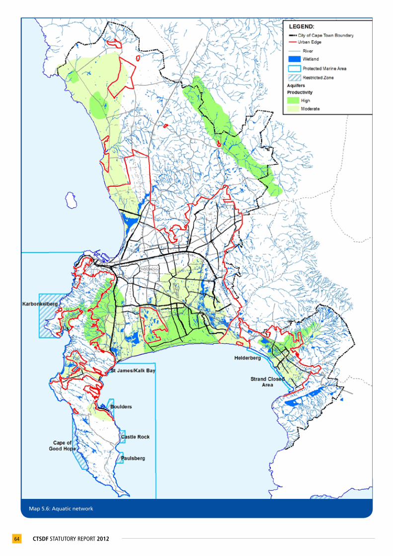
64 CTSDF STATUTORY REPORT 2012
Map 5.6: Aquatic network

Note:Thedateofendorsement/approvalofCitypolicieshasbeenusedratherthanthedateoftheirproduction,andlegislationandpoliciesreferredtointheCTSDFwillbesupersededbyfuturerevisionsandupdates.
65CTSDF STATUTORY REPORT 2012
APPROPRIATELY MANAGE URBAN DEVELOPMENT IMPACTS ON NATURAL RESOURCES AND CRITICAL BIODIVERSITY NETWORKSPOLICY STATEMENT WHAT THIS MEANS/REQUIRES POLICY GUIDELINES RELATED LEGIS. / POLICIES
Policy 27
Manage urban development along the coast in a sustainable and precautionary manner
InaccordancewiththeICMA(No24of2009)theCitywillmanagecoastaldevelopmentinawaythatenablesnaturalsystemstofunctionsustainably,reducesfloodrisk,andmakesresponsibleuseoftheeconomicandsocialbenefitsofthecoastalarea. TheCitywillsupportthedevelopmentofmixedlandusesintheproposednewcoastalnodes:Silwerstroomstrand;Strandfontein;Mnandi;andMonwabisi. Theactualfootprintofdevelopmentwithinthesenodeswillbedeterminedthroughmoredetailedstudies/plans.
Specific actions• Preparelocalspatialplansfor
Silwerstroomstrand,Strandfontein,MnandiandMonwabisiandfacilitatetheirimplementation.
P27.1AlllandusemanagementdecisionsshouldbeguidedbythedevelopmentguidelinesintherelevantDistrictSDPandotherrelevantguidelinesandalsointermsoftheCoastalProtectionManagementZoneByLawwhenapproved.
P27.2Whenassessingdevelopmentapplicationsalongthecoasttheareaspotentiallyaffectedbyclimatechangeandsea-levelrise,andadjacenttoriveroutletsshouldbetakenintoaccount(seeMap5.4).
P27.3 Promotenodalratherthancontinuousstripdevelopmentinareasidentifiedforurbandevelopmentalongthecoast.
P27.4Userelevantcoastal(seepolicyP27.2)andlanduseguidelinestoassessallland-basedactivitiesassociatedwithaquaculture.
• NationalEnvironmentalManagment:IntegratedCoastalManagementAct(No24of2010)
• CoastalZoneManagementBylaw(draft2011)
• City’sDevelopmentEdgesPolicy:UrbanandCoastalEdge(draft2010)
• CoastalDevelopmentGuidanceforCapeTown’sCoastlineintotheFuture(draft2007)
• City’scatchmentandriverspecificmanagementplans
Policy 28
Protect valuable agricultural areas, existing farmed areas and horticultural areas from urban encroachment, and support urban agriculture
AgriculturalareasareessentialforfoodsecurityinCapeTown.Topromotefoodsecurity,andhelpmitigatefoodpriceincreases,theCityshouldtherefore:• considerhaving‘high-potentialandunique
agriculturalareas’(seeMap5.7)declaredasagricultural/culturallandscapesbythehighestappropriatelevelofauthority;
• investigatewaysinwhichallagriculturalareasofsignificantvalue(seeMap5.7)couldreceivelocalprotection(overandabovetheurbanedge).Optionsincludeenvironmentalorheritageoverlayzonesappliedthroughtherelevantzoningregulations;
• investigateandencouragethedevelopmentofopportunitiesforexpandedurbanagriculture,particularlyinareaswherethiscanlinktoothereconomicactivities,andprovidelivelihoodsto‘vulnerablecommunitiesandprovidefordirecthouseholdconsumption;and
• insideandoutsidetheurbanedgeproactivelyprepareandimplementaction/managementplansthatpreventurbanencroachmentandunlawfullanduseinagriculturalareas,minimisenegativeimpactsofurbandevelopmentonfarmedlandandmanageuseofwaterandothernaturalresources.
Specificaction(s)• Investigatethefeasibilityof‘high-potential
anduniqueagriculturalareas’beingdeclaredagricultural/culturallandscapes.
• SchaapkraalUrbanEdgeInvestigation.• Activelypolicethedevelopmentofnon-
conforminglanduses,especiallyinthePhilippiHorticulturalArea.
P28.1AlllandusemanagementdecisionsshouldbeguidedbythedevelopmentguidelinesintherelevantDistrictSDP.
P28.2 ThesectionofthePhilippiHorticulturalAreathatisexcludedfromurbandevelopmentbytheurbanedgeshouldberetainedforhorticulturalpurposesandtheexploitationofsilicainthelongterm.
P28.3 DiscouragethefurthersubdivisionoflandinthePhilippiHorticulturalAreabelowwhatispermittedbythezoningandnofurthertownshipdevelopmentshouldbeconsidered.
P28.4 DiscouragedevelopmentthatunderminesagriculturalactivityinPhilippiandConstantia,LourensfordandDurbanvillewinelands/culturallandscapes.
• SubdivisionofAgriculturalLandAct(No70of1970)
• NationalHeritageResourcesAct(No25of1999)
• CapeTownZoningScheme(draft2010)
• City’sIntegratedMetropolitanEnvironmentalPolicy(2001)
• City’sPhilippiHorticulturalAreaManagementPlan(2002)

66 CTSDF STATUTORY REPORT 2012
Map 5.7: Agricultural areas to be protected

Note:Thedateofendorsement/approvalofCitypolicieshasbeenusedratherthanthedateoftheirproduction,andlegislationandpoliciesreferredtointheCTSDFwillbesupersededbyfuturerevisionsandupdates.
67CTSDF STATUTORY REPORT 2012
APPROPRIATELY MANAGE URBAN DEVELOPMENT IMPACTS ON NATURAL RESOURCES AND CRITICAL BIODIVERSITY NETWORKSPOLICY STATEMENT WHAT THIS MEANS/REQUIRES POLICY GUIDELINES RELATED LEGIS. / POLICIES
Policy 29
Adopt a proactive planning approach to mining resource management
TheCityshould:• proactivelymanagecurrentandfuture
developmentareastoensurethatsandminingresourcesare,whereappropriate,exploitedpriortodevelopmentcommencing;and
• assisttheDepartmentofMineralResources(DMR)toclosedownallillegalminingoperations.
P29.1 Protectimportantminingresourceareas,suchasrockandstonemining,aswellasspecificmineraldepositsandsurroundingtheirbufferzonestopermitfutureextraction.Onlyusesrelatedtotheextractionofmaterialsandfarmingshouldbeconsideredintheextractionareas.
P29.2 AlllanduseauthorisationsinmineralextractionareasshouldbeinformedbythedevelopmentguidelinesintherelevantDistrictSDP.
5.2.6 Make efficient use of non-renewable resources
MAKE EFFICIENT USE OF NON-RENEWABLE RESOURCESPOLICY STATEMENT WHAT THIS MEANS/REQUIRES POLICY GUIDELINES RELATED LEGIS. /POLICIES
Policy 30
Promote a culture of sustainable development and living
TheCityshould:• encouragethepublicandprivatesectorto
utilisesustainablepracticesandtechnologiesthatassistinreducingcarbonemissions,reduceenergyandwaterdemand,promotepublictransportandsupporttherecyclingofwaterandwastematerials;
• adoptanintegratedapproachtoenergyandwaterdemandmanagement;and
• introduceand/orsupporttheintroductionandimplementationofdevelopmentbylawsandpoliciesonsustainableresourceuse.
Specific action(s)• PrepareResourceEfficientDevelopmentPolicy.
P30.1Considerpassivesolardesignprincipleswhenassessingbuildingplansandlayoutsi.e.considerthemaintenanceofinteriorthermalcomfortthroughoutthesun'sdailyandannualcycleswhilstreducingtherequirementforactiveheatingandcoolingsystems.
P30.2 Promotegreenbuildingsinlinewithrelevantguidelines.
• NationalBuildingRegulationsandBuildingStandardsAct(No103of1977)
• GreenBuildingGuidelines(Draft2008)
5.2.7 Protect and enhance the city’s rural environment
Definition of ‘rural environment’
A geographic area within which a range and diversity of rural-associated activities are accommodated outside the Urban Edge. All of these activities are essentially of a rural character, function and form, and include agriculture, community commonages, conservation, agro-tourism and eco-tourism, and bulk infrastructure and facilities serving the rural area, or bulk infrastructure serving the urban areas.
PROTECT AND ENHANCE THE CITY’S RURAL ENVIRONMENTPOLICY STATEMENT WHAT THIS MEANS/REQUIRES POLICY GUIDELINES RELATED LEGIS. /POLICIES
Policy 31
Prevent urban development from intruding into the rural environment
P31.1 Residential,commercial,businessandindustriallanduses,golfestates,eco-estates,andruralliving,vineyardandequestrianestateswitharesidentialcomponentareconsideredtobeurbandevelopment,andshouldbelimitedtotheareasinsidetheUrbanEdge.
• ProvincialSpatialDevelopmentFramework:RuralLandUsePlanningandManagementGuidelines(2009)

Note:Thedateofendorsement/approvalofCitypolicieshasbeenusedratherthanthedateoftheirproduction,andlegislationandpoliciesreferredtointheCTSDFwillbesupersededbyfuturerevisionsandupdates.
68 CTSDF STATUTORY REPORT 2012
PROTECT AND ENHANCE THE CITY’S RURAL ENVIRONMENTPOLICY STATEMENT WHAT THIS MEANS/REQUIRES POLICY GUIDELINES RELATED LEGIS. /POLICIES
Policy 32
Support appropriate development and activities in rural areas, and in and around unique and culturally significant rural settlements
Strategicplanninginterventionisrequiredtoprotectandenhanceruralsettlements,suchasPella,Mamre,PhiladelphiaandKlipheuwel. Interventionsincludethefollowing:• useurbanedgestoshapethesesettlements’
growthintheshorttomediumterm;• identifyandimplementguidelinesfor
maintainingandenhancingeachsettlement’ssenseofplaceandcharacter;and
• facilitatethedevelopmentofeconomicactivitiesthatcounteractthe‘dormitory’natureofthesesettlements,suchasheritagetourism,eco-tourism,intensiveagriculturalopportunitiesadjacenttothesettlements(includinglandreformandcommonageoptions),andagro-industry.
Specific action(s)• Onprominentslopesdetermineamaximum
contourheighthigherthanwhichanybuiltformwillnotbepermittedinDistrictSDPsand/orlocalplans.ThisrefersspecificallytolandoutsidetheUrbanEdgebutmayalsorefertolandinsidetheUrbanEdge.Indeterminingthemaximumcontourlevelforbuiltformnoas-of-rightbuildingorzoningrightswillberemoved,theintentionbeingonlytoconcentratebuiltformonthelowerslopesofanerf.
P32.1Appropriatedevelopmentinruralareas,i.e.beyondtheUrbanEdge,includes:• developmentassociatedwith
farmingactivities,suchasworkerhousing,sheds,wineries,marketgardeningtunnelsand,incertainareas,agro-industrialactivities(suchaschickenbatteries)andsmall-scalefarming;
• moregeneraldevelopmentrelatedtorurallandscapes,suchastourism,nurseries,miningandrecreationalactivities(equestrian,shooting,mountainandquad-biking,landingstripsandcycleroutes);and
• essentialmunicipalinfrastructure,suchaswastewatertreatmentworks,solidwastedisposalsites,powergenerationsites,watertreatmentsitesandcemeteries.Thesitingofthisinfrastructureshouldbecarefullyconsidered,andimpactonrurallandscapesshouldbeminimised.
P32.2 Criticallanduseandbuiltformconsiderationsaredevelopments’prominence,potentialnegativevisualimpactontherurallandscape,servicerequirements,vehiculartrafficgenerationandthescale,formandlocationofeachdevelopmentinitslandscapecontext.
• ProvincialSpatialDevelopmentFramework:RuralLandUsePlanningandManagementGuidelines(2009)
• City’sUrbanEdgePlan:Atlantis,Mamre,Pella,PhiladelphiaandKlipheuwel(draft2008)
• City’sDevelopmentEdgesPolicy:UrbanandCoastalEdge(draft2010)
• City’sIntegratedMetropolitanEnvironmentalPolicy(2001)
Policy 33
Rationalise and proactively manage smallholdings
• Maintainthecharacterofexistingsmallholdingareasoutsidetheurbanedge.
• Findcreativewaystouseratesandservicechargestosupportruralactivitieswithinsmallholdingareas.
P33.1 DonotestablishanymoresmallholdingsoutsidetheUrbanEdge.
P33.2 Preventtheintrusionofnon-conforminglanduses.
P33.3 Theminimumsubdivisionsizeinsmallholdingareasmustadheretozoning,DistrictSDPsandlocalplans.
• ProvincialSpatialDevelopmentFramework:RuralLandUsePlanningandManagementGuidelines(2009)
Policy 34
Develop and manage rural gateways
TheCityshouldrecogniseexistingmajorgateways(seeMap5.8)andidentifyadditionalgateways. Themanagementofsomegateways,forexampleontheN1,requirescross-bordercollaboration.
Specific action(s)• PrepareanN1gatewaymanagementplan.• Prepareurbandesignandlandscapeframeworks
foreachgatewayarea.
P34.1 Theintrinsiccharacteristicsthatgivethegatewaystheirsenseofplaceshoulddeterminetheappropriatemix,scaleandlocationofactivitiessurroundingthem.
• ScenicDrivesNetworkManagementPlan(Vol.3,2003)
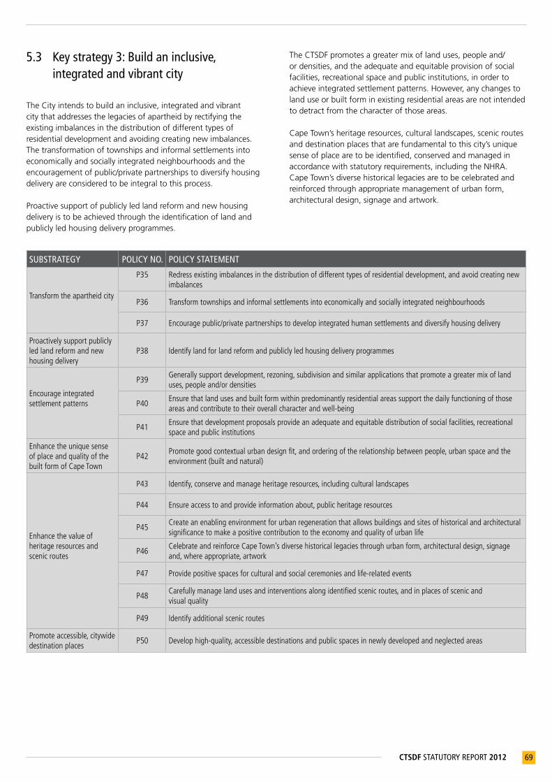
69CTSDF STATUTORY REPORT 2012
5.3 Key strategy 3: Build an inclusive, integrated and vibrant city
The City intends to build an inclusive, integrated and vibrant city that addresses the legacies of apartheid by rectifying the existing imbalances in the distribution of different types of residential development and avoiding creating new imbalances. The transformation of townships and informal settlements into economically and socially integrated neighbourhoods and the encouragement of public/private partnerships to diversify housing delivery are considered to be integral to this process.
Proactive support of publicly led land reform and new housing delivery is to be achieved through the identification of land and publicly led housing delivery programmes.
The CTSDF promotes a greater mix of land uses, people and/or densities, and the adequate and equitable provision of social facilities, recreational space and public institutions, in order to achieve integrated settlement patterns. However, any changes to land use or built form in existing residential areas are not intended to detract from the character of those areas.
Cape Town’s heritage resources, cultural landscapes, scenic routes and destination places that are fundamental to this city’s unique sense of place are to be identified, conserved and managed in accordance with statutory requirements, including the NHRA. Cape Town’s diverse historical legacies are to be celebrated and reinforced through appropriate management of urban form, architectural design, signage and artwork.
SUBSTRATEGY POLICY NO. POLICY STATEMENT
Transformtheapartheidcity
P35 Redressexistingimbalancesinthedistributionofdifferenttypesofresidentialdevelopment,andavoidcreatingnewimbalances
P36 Transformtownshipsandinformalsettlementsintoeconomicallyandsociallyintegratedneighbourhoods
P37 Encouragepublic/privatepartnershipstodevelopintegratedhumansettlementsanddiversifyhousingdelivery
Proactivelysupportpubliclyledlandreformandnewhousingdelivery
P38 Identifylandforlandreformandpubliclyledhousingdeliveryprogrammes
Encourageintegratedsettlementpatterns
P39Generallysupportdevelopment,rezoning,subdivisionandsimilarapplicationsthatpromoteagreatermixoflanduses,peopleand/ordensities
P40Ensurethatlandusesandbuiltformwithinpredominantlyresidentialareassupportthedailyfunctioningofthoseareasandcontributetotheiroverallcharacterandwell-being
P41Ensurethatdevelopmentproposalsprovideanadequateandequitabledistributionofsocialfacilities,recreationalspaceandpublicinstitutions
EnhancetheuniquesenseofplaceandqualityofthebuiltformofCapeTown
P42Promotegoodcontextualurbandesignfit,andorderingoftherelationshipbetweenpeople,urbanspaceandtheenvironment(builtandnatural)
Enhancethevalueofheritageresourcesandscenicroutes
P43 Identify,conserveandmanageheritageresources,includingculturallandscapes
P44 Ensureaccesstoandprovideinformationabout,publicheritageresources
P45Createanenablingenvironmentforurbanregenerationthatallowsbuildingsandsitesofhistoricalandarchitecturalsignificancetomakeapositivecontributiontotheeconomyandqualityofurbanlife
P46CelebrateandreinforceCapeTown’sdiversehistoricallegaciesthroughurbanform,architecturaldesign,signageand,whereappropriate,artwork
P47 Providepositivespacesforculturalandsocialceremoniesandlife-relatedevents
P48Carefullymanagelandusesandinterventionsalongidentifiedscenicroutes,andinplacesofscenicandvisualquality
P49 Identifyadditionalscenicroutes
Promoteaccessible,citywidedestinationplaces
P50 Develophigh-quality,accessibledestinationsandpublicspacesinnewlydevelopedandneglectedareas

Note:Thedateofendorsement/approvalofCitypolicieshasbeenusedratherthanthedateoftheirproduction,andlegislationandpoliciesreferredtointheCTSDFwillbesupersededbyfuturerevisionsandupdates.
70 CTSDF STATUTORY REPORT 2012
5.3.1 Transform the apartheid city
TRANSFORM THE APARTHEID CITYPOLICY STATEMENTS WHAT THIS MEANS/REQUIRES POLICY GUIDELINES RELATED LEGIS / POLICIES
Policy 35
Redress existing imbalances in the distribution of different types of residential development, and avoid creating new imbalances
ThisimpliesthattheCityshould:• promoteagreatermixofmarket-driven,gap
andsubsidisedhousingdevelopmentsinasmanyneighbourhoodsaspossible;
• avoidmakingdecisionsregardingtheaffordabilityoflandforsubsidised,rental,socialandgaphousingprogrammesandprojectsonthebasisofpricealone.Theshort-termandlong-termcapitalandrecurrentoperatingcosts/savingsincurredbythebeneficiariesandtherelevantCitydepartmentsmustbefactoredintothecalculationofthepriceoflanddevelopment;
• supportincreasedownershipmobilitybetweenformer‘township’areasandformalsuburbsthatarewelllocatedintermsofemploymentandamenityopportunities;
• adoptaspatialfair-shareapproachtotheidentificationoflandand/orhousingopportunitiesforsubsidisedandgaphousing;
• whereappropriate,usepubliclyandSOE-ownedinfillsitestohelpreconfigurethedistributionoflandusesandpeople;and
• increaselow-incomeearners’accesstoaffordablehousingthatislocatedclosetothecity’seconomicopportunities.
P35.1Avoidverylargeconcentrationsofpoorpeople,similartothoseintheMetroSoutheast,innewgrowthareas.
P35.2SupportthedevelopmentofsocialhousinginUrbanRestructuringZones.
P35.3Promotearangeofsize,typeandcostofhousingopportunities,inappropriatelocationsinnewdevelopmentareasandalongdevelopmentcorridors,activity/developmentroutesandactivitystreets,withgoodaccesstoeconomicopportunities,publictransportandsocialfacilities.
• SocialHousingAct(Act16of2008)
• UpgradingofLandTenureRightsAct(Act112of1991)
Policy 36
Transform townships and informal settlements into economically and socially integrated neighbourhoods
Giventhelegacyofapartheid,thetransformationoftownshipsandinformalsettlementswillnottakeplaceovernight,norwillittakeplacewithoutawell-formulatedplanofactionsupportedbypublicinvestment.PriorityshouldbegiventoincrementallyimprovingthelivingconditionsandsenseofcitizenshipofthemostmarginalisedresidentsofCapeTown,thehomelessandthepoorlyhoused.
Interventions in support of this strategy should:• seektobringjobsclosertothesesettlements;• improvethepublic,naturalandcultural
environment;• ensureaccesstoessentialsocialservices,and
addresscriticalsocialfacilityshortfalls;• maintain,improveandexpandthelevelof
infrastructure,servicesandfacilitiesonanongoingbasis.Whereinformalsettlementsarelocatedonlandthat,forhealthandsafetyreasons,isnotsuitedtodevelopment,supporttheidentificationanddevelopmentofalternativelandwhereresidentscouldbesettled;
• developminimumstandardguidelinesthatareacceptabletobothinformalsettlementcommunitiesaswellasinfrastructureserviceproviders;and
• supporttheViolencePreventionthroughUrbanUpgradingProgramme(VPUU).
Specific action(s)Supportthepreparationofacross-sectoralinformalsettlementsupgradeplan.
P36.1 Supporttheupgradeofexistinginformalsettlementsthatarelocatedonlandsuitedtourbandevelopment.
P36.2Wheredensitiesaretoohightofacilitatetheupgradeofanarea,supportthede-densificationofthesettlements,andassistwiththeidentificationanddevelopmentofalternativelandwhereresidentscouldbesettled.
• City’sCulturalHeritageStrategy(2005)
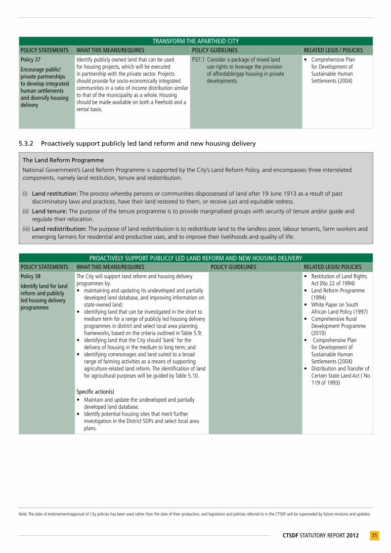
Note:Thedateofendorsement/approvalofCitypolicieshasbeenusedratherthanthedateoftheirproduction,andlegislationandpoliciesreferredtointheCTSDFwillbesupersededbyfuturerevisionsandupdates.
71CTSDF STATUTORY REPORT 2012
TRANSFORM THE APARTHEID CITYPOLICY STATEMENTS WHAT THIS MEANS/REQUIRES POLICY GUIDELINES RELATED LEGIS / POLICIES
Policy 37
Encourage public/private partnerships to develop integrated human settlements and diversify housing delivery
Identifypubliclyownedlandthatcanbeusedforhousingprojects,whichwillbeexecutedinpartnershipwiththeprivatesector.Projectsshouldprovideforsocio-economicallyintegratedcommunitiesinaratioofincomedistributionsimilartothatofthemunicipalityasawhole.Housingshouldbemadeavailableonbothafreeholdandarentalbasis.
P37.1Considerapackageofmixedlanduserightstoleveragetheprovisionofaffordable/gaphousinginprivatedevelopments.
• ComprehensivePlanforDevelopmentofSustainableHumanSettlements(2004)
5.3.2 Proactively support publicly led land reform and new housing delivery
The Land Reform Programme
National Government’s Land Reform Programme is supported by the City’s Land Reform Policy, and encompasses three interrelated components, namely land restitution, tenure and redistribution.
(i) Land restitution: The process whereby persons or communities dispossessed of land after 19 June 1913 as a result of past discriminatory laws and practices, have their land restored to them, or receive just and equitable redress.
(ii) Land tenure: The purpose of the tenure programme is to provide marginalised groups with security of tenure and/or guide and regulate their relocation.
(iii) Land redistribution: The purpose of land redistribution is to redistribute land to the landless poor, labour tenants, farm workers and emerging farmers for residential and productive uses, and to improve their livelihoods and quality of life.
PROACTIVELY SUPPORT PUBLICLY LED LAND REFORM AND NEW HOUSING DELIVERYPOLICY STATEMENTS WHAT THIS MEANS/REQUIRES POLICY GUIDELINES RELATED LEGIS/ POLICIES
Policy 38
Identify land for land reform and publicly led housing delivery programmes
TheCitywillsupportlandreformandhousingdeliveryprogrammesby:• maintainingandupdatingitsundevelopedandpartially
developedlanddatabase,andimprovinginformationonstate-ownedland;
• identifyinglandthatcanbeinvestigatedintheshorttomediumtermforarangeofpubliclyledhousingdeliveryprogrammesindistrictandselectlocalareaplanningframeworks,basedonthecriteriaoutlinedinTable5.9;
• identifyinglandthattheCityshould‘bank’forthedeliveryofhousinginthemediumtolongterm;and
• identifyingcommonagesandlandsuitedtoabroadrangeoffarmingactivitiesasameansofsupportingagriculture-relatedlandreform.TheidentificationoflandforagriculturalpurposeswillbeguidedbyTable5.10.
Specific action(s)• Maintainandupdatetheundevelopedandpartially
developedlanddatabase.• Identifypotentialhousingsitesthatmeritfurther
investigationintheDistrictSDPsandselectlocalareaplans.
• RestitutionofLandRightsAct(No22of1994)
• LandReformProgramme(1994)
• WhitePaperonSouthAfricanLandPolicy(1997)
• ComprehensiveRuralDevelopmentProgramme(2010)
• ComprehensivePlanforDevelopmentofSustainableHumanSettlements(2004)
• DistributionandTransferofCertainStateLandAct(No119of1993)
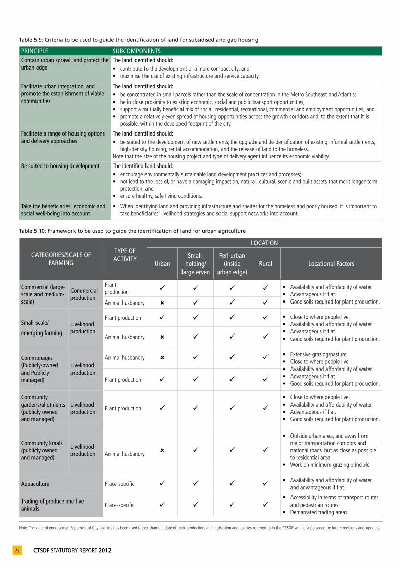
Note:Thedateofendorsement/approvalofCitypolicieshasbeenusedratherthanthedateoftheirproduction,andlegislationandpoliciesreferredtointheCTSDFwillbesupersededbyfuturerevisionsandupdates.
72 CTSDF STATUTORY REPORT 2012
Table 5.9: Criteria to be used to guide the identification of land for subsidised and gap housing
PRINCIPLE SUBCOMPONENTSContain urban sprawl, and protect the urban edge
The land identified should:• contributetothedevelopmentofamorecompactcity;and• maximisetheuseofexistinginfrastructureandservicecapacity.
Facilitate urban integration, and promote the establishment of viable communities
The land identified should:• beconcentratedinsmallparcelsratherthanthescaleofconcentrationintheMetroSoutheastandAtlantis;• beincloseproximitytoexistingeconomic,socialandpublictransportopportunities;• supportamutuallybeneficialmixofsocial,residential,recreational,commercialandemploymentopportunities;and• promotearelativelyevenspreadofhousingopportunitiesacrossthegrowthcorridorsand,totheextentthatitis
possible,withinthedevelopedfootprintofthecity.
Facilitate a range of housing options and delivery approaches
The land identified should:• besuitedtothedevelopmentofnewsettlements,theupgradeandde-densificationofexistinginformalsettlements,
high-densityhousing,rentalaccommodation,andthereleaseoflandtothehomeless.Notethatthesizeofthehousingprojectandtypeofdeliveryagentinfluenceitseconomicviability.
Be suited to housing development The identified land should:• encourageenvironmentallysustainablelanddevelopmentpracticesandprocesses;• notleadtothelossof,orhaveadamagingimpacton,natural,cultural,scenicandbuiltassetsthatmeritlonger-term
protection;and• ensurehealthy,safelivingconditions.
Take the beneficiaries’ economic and social well-being into account
• Whenidentifyinglandandprovidinginfrastructureandshelterforthehomelessandpoorlyhoused,itisimportanttotakebeneficiaries’livelihoodstrategiesandsocialsupportnetworksintoaccount.
Table 5.10: Framework to be used to guide the identification of land for urban agriculture
CATEGORIES/SCALE OF FARMING
TYPE OF ACTIVITY
LOCATION
UrbanSmall-
holding/ large erven
Peri-urban (inside
urban edge)Rural Locational Factors
Commercial (large-scale and medium- scale)
Commercial production
Plantproduction
• Availabilityandaffordabilityofwater.• Advantageousifflat.• Goodsoilsrequiredforplantproduction.Animalhusbandry
Small-scale/
emerging farmingLivelihood production
Plantproduction • Closetowherepeoplelive.• Availabilityandaffordabilityofwater.• Advantageousifflat.• Goodsoilsrequiredforplantproduction.Animalhusbandry
Commonages (Publicly-owned and Publicly-managed)
Livelihood production
Animalhusbandry • Extensivegrazing/pasture.• Closetowherepeoplelive.• Availabilityandaffordabilityofwater.• Advantageousifflat.• Goodsoilsrequiredforplantproduction.
Plantproduction
Community gardens/allotments (publicly owned and managed)
Livelihood production
Plantproduction
• Closetowherepeoplelive.• Availabilityandaffordabilityofwater.• Advantageousifflat.• Goodsoilsrequiredforplantproduction.
Community kraals (publicly owned and managed)
Livelihood production Animalhusbandry
• Outsideurbanarea,andawayfrommajortransportationcorridorsandnationalroads,butascloseaspossibletoresidentialarea.
• Workonminimum-grazingprinciple.
Aquaculture Place-specific• Availabilityandaffordabilityofwater
andadvantageousifflat.
Trading of produce and live animals
Place-specific• Accessibilityintermsoftransportroutes
andpedestrianroutes.• Demarcatedtradingareas.

Note:Thedateofendorsement/approvalofCitypolicieshasbeenusedratherthanthedateoftheirproduction,andlegislationandpoliciesreferredtointheCTSDFwillbesupersededbyfuturerevisionsandupdates.
73CTSDF STATUTORY REPORT 2012
5.3.3 Encourage integrated settlement patterns
ENCOURAGE INTEGRATED SETTLEMENT PATTERNSPOLICY STATEMENTS WHAT THIS MEANS/REQUIRES POLICY GUIDELINES RELATED LEGIS /POLICIES
Policy 39
Generally support development, rezoning, subdivision and similar applications that promote a greater mix of land uses, people and/or densities
TheCitywillstriveto:• facilitateagreatermixofpeopleand
landuses;• promotegoodaccesstoeconomic
opportunities,publicinstitutions,socialfacilitiesandpublictransport;
• encouragedevelopmentsthatprovidearangeofhousingoptionstodifferenthousingmarkets;
• locateeconomicactivitiesclosertolow-incomeresidentialareas;and
• locatehousingclosertoworkopportunities.
P39.1Supportamixoflandusesandhigher-densityresidentialdevelopment(compliantwitharea-specificpolicyframeworks)inappropriatelocationsinnewdevelopmentareasandalongactivityroutes,developmentroutesandactivitystreets.
P39.2Carefullyconsidertheimpactofdevelopmentsontheenvironmental,heritageorsceniccharacteristicsandsenseofplaceofanarea.
• CapeTownZoningScheme(draft2010)• City’sDensificationPolicy(draft2010)
Policy 40
Ensure that land uses and built form within predominantly residential areas support the daily functioning of those areas, and contribute to their overall character and well-being
Withcarefuldesignandgoodurbanmanagement,manyactivitiescanbelocatedwithinornearpredominantlyresidentialareas.Examplesofcomplementarylandusesincludelocalcornerorspazashops,live-workunitsandearlychildhooddevelopmentfacilities.
Examplesoflanduseslikelytobeincompatiblewithpredominantlyresidentialareasinclude:• certainindustries,particularlynoxious
andland-extensiveindustries;• activitiesassociatedwiththeautorepair
industry,suchaspanelbeaters;• shebeensandliquoroutlets;• activitiesthatrequirestorageof
significantamountsofhazardousmaterials;
• activitiesthatattractunacceptablyhightrafficvolumes;and
• activitiesthatcreateunacceptablyhighlevelsofnoise,particularly,butnotonly,outsideofnormalbusinesshours,suchasnightclubs.
P40.1 Carefullyconsiderthecompatibilityoflanduseswhenassessingrezoningandotherapplicationsinpredominantlyresidentialareasandattheinterfacesoftheseareaswithmixedusenodesandhigherlanduseintensityareas.
P40.2Supporttheincrementalformalisationorregularisationofappropriateeconomicactivities.

Note:Thedateofendorsement/approvalofCitypolicieshasbeenusedratherthanthedateoftheirproduction,andlegislationandpoliciesreferredtointheCTSDFwillbesupersededbyfuturerevisionsandupdates.
74 CTSDF STATUTORY REPORT 2012
Definition of ‘mixed land use’
Mixed land use refers to the horizontal and vertical integration of suitable and compatible residential and non-residential land uses within the same area or on the same parcel of land.
The importance of social facilities, public institutions and public open spaces
Social facilities, public institutions and public open spaces provide an essential collective support system for the urban population. In an environment of resource constraints, a focus on the communal facilities and public places of urban life could have a significant impact on people’s living conditions.
ENCOURAGE INTEGRATED SETTLEMENT PATTERNSPOLICY STATEMENTS WHAT THIS MEANS/REQUIRES POLICY GUIDELINES RELATED LEGIS /POLICIES
Policy 41
Ensure that development proposals provide an adequate and equitable distribution of social facilities, recreational space and public institutions
TheCityandotherspheresofgovernmentandbodiesresponsiblefortheprovisionofsocialfacilities,recreationalspacesandpublicinstitutionsshould:• ensurethatadequateprovisionis
madeforsocialfacilities,recreationalspacesandpublicinstitutionswhencommentingondevelopmentapplications;
• createabalancebetweenaddressingcriticalbacklogs,andaddressingtheneedsofnewdevelopmentareas;
• preparemedium-termplansandbudgetsfortheacquisitionoflandandthedevelopmentoffacilities;
• providefewerfacilitiesofabetterqualitywhereresourcesaretooscarcetoaccommodateallrequirements;and
• spatiallydistributesocialfacilities,recreationalspacesandpublicinstitutionsaccordingtoahierarchyoftypes(seeAppendixF).
Specific action(s)TheCitymustdeveloppoliciesandguidelinestoguidetheprovisionanddistributionofsocialfacilities,recreationalspacesandpublicinstitutions(ReferTable5.11and5.12)
P41.1 Compatiblesocialfacilities,recreationalspacesandpublicinstitutionsofasimilarscale/threshold,travelmodeanddistanceshouldbeclusteredtogetherincivicprecinctstoreinforceoneanother,increasetheirconvenienceofuse,andincreasesafetyandsecurity.
P41.2Encouragethemulti-functionaluseofsocialfacilities,placesforculturalpractices,recreationalspacesandpublicinstitutions.
P41.3 Therequirementtoprovide1.8haofPOS/1000personswillremainconsistentwithProvincialCircularLG/PB.15/1986untiltheCityhaspreparedarecreationalopenspaceoperationalpolicyorunlessthiscircularisupdatedbyPG:WC.Intheinterim,Table5.11andTable5.12willguidetheprovision,distributionanddesignofsocialfacilitiesandrecreationalspaces.
• WesternCapeLandUsePlanningOrdinance(No15of1985)andassociatedregulations
• GuidelinesforHumanSettlementPlanningandDesign(2000)
• City’sCulturalHeritageStrategy(2005)• City’sCoasttoCoastGreenway(1982)• City’sFloodplainandRiverCorridor
ManagementPolicy(2009)
Table 5.11: Detailed plans, policies and guidelines to guide the provision and distribution of social facilities, recreational spaces and public institutions
The plans, policies and guidelines related to the provision and distribution of social facilities, recreational spaces and public institutions should include:
• District SDPs that notionally distribute the metropolitan and district-significant civic precincts and recreational spaces;
• Local area development/social facility, recreational space and public institution plans, showing the distribution of recreational spaces, social facilities and appropriate public institutions;
• A recreational space operational policy to determine the provision and distribution of public open space (POS) and guide the City’s interactions with developers, and payments in lieu of the provision of recreational spaces; and
• Design guidelines to enhance the quality and performance of recreational open space.
The abovementioned plans, policies and guidelines should be informed by the Summary Guidelines and Standards for the Planning of City of Cape Town Social Facilities and Recreational Spaces (see Appendix F)
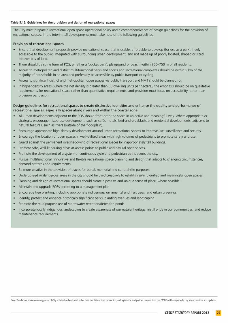
Note:Thedateofendorsement/approvalofCitypolicieshasbeenusedratherthanthedateoftheirproduction,andlegislationandpoliciesreferredtointheCTSDFwillbesupersededbyfuturerevisionsandupdates.
75CTSDF STATUTORY REPORT 2012
Table 5.12: Guidelines for the provision and design of recreational spaces
The City must prepare a recreational open space operational policy and a comprehensive set of design guidelines for the provision of recreational spaces. In the interim, all developments must take note of the following guidelines:
Provision of recreational spaces
• Ensure that development proposals provide recreational space that is usable, affordable to develop (for use as a park), freely accessible to the public, integrated with surrounding urban development, and not made up of poorly located, shaped or sized leftover bits of land.
• There should be some form of POS, whether a ‘pocket park’, playground or beach, within 200–750 m of all residents.
• Access to metropolitan and district multifunctional parks and sports and recreational complexes should be within 5 km of the majority of households in an area and preferably be accessible by public transport or cycling.
• Access to significant district and metropolitan open spaces via public transport and NMT should be planned for.
• In higher-density areas (where the net density is greater than 50 dwelling units per hectare), the emphasis should be on qualitative requirements for recreational space rather than quantitative requirements, and provision must focus on accessibility rather than provision per person.
Design guidelines for recreational spaces to create distinctive identities and enhance the quality and performance of recreational spaces, especially spaces along rivers and within the coastal zone.
• All urban developments adjacent to the POS should front onto the space in an active and meaningful way. Where appropriate or strategic, encourage mixed-use development, such as cafés, hotels, bed-and-breakfasts and residential developments, adjacent to natural features, such as rivers (outside of the floodplain).
• Encourage appropriate high-density development around urban recreational spaces to improve use, surveillance and security.
• Encourage the location of open spaces in well-utilised areas with high volumes of pedestrians to promote safety and use.
• Guard against the permanent overshadowing of recreational spaces by inappropriately tall buildings.
• Promote safe, well-lit parking areas at access points to public and natural open spaces.
• Promote the development of a system of continuous cycle and pedestrian paths across the city.
• Pursue multifunctional, innovative and flexible recreational space planning and design that adapts to changing circumstances, demand patterns and requirements.
• Be more creative in the provision of places for burial, memorial and cultural-rite purposes.
• Underutilised or dangerous areas in the city should be used creatively to establish safe, dignified and meaningful open spaces.
• Planning and design of recreational spaces should create a positive and unique sense of place, where possible.
• Maintain and upgrade POSs according to a management plan.
• Encourage tree planting, including appropriate indigenous, ornamental and fruit trees, and urban greening.
• Identify, protect and enhance historically significant parks, planting avenues and landscaping.
• Promote the multipurpose use of stormwater retention/detention ponds.
• Incorporate locally indigenous landscaping to create awareness of our natural heritage, instill pride in our communities, and reduce maintenance requirements.

Note:Thedateofendorsement/approvalofCitypolicieshasbeenusedratherthanthedateoftheirproduction,andlegislationandpoliciesreferredtointheCTSDFwillbesupersededbyfuturerevisionsandupdates.
76 CTSDF STATUTORY REPORT 2012
5.3.4 Enhance the unique sense of place and quality of the built form of Cape Town
ENHANCE THE UNIQUE SENSE OF PLACE AND QUALITY OF THE BUILT FORM OF CAPE TOWNPOLICY STATEMENTS WHAT THIS MEANS/REQUIRES POLICY GUIDELINES RELATED LEGIS / POLICIESPolicy 42
Promote good contextual urban design fit, and ordering of the relationship between people, urban space and the environment (built and natural)
TheCityshouldprepareurbandesignpolicies,withsupportingguidelines,whichshouldinformthedesignofcontextuallyappropriate,wellstructuredandaestheticallyappealingsettlements,andpromotetheexistingordesiredsenseofplace.SuchpoliciesarenecessarytointerpretandtranslatetheCTSDFandDistrictSDPsspatialvisionaswellasotherpolicyorstrategyimperatives(suchasheritagemanagement,sustainabledevelopment,climatechange,energyefficiency)intotangiblemeasuresforassessinggoodandappropriatedesign.
Specific action(s) • CompileandobtainapprovalforUrbanDesign
Policies.• ProvidetrainingtoPlanningandBuilding
DevelopmentManagementofficialsindistrictofficesonhowtointerpretandapplythepolicydirectivesandguidelines.
P42.1Considerandapplytheurbandesignguidelineswhenassessingprivatedevelopmentapplicationsandformulatingdevelopmentconditions,andalsowhendesigningpublicbuildingsandprecincts.
P42.2Considerusingthepackage-of-plansapproachforlargerdevelopments.
5.3.5 Enhance the value of heritage resources and scenic routes
Why are heritage resources important?
Heritage resources are important, because they link society through memory to a sense of social and individual identity. They belong to, and represent, all the people of Cape Town. While they may be place-specific and culture-specific, the value of respect for the past is universal. Heritage has the power to affirm diverse cultures and contribute to nation building (City’s Cultural Heritage Strategy (2005)).
ENHANCE THE VALUE OF HERITAGE RESOURCES AND SCENIC ROUTESPOLICY STATEMENTS WHAT THIS MEANS/REQUIRES POLICYGUIDELINES RELATED LEGIS / POLICIESPolicy 43
Identify, conserve and manage heritage resources, including cultural landscapes.
TheCitywill:• onanongoingbasisidentify,compile,mapand
gradeheritageresourceswithinthemunicipalareaintoaninventory.Suchresourcesmayincludeobjects,structures,streetscapes,settlements,historicandsymbolicsites,naturalandculturallandscapes,andsignificantplantings.Thisregistershouldbepubliclyavailable;
• protect,enhanceandmanageheritageresources(includingbuildings,areasandlandscapes)oflocalsignificance(Gradelll)intermsoftherequirementsoftheNHRA(includingsections30and31);
• coordinatethemanagementofheritageresourceswithpolicyandimplementationstrategiesoftherelevantheritageresourcesauthoritiesatnational,provincialandlocallevels;
• affordappropriatestatutoryprotectiontoheritageresources,andadministerandimplementaneffectivesystemofheritageresourcemanagement,whichisperiodicallyauditedandupdated;and
• enhanceheritageresourcesthroughprojectinterventionsandincentives.
P43.1 Whenmakingplanninganddevelopmentdecisionsthataffectheritageresources:• considertherelevanceofsocialand
landscapecontexts;• ensurethatheritageresourcesare
conservedintheirauthenticstateasfaraspracticallypossible,toreflecttheirhistoricalandculturalvalue;
• acknowledgethesignificanceofscalewhenmakingconservation-relateddecisionsandevaluatingheritageresourceswithinbroadercontexts;
• whereverappropriate,ensurethataplace’scharacter(tangibleandintangible)isprotectedbasedonitscontextandscale(ratherthanprotectingthecharacterofindividualsitesand/orobjectsonly);
• NationalHeritageResourcesAct(No25of1999)
• City’sCulturalHeritageStrategy(2005)
• City’sIntegratedMetropolitanEnvironmentalPolicy(2001)
• City’sResponsibleTourismPolicyandActionPlan(2009)
• WorldHeritageConventionAct(No49of1999)
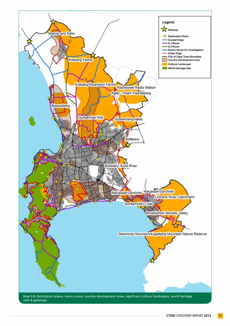
77CTSDF STATUTORY REPORT 2012
Map 5.8: Destination places, scenic routes, tourism development areas, significant cultural landscapes, world heritage sites & gateways

Note:Thedateofendorsement/approvalofCitypolicieshasbeenusedratherthanthedateoftheirproduction,andlegislationandpoliciesreferredtointheCTSDFwillbesupersededbyfuturerevisionsandupdates.
78 CTSDF STATUTORY REPORT 2012
ENHANCE THE VALUE OF HERITAGE RESOURCES AND SCENIC ROUTESPOLICY STATEMENTS WHAT THIS MEANS/REQUIRES POLICYGUIDELINES RELATED LEGIS / POLICIES
Specific action(s)• UpdateandmaintaintheCity’sHeritageAsset
Inventory.• Identifyculturallandscapesandsiteswherean
EnvironmentalOverlayZoneand/orHeritageOverlayZoneshouldbeintroduced.ExamplesofsuchareasincludePhilippi,Constantia,Lourensford,Durbanville,Mamre,Philadelphia,andEersteRiver.
• wherepossible,ensurethatnewdevelopmentsinhistoricprecinctsareofanappropriatescaleandinanappropriatearchitectural‘language’(massing,articulationandtexture);and
• ensurethatadvertising,roadways,pavements,colonnades,landscapingandtreeplantingrespectthecharacterofhistoricbuildingsandprecincts,asfaraspracticallypossible.
Policy 44
Ensure access to, and provide information about, public heritage resources
• TheCitywillensurethataccessandviewingpointsareappropriatelymarkedandinterpretedforpublicunderstanding.
• Promotethemarketingofpublicheritageresources.
P44.1Whenassessingdevelopmentapplications,encouragethecreationofviewsofheritagesiteswherenogeneralaccessisprovided.
• NationalHeritageResourcesAct(No25of1999)
Policy 45
Create an enabling environment for urban regeneration that allows buildings and sites of historical and architectural significance to make a positive contribution to the economy and quality of urban life
P45.1Encourageinvestmentintheadaptivereuseofhistoricalsites,facilitateintegrationbetweentheconservationandadaptivereuseofheritagebuildings,andpromoteurbanregenerationstrategies.
P45.2Discouragethedemolitionorinappropriatealterationofhistoricalsites.
• NationalHeritageResourcesAct(No25of1999)
Policy 46
Celebrate and reinforce Cape Town’s diverse historical legacies through urban form, architectural design, signage and, where appropriate, artwork
TheCitywill:• emphasiseunder-representedsocial,cultural,
spatialorspirituallegacies,andthoseofwhichthereisnoremainingphysicalevidence,suchasslavery;and
• identify,protectandcommemorateartefacts,structuresandplacesfromtheprecolonial,colonial,postcolonialandstruggleeras.
• NationalHeritageResourcesAct(No25of1999)
• City’sResponsibleTourismPolicyandActionPlan(2009)
• City’sCulturalHeritageStrategy(2005)
Policy 47
Provide positive spaces for cultural and social ceremonies and life-related events
TheCitywillidentifyand,whereappropriate,providelandand/orfacilitiesforculturalandsocialceremoniesandlife-relatedevents,inconsultationwiththerelevantcommunitiesandinterestgroups,andwithconsiderationofaspectssuchasbudgetrequirements,compatibilitywithsurroundinguses,futureplanningandlandownership.
P47.1 Encouragetheprovisionofpositivespacesforculturalandsocialceremoniesandlife-relatedevents,includinginitiationsites.
P47.2Recogniseanddevelopplacesofmemory,particularlyassociatedwithstruggleandunder-representedheritage.
P47.3 Acknowledgeandplanforculturalpractices(e.g.initiationsites).
• NationalHeritageResourcesAct(No25of1999)

Note:Thedateofendorsement/approvalofCitypolicieshasbeenusedratherthanthedateoftheirproduction,andlegislationandpoliciesreferredtointheCTSDFwillbesupersededbyfuturerevisionsandupdates.
79CTSDF STATUTORY REPORT 2012
ENHANCE THE VALUE OF HERITAGE RESOURCES AND SCENIC ROUTESPOLICY STATEMENTS WHAT THIS MEANS/REQUIRES POLICYGUIDELINES RELATED LEGIS / POLICIESPolicy 48
Carefully manage land uses and interventions along identified scenic routes, and in places of scenic and visual quality
TheCitywill:• notpermitfurtherdeteriorationofthescenic
visualqualityalongscenicdrivesandroutes;• enhancethescenicexperience,whereverpossible,
byremovingmoveableobstructions(e.g.alienvegetation);
• compileacomprehensivesetofguidelinesformanaginglandusesandinterventions(e.g.signage,outdooradvertisingandcellularmasts)andgeneralvisualimpactsalongscenicroutes.Intheinterim,alldevelopmentsmusttakenoteoftheScenicDriveNetworkManagementPlan(Vol3,2003);and
• whereappropriate,encourageadjoiningmunicipalitiestodefineandmanagecross-borderscenicrouteswithintheiradministrativeareas.
Specific action(s)• Developmoredetailedguidelinesformanaging
landusesandotherinterventionsalongscenicroutes.
• Whereappropriate,useoverlayzonesaspertheCTZS,toprotectandenhancevaluablescenicroutes.
P48.1 Landusemanagementdecisionsmustprotectandenhancethescenicvisualqualityalongscenicdrivesandroutesandotherplacesofscenicandvisualquality(ReferTable5.13).
P48.2 AlllandusemanagementdecisionsshouldbeguidedbytheScenicDriveNetworkManagementPlan(Vol3,2003)orsubsequentlyapprovedManagementPlan/s.
• City’sScenicDriveNetworkManagementPlan(2003)
• City’sOutdoorAdvertisingandSignageBylaw(2001)
• CellularTelecommunicationInfrastructurePolicy(2002)
Policy 49
Identify additional scenic routes
Asthecitydevelops,itmaybenecessarytoidentifyadditionalscenicroutes,usingthecriteriaoutlinedintheScenicDrivesNetwork–Volume1:StudyReport(1998).
Specific action(s)• ReviewandupdatetheScenicDrivesNetwork–
Volume1:StudyReport(1998).
Scenic routes (SRs)
Scenic routes are public roads that traverse areas of outstanding scenic quality or that provide a view of scenic areas. Scenic routes facilitate appreciation of Cape Town’s natural, built and cultural heritage, and in themselves have become attractions – they are memorable gateways into and out of the city. The tourism and recreational potential of the metropolitan area is enhanced by the user’s scenic experience and understanding. The following two types of scenic routes have been identified on Map 5.8:• SR1 routes are limited-access routes that traverse areas of high scenic quality (such as Chapman’s Peak).
• SR2 routes traverse areas of high scenic quality, and are frequently accessed (such as Hout Bay Main Road).
Table 5.13: Scenic route land use management guidelines:
The scenic route land use management guidelines include the following:
• All development and other interventions within the scenic envelope as well as the scenic corridor shall be subject to the approved policies and guidelines for scenic drives/routes. These conditions should be reinforced through District SDPs, local spatial plans and zoning regulations.
• All future buildings, roads and infrastructure, including power lines, alongside designated scenic routes, or that can be seen from scenic routes, should be positioned and designed according to relevant guidelines.
• Pipelines, transmission lines and telecommunications masts should be aligned with existing and proposed transport (road and/or rail) corridors, rather than along point-to-point cross-country routes (provided that this does not affect cultural and scenic landscapes).

Note:Thedateofendorsement/approvalofCitypolicieshasbeenusedratherthanthedateoftheirproduction,andlegislationandpoliciesreferredtointheCTSDFwillbesupersededbyfuturerevisionsandupdates.
80 CTSDF STATUTORY REPORT 2012
5.3.6 Promote accessible, citywide destination places
PROMOTE ACCESSIBLE, CITYWIDE DESTINATION PLACESPOLICY STATEMENTS WHAT THIS MEANS/REQUIRES POLICY GUIDELINES RELATED LEGIS /POLICIES
Policy 50
Develop high-quality, accessible destinations and public spaces in newly developed and neglected areas
Developunusedorunderusedopportunities,andcreateopportunitiesinareasthatareunderservedbyplacesofhighamenity/culturalvalue.
TheidentificationofnewdestinationplacesshouldbeinformedbythecriteriainTable5.14.Newdestinations’qualityshouldexemplifyandcomplementexistingplaces,suchasGrootConstantia,CapePoint,Kirstenbosch,theV&AWaterfrontandtheSeaPointPromenade,andshouldunlockrecreational,tourismandeconomicopportunities.
Prioritisethecreationandimprovementofmultifunctionalpublicspacesinpreviouslydisadvantagedareasandunderservedareas.
Specific action(s) Identifyunderutilisedopportunitiestobeinvestigated:• AthlonePowerStation• DurbanvilleandSomersetWestwinelands• MamreMissionStation• Driftsands-SwartklipPark• WestCoastandFalseBaycoastalnodes• PrincessVlei• SandIndustria• Strugglesites(e.g.LangaPassoffice)• Sitesassociatedwithslavery• Silwerstroomstrand• StrandJettyPrecinct
P50.1 Landusemanagementdecisionsmustprotectandenhanceexistingandpotentialdestinationplaces,includingaccesstotheseplaces.
P50.2Identifiedheritageplacesthatarealsopotentialdestinationplaces,mustbeappropriatelyprotectedanddeveloped.
Table 5.14: Criteria for the identification of destination places
Use the following criteria to identify destination places:
• Should contain or act as gateways to elements of natural/scenic beauty, relate to a site/landscape/event of historical/cultural/natural significance, and/or display significant innovation/creativity in built form
• Must be a permanent/fixed feature in Cape Town
• Must be either an established place that is well used by a community, or a place that facilitates access to a previously underutilised, inaccessible or neglected area of significance
• Location should generate recreational, tourism and economic opportunities, especially in disadvantaged areas
• New destination places should be targeted in underserved areas
• Must allow safe and equal access to all members of the public

81CTSDF STATUTORY REPORT 2012
6 THECAPETOWNSPATIALDEVELOPMENTFRAMEWORK
The urban structure plans (i.e. old Guide Plans) that were approved in the 1980s established a spatial structure that has since served as a binding framework, regulating the development of Cape Town. In order to replace the urban structure plans, the CTSDF is required to be of a similar level of detail, to provide spatial direction to the city’s future growth and development.
The ‘structure plan’ approach to managing the process of urban development demarcates land uses that spatially depict the suitability of land use activities. However, urban development processes are dynamic, and require flexibility to respond to change within the established urban structure. The land use classification system established by the CTSDF is therefore intentionally broad in order to reduce unnecessary amendments, and to retain a level of flexibility within the parameters of the defined urban structure. Local area guidance will be provided by District SDPs and local area planning frameworks approved at a lower level of planning status. As discussed in section 1.4, the CTSDF shall not confer or take away any rights in respect of land.
The Urban and Coastal Edge – as well as major land-extensive precautionary areas – have been generated on a geographic information system, which will reduce the need for consistency rulings. All other components are notional, and consistency rulings will be guided by the process described in section 1.4. The Cape Town Spatial Development Framework (see Map 6.1) comprises:
• Spatial Planning Categories (SPCs);
• Transport infrastructure;
• Major land-extensive precautionary areas;
• Development edges; and
• Conceptual designation(s).
6.1 Spatial Planning Categories (SPCs) The CTSDF land use classification system is consistent with the bioregional planning framework adopted by the PSDF (2009). The SPCs specify the inherent land use suitability of the city’s environmental, cultural and urban landscapes. The relationship between SPCs, the biodiversity network and the Metropolitan Open Space System (MOSS) is shown in Appendix C(i).
32 Thislistisnotexhaustive.
Table 6.1: Spatial Planning Categories (SPCs)
SPATIAL PLANNING CATEGORIES RELEVANT POLICIES32
Core 1 Statutoryconservationareas(biodiversityareasthatareformallyprotectedandmanaged);criticalbiodiversityareas;conservationpriorityzones;critical,irreplaceableandrestorablebiodiversitysites;publicconservationareasandprivateconservationareas.
P1,P25-27
Core 2 Ecologicalcorridors;criticalecologicalsupportareas;significantcoastalandduneprotectionzones;majorrivercorridorsandwaterbodies,excludingwastewatertreatmentworks.
P1,P25-27
Buffer 1 Ruralareas,gameandlivestockfarmingareas,andothernaturalvegetationareasthatdonotformpartofthecoreareas,butarerecognisedasareasthatcouldprovideopportunitiestoestablishbiodiversityoffsets.Essentialutilityserviceinfrastructuremaybeaccommodatedinbuffer1areas.
P24-27,P32,P33
Buffer 2 Otherecologicalsupportareas,transformedgameandlivestockfarmingareas,andruralareasthatdonotformpartofcore1orcore2areas.Essentialutilityserviceinfrastructure,cemeteriesoutsidetheurbanedge,andareaszonedpublicopenspacemaybeaccommodatedinbuffer2areas.
P25-27
High-potential and unique agricultural land
High-potentialanduniqueagriculturallandworthyoflong-termprotectiongivenuniqueproduction,culturalandheritageattributes.Essentialutilityserviceinfrastructuremaybeaccommodatedinhigh-potentialanduniqueagriculturalareas.
P25,P28,P31-33
Agricultural areas of significant value
Agriculturalareasofsignificantvaluegiven(1)existinguse;(2)potentialandemergingagriculturaluseduetonewcultivationtechnology,availabilityofirrigationwater,newvarietiesandcroptypes,andtherealisationofterroirqualities;and(3)foodsecurity.Essentialutilityserviceinfrastructuremaybeaccommodatedinagriculturalareasofsignificantvalue.
P25,P28,P31-33
Smallholdings Extensivelandunits(ranginginsize)locatedoutsidetheUrbanEdge.Essentialutilityserviceinfrastructuremaybeaccommodatedinsmallholdingareas.
P32-34
Urban development
Buildingsandinfrastructurewitharesidentialpurposeaswellasoffices,shops,communityfacilitiesandotherassociatedbuildings,infrastructureandpublicopenspacenecessarytoprovideforproperfunctioningofurbanareas,andamenityandrecreation.Theterm‘urbandevelopment’includesgolfestates,vineyardestateswitharesidentialcomponent,equestrianestateswitharesidentialcomponent,rurallivingestates,eco-estates,gatedcommunitiesandregionalshoppingcentres.Urbandevelopmentexcludesnoxiousindustry,andgenerallyexcludeslandforindustrialpurposes.However,servicetradesthatgeneratealowimpactonsurroundingurbanusesmaybepermissibleifthenatureandtypeofservicetradearedeemedtoformanintegralpartofanareademarcatedforurbandevelopmentpurposes.
P1-P50
Industrial development
Permitsallformsofindustriallanduses,exceptnoxiousindustries.Allowanceismadeforlimitedformsofnon-industrialactivity,suchasafactoryshop,servicestation,andmotorrepairgarage,buttheseactivitiesshouldnotcompromisethegeneraluseoftheindustrialarea.
P4,P5,P7,P8,16
Noxious industry Compriseshazardousandnoxiouslandusesintermsofsmell,product,wasteorotherobjectionableconsequencesofoperation,orthatcarriesahighriskintheeventoffireoraccident.Landusessurroundingriskindustrysitesshouldbecarefullymanaged.
P4,P5,P7,P8,P16

82 CTSDF STATUTORY REPORT 2012
33 Thislistisnotexhaustive.34 Thislistisnotexhaustive.35 WGS84TransverseMercator.36 WGS84TransverseMercator.37 WGS84TransverseMercator.
6.2 Transport infrastructureRailway lines, railway stations, IRT trunk routes and IRT trunk stations are identified on Map 6.1.
Table 6.2: Transport infrastructure
TRANSPORT INFRASTRUCTURERELEVANT POLICIES33
Railway lines and stations
Existing,plannedandpriorityrailwaylinesareindicatedintheCTSDF.Therailnetworkprovidesformobilityoverlongertripdistances.Thehierarchyofstationssupportingtherailserviceareprimarypointsofaccessibility,particularlywhenassociatedwithareasofhighroad-basedaccessibility,andcanpotentiallysupportintenseconcentrationsofactivityandmediumtohighlandusedensities.Railcorridorsandareassurroundingrailwaystationsaregenerallysuitableforawiderangeofurbandevelopmentusesatmediumtohighdensities.Generally,theclassificationofastationintermsofitstypologyshouldinformtheformandscaleofdevelopmentwithinandsurroundingthestationprecinct.
P9-P18
IRT (trunk routes) and stations
IRTtrunkroutesprovidemobilitythroughaccess-controlledright-of-wayinfrastructureandpublictransporthigh-occupancyvehicleprioritylanes.ThehierarchyofstationssupportingtheIRTserviceareprimarypointsofaccessibility,particularlywhenassociatedwithareasofhighroadbasedaccessibility,andcanpotentiallysupportintenseconcentrationsofactivityandmediumtohighlandusedensities.IRTcorridorsandareassurroundingIRTtrunkstationsaregenerallysuitableforarangeofurbandevelopmentusesatmediumtohighdensities.Generally,theclassificationofastationintermsofitstypologyshouldinformtheformandscaleofdevelopmentwithinandsurroundingthestationprecinct.
P9-P18
6.3 Major land-extensive precautionary areasMajor land-extensive precautionary areas surround land uses that, by their nature, generate objectionable consequences. These areas are generally defined at a cadastral level, and are likely to present a form of risk to development or activities. Although this may not exclude any underlying use (e.g. urban development), the risks related to the identified precautionary areas may place certain restrictions on development (i.e. in terms of use, density or form).
Table 6.3: Major land-extensive precautionary areas
MAJOR LAND-EXTENSIVE PRECAUTIONARY AREASRELEVANT POLICIES34
CTIA noise cones
Noisecontourlinesareproducedfromaseriesofmathematicalequationsthatsimulateaircraftnoiselevels.Noisecontoursassistwithplanningandprotectingthepublicagainstnoise.
UrbandevelopmentinthevicinityoftheCTIAmustbewithintheframeworkofrestrictionsimposedupontheuseoflandwithintheCTIAnoisezones.
Futurerunwayrealignmentand/orrunwayconstructionmay,subjecttoobtainingthenecessaryapprovals,causeashiftintheairportnoisecones.
P24
KNPS exclusion zones
PrecautionaryActionZone(PAZ):Theareawithin5kmfromthepoint(X=-2727.4000,Y=-3727966.6500)35thatisthemidpointofthereactorbuildings.UrgentProtectiveActionZone(UPZ):TheareafromthePAZ(5km)boundaryto16kmfromthepoint(X=-52727.4000,Y=-3727966.6500)36thatisthemidpointofthereactorbuildings.Formalemergencyplanningzone:Theareawithin16kmfromthepoint(X=-52727.4000,Y=-3727966.6500)37thatisthemidpointofthereactorbuildings.
RefertothedevelopmentcontrolsinTable5.7associatedwiththeKNPSexclusionzones.Thesedevelopmentcontrolswillbesupersededbynational‘RegulationsonDevelopmentintheFormalEmergencyPlanningZoneofKNPS,whenapproved.
P24
Utility service infrastructure
Utilityserviceinfrastructureincludes,butisnotlimitedto,wastewatertreatmentworks,landfillsitesandtransferstations.Essentialinfrastructuremaybeaccommodatedinbuffer1,buffer2,agriculturalandsmallholdingareas.Bufferareassurroundingutilityserviceinfrastructure,whichbyitsoperationgeneratesobjectionableconsequences,mustbecarefullymanaged.
P24

83CTSDF STATUTORY REPORT 2012
6.4 Development edgesDevelopment edges are demarcated lines defining the outer limits of urban development for a determined period of time. Two types of edge lines have been identified on Map 6.1, namely the Urban Edge line and the Coastal Edge line. The urban edge shown on Map 6.1 constitutes the ‘medium term Urban Edge’ (PSDF, 2009).
Table 6.4: Development edges
DEVELOPMENT EDGESRELEVANT POLICIES38
Urban Edge TheUrbanEdgeisamediumtolong-termedgeline,demarcatedinsuchapositionastophaseurbangrowthappropriately,ortoprotectnaturalresources.
P22,P23,P25,P26,P28,P33
Coastal Edge Demarcatedareaaroundthecoastinsuchapositionastolimiturbandevelopment,primarilytoprotectcoastalresources,andavoidhazardsandfinancialriskspertainingtoareasatriskofflooding.
P22,P23,P25-27
6.5 Conceptual designation(s)The conceptual designations identified by the CTSDF have significance for guiding and informing urban development, but are not precisely geographically defined (or exclusive) areas, but rather conceptually indicated. The conceptual designations have been identified at a broad metropolitan scale. Land use management decision making and urban form should be determined through more detailed district and local-level planning to ensure that the future form of growth and development is contextually appropriate, supported by the necessary infrastructure, and does not generate unacceptable or undesirable impacts on surrounding land uses.
Route designation: Land use functionality
The route designation does not replace the City’s Hierarchical Road Network Classification system, nor is it intended to run in parallel as a duplicate classification system. Appendix C(ii) describes the relationship between the CTSDF route designations and the DoT, the PSDF and the City’s Hierarchial Road Network Classification system.
Table 6.5: Conceptual designations
CONCEPTUAL DESIGNATION(S)RELEVANT POLICIES39
Urban nodes Urbannodesarecharacterisedbytheintensity,mixandclusteringofurbanactivitiesorlanduseatpointsofmaximumaccessibility,exposure,convenienceandurbanopportunity.Theroleandfunctionofurbannodesaredifferentiatedintermsofscale(metropolitan,submetropolitan,district,local).
P3-P5,P7,P8,P10,P15,P16,P22,P39,P40
New coastal nodes
Newcoastalnodesaretypicallyalsodestination-typeplacesthatareareasofattractiononthecoast–someofwhichhavenotbeencadastrallydefinedandrequiremoredetailedplanning.Coastalnodesareusuallyassociatedwithformsofdevelopmentthatsupporttheirfunctionasapointofattraction,withoutdetractingfromit.Coastalnodesmakeresponsibleuseofthesocialandeconomicbenefitsofthecoast,andhavebeenidentifiedinlocationsthatallownaturalsystemstofunctionsustainablyandareprotectedfromfloodrisk.Intheseareas,publicaccesstothecoastmustbepreserved.
P1,P7,P23,P27,P48,50
Activity routes Activityroutesarecharacterisedbystripand/ornodalurbandevelopmentalongsectionsoftheroute.Activityroutesaregenerallysupportedbyamixoflandusesandhigher-densityurbandevelopment.Theyarecharacterisedbydirectaccessandinterruptedmovementflows,especiallyatbusandtaxistopsandtrafficlights.
P3-6,P8,P10,P11,P13-16,P35,P39
Development routes
Developmentrouteshaveagreatermobilityfunctionthanactivityroutes.Mixedlandusesandhigher-densitydevelopmenttendtobenodal,withaccessprovidedatintersections,andaregenerallylinkedtoparallelandconnectingsideroutes.Developmentroutesmayincludeshortstretchesofactivityroute-typedevelopment.
P3-6,P8,P10,P11,P13-16,P35,P39
Urban freeways Urbanfreewaysfulfilamobilityfunction,anddonotpermitdirectaccesstoabuttinglanduses.Thehighconnectivityprovidedbydirectfreeway/expresswayconnectionstendstoattractmanufacturing,warehousing,majorretailandindustriallanduses.Theseopportunitiestendtoberealisedaroundkeyintersectionsoroff-ramps,andonroadsrunningparallelorlinkedtofreeways.
P6,P8,P10,P14-16
Connector routes
Connectorroutesconnectdifferentareasofthecity,andaretypicallycharacterisedbyhighvolumesoffast-movingtraffic.Insomeinstances,directaccesstoabuttinglandusesandresidentialpropertiesisprovidedalongconnectorroutes.
P8,P10,P14-16
38 Thislistisnotexhaustive.39 Thislistisnotexhaustive.


85
Map 6.1: Cape Town Spatial Development Framework
CTSDF STATUTORY REPORT 2012

87CTSDF STATUTORY REPORT 2012
7 THEWAYFORWARD
To ensure the practical application of the spatial principles, concepts, strategies and policies outlined in the CTSDF, a multifaceted implementation strategy, which includes the following actions, is required:
• Put the building blocks of the policy-driven land use management system (LUMS) in place.
• Review of the CTSDF and related policies.
• Prepare a 15-year Growth Management Plan.
7.1 Put the building blocks of the policy-driven land use management system in place
The primary building blocks of the LUMS that the City is introducing are the CTSDF, District SDPs and the new CTZS. The approval of the CTSDF as a structure plan in terms of section 4(6) of LUPO and section 34 of the MSA is the first step in the implementation of this LUMS.
Other necessary actions relate to the development and/or refinement of plans, policies and systems, namely:
• implementation and continued improvement of the CTZS;
• further rationalisation of plans and policies and/or the drafting of new plans and policies (see section 7.1.1);
• design and introduction of uniform and improved workflows, procedures, correspondence and systems to ensure legal compliance and improve administrative efficiency;
• setting up of a web-based information system; and
• introducing a system to monitor development applications’ compliance with the plans and policies, and the implementation of the CTSDF and related plans via the IDP.
7.1.1 Tasks arising out of the policy statements and their prioritisation
Table 7.1 summarises the necessary in-depth studies, new policies and workstreams of citywide significance arising out of the policy statements and guidelines. Given the resource shortages within the City, it is important that the Strategy and Planning Directorate has clear criteria for the identification and prioritisation of further work of citywide significance.
The criteria proposed below are based on the Framework for the Selection and Prioritisation of Areas for Local Area Planning Initiatives, approved by the City’s Planning and Environment Portfolio Committee (PEPCO) in April 2010.
Any further policy/study should:
• focus on meeting critical information needs/gaps;
• have been referred to in the CTSDF policy statements or other PEPCO-approved policies;
• respond to ‘significant’ planning challenges that are of citywide significance;
• support the reinforcement and alignment of strategies, policies and programmes of the Spatial Planning and Urban Design Department and related departments;
• promote the equitable allocation of planning resources in ‘high-impact’ locations or on high-impact issues;
• contribute to resource and administrative efficiency as well as successful implementation; and
• put in place tools that will improve the quality of decision-making.
Table 7.1: Schedule of in-depth studies and actions arising out of the policy statements
STRATEGY POL REF.
TASK RESP. CITY DEPT.SUPPORTING CITY DEPTS/DIRECTORATE
Plan for employment and improve access to economic opportunities
2Streamlinelanduseplanningprocessesandintegrationwithheritageandenvironmentalprocesses
P&BDM ERMDandSPUD
2 PrepareandregularlyupdateanEconomicAreasPlan SPUD ED,USD,TR&SandP&BDM5 ExpandtheUrbanDevelopmentZonesandactivelypromotetheincentive SPUD ED,P&BDMandHSD
6Ensuretheappropriateinstitutionalstructuresareinplacetopromoteregionaleconomicplanning
EMT EDandSPUD
9EngagerelevantauthoritiesaroundthealignmentandprioritisationoftheIRTandrailnetworkinvestmentintheMetroSoutheast
TR&S SPUD
12 EngagewithPRASAtoprioritiseimprovementstothepassengerrailservice TR&S
15Lobbyrelevantauthoritiestoreinforceandenhanceidentifieddecliningareasintheurbancorecorridorandtheeasterncorridor
ED,TR&S,USD SPUD
15Lobbyrelevantauthoritiestoprioritiseinvestmentinpublictransportservicesintheeasterncorridor
TR&S SPUD
17
EngagetheNationalDepartmentofTransport,PGWC,SouthAfricanCivilAviationAuthority,AirportsCompanySouthAfrica,AirTrafficNavigationServicesandSouthAfricanNationalDefenceForceregardingthedevelopmentofanintegratedsystemofairports
SPUD TR&S
18EngagewithNationalDepartmentsofPublicWorksandEnvironmentalAffairs,SANavy,TransnetandVictoriaandAlfredWaterfrontregardingtheinterfacebetweentheharbourandsurroundingareas
SPUD TR&S,P&BDM,USD
18 AssistTR&Swiththepreparationofafreightmanagementplan TR&S SPUD

88 CTSDF STATUTORY REPORT 2012
STRATEGY POL REF.
TASK RESP. CITY DEPT.SUPPORTING CITY DEPTS/DIRECTORATE
Manage urban growth, and create a balance between urban development and environmental protection
20 Preparea15-YearGrowthManagementPlan EMT USD,TR&SandSPUD
20Putappropriateinstitutionalmechanismsinplacetoaligncross-borderspatialplanningandgrowthmanagement
EMT USD,TR&SandSPUD
21StudieswhichbroadenCity’sunderstandingofformalandinformalpropertymarkets
SPUD HSDandP&BDM
21Lobbyprovincialandnationaldepartmentsresponsibleforplanningreformtosupportasteppedapproachtohousingandtenureandthedevelopmentofasinglepropertymarket
P&BDM SPUD
23AlignandupdatetheCouncilapprovedlanduseguidelinesforUrbanEdgemanagementzones(2001)oneithersideoftheUrbanEdge
SPUD P&BDMandERMD
23 FinalisetheCoastalProtectionZoneManagementBylaw ERMDandP&BDM SPUD23 CoastalDevelopmentFramework SPUD ERMDandP&BDM24 UpdaterelevantcomponentsoftheKoebergNuclearEmergencyPlan DM SPUD,P&BDMandTR&S24 ReviewandupdatetheKoebergtownplanningassessmentcriteria P&BM SPUDandDM25 PrepareaBio-regionalPlaninaccordancewithNEMBA(Act10of2004) ERMD SPUDandP&BDM
27PreparelocalspatialplansforSilwerstroomstrand,MnandiandMonwabisi,andfacilitatetheirimplementation
SPUD ERMDandP&BDM
28Investigatethefeasibilityof“highpotentialanduniqueagriculturalareas”beingdeclaredagricultural/culturallandscapes
ERMD SPUDandP&BDM
28 Policenon-conformingusesinthePhilippihorticulturalarea P&BDM29 SchaapkraalUrbanEdgeReview SPUD P&BDM,ERMD,TR&SandUSD30 PrepareResourceEfficientDevelopmentPolicy P&BDM ERMD,SPUDandUSD
32Determineamaximumcontourheight,higherthanwhichanybuiltformwillnotbepermittedinDistrictSDPand/orlocalplans
SPUD P&BDM
34PrepareanN1CorridorDevelopmentPlanincollaborationwithsurroundingmunicipalities(tobeledbyPGWC’sDEA&DP)
SPUD TR&SandUSD
34 Prepareurbandesignandlandscapeframeworkforurbangateways SPUD P&BDMandERMDBuild an inclusive, vibrant, integrated city
36 Supportthepreparationofacross-sectoralinformalsettlementsupgradingplan HSD SPUD38 Maintainandupdatetheundevelopedandpartiallydevelopedlanddatabase SPUD
38IdentifypotentialhousingsitesthatmeritfurtherinvestigationinDistrictSDPsandappropriatelocalplans
SPUD P&BDM,HSDandERMD
41Preparepoliciesandguidelinesfortheprovisionanddistributionofsocialfacilities,recreationalspacesandpublicinstitutions.
P&BDM SPUD,CPDandS&RD
42 CompileandobtainapprovalfortheUrbanDesignPolicy SPUD42 ProvidetrainingtoP&BDMofficialsregardinguseoftheUrbanDesignPolicy SPUD P&BDM43 UpdateandmaintaintheCity’sHeritageAssetInventory ERMD SPUDandP&BDM
43 IdentifyculturallandscapesandsiteswhereanEnvironmentalOverlayZoneand/orHeritageOverlayZone(whenapproved)shouldbeintroduced
ERMD SPUDandP&BDM
48 Developmoredetailedguidelinesformanaginglandusesandotherinterventionsalongscenicroutes
SPUD P&BDMandERMD
49 ReviewandupdatetheScenicDrivesNetwork–Vol1&3StudyReport(1998) SPUD P&BDMandERMD
LIST OF ACRONYMS
CPD CityParksDepartment PGWC ProvincialGovernmentWesternCape
DEA&DP DepartmentofEnvironmentandDevelopmentPlanning(PG:WC) S&RD SportsandRecreationDepartment
ED EconomicDepartment SPUD SpatialPlanningandUrbanDesignDepartment
ERMD EnvironmentalResourceManagementDepartment TR&S Transport,RoadsandStormwater
HSD HumanSettlementsDirectorate USD UtilityServicesDirectorate
P&BDM PlanningandBuildingDevelopmentManagement
89CTSDF STATUTORY REPORT 2012
7.2 Review of the Cape Town Spatial Development Framework and related policies
The dynamic nature of urban development requires that the policies, guidelines and development edges laid down in the CTSDF must be reviewed from time to time and, if necessary, adjusted to ensure they remain relevant and appropriate. Section 4 (8) of LUPO (No. 15 of 1985) requires that the CTSDF be reviewed a minimum of every ten years, or more frequently if deemed necessary. Section 34 of the MSA (No 32 of 2000) requires that the IDP (which includes the CTSDF) be reviewed annually.
The reviews should take the following into account:
• changing local, national and global dynamics;
• the impacts of climate change, peak oil and other major events;
• population, residential and economic growth trends;
• new and updated information related to, for instance, natural resources and infrastructure provision;
• ongoing heritage auditing, identification and inventories; and
• performance against approved measurements.
In terms of the CTSDF and Development Edges Policy: Urban and Coastal Edges (draft 2010), the City has committed itself to City-led five-yearly reviews of the Urban Edge. The criteria for reviewing the Urban Edge, and the procedure that will be followed, are outlined in the aforementioned policy.
7.3 Prepare a 15-Year Growth Management Plan
For the City to meet the commitments outlined in the CDS, the CTSDF and sector-based policies, plans and budgets need to be aligned. While the IDP provides a platform for cross-sectoral planning, budgeting and implementation on a five-year basis, it needs to be supported by a 15-year Growth Management Plan that provides a medium-term link between the CDS, CTSDF and medium-term sectoral plans/master plans and strategic and asset maintenance investment priorities. This Growth Management Plan should align investment locations, and establish clear targets and programmes for capital expenditure. It should be reviewed annually when the IDP is reviewed. For the Growth Management Plan to be effective, it needs to be developed in collaboration with all spheres of government, surrounding municipalities, the private sector and communities.
The objectives of the Growth Management Plan should be to:• identify and spatially depict sector-linked interventions and
investment;
• harmonise spatial and infrastructure forward planning;
• determine the preferred phasing of the city’s spatial development;
• identify infrastructure hot spots, where enhancement of development rights may need to be limited in the short to
medium term, and establish monitoring mechanisms to review their status;
• prioritise and align the priority action areas spatially and sectorally;
• identify the cross-sectoral programme and project-level planning and budgeting required to support the implementation of the prioritised action areas;
• identify the policies, economic, administrative/regulatory and financial measures, and/or institutional arrangements that need to be investigated or introduced to support implementation related to the priority action areas;
• align the City’s budget spatially and cross-sectorally; and
• align the City’s capital budget with that of surrounding municipalities and spheres of government.
Definition of a ‘priority action’ area
A priority action area is a location requiring intervention or action by the City, other spheres of government, and state-owned enterprises. The interventions may take a variety of forms, e.g. dealing with ‘crime and grime’, investing in bulk infrastructure and social facilities, improvements to the quality of the built environment, or the introduction of development incentives.
During the preparation of the CTSDF, a number of short to medium-term priority action areas of metropolitan significance were identified. They need to be supplemented with the priority action areas identified in the District SDPs, aligned with sector-based strategic and asset maintenance investment priorities, and prioritised through the IDP and 15-year growth management plan.
The priority action areas identified are based on current available information and plans, and are therefore likely to change over time. The Spatial Planning and Urban Design Department will, as part of the annual IDP review process, assess the progress made in the priority action areas, and amend and/or add to them.
The priority action areas have been grouped as follows, and are outlined in detail below:
• Transport • Economic
• Housing and infrastructure • Environmental
• Social
Phased implementation of the integrated rapid transit system
It is envisaged that the IRT system will be rolled out in phases over the next 15 to 20 years, with the initial focus on implementing Phase 1A by June 2013, to match funding availability, and the remainder of Phase 1 by 2015. Phase 1 focuses on the central city and the West Coast (Table View/Du Noon, as far as Atlantis and Mamre). Phase 2 is intended to address the substantial public transport needs of the Metro Southeast, including Khayelitsha and Mitchells Plain. Phases 3 and 4 include the Durbanville and Delft/Helderberg areas respectively, as shown on Map 7.1 (IRT business plan, 2010).

90 CTSDF STATUTORY REPORT 2012
Table 7.2: Transport priority action areas (see Map 7.1)
INTERVENTION LOCATIONS
Roads SeeMap7.1
IRT Phase1–Phase4
Newraillink(whendemandissufficient)
KhayelitshatoBellville
Introductionofpassengerrail(whendemandissufficient)
KraaifonteintoMalmesbury(improvedlevelofservice),WindemeretoParklandspassengerrail
Intensifiedmixed-usedevelopmentsurroundingIRTstations
AllIRTstations,wherefeasible.Scaleandformofdevelopmenttobeinformedbythehierarchyofstationtypologies.
Mixed-usedevelopmentsurroundingprioritisedrailstations
Scaleandformofdevelopmenttobeinformedbythehierarchyofstationtypologies.PublicsectorprioritisationtobedeterminedthroughexistingJointPlanningandDevelopmentCommittee,whichincludesrepresentativesofPRASA/IntersiteandtheCity.
Table 7.3: Economic priority action areas
INTERVENTION LOCATIONS
Private sector to be encouragedBellvilleCBD,vicinityofCTIAandBelcon,insidetheurbanedgealongN2adjacenttoMacassarandHeartlandsintheStrand.AlsoseeEconomicAreasPlan(tobedrafted).
Public-sector investment to attract private-sector investment
MetropolitanSoutheastandAtlantis,andgovernment-subsidisedhousingareasmoregenerally.Intheshortterm,KhayelitshaCBD,MitchellsPlaintowncentre,Philippiindustrialareaandsurrounds,andtheAtlantisindustrialareaareapriority(SeeMap5.2).AlsoseeEconomicAreasPlan(tobedrafted).
Metro-significant mixed-use coastal nodesMonwabisi,Kapteinsklip,Mnandi,Strandfontein,Silwerstroomstrand,Strand,MuizenbergandTableViewtoBlouberg.(SeeMap5.2)
Strategic state-owned sites –planning/public intervention
Swartklip/Armscor,StiklandHospital,Belcon,Culemborg,BlaauwbergConservationArea,FalseBaycoastline(especiallyMonwabisi,KapteinsklipandStrandfontein,theFalseBaywalkway),Silwerstroomstrandanderf1117
Major investment in economic gateways CapeTownharbour,CTIA,Transnet’sfreighthub(Belcon),Saldanha-to-CapeTownoilpipeline
Tourism development areasBlaauwberg(Atlantis),Blaauwberg(Milnerton–Bloubergstrand),CityBowl,Rondebosch/Westlake,CapeFlatsandMetroSouteast,Peninsula(Houtbay–Kommetjie),Peninsula(Muizenberg–Simon’sTown),CapePoint,HelderbergBasin,Tygerberg/OostenbergandDurbanville(seeMap5.8)
Tourism/visual gateways MunicipalboundaryandR27,N7,R44andN2(SirLowry’sPass)(SeeMap5.8)
Table 7.4: Housing and infrastructure priority action areas (see Map 7.2).
INTERVENTION LOCATIONS
Proposed housing projects SeeMap7.2Informal settlements upgrading SeeMap7.2New development areas inside the urban edge
SeeMap5.3
Wastewater treatment works – current risks and draft capacity shortfalls for planned urban development inside the urban edge
SeeMap7.2forcurrentrisks.TheadditionalcapacityrequiredatthevariouswastewatertreatmentworkstoaccommodateurbandevelopmentonthelandinsidetheurbanedgeisAthlone(50ML/day),Bellville(2 ML/dayoverandabovecurrentextension),BorcherdsQuarry(3 ML/day),Fisantekraal(24ML/dayoverandabovethePhase1development);GreenPointseaoutfall(6ML/day),HoutBayseaoutfall(2,2 ML/day),Macassar(12ML/day),MitchellsPlain(4,0ML/day),Potsdam(45ML/day);Scottsdene(2ML/day),Wesfleur(8ML/day),Wildevoëlvlei(1 ML/day),Zandvliet(36ML/dayoverandabovecurrentextensions)
Bulk-water supply – water treatment plants, reservoirs and pipelines required to accommodate urban growth
SeeMap7.2
Electricity supply SeeMap7.2Critical asset maintenance and upgrade areas
TobedeterminedbytheInfrastructureMaintenancePlan(draft)
Climate change mitigation areasExistingroad,railwaylines,electricity,wastewaterandwater-relatedinfrastructure,developedareaslocatedontheseasideofthecoastaledgeline,andintheareaspronetofloodinginthelongerterm
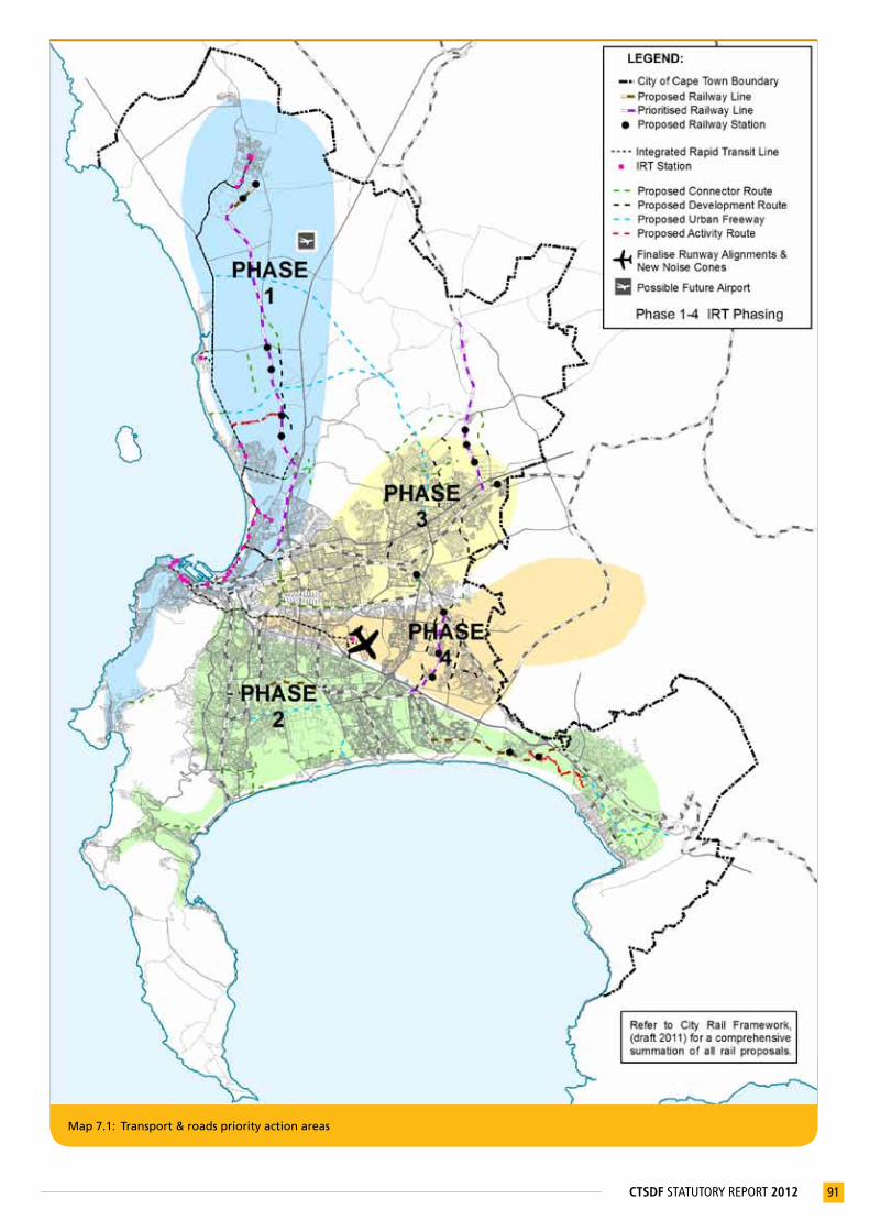
91CTSDF STATUTORY REPORT 2012
Map 7.1: Transport & roads priority action areas

92 CTSDF STATUTORY REPORT 2012
Map 7.2: Infrastructure and housing priority action areas
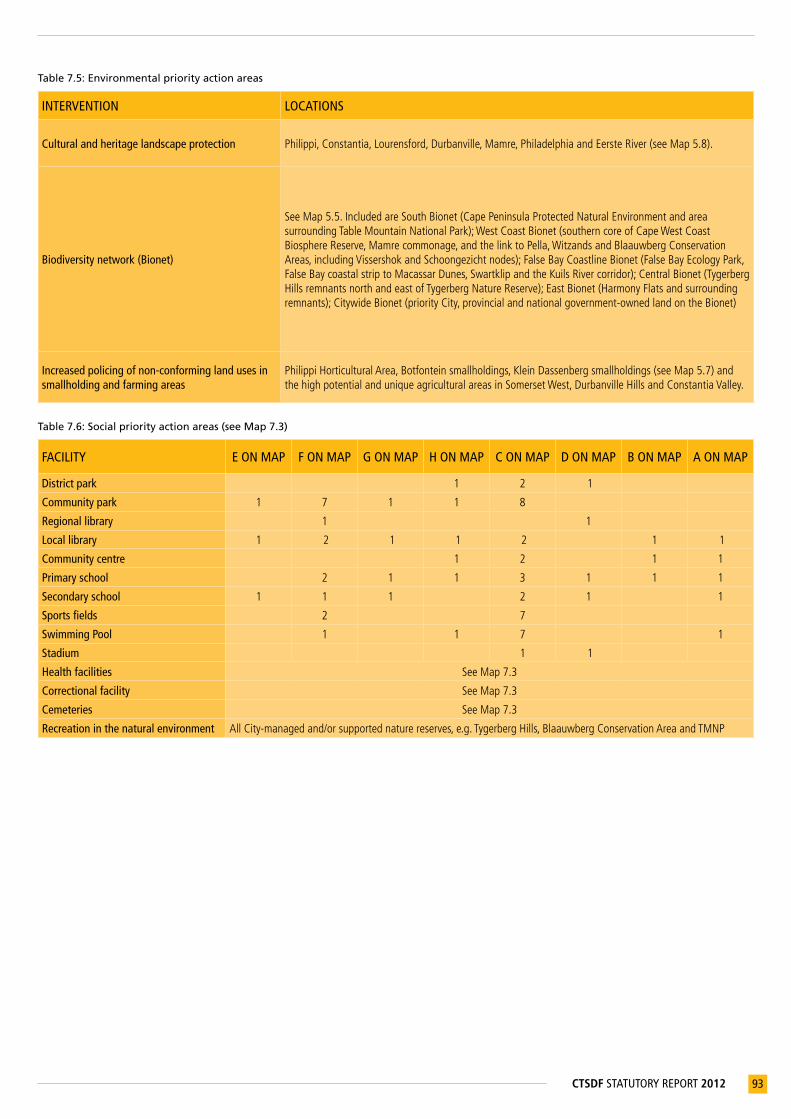
93CTSDF STATUTORY REPORT 2012
Table 7.5: Environmental priority action areas
INTERVENTION LOCATIONS
Cultural and heritage landscape protection Philippi,Constantia,Lourensford,Durbanville,Mamre,PhiladelphiaandEersteRiver(seeMap5.8).
Biodiversity network (Bionet)
SeeMap5.5.IncludedareSouthBionet(CapePeninsulaProtectedNaturalEnvironmentandareasurroundingTableMountainNationalPark);WestCoastBionet(southerncoreofCapeWestCoastBiosphereReserve,Mamrecommonage,andthelinktoPella,WitzandsandBlaauwbergConservationAreas,includingVissershokandSchoongezichtnodes);FalseBayCoastlineBionet(FalseBayEcologyPark,FalseBaycoastalstriptoMacassarDunes,SwartklipandtheKuilsRivercorridor);CentralBionet(TygerbergHillsremnantsnorthandeastofTygerbergNatureReserve);EastBionet(HarmonyFlatsandsurroundingremnants);CitywideBionet(priorityCity,provincialandnationalgovernment-ownedlandontheBionet)
Increased policing of non-conforming land uses in smallholding and farming areas
PhilippiHorticulturalArea,Botfonteinsmallholdings,KleinDassenbergsmallholdings(seeMap5.7)andthehighpotentialanduniqueagriculturalareasinSomersetWest,DurbanvilleHillsandConstantiaValley.
Table 7.6: Social priority action areas (see Map 7.3)
FACILITY E ON MAP F ON MAP G ON MAP H ON MAP C ON MAP D ON MAP B ON MAP A ON MAP
District park 1 2 1
Community park 1 7 1 1 8
Regional library 1 1
Local library 1 2 1 1 2 1 1
Community centre 1 2 1 1
Primary school 2 1 1 3 1 1 1
Secondary school 1 1 1 2 1 1
Sports fields 2 7
Swimming Pool 1 1 7 1
Stadium 1 1
Health facilities SeeMap7.3
Correctional facility SeeMap7.3
Cemeteries SeeMap7.3
Recreation in the natural environment AllCity-managedand/orsupportednaturereserves,e.g.TygerbergHills,BlaauwbergConservationAreaandTMNP

94 CTSDF STATUTORY REPORT 2012
Map 7.3: Social facilities & recreational open space priority action areas
95CTSDF STATUTORY REPORT 2012
APPENDIXA
List of planning documents to be withdrawn It is the City of Cape Town’s intention that the Cape Town Spatial Development Framework (CTSDF) and the eight District Spatial Development Plans (DSDPs) will replace and/or downgrade the status of the following plans:
A. Urban Structure Plans (previously Guide Plans)
Guide plans that were promulgated in terms of the Physical Planning Act (Act 88 of 1967), which are recognised as urban structure plans in terms of section 37 of the Physical Planning Act (Act 125 of 1991) and the Land Use Planning Ordinance (No. 15 of 1985). The competent authority will be asked to withdraw these plans on approval of the CTSDF.
• Guide Plan for the Cape Metropolitan Area: Peninsula (1988)
• Guide Plan for the Cape Metropolitan Area: Hottentots Holland Basin (1988)
• Portions of the Atlantis and Environs Guide Plan (1981)
B. Approved Structure Plans
These are historic (five years or older) structure plans approved in terms of section 4(6) of the Land Use Planning Ordinance (No. 15 of 1985). The competent authority will be asked to withdraw these plans upon approval of the CTSDF, and Council will then approve them as structure plans in terms of section 4(10) of the Land Use Planning Ordinance (No. 15 of 1985).
• Lansdowne Road Philippi Structure Plan (1995)
• Imhoff’s Gift Local Structure Plan (1989)
• Sir Lowry’s Pass Structure Plan (1997)
• Gordon’s Bay Structure Plan (1989)
• De Grendel Structure Plan (1989)
• Goodwood Structure Plan (1988)
• Lower Kuils River: Blue Downs Local Structure Plan (1987)
• Weltevreden Valley Local Structure Plan (1986)
• Table View North Structure Plan (1991)
• Lower Kuils River Area Urban Structure Plan (1986)
• Benede-Kuils River: Rotterdamgebied Plaaslike Struktuurplan (1987)
• Gaylee Kleinvlei Eersterivier Struktuurplan (1989)
C. Draft structure plans
Structure plans that have been prepared for approval, but have not been statutorily approved, will be recalled.
• Helderberg Subregional Structure Plan (2000)
• Somerset West Structure Plan (2000)
• Kommetjie-Ocean View and Environs Local Structure Plan (2000)
• Fish Hoek Valley Local Structure Plan (1999)
• Southern South Peninsula Local Structure Plan (2005)
• Macassar Structure Plan (2002)

96 CTSDF STATUTORY REPORT 2012
APPENDIXB
Summary of related sector legislation, policies and studies that have informed the SIA and CTSDF• Table B.1 summarises the vision statements of key sectoral policies and their relation to the objectives of the CTSDF.
• Table B.2 lists the national and provincial legislation and other informants to the preparation of the Strategic Impact Assessment (SIA) and CTSDF, and their current legal status.
• Table B.3 lists the City’s related sector policies, informants to the SIA and key infrastructure plans that support the implementation of the CTSDF policies.
• Table B.4 lists relevant in-depth spatial studies that informed the preparation of the SIA and CTSDF.
Table B.1: Relation of sector policies to the CTSDF strategies and policies
CITY SECTOR POLICIES
STRATEGY 1: PLAN FOR EMPLOYMENT, AND IMPROVE
ACCESS TO ECONOMIC OPPORTUNITIES
STRATEGY 2: MANAGE URBAN GROWTH, AND CREATE A BALANCE BETWEEN URBAN DEVELOPMENT
AND ENVIRONMENTAL PROTECTION
STRATEGY 3: BUILD AN INCLUSIVE, INTEGRATED, VIBRANT CITY
A Strategic Framework for a City Development Strategy for Cape Town (2010 Draft)
• Strengthenandidentifyeconomicattractorsforacompetitivegrowtheconomy,sustainablelivelihoodsandgrowingprosperity.
• Developacompactandefficienturbanform
• EnhanceCapeTown’squalityoflifeandfacilitatesocialinclusionandculturalintegration
• Protect,honourandleveragethecity’snaturalheritage.
Integrated Transport Plan 2006-2011
ITP Review (2011 Draft )
• Alignplansfordifferenttransportmodesaswellasbetweentransport,landuseandeconomicopportunities.
• Promoteagoodqualitypublictransportsystemthatprovidesmobilityfortheeconomicallydisadvantaged.
• Promotegoodqualityroadandstreetinfrastructuretosupportagoodqualitypublictransportsystem.
• Densificationandurbanedgepoliciesaimedatthedevelopmentofamorecompactcitythatallowsforadequatepublictransportthresholds.
• Promotetraveldemand-managementmeasures,limitingprivatecarusageandimprovingroadsafety.
• Protecttheenvironmentfrompollutionthroughreducedvehicleemissions.
• Promotetheuseofreducedenergytechnologiesinthemaintenanceofroadandstreetnetworks.
• Aligntransportandlanduseplanningtobringaboutalandusepatterninwhichthenecessityfortravel,especiallybycar,isminimised.
• Promotesustainabletravelpatternsbyencouragingwalking,cyclingandtheuseofpublictransport.
Economic Development Strategy (2011 Draft)
• Implementarea-basedinterventions,suchasdevelopmentcorridors,withintegratedtransport,landuseandservicesincludinglocaleconomicdevelopmentopportunities.
• PositionCapeTownasagloballycompetitivecitythroughqualityinfrastructure.
• Targetinterventionsandlocaldevelopmentintheinformalsettlementstoenhanceaccesstoeconomicopportunitiesandaddresspovertyandunemployment.
• OptimisethetourismpotentialofCapeTown’stangibleandintangibleheritageassetswhileensuringthatnaturalareasareconserved,andwasteandpollutionminimised.
• Promoteappropriatecoastaldevelopmentinlinewithguidelinestomaximiseeconomicvalueofthecoast,whileensuringthatnaturalareasremainundisturbed.
• Promotedensificationinappropriateareasinordertoreducetraveltime,promotelocaleconomicdevelopment,andreducecostsofdeliveringservices.
• Integrate‘sustainablelivelihoods’approachwithhumansettlementplanning,includingwaterandenergyefficiency,andurbanagricultureforfoodsecurityandsmallbusinessdevelopment.
Five-Year Integrated Housing Plan 2009/10–2013/14
• Planholisticallyforeconomic,social,andphysicalwellbeingofresidentialcommunities.
• Supportagreateruseofavailableinfilllandinexistingurbanareas–bothopentractslocatedwithinitsjurisdiction,andwell-locatedpocketswithintheurbancore–tofacilitateinformalareaupgradesandstandalonehousingprojectsasasteptowardslandtenure.
• Supportabalancebetweenquantityandqualityofhousingandappropriatelydenseurbanforms.
• Identifyarangeofhousingdeliveryoptionsthatcouplesnationalhousingprogrammeswithanincrementaldeliveryapproachtoprovideinitialbasicservicestosomecommunitiesandpermanenthomestoothers.

97CTSDF STATUTORY REPORT 2012
CITY SECTOR POLICIES
STRATEGY 1: PLAN FOR EMPLOYMENT, AND IMPROVE
ACCESS TO ECONOMIC OPPORTUNITIES
STRATEGY 2: MANAGE URBAN GROWTH, AND CREATE A BALANCE BETWEEN URBAN DEVELOPMENT
AND ENVIRONMENTAL PROTECTION
STRATEGY 3: BUILD AN INCLUSIVE, INTEGRATED, VIBRANT CITY
Integrated Metropolitan Environmental Policy
(2001)
• Maximisethebenefitsofenvironmentalassetswhileminimisingenvironmentalcosts.
• Committoworkingtowardsapublictransportsystemthatissafe,accessibleandaffordable.
• Minimisetheneedtotravelandpromotetheuseofpublictransportasthepreferredmodeofpassengertravel.
• Promoteappropriatetransportationsystemswhichreduceenvironmentalimpactswhileincreasingmobilityforall.
• Recognisetheinterdependenceofeconomicdevelopment,povertyandenvironment.
• Supporteconomicdevelopmentstrategiesandinitiativesthatpromoteglobalcompetitiveness,providejobs,reducepovertyandimprovelivingandbusinessenvironments.
• Promoteclean,healthy,safeandefficientlivingenvironments,whichtakecommunities,theirneedsandthesurroundingenvironmentintoaccount.
• Recognisetheneedtomanageuncontrolledurbanexpansion,whichthreatenstheresourcesoftheCityofCapeTownandleadstounwantedsocial,environmentalandeconomiccosts,byworkingtowardscreatingamorecompactmetropolitanarea
• RecognisethataneffectiveMetropolitanOpenSpaceSystem(MOSS)isessentialfortheprotectionofbiodiversityintheCityofCapeTownandforensuringaccesstorecreationalopportunitiesforall.
• Ensurethattheprinciplesandapproachesofsustainabledevelopmentareappliedintheplanninganddeliveryofinfrastructure.
• RecognisetherichculturalhistoryofCapeTown.
• Includeculturalvalues,sitesandlandscapesofhistoricsignificance,areasofscenicbeautyandplacesofspiritualimportanceinplanninganddecision-making.
• Emphasisetheupgradeofthelivingenvironmentsoftheurbanpoor.
Cultural Heritage Strategy (2005)
• Growthanddevelopmentareessentialtotheeconomiclifeofacityanditsinhabitants.Heritagemanagementshouldseektoworkwithinandguidedevelopment,toprotectheritageresourcesandtosupporteconomicgrowth.
• Heritageresourcesarevaluableeconomicresources,especiallywithrespecttotourism.Attractive,adaptivereuseofhistoricbuildings,appliedsensitively,canencourageinvestmentandsupporteconomicgrowth,whileconservingandenhancingtheuniquecharacterofthecity.
• Tobeeffective,heritagedecisionsshouldbeintegratedwitheconomic,environmentalandplanningprocesses.
• Heritageresourcemanagementneedstobesustainabletoensuresuccess.Toensureasustainableheritageenvironment,managementshouldbalancedemandsplacedontheenvironmentbypeopleandcommercialactivities,withoutreducingthecapacityoftheenvironmenttoprovideforitselfandforfuturegenerations.
• TherestorationandappropriatereuseofhistoricstructuresareapossiblecatalystintheurbanregenerationofCapeTown.Themanagementofheritagesitesandstructuresismostsuccessfulwhenintegratedwithgeneralconservationanddevelopmentstrategiesforurbanregeneration.
• Citizensshouldenjoyrightsofaccesstopublicheritageresourcesaspartofthecommonlegacyofthehistoriccity.Accesstoheritageresourcesshouldnotberestrictedonthegroundsofgender,disabilityorrace.
• TheCitywillensurethattheheritageenvironmentisenrichedbytheculturaldiversityofthecommunitiesofCapeTownthroughtheencouragementofeventsandtraditions,andthecommemorationandconservationofheritagesitesandstructuresthatrepresentthehistoriesofmanycommunities.
• Thecityanditssurroundingareasrepresentauniqueanddramaticnaturalandculturallandscape.Withinthislandscape,awidevarietyofculturallandscapescanbeidentified,whichdifferinscaleandnature.Theyprovideevidenceofthecity’shistoryovertime,andcontributetoasenseofplaceandidentity.Theyprovidedynamicreferencepointsandpositiveinstrumentsforgrowthandchange.
Municipal Disaster Risk Management Framework (2006)
• Ensureeffectiveandappropriatedisasterresponseandrecoverywithinthemunicipalareabyavertingorreducingpotentialimpactinrespectofpersonalinjury,health,lossoflifeandproperty.
• Implementuniformapproachtodisseminationofearlywarnings.
• Ensureeffectiveandappropriatedisasterresponseandrecoverywithinthemunicipalareabyavertingorreducingthepotentialimpactinrespectofinfrastructureandtheenvironment.
• Implementuniformapproachtodisseminationofearlywarnings.
• Ensurealldisasterriskmanagementstakeholderswithinthemunicipalareadevelopandimplementintegrateddisasterriskmanagementplansandriskreductionprogrammes.
• Implementrehabilitationandreconstructionstrategiesfollowingadisaster,inanintegratedanddevelopmentalmanner.

98 CTSDF STATUTORY REPORT 2012
CITY SECTOR POLICIES
STRATEGY 1: PLAN FOR EMPLOYMENT, AND IMPROVE
ACCESS TO ECONOMIC OPPORTUNITIES
STRATEGY 2: MANAGE URBAN GROWTH, AND CREATE A BALANCE BETWEEN URBAN DEVELOPMENT
AND ENVIRONMENTAL PROTECTION
STRATEGY 3: BUILD AN INCLUSIVE, INTEGRATED, VIBRANT CITY
Tourism Development Framework (2005) and Responsible Tourism Policy and Action Plan (2009)
• Establishthebasisforeconomicallysustainabletourismthatcontributestopovertyalleviation,economicempowerment,jobcreation,businessdevelopmentandskillsdevelopment.
• Establishthebasisforenvironmentallysustainabletourism,includingminimisationofresourceconsumptionandtheconservationofnaturalresources.
• Establishthebasisforsociallyandculturallysustainabletourismthatenhancesandprotectsthevalueoflocallifestylesandheritagetourism.
Water Services Development Plan 2011/11-2013/14 (2010)
• Planningforandbyallstakeholderdepartmentsshouldbeintegrated.Economicalprovisionofserviceswhereandwhenitisneededmakescitygrowthpossible.
• Reducepollutionbyimprovingthequalityofeffluentwater,whichconservestheamenityandhealthofwaterecosystems.
• Servicingstrategyandladderofservicelevelsstrivetoprovidewaterandsanitationtoallhouseholds,fromtheemergencyleveltothebasicleveltofullpermanentandsustainableservices.
Table B.2: Relevant National and Provincial legislation and policies
STRATEGIES/POLICIES/GUIDELINES STATUS
ClimateChangeStrategyandActionPlanfortheWesternCapeAdoptedbyProvincialGovernmentoftheWesternCape(PGWC)2008
CoastalZonePolicy(DepartmentofEnvironmentalAffairs&andDevelopmentPlanning/DEA&DP) Draft2007ComprehensivePlanforDevelopmentofSustainableHumanSettlements(‘BreakingNewGround’)
ApprovedbyCabinetin2004
ComprehensiveRuralDevelopmentProgramme Adoptedin2010ConservationofAgriculturalResourcesAct Act43of1983ConstitutionofRepublicofSouthAfrica Act108of1996DepartmentofWaterAffairsandForestry(DWAF)GuidelinefortheAssessment,PlanningandManagementofGroundwaterResourcesinSouthAfrica
Adopted2008
DevelopmentFacilitationAct Act67of1995DistributionandTransferofCertainStateLandAct Act119of1993GuidelineforInvolvingBiodiversitySpecialistsinEIAProcesses(DEA&DP) AdoptedbyPGWC2005GuidelineforInvolvingEconomistsinEIAProcesses(DEA&DP) AdoptedbyPGWC2005GuidelineforInvolvingHeritageSpecialistsinEIAProcesses(DEA&DP) AdoptedbyPGWC2005GuidelineforInvolvingHydrogeologistSpecialistsinEIAProcesses(DEA&DP) AdoptedbyPGWC2005GuidelineforInvolvingVisualandAestheticSpecialistsinEIAProcesses(DEA&DP) AdoptedbyPGWC2005GuidelinefortheManagementofDevelopmentonMountains,HillsandRidgesoftheWesternCape(DEA&DP)
ApprovedbyMinister2001
GuidelinesforHumanSettlementPlanningandDesign(“TheRedBook”).CompiledbyCouncilforScientificandIndustrialResearchunderpatronageofDepartmentofHousing.
Published2000
IncomeTaxAct Act58of1962IntegratedCoastalManagementProgrammefortheWesternCape Draft2004KoebergNuclearEmergencyPlan ApprovedbyNationalNuclearRegulator2010LandRedistributionPolicyforAgriculturalDevelopment Adopted2000LandReformProgramme Adoptedin1994LandUsePlanningOrdinance(WesternCape) Ordinance15of1985MetrorailWesternCapeRegionalRailPlanUpdate Draft2009MineralandPetroleumResourcesDevelopmentAct Act28of2002MunicipalSystemsAct Act32of2000NationalAirportDevelopmentPlan Draft2007NationalBuildingRegulationsandBuildingStandardsAct Act103of1977NationalClimateChangeResponseStrategy Adoptedin2004NationalEnvironmentalManagementAct Act107of1998NationalEnvironmentalManagement:AirQualityAct Act39of2004NationalEnvironmentalManagement:BiodiversityAct Act10of2004

99CTSDF STATUTORY REPORT 2012
STRATEGIES/POLICIES/GUIDELINES STATUSNationalEnvironmentalManagement:IntegratedCoastalManagementAct Act24of2008NationalEnvironmentalManagement:ProtectedAreasAct Act57of2003NationalHeritageResourcesAct Act25of1999NationalLandTransportAct Act5of2009NationalNuclearRegulatorAct Act47of1999NationalPolicyontheProtectionofHighPotentialandUniqueAgriculturalLand Adoptedin2006NationalPortsAct Act12of2005NationalPortsDevelopmentPlan PreparedbyDepartmentofTransportin2003NationalPublicTransportStrategyandActionPlan ApprovedbyCabinet2007NationalStrategyforSustainableDevelopmentandActionPlan2010-2014 Draftpublished2010NationalWaterAct Act36of1998
PhysicalPlanningActAct88of1967,recognisedasurbanstructureplansintermsofsection37ofAct125of1991
ProvincialGrowthandDevelopmentStrategy AdoptedbyPGWC2008RegulationsforDevelopmentaroundKoebergNuclearPowerStation(DepartmentofEnergy) Draftpublished2010RestitutionofLandRightsAct Act22of1994RevenuesLawsAmendmentAct Act45of2003RoadAccessGuidelines ApprovedbyPGWCin2001RuralLandUsePlanningandManagementGuidelines(aspartofWesternCapeProvincialSpatialDevelopmentFramework)
ApprovedbyPGWCin2009
SocialHousingAct Act16of2008StrategicPlanforSouthAfricanAgriculture Adopted2001SubdivisionofAgriculturalLandAct Act70of1970SustainableUtilisationofAgriculturalResourcesBill Draft2003TableMountainNationalParkContextualDevelopmentFramework(includingPolicy,StrategicManagementPlanandHeritageResourcesManagementPlan)
ApprovedbySouthAfricanNationalParksBoardin2008
UpgradingofLandTenureRightsAct Act112of1991WasteManagementSeries,SecondEdition(DWAF), Adopted1998WasteManagementSeries,ThirdEdition(DWAF) Adopted2005WaterServicesAct Act108of1997WesternCapeProvincialLandTransportFramework Draft2011WesternCapeProvincialSpatialDevelopmentFramework ApprovedasUrbanStructurePlan2009WesternCapeRegulationsrelatingtoNoiseControl Draft2007WhitePaperforSustainableCoastalDevelopmentinSouthAfrica ApprovedbytheDepartmentofEnvironmentalAffairsand
Tourism2000WhitePaperonNationalPolicyonAirportsandAirspaceManagement(DepartmentofTransport) Published1997WhitePaperonSouthAfricanLandPolicy(DepartmentofLandAffairs) Published1997
Table B.3: The current legal status of the City’s related sector policies and key infrastructure plans
STRATEGIES/POLICIES/GUIDELINES STATUSBiodiversityNetworkReport:Latestupdateentitled“BiodiversityNetworkC-PlanandMarxanAnalysis:2009MethodsandResults”
ApprovedbyMayoralCommittee2006
AirPollutionControlBylaw ApprovedbyCouncil2001AirQualityManagementPlan ApprovedbyMayoralCommittee2005BiodiversityStrategy ApprovedbyCouncil2003BylawRelatedtoStreets,PublicPlacesandthePreventionofNuisances ApprovedbyCouncil2007CapeTownZoningScheme DraftendorsedbyCouncil2010,awaitingPGWCapproval2011CellularTelecommunicationInfrastructurePolicy ApprovedbyCouncil2002CityDevelopmentStrategy Draft2010CoastalDevelopmentGuidanceforCapeTown’sCoastlineintotheFuture Draft2007CoastalProtectionZoneManagementBylaw DraftendorsedbyPEPCOMarch2009,revisionunderwayCulturalHeritageStrategy ApprovedbyMayoralCommittee2005DelineationoftheProposedCoastalProtectionZone Draft2009
DensificationPolicyDraftendorsedbyPlanningandEnvironmentPortfolioCommittee(PEPCO)2010
DevelopmentEdgesPolicy:UrbanandCoastalEdges Draft2010EconomicDevelopmentStrategy Draft2011ElectricityBusinessPlan ApprovedbyElectricityServicesDept.2010
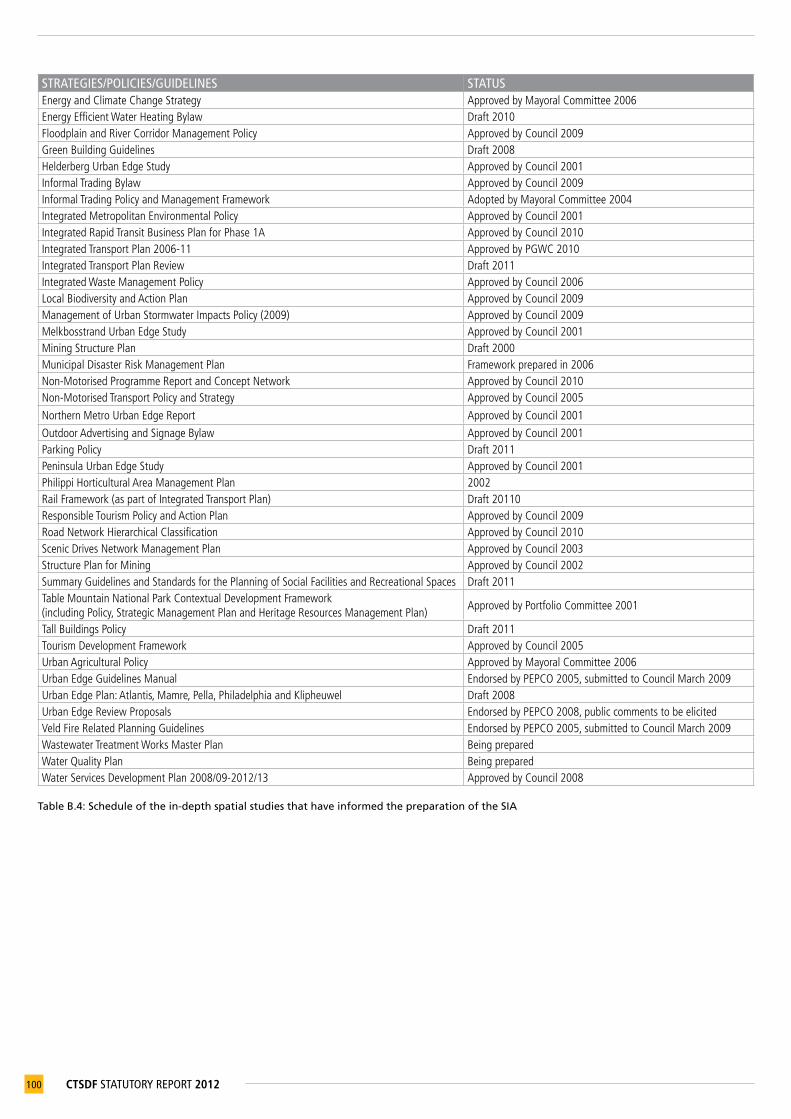
100 CTSDF STATUTORY REPORT 2012
STRATEGIES/POLICIES/GUIDELINES STATUSEnergyandClimateChangeStrategy ApprovedbyMayoralCommittee2006EnergyEfficientWaterHeatingBylaw Draft2010FloodplainandRiverCorridorManagementPolicy ApprovedbyCouncil2009GreenBuildingGuidelines Draft2008HelderbergUrbanEdgeStudy ApprovedbyCouncil2001InformalTradingBylaw ApprovedbyCouncil2009InformalTradingPolicyandManagementFramework AdoptedbyMayoralCommittee2004IntegratedMetropolitanEnvironmentalPolicy ApprovedbyCouncil2001IntegratedRapidTransitBusinessPlanforPhase1A ApprovedbyCouncil2010IntegratedTransportPlan2006-11 ApprovedbyPGWC2010IntegratedTransportPlanReview Draft2011IntegratedWasteManagementPolicy ApprovedbyCouncil2006LocalBiodiversityandActionPlan ApprovedbyCouncil2009ManagementofUrbanStormwaterImpactsPolicy(2009) ApprovedbyCouncil2009MelkbosstrandUrbanEdgeStudy ApprovedbyCouncil2001MiningStructurePlan Draft2000MunicipalDisasterRiskManagementPlan Frameworkpreparedin2006Non-MotorisedProgrammeReportandConceptNetwork ApprovedbyCouncil2010Non-MotorisedTransportPolicyandStrategy ApprovedbyCouncil2005
NorthernMetroUrbanEdgeReport ApprovedbyCouncil2001
OutdoorAdvertisingandSignageBylaw ApprovedbyCouncil2001ParkingPolicy Draft2011PeninsulaUrbanEdgeStudy ApprovedbyCouncil2001PhilippiHorticulturalAreaManagementPlan 2002RailFramework(aspartofIntegratedTransportPlan) Draft20110ResponsibleTourismPolicyandActionPlan ApprovedbyCouncil2009RoadNetworkHierarchicalClassification ApprovedbyCouncil2010ScenicDrivesNetworkManagementPlan ApprovedbyCouncil2003StructurePlanforMining ApprovedbyCouncil2002SummaryGuidelinesandStandardsforthePlanningofSocialFacilitiesandRecreationalSpaces Draft2011TableMountainNationalParkContextualDevelopmentFramework(includingPolicy,StrategicManagementPlanandHeritageResourcesManagementPlan)
ApprovedbyPortfolioCommittee2001
TallBuildingsPolicy Draft2011TourismDevelopmentFramework ApprovedbyCouncil2005UrbanAgriculturalPolicy ApprovedbyMayoralCommittee2006UrbanEdgeGuidelinesManual EndorsedbyPEPCO2005,submittedtoCouncilMarch2009UrbanEdgePlan:Atlantis,Mamre,Pella,PhiladelphiaandKlipheuwel Draft2008UrbanEdgeReviewProposals EndorsedbyPEPCO2008,publiccommentstobeelicitedVeldFireRelatedPlanningGuidelines EndorsedbyPEPCO2005,submittedtoCouncilMarch2009WastewaterTreatmentWorksMasterPlan BeingpreparedWaterQualityPlan BeingpreparedWaterServicesDevelopmentPlan2008/09-2012/13 ApprovedbyCouncil2008
Table B.4: Schedule of the in-depth spatial studies that have informed the preparation of the SIA

101CTSDF STATUTORY REPORT 2012
IN-DEPTH STUDIES UNDERTAKEN BY THE CITY1 AgriculturalLandStudypreparedbySetplan-DJEnvironmentalConsultantsJointVenture(2006)
2AgriculturalLandReviewpreparedbyiKapaEnvironplan,Setplan–DJEnvironmentalConsultantsJointventureinassociationwithAgriInformaticsandProf.T.Kleynhans(2008)
3 AirportSystemsStudy(1999)4 AnalysisoftheSpatialEconomyofCapeTown(draft2010)5 BlaauwbergDistrictSpatialDevelopmentPlan(2009)6 CapeFlatsDistrictSpatialDevelopmentPlan(2009)7 CapeTownSpatialGrowthModel(draft2008)8 CityofCapeTownCostSurfaceModelVolumes1and2,BrendanMcGill(2008)9 CMOSS:AnOpenSpaceStrategyfortheCityofCapeTown(draft2005)10 CMOSSPhaseII:Mapping–OverallProjectandSummaryReport(2003)11 CoastalDevelopmentGuidanceforCapeTown’sCoastlineintotheFuture(2007))12 EvaluationofUrbanDevelopmentZones(UDZ)PhaseIReport,CityofCapeTown(draft2010)13 HelderbergDistrictSpatialDevelopmentPlan(2010)14 KhayelitshaandMitchell’sPlainDistrictSpatialDevelopmentPlan(2010)15 MSDFReview:Phase1SpatialAnalysisofTrendsandImplications(CityofCapeTownwithsupportofProf.V.Watson)(2003)16 NorthernDistrictSpatialDevelopmentPlan(2010)17 PlanningforFutureCapeTown,CityofCapeTown(2006)18 ResidentialGrowthMonitoringSystem(UGMS)fortheCityofCapeTown,iWebtec,200819 SouthernDistrictSpatialDevelopmentPlan(2010)20 SpatialAlignmentoftheCapitalBudget,CityofCapeTownpresentation(2008)21 SummaryGuidelinesandStandardsfortheSpatialPlanningofCityofCapeTownSocialFacilitiesandRecreationalSpaces,CSIR(2010)22 TableBayDistrictSpatialDevelopmentPlan(2010)23 TygerbergDistrictSpatialDevelopmentPlan(2010)24 SpatialAnalysisofPrivateInvestmentPatternsinCapeTown–WesgroInvestmentData(2008)25 EvaluationofDevelopableLandwithintheUrbanEdge(2010)
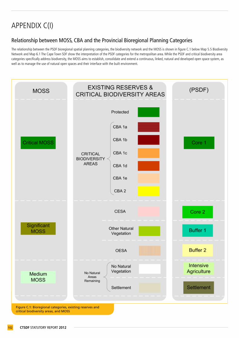
102 CTSDF STATUTORY REPORT 2012
APPENDIXC(I)
Relationship between MOSS, CBA and the Provincial Bioregional Planning Categories TherelationshipbetweenthePSDFbioregionalspatialplanningcategories,thebiodiversitynetworkandtheMOSSisshowninfigureC.1belowMap5.5BiodiversityNetworkandMap6.1TheCapeTownSDFshowtheinterpretationofthePSDFcategoriesforthemetropolitanarea.WhilethePSDFandcriticalbiodiversityareacategoriesspecificallyaddressbiodiversity,theMOSSaimstoestablish,consolidateandextendacontinuous,linked,naturalanddevelopedopenspacesystem,aswellastomanagetheuseofnaturalopenspacesandtheirinterfacewiththebuiltenvironment.
Figure C.1: Bioregional categories, existing reserves and critical biodiversity areas, and MOSS
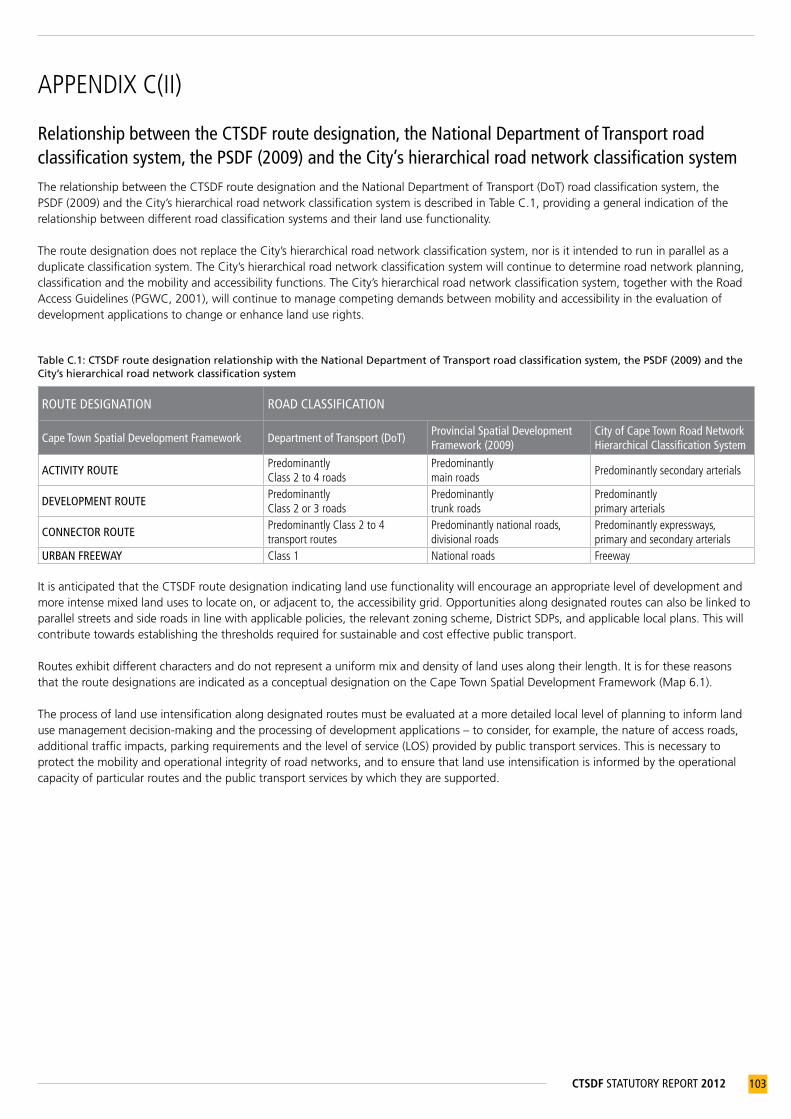
103CTSDF STATUTORY REPORT 2012
APPENDIXC(II)
Relationship between the CTSDF route designation, the National Department of Transport road classification system, the PSDF (2009) and the City’s hierarchical road network classification systemThe relationship between the CTSDF route designation and the National Department of Transport (DoT) road classification system, the PSDF (2009) and the City’s hierarchical road network classification system is described in Table C.1, providing a general indication of the relationship between different road classification systems and their land use functionality.
The route designation does not replace the City’s hierarchical road network classification system, nor is it intended to run in parallel as a duplicate classification system. The City’s hierarchical road network classification system will continue to determine road network planning, classification and the mobility and accessibility functions. The City’s hierarchical road network classification system, together with the Road Access Guidelines (PGWC, 2001), will continue to manage competing demands between mobility and accessibility in the evaluation of development applications to change or enhance land use rights.
Table C.1: CTSDF route designation relationship with the National Department of Transport road classification system, the PSDF (2009) and the City’s hierarchical road network classification system
ROUTE DESIGNATION ROAD CLASSIFICATION
Cape Town Spatial Development Framework Department of Transport (DoT) Provincial Spatial Development Framework (2009)
City of Cape Town Road Network Hierarchical Classification System
ACTIVITY ROUTEPredominantlyClass2to4roads
Predominantlymainroads
Predominantlysecondaryarterials
DEVELOPMENT ROUTEPredominantlyClass2or3roads
Predominantlytrunkroads
Predominantlyprimaryarterials
CONNECTOR ROUTEPredominantlyClass2to4transportroutes
Predominantlynationalroads,divisionalroads
Predominantlyexpressways,primaryandsecondaryarterials
URBAN FREEWAY Class1 Nationalroads Freeway
It is anticipated that the CTSDF route designation indicating land use functionality will encourage an appropriate level of development and more intense mixed land uses to locate on, or adjacent to, the accessibility grid. Opportunities along designated routes can also be linked to parallel streets and side roads in line with applicable policies, the relevant zoning scheme, District SDPs, and applicable local plans. This will contribute towards establishing the thresholds required for sustainable and cost effective public transport.
Routes exhibit different characters and do not represent a uniform mix and density of land uses along their length. It is for these reasons that the route designations are indicated as a conceptual designation on the Cape Town Spatial Development Framework (Map 6.1).
The process of land use intensification along designated routes must be evaluated at a more detailed local level of planning to inform land use management decision-making and the processing of development applications – to consider, for example, the nature of access roads, additional traffic impacts, parking requirements and the level of service (LOS) provided by public transport services. This is necessary to protect the mobility and operational integrity of road networks, and to ensure that land use intensification is informed by the operational capacity of particular routes and the public transport services by which they are supported.

104 CTSDF STATUTORY REPORT 2012
APPENDIXD
Strategic Impact Assessment summaryTable D.1: Strategic Impact Assessment (SIA) of the CTSDF
STRATEGIC ISSUES
EXISTING TRENDS AND IMPLICATIONS
POLICY AND STRATEGY RESPONSESSTRATEGIC IMPACTS OF THE CTSDF
POSSIBLE INDICATORS
Population and city growth
Rateofurbangrowth,populationgrowthanddemand
Containanddirectnewgrowthtowardssuitableareasandsustainableforms
Newdevelopmentareas Extentofurbansprawl
Urbansprawlandaspread-outcity
DensificationandUrbanEdgeIdentificationofpotentialdensificationareasandlimitstourbansprawl
Numberandlocationofapprovedbuildingplans,rezoningsandsubdivisions
Natural environmental and resource capacity
LossofbiodiversityBiodiversitystrategy:biodiversitynetworkandimplementationframework
Clarificationofnationalbiodiversitytargets;integrationofconservationplanningprincipleswithgrowthmanagement
Percentageofendangeredandcriticallyendangeredbiodiversityremaining
Poor-qualityopenspacesDevelopaqualitymetropolitanopenspacesystem(MOSS)
Linked,multifunctionalopenspacesystem
Quality,quantityandaccessibilityofgreenspacepercapita
Risksandimpactsofglobalclimatechange
Climatechangemitigationandadaptationstrategies
Identificationofvulnerableareasandactivitiestoinformmitigationactions
PercapitaCO2emissions;CoastalProtectionZone/CoastalEdge
Lossofagricultural,ruralandsmallholdingareas
Identifyandprotectpriorityagriculturalresourceareas;UrbanEdge;protectionofheritageresourcesincludingculturallandscapes
Productiveagricultural,tourism,heritageandmineralresourcesareprotected
Extentofurbansprawl,heritageinventoryupdatedandintegratedwithforwardplanningandlandusecontrols.
Spatial limits to growth
InfrastructurebacklogsPrepare15-yearGrowthManagementPlan
Promotecompact,directedurbangrowthwithinurbanedge
Residentialdensity,urbanedgeamendments
Constraintsanddevelopmentboundariestofuturegrowth
Agriculturallandreview;biodiversitynetwork;UrbanEdge;majorprecautionaryareas
Managed,compactgrowthdirectedawayfromnaturalassetsandhazards.
Urbanedgeamendments
Impactofurbangrowthonrivers,wetlandsandaquifers
Minimiseurbandevelopmentimpactsonnaturalresourceareasandcorridors
Policiesonfloodlines,aquifersandrivercorridorsinformlandusemanagement
ConformancewithDistrictSDPs
Accessibility and movement systems
Radialtransportnetworklimitsgrowth
Citywidepublictransportthatsupportstheaccessibilitygrid
Hierarchyofintegratedpublictransportservices
Modalsplit:public/privatetransportsplit;decreasingcongestion
Publictransportfailingtomeetdemand
DensificationandurbanedgestrategiesIntegratedTransportPlan(ITP)
Compactcity;implementationoftheITP–spatialimplications
Populationwithin1 kmofpublictransport;increasingpatronageofpublictransport
Spatial economy
Spatialeconomicmarginalisation
Identificationofeconomiccoreandlinkagestoaddressspatialeconomicimbalances.Promotionofsmallbusinesses.
EconomicAreasPlanJobcreationaccessibletoorwithintheMetroSoutheast
Informaleconomyhasfewopportunitiescomparedtoformaleconomy
Inclusiveandsharedeconomicgrowthbydirectingthelocationandformofdevelopmenttopromoteinformalsectoropportunities;integratedpublictransportandlanduseplanning
Informaltradingfacilitiesprovidedinappropriateareas;saleorleaseofCitylandforinformaltradingandsmallbusinessuse
Numberofnewtradingsitesandleasestoinformaltraders
Economicresources–agriculture,tourism,heritageandmineralresources
Containanddirectnewgrowthinandtowardssuitableareasandsustainableforms
Protectionoftourismandheritageresourceareas;identificationofnewtourism,heritage,natureandculturalresources,andtheupgradeofcertainstrategictourismprecinctsandresources;identificationofstrategicandaccessiblemineralresources
Numberoftourism-generatedjobs;locationofminingapplicationsreceived/approved
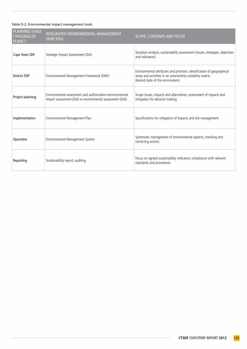
105CTSDF STATUTORY REPORT 2012
Table D.2: Environmental impact management tools
PLANNING STAGE (‘PACKAGE OF PLANS’)
INTEGRATED ENVIRONMENTAL MANAGEMENT (IEM) TOOL
SCOPE, CONTENTS AND FOCUS
Cape Town SDF StrategicImpactAssessment(SIA)Situationanalysis,sustainabilityassessment(issues,strategies,objectivesandindicators)
District SDP EnvironmentalManagementFramework(EMF)Environmentalattributesandpriorities;identificationofgeographicalareasandactivitiesinanarea/activitysuitabilitymatrix;desiredstateoftheenvironment.
Project planningEnvironmentalassessmentandauthorisation(environmentalimpactassessment(EIA)orenvironmentalassessment(EA))
Scopeissues,impactsandalternatives;assessmentofimpactsandmitigationfordecisionmaking
Implementation EnvironmentalManagementPlan Specificationsformitigationofimpactsandsitemanagement
Operation EnvironmentalManagementSystemSystematicmanagementofenvironmentalaspects;checkingandcorrectingactions
Reporting Sustainabilityreport;auditingFocusonagreedsustainabilityindicators;compliancewithrelevantstandardsandprocedures

106 CTSDF STATUTORY REPORT 2012
APPENDIXE
Overview of Environmental Impact Management ZonesEnvironmental Impact Management Zones (EIMZs) will be identified in the District SDPs. An overview of the identified EIMZs follows, with references to the relevant CTSDF policy statements.40
Table E.1: Overview of EIMZs
CTSDF POLICIES P25-P27
CTSDF POLICIES P25-P27
CTSDF POLICIES P25-P27
CTSDF POLICIES P42-P50
CTSDF POLICIES P28-P29, 31-P34
CTSDF POLICIES P11, P20, P24
EIMZ Hydrological zoneCoastal and dune zone
Conservation and biodiversity priority zone
Cultural and recreational resources zone
Economic resources zone
Urban uses and utilities zone
ENVIRONMENTAL ATTRIBUTES
Flood risk areas 1:20-yearfloodline1:50-yearfloodline1:100-yearfloodline
Rivers and wetlands• Riversand
associatedbufferareas
• Wetlandsandassociatedbufferareas
Aquifers• Highlyproductive
aquifers• Moderately
productiveaquifers
Coastal protection areas• Coastalprotection
zone• Coastalfloodrisk
areas
Dune areas• Sensitivedune
fields
Conservation and biodiversity areas• Conservation
areas• Critical
biodiversityarea1• Critical
biodiversityarea2• Criticalecological
supportareas• Othernatural
vegetation
Cultural and heritage areas• Cultural
landscapes• Potential
archaeologicalsites
• Othersignificantheritageresourceareas
• Scenicroutes
Public open spaces • Structuringopen
spaces
High-potential agricultural areas• High-potential
anduniqueagriculturallandworthyofstatutoryorlong-termprotection
• Agriculturalareasofsignificantvaluegivenexisting,orpotentialandemerginguse
• Otheragriculturalareas
• Smallholdingsandagriculturalareas
Mineral extraction areas• Prioritymineral
resourceareas
Landfill exclusion areas• Landfillsitesand
bufferzones
Industrial and commercial areas• Industrialareas• Commercialareas
Infrastructure and utilities areas• Infrastructure
servitudes,includingwastewatertreatmentworks(WWTWs)
40 Policylistnotexhaustive,andallpoliciesshouldbecheckedforreference.

107CTSDF STATUTORY REPORT 2012
APPENDIXF
Summary of the draft guidelines and standards for the planning of City of Cape Town social facilities and recreational spacesTable F.1: Matrix of potential clustering of social facilities and recreational spaces
COMPATIBLE FACILITIES
Libr
ary
Prim
ary
scho
ol
Seco
ndar
y sc
hool
Tert
iary
edu
catio
n/tr
ade
scho
ol
Com
mun
ity h
all
Indo
or s
port
s ha
ll
Spor
ts s
tadi
um
Loca
l spo
rts
field
, inc
l. m
ultip
urpo
se o
utdo
or c
ourt
s
Park
s: Co
mm
unity
Park
s: Di
stric
t
Park
s: `M
etro
polit
an
Swim
min
g po
ol
Urb
an a
gric
ultu
re
Cem
eter
y
Prim
ary
heal
th c
are
cent
re
L1 h
ospi
tal
Polic
e st
atio
n
Fire
sta
tion
Initi
atio
n si
te
Relig
ious
cen
tre
Nat
ure
cons
erva
tion
Library • • • • • • •
Primary school • • • • • • • • • •
Secondary school • • • • • • • • • • • •
Tertiary education/tradeschool • • • • • • • • • • •
Community hall • • • • • • • • • • • • • • • •
Indoor sports hall • • • • • • • •
Sports stadium • • • • • • • •
Local sports field, incl. multipurpose outdoor courts • • • • • • • • • •
Parks: Community • • • • • • • • • • • •
Parks: District • • • • • • • • • • • • •
Parks: Metropolitan • • • • • • • • • • •
Swimming pool • • • • • • • • • •
Urban agriculture • • • • • • • • •
Cemetery • • • •
Primary health care centre • • • • • • • • • •
L1 hospital • •
Police station •
Fire station • •
Initiation site •
Religious centre • • • • •
Nature conservation • • • • •

108 CTSDF STATUTORY REPORT 2012
Table F.2: Facility thresholds and their potential locations
FACILITY
TYPICAL POPULATION THRESHOLD
(NO. OF PEOPLE)
NEIGHBOURHOOD NODE
(LOCAL CLUSTER/SPECIAL PLACE)
DISTRICT NODE
SUB- METROPOLITAN
NODE
SPORTS AND PARKS PRECINCTMULTIFUNCTIONAL SPORTS,
RECREATION AND PARK COMPLEXNEIGHBOURHOOD/
DISTRICTSUB-METRO/
METRO
Early Childhood Development Centre 1000–2000 • • •
Centres of excellence 20000 • • •
Worship centre 3000–6000 • • •
Local sports field 3000 • •
Neighbourhood park 3000–6000 • •
Urban agriculture Varied • • •
Local market 5000 • •
Primary school 5500 • • •
Post office 10000 • • •
Neighbourhood sports complex 10000 • •
Secondary school 12500 • • • •
Community park 20000 • • • •
ICT access point 20000 • •
Home Affairs/other govt. institutions - district office
20000 •
Community centre 30000 • • •
Library 40000 • •
Health clinic 40000 • •
Home Affairs/other govt. institutions - local service point
40000 • •
Small museum 50000 • • •
Performing arts centre 50000 • •
Home for the aged 50000 • •
Hospice/health centre 50000 • •
District sports complex 50000 • •
District park 50000 • •
Children’s home 60000 • •
Community health centre 60000–120 000 • •
Police station 60000 • •
Magistrate’s court - •
Prisons and places of safety -
Initiation site -
Cemetery 100000 •
Tertiary institution (not university) 100000 • •
Fire station 100000 • •
Metropolitan sports complex 120000 • •
Regional park 120000 • •
Civic centre/city hall 200000 •
Home Affairs/other govt. institutions – regional office
200000 •

109CTSDF STATUTORY REPORT 2012
Table F.3: Matrix of functional potential for multiple use of social facilities
POTENTIAL SECONDARY FUNCTION
è
Plac
eto
stu
dy
Mee
tings
/soc
ial–
sm
allg
roup
Gat
herin
gs–
larg
egr
oup
Pens
ion
pay-
out
Adul
ttra
inin
gfa
cility
Coun
selli
ngc
entre
Mun
icipa
linf
orm
atio
nse
ssio
ns
Relig
ious
ser
vice
s
Pray
erm
eetin
gs
Hom
eAf
fairs
(per
iodi
c)
Socia
lWel
fare
(per
iodi
c)
Child
Wel
fare
(per
iodi
c)
Feed
ing
sche
me
Lega
laid
Ove
rflow
spo
rtfo
rsch
ools
Inte
r-sch
oole
vent
s
PRIMARY FUNCTION OF THE FACILITY
êLibrary • • • • • • • •
Communitycentre • • • • • • • • • • • • • •
Worshipcentre • • • • • • • •
School • • • • • • • • •
Sportshall • • • • • • •
Sportsstadium • • • • •
Localsportsfield • •
Multipurposeoutdoorcourt(s) • •
Natureconservation
Primaryhealthcarecentre • • • • • • •

110 CTSDF STATUTORY REPORT 2012
APPENDIXG
Record of amendmentsThis document is subject to amendment, and such amendments must be recorded in the table below.
REFERENCE NUMBER
DATE OF AMENDMENT
PROPERTY DESCRIPTION DETAILS OF AMENDMENT


APPROVED
2012