cape cod emergency traffic plan august 2016€¦ · the cape cod emergency traffic plan (ccetp) is...
TRANSCRIPT
For Official Use Only (FOUO)
COMMONWEALTH OF MASSACHUSETTS
CAPE COD EMERGENCY TRAFFIC PLAN August 2016
CAPE COD EMERGENCY TRAFFIC PLAN
Cape Cod Emergency Traffic Plan i
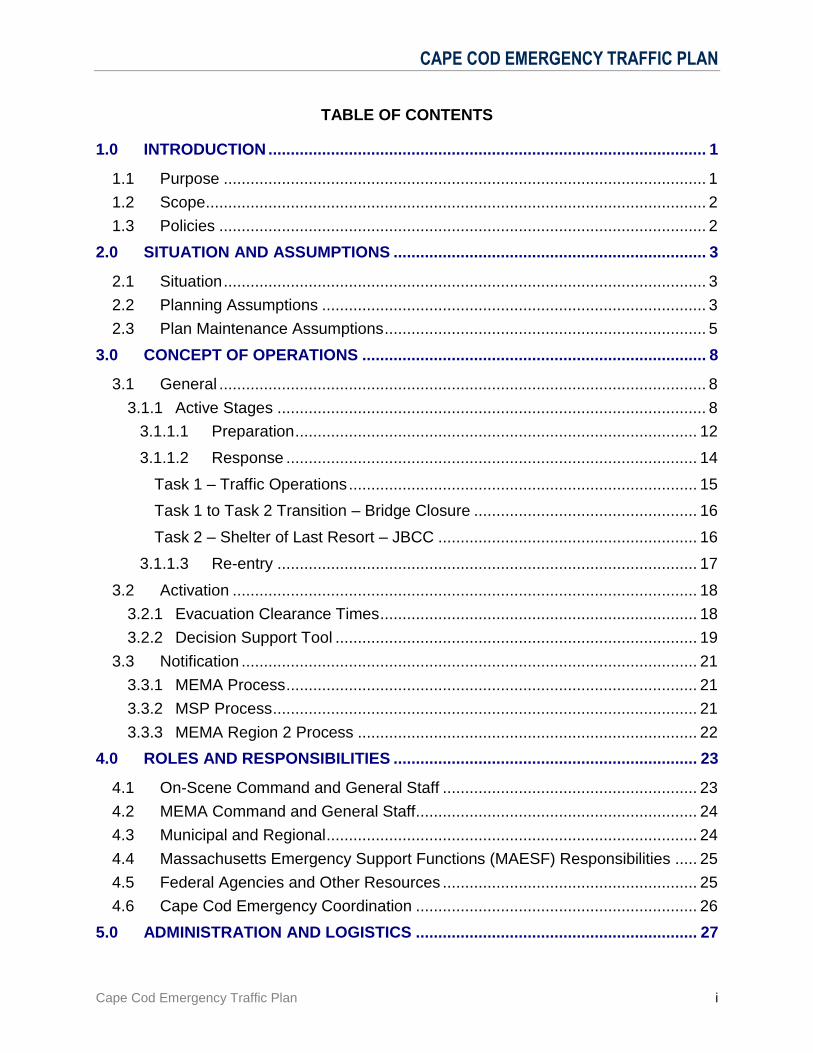
TABLE OF CONTENTS
1.0 INTRODUCTION .................................................................................................. 1
1.1 Purpose ............................................................................................................ 1
1.2 Scope ................................................................................................................ 2
1.3 Policies ............................................................................................................. 2
2.0 SITUATION AND ASSUMPTIONS ...................................................................... 3
2.1 Situation ............................................................................................................ 3
2.2 Planning Assumptions ...................................................................................... 3
2.3 Plan Maintenance Assumptions ........................................................................ 5
3.0 CONCEPT OF OPERATIONS ............................................................................. 8
3.1 General ............................................................................................................. 8
3.1.1 Active Stages ................................................................................................ 8
3.1.1.1 Preparation .......................................................................................... 12
3.1.1.2 Response ............................................................................................ 14
Task 1 – Traffic Operations .............................................................................. 15
Task 1 to Task 2 Transition – Bridge Closure .................................................. 16
Task 2 – Shelter of Last Resort – JBCC .......................................................... 16
3.1.1.3 Re-entry .............................................................................................. 17
3.2 Activation ........................................................................................................ 18
3.2.1 Evacuation Clearance Times ....................................................................... 18
3.2.2 Decision Support Tool ................................................................................. 19
3.3 Notification ...................................................................................................... 21
3.3.1 MEMA Process ............................................................................................ 21
3.3.2 MSP Process ............................................................................................... 21
3.3.3 MEMA Region 2 Process ............................................................................ 22
4.0 ROLES AND RESPONSIBILITIES .................................................................... 23
4.1 On-Scene Command and General Staff ......................................................... 23
4.2 MEMA Command and General Staff ............................................................... 24
4.3 Municipal and Regional ................................................................................... 24
4.4 Massachusetts Emergency Support Functions (MAESF) Responsibilities ..... 25
4.5 Federal Agencies and Other Resources ......................................................... 25
4.6 Cape Cod Emergency Coordination ............................................................... 26
5.0 ADMINISTRATION AND LOGISTICS ............................................................... 27

CAPE COD EMERGENCY TRAFFIC PLAN
Cape Cod Emergency Traffic Plan ii
5.1 Resource Requests ........................................................................................ 27
5.2 Pre-Event Contracts ........................................................................................ 27
5.3 Mutual Aid ....................................................................................................... 28
5.3.1 Law Enforcement......................................................................................... 28
5.3.2 Fire/EMS Services: ...................................................................................... 28
5.3.3 State Mutual Aid Compact: .......................................................................... 28
Annexes
A. GENERAL ANNEXES ...................................................................................... A-1
A.1 Standard Operating Procedures ....................................................................A-1
A.1.1 Massachusetts Emergency Management Agency – Headquarters ............A-1
A.1.2 Massachusetts State Police .......................................................................A-1
A.1.3 MEMA Region 2 .........................................................................................A-1
A.1.4 Massachusetts Department of Transportation ............................................A-1
A.1.5 United State Army Corps of Engineers .......................................................A-1
A.1.6 Barnstable County Incident Management Team ........................................A-1
A.1.7 Town of Bourne ..........................................................................................A-1
A.1.8 Town of Sandwich ......................................................................................A-1
A.1.9 Massachusetts National Guard ..................................................................A-1
A.1.10 American Red Cross ..................................................................................A-1
A.1.11 International Fund for Animal Welfare ........................................................A-1
A.1.12 Massachusetts Department of Public Health ..............................................A-1
A.1.13 Medical Reserve Corps ..............................................................................A-1
A.1.14 Upper Cape Code Regional Technical High School ...................................A-1
A.1.15 WQRC Radio ..............................................................................................A-1
A.2 Notification Procedures ..................................................................................A-2
A.2.1 Contact List ................................................................................................A-2
A.2.2 MEMA HQ Notification Procedures ............................................................A-2
A.2.3 MSP Notification Procedures ......................................................................A-2
A.2.4 MEMA Region 2 Notification Procedures ...................................................A-2
A.3 Logistics Information ......................................................................................A-2
A.3.1 Maps ...........................................................................................................A-2
A.3.2 Communications Plan .................................................................................A-2
A.3.3 Radio Communications Plan Template (ICS205) .......................................A-2
A.3.4 Communications Flow Chart ......................................................................A-2
A.3.5 Resource Flow Chart ..................................................................................A-2
CAPE COD EMERGENCY TRAFFIC PLAN
Cape Cod Emergency Traffic Plan iii
A.3.6 MSP Incident Action Plans .........................................................................A-2
B. TRAFFIC OPERATION ANNEXES .................................................................. B-1
B.1 Traffic Control Points .....................................................................................B-1
B.2 Command Post Set Up ..................................................................................B-1
B.3 Traffic Control Point Activation .......................................................................B-1
B.4 Towing ...........................................................................................................B-1
B.5 Bridge Closing................................................................................................B-1
B.6 Emergency Canal Road Access ....................................................................B-1
B.7 Traffic Advisory Broadcasts ...........................................................................B-1
C. SHELTER OF LAST RESORT ANNEXES ...................................................... C-1
C.1 Potential MA-ARNG Buildings for Shelter Operations ................................... C-1
C.2 Barracks Shelter Report ................................................................................ C-1
C.3 Barracks Floor Plan ...................................................................................... C-1
C.4 Barracks Drawing .......................................................................................... C-1
C.5 CERT Shelter Process Map .......................................................................... C-1
C.6 CERT Shelter Process Operational Stage .................................................... C-1
C.7 JBCC Shelter Resource Requirements ......................................................... C-1
C.8 JBCC Trailer Relocation Procedure .............................................................. C-1
C.9 JBCC Shelter Trailer Information .................................................................. C-1
C.10 ARC Shelter Registration Form - English ...................................................... C-1
C.11 ARC Shelter Registration Form – Spanish .................................................... C-1
C.12 ARC Client Health Record ............................................................................ C-1
C.13 IFAW Animal Intake Form ............................................................................. C-1
C.14 JBCC Shelter Information Sheet - English .................................................... C-1
C.15 JBCC Shelter Information Sheet - Spanish ................................................... C-1
D. OTHER INFORMATION ANNEXES ................................................................ D-1
D.1 MEMA Website Information .......................................................................... D-1
D.2 Summary of Decision Tool and HES ............................................................. D-1
D.3 Decision Tool Clearance Time Validation Process ....................................... D-1
D.4 Acronyms ...................................................................................................... D-1

CAPE COD EMERGENCY TRAFFIC PLAN
Cape Cod Emergency Traffic Plan 1
1.0 INTRODUCTION
The Cape Cod Emergency Traffic Plan (CCETP) is an operational plan that is used by state and local government organizations in the Commonwealth of Massachusetts to manage traffic operations during situations that require or result in a rapid egress of motor vehicles from areas of Cape Cod, or in such a large number of motor vehicles leaving Cape Cod that roadway congestion and other circumstances warrant the implementation of this Plan. This document defines procedures, details the concept of operations and assigns responsibilities for implementation. Attachments to the document include specific annexes, which incorporate operational checklists, forms and other aids needed for implementation of this plan.
1.1 Purpose
The CCETP has been developed to facilitate the egress of a high volume of traffic from Cape Cod in the event of a hurricane or other potential or actual hazard, particularly during peak tourist season. The primary goals of the CCETP are to ensure the safety of citizens in the event of hazardous weather, or possibly hazards requiring the orderly but rapid movement of motorists off Cape Cod and the Islands of Nantucket and Martha’s Vineyard; and as a last resort to provide temporary sheltering on Joint Base Cape Cod (JBCC) of displaced persons unable to exit Cape Cod due to the closure of the Bourne and Sagamore Bridges.
The procedures set forth represent a standard understanding on the part of all organizations and levels of government of their responsibilities during the plan’s implementation. They also establish uniform operational procedures through which those responsibilities can be fulfilled.
The CCETP has been developed by the Massachusetts State Police (MSP) and the Massachusetts Emergency Management Agency (MEMA), in cooperation with the Bourne and Sandwich Police Departments, Massachusetts Department of Transportation (MassDOT), Massachusetts National Guard (MA-ARNG), JBCC, U.S. Army Corps of Engineers (USACE), Barnstable County Sheriff’s Department, American Red Cross (ARC), and other state agencies and local emergency management agencies from towns across Cape Cod.
It is important to emphasize that this is not an evacuation plan. There are a number of vulnerable areas of Cape Cod at risk of storm surge inundation and flooding from serious weather events. Although residents in these areas may be ordered to evacuate, many will choose to access shelters and not leave the Cape. During the summer season however, particularly the holiday weekends, more tourists will attempt to leave the Cape if a serious hurricane is predicted. Since its inception, this plan has been developed with an emphasis on such a hurricane scenario. It is a tool, however, that can be used to assist in expediting traffic flow off Cape Cod regardless of the hazard.

CAPE COD EMERGENCY TRAFFIC PLAN
Cape Cod Emergency Traffic Plan 2
1.2 Scope
This plan applies to MEMA, MSP, MassDOT, and Massachusetts Emergency Support Function (MAESF) personnel, as well as local emergency management and response agencies tasked with planning and implementing the CCETP. Based on potential impacts of severe weather, and in coordination with the Executive Office of Public Safety and Security (EOPSS) and the Governor, the MEMA Director initiates the activation of the CCETP. Once the plan is activated, overall command and execution of the plan is under the direction of the MSP, which will serve as the Incident Commander for purposes of execution of this plan.
This Plan defines the roles and responsibilities of state and local response agencies. This Plan does not replace the authorities or responsibilities of municipal governments in Massachusetts to develop, test, and implement plans within their own jurisdictions.
1.3 Policies
The CCETP is a response-specific operational procedure that follows policies and regulations identified in the Massachusetts Comprehensive Emergency Management Plan (CEMP). As an incident requires, and at the direction of the MEMA Director or State Emergency Operation Center (SEOC) Manager, the CCETP will be activated to support activities related to efficient and rapid traffic egress off of Cape Cod. In the event of activation, MSP will establish Incident Command and MEMA will provide overall support and situational awareness to the on-scene IC regarding coordination of state response.
The MAESF agencies and organizations detailed in this Plan will work collaboratively to support the Plan.
This Plan supersedes the 2015 version of the Cape Cod Emergency Traffic Plan.
This Plan does not supersede existing local emergency plans, but rather is designed to supplement and support them. This Plan builds upon established capabilities at the local level.
The MAESF agencies and organizations assigned responsibilities within this Plan will develop and maintain the necessary plans, standard operating procedures and mutual aid agreements to successfully accomplish assigned tasks.
MEMA and MSP are responsible for overall coordination of this Plan and for coordinating with responsible MAESFs and partners to access any additional resources necessary to support emergency traffic operations on the Cape.
CAPE COD EMERGENCY TRAFFIC PLAN
Cape Cod Emergency Traffic Plan 3
2.0 SITUATION AND ASSUMPTIONS
2.1 Situation
Cape Cod and the surrounding islands are subject to a number of natural, technological, and human caused hazards that may necessitate rapid and efficient egress from areas of the Cape. At the same time, Cape roadways and bridges are restricted in route options, profile, and capacity.
This plan is focused on an emergency traffic response to a hurricane hazard, but pieces and elements of this plan could be used to respond to any prior “Notice” event that require the rapid and efficient egress of motor vehicles from Cape Cod or the need to establish a short term shelter of last resort at Joint Base Cape Cod (JBCC).
See the CEMP and the Commonwealth of Massachusetts Threat Hazard Identification and Risk Assessment (THIRA) for specific situational assumptions, threats and hazards.
2.2 Planning Assumptions
Principal assumptions underlying the CCETP concept of operations:
Activation of this plan may occur for all hazards that could result in a large volume of traffic leaving Cape Cod. However, the need to implement certain aspects of the plan, such as task implementation and termination, closing bridges, opening mass shelters at the JBCC, etc., may vary based on the specific hazard, degree of vulnerability, and projected area of impact.
Every effort will be made to provide updated and accurate information, via multiple media and outreach outlets, so that residents and visitors on Cape Cod and the Islands can make the best possible decisions for their given situation. Local and regional shelters may be available for those who wish to remain on Cape Cod through a storm or other incident/ event. Public Safety officials will request that those who decide to leave do so early to minimize impacts on public safety during the storm/ event.
Efforts will be made to identify and mobilize non-ambulatory and dependent (hospital, nursing, and/or home care) populations in affected areas prior to public notification of evacuation.
During extreme weather events, communities may require evacuation of large numbers of people from vulnerable areas that will stress the capacity of roadways available for moving traffic. Additional time to complete local evacuations, and traffic clearance through the plan, may be needed. Both evacuations and the plan must be initiated as soon as feasible upon recognition of the threat, and must function efficiently until completion.
Preliminary decisions to activate elements of this plan (including response coordination, resource and man-power requisition and staging, and public notification) may have to be made prior to there being high confidence in the weather forecast.
CAPE COD EMERGENCY TRAFFIC PLAN
Cape Cod Emergency Traffic Plan 4
The anticipated impacts of hurricanes, tropical storms and other coastal weather events on coastal communities and infrastructure cannot by measured simply by applying a rating or classification system. Environmental, seasonal, cultural, and other variables will come into play and must be considered in planning a response.
Plan implementation and local evacuations will require substantial resources for traffic control. This could exceed the capabilities of the threatened jurisdictions. Procedures have been developed for the pre-deployment of state, federal, and mutual aid personnel and equipment resources to multiple jurisdictions.
Coordination between state and local agencies involved in the implementation of the plan will occur through collaborative information sharing and decision-making concerning protective actions, resource coordination, and deployment.
Public shelter availability may be limited. This may require the full use of all shelters within the region, especially when the Bourne and Sagamore Bridges are closed. A high level of coordination will be needed to effectively communicate protective actions and shelter information to evacuees. The Barnstable County Regional Emergency Planning Committee (BCREPC) and Incident Management Team (BCIMT) will be included in these conversations.
Emergency workers whose responsibilities are to stand up shelter operations at the JBCC will be provided shelter accommodations at the JBCC during off hours. All other emergency workers involved in the execution of the plan are to report to the Incident Command/Base Camp at the Upper Cape Cod Regional Technical High School (UCCRTHS) for shelter accommodations.
Existing roadway infrastructure needs to be taken into account when executing this plan. Traffic flow off the Cape is limited by the fact that there are only two bridges, each having only two lanes of outbound traffic.
Contra-flow of traffic off-Cape is not feasible in the implementation of this plan. Traffic must still gain access to the Cape as needed and when safe. With this in mind, the CCETP is designed to lessen potential impacts, but cannot eliminate them completely.
For certain hazards, large vulnerable populations and limited evacuation road networks may require closing Cape bridges and/or changes in the plan prior to full execution. Travelers and/or evacuees, still at risk, would need to be directed to alternate shelters as quickly as possible. Public information messages will be provided throughout the course of any event to instruct motorists.
The CCETP requires effective coordination between numerous jurisdictions to maintain an efficient and safe movement of traffic out of the impacted areas and to adequate shelter locations.
Wind speeds will not be the lone decision point in whether or not to close the Bourne and Sagamore Bridges. Through joint discussion, MEMA, MSP, MassDOT, and the USACE will decide whether or not to close the bridges based on several factors, including but not limited to: wind gusts, sustained wind speeds, traffic back-ups, and projected weather forecasts. Once a decision is made, it will be reported to the appropriate persons to further support the CCETP and its activation.
CAPE COD EMERGENCY TRAFFIC PLAN
Cape Cod Emergency Traffic Plan 5
2.3 Plan Maintenance Assumptions
Regular steps must be taken to update the operational and tactical elements and procedures identified in the CCETP. The following assumptions are made about plan maintenance:
Each summer, MEMA will convene a meeting of all agencies and jurisdictions responsible for the planning and implementation of the CCETP to review the components of the plan and make any changes necessary for its effective operation. Local communities will also have an opportunity to review the plan.
At least annually, each support agency shall conduct a review of the sections of the Plan for which it has Primary or Support responsibilities for (as identified in Table 2-1), and its SOPs, personnel, equipment and resources, to ensure they maintain a high state of readiness to perform their required functions. Resources supporting the CCETP are the responsibility of each agency and include: field/portable signage, portable radios, traffic control devices, shelter materials, copies of this plan, and other supplies necessary to support CCETP operations. Resources and supplies should be inventoried annually, and replenished as needed. Additionally, each agency should update key employee positions and assigned staff included in contact logs.
At least annually, each agency should review and update agreements that support the CCETP procedures.
Agencies with responsibilities in the CCETP should conduct staff training covering the CCETP procedures.
Designated resources, such as barriers to be used to close the Bourne and Sagamore bridges, and by the MA-ARNG at the JBCC for detours/road closings, shall be deployed to their stand-by locations before Memorial Day, and prior to the start of the hurricane season. These resources shall later be reordered and stored at pre-designated locations prior to November 1 of each year.
Supply chains for sourcing supplies, materials and assets along with logistical requirements should be reviewed and tested to identify potential gaps. This will include identifying and securing vendor contracts that will not only deploy assets but assist with their relocation post-hurricane season.
MEMA will coordinate with local communities to help educate local officials, police and public works employees, and business groups, such as the Cape Cod Chamber of Commerce, the Cape Cod Commission, Cape Cod Transit and the National Park Service about the CCETP.
MEMA will consult with MassDOT on ongoing changes in the transportation infrastructure and seasonal construction and maintenance projects that could impede traffic operations. This coordination should include updates on initiatives on the part of MassDOT to improve intelligent transportation systems and roadway signage on the Cape and the integration of information systems to share roadway performance data.
On an annual basis, MEMA will review, with the consultation of MassDOT and MSP, travel demand estimates for evacuating individuals and households along
CAPE COD EMERGENCY TRAFFIC PLAN
Cape Cod Emergency Traffic Plan 6
with those who may be sheltering to account for changes in demographics and sheltering availability.
Evacuation pamphlets/brochures will be prepared and updated annually based on the CCETP, which will be shared with organizations, such as the Cape Cod Chamber of Commerce, for distribution to businesses, resorts, hotels and motels to share with employees and tourists. It should include information regarding notifications, evacuation routes, considerations as to when initiate an evacuation, local resources for supplies, rules of the road (e.g., whether shoulders will be available for travel), bridge alternatives, and mainland roadway alternatives and possible destinations.
At the conclusion of an activation of the CCETP, resources which have been deployed in support of the plan must be accounted for and replenished. These activities need to be completed within a reasonable time frame, to ensure that the equipment and facilities are prepared for another activation, whether in support of the CCETP or another incident.
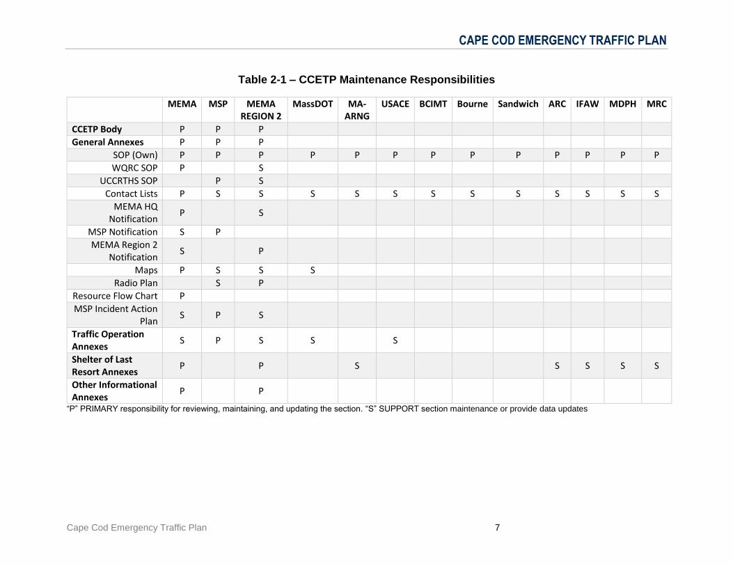
The CCETP is presented in a modular format with the operational and coordinative elements in the Main Body and agency specific and tactical elements in the Annexes. This modular nature promotes targeted testing, training, evaluation, and information updates. Table 2-1, next page, identifies the agencies responsible for Primary and Supportive review and maintenance of each section of the plan.
CAPE COD EMERGENCY TRAFFIC PLAN
Cape Cod Emergency Traffic Plan 7
Table 2-1 – CCETP Maintenance Responsibilities
MEMA MSP MEMA REGION 2
MassDOT MA-ARNG
USACE BCIMT Bourne Sandwich ARC IFAW MDPH MRC
CCETP Body P P P
General Annexes P P P
SOP (Own) P P P P P P P P P P P P P
WQRC SOP P S
UCCRTHS SOP P S
Contact Lists P S S S S S S S S S S S S
MEMA HQ Notification
P S
MSP Notification S P
MEMA Region 2 Notification
S P
Maps P S S S
Radio Plan S P
Resource Flow Chart P
MSP Incident Action Plan
S P S
Traffic Operation Annexes
S P S S S
Shelter of Last Resort Annexes
P P S S S S S
Other Informational Annexes
P P
“P” PRIMARY responsibility for reviewing, maintaining, and updating the section. “S” SUPPORT section maintenance or provide data updates
CAPE COD EMERGENCY TRAFFIC PLAN
Cape Cod Emergency Traffic Plan 8
3.0 CONCEPT OF OPERATIONS
3.1 General
This concept of operations provides an overall vision for managing the high volume of traffic that may seek to leave Cape Cod in advance of a hurricane (or other prior “Notice” event). It also includes a parallel operational track for providing shelter of last resort to motorists who may be stranded on the Cape’s roads if the bridges are shut down. It includes concepts, provisions and thresholds which will determine the need for the activation of the CCETP. It also provides for coordination of response and assistance with stakeholders at all levels of government and business community representatives.
This concept of operations addresses the stages and actions essential to implement traffic operation management strategies and tactics. It specifically focuses on preparedness, response and re-entry, along with the decisions associated with each of the stages. The concept of operations calls for advance planning recognizing the inevitable likelihood of an event that will require activation of this plan. The discussion on preparedness also emphasizes how to plan and deploy resources in advance to prevent roadway failure, particularly in the day(s) and hours just prior to landfall of a hurricane. The objective is to smooth out travel demand from the time an evacuation notification is issued in order to reduce congestion, bottlenecks and incidents to the greatest extent possible. Preparedness also includes having communication systems and standard operating procedures in place that will maximize responsiveness as weather conditions change.
This concept of operations incorporates a phased response over time in the anticipation of hazardous conditions that will initiate ground preparedness, decision-making and managing the response and re-entry along the roadways. The timeline of implementation of this Plan in advance of landfall of a hurricane is based on the strength and environmental conditions of the hurricane, how the public will respond, the availability of manpower and resources, the strength of the state’s supply chain to transport materials and supplies that have been deemed necessary to effectively manage traffic along the roadways, and the activation of contracts with vendors and suppliers that will support traffic management.
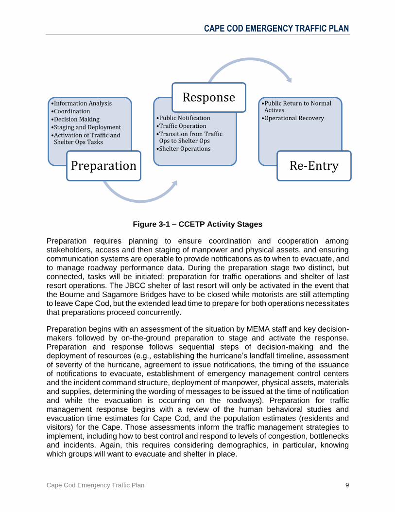
3.1.1 Active Stages
The concept of operations in this plan focuses on three stages of operation: preparation, response and re-entry. Initial preparation is critical to the successful activation of this Plan, including rapid assessment, activation, and deployment of resources to manage traffic operations in a timely enough manner to ensure roadway clearances prior to the onset of hazardous conditions.
CAPE COD EMERGENCY TRAFFIC PLAN
Cape Cod Emergency Traffic Plan 9
Figure 3-1 – CCETP Activity Stages
Preparation requires planning to ensure coordination and cooperation among stakeholders, access and then staging of manpower and physical assets, and ensuring communication systems are operable to provide notifications as to when to evacuate, and to manage roadway performance data. During the preparation stage two distinct, but connected, tasks will be initiated: preparation for traffic operations and shelter of last resort operations. The JBCC shelter of last resort will only be activated in the event that the Bourne and Sagamore Bridges have to be closed while motorists are still attempting to leave Cape Cod, but the extended lead time to prepare for both operations necessitates that preparations proceed concurrently.
Preparation begins with an assessment of the situation by MEMA staff and key decision-makers followed by on-the-ground preparation to stage and activate the response. Preparation and response follows sequential steps of decision-making and the deployment of resources (e.g., establishing the hurricane’s landfall timeline, assessment of severity of the hurricane, agreement to issue notifications, the timing of the issuance of notifications to evacuate, establishment of emergency management control centers and the incident command structure, deployment of manpower, physical assets, materials and supplies, determining the wording of messages to be issued at the time of notification and while the evacuation is occurring on the roadways). Preparation for traffic management response begins with a review of the human behavioral studies and evacuation time estimates for Cape Cod, and the population estimates (residents and visitors) for the Cape. Those assessments inform the traffic management strategies to implement, including how to best control and respond to levels of congestion, bottlenecks and incidents. Again, this requires considering demographics, in particular, knowing which groups will want to evacuate and shelter in place.
•Information Analysis•Coordination•Decision Making•Staging and Deployment•Activation of Traffic and
Shelter Ops Tasks
Preparation
•Public Notification•Traffic Operation•Transition from Traffic
Ops to Shelter Ops•Shelter Operations
Response •Public Return to Normal
Actives•Operational Recovery
Re-Entry
CAPE COD EMERGENCY TRAFFIC PLAN
Cape Cod Emergency Traffic Plan 10
The response stage is triggered by the completion of pre-evacuation preparations and consideration of the estimated clearance times and on-set of hazardous weather conditions; however, sufficient time must be allocated during this stage to begin traffic departures and manage roadway operations ensuring the most efficient performance of the transportation system. Constant monitoring of roadway conditions must be conducted to keep emergency response personnel and support personnel, and the public informed. The constant monitoring requires the communication of data and the timely translation of the data for decision-making.
In summary this concept of operations provides a timeline for advance and on-the-ground preparation, decision-making, deployment and the subsequent implementation of traffic management response.
In the end, the concept of operations needs to be actionable; this relies on:
Determining who will want to evacuate and those who will shelter in place. This information is important to being able to meet and manage the demand of individuals and households wanting to evacuate using the Cape’s roadways. This demand must be gauged and staged with respect to roadway capacities and ensuring that “acceptable” levels of service are achieved which minimize congestion, bottlenecks and incidents. There must be consideration of the make-up of the Cape’s permanent and seasonal population and their transportation needs/requirements. This concept of operations is based on the assumption that full and part-time residents and visitors who will be evacuating will have access to vehicles. But, the timing and staging and the eventual management of the evacuation routes must also consider the number and location of the most vulnerable population groups (e.g. elderly, disabled, and the carless).
Traffic management must also account for the potential use of high-occupancy vehicles to evacuate individuals and households. They constitute additional demand affecting throughput; they will contribute to congestion and potentially exacerbate congestion at the Cape’s rotaries, bridges, and entrances and exits along principal roadways, particularly Route 6.
Assessing the throughput of the regional roadway system and managing the demand to reach safe destinations. Given the geographic constraints of the Cape and the limitations posed by the roadway system, traffic must be managed over time to avoid or limit roadway failure. As it is, during peak periods, Route 6 operates at capacity, with increasing hours of delay being experienced by the traveling public. This is further exacerbated by the physical design characteristics of the roadway system – that is, the convergence of traffic at the rotaries and queuing that occurs at the bridges. The ideal is to be able to smooth out the evacuation over days and to prevent backups along the roadways, particularly at the rotaries and bridges.
CAPE COD EMERGENCY TRAFFIC PLAN
Cape Cod Emergency Traffic Plan 11
Gauging the severity and timing of a storm’s onset. Advance notice allows for staged preparations to deploy resources, particularly physical assets, such as barriers and variable message signs located either on the Cape or elsewhere in the state. This also allows for identifying and determining how and when to assign manpower and other resources to priority traffic management locations. By encouraging individuals and households to begin evacuating a few days before onset of hazardous conditions, a range of potential net effects can result. This provides for a safety buffer - a period of time prior to the onset of tropical storm force winds when the evacuation is nearing completion and traffic has returned to acceptable levels of service. Ensuring a buffer also constitutes an effective traffic management tactic to prevent mile long roadway backups and gridlock in the last hours before landfall. Timing buffers also become consequential to plan for the effects of increasing wind velocities and mandated bridge closures.
Identifying, assessing, staging and deploying resources. This requires estimating manpower requirements (e.g., state troopers, local police, National Guard and department of transportation and public works employees) that will be needed to manage traffic. This includes identifying and locating those individuals that are available locally and can be deployed from other regions of the state without diminishing the statewide response and effective management of the state’s roadways during an event. In addition to manpower, physical assets, such as barriers, variable message signs, and supplies must be identified, secured and installed to best manage traffic flow at the rotaries, bridges, and roadway entrances and exits. This requires an estimation of the extent of physical assets needed and their location to establish supply chains and manage the logistics of deployment to the Cape.
Establishing communication networks, data collection capabilities and information delivery. Increasingly, as a best practice, traffic management depends on communication and information systems. It provides a means to manage throughput, make adjustments at traffic control points, redeploy manpower and physical assets, and respond and reduce the effects of roadway incidents. The availability of data is consequential to ongoing and informed decision-making, particularly the response and reentry stages.
A discussion of each of the stages follows, emphasizing what considerations and strategies and tactics will be essential to effectively prepare and then manage the roadway system, ensuring the movement of the public to safe destinations.
Individual agency and jurisdictional operations for each stage are identified in the agency specific SOPs (included in Section A - General Annexes).
CAPE COD EMERGENCY TRAFFIC PLAN
Cape Cod Emergency Traffic Plan 12
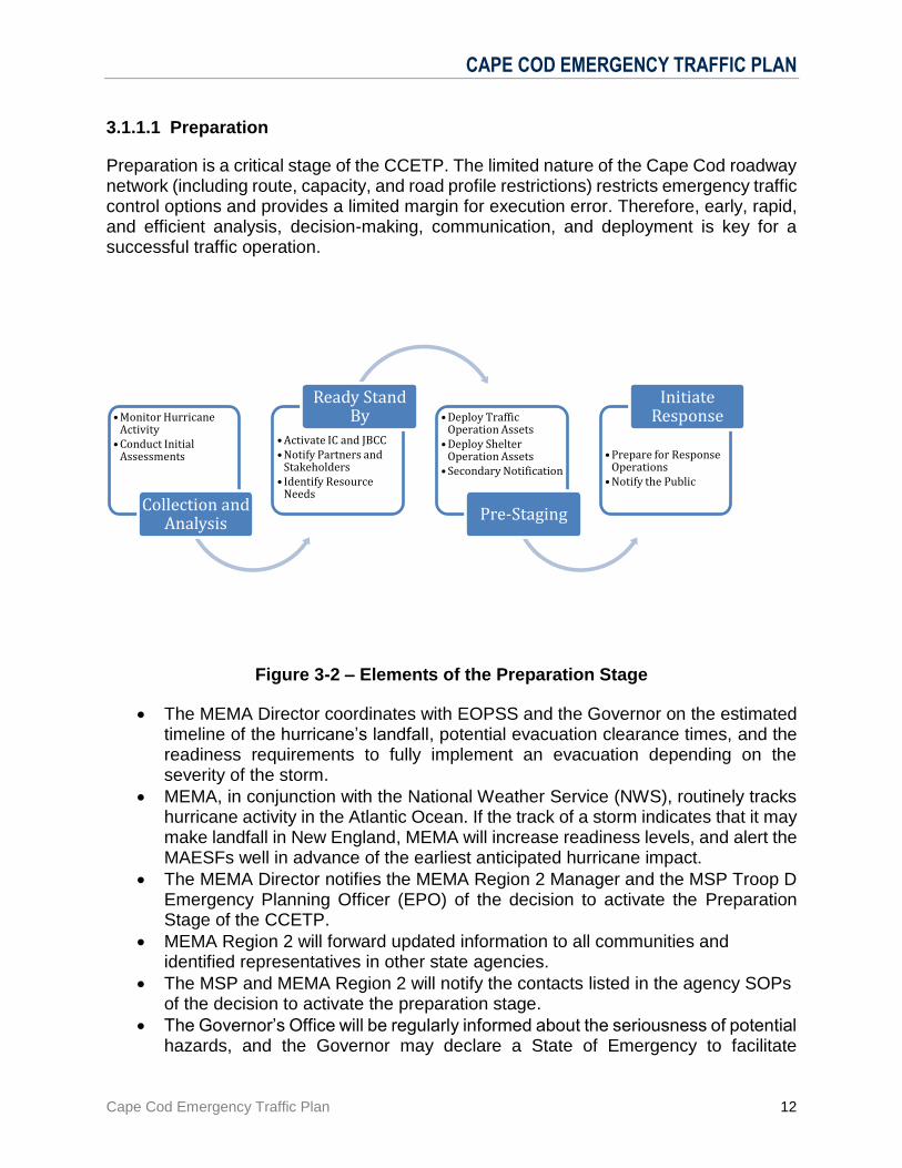
3.1.1.1 Preparation
Preparation is a critical stage of the CCETP. The limited nature of the Cape Cod roadway network (including route, capacity, and road profile restrictions) restricts emergency traffic control options and provides a limited margin for execution error. Therefore, early, rapid, and efficient analysis, decision-making, communication, and deployment is key for a successful traffic operation.
Figure 3-2 – Elements of the Preparation Stage
The MEMA Director coordinates with EOPSS and the Governor on the estimated timeline of the hurricane’s landfall, potential evacuation clearance times, and the readiness requirements to fully implement an evacuation depending on the severity of the storm.
MEMA, in conjunction with the National Weather Service (NWS), routinely tracks hurricane activity in the Atlantic Ocean. If the track of a storm indicates that it may make landfall in New England, MEMA will increase readiness levels, and alert the MAESFs well in advance of the earliest anticipated hurricane impact.
The MEMA Director notifies the MEMA Region 2 Manager and the MSP Troop D Emergency Planning Officer (EPO) of the decision to activate the Preparation Stage of the CCETP.
MEMA Region 2 will forward updated information to all communities and identified representatives in other state agencies.
The MSP and MEMA Region 2 will notify the contacts listed in the agency SOPs of the decision to activate the preparation stage.
The Governor’s Office will be regularly informed about the seriousness of potential hazards, and the Governor may declare a State of Emergency to facilitate
•Monitor Hurricane Activity
•Conduct Initial Assessments
Collection and Analysis
•Activate IC and JBCC•Notify Partners and
Stakeholders• Identify Resource
Needs
Ready Stand By •Deploy Traffic
Operation Assets•Deploy Shelter
Operation Assets•Secondary Notification
Pre-Staging
•Prepare for Response Operations
•Notify the Public
Initiate Response
CAPE COD EMERGENCY TRAFFIC PLAN
Cape Cod Emergency Traffic Plan 13
preparedness activities. Decisions may be made to close State parks, beaches, and recreational areas. MEMA will coordinate with the National Park Service about the closure of the National Seashore.
A timeline for implementation of this Plan will be created, based in part on the most recent hurricane behavioral study and projected travel time estimates from different locations (calculated using the FEMA/USACE Hurricane Evacuation Study). Information will be provided to local communities and agencies to keep them updated.
MEMA will activate the Command Post and the UCCRTHS, and the BCIMT will activate the Multi-Agency Coordination Center (MACC).
The UCCRTHS will also serve as the official Base Camp under the NIMS structure.
MA-ARNG Logistics Coordinator will designate the barracks within the JBCC that may be used to temporarily shelter motorists and pets leaving the Cape if the Bourne and Sagamore bridges are closed.
Two MEMA Field Responders will be deployed for coordination of the plan. One will be deployed to the MACC to provide a direct link between MEMA and the JBCC Shelter. The other will deploy to the MSP Command Post. These MEMA Field Responders will act as MEMA’s points of contact for both locations.
MSP will be notified of the Command Post activation and the MA-ARNG Logistics Coordinator will be notified of the JBCC shelter activation. The MEMA Field Responder reporting to the JBCC will coordinate shelter locations with the MA-ARNG Logistics Coordinator.
The MSP Troop D EPO, or designee, will assume the duties of Incident Commander (IC) at the Command Post.
BCIMT representatives will report to the MACC, and if staffing allows/ necessitates, to the JBCC shelter 48 hours prior to landfall (see the BCIMT SOP and Shelter of Last Resort Annexes).
MEMA will prepare public information announcements for release four (4) hours after responder agencies have been notified of Preparation Stage activation.
CCETP Conference Call Readiness and Notification Timeline will be established (see General Annex A 2.2)
Agencies in support of the CCETP must deploy representatives to the Command Post (CP) and must have their equipment, supplies, and personnel, mobilized and ready to deploy in support of the Plan. Once assets are pre-staged, notification should be made to the agency representatives at the CP who will notify the IC. Each agency should follow their standard operating procedures (SOPs) to support the plan’s implementation.
Coordination with the MSP will include notification about deploying troopers to priority traffic control points and secondary control points. Similar coordination with MassDOT will occur to ensure reports on the timely installation of barriers and other physical assets, such as variable message signs, and to ensure that the retrieval of data from intelligent transportation systems will be occurring.
Shelter supplies, such as shelter equipment trailers and medical supply trailers, will be mobilized and prepositioned near assigned shelter barracks.
CAPE COD EMERGENCY TRAFFIC PLAN
Cape Cod Emergency Traffic Plan 14
MEMA’s Resource Unit will arrange for initial transport of heater meals, and then subsequent meals to be supplied to the JBCC Shelter.
Necessary personnel (ARC, MRC, MDPH, IFAW, MEMA, etc.) to support the JBCC Shelter will be dispatched to the assigned shelter barracks on the JBCC to review the facilities and set up the shelters. During this time, logistical issues will be solved, communications will be made ready, walk-throughs will be completed, and a chain of command will be established. Once this is completed, the shelters will be prepared to receive persons seeking shelter.
Activities of the Response Stage will be directed and coordinated by the MSP Incident Commander at the UCCRTHS.
All resources should be ready to deploy and agencies ready to begin implementation of the CCETP prior to activation by the MSP of the Response Stage.
3.1.1.2 Response
The Incident Commander, with input from the MEMA Director, will initiate the Response Stage when all assets are in place.
The concept of the CCETP is based upon the need to reduce the causes of congestion and keep traffic flowing in the areas of the Bourne and Sagamore Bridges and Routes 6 and 28. This will be accomplished by the application of four traffic pattern alterations that:
1. Prohibits access to Routes 6 & 28 at the southern, Cape side, bases of both bridges;
2. Controls access to the Scenic Highway, Sandwich Road and Route 6 to limit traffic attempting to merge into the main stream of off-Cape traffic;
3. Allows MSP flexibility in the opening and closing of exits in order to expedite off-Cape traffic flow across the Sagamore and Bourne Bridges
This activity will be kept to a minimum, because it will be coordination and manpower intensive and could lead to extended delays.
This MAY include requiring all westbound traffic on Route 6 to cross over the Sagamore Bridge, and all northbound traffic on Route 28 to cross over the Bourne Bridge and allowing motorists to go east or west between the bridges only AFTER crossing the respective bridges.
4. Detours of traffic to alternate roadways in order to reduce congestion
Public information will be accomplished by:
1. The placement of signs and message/arrow boards at key points along major traffic routes.
2. The broadcasting of information via the EMERGENCY ALERT SYSTEM (EAS) and on the 511 cell and 617-374-1234 landline traffic information lines.
3. The broadcasting of Traffic Advisories on radio station WQRC (99.9 FM).

CAPE COD EMERGENCY TRAFFIC PLAN
Cape Cod Emergency Traffic Plan 15
4. Posting of Traffic Advisories and other pertinent information on the MSP website (www.mass.gov/msp), which will be mirrored and linked to by MEMA and local agencies.
5. Educational pamphlets distributed ahead of time to Cape Cod Chamber of Commerce, National Parks Service, and other partners with access to vacationing populations.
The CCETP contains two components in the Response Stage: Traffic Operations (Task 1) and JBCC Shelter of Last Resort Operations (Task 2). Traffic Operations and JBCC Shelter Operations should be implemented simultaneously. The decision to implement either component rests with the Incident Commander. Traffic Operations facilitates the movement of traffic traveling off-Cape. JBCC Shelter Operations provides for the temporary sheltering of motorists and their pets when the Bourne and Sagamore Bridges are closed due to safety considerations.
Task 1 – Traffic Operations
MSP will coordinate Traffic Operations from the UCCRTHS CP. Traffic Control Points (TCPs) will be established as needed to safety clear Off-Cape traffic prior to onset of hazardous conditions. The Traffic Operations Annex identifies traffic control points (TCPs) along major routes to facilitate/expedite Off-Cape traffic flow in the following manner:
On Route 6
1. Off-Cape Traffic heading west on Route 6W to Route 3 can proceed over the Sagamore Bridge flyover and continue on Route 3N at exit 1B.
2. Off-Cape Traffic heading west on Route 6W traveling to the Bourne Bridge to access Routes 25/195/495 will follow Route 6W to Route 3N where they can detour at Exit 7 in Plymouth and take Route 44W to the Route 44 rotary in Middleboro and access Route 495. Traffic can travel Route 495 North to access Routes 24, 95 and other points north; or Route 495 South to access Routes 25, 195 or other points south.
3. Local traffic traveling on Route 6W can utilize Exit 1A after the Sagamore Bridge for local traffic only. No access to Routes 28/25 via Scenic Highway.
Route 28
1. Off-Cape Traffic heading north on Route 28 to Routes 25/195/495 can travel over the Bourne Bridge and continue to those routes.
2. The Cape-side Bourne Bridge Rotary will be blocked to prevent cross-rotary traffic. The plan allows only north-south access to and from the Bridge via Route 28, and local traffic only via Trowbridge and Sandwich Roads.
3. Off-Cape traffic heading north on Route 28 which needs to go North of Route 3 should either: a. Access Route 151 in Falmouth to Route 28 to Route 130 to Route 6; or, b. Traffic can cross the Bourne Bridge, follow Route 25N, to Route 495N and take
detour at Exit 5 (Route 18/44) and follow Route 44E to Route 3 north or south.
CAPE COD EMERGENCY TRAFFIC PLAN
Cape Cod Emergency Traffic Plan 16
4. Local traffic traveling on Route 28N can use Waterhouse Rd. to access shelters at Bourne Middle School and Upper Cape Cod Regional Technical High School.
5. Local traffic traveling on Route 28N can cross the Bourne Bridge and use Exit 2 on Route 25W, to access local shelters and local destinations in Buzzards Bay and Wareham. Exit 3 (Route 6) on Route 25W will be closed and the Scenic Highway will not be accessible from the Mainland-side Bourne Rotary in Buzzards Bay, in order to eliminate cross rotary traffic.
The MSP will monitor traffic flow and may initiate detours as necessary to reduce congestion, avoid obstructions, and maximize safety. This includes the option of opening the Route 6 exit ramp (Scenic Highway) between exits 1A and 1B after the Sagamore Bridge or detouring traffic off of Route 6W at Exit 2 in Sandwich, through JBCC to Route 28N at the Otis Rotary.
See the Traffic Operation Annexes (B) for detailed procedures.
Task 1 to Task 2 Transition – Bridge Closure
The Incident Commander, with input from MEMA, MassDOT, and USACE, with support from USACE, will make a decision to close the bridges if it is no longer safe for traffic to cross them. Factors driving this decision could involve wind gusts, sustained wind speeds, traffic conditions, and/ or the projected weather forecast.
If the bridges are being closed: 1. Rte. 6W will be closed at Exit 2 in Sandwich, and Rte. 28N will be closed at
the Otis Rotary. 2. All traffic between those points and the bridges will be allowed to cross. The
bridges will be closed when this residual traffic has passed. 3. Any motorists still on the road will then have the option of going to designated
emergency parking areas in the JBCC and being shuttled to shelter in the JBCC, or seeking their own shelter elsewhere, until the storm passes.
4. Once the storm has passed and it is deemed safe by officials, the Bridges will be opened and motorists will be notified that it is safe to travel.
Traffic Operations Annex B.5 – Bridge Closure provides full bridge closure procedures
Task 2 – Shelter of Last Resort – JBCC
The Plan provides for temporary shelters on Joint Base Cape Cod at Camp Edwards to provide motorists with a safe haven if the Bourne and Sagamore Bridges are closed. Shelter preparedness operations are divided into three phases:
Phase 1: Shelter Supplies, such as Shelter Equipment Trailers and Medical Supply Trailers, are mobilized and prepositioned near assigned shelter barracks (Preparation Stage)

CAPE COD EMERGENCY TRAFFIC PLAN
Cape Cod Emergency Traffic Plan 17
Phase 2: Necessary personnel (ARC, MRC, MDPH, IFAW, MEMA, etc.) are dispatched to the assigned shelter barracks to review the facilities and set up the shelters. During this time, logistical issues will be solved, communications will be made ready, walk-throughs will be completed, and a chain of command will be established. At the completion of Phase 2, the shelters will be prepared to receive persons seeking shelter. (Preparation Stage) Phase 3: The shelter will be opened at Phase 3, and can receive, register, and shelter persons who are seeking such and in accordance with an agency’s respective SOPs. In order for Phase 3 to become active, all equipment and personnel will already be in place and prepared to operate as described above.
Shelter operations will be tiered to meet projected need. This operation is scalable, and can grow or diminish based on the projected number of people to potentially be sheltered. Suggested levels of scalability include:
Tier 1--- 2 barracks (576 beds)
Tier 2--- 4 barracks (1152 beds)
Tier 3--- 7 barracks (2016 beds)
The Barnstable County Incident Management Team (BCIMT) will serve as Coordination Entity for the JBCC Shelter Operations. A Multi-Agency Coordination Center (MACC) will be established in Barnstable County. The ARC will serve as the Branch Director on site at JBCC. The sheltering operation will follow all JBCC base orders and regulations pertaining to good order and discipline. JBCC Shelter Operations will be supported by MEMA, ARC, MA-ARNG, MRC, and IFAW. See the Shelter of Last Resort Annexes (C) for detailed procedures.
3.1.1.3 Re-entry
The Response Stage can be terminated at any time should the Incident Commander receive information that the threat of hazardous weather no longer exists and it is safe to allow re-entry.
MSP and MEMA Region 2 will notify the contacts listed in their respective SOPs to alert them of the decision to execute the Re-Entry Stage.
Information will be provided to local communities and agencies to keep them updated.
The reopening of the bridges may be accompanied by the establishment of MSP Traffic Control Points to facilitate the departure of those motorists desiring to leave the Cape. This is complete when the Incident Commander determines that normal traffic patterns are sufficient. Public service announcements will continue throughout this stage.
Re-entry may coincide with recovery operations that may require additional state agency assets and personnel.
CAPE COD EMERGENCY TRAFFIC PLAN
Cape Cod Emergency Traffic Plan 18
Local or JBCC shelters that are providing safe haven for storm clients, who have suffered damages that make their homes uninhabitable, shall be provided assistance by appropriate state agencies and voluntary disaster organizations who will attempt to provide adequate temporary shelter or housing. This may require movement from local shelters or JBCC facilities to alternate shelters or housing.
3.2 Activation
MEMA will begin monitoring tropical depressions or storms that may impact the New England Coast from 72-120 hours ahead of estimated impact. MEMA will coordinate regularly with NWS and leverage the National Hurricane Program HURREVAC system to track the storm’s progress and evaluate the need to active the CCETP.
When landfall is still 72-120 hours away, there likely will be a large amount of uncertainty in the projected path and intensity of the storm. This uncertainty must be balanced with the extensive lead time that is required to implement and stage a successful emergency traffic evacuation from the Cape. MEMA and MSP will take a staged activation approach to the CCETP. In accordance with the timeline of the Hurricane Checklist and the Preparation Stage identified above, MEMA, MSP, and CCETP partners will:
1. Be notified of the potential for CCETP Response activities; 2. Begin identifying necessary personnel and resources: 3. Begin coordinating response; 4. Notify additional personnel and access resources; and 5. Deploy personnel to designated areas.
As the storm continues to approach and the estimated cone of impact narrows on the Cape, the second element of the Preparation Stage can be initiated:
6. Begin notifying Communities and the public; 7. Staging and deploying personnel and equipment to pre-identified areas.
Finally, when the storm is 24-32 hours from landfall, an informed decision can be made to activate the Response Stage of the CCETP, directing persons in the affected areas of the storm’s impact to begin their evacuation.
3.2.1 Evacuation Clearance Times
Traffic evacuation calculations are based on the FEMA/USACE Massachusetts Hurricane Evacuation Study (HES - March 2015) which provides an “Evacuation Clearance Time” estimate for the amount of time it will take for residents and visitors- who are likely (and able) to self-evacuate the Cape to do so, following a public advisory. The HES model takes into account:
Vulnerable populations/ Facilities analysis;
Seasonal population changes;
Hurricane behavior analysis;
CAPE COD EMERGENCY TRAFFIC PLAN
Cape Cod Emergency Traffic Plan 19
The capabilities and capacities of the roadway network;
Potential chokepoints;
Impact of background traffic;
A time buffer to ensure that cars will not be on the roadway when hazardous conditions begin; and
Impact of travel time based on the time of day the evacuation is announced.
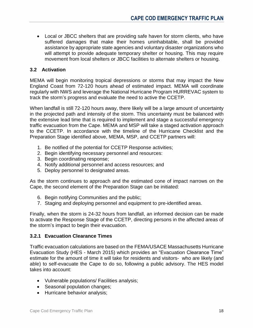
Table 3-2 depicts the summary time it would take to evacuate all residents and visitors that wish to self-evacuate the Cape
Table 3-2 – Estimated Cape Clearance Times (Medium Response)
Hurricane Category 1-2 Hurricane Category 3-4
Peak Season 22 Hours 32 Hours
Off-peak Season 12 Hours 18 Hours
See Annex D.2 for an extended summary of the MA Hurricane Evacuation Study
These numbers do not include the impact of:
Roadway “failure” due to over congestion, disabled or abandoned vehicles;
Inclement weather;
Imperfect notification of residents and vacationers.
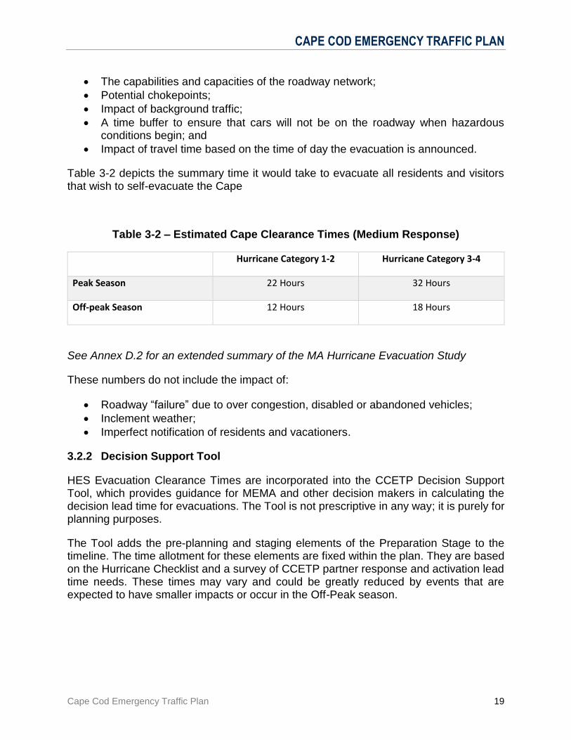
3.2.2 Decision Support Tool
HES Evacuation Clearance Times are incorporated into the CCETP Decision Support Tool, which provides guidance for MEMA and other decision makers in calculating the decision lead time for evacuations. The Tool is not prescriptive in any way; it is purely for planning purposes.
The Tool adds the pre-planning and staging elements of the Preparation Stage to the timeline. The time allotment for these elements are fixed within the plan. They are based on the Hurricane Checklist and a survey of CCETP partner response and activation lead time needs. These times may vary and could be greatly reduced by events that are expected to have smaller impacts or occur in the Off-Peak season.
CAPE COD EMERGENCY TRAFFIC PLAN
Cape Cod Emergency Traffic Plan 20
Figure 3-3 – Timeline Decision Support Tool
The final element of the Tool identifies a buffer period to ensure that motorists are off the roadways and traffic operation personnel and resources can be redeployed prior to the onset of tropical storm force winds.
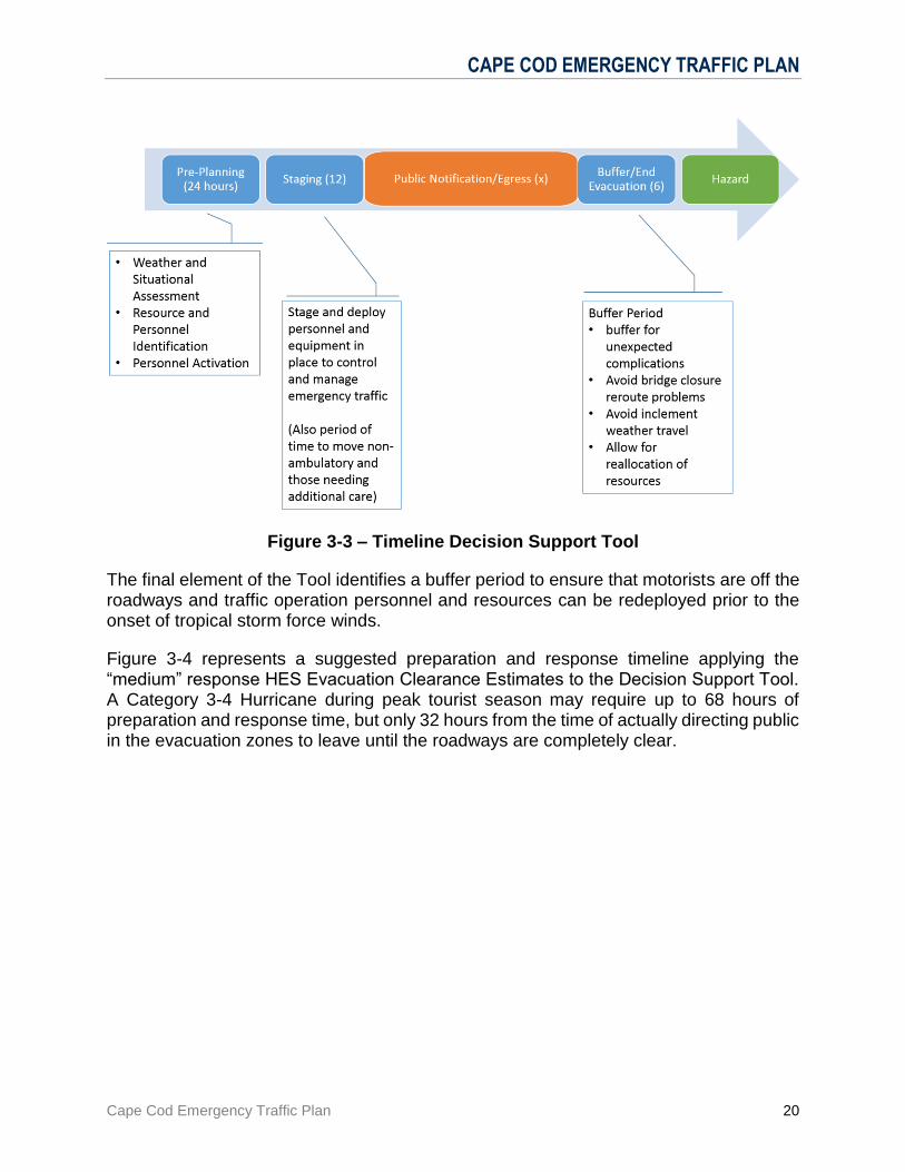
Figure 3-4 represents a suggested preparation and response timeline applying the “medium” response HES Evacuation Clearance Estimates to the Decision Support Tool. A Category 3-4 Hurricane during peak tourist season may require up to 68 hours of preparation and response time, but only 32 hours from the time of actually directing public in the evacuation zones to leave until the roadways are completely clear.
CAPE COD EMERGENCY TRAFFIC PLAN
Cape Cod Emergency Traffic Plan 21
Figure 3-4 – Timeline Scenarios
3.3 Notification
The notification section identifies CCETP partner and stakeholder notification responsibilities and procedures during an activation.
3.3.1 MEMA Process
MEMA’s Communications Center, at the direction of MEMA’s Director or SEOC Manager, will make notifications via HHAN, distribution lists, or other methods as directed in accordance with the included procedure (Annex A.2). MEMA dispatch callout procedures may be used to complete notifications, if determined necessary.
Notification at every stage will include:
MEMA Region 2
MSP Troop D EPO
MAESF -1
MAESF – 8
MAESF-11
MA-ARNG
USACE, Cape Cod Canal Field Office
For more detail see the MEMA Notification checklist in General Annex A.2 Notification
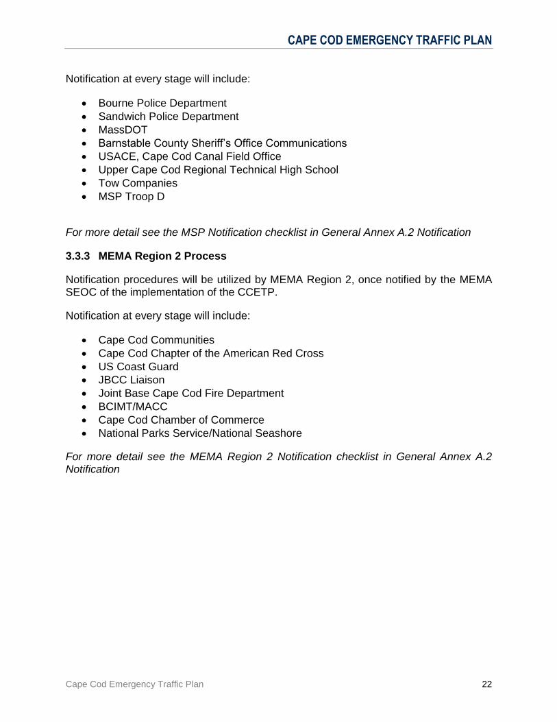
3.3.2 MSP Process
Notification procedures will be utilized by MA State Police Troop D HQ (MSP), once notified by the MEMA SEOC that the CCETP has been activated.
CAPE COD EMERGENCY TRAFFIC PLAN
Cape Cod Emergency Traffic Plan 22
Notification at every stage will include:
Bourne Police Department
Sandwich Police Department
MassDOT
Barnstable County Sheriff’s Office Communications
USACE, Cape Cod Canal Field Office
Upper Cape Cod Regional Technical High School
Tow Companies
MSP Troop D
For more detail see the MSP Notification checklist in General Annex A.2 Notification
3.3.3 MEMA Region 2 Process
Notification procedures will be utilized by MEMA Region 2, once notified by the MEMA SEOC of the implementation of the CCETP.
Notification at every stage will include:
Cape Cod Communities
Cape Cod Chapter of the American Red Cross
US Coast Guard
JBCC Liaison
Joint Base Cape Cod Fire Department
BCIMT/MACC
Cape Cod Chamber of Commerce
National Parks Service/National Seashore
For more detail see the MEMA Region 2 Notification checklist in General Annex A.2 Notification

CAPE COD EMERGENCY TRAFFIC PLAN
Cape Cod Emergency Traffic Plan 23
4.0 ROLES AND RESPONSIBILITIES
4.1 On-Scene Command and General Staff
MSP is responsible for the implementation of the CCETP, establishing the CCETP command post at UCCRTHS, staffing pre-designated traffic control points, and providing for public safety and law enforcement on the highways. Further, local communities may have to request additional resources from MSP to augment existing local patrols, due to manpower shortages or other exigent circumstances.
Figure 4-5 – MSP Command Post ICS Chart

CAPE COD EMERGENCY TRAFFIC PLAN
Cape Cod Emergency Traffic Plan 24
4.2 MEMA Command and General Staff
MEMA has overall responsibility for emergency response actions for the Commonwealth of Massachusetts. The CCETP is designed to facilitate vehicular traffic exiting Cape Cod. MEMA is responsible for ordering CCETP activation, and providing support as necessary for implementation.
MEMA Region 2 is responsible for overseeing emergency response actions in the Region, to assist the MEMA SEOC with notifications during the ordering of CCETP activation, and to provide support as necessary for implementation.
4.3 Municipal and Regional
Barnstable County Incident Management Team (BCIMT) - An Incident Management Team made up of multi-discipline and multi-jurisdictional representatives from Barnstable County. The BCIMT provides Command and Control for the sheltering portion of the CCETP, with a MACC established in Barnstable County. Barnstable County Regional Dispatch - Operating out of the Barnstable County Sheriff’s Department, Barnstable County Regional Dispatch supports radio communications for public safety organizations on Cape Cod. Cape Cod Chamber of Commerce (CCCC) – CCCC will provide a conduit of public information and alters to restaurants, hotels, motels, and other businesses that cater to tourist clientele to ensure that that population is aware of impending events and emergency alters.
Town of Bourne - Both bridges and approach roadways affect Bourne. The Bourne Police Department would support traffic and security operations within their community. Fire and EMS Services may be called upon to aid travelers. Town of Sandwich - The Sandwich Police Department would support traffic and security operations within their community. The Route 6 approach to the Sagamore Bridge passes through Sandwich. The Task I detour at Exit 2 off Route 6 and onto Route 130 passes through Sandwich also. Fire and EMS services may be called for as well. Upper Cape Cod Regional Technical High School (UCCRTHS) - UCCRTHS will be used as the Command Post for the Mass State Police during execution of the CCETP. Further, it will service as the Incident Base Camp under NIMS. WQRC Radio, Hyannis, MA - Upon notification by the State Police Incident Commander, WQRC broadcasts taped emergency messages consistent with the phases of operation issued under the Response Stage.
CAPE COD EMERGENCY TRAFFIC PLAN
Cape Cod Emergency Traffic Plan 25
4.4 Massachusetts Emergency Support Functions (MAESF) Responsibilities
ESF-1 (Transportation): Massachusetts Department of Transportation (MassDOT) - MassDOT provides a representative to the MSP Command Post and the MEMA SEOC MAESF-1 desk with communications capabilities. This agency works with MSP in plan implementation, obtains portable signs from storage areas, and transports them to traffic control points. They position message/arrow boards displaying messages consistent with the stage of operation and ensures that permanent signage is unlocked. ESF-6 (Mass Care & Sheltering): Massachusetts Department of Public Health (DPH) – MDPH will coordinate and support medical care at the JBCC for the displaced clients being temporarily sheltered at JBCC. Coordination will include working with agencies and organizations such as American Red Cross (ARC), Medical Reserve Corps, (MRC), Massachusetts System for Advance Registration (MSAR), Massachusetts Department of Mental Health (MDMH), Massachusetts Emergency Management Agency (MEMA), and local hospitals to facilitate establishment, supplying, and staffing of a non-emergent medical services clinic within the JBCC facility being used to shelter clients. Such coordination will also include working with existing medical services available at JBCC (United States Coast Guard (USCG) and Massachusetts National Guard (MA-ARNG)), local EMS, and hospital providers to ensure treatment and transport of emergent/critical patients takes place including land or air med-evacs.
ESF-16 (Military Support): Massachusetts National Guard (MA-ARNG) - MA-ARNG facilitates Task 2 detours through the JBCC. DPH, MRC, ARC, and IFAW will facilitate shelter operations, and control parking. The MA-ARNG Logistics Coordinator will provide access to the barracks, limited storage of ARC shelter provisions, traffic control, parking and transportation to the shelter locations. MA-ARNG command center at JBCC will provide command, control and communications for MA-ARNG operations and a point of contact for MA-ARNG operations.
4.5 Federal Agencies and Other Resources
The American Red Cross (ARC) – ARC will be responsible for human sheltering and service animals. The ARC will utilize the barracks designated by MA-ARNG Logistics Coordinator for registration, processing, sheltering and out-processing.
The International Fund For Animal Welfare (IFAW) – IFAW will be responsible for cohabitation sheltering: the sheltering of pets and humans in barracks designated by the MA-ARNG Logistics Coordinator. The Team Leader/designee from MAESF-11 (Animal Protection) is responsible for notifying IFAW to activate the pet shelter at the JBCC and for maintaining direction and control with IFAW throughout the event. Medical Reserve Corps (MRC) - MRC assists with limited medical care and first aid services during Shelter Operations on the JBCC. MRC will operate with pre-staged MDPH medical supply trailers, and in conjunction with the Troop Medical Clinic (TMC), which is
CAPE COD EMERGENCY TRAFFIC PLAN
Cape Cod Emergency Traffic Plan 26
adjacent to proposed shelter. MRC may also interface with Federal counterparts in the event of a large scale disaster. U.S. Army Corps of Engineers (USACE), Cape Cod Field Office - The USACE operates both cross Cape bridges and adjoining properties on both banks of the Cape Cod Canal. They are responsible for notifying the MSP and MEMA of bridge conditions and managing closings. United States Coast Guard (USCG), Air Station Cape Cod - The USCG would provide assistance in rescue operations during a storm. They have a limited role in the implementation of the Plan. The USCG also provides emergency medical services on Joint Base Cape Cod. 4.6 Cape Cod Emergency Coordination
Due to the unique geography and the localized choke points of both the Sagamore and Bourne bridges, the Cape leadership realizes how frail of a lifeline these bridges are and realistically plans for the challenges associated with those bridges being closed down for an extended period of time. The Cape Cod communities plan to handle as much as they can with Cape local resources. Cape coordination includes:
Law Enforcement agencies regularly meet to discuss mutual aid and challenges posed by geography.
Fire Departments also regularly meet to discuss mutual aid and regularly train with each other during exercises and real events.
The Barnstable County Incident Management Team (IMT) operates the Barnstable County MACC which coordinates resource response across the Cape.
The Barnstable County Regional Emergency Planning Committee regularly meets to bring together the response agencies and the Voluntary Organizations Active in Disaster (VOAD).
The REPC sponsors a regional approach to exercises and drills annually.

CAPE COD EMERGENCY TRAFFIC PLAN
Cape Cod Emergency Traffic Plan 27
5.0 ADMINISTRATION AND LOGISTICS
5.1 Resource Requests
During a CCETP activation, local jurisdictions fill all needs locally until they cannot handle them with existing resources. Once that occurs the local jurisdiction either procures the needed resource through local acquisition procedures, or requests mutual aid through existing mutual aid channels.
Once all local avenues for procurement have been exhausted, they can then route the resource request to MEMA Region 2 and if it is approved, then MEMA will source the request and advise on when the resource will be delivered or available. However, if the Barnstable County MACC (Multi Agency Coordination Center) is activated it will act as the coordination center for all communities in Barnstable County for resource requests.
The types of resource requests typically routed this way are for sandbags, traffic barriers, portable lighting, generators, etc.
Figure 5-6 –Resource Request Flowchart
Barnstable County MACC
The BCIMT operates the MACC, a NIMS standard entity. The MACC is designed to provide local Cape Cod Emergency Operations Centers (EOCs) with resources and information during major countywide or regional incidents. The MACC captures, consolidates, and coordinates local requirements and communicates and coordinates with regional, state, federal, utility, and non-governmental resources to deliver requested resources back to the local EOCs.
The MACC (if activated), will coordinate all resource requests from Cape Cod communities and communicate directly with the MEMA Region 2 EOC to facilitate the deployment of approved equipment.
5.2 Pre-Event Contracts
Tow Trucks
Shelf-Stable Meals
Local Sources and Mutual Aid
Barnstable County MACC
MEMA Region 2
MEMA SEOC - MAESF to
Source
CAPE COD EMERGENCY TRAFFIC PLAN
Cape Cod Emergency Traffic Plan 28
5.3 Mutual Aid
Mutual Aid in Massachusetts is handled differently by each discipline. The following is an explanation of mutual aid by discipline: 5.3.1 Law Enforcement
Law enforcement mutual aid is addressed in MGL Chapter 40 Section 8g. Currently all Cape towns are in a mutual aid agreement for law enforcement services. It is a possibility that law enforcement mutual aid agreements will need to be leveraged to provide full coverage for state and local Traffic Control Points during a CCETP Activation. 5.3.2 Fire/EMS Services:
Mutual aid for the fire services is also accomplished on a town by town basis. There are currently mutual aid agreements in place for all Cape towns for Fire and EMS services. This is accomplished through the Barnstable County Fire Chiefs Association. 5.3.3 State Mutual Aid Compact:
Currently all Cape communities are members of the Statewide mutual aid compacts with the exception of Barnstable, Harwich and Orleans. This is covered under MGL Chapter 40 Section 4J.

ANNEXES
Cape Cod Emergency Traffic Plan i
ANNEXES
GENERAL ANNEXES
Cape Cod Emergency Traffic Plan A-1
A. GENERAL ANNEXES
A.1 Standard Operating Procedures
A.1.1 Massachusetts Emergency Management Agency – Headquarters
A.1.2 Massachusetts State Police
A.1.3 MEMA Region 2
A.1.4 Massachusetts Department of Transportation
A.1.5 United State Army Corps of Engineers
A.1.6 Barnstable County Incident Management Team
A.1.7 Town of Bourne
A.1.8 Town of Sandwich
A.1.9 Massachusetts National Guard
A.1.10 American Red Cross
A.1.11 International Fund for Animal Welfare
A.1.12 Massachusetts Department of Public Health
A.1.13 Medical Reserve Corps
A.1.14 Upper Cape Code Regional Technical High School
A.1.15 WQRC Radio

GENERAL ANNEXES
Cape Cod Emergency Traffic Plan A-2
A.2 Notification Procedures
A.2.1 Contact List
A.2.2 MEMA HQ Notification Procedures
A.2.3 MSP Notification Procedures
A.2.4 MEMA Region 2 Notification Procedures
A.3 Logistics Information
A.3.1 Maps
A.3.2 Communications Plan
A.3.3 Radio Communications Plan Template (ICS205)
A.3.4 Communications Flow Chart
A.3.5 Resource Flow Chart
A.3.6 MSP Incident Action Plans
TRAFFIC OPERATION ANNEXES
Cape Cod Emergency Traffic Plan B-1
B. TRAFFIC OPERATION ANNEXES
B.1 Traffic Control Points
B.2 Command Post Set Up
B.3 Traffic Control Point Activation
B.4 Towing
B.5 Bridge Closing
B.6 Emergency Canal Road Access
B.7 Traffic Advisory Broadcasts

SHELTER OF LAST RESORT ANNEXES
Cape Cod Emergency Traffic Plan C-1
C. SHELTER OF LAST RESORT ANNEXES
C.1 Potential MA-ARNG Buildings for Shelter Operations
C.2 Barracks Shelter Report
C.3 Barracks Floor Plan
C.4 Barracks Drawing
C.5 CERT Shelter Process Map
C.6 CERT Shelter Process Operational Stage
C.7 JBCC Shelter Resource Requirements
C.8 JBCC Trailer Relocation Procedure
C.9 JBCC Shelter Trailer Information
C.10 ARC Shelter Registration Form - English
C.11 ARC Shelter Registration Form – Spanish
C.12 ARC Client Health Record
C.13 IFAW Animal Intake Form
C.14 JBCC Shelter Information Sheet - English
C.15 JBCC Shelter Information Sheet - Spanish

OTHER INFORMATION ANNEXES
Cape Cod Emergency Traffic Plan D-1
D. OTHER INFORMATION ANNEXES
D.1 MEMA Website Information
D.2 Summary of Decision Tool and HES
D.3 Decision Tool Clearance Time Validation Process
D.4 Acronyms