campus framework plan july 2009 - northwestern.edu · also embraces recent planning initiatives...
TRANSCRIPT

EVANSTON CAMPUS FRAMEWORK PLAN

Adopted February 2009. Second edition, revised July 2009.

EVANSTON CAMPUS FRAMEWORK PLAN
2009

ii

iii
TABLE OF CONTENTS EXECUTIVE SUMMARY 1 INTRODUCTION 4 PART ONE THE EVANSTON CAMPUS ENVIRONMENT 5
Location and Land Area Institutional Characteristics The Evanston Campus: A Physical and Natural History A Development History Landform/Water Relationships Ecology/Vegetation Climate The Evanston Campus: Context City Edges and Connections Urban Zoning and Land Regulation on Campus Campus Life Recreational and Open Spaces Parking Campus Landmarks
PART TWO EVANSTON CAMPUS FRAMEWORK PLAN 14
Planning Principles Framework Concepts Open Space Framework: The Grid and the Crescents Pedestrian and Bicycle Circulation Networks East-West North-South Crescents Water’s Edge Land Use and Capacity Framework Proposed Land Use Pattern Maximum Site Capacity Under Current Zoning Recommended Site Capacity Strategic Moves Affecting Future Capacity and Character Site Capacity Variables
Vehicular Circulation/Infrastructure Framework Existing Vehicular Connections and Parking Network Proposed Vehicular Conditions and Parking Network Existing Service and Emergency Access Network Proposed Service and Emergency Access Network Existing Major Infrastructure Corridors Proposed Major Infrastructure Corridors
PART THREE DISTRICT DEVELOPMENT STRATEGIES 30
Introduction A Development Strategy for the North District Existing Role and Geography Proposed Development Zoning Implications Accommodation Factors A Development Strategy for the Central District Existing Role and Geography Proposed Development Zoning Implications Accommodation Factors A Development Strategy for the South District Existing Role and Geography Proposed Development Zoning Implications Accommodation Factors
CONCLUSION 44 ACKNOWLEDGMENTS 45
1
EXECUTIVE SUMMARY This document offers a framework to guide the future development of North-western University’s Evanston campus. It is the result of more than a year of consultations between members of the Evanston Campus Planning Advisory Committee, members of the University community, and Sasaki Associates. The Advisory Committee developed a set of planning principles that are listed on page 2, and explained more fully in Part Two of this report. The final draft of this plan was presented to the Northwestern and Evanston communities at pub-lic meetings in September and October, 2008. Revisions to the plan were made based on comments received at those meetings, and the Trustees adopted the revised plan in 2009. Over the past ten years Northwestern has built more than 750,000 gross square feet of space on the Evanston campus. As sponsored research continues to grow, the demand for new and improved facilities will also grow, while the avail-able open space on campus will continue to decline. This plan proposes the fol-lowing improvements to meet this challenge: • Strengthen the historic crescent that borders Harris Hall, University Hall
and Deering Meadow • Create a new crescent, along a new pond edge, to serve as the organizing
spine for future buildings, services and utilities • Relocate non-academic uses from the core of campus to maximize building
capacity east of Sheridan Road • Relocate parking to campus gateways to improve pedestrian and bicycle
circulation within the core campus • Preserve open space along the existing lakefront peninsula • Provide new land near the existing science and engineering complex by fill-
ing up to four acres of the cooling pond • Bridge the divide between north and south campus precincts by providing
social and collaborative spaces at the center of campus • Create new campus gateways and strengthen Northwestern’s identity along
Sheridan Road • Create a new campus edge along Clark Street that engages downtown
Evanston. This Campus Framework Plan provides a vision for growth and transformation that would take place over the coming decades. It acknowledges that past at-tempts at master planning have not succeeded and that building by accretion has resulted in structures that neither engage their surroundings nor take advantage of Northwestern’s greatest physical asset, its proximity to Lake Michigan. The
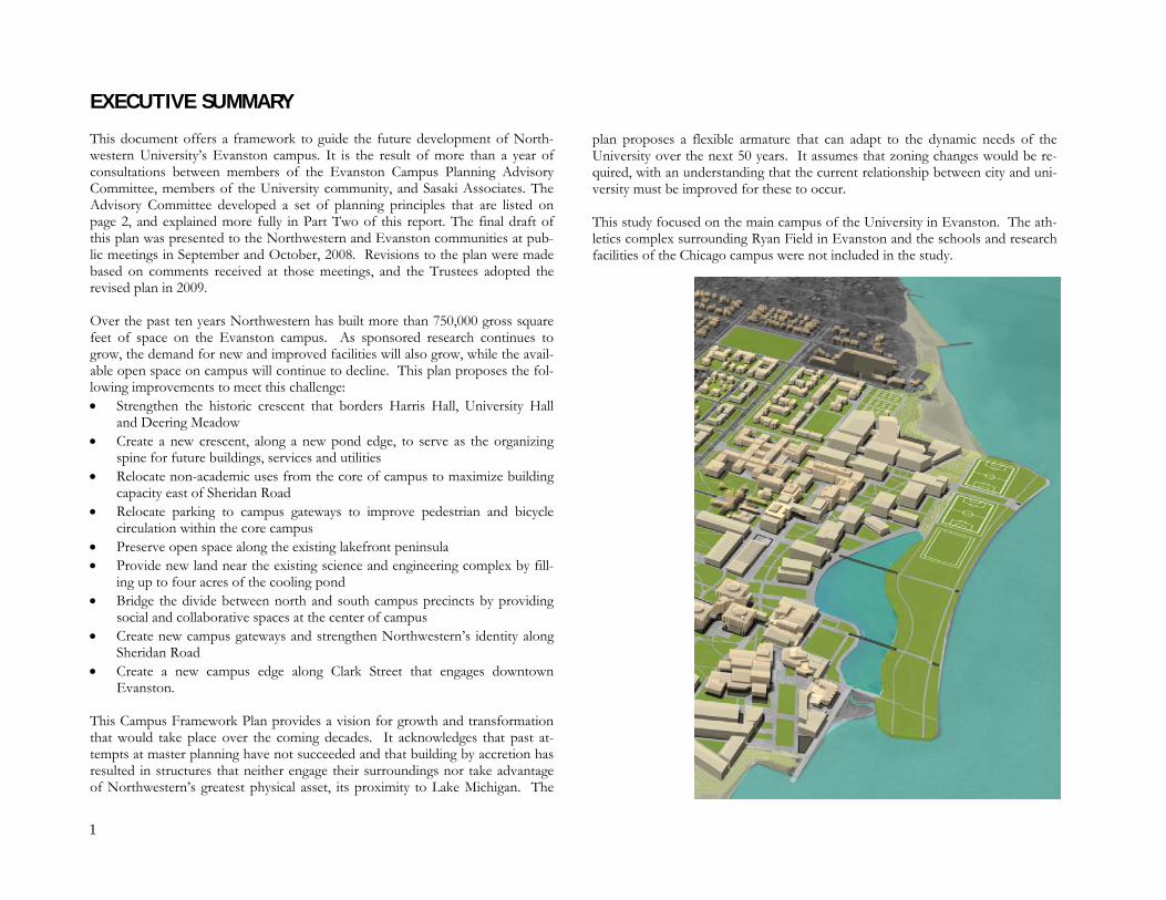
plan proposes a flexible armature that can adapt to the dynamic needs of the University over the next 50 years. It assumes that zoning changes would be re-quired, with an understanding that the current relationship between city and uni-versity must be improved for these to occur. This study focused on the main campus of the University in Evanston. The ath-letics complex surrounding Ryan Field in Evanston and the schools and research facilities of the Chicago campus were not included in the study.

2
CAMPUS FRAMEWORK PLANNING PRINCIPLES Based on an examination of the Northwestern campus context, history, planning framework, and land use patterns, the Evanston Campus Planning Advisory Committee recommended a set of eight principles to serve campus planning efforts. These principles are summarized below. • Respond to Northwestern's unique lakefront location. To fulfill the original
intent of the lakefill project, the University should maximize development opportunities presented by this valuable resource, while respecting its char-acter and the regional tradition of lakeshore open space.
• Preserve the memorable spaces of campus and enhance them, where appro-
priate, with infill development. • Create new open spaces and landscapes, rooted in the historic structure of
the campus, that organize future development. • Design in accordance with the University’s sustainability guidelines. • Develop the core of the campus as a pedestrian environment, and move
parking to campus entrances. Provide pedestrian links along north/south, east/west, and public transit routes, including those that extend into the adjoining community.
• Bridge the existing north/south division of uses and activities by identifying
facilities or programs that could serve the campus community within a new central district.
• Acknowledge the historic character of the adjoining Evanston community
and endeavor to preserve University structures where significant or practical, while introducing new development that complements and contributes to this character.
• Assess zoning opportunities that could preserve existing assets, create inno-
vative campus-community partnerships and permit new, iconic focal points on campus.

3

4
INTRODUCTION In the late 1990s, as a result of The Highest Order of Excellence strategic plan, North-western University undertook a robust program of building new academic, resi-dential and recreational facilities. Since then, nearly 750,000 gross square feet of space have been constructed on the Evanston campus. Some structures replaced antiquated or outmoded facilities, and others were created specifically to support the university’s thriving research enterprise. This rate of growth is not unusual for Northwestern. In the 1980s more than 700,000 gross square feet of new construction was completed. In the post-World War II era, as university enrollments across the country increased due to the G.I. Bill, nearly 2,000,000 gross square feet of new buildings rose on the Evanston campus between 1950 and 1969. In the 1930s and 1940s, in spite of the Great Depression, and driven largely by the completion of the Technological Institute, the University built more than 1,000,000 gross square feet of new facili-ties. Projections for the coming decades indicate the University’s recent success in attracting sponsored research will continue. A history of interdisciplinary teach-ing and inquiry is a fundamental part of this success; faculty and students are actively engaged in co-curricular endeavors that are removing the traditional boundaries between departments, disciplines and schools. Even as these col-laborative processes grow, the physical limitations of the Evanston campus con-strain future growth. The campus is geographically bound by Lake Michigan to the east. Regulatory restrictions at the western edges of the campus are equally confining. Many administrative services are provided in wood-framed houses that were built to shelter families, not academic departments. Although Northwestern is a mid-size research university, it compares itself and is compared by others with many of the country’s larger, better known, and more amply endowed institutions. If the University expects to recruit the leading fac-ulty and the brightest students in the company of these peers, it must be more thoughtful about the resources it has, more flexible in deploying its assets, and better prepared than it has been in the past. This Campus Framework Plan defines the terms by which the University can accommodate these challenges in the 21st century. Northwestern must have a campus with predictable and flexible capacity to pursue its dynamic research and professional missions. As a premier undergraduate institution, Northwestern must ensure that the physical setting will continue to undergird the quality of the collegial experience. As a major part of the civic fabric of Evanston, the campus
must maintain a respectful, engaged relationship with the neighborhoods that adjoin it. The splendid lakeshore setting requires that stewardship of the environment be an integral part of future campus development. The Framework Plan is the result of a process that began in October 2005. It also embraces recent planning initiatives undertaken by the University in previ-ous years, including President Bienen’s Advisory Committee on University Space Planning, as well as the Southeast Campus Plan undertaken by Sasaki Associates. The current planning process, also led by Sasaki, has been in-formed by a progression of in-depth working sessions with the University’s Evanston Campus Planning Advisory Committee, the members of which rep-resent a broad base of campus interests. The committee reviewed and deliber-ated, in sequence, on planning analysis, principles and assumptions, conceptual plan options at the campus-wide and district levels, and development of plan details. The process also included interviews and working sessions with stake-holder groups representing academic, administrative and student life interests. The plan has been guided and administered by the Department of Facilities Management. The Evanston campus is made up of numerous areas and districts that are distinguished from one another by their function, site character, building den-sity, and the boundaries created by streets and by non-University properties. These existing conditions, described in Part One of this document, provide the
University Hall (above) and The Arch

5
foundation for the Framework Plan which is presented in Part Two. In conjunc-tion with this overall development framework, Part Three contains guidelines for the long-term development of the three major districts that comprise the present and future campus. The district guidelines address factors such as land and building uses, building locations and massing, the “civic structure” of the districts as defined by the relationship between buildings and open spaces, and the organi-zation of entries, circulation patterns and service functions. This document has been purposely titled a framework plan, rather than a master plan, to emphasize its flexibility. The plan does not propose dates for using new building sites, nor a timetable for developing campus districts. It does not limit the University by describing what should be built and how to build it. Instead, the campus framework plan provides a matrix to guide future growth and change. Each project and each campus development decision made by the Uni-versity, whether in the next year or the next decades, can be evaluated in relation-ship to the plan and the principles. By providing a method of assessment instead of prescriptive solutions, the plan’s eight principles, with their strong focus on landscape and environmental issues, can bring coherence to the built environ-ment and continually strengthen the vision of the Evanston campus. The frame-work plan is conceived as a clear and timeless declaration of the University’s aspi-ration for a campus that has a distinct form and character, a place that not only sustains, but enriches Northwestern’s mission for future generations.
PART ONE
THE EVANSTON CAMPUS ENVIRONMENT Location and Land Area Northwestern University’s primary campus is located along the shores of Lake Michigan in Evanston, Illinois, approximately thirteen miles north of the City of Chicago, in the northeastern corner of the state. The Evanston campus is com-prised of 242.8 acres of land, or 4.5 percent of all land in the city. Six and one-half acres are leased to other non-profit institutions (Garrett-Evangelical Theo-logical Seminary and Roycemore School), and 84 acres were created during the lakefill project of 1962-1964. Evanston’s population of approximately 75,000 people lives within the city’s 7.8 square miles. The city plays a central role in the life of the University, as North-western utilizes its housing, dining and cultural offerings, and a variety of public activities that serve the campus community. In its turn the University contrib-utes significantly to the economic vitality of the city. In fiscal year 2004 North-western paid $4.87 million in direct payments to the city government and made $13.5 million in purchases from 390 local businesses. An estimated $127-$155 million is spent annually by faculty, staff, students and visitors on local restau-rants, entertainment and other retail purchases; housing rentals; and hotel expen-ditures. Institutional Characteristics Northwestern University is a private research institution comprised of 11 inde-pendent academic schools on two campuses: Evanston and Chicago. University properties on the Evanston campus total nearly 7,000,000 gross square feet. The University offers more than 80 formal academic concentrations in six schools to its 8,100 full-time undergraduate students. These schools include: the Weinberg College of Arts and Sciences; the School of Communication; the School of Edu-cation and Social Policy; the McCormick School of Engineering and Applied Science; the Medill School of Journalism; and the Bienen School of Music. Some 7,531 full-time graduate and professional students are enrolled in The Graduate School and in the professional programs offered by the Feinberg School of Medicine, the School of Law and the Kellogg School of Management, as well as graduate degree programs offered by Medill, McCormick, Communication, Edu-cation, Bienen and Continuing Studies. The School of Continuing Studies en-rolls approximately 750 students in part-time, evening undergraduate and gradu-ate programs. Additional part-time students bring the University's total enroll-ment to approximately 18,190 on both campuses (all enrollment data Fall 2007).
Deering Library, looking east from Deering Meadow

6
The Evanston Campus: A Physical and Natural History
A Development History Northwestern University was founded in 1851 to serve the Northwest Territory. In 1853 the founders purchased a 379-acre tract of land on the shore of Lake Michigan, established a campus and developed the land near it, naming the sur-rounding town Evanston in honor of one of the University’s founders, John Lane Evans. After completing its first building in 1855, Northwestern began classes that fall with two faculty members and 10 students. A number of leading architects proposed campus plans in the early part of the 20th century, among them Daniel H. Burnham, George Washington Maher and James Gamble Rogers. With the exception of Rogers’s compelling design for the South Quadrangle area, these plans were not implemented. By the late 1950s, it was apparent that the rate of campus growth was outpacing the available lands. The "lakefill" project of 1962-1964 arose out of the need to expand the campus in pursuit of continued academic excellence. Because land holdings were insufficient to support further expansion, the University was faced with three options: move west across Sheridan Road into residential areas, crowd new buildings onto existing green spaces along Sheridan, or extend eastward into Lake Michigan. The lakefill option was the most economical choice, would not displace citizens nor remove valuable real estate from the city’s tax rolls, and would enhance the beauty of the existing campus setting. Construction took two and a half years and included not only new land but the cooling pond that serves the University’s chilled water system. However, no definitive plan was ever es-tablished to maximize development potential on the 84 acres of lakefill.
Lakefill during construction, 1963 Photo courtesy Northwestern University Archives
Campus development, 1900s
Campus development, 1950s

7
Landform/Water Relationships Northwestern’s shoreline location played a historic role in shaping the physical features of the campus that are still apparent today. The Wisconsinian glacial movements created a landscape of wetlands and morainal uplands; these uplands supported oak-dominated forests containing a high diversity of flora. The large dune system, formed by the wind and wave action from Lake Michigan, further enhanced the campus landscape by creating distinct zones of lakeshore, fore-dune, and interdunal swales. The oak-topped uplands and dunes that so appealed to the University’s founders permitted early campus planners to establish a strong relationship between the buildings and the shoreline. This relationship was further enhanced by a series of jetties that connected the land to the water along the lake edge. The lakefill expansion project of the early 1960s weakened this visual and physical connec-tion by placing a barrier between the historic campus and the main lake body. Despite the construction activities of the lakefill expansion project, the visible topography of the remnant dune system still exists on campus. This change in topography — perhaps most notably apparent as one drives down the short in-cline between the central utility plant and Annenberg Hall — follows the original 1907 shoreline and reveals the strong relationship that existed between the cam-pus and the lake during this time. Ecology/Vegetation Initial campus developments incorporated the native oak savannah forests into the landscape. Those efforts remain evident today in the green spaces that are densely covered by a variety of native oak species, particularly in the area near the Arch. These mature trees, and the memorable impression they create, repre-sent a unique campus landscape expression rooted in the original ecology of the site. The patches of forest that exist on campus today are still prevalent with oaks. Canopy species include white (Quercus alba), bur (Q. macrocarpa), swamp white (Q. bicolor), and an occasional red (Q. rubra), and black (Q. velutina) oak. Climate The Lake Effect Evanston’s local climate is affected by a weather system known as the Lake Ef-fect. Although this meteorological condition can moderate air temperatures throughout the year, it is most often associated with heavy winter snowfall amounts in the Great Lakes regions. As cold Arctic air blowing from the north-east passes over the lake’s surface, it extracts heat and moisture, resulting in
cloud formation and snowfall downwind of the lakeshore. The winds and pre-cipitation that are associated with the Lake Effect greatly impact the social be-havior of people in the region, as many strive to limit their exposure to the win-ter weather.
Original shoreline, c. 1950 Photo courtesy Northwestern University Archives

8
Solar Radiation and Winds During the cold winter months, solar radiation is an important design considera-tion. Since the sun shines more than 40 percent of the daylight hours in the win-ter in this region, there is potential to capture solar energy. The built environ-ment can best capture this solar radiation by orienting buildings southward to let in the winter sun. In addition to solar radiation, southerly winds also produce slightly warmer tem-peratures in the winter. Accordingly, the coldest temperatures are realized when the winter winds are from the northwest, north, and northeast. The infiltration of winter winds can cause heat losses in buildings up to 50 percent. The use of windscreens, such as landscaping, can actually cut wind speed in half, thereby reducing the amount of heat loss.
Lake effect winds and solar orientation

9
Zoning and historic districts

10
The Evanston Campus: Context City Edges and Connections The Evanston campus lies within an extensive physical framework comprised of the lakefront, the street grid, and public transportation. Lake Michigan bounds the University on its eastern edge, while the City of Evanston bounds its other limits. Evanston’s 147 miles of streets generally follow the Chicago street grid. This grid, which starts in downtown Chicago at the intersection of State and Madison Streets, was originally set by government surveyors of the Northwest Territory. The Chicago City Council codified this pattern of street layout in 1908. Chicago’s linear park system, a great swath of recreational open space along Lake Michigan’s shores, terminates at Evanston’s southern border. Evanston resi-dents were successful in their efforts to limit extension of Lake Shore Drive be-yond Chicago, thereby preserving both private lakefront property and public beachfront parks within Evanston city limits. These parks offer recreation space and scenic views for students, faculty, and residents and this landscape edge, while not a part of the Chicago park system, provides a sense of connectivity and identity with the larger Chicago region. Although the University’s waterfront is private property, it too is widely used by Evanston residents as well as members of the Northwestern community. Public transit service, which includes Metra regional rail as well as the Chicago Transit Authority’s bus system and elevated subway (the “El”), overlays the street grid. Transit stops link residents, visitors, students, and faculty with the metropolitan Chicago region, and as such they have become nodes for commer-cial and residential activities. Four stops along the Purple Line of the “El” serve the campus, including Davis, Foster, Noyes and Central. Metra stations are lo-cated at Davis Street and at Central Street. All these transit stops are within walking distance of campus. The Northwestern campus shuttle system provides regularly-scheduled service throughout the campus, between the core campus and Ryan Field, and between the Evanston and Chicago campuses. Urban Zoning and Land Regulation on Campus Evanston has a strong tradition of regulatory zoning. The areas adjacent to the core campus include both high-density mixed use development and low density residential. Commercial and retail activity is mostly centralized in the Evanston downtown districts (D1-D4), which permit high densities and an average build-ing height of 85 feet. This business district is not only a regional attraction but also serves the larger campus community. Smaller commercial and retail corri-dors have developed in proximity to campus, notably around the Noyes Street El stop and vicinity. The immediate proximity between the central business district and general residential districts — both mature neighborhoods of predominantly
single-family homes to the north, as well as emerging low-, mid-, and high-rise condominium neighborhoods to the south — accounts in part for Evanston’s thriving real estate development and sales market. While there are ten different zoning districts governing use of University proper-ties, three principal districts currently affect the core campus, including Univer-sity Housing (U1), University Athletics (U2), and University Campus (U3). Of these, the least restrictive is U3, permitting any university purpose to be built to a height of 85 feet. The historic heart of the Northwestern campus is located within this U3 district, which extends eastward from Sheridan Road to Lake Michigan, and northward from Sheridan to Lincoln Street. In the early 1990s, the City of Evanston changed the zoning west of Sheridan Road to create a buffer zone between the University and the adjoining neighbor-hood. What had been a U2 district became two “transitional” zones. In general, the district is T2 from Sheridan Road west to the first alley, and T1 from there westward to the second alley. This regulatory land planning curtailed several previously permitted land uses and limited building heights to 45’ in the T2 dis-trict and 35’ in the T1 district closest to the existing R1 residential district along Orrington Avenue. Bordering these transitional districts are U1 districts on the north and south edges of the campus west of Sheridan Road, with permitted uses including, among other things, housing, administrative offices and classrooms. The U2 district located further west along Central Street contains the varsity athletic fa-cilities that are clustered around Ryan Field. Aside from University-owned land within the U1, U2, and U3 zones, Northwest-ern also owns several parcels and buildings in the Evanston downtown district and the residential area just west of Sheridan Road. The University also owns two parcels in immediate proximity to campus that are leased to other institu-tions. Garrett-Evangelical Theological Seminary’s lease will expire in 2039 with an option for a lease extension to the year 2138. The Roycemore School, located at the southeast corner of Orrington Avenue and Lincoln Street, has a lease that will expire in 2014. Both parcels have future development potential for Univer-sity uses. Aside from the traditional districts, Evanston zoning also incorporates a series of historic district overlays. Local and National Register historic districts bound the Northwestern campus to the south and west along Sheridan Road. They both preserve the existing buildings within their bounds and limit future development, making any University expansion into this area extremely difficult, particularly in the stringently regulated local district.

11
In the spring of 2004, the University and the City of Evanston settled a federal lawsuit over the inclusion by the city of some of the University’s property in a city historic district. As part of the settlement, Northwestern agreed not to build anything for 20 years on the open land of Foster Street, just west of Sheridan Road and north of the Foster-Walker housing complex. The University also agreed not to demolish existing buildings at 2010 and 2016 Sheridan Road for 10 years, and agreed to a 10-year moratorium on construction west of Sheridan Road between Foster Street and Library Place. Campus Life An underlying characteristic of the existing Northwestern campus is the exis-tence of two distinct districts, north and south. Clusters of undergraduate resi-dence halls, residential colleges, and fraternities (north) and sororities (south) are the organizing hubs at each end of campus.
Approximately 4,900 students, or 63 percent of the total undergraduate popula-tion, live on campus. Including fraternities and sororities, roughly 27 percent (2,100 students) are in the north campus and 35 percent (2,800 students) are in south campus. The remaining 38 percent of undergraduates live off-campus, generally within walking distance, in the area to the south and/or west of Sheri-dan Road. Graduate students are accommodated in two mid-rise facilities lo-cated at the campus periphery, Engelhart Hall to the west and McManus Living and Learning Center to the south. McManus primarily serves graduate students attending the Kellogg School of Management. Like the residence halls, academic uses are also split into north and south zones. Much of the liberal arts, social science, communication, and fine and applied arts are located on south campus, with science and engineering concentrated on the
East-west connections North and south campus districts
12
northern part of campus. Additionally, various academic departments, programs, centers and research institutes are located in houses west of Sheridan Road. Many of the administrative functions and student services are located on the southwest portion of campus, as well as along Sheridan Road. Located between the north and south districts are support facilities and student uses, including the University Library and Norris Student Center. Despite their importance, both the library and the campus center are considered to be location challenged, positioned on an eastern edge away from the major axial pedestrian path that naturally occurs along Sheridan Road. The accessibility of student life facilities is further limited by the discontinuity of internal campus pedestrian ways, for example the constricted space between Tech and Cook, and by the inconvenient placement of certain buildings. Additionally, the presence of Garrett-Evangelical Theological Seminary at a central gateway to the campus, and the parking lot at this site, impedes access and movement and exacerbates the disconnection between the northern and southern districts. Of necessity, without a convenient attractor, the primary nodes of connection have shifted away from the central campus and into dining facilities, cafes, and residence halls at the campus edges. Recreational and Open Spaces Recreational and athletic facilities serving the core campus are predominately located on the north side of campus. The main facility, the Henry Crown Sports Pavilion, Norris Aquatic Center, and Combe Tennis Center, is located at the north end of Campus Drive. During the summer months the beach north of this facility is accessible to the University community. The lakeside athletic fields south of this facility serve varsity soccer, field hockey and lacrosse, as well as intramural and club sports. Patten Gymnasium is located at the intersection of Lincoln Street and Sheridan Road, diagonally across from Floyd Long Field. The 15 hard-surface tennis courts of the Vandy Christie Tennis Center line the west-ern edge of Sheridan Road between Colfax and Noyes Streets. Blomquist Rec-reation Center, across Foster Street from the Foster-Walker residential complex, serves the central and southern campus communities. The Sailing Center is lo-cated at the southeastern tip of the campus. Parking The Northwestern community has access to surface parking lots located throughout the core campus and at Ryan Field, and in one parking structure at the southeast edge of campus. The minimum number of required parking spaces is regulated by the City of Evanston Zoning Code. At present there are eight types of parking permits, as well as several temporary and special permits. The fee structure varies by type of permit.
All faculty, staff and students living off campus and outside the walking zone are eligible for a parking permit. One must reside north of Central Street, west of Ridge Avenue (not on it) from Central Street to Emerson Street, west of the Metra tracks from Emerson Street to Lake Street and south of Lake Street (not on it) to establish eligibility. Seniors and graduate students living on campus are eligible to purchase an "R" permit.
Those persons living within the walking zone and freshmen, sophomores and juniors living on campus are not eligible to purchase a parking permit. Campus Landmarks Various landmarks on campus serve as memorable spaces for the University community. The remnants of the original oak grove near the Arch, and Deering Meadow, function as powerful visual reminders of the natural landscape that once existed in Evanston. Additionally, historic buildings such as Deering Li-brary, Lunt Hall, University Hall, and several houses along Sheridan, speak to the architectural legacy of Northwestern’s campus. East-west connections from the campus to Evanston, as well as north-south links along Sheridan, can be further strengthened and enhanced with future planning and development. Moreover, since many of these memorable spaces are located on land that existed before the lakefill, the challenge will be to create future memorable spaces on the filled land.
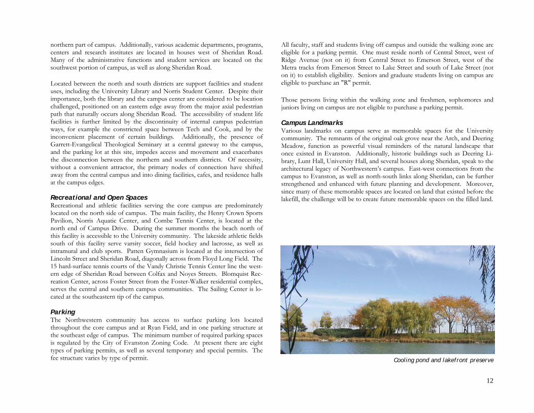
Cooling pond and lakefront preserve

13
Illustrative site plan

14
PART TWO EVANSTON CAMPUS FRAMEWORK PLAN Based on an examination of the Northwestern campus context, history, planning framework, and land use patterns, the Evanston Campus Planning Advisory Committee recommended a set of eight principles to serve campus planning efforts. These principles are summarized below. • Respond to Northwestern's unique lakefront location. To fulfill the original
intent of the lakefill project, the University should maximize development opportunities presented by this valuable resource, while respecting its char-acter and the regional tradition of lakeshore open space.
• Preserve the memorable spaces of campus and enhance them, where appro-
priate, with infill development. • Create new open spaces and landscapes, rooted in the historic structure of
the campus, that organize future development. • Design in accordance with the University’s sustainability guidelines. • Develop the core of the campus as a pedestrian environment, and move
parking to campus entrances. Provide pedestrian links along north/south, east/west, and public transit routes, including those that extend into the adjoining community.
• Bridge the existing north/south division of uses and activities by identifying
facilities or programs that could serve the campus community within a new central district.
• Acknowledge the historic character of the adjoining Evanston community
and endeavor to preserve University structures where significant or practical, while introducing new development that complements and contributes to this character.
• Assess zoning opportunities that could preserve existing assets, create inno-
vative campus-community partnerships and permit new, iconic focal points on campus.
From these principles and after testing several plan options, an overall develop-ment concept and framework plan emerged. This framework plan provides an
organizing structure for land use, open space, and circulation. First, the frame-work plan builds on the dynamic relationship between Evanston, the University, and Lake Michigan by developing east-west corridors. These corridors link the commercial and transit nodes to the academic core and, ultimately, the lakefront, which serves as the major open space area. Second, the framework plan strengthens links between the northern campus district and the southern campus district. Third, the framework plan respects the historical legacy of campus de-velopment, the crescent of open space that organizes the academic uses around Deering Meadow and the oak grove in the vicinity of the Arch, and incorporates this idea into the eastern portion of campus with a new crescent. This future crescent organizes open space and pedestrian movement and provides yet an-other connection between the northern and southern districts of campus. Combined, these three elements create a district of dynamic tension in the cen-tral portion of campus. This central district is intended to link the northern sci-ence/engineering district and the southern humanities district by proposing uses that bridge the gap between the two zones. These uses include a campus center and the social sciences disciplines. Framework Concepts As described on the following pages, several bold concepts are proposed that provide a new vision for Northwestern’s 21st-century campus. These include: • Create a major new Science and Engineering Green leading from the inter-
section of Noyes Street and Sheridan Road eastward to Lake Michigan • Define campus entrances and concentrate parking at the periphery of cam-
pus • Relocate the Allen Center from the center of campus to a new facility. • Restore and strengthen the historic crescent (and provide a new develop-
ment site) by relocating Lunt Hall to a site just north of University Hall • Infill a portion of the cooling pond to create a new crescent along the wa-
ter’s edge • Restore the residential character of the western edge of the Foster-Walker
block by relocating existing houses from the 1900 block of Sheridan Road to Orrington Avenue. Reuse the Sheridan Road section of the block for a new administrative services and support quadrangle.

15
Open Space Framework: The Grid and the Crescents The open space system preserves memorable landscape spaces, enhances existing spaces, and creates new landscape amenities throughout campus. The frame-work plan is based on a concept of four zones of landscape stratification from west to east: the city; the historic oak grove; campus quadrangles; and the lake-front preserve. Moving from west to east, the landscape environment is sequen-tially reflective of the transition from the city's rigid grid to the lake's organic edge. First, the city provides the rational network of streets that organize movement to and from campus and connect users to important transit nodes and commercial corridors. This area should include powerful streetscapes with large allées of canopy trees, pedestrian-scaled paving patterns, and lighted walkways. Existing building setbacks should be respected with uses that activate the street edge. Second, the existing oak grove adjacent to the Arch, with its in-formal curvilinear paths and dense trees, is a natural counterpoint to the urban grid. From the grove emerges the crescent that was the earliest planning axis of the 19th century campus. Known to the native Indian population as the ‘the eyebrow of beauty’, the cres-cent bows inward from its end-points along Sheridan Road, and provides the most historically distinctive architectural and land-scape identity for the campus. The crescent, the oak grove and the adjacent Deering Meadow maintain much of the original character and charm of the natural landscape and will be preserved. Third and farther east lies an ex-isting zone of internal campus streets, surface parking lots, awk-ward spaces between buildings, and the cooling pond. In this
zone, a new crescent is proposed that would mirror the historic crescent and sweep from north to south in a series of quadrangles facing Lake Michigan. These quadrangles of planted grass and shade trees would be scaled to create a sense of place between buildings, and stretch from the Sports Pavilion-Aquatic Center in the north to the proposed Music Quad in the south. The proposed Bienen School of Music buildings are intended to frame this quad and provide impressive views southward toward Chicago. At the midpoint between the old and the new crescents, and serving as a linkage between the north and south districts, an “infill” campus commons is possible for the open space area that is framed by the Jacobs Center on the west, the central utility plant on the north, and the library on the south. This area is en-hanced by the gently sloping topography that angles down toward the cooling pond and affords views to Lake Michigan. Programmatic spaces could be cre-ated by adapting selected areas of existing buildings at the ground floor level. An alternative solution would be construction of new facilities in this central precinct, north of the Jacobs Center. Fourth, much of the existing lakefront peninsula, currently used for passive rec-reation, could continue to serve as a preserve that also offers active recreational The oak grove and historic crescent, 1902
Map courtesy Northwestern University Archives
Outline of the historic crescent, 1950s Photo courtesy Northwestern University Archives

16
uses. The preserve would remain open space with deliberate views to Lake Michigan. Athletic and recreation fields would be concentrated at the northern end of the peninsula, with the southern portion used for passive types of recrea-tion, such as jogging trails and bikeways. This important open space amenity along the Lake Michigan waterfront would be preserved.
Pedestrian and Bicycle Circulation Networks Supporting and connecting these four landscape zones are a series of circulation networks that are intended to serve pedestrians and improve access for bicycles. The University’s commitment to sustainability and the linear structure of the Evanston campus support increased bicycle use in coming years. Bicycle access
The historic and proposed crescents

17
to the lakefront preserve should be maintained, and the proposed new crescent provides an opportunity for a bike lane to accommodate north-south travel, that could alleviate some of the existing bicycle circulation along Sheridan Road. It is expected that a more detailed analysis will be required to identify additional, ap-propriate bike paths throughout campus, as well as additional bike parking areas at existing and new buildings. East-West The east-west spines connect the city to the shore. These corridors with views to the lake would provide pedestrians with access routes from regional transit nodes along Noyes and Foster Streets, as well as from the commercial and retail core of downtown Evanston. At their westernmost points, these corridors read as pedestrianized urban streets, with streetscape improvements such as trees, benches, and lighting. As one moves east along these corridors, a series of gate-ways along Sheridan Road would announce one's arrival to the campus. As the routes penetrate the campus, the spaces would become more designed, with in-formal pathways that continue out to the lake's edge. At Noyes Street, the east-west corridor would become the formal Science and Engineering Green, a new campus gateway consisting of a 120-foot wide esplanade of pedestrian-friendly green space, lined with oaks and other shade trees and flanked to the north and south by a controlled access road. The Science and Engineering Green not only would provide an open space amenity for north campus students, faculty, and visitors but also would serve to organize the northern land use pattern with new buildings that front the Green. North-South Sheridan Road would continue to serve as a major pedestrian corridor, even as new north-south routes are created within the campus. The campus would bene-fit from aesthetic developments along Sheridan Road that identify it more strongly as a University space. The existing north-south path that runs just east of Tech should also be improved. Already, these corridors are frequently used by students and faculty; however, they are often interrupted by inconsistencies to the route, such as busy through-streets along Sheridan and, in the case of the internal route, buildings that block the natural course of pedestrian flow. The framework plan proposes a more thoughtful organization of buildings to maxi-mize pedestrian efficiency for moving north-south within the campus. Crescents The historic arc of buildings, located within the original oak grove area, is a natu-ral organizer for pedestrian movement, winding past University Hall, Deering Meadow and Library, and the Jacobs Center. The proposed new crescent, bow-ing inward from the lake edges to the center of campus, serves as yet another
north/south circulation path for pedestrians and bicyclists, providing a unifying element of connectivity among the campus quads through which it passes. Water's Edge The water's edge preserve and athletic fields would be linked through a series of informal pathways that permit accessibility and passive recreation. The water's edge should be a soft edge with native plantings of grasses and sedges.
Land Use and Capacity Framework
Proposed Land Use Pattern The overall land use plan proposes concentration of academic uses in the U3 zone, allowing the University to maximize development potential for key aca-demic and research uses within a zoning district that allows a building height of 85 feet. Within this zone, the Northwestern community urged the construction of a campus center facility to provide the common link between the northern and the southern academic and residential districts. More than just a student union, students and faculty envision a new structure that is centrally located and convenient to the heavily used pedestrian route along Sheridan Road. The social sciences could also be centrally located, to provide another connection between the northern Science and Engineering District and the southern Humanities Dis-trict. The Medill School of Journalism, the School of Communication, and the Bienen School of Music could expand in the southeast district. Long-term expansion areas for science and engineering growth are anticipated along the new crescent just east of the current concentration of facilities. Parcels to the west of Sheridan Road could accommodate administrative uses. Another gateway site at the intersection of Sheridan Road and Hinman Avenue, now oc-cupied by the Fairchild residence halls, could provide significant capacity for academic buildings if designed to take advantage of the maximum allowable building height. Student residences, both graduate and undergraduate, could be clustered close to both the north and south academic areas. Undergraduate residence halls could be developed in the existing north district housing area east of Sheridan Road. Combined, the residential and academic uses, as well as the recreational amenities of the Sports Pavilion-Aquatic Center and the athletic fields, would form a northern village of mixed uses. In the south, undergraduate residence halls could be developed in the southeastern portion of campus, adjacent to the existing 1835 Hinman and Jones Fine and Performing Arts Residence Halls. Graduate

18
Maximum Site Capacity

19
residential expansion could be accommodated in the southwestern portion of campus, near downtown Evanston. This area is envisioned as a mixed use dis-trict, with artist and studio space on the ground level and residences above. A new recreation center could be located between the undergraduate and graduate student residential areas near the intersection of Chicago Avenue and Clark Street. Like the northern district, the south district would be a village of mixed uses. Concurrently with the deliberations of the Evanston Campus Planning Advisory Committee, the Provost’s Advisory Committee on Student Housing was under-taking an intensive study of residential housing, and that planning analysis con-tinues. Understandably, during public presentations of the framework plan draft, future residence hall locations were a subject of much discussion. As the strategic assessment of residential housing continues, it will be essential to inte-grate the planning principles of both working groups, which could result in changes to either or both plans. Maximum Site Capacity Under Current Zoning The framework plan could accommodate a maximum of 7,457,000 new gross square feet (GSF) at full build-out; the total net gain would be 6,257,000 GSF once demolition of existing structures is accounted for. This figure represents building to the maximum height allowed by zoning for each district. Given that Northwestern has a history of facilities growth on the Evanston campus that averages 750,000 GSF per decade, the maximum build-out allows for approxi-mately 80 years of growth. Over the long term, the plan indicates the replacement of six residence halls on campus: Chapin, Foster-Walker, Fairchild East, and Fairchild West Halls in the south (907 beds) and Sargent and Bobb-McCulloch Halls in the north (640 beds). Additionally, the fraternity houses of Peanut Row (550, 562, 566, 572 and 576 Lincoln Street) would be replaced (132 beds), for a total residential displace-ment of 1,679 beds. The University does not anticipate needing to increase the number of residential beds. Instead, the displaced beds would be replaced with higher quality living spaces, with an average of 350 square feet allocated per bed. With a maximum development capacity of 729,000 GSF of new undergraduate residential program, 2,080 undergraduate beds could be accommodated, for a net gain of 381 beds. In addition, approximately 900 beds could be provided for graduate students in the mixed-use area of the south district.
Recommended Site Capacity In order to preserve and enhance the historic spaces on campus, a program that maximizes building height in all instances may not be appropriate. For instance, new residential structures could be of the size and scale of their historic counter-parts. Additionally, issues such as density and massing at a scale appropriate to building use and open space character must be considered. Not all recommen-dations suggest a reduction in building height – in some instances, the program calls for exceeding the building height of 85 feet in order to allow for legibility, identity and imageability of certain buildings on campus. Given these excep-tions, the recommended program estimates a maximum of 6,187,000 new gross square feet (GSF) at full build-out; the total net gain would be 4,987,000 GSF once demolition of existing structures is accounted for. This represents approxi-mately 66 years of growth capacity (assuming construction of 750,000 GSF per decade). Although the recommended development program also proposes replacement of the same residence halls and fraternity houses listed above, totaling 1,679 dis-placed beds, a lower building height is proposed for all of the north campus resi-dences east of Sheridan Road, to maintain the scale of the existing district. This would result in a reduced development capacity of 575,000 GSF of new under-graduate residential housing; 1,642 beds could be accommodated, representing a zero net gain, consistent with the identified needs of the University. The recom-mended development capacity also permits 900 beds for graduate students in the south district. The purpose of this framework plan was, primarily, to identify possible areas (and in some cases, specific building footprints) to accommodate future growth. Both the maximum and recommended capacity assumptions and proposals, as they pertain to the University’s residential program, should be further evaluated through the work of the Provost’s Advisory Committee on Student Housing.
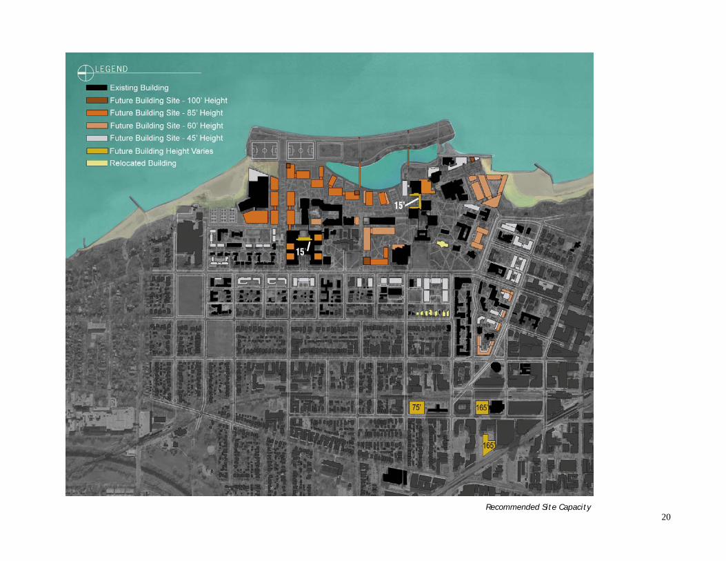
20
Recommended Site Capacity

21
Strategic Moves Affecting Future Capacity and Character Although the University could pursue several bold moves to enhance the capac-ity and quality of the campus, three such moves are considered strategic and should be carried out first in order to achieve the remaining initiatives. First, the removal of Sargent Hall residence and the Francis Searle building would make possible the development of the Science and Engineering Green as both an open space and an organizational framework for all north district development. The replacement of the dining facility in Sargent Hall, allowing for removal of Sar-gent, would permit the first phase of development of this new open space. Later replacement of Frances Searle’s facilities would allow for removal of Frances Searle and the eastward extension of the Science and Engineering Green.
Second, the move of Lunt Hall from its current location north of Jacobs to a site adjacent to University Hall, and the demolition of Shanley Pavilion, would create a development parcel for a future quadrangle and an associated underground parking facility. Third, the removal of the southeast parking deck would allow for future development and for a new, more compact parking structure.
Strategic relocations and demolition

22
Site Capacity Variables The change in the cooling pond's configura-tion and the relocation of the Allen Center are pivotal in achieving maximum program capacity. Should the University elect not to undertake these initiatives, the build-out capacity of the framework plan would be reduced, and a fundamental organizing con-cept for campus development — the crea-tion of the new crescent — would be lost. Maintaining the cooling pond as is results in a loss of 768,000 GSF of program, while maintaining the existing Allen Center results in a loss of 381,000 GSF of program. Com-bined, this represents a loss of 1,149,000 GSF of program.
Existing and proposed cooling pond
Alternate A—Lost capacity without pondfill

23
Vehicular Circulation /Infrastructure Framework
Existing Vehicular Connections and Parking Network The existing circulation network allows vehi-cles to penetrate the campus through several access points. Currently, the streets internal to campus do not restrict vehicles and exist, primarily, to serve the various parking lots. The major vehicular route through campus, Campus Drive, extends south from Lincoln Street, just west of the Sports Pavilion-Aquatic Center. The road jogs to the east and continues southward between Frances Searle Hall and the athletic fields, the Allen Center, and then along the eastern edge of the central utility plant. Campus Drive then becomes a controlled-access route just north of the library and continues as such until the Theatre and Interpretation Center, at which point it reverts to a regular road. East-west connections to Campus Drive are provided via Lincoln Street; LARC Drive; Tech Drive; the road south of Garrett Theo-logical Seminary; and Arts Circle Drive. Existing parking is distributed throughout campus and is served by the circulation net-work. Major parking areas east of Sheridan Road include: north district surface lots to the west of the Sports Pavilion-Aquatic Cen-ter, LARC Drive, Cook Hall, the Allen Cen-ter, Garrett, and the south district parking deck. Smaller surface lots along Campus Drive comprise the remaining inventory of parking in the pedestrian core of campus. West of Sheridan Road, lots are distributed among the various University-owned proper-ties, including 2020 Ridge Avenue, Rebecca Crown Center, and surface and underground parking at Engelhart Hall.
Alternate B
Alternate C

24
Proposed Vehicular Conditions and Parking Network The proposed circulation network is envi-sioned as one of limited public vehicle access in the pedestrian core of campus, with parking and drop-off points in the periphery of campus. The northern part of Campus Drive, west of the Sports Pa-vilion-Aquatic Center, remains as an entry point into campus. Additionally, Tech Drive and Arts Circle Drive remain as public vehicle roadways, each with a court for drop-offs and turn-around. The new parking strategy makes possible the reduction in vehicular traffic in the campus core. This strategy locates three parking structures around the periphery of campus in the north, central, and south. The northern parking structure, adjacent to the western edge of the Sports Pavil-ion-Aquatic Center, would be served by Lincoln Street and the existing northern portion of Campus Drive and would pro-vide parking for between 1,200 and 1,600 cars. The central parking structure is pro-posed as an underground facility just north of the existing Jacobs Center, with access from Sheridan Road, and parking for as many as 800 cars. The southern structure would be positioned in the southeast campus area, in a portion of the site occupied by the current two-level parking deck. This structure could ac-commodate up to 1,100 cars. To further relieve parking demands, many existing surface lots west of Sheridan Road would be maintained and a new above-ground garage could be built in the existing sur-face lot north of Engelhart Hall, with a 600-car capacity.
Existing and proposed vehicular connections and parking

25
Existing Service and Emergency Access Network Service is provided to the campus through a series of underground tunnels and service roads. Underground tunnels include the following: east of the Sports Pavilion-Aquatic Center, extending toward the central utility plant; running east-west along Tech Drive; running north from Tech Drive through the north dis-trict residence halls; in the south district, between Kresge/Crowe and Fairchild East and West; and in the Music Quad adjacent to Pick-Staiger. A major above-ground service road begins just south of the Sports Pavilion-Aquatic Center, extends to the west of Annie May Swift Hall, and along the western edge of the Library. Major service courts include: the north side of the library; south of the Norris Center; north of the central utility plant; the south side of Tech; Hogan; the north side of Jacobs; the east side of Rebecca Crown, and the south side of 1835 Hinman Hall. Proposed Service and Emergency Access Network Controlled access for drop-off and service is provided at several key points. These access points would serve vehicles making small deliveries and could be made accessible to the public during certain times of the day or year. In the north, a major controlled-access route extends from Tech Drive eastward around the Science and Engineering Green, as well as along the southern por-tion of Tech. In the central district, controlled access is provided to serve Garrett, the buildings proposed just south of Garrett, and the Jacobs Center. In the south, controlled access to the library is provided via Arts Circle Drive. Emergency access only is planned for the two mirroring crescents, the area east of Kresge-Crowe continuing to the library, and in the southwest residential zone. By restricting these areas to emergency vehicles only, the central core of the campus can be preserved as a pedestrian-friendly environment. Service would also continue via underground tunnels. A major new service court adjacent to the Science and Engineering Green would connect to an un-derground tunnel that serves the proposed science buildings in the east. Exist-ing underground tunnels that serve the north residential quad, the central cam-pus district, the Library and Norris Center and the area between Kresge-Crowe and the existing Fairchild dormitories would be maintained.

26
Existing and proposed service and emergency access

27
Existing Major Infrastructure Corridors The major utility/infrastructure corridor runs through the central portion of campus, extending northward from the existing south district parking deck to the library and then continuing directly north of Tech. A parallel corridor runs just eastward, serving the eastern portion of the library, Norris Center, and the pro-posed buildings of the southeast campus. Smaller utility corridors in the south district include one that runs horizontally from University Place across Sheridan Road and another between Kresge/Crowe and the Fairchild residence halls. In the north district, a corridor runs north/south from Tech and serves the north district residential zone and another corridor runs east to west just north of Tech, along the future Science and Engineering Green. Proposed Major Infrastructure Corridors In addition to the existing major infrastructure corridor, three extensions are planned. First, an east-west utility extension under the Science and Engineering Green would serve the new buildings planned for this area. Second, a new utility corridor is proposed under the new crescent, just east of the proposed science and engineering buildings. Third, a small utility easement is needed in the mixed use district, just west of the Rebecca Crown Center.

28
Existing and proposed utility corridors
29
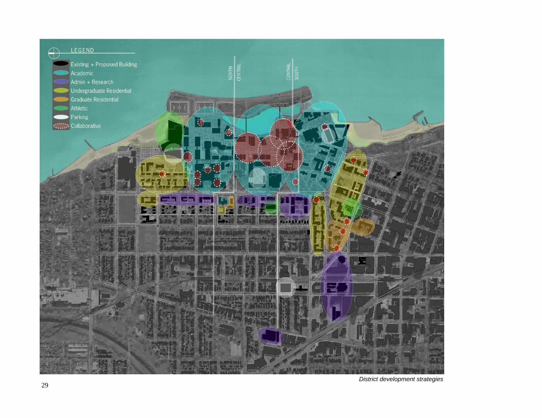
District development strategies

30
PART THREE
DISTRICT DEVELOPMENT STRATEGIES Introduction The Northwestern campus is made up of several districts and subdistricts that are defined by a particular array of land and building uses with attendant charac-teristics of density, scale, and landscape expression. The districts are frequently defined by obvious boundary elements such as major streets, open spaces, inter-vening parcels of non-University land, and water edges. The variety of campus areas and the differentiation between them are typical of dynamic, complex learning institutions. They are, in fact, rich expressions of the diversity and vital-ity of the Northwestern University environment. From a campus planning per-spective, the imperative is to sustain the richness and diversity of place embodied in the multiplicity of campus districts, while drawing those districts together in a way that makes the whole of the campus a coherent and memorable community. To express those imperatives, the Campus Framework Plan is organized around three major districts – North, Central, and South – whose functional and colle-gial relationships to one another are critical in unifying the whole of the Evans-ton campus and the institutional activities occurring on the campus. While each of the three districts is made up of numerous sub-areas of particular character and function, each also plays a primary role in the organization of University life. The North District is the heart of Northwestern’s science, engineering and technology domain, physically symbolized by the massive Technological Institute on Sheridan Road and the dense cluster of laboratory buildings, including Pancoe-ENH Life Sciences Pavilion, Ryan Hall, Hogan Hall, Catalysis Center, and Cook Hall. At the same time, the north district contains a broad mix of other uses, including student housing, indoor and outdoor sports and recreation facilities. Straddling the line between the north and central districts is the Allen Center, site of the executive education facilities of the Kellogg School of Man-agement. The north district has a high concentration of large-scale buildings in relatively dense configurations, while at the same time offering broad expanses of open land on the sports and recreation fields located on the lake side of the dis-trict. There are well-tended courtyards in the science complex and the student residential areas to the north, but, on the whole, the district does not possess the iconic collegial spaces that are more abundant in the south and central districts. Surface parking encumbers many corners of the district.
The signature characteristic of the north district is that it has substan-tial development capacity at its edges and in the redevelopment of sites whose current functions may be more appropriately located else-where. The capacity would be nec-essary to support Northwestern’s future as a research university. Equally important is the develop-ment potential to create a new, more urban vocabulary of open spaces and pedestrian corridors that would not only unify the district, but more graciously connect the area with the central and south dis-tricts. The cooling pond and the fields north of the pond can con-tinue to be important spatial re-sources and channels along which an improved pedestrian setting is achieved. The Central District is both the geographic and functional conjunc-tion of the Northwestern campus. The area is delineated by prominent buildings such as the University Library and Norris Student Center, and the Jacobs Center on Sheridan Road. The University’s central utility plant is, appropriately, lo-cated in the district. The strongest visual and geographic connections with the cooling pond are found in the central district. Cross campus movements between the academic and residential areas on the south and north traverse the central dis-trict. Given its relationship to Sheridan Road, the pond and Lake

31
Michigan, the central district has the potential to be, with prudent planning, a more powerful nexus of campus life than it is today. From a campus planning perspective, the central district is still a formative part of the larger campus environment, not yet fulfilling its potential as the unifying area of the campus that it could and should be. Pedestrian/vehicle conflicts still occur due to vehicle traffic drawn to the central parking lots and the Allen Cen-ter. Several open parcels along the pond edge could lend themselves to the de-velopment of common academic and social facilities that would be exquisitely related to the pond and public spaces adjoining the pond. The significance of the central district, therefore, is its geographic centrality, its established iconic features, and its capacity to be developed as Northwestern’s great “civic square.” The South District is the principal domain of the humanities, social sciences and the arts, as well as the University’s largest area of undergraduate residences. The oldest, most historic campus settings, including Deering Meadow, occupy the heart of the south district. At the same time, diversity of environments within this district is exceptional, from the Lake Michigan shoreline with vistas south to Chicago’s Loop, through campus properties in the urban block and street grid of Evanston, to campus holdings in downtown Evanston. In relative terms, the south district is the most complete of the three, but is adaptable to growth and change by careful “infill” and redevelopment of the established fab-ric. A significant characteristic of the south district is that it joins the most urban and the most “traditional” parts of the University in a vibrant progression of spaces leading from the city proper into the heart of the University, providing an important series of urban and regional gateways to Northwestern.

32
Proposed uses

33
A Development Strategy for the North District
Existing Role and Geography The area known as the north district includes all lands north of the Garrett entry. This district is characterized as an academic and residential zone, but also in-cludes many important athletic facilities. The distinguishing character of this district is one of large, interconnected buildings that are sited in a somewhat ran-dom arrangement. Because of this unsystematic land use pattern, the north dis-trict lacks distinguishing open space elements and a clear pattern of pedestrian circulation. This area of campus does, however, offer memorable views to Lake Michigan that should be preserved where possible and enhanced through the placement of new buildings.
Proposed Development 1. Science and Technology Expansion The open space system for the north district proposes two significant gestures: the creation of the Science and Engineering Green and the creation of the new crescent that mirrors the existing historic arc of open space along Sheridan Road (see key plan, page 34, areas marked 1). These open spaces would provide the framework for future development. The strategic removal of Frances Searle and Sargent Hall would make possible this open space system, although as noted above, replacement of the existing dining facility in Sargent Hall would be a nec-essary first step. Later replacement of Frances Searle’s facilities would allow for incremental eastward extension of the Science and Engineering Green. At Noyes Street, the east-west corridor would become the formal Science and Engineering Green, a 120-foot wide swath of pedestrian-friendly green space, lined with oaks and other shade trees and flanked to the north and south by a con-trolled access road. This dramatic new campus entry would provide an open space amenity for north district students, faculty, and visitors and also would or-ganize the northern land use pattern with new buildings that front the Green. The buildings along the Green would help frame and strengthen the open space offering views to Lake Michigan; east-west buildings would have oblique views out to the lake, whereas the north-south buildings would provide a large area of viewshed to the water. In this portion of campus, the proposed new crescent would serve as yet another north/south pedestrian way, with the buildings along it providing structure to the sinuous open space element and its associated courtyards. As the district transitions from west to east, the new buildings would include glass facades and building materials that allow for transparent views to the lakeshore. The north district already accommodates the science and engineering programs, both of which are expected to experience significant growth in space require-ments over the next several years. The buildings proposed for both the Science and Engineering Green and the new crescent are intended to accommodate this growth. As these proposed buildings are located within the U3 zoning district, they can be built to a maximum height of 85 feet. When built to maximum ca-pacity, the new science and engineering buildings could accommodate up to 1.5 million square feet of new space.
North district proposed uses

34
2. Residential The residential program in this district would be enhanced with new undergraduate residences planned adjacent to current fra-ternity houses and existing resi-dence halls, such as Slivka and Kemper. While zoning permits building the residence halls east of Sheridan to 85 feet, a recom-mended height of 45 feet is sug-gested to maintain the size and scale of the existing residences, which are successful in terms of their organization and configura-tion. A key part of the north district residential strategy is the removal of Sargent Hall, Bobb-McCulloch Hall, and Peanut Row fraternity houses. Their removal would result in the loss of 772 beds and a dining hall. The proposed replacement beds total 650, for a net loss of 122 beds. When compared with pro-posed new residential construc-tion in the south district, how-ever, there would be a zero net gain across the campus for the number of beds, consistent with the need identified by the Uni-versity. A replacement dining facility could be accommodated in the area west of the new park-ing garage, or north of Kemper Hall. This new dining hall and the existing Elder Hall facility could serve as the main dining locations for the north district. Expansion of the research enterprise may lead to a larger graduate student population in future years. Consideration was given to locating graduate housing west of Sheridan Road, at the site of the Vandy Christie Tennis Cen-
Key plan, future building sites

35
ter, given its proximity to the existing research facilities on the north campus. However, student housing is not currently permitted by right by zoning in this area, and would require a special use permit. This area is proposed for adminis-trative buildings, the only use allowed by right under the current zoning. 3. Recreation/Athletic The recreation and athletic program would be enhanced in the north district through three key initiatives. First, three athletic fields would be designed for the northern peninsula area. These fields, two of which would be NCAA-regulation size for intercollegiate sports, would include lighting, bleacher seating, and artifi-cial turf for year-round, intensive use. Long Field would remain as a grass field for intramural use and summer sports camps. Second, an expansion to the Sports Pavilion-Aquatic Center would provide needed fitness space and studios for recreation use and also locker and team rooms for varsity sports using the adjacent athletic fields, such as soccer, field hockey, and lacrosse. Third, the outdoor tennis courts currently located on the west side of Sheridan Road would be moved to the area north of the Sports Pavilion-Aquatic Center, atop the City of Evanston’s existing underground reservoir. 4. Parking A new garage is proposed immediately west of the Sports Pavilion-Aquatic Cen-ter, to serve as the main parking locus for the north district, and replace several existing surface lots. The garage is anticipated to hold between 1,200 and 1,600 cars. Primary access to the garage would be provided via Lincoln Avenue, with limited and controlled access/egress via the Science and Engineering Green. 5. Roycemore Land occupied by the Roycemore School is owned by the University with a lease that expires in 2014. At that time, the property will revert to University control. The buildings total approximately 50,000 GSF, and while much of the complex is an Evanston historic landmark, the buildings are in generally poor condition with significant code and accessibility issues. Possible adaptive reuses are cur-rently being studied by the University. Zoning Implications As with possible iconic buildings proposed in the south and central districts, the University may also seek to exceed the 85-foot height limit for a north district building.
Accommodation Factors The new parking garage would permit the removal of several surface parking lots. Next, partial filling of the cooling pond would be implemented and the three new athletic fields would be created before construction begins on the new crescent buildings, which would occupy the parcels of the existing athletic fields. Also mandatory would be the replacement of the north district dining hall before Sargent Hall is removed.
North district zoning

36
A Development Strategy for the Central District Existing Role and Geography The central district includes the area north of University Library and Norris Cen-ter and south of Garrett Place. This central campus area could be developed for the social sciences and for campus center uses. Because it houses “seam” uses, those which involve the largest amount of students, the central district could become both the physical and intellectual hub of campus. The central district open space plan preserves and augments the original crescent that begins in the south district and arcs northward toward Sheridan Road.
Proposed Development 1. New Quadrangle Relocating Lunt Hall to a site further south along the historic crescent would permit development opportunities for the area north of the Jacobs Center (see key plan, page 37, area marked 1). Although the plan diagram illustrates a quad-rangle arrangement, the architectural configuration would depend on the type of use that is chosen for this site. Suggestions have included a social sciences facil-ity, a new campus center, or a new library. Further study is needed to determine which types of facilities should be developed, and when. The northern terminus of the historic crescent could be celebrated by pedestrian pathways through the buildings themselves. 2, 3. The Central Crescent and Pond Portals The new crescent, which forms a unified expression that stretches from the south district to the north district, would reach a point of dynamic tension in the central district. Here, the land steps down to the pond’s edge, providing views to the lake and an open space amenity for the adjacent buildings. The steps to the water would provide a hard edge and serve as an informal outdoor gathering space, while the pond portals would provide a climactic expression as one moves along the crescent.
4. Garrett-Evangelical Theological Seminary Northwestern currently owns the land on which the Garrett-Evangelical Theo-logical Seminary is located. Although the lease with Garrett does not expire until 2138, in the indefinite future Northwestern may consider initiating negotiations with Garrett for use of the space it currently occupies, as the property represents
Sketch of proposed new central crescent
Central district proposed uses

37
a handsome array of buildings that contribute to the overall impression of Northwestern. Of particular interest is Loder Hall, a residence hall of undistin-guished character, that could be demolished to allow for various development opportunities. 5. Administrative Uses To the west of Sheridan, the proposed buildings could be used for either admin-istrative uses or academic centers. These buildings are part of the T2 zone and could therefore be built to a height of 45 feet, for a total of up to 218,000 GSF. 6. Parking The removal of surface parking lots west of the Allen Center and along the Garrett entry would necessitate a new central district parking strategy. The framework plan proposes a new underground parking garage (indicated by the dashed white line on the diagram at left), located north of the Jacobs Center. With access from Sheridan Road, this underground facility could accommodate as many as 800 cars. Additional need could be accommodated by maintaining some of the existing surface lots west of Sheridan Road.
Key plan, future building sites

38
Zoning Implications The only foreseeable zoning implication for the central district development strategy concerns the 85-foot height limit. The University may seek a height variance for one or two buildings to exceed the allowable height. This change would permit architectural variation and an iconic urban design statement in the district. Accommodation Factors In terms of phasing, the first strategic move that could be made is the relocation of Lunt, which would clear the way for future development of the underground parking structure and a new quadrangle.
Central district zoning

39
A Development Strategy for the South District
Existing Role and Geography The area known as the south district is bounded by Sheridan Road to the east, by Maple Avenue to the west, and by Foster Street to the north. The distinguishing character of this district is one of historic buildings that frame intimate court-yards and open spaces. The relocation of Lunt Hall from its current position north of the Jacobs Center to the area north of University Hall would strengthen the visual organization of the historic crescent, place Lunt alongside its architec-tural contemporaries, and make way for new open space and buildings that en-hance the crescent’s northern terminus. Both the existing oak grove and Deering Meadow would be preserved. Courtyard spaces in the south quadrangle of so-rorities and residence halls, between Emerson Street and University Place, would remain. The areas directly north and south of these residences, however, lack cohesion and a unifying structure. This is particularly apparent for the buildings fronting Clark Street, as well as the areas in and around the Foster-Walker resi-dence hall. Proposed Development 1. Clark Street Corridor A new mixed-use residential district is proposed for the southwestern area of campus along Clark Street (see key plan, page 40, area marked 1). The city and the university should work collaboratively on the Clark Street corridor to ac-knowledge their mutual interests in this border, to coordinate the framework plan and its principles and the city’s recent Downtown Evanston Plan, and to explore possibilities that can strengthen this important urban edge.
South district proposed uses
Art and music studios can enliven a streetscape

40
One possibility to link the downtown and the University is the creation of a more vibrant street level along the north side of Clark Street, with activities that occur after normal business hours. If graduate student residential units were located on the upper floors of new buildings, ground floor uses could include art and music studios for these students. Such opportunities offer pedestrians the ability to enjoy the creative activities within, and engage the public in the life of the Univer-sity. Other options for street level spaces along Clark Street are commercial and retail businesses that would complement, rather than compete with, private landlords. An interesting range of businesses sustains an energetic urban area, and the pro-posed residential-commercial development would serve the downtown goal of Evanston’s Comprehensive General Plan, to create “a mixed-use central business district that is attractive, convenient, livable, accessible, and economically vi-brant.” Shops and restaurants, together with the artistic and academic uses men-tioned above, would bring around-the-clock vitality to the area, support the city’s aim to maximize retail development opportunities, and promote safety and "eyes on the street."
2. Clark and Chicago Gateway Aside from the Blomquist facility, south district residents currently have no access to a multi-purpose recreation facility. A new facility is therefore proposed for the northwest corner of Chicago Avenue and Clark Street. This new facility, strategi-cally located between the mixed-use graduate student district and the undergradu-ate population, would serve as an amenity for all south district residents. The
Clark Street looking west
Key plan, future building sites
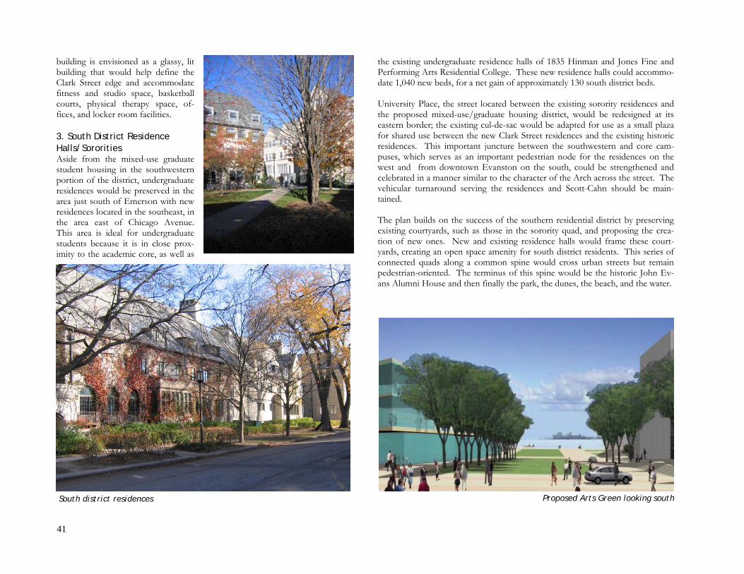
41
building is envisioned as a glassy, lit building that would help define the Clark Street edge and accommodate fitness and studio space, basketball courts, physical therapy space, of-fices, and locker room facilities. 3. South District Residence Halls/Sororities Aside from the mixed-use graduate student housing in the southwestern portion of the district, undergraduate residences would be preserved in the area just south of Emerson with new residences located in the southeast, in the area east of Chicago Avenue. This area is ideal for undergraduate students because it is in close prox-imity to the academic core, as well as
the existing undergraduate residence halls of 1835 Hinman and Jones Fine and Performing Arts Residential College. These new residence halls could accommo-date 1,040 new beds, for a net gain of approximately 130 south district beds. University Place, the street located between the existing sorority residences and the proposed mixed-use/graduate housing district, would be redesigned at its eastern border; the existing cul-de-sac would be adapted for use as a small plaza for shared use between the new Clark Street residences and the existing historic residences. This important juncture between the southwestern and core cam-puses, which serves as an important pedestrian node for the residences on the west and from downtown Evanston on the south, could be strengthened and celebrated in a manner similar to the character of the Arch across the street. The vehicular turnaround serving the residences and Scott-Cahn should be main-tained. The plan builds on the success of the southern residential district by preserving existing courtyards, such as those in the sorority quad, and proposing the crea-tion of new ones. New and existing residence halls would frame these court-yards, creating an open space amenity for south district residents. This series of connected quads along a common spine would cross urban streets but remain pedestrian-oriented. The terminus of this spine would be the historic John Ev-ans Alumni House and then finally the park, the dunes, the beach, and the water.
Proposed Arts Green looking south South district residences

42
4. Crescent-Arts Green Terminus The Music Quad, in the southeast campus district, would be comprised of the Arts Green, shaped by a new building for the Bienen School of Music on the east, and the Block Museum and School of Communication facilities on the west. The Arts Green would offer views of the Chicago skyline and provide a focal point for special events and passive recreation. Future academic buildings, either for the arts, humanities or Medill, would be oriented in line with the open space feature. The Arts Green also would serve as the terminus of the new cres-cent. 5. Oak Grove and Historic Campus The existing oak grove recalls the original landscape of Northwestern and con-tributes to a sense of identity and continuity in the south district. This land-scape, along with its associated historic buildings, would be preserved as a key memorable space on campus.
6. West Sheridan Administrative District The long-term removal of Foster-Walker residence hall and other facilities could trigger two bold moves in the block immediately west of Deering Meadow, bounded to the east by Sheridan Road and to the north and south by Foster and Emerson Streets, respectively. The existing houses along the west side of Sheri-dan Road would be moved to the west side of the block, along Orrington Ave-nue. This move would restore the residential neighborhood character of Orring-ton and provide an opportunity for University development along a major cam-pus gateway at Sheridan Road. Proposed new uses in this centralized location include the more public administrative functions, such as admissions, as well as student services. 7. New Parking Structure A new parking structure is proposed for the south district to replace the existing 742-space parking deck. The new facility could include up to seven levels above grade and two levels below grade, for a total of 1,100 parking spaces. This con-figuration would reduce the footprint of a new parking facility, and permit new buildings to be “wrapped” around the parking structure. In addition to provid-ing expansion capacity in buildings with stunning lakefront views, this strategy would consolidate parking at the periphery of the campus, thereby promoting a pedestrian-friendly campus. Further west, a new structured lot at Engelhart could accommodate up to 600 spaces, in addition to the 192 spaces that already exist on this site. Research District The University owns land in the research park triangle west of the Hilton Gar-den Inn. Northwestern’s primary option for future expansion in this district is development for research. McManus The McManus Living-Learning Center offers 208 living units of graduate hous-ing in a seven-story structure. The facility, located south of Clark Street between Chicago and Orrington Avenues, offers studio, one-bedroom, and two-bedroom apartments to students enrolled in the Kellogg School of Management. Cur-rently, McManus is underutilized, as it must compete with the local Evanston housing market. In the future, McManus could remain as a graduate student residence.
University Hall
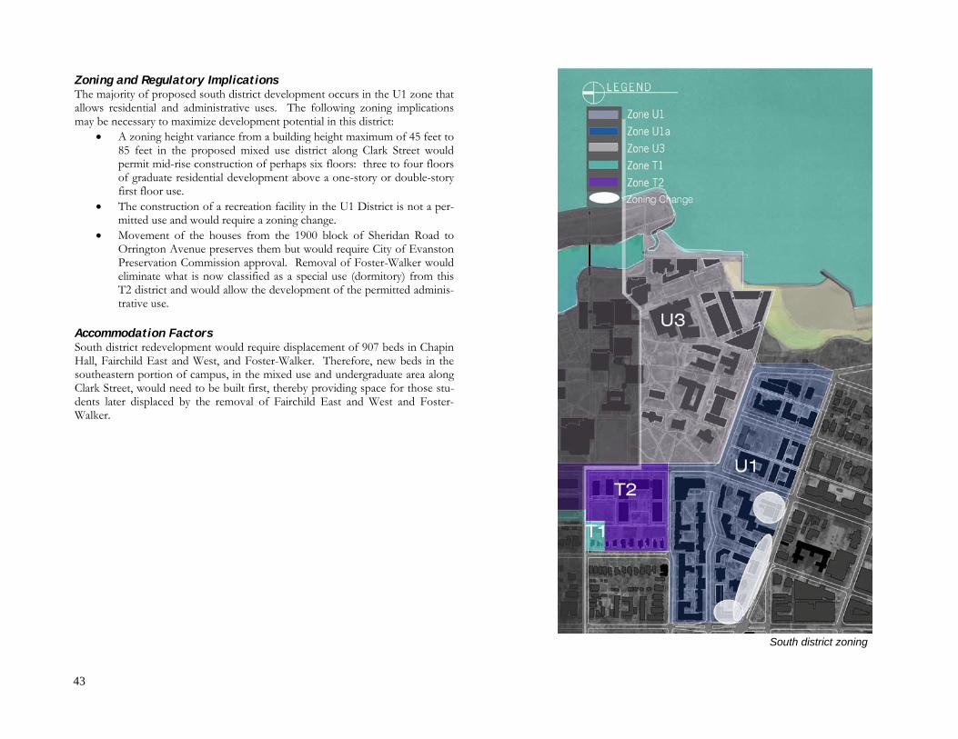
43
Zoning and Regulatory Implications The majority of proposed south district development occurs in the U1 zone that allows residential and administrative uses. The following zoning implications may be necessary to maximize development potential in this district:
• A zoning height variance from a building height maximum of 45 feet to 85 feet in the proposed mixed use district along Clark Street would permit mid-rise construction of perhaps six floors: three to four floors of graduate residential development above a one-story or double-story first floor use.
• The construction of a recreation facility in the U1 District is not a per-mitted use and would require a zoning change.
• Movement of the houses from the 1900 block of Sheridan Road to Orrington Avenue preserves them but would require City of Evanston Preservation Commission approval. Removal of Foster-Walker would eliminate what is now classified as a special use (dormitory) from this T2 district and would allow the development of the permitted adminis-trative use.
Accommodation Factors South district redevelopment would require displacement of 907 beds in Chapin Hall, Fairchild East and West, and Foster-Walker. Therefore, new beds in the southeastern portion of campus, in the mixed use and undergraduate area along Clark Street, would need to be built first, thereby providing space for those stu-dents later displaced by the removal of Fairchild East and West and Foster-Walker.
South district zoning

44
CONCLUSION This framework plan can serve the University in the coming years as a general guide that suggests where to build, where not to build, which green spaces to pre-serve, and which memorable structures and places to enhance. The primary focus for new development should be sustainability, to protect the physical environ-ment and provide buildings that meet certified standards for construction and operation. Pedestrian circulation should have precedence over vehicular access within the campus boundaries. Spatially inefficient surface lots should be removed in favor of structured garages that create open land for more green space and offer the possibility of programmatic uses in addition to spaces for cars. Functionally obsolete buildings should be removed to permit construction of new facilities with flexible floor plans and energy-efficient operating systems.

45
ACKNOWLEDGMENTS
Evanston Campus Planning Advisory Committee Craig R. Bina (WCAS83, G85, PhD87), Associate Dean for Research and Graduate Studies, Judd A. and Marjorie Weinberg College of Arts and Sciences (participating as Professor of Earth and Planetary Sciences)** Carole K. Cahill, Associate Dean, J.L. Kellogg School of Management Jad Carson, Student, Robert R. McCormick School of Engineering and Applied Science Coleen T. Coleman (C88, GSESP91), Associate Dean, School of Education and Social Policy Ed Colgate, Professor of Mechanical Engineering, McCormick School Dauphine Gregory, Northwestern University Staff Advisory Council Rebecca Griffiths, Northwestern University Staff Advisory Council** Bradford D. Hurlbut, Associate Athletic Director, Athletics and Recreation Craig A. Johnson (WCAS99, KSM07), Associate Director, Office of Budget Planning L. Todd Leasia, Director, Office for Research Safety Marv Lofquist (PhD70), Associate Dean, Weinberg Richard M. Lueptow, Senior Associate Dean, McCormick René E. Machado, Associate Dean, Henry and Leigh Bienen School of Music Jon Marino (SESP06)** G. Garth Miller, Executive Director, University Housing and Food Service Mackenzie Nicholson (McC08), Alternate** Richard Roth, Associate Dean, Medill School of Journalism** Linda M. Salchenberger (KSM80, PhD85), Associate Dean, School of Continuing Studies** Neal Sales-Griffin, Student, School of Education Roxanne Sellberg, Associate University Librarian, University Library Jean E. Shedd (KSM97), Associate Provost, Office of the Provost, Ex Officio Patricia H. Todus (KSM86), Associate Vice President and Deputy Chief Information Officer, Information Technology Douglas Troutman, Associate Dean, Medill Jay Walsh, Vice President for Research (participating as Senior Associate Dean, McCormick)** Jonathan Webber (WCAS08)** James G. Webster, Professor of Communication Studies, School of Communication Ken Woo, Director of Information Technology, SCS ** Committee member until 2008
Study Participants William J. Banis, Vice President for Student Affairs Daniel M. Bulfin, Director, Recreational Sports, Athletics and Recreation Michael F. Dacey†, Senior Associate Dean, Weinberg College of Arts and Sciences Mary K. Desler, Associate Vice President for Student Affairs and Dean of Students Sheila M. Driscoll, Director, Business and Finance, Student Affairs Lawrence B. Dumas†, Provost Dean Dipak C. Jain, Kellogg School of Management Virginia Koch, Senior Assistant Director, Residential Life Lucile R. Krasnow, Special Assistant for Community Relations Dean John Lavine, Medill School of Journalism Daniel I. Linzer, Provost (participating as Dean, Weinberg College of Arts and Sciences) Shon P. Morris (SESP88), Associate Athletic Director, Athletics and Recreation Dean Barbara J. O’Keefe, School of Communication Dean Julio M. Ottino, McCormick School of Engineering and Applied Science Dean Penelope L. Peterson, School of Education and Social Policy Lyn Weick, Senior Associate Dean, Weinberg College of Arts and Sciences Sasaki Associates M. Perry Chapman Ricardo Dumont Tyler Patrick Anna Reaves Northwestern University Facilities Management Ronald Nayler, Associate Vice President Heather Bremenstuhl, Department Assistant Quentin Bruhn, Senior Project Manager, Design & Construction Kory Burton, Project Manager, Design & Construction Lisa Carroll, Department Assistant Elizabeth Hitchcock, Senior Facilities Planner, Planning Bonnie Humphrey, Director, Design & Construction Steve Sowa, Assistant Director, Operations Paul Weller, Director, Planning Julia Winter, Facilities Planner, Planning Gary Wojtowicz, Director, Operations Ann Ziegelmaier, Landscape Architect, Planning
†deceased