california environmental quality act initial …
TRANSCRIPT

1
CALIFORNIA ENVIRONMENTAL QUALITY ACT INITIAL STUDY CHECKLIST FORM
CITY OF PASO ROBLES
1. PROJECT TITLE: Dry Creek Road Re-alignment DPW 17-21B
2. LEAD AGENCY: City of Paso Robles
Contact: Darren Nash, City Planner
Phone: (805) 237-3970 Email: [email protected]
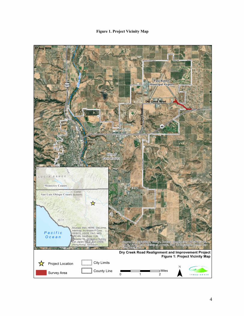
3. PROJECT LOCATION: Vicinity of the Paso Robles Municipal Airport (Airport) in the City of El Paso de Robles, California (see Figure 1 – Project Vicinity Map).
4. GENERAL PLAN DESIGNATION: BP (Business Park) and PF (Public Facilities)
5. ZONING: AP-PD (Airport, Planned Development Overlay)
6. INTRODUCTION: This Initial Study/Mitigated Negative Declaration (IS/MND) was prepared to satisfy the requirements of the California Environmental Quality Act (CEQA) (Public Resources Code Section 21000 et seq.) and the State CEQA Guidelines (14 California Code of Regulations [CCR] 15000 et seq.). CEQA requires that all state and local government agencies consider the environmental consequences of projects over which they have discretionary authority before they approve or implement those projects.
The Initial Study (IS) is a public document used by the decision-making lead agency to determine whether a project may have a significant effect on the environment. In the case of the proposed project, the City of El Paso de Robles (City) is the lead agency and will use the Initial Study to determine whether the proposed project has a significant effect on the environment.
If the lead agency finds substantial evidence that any aspect of the proposed project, either alone or in combination with other projects, may have a significant effect on the environment that cannot be mitigated to a level of insignificance, that agency is required to prepare an Environmental Impact Report (EIR). If the agency finds no substantial evidence that the proposed project or any of its aspects may cause a significant impact on the environment, a negative declaration may be prepared. If, over the course of the analysis, the proposed project is found to have a significant impact on the environment that, with specific mitigation measures, can be reduced to a less-than-significant level, a supplemental mitigated negative declaration may be prepared. In the case of this proposed project, all significant or potentially significant impacts on the environment would be reduced to less-than-significant levels with incorporation of specific mitigation measures and the resulting documentation is a mitigated negative declaration (MND).
7. PROJECT LOCATION: The Dry Creek Road Re-alignment DPW 17-21B (project) proposes various road improvements located along Dry Creek Road and Jardine Road in the City of El Paso de Robles and County of San Luis Obispo, California (see Figure 1 – Project Vicinity Map). Surrounding land uses consist

2
primarily of active vineyards and other agricultural lands, a golf course, and rural residential and commercial developments. Highway 46 is located immediately south of the proposed project site and Highway 101 is approximately 4 miles west of the project site.
8. PROJECT BACKGROUND: The Airport is surrounded by properties containing various commercial establishments, including light manufacturing, aviation-related businesses, and wineries. Dry Creek Road provides a connection between Airport Road and Jardine Road. A portion of Dry Creek Road as currently constructed, presents a traffic hazard due to poor sight distance and the road width is sub-standard. This project seeks to address the traffic hazard by realigning the eastern section of Dry Creek Road and provide standard width traffic lanes.
9. PROJECT OBJECTIVES/PURPOSE AND NEED: The City identified the public improvement project due to the degraded nature of Dry Creek Road. Dry Creek Road is a key parallel route serving local traffic in the northeast area of the City of Paso de Robles. The City has identified the opportunity to provide standard travel lanes to accommodate traffic volume using this roadway. The City will also re-align a portion of Dry Creek Road in order to alleviate compromised steep and eroding slopes and a blind turn that is considered hazardous. The road project will also include the addition of a left-hand turn lane and asphalt overlay.
The City is the Lead Agency, as defined by the CEQA, for the proposed project.
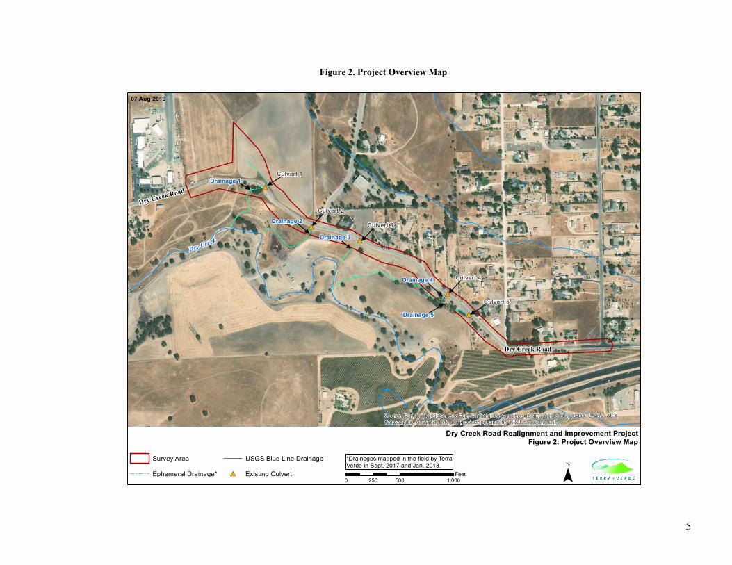
10. PROJECT DESCRIPTION: The Dry Creek Road Re-alignment DPW 17-21B (project) is a public improvement project that includes providing standard width traffic lanes and re-aligning approximately 3,370 linear feet of Dry Creek Road in addition to an asphalt overlay of approximately 1,150 linear feet. The project activities will occur on a portion of Dry Creek Road located between 2nd Wind Way and Jardine Road. The widening and realigned section of road will range between 22 feet and 28 feet wide, with a 40-foot wide section at the intersection of Aerotech Center Way to accommodate a left-hand turn lane from Dry Creek Road onto Aerotech Center Way. The majority of the public improvements to the roadway will occur within the existing right-of-way; however, portions of the realignment will require a new right-of-way to be established. The widening is required due to compromised steep and eroding slopes on the southern edge of Dry Creek Road and a blind turn that is considered hazardous. The repaved section of road will remain approximately 22 feet wide throughout. A total of five culverts occur within the project alignment and are expected to be replaced or modified as part of the project activities (Culvert 1 – Culvert 5) (see Figure 2: Project Overview).
The existing culverts consists of 18-inch corrugated metal pipes (CMP) that allow ephemeral flows and stormwater to pass from the north side of Dry Creek Road to the south side where they eventually connect with Dry Creek. As proposed, Culverts 1-2, and Culvert 4 will be replaced in-kind (18-inch CMP). Culvert 3 will be shortened by approximately 5 feet and Culvert 5 will be replaced with two 17-inch by 13-inch arch culverts.
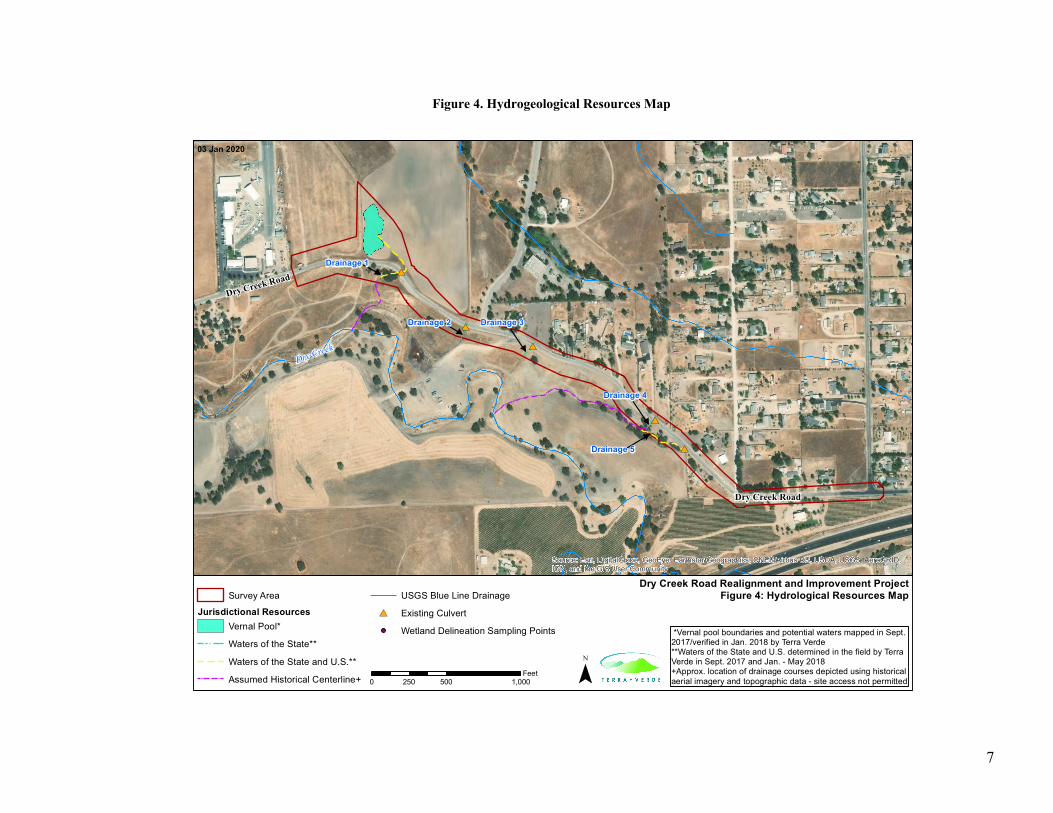
One vernal pool located in an agricultural field north of Dry Creek Road will be partially filled to accommodate the proposed road width and re-alignment. The road realignment in this area will eliminate the blind turn hazard and improve overall site distance for safety (see Figure 1: Project Vicinity Map).
Lastly, two-foot-wide infiltration swales constructed of Class 2 permeable base will also be installed on either side of the roadway from Warbirds Museum to Aerotech Center Way. The infiltration swales will be located behind the edge of the flush curb and will be shallow in flow depth and constructed to capture and filter storm water runoff before entering the newly installed stormwater culvert systems. Once construction is completed, overall public safety will be improved.

3
The following project figures are provided below:
• Figure 1: Project Vicinity Map
• Figure 2 Project Overview Map
• Figure 3: Agency Jurisdiction Map
• Figure 4: Hydrogeological Resources Map
• Figure 5: Soils Map
Based on engineer’s estimates, the project will result in the following:
Grading estimates:
• Total Cut: 4,300 cubic yards
• Total Fill: 400 cubic yards
• Total Export: 3,900 cubic yards
Area of Disturbance:
• Ground disturbance/excavation: 140,500 square feet
• Pavement overlay: 22,900 square feet
4
Figure 1. Project Vicinity Map
¯
Dry Creek Road Realignment and Improvement ProjectFigure 1: Project Vicinity Map
07 Aug 2019
¬«46
£¤101
Salin
as R
iver
Source: Esri, DigitalGlobe, GeoEye, Earthstar Geographics, CNES/Airbus DS,USDA, USGS, AEX, Getmapping, Aerogrid, IGN, IGP, swisstopo, and the GISUser Community
_̂
San Luis Obispo County
Monterey County
P a c i f i cO c e a n
Sources: Esri, HERE, DeLorme,Intermap, increment P Corp.,GEBCO, USGS, FAO, NPS,NRCAN, GeoBase, IGN,Kadaster NL, Ordnance Survey,Esri Japan, METI, Esri China(Hong Kong), swisstopo,
_̂ Project Location
Survey Area
City Limits
County Line0 21
Miles
Paso RoblesMunicipal Airport
07 Aug 2019
Air
port
Roa
d
Dry Creek Road
City ofPaso Robles
5
Figure 2. Project Overview Map
#*
#*
#*
#*
#*
Dry Creek
Dry Creek Road
Dry Creek Road
Drainage 1
Drainage 3
Drainage 4
Drainage 5
Drainage 2
Culvert 1
Culvert 2
Culvert 3
Culvert 4
Culvert 5
Source: Esri, DigitalGlobe, GeoEye, Earthstar Geographics, CNES/Airbus DS, USDA, USGS, AEX,Getmapping, Aerogrid, IGN, IGP, swisstopo, and the GIS User Community
Survey Area
Ephemeral Drainage*
USGS Blue Line Drainage
#* Existing Culvert ¯
Dry Creek Road Realignment and Improvement ProjectFigure 2: Project Overview Map
07 Aug 2019
0 500 1,000250Feet
*Drainages mapped in the field by TerraVerde in Sept. 2017 and Jan. 2018.

6
Figure 3. Agency Jurisdiction Map
Dry Creek
Dry Creek Road
Dry Creek Road
¬«46
City of Paso Robles
County of San Luis Obispo
Source: Esri, DigitalGlobe, GeoEye, Earthstar Geographics, CNES/Airbus DS, USDA, USGS, AEX,Getmapping, Aerogrid, IGN, IGP, swisstopo, and the GIS User Community
Survey Area
City Limits
USGS Blue Line Drainage
¯
Dry Creek Road Realignment and Improvement ProjectFigure 3: Agency Jurisdiction Map
07 Aug 2019
0 500 1,000250Feet
7
Figure 4. Hydrogeological Resources Map
#*
#*
#*
#*
#*
Dry Creek
Dry Creek Road
Dry Creek Road
Drainage 1
Drainage 5
Drainage 2 Drainage 3
Drainage 4
Source: Esri, DigitalGlobe, GeoEye, Earthstar Geographics, CNES/Airbus DS, USDA, USGS, AeroGRID,IGN, and the GIS User Community
Survey Area
Jurisdictional ResourcesVernal Pool*
Waters of the State**
Waters of the State and U.S.**
Assumed Historical Centerline+
USGS Blue Line Drainage
#* Existing Culvert
Wetland Delineation Sampling Points
¯
Dry Creek Road Realignment and Improvement ProjectFigure 4: Hydrological Resources Map
03 Jan 2020
0 500 1,000250Feet
*Vernal pool boundaries and potential waters mapped in Sept.2017/verified in Jan. 2018 by Terra Verde**Waters of the State and U.S. determined in the field by Terra Verde in Sept. 2017 and Jan. - May 2018+Approx. location of drainage courses depicted using historicalaerial imagery and topographic data - site access not permitted

8
Figure 5. Soils Map
Dry Creek Road
Dry Creek Road
Source: Esri, DigitalGlobe, GeoEye, Earthstar Geographics, CNES/Airbus DS, USDA, USGS, AEX,Getmapping, Aerogrid, IGN, IGP, swisstopo, and the GIS User Community
Survey Area
Soil UnitsArbuckle-Positas Complex, 50-75% Slopes
Arbuckle-Positas Complex, 9-15% Slopes
Arbuckle-San Ysidro Complex, 2-9% Slopes
Mocho Clay Loam, 2-9% Slopes
San Ysidro Sandy Loam, 2-9% Slopes
Xerofluvents-Riverwash Association ¯
Dry Creek Road Realignment and Improvement ProjectFigure 5: Soils Map
07 Aug 2019
0 500250Feet
9
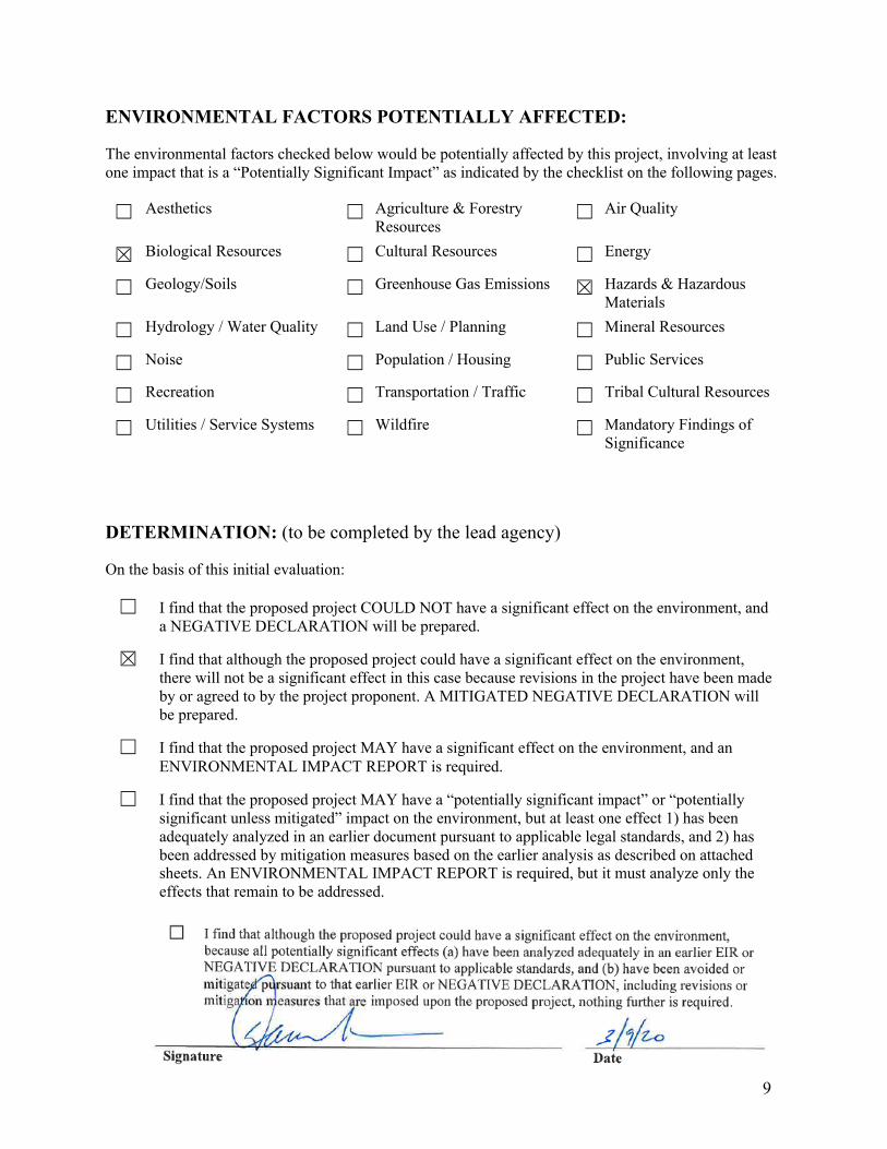
ENVIRONMENTAL FACTORS POTENTIALLY AFFECTED:
The environmental factors checked below would be potentially affected by this project, involving at least one impact that is a “Potentially Significant Impact” as indicated by the checklist on the following pages.
Aesthetics Agriculture & Forestry Resources
Air Quality
Biological Resources Cultural Resources Energy
Geology/Soils Greenhouse Gas Emissions Hazards & Hazardous Materials
Hydrology / Water Quality Land Use / Planning Mineral Resources
Noise Population / Housing Public Services
Recreation Transportation / Traffic Tribal Cultural Resources
Utilities / Service Systems Wildfire Mandatory Findings of Significance
DETERMINATION: (to be completed by the lead agency)
On the basis of this initial evaluation:
I find that the proposed project COULD NOT have a significant effect on the environment, and a NEGATIVE DECLARATION will be prepared.
I find that although the proposed project could have a significant effect on the environment, there will not be a significant effect in this case because revisions in the project have been made by or agreed to by the project proponent. A MITIGATED NEGATIVE DECLARATION will be prepared.
I find that the proposed project MAY have a significant effect on the environment, and an ENVIRONMENTAL IMPACT REPORT is required.
I find that the proposed project MAY have a “potentially significant impact” or “potentially significant unless mitigated” impact on the environment, but at least one effect 1) has been adequately analyzed in an earlier document pursuant to applicable legal standards, and 2) has been addressed by mitigation measures based on the earlier analysis as described on attached sheets. An ENVIRONMENTAL IMPACT REPORT is required, but it must analyze only the effects that remain to be addressed.

10
EVALUATION OF ENVIRONMENTAL IMPACTS:
1. A brief explanation is required for all answers except “No Impact” answers that are adequately supported by the information sources a lead agency cites in the parentheses following each question. A “No Impact” answer is adequately supported if the referenced information sources show that the impact simply does not apply to projects like the one involved (e.g., the project falls outside a fault rupture zone). A “No Impact” answer should be explained where it is based on project-specific factors as well as general standards (e.g., the project would not expose sensitive receptors to pollutants, based on a project-specific screening analysis).
2. All answers must take account of the whole action involved. Answers should address off-site as well as on-site, cumulative as well as project-level, indirect as well as direct, and construction as well as operational impacts.
3. “Once the lead agency has determined that a particular physical impact may occur, then the checklist answers must indicate whether the impact is potentially significant, less than significant with mitigation, or less than significant. “Potentially Significant Impact” is appropriate if there is substantial evidence that an effect may be significant. If there are one or more “Potentially Significant Impact” entries when the determination is made, an EIR is required.
4. “Negative Declaration: Less Than Significant With Mitigation Incorporated” applies where the incorporation of mitigation measures has reduced an effect from “Potentially Significant Impact” to a “Less Than Significant Impact.” The lead agency must describe the mitigation measures, and briefly explain how they reduce the effect to a less than significant level (mitigation measures from “Earlier Analyses,” as described in (5) below, may be cross-referenced).
5. Earlier analyses may be used where, pursuant to the tiering, program EIR, or other CEQA process, an effect has been adequately analyzed in an earlier EIR or negative declaration. Section 15063(c)(3)(D). In this case, a brief discussion should identify the following:
a. Earlier Analysis Used. Identify and state where they are available for review. b. Impacts Adequately Addressed. Identify which effects from the above checklist were within
the scope of and adequately analyzed in an earlier document pursuant to applicable legal standards, and state whether such effects were addressed by mitigation measures based on the earlier analysis.
c. Mitigation Measures. For effects that are “Less than Significant with Mitigation Measures Incorporated,” describe the mitigation measures which were incorporated or refined from the earlier document and the extent to which they address site-specific conditions for the project.
6. Lead agencies are encouraged to incorporate into the checklist references to information sources for potential impacts (e.g., general plans, zoning ordinances). Reference to a previously prepared or outside document should, where appropriate, include a reference to the page or pages where the statement is substantiated.
7. Supporting Information Sources: A source list should be attached, and other sources used, or individuals contacted should be cited in the discussion.
8. The explanation of each issue should identify:
a. the significance criteria or threshold, if any, used to evaluate each question; and
b. the mitigation measure identified, if any, to reduce the impact to less than significance.
11
Potentially Significant
Impact
Less Than Significant with
Mitigation Incorporated
Less Than Significant
Impact
No Impact
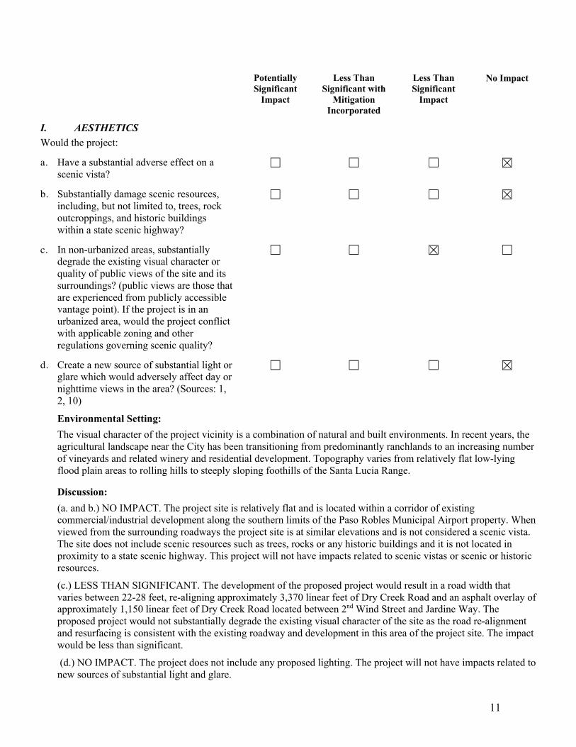
I. AESTHETICS Would the project:
a. Have a substantial adverse effect on a scenic vista?
b. Substantially damage scenic resources, including, but not limited to, trees, rock outcroppings, and historic buildings within a state scenic highway?
c. In non-urbanized areas, substantially degrade the existing visual character or quality of public views of the site and its surroundings? (public views are those that are experienced from publicly accessible vantage point). If the project is in an urbanized area, would the project conflict with applicable zoning and other regulations governing scenic quality?
d. Create a new source of substantial light or glare which would adversely affect day or nighttime views in the area? (Sources: 1, 2, 10)
Environmental Setting: The visual character of the project vicinity is a combination of natural and built environments. In recent years, the agricultural landscape near the City has been transitioning from predominantly ranchlands to an increasing number of vineyards and related winery and residential development. Topography varies from relatively flat low-lying flood plain areas to rolling hills to steeply sloping foothills of the Santa Lucia Range.
Discussion: (a. and b.) NO IMPACT. The project site is relatively flat and is located within a corridor of existing commercial/industrial development along the southern limits of the Paso Robles Municipal Airport property. When viewed from the surrounding roadways the project site is at similar elevations and is not considered a scenic vista. The site does not include scenic resources such as trees, rocks or any historic buildings and it is not located in proximity to a state scenic highway. This project will not have impacts related to scenic vistas or scenic or historic resources. (c.) LESS THAN SIGNIFICANT. The development of the proposed project would result in a road width that varies between 22-28 feet, re-aligning approximately 3,370 linear feet of Dry Creek Road and an asphalt overlay of approximately 1,150 linear feet of Dry Creek Road located between 2nd Wind Street and Jardine Way. The proposed project would not substantially degrade the existing visual character of the site as the road re-alignment and resurfacing is consistent with the existing roadway and development in this area of the project site. The impact would be less than significant. (d.) NO IMPACT. The project does not include any proposed lighting. The project will not have impacts related to new sources of substantial light and glare.

12
Potentially Significant
Impact
Less Than Significant with
Mitigation Incorporated
Less Than Significant
Impact
No Impact
Mitigation Measures: None applicable.
Findings: Based on the impact discussion above, potential impacts associated with visual or aesthetic resources would be less than significant; therefore, no mitigation is required.
II. AGRICULTURE AND FORESTRY RESOURCES In determining whether impacts to agricultural resources are significant environmental effects, lead agencies may refer to the California Agricultural Land Evaluation and Site Assessment Model (1997) prepared by the California Department of Conservation as an optional model to use in assessing impacts on agriculture and farmland. In determining whether impacts to forest resources, including timberland, are significant environmental effects, lead agencies may refer to information compiled by the California Department of Forestry and Fire Protection regarding the State’s inventory of forest land, including the forest and Range Assessment Project and the forest Legacy Assessment project; and forest carbon measurement methodology provided in Forest Protocols adopted by the California Air Resources Board. Would the project:
a. Convert Prime Farmland, Unique Farmland, or Farmland of Statewide Importance (Farmland), as shown on the maps prepared pursuant to the Farmland Mapping and Monitoring Program of the California Resources Agency, to non-agricultural use?
b. Conflict with existing zoning for agricultural use, or a Williamson Act contract?
c. Conflict with existing zoning for, or cause rezoning of, forest land (as defined in Public Resources Code section 12220(g)), timberland (as defined by Public Resources Code section 4526), or timberland zoned Timberland Production (as defined by Government Code section 51104(g))?
d. Result in the loss of forest land or conversion of forest land to non-forest use?
e. Involve other changes in the existing environment which, due to their location or nature, could result in conversion of Farmland, to non-agricultural use or

13
Potentially Significant
Impact
Less Than Significant with
Mitigation Incorporated
Less Than Significant
Impact
No Impact
conversion of forest land to non-forest use?
Environmental Setting/Discussion: (a. though e.) NO IMPACT. In addition to goals, programs, and implementation programs outlined in the Paso Robles County General Plan, the project was evaluated using the California Farmland Mapping and Monitoring program. The project site is zoned Airport (AP) with a Planned Development (PD) Overlay. Although portions of the airport property have been used in the past for dry crop production, it is not designated as Prime Farmland, Unique Farmland, or Farmland of Statewide Importance. The project site is not zoned for agriculture and is not under a Williamson Act contract. Additionally, the land does not contain and has never been designated forest land or timber land.
There is one parcel that is zoned agriculture located south of the project site, adjacent to Dry Creek Road; however, there are no project activities that would conflict with agricultural zoning nor would result in the conversion of farm land to non-agricultural use. There will be no impacts to agriculture and forestry resources.
Mitigation Measures: None applicable.
Findings: Based on the impact discussion above, potential impacts associated with agricultural resources would be less than significant; therefore, no mitigation is required.
III. AIR QUALITY Where available, the significance criteria established by the applicable air quality management or air pollution control district may be relied upon to make the following determinations. Would the project:
a. Conflict with or obstruct implementation of the applicable air quality plan? (Source: 11)
b. Result in a cumulatively considerable net increase of any criteria pollutant for which the project region is non-attainment under an applicable federal or state ambient air quality standard?
c. Expose sensitive receptors to substantial pollutant concentrations? (Source: 11)
d. Result in other emissions (such as those leading to odors) adversely affecting a substantial number of people? (Source: 11)
This section describes the impacts of the proposed project on local and regional air quality. It describes existing air quality in the City; project related direct and indirect emissions; health effects; and the impacts of these emissions
14
Potentially Significant
Impact
Less Than Significant with
Mitigation Incorporated
Less Than Significant
Impact
No Impact
on both the project area and cumulative/regional scale. The following sources were utilized in the completion of this section:
• Clean Air Plan (SLOAPCD, 2001)
• CEQA Air Quality Handbook (SLOAPCD, 2012)
• CEQA Clarification Memo related to the CEQA Air Quality Handbook (SLOAPCD, 2017)
• Annual Air Quality Report (SLOAPCD, 2017)
• CalEEMod (Version 2016.3.2) software
Environmental Setting: The project site is located in the South Central Coast Air Basin (SCCAB), which includes San Luis Obispo, Santa Barbara, and Ventura Counties, and is under the jurisdiction of the San Luis Obispo County Air Pollution Control District (SLOAPCD). The basin lies along the Pacific Ocean in central California and covers an area of roughly 9,600 square miles. While the SCCAB encompasses a relatively small area, the population of the entire air basin is over 1,500,000 (1,576,706 in 2015). From a geographical and meteorological standpoint, the County is divided into three general regions: the Coastal Plateau, the Upper Salinas River Valley, and the East County Plain. Air quality in each of these regions is characteristically different, although the physical features that divide them provide only limited barriers to transport pollutants between regions.
Local Climate and Sources of Air Pollution
The City is located in the upper Salinas River Valley region of the County. The Upper Salinas River Valley, located in the northern one-third of the County, houses 25% of the County's population. The Paso Robles area is bordered on the south and west by the rugged mountainous ridges of the Santa Lucia Coastal Range, to the east by the low hills of the La Panza and Temblor ranges, and to the north by the low hills and flat-topped mesas of the Diablo Range. The highest elevations in the vicinity are located in the Santa Lucia Coastal Range, where many peaks are 2,000 to 3,400 feet above mean sea level. Substantial ridgelines are distributed throughout the western, southern, and eastern portions of the City. The effects of the Pacific Ocean are diminished inland and by these major intervening terrain features. As a result, inland areas are characterized by a considerably wider range of temperature conditions. Maximum summer temperatures average about 70 degrees Fahrenheit near the coast, while inland valleys are often in the high 90s. Minimum winter temperatures average from the low 30s along the coast to the low 20s inland.
Airflow around the County plays an important role in the movement and dispersion of pollutants. The speed and direction of local winds are controlled by global patterns, particularly the location and strength of the Pacific High pressure system, by topographical factors, and by circulation patterns resulting from temperature differences between the land and sea. In spring and summer months, when the Pacific High attains its greatest strength, onshore winds from the northwest generally prevail during the day. At night, as the sea breeze dies, and winds flow down the coastal mountains and valleys to form a light, easterly land breeze. In the fall, onshore surface winds decline and the marine layer grows shallow, allowing an occasional reversal to a weak offshore flow. This, along with the diurnal alternation of land-sea breeze circulation, can sometimes produce a "sloshing" effect. Under these conditions, pollutants may accumulate over the ocean for a period of one or more days and are subsequently carried back onshore with the return of the sea breeze. Strong inversions can form at this time, "trapping" pollutants near the surface. This effect is intensified when the Pacific High weakens or moves inland to the east often producing a "Santa Ana" condition in which air, often pollutant-laden, is transported into the County from the east and
15
Potentially Significant
Impact
Less Than Significant with
Mitigation Incorporated
Less Than Significant
Impact
No Impact
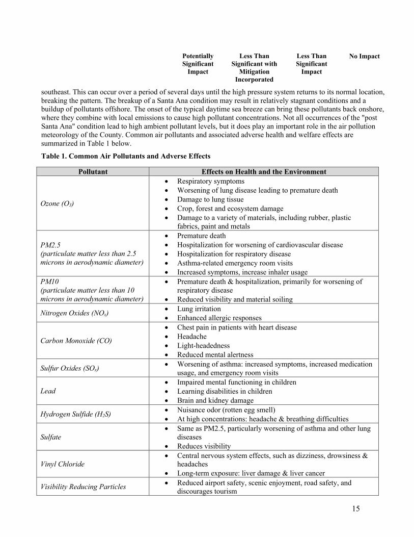
southeast. This can occur over a period of several days until the high pressure system returns to its normal location, breaking the pattern. The breakup of a Santa Ana condition may result in relatively stagnant conditions and a buildup of pollutants offshore. The onset of the typical daytime sea breeze can bring these pollutants back onshore, where they combine with local emissions to cause high pollutant concentrations. Not all occurrences of the "post Santa Ana" condition lead to high ambient pollutant levels, but it does play an important role in the air pollution meteorology of the County. Common air pollutants and associated adverse health and welfare effects are summarized in Table 1 below.
Table 1. Common Air Pollutants and Adverse Effects
Pollutant Effects on Health and the Environment
Ozone (O3)
• Respiratory symptoms • Worsening of lung disease leading to premature death • Damage to lung tissue • Crop, forest and ecosystem damage • Damage to a variety of materials, including rubber, plastic
fabrics, paint and metals
PM2.5
(particulate matter less than 2.5
microns in aerodynamic diameter)
• Premature death • Hospitalization for worsening of cardiovascular disease • Hospitalization for respiratory disease • Asthma-related emergency room visits • Increased symptoms, increase inhaler usage
PM10
(particulate matter less than 10
microns in aerodynamic diameter)
• Premature death & hospitalization, primarily for worsening of respiratory disease
• Reduced visibility and material soiling
Nitrogen Oxides (NOx) • Lung irritation • Enhanced allergic responses
Carbon Monoxide (CO)
• Chest pain in patients with heart disease • Headache • Light-headedness • Reduced mental alertness
Sulfur Oxides (SOx) • Worsening of asthma: increased symptoms, increased medication
usage, and emergency room visits
Lead
• Impaired mental functioning in children • Learning disabilities in children • Brain and kidney damage
Hydrogen Sulfide (H2S) • Nuisance odor (rotten egg smell) • At high concentrations: headache & breathing difficulties
Sulfate
• Same as PM2.5, particularly worsening of asthma and other lung diseases
• Reduces visibility
Vinyl Chloride
• Central nervous system effects, such as dizziness, drowsiness & headaches
• Long-term exposure: liver damage & liver cancer
Visibility Reducing Particles • Reduced airport safety, scenic enjoyment, road safety, and
discourages tourism

16
Potentially Significant
Impact
Less Than Significant with
Mitigation Incorporated
Less Than Significant
Impact
No Impact
Toxic Air Contaminants
About 200 chemicals have been
listed as toxic air contaminants
• Cancer • Reproductive and developmental effects • Neurological effects
Source: CA Air Resources Board website (July 2019)
Within the SCCAB, the air pollutants of primary concern, with regard to human health, include ozone, particulate matter (PM) and carbon monoxide (CO). Historically, the upper Salinas River Valley region has experienced the highest ozone and particulate levels in the County. On the local level, ozone 'transport' from one area to another is common. This is why ozone levels in a rural location of the County can be higher than levels in a more congested urban area. In this County, transport of ozone precursors from the coastal plateau and from the San Joaquin Valley may contribute to the Upper Salinas River Valley region having the highest ozone and particulate levels in the county. On a different scale, ozone and ozone precursors can also be transported over long distances, with travel times up to several days, and can cause impacts in areas far from the point of origin. Ozone transport over distances of several hundred miles has often been documented in California. Higher ozone levels have occasionally been traced to emissions which originated in other air basins, such as the San Francisco Bay Area or the San Joaquin Valley. In fact, the California Air Resource Board (CARB) has acknowledged that pollutant transport may be an important factor in the declining ozone air quality experienced in the north County in recent years; however, documentation for such transport is often incomplete.
SLOACPD provides thresholds for construction emissions of ROG and NOX (precursors to ozone), diesel particulate matter (the combined values of exhaust PM2.5 and exhaust PM10), and greenhouse gases (GHG) such as carbon dioxide (CO2). These thresholds are discussed in more detail in the next section.
Regulatory Framework
Air quality within the SCCAB is regulated by several jurisdictions including the U.S. Environmental Protection Agency (EPA), CARB, and SLOAPCD. Each of these jurisdictions develops rules, regulations, and policies to attain the goals or directives imposed upon them through legislation. For the protection of public health and welfare, the Clean Air Act (CAA) required that the U.S. EPA establish National Ambient Air Quality Standards (NAAQS) for various pollutants. These pollutants are referred to as "criteria" pollutants because the U.S. EPA publishes criteria documents to justify the choice of standards. Two types of NAAQS have been established: primary standards, which protect public health, and secondary standards, which protect public welfare from non-health-related adverse effects, such as visibility restrictions. These standards define the maximum amount of an air pollutant that can be present in ambient air without harm to the public’s health. An ambient air quality standard is generally specified as a concentration averaged over a specific time period, such as one hour, eight hours, 24 hours, or one year. The different averaging times and concentrations are meant to protect against different exposure effects. The CAA allows states to adopt additional or more health-protective standards. The NAAQS are summarized in Table 3. At the state level, the CARB is the agency responsible for coordination and oversight of state and local air pollution control programs in California and for implementing the California CAA of 1988. The CARB monitors the air quality in conjunction with air monitoring networks maintained by air pollution control districts and air quality management districts, establishing California Ambient Air Quality Standards (CAAQS), which in many cases are more stringent than the NAAQS. Additionally, CARB sets emissions standards for new motor vehicles, which differ depending on various factors, including the model year, and the type of vehicle, fuel, and engine used. Furthermore, the California CAA requires that all air districts in the state attempt to achieve and maintain CAAQS for ozone, carbon monoxide, sulfur dioxide, and nitrogen dioxide by the earliest practical date. The California CAA specifies that districts focus particular attention on reducing the emissions from transportation and area-wide emission sources, and the act provides districts with authority to regulate indirect sources. Each district plan is

17
Potentially Significant
Impact
Less Than Significant with
Mitigation Incorporated
Less Than Significant
Impact
No Impact
required to either (1) achieve a five percent annual reduction, averaged over consecutive 3-year periods, in district-wide emissions of each non-attainment pollutant or its precursors, or (2) to provide for implementation of all feasible measures to reduce emissions. Any planning effort for air quality attainment would thus need to consider both state and federal planning requirements. The NAAQS and CAAQS are summarized in Table 2 below.
Table 2. Summary of Ambient Air Quality Standards and County Attainment Classification
Pollutant Averaging Time
California Standard Federal
Concentration County Attainment Status Concentration National
Attainment Status
Ozone (O3) 8 Hour 70 ppb Non-attainment 70 ppb Non-attainment 1 Hour 90 ppb N/A N/A
Respirable
Particulate
Matter
(PM10)
24 Hours 50 µg/m3 Non-attainment 150 µg/m3 Attainment
1 Year 20 µg/m3 Non-attainment N/A N/A
Fine
Particulate
Matter
(PM2.5)
24 Hour N/A N/A 35 µg/m3 Attainment
1 Year 12 µg/m3 Attainment 12 µg/m3 Attainment
Carbon
Monoxide
(CO)
8 Hour 9.0 ppm Attainment 9 ppm Attainment
1 Hour 20 ppm Attainment 35 ppm Attainment
Nitrogen
Dioxide
(NO2)
1 Year 30 ppb Attainment 53 ppb Attainment
1 Hour 180 ppb Attainment 100 ppb Attainment
Sulfur
Dioxide
(SO2)
3 Hours N/A N/A 500 ppb (secondary) Attainment
1 Hour 250 ppb Attainment 75 ppb (primary) Attainment
Lead (Pb) 3 Month N/A N/A 0.15 µg/m3 Attainment 30 Day 1.5 µg/m3 Attainment N/A N/A
Sources: Annual Air Quality Report (SLOAPCD, 2017)
At the local level, the SLOAPCD is the agency primarily responsible for ensuring that NAAQS and CAAQS are not exceeded, and that air quality conditions within the region are maintained. Responsibilities of the SLOAPCD include, but are not limited to, preparing plans for the attainment of ambient air quality standards, adopting and enforcing rules and regulations concerning sources of air pollution, issuing permits for stationary sources of air pollution, inspecting stationary sources of air pollution and responding to citizen complaints, monitoring ambient air quality and meteorological conditions, and implementing programs and regulations required by the Federal CAA and the California CAA. In order to evaluate ozone and other air pollutant emissions, the SLOAPCD has established significance thresholds for emissions generated during construction activities. The threshold criteria established by the SLOAPCD determine the significance and appropriate mitigation level for a project’s short term construction emissions. Specifically, Table 4 shows the SLOAPCD thresholds for ozone precursors (ROG and NOX), diesel particulate matter (DPM), and fugitive dust (fugitive PM10). The thresholds are based on the California Health and Safety Code, and the CARB Carl Moyer Guidelines.

18
Potentially Significant
Impact
Less Than Significant with
Mitigation Incorporated
Less Than Significant
Impact
No Impact
Table 3. Thresholds of Significance for Construction Operations
Pollutant Threshold
Daily Quarterly Tier 1 Quarterly Tier 2 ROG and NOX
(combined) 137 lbs. 2.5 tons 6.3 tons
Diesel Particulate
Matter (DPM) 7 lbs. 0.13 tons 0.32 tons
Fugitive Particulate
Matter (PM10), Dust 2.5 tons
Greenhouse Gases (CO2, CH4, N20, HFC, CFC, F6S)
Amortized and Combined with Operational Emissions
Source: CEQA Air Quality Handbook (SLOAPCD, 2012) Mitigation of construction activities is required when the emission thresholds are equaled or exceeded by fugitive and/or combustion emissions, which are described below:
ROG and NOX Emissions
• Daily: For construction projects expected to be completed in less than one quarter (90 days), exceedance of the 137 lb./day threshold requires Standard Mitigation Measures;
• Quarterly – Tier 1: For construction projects lasting more than one quarter, exceedance of the 2.5 ton/quarter threshold requires standard mitigation measures and best available control technology (BACT) for construction equipment. If implementation of the standard mitigation and BACT measures cannot bring the project below the threshold, off-site mitigation may be necessary; and,
• Quarterly – Tier 2: For construction projects lasting more than one quarter, exceedance of the 6.3 ton/quarter threshold requires standard mitigation measures, BACT, implementation of a construction activity management plan (CAMP), and off-site mitigation.
Diesel Particulate Matter (DPM) Emissions
• Daily: For construction projects expected to be completed in less than one quarter, exceedance of the 7 lb/day threshold requires Standard Mitigation Measures;
• Quarterly - Tier 1: For construction projects lasting more than one quarter, exceedance of the 0.13 tons/quarter threshold requires standard mitigation measures, BACT for construction equipment; and,
• Quarterly - Tier 2: For construction projects lasting more than one quarter, exceedance of the 0.32 ton/quarter threshold requires standard mitigation measures, BACT, implementation of a CAMP, and off-site mitigation.
19
Potentially Significant
Impact
Less Than Significant with
Mitigation Incorporated
Less Than Significant
Impact
No Impact
Fugitive PM10/Dust Emissions
• Quarterly: Exceedance of the 2.5 ton/quarter threshold requires fugitive PM10 mitigation measures and may require the implementation of a CAMP.
Discussion: (a.) LESS THAN SIGNIFICANT. According to the SLOAPCD's CEQA Air Quality Handbook (2012), a consistency analysis with the Clean Air Plan (CAP) is required for a program-level environmental review and may be necessary for a larger project-level environmental review, depending on the project being considered. Project-Level environmental reviews which may require a consistency analysis with the CAP include: large residential developments and large commercial/industrial developments. For such projects, evaluation of consistency is based on a comparison of the proposed project with the land use and transportation control measures and strategies outlined in the CAP. If the project is consistent with these measures, the project is considered consistent with the CAP. Additionally, projects that exceed SLOAPCD's recommended significance thresholds would also be considered to potentially conflict with regional air quality planning efforts, including the control measures and strategies identified in the CAP. The proposed project is not considered a large development project that would have the potential to result in a substantial increase in population, or employment. In addition, the proposed project is also consistent with existing zoning and land use designations and would not result in the installation of any major stationary sources of emissions. Lastly, the project will not exceed SLOAPCD's recommended significance thresholds for construction (see discussion III.b below) and would not generate substantial operational emissions; therefore, the project would not conflict with or obstruct continued implementation of the CAP.
(b.) LESS THAN SIGNIFICANT. Construction-generated emissions are of temporary duration, lasting only as long as construction activities occur, but have the potential to represent a significant air quality impact. The construction of the proposed project would result in the temporary generation of emissions associated with site grading and motor vehicle exhaust associated with construction equipment and worker trips, as well as the movement of construction equipment on unpaved surfaces. According to the SLOAPCD CEQA Air Quality Handbook (2012), construction of a project could result in adverse air quality effects if temporary, short-term construction-related or operational emissions of criteria air pollutants or precursors would exceed the thresholds of significance established by the SLOAPCD (see Table 3 above). In the case of the project, no significant long-term operational emissions would occur, and this analysis relates only to construction activities which would result in air emissions that would be “short term” or temporary in duration.
Such emissions (especially fugitive dust emissions, ROG, or NOX) have the potential to represent an impact with respect to air quality. Fugitive dust emissions are primarily associated with site preparation during construction and vary as a function of such parameters as soil silt content, soil moisture, wind speed, acreage of disturbance area, and miles traveled by construction vehicles on- and off-site. ROG and NOX are ozone precursor emissions and are primarily associated with mobile equipment exhaust. Construction of the project would result in the temporary generation of ROG, NOX, PM10, and PM2.5 emissions. Off-site vehicle trips related to construction would be associated with hauling of excavated material, material and equipment delivery to the site, and worker commute trips. Table 4 presents the predicted construction emissions for the project which were estimated by utilizing CalEEMod (Version 2016.3.2) software (see Attachment 2 – CalEEMod Data Results).

20
Potentially Significant
Impact
Less Than Significant with
Mitigation Incorporated
Less Than Significant
Impact
No Impact
Table 4. Project Construction Emissions
Pollutant
Estimated Maximum
Daily Construction
Emission¹ (lbs/day)
Estimated Quarterly
Construction Emission
(tons/quarter)
APCD Daily
Thresholds (lbs/day)
APCD Threshold Quarterly
Tier 1 (tons/quarter)
APCD Threshold Quarterly
Tier 2 (tons/quarter)
ROG + NOX 79.41 1.27 137 2.5 6.3 DPM* 6.70 0.04 7 0.13 0.32 Fugitive PM10
24.71 0.10 -- 2.5 --
*Cumulative total of exhaust PM 2.5 + PM10 ¹Showing Maximum Daily Emissions from construction years 2020 and 2021. Source: CEQA Air Quality Handbook, April 2012.
The project would not exceed SLOAPCD's construction-related significance thresholds and would not generate substantial operational emissions. The construction emissions would be temporary, and less than the SLOAPCD's significance thresholds. The project proposes minimal grading activities, resulting in the project's construction-generated emissions not exceeding SLOAPCD's construction-related significance thresholds. Post-construction, the project will not generate substantial operational emissions and will not exceed SLOAPCD's operational-related thresholds. Impacts are less than significant. Although the project will not exceed these thresholds, SLOAPCD recommends standard conditions be incorporated into the project to further reduce operational emissions associated with energy use and motor vehicles. These have been incorporated into the project design and will be included on applicable construction plans. (c.) LESS THAN SIGNIFICANT. Land uses such as schools, hospitals, and convalescent homes are considered to be relatively sensitive to poor air quality because infants, the elderly, and people with health afflictions, especially respiratory ailments, are more susceptible to respiratory infections and other air quality related health problems than the general public. Residential areas are also considered to be sensitive to air pollution because residents (including children and the elderly) tend to be at home for extended periods of time, resulting in sustained exposure to any pollutants present.
The majority of the project is located adjacent to the airport complex. Residential land uses (i.e., sensitive receptors) are located adjacent to portions of the project. The primary airborne emission, which would be dust generated from construction, would occur for a short timeframe and only during the weekday hours. Once construction is complete, airborne dust emissions would no longer occur. Significant air quality emissions are not associated with the operation of this project. Given that construction emissions will be temporary in nature, and that the nearby residences are located on large lots and are set back from the project site, impacts to sensitive receptors in the vicinity would be less than significant.
(d.) NO IMPACT. The project includes widening, re-alignment and paving a portion of Dry Creek Road. The generation of noticeable offensive odors is not associated with the proposed actions. There would be no impact.
Mitigation Measures: None applicable.

21
Potentially Significant
Impact
Less Than Significant with
Mitigation Incorporated
Less Than Significant
Impact
No Impact
Findings: Based on the impact discussion above, potential impacts associated with air quality would be less than significant; therefore, no mitigation is required.
IV. BIOLOGICAL RESOURCES Would the project:
a. Have a substantial adverse effect, either directly or through habitat modifications, on any species identified as a candidate, sensitive, or special status species in local or regional plans, policies, or regulations, or by the California Department of Fish and Wildlife or U.S. Fish and Wildlife Service?
b. Have a substantial adverse effect on any riparian habitat or other sensitive natural community identified in local or regional plans, policies, regulations or by the California Department of Fish and Wildlife or U.S. Fish and Wildlife Service?
c. Have a substantial adverse effect on state or federally protected wetlands (including, but not limited to, marsh, vernal pool, coastal, etc.) through direct removal, filling, hydrological interruption, or other means?
d. Interfere substantially with the movement of any native resident or migratory fish or wildlife species or with established native resident or migratory wildlife corridors, or impede the use of native wildlife nursery sites?
e. Conflict with any local policies or ordinances protecting biological resources, such as a tree preservation policy or ordinance?
f. Conflict with the provisions of an adopted Habitat Conservation Plan, Natural Community Conservation Plan, or other approved local, regional, or state habitat conservation plan?

22
The following section is based on the Biological Resources Assessment prepared by Terra Verde in April 2018 (Attachment 3 – Biological Resources Assessment) and the Waters and Wetlands Delineation Report prepared by Terra Verde in April 2019 (Attachment 4 – Waters and Wetlands Delineation Report). Terra Verde staff conducted a series of field surveys of the proposed project alignment and surrounding areas between September 2017 and May 2018. The survey area included the proposed development area, an approximate 200-foot buffer where access was feasible, and a scan of the surrounding areas. The surveys included an inventory of botanical and wildlife species observed, a jurisdictional analysis of aquatic resources identified on site, and an assessment of habitat, focusing on the potential for special-status species to occur.
Environmental Setting: Overall, the survey area displays very little variation in habitat. Six soil types and two natural vegetation communities were documented, in addition to ruderal and developed areas. Bare soils and sparse grasses dominate the portion of the project area that is not developed. Those areas with ruderal herbaceous cover have only sparse coverage and show obvious signs of land manipulation (e.g., tractor disc lines, presence of agricultural plants such as common barley [Hordeum vulgare], etc.). Although numerous plants and wildlife are able to persist in disturbed conditions, this site supports only minimal forage and cover habitat. Historic and current land management practices have likely greatly reduced the potential for sensitive biological resources to occur on site.
Vegetation Communities The survey area totaled approximately 18 acres along a mostly linear corridor, with an expanded survey area occurring in the open field bordering the northern edge of Dry Creek Road, at the western end of the project alignment. Approximately 4.5 acres of the survey area are developed with hardscape (e.g., asphalt road surface, imported gravel, etc.) and another 3.6 acres consists of residential developments and active vineyard. Approximately 8.3 acres consists of sparse, ruderal vegetation, which is subject to regular tilling and other anthropogenic disturbances, and the remaining 1.5 acres consists of remnant blue oak woodland, bordering the southern edge of Dry Creek Road. Terra Verde biologists documented and mapped one vernal pool (0.80 acre) and its associated watershed (5.0 acres) within the ruderal portion of the survey area located north of Dry Creek Road. A total of 55 vascular plant species were identified, of which 34 (62 percent) were non-native. The abundance and density of non-native taxa substantially exceeds that of native taxa, and many of the native species documented are disturbance tolerant (e.g., narrow-leaf milkweed [Asclepias fascicularis], vinegar weed [Trichostema lanceolatum], turkey-mullein [Croton setiger], telegraph weed [Heterotheca grandiflora], etc.), reflecting the high level of disturbance on site. Wildlife
Habitat for wildlife within and around the project area is generally homogeneous, highly disturbed, and subjected to frequent maintenance activities. Vegetative cover and areas available for burrowing are limited, and it is expected that wildlife entering the survey area would primarily be transient, using the area for foraging and temporary cover rather than regular occupancy.
All invertebrate and vertebrate species observed, including those detected by indirect sign (i.e., tracks, scat, skeletal remains, dens, burrows, or vocalizations), were documented during field surveys. Wildlife observed on site included several avian species, California ground squirrel (Otospermophilus beecheyi), black-tailed jackrabbit (Lepus californicus), and Coast Range fence lizard (Sceloporus occidentalis). In addition, a bald eagle (Haliaeetus leucocephalus) was observed in flight near the intersection of Airport Road and Dry Creek Road. Common wildlife such as black-tailed deer (Odocoileus hemionus columbianus), bobcat (Lynx rufus), Botta’s pocket gopher (Thomomys bottae), and additional bird species can be expected to occur throughout the year and/or seasonally.
Hydrologic Resources A total of five jurisdictional drainage features were identified within the survey area (see Table 5 - Summary of Jurisdictional Drainage Features below). In addition, one vernal pool was identified and mapped within the

23
Potentially Significant
Impact
Less Than Significant with
Mitigation Incorporated
Less Than Significant
Impact
No Impact
survey area (see Figure 4– Hydrologic Map). Two drainages were identified as jurisdictional waters of the U.S. and state due to the presence of a well-defined bed and bank, water ponding and flow at the time of surveys, and a significant nexus to navigable waters of the U.S. (i.e., the Pacific Ocean via the Salinas River). In addition, three ephemeral drainage features were identified as potential jurisdictional waters of the state, but lacked evidence for waters of the U.S. The vernal pool identified north of Dry Creek Road is in a relatively flat, open field, dominated by ruderal herbaceous vegetation. The limits of the vernal pool habitat were mapped where the composition of vegetation transitions from dominance of hydrophytic species (i.e., designated as facultative [FAC], facultative wetland [FACW], or obligate [OBL] by the Corps; Lichvar et al., 2016) to a dominance of non-hydrophytic species (Terra Verde, 2019). In addition, the watershed boundary for the vernal pool was mapped using a half-foot topographic contour lines plotted over aerial imagery and verified in the field. The vernal pool is hydrologically connected to Dry Creek via Drainage 1 (i.e., significant nexus); and therefore, hydrologically connected to the Salinas River and the traditionally navigable waters of the Pacific Ocean. The proposed road realignment would shift the existing right-of-way north into the open field and directly impact a portion of the mapped vernal pool.
Table 5. Summary of Jurisdictional Drainage Features
Drainage ID Feature Type Feature Designation* Agency Jurisdiction*
Drainage 1 Ephemeral drainage Waters of the state, Waters of the U.S.
CDFW, RWQCB, Corps
Drainage 2 Ephemeral swale Waters of the state,
CDFW, RWQCB
Drainage 3 Ephemeral swale Waters of the state CDFW, RWQCB Drainage 4 Ephemeral swale Waters of the state
CDFW, RWQCB
Drainage 5 Ephemeral drainage Waters of the state, Waters of the U.S.
CDFW, RWQCB, Corps
Vernal Pool Vernal Pool Federal wetland / vernal pool**
CDFW, RWQCB, Corps
*Jurisdictional determinations are based on the field assessments completed by Terra Verde and are subject to concurrence from the relevant agencies. ** Refer to Terra Verde, 2019 (Waters and Wetlands Delineation Report for the Dry Creek Road Realignment and Improvement Project).
Special-status Plant Species
Terra Verde completed a series of surveys during the typical blooming period for regionally occurring special-status species. Based on this evaluation and a review of relevant literature, it was determined that suitable habitat is present for 12 of the regionally occurring special-status plant species.
In addition to species listed on the federal and California Endangered Species Acts, special-status plant species include those that are assigned a California Rare Plant Rank (CRPR) by the California Native Plant Society. Species are assigned a listing status based on the degree of rarity (Lists 1A through 4) and threat level (0.1, 0.2, and 0.3) (CNPS, 2019c). Additionally, individual oak trees (Quercus spp.) and oak woodlands are considered a sensitive resource by the State of California and the City.

24
Table 6. Summary of Special-status Plant Species
Scientific Name Common Name
Listing Status Blooming Period Occurrence Potential
Astragalus macrodon
Salinas milk-vetch CRPR 4.3 April to June The nearest documented occurrence
is approximately 2.6 miles west of the project alignment. Although marginally suitable habitat for this species is present on site, it was not detected during appropriately-timed surveys.
Castilleja densiflora subsp. Obispoensis
San Luis Obispo owl’s-clover
CRPR 1B.2 March to June The nearest documented occurrence of this species is located approximately 1.5 miles west of the project alignment. Although suitable habitat for this species is present on site, it was not detected during appropriately-timed surveys.
Convolvulus simulans
small-flowered morning-glory CRPR 4.2 April to June The nearest documented occurrence
of this species is approximately 2.2 miles north of the project alignment. Although marginally suitable habitat for this species is present on site, it was not detected during appropriately-timed surveys.
Deinandra halliana
Hall’s tarplant CRPR 1B.1 April to May The nearest documented occurrence
of this species is located approximately 20 miles northeast of the project alignment. Although marginally suitable habitat for this species is present on site, it was not detected during appropriately-timed surveys.
Hesperevax caulescens
hogwallow starfish CRPR 4.2 March to June The nearest documented occurrence
of this species is located approximately 12 miles northwest of the project alignment. Although suitable habitat for this species is present on site, it was not detected during appropriately-timed surveys.
Juncus luciensis
Santa Lucia dwarf rush CRPR 1B.2 April through
August The nearest documented occurrence of this species is approximately 2.1 miles north of the project alignment. Suitable habitat is present within the vernal pool and ephemeral drainages; however, it was not detected during appropriately-timed surveys.
Layia heterotricha
Pale-yellow layia CRPR1B.1 April through June Three documented occurrences of
this species located approximately 17 miles east, northwest, and
25
southeast of the project alignment are the nearest known occurrences. Although marginally suitable habitat for this species is present on site, it was not detected during appropriately-timed surveys.
Lepidium jaredii
Jared’s peppergrass CRPR 1B.2 March to April The nearest documented occurrence
of this species is approximately 2.0 mile north of the project alignment. Although marginally suitable habitat for this species is present on site, it was not detected during appropriately-timed surveys.
Navarretia fossalis
spreading navarretia Federal Threatened, CRPR 1B.1
April to June The nearest documented occurrence of this species is approximately 10 miles south of the project alignment. Although marginally suitable habitat for this species is present on site, it was not detected during appropriately-timed surveys.
Navarretia nigelliformis subsp.
radians
shining navarretia
CRPR 1B.2 May to July The nearest documented occurrence of this species is approximately 2.0 miles southwest of the project alignment. Although suitable habitat for this species is present on site, it was not detected during appropriately-timed surveys.
Navarretia prostrata
prostrate vernal pool navarretia CRPR 1B.1 April to July The nearest documented occurrence
of this species is approximately 14 miles northwest of the project alignment. Although suitable habitat for this species is present on site, it was not detected during appropriately-timed surveys.
Quercus douglasii
blue oak Protection under City Ordinance No. 835
n/a Several mature blue trees are present in areas identified as remnant blue oak woodland.
Special-status Wildlife Species The following section includes a summary of regional wildlife species of concern and their potential for occurrence within the survey area (Table 7 – Summary of Special-status Wildlife Species). The potential for these species to occur in the vicinity of the survey area was determined by a query of the CNDDB, and review of reported occurrences from other environmental documents, and communication with species experts.

26
Potentially Significant
Impact
Less Than Significant with
Mitigation Incorporated
Less Than Significant
Impact
No Impact
Table 7. Summary of Special-status Wildlife Species
Scientific Name Common Name
Listing Status* Occurrence Potential
Mammal Species Taxidea taxus
American badger CSC Several occurrences have been documented within 7.0 miles
of the project alignment. Open fields within and surrounding the survey area are considered suitable habitat for American badger; however, no sign (e.g., characteristic side scratching at den entrances, horizontally-oriented elliptical den openings, frequent forage excavations) of this species was observed. California ground squirrel burrows, which provide suitable prey opportunity for American badger, were observed throughout the undeveloped portions of the survey area. As such, though the long history of surficial disturbance and degraded site conditions, there is marginally suitable habitat present on site for this species to occur.
Vulpes macrotis mutica
San Joaquin kit fox (SJKF) FE SE
The project site is located within the County-designated SJKF Mitigation Area. Habitat for this species has been substantially modified within the survey area as a result of historical and ongoing farming and vegetation management. However, areas identified as ruderal herbaceous provide marginally suitable habitat for SJKF and support a substantial prey base.
Amphibian Species Rana draytonii
California red-legged frog (CRLF) FT CSC
The nearest documented occurrences of this species are located approximately 5 miles west of the project alignment. No potential breeding habitat (i.e., deep pools with emergent vegetation and overhanging cover) was identified within the survey area. Further, nearby Dry Creek is an ephemeral drainage feature and does not provide suitable breeding and/or foraging habitat for CRLF. The quality of habitat at the site is substantially degraded as a result of current and historical land uses, as such, there is only marginally suitable upland habitat for this species.
Spea hammondii
Western spadefoot toad CSC The nearest documented occurrence is located approximately
0.8 mile southeast of the project alignment. Existing vernal pool habitat near the road realignment in the western portion of the survey area may provide suitable breeding habitat for western spadefoot toad, but it is unknown whether the pool maintains a sufficient hydroperiod to support tadpole development and completion of metamorphosis. The quality of habitat at the site is substantially degraded as a result of current and historical land uses, but suitable habitat remains for this species.

27
Reptile Species Masticophis flagellum ruddocki
San Joaquin coachwhip CSC The nearest documented occurrence is located approximately
6.3 miles west of the project alignment. Within the survey area, open, ruderal fields with small mammal burrows provide suitable habitat and forage opportunity for this species. Though the quality of habitat at the site is substantially degraded as a result of current and historical land uses, suitable habitat is present for this species.
Bird Species Athene cunicularia
Western burrowing owl CSC Burrowing owl has been documented approximately 8.75
miles northwest of the project alignment. Though the quality of habitat at the site is substantially degraded as a result of current and historical land uses, suitable habitat is present for this species.
Eremophila alpestris actia
California horned lark WL California horned lark has been documented at the Paso
Robles Airport. Though the quality of habitat at the site is substantially degraded as a result of current and historical land uses, suitable habitat is present for this species.
Invertebrate Species Branchinecta lynchi
Vernal pool fairy shrimp (VPFS) FT The nearest documented occurrences are located
approximately 1.2 miles north and northwest of the project alignment. Suitable vernal pool habitat was identified during field surveys in the open field north of Dry Creek Road. This area had pooled water during the January 10, 2018 survey. The proposed road realignment will directly impact a small portion of the mapped vernal pool.
*Key:
FE- Federal Endangered
FT- Federal Threatened
SE- State Endangered
ST- State Threatened
CSC- CA Species of Special Concern
FP- State Fully Protected
WL- State Watch List Migratory Nesting Birds
In addition to those species protected by the state or federal government, all native avian species are protected by state and federal legislature, most notably the Migratory Bird Treaty Act (MBTA) and the CDFW Fish and Game code. Collectively, these and other international regulations make it unlawful to collect, sell, pursue, hunt, or kill native migratory birds, their eggs, nests, or any parts thereof. The laws were adopted to eliminate the commercial market for migratory bird feathers and parts, especially those of larger raptors and other birds of prey. Avian species can be expected to occur within the survey area during all seasons and throughout construction of the proposed project. The potential to encounter and disrupt these species is highest during their nesting season (generally February 1 through September 15) when nests are likely to be active, and eggs and young are present. The remnant blue oak woodland and ornamental trees associated with residential areas along Dry Creek Road present the highest quality habitat for nesting at the site, but open fields may also provide nesting habitat for

28
Potentially Significant
Impact
Less Than Significant with
Mitigation Incorporated
Less Than Significant
Impact
No Impact
various species. Raptors are particularly drawn to large trees and structures, and they are generally less tolerant of disturbances than other species.
Critical Habitat The project area lies entirely within the Carrizo Vernal Pool Region, Paso Robles core area. The USFWS designated this area as critical habitat for VPFS in 2005. As described by the USFWS in 2005, the essential physical and biological features (formerly known as Primary Constituent Elements [PCE’s]) are characteristics of habitat required to support VPFS, and they include:
1. Topographic features characterized by mounds, swales, and depressions with a matrix of surrounding uplands that result in complexes of continuously, or intermittently, flowing surface water in the swales connecting the pools.
2. Depressional features including isolated vernal pools with underlying restrictive soil layers that become inundated during winter rains and that continuously hold water for a minimum of 18 days, in all but the driest years.
3. Sources of food, expected to be detritus occurring in the pools, contributed by overland flow from the pools’ watershed, or the results of biological processes within the pools themselves.
4. Structure within the pools consisting of organic and inorganic materials, such as living and dead plants from plant species adapted to seasonally inundated environments, rocks, and other organic debris that may be transported into the pools.
The essential physical and biological features of VPFS critical habitat were present within the ruderal open fields identified within the survey area.
Discussion: (a.) LESS THAN SIGNIFICANT WITH MITIGATION. The paragraphs below outline the project’s potential impacts to special-status plant and animal species. Implementation of mitigation measures would reduce impacts to special-status species to less than significant (Attachment 1 – Mitigation Monitoring and Reporting Plan).
Special-status Plant Species. No special-status plants were documented within the survey area during a series of surveys that were timed to coincide with the peak blooming and/or fruiting periods for specially targeted plants of the region. As such, no impacts to special-status plants are anticipated.
Oak Trees (Protected by City of Paso Robles and County of San Luis Obispo Ordinances). Several mature oak trees are within 100 feet of the proposed project alignment. No oak tree removals are expected during project implementation; however, trimming and/or disturbance within the critical root zone of several trees may be required. Impacts to individual oak trees and oak woodland habitat are regulated under California Public Resources Code 21083.4 and the City of El Paso de Robles Oak Tree Preservation Ordinance No. 835 (City, 2002). Implementation of oak tree protection measures will be required during construction (e.g., protective fencing) in accordance with Municipal Code Sections 10.01.090 (Safeguarding Trees During Construction) and 10.01.070 (Preservation and Maintenance of Existing Oak Trees). In addition, mitigation for impacted oak trees will require oak tree replacement planting coinciding with the level of impact. No further oak tree mitigation is proposed beyond the established City ordinance.
Special-status Mammals. If American badger or SJKF occur at the site, there is potential for direct impacts to occur during construction as a result of vehicle strikes or during excavation activities, if nearby dens are occupied. Indirect impacts may occur as a result of deterring these species from utilizing the site during construction.

29
Potentially Significant
Impact
Less Than Significant with
Mitigation Incorporated
Less Than Significant
Impact
No Impact
Special-status Amphibians and Reptiles. Construction activities pose risks for direct and indirect impacts to special-status amphibians and reptiles. For example, reptiles basking on roadways will be especially vulnerable to vehicle strikes. Reptiles can be slow-moving, both because of behavioral adaptations to be camouflaged from predators and because of their ectothermic nature. This trait presents crushing hazards in the presence of relatively fast-moving equipment or even foot traffic. All special-status amphibians and reptiles presumed to be on the project site rely heavily on burrows or emergent vegetation for shelter from the elements, protection from predators, and/or reproduction. Heavy equipment and ground disturbing activities may collapse burrow systems or completely remove them, resulting in injury or death of the inhabitants or exclusion by the removal of a vital resource. Vegetation may also be removed as a result of construction activities. Ectotherms rely on shrub cover for temperature regulation and, further, vegetation provides habitat for the prey species of reptiles and amphibians. If red-legged frogs or western spadefoots occur on or near the project site, they will be particularly vulnerable during the rainy season when they are most active. San Joaquin coachwhips are most vulnerable on hot days when they are basking in open areas. Special-status Invertebrates. The current project design impacts the delineated vernal pool habitat area and associated essential physical and biological elements of VPFS critical habitat. If VPFS are present, direct impacts to this species may occur and the road realignment would directly affect VPFS critical habitat elements. Additionally, indirect impacts may occur if construction activities result in the alteration or degradation of hydrologic patterns in proximity to the vernal pool. Furthermore, introduction of sediment via erosion and runoff from project areas into adjacent habitat could be deleterious to the vernal pool habitat area and VPFS, if present. Sensitive and Nesting Birds. Direct impacts to burrowing owls, and other bird species are most likely to occur if construction activities take place during the typical avian nesting season, generally February 1 through September 15. Indirect impacts may occur due to habitat loss (e.g., removal of suitable nesting habitat) or construction-related disturbances that may deter nesting or cause nests to fail. (b.) LESS THAN SIGNIFICANT WITH MITIGATION. A total of five drainage crossings are proposed – four culvert replacements and one culvert extension. All drainages were identified as waters of the state, and two were also identified as waters of the U.S. Permits will need to be obtained from CDFW, RWQCB, and the Corps for impacts to jurisdictional drainage features and appropriate mitigation, as required by each agency, will need to be implemented following completion of construction. Further, due to site constraints associated with the steep, eroding slope bordering the southern edge of Dry Creek Road and hazardous blind turn located immediately south of the vernal pool, the road is being rerouted north of its current alignment, which would result in direct impacts to the vernal pool. As such, consultation with USFWS per Section 7 of the ESA will also be required. Temporary impacts to jurisdictional associated waters and wetlands could result from erosion, sedimentation, and discharges of hazardous materials from construction equipment (e.g., fuel). Long-term impacts may result if disturbed areas within the drainages and vernal pool are not property stabilized and restored, which could result in downstream sedimentation and/or discharges after project completion. Implementation of mitigation measures would reduce impacts to sensitive natural communities and habitats to less than significant (see Attachment 1 – Mitigation Monitoring and Reporting Program).
(c.) LESS THAN SIGNIFICANT WITH MITIGATION. The vernal pool documented on site is hydrologically connected to Dry Creek, a USGS blue line drainage, via an ephemeral drainage feature that flows under Dry Creek Road. As such, it is assumed that this feature is a federal wetland under the jurisdiction of the Corps. This feature is expected to be impacted as a result of project implementation. Implementation of mitigation measures would reduce impacts to the vernal pool habitat to less than significant (see Attachment 1 – Mitigation Monitoring and Reporting Program). (d.) LESS THAN SIGNIFICANT WITH MITIGATION. SJKF is not expected to occur on site due to lack of habitat and connectivity to known populations; however, due to the project’s location within the County-

30
Potentially Significant
Impact
Less Than Significant with
Mitigation Incorporated
Less Than Significant
Impact
No Impact
designated mitigation area, implementation of mitigation measures pursuant to the County Guide to SJKF Mitigation Procedures under CEQA will be required. Construction and implementation of the proposed project would result in approximately 3.23 acres of temporary disturbance within the undeveloped portions of the project site. These temporary disturbance areas will include approximately 0.50 acre of excavation and/or soil disturbance within open fields along the road corridor, and up to 1 acre of equipment and materials staging within designated staging areas. For projects under 40 acres in size, a standard mitigation ratio has been developed to mitigate the loss of kit fox habitat in the County. The project site falls within a 3:1 mitigation area for kit fox. Mitigation must be fulfilled by contribution to the preservation of habitat through a conservation easement agreement, compensation to a pre-determined mitigation bank (presently Palo Prieto Conservation Bank), or payment of an in-lieu fee to the San Francisco office of The Nature Conservancy (see Attachment 1- Mitigation Monitoring and Reporting Program).
(e.) LESS THAN SIGNIFICANT. Several mature oak trees are located within 100 feet of the proposed project alignment. No oak tree removals are expected during project implementation; however, trimming and/or disturbance within the critical root zone of several trees may be required. Impacts to individual oak trees and oak woodland habitat are regulated under California Public Resources Code 21083.4 and the Paso Robles City Oak Tree Preservation Ordinance (No. 835; City of Paso Robles, 2002). Implementation of oak tree protection measures would be required during construction (e.g., protective fencing) in accordance with Municipal Code Sections 10.01.090 (Safeguarding Trees During Construction) and 10.01.070 (Preservation and Maintenance of Existing Oak Trees). No oak trees occur along the portion of the alignment within County jurisdiction; therefore, the County oak tree protection measures are not addressed here. Impacts would be less than significant and no further oak tree mitigation measures are required.
(f.) NO IMPACT. The project does not conflict with an adopted Habitat Conservation Plan, Natural Community Conservation Plan, or other approved local, regional, or state habitat conservation plan. There would be no impact.
Mitigation Measures: Measure BR-1: Environmental Awareness Training
An environmental awareness training shall be presented to all construction personnel by a qualified biologist prior to start of any project activities. The training shall include color photographs and a description of the ecology of all special-status species known or determined to have potential to occur, as well as other sensitive resources requiring avoidance near the project alignment. The training shall also include a description of protection measures required by any discretionary permits, an overview of the Federal and State Endangered Species Acts, and implications of noncompliance with these regulations, and required avoidance, minimization, and mitigation measures.
Measure BR-2: Site Maintenance and General Operations
The following general measures are recommended to minimize impacts during active construction:
• The use of heavy equipment and vehicles shall be limited to the proposed project limits and defined staging areas/access points. The boundaries of each work area shall be clearly defined and marked with high visibility fencing. No work shall occur outside these limits.
• In the vicinity of sensitive resources and habitats (e.g., vernal pool, drainages, etc.), signs shall be posted at the boundary of the work area indicating the presence of sensitive resources.

31
Potentially Significant
Impact
Less Than Significant with
Mitigation Incorporated
Less Than Significant
Impact
No Impact
• Project plans, drawings, and specifications shall show the boundaries of all sensitive resource areas and the location of erosion and sediment controls, delineation of construction limits, and other pertinent measures to ensure the protection of sensitive habitats and resources.
• Staging of equipment and materials shall occur in designated areas with appropriate demarcation and perimeter controls. No staging areas shall be located within 100 feet of sensitive habitat or jurisdictional aquatic resources, including drainages and vernal pool habitat (and their associated watershed).
• Secondary containment such as drip pans shall be used to prevent leaks and spills of potential contaminants.
• Washing of concrete, paint, or equipment, and refueling and maintenance of equipment shall occur only in designated staging areas, a minimum of 100 feet from sensitive habitat or jurisdictional aquatic resources, including drainages and vernal pool habitat (and associated watershed). Sandbags and/or absorbent pads and spill control kits shall be available on site at all times to prevent water and/or spilled fuel from leaving the site.
• Construction equipment shall be inspected by the operator daily to ensure that equipment is in good working order and no fuel or lubricant leaks are present.
Measure BR-3: Paso Robles City Oak Tree Preservation Ordinance Measures
In accordance with the Paso Robles City Oak Tree Preservation Ordinance, the City shall implement the necessary measures to protect oak trees adjacent to the project alignment. At a minimum the following avoidance and minimization measures shall be implemented to address protection and avoidance of oak trees on site per Paso Robles City Oak Tree Preservation Ordinance:
• Prior to ground-breaking, oak tree protection fencing shall be installed at the edge of the critical root zone of all trees located within 100 feet of construction that will be preserved. Critical root zone (CRZ) is defined as an area of root space that is within a circle circumscribed around the truck of a tree using a radius of one foot per inch diameter at breast height (DBH) (e.g., a twenty-inch diameter tree has a CRZ with a radius of twenty feet as measured from the center of the tree). The fencing shall be in place and maintained throughout the duration of construction. Plastic orange safety fencing shall not be used as it may entangle wildlife. Other demarcation such as t-posts and yellow rope are adequate.
• No equipment shall be allowed, and no materials stored within the CRZ. • No grading or placement of fill will occur without prior approval and then only to the extent authorized by
the City. • Damage to any oak tree during construction shall be immediately reported. • All root pruning is to be done by hand.
Measure BR-4: Pre-construction Survey for American Badger and SJKF
A qualified biologist shall conduct a pre-construction survey within 30 days prior to the start of initial project activities to ensure badger or SJKF are not present within proposed work areas. If potential dens are discovered, they shall be monitored with a remote camera or tracking medium for at least three days to determine if they are occupied. If the qualified biologist determines that the potential dens may be active, an exclusion buffer shall be established within 50 feet of the den and the appropriate resource agencies shall be contacted for further guidance. If active dens are found during the breeding and rearing season, no activity shall occur within 200 feet (American badger) or 500 feet (SJKF) of the den without agency guidance and approval. Pre-activity surveys will include a general assessment for all sensitive resources with potential to be impacted.

32
Potentially Significant
Impact
Less Than Significant with
Mitigation Incorporated
Less Than Significant
Impact
No Impact
Measure BR-5: County Standard Mitigation of Impacts to SJKF Habitat
In accordance with the County Guide to SJKF Mitigation Procedures under CEQA, the City shall adopt the Standard Kit Fox CEQA Mitigation Measures and shall include these measures on development plans. The following summarizes those that are applicable to this project:
• The applicant shall mitigate for the loss of SJKF habitat either by: 1. Establishing a conservation easement on-site or off-site in a suitable San Luis Obispo County
location and provide a non-wasting endowment for management and monitoring of the property in perpetuity;
2. Depositing funds into an approved in-lieu fee program; or 3. Purchasing credits in an approved conservation bank in San Luis Obispo County.
• A maximum 25 mph speed limit shall be required at the project site during construction activities. • All construction activities shall cease at dusk and not start before dawn. • A qualified biologist shall be on-site immediately prior to initiation of project activities to inspect for any
large burrows (e.g., known and potential dens) and to ensure no wildlife are injured during project activities. If dens are encountered, they should be avoided as discussed below.
• Exclusion zone boundaries shall be established around all known and potential SJKF dens. • All excavations deeper than 2 feet shall be completely covered at the end of each working day. • All pipes, culverts, or similar structures shall be inspected for SJKF and other wildlife before burying,
capping, or moving. • All exposed openings of pipes, culverts, or similar structures shall be capped or temporarily sealed prior
to the end of each working day. • All food-related trash shall be removed from the site at the end of each workday. • Project-related equipment shall be prohibited outside of designated work areas and access routes. • Disturbance to burrows shall be avoided to the greatest extent feasible. • No rodenticides or herbicides should be applied in the project area. • Permanent fences shall allow for SJKF passage through or underneath (i.e., an approximate 4-inch passage
gap shall remain at ground level).
Measure BR-6: Surveys and Monitoring for Special-status Amphibians and Reptiles
A qualified biologist shall conduct a pre-activity survey within one week prior to the start of initial project activities to ensure special-status amphibians and reptiles are not present within proposed work areas. To minimize the potential for impacts to dispersing amphibians, work within 100 feet of drainages and suitable aquatic habitat shall occur during dry conditions. If work within 100 feet of suitable aquatic habitat is scheduled to start during the typical rainy season (i.e., November through May), when frogs and toads are most likely to be dispersing through upland habitat, a qualified biologist shall conduct daily site inspections, prior to the start of work each morning. All vehicles, equipment, and materials staged on site overnight shall be inspected. If special-status wildlife is found within the work area, it shall be allowed to leave on its own volition and, as appropriate, the resource agencies shall be contacted.
Measure BR-7: Vernal Pool Fairy Shrimp Critical Habitat
The boundaries of the vernal pool habitat area on site and associated watershed shall be included on all project plans. The limits of all workspaces, access routes, and staging areas shall also be included on project plans and clearly delineated in the field with brightly colored flagging and/or fencing. In addition, a biologist familiar with vernal pool characteristics and associated watersheds shall conduct weekly site inspections to document

33
Potentially Significant
Impact
Less Than Significant with
Mitigation Incorporated
Less Than Significant
Impact
No Impact
compliance with species and permit protection measures, including maintenance of workspace delineation fencing. Weekly biological monitoring reports shall be submitted to the City. If compliance deficiencies are identified during monitoring, the deficiency shall be documented, and follow-up actions will be required under the direction of the City representative to alleviate the compliance concern. In addition to the protection measures identified in Measures 1 and 2 above, these measures provide protection for VPFS by ensuring that no unanticipated impacts occur within suitable habitat for this species. Approximately 0.04 acre of vernal pool habitat will be permanently impacted as a result of road re-alignment. These impacts will be mitigated for through on-site creation of vernal pool habitat in the vicinity of proposed project activities, in accordance with permit conditions. A Compensatory Mitigation Plan is being prepared for the project that will detail restoration objectives, techniques, success criteria, monitoring, and reporting. The Compensatory Mitigation Plan will be provided upon availability.
Measure BR-8: Pre-construction Survey for Nesting Birds
If work is planned to occur between February 1 and September 15, a qualified biologist shall survey the area for nesting birds within one week prior to activity beginning on site. In addition, if work is planned to occur as early as January 1, a qualified biologist shall complete a focused survey for nesting golden eagles within one-quarter mile of the project site. If nesting birds are located on or near the proposed project site, they shall be avoided until they have successfully fledged, or the nest is no longer deemed active. A non-disturbance buffer of 50 feet shall be placed around non-listed, passerine species, and a 250-foot buffer will be implemented for raptor species. All activity will remain outside of that buffer until a qualified biologist has determined that the young have fledged or that proposed construction activities would not cause adverse impacts to the nest, adults, eggs, or young. If special-status avian species are identified, no work will begin until an appropriate buffer is determined in consultation with the local CDFW biologist, and/or the USFWS. Measure BR-9: Burrowing Owl
If work is planned to occur within 150 meters (approximately 492 feet) of burrowing owl habitat, within the breeding or non-breeding seasons, a qualified biologist shall conduct a preconstruction survey for this species within 14 days of the onset of construction. A second survey shall be completed immediately prior to construction (i.e., within the preceding 24 hours). The surveys shall be consistent with the methods outlined in Appendix D of the California Department of Fish and Wildlife 2012 Staff Report on Burrowing Owl Mitigation, walking 7 to 20 meter transects through the survey area and scanning the entire visible project area for sign and individuals. These surveys may be completed concurrently with any necessary SJKF, American badger, or other special-status species surveys.
If occupied burrowing owl burrows are identified, the following buffer distances shall be observed by construction, unless otherwise authorized by CDFW:
Location Time of Year Level of Disturbance Low Medium High
Nesting Sites April 1–Aug 15 656 feet 1,640 feet 1,640 feet Nesting Sites Aug 16–Oct 15 656 feet 656 feet 1,640 feet Any Occupied Burrow
Oct 16–Mar 31 164 feet 328 feet 1,640 feet

34
Potentially Significant
Impact
Less Than Significant with
Mitigation Incorporated
Less Than Significant
Impact
No Impact
If avoidance of active burrows is infeasible, the owls can be passively displaced from their burrows according to recommendations made in the Staff Report, and in coordination with CDFW.
Measure BR-10: Federal and State Waters and Wetlands
In addition to Measure 2, the following recommendations are made to protect drainage features and aquatic resources. Construction activity within 100 feet of drainages and the vernal pool shall occur only when conditions are dry. For short-term, temporary stabilization, an erosion and sedimentation control plan shall be developed outlining Best Management Practices (BMPs), which shall be implemented to prevent erosion and sedimentation into drainages and vernal pools during construction. Acceptable stabilization methods include the use of weed-free, natural fiber (i.e., non-monofilament) fiber rolls, jute or coir netting, and/or other industry standards. BMPs shall be installed and maintained for the duration of the project. The following general measures are recommended to minimize impacts to sensitive resources:
• The use of heavy equipment and vehicles shall be limited to the proposed project limits, roadway, and defined staging areas/access points. The boundaries of each work area shall be clearly defined and marked with visible flagging and/or fencing. No work shall occur outside these limits.
• Prior to project initiation, all applicable agency permits with jurisdiction over the project area (i.e., Corps, CDFW, and RWQCB) should be obtained, as necessary. All additional mitigation measures required by these agencies would be implemented as necessary throughout the project.
Measure BR-11: Restoration of Federal and State Waters
A restoration plan shall be developed that addresses restoration of all temporary impact areas within and immediately adjacent to drainages. At a minimum, the plan shall include following:
• Discussion of the proposed construction methods, construction schedule, and the implementation schedule of activities.
• Quantification of the anticipated impact areas within jurisdictional areas.
• Description of the methods for site stabilization immediately following the completion of work within the channel, using acceptable procedures (e.g., weed-free, natural fiber rolls, jute or coir netting, etc.).
• Methods for the revegetation of disturbed areas using native seed mixes and/or plantings obtained from local sources.
• Recommended species to use in seed mixes and/or for plantings, based on regional occurrence, baseline conditions, and local availability.
• Requirements for monitoring of restored areas, including photographic documentation.
• Requirement for monitoring reports.
Finding: Based on implementation of mitigation measures identified above, potential impacts to biological resources would be mitigated to a less-than-significant level.

35
Potentially Significant
Impact
Less Than Significant with
Mitigation Incorporated
Less Than Significant
Impact
No Impact
V. CULTURAL RESOURCES Would the project:
a. Cause a substantial adverse change in the significance of a historical resource as defined in §15064.5?
b. Cause a substantial adverse change in the significance of an archaeological resource pursuant to §15064.5?
c. Disturb any human remains, including those interred outside of dedicated cemeteries?
Environmental Setting: CEQA requires lead agencies to evaluate proposed projects for their potential to impact archaeological resources (Public Resources Code Section 21082, 21083.2, and 21084.1, and California Code of Regulations 15064.5). According to the CEQA Guidelines, “historical resources” include buildings, structures, objects, districts, or sites that may possess prehistoric or historical archaeological, architectural, cultural, or scientific importance. CEQA states that if a project will have a significant effect on important cultural resources, then alternative plans or mitigation measures need to be developed; however, only important cultural resources need to be considered in the mitigation plans.
The project site is situated within the prehistoric territory of the Salinan tribe (Heizer and Whipple, 1971). The Salinans occupied a geographical area extending from present day San Luis Obispo in the south to King City in the north, and west to the coast (Breschini et al., 1983). The Salinan people were seasonally migratory and, depending on food resources, would inhabit the coastal beaches to procure marine resources, and the interior Santa Lucia mountain ranges for acorn and land mammal resources. It is probable that the project site falls within the regional territory of the Migueleño group, which inhabited the upper course of the Salinas River. Padre Associates, Inc. (Padre) has completed a Phase I archaeological study, which is included as Attachment 5. As part of the consultation process with Native American organizations and individuals, Padre requested for a Sacred Lands File search to the Native American Heritage Commission (NAHC) inquiring about information concerning sacred or traditional cultural properties that may be located within the project sites. The NAHC stated that the results of the Sacred Lands File search were negative. Furthermore, Padre mailed letters to each of the Native American groups and individuals on the list provided by the NAHC; they were asked to provide pertinent information or to express any concerns they may have about the proposed project. Padre made follow-up phone calls to additional contacts.
Padre ordered a records search from the Central Coast Information Center of the California Historical Resources Information System at the University of California, Santa Barbara. The records search included a review of all recorded historic-era and prehistoric archaeological sites within a 0.25-mile radius of the project sites, as well as a review of known cultural resource surveys and technical reports. The records search indicates that portions of the project sites have been previously surveyed; however, these surveys were negative for archaeological resources. The pedestrian survey was completed on September 21 and 22, 2017. Much of the ground surface was mechanically altered either from cultivation practices or grading activities related to runway and/or road construction. No prehistoric materials were observed within the project sites.
36
Potentially Significant
Impact
Less Than Significant with
Mitigation Incorporated
Less Than Significant
Impact
No Impact
Discussion: (a. through c.) LESS THAN SIGNIFICANT. No prehistoric or historic cultural materials were observed within the project site. Based on the results of the Phase I study conducted by Padre, it is unlikely that the proposed action will have an effect on important archaeological, historical, or other cultural resources. No formal cemeteries or other places of human internment are known to exist at the site. In the unlikely event that buried archaeological deposits are encountered within the project area, the finds must be evaluated by a qualified archaeologist. Should human remains be encountered, all work within the vicinity of the remains would halt in accordance with Health and Safety Code §7050.5, PRC §5097.5, and §15064.5 of the CEQA Guidelines and the County Coroner must be contacted immediately; if the remains are determined to be Native American, then the Native American Heritage Commission must be contacted as well. Impacts are less than significant, and no mitigation measures are required.
Mitigation Measures: None applicable.
Finding: Based on the impact discussion above, potential impacts to cultural resources would be less than significant; therefore, no mitigation is required.

37
Potentially Significant
Impact
Less Than Significant with
Mitigation Incorporated
Less Than Significant
Impact
No Impact
VI. ENERGY
a. Result in a potentially significant environmental impact due to wasteful, inefficient, or unnecessary consumption of energy resources, during project construction or operation?
b. Conflict with or obstruct a state or local plan for renewable energy efficiency?
�
�
Environmental Setting: Pacific Gas & Electric Company (PG&E) is the primary electricity provider for urban and rural communities within the County of San Luis Obispo. Approximately 33% of electricity provided by PG&E is sourced from renewable resources and an additional 45% is sourced from greenhouse gas-free resources (PG&E 2019). The City of Paso Robles Climate Action Plan was adopted by the City Council in November, 2013. The Climate Action Plan is a long-range plan to reduce GHG emissions from City government operations and community activities within Paso Robles, and prepare for the anticipated effects of climate change. The Climate Action Plan will also help achieve multiple community goals such as lowering energy costs, reducing air pollution, supporting local economic development, and improving public health and quality of life. The California Building Code (CBC) contains standards that regulate the method of use, properties, performance, or types of materials used in the construction, alteration, improvement, repair, or rehabilitation of a building or other improvement to real property. The CBC includes mandatory green building standards for residential and nonresidential structures, the most recent version of which are referred to as the 2019 Building Energy Efficiency Standards. These standards focus on four key areas: smart residential photovoltaic systems, updated thermal envelope standards (preventing heat transfer from the interior to the exterior and vice versa), residential and nonresidential ventilation requirements, and non-residential lighting requirements. Discussion: (a. through b.) LESS THAN SIGNIFICANT. The proposed project would utilize electricity supplied by PG&E via an existing power pole and the installation of a temporary construction meter. Energy use would be limited to the construction phase of the project. There would be no ongoing power needs once construction is completed. The project would not result in a significant energy demand. The project would not result in a conflict with state or local renewable energy or energy efficiency plans. Therefore, the project would not result in any potentially significant impacts related to energy. Mitigation Measures: None Applicable.
Finding: Based on the impact discussion above, potential impacts associated with energy would be less than significant; therefore, no mitigation is required.
38
Potentially Significant
Impact
Less Than Significant with
Mitigation Incorporated
Less Than Significant
Impact No Impact
VII. GEOLOGY AND SOILS Would the project:
a. Directly or indirectly cause potential substantial adverse effects, including the risk of loss, loss, injury, or death involving:
i. Rupture of a known earthquake fault, as delineated on the most recent Alquist-Priolo Earthquake Fault Zoning Map issued by the State Geologist for the area or based on other substantial evidence of a known fault? Refer to Division of Mines and Geology Special Publication 42. (Sources: 1, 2, & 3)
ii. Strong seismic ground shaking? (Sources: 1, 2, & 3)
iii. Seismic-related ground failure, including liquefaction? (Sources: 1, 2 & 3)
iv. Landslides? b. Result in substantial soil erosion or the
loss of topsoil? (Sources: 1, 2, & 3)
c. Be located on a geologic unit or soil that is unstable, or that would become unstable as a result of the project, and potentially result in on- or off-site landslide, lateral spreading, subsidence, liquefaction or collapse?
d. Be located on expansive soil, as defined in Table 18-1-B of the Uniform Building Code (1994), creating substantial risks to life or property?
e. Have soils incapable of adequately supporting the use of septic tanks or alternative waste water disposal systems where sewers are not available for the disposal of waste water?

39
Potentially Significant
Impact
Less Than Significant with
Mitigation Incorporated
Less Than Significant
Impact No Impact
f. Directly or indirectly destroy a unique paleontological resource or site or unique geologic feature?
Environmental Setting: The project is located within the City of Paso Robles, San Luis Obispo County, which is situated in the southern Salinas Valley. It is located in the Coast Range – a geomorphic province between the Great Valley (i.e., Central Valley) and the Pacific Ocean. This region contains upland tracts of hills and mountains separated by lowland areas of moderate relief. There are two known fault zones on the either side of the Salinas River Valley.
The Paso Robles area is exposed to seismic hazards from movement along several regional faults. The Rinconada Fault system runs on the west side of the valley and intersects the City of Paso Robles on its western boundary. The San Andreas Fault is on the east side of the valley and is situated about 30 miles east of the City of Paso Robles. There are no Alquist-Priolo Earthquake Fault Zones within City limits.
Groundshaking The Alquist-Priolo Earthquake Fault Zoning Act was signed into California law on December 22, 1972 to mitigate the hazard of surface faulting to structures for human occupancy. The Alquist-Priolo Earthquake Fault Zoning Act's main purpose is to prevent the construction of buildings used for human occupancy on the surface trace of active faults. The Act only addresses the hazard of surface fault rupture and is not directed toward other earthquake hazards. The Act only applies to structures for human occupancy (houses, apartments, condominiums, etc.).
Soils and Liquefaction Liquefaction is a process whereby soil is temporarily transformed to a fluid form during intense and prolonged ground shaking. Areas most prone to liquefaction are those that are water saturated (e.g., where the water table is less than 30 feet below the surface) and consist of relatively uniform sands that are low to medium density. In addition to necessary soil conditions, the ground acceleration and duration of the earthquake must be of sufficient energy to induce liquefaction. According to the City General Plan Safety Element (2014), soils within the project site pose a moderate liquefaction risk.
Landslides
Landslides are a primary geologic hazard and are influenced by four factors:
• Strength of rock and resistance to failure, which is a function of rock type (or geologic formation);
• Geologic structure or orientation of a surface along which slippage could occur;
• Water (can add weight to a potentially unstable mass or influence strength of a potential failure surface); and,
• Topography (amount of slope in combination with gravitation forces).
Expansive Soils Soils that have the potential to shrink or swell significantly with changes in moisture content are called expansive soils. These soils can limit the development capacity of an area and may require significant construction modifications and excavation to replace existing materials with more stable soils. The amount of expansion (or contraction) of a soil is determined by the type and amount of the silt and clay content in the soil. Structural damage to buildings on expansive soils may result over long periods of time, usually from inadequate soils and foundation engineering, or the placement of structures directly on expansive soils.

40
Potentially Significant
Impact
Less Than Significant with
Mitigation Incorporated
Less Than Significant
Impact No Impact
The NRCS online soil report revealed five soil units within the project area (see Figure 5 – Soils Map). The primary characteristics of these soil units are described below.
Soil Unit 102: Arbuckle-Positas complex, 9 to 15 percent slopes. The parent material of this soil type is alluvium from mixed rock sources. The drainage class of this unit is well drained, and it is composed mostly of fine sandy loam and clay loam over gravelly, sandy clay loam. This soil type tends to occur on toeslopes and terraces below 1,500 feet. Soil Unit 105: Arbuckle-Positas complex, 50 to 75 percent slopes. The parent material of this soil type is alluvium from mixed rock sources. The drainage class of this unit is well drained, and it is composed mostly of fine sandy loam and sandy clay loam. This soil type tends to occur on toeslopes and escarpments at elevations of 600 to 1,500 feet. Soil Unit 106: Arbuckle-San Ysidro complex, 2 to 9 percent slopes. This soil type is nearly identical to soil unit 102, but it generally occurs on shallower slopes. Soil Unit 174: Mocho clay loam, 2 to 9 percent slopes. The parent material of this soil type is alluvium derived from sedimentary rock. The drainage class of this unit is well drained, and it is composed of clay loam. This soil type tends to occur on inset and alluvial fans at elevations of 520 to 2,020 feet. Soil Unit 196: San Ysidro sandy loam, 2 to 9 percent slopes. The parent material of this soil type is alluvium from mixed rock sources. The drainage class of this unit is moderately well drained, and it is composed of sandy and clay loams. This soil type tends to occur on alluvial fans below 1,500 feet.
Soil Unit 300: Corducci-Typic Xerifluvents, 0 to 5 percent slopes. The parent material of this soil type is mixed alluvium derived from igneous and sedimentary rock. The drainage class of this unit is somewhat excessively drained, and it is composed mostly of sand. This soil type tends to occur on flood plains, alluvial fans, and stream terraces.
Discussion: (a.i through a.ii) LESS THAN SIGNIFICANT. The potential for impact and mitigation that may result from fault rupture in the project area are identified and addressed in the City of Paso Robles Final General Plan EIR (2003), pg. 4.5-8. There are no Alquist-Priolo Earthquake Fault Zones within City limits; however, there are two known fault zones on either side of the Salinas River Valley. The Rinconada Fault system runs on the west side of the valley and grazes the City on its western boundary. The San Andreas Fault is on the east side of the valley and is situated about 30 miles east of the City. The City of Paso Robles recognizes these geological influences in the application of the California Building Code to all new developments within the City; however, since this project is limited to road re-alignment, road widening and asphalt overlay, the likelihood of on-site ground rupture or seismic ground shaking resulting in risk to people or structures is considered low. Nonetheless, the design of any structures would incorporate measures to accommodate project seismic loading, pursuant to the California Building Code and local building regulations.
(a.iii) LESS THAN SIGNIFICANT. Per the City of Paso Robles General Plan Safety Element (2014), the project site is located in an area with soil conditions that have a moderate potential for liquefaction or other types of ground failure due to seismic events and soil conditions. To reduce this potential impact, the City has a standard condition to require submittal of soils and geotechnical reports, which include site-specific analysis of liquefaction potential for all new construction, and incorporation of the recommendations of said reports into the design of the project. Since the project is limited to road re-alignment, road widening and asphalt overlay, the likelihood of seismic-related ground failure including liquefactions resulting in risk to people or structures is considered less than significant.
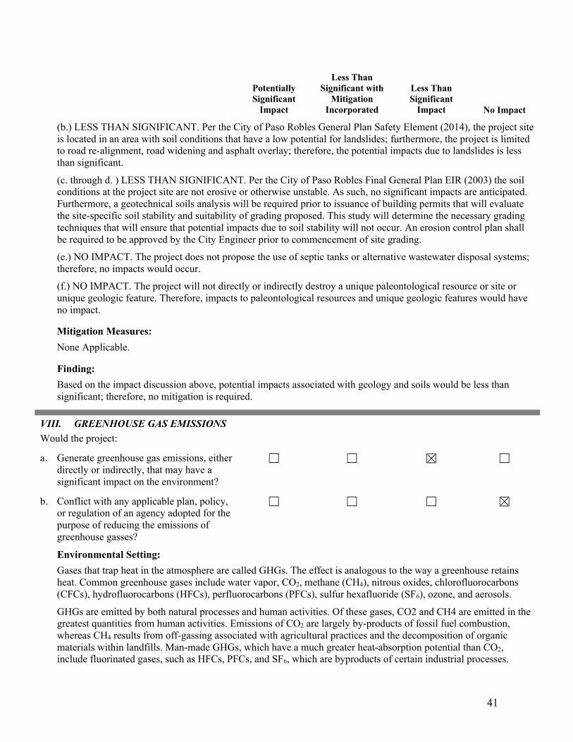
41
Potentially Significant
Impact
Less Than Significant with
Mitigation Incorporated
Less Than Significant
Impact No Impact
(b.) LESS THAN SIGNIFICANT. Per the City of Paso Robles General Plan Safety Element (2014), the project site is located in an area with soil conditions that have a low potential for landslides; furthermore, the project is limited to road re-alignment, road widening and asphalt overlay; therefore, the potential impacts due to landslides is less than significant.
(c. through d. ) LESS THAN SIGNIFICANT. Per the City of Paso Robles Final General Plan EIR (2003) the soil conditions at the project site are not erosive or otherwise unstable. As such, no significant impacts are anticipated. Furthermore, a geotechnical soils analysis will be required prior to issuance of building permits that will evaluate the site-specific soil stability and suitability of grading proposed. This study will determine the necessary grading techniques that will ensure that potential impacts due to soil stability will not occur. An erosion control plan shall be required to be approved by the City Engineer prior to commencement of site grading. (e.) NO IMPACT. The project does not propose the use of septic tanks or alternative wastewater disposal systems; therefore, no impacts would occur. (f.) NO IMPACT. The project will not directly or indirectly destroy a unique paleontological resource or site or unique geologic feature. Therefore, impacts to paleontological resources and unique geologic features would have no impact.
Mitigation Measures: None Applicable.
Finding: Based on the impact discussion above, potential impacts associated with geology and soils would be less than significant; therefore, no mitigation is required.
VIII. GREENHOUSE GAS EMISSIONS Would the project:
a. Generate greenhouse gas emissions, either directly or indirectly, that may have a significant impact on the environment?
b. Conflict with any applicable plan, policy, or regulation of an agency adopted for the purpose of reducing the emissions of greenhouse gasses?
Environmental Setting: Gases that trap heat in the atmosphere are called GHGs. The effect is analogous to the way a greenhouse retains heat. Common greenhouse gases include water vapor, CO2, methane (CH4), nitrous oxides, chlorofluorocarbons (CFCs), hydrofluorocarbons (HFCs), perfluorocarbons (PFCs), sulfur hexafluoride (SF6), ozone, and aerosols.
GHGs are emitted by both natural processes and human activities. Of these gases, CO2 and CH4 are emitted in the greatest quantities from human activities. Emissions of CO2 are largely by-products of fossil fuel combustion, whereas CH4 results from off-gassing associated with agricultural practices and the decomposition of organic materials within landfills. Man-made GHGs, which have a much greater heat-absorption potential than CO2, include fluorinated gases, such as HFCs, PFCs, and SF6, which are byproducts of certain industrial processes.

42
Potentially Significant
Impact
Less Than Significant with
Mitigation Incorporated
Less Than Significant
Impact No Impact
Plants use CO2 and water in photosynthesis and release oxygen as a waste product. Humans use this oxygen to breathe and produce CO2 as a byproduct of respiration. The different types of GHGs have varying global warming potentials (GWPs). The GWP of a GHG is the potential of a gas or aerosol to trap heat in the atmosphere. Because GHGs absorb different amounts of heat, a common reference gas, usually CO2, is used to relate the amount of heat absorbed to the amount of the gas emissions, referred to as “CO2 equivalent,” and is the amount of a GHG emitted multiplied by its GWP. CO2 has a GWP of one. By contrast, CH4 has a GWP of 21, meaning its global warming effect is 21 times greater than CO2 on a molecule per molecule basis.
Table 8. Global Warming Potentials (GWPs) Gas Global Warming Potential
Carbon Dioxide (CO2) 1 Methane (CH4) 25
Nitrous Oxide (N2O) 298 HFC-23 14,800 HFC-32 675 HFC-125 3,500 HFC-134a 1,430 HFC-143a 4,470 HFC-152a 124 HFC-227ea 3,220 HFC-236fa 9,810
HFC-4310mee 1,640 CF4 7,390 C2F6 12,200 C4F10 8,860 C6F14 9,300 SF6 22,800 NF3 17,200
Source: https://www.epa.gov/sites/production/files/2019-04/documents/us-ghg-inventory-2019-main-text.pdf
In response to the California Global Warming Solutions Act of 2006 (AB 32) the project’s greenhouse gas emissions must be evaluated under CEQA as required under Senate Bill 97 (2007). The Assembly Bill 32 Scoping Plan contains the main strategies California will use to reduce the greenhouse gases that cause climate change. The scoping plan has a range of GHG reduction actions which include direct regulations, alternative compliance mechanisms, monetary and non-monetary incentives, voluntary actions, market-based mechanisms such as a cap-and-trade system, and an AB 32 program implementation regulation to fund the program.

43
Potentially Significant
Impact
Less Than Significant with
Mitigation Incorporated
Less Than Significant
Impact No Impact
The City of Paso Robles Climate Action Plan was adopted by the City Council in November, 2013. The Climate Action Plan is a long-range plan to reduce GHG emissions from City government operations and community activities within Paso Robles, and prepare for the anticipated effects of climate change. The Climate Action Plan will also help achieve multiple community goals such as lowering energy costs, reducing air pollution, supporting local economic development, and improving public health and quality of life.
Discussion: (a.) LESS THAN SIGNIFICANT. The project will have direct GHG emissions associated with construction activity. Given the temporary nature of the construction activities, the projects impact to GHG emissions will be less than significant. (b.) NO IMPACT. The proposed project includes needed public improvements, consistent with current land uses, zoning, and with the recommended adaption measures outlined in the Climate Action Plan. No further analysis is warranted.
Mitigation Measures: None applicable.
Finding: Based on the impact discussion above, potential impacts associated with the generation of GHGs would be less than significant; therefore, no mitigation is required.
IX. HAZARDS AND HAZARDOUS MATERIALS Would the project:
a. Create a significant hazard to the public or the environment through the routine transport, use, or disposal of hazardous materials?
b. Create a significant hazard to the public or the environment through reasonably foreseeable upset and accident conditions involving the release of hazardous materials into the environment?
c. Emit hazardous emissions or handle hazardous or acutely hazardous materials, substances, or waste within one-quarter mile of an existing or proposed school?
d. Be located on a site which is included on a list of hazardous materials sites compiled pursuant to Government Code Section 65962.5 and, as a result, would it create a significant hazard to the public or the environment?
44
Potentially Significant
Impact
Less Than Significant with
Mitigation Incorporated
Less Than Significant
Impact No Impact
e. For a project located within an airport land use plan or, where such a plan has not been adopted, within two miles of a public airport or public use airport, would the project result in a safety hazard for people residing or working in the project area?
f. Impair implementation of or physically interfere with an adopted emergency response plan or emergency evacuation plan?
g. Expose people or structures, either directly or indirectly, to a significant risk of loss, injury or death involving wildland fires?
�
Environmental Setting: Regulatory bodies that oversee the use and disposal of hazardous materials include, but are not limited to, the California Environmental Protection Agency, Department of Toxic Substances Control, San Luis Obispo County Environmental Health, U.S. and California Department of Transportation, and the California Division of Occupational Safety and Health.
The project involves the re-alignment, widening and an asphalt overlay to Dry Creek Road. The project will take place on previously developed lands. Construction activities associated with the proposed project could involve the use of potentially hazardous materials, including cleaning materials, solvents, vehicle fuels, hydraulic fluids, and oils. Any negligible amounts of material would be required to be handled, stored, transported, and disposed of according to a framework of federal, state and local regulations of the previously mentioned agencies.
Discussion: (a.) LESS THAN SIGNIFICANT. The proposed project is not expected to result in impacts from hazards and hazardous materials with respect to creating a signification hazard to the public or environment through the routine transport, use, or disposal of hazardous materials. During construction, the proposed project would involve the transport of general construction materials. Construction activities would involve the use of fuels and greases for the construction equipment; however, the use, storage, transport and disposal of these materials will be carried out in accordance with federal, state, and local laws, ordinances and regulations. Once installed, the road re-alignment project would produce no waste. Impacts are considered less than significant. (b.) LESS THAN SIGNIFICANT WITH MITIGATION. During any earth-moving operations (grading, trenching, etc.) within the roadway, there is a possibility that unexpected hazardous materials could be encountered or unearthed. Hazardous materials in the construction area could create a risk to workers and the general public during excavation and transport. If contaminated soil is encountered and it is determined that it needs to be removed from the construction area, it must be transported according to State and Federal regulations and be replaced with imported soil approved for backfilling if necessary. In these cases, the contractor must comply with all applicable regulations. Based on compliance with existing standards and implementation of proposed mitigation included
45
Potentially Significant
Impact
Less Than Significant with
Mitigation Incorporated
Less Than Significant
Impact No Impact
below and in Attachment 1 – Mitigation Monitoring and Reporting Program, impacts are considered less than significant. (c.) NO IMPACT. El Paso de Robles Youth Correctional Facility is located 0.6 mile from the project area, on the intersection of Airport Road and Dry Creek Road. The facility was closed in 2009. Currently, there is no plan to reopen the facility; therefore, the project will result in no impact on schools. (d.) LESS THAN SIGNIFICANT WITH MITIGATION. A review of the Department of Toxic Substances Control database, EnviroStor, which includes lists of hazardous materials sites compiled pursuant to California Government Code Section 65962.5, identified an inactive Military Evaluation site within the Airport property. Based on compliance with existing standards and implementation of proposed mitigation included under discussion VIII(a.) above, impacts are considered less than significant. (e.) LESS THAN SIGNIFICANT. The project is located in proximity and within the Paso Robles Municipal Airport. Areas within proximity are subject to the Airport Land Use Plan, while areas within the airport property are subject to the Airport Master Plan. Within the airport property, the project is proposed within areas that have been designated future commercial/industrial sites or commercial aviation, and the proposed project falls within the allowable uses of these designations. The areas in proximity to the airport fall within Safety Zones 1, 3 and 5, and the proposed project falls within the allowable uses of these designations. Lastly, the nature of the project (i.e., road widening, re-alignment and resurfacing) is not anticipated to result in a safety hazard once installed.
(f. through g.) NO IMPACT. The City does not have any adopted emergency response or evacuation plan. As proposed, the development would not interfere with emergency response or evacuation. In addition, the project is not located within a wildland fire hazard area nor do the project components present risks involving wildland fires. There would be no impacts.

46
Potentially Significant
Impact
Less Than Significant with
Mitigation Incorporated
Less Than Significant
Impact No Impact
Mitigation Measures: Measure HM-1: Hazardous Materials Contingency Plan Prior to initiation of construction activities, the Contractor shall prepare and submit to the City of Paso Robles a contingency plan for handling hazardous materials, whether found or introduced on-site during construction. This plan shall include standard construction measures as specified in local, state and federal regulations for hazardous materials, removal of on-site debris, and confirmation of presence of pipelines on site. At a minimum, the following measures shall be included in the contingency plan:
a) If contaminated soils or other hazardous materials are encountered during any construction related soil moving operation (e.g., trenching, excavation, grading), construction shall be halted and the Hazardous Material Control Plan (HMCP) implemented.
b) Instruct workers on recognition and reporting of materials that may be hazardous.
c) Minimize delays by continuing performance of the work in areas not affected by hazardous materials operations.
d) Identify and contact subcontractors and licensed personnel qualified to undertake storage, removal, transportation, disposal, and other remedial work required by, and in accordance with, laws and regulations.
e) Forward to engineer, copies of reports, permits, receipts, and other documentation related to remedial work.
f) Notify such agencies as are required to be notified by laws and regulations within the time stipulated by such laws and regulations.
g) File requests for adjustments to contract time and contract price due to the finding of hazardous materials in the work site in accordance with conditions of contract.
Finding: Based on implementation of mitigation measure identified above, potential impacts associated with hazards and hazardous materials would be mitigated to a less-than-significant level.
X. HYDROLOGY AND WATER QUALITY Would the project:
a. Violate any water quality standards or waste discharge requirements or otherwise substantially degrade surface or ground water quality?
b. Substantially decrease groundwater supplies or interfere substantially with groundwater recharge such that the project may impede sustainable groundwater management of the basin? (Source: 7)
c. Substantially alter the existing drainage pattern of the site or area, including through the alteration of the course of a

47
Potentially Significant
Impact
Less Than Significant with
Mitigation Incorporated
Less Than Significant
Impact No Impact
stream or river or through the addition of impervious surfaces, in a manner which would: i. Result in substantial erosion or
siltation on- or off-site; ii. Substantially increase the rate or amount of surface runoff in a manner which would result in flooding on- or off-site; iii. Create or contribute runoff water which would exceed the capacity of existing or planned stormwater drainage systems or provide substantial additional sources of polluted runoff; or iv. Impede or redirect flood flows?
�
d. In flood hazard, tsunami, or seiche zones, risk release of pollutants due to project inundation?
e. Conflict with or obstruct implementation of a water quality control plan or sustainable groundwater management plan?
Environmental Setting: The City’s municipal water supply is composed of groundwater from the Paso Robles Groundwater Basin, an allocation of the Salinas River underflow, and a surface water allocation from the Nacimiento Lake pipeline project. The City established a groundwater stewardship policy to not expand dependency on the Paso Robles Groundwater Basin (“the basin”) over historic use levels/pumping from the City’s peak year of 2007. The City augmented water supply and treatment capacity by procuring surface water from Lake Nacimiento and construction of delivery facilities to the City. Additionally, the City assigns “duty” factors that anticipate the amount of water supply necessary to serve various types of land uses. The City’s Recycled Water Master Plan (AECOM, 2014) identified the potential to provide approximately 1,520 acre-feet per year (AFY) of recycled water to customers within City boundaries. Approximately 428 AFY of this supply would offset potable uses that are currently served by the City, while the remaining recycled water use in City limits would replace private well pumping for irrigation. These estimates account for blending recycled water with lower salinity water and/or groundwater to the extent needed to make it suitable for agricultural and golf course irrigation. The recycled water pipeline portions of the proposed project are consistent with the Recycled Water Master Plan. The City of Paso Robles is enrolled in the Phase II Municipal Storm Water Program as required by the State Water Resources Control Board. The program requires the City to develop and implement a Storm Water Management Plan (SWMP) in order to reduce or eliminate pollutants in Storm water runoff and non-storm water discharges. In July 2013, the City of Paso Robles developed a Storm Water Program Guidance Document, and submitted to the State Water Resources Control Board. Under this program, the City educates the community in storm water

48
Potentially Significant
Impact
Less Than Significant with
Mitigation Incorporated
Less Than Significant
Impact No Impact
pollution prevention, regulates storm water run-off from construction sites, investigates non-storm water discharges and reduces non-storm water run-off from municipal operations. As stated in Section 3, a total of five drainage features and one vernal pool were identified within the survey area, including two unnamed USGS blue line streams (see Table 5 - Summary of Jurisdictional Drainage Features).
Discussion: (a.) LESS THAN SIGNIFICANT WITH MITIGATION. A total of five jurisdictional drainage improvements and one vernal pool impact are proposed. Proposed drainage improvements will likely include replacement or installation of culverts and realignment of the road right-of-way to the north which will directly impact a portion of a vernal pool (see Figure 4). Temporary impacts associated with the proposed construction activities may include erosion and sedimentation within the channel, as well as discharges of hazardous materials from construction equipment, such as fuel. Long-term impacts may result if disturbed areas within the channel and/or vernal pool are not properly stabilized and restored, which could result in downstream sedimentation and/or discharges after project completion. Implementation of mitigation measures BR-2: (Site Maintenance and General Operations) and BR-10: (Federal and State Waters and Wetlands), discussed in Section 3; will address potential impacts to water quality standards or waste discharge requirements and protection of drainage features and aquatic resources. Furthermore, the City will comply with all applicable storm water regulations, which include the preparation of a Storm Water Pollution Prevention Plan for projects greater than or equal to one acre of disturbance. Thus, water quality standards will be maintained and discharge requirements will be in compliance with State and local regulations. Therefore, impacts to water quality and discharge will be less than significant with implementation of applicable mitigation measures.
(b.) NO IMPACT. The proposed road re-alignment project will not draw upon, decrease, or substantially interfere with groundwater recharge and will therefore have no impact. (c.i. through c.iv.) LESS THAN SIGNIFICANT. The project grading and drainage plan is designed to maintain similar drainage conditions as the existing condition. Additionally, in compliance with State and local regulations, during construction erosion and/or storm water control measures will be implemented; therefore, the project is not expected to result in substantial erosion or siltation. Impacts to drainage patterns and surface runoff would be less than significant.
(d.) LESS THAN SIGNIFICANT. In accordance with the City General Plan, there are no flood hazards, tsunami, or seiche zone hazards located on or near the project site; therefore, this project could not result in inundation impacts.
(e.) NO IMPACT. The project will implement the City’s SWMP – Best Management Practices, and would therefore not conflict with these measures.
Mitigation Measures: None applicable
Finding: Based on adherence with the applicable state and federal water quality regulations described above, along with implementation of mitigation measures BR-2, and BR-10, potential impacts to hydrology and water resources would be mitigated to a less-than-significant level.

49
Potentially Significant
Impact
Less Than Significant with
Mitigation Incorporated
Less Than Significant
Impact
No Impact
XI. LAND USE AND PLANNING Would the project:
a. Physically divide an established community?
b. Cause a significant environmental impact due to a conflict with any land use plan, policy, or regulation adopted for the purpose of avoiding or mitigating an environmental effect?
Environmental Setting: The City of Paso Robles Airport Land Use Plan was adopted by the County Airport Land Use Commission in November 1977. This document sets forth land use compatibility policies applicable to future development in the vicinity of the Airport. The compatibility policies contained within the plan are designed to ensure that future land uses in the area surrounding the Airport will be compatible with the realistically foreseeable aircraft activity at the Airport. It provides the basis by which the Airport Land Use Commission (ALUC) can carry out its land use development review responsibilities in accordance with Section 21670 et seq. of the California Public Utilities Code. The ALUC was created in response to the mandates of The State Aeronautics Act, first enacted in 1967. The ALUC receives technical support from the County of San Luis Obispo, although it is an autonomous body and not part of any local governmental structure. The Airport Land Use Plan was amended February 16, 2005 to incorporate the City of Paso Robles changes to the Paso Robles Municipal Airport Master Plan and Airport Layout Plan. Additionally, California Department of Transportation’s (Caltrans) had made substantial changes to guidelines published in the Airport Land Use Handbook. Land use planning areas within the Airport Planning Area consist of six safety zones. Generally, Safety Zone 1 is wholly contained within the existing Airport property and land uses there are governed by the City-adopted Airport Master Plan and the Federal Aviation Administration approved Airport Layout Plan. Land uses in Zones 3, 4, 5 and 6 are outside the existing Airport property and are governed wholly by the Land Use Matrix, footnotes, and any referenced policies found in Table 10 of the Airport Land Use Plan.
Discussion: (a.) NO IMPACT. The proposed public improvement project would not physically divide an established community since the project will be located within the Airport property and surrounding area, which is comprised of commercial/industrial and agricultural uses. (b.) NO IMPACT. The proposed public improvement project will be located within areas zoned Airport Planned Development (AP-PD). The project would be installed within parcels with business park (BP) and public facility (PF) land uses designations. Additionally, the project occurs within Airport Safety Zone 1, 3 and 5, per the Airport Master Plan. Public improvements are an allowed use within these zoning and land use designations; therefore, there will be no conflicts with the Plan.
Mitigation Measure: None applicable.

50
Potentially Significant
Impact
Less Than Significant with
Mitigation Incorporated
Less Than Significant
Impact
No Impact
Finding: Based on the impact discussion above, potential impacts related to land use would be less than significant; therefore, no mitigation is required.
XII. MINERAL RESOURCES Would the project:
a. Result in the loss of availability of a known mineral resource that would be of value to the region and the residents of the state? (Source: 1)
b. Result in the loss of availability of a locally-important mineral resource recovery site delineated on a local general plan, specific plan or other land use plan? (Source: 1)
Environmental Setting: The California Surface Mining and Reclamation Act of 1975 requires the State Geologist to classify land into Mineral Resource Zones according to the known or inferred mineral resource potential of that land as determined from its economic geology. The primary goal of mineral and land classification is to ensure that the mineral resource potential of land is recognized by local government when making decisions on land use. San Luis Obispo County has known deposits of gold, copper, granite, limestone and other various minerals; however, none are located within the City.
Discussion: (a. through b.) NO IMPACT. There are no known mineral resources at the project site; therefore, there will not be any impacts. Mitigation Measures: None applicable.
Finding: Based on the impact discussion above, no impacts to mineral resources would occur as a result of the proposed project; therefore, no mitigation is required.

51
Potentially Significant
Impact
Less Than Significant with
Mitigation Incorporated
Less Than Significant
Impact
No Impact
XIII. NOISE Would the project result in:
a. Generation of a substantial temporary or permanent increase in ambient noise levels in the vicinity of the project in excess of standards established in the local general plan or noise ordinance, or applicable standards of other agencies? (Source: 1)
b. Generation of excessive groundborne vibration or groundborne noise levels?
c. For a project located within the vicinity of a private airstrip or an airport land use plan or, where such a plan has not been adopted, within two miles of a public airport or public use airport, would the project expose people residing or working in the project area to excessive noise levels?
Environmental Setting: The project site is located within the property of the Airport and surrounded by public facilities, business park, and agricultural land uses. The closest residences are located adjacent to the project components proposed within the right-of-way of Dry Creek Road. The project area is currently subject to vehicle traffic noise, air traffic noise, and noise from commercial and light industrial uses surrounding the Airport property.
Discussion: (a. through c.) LESS THAN SIGNIFICANT. Re-alignment, widening and resurfacing of Dry Creek Road would create temporary increases in the ambient noise level during construction. Construction noise, and how it is perceived, would differ among the various phases of construction, depending on the particular activities, equipment used, and its proximity to sensitive noise receptors. Noise from construction is acknowledged as being exempt as an impact in the City Noise Ordinance. The project is located in an area that is designated by the Master Plan as future aviation/commercial/industrial lease sites and is therefore consistent with the Airport Master Plan. Additionally, the project is not anticipated to result in excessive noise levels during construction or ongoing operations. Therefore, impacts are expected to be less than significant.
Finding: Based on the impact discussion above, potential impacts associated with noise related impacts would be less than significant; therefore, no mitigation is required.
XIV. POPULATION AND HOUSING Would the project:
a. Induce substantial unplanned population growth in an area, either directly (for

52
Potentially Significant
Impact
Less Than Significant with
Mitigation Incorporated
Less Than Significant
Impact
No Impact
example, by proposing new homes and businesses) or indirectly (for example, through extension of roads or other infrastructure)? (Source: 1)
b. Displace substantial numbers of existing people or housing, necessitating the construction of replacement housing elsewhere?
Environmental Setting: The Airport is located in the northeastern portion of the City and is surrounded by properties containing various commercial establishments, including light industrial, aviation-related businesses, and wineries. The public improvement project includes widening and re-aligning a portion of Dry Creek Road in addition to an asphalt overlay. The project activities will occur on a portion of Dry Creek Road located between 2nd Wind Street and Jardine Way. The widening is required due to compromised steep and eroding slopes on the southern edge of Dry Creek Road and a blind turn that is considered hazardous.
Discussion: (a.) LESS THAN SIGNIFICANT. The proposed project is located within the City of Paso Robles, within the existing Airport property and surrounding roadway network. No housing is present onsite. The purpose of the proposed project is to improve public safety; therefore, it will not induce growth like the development of a residential, commercial, or industrial use. The extent to which new jobs created by a project are filled by existing residents is a factor that tends to reduce the growth inducing effect of a project. The construction of the proposed project will create short-term construction jobs; however, these short-term positions are anticipated to be filled by workers who, for the most part, reside in the project area. Therefore, construction of the proposed project will not generate a permanent increase in population within the project area. Infrastructure, including roads, sewers, water and electricity, already exists around the project site. Because the proposed project will remediate existing deficiencies in current roadway configurations, the road re-alignment will not induce indirect growth above that which currently exists. Therefore, impacts are expected to be less than significant. (b.) NO IMPACT. The proposed project would not remove/displace housing, people, or require the construction of replacement housing. No impacts would occur.
Mitigation Measures: None applicable.
Finding: Based on the impact discussion above, potential impacts associated with population and housing would be less than significant; therefore, no mitigation is required.
XV. PUBLIC SERVICES a. Would the project result in substantial adverse physical impacts associated with the provision of new or physically
altered governmental facilities, need for new or physically altered governmental facilities, the construction of which could cause significant environmental impacts, in order to maintain acceptable service ratios, response times or other performance objectives for any of the public services:
Fire protection? (Sources: 1,10)
53
Potentially Significant
Impact
Less Than Significant with
Mitigation Incorporated
Less Than Significant
Impact
No Impact
Police protection? (Sources: 1,10) Schools? Parks? Other public facilities? (Sources: 1,10) Environmental Setting: Fire Services
The Paso Robles Department of Emergency Services provides a variety of services to the community including fire suppression, emergency medical services, rescue, hazardous materials and other emergency responses. The nearest station is located at Golden Hill Road and Union Road in Paso Robles, approximately 2.75 miles away. Response times for 90 percent of incidents are 4 minutes or less. CALFIRE provides emergency services to all unincorporated areas of San Luis Obispo County through a network of fire stations, personnel, and equipment. They operate a fire station at 4735 Airport Road, adjacent to the project site.
Police Services
Law enforcement services in the City of Paso Robles are provided by the Paso Robles Police Department. The station is located at 900 Park St in the City of Paso Robles, which is located approximately 3.75 miles from the project site. The department currently employs 48 full time staff members.
Schools
The project site is located within the Paso Robles Joint Unified School District. Georgia Brown Elementary School is the closest operational school to the project area, located approximately 3.75 miles west of the project site. El Paso de Robles School youth correctional facility is located within 0.6 mile of the project area at the intersection of Airport Road and Dry Creek Road; however, the facility was closed in 2009. Currently, there is no plan to reopen the facility.
Parks/Public Facilities
Barney Schwartz Park (comprised of sports fields, playgrounds, and a pond) is the closest public park, located approximately 1.5 miles from the project site.
Discussion: (a. through e.) NO IMPACT. The project will not induce or facilitate growth in the project vicinity resulting in the need for additional public services. No new police or fire services will be necessary for the public improvement project, and the project will not require additional schools or parks. The project will not result in a substantial adverse physical impact or the need for new, or physically altered governmental facilities.
Mitigation Measure: None applicable.
Finding: Based on the impact discussion above, potential impacts associated with public services would be less than significant; therefore, no mitigation is required.

54
Potentially Significant
Impact
Less Than Significant with
Mitigation Incorporated
Less Than Significant
Impact
No Impact
XVI. RECREATION Would the project:
a. Would the project increase the use of existing neighborhood and regional parks or other recreational facilities such that substantial physical deterioration of the facility would occur or be accelerated?
b. Does the project include recreational facilities or require the construction or expansion of recreational facilities which might have an adverse physical effect on the environment?
Environmental Setting: The project site is located near various private recreational amenities including private golf courses/clubs and a water park. In addition, City-owned and operated Barney Schwartz park is located approximately 1.5 miles from the project site. The project site is not located within a designated trail corridor.
Discussion: (a. and b.) NO IMPACT. The project includes re-alignment, resurfacing and widening a section of Dry Creek Road. The project will not increase the use of neighborhoods or regional parks, or other recreational facilities. The project will not create substantial physical deterioration of any facilities. There would be no impact.
Mitigation Measure: None applicable.
Finding: Based on the impact discussion above, no impact would occur as a result of the proposed project; therefore, no mitigation is required.
XVII. TRANSPORTATION AND TRAFFIC Would the project:
a. Conflict with a program plan, ordinance or policy addressing the circulation system, including transit, roadway, bicycle and pedestrian facilities?
b. Would the project conflict or be inconsistent with CEQA Guidelines section 15064.3, subdivision (b)?
c. Substantially increase hazards due to a geometric design feature (e.g., sharp curves or dangerous intersections) or incompatible uses (e.g., farm equipment)?

55
Potentially Significant
Impact
Less Than Significant with
Mitigation Incorporated
Less Than Significant
Impact
No Impact
d. Result in inadequate emergency access? Environmental Setting: Existing Roadway Network
The project site is accessed by a network of major highways, arterial streets, and collector streets within the City of Paso Robles and County of San Luis Obispo. Highway 46 East is located approximately 0.75 mile south of the project area, and Highway 101 is approximately 4 miles west of the project site. The proposed project includes re-alignment, resurfacing and widening a portion of Dry Creek Road. Below is a brief discussion of the primary access roads for the proposed project:
• Highway 46 East: an east-west state highway connecting the Central Valley with the Central Coast. In the Paso Robles area, the highway extends as a four-lane divided expressway east and west of Union Road.
• Jardine Road: a rural two-lane road running north and south that intersects with Highway 46 East, which is controlled by a two-way stop sign (heading southbound on Jardine Road).
• Airport Road: a two-lane arterial road running north and south that intersects with Highway 46 East, which is controlled by a two-way stop sign (heading southbound on Airport Road).
• Dry Creek Road: a two-lane arterial road running east and west that merges into Jardine Road on its east side, and is controlled by a two-way stop sign (heading eastbound on Dry Creek Road) at the intersection with Airport Road on its west side.
Existing Pedestrian, Bicycle and Transit Service
No pedestrian facilities are provided on Jardine Road, Airport Road, Beacon Road, Dry Creek Road, or Highway 46 East near the project site. Bicycle facilities consist of permitted bicycle use on the shoulder of Highway 46 East; however, no other existing bicycle facilities currently exist in the project area. The City’s Bike Master Plan proposes Class II bicycle facilities along Jardine Road from Tower Road to Beacon Road. The San Luis Obispo Regional Transit Authority offers service on the Paso Express near the town center. The nearest stop is served by Route C at Cuesta College Campus on Buena Vista Drive, with hourly service from 7:15 AM to 7:15 PM on weekdays. The bus stop is located approximately 2 miles from the project site. Existing Traffic Conditions
Average daily traffic (ADT) volumes for Highway 46 East during a typical weekday were obtained from Caltrans in a 2014 report. In 2016, Associated Transportation Engineers calculated percent capacity utilization of Highway 46 East and Jardine Road, based on the 2014 Caltrans report. Additionally, the General Plan Circulation Element (2019) provides existing roadway utilization for many major city roads. Below summarizes these calculations for relevant project access roads:
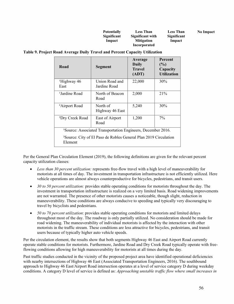
56
Potentially Significant
Impact
Less Than Significant with
Mitigation Incorporated
Less Than Significant
Impact
No Impact
Table 9. Project Road Average Daily Travel and Percent Capacity Utilization
Road Segment Average Daily Travel (ADT)
Percent (%) Capacity Utilization
¹Highway 46 East
Union Road and Jardine Road
22,000 30%
¹Jardine Road North of Beacon Road
2,000 21%
²Airport Road North of Highway 46 East
5,240 30%
²Dry Creek Road East of Airport Road
1,200 7%
¹Source: Associated Transportation Engineers, December 2016. ²Source: City of El Paso de Robles General Plan 2019 Circulation Element
Per the General Plan Circulation Element (2019), the following definitions are given for the relevant percent capacity utilization classes:
• Less than 30 percent utilization: represents free-flow travel with a high level of maneuverability for motorists at all times of day. The investment in transportation infrastructure is not efficiently utilized. Here vehicle operations are almost always counterproductive for bicycles, pedestrians, and transit users.
• 30 to 50 percent utilization: provides stable operating conditions for motorists throughout the day. The investment in transportation infrastructure is realized on a very limited basis. Road widening improvements are not warranted. The presence of other motorists causes a noticeable, though slight, reduction in maneuverability. These conditions are always conducive to speeding and typically very discouraging to travel by bicyclists and pedestrians.
• 50 to 70 percent utilization: provides stable operating conditions for motorists and limited delays throughout most of the day. The roadway is only partially utilized. No consideration should be made for road widening. The maneuverability of individual motorists is affected by the interaction with other motorists in the traffic stream. These conditions are less attractive for bicycles, pedestrians, and transit users because of typically higher auto vehicle speeds.
Per the circulation element, the results show that both segments Highway 46 East and Airport Road currently operate stable conditions for motorists. Furthermore, Jardine Road and Dry Creek Road typically operate with free-flowing conditions allowing for high maneuverability for motorists at all times during the day. Past traffic studies conducted in the vicinity of the proposed project area have identified operational deficiencies with nearby intersections of Highway 46 East (Associated Transportation Engineers, 2016). The southbound approach to Highway 46 East/Airport Road intersection operates at a level of service category D during weekday conditions. A category D level of service is defined as: Approaching unstable traffic flow where small increases in

57
Potentially Significant
Impact
Less Than Significant with
Mitigation Incorporated
Less Than Significant
Impact
No Impact
volume could cause substantial delays. Most drivers are restricted in their ability to maneuver and their selection
of travel speeds. Comfort and convenience are below tolerable.
Additionally, the southbound approach to Highway 46 East / Jardine Road intersection operates at a level of service category C during AM (7-9) and PM (4-6) peak hours. A category C level of service is defined as: stable
operations, however the ability to maneuver is more restricted by the increase in traffic volumes. Relatively
satisfactory operating speeds prevail but adverse signal coordination or longer queues cause delays.
Discussion: (a.) NO IMPACT. The City’s adopted policies and plans do not call for public transit or pedestrian facilities in this remote rural area of the City. As such, these facilities do not currently exist in the project area, and additional pedestrian, bicycle, and public transit facilities are not warranted at this time. The realignment of Dry Creek Road would not conflict with adopted policies, plans, or programs regarding public transit, bicycle, or pedestrian facilities, or otherwise decrease the performance or safety of such facilities. There are no impacts. (b.) LESS THAN SIGNIFICANT: Project operation would not result in an increase in vehicle trips that would result in impacts to traffic or transportation; however, during construction, vehicle traffic will temporarily increase due to construction-related vehicles moving to and from the work site. The project is estimated to produce up to 40 vehicles trips per day during construction, which will occur on weekdays between 7:00 AM and 3:30 PM. There are anticipated to be 120 construction days. Workers commuting to and from the jobsite would be associated with the largest increase in traffic volumes during construction, but this would be limited mainly to morning arrival and evening departures, which would occur only during established daylight working hours, and would not produce a large enough traffic volume to significantly alter existing levels of service designations; therefore, significant traffic impacts would not occur.
(c.) LESS THAN SIGNIFICANT. Construction of the project will result in elimination of a blind turn that is currently considered hazardous within the project area; therefore, impacts are expected to be less than significant. (d.) LESS THAN SIGNIFICANT. Construction of the project will not require any extended road closures. Traffic control may be necessary during project construction; however, traffic control will be temporary and detours will be available. The project will not result in inadequate emergency access; therefore, impacts are expected to be less than significant.
Mitigation Measures: None applicable.
Finding: Based on the impact discussion above, potential impacts associated with transportation would be less than significant; therefore, no mitigation is required.
XVIII. TRIBAL CULTURAL RESOURCES Would the project cause a substantial adverse change in the significance of a tribal cultural resources, defined in Public Resources Code Section 21074 as either a site, feature, place, or cultural landscape that is geographically defined in terms of the size and scope of the landscape, sacred place, or object with cultural value to a California Native American tribe, and that is:
a. Would the project cause a substantial adverse change in the significance of a tribal cultural resource, defined in Public

58
Potentially Significant
Impact
Less Than Significant with
Mitigation Incorporated
Less Than Significant
Impact
No Impact
Resources Code section 21074 as either a site, feature, place, cultural landscape that is geographically defined in terms of the size and scope of the landscape, sacred place, or object with cultural value to a California Native American tribe, and that is: i. Listed or eligible for listing in the California Register of Historical Resources, or in a local register of historical resources as defined Public Resources Code Section 5020.1(k), or
ii. A resource determined by the lead agency, in its discretion and supported by substantial evidence, to be significant pursuant to criteria set forth in subdivision (c) of Public Resources Code Section 5024.1. In applying the criteria set forth in subdivision (c) of Public Resource Code Section 5024.1, the lead agency shall consider the significance of the resource to a California Native American tribe.
Environmental Setting: As discussed in Section V above, in September of 2014, the California Legislature passed Assembly Bill 52, which added provisions to the Public Resources Code regarding the evaluation of impacts on tribal cultural resources under CEQA, and consultation requirements with California Native American tribes. In particular, Assembly Bill 52 now requires lead agencies to analyze project impacts to “tribal cultural resources” separately from archaeological resources (PRC §21074; 21083.09). The Bill defines “tribal cultural resources” in a new section of the PRC §21074. AB 52 also requires lead agencies to engage in additional consultation procedures with respect to California Native American tribes (PRC §21080.3.1, 21080.3.2, 21082.3). The project site is situated within the prehistoric territory of the Salinan tribe (Heizer and Whipple, 1971). The Salinans occupied a geographical area extending from present day San Luis Obispo in the south to King City in the north, and west to the coast (Breschini et al., 1983). The Salinan people were seasonally migratory and, depending on food resources, would inhabit the coastal beaches to procure marine resources, and the interior Santa Lucia mountain ranges for acorn and land mammal resources. It is probable that the project site falls within the regional territory of the Migueleño group, which inhabited the upper course of the Salinas River. Padre Associates, Inc. (Padre) has completed a Phase I archaeological study, which is included as Attachment 5. As part of the consultation process with Native American organizations and individuals, Padre requested for a Sacred Lands File search to the Native American Heritage Commission (NAHC) inquiring about information concerning sacred or traditional cultural properties that may be located within the project sites. The NAHC stated that the results of the Sacred Lands File search were negative. Furthermore, Padre mailed letters to each of the Native American groups and individuals on the list provided by the NAHC; they were asked to provide pertinent
59
Potentially Significant
Impact
Less Than Significant with
Mitigation Incorporated
Less Than Significant
Impact
No Impact
information or to express any concerns they may have about the proposed project. Padre made follow-up phone calls to additional contacts. Padre ordered a records search from the Central Coast Information Center of the California Historical Resources Information System at the University of California, Santa Barbara. The records search included a review of all recorded historic-era and prehistoric archaeological sites within a 0.25-mile radius of the project sites, as well as a review of known cultural resource surveys and technical reports. The records search indicates that portions of the project sites have been previously surveyed; however, these surveys were negative for archaeological resources.
Discussion: (a.i.) NO IMPACT. An archaeological survey, Native American Heritage Commission Sacred Lands file search, and records search did not identify tribal cultural resources within the project area. No tribal cultural resources exist within the project area, and therefore will have no impact.
(a.ii.) LESS THAN SIGNIFICANT. No prehistoric materials were observed within the project sites.
Based on the results of the Phase I study conducted by Padre, it is unlikely that the proposed action will have an effect on important archaeological, historical, or other cultural resources. No formal cemeteries or other places of human internment are known to exist at the site.
In the unlikely event that buried archaeological deposits are encountered within the project area, the finds must be evaluated by a qualified archaeologist. Should human remains be encountered, all work within the vicinity of the remains would halt in accordance with Health and Safety Code §7050.5, PRC §5097.5, and §15064.5 of the CEQA Guidelines and the County Coroner must be contacted immediately; if the remains are determined to be Native American, then the NAHC must be contacted as well. Impacts are less than significant and no mitigation measures are required.
Mitigation Measures: None applicable.
Finding. Based on the impact discussion above, potential impacts to tribal cultural resources would be less than significant; therefore, no mitigation is required.
XIX. UTILITIES AND SERVICE SYSTEMS Would the project:
a. Require or result in the relocation or construction of new or expanded water, wastewater treatment or storm water drainage, electric power, natural gas, or telecommunications facilities, the construction or relocation of which could cause significant environmental effects?
b. Have sufficient water supplies available to serve the project and reasonably

60
Potentially Significant
Impact
Less Than Significant with
Mitigation Incorporated
Less Than Significant
Impact
No Impact
foreseeable future development during normal, dry and multiple dry years?
c. Result in a determination by the wastewater treatment provider which serves or may serve the project that it has adequate capacity to serve the project’s projected demand in addition to the provider’s existing commitments?
d. Generate solid waste in excess of State or local standards, or in excess of the capacity of local infrastructure, or otherwise impair the attainment of solid waste reduction goals?
e. Comply with federal, state, and local management and reduction statutes and regulations related to solid waste?
Environmental Setting: Wastewater
The City Department of Public Works (Wastewater Division) owns, operates, and maintains 136 miles of sewers and 14 lift stations to collect wastewater from all of Paso Robles and east Templeton and transport it to the City’s wastewater treatment plant, which is located at 3200 Sulphur Springs Road. Ultimately, the treated wastewater effluent is discharged into the Salinas River and dried solids are disposed of at the City Landfill as vegetative cover. According to the City’s Wastewater Treatment Plant Annual Report (2018), the current average daily dry-weather sewage flow into the plant is 2.38 Millions of Gallons per Day.
Water
The City’s municipal water supply is composed of groundwater from the Paso Robles Groundwater Basin, an allocation of the Salinas River underflow, and a surface water allocation from the Nacimiento Lake pipeline project. The City established a groundwater stewardship policy to not expand dependency on the Paso Robles Groundwater Basin (“the basin”) over historic use levels/pumping from the City’s peak year of 2007. The City augmented water supply and treatment capacity by procuring surface water from Lake Nacimiento and construction of delivery facilities to the City. Additionally, the City assigns “duty” factors that anticipate the amount of water supply necessary to serve various types of land uses.
Solid Waste
The City of Paso Robles generates 45,000 tons of solid waste annually. Solid waste is collected and disposed of at the Paso Robles Landfill, located east of City limits, at 9000 Highway 46 East. The landfill is a Class III facility owned by the City of Paso Robles. The 80-acre landfill has been operating since 1970. The landfill accepts construction/demolition, industrial, mixed municipal, sludge, and tire waste. The landfill has a permitted design capacity 6,495,000 cubic yards, with a remaining capacity of 5,190,000 cubic yards, as of October 1, 2012 (CalRecycle, 2018).

61
Potentially Significant
Impact
Less Than Significant with
Mitigation Incorporated
Less Than Significant
Impact
No Impact
Discussion: (a.) LESS THAN SIGNIFICANT. Development of the proposed project will result in an increase in the amount of impermeable surfaces and therefore, an increase in surface runoff. Construction projects that disturb more than one acre require NPDES permits. Under the NPDES permits, project components are required to prepare a Stormwater Pollution Prevention Plan (SWPPP). Adherence to BMPs specified in the SWPPP is expected to reduce potential water quality impacts associated with this issue to a less than significant level. It is anticipated that because BMPs will be installed on the roadway, the construction of these features will be less than significant. Because the BMPs include features to mitigate potential impacts to water quality from project drainage, the construction operation, and maintenance of the project drainage features, including features associated with the BMPs, will not result in significant impacts to water quality.
(b.) LESS THAN SIGNIFICANT. During construction, water would be provided through a nearby fire hydrant, under a construction fire hydrant meter permit. There are no anticipated water needs for project operation and maintenance. Since the project's water needs are minimal for both construction and ongoing maintenance, the project's water use is considered less than significant.
(c.) NO IMPACT. See response to XVII.a. above. (d.) LESS THAN SIGNIFICANT. The Paso Robles Landfill has adequate capacity to accommodate solid waste that will result from construction of the proposed project; therefore, impacts are considered less than significant.
(e.) LESS THAN SIGNIFICANT. The proposed project may generate construction wastes including solid concrete, asphalt, scrap pipe, and other similar materials. The majority of these wastes would be recycled, in accordance with existing City waste diversion requirements. Therefore, impacts are expected to be less than significant.
Mitigation Measures: None applicable.
Finding: Based on the impact discussion above, potential impacts to utilities and service systems would be less than significant; therefore, no mitigation is required.
XX. WILDFIRE If located in or near state responsibility areas or lands classified as very high fire hazard severity zones, would the project:
a. Substantially impair an adopted emergency response plan or emergency evacuation plan?
b. Due to slope, prevailing winds, and other factors, exacerbate wildfire risks, and thereby expose project occupants to, pollutant concentrations from a wildfire or the uncontrolled spread of a wildfire?
c. Require the installation or maintenance of associated infrastructure (such as roads, fuel breaks, emergency water sources,

62
Potentially Significant
Impact
Less Than Significant with
Mitigation Incorporated
Less Than Significant
Impact
No Impact
power lines or other utilities) that may exacerbate fire risk or that may result in temporary or ongoing impacts to the environment?
d. Expose people or structures to significant risk, including downslope or downstream flooding or landslides, as a result of runoff, post-fire slope instability, or drainage change?
Environmental Setting: The proposed project site is located in a moderate wildfire severity zone (City of Paso Robles Local Hazard Mitigation Plan, 2016) and has an average annual windspeed of approximately 6.3 to 8.4 miles per hour (Weather Spark, 2018). Existing conditions that may exacerbate fire risk include the gently to moderately sloping topography in some areas and the moderate average windspeed. The City of Paso Robles General Plan Safety Element establishes goals, policies, and programs to reduce the threat to life, structures, and the environment caused by fire. Policy S-1B: Disaster Response, identifies review and update of the community-wide Multi-Hazard Emergency Response Plan on a periodic basis. Action Item 4 stipulates coordination with emergency services to evaluate the potential vulnerability of wildfire hazards including the accumulation of fuels (such as brush, etc.), and implement measures consistent with the Draft Local Hazard Mitigation Plan to reduce the risk from fire hazards. The California Fire Code provides minimum standards for many aspects of fire prevention and suppression activities. These standards include provisions for emergency vehicle access, water supply, fire protection systems, and the use of fire-resistant building materials.
Discussion: (a.) NO IMPACT. The City does not have any adopted emergency response or evacuation plans. As proposed, the development would not interfere with emergency response or evacuation. In addition, the project is not located within a wildland fire hazard area nor do any project components present risks involving wildland fires. There would be no impacts. (b.) LESS THAN SIGNIFICANT. The project does not present a significant fire safety risk, though it is located within a ‘moderate’ severity risk area. The road re-alignment project is not expected to exacerbate wildfire risks; and therefore, fire-related impacts would be less than significant. (c.) LESS THAN SIGNIFICANT. Existing local roads and agricultural roads would be used for access and new roads would not be constructed. Fire-related impacts due to installation of new infrastructure would be less than significant. (d.) LESS THAN SIGNIFICANT. As stated earlier, no employees would be associated with the project after completion of the construction project. The risk to structures would be low due to the low landslide and liquefaction risk. Therefore, there would be a less than significant impact to people and structures in regard to flooding and landslides from post-fire slope instability.
Mitigation Measures: None applicable.
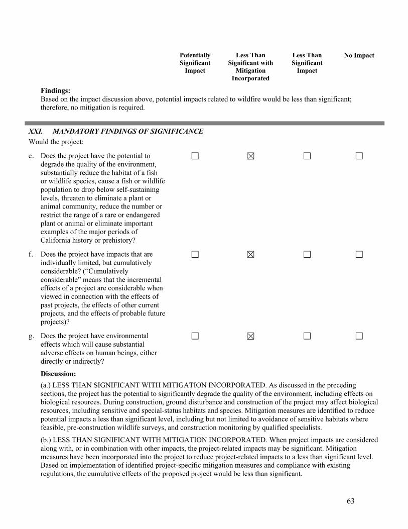
63
Potentially Significant
Impact
Less Than Significant with
Mitigation Incorporated
Less Than Significant
Impact
No Impact
Findings: Based on the impact discussion above, potential impacts related to wildfire would be less than significant; therefore, no mitigation is required.
XXI. MANDATORY FINDINGS OF SIGNIFICANCE Would the project:
e. Does the project have the potential to degrade the quality of the environment, substantially reduce the habitat of a fish or wildlife species, cause a fish or wildlife population to drop below self-sustaining levels, threaten to eliminate a plant or animal community, reduce the number or restrict the range of a rare or endangered plant or animal or eliminate important examples of the major periods of California history or prehistory?
f. Does the project have impacts that are individually limited, but cumulatively considerable? (“Cumulatively considerable” means that the incremental effects of a project are considerable when viewed in connection with the effects of past projects, the effects of other current projects, and the effects of probable future projects)?
g. Does the project have environmental effects which will cause substantial adverse effects on human beings, either directly or indirectly?
Discussion: (a.) LESS THAN SIGNIFICANT WITH MITIGATION INCORPORATED. As discussed in the preceding sections, the project has the potential to significantly degrade the quality of the environment, including effects on biological resources. During construction, ground disturbance and construction of the project may affect biological resources, including sensitive and special-status habitats and species. Mitigation measures are identified to reduce potential impacts a less than significant level, including but not limited to avoidance of sensitive habitats where feasible, pre-construction wildlife surveys, and construction monitoring by qualified specialists. (b.) LESS THAN SIGNIFICANT WITH MITIGATION INCORPORATED. When project impacts are considered along with, or in combination with other impacts, the project-related impacts may be significant. Mitigation measures have been incorporated into the project to reduce project-related impacts to a less than significant level. Based on implementation of identified project-specific mitigation measures and compliance with existing regulations, the cumulative effects of the proposed project would be less than significant.

64
Potentially Significant
Impact
Less Than Significant with
Mitigation Incorporated
Less Than Significant
Impact
No Impact
(c.) LESS THAN SIGNIFICANT WITH MITIGATION INCORPORATED. Implementation of the project would result in the generation of pollutants, which may affect air and water quality, and would result in a short-term increase in the ambient noise level during construction. Adherence to existing regulations, such as storm water BMPs and standard air quality measures, along with implementation of project-specific mitigation measures would reduce these project-specific impacts to a less than significant level; therefore, the project would not result in substantial, adverse environmental effects to human beings, either directly or indirectly.
Finding: Based on implementation of mitigation measures identified in each of the sections above, all potential impacts associated with the construction and operation of the proposed project would be mitigated to less than significant levels.
EARLIER ANALYSIS AND BACKGROUND MATERIALS
Earlier analyses may be used where, pursuant to tiering, program EIR, or other CEQA process, one or more effects have been adequately analyzed in an earlier EIR or negative declaration. Section 15063 (c)(3)(D).
EARLIER DOCUMENTS THAT MAY HAVE BEEN USED IN THIS ANALYSIS AND BACKGROUND / EXPLANATORY MATERIALS
Reference # Document Title Available for Review at:
1 City of Paso Robles General Plan City of Paso Robles Community Development Department
1000 Spring Street Paso Robles, CA 93446
2 City of Paso Robles Zoning Code Same as above
3 City of Paso Robles Environmental Impact Report for General Plan Update
Same as above
4 5 6 7
2005 Airport Land Use Plan California Agricultural Land Evaluation and Site
Assessment Model 1997 California Farmland Mapping and Monitoring
Program City of Paso Robles Climate Action Plan 2013
Same as above Same as above
Same as above
Same as above
8 City of Paso Robles Municipal Code Same as above
9 City of Paso Robles Water Master Plan Same as above
10 City of Paso Robles Urban Water Management Plan 2005
Same as above
11 City of Paso Robles Sewer Master Plan City of Paso Robles Local Hazard Mitigation
Plan 2016
Same as above Same as above

65
12 City of Paso Robles Housing Element Same as above
13
City of Paso Robles Standard Conditions of Approval for New Development
Same as above
14 San Luis Obispo County Air Pollution Control District Guidelines for Impact Thresholds and
NOA Map
APCD 3433 Roberto Court
San Luis Obispo, CA 93401
15 San Luis Obispo County – Land Use Element San Luis Obispo County Department of Planning
County Government Center San Luis Obispo, CA 93408
16 USDA, Soils Conservation Service, Soil Survey of San Luis Obispo County, Paso Robles Area,
1983
Soil Conservation Offices Paso Robles, CA 93446
17
Bike Master Plan, 2009
City of Paso Robles
Community Development Department 1000 Spring Street
Paso Robles, CA 93446

66
ADDITIONAL REFERENCES
AECOM Water. 2014. City of Paso Robles Recycled Water Master Plan. Prepared for the City of El Paso de Robles. March 2014.
Associated Transportation Engineers. 2016. Traffic and Circulation Study for The Cabernet Links & RV Resort, Paso Robles, California.
Breschini, G.S., Haversat, T., and Hampson, R.P., 1983. A Cultural Resources Overview of the Coast and Coast-Valley Study Areas. Unpublished technical report, Bureau of Land Management. On file at the Los Prietos Heritage Resource Center.
California Air Resources Board. Available online at: https://ww2.arb.ca.gov/resources/common-air-pollutants . Accessed July 2019.
California Department of Conservation. 2012. San Luis Obispo County Important Farmland Map. Available online at: ftp://ftp.consrv.ca.gov/pub/dlrp/FMMP/pdf/2012/slo12.pdf. Accessed March 1, 2018.
California Department of Toxic Substance Control (DTSC). 2015. EnviroStor Database. Available at: http://www.dtsc.ca.gov/SiteCleanup/Cortese_List.cfm. Accessed March 1, 2018.
CalRecycle. 2018. Facility/Site Summary Details: City of Paso Robles Landfill. Available online at: http://www.calrecycle.ca.gov/SWFacilities/Directory/40-AA-0001/Detail/. Accessed March 1, 2018.
Central Coast Transportation Consulting. 2016. Destino Paso Resort Hotel Transportation Impact Analysis. June 2016.
City of El Paso de Robles. 2013. Climate Action Plan.
City of El Paso de Robles. 2018. Wastewater Treatment Plant Annual Report.
City of Paso Robles Oak Tree Preservation Ordinance, Public Resources Code. 2002.
Heizer, R.F., and Whipple, M.A., 1971. The California Indians, a Source Book. University of California Press, Berkeley, Los Angeles, London.
Padre Associates, Inc. 2018. Phase I Archaeological Study, Paso Robles Phase I Airport Area Infrastructure Improvement and Dry Creek Road Realignment Projects, San Luis Obispo County, California. Prepared for Terra Verde Environmental Consulting, LLC. January 2018.
San Luis Obispo County Air Pollution Control District. 2001. Clean Air Plan
San Luis Obispo County Air Pollution Control District. 2012. CEQA Air Quality Handbook.
San Luis Obispo County Air Pollution Control District. 2017 Clarification Memo Related to the CEQA Air Quality Handbook.
San Luis Obispo County Air Pollution Control District. 2017. Annual Air Quality Report.
Terra Verde Environmental Consulting, LLC. 2019. Biological Resources Assessment – Dry Creek Road Realignment and Improvement Project, City of El Paso de Robles, California. Prepared for City of El Paso de Robles. April 2019.

67
Terra Verde Environmental Consulting, LLC. 2019. Waters and Wetlands Delineation Report – Dry Creek Road Realignment and Improvement Project, City of El Paso de Robles, California. Prepared for City of El Paso de Robles. April 2019.
US Army Corps of Engineers. 2016 National Wetland Plant List. Lichvar et. Al. 2016.
US Fish and Wildlife Service. 1918. Migratory Bird Treaty Act.
Weather Spark, 2018. Available at: https://weatherspark.com/. Accessed July 2019.