· california environmental quality act (ceqa) draft initial study . supporting the preparation of...
TRANSCRIPT

California Environmental Quality Act
(CEQA)
Draft Initial Study
Supporting the Preparation of a Mitigated Negative Declaration
Waste Discharge Requirements For Dairy Operations at the
McClelland Dairy West
May 27, 2016
California Regional Water Quality Control Board, North Coast Region 5550 Skylane Blvd., Suite A
Santa Rosa, CA 95403 Prepared By: California Regional Water Quality Control Board, North Coast Region Contact: Cherie Blatt 707-576-2755 [email protected]


Waste Discharge Requirements for Operations at the McClelland Dairy West i
Table of Contents 1. Project Information ............................................................................................. 1
1.1 Purpose and Need for the Project ...................................................................................... 2 1.2 Project Location and Existing Setting ................................................................................. 2 1.3 CEQA Requirements .......................................................................................................... 3 1.4 CEQA Baseline ................................................................................................................... 4 1.5 Project Description ............................................................................................................. 5
McClelland Dairy West .................................................................................................... 8 1.5.1
McClelland Dairy West Anticipated Truck Trips ............................................................. 10 1.5.2
1.6 Other Public Agencies Whose Approval is Required ....................................................... 14 1.7 Regulatory Setting ............................................................................................................ 14
California Water Code ................................................................................................... 14 1.7.1
Water Quality Control Plan (Basin Plan) ........................................................................ 14 1.7.2
California Antidegradation Policy ................................................................................... 14 1.7.3
California Nonpoint Source Policy ................................................................................. 15 1.7.4
Total Maximum Daily Loads (TMDL) ............................................................................. 15 1.7.5
Clean Water Act (CWA) ................................................................................................. 15 1.7.6
2. Determination .................................................................................................. 16
3. Environmental Effects of the Project ................................................................ 17
4. Mandatory Findings of Significance ................................................................. 58
5. Preparers ......................................................................................................... 60
6. References ...................................................................................................... 61
Figures
Figure 1, Project Location .................................................................................................... 7 Figure 2, McClelland West Dairy Site Map ........................................................................ 11 Figure 3, McClelland West Dairy Field Map....................................................................... 12 Figure 4, McClelland West Dairy Parcel Ownership………………………………………………. 11
Tables
Table 1-1, Current and Proposed Future Cattle Numbers ................................................... 6
Waste Discharge Requirements for Operations at the McClelland Dairy West ii
Table III-1, Bay Area Air Quality Management District Summary of Ambient Air Quality Standards and Attainment, 2015 ................................................... 22
Table VII-1, Climate Forcing Induced by Greenhouse Gas Emissions .............................. 37
Appendices Appendix A - Special Status Species Maps and Tables
Appendix B - Flood Hazard Maps
Appendix C - Soils Maps and Information
Appendix D - Archaeology (Confidential)

1
1. Project Information
a. Project Title
Waste Discharge Requirements for Dairy Operations at McClelland Dairy West
b. Lead Agency Name & Address North Coast Regional Water Quality Control Board (Regional Water Board) 5550 Skylane Blvd., Suite A Santa Rosa, CA 95403
c. Contact Person & Information Cherie Blatt, Water Resource Control Engineer North Coast Regional Water Quality Control Board 5550 Skylane Boulevard, Suite A Santa Rosa, CA 95403 Telephone: (707) 576-2755 email: [email protected]
d. Project Location
Laguna de Santa Rosa watershed, tributary to the lower Russian River, Sonoma County, California at McClelland Dairy West, 5000 Llano Road (APN: 062-240-026, 062-240-028, 062-240-001, 046-011-021, 046-011-020, 062-240-027, and 062-240-012; Longitude, Latitude: 38.3529217, -122.763483). See Figure 4, Location Map McClelland Dairy Parcel Ownership.
e. Project Sponsor's Name & Address
McClelland Dairy West – George and Jana McClelland, 6475 Bodega Avenue Petaluma CA 94952
f. General Plan Designation
Diverse Agriculture & Land Extensive Agriculture
g. Zoning
McClelland Dairy West – Base Zoning: LEA (Land Extensive Agriculture) B6 60 Z (residential density of 6 units per acre on 60 acre parcels, second units excluded). Combining Districts: F1 F2 SR VOH
h. Description of Project
The project is the adoption of Waste Discharge Requirements (WDR) for McClelland Dairy West located in western Sonoma County. The proposed WDR would regulate the discharge of waste from dairy ranching operations. The McClelland Dairy West has been in agricultural production since before the 1940s. The previous dairy operated at this site from the 1940s until 1999. The McClelland’s purchased the property in 2012 and began dry ranching at that time: raising heifers on the grazing land to the present. The ranch will revert from current cattle

2
1.1 Purpose and Need for the Project Conversion of the ranch back to previous dairy operations requires adoption of a new WDR under the Regional Water Board’s Dairy Program. The new WDR would establish a comprehensive plan for dairy management operations on the property similar to those prescribed in the existing Conditional Waiver of Waste Discharge Requirements, Order No. R1-2012-0003 for Existing Cow Dairies in the North Coast Region or the General Waste Discharge Requirements, Order No. R1-2012-0002 for Existing Cow Dairies in the North Coast Region. The Regional Water Board requires an individual Waste Discharge Requirements (WDR) for McClelland Dairy West because the dairy is not covered under the Conditional Waiver of Waste Discharge Requirements Order No. R1-2012-0003 for Existing Cow Dairies in the North Coast Region, or the General Waste Discharge Requirements Order No. R1-2012-0002 for Existing Cow Dairies in the North Coast Region. The project proposes the adoption of an individual WDR for the dairy operations at McClelland Dairy West. The following Initial Study addresses this property.
1.2 Project Location and Existing Setting The dairy is located in the Laguna de Santa Rosa watershed, which is the largest tributary to the Russian River. The broad, flat floodplain of the Laguna retains water during the winter from the Russian River and spillover from Santa Rosa Creek, storing up to 80,000 acre-feet of water (Sonoma County 2011). The floodplain supports grassland and valley oak savanna with vernal pools and dry grassland and savanna.
1 303(d) of the federal Clean Water Act requires states to identify waterbodies that do not meet water quality objectives and are not
supporting their beneficial uses. The list identifies the pollutant or stressor causing the impairment and establishes a priority for developing a control plan to address the impairment. On July 30, 2015, the USEPA gave final approval to the 2012 List of Impaired Waterbodies (it was partially approved on June 26, 2015).
ranching back to the dairy ranching operations under the proposed project. The ranch has existing structures to support dairy ranching. However, infrastructure for dairy operations would require some barns to be rebuilt on existing foundations.
This Initial Study/Mitigated Negative Declaration evaluates the environmental impacts of physical changes resulting from possible actions to comply with the WDR. Adoption of the WDR would result in the use of management practices and structural controls to meet water quality requirements.
i. Surrounding Land Uses and Setting
The dairy is located in western Sonoma County, in an unincorporated area just west of the City of Santa Rosa and southeast of the City of Sebastopol. The land use in the area is largely agricultural. The wastewater treatment plant for the City of Santa Rosa is located just north of the ranch. Just south of the project area, the predominant land use is rural residential. The ranch is in the Laguna de Santa Rosa Hydrologic Sub-Area (HSA), which is 303(d)1 listed as impaired for mercury, indicator bacteria, dissolved oxygen, nitrogen, phosphorous, sediment/siltation, and temperature (NCRWQCB 2012).
j. Other Public Agencies Whose Approval may be Required
County of Sonoma may need to issue building permits for reconstruction activities.

3
The main stem of the Laguna bisects the McClelland Dairy West property with a majority of the dairy facilities and most of the pastures located west of the Laguna. The production area of the McClelland property drains to the manure ponds. Clean rain water such as from the barn roofs will be directed to vegetated areas. There are no watercourses on the McClelland property near the production area, however, the production area is within the Turner Creek watershed, a tributary of the Laguna de Santa Rosa.
The ranch has the infrastructure in place to reestablish dairy operations, although one building would be reconstructed because it is in poor condition. In addition to the existing buildings, the ranch has wells, pasture irrigation systems, manure ponds, and pastures currently grazed by up to 300 heifers. The baseline conditions include these existing facilities and current land uses.
1.3 CEQA Requirements This project is subject to the requirements of the California Environmental Quality Act (CEQA). Prior to making a decision to approve the project, the Regional Water Board must identify and document any potential significant environmental effects of the project in accordance with CEQA. This Initial Study/Proposed Mitigated Negative Declaration (MND) has been prepared by the Regional Water Board as the CEQA lead agency and is intended to fulfill the requirements of CEQA (Public Resources Code, Div. 13, §21000-21177; California Code of Regulations, Title 14, §15000-15387).
Section 15063(d) of the California Code of Regulations states the content requirements of an Initial Study as follows:
Ҥ15063(d) Contents. An Initial Study shall contain in brief form:
(1) A description of the Project including the location of the Project;
(2) An identification of the environmental setting;
(3) An identification of environmental effects by use of a checklist, matrix, or other method, provided that entries on a checklist or other form are briefly explained to indicate that there is some evidence to support the entries;
(4) A discussion of the ways to mitigate the significant effects identified, if any;
(5) An examination of whether the Project would be consistent with existing zoning, plans, and other applicable land use controls;
(6) The name of the person or persons who prepared or participated in the Initial Study.”
Section 15071 of the California Code of Regulations states that the contents of a Negative Declaration as follows:
Ҥ 15071. Contents. A negative declaration circulated for public review shall include:
(a) A brief description of the project, including a commonly used name for the project, if any;
(b) The location of the project, preferably shown on a map, and the name of the project proponent;
(c) A proposed finding that the project will not have a significant effect on the environment;
(d) An attached copy of the initial study documenting reasons to support the finding; and

4
(e) Mitigation measures, if any, included in the project to avoid potentially significant effects.”
This Initial Study/Proposed MND will be circulated for public and agency comment for 30 days from May 27, 2016, to June 27, 2016. Written comments may be emailed, delivered, or mailed to the following address until close of business on June 27, 2016:
Cherie Blatt Water Resource Control Engineer North Coast Regional Water Board 5550 Skylane Blvd., Suite A Santa Rosa, CA 95403 Email: [email protected]
1.4 CEQA Baseline To determine whether an impact is significant, a “baseline” set of environmental conditions is required against which agencies can assess the significance of project impacts. As established by California Code of Regulations, title 14, section 15125(a), the existing environmental setting, established at the time the Notice of Preparation is published, or if there is no Notice of Preparation, at the time environmental analysis is commenced, should normally constitute the baseline. Therefore, “the impacts of a proposed project are ordinarily to be compared to the actual environmental conditions existing at the time of CEQA analysis, rather than to allowable conditions defined by a plan or regulatory framework.” (Communities for a Better Environment v. South Coast Air Quality Management District (2010) 158 Cal.App.4th 1336). The physical environmental setting will normally constitute the baseline physical conditions by which a Lead Agency determines if the project will cause a significant impact. (Cal. Code Regs., tit. 14, § 15126 & § 15063(d)(1).). In addition, operational patterns (historical use) should be considered when establishing existing operational conditions because a temporary lull or spike in operations could mischaracterize the physical environmental setting. Therefore, the McClelland’s cattle ranching operational patterns is a component of baseline physical conditions that should be used to determine if the project will cause a significant impact.
The McClelland Dairy West project area currently grazes cattle. The McClelland Dairy West conducts rotational grazing year round (depending on weather conditions). Each rotational grazing section is fenced off and the animals graze for approximately 1-5 days in a grazing section, and then the grazing section is rested for approximately 18 days before the section is grazed again. Each rotational grazing section is grazed 2-3 times. Grazing occurs when the weather if favorable and conditions are dry. The baseline herd size used in this environmental analysis is the herd count at the time of preparation of this Initial Study, which is approximately 200 heifers in winter months and 300 heifers in the summer months at McClelland Dairy West. No milking cows currently graze at the property. Up to three bulls are also kept on the property. Calves and heifers are rotated onto and off of the ranch as needed for replacement on the Home Ranch Dairy in Two Rock, California. Approximately 175 acres of the ranch are irrigated bottomlands along the Laguna de Santa Rosa. The bottomlands are used for silage, hay, and pasture. An additional 80 acres of dry uplands are used for pasture. The site contains a milking barn, silage storage area (currently in use), one large and two small hay barns, a stall barn (just the frame is existing), a concrete tank that was used to store milk barn wash water, two manure ponds, pastures, a compost area, houses, buildings, a low water crossing bridge of the Laguna de Santa Rosa, two drilled wells, and one artesian well. There are three domestic wells on the property, which are fenced to keep cattle away. A

5
compacted dirt road crosses the property from the existing buildings to the harvest and silage manure spread area and the road has been in place since before 1942. This road is used in the summer months to access the harvest silage area and year-round as access to grazing areas.
The Sonoma County Water Agency controls and maintains the Laguna de Santa and protects a fenced riparian buffer, ranging from 175 feet to 275 feet wide, along each side of the Laguna de Santa Rosa just above of the flood control channel elevation. An extensive riparian restoration project has been constructed within this area in the past few years. Cattle are fenced out of this riparian buffer area and are not allowed to enter at any time. The McClellands have a right-of-way to cross the Laguna de Santa Rosa to access their property across the Laguna during low flow periods via an existing bridge.
Tertiary treated reclaimed water is provided by the City of Santa Rosa at a rate of up to 22 inches per acre for 150 acres of the ranch or a total of 275 acre-feet per year. The reclaimed water is used to irrigate for silage production, hay production, and/or pasture. Currently, additional manure and compost are imported from the Home Ranch and applied to pastures and croplands as needed. The silage and hay produced on the ranch are used on site, and the remaining is exported for use on the Home Dairy in Two Rock. Composted manure is trucked between the dairy and the Home Ranch.
The baseline condition includes this existing facility and current land use.
1.5 Project Description The project consists of the adoption of a WDR by the Regional Water Board for reestablished dairy operations at a ranch along Llano Road in Sonoma County, California, that currently is grazed by cattle. The Regional Water Board requires an individual WDR for McClelland Dairy West because it is not covered under the Waiver of Waste Discharge Requirements, Order No. R1-2012-0003 for Existing Cow Dairies in the North Coast Region or the General Waste Discharge Requirements Order No. R1-2012-0002 for Existing Cow Dairies in the North Coast Region. The Regional Water Board must issue a new WDR because dairy operations on the ranch were not active before January 19, 2012, when the current Dairy Program was established. McClelland Dairy West is owned and operated by the McClelland family. Currently, the McClellands operate the property as a ranch, raising heifers. The McClellands want to reestablish dairy operations. Figure 1, ‘Location Map McClelland Dairy West’ illustrates the location of the property. The reestablishment of dairy operations on the ranch would include slight modifications to the grazing schedules and a change in the number of cows currently on the property from 200 to a maximum of 370 milking plus dry and 287 other dairy cattle on the McClelland Dairy West. The new dairy will not exceed 400 total milking, dry, or other cattle at any one time (Table 1-1).
Reestablishment of dairy operations would also include rebuilding barns at the McClelland property within the current footprint of the existing structures, potential rerouting of storm water and waste flows to maintain separation, and a change in the breed and management of the cattle on the land that would result in changes in the daily routine as described in section 1.5.1. The project would include adoption of a WDR that would prescribe general and specific discharge requirements for management practices on the property intended to implement applicable water quality standards from the Water Quality Control Plan for the North Coast Region (Basin Plan) (NCRWQCB 2011). If adopted, the Regional Water Board would prescribe a WDR for discharges, or threatened discharges, of waste including sediments (e.g., earthen materials such as soil and silt) and organic materials (e.g., manure) resulting from conversion to and ongoing operation of, dairy ranching activities. The WDR would also prescribe the monitoring and reporting requirements.

6
Table 1-1, Current and Proposed Future Cattle Numbers
McClelland Dairy West property
Herd Size (maximum)
Dairy Cattle Type Total Acres
Current 200 in winter 300 in summer
Dry Cows, Heifers, Calves
277
Future Project
370 Maximum Milking + Dry Cows
287 Maximum Other Dairy Cattle (Heifers, Calves, Bulls)
400 Total Milking + Dry + Other Dairy Cattle (not to exceed at any one
time)

7
Figure 1, Project Location

8
McClelland Dairy West 1.5.1
The McClelland Dairy West would become 277 acres of organic milk production, including pastures and the milking operation. The ranch currently grazes 200 heifers year round, with an additional 100 heifers on site during the summer months. Up to three bulls are also kept on the property. Calves and heifers are rotated onto and off of the ranch as needed for replacement on the Home Ranch Dairy in Two Rock, California. Pastures are currently rotationally grazed by moving all cattle to smaller fenced-in sections about every one to five days.
Approximately 175 acres of the ranch are irrigated bottomlands along the Laguna de Santa Rosa. The bottomlands are used for silage, hay, and pasture. An additional 80 acres of dry uplands are used for pasture. The ranch also consists of roads, buildings, and ungrazed lands. The Sonoma County Water Agency controls and maintains the Laguna de Santa and protects a fenced riparian buffer, ranging from 175 feet to 275 feet wide, along each side of the Laguna de Santa Rosa just above of the flood control channel elevation. An extensive riparian restoration project has been constructed within this area in the past few years. Cattle are fenced out of this riparian buffer area and are not allowed to enter at any time. The McClellands have a right-of-way to cross the Laguna de Santa Rosa to access their property across the Laguna during low flow periods via an existing bridge.
Tertiary treated reclaimed water is provided by the City of Santa Rosa at a rate of up to 22 inches per acre for 150 acres of the ranch or a total of 275 acre-feet per year. The reclaimed water is used to irrigate for silage production, hay production, and/or pasture. Currently, additional manure and compost are imported from the Home Ranch and applied to pastures and croplands as needed. The silage and hay produced on the ranch are used on site, and the remaining is exported for use on the Home Dairy in Two Rock. Composted manure is trucked between the dairy and the Home Ranch. Nutrients are measured, planned, and applied based on the plant needs, pasture use, and the number of cows on the site. All nutrients applied to the cropland and pastures must be accounted for in the required Nutrient Management Plan as part of the WDR.
The WDR addresses operational requirements to convert the property from grazing to milking operations. The site contains a milking barn, silage storage area (currently in use), one large and two small hay barns, a stall barn (just the frame is existing), a concrete tank that was used to store milk barn wash water, two manure ponds, pastures, a compost area, houses, buildings, a low water crossing bridge of the Laguna de Santa Rosa, two drilled wells, and one artesian well.
All existing building sites would be utilized for the new dairy; however, some buildings would be rebuilt on the existing footprint due to deterioration. One barn would be rebuilt on the existing foundation immediately upon WDR adoption. Clean roof runoff will be diverted away from the existing manure storage ponds to reduce mixing of clean water and wastewater in the ponds. The hay barn would have the roof replaced. All other buildings would have gutters installed to prevent clean water additions to the ponds. All clean stormwater near the dairy buildings would be discharged to the pasture lands to the west. The ranch has the infrastructure in place to reestablish dairy operations. In addition to the existing buildings, the ranch has wells, pastures, pasture irrigation systems, and manure ponds sized to accommodate the proposed herd size.
The dairy would raise a maximum of 370 cows (milking plus dry) as well as approximately 287 additional support stock that would include calves, heifers, and bulls. The total maximum dairy cattle population will not exceed 400 dairy cattle on the property at any given time. The cows would graze the pastures when the weather is favorable and conditions are dry. Typically, cows would be rotated every 1 to 5 days to a new pasture to avoid overgrazing, and to optimize forage opportunities. The pastures would be managed

9
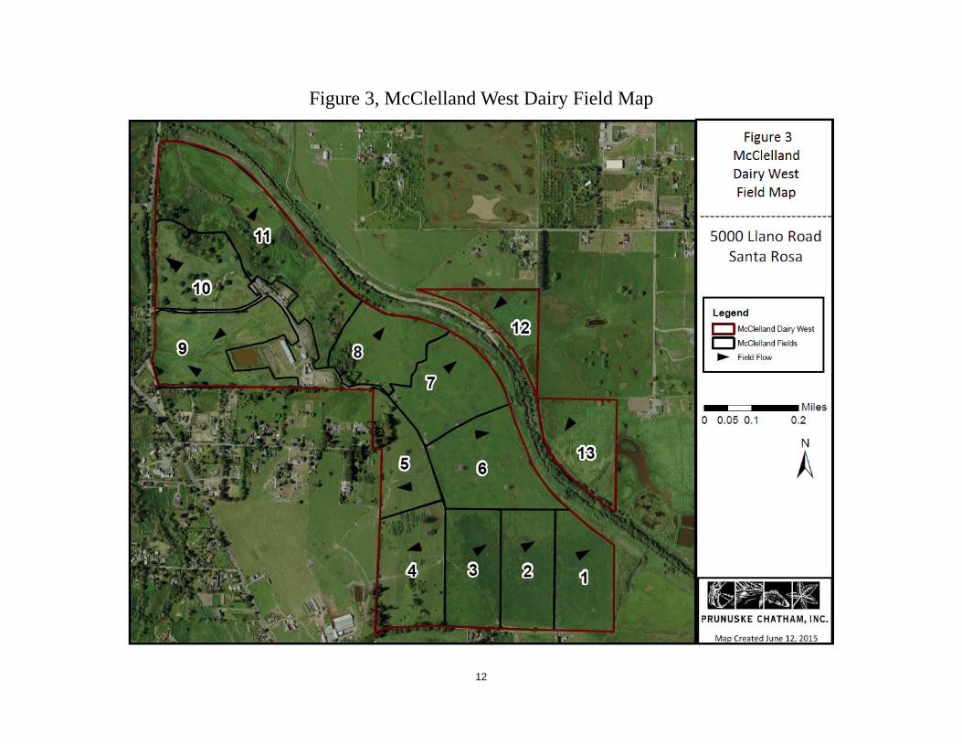
by using electrified fencing to contain and move the animals as needed. Cows would be moved to freestall barns during the wetter months, which are traditionally from November through March; however grazing may occur for a longer time in drier years and a shorter time in wetter years. Once housed in the barns, cows would be fed using silage from the dairy or feed trucked to the dairy. See Figure 3, McClelland Dairy West Field Map.
There are three domestic wells on the property, which are fenced to keep cattle away. One of the wells supplies fresh water for irrigation and would serve dairy operations and residences on the property. Well water would be used to wash cows prior to milking, to clean equipment, to wash floors, and to cool the milk. Wash water would be drained into the existing storage pond system.
Reclaimed water, provided by the City of Santa Rosa through a pipeline to the Subregional System, is used to irrigate pastures, and this use would continue for the dairy. Water is applied using a sprinkler irrigation system. The sprinkler system is run as needed based on visual crop assessment and irrigation would continue once the ranch converts to dairy operations.
The freestall barn would be used primarily for loafing and feeding. The barn would be scraped daily and manure would be directed to the storage pond. Water generated in the milking barn would also be sent to the manure pond through existing pipelines and drainage facilities. Contents of the manure pond are required to be spread evenly on the pastures in accordance with the WDR and associated Water Quality Plan and Nutrient Management Plan. Hauling of manure offsite to the Home Ranch such as for composting is an option. However, any nutrients returned to McClelland Dairy West, such as in the form of compost, must be managed for nutrient content based on the Nutrient Management Plan as required by the WDR.
All barns would have gutters installed to divert clean rain water away from the storage ponds and into vegetated areas. Rainwater collected from uncovered concrete areas containing manure, feed, or other nutrients would drain directly into the storage pond. Dry manure would be used for composting, soil amendments, bedding or trucked off site.
Based on the proposed herd size, the dairy would produce approximately 8 acre-feet of wastewater and 892 tons of manure solids annually. The existing storage pond is currently sized sufficiently to contain the wastewater produced by the proposed herd size, and no expansion of the pond system would be required to contain water during a 25-year 24-hour storm event (Erickson and Creque, 2013). An existing pump, located at the storage pond, would be used to deliver wastewater to the sprinkler system. Wastewater would be applied to all fields either when the pond is full or when the crops need it for irrigation. Any collected manure solids from the barns and calf pens would be spread evenly on the fields, stored in a location protective of water quality, or exported offsite for composting at the Home Ranch. Also, accumulated solids from the pond would be removed and either spread on the fields or exported offsite. On-site application would only be done if crops need the nutrients. Waste would be handled according to a Water Quality Plan and Nutrient Management Plan developed specifically for the dairy. The Sonoma County Water Agency manages the Laguna de Santa Rosa and the adjacent riparian area including recent revegetation. Current fencing excludes cattle from grazing within the Laguna de Santa Rosa flood control channel or within the riparian restoration project and this exclusion would continue with the conversion to dairy operations. Cattle would continue to cross the Laguna during the dry season, in a controlled manner, via an existing low water crossing bridge.

10
McClelland Dairy West Anticipated Truck Trips 1.5.2
Truck trips would be limited with the conversion to dairy operations. Cows would be milked twice a day, and one new truck trip would be added to collect and haul the milk offsite once a day. The ranch already imports feed to the property during the winter months for the existing grazing operation, and hauling in feed would continue with the dairy. Manure, solids, and liquids from the storage ponds are either spread on the pastures or hauled offsite, and the practice would continue with the reestablishment of the dairy.
A compacted dirt road crosses the property from the existing buildings to the harvest and silage manure spread area and the road has been in place since at least 1942. This road is used in the summer months to access the harvest silage area and year-round as access to grazing areas. Use of this road would continue with the reestablishment of the dairy.

11
Figure 2, McClelland West Dairy Site Map
12
Figure 3, McClelland West Dairy Field Map

13
Figure 4, McClelland West Dairy Parcel Ownership

14
1.6 Other Public Agencies Whose Approval is Required Conversion of the ranch back to dairy operations would require adoption of a WDR by the Regional Water Board, and dairy operations would be conducted to meet applicable water quality requirements. Sonoma County may have permitting or approval authority over reconstruction of dairy buildings.
1.7 Regulatory Setting WDRs are a regulatory mechanism intended to ensure that waste discharges from the reestablished dairy operations at McClelland Dairy West comply with applicable water quality requirements, primarily Water Code §13000 et seq. and the Water Quality Control Plan for the North Coast Basin.
California Water Code 1.7.1
Water Code section 13260(a) requires that any person discharging waste or proposing to discharge waste within any region that could affect the quality of the waters of the State, other than into a community sewer system, must file with the appropriate Regional Water Board a Report of Waste Discharge (ROWD) containing such information and data as may be required. Under Water Code section 13263, the Regional Water Board prescribes requirements as to the nature of any proposed or existing discharge with relation to the receiving water conditions. The discharge requirements implement any relevant Basin Plan requirements and take into consideration beneficial uses and objectives reasonably required to protect such uses, and other relevant factors. Waste discharge requirements may be waived when a regional board finds, pursuant to Water Code section 13269, that a waiver of waste discharge requirements for a specific type of discharge is consistent with applicable state or regional water quality control plans and is in the public interest.
Water Quality Control Plan (Basin Plan) 1.7.2
The Basin Plan is the Regional Water Board's master water quality control planning document. It designates beneficial uses and water quality objectives for waters of the State, including surface waters and groundwater. It also includes programs of implementation to achieve water quality standards. The Basin Plan has been adopted and approved by the State Water Resources Control Board (State Board), as well as by the United States Environmental Protection Agency (USEPA) and the Office of Administrative Law (OAL) when required. Waste Discharge Requirements require compliance with the Basin Plan water quality objectives, prohibitions, action plans, and policies.
California Antidegradation Policy 1.7.3In 1968, the State Water Board adopted Resolution 68-16 which states:
1. Whenever the existing quality of water is better than the quality established in policies as of the date on which such policies become effective, such existing high quality will be maintained until it has been demonstrated to the State that any change will be consistent with maximum benefit to the people of the State, will not unreasonably affect present and anticipated beneficial use of such water and will not result in water quality less than that prescribed in the policies.
2. Any activity which produces or may produce a waste or increased volume or concentration of waste and which discharges or proposes to discharge to existing high quality waters will be required to meet waste discharge requirements which will result in the best practicable

15
treatment or control of the discharge necessary to assure that (a) a pollution or nuisance will not occur and (b) the highest water quality consistent with maximum benefit to the people of the State will be maintained.
Any activity that results in the degradation of the quality of waters of the state is required to employ best practicable treatment or control of the discharge necessary to assure that pollution or nuisance will not occur and the highest quality of water will be maintained consistent with maximum benefit to the people of the state.
California Nonpoint Source Policy 1.7.4
The State Board adopted the Policy for the Implementation and Enforcement of the Nonpoint Source Pollution Control Program (NPS Policy) pursuant to Water Code §13369 (a)(2)(B). The NPS Policy requires regulation of nonpoint source pollution through one, or a combination, of the following permitting authorities:
• Basin Plan prohibitions
• Waste Discharge Requirements
• Conditional Waivers of Waste Discharge Requirements
The WDR for the McClelland Dairy West would be consistent with the California Nonpoint Source Policy.
Total Maximum Daily Loads (TMDL) 1.7.5
Section 303(d) of the Clean Water Act (CWA) and associated regulations contain provisions for developing TMDLs for impaired waterbodies. In 1996, the USEPA approved the Laguna de Santa Rosa TMDL for high levels of ammonia and low dissolved oxygen concentrations. Regional Water Board staff is currently developing new TMDLs for indicator bacteria, nitrogen, phosphorus, dissolved oxygen, temperature, and sediment in the Laguna de Santa Rosa watershed to address continuing water quality impairments.
Clean Water Act (CWA) 1.7.6
The State and Regional Water Boards are delegated as the State agency with responsibility for implementing the federal CWA in California.

Determination
16
2. Determination
The environmental factors checked below would be potentially affected by this Project, involving at least one impact that is a "Potentially Significant Impact" as indicated by the checklist on the following pages.
Aesthetics Agriculture Resources Air Quality
Biological Resources Cultural Resources Geology /Soils
Hazards & Hazardous Materials Hydrology / Water Quality Land Use / Planning
Mineral Resources Noise Population / Housing
Public Services Recreation Transportation/Traffic
Utilities / Service Systems Mandatory Findings of Significance
On the basis of this initial evaluation:
I find that the proposed Project COULD NOT have a significant effect on the environment and a NEGATIVE DECLARATION will be prepared.
I find that although the proposed Project could have a significant effect on the environment, there will not be a significant effect in this case because revisions in the Project have been made by or agreed to by the Project proponent. A MITIGATED NEGATIVE DECLARATION will be prepared.
I find that the proposed Project MAY have a significant effect on the environment, and an ENVIRONMENTAL IMPACT REPORT is required.
I find that the proposed Project MAY have a “potentially significant impact” or “potentially significant unless mitigated" impact on the environment, but at least one effect 1) has been adequately analyzed in an earlier document pursuant to applicable legal standards, and 2) has been addressed by mitigation measures based on the earlier analysis as described on attached sheets. An ENVIRONMENTAL IMPACT REPORT is required, but it must analyze only the effects that remain to be addressed.
I find that although the proposed Project could have a significant effect on the environment, because all potentially significant effects (a) have been analyzed adequately in an EARLIER EIR or NEGATIVE DECLARATION pursuant to applicable legal standards, and (b) have been avoided or mitigated pursuant to that earlier EIR or NEGATIVE DECLARATION, including revisions or mitigation measures that are imposed upon the proposed Project, nothing further is required.
_____________________________________ __________________________
Signature Date
____________________________________
Name, Title

Aesthetics
17
3. Environmental Effects of the Project
I. AESTHETICS
Would the Project: Potentially Significant
Impact
Less Than Significant
With Mitigation
Incorporated
Less-Than-
Significant Impact
No Impact
a. Have a substantial adverse effect on a scenic vista? X
b. Substantially damage scenic resources, including, but not limited to, trees, rock outcroppings, and historic buildings within a state scenic highway?
X
c. Substantially degrade the existing visual character or quality of the site and its surroundings? X
d. Create a new source of substantial light or glare which would adversely affect day or nighttime views in the area? X
Discussion:
I. a & c) Adverse effect on a scenic vista or substantially degrade existing visual character or quality – No Impact
One of the most important scenic elements of western Sonoma County, typifying the scenic character of areas inland from the coast, is the open hills of grazing land with cattle roaming across them. McClelland Dairy West is visible from Llano Road and Highway 116. The appearance of animals grazing would not change with reestablishment of dairy operations. Changes in ranch management, such as feeding routines, would not alter the visual character. The adoption of a WDR and reestablishment of dairy operations would have no impact on scenic resources.
I. b) Adverse effect on scenic resources on a State scenic highway – No Impact
McClelland Dairy West is located northwest of the intersection of Llano Road and Highway 116. This portion of Highway 116 is eligible for designation as a State Scenic Route (Caltrans 2015). As described above, conversion of the property to a dairy operation would not adversely affect the scenic nature of the property. The adoption of a WDR and reestablishment of grazing would have no impact on scenic resources on a State Scenic Highway.
I. d) Create a new source of substantial light or glare that would adversely affect day or nighttime views in the area – Less than Significant
New lights may be installed on the barns to accommodate milking. The milk barn sits on the top of a hill with a 360 degree view of the surrounding country side. These new lights would be visible across the fields and potentially from the roads. However, the amount of light shed would not interfere significantly with a dark night sky or change the existing character of the night in the neighborhood. Llano Road, the closest roadway, is approximately 1,700 feet from the dairy structures at McClelland Dairy West. Glare from the new lights would not create substantial light or glare because of the distance from the light source to Llano Road and other buildings and vegetation blocking the view. Residences located south of the dairy are over 650 feet from the milk barn and the view is blocked by trees. Other residences across Llano Road would not be affected by new lights on the barns since trees line the parcel boundary, and

Aesthetics
18
views would be partially blocked by other buildings on the dairy. The impact from new barn lights on daytime or nighttime views would be less than significant.

Agriculture and Forest Resources
19
II. AGRICULTURE AND FOREST RESOURCES
Potentially Significant
Impact
Less Than Significant
With Mitigation
Incorporated
Less-Than-
Significant Impact No Impact
Would the Project: (In determining whether impacts to agricultural resources are significant environmental effects, lead agencies may refer to the California Agricultural Land Evaluation and Site Assessment Model (1997) prepared by the California Dept. of Conservation as an optional model to use in assessing impacts on agriculture and farmland. In determining whether impacts to forest resources, including timberland, are significant environmental effects, lead agencies may refer to information compiled by the California Department of Forestry and Fire Protection regarding the state’s inventory of forest land, including the Forest and Range Assessment Project and the Forest Legacy Assessment Project; and forest carbon measurement methodology provided in Forest Protocols adopted by the California Air Resources Board.)
a. Convert Prime Farmland, Unique Farmland, or Farmland of Statewide Importance (Farmland), as shown on the maps prepared pursuant to the Farmland Mapping and Monitoring Program of the California Resources Agency, to non-agricultural use?
X
b. Conflict with existing zoning for agricultural use, or a Williamson Act contract? X
c. Conflict with existing zoning for, or cause rezoning of, forest land (as defined in Public Resources Code section 12220(g)), timberland (as defined by Public Resources Code section 4526), or timberland zoned Timberland Production (as defined by Government Code section 51104(g))?
X
d. Result in the loss of forest land or conversion of forest land to non-forest use? X
e. Involve other changes in the existing environment which, due to their location or nature, could result in conversion of Farmland, to non-agricultural use or conversion of forest land to non-forest use?
X
Discussion:
II. a, b, c, d, e) Convert farmland/forestland or conflict with existing zoning for agricultural/forest land use – No Impact
The property would remain in agricultural use. Adoption of a WDR related to the reestablishment of dairy operations would not result in changes to the current condition of agricultural resources. No farmlands or forest lands would be converted to nonagricultural or non-forest land uses. The project would not conflict with existing zoning for agricultural use or any Williamson Act contract. There are no forest lands in the project area.

Air Quality
20
III. AIR QUALITY
Would the Project: (Where available, the significance criteria established by the applicable air quality management or air pollution control district may be relied upon to make the following determinations.) Potentially
Significant Impact
Less Than Significant
With Mitigation
Incorporated
Less-Than-
Significant Impact
No Impact
a. Conflict with or obstruct implementation of the applicable air quality plan?
X
b. Violate any air quality standard or contribute substantially to an existing or projected air quality violation?
X
c. Result in a cumulatively considerable net increase of any criteria pollutant for which the Project region is nonattainment under an applicable federal or state ambient air quality standard (including releasing emissions which exceed quantitative thresholds for ozone precursors)?
X
d. Expose sensitive receptors to substantial pollutant concentrations?
X
e. Create objectionable odors affecting a substantial number of people?
X
Discussion:
III. a) Conflict with or obstruct implementation of the applicable air quality plan – No Impact
The property is located within the jurisdiction of the Bay Area Air Quality Management District (BAAQMD). In 2010, BAAQMD adopted the Clean Air Plan (CAP) addressing four categories of pollutants:
• Ground-level ozone and its key precursors, reactive organic gases (ROG), and total concentration of nitric oxide and nitrogen dioxide (NOx);
• Particulate matter2 (PM): PM10, primary PM2.5, as well as precursors to secondary PM2.5; • Air toxics; and • Greenhouse gases (GHG).
The plan includes Stationary Source Measure 3 for livestock waste management practices to reduce ROG, ammonia, PM, and GHG. The measure calls for best management practices that reduce organic emissions from feed, which constitute half of organic emissions at small-scale dairies (BAAQMD 2010) and from waste streams. These best management practices are:
• Prepare feed according to National Research Council guidelines specified in the most recent version of the “Nutrient Requirements of Dairy Cattle.”
• Store grain in a weatherproof storage structure from October through May. • Remove feed from the area where animals eat at least once every 14 days.
2 Particulate matter is described as PM10, particulate matter up to 10 micrometers in size, and PM2.5, particulate matter smaller than
2.5 micrometers.

Air Quality
21
• Cover the horizontal surface of silage piles, except for the area where feed is being removed from the silage pile.
• Flush or hose milking parlor immediately prior to, immediately after, or during each milking. • Flush freestalls more frequently than the milking schedule. • Use non-manure-based bedding for at least 90% of the bedding material, by weight, for
freestalls (e.g., rubber mats, almond hulls, sand, or waterbeds). • Inspect water pipes and troughs and repair leaks at least once every 14 days. • Clean concrete areas such that the depth of animal waste does not exceed 12 inches at any
point or time, except in-corral mounding. • Manage corrals such that the animal waste depth in the corral does not exceed twelve inches
at any point or time, except for in-corral mounding. • Knock down fence line animal waste build-up prior to it exceeding a height of 12 inches at any
time. • Scrape or flush feed aprons in corrals at least once every 7 days. • Maintain corrals to ensure drainage and to prevent water from standing more than 48 hours. • Cover dry animal waste piles outside of the corrals with a waterproof covering from October
through May, except for times, not to exceed 24 hours, when wind removes the covering. • Cover dry separated solids outside the corrals with a waterproof covering from October
through May, except for times, not to exceed 24 hours, when wind removes the covering. • Remove solids from the waste system with a solid separator system prior to the waste entering
the lagoon. • Manage the liquid animal waste so it stands in the fields no more than 24 hours if it is applied
on land as fertilizer. • Do not apply any solid animal waste that has a moisture content of more than 50% as fertilizer
on fields.
The rancher already implements management practices that meet, and usually exceed, these standards. Dairy operations would be in full compliance with the CAP. No impact would occur.
III. b & c) Violate any air quality standard or contribute substantially to an existing or projected air quality violation or result in a cumulatively considerable net increase of any criteria pollutant – Less than Significant
Chemicals with potential basin-wide effects are regulated under the federal Clean Air Act (CAA) in two groups: 1) toxic air contaminants with immediate, acute toxicity effects and 2) criteria pollutants that are common chemicals with long-term health effects. Acutely toxic chemicals are problematic at any concentration; however, the effect of criteria contaminants depends on the amount of exposure over time. Accordingly, the USEPA sets limits on maximum atmospheric concentration for each pollutant. The State of California is required to use these limits but may also set higher standards when the California Air Resources Board (CARB) determines that tighter limits would protect human health. See Table III-1 below for State and federal standards and whether the Bay Area is currently meeting those standards.

Air Quality
22
Table III-1, Bay Area Air Quality Management District Summary of Ambient Air Quality Standards and Attainment, 2015
Pollutant
Averaging
Time
California Standards 1 National Standards 2
Concentration Attainment
Status Concentration3 Attainment
Status
Ozone (Oe) 8-hour 0.070 ppm (137 µg/m3) N 0.075 ppm N4
1-hour 0.09 ppm (180 µg/m3) N See Note 5
Carbon Monoxide (CO)
8-hour 9.0 ppm (10 mg/m3) A 9 ppm (10 mg/m3) A6
1-hour 20 ppm (23 mg/m3) A 35 ppm (40 mg/m3) A
Nitrogen Dioxide (NO2)
1-hour 0.18 ppm (339 µg/m3) A 0.100 ppm; See Note 11 U
Annual Arithmetic
Mean (AAM) 0.030 ppm (57 µg/m3) 0.053 ppm (100 µg/m3) A
Sulfur Dioxide (SO2)
24-hour 0.04 ppm (105 µg/m3) A 0.14 ppm (365 µg/m3) A
1-hour 0.25 ppm (655 µg/m3) A 0.075 ppm (196 µg/m3) A
AAM 0.030 ppm (80 µg/m3) A
Particulate Matter (PM10)
AAM 20 µg/m3 N7 50 µg/m3 f
24-hour 50 µg/m3 N 150 µg/m3 U
Fine Particulate Matter (PM2.5)
AAM 12 µg/m3 N7 15 µg/m3 U/A
24-hour No Standard 65 µg/m3 N
Sulfates 24-hour 25 µg/m3 A
Lead
30-day Avg. 1.5 µg/m3 - A
Quarter - 1.5 µg/m3 A
3-month Avg14
- 0.15 µg/m3 See Note 14
Sulfates 24-hour 25 µg/m3
No Federal Standards
Hydrogen Sulfide 1-hour 0.03 ppm (42 µg/m3) U16
Vinyl Chloride 24-hour 0.010 ppm (26 µg/m3)
Visibility Reducing
Particles (VRP) 8-hour See Note 8 U
Source: Bay Area Air Quality Management District 2015
Notes: 1. California standards for ozone, carbon monoxide (except Lake Tahoe), sulfur dioxide (1-hour and 24-hour), nitrogen
dioxide, suspended particulate matter - PM10, and visibility reducing particles are values that are not to be exceeded.
2. National standards shown are the "primary standards" designed to protect public health. National standards other than for ozone, particulates and those based on annual averages are not to be exceeded more than once a year. The 1-hour ozone standard is attained if, during the most recent three-year period, the average number of days per year with maximum hourly concentrations above the standard is equal to or less than one. The 8-hour ozone standard is attained when the 3-year average of the 4th highest daily concentrations is 0.075 ppm (75 ppb) or less.

Air Quality
23
The 24-hour PM10 and PM2.5 standards are attained when the 3-year average of the 99th percentile of monitored concentrations equal to or less than the standard.
3. National air quality standards are set by US EPA at levels determined to be protective of public health with an adequate margin of safety.
4. Final designations effective July 20, 2012. 5. The national 1-hour ozone standard was revoked by USEPA on June 15, 2005. 6. In April 1998, the Bay Area was redesignated to attainment for the national 8-hour carbon monoxide standard. 7. In June 2002, CARB established new annual standards for PM2.5 and PM10. 8. Statewide VRP Standard (except Lake Tahoe Air Basin): Particles in sufficient amount to produce an extinction
coefficient of 0.23 per kilometer when the relative humidity is less than 70 percent. This standard is intended to limit the frequency and severity of visibility impairment due to regional haze and is equivalent to a 10-mile nominal visual range.
9. The 8-hour CA ozone standard was approved by the Air Resources Board on April 28, 2005 and became effective on May 17, 2006.
10. On January 9, 2013, the USEPA issued a final rule to determine that the Bay Area attains the 24-hour PM2.5 national standard. This USEPA rule suspends key SIP requirements as long as monitoring data continues to show that the Bay Area attains the standard. Despite this USEPA action, the Bay Area will continue to be designated as “non-attainment” for the national 24-hour PM2.5 standard until such time as the Air District submits a “redesignation request” and a “maintenance plan” to USPA, and USEPA approves the proposed redesignation.
11. To attain this standard, the 3-year average of the 98th percentile of the daily maximum 1-hour average at each monitor within an area must not exceed 0.100ppm (effective January 22, 2010).
12. On June 2, 2010, the USEPA established a new 1-hour SO2 standard, effective August 23, 2010, which is based on the 3-year average of the annual 99th percentile of 1-hour daily maximum concentrations. The existing 0.030 ppm annual and 0.14 ppm 24-hour SO2 NAAQS however must continue to be used until one year following USEPA initial designations of the new 1-hour SO2 NAAQS. USEPA expects to designate areas by June 2012.
13. CARB has identified lead and vinyl chloride as ‘toxic air contaminants’ with no threshold level of exposure below which there are no adverse health effects determined.
14. National lead standard, rolling 3-month average: final rule signed October 15, 2008. Final designations effective December 31, 2011.
15. In December 2012, USEPA strengthened the annual PM2.5 National Ambient Air Quality Standards (NAAQS) from 15.0 to 12.0 micrograms per cubic meter (μg/m3). In December 2014, USEPA issued final area designations for the 2012 primary annual PM2.5 NAAQS. Areas designated “unclassifiable/attainment” must continue to take steps to prevent their air quality from deteriorating to unhealthy levels. The effective date of this standard is April 15, 2015.
16. Unclassified – attainment status for pollutant has not been designated, considered attainment for regulatory purposes.
Adoption of a WDR and reestablishment of dairy operations would not change the air contaminant emissions generated by vehicle emissions, particulate matter from driving on unpaved ranch roads, emissions of solvents from cleaning and maintenance activities, or air emissions from animal waste. Operation of the dairy would increase milk truck vehicle trips to and from the dairy by one trip per day. The number of vehicles and the cleaning and maintenance activities would otherwise remain the same as current operations.
Dairy operations would not generate chemicals identified by the State of California as toxic air contaminants (CARB 2011) except for particulate emissions from diesel engines. Since the standards for particulate emissions are regulated under criteria pollutants, this analysis addresses only criteria pollutants. Of the new or expanded dairy activities, the one that would increase criteria pollutants is the increase of one milk truck trip per day. Increased use of electricity also has the capacity to generate criteria pollutants when it is produced by burning fossil fuels. However, electric power in Sonoma County comes largely from the Geysers and other renewable, largely clean, sources. Effects of increase electrical use are discussed in the GHG section and would not have an effect on local concentrations of criteria pollutants.
Vehicles produce carbon monoxide (CO), nitrogen dioxide (NO2), sulfur dioxide (SO2), particulate matter (PM10), fine particulate matter (PM2.5), and ozone precursors. Of these pollutants, the Bay Area is nonattainment for ozone and particulate matter. However, the project would increase milk truck vehicle

Air Quality
24
use by approximately one vehicle per day. Comparing an increase of approximately one vehicle to the 416,480 on- and off-road vehicles already operating in Sonoma County (DMV 2009), this comprises an increase of approximately 0.0002%, which is not a substantial increase in criteria pollutants. The impact on air quality from the adoption of a WDR related to the reestablishment of dairy operations would be less than significant.
III. d & e) Expose sensitive receptors to substantial pollutant concentrations or create objectionable odors affecting a substantial number of people – No Impact
Dairy operations at the ranch would not expose sensitive receptors to pollutants because cattle currently graze on the ranch, and the ranch has an existing manure pond. Manure is spread on the fields currently, and the practice would continue with the reestablishment of dairy operations. Cattle would move from the pastures to the milking barn two times per day. Once milked, the cows would return to the pasturelands to graze. Manure amounts would increase slightly at the dairy; however, manure management would continue and no new composting areas or manure ponds would be developed. No new areas would be exposed to odors and no increase in objectionable odors is anticipated, and, thus, there would be no impact.

Biological Resources
25
IV. BIOLOGICAL RESOURCES
Would the Project:
Potentially Significant
Impact
Less Than Significant
With Mitigation
Incorporated
Less-Than-
Significant Impact
No Impact
a. Have a substantial adverse effect, either directly or through habitat modifications, on any species identified as a candidate, sensitive, or special-status species in local or regional plans, policies, or regulations, or by the California Department of Fish and Wildlife or U.S. Fish and Wildlife Service?
X
b. Have a substantial adverse effect on any riparian habitat or other sensitive natural community identified in local or regional plans, policies, regulations or by the California Department of Fish and Wildlife or US Fish and Wildlife Service?
X
c. Have a substantial adverse effect on federally protected wetlands as defined by Section 404 of the Clean Water Act (including, but not limited to, marsh, vernal pool, coastal, etc.) through direct removal, filling, hydrological interruption, or other means?
X
d. Interfere substantially with the movement of any native resident or migratory fish or wildlife species or with established native resident or migratory wildlife corridors, or impede the use of native wildlife nursery sites?
X
e. Conflict with any local policies or ordinances protecting biological resources, such as a tree preservation policy or ordinance?
X
f. Conflict with the provisions of an adopted Habitat Conservation Plan, Natural Community Conservation Plan, or other approved local, regional, or state habitat conservation plan?
X
Discussion:
On May 18, 2015, biologists conducted a site assessment of the McClelland Dairy West property. The purpose of the visit was to characterize natural resources present on the property and to identify the potential presence of any sensitive species or habitat types potentially affected by the adoption of the WDR related to the reestablishment of dairy operations. A review of background information, including aerial imagery and the California Natural Diversity Database (CNDDB) maintained by the California Department of Fish and Wildlife, was done prior to the site visit. The CNDDB is a repository of information on sightings and collections of rare, threatened, or endangered plant and animal species within California. CNDDB reports occurrences of special-status species that have been entered into the database and does not generally include inventories of more common animals or plants. In addition to the CNDDB, other databases (e.g., U.S. Fish and Wildlife Service, California Native Plant Society) and general references were also consulted to evaluate the potential for additional unique biological communities and special-status species. The search focused on CNDDB-reported occurrences for the Two Rock and Sebastopol

Biological Resources
26
7.5’ USGS quadrangles where the property is located and surrounding quads, and those species identified as having a high likelihood of occurrence in the background reports.
The McClelland property has been in agricultural production since before the 1940s. Throughout the history of this dairy, agricultural production has included grazing, crop production, fertilizer application, and infrastructure development with other associated uses. While the number of animals grazing could increase, rotational grazing, cows/acre, and frequency of grazing, as well as the housing of animals in the barn during the wetter winter months, would result in a grazing impact similar to existing baseline conditions. The existing footprint of the current cattle grazing operation would remain the same for the proposed conversion to dairy farming on the property.
Habitat on the McClelland property consists of grassland used for pasture and silage production, mixed oak woodland, wetlands, and swales. On its north side, the property abuts the Laguna de Santa Rosa. Ranch and dairy buildings, including residences, barns, and two manure lagoons, are present on the northern part of the property.
Most of the herbaceous vegetation has been highly managed for ranching, with regular tilling and planting of forage species. It is dominated by planted species including Italian rye, barley (Hordeum sp.), vetch (Vicia sp.), and oat (Avena sp.).
Wetlands are present in two places along the northeast-facing slope above the Laguna floodplain. One wetland occurs below the old ranch housing and is dominated by Himalayan blackberry. Another occurs east of the dairy buildings and is dominated by rushes. Both of these are densely vegetated and appear relatively undisturbed by cattle. In addition, some cattails (Typha sp.) have established in the manure lagoons.
A remnant stand of mature oaks [black oak (Q. kelloggii), valley oak, and coast live oak (Q. agrifolia)] is present along Llano Road, and scattered oaks are present throughout the property. These trees would remain. Along the Laguna corridor, both naturally occurring and planted riparian vegetation is present, including willows, oaks, and other woody native species. Riparian vegetation along the Laguna is fenced and cattle are excluded from the area. The fence would remain with the reestablishment of dairy operations. Trees within the fenced area would not be removed as part of dairy operations, and the riparian vegetation would remain.
IV. a) Impacts to candidate, sensitive and special-status species – No Impact
The goal of the WDR for the cow dairy is to establish requirements to conduct dairy operations in compliance with applicable water quality standards and regulations; requirements are also designed to protect riparian habitat and aquatic species. The WDR would require the dairy operations to be conducted in a manner that complies with applicable water quality standards. The practices would include protection and restoration of the beneficial uses of water, including those that support habitats necessary, at least in part, for the survival and successful maintenance of plant or animal species established under State or federal laws as rare, threatened, or endangered.
The WDR would include a wide range of specific requirements designed to prevent or minimize either direct or indirect adverse impacts to in-stream and riparian habitat. Existing fencing on the property prevents cattle from entering riparian areas along the Laguna de Santa Rosa to protect riparian-dependent species that occupy the area. Pastures used for grazing on the property do not support riparian vegetation. The reestablishment of dairy operations would not result in impacts to riparian

Biological Resources
27
vegetation or special-status species because the WDR would require that the fencing be maintained to exclude cattle from the sensitive riparian areas.
The production area of the McClelland property drains to the manure ponds. This area is in the Turner Creek watershed, which is a tributary to the Laguna de Santa Rosa watershed. Existing riparian vegetation along the channels and the distance between the production areas and the channels would protect water quality and aquatic special-status species. Additionally, water quality measures mandated in the WDR would further protect water quality in Turner Creek and the Laguna de Santa Rosa. The Regional Water Board would include the following to protect water quality: 1) require appropriately sized manure ponds to prevent overflow of water during storm events, 2) prohibit discharge of sediments and nutrients from compost and manure areas to surrounding surface waters, 3) prevent recycled water used for irrigation from running off and entering surface waters, and 4) prevent manure and sediment from entering waterways bridged by cattle crossings.
While the WDR would not be explicitly designed to mitigate potential impacts on terrestrial species, approval of the WDR and implementation of covered activities would not alter current conditions at the dairy, and the current conditions do not result in impacts on special status terrestrial animals. Therefore, issuance of the WDR and reestablishment of dairy operations would have no impacts to special status terrestrial animals.
Special-status Plants
Vernal pool plants
Several listed vernal pool plant species are reported within the Laguna de Santa Rosa and habitats surrounding the McClelland Dairy West property. They include, but are not limited to, three federally listed species (Sonoma sunshine, Burke’s goldfields, and Sebastopol meadowfoam) and additional species of local concern (e.g., California Native Plant Society-listed species). Vernal pools and wetland habitats on the property are unlikely to support populations of listed plants given the current condition and historical land uses. Current ranching operations on the property includes seasonal grazing within wetlands and the application of manure nutrients and soil amendments such as lime and gypsum. Under the dairy operations, the seasonal use of these areas would remain the same. The reestablishment of dairy operations would not result in new impacts on listed plants, as no new areas would be grazed or otherwise impacted. Additionally, cattle are excluded from entering riparian areas along the Laguna de Santa Rosa. Based on the present habitat, current and future grazing on the site, and lack of access by cattle to the riparian areas, no special-status plant species would be affected by the adoption of the WDR related to the reestablishment of dairy operations.
Special-status Wildlife
California tiger salamander
Based on the field survey and background review, California tiger salamander (CTS) breeding and upland habitats were identified in the vicinity of the McClelland Dairy West. Adult occurrences of CTS were reported east of the McClelland property on the west side of Stony Point Road. CTS were also reported north of the Santa Rosa Wastewater Treatment Plant. CTS are not documented on the west side of the Laguna de Santa Rosa and are unlikely to occur on the McClelland Dairy West property.

Biological Resources
28
Under the reestablished dairy operation, seasonal grazing would continue. Manure application rates and irrigation would also continue and the manure application rates could vary depending on the estimated crop needs to support the proposed grazing. Currently, cattle are grazed during the drier months and are housed and fed in the barn during the wetter winter months. While the number of animals grazing would increase, CTS migration and breeding occur during the winter months when the cows would be not be grazing outside. The adoption of the WDR related to the reestablishment of dairy operations would not result in impacts to CTS because no new areas would be grazed or included in future dairy operations.
IV. b & c) Impacts to riparian habitat and jurisdictional wetlands and waters of the U.S. –Less than Significant
Adoption of the WDR and reestablishment of dairy operations on the McClelland Dairy West would not change the current conditions of the riparian habitat or wetlands on the property. Currently, grazing occurs seasonally in pastures on the property, and the pastures have wetlands and vernal pools in them as well as riparian habitat along the Laguna de Santa Rosa. Existing fencing, along the perimeter of the property and along riparian areas within the property, excludes cattle from grazing in riparian habitats. Use of electric fencing would continue as part of grazing management to provide optimal forage opportunities and minimize damage from grazing, including grazing in vernal pools. The impacts to riparian habitats and jurisdictional wetlands and waters would remain less than significant.
IV. d) Impact on movement of native residents or migratory fish or wildlife species - Less than Significant
Adoption of the WDR and the conversion to dairy operations on the property would not interfere with the movement of any native or resident fish or wildlife species. As part of the dairy operations, external fencing would remain the same, and conditions would not change from current conditions. The management of internal fencing for rotational grazing would occur more frequently to provide optimal forage opportunities for the cows but would occur in a manner that is consistent with current operations (e.g., fencing type and location). Current operations do not prevent fish or wildlife migration, and the impact from the conversion to dairy operations would remain less than significant.
IV. e & f) Conflict with local policies or ordinances protecting biological resources or conflict with provisions of an adopted Habitat Conservation Plan, Natural Community Conservation Plan, or other approved local, regional, or state habitat conservation plan – No Impact
Adoption of the WDR and reestablishment of dairy operations would not conflict with local policies or ordinances protecting biological resources or conflict with other plans. The property is located within an area covered by the U.S. Fish and Wildlife Service’s Santa Rosa Plain Conservation Strategy for California tiger salamander (Strategy). The Strategy was adopted in 2005 to protect federally listed California tiger salamander and five species of federally listed vernal pool plants; the Strategy:
• Identifies potential impacts on listed species from development activities.
• Establishes preserves for species protection.
• Designates priority areas for development, conservation, and mitigation based upon habitat value and surrounding existing uses.
• Provides standards for acceptable land management within the Strategy area.
The Strategy identifies grazing as an appropriate management practice for habitat preserves:

Biological Resources
29
Management of the vegetation on the site may require numerous techniques to reduce or eliminate exotic, competing, or undesirable plant species. These techniques should be compatible with listed plants. These techniques will include an appropriate grazing regime or mowing.
The McClelland Dairy West is listed as having potential habitat for CTS and vernal pool plants; however, a majority of the property is on the Laguna de Santa Rosa floodplain, and CTS generally do not utilize floodplain habitat. Pastures outside the floodplain provide upland habitat, and the property is on the far western boundary of CTS critical habitat. The pastures are tilled and grazed currently, and both practices would continue with adoption of the WDR and reestablishment of dairy operations. Continued grazing of the pastures would not conflict with the Santa Rosa Plain Conservation Strategy as grazing is a consistent practice.
The Sonoma County General Plan (Sonoma County 2013) identifies the ranch as diverse agriculture and includes a number of goals and policies associated with biological resources and biotic habitat areas. The adoption of the WDR and reestablishment of dairy operations would not conflict with the policies since the dairy operations would be conducted to protect water quality and riparian habitats. Trees would not be removed within existing riparian areas, riparian corridors would continue to be protected, water quality protection measures would be implemented, and grazing would be conducted in a manner designed to protect local resources; therefore, there would be no conflicts with local plans.

Cultural Resources
30
V. CULTURAL RESOURCES
Would the Project:
Potentially Significant
Impact
Less Than Significant
With Mitigation
Incorporated
Less-Than-
Significant Impact
No Impact
a. Cause a substantial adverse change in the significance of historical resources or archaeological resources as defined in Section 15064.5?
X
b. Directly or indirectly destroy a unique paleontological resource or site or unique geologic feature, or disturb any human remains, including those interred outside of formal cemeteries?
X
c. Cause a substantial adverse change in the significance of a tribal cultural resource as defined in Section 21074 of the Public Resources Code?
X
Discussion:
Archival Records Search Results
An archival records search at the Northwest Information Center (NWIC) of the California Historical Resource Information System was completed for the property in order to obtain information on any recorded cultural resources sites and to help predict the potential for the presence of unknown resources. The search results identified previous cultural resources studies within ¼ mile of the McClelland property. Important reports are: Cultural Resources Inventory Report, Project Number 749104130LM (Goodsell 2014) and A Cultural Resources Survey for the McClelland Dairy Project, Sonoma County, California (Alshuth and Origer, 2016) as part of the McClelland Dairy West project.
Native American Tribal Contacts
The Native American Heritage Commission (NAHC) was contacted on May 15, 2015, to request a review of the sacred lands file for the presence of resources within or near the property and to request a list of tribal representatives who may have knowledge of resources within the area. On July 10, 2015, the Regional Water Board received a reply from NAHC with the tribal representatives list. On July 21, 2015, the Regional Water Board sent letters to the tribal representatives on the list notifying them of the proposed project, and requesting information on any resources that may be impacted. A project description and map were included in the letters. On July 24, 2015, Regional Water Board received an email response from a tribal representative of the Federated Indians of Graton Rancheria requesting to discuss the project in more detail and review of cultural resources reports and surveys. A general letter addressed to “Agency Representative,” dated July 1, 2015, was attached to the email from the Federated Indians of Graton Rancheria. This general letter requests formal notice and information on the proposed project and states that the tribe may request consultation and mitigation. Regional Water Board staff had a conference call with the tribal representatives on July 28, 2015. Additional project information was sent to the tribe per their request. Regional Water Board staff met with the tribal representatives on September 1, 2015. Then on September 14, 2015, tribal representatives and tribal archaeologist visited McClelland Dairy West along with the landowners and Regional Water Board staff. On November 13, 2015, Regional Water Board staff and the McClellands met with tribal representatives to further discuss the draft project. These meetings with the tribe resulted in the landowners hiring a private archaeologist in late 2015 to survey one of the parcels (Alshuth and Origer, 2016). Recommendations from that report
Cultural Resources
31
are reflected in this Cultural Resources section of the Initial Study. On April 12, 2016, North Coast Regional Water Quality Control Board staff met with the Federated Indians of Graton Rancheria representatives (Tribe) to discuss tribal cultural resources at the proposed McClelland Dairy West Site.
V. a) Historical Resources and Archaeological Resources – Less than Significant with Mitigation A July 6, 2015, letter to the McClelland project consultant from the Northwest Information Center, Sonoma State University, regarding the project, states that: “The State Office of Historic Preservation Historic Property Directory (OHP HPD) (which includes listings of the California Register of Historical Resources, California State Historical Landmarks, California State Points of Interest, and the National Register of Historic Places) lists no recorded buildings or structures within the proposed project areas. In addition to these inventories, the NWIC base maps show no recorded buildings or structures within the proposed project areas.” The letter goes on to the state that 1866 and 1935 maps depict buildings or structures within the project area. It concludes that there is a moderate potential of historic-period archaeological resources at the dairy, and recommends that a professional archaeologist assess the resources and provide project-specific recommendations. The letter also recommends that the local Native American tribe(s) be contacted regarding traditional, cultural, and religious heritage values.
The Alshuth and Origer (2016) archaeological study identifies cultural resources, evaluates the significance, assesses resource vulnerability to effects that could arise from the project activities, and contains suggestions to protect the resource integrity. This study lists six residences, three barns, and two outbuildings. All buildings are listed as built after 1935 and none as meeting the criteria for inclusion on the California Register of Historical Resources. As part of the new project, barns would be reconstructed at McClelland Dairy West on the existing foundations as the previous structures on APN 062-240-026. This activity does not involve alteration of historical resources. No other building construction, reconstruction, or removal is proposed to convert back to dairy operations on the project site.
The remaining 173 acres (APNs 062-240-028, 062-240-001, 046-011-020, and 062-240-012) consist of grazing land, forest, brushy vegetation, and dirt roads. These parcels do not contain any buildings. At least one archaeological study (Goodsell 2014) was done on some of these parcels. Other archaeological studies done on or in the dairy parcel areas are listed in NWIC File No. 14-1787. Based on an evaluation of the environmental setting and features associated with known archaeological sites, Native American resources in this part of Sonoma County have been found near sources of water (including perennial and intermittent springs and streams) and near the interface between valleys and adjacent uplands. The dairy is located adjacent to the main channel of the Laguna de Santa Rosa and portions of the dairy grazing land are located within alluvial fan deposits on the Santa Rosa Plain.
There are three archaeological sites identified and described in Appendix D – Archaeology (Confidential). No information exists regarding whether, without merely adding to the current body of knowledge, the sites contain information needed to answer important scientific research with a demonstrable public interest in that information, contain information that the sites have a special and particular quality such as being the oldest of its type or the best available example of its type, or information that is directly associated with a scientifically recognized important prehistoric or historic event or person. (Public Resources Code section 21083.2). As such these sites shall not be treated as a unique archaeological resources in this CEQA analysis. The archeological sites are not listed in, and have not been determined yet by the State Historical Resources Commission, to be eligible for listing in the California Register of Historical Resources. However, each of the archaeological sites has yielded, or may be likely to yield,
Cultural Resources
32
information important to prehistory or history of the local area or the state of California or the nation (Alshuth and Origer 2016) and are therefore historically significant (14 Cal. Code of Regs. Section 15064.5(a)).
Potential Impacts
A project with an effect that may cause a substantial adverse change in the significance of a historical resource is a project that may have a significant effect on the environment. (14 Cal. Code of Regs. Section 15064.5(b)). A substantial adverse change in the significance of a historical resource means physical demolition, destruction, relocation, or alteration of the resource of its immediate surroundings such that the significance of a historical resource would be materially impaired. Dairy operations would not alter in an adverse manner those physical characteristics of the archaeological sites that convey its historical significance and thus would not impact its inclusion or eligibility for inclusion in the California Register of Historical Resources or a local register. No new areas would be grazed and no soil excavation would occur as part of the dairy conversion or with adoption of the WDR. The archaeological resources are to remain in place. Grazing is not expected to have a significant impact when conducted during dry conditions and of limited duration. Changes in rotational grazing operations, such as a substantial increase in herd size that does not allow vegetation to grow sufficiently during rest periods, and grazing during wet conditions, could cause a significant impact. An increase in herd size would not result in increased compression of the ground. However, exposed objects may be impacted by grazing, either through the grazing of vegetation that could uncover that resource, or through the direct contact of the animal with the object.
Mitigation to Less than Significant Impact
Changes in rotational grazing operations, such as a substantial increase in herd size that does not allow vegetation to grow sufficiently during rest periods, and grazing during wet conditions, could cause an adverse effect on these resources. Exposed objects may be impacted by grazing, either through the grazing of vegetation that could uncover that resource, or through the direct contact of the animal with the object. Prior to the start of any grazing under the McClelland Dairy West project, these archaeological sites will be surrounded with permanent fencing to control the number of animals that are rotationally grazed.
Within this fencing, dairy cattle would be rotationally grazed during the growing season when soil conditions are dry such as in the spring and summer. This time period depends on drought and weather conditions, but may approximately span the period between March 15 and June 30. Dairy cattle within this permanent fencing would not exceed 20 cattle for a maximum of two consecutive days for a rotation of once per 18-day period or more. This allows the trimmed grass to grow back before the next rotation or until June 30 when the rotation ends for the calendar year. A compost, fertilizer, and/or mulch layer may be added to these sites as needed for plant fortification. The extra layer will benefit and protect the underlying soil. Fertilizer and compost application is allowed within this fenced area, however, no digging, tilling, pipe installation, or heavy equipment is allowed. If soil erosion or adverse impacts to cultural resources are observed by the dairy operators, then dairy cattle will be removed from the fenced sites and vegetation allowed to grow back to protect the resources and use by cattle will be reduced in future entries to avoid adverse impacts to the resources.

Cultural Resources
33
For treatment of the sites as a tribal cultural resource and associated mitigation measures, see section V.c) below.
V. b) Paleontologic resources, human remains– No Impact
No paleontological resources or human remains were identified on the McClelland property. No paleontological resources or sites or unique geologic features are cited in the archaeological studies. The project will not involve deep ripping or soil movement that could impact unknown paleontological resources.
In the event that grazing or other dairy operations uncover previously undiscovered or undocumented resources, California law protects Native American burials, skeletal remains, and associated grave goods regardless of the antiquity and provides for the sensitive treatment and disposition of those remains (Health & Safety Code, section 7050.5; Public Resource Code, section 5097.9 et seq).
Some barns would be reconstructed at McClelland Dairy West on the existing footprint or foundations as the previous structures. Construction activities would not require excavation or grading, and movement of construction vehicles would be on established roadways. Any changes associated with the placement of materials or disposal bins during construction would not lead to ground disturbance and so no impact on undiscovered and unidentified archeological, paleontologic resources, or tribal cultural resources would occur.
Human Remains: California Health and Safety Code Section 7050.5 states that it is a misdemeanor to knowingly disturb human remains. If human remains are encountered, work shall halt in the vicinity and the County Coroner shall be notified. At the same time, a qualified archaeologist shall be contacted to evaluate the discovery. If human remains are of Native American origin, the Coroner shall notify the Native American Heritage Commission within 24 hours of identification, pursuant to Public Resources Code section 5097.98 and California Code of Regulations, title 14, section 5064.5(e). The Native American Heritage Commission will identify the person or persons most likely descended from the deceased. The landowner shall discuss and confer with the descendants all reasonable options regarding the descendants’ preferences for treatment.
V. c) Tribal cultural resources- Less than Significant Impact with Mitigation
There are three archaeological sites with Native American importance, identified in Appendix D – Archaeology (Confidential). The sites will likely yield information important to the prehistory or history of the local area of California. The sites are also associated with lives of persons important in our past. In recognition of the sites cultural value to California Native American tribal governments, the Regional Water board has determined in its discretion to treat the three sites as tribal cultural resources. (Public Resources Code section 21074(a)(2)).
Potential Impacts
Tribal cultural resources were identified on the property in pastures in which grazing would occur. Grazing is not expected to have a significant impact when conducted during dry conditions and of limited duration. Changes in rotational grazing operations, such as a substantial increase in herd size that does not allow vegetation to grow sufficiently during rest periods, and grazing during wet conditions, could cause a significant impact on tribal cultural resources. Exposed tribal cultural resources may be impacted

Cultural Resources
34
by grazing, either through the grazing of vegetation that could uncover that resource, or through the direct contact of the animal with the tribal cultural resource.
Also, a dirt road on the property, in existence prior to 1942, travels through one archaeology site. This is an existing physical feature of the property and there is no evidence of erosion. However, if erosion of the road surface were to occur it could adversely impact cultural resources buried below the road.
Mitigation to Less Than Significant Impact
No new areas would be grazed and no soil excavation would occur as part of the dairy conversion or with adoption of the WDR. An increase in herd size would not result in increased compression of the ground and would therefore not impact undiscovered or undocumented buried cultural resources. However, an increase in herd size and grazing during wet conditions that would not allow vegetation to grow sufficiently during rest periods could cause some soil movement and lead to exposure of tribal cultural resources. This impact is lessened by rotational grazing practices. Grazing would continue to occur only during dry conditions and of limited duration through the use of rotational grazing.
Prior to the start of any grazing under the McClelland Dairy West project, these archaeological sites will be surrounded with permanent fencing to control the number of animals that are rotationally grazed. Within this fencing, dairy cattle would be rotationally grazed during the growing season when soil conditions are dry such as in the spring and summer. This time period depends on drought and weather conditions, but may approximately span the period between March 15 and June 30. Dairy cattle within this permanent fencing would not exceed 20 cattle for a maximum of two consecutive days for a rotation of once per 18-day period or more. This allows the trimmed grass to grow back before the next rotation or until June 30 when the rotation ends for the calendar year. A compost, fertilizer, and/or mulch layer may be added to these sites as needed for plant fortification. The extra layer will benefit and protect the underlying soil. Fertilizer and compost application is allowed within this fenced area, however, no digging, tilling, pipe installation, or heavy equipment is allowed. If soil erosion or adverse impacts to cultural resources are observed by the dairy operators, then dairy cattle will be removed from the fenced sites and vegetation allowed to grow back to protect the resources and use by cattle will be reduced in future entries to avoid adverse impacts to the cultural resources. Therefore, any significant impacts to tribal cultural resources will be less than significant with mitigation.
A compacted dirt road bisects a portion of the property. This is an existing condition of the property. Conversion of the dairy operations is not expected to lead to an increase or different use of the road. The McClellands use this road for truck and tractor access to an otherwise inaccessible part of the ranch making use of the road important to the ranch. The archaeologists examined this road during the field survey, observed no erosion, and stated that few archaeological specimens were exposed (Alshuth and Origer 2016). The dairy operator will continue to use the road only when dry and monitor use to ensure that erosion does not occur. If erosion of the road surface or adjacent area occurs, the use will be halted immediately until the road surface is restored, or is reseeded so that a thick growth of pasture grasses is established, or is covered with gravel or other material. Therefore, use of the dirt road would not lead to a substantial adverse change to the tribal cultural resource above existing baseline conditions and there would be a less than significant impact from use of the road.
The tribal cultural resource sites that will have permanent fencing prior to dairy grazing are mapped in Confidential Appendix D for review by authorized entities such as the discharger and tribal representatives of the Federated Indians of Graton Rancheria.

Geology and Soils
35
VI. GEOLOGY AND SOILS
Would the Project: Potentially Significant
Impact
Less Than Significant
With Mitigation
Incorporated
Less-Than-
Significant Impact
No Impact
a. Expose people or structures to potential substantial adverse effects, including the risk of loss, injury, or death involving: i. Rupture of a known earthquake fault, as delineated on
the most recent Alquist-Priolo Earthquake Fault Zoning Map issued by the State Geologist for the area or based on other substantial evidence of a known fault? Refer to Division of Mines and Geology Special Publication 42.
X
ii. Strong seismic ground shaking? X
iii. Seismic related ground failure, including liquefaction? X
iv. Landslides? X
b. Result in substantial soil erosion or the loss of topsoil? X
c. Be located on a geologic unit or soil that is unstable, or that would become unstable as a result of the Project, and potentially result in on, or off, site landslide, lateral spreading, subsidence, liquefaction or collapse?
X
d. Be located on expansive soil, as defined in Table 18-1-B of the Uniform Building Code (1994), creating substantial risks to life or property?
X
e. Have soils incapable of adequately supporting the use of septic tanks or alternative wastewater disposal systems where sewers are not available for the disposal of wastewater?
X
Discussion:
VI. a.i, ii, iii, iv) Fault rupture, strong seismic ground shaking, seismic-related liquefaction, and landslides– No Impact
Fault Rupture
According to the most recent Alquist-Priolo Earthquake Fault Zoning Maps, the project area is not within a designated Fault Rupture Hazard Zone. The Rodgers Creek Fault, which runs along the eastern edge of the Santa Rosa Plain, is about four miles away. The risk of surface rupture is considered low. Since this project either does not change structures or replace older structures in their original footprint with ones built to current codes, it would do nothing to increase the risk of damage from fault rupture. Therefore, the adoption of the WDR and reestablishment of dairy operations would have no impact on hazards associated with fault rupture.

Geology and Soils
36
Strong Ground Shaking
Potential ground shaking in the area could range from light to violent, with the most severe ground shaking occurring from an earthquake originating on the San Andreas and the Rodgers Creek faults (ABAG 2015). Ground shaking is the most widespread effect of earthquakes, and it poses a greater seismic threat than local ground rupture in this area. The projects would not change the potential hazards of ground shaking at the ranch, except to render barns that need to be refurbished or made more earthquake safe. Therefore, the reestablishment of dairy operations would have no impact on hazards associated with strong ground shaking.
Seismic-related Ground Failure including Liquefaction
A portion of the ranch has moderate to high potential for liquefaction during a strong earthquake (ABAG 2015). The potential for liquefaction is highest adjacent to the Laguna de Santa Rosa. As these areas do not have buildings or structures and is only used for grazing, there is little hazard associated with it liquefying. The adoption of the WDR and reestablishment of dairy operations would not change the likelihood of liquefaction occurring. No barns or structures would be damaged if liquefaction were to occur in the pasturelands.
Landslides
The project area is largely flat with little or no potential for the formation of landslides. There would be no impact from landslides.
VI. b) Soil erosion and loss of top soil – Less than Significant with Mitigation
According to the Sonoma County Soil Survey (1972), there are seven soil types identified on the ranch; see Figure C-1 in Appendix C.
• Clear Lake clay, ponded, with 0 to 2 percent slopes, moderately to very slowly permeable, slightly to highly expansive, highly corrosive to untreated steel and concrete, with fair to poor soil strength, and very low liquefaction potential.
• Cotati fine sandy loam, 2 to 9 percent slopes, moderately well drained with slow to rapid runoff potential, moderate erosion potential.
• Cotati fine sandy loam, 9 to 15 percent slopes, moderately well drained with slow to rapid runoff potential, high erosion potential.
• Cotati fine sandy loam, 15 to 30 percent slopes, moderately well drained with slow to rapid runoff potential, high erosion potential.
• Haire fine sandy loam, hummocky, 0 to 5 percent slopes, moderately well drained clay loams with clay subsoil and underlain by old terrace-alluvium, moderate drainage, and a very low to moderately low capacity to transmit water, high erosion potential, moderate to high shrink-swell potential, moderate-high corrosivity, and medium compressibility.
• Wright loam, wet, 0 to 2 percent slopes, moderately to very slowly permeable, slightly to highly expansive, highly corrosive to untreated steel and concrete, with fair to poor soil strength, very low liquefaction potential, and low erosion hazard.
• Wright loam, shallow, wet, 0 to 2 percent slopes, moderately to very slowly permeable, slightly to highly expansive, highly corrosive to untreated steel and concrete, with fair to poor soil strength, very low liquefaction potential, and low erosion hazard.

Geology and Soils
37
Impacts
The adoption of the WDR would not involve earth-moving activities and would not result in substantial soil erosion or the loss of topsoil. However, grazing activities could result in topsoil loss or erosion if pastures are overgrazed and managed poorly. The rancher currently grazes between 200 and 300 heifers. Grazing could cause erosion and loss of topsoil or have little overall effect depending on the intensity (cows/acre and grazing time per pasture), forage plant quantity and quality, rainfall, soil type, and grazing management.
The rancher intends to utilize rotational grazing using mobile electric fences and permanent fencing. Rotational grazing can reduce soil erosion if managed properly. At McClelland Dairy West, the herd would be increased to a maximum of 400 dairy cattle. The rancher would supplement grazing with silage as needed when pasture grasses are low. Manure is composted and distributed on fields at the McClelland Dairy West to maintain soil quality. The practice would continue with the reestablishment of dairy operations. Nonetheless, the potential for soil erosion and loss of topsoil exists with increased cattle numbers.
Mitigation to Less than Significant
The WDR would include requirements to protect against erosion, sedimentation, and subsequent water quality problems. Soil loss would be mitigated through rotational grazing, maintaining the proper number of cows/acre, and establishing grazing times that are based on soil type, and other controls such as proper maintenance of drainage systems. Therefore, the impact would be mitigated to less than significant.
VI. c, d) Liquefaction, unstable or expansive soils – No Impact
Soils in the area have a moderate likelihood of liquefaction not induced by earthquake (ABAG 2015). As more cows graze the land, more waste would go into the waste management ponds. Ponds at McClelland Dairy West would be cleaned annually. The McClelland ponds sit on a hillside with sides built up with soil berms. The berms are compacted and have been secure for many decades of cattle ranching at the site. The Sonoma County Soil Survey (1972) identifies three soil types present on the ranch that vary from slightly to highly expansive. However, increased waste in waste management ponds and reestablishing dairy operations on the ranch would have no effect on expansive soils. No impact from unstable or expansive soils or from liquefaction are anticipated from reestablishment of dairy operations.
VI. e) Septic tanks or alternative wastewater disposal systems – No Impact
The project would not involve changes to the existing septic system on the property. The ranch has a wastewater pond for manure management, and an existing septic system for wastewater disposal for the residential portion of the property. The existing septic system would continue to be used for toilets and sinks in the milking barns.
The wastewater pond would be managed according to the Water Quality Plan developed for the ranch as required in the WDR. No additional alternative wastewater disposal systems would be constructed to reestablish dairy operations, and no impact would occur.

Greenhouse Gas Emissions
38
VII. GREENHOUSE GAS EMISSIONS
Would the Project: Potentially Significant
Impact
Less Than Significant
With Mitigation
Incorporated
Less-Than-
Significant Impact
No Impact
a. Generate greenhouse gas emissions, either directly or indirectly, that may have a significant impact on the environment?
X
b. Conflict with an applicable plan, policy or regulation adopted for the purpose of reducing the emissions of greenhouse gases?
X
VII. a) Generate greenhouse gas emissions – Less Than Significant
Worldwide approximately 18 percent of human-induced greenhouse gas (GHG) emissions come from agriculture, with 14.5 percent from livestock (FA0 2013). Of the GHGs from livestock, 61 percent come from cattle. Ranch operations generate direct GHG emissions from vehicles, energy use, feed production, water movement for irrigation, washing, waste management, animal feed and waste products, and direct animal emissions. In addition, production of animal feed offsite generates emissions from the use of farm equipment, pesticides and herbicides, and water movement for irrigation to grow the crops, as well as from the transportation and refrigeration necessary to get beef and dairy products to processing facilities and to market.
The specific gases produced from dairy operations include carbon dioxide (CO2), methane (CH4), nitrous oxide (N2O), and hydrofluorocarbons (HFCs) for refrigeration. Different GHGs produce different amounts of heat trapping per molecule (called forcing) and, therefore, have different contributions to the changing climate. To allow for easy comparison of the environmental impacts of different GHGs, they are all reported as global warming potential in CO2E, the equivalent amount of climate forcing3 if it were all in CO2. Table VII-1 shows the relative climate forcing over a 100-year period of GHGs generated by cattle ranching.
Table VII-1, Climate Forcing Induced by Greenhouse Gas Emissions
Greenhouse Gas Global Warming Potential (GWP)
Carbon Dioxide 1
Methane 25
Nitrous Oxide 298
Hydrofluorocarbons 140 – 11,700 depending on the particular gas
Source: USEPA 2015.
For this project, increased GHGs would occur due to an increased number of cattle, the slightly increased vehicle traffic, and the increased power usage with reestablishment of the milking operations. The
3 Climate forcing is any influence on climate that originates from outside the climate system itself. The climate system includes the
oceans, land surface, cryosphere, biosphere, and atmosphere.

Greenhouse Gas Emissions
39
increase in vehicle use by one truck trip per day would not substantially increase climate forcing because it is a minor contribution. Power for milking operations would be provided by Sonoma Clean Power, which results in substantially less GHG emissions than other power providers.
GHG increases would be produced by the increased number of cows and the methane and nitrous oxide they produce. Factors determining the amount of these gases produced include freshness of any silage used to enrich feed (older silage off-gases more than very fresh food), the quality of the feed (lower quality feed generates more methane), and the management of manure. Each cow, depending on management factors, may produce between 70 and 120 kilograms (kg) of methane per year (FAO 2013); therefore, the potential GHG emission increases resulting from the increase in the number of cows grazed could produce 10 to 18 tonnes of additional methane a year (263 to 450 tonnes CO2E4). This is about the same as adding two to four cars to the road (EPA 2015).
In considering the impact of these emissions, it is necessary to also consider offsets from ranching and ranching practices. The per acre emissions from agricultural land is much less than that from urban areas (CARB 2014), so maintaining viable ranches is an important GHG reduction measure where they are located on historic grassland or savanna. GHGs from ranching can be further reduced by best management practices to reduce the generation of GHGs and soil management practices that actively promote carbon sequestration:
• McClelland Dairy West intends to use short-term, rotational grazing; this practice means that the cows would eat fairly young grass and then move to the next pasture before bare soil is exposed. As a result, the quality of the food is maintained, reducing the total methane produced. Well managed rotational grazing also helps retain organics in the soil, reducing total GHG emissions.
• The rancher would improve the separation of wet and dry waste.
o At the McClelland Dairy West, the barn would be dry-scraped to capture manure for reuse. Wet waste would go to the manure ponds while manure would be composted and spread on the land to enrich the grass. This process has been shown to increase carbon sequestration in ranch land soils (Marin Carbon Project 2013).
• The rancher would continue to irrigate with reclaimed and/or wastewater, which allows carbon sequestration to continue, even in dry years.
Methods for quantification of some of these offsets are not well developed. However, preliminary studies of carbon farming show that the proposed ranchland management strategies can increase soil carbon sequestration by 25-70 percent (Ryals and Whendee 2013). Grazed land sequesters 129 grams carbon/ square meter on average (Soussana et al 2010), and improvements in ranch management would likely sequester between 100 and 250 tonnes CO2E annually.
This analysis uses approximations and does not quantify every source of GHG emissions or reductions; however, in analyzing the major sources of GHGs, it appears that improvements in GHG management on the ranch would offset the increase in herd size, leaving the adoption of the WDR and reestablishment of dairy operations with no or very little net impact on GHG emissions. The impact would be less than significant.
4 “Carbon dioxide equivalent” or “CO2E” is a term for describing different greenhouse gases in a common unit. For any quantity and
type of greenhouse gas, CO2E signifies the amount of CO2 that would have the equivalent global warming impact. It allows “bundles” of GHGs to be expressed as a single number; and it allows different bundles of GHGs to be easily compared (in terms of their total global warming impact).

Greenhouse Gas Emissions
40
VII.b) Conflict with applicable plan, policy or regulation – No Impact
As human-induced climate change caused by the generation of GHGs has become widely recognized as a major threat to human welfare and environmental health, government entities at many levels are taking action to reduce GHG emissions. Plans, policies, or regulations that apply to the location and activities of the dairy conversion project include:
California Air Resources Board Scoping Plan – Under the authority of the California Global Warming Solutions Act of 2006, CARB is required to create and update a Scoping Plan that provides specific measures across many sectors to reduce GHGs and other drivers of climate change. The Board approved the First Update to the Climate Change Scoping Plan on May 22, 2014. The updated Scoping Plan includes measures to reduce methane emissions from both enteric fermentation and manure management. In addition, the Scoping Plan includes measures to increase rangeland as a carbon sink. The ranch in this project would be in compliance with the Scoping Plan.
BAAQMD Climate Action Plan - As described in the Air Quality section above, BAAQMD has adopted a CAP that includes measures for GHG reductions. The ranches in this project would be in compliance with the BAAQMD CAP.
The State of California has enacted other plans for GHG reduction, but most are related to land use and transportation; none have bearing on this project. Sonoma County Regional Climate Protection Authority and County of Sonoma General Services Department published a climate protection action plan in 2006, but the plan did not include measures relevant to the current project. Therefore, the project would be in compliance with all relevant plans.

Hazards and Hazardous Materials
41
VIII. HAZARDS AND HAZARDOUS MATERIALS
Would the Project: Potentially Significant
Impact
Less Than Significant
With Mitigation
Incorporated
Less-Than-
Significant Impact
No Impact
a. Create a significant hazard to the public or the environment through the routine transport, use, or disposal of hazardous materials?
X
b. Create a significant hazard to the public or the environment through reasonably foreseeable upset and accident conditions involving the release of hazardous materials into the environment?
X
c. Emit hazardous emissions or handle hazardous or acutely hazardous materials, substances, or waste within one-quarter mile of an existing or proposed school?
X
d. Be located on a site which is included on a list of hazardous materials sites compiled pursuant to Government Code Section 65962.5 and, as a result, would it create a significant hazard to the public or the environment?
X
e. For a project located within an airport land use plan or, where such a plan has not been adopted, within two miles of a public airport or public use airport, would the Project result in a safety hazard for people residing or working in the Project area?
X
f. For a project within the vicinity of a private airstrip, would the project result in a safety hazard for people residing or working in the project area?
X
g. Impair implementation of or physically interfere with an adopted emergency response plan or emergency evacuation plan?
X
h. Expose people or structures to a significant risk of loss, injury or death involving wildland fires, including where wildlands are adjacent to urbanized areas or where residences are intermixed with wildlands?
X
Discussion:
VIII. a, b) Hazardous materials and accident conditions – Less than Significant Ranching requires similar hazardous materials to normal household use: vehicles need gasoline, oil, and other operational fluids; operations require household toxics such as chlorine, and acetone. In addition, farming often uses and creates ammonia, nitrates, and methane from animal wastes. Ranching can use some chemicals in larger quantities that are directly part of taking care of the animals. Use and generation of these compounds is the baseline condition of the project, as ranching is ongoing on the property. Standard measures such as wearing appropriate personal protective gear for employees when applying chemicals and specialized containers for shipping are in place and required by law.
Hazards and Hazardous Materials
42
The reestablishment of dairy operations may slightly increase the amount of some chemicals used; however, the conditions would not change in ways that could make accidents in storing and delivery of materials more likely. Possible air and water contamination from increased wastes are separately assessed in the air quality, GHG, and hydrology sections; however, the actual potential for human exposure to toxic chemicals is not large and would not change; therefore, adoption of the WDR and reestablishment of dairy operations would have a less-than-significant impact on hazardous materials accidental discharge potential.
VIII. c) Emit hazardous emissions within 0.25 mile of a school – No Impact
The ranch is not located within 0.25 miles of a school. There would be no impact from the release of hazardous emissions near a school.
VIII. d) Included on a list of hazardous materials sites – No Impact
The ranch is not included on the Cortese List maintained by the California Department of Toxic Substances or the EnviroStor List maintained by the USEPA. These lists compile multiple sources of toxics identification to comprehensively screen for toxic sites. The ranch is not a known toxic site and would have no impact on toxic sites.
VIII. e, f) Safety hazard for people residing or working within two miles of an airport – No Impact
The project is not within two miles of an airport and would create no airport related safety hazards.
VIII. g) Impair or interfere with an adopted emergency response/evacuation plan – No Impact
The project would happen entirely on an established ranch using existing roads and buildings; there would be no mechanism by which it could interfere with emergency response or prevent any evacuation.
VIII. h) Exposure to wildland fires – Less Than Significant
Adoption of the WDR related to the reestablishment of dairy operations would not increase the risk of wildfires in the area. The ranch currently uses electrified fencing for pasture management, which could be a cause of man-caused wildland fires; however, no fires have started from the use of electrified fencing, and none are expected in the future. Exposure to wildfire would remain less than significant.

Hydrology and Water Quality
43
IX. HYDROLOGY
Would the Project:
Potentially Significant
Impact
Less Than Significant
With Mitigation
Incorporated
Less-Than-
Significant Impact
No Impact
a. Violate any water quality standards or waste discharge requirements? X
b. Substantially deplete groundwater supplies or interfere substantially with groundwater recharge such that there would be a net deficit in aquifer volume or a lowering of the local groundwater table level (e.g., the production rate of pre-existing nearby wells would drop to a level which would not support existing land uses or planned uses for which permits have been granted)?
X
c. Substantially alter the existing drainage pattern of the site or area, including through the alteration of the course of a stream or river, in a manner which would result in substantial erosion or siltation on- or off- site?
X
d. Substantially alter the existing drainage pattern of the site or area, including through the alteration of the course of a stream or river, or substantially increase the rate or amount of surface runoff in a manner which would result in flooding on- or off- site?
X
e. Create or contribute runoff water which would exceed the capacity of existing or planned stormwater drainage systems or provide substantial additional sources of polluted runoff?
X
f. Otherwise substantially degrade water quality? X
g. Place housing within a 100-year flood hazard area as mapped on a federal Flood Hazard Boundary or Flood Insurance Rate Map or other flood hazard delineation map?
X
h. Place within a 100-year flood hazard area structures which would impede or redirect flood flows? X
i. Expose people or structures to a significant risk of loss, injury or death involving flooding, including flooding as a result of the failure of a levee or dam?
X
j. Inundation by seiche, tsunami, or mudflow? X

Hydrology and Water Quality
44
Discussion:
IX. a & f) Violate water quality standards or degrade water quality – Less than Significant with Mitigation
The project consists of adoption of a WDR under the Regional Water Board’s Dairy Program. The purpose is to implement the Water Code and State and federal policy and regulations and to achieve protection of the beneficial uses of water and water quality objectives established in the Basin Plan. The WDR includes enforceable conditions or requirements that ensure implementation of management measures and monitoring requirements necessary to protect the beneficial uses of water identified in the Basin Plan, which contains the water quality objectives, prohibitions, and policies needed to protect the beneficial uses.
The ranch is located in the Laguna de Santa Rosa watershed near the mainstem of the Laguna. The Laguna de Santa Rosa is a major tributary of the Russian River and drains a 254-square mile watershed in Sonoma County. Major tributaries to the Laguna de Santa Rosa include Windsor Creek, Mark West Creek, Santa Rosa Creek, Blucher Creek, and Copeland Creek. The Laguna is included on the current Clean Water Act Section 303(d) List of Impaired Waters for several pollutants/stressors, including nitrogen, phosphorus, dissolved oxygen, mercury, temperature, and sediment. Protection of the Laguna de Santa Rosa’s water quality and beneficial uses is of paramount concern in the area.
The existing and potential beneficial uses of waters in the Laguna de Santa Rosa watershed include:
a. Municipal and Domestic Supply (MUN) b. Agricultural Supply (AGR) c. Industrial Service Supply (IND) d. Industrial Process Supply (PRO) e. Groundwater Recharge (GWR) f. Freshwater Replenishment (FRSH) g. Navigation (NAV) h. Hydropower Generation (POW) i. Water Contact Recreation (REC-1) j. Non-Contact Water Recreation (REC-2) k. Commercial and Sport Fishing (COMM) l. Cold Freshwater Habitat (COLD) m. Warm Freshwater Habitat (WARM) n. Wildlife Habitat (WILD)
o. Preservation of Areas of Special Rare, Threatened, or Endangered Species (RARE)
p. Migration of Aquatic Organisms (MIGR) q. Spawning, Reproduction, and/or Early
Development (SPWN) r. Shellfish Harvesting (SHELL) s. Aquaculture (AQUA) t. Native American Culture (CUL) u. Flood Peak Attenuation/Flood Water Storage
(FLD) v. Wetland Habitat (WET) w. Water Quality Enhancement (WQE)
Impacts
The WDR includes specific and general requirements to implement management practices to ensure that discharges, or potential discharges, from dairy operations meet water quality standards. Potential impacts to water quality from dairy operations would primarily come from nutrients and wastes, including sediment.
Mitigation to Less than Significant
To ensure water quality protection, the WDR requires completion of a Water Quality Plan and a Nutrient Management Plan specifically for the dairy, as well as development of a monitoring plan to track successful implementation of the elements in all of these plans. Water quality protection measures include waste containment and nutrient application rates consistent with agronomic rates to prevent

Hydrology and Water Quality
45
nutrient runoff. Existing manure ponds must be sized to hold normal rainfall on the pond and wash water from milking facilities to accommodate a 25-year, 24-hour storm event to avoid overflows and runoff to Turner Creek and the Laguna de Santa Rosa. Rainwater from dairy buildings and facilities must be discharged away from manure ponds through the use of gutters and other infrastructure.
Berms and other treatments must be maintained to prevent manure runoff that could affect groundwater and surface water quality. Compost areas must not discharge sediment or nutrients to surface water or groundwater. Compost must be spread on the field prior to the rainy season or covered to prevent discharges. Manure and compost must not be spread near watercourses, gullies, or swales where sediment and nutrients could enter surface water or groundwater.
Riparian areas must be maintained or fenced to exclude cattle to protect water quality. Low water crossings and/or bridges must be kept clean of manure and sediment to prevent discharges to the watercourse. Cattle would be housed and fed in the barns during wet winter months, which would avoid water quality impacts during wet weather.
The WDR includes the measures necessary to prevent sediment and nutrient discharges, protect riparian vegetation, control the facility’s waste, and protect water quality and beneficial uses. Additionally, the monitoring and reporting requirements and the need to implement corrective measures means that the dairy would comply with the water quality standards for the Laguna de Santa Rosa and its tributaries. The Regional Water Board has the regulatory authority to require additional mitigation should water quality impacts occur. Therefore, any impacts would be less than significant with implementation of mitigation measures included in the WDR.
IX. b) Substantially deplete groundwater supplies or interfere with groundwater recharge – No Impact
The adoption of WDR related to the reestablishment of dairy operations would not deplete groundwater supplies or interfere with groundwater recharge. The property has existing wells that currently supply water for ranching operations and domestic use, and the wells would continue to be used for dairy operations. Although pumping would increase to supply adequate water for the milking cows, well water supplies are sufficient to provide the needed water for dairy operations without depleting water supplies (Erickson 2013). The pastures are irrigated with recycled water from the City of Santa Rosa’s Subregional System or from water stored in the manure ponds, and the same irrigation practices would continue with the reestablishment of dairy operations. No new wells are proposed.
No new impervious surfaces would be created with the adoption of the WDR or from reestablishment of dairy operations as any new construction would occur on existing foundations or resurfacing would be done on previously compacted areas. The amount of impervious surface would not increase, and the groundwater recharge potential would not change.
IX. c & d) Substantially alter drainage patterns resulting in erosion, siltation, or flooding – Less than Significant
Dairy operations authorized and conducted under the WDR would not substantially alter the existing drainage pattern of the pastures or dairy facilities. The dairy would be operated to avoid overgrazing through implementation of a rotational grazing management strategy to provide optimal forage opportunities for cattle and to protect the pasture from compaction and potential erosion and sedimentation. The continued use of rotational grazing would not substantially alter drainage patterns.

Hydrology and Water Quality
46
The impacts would be less than significant following the adoption of the WDR related to the reestablishment of dairy operations.
IX. e) Exceed storm water drainage systems or contribute polluted runoff – Less than Significant
Adoption of the WDR and the subsequent reestablishment of dairy operations require that the existing manure ponds be sized to contain rainfall on the pond and normal wash water used in milk production area during a 25-year, 24-hour storm event. The rancher developed a Comprehensive Nutrient Management Plan (CNMP) for dairy operations (Erickson 2013). The plan illustrates that existing ponds are sized to accommodate the flows anticipated during 25-year, 24-hour storm event. In addition, rain gutters would be added to existing buildings on the property and on all reconstructed buildings to minimize stormwater additions to the existing pond. No new or expanded wastewater facilities would be required, and the installation of gutters on the barns and facilities to divert clean roof water away from the pond are the only proposed additions to the stormwater system. The impacts to the existing drainage systems would be less than significant.
IX. g, h, i, & j) Place housing or structures within a 100-year flood zone or result in flooding or inundation – No Impact
Adoption of WDR and reestablishment of dairy operations would not include placement of housing, and no new structures would be constructed within the 100-year floodplain. The production area and manure pond are both located above the 100-year floodplain. Flooding occurs on portions of the ranch when flows in the Laguna de Santa Rosa and rise. Cattle would not be grazed during periods of flooding. Dairy operations would not create flooding or impede flood flows because any new construction would occur on existing foundations, and no new construction would occur within the 100-year flood zone; see Appendix B, Flood Hazard Maps. No new flooding impacts would occur.

Land Use and Planning
47
X. LAND USE AND PLANNING
Would the Project:
Potentially Significant
Impact
Less-Than-Significant
With Mitigation
Incorporated
Less-Than-
Significant Impact
No Impact
a. Physically divide an established community? X
b. Conflict with any applicable land use plan, policy, or regulation of an agency with jurisdiction over the Project (including, but not limited to the general plan, specific plan, local coastal program, or zoning ordinance) adopted for the purpose of avoiding or mitigating an environmental effect?
X
c. Conflict with any applicable habitat conservation plan or natural community conservation plan? X
Discussion:
X. a) Physically divide an established community – No Impact
The project does not include changes in the physical structure of the community, so it would have no impact that would divide a community.
X. b) Conflict with any applicable land use plan, policy, or regulation adopted for the purpose of avoiding or mitigating an environmental effect – No Impact
The Sonoma County General Plan 2020 designates the project area for agriculture. The existing ranch, whether raising cattle or producing milk, is fully consistent with the zoning, both strict interpretation of the ordinance, and the spirit of the General Plan. There is no conflict and, therefore, no impact.
X. c) Conflicts with any applicable habitat conservation plan or natural community conservation plan – No Impact
The ranch is located in the Santa Rosa Plain Conservation Strategy area. Establishment of dairy operations would be consistent with allowable management for lands addressed in the Strategy. There are no other habitat conservation plans or natural community conservation plans that cover the ranch. There would be no impact.

Mineral Resources
48
XI. MINERAL RESOURCES
Would the project: Potentially Significant
Impact
Less Than Significant
With Mitigation
Incorporated
Less-Than-
Significant Impact
No Impact
a. Result in the loss of availability of a known mineral resource that would be of value to the region and the residents of the state?
X
b. Result in the loss of availability of a locally-important mineral resource recovery site delineated on a local general plan, specific plan or other land use plan?
X
Discussion:
XI. a & b) Loss of Availability of a Known or Delineated Mineral Resources – No Impact
The adoption of the WDR would not authorize mining activities or other activities that could affect mineral resources, and the property is not located within a mineral extraction area. Therefore, the project would not result in loss of availability of mineral resources.

Noise
49
XII. NOISE
Would the project result in: Potentially Significant
Impact
Less Than Significant
With Mitigation Incorporated
Less-Than-
Significant Impact
No Impact
a. Exposure of persons to or generation of noise levels in excess of standards established in the local general plan or noise ordinance, or applicable standards of other agencies?
X
b. Exposure of persons to or generation of excessive ground borne vibration or ground borne noise levels? X
c. A substantial permanent increase in ambient noise levels in the Project vicinity above levels existing without the Project?
X
d. A substantial temporary or periodic increase in ambient noise levels in the Project vicinity above levels existing without the Project?
X
e. For a project located within an airport land use plan or, where such a plan has not been adopted, within two miles of a public airport or public use airport, would the Project expose people residing or working in the Project area to excessive noise levels?
X
f. For a project within the vicinity of a private airstrip, would the Project expose people residing or working in the project area to excessive noise levels?
X
Discussion:
XII. a, b, c, & d) Exposure to noise and vibration levels in excess of standards or a substantial temporary or permanent increase in ambient noise levels – Less than Significant
Adoption of the WDR related to the conversion back to dairy operations on the McClelland Dairy West would create a minimal noise increase compared to current ranch operations. Dairy operations would require use of the same equipment types and frequency as the current ranching operations, except for equipment used to milk cows. The milking equipment would not produce high noise levels, and milking would occur in the fully enclosed milking barns. Current ranching operations do not create noise or vibration in excess of Sonoma County standards; therefore, no temporary or permanent changes in noise levels are anticipated. The noise impact would be less than significant.
Building reconstruction activities at McClelland Dairy West could temporarily increase noise and could create some vibration around the construction area. Proposed construction activities and the typical equipment used in roofing and building construction would not produce noise or vibration in excess of County standards, and the increase would be temporary during construction activities only. Construction would not occur at night. The temporary increase in noise during construction would be less than significant.

Noise
50
XII. e & f) Exposure of people residing or working near an airport or private airstrip to excessive noise levels – No Impact
The McClelland Dairy West property is not located near an airport or landing strip; therefore, no impact from noise would occur with the proposed project.
Population and Housing
51
XIII. POPULATION AND HOUSING
Would the Project:
Potentially Significant
Impact
Less Than Significant
With Mitigation
Incorporated
Less-Than-
Significant Impact
No Impact
a. Induce substantial population growth in an area, either directly (for example, by proposing new homes and businesses) or indirectly (for example, through extension of roads or other infrastructure)?
X
b. Displace substantial numbers of existing housing, necessitating the construction of replacement housing elsewhere?
X
c. Displace substantial numbers of people, necessitating the construction of replacement housing elsewhere?
X
Discussion:
XIII. a) Induce substantial population growth – No Impact
The project includes adoption of a WDR and reestablishment of dairy operations. It does not include new homes or businesses, only a change in product from the existing ranch. It does not add any infrastructure to enable growth, and it would not influence growth. There would be no impact.
XIII. b & c) Displace substantial numbers of existing housing or people – No Impact
The ranch housing that currently exists on the property would continue to be used. No housing or people would be displaced by the project, so there would be no impact.
Public Services
52
XIV. PUBLIC SERVICES
Would the Project result in substantial adverse physical impacts associated with the provision of new or physically altered governmental facilities, need for new or physically altered governmental facilities, the construction of which could cause significant environmental impacts, in order to maintain acceptable service ratios, response times or other performance objectives for any of the public services: Potentially
Significant Impact
Less Than Significant
With Mitigation
Incorporated
Less-Than-
Significant Impact
No Impact
a. Fire protection? X
b. Police protection? X
c. Schools? X
d. Parks? X
e. Other public facilities? X
Discussion:
XIV. a, b, c, d, & e) Impacts associated with new or altered fire or police protection, schools, parks, or other facilities – No Impact
The adoption of the WDR would not change the physical set up of the ranch in a way that could alter emergency access or add activities that would require additional emergency services. The project would, therefore, have no impact on any emergency services.

Recreation
53
XV. RECREATION
Would the Project:
Potentially Significant
Impact
Less-Than-Significant
With Mitigation
Incorporated
Less-Than-
Significant Impact
No Impact
a. Increase the use of existing neighborhood and regional parks or other recreational facilities such that substantial physical deterioration of the facility would occur or be accelerated?
X
b. Include recreational facilities or require the construction or expansion of recreational facilities, which might have an adverse physical effect on the environment?
X
Discussion:
XV. a & b) Increase in the use of existing facilities resulting in substantial physical deterioration or require construction or expansion of recreational facilities – No Impact
The adoption of the WDR and the reestablishment of dairy operations would not include recreational facilities or the use of existing recreational facilities in any way. There are no parks or other recreational facilities near the project, except a public education trail at the Laguna de Santa Rosa Wastewater Treatment Plant. It is unlikely that any change in normal ranch operations resulting from the project would be noticeable from the trail, and there would be no mechanism by which ranch operations could affect it. The project would have no impact on recreation.

Transportation/Traffic
54
XVI. TRANSPORTATION / TRAFFIC
Would the Project: Potentially Significant
Impact
Less Than Significant
With Mitigation
Incorporated
Less-Than-
Significant Impact
No Impact
a. Conflict with an applicable plan, ordinance or policy establishing measures of effectiveness for the performance of the circulation system, taking into account all modes of transportation including mass transit and non-motorized travel and relevant components of the circulation system, including but not limited to intersections, streets, highways and freeways, pedestrian and bicycle paths, and mass transit?
X
b. Conflict with an applicable congestion management program, including, but not limited to level of service standards and travel demand measures, or other standards established by the county congestion management agency for designated roads or highways?
X
c. Result in a change in air traffic patterns, including either an increase in traffic levels or a change in location that results in substantial safety risks?
X
d. Substantially increase hazards due to a design feature (e.g., sharp curves or dangerous intersections) or incompatible uses (e.g., farm equipment)?
X
e. Result in inadequate emergency access? X
f. Conflict with adopted policies, plans, or programs regarding public transit, bicycle, or pedestrian facilities, or otherwise decrease the performance or safety of such facilities?
X
Discussion:
XVI. a & b) Conflict with applicable plans, ordinances, or policies relating to the effectiveness of the circulation system or an applicable congestion management plan – Less than Significant
A change from ranching to dairy operations at the McClelland Dairy West would require reconstruction of some barns. Construction would only temporarily increase the number of vehicles per day to the site. Once installation is completed and dairy operations begin, the number of vehicle trips per day would increase by approximately one vehicle: a truck would pick up milk once per day, and the additional truck trip would not conflict with any circulation or congestion management plan. The impact would be less than significant.
XVI. c) Result in a change in air traffic patterns – No Impact
The project would not use or affect air traffic. There is no change in land use that could require a change in air traffic patterns. There is no mechanism by which the project could change air traffic patterns, so there would be no impact on air traffic.
Transportation/Traffic
55
XVI. d, e, & f) Substantially increase hazards due to a design feature, result in inadequate emergency access, or conflict with adopted plans for public transit, bicycle, or pedestrian facilities – No Impact
The adoption of the WDR would not require changes in any roads. As explained above, the total additional traffic would be too small to make any noticeable difference in emergency access or access/feeling for a user of any type of transportation, including public transit, bicycles, and pedestrians.
Utilities and Service Systems
56
XVII. UTILITIES AND SERVICE SYSTEMS
Would the Project: Potentially Significant
Impact
Less Than Significant
With Mitigation
Incorporated
Less-Than-
Significant Impact
No Impact
a. Exceed wastewater treatment requirements of the applicable Regional Water Quality Board? X
b. Require or result in the construction of new water or wastewater treatment facilities or expansion of existing facilities, the construction of which could cause significant environmental effects?
X
c. Require or result in the construction of new stormwater drainage facilities or expansion of existing facilities, the construction of which could cause significant environmental effects?
X
d. Have sufficient water supplies available to serve the Project from existing entitlements and resources, or are new or expanded entitlements needed?
X
e. Result in a determination by the wastewater treatment provider which serves or may serve the Project that it has adequate capacity to serve the Project’s projected demand in addition to the provider’s existing commitments?
X
f. Be served by a landfill with sufficient permitted capacity to accommodate the Project's solid waste disposal needs?
X
g. Comply with federal, state, and local statutes and regulations related to solid waste? X
Discussion:
XVII. a, b, c, d, & e) Exceed wastewater treatment requirements, require construction or expansion of new water, wastewater, or stormwater treatment facilities – No Impact
Adoption of the WDR and the subsequent dairy operations require that the existing manure pond be sized to contain rainfall on the pond and normal wash water used in milk production area during a 25-year, 24-hour storm event. The ranch developed a Comprehensive Nutrient Management Plan (CNMP) for dairy operations (Erickson 2013). The plan illustrates that the current sizing of the ponds on the ranch is sufficient to accommodate the anticipated runoff into the wastewater pond. Additionally, rain gutters would be added to existing and reconstructed buildings at the McClelland Dairy West to minimize storm water additions to the existing pond. No new or expanded wastewater facilities would be required, and the installation of gutters on the barns and facilities to divert clean roof water away from the pond are the only proposed additions to the stormwater system.
Existing water supplies on the ranch are adequate to serve the reestablished dairy operations and to supply the additional needs in the milking parlor. McClelland Dairy West would continue to irrigate
Utilities and Service Systems
57
pastures with water pumped from the existing ponds and augmented with recycled water when necessary. No new water supplies would be required.
XVII. f & g) Have sufficient landfill capacity and comply with statutes related to solid waste – No Impact
The dairy would continue to be served by its existing waste disposal service provider for disposal of solid waste (except manure). Ranch operations currently comply with statutes related to solid waste, and the reestablished dairy operations would not significantly change the amount of solid waste produced or change the way solid waste is handled. Therefore, there would be no impact.
Mandatory Findings of Significance
58
4. Mandatory Findings of Significance
Would the Project: Potentially Significant
Impact
Less Than Significant
With Mitigation Incorporated
Less-Than-Significant
Impact
No Impact
a. Does the Project have the potential to degrade the quality of the environment, substantially reduce the habitat of a fish or wildlife species, cause a fish or wildlife population to drop below self-sustaining levels, threaten to eliminate a plant or animal community, reduce the number or restrict the range of a rare or endangered plant or animal or eliminate important examples of the major periods of California history or prehistory?
X
b. Does the Project have impacts that are individually limited, but cumulatively considerable? (“Cumulatively considerable” means that the incremental effects of a Project are considerable when viewed in connection with the effects of past projects, the effects of other current projects, and the effects of probable future projects)?
X
c. Does the Project have environmental effects which will cause substantial adverse effects on human beings, either directly or indirectly?
X
Discussion
4. a) Degrade the quality of the environment - Less than Significant with Mitigation
Based on the analysis contained in this Initial Study all impacts associated with the issuance of the WDR would either have no impact, less than significant impacts, or less than significant impacts following implementation of mitigation measures. With implementation of the mitigation measures, the project does not have the potential to degrade the quality of the environment, including fish or wildlife species or their habitat or plant and animal communities.
4. b) Degrade the quality of the environment as a result of cumulative impacts- Less than Significant
Cumulative impacts are defined as “two or more individual effects which, when considered together, are considerable or which compound or increase other environmental impacts” (CEQA Guidelines §15355). Cumulative impacts can result from individually minor but collectively significant actions taking place over a period of time.
A cumulative impact is the effect on the environment, which results from the incremental impact of the proposed project when combined with the effects of other past, present, and reasonably foreseeable future projects. The significance of a cumulative impact may be greater than the significance of individual effects resulting from the individual actions.
As described in the evaluation of impacts for all resources in Section 3, dairy operations covered under the WDR could result in degraded water quality from increased erosion, or from discharge of sediment

Mandatory Findings of Significance
59
and nutrients to surface or groundwater. The projects’ potential contribution to any cumulative water quality impact would not be cumulatively considerable (less than significant). In addition, a possible impact to tribal cultural resources from soil erosion is mitigated to less than significant through the use of rotational grazing and proper maintenance of drainage systems and would not increase other environmental impacts. All other project impacts were either No Impact or Less than Significant.
In addition, there would be no cumulative impact from the incremental impact of the project when added to other closely related past, present, and reasonable foreseeable probable future projects. There are other dairies operations proposed or already operating near the McClelland property. However, these dairies are regulated through waste discharge requirements (or waiver of waste discharge requirements) which are designed to reduce the impact of erosion on water quality, and to reduce the impact of sediment and nutrient discharges. The incremental impact of the project would not lead to a cumulative impact.
4. c) Degrade the quality of the environment for humans- Less than Significant
As described in the evaluation of impacts for all resources in Section 3, adoption of the WDR would not degrade the environment for humans. With implementation of mitigation measures the project does not have the potential to degrade, important examples of the major periods of California history or prehistory or cause adverse effects on human beings. The impacts related to traffic, noise, air quality, public services, utilities and service systems, and aesthetics were all identified as No Impact or Less than Significant.

60
5. Preparers
Cherie Blatt Water Resource Control Engineer North Coast Regional Water Quality Control Board
The following Prunuske Chatham, Inc. team members assisted in preparation of this Initial Study/Proposed MND:
Kathie Lowry Project Principal Carrie Lukacic Project Manager Senior Environmental Planner Laura Saunders Certified Planner/ Ecologist Jennifer Michaud Senior Wildlife Biologist Joan Schwan Vegetation Ecologist

61
6. References
Alshuth, Taylor and Thomas Origer. 2016. A Cultural Resources Survey for the McClelland Dairy Project, Sonoma County, California.
Association of Bay Area Governments (ABAG). 2015. Earthquake and Hazards Program Interactive Hazard Maps. Website accessed May 22, 2015 at: http://gis.abag.ca.gov/website/Hazards/.
Bay Area Air Quality Management District. 2010. Bay Area 2010 Clean Air Plan. Prepared in cooperation with the Association of Bay Area Governments (ABAG); the Bay Conservation and Development Agency (BCDC), and the Metropolitan Transit Commission.
California Air Resources Board (CARB). 2011. Toxic Air Contaminant Identification List. Website accessed May 27, 2015 at http://www.arb.ca.gov/toxics/id/taclist.htm.
California Air Resources Board (CARB). 2014. Climate Change Scoping Plan: Building on the Framework. Prepared pursuant to AB 32 The California Global Warming Solutions Act of 2006 under the supervision of Edmund G. Brown Jr., Governor; Matt Rodriquez; Secretary, California Environmental Protection Agency; Mary D. Nichols, Chairman, Air Resources Board; and Richard W. Corey, Executive Officer, Air Resources Board.
California Department of Conservation (CDC), Division of Mines and Geology. 1983. Mineral Resource Zones and Resource Sectors for Napa and Western Solano Counties North San Francisco Bay Production – Consumption Region.
California Department of Transportation (Caltrans). 2015. California Scenic Highway Mapping System. Website accessed May 25, 2015 at http://www.dot.ca.gov/hq/LandArch/scenic_highways/index.htm
Environmental Protection Agency. 2015. Clean Energy: Calculations and References. Website accessed May 29, 2015 at http://www.epa.gov/cleanenergy/energy-resources/refs.html
Erickson, Lee and Jeffrey Creque. 2013. Comprehensive Nutrient Management Plan, McClelland Llano Road Dairy.
Food and Agriculture Organization of the United Nations (FAO). 2013. Tackling climate change through livestock – A global assessment of emissions and mitigation opportunities. Prepared by Gerber, P.J., Steinfeld, H., Henderson, B., Mottet, A., Opio, C., Dijkman, J., Falcucci, A. & Tempio, G. Rome.
Goodsell, Joanne. 2014. Cultural Resources Inventory Report, Project Number 749104130LM.
Intergovernmental Panel on Climate Change (IPCC). 2007. Fourth Assessment Report. Climate Change 2007: Working Group I: The Physical Science Basis. Website accessed on May 29, 2015 at https://www.ipcc.ch/publications_and_data/ar4/wg1/en/ch2s2-10-2.html.
Marin Carbon Project. 2013. Website accessed May 29, 2015 at http://www.marincarbonproject.org/
Metropolitan Transit Commission (MTC). 2009. Maps & Data: Estimated Fees Paid Vehicle Registrations by Bay Area County, 1977-2008. Compiled using data from the Department of Motor Vehicles. Last Updated July 27, 2009. Website accessed at http://www.mtc.ca.gov/maps_and_data/datamart/stats/regveh.htm

62
Natural Resource Conservation Service, United States Department of Agriculture (NRCS) and Colorado State University. 2015. Comet-Planner: Carbon and Greenhouse Gas Evaluation for NRCS conservation practice planning. Website accessed May 27, 2015 at http://comet-planner.nrel.colostate.edu/
North Coast Regional Water Quality Control Board (NCRWQCB). 2012. Impaired Water Bodies 2010 Table. Website accessed May 26, 2016 at
http://www.waterboards.ca.gov/northcoast/water_issues/programs/tmdls/303d/pdf/120524/Impaired_Waterbodies_2010_Table_05242012.pdf
North Coast Regional Water Quality Control Board (NCRWQCB). 2011. Water Quality Control Plan for the North Coast Region.
Rebecca Ryals and Whendee L. Silver 2013. Effects of organic matter amendments on net primary productivity and greenhouse gas emissions in annual grasslands. Ecological Applications 23:46–59. http://dx.doi.org/10.1890/12-0620.1
Sonoma County. 2011. Sonoma County Hazard Mitigation Plan. Sonoma County Permit and Resource Management Department. 2011 Update.
Sonoma County. 2006. Sonoma County General Plan 2020 General Plan Update Draft Environmental Impact Report. Sonoma County Permit and Resource Management Department, State Clearinghouse No. 2003012020, January 2006.
Soussana et al. 2010. Improving the use of modelling for projections of climate change impacts on crops and pastures. Journal of Experimental Botany 2010;61:2217-2228.
U.S. Fish and Wildlife Service (USFWS). 2005. Santa Rosa Plain Conservation Strategy.
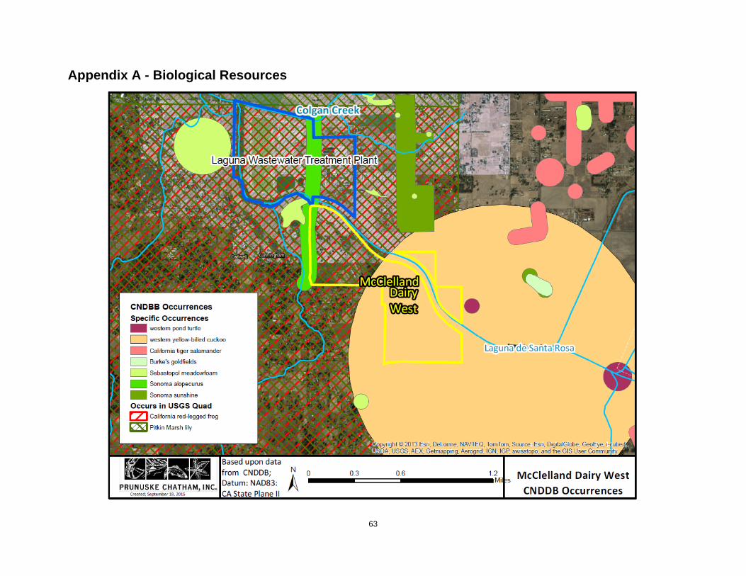
63
Appendix A - Biological Resources
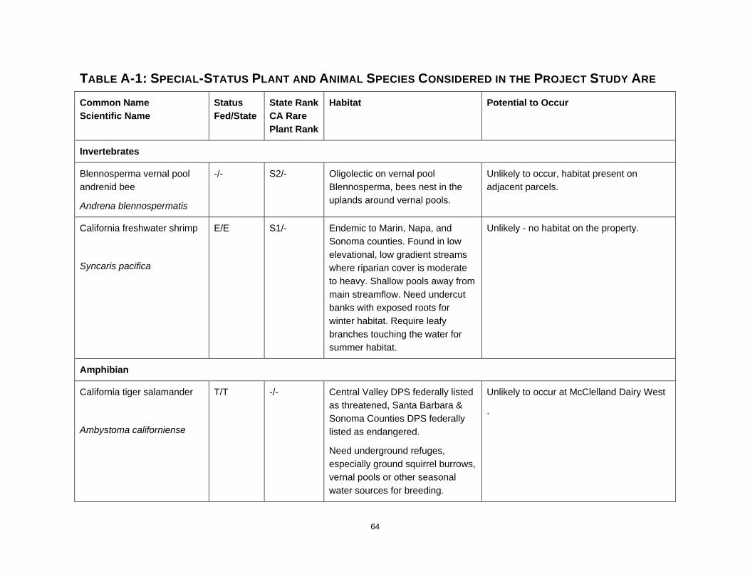
64
TABLE A-1: SPECIAL-STATUS PLANT AND ANIMAL SPECIES CONSIDERED IN THE PROJECT STUDY ARE Common Name Scientific Name
Status Fed/State
State Rank CA Rare Plant Rank
Habitat Potential to Occur
Invertebrates
Blennosperma vernal pool andrenid bee
Andrena blennospermatis
-/- S2/- Oligolectic on vernal pool Blennosperma, bees nest in the uplands around vernal pools.
Unlikely to occur, habitat present on adjacent parcels.
California freshwater shrimp
Syncaris pacifica
E/E S1/- Endemic to Marin, Napa, and Sonoma counties. Found in low elevational, low gradient streams where riparian cover is moderate to heavy. Shallow pools away from main streamflow. Need undercut banks with exposed roots for winter habitat. Require leafy branches touching the water for summer habitat.
Unlikely - no habitat on the property.
Amphibian
California tiger salamander
Ambystoma californiense
T/T -/- Central Valley DPS federally listed as threatened, Santa Barbara & Sonoma Counties DPS federally listed as endangered.
Need underground refuges, especially ground squirrel burrows, vernal pools or other seasonal water sources for breeding.
Unlikely to occur at McClelland Dairy West
.

65
TABLE A-1: SPECIAL-STATUS PLANT AND ANIMAL SPECIES CONSIDERED IN THE PROJECT STUDY ARE Common Name Scientific Name
Status Fed/State
State Rank CA Rare Plant Rank
Habitat Potential to Occur
Reptiles
western pond turtle
Emys marmorata
FSC/CSC S3/- Still waters, ponds, slow streams with instream or bank resting sites. Need basking sites and suitable (sandy banks or grassy open fields) upland habitat up to 0.5 km from water for egg laying.
Unlikely to occur within the dairy, could occur within adjacent riparian areas
Birds
western yellow-billed cuckoo
Coccyzus americanus occidentalis
T/E S1/- Riparian forest nester, along the broad, lower flood-bottoms of larger river systems.
Nest in riparian jungles of willow, often mixed with cottonwoods, lower story of blackberry, nettles, or wild grape.
Unlikely to occur within the dairy, could occur within adjacent riparian areas
Mammals
American badger
Taxidea taxus
-/- S3 Most abundant in drier open stages of most shrub, forest, and herbaceous habitats, with friable soils.
Need sufficient food, friable soils and open uncultivated ground, preys on burrowing rodents, digs
Unlikely to occur, ground cultivated

66
TABLE A-1: SPECIAL-STATUS PLANT AND ANIMAL SPECIES CONSIDERED IN THE PROJECT STUDY ARE Common Name Scientific Name
Status Fed/State
State Rank CA Rare Plant Rank
Habitat Potential to Occur
burrows.
Plants
Sonoma alopecurus
Alopecurus aequalis var. sonomensis
E/- S1/1B Freshwater marshes and swamps, riparian scrub. Wet areas, marshes, riparian banks with other wetland species. 5-360 m.
Unlikely to occur, may be present in riparian areas adjacent to the dairy
fragrant fritillary
Fritillaria liliacea
-/- S2/1B Coastal scrub, valley and foothill grassland, coastal prairie. Often on serpentine, various soils reported though usually clay, in grassland. 3-410m.
Not likely to occur
Sonoma sunshine
Blennosperma bakeri
E/E S1/1B Vernal pools, valley and foothill grassland. 10-110 m.
Vernal pools and wetland habitats on the property are unlikely to support populations of listed plants given the current condition and historical land uses.
Sonoma spineflower
Chorizanthe valida
E/E S1/1B Coastal prairie, sandy soils. Not likely to occur
dwarf downingia
-/- S2/2 Valley and foothill grassland (mesic sites), vernal pools. Vernal lake and pool margins with a variety of associates. Found in
Vernal pools and wetland habitats on the property are unlikely to support populations of listed plants given the current condition

67
TABLE A-1: SPECIAL-STATUS PLANT AND ANIMAL SPECIES CONSIDERED IN THE PROJECT STUDY ARE Common Name Scientific Name
Status Fed/State
State Rank CA Rare Plant Rank
Habitat Potential to Occur
Downingia pusilla several types of vernal pools. and historical land uses.
congested-headed hayfield tarplant
Hemizonia congesta ssp. congesta
-/- S1S2/1B Valley and foothill grassland. Grassy valleys and hills. Often I fallow fields and sometimes along roadsides. 20-560 M
Not likely to occur
thin-lobed horkelia
Horkelia tenuiloba
-/- S2/1B Broadleaved upland forest, chaparral, valley and foothill grassland. Sandy soils, mesic openings. 50-500 M.
Not likely to occur
Burke's goldfields
Lasthenia burkei
E/E S1/1B Vernal pools, meadows, and seeps. Most often in vernal pools and swales. 15-600 M.
Vernal pools and wetland habitats on the property are unlikely to support populations of listed plants given the current condition and historical land uses.
Baker's goldfields
Lasthenia californica ssp. bakeri
-/- SH/1B.2 Closed –cone coniferous forest, coastal scrub meadows and seeps, marshes and swamps. Openings. 60-520 M.
Vernal pools and wetland habitats on the property are unlikely to support populations of listed plants given the current condition and historical land uses.
Legenere
Legenere limosa
-/- S2/1B.1 Beds of vernal pools. 1-880 M. Vernal pools and wetland habitats on the property are unlikely to support populations of listed plants given the current condition and historical land uses.

68
TABLE A-1: SPECIAL-STATUS PLANT AND ANIMAL SPECIES CONSIDERED IN THE PROJECT STUDY ARE Common Name Scientific Name
Status Fed/State
State Rank CA Rare Plant Rank
Habitat Potential to Occur
Sebastopol meadowfoam
Limnanthes vinculans
E/E S1/1BG.1 Mesic meadows, vernal pools, valley and foothill grassland. Swales, wet meadows and marshy areas in valley oak savanna on poorly drained soils of clays and sandy loam. 15-305 M.
Vernal pools and wetland habitats on the property are unlikely to support populations of listed plants given the current condition and historical land uses.
marsh microseris
Microseris paludosa
-/- S2/1B Closed-cone coniferous forest, cismontane woodland, coastal scrub valley and foothill grasslands
Unlikely to occur
Baker's navarretia
Navarretia leucocephala ssp. bakeri
-/- S2/1B Cismontane woodland, meadows, seeps, vernal pools, valley and foothill grassland
Vernal pools and wetland habitats on the property are unlikely to support populations of listed plants given the current condition and historical land uses.
Cunningham Marsh cinquefoil
Potentilla uliginosa
-/- SH/1A Freshwater marshes and swamps
Unlikely to occur
California beaked-rush
Rhynchospora californica
-/- S1/1B Bogs and fens, marshes and swamps, lower montane coniferous forests, meadows and seeps.
Unlikely to occur
showy rancheria clover E/- S1/1B Valley and foothill grasslands, coastal bluff scrub. Sometimes on
Unlikely to occur
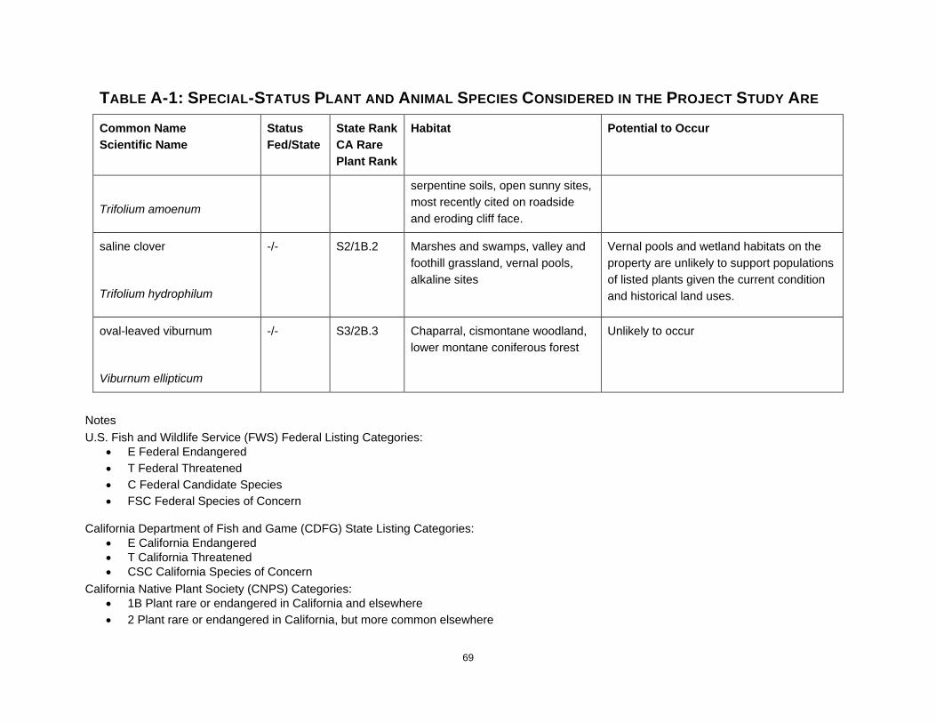
69
TABLE A-1: SPECIAL-STATUS PLANT AND ANIMAL SPECIES CONSIDERED IN THE PROJECT STUDY ARE Common Name Scientific Name
Status Fed/State
State Rank CA Rare Plant Rank
Habitat Potential to Occur
Trifolium amoenum
serpentine soils, open sunny sites, most recently cited on roadside and eroding cliff face.
saline clover
Trifolium hydrophilum
-/- S2/1B.2 Marshes and swamps, valley and foothill grassland, vernal pools, alkaline sites
Vernal pools and wetland habitats on the property are unlikely to support populations of listed plants given the current condition and historical land uses.
oval-leaved viburnum
Viburnum ellipticum
-/- S3/2B.3 Chaparral, cismontane woodland, lower montane coniferous forest
Unlikely to occur
Notes U.S. Fish and Wildlife Service (FWS) Federal Listing Categories:
• E Federal Endangered • T Federal Threatened • C Federal Candidate Species • FSC Federal Species of Concern
California Department of Fish and Game (CDFG) State Listing Categories: • E California Endangered • T California Threatened • CSC California Species of Concern
California Native Plant Society (CNPS) Categories: • 1B Plant rare or endangered in California and elsewhere • 2 Plant rare or endangered in California, but more common elsewhere

70
Appendix B – FEMA Flood Hazards

71
Appendix C – Soil Maps

72

McClelland Dairy West Soil Map—Sonoma County, California
73

Map Unit Description---Sonoma County, California McClelland Dairy West
74
Map Unit Description
The map units delineated on the detailed soil maps in a soil survey represent the soils or miscellaneous areas in the survey area. The map unit descriptions in this report, along with the maps, can be used to determine the composition and properties of a unit.
A map unit delineation on a soil map represents an area dominated by one or more major kinds of soil or miscellaneous areas. A map unit is identified and named according to the taxonomic classification of the dominant soils. Within a taxonomic class there are precisely defined limits for the properties of the soils. On the landscape, however, the soils are natural phenomena, and they have the characteristic variability of all natural phenomena. Thus, the range of some observed properties may extend beyond the limits defined for a taxonomic class. Areas of soils of a single taxonomic class rarely, if ever, can be mapped without including areas of other taxonomic classes. Consequently, every map unit is made up of the soils or miscellaneous areas for which it is named and some minor components that belong to taxonomic classes other than those of the major soils.
Most minor soils have properties similar to those of the dominant soil or soils in the map unit, and thus they do not affect use and management. These are called noncontrasting, or similar, components. They may or may not be mentioned in a particular map unit description. Other minor components, however, have properties and behavioral characteristics divergent enough to affect use or to require different management. These are called contrasting, or dissimilar, components. They generally are in small areas and could not be mapped separately because of the scale used. Some small areas of strongly contrasting soils or miscellaneous areas are identified by a special symbol on the maps. If included in the database for a given area, the contrasting minor components are identified in the map unit descriptions along with some characteristics of each. A few areas of minor components may not have been observed, and consequently they are not mentioned in the descriptions, especially where the pattern was so complex that it was impractical to make enough observations to identify all the soils and miscellaneous areas on the landscape.
The presence of minor components in a map unit in no way diminishes the usefulness or accuracy of the data. The objective of mapping is not to delineate pure taxonomic classes but rather to separate the landscape into landforms or landform segments that have similar use and management requirements. The delineation of such segments on the map provides sufficient information for the development of resource plans. If intensive use of small areas is planned, however, onsite investigation is needed to define and locate the soils and miscellaneous areas.
An identifying symbol precedes the map unit name in the map unit descriptions. Each description includes general facts about the unit and gives important soil properties and qualities.
Map Unit Description---Sonoma County, California McClelland Dairy West
75
Soils that have profiles that are almost alike make up a soil series. All the soils of a series have major horizons that are similar in composition, thickness, and arrangement. Soils of a given series can differ in texture of the surface layer, slope, stoniness, salinity, degree of erosion, and other characteristics that affect their use. On the basis of such differences, a soil series is divided into soil phases. Most of the areas shown on the detailed soil maps are phases of soil series. The name of a soil phase commonly indicates a feature that affects use or management. For example, Alpha silt loam, 0 to 2 percent slopes, is a phase of the Alpha series.
Some map units are made up of two or more major soils or miscellaneous areas. These map units are complexes, associations, or undifferentiated groups.
A complex consists of two or more soils or miscellaneous areas in such an intricate pattern or in such small areas that they cannot be shown separately on the maps. The pattern and proportion of the soils or miscellaneous areas are somewhat similar in all areas. Alpha-Beta complex, 0 to 6 percent slopes, is an example.
An association is made up of two or more geographically associated soils or miscellaneous areas that are shown as one unit on the maps. Because of present or anticipated uses of the map units in the survey area, it was not considered practical or necessary to map the soils or miscellaneous areas separately. The pattern and relative proportion of the soils or miscellaneous areas are somewhat similar. Alpha-Beta association, 0 to 2 percent slopes, is an example.
An undifferentiated group is made up of two or more soils or miscellaneous areas that could be mapped individually but are mapped as one unit because similar interpretations can be made for use and management. The pattern and proportion of the soils or miscellaneous areas in a mapped area are not uniform. An area can be made up of only one of the major soils or miscellaneous areas, or it can be made up of all of them. Alpha and Beta soils, 0 to 2 percent slopes, is an example.
Some surveys include miscellaneous areas. Such areas have little or no soil material and support little or no vegetation. Rock outcrop is an example.
Additional information about the map units described in this report is available in other soil reports, which give properties of the soils and the limitations, capabilities, and potentials for many uses. Also, the narratives that accompany the soil reports define some of the properties included in the map unit descriptions.
Report—Map Unit Description Sonoma County, California
CfA—Clear Lake clay, ponded, 0 to 2 percent slopes
Map Unit Setting National map unit symbol: hfbm Elevation: 1,500 feet Mean annual precipitation: 10 to 35 inches Mean annual air temperature: 57 to 63 degrees F Frost-free period: 245 to 300 days Farmland classification: Farmland of statewide importance

Map Unit Description---Sonoma County, California McClelland Dairy West
76
Map Unit Composition Clear lake and similar soils: 85 percent Minor components: 15 percent Estimates are based on observations, descriptions, and transects of the
mapunit.
Description of Clear Lake
Setting Landform: Basin floors Landform position (two-dimensional): Toeslope Landform position (three-dimensional): Tread Down-slope shape: Linear Across-slope shape: Linear Parent material: Alluvium derived from sedimentary rock
Typical profile H1 - 0 to 13 inches: clay H2 - 13 to 60 inches: clay
Properties and qualities Slope: 0 to 2 percent Depth to restrictive feature: More than 80 inches Natural drainage class: Poorly drained Runoff class: High Capacity of the most limiting layer to transmit water (Ksat):
Moderately low to moderately high (0.06 to 0.20 in/hr) Depth to water table: About 0 inches Frequency of flooding: None Frequency of ponding: Frequent Calcium carbonate, maximum in profile: 5 percent Salinity, maximum in profile: Nonsaline (0.0 to 2.0 mmhos/cm) Available water storage in profile: Moderate (about 9.0 inches)
Interpretive groups Land capability classification (irrigated): 3w Land capability classification (nonirrigated): 3w Hydrologic Soil Group: C/D
Minor Components
Huichica Percent of map unit: 6 percent
Whight Percent of map unit: 6 percent
Zamora Percent of map unit: 3 percent
Map Unit Description---Sonoma County, California McClelland Dairy West
77
RnA—Riverwash
Map Unit Setting
National map unit symbol: hfj7 Elevation: 700 to 2,900 feet Mean annual precipitation: 8 to 15 inches Mean annual air temperature: 46 to 52 degrees F Frost-free period: 110 to 180 days Farmland classification: Not prime farmland
Map Unit Composition
Riverwash: 85 percent Minor components: 15 percent Estimates are based on observations, descriptions, and transects of the
mapunit.
Description of Riverwash
Setting Landform: Flood plains Parent material: Sandy and gravelly alluvium
Typical profile H1 - 0 to 6 inches: very gravelly sand H2 - 6 to 60 inches: stratified very gravelly coarse sand to very
gravelly sand
Properties and qualities Slope: 0 to 2 percent Natural drainage class: Excessively drained Runoff class: Negligible Capacity of the most limiting layer to transmit water (Ksat): High to
very high (5.95 to 19.98 in/hr) Depth to water table: About 0 inches Frequency of flooding: Frequent Available water storage in profile: Very low (about 1.8 inches)
Interpretive groups Land capability classification (irrigated): None specified Land capability classification (nonirrigated): 8
Minor Components
Unnamed Percent of map unit: 15 percent
WhA—Wright loam, wet, 0 to 2 percent slopes
Map Unit Setting
National map unit symbol: hfkm Elevation: 60 to 300 feet Mean annual precipitation: 30 inches

Map Unit Description---Sonoma County, California McClelland Dairy West
78
Mean annual air temperature: 55 degrees F Frost-free period: 240 to 260 days Farmland classification: Farmland of statewide importance
Map Unit Composition
Wright and similar soils: 85 percent Minor components: 15 percent Estimates are based on observations, descriptions, and transects of the
mapunit. Description of Wright
Setting Landform: Terraces Landform position (two-dimensional): Footslope Landform position (three-dimensional): Tread Down-slope shape: Linear Across-slope shape: Linear Parent material: Alluvium
Typical profile H1 - 2 to 7 inches: loam H2 - 7 to 25 inches: loam H3 - 25 to 62 inches: clay H4 - 62 to 73 inches: sandy clay loam
Properties and qualities Slope: 0 to 2 percent Depth to restrictive feature: More than 80 inches Natural drainage class: Somewhat poorly drained Runoff class: High Capacity of the most limiting layer to transmit water (Ksat): Very low
to moderately low (0.00 to 0.06 in/hr) Depth to water table: About 0 inches Frequency of flooding: None Frequency of ponding: None Available water storage in profile: Low (about 5.2 inches)
Interpretive groups Land capability classification (irrigated): 3w Land capability classification (nonirrigated): 3w Hydrologic Soil Group: D
Minor Components
Unnamed Percent of map unit: 5 percent Landform: Flood plains
Huichica Percent of map unit: 3 percent
Yolo Percent of map unit: 3 percent

Map Unit Description---Sonoma County, California McClelland Dairy West
79
Zamora
Percent of map unit: 3 percent
Clear lake Percent of map unit: 1 percent Landform: Flood plains
WoA—Wright loam, shallow, wet, 0 to 2 percent slopes
Map Unit Setting National map unit symbol: hfkp Elevation: 60 to 300 feet Mean annual precipitation: 30 inches Mean annual air temperature: 55 degrees F Frost-free period: 240 to 260 days Farmland classification: Not prime farmland
Map Unit Composition
Wright and similar soils: 85 percent Minor components: 15 percent Estimates are based on observations, descriptions, and transects of the
mapunit.
Description of Wright
Setting Landform: Hills, terraces Landform position (two-dimensional): Backslope, footslope Landform position (three-dimensional): Side slope, tread Down-slope shape: Concave, linear Across-slope shape: Convex, linear Parent material: Alluvium
Typical profile H1 - 0 to 7 inches: loam H2 - 7 to 15 inches: loam H3 - 15 to 62 inches: clay H4 - 62 to 73 inches: sandy clay loam
Properties and qualities Slope: 0 to 2 percent Depth to restrictive feature: More than 80 inches Natural drainage class: Somewhat poorly drained Runoff class: Very high Capacity of the most limiting layer to transmit water (Ksat): Very low
to moderately low (0.00 to 0.06 in/hr) Depth to water table: About 0 inches Frequency of flooding: None Frequency of ponding: None Available water storage in profile: Low (about 4.5 inches)
Interpretive groups Land capability classification (irrigated): None specified

Map Unit Description---Sonoma County, California McClelland Dairy West
80
Land capability classification (nonirrigated): 4w Hydrologic Soil Group: D
Minor Components
Huichica Percent of map unit: 5 percent
Yolo Percent of map unit: 5 percent
Clear lake Percent of map unit: 3 percent Landform: Depressions
Unnamed Percent of map unit: 2 percent Landform: Depressions
Data Source Information
Soil Survey Area: Sonoma County, California Survey Area Data: Version 8, Sep 25, 2014

Physical Soil Properties---Sonoma County, California McClelland Dairy West
81
Physical Soil Properties
This table shows estimates of some physical characteristics and features that affect soil behavior. These estimates are given for the layers of each soil in the survey area. The estimates are based on field observations and on test data for these and similar soils.
Depth to the upper and lower boundaries of each layer is indicated. Particle
size is the effective diameter of a soil particle as measured by sedimentation, sieving, or micrometric methods. Particle sizes are expressed as classes with specific effective diameter class limits. The broad classes are sand, silt, and clay, ranging from the larger to the smaller.
Sand as a soil separate consists of mineral soil particles that are 0.05 millimeter to 2 millimeters in diameter. In this table, the estimated sand content of each soil layer is given as a percentage, by weight, of the soil material that is less than 2 millimeters in diameter.
Silt as a soil separate consists of mineral soil particles that are 0.002 to 0.05 millimeter in diameter. In this table, the estimated silt content of each soil layer is given as a percentage, by weight, of the soil material that is less than 2 millimeters in diameter.
Clay as a soil separate consists of mineral soil particles that are less than 0.002 millimeter in diameter. In this table, the estimated clay content of each soil layer is given as a percentage, by weight, of the soil material that is less than 2 millimeters in diameter.
The content of sand, silt, and clay affects the physical behavior of a soil. Particle size is important for engineering and agronomic interpretations, for determination of soil hydrologic qualities, and for soil classification.
The amount and kind of clay affect the fertility and physical condition of the soil and the ability of the soil to adsorb cations and to retain moisture. They influence shrink- swell potential, saturated hydraulic conductivity (Ksat), plasticity, the ease of soil dispersion, and other soil properties. The amount and kind of clay in a soil also affect tillage and earthmoving operations.
Moist bulk density is the weight of soil (ovendry) per unit volume. Volume is measured when the soil is at field moisture capacity, that is, the moisture content at 1/3- or 1/10-bar (33kPa or 10kPa) moisture tension. Weight is determined after the soil is dried at 105 degrees C. In the table, the estimated moist bulk density of each soil horizon is expressed in grams per cubic centimeter of soil material that is less than 2 millimeters in diameter. Bulk density data are used to compute linear extensibility, shrink-swell potential, available water capacity, total pore space, and other soil properties. The moist bulk density of a soil indicates the pore space available for water and roots. Depending on soil texture, a bulk density of more than 1.4 can restrict water storage and root penetration. Moist bulk density is influenced by texture, kind of clay, content of organic matter, and soil structure.

Physical Soil Properties---Sonoma County, California McClelland Dairy West
82
Saturated hydraulic conductivity (Ksat) refers to the ease with which pores in a saturated soil transmit water. The estimates in the table are expressed in terms of micrometers per second. They are based on soil characteristics observed in the field, particularly structure, porosity, and texture. Saturated hydraulic conductivity (Ksat) is considered in the design of soil drainage systems and septic tank absorption fields.
Available water capacity refers to the quantity of water that the soil is capable of storing for use by plants. The capacity for water storage is given in inches of water per inch of soil for each soil layer. The capacity varies, depending on soil properties that affect retention of water. The most important properties are the content of organic matter, soil texture, bulk density, and soil structure. Available water capacity is an important factor in the choice of plants or crops to be grown and in the design and management of irrigation systems. Available water capacity is not an estimate of the quantity of water actually available to plants at any given time.
Linear extensibility refers to the change in length of an unconfined clod as moisture content is decreased from a moist to a dry state. It is an expression of the volume change between the water content of the clod at 1/3- or 1/10-bar tension (33kPa or 10kPa tension) and oven dryness. The volume change is reported in the table as percent change for the whole soil. The amount and type of clay minerals in the soil influence volume change.
Linear extensibility is used to determine the shrink-swell potential of soils. The shrink-swell potential is low if the soil has a linear extensibility of less than 3 percent; moderate if 3 to 6 percent; high if 6 to 9 percent; and very high if more than 9 percent. If the linear extensibility is more than 3, shrinking and swelling can cause damage to buildings, roads, and other structures and to plant roots. Special design commonly is needed.
Organic matter is the plant and animal residue in the soil at various stages of decomposition. In this table, the estimated content of organic matter is expressed as a percentage, by weight, of the soil material that is less than 2 millimeters in diameter. The content of organic matter in a soil can be maintained by returning crop residue to the soil.
Organic matter has a positive effect on available water capacity, water infiltration, soil organism activity, and tilth. It is a source of nitrogen and other nutrients for crops and soil organisms.
Erosion factors are shown in the table as the K factor (Kw and Kf) and the T factor. Erosion factor K indicates the susceptibility of a soil to sheet and rill erosion by water. Factor K is one of six factors used in the Universal Soil Loss Equation (USLE) and the Revised Universal Soil Loss Equation (RUSLE) to predict the average annual rate of soil loss by sheet and rill erosion in tons per acre per year. The estimates are based primarily on percentage of silt, sand, and organic matter and on soil structure and Ksat. Values of K range from 0.02 to 0.69. Other factors being equal, the higher the value, the more susceptible the soil is to sheet and rill erosion by water.
Erosion factor Kw indicates the erodibility of the whole soil. The estimates are modified by the presence of rock fragments. Erosion factor Kf indicates the erodibility of the fine-earth fraction, or the material less than 2 millimeters in size.
Physical Soil Properties---Sonoma County, California McClelland Dairy West
83
Erosion factor T is an estimate of the maximum average annual rate of soil erosion by wind and/or water that can occur without affecting crop productivity over a sustained period. The rate is in tons per acre per year.
Wind erodibility groups are made up of soils that have similar properties affecting their susceptibility to wind erosion in cultivated areas. The soils assigned to group 1 are the most susceptible to wind erosion, and those assigned to group 8 are the least susceptible. The groups are described in the "National Soil Survey Handbook."
Wind erodibility index is a numerical value indicating the susceptibility of soil to wind erosion, or the tons per acre per year that can be expected to be lost to wind erosion. There is a close correlation between wind erosion and the texture of the surface layer, the size and durability of surface clods, rock fragments, organic matter, and a calcareous reaction. Soil moisture and frozen soil layers also influence wind erosion.
Reference: United States Department of Agriculture, Natural Resources Conservation Service. National soil survey handbook, title 430-VI. (http://soils.usda.gov)
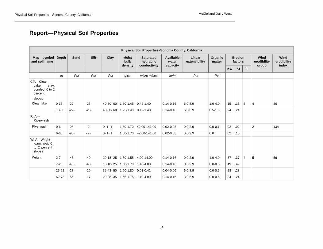
Physical Soil Properties---Sonoma County, California McClelland Dairy West
84
Report—Physical Soil Properties
Physical Soil Properties–Sonoma County, California
Map symbol and soil name
Depth Sand Silt Clay Moist bulk
density
Saturated hydraulic
conductivity
Available water
capacity
Linear extensibility
Organic matter
Erosion factors
Wind erodibility
group
Wind erodibility
index Kw Kf T
In Pct Pct Pct g/cc micro m/sec In/In Pct Pct CfA—Clear
Lake clay, ponded, 0 to 2 percent slopes
Clear lake 0-13 -22- -28- 40-50- 60 1.30-1.45 0.42-1.40 0.14-0.16 6.0-8.9 1.0-4.0 .15 .15 5 4 86
13-60 -22- -28- 40-50- 60 1.25-1.40 0.42-1.40 0.14-0.16 6.0-8.9 0.5-1.0 .24 .24 RnA—
Riverwash
Riverwash 0-6 -98- - 2- 0- 1- 1 1.60-1.70 42.00-141.00 0.02-0.03 0.0-2.9 0.0-0.1 .02 .02 2 134
6-60 -93- - 7- 0- 1- 1 1.60-1.70 42.00-141.00 0.02-0.03 0.0-2.9 0.0 .02 .10 WhA—Wright
loam, wet, 0 to 2 percent slopes
Wright 2-7 -43- -40- 10-18- 25 1.50-1.55 4.00-14.00 0.14-0.16 0.0-2.9 1.0-4.0 .37 .37 4 5 56
7-25 -43- -40- 10-18- 25 1.60-1.70 1.40-4.00 0.14-0.16 0.0-2.9 0.0-0.5 .49 .49 25-62 -28- -29- 35-43- 50 1.60-1.80 0.01-0.42 0.04-0.06 6.0-8.9 0.0-0.5 .28 .28 62-73 -55- -17- 20-28- 35 1.65-1.75 1.40-4.00 0.14-0.16 3.0-5.9 0.0-0.5 .24 .24

Physical Soil Properties---Sonoma County, California McClelland Dairy West
85
Data Source Information
Soil Survey Area: Sonoma County, California Survey Area Data: Version 8, Sep 25, 2014
Map symbol and soil name
Depth Sand Silt Clay Moist bulk
density
Saturated hydraulic
conductivity
Available water
capacity
Linear extensibility
Organic matter
Erosion factors
Wind erodibility
group
Wind erodibility
index Kw Kf T
In Pct Pct Pct g/cc micro m/sec In/In Pct Pct WoA—Wright
loam, shallow, wet, 0 to 2 percent slopes
Wright 0-7 -43- -40- 10-18- 25 1.50-1.55 4.00-14.00 0.14-0.16 0.0-2.9 1.0-4.0 .43 .43 3 5 56
7-15 -43- -40- 10-18- 25 1.60-1.70 1.40-4.00 0.14-0.16 0.0-2.9 0.0-0.5 .49 .49 15-62 -28- -29- 35-43- 50 1.60-1.80 0.01-0.42 0.04-0.06 6.0-8.9 0.0-0.5 .28 .28 62-73 -55- -17- 20-28- 35 1.65-1.75 1.40-4.00 0.14-0.16 3.0-5.9 0.0-0.5 .24 .24

Chemical Soil Properties---Sonoma County, California
86
Chemical Soil Properties
This table shows estimates of some chemical characteristics and features that affect soil behavior. These estimates are given for the layers of each soil in the survey area. The estimates are based on field observations and on test data for these and similar soils.
Depth to the upper and lower boundaries of each layer is indicated.
Cation-exchange capacity is the total amount of extractable cations that can be held by the soil, expressed in terms of milliequivalents per 100 grams of soil at neutrality (pH 7.0) or at some other stated pH value. Soils having a low cation-exchange capacity hold fewer cations and may require more frequent applications of fertilizer than soils having a high cation-exchange capacity. The ability to retain cations reduces the hazard of ground-water pollution.
Effective cation-exchange capacity refers to the sum of extractable cations plus aluminum expressed in terms of milliequivalents per 100 grams of soil. It is determined for soils that have pH of less than 5.5.
Soil reaction is a measure of acidity or alkalinity. It is important in selecting crops and other plants, in evaluating soil amendments for fertility and stabilization, and in determining the risk of corrosion.
Calcium carbonate equivalent is the percent of carbonates, by weight, in the fraction of the soil less than 2 millimeters in size. The availability of plant nutrients is influenced by the amount of carbonates in the soil.
Gypsum is expressed as a percent, by weight, of hydrated calcium sulfates in the fraction of the soil less than 20 millimeters in size. Gypsum is partially soluble in water. Soils that have a high content of gypsum may collapse if the gypsum is removed by percolating water.
Salinity is a measure of soluble salts in the soil at saturation. It is expressed as the electrical conductivity of the saturation extract, in millimhos per centimeter at 25 degrees C. Estimates are based on field and laboratory measurements at representative sites of nonirrigated soils. The salinity of irrigated soils is affected by the quality of the irrigation water and by the frequency of water application. Hence, the salinity of soils in individual fields can differ greatly from the value given in the table. Salinity affects the suitability of a soil for crop production, the stability of soil if used as construction material, and the potential of the soil to corrode metal and concrete.
Sodium adsorption ratio (SAR) is a measure of the amount of sodium (Na) relative to calcium (Ca) and magnesium (Mg) in the water extract from saturated soil paste. It is the ratio of the Na concentration divided by the square root of one-half of the Ca + Mg concentration. Soils that have SAR values of 13 or more may be characterized by an increased dispersion of organic matter and clay particles, reduced saturated hydraulic conductivity and aeration, and a general degradation of soil structure.

Chemical Soil Properties---Sonoma County, California
87
Report—Chemical Soil Properties
Data Source Information Soil Survey Area: Sonoma County, California Survey Area Data: Version 8, Sep 25, 2014
Chemical Soil Properties–Sonoma County, California
Map symbol and soil name Depth Cation- exchange capacity
Effective cation-
exchange capacity
Soil reaction Calcium carbonate
Gypsum Salinity Sodium adsorption
ratio
In meq/100g meq/100g pH Pct Pct mmhos/cm CfA—Clear Lake clay, ponded, 0 to
2 percent slopes
Clear lake 0-13 30-50 — 5.6-7.3 0 0 0 0
13-60 30-50 — 7.4-8.4 0-5 0 0.0-2.0 0
RnA—Riverwash Riverwash 0-6 — 1.0-5.0 — 0 0 0 0
6-60 — 1.0-5.0 — 0 0 0 0
WhA—Wright loam, wet, 0 to 2 percent slopes
Wright 2-7 10-15 — 5.1-6.5 0 0 0 0
7-25 10-15 — 5.1-6.0 0 0 0 0
25-62 35-45 — 4.5-7.3 0 0 0 0
62-73 20-30 — 6.1-7.3 0 0 0 0
WoA—Wright loam, shallow, wet, 0 to 2 percent slopes
Wright 0-7 10-15 — 5.1-6.5 0 0 0 0
7-15 10-15 — 5.1-6.0 0 0 0 0
15-62 35-45 — 4.5-7.3 0 0 0 0
62-73 20-30 — 6.1-7.3 0 0 0 0

88
Appendix D – Archaeology (Confidential)

89