1.san elijo cover · prepared in compliance with the ceqa plus requirements for srf funding. 1.4...
TRANSCRIPT

SAN ELIJO RECYCLED WATER PROJECT MITIGATED NEGATIVE DECLARATION
Prepared for:
San Elijo Joint Powers Authority 2695 Manchester Avenue Cardiff, California 92007 Contact: Michael Thornton
760.753.6203
Prepared by:
605 Third Street Encinitas, California 92024 Contact: Carey Fernandes
760.479.4299
DECEMBER 2009

Printed on 30% post-consumer recycled material.

San Elijo Recycled Water Project MND 6341-01 December 2009 ToC-i
TABLE OF CONTENTS
Section Page No.
1.0 INTRODUCTION.......................................................................................................... 1-1 1.1 Project Need and Objectives................................................................................ 1-1 1.2 Project Location and Description Summary ........................................................ 1-1 1.3 California Environmental Quality Act (CEQA) Authority to Prepare a Negative
Declaration........................................................................................................... 1-2 1.4 Other Agencies That May Use The Mitigated Negative Declaration and
Preliminary Environmental Review..................................................................... 1-2 1.5 Public Review Process......................................................................................... 1-7
2.0 PROJECT DESCRIPTION .......................................................................................... 2-1 2.1 Project Location ................................................................................................... 2-1 2.2 Environmental Setting ......................................................................................... 2-1 2.3 Project Characteristics ......................................................................................... 2-1
2.3.1 Project Components ................................................................................. 2-2 2.3.2 Project Construction................................................................................. 2-8
3.0 FINDINGS...................................................................................................................... 3-1 3.1 No Significant Effect Finding.............................................................................. 3-1
4.0 INITIAL STUDY ENVIRONMENTAL CHECKLIST............................................. 4-1 I. Aesthetics............................................................................................................. 4-5 II. Agricultural Resources......................................................................................... 4-7 III. Air Quality ........................................................................................................... 4-8 IV. Biological Resources ......................................................................................... 4-12 V. Cultural Resources ............................................................................................. 4-17 VI. Geology And Soils............................................................................................. 4-19 VII. Hazards And Hazardous Materials .................................................................... 4-21 VIII. Hydrology And Water Quality........................................................................... 4-24 IX. Land Use And Planning ..................................................................................... 4-27 X. Mineral Resources ............................................................................................. 4-28 XI. Noise .................................................................................................................. 4-29 XII. Population And Housing.................................................................................... 4-31 XIII. Public Services................................................................................................... 34-2 XIV. Recreation .......................................................................................................... 4-33 XV. Transportation/Traffic........................................................................................ 4-34 XVI. Utilities And Service Systems ........................................................................... 4-36 XVII. Mandatory Findings Of Significance................................................................. 4-38

Table of Contents
San Elijo Recycled Water Project MND 6341-01 December 2009 ToC-ii
Section Page No.
5.0 REFERENCES............................................................................................................... 5-1
6.0 SUMMARY OF IMPACTS AND MITIGATION...................................................... 6-1
APPENDIX
A Biological Resources Letter Report, San Elijo Joint Powers Authority Project
FIGURES
1 Regional Map................................................................................................................... 1-3 2 Vicinity Map .................................................................................................................... 1-5 3 Site Plan ........................................................................................................................... 2-3 4 Off-Site Improvements .................................................................................................... 2-5
TABLE
1 Estimated Construction Emissions ................................................................................ 4-10

San Elijo Recycled Water Project MND 6341-01 December 2009 1-1
SECTION 1.0 INTRODUCTION
1.1 PROJECT NEED AND OBJECTIVES
The San Elijo Joint Powers Authorities (SEJPA) owns and operates the San Elijo Water Reclamation Facility which was constructed in 1965. The facility is comprised of a 5.25-million-gallon-per-day (MGD) rated secondary treatment plant with ocean outfall disposal capabilities and a 2.48 MGD tertiary treatment plant that serves recycled water for primarily landscape uses. The agency received an annual average daily flow of approximately 3.1 MGD, of which the SEJPA successfully recycles approximately 1,200 to 1,300 acre-feet (AF) annually. Studies have shown that the areas surrounding the water reclamation facility could offset 600 to 1,000 AF per year of existing potable water use with recycled water.
The SEJPA is proposing improvements to its recycled water system that will continue to help the water districts that serve the residence and businesses of Del Mar, Encinitas, and Solana Beach create a more reliable and diversified water supply. The project will also include pollution control and energy efficiency components intended to broaden the overall environmental benefits of this project.
1.2 PROJECT LOCATION AND DESCRIPTION SUMMARY
The project is located in the County of San Diego within the Cardiff-by-the-Sea community of the City of Encinitas (Figures 1 and 2). The project site is located within the SEJPA water reclamation facility located at 2695 Manchester Avenue.
The project proposes to create an additional 600 AF per year of new water supply; improve the quality, reliability and operational efficiency of the recycled water produced at the facility; add treatment to allow the facility to accept and treat urban runoff; and create new opportunities to protect coastal water quality.
Project improvements would include (1) constructing 0.5 MGD of advanced wastewater treatment, (2) converting an existing tank to store recycled water, (3) constructing a new recycled water distribution pumping station, (4) convert existing tanks to store treated wastewater from the Escondido Land Outfall for emergency outfall pressure equalization, and (5) construct new distribution pipelines to serve additional customers. Items 1 through 4 will be activities performed at the San Elijo Water Reclamation Facility. Item 5 would provide offsite recycled water extension pipelines along Encinitas Boulevard (from 3rd Street to Saxony Road, approximately 0.61 mile in length) and Paseo de Las Flores (from Quail Gardens Drive to Lynwood Drive, approximately 0.56 mile in length).

1.0 Introduction
San Elijo Recycled Water Project MND 6341-01 December 2009 1-2
1.3 CALIFORNIA ENVIRONMENTAL QUALITY ACT (CEQA) AUTHORITY TO PREPARE A NEGATIVE DECLARATION
The SEJPA is the lead California Environmental Quality Act (CEQA) agency for the review and approval of the proposed project. Based on the findings of the Initial Study/Environmental Checklist, the District has made the determination that a Mitigated Negative Declaration (MND) is the appropriate environmental document to be prepared in compliance with CEQA. As provided for by CEQA Section 21064.5, an MND may be prepared for a project subject to CEQA when an Initial Study has identified potentially significant effects on the environment, but (1) revisions in the project plans or proposals made by, or agreed to by, the Applicant before the proposed Negative Declaration and Initial Study are released for public review would avoid the effects or mitigate the effects to a point where clearly no significant effect on the environment would occur; and (2) there is no substantial evidence in light of the whole record before the public agency that the project, as revised, may have a significant effect on the environment.
This draft MND has been prepared by the SEJPA as the lead agency and is in conformance with Section 15070(a) of the CEQA Guidelines. The purpose of the MND and the Initial Study Checklist/Environmental Evaluation is to determine any potentially significant impacts associated with the proposed project and to incorporate mitigation measures into the project design as necessary to reduce or eliminate the significant or potentially significant effects.
In addition to standard CEQA compliance, the SEJPA has the potential to apply for the State Revolving Funds (SRF) Loan Program, which is partially funded by the U.S. Environmental Protection Agency (USEPA). This makes the project subject to federal environmental regulations guiding the General Conformity Rule for the Clean Air Act, the Endangered Species Act, and the National Historic Preservation Act. USEPA has allowed a modified CEQA, called CEQA-PLUS, to be the compliance base for projects applying for SRF funds. This draft MND has been prepared in compliance with the CEQA plus requirements for SRF funding.
1.4 OTHER AGENCIES THAT MAY USE THE MITIGATED NEGATIVE DECLARATION AND PRELIMINARY ENVIRONMENTAL REVIEW
This MND is intended to be used by responsible and trustee agencies that may have review authority over the project. Based on the analysis in Section 4, “Initial Study/Environmental Checklist,” and Section 5, “Discussion of Environmental Checklist,” of this document, review by the State Water Resource Control Board will be necessary.

ImperialBeach
ChulaVista
NationalCity
Bonita
Coronado
LemonGrove
LaMesa
Poway
Encinitas
San Diego
Carlsbad
SanMarcos Escondido
VistaValleyCenter
Camp PendletonSouth Hidden
MeadowsOceanside
Bonsall
CampPendleton
North
Fallbrook
Rainbow
Jamul
Rancho SanDiegoSpring
Valley
Casa deOro-Mount Helix
AlpineHarbisonCanyon
Lakeside PineValley
El Cajon
Santee
Ramona San DiegoCountryEstates
Julian
BorregoSprings
SanClemente
DanaPoint
San JuanCapistrano
Highlands
Temecula
Imperial County
Orange
County
San Diego
CountySan Diego County
San Diego County
Riverside County
P a c i f i c
O c e a n
M e x i c oM e x i c o905
195
78
209
52
163
56
75
1
98
111371
67
86
76
79
94
8
15
8
805
5
5
15
FIGURE 1
Regional MapSEJPA Water Reclamation Facility Improvement Project
6341-01DECEMBER 2009
Z:\P
rojec
ts\j63
4101
\MAP
DOC\
WOR
KING
\Fig1
_Reg
iona
l.mxd
0 155 10Miles
Project Site

1.0 Introduction
San Elijo Recycled Water Project MND 6341-01 December 2009 1-4
INTENTIONALLY LEFT BLANK

5
FIGURE 2Vicinity Map
6341-01SEJPA Water Reclamation Facility Improvement ProjectDECEMBER 2009
SOURCE: USGS 7.5 Minute Series, Encinitas Quadrangle.
Z:\P
rojec
ts\j63
4101
\MAP
DOC\
WOR
KING
\Fig2
_Vici
nity.m
xd
0 2,0001,000Feet
Project Site

1.0 Introduction
San Elijo Recycled Water Project MND 6341-01 December 2009 1-6
INTENTIONALLY LEFT BLANK

1.0 Introduction
San Elijo Recycled Water Project MND 6341-01 December 2009 1-7
1.5 PUBLIC REVIEW PROCESS
In accordance with CEQA, a good faith effort has been made during the preparation of this MND to contact affected agencies, organizations, and persons who may have an interest in this project.
In reviewing the MND, affected public agencies and the interested public should focus on the sufficiency of the document in identifying and analyzing the possible impacts on the environment and ways in which the impacts of the project are proposed to be avoided or minimized.
Comments on the MND may be made in writing before the end of the public review period. A 30-day review and comment period from September 21, 2009 to October 21, 2009 has been established in accordance with Section 15072(a) of the CEQA Guidelines. Following the close of the public comment period, the SEJPA will consider this MND and comments thereto in determining whether to approve the proposed project.
Written comments on the MND should be sent to the following address by 4:00 p.m., on October 21, 2009.
San Elijo Joint Powers Authority
2695 Manchester Avenue
Cardiff By The Sea, California 92007
Attention: Michael Thornton

1.0 Introduction
San Elijo Recycled Water Project MND 6341-01 December 2009 1-8
INTENTIONALLY LEFT BLANK

San Elijo Recycled Water Project MND 6341-01 December 2009 2-1
SECTION 2.0 PROJECT DESCRIPTION
2.1 PROJECT LOCATION
The project is located in the County of San Diego within the Cardiff-by-the-Sea community of the City of Encinitas (Figures 1 and 2). The project site is located within the SEJPA water reclamation facility located at 2695 Manchester Avenue. Specifically the project site is located west of Interstate 5 (I-5), north of Manchester Avenue. The project site is surrounded by residential uses to the north, southeast, and west; I-5 to the northeast; and San Elijo Lagoon to the south of Manchester Avenue.
2.2 ENVIRONMENTAL SETTING
Encinitas is a coastal community located in northwestern San Diego County. The Cardiff-by-the-Sea community consists primarily of single family residential developments, with some commercial uses and a community college. San Elijo Lagoon is located approximately 1,000 feet to the south of the project site. The project occurs within the boundaries of the SEJPA’s existing facility. The topography of the site is generally level with a slight slope dropping from the north to the south. Elevations within the project site range from approximately 30 feet above mean sea level (amsl) at the south end of the site to approximately 40 feet amsl at the north end of the site. The immediate project area is characterized by developed land cover (Figure 3).
The proposed off-site recycled water pipeline would be constructed along the public right of way in the street of Paseo de Las Flores and Encinitas Boulevard. Paseo de Las Flores is located east of Quail Garden Drive and extends to Lynwood Drive, and is less than 0.6 mile in length. Paseo de Las Flores travels across Encinitas Ranch Golf Course and through a residential community which would be served by the recycled water (Figure 4). The Encinitas Boulevard pipeline extension would be from Saxony Road to B Street, and is approximately 0.6 mile in length. This pipeline extension would travel across a commercial area and would serve recycled water to the Cottonwood Creek Park for irrigation and the Moonlight Beach Urban Runoff Treatment Facility for backwashing of filters.
2.3 PROJECT CHARACTERISTICS
The project proposes to create an additional 600 AF per year of new water supply; improve the quality, reliability and operational efficiency of the recycled water produced at the facility; add treatment to allow the facility to accept and treat urban runoff; and create new opportunities to protect coastal water quality.

2.0 Project Description
San Elijo Recycled Water Project MND 6341-01 December 2009 2-2
Project improvements include (1) constructing 0.5 MGD of advanced wastewater treatment, (2) converting an existing tank to store recycled water, (3) constructing a new recycled water distribution pumping station, (4) convert existing tanks to store treated wastewater from the Escondido Land Outfall for emergency outfall pressure equalization, and (5) construct new distribution pipelines to serve additional customers. Items 1 through 4 will be activities performed at the San Elijo Water Reclamation Facility. Item 5 would provide off-site recycled water extension pipelines along Encinitas Boulevard (from 3rd Street to Saxony Road, approximately 0.61 mile in length) and Paseo de Las Flores (from Quail Gardens Drive to Lynwood Drive, approximately 0.56 mile in length).
2.3.1 Project Components
Advanced Treatment
The proposed 0.5 MGD advanced treatment facility is intended to reduce total dissolved solids (TDS) in the recycled water to approximately 950 mg/L so that recycled water more closely matches local potable water quality. Improved water quality is important to attracting agricultural or other salt sensitive customers. The improved water quality will also avoid negative TDS impacts to existing users and will be helpful in preventing unwanted salinity buildup in this region’s water basin.
For the advance treatment system, SEJPA is considering membrane treatment processes, consisting of microfiltration or ultrafiltration membranes followed by reverse osmosis membranes. The microfiltration or ultrafiltration membranes are providing pretreatment to improve the operability, reduce the overall costs, and extend the life of the reverse osmosis membranes, which would remove TDS and other undesirable micro contaminates that limit the beneficial reuse of this water supply. In wastewater applications, this “microfiltration/reverse osmosis” process, as it is commonly referred to, is a well-established treatment process with advanced wastewater facilities in operation today. Waste brine from the reverse osmosis process would be discharged to the existing ocean outfall in accordance with the requirements of the current National Pollutant Discharge Eliminate System (NPDES) discharge permit. It is expected that the advanced water treatment system will require a footprint of approximately 40 feet by 100 feet and will be located at a site within the San Elijo water recycling facility (WRF) that is already paved. No additional impervious surface is foreseen with this treatment addition.

FIGURE 3
Site PlanSEJPA Water Reclamation Facility Improvement Project
6341-01DECEMBER 2009
SOURCE: SEJPA 2009
Z:\P
rojec
ts\j63
4101
\MAP
DOC\
WOR
KING
\Fig3
_Site
Plan
.mxd

2.0 Project Description
San Elijo Recycled Water Project MND December 2009
INTENTIONALLY LEFT BLANK

FIGURE 4
Off-site ImprovementsSEJPA Water Reclamation Facility Improvement Project
6341-01DECEMBER 2009
SOURCE: Aerial, DigitalGlobe; 2008Roads, SanGIS; 2008
Z:\P
rojec
ts\j63
4101
\MAP
DOC\
WOR
KING
\Fig4
_Offs
ite_P
ipelin
e.m
xd
0 1,500750Feet
LegendProposed recycledwater pipeline extension
NO
RT
H C
OA
ST
HI G
HW
AY
10
1
L E U C A D I A B L
SA
XO
NY
RD
E N C I N I T A S B L
P A S E O D E L AS
FL
OR
ES
LY
NW
OO
D D
R
QU
AI L
GA
RD
EN
S D
R
3R
D S
T

2.0 Project Description
San Elijo Recycled Water Project MND December 2009
INTENTIONALLY LEFT BLANK

2.0 Project Description
San Elijo Recycled Water Project MND 6341-01 December 2009 2-7
The new 0.5 MGD of advanced treatment will increase the total recycled water production of the San Elijo WRF to roughly 3 MGD, and will enable the facility to produce an additional 600 AF per year of new water. Furthermore, having the ability to remove TDS and other undesirable microconstituents will also allow the SEJPA to accept urban runoff for treatment and recycling. Currently, the SEJPA receives a small flow of urban runoff from one beach site. However, the addition of the 0.5 MGD advanced treatment facility will greatly improve opportunities to redirect urban runoff to treatment and recycling. The SEJPA is in discussions with the cities of Encinitas and Solana Beach regarding the possibility of constructing additional urban runoff or first-flush stormwater stations to help protect regional coastal waters.
Recycled Water Storage/Distribution Pump Station
Another element of the project is adding on-site recycled water storage and a high efficiency distribution pump station. Increasing the recycled water system’s storage capabilities is desirable as it will make the system more reliable and energy efficient. The storage will work as the new distribution pump station’s forebay, which will allow the pumps to operate with fewer motor starts and stops. The on-site water storage will also increase the total system storage by approximately 33%, providing flexibility for operating and maintaining the system.
The on-site water storage will be achieved through the conversion of an existing 450,000 gallon concrete tank. The tank (Aeration Basin No. 4) was constructed in 1992 to meet future wastewater treatment needs. At that time, the facility operated two basins in parallel to treat the 3 MGD average day flow, with a third basin as a backup. Since 1992, the need for increase wastewater treatment capacity never materialized. Furthermore in 2008, the SEJPA performed an energy optimization project that resulted in one basin being capable to treat the full 3 MGD flow. That now provides two basins in reserve for wastewater treatment and allows Aeration Basin No.4 to be converted to recycled water storage. Aeration Basin No.4 is viewed by the SEJPA as an underutilized asset and would provide immediate benefit to the recycled water program as an on-site storage tank.
The existing recycled water program is served by a distribution pump station equipped with three 150 hp constant speed pumps. This station serves the north system that has the Oak Crest Reservoir with a high water level of 418-feet and the south system that has the Lomas Santa Fe Reservoir with a high water level of 331-feet. Although this station has been serviceable, it is not especially energy efficient. The station is in its ninth year of operation and has had one motor and one starter failure. This project will evaluate replacing this distribution station with a more reliable and energy efficient pump station. The proposed new pump station will be designed with four pumps to maximize delivery capacity and with accommodations for two future pumps. The design will focus on energy efficiency and system reliability, and will provide for future expansion.

2.0 Project Description
San Elijo Recycled Water Project MND 6341-01 December 2009 2-8
Flow Equalization for Ocean Outfall System and Protection of Coastal Waters from Spills
This proposed project also includes mechanical piping and valves to divert flow from the Escondido Land Outfall during short periods of high flows as a means of preventing treated wastewater spill into the Escondido Creek which flows into the San Elijo Lagoon and then into the Pacific Ocean. The Escondido Land Outfall connects to the San Elijo Ocean Outfall in a below ground vault located across the street from the San Elijo Water Reclamation Facility. Currently existing is a 10-inch-diameter pipeline that allows the SEJPA to divert effluent from the Land Outfall to the SEJPA’s tertiary system for recycling. With a relatively minor construction effort, this pipeline could be routed to the SEJPA’s secondary clarifier basins. With the addition of automated valves and flow pressure sensors, flow from the outfall could be diverted to the SEJPA’s secondary clarifiers through an automated system based on real time information. One basin (215,000 gallons) can be fully committed to storing Escondido effluent. Once flow fills this structure it can be diverted to others. At any one time, there are typically three basins or approximately 645,000 gallons of secondary basin capacity available.
Recycled Water Distribution Extension
To reach new recycled water customers, the project includes extending existing recycled water distribution system. Two pipeline extensions have been identified and are each approximately 0.6 miles in length. The first extension involves constructing 3,100 feet of new 8-inch-diameter recycled water pipeline along Paseo de Las Flores from Quail Gardens Drive to Lynwood Drive. The recycled water pipeline would be constructed within the existing public right-of-way.
The second extension involves constructing 3,000 feet of new 8-inch-diameter recycled water pipeline along Encinitas Boulevard from Saxony Road to B Street. This pipeline extension travels across commercial area and would be constructed within the existing public right-of-way within Encinitas Boulevard.
2.3.2 Project Construction
The project would involve implementing the improvements over an approximate 8-month period, commencing in January 2010. Construction of the off-site recycled water pipeline improvements would occur concurrently with the on-site improvements; however, the off-site recycled water pipeline improvements are anticipated to occur over an approximate four-week period.
Construction equipment would include: excavators, trenchers, dump trucks, tractors/loaders/backhoes, crew trucks, and concrete trucks, pavers, and paving equipment. A traffic control plan would be prepared for the project, and no road closures

2.0 Project Description
San Elijo Recycled Water Project MND 6341-01 December 2009 2-9
All project construction would occur from Monday through Friday from 7 a.m. to 4:30 p.m., in accordance with the City of Encinitas Municipal Code.
2.0 Project Description
San Elijo Recycled Water Project MND 6341-01 December 2009 2-10
INTENTIONALLY LEFT BLANK

San Elijo Recycled Water Project MND 6341-01 December 2009 3-1
SECTION 3.0 FINDINGS
The SEJPA finds that the project will not have a significant adverse effect on the environment based on the Initial Study/Environmental Checklist (see Section 4.0) and the Discussion of Environmental Checklist. Some potentially significant effects have been identified and mitigation measures have been incorporated into the project to ensure that these effects remain at less than significant levels. An MND is therefore proposed to satisfy the requirements of CEQA (PRC 21000 et. seq.; 14 CCR 15000 et. seq.). This conclusion is supported by the following:
3.1 NO SIGNIFICANT EFFECT FINDING
1. Aesthetics: Temporary impacts to aesthetics would occur during construction. However construction related impacts are short-term in nature and would cease upon project completion. Therefore, impacts would be less than significant.
2. Agricultural Resources: The project site is not located on prime or unique/important farmland, and no agricultural products are produced within the project site. The off-site recycled water expansion along Paseo de Las Flores would occur within existing right of way and would not result in impacts to adjacent agricultural resources. Therefore, impacts to agricultural resources would be less than significant.
3. Air Quality: Project construction would result in a minor and temporary increase in emission of air pollutants. However, the emissions calculated for the proposed project were below the significance threshold and would not in a short-term impact on the ambient air quality. Impacts would be less than significant.
4. Biological Resources: The project would not result in impacts to sensitive plant species. Potential indirect impacts to bird species may result during the construction phase of the project. Mitigation measures will reduce potential impacts to less than significant levels. No impacts to wildlife corridors or habitat conservation plans would occur.
5. Cultural Resources: No cultural resources were identified during literature reviews, record searches or site visits conducted for the project sites. Therefore, no impacts to cultural resources are anticipated.
6. Geology and Soils: The proposed project would not expose people or structures to adverse risk associated with geologic or soil conditions. Best management practices (BMPs) would be implemented as a project design feature to reduce impacts to soil erosion to less than significant.

3.0 Findings
San Elijo Recycled Water Project MND 6341-01 December 2009 3-2
7. Hazards and Hazardous Materials: The project would not introduce significant hazardous materials to people or the environment, and no previous hazardous reports have been listed for the project site. Therefore, impacts would be less than significant.
8. Hydrology and Water Quality: BMPs will be implemented to reduce construction related impacts to less than significant. The project would be in compliance with the existing SEJPA NPDES permit for the reclaimed water facility. Impacts would be less than significant.
9. Land Use and Planning: The project would be compatible with existing and planned land uses in the project vicinity. No change in land use is proposed.
10. Mineral Resources: The project sites do not contain important mineral deposits. Implementation of the proposed project would not preclude any plans for mineral recovery.
11. Noise: The primary source of noise associated with the project includes short-term construction activities. Due to the location of sensitive receptors the project would result in short-term construction related impacts. However, mitigation measures will reduce potential noise impacts to a less than significant level.
12. Population and Housing: The project would not affect local housing availability or generate additional population. The project would increase the quality and capacity of an existing treatment facility. The increased capacity would help alleviate the water shortages in the water districts that serve the project area. Impacts would be less than significant.
13. Public Services: The proposed project would not generate a demand for public services, and no significant impacts would occur
14. Recreation: Implementation of the proposed project would not create additional demand for recreational facilities or increase the use of existing recreational facilities. No impacts to recreation would occur.
15. Transportation/Traffic: During construction, traffic would be generated by equipment delivery, material delivery/disposal, and construction worker transport. No road closures are anticipated during construction or operation of the proposed project.
16. Utilities and Service Systems: The project would increase the quality and capacity of an existing treatment facility. The project itself would not necessitate the need for additional utilities and service systems. Impacts would be less than significant.

3.0 Findings
San Elijo Recycled Water Project MND 6341-01 December 2009 3-3
17. Mandatory Findings of Significance: No long-term significant impacts are associated with the project, and impacts would not be cumulatively considerable.

3.0 Findings
San Elijo Recycled Water Project MND 6341-01 December 2009 3-4
INTENTIONALLY LEFT BLANK

San Elijo Recycled Water Project MND 6341-01 December 2009 4-1
SECTION 4.0 INITIAL STUDY ENVIRONMENTAL CHECKLIST
1. PROJECT: San Elijo Recycled Water Project
2. LEAD AGENCY: San Elijo Joint Powers Authority
3. CONTACT PERSON & PHONE: Michael T. Thornton .760.753.6203 x 72
4. PROJECT LOCATION: 2695 Manchester Avenue, Cardiff, California 92007
5. APPLICANT: San Elijo Joint Powers Authority
6. GENERAL PLAN DESIGNATION: Public/Semi-Public
7. ZONING: Public/Semi-Public
8. PROJECT DESCRIPTION: The SEJPA is proposing improvements to its recycled water system that will help the water districts that serve the residence and businesses of Del Mar, Encinitas, and Solana Beach a more reliable and diversified water supply.
The purpose of the project is to improve the quality of recycled water, increase systems reliability and operational efficiency, and help maximize its capability to serve the region with a locally produced, drought resistant supply of water. The primary improvements being considered include constructing 0.5 MGD of advanced wastewater treatment, adding on-site recycled water storage, improve the main distribution pumping system located at the treatment plant, and a new distribution pipeline to serve additional customers.
Construction of the proposed improvements would involve the conversion of an existing aeration basin (Aeration Basin No.4) into the new recycled water storage system. The remaining project features would result in new structures within the existing water reclamation facility (see Figure 3).
The primary goals of the project are as follows:
• Improve water quality to meet or exceed permit and water agreement requirements
• Increase system production and distribution capacity
• Improve system reliability and operational efficiency
• Provide infrastructure to serve new customers
• Increase recycled water supply by 600 AF per year.

4.0 Initial Study Environmental Checklist
San Elijo Recycled Water Project MND 6341-01 December 2009 4-2
Secondary goals of the project are as follows:
• Provide hydraulic equalization capacity to the San Elijo Ocean Outfall System to help prevent treated wastewater spills from the Escondido Land Outfall into the San Elijo Lagoon
• Provide limited allowances to Member Agencies for groundwater discharge to sewer system
• Provide limited allowances to Member Agencies for diverting urban runoff to the sewer system as means of protecting estuaries and coastal waters.
For the advanced treatment system, SEJPA is considering membrane treatment processes, consisting of microfiltration or ultrafiltration membranes followed by reverse osmosis membranes. The microfiltration or ultrafiltration membranes would provide pretreatment to improve the operability, reduce the overall costs, and extend the life of the reverse osmosis membranes, which would remove TDS and other undesirable micro contaminates that limit the beneficial reuse of this water supply. In wastewater applications, this “microfiltration/reverse osmosis” process, as it is commonly referred to, is a well-established treatment process with advanced wastewater facilities in operation today. Waste brine from the reverse osmosis process would be discharged to the existing ocean outfall in accordance with the requirements of the current NPDES discharge permit.
The proposed 0.5 MGD demineralization advanced treatment facility will reduce TDS in the recycled water to about 950 mg/L so that recycled water more closely matches local potable water quality. Improved water quality may attract new agricultural customers and will avoid negative impacts to existing users. New facilities will also include recycled water storage and high efficiency distribution pumps to improve operational efficiencies and to maximize delivery capacity. In addition, minor extensions of the existing recycled water distribution system will be constructed to reach new customers. The project will decrease reliance on imported water, enhance supplies during drought, and converts effluent that would otherwise be sent to the ocean, into a recycled water supply. Further, the project will allow SEJPA to accept urban runoff (generally too high in TDS for reclamation) for treatment and recycling. Currently, the SEJPA is working with the City of Encinitas to construct an urban runoff and first-flush storm water receiving station that will direct this flow to the water reclamation facility. This will help protect the San Elijo Lagoon, which is a 303d listed impaired water body, from pollution associated with urban runoff.
The proposed improvements to the conveyance and storage systems are intended to increase system reliability and operating efficiency, as well as allow the system to reach its intended service goal of producing and delivering 1,600 AF (522 million gallons) annually.

4.0 Initial Study Environmental Checklist
San Elijo Recycled Water Project MND 6341-01 December 2009 4-3
By adding advanced treatment and additional water storage, the project can also have non-recycled water benefits. These secondary benefits include water quality protection to the local estuary and coastal waters by diverting dry weather urban runoff and possibly “first flush” stormwater to the San Elijo Water Reclamation Facility. Urban runoff from Caltrans and other sites which is often too high in TDS for reclamation could be treated and recycled with the addition of the advanced treatment system at the reclamation facility. Also, the addition of on-site water storage could help reduce spills from the Escondido Land Outfall by having flow equalization capabilities that currently are not available.
An off-site component of the project includes the construction of two new recycled water pipelines each consisting of approximately 0.6 mile in length. The first extension involves constructing 3,100 feet of new 8-inch-diameter recycled water pipeline along Paseo de Las Flores from Quail Gardens Drive to Lynwood Drive. The second extension involves constructing 3,000 feet of new 8-inch-diameter recycled water pipeline along Encinitas Boulevard from Saxony Road to B Street. Both recycled water pipelines would be constructed within the existing right-of-ways and would allow more customers to be served with recycled water.
9. SURROUNDING LAND USE(S) AND PROJECT SETTING: The project is located in the City of Encinitas within northern San Diego County, California (see Figure 1). The proposed recycled water project would be located within the existing recycled water storage facility located north of Manchester Avenue and west of I-5 (see Figure 2). The surrounding land uses include undeveloped land to the north, to I-5 to the east, Manchester Avenue and San Elijo Lagoon to the south, and existing residential uses to the west.
10. OTHER REQUIRED AGENCY APPROVALS: None required.
11. PREVIOUS ENVIRONMENTAL DOCUMENTATION: None.
12. CONSULTATION:
A. Federal, State, and Other Local Agencies:

4.0 Initial Study Environmental Checklist
San Elijo Recycled Water Project MND 6341-01 December 2009 4-4
13. SUMMARY OF ENVIRONMENTAL FACTORS POTENTIALLY AFFECTED: The project will result in potentially significant impacts, all of which can be mitigated, to the following environmental resources/topics:
Aesthetics/Lighting Agricultural Air Quality
Biological Resources Cultural Resources Geological
Hazards Water Land Use & Planning
Mineral Resources Noise Population & Housing
Public Services Recreation Transportation
Utilities Systems
14. ENVIRONMENTAL CHECKLIST: This section analyzes the potential environmental impacts which may result from the proposed project. For the evaluation of potential impacts, the questions in the Initial Study Checklist (Section 2) are stated, and answers are provided according to the analysis undertaken as part of the Initial Study. The analysis considers the project’s short-term (construction-related) impacts and its operational (day-to-day) impacts. There are four possible responses to each question:
1. No Impact. Future development arising from the project’s implementation will not have measurable environmental impact on the environment; no additional analysis is required.
2. Less Than Significant Impact. The development associated with project implementation will have the potential to impact the environment. However, impacts will be less than the levels or thresholds that are considered significant; no additional analysis is required.
3. Potentially Significant Unless Mitigated. The development will have the potential to generate impacts which may be considered as a significant effect on the environment, although mitigation measures or changes to the project’s physical or operational characteristics can reduce these impacts to levels that are less than significant.
4. Potentially Significant Impact. Future implementation will have impacts that are considered significant, and additional analysis is required to identify mitigation measures that could reduce these impacts to less than significant levels.
4.0 Initial Study Environmental Checklist
San Elijo Recycled Water Project MND 6341-01 December 2009 4-5
Potentially Significant
Impact
Less Than Significant
with Mitigation
Incorporated
Less Than Significant
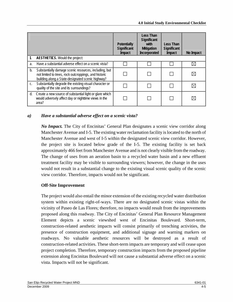
Impact No Impact I. AESTHETICS. Would the project: a. Have a substantial adverse effect on a scenic vista? b. Substantially damage scenic resources, including, but
not limited to trees, rock outcroppings, and historic building along a State-designated scenic highway?
c. Substantially degrade the existing visual character or quality of the site and its surroundings?
d. Create a new source of substantial light or glare which would adversely affect day or nighttime views in the area?
a) Have a substantial adverse effect on a scenic vista?
No Impact. The City of Encinitas’ General Plan designates a scenic view corridor along Manchester Avenue and I-5. The existing water reclamation facility is located to the north of Manchester Avenue and west of I-5 within the designated scenic view corridor. However, the project site is located below grade of the I-5. The existing facility is set back approximately 466 feet from Manchester Avenue and is not clearly visible from the roadway. The change of uses from an aeration basin to a recycled water basin and a new effluent treatment facility may be visible to surrounding viewers; however, the change in the uses would not result in a substantial change to the existing visual scenic quality of the scenic view corridor. Therefore, impacts would not be significant.
Off-Site Improvement
The project would also entail the minor extension of the existing recycled water distribution system within existing right-of-ways. There are no designated scenic vistas within the vicinity of Paseo de Las Flores; therefore, no impacts would result from the improvements proposed along this roadway. The City of Encinitas’ General Plan Resource Management Element depicts a scenic viewshed west of Encinitas Boulevard. Short-term, construction-related aesthetic impacts will consist primarily of trenching activities, the presence of construction equipment, and additional signage and warning markers on roadways. No valuable aesthetic resources will be destroyed as a result of construction-related activities. These short-term impacts are temporary and will cease upon project completion. Therefore, temporary construction impacts from the proposed pipeline extension along Encinitas Boulevard will not cause a substantial adverse effect on a scenic vista. Impacts will not be significant.

4.0 Initial Study Environmental Checklist
San Elijo Recycled Water Project MND 6341-01 December 2009 4-6
b) Substantially damage scenic resources, including, but not limited to, trees, rock outcroppings, and historic buildings within a state scenic highway?
No Impact. The Encinitas General Plan designates Manchester Avenue as a scenic highway. However, due to the existing mature landscaping along Manchester Avenue and surrounding the existing water reclamation facility, the project is not clearly visible from Manchester Avenue. The change of uses from an aeration basin to a recycled water basin and a new effluent treatment facility may be visible from Manchester Avenue; however, the change in the uses would not result in a substantial change to the existing visual scenic quality of the scenic view corridor. No scenic resources, including trees, rock outcroppings, or historic buildings, are situated on site. Impacts are therefore less than significant.
Off-Site Improvement
A recycled water pipeline would be extended within the existing right-of way along Paseo De Las Flores and Encinitas Boulevard/B Street. Paseo de Las Flores, Encinitas Boulevard, and B Street are not designated or located adjacent to a designated scenic highway. In addition, all work would occur within the existing right-of-way and would not impact any scenic resources such as trees, rock outcrops, or historic buildings. Therefore, no impacts would result.
c) Substantially degrade the existing visual character or quality of the site and its surroundings?
No Impact. The project would entail the expansion and improvement of an existing water reclamation facility and the minor extension of existing recycled water pipelines. The existing reclaimed water facility is not clearly visible to sensitive viewers due to the projects topographic location and the mature landscaping that surrounds the site. In addition, the change in uses would not result in a substantial change to the existing visual character or quality of the site or its surroundings. Therefore, impacts would be less than significant.
Off-Site Improvement
During construction activities a temporary change in the existing visual character along Paseo de Las Flores and Encinitas Boulevard would result from off-site trenching activities associated with the minor recycled water pipeline extensions. However, once construction is completed no change would result in the existing visual character. Impacts would be less than significant.

4.0 Initial Study Environmental Checklist
San Elijo Recycled Water Project MND 6341-01 December 2009 4-7
d) Create a new source of substantial light or glare which would adversely affect day or nighttime views in the area?
No Impact. The proposed expansion and improvements would not create new sources of light or glare. Therefore, no impacts would result.
Potentially Significant
Impact
Less Than Significant
with Mitigation Incorporated
Less Than Significant
Impact No Impact II. AGRICULTURAL RESOURCES. Would the project: a. Convert Prime Farmland, Unique Farmland, Farmland
of Statewide Importance as depicted on maps prepared pursuant to the Farmland Mapping and Monitoring Program of the CA Resources Agency?
b. Conflict with existing zoning for agricultural use, or a Williamson Act Contract?
c. Involve other changes in the existing environment which, due to their location or nature, could result in conversion of Farmland, to non-agricultural use?
a) Convert Prime Farmland, Unique Farmland, or Farmland of Statewide Importance
(Farmland), as shown on the maps prepared pursuant to the Farmland Mapping and Monitoring Program of the California Resources Agency, to non-agricultural use?
No Impact. According to the San Diego County Important Farmland Map (2004) prepared by the California Department of Conservation Farmland Mapping and Monitoring Program, the project site is designated as urban and built-up land. No land is designated Prime Farmland, Unique Farmland, or Farmland of Statewide Importance within the project site or its surrounding area.
Off-Site Improvement
The project proposes the expansion of an existing off-site recycled water pipeline service to Paseo de Las Flores and Encinitas Boulevard. The expansions would occur within the existing right-of-way; which is currently developed with the existing roadway. While a portion of Paseo de Las Flores travels through the Ecke Agricultural Preserve which is designated as Farmland of Statewide Importance, all proposed construction activities would occur within the existing right-of-way and no disturbance would occur to the adjacent parcels of land. There is no land designated as farmland along or immediately adjacent to Encinitas Boulevard in the area associated with the proposed recycled water expansion. Therefore, the proposed off-site expansions would not result in the conversion of Prime Farmland, Unique Farmland, or Farmland of Statewide Importance. No impact would result.

4.0 Initial Study Environmental Checklist
San Elijo Recycled Water Project MND 6341-01 December 2009 4-8
b) Conflict with existing zoning for agricultural use, or a Williamson Act contract?
No Impact. The proposed project is located in an area zoned for public/semi-public use; agricultural designations do not occur within the project area and no Williamson Act contracts apply (California Department of Conservation 2004). Therefore, implementation of the project will not result in any conflicts with existing zoning for agricultural use or a Williamson Act Contract.
Off-Site Improvement
The proposed off-site recycled water pipeline expansion would occur within the existing right-of-ways along Paseo de Las Flores and Encinitas Boulevard. While a portion of Paseo de Las Flores travels through the Ecke Agricultural Preserve contract, all proposed construction activities would occur within the existing right-of-way and no disturbance would occur to the adjacent parcels of land. In addition, no land surrounding Encinitas Boulevard in the area proposed for the recycled water pipeline is zoned for agricultural use or contains a Williamson Act contract. Therefore, the proposed off-site expansions would not result in a conflict with existing zoning for agricultural use or a Williamson Act Contract. Impacts would be less than significant.
c) Involve other changes in the existing environment which, due to their location or nature, could result in conversion of Farmland, to non-agricultural use?
No Impact. As previously stated, the proposed project area is not located within an agricultural area. Thus, implementation of this project will not result in changes to the environment, which will result in the conversion of farmland to non-agricultural use. No impacts are anticipated in this regard. The proposed off-site pipeline extension would not result in changes to the existing environment that would result in the conversion of farmland to non-agricultural uses. No impacts regarding the conversion of farmland to non-agricultural uses would result.
Potentially Significant
Impact
Less Than Significant
with Mitigation Incorporated
Less Than Significant
Impact No Impact III. AIR QUALITY. Would the project: a. Conflict with or obstruct implementation of the
applicable air quality plan?
b. Violate an air quality standard or contribute to an existing or projected air quality violation?

4.0 Initial Study Environmental Checklist
San Elijo Recycled Water Project MND 6341-01 December 2009 4-9
Potentially Significant
Impact
Less Than Significant
with Mitigation Incorporated
Less Than Significant
Impact No Impact c. Result in a cumulatively considerable net increase of
any criteria pollutant for which the project region is non-attainment under the applicable federal or state ambient air quality standard (including releasing emissions which exceed quantitative thresholds for ozone precursors)?
d. Expose sensitive receptors to substantial pollutant concentrations?
e. Create objectionable odors affecting a substantial number of people?
a) Conflict with or obstruct implementation of the applicable air quality plan?
Less Than Significant Impact. The project site is located within the San Diego Air Basin, which is governed by the San Diego Air Pollution Control Board. A consistency determination is made in local agency project review by comparing local planning projects to the Regional Air Quality Strategy (RAQS) in several ways. It fulfills the CEQA goal of fully informing local agency decision makers of the environmental costs of the project under consideration at a stage early enough to ensure that air quality concerns are addressed. Only new or amended General Plan elements, Specific Plans, and significantly unique projects need to undergo consistency review due to the RAQS being based on projections from local General Plans. Therefore, projects that are consistent with the local General Plan are considered consistent with the air quality-related regional plan. The proposed project will be consistent with SANDAG growth forecasts and all applicable emissions control measures identified within the RAQS. Therefore, the proposed project will not conflict or obstruct implementation of the RAQS/State Implementation Plan; impacts will be less than significant.
b) Violate any air quality standard or contribute substantially to an existing or projected air quality violation?
Less Than Significant Impact. An Air Quality Impact Assessment was prepared by SRA in April 2009. Project construction emissions were generated for the proposed project and are provided in Table 1 below. As shown in Table 1, project construction emissions are below the significance thresholds and would not result in a short-term impact on the ambient air quality. Therefore, construction related impacts will be less than significant.

4.0 Initial Study Environmental Checklist
San Elijo Recycled Water Project MND 6341-01 December 2009 4-10
Table 1 Estimated Construction Emissions
EMISSION SOURCE CO NO ROC SOx PM10 PM2.5 Lbs/day
Fugitive Dust – Excavation — – – – 11.76 2.45 Heavy Equipment Exhaust 67.12 141.05 18.39 0.15 8.25 7.34 Heavy Duty Truck Traffic 21.70 60.74 4.46 0.08 2.61 2.58 Worker Travel – Vehicle Emissions 27.18 2.28 0.99 0.04 0.31 0.31
Total 116.00 204.07 23.84 0.27 22.93 12.68 Significance Threshold 550 250 75 250 100 55 Significant? No No No No No No
Tons/year Fugitive Dust – Materials Handling — — — — 0.18 0.04 Heavy Equipment Exhaust 6.98 14.67 1.91 0.02 0.86 0.77 Heavy Duty Truck Traffic 2.26 6.32 0.46 0.01 0.27 0.27 Worker Travel – Vehicle Emissions 2.83 0.24 0.10 0.00 0.03 0.03
Total 12.07 21.23 2.47 0.03 1.34 1.11 Significance Threshold 550 100 75 150 150 55 Significant? No No No No No No De Minims Threshold 100 100 100 — — — Above De Minimis Threshold? No No No — — — SDAB Air Basin Emissions Forecast, 2010, tons/year
274,955 58,437 54,969 — — —
Source: SRA 2009
While emissions from construction activities will occur over a temporary period, the project would not introduce additional operational traffic to the immediate area. Operational emissions are not anticipated to differ from existing conditions and would therefore not result in significant impacts on air quality.
c) Result in a cumulatively considerable net increase of any criteria pollutant for which the project region is non-attainment under the applicable federal or state ambient air quality standard (including releasing emissions which exceed quantitative thresholds for ozone precursors)?
Less Than Significant Impact. The San Diego Air Basin is classified as a federal non-attainment region for O3 and a state non-attainment region for O3, PM10 and PM2.5. The proposed project would represent a contribution to a cumulatively considerable potential net increase in emissions throughout the air basin. However, as described above, emissions associated with the proposed project would be minimal. Although project specific impacts related to O3, PM10 and PM2.5 during construction are considered less than significant, the cumulative impact from simultaneous construction within the air basin is a contributing

4.0 Initial Study Environmental Checklist
San Elijo Recycled Water Project MND 6341-01 December 2009 4-11
factor to the overall pollution burden. However, because project construction would be a temporary event that would not result in permanent emissions of pollutants, the project construction would not be expected to cause degradation in the ambient air quality in the long term. Impacts would be less than significant.
d) Expose sensitive receptors to substantial pollutant concentrations?
Less Than Significant Impact. The project proposes to expand and improve its existing recycled water program; and extend 0.6 mile of off-site recycled water pipeline along Paseo de Las Flores and Encinitas Boulevard. Adjacent sensitive land uses include residential uses to the west and southeast of the project site, and both north and south of the eastern portion of the Paseo de Las Flores pipeline extension. Project construction would result in emissions of diesel particulate matter from construction equipment. Long-term exposure to diesel particulate matter has been identified by the State of California as having the potential for adverse health effects, including increased risk of cancer and respiratory effects. Because construction is a short-term event and adverse health effects are only predicted for long-term exposure, impacts due to emissions of diesel particulate during construction would be less than significant.
e) Create objectionable odors affecting a substantial number of people?
Less Than Significant Impact. During the construction period, potential odors associated with the proposed project will result from the application of asphalt and from diesel and gas fumes. Due to the residential uses surrounding the project site, odors associated with project construction will be considered adverse and potentially significant. However, due to the temporary nature of construction, impacts are expected to be less than significant
CEQA PLUS
CEQA-Plus integrates regulations from the Clean Air Act (CAA) to projects in areas that are subject to the General Conformity Rule. CEQA-Plus requires that an analysis is conducted for each criteria pollutant for which the air basin is considered nonattainment or maintenance. Section 176(c) of the 1990 CAA Amendments contains the General Conformity Rule (40 CFR 51.850–860 and 40 CFR 93.150–160). The General Conformity Rule requires any federal agency responsible for an action in a non-attainment or maintenance area to determine that the action conforms to the applicable SIP. This means that federally supported or funded activities will not (1) cause or contribute to any new air quality standard violation, (2) increase the frequency or severity of any existing standard violation, or (3) delay the timely attainment of any standard, interim emission reduction, or other milestone. The rule allows for approximately 30 exemptions that are assumed to conform to an applicable SIP. Emissions of attainment pollutants are exempt from

4.0 Initial Study Environmental Checklist
San Elijo Recycled Water Project MND 6341-01 December 2009 4-12
conformity analyses. Actions would conform to a SIP if their annual direct and indirect emissions remain less than the applicable de minimis thresholds. Formal conformity determinations are required for any actions that exceed these thresholds. However, if the total emissions of a pollutant from a federal action exceed 10% of a nonattainment area’s emissions inventory of that pollutant, the action is defined as a regionally significant action and it would also require a conformity determination. Under the Federal Clean Air Act, Federal actions may be exempt from conformity determinations if they do not exceed designated de minimis levels for criteria pollutants (40 CFR 51.853[b]).
Based on the present attainment status of the San Diego Air Basin (SDAB), the Proposed Action would conform to the most recent USEPA-approved SIP if its annual construction or operational emissions do not exceed 100 tons of NOx or VOCs. The General Conformity Rule has been adopted by the San Diego Air Pollution Control District as Rule 1501.
As shown in Table 1, the projects construction emissions would not exceed the de minimis thresholds for CO, NOx, or VOC emissions. In addition, the emissions generated by the proposed project would be less than 10% for each pollutant (CO, NOx, and VOC). As discussed above, if project emissions are below the de minimis levels and less than 10% of the nonattainment area’s emissions inventory of that pollutant, further analysis under the General Conformity Rule is not required. Therefore, the project would be consistent with the General Conformity rule and no future analysis is required.
Potentially Significant
Impact
Less Than Significant
with Mitigation Incorporated
Less Than Significant
Impact No Impact IV. BIOLOGICAL RESOURCES. Would the project: a. Have a substantial adverse effect, either directly or
through habitat modifications, on any species identified as a candidate, sensitive, or special status species in local or regional plans, policies, or regulations, or by the California Department of Fish and Game or the USFWS?
b. Have a substantial adverse effect on any riparian habitat or other sensitive natural community identified in local or regional plans, policies, regulations, or by the California Department of Fish and Game (CDFG) or U.S. Fish and Wildlife Service?
c. Have a substantial adverse effect on federally protected wetlands as defined by Section 404 of the Clean Water Act (including, but not limited to, marsh, vernal pool, coastal, etc.) through direct removal, filling, hydrological interruption, or other means?

4.0 Initial Study Environmental Checklist
San Elijo Recycled Water Project MND 6341-01 December 2009 4-13
Potentially Significant
Impact
Less Than Significant
with Mitigation Incorporated
Less Than Significant
Impact No Impact d. Interfere substantially with the movement of any native
resident or migratory fish or wildlife species or with established native resident or migratory wildlife corridors, or impede the use of native wildlife nursery sites?
e. Conflict with any local policies or ordinances protecting biological resources, such as tree preservation policy/ordinance?
f. Conflict with the provisions of an adopted Habitat Conservation Plan, Natural Community Conservation Plan, or other approved local, regional, or state habitat conservation plan?
a. Have a substantial adverse effect, either directly or through habitat modifications, on any
species identified as a candidate, sensitive, or special status species in local or regional plans, policies, or regulations, or by the California Department of Fish and Game or the USFWS?
Less Than Significant Impact. .A biological survey of the project area was conducted by Dudek biologist on April 8 and April 17, 2009. In addition a Biological Resources Letter Report was prepared for the proposed project by Dudek on April 24, 2009. According to the letter report, the entire project area is supported by existing hardscape, structures, residential development and ornamental landscaping with no natural vegetation communities and/or land covers present.
A review of the California Natural Diversity Database (CNDD) was conducted to supplement the 2009 biological surveys. CNDD records/occurrence data was reviewed within a 1 mile radius of the sites; however, impacts to special-status plants were not analyzed due to the lack of vegetation communities in the project area.
There are no vegetation communities, including sensitive habitats or special status plant species within the project area. In addition, no invertebrate, amphibian, reptile, or mammal species were detected in the project area during the site survey and due to the degree if impervious surface present wildlife use of the area is expected to be low. Therefore, impacts would be less than significant.
b. Have a substantial adverse effect on any riparian habitat or other sensitive natural community identified in local or regional plans, policies, regulations or by CDFG or USFWS?

4.0 Initial Study Environmental Checklist
San Elijo Recycled Water Project MND 6341-01 December 2009 4-14
No Impact. See response to IV.a above. The project would not result in impacts to riparian habitat or other sensitive natural communities.
c. Have a substantial adverse effect on federally protected wetlands as defined by Section 404 of the Clean Water Act (including, but not limited to, marsh, vernal pool, coastal, etc.) through direct removal, filling, hydrological interruption, or other means?
No Impact. There are no sensitive wetland communities on the project site. Therefore, no impacts will occur.
d. Interfere substantially with the movement of any native resident or migratory fish or wildlife species or with established native resident or migratory wildlife corridors, or impede the use of native wildlife nursery sites?
Potentially Significant Unless Mitigated. The project site is bounded by development. Therefore, there are no habitat linkages or wildlife corridors in the immediate project vicinity that will be directly or indirectly impacted by the proposed project. Impacts to habitat linkages and wildlife corridors would not result. Some bird species present or potentially present in the project area may nest within the assortment of ornamental trees and shrubs along Encinitas Boulevard and Paseo de Las Flores and on the grounds of the reclamation facility. Breeding birds, including the California gnatcatcher and least Bell’s vireo, can be significantly affected by short-term construction-related noise, which can result in the disruption of foraging, nesting, and reproductive activities. Breeding passerine species may utilize ornamental trees and shrubs with good vegetative structure for nest construction and foraging while raptor species may nest in larger, taller trees within the project area. The California gnatcatcher may occur and nest in off-site disturbed coastal sage scrub habitats to the west of the reclamation facility. The least Bell’s vireo may occur and nest in off-site southern willow scrub habitat just south of Encinitas Boulevard west of Pacific Coast Highway. If nesting bird species are present at the time of construction, indirect impacts to these species could occur due to construction related noise.
Mitigation Measures
BIO-1 To avoid direct and indirect impacts to migratory bird species protected under the Migratory Bird Treaty Act (MBTA), a nesting bird survey should shall be conducted by a qualified biologist within 72 hours of removal of trees if trees are to be removed between January 1 and August 15. If occupied nests are present, impacts to vegetation must be avoided until the juvenile birds have fledged. If a raptor nest is identified in the larger trees at the reclamation facility, the nest tree will be flagged and a 500-foot buffer will be established around the tree. Grading shall be avoided

4.0 Initial Study Environmental Checklist
San Elijo Recycled Water Project MND 6341-01 December 2009 4-15
within the buffer area until the birds have fledged and nesting activity has been completed.
BIO-2 To avoid indirect impacts to the California gnatcatcher, construction occurring at the reclamation facility shall be conducted outside of the breeding season for this species (February 15 to August 31). If construction must occur during the breeding season for this species the following measures shall be implemented:
a) Prior to any construction-related activity, the biologist shall survey up to 500 feet from the proposed construction area at the SEJPA recycled water facility in accordance with the U.S. Fish and Wildlife Service protocol for this species.
b) If no California gnatcatchers are found to be present within areas up to 500 feet of the proposed construction area, then project construction may proceed without restrictions.
c) If California gnatcatchers are found in off-site areas, construction within 500 feet shall not commence until temporary noise barrier(s) are in place between the construction area and occupied gnatcatcher habitat. The location of the noise barrier(s) shall be determined by the biologist and acoustician. Construction noise levels shall be monitored at the edge of occupied habitat with the noise barrier(s) in place. Other measures shall be implemented, as necessary, to reduce noise levels to below 60 dB(A), or to the ambient noise level if it already exceeds 60 dB(A) at the edge of the occupied habitat.
d) Construction noise shall be monitored once weekly to verify that noise at the edge of occupied habitat in the Multiple Habitat Conservation Plan (MHCP) “hardline” area is maintained below 60 dB(A), or to the ambient noise level if it already exceeds 60 dB(A). If this requirement cannot be met, other measures shall be implemented as necessary, to reduce noise levels to below 60 dB(A) or to the ambient noise level if it already exceeds 60 dB(A). Such measures may include, but are not limited to, placement of construction equipment, and limitations on the simultaneous use of equipment.
BIO-3 To avoid indirect impacts to the least Bell’s vireo during construction, any work occurring along Encinitas Boulevard, west of Pacific Coast Highway (PCH), shall be conducted outside of the breeding season for this species (March 15–September 15). If construction must occur during the breeding season for the least Bell’s vireo, the following measure shall be implemented:
a) Prior to any construction-related activity, the biologist shall survey up to 500 feet from the proposed construction area at the western portion of Encinitas

4.0 Initial Study Environmental Checklist
San Elijo Recycled Water Project MND 6341-01 December 2009 4-16
Boulevard in accordance with the U.S. Fish and Wildlife Service approved survey methods for this species.
b) If no least Bell’s vireo are found to be present within areas up to 500 feet of the proposed construction area, then project construction may proceed without restrictions.
c) If least Bell’s vireo are found in off-site areas, construction within 500 feet shall not commence until temporary noise barrier(s) are in place between the construction area and occupied gnatcatcher habitat. The location of the noise barrier(s) shall be determined by the biologist and acoustician. Construction noise levels shall be monitored at the edge of occupied habitat with the noise barrier(s) in place. Other measures shall be implemented, as necessary, to reduce noise levels to below 60 dB(A), or to the ambient noise level if it already exceeds 60 dB(A) at the edge of the occupied habitat.
d) Construction noise shall be monitored once weekly to verify that noise at the edge of occupied habitat is maintained below 60 dB(A), or to the ambient noise level if it already exceeds 60 dB(A). If this requirement cannot be met, other measures shall be implemented as necessary, to reduce noise levels to below 60 dB(A) or to the ambient noise level if it already exceeds 60 dB(A). Such measures may include, but are not limited to, placement of construction equipment, and limitations on the simultaneous use of equipment.
e. Conflict with any local policies or ordinances protecting biological resources, such as tree preservation policy/ordinance?
No Impact. The project would not conflict with any local polices or ordinances protecting biological resources. The project would not entail the removal of any trees; therefore, no impacts would result.
f. Conflict with the provisions of an adopted Habitat Conservation Plan, Natural Community Conservation Plan, or other approved local, regional, or state habitat conservation plan?
No Impact. The project site is located City of Encinitas’ Draft MHCP Subarea Plan. The Draft MHCP identifies Focused Planning Areas (FPAs) within which some lands will be designated for open space and habitat preservation. The three project areas are not located within the City’s of Encinitas’ FPA. Therefore the project is consistent with the City of Encinitas’ Draft MHCP Subarea Plan. No impacts would result.

4.0 Initial Study Environmental Checklist
San Elijo Recycled Water Project MND 6341-01 December 2009 4-17
CEQA Plus
CEQA Plus requires a project to be consistent with the federal environmental regulations guiding the Endangered Species Act (ESA). The requirements include the preparation of a species list and analyzing potential project effects on special-status species. A species list has been prepared and is provided as Appendix A to the Biological Resources Letter Report prepared by Dudek in April 2009. In addition, the Biological Letter Report analyzed the potential impacts to special status species. As discussed above, there are no special status plant species within the project area. Therefore, no direct or indirect impacts to special status plant species are expected to occur. Some bird species present or potentially present in the project area may nest within the assortment of ornamental trees and shrubs within the reclaimed water facility and along the two off-site pipeline expansion locations (Paseo del Las Flores and Encinitas Boulevard). These potential nesting species include raptors and a variety of songbirds. No other special status wildlife species are present or anticipated to occur within the project area. The California gnatcatcher may occur and nest in off-site disturbed coastal sage scrub habitats to the west of the reclamation facility. In addition, the least Bell’s vireo may occur and nest in off-site southern willow scrub habitat just south of Encinitas Boulevard west of Pacific Coast Highway. If nesting species are present at the time of construction, indirect impacts to these species could occur due to construction related noise. However, incorporation of mitigation measures BIO-1, BIO-2, and BIO-3 provided above would avoid direct and indirect impacts to special status wildlife species. Therefore, impacts would be less than significant.
Potentially Significant
Impact
Less Than Significant
with Mitigation Incorporated
Less Than Significant
Impact No Impact V. CULTURAL RESOURCES. Would the project: a. Cause a substantial adverse change in the significance
of a historical resource as defined in Section 15064.5 of CEQA?
b. Cause a substantial adverse change in the significance of an archaeological resource pursuant to Section 15064.5 of CEQA?
c. Directly or indirectly destroy a unique paleontological resource or site or unique geologic feature?
d. Disturb any human remains, including those interred outside of formal cemeteries?

4.0 Initial Study Environmental Checklist
San Elijo Recycled Water Project MND 6341-01 December 2009 4-18
a. Cause a substantial adverse change in the significance of a historical resource as defined in ' 15064.5 of CEQA?
No Impact. The project site is currently developed as a water reclamation facility. The facility was originally constructed in 1965, and consists of wastewater treatment structures/facilities. Land uses surrounding the project site consist of residential uses to the north, southeast, and west; I-5 to the northeast; and San Elijo Lagoon to the south of Manchester Avenue. There are no known historical resources located within or adjacent to the project site; therefore, no impact would occur.
b. Cause a substantial adverse change in the significance of an archaeological resource pursuant to '15064.5 of CEQA?
No Impact. An Archaeological Survey Report was prepared for the proposed project by ASM Affiliates in April 2009. According to the archaeological survey report, no archaeological resources were identified within or adjacent to the area to be impacted by the proposed project. Therefore, no impacts would result.
c. Directly or indirectly destroy a unique paleontological resource or site or unique geologic feature?
No Impact. See response V.b.
d. Disturb any human remains, including those interred outside of formal cemeteries?
No Impact. Since the project site has previously been developed and paved, and the project entails reconstruction and expansion of existing facilities, impacts from the disturbance of human remains are not anticipated.
CEQA Plus
Compliance with CEQA Plus requires that the proposed project is subject to the federal environmental regulations guiding the National Historic Preservation Act (NHPA). As mentioned above, an Archaeological Survey Report was prepared for the project by ASM Affiliates in April 2009. The report was conducted to assess the presence or absence of potentially significant prehistoric and historic sites in the project area, for Section 106 consultation with the California State Historic Preservation Officer (SHPO) under the NHPA. According to the Archaeological Survey Report no cultural resources including historic and prehistoric resources have been identified within or adjacent to areas proposed to be impacted by the proposed project. Therefore, the proposed project is consistent with the CEQA Plus and NHPA requirements, and no impacts would result.

4.0 Initial Study Environmental Checklist
San Elijo Recycled Water Project MND 6341-01 December 2009 4-19
Potentially Significant
Impact
Less Than Significant
with Mitigation Incorporated
Less Than Significant
Impact No Impact VI. GEOLOGY AND SOILS. Would the project: a. Expose people or structures to potential substantial
adverse effects, including the risk of loss, injury, or death involving (i) rupture of a known earthquake fault, as delineated on the most recent Alquist-Priolo Earthquake Fault Zoning Map issued by the State Geologist, or based on other substantial evidence of a known fault (Refer to DM&G Pub. 42)?; or, (ii) strong seismic ground shaking?; or, (iii) seismic-related ground failure, including liquefaction?; or, (iv) landslides?
b. Result in substantial soil erosion or the loss of topsoil? c. Be located on a geologic unit or soil that is unstable, or
that would become unstable as a result of the project, and potentially result in on-site or off-site landslide, lateral spreading, subsidence, liquefaction or collapse?
d. Be located on expansive soil, as defined in Table 18- 1-B of the 1994 UBC, creating substantial risks to life or property?
a) Expose people or structures to potential substantial adverse effects, including the risk of
loss, injury, or death involving:
1) Rupture of a known earthquake fault, as delineated on the most recent Alquist-Priolo Earthquake Fault Zoning Map issued by the State Geologist for the area or based on other substantial evidence of a known fault? Refer to Division of Mines and Geology Special Publication 42.
Less Than Significant Impact. The project is located within seismically active southern California, an area where several faults and fault zones are considered active by the California Division of Mines and Geology. Alquist-Priolo earthquake fault zones have been established for the majority of these faults and fault zones. The purpose of the Alquist-Priolo earthquake fault zones is to prohibit the location of structures on the traces of active faults, thereby mitigating potential damage due to fault surface rupture. According to the California Department of Conservation Geological Survey, the City of Encinitas is not listed as being affected by an Alquist-Priolo earthquake fault zone. Therefore, impacts would be less than significant

4.0 Initial Study Environmental Checklist
San Elijo Recycled Water Project MND 6341-01 December 2009 4-20
2) Strong seismic ground shaking?
Less Than Significant Impact. The proposed project is not located within a known earthquake fault zone, as defined by the most recent Alquist-Priolo Earthquake Fault Zoning Map, or other fault zones known based on substantial evidence however, the project site, as with most of southern California, would be subject to moderate to sever ground shaking during a major earthquake. The Rose Canyon Fault, located approximately 2.5 miles west of the project site, is the closest known active fault and is the dominant source of potential ground motion. However, since no Alquist-Priolo Earthquake Fault Zones exist within the City of Encinitas, there are no restrictions on development related to Alquist-Priolo requirements. The proposed project would adhere to the California Building Codes (CBC) for the latest seismic standards for structure construction. Since the project does not involve any residential structures and the CBC standards will be implemented into the project design features, less than significant impacts to people or structures would occur as a result of seismic ground shaking.
3) Seismic-related ground failure, including liquefaction?
Less Than Significant Impact. Liquefaction typically occurs in saturated soils when a site is subjected to strong seismic shaking. The project site is underlain by Corralitos loamy sand. Therefore, the project site is susceptible to liquefaction. However, due to project design features such as construction adhering to CBC standards, impacts from seismic related ground failure would be less than significant.
4) Landslides?
Less Than Significant Impact. Landslides are mass movements of the ground that include rock falls, relatively shallow slumping and sliding of soil, and deeper rotational or transitional movement of soil or rock. According to the California Department of Conservation 1986 Landslide Hazards in the Encinitas Quadrangle, the proposed project site is located in an area designated as least susceptible to landslides. Impacts are expected to be less than significant.
b) Result in substantial soil erosion or the loss of topsoil?
Less Than Significant Impact. The project site is currently developed and would entail the conversion and expansion of existing facilities, and re-pavement of the portions of the site. During construction it is likely that soil erosion could occur; however, implementation of BMPs would reduce the amount of erosion that would occur and would reduce potential impacts to less than significant.

4.0 Initial Study Environmental Checklist
San Elijo Recycled Water Project MND 6341-01 December 2009 4-21
During the operational phase of the project, the site will return to a paved surface and impacts would not result.
c) Be located on a geologic unit or soil that is unstable, or that would become unstable as a result of the project, and potentially result in on-site or off-site landslide, lateral spreading, subsidence, liquefaction or collapse?
Less Than Significant Impact. See response to 4.6a-2 and 3. The project site is susceptible to unstable soils; however, with adherence to the CBC, impacts would be less than significant.
e) Be located on expansive soil, as defined in Table 18-1-B of the Uniform Building Code (1997), creating substantial risks to life or property?
Less Than Significant Impact. The project site is underlain by Corralitos loamy sand. According to Table 18-1-B, the project site has a medium potential for expansive soils. In order to prevent significant impact to the project as a result of expansive soils; the expansive soils shall be replaced with non-expansive soils pursuant to the applicable requirements of the City of Encinitas for issuance of a grading permit. Impacts are expected to be less than significant.
Potentially Significant
Impact
Less Than Significant
with Mitigation Incorporated
Less Than Significant
Impact No Impact VII. HAZARDS AND HAZARDOUS MATERIALS. Would the project: a. Create a significant hazard to the public or the
environment through the routine transport, use, or disposal of hazardous materials?
b. Create a significant hazard to the public or the environment through reasonably foreseeable conditions involving the release of hazardous materials into the environment?
c. Emit hazardous emissions or handle hazardous or acutely hazardous materials, substances, or waste within one-quarter mile of an existing or proposed school?
d. Be located on a site which is included on a list of hazardous materials sites compiled pursuant to Government Code Section 65962.5 and, as a result, would it create a significant hazard to the public or the environment?

4.0 Initial Study Environmental Checklist
San Elijo Recycled Water Project MND 6341-01 December 2009 4-22
Potentially Significant
Impact
Less Than Significant
with Mitigation Incorporated
Less Than Significant
Impact No Impact e. For a project located within an airport land use plan or,
where such a plan has not been adopted, within two miles of a public airport or public use airport, would the project result in safety hazard for people residing or working in the project area?
f. For a project within the vicinity of a private airstrip, would the project result in a safety hazard for people residing or working in the project area?
g. Impair implementation of or physically interfere with an adopted emergency response plan or emergency evacuation plan?
h. Expose people or structures to a significant risk of loss, injury or death involving wildland fires, including where wildlands are adjacent to urbanized areas or where residences are intermixed with wildlands?
a) Create a significant hazard to the public or the environment through the routine transport,
use, or disposal of hazardous materials?
Less Than Significant Impact. On-site use and storage of hazardous materials will be limited to common chemicals used for recycling water and maintenance. The conversion and expansion of the existing facilities on site would not change the character of use or transport of hazardous materials, and therefore, would not cause long term impacts concerning the routine transport, use or disposal of hazardous materials. During the construction period, standard BMPs will be applied to ensure that all hazardous materials (i.e., construction equipment fuel) are stored properly and that no hazards occur during this phase of the project. Therefore, impacts will be less than significant.
b) Create a significant hazard to the public or the environment through reasonably foreseeable upset and accident conditions involving the release of hazardous materials into the environment?
Less Than Significant Impact. On-site use and storage of hazardous materials will be limited to common chemicals used for recycling water and maintenance. The conversion and expansion of the existing facilities on site would not change the character of use, and therefore, would not cause long term impacts regarding a reasonably foreseeable upset and accident conditions involving the release of hazardous materials. During the construction phase standard BMPs would be applied to ensure that all hazards materials are handled properly and that no hazards occur during this phase of the project.

4.0 Initial Study Environmental Checklist
San Elijo Recycled Water Project MND 6341-01 December 2009 4-23
During the operational phase, the facility’s existing Hazardous Materials Business Plan and Operation Management Plan will be updated to incorporate the new list and quantities of hazardous materials that are stored and used on site, and the proper procedures for release of such chemicals. Therefore, impacts will be less than significant.
c) Emit hazardous emissions or handle hazardous or acutely hazardous materials, substances, or waste within one-quarter mile of an existing or proposed school?
No Impact. There are no existing or proposed schools located with a quarter mile of the proposed project site. Therefore, no impacts would occur.
d) Be located on a site which is included on a list of hazardous materials sites compiled pursuant to Government Code Section 65962.5 and, as a result, would it create a significant hazard to the public or the environment?
No Impact. The project site is not included on a list of sites containing hazardous materials, and will therefore not result in a significant hazard to the public or to the environment as a result of disturbance/modification to an existing hazardous materials site (State of California 2009).
e) For a project located within an airport land use plan or, where such a plan has not been adopted, within two miles of a public airport or public use airport, would the project result in a safety hazard for people residing or working in the project area?
No Impact. The project site is not located within an airport land use plan or within two miles of a public airport or public use airport. Therefore, no impacts would result.
f) For a project within the vicinity of a private airstrip, would the project result in a safety hazard for people residing or working in the project area?
No Impact. The proposed project site is not located within the vicinity of a private airstrip and will not result in a safety hazard for people residing or working in the project area.
g) Impair implementation of or physically interfere with an adopted emergency response plan or emergency evacuation plan?
No Impact. The conversion and expansion of existing facilities, including the off-site pipelines, is not anticipated to result in any construction related road closures that will impair implementation of or physically interfere with an adopted emergency response plan or emergency evacuation plan. No impacts would result.

4.0 Initial Study Environmental Checklist
San Elijo Recycled Water Project MND 6341-01 December 2009 4-24
h) Expose people or structures to a significant risk of loss, injury or death involving wildland fires, including where wildlands are adjacent to urbanized areas or where residences are intermixed with wildlands?
No Impact. The project site is located adjacent to San Elijo Lagoon and existing urban uses such as residential uses, commercial uses and I-5. The project is not located near existing wildlands. In addition, the project proposes to expand and improve an existing recycled water program to increase recycled water supplies. No impacts would result.
Potentially Significant
Impact
Less Than Significant
with Mitigation Incorporated
Less Than Significant
Impact No Impact VIII. HYDROLOGY AND WATER QUALITY. Would the project: a. Violate any water quality standards or waste discharge
requirements?
b. Substantially deplete groundwater supplies or interfere substantially with groundwater recharge such that there would be a net deficit in aquifer volume or a lowering of the local groundwater table level (e.g., the production rate of pre-existing nearby wells would drop to a level which would not support existing land uses or planned uses for which permits have been granted)?
c. Substantially alter the existing drainage pattern of the site or area including through the alteration of the course of a stream or river, in a manner which would result in substantial erosion or siltation on- or off- site?
d. Substantially alter the existing drainage pattern of the site or area, including through the alteration of the course of a stream or river, or substantially increase the rate or amount of surface runoff in a manner which would result in flooding on or off-site?
e. Create or contribute runoff water which would exceed the capacity of existing or planned stormwater drainage systems or provide substantial additional sources of polluted runoff?
f. Otherwise substantially degrade water quality?
g. Place housing within a 100-year flood hazard area as mapped on a Federal Flood Hazard Boundary or Flood Insurance Rate map or other flood hazard delineation map?
h. Place within a 100-year flood hazard area structures which would impede or redirect flood flows?

4.0 Initial Study Environmental Checklist
San Elijo Recycled Water Project MND 6341-01 December 2009 4-25
Potentially Significant
Impact
Less Than Significant
with Mitigation Incorporated
Less Than Significant
Impact No Impact i. Expose people or structures to a significant risk of
loss, injury or death involving flooding, including flooding as a result of the failure of a levee or dam?
j. Inundation by seiche, tsunami, or mudflow?
a) Violate any water quality standards or waste discharge requirements?
Less Than Significant Impact. Construction of proposed project is not expected to violate any water quality standards or waste discharge requirements.
Construction activities associated with the proposed project could result in wind and water erosion leading to sediment laden discharges to nearby water resources. Sediment transport to drainages and nearby San Elijo Lagoon located to the south of the project area could result in degradation of water quality. Similarly, fuels, oils, lubricants, and other hazardous substances used during construction could be released and impact surface and groundwater. The project would be required to comply with the Regional Water Quality Control Boards and the City of Encinitas’ construction stormwater requirements. In addition, the project has incorporated several BMPs to address potential water quality and drainage impacts such as the use of silt fencing and direction of construction area drainage to existing storm drain facilities through the use of sandbags, gravel bags, or similar devices along the graded areas to minimize sediment transport.
With implementation of the above mentioned BMPs, the pollutants of concern will be limited, eliminated, or treated to the maximum extent practicable. Impacts would be less than significant.
During the operational phase of the project, water brine from the reverse osmosis process would be discharged to the existing ocean outfall in accordance with the requirements of SEJPA’s current NPDES permit. Since the SEJPA is already permitted to perform this activity with no limits on the quantity of discharge, impacts would be less than significant.
b) Substantially deplete groundwater supplies or interfere substantially with groundwater recharge such that there would be a net deficit in aquifer volume or a lowering of the local groundwater table level (e.g., the production rate of pre-existing nearby wells would drop to a level which would not support existing land uses or planned uses for which permits have been granted)?

4.0 Initial Study Environmental Checklist
San Elijo Recycled Water Project MND 6341-01 December 2009 4-26
No Impact. The project proposed to convert an existing aeration basin with a recycled water basin and recycled water pipelines. Construction of the proposed project would not increase the amount of impervious surfaces within the reclamation facility or the off-site recycled water pipeline locations. Therefore, no impact would result.
c) Substantially alter the existing drainage pattern of the site or area, including through the alteration of the course of stream or river, in a manner which would result in substantial erosion or siltation on- or off-site?
No Impact. The project consists of the expansion and improvements to an existing reclaimed water facility. The proposed improvements would not alter the existing drainage patter of the site or area, nor would it result in the alteration of the course of a stream or river, in a manor that would result in substantial erosion or siltation on or off-site. Therefore, no impacts would result.
d) Substantially alter the existing drainage pattern of the site or area, including through the alteration of the course of a stream or river, or substantially increase the rate or amount of surface runoff in a manner which would result in flooding on- or off-site?
No Impact. See response to VIII.c above. The project would not involve the alteration of an existing stream or river, nor would it alter the existing drainage pattern on or off-site. No impacts would result.
e) Create or contribute runoff water which would exceed the capacity of existing or planned stormwater drainage systems or provide substantial additional sources of polluted runoff?
No Impact. The project site is currently developed with the existing water reclamation facility, and the off-site locations are currently developed as paved roadways. Since the site is already developed and paved, and the project would entail the same existing uses, it is assumed that the amount of runoff would remain the same and that no impacts would occur.
f) Otherwise substantially degrade water quality?
Less Than Significant Impact. No elements of the proposed project are anticipated to degrade water quality. Therefore, impacts will be less than significant.
g) Place housing within a 100-year flood hazard area as mapped on a federal Flood Hazard Boundary or Flood Insurance Rate Map or other flood hazard delineation map?

4.0 Initial Study Environmental Checklist
San Elijo Recycled Water Project MND 6341-01 December 2009 4-27
No Impact. The project would not result in the construction of housing within a 100-year flood hazard area. In addition, the proposed project would not result in any changes to an existing 100-year flood hazard area that would result in housing being located within a 100-year flood hazard area. Therefore, no impacts would result.
h) Place within a 100-year flood hazard area structures which would impede or redirect flood flows?
No Impact. The proposed project does not place structures within a 100-year flood hazard area. Therefore, no impacts would result.
i) Expose people or structures to a significant risk of loss, injury or death involving flooding, including flooding as a result of the failure of a levee or dam?
Less Than Significant Impact. No portion of the proposed project would involve the construction of a levee or dam which could potentially place downstream people or structures at risk. In addition, the proposed project would not result in the exposure of people or structures to a significant risk of loss, injury or death involving flooding. Therefore, impacts will be less than significant.
j) Inundation by seiche, tsunami, or mudflow
Less Than Significant Impact. The project is located approximately 0.5 mile east of the Pacific Ocean. The project proposes to improve and expand the existing water recycling facilities located within the existing water reclamation facility. The project does not propose any new uses that do not already occur at the project site. In addition, the off-site recycled water pipelines would be constructed under the existing roadway. The project area is susceptible to inundation by seiche due to its proximity to the San Elijo Lagoon; however, due to the shallowness of the Lagoon and location of the project site in relation to the lagoon, the likelihood of impacts from a seiche would not be likely. Impacts are considered less than significant.
Potentially Significant
Impact
Less Than Significant with
Mitigation Incorporated
Less Than Significant
Impact No Impact IX. LAND USE AND PLANNING. Would the project: a. Physically divide an established community? b. Conflict with any applicable land use plan, policy, or
regulation of an agency with jurisdiction over the project (including, but not limited to the General Plan, specific plan, local coastal program, or zoning ordinance) adopted for the purpose of avoiding or mitigating an environmental effect?

4.0 Initial Study Environmental Checklist
San Elijo Recycled Water Project MND 6341-01 December 2009 4-28
Potentially Significant
Impact
Less Than Significant with
Mitigation Incorporated
Less Than Significant
Impact No Impact c. Conflict with any applicable habitat conservation plan
or natural community conservation plan?
a) Physically divide an established community?
No Impact. The project proposes to expand and improve its existing recycled water program within the existing reclaimed water facility and provide minimal expansion to existing recycled water pipelines. Therefore, the proposed project would not have an impact on the physical arrangement of an established community. Therefore, no impacts are anticipated to occur.
b) Conflict with any applicable land use plan, policy, or regulation of an agency with jurisdiction over the project (including, but not limited to the general plan, specific plan, local coastal program, or zoning ordinance) adopted for the purpose of avoiding or mitigating an environmental effect?
No Impact. The proposed project is consistent with the General Plan Land Use and Zoning designations for the project site (public/semi-public lands). Therefore no impact would result.
c) Conflict with any applicable habitat conservation plan or natural community conservation plan?
No Impact. The project site is located City of Encinitas’ Draft MHCP Subarea Plan. The MHCP identified FPAs within which some lands will be designated for open space and habitat preservation. The three project areas are not located within the City’s of Encinitas’ FPA. Therefore the project is consistent with the City of Encinitas’ Draft MHCP Subarea Plan. No impacts would result.
Potentially Significant
Impact
Less Than Significant with
Mitigation Incorporated
Less Than Significant
Impact No Impact X. MINERAL RESOURCES. Would the project: a. Result in the loss of availability of a known mineral
resource that would be of value to the region and the residents of the state?
b. Result in the loss of availability of a locally-important mineral resource recovery site delineated on a local general plan, specific plan, or other land use plan?

4.0 Initial Study Environmental Checklist
San Elijo Recycled Water Project MND 6341-01 December 2009 4-29
a) Result in the loss of availability of a known mineral resource that would be of value to the region and the residents of the state?
No Impact. According to the Generalized Mineral Land Classification Map of Western San Diego County, the project site is located within an existing urban boundary and is not located in an area designated as containing significant mineral resources (MRZ-2). Additionally, the project would expand and improve existing facilities within an existing developed area. Therefore, the project will have no impact on a known mineral resource.
b) Result in the loss of availability of a locally-important mineral resource recovery site delineated on a local general plan, specific plan, or other land use plan?
No Impact. Refer to response to item IV.10.a, above.
Potentially
Significant Impact
Less Than Significant
with Mitigation Incorporated
Less Than Significant
Impact No Impact XI. NOISE. Would the project: a. Exposure of persons to or generation of noise levels in
excess of standards established in the local general plan or noise ordinance, or applicable standards of other agencies?
b. Exposure of persons to or generation of excessive groundborne vibration or groundborne noise levels?
c. A substantial permanent increase in ambient noise levels in the project vicinity above levels existing without the project?
d. A substantial temporary or periodic increase in ambient noise levels in the project vicinity above levels existing without the project?
e. For a project located within an airport land use plan or, where such a plan has not been adopted, within two miles of a public airport or public use airport, would the project expose people residing or working in the project area to excessive noise levels?
f. For a project within the vicinity of a private airstrip, would the project expose people residing or working in the project area to excessive noise levels?
a) Exposure of persons to or generation of noise levels in excess of standards established in
the local general plan or noise ordinance, or applicable standards of other agencies?
Less Than Significant Impact. Construction of the proposed project would result in a temporary increase in existing noise levels. Construction equipment noise generally ranges from 70 to 95 dB(A) at 50 feet from the source. Sensitive receptors including residences
4.0 Initial Study Environmental Checklist
San Elijo Recycled Water Project MND 6341-01 December 2009 4-30
located approximately 200 feet to the west. Construction is governed by the City of Encinitas’ Municipal Code Section 9.32.410 8 (Construction Equipment), which limits construction activities to the hours of 7 a.m. to 7 p.m. Monday through Saturdays with the exception of legal holidays. Construction equipment shall not exceed 75 dB for more than 8 hours during any 24-hour period when measured at or within the property lines of any property used for residential purposes. Since all construction activities would occur during hours permitted by the City’s ordinance, the proposed project would not exceed established noise standards for construction. However, due to the proximity of sensitive receptors the following mitigation measure shall be implemented to reduce construction noise levels to 75 dBA or less.
Mitigation Measures
NOI-1 All construction vehicles or equipment operated within 1,000 feet of a dwelling or noise sensitive receptor shall be operated with properly operating and maintained mufflers by the SEJPA’s contractors;
NOI-2 Stockpiling and/or staging areas during construction shall be located as far as practical from dwellings and other noise sensitive receptors.
Operation of the proposed project would result in the same noise levels that occur from the existing conditions. No impacts would result.
b) Exposure of persons to or generation of excessive groundborne vibration or groundborne noise levels?
Less Than Significant Impact. The amount of construction activities required for the proposed facility is not anticipated to generate excessive groundborne vibrations or noise levels. However, as mentioned above, construction activities and scheduling will comply with the City of Encinitas’ Municipal Code. Due to the temporary nature of construction activities, impacts in this regard are considered to be less than significant.
c) A substantial permanent increase in ambient noise levels in the project vicinity above levels existing without the project.
Less Than Significant Impact. The expansion of existing wastewater facilities and distribution pipeline within the existing reclaimed water facility and off-site locations would not result in a substantial permanent increase in ambient noise levels in the project vicinity. Impacts would be less than significant.
d) A substantial temporary or periodic increase in ambient noise levels in the project vicinity above levels existing without the project?

4.0 Initial Study Environmental Checklist
San Elijo Recycled Water Project MND 6341-01 December 2009 4-31
Less Than Significant Impact. Construction of the proposed project would temporarily increase ambient noise levels in the project vicinity above levels existing without the project. However, given the temporary nature of noise disturbances and the incorporation of the noise control measures provided in the City’s Municipal Code and implementation of mitigation measures NOI-1 and NOI-2 identified in XI.a above, impacts would be less than significant.
e) For a project located within an airport land use plan or, where such a plan has not been adopted, within two miles of a public airport or public use airport, would the project expose people residing or working in the project area to excessive noise levels?
No Impact. The proposed project site is not located within an airport land use plan or within two miles of a public airport or public use airport.
f) For a project within the vicinity of a private airstrip, would the project expose people residing or working in the project area to excessive noise levels?
No Impact. The proposed project site is not located within the vicinity of a private airstrip and will not expose people residing or working in the project area to excessive noise levels.
Potentially Significant
Impact
Less Than Significant
with Mitigation Incorporated
Less Than Significant
Impact No Impact XII. POPULATION AND HOUSING. Would the project: a. Induce substantial population growth in an area, either
directly (for example, by proposing new homes and businesses) or indirectly (for example, through extension of roads or other infrastructure)?
b. Displace substantial numbers of existing housing, necessitating the construction of replacement housing elsewhere?
c. Displace substantial numbers of people, necessitating the construction of replacement housing elsewhere?
a) Induce substantial population growth in an area, either directly (for example, by
proposing new homes and businesses) or indirectly (for example, through extension of roads or other infrastructure)?
Less Than Significant Impact. The project would convert an existing aeration basin to a recycled water basin, and would construct new pipelines (on- and off-site) to distribute the recycled water. The off-site pipelines would be construction for a distance of approximately 0.5 a mile, the entire length of Paseo de Las Flores and for approximately 0.6 mile along Encinitas Boulevard. The increase in recycled water would help alleviate the water shortages

4.0 Initial Study Environmental Checklist
San Elijo Recycled Water Project MND 6341-01 December 2009 4-32
in the water districts that serve the residences and business of Del Mar, Encinitas, and Solana Beach. The proposed improvements would not serve to supply future development but to supplement water to existing development. Therefore, impacts would be less than significant.
b) Displace substantial numbers of existing housing, necessitating the construction of replacement housing elsewhere?
No Impact. The proposed project will not require the removal of existing housing, and therefore, will not necessitate the construction of replacement housing elsewhere.
c) Displace substantial numbers of people, necessitating the construction of replacement housing elsewhere?
No Impact. The project will not result in displacement of people; therefore, no replacement housing will be required.
Potentially
Significant Impact
Less Than Significant
with Mitigation Incorporated
Less Than Significant
Impact No Impact XIII. PUBLIC SERVICES. Would the project result in substantial adverse physical impacts associated with the provision of new or physically altered governmental facilities, need for new or physically altered governmental facilities, the construction of which could cause significant environmental impacts, in order to maintain acceptable service ratios, response times or other performance objectives for any of the public services: a. Fire Protection?
b. Police Protection?
c. Schools?
d. Parks?
e. Other public facilities?
a) Fire protection?
Less Than Significant Impact. The conversion and expansion of existing facility uses would not increase the needs of fire protection services. The design of the proposed project must comply with Fire Department requirements and standards to ensure access is provided. The project is not anticipated to result in any road closures. The project would result in an increase in recycled water and availability of this water resource to the servicing communities. Therefore, impacts to response times will be less than significant.

4.0 Initial Study Environmental Checklist
San Elijo Recycled Water Project MND 6341-01 December 2009 4-33
b) Police protection?
Less Than Significant Impact. The conversion and expansion of existing recycled water uses would not increase the needs of police protection services. The project is not anticipated to result in any road closures and therefore would not disrupt any emergency response plan. No significant impacts related to police protection or services will be anticipated with implementation of the proposed project.
c) Schools?
No Impact. The proposed project will not result in an increase in students or affect existing or proposed schools. Since the project does not propose housing, impacts to existing schools or the need for additional schools will not result.
d) Parks?
No Impact. The proposed project would not result in an increase in use of existing parks. No impacts would result.
e) Other public facilities?
No Impact. No additional public facilities would be impacted by the conversion and expansion of existing facilities. No impacts would result.
Potentially Significant
Impact
Less Than Significant with
Mitigation Incorporated
Less Than Significant
Impact No Impact XIV. RECREATION. Would the project:
a. Would the project increase the use of existing neighborhood and regional parks or other recreational facilities, such that substantial physical deterioration of the facility would occur or be accelerated?
b. Does the project include recreational facilities or require the construction or expansion of recreational facilities, which might have an adverse physical effect on the environment?
a) Would the project increase the use of existing neighborhood and regional parks or other
recreational facilities such that substantial physical deterioration of the facility would occur or be accelerated?

4.0 Initial Study Environmental Checklist
San Elijo Recycled Water Project MND 6341-01 December 2009 4-34
No Impact. The conversion and expansion of existing recycled water uses would not result in an increase of use of existing neighborhood and regional parks or other recreational facilities. Therefore, no impacts would result.
b) Does the project include recreational facilities or require the construction or expansion of recreational facilities which might have an adverse physical effect on the environment?
No Impact. The proposed project does not include recreational facilities or require the construction or expansion of recreational facilities. No impacts would result.
Potentially Significant
Impact
Less Than Significant
with Mitigation Incorporated
Less Than Significant
Impact No Impact XV. TRANSPORTATION/TRAFFIC. Would the project: a. Cause an increase in traffic which is substantial in
relation to the existing traffic load and capacity of the street system (i.e., result in a substantial increase in either the number of vehicle trips, the volume to capacity ratio on roads, or congestion at intersections)?
b. Exceed, either individually or cumulatively, a level of service standard established by the county congestion/management agency for designated roads or highways?
c. Result in a change in air traffic patterns, including either an increase in traffic levels or a change in location that results in substantial safety risks?
d. Substantially increase hazards due to a design feature (e.g., sharp curves or dangerous intersections) or incompatible uses (e.g., farm equipment)?
e. Result in inadequate emergency access?
f. Result in inadequate parking capacity? g. Conflict with adopted policies, plans, or programs
supporting alternative transportation (e.g., bus turnouts, bicycle racks)?
a) Cause an increase in traffic which is substantial in relation to the existing traffic load and
capacity of the street system (i.e., result in a substantial increase in either the number of vehicle trips, the volume to capacity ratio on roads, or congestion at intersections)?
Less Than Significant Impact. During the construction phase of the proposed project traffic would be generated by construction crews and equipment/material traveling to and from the project site. Construction traffic would primarily use Manchester Avenue, and Leucadia and Encinitas Boulevards for the off-site pipelines, to access the site. Due to the size of the project, a relatively small number of vehicles would be required and would be staged on-site

4.0 Initial Study Environmental Checklist
San Elijo Recycled Water Project MND 6341-01 December 2009 4-35
with no required lane closures or substantial impacts to the existing street system during construction. Therefore, increased traffic levels from the construction phase of the proposed project would be short term and less than significant. During operation, no new sources of traffic would be generated by the proposed project.
b) Exceed, either individually or cumulatively, a level of service standard established by the county congestion management agency for designated roads or highways?
Less Than Significant Impact. See response to XV.a above.
c) Result in a change in air traffic patterns, including either an increase in traffic levels or a change in location that results in substantial safety risks?
No Impact. The project does not propose any use which will result in a change in air traffic patterns. Therefore, no impact will occur.
d) Substantially increase hazards due to a design feature (e.g., sharp curves or dangerous intersections) or incompatible uses (e.g., farm equipment)?
No Impact. The proposed project does not include the development or redesign of any roadways that will pose a hazardous threat due to a design feature. No impacts are expected.
e) Result in inadequate emergency access?
Less Than Significant Impact. See response to item VII.g and XIII.a.1. Development will be required to meet City standards for emergency access. The design of the proposed project must comply with Fire Department requirements and standards to ensure access is provided. The proposed project will not involve the closure of any surface streets that will increase the response time for emergency services. Therefore, impacts to emergency access will be less than significant.
f) Result in inadequate parking capacity?
Less Than Significant Impact. During the construction phase construction workers would utilize the parking spaces provided within the water reclamation facility, and during pipeline construction, workers may utilize public parking on area streets. During the operational phase, the project would not generate the need for additional parking spaces/capacity. Therefore, impacts will be short-term and less than significant.
g) Conflict with adopted policies, plans, or programs supporting alternative transportation (e.g., bus turnouts, bicycle racks)?

4.0 Initial Study Environmental Checklist
San Elijo Recycled Water Project MND 6341-01 December 2009 4-36
No Impact. Project implementation will not conflict with adopted policies, plans, or programs supporting alternative transportation. No impacts would occur
Potentially
Significant Impact
Less Than Significant
with Mitigation Incorporated
Less Than Significant
Impact No Impact XVI. UTILITIES AND SERVICE SYSTEMS. Would the project: a. Exceed wastewater treatment requirements of the
applicable Regional Water Quality Control Board?
b. Require or result in the construction of new water or wastewater treatment facilities or expansion of existing facilities, the construction of which could cause significant environmental effects?
c. Require or result in the construction of new storm water drainage facilities or expansion of existing facilities, the construction of which could cause significant environmental effects?
d. Have sufficient water supplies available to serve the project from existing entitlements and resources, or are new or expanded entitlements needed?
e. Result in a determination by the wastewater treatment provider which serves or may serve the project that it has adequate capacity to serve the project’s projected demand in addition to the provider’s existing commitments?
f. Be served by a landfill with sufficient permitted capacity to accommodate the project’s solid waste disposal needs?
g. Comply with federal, state, and local statutes and regulations related to solid waste?
a) Exceed wastewater treatment requirements of the applicable Regional Water Quality
Control Board?
Less Than Significant Impact. The proposed project will increase the quality and capacity of an existing wastewater treatment facility. In addition, the proposed project is consistent with the General Plan land use designation for the project site, and would not introduce new uses or additional structures that would create wastewater. Therefore, impacts will be less than significant.
b) Require or result in the construction of new water or wastewater treatment facilities or expansion of existing facilities, the construction of which could cause significant environmental effects?

4.0 Initial Study Environmental Checklist
San Elijo Recycled Water Project MND 6341-01 December 2009 4-37
Less Than Significant Impact. See response to item XVI.a, above. The project would result in the expansion and improvement of an existing wastewater facility of which the environmental effects are addressed within this environmental document. The construction of the proposed improvements would not create the need for new water or wastewater facilities. Therefore, impacts will be less than significant.
c) Require or result in the construction of new stormwater drainage facilities or expansion of existing facilities, the construction of which could cause significant environmental effects?
Less Than Significant Impact. The construction of the proposed expansion and improvements of the existing wastewater facilities would not result in the construction of new stormwater drainage facilities or the expansion of stormwater facilities. Impacts would be less than significant.
d) Have sufficient water supplies available to serve the project from existing entitlements and resources, or are new or expanded entitlements needed?
No Impact. The project would expand and improve an existing wastewater treatment facility to provide improved quality and increase quantities of recycled water to existing water users. The project itself would not necessitate the need for additional water supplies. No impacts would result.
e) Result in a determination by the wastewater treatment provider which serves or may serve the project that it has adequate capacity to serve the project’s projected demand in addition to the provider’s existing commitments?
Less Than Significant Impact. Refer to response to items XVI.a and XVI.b, above.
f) Be served by a landfill with sufficient permitted capacity to accommodate the project’s solid waste disposal needs?
No Impact. Solid waste during construction would be minimal and a short-term increase to the local landfill. The process produces not waste, but water from the waste. Impacts to solid waste capacity are anticipated to not be significant.
g) Comply with federal, state, and local statutes and regulations related to solid waste?
No Impact. The project will comply with federal, state, and local status and regulations related to solid waste during both construction and operation. No impacts will result.

4.0 Initial Study Environmental Checklist
San Elijo Recycled Water Project MND 6341-01 December 2009 4-38
Potentially
Significant Impact
Less Than Significant
with Mitigation Incorporated
Less Than Significant
Impact No Impact XVII. MANDATORY FINDINGS OF SIGNIFICANCE. Would the project: a. Does the project have the potential to degrade the
quality of the environment, substantially reduce the habitat of a fish or wildlife species, cause a fish or wildlife population to decrease below self- sustaining levels, threaten to eliminate a plant or animal community, reduce the number or restrict the range of a rare or endangered plant or animal, or eliminate important examples of major periods of California history or prehistory?
b. Does the project have the potential to achieve short-term, to the disadvantage of long-term, environmental goals?
c. Does the project have impacts which are individually limited, but cumulatively considerable (“Cumulatively considerable” means the project’s incremental effects are considerable when compared to the past, present, and future effects of other projects)?
d. Does the project have environmental effects which will have substantial adverse effects on human beings, directly or indirectly?
a) Does the project have the potential to degrade the quality of the environment, substantially
reduce the habitat of a fish or wildlife species, cause a fish or wildlife population to decrease below self- sustaining levels, threaten to eliminate a plant or animal community, reduce the number or restrict the range of a rare or endangered plant or animal?
Less Than Significant Impact. The proposed project site is currently developed and would remain developed with the approval of the proposed project. Mitigation measures have been incorporated into the project to reduce potential direct and indirect impacts to biological resources. No additional mitigation measures would be required.
b) Does the project have the potential to achieve short-term, to the disadvantage of long-term, environmental goals?
Less Than Significant Impact. The proposed project will not have the potential to achieve short-term, to the disadvantage of long-term, environmental goals. The project is consistent with the City of Encinitas’ General Plan. The project proposes to add much needed recycled water to the water districts that serve residents and businesses of Del Mar, Encinitas, and Solana Beach; which will help alleviate existing and long-term water shortage concerns for these cities. Mitigation measures have been incorporated into the project to reduce potential

4.0 Initial Study Environmental Checklist
San Elijo Recycled Water Project MND 6341-01 December 2009 4-39
direct and indirect impacts to biological resources. No additional mitigation measures would be required.
c) Does the project have impacts which are individually limited, but cumulatively considerable (“Cumulatively considerable@ means the project’s incremental effects are considerable when compared to the past, present, and future effects of other projects)?
Less Than Significant Impact. The proposed project would not result in substantial direct or indirect adverse effects. Mitigation measures are provided in order to reduce the project’s temporary effects on construction impacts to biological resources and noise to below the level of significance. With the incorporation of mitigation measures provided in this MND, impacts to the environment would have a minimal effect and therefore, are not foreseen to contribute to a cumulative impact. No additional mitigation measures would be required.
d) Does the project have environmental effects which will have substantial adverse effects on human beings, directly or indirectly?
Less Than Significant Impact. The proposed project would have the potential to result in environmental impacts; however, implementation of mitigation measures NOI-1 and NOI-2, the proposed project would not result in impacts that would cause adverse effects on human beings. Based on the analysis of all the above questions, it has been determined that there would be no significant direct or indirect effect on human beings.
15. PREPARATION. The initial study for the subject project was prepared by:
Dudek , 605 Third Street, Encinitas, CA 92024
16. DETERMINATION. (To be completed by lead agency) Based on this initial evaluation:
I find that the proposed project COULD NOT have a significant effect on the environment, and a NEGATIVE DECLARATION will be prepared.
I find that although the proposed project could have a significant effect on the environment, there will not be a significant effect in this case because the mitigation measures described herein have been included in this project. A MITIGATED NEGATIVE DECLARATION will be prepared.
I find that the proposed project MAY have a significant effect on the environment, and an ENVIRONMENTAL IMPACT REPORT is required.

4.0 Initial Study Environmental Checklist
San Elijo Recycled Water Project MND 6341-01 December 2009 4-40
17. DE MINIMIS FEE DETERMINATION (Chapter 1706, Statutes of 1990-AB 3158)
It is hereby found that this project involves no potential for any adverse effect, either individually or cumulatively, on wildlife resources and that a "Certificate of Fee Exemption" shall be prepared for this project.
It is hereby found that this project could potentially impact wildlife, individually or cumulatively, and therefore fees shall be paid to the County Clerk in accordance with Section 711.4(d) of the Fish and Game Code.
18. ENVIRONMENTAL DETERMINATION: The initial study for this project has been reviewed and the environmental determination, contained in Section V. preceding, is hereby approved:
___________________________________________
19. PROPERTY OWNER/APPLICANT CONCURRENCE: Section 15070(b)(1) of the California Environmental Quality Act (CEQA) Guidelines provides that Lead Agencies may issue a Mitigated Negative Declaration where the initial study identifies potentially significant effects, but, revisions in the project plans or proposals made by, or agreed to by the applicant before a proposed mitigated negative declaration and initial study are released for public review would avoid the effects or mitigate the effects to a point where clearly no significant effects would occur. The property owner/applicant signifies by their signature below their concurrence with all mitigation measures contained within this environmental document. However, the applicant’s concurrence with the Draft Mitigated Negative Declaration is not intended to restrict the legal rights of the applicant to seek potential revisions to the mitigation measures during the public review process.
__________________________________________________

San Elijo Recycled Water Project MND 6341 December 2009 5-1
SECTION 5.0 REFERENCES
14 CCR 15000 et. seq
40 CFR 51.850-860
40 CFR 93.150-160
40 CFR 51.853(b)
ASM Affiliates. 2009. An Archaeological Survey Report for the San Elijo JPA Project, Encinitas, San Diego County, California. April.
California Department of Toxic Substance Control. 2009. Envirostor Database. Viewed on May 1. Available at: http://www.envirostor.dtsc.ca.gov/public/
California Department of Conservation. 2004. Farmland Mapping and Monitoring Program. San Diego County Important Farmland Map.
California Department of Conservation. 1986. Landslide Hazards in the Encinitas Quadrangle, San Diego County, California.
California Department of Conservation. 1983. Mineral Land Classification: Aggregate Materials in the western San Diego County Production – Consumption Region
City of Encinitas. 1995. City of Encinitas General Plan. Resource Management Element. Amended May 11.
Dudek. 2009. Biological Resources Letter Report, San Elijo Joint Powers Authority Project, City of Encinitas, California. April.
PRC 21000 et. seq.;
San Diego County Important Farmland Map. 2004
SRA. 2009. Air Quality Letter Report, San Elijo JPA Project. April.
U.S. Department of Agriculture. 1973. Soil Survey, San Diego Area, California. December.

5.0. References
San Elijo Recycled Water Project MND 6341-01 December 2009 5-2
INTENTIONALLY LEFT BLANK

San Elijo Recycled Water Project MND 6341-01 December 2009 6-1
SECTION 6.0 SUMMARY OF IMPACTS AND MITIGATION
BIOLOGICAL RESOURCES
Impact
Some bird species present or potentially present in the project area may nest within the assortment of ornamental trees and shrubs along Encinitas Boulevard and Paseo de Las Flores and on the grounds of the reclamation facility. Breeding birds, including the California gnatcatcher and least Bell’s vireo, can be significantly affected by short-term construction-related noise, which can result in the disruption of foraging, nesting, and reproductive activities. If nesting bird species are present at the time of construction, indirect impacts to these species could occur due to construction related noise.
Mitigation
Mitigation Measure BIO-1 To avoid direct and indirect impacts to migratory bird species protected under the MBTA, a nesting bird survey should be conducted by a qualified biologist within 72 hours of removal of trees if trees are to be removed between January 1 and August 15. If occupied nests are present, impacts to vegetation must be avoided until the juvenile birds have fledged. If a raptor nest is identified in the larger trees at the reclamation facility, the nest tree will be flagged and a 500-foot buffer will be established around the tree. Grading shall be avoided within the buffer area until the birds have fledged and nesting activity has been completed.
Mitigation Measures BIO-2 To avoid indirect impacts to the California gnatcatcher, construction occurring at the reclamation facility shall be conducted outside of the breeding season for this species (February 15 to August 31). If construction must occur during the breeding season for this species the following measures shall be implemented:
a) Prior to any construction-related activity, the biologist shall survey up to 500 feet from the proposed construction area at the SEJPA recycled water facility in accordance with the U.S. Fish and Wildlife Service protocol for this species.
b) If no California gnatcatchers are found to be present within areas up to 500 feet of the proposed construction area, then project construction may proceed without restrictions.
c) If California gnatcatchers are found in offsite areas, construction within 500 feet shall not commence until temporary noise barrier(s) are in place between the construction area and occupied gnatcatcher habitat. The location of the noise barrier(s) shall be determined by the biologist and acoustician. Construction noise levels shall be monitored at the edge of

6.0. Summary of Impacts and Mitigation
San Elijo Recycled Water Project MND 6341-01 December 2009 6-2
occupied habitat with the noise barrier(s) in place. Other measures shall be implemented, as necessary, to reduce noise levels to below 60 dB(A), or to the ambient noise level if it already exceeds 60 dB(A) at the edge of the occupied habitat.
d) Construction noise shall be monitored once weekly to verify that noise at the edge of occupied habitat in the MHCP “hardline” area is maintained below 60 dB(A), or to the ambient noise level if it already exceeds 60 dB(A). If this requirement cannot be met, other measures shall be implemented as necessary, to reduce noise levels to below 60 dB(A) or to the ambient noise level if it already exceeds 60 dB(A). Such measures may include, but are not limited to, placement of construction equipment, and limitations on the simultaneous use of equipment.
Mitigation Measure BIO-3 To avoid indirect impacts to the least Bell’s vireo during construction, any work occurring along Encinitas Boulevard, west of PCH, shall be conducted outside of the breeding season for this species (March 15–September 15). If construction must occur during the breeding season for the least Bell’s vireo, the following measure shall be implemented:
a) Prior to any construction-related activity, the biologist shall survey up to 500 feet from the proposed construction area at the western portion of Encinitas Boulevard in accordance with the U.S. Fish and Wildlife Service approved survey methods for this species.
b) If no least Bell’s vireo are found to be present within areas up to 500 feet of the proposed construction area, then project construction may proceed without restrictions.
c) If least Bell’s vireo are found in off-site areas, construction within 500 feet shall not commence until temporary noise barrier(s) are in place between the construction area and occupied gnatcatcher habitat. The location of the noise barrier(s) shall be determined by the biologist and acoustician. Construction noise levels shall be monitored at the edge of occupied habitat with the noise barrier(s) in place. Other measures shall be implemented, as necessary, to reduce noise levels to below 60 dB(A), or to the ambient noise level if it already exceeds 60 dB(A) at the edge of the occupied habitat.
d) Construction noise shall be monitored once weekly to verify that noise at the edge of occupied habitat is maintained below 60 dB(A), or to the ambient noise level if it already exceeds 60 dB(A). If this requirement cannot be met, other measures shall be implemented as necessary, to reduce noise levels to below 60 dB(A) or to the ambient noise level if it already exceeds 60 dB(A). Such measures may include, but are not limited to, placement of construction equipment, and limitations on the simultaneous use of equipment.

6.0. Summary of Impacts and Mitigation
San Elijo Recycled Water Project MND 6341-01 December 2009 6-3
NOISE
Impact
Due to the proximity of sensitive receptors, construction of the proposed project would result in a temporary increase in existing noise levels.
Mitigation
Mitigation Measure NOI-1: All construction vehicles or equipment operated within 1,000 feet of a dwelling or noise sensitive receptor shall be operated with properly operating and maintained mufflers by the SEJPA’s contractors;
Mitigation Measure NOI-2: Stockpiling and/or staging areas during construction shall be located as far as practical from dwellings and other noise sensitive receptors.

6.0. Summary of Impacts and Mitigation
San Elijo Recycled Water Project MND 6341-01 December 2009 6-4
INTENTIONALLY LEFT BLANK

APPENDIX A Biological Resources Letter Report, San Elijo Joint
Powers Authority Project


December 4, 2009 6341-01
Mr. Michael Thornton San Elijo Joint Powers Authority 2695 Manchester Avenue Cardiff-by-the-Sea, California 92007
Subject: Biological Resources Letter Report, San Elijo Joint Powers Authority Project, City of Encinitas, California
Dear Mr. Thornton,
On April 8 and 17, 2009, Dudek biologists Tricia Wotipka and Callie Ford conducted baseline biological reconnaissance surveys of the project area, which included an approximately 0.5-mile section of Paseo de las Flores Road between Quail Gardens and Lynwood Drive, an approximately 0.5-mile section of Encinitas Boulevard between Saxony Road and Third Street, and the San Elijo Joint Powers Authority (SEJPA) recycled water storage facility, in the City of Encinitas, California. The surveys were conducted to inventory the biological resources and identify potential biological constraints along Encinitas Boulevard and Paseo de las Flores Road and at the recycled water storage facility.
The purposes of this report are to describe the biological character of the study area in terms of vegetation, flora, fauna, and wildlife habitats, and to analyze the significance of the biological resources within the study area in terms of federal, state, and local laws and policies. In addition, an analysis of direct and indirect impacts of the proposed work, and a discussion of avoidance, minimization, and mitigation measures that would reduce impacts to biological resources to below a level of significance, are provided in this report.
The SEJPA is proposing improvements to its recycled water system that will help the water districts provide a more reliable and diversified water supply to the residences and businesses of Del Mar, Encinitas, and Solana Beach. Improvements will include providing recycled water pipeline extensions along 0.5-mile sections of Paseo de las Flores Road and Encinitas Boulevard and new recycled water pipelines within the existing recycled water storage facility.
The purpose of the project is to improve the quality of recycled water, increase systems reliability and operational efficiency, and help maximize the capability of the facility to serve the region with a locally produced supply of water that is not affected by drought. The primary improvements being considered include constructing 0.5 million gallons per day of advanced wastewater treatment, adding on-site recycled water storage, improving the main distribution

Mr. Michael Thornton Subject: Biological Resources Letter Report, San Elijo Joint Powers Authority Project, City of
Encinitas, California
6341-01 2 December 2009
pumping system located at the treatment plant, and providing a new distribution pipeline to serve additional customers.
Project Setting
Physical Characteristics
The project is located in the community of Cardiff-by-the-Sea in the City of Encinitas, California (Figures 1 and 2). The SEJPA recycled water facility is located at 2695 Manchester Avenue, west of Interstate 5 (I-5) and north of Manchester Avenue and the San Elijo Lagoon Nature Center. The recycled water facility is surrounded by residential uses to the north, southeast, and west; I-5 to the northeast; and San Elijo Lagoon to the south of Manchester Avenue. The section of Paseo de las Flores Road surveyed is bordered by Encinitas Ranch Golf Course and residential development; the section of Encinitas Boulevard intersects with I-5 and is bordered by commercial development and the Cottonwood Creek Community Park.
The recycled water facility is represented on the U.S. Geological Survey (USGS) 7.5-minute map, Encinitas quadrangle, in Section 26, Township 13 South, Range 4 West, latitude 33°01'00" and longitude 117°16'24" (Figure 2). The Paseo de las Flores Road section is represented on the USGS 7.5-minute map, Encinitas quadrangle, in Section 2, Township 13 South, Range 4 West, latitude 33°03'51" and longitude 117°16'31". The Encinitas Boulevard section is represented on the USGS 7.5-minute map, Encinitas quadrangle, in Section 10, Township 13 South, Range 4 West, latitude 33°02'54" and longitude 117°17'18".
Methods
Dudek biologist Tricia Wotipka conducted a general biological reconnaissance survey of the recycled water facility and 0.5-mile Paseo de las Flores Road section of the study area on April 8, 2009, from 1:15 p.m. to 2:15 p.m. under favorable survey conditions (approximately 69°–71° F, partly cloudy skies, and 4–6 mile per hour winds). Dudek biologist Callie Ford conducted a general biological reconnaissance survey of the 0.5-mile Encinitas Boulevard section of the study area on April 17, 2009, from 3:00 p.m. to 4:15 p.m under favorable survey conditions (approximately 77° F, clear skies, and 0–3 mile per hour winds). The entire study area (i.e., recycled water facility and 0.5-mile-sections of Paseo de las Flores Road and Encinitas Boulevard) were covered on foot. Areas on site and adjacent to the recycled water facility were assessed using binoculars (10 × 50 power). Binoculars (10 × 50 and 10 × 42 power) were also used to identify wildlife species observed along Paseo de las Flores Road and Encinitas Boulevard. Given the extensive amount of planted and horticultural species present in the project area, a plant list was not compiled. The potential for special-status plant and wildlife species to

Mr. Michael Thornton Subject: Biological Resources Letter Report, San Elijo Joint Powers Authority Project, City of
Encinitas, California
6341-01 3 December 2009
occur in the project area was evaluated based on the vegetation communities/land covers present. Due to the urbanized setting of the project area, a vegetation map was not prepared. However, general land uses, including the presence of natural vegetation communities, were noted to support the analysis of potential habitat for wildlife species.
Data regarding biological resources present on the project site were obtained through a review of pertinent literature and through field reconnaissance; both are described in detail below.
Literature Review
Sensitive biological resources present or potentially present on site were identified through a literature search using the California Department of Fish and Game’s (CDFG) California Natural Diversity Database (CNDDB) (CDFG 2009a) to identify potentially occurring sensitive wildlife species within 1 mile of the project boundary. General information regarding wildlife species present in the region was obtained from Stebbins (2003) for reptiles and amphibians, American Ornithologists' Union (1998) and Banks et al. (2002–2007) for birds, Jones et al. (1997) for mammals, and Emmel and Emmel (1973) for butterflies. Plant species nomenclature follows Hickman (1993).
Latin and common names of native and naturalized plants follow The Jepson Manual: Higher Plants of California (Hickman 1993).
Special-status species are those species that have been given special recognition by federal, state, or local conservation agencies and organizations due to limited, declining, or threatened population sizes. This includes those species listed by the state and federal government as threatened or endangered, those species proposed for state and/or federal listing or candidates, and those plant species found on Lists 1A, 1B, or 2 of the California Native Plan Society (CNPS) Inventory of Rare and Endangered Plants of California (2008; Inventory) or CNPS online inventory (http://cnps.web.aplus.net/cgi-bin/inv/inventory.cgi).
Sources used for determining special-status biological resources are as follows:
• Wildlife: CDFG Special Animals List (CDFG 2009b)
• Plants: CDFG Special Plants List (CDFG 2009c) and CNPS (2008) (including any revisions provided on http://www.cnps.org/inventory, accessed April 2009).
A review of the CNDDB was conducted to supplement the 2009 biological survey and better determine what special-status wildlife species may be present within the project corridor based on geographic range, suitable habitat, and known occurrences within the project vicinity.

Mr. Michael Thornton Subject: Biological Resources Letter Report, San Elijo Joint Powers Authority Project, City of
Encinitas, California
6341-01 4 December 2009
CNDDB records/occurrence data was reviewed within a 1-mile radius of the sites. Impacts to special-status plants were not analyzed due to the lack vegetation communities in the project area.
Survey Limitations
Limitations of the survey include seasonal constraints, a diurnal bias, and the absence of focused trapping for small mammals and reptiles. Climatic conditions during the survey generally were favorable for the identification of wildlife. Because the survey was conducted in spring, many fall and winter migratory bird species would not have been detected. Surveys were conducted during the daytime to maximize visibility for the detection of plants and most animals. Birds represent the largest component of the vertebrate fauna, and because they are active in the daytime, diurnal surveys maximize the number of observations of this portion of the fauna. In contrast, daytime surveys usually result in few observations of mammals, many of which may only be active at night. In addition, many species of reptiles and amphibians are secretive in their habits and are difficult to observe using standard meandering transects. Pitfall trapping is the most effective technique for detecting many of these species; however, such trapping was beyond the scope of this project.
Regulatory Context
CEQA-PLUS
The SEJPA recycled water facility project is subject to regulations under the California Environmental Quality Act (CEQA). In addition to standard CEQA compliance, the SEJPA has the potential to apply for the State Revolving Funds (SRF) Loan Program, which is partially funded by the U.S. Environmental Protection Agency (USEPA). This makes the project subject to federal environmental regulations guiding the General Conformity Rule for the Clean Air Act, the Endangered Species Act, and the National Historic Preservation Act. USEPA has allowed a modified CEQA, called CEQA-PLUS, to be the compliance base for projects applying for SRF monies.
This biological letter report satisfies the Endangered Species Act section of CEQA-PLUS by providing a species list and analyzing potential project effects on special-status species. CEQA-PLUS generally requires a biological assessment for these projects; however, the information provided in this letter report meets the requirements for the State Water Resources Control Board (“Board”) Clean Water SRF Program Evaluation Form for Environmental Review and Federal Coordination. Per communication with the Board, a biological assessment is not required.

Mr. Michael Thornton Subject: Biological Resources Letter Report, San Elijo Joint Powers Authority Project, City of
Encinitas, California
6341-01 5 December 2009
City of Encinitas
The City of Encinitas is located within the North County Multiple Habitat Conservation Plan (MHCP). The MHCP is a comprehensive conservation planning process that addresses the needs of multiple plant and animal species in northwestern San Diego County (AMEC 2003).
The MHCP encompasses the cities of Carlsbad, Encinitas, Escondido, Oceanside, San Marcos, Solana Beach, and Vista. Its goal is to conserve approximately 19,000 acres of habitat, of which roughly 8,800 acres (46%) are already in public ownership and contribute toward the habitat preserve system for the protection of more than 80 rare, threatened, or endangered species (AMEC 2003). The City of Encinitas drafted a Subarea Plan, which represents the contribution of the City of Encinitas to the MHCP and to regional California Natural Community Conservation Plan conservation goals. The planning process for Encinitas is an outgrowth of the evolving subregional plan and is completely integrated with and consistent with the MHCP (Ogden 2001). The MHCP identified Focused Planning Areas (FPA) within which some lands will be dedicated for open space and habitat preservation (AMEC 2003).
The two project areas are not located within the City of Encinitas’ FPAs. However, the off site section of disturbed coastal sage scrub to the west of the recycled water facility is located within a “hardline” area1. Since this area is not located within the project boundaries and will not be directly impacted, the project is consistent with the City of Encinitas’ regional planning efforts.
Results
Vegetation Communities/Land Covers
The entire project area is supported by existing hardscape, structures, residential development, and ornamental landscaping with no natural vegetation communities and/or land covers present (Figures 3 and 4). The 0.5-mile section of Paseo de las Flores Road consists of an approximately 60-foot right-of-way supporting an existing paved roadway and sidewalks; an additional 15 to 20 feet of land was surveyed on either side of the right-of-way to document the presence of wildlife species using the scattered trees and ornamental shrubs along the Encinitas Ranch Golf Course and residential development. The SEJPA recycled water facility is developed with some ornamental grasses and landscaping throughout the facility. The 0.5-mile section of Encinitas Boulevard consists of an approximately 60-foot right-of-way supporting an existing paved roadway, sidewalks, scattered ornamental trees and planted shrubs, and some limited natural
1 A hardline area indicates lands that will be conserved and managed for biological resources (AMEC 2003).

Mr. Michael Thornton Subject: Biological Resources Letter Report, San Elijo Joint Powers Authority Project, City of
Encinitas, California
6341-01 6 December 2009
riparian areas associated with Cottonwood Creek, including a mature stand of willows at the western end of Encinitas Boulevard. Thus all features of the proposed project, including the SEJPA recycled water facility, Paseo de las Flores Road, and Encinitas Boulevard are composed of developed or landscaped lands. Adjacent to the recycled water facility to the west is an approximately 200-foot-wide section of disturbed coastal sage scrub bordered by residential development. Although this community was not identified in the project area itself, it is the primary habitat type for the federally listed threatened California gnatcatcher (Polioptila californica californica). Also, while not in the project area itself, there is a small riparian area composed of southern willow scrub habitat just off site at the southeast corner of Encinitas Boulevard and Third Street. This is suitable habitat for the federally and state-listed endangered least Bell’s vireo (Vireo bellii pusillus). A brief description of these communities is provided below.
Disturbed Coastal Sage Scrub This plant community is generally characterized by a variety of soft, low, aromatic, drought-deciduous shrubs, such as California sagebrush (Artemisia californica), California buckwheat (Eriogonum fasciculatum), California bush sunflower (Encelia californica), and sages (Salvia spp.), with scattered evergreen shrubs, including lemonadeberry (Rhus integrifolia), laurel sumac (Malosma laurina), and toyon (Heteromeles arbutifolia). It typically develops on south-facing slopes and other xeric (dry) situations. Disturbed coastal sage scrub functions similarly to native coastal sage scrub but it is dominated by non-native species ranging from 30% to 40% cover. Coastal sage scrub, including disturbed forms, is considered a sensitive vegetation community because of its depleted nature and the large number of special-status plant and wildlife species that it supports (Holland 1986).
The disturbed coastal sage scrub present in adjacent, off site areas is generally characterized by laurel sumac (Malosma laurina), lemonadeberry (Rhus integrifolia), acacia (Acacia sp.), scattered California sagebrush (Artemisia californica), annual non-native grasses, forbs, and naturalized ornamental species. No disturbed coastal sage scrub is present in the project area.
Southern Willow Scrub According to Holland (1986), southern willow scrub has been described as a dense, broad-leafed, winter-deciduous riparian thicket dominated by several species of willow (Salix spp.), with scattered emergent Fremont cottonwood (Populus fremontii) and western sycamore (Platanus racemosa). Most stands are too dense to allow much understory development. This plant community is considered to be in an early successional stage due to repeated disturbance/flooding and is therefore unable to develop into the taller southern cottonwood-willow riparian forest.

Mr. Michael Thornton Subject: Biological Resources Letter Report, San Elijo Joint Powers Authority Project, City of
Encinitas, California
6341-01 7 December 2009
Southern willow scrub is present along Cottonwood Creek on the south side of Encinitas Boulevard between Pacific Coast Highway (PCH) and Third Street. It is characterized by mostly willows (Salix spp.) with common, but more scattered, riparian species including Fremont cottonwood, western sycamore, and mulefat (Baccharis salicifolia). The understory of this community is limited due to the presence of pedestrian footpaths leading to an existing tennis court but in some areas supports a limited assemblage of native and non-native herbs and forbs.
Floral Diversity
All of the plant species recorded from the project area are ornamental or horticultural in nature and as such were not included in the inventory. Due to the extensive urban environment present, no vascular plant species were recorded from the project area. No special-status plant species would be expected to occur in the project area due to the developed nature of the site and regular use that it has received.
Wildlife Diversity
No invertebrate, amphibian, reptile, or mammal species were detected in the project area during the survey and due to the degree of impervious surface present wildlife use of the area is expected to be low.
Sixteen bird species were detected in the project area. Most bird species observed are common, disturbance-adapted species typically found in urban and suburban settings, including, but not limited to, house finch (Carpodacus mexicanus), house sparrow (Passer domesticus), northern mockingbird (Mimus polyglottos), American crow (Corvus brachyrhynchos), mourning dove (Zenaida macroura), Anna’s hummingbird (Calypte anna), and bushtit (Psaltriparus minimus). A pair of white-throated swifts (Aeronautes saxatalis) was seen in flight over the recycled water facility. An American kestrel (Falco sparverius) was seen perched on a utility line along Encinitas Boulevard; a pair of killdeer (Charadrius vociferous) was observed in the Cottonwood Creek Community Park adjacent to Encinitas Boulevard. Additional wildlife species are listed in Appendix A. Throughout the survey area, there is limited to no cover for wildlife species and limited opportunities for nesting for most birds with the exception of some ornamental trees along Paseo de las Flores Road, several scattered palm trees and ornamentals shrubs within the recycled water facility, and natural areas supporting southern willow scrub and native uplands vegetation along Encinitas Boulevard near Cottonwood Creek Community Park. There are two areas along Encinitas Boulevard—one near the community park and the other near the intersection of Encinitas Boulevard and Third Street—that appear to support a variety of wildlife

Mr. Michael Thornton Subject: Biological Resources Letter Report, San Elijo Joint Powers Authority Project, City of
Encinitas, California
6341-01 8 December 2009
species. Those areas along Encinitas Boulevard supporting native vegetation could provide cover and potential nesting opportunities for bird species.
No state- or federally listed threatened or endangered wildlife species were observed within the project area, and none are expected to occur due to the developed nature of the project area, the surrounding development, and the activity that the site has regularly received due to ongoing facility operations and residential uses. However, the California gnatcatcher has the potential to occur in disturbed coastal sage scrub areas adjacent to the recycled water facility to the west and has been documented by the CNDDB within a one-mile radius of the recycled water facility. Regarding other listed species in the project area, although the CNDDB reports no least Bell’s vireo occurrences in urbanized riparian areas along Encinitas Boulevard, the southern willow scrub present just south of Encinitas Boulevard between PCH and Third Street is vertically stratified with good vegetative cover and therefore has potential to support least Bell’s vireo.
In addition, nesting birds could nest in any native vegetation or ornamentally-planted trees and shrubs within the project area along Encinitas Boulevard, Paseo de las Flores Road, and on the grounds of the recycled water facility.
Project Impacts
This section addresses direct, indirect, and cumulative impacts to biological resources that may result due to project implementation. Direct impacts consist of the loss of on-site habitat and the plant and wildlife species that it contains. Indirect impacts, in this context, refer to off-site effects, either short-term indirect impacts due to project construction or long-term, chronic indirect impacts associated with the project. Cumulative impacts refer to incremental individual environmental effects of the proposed project and other past, present, and reasonably foreseeable future projects when combined together.
Vegetation Communities/Land Covers
Direct Impacts There are no vegetation communities, including sensitive habitats and jurisdictional wetlands, within the project area. Therefore, direct impacts to vegetation communities, including sensitive habitats and jurisdictional wetlands, are not expected to occur.
Indirect Impacts Because of the project’s urban setting, no long-term indirect impacts to off-site biological resources are anticipated. Short-term indirect impacts that could potentially result from project construction include dust, noise, sedimentation, and pollutant run-off, which could adversely

Mr. Michael Thornton Subject: Biological Resources Letter Report, San Elijo Joint Powers Authority Project, City of
Encinitas, California
6341-01 9 December 2009
affect biological resources off site and south of the recycled water facility and in riparian areas south of Encinitas Boulevard between PCH and Third Street.
Special-Status Plant Species
Direct Impacts No special-status plant species are present or expected to occur in the project area. Therefore, no direct impacts to special-status plant species are anticipated.
Indirect Impacts Due to the developed nature of surrounding off-site areas, special-status plant species are not expected to occur in off-site, adjacent areas. Therefore, indirect impacts to special-status plant species are not expected to occur.
Special-Status Wildlife Species
Direct Impacts Some bird species present or potentially present in the project area may nest within the assortment of native and ornamental trees and shrubs along Encinitas Boulevard, Paseo de las Flores Road, and on the grounds of the recycled water facility. These potential nesting species include raptors and a variety of songbirds. These species are protected under the Migratory Bird Treaty Act (MBTA). Avoidance measures consistent with MBTA requirements are described below. No other special-status wildlife species are present or anticipated to occur in the project area and no other direct impacts to special-status wildlife species are anticipated.
Indirect Impacts Raptors (birds of prey), migratory birds, and numerous other avian species are protected by a number of state and federal laws. The federal MBTA prohibits the killing, possessing, or trading of migratory birds except in accordance with regulations prescribed by the Secretary of Interior. Section 3503.5 of the California Fish and Game Code states that it is “unlawful to take, possess, or destroy any birds in the order Falconiformes or Strigiformes (birds-of-prey) or to take, possess, or destroy the nest or eggs of any such bird except as otherwise provided by this code or any regulation adopted pursuant thereto.”
Breeding birds, including the California gnatcatcher and least Bell’s vireo, can be significantly affected by short-term construction-related noise, which can result in the disruption of foraging, nesting, and reproductive activities. Breeding passerine species may utilize ornamental trees and shrubs with good vegetative structure for nest construction and foraging while raptor species may nest in larger, taller trees within the project area. The California gnatcatcher may occur and

Mr. Michael Thornton Subject: Biological Resources Letter Report, San Elijo Joint Powers Authority Project, City of
Encinitas, California
6341-01 10 December 2009
nest in off-site disturbed coastal sage scrub habitats to the west of the reclamation facility. The least Bell’s vireo may occur and nest in off-site southern willow scrub habitat just south of Encinitas Boulevard and west of PCH. If nesting bird species are present at the time of construction, indirect impacts to these species could occur due to construction-related noise.
Wildlife Corridors/Habitat Linkages
Direct Impacts The project area is not part of a habitat linkage or wildlife corridor. Project construction would not affect existing habitat linkages or corridors.
Indirect Impacts Because the project area is bound by development, there are no habitat linkages or wildlife corridors in the immediate project vicinity that will be indirectly impacted by the proposed project. Therefore, indirect impacts to habitat linkages and wildlife corridors are not anticipated.
Cumulative Impacts
Due to the lack of biological resources in the project area, implementation of the proposed project would not contribute to the cumulative loss of biological resources within the City of Encinitas and County of San Diego. Therefore, cumulative impacts to biological resources are not anticipated.
Avoidance and Mitigation Measures
Vegetation Communities/Land Covers
No mitigation for direct impacts to developed lands due to project implementation is required pursuant to CEQA. Any proposed equipment staging areas shall be located in disturbed upland areas outside of riparian habitats and other jurisdictional waters of the U.S., including wetlands, to avoid direct and indirect impacts to jurisdictional resources. Development and adherence to standard construction Best Management Practices would be anticipated to avoid any potential short-term indirect impacts resulting from pollutant runoff to any biological resources, including jurisdictional waters of the U.S., in the project vicinity.
Special-Status Plant Species
No direct and indirect impacts to special-status plant species are anticipated. Therefore, no mitigation is required.
Mr. Michael Thornton Subject: Biological Resources Letter Report, San Elijo Joint Powers Authority Project, City of
Encinitas, California
6341-01 11 December 2009
Special-Status Wildlife Species
To avoid direct and indirect impacts to migratory bird species protected under the MBTA, including raptors and other species that may nest in the ornamental trees and shrubs in the project area, a nesting bird survey should shall be conducted by a qualified biologist within 72 hours of removal of the trees if the trees are to be removed between January 1 and September 15. If occupied nests are present, impacts to vegetation must be avoided until the juvenile birds have fledged. If a raptor nest is identified in the larger trees at the reclamation facility, the nest tree will be flagged and a 500-foot buffer will be established around the tree. Grading will be avoided within the buffer area until the birds have fledged and nesting activity has been completed.
To avoid indirect impacts to the California gnatcatcher, construction occurring at the recycled water facility will be conducted outside of the breeding season for this species (February 15–August 31). If construction must occur during the breeding season for the California gnatcatcher, the following measures shall be implemented:
1. Prior to any construction-related activity, the biologist shall survey up to 500 feet from the proposed construction area at the SEJPA recycled water facility in accordance with the U.S. Fish and Wildlife Service protocol for this species.
2. If no California gnatcatchers are found to be present within areas up to 500 feet of the proposed construction area, then project construction may proceed without restrictions.
3. If California gnatcatchers are found in off-site areas, construction within 500 feet shall not commence until temporary noise barrier(s) are in place between the construction area and occupied gnatcatcher habitat. The location of the noise barrier(s) shall be determined by the biologist and acoustician. Construction noise levels shall be monitored at the edge of occupied habitat with the noise barrier(s) in place. Other measures shall be implemented, as necessary, to reduce noise levels to below 60 dB(A), or to the ambient noise level if it already exceeds 60 dB(A) at the edge of the occupied habitat.
4. Construction noise shall be monitored once weekly to verify that noise at the edge of occupied habitat in the MHCP “hardline” area is maintained below 60 dB(A), or to the ambient noise level if it already exceeds 60 dB(A). If this requirement cannot be met, other measures shall be implemented as necessary, to reduce noise levels to below 60 dB(A) or to the ambient noise level if it already exceeds 60 dB(A). Such measures may include, but are not limited to, placement of construction equipment, and limitations on the simultaneous use of equipment.

Mr. Michael Thornton Subject: Biological Resources Letter Report, San Elijo Joint Powers Authority Project, City of
Encinitas, California
6341-01 12 December 2009
To avoid indirect impacts to the least Bell’s vireo during construction, any work occurring along Encinitas Boulevard, west of PCH, shall be conducted outside of the breeding season for this species (March 15–September 15). If construction must occur during the breeding season for the least Bell’s vireo, the following measures shall be implemented:
1. Prior to any construction-related activity, the biologist shall survey up to 500 feet from the proposed construction area at the western portion of Encinitas Boulevard in accordance with the U.S. Fish and Wildlife Service approved survey methods for this species.
2. If no least Bell’s vireo are found to be present within areas up to 500 feet of the proposed construction area, then project construction may proceed without restrictions.
3. If least Bell’s vireo are found in off-site areas, construction within 500 feet shall not commence until temporary noise barrier(s) are in place between the construction area and occupied gnatcatcher habitat. The location of the noise barrier(s) shall be determined by the biologist and acoustician. Construction noise levels shall be monitored at the edge of occupied habitat with the noise barrier(s) in place. Other measures shall be implemented, as necessary, to reduce noise levels to below 60 dB(A), or to the ambient noise level if it already exceeds 60 dB(A) at the edge of the occupied habitat.
4. Construction noise shall be monitored once weekly to verify that noise at the edge of occupied habitat is maintained below 60 dB(A), or to the ambient noise level if it already exceeds 60 dB(A). If this requirement cannot be met, other measures shall be implemented as necessary, to reduce noise levels to below 60 dB(A) or to the ambient noise level if it already exceeds 60 dB(A). Such measures may include, but are not limited to, placement of construction equipment, and limitations on the simultaneous use of equipment.
Wildlife Corridors and Habitat Linkages
Because no direct or indirect impacts to wildlife corridors and habitat linkages are proposed, no mitigation is required.

Mr. Michael Thornton Subject: Biological Resources Letter Report, San Elijo Joint Powers Authority Project, City of
Encinitas, California
6341-01 13 December 2009
If you have any questions or comments regarding the content of this letter please do not hesitate to contact me at 760.479.4295 or at [email protected].
Sincerely,
____________________________ Tricia Wotipka Project Manager/Biologist Att: Figures 1–4 Appendix A cc: Elizabeth Doalson, Dudek Anita Hayworth, Dudek Callie Ford, Dudek

Mr. Michael Thornton Subject: Biological Resources Letter Report, San Elijo Joint Powers Authority Project, City of
Encinitas, California
6341-01 14 December 2009
LITERATURE CITED
AMEC Earth & Environmental, Inc., Conservation Biology Institute, Onaka Planning & Economics, and Tick Alexander Company. 2003. Volume 1. Final MHCP Plan. Prepared for Multiple Habitat Conservation Program, administered by SANDAG for the Cities of Carlsbad, Encinitas, Escondido, Oceanside, San Marcos, Solana Beach, and Vista. March.
American Ornithologists’ Union. 1998. Check-list of North American Birds, 7th edition. American Ornithologists’ Union. Washington D. C.
Banks, R.C., C. Cicero, J.L. Dunn, A.W. Kratter, P.C. Rasmussen, J.V. Remsen, Jr., J.D. Rising, and D.F. Stotz. 2002. Forty-third supplement to the American Ornithologists’ Union Check-list of North American Birds. Auk 119: 897-906.
Banks, R.C., C. Cicero, J.L. Dunn, A.W. Kratter, P.C. Rasmussen, J.V. Remsen, Jr., J.D. Rising, and D.F. Stotz. 2003. Forty-fourth supplement to the American Ornithologists’ Union Check-list of North American Birds. Auk 120: 923-931.
Banks, R.C., C. Cicero, J.L. Dunn, A.W. Kratter, P.C. Rasmussen, J.V. Remsen, Jr., J.D. Rising, and D.F. Stotz. 2004. Forty-fifth supplement to the American Ornithologists’ Union Check-list of North American Birds. Auk 121: 985-995.
Banks, R.C., C. Cicero, J.L. Dunn, A.W. Kratter, P.C. Rasmussen, J.V. Remsen, Jr., J.D. Rising, and D.F. Stotz. 2005. Forty-sixth supplement to the American Ornithologists’ Union Check-list of North American Birds. Auk 122: 1026-1031.
Banks, R.C., C. Cicero, J.L. Dunn, A.W. Kratter, P.C. Rasmussen, J.V. Remsen, Jr., J.D. Rising, and D.F. Stotz. 2006. Forty-seventh supplement to the American Ornithologists’ Union Check-list of North American Birds. Auk 123: 926-936.
Banks, R.C., R.T. Chesser, C. Cicero, J.L. Dunn, A.W. Kratter, I.J. Lovette, P.C. Rasmussen, J.V. Remsen, Jr., J.D. Rising, and D.F. Stotz. 2007. Forty-eighth supplement to the American Ornithologists’ Union Check-list of North American Birds. Auk 124: 1109-1115.
CDFG (California Department of Fish and Game). 2009a. California Natural Diversity Database. Rarefind. Version 3.0.5. Computer database. April 6, 2009.
CDFG. 2009b. Special Animals. Biannual publication, mimeo. May 25, 2007. 55 pp.

Mr. Michael Thornton Subject: Biological Resources Letter Report, San Elijo Joint Powers Authority Project, City of
Encinitas, California
6341-01 15 December 2009
CDFG. 2009c. Special Vascular Plants, Bryophytes, and Lichens List. Biannual publication, mimeo. May. 96 pp.
CNPS (California Native Plant Society). 2008. Inventory of Rare and Endangered Plants (online edition, v7-06b 4-8-09; accessed at http://www.cnps.org/).
Emmel, T.C. and J.F. Emmel. 1973. The Butterflies of Southern California. Natural History Museum of Los Angeles County, Science Series 26:1-148.
Hickman, J.C. 1993. The Jepson Manual: Higher Plants of California. University of California Press, Berkeley. 1400 pp.
Holland, R.F. 1986. Preliminary Descriptions of the Terrestrial Natural Communities of California. California Department of Fish and Game. Sacramento, CA.
Jones, K.K. Jr., D.C. Carter, H.H. Genoways, R.S. Hoffman, and D.W. Rice. 1997. Revised Checklist of North American Mammals North of Mexico. Occasional Papers of the Museum of Texas Tech University, no. 143.
Ogden Environmental and Energy Services Co., Inc. 2001. Public Review Draft Encinitas Subarea Plan. Prepared for City of Encinitas: Encinitas, California. June 2001.
Stebbins, R.C. 2003. A field guide to western reptiles and amphibians. Houghton Mifflin Co., Boston, Mass.


ImperialBeach
ChulaVista
NationalCity
Bonita
Coronado
LemonGrove
LaMesa
Poway
Encinitas
San Diego
Carlsbad
SanMarcos Escondido
VistaValleyCenter
Camp PendletonSouth Hidden
MeadowsOceanside
Bonsall
CampPendleton
North
Fallbrook
Rainbow
Jamul
Rancho SanDiegoSpring
Valley
Casa deOro-Mount Helix
AlpineHarbisonCanyon
Lakeside PineValley
El Cajon
Santee
Ramona San DiegoCountryEstates
Julian
BorregoSprings
SanClemente
DanaPoint
San JuanCapistrano
Highlands
Temecula
Imperial County
Orange
County
San Diego
CountySan Diego County
San Diego County
Riverside County
P a c i f i c
O c e a n
M e x i c oM e x i c o905
195
78
209
52
163
56
75
1
98
111371
67
86
76
79
94
8
15
8
805
5
5
15
FIGURE 1
Regional MapSEJPA Water Reclamation Facility Improvement Project
6341-01DECEMBER 2009
Z:\P
rojec
ts\j63
4101
\MAP
DOC\
WOR
KING
\Fig1
_Reg
iona
l.mxd
0 155 10Miles
Project Site

5
FIGURE 2Vicinity Map
6341-01SEJPA Water Reclamation Facility Improvement ProjectDECEMBER 2009
SOURCE: USGS 7.5 Minute Series, Encinitas Quadrangle.
Z:\P
rojec
ts\j63
4101
\MAP
DOC\
WOR
KING
\Fig2
_Vici
nity.m
xd
0 2,0001,000Feet
Project Site

FIGURE 3
Site PlanSEJPA Water Reclamation Facility Improvement Project
6341-01DECEMBER 2009
SOURCE: SEJPA 2009
Z:\P
rojec
ts\j63
4101
\MAP
DOC\
WOR
KING
\Fig3
_Site
Plan
.mxd

FIGURE 4
Off-site ImprovementsSEJPA Water Reclamation Facility Improvement Project
6341-01DECEMBER 2009
SOURCE: Aerial, DigitalGlobe; 2008Roads, SanGIS; 2008
Z:\P
rojec
ts\j63
4101
\MAP
DOC\
WOR
KING
\Fig4
_Offs
ite_P
ipelin
e.m
xd
0 1,500750Feet
LegendProposed recycledwater pipeline extension
NO
RT
H C
OA
ST
HI G
HW
AY
10
1
L E U C A D I A B L
SA
XO
NY
RD
E N C I N I T A S B L
P A S E O D E L AS
FL
OR
ES
LY
NW
OO
D D
R
QU
AI L
GA
RD
EN
S D
R
3R
D S
T

APPENDIX A List of Wildlife Species Observed on Site


APPENDIX A List of Wildlife Species Observed on Site
6341-01 A-1 December 2009
BIRDS
AEGITHALIDAE – BUSHTITS Psaltriparus minimus – bushtit
APODIDAE – SWIFTS Aeronautes saxatalis – white-throated swift
CHARADRIIDAE – PLOVERS Charadrius vociferus – killdeer
COLUMBIDAE – PIGEONS AND DOVES Zenaida macroura – mourning dove
CORVIDAE – JAYS AND CROWS Corvus brachyrhynchos – American crow
EMBERIZIDAE – BUNTINGS & SPARROWS Melospiza melodia – song sparrow
FALCONIDAE – FALCONS Falco sparverius – American kestrel
FRINGILLIDAE – FINCHES Carpodacus mexicanus – house finch Carduelis psaltria - lesser goldfinch Carduelis tristis - American goldfinch
MIMIDAE – THRASHERS Mimus polyglottos – northern mockingbird
PARULIDAE – WOOD WARBLERS Geothlypis trichas – common yellowthroat Vermivora celata – orange-crowned warbler
PASSERIDAE – OLD WORLD SPARROWS * Passer domesticus – house sparrow

APPENDIX A (Continued)
6341-01 A-2 December 2009
TROCHILIDAE – HUMMINGBIRDS Calypte anna – Anna's hummingbird
TROGLODYTIDAE – WRENS Thryomanes bewickii – Bewick's wren
* signifies introduced (non-native) species

NOTICE OF INTENT TO ADOPT A MITIGATED NEGATIVE DECLARATION and CEQA PLUS and NOTICE OF
AVAILABILITY FOR PUBLIC REVIEW For the San Elijo Joint Powers Authority Recycled Water Project
Pursuant to §15072 of the California Environmental Quality Act (CEQA) guidelines NOTICE IS HEREBY GIVEN that the San Elijo Joint Powers Authority (SEJPA) has completed a draft Mitigated Negative Declaration (MND) for the San Elijo Recycled Water Project which is currently available for public review. The proposed project is located within the City of Encinitas, San Diego County. The SEJPA owns and operates the San Elijo Water Reclamation Facility which was constructed in 1965. The facility is comprised of a 5.25-million-gallon-per-day (MGD) rated secondary treatment plant with ocean outfall disposal capabilities and a 2.48 MGD tertiary treatment plant that serves recycled water for primarily landscape uses. The SEJPA is proposing improvements to its recycled water system that will continue to help the water districts that serve the residences and businesses of Del Mar, Encinitas, and Solana Beach create a more reliable and diversified water supply. The project will also include pollution control and energy efficiency components intended to broaden the overall environmental benefits of the project. The project proposes to create an additional 600 acre feet (AF) per year of new water supply; improve water quality, reliability and operational efficiency of the recycled water produced at the facility; add treatment to allow the facility to accept and treat urban runoff; and create new opportunities to protect coastal water quality. Project improvements would include (1) constructing 0.5 MGD of advanced wastewater treatment, (2) converting an existing tank to store recycled water, (3) constructing a new recycled water distribution pumping station, (4) convert existing tanks to store treated wastewater from the Escondido Land Outfall for emergency outfall pressure equalization, and (5) construct new distribution pipelines to serve additional customers. Items 4 through 4 will be activities performed at the San Elijo Water Reclamation Facility. Item 5 would provide offsite recycled water extension pipelines along Encinitas Boulevard (from 3rd Street to Saxony Road, approximately 0.61 mile in length) and Paseo de Las Flores (from Quail Gardens Drive to Lynwood Drive, approximately 0.56 mile in length). In compliance with CEQA, the SEJPA has prepared an MND and CEQA Plus to address the potential environmental effects of the proposed project. The MND is available for a 30-day public review period from Monday, September 21, 2009 through Wednesday, October 21, 2009. You are invited to review the document and submit written comments on the proposed MND by 4:00 PM, October 21, 2009 to:
San Elijo Joint Powers Authority
2695 Manchester Avenue Cardiff, California 92007
Attention: Michael Thornton, General Manager The document is available for review at the SEJPA at the address above, in addition to the libraries listed below.
Cardiff Library Branch, 2081 Newcastle Ave, Cardiff By Sea Encinitas Library Branch, 540 Cornish Drive, Encinitas
Solana Beach Library, 157 Stevens, Solana Beach

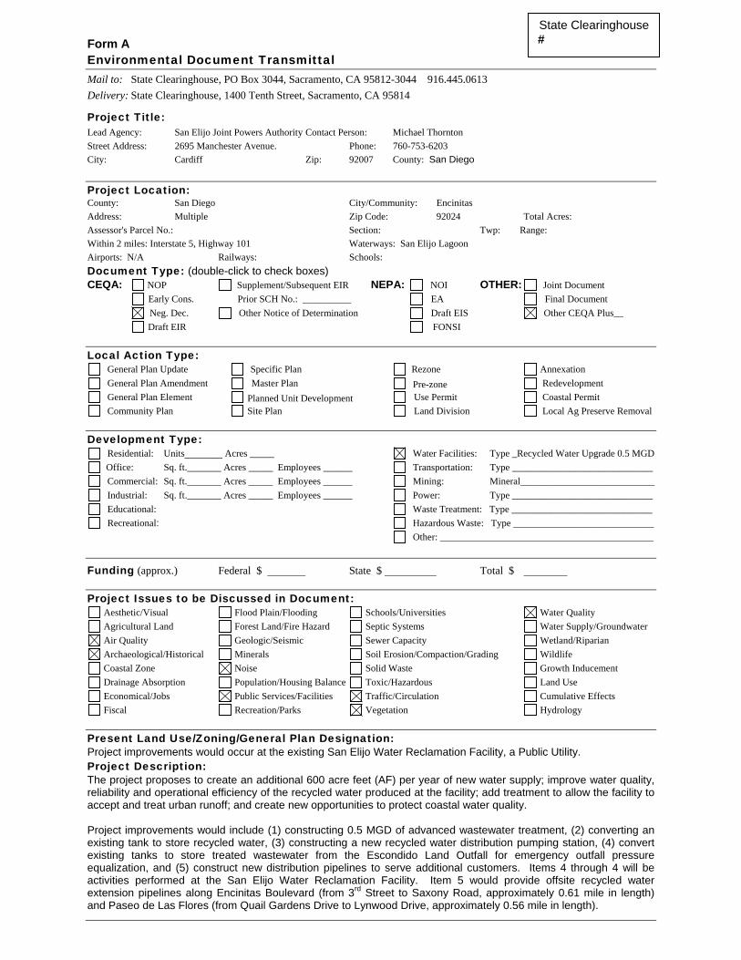
Form A Environmental Document Transmittal Mail to: State Clearinghouse, PO Box 3044, Sacramento, CA 95812-3044 916.445.0613 Delivery: State Clearinghouse, 1400 Tenth Street, Sacramento, CA 95814
Project Title: Lead Agency: San Elijo Joint Powers Authority Contact Person: Michael Thornton Street Address: 2695 Manchester Avenue. Phone: 760-753-6203 City: Cardiff Zip: 92007 County: San Diego Project Location: County: San Diego City/Community: Encinitas Address: Multiple Zip Code: 92024 Total Acres: Assessor's Parcel No.: Section: Twp: Range: Within 2 miles: Interstate 5, Highway 101 Waterways: San Elijo Lagoon Airports: N/A Railways: Schools: Document Type: (double-click to check boxes) CEQA: NOP Supplement/Subsequent EIR NEPA: NOI OTHER: Joint Document Early Cons. Prior SCH No.: __________ EA Final Document Neg. Dec. Other Notice of Determination Draft EIS Other CEQA Plus__ Draft EIR FONSI
Local Action Type: General Plan Update Specific Plan Rezone Annexation General Plan Amendment Master Plan Pre-zone Redevelopment General Plan Element Planned Unit Development Use Permit Coastal Permit Community Plan Site Plan Land Division Local Ag Preserve Removal
Development Type: Residential: Units_______ Acres _____ Water Facilities: Type _Recycled Water Upgrade 0.5 MGD Office: Sq. ft._______ Acres _____ Employees ______ Transportation: Type _____________________________ Commercial: Sq. ft._______ Acres _____ Employees ______ Mining: Mineral ___________________________ Industrial: Sq. ft._______ Acres _____ Employees ______ Power: Type _____________________________ Educational: Waste Treatment: Type _____________________________ Recreational: Hazardous Waste: Type _____________________________
Other: ____________________________________________
Funding (approx.) Federal $ State $ Total $ Project Issues to be Discussed in Document:
Aesthetic/Visual Flood Plain/Flooding Schools/Universities Water Quality Agricultural Land Forest Land/Fire Hazard Septic Systems Water Supply/Groundwater Air Quality Geologic/Seismic Sewer Capacity Wetland/Riparian Archaeological/Historical Minerals Soil Erosion/Compaction/Grading Wildlife Coastal Zone Noise Solid Waste Growth Inducement Drainage Absorption Population/Housing Balance Toxic/Hazardous Land Use Economical/Jobs Public Services/Facilities Traffic/Circulation Cumulative Effects Fiscal Recreation/Parks Vegetation Hydrology
Present Land Use/Zoning/General Plan Designation: Project improvements would occur at the existing San Elijo Water Reclamation Facility, a Public Utility. Project Description: The project proposes to create an additional 600 acre feet (AF) per year of new water supply; improve water quality, reliability and operational efficiency of the recycled water produced at the facility; add treatment to allow the facility to accept and treat urban runoff; and create new opportunities to protect coastal water quality. Project improvements would include (1) constructing 0.5 MGD of advanced wastewater treatment, (2) converting an existing tank to store recycled water, (3) constructing a new recycled water distribution pumping station, (4) convert existing tanks to store treated wastewater from the Escondido Land Outfall for emergency outfall pressure equalization, and (5) construct new distribution pipelines to serve additional customers. Items 4 through 4 will be activities performed at the San Elijo Water Reclamation Facility. Item 5 would provide offsite recycled water extension pipelines along Encinitas Boulevard (from 3rd Street to Saxony Road, approximately 0.61 mile in length) and Paseo de Las Flores (from Quail Gardens Drive to Lynwood Drive, approximately 0.56 mile in length).
State Clearinghouse #

Reviewing Agencies Checklist Form A, continued ______ Resources Agency ______ Boating & Waterways ______ Coastal Commission ______ Coastal Conservancy ______ Colorado River Board Environmental Protection Agency ______ Conservation ___√ _ Air Resources Board ___√___ Fish & Game ___√__ California Waste Management Board ______ Forestry & Fire Protection ___√___ SWRCB: Clean Water Grants ___√__ Office of Historic Preservation ______ SWRCB: Delta Unit ______ Parks & Recreation ______ SWRCB: Water Quality ______ Reclamation Board ______ SWRCB: Water Rights ______ S.F. Bay Conservation & Development Commission ___√___ Regional WQCB (_______) ____√__ Water Resources (DWR) Youth & Adult Corrections
Business, Transportation & Housing ______ Corrections ______ Aeronautics Independent Commissions & Offices ______ California Highway Patrol ______ Energy Commission ___ ___ CALTRANS District #11 ___√___ Native American Heritage Commission __ ___ Department of Transportation Planning (headquarters) ______ Public Utilities Commission ______ Housing & Community Development ______ Santa Monica Mountains Conservancy ______ Food & Agriculture ______ State Lands Commission
Health & Welfare ______ Tahoe Regional Planning Agency ______ Health Services_____________________ ______ Dept. of Toxic Substances Control
State & Consumer Services ______ General Services ______ OLA (Schools)
Public Review Period (to be filled in by lead agency) Starting Date: September 21, 2009 Ending Date: October 21, 2009 Signature: Date: September 17, 2009
KEY S = Document sent by lead agency X = Document sent by SCH √= Suggested distribution
Lead Agency (Complete if applicable):
Consulting Firm: Dudek
Address: 605 Third Street
City/State/Zip: Encinitas, CA 92024
Contact: Carey Fernandes
Phone: (760) 479-4299
For SCH Use Only:
Date Received at SCH ______________________
Date Review Starts _________________________
Date to Agencies ___________________________
Date to SCH _______________________________
Clearance Date _____________________________
Notes:
Applicant: San Elijo Joint Powers Authority
Address: 2695 Manchester Avenue
City/State/Zip: Cardiff, CA 92007
Phone: (760) 753-6203

An Archaeological Survey Report for the San Elijo JPA Project, Encinitas San Diego County, California Prepared for: Dudek Engineering + Environmental 605 Third Street Encinitas, California 92024 Prepared by: Don Laylander and Elizabeth Potter April 2009 2034 Corte Del Nogal Carlsbad, California 92011


AN ARCHAEOLOGICAL SURVEY REPORT for the
SAN ELIJO JPA PROJECT, ENCINITAS SAN DIEGO COUNTY, CALIFORNIA
Prepared for:
Dudek Engineering + Environmental 605 Third Street
Encinitas, California 92024
Prepared by:
Don Laylander and Elizabeth Potter ASM Affiliates, Inc. 2034 Corte del Nogal
Carlsbad, California 92011
USGS 7.5-minute Encinitas topographic quadrangle
Keywords: survey; Encinitas; Township 12 South, Range 4 West
April 2009
PN 15360


Table of Contents
San Elijo JPA Survey i
TABLE OF CONTENTS Chapter Page
MANAGEMENT SUMMARY ................................................................. iii
1. INTRODUCTION.......................................................................... 1 UNDERTAKING .................................................................................... 1 STUDY PERSONNEL ............................................................................. 1
2. SETTING .................................................................................... 7 NATURAL SETTING .............................................................................. 7 PALEOENVIRONMENTS ........................................................................ 8 CULTURE HISTORY .............................................................................10
The Late Pleistocene/Early Holocene........................................................10 The Middle Holocene...........................................................................11 The Late Holocene ..............................................................................12 The Ethnographic Present......................................................................13 The Historic Period .............................................................................14 Regional Archaeological Investigations .....................................................15
3. METHODS ................................................................................ 17 RECORDS SEARCHES AND NATIVE AMERICAN COORDINATION .............17 ARCHAEOLOGICAL FIELD CHECK ........................................................17
4. FINDINGS................................................................................. 19 RECORDS SEARCH ..............................................................................19 FIELD CHECK RESULTS .......................................................................19
5. MANAGEMENT CONSIDERATIONS............................................. 27
REFERENCES.................................................................................... 29

Table of Contents
ii San Elijo JPA Survey
LIST OF FIGURES Page Figure 1. Project vicinity map. ......................................................................... 2 Figure 2a. Project location map – Paseo de las Flores and Encinitas Boulevard
extensions. ................................................................................... 3 Figure 2b. Project location map – San Elijo Recycled Water Storage Facility. ................. 4 Figure 3a. Project map – Paseo de las Flores and Encinitas Boulevard extensions............. 5 Figure 3b. Project map – San Elijo Recycled Water Storage Facility............................. 6 Figure 4. View of project area along Paseo de las Flores. .......................................26 Figure 5. View of project area along Encinitas Boulevard. ......................................26
LIST OF TABLES Page Table 1. Previous Cultural Resources Reports within One Mile of the San Elijo
Recycled Water Storage Facility and within One-Half Mile of the Other Project Areas ...............................................................................20
Table 2. Cultural Resources Previously Recorded within One Mile of the San Elijo Recycled Water Storage Facility and within One-Half Mile of the Other Project Areas ...............................................................................24

Table of Contents
San Elijo JPA Survey iii
MANAGEMENT SUMMARY
The San Elijo Joint Powers Authority (JPA) proposes to construct additional facilities in Encinitas and Solana Beach, San Diego County, California. These facilities would include (1) a new recycled water pipeline, a new effluent storage basin, and conversion of an aeration basin to a recycled water storage basin within the existing San Elijo Recycled Water Storage Facility, (2) a pipeline extension within the existing right-of-way along Encinitas Boulevard, and (3) a pipeline extension within the existing right-of-way along Paseo de las Flores. A records searches at the South Coastal Information Center (SCIC) of the California Historical Resources Information System (CHRIS), housed at San Diego State University, identified 47 previously recorded prehistoric and historic archaeological sites and isolates lying within a 1-mi. radius around the San Elijo Recycled Water Storage Facility, or within a .5-mi. radius around the two pipeline extensions. None of the previously recorded resources are located within or immediately adjacent to the project areas. An archaeological field check confirmed that the project areas lie under paved surfaces. Areas immediately adjacent to the pipeline routes with exposed natural ground surfaces were inspected for evidence of archaeological resources. No resources were identified. These studies have been conducted to comply with the California Environmental Quality Act, (CEQA) and the National Historic Preservation Act (NHPA). No historic properties will be affected by the project.


1. Introduction
San Elijo JPA Survey 1
1. INTRODUCTION
This study was conducted to assess the presence or absence of potentially significant prehistoric and historic sites in the project area, for Section 106 consultation with the California State Historic Preservation Officer (SHPO) under the National Historic Preservation Act (NHPA).
UNDERTAKING
The San Elijo Joint Powers Authority (JPA) proposes to construct additional facilities in Encinitas and Solana Beach, San Diego County, California (Figures 1-3). These facilities would include (1) a new recycled water pipeline, a new effluent storage basin, and conversion of an aeration basin to a recycled water storage basin within the existing San Elijo Recycled Water Storage Facility, (2) a pipeline extension within the existing right-of-way along Encinitas Boulevard, and (3) a pipeline extension within the existing right-of-way along Paseo de las Flores.
STUDY PERSONNEL
The following individuals were instrumental in conducting the investigations and producing this report: John R. Cook, ASM Principal (B.A., Anthropology and Philosophy, San Diego State University), served as project manager. Don Laylander, ASM Senior Archaeologist (M.A., Anthropology, San Diego State University), served as principal investigator and report coauthor. Elizabeth Potter, ASM Associate Archaeologist (B.A., Anthropology, Thomas Edison State University), participated as field director and report coauthor. Zee Malas was the graphic illustrator, and Marcia Sandusky was the desktop publisher.

1. Introduction
2 San Elijo JPA Survey
Figure 1. Project vicinity map.

1. Introduction
San Elijo JPA Survey 3
Figure 2a. Project location map – Paseo de las Flores and Encinitas Boulevard extensions.

1. Introduction
4 San Elijo JPA Survey
Figure 2b. Project location map – San Elijo Recycled Water Storage Facility.

1. Introduction
San Elijo JPA Survey 5
Figure 3a. Project map – Paseo de las Flores and Encinitas Boulevard extensions.

1. Introduction
6 San Elijo JPA Survey
Figure 3b. Project map – San Elijo Recycled Water Storage Facility.

2. Setting
San Elijo JPA Survey 7
2. SETTING
This chapter places the project area within its regional context. Some of the characteristics of the region’s modern settings are indicated, as well as what is known concerning its paleoenvironment. The culture history of the region is reviewed, including the prehistoric archaeological sequence, conditions present immediately prior to European contact as they have been reconstructed through ethnographic evidence, and the period that followed the advent of written records. The development of investigations into regional prehistoric archaeology is also discussed briefly. The discussion is largely taken from a previous report addressing the same region (Laylander and Akyüz 2008).
NATURAL SETTING
The study areas are located on the central coastal plain of San Diego County, from south of Batiquitos Lagoon in the north to south of San Elijo Lagoon in the south. The plain varies in width from 5 to 15 km (Bowman 1973). To the east is a province of foothills and inland valleys. Still farther east (more than 40 km) lie the higher mountains of the Peninsular Range and, beyond them, the low Colorado Desert. Although considerable relief is present, the region’s topography presented no serious barriers to prehistoric human travel, either east-west between coastal and inland areas or north-south along the coastal plain. On the other hand, the generally open, unsheltered coastline, the cool waters of the California Current, and the distance to the nearest large offshore islands (nearly 100 km to San Clemente and Santa Catalina) may not have encouraged the prehistoric cultures to adopt a strongly maritime orientation, in contrast to the situation in the Santa Barbara Channel area farther north (Warren 1968:6-7). Batiquitos Lagoon is the estuary of San Marcos Creek, while San Elijo Lagoon is the estuary of Escondido Creek. Both creeks are relatively small drainage systems, with headwaters in small mountain ranges 15-25 km northeast of the project areas. Geologically, the coastal plain consists of raised Pleistocene terrace deposits and Upper Pliocene marine sedimentary rocks (Strand 1962; Weber 1963). Cobbles in the marine conglomerates offered material that was potentially usable prehistorically for lithic tools. Other geological units found farther east also formed significant elements in the study areas’ settings, either as quarry areas for lithic material that were exploited directly by the prehistoric inhabitants or as sources for the usable cobbles that are found in the drainages crossing the coastal plains. The Santiago Peak Volcanics, composed of metamorphosed, fine-grained rocks of Jurassic or Triassic age, occur over extensive portions of western San Diego County, within 5-10 km of the study areas. Extensive areas of Mesozoic granitic rock and associated schist and gneiss generally lie to the east of the Santiago Peak formation. These plutonic and high-grade metamorphic rocks provided the preferred materials for most of the region’s prehistoric ground stone tools.

2. Setting
8 San Elijo JPA Survey
The Mediterranean climate of the study areas is characterized as semi-arid and cool (Köppen classification BSk), with generally mild temperatures and a limited amount of rainfall concentrated during the winter months (Pryde 2004a). The average January minimum daily temperature is 6° C; the average July maximum daily temperature is 25° C. The average annual precipitation is about 24 cm, but the amount of rainfall actually falling during any given year is highly variable. The most extensive natural vegetation association for the region is coastal sage scrub (Munz 1974; Pryde 2004a). Prominent species found within this association include buckwheat (Eriogonum fasciculatum), white and black sage (Salvia apiana and S. mellifera), coastal sagebrush (Artemisia californica), sugar bush (Rhus ovata), squaw bush (R. trilobata), and laurel sumac (R. laurina). In the valleys, there are plant associations characteristic of freshwater marsh, salt marsh, and riparian habitats. Freshwater marsh species include cattail (Typha sp.), spike-rush (Eleocharis sp.), and bulrush (Scirpus sp.). Salt marshes contain pickleweed (Salicornia virginica), saltgrass (Distichlis spicata), and sea-lavender (Limonium californicum). Trees conspicuous in local riparian associations include willow (Salix sp.), cottonwood (Populus fremontii), and sycamore (Platanus racemosa). Modern development has extensively modified the natural settings of coastal plain. Nonnative species, including both inadvertently introduced Old World grasses and intentionally imported landscaping plants, have replaced most of the native vegetation. Much of the area has been graded for the construction of highways, roads, homes, and businesses, and a substantial portion now lies under pavement.
PALEOENVIRONMENTS
Studies have gradually sketched in several elements of the region’s late Pleistocene and Holocene paleoenvironments. Included have been changes in the coastline, alluviation, climate, and vegetation. The rise in sea level during the late Pleistocene and early Holocene pushed the shoreline several kilometers to the east of the location it had occupied at the time of the last glacial maximum (cf., Inman 1983). Most near-coast archaeological sites dating from the late Pleistocene and early Holocene were almost certainly inundated or destroyed during this process. Rocky headlands were created, and the lower courses of rivers and creeks were drowned as estuaries. Through the middle and late Holocene, the rate of further marine transgression progressively slowed, and lower-energy coastal environments had time to evolve. Sandy beaches tended to replace rocky headlands. Estuaries and bays were converted into lagoons, as sand barriers partially cut them off from the ocean and made their waters at least intermittently brackish or fresh. The progressive accumulation of sediment within the lagoons tended to make them shallower and therefore more subject to abrupt changes in salinity. Such environmental changes strongly affected the amounts and kinds of marine and littoral resources that were available to prehistoric people.

2. Setting
San Elijo JPA Survey 9
While the trajectories for environmental changes within the various drainages were probably similar, the rates at which they occurred would have varied according to such factors as the size of the bays, estuaries, or lagoons; the amount of fresh water feeding into and potentially flushing them; and the amount of sediment available to fill in the lagoons or to close them off from the open ocean (Masters and Aiello 2007). The formation of extensive sandy beaches seems to have been initiated in the north, near Dana Point in southern Orange County, and to have spread progressively southward toward La Jolla within the Oceanside littoral cell (Inman 1983). This suggests the existence of a north-to-south sequence in lagoon evolution. The best-reported case so far is Batiquitos Lagoon, where paleoenvironmental and archaeological studies have documented the closure of the lagoon and extensive sedimentation between about 3,500 and 1,000 years ago (Gallegos 1985; Masters 1983; Miller 1966). This episode was associated with a sharp decline in the prehistoric human use of the area. Other local paleoenvironmental studies have examined the Las Flores paleoestuary (Byrd et al. 2000), the San Luis Rey River valley (Masters 1994), San Elijo Lagoon (Foster 1993), and San Diego Bay (Masters 1988). Alluviation in river valleys and on the coastal plain may have been an important process from the perspective of archaeological investigations, because of its potential to bury prehistoric sites. Several recent studies have addressed alluviation in the Camp Pendleton area of northern San Diego County (Pearl and Waters 1998; Waters 1996a, 1996b; Waters et al. 1999). Patterns in paleoclimatic change are still not definitively established for coastal San Diego County. The most widely accepted general model for Holocene climates in western North America projects a gradual warming and drying trend through the early Holocene, reaching a peak in the middle Holocene, and subsequently becoming irregularly somewhat cooler (e.g., Antevs 1948). However, more complex patterns of warm/cool and wet/dry climatic shifts have usually been reported in regions where more detailed investigations have been undertaken (cf., Moratto et al. 1978; West et al. 2007). The effects of long-term temperature changes in western San Diego County were probably muted by the region’s coastal setting. Nonetheless, a shift in the North Pacific winter storm pattern either farther to the north, bypassing San Diego, or to the south, bringing in greater precipitation, could have had important consequences within this semi-arid setting. The Medieval Climatic Anomaly, an extended period of drought between about A.D. 800 and 1350, has been credited with important influences on human settlement in California, at least in such marginal environments as San Clemente Island (Jones et al. 1999; Yatsko 2002). Warming or cooling of the ocean along the coast might have pushed the ranges for particular shellfish species to the north or to the south respectively, but the array of species that are found in archaeological middens on the central San Diego coast seems to have remained fairly constant throughout the Holocene, when allowance is made for the changes in coastal morphology and habitats. If paleoclimatic variability was limited, it is also likely that natural changes in the region’s vegetation were not drastic. Recent investigations in northern San Diego County have included pollen studies on lower Las Flores Creek (Anderson and Byrd 1998). Those studies suggest the presence between about 9,000 and 4,000 years ago of species that were adapted to a somewhat

2. Setting
10 San Elijo JPA Survey
wetter climate, subsequently stabilizing to a more familiar mosaic of coastal sage scrub, chaparral, and grassland by about 2,600 years ago.
CULTURE HISTORY
Archaeological investigations have documented human occupations on the San Diego coast that spanned at least the last 10,000 years (Byrd and Raab 2007; Warren et al. 2008). A variety of different chronological divisions and sets of terms have been used to sort the evidence into temporal and, to a lesser extent, geographical units. Some confusion has resulted from the mixture of units that are defined on the basis of chronology with units defined by cultural content or by inferred ethnicity. The present discussion is framed in terms of five main divisions: an early period bridging the latest Pleistocene to early Holocene, prior to about 6000 B.C.; a middle Holocene period, stretching between about 6000 and 2000 B.C.; a late Holocene period, between about 2000 B.C. and A.D. 1769; a synchronic “ethnographic present,” representing conditions just prior to European contact, as they have been inferred from subsequent ethnographic studies; and the historic period since A.D. 1769. The Late Pleistocene/Early Holocene
The initial period, prior to about 6000 B.C., includes archaeological manifestations that have been variously labeled as Early Man, Clovis, Paleoindian, Lake Mohave, San Dieguito, Scraper Maker, or Western Pluvial Lakes Tradition, as well as some of the components that have been termed Archaic, La Jolla, or Encinitas. There have been several proposals for the recognition of local human occupations extending back into the Pleistocene Epoch for several millennia, or for as long as tens or even hundreds of millennia (e.g., Bada et al. 1974; Carter 1957, 1980; Minshall 1976; Moriarty and Minshall 1972). No such claims have as yet met with general scholarly acceptance (e.g., Moratto 1984; Taylor et al. 1985). Concerns have been raised as to the reliability of early dates based on geologic contexts, amino acid racemization, or non-AMS radiocarbon dating. For some specimens, a natural rather than a cultural origin has been suggested. The issue of a human presence in North America prior to the terminal Pleistocene, in particular along the continent’s western coastline, is a topic of ongoing investigation and lively debate within the archaeological profession (e.g., Dillehay 1989, 1997). If early occupation of the continent did occur, then coastal San Diego County, where uplifted Pleistocene terraces may have partly compensated for subsequently rising sea levels, is in some respects a logical place to seek their traces. Archaeological evidence assignable to the terminal Pleistocene (ca. 9500 B.C.) Clovis complex is fairly well documented in several parts of California, including the Mojave Desert (Davis and Shutler 1969). However, such remains appear to be scarce or absent in San Diego County (Rondeau et al. 2007). Any coastal sites from this period could well have been subsequently submerged by the rising post-Pleistocene sea.

2. Setting
San Elijo JPA Survey 11
The earliest generally accepted local pattern is known as the San Dieguito Complex. Dates for the San Dieguito component at the C. W. Harris Site begin at 9030 ±350 radiocarbon years before the present (RCYBP; calibrated to a two-sigma range of 9235-7382 B.C.), and Claude N. Warren and his associates (2008) have projected a local starting date for the component at about 10,500 RCYBP. Building on the discussion of North American cultural stages by Gordon R. Willey and Philip Phillips (1958), some scholars would see the San Dieguito pattern as a Lithic or Paleoindian phenomenon, characterized by high mobility and an emphasis on big game hunting. Others would classify San Dieguito as an early Archaic stage phenomenon, involving a more diversified and plant-oriented adaptation. Remains that have been considered to be characteristic of San Dieguito components include large stemmed projectile points (Lake Mohave and Silver Lake forms), crescents, heavy unifacial tools (scraper planes), focused use of the local volcanic or metavolcanic rock for flaking, infrequent milling tools, and little emphasis on shellfish harvesting. Longstanding disagreements have concerned the identification of which archaeological components should be classified as San Dieguito, and consequently how the complex should be dated and interpreted functionally. Malcolm J. Rogers (1929a, 1966), working before any absolute dating methods for local prehistory were available, assigned numerous site components in western San Diego County to the San Dieguito complex, apparently primarily on the basis of the presence of large bifacially and unifacially flaked stone tools. In subsequent studies, Warren and his collaborators generally adopted a more restricted view (Warren 1966, 1967, 1968, 1985, 1987; Warren and True 1961; Warren et al. 2008.). They accepted the C. W. Harris Site and a few other sites as containing true San Dieguito components. However, they rejected this assignment for site components that were as early as the San Dieguito components, or nearly so, but that had assemblage characteristics more similar to middle Holocene patterns. Still other investigators have called into question the validity of San Dieguito as a category, suggesting that San Dieguito-like components were only functionally specialized activity sets, rather than evidence of distinct chronological or ethnic units (Bull 1983, 1987; Ezell 1983, 1987; Gallegos 1987a; Hanna 1983). As has been noted, there are a number of components on the central San Diego coast that date from the early Holocene but are more similar to typical middle Holocene sites in many of their characteristics, including the presence of extensive shellfish remains, significant amounts of ground stone, and fairly sparse and crude flaked cobble tools (cf., Warren et al. 2008). The relationship between such components and the ones labeled San Dieguito is an issue of ongoing research interest. The Middle Holocene
The middle Holocene period (ca. 6000 to 2000 B.C.) encompasses most of the assemblages assigned to the Archaic (or Early Archaic, or Middle Archaic), La Jolla, Millingstone, Littoral, Shell Midden, Encinitas, Campbell, and Pauma analytical units. Characteristic of such components are shell middens, fairly abundant ground stone, generally simple flaked stone assemblages, and inhumation. Middle Holocene sites are the most conspicuous archaeological element within the central San Diego coastal plain.

2. Setting
12 San Elijo JPA Survey
The local middle Holocene pattern is notable for its apparent continuity and conservatism, as compared with contemporaneous patterns in some other parts of southern California, including the Santa Barbara coast and the Mojave Desert. Several proposals have been made to subdivide the period locally into two or three separate chronological units (e.g., Harding 1951; Moriarty 1966; Rogers 1945; Warren 1964; Warren et al. 2008). However, firm criteria for such distinctions have not been identified, and even the general directions of change are uncertain. For example, the extent to which there was an evolution toward a maritime rather than strictly a littoral adaptation, at least in the San Diego Bay area, has also been debated (cf., Gallegos and Kyle 1988). Various relationships have been proposed between coastal manifestations and the sparser inland San Diego County sites dating from this period, which are sometimes labeled Inland La Jolla, Pauma, or Campbell. Possible interpretations are that coastal and inland sites were produced by the movements of members of a single population, on a seasonal or episodic basis; by separate but related populations that were economically complementary to each other; or by ethnically distinct groups, with inland and some coastal components reflecting intrusions of people from the eastern deserts (True 1958, 1980; Warren 1968; Warren et al. 2008). The Late Holocene
The late Holocene spans a period of apparently accelerated change in the region’s prehistoric cultures. The first half of the period is not well documented but appears to represent a continuation of the middle Holocene patterns. The second half of the late Holocene includes patterns known by such labels as Late Prehistoric, Late Archaic, Shoshonean, Yuman, San Luis Rey, and Cuyamaca. Hallmarks of the later period include the mortar and pestle, ceramics, small arrow-size points, and human cremation. The chronologies for the introduction or innovation of these traits are only imprecisely known; they may well have arisen at separate times, over a period spanning as much as 1,500 years. Archaeological sites that are associated with the second half of the late Holocene appear to be much more numerous than earlier sites in most of the inland portions of San Diego County (Christenson 1990; Jones 1992:21). A few late period coastal village locations have been identified archaeologically, but the central coast between Oceanside and Del Mar seems to have played a less important role during this period than it had during the preceding period, probably at least in part because of natural changes in the coastal environment (Gallegos 1992; Masters and Gallegos 1997). In northern San Diego County, late period shell middens are common and characteristically contain a high proportion of bean clam (Donax gouldii) shells, but Donax middens are uncommon south of Carlsbad (Laylander and Saunders 1993). Only limited success has been achieved in attempts to distinguish between the archaeological residues that were produced by the linguistically unrelated but culturally similar Luiseño and Ipai/Kumeyaay (Pigniolo 2004; True 1966).

2. Setting
San Elijo JPA Survey 13
The Ethnographic Present
Early descriptions of the lifeways of the San Diego County groups were provided by explorers, missionaries, administrators, and other travelers, who gave particular attention to the coastal populations (Boscana 1846; Fages 1937; Geiger and Meighan 1976; Harrington 1934; Laylander 2000). Subsequent ethnographers in the early twentieth century were able to give much more objective, detailed, and penetrating accounts, but in most cases they described inland rather than coastal lifeways. Most of the ethnographers attempted to distinguish between observations of the customs of surviving Native Americans and orally transmitted or inferred information concerning the lifeways of native groups prior to European intrusion into the region. The second of these subjects provides a terminal baseline for discussing the cultures of the region’s prehistory. The study areas lie within the territory attributed ethnographically to the Ipai (Northern Diegueño; northern Kumeyaay). Ipai, Kumeyaay, and Tipai are very closely related Yuman languages or possibly dialects, with ties to other languages in northern Baja California, on the lower Colorado River, and in western Arizona. According to the debatable technique of glottochronology, the separation of the Ipai and Kumeyaay languages from their closest relative, Cocopa in the Colorado River’s delta, may date back about 1,000-1,200 years, and the separation from other Yuman groups may have occurred around 1,500-2,000 years ago (Laylander 1985). Aboriginal subsistence in the region was largely or entirely based on harvesting natural plants and animals, rather than on growing agricultural crops. Acorns were a staple for the western groups, as were agave and mesquite for eastern groups. Numerous other plants were valued for the dietary contributions from their seeds, fruit, roots, stalks, or greens, and a still larger number of species had known medicinal uses. Game animals included deer first and foremost, but mountain sheep and pronghorn antelope were also present, as well as bears, mountain lions, bobcats, coyotes, and other medium-sized mammals. Small mammals were probably as important in aboriginal diets as larger animals, with jackrabbits and cottontails being preeminent, but woodrats and other rodents were commonly exploited. Various birds, reptiles, and amphibians were caught and eaten; food taboos were few in number and inconsistent, to judge from the surviving ethnographic record. The only pre-contact domesticated animal was the dog. It is not clear whether marine fish and shellfish were a mainstay for some coastal groups or merely provided supplemental or emergency food sources for groups that were oriented primarily toward terrestrial resources. Interregional exchange systems are known to have linked the coast with areas to the east in particular, but exchange may have been more concerned with facilitating social and ceremonial matters than with meeting material needs. The Ipai had developed a varied material culture that functioned well but was not highly elaborated, by worldwide standards. An array of tools were made from stone, wood, bone, and shell, and these served to procure and process the region’s resources. Needs for shelter and clothing were minimal, but considerable attention was devoted to personal decoration in ornaments, painting, and tattooing. The local pottery was well made, although infrequently decorated. Basketry was a craft that was particularly refined.

2. Setting
14 San Elijo JPA Survey
The Ipai were subdivided into essentially sovereign local communities or tribelets. Community membership was generally inherited in the male line. However, in practice some degree of intermixing of these patriclans was certainly present during the historic period, and this may have reflected a considerable degree of flexibility in community membership during prehistoric times as well. Later descriptions of the settlement systems have been inconsistent, and there may have been considerable variability in practice (cf., Laylander 1992, 1997; Owen 1965; Shipek 1982; Spier 1923). In some areas, substantially permanent, year-round villages seem to have existed, with more remote resources beyond the daily foraging range being acquired by special task groups. In other areas, communities appear to have followed an annual circuit among seasonal settlements, or to have oscillated between summer and winter villages, often with the group splitting up into its constituent families during certain seasons. Some differences in settlement strategies may have reflected local differences in resource availability or cyclical effects of variability between times of plenty and times of stress. Rights of ownership over the land and its various resources were vested both in individual families and in the clans or communities as a whole. Leadership within communities had at least a tendency to be hereditary, but it was relatively weak; authority was more ceremonial and advisory than administrative or judicial. Headmen had assistants, and shamans exerted an important influence in community affairs, beyond their role in curing individual illness. The Historic Period
European activity in the region began as early as A.D. 1542, when Juan Rodríguez Cabrillo landed in San Diego Bay. Sebastián Vizcaíno returned in 1602, and it is possible that there were other subsequent contacts that went unrecorded. These brief encounters made the local native people aware of the existence of other cultures that were technologically and socially more complex than their own. Epidemic diseases may also have been introduced into the region at an early date, either by direct contacts with the infrequent European visitors or through waves of diffusion emanating from native peoples farther to the east or south (Preston 2002). It is possible, but as yet unproven, that the precipitous demographic decline of native peoples had already begun prior to the arrival of Gaspar de Portolá and Junípero Serra in 1769. Any archaeological evidence concerning biological and cultural changes in the San Diego area during the protohistoric centuries (A.D. 1542-1769) would potentially hold considerable research interest. Spanish colonial settlement was initiated in 1769, when multiple expeditions arrived in San Diego by land and sea, and then continued northward through the coastal plain toward Monterey. A military presidio and a mission to deal with the local Kumeyaay and Ipai were soon firmly established at San Diego, despite violent resistance to them from a coalition of native communities in 1776. The Luiseño were brought first to the mission at San Juan Capistrano, beginning in 1776, and then to San Luis Rey after 1798. The coastal communities were evidently the ones initially drawn into the mission system, and the first ones to turn away from traditional lifeways. Private ranchos subsequently established by Spanish or Mexican soldiers and others also appropriated for their own use many of the remaining coastal or near-coastal locations, as well as Indian labor (Pourade 1960-1967).

2. Setting
San Elijo JPA Survey 15
Mexico’s separation from the Spanish Empire in 1821 and the secularization of the California missions in the 1830s caused further disruptions in western San Diego County. Some former mission neophytes were absorbed into the work forces on the ranchos, while others drifted toward the urban centers at San Diego and Los Angeles or moved to the eastern portions of the county where they were able to join still largely autonomous native communities. United States conquest and annexation, together with the gold rush in northern California, brought many additional outsiders into the region. Development during the following decades was fitful, undergoing cycles of boom and bust, but the coastal plains became progressively more and more urbanized, until at present only scattered patches of undeveloped land remain between the city of San Diego and Camp Pendleton (Pryde 2004b). Encinitas and Solana Beach were incorporated as cities in 1986. Some sizeable portions of the region were still relatively undeveloped as late as the 1970s and 1980s. As a result, many of the archaeological deposits in those areas were studied under the aegis of federal or state environmental regulations, and substantial amounts of archaeological information were collected before the sites were destroyed. Regional Archaeological Investigations
The archaeological character of shell middens in coastal San Diego County was recognized at least as early as the nineteenth century. However, significant scientific investigation of them got under way only with the work of Malcolm J. Rogers of the San Diego Museum of Man between 1918 and 1945. Rogers documented the presence of numerous archaeological sites throughout western San Diego County, and he recognized several chronologically distinct categories of sites, whose relationships he attempted to unravel. As part of a 1929 project under the auspices of the Smithsonian Institution, Rogers conducted limited excavations at coastal sites between Mission Bay to the south and Buena Vista Lagoon to the north. Unfortunately, a full report of his 1929 excavations was never prepared, although Rogers’ field notes, site records, and a “Preliminary Report of Archaeological Work on Pacific Coast Shell-Middens during 1929” are on file at the San Diego Museum of Man (Rogers 1929b). The 1929 work presumably influenced Rogers’ early attempts to formulate the relative chronological placements and define the characteristics of the La Jolla (Littoral, Shell Midden), San Dieguito (Scraper Maker), and Yuman complexes (Rogers 1929a, 1945). After Rogers, several other investigators attempted to clarify some of the issues that had been raised by his pioneering work. Mabel Harding (1951) addressed the concept of the La Jolla complex through excavations at a site in Sorrento Valley. William J. Wallace (1955) developed a general chronology for coastal southern California, assigning the local La Jolla complex components to a wider Millingstone Horizon. Clement W. Meighan and his student, D. L. True, conducted studies in inland areas of northern San Diego County that had relevance to the interpretation of coastal components (Meighan 1954; True 1958). A brief fluorescence of archaeological work on coastal San Diego County sites came in the late 1950s and early 1960s. Particularly notable were investigations at Batiquitos Lagoon by

2. Setting
16 San Elijo JPA Survey
Warren and others of the UCLA Archaeological Survey in 1960-1961 (Crabtree et al. 1963; Warren 1964; Warren, True, and Eudey 1961; Warren, Warren, and Chandonet 1961). Warren, True, and Ardith A. Eudey (1961) also made comparisons, primarily on the basis of survey data, among sites in several portions of western San Diego County. Excavation of burial sites in the community of La Jolla did much to define the characteristics of the La Jolla complex (Moriarty et al. 1959; Shumway et al. 1961). James R. Moriarty III (1966, 1967) excavated an early Holocene component at Agua Hedionda Lagoon. Wallace (1960) surveyed sites within the Buena Vista watershed. The most recent upsurge of archaeological work dates from the 1970s, when environmental laws began to require that consideration be given to the effects of development projects on cultural resources. Numerous large and small archaeological projects were conducted near the central San Diego County coast during the 1970s, 1980s, and 1990s. Such issues as the chronology of coastal occupations and changes in local prehistoric lifeways continued to be debated and tested against the grown body of scientific archaeological evidence (e.g., Byrd and Raab 2007; Gallegos 1987b; Laylander 1993; McDonald and Eighmey 2008; Warren et al. 2008).

3. Methods
San Elijo JPA Survey 17
3. METHODS
RECORDS SEARCHES AND NATIVE AMERICAN COORDINATION
Records searches at SCIC were conducted on March 23 and April 21, 2009. The records searches encompassed a search radius of 1 mi. around the San Elijo Recycled Water Storage Facility and a search radius of 0.5 mi. around the other project areas. They included plotting of all resources recorded on CHRIS trinomial and primary number maps and making copies of the record forms for the recorded resources, plotting of previous archaeological project boundaries and copying the National Archaeological Database (NADB) citations for reports addressing those projects, copying historic maps on file at the SCIC, and copying a map and database of historic addresses (formerly Geofinder). Requests to the Native American Heritage Commission (NAHC) to conduct a search of its Sacred Lands File (SLF) were sent on March 20 and April 15, 2009. Responses from the NAHC were received on March 30 and April 21, 2009, indicating that the Sacred Lands File failed to indicate the presence of Natural American cultural resources in the immediate project area. Local Native American contacts were identified, including: Steve Banegas, Kumeyaay Cultural Repatriation Committee; Bobby L. Barrett, Viejas Band of Mission Indians; Bennae Calac, Pauma Valley Band of Luiseño Indians; Ron Christman, Kumeyaay Cultural Historic Committee; Paul Cuero, Kumeyaay Cultural Heritage Preservation; Christobal C. Devers, Pauma & Yuima; Shasta Gaughen, Cupa Cultural Center (Pala Band); Johnny Hernandez, Santa Ysabel Band of Diegueno Indians; Monique LaChappa, Campo Indian Nation; Allen E. Lawson, San Pasqual Band of Mission Indians; Clint Linton; Carmen Lucas, Kwaaymii Laguna Band of Mission Indians; Kenneth Meza, Jamul Indian Village; Rebecca Osuna, Inaja Band of Mission Indians; Edwin Romero, Barona Group of the Capitan Grande; Mark Romero, Mesa Grando Band of Mission Indians, Russell Romo, San Luis Rey Band of Mission Indians; Danny Tucker, Sycuan Band of the Kumeyaay Nation; and Mel Vernon, San Luis Rey Band of Mission Indians. Contact letters were sent to these individuals on March 31 and April 15, 2009.
ARCHAEOLOGICAL FIELD CHECK
Field checks were performed on March 26 and April 27, 2009. The purpose of the field checks was to confirm that the areas of direct project impacts lay under developed or paved surfaces, and to examine any adjacent natural surfaces for evidence of archaeological deposits.


4. Findings
San Elijo JPA Survey 19
4. FINDINGS
RECORDS SEARCH
SCIC records identified 78 previous cultural resources reports that addressed areas within a 1-mi. radius of the San Elijo Recycled Water Storage Facility or within a 0.5-mi. radius of the other project areas (Table 1). These records also identified 48 cultural resources previously recorded within the same radii (Table 2). These included 29 prehistoric sites, nine prehistoric isolates, seven historic-period sites or features, two unspecified resources, and one resource subsequently determined to be natural rather than cultural. The historic addresses database identified one address within the search radii: 1725 MacKinnon Avenue, in Cardiff. None of these resources were located within or immediately adjacent to the present project areas.
FIELD CHECK RESULTS
The project areas were examined by ASM Associate Archaeologist Elizabeth Potter:
• The Paseo de las Flores Extension runs east from Quail Gardens Drive along Paseo de Las Flores. The route passes within Encinitas Ranch Golf Course, Ecke Growers facilities, and a residential area (Figure 4). Areas adjacent to the road are covered by manicured non-native plants, groomed golf course grass, sidewalks, and an asphalt road.
• The Encinitas Boulevard Extension is located in a commercial area along Encinitas Boulevard, east and west of Interstate 5, between Saxony Road and 3rd Street (Figure 5). Vegetation consists of ornamental landscaping and other non-native plants. Areas adjacent to the northern and southern edges of Encinitas Boulevard were inspected for cultural resources.
• The San Elijo Recycled Water Storage Facility is located on a developed parcel, covered by buildings, structures, and asphalt.
No cultural resources were observed during the field survey.

4. Findings
20 San Elijo JPA Survey
Table 1. Previous Cultural Resources Reports within One Mile of the San Elijo Recycled Water Storage Facility and within One-Half Mile of the Other Project Areas
(from SCIC)
NADB No. Author Date Title
1120142 Berryman, Stanley 1976 Archaeological Reconnaissance of Villa Cardiff Development. Berryman Archaeological Consultants. Submitted to William Moorhous.
1120200 Berryman, Stanley R. 1971 Results of a 1.5% Test Excavation at the Villa Cardiff Archaeological Site Number W-167. Berryman Archaeological Consultants. Submitted to Time for Living, Inc.
1120246 Bull, Charles 1976 Appendix E: An Archaeological Survey of Playmor North. RECON, San Diego.
1120550 Cupples, Sue Ann 1975 San Elijo Water Pollution Control Facility Archaeological Survey. Submitted to Brown & Caldwell Consulting Engineers.
1120624 Fink, Gary R. 1974 Archaeological Survey for Proposed Beach Assesses at “D” and “J” Streets, Encinitas and Seascape Surf, Del Mar. County of San Diego Department of Transportation. Submitted to Park Development Division.
1120671 Gallegos, Dennis, Dayle
Cheever, and Stephan Van Wormer
1986 A Cultural Resource Overview for the Encinitas Planning Area, Encinitas, California. WESTEC Services.
1120672 Gallegos, Dennis, Roxana
Phillips, and Andrew Pigniolo
1988 A Cultural Resource Overview for the San Dieguito River Valley, San Diego, California. WESTEC Services. Submitted to City of San Diego.
1120724 Kaldenberg, Russell L. 1974 An Environmental Impact Report (Archaeology) on Pacesetter South near Cardiff-By-The-Sea, San Diego County, California. San Diego State University. Submitted to Pacesetter/Landmark Homes.
1120829 Fink, Gary, and Janet
Hightower 1979
The Cultural Resources of San Elijo Lagoon Regional Park, Solana Beach, California.
1120871 Fink, Gary R. 1973 The Archaeology of the Olivenhain Force Main Sewer. San Diego County Engineering Department. Submitted to Department of Sanitation and Flood Control.
1121009 Gallegos, Dennis 1987 Cultural Resource Testing Program for Archaeological Sites SDi-607, SDi-612, SDI-212, SDI-6825 and W-105, Carlsbad, California. WESTEC Services. Submitted to City of Carlsbad.
1121053 Gallegos, Dennis R., and
Richard Carrico 1984
Archaeological Survey: Cardiff Sea Point. WESTEC Services. Submitted to Land Specialists, Inc.
1121104 Loughlin, Barbara A., and
Charles Bull 1974
An Environmental Impact Report (Archaeology) on San Elijo Lagoon, San Diego County, California. San Diego State University. Submitted to Pacesetter/Landmark Homes.
1121163 Hector, Susan 1986 Resources Studies on the Ecke Ranch, Encinitas. RECON. Submitted to Steve Flint Turrini and Brink.
1121344 Polan, H. Keith 1980 An Archaeological Reconnaissance of the Mira Costa College-Southern Campus Site, Cardiff-By-The-Sea, California. Heritage Environmental Services. Submitted to Nasland Engineering.
1121474 Scientific Resource
Surveys 1982
Cultural Resources Report on the Rancho La Costa Properties Located in the County of San Diego. Submitted to Curtis Scott Englehorn.
1121567 David D. Smith and
Associates 1974
Archaeological Resources of the Cardiff Sea Village Property, Appendix A: Archaeological Salvage Report. Submitted to Piedmont Construction.
1121638 Woodward, Jim, and Geogre Stammerjohan
1985 Resource Inventory: Cultural Resources, San Diego Coast State Beaches. Department of Parks and Recreation.
1121640 Woodward, Jim 1983 Archaeological Survey Report: Cardiff State Beach General Plan. Department of Parks and Recreation.
1121679 Smith, Brian F. 1982 An Archaeological Reconnaissance of the Solana Point project and Evaluation of Site SDM-W-51A. Brian F. Smith Archaeological/Historical Consultant. Submitted to Solana Point Venture.

4. Findings
San Elijo JPA Survey 21
NADB No. Author Date Title
1121684 Smith, Brian F. 1986 An Archaeological Survey of the 11-Acre Shelley/Manchester Property and the Evaluation of Site SDi-10220. Submitted to Duvivier Construction.
1121903 Smith, Brian F. 1990 An Archaeological Survey of the Eikel Subdivision Project. Submitted to P&D Technologies.
1121922 Hanna, David, Jr. 1977 Saxony Road Lot Splits: An Archaeological Reconnaissance near Leucadia, California. Archaeological Systems Management. Submitted to Advance Planning & Research Associates.
1122006 RBR & Associates n.d. San Elijo Pines Tentative Map and Planned Residential Development Draft Environment Impact Report. Submitted to Dan Shelley.
1122141 Graves Engineering 1985 Draft Environment Impact Report: Cardiff Sea Point Condominiums, Cardiff-By-The-Sea, California. Submitted to Cardiff Sea Point Partnership.
1122185 Mooney-Lettieri and
Associates 1983
Draft Environmental Impact Report for San Elijo Sur. Submitted to Don Balsley.
1122205 Mooney-Lettieri and
Associates 1983
Draft Supplemental Environmental Impact Report for San Elijo Sur. Submitted to Don Balsley.
1122669 Smith, Brian F. 1989 An Archaeological Survey of the San Dieguito Financial Center, City of Encinitas. Brian F. Smith and Associates. Submitted to A. D. Hinshaw Associates.
1122753 Scientific Resource
Surveys 1993
Subsurface Testing and Historical Assessment of the 836-Acre Encinitas Ranch, Encinitas, San Diego County, California. Submitted to Curtis Scott Englehorn and Associates.
1123010 Gallegos, Dennis, and
Nina Harris 1995
Historical/Archaeological Survey Report for North Rios Drive Subdivision, Solana Beach, California. Gallegos & Associates. Submitted to RB Riggan and Associates.
1123012 Gallegos, Dennis, Nina
Harris, and Adella Schroth
1995 Historical/Archaeological Survey and Test Report for the Skerrett Subdivision, Solana Beach, California. Gallegos & Associates. Submitted to RB Riggan and Associates.
1123028 Smith, Brian 1995 Results of an Archaeological Evaluation of Cultural Resources with the Proposed Corridor for the San Elijo Water Reclamation System. Brian F. Smith and Associates. Submitted to San Elijo Joint Powers Authority.
1123061 Smith, Brian, Stephen
Burke, and Dennis Fischer
1989 An Archaeological Survey of the 280-Acre Green Valley Zone 23 Property. Brian F. Smith and Associates. Submitted to P&D Technologies.
1123308 Schaefer, Jerry 1998 La Orilla Pump Station and Sewer Line Project: Cultural Resources Study. ASM Affiliates. Submitted to Dudek & Associates.
1123623 Hunt, Kevin P., and Brian
F. Smith 1998
Results of a Data Recovery Program at Site SDI-13,172, the La Costa Glen Project, Carlsbad, California. Submitted to Continuing Life Communities.
1124131 RECON 1981 Draft Environmental Impact Report for the Saxony Gardens Apartments Project. RECON. Submitted to The Housing Group.
1124634 TRS Consultants 1985 Draft Environmental Impact Report: Major Use Permit 84-18. Submitted to Takara International.
1124640 WESTEC Services 1981 Quail Gardens Unit 1 Draft Environmental Impact Report. Submitted to Breen Homes.
1124711 Boxt, Matthew A., and
Christine Barretta 1992
A Paleontological and Cultural Resource Investigation of the Encinitas Ranch, San Diego County, California. Scientific Resources Surveys. Submitted to Curtis Scott Englehorn and Associates.
1124804 Scientific Resources
Surveys 1982
Cultural Resources Report on the Rancho La Costa Properties Located in the County of San Diego. Submitted to Curtis Scott Englehorn and Associates.
1124875 Mooney-Lettieri &
Associates 1984
Draft Supplemental Environmental Impact Report for San Elijo Sur. Submitted to Don Balsley.
1124965 RECON 1981 Draft EIR for Sandcastle. Submitted to Austin-Hansen, Inc.
1124966 RECON 1981 Draft EIR for Seaside Solana Beach. Submitted to Solana Beach Properties.

4. Findings
22 San Elijo JPA Survey
NADB No. Author Date Title
1125801 QEACT n.d. Focussed Environmental Impact Report: Solana Point Venture. Submitted to Solana Point Venture.
1125882 Cupples, Sue Ann 1975 San Elijo Water Pollution Control Facility: Archaeological Survey Report. Submitted to Brown & Caldwell Consulting Engineers.
1126089 Smith, Davis 1973 Archaeological Salvage of the Fox Point Site. David D. Smith & Associates. Submitted to Pacific Scene.
1126629 Rosen, Martin 1999 Historic Property Survey Report: Oceanside to San Diego, Rail to Trail.
1127113 May, Ron, Stanley
Berryman, and Jay Hatley 1974
Archaeology of Loma del Cielo: An Analysis of Paleo-Indian Fire Hearths and an Associated Workshop.
1127117 City of San Diego 1974 Draft EIR: San Elijo Lagoon Acquisition.
1127607 Wade, Sue 1999 Encinitas/La Costa Avenue Property: Cultural Resource Review and Site Update. Heritage Resources. Submitted to REC Engineering/Environmental.
1128581 Cook, John R. 1982 Cultural Resource Survey Report Form for Holmwood Lane. Submitted to Donald E. Balsley.
1128969 Dolan, Christy 2004 Historic Properties Survey Report for the Manchester Avenue/Interstate 5 Interchange Project, San Diego County, California. EDAW. Submitted to City of Encinitas Engineering Services.
1129361 Byrd, Brian F., and Collin
O’Neill 2002
Archaeological Survey Report for the Phase I Archaeological Survey along Interstate 5, San Diego County, CA. ASM Affiliates. Submitted to Caltrans District 11.
1129362 Laylander, Don, and
Mark Becker 2004
Archaeological Testing at Twelve Prehistoric Sites (SDI-603, -628, -4553, -6831, -6882, -10965, -12670, -13484, -15678, -15679, -15680) on the Central San Diego Coast, San Diego County, California. ASM Affiliates. Submitted to Caltrans District 11, San Diego.
129721 Pierson, Larry J. 2005 A Historical Architectural Evaluation for the East Saxony Portion of the Encinitas Ranch Specific Plan: APA EIR. Brian F. Smith & Associates. Submitted to Dudek & Associates.
1129806 Berryman, Stanley R. 1976 Archaeological Reconnaissance of Sea Crest Estates. Berryman Archaeological Consultants. Submitted to William Moorhous.
1129977 May, Ronald 1973 Archaeological Survey of the Proposed Fox Point Development. David D. Smith and Associates. Submitted to County of San Diego.
1130093 May, Ronald 1974 Archaeological Resources of the Cardiff Sea Village Property. David Smith Associates, Environmental Consultants. Submitted to Piedmont Construction Company.
1130118 Robbins-Wade, Mary 2006 Archaeological Survey: Northwest Quadrant Recycled Water Pipelines project, Encinitas and Carlsbad, San Diego County, California. Affinis. Submitted to Helix Environmental Planning.
1130185 Robbins-Wade, Mary 2006 Archaeological Resources Survey and Assessment, Quail Gardens Medical Office Building, Encinitas, San Diego County, California. Affinis. Submitted to Sea Breeze Properties.
1130350 Robbins-Wade, Mary 2005 Archaeological Resources Survey: Batiquitos Bluffs, Encinitas, San Diego County, California. Affinis. Submitted to Batiquitos Land.
1130351
Robbins-Wade, Mark, G. Timothy Gross, Matt Sivba, and Stephen R.
Van Wormer
2006 Archaeological Resources Evaluation: CA-SDI-6868, Batiquitos Bluffs, Encinitas, San Diego County, California. Affinis. Submitted to Batiquitos Land.
1130658 Lorenzen, Karl J. 2006 An Archaeological Survey of the Scripps Master Plan Hospital Expansion Project, City of Encinitas, County of San Diego, California. Brian F. Smith and Associates. Submitted to Dudek & Associates.
1130705 Byrd, Brian F., Kevin O.
Pope, and Seetha N. Reddy
2004 Results of NSF-Funded Archaeological and Paleoenvironmental Investigations at San Elijo Lagoon, San Diego County, California. ASM Affiliates.
1130879 Coley, Ida Lou 1991 Report for the Cottonwood Creek.

4. Findings
San Elijo JPA Survey 23
NADB No. Author Date Title
1131144 Hector, Susan 2007 Encina-Penasquitos Transmission Line Records Search. ASM Affiliates. Submitted to SDG&E.
1131202 McGinnis, Patrick 2007 Cultural Resource Survey for the Bahlmann/Brown Property, 645 Saxony Road, Encinitas, California. Tierra Environmental Services. Submitted to DCN Properties.
1131436 Bonner, Wayne H., and
James M. Keasling 2007
Cultural Resource Records Search Results for T-Mobile Facility Candidate SD06626B (San Elijo Water Reclamation Facility), 2695 Manchester Avenue, Cardiff-By-The-Sea, San Diego County, California. Michael Brandman Associates. Submitted to Environmental Assessment Specialists.
1131467 May, Ronald V., and
Dale Ballou May 2005
Historical Nomination of the Anthony A. and Katherine Berhalter House, 221 Sunset Drive, Seaside Gardens Annex, City of Encinitas. Legacy 106. Submitted to Erin and Anthony Smith.
1131620 County of San Diego 1979 Environmental Assessment: San Elijo Lagoon Regional Park and Ecological Reserve Nature Center. County of San Diego Department of Parks and Recreation.
1131622 Byrd, Brian F. 2003 Letter Report for San Elijo Reserve County Park. ASM Affiliates.Submitted to County of San Diego Department of Parks and Recreation.
1131659 McLean, Roderic 2007 Birmingham View Facility, 1661 Lake Drive, Encinitas, San Diego County, California. Clayton Group Services.
1131759
Guerrero, Monica C., and Dennis R. Gallegos
2004 Cultural Resource Survey for the Solana Beach Forcemain Project, City of Solana Beach, California. Gallegos & Associates. Submitted to Dudek & Associates.
1131761 Dominici, Deb 2007 Historic Property Survey Report: I-5 North Coast Widening Project. Caltrans District 11.
1131774 Robbins-Wade, Mary 2006 Archaeological Survey Report: Encinitas Grade-Separated Pedestrian Crossings, Encinitas, San Diego County, California. Affinis. Submitted to Helix Environmental Planning.
1131874 Bonner, Wayne H., and
Marni Aislin-Kay 2008
Cultural Resources Records Search and Site Visit results for Verizon Wireless Candidate “Quail Gardens,” 1275 #C Quail Gardens Drive, Encinitas, San Diego County, California. Michael Brandman Associates. Submitted to EBI Consulting.
1132038 Guerrero, Monica, and
Dennis R. Gallegos 2007
Cultural Resource Monitoring Report for the Solana Beach Forcemain Project, City of Solana Beach, California. Gallegos & Associates. Submitted to Dudek & Associates.
1132061 Zepeda-Herman, Carmen 2009 Final Archaeological Monitoring and Feature Excavations for the San Elijo Lagoon Nature Center Project. RECON. Submitted to County of San Diego Department of Public Works.

4. Findings
24 San Elijo JPA Survey
Table 2. Cultural Resources Previously Recorded within One Mile of the San Elijo Recycled Water Storage Facility and within One-Half Mile of the Other Project Areas
(from SCIC)
Primary No. / Trinomial
Distance from
Project Areas Recorder, Date Characteristics
P-37-000214 CA-SDI-214
0.4 mi. Treganza, n.d. Not specified
P-37-000215 CA-SDI-215/H
0.8 mi.
Treganza, n.d.; Fink, 1979; Hector, 1980; Noah, 1981; Dietler, McGinnis, Frazier,
1998
Prehistoric burial, ground stone, flaked lithic debitage, marine shell; historic refuse
P-37-000606 CA-SDI-606
0.4 mi. Warren, 1959; Pallette, 2005 Prehistoric marine shell
P-37-002718 CA-SDI-2718
0.7 mi. Voss, Sheady, 1969 Prehistoric flaked lithics
P-37-004490 CA-SDI-4490
0.4 mi. May, 1972; Ryzdynski, 1972 Prehistoric burials, hearths, ground stone, flaked
lithic tools, debitage, marine shell P-37-004548 CA-SDI-4548
0.5 mi. unknown Site record missing
P-37-004549 CA-SDI-4549
0.2 mi. May, 1974; Pallette, 2005 Prehistoric hearths, flaked lithic debitage
P-37-004450 CA-SDI-4550
0.2 mi. May, 1974; Pallette, 2005 Prehistoric hearths, rock ring, artifacts
P-37-004551 CA-SDI-4551
0.4 mi. May, 1974 Prehistoric hearths, marine shell
P-37-004552 CA-SDI-4552
0.2 mi. May, 1974; Pallette, 2005 Prehistoric hearth, midden
P-37-004553 CA-SDI-4553
0.1 mi. May, 1974; Shaver, 2002;
Laylander, 2003; Pallette 2005 Prehistoric ground stone, flaked lithic debitage,
ceramics, marine shell, animal bone P-37-004658 CA-SDI-4658
0.1 mi. Hatley, Graham, 1976 Prehistoric manos, retouched flaked lithic tools,
cores, debitage, fire-affected rock P-37-006849 CA-SDI-6849
0.3 mi. Fink, 1979; Shaver, Tuthill,
Theroux, 2002 Prehistoric ground stone, flaked lithic tools,
debitage, fire-affected rock, marine shell P-37-006850 CA-SDI-6850
0.1 mi. Fink, 1979;
Zepeda-Herman, 2009 Prehistoric hearth, flaked lithic debitage, marine
shell P-37-006851 CA-SDI-6851
0.2 mi. Fink ,1979; O’Neill, 2000 Marine shell (apparently non-cultural)
P-37-006854 CA-SDI-6854
0.3 mi. Fink, Hightower, Fergoda, 1979 Historic kelp factory structures
P-37-006855 CA-SDI-6855
0.8 mi. Hightower, 1979 Historic animal grave
P-37-006856 CA-SDI-6856
1.0 mi. Fink, Fergoda, Hightower, 1979 Historic house foundation
P-37-010220 CA-SDI-10220
0.1 mi. Cardenas, Winterrowd, 1985 Prehistoric ground stone, flaked lithic tools,
debitage, fire-affected rock, marine shell P-37-012598
CA-SDI-12598H 0.3 mi. Beck, Joyner, 1991 Historic buildings
P-37-013753 CA-SDI-13753
0.8 mi. Rogers, n.d. Prehistoric ground stone, marine shell, animal bone
P-37-013926 CA-SDI-13903
0.9 mi. Smith, 1995 Prehistoric flaked lithics, marine shell, animal bone
P-37-014225 CA-SDI-14057
0.8 mi. Smith, 1982;
Harris, Tift, Gallegos, 1995 Prehistoric ground stone, flaked lithic tools, cores,
fire-affected rock, marine shell, animal bone

4. Findings
San Elijo JPA Survey 25
Primary No. / Trinomial
Distance from
Project Areas Recorder, Date Characteristics
P-37-017027 CA-SDI-15066
0.9 mi. McGinnis, 1998 Prehistoric ground stone, flaked lithic core,
debitage, marine shell P-37-018808 0.4 mi. O’Neill, 2000 Prehistoric isolated marine shell
P-37-025105 0.1 mi. Shaver, Tuthill, Theroux, 2002 Prehistoric isolated marine shell
P-37-025106 0.8 mi. Shaver, Tuthill, Theroux, 2002 Prehistoric isolated flaked lithic tool
P-37-025107 0.4 mi. Shaver, Tuthill, Theroux, 2002 Prehistoric isolated marine shell
P-37-025108 0.6 mi. Shaver, Carrel, Fayer, 2003 Prehistoric isolated marine shell
P-37-025109 0.7 mi. Shaver, Carrel, Fayer, 2003 Prehistoric isolated marine shell
P-37-025110 0.6 mi. Shaver, Carrel, Fayer, 2003 Prehistoric isolated marine shell
P-37-025111 0.6 mi. Shaver, Carrel, Fayer, 2003 Prehistoric isolated marine shell
P-37-025112 0.8 mi. Shaver, Carrel, Fayer, 2003 Prehistoric isolated marine shell P-37-025113
CA-SDI-16635 0.3 mi. Shaver, Tuthill, Theroux, 2002 Prehistoric flaked lithic cores, marine shell
P-37-025114 CA-SDI-16636
0.3 mi. Shaver, Tuthill, Theroux, 2002 Prehistoric ground stone, flaked lithic tool, fire-
affected rock, marine shell P-37-025115
CA-SDI-16637 0.4 mi. Shaver, Tuthill, Theroux, 2002
Prehistoric ground stone, flaked lithic tool, marine shell
P-37-025116 CA-SDI-16638
0.4 mi. Dolan, Shaver, 2003 Historic house foundations, refuse
P-37-025117 CA-SDI-16639
0.4 mi. Shaver, Carrel, Fayer, 2003;
Pallette 2006 Prehistoric hearth, possible ground stone, flaked
lithic tool, debitage, ceramics, marine shell P-37-026480
CA-SDI-17376 0.3 mi. Stephenson, 1974
Prehistoric flaked lithic debitage, fire-affected rock, marine shell
P-37-026503 CA-SDI-17399
0.8 mi. Rogers, n.d. Prehistoric ground stone, marine shell, animal bone
P-37-026505 CA-SDI-17401
0.9 mi. Rogers, n.d. Prehistoric ground stone, flaked lithic tools, marine
shell P-37-026506
CA-SDI-17402 0.1 mi. Rogers, n.d.
Prehistoric artifacts, cobble hearths, midden, marine shell
P-37-026510 CA-SDI-17406
0.3 mi. Rogers, n.d. Prehistoric marine shell, charcoal
P-37-026514 CA-SDI-17410
0.2 mi. not specified Prehistoric flaked lithic debitage, marine shell
P-37-027037 CA-SDI-17673
0.4 mi. Pallette, 2005 Prehistoric flaked lithic debitage, fire-affected rock,
marine shell P-37-027115
CA-SDI-17734 0.3 mi. Giletti, Sivba, Stroud 2005 Prehistoric marine shell
P-37-027178 CA-SDI-17777
0.9 mi. Dieter, McGinnis, Frazier, 1998 Historic refuse
P-37-029481 0.3 mi. Moslak, Wolf, 2007 Historic railroad alignment

4. Findings
26 San Elijo JPA Survey
Figure 4. View of project area along Paseo de las Flores. Figure 5. View of project area along Encinitas Boulevard.

5. Management Considerations
San Elijo JPA Survey 27
5. MANAGEMENT CONSIDERATIONS
No cultural resources have been identified within or adjacent to areas to be impacted by the proposed project, either in previous cultural resource records or during field checks for the present project. It appears unlikely that intact cultural deposits would have survived within the developed San Elijo Recycled Water Storage Facility parcel or under Paseo de las Flores or Encinitas Boulevard. Consequently, testing for such deposits or monitoring during project construction do not appear to be warranted.


References
San Elijo JPA Survey 29
REFERENCES
Anderson, R. S., and B. F. Byrd 1998 Late-Holocene Vegetation Changes From the Las Flores Creek Coastal Lowlands,
San Diego County, California. Madrono 45:171-182. Antevs, Ernst
1948 Climate Changes and Pre-white Man. University of Utah Bulletin 38(20):167-191. Bada, Jeffrey, Roy Schroeder, and George Carter
1974 New Evidence for the Antiquity of Man in North America Deduced from Aspartic Acid Racemization. Science 184:791-793.
Boscana, Gerónimo
1846 Chinigchinich; A Historical Account of the Origin, Customs, and Traditions of the Indians at the Missionary Establishment of St. Juan Capistrano, Alta California. In Life in California, by Alfred Robinson, pp. 227-341. Wiley & Putnam, New York.
Bowman, Roy H.
1973 Soil Survey, San Diego Area, California. U.S. Department of Agriculture, Washington, D.C.
Bull, Charles S.
1983 Shaking the Foundations: The Evidence for San Diego Prehistory. San Diego State University Cultural Resource Management Center Casual Papers 1(3):15-64.
1987 A New Proposal: Some Suggestions for San Diego Prehistory. In San Dieguito – La Jolla: Chronology and Controversy, edited by Dennis R. Gallegos, pp. 35-42. San Diego County Archaeological Society Research Paper No. 1. San Diego.
Byrd, B. F., O. K. Davis, and K. O. Pope
2000 Diachronic Trends in Human Adaptation: Reconstructing a 9000-Year Paleoenvironmental Record for the Lower Las Flores Creek on Camp Pendleton. Paper presented at the annual meeting of the Society for California Archaeology.
Byrd, Brian F., and L. Mark Raab
2007 Prehistory of the Souther Bight: Models for a New Millennium. In California Prehistory: Colonization, Culture, and Complexity, edited by Terry L. Jones and Kathryn A. Klar, pp. 215-227. Altamira Press, Lanham, Maryland.
Carter, George
1957 Pleistocene Man at San Diego. Johns Hopkins Press, Baltimore. 1980 Earlier Than You Think: A Personal View of Man in the Americas. Texas A&M
University, College Station.

References
30 San Elijo JPA Survey
Christenson, Lynne E. 1990 The Late Prehistoric Yuman People of San Diego County, California: Their
Settlement and Subsistence System. Unpublished Ph.D. dissertation, Department of Anthropology, Arizona State University, Tempe.
Crabtree, Robert H., Claude N. Warren, and D. L. True.
1963 Archaeological Investigations at Batiquitos Lagoon, San Diego County, California. Archaeological Survey Annual Report 1962-1963:407-438. Department of Anthropology and Sociology, University of California, Los Angeles.
Davis, Emma L., and Richard Shutler, Jr.
1969 Recent Discoveries of Fluted Points in California and Nevada. Nevada State Museum Anthropological Papers 14:154–169. Carson City.
Dillehay, Tom D.
1989 Monte Verde: A Late Pleistocene Settlement in Chile. Vol. 1. Smithsonian Institution, Washington, D.C.
1997 Monte Verde: A Late Pleistocene Settlement in Chile. Vol. 2. Smithsonian Institution, Washington, D.C.
Ezell, Paul
1983 A New Look at the San Dieguito Culture. San Diego State University Cultural Resource Management Casual Papers 1(3):103-109.
1987 The Harris Site – An Atypical San Dieguito Site or Am I Beating a Dead Horse? In San Dieguito – La Jolla: Chronology and Controversy, edited by Dennis R. Gallegos, pp. 15-22. San Diego County Archaeological Society Research Paper No. 1. San Diego.
Fages, Pedro
1937 A Historical, Political, and Natural Description of California (1775). Translated by Herbert Ingram Priestly. University of California Press, Berkeley.
Foster, J. H.
1993 Flood Frequency Analysis of San Elijo Lagoon Sediments from San Diego County, California. Paper presented at the annual meeting of the Geological Society of America.
Gallegos, Dennis R.
1985 Batiquitos Lagoon Revisited. Cultural Resource Management Casual Papers 2(1):1-13. Department of Anthropology, San Diego State University.
1987a A Review and Synthesis of Environmental and Cultural Material for the Batiquitos Lagoon Region. In San Dieguito – La Jolla: Chronology and Controversy, edited by Dennis R. Gallegos, pp. 23-34. San Diego County Archaeological Society Research Paper No. 1.

References
San Elijo JPA Survey 31
1987b San Dieguito-La Jolla: Chronology and Controversy. San Diego County Archaeological Society Research Paper No. 1.
1992 Patterns and Implications of Coastal Settlement in San Diego County: 9000 to 1300 Years Ago. In Essays on the Prehistory of Maritime California, edited by Terry L. Jones, pp. 205-216. Center for Archaeological Research at Davis Publications No. 10. Davis, California.
Gallegos, Dennis R., and Carolyn Kyle
1988 Five Thousand Years of Maritime Subsistence at Ballast Point Prehistoric Site SDI-48 (W-164), San Diego. WESTEC Services, San Diego.
Geiger, Maynard, and Clement W. Meighan
1976 As the Padres Saw Them: California Indian Life and Customs as Reported by the Franciscan Missionaries, 1813-1815. Santa Barbara Mission Archive Library, Santa Barbara, California.
Hanna, David C.
1983 A Major Challenge to “San Dieguito” and “La Jolla”. San Diego State University Cultural Resource Management Center Casual Papers 1(3):76-102.
Harding, Mabel
1951 La Jollan Culture. El Museo 1(1):10-11; 31-38, San Diego. Harrington, John P.
1934 A New Original Version of Boscana’s Historical Account of the San Juan Capistrano Indians of Southern California. Smithsonian Miscellaneous Collections 92(4). Washington, D.C.
Inman, D. L.
1983 Application of Coastal Dynamics to the Reconstruction of Paleocoastlines in the Vicinity of La Jolla, California. In Quaternary Coastlines and Marine Archaeology, edited by P. M. Masters and N. C. Flemming, pp. 1-49. Academic Press, New York.
Jones, Terry L. (editor)
1992 Essays on the Prehistory of Maritime California. Center for Archaeological Research at Davis Publications No. 10. Davis, California.
Jones, Terry L., Gary M. Brown, L. Mark Raab, Janet L. McVickar, W. Geoffrey Spaulding, Douglas J. Kennett, Andrew York, and Phillip L. Walker
1999 Environmental Imperatives Reconsidered: Demographic Crises in Western North America during the Medieval Climatic Anomaly. Current Anthropology 40:137-169.
References
32 San Elijo JPA Survey
Laylander, Don 1985 Some Linguistic Approaches to Southern California’s Prehistory. San Diego State
University Cultural Resource Management Center Casual Papers 2(1):14-58. 1992 Organización comunitaria de los yumanos occidentales: una revisión etnográfica y
prospecto arqueológico. Estudios Fronterizos 24-25:31-60. 1993 (ed.) Research Issues in San Diego Archaeology. Revised edition. San Diego
County Archaeological Society. 1997 Inferring Settlement Systems for the Prehistoric Hunter-Gatherers of San Diego
County, California. Journal of California and Great Basin Anthropology 19:179-196.
2000 Early Ethnography of the Californias, 1533-1825. Coyote Press Archives of California Prehistory No. 47, Salinas.
Laylander, Don, and Linda Akyüz
2008 Archaeological Survey for the Caltrans I-5 North Coast Corridor Project Biological Mitigation Parcels, San Diego County, California. ASM Affiliates, Carlsbad, California.
Laylander, Don, and Dan Saunders
1993 Donax Exploitation on the Pacific Coast: Spatial and Temporal Limits. Proceedings of the Society for California Archaeology 6:313-325.
Masters, Patricia M.
1983 Detection and Assessment of Prehistoric Artifact Sites off the Coast of Southern California. In Quaternary Coastlines and Marine Archaeology: Towards the Prehistory of Land Bridges and Continental Shelves, edited by P. M. Masters and N. C. Flemming, pp. 189-214. Academic Press, New York.
1988 Paleo-environmental Reconstruction of San Diego Bay, 10,000 years PB to Present. In Five Thousand Years of Maritime Subsistence at Ballast Point Prehistoric Site SDI-48 (W-164) San Diego, California, edited by Dennis R. Gallegos and Carolyn Kyle. WESTEC Services, San Diego.
1994 Paleo-environmental Reconstruction of the Lower San Luis Rey Valley, 20,000 to 3,000 Years B.P. In Archaeological Investigations at Five Sites on the Lower San Luis Rey River, San Diego County, California: Final Report, edited by Michael J. Moratto, pp. A1-A19. Applied EarthWorks, Fresno, California.
Masters, Patricia M., and Ivano Aiello
2007 Post-glacial Evolution of Coastal Environments. In California Prehistory: Colonization, Culture, and Complexity, edited by Terry L. Jones and Kathryn A. Klar, pp. 35-51. Altamira Press, Lanham, Maryland.
Masters, Patricia M., and Dennis R. Gallegos
1997 Environmental Change and Coastal Adaptations in San Diego County during the Middle Holocene. In Archaeology of the California Coast during the Middle

References
San Elijo JPA Survey 33
Holocene, edited by Jon M. Erlandson and Michael A. Glassow, pp. 11-22. Perspectives in California Archaeology No. 4. Institute of Archaeology, University of California, Los Angeles.
McDonald, Meg, and James D. Eighmey
2008 Late Period Prehistory in San Diego. In Prehistoric and Historic Archaeology of Metropolitan San Diego: A Historic Properties Background Study, pp. 109-169. ASM Affiliates, Carlsbad, California.
Meighan, Clement W.
1954 A Late Complex in Southern California Prehistory. Southwestern Journal of Anthropology 10:215-227.
Miller, Jacqueline
1966 The Present and Past Molluscan Faunas and environments of Four Southern California Coastal Lagoons. Unpublished Master’s thesis, Department of Oceanography, University of California, San Diego.
Minshall, Herbert L.
1976 The Broken Stones: The Case for Early Man in California. Copley Press, La Jolla, California.
Moratto, Michael J.
1984 California Archaeology. Academic Press, Orlando, Florida. Moratto, Michael J., Thomas F. King, and Wallace B. Woolfenden
1978 Archaeology and California’s Climate. Journal of California Anthropology 5:147-161.
Moriarty, James R., III
1966 Cultural Phase Divisions Suggested by Typological Change Coordinated with Stratigraphically Controlled Radiocarbon Dating at San Diego. Anthropological Journal of Canada 4:20-30.
1967 Transitional Pre-desert Phase in San Diego County, California. Science 155:553-556.
Moriarty, James R., III, and Herbert Minshall
1972 A New Pre-Desert Site Discovered near Texas Street. Anthropological Journal of Canada 10(3):10-13.
Moriarty, James R., III, George Shumway, and Claude N. Warren
1959 Scripps Estates Site I (SDi-525): A Preliminary Report on an Early Site on the San Diego Coast. Archaeological Survey Annual Report 1958-1959:185-216. University of California, Los Angeles.

References
34 San Elijo JPA Survey
Munz, Philip A. 1974 A Flora of Southern California. University of California Press, Berkeley.
Owen, Roger C.
1965 The Patrilineal Band: A Linguistically and Culturally Hybrid Social Unit. American Anthropologist 67:675-690.
Pearl, F. B., and M. R. Waters
1998 Geoarchaeological Assessment of the Potential for Buried Archaeological Sites within Sixteen Drainages on Camp Pendleton Marine Corps Base, California. U.S. Army Corps of Engineers, Los Angeles District.
Pigniolo, Andrew R.
2004 Points, Patterns, and People: Distribution of the Desert Side-Notched Point in San Diego. Proceedings of the Society for California Archaeology 14:27-39.
Pourade, Richard F.
1960-1967 The History of San Diego. 6 vols. Union-Tribune Publishing Company, San Diego.
Preston, William L.
2002 Portents of Plague from California’s Protohistoric Period. Ethnohistory 49:69-121. Pryde, Philip R.
2004a The Nature of the County: San Diego’s Climate, Soils, Vegetation, and Wildlife. In San Diego: An Introduction to the Region, by Philip R. Pryde, pp. 31-51. Sunbelt Publications, San Diego.
2004b San Diego: An Introduction to the Region. Sunbelt Publications, San Diego. Rogers, Malcolm J.
1929a The Stone Art of the San Dieguito Plateau. American Anthropologist 31:454-467. 1929b Field Notes: 1929 San Diego-Smithsonian Expedition. Manuscript on file at the
San Diego Museum of Man. 1945 An Outline of Yuman Prehistory. Southwestern Journal of Anthropology 1:167-
198. 1966 Ancient Hunters of the Far West. Union-Tribune Publishing, San Diego.
Rondeau, Michael F., Jim Cassidy, and Terry L. Jones
2007 Colonization Technologies: Fluted Projectile Points and the San Clemente Island Woodworking/Microblade Complex. In California Prehistory: Colonization, Culture, and Complexity, edited by Terry L. Jones and Kathryn A. Klar, pp. 63-70. Altamira Press, Lanham, Maryland.

References
San Elijo JPA Survey 35
Shipek, Florence C. 1982 Kumeyaay Socio-Political Structure. Journal of California and Great Basin
Anthropology 4:2. Shumway, George, Carl L. Hubbs, and James R. Moriarty, III
1961 Scripps Estate Site, San Diego, California: A La Jolla Site Dated 5460 to 7370 Years Before the Present. Annals of the New York Academy of Sciences 93:37-132.
Spier, Leslie
1923 Southern Diegueno Customs. University of California Publications in American Archaeology and Ethnology 20:295-358. Berkeley.
Strand, Rudolph G.
1962 San Diego-El Centro Sheet. Geologic Map of California. California Division of Mines and Geology, Sacramento.
Taylor, R., L. Payen, C. Prior, P. Slota, R. Gillespie, J. Gowlett, R. Hedges, A. Hull, T. Zabel, D. Donahue, and R. Berger
1985 Major Revisions in the Pleistocene Age Assignments for North American Human Skeletons by C14 Accelerator Mass Spectrometry: None Older Than 11,000 C14 Years B.P. American Antiquity 50:136-140.
True, Delbert L.
1958 An Early Complex in San Diego County, California. American Antiquity 23:255-263.
1966 Archaeological Differentiation of Shoshonean and Yuman Speaking Groups in Southern California. Unpublished Ph.D. dissertation, Department of Anthropology, University of California, Los Angeles.
1980 The Pauma Complex in Northern San Diego County: 1978. Journal of New World Archaeology 3(4):1-39.
Wallace, William J.
1955 A Suggested Chronology for Southern California Coastal Archaeology. Southwestern Journal of Anthropology 11:214-230.
1960 Archaeological Resources of the Buena Vista Watershed, San Diego County, California. Archaeological Survey Annual Report 1959-1960:277-306. University of California, Los Angeles.
Warren, Claude N.
1964 Cultural Change and Continuity on the San Diego Coast. Unpublished Ph.D. dissertation, Department of Anthropology, University of California, Los Angeles.
1966 The San Dieguito Type Site: M. J. Rogers’ 1938 Excavation on the San Dieguito River. San Diego Museum Papers No. 5. San Diego.

References
36 San Elijo JPA Survey
1967 The San Dieguito Complex: Review and Hypothesis. American Antiquity 32:168-185.
1968 Cultural Tradition and Ecological Adaptation on the Southern California Coast. In Archaic Prehistory in the Western United States, edited by Cynthia Irwin-Williams, pp. 1-14. Eastern New Mexico University Contributions in Anthropology No. 1. Portales.
1985 Garbage About the Foundations: A Comment on Bull’s Assertions. San Diego State University Cultural Resource Management Center Casual Papers 2(1):82-90.
1987 The San Dieguito and La Jolla: Some Comments. In San Dieguito – La Jolla: Chronology and Controversy, edited by Dennis R. Gallegos, pp. 73-85. San Diego County Archaeological Society Research Paper No. 1. San Diego.
Warren, Claude, Gretchen Siegler, and Frank Dittner
2008 Paleo-Indian and Early Archaic Periods. In Prehistoric and Historic Archaeology of Metropolitan San Diego: A Historic Properties Background Study, pp. 13-107. ASM Affiliates, Carlsbad, California.
Warren, Claude N., and D. L. True
1961 The San Dieguito Complex and Its Place in California Prehistory. UCLA Archaeological Survey Annual Report 1960-61:246-338. University of California, Los Angeles.
Warren, Claude N., Delbert L. True and Ardith A. Eudey
1961 Early Gathering Complexes of Western San Diego County: Results and Interpretations of an Archaeological Survey. Archaeological Survey Annual Report 1960-1961:1-106. Department of Anthropology and Sociology, University of California, Los Angeles.
Warren, Claude N., Elizabeth von Till Warren, and Ernest Chandonet
1961 Archaeology: State Agencies Cooperate to Save Valuable Midden Sites. California Highways and Public Works May/June:45-51.
Waters, Michael R.
1996a Geoarchaeological Investigations at Horno Canyon and Las Flores Creek on Camp Pendleton. In Coastal Archaeology of Las Flores Creek and Horno Canyon, Camp Pendleton, California, edited by Brian F. Byrd, pp. 47-56. ASM Affiliates, Encinitas, California.
1996b Geoarchaeological Investigations along San Mateo Creek. In Archaeological Testing in Between and Adjacent to CA-SDI-13,325, and CA-SDI-13,324 along San Mateo Creek, Northwestern Camp Pendleton, San Diego County, California, by Seetha N. Reddy, Barbara J. Giacomini, and Carol Serr. ASM Affiliates, Encinitas, California.

References
San Elijo JPA Survey 37
Waters, Michael R., Brian F. Byrd, and Seetha N. Reddy 1999 Late Quaternary Geology and Geoarchaeology of Two Streams along the Southern
California Coast. Geoarchaeology 14:289-306. Weber, F. Harold
1963 Geology and Mineral Resources of San Diego County, California. California Division of Mines and Geology, San Francisco.
West, G. James, Wallace Woolfenden, James A. Wanket, and R. Scott Anderson
2007 Late Pleistocene and Holocene Environments. In California Prehistory: Colonization, Culture, and Complexity, edited by Terry L. Jones and Kathryn A. Klar, pp. 11-34. Altamira Press, Lanham, Maryland.
Willey, Gordon R., and Philip Phillips
1958 Method and Theory in American Archaeology. University of Chicago Press. Yatsko, Andy
2002 Paleodemographic Change on San Clemente Island during the Medieval Climatic Anomaly. Paper presented to the San Diego County Archaeological Society.


State Water Resources Control Board (State Water Board) Clean Water State Revolving Fund Program
Evaluation Form for Environmental Review and Federal Coordination
1. Federal Endangered Species Act, Section 7: Does the project involve any direct effects from construction activities, or indirect effects such as growth inducement that may affect federally listed threatened or endangered species that are known, or have a potential, to occur on-site, in the surrounding area, or in the service area?
xxC] No. Discuss why the project will not impact any federally listed special status species:
0 Yes. Include infonnation on federally listed species that could potentially be affected by this project and any proposed avoidance and coinpensation measures so that the State Water Board can initiate informal/fomal consultation with the applicable federally designated agency. Document any previous ESA consultations that may have occurred with the project.
Attach project-level biological surveys, evaluations analyzing the project's direct and indirect effects on special-status species, and a current species list for the project area.
2. National Historic Preservation Act, Section 106: Identify the Area of Potential Effects (APE), including construction, staging areas, and depth of any excavation. (Note that the APE is three dimensional and includes all areas that may be affected by the project, including the surface area and extending below ground to the depth of any project excavations.)
Attach a current records search with maps showing all sites and surveys drawn in relation to the project area, and records of Native American consultation.


