c o p e r n i c u s e m s i n s u p p o r t o f c r i s i...
TRANSCRIPT

Copernicus EU
Copernicus EU www.copernicus.eu
Copernicus EU
C o p e r n i c u s E M S i n s u p p o r t o f c r i s i s p r e p a r e d n e s s a n d r e s p o n s e o p e r a t i o n s
Copernicus Emergency Management Service
EmergencyManagement
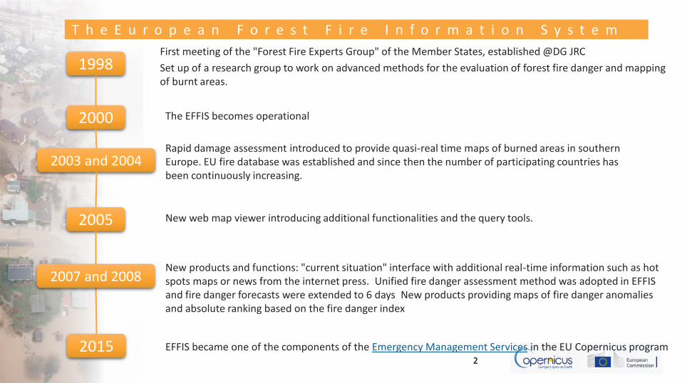
T h e E u r o p e a n F o r e s t F i r e I n f o r m a t i o n S y s t e m
22
2005
Rapid damage assessment introduced to provide quasi-real time maps of burned areas in southern Europe. EU fire database was established and since then the number of participating countries has been continuously increasing.
First meeting of the "Forest Fire Experts Group" of the Member States, established @DG JRC
Set up of a research group to work on advanced methods for the evaluation of forest fire danger and mapping of burnt areas.
1998
2015 EFFIS became one of the components of the Emergency Management Services in the EU Copernicus program
New products and functions: "current situation" interface with additional real-time information such as hot spots maps or news from the internet press. Unified fire danger assessment method was adopted in EFFIS and fire danger forecasts were extended to 6 days New products providing maps of fire danger anomalies and absolute ranking based on the fire danger index
2000 The EFFIS becomes operational
2003 and 2004
2007 and 2008
New web map viewer introducing additional functionalities and the query tools.

EmergencyManagement
S c o p e o f E F F I S
3
Harmonize the fire information exchange

EmergencyManagement
T h e E F F I S n e t w o r k
PT-ES-FR-UK-IT-CH-DE-SE-NO-BE-CZ-AT-SI-HR-FI-PL-SK-HU-MK-GR-EE-LV-LT-RO-BG-TR-CY-IE-MA-LB-ME-BS-KO-AL-RU-ALG-LEB-MOR-TUN
• EFFIS services and products are freelyaccessible via the EFFIS portal athttp://forest.jrc.ec.europa.eu/effis/
• EFFIS users include:• EC DGs and Services,• European Parliament,• associated national/regional
forest fire and civil protectionservices,
• FAO, Silva Mediterranea,• UNECE
2016 EFFIS Network – 40 countries

EmergencyManagement
E F F I S u n d e r t h e C o p e r n i c u s p r o g r a m m e
• Provides EU level assessments during both pre-fire and post-fire phases, thus supporting fire prevention, preparedness, fire fighting and post-fire operations
• Complements national fire information systems through the provision of harmonised data, methods and standards
Forest fire events
Fire detection
Burnt area maps
Land cover damage assessment
Emission assessment
Potential soil erosion estimates
Vegetation regenaration
Danger forecastEuropean Fire database

EmergencyManagement
Starting from 2016 – the following EFFIS components will be operated outside JRC:
1. Fire danger forecast
• Short and long-term fire danger forecast
• Monthly and seasonal fire weather forecast
2. Active fire and burnt area mapping
• Active fire mapping – MODIS/VIIRS/Sentinels
• Medium spatial resolution (approx 300 m) near-real time mapping of burnt areas (twice a day in pan-European region) (MODIS/VIIRS/Sentinel)
• High spatial resolution (e.g. Sentinel2, Landsat res.) weekly (or bi-weekly) mapping of burnt areas
O p e r a t i o n a l E F F I S c o m p o n e n t s

EmergencyManagement
F i r e d a n g e r f o r e c a s t
Short and long-term fire danger forecast
Monthly and seasonal fire weather forecast
daily maps of 1 to 10 days of forecasted fire danger level using numerical weather predictions
1. Fire danger forecast
temperature and rainfall anomalies expected over European and Mediterranean areas. Based on the ECMWF (European Centre for Medium-Range Weather Forecasts) Montlhy an Seasonal Forecasting

EmergencyManagement
F i r e d a n g e r f o r e c a s t
• ECMWF (16 km – 10 day forecast) • MeteoFrance (10 km 3 day forecast) • DWD (25 km 6 day forecast) • FWI Anomalies – deviation form historical average • FWI Percentiles - % with respect to historical values

EmergencyManagement
F i r e d a n g e r f o r e c a s t - c l a s s e s
• 6 classes (very low, low, medium, high, very high and extreme)
• spatial resolution of about 16 km (ECMWF data), 10 km (MF data) and 36 km (DWD data)
• harmonized picture of the spatial distribution of fire danger level throughout EU

EmergencyManagement
• Active fire mapping(MODIS/VIIRS/Sentinel2&3),
• Firenews, items selected from a large set of RSS feeds published by various forest fires related sites
• Medium spatial resolution (~ 300 m) Near-real time mapping of burnt areas (twice a day in pan-European region)(MODIS/VIIRS/Sentinel3)
• High spatial resolution(~10-30 m) weekly (or bi-weekly) mapping of burnt areas(e.g. Sentinel2, Landsat8, SPOT)
P o s t f i r e a s s e s s m e n t – a c t i v e f i r e s
11
On Saturday 10-09-2016 morning, four fires started on the island of Thassos (NE Greece) and continued burning for three days. The fires were probably caused by strong lightning activity not followed by rain (Dry storm). Several villages have been evacuated.
Fire Severity based on the Relative Difference Normalized Burn Ratio
2. Active fire and burnt area mapping

EmergencyManagement
P o s t f i r e a s s e s s m e n t – b u r n t a r e a
Hot spots and perimeters of the burnt areas have different colours depending on the time frame they belong to.

EmergencyManagement
P o s t f i r e - R a p i d d a m a g e a s s e s s m e n t
Burnt area mapping (Rapid Damage Assessment) • burned areas during the
fire season, derived from MODIS daily images with 250 m spatial resolution
• daily update of the perimeters of burnt areas in Europe for fires of about 40 ha or larger:• Location • Fire duration • Total burnt area• Landcover affected

EmergencyManagement
P o s t d a m a g e a s s e s s m e n t - f i r e s e v e r i t y
• Fire severity: based on the Relative Difference Normalized Burn Ratio (Miller et al. 2009)
• Under development:• Post-fire vegetation
regeneration to assess the vegetation recovery in a time series of images
• Post-fire soil erosion risk to assess the potential soil loss

EmergencyManagement The following EFFIS components are operated by the JRC:
3. Enhancements of other existing modules of EFFIS e.g. fire database, fire emissions and dispersion, soil erosion, vegetation regeneration, fire spread prediction for large fires, etc.
4. Dissemination services – operation of web services & contact with countries
5. Development of a Global Wildfire Information System (GWIS) in cooperation with GOFC Fire IT (Global Observation of Forest Cover Fire Implementation Team) and GEO (Group on Earth Observations).
E F F I S c o m p o n e n t s - n e x t e n h a n c e m e n t

EmergencyManagement
G l o b a l W i l d f i r e I n f o r m a t i o n S y s t e m - p r e v i e w

EmergencyManagement
E F A S p a r t n e r s h i p
17
How can I access EFFIS?
• The EFFIS landing page provides fire danger forecast and active fire and burnt area mapping in a freely accessible Web-GIS at: http://forest.jrc.ec.europa.eu/effis/
• WMS are available at http://forest.jrc.ec.europa.eu/effis/applications/data-and-services/ , serving Hot Spot, Burnt Area Points, Burnt Area Perimeters (24 hours, 7 days, 30 days, entire season)
• Get additional support by filling in the data request form for any request of data which is not available through the EFFIS web services (e.g. historic data, extracts of the fire database, or raw burned area perimeters) can be asked.