broadway complete streets final recommendations
TRANSCRIPT

BROADWAYComplete Streets Plan
BROADWAY COMPLETE STREETSFINAL RECOMMENDATIONS
APRIL 2016
Resolution 2016-0277 August 4, 2016 Page 4 of 127

Resolution 2016-0277 August 4, 2016 Page 5 of 127
TABLE OF CONTENTS INTRODUCTION . . . . . . . . . . . . . . . . . . . . . . . . . . . . . . . . . . . . . . . . . . . . . . . . . . . . . . . . . . . . . . . . . . . . . . . . . . . . . . . . . . . . . . . . . . . . . . . . . .1 FRAMEWORK AND EVALUATION . . . . . . . . . . . . . . . . . . . . . . . . . . . . . . . . . . . . . . . . . . . . . . . . . . . . . . . . . . . . . . . . . . . . . . . . . . . . . . . . . . 5 CORRIDOR ALTERNATIVES . . . . . . . . . . . . . . . . . . . . . . . . . . . . . . . . . . . . . . . . . . . . . . . . . . . . . . . . . . . . . . . . . . . . . . . . . . . . . . . . . . . . . . . 9 URBAN DESIGN . . . . . . . . . . . . . . . . . . . . . . . . . . . . . . . . . . . . . . . . . . . . . . . . . . . . . . . . . . . . . . . . . . . . . . . . . . . . . . . . . . . . . . . . . . . . . . . . 31 PRELIMINARY COST ESTIMATES . . . . . . . . . . . . . . . . . . . . . . . . . . . . . . . . . . . . . . . . . . . . . . . . . . . . . . . . . . . . . . . . . . . . . . . . . . . . . . . . . 57 FUNDING + IMPLEMENTATION . . . . . . . . . . . . . . . . . . . . . . . . . . . . . . . . . . . . . . . . . . . . . . . . . . . . . . . . . . . . . . . . . . . . . . . . . . . . . . . . . . . 63 CONCLUSIONS + NEXT STEPS . . . . . . . . . . . . . . . . . . . . . . . . . . . . . . . . . . . . . . . . . . . . . . . . . . . . . . . . . . . . . . . . . . . . . . . . . . . . . . . . . . . .71
IIIResolution 2016-0277 August 4, 2016 Page 6 of 127
FINAL RECOMMENDATIONS
TABLE OF FIGURESFIGURE 1 COMPLETE STREETS IMPLEMENTATION . . . . . . . . . . . . . . . . . . . . . . . . . . . . . . . . . . . . . . . . . . . . . . . . . . . . . . . . . . . . . . . . . . . . . . . . 2FIGURE 2 MULTIDISCIPLINARY EVALUATION FRAMEWORK . . . . . . . . . . . . . . . . . . . . . . . . . . . . . . . . . . . . . . . . . . . . . . . . . . . . . . . . . . . . . . . . .7FIGURE 3 CORRIDOR DISTRICTS . . . . . . . . . . . . . . . . . . . . . . . . . . . . . . . . . . . . . . . . . . . . . . . . . . . . . . . . . . . . . . . . . . . . . . . . . . . . . . . . . . . . . . . 10FIGURE 4 TYPICAL CROSS SECTION - EXISTING . . . . . . . . . . . . . . . . . . . . . . . . . . . . . . . . . . . . . . . . . . . . . . . . . . . . . . . . . . . . . . . . . . . . . . . . . . 11FIGURE 5 TYPICAL CROSS SECTION – PROPOSED . . . . . . . . . . . . . . . . . . . . . . . . . . . . . . . . . . . . . . . . . . . . . . . . . . . . . . . . . . . . . . . . . . . . . . . . 11FIGURE 6 PROPOSED CORRIDOR IMPROVEMENTS . . . . . . . . . . . . . . . . . . . . . . . . . . . . . . . . . . . . . . . . . . . . . . . . . . . . . . . . . . . . . . . . . . . . . . .12FIGURE 7 RIVERSIDE BOULEVARD OPTION 1 PLAN VIEW . . . . . . . . . . . . . . . . . . . . . . . . . . . . . . . . . . . . . . . . . . . . . . . . . . . . . . . . . . . . . . . . . .16FIGURE 8 RIVERSIDE BOULEVARD OPTION 1 BIRD’S EYE RENDERING . . . . . . . . . . . . . . . . . . . . . . . . . . . . . . . . . . . . . . . . . . . . . . . . . . . . . .16FIGURE 9 RIVERSIDE BOULEVARD OPTION 2 (PREFERRED) PLAN VIEW . . . . . . . . . . . . . . . . . . . . . . . . . . . . . . . . . . . . . . . . . . . . . . . . . . . . 17FIGURE 10 RIVERSIDE BOULEVARD OPTION 2 (PREFERRED) BIRD’S EYE RENDERING . . . . . . . . . . . . . . . . . . . . . . . . . . . . . . . . . . . . . . . . 17FIGURE 11 LAND PARK DRIVE/ 16TH STREET OPTION 1 PLAN VIEW . . . . . . . . . . . . . . . . . . . . . . . . . . . . . . . . . . . . . . . . . . . . . . . . . . . . . . . . . .18FIGURE 12 LAND PARK DRIVE/ 16TH STREET OPTION 1 BIRD’S EYE RENDERING . . . . . . . . . . . . . . . . . . . . . . . . . . . . . . . . . . . . . . . . . . . . . .18FIGURE 13 LAND PARK DRIVE/ 16TH STREET OPTION 2 (PREFERRED) PLAN VIEW . . . . . . . . . . . . . . . . . . . . . . . . . . . . . . . . . . . . . . . . . . . .19FIGURE 14 LAND PARK DRIVE/ 16TH STREET OPTION 2 (PREFERRED) BIRD’S EYE RENDERING. . . . . . . . . . . . . . . . . . . . . . . . . . . . . . . .19FIGURE 15 BROADWAY STATION LIGHT RAIL OPTION 1 PLAN VIEW . . . . . . . . . . . . . . . . . . . . . . . . . . . . . . . . . . . . . . . . . . . . . . . . . . . . . . . . . 20FIGURE 16 BROADWAY STATION LIGHT RAIL OPTION 1 BIRD’S EYE RENDERINGS . . . . . . . . . . . . . . . . . . . . . . . . . . . . . . . . . . . . . . . . . . . 20FIGURE 17 BROADWAY STATION LIGHT RAIL OPTION 2 (PREFERRED) PLAN VIEW . . . . . . . . . . . . . . . . . . . . . . . . . . . . . . . . . . . . . . . . . . . .21FIGURE 18 BROADWAY STATION LIGHT RAIL OPTION 2 (PREFERRED) BIRD’S EYE RENDERINGS . . . . . . . . . . . . . . . . . . . . . . . . . . . . . .21FIGURE 19 SURVEY RESULTS – SUMMARY OF COMMENTS ON THE ROAD DIET CONCEPT . . . . . . . . . . . . . . . . . . . . . . . . . . . . . . . . . . . . 30FIGURE 20 SIDEWALK ZONES SHOW VARIOUS IMPROVEMENTS THAT CONTRIBUTE TO PEDESTRIAN COMFORT. . . . . . . . . . . . . . 35FIGURE 21 COST ESTIMATES FOR OPTION 1 . . . . . . . . . . . . . . . . . . . . . . . . . . . . . . . . . . . . . . . . . . . . . . . . . . . . . . . . . . . . . . . . . . . . . . . . . . . . . . . 59FIGURE 22 COST ESTIMATES FOR URBAN DESIGN ELEMENTS . . . . . . . . . . . . . . . . . . . . . . . . . . . . . . . . . . . . . . . . . . . . . . . . . . . . . . . . . . . . . . 60FIGURE 23 SUMMARY OF STATE AND REGIONAL FUNDING PROGRAMS . . . . . . . . . . . . . . . . . . . . . . . . . . . . . . . . . . . . . . . . . . . . . . . . . . . . 63FIGURE 24 CITY OF SACRAMENTO TRANSPORTATION PROGRAM FUNDING . . . . . . . . . . . . . . . . . . . . . . . . . . . . . . . . . . . . . . . . . . . . . . . . 64FIGURE 25 18TH AND BWY INTERSECTION, ONE LAYER OF IMPROVEMENTS . . . . . . . . . . . . . . . . . . . . . . . . . . . . . . . . . . . . . . . . . . . . . . . . . 67FIGURE 26 18TH AND BWY INTERSECTION, TWO LAYER OF IMPROVEMENTS . . . . . . . . . . . . . . . . . . . . . . . . . . . . . . . . . . . . . . . . . . . . . . . . 67FIGURE 27 18TH AND BWY INTERSECTION, THIRD LAYER OF IMPROVEMENTS . . . . . . . . . . . . . . . . . . . . . . . . . . . . . . . . . . . . . . . . . . . . . . . 68
IV Resolution 2016-0277 August 4, 2016 Page 7 of 127

BROADWAY STREET IMPROVEMENTS
INTRODUCTIONBroadway Complete Street Plan
The Broadway Complete Street Plan builds upon several planning efforts in the Broadway Corridor and greater study area, including the Broadway Vision Plan by the Urban Land Institute, Sacramento District Council, and the Greater Broadway Partnership in 2012
01
1Resolution 2016-0277 August 4, 2016 Page 8 of 127

FINAL RECOMMENDATIONS
SETTING - PROJECT CORRIDOR, DISTRICTS, CITY PRIORITIESThe Broadway Complete Street Plan builds upon several planning efforts in the Broadway Corridor and greater study area, including the Broadway Vision Plan by the Urban Land Institute, Sacramento District Council, and the Greater Broadway Partnership in 2012. The Broadway study area is a central neighborhood located just south of downtown Sacramento, hosting a diverse cultural mix of businesses, residents, parks, and historical landmarks. Broadway anchors multimodal transportation connections to these destinations, maiking it accessible by foot, bike, bus, light rail, local streets, and several major highway connections.
Currently, residents, workers, and business owners look to improve the safety, connectivity, and character of the Broadway corridor. Unfortunately, they often characterize Broadway with disconnected pedestrian facilities and amenities, discontinuous bicycle facilities, fast-moving, uninviting traffic conditions, undersized transit facilities or slower operations, poor or unrecognizable urban design. These conditions result in an environment that is unwelcoming to pedestrians, cyclists, and transit riders and produces imbalances that could be improved to enhance corridor access for motorists and businesses as well.
In 2014, the City secured a Community-Based Transportation Planning Grant from Caltrans, supplemented with local matching funds, to undertake this Broadway Complete Streets Plan, with a focus on technical review of the Broadway Vision Plan in order to advance implementation of a project that improves safety, access and character of Broadway. This Plan focuses development of a path for implementation of complete streets design for Broadway, in the context of the Broadway Vision Plan, but also noting the need for safe, connected multimodal travel in the Corridor. The following report outlines the approach, analysis, and findings about the design of the corridor, along with an approach to funding and phasing a Broadway Complete Streets project.
FIGURE 1 COMPLETE STREETS IMPLEMENTATION WOULD IMPROVE SAFETY, ACCESS, AND CONNECTIVITY FOR BROADWAY TRAVELERS
2 Resolution 2016-0277 August 4, 2016 Page 9 of 127
BROADWAY STREET IMPROVEMENTS
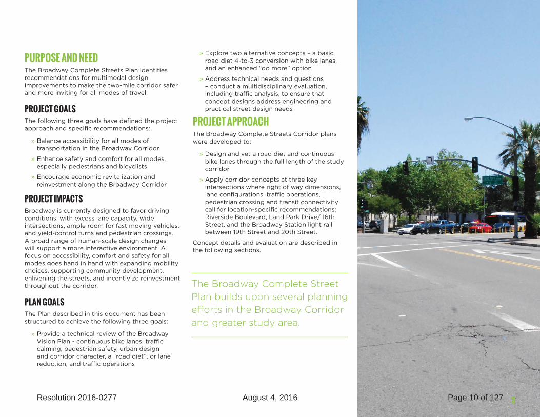
PURPOSE AND NEEDThe Broadway Complete Streets Plan identifies recommendations for multimodal design improvements to make the two-mile corridor safer and more inviting for all modes of travel.
PROJECT GOALSThe following three goals have defined the project approach and specific recommendations:
» Balance accessibility for all modes of transportation in the Broadway Corridor
» Enhance safety and comfort for all modes, especially pedestrians and bicyclists
» Encourage economic revitalization and reinvestment along the Broadway Corridor
PROJECT IMPACTS Broadway is currently designed to favor driving conditions, with excess lane capacity, wide intersections, ample room for fast moving vehicles, and yield-control turns and pedestrian crossings. A broad range of human-scale design changes will support a more interactive environment. A focus on accessibility, comfort and safety for all modes goes hand in hand with expanding mobility choices, supporting community development, enlivening the streets, and incentivize reinvestment throughout the corridor.
PLAN GOALSThe Plan described in this document has been structured to achieve the following three goals:
» Provide a technical review of the Broadway Vision Plan - continuous bike lanes, traffic calming, pedestrian safety, urban design and corridor character, a “road diet”, or lane reduction, and traffic operations
» Explore two alternative concepts – a basic road diet 4-to-3 conversion with bike lanes, and an enhanced “do more” option
» Address technical needs and questions – conduct a multidisciplinary evaluation, including traffic analysis, to ensure that concept designs address engineering and practical street design needs
PROJECT APPROACHThe Broadway Complete Streets Corridor plans were developed to:
» Design and vet a road diet and continuous bike lanes through the full length of the study corridor
» Apply corridor concepts at three key intersections where right of way dimensions, lane configurations, traffic operations, pedestrian crossing and transit connectivity call for location-specific recommendations: Riverside Boulevard, Land Park Drive/ 16th Street, and the Broadway Station light rail between 19th Street and 20th Street.
Concept details and evaluation are described in the following sections.
The Broadway Complete Street Plan builds upon several planning efforts in the Broadway Corridor and greater study area.
3Resolution 2016-0277 August 4, 2016 Page 10 of 127

FINAL RECOMMENDATIONS4 Resolution 2016-0277 August 4, 2016 Page 11 of 127

BROADWAY STREET IMPROVEMENTS
FRAMEWORK AND EVALUATIONCriteria
This section describes the study team’s approach to development and evaluation of design options for complete streets treatments in the Broadway Corridor. The following chapter, Chapter 3, describes the corridor alternatives and their performance with respect to these multimodal, and in fact multidisciplinary, evaluation criteria.
02
5Resolution 2016-0277 August 4, 2016 Page 12 of 127

FINAL RECOMMENDATIONS
OVERVIEWThis section describes the study team’s approach and evaluation of design options for complete streets treatments in the Broadway Corridor. The following chapter, Chapter 3, describes the corridor alternatives and their performance with respect to these multimodal, and in fact multidisciplinary, evaluation criteria.
The plan evaluation aims to ensure that the project would incorporate, understand, and address both the technical needs of the project as well as community, stakeholder, and agency concerns. The study team began with a review of multimodal level of service metrics, typically referred to as MMLOS, on similar relevant projects. After coordination with agency partners and community feedback, the team settled on a detailed quantitative and qualitative analysis framework. This allows for a measured, comprehensive discussion of the potential project tradeoffs. It also allows for a discussion of possible impacts and mitigation or management of those impacts in the next phase of project implementation.
The evaluation describes the quality of each design option, including the existing condition for reference, with respect to the following areas of potential impact:
» Pedestrian and bicycle safety and comfort
» Transit access and operational impacts
» Traffic operations and parking
» Urban landscape and design
Within each of these categories, there are further details that help to arrive at an overall understanding of the potential impact of each design option. For example, within Pedestrian Conditions, both the width of the pedestrian path of travel and the percentage of the total building to building right of way dedicated to pedestrians were analyzed.
» crosswalk type
» curb type
» amount of shading
» adjacent lane use
» crossing distance
» crossing opportunities
To evaluate the ways that bicycling conditions change across the design options, the team analyzed the following:
» opportunities for bike parkign
» connections to network
» comfort
» safety
Comfort and safety were analyzed together, with consideration of the following:
» width of the bicycle lane
» percentage of the route along Broadway in a dedicated bicycle lane
» percentage of the route along Broadway that is buffered from vehicular traffic
» speed of the lane adjacent to the bicycle facility
To understand the potential transit access and operations impacts across the design options, the team analyzed the following:
» stop amenities
» stop spacing
» connectivity
» reliability
To assess the potential traffic impacts and parking access across the design options, the team analyzed the following:
» travel time
» turn opportunities
» delay and queuing
» parking by segment
Within each of the metrics in traffic and parking, the impacts were examined in total and by segment rather than by block or by space. For example, we summarize the change in dedicated left-turn opportunities as 3 turns per 5 blocks in one option vs perhaps 2 turns per 5 blocks in the other. This methodology is more instructive for understanding impacts at a corridor level. It is also more indicative of a conceptual design study and analysis. More detail will be developed during the final design and analysis of the project as it approaches implementation.
To understand the potential enhancements to the urban design realm, the following metrics were examined:
» connection to adjacent use
» amount/ quality of activity spaces
» comfort and safety
6 Resolution 2016-0277 August 4, 2016 Page 13 of 127

BROADWAY STREET IMPROVEMENTS
METRICS ANALYZED
Pedestrian Conditions
• crosswalk type • adjacent lane use
• curb type • crossing distance
• amount of shading • crossing opportunities
Bicycling Conditions
• opportunities for bike parking • comfort
• connections to network • safety
Transit Conditions
• stop amenities • connectivity
• stop spacing • reliability
Traffic Conditions
• travel time • delay and queuing
• turn opportunities • parking by segment
Urban Design
• connection to adjacent use • amount/quality of activity spaces
• comfort & security
The complete, multidisciplinary criteria are shown below.
The evaluation includes both qualitative and quantitative measures. The primary sources of data for evaluating performance include:
» Transportation demand modeling and traffic operations analysis
» Conceptual engineering designs
» Data on the performance of other complete streets projects in similar settings
» Stakeholder and community outreach
Key aspects of the project were assessed using a two-step approach to modeling transportation conditions, as summarized in Figure 2. The models used for this evaluation are:
» Sacramento Council of Governments Activity-Based Travel Demand Forecasting model, which models Sacramento area transportation demand and conditions (SACOG model)
» Synchro, which provides traffic analysis at specific key intersections
More detail on the traffic analysis process is provided in the technical appendix.
When presented to agency partners, stakeholders, and the community for feedback, most felt that this matrix would best capture the overall goals and objectives of the Broadway Complete Streets project. There was some discussion as to whether one goal might be more important than others, eg pedestrian safety; however, since the goal is simply to bring a better balance to the street, in the end no one metric outshined another. As a result no weighting is assigned to individual metrics or modes, nor are any values assigned or summed. This allows a broad examination of the tradeoffs and synergies of each option.
More detail on the overall performance of the design options is included in chapter 3, following the description of each option.
FIGURE 2 MULTIDISCIPLINARY EVALUATION FRAMEWORK
The approach for the evaluation criteria was to ensure that the project would incorporate, understand, and address both the technical needs of the project as well as community, stakeholder, and agency concerns.
7Resolution 2016-0277 August 4, 2016 Page 14 of 127

FINAL RECOMMENDATIONS8 Resolution 2016-0277 August 4, 2016 Page 15 of 127

BROADWAY STREET IMPROVEMENTS
CORRIDOR ALTERNATIVESOptions
Previous examinations of Broadway envision a reduction from the 4-lane cross-section, often with parking, an occasional left-turn pocket, and discontinuous bike lanes in order to improve the safety, operation, and connectivity along Broadway. Corridor-wide, the concept of a 2-lane cross-section with alternating median/dedicated left-turn lanes makes room for continuous bike lanes with parking in key areas.
03
9Resolution 2016-0277 August 4, 2016 Page 16 of 127

FINAL RECOMMENDATIONS
The design concepts were was applied, refined, and analyzed throughout the corridor, which spans the Marina District, the Tower District, and the Upper District, from 3rd Street at the west end to 26th Street/ Fernando Way at the east end. Specific design recommendations were developed for the following three key intersections:
» Riverside Boulevard
» Land Park Drive/ 16th Street
» Broadway Station light rail between 19th Street and 20th Street
CRITICAL ISSUES Key issues that stand out from project walk audits, outreach, and previous visioning processes include:
» Long distances between crossings
» Uncomfortable pedestrian crossing conditions
» Fast-turning vehicles
» Sidewalk obstructions or narrow sidewalks
» Limited, discontinuous bike lanes
» No buffer between bike lanes and vehicle lanes where present
» Limited connections to existing bike network on other streets
» Limited transit amenities
» Inconvenient connections between bus and light rail
Pedestrian crossings are especially long and challenging at the key intersections. Eastbound right turns are yield-controlled at Riverside Boulevard and Land Park Drive, and westbound bus passengers must take an indirect path of travel to connect to the Broadway light rail station.
FIGURE 3 CORRIDOR DISTRICTS
10 Resolution 2016-0277 August 4, 2016 Page 17 of 127

BROADWAY STREET IMPROVEMENTS
CORRIDOR-WIDE ROAD DIETWhile the right of way dimensions and lane configurations vary across the Broadway corridor, the typical cross section includes a sidewalk and parking lane on each side, two travel lanes in each direction, and a painted median, illustrated in Figure 4.
DEFINITION/DESCRIPTIONA road diet reduces the total number of vehicle lanes from four, with two in each direction, to three, with one in each direction and a center left-turn pocket. Roads with average daily traffic (ADT) volumes of less than 25,000 can usually accommodate this lane reduction, with some modifications at key locations to ensure access to local businesses, maintain traffic flow, and maintain or enhance transit performance. Figure 3 illustrates the typical configuration for the road diet with buffered bike lanes.
The proposed road diet allows for a buffered bike lane through the entire corridor, and presents opportunities for pedestrian crossing improvements, new pedestrian crossings, and sidewalk enhancements.
Figure 5 illustrates the proposed corridor-wide improvement and locations of key intersections where specific recommendations vary.
FIGURE 4 TYPICAL CROSS SECTION - EXISTING
FIGURE 5 TYPICAL CROSS SECTION – PROPOSED
11Resolution 2016-0277 August 4, 2016 Page 18 of 127

FINAL RECOMMENDATIONS
ADVANTAGESThe road diet reallocates right of way from high speed vehicles to a variety of active users, dedicating space to pedestrians, bicyclists and slower moving/ turning vehicles. With a narrower vehicle right of way, the corridor is designed for lower driving speeds, and provides cues to drivers that this corridor is shared with other users.
Traffic calming:
» Road diet treatments shift the corridor design from accommodating vehicle throughput to providing space for all users, including pedestrians, bicyclists, transit passengers, and visitors to local businesses
» Narrower vehicle lanes and clear definitions of space for other users reduces corridor design speed and slows motorists
» Smaller turning radii at intersections reduces design speeds for turning vehicles and positions drivers closer to perpendicular as they approach crosswalks, bringing pedestrians into their field of vision
FIGURE 6 PROPOSED CORRIDOR IMPROVEMENTS
12 Resolution 2016-0277 August 4, 2016 Page 19 of 127

BROADWAY STREET IMPROVEMENTS
PEDESTRIAN SAFETY: » About 25% of corridor residents commute by walking, biking or transit, more than double the citywide average
» Bulb-outs at intersections and mid-block crossings reduce the distance pedestrians need to cross and reduce the exposure to vehicle conflicts
» Crossing treatments will highlight the presence of pedestrians at intersections, increasing motorists awareness of where to expect pedestrians
BUFFERED BIKE LANES: » Allocates road space to cyclists, creating a continuous route for the entire corridor
» Increases motorist awareness and visibility of bicyclists, while making bicyclists presence and movements more predictable
» Marking the bike lane through the intersection provides continuous signal to both motorists and bicyclists
OPPORTUNITIES FOR TRANSIT CONNECTIONS: » Transit riders make about 6,500 trips along Broadway each day, with about 1,500 boardings at the Broadway Station light rail
» Broadway hosts one of Sacramento’s highest ridership bus lines (Route 51), operating every 12 minutes almost 14 hours per day
» The road diet presents opportunities for traffic calming and improved pedestrian crossing treatments at Broadway Station (details for Option 1 and Option 2 are outlined below)
DEDICATED LEFT-TURNING POCKETS: » Dedicated lanes for left turns improves predictability of vehicle movements at intersections and allows for through moving vehicles to travel across intersections without interruption
» Signals can be optimized to accommodate turning movements
CHALLENGESThere are some challenges to consider in evaluating road diet treatments. The maximum ADT on the Broadway corridor reach approximately 22,000 east of 17th Street, which can typically be accommodated with one lane in each direction. However, on streets with higher ADT, it can be more difficult to achieve road diet without advance design or technology.
» Vehicle capacity may be constrained where ADTs cannot be accommodated
» Queues may form at congested intersections or turn locations with high vehicle volumes
» Fewer lanes can hinder transit operations unless protective measures are employed
13Resolution 2016-0277 August 4, 2016 Page 20 of 127
FINAL RECOMMENDATIONS
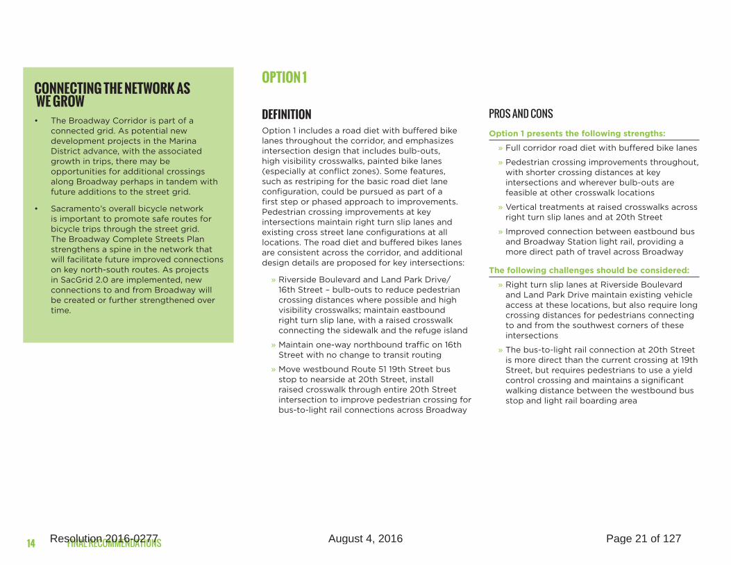
OPTION 1
DEFINITIONOption 1 includes a road diet with buffered bike lanes throughout the corridor, and emphasizes intersection design that includes bulb-outs, high visibility crosswalks, painted bike lanes (especially at conflict zones). Some features, such as restriping for the basic road diet lane configuration, could be pursued as part of a first step or phased approach to improvements. Pedestrian crossing improvements at key intersections maintain right turn slip lanes and existing cross street lane configurations at all locations. The road diet and buffered bikes lanes are consistent across the corridor, and additional design details are proposed for key intersections:
» Riverside Boulevard and Land Park Drive/ 16th Street – bulb-outs to reduce pedestrian crossing distances where possible and high visibility crosswalks; maintain eastbound right turn slip lane, with a raised crosswalk connecting the sidewalk and the refuge island
» Maintain one-way northbound traffic on 16th Street with no change to transit routing
» Move westbound Route 51 19th Street bus stop to nearside at 20th Street, install raised crosswalk through entire 20th Street intersection to improve pedestrian crossing for bus-to-light rail connections across Broadway
PROS AND CONSOption 1 presents the following strengths:
» Full corridor road diet with buffered bike lanes
» Pedestrian crossing improvements throughout, with shorter crossing distances at key intersections and wherever bulb-outs are feasible at other crosswalk locations
» Vertical treatments at raised crosswalks across right turn slip lanes and at 20th Street
» Improved connection between eastbound bus and Broadway Station light rail, providing a more direct path of travel across Broadway
The following challenges should be considered:
» Right turn slip lanes at Riverside Boulevard and Land Park Drive maintain existing vehicle access at these locations, but also require long crossing distances for pedestrians connecting to and from the southwest corners of these intersections
» The bus-to-light rail connection at 20th Street is more direct than the current crossing at 19th Street, but requires pedestrians to use a yield control crossing and maintains a significant walking distance between the westbound bus stop and light rail boarding area
CONNECTING THE NETWORK AS WE GROW• The Broadway Corridor is part of a
connected grid. As potential new development projects in the Marina District advance, with the associated growth in trips, there may be opportunities for additional crossings along Broadway perhaps in tandem with future additions to the street grid.
• Sacramento’s overall bicycle network is important to promote safe routes for bicycle trips through the street grid. The Broadway Complete Streets Plan strengthens a spine in the network that will facilitate future improved connections on key north-south routes. As projects in SacGrid 2.0 are implemented, new connections to and from Broadway will be created or further strengthened over time.
14 Resolution 2016-0277 August 4, 2016 Page 21 of 127

BROADWAY STREET IMPROVEMENTS
OPTION 2 (PREFERRED)
DEFINITIONAs in Option 1, Option 2 includes a road diet with buffered bike lanes throughout the corridor, and emphasizes intersection design that includes bulb-outs, high visibility crosswalks, painted bike lanes (especially at conflict zones). Some features, such as restriping for the basic road diet lane configuration, could be pursued as part of a first step or phased approach to improvements.
Option 2 removes the right turn slip lanes at key intersections, introduces two-way traffic on 16th Street (consistent with the Downtown Plan), and includes significant transit hub improvements between 19th and 20th Streets, connecting bus and light rail at Broadway Station. The road diet and buffered bikes lanes are consistent across the corridor, and additional design details are proposed for key intersections:
» Riverside Boulevard and Land Park Drive/ 16th Street – bulb-outs to reduce pedestrian crossing distances at all corners and high visibility crosswalks; bring all approach lanes to the signal-controlled intersections, removing yield-controlled eastbound right turn slip lanes while maintaining dedicated right turn lanes
» Introduce two-way traffic on 16th Street (consistent with the Downtown Plan), and reroute southbound Route 6 bus from 15th street to 16th Street
» Maintain existing location for westbound 19th Street bus stop, with a midblock crosswalk immediately west of the light rail tracks to facilitate direct pedestrian access across Broadway for westbound bus-to-light rail connections
» Locate bike lanes adjacent to curb,introduce bus boarding islands, and exclusive bus only lanes between 19th Street and 20th Street to eliminate bike-bus conflict and expand loading and waiting area for bus passengers
PROS AND CONSOption 2 presents the following strengths:
» Full corridor road diet with buffered bike lanes
» Pedestrian crossing improvements throughout, removing right turn slip lanes at key intersections to significantly reduce pedestrian crossing distance, and wherever bulb-outs are feasible at other crosswalk locations
» Squaring up intersections with bulbs at corners, to slow down vehicles at intersections without reducing roadway capacity
» Two-way traffic on 16th Street will offer greater vehicle access on 16th and consistent routing of northbound and southbound Route 6 bus service and reduce Broadway cut-through traffic
» Pedestrian crossing between 19th and 20th Streets for a direct connection between the eastbound Route 51 bus and Broadway Station light rail, providing the shortest possible path of travel across Broadway
» Bus boarding islands provide additional space for bus passengers and establish a transit hub at this important light rail and bus connection point
» Bus boarding islands and curbside bike lanes eliminate bike-bus conflict at this potentially busy transfer station with frequent bus service
The following challenges should be considered:
» Eliminating right turn slip lanes at Riverside Boulevard and Land Park Drive reduces pedestrian crossing distances, but also requires tighter turning radii for large vehicles making eastbound right turns
» The bus-to-light rail connection at the midblock crossing is the most direct connection between bus and light rail, but will require coordination at adjacent intersections and with the freight rail crossing. Given the location of this crossing, during the next phase of development further analysis should explore the pedestrian crossing control that best addresses transit connectivity while also managing vehicle queuing in a manner acceptable to Sacramento Regional Transit and California Public Utilities Commission. It will also be necessary to coordinate with improvements proposed for 19th Street as part of the Downtown study, Grid 2.0, which recently settled on an option that would convert 19th Street to one-way operations between Broadway and X Street.
15Resolution 2016-0277 August 4, 2016 Page 22 of 127

FINAL RECOMMENDATIONS
KEY INTERSECTION DETAILSThe following sections provide illustrations for Option 1 and Option 2 (preferred) at Riverside Boulevard, Land Park Drive/ 16th Street and Broadway Station light rail.
RIVERSIDE BOULEVARD
FIGURE 7 RIVERSIDE BOULEVARD OPTION 1 PLAN VIEW FIGURE 8 RIVERSIDE BOULEVARD OPTION 1 BIRD’S EYE RENDERING
MaiMaiMaintantatatain in in in easeeastbotbotbotbobooundundundnd rigrigrrighthththt turturturtu n sn sn ssliplipiplip lalane,ne,nene,n wiwiwiw tth th hrairairaiar sedsedss crcrcrc ossossossswalwalwawwalw k ak ak ak ak ak acrocrocrocroooss ssssss ssyieyieiyieyieyieyield-ld-ld-conconconco trotrotroollelleeled sd sd sd sd sd lipipliplip lalalanennenene
PedPedPedestestestriairian cn rososossinsinnngimpprovemem nts annnndbullb b-ob-outsutss at threeee corornernerss
16 Resolution 2016-0277 August 4, 2016 Page 23 of 127

BROADWAY STREET IMPROVEMENTS
FIGURE 9 RIVERSIDE BOULEVARD OPTION 2 (PREFERRED) PLAN VIEW FIGURE 10 RIVERSIDE BOULEVARD OPTION 2 (PREFERRED) BIRD’S EYE RENDERING
PedPedestestrian cccrosssssingimpimprovrovemeenntsnn andbulbulb-ob-outsu atat aaala lll cl orners
Trimmed median on south side to accommodate largeg vehvehicle turns
SigSigSigiiSignifinifinifin cancancancantlytlytlytly shshshshortorttortorter er er ercrocrocrocrocrossississississss ng ng ngng disdisdisi tantantanananancescescescescesescese andandandandn opopopoppporporppporportuntuntuntunitiititiitities es s es esee forforforforfor lanlananlandscdscddscapiapiapiap ngngngng
No NoNoooNoNo rigririgrigrigrigigrigrigrigrigrigrigriiggggriggggggggggggggght ht htht ht httthtththttththtthtththtturturturturturturturn ssssssssssssn ssn ssn ssn sn ssn lipliplipiplipliplipliplipliliipipiipiipliplipliplipilipliplipiilipipipp llalanlaaanaallllaanlanananaanananlaananllaaanaaaneeeeeeeeeeeeeeee
17Resolution 2016-0277 August 4, 2016 Page 24 of 127

FINAL RECOMMENDATIONS
BROADWAY STATION LIGHT RAIL – 19TH STREET TO 20TH STREET
FIGURE 11 LAND PARK DRIVE/ 16TH STREET OPTION 1 PLAN VIEW FIGURE 12 LAND PARK DRIVE/ 16TH STREET OPTION 1 BIRD’S EYE RENDERING
MaMaiMaiMaiMaiMMaMMaMaiMMaiaiMaMaiMaiMaiMMaiaiaiMaaiaiMaiaMMaiaaiaaaaaintnntntntntntnttntatatatantntnntntntanntnttntnnntnnnttttnnn ininin n easeaseaseaseaeastbotbotboooooooooooooooundundunuunnnununununduununuuuuuuuuu igrigrigrigrigrigrigrigrigrigrigrigrigririgrigrigrigrrigigriggrigriggiigrririrrriigr hthththt httht th tturturn sn sliplippipliplipiplipliplippplipippliplipppipippp lllalall ne,ne,ne,nen ,, wiwwiwwiiiwiwiththththhththththhhhhthttttttttththtttthttttt
raiaisedsed crrrrrrrrrossossososososososoosossosossosoosossooooo wallwalwalwalkk ak aaak aaacrocrocrocrorrocrocrocrocrocrocrocrocrocroccrcrocrocroroorocrocrocroocrorcrrrosss sssss sssssssssyieeyield-d---d-----dddd conconcccccoccccccccccccc trotrotrotror lleeleeeeeedddd sd ssd sd sd sd ssd sd sliplipipliplippipiplipipliplilipiplippipplipipipipippipippppppppipippipp lalalalalane nene nnene n
Pedesttriai n cn rosrossinsinngggimprovements anndddbullbu b-ob-ob utsuts at ththreeree corcornernerss
Maaiaintantantaiiin one-wwwaw y norororthbththbounounnu d td td traaffic on 16t6t6th Sh Sh Street, no change eetoo o busb routingg
18 Resolution 2016-0277 August 4, 2016 Page 25 of 127

BROADWAY STREET IMPROVEMENTS
FIGURE 13 LAND PARK DRIVE/ 16TH STREET OPTION 2 (PREFERRED) PLAN VIEW FIGURE 14 LAND PARK DRIVE/ 16TH STREET OPTION 2 (PREFERRED) BIRD’S EYE RENDERING
PedPedPedestestestrian cn ccn crosrosrossinsinsinng g gg impimpimpmprovro emementsnts anananandd d dbulbulbulb-outs atat alall cl ornrnerserse
Siggggnifinifinifinificccantlyt shhhhorto er crocrocrorossissississing nnn disstantannnces
dandandn opopopportunitttit es for lalanlanlandscdscd apiap ng
No NoNo No No No NoNoNoNoNo No oooNNoNoooNoNNoNo NoNo NoNo NoNoNoNo No oNo No NoNNNo rigririgrigrigrigrigigrigrigrigiggirigigrigrigrigrigrigrigrigrigirigrrrigrigigghhhthhthhthhhhhhhhhhhhhhhhtht hhhhthhtttttturtttturturttturturtuturturturrtuturturt rturttutturtu n sn sn ssn sn sn sn sn sn sn sn sn sn sssn sn lililiililiiilliiliililiiliipliiippliplliiipiipipii lane
Two-way traffic on16th Strerereet,et,et, rerrererououurouroutintinintinting southbbounoound Rd Rd Rd R outooo e 6666 bus to 16th S S Stretret eetet
19Resolution 2016-0277 August 4, 2016 Page 26 of 127

FINAL RECOMMENDATIONS
BROADWAY STATION LIGHT RAIL
FIGURE 15 BROADWAY STATION LIGHT RAIL OPTION 1 PLAN VIEW
FIGURE 16 BROADWAY STATION LIGHT RAIL OPTION 1 BIRD’S EYE RENDERINGS
Shift westbounnd RouRououRoutetetete 5151551 busbusbusss ststssttststsss op op opop op opop op opopopoppooop ffrofrofrom mnearside 19t19t19t9t9t9 h Shh hh SSSSSSSSSSSSSSSh SSSSSSSSSSSSSSStretretretretretretrettretretretretretretretretrereetrtretrrtr eeeeeeteteeeeeeteeeeetetetetee to toneaneaneanearsirsirsirsidedede de 2020t20t0t0t0t20t20t0t0t20t20t0t0t0t0tt0t20t00t0thhh h Sh Sh S S S SSSSShh Sh Sh SSSh Sh SSS SSShh Sh SShhh Sh S SSShh Shhh tretretretretretretretretreretreetreetretreeetreetretrereeeeeeeeeeeetetete
RaiRaiRaiRaiRaiRaiRaiRaiRaiaiRaiRaRaiRaiaaaaiaaa sedsedsedsedsedsedsedsedsedsedseddsedseddsedsedsedsedsedsedsedseddseesseds dddssedddd inininininini tertertertertertererrsecsecseecececececececececececececececeeececececececececeececcececeectiottiotiotiotitiotiotiottiotiotiottitiottiotiotiot otiotiotittioit n an n n an n an an ann an ann an n an ann annn at 2ot2ot2ot2ot2ot2ot2ot2oto2ot2ot2ot2ot2oo2 h Sh Sh Sh Sh Sh Sh Sh Sh Sh Sh SSh SShhh Sh Sh Sh Sh h Sh Sh Sh SSh SStrtrtretretrtrt et etetet tet et totototo to oo o o ooo o tooo otoooooooooooooooo o imiimpmpimpimpmpimpmpimpimpimpimmmpmpmpmpmpimiimimiimmpmpimimmpimpmimmmpmpprrrorororororovrrroorrrrror e pedpedddddessstststriariarian vnn viissisis bbilbilbilityitity ananand comcommcommmmmmmmmmmmmmmmmmfofoorororfofofofofoofofooofoooo t at at s ws ws weeellellellellellllellllele asasasasasasasasasaaasasasaasaaasaasaasaaa drdrdrivevever yield complianceiiiiiiiii ldldldddlddddldddlddlddd llilill
More direct path of travel from westbound bus stop to light rail boarding arearararar a
20 Resolution 2016-0277 August 4, 2016 Page 27 of 127

BROADWAY STREET IMPROVEMENTS
FIGURE 17 BROADWAY STATION LIGHT RAIL OPTION 2 (PREFERRED) PLAN VIEW
FIGURE 18 BROADWAY STATION LIGHT RAIL OPTION 2 (PREFERRED) BIRD’S EYE RENDERINGS
More direct path of travel from westbound bus stop toto to ttototo ligligligligliligghth rail bboaroaroaroaroaroardindindindindinding g ag ag g gg rea
DedDedDedDedDedDedDededDedDedDDeDeDDeDeDeDeeee icaicaiicaicaiicaicaicaicaicacai tedtedtedtedtedteddteddtedtedt dd bubus ls lss ananeaneaneaneaneeaneaneneaneaneaneaneneea eee andandandandandddd bbobbbobobbbbobb ardingg isisisislanlanlanandddddddsddsds ddddddddddddat at at at 1919t19 h Street et RouRouRouRouteetetete51 5151 5151 515151 5515151515151515551555515 ssstsstop for bototototothhhhhdirdirdirdirdirdirdirdirddirdd rdird ecteeeeeeeeeeeeeeee ions
CurCurCCuCuCurCurCCuCCuCCuCu bsibsbsibsib de dedee bike lanes to elieleelieeeeele minmmminminminmmmmmm ateateateate bike-bus conflict at tttatattat ttttttttt bbbboboaabbbbbb rdrdrdiing areas and thrhrhrhthrhrhrhrhhrhrhrhhrhrhrhhhhrougougougoo h lh lh lh lh engengengenggggggthththth ofofof of bloblobloblockckckck
Signal-controlled pedes-trian crossing between bus boarding islands bus boarding islandsand light rail tracks
21Resolution 2016-0277 August 4, 2016 Page 28 of 127

FINAL RECOMMENDATIONS
CASE STUDIESThe following case studies provide examples of application and impacts of road diets in several cities, and Caltrain’s urban rail track crossing design. Additional details are included in the [Case Studies technical appendix].
ROAD DIET EXAMPLESSacramento’s Broadway corridor has an average daily traffic (ADT) of 21,980 vehicles at its busiest intersection, Broadway and 17th. As a general rule, two and three lane roads are capable of accommodating up to 25,000 vehicles per day. The Broadway corridor is similar to a number of recent road diet conversion cases, providing real-world examples of how the change in road design impacts traffic patterns and local economic activity.
York Boulevard, Los Angeles
LA DOT implemented a road diet on 1.3 miles of the York Boulevard corridor in the Highland Park neighborhood of northeast LA County in 2006. The design changes included a mixed use lane reduction from two lanes each way to one lane each way with a center turn lane. A few years later, bicycle lanes were added. The following impacts were recorded after implementation:
» 85-95% of business survey respondents did not feel that bike lanes had hurt their business
» Sales tax revenues at local businesses on the road diet section of York Blvd increased from $727,000 to $1.1M post-road diet implementation
» Since the road diet installation, 21 new businesses have opened on the corridor
» There is a disconnect between how businesses think their customers travel to shop and how customers reported traveling – 60-75% of businesses said customers drive, while only about 15-30% of customers reported driving
» After the road diet, this portion of York Blvd experienced a 23% reduction in pedestrian/automobile collisions and a 27% reduction in injuries.
Ocean Park Blvd, Santa Monica
The City of Santa Monica installed a road diet on 1.1 miles of Ocean Park Blvd in 2008 consisting of a four to three lane road diet and addition of bike lanes. The following safety impacts were recorded:
» 65% reduction in collisions in first nine months
» Traffic volumes decreased from approximately 23,000 ADT to 19,000-20,000 ADT after the road diet
» Vehicles appeared to move to the I-10 freeway and traffic counts on adjacent side streets remained stable to pre-road diet volumes
Stone Way N, Seattle
The City of Seattle completed a road diet on Stone Way N in 2007, reducing mixed use traffic lanes from four to three and adding bike lanes. The following impacts were recorded:
» Automobile speeds declined, with a decrease in excessive speeding
» Vehicle traffic decreased approximately 6 percent in the corridor, while bicycling increased 35%
» Vehicles have not diverted to nearby side streets; in fact, traffic decreased even more substantially on side streets than on Stone Way
» Total collisions declined 14% between the periods of 2005-07 and 2007-09; pedestrian collisions declined 80%
CONCLUSIONSThese case studies demonstrate that:
• Fewer customers drive to shop than businesses think, as on York Blvd in LA
• Thriving shopping areas will not be negatively impacted by a road diet; in fact, facilitating opportunities for pedestrians and cyclists to visit businesses will introduce new customers
• Current traffic on the Broadway corridor is safely in the range for a successful road diet; Ocean Park Blvd in Santa Monica had high daily traffic volumes but found that side street traffic remained stable
• Adjacent side streets may not be overrun by new traffic when a road diet is implemented; in fact, traffic may decrease in the area, as occurred in Seattle
22 Resolution 2016-0277 August 4, 2016 Page 29 of 127

BROADWAY STREET IMPROVEMENTS
SIGNAL-CONTROLLED PEDESTRIAN CROSSING SYSTEMS AT CALTRAIN RAIL TRACKSSignal preemption is used to make signals for vehicular crossings of rail tracks and intersections function together effectively, with the goal of having vehicles clear of the railroad crossing when a train approaches. This system can also be used to coordinate signal control for pedestrian crosswalks and nearby intersections. According to Caltrain, which uses signal preemption at several urban rail track crossings, an effective interconnection system improves safety and vehicular traffic at rail crossings, the planning and design of the roadway signal system and expedites the diagnostics processing of both the railroad and roadway signal systems.
When to Apply Signal Preemption
The Institute of Transportation Engineers (ITE) recommends that signal preemption be applied at rail crossings when there is a potential for traffic to extend across a rail.
Signal Preemption Design
The distance between the rail tracks and the 19th Street and 20th Street intersections are approximately 110 feet and 160 feet, respectively. This falls short of the most recent 200 foot threshold of “long distance” approach set by the Manual on Uniform Traffic Control Devices (MUTCD) and therefore this crossing should follow the ITE best practices for “short distances”. At rail crossings with “short distances” and likelihood for frequent vehicle queuing over the rail tracks, a pre-signal should be installed even if gates are used at the crossing.
When a pre-signal is used, intervals should be progressively timed with signals downstream to ensure there is adequate time for vehicles to clear the rail crossing. The progressive timing should take vehicles that need to stop prior to crossing the tracks (e.g. school busses) into consideration. For added safety, vehicle detection could be used in the clear storage area on either side of the tracks to provide additional security for instances where vehicles could get trapped within the minimum track clearance zone by extending the clear track green interval.
Pedestrian Safety
Caltrain Design Criteria recognizes that in urban areas pedestrians will cross rail tracks and roads whether or not there is a designated place to do so. Therefore, Caltrain Design Standards require that pedestrian safety features be used at all rail crossings in urban areas. At grade crossings, Caltrain requires active warning devices be used for pedestrian crossing areas. Further, automatic pedestrian gate arms and passive traffic control devices may be installed, and if necessary should be included at all four quadrants of where vehicular crossing occurs. If automatic pedestrian gate arms are used, these should not be attached to the vehicular gate mechanism as it increases the potential for failure.
Source: Guide for Traffic Signal Preemtion Near Railroad Grade Crossing, http://d2dtl5nnlpfr0r.cloudfront.net/tti.tamu.edu/documents/1439-9.pdf.
CONCLUSIONSSafety at railroad crossings in urban areas can be enhanced using signal preemption and interconnect circuits. These systems allow for advanced warnings when trains approach and coordinate traffic movement to prohibit moving vehicles from approaching the rail crossing when trains approach. These methods also facilitate the safe placement of vehicles at intersections near rail crossings by allowing sufficient time for vehicles to exit the clear zone of a rail crossing. Each of these methods should be coordinated with pedestrian safety features at rail crossings to create a safe environment for both pedestrians and vehicles.
23Resolution 2016-0277 August 4, 2016 Page 30 of 127
FINAL RECOMMENDATIONS
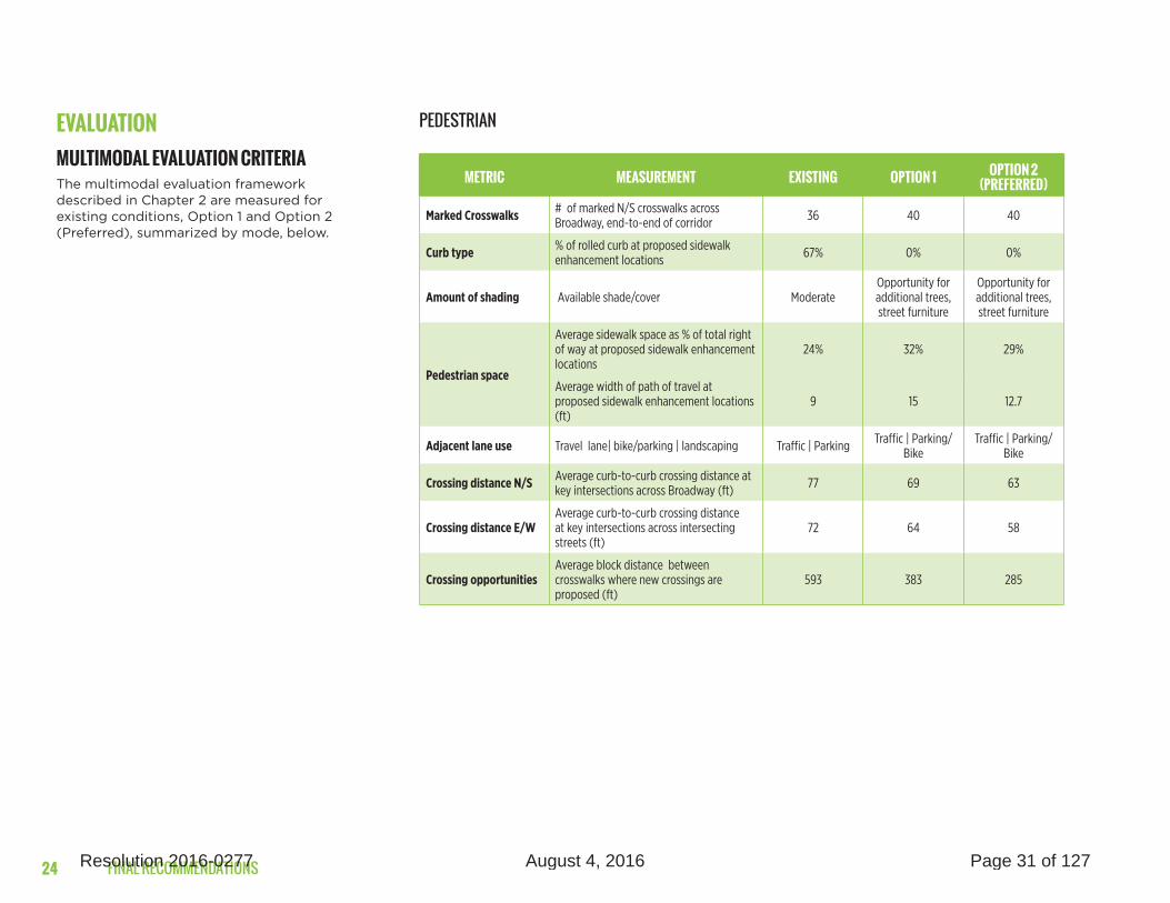
EVALUATIONMULTIMODAL EVALUATION CRITERIAThe multimodal evaluation framework described in Chapter 2 are measured for existing conditions, Option 1 and Option 2 (Preferred), summarized by mode, below.
METRIC MEASUREMENT EXISTING OPTION 1 OPTION 2 (PREFERRED)
Marked Crosswalks# of marked N/S crosswalks across Broadway, end-to-end of corridor 36 40 40
Curb type % of rolled curb at proposed sidewalk enhancement locations 67% 0% 0%
Amount of shading Available shade/cover ModerateOpportunity for additional trees, street furniture
Opportunity for additional trees, street furniture
Pedestrian space
Average sidewalk space as % of total right of way at proposed sidewalk enhancement locations
24% 32% 29%
Average width of path of travel at proposed sidewalk enhancement locations (ft)
9 15 12.7
Adjacent lane use Travel lane| bike/parking | landscaping Traffic | Parking Traffic | Parking/Bike
Traffic | Parking/Bike
Crossing distance N/SAverage curb-to-curb crossing distance at key intersections across Broadway (ft) 77 69 63
Crossing distance E/W
Average curb-to-curb crossing distance at key intersections across intersecting streets (ft)
72 64 58
Crossing opportunities
Average block distance between crosswalks where new crossings are proposed (ft)
593 383 285
PEDESTRIAN
24 Resolution 2016-0277 August 4, 2016 Page 31 of 127

BROADWAY STREET IMPROVEMENTS
METRIC MEASUREMENT EXISTING OPTION 1 OPTION 2 (PREFERRED)
Opportunities for bike
parking# end-to-end of corridor
Very minimal due to sidewalk
constraints
Available on proposed sidewalk
enhancement blocks
Available on proposed sidewalk
enhancement blocks
Connections to network # of cross streets with bike routes 5 13 13
Comfort & safety
Width of lane (ft) None or 5 6 6
% of route with dedicated bike lane 21% 100% 100%
% of route buffered None 85% 90%
Speed of adjacent lane 25-30 mph 25 mph 25 mph
BICYCLE
METRIC MEASUREMENT EXISTING OPTION 1 OPTION 2 (PREFERRED)
Stop amenities none | basic | enhanced None/minimum Basic Enhanced
Stop spacing Density of transit service on corridor Adequate No change No change
Connectivity # of new, direct connections | transfers N/AImproved at
Broadway Station (LRT)
Direct connection at Broadway Station (LRT)
Walking distance (ft) from WB bus stop to Broadway Station (LRT) 470 370 200
Reliability # of blocks with route in dedicated lane 0 0 2
TRANSIT
IMPROVING TRANSIT AS PART OF A COMPLETE STREET• Over time, opportunities for sidewalk
expansion can be explored on blocks as appropriate. The Broadway Complete Streets Plan designs allow for conversion of the parking lane to an expanded sidewalk to create space for better bus amenities, landscaping, sidewalk dining, and other urban design elements.
• The bus boarding island treatment at 19th Street/Riverside Boulevard can be reproduced at other stop locations where warranted and appropriate right of way exists. This design would likely require removing the two-way left turn lane or other turn pockets, and will require signal modifications if bus queue jumps are desired.
• Buses will continue to make their stops curbside in bus stop zones as they do currently (with the exception of the new 19th St transit boarding islands). With the bus stopped curbside, vehicles will still be able to pass in the travel lane. It will be necessary to evaluate traffic congestion, bus travel times and frequencies, as well as ridership to ensure ongoing performance and protection for transit and other modes as the project progresses.
• Although this Plan includes suggested locations for key features, specific design features for elements such as bulbouts and traffic islands will be further examined during the final engineering design phase. This may result in refinements to the number and spacing along the corridor, as well as the size in order to maximize accessibility along the corridor as well as safety at each location while still accommodating emergency vehicle access and buses where needed.
25Resolution 2016-0277 August 4, 2016 Page 32 of 127

FINAL RECOMMENDATIONS
METRIC MEASUREMENT EXISTING OPTION 1 OPTION 2 (PRE-FERRED)
Connection to adjacent
usetype/character of setback Poor Improved Improved
Comfort & safety pedestrian-oriented lighting None Improved Improved
Amount of activity
spaces opportunities for programmed space Limited Improved with
landscapingImproved with
landscaping
URBAN DESIGN
» For the most part, the concepts recommended in Option 1 and Option 2 do not call for specific urban design treatments; rather, there are opportunities to implement improvements for connections to adjacent uses, comfort, safety, and activity spaces throughout the corridor
» A detailed discussion about urban design recommendations and opportunities is presented in Chapter 4
METRIC MEASUREMENT EXISTING OPTION 1 OPTION 2 (PREFERRED)
AM Peak Travel Time (WB)
Minutes, of travel time across corridor, from west of 5th St. to east of Franklin Blvd.
8.4 8.4 8.4
AM Peak Travel Time (EB) 7.4 8.4 8.4
PM Peak Travel Time (WB) 9.7 9.7 9.7
PM Peak Travel Time (EB) 8.4 9.7 9.7
AM Peak Delay Average seconds of delay at key intersections
29.2 25.6 25.6
PM Peak Delay 24.4 33.4 33.4
Turn opportunities Change in dedicated left turn opportunities Frequent No change No change
On-Street Parking Change in on-street parking supply Ample No change No change
TRAFFIC/ AUTO
26 Resolution 2016-0277 August 4, 2016 Page 33 of 127

BROADWAY STREET IMPROVEMENTS
METHODOLOGYTo monitor the performance of auto traffic within the study area, an analysis was conducted which focused on the traffic operations of 32 intersections both on Broadway and adjacent to the study area. Special consideration was taken to monitor how the reduction in travel lanes on Broadway may cause some traffic to divert to parallel streets, especially W Street, X Street and 2nd Avenue during peak commute hours.
The City of Sacramento is currently conducting a Downtown Transportation Study that is defining a comprehensive multi-modal transportation network for the street grid that serves Downtown and Midtown. A Preferred Network has been defined that includes the proposed Broadway Complete Streets Plan and conversions of a number of one-way streets in the study area. The changes in the Preferred Network include:
1. 16th Street between Broadway and X Street converted from three northbound lanes to two northbound lanes and one southbound lane
2. A new one-way southbound street connecting X Street to Broadway at the southbound on-ramp to SR 99
Another key project that will influence travel patterns in the study area is the proposed new Sacramento River Crossing that is included in the 2016 Metropolitan Transportation Plan / Sustainable Community Strategy (MTP/SCS). Consistent with the assumptions used by SACOG for the MTP/SCS, this 2036 analysis includes a new bridge that extends from the western end of Broadway to South River Road in West Sacramento. It was assumed that the new River Crossing would be connected to W Street and X Street and that Broadway would not connect directly to new River Crossing.
Traffic counts were conducted in 2015 at the study intersections and were used to analyze traffic operation under existing conditions. SACOG’s regional travel demand model (SACSIM) was used to predict the changes in travel demand and traffic patterns under the other scenarios. The 2036 traffic forecasts are based on the SACOG’s 2036 development estimates for the 2016 Metropolitan Transportation Plan / Sustainable Community Strategy (MTP/SCS).
For signalized and unsignalized intersections, operational analyses were conducted using a methodology outlined in the Transportation Research Board’s Highway Capacity Manual (HCM). This procedure calculates an average control delay per vehicle for each movement at an intersection, and assigns a level of service (LOS) letter grade designation. More information on the traffic model and HCM methodology can be found in the Technical Appendix.
ANALYSIS SUMMARYFigures x and x summarize the peak PM hour levels of service for the existing conditions and existing with the implementation of Broadway Option 2. More details regarding the predicted travel demand model for 2026 can be found in the Technical Appendix. A summary of the traffic analysis shows that:
» All of the study intersections currently operate at LOS D or better conditions during the AM and PM peak hours on a typical weekday for both the existing and existing plus plan conditions
» Some intersections are projected to improve in operation due to one to two-way operation changes, shifts in travel patterns, and signal timing changes
» The road diet on Broadway, coupled with a proposed new one-way southbound street connecting X Street to Broadway at the southbound on-ramp to SR 99, would divert some Broadway traffic to W Street and X Street, especially under 2036 conditions. The changes in levels of service at most study intersections due to Broadway Complete Streets Plan are projected to be modest.
» The only location where the proposed Broadway Complete Streets Plan would cause LOS F conditions is the intersection of Broadway with 19th Street/Freeport Boulevard during the PM peak hour under 2036 conditions. It should be noted that the 2036 development forecasts prepared by SACOG assumed a significant increase in college enrollment at Sacramento City College on Freeport Boulevard, which results in a significant traffic increase on 19th Street and Freeport Boulevard.
QUEUING ANALYSISTo assist the preliminary design for the Broadway Complete Streets Plan, the model was used to estimate queuing along Broadway with the Plan with a focus on queues in left-turn lanes on Broadway at its signalized intersections.
The proposed design for the Broadway Complete Streets Plan calls for a continuous two-way left turn lane on most of Broadway, which allows access to driveways as well as unsignalized cross-streets. The analysis indicates that during peak hours the traffic queues for the through travel lanes along Broadway at many of its signalized intersection will extend for most of a block. Some motorists could choose to use a portion of the continuous two-way left turn lane to access the left-turn lane at the down-stream traffic signal or wait in the through-lane traffic queue until they are close to the signal. The length of each left turn
27Resolution 2016-0277 August 4, 2016 Page 34 of 127

FINAL RECOMMENDATIONS
pocket can be adjusted for demand at particular intersections and consideration for the need for a two-way left turn lane.
The Synchro analysis software indicates that the queues at left-turn lanes along Broadway at its signalized intersections will be “metered” by the queues in the through lanes along Broadway. Thus the estimated queue lengths in the left-turn lanes at signalized intersections are modest.
TRAVEL TIME ANALYSISThe model was also used to estimate the change in travel times along Broadway from west of 5th Street to east of Franklin Boulevard. The model accounts for delays at signalized intersections, queuing delays, as well as general travel time moving along the corridor. It should be noted that travel time estimates used in this model are not as accurate as those provided by a simulation model. The analysis indicates that implementation of the Broadway Complete Streets Plan would result in a modest increase in eastbound travel times and no change in westbound travel time under existing conditions.
PUBLIC ENGAGEMENT This project was structured around a robust public outreach process at each stage of analysis, concept development and evaluation. The recommendations presented in this report are informed by input from the community, along with the technical stakeholders and the City team.
OUTREACH ACTIVITIES » Walking audit & neighborhood flyering
» 3 rounds of outreach
– Spring 2015: mobile workshops at lunch and evening hours throughout the corridor
– Fall 2015: public workshop with over 65 in attendance & meetings
– Winter 2016: public workshop with over 60 in attendance & meetings
» Online and printed surveys distributed in sum-mer and fall of 2015 with over 200 community member responses
28 Resolution 2016-0277 August 4, 2016 Page 35 of 127

BROADWAY STREET IMPROVEMENTS
WHAT WE HEARDPriorities for improvements:
» Pedestrian and bicycle safety and comfort
» Lane reduction, traffic calming
» Streetscape improvements
Responses to concepts
» Full-length road diet enjoys great support due to safety and accessibility improvements Support for pedestrian and bicycle enhancements
» Support for overall road diet concept
» Focus on benefits:
» Shorter pedestrian crossings
» Dedicated bike lanes with buffer
» Slower, calmer traffic
» Concerns identified:
» Safety at pedestrian crossings and bike-vehicle mixing zones
» Potential conflict between bikes and right turning vehicles
» Traffic delay and diversions (minimal or manageable)
» Possible reductions in parking access (manageable)
» Access to/impacts on businesses along the corridor
29Resolution 2016-0277 August 4, 2016 Page 36 of 127

FINAL RECOMMENDATIONS
FIGURE 19 SURVEY RESULTS – SUMMARY OF COMMENTS ON THE ROAD DIET CONCEPT
Likes Bike & Pedestrian Enhancements
46%
Likes Overall Concept
43%
Likes Turning Lane Improvements
6%Likes Improved Safety
3%Likes Road Diet Concept
2%
30 Resolution 2016-0277 August 4, 2016 Page 37 of 127

BROADWAY STREET IMPROVEMENTS
URBAN DESIGN Placemaking Strategies for the Broadway Corridor
Urban design goals detailed on the following pages aim to create a distinguished identity befitting a grand avenue. Placemaking concepts for the street emphasize its character and celebrate historic resources such as the Tower Theater and the City Cemetery. Streetscape elements illustrated in this chapter suggest styles and materials that relate to the greater vision for Broadway as a safe and comfortable multi-modal street. Urban design typologies and photo simulations demonstrate how streetscape elements could be incorporated into the corridor design implementation.
04
31Resolution 2016-0277 August 4, 2016 Page 38 of 127

FINAL RECOMMENDATIONS
URBAN DESIGN PRINCIPLES
01 SENSE OF PLACE AND IDENTITY The Broadway Corridor is a unique, historic street in Sacramento, just on the edge of the downtown districts. Its history should be celebrated and manifested in its urban design character. The quality and character of the placemaking strategies should reflect the historic, electric identity of the corridor. From industrial land uses, to a historic theater landmark, to new retail and restaurants, Broadway is home to a variety of uses, neighborhoods, and historic resources that create a unique identity.
» Enhanced Character Elements: Character elements on Broadway including architecturally significant structures and signage should be preserved and enhanced as they contribute to a strong identity for the corridor. New planting and furnishing should emphasize these features, reinforce view corridors, and allow opportunities to admire these features.
» Gateway Elements: Introducing gateway elements at significant points on the corridor will create impactful interventions that give the street a stronger identity. Gateway elements can include pedestrian and vehicular signage, colored and/or patterned crosswalk pavement, sculptural elements, unique planting and furnishing.
» Celebration of History: The historic aspects of Broadway should be celebrated as visual elements along the corridor. Interventions might include interpretive signage, murals on walls along the corridor, etc. This would be particularly impactful near Tower Theater as it is a place with rich history and a current source of positive identity.
» Distinct Character Zones: The distinct character zones that broadly comprise the corridor include the Marina District, the Tower District and the Upper District. In the Marina District, industrial heritage should be recognized, including current light industrial uses and historic cemetery. The Tower District, as mentioned previously, should celebrate the historic Tower Theater. The Upper District, dominated by public and institutional uses could use clear signage for pedestrians and vehicles to enhance visibility.
» Unique Streetscape Elements and Programming: Sense of place along the corridor can be accomplished through unique streetscape design interventions. Streetscape elements can include: sculptures, activated building frontages, furniture and planting. Enhanced streetscape elements placed strategically in distinct character zones can highlight several of the goals mentioned above.
32 Resolution 2016-0277 August 4, 2016 Page 39 of 127

BROADWAY STREET IMPROVEMENTS
URBAN DESIGN PRINCIPLES
02 SAFETYDesigning with safety in mind is integral for the success of the Broadway Corridor. With a safe corridor comes a level of comfort for all users. Streetscape elements selection should keep in mind principals of safety including visibility, sidewalk capacity and interface with transit.
» Visibility: Visibility is one of the key principals of safety. Pedestrians and bicyclists should be legible to motorists on the Broadway Corridor through several interventions including lighting. Street lights provide an opportunity for visibility, illuminating and a consistent element along the length of Broadway. Street lights illuminate the sidewalk area for pedestrians.
» Street Width Capacity: While street width capacity is detailed in other chapters of this document, it is an importance emphasis of the urban design. When designing sidewalk widths that include street furniture and planting, it is important to consider street width minimums related to sidewalk capacity for pedestrian travel.
» Crosswalks: Creating a visible crosswalk could assist in creating a safe environment for all modes of transit. Additionally, creating legible and visually unique crosswalks establish a vocabulary for identity.
» LRT Interface: Urban design and safety are particularly important at the LRT station at Broadway. Features including transit shelters, planting, and crosswalks could assist in creating a safer transit experience.
33Resolution 2016-0277 August 4, 2016 Page 40 of 127

FINAL RECOMMENDATIONS
URBAN DESIGN PRINCIPLES
03 URBAN ECOLOGY Broadway is near several parks and historic open spaces and the street itself should reflect the intent of larger ecological goals for the community. The urban ecology of the Broadway Corridor could contribute to the greater Sacramento open space network.
» A Healthy Urban Forest: Street trees along Broadway should be selected and cared for as part of an urban forest. Factors such as fruit and leaf clean-up, surfical roots, and shade should contribute to tree selection. It is important to draw from a list of trees that have successfully thrived in the region. Benefits of an urban forest include shade, combatting the urban heat island effect, and carbon sequestration. Trees also help with stormwater management because of their ability to absorb water.
» Stormwater Management: Extended sidewalks and bulbouts allow opportunities to incorporate stormwater management into the streetscape design. Creating resilient landscapes along the corridor foster a richer ecology and emphasize this streetscape as part of an ecological infrastructure.
34 Resolution 2016-0277 August 4, 2016 Page 41 of 127

BROADWAY STREET IMPROVEMENTS
URBAN DESIGN PRINCIPLES
04 COMFORT AND QUALITY OF SPACE The comfort and quality of urban design interventions along Broadway are vital to its realization as a complete street. Several streetscape elements contribute to a comfortable environment for pedestrians and bicyclists and encourage people from surrounding neighborhoods to walk and bike to Broadway.
» Shade: Currently, Broadway’s tree canopy is minimal in several areas, making it inhospitable for pedestrians in extreme climate conditions. Providing more shade by introducing more trees or shade structures along the corridor could help create a more hospitable sidewalk zone for pedestrians.
» Sidewalk Zones: Activation of sidewalk zones in the form of outdoor cafes, pop up retail and gallery spaces and parklets suggest a variety of activities along the corridor that create visual and programmatic interest.
» Seating: Outdoor seating provides areas of respite for pedestrians. Strategic placement of seating at intersections and bus shelters will provide opportunities for seating in high traffic zones.
» Bicycle Parking: As bicycle lanes have been planned for the length of Broadway, bicycle parking is an important element that contributes to the comfort of its users. Several types of bicycle parking should exist along the corridor in order to provide safe and secure parking.
» Bus and LRT Shelters: Bus lines exist along the corridor and at several cross streets in the area, as well as the LRT station near Broadway between 19th and 20th Street. Urban design interventions should take this into account, planning for bus and LRT shelters that reflect the larger design intent and create a comfortable area for pedestrians.
Frontage Zone
Pedestrian Zone
Public Amenity Zone
FIGURE 20 SIDEWALK ZONES SHOW VARIOUS IMPROVEMENTS THAT CONTRIBUTE TO PEDESTRIAN COMFORT.
35Resolution 2016-0277 August 4, 2016 Page 42 of 127
FINAL RECOMMENDATIONSFINAL RECOMMENDATIONS
URBAN DESIGN PRINCIPLES
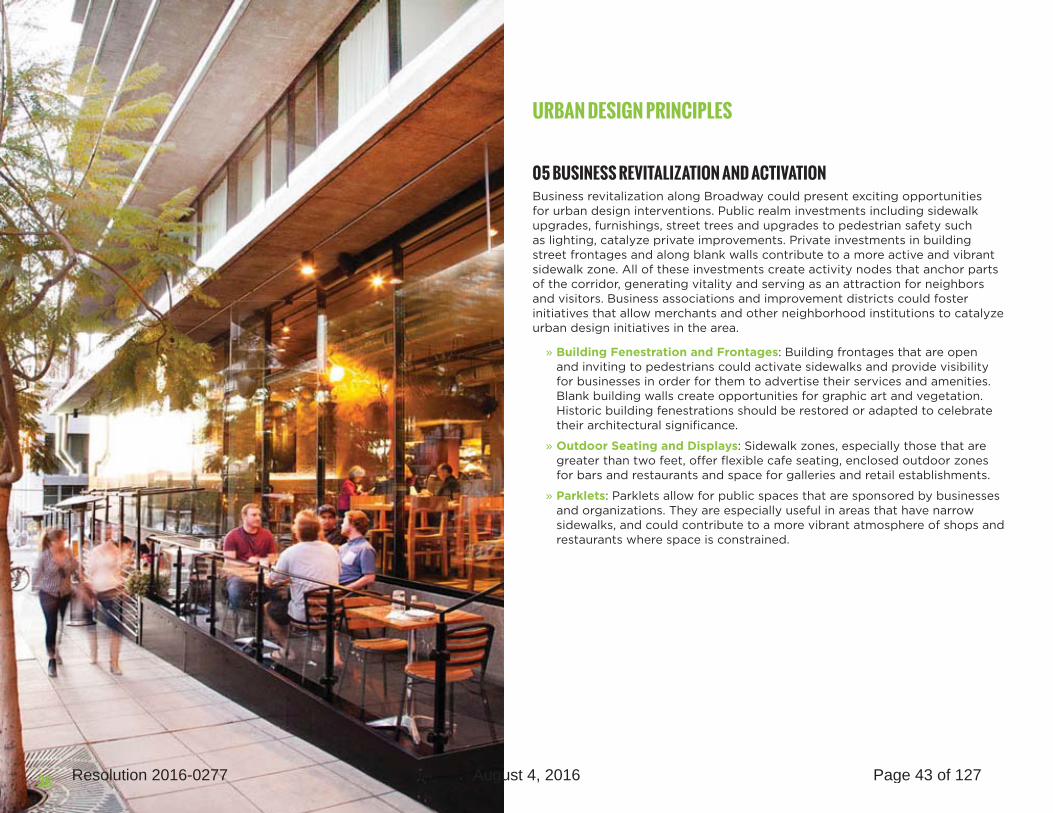
05 BUSINESS REVITALIZATION AND ACTIVATION Business revitalization along Broadway could present exciting opportunities for urban design interventions. Public realm investments including sidewalk upgrades, furnishings, street trees and upgrades to pedestrian safety such as lighting, catalyze private improvements. Private investments in building street frontages and along blank walls contribute to a more active and vibrant sidewalk zone. All of these investments create activity nodes that anchor parts of the corridor, generating vitality and serving as an attraction for neighbors and visitors. Business associations and improvement districts could foster initiatives that allow merchants and other neighborhood institutions to catalyze urban design initiatives in the area.
» Building Fenestration and Frontages: Building frontages that are open and inviting to pedestrians could activate sidewalks and provide visibility for businesses in order for them to advertise their services and amenities. Blank building walls create opportunities for graphic art and vegetation. Historic building fenestrations should be restored or adapted to celebrate their architectural significance.
» Outdoor Seating and Displays: Sidewalk zones, especially those that are greater than two feet, offer flexible cafe seating, enclosed outdoor zones for bars and restaurants and space for galleries and retail establishments.
» Parklets: Parklets allow for public spaces that are sponsored by businesses and organizations. They are especially useful in areas that have narrow sidewalks, and could contribute to a more vibrant atmosphere of shops and restaurants where space is constrained.
36 Resolution 2016-0277 August 4, 2016 Page 43 of 127

BROADWAY STREET IMPROVEMENTS
URBAN DESIGN DISTRICTS + CORRIDOR CHARACTER
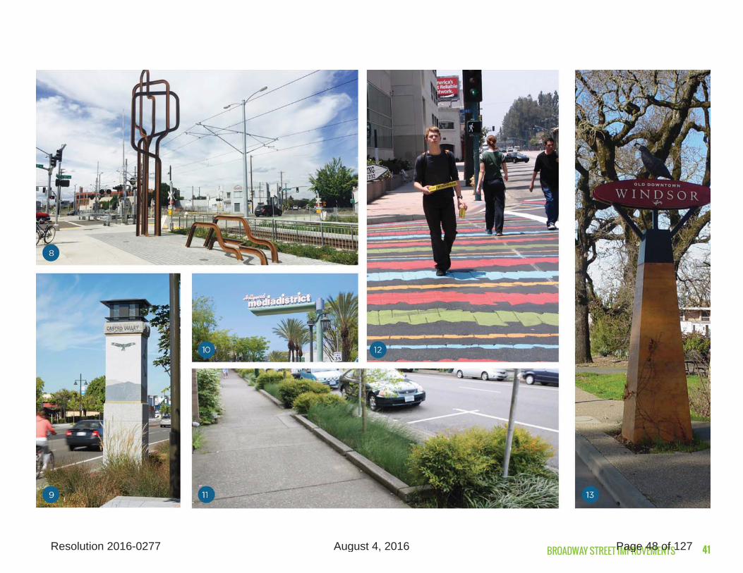
The Broadway Corridor is made up of three distinct districts: the Marina District, the Tower District and the Upper District. While each of these districts has a unique character, the urban design of Broadway should also create a strong, legible corridor that attracts citywide and even regional visitors while serving neighborhood residents and businesses. A standard furnishing foundation including benches, trash cans, street trees and lighting should exist consistently along the entire corridor. Additionally, the scale of the street should be taken into consideration. Designing at a larger scale will reinforce Broadway’s historic past as a grand boulevard. A level of grandeur could be
emphasized by preserving existing vistas and view corridors and introducing a consistent allée of large trees when possible.
In addition to a corridor wide vocabulary of standard streetscape elements, enhanced streetscape elements allow each individual district to display distinct character through changes in paving, crosswalk colors, furnishing and storefront activation. Gateway elements, public art and interpretive signage could also create a sense of place that demonstrates the history and unique land uses that each district has to offer.
37Resolution 2016-0277 August 4, 2016 Page 44 of 127

FINAL RECOMMENDATIONS38 Resolution 2016-0277 August 4, 2016 Page 45 of 127

BROADWAY STREET IMPROVEMENTS 39Resolution 2016-0277 August 4, 2016 Page 46 of 127

FINAL RECOMMENDATIONS40 Resolution 2016-0277 August 4, 2016 Page 47 of 127
BROADWAY STREET IMPROVEMENTS 41Resolution 2016-0277 August 4, 2016 Page 48 of 127

FINAL RECOMMENDATIONS42 Resolution 2016-0277 August 4, 2016 Page 49 of 127

BROADWAY STREET IMPROVEMENTS 43Resolution 2016-0277 August 4, 2016 Page 50 of 127

FINAL RECOMMENDATIONS
The sidewalk widths on Broadway vary block by block through the corridor and more described more fully in the existing conditionsl technical appendix. The following pages detail typologies for a 6’ sidewalk, which mostly exist between 6th Street and Riverside Boulevard, 15’ sidewalks which exist near the LRT station and 8-10’ sidewalks which exists in most other areas of the corridor. Each sidewalk width presents different design opportunities and constraints.
URBAN DESIGN TYPOLOGIES [6’ SIDEWALK]
While a 6’ sidewalk may seem limiting for urban design interventions, not all elements require a wide sidewalk. Most 6’ sidewalks are between 6th street and Riverside Boulevard on Broadway. Basic elements that could be placed on this sidewalk include street lights and narrow planters. Businesses with street frontage could provide awning for shade. Where a blank wall exists, visual interest including a green wall or a graphic symbol could enhance the sidewalk experience. Where a narrow sidewalk exists, bicycle parking, parklets and other appropriate amenities can exist on the street adjacent to the sidewalk and still provide benefits for users.
A 6’ sidewalk with planters and overhang.
44 Resolution 2016-0277 August 4, 2016 Page 51 of 127

BROADWAY STREET IMPROVEMENTS 45Resolution 2016-0277 August 4, 2016 Page 52 of 127

FINAL RECOMMENDATIONS
URBAN DESIGN TYPOLOGIES [8-10’ SIDEWALK]
While an 8-10’ sidewalks is not a significant increase in width, it allows for some significant changes to the sidewalk section. The average sidewalk width is between 8-10’ along Broadway. The minimum allowable width for a street tree should be no smaller than 4’ of the sidewalk width. In this section, single bicycle racks can be placed on the sidewalk between street trees. Businesses could place informal seating that does not exceed 3’ of sidewalk width. Fenestration including awnings are encouraged in this street section. Bicycle parking and parklets outside of the sidewalk zone are encouraged in this section as they can allow for greater sidewalk capacity.
Parklets are a good option for extending sidewalk public space.
46 Resolution 2016-0277 August 4, 2016 Page 53 of 127

BROADWAY STREET IMPROVEMENTS 47Resolution 2016-0277 August 4, 2016 Page 54 of 127

FINAL RECOMMENDATIONS
URBAN DESIGN TYPOLOGIES [15’+ SIDEWALK]
A sidewalk that is 15 feet or more exists around the LRT Station from 18th to 21st Street. Not only does this section allow for a wider pedestrian zone, it also allows for larger shade trees. Additionally, furniture such as benches and trash cans can be introduced to the sidewalk zone. A wider street also allows businesses to inhabit a greater outdoor flexible space that could be used for seating or a sidewalk gallery.
A wide sidewalk allows for various amenities including seating and street trees.
48 Resolution 2016-0277 August 4, 2016 Page 55 of 127

BROADWAY STREET IMPROVEMENTS 49Resolution 2016-0277 August 4, 2016 Page 56 of 127

FINAL RECOMMENDATIONS
URBAN DESIGN POTENTIALS TOWER GATEWAY Currently, public space around the Tower Theater does little to hint at its storied past. In the photosimulation above, the art deco architecture of the theater manifests in pavement patterns around the bulbout intersections. New furnishing and other elements branded with the Tower District give the intersection an identity. Additionally, a sculpture and small plaza in the bulbout adjacent to the Tower Theater create a gateway marker for the district. Crosswalk interventions create identity and also provide legibility for pedestrians.
DESIGN DETAILS• Design details address specific features for
landscaping, sidewalk styles, and colored crosswalk treatments, and are subject to approval by City engineers. Currently, the Manual of Uniform Traffic Control Devices (MUTCD) Official Ruling 3(09)-24(I) regulates the use of decorative crosswalk paint, but discussions in the traffic engineering community have been ongoing regarding the use of experimental crosswalk treatments. Each jurisdiction is able to make their own decisions regarding the use and treatment of high-visibility crosswalk treatments on a case by case basis.
50 Resolution 2016-0277 August 4, 2016 Page 57 of 127

BROADWAY STREET IMPROVEMENTS
URBAN DESIGN POTENTIALS BROADWAY AND 18TH The interventions shown on Broadway and 18th Street imagine an intersection that combines a rich ecology with business revitalization and pedestrian amenities. The corner business spills over into the street, supported by amenities including benches and large shade trees. The planted bulbout provides visual and textural interest while shortening the crosswalk for pedestrians. This is another example of how urban design treatments can complement the transportation elements of a complete streets design for Broadway.
51Resolution 2016-0277 August 4, 2016 Page 58 of 127
FINAL RECOMMENDATIONS
URBAN DESIGN CASE STUDIESNOHO ARTS DISTRICT STREETSCAPE North Hollywood, CA
The NOHO Arts District Streetscape is composed of a series of streets including Lankershim Boulevard, a main street that is connected to an LA Metro stop. The land uses in the area are a mix of institutional, residential, restaurants, and theaters. The goals of this streetscape included realizing potential of interstitial spaces, strong connections to transit and creating an identity for the district. Various trees, street lights, furnishing, and signage have formed a unified corridor. A large sign that spans a main corridor in the NOHO arts district created a gateway that reflects the character for the district. Custom banner signs and crosswalks mark the corridors in the NOHO arts district as well. Recently, the NOHO plaza was built in an underutilized alley and includes flexible furniture and vibrant painted paving, resulting in a pocket park that provides a respite for transit riders and areas for informal meeting.
52 Resolution 2016-0277 August 4, 2016 Page 59 of 127

BROADWAY STREET IMPROVEMENTS
URBAN DESIGN CASE STUDIESNORTH PARK STREETSCAPE San Diego, CA
North Park is a neighborhood located northeast of downtown San Diego. Like the Broadway Corridor, the North Park District has several bus lines that traverse through it. Additionally, there are a number of historical landmarks including the North Park Theater. The existing fine grain street pattern fosters connectivity and promotes walkability. Streetscape improvements for the area include decorative tree grates, seating and shelters, and gateway signage. Architectural interventions include restored historic buildings and activated frontage areas with outdoor cafe and retail displays.
53Resolution 2016-0277 August 4, 2016 Page 60 of 127

FINAL RECOMMENDATIONS
URBAN DESIGN CASE STUDIESCASTRO VALLEY BOULEVARD Castro Valley, CA
The redesign of Castro Valley Boulevard, a former state highway and large, traffic-dominated thoroughfare, created a new pedestrian-friendly retail main street and town center for this established Alameda County, California community. The design combined pedestrian enhancements such as bulb-outs, pedestrian-scaled lights, gateway elements, furnishing and bicycle parking with highly crafted elements that convey the community’s unique identity. Travel and parking lane widths are sized to facilitate safe flow of cars, to calm traffic, and to be in balance with other modes of travel. Bicycle lanes enhance access to local businesses. Sustainable measures were employed as well, such as capturing and filtering storm water to prevent erosion of nearby creeks and pollutants from entering the bay.
54 Resolution 2016-0277 August 4, 2016 Page 61 of 127

BROADWAY STREET IMPROVEMENTS
PHASING AND IMPLEMENTATION Elements of this plan are intended to enhance mobility and livability position this project for grant funding. In some cases, funding may be correlated with elements of implementation, i.e. striping, sidewalk enhancements and street trees. However, funding may be available to complete the entire length or select segments. This plan identifies two general phases: near term and long term implementation. These phases are based on available sources of funding and amount of budget resources to complete the project.
» Near Term Opportunities: Several aspects of the Broadway Streetscape design can be implemented immediately and over the next several years.
» Pilot Road Striping: In several areas of the corridor, new striping can be introduced as a pilot project in order to incorporate bicycle lanes, legible crosswalks, etc. It also presents a near term opportunity if street repaving is necessary.
» Green Walls and Graphic Art: Interventions at existing buildings including murals, graphic art and green walls can be implemented in the near term by building owners and merchants.
» Parklets and On-Street Bicycle Parking: A parklet program can be implemented immediately as they can be designed and installed in existing parking spaces. Additionally, on-street bicycle parking can be installed in existing parking spaces.
» Future Implementation: Streetscape construction may need to take place over several phases due to the cost of infrastructure and complete streets implementation. Construction of the streetscape could happen in segments in order to create less disruption for the community, merchants and residents. Creating phases based on districts outlined in previous sections provides logical areas for implementation. Streetscape construction should occur in order of community priority and opportunity: the Tower District, the Marina District and the Upper District.
» Tower District: As the Tower District is the most defined district, the construction in this area is a logical early phase to revitalize the corridor and build off existing resources and success. In addition to the interventions mentioned in the Upper and Marina Districts, the Tower District also includes potential gateway elements and signage, potentially decorative paving, site walls and distinct furnishing and mobility enhancements around the LRT station.
» Marina District: The Marina District has the greatest level of potential development and change as well as some of the narrowest sidewalks. This phase will include sidewalk widening and bulbouts, new pedestrian crossings, key intersection interventions at Riverside Boulevard and standard streetscape elements and furnishing along its length.
» Upper District: The employment centers in the Upper District have the highest traffic volume and need for walkability. The Upper District interventions also include sidewalk extensions and bulbouts, new pedestrian crossings and standard streetscape elements and furnishings.
The first phase in the Broadway and 18th Street area could be furnishing, striping and related private investment with facade improvements. This phase can be completed at a lower cost if associated with normal street repaving.
The second phase in the Broadway and 18th Street area could include bulbouts, sidewalk enhancements, vegetation and street trees. It is important to coordinate between paving construction and tree planting, as irrigation lines and soil trenches for healthy roots can be established for optimal success.
The final phase includes additional streetscape furnishing. Higher levels of private investment in buildings come with this degree of public improvements.
PHASING EXAMPLE
55Resolution 2016-0277 August 4, 2016 Page 62 of 127

FINAL RECOMMENDATIONS56 Resolution 2016-0277 August 4, 2016 Page 63 of 127

BROADWAY STREET IMPROVEMENTS
PRELIMINARY COST ESTIMATES05
57Resolution 2016-0277 August 4, 2016 Page 64 of 127

FINAL RECOMMENDATIONS
APPROACH AND ASSUMPTIONSPreliminary estimates have been developed for the construction cost associated with the 10% concept designs for corridor improvements described in the Corridor Alternatives section of this report. These estimates are for construction costs only, and do not include elements such as right of way acquisi-tion, utility relocation, and various soft costs, project approvals, and City staff time.
To facilitate efficient implementation, estimates are provided for the following scenarios:
» First phase road diet as a precursor to either Option 1 or Option 2
» Road diet with Option 1 intersection improve-ments
» Road diet with Option 2 intersection improve-ments
FIRST PHASE ROAD DIETA First Phase Road Diet could be implemented with a focus on restriping and other low-impact interventions for a low construction cost and near-term phasing.
» Reconfigure vehicle and bicycle lanes on Broadway and improve pedestrian crossings with striping only
» Striping removal cost is included in the price of restriping
» Slurry seal is recommended to smooth the roadway surface after striping removal
» Traffic signals remain in place with minor signal timing updates and modification
Total construction cost for First Phase: approxi-mately $1.1 million
ROAD DIET - OPTION 1Road Diet – Option 1 implementation includes all of the striping and slurry seal improvements listed above, with additional construction costs for key intersection improvements.
» Maintain slip lane configuration at Riverside Boulevard and Land Park Drive, with raised crosswalks across slip lanes
» Expanded sidewalks on the north side of Broadway between 18th and 20th Streets
» Pedestrian treatments at the Broadway light rail station, including a raised intersection at 20th St
» Traffic signals remain in place with minor signal timing updates and modification
Total construction cost for Road Diet – Option 1: approximately $5.7 million
ROAD DIET – OPTION 2Road Diet – Option 2 implementation includes all of the striping and slurry seal improvements listed above, with additional construction costs for key intersection improvements.
» Remove slip lane at Riverside Boulevard and Land Park Drive and expand sidewalk space at the corners, bringing the intersections closer to square
» Bus boarding islands at the 19th Street RT stops adjacent to the Broadway light rail station
» Relocate traffic signals where slip lane modifi-cation requires different placement
Total construction cost for Road Diet – Option 1: approximately $6.5 million
The higher cost for Option 2 can be attributed to the following:
» Relocated signals due to removing islands at Riverside Boulevard and Land Park Drive
» Construction of larger, additional curb exten-sions at key intersections
Additional details about assumptions and line item costs are included in Appendix X.
58 Resolution 2016-0277 August 4, 2016 Page 65 of 127

BROADWAY STREET IMPROVEMENTS
FIGURE 21 COST ESTIMATES FOR OPTION 1
$-
$1.0
$2.0
$3.0
$4.0
$5.0
$6.0
$7.0
$8.0
$9.0
$10.0
Option 1 Option 2
Phase 1 Phase 2
59Resolution 2016-0277 August 4, 2016 Page 66 of 127

FINAL RECOMMENDATIONS
FIGURE 22 COST ESTIMATES FOR URBAN DESIGN ELEMENTS
ITEM UNIT COST PER UNITRain Garden EA $15,000
Enhanced Sidewalk Paving (Typical Intersection) EA $50,000
Street Lights Average Block $70,000
Furnishings (Bike Rack, Trash/Recycle, Bench) Average Block $2,700
Gateway Elements EA $25,000
Parklet EA $20,000
Transit Shelter (Custom) EA $35,000
Transit Shelter (Standard) EA $15,000
Enhanced Crosswalk Treatment (4 Per Intersection) EA $6,600
At Grade Planting (Typ Block) EA $6,750
Street Tree- Standard 24” Box (Grate, Planting Soil, Irrigation) EA $5,000
Street Tree-Accent Palm (Grate, Planting Soil, Irrigation) EA $15,000
60 Resolution 2016-0277 August 4, 2016 Page 67 of 127

BROADWAY STREET IMPROVEMENTS
FUNDING + IMPLEMENTATIONImprovements
The improvements discussed in this plan might not be implemented all at once, whether due to timeline, funding, or resource constraints. A combination of time and persistence, grant writing, collaborative partnerships, layering and leveraging of multiple funding sources might be necessary to bring the complete streets solutions for Broadway from concept to construction.
The most promising programs available to help fund the proposed improvements for the Broadway Corridor are identified below. They provide potential opportunities for roadway, sidewalk and streetscape improvements, traffic controls, and other infrastructure to support multi-modal access, safety and mobility, corridor enhancement and economic development.
06
61Resolution 2016-0277 August 4, 2016 Page 68 of 127

FINAL RECOMMENDATIONS
STATE AND REGIONAL FUNDING SOURCES The Sacramento Area Council of Governments (SACOG) is an association of local governments in the six-county Sacramento area that provides transportation planning and funding for the region. SACOG conducts programming rounds to allocate funds to projects based on available apportionments from federal and state sources, including regional Congestion Mitigation and Air Quality (CMAQ), Regional Surface Transportation Program (RSTP), State Transportation Improvement Program (STIP), and Active Transportation Program (ATP) funds. These funds are distributed to member agencies through Regional ATP, Air Quality, Regional Bicycle & Pedestrian Funding Program (BPFP), Community Design, Transportation Demand Management (TDM) and Regional/Local Funding Programs.
ACTIVE TRANSPORTATION PROGRAM (STATEWIDE)Pursuant to California Senate Bill 99 (Chapter 359, Statutes of 2013) and Assembly Bill 101 (Chapter 354, Statutes of 2013), the Active Transportation Program (ATP) was created to fund bicycle and pedestrian infrastructure and non-infrastructure projects. The ATP combines many federal and state funding streams previously used for bicycle, pedestrian, safety, and other related purposes into one funding stream with broad eligibilities.
Eligible applicants include cities, counties, MPOs, transit agencies, natural-resource or public-lands agencies, tribal governments, private nonprofit tax-exempt organizations, and public schools or school districts.
Eligible projects for ATP funding include:
» Infrastructure – capital improvements, including planning, design and construction.
» Non-infrastructure – education, encouragement, enforcement and planning activities that further the program’s goals.
» Combined Infrastructure and non-infrastructure activities.
» Plans, which must be stand alone.
Eligible examples include the development of bikeways and walkways, installation of traffic-control devices and lighting that improves safety for non-motorists, bike-share programs, bike-carrying facilities on public transit, bike parking and storage facilities, landscaping that improves bicycle-and pedestrian safety and convenience, trails that serve a transportation purpose, projects that improve the safety of non-motorized students, and education programs to increase walking and biking.
REGIONAL ACTIVE TRANSPORTATION PROGRAM (ATP) AND REGIONAL BICYCLE AND PEDESTRIAN FUNDING PROGRAM (BPFP)In 2015, SACOG consolidated the regional MPO component of the ATP with the Regional Bicycle and Pedestrian Program to enable applicants to efficiently and effectively apply to both programs (if applicable).
The Regional ATP targets projects that increase walking/biking, improve safety, and benefit disadvantaged communities. The Regional BPFP concentrates on project performance to implement the Region’s Metropolitan Transportation Plan/Sustainable Communities Strategy (MTP/SCS). Together, the programs strive to improve the region’s active transportation system, air quality, and overall quality of life.
Funds can be used for construction, as well as preliminary engineering, which includes environmental work and design, as well as for right-of-way phases. Non-infrastructure projects include bicycle and pedestrian planning, education, information, Safe Routes to School Programs, and marketing efforts.
SACOG COMMUNITY DESIGN GRANTSThe Community Design Funding Program provides financial assistance to local government agencies seeking to implement physical development that is consistent with SACOG’s Blueprint Principles. Approximately every two years, SACOG accepts applications for projects from cities, counties, transit districts and air districts from Sacramento, Sutter, Yolo and Yuba Counties.
The Blueprint Principles are:
» Transportation Choices
» Housing Diversity
» Compact Development
» Use of Existing Assets
» Mixed Land Uses
» Quality Design
» Natural Resource Conservation
SACOG REGIONAL LOCAL FUNDING PROGRAMThe Regional/Local Program is SACOG’s largest competitive program. The emphasis of the program is to fund projects that will help implement the MTP/SCS by providing regional benefits.
62 Resolution 2016-0277 August 4, 2016 Page 69 of 127

BROADWAY STREET IMPROVEMENTS
STATE AFFORDABLE HOUSING AND SUSTAINABLE COMMUNITIES PROGRAMThe California Strategic Growth Council’s Affordable Housing and Sustainable Communities Program (AHSC) awards funds, through a competitive application process, for land-use, housing, transportation and land-preservation projects to support infill and compact development that reduces greenhouse gas emissions. Funded by State cap-and-trade emissions reduction auction proceeds, this program provides a major new source of funding for infill, mixed-use, transit-oriented development
and multimodal-transportation infrastructure capital projects and programs.
The program specifies three types of eligible project areas:
» Transit-Oriented Development projects within one-half mile of high-quality (high frequency) transit
» Integrated Connectivity Projects in areas with at least one transit station or stop that has sustainable transportation infrastructure to induce mode shift, and at least one additional capital or program use
» Rural Innovation Project Areas, which are the same as Integrated Connectivity Projects, but lack high-quality transit service, and are located in rural areas
The following table summarizes the funding programs that are administered by SACOG and programs administered by the State that are possible candidates for funding elements of the Broadway Complete Streets Plan. Additional details are included in the [funding technical appendix].
FUNDING PROGRAM
STATE ACTIVE TRANSPORTATION
PROGRAM
REGIONAL ACTIVE TRANSPORTATION
PROGRAM
BICYCLE &PEDESTRIAN
FUNDINGPROGRAM
COMMUNITYDESIGN FUNDING
PROGRAM
REGIONAL/LOCALFUNDING
PROGRAM
STATE AFFORDABLE HOUSING AND SUSTAINABLE
COMMUNITIES PROGRAM
Administrator Caltrans Sacramento Area Council of Governments (SACOG) SACOG SACOGDept. of Housing and Community Development (HCD)
Purpose
Encourage increased use of active modes of transportation through walking/biking infrastructure improvements and programs.
The Regional ATP targets projects that increase walking/biking, improve safety, and benefit disadvantaged communities. The Regional BPFP concentrates on project performance to implement the MTP/SCS. Together, the programs strive to improve the region’s active transportation system, air quality, and overall quality of life.
Physical implementation of SACOG Blueprint principles (compact development, mixed of land uses, transportation options, etc.)
Implement the MTP/SCS by providingRegional benefits.
Projects that reduce GHG emissions and VMT through land use, housing, transportation, and agricultural land preservation practices that support infill development
Funding Levels $250,000 min. No max. Infrastructure: $250,000 min. Programs: $50,000 min. No max.
Capital projects:$250,000 min. forPre-construction-only projects:$150,000min. Non-capitalprojects: $50,000 min. No max.
Categories: 1) Conventional:$300,000 to $4 million;Pre-construction$150,000-$500,000.2) CompleteStreets focus:$1.5 million-$4 million. 3) Non Competitive: max $100,000.
Capital projects do not have min or max project size.
$500,000 min. $20 million max.
FIGURE 23 SUMMARY OF STATE AND REGIONAL FUNDING PROGRAMS
63Resolution 2016-0277 August 4, 2016 Page 70 of 127

FINAL RECOMMENDATIONS
LOCAL FUNDING STRATEGIES In addition to the grant and funding programs identified above, the City may want to explore opportunities for funding Broadway improvements through the City’s Capital Improvement Program or a financing district, whether directly or as a means to providing local match for some of the sources above. This can be seen as a way to advance select project elements and/or to leverage and extend the benefit of local dollars.
CITY CAPITAL IMPROVEMENT PROGRAMThe 2015-2020 Transportation Program contained within the City’s overall 5-year Capital Improvement Program (CIP) is designed to optimize the use of available local funds by leveraging state and federal funds to achieve the City’s transportation priorities. Pedestrian and bicycle projects are in the Transportation Program to reflect the importance of those modes of travel as part of the overall transportation network.
The Transportation Program allocates funding to seven major subprogram areas shown in Figure 8. Funds are secured from multiple sources, such as the Federal Highway Safety Improvement Program, State Transportation Development Act, State Gas Excise Tax, County Measure A Transportation Sales Tax, City Major Street Construction Tax, and the City Landscaping and Lighting and Assessment District.
FIGURE 24 CITY OF SACRAMENTO TRANSPORTATION PROGRAM FUNDING
64 Resolution 2016-0277 August 4, 2016 Page 71 of 127

BROADWAY STREET IMPROVEMENTS
Projects and programs within the Major Streets, Traffic Operations and Safety, Street Maintenance and Community Enhancements subprogram areas could be scrutinized for potential near-term sources to help fund Broadway improvements. In addition, a new project proposal could be developed to help implement future improvements for consideration in the City CIP review process.
ENHANCED INFRASTRUCTURE FINANCING DISTRICTThe formation of an Enhanced Infrastructure Financing District (EIFD) could present a long-term strategy for funding improvements on the Broadway corridor and elsewhere in the city. Authorized by state legislation in 2014, an EIFD may be created by a city or county to collect tax increment revenues to finance improvements. Entities participating in an EIFD can include cities, counties and special districts, but not schools.
Infrastructure projects that can be financed through an EIFD include new construction and rehabilitation. Facilities don’t need to be located within the EIFD boundaries, but they must have a tangible connection to the EIFD’s work as detailed in its infrastructure financing plan.
An EIFD cannot be used to fund routine maintenance or operation costs. An infrastructure financing plan must be adopted before a city or county forms an EIFD. An EIFD is governed by a public financing authority, consisting of members from the city or county legislative body, participating taxing entities, and the public.
Additional details about EIFD requirements and structure are included in the [funding technical appendix].
MOBILIZING PUBLIC/PRIVATE PARTNERSHIPSThe Greater Broadway Partnership (GBP) provides corridor cleanup, safety, physical enhancement and economic enhancement services and activities on behalf of the property owners and businesses within the GBP Property-based Improvement District.
The GBP, City, business and property owners and other organizations and associations could pursue additional collaborations and strategies to stimulate public and private investment in the Broadway corridor. Two examples discussed below include Tactical Urbanism and Crowdfunding.
TACTICAL URBANSIM Working together, the City, GBP, business and property owners, residents and other organizations and associations could install temporary transformations to visualize, test, experience and promote changes, and attract new public and private investment. Sometimes referred to as “tactical urbanism,”“placemaking”, or simply “pilot projects,” there is a growing number of examples across the nation. Sample projects include:
» Converting street edges into enhanced bikeways.
» Turning on-street parking spaces into extended sidewalks with outdoor seating and other features, known as parklets or streetdecks.
» Adding chairs, landscaping, art and other street furniture on existing sidewalks.
» Converting vacant lots into community gardens and play lots.
» Converting off-street parking areas into small plazas or food-vendor courtyards.
» Improving blank walls and empty spaces with public art and colorful murals.
Changes are often installed with local donated or recycled materials, supplies and volunteer labor. Ideas are tested with chalk, temporary paint, movable planters and homemade chairs and benches. The process builds connections, creates civic engagement, and empowers community members. The physical projects create opportunities for people to meet their neighbors.
Temporary projects can have a significant impact and help both the community and local officials envision a new future for a place – and attract funding for permanent improvements. City officials can use temporary permits and provide technical guidance to ensure adequate safety and operations. These pilots help foster innovation by residents, while enabling officials to evaluate the success of practices before making higher-cost, capital investments or regulatory changes.
CIVIC CROWDFUNDINGCrowdfunding is a means to collect monetary contributions from a large number of people or sources through an online platform to fund a project or venture. Civic crowdfunding is very flexible in the projects that can be funded. Examples might include bike racks, community gardens, playgrounds, renovation projects, neighborhood markets, cultural facilities, parks and recreation facilities, social services and conservation-easement purchases.
Examples of civic-specific crowdfunding platforms include Ioby and Citizinvestor. A platform like Neighbor.ly facilitates individual investment in municipal bonds. Larger crowdfunding sites, such as Gofundme, Kickstarter and Indiegogo, also have “community” or “civic” categories for projects.
65Resolution 2016-0277 August 4, 2016 Page 72 of 127

FINAL RECOMMENDATIONS
The lead for a crowdfunding effort could be an individual, a community-based organization, any nonprofit or a government entity. They would use an online platform to initiate a crowdfunding campaign.
Successful examples and sources for more information about Tactical Urbanism and Civic Crowdfunding are included in the [funding technical appendix].
PHASING AND IMPLEMENTATION Elements of this plan defined to enhance mobility and livability position this project for grant funding. In some cases, funding may be correlated with elements of implementation, i.e. striping, sidewalk enhancements and street trees. However, funding may be available to complete the entire length or select segments.
Based on performance and community feedback, Option 2 enjoys broad-based support, with some skepticism from those concerned about traffic and parking impacts. Though these impacts appear minimal and can be managed or mitigated, a phased approach can help demonstrate the benefits without large-scale construction.
Phased implementation can also reduce the wait for benefits, but it should be noted that partial implementation typically means only partial benefits. This plan identifies ways to advance improvements to Broadway in two general phases: near term and long term implementation, in the event that complete implementation is not financially or politically feasible.
Near Term Opportunities: Several aspects of the Broadway Streetscape design can be implemented immediately and over the next several years.
Pilot Road Striping: In several areas of the corridor, new striping can be introduced as a pilot project in order to incorporate bicycle lanes, legible crosswalks, etc. It also presents a near term opportunity if street repaving is necessary.
Green Walls and Graphic Art: Interventions at existing buildings including murals, graphic art and green walls can be implemented in the near term by building owners and merchants.
Parklets and On-Street Bicycle Parking: A parklet program can be implemented immediately as they can be designed and installed in existing parking spaces. Additionally, on-street bicycle parking can be installed in existing parking spaces.
Complete or Long Term Implementation: Streetscape construction might need to take place over several phases due to the cost of infrastructure and complete streets implementation. Construction of the streetscape could unfold in segments in order to create less disruption for the community, merchants and residents. Creating phases based on districts outlined in previous sections provides logical areas for implementation. Streetscape construction should occur in order of community priority and opportunity: the Tower District, the Marina District and the Upper District.
Tower District: As the Tower District is the most defined district, the construction in this area is a logical early phase to revitalize the corridor and build off existing resources and success. In addition to the interventions mentioned in the Upper and Marina Districts, the Tower District also includes potential gateway elements and signage, potentially decorative paving, site walls and distinct furnishing and mobility enhancements around the LRT station.
Marina District: The Marina District has the greatest level of potential development and change as well as some of the narrowest sidewalks. This phase could include sidewalk widening and bulbouts, new pedestrian crossings, key intersection interventions at Riverside Boulevard and standard streetscape elements and furnishing along its length.
Upper District: The employment centers in the Upper District have the highest traffic volume and need for walkability. The Upper District interventions would also include sidewalk extensions and bulbouts, new pedestrian crossings and standard streetscape elements and furnishings.
66 Resolution 2016-0277 August 4, 2016 Page 73 of 127

BROADWAY STREET IMPROVEMENTS
PHASING EXAMPLE The first phase in the Broadway and 18th Street area could be furnishing, striping and related private investment with facade improvements. This phase can be completed at a lower cost if associated with normal street repaving.
The second phase in the Broadway and 18th Street area could include bulbouts, sidewalk enhancements, vegetation and street trees. It is important to coordinate between paving construction and tree planting, as irrigation lines and soil trenches for healthy roots can be established for optimal success.
The final phase includes additional streetscape furnishing. Higher levels of private investment in buildings come with this degree of public improvements.
FIGURE 25 18TH AND BWY INTERSECTION, ONE LAYER OF IMPROVEMENTS
FIGURE 26 18TH AND BWY INTERSECTION, TWO LAYER OF IMPROVEMENTS
67Resolution 2016-0277 August 4, 2016 Page 74 of 127

FINAL RECOMMENDATIONS
FIGURE 27 18TH AND BWY INTERSECTION, THIRD LAYER OF IMPROVEMENTS
68 Resolution 2016-0277 August 4, 2016 Page 75 of 127

BROADWAY STREET IMPROVEMENTS
CONCLUSIONS + NEXT STEPSSummary of Recommendations
The Broadway Complete Street Plan builds upon several planning efforts in the Broadway Corridor and greater study area, including the Broadway Vision Plan by the Urban Land Institute, Sacramento District Council, and the Greater Broadway Partnership in 2012.
07
69Resolution 2016-0277 August 4, 2016 Page 76 of 127

FINAL RECOMMENDATIONS
The Broadway study area is a central neighborhood located south of downtown Sacramento, hosting a diverse cultural mix of businesses, residents, parks, and historical landmarks. This Plan began with a technical review of those concepts, with the goal of bringing a better balance to Broadway as a multimodal street rather than solely an auto thoroughfare.
Broadway anchors multimodal transportation connections to neighborhood and regional destinations, accessible by foot, bike, bus, light rail, local streets, and several major highway connections. Through a combination of technical analysis, urban design, and public participation, this Plan has outlined two potential concepts for improving safety, connectivity, and mobility for all Broadway travelers, and also contributing to a more vibrant urban fabric for the corridor.
MAKING THE STREET COMPLETEThe improvements discussed in this plan might not be implemented all at once, whether due to timeline, funding, or resource constraints. A combination of time and persistence, grant writing, collaborative partnerships, layering and leveraging of multiple funding sources might be necessary to bring the complete streets solutions for Broadway from concept to construction.
The City of Sacramento has already begun to pursue funding sources for the long-term options, including environmental review, detailed design, and construction. Phase 1 is intended to deliver low-cost, high impact safety improvements to the corridor that may be able proceed in advance of corridor-wide improvements. However, the project is laid out in components that can be delivered as one complete project, or strategically as complementary projects within the corridor or the city at large come on line. As the project advances to the next step in development, the City and its partners will work to explore these synergies to best deliver value and progress for the residents, workers, and businesses utilizing Broadway and its diverse amenities.
70 Resolution 2016-0277 August 4, 2016 Page 77 of 127

BROADWAY STREET IMPROVEMENTS 71Resolution 2016-0277 August 4, 2016 Page 78 of 127

FINAL RECOMMENDATIONS
SOURCE: XX
Resolution 2016-0277 August 4, 2016 Page 79 of 127