british geological survey9 north coast of vava'u island, showing high sea-cliffs, the narrow...
TRANSCRIPT


BRITISH GEOLOGICAL SURVEY
TECHNICAL REPORT WC/93/31
Overseas Geology Series
ODNBGS R & D PROGRAMME PROJECT NO R5542 (91/4)
BEACH-SAND RESOURCES OF TONGA
BY
D R Tappin
This report was prepared for the Overseas Development Administration
Cover Illustration: Sand extraction from Lavengatonga Beach, Tongatapu Island
Geographical Index: SW Pacific, Kingdom of Tonga, Tongatapu, Vava’u, Ha’apai
Subject Index: Construction Sand, Mineral Resources, Aggregates, Environment
Bibliographic Reference: Tappin, D R 1993. Beach- sand resources of Tonga. British Geological Survey Technical Report WC/93/31
British Geological Survey Coastal Geology Group Keyworth, Nottingham
NG12 5GG.UK
Fax: 44-(0)602-363200 Telex: 378173 BGSKEY G
0 NERC Copyright 1993

EXECUTIVE SUMMARY
On small, tropical limestone islands, aggregates are in limited supply. For the Kingdom of Tonga a project was formulated to investigate the problems of aggregate supply and acceptable working practices. Two aspects were to be addressed, the limestone resources and the sand supply. A report on the limestones has already been completed (Harrison, 1993). This report deals with the sand supply. The work was supported by the Overseas Development Administration (ODA) and carried out as part of the ODABGS Programme of Research and Development in the developing countries, as part of the British Government aid programme.
On all the major islands in Tonga the beaches provide the sand used in the construction industry. Although used as a sand source, the beaches also are the first defence against coastal erosion and provide an important recreational facility. The effect of continued beach-sand extraction on two of the islands has led to beach recession and coastal erosion. The project aims were to evaluate the beach-sand resource and to formulate (if possible) an extraction strategy to preserve the beaches.
An important aspect of the project was the methodology involved. To accurately survey the beaches and to measure the sediment volumes present, a Total Station (an electronic levelling device) with associated software was utilised. The beach-profiling data so recorded were downloaded onto a computer aided draughting system (Autocad) and all diagrams were produced using this system. This is the first time that a full quantitative assessement of beach- sand reserves and replenishment rates has been carried out for Tonga.
The beaches on the main islands of Tongatapu, Ha’apai and Vava’u were surveyed. On Tongatapu the extraction of sand from the beaches has led to the movement landward of the main beaches by as much as 50 metres. Additionally, erosion to landward of the beaches has also taken place. The sand on all of the main beaches surveyed represents up to 28 years supply at the present annual extraction rate of 14,000 tonnes. This would be extended a further 14 years by sand replenishment from the reef flat. However, not all beaches may be used as a sand source and on the beaches mainly used as a sand source (in the east) the natural replenishment rate is 17% of the extraction rate. On these main beaches reserves, at the natural replenishment rate calculated, are estimated to last seven to eight years. Continued extraction at the present rate cannot be sustained and will eventually lead to the beaches’ destruction.
For Tongatapu an extraction strategy has been devised. Continued use of the eastern beaches will confine the damage to one area. Additional sand may be extracted from the larger beaches on the west and south coast. Small beaches should not be used. The methodology developed during this project should be used to monitor the impact of sand extraction upon the beaches.

On the main islands of the Ha’apai Group (Lifuka and Foa), there are plentiful reserves of beach-sand. On Vava’u Island, beach-sand extraction has led to beach wasting. The beaches are small and replenishment rates low. A new intertidal sand source discovered in 1988 is now utilised.
The methodology devised for the project is applicable elsewhere in the region where beach sand is used an aggregate and where a quantitative assessment of coastal zone resources is required.

CONTENTS
EXECUTIVE SUMMARY
INTRODUCTION 1
GEOLOGICAL SETTING AND LOCATION OF BEACHES 2
SAND EXTRACTION IN TONGA 6
GENERAL 6
6 PREVIOUS STUDIES
PRODUCTION STATISTICS 7
THE RESOURCE SURVEYS 9
9 METHODOLOGY
TONGATAPU Description of the Coastal Zone Results Summary: present state of the beaches
12 12 14 21
22 22 22
VAVA’U GROUP Description of the Coastal Zone Results
26 26 26
HA’APAI GROUP Description of the Coastal Zone Results
BEACH-SAND RESOURCES AND EXTRACTION STRATEGY 30
TONGATAPU 30
32
33
VAVA’U GROUP
HA’APAI GROUP

CONCLUSIONS
TONGATAPU
VAVA’U GROUP
HA’APAI GROUP
REGIONAL IMPACT
RECOMMENDATIONS
REFERENCES
34
34
35
35
35
37
38

FIGURES
1 Location Map
2 Tongatapu Island, showing the main beach tracts surveyed (in black), location of the sand samples, the reef areas (A to F) calculated in Table 4 and the 200 metres isobath.
3 Vava’u Island, showing main beaches (in black).
4 Lifuka and Foa Islands of the Ha’apai Group showing main beach tracts. (Beaches shown in black).
TABLES
1 Beach-sand extraction rates for Tongatapu for the years 1985 to 1992.
2 Densities of sand samples from the beaches of Tongatapu.
3 Beach-sand estimates and beach lengths for Tongatapu Island.
4 Areas of reef adjacent to the main beaches of Tongatapu Island (locations shown on Figure 2 ) and estimated annual sediment production rates using a carbonate production rate of 4kg/m2/yr
5 Beach-sand estimates and beach lengths for the Vava’u Island Group.
6 Beach-sand estimates and beach lengths for Lifuka and Foa Islands Ha’apai Group.
PLATES
1 Sand extraction from Lavengatonga Beach, Tongatapu.
2 Sand extraction from Lavengatonga Beach, Tongatapu.
3 Laulea Beach, Tongatapu after sand extraction. Note the large areas of beachrock exposed at the foot of the beach, the thin sand cover and the scarp at the back of the beach. In the mid-distance is a housing development constructed on the Pumice Terrace.
4 Coastal elements of Ha’asini Beach, Tongatapu, showing the algal terrace at the front of the reef, the reef flat, the steeply sloping beach face, and vegetated Pumice Terrace. (See Enclosure 1, Profile Oholei 29)
5 Fuamotu Beach, Tongatapu, showing the steeply sloping foreshore grading landward into the vegetated Pumice Terrace. (See Enclosure 2, Profile Fuamotu 4).
3
10
23
27
7
9
16
20
22
26
8
13

6 'Ahononou Beach, Tongatapu showing the effects of sand extraction. Note the extensive areas of exposed beachrock at the foot of the beach, the thin sand cover on the beach and the 'cliffed' boundary with the Pumice Terrace. (See Enclosure 2, Profile 'Ahononou 3).
7 Utukehe 'pocket beach', Tongatapu. Note the almost complete sand cover, the steep slope of the beach that grades back into the vegetated Pumice Terrace. (See Enclosure 3, Profile Utukehe 2).
8 Monotapu 'pocket beach', Tongatapu. Compare with Figure 7 and note the effects of sand extraction that have led to the exposure of rock at the foot of the beach, the thin sand cover and the scarp boundary between the back beach and the Pumice Terrace. (See Enclosure 3, Profile Monotapu 2).
9 North coast of Vava'u Island, showing high sea-cliffs, the narrow reef and small re-entrant beaches.
10 Koloa Island, Vava'u showing small re-entrant beach (K-3) with extensively exposed beachrock and partly excavated Pumice Terrace to rear of beach. (See Enclosure 4, Profile Koloa-3 1).
11 Foa 1 Beach, Foa Island. The reef flat is wide (300 metres) and the beach comprises a foreshore, berm-crest and wide, partly vegetated, backbeach that passes to landward into the Pumice Terrace. Low sea-cliffs are at the end of the beach. (See Enclosure 5, Profile Foa-1 6).
13
15
15
24
24
29
12 The Nikon Total Station: an electronic level. 29

ENCLOSURES (in folder at end of report)
1 Representative beach profiles and sand thicknesses for the eastern beaches of Tongatapu Island.
2 Representative beach profiles and sand thicknesses for the southern beaches of Tongatapu Island.
3 Representative beach profiles and sand thicknesses for the pocket and western beaches of Tongatapu Island.
4 Representative beach profiles and sand thicknesses for the beaches of the Vava’u Island Group.
5 Representative beach profiles and sand thicknesses for the beaches of Lifuka and Foa Islands in the Ha’apai Group.
INTRODUCTION
Many low-lying coralline islands in the southwest Pacific have few indigenous sources of building and civil engineering materials. In 1990 a project was formulated to address the problems of aggregates supply using the Kingdom of Tonga as a model for the region. This proposal subsequently became the ODABGS R&D Project No. R5542 (9 1/4) ’Evaluation of Aggregate Potential on Coralline Islands in the southwest Pacific’.
The original proposal envisaged five main objectives:
1. 2. 3.
4.
5.
To map and report on the limestone resources of the main Tongan islands. To assess present coralline sand resources and identify alternative sand sources. To set up a land and nearshore database for archiving requisite data to serve the production of geological and land-use maps. To provide advice and assistance to local geologists to upgrade their approach to bulk minerals assessment . To raise the profile of bulk mineral studies in the field of geological aid projects.
A preliminary visit to Tonga and Fiji was undertaken during November 1991 (Tappin and Harrison, 1991) with the aim of gathering all available data so as to review the Project objectives. During the visit, discussions were held at the South Pacific Applied Geoscience Commission (SOPAC) office in Fiji and at the offices of the relevant Government Departments in Tonga. Some preliminary field inspections of the beaches and quarries on Tongatapu, Ha’apai and Vava’u were also undertaken.
As a result of the reconnaissance visit some modifications to the original project objectives were made. The modifications were to take account of recent developments in research into aggregate resources in Tonga. Two new reports, one on limestone resources by the New Zealand Department of Scientific and Industrial Research, DSIR (Penin and Mansergh, 1989) and another on offshore sand resources by SOPAC (Smith and Gatliff, 1991), modified the need for a major BGS contribution in these fields. In the instance of the DSIR report, a general account of the limestone resources in Tonga had been prepared, although it lacked any quantitative investigation of the physical, mechanical and chemical properties of the limestones and any systematic evaluation of aggregates production. In the instance of the SOPAC study, offshore sand assessment had been completed to the stage at which the resource had been delineated and quantified and there remained the environmental impact of extraction to be carried out. Results from the offshore surveys show that large volumes of construction grade sand exist off Nuku’alofa. At one location over 4 million cubic metres of sand is present, representing over 200 years supply. The aims of the BGS project were therefore amended, and it was decided to focus upon three main aspects of aggregate production:
1. Beach- sand assessment 2. Limestone aggregate evaluation 3. Minerals planning guidance
British Geological Survey Coastal Geology Group
Beach Sand Resources of Tonga Report No WCl9313 1

The training of local personnel in aggregate assessment remained an important part of the Project.
This report presents the results of those parts of the project concerned with beach-sand assessment in Tonga. It summarises the field investigations carried out in Tonga during October-November 1992 and data reduction and interpretation undertaken at BGS Keyworth during April-July 1993. It should be read in conjunction with the separate reports detailing the evaluation of limestone resources on the main Tongan Islands (Harrison, 1993), and the broader, regional applications of the project results (Tappin and Harrison, 1993 [in prep]).
The beaches of Tonga are the only indigenous source of sand, apart from quarry fines. Extraction of sand from the beaches has led to their despoliation, and for some time this despoliation has been cause of concern. The beaches are the first line of defence against erosion by the sea as well as being a recreational facility. The author had occupied the post of Government Geologist in Tonga between 1983 and 1988 and during the 1991 field visit it was evident that during the intervening three years erosion had taken place on those beaches from which sand had been extracted. No quantitative estimate has ever been put on the beach-sand reserves, nor on the effects of the extraction. The aims of the survey, therefore, were to establish a methodology whereby beach-sand resources could be rapidly assessed; quantify the beach-sand resource and the rate of erosion; assess the impact of sand extraction; and to identify those beaches from which sand could be extracted with the minimum of environmental damage. It was accepted that continued extraction would continue to despoil the beaches, but within this constraint an extraction strategy would be formulated which might limit or geographically confine this damage. A further aspect of the project was to put the beach-sand resource into context with the newly discovered offshore sand resource.
GEOLOGICAL SETTING AND LOCATION OF BEACHES
The Kingdom of Tonga comprises a double chain of 160 islands located on the crest of the Tonga Ridge (Figure 1). The islands of the western chain are volcanic in origin, whereas those of the eastern chain are mainly of limestone. The larger islands, that hold the centres of population, are in the east and may be subdivided into three main groups. The largest island, Tongatapu (249 square kilometres), is located in the south. It includes the capital, Nuku’alofa. The second largest island, Vava’u, is part of the Vava’u Group that lies in the north. Between Tongatapu and Vava’u lies the Ha’apai Group of islands of which Lifuka and Foa are the largest and most populous.
Toizgatapu. Tongatapu (Figure 2) comprises Pliocene to Holocene limestones that overlie older volcanic rocks (Cunningham and Anscombe, 1985). Only limestones are exposed at the surface. The highest land (65 metres) is in the southeast, from which point the land surface slopes down towards the north. The most extensive beach tract extends around this high-land area, and it is from here that most sand extraction takes place. Other beach tracts are located on the western, leeward side of the island. ’Pocket beaches’ occupy indentations (re-entrants) in the southern and eastern coasts. The northern coast is low-lying. It is mangrove fringed in part, with narrow beaches. Beach development is related to geomorphology and wave energy
British Geological Survey Coastal Geology Group
2 Beach Sand Resources of Tonga Report No WCl93131

19"
20"
21"
Figure 1 Location Map

(Tappin and Sallenger, 1991). The southeast coast is exposed to the southeast Trade Winds and wave energy incident upon the coast is high. High levels of wave energy lead to vigorous reef growth and high sediment productivity.
Vava’u Group. The Vava’u Group comprises numerous islands and sand cays, the largest of which is Vava’u itself (Figure 3). High cliffs (up to 210 metres) form the the northern end of Vava’u and the land slopes gently down towards the south. The southern coast is deeply indented with narrow inlets, and offshore there are many small islands and sand cays. Beaches are small and those accessible for sand extraction lie along the southern coast, mainly in the southeast.
Ha’apai Group. The Ha’apai Group comprises low lying (up to 20 metres) islands. The main islands investigated during this project were Lifuka and Foa (Figure 4). The larger beach tracts lie along the eastern sides of these islands. Their situation is analogous to the southeastern beaches of Tongatapu in that they are located on the windward side of the island, where sediment productivity from the reef is high.
All sand on the main islands is formed of calcium carbonate. The main source of the carbonate is the fringing reef. There are no rivers draining the land; run-off is by sheet flow. There is little evidence of modern marine erosion of the coastal-cliffs.
British Geological Survey Coastal Geology Group
Beach Sand Resources of Tonga Report No WC/93/3 1


SAND EXTRACTION IN TONGA
GENERAL
The only onshore source of sand in Tonga is from the beaches or from the fines produced by limestone quarrying. With the exception of the Ha’apai Group of islands, the sand extraction is administered by personnel from the the Ministry of Lands, Survey and Natural Resources. Identification of sand extraction locations is a subjective process, based mainly on visual evaluation of the beaches. To extract the sand the Ministry contract locally for front-end loaders and trucks (Plates 1 and 2). The sand is transported from the beaches to local stockpiles from where it is distributed.
On Tongatapu the beaches on the eastern coast have been most used for sand extraction. They are the natural choice, as they are wide and long. Located on the windward coast, sediment productivity levels are high. Dominant sediment transport along this coast is to the north (Tappin and Sallenger, 199 l), thus natural sand replenishment at Laulea and Lavengatonga (Figure 2) is likely to be high.
The sand is used for general construction purposes in concrete and road building. A minor, but important, use of the sand is in burials.
PREVIOUS STUDIES
On Tongatapu, concern over sand supplies has existed for some time. SOPAC initiated a beach monitoring programme in the late 1970’s (Gauss and Carter, 1982), but the data have not been compiled. Onshore sand resources on the western peninsula have been investigated (Tiffin, 1982) but not exploited. However, the grade of the sand is fine and would have to be mixed with coarser sand to be of use in concrete manufacture. The study of the coastal morphology by Tappin and Sallenger (1991) provides the first quantitative appraisal of the impact of beach-sand extraction. Their data was confined to a single profile/depth measurement at each beach. Their broad calculations indicate that sand extraction at an annual rate of 10,000 to 20,000 tonnes was not sustainable. Natural sand replenishment from the reef was not of sufficient volume to replace all of the sand removed. Perrin and Mansergh (1989)’ recommended that in view of beach-sand depletion, the sands of the Pumice Terrace be investigated for extraction. Lewis et al. (1991) considered the beach-sand extraction in the context of the offshore resource. In view of the evidence that the beach-sand supplies are finite they recommended that the option of offshore dredging be subject to a full economic evaluation.
Perrin and Mansergh (1989) reviewed the sand supply on Vava’u and Ha’apai. On Vava’u, the sand depletion of the beaches was noted, although in 1988 sand was extracted from the intertidal zone between Koloa Island and the mainland (Figure 3). A new sand deposit was located on the east side of Pangaimotu island, that now is the main Vava’u source. For Lifuka Island it was recommended that exploration for further resources take place on the west side of the island.
British Geological Survey Coastal Geology Group
6 Beach Sand Resources of Tonga Report No WC/93/3 1
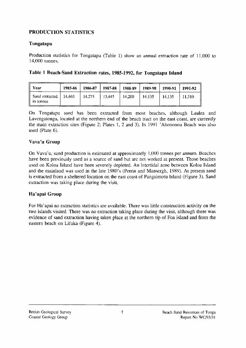
PRODUCTION STATISTICS
Tongatapu
Year
Sand extracted in tonnes
Production statistics for Tongatapu (Tabl,: 1) show an annual extraction rate 0:
14,000 tonnes.
1985-86 1986-87 1987-88 1988-89 1989-90 1990-91 1991-92
14,465 14,275 13,445 14,200 14,135 14,135 11,310
11.000 to
Table 1 Beach-Sand Extraction rates, 1985-1992, for Tongatapu Island
On Tongatapu sand has been extracted from most beaches, although Laulea and Lavengatonga, located at the northern end of the beach tract on the east coast, are currently the main extraction sites (Figure 2; Plates 1, 2 and 3). In 1991 ’Ahononou Beach was also used (Plate 6).
Vava’u Group
On Vava’u, sand production is estimated at approximately 1,000 tonnes per annum. Beaches have been previously used as a source of sand but are not worked at present. Those beaches used on Koloa Island have been severely depleted. An intertidal zone between Koloa Island and the mainland was used in the late 1980’s (Perrin and Mansergh, 1989). At present sand is extracted from a sheltered location on the east coast of Pangaimotu Island (Figure 3). Sand extraction was taking place during the visit.
Ha’apai Group
For Ha’apai no extraction statistics are available. There was little construction activity on the two islands visited. There was no extraction taking place during the visit, although there was evidence of sand extraction having taken place at the northern tip of Foa island and from the eastern beach on Lifuka (Figure 4).
British Geological Survey Coastal Geology Group
7 Beach Sand Resources of Tonga Report No WCl9313 1


THE RESOURCE SURVEYS
METHODOLOGY
The aim of the 1992 fieldwork was to survey all of the major beach tracts and the sand thicknesses on the beaches. Additionally the reef-flat and hinterland were to be surveyed. An important aspect of the data acquisition was the technology utilised. To rapidly acquire accurate survey data, an electronic level (Nikon Total Station) was used (Plate 12). Distance and height measurements are recorded by the Total Station as horizontal and vertical angles and a slope distance. Distance between profiles varied between 50 and 150 metres but generally averaged 75 metres. Determination of the distance between profiles was often controlled by line-of-sight. The survey data from the Total Station was stored in a CMT data- logger and subsequently converted into x,y,z coordinates using a processing package provided by Survey Supplies. Depth measurements were taken with a 3 metre long steel rod, driven by manpower into the beach-sand. On Tongatapu, 142 profiles were acquired, on Lifuka and Foa, 42 profiles and on Vava’u, 25 profiles. Representative profiles from all islands are included as Enclosures 1 to 5. Benchmarks were set up on all main beaches. Interpretation of aerial photographs from 1968, 1980 (only available for Tongatapu) and 1990 allowed changes in beach widths to be monitored over a period of 22 years.
At BGS, the survey data were downloaded from the data-logger onto an ’Autocad’ computer aided draughting system. Using the vertical and horizontal coordinates all beach profile data were hand-drawn and the depth measurements added. The profiles were then digitised using Autocad. Sand areas for each profile between the beachfront and the foot of the Pumice Terrace were calculated using Autocad. Sand volumes along the beaches were calculated by the use of the horizontal coordinate data. Tonnages were calculated using a density of 2.05 tonnes per cubic metre. The densities on six representative sand samples were calculated at BGS (Table 2).
Table 2 Densities of sand samples from the beaches of Tongatapu.
Sand Sample Ll Laulea 3
Fuamotu 2
Ha’asini 1
)I Lavengatonga 1 I 2.2
Monotapu
Average
British Geological Survey Coastal Geology Group
9 Beach Sand Resources of Tonga Report No WCl93f3 1

N
I d
FigOre 2 Tongatapu Island, showing the main beach tracts surveyed (in black), location of the sand samples, the d a r e a s (A to F) calculated in Table4 and the 200 metres isobath

The survey data is filed in Autocad, Microstation and DXF format and is available from the British Geological Survey, Keyworth, Nottingham. It is also filed in Autocad format at the Ministry of Lands, Surveys and Natural Resources, Nuku’alofa, Tonga . The data comprises the beach topographic surveys (for Tongatapu, 13 Files; for Ha’apai, 5 Files; for Vava’u, 8 Files) and beach profiles with sand thicknesses (for Tongatapu, 14 Files; for Ha’apai, 5 Files; for Vava’u 8 Files).
For Tongatapu, to put the beach-sand extraction into a natural context and to determine a sustainable rate of beach-sand extraction, sediment sources, transport directions and sinks had to be identified. This is particularly crucial for the main sand extraction beaches on the eastern coast. Tappin and Sallenger (1991) propose that all beach-sand (including that forming the Pumice Terrace) is originally reef-derived, and that the beach-sands are driven along the coast by the prevailing south-easterly Trade Winds: northward along the eastern coast and westward along the southern coast. The ultimate sink of beach-sand on the eastern coast is at Laulea and on the western coast is at ’Ahononou.
To calculate the likely volume of sediment to be contributed from the reef to the beaches, three aspects had to be considered: (i) the area of the reef likely to contribute sediment to the beaches, (ii) the production of calcium carbonate from this area of reef and (iii) the volume of sediment likely to be cast up onto the beach from the reef.
To calculate the reef area that would act as a sediment source for the beaches was straightforward. Because of the algal terrace at the seaward margin of the reef-flat it was considered probable that the reef-flat and algal terrace would act as the main sediment sources. Sediment from the reef-face would be shed seaward and lost to the system. (This is one major difference between reefal systems on tropical islands and clastic shorelines (without reefs) on continental shelves in temperate climates. On continental shelves, the beach would be constructed during normal sea conditions, but during storms the beach would be eroded and the beach sediment transported offshore to form an offshore bar. A return to normal sea states would result in the erosion of the bar and the transport of sediments back up onto the beach). The method used in the calculation was to digitise the aerial photographs and calculate the area of the reef-flat and algal terrace using Microstation.
’Production’ of calcium carbonate, the calcium carbonate produced (calcification) by reef organisms, is usually reported in kilograms of calcium carbonate produced per square metre of reef per year (kg/m2/yr). Methods of estimating production in reef systems, such as that found on Tongatapu, include those based upon (i) the carbonate production of individual reef organisms and deriving from these figures estimates of the gross production of representative reef environments (Chave et al., 1972) and (ii) monitoring the CO, flux across the reef (Smith and Kinsey, 1976). There are three organisms which are recognised as major contributors of calcium carbonate: corals, coralline red algae and calcareous green algae. Surprisingly, the range of carbonate production values from different reef settings are similar and (apparently) independent of the contributing organism (Smith and Kinsey; 1976). Whole reef averages are 1 .O- 1 .5kg/m2/yr, but in shallow, well-flushed seaward reef environments, such as those in Tongatapu, the figures are higher at 4kg/m2/yr.
British Geological Survey Coastal Geology Group
11 Beach Sand Resources of Tonga Report No WCl9313 1

How much of the carbonate sediment produced by the reef may actually be transported onto the beach is the most difficult part of the equation. A review by Kinsey and Davies (1979) for One Tree Reef in the Great Barrier Reef of Australia, using the carbon flux method, gave calcification rates of 4kg/m2/yr, out of which approximately 50% was eroded and transported into back-reef areas. Sedimentation rates in the lagoon to leeward of One Tree Reef suggest that about half of the carbonate production is deposited in the back reef areas (Kinsey and Davies, 1979). Kinsey and Davies (1979) also believe that on the reef flat, calcification is accrued in situ, and does not therefore represent a significant sediment source. On Tongatapu however, the reef flat does indeed contribute significantly to the beaches in the form of foraminifera, which live in the algal turf. In sediment samples analysed by Tappin and Sallenger (1991) up to 50% of some sands comprise foraminifera. It is also probable that the reef-flat is not accreting vertically so it would be anticipated that most sediment produced would be eroded and removed. It is therefore considered probable that the carbonate production on the eastern reefs of Tongatapu is in the region of 4kg/m2/yr with 50% of this production shed onto the beaches.
TONGATAPU
Description of the Coastal Zone
On Tongatapu the main elements of the western, southern and eastern coastal zone (Tappin and Sallenger, 1991) are the fringing reef, beaches, pocket beaches, the 'Pumice Terrace' and cliffs.
Fringing Reef. The fringing reef is between 25 and 200 metres wide (Plate 4). It comprises the reef-face, algal terrace and reef-flat. The algal terrace is best developed on the windward east coast where it attains heights of two metres above the reef-flat. The reef flat on the eastern and southern coasts is mainly algal whereas on the western coast it is algal with corals. The difference in reef type is mainly due to the reef-flat on the east coast being higher than on the west. The difference in elevation leads to large areas of the flat in the east drying at low tide, whereas in the west the flat is always covered by water.
Beaches. Beach morphology varies around the coast. The east coast beaches are widest at the northern end of the main beach tract, with maximum widths of 50 metres at Laulea and Lavengatonga beaches (Plates 1 and 3, Figure 2). The wide beaches in their natural state comprise a foreshore that, to landward, passes through an abrupt change in slope (the berm- crest) into a wide backbeach (the berm). The beaches south of Oholei narrow to 20-25 metres (Plate 4). They comprise mainly steep foreshores and the backbeach is narrow or not well developed. South coast beaches are morphologically similar to those south of Oholei, with steep foreshores and narrow or absent backbeaches (Plate 5). The western beaches comprise foreshores with gentle gradients. The berm-crest is not well developed and backbeach areas are narrow or absent. Binocular examination of the beach-sand shows it to be derived from the fringing reef (Tappin and Sallenger, 1991). At the tide mark there is usually a cobble grade superficial cover of coral fragments, gastropods, bivalves and organic litter that includes Halimeda,
British Geological Survey Coastal Geology Group
12 Beach Sand Resources of Tonga Report No WCl93l3 1

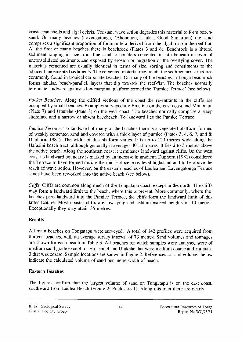
crustacean shells and algal debris. Constant wave action degrades this material to form beach- sand. On many beaches (Lavengatonga, ’Ahononou, Laulea, Good Samaritan) the sand comprises a significant proportion of foraminifera derived from the algal mat on the reef flat. At the foot of many beaches there is beachrock (Plates 3 and 6). Beachrock is a littoral sediment ranging in size from fine sand to boulders cemented in situ beneath a cover of unconsolidated sediments and exposed by erosion or migration of the overlying cover. The materials cemented are usually identical in terms of size, sorting and constituents to the adjacent uncemented sediments. The cemented material may retain the sedimentary structures commonly found in tropical carbonate beaches. On many of the beaches in Tonga beachrock forms tabular, beach-parallel, layers that dip towards the reef-flat. The beaches normally terminate landward against a low marginal platform termed the ’Pumice Terrace’ (see below).
Pocket Beaches. Along the cliffed sections of the coast the re-entrants in the cliffs are occupied by small beaches. Examples surveyed are Emeline on the east coast and Monotapu (Plate 7) and Utukehe (Plate 8) on the west coast. The beaches normally comprise a steep shoreface and a narrow or absent backbeach. To landward lies the Pumice Terrace.
Pumice Terrace. To landward of many of the beaches there is a vegetated platform formed of weakly cemented sand and covered with a thick layer of pumice (Plates 3, 4, 6, 7, and 8; Duphorn, 1981). The width of this platform varies. It is up to 120 metres wide along the Ha’asini beach tract, although generally it averages 40-50 metres. It lies 2 to 5 metres above the active beach, Along the southeast coast it terminates landward against cliffs. On the west coast its landward boundary is marked by an increase in gradient. Duphorn (1981) considered the Terrace to have formed during the mid-Holocene sealevel highstand and to be above the reach of wave action. However, on the eastern beaches of Laulea and Lavengatonga Terrace sands have been reworked into the active beach (see below).
Clifss. Cliffs are common along much of the Tongatapu coast, except in the north. The cliffs may form a landward limit to the beach, where this is present. More commonly, where the beaches pass landward into the Pumice Terrace, the cliffs form the landward limit of this latter feature. Most coastal cliffs are low-lying and seldom exceed heights of 10 metres. Exceptionally they may attain 35 metres.
Results
All main beaches on Tongatapu were surveyed. A total of 142 profiles were acquired from thirteen beaches, with an average survey interval of 73 metres. Sand volumes and tonnages are shown for each beach in Table 3. All beaches for which samples were analysed were of medium sand grade except for Ha’asini 4 and Utukehe that were medium-coarse and Ha’atafu 3 that was coarse. Sample locations are shown in Figure 2. References to sand volumes below indicate the calculated volume of sand per metre width of beach.
Eastern Beaches
The figures confirm that the largest volume of sand on Tongatapu is on the east coast, southward from Laulea Beach (Figure 2; Enclosure 1). Along this tract there are nearly
British Geological Survey Coastal Geology Group
14 Beach Sand Resources of Tonga Report No WCI9313 1


350,000 tonnes of sand. The sand distribution however is uneven.
Laulea, Lavengatonga arid Oholei Beaches. 181,000 tonnes of sand are on Laulea and Lavengatonga/Oholei beaches in two tracts with a combined length of 2820 metres (Plates 1 and 3). The beaches attain maximum widths of up to 50 metres and are the widest beaches
Table 3 Beach-sand estimates and beach lengths for Tongatapu Island
Beach Estimate Beach Length (metric (met res) tonnes)
Ha,asini I 171,235 I 2,680
Lavengatonga
Laulea
Fuamotu I 85,785 I 2,500
70,853 1,200
66,029 1,100
Ha’atafu
Emeline
’ Ahononou
Good Samaritan
Fahina
Utukehe
Nakolo
Monotapu
TOTAL
I ~ 44,385 I 520 ~~
11 Oholei
43,292 1,600
31,551 350
27,129 800
19,602 700
12,580 270
10,236 220
4,29 1 600
1,469 230
589,067 12,770
on Tongatapu (Enclosure 1). The volume of sand per metre width of beach is greater than at any other beach location. Largest sand volumes at Laulea are along the central part of the beach and at Lavengatonga are south of the track leading down to the beach.
At Lavengatonga, recent sand extraction has significantly thinned the sand cover over some areas of the beach (compare Profiles Lavengatonga 3 and 4 on Enclosure 1). During the visit sand extraction was taking place. The sand had been stockpiled on the beach. Beachrock was exposed at the foot of the track leading down to the beach. Southward along Lavengatonga Beach-sand volumes increase towards Oholei Beach. At the border between Lavengatonga and
British Geological Survey Coastal Geology Group
16 Beach Sand Resources of Tonga Report No WC/93/3 1

Oholei Beaches sand volumes are greatest (Profile Oholei X on Enclosure 1).
It is evident that at Laulea and Lavengatonga/Oholei beaches the sand extraction has led to the landward recession of the beach. At Laulea Beach deep grooves in the beachrock show where the front-end loaders have removed sand. Also at Laulea Beach, a comparison of the aerial photographs taken in 1968 and 1990 shows that the magnitude of the recession is up to 50 metres on the main beach. However, at the centre of the re-entrant it is far greater. On the 1968 photographs sand extends 100 metres seaward from the Pumice Terrace across the reef flat. This sand body is absent on the 1990 photographs and was not present during the 1992 survey. At least 50 metres of recession of the sand body is measured by comparison of the photographs. A large sand body seaward of the reef at the centre of the re-entrant indicates that at certain times sand exits from the beach system through a break in the reef- front. Large areas of beachrock are now exposed at the foot of the Laulea Beach (Plate 3). This beachrock was not exposed in 1968.
At Lavengatonga Beach the beach widths on the two sets of photographs are about 40 metres, apparently showing no change. However, on the 1968 aerial photographs there is no beachrock visible, yet on the 1990 photographs the beachrock at the foot of the beach is clearly visible. There has obviously been beach recession (15-20 metres), and further observation of the photographs indicates that the beach has migrated landward by erosion of the vegetated Pumice Terrace. The later aerial photographs show the Pumice Terrace to be dissected and much of the vegetation to be removed. Photographs taken at Oholei Beach before and after Hurricane Isaac, that hit Tonga in 1982, show that during storms the area at the back of the beach (the Pumice Terrace) is reworked into the active beach (Lewis et al., 1991). In 1978 sand was extracted from the Lavengatonga Beach. During the next two years longshore drift from the south reformed the beach. Then in March 1982 Cyclone Isaac cut back into the vegetated backbeach and reworked the sand into the active beach. All vegetation was removed from a zone 50 metres landward of the high-water mark.
Ha'asini Beach. South of Oholei Beach 171,000 tonnes of sand are found along a beach tract 2,680 metres in length (Plate 4; Enclosure 1, Profiles Oholei 3 - 37). Sand extraction has not taken place along this beach tract. Beach widths average 25 metres. There appears to be no change in beach width between 1968 and 1990. Sand thicknesses on the backbeach average 2 metres. Sand volumes per metre of beach section are less than to the north.
South coast beaches
On the south coast are the beaches of Nakolo, Fuamotu and 'Ahononou (Enclosure 2).
Nakolo Beach. Nakolo Beach lies at the foot of cliffs below the highest point on Tongatapu. 600 metres long, the sand thickness nowhere exceeds 1 metre. The beach has never been used for sand extraction.
Fuarnotu Beach. Fuamotu Beach is a tract of sand 2500 metres long (Plate 5). Commercial sand extraction has not taken place on the beach. The beach profile is similar to beaches south of Oholei (Compare Enclosure 2, Profiles Fuamotu 1 and Fuamotu-2 4 and 12 with Enclosure
British Geological Survey Coastal Geology Group
17 Beach Sand Resources of Tonga Report No WCl93131

1, Profiles Oholei 9 - 29). The beach is generally narrow (12 to 25 metres wide). Sand thicknesses on the backbeach average about two metres. There is little beachrock exposed and the sand at the foot of the beach lies upon the inner reef-flat. 86,000 tonnes of sand are estimated to be present on the beach. Comparison of the 1968 and 1990 aerial photographs shows no change in beach width over the intervening 22 years.
'Ahononou Beach. ' Ahononou Beach lies at the western termination of the southern beaches (Plate 6). It is 800 meh-es long. In 1991, extraction from the beach stripped sand down to the beachrock (Lewis et al., 1991). Profiling shows that from where the sand was removed (Enclosure 2, Profiles 3 and 6) the beach is 10-15 metres wide. Much beachrock is exposed along the foot of the beach. In part this exposure is due to the 1991 sand extraction, photographs (Lewis et al., 1991) taken immediately after the extraction took place show the subsurface beachrock exposed along the beach. However, the author visited the beach in 1988 and recalls that beachrock was exposed at this time also. On the 1990 aerial photographs the beach is 15-20 metres wide and beachrock is clearly visible. On the 1968 aerial photographs the beach width is 40 metres, and no beachrock is exposed.
A profile taken in 1984 near to Profile 6 shows the beach at this time to be 20 metres wide and the sand volume along the profile to 37.7 cubic metres of sand per metre length of beach. Thus at this location between 21 and 23 cubic metres of sand per metre length of beach have been removed. Assuming an even profile along the beach between Profiles 7 and 10, it would appear that approximately 13,000 tonnes of sand have been lost from the beach since 1984. The loss is interpreted as due to extraction, much of which took place during 1991 (Lewis et al., 1991).
Much (illegal) sand extraction has taken place from the Pumice Terrace. The effects of this extraction are clearly visible on the 1990 aerial photographs; vegetation cover is sparse and excavations in the sand readily apparent. On the 1968 photographs there is a complete vegetation cover on the Pumice Terrace.
Pocket Beaches
Numerous small re-entrants in the cliffed coastline on the eastern and southwestern coasts are occupied by small beaches, some of which have been exploited as a sand source. Representative profiles are shown on Enclosure 3.
Emeline Beach. On the eastern coast, Emeline Beach, up to 350 metres in length and up to 35 metres wide, was used a sand source probably about 15 to 20 years ago; it is not used now. The survey data show 31,000 tonnes of sand to be present. The sand is up to two metres thick on the backbeach.
Monotapu Beach. A small pocket beach on the west coast, Monotapu Beach has been denuded of sand during previous extraction episodes (Plate 8). 230 metres long, the beach comprises exposed beachrock over much of its length. The beach width at its widest point is 12 metres. Profiling and depth measurement show a thin sand cover, with greatest measured thickness
British Geological Survey Coastal Geology Group
18 Beach Sand Resources of Tonga Report No WCl93l3 1

0.41 metres. Sand volumes per metre length of beach are very low (4.76m3). About 1,500 tonnes of sand are present on the beach. Sand has been extracted from the southern part of the Pumice Terrace.
Utukehe Beach. Another small pocket beach just to the north of Monotapu Beach, Utukehe Beach has not suffered sand extraction (Plate 7). 220 metres in length, there is a complete sand cover, with thicknesses in the backbeach area up to 2 metres and beach widths up to 30 metres. Sand volumes per metre length of beach are up to 42 cubic metres. Approximately 10,000 tonnes of sand are on the beach.
Western Beaches
Three beaches occupy the western coast of Tongatapu; Fahina, Good Samaritan and Ha’atafu. Representative profiles are shown on Enclosure 3.
Fahina Beach. Fahina Beach, to the north of Utukehe Beach, is a small beach 270 metres long. It has never been used as a sand source. Over 12,000 tonnes of sand area present on the beach, which is up to 40 metres wide. The sand is up to 2 metres thick on the backbeach.
Good Samaritan Beach. The Good Samaritan Beach is located at the southern end of the western peninsula on Tongatapu. 700 metres long, it was previously used as a source of sand but has not been used in the past ten years. At the northern end is the resort of the Good Samaritan Inn. Over 19,000 tonnes of sand are present on the beach, which is up to 30 metres wide. On the 1968 aerial photographs the beach is up 60 metres wide, with the greatest widths in the north; no beachrock is exposed. On the 1990 photographs, and also seen during the 1992 survey, there is much beachrock exposed at the foot of the beach.
Ha’atafu Beach. Ha’atafu Beach is at the northern end of the western peninsula. At its northern end is the Ha’atafu Beach Resort. 1600 metres long, there are over 43,000 tonnes present on the beach. Once a source of sand, it has not been used for at least ten years. During the survey of 1992 the beach was up to 25 metres wide with much beachrock exposed at the foot of the beach. On the 1968 aerial photographs the beach, at its maximum width in the north, was 40 metres wide and extends over the inner reef flat; there is no evidence of beachrock exposure.
Natural Beach Replenishment
All the sand on the beaches is derived primarily from the fringing reef, although during storms sand from the Pumice Terrace may be reworked into those beaches from which sand has been extracted. Derivation from the reef is attributed to two processes; direct input from the adjacent reef and longshore drift. Along the southeast coast the effect of the southeast Trade Winds is to drive sediment along the coast (Tappin and Sallenger, 1991). On the east coast the drift is to the north, on the south towards the west. On the west coast wave refraction drives the sediment northward.
British Geological Survey Coastal Geology Group
19 Beach Sand Resources of Tonga Report No WC/93/3 1

For Tongatapu the reef flat on the southeast and west coast has been subdivided into six zones and their areas calculated (Table 4 and Figure 2).
Reef flat
On the east coast of Tongatapu the area of the reef-flat north of Houma Toloa Point has been calculated at 1,153,953 square metres. Using the figures for reef productivity quoted above, the reef flat would be expected to produce 4,616 tonnes of carbonate per year. 50% of this figure would be expected to be transported onto the beaches, and it is estimated that approximately 2,300 tonnes of sediment per annum is available for beach construction (Table 4).
Area Sediment (metres2) production
(tonnes per annum)
Table 4 Areas of reef adjacent to the main beaches of Tongatapu (locations shown on Figure 2) and estimated annual sediment production rates using a carbonate production rate of 4kg/m2/yr.
Area A
Area B
Area C
Area D
Area E
Area F
Western Tongatapu
Southeastern Tongatapu
728,212 2,912
754,200 3,016
339,320 1,357
237,900 95 1
574,460 2,297
1,153,953 4,6 15 ~~
TOTAL 3,788,045 15,148
The reef flat area along the south coast west of Houma Toloa Point to 'Ahononou Beach is 812,360 square metres. Carbonate production from the reef is 3249 tonnes per year. Approximately 1,600 tonnes would be available for beach construction (Table 4).
On the west coast of Tongatapu the reef flat area is 1,812,732 square metres. A reef of this area would be expected to produce 7,250 tonnes of carbonate per annum. Of this amount approximately 3,600 tonnes would be available for beach construction (Table 4).
It may be anticipated therefore that in total 15,000 tonnes of carbonate sediment may be produced from the reef adjacent to the main beaches on Tongatapu Island, of which 7,500 may be cast up onto the beaches. This represents 50% of the annual extraction rate. However, on the eastern coast, from where most sand is extracted, the weight of sediment cast up onto the beach (2,300 tonnes) represents 17% of the annnual extraction.
20 British Geological Survey Coastal Geology Group
Beach Sand Resources of Tonga Report No WCJ93l3 1

Summary: present state of the beaches
On the main beaches of Tongatapu there are approximately 600,000 tonnes of sand. Most sand is concentrated on the southeastern beaches where nearly 470,000 tonnes are present. The other main concentration of sand is on the beaches of the western peninsula.
On beaches where there has never been sand extraction the photographic evidence indicates that neither beach recession nor erosion of the Pumice Terrace has taken place. On all beaches where sand extraction has taken place, the evidence clearly indicates that there has been significant beach recession, that can be measured in tens of metres. Beachrock has become exposed at the foot of the beach. Where figures are available this recession is accompanied by a reduction in the volume of sand on the beach.
Some of the smallest beaches have been most depleted by the sand extraction; Monotapu Beach being the most severe case. Comparison with the adjoining beach of Utukehe shows that almost 9,000 tonnes of sand have been removed from Monotapu. Although the sand extraction took place over ten years ago the beach shows no sign of recovery. (However, it is likely that at present illegal sand extraction takes place from this beach). On the western beaches of Good Samaritan and Ha’atafu, from which sand has not been extracted for over ten years, recovery appears to be slow. Beach widths now are half of what they were in 1968.
Sustained sand extraction from the larger beaches of the eastern coast has led not only to severe sand depletion and beach recession, but also to erosion of the Pumice Terrace.
British Geological Survey Coastal Geology Group
21 Beach Sand Resources of Tonga Report No WCJ93l31

VAVA’U GROUP
TOTAL
Description of the Coastal Zone
20,309 1,810
The main coastal features on Vava’u include the reef, cliffs and mangroves. The beaches are a minor coastal element. The coast is cliffed (up to 210 metres high) on the eastern, western and northern sides (Plate 9). Along these coasts the reef is narrow. The beaches lie at the foot of the cliffs in small re-entrants in the coastline. The sinuous southern coastline is sheltered and mangrove fringed. The beaches are small and lie mainly in the southeast (Figure 3; Plate 10). On Koloa Island they lie between headlands. On the southeast coast of Vava’u Island the beaches occupy re-entrants in the cliff. There is much beachrock exposed. To landward they pass into the Pumice Terrace which is 0.5 to 1.5 metres above the beach. Other small beaches lie on Pangaimotu and ’Utungeke Islands.
Results
All beaches on Vava’u are small. Sand volumes/tonnages are small (Table 5 ) and sand grade is medium to coarse. The beaches are no longer used as a sand source. Representative profiles of the beaches are included on Enclosure 4.
Table 5 Beach-sand estimates and beach lengths for the Vava’u Island Group
Beach (metric (metres) tonnes)
Keitahi 5,597
Ene’io I 4,769 I 230
Nga’unoho I 2,640 I 140
Ano I 2,288 I 290
1 1 Koloa 6 I 2,192 I 130
Two large beaches in the east are Keitahi and Ene’io (Enclosure 4, Profiles Keitahi 3 and Ene’io 1). Approximately 5,000 tonnes of sand are present on each of these beaches. Ene’io
British Geological Survey Coastal Geology Group
22 Beach Sand Resources of Tonga Report No WCl9313 1
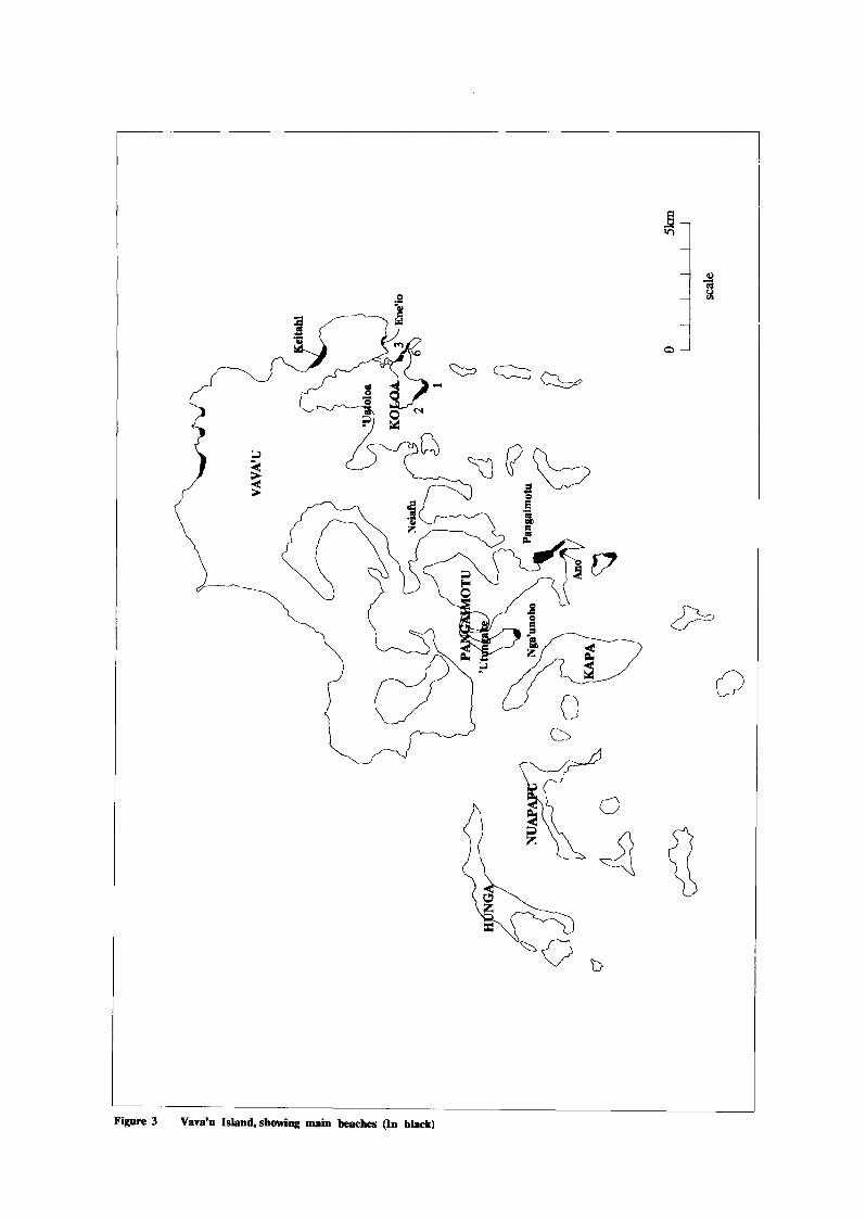
I
Figore 3 Vava’n Island, showing main beaches (In black)


Beach has not been used for sand extraction but the Pumice Terrace to landward of Keitahi Beach has been illegally mined and much sand removed. The beaches on Koloa Island were used previously but the sand present now is limited. Just over 2,000 tonnes are present on the largest beach (K6). The sand on Koloa 2 Beach has been almost completely removed (Enclosure 4, Profile Koloa-2 1).
Other beaches are on the southern coast of Pangaimotu Island. The western part of Ano Beach was previously used as a sand source (Enclosure 4, Profile 4). The eastern side is a resort from which no sand has been removed (Enclosure 4, Profile 1). Comparison of the profiles shows the effect of the sand extraction. Because of the sheltered location of the beach (Figure 3) sediment productivity from the reef is low. Nga’unoho is on the southern tip of ’Utungeke Island (Figure 3). Again the beach is small, just over 2,500 tonnes of sand are present (Enclosure 4, Profile Nga’unoho 1). Sand extraction has not taken place on the beach.
British Geological Survey Coastal Geology Group
25 Beach Sand Resources of Tonga Report No WCl9313 1

HA’APAI GROUP
Foa East
Lifuka South
Foa South
TOTAL
Description of Coastal Zone
95,332 785
65,78 1 1,300
5,499 500
280,962 4,385
On Lifuka and Foa Islands the main coastal elements are the fringing reef, beaches, Pumice Terrace and cliffs (Plate 11). The fringing reef comprises similar elements to those on Tongatapu with a low-lying algal rim that is less than one metre in height above the reef-flat. On the east coast the reef is up to 350 metres wide. The beaches on Lifuka Island are wide (up to 40 metres) and similar in morphology to those on the east coast of Tongatapu. The foreshore slopes landward through a poorly marked berm into a backbeach. To landward of the backbeach lies the Pumice Terrace. The Terrace is separated from the backbeach by a low step between 0.5 and 2.0 metres high. On Foa Island the main beaches lie in the north and on the eastern and southern coasts (Figure 4). Low cliffs less than 5 metres high lie along much of the eastern coasts of Lifuka and Foa Islands.
Results
The largest beaches on Lifuka and Foa islands lie on the eastern coast (Figure 4 and Enclosure 5). Beach-sand is medium grade, and suitable for all types of construction usage. Beach-sand tonnages are shown on Table 6.
Table 6 Beach-sand estimates and beach lengths for Lifuka and Foa Islands - Ha’apai Group
(metric
Lifuka North 114,350
Beach length (metres)
1,800
On Lifuka there are two beach tracts separated by a low raised cliff. Little sand extraction has taken place on the beaches. The northern tract is 1800 metres long. Almost 115,000 tonnes of sand are present on the beach. Sand thickness on the backbeach is up to 2.5 metres. There is beachrock exposed at the northern and southern ends of the beach. The southern beach is 1300 metres long. Approximately 65,000 tonnes of sand are present on the beach. Sediment thicknesses are generally less than on the northern beach.
British Geological Survey Coastal Geology Group
26 Beach Sand Resources of Tonga Report No WC/93/3 1

0 5km
SCALE
Figure 4 Lifuka and Foa islands of the Ha’apai Group, showing main beach tracts. (Beaches shown in black)

On Foa there are two main beach tracts; on the northern tip and on the northeastern coast, with a smaller tract on the southern coast. Only the eastern and southern beaches were surveyed. The northern beach showed evidence of sand extraction. On the eastern beach there is approximately 95,000 tonnes of sand on the beach. Beach widths can be over 55 metres. On the backbeach, sand thicknesses may be up to 2.5 metres. Beachrock is exposed at the northern end of the beach. The southern beach is 1000 metres long, subdivided in the centre by a low beachrock exposure. Only the eastern part of the beach was surveyed. Volumes of sand are low, only 5,500 tonnes are present on the beach. Sand thicknesses are low, up to 1 metre being present on the backbeach. Beachrock is exposed along the foot of the beach.
British Geological Survey Coastal Geology Group
28 Beach Sand Resources of Tonga Report No WC/93/3 1


BEACH-SAND RESOURCES AND EXTRACTION STRATEGY
TONGATAPU
It is estimated that of the total sand present on the beaches (600,000 tonnes), approximately 66% is recoverable (400,000 tonnes), and is termed here the reserve. At an annual rate of extraction of about 14,000 tonnes, this reserve would last approximately 28 years. Natural sand replenishment along the main reefbeach tracts (estimated at 7,500 tonnes per annum) would extend the supply by an additional 14 years. Continued erosion of the Pumice Terrace and the additional sand provided to the beaches therefrom would further extend the supply, but as the contribution from this source is of a 'catastrophic' nature (taking place during severe storms) the contribution is not quantifiable. However, not all beaches are used for sand extraction, and to put the reserve in a more immediate context, the sand recoverable from Laulea and Lavengatonga beaches (90,000 tonnes) would last another six years at the recovery and extraction rates quoted above, this figure being extended a further one to two years by natural replenishment. Addition of sand from Pumice Terrace is not included in this estimate.
In the absence of an alternative source of sand supply, what options are available to meet the demand and minimise the adverse environmental impact of sand extraction?
Ideally, with natural replenishment along the main beach tracts representing 50% of the annual extraction rate, all main beaches should be utilised, thereby spreading the impact of extraction. However, the survey results show that some beaches should be avoided; these include the pocket beaches where sediment volumes are too small to warrant exploitation. The effects of sand extraction on Monotapu Beach (compare Plates 7 and 8 and Profiles Monotapu 2 and Utukehe 2 on Enclosure 3) illustrate the destruction that occurs when beaches of this type are used. The slow recovery rate of these pocket beaches is attributed to the small 'reef catchments' from which replacement sediment is derived.
Additionally, beaches upon which tourist resorts are sited should also be excluded because of a conflict of interest. Included in this category are the western beaches of Good Samaritan and Ha'atafu, and the 'Oholei Beach on the east coast. However, for the western beaches it is considered that sand could be extracted on a sustainable basis from locations distant to the resorts. The Good Samaritan Beach is 700 metres long and the Ha'atafu Beach is 1,600 metres long, Both resorts are located at the northern end of the beach. It is recommended that limited volumes of sand be extracted from these beaches at locations distant from the resorts. The replenishment figures indicate that each of these beaches should be able to sustain an annual sand extraction of 1000 tonnes. The extraction should take place extensively so as to spread the impact.
Sand extraction from the southern beaches has so far been confined to 'Ahononou where it has left the beach in a poor state. This beach should not be further used until there has been some recovery. Along Fuamotu Beach the replenishment figures indicate that a sustainable level of annual extraction would be in the order of 1000 tonnes.
Extraction from the beaches as detailed above would provide perhaps 3,000 tonnes of sand
British Geological Survey Coastal Geology Group
30 Beach Sand Resources of Tonga Report No WCl93/3 1

annually, but this still leaves a balance of 10,000-11,000 tonnes to find from the eastern beaches. Two options are considered.
i) To continue to use Laulea and Lavengatonga beaches and confine the impact of sand extraction to these two locations. As noted above, the reserves of sand at these two beaches are likely to last for another seven to eight years, but the beaches’ location at the northern end of the eastern beach tract ensures the maximum possible natural recharge from the reef. Also, the continued erosion of the Pumice Terrace during storm conditions should continue to recharge the active beach. However, the erosion will lead to the further retreat of the Pumice Terrace and the landward retreat of the beach. It should be noted that the erosion of the Pumice Terrace will have an impact upon any constructions or developments on the Terrace. At Laulea there is a large cemetery and a housing development. At Lavengatonga there is a cemetery, some houses and a tourist facility. Farther south, at Oholei Beach, where there is a long established tourist facility, there is already evidence that the sand extraction taking place on Lavengatonga Beach to the north, has the effect (through exacerbated longshore drift) of reducing sand volumes. The effects are particularly severe during storm conditions.
ii) The second option is to utilise the (hitherto unused) beach tracts to the south of Oholei Beach where, along the Ha’asini Beach tract there are approximately 171,000 tonnes of sand of which about 113,000 tonnes (eight years supply) are considered recoverable. The survey data indicate that there are several locations along this beach tract where extraction could take place: one is the beach immediately south of Oholei Beach, and another is 500 metres farther south from Oholei (see Enclosure 1, Rofile Oholei 9). At both these locations new access roads would be required for extraction to take place. Extraction along these southern tracts may interfere with the sediment recharge to the north. The beach is narrow and long beach lengths will need to be used. Much of the wider parts of the Pumice Terrace along this beach tract are used for agriculture. Only those beach sections seaward of unused Pumice Terrace should be considered for use.
The decision on whether one or other (or both) of these options is/are taken can only be made by the Tongan Government because of the weighting to be placed between the effects of continued sand extraction at Laulea and Lavengatonga (the eventual destruction of facilities on the Pumice Terrace) and the capital cost of accessing new extraction localities to the south of Oholei Beach (new access roads). However it is recommended here that exploitation of the reserves to the south of Oholei be seriously investigated.
An alternative proposed by Perrin and Mansergh, (1989) is to extract the sand directly from the Pumice Terrace. Probably a relict beach deposit, the sand would be of a grade similar to that forming the present beach. This alternative is not recommended for the following reasons:
i) the sand from the Terrace landward of the Laulea and Lavengatonga beaches is already being reworked naturally into the active beach and subsequently extracted. The Terrace deposits are therefore being used already.
ii) elsewhere, extraction of sand from the Terrace has already taken place illegally and could lead to coastal erosion (see Vava’u below).
British Geological Survey Coastal Geology Group
31 Beach Sand Resources of Tonga Report No WC/93/3 1

iii) extracting sand from the Terrace direct would involve the clearing the mature vegetation, a costly procedure.
Whatever strategy is eventually preferred, monitoring of the beaches should be an essential aspect of the extraction. Beach profiling should be undertaken both before and after the extraction takes place. The Benchmarks set up for the 1992 survey should be used. By this method there will be an ongoing accurate assessment of the beach-sand reserve.
The extraction strategy discussed above considers only the beach-sand resource in isolation. However, there are two alternative sources for sand grade material: crushed quarry dust and the newly proved offshore sand accumulation off Nuku’alofa (Smith and Gatliff, 1991). A further alternative is to use beach-sands from the Ha’apai Island Group. This is not considered feasible because of the additional recurrent cost of transport from Ha’apai to Tongatapu.
Quarry dust is used in concrete manufacture, but according to Candler (1992) the behaviour of the dust in concrete is problematic. The high fines content of the dust serves to reduce concrete strength by up to 20% and mixes using dust are unstable and prone to segregation. Mixes remain workable only within a very narrow water/cement band, with slump test samples collapsing when this band was exceeded. Better quality concrete was achieved using a mix of dust and sand although Candler does note that a better quality concrete may be produced from dust where the fines are at a minimum. The quality of the dust is dependent upon the crusher plant operator. At present there are no statistics on the volume of crusher dust produced or used in concrete manufacture.
At the offshore Nuku’alofa sand location there are over 4 million cubic metres of sand, representing over 200 years of supply. The sand is coarse grade and suitable for use in concrete manufacture. There has been no Environmental Impact Assessment nor economic analysis carried out on this deposit.
In the context of finite beach-sand resources both of these alternatives should be further (and fully) investigated with a view to substituting the present beach-sand source.
VAVA’U GROUP
In the Vava’u Group, the sand accumulation on the east side of Pangaimotu Island (Figure 3) discovered by Perrin and Mansergh (1989) is approximately 136,000 tonnes and should provide the Group with all of its future sand requirements. The discovery obviates any future need for sand to be extracted from the beaches in the Group. However, previous to the discovery, sand was taken from the beaches and the effects are still apparent. Extraction from the beaches of Koloa Island has led to severe sand depletion. In the case of Koloa 2 Beach the extraction has led to its almost complete destruction (Enclosure 4, Profile Koloa-2 1). The extraction at Ano Beach has left one half of the beach denuded of sand as described above in the results section. Because of the sheltered nature of the southern coastline of Vava’u, sediment production levels are low and the beaches previously utilised are slow to recover.
British Geological Survey Coastal Geology Group
32 Beach Sand Resources of Tonga Report No WCJ93l3 1

Although official beach-sand extraction has now been terminated there is still some illegal sand extraction. The illegal extraction takes place from the Pumice Terrace landward of Keitahi Beach and sand has been removed to below the beach level. In places there is only a narrow strip of sand between the extraction pits and the beach. In the event of a severe storm it is likely that this strip will be breached and the area landward of the beach inundated. This would lead to salt water contamination of the area and the establishment of swamp conditions. The area would be rendered unfit for use.
HA’APAI GROUP
There is no problem with sand supplies in the Lifuka Group, with over 280,000 tonnes of sand present on the main beaches of Lifuka and Foa.
British Geological Survey Coastal Geology Group
33 Beach Sand Resources of Tonga Report No WC/93/3 1

CONCLUSIONS
The beaches of Tonga provide the main onshore source of construction grade sand. The only other (minor) source of sand grade material comes from quarry crusher dust. No statistics are available on its production or use.
TONGATAPU
On Tongatapu, the results of the beach survey reveal the volume/tonnage of sand on the beaches and its distribution, the natural recharge rate of the beaches from the reef and the effects of the extraction of sand.
Sand is extracted from the beaches at an annual rate of between between 11,000 and 14,000 tonnes, most of which is from the eastern beaches at Laulea and Lavengatonga. Comparison of those beaches not used for extraction with those that have been used shows that the extraction over the past 25 years at the utilised beaches has led to significant beach recession and erosion of the areas landward of the beaches.
Calculation of sediment productivity from the reef reveals that overall, the natural sand replenishment rate is approximately 50% of the total extraction rate. However, because the beaches on the eastern coast are used preferentially the rate of natural replenishment at these locations is reduced to 17% of the extraction rate.
At present extraction rates there is approximately 28 years supply of sand on the beaches (the reserve). Natural replenishment from the reef will extend this time to 42 years. Erosion of the Pumice Terrace will further re-supply the beaches and extend the beach resource (by a factor unknown), but will affect buildings and agricultural activities located on the Terrace. The erosion of the Terrace takes place during infrequent storm conditions so the rate of re-supply cannot be calculated. To place the resource in sharper focus it is calculated that the present sand reserve on the Laulea and Lavengatonga Beaches will last a further six years (at present extraction rates) with an extension by natural replenishment of two to three years. These calculations do not take into account the erosion of, and resupply from, the Pumice Terrace.
Not all beach-sand is available for use. The small, pocket beaches should not be used. The western coast tourist beaches should be used at extraction rates equal only to natural replenishment rates and in areas distant from the resorts themselves. ’ Ahononou Beach, on the southern coast, should not be used until fully recovered from the past sand extraction. Whatever future strategy of sand extraction is followed (see below), at the present rate of sand extraction the beach-sand reserve is finite.
A strategy for beach-sand exploitation is presented, based upon the survey results and excluding alternative sand sources. The main sand resource is on the eastern coast beaches, and these will continue to provide most of the sand requirements. This will confine the environmental damage to one location. Additional sand may be extracted at other beaches at a rate equal to that of natural replenishment.
British Geological Survey Coastal Geology Group
34 Beach Sand Resources of Tonga Report No WC/93/3 1

The use of the Pumice Terrace is not considered to be an attractive alternative sand source. On the eastern beaches the sands of the Terrace are already being reworked into the beaches and the sand thereby derived is being extracted. In many places the Terrace is utilised for agriculture, housing, as a tourist facility or for cemeteries. In these places it is not available for use. Use of the Terrace may well lead to increased erosion and inundation by the sea that will result in the pollution of areas to landward of the beach and the creation of swamp conditions.
In view of the finite nature of the beach resource, alternative sand sources should be actively considered. Quarry dust is a by product of the crushing process and may provide a suitable substitute; figures on its production and usage are not available. The sand resource identified offshore of Nuku’alofa has been delineated but not assessed for the environmental consequences of its use nor for its economic viability.
Beach surveying should be an integral part of the sand extraction. The methodologies established during this project are a speedy and accurate way of monitoring the sand resource and its extraction.
VAVA’U GROUP
On Vava’u the beaches are too small to be used as a viable sand source. Previous extraction has despoiled those used. Fortunately, an alternative source in an isolated location has been identified and is now utilised. There is enough sand present that at present demand will last for over 100 years.
HA’APAI GROUP
Sand supplies on Ha’apai are not a problem. There is plenty of beach-sand to accommodate the demand. The beaches are in a good state.
REGIONAL IMPACT
The regional significance of the project results, including the quarry limestone study, is discussed more fully in the final summary report of the project (Tappin and Harrison, 1993 [in prep]). However, the following considerations are noted briefly in concluding the project report:
i) The quantitative approach to beach resources and their relationship to reef productivity. On other islands in the region where beach-sands are used in construction, or where there is conflict over the resource (eg: construction material source versus recreation), investigation of longer term changes in the beaches from aerial photographs, together with beach profiling and sediment thickness measurement interrelated with reef productivity can give a real assessment of the impact of development on the resource.
British Geological Survey Coastal Geology Group
35 Beach Sand Resources of Tonga Report No WC/93/3 1

ii) The methodology. Using the Total Station and associated data-logger and computer software, the surveying and data reduction can be carried out rapidly and accurately. The data, downloaded onto the computer, can then be processed and manipulated as neccessary. The output can be presented in any necessary graphic or digital form.
As well as applying the methodology to beach-sand resource assessment, it can be used to study and monitor the effects of coastal erosion. This may be particularly useful in the context of possible sea-level rise with its attendant importance to low-lying coastal development.
British Geological Survey Coastal Geology Group
36 Beach Sand Resources of Tonga Report No WCJ93 13 1

RECOMMENDATIONS
1. The sand on the beaches of Tongatapu is a resource with a total reserve life of 42 years although practically because of restrictions on the use of many beaches this is more reasonably assessed at 25 years. The onshore sand reserve is finite, therefore all other alternative sand sources should be assessed as a matter of urgency.
2. An Environmental Impact Assessment and full economic assessment of the sand deposit offshore of Nuku’alofa should be carried out. If the results of these assessments are positive the resource should be exploited.
3. A full evaluation of the use of crushed quarry dust in the manufacture of concrete should be carried out and crushing practice improved to provide the grade of dust most useful in concrete manufacture.
4. If sand extraction from the beaches is to continue then the following strategy is recommended:
i) Continue to use the eastern beaches of Laulea and Lavengatonga as the main sand source.
ii) Expand the east coast operations to the beaches south of Oholei.
iii) Utilise the beaches on the western coast (Good Samaritan and Ha’atafu) and southern coast (Fuamotu) at a sustainable rate of extraction estimated at 1000 tonnes per annum for each beach and avoiding proximity to currently developed recreational areas.
iv) Not to use the smaller beaches nor the pocket beaches.
v) Not to extract sand directly from the Pumice Terrace.
vi) Implement a policy of beach surveying and long term monitoring based upon the methodologies established during this project. Additional surveying equipment (Total Station) and data recorders will be required. This should be purchased.
British Geological Survey Coastal Geology Group
37 Beach Sand Resources of Tonga Report No WC/93/3 1

REFERENCES
Candler, G.G., 1992. Engineering testing of building materials in Tonga. Ministry of Works, Tonga.
Chave, K.E., Smith, S.V. and Roy, K.J., 1972. Carbonate production by Coral Reefs. Marine Geology, 12, p.123-150.
Cunningham, J.K. and Anscombe, K.J., 1985. Geology of ’Eua and other islands, Kingdom of Tonga. In, Scholl, D.W. and Vallier, T.L., 1985. Geology and offshore resources of Pacific Island arcs: Tonga Region. Circum-Pacific Council for Energy and Mineral Resources. Earth Science Series 2, p.221-257, Houston.
Duphorn, K., 1981. Interim report on applied coral sand investigations in and off Tongatapu. Institute of Marine Resources Report, The University of the South Pacific, Suva,Fiji, pp. 19.
Gauss, G.A. and Carter, R., 1982. Tongatapu sand inventory - investigation of intertidal and shallow water areas north coast Tongatapu CCOP/SOPAC Cruise Report 68.
Harrison, D.J., 1993. The limestone resources of Tongatapu and Vava’u, Kingdom of Tonga. British Geological Survey Technical Report WC/93/23.
Kinsey, D.W. and Davies, P.J., 1979. Carbon turnover, calcification and growth in coral reefs. In. Trudinger, P.A. and Swaine, D.J., (eds). Biogeochemical cycling of mineral-forming elements, Elsevier, Studies in Environmental Science, 3, p.13 1- 162.
Lewis, K.B., Smith, R.B. and POW, J.S., 1991. Future sand supplies for Tongatapu: viability of offshore mining. SOPAC Technical Report 134. pp.38.
Perrin, N.D. and Mansergh, G.D., 1989. Construction materials investigation (onshore), Tonga. New Zealand Department of Scientific and Industrial Research. Report EGI 89/054.
Smith, R.B. and Gatliff, R., 1991. Assessment of sand resources, north Tongatapu, Nuku’lofa, Tonga. SOPAC Technical Report 123.
Smith, S.V. and Kinsey, D.W., 1976. Calcium carbonate production, coral reef growth, and sea level change. Science. Vol. 194, p.937-939.
Tappin, D.R. and Harrison, D.J., 1991. Visit to Tonga and Fiji: Evaluation of aggregate potential on coralline islands in the Kingdom of Tonga. British Geological Survey Technical Report WB/9 1/27R.
Tappin, D.R. and Harrison, D.J., 1993 [in prep]. ODA&BGS R&D Programme Project RSJ42 Final Summary Report: Evaluation of limestone potential on small coralline islands in the Kingdom of Tonga. British Geological Survey Technical Report.
British Geological Survey Coastal Geology Group
38 Beach Sand Resources of Tonga Report No WC/93/3 1

Tappin, D.R. and Sallenger, A.H., 1991. Coastal morphology and sediment study of Tongatapu, Kingdom of Tonga. in. Workshop on Coastal Processes in the South Pacific Island Nations. SOPAC Tecnical Bulletin 7. p.131-144.
Tiffin, D.L., 1981. Kolovai Ridge sand survey, Kingdom of Tonga. CCOP/SOPAC Cruise Report 64.
British Geological Survey Coastal Geology Group
39 Beach Sand Resources of Tonga Report No WC19313 1


