british columbia’s grassland regions · major grassland ecosystems the bc grasslands mapping...
TRANSCRIPT
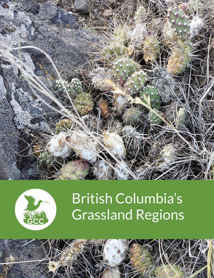
British Columbia’s Grassland Regions

2© Grasslands Conservation Council of British Columbia
British Columbia’s Grassland Regions
Grasslands Conservation Council of British Columbia. (2017). British Columbia’s Grassland Regions. Kamloops, BC: Author.
The Grasslands Conservation Council of British Columbia’s mission is to:
• Foster understanding and appreciation for the ecological, social, economic, and cultural importance of BC grasslands.
• Promote stewardship and sustainable management practices to ensure the long-term health of BC grasslands.
• Promote the conservation of representative grassland ecosystems, species at risk, and their habitats.
The GCC acknowledges the contributions of the original authors, artists, and photographers of the material in this e-book: staff members, contractors, and volunteers.
Commonsense solutions for BC grasslands.bcgrasslands.org
3© Grasslands Conservation Council of British Columbia
British Columbia’s Grassland Regions
Table of Contents
GRASSLANDS MAPPING .......................................................................................................................................... 4
Grassland Facts | Ecosystem Classification Systems
MAJOR GRASSLAND ECOSYSTEMS ................................................................................................................. 6
Each ecosystem below includes: Grassland Landscapes | Unique Features | Plant Communities | Key Plant Species | Wildlife | Species at Risk
East Kootenay Trench .................................................................................................................................................. 7
Okanagan ..........................................................................................................................................................................13
Thompson-Pavilion ......................................................................................................................................................22
Southern Thompson Upland ...................................................................................................................................30
Cariboo-Chilcotin & Central Interior .................................................................................................................35
Sub-Boreal Interior & Northern Boreal Mountains ...................................................................................42
Boreal & Taiga Plains ...................................................................................................................................................47
Georgia Depression .....................................................................................................................................................51
4© Grasslands Conservation Council of British Columbia
British Columbia’s Grassland Regions
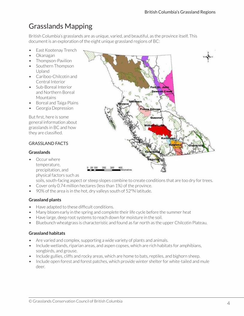
Grasslands MappingBritish Columbia’s grasslands are as unique, varied, and beautiful, as the province itself. This document is an exploration of the eight unique grassland regions of BC:
• East Kootenay Trench• Okanagan• Thompson-Pavilion• Southern Thompson
Upland• Cariboo-Chilcotin and
Central Interior• Sub-Boreal Interior
and Northern Boreal Mountains
• Boreal and Taiga Plains• Georgia Depression
But first, here is some general information about grasslands in BC and how they are classified.
GRASSLAND FACTS
Grasslands
• Occur where temperature, precipitation, and physical factors such as soils, south-facing aspect or steep slopes combine to create conditions that are too dry for trees.
• Cover only 0.74 million hectares (less than 1%) of the province.• 90% of the area is in the hot, dry valleys south of 52ºN latitude.
Grassland plants
• Have adapted to these difficult conditions.• Many bloom early in the spring and complete their life cycle before the summer heat• Have large, deep root systems to reach down for moisture in the soil.• Bluebunch wheatgrass is characteristic and found as far north as the upper Chilcotin Plateau.
Grassland habitats
• Are varied and complex, supporting a wide variety of plants and animals.• Include wetlands, riparian areas, and aspen copses, which are rich habitats for amphibians,
songbirds, and grouse.• Include gullies, cliffs and rocky areas, which are home to bats, reptiles, and bighorn sheep.• Include open forest and forest patches, which provide winter shelter for white-tailed and mule
deer.
5© Grasslands Conservation Council of British Columbia
British Columbia’s Grassland Regions
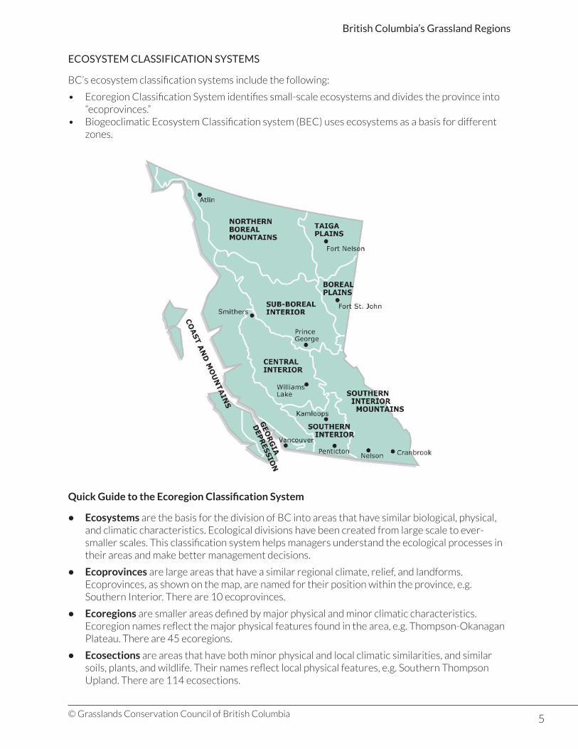
ECOSYSTEM CLASSIFICATION SYSTEMS
BC’s ecosystem classification systems include the following:
• Ecoregion Classification System identifies small-scale ecosystems and divides the province into “ecoprovinces.”
• Biogeoclimatic Ecosystem Classification system (BEC) uses ecosystems as a basis for different zones.
Quick Guide to the Ecoregion Classification System
• Ecosystems are the basis for the division of BC into areas that have similar biological, physical, and climatic characteristics. Ecological divisions have been created from large scale to ever-smaller scales. This classification system helps managers understand the ecological processes in their areas and make better management decisions.
• Ecoprovinces are large areas that have a similar regional climate, relief, and landforms. Ecoprovinces, as shown on the map, are named for their position within the province, e.g. Southern Interior. There are 10 ecoprovinces.
• Ecoregions are smaller areas defined by major physical and minor climatic characteristics. Ecoregion names reflect the major physical features found in the area, e.g. Thompson-Okanagan Plateau. There are 45 ecoregions.
• Ecosections are areas that have both minor physical and local climatic similarities, and similar soils, plants, and wildlife. Their names reflect local physical features, e.g. Southern Thompson Upland. There are 114 ecosections.
6© Grasslands Conservation Council of British Columbia
British Columbia’s Grassland Regions
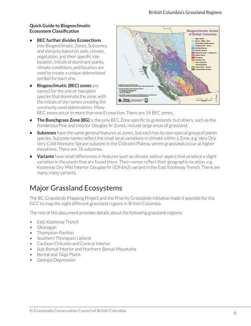
Quick Guide to Biogeoclimatic Ecosystem Classification
• BEC further divides Ecosections into Biogeoclimatic Zones, Subzones, and Variants based on soils, climate, vegetation, and their specific site location. Initials of dominant plants, climate conditions, and location are used to create a unique abbreviated symbol for each one.
• Biogeoclimatic (BEC) zones are named for the one or two plant species that dominate the zone, with the initials of the names creating the commonly used abbreviation. Many BEC zones occur in more than one Ecosection. There are 14 BEC zones.
• The Bunchgrass Zone (BG) is the only BEC Zone specific to grasslands, but others, such as the Ponderosa Pine and Interior Douglas-fir Zones, include large areas of grassland.
• Subzones have the same general features as zones, but each has its own special group of plants species. Subzone names reflect the small local variations in climate within a Zone, e.g. Very Dry Very Cold Montane Spruce subzone in the Chilcotin Plateau where grasslands occur at higher elevations. There are 76 subzones.
• Variants have small differences in features such as climate, soils or aspect that produce a slight variation in the plants that are found there. Their names reflect their geographic location, e.g. Kootenay Dry Mild Interior Douglas-fir (IDFdm2) variant in the East Kootenay Trench. There are many, many variants.
Major Grassland EcosystemsThe BC Grasslands Mapping Project and the Priority Grasslands Initiative made it possible for the GCC to map the eight different grassland regions in British Columbia.
The rest of this document provides details about the following grassland regions:
• East Kootenay Trench• Okanagan• Thompson-Pavilion• Southern Thompson Upland• Cariboo-Chilcotin and Central Interior• Sub-Boreal Interior and Northern Boreal Mountains• Boreal and Taiga Plains• Georgia Depression
7© Grasslands Conservation Council of British Columbia
British Columbia’s Grassland Regions
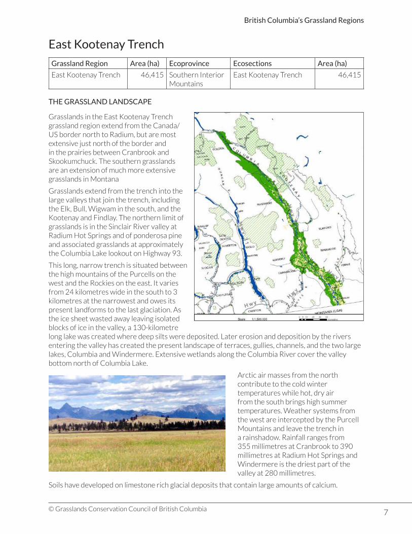
East Kootenay Trench
Grassland Region Area (ha) Ecoprovince Ecosections Area (ha)
East Kootenay Trench 46,415 Southern Interior Mountains
East Kootenay Trench 46,415
THE GRASSLAND LANDSCAPE
Grasslands in the East Kootenay Trench grassland region extend from the Canada/US border north to Radium, but are most extensive just north of the border and in the prairies between Cranbrook and Skookumchuck. The southern grasslands are an extension of much more extensive grasslands in Montana
Grasslands extend from the trench into the large valleys that join the trench, including the Elk, Bull, Wigwam in the south, and the Kootenay and Findlay. The northern limit of grasslands is in the Sinclair River valley at Radium Hot Springs and of ponderosa pine and associated grasslands at approximately the Columbia Lake lookout on Highway 93.
This long, narrow trench is situated between the high mountains of the Purcells on the west and the Rockies on the east. It varies from 24 kilometres wide in the south to 3 kilometres at the narrowest and owes its present landforms to the last glaciation. As the ice sheet wasted away leaving isolated blocks of ice in the valley, a 130-kilometre long lake was created where deep silts were deposited. Later erosion and deposition by the rivers entering the valley has created the present landscape of terraces, gullies, channels, and the two large lakes, Columbia and Windermere. Extensive wetlands along the Columbia River cover the valley bottom north of Columbia Lake.
Arctic air masses from the north contribute to the cold winter temperatures while hot, dry air from the south brings high summer temperatures. Weather systems from the west are intercepted by the Purcell Mountains and leave the trench in a rainshadow. Rainfall ranges from 355 millimetres at Cranbrook to 390 millimetres at Radium Hot Springs and Windermere is the driest part of the valley at 280 millimetres.
Soils have developed on limestone rich glacial deposits that contain large amounts of calcium.

8© Grasslands Conservation Council of British Columbia
British Columbia’s Grassland Regions
HISTORICAL LAND IMPACTS
Many factors have influenced the development of grasslands in the East Kootenay Trench, including climate, fire, forest expansion, logging, grazing by livestock and wildlife, and settlement.
While lightning is the only natural cause of fires, aboriginal people used fire to maintain open grasslands and to feed their growing number of horses. Logging and expansion of settlement in the early years of the twentieth century came with more fires, many of them traveling far
beyond their intended extent.
The grasslands have also been altered by long time grazing by often large herds of horses and other livestock. In the 1880s there were as many as 2,000 horses and 500 head of cattle on Joseph’s Prairie in the Cranbrook area. More domestic animals were added as the Canadian Pacific railway expanded into the area and more settlers arrived.
Feral horses were a particular problem even into the 1960s. As livestock numbers declined in more recent years, the populations of mule deer and elk have increased substantially. The grasslands continue to be in a largely overgrazed condition. The historic alteration of the native grasslands in the trench mean that scientists are not able to describe the original grasslands.
UNIQUE FEATURES - DUTCH CREEK HOODOOS
Highway 93 takes a sharp right hand turn over Dutch Creek, at the north end of Columbia Lake. The turn in the road follows the huge serrated wall of silts called The Hoodoos. This wall is only the southernmost end of the long southern edge of a high, flat bench that runs along the west side of the Trench above the Columbia River. Extensive grasslands cover the bench, with Douglas-fir forests on cooler slopes and aspens filling the gullies.
The bench is apparently older than the last glaciation having been deposited into some long-ago lake. Mixed layers of silts and coarser material indicate the differences in the material being brought into the lake by an ancient river. Thousands of years of erosion has sculpted the distinctive hoodoo pillars and the cap of coarser materials on the upper layers has helped to protect them.

9© Grasslands Conservation Council of British Columbia
British Columbia’s Grassland Regions
PLANT COMMUNITIES
Ecosection BEC Zones with Grasslands *Major grassland BEC Subzones and Variants
East Kootenay Trench Ponderosa Pine ZoneInterior Douglas-Fir ZoneMontane Spruce ZoneEngelmann Spruce-Sub-alpine Fir Zone
PPdh2: Kootenay Dry Hot Ponderosa Pine VariantIDFunn: Undifferentiated Nelson Forest Region Interior Douglas-fir VariantIDFdm2: Kootenay Dry Mild Interior Douglas-fir Variant
* Over 3,000 hectares
The lowest parts of the East Kootenay Trench are at 700 metres which is 300 metres higher in elevation than the lowest areas in the Okanagan grasslands region. 90% of the grasslands are found in the Ponderosa Pine and Douglas-fir zones, with only small pockets in the Montane Spruce and higher elevation zones.
Some species commonly found in the South Okanagan and Kettle River grasslands are less common in the East Kootenay Trench. Antelope-brush is widespread on the Kootenay River floodplains and occurs on dry sites from the Tobacco Plains to just south of Canal Flats.
Bluebunch wheatgrass, Idaho fescue, rough fescue, mock orange and bitterroot are all found in the southern part of the trench, but only Idaho fescue and rough fescue extend as far north as Invermere. Brittle prickly-pear cactus, common in the South Okanagan, is only found in a few places in the Trench. Big sagebrush is found in a small patch near Invermere and as individual plants in the far south, while common rabbit-brush and arrow-leaved balsamroot are uncommon.
PPdh2: Kootenay Dry Hot Ponderosa Pine Variant: 15,900 hectares
These grasslands extend north from the Canada/US border as large and small areas through the Tobacco Plains and from the lower St. Mary River valley as far as Skookumchuck. They were much more extensive in the south before Lake Kookanusa was created behind the Libby dam on the Kootenay River. The original community is thought to have been similar to the Upper Grasslands of the Thompson Basin.
Ponderosa pine occurs up to 950 metres elevation as far north as Canal Flats, where it mixes with Douglas-fir. Under the best conditions there is a mix of grasses including Idaho fescue, rough fescue and bluebunch wheatgrass with silky lupine, timber milk-vetch, round-leaved alumroot, and meadow death-camas among other flowering plants.
An area at Skookumchuck Prairie that was enclosed with a fence in the 1950s to keep livestock out has been monitored to follow the change in plant cover without grazing. After 50 years of study, Idaho fescue seems to be the dominant species.
IDFunn: Undifferentiated Nelson Forest Region Interior Douglas-fir Variant: 3,500 hectares
The original plant species of this variant are unknown as the area has been heavily overgrazed and along Columbia Lake, has been converted to agricultural land. It is likely that rough fescue, Idaho fescue and bluebunch wheatgrass dominated the community with a few Douglas-fir trees. Common rabbit-brush, Rocky Mountain juniper, common juniper, and saskatoon would also have been present.

10© Grasslands Conservation Council of British Columbia
British Columbia’s Grassland Regions
IDFdm2: Kootenay Dry Mild Interior Douglas-fir Variant: 23,450 hectares
This variant occurs above the Ponderosa Pine Variant in the south and from the valley bottom to 1,200 metres as far north as Briscoe. It is only found in the driest sites and ponderosa pine and Douglas-fir trees make up less than 15% of the cover.
On the warmest sites antelope-brush and other shrubs including chokecherry, saskatoon, and mock-orange grow under open Douglas-fir stands. North of Canal Flats Rocky Mountain juniper is the dominant shrub. Other grassland communities in these open Douglas-fir forests are dominated by bluebunch wheatgrass.
Other Grassland Communities
A 20 to 30 hectare area of grassland east of Golden on a steep slope above the Kicking Horse River is the most northerly extent of this plant community in the Trench and the most easterly extent of grasslands in the province.
Small pockets of grasslands and open forests occur on south and east-facing slopes in the Montane Spruce Zone. Grasslands are also found into the alpine where there are rich arrays of flowering plants.
Cottonwood forests are found on the active floodplains along the Kootenay River, Lake Kookanusa and Lake Windermere. Black spruce, red-osier dogwood, Nootka rose, prickly rose, and mountain alder are common accompanying species. Ponds, marshes, and wetlands occur on the upland benches where many of them dry
up during the summer months. The presence of alkali saltgrass and foxtail barley indicate the highly alkaline conditions of many ponds.
Marshes are found from the valley bottom to the Montane Spruce Zone with bulrushes the most common species. Where cattail marshes do occur they are often the only plant in the marsh.
Shrublands commonly develop after fires and are widespread in the grasslands of the Trench. The species composition varies with location with antelope brush the dominant species south of Canal Flats and below 1,150 metres. At higher elevations and further north in the valley, snowbrush, redstem ceanothus, and soopolallie are the most common species.
Trembling aspen often grows up after fires and is also found in moist depressions and swales throughout the Trench.
KEY PLANT SPECIES
Idaho Fescue
• Found throughout the grasslands of the Trench as far north as Invermere.• Grows on cool, north-facing slopes but less frequent in open forest grasslands.• Perennial bunchgrass that grows in a dense tufted, from 30 – 90 cm tall.• Leaves are long and narrow with a blueish colour and are very rough to the touch.• An important grass for grazing livestock, but reduced in abundance by heavy grazing.
11© Grasslands Conservation Council of British Columbia
British Columbia’s Grassland Regions
WILDLIFE
The complex mix of grasslands, open forests, and closed forests, combined with the extensive wetlands of the Columbia and Kootenay Rivers, provides habitat for a wide variety of wildlife species. Many use the adjacent grasslands for at least parts of their life cycle.
The common garter snake, western garter snake, western toad, and long-toed salamander are the only reptiles and amphibians commonly found in the Trench.
Over 70% of the birds found in BC occur in this region and over 60% of species that breed in the province can be found here. Typical grassland species include western meadowlark and vesper sparrow, which nest in the shelter of large bunchgrass plants, and common nighthawk, which lays its eggs directly on the ground. Brewer’s blackbird, black-billed magpie, and bank swallow are some other commonly seen birds.
Raptors, such as the turkey vulture, Cooper’s hawk, American kestrel, and bald eagle, find prey in the open grasslands but nest away from the grasslands in large trees or cliffs.
The Black-chinned hummingbird, black-billed cuckoo, common poorwill, and western bluebird are all found in the Trench but are less-commonly found in other grassland areas of the province. The white-breasted nuthatch is found in open pine and fir grasslands forests and has the highest number of breeding pairs in the province. While most grassland birds migrate south in the fall, Clark’s nutcracker, Bohemian waxwing, and Harris’s sparrow are only a few of the birds that remain for the winter, foraging and sheltering in the open forests.
Wetlands, ponds, and marshes and adjacent riparian vegetation are home to a wide variety of birds including ducks, geese, shorebirds, and perching birds. Many species use the area to rest during migration but killdeer, American coot , Mallard, red-winged blackbird, marsh wren, and a host of warblers stay to nest and raise their young.
A variety of small mammals are found in the grasslands, including the yellow-bellied marmot, Columbian ground squirrel, mice, voles, and shrews. The coyote is an efficient predator.
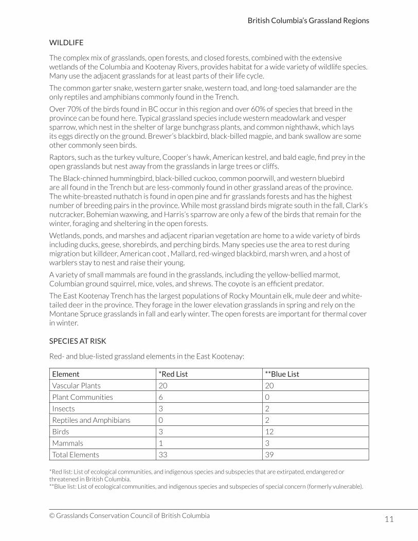
The East Kootenay Trench has the largest populations of Rocky Mountain elk, mule deer and white-tailed deer in the province. They forage in the lower elevation grasslands in spring and rely on the Montane Spruce grasslands in fall and early winter. The open forests are important for thermal cover in winter.
SPECIES AT RISK
Red- and blue-listed grassland elements in the East Kootenay:
Element *Red List **Blue List
Vascular Plants 20 20
Plant Communities 6 0
Insects 3 2
Reptiles and Amphibians 0 2
Birds 3 12
Mammals 1 3
Total Elements 33 39
*Red list: List of ecological communities, and indigenous species and subspecies that are extirpated, endangered or threatened in British Columbia.**Blue list: List of ecological communities, and indigenous species and subspecies of special concern (formerly vulnerable).

12© Grasslands Conservation Council of British Columbia
British Columbia’s Grassland Regions
Most listed plant species occur in the Kootenay Dry Mild Interior Douglas-fir Variant, and all but one of the red-listed species (Flat-topped broomrape) occur there. Some species including yellow buckwheat, androsace buckwheat, elk thistle, and fuzzy-tongued penstemon are unique to the east Kootenay Trench grassland region.
Annual paintbrush, three-spot mariposa lily, and viviparous fescue are not as abundant in other parts of the province. Yellow buckwheat and three-spot mariposa lily are apparently near their northern limit in BC. Some listed species, such as prairie crocus, prairie coneflower, scarlet gaura, and scarlet globe-mallow and others are of prairie origin.
Three butterfly species are red-listed, the Dione copper, Gillette checkerspot, and the vivid dancer and two are blue-listed: the common ringlet and the eastern tailed blue. Painted turtle and rubber boa are the only two listed reptiles found in the region, occurring in wetlands in the ponderosa pine and Douglas-fir grasslands.
Only one red-listed bird species recorded in the Trench is confirmed as nesting there: The American avocet, an elegant shorebird, relies on small grasslands ponds and marshes. The grasshopper sparrow may occur in the extreme southern end of the Trench. The red-listed peregrine falcon, anatum subspecies, and prairie falcon have been observed during the nesting season but their status is not confirmed. They hunt over grasslands, open forests, and wetlands but nest elsewhere.
The blue-listed great blue heron and the American bittern can also be found in wet areas; the heron nests in colonies, usually in cottonwood trees, while the secretive bittern builds a well-concealed nest over the water in cattails or rushes. Sandhill cranes prefer isolated marshes and wet areas in forest openings for breeding, and are known to nest in the Trench north of Cranbrook.
The flammulated owl in open Douglas-fir forests breeds as far north as Radium Hot Springs. Lewis’s woodpecker relies on ponderosa pine, black cottonwood or Douglas-fir snags for nesting and forages over adjacent grasslands for flying insects. Found in the open grasslands and forests from the Ponderosa Pine to the Montane Spruce Zone, they are known to nest at Newgate, Wycliffe, and Windermere.
Long-billed curlew prefer well-grazed grasslands with low vegetation and are found from Grasmere to Windermere. Sharp-tailed grouse are present in the southern portion of the Trench, although their numbers are uncertain. The bobolink, a black and white bird the size of a meadowlark, is found in open grasslands and open forests from the Ponderosa Pine Zone to the Montane Spruce Zone.
White-throated swift is recorded from the northern end of the East Kootenay Trench grasslands Region, where it would be nesting on steep cliffs.
Red-listed badger and blue-listed ermine are the only small mammals at risk in the Trench.
Blue-listed Rocky Mountain bighorn sheep forage in the grasslands year-round and use nearby cliffs and talus slopes for lambing and escape terrain. They also use Montane Spruce forests for fall and early winter grazing and are sometimes found on ridges in the sub-alpine and alpine areas. Important habitat areas are along the east side of Columbia Lake and the west-facing slopes on the east side of
Lake Windermere.
Species at Risk Profile: Long-billed curlew
• Blue-listed in BC• Listed under the Federal Species at Risk Act (SARA)
The largest concentration of Long-billed curlew nesting pairs in East Kootenay Trench grasslands region is at Skookumchuck Flats where at least twenty breeding pairs have been recorded.
Long-billed curlews prefer short grass areas, presumably so they can for see predators more easily. Where there are large numbers they will nest fairly
13© Grasslands Conservation Council of British Columbia
British Columbia’s Grassland Regions
close together. They feed on beetles and grasshoppers during the breeding season in BC. Nests are made in small depressions, which they line with some grass and usually lay four eggs. Their streaky brown colouring allows them to blend in with the dead leaves from the previous year’s plant growth.
Once hatched, the birds move their chicks to longer grass usually in moister sites or even hayfields. Only one or two chicks survive the attention of the raptors, owls, crows, ravens, and magpies that prey on them. Curlews have left the grasslands by the end of August and moved to coastal or inland mudflats from California to Guatemala.
The population in the Trench seems to be increasing but there is the ever-present threat of habitat loss due to conversion of grassland to other uses and encroachment of trees into their grasslands habitat.
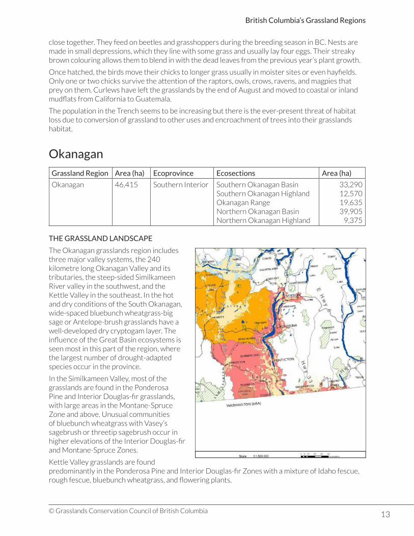
Okanagan
Grassland Region Area (ha) Ecoprovince Ecosections Area (ha)
Okanagan 46,415 Southern Interior Southern Okanagan BasinSouthern Okanagan HighlandOkanagan RangeNorthern Okanagan BasinNorthern Okanagan Highland
33,29012,57019,63539,905
9,375
THE GRASSLAND LANDSCAPE
The Okanagan grasslands region includes three major valley systems, the 240 kilometre long Okanagan Valley and its tributaries, the steep-sided Similkameen River valley in the southwest, and the Kettle Valley in the southeast. In the hot and dry conditions of the South Okanagan, wide-spaced bluebunch wheatgrass-big sage or Antelope-brush grasslands have a well-developed dry cryptogam layer. The influence of the Great Basin ecosystems is seen most in this part of the region, where the largest number of drought-adapted species occur in the province.
In the Similkameen Valley, most of the grasslands are found in the Ponderosa Pine and Interior Douglas-fir grasslands, with large areas in the Montane-Spruce Zone and above. Unusual communities of bluebunch wheatgrass with Vasey’s sagebrush or threetip sagebrush occur in higher elevations of the Interior Douglas-fir and Montane-Spruce Zones.
Kettle Valley grasslands are found predominantly in the Ponderosa Pine and Interior Douglas-fir Zones with a mixture of Idaho fescue, rough fescue, bluebunch wheatgrass, and flowering plants.
14© Grasslands Conservation Council of British Columbia
British Columbia’s Grassland Regions
North of Kelowna grasslands are found on the rolling benches and hills of the Interior Douglas-fir zone. Subalpine and alpine grasslands are found in the Hunters Range area north of the Shuswap River.
The underlying geology of the Okanagan grasslands region defines the major structure of the valleys and glaciation provided the final surfaces on which grasslands have developed. The ice sheet that covered the area 15,000 years ago was as much as 2150 metres thick. Ice retreated from the hillsides first while remaining in the valley bottoms. Rivers flowed along the sides of Okanagan Lake, depositing moraine in long ridges that are particularly visible on the slopes north east of Kelowna.
As the ice melted in the valley, a large block remained at McIntyre Bluff north of Oliver, ponding back water in Glacial Lake Penticton to a height 100 metres above the present lake level. Rivers pouring into the lake deposited gravels and silts as terraces and fans that are now perched on the hillsides above the lake.
The silt cliffs that form the distinctive benches at Summerland and Penticton were deposited on the lake bottom and eroded as the lake level dropped. Post-glacial erosion deepened side valleys leaving a legacy of fans such as the large area between Skaha Lake and Okanagan Lake where Penticton stands today.
Terraces and fans left along the Similkameen River provide suitable conditions for bluebunch wheatgrass-big sage communities. The Kettle River valley was scoured by ice extending into the United States, with thick glacial lake deposits left as ice-damned lakes drained.
In the rainshadow of the Coast and Cascade Mountains, the Okanagan grasslands region is generally hot and dry in summer. Hot, dry air from the south in summer brings higher temperatures to the South Okanagan and almost desert conditions. Similarly the influence of Arctic air masses from the north in winter are felt more in the north and at higher elevations.
Precipitation increases from south to north with Oliver having 305 millimetres and Armstrong 488 millimetres. The Kettle valley also has more precipitation (420 millimetres) but less falls as snow than at many parts of the southern Okanagan. Okanagan Lake and the other lakes in the valley help to moderate temperatures throughout the year.
HISTORICAL IMPACTS
Okanagan region grasslands have been altered in a number of ways. Fire has always been present as a result of lightning strikes and aboriginal peoples are known to have set fires to improve grazing and plant food sources. Fires were also set by prospectors searching for mineral exposures and by early settlers.
Livestock grazing has impacted many areas of these dry grasslands, particularly along the old Brigade Trails from Kamloops to Washington State. 200 to 300 horses in each brigade used the routes, with many animals left out to fend for themselves along the way. The gold rush in the 1860s increased the need for beef and the gradual increase in permanent settlements created even more demand. By 1892, 20,000 head of cattle grazed the grasslands and dry forests between Oliver and Enderby.
Soil survey parties in the 1960s reported widespread overgrazing. These conditions allowed for the spread of non-native invasive species such as knapweeds into the grasslands. Agriculture in the form of orchards and vineyards, and urban development continue to intrude onto the grasslands of this region.
Grasslands in the Okanagan region are protected in parks and other conservation areas where livestock grazing is managed to reduce the impact on plant communities. Research projects, particularly in the South Okanagan, are giving grasslands managers a better understanding of grasslands species and their particular needs.
15© Grasslands Conservation Council of British Columbia
British Columbia’s Grassland Regions
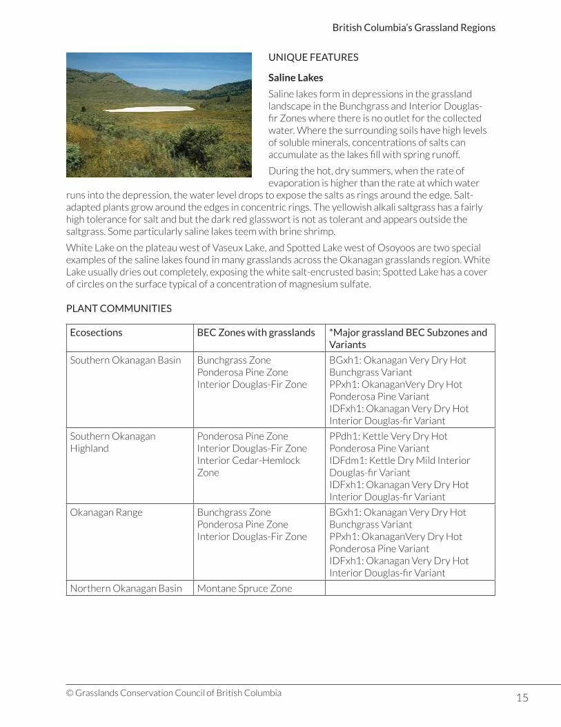
UNIQUE FEATURES
Saline Lakes
Saline lakes form in depressions in the grassland landscape in the Bunchgrass and Interior Douglas-fir Zones where there is no outlet for the collected water. Where the surrounding soils have high levels of soluble minerals, concentrations of salts can accumulate as the lakes fill with spring runoff.
During the hot, dry summers, when the rate of evaporation is higher than the rate at which water
runs into the depression, the water level drops to expose the salts as rings around the edge. Salt-adapted plants grow around the edges in concentric rings. The yellowish alkali saltgrass has a fairly high tolerance for salt and but the dark red glasswort is not as tolerant and appears outside the saltgrass. Some particularly saline lakes teem with brine shrimp.
White Lake on the plateau west of Vaseux Lake, and Spotted Lake west of Osoyoos are two special examples of the saline lakes found in many grasslands across the Okanagan grasslands region. White Lake usually dries out completely, exposing the white salt-encrusted basin; Spotted Lake has a cover of circles on the surface typical of a concentration of magnesium sulfate.
PLANT COMMUNITIES
Ecosections BEC Zones with grasslands *Major grassland BEC Subzones and Variants
Southern Okanagan Basin Bunchgrass ZonePonderosa Pine ZoneInterior Douglas-Fir Zone
BGxh1: Okanagan Very Dry Hot Bunchgrass VariantPPxh1: OkanaganVery Dry Hot Ponderosa Pine VariantIDFxh1: Okanagan Very Dry Hot Interior Douglas-fir Variant
Southern Okanagan Highland
Ponderosa Pine ZoneInterior Douglas-Fir ZoneInterior Cedar-Hemlock Zone
PPdh1: Kettle Very Dry Hot Ponderosa Pine VariantIDFdm1: Kettle Dry Mild Interior Douglas-fir VariantIDFxh1: Okanagan Very Dry Hot Interior Douglas-fir Variant
Okanagan Range Bunchgrass ZonePonderosa Pine ZoneInterior Douglas-Fir Zone
BGxh1: Okanagan Very Dry Hot Bunchgrass VariantPPxh1: OkanaganVery Dry Hot Ponderosa Pine VariantIDFxh1: Okanagan Very Dry Hot Interior Douglas-fir Variant
Northern Okanagan Basin Montane Spruce Zone

16© Grasslands Conservation Council of British Columbia
British Columbia’s Grassland Regions
Ecosections BEC Zones with grasslands *Major grassland BEC Subzones and Variants
Northern Okanagan Highlands
Engelmann Spruce-Sub-alpine Fir ZoneAlpine Tundra ZoneBunchgrass ZonePonderosa Pine ZoneInterior Douglas-Fir ZonePonderosa Pine ZoneInterior Douglas-Fir ZoneMontane Spruce ZoneEngelmann Spruce-Sub-alpine Fir ZoneInterior Cedar-Hemlock Zone
BGxh1: Okanagan Very Dry Hot Bunchgrass VariantPPxh1: Okanagan Very Dry Hot Ponderosa Pine VariantIDFxh1: Okanagan Very Dry Hot Interior Douglas-fir VariantPPxh1: Okanagan Very Dry Hot Ponderosa Pine VariantIDFxh1: Okanagan Very Dry Hot Interior Douglas-fir VariantIDFdm1: Kettle Dry Mild Interior Douglas-fir Variant
* Over 3,000 hectares
Almost 50% of the grasslands of the Okanagan grasslands region occur in the Okanagan and Similkameen Valleys in the lower elevation Bunchgrass and Ponderosa Pine Zones. The Interior Douglas-fir Zone in the North Okanagan Basin and the Kettle Valley portion of the North Okanagan Highlands account for most of the other grasslands.
BGxh1: Okanagan Very Dry Hot Bunchgrass Variant: 22,780 hectares
Some of the hottest and driest conditions in the province are found in the Southern Okanagan Basin from the valley bottom of the Okanagan and Similkameen at 250 metres to about 700 metres at Summerland. The area is the northern extension of similar grasslands that occur as far south as Oregon and has the most diverse array of grasslands species in the province.
Antelope-brush and common rabbit-brush are the common shrub species on the driest sites, while threetip sagebrush is widely distributed. Big sagebrush is found where there is more moisture, often accompanied by saskatoon, common chokecherry, Douglas maple, and mock-orange. Ponderosa pine and Douglas-fir grow in moist sites.
Widely-spaced bluebunch wheatgrass is found on undisturbed sites with a healthy cryptogamic crust of lichens, mosses, algae, and fungi. Prairie sagewort,
junegrass, yarrow long-leaved phlox, prickly phlox, bitterroot, and snow buckwheat are some common flowering plants of these sites. Idaho fescue and rough fescue dominate on cooler north- and east-facing slopes while giant wild rye is found in moist and saline sites at higher elevations.
PPxh1: OkanaganVery Dry Hot Ponderosa Pine Variant: 28,660 hectares
Open ponderosa pine grasslands are found between 335 and 940 metres above the bunchgrass variants as far north as Vernon in the Okanagan valley and to Keremeos in the Similkameen. Plant associations resemble those found further south in Washington and further north in BC.
Bluebunch wheatgrass, Idaho fescue, and rough fescue are common grasses in these parkland areas of grasslands, open forest, and shrubs. Some flowering plants also found include Sandberg’s bluegrass, junegrass, yarrow, and arrow-leaved balsamroot.

17© Grasslands Conservation Council of British Columbia
British Columbia’s Grassland Regions
Antelope brush communities occur on the driest sites with red three-awn, bluebunch wheatgrass, snow buckwheat, common selaginella, and arrow-leaved balsamroot.
The mountain pine beetle epidemic of 2005-07 killed large numbers of the ponderosa pine trees in this variant and the impact this will have on the grasslands is not known.
PPdh1: Kettle Very Dry Hot Ponderosa Pine Variant: 5,150 hectares
Grasslands are more common than open forests in this variant as hot, dry summers and low snow cover in winter reduce the amount of moisture available for tree growth. They range from 450 to 950 metres on valley bottoms and south-facing slopes from Johnstone Creek to Boundary Falls and from July Creek to Christina Lake.
In the least disturbed areas, bluebunch wheatgrass, rough fescue, and Idaho fescue cover most of the ground, with white silky lupine, arrow-leaved balsamroot, sticky geranium, and lemonweed. Open ponderosa pine forests are most common on south-facing slopes with a mix of grasses and a variety of flowering plants including arrow-leaved balsamroot, sticky geranium, silky lupine, and parsley-flowered buckwheat. Many sites have introduced species such as great mullein, yellow salsify, and sulphur cinquefoil.
The impact of the mountain pine beetle on ponderosa pine trees in this variant and the subsequent impact on grasslands is unknown.
On upper slopes and rocky areas compact selaginella is the most common plant with bluebunch wheatgrass and occasionally common snowberry or saskatoon. Where soils are coarse in texture, moisture does not remain for long, and trees cannot thrive. Where these soils occur on mid-slopes, bluebunch bunch wheatgrass, with compact selaginella, thread-leaved phacelia, junegrass, and introduced cheatgrass. A number of red-listed plant species are also found in these communities.
Noxious weeds are extensive in this variant and in places, diffuse knapweed and cheatgrass can form nearly 50% of the cover. Other non-native species include Kentucky bluegrass, creeping bentgrass, field bindweed, and common hound’s tongue.
IDFxh1: Okanagan Very Dry Hot Interior Douglas-fir Variant: 44,335 hectares
The largest variant in the Okanagan grasslands region occurs in different forms. From the Canada/US border north to Enderby and along the Similkameen River valley to Princeton, open forests and grasslands are found between the Ponderosa Pine and Montane Spruce Zones.
In the Coldstream valley from Vernon to Lumby, and on the east side of Okanagan Lake to Woods Lake,
it occurs as extensive open grasslands. Most of the variant in the Kettle Valley has no trees or has small patches of aspen and Douglas-fir in moist draws and depressions. Near Bridesville, Douglas-fir grasslands extend from the valley floor to merge with continuous forest.
Idaho fescue, rough fescue, and bluebunch wheatgrass are the dominant grasses on least disturbed sites, with silky lupine, arrow-leaved balsamroot, parsnip-flowered buckwheat, and junegrass. Shrubs such as saskatoon, mock orange, and common snowberry occupy moist areas and cooler slopes. Bluebunch wheatgrass, silky lupine, and arrow-leaved balsamroot occur on drier sites.
18© Grasslands Conservation Council of British Columbia
British Columbia’s Grassland Regions
Where grasslands have been heavily disturbed cheatgrass, dandelion, great mullein, compound fleabane, and knapweeds are the dominant plants.
IDFdm1: Kettle Dry Mild Interior Douglas-fir Variant: 6,640 hectares
These grasslands are most extensive in the Kettle Vvalley above the Ponderosa Pine grasslands and the warmer Interior Douglas-fir grasslands. They also occur east of Osoyoos from Anarchist Mountain to Bridesville ,and in the Granby River valley north of Grand Forks. In the Okanagan Valley, they extend along the east side between 560 and 1,200 metres elevation from Osoyoos to Kelowna. Winters in these areas are relatively mild and snow free, and summers are very hot, but frost can also occur in the growing season.
On sites in the best condition, bluebunch wheatgrass is the dominant species with junegrass, yarrow, and silky lupine. Big sagebrush may occur in places in the Okanagan, and Idaho fescue occurs on moister sites.
Past grazing and cultivation in these grasslands have altered their composition with non-native plants and noxious weeds forming a large component of plant communities. Diffuse knapweed, cheatgrass, Kentucky bluegrass, quackgrass, common hound’s tongue, and sulphur cinquefoil are only a few of the species found in various combinations, occasionally with bluebunch wheatgrass or Columbia bluegrass.
Other Grassland Communities
Small areas of grassland occur in other BEC zones in the Okanagan grasslands region. Grasslands on Mount Kobau near Oliver and from Keremeos to Hedley in the Similkameen Valley are in the Montane Spruce Zone from 1,450 to 1,650 metres in elevation. Red-listed in this zone, Vasey’s big sagebrush-Pinegrass communities occur on south-facing slopes with species characteristic of both forest and grassland, including pinegrass, Idaho fescue, silky lupine, western meadowrue, and wild strawberry. On drier sites with moderately steep slopes, Vasey’s sagebrush occurs in association with bluebunch wheatgrass and Idaho fescue. Common juniper may be found on some sites.
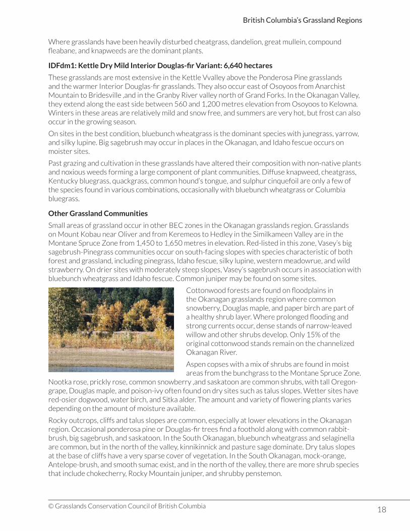
Cottonwood forests are found on floodplains in the Okanagan grasslands region where common snowberry, Douglas maple, and paper birch are part of a healthy shrub layer. Where prolonged flooding and strong currents occur, dense stands of narrow-leaved willow and other shrubs develop. Only 15% of the original cottonwood stands remain on the channelized Okanagan River.
Aspen copses with a mix of shrubs are found in moist areas from the bunchgrass to the Montane Spruce Zone.
Nootka rose, prickly rose, common snowberry ,and saskatoon are common shrubs, with tall Oregon-grape, Douglas maple, and poison-ivy often found on dry sites such as talus slopes. Wetter sites have red-osier dogwood, water birch, and Sitka alder. The amount and variety of flowering plants varies depending on the amount of moisture available.
Rocky outcrops, cliffs and talus slopes are common, especially at lower elevations in the Okanagan region. Occasional ponderosa pine or Douglas-fir trees find a foothold along with common rabbit-brush, big sagebrush, and saskatoon. In the South Okanagan, bluebunch wheatgrass and selaginella are common, but in the north of the valley, kinnikinnick and pasture sage dominate. Dry talus slopes at the base of cliffs have a very sparse cover of vegetation. In the South Okanagan, mock-orange, Antelope-brush, and smooth sumac exist, and in the north of the valley, there are more shrub species that include chokecherry, Rocky Mountain juniper, and shrubby penstemon.

19© Grasslands Conservation Council of British Columbia
British Columbia’s Grassland Regions
KEY PLANT SPECIES
Antelope-brush (Purshia tridentata)
• Widespread in the dry sagebrush grasslands of the South Okanagan.
• Medium to tall deciduous shrub with stiff, woolly branches.
• Small wedge-shaped leaves have three fine teeth at the tip and rolled edges.
• Silvery-greenish and hairy on the upper surface, grey-woolly beneath.
• Single yellow flowers with five petals cover the branches in spring.
• Small pear-shaped black seeds are eaten by chipmunks, ground squirrels and deer mice.• Seed caches are a source of new seedlings.• Important browse for deer.• Conversion of antelope-brush grasslands to orchards and wineries has severely reduced the
extent.
WILDLIFE
The Okanagan grasslands region has the highest diversity of wildlife in BC, and many species use grasslands for some part of their needs. Several species are unique to the region and others are at or near the northern limit of their range.
Insects in the grasslands are important for pollination, nutrient cycling, and as food for other animals. Insect populations of the province have not been studied as much as the larger mammals, but many surveys and studies have been done in the South Okanagan and lower Similkameen. Many species are found nowhere else in BC, others nowhere else in Canada.
Rocky Mountain wood ticks are found throughout the lower elevation grasslands, but especially in rocky areas, from early March to late June.
The Okanagan grasslands region is home to almost 75% of all bird species in the province. Meadowlarks, vesper sparrows, and common nighthawk are familiar ground-nesting birds of
the open grasslands but many more species use the grasslands for at least part of their needs.
Aspen groves are particularly rich food sources for a wide variety of species that also forage over the grasslands. Cavity nesters such as mountain bluebirds, swallows, and woodpeckers; raptors, songbirds, and sparrows also can be found there. Marshes, ponds, and wetlands with riparian vegetation provide further rich habitats for a variety of shorebirds, waterfowl, perching birds, and raptors.
Both mule deer and white-tailed deer are widespread in the region and use the Bunchgrass and Ponderosa Pine Zones in spring, fall, and winter. Winter ranges include east slopes of Okanagan Valley from Summerland to Penticton, the Ashnola Valley and between Grand Forks and Christina Lake in the Kettle Valley. Summers are spent in higher elevation forests, sometimes a long way from their winter home. Mountain goats use the lower slopes of the high cliffs between Keremeos and Hedley during the winter, and small numbers are found on the steep rocky slopes on the west side of Okanagan Lake south of Summerland.
20© Grasslands Conservation Council of British Columbia
British Columbia’s Grassland Regions
Small mammals include muskrat, bushy-tailed woodrat, bog lemmings, red squirrels, yellow-bellied marmots, and Columbian ground squirrels. Eleven species of bats are found in the grasslands and associated wetlands, cliffs, canyons, and rocky outcrops. Okanagan Falls is the favoured place in the Okanagan Valley for feeding bats on warm summer evenings.
SPECIES AT RISK
Red- and blue-listed grassland elements in the Okanagan:
Element *Red List **Blue List
Vascular Plants 73 39
Plant Communities 27 11
Insects 5 6
Reptiles and Amphibians 4 7
Birds 15 25
Mammals 5 10
Total Elements 129 98
*Red list: List of ecological communities, and indigenous species and subspecies that are extirpated, endangered or threatened in British Columbia.**Blue list: List of ecological communities, and indigenous species and subspecies of special concern (formerly vulnerable) in British Columbia.
The South Okanagan and lower Similkameen Valley is Canada’s hot spot for red- and blue-listed species with over 30% (57 species) of the province’s listed species. Over 50% of the species are associated with grasslands, and more particularly with Antelope-brush plant communities. Only 10% of the Antelope-brush-Needle-and-thread grass community is left in the South Okanagan, and it is ranked as one of the four most endangered ecosystems in Canada.
Some plants, such as the red-listed short-flowered evening-primrose and Andean evening-primrose, are restricted to the southern Okanagan Basin, others are found only occasionally beyond that area, and yet others have been found only in very specific locations. Threetip sagebrush is most abundant near the Canada/US border and occurs as far north as Summerland. Antelope-brush occurs as far north as Kaleden, and east to southwest slopes of Anarchist Mountain with a few plants as far north as Westbank and as far west as Osprey Lake north of Princeton.
Most of the 11 listed insect species are only found in the South Okanagan, with some not found elsewhere in Canada, including the Vivid dancer, Parawan tiger beetle, and ground mantid. The Mormon metalmark is found only in the South Okanagan and Similkameen while the Monarch ranges through the Okanagan Valley as far as the Thompson region.
The red-listed night snake has only been found in one location, but the rubber boa, western rattlesnake, and racer are more readily seen in grasslands near wetlands and riparian areas, or their winter homes in talus slopes and rocky outcrops. The Great Basin spadefoot toad, painted turtle, and tiger salamander are associated with ponds and shallow lake edges. The spadefoot toad overwinters by digging down deeply into the soft ground along pond edges. Tiger salamanders can live in the saline or alkaline conditions found in many ponds and wet areas of the Okanagan Valley.
Thirty-five listed bird species are found in the South Okanagan and lower Similkameen, but only 16 are found in the Kettle River valley. It is thought that the changes made in grassland communities by heavy grazing may account for the lower numbers in the Kettle Valley. The red-listed sage thrasher nests at White Lake and Chopaka grasslands and ranges as far as the North Okanagan.

21© Grasslands Conservation Council of British Columbia
British Columbia’s Grassland Regions
Brewer’s sparrow and yellow-breasted chat are found in sagebrush grasslands and riparian areas in the South Okanagan. The only known BC populations of the canyon wren are found in the cliffs and canyons between Osoyoos and Okanagan Falls. The blue-listed gray flycatcher, Lewis’s woodpecker, and flammulated owl prefer the Ponderosa Pine Zone.
The blue-listed California bighorn sheep depend on grasslands for a large part of their needs. In the Ashnola Valley they move between lower elevation and sub-alpine or alpine grasslands. In the Okanagan Valley they stay on the Lower Grasslands and open forest most of the year. Important wintering areas are used on the east side of the valley from Oliver to Penticton and at Shorts Creek on the northwest side of Okanagan Lake. In the South Okanagan, bighorn sheep come in close contact with domestic livestock, agricultural activities, and recreationists and have experienced die-offs. Residents have been involved in the recovery efforts for this herd.
The red-listed badger prefers the grasslands open forests in the Okanagan and Similkameen Valleys. Numbers are low throughout the province. Blue-listed Nuttall’s cottontail is found in small numbers in sagebrush habitat in the South Okanagan and lower Similkameen.
Six listed bat species use grasslands and riparian areas for feeding and warm crevices in cliffs for resting and for rearing young. The western red bat is known only from Okanagan Falls in the Okanagan region.
Species at Risk Profile: Pallid Bat
• Red-listed in BC• Listed under the Federal Species at Risk Act (SARA)
The pallid bat is known in Canada only from Osoyoos to Okanagan Falls. Much more numerous further south in the US, pallid bat numbers in the Okanagan are not known, but the population is thought to be very small. These bats feed over open grasslands with scattered big sagebrush, rabbit-brush, and Antelope-brush, and even along roadsides. They have separate daytime and night-time roosts in ponderosa pine trees, crevices, and cliffs. It is not known if they hibernate in the Okanagan.
The pallid bats has dark grey wings and a light body with large tan-coloured ears. Glands behind the nostril emit a skunk-like smell. Flying during the night, they hunt their prey by flying low over the grasslands and even spend time on the ground. Beetles and moths are their usual food in the Okanagan, which they may take back to their night roost to eat. Bats are themselves prey for owls, hawks, and snakes, as well as domestic cats.
Threats to bat populations include habitat loss and insects laden with pesticides used in fruit orchards.

22© Grasslands Conservation Council of British Columbia
British Columbia’s Grassland Regions
Thompson-Pavilion
Grassland Region Area (ha) Ecoprovince Ecosections Area (ha)
Thompson-Pavilion 143,975 Southern Interior Thompson BasinPavilion Ranges
98,84038,175
THE GRASSLAND LANDSCAPE
The Thompson-Pavilion grasslands region is dominated by the large, deep, steep-sided valleys of the Thompson, North Thompson, Bonaparte and Fraser Rivers. Grasslands are extensive in the valley bottoms and lower slopes, and interlace with the dry ponderosa pine and Douglas-fir forests at higher elevations. They are most extensive in the Thompson River valley and tributaries, Hat Creek valley and along the Fraser River north of Lillooet.
The present landscape was sculpted by a 1,000 metre thick ice sheet that covered the interior plateaus 15,000 years ago. As the ice melted about 12,000 years ago, vast quantities of water flowed over the area, over-deepening river valleys, filling many valleys with temporary lakes, and depositing thick layers of glacial till and silts.
Valley floors are lake-bottom flat and upland areas consist of flat terraces and gullies often interspersed with rocky cliffs and talus slopes. Winds blew a layer of fine sands and silts over the landscape that in places provided a favourable substrate for the creation of soils.
In the rainshadow of the Coast Mountains, rainfall is lowest in the western portions of the region, increasing towards Chase and up the North Thompson River. Hot dry air flows into the region from the south during the summer while the region is often under the influence of Arctic air masses in winter. The large expanse of grasslands around Ashcroft, at the junction of the Bonaparte and Thompson Rivers, are as dry as those found in the South Okanagan. At Cornwall Hill, grasslands extend from the valley floor on south-facing
slopes almost to sub-alpine elevations over only 15 kilometres.
Research studies in the Lac du Bois area northwest of Kamloops, where south-facing slopes gradually rise up to the heights of the plateau, have demonstrated the effect of elevation on temperature and precipitation. Precipitation increases from 240 millimetres in the valley bottom to 300 millimetres above 850 metres while temperatures are warmer and frost-free periods are longer in the valley bottom.
23© Grasslands Conservation Council of British Columbia
British Columbia’s Grassland Regions
HISTORICAL IMPACTS
Most of the accessible lower elevation grasslands have been heavily used over the past 150 years as the livestock industry developed and thrived. In and around urbanized areas grasslands have been lost to development.
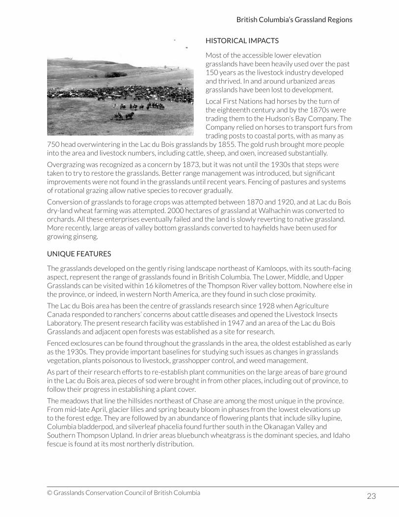
Local First Nations had horses by the turn of the eighteenth century and by the 1870s were trading them to the Hudson’s Bay Company. The Company relied on horses to transport furs from trading posts to coastal ports, with as many as
750 head overwintering in the Lac du Bois grasslands by 1855. The gold rush brought more people into the area and livestock numbers, including cattle, sheep, and oxen, increased substantially.
Overgrazing was recognized as a concern by 1873, but it was not until the 1930s that steps were taken to try to restore the grasslands. Better range management was introduced, but significant improvements were not found in the grasslands until recent years. Fencing of pastures and systems of rotational grazing allow native species to recover gradually.
Conversion of grasslands to forage crops was attempted between 1870 and 1920, and at Lac du Bois dry-land wheat farming was attempted. 2000 hectares of grassland at Walhachin was converted to orchards. All these enterprises eventually failed and the land is slowly reverting to native grassland. More recently, large areas of valley bottom grasslands converted to hayfields have been used for growing ginseng.
UNIQUE FEATURES
The grasslands developed on the gently rising landscape northeast of Kamloops, with its south-facing aspect, represent the range of grasslands found in British Columbia. The Lower, Middle, and Upper Grasslands can be visited within 16 kilometres of the Thompson River valley bottom. Nowhere else in the province, or indeed, in western North America, are they found in such close proximity.
The Lac du Bois area has been the centre of grasslands research since 1928 when Agriculture Canada responded to ranchers’ concerns about cattle diseases and opened the Livestock Insects Laboratory. The present research facility was established in 1947 and an area of the Lac du Bois Grasslands and adjacent open forests was established as a site for research.
Fenced exclosures can be found throughout the grasslands in the area, the oldest established as early as the 1930s. They provide important baselines for studying such issues as changes in grasslands vegetation, plants poisonous to livestock, grasshopper control, and weed management.
As part of their research efforts to re-establish plant communities on the large areas of bare ground in the Lac du Bois area, pieces of sod were brought in from other places, including out of province, to follow their progress in establishing a plant cover.
The meadows that line the hillsides northeast of Chase are among the most unique in the province. From mid-late April, glacier lilies and spring beauty bloom in phases from the lowest elevations up to the forest edge. They are followed by an abundance of flowering plants that include silky lupine, Columbia bladderpod, and silverleaf phacelia found further south in the Okanagan Valley and Southern Thompson Upland. In drier areas bluebunch wheatgrass is the dominant species, and Idaho fescue is found at its most northerly distribution.

24© Grasslands Conservation Council of British Columbia
British Columbia’s Grassland Regions
PLANT COMMUNITIES
Ecosections BEC Zones with grasslands *Major grassland BEC Subzones and Variants
Southern Okanagan Basin Bunchgrass ZonePonderosa Pine ZoneInterior Douglas-Fir Zone
BGxh1: Okanagan Very Dry Hot Bunchgrass VariantPPxh1: OkanaganVery Dry Hot Ponderosa Pine VariantIDFxh1: Okanagan Very Dry Hot Interior Douglas-fir Variant
Thompson Basin Bunchgrass ZonePonderosa Pine ZoneInterior Douglas-Fir Zone
BGxh2: Thompson Very Dry Hot Bunchgrass VariantBGxw1: Nicola Very Dry Warm Bunchgrass VariantPPxh2: Thompson Very Dry Hot Ponderosa Pine VariantIDFxh2: Thompson Very Dry Hot Interior Douglas-fir VariantIDFdk1: Thompson Dry Cool Interior Douglas-fir Variant
Pavilion Ranges Bunchgrass ZonePonderosa Pine ZoneInterior Douglas-Fir Zone
BGxh2: Nicola Very Dry Warm Bunchgrass VariantBGxh3: Nicola Very Dry Warm Bunchgrass VariantPPxh2: Thompson Very Dry Hot Ponderosa Pine VariantIDFxh2: Thompson Very Dry Hot Interior Douglas-fir VariantIDFdk1: Thompson Dry Cool Interior Douglas-fir Variant
* Over 3,000 hectares
Over 98% of the grasslands in Thompson-Pavilion region are found in the Bunchgrass, Ponderosa Pine, and Interior Douglas-Fir Zones, in only four variants.
Grasslands in the Thompson-Pavilion region are protected in parks and other conservation areas where livestock grazing is managed to reduce the impact on plant communities. Research projects are giving grasslands managers a better understanding of grasslands species and their particular needs.
BGxh2: Thompson Very Dry Hot Bunchgrass Variant: 45,560 hectares
Known as the Lower Grasslands, these grasslands are found in the Thompson Valley from Spences Bridge to Prichard up to about 700 metres elevation. Long, hot summers and low annual rainfall that falls mostly as winter snow produces a mix of plants adapted to this harsh environment. They account for almost 33% of the region’s grasslands.
25© Grasslands Conservation Council of British Columbia
British Columbia’s Grassland Regions
Widely spaced clumps of bluebunch wheatgrass, big sagebrush, and an array of early spring blooming plants are characteristic. Flowering plants include common rabbit-brush, brittle prickly-pear cactus, sagebrush buttercup, yellow bell, large-fruited desert parsley, and Thompson’s paintbrush. Interspersed between the plants is a thin, fragile layer of lichens, mosses, and fungi called a cryptogamic crust that helps to protect the soil from erosion.
Areas of rough fescue can occur on cooler north-facing slopes with round-leaved alumroot, parsnip-flowered buckwheat, saskatoon, and common snowberry. Common rabbit-brush, Sandberg’s bluegrass, big sagebrush, and low pussytoes are common in disturbed areas. Cheatgrass, Russian thistle, diffuse knapweed, Dalmation toadflax, and leafy spurge are only a few of the non-native species also found in disturbed areas.
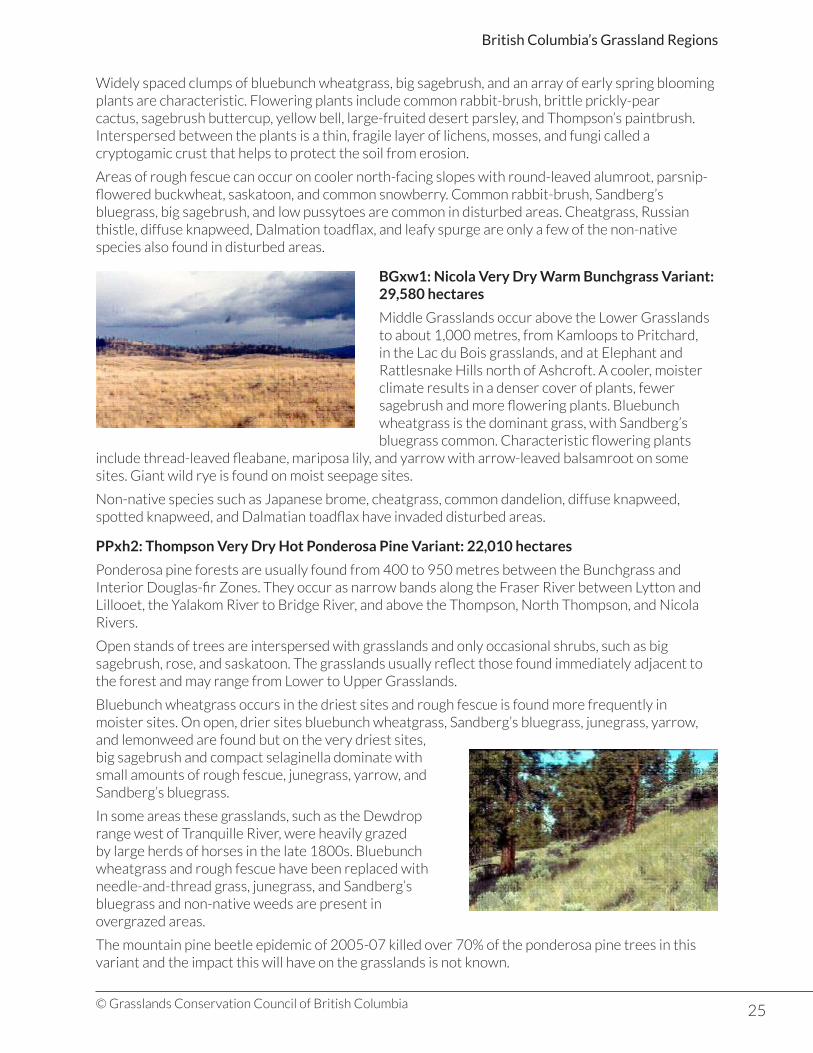
BGxw1: Nicola Very Dry Warm Bunchgrass Variant: 29,580 hectares
Middle Grasslands occur above the Lower Grasslands to about 1,000 metres, from Kamloops to Pritchard, in the Lac du Bois grasslands, and at Elephant and Rattlesnake Hills north of Ashcroft. A cooler, moister climate results in a denser cover of plants, fewer sagebrush and more flowering plants. Bluebunch wheatgrass is the dominant grass, with Sandberg’s bluegrass common. Characteristic flowering plants
include thread-leaved fleabane, mariposa lily, and yarrow with arrow-leaved balsamroot on some sites. Giant wild rye is found on moist seepage sites.
Non-native species such as Japanese brome, cheatgrass, common dandelion, diffuse knapweed, spotted knapweed, and Dalmatian toadflax have invaded disturbed areas.
PPxh2: Thompson Very Dry Hot Ponderosa Pine Variant: 22,010 hectares
Ponderosa pine forests are usually found from 400 to 950 metres between the Bunchgrass and Interior Douglas-fir Zones. They occur as narrow bands along the Fraser River between Lytton and Lillooet, the Yalakom River to Bridge River, and above the Thompson, North Thompson, and Nicola Rivers.
Open stands of trees are interspersed with grasslands and only occasional shrubs, such as big sagebrush, rose, and saskatoon. The grasslands usually reflect those found immediately adjacent to the forest and may range from Lower to Upper Grasslands.
Bluebunch wheatgrass occurs in the driest sites and rough fescue is found more frequently in moister sites. On open, drier sites bluebunch wheatgrass, Sandberg’s bluegrass, junegrass, yarrow, and lemonweed are found but on the very driest sites, big sagebrush and compact selaginella dominate with small amounts of rough fescue, junegrass, yarrow, and Sandberg’s bluegrass.
In some areas these grasslands, such as the Dewdrop range west of Tranquille River, were heavily grazed by large herds of horses in the late 1800s. Bluebunch wheatgrass and rough fescue have been replaced with needle-and-thread grass, junegrass, and Sandberg’s bluegrass and non-native weeds are present in overgrazed areas.
The mountain pine beetle epidemic of 2005-07 killed over 70% of the ponderosa pine trees in this variant and the impact this will have on the grasslands is not known.

26© Grasslands Conservation Council of British Columbia
British Columbia’s Grassland Regions
IDFxh2: Thompson Very Dry Hot Interior Douglas-fir Variant: 25,220 hectares
Cooler temperatures and more precipitation in both summer and winter results in lush grasslands with many wildflowers in the Upper Grasslands and parklands of this variant. They occur from 850 to 1,130 metres, above the Ponderosa Pine and Bunchgrass Zones both north and south of Kamloops, and at the north end of Hat Creek valley.
Rough fescue is the dominant grass in the Upper Grasslands, along with bluebunch wheatgrass, Columbia needlegrass, Kentucky bluegrass, and Junegrass. Arrow-leaved balsamroot occurs in waves in some areas, and chocolate lily, upland larkspur, sticky geranium, yarrow, death camas, and parsnip-flowered buckwheat are common. There are few shrubs in this grassland, and there is no microbiotic layer between the closely-growing plants.
Bluebunch wheatgrass is found on dry sites along with prairie sagewort, junegrass, needle-and-thread grass and umber pussytoes. As much as 95% of the vegetative cover on some sites may be rough fescue as few species can compete with it, or with the thick litter layer.
Many areas of the Upper Grasslands have been altered by long-time grazing, with needle-and-thread grass, low pussytoes, and yarrow as common species, along with many non-native species such as dandelion, Russian thistle, and cheatgrass. In recent years these non-native plants have been displaced by noxious weeds such as spotted knapweed, common hound’s tongue, and Dalmatian toadflax. Improvements in cattle management over the past 30 years are helping the restoration of these grasslands.
IDFdk1: Thompson Dry Cool Interior Douglas-fir Variant: 5,885 hectares
This variant, a continuation of the Upper Grasslands, occurs between about 1,130 and 1,460 metres and covers large areas west of Cache Creek and northeast of Paul Lake near Kamloops. In other areas they occur as openings on cool, moist sites in an otherwise continuous forest.
The dominant grasses are rough fescue and bluebunch wheatgrass, with spreading needlegrass, yarrow, and junegrass commonly associated with them. On drier sites bluebunch wheatgrass and junegrass are dominant, and dense stands of trembling aspen are found in moister sites.
Overgrazing has also altered these grasslands with many areas of exposed soil and noxious weeds such as spotted knapweed and Dalmatian toadflax.
Other Grassland Communities
Small areas of grasslands are found in the Montane Spruce Zone between 1,320 and 1,650 metres in the western part of the region near Lillooet and west of Ashcroft. Little is known about the range of communities in this zone, but bluebunch wheatgrass is often found to be the dominant grass in several communities, along with junegrass and white pussytoes on some sites.
Where grasslands occur amongst Douglas-fir, pinegrass may be present with a shrub layer containing tall Oregon grape and common snowberry. Pinegrass also forms the dominant species at higher elevations in this zone, along with a diverse layer of flowering plants. Grasslands are also found in many of the other BEC Zones in the region but only in small, discontinuous patches.
27© Grasslands Conservation Council of British Columbia
British Columbia’s Grassland Regions
The complex landscape of this region includes rocky outcrops, talus slopes and gullies where hot, dry conditions take grasslands into forested areas, while cool, moist exposures encourage tree growth down into the grasslands. On cool, moister north-facing slopes throughout the grasslands, Douglas-fir patches add diversity to the landscape.
Lakes and ponds are notably absent over much of the grasslands in Thompson-Pavilion although a variety of wetland types occur in depressions and gullies. Cattail and bulrush marshes, Baltic rush communities, and willow swamps are only a few of the plant associations found. Water levels rise with spring run-off and many are dry by summer’s end. Saline ponds occur in many areas where water levels rise with spring run-off but evaporate quickly in the heat of summer. Salt-adapted plants occur as rings of vegetation around the ponds, with maritime or red glasswort creating a striking red rim against the white salt-encrusted centre.
Trembling aspens grow in the moister sites and north-facing slopes throughout the grasslands and are particularly extensive on cooler, moist sites in the Upper Grasslands. Patches of rose and snowberry add to the variety of the landscape and the complex of habitats in the Upper Grasslands. Cottonwoods stands line river edges in the Thompson River valley, often with trembling aspen, paper birch, and a mixed shrub layer.
KEY PLANT SPECIES
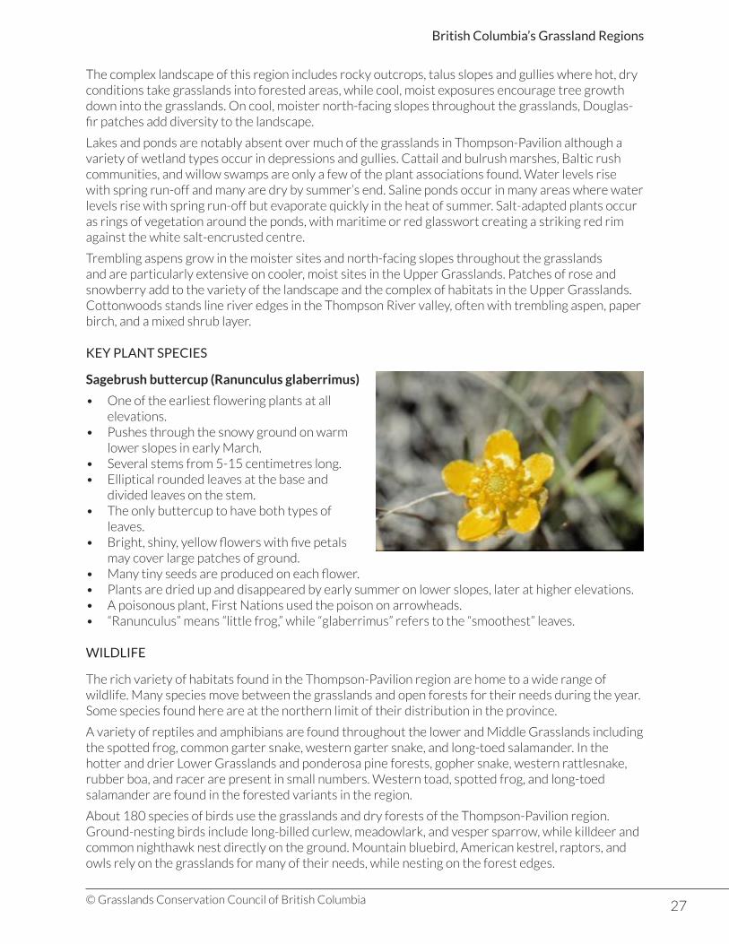
Sagebrush buttercup (Ranunculus glaberrimus)
• One of the earliest flowering plants at all elevations.
• Pushes through the snowy ground on warm lower slopes in early March.
• Several stems from 5-15 centimetres long.• Elliptical rounded leaves at the base and
divided leaves on the stem.• The only buttercup to have both types of
leaves.• Bright, shiny, yellow flowers with five petals
may cover large patches of ground.• Many tiny seeds are produced on each flower.• Plants are dried up and disappeared by early summer on lower slopes, later at higher elevations.• A poisonous plant, First Nations used the poison on arrowheads.• “Ranunculus” means “little frog,” while “glaberrimus” refers to the “smoothest” leaves.
WILDLIFE
The rich variety of habitats found in the Thompson-Pavilion region are home to a wide range of wildlife. Many species move between the grasslands and open forests for their needs during the year. Some species found here are at the northern limit of their distribution in the province.
A variety of reptiles and amphibians are found throughout the lower and Middle Grasslands including the spotted frog, common garter snake, western garter snake, and long-toed salamander. In the hotter and drier Lower Grasslands and ponderosa pine forests, gopher snake, western rattlesnake, rubber boa, and racer are present in small numbers. Western toad, spotted frog, and long-toed salamander are found in the forested variants in the region.
About 180 species of birds use the grasslands and dry forests of the Thompson-Pavilion region. Ground-nesting birds include long-billed curlew, meadowlark, and vesper sparrow, while killdeer and common nighthawk nest directly on the ground. Mountain bluebird, American kestrel, raptors, and owls rely on the grasslands for many of their needs, while nesting on the forest edges.

28© Grasslands Conservation Council of British Columbia
British Columbia’s Grassland Regions
The ponds, lakes and wetlands are filled in spring with migrating waterfowl, many of which move to higher elevations or more northern latitudes for breeding. Mallard, American widgeon, lesser scaup, redhead, ruddy duck, Barrow’s goldeneye and northern shoveler are only a few species known to breed. Marshy edges are home to blackbirds, marsh wrens and rails.Aspen groves, riparian areas and the grassland-forest edge with their rich insect populations provide important habitat for a variety of songbirds, finches,
thrushes and sparrows. Owls and woodpeckers also take advantage of these rich areas.
Mule deer are found throughout the region, where they spend the winter in the open forests above the grasslands and use the grasslands in early spring as soon as young grass shoots begin to sprout. A small group of Rocky Mountain elk were introduced in the lower Thompson River valley west of Lytton where they use Lower Grasslands in spring, fall and winter.
Coyotes are found throughout the lower elevation grasslands in Thompson-Pavilion Region and red fox are found in the Lac du Bois area. River edges, ponds, lakes and wetlands provide habitat for river otter, beaver and muskrat. The pocket gopher is found only south of the Thompson River, at the northern limit of it range, while a number of mice, voles and shrews are found throughout the grasslands.
SPECIES AT RISK
Red- and blue-listed grassland elements in the Thompson-Pavilion region:
Element *Red List **Blue List
Vascular Plants 37 18
Plant Communities 18 7
Insects 0 0
Reptiles and Amphibians 0 5
Birds 3 8
Mammals 1 4
Total Elements 59 42
*Red list: List of ecological communities, and indigenous species and subspecies that are extirpated, endangered or threatened in British Columbia.**Blue list: List of ecological communities, and indigenous species and subspecies of special concern (formerly vulnerable) in British Columbia.
Only a few of the listed species in the Thompson-Pavilion grasslands region, including low hawksbeard, rough dropseed, and satin grass, are unique to the region. Oregon checker-mallow is found in the Middle and Upper Grasslands in Lac du Bois Grasslands Protected Area and nowhere else in Canada. Some species found in lower elevations also occur in the Okanagan Valley, such as Okanagan fameflower, while others also occur in the East Kootenay Trench region.
More than 70% of the twenty-five red-and blue-listed plant communities in the Bunchgrass, Ponderosa Pine and Interior Douglas-fir Zones are considered to be endangered.

29© Grasslands Conservation Council of British Columbia
British Columbia’s Grassland Regions
Blue-listed reptiles, including western rattlesnake, gopher snake, racer, and rubber boa, are found in the lower elevations of the Bunchgrass and Ponderosa pine Zones. The rocky south-facing slopes above Kamloops Lake are particularly favoured by the western rattlesnake. The blue-listed Great Basin spadefoot toad occurs around ponds in the Lower Grasslands.
Of the eleven listed bird species, the red-listed western screech owl, and prairie falcon have only been recorded incidentally while the burrowing owl was recorded only once in the 1930s. All of the blue-listed species are found in the lower elevations of the Thompson Basin.
Great blue heron are found at lakes, ponds, and wetlands throughout the lower elevations of the region, but only a few nesting colonies are recorded. White-throated swifts nest on steep cliffs and canyons and feed on flying insects. They are known to occur at Marble Canyon Provincial Park and on cliffs in Kamloops.
Sharp-tailed grouse nest in lower elevation grasslands moving up into the dry forests. Numbers have declined since the 1960s and known leks and habitat are protected in Lac du Bois Grasslands Protected Area. Long-billed curlew also nests on the ground, preferring open areas with short plant cover.
Lewis’s woodpeckers are found in the lower elevation cottonwoods stands and open ponderosa pine forest where they nest in trees and feed on insects, fruits, and seeds. Loss of cottonwood stands is of particular concern for this species.
California bighorn sheep were introduced on the north slopes of Kamloops Lake in the 1960s and now range as far east as Monte Creek. They use the lower elevation grasslands in spring, fall, and winter, moving into the cooler forests for summer grazing.
Tranquille Wildlife Management Area is an important resting area during migration for many waterfowl and other birds, including the red-listed Western Grebe and American Pelican.
Species at Risk Profile: Gopher Snake (Pituophis catenifer deserticola)
• Blue-listed in BC
The hot, dry grasslands of the Thompson-Pavilion region are home to the gopher snake. The back and sides of this one-to two-metres long gopher snake have black or brown blotches in rows similar to the western rattlesnake. However, the small head and dark stripe across the head from one round eye to the other distinguish the gopher snake’s head from the triangular shape of the rattlesnake’s large
head. The gopher snake in not venomous and has no rattle at the end of its tail, although it can take a defensive stance, indicated when its tail vibrates.
In spring and fall it forages during the day, but as the summer heat increases it becomes more nocturnal. The preferred habitats are shrub grasslands beside ponds where it feeds on gophers, mice, squirrels, and even small rabbits. Eggs are laid in a rock crevice, under a talus slope or in a burrow in early July, and young hatch in late August or early September. It hibernates deep in the rocks of south-facing slopes.
Habitat for gopher snakes has been reduced by urban development, by ploughing of grasslands for agriculture, by recreational activity, and by destruction of den sites. Gopher snakes are often mistaken for rattlesnakes and killed.
In the Thompson-Pavilion region the gopher snake is at the northern limits of its range which coincides with the northern limits of big sagebrush in the Thompson and Fraser Valleys.
30© Grasslands Conservation Council of British Columbia
British Columbia’s Grassland Regions
Southern Thompson Upland
Grassland Region Area (ha) Ecoprovince Ecosections Area (ha)
Southern Thompson Upland
134,325 Southern Interior Southern Thompson Upland
134,325
THE GRASSLAND LANDSCAPE
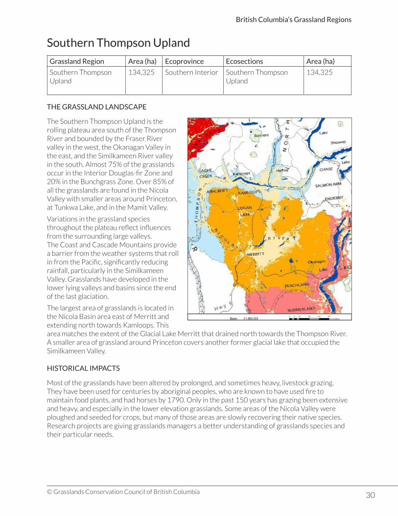
The Southern Thompson Upland is the rolling plateau area south of the Thompson River and bounded by the Fraser River valley in the west, the Okanagan Valley in the east, and the Similkameen River valley in the south. Almost 75% of the grasslands occur in the Interior Douglas-fir Zone and 20% in the Bunchgrass Zone. Over 85% of all the grasslands are found in the Nicola Valley with smaller areas around Princeton, at Tunkwa Lake, and in the Mamit Valley.
Variations in the grassland species throughout the plateau reflect influences from the surrounding large valleys.The Coast and Cascade Mountains provide a barrier from the weather systems that roll in from the Pacific, significantly reducing rainfall, particularly in the Similkameen Valley. Grasslands have developed in the lower lying valleys and basins since the end of the last glaciation.
The largest area of grasslands is located in the Nicola Basin area east of Merritt and extending north towards Kamloops. This area matches the extent of the Glacial Lake Merritt that drained north towards the Thompson River. A smaller area of grassland around Princeton covers another former glacial lake that occupied the Similkameen Valley.
HISTORICAL IMPACTS
Most of the grasslands have been altered by prolonged, and sometimes heavy, livestock grazing.They have been used for centuries by aboriginal peoples, who are known to have used fire to maintain food plants, and had horses by 1790. Only in the past 150 years has grazing been extensive and heavy, and especially in the lower elevation grasslands. Some areas of the Nicola Valley were ploughed and seeded for crops, but many of those areas are slowly recovering their native species.Research projects are giving grasslands managers a better understanding of grasslands species and their particular needs.

31© Grasslands Conservation Council of British Columbia
British Columbia’s Grassland Regions
UNIQUE FEATURES
The valley that extends from Nicola Lake north to Campbell Creek contains a series of lakes of varying size, shape, and character. The valley was deepened by vast quantities of meltwater from Glacial Lake Merritt that flowed north to the valley of the Thompson River through Campbell Creek. Shumway Lake and Trapp Lakes sit in winding, grass-draped valleys with low hills, while Napier Lake is in a deep, rock-lined canyon. High cliffs and talus slopes combined with the mix of grassland and forested areas create habitats for a wide range of species.
Shallow water, marshy areas, and riparian woodlands provide habitat for a variety of migrating and resident bird species as well as many other wildlife species. A large variety and numbers of waterfowl can be seen in migration in spring and fall. The road along the valley provides many opportunities to view birds without disturbing them.
PLANT COMMUNITIES
Ecosections BEC Zones with grasslands *Major grassland BEC Subzones and Variants
Southern Thompson Basin Bunchgrass ZonePonderosa Pine ZoneInterior Douglas-Fir ZoneMontana Spruce ZoneEnglemann Spruce-Sub-Alpine Fir
BGxw1: Nicola Very Dry Warm Bunchgrass VariantPPxh2: Thompson Very Dry Hot Ponderosa Pine VariantIDFxh1: Okanagan Very Dry Hot Interior Douglas-fir VariantIDFxh2: Thompson Very Dry Hot Interior Douglas-fir VariantIDFdk1: Thompson Dry Cool Interior Douglas-fir Variant
Pavilion Ranges Bunchgrass ZonePonderosa Pine ZoneInterior Douglas-Fir Zone
BGxh2: Nicola Very Dry Warm Bunchgrass VariantBGxh3: Nicola Very Dry Warm Bunchgrass VariantPPxh2: Thompson Very Dry Hot Ponderosa Pine VariantIDFxh2: Thompson Very Dry Hot Interior Douglas-fir VariantIDFdk1: Thompson Dry Cool Interior Douglas-fir Variant
* Over 3,000 hectares
Nicola Very Dry Warm Bunchgrass Variant (BGxw1): 27,650 hectares
The grasslands of the lower elevations of the Nicola Basin are Middle Grasslands, similar to those in the Thompson-Pavilion region. Bluebunch wheatgrass is the dominant grass, with varying small amounts of needle and thread grass, and junegrass. Flowering plants are also sparse and include large-fruited desert-parsley, mariposa lily, prairie sagewort, yarrow, lemonweed, and arrow-leaved balsamroot.
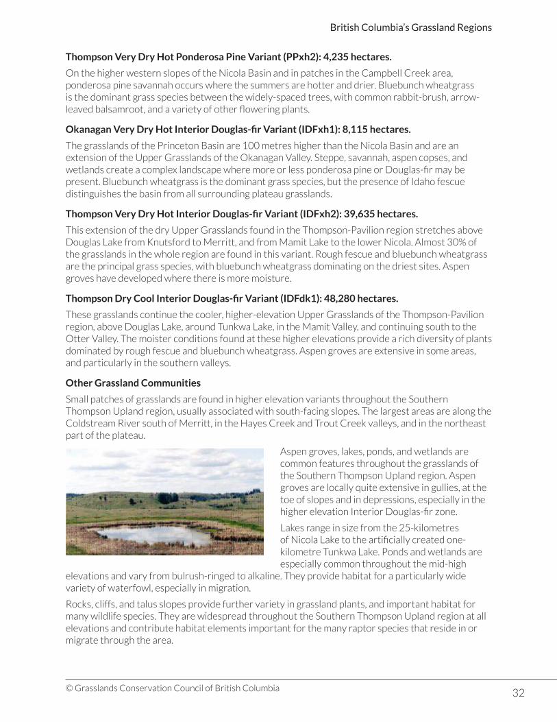
32© Grasslands Conservation Council of British Columbia
British Columbia’s Grassland Regions
Thompson Very Dry Hot Ponderosa Pine Variant (PPxh2): 4,235 hectares.
On the higher western slopes of the Nicola Basin and in patches in the Campbell Creek area, ponderosa pine savannah occurs where the summers are hotter and drier. Bluebunch wheatgrass is the dominant grass species between the widely-spaced trees, with common rabbit-brush, arrow-leaved balsamroot, and a variety of other flowering plants.
Okanagan Very Dry Hot Interior Douglas-fir Variant (IDFxh1): 8,115 hectares.
The grasslands of the Princeton Basin are 100 metres higher than the Nicola Basin and are an extension of the Upper Grasslands of the Okanagan Valley. Steppe, savannah, aspen copses, and wetlands create a complex landscape where more or less ponderosa pine or Douglas-fir may be present. Bluebunch wheatgrass is the dominant grass species, but the presence of Idaho fescue distinguishes the basin from all surrounding plateau grasslands.
Thompson Very Dry Hot Interior Douglas-fir Variant (IDFxh2): 39,635 hectares.
This extension of the dry Upper Grasslands found in the Thompson-Pavilion region stretches above Douglas Lake from Knutsford to Merritt, and from Mamit Lake to the lower Nicola. Almost 30% of the grasslands in the whole region are found in this variant. Rough fescue and bluebunch wheatgrass are the principal grass species, with bluebunch wheatgrass dominating on the driest sites. Aspen groves have developed where there is more moisture.
Thompson Dry Cool Interior Douglas-fir Variant (IDFdk1): 48,280 hectares.
These grasslands continue the cooler, higher-elevation Upper Grasslands of the Thompson-Pavilion region, above Douglas Lake, around Tunkwa Lake, in the Mamit Valley, and continuing south to the Otter Valley. The moister conditions found at these higher elevations provide a rich diversity of plants dominated by rough fescue and bluebunch wheatgrass. Aspen groves are extensive in some areas, and particularly in the southern valleys.
Other Grassland Communities
Small patches of grasslands are found in higher elevation variants throughout the Southern Thompson Upland region, usually associated with south-facing slopes. The largest areas are along the Coldstream River south of Merritt, in the Hayes Creek and Trout Creek valleys, and in the northeast part of the plateau.
Aspen groves, lakes, ponds, and wetlands are common features throughout the grasslands of the Southern Thompson Upland region. Aspen groves are locally quite extensive in gullies, at the toe of slopes and in depressions, especially in the higher elevation Interior Douglas-fir zone.
Lakes range in size from the 25-kilometres of Nicola Lake to the artificially created one-kilometre Tunkwa Lake. Ponds and wetlands are especially common throughout the mid-high
elevations and vary from bulrush-ringed to alkaline. They provide habitat for a particularly wide variety of waterfowl, especially in migration.
Rocks, cliffs, and talus slopes provide further variety in grassland plants, and important habitat for many wildlife species. They are widespread throughout the Southern Thompson Upland region at all elevations and contribute habitat elements important for the many raptor species that reside in or migrate through the area.
33© Grasslands Conservation Council of British Columbia
British Columbia’s Grassland Regions
KEY PLANT SPECIES
Trembling Aspen (Populus tremuloides)
• A common feature on the grassland landscape where moisture collects.• Grows from suckers, creating large groups of the same clone that change colour at the same time
in the fall.• Greenish-white bark contains chlorophyll and is torn off and eaten by moose in winter.• Rounded leaves with a pointed tip are bright green above, paler below.• Leaf stalk is flattened allowing the leaves to twirl or “tremble.”• Aspen groves are important habitat for grouse, hawks, owls and cavity-nesting birds.
WILDLIFE
More than 119 wildlife species, including 14 reptiles and amphibians, 79 birds, and 26 mammals are found in the Southern Thompson Upland region. Mule deer are the most common large mammal, using the grasslands in spring, summer, and fall, and moving to the protection of the open Douglas-fir and ponderosa pine forests for the winter.
Many small mammal species are resident in the grasslands. The yellow-bellied marmot, muskrat, western harvest mouse, and meadow vole are the most common resident mammals in the Bunchgrass and Interior Douglas-fir Zones. The pocket gopher is probably the most widespread small mammal in the Interior Douglas-fir Zone, spending most of its life in underground burrows. The Thompson River is the northern limit of its extent .
The big brown bat and Yuma myotis are the two most common bat species found in elevations below 1,070 metres and are often associated with water bodies. Both species roost in buildings and big brown bats may hibernate locally.
The variety and complexity of habitats in the region support over 160 species of birds. Black-billed magpie, vesper sparrow, meadowlark, American kestrel, red-tailed hawk, and Northern harrier are common at lower elevations. The many lakes, ponds and wetlands from Campbell Creek south to Princeton and at higher elevations provide habitat for a wide variety of waterfowl, cavity nesters, and songbirds. Species include American widgeon, Barrow’s goldeneye, mallard, ruddy duck, American coot red-shafted flicker, mountain bluebird, yellow warbler, and red and yellow-headed blackbirds.
The many access roads in the region provide many opportunities to view waterfowl and a variety of raptors and songbirds from spring through fall.
Reptiles and amphibians are most numerous in lower elevations with common garter snake, wood frog, and long-toed salamander most commonly found.
SPECIES AT RISK
Red- and blue-listed grassland elements in the Southern Thompson Upland:
Element *Red List **Blue List
Vascular Plants 16 5
Plant Communities 14 6
Insects 0 0
Reptiles and Amphibians 0 6
Birds 5 14
Mammals 1 1
Total Elements 36 32
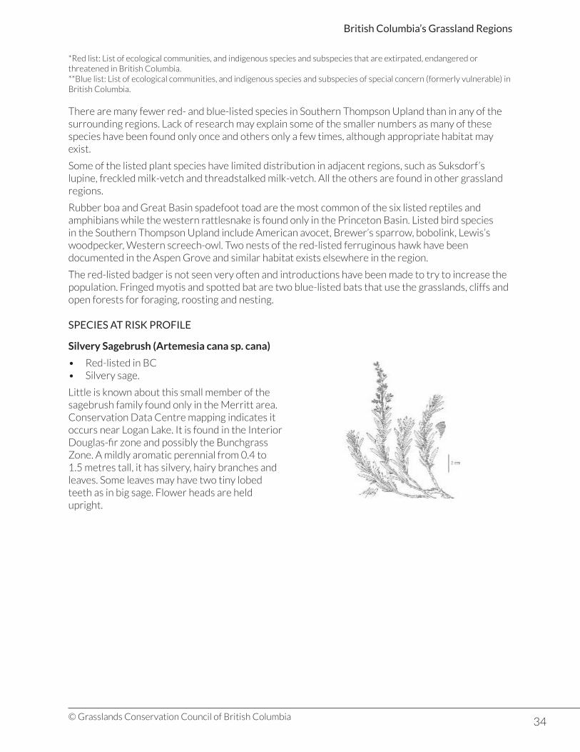
34© Grasslands Conservation Council of British Columbia
British Columbia’s Grassland Regions
*Red list: List of ecological communities, and indigenous species and subspecies that are extirpated, endangered or threatened in British Columbia.**Blue list: List of ecological communities, and indigenous species and subspecies of special concern (formerly vulnerable) in British Columbia.
There are many fewer red- and blue-listed species in Southern Thompson Upland than in any of the surrounding regions. Lack of research may explain some of the smaller numbers as many of these species have been found only once and others only a few times, although appropriate habitat may exist.
Some of the listed plant species have limited distribution in adjacent regions, such as Suksdorf’s lupine, freckled milk-vetch and threadstalked milk-vetch. All the others are found in other grassland regions.
Rubber boa and Great Basin spadefoot toad are the most common of the six listed reptiles and amphibians while the western rattlesnake is found only in the Princeton Basin. Listed bird species in the Southern Thompson Upland include American avocet, Brewer’s sparrow, bobolink, Lewis’s woodpecker, Western screech-owl. Two nests of the red-listed ferruginous hawk have been documented in the Aspen Grove and similar habitat exists elsewhere in the region.
The red-listed badger is not seen very often and introductions have been made to try to increase the population. Fringed myotis and spotted bat are two blue-listed bats that use the grasslands, cliffs and open forests for foraging, roosting and nesting.
SPECIES AT RISK PROFILE
Silvery Sagebrush (Artemesia cana sp. cana)
• Red-listed in BC• Silvery sage.
Little is known about this small member of the sagebrush family found only in the Merritt area. Conservation Data Centre mapping indicates it occurs near Logan Lake. It is found in the Interior Douglas-fir zone and possibly the Bunchgrass Zone. A mildly aromatic perennial from 0.4 to 1.5 metres tall, it has silvery, hairy branches and leaves. Some leaves may have two tiny lobed teeth as in big sage. Flower heads are held upright.
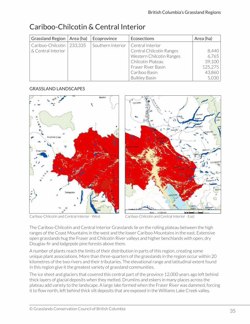
35© Grasslands Conservation Council of British Columbia
British Columbia’s Grassland Regions
Cariboo-Chilcotin & Central Interior
Grassland Region Area (ha) Ecoprovince Ecosections Area (ha)
Cariboo-Chilcotin & Central Interior
233,335 Southern Interior Central InteriorCentral Chilcotin RangesWestern Chilcotin RangesChilcotin PlateauFraser River BasinCariboo BasinBulkley Basin
8,4406,765
39,100125,275
43,8605,030
GRASSLAND LANDSCAPES
The Cariboo-Chilcotin and Central Interior Grasslands lie on the rolling plateau between the high ranges of the Coast Mountains in the west and the lower Cariboo Mountains in the east. Extensive open grasslands hug the Fraser and Chilcotin River valleys and higher benchlands with open, dry Douglas-fir and lodgepole pine forests above them.
A number of plants reach the limits of their distribution in parts of this region, creating some unique plant associations. More than three-quarters of the grasslands in the region occur within 20 kilometres of the two rivers and their tributaries. The elevational range and latitudinal extent found in this region give it the greatest variety of grassland communities.
The ice sheet and glaciers that covered this central part of the province 12,000 years ago left behind thick layers of glacial deposits when they melted. Drumlins and eskers in many places across the plateau add variety to the landscape. A large lake formed when the Fraser River was dammed, forcing it to flow north, left behind thick silt deposits that are exposed in the Williams Lake Creek valley.
Cariboo-Chilcotin and Central Interior - West Cariboo-Chilcotin and Central Interior - East

36© Grasslands Conservation Council of British Columbia
British Columbia’s Grassland Regions
The Coast Mountains on the west capture moisture from the south-westerly weather systems that roll in off the coast, creating a rainshadow effect on the plateau. Winters are cold with precipitation falling as snow while summers in the lower valleys are hot and dry. Grassland plants have adapted to these difficult conditions by blooming early in the spring and completing their life cycle before the summer heat.
Bluebunch wheatgrass is the characteristic grass of these hot, dry grasslands stretching from French Bar north past the Fraser-Chilcotin junction and west to Farwell Canyon. There are similarities between these grasslands and those in the Thompson River and Okanagan valleys and many plant species are found even further south in the Great Basin. Two bunchgrass communities are identified within the Bunchgrass Zone: Lower and Middle Grasslands.
HISTORICAL IMPACTS
These bunchgrass grasslands have supported livestock grazing for nearly 120 years with some areas more intensively grazed than others. By 1914 there were indications that some areas had been over grazed and surveys in the 1930s confirmed the case for Becher’s Prairie and Riske Creek Prairie. It was not until the 1970s that range management techniques were introduced that have produced a gradual improvement in the condition of these grasslands.
Grasslands in the Cariboo-Chilcotin and Central Interior region are protected in parks and other conservation areas where livestock grazing is managed to reduce the impact on plant communities. Research projects are giving grassland managers a better understanding of grassland species and their particular needs.
UNIQUE FEATURES
Cliff and talus slopes are found in only a few places along the deep river valleys that dissect the region. The basalt lavas that form the Chilcotin Plateau and older, underlying rocks are exposed in sometimes spectacular formations.
Doc English Bluff, just south of the Sheep Creek Bridge carrying Highway 24 across the Fraser River is one such formation. Limestone cliffs with sinkholes and caves rear 355 metres on a ridge above the Fraser River. Limestone-loving plants, fern communities, and many rare vascular plants occur there. The cliffs are used by California bighorn sheep and by white-throated swifts and golden eagle for nesting.
The cliffs where Dog Creek joins the Fraser River are massive with a healthy riparian zone at the base. Many raptor species nest on the cliffs while white-throated swifts, rock wren, warblers, and lazuli bunting may be seen and heard.
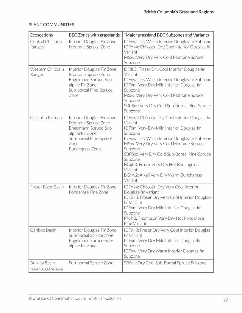
37© Grasslands Conservation Council of British Columbia
British Columbia’s Grassland Regions
PLANT COMMUNITIES
Ecosections BEC Zones with grasslands *Major grassland BEC Subzones and Variants
Central Chilcotin Ranges
Interior Douglas-Fir ZoneMontane Spruce Zone
IDFdw: Dry Warm Interior Douglas-fir SubzoneIDFdk4: Chilcotin Dry Cool Interior Douglas-fir VariantMSxv: Very Dry Very Cold Montane Spruce Subzone
Western Chilcotin Ranges
Interior Douglas-Fir ZoneMontane Spruce ZoneEngelmann Spruce-Sub-alpine Fir ZoneSub-boreal Pine-Spruce Zone
DFdk3: Fraser Dry Cool Interior Douglas-fir VariantIDFdw: Dry Warm Interior Douglas-fir SubzoneIDFxm: Very Dry Mild Interior Douglas-fir SubzoneMSxv: Very Dry Very Cold Montane Spruce SubzoneSBPSxc: Very Dry Cold Sub-Boreal Pine-Spruce Subzone
Chilcotin Plateau Interior Douglas-Fir ZoneMontane Spruce ZoneEngelmann Spruce-Sub-alpine Fir ZoneSub-boreal Pine-Spruce ZoneBunchgrass Zone
IDFdk4: Chilcotin Dry Cool Interior Douglas-fir VariantIDFxm: Very Dry Mild Interior Douglas-fir SubzoneIDFdw: Dry Warm Interior Douglas-fir SubzoneMSxv: Very Dry Very Cold Montane Spruce SubzoneSBPSxc: Very Dry Cold Sub-Boreal Pine-Spruce SubzoneBGxh3: Fraser Very Dry Hot Bunchgrass VariantBGxw2: Alkali Very Dry Warm Bunchgrass Variant
Fraser River Basin Interior Douglas-Fir ZonePonderosa Pine Zone
IDFdk4: Chilcotin Dry Very Cool Interior Douglas-fir VariantIDFdk3: Fraser Dry Very Cool Interior Douglas-fir VariantIDFxm: Very Dry Mild Interior Douglas-fir SubzonePPxh2: Thompson Very Dry Hot Ponderosa Pine Variant
Cariboo Basin Interior Douglas-Fir ZoneSub-boreal Spruce ZoneEngelmann Spruce-Sub-alpine Fir Zone
IDFdk3: Fraser Dry Very Cool Interior Douglas-fir VariantIDFxm: Very Dry Mild Interior Douglas-fir SubzoneIDFxw: Very Dry Warm Interior Douglas-fir Subzone
Bulkley Basin Sub-boreal Spruce Zone SBSdk: Dry Cool Sub-Boreal Spruce Subzone
* Over 3,000 hectares
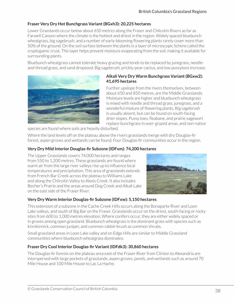
38© Grasslands Conservation Council of British Columbia
British Columbia’s Grassland Regions
Fraser Very Dry Hot Bunchgrass Variant (BGxh3): 20,225 hectares
Lower Grasslands occur below about 650 metres along the Fraser and Chilcotin Rivers as far as Farwell Canyon where the climate is the hottest and driest in the region. Widely spaced bluebunch wheatgrass, big sagebrush, and a number of early-blooming flowering plants rarely cover more than 50% of the ground. On the soil surface between the plants is a layer of microscopic lichens called the cryptogamic crust. This layer helps prevent moisture evaporating from the soil, making it available for surrounding plants.
Bluebunch wheatgrass cannot tolerate heavy grazing and tends to be replaced by junegrass, needle-and-thread grass, and sand dropseed. Big sagebrush, prickly-pear cactus, and low pussytoes increase.
Alkali Very Dry Warm Bunchgrass Variant (BGxw2): 41,695 hectares
Further upslope from the rivers themselves, between about 650 and 850 metres, are the Middle Grasslands. Moisture levels are higher and bluebunch wheatgrass is mixed with needle and thread grass, junegrass, and a wonderful mixture of flowering plants. Big sagebrush is usually absent, but can be found on south-facing drier slopes. Pussy toes, fleabane, and prairie sagewort replace bunchgrass in over-grazed areas, and non-native
species are found where soils are heavily disturbed.
Where the land levels off on the plateau above the rivers grasslands merge with dry Douglas-fir forest, aspen groves and wetlands can be found. Four Douglas-fir communities occur in the region.
Very Dry Mild Interior Douglas-fir Subzone (IDFxm): 74,200 hectares
The Upper Grasslands covers 74,000 hectares and ranges from 550 to 1,200 metres. These grasslands are found where warm air from the large river valleys rise up to influence local temperatures and precipitation. This area of grasslands extends from French Bar Creek across the plateau to Williams Lake and along the Chilcotin Valley to Alexis Creek. It also includes Becher’s Prairie and the areas around Dog Creek and Alkali Lake on the east side of the Fraser River.
Very Dry Warm Interior Douglas-fir Subzone (IDFxw): 5,150 hectares
This extension of a subzone in the Cache Creek Hills occurs along the Bonaparte River and Loon Lake valleys, and south of Big Bar on the Fraser. Grasslands occur on the driest, south-facing or rocky sites from 600 to 1,000 metres elevation. Where conifers occur, they are either widely spaced or in groves among open grassland. Bluebunch wheatgrass is the dominant grass with species such as kinnikinnick, common juniper, and common rabbit-brush as common shrubs.
Small grassland areas in Loon Lake valley and on Edge Hills are similar to Middle Grassland communities where bluebunch wheatgrass dominates.
Fraser Dry Cool Interior Douglas-fir Variant (IDFdk3): 30,860 hectares
The Douglas-fir forests on the plateau area east of the Fraser River from Clinton to Alexandria are interspersed with large pockets of grasslands, aspen groves, ponds, and wetlands such as around 70 Mile House and 100 Mile House to Lac La Hache.

39© Grasslands Conservation Council of British Columbia
British Columbia’s Grassland Regions
Chilcotin Dry Very Cool Interior Douglas-fir Variant (IDFdk4): 23,7990 hectares
Grasslands in this variant occur in small areas along both sides of the Chilcotin River as far west as Chilanko Forks, on the west side of the Fraser River, and in the Taseko valley between 1,050 and 1,350 metres elevation. Park-like stands of Douglas-fir and lodgepole pine have an understory of pinegrass and kinnikinnick, with common juniper, saskatoon, and spreading needlegrass.
On steeper slopes open grasslands occur with bluebunch wheatgrass on the driest sites and porcupine grass and other species are found on cooler, moister sites. On north-facing slopes and swales near Churn Creek, short-awned porcupine grass and litter almost completely cover the ground.
Dry Warm Interior Douglas-fir Subzone (IDFdw): 5,150 hectares
Small areas of grasslands occur in the Chilko and Tatlayoko Valleys on steep south-facing slopes from valley bottom to about 1400 metres. Little is known about their composition.
Very Dry Very Cold Montane Spruce Subzone (MSxv): 4,270 hectares
Level, well-drained sites in the upper Chilcotin and Hungry valley, as well as around Itcha Lake, have species more typically found at sub-alpine and alpine elevations. Cold winters, short, warm summers, and frost in every month inhibit the growth of trees. Alpine fescue communities may have widely-spaced lodgepole pine, while timber oatgrass dominates wetter sites in Big Creek Park. Rough fescue and prairie sagewort communities are found on steep, south- facing slopes while more moderate slopes in Churn Creek Park have a mix of dry, southern species, alpine, and boreal species.
Dry Cool Sub-Boreal Spruce Subzone (SBSdk): 4,695 hectares
Further north in the Nazko Upland and Bulkley Basin, grasslands have developed on steep south-facing slopes within a sea of forests. The largest areas are found around the community of Fraser Lake, on the north shore of Fraser Lake and along the Stellako River. The dominant grasses are slender wheatgrass, interior bluegrass, and stiff needlegrass, with fewer flowering plants.
Other Grassland Communities
Small pockets of Engelmann Spruce-Subalpine Fir grasslands occur in high elevation valley bottoms, especially on the east side of the Coast Ranges and in the Camelsfoot Range. Altai fescue and Rocky Mountain fescue are the dominant grasses.
Isolated areas of grasslands of the Sub-Boreal Pine – Spruce Zone occur in northern and western areas of the Chilcotin Plateau between 850 and 1,300 metres elevation. A variety of grassland types are found, with variations dependant on slope, aspect, climate, and soils. They indicate the northern limit of Great Basin influences. Dry sites on steep, warm slopes have bluebunch wheatgrass and other lower elevation species, with bluebunch wheatgrass possibly at the most northern extent in BC and North America.
Some sub-alpine and alpine grassland communities only occur over small areas, but some are unique in the region. Exposed dry ridges and gentle slopes with southerly or westerly aspects provide drier and warmer conditions than surrounding areas. Complexes of species on these sites usually include Altai fescue with greater or lesser amounts of other grasses, flowering plants, shrubs, mosses. and lichens.

40© Grasslands Conservation Council of British Columbia
British Columbia’s Grassland Regions
Many wetland ecosystems are found throughout the grasslands of the Cariboo-Chilcotin and Central Interior, adding variety and complexity to the landscape. Marshes, fens, shrub-carrs, and fens all frequently occur and often create complex systems that may vary as water levels change. Saline meadows are often found in association with shallow lakes, showing characteristic rings of white salts and salt-adapted plants. Cottonwood forests occur on the bottomlands of the Fraser River, Chilcotin River, and Churn Creek.
KEY PLANT SPECIES
Porcupine Grass (Hesperostipa curtiseta)
• Densely tufted perennial bunchgrass.• Long leaves are flat or rolled and rough on the top
side.• Long stems hold up a mass of seed heads, each with
a twisted bristle, or awn.• Awns help seeds make their way into the ground.• Dominant vegetation in areas of the Cariboo-
Chilcotin Plateau.• Sweeping golden prairies in the fall.
WILDLIFE
The variety of ecosystems found in the region provide habitat for a large number of wildlife species, 45 of which are red- or blue-listed, with many are at the limits of their range in the province. Spotted frog, western toad, and western garter snake are found from grasslands to alpine while the northernmost extent of the gopher snake and the rubber boa coincides with the limits of big sagebrush.
209 bird species are found in the Cariboo-Chilcotin but not all are specifically associated with grasslands. Western meadowlark, vesper sparrow, common nighthawk, and long-billed curlew are only a few typical grassland birds. All nest on the ground and are at risk from livestock grazing. Raptors such as Cooper’s hawk, red-tailed hawk, and American kestrel nest in the forests and hunt their prey over the grasslands. The Upper Grasslands near Riske Creek are the northern limit for such species as Brewer’s sparrow, Prairie falcon, bobolink, and flammulated owl.
The aspen groves, wetlands, and riparian areas of the Fraser Plateau attract large numbers of waterfowl species. The area is the world centre for Barrow’s goldeneye, greater yellowlegs, and yellow-headed blackbird. Wetlands of the area are important breeding areas for sandhill cranes and resting places for large numbers of swans in migration. The red-listed American pelican nests at only at Stum Lake in the province and uses many surrounding grassland lakes for foraging.
Moose also rely on shrub-carr and wetlands and are numerous throughout the region. Mule deer are most numerous in the grasslands along the Fraser River, moving up into the montane spruce and sub-alpine areas as the year progresses. The largest population (500) of California bighorn sheep in North America can be seen along the main road switchbacks to the canyon of the Chilcotin River where it meets the Fraser. The area is critical for breeding, lambing, and winter range.
Bats forage over the grasslands and wetlands from the lowest grassland elevations to the Sub-boreal Spruce Zone. Ten species have been identified with only the big brown bat and Townsend’s big-eared bat known to hibernate in the area.
Porcupine Grass (c) USFWS Mountain-Prairie (https://commons.wikimedia.org/wiki/File:Porcupine_Grass_(14258091497).jpg). CC-BY-2.0)
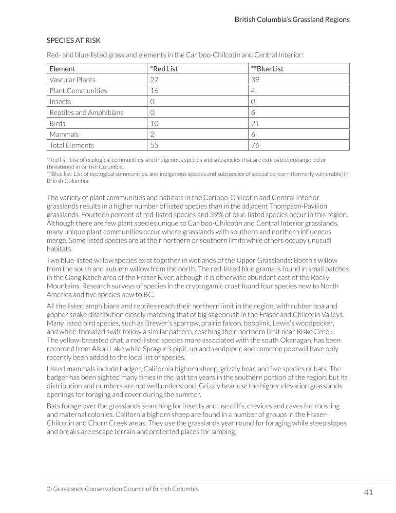
41© Grasslands Conservation Council of British Columbia
British Columbia’s Grassland Regions
SPECIES AT RISK
Red- and blue-listed grassland elements in the Cariboo-Chilcotin and Central Interior:
Element *Red List **Blue List
Vascular Plants 27 39
Plant Communities 16 4
Insects 0 0
Reptiles and Amphibians 0 6
Birds 10 21
Mammals 2 6
Total Elements 55 76
*Red list: List of ecological communities, and indigenous species and subspecies that are extirpated, endangered or threatened in British Columbia.**Blue list: List of ecological communities, and indigenous species and subspecies of special concern (formerly vulnerable) in British Columbia.
The variety of plant communities and habitats in the Cariboo-Chilcotin and Central Interior grasslands results in a higher number of listed species than in the adjacent Thompson-Pavilion grasslands. Fourteen percent of red-listed species and 39% of blue-listed species occur in this region.Although there are few plant species unique to Cariboo-Chilcotin and Central Interior grasslands, many unique plant communities occur where grasslands with southern and northern influences merge. Some listed species are at their northern or southern limits while others occupy unusual habitats.
Two blue-listed willow species exist together in wetlands of the Upper Grasslands: Booth’s willow from the south and autumn willow from the north. The red-listed blue grama is found in small patches in the Gang Ranch area of the Fraser River, although it is otherwise abundant east of the Rocky Mountains. Research surveys of species in the cryptogamic crust found four species new to North America and five species new to BC.
All the listed amphibians and reptiles reach their northern limit in the region, with rubber boa and gopher snake distribution closely matching that of big sagebrush in the Fraser and Chilcotin Valleys. Many listed bird species, such as Brewer’s sparrow, prairie falcon, bobolink, Lewis’s woodpecker, and white-throated swift follow a similar pattern, reaching their northern limit near Riske Creek. The yellow-breasted chat, a red-listed species more associated with the south Okanagan, has been recorded from Alkali Lake while Sprague’s pipit, upland sandpiper, and common poorwill have only recently been added to the local list of species.
Listed mammals include badger, California bighorn sheep, grizzly bear, and five species of bats. The badger has been sighted many times in the last ten years in the southern portion of the region, but its distribution and numbers are not well understood. Grizzly bear use the higher elevation grasslands openings for foraging and cover during the summer.
Bats forage over the grasslands searching for insects and use cliffs, crevices and caves for roosting and maternal colonies. California bighorn sheep are found in a number of groups in the Fraser-Chilcotin and Churn Creek areas. They use the grasslands year round for foraging while steep slopes and breaks are escape terrain and protected places for lambing.

42© Grasslands Conservation Council of British Columbia
British Columbia’s Grassland Regions
Species At Risk Profile: American White Pelican
• Red-listed in BC
Stum Lake in the Sub-Boreal Spruce Zone is the only known nesting site in BC for this intriguing bird. The surrounding grassland-associated lakes, ponds, and wetlands provide foraging habitat.
Pelicans make their nests on the flatter parts of rocky islands about 80 to 600 metres from the shore of the lake, using dirt, sticks, reeds, and debris. 220 to 250 nests were observed in
1998, though as many as 423 were recorded in 1993. The preferred food is chub, suckers, Northern squawfish, and rainbow trout, which are found more abundantly in surrounding lakes than in Stum Lake itself. They are known to forage as far as 150 kilometres away.
After arriving in mid-April, pelicans lay 1-4 eggs, with hatching in late June. Actual clutch size ranges from 1.95 to 1.69 depending on whether or not the birds were disturbed. Young are fledged by late July or early August, and the pelicans leave the Chilcotin between late September and mid-October.
Pelicans are highly susceptible to disturbance, especially during the nesting period. Changes in the water level of Stum Lake can make nesting sites more available to predators or flood low-lying nests. Overflights by aircraft and human or wildlife activity on shore can create sufficient disturbance to affect breeding success.
Alkali Lake is an important stopover lake in both spring and fall migration and for feeding. From 1-100 birds are reported to feed there throughout the summer. Pelicans also feed on Williams Lake, Abuntlet, Chilcotin, Kluskus, and Pantage Lakes, among others. Pelicans in migration are reported from Okanagan Valley lakes, Nicola Valley lakes, Tranquille Wildlife Management Area in the Thompson Valley, and Williams Lake.
This population of pelicans overwinters in southern California. Loss of wintering habitat and hunting are two major threats to populations in their wintering grounds.
Sub-Boreal Interior & Northern Boreal Mountains
Grassland Region Area (ha) Ecoprovince Ecosections Area (ha)
Sub-Boreal InteriorNorthern Boreal Mountains
117,27549,400
Sub-Boreal InteriorNorthern Boreal Mountains
Peace FoothillsMisinchinka RangesMuskwa FoothillsEastern Muskwa RangesHyland Highland
5,4503,660
36,9105,7656,725
GRASSLAND LANDSCAPES
This northern mountainous region is a mix of rugged mountain ranges, extensive high, rolling plateaus, and deep river valleys. Elevations range from 750 metres in the lowlands to 2,700 metres in the Cassiar Mountains. The rolling Nechako Plateau dominates the southern portion of the region with elevations from 1,900 to 2,300 metres.

43© Grasslands Conservation Council of British Columbia
British Columbia’s Grassland Regions
Small areas of grasslands scattered throughout are an important component of this mountainous region of northeastern British Columbia. The Rocky Mountains are an important influence on growing conditions and the Peace River valley dominates the lowlands in the east. West of the mountains grasslands are most extensive in the Spatzizi River valley, while in the east grasslands of the Muskwa Foothills cover nearly 37,000 hectares.
Summers in these northern latitudes are cool to warm, and winters are long and cold. Precipitation amounts increase from south to north and in many areas the ground stays frozen for much of the year, limiting the growth of trees. Rainshadows occur both to the east of the Coast Ranges and to the east of the Rocky Mountains, creating conditions where grasslands can dominate in some areas.
Areas without ice cover during the last glaciation maintained seed sources, including grasses, for later re-establishment of vegetation. Many of the grasslands species are found throughout the polar regions of the world. The most extensive grasslands occur in only three BEC Zones.
HISTORICAL IMPACTS
These northern grasslands, where small settlements are few and far between, have been only lightly used since the arrival of Europeans. Livestock graze only lightly, but there are populations of large ungulates, including stone sheep, mountain goat, caribou, and Rocky Mountain elk that may graze heavily at times during the year.
PLANT COMMUNITIES
Ecosections BEC Zones with grasslands *Major grassland BEC Subzones and Variants
Peace Foothills Engelmann Spruce-Sub-alpine Fir ZoneBoreal White and Black Spruce Zone
ESSFmv4: Graham Moist Very ColdEngelmann Spruce-Sub-alpine Fir Variant
Misinchinka Ranges
Engelmann Spruce-Sub-alpine Fir Zone
ESSFmv4: Graham Moist Very ColdEngelmann Spruce-Sub-alpine Fir Variant
Muskwa Foothills Boreal White and Black Spruce ZoneSpruce-Willow-Birch Zone
BWBSmw2: Fort Nelson Moist Warm Boreal White and Black Spruce VariantSWBmk: Spruce-Willow-Birch Subzone
Eastern Muskwa Ranges
Boreal White and Black Spruce ZoneSpruce-Willow-Birch Zone
BWBSmw2: Fort Nelson Dry Cool Boreal White and Black Spruce Variant
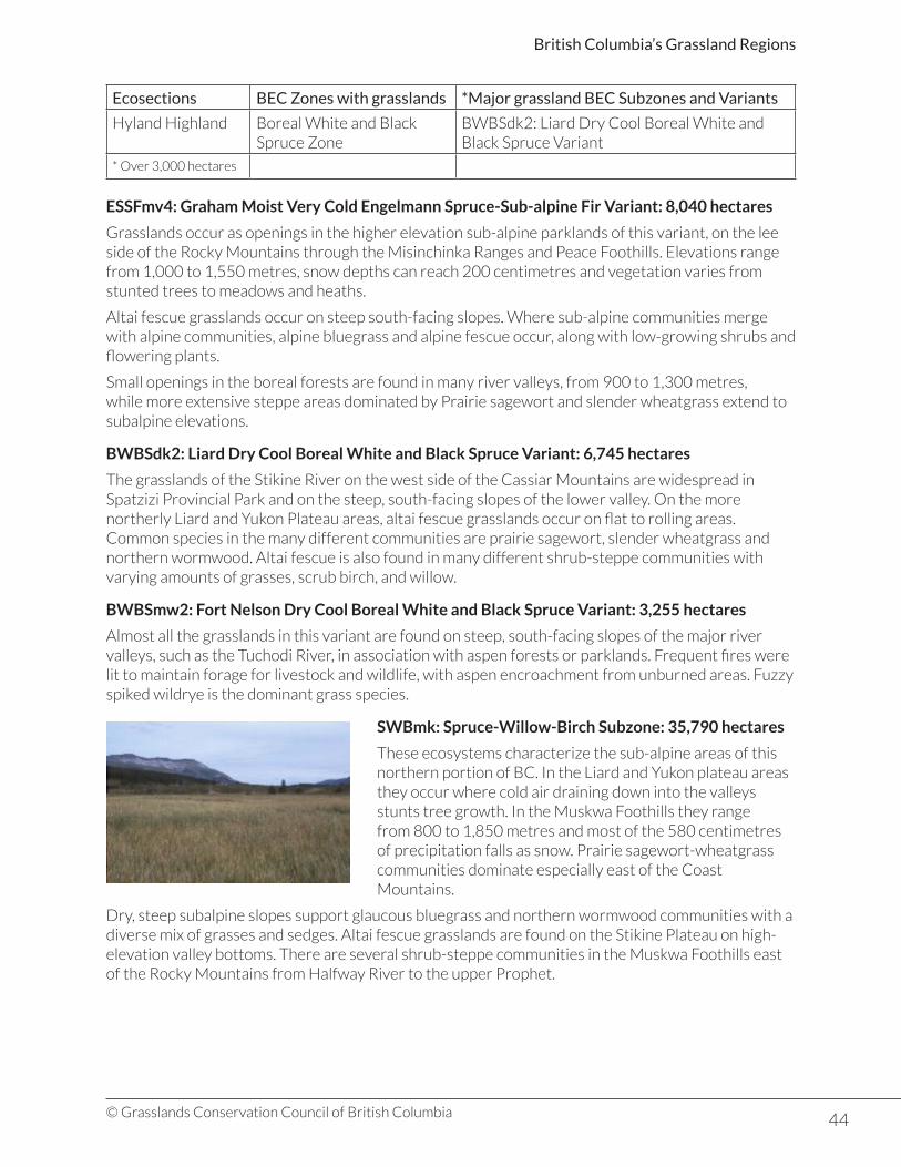
44© Grasslands Conservation Council of British Columbia
British Columbia’s Grassland Regions
Ecosections BEC Zones with grasslands *Major grassland BEC Subzones and Variants
Hyland Highland Boreal White and Black Spruce Zone
BWBSdk2: Liard Dry Cool Boreal White and Black Spruce Variant
* Over 3,000 hectares
ESSFmv4: Graham Moist Very Cold Engelmann Spruce-Sub-alpine Fir Variant: 8,040 hectares
Grasslands occur as openings in the higher elevation sub-alpine parklands of this variant, on the lee side of the Rocky Mountains through the Misinchinka Ranges and Peace Foothills. Elevations range from 1,000 to 1,550 metres, snow depths can reach 200 centimetres and vegetation varies from stunted trees to meadows and heaths.
Altai fescue grasslands occur on steep south-facing slopes. Where sub-alpine communities merge with alpine communities, alpine bluegrass and alpine fescue occur, along with low-growing shrubs and flowering plants.
Small openings in the boreal forests are found in many river valleys, from 900 to 1,300 metres, while more extensive steppe areas dominated by Prairie sagewort and slender wheatgrass extend to subalpine elevations.
BWBSdk2: Liard Dry Cool Boreal White and Black Spruce Variant: 6,745 hectares
The grasslands of the Stikine River on the west side of the Cassiar Mountains are widespread in Spatzizi Provincial Park and on the steep, south-facing slopes of the lower valley. On the more northerly Liard and Yukon Plateau areas, altai fescue grasslands occur on flat to rolling areas. Common species in the many different communities are prairie sagewort, slender wheatgrass and northern wormwood. Altai fescue is also found in many different shrub-steppe communities with varying amounts of grasses, scrub birch, and willow.
BWBSmw2: Fort Nelson Dry Cool Boreal White and Black Spruce Variant: 3,255 hectares
Almost all the grasslands in this variant are found on steep, south-facing slopes of the major river valleys, such as the Tuchodi River, in association with aspen forests or parklands. Frequent fires were lit to maintain forage for livestock and wildlife, with aspen encroachment from unburned areas. Fuzzy spiked wildrye is the dominant grass species.
SWBmk: Spruce-Willow-Birch Subzone: 35,790 hectares
These ecosystems characterize the sub-alpine areas of this northern portion of BC. In the Liard and Yukon plateau areas they occur where cold air draining down into the valleys stunts tree growth. In the Muskwa Foothills they range from 800 to 1,850 metres and most of the 580 centimetres of precipitation falls as snow. Prairie sagewort-wheatgrass communities dominate especially east of the Coast Mountains.
Dry, steep subalpine slopes support glaucous bluegrass and northern wormwood communities with a diverse mix of grasses and sedges. Altai fescue grasslands are found on the Stikine Plateau on high-elevation valley bottoms. There are several shrub-steppe communities in the Muskwa Foothills east of the Rocky Mountains from Halfway River to the upper Prophet.

45© Grasslands Conservation Council of British Columbia
British Columbia’s Grassland Regions
Other Grassland Communities
In the Sub-boreal Interior Ecoprovince, grasslands cover less than 1,000 hectares in a forested landscape. Most are found on the Nechako and Fraser Plateaus on west- and south-facing slopes. Areas of concentration include the area between North Cunningham Lake and South Trembleur Lake and the south end of Takla Lake.
The grasslands communities of this region contain plants that link them to many other areas where growing conditions may be very different. Southern grasslands plants such as junegrass, yarrow, and prickly rose are common in northern grasslands. Fuzzy spiked ryegrass is found as far south as the Rocky Mountain Trench and through the boreal forest in Alberta. Other species are also common in prairie grasslands, or in alpine and arctic locations.
Aspen parklands are found extensively in the Rocky Mountain foothills with a shrub layer of soopolallie, wild rose, twinflower and highbush cranberry. Cold basins and subalpine meadows often have large areas of fens, meadows, and shrub-carrs where Barclay’s willow is a common shrub.
KEY PLANT SPECIES
Altai fescue (Festuca altaica)
• A densely tufted grass 30-90 cm tall.• Many years’ leaves remain to create a hummocky plant.• Leaf blades long and may be folded or flat.• Open flower heads, often one-sided.• Dominant grass from low to high elevations in northern
latitudes.• Found in Asia beyond the Bering Sea.
WILDLIFE
Species diversity is high in these northern latitudes, helped by the many migratory bird species that move north for the summer. Garter snakes have limited distribution in the warmer variants while long-toed salamanders, spotted frog, and western toad are more numerous and associated with wetlands.
Some familiar southern grasslands birds such as the meadowlark, common nighthawk, and vesper sparrow occur in northern grasslands along with many warblers, horned larks, mountain bluebirds, and sparrows. Ducks and shorebirds use the many subalpine lakes and wetlands to breed or in migration. Ruffed grouse and sharp-tailed grouse are found in shrub thickets and aspen copses, while a variety of raptors and owls prey on small mammals of the grasslands.
UNIQUE FEATURES
Stone sheep are one of two species of thinhorn sheep found in the mountainous northern regions of BC. The Sub-Boreal Interior and Northern Boreal Mountains grasslands are home to most of the world’s population of these dark-coated sheep. They rely on grasslands for much of their food, including grasses, some flowering plants, and young willow and poplar sprouts.
The highest elevation cliffs and rocky areas adjacent to small grasslands are important areas for stone sheep in the winter. The windswept cliff areas have less snow and they are able to find the grasses they need. They also have more protection in these areas from their main predator: wolves.
The sheep move down to lower elevation sub-alpine grasslands, avalanche tracks, and rock slides in spring, moving back up to alpine pastures for the summer. Cliffs also provide protection for lambing and raising young. Mineral licks are also important for stone sheep; some licks close to the Alaska Highway provide visitors with viewing opportunities in spring and summer.
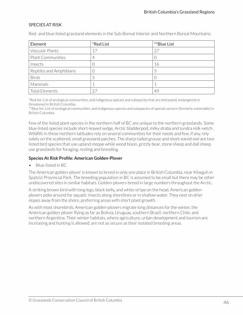
46© Grasslands Conservation Council of British Columbia
British Columbia’s Grassland Regions
SPECIES AT RISK
Red- and blue-listed grassland elements in the Sub-Boreal Interior and Northern Boreal Mountains:
Element *Red List **Blue List
Vascular Plants 17 27
Plant Communities 4 0
Insects 0 16
Reptiles and Amphibians 0 5
Birds 5 0
Mammals 1 1
Total Elements 27 49
*Red list: List of ecological communities, and indigenous species and subspecies that are extirpated, endangered or threatened in British Columbia.**Blue list: List of ecological communities, and indigenous species and subspecies of special concern (formerly vulnerable) in British Columbia.
Few of the listed plant species in the northern half of BC are unique to the northern grasslands. Some blue-listed species include short-leaved sedge, Arctic bladderpod, milky draba and tundra milk-vetch.Wildlife in these northern latitudes rely on several communities for their needs and few, if any, rely solely on the scattered, small grassland patches. The sharp-tailed grouse and short-eared owl are two listed bird species that use upland steppe while wood bison, grizzly bear, stone sheep and dall sheep use grasslands for foraging, resting and breeding.
Species At Risk Profile: American Golden-Plover
• Blue-listed in BC
The American golden-plover is known to breed in only one place in British Columbia, near Kliwguh in Spatzizi Provincial Park. The breeding population in BC is assumed to be small but there may be other undiscovered sites in similar habitats. Golden-plovers breed in large numbers throughout the Arctic.
A striking brown bird with long legs, black belly, and white stripe on the head, American golden-plovers poke around for aquatic insects along shorelines or in shallow water. They nest on drier slopes away from the shore, preferring areas with short plant growth.
As with most shorebirds, American golden-plovers migrate long distances for the winter, the American golden-plover flying as far as Bolivia, Uruguay, southern Brazil, northern Chile, and northern Argentina. Their winter habitats, where agriculture, urban development and tourism are increasing and hunting is allowed, are not as secure as their isolated breeding areas.
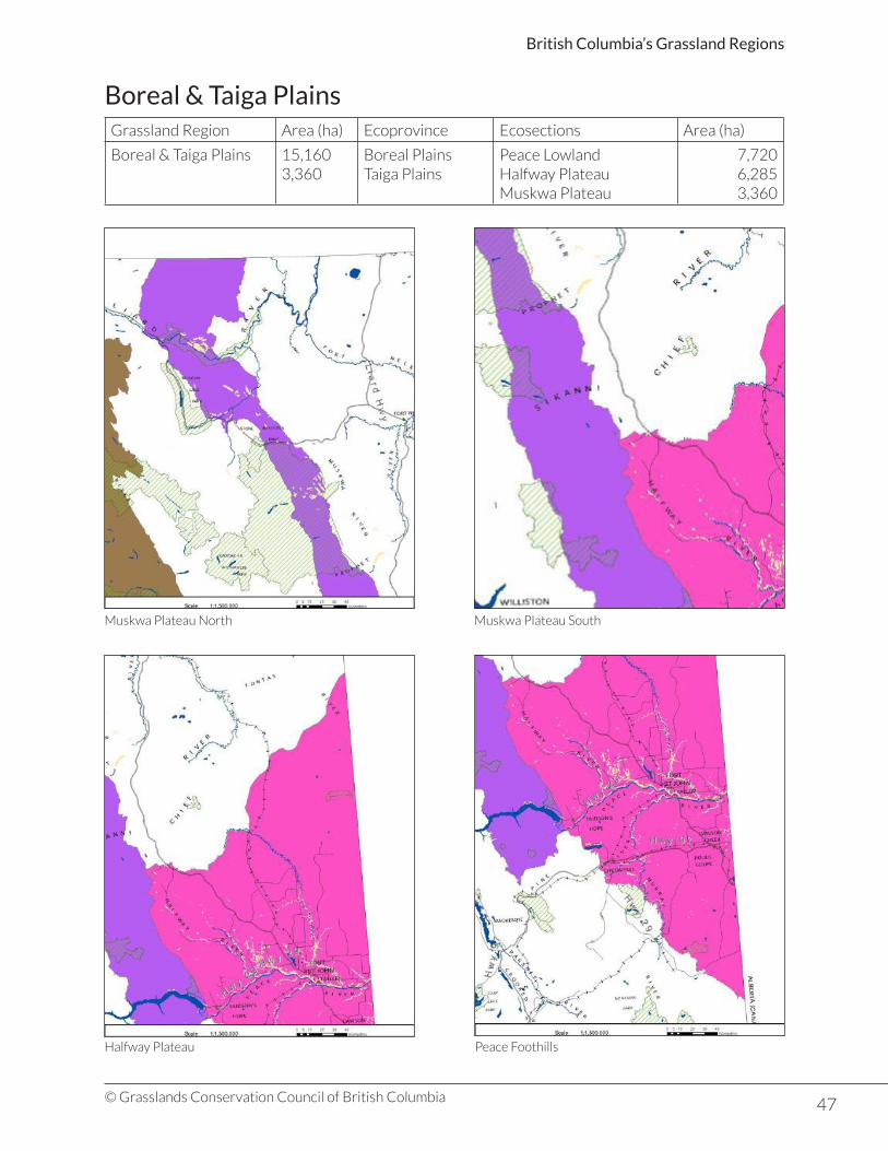
47© Grasslands Conservation Council of British Columbia
British Columbia’s Grassland Regions
Boreal & Taiga PlainsGrassland Region Area (ha) Ecoprovince Ecosections Area (ha)
Boreal & Taiga Plains 15,1603,360
Boreal PlainsTaiga Plains
Peace LowlandHalfway PlateauMuskwa Plateau
7,7206,2853,360
Muskwa Plateau North Muskwa Plateau South
Halfway Plateau Peace Foothills

48© Grasslands Conservation Council of British Columbia
British Columbia’s Grassland Regions
GRASSLAND LANDSCAPES
The grasslands of the Boreal Plains Ecoprovince of northeastern British Columbia occur south of Beatton River and east of the Rocky Mountains. The landscape is gently rolling and dominated by the deep valley of the Peace River.
The grasslands in the Muskwa Foothills Ecosection of the Taiga Plains Ecoprovince cover an extensive lowland that has been cut into by many large rivers. Soils are developed on glacial deposits that vary from
glacial till to thick sediments left when ice-damned lakes, such as Glacial Lake Peace, drained.
The grasslands regions of the Boreal and Taiga Plains are influenced by weather systems from both the Pacific and the Arctic. Winters are long and cold under the influence of Arctic weather systems and, while summer is the time when most rain falls on the plains, long sunny and hot conditions dry out the soils.
HISTORICAL IMPACTS
Grasslands are now restricted to the south-facing slopes, river terraces, and uplands along the main river valleys. The grasslands of the rolling plains were ploughed under after the First World War finished in 1918. Livestock grazing has been extensive along the Peace River, and the present composition of many plant communities may have been altered.
UNIQUE FEATURES
The Peace River valley is the most prominent feature of the Boreal and Taiga Plains Ecoprovince. It has carved its course from its headwaters in the northern Rocky Mountains to the Alberta border and on to the Athabasca River. The deep valley up river from Hudson’s Hope is now buried under the waters of Williston Lake behind the W.A.C. Bennett dam. Below Hudson’s Hope the spectacular valley has been carved through the layers of deposits that poured into the ancient Glacial Lake Peace as the ice melted after the last glaciation. In places these deposits are as much as 225 metres deep.
Most of the remaining grasslands communities in the Boreal and Taiga Plains Ecoprovince are found along the breaks of the Peace River valley where cultivation was difficult or impractical.
PLANT COMMUNITIES
Ecosections BEC Zones with grasslands *Major grassland BEC Subzones and Variants
Peace Lowland Boreal White and Black Spruce Zone
BWBSmw1: Peace Moist Warm Boreal White and Black Spruce Variant
Halfway Plateau Boreal White and Black Spruce Zone
BWBSmw1: Peace Moist Warm Boreal White and Black Spruce Variant
Kiskatinaw Plateau Boreal White and Black Spruce Zone
Clear Hills Boreal White and Black Spruce Zone
Muskwa Plateau Boreal White and Black Spruce Zone
BWBSmw2: Fort Nelson Moist Warm Boreal White and Black Spruce Variant
* Over 3,000 hectares
49© Grasslands Conservation Council of British Columbia
British Columbia’s Grassland Regions
The grasslands of the Boreal and Taiga Plains on the dry eastern side of the Northern Rocky Mountains are part of the northern extension of the mixed grasslands of the prairies.
BWBSmw1: Peace Moist Warm Boreal White and Black Spruce Variant: 14,245 hectares
Slender wheatgrass, related to the southern bluebunch wheatgrass, is the dominant grass species. The most extensive grasslands occur in this variant. The most widespread grasslands community is wheatgrass-needlegrass that covers the rolling plateaus and south-facing slopes of the major river valleys between 750 and 1,050 metres. Other characteristic species in this community include short-awned porcupine grass, june grass, blunt sedge, northern bedstraw, yarrow, and veiny meadowrue.
The Wheatgrass-Sedge association is less extensive and is found on low, moist, flat areas. It has a much wider variety of plant species, especially grasses and sedges. Other characteristic species include awned sedge, prairie rose, and common snowberry. The rich layer of flowering plants includes sedges, northern bedstraw, fireweed, and veiny meadowrue.
Needlegrass communities, which include porcupine grass, Columbia needlegrass, and green needlegrass are restricted to the drier, steeper south-facing valley slopes and knolls . They compete with poplar vegetation.
BWBSmw2: Fort Nelson Moist Warm Boreal White and Black Spruce Variant: 3,250 hectares
A small area of grassland that occurs on steep slopes along the Prophet River at the southern end of the Muskwa Plateau. Species composition is probably similar to the grassland communities described above.
Other Grassland Communities
Other grassland communities include prairie sagewort-western wheatgrass that grows on heavy soils on steep slopes above the Peace River. The shrub-steppe communities have a mix of saskatoon, rose, western snowberry, and trembling aspen and are found on steep, south-facing slopes of the Peace, Beatton, and Halfway Rivers.
The grasslands of the Boreal and Taiga Plains are interspersed with areas of aspen parkland. Mixed communities of grasslands, wetlands, and forested areas include many shrubs and flowering plants. Groves of aspen and willow occur in moister areas in the large valleys. These communities add to the rich diversity of habitats found in this northern grassland region of British Columbia.
Many grasslands communities found in the Boreal and Taiga Plains share characteristics with other grassland communities further south in the prairies of Alberta. Some plants are at the most northern extent of their range, such as the plains reedgrass. Green needlegrass is unique to the Taiga Plains Ecoprovince but is common on central Alberta’s parklands. Other species occur throughout circumpolar regions and probably originate from arctic regions.
KEY PLANT SPECIES
Slender Wheatgrass (Elymus trachycaulus)
• A slender perennial grass with a tufted form about 50 – 90 cm tall.• leaves are rough and flat.• flower head is a slender spike.• widespread throughout the northern part of the province but dominant in the Peace River
grasslands.
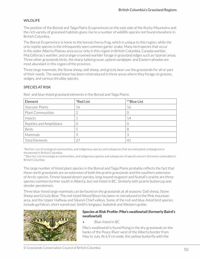
50© Grasslands Conservation Council of British Columbia
British Columbia’s Grassland Regions
WILDLIFE
The position of the Boreal and Taiga Plains Ecoprovinces on the east side of the Rocky Mountains and the rich variety of grassland habitats gives rise to a number of wildlife species not found elsewhere in British Columbia.
The Boreal Ecoprovince is home to the boreal chorus frog, which is unique to this region, while the only reptile species is the infrequently seen common garter snake. Many bird species that occur in the wider Alberta Plateau area occur only in this region in British Columbia. Canada warbler, MacGillivray’s warbler, and orange-crowned warbler forage in grassland edges such as riparian areas. Three other grasslands birds, the sharp-tailed grouse, upland sandpiper, and Eastern phoebe are most abundant in this region of the province.
Three large mammals, the Stone sheep, dall sheep, and grizzly bear use the grasslands for all or part of their needs. The wood bison has been reintroduced in three areas where they forage on grasses, sedges, and various shrubby species.
SPECIES AT RISK
Red- and blue-listed grassland elements in the Boreal and Taiga Plains:
Element *Red List **Blue List
Vascular Plants 16 16
Plant Communities 2 0
Insects 1 14
Reptiles and Amphibians 0 0
Birds 5 8
Mammals 3 3
Total Elements 27 41
*Red list: List of ecological communities, and indigenous species and subspecies that are extirpated, endangered or threatened in British Columbia.**Blue list: List of ecological communities, and indigenous species and subspecies of special concern (formerly vulnerable) in British Columbia.
The large number of listed plant species in the Boreal and Taiga Plains probably reflects the fact that these north grasslands are an extension of both the prairie grasslands and the southern extension of Arctic species. Fennel-leaved desert-parsley, long-leaved mugwort and Nuttall’s orache are three species common further south in Alberta, but red-listed in BC. Similarly with prairie buttercup and slender penstemon.
Three blue-listed large mammals can be found on the grasslands at all seasons: Dall sheep, Stone Sheep and Grizzly Bear. The red-listed Wood Bison has been re-introduced to the Pink mountain area, and the Upper Halfway and Sikanni Chief valleys. Some of the red-and blue-listed bird species include gyrfalcon, short-eared owl, Smith’s longspur, bobolink and Western grebe.
Species at Risk Profile: Pike’s swallowtail (formerly Baird’s swallowtail)
• Blue-listed in BC
Pike’s swallowtail is found flying in the dry grasslands on the banks of the Peace River west of the Alberta border from May to July. At 6.9 cm wide, this yellow butterfly with the
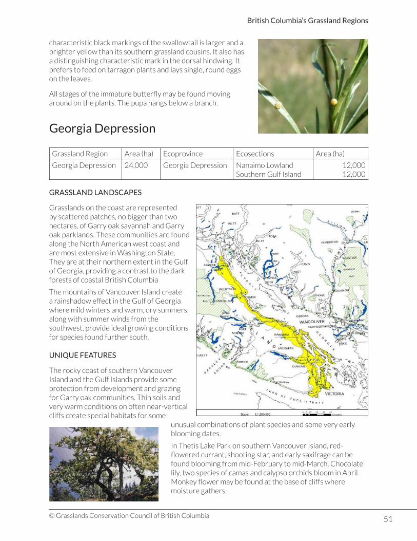
51© Grasslands Conservation Council of British Columbia
British Columbia’s Grassland Regions
characteristic black markings of the swallowtail is larger and a brighter yellow than its southern grassland cousins. It also has a distinguishing characteristic mark in the dorsal hindwing. It prefers to feed on tarragon plants and lays single, round eggs on the leaves.
All stages of the immature butterfly may be found moving around on the plants. The pupa hangs below a branch.
Georgia Depression
Grassland Region Area (ha) Ecoprovince Ecosections Area (ha)
Georgia Depression 24,000 Georgia Depression Nanaimo LowlandSouthern Gulf Island
12,00012,000
GRASSLAND LANDSCAPES
Grasslands on the coast are represented by scattered patches, no bigger than two hectares, of Garry oak savannah and Garry oak parklands. These communities are found along the North American west coast and are most extensive in Washington State. They are at their northern extent in the Gulf of Georgia, providing a contrast to the dark forests of coastal British Columbia
The mountains of Vancouver Island create a rainshadow effect in the Gulf of Georgia where mild winters and warm, dry summers, along with summer winds from the southwest, provide ideal growing conditions for species found further south.
UNIQUE FEATURES
The rocky coast of southern Vancouver Island and the Gulf Islands provide some protection from development and grazing for Garry oak communities. Thin soils and very warm conditions on often near-vertical cliffs create special habitats for some
unusual combinations of plant species and some very early blooming dates.
In Thetis Lake Park on southern Vancouver Island, red-flowered currant, shooting star, and early saxifrage can be found blooming from mid-February to mid-March. Chocolate lily, two species of camas and calypso orchids bloom in April. Monkey flower may be found at the base of cliffs where moisture gathers.

52© Grasslands Conservation Council of British Columbia
British Columbia’s Grassland Regions
PLANT COMMUNITIES
Ecosections BEC Zones with grasslands *Major grassland BEC Subzones and Variants
Nanaimo Lowland Coastal Douglas-Fir Zone CDFmm: Moist Maritime Coastal Douglas-fir Subzone
Southern Gulf Island
Coastal Douglas-Fir Zone CDFmm: Moist Maritime Coastal Douglas-fir Subzone
* Over 3,000 hectares
CDFmm: Moist Maritime Coastal Douglas-fir Subzone: 2,400 hectares
Found on rocky cliffs and gentle, south-facing hillsides on the east coast of Vancouver Island from Comox to East Sooke and through the Gulf Islands, the largest grassland area is on the south-facing slopes of Saturna Island. The shallow soils on which the Garry oak communities grow have developed on glacial deposits left behind after the Pleistocene glaciation.
Garry oak and arbutus are the dominant trees, with a rich carpet of spring flowering plants. The
composition of the communities varies between sites. Garry oak is dominant in most communities on southern Vancouver Island, but where rock outcrops reduce soil depth, arbutus is the dominant tree species. A mosaic of communities throughout the range of Garry oak ecosystems include coniferous forests, parklands, shrub-steppe, rock outcrops flower meadows, and small grasslands.
Some species from interior grasslands are also found in Garry oak communities, including brittle prickly-pear cactus, chocolate lily, death camas, mock-orange, northern wormwood, and tall Oregon grape. Common snowberry and Nootka rose are found on moist sites.
Garry oak communities cover only 5% of their original range with less than 1,000 hectares in a pristine state. The communities have become fragmented by a century of development, by livestock grazing, and by the spread of introduced plants. Scotch broom, Kentucky bluegrass, orchard grass, and sweet vernalgrass are only a few of the non-native species that continue to threaten Garry oak savannah and parkland ecosystems.
KEY PLANT SPECIES
Garry Oak
• Heavy-looking tree with deeply ridged grey bark up to 25 metres tall.• In rocky areas or shallow soils may be quite stunted.• Leaves are dark green and oak-shaped, usually single and alternating on the branch.• Flowers are tiny, coming out with the leaves.• Male flowers a hanging catkin; female flowers single.• Acorns are 2-3 cm long, edible, but with tannins.• Salish peoples ate acorns after soaking to remove the tannins.• Oak bark was used in medicines.
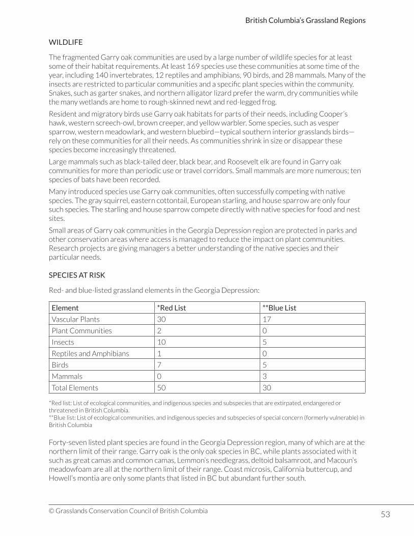
53© Grasslands Conservation Council of British Columbia
British Columbia’s Grassland Regions
WILDLIFE
The fragmented Garry oak communities are used by a large number of wildlife species for at least some of their habitat requirements. At least 169 species use these communities at some time of the year, including 140 invertebrates, 12 reptiles and amphibians, 90 birds, and 28 mammals. Many of the insects are restricted to particular communities and a specific plant species within the community. Snakes, such as garter snakes, and northern alligator lizard prefer the warm, dry communities while the many wetlands are home to rough-skinned newt and red-legged frog.
Resident and migratory birds use Garry oak habitats for parts of their needs, including Cooper’s hawk, western screech-owl, brown creeper, and yellow warbler. Some species, such as vesper sparrow, western meadowlark, and western bluebird—typical southern interior grasslands birds—rely on these communities for all their needs. As communities shrink in size or disappear these species become increasingly threatened.
Large mammals such as black-tailed deer, black bear, and Roosevelt elk are found in Garry oak communities for more than periodic use or travel corridors. Small mammals are more numerous; ten species of bats have been recorded.
Many introduced species use Garry oak communities, often successfully competing with native species. The gray squirrel, eastern cottontail, European starling, and house sparrow are only four such species. The starling and house sparrow compete directly with native species for food and nest sites.
Small areas of Garry oak communities in the Georgia Depression region are protected in parks and other conservation areas where access is managed to reduce the impact on plant communities. Research projects are giving managers a better understanding of the native species and their particular needs.
SPECIES AT RISK
Red- and blue-listed grassland elements in the Georgia Depression:
Element *Red List **Blue List
Vascular Plants 30 17
Plant Communities 2 0
Insects 10 5
Reptiles and Amphibians 1 0
Birds 7 5
Mammals 0 3
Total Elements 50 30
*Red list: List of ecological communities, and indigenous species and subspecies that are extirpated, endangered or threatened in British Columbia.**Blue list: List of ecological communities, and indigenous species and subspecies of special concern (formerly vulnerable) in British Columbia
Forty-seven listed plant species are found in the Georgia Depression region, many of which are at the northern limit of their range. Garry oak is the only oak species in BC, while plants associated with it such as great camas and common camas, Lemmon’s needlegrass, deltoid balsamroot, and Macoun’s meadowfoam are all at the northern limit of their range. Coast microsis, California buttercup, and Howell’s montia are only some plants that listed in BC but abundant further south.

54© Grasslands Conservation Council of British Columbia
British Columbia’s Grassland Regions
Most animals found in Garry oak communities only use the community for part of their annual needs as the areas are so small. Some insects are known to feed specifically on one particular species of plants while reptiles and amphibians, with a smaller range, may rely heavily on these communities. The red-tailed snake is one such species with a habitat restricted to dry, south-facing slopes. Townsend’s big-eared bat is blue-listed and only one of ten other listed bats that use these habitats for foraging, roosting, and breeding.
Species at Risk Profile: Deltoid balsamroot
• Red-listed in BC• Listed under the Federal Species at Risk Act (SARA)
Deltoid balsamroot (Balsamorhiza deltoidea) is a common species at the northern limit of its distribution in BC. Related to the balsamroots of the Southern Interior and Chilcotin grasslands, it is the only balsamroot west of the Cascade Mountains.
Large, showy yellow sunflower heads shine above the long lance-shaped leaves in early spring. Fine white hairs on the leaves and stems of the plant act like a white t-shirt, reflecting the sun and helping to cool the plant. A deep tap root allows it to thrive in the dry, rocky situations of Garry oak communities on southeastern Vancouver Island.