bmc minerals (no.1) ltd - kudz ze kayah...
TRANSCRIPT

BMC Minerals (No.1) Ltd
Incorporated in British Columbia, Canada, Reg No. BC 1014247 Vancouver Office: Suite 530, 1130 West Hastings St, Vancouver, BC V6E 4A4,
Phone +1 778 379 9262, Website: www.kudzzekayah.com
BMC Minerals (No.1) Ltd 22nd January 2016
Significant New Discovery and Major Resource Upgrade for KZK Zn‐Pb‐Cu‐Ag‐Au Project, Yukon
BMC Minerals (No.1) Ltd (“BMC” or the “Company”) announced a new discovery and a resultant resource upgrade for the ABM deposit within its 100% owned Kudz Ze Kayah Project (“KZK” or “the Project”), located east of Whitehorse in the Yukon Territory, Canada. The Project, hosting zinc‐rich polymetallic massive‐sulphide mineralization, was acquired by BMC in early 2015.
Highlights • New discovery (Krakatoa Zone) located immediately adjacent to the existing ABM Deposit. • Krakatoa Zone drill intercepts include:
o 25.9m @ 9.5% Zn, 4.9% Pb, 1.0% Cu, 292g/t Ag, 1.8g/t Au from 217.2m (K15‐292) o 21.3m @ 10.7% Zn, 3.6% Pb, 1.0% Cu, 234g/t Ag, 2.1g/t Au from 198.0m (K15‐303) o 18.2m @ 6.5% Zn, 3.8% Pb, 0.2% Cu, 307g/t Ag, 2.4g/t Au from 228.8m (K15‐305) o 29.6m @ 10.2% Zn, 5.2% Pb, 1.2% Cu, 275g/t Ag, 2.0g/t Au from 167.2m (K15‐319) o 21.4m @ 8.9% Zn, 3.7% Pb, 1.1% Cu, 292g/t Ag, 1.6g/t Au from 225.2m (K15‐321)
• ABM Deposit Mineral Resource, inclusive of Krakatoa Zone, now comprises a combined
total of: o 20.1Mt @ 6.4% Zn, 2.0% Pb, 0.9% Cu, 151g/t Ag, 1.4g/t Au
• Mineralization:
o Massive sulphide ore up to 30m true thickness at ABM and up to 22m at Krakatoa. o Both zones extend close to surface and Krakatoa Zone remains open at depth.
• 2016 work program:
o Comprehensive metallurgical test work program, and detailed environmental, hydrological and geotechnical studies to a Pre‐Feasibility study level.
o Exploration focus on ABM resource extensions and testing of regional targets.
Scott Donaldson, BMC President and Director stated: “Since acquiring KZK in early 2015 we have integrated the historical project data with newly acquired data and then carried out a targeted drilling program. Today’s announcement of the significant expansion and upgrade to the existing project mineral resource base is the result of that work and confirms the importance of KZK as an excellent potential development opportunity for the company. Our team has an enviable track record of project development and the 2016 work program will see us further expand the resource and work up the project to a pre‐feasibility phase. In parallel to our work at KZK we continue to look for new opportunities, especially within the base metal space.”
Contacts: Scott Donaldson, President and Director E: [email protected] Website: www.zudzzekayah.com T: +61 429 081 116 (Australia) T: +1 604 727 0738 (Canada)

BMC Minerals (No.1) Ltd
2 | P a g e
Additional Information BMC
Minerals (No.1) Ltd
BMC Minerals (No.1) Ltd is a wholly subsidiary of BMC (UK) Limited a mining development company created as the result of a strategic relationship between a team of established mine developers and a major natural resources private equity group focused on advancing superior base metals assets into development.
The BMC (UK) Limited executive team has a strong track record of discovery, development and operation of independent zinc and other base metals projects worldwide. BMC (UK) Limited seeks to identify, acquire and develop a portfolio of metals assets during the current depressed commodity prices, with the express intent of delivering a new suite of mining ready production assets into the next commodity cycle upturn. BMC (UK) Limited believes that a significant supply and demand gap for many base metals will occur over the next five years due to a lack of current investment resulting in an upcoming dearth of successful new production assets being brought online.
BMC (UK) Limited identified the KZK asset as having the potential for full mine development due to its size, grade, metallurgical properties and the opportunity for resource growth.
KZK Project
The ABM deposit is located within the KZK Project which is in turn situated on the northern flank of the Pelly Mountain Range, 260km northwest of Watson Lake and 115km southeast of Ross River in Yukon, Canada (Figure 1). The Project area lies approximately 23km south of Finlayson Lake and 25km west of the Wolverine Mine (Yukon Zinc). The project is accessed via a 20km access road from the Robert Campbell Highway, and all season road access exists to ice free port facilities at Skagway (Alaska) and Stewart (British Columbia).
Figure 1: Location of Kudz Ze Kayah Project, Yukon, Canada

BMC Minerals (No.1) Ltd
3 | P a g e
BMC (UK) Limited, through its wholly owned Canadian subsidiary BMC Minerals (No.1) Ltd, purchased the KZK Project from Teck Resources Limited (“Teck”) on 24th January 2015. The ABM project area is covered by a Socio‐Economic Participation Agreement (“SEPA”), with both BMC and the Ross River Dena Council, on behalf of the Kaska Nation, being party to the SEPA.
KZK Pre‐2015 Exploration and Feasibility Study
Cominco discovered the ABM deposit in April 1994 as a result of a diamond drilling program undertaken to follow up on an anomalous base metals in stream silt samples, and the later discovery of massive sulphide‐magnetite float and delineation of a major geophysical anomaly. Resource definition drilling by Cominco during 1994 and 1995 delineated a polymetallic (Zn‐Pb‐Cu‐Ag‐Au) massive sulphide deposit at ABM, classified as a Volcanic‐Hosted Massive Sulphide “VHMS” deposit. In 1995 a Pre‐Feasibility study was undertaken on the ABM deposit to industry standards of the day, followed by additional metallurgical and geotechnical studies that were taken to a Feasibility level.
Figure 2: Location of the KZK Project and the ABM and GP4F deposits. The Wolverine and Fyre lake deposits are not owned by BMC.
The GP4F deposit, located ~5km to the southeast of the ABM deposit, was initially highlighted by a HLEM/MAG geophysical anomaly. Diamond drilling in 1995 failed to intersect significant mineralization, however nine subsequent diamond holes drilled in 1998 all intersected the GP4F mineralized horizon.

BMC Minerals (No.1) Ltd
4 | P a g e
Prior to 2015 no significant exploration drilling had been undertaken between the ABM and GP4F deposits, or along strike to the west of the ABM deposit, and the area is considered to remain highly prospective as evidenced by the recent Krakatoa discovery.
ABM Deposit Resource Estimate
The upgraded Mineral Resource estimate at ABM follows a ~25,000m diamond drilling program during 2015 which focused on upgrading the existing ABM resource and discovering and defining the new Krakatoa Zone located immediately adjacent to the ABM Zone (the historic deposit). The Mineral Resource estimate, undertaken by independent mining consultancy CSA Global Pty Ltd (“CSA Global”), is reported in Table 1 in accordance with the JORC Code (2012). The previously reported Inferred Resource estimate for the nearby GP4F deposit (1.7Mt @ 6.1% Zn, 2.6% Pb, 0.2% Cu, 76g/t Ag, 1.0g/t Au) is not included in the tables below.
Tonnes Cu Pb Zn Au Ag Cu metal
Pb metal
Zn metal Au Ag
Mt wt% wt% wt% g/t g/t kt kt kt koz Moz
ABM Zone
Indicated 14.6 1.0 1.6 6.0 1.3 131 139.6 227.3 878.2 612.0 61.7
Inferred 0.4 1.1 1.5 4.7 0.9 101 4.1 5.4 17.2 11.0 1.2
total 15.0 1.0 1.6 6.0 1.3 130 143.8 232.7 895.4 623.0 62.9
Krakatoa Zone
Indicated 2.1 0.5 3.7 7.6 2.0 230 10.6 76.7 158.9 131.3 15.4
Inferred 3.0 0.6 2.9 7.4 1.6 202 18.9 87.9 222.3 150.9 19.4
total 5.1 0.6 3.2 7.5 1.7 213 29.5 164.6 381.2 282.2 34.9
ABM Deposit (total)
Indicated 16.7 0.9 1.8 6.2 1.4 144 150.2 304.0 1,037.2 743.4 77.1
Inferred 3.4 0.7 2.8 7.1 1.5 191 23.0 93.3 239.5 161.8 20.6
TOTAL 20.1 0.9 2.0 6.4 1.4 151 173.2 397.3 1,276.7 905.2 97.8
Table 1: ABM Deposit Mineral Resource Estimate by Zone (minor errors may occur due to rounding)
Tonnes Cu Pb Zn Au Ag Cu metal
Pb metal
Zn metal Au Ag
Mt wt% wt% wt% g/t g/t kt kt kt koz Moz
ABM Deposit: Indicated
Massive 14.3 0.9 2.0 6.7 1.5 144 122.2 289.2 966.3 691.0 71.9
Stockwork 2.4 1.2 0.6 3.0 0.7 68 28.0 14.8 70.9 52.3 5.2
total 16.7 0.9 1.8 6.2 1.4 144 150.2 304.0 1,037.2 743.4 77.1
ABM Deposit: Inferred
Massive 2.8 0.7 3.0 7.5 1.5 198 18.6 81.9 206.8 136.5 17.6
Stockwork 0.6 0.7 1.9 5.4 1.3 157 4.4 11.4 32.7 25.3 3.0
total 3.4 0.7 2.8 7.1 1.5 191 23.0 93.3 239.5 161.8 20.6
ABM Deposit: (Indicated +Inferred)
Massive 17.1 0.8 2.2 6.9 1.5 163 140.9 371.1 1,173.1 827.6 89.5
Stockwork 3.0 1.1 0.9 3.5 0.8 86 32.4 26.3 103.5 77.6 8.3
TOTAL 20.1 0.9 2.0 6.4 1.4 151 173.2 397.3 1,276.7 905.2 97.8
Table 2: ABM Deposit Mineral Resource Estimate by ore type (minor errors may occur due to rounding)

BMC Minerals (No.1) Ltd
5 | P a g e
ABM Deposit Geology
The ABM deposit (Figures 3 to 7) comprises two major zones (ABM Zone and Krakatoa Zone) of continuous shallow‐dipping VHMS mineralization within a thick felsic tuff and sill/flow complex that provides for a geotechnically competent host sequence. The ABM Zone is primarily hosted within a felsic volcanic package, whereas the Krakatoa Zone is predominantly hosted with a pre‐mineralization mafic sill that intruded the felsic volcanic package. Mineralization also occurs in the hangingwall to the mafic sill at Krakatoa in what is interpreted to be the equivalent of the ABM mineralized position. Only minor mineralization occurs in the mafic unit stratigraphically beneath the ABM Zone.
The upper limits of the ABM and Krakatoa Zones are truncated near surface and overlain by glacial sediments. The massive sulphide mineralization at ABM occurs under ~2 m to 20 m of glacial overburden and is up to ~30 m in true thickness, whereas the Krakatoa Zone occurs under ~30 m of glacial overburden and is up to ~22 m in true thickness. The down‐dip margin of the ABM Zone appears to transition into a mixed volcano‐sedimentary package, whereas the Krakatoa Zone remains open at depth.
Figure 3: Plan view of ABM Deposit showing both ABM and Krakatoa Zones and selected drill intercepts from 2015 drill program undertaken by BMC. Section lines shown correspond to Figures 4 to 7.
BMC Minerals (No.1) Ltd
6 | P a g e
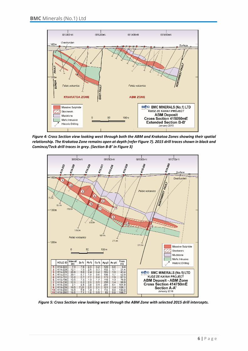
Figure 4: Cross Section view looking west through both the ABM and Krakatoa Zones showing their spatial relationship. The Krakatoa Zone remains open at depth (refer Figure 7). 2015 drill traces shown in black and Cominco/Teck drill traces in grey. (Section B‐B’ in Figure 3)
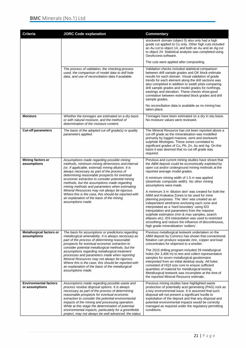
Figure 5: Cross Section view looking west through the ABM Zone with selected 2015 drill intercepts.

BMC Minerals (No.1) Ltd
7 | P a g e
Figure 6: Cross Section view looking west through the ABM Zone with selected 2015 drill intercepts.
Figure 7: Oblique Cross Section looking northwest through Krakatoa Zone (parallel to bounding faults).

BMC Minerals (No.1) Ltd
8 | P a g e
A post‐mineralization brittle fault zone offsets the ABM and Krakatoa mineralized zones, and angular clasts of sulphide are to be found within the fault zone breccias. The south‐eastern margin of Krakatoa is cut by another late brittle fault zone, the south‐eastern side of which is considered to be a significant exploration target that is yet to be drill tested.
Although Krakatoa can be observed in data derived from the 2015 VTEM survey undertaken by BMC, the discovery was made on the basis of geological targeting which permitted the Krakatoa Zone to be intersected in only the second hole east of the East Fault. The VTEM did however permit the refinement of drill targeting closer to surface.
A ~25,000m diamond drilling program undertaken at the KZK project during the 2015 field season has also provided data and material for a comprehensive metallurgical testwork program, and detailed environmental, hydrological and geotechnical studies which are now well underway.
2016 Outlook
This revised resource estimate is expected to form the basis of a Prefeasibility Study to be completed in late 2016.
The proposed program for the 2016 field season will include diamond drilling of resource extensions proximal to the ABM deposit, including down‐dip of Krakatoa and along strike from ABM where mineralization is not yet closed off. On a more regional basis the work will include extending VTEM coverage of the project and the drill testing of a variety of regional exploration targets. This includes targets which have been identified along the trend which contains both the ABM and GP4F deposits. Initial work will also be undertaken along the trend on which the Wolverine deposit is located, as well as the down‐plunge extensions of this deposit.
JORC Competent Person Statement
The information in this report that relates to the Mineral Resources has been compiled by Aaron Green, who is a full‐time employee of CSA Global Pty Ltd. Mr. Green is a Member of the Australian Institute of Geoscientists and has sufficient experience relevant to the style of mineralization and type of deposit under consideration and to the activity which he is undertaking to qualify as a Competent Person as defined in the JORC Code (2012). Mr. Green consents to the disclosure of this information in this report in the form and context in which it appears.
The information in this report that relates to the Exploration Results has been compiled by Neil Martin, who is a full‐time employee of BMC (UK) Limited. Dr. Martin is a Member of the Australian Institute of Geoscientists and has sufficient experience relevant to the style of mineralization and type of deposit under consideration and to the activity which he is undertaking to qualify as a Competent Person as defined in the JORC Code (2012). Dr Martin consents to the disclosure of this information in this report in the form and context in which it appears.
The information in this report that relates to BMC Mineral Resources is in part a compilation of previously published data for which a Competent Persons consent was obtained. Their consent remains in place for subsequent releases by the Company of the same information in the same form and context, until the consent is withdrawn or replaced by a subsequent report and accompanying consent. The information in this report has been extracted from the BMC Public Release “Initial Resource Estimate for KZK Zn‐Pb‐Cu‐Ag‐Au Project, Yukon” dated 18 January 2016 and is available on the BMC website www.bmcminerals.com. The Company confirms that it is not aware of any new information or data that materially affects the information included in the original market announcements and that all material assumptions and technical parameters underpinning the estimates in the market announcements continue to apply and have not materially changed. The Company confirms that the form and context in which the Competent Person’s findings are presented have not been materially modified from the original market announcements.

BMC Minerals (No.1) Ltd
9 | P a g e
Appendix 1 JORC Code – Table 1
Section 1: Sampling Techniques and Data (Criteria in this section apply to all succeeding sections)
Criteria JORC Code explanation Commentary
Sampling techniques Nature and quality of sampling (eg. cut channels, random chips, or specific specialised industry standard measurement tools appropriate to the minerals under investigation, such as down hole gamma sondes, or handheld XRF instruments, etc). These examples should not be taken as limiting the broad meaning of sampling.
The ABM deposit was sampled using diamond drill holes at nominal 50 m spacing on 25 m north-south oriented sections extending out to 100 m on the peripheries of the deposit.
Drilling at the project was completed by Cominco from 1994-1998 (199 holes). In 2015, BMC Minerals (No.1) Ltd. completed a further 137 holes. A total of 336 diamond drill holes occur on the property for 53,694 m of drilling. 216 assayed drill holes intersect the interpreted mineralisation zones.
ABM holes were generally angled (-30° to -90°) towards grid south with dip angles set to optimally intersect the mineralised horizon. Approximately 20% of the holes have been drilled vertically.
Krakatoa holes mostly drilled grid southwest and angled at -30° to -90° to avoid bounding faults. Only one hole was drilled vertically.
Include reference to measures taken to ensure sample representivity and the appropriate calibration of any measurement tools or systems used.
Diamond drilling was used to delineate the resource. Diamond core was used to obtain high quality samples that were logged for lithological, structural, density and other attributes.
Cominco: Drill hole locations were originally picked up by survey contractors. The majority of holes have used ‘single-shot’, acid-etch style down-hole surveys taken approximately every 30 m down hole.
Limited quality assurance procedures and quality control results have been documented in various internal reports. However, 2015 drilling indicates no significant major issue with Cominco drillhole survey data
A selection of drillholes from 3 sections were sampled and re-assayed at SGS Laboratory in Burnaby, BC (Vancouver) using the same assaying methodology as the 2015 program.
BMC: Proposed drill hole locations were surveyed and marked by survey contractors prior to drilling. After drilling was completed a total of 87 holes were surveyed by survey contractors and the remaining 50 were located via an Azimuth Positioning System (APS) for x and y coordinates and RL from a DEM derived from a LIDAR survey. Holes were surveyed using a Reflex EZ-Shot on advancement of the hole. Readings were capture below the collar and at 25 m intervals thereafter.
The 2015 field QAQC program entailed submission of coarse blank material every 20th sample and Certified Reference Material (CRM) every 20th sample. CRM was selected in several grade ranges and manufactured from sulphide ore similar to the target mineralization. Approximately 3% of samples analysed were submitted to an alternate laboratory for umpire analyses. Additional quartz wash was inserted in the pulverizing stage between major changes in intensity of mineralization. Quartz wash residues were retained for possible later analyses. Wet screen analyses was completed every 50th sample.
Based on an assessment of the past reports, historical drilling results and review of the current procedures, CSA Global considers the entire dataset to be

BMC Minerals (No.1) Ltd
10 | P a g e
Criteria JORC Code explanation Commentary
acceptable for use in Mineral Resource estimation.
Aspects of the determination of mineralisation that are Material to the Public Report. In cases where ‘industry standard’ work has been done this would be relatively simple (eg. ‘reverse circulation drilling was used to obtain 1 m samples from which 3 kg was pulverised to produce a 30 g charge for fire assay’). In other cases more explanation may be required, such as where there is coarse gold that has inherent sampling problems. Unusual commodities or mineralisation types (eg. submarine nodules) may warrant disclosure of detailed information.
Cominco: The majority of sulphide intersections were sawn using an open-circulation rock saw, typically into 1.5 m long samples, however it is evident from field observation that some were split with a manual core splitter. Samples were sent to Cominco Exploration Research Laboratory (CERL) in Vancouver. Samples were subjected to a three stage crushing procedure, pulverised, and screened to -150 mesh prior to aqua regia digestion (and solvent extraction in the case of Au) and assaying.
BMC: All sulphide intersections were sawn using an open-circulation rock saw, typically into 1.0 m long samples. Samples were sent to SGS. Samples were weighed, dried and crushed to 75% passing 2 mm, with a 250 g split pulverized to 85% passing 75 microns. Gold was analysed by 30 g fire assay with an AAS finish and silver analysed by ICP with an AAS finish on a two gram 2-acid digest aliquot. Gold and silver over limits were triggered at Au >5 g/t and Ag >150 g/t respectively, resulting in re-analysis using a 30 g fire assay with gravimetric finish. Assay results for copper, lead, zinc and iron were completed using a Na peroxide fusion and ICP-AES analysis. Select samples were analysed for trace elements using aqua regia digest and ICP-MS finish.
Drilling techniques Drill type (e.g. core, reverse circulation, open-hole hammer, rotary air blast, auger, Bangka, sonic etc) and details (e.g. core diameter, triple of standard tube, depth of diamond tails, face-sampling bit or other type, whether core is orientated and if so, by what method, etc).
Cominco: All Cominco drilling at the deposit was NQ size diamond core and was not oriented.
BMC: Drilling in 2015 undertaken by BMC was composed of NQ3 and HQ3 size diamond drill core. Larger diameter core was used where wedging off of parent holes to retrieve core used for metallurgical studies was required. In total, 83 holes were completed using HQ3 and 54 completed using NQ3 tools. Triple tube coring with inner split tubes were used to maximize recovery. All core was orientated from 20 m above the mineralized zone to the end of hole using the Reflex ACTII RD core orientation system.
Drill sample recovery Method of recording and assessing core and chip sample recoveries and results assessed.
Diamond core was visually logged for every hole and recorded in the database.
The historical drilling database only recorded sample recovery for core holes drilled in 1998. Significant core loss has been recorded over some mineralised intervals, although the weighted average recovery recorded was 93%.
The 1995 PFS document reported: ‘Preliminary rock quality data interpreted from drill core, indicates that the western and central portions of the deposit yield fair (50-75%) to good (75-90%) RQD values while the eastern portion yields poor (25-50%) to fair (50-75%) RQD values.
During the 2015 drilling recovery and RQD was recorded for all holes. Rock quality was good with recovery values averaging greater than 89% and RQD values confirm show the same distribution delineated in the historical data. Special attention was paid to recovery through mineralised intervals and several mineralised intervals were redrilled to achieve better recoveries.
Measures taken to maximise sample recovery and ensure representative nature of the samples.
CSA Global is not aware of the historical drilling practices employed to maximise recoveries. However, visual inspection of numerous historical holes displayed excellent core recoveries throughout the mineralised zones.
In 2015 triple tube coring with inner split tubes were

BMC Minerals (No.1) Ltd
11 | P a g e
Criteria JORC Code explanation Commentary
used to maximize core recovery.
Whether a relationship exists between sample recovery and grade and whether sample bias may have occurred due to preferential loss/gain of fine/coarse material.
The massive sulphide style of the mineralisation and the consistency of the mineralised intervals are considered to preclude any issue of sample bias due to material loss or gain.
Logging Whether core and chip samples have been geologically and geotechnically logged to a level of detail to support appropriate Mineral Resource estimation, mining studies and metallurgical studies.
Drill core was extensively logged in detail to support historical and current mining feasibility studies.
Whether logging is qualitative or quantitative in nature. Core (or costean, channel, etc) photography.
Logging of diamond core recorded lithology, mineralogy, mineralisation, structural, weathering, colour and other relevant features of the samples. Logging is both qualitative (eg. colour) and quantitative (eg. mineral percentages). All drill core, including historical core, was photographed.
The total length and percentage of the relevant intersections logged.
All drill holes were logged in full.
Sub-sampling techniques and sample preparation
If core, whether cut or sawn and whether quarter, half or all core taken.
All 2015 and the majority of historical sulphide intersections were sawn with an open circulation rock saw in half with half core submitted for chemical analysis. It is evident from field observation that some historical core was split with a manual core splitter. The remaining half core was retained for reference and/or further testwork.
If non-core, whether riffled, tube sampled, rotary split, etc and whether sampled wet or dry.
Not applicable - no non-core holes have been drilled at the deposit.
For all sample types, the nature, quality and appropriateness of the sample preparation technique.
In 1994, all sulphide intersections were sawn with an open circulation rock saw, typically into 1.5 m long samples, and sent to CERL in Vancouver. Samples were subjected to a three stage crushing procedure, pulverised, and screened to –150 mesh prior to aqua regia digestion (and solvent extraction in the case of Au) and assaying.
In 1995, all samples were split by hydraulic splitter, typically to 1.5 m lengths, and subject to the same preparation and analytical procedures as above.
Details of the post-1995 sampling and preparation procedures have not been located but it can be assumed that similar procedures to those used previously were adopted.
These procedures were considered appropriate ‘industry standard’ techniques at the time.
In 2015, all sulphide intersections were sawn using an open-circulation rock saw, typically into 1.0 m long samples. Samples were sent to SGS Laboratory in Burnaby, BC. Samples were weighed, dried and crushed to 75% passing 2 mm, with a 250 g split pulverized to 85% passing 75 microns.
These procedures are considered to be industry standard techniques and appropriate for the style of mineralisation.
Quality control procedures adopted for all sub- sampling stages to maximise representivity of samples.
No documented quality assurance procedures have been located for the Cominco drilling programs. Detailed and systematic quality control programs do not appear to have been in place during the Cominco drilling, however it may be that the documentation has not yet been located.
Limited umpire assaying was conducted during the 1995 drill program with good correlation between the results reported. However, this data has not been

BMC Minerals (No.1) Ltd
12 | P a g e
Criteria JORC Code explanation Commentary
verified.
The 2015 field QAQC program entailed submission of coarse blank material every 20th sample and Certified Reference Material (CRM) every 20th sample. CRM was selected in several grade ranges and with a matrix similar to the mineralogy of the ABM deposit.
Results from the CRM analyses indicate a slight positive bias in the Pb and Zn data of 2% and 3% respectively while Cu Ag and Au values indicate a slight negative bias of -1%, -2% and -2.6% respectively. Overall the quality of the data is considered to be good.
Approximately 3% of samples analysed in 2015 were submitted to ALS Minerals for umpire analyses via Na peroxide fusion and ICP-OES finish. The check assays are in close agreement for Cu and Zn while Pb shows a slight positive bias relative to SGS and Ag a slight negative bias. Gold shows some variability between the two labs reflecting the nuggety nature of the Au distribution, which has also been confirmed in petrographic studies.
Results from the coarse blank material show little evidence of cross contamination.
Additional quartz wash was inserted in the pulverizing stage where high grade mineralisation was suspected. Quartz wash residues were retained for possible later analyses. Wet screen analyses was completed every 50th sample to ensure consistent crush size.
Measures taken to ensure that the sampling is representative of the in situ material collected, including for instance results for field duplicate/second-half sampling.
Although no documentation has been located detailing the result of field duplicates, ¼ core sampling and visual validation of the logging compared to the assay results supports the representivity of the sampling.
In 2015, field duplicates were not collected however remaining half core from 27 historical holes on three sections drilled by Cominco were resampled and analysed on the same intervals. Comparison between the Cominco results and the 2015 results delineate the following:
• Cu – good agreement up to 3% • Pb – positive bias in SGS data strongest
above 2% • Zn – positive bias in SGS data >2.6% • Ag – good agreement to 250 ppm • Au – good to fair agreement to 3 ppm;
negative bias in SGS data > 3 ppm • Fe – good agreement in the range 8-15%
with positive bias in the SGS data below 8% and negative bias greater than 15%
Overall agreement between the 2015 and historical data are considered to be very good.
Whether sample sizes are appropriate to the grain size of the material being sampled.
Sample sizes are considered appropriate for the rock type, style of mineralisation (massive sulphides), the thickness and consistency of the intersections, the sampling methodology and percent value assay ranges for the primary elements at ABM.
Quality of assay data and laboratory tests
The nature, quality and appropriateness of the assaying and laboratory procedures used and whether the technique is considered partial or total.
Following aqua regia digestion (and solvent extraction in the case of Au), all 1994 samples were analysed by atomic absorption spectrophotometry (AAS) for Cu, Pb, Zn, Ag, Au and Fe. Base metals and Fe were then determined using standard wet chemical assay procedures and precious metals were analysed by fire assay. Ba was determined by pressed pellet/x-ray florescence (XRF). All samples were also analysed by multi-element ICP.

BMC Minerals (No.1) Ltd
13 | P a g e
Criteria JORC Code explanation Commentary
Similar assaying procedures were used in 1995, although Ba and Fe were not assayed.
In 1997, a total of 349 core samples were collected. Of these, 320 were analysed for 27 elements by ICP, Au by aqua regia decomposition/AAS and Ba by XRF, in addition to whole rock major and minor oxides by XRF and trace elements Zr and Y by pressed pellet AAS at CERL in Vancouver.
For drilling conducted in 1998, a total of 197 core samples were collected and analysed for Cu, Pb, Zn, Ag, As, Cd, Co, Ni, Fe, Mo, Cr, Bi, Sb, V, Sn, W, Sr, Y, La, Mn, Mg, Ti, Al, Ca, Na and K by ICP, Au by aqua regia decomposition/AAS and Ba by XRF at CERL. Intervals with greater than 1% Pb, Zn or Cu were assayed for Cu, Pb, Zn, Fe (total), Ag (AAS), Au (fire assay with AA and gravimetric finish) and Se by ICP and XRF.
In 2015, a total of 5,930 samples were collected and analysed for Cu, Pb, Zn, Ag, Au, Fe; 2,835 samples for Ba and 2,736 samples analysed for S using a Na- peroxide fusion and ICP-AES finish. The Na-peroxide fusion is considered to be a complete digestion. 1,145 were analysed for As, Bi, Hg, Sb and Se using aqua regia digest with ICP-MS finish.
Au was analysed by 30 g fire assay with an AAS finish and Ag analysed by ICP with an AAS finish on a two gram 2-acid digest aliquot. Samples that returned >4% Ba were analysed by XRF.
Au and Ag over-limits were triggered at Au >5 g/t and Ag >150 g/t respectively, resulting in re-analysis using a 30 g fire assay with gravimetric finish.
For geophysical tools, spectrometers, handheld XRF instruments, etc, the parameters used in determining the analysis including instrument make and model, reading times, calibrations factors applied and their derivation, etc.
Magnetic susceptibility measurements were recorded for all mineralized intervals in all holes in the 2015 drill program using an average of three readings per sampled interval from a KT-10 Magnetic Susceptibility Meter. Magnetic susceptibility measurements were collected from a selection of holes at 0.5 m intervals from top to bottom using a MPP Probe M Magnetic Susceptibility Meter.
There is no record of Cominco recording magnetic susceptibility in the earlier drilling campaigns.
Nature of quality control procedures adopted (eg standards, blanks, duplicates, external laboratory checks) and whether acceptable levels of accuracy (ie lack of bias) and precision have been established.
No documented quality assurance procedures have been located for the Cominco drilling programs.
The 2015 field QAQC program entailed submission of coarse blank material every 20th sample and Certified Reference Material (CRM) every 20th sample. CRM was selected in several grade ranges and with a matrix similar to the mineralogy of the ABM deposit.
Results from the CRM analyses indicate a slight positive bias in the Pb and Zn data of 2% and 3% respectively while Cu, Ag and Au values indicate a slight negative bias of -1%, -2% and -2.6% respectively. The observed level of bias is acceptable and the overall quality of data is considered to be good.
Approximately 3% of samples analysed in 2015 were submitted to ALS Minerals for umpire analyses via Na peroxide fusion and ICP-OES finish. The check assays are in close agreement for Cu and Zn while Pb shows a slight positive bias relative to SGS and Ag a slight negative bias. Gold shows some variability between the two labs reflecting the nuggety nature of the Au distribution. Overall there is very good agreement between the SGS and ALS results.

BMC Minerals (No.1) Ltd
14 | P a g e
Criteria JORC Code explanation Commentary
Results from the coarse blank material show little evidence of cross contamination.
Additional quartz wash was inserted in the pulverizing stage where high grade mineralisation was suspected. Quartz wash residues were retained for possible later analyses. Wet screen analyses was completed every 50th sample to ensure consistent crush size.
Verification of sampling and assaying
The verification of significant intersections by either independent or alternative company personnel.
Historical and 2015 drill core has been viewed by CSA Global and BMC’s Exploration Manager.
Visual validation of mineralisation against assay results was undertaken for several holes.
The use of twinned holes. A total of 10 Cominco holes on three sections were twinned by BMC in 2015. In general the hole pairs match well in terms of downhole metal distribution and observable mineralised intersections.
Documentation of primary data, data entry procedures, data verification, data storage (physical and electronic) protocols.
Cominco: Documentation of data protocols adopted by Cominco have not been located. BMC is currently in the process of validating all historical data against original records to produce a complete database for the KZK Project.
BMC: Data are entered in the field into a Geospark database on a Toughbook field laptop. The data was validated in the field and electronically transferred to an Access database off site. Further validation was completed via routine queries.
Discuss any adjustment to assay data. No adjustments or calibrations were made to any assay data.
Location of data points Accuracy and quality of surveys used to locate drill holes (collar and down-hole surveys), trenches, mine workings and other locations used in Mineral Resource estimation.
Many of the early drill holes appear to have been drilled on a truncated local grid. Following completion, the 1994 Cominco drill hole collars were surveyed by McElhanney Consulting Services Limited of Vancouver, B.C. Expected accuracy is unknown.
Details of the surveying for post-1994 drilling have not been identified.
A total of 84 Cominco collars were located, verified and surveyed by Challenger Geomatics in 2015 using Leica Viva (RTK) GNSS resulting in location accuracy of 0.25 m.
A total of 87 holes drilled in 2015 were surveyed by Challenger Geomatics using Leica Viva (RTK) GNSS resulting in location accuracy of 0.25 m. The remaining 50 drillholes were located via an Azimuth Positioning System (APS) for x and y coordinates and RL from a DEM derived from a LiDAR survey. The APS unit is capable of accuracy down to less than 1 m and the vertical precision of the Lidar survey is 0.1 m.
The majority of the Cominco holes have used ‘single- shot’ surveys approximately every 30 m down hole. The reliability of the historical downhole surveying is considered poor.
Down hole surveying in 2015 was conducted using a Reflex EZ-Shot “single-shot” during advancement of the hole starting from start of bedrock and on 25 m intervals thereafter. Accuracy of azimuth values were judged based on magnetic readings from the instrument. Only values between 5600 nT and 6000nT were deemed to be accurate.
Specification of the grid system used. The grid system for the KZK Project is UTM zone 9 NAD83.
Quality and adequacy of topographic control. Topographic control with accuracy to 0.1 m was

BMC Minerals (No.1) Ltd
15 | P a g e
Criteria JORC Code explanation Commentary
provided by a LiDAR survey data flown in 2015.
Data spacing and distribution
Data spacing for reporting of Exploration Results. ABM Zone holes are drilled at nominal 50 m spacings on 25 m north-south oriented sections extending out to 100 m on the peripheries of the deposit.
The Krakatoa Zone is drilled by southwest oriented holes targeting pierce points of 40 m to 60 m in the central portion of the deposit to 100 m on the peripheries.
Whether the data spacing and distribution is sufficient to establish the degree of geological and grade continuity appropriate for the Mineral Resource and Ore Reserve estimation procedure(s) and classifications applied.
The mineralised domains for ABM have demonstrated sufficient continuity in both geological and grade continuity to support the definition of Mineral Resources and the classification applied under the JORC Code (2012).
Whether sample compositing has been applied. Sample compositing was not applied.
Orientation of data in relation to geological structure
Whether the orientation of sampling achieves unbiased sampling of possible structures and the extent to which this is known, considering the deposit type.
The ABM Zone was drilled towards grid south at angles ranging from -30° to vertical (-90°) to intersect the mineralised zones close to perpendicular for the bulk of the deposit.
The Krakatoa Zone was drilled towards grid southwest at varying angles to obtain close to true width intersections.
If the relationship between the drilling orientation and the orientation of key mineralised structures is considered to have introduced a sampling bias, this should be assessed and reported if material.
To date, mineralisation orientation has been favourable and sample widths are not considered to have added a sampling bias.
Sample security The measures taken to ensure sample security. No records detailed sample security have been located for the historical Cominco drilling.
For 2015 drilling, sample chain of custody is managed by BMC. All 2015 samples were bagged in poly sample bags labelled with unique sample numbers and equivalent bar-coded sample tags included in the bag. Samples were then packaged in lots of 5-10 in white poly rice sacks. The rice sacks were sealed using fibre tape and uniquely numbered non reusable security seals. Sacks were then palletised and shrink wrapped for shipment to the lab. Tracking numbers, bag inventory and security tag information is then provided to the lab with instructions to notify upon receipt and of any compromised bags.
Audits or reviews The results of any audits or reviews of sampling techniques and data.
A review of the sampling techniques and data was carried out by CSA Global during November 2014. The sampling techniques and data were considered to be of sufficient quality to carry out resource estimation.
Section 2: Reporting of Exploration Results (Criteria listed in the preceding section also apply to this section)
Criteria JORC Code explanation Commentary Mineral tenement and land tenure status
Type, reference name/number, location and ownership including agreements or material issues with third parties such as joint ventures, partnerships, overriding royalties, native title interests, historical sites, wilderness or national park and environmental settings.
BMC has acquired 100% of a total of 1,301 Mineral Claims that make up the KZK project.
The security of the tenure held at the time of reporting along with any known impediments to obtaining a licence to operate in the area.
The project lies within boundaries of Ross River Kaska territory, an untreatied First Nation band. BMC have a SEPA (Socio Economic Participation Agreement) across the ABM resource and surrounding claims which outlines mutual obligations for both parties (executed 1994 with Cominco and assigned when purchase by BMC). SEPA signed by RRFN on behalf

BMC Minerals (No.1) Ltd
16 | P a g e
Criteria JORC Code explanation Commentary
of Kaska Nation.
All tenure is in good standing with the Yukon Territorial Government
Exploration done by other parties
Acknowledgment and appraisal of exploration by other parties.
The majority of previous exploration has been conducted by Cominco and is considered to be of a high standard. Limited exploration work and an updated feasibility study was also completed by Expatriate Resources Ltd in 2000 before the project was handed back to Teck Cominco in 2001.
Geology Deposit type, geological setting and style of mineralisation.
The ABM deposit comprises a continuous zone of ‘Kuroko-style’ volcanic hosted massive sulphides (VHMS) within a thick felsic tuff and sill/flow complex. The ABM Zone mineralisation sub-crops under 2 m to 20 m of glacial overburden and extends for approximately 800 m in an east-west direction. It ranges in thickness from less than 2 m to greater than 30 m, averaging 18 m.
The Krakatoa Zone occurs under ~30 m of glacial overburden and averages approximately 22 m true thickness in the main lens. This zone is approximately 240 m wide and extends for 450 m down plunge. It remains open at depth.
Drill hole Information A summary of all information material to the understanding of the exploration results including a tabulation of the following information for all Material drill holes:
• easting and northing of the drill hole collar • elevation or RL (Reduced Level – elevation
above sea level in metres) of the drill hole collar • dip and azimuth of the hole • down hole length and interception depth • hole length.
Drillhole summary is included.
If the exclusion of this information is justified on the basis that the information is not Material and this exclusion does not detract from the understanding of the report, the Competent Person should clearly explain why this is the case.
Not applicable.
Data aggregation methods
In reporting Exploration Results, weighting averaging techniques, maximum and/or minimum grade truncations (eg. cutting of high grades) and cut-off grades are usually Material and should be stated.
Drillhole intervals are calculated using a length- weighted average. Assay values were considered significant and composited if Cu>1% or Pb >2% or Zn>2% with a maximum internal waste of 3 m. When assay value is below detection limit half of the detection limit is used.
Intervals were split based on the style of mineralisation (massive, stockwork, disseminated).
Where aggregate intercepts incorporate short lengths of high grade results and longer lengths of low grade results, the procedure used for such aggregation should be stated and some typical examples of such aggregations should be shown in detail.
Not applicable.
The assumptions used for any reporting of metal equivalent values should be clearly stated.
No metal equivalent values are currently being used.
Relationship between mineralisation widths and intercept lengths
These relationships are particularly important in the reporting of Exploration Results. If the geometry of the mineralisation with respect to the drill hole angle is known, its nature should be reported. If it is not known and only the down hole lengths are reported, there should be a clear statement to this effect (eg ‘down hole length, true width not known’).
Mineralisation is typically intersected with true-width approximately equal to down hole lengths. Where the drillholes intersect the mineralisation orthogonally the calculated true widths are provided in the drill results table.
Diagrams Appropriate maps and sections (with scales) and tabulations of intercepts should be included for any significant discovery being reported These should
Refer to Figures in body of text.

BMC Minerals (No.1) Ltd
17 | P a g e
Criteria JORC Code explanation Commentary
include, but not be limited to a plan view of drill hole collar locations and appropriate sectional views.
Balanced reporting Where comprehensive reporting of all Exploration Results is not practicable, representative reporting of both low and high grades and/or widths should be practiced to avoid misleading reporting of Exploration Results.
Comprehensive results are reported.
Other substantive exploration data
Other exploration data, if meaningful and material, should be reported including (but not limited to): geological observations; geophysical survey results; geochemical survey results; bulk samples – size and method of treatment; metallurgical test results; bulk density, groundwater, geotechnical and rock characteristics; potential deleterious or contaminating substances.
All relevant exploration data is detailed in the body of the report.
Further work The nature and scale of planned further work (eg tests for lateral extensions or depth extensions or large-scale step-out drilling).
Additional exploration drilling is also warranted to test possible extensions to the deposit both down dip and along strike.
Diagrams clearly highlighting the areas of possible extensions, including the main geological interpretations and future drilling areas, provided this information is not commercially sensitive.
All relevant diagrams and inferences have been illustrated in this report.
Section 3 Estimation and Reporting of Mineral Resources (Criteria listed in the preceding section also apply to this section)
Criteria JORC Code explanation Commentary
Database integrity Measures taken to ensure that data has not been corrupted by, for example, transcription or keying errors, between its initial collection and its use for Mineral Resource estimation purposes.
The drillhole database was managed off site by OMI Pty Ltd (OMI) based on information provided by BMC, Equity Exploration and the laboratories.
Original ‘hard copy’ data was located by BMC and entered by OMI into an Access database. Results from the 2015 exploration program were managed by OMI and loaded directly into the master Access database.
Data used in the Mineral Resource estimate is sourced from a database export provided by OMI. Relevant tables from the database were imported into Surpac software.
Data validation procedures used. Throughout the 2015 exploration program, the data was extensively reviewed and validated by BMC and CSA Global.
Validation of the final data import by CSA Global included checks for overlapping intervals, missing survey data, missing assay data, missing lithological data and missing collars.
Site visits Comment on any site visits undertaken by the Competent Person and the outcome of those visits.
The Competent Person (CP), Aaron Green of CSA Global, visited the project from 11th to 13th November 2015. Diamond drilling programs were underway at KZK during the site visit. The CP was able to review drilling and sampling procedures, as well as examine the mineralisation occurrence and associated geological features. Site sample storage facilities and the analytical laboratory in Vancouver (SGS) were also inspected.
There were no negative outcomes from any of the above inspections, and all samples and geological

BMC Minerals (No.1) Ltd
18 | P a g e
Criteria JORC Code explanation Commentary
data were deemed fit for use in the Mineral Resource estimate.
If no site visits have been undertaken indicate why this is the case.
Not applicable.
Geological interpretation
Confidence in (or conversely, the uncertainty of ) the geological interpretation of the mineral deposit.
Geological interpretation was completed by Equity Exploration, BMC and CSA Global geologists. The geological interpretations were found to be of a high standard. Continuity of mineralisation is excellent and is intimately associated with massive sulphide horizons.
The geological interpretation provided a sound foundation for interpretation of boundaries to the polymetallic Cu-Pb-Zn-Au-Ag mineralisation.
Nature of the data used and of any assumptions made.
Detailed geological logging, including re-logging of historical Cominco/Teck holes to ensure data consistency, in conjunction with chemical assays has been used to identify individual lithological units during the interpretation process. Cu, Pb, Zn, Au, Ag and lithology were plotted on drill hole traces to assist the interpretation.
The effect, if any, of alternative interpretations on Mineral Resource estimation.
Geological continuity is very good between drillholes and conforms well to anticipated geological models for VHMS mineralisation. This is supported by the minor changes required to the geological interpretation following the 2015 resource infill drilling program and Cominco/Teck drillhole re-logging. The data does not lend itself to alternative interpretations.
The use of geology in guiding and controlling Mineral Resource estimation.
Geology has been the primary influence in controlling the Mineral Resource estimation. Wireframes have been constructed for the main mineralised horizons and geological features as determined by the geological logging and chemical assays.
The factors affecting continuity both of grade and geology.
Continuity of geology and structures can be identified and traced between drillholes by visual and geochemical characteristics. The massive, semi massive and stockwork sulphide zones hosing the mineralisation have been logged in the drill core and have been modelled.
Dimensions The extent and variability of the Mineral Resource expressed as length (along strike or otherwise), plan width, and depth below surface to the upper and lower limits of the Mineral Resource.
The ABM Mineral Resource, including both the ABM Zone and Krakatoa Zone, is contained within an area defined by a strike length of 800 m (414,500 m E to 415,300 m E) and across-strike from 6,814,875 mN to 6,814,755 mN (880 m). The reported Mineral Resource lies within 330 m of surface (1,440 to 1,110 m RL).
Estimation and modelling techniques
The nature and appropriateness of the estimation technique(s) applied and key assumptions, including treatment of extreme grade values, domaining, interpolation parameters and maximum distance of extrapolation from data points. If a computer assisted estimation method was chosen include a description of computer software and parameters used.
All modelling was undertaken using Surpac V6.2, V6.5 and V6.6 software.
The deposit was divided into two distinct zones, ABM and Krakatoa, each estimated separately.
For ABM, hard boundaries were used for the majority of the domains (both stockwork and massive sulphide), consistent with the geological interpretation. 5 minor domains, which had very low data support, had semi-soft boundaries applied with adjacent domains that were deemed appropriate based on grade, domain type and proximity. These soft boundaries were only applied one way – so that the smaller domain used data from a larger domain, but not vice versa.
For Krakatoa, only hard boundaries were used, due to the greater separation and uniqueness of the individual domains.

BMC Minerals (No.1) Ltd
19 | P a g e
Criteria JORC Code explanation Commentary
For ABM, high grade cuts for Pb, Zn and Au were applied to the massive sulphide domains, whilst high grade cuts for Cu and Pb were applied to the stockwork domains, following statistical analysis.
For Krakatoa, high grade cuts were applied on an individual domain basis. The largest domain (object 9) had a high grade cut applied to Cu only. The largest stockwork domain (object 5) also only had a high grade cut applied to Cu only. Other high cuts included an Au cut to object 14, and both an Au and an Ag cut to object 24. Statistical analysis was completed using GeoAccess software.
Block grades were interpolated using ordinary kriging (OK).
An orientated ‘ellipsoid’ search was used to select data for interpolation. For ABM, search ellipsoid orientations were based on orientations derived from the variographical analysis. An ellipsoid was produced for each individual element, with bearings varying from 0° to 20°, and plunges between -30° and -35°, all with zero dip (Surpac convention). These orientations honour the orientation of the ABM deposit. Where the mineralisation approaches a more horizontal habit north of 6,815,550 mN, the ellipses were adjusted to suit – with the plunges adjusted by -25° to between -5° and -10°.
For Krakatoa, search ellipse orientations were duplicated from ABM, as the strike and dip trends of both deposits are very similar. The Krakatoa deposit maintains a consistent strike and dip trend along its extent, and so no plunge adjustment was required.
A three-pass estimation search was used to complete estimation for Cu, Pb, Zn, Au and Ag within the domain objects, with separate dimensions for each element, based on the variogram ranges. For ABM, first pass search radii of 55 m to 150 m, and second pass search radii of 80 m to 225 m along strike were used with the minimum number of samples set to 6 for both passes. The number of samples per hole was limited to 3. A third expanded estimation pass with radii of 160 m to 450 m was used to inform remaining un-estimated blocks.
For Krakatoa, first pass search radii of 50 m to 100 m, and second pass search radii of 80 m to 150 m along strike were used with the minimum number of samples set to 6 for both passes. The number of samples per hole was limited to 3. A third expanded estimation pass with radii of 160 m to 300 m was used to inform remaining un-estimated blocks.
The search parameters were based on Kriging Neighbourhood Analysis (KNA), undertaken using Supervisor software, with some consideration towards the overall drilling density.
The availability of check estimates, previous estimates and/or mine production records and whether the Mineral Resource estimate takes appropriate account of such data.
Numerous resource estimates were completed by Cominco between 1994 and 1998. Subsequent resource estimates were also completed by Teck Cominco in 2007 and Expatriate Resources (2000). After acquiring the project in 2015, BMC undertook a resource estimate based on historical data to generate an Inferred resource.
The reported ABM Zone Mineral Resource estimate is comparable in size and grade to previous estimates, although slightly increased tonnage is a result of successful extensional drilling down dip and to the west. Minimal differences can be attributed to changes in estimation techniques, bulk density values, minor adjustments to resource wireframes with increased

BMC Minerals (No.1) Ltd
20 | P a g e
Criteria JORC Code explanation Commentary
drilling (both extensional and infill) and previous reporting of resources as ‘mineral inventory’ following mining evaluation studies (Cominco 1995 & 1998, Teck 2007).
The Krakatoa Zone was discovered in October 2015 and this is the maiden Mineral Resource estimate for this zone.
No mining has yet taken place at the ABM deposit.
The assumptions made regarding recovery of by- products.
Gold and silver have been estimated as it is assumed they will be recoverable as part of the Cu, Pb and/or Zn recovery process. This was demonstrated by Cominco metallurgical testwork undertaken in 1990s.
Estimation of deleterious elements or other non- grade variables of economic significance (eg. sulphur for acid mine drainage characterisation).
Potentially deleterious Se (Selenium), Hg (Mercury), Antimony (Sb) and As (Arsenic) have not been estimated into the block model as final multi-element results were not available for the 2015 drilling at the time of this resource update. Future resource and geo- metallurgical modelling will include these elements along with Bi (Bismuth), Ba (Barium) and S (Sulphur).
In the case of block model interpolation, the block size in relation to the average sample spacing and the search employed.
A parent cell size of 10 m E by 10 m N by 5 m RL was adopted with standard sub-celling to 5 m E by 5 m N by 2.5 m RL to maintain the resolution of the mineralised lenses whilst restricting the overall size of the model. The block size is considered to be appropriate given the dominant drill hole spacing, style of mineralisation and proposed mining methods.
Any assumptions behind modelling of selective mining units.
No assumptions were made regarding selective mining units.
Any assumptions about correlation between variables.
No assumptions were made about the correlation between variables.
Description of how the geological interpretation was used to control the resource estimates.
The geometry of the massive sulphide horizons, as defined in logging and detailed sectional/plan interpretation, formed the basis for mineralisation interpretations.
At the ABM Zone, a footwall mafic intrusive (sill or dyke?) was modelled to control the base of the massive sulphide mineralisation. The main massive sulphide lens is offset down dip by the east-west trending Northwest Fault.
The Krakatoa Zone massive sulphide represents a down-thrown block (in oblique dextral fashion) to the east of the ABM Zone by the East Fault and appears to be cut-off further to the east by the Fault Creek Fault (Sunda Fault). It remains open down plunge.
Unlike the ABM Zone, the main mineralised lens at Krakatoa occurs within the mafic intrusive unit with smaller, less continuous massive and stockwork mineralisation in the immediate footwall and hangingwall of the mafic.
Hard boundaries for estimation were used between mineralised lithological domains.
Discussion of basis for using or not using grade cutting or capping.
Following statistical analysis, it was determined that high grade cuts were required for Pb, Zn and Au in the massive sulphide domains for the ABM Zone, whilst high grade cuts for Cu and Pb were applied to the stockwork domains.
For Krakatoa, high grade cuts were applied on an individual domain basis. The largest domain (object 9) had a high grade cut applied to Cu only. The largest
BMC Minerals (No.1) Ltd
21 | P a g e
Criteria JORC Code explanation Commentary
stockwork domain (object 5) also only had a high grade cut applied to Cu only. Other high cuts included an Au cut to object 14, and both an Au and an Ag cut to object 24. Statistical analysis was completed using GeoAccess software.
The cuts were applied after compositing.
The process of validation, the checking process used, the comparison of model data to drill hole data, and use of reconciliation data if available.
Validation checks included statistical comparison between drill sample grades and OK block estimate results for each domain. Visual validation of grade trends for each element along the drill sections was also completed in addition to swath plots comparing drill sample grades and model grades for northings, eastings and elevation. These checks show good correlation between estimated block grades and drill sample grades.
No reconciliation data is available as no mining has taken place.
Moisture Whether the tonnages are estimated on a dry basis or with natural moisture, and the method of determination of the moisture content.
Tonnages have been estimated on a dry in situ basis. No moisture values were reviewed.
Cut-off parameters The basis of the adopted cut-off grade(s) or quality parameters applied.
The Mineral Resource has not been reported above a cut-off grade as the mineralisation was modelled primarily by logged massive, semi and stockwork sulphide lithologies. These zones correlated to significant grades of Cu, Pb, Zn, Au and Ag. On this basis it was deemed that no cut-off grade was required.
Mining factors or assumptions
Assumptions made regarding possible mining methods, minimum mining dimensions and internal (or, if applicable, external) mining dilution. It is always necessary as part of the process of determining reasonable prospects for eventual economic extraction to consider potential mining methods, but the assumptions made regarding mining methods and parameters when estimating Mineral Resources may not always be rigorous. Where this is the case, this should be reported with an explanation of the basis of the mining assumptions made.
Previous and current mining studies have shown that the ABM deposit could be economically exploited by open cut and/or underground mining methods at the reported average model grades.
A minimum mining width of 1.5 m was applied (downhole composite width). No other mining assumptions were made.
A minimum 3 m ‘dilution skin’ was created for both the ABM and Krakatoa Zones to be used for mine planning purposes. The ‘skin’ was created as an independent wireframe enclosing each zone and interpolated as a ‘hard boundary’ using ID3 interpolation and parameters from the massive sulphide estimation (min & max samples, search ellipses etc). ID3 interpolation was used to restricted smoothing and reduce the influence of discontinuous, high grade mineralisation ‘outliers’.
Metallurgical factors or assumptions
The basis for assumptions or predictions regarding metallurgical amenability. It is always necessary as part of the process of determining reasonable prospects for eventual economic extraction to consider potential metallurgical methods, but the assumptions regarding metallurgical treatment processes and parameters made when reporting Mineral Resources may not always be rigorous. Where this is the case, this should be reported with an explanation of the basis of the metallurgical assumptions made.
Previous metallurgical testwork undertaken on the ABM deposit by Cominco has shown that conventional flotation can produce separate zinc, copper and lead concentrates for shipment to a smelter.
The 2015 drilling program included 29 metallurgical holes (for 3,406 m) to test and collect representative samples for seven metallurgical geodomains interpreted from an initial desktop study. All holes consisted of HQ3 size core to ensure sufficient quantities of material for metallurgical testing. Metallurgical testwork was incomplete at the time of the reported Mineral Resource estimate.
Environmental factors or assumptions
Assumptions made regarding possible waste and process residue disposal options. It is always necessary as part of the process of determining reasonable prospects for eventual economic extraction to consider the potential environmental impacts of the mining and processing operation. While at this stage the determination of potential environmental impacts, particularly for a greenfields project, may not always be well advanced, the status
Previous mining studies have highlighted waste production of potentially acid generating (PAG) rock as a key environmental issue. It is assumed that such disposal will not present a significant hurdle to exploitation of the deposit and that any disposal and potential environmental impacts would be correctly managed as required under the regulatory permitting conditions.

BMC Minerals (No.1) Ltd
22 | P a g e
Criteria JORC Code explanation Commentary
of early consideration of these potential environmental impacts should be reported. Where these aspects have not been considered this should be reported with an explanation of the environmental assumptions made.
BMC have engaged Access Consulting to undertake characterisation of waste rock for acid rock drainage (ARD) and metal leaching (ML) sample analysis. A preliminary geological interpretation and wireframes for ARD geodomains was completed by Equity Exploration and CSA Global, and incorporated into the block model for analysis. This work is ongoing.
Bulk density Whether assumed or determined. If assumed, the basis for the assumptions. If determined, the method used, whether wet or dry, the frequency of the measurements, the nature, size and representativeness of the samples.
CSA Global used fixed density values assigned into the block model for each regolith and lithological unit, setting fresh felsic material to 2.76 t/m3 (based on the median of the normal histogram from the measured bulk density dataset), 2.80 t/m3 for the mafic intrusive rock, and 2.00 t/m3 for overburden.
For the mineralised domains, bulk density was estimated using OK, utilising the variogram parameters that were derived for Fe in order to honour the relationship between density and Fe content.
In order to create a reliable bulk density dataset with which to estimate, a regression was derived based on sulphur content (where available) for samples that had no clean bulk density measurement. For samples that had neither a bulk density or a sulphur value, bulk densities were calculated using the Fe-Cu-Pb-Zn formula - (1.0*Cu%)+(1.81*Pb%)+(0.97*Zn%)+(1.20*Fe%).
For Krakatoa data, a linear regression was derived using the Fe-Cu-Pb-Zn formula shown above, to create a weighted metal factor, which was plotted against measured bulk density. Outliers were filtered where they did not fall within the +/-20% control lines. This resulted in a simple linear regression that could be applied to all samples. Where there is a clean measured bulk density reading, it is used, otherwise the calculated bulk density is used.
Based on the parameters detailed above, calculated bulk densities were derived for 1,027 core samples from 54 holes at ABM, and for 1,121 core samples from 24 holes at Krakatoa for use in the bulk density interpolation.
The bulk density for bulk material must have been measured by methods that adequately account for void spaces (vugs, porosity, etc), moisture and differences between rock and alteration zones within the deposit.
Density measurements were calculated using the water immersion method from drill core across the deposit and from the various rock types. The entire sample sent for geochemical analysis (i.e. half core) was measured for bulk density in 2015.
Discuss assumptions for bulk density estimates used in the evaluation process of the different materials.
Average densities were applied to overburden material as well as the various lithological domains based on measured densities. The bulk density for the mineralised zone was interpolated using a combination of measured and calculated bulk densities for samples within the mineralised wireframes.
It is assumed that use of the regression formulas based on correlation between combined metal content and density is an appropriate method of representing the expected variability in bulk density for the grade estimated mineralised blocks. Analysis of the results of application of the regression formulas to the model by individual mineralised domain unit shows that the mean model density compares closely to the mean of the density measurements from within each zone.
Classification The basis for the classification of the Mineral Resources into varying confidence categories.
The Mineral Resource was classified as Indicated and Inferred taking into account the level of geological understanding of the deposit, quality of samples, density data, drill hole spacing, sampling and assaying processes, and success of the 2015 infill drilling program in confirming the geological interpretation and continuity of mineralised horizons.

BMC Minerals (No.1) Ltd
23 | P a g e
Criteria JORC Code explanation Commentary
ABM Zone: Majority of resource classified as Indicated based on continuity of mineralisation and grade, as well as drill spacing. Minor stockwork zones classified as Inferred.
Krakatoa Zone: Central portion of object 9 (main zone) classified as Indicated based on very good continuity of grade and massive sulphide within the basal section of the mafic intrusive, despite the drill spacing of 50- 60m pierce points. Remaining zones classified as Inferred including footwall and hangingwall zones.
Whether appropriate account has been taken of all relevant factors (ie relative confidence in tonnage/grade estimations, reliability of input data, confidence in continuity of geology and metal values, quality, quantity and distribution of the data).
The classification reflects areas of lower and higher geological confidence in mineralised lithological domain continuity based the intersecting drill sample data numbers, spacing and orientation. Overall mineralisation trends are reasonably consistent within the various lithotypes over numerous drill sections.
Whether the result appropriately reflects the Competent Person’s view of the deposit.
The Mineral Resource estimate appropriately reflects the view of the Competent Person.
Audits or reviews The results of any audits or reviews of Mineral Resource estimates.
Internal audits were completed by CSA Global which verified the technical inputs, methodology, parameters and results of the estimate.
As yet, no external audits have been undertaken.
Discussion of relative accuracy/ confidence
Where appropriate a statement of the relative accuracy and confidence level in the Mineral Resource estimate using an approach or procedure deemed appropriate by the Competent Person. For example, the application of statistical or geostatistical procedures to quantify the relative accuracy of the resource within stated confidence limits, or, if such an approach is not deemed appropriate, a qualitative discussion of the factors that could affect the relative accuracy and confidence of the estimate.
The Mineral Resource accuracy is communicated through the classification assigned to various parts of the deposit. The Mineral Resource estimate has been classified in accordance with the JORC Code, 2012 Edition using a qualitative approach. All factors that have been considered have been adequately communicated in Section 1 and Section 3 of this Table.
The statement should specify whether it relates to global or local estimates, and, if local, state the relevant tonnages, which should be relevant to technical and economic evaluation. Documentation should include assumptions made and the procedures used.
The Mineral Resource statement relates to a global estimate of in-situ tonnes and grade.
These statements of relative accuracy and confidence of the estimate should be compared with production data, where available.
The deposit has not, and is not currently being mined.

BMC Minerals (No.1) Ltd
24 | P a g e
Appendix 2 2015 Drill ing Intercept Data

BMC Minerals (No.1) Ltd
25 | P a g e

BMC Minerals (No.1) Ltd
26 | P a g e

BMC Minerals (No.1) Ltd
27 | P a g e

BMC Minerals (No.1) Ltd
28 | P a g e

BMC Minerals (No.1) Ltd
29 | P a g e