blueprint for mobility - durham-chapel hill … · •review blueprint, ... •comprised of local...
TRANSCRIPT

NC-54/I-40 CORRIDOR
BLUEPRINT FOR MOBILITY
May 11, 2010
Public Workshop #3

What we’ll do tonight
• Study Overview and Goals
• Review Blueprint, Discuss & Comment
– Land Use Recommendations
– Transit, Bicycle & Pedestrian Networks
– Roadway Recommendations
• Project Phasing Concepts

Project Objectives• Clearly define a realistic “blueprint”
for an integrated growth and mobility strategy for the corridor
• Establish a development framework that strengthens travel options for all modes and reduces vehicle miles of travel (VMT)
• Improve operations and safety, and reduce delay
• Define project priorities and phasing linked to timing of growth

Who is involved?
STEERING COMMITTEE
• Comprised of local agency staff, NCDOT, UNC
• Meet monthly to guide study process
• Focal point for development of technical and policy recommendations to governing bodies
STUDY PARTNERS
• DCHC MPO*
• NC Department of Transportation
• Triangle Transit
• City of Durham*
• Durham County*
• Town of Chapel Hill*
• UNC
• Chapel Hill Transit
• DATA
* Funding Partners
Consulting Team
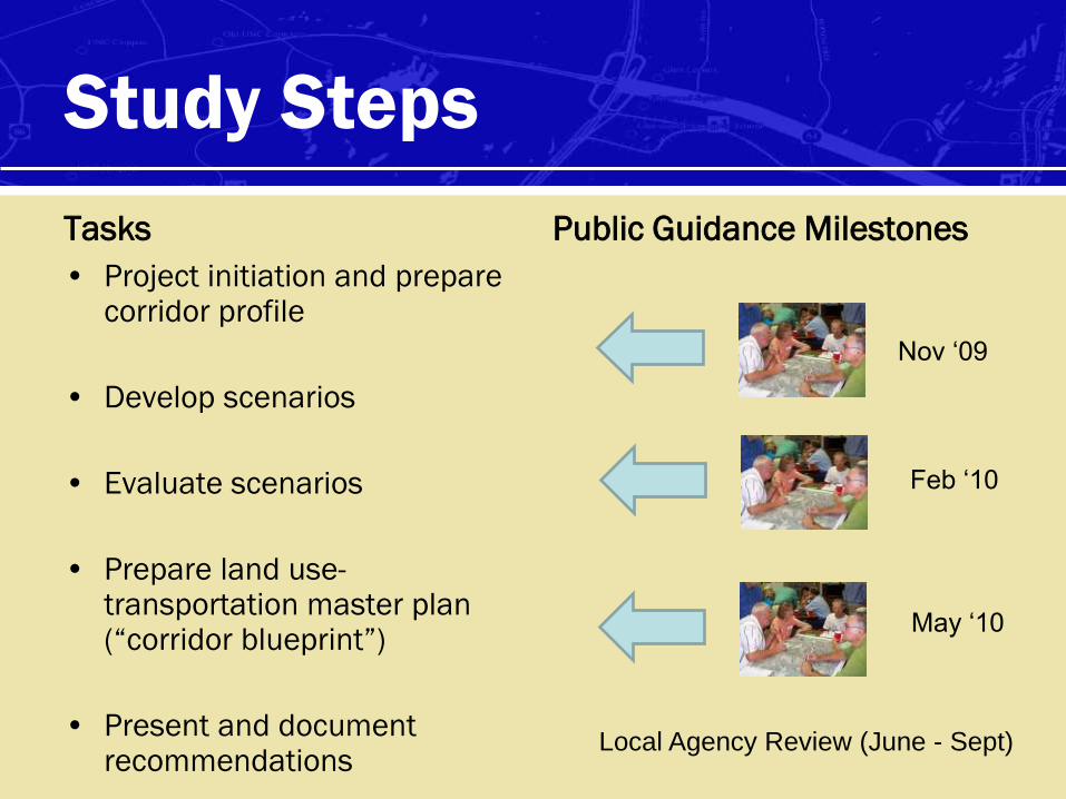
Study Steps
Tasks
• Project initiation and prepare corridor profile
• Develop scenarios
• Evaluate scenarios
• Prepare land use-transportation master plan (“corridor blueprint”)
• Present and document recommendations
Public Guidance Milestones
Nov ‘09
Feb ‘10
May ‘10
Local Agency Review (June - Sept)
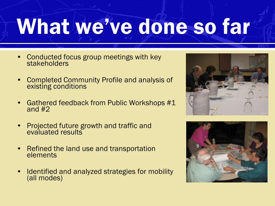
What we’ve done so far
• Conducted focus group meetings with key stakeholders
• Completed Community Profile and analysis of existing conditions
• Gathered feedback from Public Workshops #1 and #2
• Projected future growth and traffic and evaluated results
• Refined the land use and transportation elements
• Identified and analyzed strategies for mobility (all modes)

Getting to the Corridor Blueprint
• A complex corridor
– Multiple travel “markets”
– Competition for limited space
• A dynamic corridor
• A vision with the right balance among
strategies and realistic steps to get there

Getting to the Corridor Blueprint
• Very helpful ideas and feedback from focus groups, stakeholders and the public– Adjusted the land use categories and designations
accordingly
– Modified the transportation strategies
• Evaluated the „final scenario‟
• Plan shows a doubling of transit mode share with recommendations in place

NC 54/I-40 Corridor
Master Plan Draft
Land Use Blueprint

Community Elements• Slides summarize Community Elements (types of
development) recommended for the NC 54 study corridor– within the first 1/4 mile of a proposed light rail station area
– between 1/4 mile and 1/2 mile of a proposed light rail station area
– outside of the immediate station area vicinity
• Each example shows densities, massing and parking specific to that example place, with photos of the types of development that might be implemented within that area
• FAR, or Floor Area Ratio, is the ratio between the total floor area to be built on a site and the size of a site

NC 54 Corridor Concept
Mixed-Use 1
Mixed-Use 2
Residential 1
Residential 2
Employment
Conceptual Land Use

Concept Land Uses
Five general land use types:
1. Mixed Use 1 – higher density station area mixed use with primarily retail and office
2. Mixed Use 2 – retail on bottom floor with residential above
3. Residential 1 – mostly multi-family with neighborhood uses as appropriate
4. Residential 2 – mostly single-family homes with neighborhood uses as appropriate
5. Employment – could include office, institutional or health care facilities. This includes some mix of land uses and will be transit oriented to the maximum extent possible

Concept Land Uses
Five general land use categories:
Mixed
Use 1
Mixed
Use 2
Residen-
tial 1
Residen-
tial 2
Employ-
ment
No. of stories 3 – 8 2 – 4 2 – 4 1 – 3 4 – 12
Floor-to-area
ratios (non-
residential)
1.25 – 2.25 1.0 – 1.5 - - 0.5 – 1.0
Dwelling
Units per
Acre
35 – 75 25 – 35 15 – 35 6 – 10 -
Employees
per Acre45 - 90 25 - 50 9 - 15 6 - 12 35 - 175

Station Area – ¼ Mile Radius
This is the most intense and walkable area of development. Parking
ratios are kept as low as possible in this zone with access primarily
directly from transit, walking trips from adjacent community and the
park and ride facility. This zone is rich in employment and amenities to
attract pedestrians. It includes restaurants and other retail businesses

Station Area – ¼ Mile Radius
ParkingIn the immediate vicinity of station areas we recommend that on-site parking
requirements are waived. To the extent possible parking should be accommodated
in shared structured facilities or on-street. Additionally parking caps should apply as
follows:
• Retail should be capped at 2.5 spaces / 1000 SF of usable shop area
• Office should be capped at 1.5 spaces / 1000 SF of usable office space
• Residential Parking should be capped at 1.25 spaces per unit

DETAILS
FAR 0.5-1
Employment 35-
175 /Ac
Primarily Office with
Ground Floor Retail
Shared Structured
Parking
Shared Surface
Parking
Station Area EmploymentOffice / Institutional
¼ Mile Radius

DETAILS
FAR 2.0
Office Emp 150/Ac
Retail Emp 25/Ac
Total 175/Ac
Private Structured
Parking
Station Area Mixed-UseRetail / Office
¼ Mile Radius

¼ Mile Radius
DETAILS
FAR 1.0
Office Emp 58/Ac
Retail Emp 24.5/Ac
Total 82.5/Ac
Shared Surface Parking
On-Street Parking
Station Area Mixed-UseRetail / Office

Station Area Mixed-UseRetail / Office
DETAILS
FAR 1.25
Office Emp 72/Ac
Retail Emp 25/Ac
Total 97/Ac
Shared Surface Parking
On-Street Parking
¼ Mile Radius

¼ Mile Radius
Station Area Mixed-UseRetail / Residential High
DETAILS
FAR 4
Residential 130/Ac
Retail Emp 25/Ac
No On-Site Parking

¼ Mile Radius
Station Area Mixed-UseRetail / Residential
FAR 2.167
Retail Emp 32/Ac
Units 50/Ac
Private Structured
Parking
¼ Mile Radius
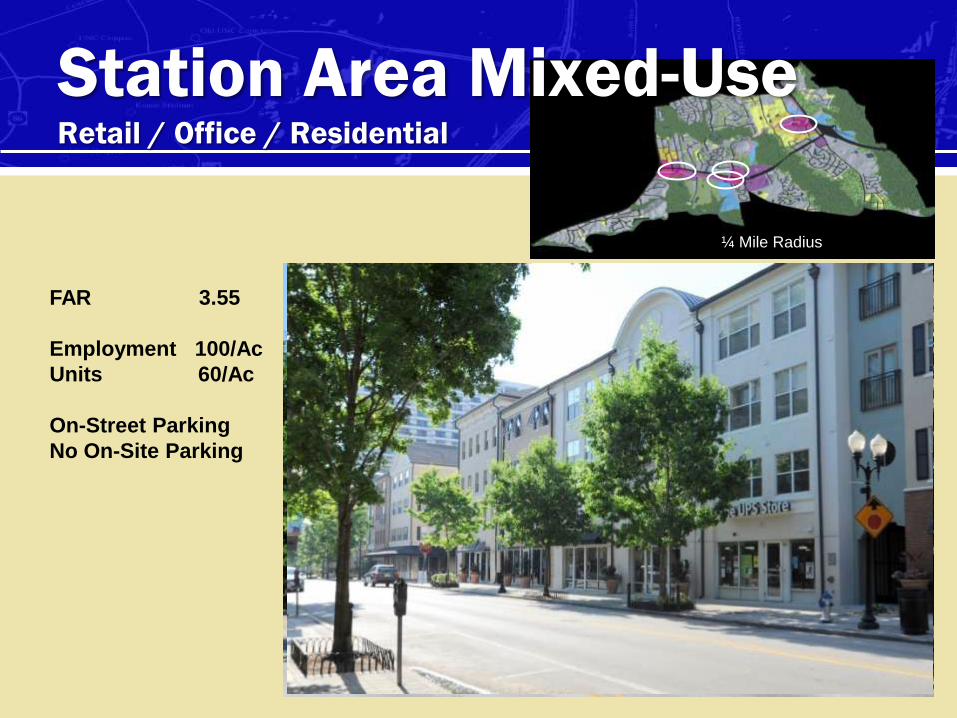
Station Area Mixed-UseRetail / Office / Residential
FAR 3.55
Employment 100/Ac
Units 60/Ac
On-Street Parking
No On-Site Parking

¼ Mile Radius
Station Area Mixed-UseRetail / Residential
DETAILS
FAR 1.77
Employment 25/Ac
Units 45/Ac
Shared Structured
Parking

Station Area – ½ Mile Radius
ParkingIn the second ¼ mile we recommend that, except for residential uses, on-site
parking requirements are waived. To the extent possible parking should be
accommodated in shared surface facilities or on-street. This takes advantage
of different peaks in demand. Additionally parking caps should apply as
follows:
• Retail should be capped at 3 spaces / 1000 SF of usable shopping area
• Office should be capped at 2 spaces / 1000 SF of usable office space
• Residential should be capped at 1.5 spaces per unit

Station Area – ½ Mile Radius
The second ¼ mile from the stations has local-serving mixed-use and
relatively dense housing stock. These include townhouses,
apartment/condo and small lot single-family residences. The street
network is connected with relatively small blocks. This retains the ease
of walking through the district.

DETAILS
FAR 1.48
Employment 25/Ac
Units 23/Ac
Shared Surface Parking
On-Street Parking
Residential Mixed-UseRetail / Residential
1/2 Mile Radius

DETAILS
FAR 0.9
Employment 52/Ac
Units 12/Ac
Garage Parking
Shared Surface & On-Street
1/2 Mile Radius
Residential Mixed-UseLive / Work Units

ResidentialCondominium
DETAILS
FAR
1.75
Units
50/Ac
Shared Surface
Parking
On-Street Parking
(Visitors)
1/2 Mile Radius

ResidentialCondominium
DETAILS
FAR 1.0
Units 33/Ac
Shared Surface Parking
On-Street Parking
(Visitors)
1/2 Mile Radius

ResidentialCondominium
DETAILS
FAR 1.05
Units 25/Ac
Shared Surface Parking
On-Street Parking
(Visitors)
1/2 Mile Radius

ResidentialTownhouse
DETAILS
FAR 0.71
Units 18/Ac
Shared Surface Parking
On-Street Parking
(Visitors)
1/2 Mile Radius

ResidentialSmall Lot Single-Family
DETAILS
FAR 0.775
Units 10.8/Ac
Garage
Shared Surface
(Visitors)
1/2 Mile Radius

ResidentialSingle-Family
DETAILS
FAR 0.775
Units 4-8/Ac
Alley-Loaded Garage
On-Street
1/2 Mile Radius
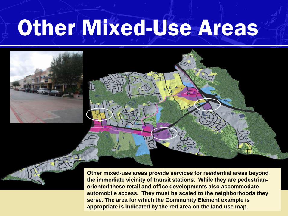
Other Mixed-Use Areas
Other mixed-use areas provide services for residential areas beyond
the immediate vicinity of transit stations. While they are pedestrian-
oriented these retail and office developments also accommodate
automobile access. They must be scaled to the neighborhoods they
serve. The area for which the Community Element example is
appropriate is indicated by the red area on the land use map.

Lifestyle CenterMixed-Use Retail
DETAILS
FAR 0.34
Retail 25
Emp/Ac
Office 17
Emp/Ac
Parking
Retail 4.5 /
1000 SF
Office 2.5/ 1000
SF
Shared Surface
Parking
* Mix of Uses distributes
peak demands for
parking over time
Other Mixed-Use Areas

Neighborhood CenterMixed-Use Retail/Office
DETAILS
FAR 0.775
On-Site Parking
Retail 3/1000 SF
Office 2/1000 SF
Shared Surface Parking
On-Street Parking
Other Mixed-Use Areas

Corner Shops and OfficesMixed-Use Retail/Office
DETAILS
FAR 0.775
On-Site Parking
Retail 3/1000 SF
Office 2/1000 SF
Shared Surface
On-Street Parking
Other Mixed-Use Areas

Transit Oriented
Development
Potential Phasing at Leigh Village

Pre-Transit Development
Structured parking is provided to support the core Main Street and new park &
ride location. This mixed-use development anticipates Transit Oriented
Development and is built in phases as absorption allows.
Shared
Structured Parking
(Park and Ride)
Shared
Surface Parking
(Future
Development)
Shared
Surface Parking
Shared
Structured
Parking (Park
and Ride)

Pre-Transit Development
Shared
Surface Parking
Shared
Surface Parking
Additional Mixed-Use and Employment is added supported by the shared parking
structure and shared surface parking. Primary access is by auto although Bus Rapid
Transit could be phased in prior to light rail transit implementation.
Shared
Surface Parking
(Future
Development) Shared
Structured Parking
(Park and Ride)
Shared
Structured
Parking (Park
and Ride)

Pre-Transit Development
Shared
Surface Parking
Shared
Surface Parking
Housing is developed as the market demands. Densities anticipate the ultimate
development of transit in the corridor.
Shared
Surface Parking
(Future
Development) Shared
Structured Parking
(Park and Ride)
Shared
Structured
Parking (Park
and Ride)

Infill Following Rail Implementation
Once transit is fully implemented shared parking facilities can be replaced with
structured parking as surface lots are developed. Cost will be shared by existing
and new development. Additional commercial development will follow build-out of
housing in the corridor.
Shared Structured
Parking (Park and
Ride, retail and
housing)
Shared
Structured Parking
(Park and Ride)

Your turndiscuss & comment on
land use

Transit System
RecommendationsPhased Enhancements

Existing Bus Service
Chapel Hill Transit
Triangle Transit
Transit travel markets
Transfer Center
(Transit systems and
Park-n-Ride)
Transit Markets: Typical service
along corridor, connections to
regional routes, and Park-n-Ride
Chapel Hill Transit:
- Provides service to
destinations within
Chapel Hill only.
-Connects with TT for
regional connection.
Triangle Transit:
- Provides regional
connections and
express service
between major transit
generators.
Transit marketsTransit markets
Existing CHT Park-n-Ride

SHORT TERM - Expanded Bus Service
Chapel Hill Transit
Chapel Hill Transit
Future Bus Service
Triangle Transit
Transit travel markets
Park-n-Ride Location
Bus Transfer Location
Transit Markets: Expand local
service, and create better regional
bus connections
Chapel Hill Transit:
- Future plans indicate
the potential for new
bus service, which
help connect low
density to regional
transfer points.
Possible transfer location between CHT and TT
Transit supportive destinations
Future Park-n-Ride
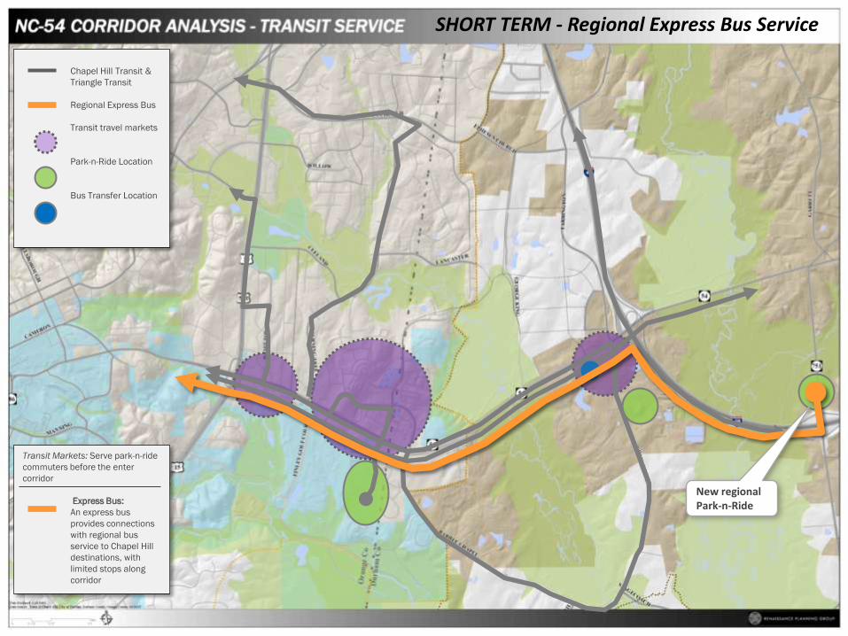
SHORT TERM - Regional Express Bus Service
Chapel Hill Transit &
Triangle Transit
Regional Express Bus
Transit travel markets
Park-n-Ride Location
Bus Transfer Location
Transit Markets: Serve park-n-ride
commuters before the enter
corridor
Express Bus:
An express bus
provides connections
with regional bus
service to Chapel Hill
destinations, with
limited stops along
corridor
New regional Park-n-Ride

Future Transit Supportive Development
Chapel Hill Transit,
Triangle Transit, &
Express Bus Service
Existing transit travel
markets
Park-n-Ride Location
Bus Transfer Location
Transit Markets: New land
development is transit oriented
New corridor nodes
provide land use
support for greater
regional origins and
destinations. This
increases the need for
connectivity.
Future transit supportive land development
Future transit supportive land developmentFuture transit
supportive land development
Future transit supportive land development

LONG TERM – Expanded Bus Service
Chapel Hill Transit,
Triangle Transit, &
Express Bus Service
Existing transit travel
markets
Transfer between
transit systems (Park-
n-Ride)
Chapel Hill Transit,
Triangle Transit, &
Express Bus
Bus Service Expansion
Future and existing
transit travel markets
Park-n-Ride Location
Bus Transfer Location
Transit Markets: Expand local
service, and create better regional
bus connections
Chapel Hill Transit:
- With new transit
supportive land uses,
there would be a need
for more direct bus
routes exiting north of
the corridor

LONG TERM – Enhanced Bus Service
Chapel Hill Transit,
Triangle Transit, &
Express Bus Service
Existing transit travel
markets
Transfer between
transit systems (Park-
n-Ride)
Chapel Hill Transit,
Triangle Transit, &
Express Bus
Enhanced Bus
Phase 1
Enhanced Bus
Phase 2
Future and existing
transit travel markets
New Transfer Center
(Transit systems and
Park-n-Ride)
Bus Transfer Location
Transit Markets: BRT provides
faster, more direct service
between regional destinations
Enhanced Bus
connects to region
services, and
provides fast
connections to major
transit generators
faster (Park-n-Ride,
UNC, Hospital, etc.)
Local service serves
as a feeder to
regional and express
routes
Transit supportive land uses also serve as transfers between bus with signal priority, local bus, regional bus service and Park-n-Ride

LONG TERM – Create Flex-Route w/LRT
Chapel Hill Transit,
Triangle Transit, &
Express Bus
Enhanced Bus Service
Flex-Route Shuttle
Transit Markets: Flex-routes to
attract more local residents to
access regional service and LRT
New flex-route
shuttle service for
low density areas

Park-n-Ride
Recommendations
Light Rail Alignment
Light Rail stations
serving transit
supportive nodes
and regional
connections
LONG TERM – Light Rail Transit
Chapel Hill
Durham
Meadowmont
UNC
Duke
Medical
New Hope
Triangle Metro
Center
RTP North
Alston Ave
751
751
751
55
55
147
54
54
15
501
15
501
54
40
Downtown
Durham

¼ mile
½ mile
¼ mile
½ mile
¼ mile
½ mile
LONG TERM – Light Rail Transit
Chapel Hill Transit &
Triangle Transit
Enhanced Bus Service
Light Rail
Light Rail stations
serving transit
supportive nodes
and regional
connections
¼ mile
½ mile

LONG TERM – Light Rail Transit
Transit supportive land uses also serve as transfers between BRT, regional bus service and Park-n-Ride
Chapel Hill Transit &
Triangle Transit
Enhanced Bus
Light Rail
Transit Supportive
Land Uses
Transfer Center
(Transit systems and
Park-n-Ride)
LRT Stations
Bus Transfer Location
New regional connections service
regional Transit Markets
Light Rail connects
corridor with region,
as well as Express
Bus and TT
continues to serve
commuter markets
not along LRT
Enhanced Bus
provides fast
connections to major
transit generators
(Park-n-Ride, UNC,
Hospital, etc.)
Local service helps
feed to LRT and
express bus

Recommended Bicycle
and Pedestrian Blueprint

Bicycle & Pedestrian Network
• Fully connected bicycle and pedestrian network with range of
treatments and facility types
– Minimum five foot bike lane for Chapel Hill section of NC 54
– Off-road shared path for Durham section of NC 54
– Markings, lanes, paved shoulders, shared paths on other roadways
• Supports transit „customer delivery system‟
• Superstreet concept allows for safe at-grade crossing for
pedestrians
• Bridge crossing at Meadowmont & Friday Center LRT stations
• Improvements at 15-501 ramps
• Pedestrian infrastructure needed along I-40 overpass

At-grade
intersection
treatment to
accommodate trail
and increased
pedestrian
crossings
Improved
pedestrian
features and
bike lanes
Pedestrian
underpass
Shared use path
overpass connected to
elevated LRT stationPaved shoulder
connection to
the American
Tobacco Trail
Sidewalks at overpass
or median
enhancement for
modified interchange
You can find the high quality image of this in
the folder on the VA server:
\\10.0.3.12\virginiadata\Prjs\NC54\graphics\K
workingfiles\latestJPEGS

You can find the high quality image of this in
the folder on the VA server:
\\10.0.3.12\virginiadata\Prjs\NC54\graphics\K
workingfiles\latestJPEGS


Street Connectivity
• Parallel routes provide alternative access for
local traffic
• Provides route choice for all modes to avoid NC
54 whenever possible
• Cross-access and inter-parcel connectivity
required as future development occurs

New Connections
New Connections

Complete Streets
• New connector and neighborhood street networks should
be „complete‟ – with sidewalks, bike lanes or trails,
transit stops, trees

Design guidelines
• Guidelines to help ensure vision is implemented

Your turndiscuss & comment on
transit, bicycle and
pedestrian strategies
Recommended Roadway
Blueprint

Roadway Conditions• NC 54 traffic grew 30% in last
decade– 1997: 35,000 vehicles per day
– 2007: Increased to 47,000
• Similar rate of increase for I-40
• Highest traffic growth on Farrington and Barbee Chapel Roads– Traffic levels have doubled in 10
years
– Environmental and residential constraints limit corridor options
• Multiple local and express bus routes serving the corridor

Roadway Conditions• Today the NC 54 corridor is already plagued with congestion, primarily
westbound into Chapel Hill and UNC in the AM peak, and eastbound
onto I-40 in the PM peak
• In the future, traffic volumes will drastically increase. The corridor
serves both regional and local traffic, and both will grow substantially in
the future.
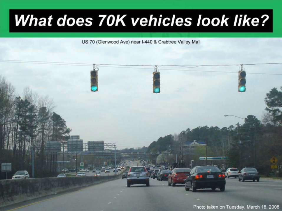
• In 2020, volumes will reach about70,000 vehicles per day (as
compared to 45,000 vehicles per day in 2009).
• If no improvements are made, conditions will rapidly deteriorate. Wait
times will increase significantly. For example, at East Barbee Chapel
Road, the westbound wait time will increase from about 40 seconds in
the AM peak hour to about 4 minutes. At Huntingridge Road, the
westbound wait time could reach above 9 minutes.


Roadway Conditions
• Widening the corridor to six lanes in the
Durham portion will not solve the problem
• Two major impediments to capacity of the
road:
– Traffic signals
– Close proximity of Farrington Road to the I-40
interchange

Traffic Signals
• Traditional traffic signals are not efficient.
• Within the NC 54 corridor, the mainline “through”
movements are very large.
• At a typical traffic signal, most of the green time is
taken away from the through movement and given
to the side streets and left turns.
• Reducing the number of phases at a signal gives
more green time back to the major through
movements.
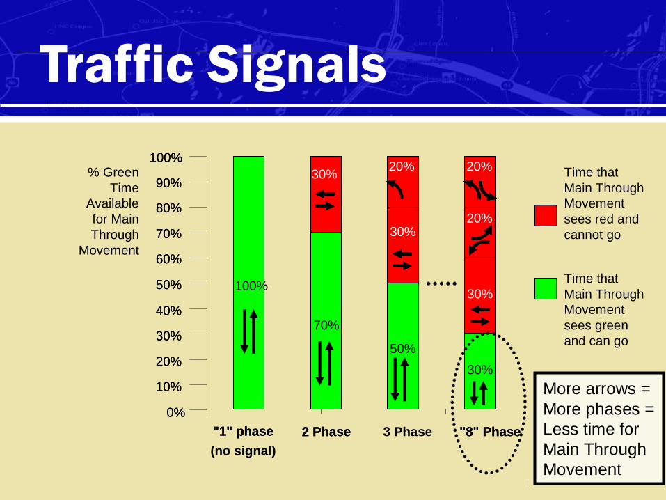
More arrows =
More phases =
Less time for
Main Through
Movement
100%
"1" phase
100%
"1" phase
(no signal)
70%
30%
2 Phase
70%
30%
2 Phase
50%
30%
3 Phase
% Green
Time
Available
for Main
Through
Movement
0%
10%
20%
30%
40%
50%
60%
70%
80%
90%
100%
0%
10%
20%
30%
40%
50%
60%
70%
80%
90%
100%
30%
30%
20%
"8" Phase
20%
30%
30%
20%
"8" Phase
20% Time that
Main Through
Movement
sees red and
cannot go
Time that
Main Through
Movement
sees green
and can go
20%
Traffic Signals

Traffic Signals
• Unconventional intersections can greatly improve
roadway capacity.
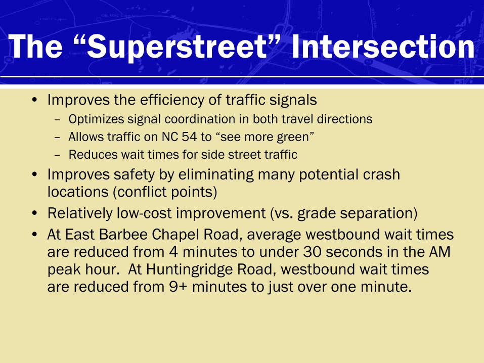
• Improves the efficiency of traffic signals
– Optimizes signal coordination in both travel directions
– Allows traffic on NC 54 to “see more green”
– Reduces wait times for side street traffic
• Improves safety by eliminating many potential crash locations (conflict points)
• Relatively low-cost improvement (vs. grade separation)
• At East Barbee Chapel Road, average westbound wait times are reduced from 4 minutes to under 30 seconds in the AM peak hour. At Huntingridge Road, westbound wait times are reduced from 9+ minutes to just over one minute.
The “Superstreet” Intersection

The “Superstreet” Intersection

• Side-street traffic can only turn right onto NC
54.
• To go straight or turn left, you must turn right
and make a u-turn.
• This treatment is recommended at several
locations within the NC 54 corridor.
• At other intersections, left turns from side-
streets are allowed.
The “Superstreet” Intersection


How do bicyclists and
pedestrians cross the street?

Buses & Emergency Vehicles
Emergency vehicles and transit buses
can safely navigate the superstreet
intersections with minimal change in
transport time.
Improved traffic flow may improve
response time and safety for emergency
vehicles

Buses & Emergency Vehicles
U-turns and
left turns are
designed to
easily
accommodate
larger
vehicles.
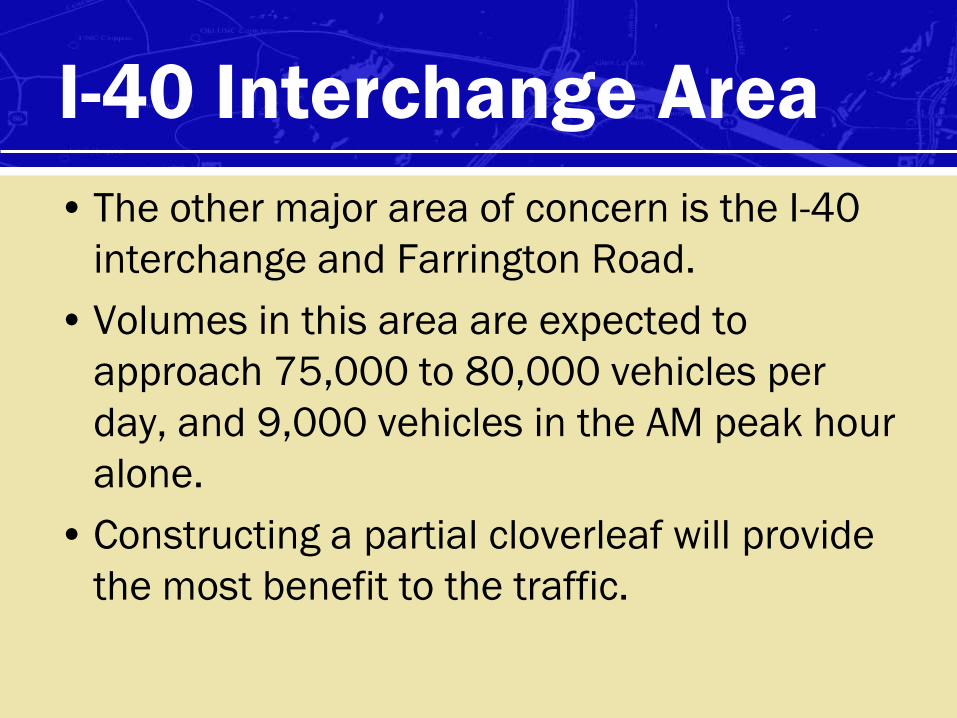
I-40 Interchange Area
• The other major area of concern is the I-40
interchange and Farrington Road.
• Volumes in this area are expected to
approach 75,000 to 80,000 vehicles per
day, and 9,000 vehicles in the AM peak hour
alone.
• Constructing a partial cloverleaf will provide
the most benefit to the traffic.

Interchange Concept

Other Concepts Considered
• A short review of other intersection
alternatives the study team has considered
for both intersections along NC 54 and for
the I-40 interchange:
• The superstreet concepts with the partial
cloverleaf interchange at I-40 will provide
the most “bang for your buck”

Median U-turn

Bowtie

Quadrant Roadway

Continuous Flow Intersection

Echelon Interchange

Center Turn Overpass
Arterial
Arterial or collector

Two Level Signalized Interchange

Diverging Diamond

Roundabout Interchange

Single Point Urban Interchange
I-40 at Galimore Dairy Road
Tampa, FL

Jughandle

Long-Term Solutions• The recommendations here provide the most additional
roadway capacity for the interim volumes.
• The biggest problem is the close proximity of Farrington Road to the interstate.
• If we assume traffic volumes will continue to grow and the vehicular demand must be met, eventually the volumes will necessitate closing off the intersection to let the traffic flow, or constructing a flyover ramp for the eastbound traffic to access I-40 without interruption from the Farrington Road signal.
• It appears that this choice will have to be made as 2020 approaches.

Long Term Improvements – Minimal
I-40 Additional Ramps
Potential New
Connections
Grade Separate to
Eliminate NC-54
Signals
Grade Separation
(urban
interchange)
Enhanced Interchange
with flyover ramps

Additional Improvements – Higher Cost (as needed)
Enhanced Interchange
with flyover ramps
Elevated Regional Traffic
Additional Ramps
Raised Regional
Roadway
Long Term Improvements – More Extensive

Roadway Network
• The recommendations here provide the most additional roadway capacity for the interim year volumes.
• The biggest problem is the close proximity of Farrington Road to the interstate – future flyover needed??
• Longer term, grade separation (interchanges) will need to occur along NC 54 and the I-40 Interchange rebuilt.
• The multimodal strategy of creating an environment that encourages transit/walking/biking will be critically important towards managing congestion into the future.

Your turndiscuss & comment on
roadway strategies

Project
Phasing

Phasing- Short term
Short Term (5 years or less)
• Restripe NC 54 between 15-501 and I-40 for narrower lanes (11‟ wide) to provide bike lane for on-road cyclists
• Implement high-visibility crosswalks at 15-501 ramp intersection with signage to alert drivers of the possible presence of cyclists in the bike lane and pedestrians in crosswalks, and modify the raised channelization islands as necessary
• Begin to provide park-and-ride locations at Gateway and Southpoint to intercept park-and-ride at Friday Center
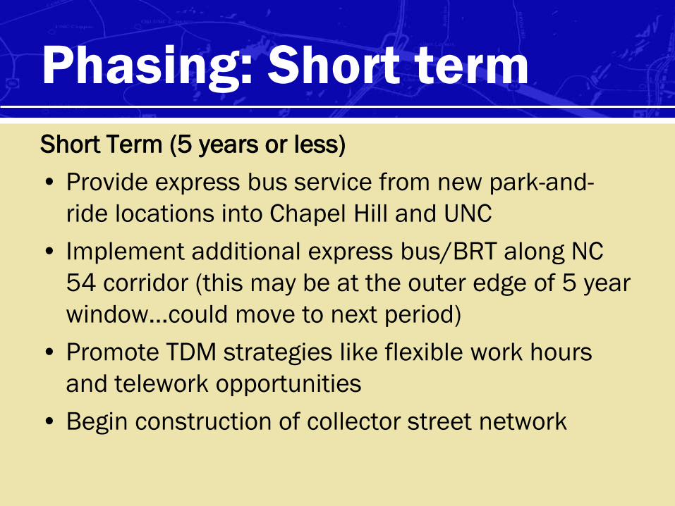
Phasing: Short term
Short Term (5 years or less)
• Provide express bus service from new park-and-
ride locations into Chapel Hill and UNC
• Implement additional express bus/BRT along NC
54 corridor (this may be at the outer edge of 5 year
window…could move to next period)
• Promote TDM strategies like flexible work hours
and telework opportunities
• Begin construction of collector street network
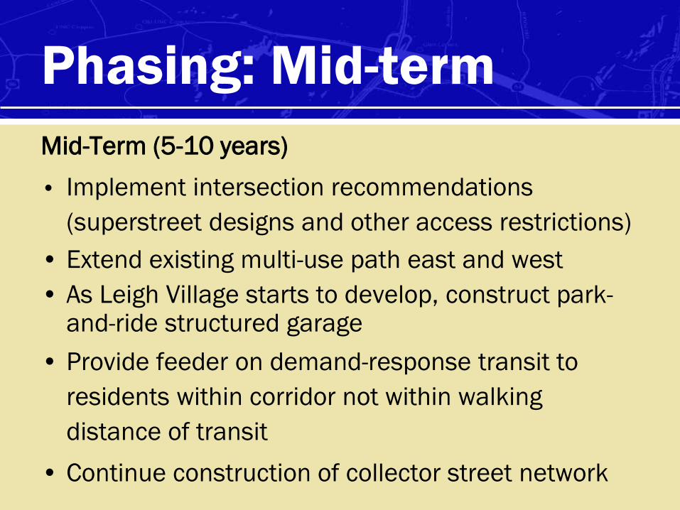
Phasing: Mid-term
Mid-Term (5-10 years)
• Implement intersection recommendations
(superstreet designs and other access restrictions)
• Extend existing multi-use path east and west
• As Leigh Village starts to develop, construct park-and-ride structured garage
• Provide feeder on demand-response transit to
residents within corridor not within walking
distance of transit
• Continue construction of collector street network

Phasing: Mid-term
• Construct modified superstreet recommendations
on Chapel Hill portion to improve operations
• Modify I-40 interchange at NC 54
• Widen NC 54 to 6 lanes in Durham portion
• Extend multi-use path along both sides of corridor
• Change Farrington Road – either close it off to let
the eastbound traffic flow or construct a flyover to
get eastbound traffic onto eastbound I-40

Phasing: Long-term
• Invest in transit on all scales – more local routes to
serve more riders; more robust express service
to/from major centers (eventually served by LRT)
• Construct LRT and begin operations
• Long Term – Hard decisions and major investments
need to be made:
– either grade-separate intersections to provide more vehicle
capacity, or
– invest in a more robust transit system coupled with parking
restrictions and incentives for non-auto travel and peak
traffic volume reduction

Next Steps
• Finalize necessary plan revisions
• Present to MPO TAC on May 12
• Submit draft report end of May
– Available to public for review following steering committee review
• Ongoing review through City, Town & MPO

NC-54/I-40 CORRIDOR
BLUEPRINT FOR MOBILITY