bat report final - mn it services
TRANSCRIPT

Searsburg Wind Tower Expansion Project
Bat Habitat Assessment and Mapping
Final Report
Prepared by:
Arrowwood Environmental
Prepared for:
enXco, Inc./Deerfield Wind, LLC

__________________________________________________________________________________________________________________
May 2005
Searsburg Wind Power Expansion Project
Final Report
Bat Habitat Assessment and Mapping
Introduction
In January, 2005 a team of biologists, regulators, and project proponents met to discus possible
bat habitat near the proposed Searsburg Wind Power Expansion projects. As a result of this
meeting the initial habitat identification phase regarding bats near the project has been
developed. Arrowwood Environmental was retained by Deerfield Wind LLC to conduct the
bat habitat assessment for the proposed project. The focus of this study was on two species of
bats: the federally endangered Indiana bat (Myotis sodalis) and the Vermont state threatened
small-footed bat (Myotis leibii). This report outlines the methodology and results of that study.
Methodology
The work discussed in this report involves the remote mapping of potential Indiana bat and
Small-footed bat habitats at the proposed Searsburg expansion area. The scope of work and
the habitat criteria considered in this study was developed in cooperation with Vermont
Agency of Natural Resources biologists and US Fish and Wildlife biologists. The primary
tools for mapping habitat elements were aerial photographs. These were examined under
stereoscope to obtain information on topography. The state-wide 1:40,000 Color Infra-red
photographs were employed to this end. In addition, National Agricultural Imagery Program
true color orthophotos (2003) and black and white Orthophotos (1995-1998), and USGS
topographic maps supplemented the aerial photo information. The study area for this inventory
consists of a 3 mile radius centered along the proposed development ridge. This study area is
shown on the attached map. Methodologies used for the habitat assessments are detailed for
each species below.

Indiana Bat (Myotis sodalis)
Habitat identification for the Indiana bat focused on summer-time use of maternity roost areas.
The habitat suitability index (HSI) for this species (U.S. Fish and Wildlife Service) outlines a
methodology for assessing the potential for necessary habitat within a certain area. The
methodology presented in the HSI was used during this study. That methodology calls for
assessing habitat within 2km diameter areas. The entire study area was divided into 39
overlapping 2km diameter areas (see attached map) and individual assessments were made for
each of these areas. Each area consisted of approximately 872 acres. Under this HSI model,
three variables are assessed: 1) food suitability as a function of cover type diversity; 2) roost
suitability as a function of the density of roost trees and; 3) landscape suitability as a function
of forest cover. A complete HSI determination could not be conducted because of the lack of
field work associated with the inventory at this stage. The current study consisted of only
assessing the food suitability and landscape suitability of each of the 2km diameter areas.
The food suitability assessment consisted of determining the amount of cover type diversity for
each area. The following cover type classes were used:
1. Row crop
2. Pasture and Hay meadow
3. Wetland
4. Open water
6. Early successional habitat
7. Deciduous forest (including upland and floodplain)
8. Coniferous forest
In order for one of the above cover types to be considered present in a suitable amount, it must
comprise at least 10% of the landscape being assessed (approximately 87 acres in each 2km
diameter area). For each area, the presence of these cover types was recorded.
The landscape suitability portion of the model measures the amount of forest cover within each
area. Indiana bats are typically found in areas with a "moderate" amount of forest cover.
While less than 5% forest is unsuitable, the ideal range is a landscape with 20-60% forest. The
amount of forest as a percentage of the total area was recorded for each 2km diameter area.
Small-footed Bat (Myotis leibii)
Habitat identification for the small-footed bat focused on the presence of cliffs and talus areas
as maternity roosting areas. Digital USGS topographic maps were used to initially identify
areas that are steep enough to support cliffs and talus areas. The entire study area was then
examined with 1990s Color Infrared Aerial Photos (CIR) with special attention paid to the
areas identified with the topographic maps. Dot locations of potential areas were mapped.
Information such as elevation, aspect, size and quality of the potential habitat is included with
the location map.
Results
Indiana Bat (Myotis sodalis)
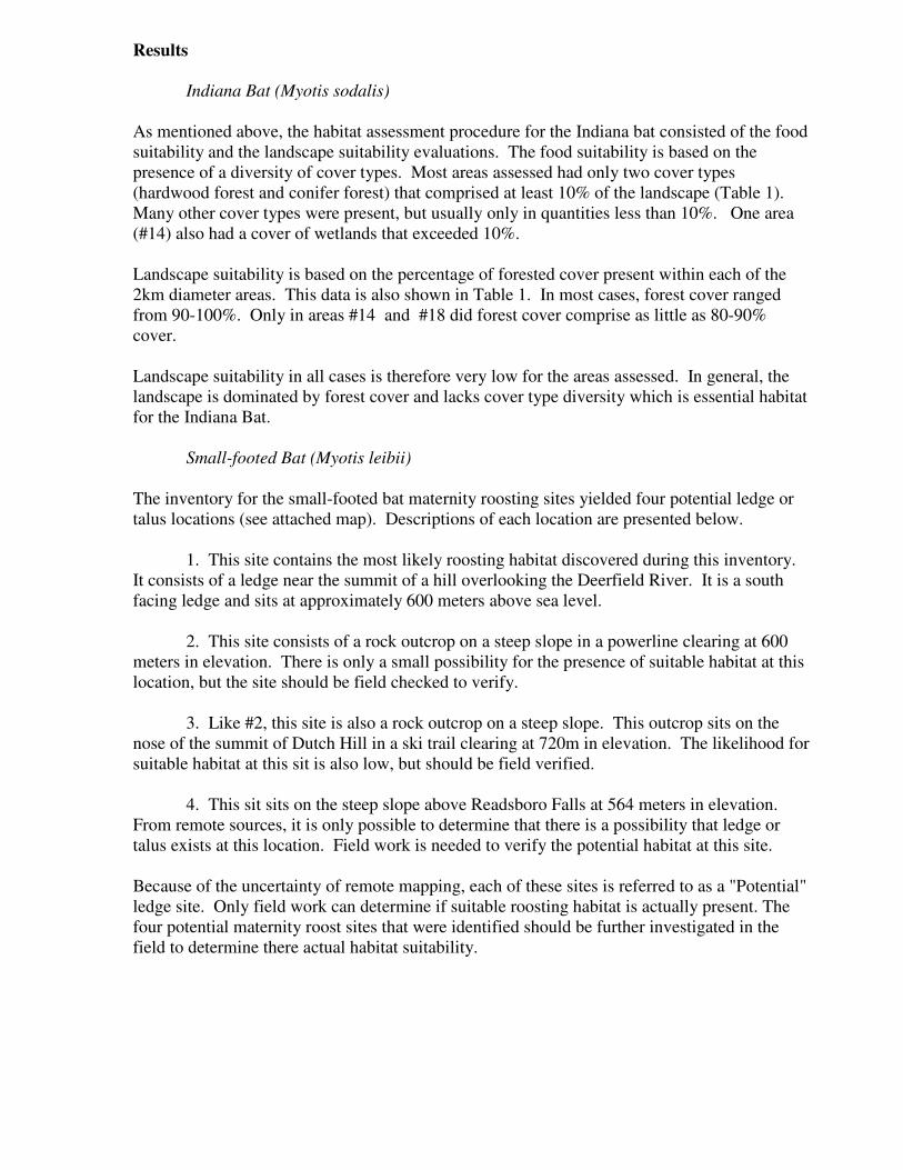
As mentioned above, the habitat assessment procedure for the Indiana bat consisted of the food
suitability and the landscape suitability evaluations. The food suitability is based on the
presence of a diversity of cover types. Most areas assessed had only two cover types
(hardwood forest and conifer forest) that comprised at least 10% of the landscape (Table 1).
Many other cover types were present, but usually only in quantities less than 10%. One area
(#14) also had a cover of wetlands that exceeded 10%.
Landscape suitability is based on the percentage of forested cover present within each of the
2km diameter areas. This data is also shown in Table 1. In most cases, forest cover ranged
from 90-100%. Only in areas #14 and #18 did forest cover comprise as little as 80-90%
cover.
Landscape suitability in all cases is therefore very low for the areas assessed. In general, the
landscape is dominated by forest cover and lacks cover type diversity which is essential habitat
for the Indiana Bat.
Small-footed Bat (Myotis leibii)
The inventory for the small-footed bat maternity roosting sites yielded four potential ledge or
talus locations (see attached map). Descriptions of each location are presented below.
1. This site contains the most likely roosting habitat discovered during this inventory.
It consists of a ledge near the summit of a hill overlooking the Deerfield River. It is a south
facing ledge and sits at approximately 600 meters above sea level.
2. This site consists of a rock outcrop on a steep slope in a powerline clearing at 600
meters in elevation. There is only a small possibility for the presence of suitable habitat at this
location, but the site should be field checked to verify.
3. Like #2, this site is also a rock outcrop on a steep slope. This outcrop sits on the
nose of the summit of Dutch Hill in a ski trail clearing at 720m in elevation. The likelihood for
suitable habitat at this sit is also low, but should be field verified.
4. This sit sits on the steep slope above Readsboro Falls at 564 meters in elevation.
From remote sources, it is only possible to determine that there is a possibility that ledge or
talus exists at this location. Field work is needed to verify the potential habitat at this site.
Because of the uncertainty of remote mapping, each of these sites is referred to as a "Potential"
ledge site. Only field work can determine if suitable roosting habitat is actually present. The
four potential maternity roost sites that were identified should be further investigated in the
field to determine there actual habitat suitability.
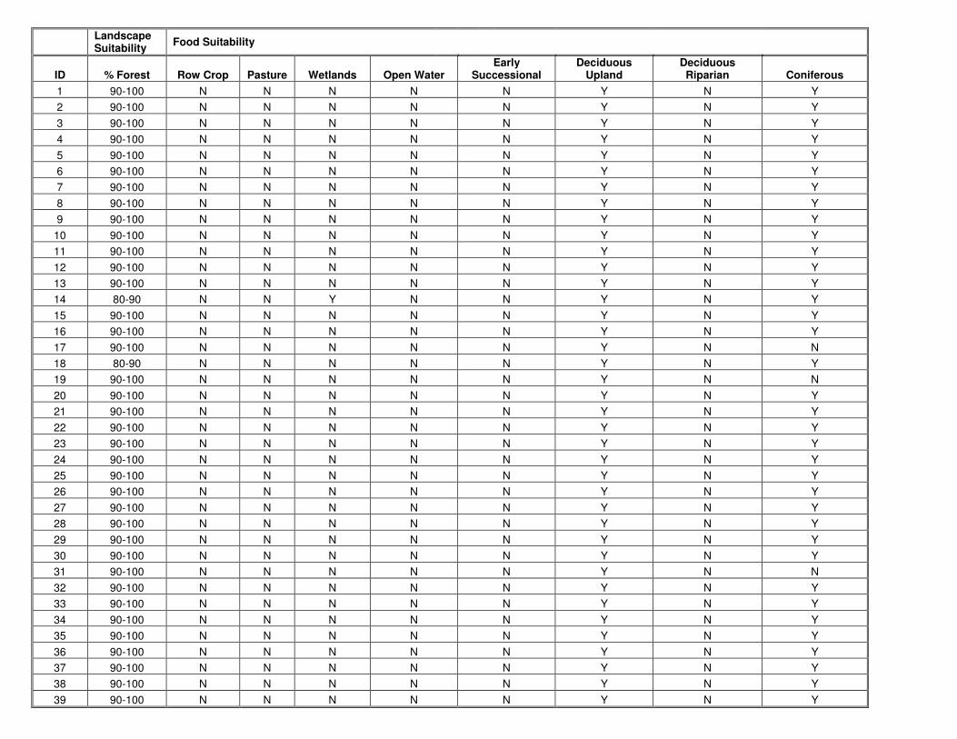
Landscape Suitability
Food Suitability
ID % Forest Row Crop Pasture Wetlands Open Water Early
Successional Deciduous
Upland Deciduous Riparian Coniferous
1 90-100 N N N N N Y N Y
2 90-100 N N N N N Y N Y
3 90-100 N N N N N Y N Y
4 90-100 N N N N N Y N Y
5 90-100 N N N N N Y N Y
6 90-100 N N N N N Y N Y
7 90-100 N N N N N Y N Y
8 90-100 N N N N N Y N Y
9 90-100 N N N N N Y N Y
10 90-100 N N N N N Y N Y
11 90-100 N N N N N Y N Y
12 90-100 N N N N N Y N Y
13 90-100 N N N N N Y N Y
14 80-90 N N Y N N Y N Y
15 90-100 N N N N N Y N Y
16 90-100 N N N N N Y N Y
17 90-100 N N N N N Y N N
18 80-90 N N N N N Y N Y
19 90-100 N N N N N Y N N
20 90-100 N N N N N Y N Y
21 90-100 N N N N N Y N Y
22 90-100 N N N N N Y N Y
23 90-100 N N N N N Y N Y
24 90-100 N N N N N Y N Y
25 90-100 N N N N N Y N Y
26 90-100 N N N N N Y N Y
27 90-100 N N N N N Y N Y
28 90-100 N N N N N Y N Y
29 90-100 N N N N N Y N Y
30 90-100 N N N N N Y N Y
31 90-100 N N N N N Y N N
32 90-100 N N N N N Y N Y
33 90-100 N N N N N Y N Y
34 90-100 N N N N N Y N Y
35 90-100 N N N N N Y N Y
36 90-100 N N N N N Y N Y
37 90-100 N N N N N Y N Y
38 90-100 N N N N N Y N Y
39 90-100 N N N N N Y N Y

9
100
100
READSBORO
SEARSBURG
WOODFORD
STAMFORD
WILMINGTON
WHITINGHAM
9
8
7
65
4
3
2
1
17
19
10
37
16
15
18
11
31
27
21
13
14
12
39
38
36
35
33
32
30
29
2826
25
23
22
20 34
24
72°55'0"W72°56'0"W72°57'0"W72°58'0"W72°59'0"W73°0'0"W73°1'0"W73°2'0"W73°3'0"W
42°55
'0"N
42°54
'0"N
42°53
'0"N
42°52
'0"N
42°51
'0"N
42°50
'0"N
42°49
'0"N
42°48
'0"N
42°47
'0"N
page
0 3,000 6,0001,500Feet
1 inch equals 6,000 feet
LegendProposed TurbinesExisting TurbinesIndiana Bat AreasStudy Area
Indiana Bat Habitat AssessmentProposed Searsburg Wind Turbine Expansion Project
Turbine locations providedby Searsburg Wind, Studyarea and Habitat areas byArrowwood Envrionmental.Other data from VCGI.
Prepared for Vermont Environmental Research Associates4/25/05

9
100
100
READSBORO
SEARSBURG
WOODFORD
STAMFORD
WILMINGTON
WHITINGHAM
2
4
3
1
72°55'0"W72°56'0"W72°57'0"W72°58'0"W72°59'0"W73°0'0"W73°1'0"W73°2'0"W73°3'0"W
42°55
'0"N
42°54
'0"N
42°53
'0"N
42°52
'0"N
42°51
'0"N
42°50
'0"N
42°49
'0"N
42°48
'0"N
42°47
'0"N
page
0 3,000 6,0001,500Feet
1 inch equals 6,000 feet
LegendProposed TurbinesExisting Turbines
Potential Ledges
Study Area
Small Footed Bat Habitat AssessmentProposed Searsburg Wind Turbine Expansion Project
Turbine locations providedby Searsburg Wind, Studyarea and Habitat areas byArrowwood Envrionmental.Other data from VCGI.
Prepared for Vermont Environmental Research Associates4/25/05