basins at risk : conflict and cooperation over international freshwater resources
DESCRIPTION
The Basins at Risk project (BAR) addressed a series of overarching gaps in research on freshwater resources and international conflict by providing a quantitative, global scale exploration of the relationship between freshwater resources and conflict. The project incorporated a spatial perspective and considered the full spectrum of interactions, using precise definitions of conflict and cooperation. The purpose of the research was to identify historical indicators of international freshwater conflict and cooperation and, from them, create a framework to identify and evaluate international river basins at potential risk for future freshwater conflict.TRANSCRIPT

63
CHAPTER 4 CONFLICT AND COOPERATION OVER INTERNATIONAL FRESHWATER RESOURCES: INDICATORS
AND FINDINGS OF THE BASINS AT RISK PROJECT
Shira Yoffe, Aaron T. Wolf, Mark Giordano
To be submitted for publication, with revisions, to the Journal of the American Water Resources Association

64
ABSTRACT
This paper seeks to identify historical indicators of international freshwater
conflict and cooperation and create a framework to identify and evaluate international
river basins at potential risk for future conflict. To accomplish this task, we derived
biophysical, socioeconomic, and geopolitical variables at multiple spatial and temporal
scales from a GIS of international river basins and associated countries, and tested these
variables using a database of historical incidents of water-related cooperation and conflict
across all international basins, 1948 to 1999. We found that international relations over
freshwater resources are overwhelmingly cooperative and cover a wide range of issue
areas, including water quantity, quality, joint management, and hydropower. Conflictive
relations tend to center on quantity and infrastructure concerns. No single indicator
explained conflict/cooperation over water, including climate, water stress, government
type, and dependence on freshwater resources for agriculture or energy. Even those
indicators that showed a significant correlation with water conflict, such as high
population density, low per capita GDP, and overall unfriendly international relations,
explained only a small percentage of the variability in the data. Overall, the most
promising sets of indicators for water conflict were those associated with rapid or
extreme changes in the institutional or physical systems within a basin (e.g.,
internationalization of a basin, large dams) and the key role of institutional mechanisms,
such as international freshwater treaties, in mitigating such conflict.
KEYWORDS
water, international river basins, conflict, cooperation, event data, GIS, geography,
indicators

65
INTRODUCTION
In the policy literature and popular press, issues of water and international conflict
have been linked with increasing frequency (Westing 1986; Elliott 1991; Gleick 1993;
Homer-Dixon 1994; Remans 1995; Butts 1997; Elhance 1999). This literature often
stresses various indicators for conflict, including proximity, government type, aridity and
rapid population growth. Yet despite the number of case studies analyzing and
comparing water-related conflict in various international river basins, little global-scale
or quantitative evidence has been compiled. Existing work often consists of case studies
from the most volatile basins and excludes examination of cooperation, spatial variability
and precise definitions of conflict.
In the Basins at Risk (BAR) project, we addressed the gaps in the literature on
international freshwater resources by providing a quantitative, global scale exploration of
the relationship between freshwater and conflict. We considered the full spectrum of
interactions, using precise definitions of cooperation and conflict and our approach
incorporates a spatial perspective. In essence, we asked whether the theories and claims
are supported by historical evidence. We also considered another hypothesis, that the
likelihood and intensity of conflict within a basin increases as the magnitude or amount
of physical or institutional change exceeds the capacity within a basin to absorb that
change.
The BAR project had three objectives:
• to identify historical indicators of international freshwater conflict and
cooperation;
• to use these indicators to create a framework to identify and evaluate international
river basins at potential risk for future freshwater conflict; and
• to enhance understanding of the driving forces that may cause water to become a
focus of conflict or cooperation.
It is hoped such information can contribute to the development of international
management approaches designed to enhance cooperation and mitigate the potential
conflict over international freshwater resources.

66
METHODS
Our approach consisted of three main elements:
• creation of an event database documenting historical water relations, including a
methodology for identifying and classifying events by their intensity of
cooperation and conflict;
• construction of a Geographic Information System (GIS)18 of countries and
international basins, both current and historical, and creation of associated
indicator variables (biophysical, socioeconomic, political); and
• formulation and testing of hypotheses about factors associated with water conflict.
The BAR Water Event Database19
In the BAR Water Event Database (http://www.transboundarywater.orst.edu), we
compiled all reported instances of conflict or cooperation over international freshwater
resources in the world from 1948-1999. For each event, we documented the international
river basin in which it occurred, the countries involved in the event, the date, level of
intensity of conflict or cooperation, and the main issue associated with each event. This
information was compiled in a relational database to allow for analyses at an array of
spatial and temporal scales (Table 4.1).
We defined water events as instances of conflict and cooperation that
• occur within an international river basin,
• involve the nations riparian to that basin,20 and
18 A GIS is a computerized system that enables storage, management, analysis, modeling, and display of spatial and associated data. 19 For a more detailed discussion of the BAR Water Event Database, see Chapter 2, Yoffe and Larson (2001). 20 In incidents involving a country that is a topographic, but not functional, riparian (i.e., the country’s territorial share of a basin does not regularly contribute water to that basin), the country is not treated as riparian, and so that incident would not be considered an event. An exception to this rule are situations in which the country acts as a riparian, such as Egypt in the Jordan River basin during the course of the Huleh Swamp drainage dispute.

67
• concern freshwater as a scarce or consumable resource (e.g., water quantity, water
quality) or as a quantity to be managed (e.g., flooding or flood control, managing
water levels for navigational purposes).
Incidents that did not meet the above criteria were not included as events in the
analyses.21
We chose the time period, 1948-1999, for its relevance to potential future
instances of cooperation and conflict and for data manageability and availability. The
spatial coverage is global and considers all international river basins.
We gathered event data from political science datasets (International Crisis
Behavior Project (Brecher and Wilkenfeld 2000); the Conflict and Peace Databank (Azar
1993); Global Event Data System (Davies 1998); Transboundary Freshwater Dispute
Database (Wolf 1999)), historical analyses, and case studies of international river basins.
In addition, we conducted our own primary searches of several electronic news databases
(Foreign Broadcast Information Service; World News Connection; Lexis-Nexis
Academic Universe), from which we obtained about half of our event data.
Incidents of conflict and cooperation over freshwater were considered in two
basic formats:
• interactions, in which incidents are broken out by the country-pairs (dyads) and
basins involved, and
• events, in which one entry is provided for each incident in a basin, regardless of
the number of country-pairs involved.
The BAR Water Event database contains approximately 1,800 events, which can
be broken out into approximately 3,300 country-pair interactions. The data includes
events for 124 countries and 122 out of 265 current and historical international basins.
21 E.g., water as a weapon/victim/target of warfare; navigation or construction of ports; boundary or territorial disputes (e.g., control over river islands); purchasing and selling of hydroelectricity; third-party (i.e., non-basin country) involvement; issues internal to a country.

68
Table 4.1: Example of Events in BAR Water Event Database
The Historical GIS
We created a Geographic Information System (GIS) to delineate all international
basins, current and historical, and their riparian countries, from 1948-1999 (Chapter 4).
The GIS allowed us to conduct analyses at a range of spatial scales, including country,
region, and basin-country polygon.22 The key unit of analysis, however, was the
22 A basin-country polygon refers to a country’s territorial share of an international basin. It is the smallest spatial grain used in the BAR study.
DATE BASIN COUNTRIES INVOLVED
BAR SCALE EVENT SUMMARY ISSUE
TYPE
12/5/73 LaPlata Argentina-Paraguay 4
PRY and ARG agree to build 1B dam, hydroelectric project Infrastructure
1/1/76 Ganges Bangladesh-India-United
Nations -2
Bangladesh lodges formal protest against India with United Nations, which adopts consensus statement encouraging parties to meet urgently, at level of minister, to arrive at settlement.
Quantity
7/3/78 Amazon
Bolivia-Brazil-Colombia-
Ecuador-Guyana-Peru-Suriname-
Venezuela
6
Treaty for Amazonian Cooperation
Economic Development
4/7/95 Jordan Israel-Jordan 4
Pipeline from Israel storage at Beit Zera to Abdullah Canal (East Ghor Canal) begins delivering water stipulated in Treaty (20 mcm summer, 10 mcm winter). The 10 mcm replaces the 10 mcm of desalinated water stipulated Annex II, Article 2d until desalinization plant complete.
Quantity
6/1/99 Senegal Mali-Mauritania -3
13 people died in communal clashes in 6/99 along Maur. & Mali border; conflict started when herdsmen in Missira-Samoura village in w. Mali, refused to allow Maur. horseman to use watering hole; horseman returned w/ clansmen, attacking village on 6/20/99, causing 2 deaths; in retaliation that followed, 11 more died.
Quantity

69
international river basin, which comprises all the land that drains through a given river
and its tributaries into the ocean or an internal lake or sea and includes territory of more
than one country.
BAR’s GIS includes 263 current international basins and two historical basins.
This historical GIS enabled incorporation of both temporal and spatial variability into our
analyses. It allowed us to derive data, including population, climate, and water
availability, at the basin level or other scales and to explore correlations between these
variables and the event data. This ability to explore factors associated with events, in
essence to ask why an event occurred, is a powerful feature of the BAR Event Database
and directly addresses past criticisms concerning the utility of event datasets (Lanphier
1975; Andriole and Hopple 1984; Laurance 1990).
The BAR Scale of Intensity of Conflict and Cooperation
Each event was coded by its intensity of conflict or cooperation. We created a 15
point “BAR Scale”, whose numbers range from +7, the most cooperative – voluntary
unification into one nation over water, to -7, the most conflictive – formal declaration of
war over water; 0 represents neutral or non-significant acts (Table 4.2). The BAR Scale,
while based on the International Cooperation and Conflict Scale developed by Edward
Azar (1993), incorporates water-specific terms and other changes, described in detail in
Chapter 2.
Before conducting our statistical analyses, we applied an exponential
transformation to the BAR Scale values (Table 4.2), in order to provide a numerical
representation of the (in our view) greater significance of the extremes of the scale and
the transition from, for example, extensive war acts and small scale military acts
(categories -6 and -5) as compared to the transition from strong to mild verbal hostility (-
2 to -1). Other transformations besides the exponential are possible. Having chosen our
transformation, we calculated conflict/cooperation at a range of spatial and temporal

70
scales (e.g. basin, country, year, etc.).23 We then averaged these values for our response
variable. In analyses comparing data by year, the response variable was the average
value of conflict/cooperation for all events in that year (AABS). In analyses spanning the
entire time period of our study, the response variable was the average of the annual
averages (ABS). The graphs accompanying this paper show the results of analyses back-
transformed to the 15-point (+7 to -7) BAR Scale.
23 For example, the formula for calculating event intensity for a basin, j, over the entire time period is:
∑=
n
i 1 aij/n where ai is an event and n is the number of events associated with basin j. This formula can be modified to calculate event intensity by year, by dyad, etc.

71
Table 4.2: Water Event Intensity Scale
COPDAB SCALE
RE-CENTERED BAR SCALE
ANTI-LOGGED, RE-CENTERED SCALE
EVENT DESCRIPTION
15 -7 -198.3 Formal Declaration of War
14 -6 -130.4 Extensive War Acts causing deaths, dislocation or high strategic cost
13 -5 -79.4 Small scale military acts
12 -4 -43.3 Political-military hostile actions
11 -3 -19.8
Diplomatic-economic hostile actions. Unilateral construction of water projects against another country’s protests; reducing flow of water to another country, abrogation of a water agreement.
10 -2 -6.6 Strong verbal expressions displaying hostility in interaction. Official interactions only.
9 -1 -1.0 Mild verbal expressions displaying discord in interaction. Both unofficial and official, including diplomatic notes of protest.
8 0 0.0 Neutral or non-significant acts for the inter-nation situation
7 1 1.0 Minor official exchanges, talks or policy expressions--mild verbal support
6 2 6.6 Official verbal support of goals, values, or regime
5 3 19.8 Cultural or scientific agreement or support (non-strategic). Agreements to set up cooperative working groups.
4 4 43.3
Non-military economic, technological or industrial agreement. Legal, cooperative actions between nations that are not treaties; cooperative projects for watershed management, irrigation, poverty-alleviation.
3 5 79.4 Military economic or strategic support
2 6 130.4 Major strategic alliance (regional or international). International Freshwater Treaty
1 7 198.3 Voluntary unification into one nation

72
RESULTS AND DISCUSSION
Are the theories and claims linking water to international conflict supported by
historical evidence? If not, what is water’s role in international relations? What basins
are at potential risk for future conflict over international freshwater resources? The
following sections describe historical patterns in international conflict and cooperation
over freshwater resources and the hypotheses and statistical analyses from which we
derive our framework for identifying basins at risk.
Overall Patterns
We found no events at the extremes of the intensity scale – no formal declaration
of war over water and no countries voluntarily unifying into one nation over water. For
the years 1948-1999, cooperation over water, including the signing of treaties, far
outweighed overall conflict over water and violent conflict in particular (Fig. 4.1). Out of
1,831 events, 28% were conflictive (507 events), 67% were cooperative (1,228), and the
remaining 5% were neutral or non-significant. Of the total events, more than half (57%)
represented verbal exchanges, either mildly conflictive or cooperative. Interactions
follow the same pattern.24
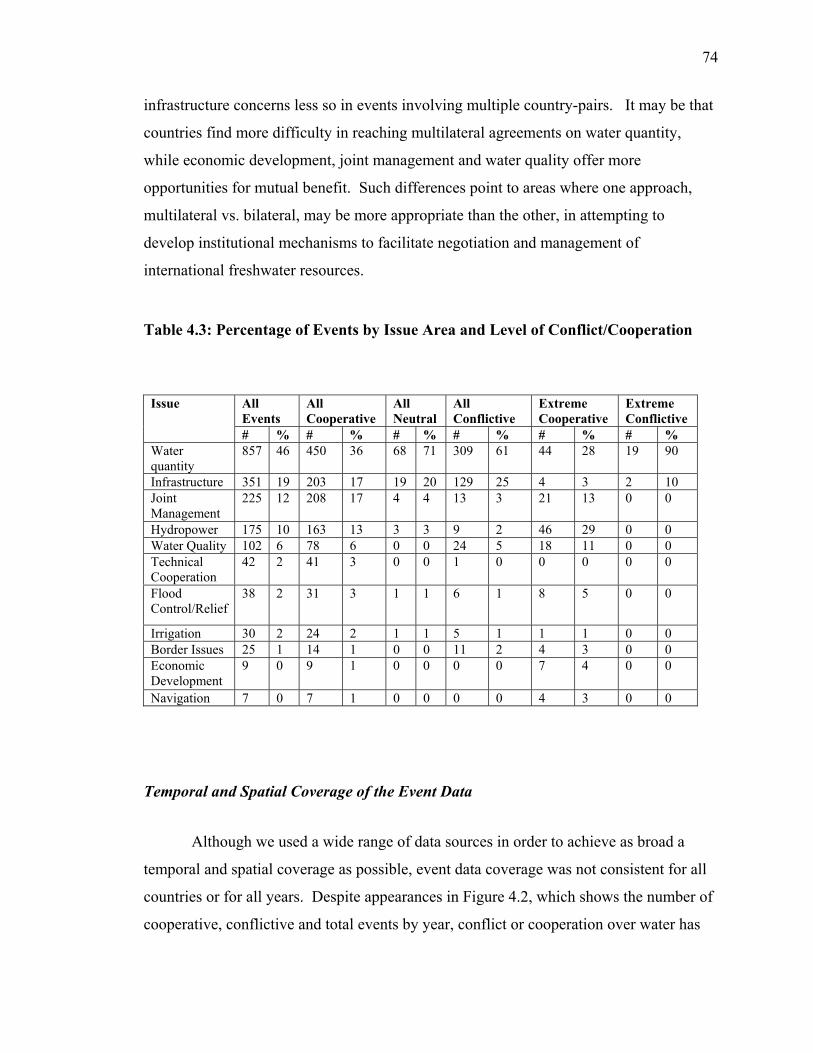
Six issues, water quantity, infrastructure, joint management and hydropower,
dominated the events. Cooperative events concerned a slightly wider range of issues than
conflictive events, with a more dramatic difference at the extremes of the scale.
International freshwater treaties, the most cooperative event in our dataset, covered a
wide range of issue areas, with emphasis on water quality and quantity, hydropower, joint
management and economic development. The most extremely conflictive events in our
database, extensive military acts, concerned quantity and infrastructure exclusively, two
issue areas closely tied together (Table 4.3).
24 Out of approximately 3,200 interactions (events by dyad), 17% are conflictive (568 interactions), 78% are cooperative (2,544), 5% are neutral, and verbal exchanges account for 54% of total interactions.

73
Figure 4.1: Total Number of Events by BAR Intensity Scale
In comparing events to interactions, we found that events involving high levels of
conflict (BAR Scale –3 to –7) occurred for the most part between individual dyads (i.e.,
involve only one country-pair). In contrast, highly cooperative events (BAR Scale +3 to
+7) often involved multiple dyads. For example, the 157 international freshwater treaties
(BAR Scale +6) involved 490 dyadic interactions (an average of approximately 3 country
pairs per treaty), while all of the 21 events categorized as Extensive War Acts (BAR
Scale –6) were bilateral conflicts. A large portion of the multilateral freshwater treaties
emphasized economic development, joint management, and water quality, whereas
bilateral agreements tended to concern water quantity and hydropower. Overall, joint
management, water quality, and economic development were more prevalent and
0
157
7
266
170
190
438
96
250
164
50
616210
0
50
100
150
200
250
300
350
400
450
-7 -6 -5 -4 -3 -2 -1 0 1 2 3 4 5 6 7
More Conflictive More Cooperative
74
infrastructure concerns less so in events involving multiple country-pairs. It may be that
countries find more difficulty in reaching multilateral agreements on water quantity,
while economic development, joint management and water quality offer more
opportunities for mutual benefit. Such differences point to areas where one approach,
multilateral vs. bilateral, may be more appropriate than the other, in attempting to
develop institutional mechanisms to facilitate negotiation and management of
international freshwater resources.
Table 4.3: Percentage of Events by Issue Area and Level of Conflict/Cooperation
Temporal and Spatial Coverage of the Event Data
Although we used a wide range of data sources in order to achieve as broad a
temporal and spatial coverage as possible, event data coverage was not consistent for all
countries or for all years. Despite appearances in Figure 4.2, which shows the number of
cooperative, conflictive and total events by year, conflict or cooperation over water has
All Events
All Cooperative
All Neutral
All Conflictive
Extreme Cooperative
Extreme Conflictive
Issue
# % # % # % # % # % # % Water quantity
857 46 450 36 68 71 309 61 44 28 19 90
Infrastructure 351 19 203 17 19 20 129 25 4 3 2 10 Joint Management
225 12 208 17 4 4 13 3 21 13 0 0
Hydropower 175 10 163 13 3 3 9 2 46 29 0 0 Water Quality 102 6 78 6 0 0 24 5 18 11 0 0 Technical Cooperation
42 2 41 3 0 0 1 0 0 0 0 0
Flood Control/Relief
38 2 31 3 1 1 6 1 8 5 0 0
Irrigation 30 2 24 2 1 1 5 1 1 1 0 0 Border Issues 25 1 14 1 0 0 11 2 4 3 0 0 Economic Development
9 0 9 1 0 0 0 0 7 4 0 0
Navigation 7 0 7 1 0 0 0 0 4 3 0 0

75
not necessarily been increasing over time. Rather, identification of water events for
earlier periods is less comprehensive, because the relative lack of contextual information
in the datasets used made positive identification of water-specific events difficult. The
skew towards later years in the temporal distribution also reflects intensity of effort, in
large part because of the availability of electronic news databases, with searchable text
or summaries, for the latter period of our study. The pattern of temporal distribution may
also reflect a growing importance of water, and environmental issues in general, in
international news reporting.
Figure 4.2: Distribution of Cooperative, Conflictive, and Total Events By Year
From a regional perspective, the majority of events in the BAR Water Event
Database are associated with basins in North Africa and the Middle East, Sub-Saharan
Africa, and Eastern Europe – followed by Southeast and South Asia and South America
(Fig. 4.3; Appendix 10 lists the basins included in each regional grouping). For all but
one of these regions, the average BAR Scale is cooperative (Fig. 4.4). Overall, the
Middle East/North Africa region shows the lowest, while Western Europe represents the
0
40
80
120
160
200
1948
1951
1954
1957
1960
1963
1966
1969
1972
1975
1978
1981
1984
1987
1990
1993
1996
1999
Total Events
Conflictive Events
Cooperative Events

76
highest, level of cooperation. In terms of number of events therefore, BAR’s water event
data is somewhat weighted toward the least cooperative region. Despite this bias, we
found that the majority of international relations over freshwater resources were
cooperative. Moreover, the most conflictive basins were also among the most
cooperative (Appendix 4, Table A4.4). The same does not hold true for dyads. Country-
pairs with highly conflictive events also have highly cooperative events, but not
necessarily the reverse (Appendix 5). The basins for which we had the highest number of
events were: Danube, Ganges-Brahmaputra-Meghna, Jordan, La Plata, Tigris-Euphrates,
Mekong. A comparison of the number of events per basin region with the number of
interactions reveals that multilateral relations were most prevalent in Eastern Europe,
Southeast Asia, Soviet Union/FSU, and East Asia, as compared with other study regions
(Fig. 4.3, Table 4.4).
Figure 4.3: Number of Events and Interactions Per Basin-Region
0
100
200
300
400
500
600
700
East A
sia
Eastern
Europe
Former
Soviet
Unio
n
North A
frica/
Middle
East
North A
merica
South
America
South
Asia
Southe
ast A
sia
Sub-Sah
aran A
frica
West
ern Euro
pe
# Events# Interactions

77
Table 4.4: Numbers and Percentages Behind Figure 4.4
Figure 4.4: Average BAR Scale Values By Basin-Region
Basin Region # Events
# Interactions
Total Difference
# of Basins per Region
% Increase of Interactions Relative to Events
% Increase Weighted by # of Basins
East Asia 66 84 18 11 21.43 1.95 Eastern Europe 210 556 346 14 62.23 4.45 Soviet Union/FSU 82 220 138 30 62.73 2.09 N. Africa/Mid. East 531 652 121 21 18.56 0.88 North America 86 87 1 40 1.15 0.03 South America 152 305 153 38 50.16 1.32 South Asia 231 237 6 5 2.53 0.51 Southeast Asia 134 372 238 18 63.98 3.55 Sub-Saharan Africa 196 655 459 54 70.08 1.30 Western Europe 73 94 21 34 22.34 0.66
-3
-2
-1
0
1
2
3
4
5
East Asia
Eastern EuropeFormer Soviet UnionNorth Africa/Middle East
North AmericaSouth AmericaSouth Asia
Southeast AsiaSub-Saharan AfricaW
estern Europe

78
Hypotheses and Analyses for Developing Framework to Identify Basins at Risk
We tested a set of hypotheses relating the level of international
conflict/cooperation over water to a set of quantifiable independent variables cited in the
literature, or formulated by our research group. For the majority of our analyses, we
chose to use linear regression as our main statistical tool because it offered a concise
summary of the mean of the response variable as a function of an explanatory variable.
Linear regression models were compared to assess the relative strength of various
independent variables in explaining the variability in the event data. Other univariate
statistical analyses employed two-sample t-tests. We also considered indicators based on
qualitative assessments of the empirical data (graphical comparison of average BAR
Scale values), where statistical analyses were not feasible/appropriate. Table 4.5 lists the
majority of hypotheses considered. The results of the hypotheses are discussed below.
Further detail regarding the hypotheses and datasets used may be found in the Appendix.

79
Table 4.5: Hypotheses Considered and Results
Indicator Relationship of Interest Result Linear regression n R2 Coeff. P-value* GDP GDP vs. country ABS 115 0.01 0.00 0.43 GDP/capita GDP/capita vs. country ABS 114 0.05 5.11 0.01
Population density vs. country ABS 123 0.03 -0.02 0.04 Population density vs. basin ABS 121 0.04 -0.30 0.04
Population density (# people/km2)
Population density vs. basin-country polygon ABS 344 0.02 -0.19 0.00 Overall Relations Friendship/Hostility vs. country ABS 130 0.12 1.74 0.00
Ratio of GDP/capita vs. dyad ABS 304 0.02 -1.78 0.03 Relative Power Ratio of population densities vs. dyad ABS 490 0.02 6.70 0.00 National pop. growth rate (1950-1999) vs. country ABS 126 0.02 -11.77 0.08 Rate of Population
Growth National pop. growth rate (1950-1999) vs. average country Friendship/Hostility
169 0.07 -3.24 0.00
# of dams vs. basin ABS 82 0.00 -1.57 0.58 # of Dams # of dams vs. basin-country polygon ABS 155 0.02 0.00 0.12 Dam density vs. basin ABS 82 0.02 -3.93 0.16 Dam Density (#
dams/km2) Dam density vs. basin-country polygon ABS 155 0.01 -0.00 0.16 Basin Area Basin area in km2 vs. basin ABS 122 0.03 3.47 0.04 # Basin Countries # of countries sharing a basin vs. basin ABS 122 0.01 1.39 0.38 Water Stress Freshwater availability/capita vs. basin ABS 86 0.01 6.56 0.51 Social Water Stress Capacity adjusted water/capita vs. basin ABS 85 0.04 5.66 0.06
Country HDI vs. country ABS 119 0.01 19.39 0.29 Human Dev. Index (HDI) Average of riparian country HDI’s vs. basin ABS 121 0.01 -24.87 0.37 Agric. as % GDP % GDP in agriculture vs. country ABS 63 0.01 -0.22 0.35 % labor force % country labor force in agriculture vs. country ABS 126 0.00 -0.08 0.47 Hydropower Hydropower as % electricity production vs. country ABS 98 0.04 -0.06 0.06

80
Table 4.5: Hypotheses Considered and Results (cont.)
*p-value considered significant at < .05
Indicator Relationship of Interest Result Two-Sample T-test n P-value* Freshwater Treaties ABS of non-treaty dyads (2.6) vs. ABS of dyads with treaties for
years before first treaty signed (2.5) 388 0.34
Adjacency ABS of basin dyads sharing a border (3.8) vs. ABS of basin dyads not sharing border (3.3)
3,332 0.00
Riverine Contiguity ABS of riparian countries with river as border (4.0) vs. ABS or riparian countries w/out river as border (3.9)
390 0.31
No statistical test conducted due to structure of data Graphical comparison of ABS Dam density and freshwater treaties
Series of comparisons of high dam density and low dam density basins with and without treaties
High dam density basins more conflictive than low dam density basins except in presence of freshwater treaties.
Freshwater Treaties Basin AABS in 3 years before a treaty was signed vs. three years after treaty signature
3 years preceding treaty, ABS no different than in normal years. 3 years following treaty, ABS higher than in normal years.
Climate Basin % primary climate zone (based on % area) vs. basin ABS ABS of arid basins similar to that of basin in most other climate zones.
Precipitation Annual basin precipitation vs. basin AABS Most cooperative years were those in which rainfall close to avg. basin precipitation. Very dry years marginally more cooperative than wet/very wet years.

81
GDP and Population
We considered Gross Domestic Product (GDP) and GDP per capita at the country
scale and population and population density (# people/km2) at the basin and country
scales. Only GDP per capita and population density showed an association with conflict
over water. We found that rich countries and those with lower population densities
tended to be more cooperative over water than poorer, more densely populated countries.
Despite their statistical significance, however, these factors explain only a small
percentage of the variability in the data (r-squared values < .10).
Overall Relations
The overall level of friendship-hostility among riparian countries was
significantly associated with conflict/cooperation over water. Countries that cooperate in
general also cooperate over water, and countries with overall unfriendly relations also are
unfriendly over water issues. We also considered whether this correlation held true at the
regional scale. While we did not see a correlation between relations over water and
overall friendship-hostility at the region-scale, we did find that, from a regional
perspective, countries appear to have friendlier relations over water than they do overall
(Fig. 4.5). This result may indicate that other, non-water, issues provide a greater source
of regional tensions. Although the Middle East/North Africa region presents an
exception, it should be noted that the water event data is based on public reports of
interactions and therefore under-represents non-public cooperation, such as the secret
“picnic table talks” between Israel and Jordan on the Jordan river. At the country level,
the relationship is much less clear, perhaps because freshwater resources are largely dealt
with as a bilateral concern.

82
Figure 4.5: Comparison of BAR Scale vs. Friendship-Hostility Index, by Region
We also considered population growth rates and conflict over water, as well as
conflict overall. Countries with more rapidly growing populations tended to be more
internationally conflictive overall, but not more conflictive over water resources. These
findings suggest that the drivers of water conflict and cooperation are not the same as for
overall conflict and cooperation.
Relative Power
A general indicator of international conflict cited in the political
science/geography literature is “relative power.” Theorists exploring geography as a
source of conflict consider distribution of power (e.g., Mandel 1980) or the change in the
relative power of states (e.g., Prescott 1965; Garnham 1976) as indicators of the
frequency or likelihood of territorial disputes. Authors have offered various ways to
measure relative power. Garnham (1976), for example, measured power parity using
-3
-2
-1
0
1
2
3
4
5
6
East A
sia
Eastern
Europe
Former
Soviet
Unio
n
North A
frica/
Middle
East
North A
merica
South
America
South
Asia
Southe
ast A
sia
Sub-Sah
aran A
frica
West
ern Euro
pe
BA
R S
cale
Water Friendship-Hostility
Friendship-Hostility

83
four indicators of national power: geographical area, population size, fuel consumption,
and steel production. These indicators are assumed to correlate with a nation’s capability
to create and mobilize military forces. Garnham found that international war was more
likely to occur between nation-states of relatively equal national power, in terms of
population parity.
We tested a series of possible measures of relative power between countries,
including the ratio of GDP per capita between basin-dyads and the ratio of their
population densities. We found that dyads with greater differences in their per capita
GDP’s were associated with greater conflict over water. In contrast, basin-dyads with
greater differences in their population densities were associated with greater cooperation
over their shared freshwater resources. As with the other statistical analyses above,
however, these indicators explain only a small percentage of the variability in the data.
Infrastructural Development and Institutional Mechanisms
The majority of indicators discussed in this paper relate to existing theoretical
claims regarding causes of international conflict or, more specifically, geography or
water’s relationship to international conflict. We also considered our own hypothesis:
that the likelihood and intensity of conflict within a basin increases as the magnitude or amount of change in physical or institutional systems exceeds the capacity to absorb that change.
An extreme change in the physical systems of a basin might be the construction of
a large dam or water development project. We tested number of dams and density of
dams (number of dams/1000 km2) against the BAR scale and neither proved significant.
In and of themselves, dams did not appear to provide a useful indicator for conflict over
water, yet many of the conflictive events in the database concerned infrastructure
development issues. We then considered the relationship of dams to freshwater treaties.
We divided basins into two groups, those with a high density of dams and those with a
low density of dams. We also identified basins with and without treaties. We then did a

84
series of comparisons (Table 4.6) and found that overall and in basins without treaties,
lower dam density basins tended to exhibit slightly less conflict. In basins with treaties,
the relationship was reversed and lower dam density basins exhibited slightly more
cooperation. In all these instances, however, the relationship was not significant. We
then compared high dam density basins with treaties to those without. In high dam
density basins, treaties mitigate conflict. High dam density basins with treaties showed
significantly higher levels of cooperation than in non-treaty basins (41% difference;
average BAR Scale of +4.2 in treaty basins vs. +2.5 in non-treaty basins). Moreover, this
difference was not because pairs of countries with treaties started out as inherently more
cooperative than pairs of countries without treaties. In fact, average water relations
between dyads in the three years before a treaty was signed were somewhat more
conflictive than in general. Nonetheless, once a freshwater treaty was signed,
cooperation increased and, over time, often additional treaties were signed.
Table 4.6: Dam Density and Freshwater Treaties
In terms of rapid change on the institutional side, we considered
internationalization of basins. Internationalized basins refer to basins whose management
institutions were developed under a single jurisdiction, which was then fragmented when
that jurisdiction suddenly became divided among two or more nations. Basins in regions
experiencing internationalization, such as during the break up of the British Empire or the
Basin Setting BAR Scale
% Difference
Basins With Low Dam Density 4.2 Basins With High Dam Density 3.7 -12%
Basins Without Treaties and Low Dam Density 2.8 Basins Without Treaties and High Dam Density 2.5 -12%
Basins W/Treaties (value of first treaty excluded) and Low Dam Density 3.8 Basins W/Treaties (value of first treaty excluded) and High Dam Density 4.2 11%
Basins W/Treaties (value of first treaty excluded) and High Dam Density 4.2 Basins Without Treaties and High Dam Density 2.5 -41%

85
fall of the Soviet Union, showed much higher levels of conflict compared to other parts
of the world.
Figure 4.6 indicates three distinct periods of cooperation over international
freshwater resources.25 Although we found many more cooperative events toward the
latter years of the study, there was no significant increase in terms of cooperative events
as a percent of total events recorded. In periods one and three (1948-1970 and 1987-
1999), cooperation over water was relatively low compared to the middle period (1971-
1986). We speculated that the difference in levels of cooperation was related to shifts in
the international system during those time periods. We explored whether regions
undergoing internationalization of river basins, due to either the disintegration of the
British Empire or the breakup of the Soviet Union, accounted for the differences in
overall cooperation.
Figure 4.6: Cooperative Events as Percentage of Total Events By Year
25 Cooperative events represent 64% of total events for both 1948-1970 and 1987-1999 time periods and 84% from 1971-1986.
0%
10%
20%
30%
40%
50%
60%
70%
80%
90%
100%
1948
1951
1954
1957
1960
1963
1966
1969
1972
1975
1978
1981
1984
1987
1990
1993
1996
1999
Period Two82% of Total
Period One64% of Total
Period Three60% of Total

86
We found that periods of internationalization were associated with higher levels
of conflict. Figure 4.7 depicts the average BAR Scale value for the Middle East and
South Asia, regions of British control, for three time periods under consideration. Figure
4.8 depicts the same for Eastern Europe and the (former) Soviet Union. The graph for the
Middle East/North Africa and South Asia indicates that while cooperation over water for
the world as a whole decreased slightly from 1948 to 1999, the Middle East/North Africa
and South Asia show very low levels of cooperation from 1948-1970, an increase from
1971-1986 – a period of the relative stability during the Cold War, and then a slight drop
from 1987-1999. This drop in later years is worth further exploration. It may reflect, for
example, active nationalist movements within a basin (e.g., Kurds and the Tigris-
Euphrates, Palestinians in the Jordan basin), the decline of Cold War influence on
regional stability, or infrastructure development plans in the Nile basin. The graph for
Eastern Europe and the former Soviet Union illustrates that, while the rest of the world
shows a decrease in cooperation in the latter period, 1990-1999, the regions of Eastern
Europe and the former Soviet Union show a much more marked drop in cooperation.
Both these graphs show low levels of cooperation during periods when the regions of
interest were experiencing the emergence of new nations and, with that, the
internationalization of river basins.
Adjacency/Spatial Proximity
Pairs of countries within an international river basin that also shared a border
cooperated more over water than pairs of countries that shared a basin, but not border.
This result contrasts with theories of geography and war. States are expected to exhibit
more conflict with neighboring states than with others, because 1) it is less difficult to
wage war against closer countries than against more distant nations) (Garnham 1976;
Most and Starr 1989 in Vasquez 1995; Russett 1967); 2) multiple shared borders create
uncertainty, which contributes to conflict (Richardson 1960; Midlarsky 1975; both in
Diehl 1991); and, 3) countries closer together are more likely to have conflicting interests
because of their proximity to each other (Bremer 1992).

87
Figure 4.7: Average BAR Scale by Time Period for Middle East and South Asia
Figure 4.8: Average BAR Scale by Time Period for Eastern Europe and Soviet Union/FSU
Several studies have found a relationship between proximity and violent
international conflict, war in particular (Gleditsch and Singer 1975; Garnham 1976;
Gochman 1991; Gleditsch 1995; Bremer 1992). These studies, however, focused on wars
or militarized international disputes, rather than a spectrum of conflict types, and did not
0
1
2
3
4
5
6
1948-1970 1971-1986 1987-1999
BA
R S
cale
Eastern Europe and Soviet Union/FSU
Rest of World
-3
-2
-1
0
1
2
3
4
5
1948-1970 1971-1986 1987-1999
BA
R S
cale
ME/NA and South Asia
Rest of World

88
consider the specific issue under dispute. Vasquez (1995) contends that the reason
proximity is associated with international conflict is that war arises “from specific
territorial disputes that have been unable to be resolved by other means. ... Wars are
clustered among neighbors because neighbors have territorial disputes” (p.281). Many of
the quantitative studies linking proximity in war concern territory or fail to distinguish
the issues over which the war is fought. Toset and Gleditsch (2000) consider the
relationship between militarized interstate disputes and water scarcity, as well as
proximity, shared rivers, and other factors. Their study found contiguity to be significant,
but not freshwater availability per capita.26 Toset and Gleditsch explored militarized
interstate disputes only and they note that it may be unreasonable to expect disputes over
water to escalate to armed conflict. Even their study, however, does not distinguish the
issues over which the conflicts were fought; in particular, whether the conflicts concerned
shared rivers or freshwater as a resource.
Since the BAR water events specifically exclude issues where the concern is over
territory or rivers as borders, we did not expect to find a correlation between proximity
and conflict over international freshwater resources. In the political geography literature,
the importance of shared borders has lain in interaction opportunities and the role of
uncertainty. Our finding highlights that shared borders in and of themselves represent
opportunities for cooperation, as well as conflict. This finding fits with more recent
literature, which speculates that the effects of geography on the likelihood of war are not
uniform and considers coexistence and cooperation, rather than conflict, across
international boundaries (e.g., Barnard 1994; Blake 1994; Gradus 1994).
We infer that for water issues, shared borders in shared basins offer opportunities
for trade-offs and cooperative interactions between states, because of the geographic
proximity and other, non-water, relations the states may share. In situations where states
share a river, but not a border, there may be fewer opportunities for such cooperative
interactions. If uncertainty associated with multiple borders increases the potential for
international conflict, then perhaps shared river systems, which serve to expand a
26 In addition, their data sources differ from those we used. Shared rivers were defined using the 1978 UN Register of International Rivers, with supplemental sources, freshwater resources per capita was defined at

89
country’s physical connections beyond its immediate neighbors, contribute to such
conflict when other opportunities for cooperative interactions, such as with a shared
border, are lacking.
Climate, Precipitation, Water Availability
Two factors often cited as indicators of water conflict are climate and water
availability. In a modified form of environmental determinism, authors cite such factors
as aridity and population growth as key contributors to potential ‘water wars,’ because
scarcity of water is seen as contributing to instability and conflict (e.g., Gurr 1985;
Lipschutz 1989; Homer-Dixon 1991; Elliott 1991; Westing 1986). Such thinking is
prevalent in environmental security literature, which links environment and natural
resource issues with violent conflict and national security concerns (e.g., Ullman 1983;
Westing 1986; Gleick 1989; Myers 1989; Tuchman Mathews 1989; Homer-Dixon 1991).
We found no relationship between climate and water conflict/cooperation in a
basin. Arid regions were not found to be substantially less cooperative than other climate
zones, excepting humid mesothermal regions. This latter climate zone includes the
basins of Western Europe, in which other factors (e.g., overall friendly relations,
relatively high GDP) may facilitate cooperation (Fig. 4.9).
the country level, and contiguity data was obtained from the Correlates of War Project (Toset and Gleditsch 2000).

90
Figure 4.9: Primary Climate Type vs. BAR Scale by Basin
In addition to overall climate, we considered precipitation as an explanatory
factor. For the 11 basins for which annual precipitation data were available (for the years
1948-1999), we found that the most cooperative years were those in which rainfall was
close to average basin precipitation, and that very dry years were marginally more
cooperative than wet or very wet years (Fig. 4.10). Although 11 basins do not provide
enough data for a broad assessment, Figure 4.10 does illustrate the wide range of
variation in precipitation patterns from basin to basin. It may be that it is not the overall
climate or average precipitation levels that provide an indicator of conflict, but the
occurrence of extremes or the level of uncertainty concerning available water resources in
a basin.
0
1
2
3
4
5
Tropical Rainy Dry HumidMeso-thermal
HumidMicro-thermal
BA
R S
cale

91
Figure 4.10: Annual Precipitation in Select Basins vs. BAR Scale
Although environmental security literature identifies few numerical measures of
water as a potential indicator of international conflict, Falkenmark’s (1989) Water Stress
Index (WSI) offers a measure widely cited in water resources management. This index
divides the volume of available water resources for each country by its population. We
also considered Ohlsson’s (1999) “Social Water Stress Index” (SWSI), basically
Falkenmark’s WSI weighted by a measure of a country’s adaptive capacity (the UNDP’s
Human Development Index). Both the WSI and SWSI are usually derived and applied at
the country-level. We considered these measures at the basin scale. Water availability
by basin, both with and without an adjustment for institutional capacity, failed to show
significant association with cooperation/conflict over freshwater resources.
Although the Social Water Stress Index incorporates the Human Development
Index (HDI), for our purposes it provided only a partial picture of water-related
institutional capacity because it is not water specific. The HDI itself is not significantly
-4
-2
0
2
4
6A
ral S
ea
Dan
ube
Tig
res/
Eup
hrat
es
Gan
ges
Indu
s
Jord
an
La
Plat
a
Ora
nge
Mek
ong
Nile
Salw
een
All
BA
R S
cale
Very Dry (-2 Std. Dev.)Dry (-1 Std. Dev.)Normal (~ mean)Wet (+1 Std. Dev.)Very Wet (+2 Std. Dev.)

92
associated with conflict/cooperation over water. We considered testing percent of
population with access to freshwater or sanitation services, incidence of water related
disease, water quality/water pollution trends, and/or efficiency of existing water uses and
water delivery systems. Currently available, global-scale data for these variables,
however, were either unavailable or did not allow for cross-country comparisons.
Resource Dependence for Agricultural and Energy Needs
We also considered other indicators that might provide measures of a country’s
dependence upon freshwater resources, such as hydropower, potential irrigation, and the
proportion of the economy in agriculture. We found that dependence upon water in terms
of agricultural or energy needs was not associated with conflict/cooperation over water.
Our findings differ from Gleick (1993), who identifies indices of vulnerability which
might suggest “regions at risk” for international water conflicts. Gleick’s indices are: 1)
ratio of water demand to supply; 2) water availability per person (Falkenmark’s water
stress index); 3) fraction of water supply originating outside a nation’s borders; and 4)
dependence on hydroelectricity as a fraction of total electrical supply. Gleick’s indicators
concern the nation as the unit of analysis and focus on the physical components of energy
and water needs. He did not quantitatively test these indicators. We also attempted to
test water supply originating in other countries and potential irrigation as a measure of
water demand, but the scale of available data was too coarse to be useful. Our findings
indicate that, at the global scale, no one indicator of water resource availability is likely
to provide a useful measure of the potential for conflict over freshwater resources within
a basin.
Government Type
In addition to relative power, discussed above, political geography and political
science theory consider the role of government type in overall international conflict. In
general, these theories do not directly address resource-related issues, but they do deal

93
specifically with indicators of international conflict. Our findings suggest that
government regime type is not a useful indicator for international conflict over freshwater
resources. The current political science wisdom concerning regime type and international
conflict is that democracies are not more peaceful than other regime types, although they
tend not to fight other democracies (e.g., Gleditsch 1995). Also, societies in uneven
transition between democracy and autocracy are considered more likely to be involved in
international conflict, as are highly undemocratic countries (Gleditsch and Ward 2000).
We found that governments under disruption or in transition (i.e., regimes with a
mix of autocratic and democratic tendencies) were no more bellicose over water than
other regime types and that countries at the democratic end of the spectrum tended to
exhibit less cooperation over water than other regime types (Fig. 4.11), with the
exception of countries at the democratic extreme. In comparing levels of water conflict
between country pairs by their type of government regime, we found little discernible
trend, except that the few sets of neighbors with the highest possible heterogeneity
(greatest difference in type of government regime) seemed to have the worst relations
(Fig. 4.12).27 These differences between our findings and current political science theory
may reflect the fact that the theories are based on research concerned specifically with
international war, not a spectrum of conflict. Moreover, these studies rarely incorporate
what the conflicts are about (e.g., territory, ideology, control of resources). Since over
water, historically countries have exhibited greater cooperation than violent conflict,
political science theories that hold true for war in general, might not hold true where
water is concerned.
27 Fig. 4.12 shows the difference between government types within a basin and the average BAR scale for each possible mix of governments. The Democracy-Autocracy variable, taken from the Polity IIID Project (McLaughlin, Gates et al. 1998), includes ten degrees of government type, so that there are 20 possible mixes within a basin (i.e., a strong democracy neighboring a strong autocracy would have a difference of 20).

94
Figure 4.11: Grouped Regime Type vs. BAR Scale, 1948-1999
Figure 4.12: Difference in Regime Type by Country-Pair vs. BAR Scale, 1948-1999
0
0.5
1
1.5
2
2.5
3
3.5
4
4.5
Most Autocratic(-10 to -6)
Mixed(-5 to +5)
Most Democratic(+6 to +10)
In Disruption(-88, -77, -66)
Government Regime Type
BA
R S
cale
-2
-1
0
1
2
3
4
5
6
0 1 2 3 4 5 6 7 8 9 10 11 12 13 14 15 16 17 18 19
Difference in Democracy-Autocracy Index Values by Country-Pair
BA
R S
cale

95
Basins At Risk
Based on an assessment of our global-scale analyses, discussed in following
sections, we created a framework to identify basins at risk for future conflict over
freshwater resources. We systematically pulled out those basins that had a confluence of
what we identified as indicators, based on the results of our statistical and empirical
analyses and our own qualitative judgment – basins with:
• high population density (>100/sq.km);
• low per capita GDP (< $765/person – 1998 World Bank lowest income
country definition);
• overall unfriendly relations (BAR Scale < -1.0);
• politically active minority groups that may lead to internationalization;
• proposed large dams or other water development projects; and,
• no or only limited freshwater treaties.
In addition, we also pulled out basins with ongoing international water conflicts.
Basins experiencing both high population density and average low per capita
GDP include the Ca (Laos and Vietnam), Cross (Cameroon and Nigeria), Drin (Albania,
Macedonia, and Serbia & Montenegro), Fenney (India, Bangladesh), Ganges-
Brahmaputra-Meghna (India, Bangladesh, Bhutan, Nepal, Burma, and China), Han
(North and South Korea), Indus (India, Pakistan, China, Afghanistan), Irrawaddy (India,
Burma and China), Karnaphuli (Bangladesh, India), Red (China, Laos, Vietnam), Saigon
(Cambodia, Vietnam), Song Vam Co Dong (Cambodia, Vietnam), and Yalu (China and
North Korea). Of these, only the Ganges, Indus, and Song Vam Co Dong have
international freshwater agreements and only the latter includes all the riparians.
Appendix 13 contains tables listing basins and countries by the above factors, as well as
the historically (1948-1994) most overall conflictive pairs of countries (BAR Scale ≤ -
1.0) and the basins they share.
Regarding the potential for internationalization, we have information on current
international basins that might experience further internationalization because of the
presence of politically active minority groups with assertive nationalist aspirations (see
Appendix 11). These basins include the Salween (Shan, Karen and other groups), Tigris-

96
Euphrates (Kurds), Jordan (Palestinians); Indus (Kashmiri), Ganges (Chittagong Hill
peoples), Kura (Nagorno-Karabahk), Ili and Tarim (Uighers in northwest China that want
separate East Turkestan State), Chiloango (Cabindans in Angola), Nile (Nuba in Sudan),
Awash, Juba-Shibeli and/or Nile (Oromos in Ethiopia), and Ebro and Bidasoa (Basques
in Spain).28
In term of physical change, basins in which large development projects are
planned include, but are not limited to, the Amazon, Asi-Orontes, Ganges, Incomati,
Indus, Irrawady, Kunene, La Plata, Mekong, Niger, Nile, Okavango, Orinoco-Caronni,
Po, Salween, Senegal, Song Vam Co Dong, Tigris, Volta, and Zambezi.29
Of the above basins, only the Amazon, Incomati, Kunene, Niger, Okavango,
Orinoco-Caroni, and Song Vam Co Dong have freshwater treaties that involve all the
riparian parties. The provisions and strength of these treaties varies greatly, however.
For example, the Okavango basin agreements that include all the basin riparians are
general, multi-country SADC protocols regarding shared watercourse systems, rather
than specific agreements on the quantity, quality or infrastructure issues unique to the
Okavango. And although minutes on cooperation in water conservancy were signed
between Cambodia and Vietnam on the Song Vam Co Dong, these minutes do not
necessarily address development project concerns. Such realizations speak to the need to
explore basins individually, in order to determine the propensity for conflict.
When all the various factors described above are pulled together, the following
basins are worth further investigation as to the potential for future conflict over
freshwater resources.30 We divide these ‘Basins at Risk’ into three categories (Fig. 4.13,
Table 4.7). The first category, basins negotiating current conflicts, includes the Aral Sea,
Jordan, Nile, and Tigris-Euphrates. While each of these basins has a treaty associated
with it, none of those treaties include all of the basin riparians. These basins are well
known “hot spots”, where the potential for continued disputes, at least into the immediate
28 The conflicts involving the Abkhaz in Georgia, Chechens in Russia, Moros in Philippines, and East Timorese in Indonesia fall outside of existing international basins. 29 Data on future development projects were obtained from multiple sources, including news reports and websites on tender requests and construction bids. Data compiled by Kyoko Matsumoto. 30 See also Wolf, Yoffe, Giordano (2001) for an earlier discussion and listing of basins at risk.

97
future, is therefore considered likely. The second category is basins in which factors
point to the potential for future conflict and in which up-coming development projects or
other stresses upon the water system have raised protests among the riparians. The third
category is similar to the second in that there is a confluence of factors which indicate the
potential for future conflict. Unlike category 2 basins, however, there is no evidence of
existing tensions in public policy or news fora. When viewing all the categories together,
what stands out is that the majority of basins at risk fall in southern Asia and central and
southern Africa.
In this section, we have discussed a series of possible indicators, derived from a
broad and highly variable set of data, which concern basins that show a high degree of
individuality. Categorizing a basin as “at risk” does not presume to identify basins in
which acute conflict will occur, but to point to basins worth more detailed investigation.
In such investigations, particular attention should be paid to the indicators discussed
above, as well as more detailed assessment of the:
• existence, strength and provisions of existing international water treaties or
other relevant, basin-level institutional mechanisms, as well as the level of
development of water institutions within individual riparian countries;31
• quality of governance within the basin and conditions, such as high population
density and low per capita GDP, that may hamper a government’s ability to
cope with change; and
• uncertainties associated with the basin’s water regime (i.e., climatic variability
and institutional adaptability to extreme fluctuations in water availability).
31 There are as many definitions of institutions as there are theorists to describe them. O’Riordan, Cooper, et al. (1998 348) provide a listing of interrelated concepts at the heart of the meaning of institutions. “Institutions regulate behavior via socially approved mechanisms such as the rule of law and the accountable exercise of power. Institutions have a degree of permanence and are relatively stable. … Institutions are patterns of routinized behavior. Institutions are continually being renegotiated … Institutions are cognitive and normative structures that stabilize perceptions, interpretation, and justifications. Institutions determine what is appropriate, legitimate, and proper; they define obligations, self restraints, rights and immunities, as well as sanctions for unacceptable behavior. Institutions structure the channels through which new ideas are translated into policy and new challenges receive a government response. …”

98
The above frameworks represent an intermediate step between the specific
comparisons associated with case studies and the broad quantitative assessments that base
predictive indicators solely on statistical results. Although some indicators proved
statistically significant, individually they explained only a small percent of the variability
in the event data. Moreover, no formal multivariate analyses were conducted (as the data
sets lie at different spatial scales). The frameworks represent a qualitative assessment of
the relative importance of our statistical and empirical findings, given our knowledge
transboundary freshwater resources and the constraints of the data sources used.

99
Figure 4.13: Basins At Risk – Categories 1, 2, and 3
1410
11
3
41
28
12
13
6
9
5
7
24
2129
23
19
2028
17
18
262215
16
25
27
Basins At RiskCartography: Shira YoffeJanuary 2002
Category 1Category 2Category 3International BasinsCountries

100
Table 4.7: Basins At Risk – Basin Map Number and Basin Riparians
# Basin Name Basin Riparians
CATEGORY 1 – Negotiating Current Conflicts 1 Aral Sea Afghanistan, China, Kazakhstan, Kyrgyzstan, Tajikistan, Turkmenistan,
Uzbekistan 2 Jordan Israel, Jordan, Lebanon, Palestinians, Syria
3 Nile Burundi, Congo (Kinshasa), Egypt, Eritrea, Ethiopia, Kenya, Rwanda, Sudan, Tanzania, Uganda
4 Tigris-Euphrates Iran, Iraq, Jordan, Saudi Arabia, Syria, Turkey
CATEGORY 2 – Indicators and Protests Over Water 5 Asi/Orontes Lebanon, Syria, Turkey 6 Ganges-Brahmaputra-
Meghna Bangladesh, Bhutan, Burma, China, India, Nepal
7 Han North and South Korea 8 Indus Afghanistan, China, India, Pakistan 9 Kune Angola, Namibia 10 Lake Chad Algeria, Cameroon, Central African Republic, Chad, Libya, Niger,
Nigeria, Sudan 11 Mekong Burma, Cambodia, China, Laos, Thailand, Vietnam 12 Okavango Angola, Botswana, Namibia, Zimbabwe 13 Salween China, Burma, Thailand 14 Senegal Guinea, Mali, Mauritania, Senegal CATEGORY 3 – Indicators Only 15 Ca Laos and Vietnam 16 Chiloango Angola, Congo (Kinshasa), Congo (Brazzaville) 17 Cross Cameroon, Nigeria 18 Drin Albania, Macedonia, Serbia & Montenegro 19 Irrawaddy Burma, China, India 20 Kura-Araks Armenia, Azerbaijan, Georgia, Iran, Turkey 21 La Plata Argentina, Bolivia, Brazil, Paraguay, Uruguay 22 Lempa El Salvador, Guatemala, Honduras 23 Limpopo Botswana, Mozambique, South Africa, Zimbabwe 24 Ob China, Kazakhstan, Russia 25 Red China, Laos, Vietnam 26 Saigon Cambodia, Vietnam 27 Song Vam Co Dong Cambodia, Vietnam 28 Yalu China, North Korea 29 Zambezi Angola, Botswana, Congo (Kinshasa), Malawi, Mozambique, Namibia,
Tanzania, Zambia, Zimbabwe

101
CONCLUSION
Historically, international cooperation over freshwater resources as a resource far
outweighs international conflict. There have been no formal declarations of war over
water. Where acute conflict over water has occurred, it concerned quantity and
infrastructure, two issues closely related. These instances of acute conflict involve
bilateral interactions, while cooperation is much more likely to be multilateral in nature.
Multilateral interactions are also more likely to involve joint management, water quality,
and economic development issues, rather than water quantity and infrastructure, which
are more often bilateral concerns. Such differences highlight issues that may be
appropriate for development of multilateral (as opposed to bilateral) institutional
mechanisms to facilitate negotiation and management of freshwater resources.
Regionally, and for many at the bilateral level as well, countries exhibit greater
cooperation over water than overall, indicating that countries in conflict over other
concerns may still find common interest in cooperation with regard to their shared water
resources.
Most of the commonly cited indicators linking freshwater to conflict proved
unsupported by the data. Neither spatial proximity, government type, climate, basin
water stress, dams or development, nor dependence on freshwater resources in terms of
agricultural or energy needs showed a significant association with conflict over
freshwater resources. In fact, no one indicator proved a relevant, in and of itself. Even
those factors that showed a statistically significant association with conflict or
cooperation over freshwater resources explained only a small percent of the variability in
the data.
The relevant indicators appear to be rapid or extreme changes in physical or
institutional settings within a basin -- internationalization, large dams -- and the presence
of institutional mechanisms that mitigate uncertainty, international freshwater treaties in
particular. Broadly defined, institutions and institutional infrastructure matter, perhaps
because institutions provide a mechanism for mitigating or managing the uncertainty that
theorists associate with a propensity towards international conflict. Institutions are also

102
important because they reflect a country’s ability to understand and cope with stresses
upon water resource systems.
Although no one indicator was sufficient to identify a basin at potential risk, in
and of itself, we took those indicators that showed some association and qualitatively
created a framework to identify basins at potential risk for future conflict. The majority
of these basins fall in southern Asia and central and southern Africa. Identifying a basin
at risk does not presume that conflict will occur in that basin, but to point to regions
worth more detailed investigation in terms of water resource institutions, water resource
needs and the ability of riparians to work together and to cope with changes or stresses
upon a basin’s water institutions and hydrological systems.
In the future, there will be international conflicts over water, and it may be that
such conflicts will increase given increasing populations or other possible stresses upon
the resource. The question is how and at what level of intensity such conflicts will be
dealt with by the parties concerned.
Our framework to identify and evaluate basins at risk was based on historical
indicators. There are a number of possible future trends, however, that may also
influence the potential for international conflict or cooperation over water. There may be
technological, economic, or management innovations in the obtaining, delivery, use, and
overall management of water resources (e.g., cheap desalinization, transglobal water
shipments, water sector privatization trends, Star Trek-like water replicators, etc.). There
may also be new challenges to water management, such as changes in water-borne
disease vectors, environmental and health impacts associated with wastewater reuse, and
increased urbanization of populations. Intra-national water issues and their relationship
to violent conflict, not explored in this study, may influence international water concerns.
Climatic changes associated with global warming, especially if the presence of
uncertainty contributes to conflict, may lead to higher incidences of conflict over
international freshwater resources, assuming that there are no basin-level, institutional
mechanisms in place to mitigate such conflict.
This study is a first step in what is hoped to be continued exploration of conflict
and cooperation over freshwater resources, using the database we have created. Other
issues that may play a role and which are worth further analysis include:

103
• intra-national water conflict and its possible relationship to water conflict at the
international level;
• other indicators of intra-national government instability (e.g., civil unrest; number
of regime changes from 1948-1999);
• spatial associations and the development of cooperative relationships (e.g., the
role of border rivers in enhancing cooperation or conflict);
• multilateral vs. bilateral interactions (e.g., an exploration of why countries might
find more difficulty in reaching multilateral agreements on water quantity, while
treaties on economic development, joint management and water quality are more
common);
• the influence of non-riparian countries or entities (e.g., World Bank) on water
conflict and cooperation within a basin;
• whether basins with greater annual or inter-annual variability in precipitation
show higher propensity for conflict than basins with more predictable climatic
patterns.
This latter question also plays into analyses regarding institutions and infrastructure,
since both provide mechanisms for managing variability in water supply and demand.
Overall, it may not be the trends, such as population growth or average climate, but the
discontinuities, such as extreme climatic events or sudden institutional change, which
provide relevant indicators of international water conflict or cooperation.32
32 The Basins At Risk project offers a wealth of data and resources for further research and comparative analyses. We hope that others will make use of the data we have gathered. The statistical analyses and numerical data developed through the BAR project are available through the Transboundary Freshwater Dispute Database website at: http://www.transboundarywaters.orst.edu.

104
APPENDIX –HYPOTHESES AND STATISTICAL RESULTS
Some definitions
• Average BAR Scale (ABS) refers to an average of the average for each year
• Average Annual BAR Scale (AABS ) refers to an average for each year
• The term dyad refers to a pair of countries.
• Riparian country refers to a country associated with an international basin.
• Basin-country polygon refers to a spatial unit – a country’s territorial share of a
particular international basin.
GDP and Population
Hypothesis 1: Lower GDP (gross domestic product) was associated with higher levels of
conflict over water.
Measure: GDP vs. ABS by country.
Test: Linear regression. n = 115, R-square = 0.01, Coeff. = 0.00, p-value = 0.43
Outcome: Not significant.
Data Sources and Caveats: WRI (1998).
Hypothesis 2: Higher GDP per capita was associated with greater cooperation.
Measure: 1995 GDP per capita data vs. ABS by country.
Test: Linear regression, n = 114, R-square = 0.05, Coeff. = 5.11, p-value = 0.01
Outcome: Higher GPD/capita was associated with greater cooperation over water.
Data Source and Caveats: WRI (1998).

105
Hypothesis 3A, 3B, 3C: Greater population density was associated with higher levels of
conflict.
Measure: Population density (current data; ln of number of people/km2) vs. ABS, at
country, basin, and basin-country polygon scales
Test: Linear regression. By country: n = 123, R-square = 0.03, Coeff. = -.02, p-value =
0.04; by basin: n = 121, R-square = 0.04, Coeff. = -0.30, p-value = 0.04; by basin-country
polygon: n = 344, R-square = 0.02, Coeff. = -0.19, p-value = 0.00
Outcome: Greater population density was associated with higher levels of conflict over
freshwater resources at all scales.
Data Sources and Caveats: BAR. See Chapter 3 for a description of derivation of
population data, as well as population density maps by basin. Population data was in
persons/km2 from Landscan 30 by 30 second resolution data (Dobson, Bright et al. 2000).
Relative Power (Ratios of GDP and population)
Hypothesis 4: Dyads with larger differences (measured as a ratio) in their respective per
capita GDP’s showed a greater association with conflict.
Measure: Ratio of GDP per capita (1995 data, ln) vs. ABS, by dyad
Test: Linear regression, n = 304, R-square = 0.02, Coeff. = -1.78, p-value = .03
Outcome: Dyads with greater differences in per capita GDP were associated with
conflict.
Data Source and Caveats: WRI (1998).
Hypothesis 5: Pairs of basin-country polygons with larger differences in their respective
population densities were associated with greater conflict.
Measure: Ratio of population densities (current data; ln of number of people/km2) vs.
ABS by dyad
Test: Linear regression, n = 490, R-square = 0.02, Coeff. = 6.70, p-value = 0.00
Outcome: High differences in population density between basin-country polygon pairs
within a basin (based on the ratio of their population densities) were associated with
greater levels of cooperation between those two countries.

106
Data Source and Caveats: BAR. See hypothesis 3.
Overall Relations
Hypothesis 6: A country’s overall Friendship/Hostility was associated with its
conflict/cooperation over water.
Measure: Friendship/Hostility vs. ABS by country
Test: Linear regression, n = 130, R-square = 0.12, Coeff. = 1.74, p-value = .00
Outcome: Friendship/Hostility showed a significant association with ABS.
Data Sources and Caveats: We created the Friendship/Hostility (F/H) variable using a
combined COPDAB and GEDS database containing more than 330,000 event records,
spanning the years 1948 to 1994. For each country in the COPDAB/GEDS database, we
calculated the average friendship or hostility values associated with that country, by the
same method used to calculate average BAR Scale (Yoffe and Giordano 2001). To avoid
double-counting when comparing F/H with friendship/hostility over water, we removed
all events from the F/H variable that were also included in the calculation of the BAR
Scale.
Hypothesis 7: Countries with more rapidly growing populations exhibited greater
conflict over water than countries with more stable or declining populations.
Measure: National population growth rate (1950-1999) vs. ABS, by country
Test: Linear regression, n = 126, R-square = 0.02, Coeff. = -11.77, p-value = 0.08
Outcome: No correlation between national population growth rates and ABS.
Data Sources and Caveats: WRI (1998).
Hypothesis 8: Countries with more rapidly growing populations exhibited more overall
conflict than countries with more stable or declining populations.
Measure: National population growth rate (1950-1999) vs. average Friendship/Hostility
Index, by country
Test: Linear regression, n= 169, R-square = 0.07, Coeff. = -3.24, p-value = 0.00

107
Outcome: Countries with more rapidly growing populations were significantly
associated with higher levels of overall conflict.
Data Sources and Caveats: WRI (1998).
Number of Dams and Dam Density
Hypothesis 9A, 9B: Greater numbers of dams were associated with higher levels of
conflict.
Measure: Number of dams (current data) vs. ABS, by basin and basin-country polygon.
Test: Linear regression. By basin - n = 82, R-square = 0.00, Coeff. = -1.57, p-value =
0.58; By basin-country polygon - n = 155, R-square = 0.02, Coeff. = 0.00, p-value = 0.12.
Outcome: Number of dams showed no correlation with ABS at either the basin or basin-
country polygon level.
Data Sources and Caveats: We derived number of dams and dam density from Digital
Chart of the World (DCW) data. The DCW is an extensive group of coverages
developed under contract by Environmental Systems Research Institute (ESRI) and
available through the US Defense Mapping Agency, and is considered to have a
minimum resolution of 500 meters (Kemp 1993 369). Included in the DCW is a geo-
referenced coverage of all the world’s dams. The dam data does not account for the
impact of the dam. Neither dam height, reservoir capacity, nor effect on downstream
water uses are incorporated into the above analysis.
Hypothesis 10A, 10B: Greater dam density (number of dams/1000 km2) was associated
with higher levels of conflict.
Measure: Dam density (current data) vs. ABS, by basin and basin-country polygon
Test: Linear regression. By basin - n = 82, R-square = 0.02, Coeff. = -3.93, p-value =
0.16; by basin-country polygon - n = 152, R-square = 0.01, Coeff. = -0.00, p-value = 0.16
Outcome: Dam density showed no correlation with ABS at either scale.
Data Sources and Caveats: See hypothesis 9.

108
Freshwater Treaties
Hypothesis 11: In the three years preceding the signing of a treaty, conflict levels were
higher than in other years and in the three years following treaty signature, conflict levels
were lower than other years.
Measure:
Test: No statistical test conducted.
Outcome: In the three year period following freshwater treaty signature, average levels
of cooperation were higher (3.0 on the BAR Scale) than in “normal” years (2.2). In the
three year period preceding treaty signature, the average level of conflict/cooperation was
no different (2.3) than in all other “normal” years.
Data Sources and Caveats: BAR. “Normal years” refer to all years except three years
before, three years after, and the year in which a treaty was signed for those dyads that
share freshwater treaties. The comparison of ABS by dyad before and after the signing of
a treaty excludes the scale value for the first treaty event in the calculation of ABS. Only
dyads which share an international basin were considered.
Hypothesis 12: Dyads that sign freshwater treaties were inherently more cooperative
over water before the signing of their first treaty than dyads without freshwater treaties
Measure: ABS of non-treaty dyads vs. ABS of dyads with treaty for the years before the
first treaty was signed
Test: Two-sample t-test, n = 388, ABS non-treaty dyads = 2.6 out of n = 291, ABS
dyads with treaties for years before first treaty was signed = 2.5 our of n= 97, p-value =
0.34
Outcome: No significant difference in ABS between treaty dyads for the years before a
first treaty was signed and the ABS of non-treaty dyads.
Data Sources and Caveats: BAR. A dyad was considered without a treaty up to the
year the first treaty was signed between that dyad, if such an event occurred. A dyad was
considered a ‘treaty dyad’ from the year in which the first treaty was signed. Dyads with
treaties signed before 1948 were classified as treaty dyads from 1948 on, the start of our
study period. Only dyads that share an international basin were included.

109
Hypothesis 13: The signing of a first freshwater treaty contributed to increased future
cooperation over water in a basin.
Measure: A comparison of the difference in ABS by basin before a treaty was signed
and after a treaty was signed, with all treaty values excluded, vs. the same comparison
with only the first treaty value excluded.
Test: No test for difference in means conducted. See Table 4.8.
Outcome: With all treaty values excluded, the difference in ABS was 11%. With the
value of the first treaty excluded, the difference in ABS in basins before a treaty was
signed as compared with the ABS for the years after a first treaty was signed was 51%.
Data Sources and Caveats: BAR. A basin was considered without a treaty up to the
year the first treaty was signed in that basin, if such an event occurred. A basin was
considered a ‘treaty basin’ from the year in which the first treaty was signed. Basins with
treaties signed before 1948 were classified as treaty basins from 1948 on, the start of our
study period. We calculated ABS for treaty basins in two ways: 1) with the scale value of
the first treaty excluded from the average; and, 2) with the values for all treaty events
excluded.
Table 4.8: Basin ABS Before and After Signing of 1st Freshwater Treaty – Treaties Are Followed by More Treaties
Dams and Freshwater Treaties
Hypothesis 14: The presence of freshwater treaties mitigated the conflict that would
otherwise have been associated with high dam density in a basin.
Basin Setting BAR Scale
% Difference
Basins Prior to Treaties 2.6 Basins After Treaties (treaty values excluded) 2.7 11%
Basins Prior to Treaties 2.6 Basins After Treaties (value of first treaty excluded) 4.0 51%

110
Measure: A series of comparisons of high dam density basins and low dam density
basins with and without treaties.
Test: No test for difference in means conducted. See Table 4.6.
Outcome: Overall, high dam density basins are slightly more conflictive than low dam
density basins (~12% difference), except when comparing basins with treaties, in which
the relationship is reversed and the higher density basins show slightly greater
cooperation (again ~12% difference). A substantive difference occurs, however, when
comparing high dam density basins with treaties to high dam density basins without
treaties (~41%), with those basins without treaties showing much higher levels of
conflict.
Data Sources and Caveats: See hypothesis 9 for source and caveats regarding dam
density data. High and low dam density basins were divided into two groups by splitting
basins at the median dam density value. See hypothesis 13 for definitions of treaty and
non-treaty basins. A caveat concerning this analysis was that the dam data is not
temporally linked to the event data, so there was no distinction made between when a
dam was constructed and the signing of a treaty.
Adjacency
Hypothesis 15: Adjacent dyads within a basin were more likely to have instances of
conflict than dyads that shared a basin, but not a boundary (e.g., in the Nile basin, Egypt
and Sudan vs. Egypt and Ethiopia).
Measure: Average BAR Scale (ABS) among dyads within a basin that are adjacent
against ABS among non-adjacent dyads within a basin
Test: 2-sample t-test, n = 3,332, mean of adjacent = 37.06 out of 2114 n, mean of non-
adjacent = 24.62 out of 1218 n, p-value = 0.00
Outcome: Adjacent basin-dyads were significantly associated with a higher level of
cooperation than non-adjacent basin-dyads.
Data Source and Caveats: BAR

111
Hypothesis 16: Countries that shared a river boundary with another country were more
prone to conflict over international freshwater resources than basin countries that did not
have a river as part of their border.
Measure: ABS of riparian countries with a river as a border against ABS of riparian
countries without a river border
Test: 2-sample t-test assuming unequal variance, n = 390, 2-sided p-value = 0.31
Outcome: No significant association. Countries with rivers as borders were slightly
more cooperative than countries without river borders (ABS 4.03 and 3.86, respectively).
Data Source and Caveats: BAR. For each riparian country, we coded whether a river
formed a portion of its border as a yes/no variable, based on data from our GIS. This
variable did not measure the average BAR Scale value between dyads that share a river
as a border as compared to dyads that do not share a river as a border. We did not weight
the contiguity variable to incorporate the length of the river border or the importance of
the river, as the former does not necessarily provide a good measure of the latter and as
the latter is a highly subjective measurement for which global data was not available.
Geographic Size
Hypothesis 17: Larger basins, in terms of area, were associated with greater conflict
over freshwater resources.
Measure: Basin area in km2 vs. ABS by basin
Test: Linear regression, n = 122, R-square = 0.03, Coeff. = 3.47, p-value = 0.04
Outcome: Larger basins were significantly more cooperative than smaller basins.
Data Source and Caveats: BAR. Although this finding appears relevant to other
analyses in which the coarse scale of the data excludes basins < 25,000 km2 in area, it
explains such a small percentage of the variability in the data that we consider its impact
on relevant analyses negligible.
Hypothesis 18: Basins with a greater number of riparian countries were associated with
higher levels of conflict.
Measure: Number of countries sharing a basin vs. ABS of that basin

112
Test: Linear regression, n = 122, R-square = 0.01, Coeff. = 1.39, p-value = 0.38
Outcome: The number of countries sharing a basin showed no significant association
with ABS by basin.
Data Source and Caveats: BAR
Riparian Position
Hypothesis 19A, 19B: 19A. The riparian position of a country (i.e., upstream,
downstream, mid-basin) was associated with its conflict/cooperation over water.
19B. A country’s vote on the 1997 UN Convention on the Non-Navigational Uses of
International Watercourses was associated with its riparian position.
Measure:
Test:
Outcome: We were unable to adequately test these hypotheses.
Data Source and Caveats: BAR. Riparian position of countries in each basin was
derived by examining by hand stream network coverages overlaid on basin and country
polygon coverages. Precise definition of riparian position proved difficult, as countries
often represented multiple positions within a single basin or across a series of basins.
Moreover, by definition, countries with a particular position will interact with countries
with a different position (i.e. upstream countries interact with downstream countries), and
therefore it makes little sense to wonder if upstream countries are more conflictive than
downstream countries, since they are interacting with each other. For future research, the
last concern might be addressed by including a variable delineating whether a country
was the initiator or recipient of a particular conflictive or cooperative action. Although
other studies have considered riverine contiguity or upstream-downstream as a factor in
the likelihood of military conflict (Toset and Gleditsch 2000), it does not appear that
these studies considered the river network in its entirety.

113
Climate and Precipitation
Hypothesis 20: Basins with largely arid climates were more prone to conflict over water
than basins of other climate types.
Measure: Percent primary climate zone of a basin (based on largest percent area) vs.
ABS
Test: Bar graph. Figure 4.9. No statistical test for difference in means conducted.
Outcome: Arid regions were not found to be substantialy more conflictive than other
climate zones, excepting humid mesothermal regions.
Data Source and Caveats: Climate zones were derived from a United Nations Food and
Agricultural Organization map of world climate zones (FAO-SDRN Agrometeorology
Group 1997), which was collapsed into five primary climate types: Tropical Rainy, Dry,
Humid Mesothermal, Humid Microthermal, and Polar. Only one basin was defined as
Polar, so it was not considered in this comparison. The FAO map, while digital, required
a series of transformations in order to convert it to a format suitable for analysis purposes.
Appendix 9 describes the derivation of the climate zone by basin data. The scale of the
climate data limits calculations to basins with area > 25,000 km2.
Hypothesis 21: Basins with lower annual levels of precipitation were associated with
higher levels of conflict over water.
Measure: Precipitation data by basin for each year from 1948-1999 were compared with
the AABS for that basin and year. Years in which rainfall were normal were defined as
within one standard deviation of mean basin precipitation. Dry and very dry years were
defined as precipitation between 1 and 2 standard deviations below mean and more than 2
standard deviations below mean, respectively. Wet and very wet years were defined as
precipitation between 1 and 2 standard deviations above mean and greater than 2 standard
deviations above mean, respectively.
Test: Bar graph. Figure 4.10. No statistical test conducted.
Outcome: Data were available for only 11 basins, making broad assessments difficult.
Preliminary findings indicate that very dry years were marginally more cooperative than

114
wet or very wet years and that the most cooperative years were those in which rainfall
was close to average basin precipitation.
Data Source and Caveats: Precipitation data were derived from the Global Historical
Climatology Network (GHCN) data set produced by the National Climatic Data Center
(NCDC) in cooperation with the World Meteorological Organization (Vose, Schmoyer et
al. 1992). The data were downloaded from NCDC's web site at www.ncdc.noaa.gov.
Appendix 8 details how BAR derived the basin level precipitation data.
Water Availability (water stress, social water stress)
Hypothesis 22A, 22B: More severe water stress (lower water available/per capita) was
associated with higher levels of conflict.
Measure: Freshwater available per capita vs. ABS at country and basin scales
Test: Linear regression. By country, n = 113, R-square = 0.04, Coeff. = 4.19, p-value =
0.03; By basin, n = 86, R-square = 0.01, Coeff. = 6.56, p-value = 0.51
Outcome: By country, lower freshwater available per capita was significantly associated
with higher levels of conflict. By basin, the trend ran in the same direction as by country,
but the association was not significant.
Data Source and Caveats: Freshwater availability per capita by country was obtained
from the World Resources Institute (WRI 1998). This data source was used, rather than
that derived by BAR, because in enabled inclusion of countries smaller than 25,000 km2 ,
necessary to insure a large enough sample size for statistical analysis. At the basin scale,
freshwater availability per capita (“water stress”) was calculated by combining BAR-
derived discharge data with BAR-derived population data (see Chapter 3). Population
data was in persons per km2 from Landscan 30 by 30 second resolution data (Dobson,
Bright et al. 2000). Discharge data was in km3 of water per year, derived from runoff
data produced by the Complex Systems Research Center at the University of New
Hampshire (UNH) and the Global Runoff Data Center (GRDC) in Koblenz, Germany
(Fekete, Vorosmarty et al. 2000).
Caution should be used in interpreting results from the water stress data. WRI
water availability data are measured as total renewable surface and groundwater and

115
typically include flows from other countries that may be committed to downstream users.
The data also mask large seasonal, inter-annual and long-term variations. It is not as
accurate as the discharge data derived by BAR. At the basin-scale, the discharge data
does not account for natural (e.g., evapo-transpiration) or anthropocentric (e.g., irrigation)
extractions of water from the river system and may therefore overestimate water available
downstream. This caveat is especially relevant for exotic, or allogenic, basins, in which
the lower portion of the river system derives its water solely from upstream sources (e.g.,
Colorado, Nile). Our calculated discharge numbers did compare closely with discharge
data from alternate sources, with larger and wetter basins matching most closely. The
scale of the discharge data limits calculations to areas greater than 25,000 sq. km.,
constraining analysis to 86 of the 123 basins for which we had event data.
Hypothesis 23A, 23B: More severe social water stress (lower capacity-adjusted water
available/per capita) was associated with higher levels of conflict.
Measure: Capacity Adjusted Water per Capita vs. ABS, by country and basin
Test: Linear regression. By country, n = 109, R-square = 0.05, Coeff. = 4.43, p-value =
0.02; by basin, n = 85, R-square = 0.04, Coeff. = 5.66, p-value = 0.06
Outcome: Countries with lower capacity adjusted water per capita were significantly
associated with higher levels of conflict. By basin, the trend ran in the same direction as
by country, but the association was not significant.
Data Source and Caveats: See hypothesis 22 for the sources of data on freshwater
availability at the country and basin scale. Our Capacity Adjusted Water Per Capita
variable is based on methodology used by Ohlsson (1999) in the construction of his
Social Water Stress Index. Ohlsson’s index begins with the awkward accounting unit of
100 people/km3 of water/year (basically the Water Stress Index), which he then divides
by the Human Development Index (HDI). The results of this quotient are then divided by
an arbitrary value of 2 in order “to make the two indices (Water Stress Index and Social
Water Stress Index) directly comparable” (Ohlsson 1999 248). Our variable starts with
the more intuitive accounting unit of m3 of water/per capita/year (basically the inverse of
Ohlsson’s unit). We then multiply, rather than divide, this value by a normalized HDI.
The HDI is normalized such that the median country value equals 1 in a base year of

116
1997, in order to ease interpretation. Thus countries with higher than average HDI’s have
their per capita water availability number adjusted upwards and those with lower than
average HDI’s have their number adjusted downwards. If a country has an HDI higher
than the original value of the median HDI, its “water per capita” increases. If a country’s
HDI value is lower than the median, that country’s “water per capita” decreases and it is
considered to suffer from more severe water stress.
Because the UNDP Human Development Index (HDI) is classified by country, we
averaged the HDI of each basin’s riparian countries to calculate capacity-adjusted water
availability per basin. This averaging masks within-basin variation in government
institutional capacity and should therefore be considered with caution. Analysis was
limited to those countries that have HDI values.
Hypothesis 24A, 24B: Countries with a higher Human Development Index (i.e., higher
level of institutional capacity) showed a stronger association with cooperation.
Measure: Most recent available HDI (by country) vs. ABS, by country and basin
Test: Linear regression. By country, n = 120, R-square = 0.01, p-value = 0.29; by basin,
n = 121, R-square = 0.01, p-value = 0.37
Outcome: Not significant at either the country or basin scale.
Data Source and Caveats: United Nations Development Programme (UNDP) HDI data
was obtained from the World Resources Institute (1998). The HDI is comprised of life
expectancy, literacy and educational enrollment, and GDP per capita (in purchasing
power parity dollars), per country. Although often used as a measure of the institutional
capacity of a country, for our purposes, HDI provided only a partial picture of
institutional capacity. It does not, for example, include measures of percent of population
with access to freshwater or sanitation services, incidence of water related disease, water
quality/water pollution trends, and/or efficiency of existing water uses and water delivery
systems. A number of BAR countries drop out of this analysis because they lack HDI
values, which may impact more conflictive events. To obtain an HDI value at the basin-
scale, we averaged the HDI of each basin’s riparian countries. This averaging masks
within-basin variation in government institutional capacity and should therefore be
considered with caution.

117
Resource Dependence (potential irrigation, economy in agriculture, hydropower)
Hypothesis 25: Countries with greater potential irrigable area were associated with
greater conflict over water.
Measure:
Test:
Outcome: We were unable to derive appropriate scale data to test this hypothesis.
Data Source and Caveats: We used a GIS to calculate an estimate of the arable and
irrigable land within each international river basin, based on climate, land cover, slope,
elevation, soil degradation, soil type, and existing irrigated area data layers. This
estimate was compared with an existing global GIS coverage of currently irrigated area,
to calculate the amount of potential future irrigated land per international river basin.
While the methodology was sound, the analysis was limited to the scale of the coarsest
dataset used, one degree resolution (equivalent to approximately 110,000 meters in the
Lambert equal area world projection), and the resulting variable proved too coarse to
provide a meaningful numerical estimate. It will be worth exploring, however, as finer
scale datasets become available. For a detailed description, see Wiess (2001).
Hypothesis 26: Countries with agriculture as a larger percent of their GDP were
associated with greater levels of conflict over water.
Measure: % GDP vs. ABS, by country
Test: Linear regression, n = 63, R-square = 0.01, Coeff. = -0.22, p-value = 0.35
Outcome: Not significant.
Data Source and Caveats: WRI (1998).
Hypothesis 27: Countries with a larger percent of their labor force in agriculture were
associated with greater conflict.
Measure: % labor force in agriculture vs. ABS, by country
Test: Linear regression, n = 126, R-square = 0.00, Coeff. = -0.08, p-value = 0.47
Outcome: Not significant.
Data Source and Caveats: WRI (1998).

118
Hypothesis 28: Countries more heavily dependent upon hydropower were associated
with greater conflict over water.
Measure: Hydropower as a percent of total electricity production for 1995 (or most
recent year available for that country) vs. ABS, by country
Test: Linear regression. n = 98, R-square = 0.04, Coeff. = -0.06, p-value 0.06
Outcome: Not significant.
Data Sources and Caveats: WRI (1998).
Hypothesis 29: Countries whose surface or ground water supply depends upon sources
originating outside their borders were more prone to conflict over water than countries
lacking such dependence.
Measure:
Test:
Outcome: Unable to test this hypothesis.
Data Sources and Caveats: The scale of available, spatially explicit global level data
for discharge (Fekete, Vorosmarty et al. 2000) is too coarse to calculate meaningful
values for the size of the areas of interest.
Government Type
Hypothesis 30: Autocracies showed greater tendency toward conflict over water than
other government regime types.
Measure: Democracy-Autocracy Index values vs. AABS, by country and year
Test: No statistical test for difference in means conducted.
Outcome: Autocracies did not exhibit greater tendency toward conflict. Countries at the
democratic end of the spectrum tended to exhibit slightly greater conflict over water than
other regime types, with the exception of countries at the democratic extreme (a value of
+10 on the DEM-AUT Index, see hyp. 31).
Data Source and Caveats: The Democracy-Autocracy variable is taken from the Polity
IIID Project (McLaughlin, Gates et al. 1998), which codes structural characteristics of

119
regimes, including the direction of change in terms of democracy or autocracy, for
approximately 152 countries from 1800 to 1994. Coding is done for states when they are
independent only. The DEM-AUT value is the Democracy Index minus the Autocracy
Index, with each index consisting of an additive 10-point scale. In the DEM-AUT Index,
therefore, a negative value indicates autocratic tendencies and a positive value indicates
democratic tendencies. The further a value from 0, the stronger the tendency. Countries
with values close to 0 indicate a mix of autocratic and democratic tendencies. In
addition, PolityIIID also accounts for values outside the scale, such as a period of
interruption (DEM-AUT value of “66”; e.g., occupation of a country by foreign powers
during wartime, where the previous polity is re-established after the occupation ends); a
period of interregnum in which central political authority has collapsed completely
(DEM-AUT of “77”; e.g., during a period of civil war); and, periods of transition (DEM-
AUT of “88”).
Hypothesis 31: Governments under disruption or in transition showed greater tendency
toward conflict over water than more stable government regimes.
Measure: Democracy-Autocracy Index values in three groups – Autocracies,
Democracies, and Mixed vs. AABS, by country and year
Test: Bar graph. Figure 4.11. No statistical test for difference in means conducted.
Outcome: Governments under disruption (DEM-AUT score of 66, 77, 88) or in
transition (i.e., regimes with a mix of autocratic and democratic tendencies) did not
exhibit greater tendencies towards water-related conflict than other regime types.
Countries at the democratic end of the spectrum tended to exhibit greater conflict over
water than other regime types.
Data Source and Caveats: The Democracy-Autocracy variable is taken from the Polity
IIID Project (McLaughlin, Gates et al. 1998). See Hypothesis 30. Also included in the
mixed column were countries with DEM-AUT values of 66, 77, and 88.
Hypothesis 32: Certain pairings of government types were more prone to conflict over
freshwater resources than others.

120
Measure: Difference in DEM-AUT values between dyads vs. ABS by dyad, plotted for
each possible mix of government types
Test: Bar graph. Figure 4.12. No statistical test conducted.
Outcome: The graph indicated little discernible trend, except that neighbors with the
highest possible heterogeneity (greatest difference in type of government regime) seemed
to have the worst relations.
Data Source and Caveats: See hypothesis 30. Only basin dyads were considered. The
Democracy-Autocracy variable (McLaughlin, Gates et al. 1998), includes ten degrees of
government type, so that there are 20 possible mixes within a basin (i.e., a strong
democracy neighboring a strong autocracy would have a difference of 20).
ACKNOWLEDGEMENTS
Spanning three years, the Basins At Risk project involved the efforts of more than
10 faculty and student researchers at Oregon State University. The authors would like to
acknowledge the insights, assistance and support of Dr. Julia Jones, Dr. Jon Kimerling,
Dr. Phil Jackson, Dr. Chuck Rosenfeld, Dr. Dawn Wright, Case Bowman, Kuuipo
Burleigh, Becci Dale, Meredith Giordano, Greg Fiske, Jeanne Hoadley, Kelli Larson,
Kyoko Matsumoto, Marc Rothgery, Brian Ward, and Daniel Wise. In addition, the
authors would like to extend their thanks to George Taylor, Oregon State Climatologist,
and his assistants Nathaniel De Young and Melanie Mitchell; Mark Levy, CIESIN; Jake
Brunner and Kirsten Thompson,WRI; Petra Doell, University of Kassel, Germany;
Glenda Pearson, University of Washington Library; David B. Kynoch, President, Pacific
Northwest GIS Consulting, Inc.; Dr. Michael D. Ward, Department of Political Science,
University of Washington (Seattle); Balazs Fekete, Complex Systems Research Center,
University of New Hampshire; Dr. Jerome E. Dobson, Oak Ridge National Laboratory;
Joe Toth and Carrie Ottow, OSU Valley Library; Brian Smith; Jeff Danielson and Kent
Lethcoe, EROS Data Center; Global Event Data System, University of Maryland;
National Geographic; and, the National Science Foundation Graduate Research
Traineeship (GRT) Fellowship in Landscape Studies.