bacchus marsh urban growth framework … · urban growth framework ... • a high level strategic...
TRANSCRIPT
Bacchus Marsh Urban Growth FrameworkCommunity EngagementFebruary 2017
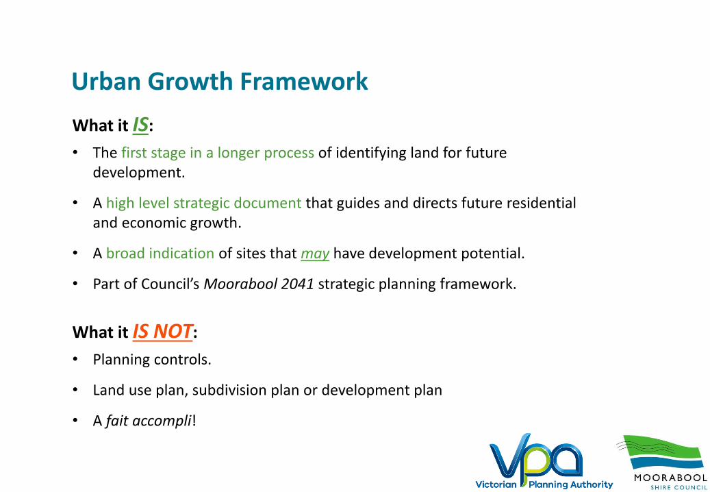
Urban Growth Framework
What it IS:
• The first stage in a longer process of identifying land for future development.
• A high level strategic document that guides and directs future residential and economic growth.
• A broad indication of sites that may have development potential.
• Part of Council’s Moorabool 2041 strategic planning framework.
What it IS NOT:
• Planning controls.
• Land use plan, subdivision plan or development plan
• A fait accompli!

Why do we need a UGF in Bacchus Marsh? Bacchus Marsh is not an Island.
Metro Rail ticketing zones
Shopping & expenditure
Regional community infrastructure
Jobs & commuting
Growth in Melton & Wyndham
Freight & natural resources
Tourism & business growth
Education within districtWhat affects the metro economy
affects Bacchus Marsh.

In response do we?
26 years to 2041
500 new residents per year
220 new dwellingsper year
3% growthper year
BACCHUS MARSH DISTRICT
IN THE EAST ALONE(MERRIMU, HOPETOUN PARK &
SURROUNDS)
5000 new residents by 2041
1900 new homes (65 per year) by 2041
Not address growth pressures and allow developers to drive it with their own visions.
orActively manage and shape growth to direct how change occurs.

Vision
• A vibrant and sustainable regional centre.
• A 20-minute community with integrated housing, employment opportunities, shopping and daily activities.
• Well-connected and accessible for all.
• A community supported by a range of services and facilities.
• Recognised as the gateway to the Central Highlands region.


Current Planning Scheme – potential Eastern Link Rd
Eastern Link Road –shown in Planning Scheme since 2009
An Eastern Link Road has been an identified need since the mid 2000’s
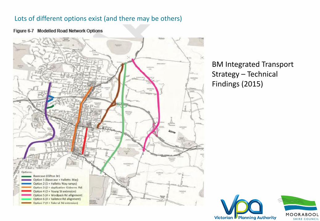
BM Integrated Transport Strategy – Technical Findings (2015)
Lots of different options exist (and there may be others)
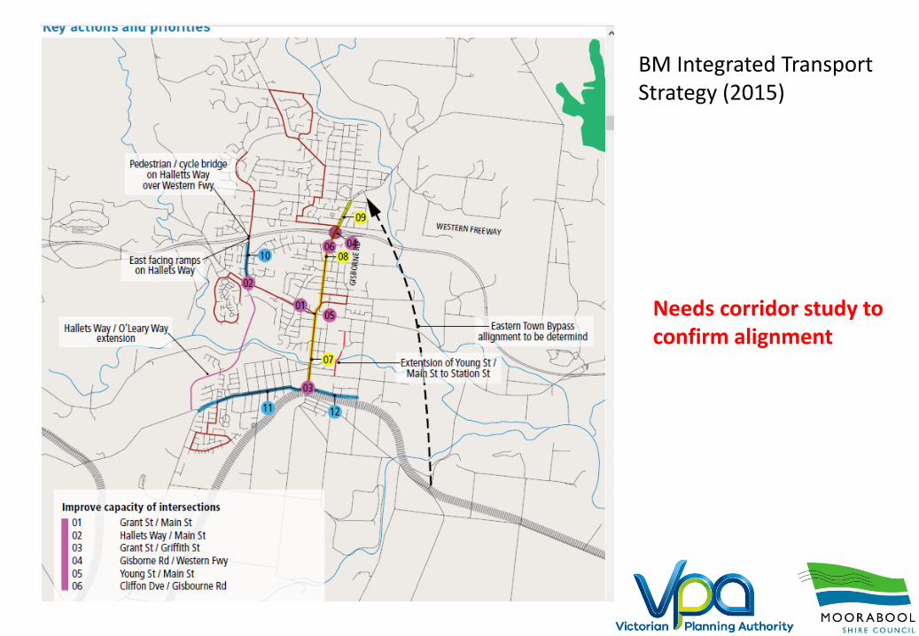
Needs corridor study to confirm alignment
BM Integrated Transport Strategy (2015)
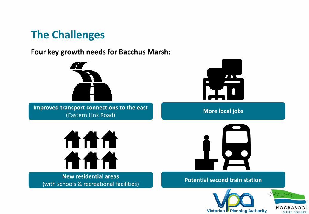
The Challenges
Four key growth needs for Bacchus Marsh:
New residential areas (with schools & recreational facilities)
Potential second train station
Improved transport connections to the east(Eastern Link Road)
More local jobs

Consultations undertaken
850 completed surveys
2 community workshops
Surveyed professionals
Sand & coal mine operators

Studies undertaken – recurring issues
Part of Melbourne but physically separate
Greater retail choice required
Expanded education and health priorities
Change is inevitable but must be managed
Expanded education and health priorities
Ongoing investment in public transport and
non-vehicle movement
Traffic congestion & missing links
Support residents who live at home longer
Wider range of community
infrastructure required

The Background
Closing the gap on key planning matters:
• Prioritising a future eastern link road investigation (Woolpack Road versus alternatives).
• Appropriate buffers for State significant activities eg sand mines, irrigation district, coal mine/landfill.
• Future directions of housing growth once greenfield areas around Bacchus Marsh are developed.
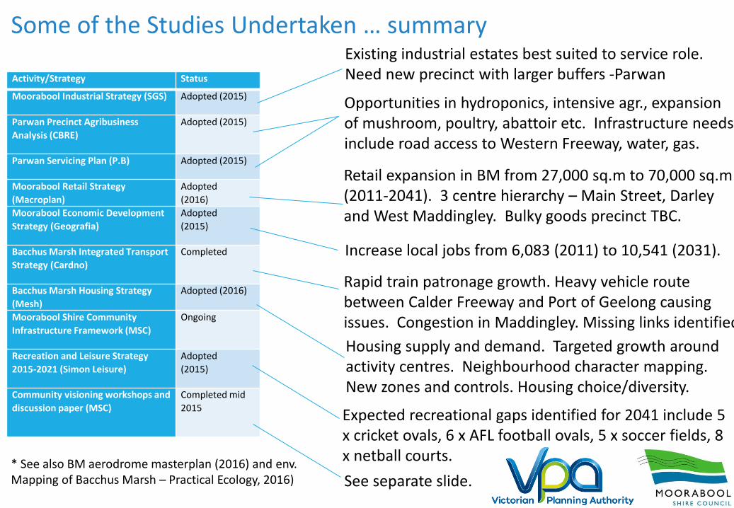
Some of the Studies Undertaken … summary
Activity/Strategy Status
Moorabool Industrial Strategy (SGS) Adopted (2015)
Parwan Precinct Agribusiness
Analysis (CBRE)
Adopted (2015)
Parwan Servicing Plan (P.B) Adopted (2015)
Moorabool Retail Strategy
(Macroplan)
Adopted
(2016)
Moorabool Economic Development
Strategy (Geografia)
Adopted
(2015)
Bacchus Marsh Integrated Transport
Strategy (Cardno)
Completed
Bacchus Marsh Housing Strategy
(Mesh)
Adopted (2016)
Moorabool Shire Community
Infrastructure Framework (MSC)
Ongoing
Recreation and Leisure Strategy
2015-2021 (Simon Leisure)
Adopted
(2015)
Community visioning workshops and
discussion paper (MSC)
Completed mid
2015
Existing industrial estates best suited to service role. Need new precinct with larger buffers -Parwan
Opportunities in hydroponics, intensive agr., expansion of mushroom, poultry, abattoir etc. Infrastructure needs include road access to Western Freeway, water, gas.
Retail expansion in BM from 27,000 sq.m to 70,000 sq.m(2011-2041). 3 centre hierarchy – Main Street, Darley and West Maddingley. Bulky goods precinct TBC.
Increase local jobs from 6,083 (2011) to 10,541 (2031).
Rapid train patronage growth. Heavy vehicle route between Calder Freeway and Port of Geelong causing issues. Congestion in Maddingley. Missing links identified.
Housing supply and demand. Targeted growth around activity centres. Neighbourhood character mapping. New zones and controls. Housing choice/diversity.
Expected recreational gaps identified for 2041 include 5 x cricket ovals, 6 x AFL football ovals, 5 x soccer fields, 8 x netball courts.
See separate slide.* See also BM aerodrome masterplan (2016) and env. Mapping of Bacchus Marsh – Practical Ecology, 2016)

Projects currently underway
• Integrated Water Management Plan (Western Water)• Ballarat Line Upgrade (PTV) – including new platform at B.M• Buffer Assessment - to be commissioned Feb 2017 • Parwan
• Business Case – to be commissioned Feb 2017 • Business Case and Economic Analysis• Traffic Study • Drainage Study
• Bacchus Marsh Irrigation District – Modernisation of Water Supply (SRW)