avon power station - abode group
TRANSCRIPT

Avon Power Station January 2015
EIA Scoping Report
Avon Power Station EIA Scoping Report Scottish Power Generation Limited

Avon Power Station January 2015
EIA Scoping Report
Table of Contents
1 Introduction 1 Background 1 Consenting Regime 3 Objectives of Scoping 3 The Need for the Proposed Development 4
2 Description of the Existing Environment 6 Description of the Site 6 Site surroundings 8 Historic and Existing Site Use 9 Sensitive Environmental Receptors 10 Previous Environmental Studies 11
3 Project Description 12 The Proposed Development 12 Overview of Operation of Combined Cycle Gas Turbines 13 Fast Response Generators 15 Electricity Connection 15 Gas Connection 16 Water Supply Options 16 Water Discharge 17 Access to the Site 17 Potential Rail Spur 17 Carbon Capture Readiness (CCR) 17 Preparation of the Site 18 Construction Programme and Management 19
4 Project Alternatives 20 Alternative Sites 20 Alternative Developments 20 Alternative Technologies 21
5 Planning Policy 22 Primary Policy Framework 22 Secondary Policy Framework 23
6 Potentially Significant Environmental Issues 25 Air Quality 25 Noise and Vibration 28 Ecology 31 Flood Risk, Hydrology and Water Resources 35 Geology, Hydrogeology and Land Contamination 36 Archaeology and Cultural Heritage 38 Traffic and Transport 41 Land Use, Recreation and Socio-Economics 43 Landscape and Visual Impact Assessment 44 Health Impact Assessment 47 Sustainability and Climate Change 47 CHP Assessment 48
Avon Power Station January 2015
EIA Scoping Report
CCR Assessment 48
7 Non-Significant EIA Issues 49 Waste 49 Electronic Interference 49 Aviation 49 Accidental Events 50
8 Environmental Impact Assessment Process 51 EIA Methodology and Reporting 51 Structure of the Environmental Statement (or PEI Report) 51 Structure of Technical Chapters 52 Baseline Conditions 54 Potential Impacts and Mitigation Measures 54 Residual Effects and Conclusions 54 Cumulative Impact Assessment 54 Scoping and Consultation 57
9 Conclusions 59
10 References 60

Avon Power Station January 2015
EIA Scoping Report
Glossary of Terms
Term Description
Applicant The party applying for development consent.
Associated
Development
Development associated with the principal development within the site for which DCO is being
sought, such as pipework, control rooms, water supply, storage and purification equipment, gas
receiving equipment, grid connection infrastructure and supporting site infrastructure (defined
by The Planning Act 2008, Section 120).
Avon Power Station The proposed generating station (or power station), referred to as ‘The Proposed Development’.
Carbon Capture Ready (CCR)
A generating station that adheres to the UK CCR Guidance. A generating station that is CCR will have sufficient land adjacent to the generating station to install carbon capture technology at some point in the future, should the technology become viable.
Carbon Capture Storage
Carbon capture and storage (CCS) is the process of capturing waste carbon dioxide (CO2) from a power plant and transporting it to a storage site (an underground reservoir for example).
Combined Cycle Gas Turbines (CCGT)
CCGT is a form of highly efficient energy generation technology that combines a gas-fired turbine with a steam turbine. It captures waste heat from the gas-fired turbine which would otherwise be emitted to atmosphere to drive the steam turbine, hence increasing the electrical efficiency of the plant.
CCR Site This is an area of land within the western part of the Site which is reserved for the future retrofit of Carbon Capture plant should this ever be required.
CHP Ready A generating station that adheres to the UK CHP Guidance. A generating station that is CHP-R is designed to be ready, with minimum modification, to export heat should the demand become available.
Cooling Water Pipeline A proposed water supply pipeline that connects the Proposed Development to either the Wessex Water wastewater treatment works or the Littleton water treatment plant.
Cooling Water Pipeline Corridor
A corridor or area within which the proposed cooling water pipeline and enabling and construction works associated with the pipeline will be installed and completed.
Development Consent Order
A development consent order, when issued, combines the grant of planning permission with a range of other consents that in other circumstances have to be applied for separately, such as listed building consent. All applications for development consent orders will be made to the Planning Inspectorate. The Planning Inspectorate makes a recommendation to the Secretary of State, who in turns determines the application.
Dry-cooling A type of cooling system that uses air to cool the steam exiting a gas turbine.
Electrical Connection The underground or above ground connection proposed between the Avon power station and the UK electricity transmission system. Several potential options are currently under consideration.
EIA Regulations 2009 The Infrastructure Planning (Environmental Impact Assessment) Regulations 2009 (SI2263) (as amended).
Environmental Effects Environmental effect is determined by a combination of the sensitivity of the receptor and the
magnitude of the impact (refer below). It is an assessment of environmental effects that is
required by Schedule 4 of the EIA Regulations (2009). Effects can be either positive, neutral
or negative.
Environmental Impacts Environmental impact is described and characterised for each technical discipline in order to allow the significance of the environmental effect to be determined based on frequency, duration, reversibility, and probability of the impact occurring (i.e. impact magnitude) along with the sensitivity of the receptor.
Avon Power Station January 2015
EIA Scoping Report
Term Description
Environmental Impact Assessment
A process for determining how a Project may affect the environment. The results of an Environmental Impact Assessment (EIA) should establish a development’s principal potential effects, their significance and how they interact. This information is summarised in a Preliminary Environmental Information Report or Environmental Statement, depending on what stage the project is at.
Environmental Statement
A statement that includes information specified in the EIA Regulations as that reasonably required to assess the environmental effects of the development and of any associated development in which the applicant can, having regard in particular to current knowledge and methods of assessment, reasonably be required to compile.
Heat Recovery Steam Generator
A heat recovery steam generator or HRSG is an energy recovery heat exchanger that recovers heat from a hot gas stream.
Hybrid Cooling System A cooling system that extracts waste heat to the atmosphere and uses a mixture of air and water to cool the steam exiting the gas turbine.
Multi-shaft A configuration of CCGT that includes two gas turbines and generators (the same number as two single-shaft units), but supplies steam from the HRSG to a separate steam turbine and generator that is common to each train.
Nationally Significant Infrastructure Project
Infrastructure projects which are dealt with by the Planning Inspectorate are known as Nationally Significant Infrastructure Projects (NSIPs). The thresholds are set out in sections 15-30 of the 2008 Planning Act.
The Proposed Development falls within the definition of a ‘Nationally Significant Infrastructure Project’ (NSIP) under Section 14(1)(a) and Sections 15(2) of the Planning Act 2008 (Ref. 2-1), as it is an onshore generating station within England that will have a generating capacity greater than 50MW gross output.
Peaking Plant Generating plant that is designed to operate for short periods of time and to ‘top up’ the national grid during periods of high demand / peaks.
Planning Inspectorate (PINS)
The agency responsible for operating the planning process for nationally significant infrastructure projects (NSIPs).
Preliminary Environmental Information
Information referred to in Part 1 of Schedule 4 of the EIA Regulations (2009) which has been compiled by the applicant and is reasonably required to assess the environmental effects of the development (and any associated development).
Public Right of Way An access track that is open to everyone including roads, paths or tracks, bridleways and can run through towns, countryside or private property.
Rochdale Envelope An approach that allows a range, or envelope of parameters to be applied for, as described in the Planning Inspectorate’s Advice Note 9.
Scoping A stage which occurs early in the project cycle identifying the key environmental issues and the procedures for determining the extent of and the approach to an EIA.
Scoping Opinion The written statement by the Secretary of State as to the information to be provided in an environmental statement.
Scoping Report A report by the Applicant on the results of the Scoping exercise as detailed above which is submitted to the Planning Inspectorate.
Single-shaft A configuration of CCGT that consists of only one gas turbine, steam turbine, generator and HRSG per CCGT unit, with the gas turbine and steam turbine coupled to the generator.
The Applicant ScottishPower Generation Land Limited.
The Proposed Development
The term used to describe the Avon Power Station generating station, comprising the construction and operation of the gas fired power station including the CCGT units, the Fast Response Generators and supporting infrastructure such as connections to the UK gas and electricity transmission systems, potential connections to facilitate water supply and discharge, and potential road and rail access improvements.
The DCO site boundary
The application site for which Development Consent Order (DCO) is being sought. It comprises the main application Site along with corridors for the associated development connections needed to operate the Proposed Development.
The Site Part of the DCO site boundary comprising the main 45 ha development area fully owned by the Applicant within which the main generating station is to be constructed and operated.
Wet-cooling A cooling system that uses water to cool the steam exiting a gas turbine.

Avon Power Station January 2015
EIA Scoping Report
Abbreviations
Abbreviation Description
µg/m3 Micrograms per Cubic Metre
AOD Above Ordinance Datum
APFP Applications: Prescribed Forms and Procedure
APHO Association of Public Health Observatories
AQMA Air Quality Management Area
BAT Best Available Techniques
BCC Bristol City Council
bgl Below Ground Level
BRERC Bristol Regional Environmental Records Centre
BS British Standard
BTO British Trust for Ornithology
CAA Civil Aviation Association
CCGT Combined Cycle Gas Turbine
CCR Carbon Capture Ready
CCS Carbon Capture and Storage
CEMP Construction Environmental Management Plan
CHP Combined Heat and Power
CIEEM Chartered Institute of Ecology and Environmental Management
CO Carbon Monoxide
CO2 Carbon Dioxide
CTMP Construction Traffic Management Plan
dB Decibel
DCLG Department for Communities and Local Government
DCO Development Consent Order
DECC Department for Energy and Climate Change
DfT Department for Transport
DMRB The Design Manual for Roads and Bridges
EA Environment Agency
EH English Heritage
EIA Environmental Impact Assessment
ELVs Emission Limit Values
EMR Electricity Market Reform
EPC Engineering, Procurement and Construction Contractor
EQS Environmental Quality Standards
ES Environmental Statement
FRA Flood Risk Assessment
GI Ground Investigation
GIS Gas Insulated Switchgear
GW Gigawatt
ha Hectare
HA Highways Agency
Avon Power Station January 2015
EIA Scoping Report
Abbreviation Description
HER Historic Environment Record
HGV Heavy Goods Vehicle
HIA Health Impact Assessment
HRA Habitats Regulations Assessment
HRSG Heat Recovery Steam Generator
IAQM Institute of Air Quality Management
IED Industrial Emissions Directive
IEEM Institute of Ecology and Environmental Management
IEMA Institute of Environmental Management and Assessment
IPC Infrastructure Planning Commission
ISO International (ISO) Standards
km Kilometre
kV kilovolt
LCPD Large Combustion Plant Directive
LNG Liquefied Natural Gas
LSIDB Lower Severn Internal Drainage Board
m Metre
m/s Metres per second
MW Megawatt
NAQS National Air Quality Strategy
NE Natural England
NETS National Electricity Transmission System
NG National Grid
NGG National Grid Gas
NO2 Nitrogen Dioxide
NOx Nitrogen
NPPF National Planning Policy Framework
NPS National Policy Statement
NSIP National Significant Infrastructure Project
NTS Non-Technical Summary
OHLs Overhead Line
ONS Office for National Statistics
OS Ordinance Survey
PEIR Preliminary Environmental Information Report
PINS The Planning Inspectorate
PM10 Particulate Matter
PM2.5 Particulate Matter
PROW Public Right of Way
SAC Special Area Conservation
SDLL Severnside Development Land Ltd
SERC Severnside Energy Recovery Centre
SGC South Gloucestershire Council
SINC Site of Importance for Nature Conservation
SITA The Severnside Energy Recovery Centre

Avon Power Station January 2015
EIA Scoping Report
Abbreviation Description
SoCC Statement of Community Consultation
SPA Special Protection Area
SPDs Supplementary Planning Documents
SPGs Supplementary Planning Guidance
sq ft Square foot
SSSI Site of Special Scientific Interest
TA Transport Assessment
TTWA Travel to Work Area
ZTV Zone of Theoretical Visibility
Avon Power Station January 2015
EIA Scoping Report
1
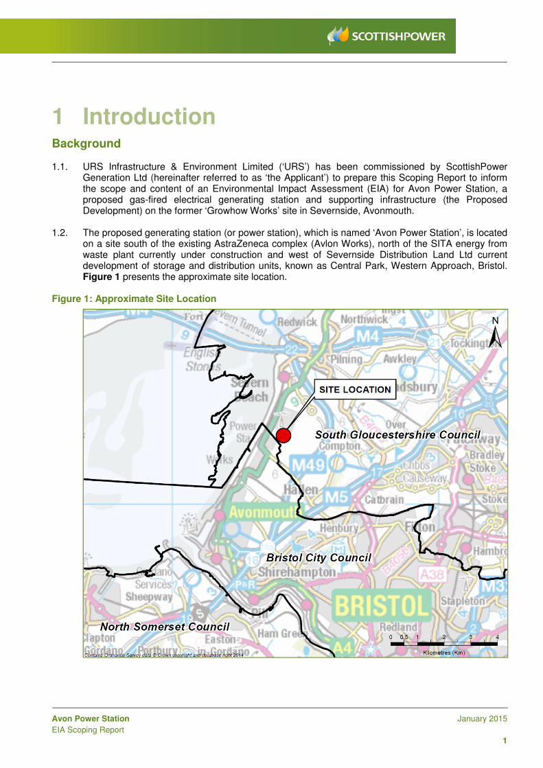
1 Introduction Background
1.1. URS Infrastructure & Environment Limited (‘URS’) has been commissioned by ScottishPower Generation Ltd (hereinafter referred to as ‘the Applicant’) to prepare this Scoping Report to inform the scope and content of an Environmental Impact Assessment (EIA) for Avon Power Station, a proposed gas-fired electrical generating station and supporting infrastructure (the Proposed Development) on the former ‘Growhow Works’ site in Severnside, Avonmouth.
1.2. The proposed generating station (or power station), which is named ‘Avon Power Station’, is located on a site south of the existing AstraZeneca complex (Avlon Works), north of the SITA energy from waste plant currently under construction and west of Severnside Distribution Land Ltd current development of storage and distribution units, known as Central Park, Western Approach, Bristol. Figure 1 presents the approximate site location.
Figure 1: Approximate Site Location
Avon Power Station January 2015
EIA Scoping Report
2
1.3. The Proposed Development will provide up to 1,800 MW of electricity generation capacity at site rated conditions. The electrical output capacity will be generated from up to two units of Combined Cycle Gas Turbines (CCGTs) and potentially up to 300MW capacity of Fast Response Generators installed on the same site.
1.4. For the purpose of this Report, the following definitions are used:
• the Proposed Development: comprises the construction and operation of the gas fired power station including the CCGT units, the Fast Response Generators and supporting infrastructure such as connections to the UK gas and electricity transmission systems, potential connections to facilitate water supply and discharge, and potential road and rail access improvements (refer to Section 3 - Project Description);
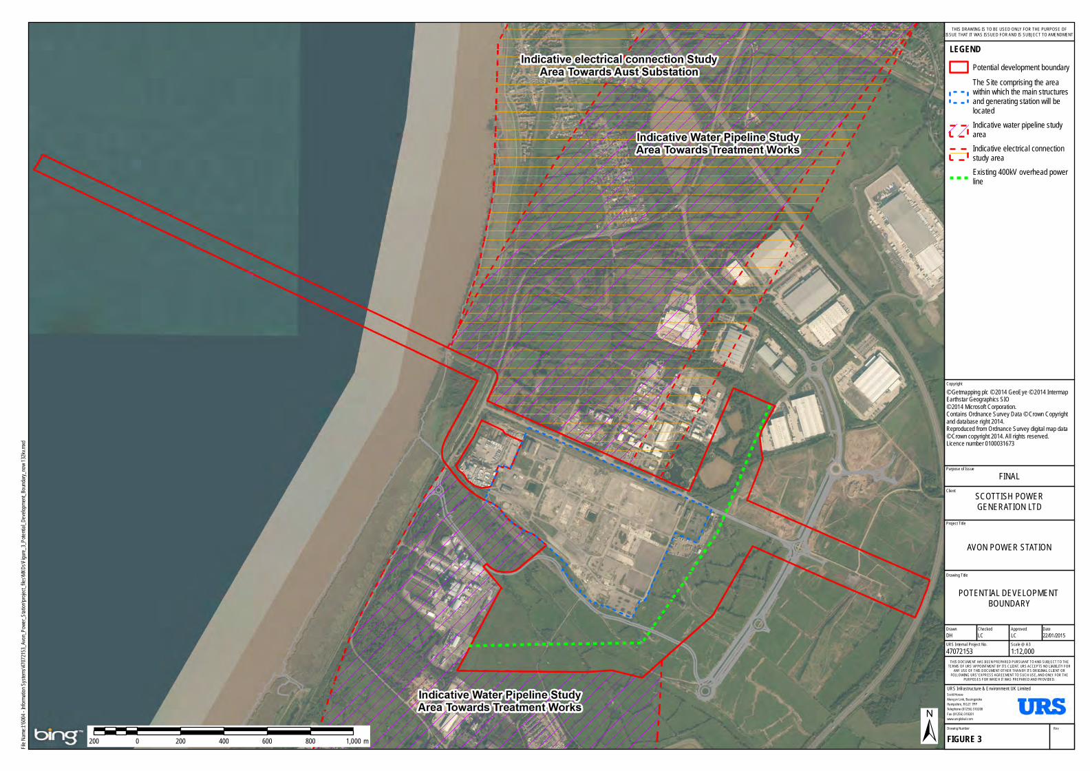
• the Development Consent Order (DCO) site boundary: comprises the area contained within the red line boundary (including both the solid and dotted red line boundary) illustrated in Figure 2, including the main application Site and corridors for the Associated Development connections needed to operate the Proposed Development; and
• the Site (blue dotted line shown in Figure 3) is the 45 ha main development area fully owned by the Applicant within which the main structures and generating station are to be constructed and operated.
1.5. An Environmental Information Report was published by the Applicant in 2011 as part of a Stage 1
consultation exercise undertaken at that time. Subsequently, the Project was put on hold until now, in part in order for details around the necessary gas and grid connections to be determined. Given the length of time that has passed since that consultation exercise, a refreshed Stage 1 consultation exercise is now being undertaken.
1.6. This Scoping Report considers the environmental context of the Site and the potential for environmental impacts from the Proposed Development. Where environmental impacts are considered to have the potential to result in likely significant effects, these have been identified, and this Report outlines the proposed approach to be used in the EIA to characterise and understand the significance of these effects. This Scoping Report also outlines issues perceived to be non-significant which it is proposed do not require formal assessment as part of the EIA and so are proposed to be scoped out (refer Section 7). Cumulative impacts, the approach to the cumulative assessment and the schemes that will be considered are also presented (refer Section 8).
1.7. The EIA is an iterative process that feeds into the engineering design process to mitigate significant environmental effects where they are predicted to occur. Where possible, any such mitigation is embedded within the project design so that such an effect does not occur in the first place. The identification and assessment of likely significant effects predicted in respect of the final design iteration, along with the findings of the EIA will be reported in an Environmental Statement (ES), in accordance with The Infrastructure Planning (Environmental Impact Assessment) Regulations 2009 (as amended) (‘EIA Regulations’) [Ref. 1]. The ES will be submitted with the Development Consent Order (DCO) Application in accordance with Regulation 5 (2)(a) of the Infrastructure Planning (Applications: Prescribed Forms and Procedure) Regulations 2009 (‘APFP Regulations’) [Ref. 2].

Littleton WaterTreatment Works
Indicative WaterPipeline StudyArea Towards
Treatment Works
Indicative WaterPipeline StudyArea Towards
Treatment Works
Wessex WaterTreatment Works
Aust Substation
Indicative electricalconnection Study
Area TowardsAust Substation
City ofBristol Council
City ofBristolCouncil
SouthGloucestershire
Council
North SomersetCouncil
Forest of DeanDistrictCouncil
MonmouthshireCouncil
Purpose of Issue
Project Title
Drawing Title
Drawn Checked
Scott HouseAlençon Link, BasingstokeHampshire, RG21 7PPTelephone (01256) 310200Fax (01256) 310201www.ursglobal.com
URS Infrastructure & Environment UK Limited
DateApproved
RevDrawing Number
FIGURE 2
THIS DOCUMENT HAS BEEN PREPARED PURSUANT TO AND SUBJECT TO THETERMS OF URS' APPOINTMENT BY ITS CLIENT. URS ACCEPTS NO LIABILITY FOR
ANY USE OF THIS DOCUMENT OTHER THAN BY ITS ORIGINAL CLIENT ORFOLLOWING URS' EXPRESS AGREEMENT TO SUCH USE, AND ONLY FOR THE
PURPOSES FOR WHICH IT WAS PREPARED AND PROVIDED.
URS Internal Project No. Scale @ A347072153 1:45,000DH LC LC 22/01/2015
Client
File Na
me:I:\5
004 - In
formatio
n Syst
ems\4
707215
3_Avon
_Pow
er_Sta
tion\pro
ject_fi
les\MX
Ds\Fig
ure_2_
DCO_
Devel
opment
_Boun
dary.m
xd
1 0 1 2 3 4 5 km
LEGENDPotential development boundaryIndicative water pipeline studyareaIndicative electrical connectionstudy areaExisting 400kV overhead powerlineLocal authority boundary
DCO DEVELOPMENT BOUNDARY
AVON POWER STATION
FINALSCOTTISH POWERGENERATION LTD
THIS DRAWING IS TO BE USED ONLY FOR THE PURPOSE OFISSUE THAT IT WAS ISSUED FOR AND IS SUBJECT TO AMENDMENT
Copyright© Getmapping plc © 2014 GeoEye © 2014 IntermapEarthstar Geographics SIO© 2014 Microsoft Corporation.Contains Ordnance Survey Data © Crown Copyrightand database right 2014.Reproduced from Ordnance Survey digital map data © Crown copyright 2013. All rights reserved. Licence number 0100031673
Purpose of Issue
Project Title
Drawing Title
Drawn Checked
Scott HouseAlençon Link, BasingstokeHampshire, RG21 7PPTelephone (01256) 310200Fax (01256) 310201www.ursglobal.com
URS Infrastructure & Environment UK Limited
DateApproved
RevDrawing Number
FIGURE 3
THIS DOCUMENT HAS BEEN PREPARED PURSUANT TO AND SUBJECT TO THETERMS OF URS' APPOINTMENT BY ITS CLIENT. URS ACCEPTS NO LIABILITY FOR
ANY USE OF THIS DOCUMENT OTHER THAN BY ITS ORIGINAL CLIENT ORFOLLOWING URS' EXPRESS AGREEMENT TO SUCH USE, AND ONLY FOR THE
PURPOSES FOR WHICH IT WAS PREPARED AND PROVIDED.
URS Internal Project No. Scale @ A347072153 1:12,000DH LC LC 22/01/2015
Client
File Na
me:I:\5
004 - In
formatio
n Syst
ems\4
707215
3_Avon
_Pow
er_Sta
tion\pro
ject_fi
les\MX
Ds\Fig
ure_3_
Poten
tial_D
evelop
ment_
Bound
ary_no
w 132k
v.mxd
200 0 200 400 600 800 1,000 m
LEGENDPotential development boundaryThe Site comprising the areawithin which the main structuresand generating station will belocatedIndicative water pipeline studyareaIndicative electrical connectionstudy areaExisting 400kV overhead powerline
POTENTIAL DEVELOPMENT BOUNDARY
AVON POWER STATION
FINALSCOTTISH POWERGENERATION LTD
THIS DRAWING IS TO BE USED ONLY FOR THE PURPOSE OFISSUE THAT IT WAS ISSUED FOR AND IS SUBJECT TO AMENDMENT
Copyright© Getmapping plc © 2014 GeoEye © 2014 IntermapEarthstar Geographics SIO© 2014 Microsoft Corporation.Contains Ordnance Survey Data © Crown Copyrightand database right 2014.Reproduced from Ordnance Survey digital map data © Crown copyright 2014. All rights reserved. Licence number 0100031673

Avon Power Station January 2015
EIA Scoping Report
3
Consenting Regime
1.8. The Proposed Development is a ‘generating station [power station] exceeding 50 MW capacity’, and so is a ‘nationally significant infrastructure project’ (NSIP) under Section 15(2)(c) of the Planning Act 2008 [Ref. 3]. It is also a ‘Schedule 1’ development under The Infrastructure Planning (Environmental Impact Assessment) Regulations 2009 (as amended) (‘EIA Regulations’) as it constitutes “Thermal power stations and other combustion installations with a heat output of 300 megawatts or more”. As such an EIA is required for Avon Power Station and an ES needs to be prepared in accordance with these Regulations.
1.9. As an NSIP, the Applicant is required to seek a DCO to construct the power station, under Section 31 of the Planning Act 2008. The DCO application will be prepared in accordance with Section 37 of this Act and secondary legislation including the EIA Regulations and the APFP Regulations. The DCO application will be submitted to the Planning Inspectorate (PINS) who will appoint a panel to examine the application and thereafter make recommendations to the Secretary of State for Energy & Climate Change, who will subsequently determine whether or not a DCO should be granted for Avon Power Station.
1.10. Figure 2 illustrates the potential DCO site boundary currently under consideration. This comprises the Site as well as the potential Associated Development corridors, within which any new supporting infrastructure associated with the NSIP, such as gas or water pipelines and electrical connections, will be constructed. At this stage there are a number of potential connection options still under consideration for the Proposed Development and these have been retained within the potential DCO site boundary. As the design of the Proposed Development is further developed, it is likely that some of these connections will be refined or removed thereby amending the DCO site boundary. For the purposes of the EIA, any retained options under consideration will be included within the DCO site boundary and assessed accordingly.
1.11. As the design of the Proposed Development has not been finalised, the EIA will be conducted using ‘worst case’ assumptions to provide a conservative assessment of environmental effects, adopting selected use of the principles of the Rochdale envelope in accordance with Planning Inspectorate Advice Note 9.
1.12. Descriptions of the Site and the Proposed Development are presented in Sections 2 and 3 of this report.
Objectives of Scoping
1.13. With the EIA Regulations (detailed above) determining that the Avon Power Station is defined as EIA development, scoping forms a key stage of the EIA process, providing a framework for identifying likely significant environmental impacts arising from the development and distinguishing the priority issues needing to be addressed within the EIA. Scoping also allows stakeholders an early opportunity to comment on the proposed methodology for the EIA and the proposed structure and content of the ES.
1.14. This Scoping Report has been prepared as part of a request to PINS for a formal Scoping Opinion on the information to be provided in the ES, pursuant to Regulation 8 of the EIA Regulations. PINS will subsequently consult with the identified statutory consultees. In addition to this information, the ES will consider the potential inter-relationships between different environmental topic areas.
1.15. Table 1 presents a list of information which should be included in a Scoping Report, as highlighted
in The Planning Inspectorate Advice Note 7: ‘Environmental Impact Assessment: screening and scoping’ [Ref. 4], and the location where in this report the information is presented. In addition to this information, the ES will consider the potential inter-relationships between different environmental topic areas.

Avon Power Station January 2015
EIA Scoping Report
4
Table 1: Information provided in the Scoping Report (based on Advice Note 7)
Description of Information required Section in Scoping Report
where the Information is
Presented
A plan showing:
• the DCO site boundary and associated development;
• permanent land take required for the NSIP;
• temporary land take required for construction, including off-site construction
compounds;
• existing infrastructure which would be retained or upgraded for use as part of the NSIP;
• existing infrastructure which would be removed; and
• features including planning constraints and designated areas on and around the site,
such as national parks or historic landscapes
Figure 2 and Figure 3.
Figure 5 and Figure 5a
illustrate the
environmental constraints
and considerations
A description of:
• the NSIP Site;
• the NSIP development; and
• its possible effects on the environment.
Section 2
Section 3
Section 6
An outline of the main alternatives considered and the reasons for selecting a preferred
option
Section 4
Results of desktop and baseline studies where available Section 6
Guidance and best practice to be relied upon Section 6
Methods used or proposed to be used to predict impacts and the significance criteria
framework used
Section 8
Where cumulative development has been identified, how the developer intends to assess
these impacts in the ES
Section 8 and Figure 8
An indication of any European designated nature conservation sites that are likely to be
significantly affected by the Proposed Development and the nature of the likely significant
impacts on these sites
Figure 5, Section 2 and
Section 6
Where a developer seeks to scope out matters, a full justification for scoping out such
matters
Section 7
Key topics covered as part of the developer’s scoping exercise Section 6
An outline of the structure of the proposed ES Section 8
The Need for the Proposed Development 1.16. The Energy White Paper ‘Meeting the Energy Challenge’ published in 2007 by the Department for
Trade and Industry, which formed the basis of the Energy Act 2008 [Ref. 5], sets out the Government’s plans for tackling climate change by reducing carbon emissions whilst ensuring the availability of secure, clean, affordable energy.
1.17. The White Paper and the Overarching National Policy Statement (NPS) for Energy (EN-1) [Ref. 6] both emphasise the importance of a diverse mix of energy generating technologies, including renewables, nuclear and fossil fuels, to avoid over-dependence on a single fuel type and thereby ensure security of supply. The National Policy Statement for Fossil Fuel Electricity Generating Infrastructure (NPS EN-2) [Ref. 7] further emphasises that fossil fuel generating stations play a vital role in providing reliable electricity supplies as the UK makes the transition to a low carbon economy.
Avon Power Station January 2015
EIA Scoping Report
5
1.18. Changes to the current mix of energy generating plant will occur as a large number of existing oil, coal and nuclear power stations close over the next 10-15 years due to the requirements of the European Industrial Emissions Directive (IED) [Ref. 8] which incorporates and supersedes the requirements of the former Large Combustion Plant Directive (2001/80/EC) [Ref. 9] and/or as plants reach the end of their operational lives. Projections quoted in NPS (EN-1) indicate 22 Gigawatts (GW) of electricity generating capacity will close over this period. This creates a significant need for new major energy infrastructure.
1.19. The long lead-in for new nuclear power stations means that new fossil fuel and renewable generating capacity will need to be progressed to meet demand.
1.20. Renewable energy is important to achieve the UK’s targets for reductions in carbon emissions, but NPS (EN-1) also emphasises the ongoing requirement for fossil fuel power stations as they offer more flexibility in response to changes in energy demand compared to many renewable energy technologies. Recent Department of Energy and Climate Change (DECC) projections indicate that more than 15GW of fast response generation plant is required in the UK to support the intermittency of renewable electricity generation [Ref. 10]. Fast response generation forms part of the Proposed Development as described in Section 3: Project Description.
1.21. The UK faces closure of existing generating capacity as older, more polluting, power stations close, whilst UK electricity demand is projected to grow as heat and transport systems are increasingly electrified. The investment required to transform the UK’s electricity infrastructure will stimulate the economy, support the growth of UK supply chains and boost the jobs market.
1.22. The UK Government has undertaken Energy Market Reform (EMR), which is intended to deliver low carbon energy and reliable supplies that the UK needs, while minimising costs to consumers. The EMR introduces a key mechanism to provide incentives for the investment required in energy infrastructure - the Capacity Market, which provides a regular retainer payment to reliable forms of capacity (both demand and supply side), in return for such capacity being available when the system is tight.
1.23. The reformed electricity market is intended to transform the UK electricity sector to one in which low-carbon generation can compete with conventional, fossil-fuel generation – ensuring a cleaner, more sustainable energy mix. Nevertheless, gas generation is still required to meet demand and it also contributes to the objective of reducing national carbon dioxide (CO2) emissions as generating electricity from gas is more efficient and of lower carbon intensity than other fossil fuels such as coal, resulting in significantly lower CO2 emissions per generated MW from gas-fired power stations compared to coal-fired power stations.
1.24. For these reasons, the Applicant considers that there is a national need for the development of a new gas-fired electricity generating station and has selected the Site on which to do so for technical, environmental and commercial reasons. The Applicant proposes to seek Development Consent for the construction and operation of a gas-fired power station at the Site.

Avon Power Station January 2015
EIA Scoping Report
6
2 Description of the Existing Environment Description of the Site 2.1. The Site (defined by the dotted blue line in Figure 3) is approximately 45 hectares (ha) in area
located on land approximately 5 kilometres (km) northeast of Avonmouth and 10km from Bristol in an area called Severnside. The approximate Ordnance Survey Grid Reference for the centre of the Site is ST542 829. The Site is largely flat, with levels ranging between 5.5m above ordnance datum (AOD) and 7m AOD.
2.2. The Site is located within the administrative area of South Gloucestershire Council (SGC) with a small area of the potential development boundary (refer below) to the south located within the Bristol City Council (BCC) boundary.
2.3. The potential development boundary (the solid red line), as illustrated in Figure 2 and 3, comprises
an area of approximately 154 hectares (ha), including connection routes for the proposed gas connection to the National Grid Gas Transmission network (named the Feeder 14 pipeline) and the proposed electricity connection to the National Grid. This site area may further include a water supply pipeline to/ from Wessex Water wastewater treatment facility or Littleton water treatment works (see Section 3: Water Supply Options), and may also include an electrical connection to Aust (see Section 3: Electricity Connection). This will be decided prior to submitting the DCO application and following pre-application consultation with stakeholders. Where this affects the scope of the work to be carried out for the EIA, it is noted within this report, along with a description of the additional work that will be undertaken as part of the EIA should any of these connection routes be retained and progressed as part of the DCO application.
2.4. The Site is predominantly located 400m east of the Severn Estuary in a largely industrial area just over 1km west of the M49 motorway. Part of the current DCO site boundary extends into the Estuary as an existing outfall associated with the former use of the Site may be utilised for the discharge of treated wastewater. The Severn Estuary is designated as a Special Area of Conservation (SAC), Special Protection Area (SPA), Ramsar Site and Site of Special Scientific Interest (SSSI) due to both habitat and species assemblages.
2.5. The Site was previously occupied by Severnside Fertiliser Works, owned and operated by
GrowHow UK Limited (formerly owned by Terra Nitrogen and ICI). The former fertiliser manufacturing and storage facility was operational from the 1960’s until 2008. The majority of the buildings associated with the former use of the Site have now been demolished and the Site is currently dominated by hardstanding interspersed with grassed areas and shrub vegetation. The Site currently contains a number of buildings and structures of varying ages but these are due to be demolished under permitted development rights prior to submission of the DCO application.
2.6. There are two surface water drainage reservoirs (Redwick and Severnside) located centrally within
the Site that were previously used for surface water and firewater retention. A rhine (drainage channel), known as Central Rhine, runs along the northern boundary of the Site parallel with Central Avenue.
2.7. There are a number of existing underground services present on the Site [Ref. 11]. A petroleum pipeline runs along the northerly edge of the Site; a potable water pipeline runs across the northwest of the Site, whilst a redundant water pipeline is located in the centre of the Site running north-south.
2.8. Photographs 1 to 3 show views within the Site. Photograph 3 shows the petroleum pipeline. The locations and direction at which the photographs were taken are illustrated in Figure 4.

1 3
2
Purpose of Issue
Project Title
Drawing Title
Drawn Checked
Scott HouseAlençon Link, BasingstokeHampshire, RG21 7PPTelephone (01256) 310200Fax (01256) 310201www.ursglobal.com
URS Infrastructure & Environment UK Limited
DateApproved
RevDrawing Number
FIGURE 4
THIS DOCUMENT HAS BEEN PREPARED PURSUANT TO AND SUBJECT TO THETERMS OF URS' APPOINTMENT BY ITS CLIENT. URS ACCEPTS NO LIABILITY FOR
ANY USE OF THIS DOCUMENT OTHER THAN BY ITS ORIGINAL CLIENT ORFOLLOWING URS' EXPRESS AGREEMENT TO SUCH USE, AND ONLY FOR THE
PURPOSES FOR WHICH IT WAS PREPARED AND PROVIDED.
URS Internal Project No. Scale @ A347072153 1:10,000DH LC LC 22/01/2015
Client
File Na
me:I:\5
004 - In
formatio
n Syst
ems\4
707215
3_Avon
_Pow
er_Sta
tion\pro
ject_fi
les\MX
Ds\Fig
ure_4_
Locatio
n_of_p
hotogr
aphs_o
n_site.
mxd
200 0 200 400 600 800 1,000 m
LEGENDPotential development boundary
Photograph location and direction
LOCATION OF PHOTOGRAPHS ON SITE
AVON POWER STATION
FINALSCOTTISH POWERGENERATION LTD
THIS DRAWING IS TO BE USED ONLY FOR THE PURPOSE OFISSUE THAT IT WAS ISSUED FOR AND IS SUBJECT TO AMENDMENT
Copyright© Getmapping plc © 2014 GeoEye © 2014 IntermapEarthstar Geographics SIO © 2014 Microsoft Corporation.Contains Ordnance Survey Data © Crown Copyrightand database right 2014.Reproduced from Ordnance Survey digital map data © Crown copyright 2014. All rights reserved. Licence number 0100031673

Avon Power Station January 2015
EIA Scoping Report
7
Photograph 1: Photograph located in the centre of the Site, facing east
Photograph 2: Photograph located in the northwest area of the Site, facing southwest

Avon Power Station January 2015
EIA Scoping Report
8
Photograph 3: Photograph located in the north of the Site, facing west along the northern boundary
Site surroundings
2.9. The Site is located to the east of the Severn Estuary in a predominantly industrial area with areas of currently undeveloped greenfield land nearby. The surrounding topography is flat. The Welsh shore of the Severn Estuary is located approximately 7 kilometres to the west of the Site.
2.10. To the north, the Site is bounded by Central Avenue, an unadopted road running from west to east. A drainage ditch, known as Central Rhine runs along the northern boundary of the Site, parallel to Central Avenue and is part of a network of drainage ditches in the area draining to the Severn Estuary. To the north of Central Avenue lies the AstraZeneca pharmaceutical works.
2.11. To the east of the Site, the land has been raised and is currently being used by third party for vehicle storage. The land to the south and east of this is currently being developed by Severnside Development Land Limited (SDLL) for storage and distribution purposes as part of the Central Park (Western Approach) development. The M49 motorway is located to the east, with the Avonmouth LNG Terminal and Hallen Industrial Estate situated to the southeast.

Avon Power Station January 2015
EIA Scoping Report
9
2.12. The land to the south of the Site is under development. The land immediately to the southeast of the main development area is subject to proposals by a third party for a separate CCGT power station. The potential for cumulative impacts with this CCGT is discussed in Section 8: Cumulative Impact Assessment. A series of 11kV, 132kV and 400kV overhead electrical lines (OHL) cross the land to the southeast of the Site in a nominally north to south direction. To the southwest of the Site is a consented Energy from Waste facility (Local Planning Authority reference PT12/1303/MW), which is currently under construction and due for completion and commissioning in 2016. A large rhine (the Red Rhine) is located approximately 100m south of the Site, currently running in an east to west direction. There are proposals to relocate the Red Rhine along the south of the Site boundary under the extant 1957/58 consent, which are discussed further in Section 8: Cumulative Impact Assessment. The diversion of the Red Rhine is due to be completed in mid-2015, in advance of the expected Avon Power Station DCO submission date. The existing Seabank 1 & 2 power station is located approximately 200m southwest of the Site boundary.
2.13. The land immediately to the west of the Site is occupied by a small industrial estate. The A403 Severn Road is located 200m west of the Site and runs parallel to the western boundary and the Severn Estuary. Severn Road is separated from the Estuary by a railway embankment and the foreshore of the Estuary.
2.14. Nearby residential communities include Severn Beach, Easter Compton, Pilning, Redwick and Hallen, approximately 1.5km north, 1.5km east, 2.1km northeast and 2.4km southeast of the Site respectively, as shown in Figure 5. In addition, there are a small number of farms in the surrounding area, including several within 500m to 1.5km of the Site.
Historic and Existing Site Use 2.15. Using historical mapping provided by Envirocheck (Ref. 12), a timeline of the Site over the last two
decades is described in Table 2.
Table 2: Historical Map Descriptions
Published
Date
Map Scale Description
1888 - 1889 1:10,560 The Site is mainly grassland split into several fields lined with trees / shrub.
Vinpennys Common and Severn Farm are both located on the boundary of the north east
corner of the Site, and Stowick Farm immediately to the south.
A minor road runs vertical through the centre of the Site, with ‘New Pill Grout’ to the east,
adjacent to mudflats on the estuary.
1903 - 1904 1:10,560 A railway line is identifiable running north/south alongside the visible section of the estuary.
1920 - 1921 1:10,560 The railway line is now named ‘Avonmouth Branch’.
A number of footpaths run through the Site, and the ‘Severn Road’ is named, running
north/south alongside the estuary, and then southeast towards Chittening Farm.
1955 1:10,560 No significant change.
1965 1:10,560 The entire Site has been developed, named ‘Works’ with a number of roads connecting
various buildings.
Severn Farm and Vinpennys Common still remain on the boundary of the north east corner
of the Site. To the south of the Site, ‘Stowick Farm’ has been demolished, and a railway
track has been built running from Crooks Marsh to New Pill Grout.
The ‘Red Rhine’ is now located to the east of the Site, and enters the Site for approximately
100m. A number of minor rhines are also present within the eastern side of the Site.
Development is now present to the south of the Site including a ‘Depot’ and other ‘Works’
approximately 700m from the Site boundary.
Avon Power Station January 2015
EIA Scoping Report
10
Published
Date
Map Scale Description
1974 – 1975 1: 10,000 The Site is now named ‘Severnside Works’, and is heavily developed with a high density of
buildings and roads. Most areas of grassland / rhines have been removed within the Site
boundary.
An Overhead line (OHL) exits the eastern edge of the Site and runs east for approximately
500m, and then south.
Immediately to the South of the Site is the railway track and then the ‘Red Rhine’.
Approximately 100m south are tanks and then the ‘Seabank Gas Works’.
A landfill site is now identifiable 800m east of the Site boundary.
1975 – 1991 1: 10,000 No significant change.
1999 1: 10,000 The railway to the south of the Site is now named ‘dismantled’. A landfill site is now
identifiable 200m south of the Site boundary.
2008 1: 10,000 The OHL has been redirected following the eastern perimeter of the Site, and then west
towards Seabank 400kV substation.
Severn View Industrial Park is labelled in the area of land to the west of the Site before
Severn Road.
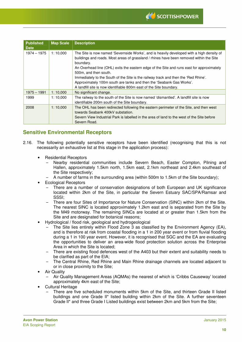
Sensitive Environmental Receptors 2.16. The following potentially sensitive receptors have been identified (recognising that this is not
necessarily an exhaustive list at this stage in the application process):
• Residential Receptors – Nearby residential communities include Severn Beach, Easter Compton, Pilning and
Hallen, approximately 1.5km north, 1.5km east, 2.1km northeast and 2.4km southeast of the Site respectively;
– A number of farms in the surrounding area (within 500m to 1.5km of the Site boundary);
• Ecological Receptors – There are a number of conservation designations of both European and UK significance
located within 2km of the Site, in particular the Severn Estuary SAC/SPA/Ramsar and SSSI;
– There are four Sites of Importance for Nature Conservation (SINC) within 2km of the Site. The nearest SINC is located approximately 1.2km east and is separated from the Site by the M49 motorway. The remaining SINCs are located at or greater than 1.5km from the Site and are designated for botanical reasons;
• Hydrological / flood risk, geological and hydrogeological – The Site lies entirely within Flood Zone 3 as classified by the Environment Agency (EA),
and is therefore at risk from coastal flooding in a 1 in 200 year event or from fluvial flooding during a 1 in 100 year event. However, it is recognised that SGC and the EA are evaluating the opportunities to deliver an area-wide flood protection solution across the Enterprise Area in which the Site is located;
– There are existing flood defences west of the A403 but their extent and suitability needs to be clarified as part of the EIA;
– The Central Rhine, Red Rhine and Main Rhine drainage channels are located adjacent to or in close proximity to the Site;
• Air Quality – Air Quality Management Areas (AQMAs) the nearest of which is ‘Cribbs Causeway’ located
approximately 4km east of the Site;
• Cultural Heritage – There are five scheduled monuments within 5km of the Site, and thirteen Grade II listed
buildings and one Grade II* listed building within 2km of the Site. A further seventeen Grade II* and three Grade I Listed buildings exist between 2km and 5km from the Site;
Avon Power Station January 2015
EIA Scoping Report
11
– Underground archaeology may be present onsite or in the vicinity of the Site, recognising that the Site itself has a long industrial history and has previously been extensively developed;
• Traffic and Transport – There are several local public rights of way in the vicinity of the Site, including Local Plan
LC12 recreational routes (safeguarded under the SGC Local Plan); – The existing local transport network is likely to be used for material deliveries and worker
access to the Site, particularly during the construction phase. Local routes include the A403 via Central Avenue, which connects the Site to the wider motorway network including the M49 and M5.
2.17. These sensitive receptors are discussed further within Section 6 of this report. There are also a number of other proposed developments in the area. These are considered as potential future receptors and cumulative schemes and are discussed in Section 8.
2.18. Figure 5 and Figure 5a illustrate current environmental designations within the Site and surrounding area.
Previous Environmental Studies 2.19. There are a number of environmental studies that have been carried out within or in the area
surrounding the Site. These include, but are not limited to:
• The environmental information report and consultation documents published in 2011 [Ref. 13];
• Phase I Environmental Desk Study Report for the Site (prepared in 2009) [Ref. 14] and Envirocheck Report [Ref. 12];
• Flood Risk and Drainage Assessment for the Site undertaken in 2011 [Ref. 15] and Surface Water Strategy (2011) [Ref. 16];
• Ecology Phase II Protected Species Report undertaken in 2011 [Ref. 17] and the Ecology Appraisal and Protected Species Report in 2014 [Ref. 18];
• SDLL Ecology Reports produced in 2007 and 2010, including Ecology Phase I Habitat Survey [Ref. 19], Ecology Phase II Badger Survey (Ref. 20), Great Crested Newts Survey (Ref. 21), Reptile Survey [Ref. 22], Dormouse Survey [Ref. 23], Bat Survey [Ref. 24], Water Vole Survey [Ref. 25], Breeding Bird Survey [Ref. 26] and Wintering Bird Survey [Ref. 27];
• Soil and Groundwater Summary Report for the Site prepared in 1997 and 2000 [Ref. 28] and a Phase II Site Investigation and Risk Assessment Report prepared in 2009 [Ref. 29];
• Documents associated with the re-alignment of part of the road access which will serve the SITA Energy Recovery Centre approved under reference PT09/5982/FMW to create a road around the southern perimeter of the Site (application number PT12/1207/MW); and
• Publicly available environmental data associated with the nearby cumulative EIA developments, such as Seabank 3, the Severnside Energy Recovery Centre (SERC) Bottom Ash Facility & Railhead – SITA and Severnside Recovery Centre (APP/P0119/A/10/2140199).
2.20. The cumulative developments are described in more detail in Section 8: Cumulative Impact Assessment of this report.

Severn EstuarySPA, SSSI, and Ramsar
Severn Estuary SAC
Red Rhine
Central Avenue Rhine
Pilning
M49
Easter Compton
Hallen
HenburyAvonmouth Docks
Severn Beach
Main Rhine
ElmoreFarm
ElmingtonManor Farm
BewickFarm
HallenFarm
Moorhouse
WhitehouseFarm
Purpose of Issue
Project Title
Drawing Title
Drawn Checked
Scott HouseAlençon Link, BasingstokeHampshire, RG21 7PPTelephone (01256) 310200Fax (01256) 310201www.ursglobal.com
URS Infrastructure & Environment UK Limited
DateApproved
RevDrawing Number
FIGURE 5
THIS DOCUMENT HAS BEEN PREPARED PURSUANT TO AND SUBJECT TO THETERMS OF URS' APPOINTMENT BY ITS CLIENT. URS ACCEPTS NO LIABILITY FOR
ANY USE OF THIS DOCUMENT OTHER THAN BY ITS ORIGINAL CLIENT ORFOLLOWING URS' EXPRESS AGREEMENT TO SUCH USE, AND ONLY FOR THE
PURPOSES FOR WHICH IT WAS PREPARED AND PROVIDED.
URS Internal Project No. Scale @ A347072153 1:25,000DH LC LC 22/01/2015
Client
File Na
me:I:\5
004 - In
formatio
n Syst
ems\4
707215
3_Avon
_Pow
er_Sta
tion\pro
ject_fi
les\MX
Ds\Fig
ure_5_
Enviro
nment
_Desi
gnation
s.mxd
0.5 0 0.5 1 1.5 2 2.5 km
LEGENDPotential development boundaryResidential receptorReservoirLocal Plan LC12 recreational routeExisting Public Right of WayExisting 400kV power line
Designated SitesRamsarSite of Special Scientific Interest (SSSI)Special Protection Area (SPA)Special Area of Conservation (SAC)Local Nature Reserve (LNR)Site of Nature Conservation Interest (SINC)*
Cultural HeritageListed buildingRecord of scheduled monument
Flood RiskSurface water course
ENVIRONMENTALDESIGNATIONS
AVON POWER STATION
FINALSCOTTISH POWERGENERATION LTD
THIS DRAWING IS TO BE USED ONLY FOR THE PURPOSE OFISSUE THAT IT WAS ISSUED FOR AND IS SUBJECT TO AMENDMENT
Copyright© Natural England material is reproduced with thepermission of Natural England 2014. LNR Data - NB This national dataset is "indicative" not "definitive". Definitive information can only be provided by individual local authorites and you should refer directly to their information for all purposes that require the most up to date and complete dataset.© English Heritage 2014. Contains Ordnance Surveydata © Crown copyright and database right 2014 TheEnglish Heritage GIS Data contained in this materialwas obtained on September 2014.The most publicly available up to date English Heritage GIS Data can be obtained from http://www.english-heritage.org.uk. SINC boundaries are indicative only, digitised by URS with permission from BRERC.
© Getmapping plc © 2014 GeoEye © 2014 Intermap Earthstar Geographics SIO© 2014 Microsoft Corporation.Contains Ordnance Survey Data © Crown Copyright and database right 2014.© Reproduced from Ordnance Survey digital map data © Crowncopyright 2014. All rights reserved. Licence number 0100031673.
*SINC boundaries are indicative only

Red Rhine
Central Avenue Rhine
Pilning
M49
Easter Compton
Hallen
HenburyAvonmouth Docks
Severn Beach
Main Rhine
Purpose of Issue
Project Title
Drawing Title
Drawn Checked
Scott HouseAlençon Link, BasingstokeHampshire, RG21 7PPTelephone (01256) 310200Fax (01256) 310201www.ursglobal.com
URS Infrastructure & Environment UK Limited
DateApproved
RevDrawing Number
FIGURE 5A
THIS DOCUMENT HAS BEEN PREPARED PURSUANT TO AND SUBJECT TO THETERMS OF URS' APPOINTMENT BY ITS CLIENT. URS ACCEPTS NO LIABILITY FOR
ANY USE OF THIS DOCUMENT OTHER THAN BY ITS ORIGINAL CLIENT ORFOLLOWING URS' EXPRESS AGREEMENT TO SUCH USE, AND ONLY FOR THE
PURPOSES FOR WHICH IT WAS PREPARED AND PROVIDED.
URS Internal Project No. Scale @ A347072153 1:25,000DH LC LC 22/01/2015
Client
File Na
me:I:\5
004 - In
formatio
n Syst
ems\4
707215
3_Avon
_Pow
er_Sta
tion\pro
ject_fi
les\MX
Ds\Fig
ure_5a
_Flood
_Risk
.mxd
0.5 0 0.5 1 1.5 2 2.5 km
LEGENDPotential development boundarySurface water courseMain riverLikely to be affected by a major flood, with up to a 0.1 per cent (1 in 1000) chance of occurring each year.*Flooding from the sea that has a 0.5% (1 in 200) or greater chance of happening each year; or from a river by a flood that has a 1% (1 in 100) or greater chance of happening each year.*
FLOOD RISK
AVON POWER STATION
FINALSCOTTISH POWERGENERATION LTD
THIS DRAWING IS TO BE USED ONLY FOR THE PURPOSE OFISSUE THAT IT WAS ISSUED FOR AND IS SUBJECT TO AMENDMENT
Copyright
* Flood data is indicative only, captured fromEnvironment Agency Website 2014.
© Getmapping plc © 2014 GeoEye © 2014 Intermap Earthstar Geographics SIO© 2014 Microsoft Corporation.© Reproduced from Ordnance Survey digital map data © Crowncopyright 2014. All rightsreserved. Licence number 0100031673.

Avon Power Station January 2015
EIA Scoping Report
12
3 Project Description The Proposed Development 3.1. The Proposed Development comprises the construction and operation of a gas-fired electrical
generating station with an electrical output capacity of up to 1,800 MW at site rated conditions, and associated supporting infrastructure. The main plant, a Combined Cycle Gas Turbine (CCGT) power station, comprises up to two main gas turbines and associated steam turbine(s). The Proposed Development may also include Fast Response Generators (also known as a “peaking plant”) of up to 300 MW capacity. The plant will be fuelled by natural gas supplied from the National Grid Gas Transmission network. At this stage, there are several options for supporting infrastructure to the main generating units that are being considered, as outlined in the remainder of this section. The gas connection is described in Section 3: Gas Connection (Para 3.24).
3.2. There are two configuration options for the main CCGT units that are currently under consideration:
a single shaft option and a multi-shaft option, which are discussed in turn below. At this stage in the application process, the final decision as to which design configuration will be adopted has not yet been made, as an Original Equipment Manufacturer (OEM) has not been selected. Therefore both configurations will be retained through the application process and the environmental implications of both designs will be assessed as part of the EIA. An initial concept layout of the Proposed Development is shown in Figure 6.
3.3. If selected, the single shaft option would comprise two main buildings (the turbine halls) each with a footprint of approximately 70m by 40m and a height of approximately 35m, and each with an exhaust stack of around 90m in height to discharge the combustion emissions to air. The height of the exhaust stacks are not confirmed and will be determined through air dispersion modelling and stack height sensitivity assessments in consultation with the EA. Each building will contain a gas turbine, its associated steam turbine and up to two electrical generators. Adjacent to each turbine hall will be separate structures containing heat recovery steam generators (HRSGs), one per gas turbine, each approximately 45m by 30m and a height of approximately 45m.
3.4. Alternatively, if selected, the multi-shaft option would comprise one larger main structure (the turbine hall) approximately 140m long and ranging from 20m to 60m wide, and a height of approximately 35m, with up to two exhaust stacks of around 90m in height, which again would be determined by way of air dispersion modelling. The turbine hall for the multi-shaft option will contain two gas turbines, a steam generator and up to three electrical generators. Adjoining the turbine hall will be two separate structures containing the HRSGs, one per gas turbine, each approximately 45m by 30m and a height of approximately 45m.
3.5. The number of stacks for both options is currently under consideration. At this stage it is expected that there would be two main stacks (one for each gas turbine), with the potential for additional smaller bypass stacks should fast response capability on the CCGT units be included. The plant will be designed to operate for a period of at least 25 years.
3.6. Depending on the cooling technology to be selected, the cooling structures will either be an Air Cooled Condenser, which is a bank of cooling fans mounted on a gantry with a footprint of approximately 130m by 130m and a height of approximately 45m, or two banks of hybrid cooling cells, of approximate dimensions 135m by 35m and a height of approximately 15m.
3.7. There will also be additional structures of lower height and smaller footprint than the main generator buildings to accommodate for example Fast Response Generators (FRGs), auxiliary boiler plant, control rooms, water treatment plant, workshops, offices and parking. Access to the Site would be provided from two locations, both of which are located on Central Avenue (Figure 6). The western access point is currently in use, providing access to the existing site office and car park. The eastern access comprises reinstatement of a previous access point which is currently gated.

Purpose of Issue
Project Title
Drawing Title
Drawn Checked
Scott HouseAlençon Link, BasingstokeHampshire, RG21 7PPTelephone (01256) 310200Fax (01256) 310201www.ursglobal.com
URS Infrastructure & Environment UK Limited
DateApproved
RevDrawing Number
FIGURE 6
THIS DOCUMENT HAS BEEN PREPARED PURSUANT TO AND SUBJECT TO THETERMS OF URS' APPOINTMENT BY ITS CLIENT. URS ACCEPTS NO LIABILITY FOR
ANY USE OF THIS DOCUMENT OTHER THAN BY ITS ORIGINAL CLIENT ORFOLLOWING URS' EXPRESS AGREEMENT TO SUCH USE, AND ONLY FOR THE
PURPOSES FOR WHICH IT WAS PREPARED AND PROVIDED.
URS Internal Project No. Scale @ A347072153 1:6,000DH LC LC 07/01/2015
Client
File Na
me:I:\5
004 - In
formatio
n Syst
ems\4
707215
3_Avon
_Pow
er_Sta
tion\pro
ject_fi
les\MX
Ds\Fig
ure_6_
Initial_
Conce
pt no 1
32kv p
ower l
ine.mx
d
100 0 100 200 300 400 500 m
LEGENDPotential development boundaryArea reserved for potential futureuse for carbon capture equipmentConstruction laydown areaCooling TechnologyGrid connection areaMain plant areaExisting 400kV overhead powerlineRail sidings
INITIAL CONCEPT
AVON POWER STATION
FINALSCOTTISH POWERGENERATION LTD
THIS DRAWING IS TO BE USED ONLY FOR THE PURPOSE OFISSUE THAT IT WAS ISSUED FOR AND IS SUBJECT TO AMENDMENT
Copyright© Getmapping plc © 2014 GeoEye © 2014 IntermapEarthstar Geographics SIO© 2014 Microsoft Corporation.Contains Ordnance Survey Data © Crown Copyrightand database right 2014.Reproduced from Ordnance Survey digital map data © Crown copyright 2014. All rights reserved. Licence number 0100031673
Avon Power Station January 2015
EIA Scoping Report
13
3.8. The CCGT units are likely to be located in the eastern portion of the Site as shown in Figure 6 although this concept design is subject to change as the preliminary design progresses and further design iterations incorporate findings from the EIA. The western portion of the Site will be reserved for future use for outage construction and laydown areas and the siting of carbon capture and compression equipment, should it be required, in order to meet the requirements set out in the Carbon Capture Readiness (Electricity Generating Stations) Regulations 2013 [Ref. 30) and the DECC Carbon Capture Readiness Guidance [Ref. 31] for the Proposed Development to be Carbon Capture Ready (CCR). It should also be noted that although the location of the CCR land is shown within the DCO application red line boundary, the provision of carbon capture equipment does not form part of the current DCO application, as the deployment of such technology is currently unproven on a commercial scale. In the event that any CCS is required for the generating station in the future, this would be subject to a separate consenting and assessment process.
Overview of Operation of Combined Cycle Gas Turbines
3.9. In a CCGT power station, natural gas is used as the primary fuel and it is mixed and combusted with compressed air in the combustion chamber. The resultant hot combustion gases expand, rotating gas turbine blades at high speed to drive the turbine, which is connected to an electrical generator to produce electricity.
3.10. The hot exhaust gases from the gas turbine are then passed through an HRSG, a type of boiler, which utilises heat to make steam to drive a steam turbine. The steam turbine is also connected to an electrical generator to produce additional electricity, thereby maximising the electricity generation from the combusted fuel. The exhaust steam from the steam turbine is condensed (cooled) back into water, which is returned to the HRSG to continue the process. The waste gases from the HRSG are released into the atmosphere via an exhaust stack.
3.11. CCGTs can be configured in one of two ways – ‘single shaft’ configuration, where each gas turbine is connected to its own steam turbine in a ‘train’, or ‘multi-shaft’, where two (or more) gas turbines connect to a single (larger) steam turbine. There are advantages and disadvantages of each configuration and therefore, as outlined above, at this stage in the application process the preferred option has not yet been selected by the Applicant. The assessment of environmental impact that will accompany the DCO application will therefore consider the potential implications of both configurations. Whichever option is selected for the configuration of the CCGT units, they will be designed to be Combined Heat and Power (CHP) Ready in accordance with current requirements; a CHP feasibility study will accompany the DCO application.
3.12. Each generating module typically has an individual stack, or alternatively the flues from each unit may be grouped together in one multi-flue stack. The preferred design for Avon power station will be determined during the preliminary design development and will take account of the findings of the air quality assessment, which will determine the arrangement that provides the required dispersion of the atmospheric emissions.
3.13. As an example, a schematic of the power generation process associated with a multi-shaft configuration for the Proposed Development is provided in Figure 7. The schematic shows the gas turbine and steam turbine both driving two independent electrical generators to create electricity. The produced electricity will be exported to the UK National Grid transmission system.
3.14. As a result of the re-use of waste heat from the gas turbine in the HRSG, the electrical efficiency of a modern CCGT power station is in the range of about 55-61%. This is considerably higher than that for an open cycle gas turbine or a conventional coal, oil or gas fired steam turbine generating plant.

Avon Power Station January 2015
EIA Scoping Report
14
Figure 7: Power Generation Process (for a multi-shaft generating module)
The Cooling System and Aqueous Discharges 3.15. As outlined above, a cooling system is required to condense the steam used in the power
generation process once it has passed through the steam turbine, and before it is returned to the HRSG for re-use.
3.16. Three types of methods for cooling are available to this type of plant:
• Direct water-cooling technology: this consists of high efficiency water-cooled condensers. It requires the abstraction of large quantities of water from an accessible water source (such as a river estuary or the sea) and the discharge of warmer water back into the water source after it has been used for cooling. This method of cooling requires the construction of an intake and outfall structure within an appropriate controlled water body. The main advantage of this cooling method is that it uses a colder cooling medium (river or sea water as opposed to air) and avoids the electrical consumption of the fans used in air cooled condensers thereby improving the thermal efficiency of the fuel used. However, the abstraction and discharge of water can only be undertaken in locations and in a way that would not give rise to significant impacts on the water body and the environment.
• Dry-cooling technology: this consists of a system of air-cooled condenser fans situated in fan banks. The steam is condensed directly by air in a heat exchanger (the air cooled condenser) and the condensate is returned to the steam cycle in a closed loop. The air flow is induced solely by mechanical draft from the fans. This cooling method requires electrical energy to operate the fans, and therefore results in slightly reduced electrical output to the national transmission system; in effect therefore this slightly increases fuel consumption and the emission of exhausts gases for each megawatt of electricity produced, thereby slightly reducing the thermal efficiency of the system. However, the advantages of air cooled condensers are that they require no cooling water abstraction, treatment or discharge and do not give rise to any visible plumes being discharged to air.
• Hybrid-cooling technology: this is essentially a combination of dry-cooling and wet-cooling. Water must still be abstracted from a controlled water source but a smaller volume of water needs to be abstracted than for direct water cooling, as it is predominantly recirculated and additional water is only needed to replace the water lost through evaporation and purging of the cooling system. The temperature of the returned water is also lower than direct water cooling.

Avon Power Station January 2015
EIA Scoping Report
15
However, the use of cooling cells can give rise to visible water plume emissions to air under certain meteorological conditions and also results in a marginally lower plant thermal efficiency than direct water cooling.
3.17. At this early stage in the project design, the final cooling technology selection has not been made,
however a preliminary Best Available Technique (BAT) assessment has concluded that the option of direct water cooling using water from the Estuary should be discarded, due to a combination of technical and environmental challenges. For the hybrid-cooling option, the feasibility of two possible sources of make-up water are currently being assessed as discussed below in Section 3: Water Supply Options (Para 3.25). If neither water source is appropriate then dry-cooling would still remain a viable option.
Fast Response Generators 3.18. The feasibility of including additional fast response generators is currently being investigated and
may form part of the Proposed Development; at this stage it is assumed that such plant will form part of the Proposed Development and they will therefore be assessed as part of the DCO application.
3.19. A fast response generator (“peaking plant”) is used to rapidly supply electricity to the UK
transmission system in response to shortfalls in electricity generation supplying the system during periods of increased demand. Fast response generators do not operate all the time and can be fired up at short notice to help cope with periods of high demand or low supply nationally (for example, when the wind is not blowing to provide adequate electricity to meet demand that otherwise could have been met from wind farms). If feasibility studies and discussions with National Grid identify a requirement for fast response capacity as part of the Proposed Development, it would be installed in addition to the CCGT plant, with the combined maximum output capacity not exceeding 1,800 MW electrical output.
3.20. Should fast response generators be installed at the Site, they would be contained within the
identified Site boundary (Figure 3). The plant would be installed in a separate building with a smaller footprint and height than the main CCGT buildings. A separate stack would be needed for the emissions from the plant, which again would be of lower height than the proposed CCGT main stacks.
3.21. Different fast response plant technologies are available and the preferred technology has not yet been selected. However, it is envisaged that up to two Open Cycle Gas Turbines (OCGTs) could be installed, with a combined electrical capacity of up to 300 MW. As outlined above, OCGTs are less efficient than CCGT units as there is no steam cycle and generation is solely from the use of gas turbines, however, this means that such plant are quicker to start up and supply electricity on demand as required.
Electricity Connection 3.22. The Applicant has entered into discussions with National Grid Electricity Transmission (NGET) UK
with regard to the export of electricity from the Proposed Development via the national transmission infrastructure. Currently, three connection options are under consideration:
• Connection to the existing National Grid 400kV overhead line located to the east of the Site (Figure 3). To facilitate this connection, a new sub-station will be built in the east of the Site. The connection from the sub-station to the overhead line can be facilitated in a number of ways but is likely to comprise the installation of up to 4 transmission towers to bring the existing line into and out of the Site. At this stage the preferred option has not been selected as it is subject to further technical evaluation.
Avon Power Station January 2015
EIA Scoping Report
16
• Connection to the existing Seabank sub-station located to the south west of the Site (to the south of the existing Seabank 1 and 2 power station) (Figure 3). There may be sufficient capacity within this sub-station to accommodate the Proposed Development although this is subject to further technical evaluation by NGET. If such a connection were to be made, it is likely that this would be facilitated by a ground level or below ground transmission cable running parallel to the A4303 around the Seabank 1 and 2 site.
• Connection to the existing Aust Sub-station located approximately 8km north northeast (NNE) of the Site (Figure 2). If such a connection were to be made, this would be facilitated by a below ground transmission cable running parallel to the A4303, crossing under the M4 and M48 motorways.
3.23. Whichever of the above connections to the existing electricity grid is selected, it will be Associated Development to the Proposed Development and therefore will be included and assessed as part of the DCO application. However, any reinforcement works required to be undertaken on the transmission system by NGET to support a wider need for the area would not form part of this application or EIA, other than as a potential cumulative scheme for consideration of cumulative effects.
Gas Connection 3.24. The natural gas fuel will be provided via connection to the existing National Grid Gas (NGG)
Transmission network. The connection will comprise a new nominally 900 millimetre (mm) diameter pipeline that will extend approximately 1.5km to connect with the existing high pressure gas main (called Feeder 14) to the east of the Site. The connection to the existing gas transmission network forms part of the Proposed Development. However, it is understood that the Feeder 14 pipeline is to be relocated such that it flanks the western side of the M49 motorway. It is also understood that the capacity of Feeder 14 may be increased. The relocation and capacity increase works are to be undertaken by NGG and neither form part of this DCO application.
Water Supply Options
3.25. In the event that hybrid cooling is used, there are two potential water supply options under consideration at this stage in the project. Preliminary discussions have taken place with Wessex Water to provide treated water from the wastewater treatment facility located approximately 3.5km south of the Site. Water would be provided either via upgrade of the existing water pipeline that supplies the adjacent Seabank 1 and 2 Power Station or via a new pipeline route located within the Study Area corridor shown on Figure 2.
3.26. Contact has also been made with Bristol Water regarding the potential supply of water from the Littleton reservoir and water treatment works located to the north of the Site. Water would be provided either through upgrade of an existing water pipeline that runs from the Site to the Littleton Treatment Works or via a new pipeline route located within the northern Study Area corridor shown on Figure 2.
• At this stage, both potential options are being evaluated for technical feasibility and the potential environmental implications. Therefore both options will be retained as part of the Proposed Development and be assessed as part of the EIA.
Avon Power Station January 2015
EIA Scoping Report
17
Water Discharge
3.27. If hybrid cooling is selected for the Proposed Development, some of the abstracted water will need to be discharged from the Site as a purge (called blowdown) to avoid a build-up of solids within the cooling system. Irrespective of the choice of cooling technology, there will also need to be boiler blowdown periodically discharged from the CCGT steam systems.
3.28. If water is taken from the Wessex Water wastewater treatment works, the discharged water from the Proposed Development could potentially be returned to the same works from which it was abstracted, although this may not be technically feasible and is subject to further design evaluation. If water is taken from the Littleton water treatment plant, the blowdown could not be returned to that plant. If water return to the source is not possible, cooling water blowdown could potentially be discharged to the River Severn via the existing outfall pipeline. Should the River Severn outfall be used it may need to be repaired. If any such works are to be undertaken as part of the construction of the Proposed Development, these will be specifically considered in the scope of the EIA.
3.29. Similarly, boiler blowdown may be discharged through the existing outfall or, subject to drainage design and approval from the EA and Lower Severnside Internal Drainage Board, discharged to the Central Rhine via the existing surface water reservoirs on Site. Should any blowdown be discharged from the Site, it would be treated on the Site as required, prior to discharge, in accordance with the conditions of the Environmental Permit that will need to be obtained from the EA for the operation of the Proposed Development.
Access to the Site 3.30. Access would be provided from two locations, both of which are located on Central Avenue (Figure
6). The western access point is currently in use, providing access to the existing site office and car park. The eastern access comprises reinstatement of a previous access point which is currently gated.
Potential Rail Spur
3.31. Figure 6 shows the potential for a rail spur to be re-established for use during the construction phase of the Proposed Development, connecting the Proposed Site at the southwest corner to the existing Avonmouth to Severn Beach rail line that runs to the west. A rail spur has previously existed in this location. The purpose of the spur would be to facilitate the import of fill or construction materials during the construction phase should any of the land levels need to be raised to mitigate potential flooding events (refer Section 6: Flood Risk). The use of such a rail spur is being evaluated for potential benefits and feasibility and may form part of the Proposed Development if found to be viable and beneficial.
Carbon Capture Readiness (CCR) 3.32. The Carbon Capture Readiness (Electricity Generating Stations) Regulations 2013 [Ref. 30]
implement Article 36 of Directive 2010/75/EU of the European Parliament and of the Council on Industrial Emissions (Integrated Pollution Prevention and Control) (“the 2010 Directive” or Industrial Emissions Directive (IED)). CCR needs to be demonstrable for all new combustion generating stations with a generating capacity at or over 300 MW and of a type covered by the European Union Large Combustion Plant Directive as set out in Section 4.7 of NPS (EN-1) [Ref. 6].
Avon Power Station January 2015
EIA Scoping Report
18
3.33. The installation and operation of Carbon Capture (CC) technology and transport and storage of CO2 will not form part of this DCO application, as the deployment of such technology is currently unproven on a commercial scale. In the event that any Carbon Capture and compression technology is required for the generating station in the future, this would be the subject of a separate consenting and assessment process at that time. For the purposes of this DCO application and in accordance with UK requirements, Carbon Capture and Storage (CCS) will be considered through preparation of a standalone supplementary report to the DCO application that addresses the requirements of the DECC CCR Guidance [Ref. 31].
3.34. In accordance with UK CCR requirements, the Site will incorporate an area set aside for the
potential future installation of Carbon Capture technology. It is recognised that technological progress and developments in the regulatory framework for the use of carbon capture technology are likely to occur within the lifetime of the Proposed Development. Therefore, the design of the power station will be developed with consideration for the possible future retrofitting of carbon capture technology at a future date.
3.35. The CCR requirement means that applicants must demonstrate that CCS technology (of which
there are 3 key types: pre-combustion capture, post-combustion capture and oxy-fuel combustion) has been considered as part of the application. The CCR Report will demonstrate:
• That sufficient space is available on or near the site to accommodate carbon capture equipment in the future;
• The technical feasibility of retrofitting their chosen carbon capture technology;
• That a suitable area of deep geological storage offshore exists for the storage of captured CO2 from the proposed power station;
• The technical feasibility of transporting the captured CO2 to the proposed storage area;
• The likelihood that it will be economically feasible within the power station’s lifetime, to link it to a full CCS chain, covering retrofitting of capture equipment, transport and storage; and
• That the Proposed Development is considered CCR.
3.36. As such, an area of approximately 4.5 ha has been reserved in the western portion of the Site (Figure 6) to allow for the potential future provision of equipment for CC technology, although this area will be refined as part of the CCR feasibility study. The area currently set aside for CC is set out in the DECC Guidance Note (2009) and subsequently updated by the Imperial College London Review. The CCR study will evaluate the requirements for each of the key potential future stages of CCS deployment, namely capture, transport and eventual storage of carbon. For the purposes of this DCO application therefore, only a high level evaluation of carbon capture readiness will be undertaken in accordance with the CCR requirements.
Preparation of the Site
Diversion of Existing Services
3.37. As part of the preliminary design and feasibility assessment, the Applicant has already considered the need to divert existing onsite services and utilities. There may be diversions required to underground cables and water and effluent pipelines. The nature of the required diversion of these services will become clearer as the design layout of the Proposed Development progresses. The EIA will consider the implications of these service diversions to identify whether they are likely to result in significant environmental effects.
Avon Power Station January 2015
EIA Scoping Report
19
Site Clearance and Earthworks
3.38. The Site was formerly used as a chemical manufacturing plant. Demolition works have taken place and the Proposed Site is predominantly cleared with some further demolition activities programmed for January 2015, however no demolition works are included as part of the DCO application. Depending on the results of the Flood Risk Assessment (FRA), it may be necessary to either raise areas of the Site above the maximum flood level, or to have mitigation measures installed to protect the Site from water inundation during flood events. The environmental effects of any such works will be assessed in the EIA and the findings shared with stakeholders during the consultation process.
Construction Programme and Management 3.39. Subject to a DCO being granted and following a final investment decision, it is anticipated that the
Proposed Development will be built in a single phase that would last approximately 3 years.
3.40. The earliest construction would start is expected to be 2018, with a planned commission date at the earliest by 2021/2022.
3.41. The decision on the commencement of the development will be subject to a number of factors including: completion of any required grid or gas network connection reinforcements; electricity and gas market conditions; and equipment supplier’s capabilities.
3.42. The EIA will be detailed in an Environmental Statement (ES) that will accompany the DCO application. The ES will provide further details of the proposed construction activities, their anticipated duration, along with an indicative programme of each phase of the works.
3.43. The ES will also provide a framework Construction Environmental Management Plan (CEMP), which will describe the specific mitigation measures to be followed to reduce potential nuisance or environmental effects from:
• Use of land for temporary laydown areas, accommodation, etc. It is currently anticipated that the portion of the western half of the Site that will be reserved for CCR would also be used for this purpose;
• Construction traffic (including parking and access requirements) and changes to access and temporary road or footpath closure (if required);
• Ecological impacts;
• Emissions to air and water;
• Drainage and flood risk;
• Ground contamination;
• Noise and vibration impacts;
• Utilities diversions if required;
• Dust generation and impacts;
• Soil removal; and
• Waste generation.
3.44. The CEMP will be implemented through a requirement attached to the DCO for the Proposed Development and would identify environmental management procedures to be adhered to throughout construction.
3.45. It is envisaged that the plant will have a design life of at least 25 years. After this time on-going
operation will be reviewed and if it is not appropriate to continue operation the site will be decommissioned. The EIA will include an outline of key decommissioning activities.
Avon Power Station January 2015
EIA Scoping Report
20
4 Project Alternatives 4.1. Alternatives to the Proposed Development that have or are being considered include:
• Similar development at an alternative site;
• Alternative development within the Site; and
• Alternative technologies.
4.2. A ‘no development’ alternative would not deliver the additional electricity generation capacity associated with this Nationally Significant Infrastructure Project, the need for which is identified in the NPS EN-1 and EN-2, and has therefore not been considered.
Alternative Sites
4.3. The Applicant regularly considers potential sites for new power generation development. In addition to the Site at Severnside, a number of other sites in the UK have been considered by the Applicant for potential new power stations including CCGTs.
4.4. A range of factors are considered in the selection and prioritisation of power station development sites, many of which relate to the commercial viability of development. These include:
• Availability and suitability of sufficient land (including not only the power generation technology but also land available for potential future CCS technology and lay down areas for construction);
• Distances to connect to the UK electricity grid and gas supply network and strategic location on the electricity grid network to support grid requirements and meet demand;
• Site sensitivity in terms of proximity to sensitive receptors such as residential areas or designated ecological receptors;
• Site constraints including topography, accessibility and ground conditions; and
• Cost associated with electricity grid connection and gas supply connection.
4.5. The Site was selected because of its industrial history and setting, with the opportunity to utilise existing gas, water and electricity infrastructure supplying nearby developments and access to electricity transmission system.
Alternative Developments
4.6. The Site is located within the Severnside area, which is allocated by the SGC Core Strategy for employment uses based on extensive opportunities for storage and distribution development.
4.7. It is also within the boundary of a site covered by planning permission SG 4244, which was granted on 27th November 1957 and approves various defined industrial uses (excluding power generation) on approximately 1,000 acres (405 hectares) of land.
4.8. Alternative layouts and technologies for the proposed CCGT power station will be considered during the design process. An initial feasibility study has been undertaken by the Applicant to investigate various options in terms of the design layout and installed capacity of the Proposed Development. The feasibility study considered:
• A 900 – 1,200 MW CCGT power station on an area of the Site; and
• Other potential brownfield development sites in the South of England and Wales.

Avon Power Station January 2015
EIA Scoping Report
21
4.9. For various technical, commercial and environmental reasons, the preferred site selected by the Applicant was the Site identified in Figure 2. In addition since the initial feasibility study was completed, DECC published the draft Gas Delivery Plan [Ref. 10] indicating the national need for peaking plant to be developed. Recent technology advances in CCGT design have also taken place, which have increased the output from new build CCGT units beyond levels that could previously be attained. For these reasons, the Proposed Development design has evolved.
4.10. A detailed appraisal of the development options and alternatives considered will be presented as part of the ES, outlining the rationale for the final Site layout and showing the design iteration throughout the DCO consenting process.
Alternative Technologies
4.11. An overview and justification for the chosen technology will be provided in the ES, including an evaluation of the use of Best Available Techniques (BAT) for the Proposed Development and the options currently under consideration discussed in Section 3. The BAT assessment will evaluate, amongst other things, the choice of cooling technology and method of electrical connection.

Avon Power Station January 2015
EIA Scoping Report
22
5 Planning Policy
5.1. This section sets out the policy framework that has been taken into account when defining the scope of the EIA. This includes the ‘Primary Policy Framework’ within which the DCO application must be examined and determined, as well as the ‘Secondary Policy Framework’ which comprises other policy documents that may be taken into account in examining and determining the DCO application where those policies are important and relevant to the Secretary of State’s decision.
Primary Policy Framework
National Policy Statements
5.2. The Department for Energy and Climate Change (DECC) published a number of National Policy
Statements (NPSs) in relation to energy infrastructure, which received designation by the Secretary of State for Energy and Climate Change in July 2011, following their approval by Parliament.
5.3. Under Section 104(3) of the Planning Act 2008 (as amended) (2008 Act), DCO applications for NSIPs are required to be determined by the Secretary of State in accordance with policy set out in the relevant NPSs. The exceptions being; for where this would lead to the UK being in breach of any of its international obligations, lead to the Secretary of State being in breach of any duty imposed by or under any enactment, be unlawful by virtue of any enactment, the adverse impacts of the development would outweigh its benefits, or any condition prescribed for deciding an application otherwise than in accordance with a NPS is met.
5.4. The NPSs relevant to the Proposed Development are listed below:
• Overarching National Policy Statement For Energy: EN-1 (NPS EN-1) [Ref. 6]: This document sets out national policy for energy infrastructure as defined by the 2008 Act and provides an umbrella document under which all other energy NPSs sit. The policies within this NPS, in combination with policies set out in relevant technology specific energy NPSs, provide the primary basis for decisions by the Secretary of State and set out the need for new energy infrastructure.
• National Policy Statement for Fossil Fuel Generating Infrastructure: EN-2 (NPS EN-2) [Ref. 7]: This NPS sets out policies specific to the determination of applications for fossil fuel electricity generating infrastructure.
• National Policy Statement for Gas Supply Infrastructure and Gas and Oil Pipelines: EN-4 (NPS EN-4) [Ref. 32]: This NPS sets out policies specific to the determination of applications for gas pipelines.
• National Policy Statement for Electricity Networks Infrastructure: EN-5 (NPS EN-5) [Ref. 33]: This NPS sets out policies specific to the determination of applications for electricity networks and transmission lines.
5.5. The scope of the EIA will be designed to meet the requirements set out in NPS EN-1 and NPS EN-
2, NPS EN-4 and NPS EN-5. In particular, the scope of the EIA will take account of Section 5, ‘Generic Impacts’ of NPS EN-1, which sets out generic impacts of NSIP energy projects on an EIA topic-by-topic basis, including specifying what is required in terms of both ‘Applicant’s assessment’ and ‘IPC decision making’ and 'Mitigation'. The scope of the EIA will also consider the relevant 'Applicant's Assessment', 'IPC Decision Making' and 'Mitigation' sections of NPS EN-2, EN-4 and EN-5. The results of the EIA, presented in the ES, will provide information and evidence that will enable PINS and the Secretary of State to determine whether the Proposed Development is compliant with the relevant NPS policies.
Avon Power Station January 2015
EIA Scoping Report
23
Secondary Policy Framework
The Development Plan
5.6. NPS EN-1 states that consideration may be given to planning policy outside the NPSs where it is important and relevant to the Secretary of State’s decision. The Site is located within SGC (though may extend into BCC depending on the final design, as discussed in Section 2). The Development Plan for SGC currently comprises the documents listed below:
• SGC Core Strategy, adopted 2013 [Ref. 34]
• SGC Local Plan, adopted 2006 [Ref. 35];
• West of England Partnership Joint Waste Core Strategy, adopted March 2011 [Ref. 36];
• SGC Minerals and Waste Local Plan, adopted 2002 (saved policies) [Ref. 37];
5.7. The Development Plan for BCC comprises the documents listed below:
• BCC Core Strategy, adopted June 2011 [Ref. 39];
• BCC Local Plan, adopted 1997 (saved policies) [Ref. 40];
• West of England Partnership Joint Waste Core Strategy, March 2011 [Ref. 41];
5.8. The scope of the EIA will take account of relevant Development Plan policies.
Other Relevant Local Policy
5.9. SGC has prepared the Supplementary Planning Documents (SPDs) and Supplementary Planning Guidance (SPGs) listed below, which are potentially relevant to the EIA:
• SGC Planning Guidance: Biodiversity in the Planning Process (SPG), adopted November 2005 [Ref. 44];
• SGC Design Guide: Sustainable Drainage Systems (SPG) [Ref. 45];
• SGC Planning Guidance: Trees on Development Sites (SPG), adopted November 2005 [Ref. 46];
• SGC Design Guide: Waste Audits (SPG) [Ref. 47];
• SGC Landscape Character Assessment (SPD) Adopted July 2005 [Ref. 48].
5.10. Where relevant, the above documents will be taken into account in designing the scope of the EIA.
5.11. SPDs and SPGs adopted by BCC, which may be relevant to the EIA include the documents listed below:
• Waste and Recycling: Collection & Storage Facilities – Guidance for developers, owners and occupiers, 2010 [Ref. 49];
• Supplementary Planning Document 1: Tall Buildings, adopted January 2005 [Ref. 50];
• Supplementary Planning Document 5: Sustainable Building Design and Construction, adopted February 2006 [Ref. 51];
• Supplementary Planning Document 7: Archaeology and Development, adopted March 2006 [Ref. 52];
• BCC Local Plan Policy Advice Note 2: Conservation Area Enhancement Statements; November 1993 [Ref. 53];
• BCC Local Plan Policy Advice Note 14: Safety and Security, June 1997 [Ref. 54];
• BCC Local Plan Policy Advice Note 15: Responding to Local Character, March 1998 [Ref. 55].
5.12. Where relevant, the above documents will be taken into account in designing the scope of the EIA.
Avon Power Station January 2015
EIA Scoping Report
24
National Planning Policy Framework
5.13. The National Planning Policy Framework (NPPF) [Ref. 56] sets out national planning policy and how this should be applied. It is accompanied by the National Planning Policy Framework Technical Guidance (NPPF TG) which seeks to ensure the effective implementation of the NPPF in areas at risk of flooding and in relation to minerals extraction. The NPPF will be taken into account in defining the scope of the ES.
Other Relevant National Policy
5.14. Although Planning Policy Statement 25: Development and Flood Risk has been cancelled by the NPPF, its Practice Guide [Ref. 57] remains in force and provides guidelines on how to implement development and flood risk policies. This document will also be given consideration when defining the scope of the ES.
5.15. The application for the DCO is to be accompanied by details of consent and licences required under other legislation. The information will be presented in accordance with the Infrastructure Planning (Applications): Prescribed Forms and Procedures Regulations 2009.

Avon Power Station January 2015
EIA Scoping Report
25
6 Potentially Significant Environmental Issues
6.1. The following sections present a discussion of the potential environmental impacts associated with the Proposed Development that will be considered as part of the EIA. The methodology and assessment criteria that will be used to assess the potential significance of the effects arising from the identified impacts are also outlined alongside the potential mitigation measures for implementation following assessment.
Air Quality
Baseline Conditions
6.2. SGC has declared three Air Quality Management Areas (AQMAs) within its administrative area, the nearest of which is ‘Cribbs Causeway’ located over 4km east of the Site, which was designated due primarily to traffic emissions.
6.3. Baseline, or existing, background air quality at the Site will be determined using data from nearby representative automatic monitoring stations, supplemented by Local Authority diffusion tube sampling and Defra background air quality maps, where appropriate. A summary of the available local monitoring data is presented in Table 3 for the latest years of ratified data which are currently 2012-2013. The need for additional monitoring will be discussed and agreed with relevant consultees such as the EA and SGC.
Table 3: Local Air Quality Monitoring Data, 2012-13
Station Name/ID Site Type Location Distance from
Site
Concentrations (µg/m3)
NOX NO2 PM10 PM2.5
Filton – Conygre House,
Conygre Road (360768,
179407)
Automatic Urban
Background 8km east - 20 18 -
Bristol St Pauls (359501,
173935) Automatic
Urban
Background 10km southeast 47 28 18 -
Chepstow A48
(353126,193473) Automatic Traffic Urban 11km north 84 36 19 14
Severn Beach Primary
School (38) (354282,
184653)
Diffusion
Tube
Urban
Background 2km north - 18 - -
Defra Background Maps Estimated Background
(Centred
onsite) 19 14 15 10
6.4. Given the potential for cumulative effects from the Proposed Development and committed developments in the immediate vicinity of the Site, a targeted local NO2 diffusion tube survey may be considered as part of the baseline data collection. Any such monitoring would be undertaken for a period of at least 3-6 months at locations away from road kerbsides in order to inform the understanding of local background air quality.
Avon Power Station January 2015
EIA Scoping Report
26
6.5. The background air quality concentrations at the designated habitat sites will be obtained from UK AIR [Ref. 58] and the UK Pollutant Deposition website. The existing acid and nutrient nitrogen deposition rates will be obtained from the UK Air Pollution Information System (UK APIS) [Ref. 59].
Scope of the Assessment 6.6. The Proposed Development, when operational, will emit known pollutants to air, via one or more
emission stacks. These will primarily include the combustion products nitrogen oxides and carbon monoxide, for which Air Quality Objectives have been set as part of the National Air Quality Strategy (NAQS), as well as CO2 and potentially additional trace pollutants. As the plant will be fired on natural gas, emissions of sulphur oxides and particulates (dust) are expected to be minimal. The plant will be designed to comply with the requirements of the Industrial Emissions Directive (IED) [Ref. 8] (which consolidates the requirements of the former Large Combustion Plant Directive and Integrated Pollution Prevention and Control Directive) and in accordance with the EA Horizontal Guidance Note H1 – Environmental Risk Assessments for Permits [Ref. 60].
6.7. The scope of the assessment will be agreed with consultees including the EA, SGC and BCC. An atmospheric impact assessment will be undertaken for the main point source emissions, utilising air dispersion modelling to assess the impact to air quality potentially brought about through the generation and dispersion of emissions from the proposed plant. The study will be desk-based and shall assess the predicted concentrations of combustion pollutants specifically detailed in the IED at identified receptors (such as, residential properties, schools, nature sites etc.) within the local area, as well as the nearby AQMAs. The significance of effect will be evaluated with reference to statutory NAQS objectives set for the protection of human health, considering the effect of emissions from the Proposed Development in isolation, when added to the representative background concentrations and also cumulatively with other committed developments.
6.8. The modelling will be based on Emission Limit Values specified within the IED and at full operating load, thereby presenting a worst-case scenario in the ES. Should it be deemed appropriate to also model lower operating loads, justification for this will be provided and the load clearly stated in the assessment. The assessment will consider the emissions from the main CCGT units as well as those from the fast response generators, recognising that these generators are likely to only operate intermittently to meet national electricity peak demand. Modelling will be undertaken in accordance with the guidance outlined in the EA documents Horizontal Guidance Note H1 – Annex F, “Air dispersion modelling report requirements for detailed air dispersion modelling” and AQTAG06 Technical Guidance on detailed modelling approach for an appropriate assessment for emissions to air (2014) [Ref. 61].
6.9. The atmospheric dispersion modelling study of operational emissions will be undertaken using the Atmospheric Dispersion Modelling System (ADMS) model, currently version 5.0. ADMS is widely used by industry and the regulatory authorities. Consideration and justification will also be given to using alternative dispersion modelling software, for example AERMOD Modelling System. The use of either model will be considered and justified in the ES.
6.10. The dispersion modelling study will be used to determine the most appropriate height for the emission stacks based on the resultant maximum short term and long term ground level concentrations predicted for a range of potential stack heights for the CCGTs and fast response generators. The potential effects of buildings/structures and terrain on dispersion will be considered as part of the assessment. This will include the parameters proposed under the Rochdale Envelope for the Proposed Development, for example regarding the use of either the single shaft or multi-shaft plant configuration. The modelling will be undertaken using five years of hourly sequential meteorological data derived from the most appropriate weather monitoring station in proximity to the Site. The relationship between stack height design and the dispersion of emissions to air will be explained in the ES.
Avon Power Station January 2015
EIA Scoping Report
27
6.11. Impacts on nationally and internationally designated ecological receptors will be assessed at a distance of up to 10km from the Site, based on the screening distances agreed by the EA and Natural England (NE) for gas-fired combustion plant of greater than 50 MW thermal input rating. The impact assessment will evaluate the potential contributions to critical loads, and to acid deposition and nutrient-nitrogen deposition rates as well as the effect on ground level atmospheric concentrations with reference to National Objectives for the Protection of Vegetation and Ecosystems (NOPVEs). Non-statutory habitat sites within 2km of the Site will also be considered, in accordance with the EA Horizontal Guidance Note H1 – Environmental Risk Assessments for Permits.
6.12. An air quality impact assessment will also be undertaken on the effects of road traffic on the local road network associated with the construction and operation of the Proposed Development, in accordance with the methods outlined in the guidance for local authorities (LAQM.TG09). Either the Highways Agency’s (HA’s) Design Manual for Roads and Bridges (DMRB) screening model or detailed ADMS-Roads dispersion model may be used, depending on background concentrations and predicted percentage traffic increase as a result of the Proposed Development. Both modelling tools have been specifically designed to assess the impact of road traffic emissions in urban areas in the UK (taking into account the recent national changes to nitrogen oxide factors). It is envisaged that greater traffic flows to the Site will occur during the construction phase, from both HGVs and the construction workforce accessing the site; operational traffic flows are expected to be low.
6.13. Should dispersion modelling be required, the assessment would utilise local traffic data obtained during the proposed traffic and transport assessment (see Section 6: Traffic and Transport), including traffic numbers, fleet composition, and average vehicle speeds, to calculate emission fluxes for the above listed pollutants from each road source. A number of traffic scenarios would be modelled using designated HGV routes, including present-day, and a given future date both with and without the Proposed Development, with specific reference to the AQMAs. It is recognised that the proposed timing and routing of construction traffic to and from the Proposed Development will need to be considered alongside the timing and routing of traffic to other committed developments in the area, notably any further developments on Severnside, Seabank 3, SITA and the Hinkley Point C connection project.
6.14. In addition, potential impacts and nuisance from site preparation and construction activities, including construction dust and mobile plant exhaust emissions generated during the construction of the plant and any associated infrastructure will be considered using a screening assessment based on the IAQM Guidance on the Assessment of Impacts of Construction on Air Quality [Ref. 62]. Where appropriate, mitigation measures will be recommended for the control of dust and site plant emissions both on site and off site during demolition or construction works to minimise or remove the potential impacts.
6.15. The cumulative effects of the main point source emissions with those of other committed developments in the site vicinity will be considered in the assessment. In addition, the potential combined effect on the baseline air quality from vehicular traffic and operational emissions associated with the Proposed Development will be considered.
6.16. It is not considered necessary to prepare a separate Human Health Risk Assessment (HHRA) for the Proposed Development because the emissions of trace species such as heavy metals and dioxins will be insignificant. Nevertheless, a separate Health Impact Assessment (HIA) ES chapter will be produced to identify and summarise potential health and wellbeing effects (both adverse and beneficial) of the Proposed Development, the methodology of which will be agreed with relevant consultees. The HIA chapter will provide a summary of information provided within other technical chapters (e.g. air quality, noise) for the purposes of ensuring health related information is in a readily accessible place within the ES for interested parties. For further information see Section 6: Health Impact Assessment.

Avon Power Station January 2015
EIA Scoping Report
28
6.17. Given the subjectivity that can occur when assigning a level of significance to a given air quality impact, the Applicant has produced a set of quantitative significance criteria for air quality assessment and which would be used in the assessment undertaken as part of this EIA. The quantitative significance criteria will be agreed with consultees prior to the undertaking of the air quality assessment. These significance criteria are based on:
• The Environment Agency EPR Horizontal Guidance Note H1: Environmental Risk Assessment, Annex F Air Emissions December 2011;
• The Environmental Protection UK “Development Control: Planning for Air Quality” 2010 update; and
• The HA’s DMRB, which outlines numerical criteria for determining significant and non-significant impacts of vehicular emission sources.
6.18. The assessment of significance will be used to determine whether any additional mitigation is required for the minimisation of emissions to air and to demonstrate that the control measures to be employed – including the choice of stack height – are appropriate for the construction and operation of the Proposed Development.
Noise and Vibration
Baseline Conditions
6.19. The surrounding area is predominantly industrial, including various manufacturing facilities, energy recovery and generation facilities, industrial parks and distribution centres. There are a number of individual farms within 500m to 1.5km of the Site, with the nearest residential communities approximately 1.5km north of the Site.
6.20. Ecological receptors which may be sensitive to a change in noise include designated coastal and floodplain grazing marsh (a biodiversity action plan priority habitat) and a number of conservation designations within 2km of the Site of both European and national significance.
Scope of the Assessment
6.21. The following potential impacts are likely to be associated with the Proposed Development:
• Construction noise and vibration impacts (including site preparation works, gas, water (if required) and electricity connection works and construction traffic on public roads);
• Operational noise impacts from the Proposed Development;
• Operational noise impacts from road traffic on public roads; and
• Noise and vibration impacts from decommissioning activities.
6.22. Based on the distance between the Site and the nearest residential receptors, significant vibration impacts associated with Site operational activities are considered unlikely, although they will still be considered as part of the EIA.
6.23. The scope of the noise and vibration assessment will be:
• Identification of nearest noise sensitive receptors;
• Liaison with Local Authorities’ Environmental Health Officer(s) to agree scope and methodology of noise assessment, including baseline noise monitoring locations and measurement protocol and noise criteria;
• Establishment of baseline noise levels in the locality; and
• Assessment of the impact of predicted noise levels at the nearest noise sensitive receptors from the construction and operation of the Proposed Development. This will include: – Construction noise and vibration (including construction traffic on public roads); and – Operational noise and vibration (including site traffic on public roads).
Avon Power Station January 2015
EIA Scoping Report
29
6.24. The noise and vibration assessment will be carried out in accordance with the following guidance:
• Overarching National Policy Statement for Energy (EN-1), July 2011 (NPS EN-1) [Ref. 6];
• National Policy Statement for Fossil Fuel Electricity Generating Infrastructure (EN-2), July 2011 (NPS EN-2) [Ref. 7];
• SGC Local Plan, adopted 2006 [Ref. 35]; and
• National Planning Policy Framework, 2012 [Ref. 56];
6.25. Additionally, reference will be made, but not be limited, to the following:
• British Standard 5228:1 2009 ‘Code of practice for noise and vibration control on open sites’ Noise [Ref. 63];
• British Standard 5228:2 2009 ‘Code of practice for noise and vibration control on open sites’ Vibration [Ref. 64];
• ISO 9613-2: 1996 ‘Attenuation of sound during propagation outdoors. Part 2: General method of calculation’ [Ref. 65];
• BS 4142: 1997 ‘Method for rating noise affecting mixed residential and industrial areas’ [Ref. 66];
• British Standard 7385: 1993 ‘Evaluation and measurement for vibration in buildings’ [Ref. 67];
• British Standard 6472: 2008 ‘Guide to evaluation of human exposure to vibration in buildings’ [Ref. 68];
• Control of Pollution Act 1974 [Ref. 69];
• SI 2001/1701: The Noise Emission in the Environment by Equipment for use Outdoors Regulations 2001 (EC Directive 2000/14/EC) [Ref. 70]; and
• Calculation of Road Traffic Noise, DoT, 1988 [Ref. 71].
6.26. The baseline noise monitoring locations and the monitoring regime to be employed will be agreed in advance with the Environmental Health Officers at SGC and, where appropriate, BCC. The monitoring procedures will conform to BS 7445: 1991 ‘Description and Measurement of Environmental Noise’ [Ref. 72]. Medium term baseline monitoring will be carried out in close proximity to local sensitive receptors to include weekend and weekday times. Preferably, and subject to adequate security, a minimum five day unmanned monitoring period may also be undertaken (if possible from Thursday to Monday). However, if a suitable secure monitoring site is not identifiable, this may not be possible and a shortened, manned monitoring regime may be carried out instead.
6.27. Noise and vibration levels associated with any site preparation and construction works will be calculated at identified and agreed sensitive receptors using the data and procedures given in BS 5228: 2009 ‘Code of practice for noise and vibration control from construction and open sites’. Additionally, noise increases at sensitive receptors due to any construction traffic on public roads will be calculated according to the methods given in Calculation of Road Traffic Noise by the Department of Transport. The noise assessment will include information on the types of vehicle and plant to be used during the construction phase.
6.28. As necessary, the assessment of construction works will include the works associated with electrical connections and any pipelines, if these components are included in the scope of the Proposed Development.

Avon Power Station January 2015
EIA Scoping Report
30
6.29. The operational noise impact of the Proposed Development will be predicted using computer noise modelling software (SoundPLAN), based on the proposed plant layout, plant operating conditions and the levels of noise generated by individual plant items and vehicles; the latter may be derived from publicly available data sources and case studies from other equivalent developments. The modelling software enables a detailed evaluation of the potential effects of the proposed equipment and buildings, taking into account existing surrounding buildings and ground features. The software implements the methodology in ISO 9613-2: 1996 ‘Attenuation of sound during propagation outdoors, Part 2: General method of calculation’ for the calculation of noise levels from industrial sources’.
6.30. The modelling and assessment of operational noise will take into account of PINS Advice Note 9 “Using the Rochdale Envelope” to maintain flexibility and deal with uncertainty in preparing the application.
6.31. The significance of the noise impact of the proposed power station will be assessed using the method given in British Standard BS 4142: 1997 ‘Method for rating noise affecting mixed residential and industrial areas’. This standard provides a method for rating the acceptability of increases in existing noise levels at noise-sensitive receptors affected by noise from fixed plant at proposed developments. BS 4142 is considered the best practice guidance, although it can be interpreted differently by different Local Authorities; therefore the assessment methodology will be discussed with the relevant Environmental Health Officer(s) to determine any local requirements.
6.32. Additionally, the tonal, impulsive and low frequency characteristics of the noise emissions from the Proposed Development will be quantified and assessed against the prevailing noise climate to the sensitive receptors.
6.33. As part of the assessment of the potential impacts of construction and operational noise (including that from off-site traffic) on local ecological receptors, representative LAeq and LAmax noise levels will be determined at the habitat sites of importance to bird life. Should noise levels be shown to be acceptable at the nearest habitat sites to the Site (and traffic routes), it will not be considered necessary to assess those further from the Site. The study area and the relevant species and habitats for these ecological receptors will be agreed with Natural England.
6.34. In particular, if any works are to be undertaken within the estuary itself – repairing the outfall for example – a specific assessment of underwater noise impacts during construction would be undertaken. However, should the DCO site boundary not include construction works on the existing outfall, no such work would be undertaken.
6.35. The operational assessment will include the electrical connections to an electricity substation and any water or gas connection pipelines, if these components are to be included in the DCO application.
6.36. Any change in road traffic noise levels during the operational phase, will be predicted at a selection of relevant receptors using the standard methodology outlined in the ‘Calculation of Road Traffic Noise’. The predictions will be based on baseline traffic flows and with-development traffic data provided as part of the proposed traffic and transport assessment (see Section 6: Traffic and Transport).
6.37. The significance of changes in road traffic noise levels will be assessed based on a range of relevant guidance including the Design Manual for Roads and Bridges [Ref. 73].

Avon Power Station January 2015
EIA Scoping Report
31
Ecology
Baseline Conditions
6.38. An ‘extended’ Phase 1 Habitat survey of the proposed Site was undertaken by Environ during the spring of 2006 [Ref. 19], and updated in 2013 by Mott MacDonald [Ref. 17], which have been used to inform this Scoping Report. The survey included a desk-based study, which sought to identify the presence of statutory and non-statutory designated sites within 2km of the Site boundary. This search was extended to 10km for Special Areas of Conservation (SAC) designated principally for bats. In addition to this, historical records of protected and notable species within a 2km search area are understood to have been purchased from the Bristol Regional Environmental Records Centre (BRERC).
6.39. The Site lies in close proximity to (and may enter, if the outfall pipe is included within the DCO site boundary) the Severn Estuary, which is designated as a SAC, Special Protection Area (SPA), Ramsar Site and Site of Special Scientific Interest (SSSI). The Severn Estuary has been designated as a SAC for the marine and intertidal habitats present, whilst the designation as an SPA reflects the Site’s importance for supporting internationally important populations of passage and wintering birds (waterfowl and waders). There are also four Sites of Importance for Nature Conservation (SINC) within 2km of the Site. The nearest SINC is located approximately 1.2km to the east and is separated from the Site by the M49 motorway. The remaining SINC’s are located at or greater than 1.5km from the Site and are designated for botanical reasons.
6.40. A field visit undertaken in accordance with published guidance (Joint Nature Conservation Committee (JNCC) (2010) was carried out by third party in 2013 and comprised a Site walkover to map and record habitat types present within the development footprint. The survey, undertaken during May and June 2013, also sought to identify the likelihood of protected and notable species occurring within and adjacent to the Site. All areas of the Site are understood to have been accessed for the survey, although building surveys were external only.
6.41. The survey identified that much of the Site comprised bare ground and building rubble, the latter of which was undergoing colonisation by plants such as weld (Reseda luteola), ragwort (Senecio jacobaea) and bristly ox-tongue (Helminthotheca echioides). Three buildings were present onsite at the time of the survey and which are due to be demolished by the end of 2014. Bat potential for these buildings is described later in this section.
6.42. An extensive network of rhines is present within the Severn Beach industrial area, which drain this low lying land into the Severn Estuary. Central Rhine runs along the northern boundary of the Site, parallel with Central Avenue. Another substantial Rhine, Red Rhine, runs between the Seabank Power Station and the Site. A number of smaller rhines are present within 250m of the Site boundary. Two reservoirs are located on Site, namely Severnside Reservoir and Redwick Reservoir; both have concrete walls and at the time of the survey had little to no marginal and aquatic vegetation.
6.43. The intertidal foreshore around the existing outfall to the estuary consists of a relatively narrow line of typical lower saltmarsh. At the time of the survey itwas heavily grazed by wildfowl but included species such as sea arrowgrass (Triglochin maritimum), sea aster (Aster tripolium) and sea plantain (Plantago maritima). Coastal grassland lay landwards of the saltmarsh. As elevation increases slightly, the upper saltmarsh takes on characteristics of neutral grassland, grazed by rabbits.
6.44. Based on the survey findings, the habitats present on or adjacent to the Site appeared suitable to support the following species / groups: badger; bats (foraging / commuting only); riparian mammals; great crested newt; birds; and invertebrates. Details of targeted surveys undertake for these species / groups are provided in the following list.

Avon Power Station January 2015
EIA Scoping Report
32
• Badger: Historical records of badger were identified during the desk-based study and the initial field survey identified limited suitable habitat. A 2007 badger survey identified a five-hole badger sett south of the Site near to the site proposed for the Seabank 3 Power Station. The Site and the Study Area were searched for evidence of badger, following published guidelines (Harris, Creswell & Jefferies, 1989). Two badger dung pits were reported within the Site, along the disused railways at the southern boundary. There was a push-through under the boundary fence in this area, which was reported to be large enough to be used by badgers; however no badger guard hairs were found. No setts were recorded during the survey;
• Bats: Three buildings were present on Site at the time of the survey. The buildings were inspected both externally and internally in November 2013 for signs of use by bats. Signs of bat presence include bat droppings, urine stains, hair, feeding remains, rub and scratch marks and visual sighting of bats themselves. The undercroft had high potential as a hibernation roost due to constant temperature, roosting features and access. Holes into cavity wall and undercroft also provided a high potential for summer roosting; Remote recording bat detector surveys were carried out between November 2013 and February 2014 to establish whether bats were using an underground structure for hibernation. No bat activity was recorded. Transect-based activity surveys were undertaken throughout summer 2013 and driven transects were carried out on the Site and on the adjacent land. Relatively little bat activity was recorded at the Site. Bat activity was higher on the adjacent land and included pipistrelles (mainly Pipistrellus pipstrellus) and noctules (Nyctalus noctula). Much of the foraging activity was concentrated along the Red Rhine;
• Water Vole and Otter: Riparian mammal surveys were undertaken in 2013 by third party, reportedly using the best practice methods recommended within Strachan & Moorhouse (2006) and Ward et al. (1984). The banks of the rhines and other waterbodies were inspected for signs of water vole (including feeding remains, burrows, latrines and lawns) and otter (holts, couches, spraints, feeding remains etc.). No evidence of water vole or otters were found;
• Reptiles: Given the mosaic of habitats present (including scrub, waterbodies, refugia and grassland), it is possible that species of reptiles could be present on the Site and adjacent land. Reptile surveys were undertaken on the Site and adjacent land between June and September 2013. No reptiles were recorded on the Site; however, grass snake was recorded (peak count of one) within the adjacent land. Environ had previously undertaken a reptile survey of the surrounding areas in 2010, which resulted in a peak count of four grass snakes. This indicates a small population of grass snakes is present in the local area, likely to be closely associated with the rhines;
• Great Crested Newt: Habitat Suitability Index (HSI) assessments were undertaken by third party in 2013. GCN presence / absence surveys, comprising four visits and using three approved survey techniques, were undertaken at six waterbodies. Where GCN were recorded, a further two survey visits were undertaken. A strip of land adjacent to the southern edge of the Site has been designated by Severnside Distribution Land Limited (SDLL) as a ‘GCN habitat area’, specifically designed to provide habitat suitable to the species. This area is separated from the Site by fencing and contained two ponds, a number of hibernacula and areas of scrub, semi-improved neutral grassland and trees. Given the number of waterbodies, and the historical records of this species, there is potential for GCN to be within the study area;
• Birds: To ascertain the value of the Site for nesting birds, a Breeding Bird Survey was undertaken by third party during 2013. The field methodology involved three visits to all accessible areas within 150m of the survey area (including the adjacent land). A specific barn owl (Tyto alba) nest/roost survey was undertaken, searching suitable buildings for signs of use. A total of 32 species of bird were assessed to be breeding on or adjacent to the Site. Included within this list was one Schedule 1 (Wildlife and Countryside Act 1981) species (Cettia cetti), six species of Principal Importance (Natural Environment and Rural Communities Act 2006) and

Avon Power Station January 2015
EIA Scoping Report
33
four Red List species (Birds of Conservation Concern). Gadwall (Anas strepera), lapwing (Vanellus vanellus) and shelduck (Tadorna tadorna) were recorded, all of which are listed as qualifying features for the adjacent Severn Estuary SPA, although shelduck was not considered by the surveyors to be breeding on Site. The targeted barn owl survey found numerous pellets, staining and feathers within one Site building, indicative of occasional use as a roost or rest site; however, no breeding evidence was recorded and the building was considered unlikely to have ever been used as a nesting site.
• Invertebrates: Brownfield sites often support diverse assemblages of invertebrates, many of which are important on a national level. A targeted invertebrate survey was undertaken in 2011 and repeated in summer 2013. The 2013 survey comprised two visits, one each in June and July. Surveying involved searching flowers for larger species, notably hoverflies, bees and wasps and examining plants for signs of larvae. Most specimens were taken by sweep netting through grass, herbage, understorey vegetation, over deadwood, along the bases of trees and from overhanging branches. When the results of the 2011 surveys are added to those collected during 2013, a total list of 354 species was achieved. This combined list included 21 key species, which as a proportion equals around 6%. As such, the Site is considered to support an invertebrate assemblage of some conservation importance.
Scope of Assessment
6.45. Potential impacts on ecological receptors will be assessed using the Chartered Institute for Ecology and Environmental Management’s (CIEEM) Ecological Impact Assessment Guidelines (2006). Any potentially significant adverse impacts will be mitigated or compensated for and ecological enhancements will also be recommended where appropriate. Following the implementation of mitigation and compensation, the Ecology Chapter will identify the residual impacts on ecological receptors. The assessment will cover habitats, species and processes within the site and surroundings and will consider potential impacts on designated sites of international, national, county and local importance.
6.46. In summary the following ecological specie- specific surveys (with timescales) are proposed to be undertaken within the study area to facilitate an adequate assessment of the likely effects of the Proposed Development on designated sites and protected/notable species and to adequately inform the EIA and DCO application:
• Wintering bird survey (diurnal and nocturnal visits during different tides in each month between October 2014 – March 2015);
• Intertidal Phase 1 Biotope Mapping of the Severn Estuary SAC;
• Passage birds survey;
• Amphibian survey (GCN) (comprising four survey visits between mid-March to mid-June 2015). Visits will be undertaken to all identified ponds, lagoons and a percentage of Rhines (c. 30%) within 250m of the Site or within the study area;
• Badger survey (survey proposed in early spring 2015);
• Water vole survey (survey proposed in spring 2015);
• Otter survey (survey proposed in spring 2015);
• Bat emergence surveys on any Site buildings if they remain undemolished comprising three visits between May and August 2015;
• Bat activity survey (April to August, informed by Bat Conservation Trust 2012 Guidance); and
• Aquatic invertebrate surveys (spring to late summer 2015). 6.47. Data on the status of habitats, reptiles, breeding birds and terrestrial invertebrates already exists for
the Site, the connection corridors and surrounding land. The Site, connection corridors and surrounding habitats will be surveyed and assessed to determine whether this information remains valid and sufficient to allow likely significant impacts to be identified without additional survey work beyond the list presented above. Surveys will be undertaken if deemed necessary to inform the impact assessment or the mitigation requirements.
Avon Power Station January 2015
EIA Scoping Report
34
6.48. The results of these surveys in combination with the existing desk-based study, field data and statutory consultation responses will be used to undertake an assessment to identify the likely significant effects on ecological resources, the findings of which will be included in the Ecology Chapter of the ES. Once the ecological baseline for the Site has been fully described, ecological receptors that are likely to be significantly affected by the Proposed Development will be identified and appropriate and proportionate mitigation will be described. Mitigation design will consider wider strategic aims and options for mitigation of development in the Severnside and Avonmouth area, particularly in relation to the European and other statutory nature conservation designations. Consideration will be given to the SGC, BCC and NE report “Severnside and Avonmouth Wetland Habitat Project” (‘the Cresswell Report’) [Ref. 74] when designing mitigation.
6.49. The assessment will take into account predicted noise, vibration, air quality and water quality impacts. Based on the modelling results from the air quality assessment, the Ecology assessment will consider whether there is a potential for pollutants emitted by the Proposed Development to significantly affect any designated sites in the surrounding area, including any European Protected Sites, specifically SACs (the nearest of which is The Severn Estuary SAC/SPA/Ramsar Site and SSSI which lies to the west of the Site). Potential pollutant effects will be assessed both alone and in combination with other committed plans or projects, so as to satisfy the requirements of the Conservation of Habitats and Species Regulations 2010 (as amended). If required, mitigation will be proposed and agreed, in consultation with the County Ecologist and NE, to ensure that there are no likely significant effects to the SAC (alone and in combination with other plans and projects).
6.50. In the event that specific works are required into the estuary for the repair, replacement or extension of the existing outfall, specific marine and benthic surveys will be undertaken (Phase 1 Habitat Biotope Mapping survey and/or subtidal surveys as required) to enable the characterisation of the sensitivity of the estuary around any area of proposed construction work. The works will be designed to minimise disturbance to the estuary and protected species within it. Should construction works on the outfall not be retained within the DCO, these surveys and assessments would not be undertaken.
Habitats Regulations Assessment
6.51. The Conservation of Habitats and Species Regulations 2010 require that the Secretary of State considers whether the Proposed Development is likely to have a significant impact on a European Site or on any sites to which the same protection is applied as a matter of policy (e.g. a Ramsar Site), either alone or in combination with other plans or projects. If likely significant effects cannot be excluded, an Appropriate Assessment is required to determine whether the Proposed Development may have an adverse effect on the integrity of the protected site.
6.52. The Severn Estuary (SAC/SPA/Ramsar Site/SSSI) is located to the west of the Site and subject to the modification and use of the existing outfall, the DCO site boundary may extend within it. In order to assess likely significant effects on qualifying features and determine effects on the integrity of the Site, a Habitats Regulations Assessment (HRA) screening exercise will be required to determine the potential, or otherwise, for the project to impact the Severn Estuary and other European Sites. Air quality impacts will be investigated on all susceptible European sites within a 10km radius of the facility.
6.53. The Screening Exercise will be used to identify whether there is a requirement for further consideration of effects on European Sites, i.e. the need for Appropriate Assessment as the next stage of HRA. Consideration will be given to the use of an Evidence Plan in discussion with the statutory nature conservation bodies. If necessary, draft European Protected Species Licences will be prepared to accompany the application for development consent.
Avon Power Station January 2015
EIA Scoping Report
35
Flood Risk, Hydrology and Water Resources
Baseline Conditions
6.54. An initial review of available information has been undertaken to identify the existing local drainage and hydrology of the Site and local area.
6.55. The Proposed Development is located on an industrial site, formerly used as the ICI fertiliser plant. The Central Avenue Rhine flows along the northern boundary of the site in a westerly direction, joining the Main Rhine which flows south (see Figure 5 and Figure 5a). This Rhine is predominantly an open channel, with culverted sections and a number of control structures (sluice gates) along its length. The Main Rhine flows south, adjacent to Severn Road before joining the Red Rhine, which is located to the south of the Site. The Red Rhine discharges through a tide flap valve into the Severn Estuary.
6.56. The Environment Agency Flood Map identifies that land located within the area of interest is within Flood Zone 3. The definition of Flood Zone 3 according to the National Planning Policy Framework (NPPF) is, land assessed as having a 1 in 100 year or greater annual probability of river flooding (>1%) or a 1 in 200 or greater annual probability of flooding from the sea (>0.5%) in any year. SGC and BCC, along with the Lower Severn Internal Drainage Board, have prepared the Avonmouth/ Severnside Strategic Flood Risk Assessment Level 2 Report, which has been endorsed by the EA. This document will be taken into consideration in the determination of baseline conditions in the FRA for the Proposed Development.
6.57. A Flood Risk Assessment (FRA) for the Site was produced by third party in 2009 (Ref. 15) and addressed the potential effects of flooding from the rhines around the Site. This assessment confirmed that fluvial flooding would be predicted to occur on the Site during a 1 in 100 year return period, inclusive of the effects of climate change. It should be noted however that this modelling approach was based on the Red Rhine configuration at that time (which was altered in August 2014) and did not include some of the recent changes in local infrastructure (e.g. raised land on other development sites in the vicinity).
Scope of Assessment
6.58. A desk based assessment will be completed to confirm potential surface water and groundwater receptors located within and in proximity to the Site and to assess the flood risk posed to and from the Proposed Development.
6.59. Consideration will be given to the potential impacts and effects on identified receptors during the construction (including enabling works), operation and decommissioning phases of the Proposed Development. An assessment of potential impacts on water quality, for example as a result of run-off entering surface water courses during the construction phase, will be undertaken. The assessment will consider any embedded mitigation measures by design (such as the control of surface water run-off rates to greenfield rates), together with the need for additional site specific mitigation measures to protect the water environment. The nature of residual effects remaining after mitigation will be evaluated. The cumulative effect of the Proposed Development along with other consented or committed schemes will also be considered.
6.60. Throughout the EIA process consultation will be undertaken with the EA, the local Councils (SGC and BCC), the Lower Severn Internal Drainage Board, Wessex Water and Bristol Water in order to obtain all relevant flood risk, drainage, water resource quality and water use related information. A site visit will also be undertaken to confirm the location of existing Rhines and the nature of the existing outfall to the Severn Estuary.

Avon Power Station January 2015
EIA Scoping Report
36
6.61. A standalone FRA will be produced to assess the risk posed to the Site from all flood sources and to assess the risk posed to third parties arising from the Proposed Development. The FRA reporting will have regard for the relevant statutory guidance on planning, development and flood risk, including the NPS and the NPPF. The FRA will be summarised as a supporting annex to the ES.
6.62. The scope of the FRA will include an assessment of the effects of the diverted Red Rhine on fluvial flooding at the Site. A 2D hydraulic model representation of the diversion will quantify both the effects of fluvial and tidal flooding taking any potential land raising within the site / at the site into consideration (where applicable). It is envisaged at this stage that the Central Avenue Rhine and the Main Rhine to the west will be represented using a Digital Terrain Model only. However, the methodology will be agreed with the EA and/ or Lower Severn Internal Drainage Board and if it is decided that the Central Avenue Rhine and the Main Rhine will need to be hydraulically modelled these can be subsequently included.
6.63. Tidal flood risk will also be considered as part of the FRA through assessment of a potential breach/overtopping of the Severn Estuary flood defences under present and projected sea level scenarios.
6.64. Assessment of both fluvial and tidal impacts will inform the study and identify suitable mitigation measures (such as ground raising) for implementation onsite. The management of surface water runoff will also be considered as part of the FRA and summarised within the EIA; it is envisaged that the design of the Proposed Development will include surface water run-off management to control run-off rates to greenfield rates.
6.65. Consideration of potential effects on groundwater is discussed below.
Geology, Hydrogeology and Land Contamination
Baseline Conditions
6.66. The Site was originally part of a larger area of land purchased by ICI Chemicals Ltd in 1957 for industrial development. The Site was occupied by Severnside Fertiliser Works, owned and operated by GrowHow UK Limited (formerly owned by Terra Nitrogen and ICI). The former fertiliser manufacturing and storage facility operated from the 1960’s until its closure in 2008.
6.67. The Site is bounded to the north by Central Avenue, with the Avlon pharmaceutical works beyond. Redundant rail tracks, open scrubland and the Red Rhine lie to the south with the Seabank Power Station to the south west. Agricultural land traversed by a number of land drains extends to the east and southeast of the Site, while Severn Road (the A403 coastal road) and a local railway line border the Site to the west.
6.68. The Site is relatively flat and low lying, with ground level generally between 6 metres and 7.5 metres above Ordnance Datum. The geological map of the Site shows the Site to be underlain by alluvial drift deposits of fissured clay and silty sandy clay with lenses of peat, and on occasion, sandy gravel layers which in turn overlies Mercia Mudstone (formerly Keuper Marl) of Triassic age. Intrusive investigations undertaken at the Site confirm the geology above.
6.69. Shallow investigations undertaken to-date indicated the presence of a shallow discontinuous perched groundwater body at the boundary between the made ground and clay alluvium and within the shallow clay deposits. It is expected that a deeper groundwater body exists within the gravel strata at the base of the alluvium deposits. The bedrock underlying the Site has been classed as an Unproductive Stratum by the EA.
6.70. Previous investigations undertaken on the Site have identified:

Avon Power Station January 2015
EIA Scoping Report
37
• Elevated Total Petroleum Hydrocarbons in soil and groundwater in former fuel storage areas. Little information exists as to the extent of remediation undertaken at the time of removal of the storage tanks;
• Elevated nitrates, ammoniacal nitrogen and pH have been identified in soil and groundwater in former operational areas; and,
• Elevated metals (particularly copper, nickel, zinc and arsenic) in soil and groundwater around the Site.
6.71. Scale from phosphate ores used in production on the internal surfaces of the process plant pipework has been found to contain naturally occurring radioactive material (NORM). Remedial works were reported to have been undertaken by third party, the results of which have not been reviewed.
6.72. A landfill formerly operated by ICI to deposit inert, industrial and special wastes generated by the site’s operations is located approximately 500m southeast of the main part of the Site, in proximity to the corridor identified for the proposed gas pipeline to connect to the National Grid Feeder 14. There is some uncertainty about the extent and construction of the landfill, and whether the landfill represents construction risks for the proposed gas pipeline extension to the east of the existing valve station.
6.73. Asset Owners who have assets near the Site include Esso Petroleum, National Grid plc and Western Power Distribution Ltd.
Scope of the Assessment
6.74. A desk based assessment will be completed to identify potential contaminative uses of the Site and the surrounding area. This will include a review of the results from existing investigations of the Site, as well as a site specific Envirocheck® Report which has been commissioned and includes historical maps, geological and hydrogeological maps. This desk based assessment will identify the potential for land contamination and potential pathways to sensitive receptors on and off the Site. The desk based assessment will consider the potential for current and historic land use surrounding the Site to have impacted upon the ground conditions at the Site. This information will be used, together with consultation responses during the scoping process and additional consultations to determine the extent of the study area for the assessment.
6.75. The results of the desk based assessment will help assess whether data gaps exist and the requirements for any additional intrusive investigation at the Site or within the study area. The scope of such works will be discussed and agreed in advance with the EA and the local Councils (SGC and, if appropriate, BCC) if deemed to be required. It is also intended that environmental sampling will be carried out as part of the preliminary geotechnical works, the scope of which will be discussed with the aforementioned organisations, and may negate the need for further sampling. Whilst there is a substantial volume of information on soil and groundwater quality beneath the former operational area of the Severnside works, there is less information available along the route of the proposed gas pipeline extension to the east of the Site or the potential water and electrical connection routes to the north and south. The extent of any intrusive works to be undertaken in these locations will be determined as part of the assessment and will be subject to availability of access.
6.76. An assessment of impacts on existing ground conditions will be undertaken as part of the EIA, including the potential for the Proposed Development to lead to land contamination. Consideration will be given to potential impacts associated with the construction, operation and demolition of the Proposed Development and how these will be prevented or minimised. It is envisaged that operational impacts will be prevented through the use of preventative measures and containment systems to be installed as a requirement of the Environmental Permit required for the operation of the power station.

Avon Power Station January 2015
EIA Scoping Report
38
6.77. Should any works be proposed on the outfall into the estuary, the ground conditions assessment will specifically consider the potential effect of construction on marine soils and sediment transport and the findings of the assessment would be used to inform the Construction Environmental Management Plan (CEMP) that would be used to manage the construction works for the Proposed Development.
6.78. Based on the assessment of the baseline and the identification of any potential impacts, the ES will make recommendations for mitigation measures. This may include the recommendation for further intrusive investigation works post the granting of consent, quantitative risk assessment, remediation and validation. It will also make recommendations for mitigation should any previously unidentified contamination be encountered during the construction phase which should be employed to minimise the risk of their mobilisation.
Archaeology and Cultural Heritage
Baseline Conditions
6.79. There is evidence that archaeological remains have the potential to exist at the Site. Previous desk studies and investigations upon and in close proximity to the Site indicate activity of prehistoric, Roman, Medieval, post-medieval and modern date. However, given that there has been previous development of modern-date infrastructure across the Site associated with its former industrial use, there is also the strong potential for any remains to have already been previously disturbed. As a result, the preliminary data search suggests the potential for below-ground remains at the Site is medium to high.
6.80. Table 4 presents a summary of the archaeological records within the Site.
Table 4: Archaeological Assets within the Site
Ref Monument Type Period Comments
2992 Farmstead Medieval Area bounded by ditches and surrounded by ridge and furrow. May
be former site of farm. Building remains, enclosures and trackway
leading north-west, indicating the site of a deserted farm. The record
comes from Aerial photographic evidence.
17646 Ridge and
Furrow
Medieval A small area of remnant ridge and furrow cultivation was recorded
within the Site in 2004
17668 Buried land
Surface
Prehistoric Deposits of burnt material (of Bronze Age date) mainly plant material
were recorded at this site in bore holes, a trial trench and during a
watching brief. They were intermittent and no associated
archaeological deposits were recorded.
14322 Railway Modern A railway branch linking the ICI Severnside works to the Avonmouth
Seven Tunnel Railway runs along the southern boundary of the site.
The works dates to shortly after WWII and the railway is presumably
of similar date. The Pilning parish file dates the opening to 1962.
6716 Enclosure Medieval Building remains and small derelict enclosure suggesting the site of
a deserted farm located immediately outside eastern boundary of the
Site.
6448 Buried land
Surface
Prehistoric Peat deposit located along possible proposed pipeline route close to
M4
Previous archaeological investigation on and adjacent to the Site includes previous desk based surveys and trial trench evaluation as presented in Table 5. All available relevant reports will be consulted as part of the baseline assessment.
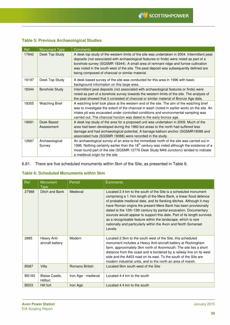
Avon Power Station January 2015
EIA Scoping Report
39
Table 5: Previous Archaeological Studies
Ref Monument Type Comments
17642 Desk Top Study A desk top study of the western limits of the site was undertaken in 2004. Intermittent peat
deposits (not associated with archaeological features or finds) were noted as part of a
borehole survey (SGSMR 18344). A small area of remnant ridge and furrow cultivation
was noted in the south west of the site. The peat deposit was subsequently defined are
being composed of charcoal or similar material.
19197 Desk Top Study A desk based survey of the site was conducted for this area in 1996 with basic
background information on this large area.
18344 Borehole Study Intermittent peat deposits (not associated with archaeological features or finds) were
noted as part of a borehole survey towards the western limits of the site. The analysis of
the peat showed that it consisted of charcoal or similar material of Bronze Age date.
18355 Watching Brief A watching brief took place at the western end of the site. The aim of the watching brief
was to investigate the extent of the charcoal in wash (noted in earlier work) on the site. An
intake pit was excavated under controlled conditions and environmental sampling was
carried out. The charcoal horizon was dated to the early bronze age.
19091 Desk Based
Assessment
A desk top study of the area for a proposed unit was undertaken in 2009. Much of the
area had been developed during the 1960 but areas to the north had suffered less
damage and had archaeological potential. A barrage balloon anchor (SGSMR19088 and
associated huts (SGSMR 19088) were recorded in the study.
12687 Archaeological
Survey
An archaeological survey of an area to the immediate north of the site was carried out in
1996. Nothing certainly earlier than the 18th
century was noted although the existence of a
moat round part of the site (SGSMR 12776 Desk Study M49 Junction)) tended to indicate
a medieval origin for the site
6.81. There are five scheduled monuments within 5km of the Site, as presented in Table 6. Table 6: Scheduled Monuments within 5km
Ref Monument
Type
Period Comments
27988 Ditch and Bank Medieval Located 2.4 km to the south of the Site is a scheduled monument
comprising a 1.1km length of the Mere Bank, a linear flood defence
of probable medieval date, and its flanking ditches. Although it may
have Roman origins the present Mere Bank has been provisionally
dated to the 12th-13th century by partial excavation. Documentary
sources would appear to support this date. Part of its length survives
as a recognisable feature within the landscape, which is rare
nationally and particularly within the Avon and North Somerset
Levels.
2885 Heavy Anti-
aircraft battery
Modern Located 2.5km to the south west of the Site, this scheduled
monument includes a Heavy Anti-aircraft battery at Rockingham
farm, approximately 3km north of Avonmouth. The site lies a short
distance from the coast and is bordered by a railway line on its west
side and the A403 road on its east. To the south of the Site are
modern industrial units, and to the north an area of marsh.
BS87 Villa Romano British Located 5km south west of the Site
BS183 Blaise Castle,
Hillfort
Iron Age - medieval Located 4.4 km to the south
BS53 Hill fort Iron Age Located 4.4 km to the south

Avon Power Station January 2015
EIA Scoping Report
40
6.82. In addition, there are thirteen Grade II listed buildings and one Grade II* listed building within 2km of the Site. A further seventeen Grade II* and three Grade I Listed buildings exist between 2km and 5km from the Site.
Scope of the Assessment
6.83. A desk-based archaeological assessment will determine, as far as is reasonably possible from existing records, the nature of the archaeological resource within a study area of 1km from the DCO site boundary and will be used to identify any impacts that the Proposed Development may have on the receptors.
6.84. An inventory of all identified heritage assets will be cross-referenced to drawings (base maps) and the report narrative. In accordance with the NPPF and national standards and guidelines presented in the following list, the impact of the Proposed Development on the significance of the setting of all identified designated heritage assets within 5km of the Site and connection corridors will also be assessed.
6.85. Due to the scale of the Proposed Development there is potential for the setting of these designated heritage assets and other non-designated assets to be impacted by the Proposed Development; therefore potential setting impacts will be assessed by a built heritage specialist in relation to the scheme Zone of Theoretical Visibility (ZTV) (to be undertaken as part of the landscape and visual impact assessment as discussed in Section 6: Landscape and Visual Impact Assessment of this Scoping Report). The assessment will follow current professional good practice and guidance including that produced by the Institute for Archaeologists (IfA) and English Heritage:
• IfA (2012) - Standard and Guidance for archaeological desk-based assessment [Ref. 75]; and
• IfA (2013) – Code of Conduct [Ref. 76];
• English Heritage (2008) – Conservation Principles: Policies and Guidance for the sustainable Management of the Historic Environment [Ref. 77];
• English Heritage (2011) - The Setting of Heritage Assets [Ref. 78]. It is understood this guidance is currently being updated by EH; the latest version at the time of submitting the ES will be taken into account in the EIA;
• English Heritage (2014) Historic Environment Advice; Note No 3 Good Practice in Planning, The Setting of Heritage Assets, Draft Consultation [Ref. 79] http://www.english-heritage.org.uk/content/imported-docs/f-j/gpa3-setting-consultation.pdf
• English Heritage (2011) - Seeing History in the view [Ref. 80]; and
• English Heritage (2008) Severn Estuary Rapid Coastal Zone Survey [Ref. 81], where applicable.
6.86. Publications consulted will also include:
• DCLG (2006) The Archaeology of the Severn Estuary, Department for Communities and Local Government [Ref. 82];
• SELRC (1990-2010) Archaeology in the Severn Estuary Journal Publications, Severn Estuary Levels Research Committee [Ref. 83]; and
• CBA (2013) The Bronze Age in the Severn Estuary, Council for British Archaeology [Ref. 84].
6.87. The potential for palaeoenvironmental survival on the Site is likely to be high based on previous geotechnical investigations undertaken in the area.
Avon Power Station January 2015
EIA Scoping Report
41
6.88. It is possible that archaeological evaluation will be required should the baseline assessment not provide sufficient information to fully assess the archaeological potential within the Site or study area. If this is the case, evaluation requirements will be discussed and agreed with SGC and BCC as early as possible and the work conducted to inform the ES. Any such geophysical survey or intrusive evaluation data would be used to discuss and agree with SGC and BCC any potential mitigation strategies required for the construction or operation of the Proposed Development that would need to be included as Requirements to the DCO.
6.89. Should any works be undertaken on the outfall into the estuary, a specific evaluation of marine and intertidal heritage assets would be undertaken as part of the EIA; such studies are not proposed if construction works on the outfall are not retained within the DCO.
Traffic and Transport
Baseline Conditions
6.90. The main access to the Site is proposed to be from the A403 via Central Avenue. The A403 is a single lane carriageway that runs from Avonmouth in the south, to a junction with the M48 motorway in the north, located on the east side of the Severn Bridge. In the south, the A403 connects with the A4 Crowley Way which is in close proximity to Junction 18 of the M5 and M49 motorways. The A403 runs southwards from the M48 junction in the north skirting the villages of Pilning and Severn Beach.
6.91. Planning approval has been granted by SGC for a new spine access road that will link the adjacent SITA Energy Recovery Centre (located to the south of the Site) with the A403. The link road will form a new three arm roundabout junction with the A403. The land owner (Severnside Distribution Land Limited (SDLL)) is in the process of extending this new spine access road, under the extant 1957/58 planning permission. A secondary access point to the Site is being considered from the proposed spine access road via an access point along the southern boundary of the Site.
6.92. Based on previous studies in the area, in general, it appears that the current highway network has some spare capacity. However, it is recognised that the future baseline conditions could vary greatly given the amount of committed development in the area. Consultation with SGC and BCC will be undertaken to agree and determine which schemes, together with any further highway infrastructure enhancements, should be included in the future baseline scenario. Information on public rights of way, bridleways and byways will also be included.
Scope of the Assessment
6.93. To address in detail the impacts of the Proposed Development on the transport network, a Transport Assessment (TA) will be produced to support the DCO application. The scope for the TA will follow the guidelines set out in the Department for Transport’s ‘Guidance on Transport Assessment’ (2007) [Ref. 85]. SGC, BCC and the Highways Agency will also be consulted so that the scope of the TA can be agreed. Although the DfT has withdrawn the ‘Guidance on Transport Assessment’ (2007), relevant parts of the guidance will be discussed with the above consultees to inform the assessment.
6.94. During the operational phase of the development, it is anticipated that there will be a work-force of approximately 40-60 people that will be required on a shift basis over a 24 hour period. Staff will travel to and from work in a variety of directions. Fuel will be delivered by pipeline (there is no liquid fuel required), and other operational and maintenance consumables are likely to be minimal. Therefore it is considered that the effects of operational traffic would be negligible and a detailed assessment of the operational phase of the development is not proposed for the ES.

Avon Power Station January 2015
EIA Scoping Report
42
6.95. The principal vehicle movements are anticipated to be associated with the construction phase of the development. A preliminary assessment has been undertaken to establish the level of traffic that is likely to be associated with this phase. The number of construction vehicles associated with the delivery of equipment and the labour force will be estimated based on comparable UK CCGT power station construction projects. It is likely to be around 800 vehicle movements per day during the peak construction period (assuming a single phased development where both CCGT units and supporting infrastructure are constructed in one phase of works); it would be less if the Proposed Development is phased. Additional HGV movements may be required if land raising is needed to be undertaken at the start of the construction phase; these movements would occur at a different time to the peak construction workforce numbers. Based on previous experience and other construction projects in the area, a distribution profile for vehicle movements accessing the Site will be developed for the Proposed Development to establish where trips are likely to originate from. The analysis will be used to understand the impact on the surrounding highway network. The timing of the Proposed Development with other committed schemes in the vicinity will be considered.
6.96. The scope of the TA will cover the following key areas:
• A review of national, regional and local transport policy - including the Joint Local Transport Plan 3 (JLTP3) (issued by the four councils of Bath and North East Somerset, BCC, North Somerset and SGC), Bristol Development Framework Core Strategy (Adopted June 2011), the emerging SGC Core Strategy, the Avonmouth and Severnside Integrated Development, Infrastructure and Flood Risk report, (Feb 2012) and the Avonmouth/ Severnside Outline Development Strategy, (April 2012);
• A description of baseline and future baseline conditions, including consideration of accessibility by all main transport modes and available traffic flow data;
• Calculations of construction and development traffic flows;
• Distribution and assignment of construction traffic flows, including the identification of routes for abnormal loads such as the delivery of generators and transformers;
• Local network impact analysis, with the size of the study area to be confirmed with the local authorities and the HA as will the need to undertake detailed capacity analysis on any key junctions;
• Consideration of the local public rights of way including bridleways and bypasses for commuting, and whether this would be affected by the Proposed Development;
• Cumulative impact assessment – the Severnside/ Avonmouth area is forecast for significant employment growth. The phasing of the Proposed Development in relation to other committed developments and relevant potential future developments (e.g. the proposed M49 junction to the east of the site) will be reviewed and any potential cumulative impacts on transport infrastructure will be assessed;
• A review of highway safety issues including examination of personal injury accident data;
• The formulation of mitigation measures, such as a Travel Plan to promote sustainable journeys during the operational phase of the development and where possible reduce single occupant car journeys; and
• A Construction Traffic Management Plan will be developed to seek to minimise the impact of construction vehicles arriving and departing the Site.
6.97. An initial review of local traffic data held by SGC, BCC and the HA has been undertaken. Additional traffic surveys may need to be undertaken to supplement some of the data held by the local authorities, though this will be determined in liaison with SGC, BCC and the HA. The data will be used to quantify baseline vehicular demand along key routes to and from the Site. The data will also form the basis of calculations to quantify the impact of construction traffic on the surrounding road network.
Avon Power Station January 2015
EIA Scoping Report
43
6.98. The traffic and transport chapter in the ES will summarise the salient points from the Transport Assessment. It will also relate the magnitude and significance of potential impacts to criteria contained in the ‘Guidelines for the Environmental Impact Assessment of Road Traffic’ document, produced by the Institute of Environmental Management & Assessment. A summary of any residual and cumulative impacts will be provided following the use of embedded mitigation, to identify whether additional mitigation is required to fully address the impact of the Proposed Development on the transport network.
Land Use, Recreation and Socio-Economics
Baseline Conditions
6.99. The Proposed Development is located in an existing industrial employment area. The employment uses surrounding the Site include the Avlon and the AstraZeneca pharmaceutical works immediately to the north. The area surrounding the Proposed Development which is outside of the industrial area and between the M49 is mainly agricultural land. There are no residential uses immediately adjacent to the Site. There is a series of Public Rights of Way passing through the area (see Figure 5).
Scope of the Assessment
6.100. For the purposes of the ES, due consideration will be given to the role of the Proposed Development in the generation of direct and indirect employment opportunities at the local and regional level, during the construction, operation and eventual decommissioning phases. A detailed socio-economic assessment will be undertaken to assess the impact of the Proposed Development on the baseline conditions within both the local and wider area. The assessment will also consider the impact of the Proposed Development on land use and recreation on the Site and surrounds.
6.101. The methodology proposed for assessing land use, recreation and socio-economic impacts will follow standard EIA guidance and will involve:
• Review of relevant baseline conditions at the Site and locality;
• Assessment of policy justification for the provision of additional employment space and the contribution of these activities to SGC’s and, where appropriate BCC’s policy objectives;
• Estimate of employment generated during the construction, operational and decommissioning phases;
• Consideration of local and national policy, plans and development constraints;
• Assessment of the impact of the Proposed Development on Public Rights of Way and wider recreational activities in the area;
• Assessment of the impact of the Proposed Development on users of the Severn Estuary;
• Consideration will also be given to whether there are any nuisance or health and safety implications that might affect recreational activities and land use in the immediate surrounds, in particular the status and viability of the Avonmouth Severnside Enterprise Area; and
• Assessment of the likely scale, permanence and significance of impacts.
6.102. The social and economic policy context review will consider relevant policy at various levels including: local (SGC and, where appropriate, BCC), regional (South West) and national (in terms of urban regeneration and neighbourhood renewal). The assessment will be carried out using a number of recognised data sources including, but not limited to the following:
• Office of National Statistics Labour Force and Neighbourhood Statistics;
• Annual Business Inquiry;
• Annual Population Survey;
• Census 2011; and
• Travel to Work Data.

Avon Power Station January 2015
EIA Scoping Report
44
6.103. Wherever possible the impacts of the socio-economic assessment will be appraised against relevant national standards such as those provided by HM Treasury and Homes and Communities Agency (HCA). Where no standards exist, professional experience and judgement will be applied and justified.
6.104. A summary will be provided of key residual impacts of the Proposed Development and how the Proposed Development fits into local and regional planning and development objectives, as well as its overall impact on the contribution to the local economy and community.
Landscape and Visual Impact Assessment
6.105. This section provides information on the likely effects of the Proposed Development upon landscape character and visual amenity of the Site and the surrounding area.
Baseline Conditions
6.106. An initial Site visit and review of planning policy context relevant to landscape character and visual amenity have been undertaken to assess the potential landscape and visual impacts of the Proposed Development to inform this scoping exercise and recommend a study area for the landscape and visual impact assessment. A more detailed assessment will be undertaken as the concept design of the Proposed Development is further developed.
6.107. Within 10km of the Site, there are several historic landscapes either registered in the English Heritage or Cadw Register of Historic Parks and Gardens. To the south and south-east of the Site, within 5km of the Site are Blaise Castle and Hamlet (Grade II*), Royal Victoria Park, formerly Brentry House (Grade II), Kings Weston House (Grade II) and Leigh Court (Grade II). Between 5 and 10km of the Site to the south and south-east are Ashton Court (Grade II*), Tyntesfield (Grade II*), Bristol University Botanic Gardens and Rayne Thatch (Grade II), Stoke Park (Grade II), Goldney House (Grade II*) and Oldbury Court (Grade II). To the north within Wales between 5 and 10km from the Site are St. Pierre Park (Grade II), Mathern Palace (Grade II*), Wyelands (Grade II) and Moynes Court (Grade II). In addition to the north within 10km of the Site is the Wye Valley Area of Outstanding Natural Beauty (AONB).
6.108. The Site is an area of brownfield land located within the coastal belt west of the M49 motorway link and surrounded by industrial development. The nearest residential community is approximately 1.5km north of the Site at Severn Beach. Other settlements within 2.5km of the Site include Pilning, to the northeast, Easter Compton to the east and Hallen to the southeast.
6.109. The Severn Way long distance path runs through Severn Beach and continues south past the Site.
The Forest of Avon Community Forest Path is to the east of the Site along a wooded ridge that contains the River Avon floodplain. The ridge extends from Olveston, approximately 7km to the northeast to Kings Weston approximately 5km to the southeast. Using the stacks of the existing Seabank 1 & 2 Power Stations for reference, it is clear that potential views of the Proposed Development from the east would be unlikely to extend beyond the wooded ridge.
6.110. To the west, the floodplain is contained by the flood wall with the open water of the Severn Estuary stretching beyond towards the South Wales coast. Potential views of the Proposed Development from the west and northwest would be possible from the South Wales coast, approximately 5.2km to the northwest at its closest point. The distance of the views and potential for interruption by low-lying intervening structures such as buildings, vegetation and landform would, however, limit these views resulting in only the upper parts of the Proposed Development being visible amongst the extensive industrial built-up area of Avonmouth.
Avon Power Station January 2015
EIA Scoping Report
45
6.111. To the north, northeast, southwest and southeast the screening effect of vegetation, mounding, buildings and structures would restrict potential views of the Proposed Development across the flat floodplain, although, where the visual receptor is raised above these low lying-elements, potential views would be possible. For example, drivers/ passengers on the Severn Estuary crossings approximately 2.5km and 7.5km to the north respectively, and ramblers at Kings Weston House in Bristol, approximately 5km to the south and at Portishead Pier, approximately 8.5km to the southwest, could potentially experience distant views of the Proposed Development.
Scope of the Assessment
6.112. The method of landscape and visual impact assessment which is proposed has been devised to address the specific impacts likely to result from a development of its scale and nature. The methodology draws upon the following established best practice guidance:
• Guidelines for Landscape and Visual Impact Assessment (Landscape Institute and Institute of Environmental Management and Assessment, 2013) [Ref. 86];
• Landscape Character Assessment: Guidance for England and Scotland (Countryside Agency and Scottish Natural Heritage, 2002) [Ref. 87];
• Landscape Institute Advice Note 01/11: Photography and photomontage in landscape and visual impact assessment (Landscape Institute, 2011) [Ref. 88]; and
• The assessment will also take account of SGC Landscape Character Assessment (SPD) Adopted July 2005 and the Draft Review of the SPD published in 2013.
6.113. The EIA process requires that a clear distinction is drawn between landscape and visual impacts, as
follows:
• Landscape impacts relate to the degree of change to physical characteristics or components of the landscape, which together form the character of that landscape, e.g. landform, vegetation and buildings; and
• Visual impacts relate to the degree of change to an individual receptor’s view of that landscape, e.g. local residents, users of public footpaths or motorists passing through the area.
6.114. The assessment of impacts on built heritage, including impacts on the setting of listed buildings and
structures, will be addressed under the Cultural Heritage and Archaeology section of the EIA, as discussed above.
6.115. A detailed study of the existing landscape components, character and views of the Site and an identified study area will be carried out in consideration of the following:
• Site context;
• Topography;
• Vegetation;
• Roads, Public Rights of Way and access;
• Settlement and land-use;
• Landscape character; and
• Representative views.
6.116. This will be supported by tables, drawings and photographs as appropriate. The planning context with respect to landscape character and visual amenity will also be assessed, taking into account relevant European, national, regional and local planning policies. The baseline study will form the basis of the assessment of the predicted impacts of the Proposed Development.

Avon Power Station January 2015
EIA Scoping Report
46
6.117. It is proposed that ten representative views will be identified within the Zone of Theoretical Visibility (ZTV) for the main building envelope and the potential stack(s). The location of the ten representative views and three photomontages will be agreed in consultation with SGC and, if appropriate, BCC. A ZTV is a graphical representation of places within the study area from where the Proposed Development could potentially be visible and is generated by computer by analysing a model of the Proposed Development and a bare ground Digital Terrain Model (DTM). The resulting ZTV is reviewed with fieldwork against the following criteria in order to determine the selection of representative views which form the basis of the visual assessment:
• Receptor function / activity;
• Distance from the Site;
• Topography and elevation;
• Degree and period of exposure;
• Designation of the viewing place; and
• Distribution of receptors.
6.118. The ES will include full information on the ZTV model used, the area covered, the timing of survey work and the methodology used.
6.119. From the initial site visit and planning policy context review, a 10km radius study area is proposed for the visual impact assessment of the Proposed Development. This would enable any potential distant views from the South Wales coast in the northwest, from Olveston in the northeast and from Portishead in the southwest to be included in the visual impact assessment. In contrast, a smaller study area of 5km radius is proposed for assessing landscape character. Beyond these distances it is anticipated that the Proposed Development is unlikely to give rise to any significant landscape character effects. As the proposed gas, water and electrical connections (other than any electrical connection to the existing overhead line in the immediate vicinity of the Site) would be below ground, landscape and visual impacts in the connection corridors would be restricted to temporary effects during the construction phase only.
6.120. Accurate Visual Representations (photomontages) of the Proposed Development for three of the agreed representative views (visual receptors) will be produced in line with the guidance within the Landscape Institute Advice Note 01/11: Photography and photomontage in landscape and visual impact assessment.
6.121. The assessment will establish the potential effects of the Proposed Development at three points in time:
• During site preparation and construction;
• In the first year after construction; and
• In the fifteenth year after construction.
6.122. A cumulative impact assessment will be undertaken for the Proposed Development considering other committed developments in the vicinity, to an approach agreed with SGC.
6.123. A landscaping approach that enhances or mitigates the Proposed Development will be discussed
within the ES, with the expectation that a landscaping strategy will be prepared to support the DCO application, in liaison with SGC and, if appropriate, BCC, which would be supported by a detailed landscaping scheme to be approved and implemented as a Requirement of the DCO.
Avon Power Station January 2015
EIA Scoping Report
47
Health Impact Assessment
Baseline Conditions
6.124. The Site is within a predominantly industrial area north of Avonmouth and constitutes a relatively flat area of open, uneven grassland. The nearest residential communities are located approximately 1.5km north of the Site in Severn Beach, together with a farm located approximately 500m southeast. The larger communities of Avonmouth and Bristol are located some 5km southwest and 10km southeast of the Site respectively.
6.125. The health of people living in South Gloucestershire is generally better than the average of England as a whole when comparing life expectancy, deprivation, infant mortality and causes of premature mortality such as smoking and obesity [Ref. 89].
Scope of the Assessment
6.126. It is not considered necessary to prepare a separate Human Health Risk Assessment (HHRA) for the Proposed Development because the emissions of trace species such as heavy metals and dioxins will be insignificant. Nevertheless, a separate Health Impact Assessment (HIA) ES chapter will be produced to identify and summarise potential health and wellbeing effects (both adverse and beneficial) of the Proposed Development, the methodology of which will be agreed with relevant consultees. The HIA chapter will provide a summary of information provided within other technical chapters (e.g. air quality, noise) for the purposes of ensuring health related information is in a readily accessible place within the ES for interested parties. For further information see Section 6: Health Impact Assessment.
Sustainability and Climate Change
6.127. National, regional and local policy and guidance promote sustainability principles, particularly with regard to the reuse of land and buildings, air quality and land contamination issues, energy conservation, materials and water usage. The ES will incorporate an assessment of the design against established sustainability criteria to take into account the following:
• Land, materials and natural resource use;
• Energy consumption and energy efficiency;
• Waste minimisation and implementation of the waste hierarchy, including a waste management plan covering the construction and operational phases of the Proposed Development;
• Construction materials specification and usage in relation to CO2 emissions and ozone depletion;
• Provision of natural gas as a fuel;
• Biodiversity; and
• The aims of the SGC Action Plan.
6.128. The carbon emissions/ carbon footprint arising from the combustion of fuel will be calculated and assessed in a standalone Climate Change Impact Report that will be submitted with the DCO application, which will consider the proposed plant efficiency and performance against UK data including the average carbon emissions associated with the current electricity fuel mix in the UK.

Avon Power Station January 2015
EIA Scoping Report
48
CHP Assessment 6.129. Although not formally part of the EIA, it is a requirement for all new power stations to explore and
develop feasible CHP opportunities, as specified in Section 4.6 of NPS EN-1. This is in order to maximise the use of waste heat and in turn the thermal efficiency of the proposed combustion plant. In particular, the Proposed Development will be designed to be CHP Ready in accordance with the Environment Agency CHP Ready Guidance for Combustion and Energy from Waste Power Plants, February 2013 [Ref. 90] and NPS EN-1 and EN-2.
6.130. The CHP feasibility study to be undertaken as part of the DCO application will involve identifying and contacting potential CHP users within 15 km of the Site in accordance with the Environment Agency Guidance. This will initially be based on examining published Heat Mapping for the area and engaging with SGC. Should any potential uses be identified, a more detailed heat map of the local area would be produced incorporating community, commercial and industrial heat uses and opportunities. Within this heat map the identified users would then be classified into user sectors. Opportunities are likely to consider industrial, residential and housing opportunities as well as hotels, leisure centres, large corporate buildings, hospitals, universities, prisons, defence installations and accommodation complexes.
6.131. The CHP feasibility assessment will review the proposed CCGT against each of the three BAT tests within the CHP Ready guidance to assess potential viability and demonstrate compliance with the tests. Heat availability from the Proposed Development will be estimated, considering its potential nature (as steam or hot water) and the frequency of its availability (based on the expected running hours of the plant) and evaluated against the identified potential CHP users to assess the viability of CHP provision from the Proposed Development. Notwithstanding any findings of the assessment, the Proposed Development will be constructed as CHP Ready.
CCR Assessment
6.132. As outlined in Section 3: Carbon Capture Readiness (CCR), a standalone CCR assessment will be prepared and submitted with the DCO application to demonstrate that the Proposed Development is Carbon Capture Ready and that the potential future installation of carbon capture equipment, together with the potential transport and storage of the captured carbon is potentially feasible, should CCS technology become commercially deployable for power generation facilities in the future. The CCR assessment will demonstrate that adequate space is available on the Site for the future use of carbon capture equipment and that a theoretical route to an appropriate geological storage facility is possible. As CCS technology is not being deployed at the current time, the DCO for the Proposed Development will not include any provisions for CCS, which would be consented under a separate consent in the future if required.
Avon Power Station January 2015
EIA Scoping Report
49
7 Non-Significant EIA Issues 7.1. The aim of the Scoping Stage is to focus the EIA on those environmental aspects that may be
significantly affected by the Proposed Development. In so doing, the significance of potential impacts associated with the Proposed Development becomes more clearly defined, resulting in certain aspects being considered ‘non-significant’. This section provides a summary of those issues, which have been considered during the preparation of this Scoping Report, but are not considered likely to be significant for the Proposed Development and it is therefore proposed will not be considered in detail in the ES.
Waste
7.2. There will be relatively little waste produced from the operation of the Proposed Development. It is not intended to remove significant quantities of material from Site during construction (there are no demolition works for example) and there is relatively little waste generated from the operation of gas-fired CCGT power stations, except for general waste associated with office/administrative activities. There may however be a need to remove some soils from the Site for treatment or disposal, if found to be contaminated and it is not practical to treat this onsite.
7.3. A description of the potential construction phase waste streams and estimated volumes will be provided within the Construction chapter of the ES, along with a description of the requirements under the Site Waste Management Plans (SWMP) Regulations (2008). In addition to this, the CEMP, which would be produced following receipt of a DCO, will set out how waste will be managed on Site, and opportunities to recycle waste will be explored.
7.4. For the operational phase, an analysis of the main waste streams will be provided. A Waste Management Strategy will be produced in accordance with the current local standards and policies.
7.5. Taking the above into account, it is considered that the production of a separate waste chapter of the ES is not required for the Proposed Development.
Electronic Interference
7.6. A screening assessment will be undertaken to determine the existing effect of the current buildings onsite, the likely extent and massing of buildings associated with the Proposed Development and the location of television transmission antennae in the area. Based on the level of building massing, the fact that the nearest residential dwellings are 1.5km north of the Site, and a farm 500m to the southeast, and the location of transmission antennae, it is not envisaged at this stage that a full assessment of electronic interference will be required.
Aviation
7.7. The Civil Aviation Association (CAA) has a general interest in charting all known structures of 91.4 m (300 feet) or more above ground level. The Avon Power Station stacks are not expected to exceed this height, and other nearby industrial developments such as the SITA Severnside Energy Recovery Centre (currently under-construction), have stacks at a height of 80m and above.

Avon Power Station January 2015
EIA Scoping Report
50
7.8. The proposed buildings, likely stack heights, temporary structures (e.g. cranes used during construction) and the Site’s location are considered very unlikely to warrant the inclusion of an assessment of the potential impacts of the Proposed Development on the operating procedures at the nearest airfield. Bristol Filton Airport (located 4km east of the Site) is now closed, with minor use from the emergency services, and Bristol International Airport is located over 15km south of the Site. Further to this, it is confirmed that the Power Station is not intended to vent or flare gas either routinely or as an emergency procedure. It is therefore proposed that aviation is scoped out of the EIA. However, individual parties (CAA, MOD, Bristol Filton Airport and Bristol International Airport) will be included in statutory and non-statutory consultation exercises and should the proposed stack heights or cranes exceed 91m, this decision to scope out aviation effects will be re-evaluated. The need for aviation lighting will also be considered during this consultation process.
Accidental Events
7.9. The description of the Proposed Development in the ES will be written to provide sufficient information to allow the key environmental issues identified to be adequately assessed. Accidental events such as the potential for fuel spillages and abnormal air emissions, and how the risk of these events will be minimised, will be discussed in the relevant chapter of the ES.
7.10. Accidental events will predominantly be defined and considered as part of the Environmental Permit required from the EA for the operation of the power station. The application for the permit – which will be made separately to the DCO application but within similar time-scales - will include reference to the Applicant’s overarching principles of emergency management as well as specific emergency response plans and procedures.
Avon Power Station January 2015
EIA Scoping Report
51
8 Environmental Impact Assessment Process
EIA Methodology and Reporting
8.1. The ES will set out the process followed during the EIA including the methods used for the collection of data and for the identification and assessment of impacts. Any assumptions made will be clearly identified. It is proposed that a largely complete draft ES will be used as a Preliminary Environmental Information Report (PEIR) for the Proposed Development which will be published for review by statutory and non-statutory consultees around the second stage of consultation (under Section 47 of the Planning Act) of the DCO application. Consultation responses will be taken into account in the finalisation of the ES that will accompany the DCO application submission.
8.2. The EIA process is designed to be capable of, and sensitive to, changes that occur as a result of changes to the design of the development, including any embedded mitigation measures that are incorporated during the EIA. This will be particularly important for this scheme as the design and layout of the power station is still being refined, and minor changes are likely to be made following submission of this EIA Scoping Report.
8.3. Impacts will be considered on the basis of their magnitude, duration and reversibility. Cumulative and combined effects will also be considered where appropriate. Significance will be evaluated on the basis of the scale of the impact and the importance or sensitivity of the receptors, in accordance with standard assessment methodologies (major, moderate, minor and negligible). Generally, effects that are of moderate or major significance are considered to be likely significant effects for the purposes of the EIA Regulations.
8.4. Where potentially significant environmental effects are identified in the assessment process, measures to mitigate these effects will be proposed in the form of draft Requirements that will be submitted as part of the draft DCO for the Proposed Development. Any such Requirements will be discussed and agreed with relevant stakeholders.
Structure of the Environmental Statement (and PEI Report)
8.5. The ES is based on a number of related activities, as follows:
• Establishing existing baseline conditions;
• Consultation with statutory and non-statutory consultees throughout the EIA process;
• Consideration of relevant local, regional and national planning policies, guidelines and legislation relevant to EIA;
• Consideration of technical standards for the development of significance criteria;
• Review of secondary information, previous environmental studies and publicly-available information and databases;
• Physical surveys and monitoring;
• Desk-top studies;
• Computer modelling;
• Reference to current legislation and guidance; and
• Expert opinion.
8.6. The ES will include a section that will describe the site and its surroundings in detail, including the identification of land that could be directly or indirectly affected by the Proposed Development and any associated facilities, landscaping areas and potential off-site mitigation or compensation.
Avon Power Station January 2015
EIA Scoping Report
52
8.7. The ES will include a description of all aspects of the Proposed Development at construction, operation and decommissioning stages which will include a description of the land use requirements, site preparation, construction processes and methods and transport routes.
8.8. The ES will address the direct effects of the Proposed Development in addition to the likely indirect, cumulative, short, medium and long term, permanent, temporary, beneficial and adverse effects. The mitigation measures envisaged in order to avoid, reduce or remedy significant adverse effects will also be described. The concluding chapters will provide a summary of the cumulative and residual impacts and the mitigation measures proposed.
8.9. The ES will comprise the following set of documents:
• Non-Technical Summary (NTS): this document will provide a summary of the key issues and findings of the EIA in non-technical language.
• Volume I: Environmental Statement: this will contain information prepared on behalf of the Applicant on the likely environmental effects of the Proposed Development with the proposed chapter headings as follows:
1. Introduction; 2. Assessment Methodology; 3. Description of the Site; 4. The Proposed Development; 5. Construction Works; 6. Design Evolution and Alternatives Assessment; 7. Planning Policy Context; 8. Air Quality; 9. Noise and Vibration; 10. Ecology and Habitats; 11. Flood Risk, Hydrology and Water Resources; 12. Geology, Hydrogeology and Land Contamination; 13. Archaeology and Cultural Heritage; 14. Traffic and Transportation; 15. Landuse, Recreation and Socio-economics; 16. Landscape and Visual Effects; 17. Sustainability and Climate Change; 18. Health Impact Assessment; 19. Cumulative Impacts; 20. Residual Impacts.
• Volume II: Figures
• Volume III: Technical Appendices: these will provide the supplementary environmental studies conducted during the EIA including relevant data tables, figures and photographs. This will include the CHP Assessment, FRA and CCR feasibility study.
Structure of Technical Chapters
8.10. Chapters 8-18 will be structured based on the following sub-headings:
Introduction
8.11. This section will describe the format of the assessment presented within the chapter and identify the author.

Avon Power Station January 2015
EIA Scoping Report
53
Legislation and Planning Policy Context
8.12. This section of the technical chapters will provide an overview of the chapter-relevant legislation and planning policy applicable to the assessment, recognising that a summary and review of overarching legislation and policy will be presented in Chapter 7 of the ES.
Assessment Methodology and Significance Criteria
8.13. The methods used in undertaking the technical study will be outlined in this section with references to published standards (e.g. British Standards, Building Research Establishment), guidelines (e.g. Design Manual for Roads and Bridges and Institute of Environmental Management & Assessment guidelines) and relevant significance criteria.
8.14. The significance of residual effects will be evaluated with reference to definitive standards, accepted criteria and legislation where available. Where it is not possible to quantify impacts, qualitative assessments will be carried out, based on available knowledge and professional judgment. Where uncertainty exists, this will be noted in the relevant technical assessment chapter.
8.15. The specific criteria for each technical assessment will be set out, giving due regard to the following:
• Extent and magnitude of the impact;
• Impact duration (whether short, medium or long term);
• Impact nature (whether direct or indirect, reversible or irreversible);
• Whether the impact occurs in isolation, is cumulative or interactive;
• Performance against environmental quality standards;
• Sensitivity of the receptor; and
• Compatibility with environmental policies and standards.
8.16. For issues where definitive quality standards do not exist, significance will be based on the:
• Local, district, regional or national scale or value of the resource affected;
• Number of receptors affected;
• Sensitivity of these receptors;
• Duration of the effect; and
• Professional judgement.
8.17. In order to provide a consistent approach to expressing the outcomes of the various studies undertaken as part of the EIA, and thereby enable comparison between effects upon different environmental components, the following terminology will be used in the ES to define residual effects:
• Adverse - Detrimental or negative effects to an environmental resource or receptor; and
• Beneficial - Advantageous or positive effects to an environmental resource or receptor.
8.18. Where adverse or beneficial effects are identified, these will be assessed against the following scale:
• Negligible - Imperceptible effects to an environmental resource or receptor;
• Minor - Slight, very short or highly localised effects of no significant consequence;
• Moderate - More than a slight, very short or localised effects (by extent, duration or magnitude) which may be considered significant; and
• Major - Considerable effects (by extent, duration or magnitude) of more than local significance or in breach of recognised acceptability, legislation, policy or standards.

Avon Power Station January 2015
EIA Scoping Report
54
8.19. For the purpose of this EIA, moderate and major effects will be deemed ‘significant’.
8.20. Each of the technical chapters will provide the criteria, including sources and justifications, for quantifying the different levels of residual effect. Where possible, these will be based upon quantitative and accepted criteria (for example, the National Air Quality Strategy objectives or noise assessment guidelines), together with the use of value judgement and expert interpretation to establish to what extent an impact is environmentally significant.
Baseline Conditions
8.21. In order to assess the potential impacts of the Proposed Development, it is necessary to determine the environmental conditions that currently exist onsite and in the surrounding area. These are known as ‘baseline conditions’. Baseline conditions will be determined using the results of onsite surveys and investigations or desk based data searches, or a combination of these, as appropriate.
8.22. The future baseline conditions will also consider the consented new spine access road linking the adjacent proposed SITA Energy Recovery Centre with the A403 (via a new roundabout to be constructed on the A403). It is anticipated that this will be built prior to Avon Power Station potentially allowing access directly from this road into the Site from the south. It should be noted that Avon Power Station is not reliant on this spine road however, and access can be achieved from the A403 via Central Avenue to the north of the Site.
Potential Impacts and Mitigation Measures
8.23. This section will identify the potential impacts resulting from the Proposed Development. This section will also describe the mitigation measures (including any embedded mitigation) that the Applicant will implement to reduce adverse effects and enhance beneficial effects during the construction and operational phases of the Proposed Development.
Residual Effects and Conclusions
8.24. Effects of the Proposed Development remaining following the implementation of available mitigation measures are known as ‘residual effects’. These will be discussed for each of the residual effects, and their significance level identified within the ES.
Cumulative Impact Assessment
8.25. In accordance with the EIA Regulations, consideration will be given to the potential for ‘cumulative effects’ to arise. These are effects that result from incremental changes caused by other reasonably foreseeable developments.
8.26. For the cumulative impact assessment, two types of effect will be considered:
• The combined effects of several development schemes which may, on an individual basis be insignificant but, cumulatively, have a likely significant effect; and
• The combined effect of individual impacts on a single receptor.
8.27. Cumulative effects are those that accrue over time and space from a number of development activities. The impact of the Proposed Development will be considered in conjunction with the potential impacts from other projects or activities which are both reasonably foreseeable in terms of delivery (e.g. have planning consent) and are located within a realistic geographical scope where environmental impacts could act together to create a more significant overall effect.

Avon Power Station January 2015
EIA Scoping Report
55
8.28. Based on an initial search of the planning register, Figure 8 presents the known cumulative developments within the vicinity of the Site where the application has been submitted or beyond, or which has been specifically requested for consideration by a key stakeholder. These are described below:
1. Seabank 3 CCGT (SSE Seabank Land Investments Ltd): DCO Application. A proposed 1,400 MW CCGT power station on a 19ha site in Severnside, to the immediate south of the Site. The proposed scheme has been through EIA scoping, and two stages of public consultation and the DCO application is understood to be in the process of being finalised for submission to PINS.
2. Severnside Energy Recovery Centre (SITA) – PT09/5982/FMW: Granted. Development of an Energy Recovery Centre (called SERC). The application was granted on appeal in 2011. Construction works have begun.
3. Bottom Ash Facility (SITA) – APP/P0119/A/10/2140199: Granted. Bottom Ash Facility and associated Railhead which will serve the consented Severnside Energy Recovery Centre (SERC).
4. Spine Access Road (Severnside Distribution Land Ltd) – PT12/1207/MW: Granted. A road linking the adjacent SERC facility with the A403 (via a new 3-arm roundabout to be constructed on the A403). Permission was granted by SGC for the access road under reference PT09/5982/FMW, and a further application was granted planning permission for the re-alignment of the original planned and approved road under reference. Severnside Distribution Land Ltd intends to extend this new Spine Access Road, under the extant 1957/58 consent (which is discussed further in bullet point 16), along part of the southern perimeter of the Proposed Site. Construction works started in winter 2013/14.
5. Anaerobic Digestion Facility (New Earth Solution) – PT12/1015/MW: Granted. Consent was granted for change of use of agricultural land to anaerobic digestion facility including weighbridges, reception building, biofilter, digestion and storage tanks and associated plant and infrastructure.
6. Resource Recovery Centre (VIRIDOR) – 09/04470/F: Granted. Consent was granted for the construction and operation of a Resource Recovery Centre including a materials recycling facility, associated office, visitor centre and energy from waste and bottom ash facility, with new access road and weighbridge facilities, associated landscaping and surface water attenuation features.
7. Deep-sea Container Terminal (Bristol Port Company) - 08/03387/K: Granted. Consent was granted for the construction of a deep-sea container terminal on the site of a former oil terminal at Avonmouth to accommodate the existing large container ships and future generations of Ultra Large Container Ships (ULCS).
8. Biomass Plant (Helius Energy) – 09/00506/K: Deemed Planning Permission Granted. Consent was granted for a biomass fuel store and biomass fired electricity generating plant, capable of generating approximately 100MW of electricity.
9. Bristol Resource Recovery Centre (Cyclamax) Plot M2, Merebank Estate, Kingsweston Lane - 11/01773/F: Granted. Proposed Bristol Resource Recovery Centre to consist of: a 100,000 tonnes per annum batch oxidation gasification facility; a 80,000 tonnes per annum materials recycling facility to process source segregated recyclable materials; an end of life plastics to fuel conversion facility; a vehicle depot for waste collection vehicles; and a temporary refuse derived fuel production facility to be located within the proposed gasification building.
10. W4B, Former Columbian Chemicals (Sevalco), Severn Road - 09/03235/F: Granted on appeal. Redevelopment of part of existing industrial site for a Bio-fuel energy plant together with ancillary access roads, parking facilities and landscaping.
11. Unit and Service Centre (Asda), Former Rhodia Works, St. Andrews Road - 12/03149/F: Granted. Redevelopment of the former Rhodia chemical works to provide a chilled distribution unit (Use Class B8) and an ancillary service centre (Use Class B2).
12. Rockingham Park (Terramond Ltd), – 11/05157/P: Granted. Outline planning application for industrial redevelopment, comprising B1(b), B1(c) and B8 uses.

Avon Power Station January 2015
EIA Scoping Report
56
13. Biomass Renewable Energy Plant (E.ON), Portbury Docks – 09/00506/K: Granted. An application to build a biomass-fired renewable energy plant as a means of increasing electricity generation derived from non-fossil fuels. The proposed plant would be located at the Royal Portbury Dock, within the Port of Bristol and would be developed on a plot of land approximately 5ha in size, leased to E.ON by The Bristol Port Company.
14. Carbon 8 (Carbon 8 Aggregates Ltd), Hallen - 14/2938/F: Pending Consideration. An application for the proposed demolition of existing buildings and erection of aggregates production facility on an existing industrial yard located on Central Avenue, Hallen. The site is approximately 1.5ha.
15. Hinkley Point C Connection (National Grid) – DCO Application, Pending Determination. A new 400kV connection between Bridgwater, Somerset and Seabank Substation, north of Avonmouth. It is proposed to extend the existing Seabank electricity substation compound and substation building to accommodate additional electrical plant and equipment. It includes an OHL across the River Avon to the west of the existing 132kV OHL and then follows the edge of Avonmouth village (travelling through the Avonmouth Docks complex) before heading through the centre of the industrial area and connecting into Seabank substation.
16. The 1957 Consent – SG 4244: Granted. Planning permission was granted on 27 November 1957 for a variety of uses on approximately 1,060ha of land, with an additional 10ha added by a 1958 consent, which remains extant for future development. Approximately 405ha is approved for industrial use – for the construction and operation of factories for the production of chemical and allied products (including non-ferrous metals) and for the development of offices, warehouses, canteens, clubs, hostels, training establishments, sports pavilions and playing fields etc. This includes the Proposed Development Site (but not all the land contained within the wider DCO site boundary). A peripheral 220ha, mainly in the eastern portion of the consented area, allows for the development of offices, warehouses, canteens, clubs, hostels, training establishments, sports pavilions and playing fields etc. A further 445ha of land extending from the coastline into the Severn Estuary was originally approved for the construction and operation of any buildings structures or engineering works expedient to the construction and operation of the factories, though this was later rescinded through a Section 106 agreement with ICI accompanying the granting of planning permission for the development of the first phase of the Western Approaches Business Park (P94/400/8). This agreement included the setting aside of 38ha of land for ecology enhancements and the creation of a number of green corridors within the 1957-58 consented land. Developments being built under this extant planning permission include, but are not limited to, the following: – Spine Access Road. Severnside Distribution Land Ltd intends to extend the new spine
access road mentioned in point 4 above around the southern perimeter of the Proposed Site. Enabling work has begun on this project.
– Diversion of the Red Rhine. Severnside Distribution Land Ltd also intends to create a new drainage channel or rhine along the southern boundary of the Proposed Site under this extant consent and with permission from the Lower Severn Internal Drainage Board. The creation of this new channel commenced in winter 2013/14.
– Central Park. A 240ha (600 acre) warehouse and distribution park development, which is strategically located within the region and designed to be the South West’s largest distribution park, capable of accommodating units of over 850,000 square foot (sq ft). The land for Central Park is currently being raised to protect against flood risk.
8.29. Information on other developments that have the potential for cumulative effects with the Proposed Development will be identified in consultation with the local planning authorities.
8.30. In particular, it is recognised that it will be important to consider the potential cumulative effects of the proposed Seabank 3 Power Station and Hinkley C Connection Project, as the construction phases of these and the Proposed Development may overlap and similar transport routes may be considered for each scheme.
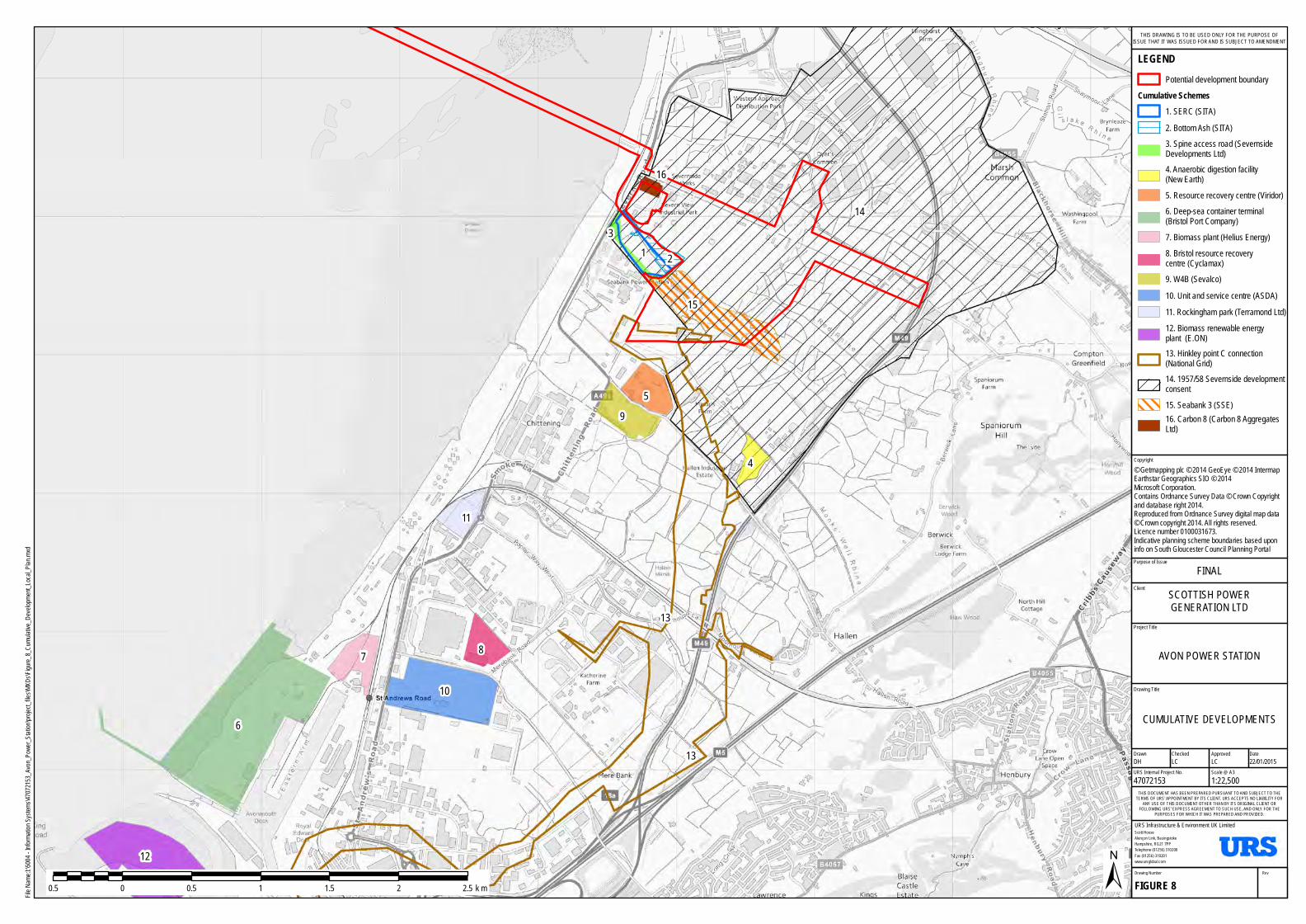
12
6
7
10
8
11
4
95
13
2
13
13
15
16
14
Purpose of Issue
Project Title
Drawing Title
Drawn Checked
Scott HouseAlençon Link, BasingstokeHampshire, RG21 7PPTelephone (01256) 310200Fax (01256) 310201www.ursglobal.com
URS Infrastructure & Environment UK Limited
DateApproved
RevDrawing Number
FIGURE 8
THIS DOCUMENT HAS BEEN PREPARED PURSUANT TO AND SUBJECT TO THETERMS OF URS' APPOINTMENT BY ITS CLIENT. URS ACCEPTS NO LIABILITY FOR
ANY USE OF THIS DOCUMENT OTHER THAN BY ITS ORIGINAL CLIENT ORFOLLOWING URS' EXPRESS AGREEMENT TO SUCH USE, AND ONLY FOR THE
PURPOSES FOR WHICH IT WAS PREPARED AND PROVIDED.
URS Internal Project No. Scale @ A347072153 1:22,500DH LC LC 22/01/2015
Client
File Na
me:I:\5
004 - In
formatio
n Syst
ems\4
707215
3_Avon
_Pow
er_Sta
tion\pro
ject_fi
les\MX
Ds\Fig
ure_8_
Cumu
lative_
Devel
opment
_Local
_Plan
.mxd
0.5 0 0.5 1 1.5 2 2.5 k m
LEGENDPotential development boundary
Cumulative Schemes1. SERC (SITA)2. Bottom Ash (SITA)3. Spine access road (Severnside Developments Ltd)4. Anaerobic digestion facility (New Earth)5. Resource recovery centre (Viridor)6. Deep-sea container terminal (Bristol Port Company)7. Biomass plant (Helius Energy)8. Bristol resource recovery centre (Cyclamax)9. W4B (Sevalco)10. Unit and service centre (ASDA)11. Rockingham park (Terramond Ltd)12. Biomass renewable energy plant (E.ON)13. Hinkley point C connection (National Grid)14. 1957/58 Severnside development consent15. Seabank 3 (SSE)16. Carbon 8 (Carbon 8 Aggregates Ltd)
CUMULATIVE DEVELOPMENTS
AVON POWER STATION
FINALSCOTTISH POWERGENERATION LTD
THIS DRAWING IS TO BE USED ONLY FOR THE PURPOSE OFISSUE THAT IT WAS ISSUED FOR AND IS SUBJECT TO AMENDMENT
Copyright© Getmapping plc © 2014 GeoEye © 2014 IntermapEarthstar Geographics SIO © 2014 Microsoft Corporation.Contains Ordnance Survey Data © Crown Copyrightand database right 2014.Reproduced from Ordnance Survey digital map data© Crown copyright 2014. All rights reserved.Licence number 0100031673.Indicative planning scheme boundaries based uponinfo on South Gloucester Council Planning Portal

Avon Power Station January 2015
EIA Scoping Report
57
8.31. The impact of the Proposed Development on the Avonmouth Severnside Enterprise Area will be considered within the technical assessments, where relevant. It is not considered appropriate however to treat this enterprise area as a cumulative development itself, that has the potential to give rise to environmental effects. The list of cumulative developments will evolve during the EIA process and, should the enterprise area lead to planning permission being sought or granted for specific projects, these would be considered as part of the cumulative impact assessment.
8.32. The combination of predicted environmental impacts resulting from a single development on any one receptor that may collectively cause a greater effect, are referred to as combined effects. Potential combined effects that will be considered include the combined effects of noise and air quality/ dust impacts during construction on local residents.
Scoping and Consultation
8.33. The process of consultation is critical to the development of a comprehensive and balanced ES. The views of statutory and non-statutory consultees serve to focus the environmental studies and to identify specific issues that require further investigation. Consultation is an ongoing process, which enables mitigation measures to be incorporated into the project design thereby limiting adverse effects and enhancing environmental benefits.
8.34. Statutory consultees will be formally requested for their views and consideration of this Scoping Report by the Planning Inspectorate. In addition, in accordance with Section 47(6) of the Planning Act 2008 (as amended), for a nationally significant infrastructure project (NSIP) such as Avon Power Station, the Applicant has prepared a Statement of Community Consultation (SOCC) for publication in 2014. This outlines how the Applicant intends to consult with the local community about the Proposed Development. The Applicant is required to consult the relevant local authorities on the draft SOCC and they will have a period of at least 28 days following receipt of the request to comment on a draft SOCC prior to its publication for inspection by the public.
8.35. At this stage, a two stage approach to public consultation is planned, as follows:
• A first round of public exhibition events to be held in January 2015 to introduce the proposals and present an initial design and the options currently under consideration for the Proposed Development;
• A second round of public exhibition events to be held in Quarter 2 2015, which would be when the submission of the Preliminary Environmental Information (PEI), required by the Infrastructure and Planning (Environmental Impact Assessment Regulations) 2009 and the Planning Act 2008 is expected to be available. As discussed above in Section 8: EIA Methodology, the PEI will comprise an early draft of the ES, to allow consultees to develop an informed view of the Proposed Development, but potentially without the completion of certain surveys and assessments at that time. A ‘chosen’ design will be presented based on a consideration of BAT and feedback from the first round of events and ongoing dialogue with statutory consultees. Members of the public will be given an opportunity to comment on the chosen technology and design before proposals are ‘fixed’ for the DCO application and the ES is finalised.
8.36. In accordance with Section 42 of the Planning Act, a number of stakeholder meetings have already taken place or are due to take place imminently to provide an introduction to the proposals, with the following statutory consultees:
• The Planning Inspectorate (PINS);
• SGC Planning Department;
• BCC Planning Department;
• The Environment Agency;
• Natural England; and

Avon Power Station January 2015
EIA Scoping Report
58
• The Highways Agency.
8.37. A project website is already available for Avon Power Station (www.avonpowerstation.com) to provide up-to-date information on the project and copies of any information made available at the proposed public exhibition events.
8.38. All responses received during consultation will be carefully considered and taken into account in the development of the project in accordance with Section 49 of the Planning Act 2008. Details of any responses received during consultation and the account taken of those responses will be included in a Consultation Report. This Consultation Report will be submitted with the application for a DCO to PINS and will therefore be available for public review.
8.39. The Consultation Report under Section 37 of the Planning Act will demonstrate how the Applicant has complied with the consultation requirements of the Planning Act 2008 and will be considered by PINS, both when determining whether to accept the application, and then in examining the application.
Avon Power Station January 2015
EIA Scoping Report
59
9 Conclusions 9.1. This Scoping Report requests the Scoping Opinion of the Planning Inspectorate pursuant to
Regulation 8 of the Infrastructure Planning (Environmental Impact Assessment Regulations 2009). It has outlined what is considered by the Applicant to be a comprehensive scope of work proposed for the EIA based on previous experience of the assembled team of specialists and existing baseline studies of the Site. The Planning Inspectorate and other identified statutory consultees are invited to consider the contents of this Report and comment accordingly within the statutory 42 day time period.

Avon Power Station January 2015
EIA Scoping Report
60
10 References Ref. 1 HMSO (2012), The Infrastructure Planning (Environmental Impact Assessment) Regulations
2009 (as amended), Her Majesty's Stationery Office
Ref. 2 HMSO (2009), Infrastructure Planning (Applications: Prescribed Forms and Procedure) Regulations 2009 (‘APFP Regulations’)
Ref. 3 HMSO (2008), The Planning Act
Ref. 4 Planning Inspectorate (2012), Screening and Scoping under the EIA Regulations. Advice note seven: Environmental Impact Assessment: screening and scoping
Ref. 5 HMSO (2008), Energy Act
Ref. 6 DECC (2011), Overarching National Policy Statement (NPS) for Energy: EN-1, Department of Energy and Climate Change
Ref. 7 DECC (2011), National Policy Statement (NPS) for Fossil Fuel Generating Infrastructure: EN-2, Department of Energy and Climate Change
Ref. 8 European Commission (2010), Industrial Emissions Directive 2010/75/EU
Ref. 9 Large Combustion Plant Directive (2001/80/EC)
Ref. 10 DECC (2014) EMR Draft Gas Delivery Plan
Ref. 11 Pinsent Masons (2009) Report Prepared for ScottishPower Generation Limited relating to the Purchase of Land and Buildings on the South Side of Central Avenue, Severnside, Avonmouth
Ref. 12 Envirocheck Report (2009), Severnside Site
Ref. 13 Mott McDonald (2011), Preliminary Environmental Information Report (PEIR)
Ref. 14 Arup (2009), Phase I Environmental Desk Study Report, TerraNitrogen
Ref. 15 Hyder (2009), Flood Risk and Drainage Assessment (Vol 1 – FRA), Severnside Works
Ref. 16 Hyder (2009), Flood Risk and Drainage Study (Vol 2 – Surface Water Drainage Strategy), Severnside Works
Ref. 17 Mott McDonald (2011), Phase II Protected Species Report
Ref. 18 Mott McDonald (2014), Preliminary Environmental Assessment and Species Survey
Ref. 19 Environ (2006), Ecological Report and Extended Phase I Habitat Survey – Land at Severnside
Ref. 20 Environ (2007), Ecological Report – Phase II Badger Survey – Land at Severnside
Ref. 21 Environ (2010), Great Crested Newt Survey Report – Land at Severnside
Ref. 22 Environ (2010), Reptile Survey – Land at Severnside
Ref. 23 Environ (2010), Dormouse Survey – Land at Severnside
Ref. 24 Environ (2010), Bat Survey – Land at Severnside
Ref. 25 Environ (2010), Water Vole Survey Report – Land at Severnside
Ref. 26 Environ (2010), Breeding Bird Survey – Land at Severnside
Ref. 27 Environ (2010), Wintering Bird Survey – Land at Severnside

Avon Power Station January 2015
EIA Scoping Report
61
Ref. 28 Severnside Works (2000), Soil and Groundwater Summary Report for Severnside Works – Various Sources
Ref. 29 Arup (2009), Phase II Site Investigation
Ref. 30 The Carbon Capture Readiness (Electricity Generating Stations) Regulations 2013
Ref. 31 DECC (2009), Carbon Capture Readiness (CCR), A guidance note for Section 36 Electricity Act 1989 consent applications, Department of Energy and Climate Change
Ref. 32 DECC (2011), Overarching National Policy Statement (NPS) for Gas Supply Infrastructure and Gas and Oil Pipelines: EN-4
Ref. 33 DECC (2011), Overarching National Policy Statement (NPS) National Policy Statement (NPS) for Electricity Networks Infrastructure: EN-5
Ref. 34 SGC (2012), Core Strategy Ref. 35 SGC (2006), Local Plan, South Gloucestershire Council
Ref. 36 WEP (2011), West of England Joint Waste Core Strategy, West of England Partnership
Ref. 37 SGC (2002), SGC Minerals and Waste Local Plan
Ref. 38 SWRDA (2001), Regional Planning Guidance Note 10 for the South West (revoked)
Ref. 39 Bristol City Council (BCC) (2011), BCC Core Strategy
Ref. 40 Bristol City Council (BCC) (1997), BCC Local Plan
Ref. 41 West of England Partnership Joint Waste Core Strategy, March 2011
Ref. 42 Regional Planning Guidance Note 10 for the South West, September 2001 (revoked)
Ref. 43 HMSO (2011), Localism Act
Ref. 44 SGC (2005), SGC Planning Guidance: Biodiversity in the Planning Process
Ref. 45 SGC (2002), SGC Design Guide: Sustainable Drainage Systems
Ref. 46 SGC (2005), SGC Planning Guidance: Trees on Development Sites
Ref. 47 SGC (2002), SGC Design Guide: Waste Audits (SPG)
Ref. 48 SGC (2005), Landscape Character Assessment (SPD)
Ref. 49 BCC (2010) Waste and Recycling: Collection and Storage Facilities - Guidance for developers, owners and occupiers
Ref. 50 BCC (2005) Supplementary Planning Document 1: Tall Buildings
Ref. 51 BCC (2006) Supplementary Planning Document 5: Sustainable Building Design and Construction
Ref. 52 BCC (2006) Supplementary Planning Document 7: Archaeology and Development
Ref. 53 BCC (1993) BCC Local Plan Policy Advice Note 2: Conservation Area Enhancement Statements
Ref. 54 BCC (1997) BCC Local Plan Policy Advice Note 14: Safety and Security
Ref. 55 BCC (1998) BCC Local Plan Policy Advice Note 15: Responding to Local Character
Ref. 56 Department for Communities and Local Government, (2012), ‘National Planning Policy Framework’, The National Archives

Avon Power Station January 2015
EIA Scoping Report
62
Ref. 57 Department for Communities and Local Government, (2009), Planning Policy Statement 25 Development and Flood Risk Practice Guide
Ref. 58 Department for Environment Food and Rural Affairs, UK AIR: Air Information Resource (online) Available at: http://uk-air.defra.gov.uk/
Ref. 59 Air Pollution Information System (APIS) (online) Available at: http://www.apis.ac.uk/habitat_table.html
Ref. 60 Environment Agency (EA) (2011), H1 Guidance: Annex F
Ref. 61 AQTAG06 (2014), Technical guidance on detailed modelling approach for an appropriate assessment for emissions to air
Ref. 62 IAQM (2011), Guidance on the Assessment of the Impacts of Construction on Air Quality and the Determination of their Significance
Ref. 63 British Standard 5228:1 (2009), Code of practice for noise and vibration control on open sites - Noise
Ref. 64 British Standard 5228:2 (2009), Code of practice for noise and vibration control on open sites - Vibration
Ref. 65 ISO 9613-2 (1996), Attenuation of sound during propagation outdoors. Part 2: General method of calculation
Ref. 66 British Standard 4142 (1997), Method for rating noise affecting mixed residential and industrial areas
Ref. 67 British Standard 7385 (1993), Evaluation and measurement for vibration in buildings
Ref. 68 British Standard 6472 (2008), Guide to evaluation of human exposure to vibration in buildings
Ref. 69 Control of Pollution Act (1974)
Ref. 70 SI 2001/1701 (2001), The Noise Emission in the Environment by Equipment for use Outdoors Regulations 2001 (EC Directive 2000/14/EC)
Ref. 71 Department of Transport (1988), Calculation of Road Traffic Noise
Ref. 72 British Standard 7445 (1991), Description and Measurement of Environmental Noise
Ref. 73 Highways Agency (HA) (2011), Design Manual for Roads and Bridges
Ref. 74 SGC, BCC & Natural England (2010), Severnside/ Avonmouth Wetland Habitat Project Stage 1: Distribution of Wetland Birds within the Study Area. Report no: WX71453/C1453/Final/V1
Ref. 75 IfA (2012), Standard and Guidance for archaeological desk-based assessment
Ref. 76 IfA (2013), Code of Conduct
Ref. 77 EH (2008), Conservation Principles: Policies and Guidance for the sustainable Management of the Historic Environment
Ref. 78 EH (2011), The Setting of Heritage Assets
Ref. 79 EH (2014), Historic Environment Advice; Note No 3 Good Practice in Planning, The Setting of Heritage Assets, Draft Consultation: www.english-heritage.org.uk/content/imported-docs/f-j/gpa3-setting-consultation.pdf
Ref. 80 EH (2011), Seeing History in the view
Ref. 81 EH (2008), Severn Estuary Rapid Coastal Zone Survey
Avon Power Station January 2015
EIA Scoping Report
63
Ref. 82 DCLG (2006), The Archaeology of the Severn Estuary
Ref. 83 SELRC (1990-2010), Archaeology in the Severn Estuary Journal Publications
Ref. 84 CBA (2013), The Bronze Age in the Severn Estuary
Ref. 85 DfT (2007), Guidance on Transport Assessment, Department for Transport [Withdrawn]
Ref. 86 LIEMA (2013), Guidelines for Landscape and Visual Impact Assessment, Landscape Institute and Institute of Environmental Management and Assessment
Ref. 87 Countryside Agency and Scottish Natural Heritage (2002), Landscape Character Assessment: Guidance for England and Scotland
Ref. 88 Landscape Institute (2011), Landscape Institute Advice Note 01/11: Photography and photomontage in landscape and visual impact assessment
Ref. 89 Public Health (2013), Local Health Profiles (online), Available at: www.apho.org.uk
Ref. 90 EA (2013) CHP Ready Guidance for Combustion and Energy from Waste Power Plants, February 2013