auckland council auckland council lidar 2016-17 … › v1 › auth_opentopography › www ›...
TRANSCRIPT

AAM NZ Limited 6 Ossian Street, Napier, New Zealand [email protected]
AUCKLAND COUNCIL AUCKLAND COUNCIL LIDAR 2016-17 VOLUME 11286A01NOM
Summary Project AAM was engaged by Auckland Council to undertake an airborne LiDAR survey over the southern 1/3 of the Council’s territory (the project extent is shown on maps towards the back of this report). The data was captured between 9 September 2016 and 6 February 2017.
LiDAR data and other products supplied over the course of this project include:
1. Raw (Classified) LiDAR point cloud - RPC 2. DTM (Ground) LiDAR point cloud - DTM 3. Above Ground LiDAR point cloud - AG 4. Contours 5. Digital Elevation Model (DEM) 6. Digital Surface Model (DSM) 7. Digital Camera Imagery – supplied when lighting conditions allowed 8. Ancillary Files:
Trajectories as ESRI Shapefile Tile Index Metadata as ESRI Shapefile Project Extent as ESRI Shapefile
The project specification for point cloud accuracy is vertical <= 0.10m RMS, and horizontal <= 30cm RMS. This dataset is supplied on NZTM map projection, all products are supplied in Auckland 1946 vertical datum, point cloud products are also supplied in NZVD2016 vertical datum.
(Ref: PWNZ 11286A, PW 26933A)

AUCKLAND COUNCIL
AUCKLAND COUNCIL LIDAR 2016-17 DATA DOCUMENTATION
AAM NZ Limited April 2018 Page 2 of 13
CONTENTS Page Nos.
1. Project Report ........................................................................................................... 3
2. Data Installation ........................................................................................................ 6
3. Additional Services ................................................................................................... 7
4. Metadata ................................................................................................................... 8
5. Accuracy ................................................................................................................... 9
6. Conditions Of Supply .............................................................................................. 10
7. Project Area ............................................................................................................ 11
8. Validation Plots ....................................................................................................... 12
AUCKLAND COUNCIL
AUCKLAND COUNCIL LIDAR 2016-17 DATA DOCUMENTATION
AAM NZ Limited April 2018 Page 3 of 13
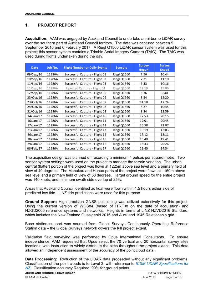
1. PROJECT REPORT Acquisition: AAM was engaged by Auckland Council to undertake an airborne LiDAR survey over the southern part of Auckland Council territory. The data was captured between 9 September 2016 and 6 February 2017. A Riegl Q1560 LiDAR sensor system was used for this project; this sensor system contains a Trimble Aerial Imagery Camera (TAIC). The TAIC was used during flights undertaken during the day.
Date Job No. Flight Number or Daily Events Sensors Survey
Begun
Survey
Ended
09/Sep/16 11286A Successful Capture - Flight 01 Riegl Q1560 7:56 10:44
10/Sep/16 11286A Successful Capture - Flight 02 Riegl Q1560 7:31 11:10
11/Sep/16 11286A Successful Capture - Flight 03 Riegl Q1560 6:33 10:16
11/Sep/16 11286A Rejected Capture - Flight 04 Riegl Q1560 12:19 15:06
12/Sep/16 11286A Successful Capture - Flight 05 Riegl Q1560 6:36 9:40
23/Oct/16 11286A Successful Capture - Flight 06 Riegl Q1560 8:54 12:20
23/Oct/16 11286A Successful Capture - Flight 07 Riegl Q1560 14:18 17:24
24/Oct/16 11286A Successful Capture - Flight 08 Riegl Q1560 8:27 10:45
31/Oct/16 11286A Successful Capture - Flight 09 Riegl Q1560 9:34 12:59
14/Jan/17 11286A Successful Capture - Flight 10 Riegl Q1560 17:53 20:15
16/Jan/17 11286A Successful Capture - Flight 11 Riegl Q1560 19:01 20:45
17/Jan/17 11286A Successful Capture - Flight 12 Riegl Q1560 20:58 22:07
21/Jan/17 11286A Successful Capture - Flight 13 Riegl Q1560 10:19 12:03
26/Jan/17 11286A Successful Capture - Flight 14 Riegl Q1560 17:12 18:11
28/Jan/17 11286A Successful Capture - Flight 15 Riegl Q1560 16:40 19:41
29/Jan/17 11286A Successful Capture - Flight 16 Riegl Q1560 18:33 20:26
06/Feb/17 11286A Successful Capture - Flight 17 Riegl Q1560 11:40 14:54
The acquisition design was planned on recording a minimum 4 pulses per square metre. Two sensor system settings were used on the project to manage the terrain variation. The urban central (flatter) portion of the project was flown at 1225m above sea level and a primary field of view of 40 degrees. The Manukau and Hunua parts of the project were flown at 1160m above sea level and a primary field of view of 58 degrees. Target ground speed for the entire project was 140 knots, and minimum swath side overlap of 25%. Areas that Auckland Council identified as tidal were flown within 1.5 hours either side of predicted low tide. LINZ tide predictions were used for this purpose. Ground Support: High precision GNSS positioning was utilized extensively for this project. Using the current version of WGS84 (based of ITRF08 on the date of acquisition) and NZGD2000 reference systems and networks. Heights in terms of LINZ NZVD2016 Standard, which includes the New Zealand Quasigeoid 2016 and Auckland 1946 Relationship grid. Base station support was sourced from Global Surveys Continuously Operating Reference Station data – the Global Surveys network covers the full project extent. Validation field surveying was performed by Opus International Consultants. To ensure independence, AAM requested that Opus select the 70 vertical and 20 horizontal survey sites locations, with instruction to widely distribute the sites throughout the project extent. This data allowed an independent assessment of the accuracy of the point cloud data. Data Processing: Reduction of the LiDAR data proceeded without any significant problems. Classification of the point clouds is to Level 3, with reference to ICSM LiDAR Specifications for NZ. Classification accuracy Required: 99% for ground points.
AUCKLAND COUNCIL
AUCKLAND COUNCIL LIDAR 2016-17 DATA DOCUMENTATION
AAM NZ Limited April 2018 Page 4 of 13
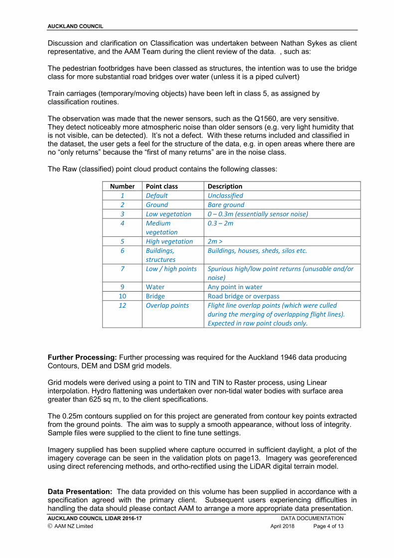
Discussion and clarification on Classification was undertaken between Nathan Sykes as client representative, and the AAM Team during the client review of the data. , such as: The pedestrian footbridges have been classed as structures, the intention was to use the bridge class for more substantial road bridges over water (unless it is a piped culvert) Train carriages (temporary/moving objects) have been left in class 5, as assigned by classification routines. The observation was made that the newer sensors, such as the Q1560, are very sensitive. They detect noticeably more atmospheric noise than older sensors (e.g. very light humidity that is not visible, can be detected). It’s not a defect. With these returns included and classified in the dataset, the user gets a feel for the structure of the data, e.g. in open areas where there are no “only returns” because the “first of many returns” are in the noise class. The Raw (classified) point cloud product contains the following classes:
Number Point class Description
1 Default Unclassified
2 Ground Bare ground
3 Low vegetation 0 – 0.3m (essentially sensor noise)
4 Medium
vegetation
0.3 – 2m
5 High vegetation 2m >
6 Buildings,
structures
Buildings, houses, sheds, silos etc.
7 Low / high points Spurious high/low point returns (unusable and/or
noise)
9 Water Any point in water
10 Bridge Road bridge or overpass
12 Overlap points Flight line overlap points (which were culled
during the merging of overlapping flight lines).
Expected in raw point clouds only.
Further Processing: Further processing was required for the Auckland 1946 data producing Contours, DEM and DSM grid models. Grid models were derived using a point to TIN and TIN to Raster process, using Linear interpolation. Hydro flattening was undertaken over non-tidal water bodies with surface area greater than 625 sq m, to the client specifications. The 0.25m contours supplied on for this project are generated from contour key points extracted from the ground points. The aim was to supply a smooth appearance, without loss of integrity. Sample files were supplied to the client to fine tune settings. Imagery supplied has been supplied where capture occurred in sufficient daylight, a plot of the imagery coverage can be seen in the validation plots on page13. Imagery was georeferenced using direct referencing methods, and ortho-rectified using the LiDAR digital terrain model. Data Presentation: The data provided on this volume has been supplied in accordance with a specification agreed with the primary client. Subsequent users experiencing difficulties in handling the data should please contact AAM to arrange a more appropriate data presentation.
AUCKLAND COUNCIL
AUCKLAND COUNCIL LIDAR 2016-17 DATA DOCUMENTATION
AAM NZ Limited April 2018 Page 5 of 13
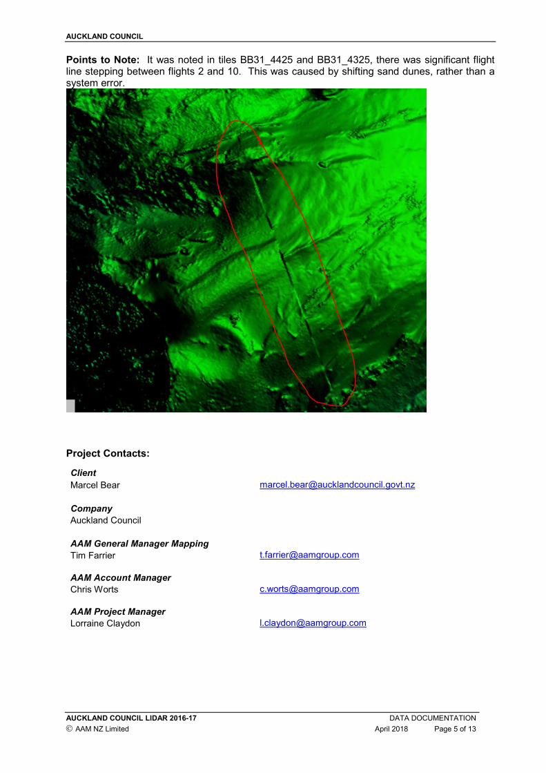
Points to Note: It was noted in tiles BB31_4425 and BB31_4325, there was significant flight line stepping between flights 2 and 10. This was caused by shifting sand dunes, rather than a system error.
Project Contacts:
Client
Marcel Bear [email protected]
Company
Auckland Council
AAM General Manager Mapping
Tim Farrier [email protected]
AAM Account Manager
Chris Worts [email protected]
AAM Project Manager
Lorraine Claydon [email protected]

AUCKLAND COUNCIL
AUCKLAND COUNCIL LIDAR 2016-17 DATA DOCUMENTATION
AAM NZ Limited April 2018 Page 6 of 13
2. DATA INSTALLATION
Data formats : ESRI ASCII , ESRI Shapefile, LAS v1.3, TIFF/TFW Information files on media : Readme_11286A01NOM.pdf
Data formatted on : 30/04/2018 Disk volume : 11286A01NOM README FILE This document (Readme_11286A01NOM.pdf) is provided as an Acrobat file in this volume. FILE SIZES AND NAMES The file naming convention follows the tile numbering system provided by Council. A year stamp (year of project capture commencement), and a product dataset code:
[Product ID]_[Topo50 Prime]_[Topo50 TILE]_YEAR.[format] [ProductID] :
• RPC – Raw Point Cloud
• DTM – Digital Terrain Point Cloud
• AG – Above Ground Point Cloud
• DEM – Digital Elevation Model (grid)
• DSM – Digital Surface Model (grid)
• Contour – Contours
• RGB - Imagery [format] - *.las, *.asc, *.shp, *.tif e.g. RPC_BA32_3604_2016.las
AUCKLAND COUNCIL
AUCKLAND COUNCIL LIDAR 2016-17 DATA DOCUMENTATION
AAM NZ Limited April 2018 Page 7 of 13
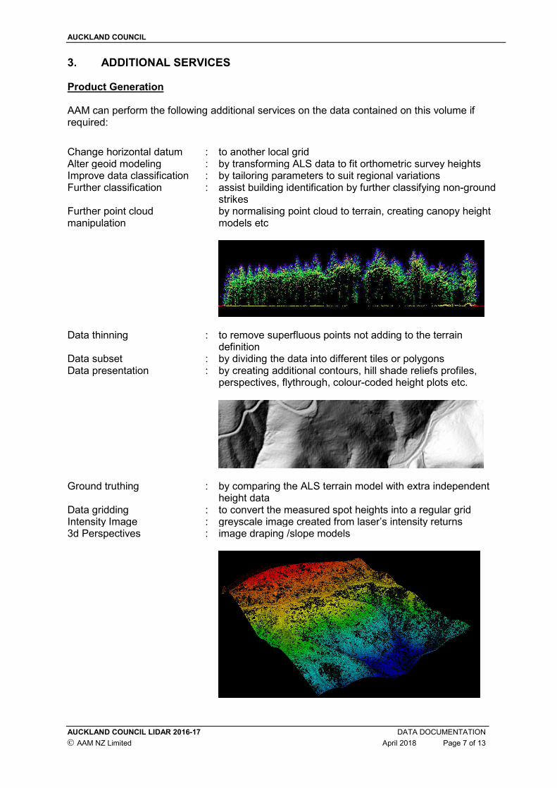
3. ADDITIONAL SERVICES Product Generation AAM can perform the following additional services on the data contained on this volume if required:
Change horizontal datum : to another local grid Alter geoid modeling : by transforming ALS data to fit orthometric survey heights Improve data classification : by tailoring parameters to suit regional variations Further classification : assist building identification by further classifying non-ground
strikes Further point cloud manipulation
by normalising point cloud to terrain, creating canopy height models etc
Data thinning : to remove superfluous points not adding to the terrain definition
Data subset : by dividing the data into different tiles or polygons Data presentation : by creating additional contours, hill shade reliefs profiles,
perspectives, flythrough, colour-coded height plots etc.
Ground truthing : by comparing the ALS terrain model with extra independent height data
Data gridding : to convert the measured spot heights into a regular grid Intensity Image : greyscale image created from laser’s intensity returns 3d Perspectives : image draping /slope models

AUCKLAND COUNCIL
AUCKLAND COUNCIL LIDAR 2016-17 DATA DOCUMENTATION
AAM NZ Limited April 2018 Page 8 of 13
4. METADATA
SOURCE DATA
Item Source Description Ref No Date
Laser System AAM Riegl Q1560 11286A 09.09.2016 – 06.02.2017
Base Stn Coords Global Surveys CORS 11286A 09.09.2016 – 06.02.2017
Field Survey Data Opus RTK GPS 11286A 06.09.2016 – 16.09.2016
LASER DATA CHARACTERISTICS
Characteristic Description
Device Name: Riegl Q1560 – 2 laser channel system Half Scan Angle: 20 & 29 degrees Laser Pulse Rate: 320 - 330 kHz Laser Pulse Mode: Multipulse Laser Return Types: 1st, 2nd, 3rd S 7th and last File Format: ESRI ASCII Grid, ESRI Shapefile, LAS 1.3, TIF Contour Interval: 0.25m Horizontal Datum: NZGD2000 Vertical Datum: NZVD2016 (and Auckland 1946) Map Projection: NZTM Vertical Accuracy Specification: ±0.10m RMS Horizontal Accuracy Specification: ±0.30m RMS
REFERENCE SYSTEMS
Horizontal Vertical
Datum NZGD2000 NZVD2016 (Auckland 1946) Projection NZTM N/A Geoid Model N/A NZGeoid2016
AUCKLAND COUNCIL
AUCKLAND COUNCIL LIDAR 2016-17 DATA DOCUMENTATION
AAM NZ Limited April 2018 Page 9 of 13
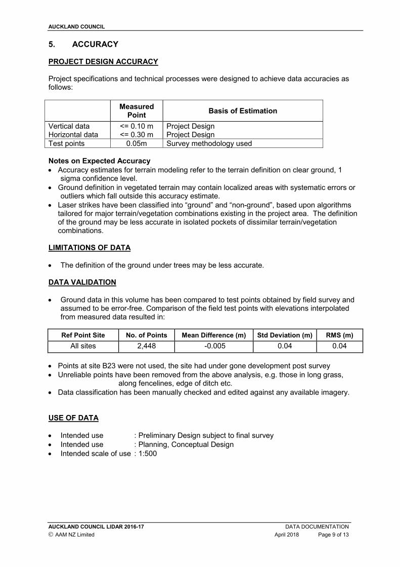
5. ACCURACY PROJECT DESIGN ACCURACY Project specifications and technical processes were designed to achieve data accuracies as follows:
Measured Point
Basis of Estimation
Vertical data <= 0.10 m Project Design Horizontal data <= 0.30 m Project Design
Test points 0.05m Survey methodology used
Notes on Expected Accuracy
• Accuracy estimates for terrain modeling refer to the terrain definition on clear ground, 1 sigma confidence level.
• Ground definition in vegetated terrain may contain localized areas with systematic errors or outliers which fall outside this accuracy estimate.
• Laser strikes have been classified into “ground” and “non-ground”, based upon algorithms tailored for major terrain/vegetation combinations existing in the project area. The definition of the ground may be less accurate in isolated pockets of dissimilar terrain/vegetation combinations.
LIMITATIONS OF DATA
• The definition of the ground under trees may be less accurate. DATA VALIDATION
• Ground data in this volume has been compared to test points obtained by field survey and assumed to be error-free. Comparison of the field test points with elevations interpolated from measured data resulted in:
Ref Point Site No. of Points Mean Difference (m) Std Deviation (m) RMS (m)
All sites 2,448 -0.005 0.04 0.04
• Points at site B23 were not used, the site had under gone development post survey
• Unreliable points have been removed from the above analysis, e.g. those in long grass, along fencelines, edge of ditch etc.
• Data classification has been manually checked and edited against any available imagery. USE OF DATA
• Intended use : Preliminary Design subject to final survey
• Intended use : Planning, Conceptual Design
• Intended scale of use : 1:500

AUCKLAND COUNCIL
AUCKLAND COUNCIL LIDAR 2016-17 DATA DOCUMENTATION
AAM NZ Limited April 2018 Page 10 of 13
6. CONDITIONS OF SUPPLY The data in this volume has been commissioned by AUCKLAND COUNCIL. The data in this volume is provided by AAM NZ Limited (AAM) to AUCKLAND COUNCIL under ACPN_20055, dated 8 August 2016, which provides AUCKLAND COUNCIL with a full and unrestricted license in perpetuity to use all reports, mapping and other delivered data (Project IP), in accord with documented provisions, and subject to the following conditions: 1. This file (Readme_11286A01NOM.PDF) is always stored with the unaltered data contained
in this volume. 2. This volume of data is not altered in any way without the approval of AAM. The data may
be copied from this file to another. Any breach of these conditions will result in the immediate termination of the license issued by AAM, and AUCKLAND COUNCIL will indemnify AAM from all resulting liabilities. Any problems associated with the information in the data files contained in this volume should be reported to AAM NZ Limited. A complete list of project related contacts is listed on page 5 under the Project Report heading. 6 Ossian St, NAPIER New Zealand Telephone +64 27 502 6900 Email [email protected] Web www.aamgroup.com
AUCKLAND COUNCIL
AUCKLAND COUNCIL LIDAR 2016-17 DATA DOCUMENTATION
AAM NZ Limited April 2018 Page 11 of 13
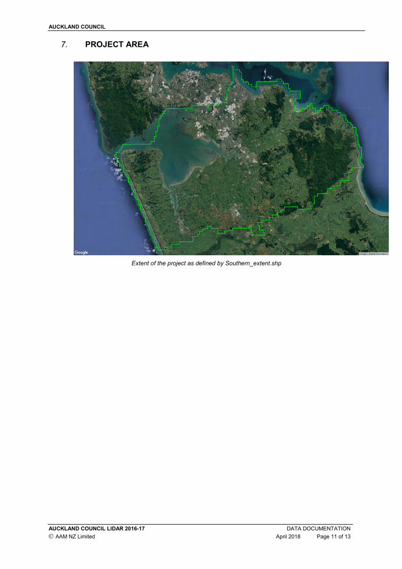
7. PROJECT AREA
Extent of the project as defined by Southern_extent.shp
AUCKLAND COUNCIL
AUCKLAND COUNCIL LIDAR 2016-17 DATA DOCUMENTATION
AAM NZ Limited April 2018 Page 12 of 13
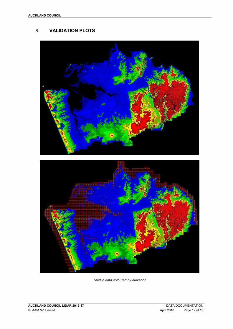
8. VALIDATION PLOTS
Terrain data coloured by elevation
AUCKLAND COUNCIL
AUCKLAND COUNCIL LIDAR 2016-17 DATA DOCUMENTATION
AAM NZ Limited April 2018 Page 13 of 13
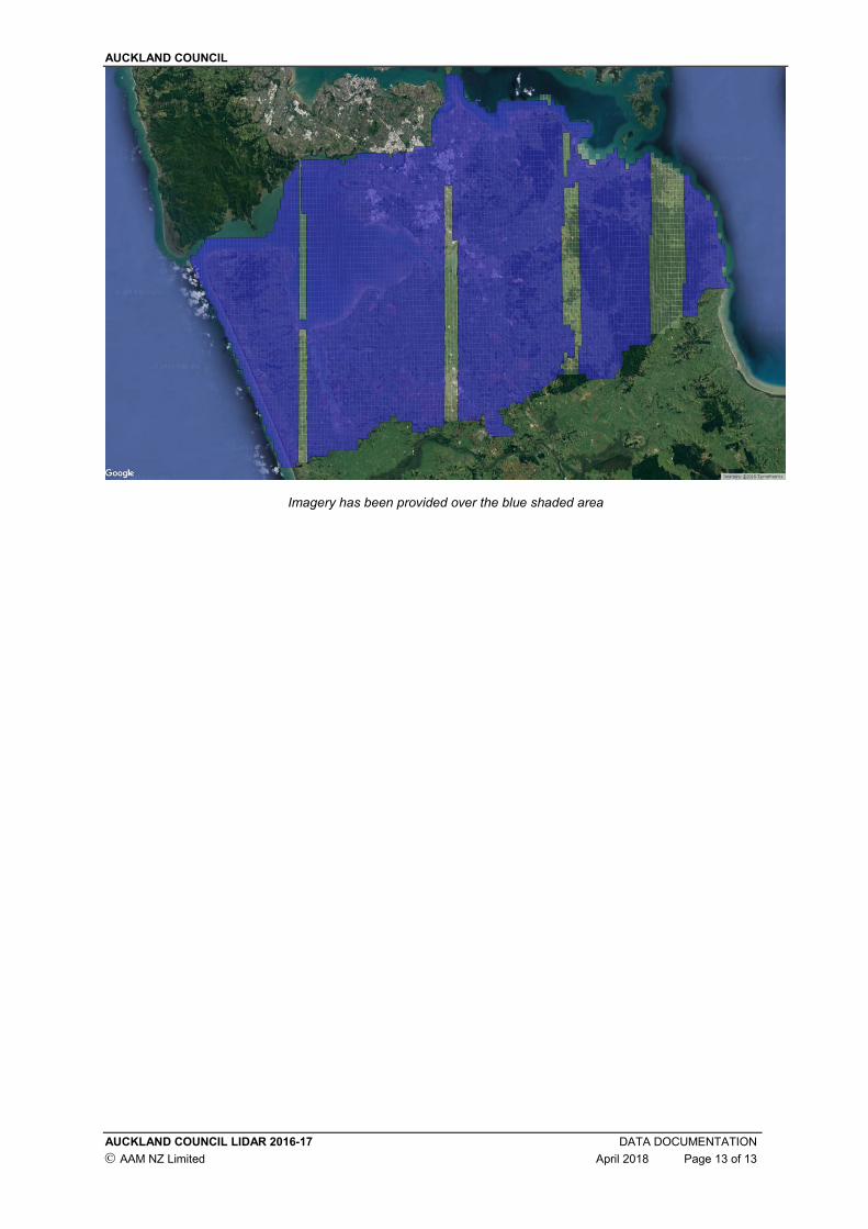
Imagery has been provided over the blue shaded area