astronmy and sankusthapanam in temple · pdf filein temple construction ... n or +ve sign and...
TRANSCRIPT

1
����������������������������������
ASTRONOMY AND �ANKUSTH�PANAM
IN TEMPLE CONSTRUCTION
Dr.M.L.Raja, M.B.,B.S.,D.O.,*
In Temple construction, two important things are to be fixed before starting the work. 1.
Deriving the auspicious time for Boomi Pooja, Kumbha Abhishekam etc. 2. Fixing the directions
exactly (mainly 8, North, East, South, West and the 4 in between). Here Astronomy plays the
important role and based on it only the construction proceeds.
Astronomy is the branch of Science that deals with the study of celestial bodies (such as
stars, planets, satellites, comets, nebulae, star clusters, and galaxies) and phenomena that originate
outside the atmosphere of Earth (such as the cosmic background radiation). It is concerned with
the evolution, physics, chemistry, meteorology and the motion of celestial objects, as well as
the formation and the development of the Universe.
The auspicious time is based on the aspects, phenomena and positions of celestial bodies,
especially the nine Graha (not synonym to planets) and the stars at ecliptic plane of Earth (27
Nakshatra). The positions of Navagraha, with reference to Earth are changing constantly. Hence to
assess their positions in the celestial sphere, their motion is to be assessed, with reference to the
fixed ecliptic stars. The positions of these ecliptic stars which are constant (fixed, not moving, as
for as Earth is concerned) can be ascertained, by creating imaginary celestial co-ordinates, passing
through the celestial sphere. These are with reference to the celestial equator which is nothing but
the extension of the equator of the Earth. The celestial co-ordinates that pass through the north and
south celestial poles, cutting the celestial equator at right angles, are the longitudes and their angle
is mentioned as right ascension. They are 360 in total, one for each degree of angle. The celestial
co-ordinate that passes exactly at the celestial equator is 0° declination and the co-ordinates that
are parallel to this celestial equator are latitudes and their angle is mentioned as declination. That
pass through the northern hemisphere are 90 in number (one for each degree) and are denoted with
N or +ve sign and the other 90 that pass south to equator are denoted with S or ����ve sign. These are
celestial co-ordinates of equatorial system. In this system, the declination of the Graha, especially
of the Sun, is used in calculating the positions of Graha, relative to the equator of the Earth.
* Director, AVINASH (Academy on Vibrant National Arts and Scientific Heritage),
Sree Krishna Hospital, Pallipalayam Erode-6, PIN -638006, T.N.State, [email protected]

2
The other system is ecliptic co-ordinates, where the ecliptic of the Earth is the central line
and is marked as 0° celestial latitude. The ecliptic is the annual path of the Earth around the Sun.
The lines passing parallel to this are the celestial latitudes, 90 northwards and 90 southwards and
are marked as N or + and S or ����ve sign. The north and south poles of the ecliptic are known as
Kadamba in our Nation’s astronomy and the longitudinal lines passing through these ecliptic poles,
cutting the ecliptic at right angles are the celestial longitudes and are 360 in number, one for each
degree. These celestial co-ordinates of ecliptic system are used to fix the positions of the Graha.
Thus, the positions of Graha are mentioned relative to the Earth’s position in the ecliptic and not
with reference to the celestial sphere and this itself proves that these co-ordinates were developed
in our Nation and spread to the whole world. This is because, in our astronomy, the positions of
Graha are assessed with reference to Earth’s position in the ecliptic, there by understanding the
effect of Graha on Earth, where as in the western astronomy they are described with reference to
the celestial sphere. These co-ordinates are the celestial longitudes and latitudes. The co-ordinates
of ecliptic and equatorial systems differ by 23° 27` at the maximum at solstices and 0° at
equinoxes, as the Earth is inclined at its axis by 23° 27` to its ecliptic path around the Sun.

3
The longitudes and latitudes of the Earth are same as that of right ascension and
declination of celestial sphere. The longitudes pass through the North and South poles (Dhruva) of
Earth, cutting the Equator of the Earth at right angles. They are 360, one for each degree. The
prime meridian is 0° longitude and the other longitudes are mentioned as East, if they are east to
this prime meridian and west if they are west. The latitudes of the Earth pass parallel to equator of
the Earth (0° latitude) and the latitudes (90) in northern hemisphere are denoted as N or +ve sign
and the southern latitudes (90) are denoted as S or ����ve sign. These are of equatorial system and
they are also important in arriving the auspicious time, as the effect of Graha varies at different
longitudes and latitudes on the Earth. Besides, these co-ordinates of the Earth and the declination
of the Sun are important in fixing the direction, at the place of temple construction.
Magnetism is not useful in fixing the directions exactly. This is because, the north
magnetic pole is on Ellef Ringnes Island in northern Canada, about 870 miles from the
geographic North Pole. The south magnetic pole is off Wilkes Land, Antarctica, about 1,710 miles
from the geographic South Pole, as shown in the figure.
Moreover, their positions vary at different periods of time. For example, the North Magnetic Pole
moves slowly over time, due to magnetic changes in the Earth’s Core. In 2001, it was determined
by the Geological Survey of Canada to lie near Ellesmere Island in northern Canada at 81.3°N,
110.8°W. It was estimated to be at 82.7°N, 114.4°W in 2005. In 2009, it was moving toward
Russia at between 34 and 37 miles (55-60 km) per year. The positions of North Magnetic Pole at
various periods are 81.3°N, 110.8°W (2001), 82.3° N, 113.4°W (2004 est.), and 82.7°N,
114.4°W (2005 est.) and of the South Magnetic Pole are 64.6 ° S, 138.5 ° E (1998), 63.5 ° S,
4
138.0 ° E (2004 est.) and 64.487 ° S, 137.684° E (2007). Hence, an alternate method, for the exact
fixation of the directions, is required. Fixing the directions is a very essential basic thing, in temple
constructions, because the places and front view of various Deities should be exact, as mentioned
in temple architecture, �gama and Veda. For this, our ancestors developed a system and method,
using Astronomy and the �anku. The �anku is a Gnomon, usually a wooden, cylindrical, massive,
straight rod (pillar, pole) of 12 Angula (1/2 cubit) height.
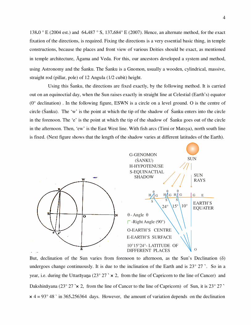
Using this �anku, the directions are fixed exactly, by the following method. It is carried
out on an equinoctial day, when the Sun raises exactly in straight line at Celestial (Earth’s) equator
(0° declination) . In the following figure, ESWN is a circle on a level ground. O is the centre of
circle (�anku). The ‘w’ is the point at which the tip of the shadow of �anku enters into the circle
in the forenoon. The ‘e’ is the point at which the tip of the shadow of �anku goes out of the circle
in the afternoon. Then, ‘ew’ is the East West line. With fish arcs (Timi or Matsya), north south line
is fixed. (Next figure shows that the length of the shadow varies at different latitudes of the Earth).
H
S
GHS
G HS
G
O
EG
H-HYPOTENUSE
G-GENOMON ( ANKU)�
S-EQUINACTIAL SHADOW
E-EARTH’S SURFACE
O-EARTH’S CENTRE
SUN
�
� �- Angle
� �
-Right Angle (90°)
EARTH’S EQUATER10°15°24°
SUNRAYS
10°15°24°- LATITUDE OF DIFFERENT PLACES
But, declination of the Sun varies from forenoon to afternoon, as the Sun’s Declination (�)
undergoes change continuously. It is due to the inclination of the Earth and is 23° 27 `. So in a
year, i.e. during the Uttar�ya�a (23° 27 ` ���� 2, from the line of Capricorn to the line of Cancer) and
Dakshin�yana (23° 27 `���� 2, from the line of Cancer to the line of Capricorn) of Sun, it is 23° 27 `
���� 4 = 93° 48 ̀in 365.256364 days. However, the amount of variation depends on the declination

5
of the Sun. It is maximum up to 24` when the declination is 0 ° i.e. on equinoctial days and almost
zero when the declination is 23° 27 ` i.e. on solstice days. Hence, the directions vary, very slightly
from ‘ew’ to ‘e`w’ as shown in the figure. The difference between ‘e’ and ‘e`’ is ‘d’ and can be
calculated, by the following method. Sun’s declination on a particular day of a year is already
computed and is available for all the days of a year. Hence, the values of � and �` can be
calculated. ( � is the declination of the Sun on the forenoon and �` is the declination of the Sun in
the afternoon, at the time of ‘w’ and ‘e’ markings, respectively).
Here, Rsine � is local latitude. The value of Rcos � (local co-latitude) and the local latitude Rsine �
can be calculated by using the �anku, on the equinoctial day or in any other day by taking into
consideration of the Sun’s declination on that particular day, as shown in the following figures.
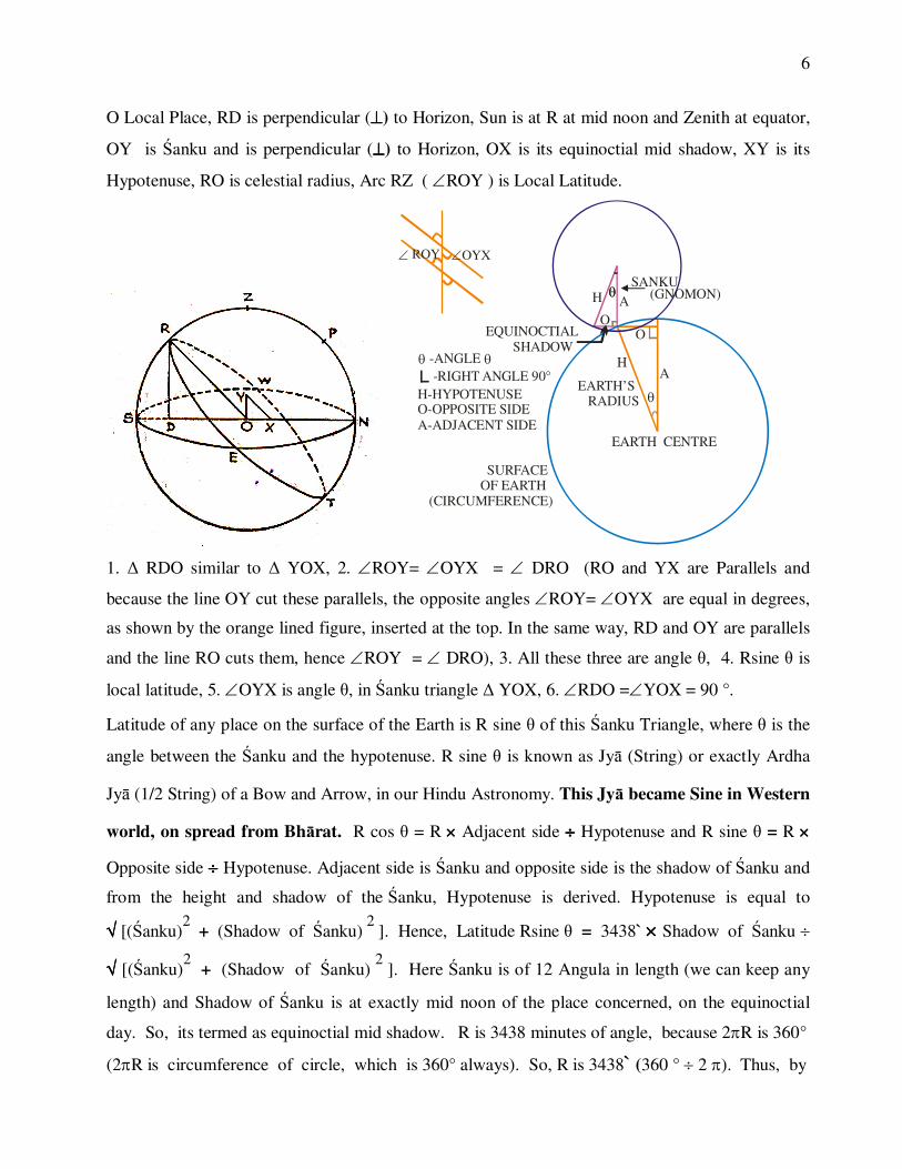
NESW is Horizon, NESW are directions, Z is Zenith of the local place, ZRSTNP is Local
Meridian, R is the point of intersection of local meridian and Celestial Equator, RETW is Equator,
6
O Local Place, RD is perpendicular (����) to Horizon, Sun is at R at mid noon and Zenith at equator,
OY is �anku and is perpendicular (����) to Horizon, OX is its equinoctial mid shadow, XY is its
Hypotenuse, RO is celestial radius, Arc RZ ( �ROY ) is Local Latitude.
H
H
OO
A
A
EARTH CENTRE
(GNOMON)
EARTH’S RADIUS
SURFACE OF EARTH (CIRCUMFERENCE)
EQUINOCTIAL SHADOW
�
�H-HYPOTENUSEO-OPPOSITE SIDEA-ADJACENT SIDE
�
�
-ANGLE �-RIGHT ANGLE 90°
SANKU
1. � RDO similar to � YOX, 2. �ROY= �OYX = � DRO (RO and YX are Parallels and
because the line OY cut these parallels, the opposite angles �ROY= �OYX are equal in degrees,
as shown by the orange lined figure, inserted at the top. In the same way, RD and OY are parallels
and the line RO cuts them, hence �ROY = � DRO), 3. All these three are angle �, 4. Rsine � is
local latitude, 5. �OYX is angle �, in �anku triangle � YOX, 6. �RDO =�YOX = 90 °.
Latitude of any place on the surface of the Earth is R sine � of this �anku Triangle, where � is the
angle between the �anku and the hypotenuse. R sine � is known as Jy� (String) or exactly Ardha
Jy� (1/2 String) of a Bow and Arrow, in our Hindu Astronomy. This Jy� became Sine in Western
world, on spread from Bh�rat. R cos � = R ���� Adjacent side ���� Hypotenuse and R sine � = R ����
Opposite side ���� Hypotenuse. Adjacent side is �anku and opposite side is the shadow of �anku and
from the height and shadow of the �anku, Hypotenuse is derived. Hypotenuse is equal to
���� [(�anku)2
+ (Shadow of �anku) 2
]. Hence, Latitude Rsine � = 3438` ���� Shadow of �anku �
���� [(�anku)2
+ (Shadow of �anku) 2
]. Here �anku is of 12 Angula in length (we can keep any
length) and Shadow of �anku is at exactly mid noon of the place concerned, on the equinoctial
day. So, its termed as equinoctial mid shadow. R is 3438 minutes of angle, because 2�R is 360°
(2�R is circumference of circle, which is 360° always). So, R is 3438` (360 ° � 2 �). Thus, by
� ROY �OYX
7
using the �anku and the fore detailed calculations, both developed and practiced in our Nation in
the remote past, we can fix the directions exactly, at the place of construction of the Temple and it
is the very reliable, exact and correct method in fixing the directions. The R sine � (Ardha Jy� )
values, including its computation and derivation for the angles of a circle, from 3° 45 ` to 90 ° at
intervals of 3 ° 45 ` (totally 24 values) are given by �ryabha��a, in 2741 B.C.E. in his
Astronomical and Mathematical text �ryabha���yam, in 11 and 12 �loka of 2nd Addhy�ya� (Ganita
P�da�). S�rya Siddh�nta� gave these values in 16 to 23 �loka (including values of versed sine,
Utkrama Jy�) of 2nd Adhy�ya� (Sputa Gati�). Value of Ardha Jy� for 90 ° is 3438`, where the
length of the chord (string of the bow) is equal to the radius of circle.
This method and science of fixing the directions exactly, at any locality on Earth, by
using the �anku and these calculations, are detailed well in the ancient astronomical texts of our
Nation, in the remote past itself. 1. S�rya Siddh�nta� of remotest antiquity, in its 1 to 8th �loka of
3rd Adhik�ra� (Tripra�n�dhik�ra�), 2. Mah�ryabha��a Siddh�nta�, written by �ryabha��a, nearer to
the beginning of this Kaliyuga (4700 years before present) in the 1 to 6th �loka of 4th Adhik�ra�
(Tripra�n�dhik�ra�), 3. Pa�ca Siddh�ntik� of Var�hamihira of 123 B.C.E. in 19 to 21st �loka of the
4th Adhy�ya� (Kara��dhy�ya�) [21st �loka deals with the method of using the shadow of any day
in a year, to fix directions], 4. Brahmasphu�a Siddh�nta� of Brahmagupta (30 B.C.E.) in 1 to 5th
�loka of 3rd Adhik�ra� (Tripra�n�dhik�ra�), 5. Siddh�nta �iroman� of Bh�skar�c�rya (486 B.C.E.)
in 8 and 9th �loka of 3rd Adhik�ra� (Tripra�n�dhik�ra�) of Gol�ddhy�ya�, 6. Mah�bh�skar�yam of
Bh�skara (522 /629 C.E.) in 1 to 5th �loka of 3rd Addhy�ya� 7. Laghu Bh�skar�yam of Bh�skara 1
to 4th �loka of 3rd Addhy�ya� 8.Vate�vara Siddh�nta� and Gola in the 2 to 5th �loka of 1st
Adhy�ya� (Viuvach�y�s�dhanvidhi�) of the 3rd Adhik�ra� (Tripra�n�dhik�ra�) [It mentions the
correction to be done due to variation in declination of the Sun, in a single day], 9.
�iyadh�vddhita Tantram of Lall�c�rya in 1 to 7th �loka of 3rd Adhik�ra� (Tripra�n�dhik�ra�), and
10. Golad�pik� of Parame�vara in 1 to 53rd �loka of 4th Addhy�ya�, all these ancient astronomical
and mathematical texts of our Nation, described this method.
8
Even the ancient non-astronomical texts are also describes it, at times. For example, “Ne�unal
V��ai” a very ancient Sangham Tamil Literature of Patthupp���u texts, describes it as follows.
“……………………………… m�thiram virikathir parappiya viyalv�y ma��ilam,
Erukol kurinilai vazhukk�tha ku�akkerbu, oruthiram c�r� arai n�l amaiyatthu,
N�lari pulavar nunnithir kayiri��u, Deyem ko��u Deiva nokkip
Perum peyar mannarkkoppa manai vakutthu,…………’’ (72 to 78 lines)
The meaning is “The Sun, rising at east, proceeds towards west. On the day, exactly at mid noon,
at which there were no shadows, neither on north or south side of the two �anku (wooden sticks),
the experts of civil engineering, who knew well the texts of civil engineering and architecture
(�ilpa ��stram), fixed the directions, at that place with ropes, after worshiping God and thus
started constructing a great palace for the great King.”
The two �anku will not cast their shadows at their northern and southern sides, at exact mid noon
only on a day, when the local latitude of that place and the declination of the Sun are exactly equal.
That means, on that particular day, the Sun rises in the east exactly in the line of the latitude of that
place and the Sun is exactly at the zenith of that place, at exact mid noon, on that day. Thus, our
ancestors knew the Sun’s declination (and other celestial co-ordinates) and the latitude co-
ordinates (and other co-ordinates) of the Earth. This can be proved by the following evidences.
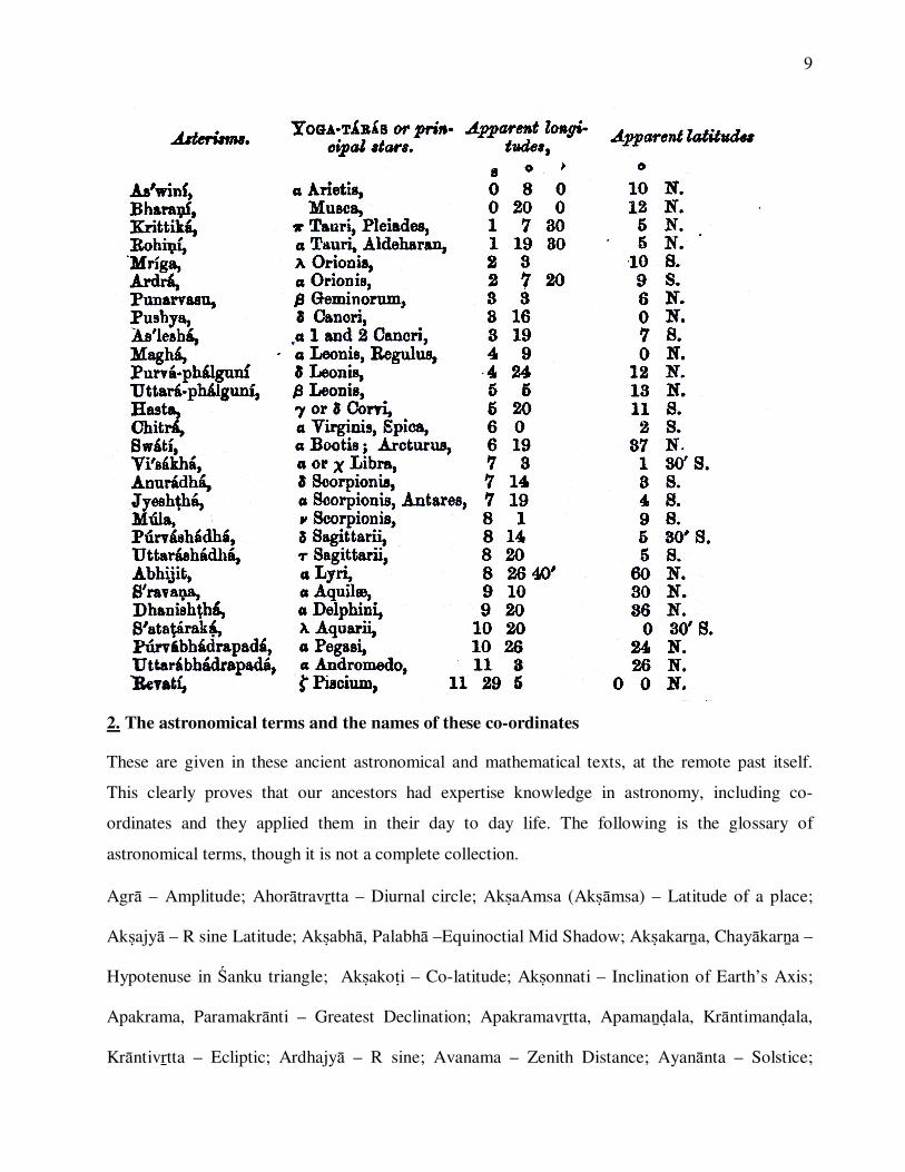
1. The list of 27 ecliptic stars and their co-ordinates
S�rya Siddh�nta� in 2 and 57th �loka of 1st Adhik�ra� (Madhyam�dhik�ra�) clearly reveals that
this text was taught at the end of Kta Yuga of the present 28th Mah�yuga i.e. 12,96,000 +
8,64,000 + 5,112 = 21,60,112 years before present. �loka 8 and 9th of 1st Adhik�raha mentions
that it was taught every Yuga to Saints (�i) by Bh�skara (Sun God) i.e. even at a period, prior to
this. The 8th Adhik�ra� (Nakatragrahayutyadhik�ra�, 1 to 21st �loka) gave the Polar Longitude
(Dhruva�, Dhruvakam) and Latitude (Vikepa�) of all 28 Ecliptic stars, in the following table.
Bh�skara’s Mah�bh�skar�yam and Laghu Bh�skar�yam, Lall�c�rya’s �iyadh�vddhita Tantram,
Brahmagupta’s Brahmasphu�a Siddh�nta� and Kha��a Kh�dyaka, �r�pati’s Siddh�nta �ekara,
Bh�skar�c�rya’s Siddh�nta �iroma�� also gave the celestial longitudes and celestial latitudes of
these 27 ecliptic stars.
9
2. The astronomical terms and the names of these co-ordinates
These are given in these ancient astronomical and mathematical texts, at the remote past itself.
This clearly proves that our ancestors had expertise knowledge in astronomy, including co-
ordinates and they applied them in their day to day life. The following is the glossary of
astronomical terms, though it is not a complete collection.
Agr� – Amplitude; Ahor�travtta – Diurnal circle; AkaAmsa (Ak�msa) – Latitude of a place;
Akajy� – R sine Latitude; Akabh�, Palabh� –Equinoctial Mid Shadow; Akakar�a, Chay�kar�a –
Hypotenuse in �anku triangle; Akako�i – Co-latitude; Akonnati – Inclination of Earth’s Axis;
Apakrama, Paramakr�nti – Greatest Declination; Apakramavtta, Apama��ala, Kr�ntiman�ala,
Kr�ntivtta – Ecliptic; Ardhajy� – R sine; Avanama – Zenith Distance; Ayan�nta – Solstice;

10
Ayanacalana – Oscillation of Equinox; Bh�gola – Earth; Gola – globe, sphere; Candrakar�a –
Distance of Moon from Earth; CandraP�da – Nodes of Moon (R�hu and Ketu); Dgjy� - Rsine of
Zenith; D�rgh�msa, Des�ntra – Longitude of a place; Dggola – Visible Celestial Sphere; Dkepa
– Ecliptic Zenith Distance; Dkepama��ala – Vertical circle through central ecliptic point;
Dkma��ala – Visible vertical circle; Dgamasc�pa – Zenith Distance; Dhruva – Pole; Dhruvaka –
Polar Longitude; Jy� – R sine; Hora – 1/24 th of a day; Kadamba – Pole of Ecliptic; Kaka – Orbit;
Kap�la – Hemisphere; Ko�ijy� – R cosine; Ko�i – Perpendicular Side of Right Angled Triangle;
Kr�nti, Apama – Declination; Kr�ntijy� – Rsine declination; Kr�ntip�da – Eqinox; Kipti, �ara –
Celestial Latitude; K�itija, Harija – Horizon (Va�e�vara Gola 3-2); Lambajy� – Rsine of co-
latitude; Lamb�msa – Co-latitude in degrees; Lambana – Parallax of Longitude; Ma�dan�ca –
Perigee and Perihelion; Ma�docca – Apogee and Aphelion; N��ivalaya, Vi�uvadvalaya, N��ivtta,
Vi�uvadvtta – Celestial Equator ; Natak�la – Hour Angle; Nati, Avanati – Latitudinal Parallax;
N�cocca Vtta –Epicycle; Parama Lambana – Horizontal, maximum parallax; Paridhi, Nemi –
Circumference; P�rv�par� – East West Line; Ravikar�a – Distance of Sun from Earth; Rekh�,
Madhya Rekh� – Prime Meridian, La�ka and Ujjain� (Line of Prime Meridian);
Samama��ala – Prime Vertical; Sphu�avikepa – Celestial Latitude corrected by Parallax; �anku –
Gnomon, Rsine Latitude; Trijy� – Rsine of an arc of 90 °; Unnati, Unnata – Altitude; Udvtta,
Unma��ala – Equinoctial, 6’o clock, east west circle; Vidigvtta – Intermediate Cardinal Points;
Vikepa – Celestial Latitude of a Graha (Polar Latitude); Vima��ala – Orbit of a Graha; Vi�uvat –
Equator; V�tta – Circle (Vertical); Yamayotravtta – The Local Meridian passing through North
South Cardinal Points. These are all the some of the astronomical terms used in the ancient
astronomical texts of our Nation, showing the richness of our ancestor’s knowledge in astronomy.
3. Reference of La�ka Ujjian� Prime Meridian in our Nation’s ancient astronomical texts
A. S�rya Siddh�nta� 37 to 42, 52, 70 and 71st �loka of 12th Adhy�ya� mentioned about La�ka,
as a great city situated in the southern part of our Nation Bh�rata, on Earth’s Circumference

11
(Equator) [39th �loka]. It mentioned 4 cities, 1. La�ka, 2. Yamako�i of Bhadr��va Nation in
East, 3. Romaka in Ketum�l� Nation in West and 4. Opposite to La�ka is Siddhapuri of Kuru
Nation. These 4 cities situated on Earth’s circumference at equal distances (90° apart). In these
places there is no equinoctial mid shadow (when Sun rises at Equator (Equinox) with 0°
declination). �loka 1-62 mentions Avant� (Ujjain�) in Prime Meridian (Rekh�). This La�ka was
situated south-east of Maldives and is different from the present day Sr� La�ka.
B. �ryabha���yam of �ryabha��a (2764 B.C.E.) mentions in the 14th �loka of 4th Addhy�ya�
(Golap�da�) as, from the centre of land and water, at a distance of one quarter of the Earth’s
circumference lies La�ka and Ujjain� lies exactly northwards of La�ka, at a distance of 1/16 of
the Earth’s Circumference (360° ÷ 16 = 22.5° ),
C. Brahmagupta’s (30 B.C.E.) Brahmasphu�a Siddh�nta� (21-9th �loka), mentioned that Ujjain�
is at 1/15th part of Earth’s circumference (24°),
D. Mah�bhaskar�yam of Bh�skara (522 /629 C.E.), in 1 and 2nd �loka of 2nd Addhy�ya�
mentions that La�ka and Ujjain� are in the same meridian,
E. Kara�aratnam of Dev�c�rya 30th �loka of 1st Addhy�ya� mentioned in the same way,
F. Var�hamihira’s (123 B.C.E.) Pa�casiddh�ntik�, 13th Addhy�ya� (Trilokyasamsth�nam), 10,
11,17,19, 26 and 32nd �loka, details Ujjain� and La�ka. (Both in same meridian, 17th �loka).
G. Lallac�rya’s �iyadh�vddhita Tantram, 3, 4 and 12th �loka of Bh�gol�ddhy�ya� (17th
Addhy�ya�) and 24 and 25 �loka of 19th Addhy�ya� (Bhuvanako�a) describes Kany�
(Kum�rik�) part of Bh�rata Nation. La�ka was situated in this part. 40th �loka describes Ujjain�
at Prime Meridian,
H. Vate�vara Siddh�nta� and Gola 10th �loka of 5th Addhy�ya� of Gola part mentioned the
four cities including La�ka in Equator, 1 and 2nd �loka of 8th section of 1st Addhy�ya�
mentioned that La�ka and Ujjain� in Prime Meridian,
I. Sripati’s Siddh�nta Sekara in 2nd Addhy�ya� 95 to 97th �loka mentioned that La�ka and
Ujjain� in Prime Meridian
J. Siddh�nta Dharpana of N�laka��a Somay�ji, 15th �loka mentioned that Ujjain� is north to
La�ka by 1/15th part of Earth’s Circumference (24°),
12
K. Bh�skar�c�rya’s (486 C.E.) Kara�akut�kalam 1-14th �loka mentioned that Ujjain� in Prime
Meridian (Madhya Rekh�),
L. Golad�pik� of Parame�vara in 3rd Addhy�ya� describes the Earth and its divisions.
In 8, 9 and 26 to 29th �loka mentioned the four cities including La�ka. The 77 to 91st �loka
describes the Nation Bh�rat and 92nd �loka after describing the river Ganga, mentioned that
La�ka is situated at the top of the mountain in the Malaya Island, one of the six islands of
Kum�r� Islands situated at the southern most end of Bh�rat (Anga, Yava, Malaya, Sankhaka,
Kumuda and Var�ha), Rivers flown from Malaya mountain were Ktam�l� and T�mprapara��,
M. Laghum�nasam of Ma�jul�c�rya 3rd �loka of 4th Addhy�ya� mentioned Avant� (Ujjain�)
in Prime Meridian. This proves that initially La�ka Ujjain� was the prime meridian and when
the westerners copied these co-ordinates from these texts, they changed it to Greenwich.
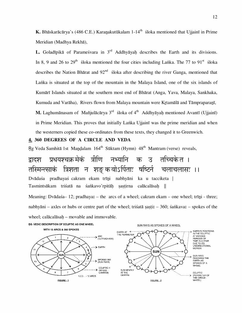
4. 360 DEGREES OF A CIRCLE AND VEDA
�g Veda Samhit� 1st Ma��alam 164th S�ktam (Hymn) 48th Mantram (verse) reveals,
�������������������� ������������������������� ����������� ������������������ ����������������������� ���������������� �� !�������"���"�������� Dv�da�a pradhaya� cakram ekam tr��i �nabhy�ni ka u tacciketa ��Tasmints�kam tri�at� na �a�kavo’rpit�� a�irna cal�cal�sa� ��
Meaning: Dv�da�a– 12; pradhaya: – the arcs of a wheel; cakram ekam – one wheel; tr��i - three;
nabhy�ni – axles or hubs or centre part of the wheel; tri�at� a�i: – 360; �a�kava: – spokes of the
wheel; cal�cal�sa� – movable and immovable.
13
“The arcs are twelve, the wheel is one and three are the axles. Who indeed knows it? Within it are
collected three hundred and sixty spokes, which are as it were movable and immovable.”
This shows clearly that the time divisions in our Nation, is based on the angular distance covered
by the Earth, in its Ecliptic round the Sun, in that particular time. One year is the time required for
the Earth to travel 360° (one full circle) of angular distance, in its ecliptic around the Sun. In the
same way, one month for 30° (one arc-r�si-sign), one day for 1° (amsa- spoke), one gha�ik� (n���-
n��ik�) for one minute (lipt�-kal�), one vigha�ik� (vin���, vin��ik�) for one second (vilipt�, vikal�)
and one Gurvakara is the time required for the Earth to travel one third (tatpar�) of angular
distance, in its ecliptic around the Sun. Thus, there is an exact confluence of the spatial distance
travelled by the Earth in the Ecliptic in its unidirectional motion and the Time Measurements
developed in our Nation. This is completely scientific and is totally based on the angular distance
covered by the Earth in the Ecliptic and the time required for that. Thus, the concept of 360° of
angles for a circle, is based on Earth’s revolution round the Sun in the Ecliptic, as revealed in �g
Veda Samhit� verses 1-164-48 and 11. Hence, it is clear that 1. The concept of 360° of angles for
a circle and 2. The Time Space and the Direction Concept (Dig De�a K�la Vardham�na) of the
most modern science, had been developed scientifically and applied in the day-to-day life, by our
Ancestors, in the remotest antiquity itself.
5. The Jantar Mantars, present even to-day at Ujjain�, Delhi, Varanas�, Mathur� and Jaipur and
the various instruments like Transit Instrument, Sun-Dial, R�m Yantra etc. constructed there,
proves our ancestor’s knowledge in astronomy.
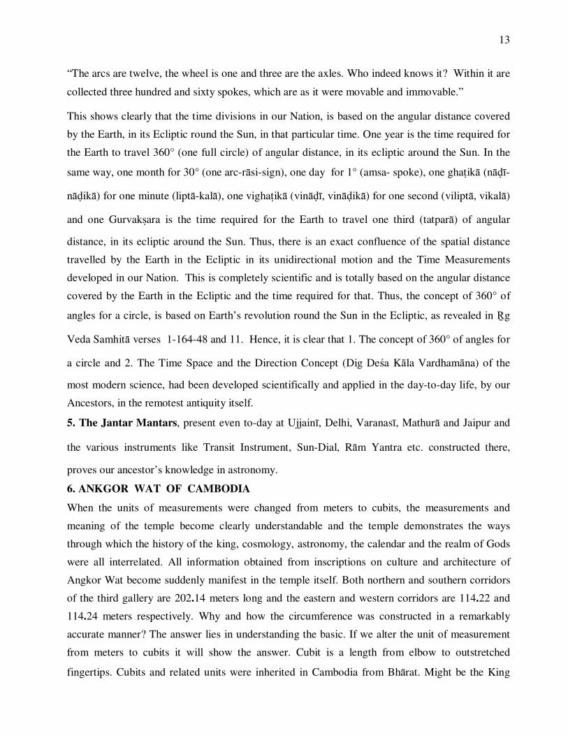
6. ANKGOR WAT OF CAMBODIA
When the units of measurements were changed from meters to cubits, the measurements and
meaning of the temple become clearly understandable and the temple demonstrates the ways
through which the history of the king, cosmology, astronomy, the calendar and the realm of Gods
were all interrelated. All information obtained from inscriptions on culture and architecture of
Angkor Wat become suddenly manifest in the temple itself. Both northern and southern corridors
of the third gallery are 202.14 meters long and the eastern and western corridors are 114.22 and
114.24 meters respectively. Why and how the circumference was constructed in a remarkably
accurate manner? The answer lies in understanding the basic. If we alter the unit of measurement
from meters to cubits it will show the answer. Cubit is a length from elbow to outstretched
fingertips. Cubits and related units were inherited in Cambodia from Bh�rat. Might be the King
14
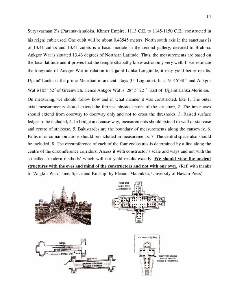
S�ryavarman 2’s (Paramavi�uloka, Khmer Empire, 1113 C.E. to 1145-1150 C.E., constructed in
his reign) cubit used. One cubit will be about 0.43545 meters. North south axis in the sanctuary is
of 13.41 cubits and 13.41 cubits is a basic module in the second gallery, devoted to Brahma.
Ankgor Wat is situated 13.43 degrees of Northern Latitude. Thus, the measurements are based on
the local latitude and it proves that the temple sthapathy knew astronomy very well. If we estimate
the longitude of Ankgor Wat in relation to Ujjain� La�ka Longitude, it may yield better results.
Ujjain� La�ka is the prime Meridian in ancient days (0° Logitude). It is 75°46´38´´ and Ankgor
Wat is103° 52´ of Greenwich. Hence Ankgor Wat is 28° 5´ 22 ´´ East of Ujjain� La�ka Meridian.
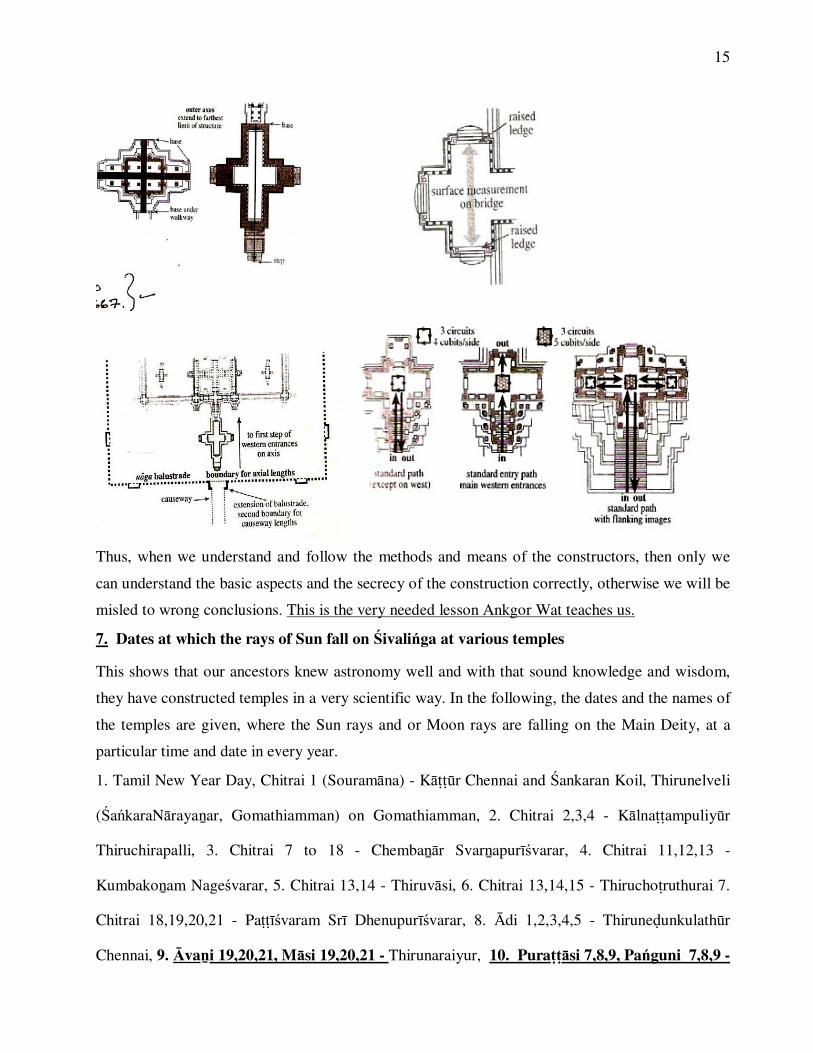
On measuring, we should follow how and in what manner it was constructed, like 1. The outer
axial measurements should extend the farthest physical point of the structure, 2. The inner axes
should extend from doorway to doorway only and not to cross the thresholds, 3. Raised surface
ledges to be included, 4. In bridge and cause way, measurements should extend to wall of staircase
and centre of staircase, 5. Balustrades are the boundary of measurements along the causeway, 6.
Paths of circumambulations should be included in measurements, 7. The central space also should
be included, 8. The circumference of each of the four enclosures is determined by a line along the
centre of the circumference corridors. Assess it with constructor’s scale and ways and not with the
so called ‘modern methods’ which will not yield results exactly. We should view the ancient structures with the eyes and mind of the constructors and not with our own. (Ref. with thanks
to ‘Angkor Wat: Time, Space and Kinship’ by Eleanor Mannikka, University of Hawaii Press).
15
Thus, when we understand and follow the methods and means of the constructors, then only we
can understand the basic aspects and the secrecy of the construction correctly, otherwise we will be
misled to wrong conclusions. This is the very needed lesson Ankgor Wat teaches us.
7. Dates at which the rays of Sun fall on �ivali�ga at various temples
This shows that our ancestors knew astronomy well and with that sound knowledge and wisdom,
they have constructed temples in a very scientific way. In the following, the dates and the names of
the temples are given, where the Sun rays and or Moon rays are falling on the Main Deity, at a
particular time and date in every year.
1. Tamil New Year Day, Chitrai 1 (Souram�na) - K����r Chennai and �ankaran Koil, Thirunelveli
(�a�karaN�raya�ar, Gomathiamman) on Gomathiamman, 2. Chitrai 2,3,4 - K�lna��ampuliy�r
Thiruchirapalli, 3. Chitrai 7 to 18 - Chemba��r Svar�apur��varar, 4. Chitrai 11,12,13 -
Kumbako�am Nage�varar, 5. Chitrai 13,14 - Thiruv�si, 6. Chitrai 13,14,15 - Thirucho�ruthurai 7.
Chitrai 18,19,20,21 - Pa����varam Sr� Dhenupur��varar, 8. �di 1,2,3,4,5 - Thirune�unkulath�r
Chennai, 9. �va�i 19,20,21, M�si 19,20,21 - Thirunaraiyur, 10. Pura���si 7,8,9, Pa�guni 7,8,9 -
16
Thirupai�j�li, 11. Pura���si 8, Pa�guni 8 - Thirupp��rurai, 12. Thai Rathasaptami - Ka�chipuram
Ek�mbaran�thar and Thiruche�ko�u Erode, 13. Thai Am�vasyai for 1 week - Thirunelveli Sr�
Nelliayappar, 14. M�si �ivar�tri - Thirumurukanp���i Avina�i, 15.M�si 13,14,15 - Thirucherai,
16. M�si 18 - Sr� ARUN�CHALE�VARAR, 17. M�si 24,25,26 - Thirukaruk�v�r, 18. M�si 30,
for 1 week - Nannilam, 19. M�si 8,9,10 - Evening Time from 5-30 PM onwards first on Nandiyam
Perum�n, then at the footstep of Karuvarai (Sanctum Sanctorum), then at the base, middle part and
then upper part of �ivali�ga, (2 minutes at each part) Th�rama�galam Salem, 20. Pa�guni 1,2,3 -
M�nthurai, 21. Pa�guni 13,14,15 - Thiruvedikudi, 22. Pa�guni 26,27,28 - Sr�Maku�e�varar
Thirup���iKo�umu�i Erode and 23. On Equinoctial days - Modher� (DharmaAra�ya), Gujarath
102 Kms from Kar��vati, on the bank of Pupavathi River. The temple was constructed during the
rule of King Beemdev of Sola�ki Kingdom, in 1026 C.E. The Light Rays of the Sun fall on God
S�rya (the Main Diety) in the mornings. Sthalapur��a says Sr� R�ma with Seetha M�tha on return
to Ayodhya, after victory at La�ka worshiped here, on the advice of �i Vasi�ha. In
Thirunaraiy�r, Thirupai�j�li and Thirupp��rurai, the temples are constructed in a very special
manner, so that the rays of the Sun, worship �ivali�ga both during Uttar�ya�a and Dakin�yana
transits of the Sun, as shown by the dates mentioned above, which are exactly six months apart.
The most interesting will be the temple at Thirun�ge�varam, near Kumbako�am. Here
we worship Sr� N�gan�thasv�my (Se�baga �ra�ye�varar) and Piraiya�iv�nnuthal Umay�mbikai
(Ardhacandrabimba Guj�mbik�). On K�rthikai Month Pour�ami (mostly the star of the day is
Kttik�), at night 8 to 9 PM, the Light Rays of Moon will fall at the feet of Piraiya�iv�nnuthal
Umay�mbikai. Chandra is said to perform P�ja and worship Piraiya�iv�nnuthal Umay�mbikai on
K�rthikai Pour�ami day. The following diagram shows that with respect to the Sun, the Earth and
the Moon are in conjunction with the ecliptic star Kttik�. However, with Earth as the reference
point, the Moon is in conjunction with the star Kttik� and the Sun, at V�cika R�si, is exactly 180
degrees apart from Moon, and thus it is a full moon day (Pour�ami). Since the Sun is at V�cika

17
R�si, it is K�rtikai month. This month is named as K�rtikai, because almost in all K�rtikai months
of all years, the full Moon, which is 180 degree apart from the Sun at V�cika R�si, is in
conjunction with the star Kttik�. In our Nation, all the months of the year are named in this way
only, i.e. with astronomical basis only. This shows our ancestors’ thorough astronomical
knowledge. Here, on the Full moon day of K�rthikai month, the Moon rays worship the feet of
Piraiya�iv�nnuthal Umay�mbikai.
MAKARA12 RASI ( ZODAICS)
MOON
EARTH
MOON’S ORBIT AROUND EARTH
SUN
EARTH’S ORBIT AROUND SUN (ECLIPTIC)
SUN’S APPARENT ORBIT
MASHA RSHABHA
MITHUNA
KARKATAKA
SIMHA
KANYA
TULAVRISCIKA
DHANUS
KUMBHA
MEENA
(26°40’ TO 40°00’)KRITTIKA
210° TO 240°
0 360° / °30°
60°
90°
120°
150°
180°
210°
240°
270°
300°
330°
The same thing happens at Thi�gal�r near Kumbako�am. Here we worship Kail�san�thar and
Periyan�yakiamb�l. On Pour�ami tithi in Ph�lguna (Pa�guni) month (mostly the star of the day is
12 RASI ( ZODAICS)
MOON
EARTH
MOON’S ORBIT AROUND EARTH
SUN
EARTH’S ORBIT AROUND SUN (ECLIPTIC)
SUN’S APPARENT ORBIT
MASHA RSHABHA
MITHUNA
KARKATAKA
SIMHA
KANYA
TULAVRISCIKA
DHANUS
MAKARA
KUMBHA
MEENA330° TO 360°
0 360° / °30°
60°
90°
120°
150°
180°
210°
240°
270°
300°
330°
UTTARA PHALGUNI(UTTIRAM) 146° 40 ̀TO 160°)

18
Uttara Ph�lgun�, Uttiram), at Sun Rise, the Light Rays of the Sun fall on �ivali�ga and at Moon
Rise, the Light Rays of the Moon fall on the �ivali�ga. Here the Moon is in conjunction with the
star Uttara Ph�lgun� (Uttiram) and is 180 degree apart from the Sun, on seen from the Earth. Hence
it is a full moon day and the month is named as Ph�lguna (Pa�guni). The Sun is at M�na R�si with
reference to Earth.
In these two temples, the rays of Moon worship God, on a particular month’s full moon
day only and not in all 12 full moon days of a year. This is because, the Earth’s axis is inclined at
23° 27` to its ecliptic path around the Sun. Thus, the temples are constructed in a special manner,
that the rays can enter into the Sanctum Sanctorum at a particular angle, calculated according to
the declination of the Sun and the Moon, on that particular month’s full moon day. This is because,
on revolving round the Sun in its Ecliptic, the part of the Earth that is in direct line with the Sun
varies constantly, in accordance with Sun’s declination. This is shown in the above figures. Here it
is shown that the Sun Rays fall straight (90º) at the Equator of the Earth on March 21st and
September 23rd (Sun’s declination 0º), at the tropic of Cancer on June 21st (Sun’s declination 23º
27`N) and at tropic of Capricorn on December 22nd (Sun’s declination 23º 27`S). The Moon is
19
revolving round the Earth in almost in the same plane at which the Earth revolves round the Sun
i.e. with a tilt of 5.145º only to the ecliptic. Thus, the plane of Earth, Moon and the Sun is almost
same. Thus, the Earth’s tilt towards Moon and Sun is unique to that month and date, that means, at
that particular angle only, the Moon rays can enter into the Sanctum Sanctorum, in that month, on
that particular date and not in other months and other dates. This particular angle is different for
each month. Besides, due to inclination of the Earth, the various places of Earth are at various
angles towards Sun and Moon, on any day of the year. In the same way, the angle at which the Sun
is seen from a particular place varies on every day of the year, due to changing declination of the
Sun. This is the basis of constructing a temple with the mechanism that enables the Sun rays to fall
on the Deity, only on a particular date in a year.
COCLUSION
These evidences clearly show that astronomy is well developed in our Nation, that too, in
the remotest antiquity. The movements of celestial bodies are calculated exactly with the expertise
knowledge in astronomy, using the celestial co-ordinates, by our ancestors. This is essential in
calculating the auspicious time in temple construction. In the same way, the co-ordinates of the
Earth, the declination of the Sun and �ankusthap�nam are very essential in fixing the directions
exactly, at the place of temple construction. These things prove that our ancestors had a thorough
knowledge in Astronomy, Civil Engineering, Architecture and Mathematics including Geometry
and this knowledge had spread to the whole world. Thus, in our Nation, the temple construction
and architecture are completely based on astronomy and is totally scientific. Hence, temple
architecture and construction are Divinity, excellent art, but none the less science.
-----------------------------------------------------------------------------------------------------------------------