assessment of soil erosion at a dc park facility spring ... assessment of soil erosion at a dc park...
TRANSCRIPT

1
Assessment of Soil Erosion at a DC Park Facility Spring Valley Park
NW Washington, DC
Annual Progress Report for FY 2004
Prepared by: Principal Investigators : Inder Bhambri, Ph.D., PE
Philip Brach, Ph.D., PE, FNSPE Ahmet Zeytinci, Ph.D., PE Student Interns: Aristides A. Moreno Ferebory Kourouma
Koji Harada
Department of Engineering, Architecture and Aerospace Technology University of the District of Columbia
Date: May 2005
Prepared for the DC Water Resources Research Institute Funded by USGS through the US Department of Interior

2
Table of Contents
Introduction ………...………………………………1
Background Concepts and Formulae………………...3
Methodology……… ….……………………………...5
Observations and Results …….……………………....7
Conclusion……………………………………………12
Appendix A…………………………………………...14

3
INTRODUCTION The purpose of this project is to provide a preliminary site inventory and assessment of soil
erosion for the Spring Valley Park. This park was one of nine (9) identified by the USDA
Natural Resources Conservation Service through the Watershed Protection Division of the DC
Department of Health as having severe gully or stream erosion. Due to its location relative to
the University and small size it was determined to be an ideal park for the pilot assessment study.
Failure to control erosion caused by the runoff of rain water can lead to environmental
problems, both natural and man-made. Awareness of such problems is the beginning of
environmental education. But, learning must go beyond awareness. Knowledge of the causes and
solutions of problems is an important part of environmental studies. After studying the faults at
Spring Valley Park we recommend to take direct action for the repair and protection of the park
since the erosion is leaving the roots of the trees hanging on the edges of gullies and causing
them to fall into the ravine.
We have found that erosion is a major cause of the deterioration of the quality of the
park. “Erosion”, a venerable and time-worn subject, in the history of conservation is still a major
ecologic force in the world. Whereas there has been improved control of soil erosion from
agricultural lands, in urban areas this has not been the case. Increasing erosion from newly
graded land and excavations related to road construction and urban development has
compounded the problem in urban areas. All of these changes reduce the capacity of watersheds
to absorb heavy rainfall, and they increase the dangers of severe floods.
Studies in the 1950’s indicated that there is more than 300 tons of erosion per square mile
per year in the United States, not including wind erosion.

4
Some erosion is unavoidable, of course, and should be considered part of the natural
geologic process. There is no doubt, however, that man’s activities, particularly in urban areas
have tremendously accelerated erosion.
Spring Valley Park, is getting deeper with time, its gully carries and transports the soil
directly to the Potomac River. This not only contributes to the cause of floods but also damages
the fauna of the river. Spring Valley Park is an excellent case study that will lead to a “protocol”
for the analysis and remediation of erosion in all other parks in the District of Columbia.
OBJECTIVE
The objective of this study was to select a single park in Washington, DC
and to identify within that park the location of eroded areas, the causes of the soil
erosion, and to recommend potential remedial measures to control soil erosion in
the park. A single park was selected to serve as model for the investigation of all
parks in the District of Columbia for the remediation of soil erosion.
The Spring Valley Park, located at in the 4900 block of Fordham St. NW, was
selected for the initial study for the following reasons:
·The proximity of the park to the University. ·The relatively small size of the park. ·The relatively serious nature of the current state of erosion.
These reasons made the park “best” suited for a pilot project that would be
accomplished by students and faculty from the University and the resources
available.

5
METHODOLOGY
Site investigation: The park site is visited to establish the general location of the park, the most obvious problem areas and to identify any unique characteristic of the park.
Data collection: The boundary and topography of the park are established. Either from existing maps and/or by making a new survey.
Identification of problem areas: A carefully visual survey is made of all areas of the park which show evidence of erosion and are indicated on the site plan/ topographic map for further analysis.
Determination of causes: Through consideration of a cursory hydrological analysis the most likely cause of the erosion at each site is documented
Remediation: Potential means of ameliorating the erosion at each site is presented
SITE INVESTIGATION A topographic map of the site is necessary. In that there was not a workable map available, the
project team made the initial reconnaissance for the field survey for a topographic map of the
park. This enabled the team to determine the position of abutting roads, the creek bed, and the
characteristics of the terrain. In addition the areas of erosion that were denied to require
remediation were identified and photographed.
DATA COLLECTION The field team completed a field survey to draw a topographic map of the park and to locate the
boundary of the park relative to the abutting properties.
All the data obtained from the field measurements are listed on an excel spreadsheet in
Appendix-A A site plan was prepared using Auto CAD 2005 software

6
The most common way of indicating relief on a map is using contours. The contour interval
selection depends on the diversity of relief in the area being mapped as well as the purpose and scale
of the map. For this project it was determined that the contour interval should be 1 foot.
IDENTIFICATION OF PROBLEM AREAS
Four primary locations were found to have serious erosion and in need of remediation. These are
identified as ERN areas (Erosion Remediation Necessary) and are shown on the site plan. Two areas
in need of corrective action, but not erosion related were also identified. The overall quality of the
park will be improved if both the erosion and ancillary problems are addressed.
DETERMINATION OF CAUSES
(Still being prepared)
REMEDIATION
(Still being prepared)
7
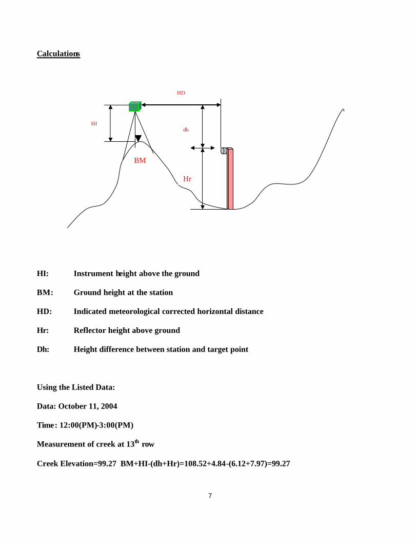
Calculations
HI: Instrument height above the ground
BM: Ground height at the station
HD: Indicated meteorological corrected horizontal distance
Hr: Reflector height above ground
Dh: Height difference between station and target point
Using the Listed Data:
Data: October 11, 2004
Time: 12:00(PM)-3:00(PM)
Measurement of creek at 13th row
Creek Elevation=99.27 BM+HI-(dh+Hr)=108.52+4.84-(6.12+7.97)=99.27
HI
HD
BM
Hr
dh
8
Results
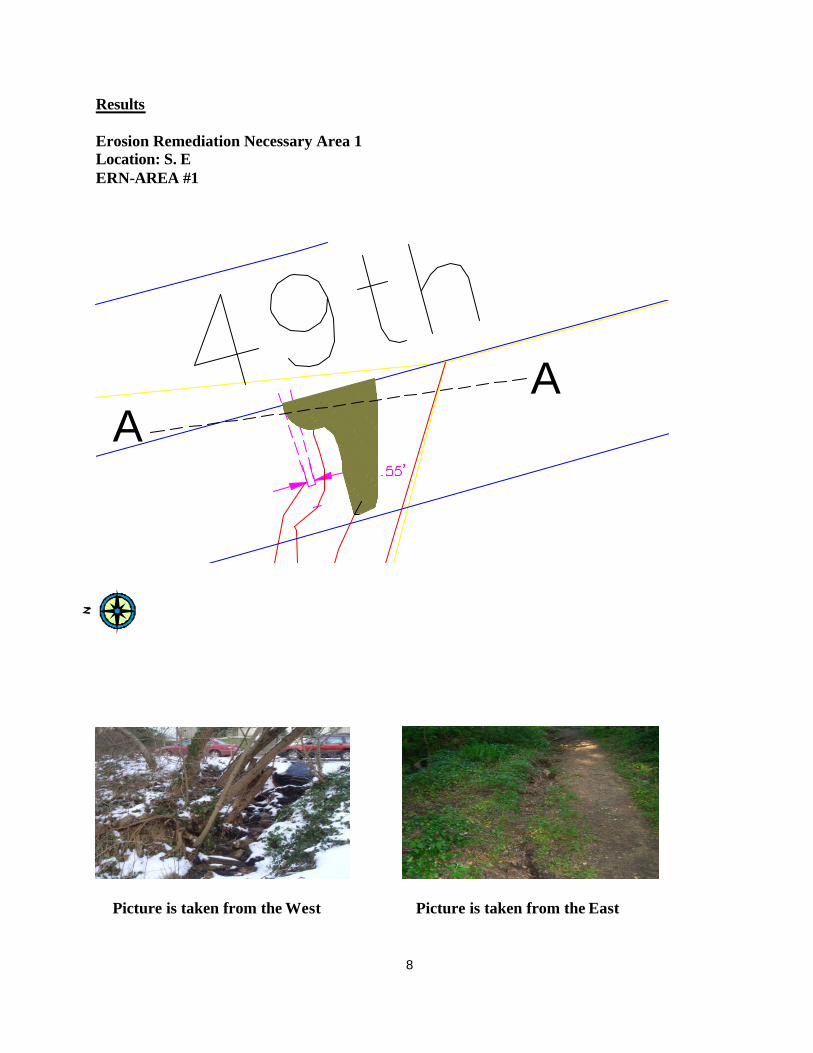
Erosion Remediation Necessary Area 1 Location: S. E ERN-AREA #1
AA
Picture is taken from the West Picture is taken from the East
9
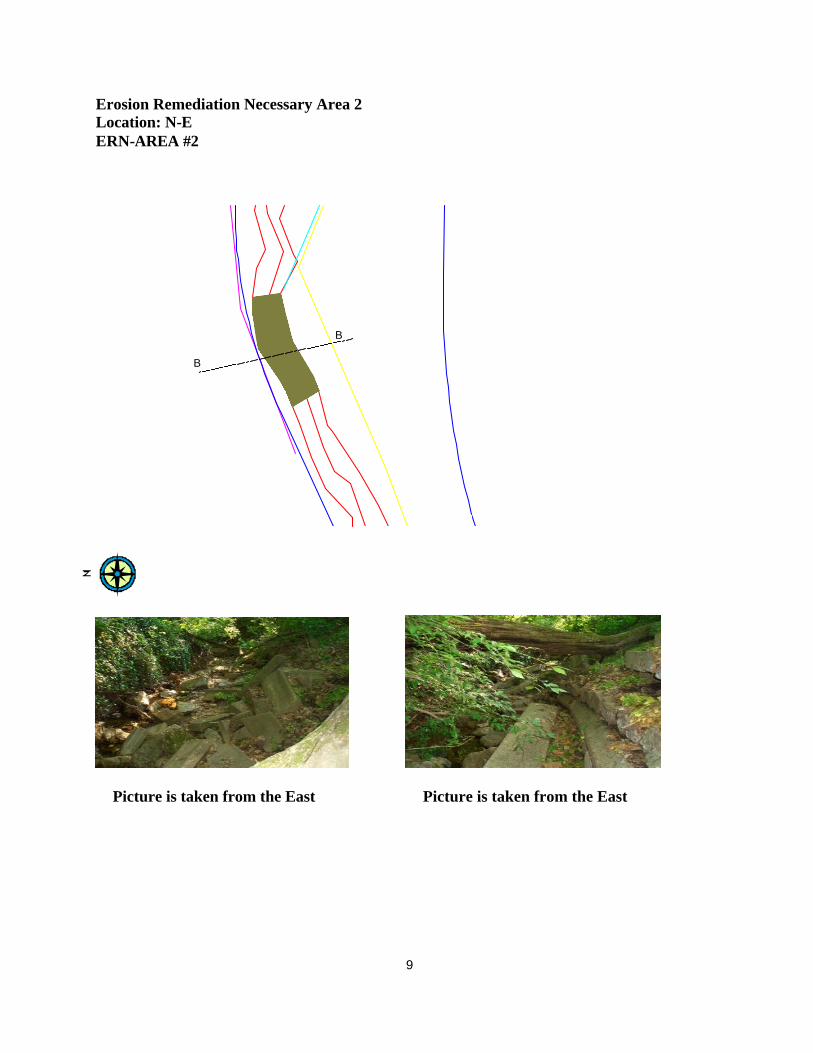
Erosion Remediation Necessary Area 2 Location: N-E ERN-AREA #2
B
B
Picture is taken from the East Picture is taken from the East
10
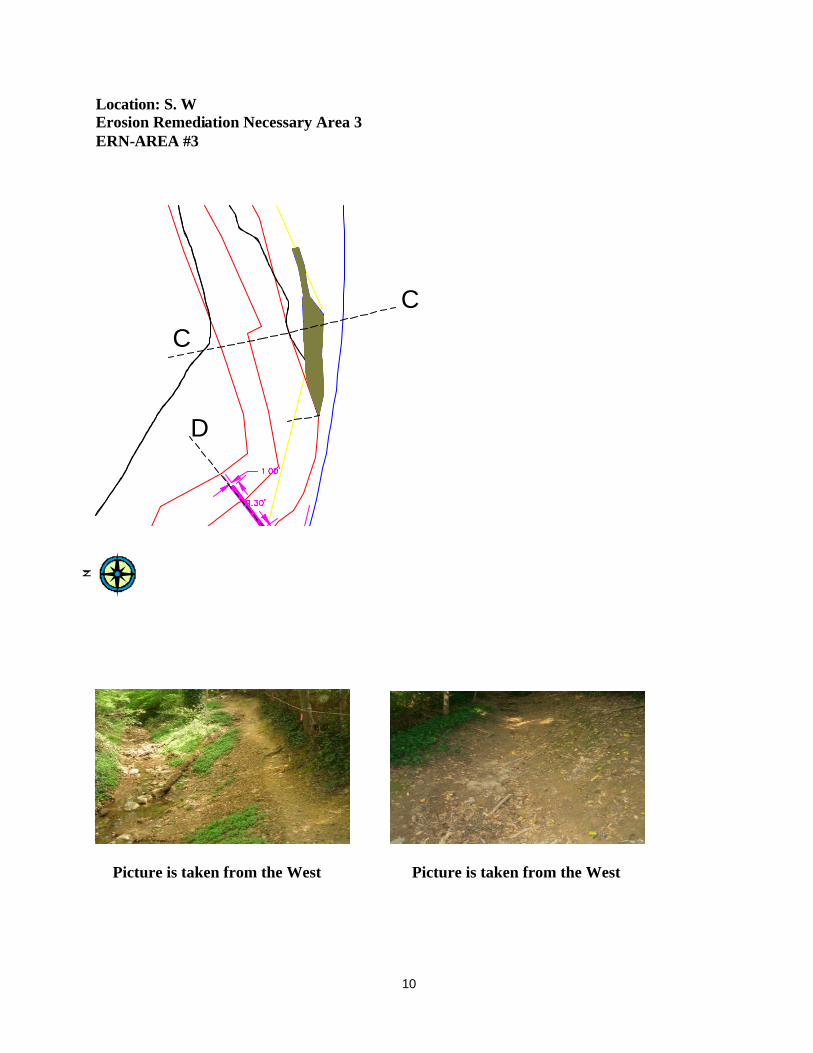
Location: S. W Erosion Remediation Necessary Area 3 ERN-AREA #3
C
C
D
Picture is taken from the West Picture is taken from the West

11
Location: S. W Erosion Remediation Necessary Area 4 AREA #4
D
D
Picture is taken from the North West Picture is taken from the West
12
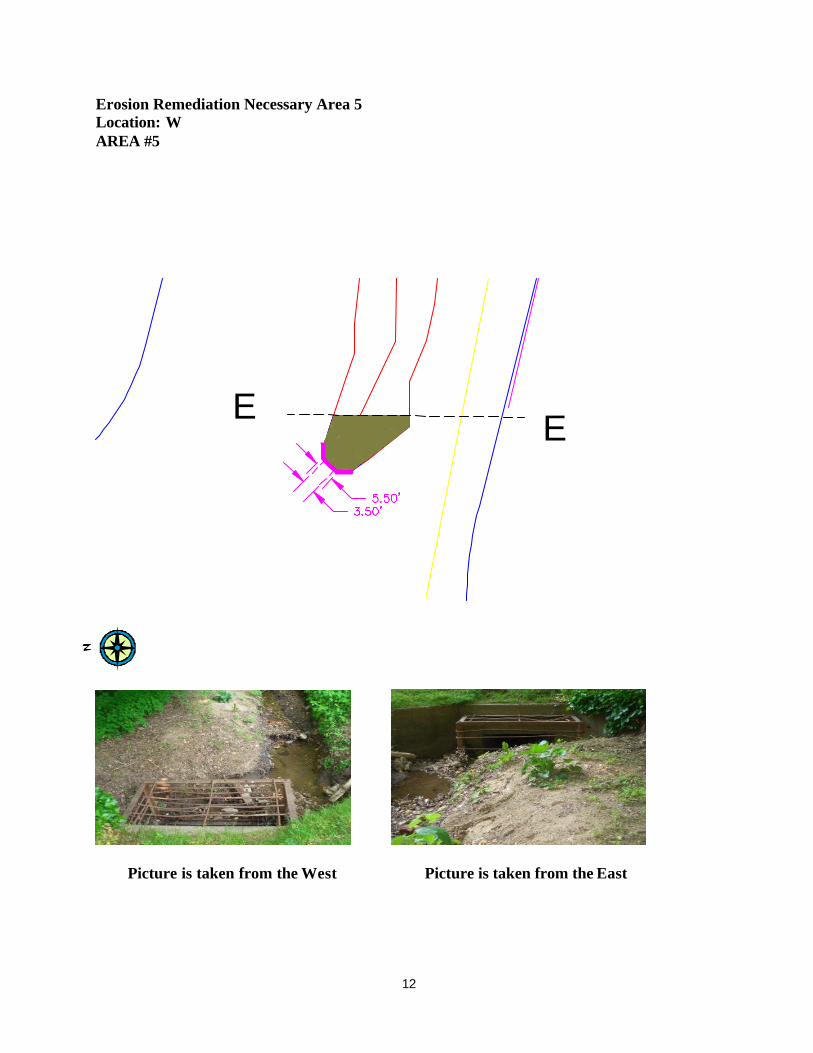
Erosion Remediation Necessary Area 5 Location: W AREA #5
E E
Picture is taken from the West Picture is taken from the East

13
Conclusions
ERN: “Erosion Remediation Necessary” ERN AREA (1) A drop inlet should be built on the west curb of the sheet at the lowest point w/ the pipe draining to the same location as the pipe draining the east side of the area. (See drawing) ERN AREA (2) Provide cribbing 100’ as an interim solution to mitigate erosion on the abutting property, a wall of cribbing 100’ long plus 10’ high. Would this be inadequate? An RW will have to be built. ERN AREA (3) Grade the existing ground to a small open channel 2-3’ w/ surface treatment sufficient treatment with gravel must be used. AREA (4) DAM There is an existing dam silted up; the silt needs to be clean up and clear away the debris ANCILLIARY
(1) Rebuild the bridge w/ handrail 4’ wide (2) w/ a single hand rail (3) Dam for crossing
NOT EROSION RELATED Park’s service should consider erecting demarcation of park properties, for example “putting a sign”.

14
APPENDIX A
15
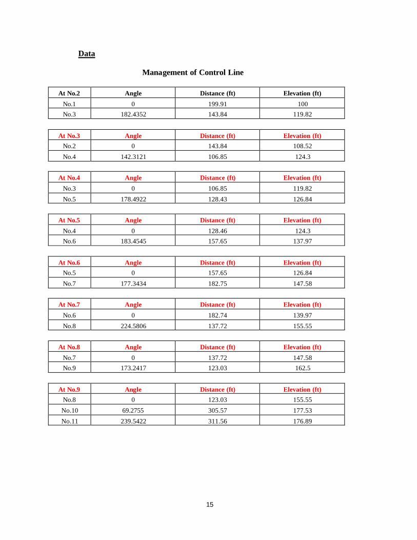
Data
Management of Control Line
At No.2 Angle Distance (ft) Elevation (ft)
No.1 0 199.91 100
No.3 182.4352 143.84 119.82
At No.3 Angle Distance (ft) Elevation (ft)
No.2 0 143.84 108.52
No.4 142.3121 106.85 124.3
At No.4 Angle Distance (ft) Elevation (ft)
No.3 0 106.85 119.82
No.5 178.4922 128.43 126.84
At No.5 Angle Distance (ft) Elevation (ft)
No.4 0 128.46 124.3
No.6 183.4545 157.65 137.97
At No.6 Angle Distance (ft) Elevation (ft)
No.5 0 157.65 126.84
No.7 177.3434 182.75 147.58
At No.7 Angle Distance (ft) Elevation (ft)
No.6 0 182.74 139.97
No.8 224.5806 137.72 155.55
At No.8 Angle Distance (ft) Elevation (ft)
No.7 0 137.72 147.58
No.9 173.2417 123.03 162.5
At No.9 Angle Distance (ft) Elevation (ft)
No.8 0 123.03 155.55
No.10 69.2755 305.57 177.53
No.11 239.5422 311.56 176.89
16
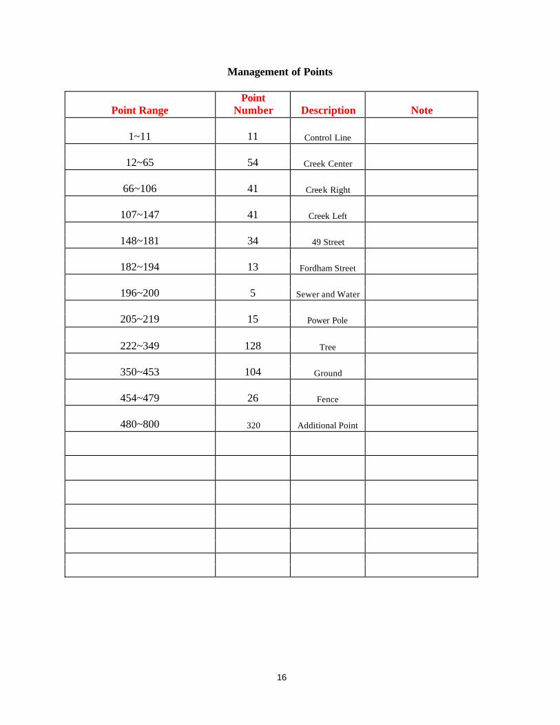
Management of Points
Point Range Point
Number Description Note
1~11 11 Control Line
12~65 54 Creek Center
66~106 41 Creek Right
107~147 41 Creek Left
148~181 34 49 Street
182~194 13 Fordham Street
196~200 5 Sewer and Water
205~219 15 Power Pole
222~349 128 Tree
350~453 104 Ground
454~479 26 Fence
480~800 320 Additional Point

17
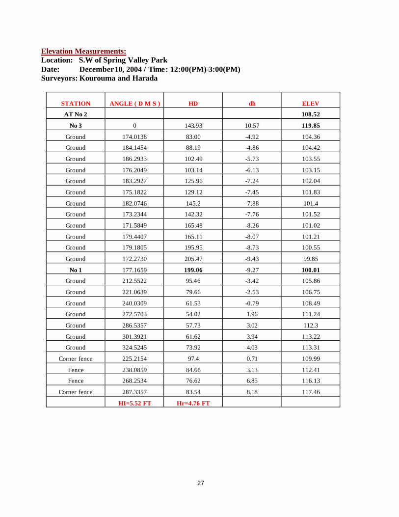
Elevation Measurements: Location: S.E of Spring Valley Park Date: October 4, 2004 / Time: 10:00(AM)-12:00(PM) Surveyors: Kourouma and Harada
STATION ANGLE ( D M S ) HD dh ELEV AT No.1
No.2 0.0000 199.92 4.86 108.52
Manhole 190.2644 15.90 3.04 100.03
Creek (water bed) 184.1548 44.36 -1.44 95.55
BM= 100.00
Hi= 4.97
r= 7.98
STATION ANGLE ( D M S ) HD dh ELEV
AT No.2
No.1 0.0000 199.91 -12.04 100.01
Concrete 16.5744 105.11 -6.59 98.80
Creek (water bed) 16.1426 100.92 -6.12 99.27
Creek (water bed) 17.0105 69.56 -4.66 100.73
Creek (water bed) 27.3305 52.00 -4.11 101.28
Creek (water bed) 49.5100 37.58 -2.89 102.50
Creek (water bed) 100.2743 23.82 -2.13 103.26
Creek (water bed) 133.4755 40.09 -1.42 103.97
Creek (water bed) 151.2928 55.33 -0.44 104.95
Creek (water bed) 172.2559 68.33 0.79 106.18
Creek (water bed) 174.0920 69.19 3.36 108.75
Creek (water bed) 181.5717 83.58 2.75 108.14
Creek (water bed) 177.1931 102.65 3.49 108.88
Creek (water bed) 172.1255 130.23 4.51 109.90
BM= 108.52
Hi= 4.84
r= 7.97
18
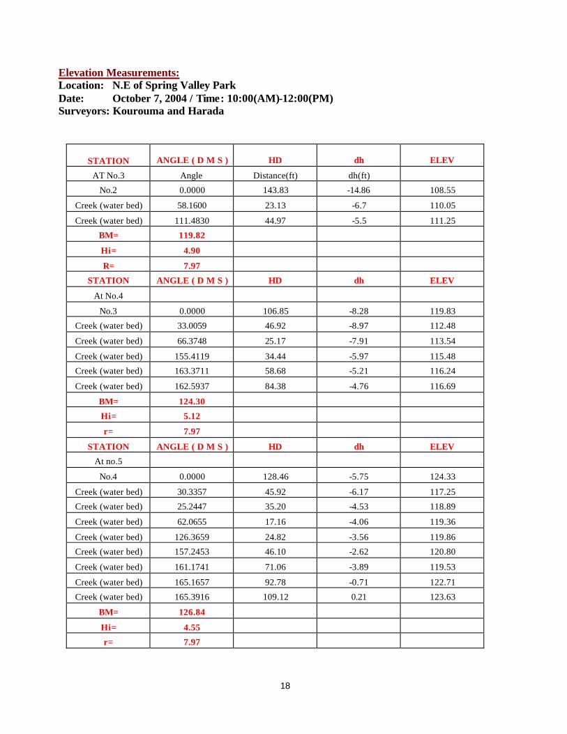
Elevation Measurements: Location: N.E of Spring Valley Park Date: October 7, 2004 / Time: 10:00(AM)-12:00(PM) Surveyors: Kourouma and Harada
STATION ANGLE ( D M S ) HD dh ELEV
AT No.3 Angle Distance(ft) dh(ft)
No.2 0.0000 143.83 -14.86 108.55
Creek (water bed) 58.1600 23.13 -6.7 110.05
Creek (water bed) 111.4830 44.97 -5.5 111.25
BM= 119.82
Hi= 4.90
R= 7.97
STATION ANGLE ( D M S ) HD dh ELEV
At No.4
No.3 0.0000 106.85 -8.28 119.83
Creek (water bed) 33.0059 46.92 -8.97 112.48
Creek (water bed) 66.3748 25.17 -7.91 113.54
Creek (water bed) 155.4119 34.44 -5.97 115.48
Creek (water bed) 163.3711 58.68 -5.21 116.24
Creek (water bed) 162.5937 84.38 -4.76 116.69
BM= 124.30
Hi= 5.12
r= 7.97
STATION ANGLE ( D M S ) HD dh ELEV
At no.5
No.4 0.0000 128.46 -5.75 124.33
Creek (water bed) 30.3357 45.92 -6.17 117.25
Creek (water bed) 25.2447 35.20 -4.53 118.89
Creek (water bed) 62.0655 17.16 -4.06 119.36
Creek (water bed) 126.3659 24.82 -3.56 119.86
Creek (water bed) 157.2453 46.10 -2.62 120.80
Creek (water bed) 161.1741 71.06 -3.89 119.53
Creek (water bed) 165.1657 92.78 -0.71 122.71
Creek (water bed) 165.3916 109.12 0.21 123.63
BM= 126.84
Hi= 4.55
r= 7.97
19
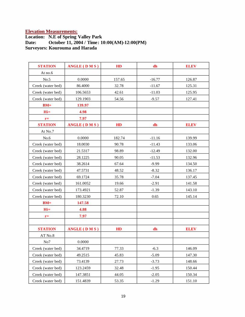
Elevation Measurements: Location: N.E of Spring Valley Park Date: October 11, 2004 / Time: 10:00(AM)-12:00(PM) Surveyors: Kourouma and Harada
STATION ANGLE ( D M S ) HD dh ELEV
At no.6
No.5 0.0000 157.65 -16.77 126.87
Creek (water bed) 86.4000 32.78 -11.67 125.31
Creek (water bed) 106.5653 42.61 -11.03 125.95
Creek (water bed) 129.1903 54.56 -9.57 127.41
BM= 139.97
Hi= 4.98
r= 7.97
STATION ANGLE ( D M S ) HD dh ELEV
At No.7
No.6 0.0000 182.74 -11.16 139.99
Creek (water bed) 18.0030 90.78 -11.43 133.06
Creek (water bed) 21.5317 98.89 -12.49 132.00
Creek (water bed) 28.1225 90.05 -11.53 132.96
Creek (water bed) 38.2614 67.64 -9.99 134.50
Creek (water bed) 47.5731 48.52 -8.32 136.17
Creek (water bed) 69.1724 35.78 -7.04 137.45
Creek (water bed) 161.0052 19.66 -2.91 141.58
Creek (water bed) 173.4921 52.87 -1.39 143.10
Creek (water bed) 180.3230 72.10 0.65 145.14
BM= 147.58
Hi= 4.88
r= 7.97
STATION ANGLE ( D M S ) HD dh ELEV
AT No.8
No7 0.0000
Creek (water bed) 34.4719 77.33 -6.3 146.09
Creek (water bed) 49.2515 45.83 -5.09 147.30
Creek (water bed) 73.4139 27.73 -3.73 148.66
Creek (water bed) 123.2459 32.48 -1.95 150.44
Creek (water bed) 147.3851 44.05 -2.05 150.34
Creek (water bed) 151.4839 53.35 -1.29 151.10
20
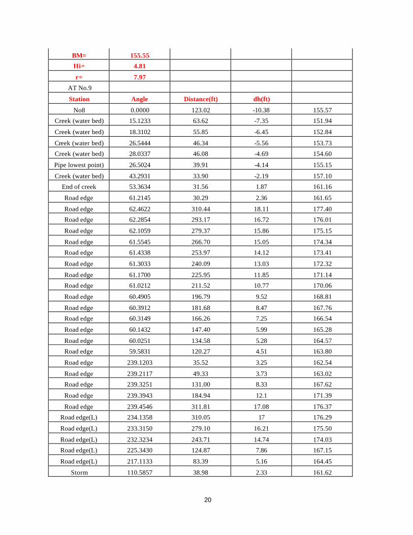
BM= 155.55
Hi= 4.81
r= 7.97
AT No.9
Station Angle Distance(ft) dh(ft)
No8 0.0000 123.02 -10.38 155.57
Creek (water bed) 15.1233 63.62 -7.35 151.94
Creek (water bed) 18.3102 55.85 -6.45 152.84
Creek (water bed) 26.5444 46.34 -5.56 153.73
Creek (water bed) 28.0337 46.08 -4.69 154.60
Pipe lowest point) 26.5024 39.91 -4.14 155.15
Creek (water bed) 43.2931 33.90 -2.19 157.10
End of creek 53.3634 31.56 1.87 161.16
Road edge 61.2145 30.29 2.36 161.65
Road edge 62.4622 310.44 18.11 177.40
Road edge 62.2854 293.17 16.72 176.01
Road edge 62.1059 279.37 15.86 175.15
Road edge 61.5545 266.70 15.05 174.34
Road edge 61.4338 253.97 14.12 173.41
Road edge 61.3033 240.09 13.03 172.32
Road edge 61.1700 225.95 11.85 171.14
Road edge 61.0212 211.52 10.77 170.06
Road edge 60.4905 196.79 9.52 168.81
Road edge 60.3912 181.68 8.47 167.76
Road edge 60.3149 166.26 7.25 166.54
Road edge 60.1432 147.40 5.99 165.28
Road edge 60.0251 134.58 5.28 164.57
Road edge 59.5831 120.27 4.51 163.80
Road edge 239.1203 35.52 3.25 162.54
Road edge 239.2117 49.33 3.73 163.02
Road edge 239.3251 131.00 8.33 167.62
Road edge 239.3943 184.94 12.1 171.39
Road edge 239.4546 311.81 17.08 176.37
Road edge(L) 234.1358 310.05 17 176.29
Road edge(L) 233.3150 279.10 16.21 175.50
Road edge(L) 232.3234 243.71 14.74 174.03
Road edge(L) 225.3430 124.87 7.86 167.15
Road edge(L) 217.1133 83.39 5.16 164.45
Storm 110.5857 38.98 2.33 161.62
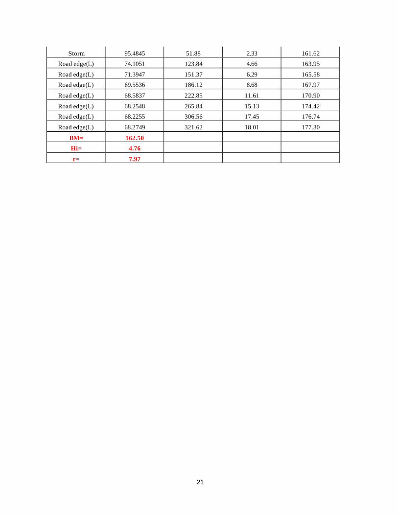
21
Storm 95.4845 51.88 2.33 161.62
Road edge(L) 74.1051 123.84 4.66 163.95
Road edge(L) 71.3947 151.37 6.29 165.58
Road edge(L) 69.5536 186.12 8.68 167.97
Road edge(L) 68.5837 222.85 11.61 170.90
Road edge(L) 68.2548 265.84 15.13 174.42
Road edge(L) 68.2255 306.56 17.45 176.74
Road edge(L) 68.2749 321.62 18.01 177.30
BM= 162.50
Hi= 4.76
r= 7.97
22
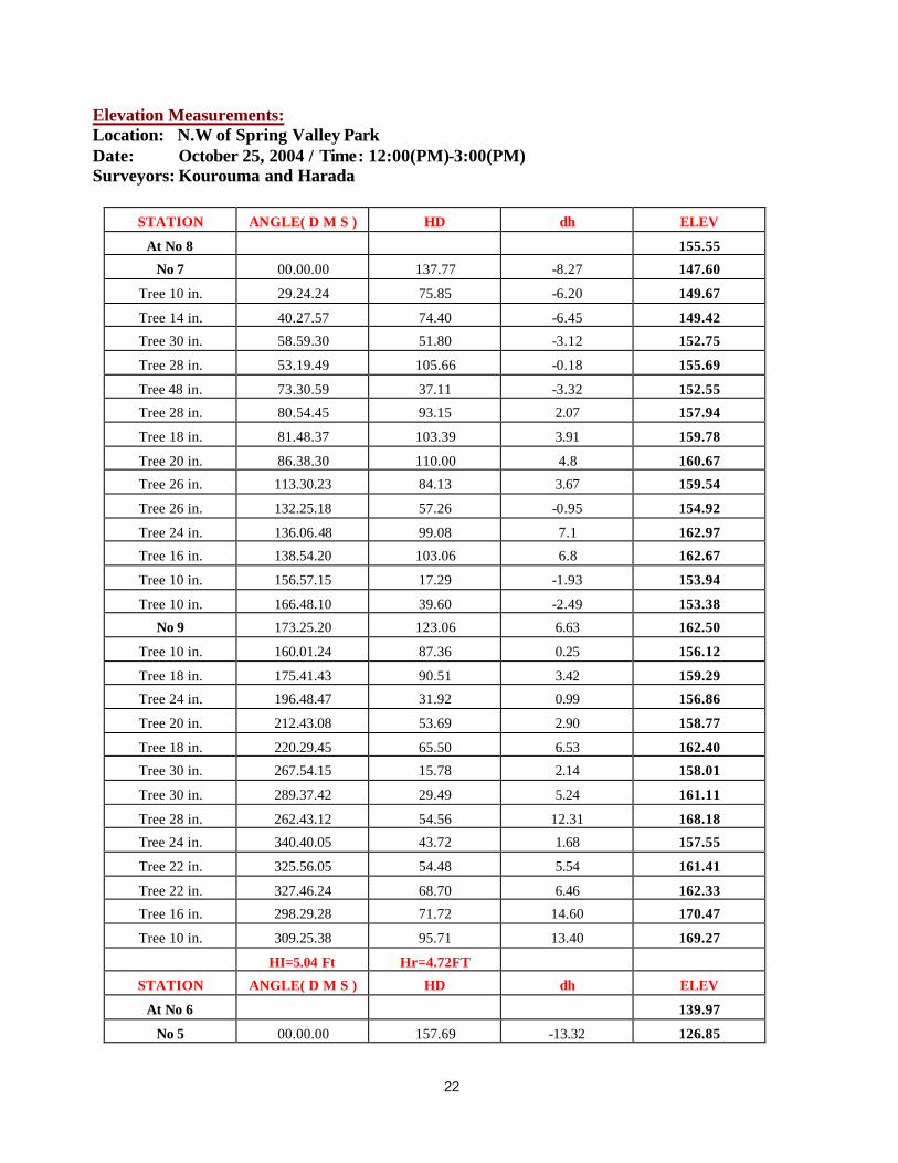
Elevation Measurements: Location: N.W of Spring Valley Park Date: October 25, 2004 / Time: 12:00(PM)-3:00(PM) Surveyors: Kourouma and Harada
STATION ANGLE( D M S ) HD dh ELEV
At No 8 155.55
No 7 00.00.00 137.77 -8.27 147.60
Tree 10 in. 29.24.24 75.85 -6.20 149.67
Tree 14 in. 40.27.57 74.40 -6.45 149.42
Tree 30 in. 58.59.30 51.80 -3.12 152.75
Tree 28 in. 53.19.49 105.66 -0.18 155.69
Tree 48 in. 73.30.59 37.11 -3.32 152.55
Tree 28 in. 80.54.45 93.15 2.07 157.94
Tree 18 in. 81.48.37 103.39 3.91 159.78
Tree 20 in. 86.38.30 110.00 4.8 160.67
Tree 26 in. 113.30.23 84.13 3.67 159.54
Tree 26 in. 132.25.18 57.26 -0.95 154.92
Tree 24 in. 136.06.48 99.08 7.1 162.97
Tree 16 in. 138.54.20 103.06 6.8 162.67
Tree 10 in. 156.57.15 17.29 -1.93 153.94
Tree 10 in. 166.48.10 39.60 -2.49 153.38
No 9 173.25.20 123.06 6.63 162.50
Tree 10 in. 160.01.24 87.36 0.25 156.12
Tree 18 in. 175.41.43 90.51 3.42 159.29
Tree 24 in. 196.48.47 31.92 0.99 156.86
Tree 20 in. 212.43.08 53.69 2.90 158.77
Tree 18 in. 220.29.45 65.50 6.53 162.40
Tree 30 in. 267.54.15 15.78 2.14 158.01
Tree 30 in. 289.37.42 29.49 5.24 161.11
Tree 28 in. 262.43.12 54.56 12.31 168.18
Tree 24 in. 340.40.05 43.72 1.68 157.55
Tree 22 in. 325.56.05 54.48 5.54 161.41
Tree 22 in. 327.46.24 68.70 6.46 162.33
Tree 16 in. 298.29.28 71.72 14.60 170.47
Tree 10 in. 309.25.38 95.71 13.40 169.27
HI=5.04 Ft Hr=4.72FT
STATION ANGLE( D M S ) HD dh ELEV
At No 6 139.97
No 5 00.00.00 157.69 -13.32 126.85

23
Tree 26 in. 42.00.39 59.12 -8.47 131.7
Tree 26 in. 45.05.59 74.30 -7.45 132.72
Tree 30 in. 48.55.29 76.95 -6.27 133.9
Tree 24 in. 53.30.57 70.82 -6.47 133.7
Tree 22 in. 73.08.19 59.80 -4.67 135.5
Tree 38 in. 91.13.02 57.69 -3.61 136.56
Tree 10 in. 99.47.15 49.86 -4.51 135.66
Tree 10 in. 125.07.20 66.02 -2.43 137.74
Tree 10 in. 131.52.42 75.30 0.02 140.19
Tree 38 in. 170.54.33 204.28 6.11 146.28
Tree 38 in. 173.02.10 225.34 7.81 147.98
No 7 177.32.51 182.77 7.44 147.61
HI=4.92Ft Hr=4.72Ft
STATION ANGLE( D M S ) HD dh ELEV
At No 5 126.84
No 4 00.00.00 128.50 -2.49 124.36
Tree 24 in. 21.00.19 123.09 -4.33 122.52
Tree 30 in. 28.17.58 97.82 -0.88 125.97
Tree 36 in. 25.24.38 86.75 -1.33 125.52
Tree 28 in. 34.21.58 65.89 0.95 127.8
Tree 10 in. 14.13.38 85.44 -8.91 117.94
Tree 26 in. 54.06.15 42.23 2.33 129.18
Tree 16 in. 70.41.46 47.06 4.35 131.2
Tree 32 in. 90.04.55 43.01 5.06 131.91
Tree 20 in. 95.48.41 26.50 0.57 127.42
Tree 38 in. 137.29.13 45.21 3.79 130.64
Electric Pole 136.55.27 73.60 6.39 133.24
Electric Pole 326.01.01 73.08 2.46 129.31
Electric Pole 232.57.24 52.09 6.45 133.3
HI=4.73 Ft Hr=4.72 Ft
STATION ANGLE( D M S ) HD dh ELEV
At No 7 147.58
No 6 00.00.00 182.77 -7.83 139.99
Tree 26 in. 116.02.15 32.07 -1.98 145.84
Electric Pole 171.21.30 110.44 8.23 156.05
Electric Pole 80.23.17 58.88 0.71 148.53
Existing Nail 18.06.35 10.90 -0.68 147.14
HI=4.96 Ft Hr=4.72 Ft
STATIO N ANGLE( D M S ) HD dh ELEV
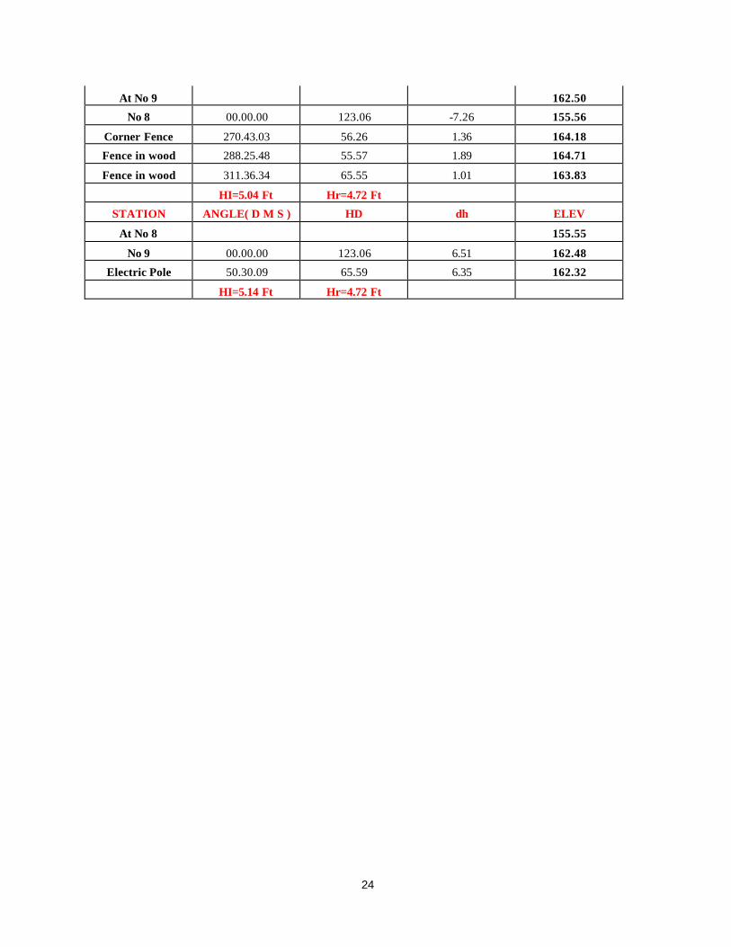
24
At No 9 162.50
No 8 00.00.00 123.06 -7.26 155.56
Corner Fence 270.43.03 56.26 1.36 164.18
Fence in wood 288.25.48 55.57 1.89 164.71
Fence in wood 311.36.34 65.55 1.01 163.83
HI=5.04 Ft Hr=4.72 Ft
STATION ANGLE( D M S ) HD dh ELEV
At No 8 155.55
No 9 00.00.00 123.06 6.51 162.48
Electric Pole 50.30.09 65.59 6.35 162.32
HI=5.14 Ft Hr=4.72 Ft

25
Elevation Measurements: Location: S.E of Spring Valley Park Date: December 1, 2004 / Time: 1:00(PM)-3:00(PM) Surveyors: Kourouma and Harada
STATION ANGLE ( D M S ) HD dh ELEV
AT No 4 124.3
No 5 0 128.48 2.24 126.85
Ground 19.2029 59.88 0.63 125.24
Ground 19.4347 36.49 -2.46 122.15
Ground 183.2154 13.55 -0.36 124.25
Ground 146.5201 17.94 2.03 126.64
Ground 185.5907 40.92 -1.56 123.05
Ground 184.4536 54.95 -1.65 122.96
Ground 181.0302 68.95 -1.99 122.62
Ground 179.2727 90.77 -4.04 120.57
No 3 181.1335 106.89 -4.75 119.86
Ground 335.0902 83.66 2.75 127.36
Ground 329.4050 75.22 2.07 126.68
Ground 317.2925 56.12 0.06 124.67
Ground 303.4536 50.35 -1.07 123.54
Ground 287.4123 43.7 -2.5 122.11
Ground 269.0517 41.55 -3.57 121.04
Corner fence 266.2754 55.77 -1.33 123.28
Fence 250.3152 66.65 -1.16 123.45
Fence 239.0729 80.92 -1.27 123.34
Corner fence 231.5629 95.18 -1.97 122.64
Ground 245.2321 46.57 -4.26 120.35
Ground 225.2802 62.69 -5.55 119.06
Ground 217.0640 81.00 -6.58 118.03
Ground 212.5347 99.95 -7.13 117.48
HI=5.07 FT Hr=4.76 FT

26
Elevation Measurements: Location: N.E of Spring Valley Park Date: December 8, 2004 / Time: 12:00(PM)-3:00(PM) Surveyors: Kourouma and Harada
STATION ANGLE ( D M S ) HD dh ELEV
AT No 3 119.82
No 4 0 106.93 4.08 124.3
Ground 5.1840 26.03 1.32 121.54
Ground 339.2328 9.32 -0.99 119.23
Ground 222.3418 10.94 -2.56 117.66
Ground 211.5804 20.64 -3.39 116.83
Ground 210.3858 26.57 -5.01 115.21
Ground 208.1107 32.65 -5.99 114.23
Ground 208.5020 40.84 -5.77 114.45
Ground 208.3936 56.73 -8.01 112.21
Ground 210.3041 76.63 -6.65 113.57
Sewer 219.4120 90.36 -7.93 112.29
Ground 223.4014 101.16 -8.64 111.58
Ground 215.3332 101.32 -9.09 111.13
Ground 219.3435 117.43 -10.04 110.18
Ground 215.5514 118.12 -9.96 110.26
Ground 219.3945 133.94 -11.11 109.11
Ground 215.4250 136.67 -10.97 109.25
No 2 217.2558 143.93 -11.65 108.57
Ground 218.4049 166.34 -12.51 107.71
Ground 216.2835 166.96 -12.34 107.88
Ground 218.3045 196.66 -13.93 106.29
Ground 215.3204 197.61 -13.92 106.3
Ground 247.3706 96.81 -5.84 114.38
Ground 243.4008 79.28 -6.57 113.65
Ground 252.2752 86.58 -5.07 115.15
Ground 243.1132 66.25 -6.02 114.2
Ground 258.1214 70.72 -4.78 115.44
Ground 264.3821 54.18 -4.57 115.65
Ground 285.5906 51.7 -3.09 117.13
Ground 308.0155 61.63 -2.32 117.9
HI=5.16 FT Hr=4.76 FT
27
Elevation Measurements: Location: S.W of Spring Valley Park Date: December 10, 2004 / Time: 12:00(PM)-3:00(PM) Surveyors: Kourouma and Harada
STATION ANGLE ( D M S ) HD dh ELEV
AT No 2 108.52
No 3 0 143.93 10.57 119.85
Ground 174.0138 83.00 -4.92 104.36
Ground 184.1454 88.19 -4.86 104.42
Ground 186.2933 102.49 -5.73 103.55
Ground 176.2049 103.14 -6.13 103.15
Ground 183.2927 125.96 -7.24 102.04
Ground 175.1822 129.12 -7.45 101.83
Ground 182.0746 145.2 -7.88 101.4
Ground 173.2344 142.32 -7.76 101.52
Ground 171.5849 165.48 -8.26 101.02
Ground 179.4407 165.11 -8.07 101.21
Ground 179.1805 195.95 -8.73 100.55
Ground 172.2730 205.47 -9.43 99.85
No 1 177.1659 199.06 -9.27 100.01
Ground 212.5522 95.46 -3.42 105.86
Ground 221.0639 79.66 -2.53 106.75
Ground 240.0309 61.53 -0.79 108.49
Ground 272.5703 54.02 1.96 111.24
Ground 286.5357 57.73 3.02 112.3
Ground 301.3921 61.62 3.94 113.22
Ground 324.5245 73.92 4.03 113.31
Corner fence 225.2154 97.4 0.71 109.99
Fence 238.0859 84.66 3.13 112.41
Fence 268.2534 76.62 6.85 116.13
Corner fence 287.3357 83.54 8.18 117.46
HI=5.52 FT Hr=4.76 FT

28
Elevation Measurements: Location: N.W of Spring Valley Park Date: December 13, 2004 / Time: 12:00(PM)-3:00(PM) Surveyors: Kourouma and Harada
STATION ANGLE ( D M S ) HD dh ELEV
AT NO 2 108.52
NO 1 0 199.05 -6.69 100.03
Right of creek 12.2933 56.61 -0.96 105.76
Right of creek 19.2801 40.98 -0.51 106.21
Right of creek 52.2435 19.50 0.46 107.18
Right of creek 141.2889 20.21 1.88 108.6
Right of creek 157.2102 42.39 3.08 109.8
Right of creek 160.4541 46.96 4.00 110.72
Right of creek 177.0404 53.22 5.04 111.76
Right of creek 187.0000 64.88 6.33 113.05
Right of creek 188.4726 86.82 5.63 112.35
Right of creek 185.2400 105.18 7.5 114.22
NO 3 182.4327 143.72 13.09 119.81
Left of creek 26.1847 71.66 -2.46 104.26
Left of creek 42.1027 50.52 -0.65 106.07
Left of creek 64.4430 40.00 0.85 107.57
Left of creek 114.374 37.28 2.92 109.64
Left of creek 136.1445 58.05 5.31 112.03
Left of creek 142.4301 64.34 5.26 111.98
Left of creek 148.3931 71.42 5.67 112.39
Left of creek 167.2159 78.98 5.35 112.07
Left of creek 173.4609 86.41 5.29 112.01
Left of creek 172.1926 100.69 7.42 114.14
HI=5.20 FT Hr=7.00 FT

29
Elevation Measurements: Location: S.W of Spring Valley Park Date: December 15, 2004 / Time: 12:00(PM)-3:00(PM) Surveyors: Kourouma and Harada
STATION ANGLE ( D M S ) HD dh ELEV
AT NO 3 119.82
NO 2 0 106.79 -9.14 108.54
Right of creek 30.2834 15.87 -1.70 115.98
Right of creek 131.3947 40.12 3.69 121.37
Right of creek 134.5939 66.82 4.40 122.08
Right of creek 138.8142 95.21 5.29 122.97
Left of creek 52.1921 39.59 -2.21 115.47
Left of creek 98.5914 54.75 -0.49 117.19
Left of creek 114.5521 75.55 1.15 118.83
Left of creek 120.2951 99.73 2.65 120.33
HI=4.86 FT Hr=7.00 FT
STATION ANGLE ( D M S ) HD dh ELEV
AT NO 4 124.30
NO 3 0 106.79 -2.36 119.87
Right of creek 187.3320 26.05 -0.66 121.57
Right of creek 173.5499 60.59 1.25 123.48
Right of creek 173.4050 87.85 1.81 124.04
Right of creek 178.2139 123.65 3.76 125.99
Right of creek 174.5550 145.59 4.96 127.19
Left of creek 138.1218 96.04 0.74 122.97
Left of creek 149.1847 59.31 1.87 124.1
Left of creek 154.2230 79.06 3.99 126.22
Left of creek 158.5850 101.79 6.66 128.89
Left of creek 164.1337 127.89 7.41 129.64
HI=4.93 FT Hr=7.00 FT
STATION ANGLE ( D M S ) HD dh ELEV
AT NO 5 126.84
NO 4 0 128.43 -0.28 124.34
Right of creek 148.094 18.40 2.33 126.95
Right of creek 167.0442 44.27 3.44 128.06
Right of creek 166.4813 67.14 5.67 130.29
Right of creek 175.1641 92.12 9.31 133.93
Left of creek 121.4707 42.42 6.82 131.44
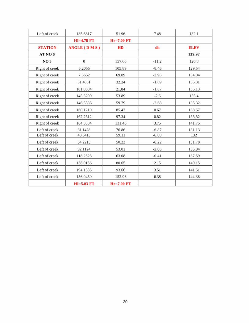
30
Left of creek 135.6817 51.96 7.48 132.1
HI=4.78 FT Hr=7.00 FT
STATION ANGLE ( D M S ) HD dh ELEV
AT NO 6 139.97
NO 5 0 157.60 -11.2 126.8
Right of creek 6.2055 105.89 -8.46 129.54
Right of creek 7.5652 69.09 -3.96 134.04
Right of creek 31.4051 32.24 -1.69 136.31
Right of creek 101.0504 21.84 -1.87 136.13
Right of creek 145.3200 53.89 -2.6 135.4
Right of creek 146.5536 59.79 -2.68 135.32
Right of creek 160.1210 85.47 0.67 138.67
Right of creek 162.2612 97.34 0.82 138.82
Right of creek 164.3334 131.46 3.75 141.75
Left of creek 31.1428 76.86 -6.87 131.13 Left of creek 48.3413 59.11 -6.00 132
Left of creek 54.2213 50.22 -6.22 131.78
Left of creek 92.1124 53.01 -2.06 135.94
Left of creek 118.2523 63.08 -0.41 137.59
Left of creek 138.0156 80.65 2.15 140.15
Left of creek 194.1535 93.66 3.51 141.51
Left of creek 156.0450 152.93 6.38 144.38
HI=5.03 FT Hr=7.00 FT
31
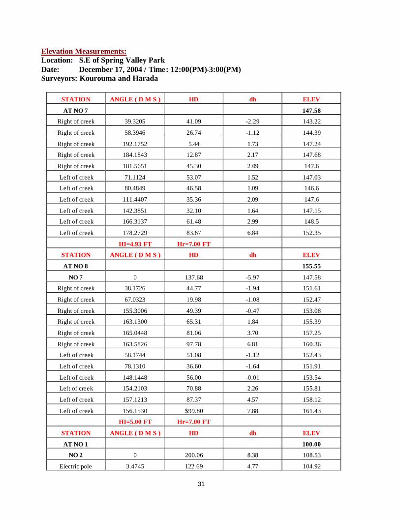
Elevation Measurements: Location: S.E of Spring Valley Park Date: December 17, 2004 / Time: 12:00(PM)-3:00(PM) Surveyors: Kourouma and Harada
STATION ANGLE ( D M S ) HD dh ELEV
AT NO 7 147.58
Right of creek 39.3205 41.09 -2.29 143.22
Right of creek 58.3946 26.74 -1.12 144.39
Right of creek 192.1752 5.44 1.73 147.24
Right of creek 184.1843 12.87 2.17 147.68
Right of creek 181.5651 45.30 2.09 147.6
Left of creek 71.1124 53.07 1.52 147.03
Left of creek 80.4849 46.58 1.09 146.6
Left of creek 111.4407 35.36 2.09 147.6
Left of creek 142.3851 32.10 1.64 147.15
Left of creek 166.3137 61.48 2.99 148.5
Left of creek 178.2729 83.67 6.84 152.35
HI=4.93 FT Hr=7.00 FT
STATION ANGLE ( D M S ) HD dh ELEV
AT NO 8 155.55
NO 7 0 137.68 -5.97 147.58
Right of creek 38.1726 44.77 -1.94 151.61
Right of creek 67.0323 19.98 -1.08 152.47
Right of creek 155.3006 49.39 -0.47 153.08
Right of creek 163.1300 65.31 1.84 155.39
Right of creek 165.0448 81.06 3.70 157.25
Right of creek 163.5826 97.78 6.81 160.36
Left of creek 58.1744 51.08 -1.12 152.43
Left of creek 78.1310 36.60 -1.64 151.91
Left of creek 148.1448 56.00 -0.01 153.54
Left of creek 154.2103 70.88 2.26 155.81
Left of creek 157.1213 87.37 4.57 158.12
Left of creek 156.1530 $99.80 7.88 161.43
HI=5.00 FT Hr=7.00 FT
STATION ANGLE ( D M S ) HD dh ELEV
AT NO 1 100.00
NO 2 0 200.06 8.38 108.53
Electric pole 3.4745 122.69 4.77 104.92

32
Electric pole 328.5758 151.52 9.10 109.25
Ground 346.4440 101.53 3.35 103.5
Ground 331.3310 108.89 4.21 104.36
Tree 3 ft 323.2621 75.75 3.14 103.29
Tree 3 ft 334.4657 44.89 1.49 101.64
Ground 4.0618 99.58 3.8 103.95
Ground 18.0508 55.97 0.9 101.05
Ground 75.5657 47.90 -0.1 100.05
Sewer 100.1352 159.68 -2.65 97.5
Edge 100.4248 160.03 -3.09 97.06
Sewer 101.2113 150.36 -2.54 97.61
Edge 102.0733 151.19 -3.21 96.94
Edge 105.5146 122.51 -3.04 97.11
Edge 108.5948 67.51 -1.84 98.31
Edge 108.2741 29.2 -1.09 99.06
Manhole water 104.2323 84.04 -2.13 98.02
DCSL 104.1132 95.39 -1.83 98.32
DCSL 20.2230 10.61 1.14 101.29
Edge 289.2558 64.95 2.05 102.2
Edge 268.4257 84.30 2.41 102.56
Edge 203.3803 29.20 -0.19 99.96
Curb 134.5950 67.00 -2.09 98.06
Middle curb 125.4839 98.46 -3.08 97.07
End curb 119.2959 128.02 -3.40 96.75
Curb 112.4807 158.88 -3.77 96.38
Edge 107.3745 183.67 -4.00 96.15
Sewer 107.1832 188.67 -3.17 96.98
Corner 346.0131 103.98 2.38 102.53
HI=4.97 FT Hr=4.82 FT

33
Elevation Measurements: Location: S.E of Spring Valley Park Date: December 20, 2004 / Time: 12:00(PM)-3:00(PM) Surveyors: Kourouma and Harada
STATION ANGLE ( D M S ) HD dh ELEV
AT NO 2 108.52
NO 1 0 200.05 -8.66 100.02
Fence corner 351.3136 78.27 -3.00 105.68
Fence 333.3305 29.20 -0.35 108.33
Fence 208.4418 29.33 2.90 111.58
Electric pole 194.1922 64.65 5.19 113.87
Fence 193.0423 73.71 5.66 114.34
Fence 187.2655 103.95 7.16 115.84
Fence 185.3931 129.68 11.17 119.85
Corner 183.1355 155.40 13.35 122.03
No 3 182.4326 144.00 11.12 119.8
Electric pole 116.2842 82.70 8.51 117.19
HI=4.93 FT Hr=4.77 FT
STATION ANGLE ( D M S ) HD dh ELEV
AT NO 4 124.3
NO 3 0 106.99 -4.40 119.84
Electric pole 318.4120 44.13 9.36 133.60
Fence 284.0224 32.00 7.75 131.99
Corner fence 212.2936 75.63 5.75 129.99
Electric pole 210.4802 78.96 5.12 129.36
Electric pole 129.2249 68.35 2.38 126.62
No 5 178.4904 128.68 2.59 126.83
HI=4.71 FT Hr=4.77 FT
STATION ANGLE ( D M S ) HD dh ELEV
AT NO 5 126.84
NO 4 0 128.62 -2.37 124.32
Electric pole 232.5137 52.77 6.74 133.43
Electric pole 136.4706 75.43 8.42 135.11
NO 6 183.4540 157.84 13.28 139.97
HI=4.62 FT Hr=4.77 FT
STATION ANGLE ( D M S ) HD dh ELEV
AT NO 6 139.97
NO 5 0 157.87 -13.07 126.86

34
Electric pole 200.2935 55.24 8.73 148.66
Electric pole 225.5128 93.85 22.24 162.17
Electric pole 117.5501 74.72 -0.33 139.6
NO 7 177.3423 182.94 7.67 147.6
HI=4.73 FT Hr=4.77 FT
35
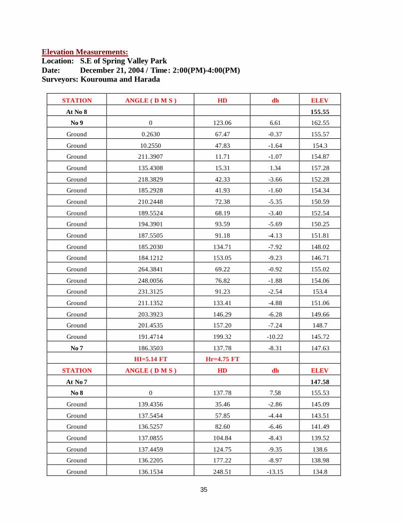
Elevation Measurements: Location: S.E of Spring Valley Park Date: December 21, 2004 / Time: 2:00(PM)-4:00(PM) Surveyors: Kourouma and Harada
STATION ANGLE ( D M S ) HD dh ELEV
At No 8 155.55
No 9 0 123.06 6.61 162.55
Ground 0.2630 67.47 -0.37 155.57
Ground 10.2550 47.83 -1.64 154.3
Ground 211.3907 11.71 -1.07 154.87
Ground 135.4308 15.31 1.34 157.28
Ground 218.3829 42.33 -3.66 152.28
Ground 185.2928 41.93 -1.60 154.34
Ground 210.2448 72.38 -5.35 150.59
Ground 189.5524 68.19 -3.40 152.54
Ground 194.3901 93.59 -5.69 150.25
Ground 187.5505 91.18 -4.13 151.81
Ground 185.2030 134.71 -7.92 148.02
Ground 184.1212 153.05 -9.23 146.71
Ground 264.3841 69.22 -0.92 155.02
Ground 248.0056 76.82 -1.88 154.06
Ground 231.3125 91.23 -2.54 153.4
Ground 211.1352 133.41 -4.88 151.06
Ground 203.3923 146.29 -6.28 149.66
Ground 201.4535 157.20 -7.24 148.7
Ground 191.4714 199.32 -10.22 145.72
No 7 186.3503 137.78 -8.31 147.63
HI=5.14 FT Hr=4.75 FT
STATION ANGLE ( D M S ) HD dh ELEV
At No 7 147.58
No 8 0 137.78 7.58 155.53
Ground 139.4356 35.46 -2.86 145.09
Ground 137.5454 57.85 -4.44 143.51
Ground 136.5257 82.60 -6.46 141.49
Ground 137.0855 104.84 -8.43 139.52
Ground 137.4459 124.75 -9.35 138.6
Ground 136.2205 177.22 -8.97 138.98
Ground 136.1534 248.51 -13.15 134.8
36
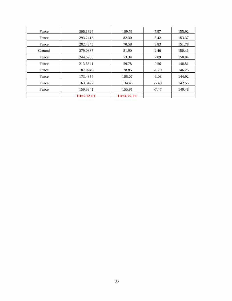
Fence 306.1824 109.51 7.97 155.92
Fence 293.2413 82.30 5.42 153.37
Fence 282.4845 70.58 3.83 151.78
Ground 279.0337 51.90 2.46 150.41
Fence 244.5238 53.34 2.09 150.04
Fence 213.5341 59.78 0.56 148.51
Fence 187.0249 78.85 -1.70 146.25
Fence 173.4354 105.07 -3.03 144.92
Fence 163.3422 134.46 -5.40 142.55
Fence 159.3841 155.91 -7.47 140.48
HI=5.12 FT Hr=4.75 FT

37
Elevation Measurements: Location: N.E of Spring Valley Park Date: January 4, 2005 / Time: 10:00(AM)-12:00(PM) Surveyors: Kourouma and Harada
STATION ANGLE ( D M S ) HD dh ELEV
At No 5 126.84
No 6 0 157.72 12.69 140.08
Ground 358.2013 92.58 7.46 134.85
Ground 0.2857 68.61 4.83 132.22
Ground 3.3857 43.37 1.71 129.1
Ground 14.2826 19.45 0.20 127.59
Ground 55.5250 29.66 2.01 129.4
Ground 97.4509 24.77 1.33 128.72
Ground 154.2841 34.87 -1.05 126.34
Ground 154.3629 51.74 -1.19 126.2
Ground 167.1957 64.49 -2.25 125.14
Ground 149.0417 68.85 0.72 128.11
Ground 174.4010 130.38 -2.79 124.6
HI=5.30 FT Hr=4.75 FT

38
Elevation Measurements: Location: S.E of Spring Valley Park Date: January 11, 2005 / Time: 12:00(PM)-2:00(PM) Surveyors: Kourouma and Harada
STATION ANGLE ( D M S ) HD dh ELEV
AT No 4 124.3
No 3 0 106.9 -4.67 119.85
Tree 3 ft 350.0134 24.77 2.16 126.68
Tree 3 ft 24.1155 25.89 -1.41 123.11
Tree 3 ft 308.2448 22.56 4.6 129.12
Tree 4 ft 293.0220 6.35 1.31 125.83
Tree 3 ft 187.4514 44.89 -1.27 123.25
Tree 4 ft 184.3655 50.02 -0.17 124.35
Tree 4 ft 200.1604 87.27 4.45 128.97
No 5 178.4922 128.49 2.31 126.83
HI=4.94 FT Hr=4.72 FT
STATION ANGLE ( D M S ) HD dh ELEV
AT No 5 126.84
No 4 0 128.47 -2.76 124.32
Tree 2.5 ft 293.4234 33.74 2.52 129.60
Tree 2.5 ft 284.1719 45.74 5.24 132.32
Tree 2 ft 274.1550 45.85 4.76 131.84
Tree 1.5 ft 251.2522 54.88 6.31 133.39
Tree 1 ft 233.3920 61.8 8.18 135.26
Tree 1 ft 212.2610 54.31 5.67 132.75
Tree 3 ft 215.0357 68.83 9.97 137.05
Tree 1 ft 224.5344 71.79 10.83 137.91
Tree 1ft 201.1524 66.54 6.4 133.48
Tree 1.5 ft 197.1902 86.72 9.81 136.89
Tree 2 ft 187.3414 81.65 7.3 134.38
Tree 1 ft 168.2022 63.28 3.58 130.66
Tree 4 ft 178.4856 44.07 2.57 129.65
No 6 183.4535 197.72 12.93 140.01
HI=4.96 FT Hr=4.72FT
STATION ANGLE ( D M S ) HD dh ELEV
AT No 6 139.97
No 5 0 157.71 -13.3 126.85
Tree 2 ft 8.0222 30.55 -1.5 138.65
Tree 3.5 ft 22.0432 14.32 -0.72 139.43
Tree 2.5 ft 150.5451 22.01 -1.69 138.46
Tree 2.5 ft 183.5026 29.86 0.96 141.11

39
Tree 2.5 ft 189.3819 44.62 2.73 142.88
Tree 1 ft 205.4137 53.65 7.1 147.25
Tree 2 ft 244.5452 49.57 13.11 153.26
Tree 1.5 ft 235.0458 63.16 15.43 155.58
Tree 1 ft 298.0634 45.12 7.44 147.59
Tree 1 ft 286.0242 36.58 7.57 147.72
Tree 1.5 ft 262.2002 13.96 2.89 143.04
Tree 2 ft 170.3946 106.83 2.14 142.29
Tree 2 ft 174.2444 129.57 4.66 144.81
Tree 1.5 ft 175.3649 159.12 6.61 146.76
Tree 1 ft 173.1204 105.46 5.87 146.02
Tree 1 ft 177.5517 191.99 7.26 147.41
HI=4.90 FT Hr=4.72 FT
STATION ANGLE ( D M S ) HD dh ELEV
AT No 7 147.58
No 6 0 182.81 -7.92 140.01
Tree 2 ft 209.2301 78.4 3.86 151.79
Tree 2.5 ft 216.3111 98.04 5.19 153.12
Tree 2.5 ft 222.2642 109.03 6.83 154.76
Tree 1.5 ft 230.1236 71.3 6.83 154.76
Tree 1.5 ft 231.2504 47.25 5.09 153.02
Tree 1.5 ft 239.0610 31.35 4.07 152
Tree 1.5 ft 245.3542 57.5 8.27 156.2
Tree 1 ft 259.3916 31.46 5.77 153.7
Tree 1 ft 266.3947 65.26 13.71 161.64
Tree 1 ft 279.1928 67.28 15.29 163.22
Tree 1.5 ft 282.5351 39.71 8.78 156.71
Tree 2 ft 293.5924 14.89 1.95 149.88
Tree 1 ft 305.4265 20.55 2.91 150.84
Tree 1 ft 347.0928 42.49 -0.64 147.29
Tree 2 ft 342.0652 52.56 -0.18 147.75
Tree 2 ft 330.2145 62.47 1.98 149.91
Tree 2 ft 321.4922 50.84 6.32 154.25
Tree 2 ft 348.2953 75.72 -2.34 145.59
Tree 1.5 ft 343.0850 93.07 -1.42 146.51
HI=5.07 FT Hr=4.72FT