assesscr parcel numbers): 022,131,015 ^ legal descriprion ... · space heating: noturol gas lp hec:...
TRANSCRIPT

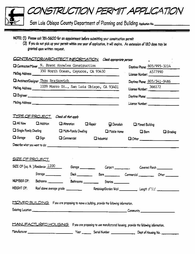
A s s e s s c r P a r c e l N u m b e r s ) : 0 2 2 , 1 3 1 , 0 1 5 ^Legal Descriprion: Lat/Bbck 1-42-43/35 CPU // 4 Section/Township/Range Cambria PinesSite Location 0>rovide the project address - if no street address, describe first with name of rood providing primory access to the site, then nearest roods,lendmarb.etc.l ^^1 Hillcrest Drive, Cambria Pines 93428Describe current uses, existing strucTures, and other improvements and veaetotion on the propenyr House in serious disrepair
Brieay describe project: remove house and other vrooden structures to first floor level, retainmasonary improvements, walkways and gardens
I, the owner of record of this property, consent to the named agent/applicant to act In my behalf in ail contacts with the county in connection with this mofrer. I havecompleted this form accurately and declare thot ail statement here ore true. I do hereby grant oiScial representatives of the county authorization to inspect the suectproperty.
Property owner signature, March 9, 1998
CTOEU5E0NLY
PateReowad:
^cnntnaAea:
land Use Cotcgoryr
Receipf to.
CommitfCodK,
UM use LaeooY.' J - ^ ^ ' * > ^ V
CoflstelZoBerC ]ln [JOut ERfbrcemcntCose: f JYes r Ho Rlg< -
. lfee6ro«D?t
' j " " ; '
'iComments:

7 ^ / 7 ^ 7 ^ h / z v z -a. The proposed project will be available for use by the public at large and It is likely that the project will be used or will
benefit more than residents of the immediate vicinity; and
b. The project will be of obvious public benefit. Evidence of public benefit may include but is not limited to:
(1) The project meets a need previously Identified or recognized by the Board of Supervisors.
(2) The project replaces another facility that previously provided public benefit.
(3) The project provides a facility not presently available in the community.
(4) The project has generated substantial, obvious community support.
(5) The project would reduce other county costs or increase other county revenues; and
c. The fee(s) to be waived will not exceed a total of $1,500.
d. Planning Director decisions may be appealed in writing within ten days to the Board of Supervisors, whose decisionwiil be final.
e. Notwithstanding any other provision of this fee schedule, the Board of Supervisors retains the authority to considerother fee waiver requests when it considers such waivers to be equitable and in the public interest.
10. Where disestablishment of a preserve is requested concurrently with a general plan amendment application for the property,this fee will not be collected and these costs will instead be covered by the general plan amendment fee.
11. This fee applies to all Requests for Allocation for new residential dwelling units submitted in accordance with the GrowthManagement Ordinances (Title 26). This fee is non-refundable. This fee also applies to applications for "grandfathered"un i t s i n Cambr ia .
12. A pre-application is required for the following types of applications:
a. Development Planb. Development Plan for oil wells/minesc . P a r c e l M a p sd . T r a c t M a p se. LUE/LCP map or text amendment
1 5

PROFERTTAND PRDJECT LAYOUTSan Luis Obispo County Deportment of Pionning and Buiiding
Rease make sure you put oil the required information as specified on the bock of this formon -fhe plon, and that you Include on Accurately drown vidnHy mop that shows how to drivethe properly.
1—aciALlEilln.[=i-.j
N O R T H

CSRAPINjt; □ Yes Q No Ifyes, provide the foliowir inforniotionDEPTH OF; Cuts (min I max) Fills (min E max)CUBIC YDS OF; Cut c.y. Rll_ ^c.y. Totol c.y. (cut E fill)
■ Total Area of Site Disturbonce Percent Slope of NoturolOrade %
T Y P E O F C O N ^ T R U C T I Q N
FOUNDATION; Q Sbb □ Perimeter E Piers □ Pole □ Other
FRAMEWORK; □ Wood Stud □ Mosonry/Concrete QMetol □Timber □ Other
EXTERIOR; □ Stucco □ Plywood □ Board □ Stone Veneer QBricl: Veneer □ Metal DOtherROOF; Rtch; Moterial: QTile □ Wood Shakes/Shingles □ Built-up Comp □ Comp Shingle Q Metal □ Other
M E C H A N I C A L ^ E N E P i S Y I N F O R M AT I O N
SPACE COOLING: □ None □ AC Q Evaporat ive □ Other
SPACE HEATING: □ Noturol Gas □ LP □ Hec: Pump □ OtherWATER HEATING: □ Notural Gas □ LP □ Electric wrth Solor □ Other
FIREPLACE: QYes □ No (All Hrepbces must be EPA or 5L0 County APCD Approved)
U T I L I T I E S )
WATER: O Well Q Public - ogency or company responsible for water provision:Do yoj hove 0 valid will-serve letter? Q Yes Eyes, pleose submit copy Q NoSEWAGE DISPOSAL: Q Private D Public - agency or compony responsible for sewoge disposol:Do you hove o valid will-serve lerrer? Q Yes E yes, please submit copy Q NoG A S : □ N a t u r a l G L P G T E M P O R A R Y P O W E R ? G Ye s □ N o
FIRE JURISDICTION: (Speciry Fire Department):RRE HAZARD ZONE* QVery High Q High G ModerateDo you hove o valid fire sofety plan? G Yes E yes. please submit copy G NoENCROACHMENT PERMIT: Do you have o previous encroachment permit? G Yes Eyes, pleose submit copy G No
O T C E
S c t b o c k s - f t n ^ M fl f fi e : ' ^ oh o t : & d £ ( L i
B w k fi n g f e e tRre Plan ASQR ^yS|5>||By|::SS^ Waferi}istrfe i ] i2ec )li gQRbnners a - J k ^ T / ^ / c j 7