arcgis 10.6.1 and arcgis pro 2.2 geographic and vertical ... · arcgis 10.6.1 and arcgis pro 2.2...
TRANSCRIPT
Copyright @ 2012, 2015, 2016, 2017, 2018 Esri 1
ArcGIS 10.6.1 and ArcGIS Pro 2.2 Geographic and Vertical Transformation Tables
Note: Some numbers have been rounded for display. Area of use values are in degrees based upon WGS 1984.
Table of Contents
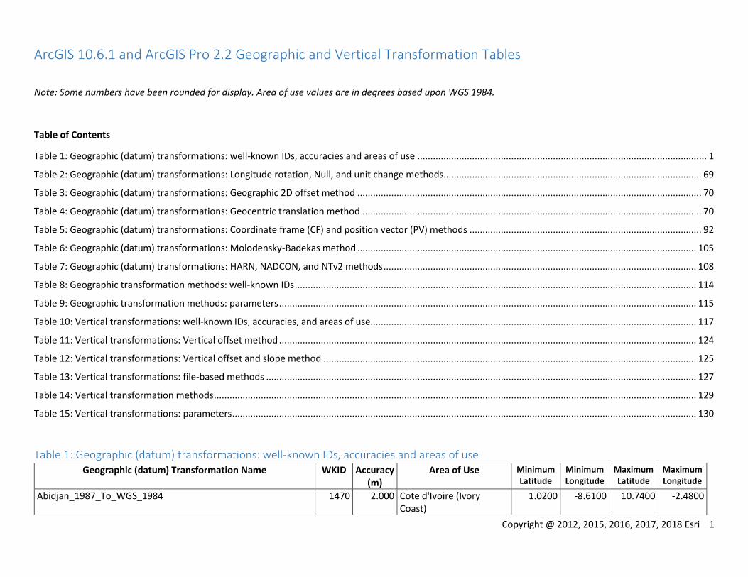
Table 1: Geographic (datum) transformations: well-known IDs, accuracies and areas of use ............................................................................................................... 1
Table 2: Geographic (datum) transformations: Longitude rotation, Null, and unit change methods................................................................................................... 69
Table 3: Geographic (datum) transformations: Geographic 2D offset method .................................................................................................................................... 70
Table 4: Geographic (datum) transformations: Geocentric translation method .................................................................................................................................. 70
Table 5: Geographic (datum) transformations: Coordinate frame (CF) and position vector (PV) methods ......................................................................................... 92
Table 6: Geographic (datum) transformations: Molodensky-Badekas method .................................................................................................................................. 105
Table 7: Geographic (datum) transformations: HARN, NADCON, and NTv2 methods ........................................................................................................................ 108
Table 8: Geographic transformation methods: well-known IDs .......................................................................................................................................................... 114
Table 9: Geographic transformation methods: parameters ................................................................................................................................................................ 115
Table 10: Vertical transformations: well-known IDs, accuracies, and areas of use............................................................................................................................. 117
Table 11: Vertical transformations: Vertical offset method ................................................................................................................................................................ 124
Table 12: Vertical transformations: Vertical offset and slope method ............................................................................................................................................... 125
Table 13: Vertical transformations: file-based methods ..................................................................................................................................................................... 127
Table 14: Vertical transformation methods ......................................................................................................................................................................................... 129
Table 15: Vertical transformations: parameters .................................................................................................................................................................................. 130
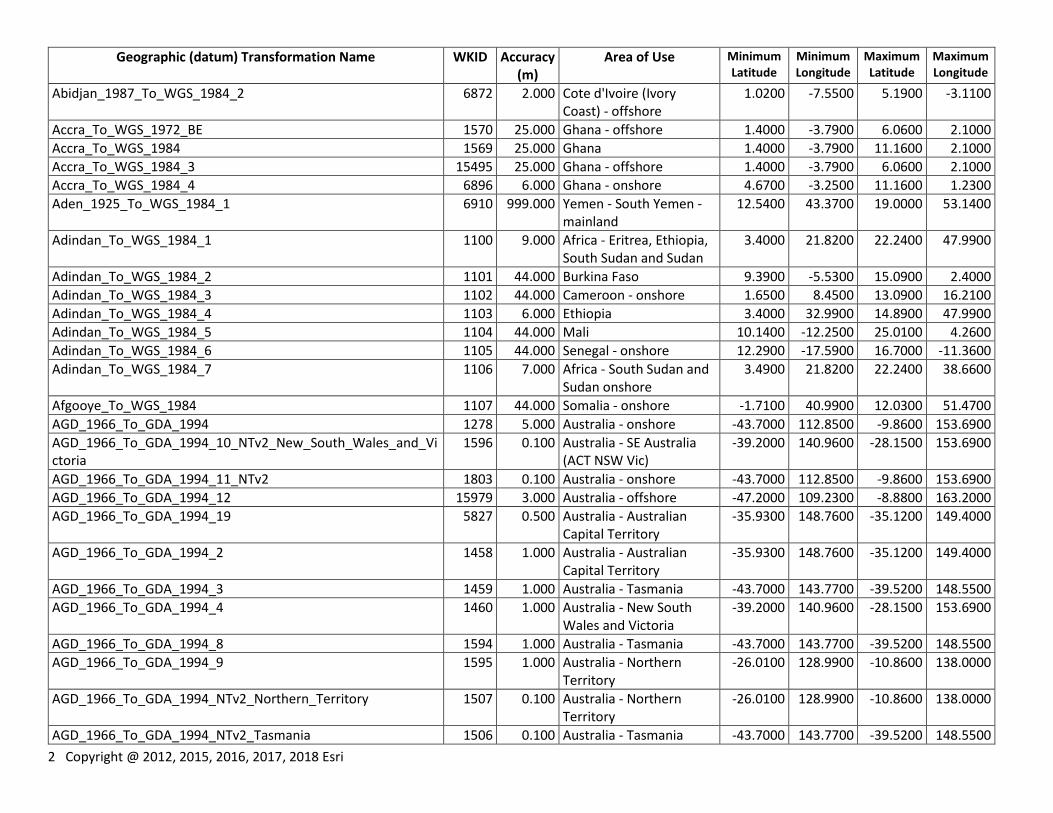
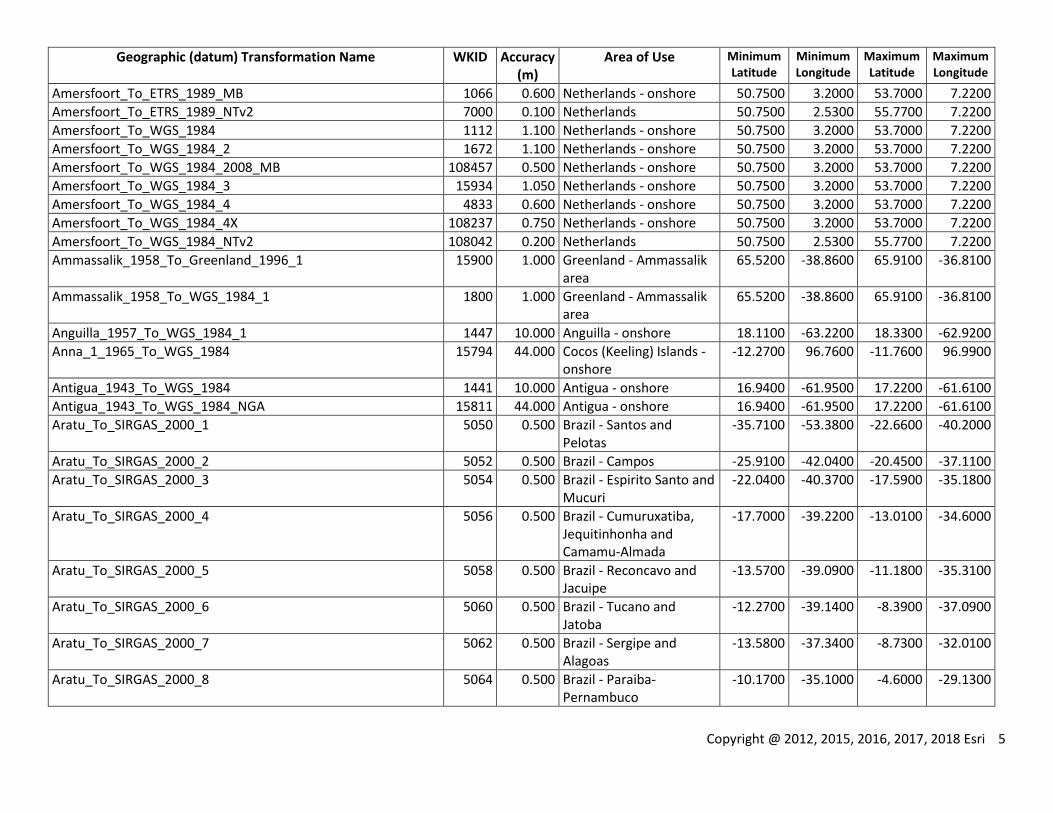
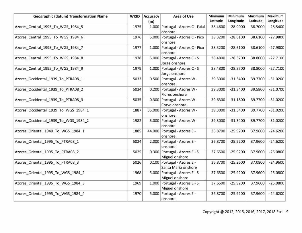
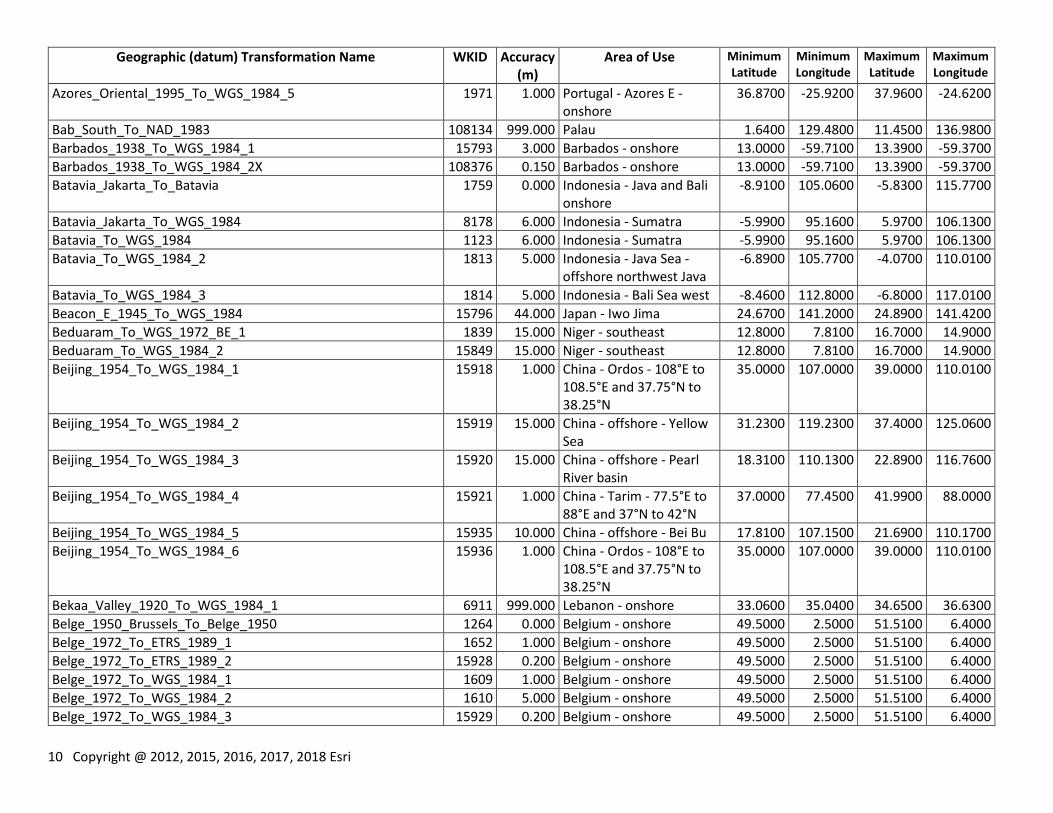
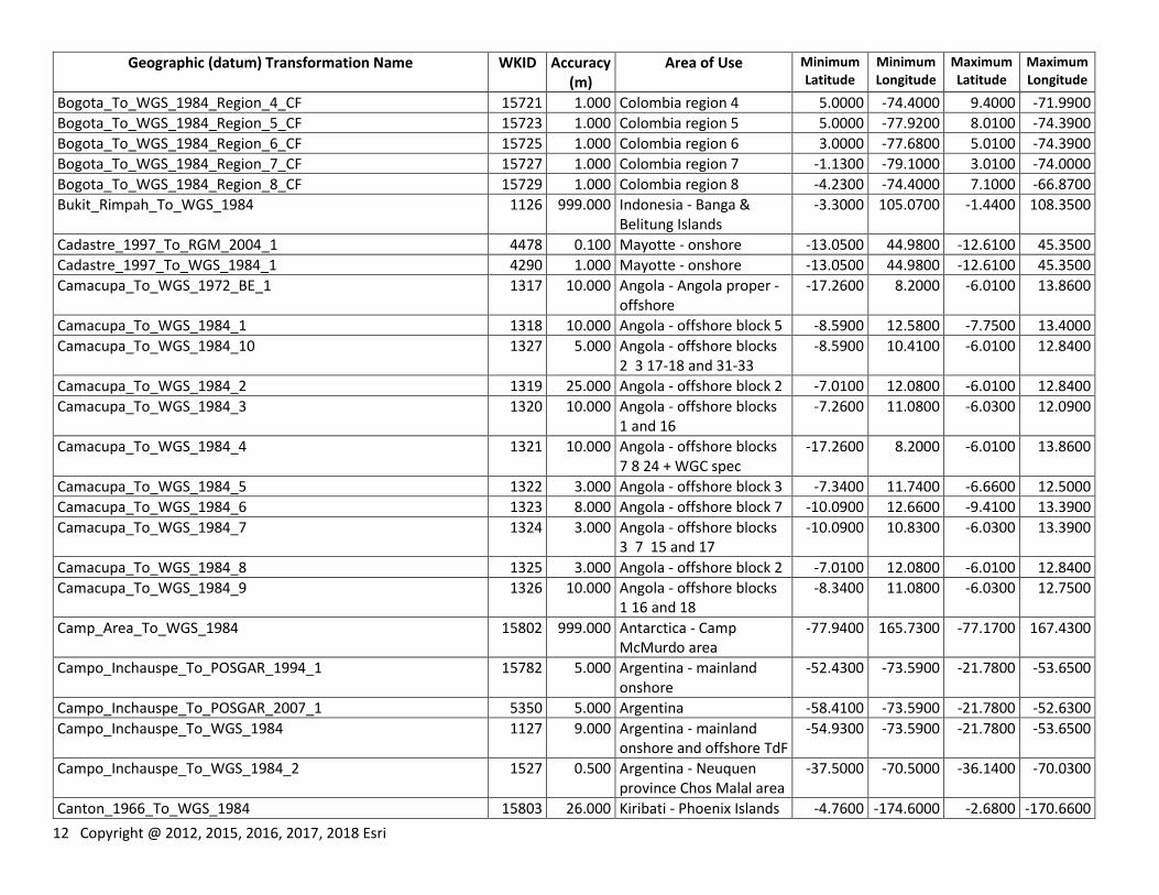
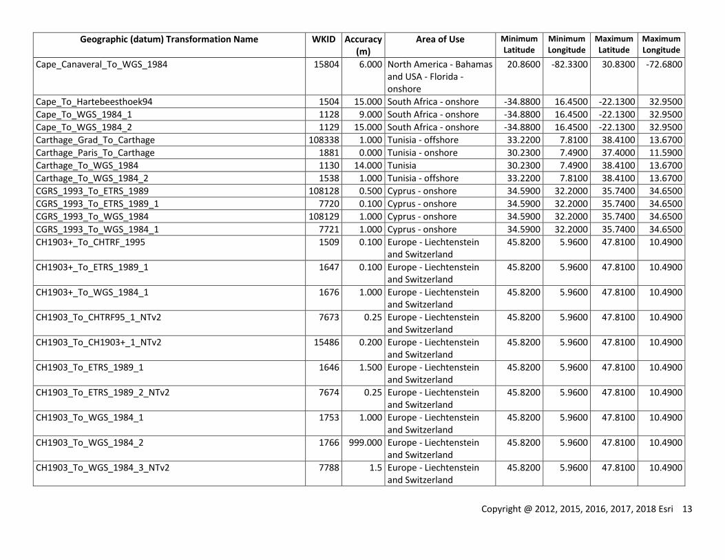
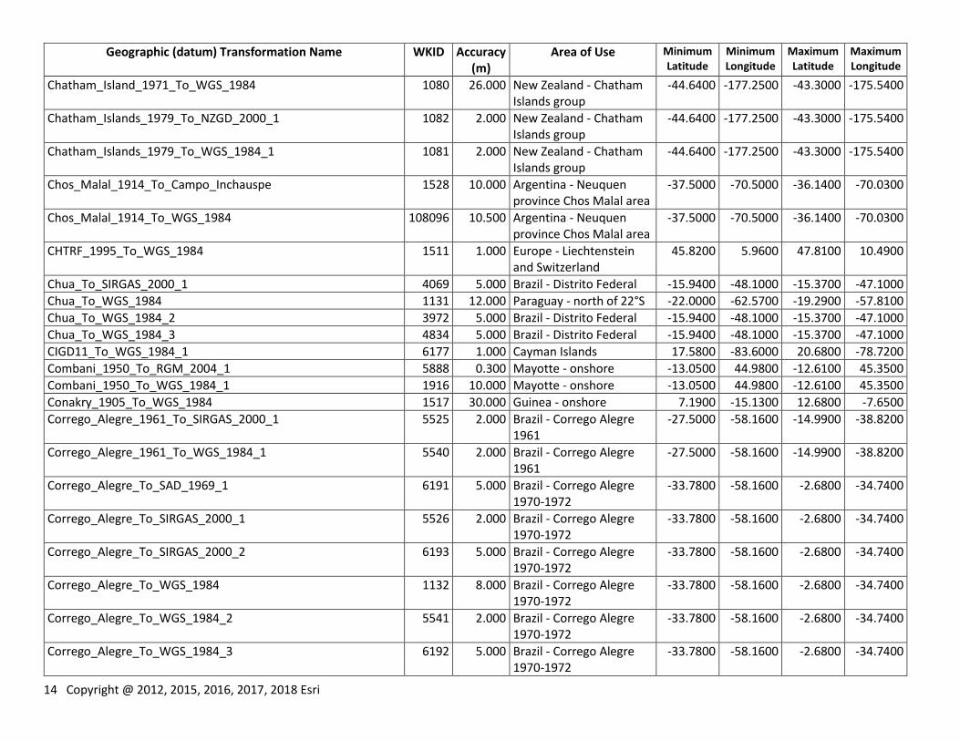
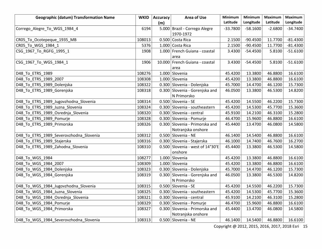
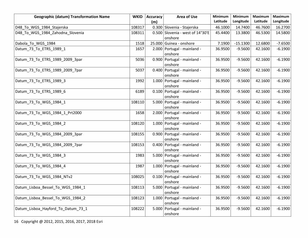
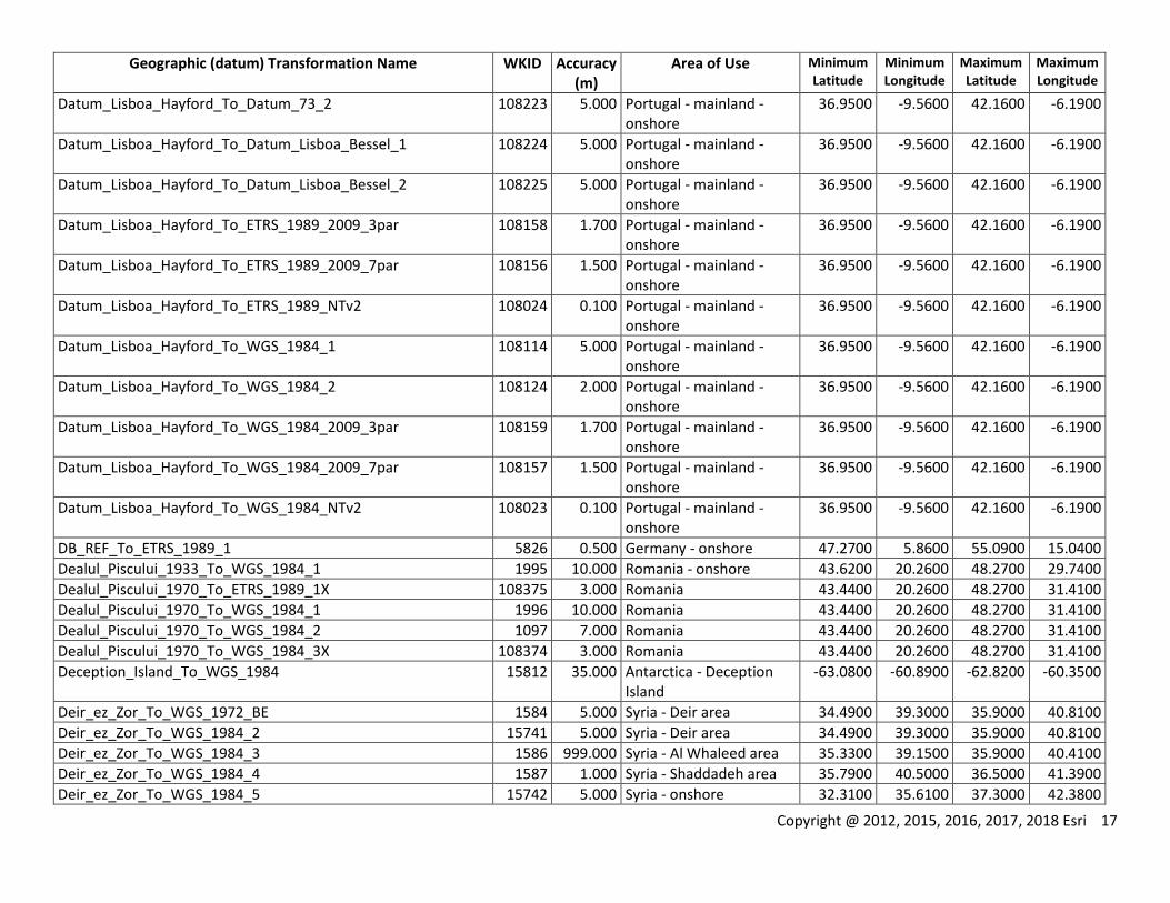
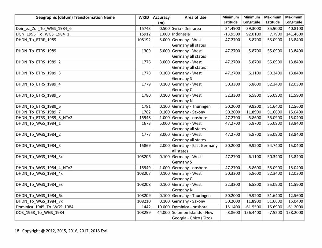
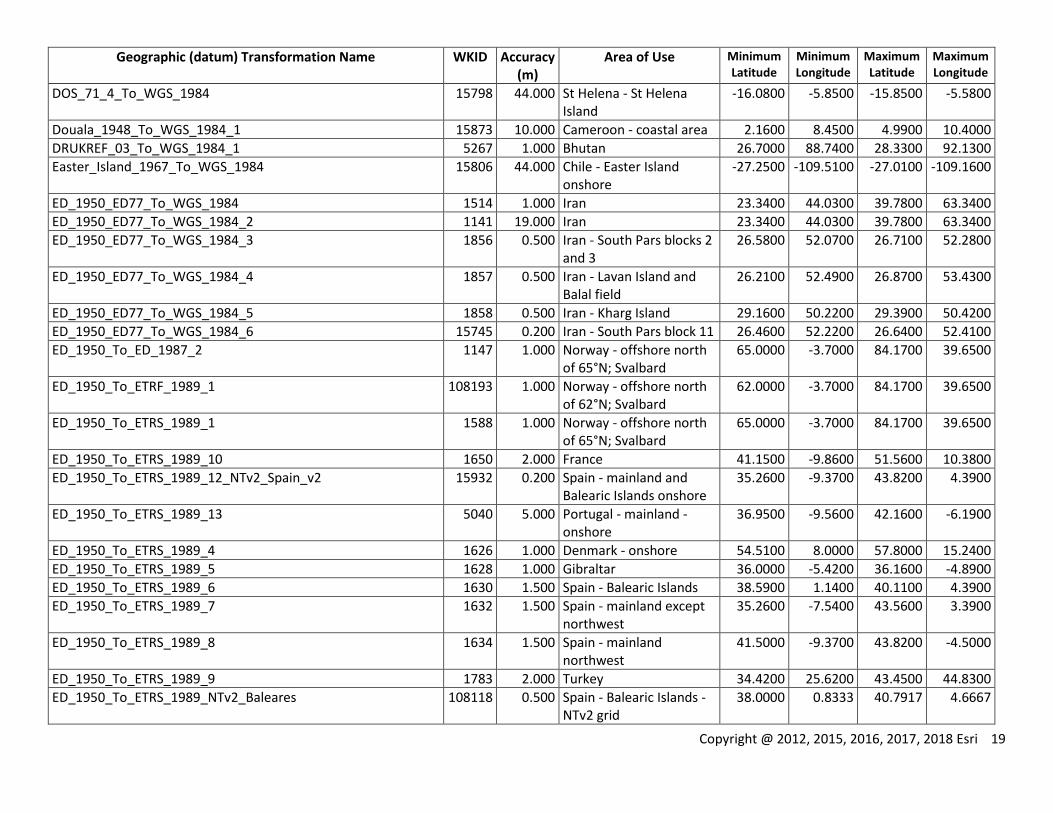
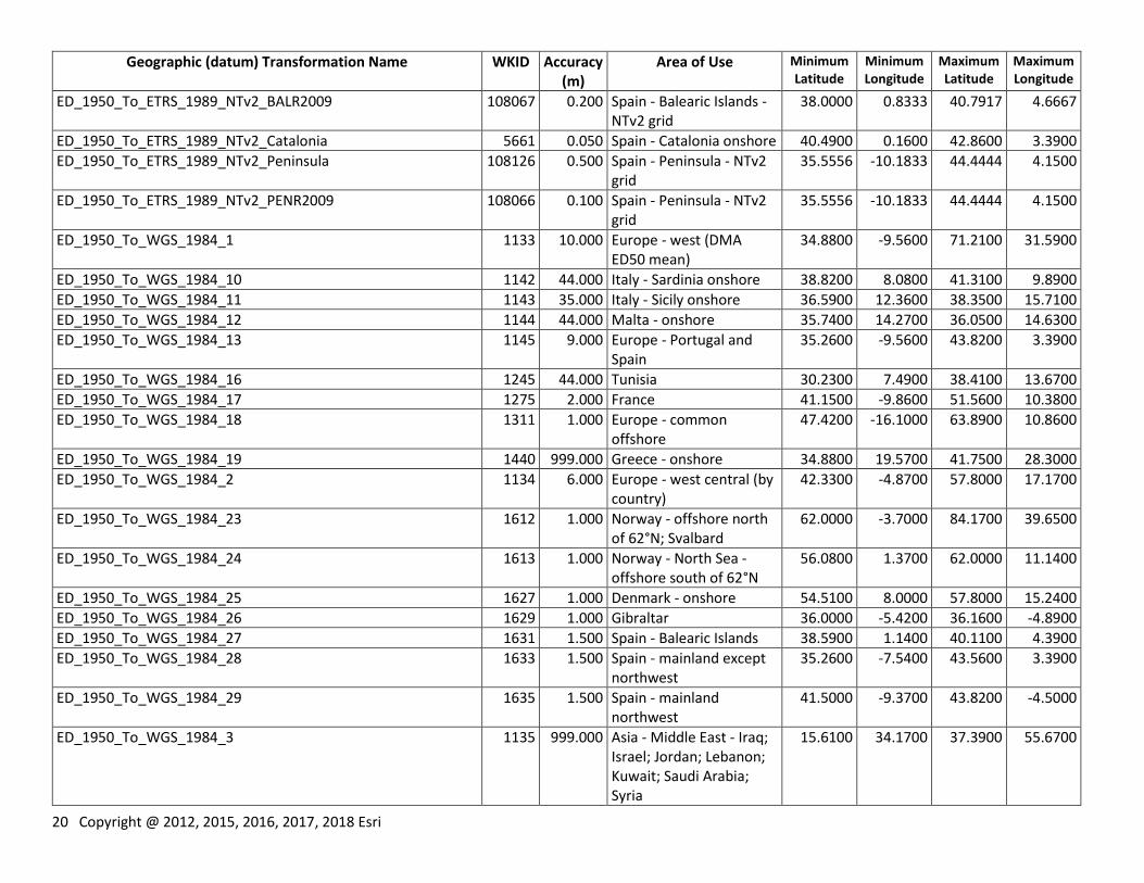
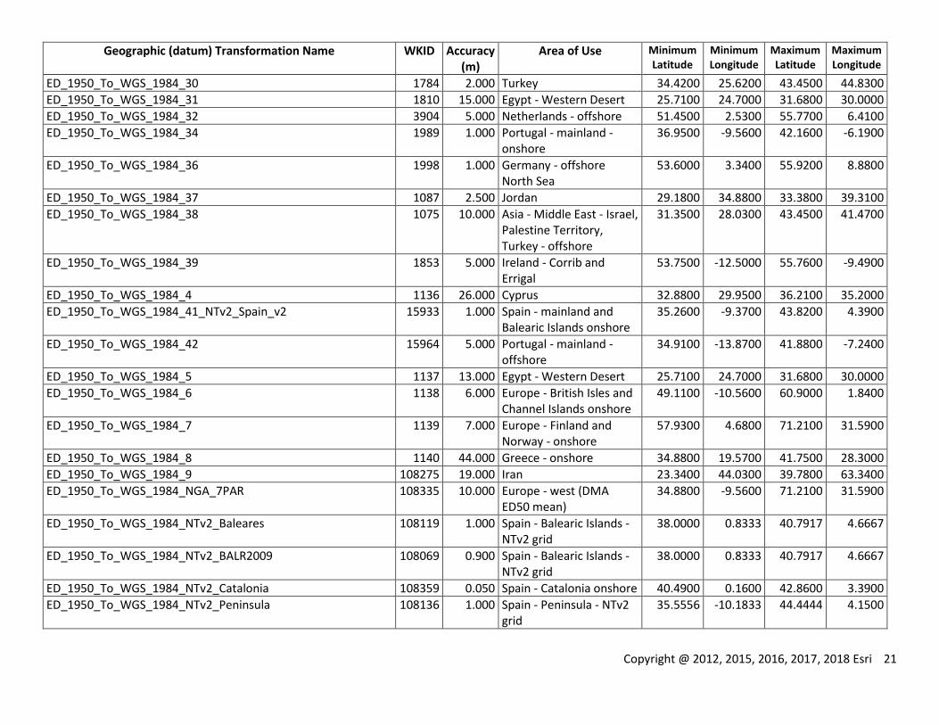
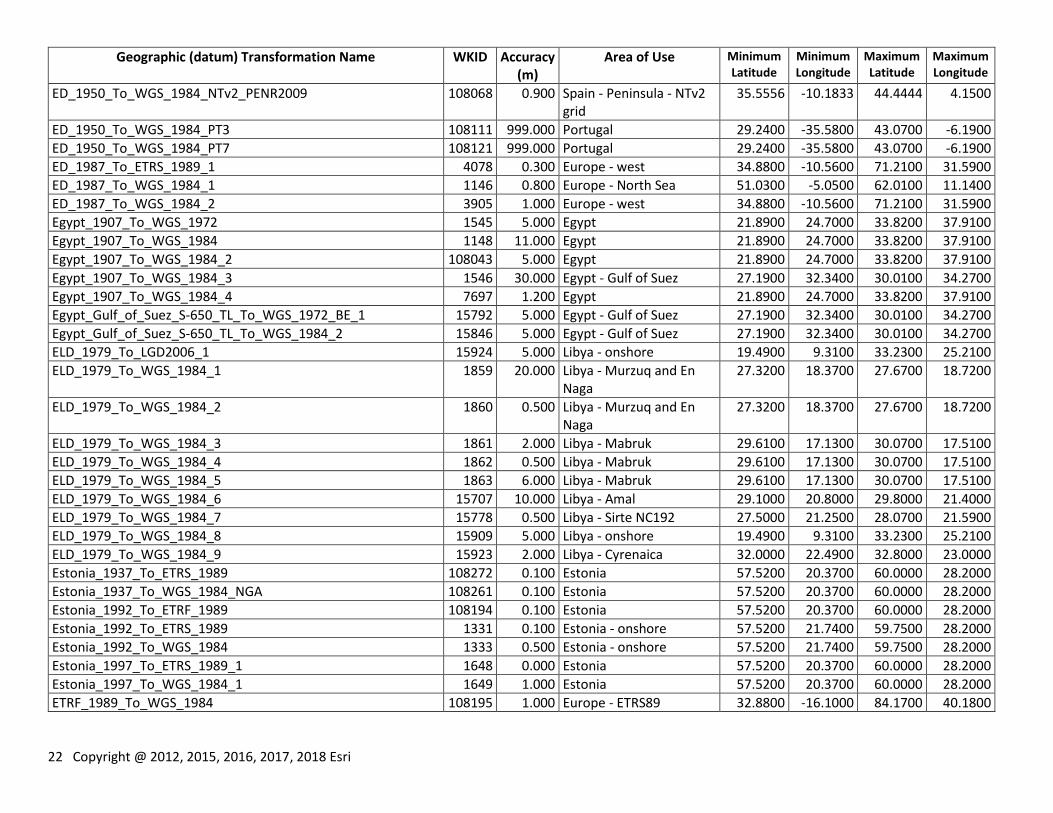
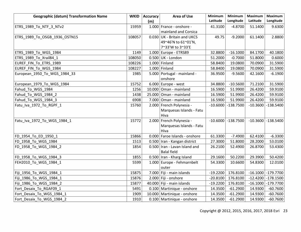
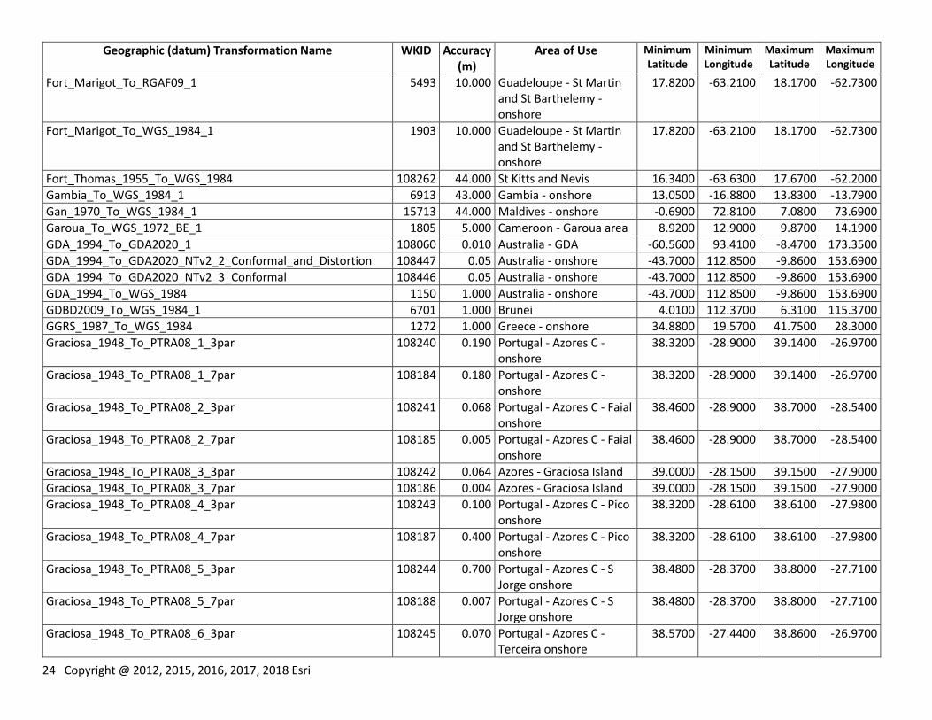
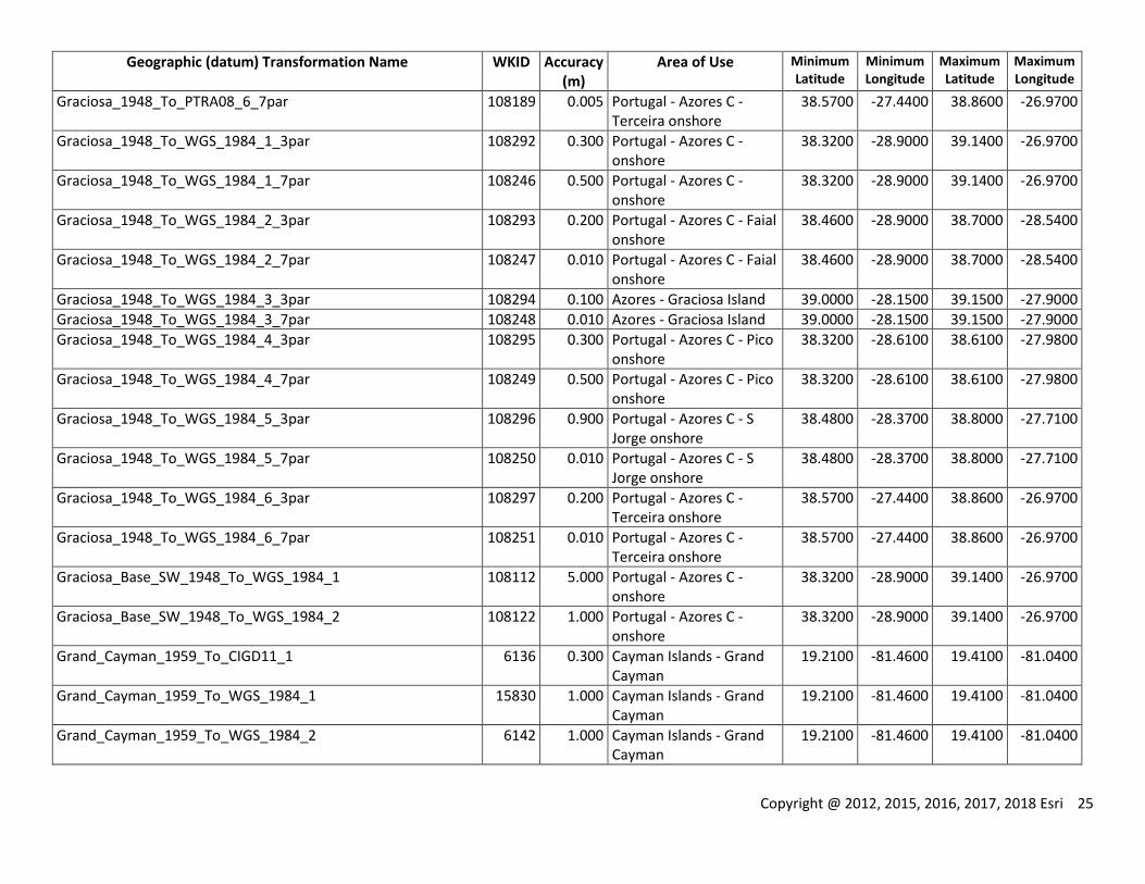
Table 1: Geographic (datum) transformations: well-known IDs, accuracies and areas of use Geographic (datum) Transformation Name WKID Accuracy
(m) Area of Use Minimum
Latitude Minimum Longitude
Maximum Latitude
Maximum Longitude
Abidjan_1987_To_WGS_1984 1470 2.000 Cote d'Ivoire (Ivory Coast)
1.0200 -8.6100 10.7400 -2.4800
2 Copyright @ 2012, 2015, 2016, 2017, 2018 Esri
Geographic (datum) Transformation Name WKID Accuracy (m)
Area of Use Minimum Latitude
Minimum Longitude
Maximum Latitude
Maximum Longitude
Abidjan_1987_To_WGS_1984_2 6872 2.000 Cote d'Ivoire (Ivory Coast) - offshore
1.0200 -7.5500 5.1900 -3.1100
Accra_To_WGS_1972_BE 1570 25.000 Ghana - offshore 1.4000 -3.7900 6.0600 2.1000
Accra_To_WGS_1984 1569 25.000 Ghana 1.4000 -3.7900 11.1600 2.1000
Accra_To_WGS_1984_3 15495 25.000 Ghana - offshore 1.4000 -3.7900 6.0600 2.1000
Accra_To_WGS_1984_4 6896 6.000 Ghana - onshore 4.6700 -3.2500 11.1600 1.2300
Aden_1925_To_WGS_1984_1 6910 999.000 Yemen - South Yemen - mainland
12.5400 43.3700 19.0000 53.1400
Adindan_To_WGS_1984_1 1100 9.000 Africa - Eritrea, Ethiopia, South Sudan and Sudan
3.4000 21.8200 22.2400 47.9900
Adindan_To_WGS_1984_2 1101 44.000 Burkina Faso 9.3900 -5.5300 15.0900 2.4000
Adindan_To_WGS_1984_3 1102 44.000 Cameroon - onshore 1.6500 8.4500 13.0900 16.2100
Adindan_To_WGS_1984_4 1103 6.000 Ethiopia 3.4000 32.9900 14.8900 47.9900
Adindan_To_WGS_1984_5 1104 44.000 Mali 10.1400 -12.2500 25.0100 4.2600
Adindan_To_WGS_1984_6 1105 44.000 Senegal - onshore 12.2900 -17.5900 16.7000 -11.3600
Adindan_To_WGS_1984_7 1106 7.000 Africa - South Sudan and Sudan onshore
3.4900 21.8200 22.2400 38.6600
Afgooye_To_WGS_1984 1107 44.000 Somalia - onshore -1.7100 40.9900 12.0300 51.4700
AGD_1966_To_GDA_1994 1278 5.000 Australia - onshore -43.7000 112.8500 -9.8600 153.6900
AGD_1966_To_GDA_1994_10_NTv2_New_South_Wales_and_Victoria
1596 0.100 Australia - SE Australia (ACT NSW Vic)
-39.2000 140.9600 -28.1500 153.6900
AGD_1966_To_GDA_1994_11_NTv2 1803 0.100 Australia - onshore -43.7000 112.8500 -9.8600 153.6900
AGD_1966_To_GDA_1994_12 15979 3.000 Australia - offshore -47.2000 109.2300 -8.8800 163.2000
AGD_1966_To_GDA_1994_19 5827 0.500 Australia - Australian Capital Territory
-35.9300 148.7600 -35.1200 149.4000
AGD_1966_To_GDA_1994_2 1458 1.000 Australia - Australian Capital Territory
-35.9300 148.7600 -35.1200 149.4000
AGD_1966_To_GDA_1994_3 1459 1.000 Australia - Tasmania -43.7000 143.7700 -39.5200 148.5500
AGD_1966_To_GDA_1994_4 1460 1.000 Australia - New South Wales and Victoria
-39.2000 140.9600 -28.1500 153.6900
AGD_1966_To_GDA_1994_8 1594 1.000 Australia - Tasmania -43.7000 143.7700 -39.5200 148.5500
AGD_1966_To_GDA_1994_9 1595 1.000 Australia - Northern Territory
-26.0100 128.9900 -10.8600 138.0000
AGD_1966_To_GDA_1994_NTv2_Northern_Territory 1507 0.100 Australia - Northern Territory
-26.0100 128.9900 -10.8600 138.0000
AGD_1966_To_GDA_1994_NTv2_Tasmania 1506 0.100 Australia - Tasmania -43.7000 143.7700 -39.5200 148.5500
Copyright @ 2012, 2015, 2016, 2017, 2018 Esri 3
Geographic (datum) Transformation Name WKID Accuracy (m)
Area of Use Minimum Latitude
Minimum Longitude
Maximum Latitude
Maximum Longitude
AGD_1966_To_GDA_1994_NTv2_Victoria 1464 0.100 Australia - Victoria -39.2000 140.9600 -33.9800 150.0400
AGD_1966_To_PNG_1994_1 5662 2.000 Papua New Guinea - PFTB
-8.2800 142.2400 -5.5900 144.7500
AGD_1966_To_PNG_1994_2 6937 1.000 Papua New Guinea - mainland onshore
-10.7600 140.8500 -2.5300 150.9600
AGD_1966_To_PNG_1994_3 6938 4.000 Papua New Guinea - mainland onshore
-10.7600 140.8500 -2.5300 150.9600
AGD_1966_To_PNG_1994_4 6939 1.000 Papua New Guinea - PFTB
-8.2800 142.2400 -5.5900 144.7500
AGD_1966_To_PNG_1994_5 6940 2.000 Papua New Guinea - PFTB
-8.2800 142.2400 -5.5900 144.7500
AGD_1966_To_PNG_1994_6 6941 0.500 Papua New Guinea - North Fly
-6.6000 140.8900 -5.0500 141.5400
AGD_1966_To_PNG_1994_7 6942 2.500 Papua New Guinea - North Fly
-6.6000 140.8900 -5.0500 141.5400
AGD_1966_To_WGS_1984 1108 6.000 Australia - onshore -43.7000 112.8500 -9.8600 153.6900
AGD_1966_To_WGS_1984_12 1665 1.000 Australia - Australian Capital Territory
-35.9300 148.7600 -35.1200 149.4000
AGD_1966_To_WGS_1984_13 1666 1.000 Australia - New South Wales and Victoria
-39.2000 140.9600 -28.1500 153.6900
AGD_1966_To_WGS_1984_14 1667 1.000 Australia - Tasmania -43.7000 143.7700 -39.5200 148.5500
AGD_1966_To_WGS_1984_15 1668 1.000 Australia - Northern Territory
-26.0100 128.9900 -10.8600 138.0000
AGD_1966_To_WGS_1984_16 15788 5.000 Australia - onshore -43.7000 112.8500 -9.8600 153.6900
AGD_1966_To_WGS_1984_17_NTv2 15786 1.000 Australia - onshore -43.7000 112.8500 -9.8600 153.6900
AGD_1966_To_WGS_1984_18 15980 3.000 Australia - offshore -47.2000 109.2300 -8.8800 163.2000
AGD_1966_To_WGS_1984_19 5841 2.000 Papua New Guinea - PFTB
-8.2800 142.2400 -5.5900 144.7500
AGD_1966_To_WGS_1984_21 6943 5.000 Papua New Guinea - mainland onshore
-10.7600 140.8500 -2.5300 150.9600
AGD_1966_To_WGS_1984_22 6944 4.000 Papua New Guinea - PFTB
-8.2800 142.2400 -5.5900 144.7500
AGD_1966_To_WGS_1984_23 6945 4.000 Papua New Guinea - North Fly
-6.6000 140.8900 -5.0500 141.5400
AGD_1984_To_GDA_1994 1279 5.000 Australia - onshore -43.7000 112.8500 -9.8600 153.6900
4 Copyright @ 2012, 2015, 2016, 2017, 2018 Esri
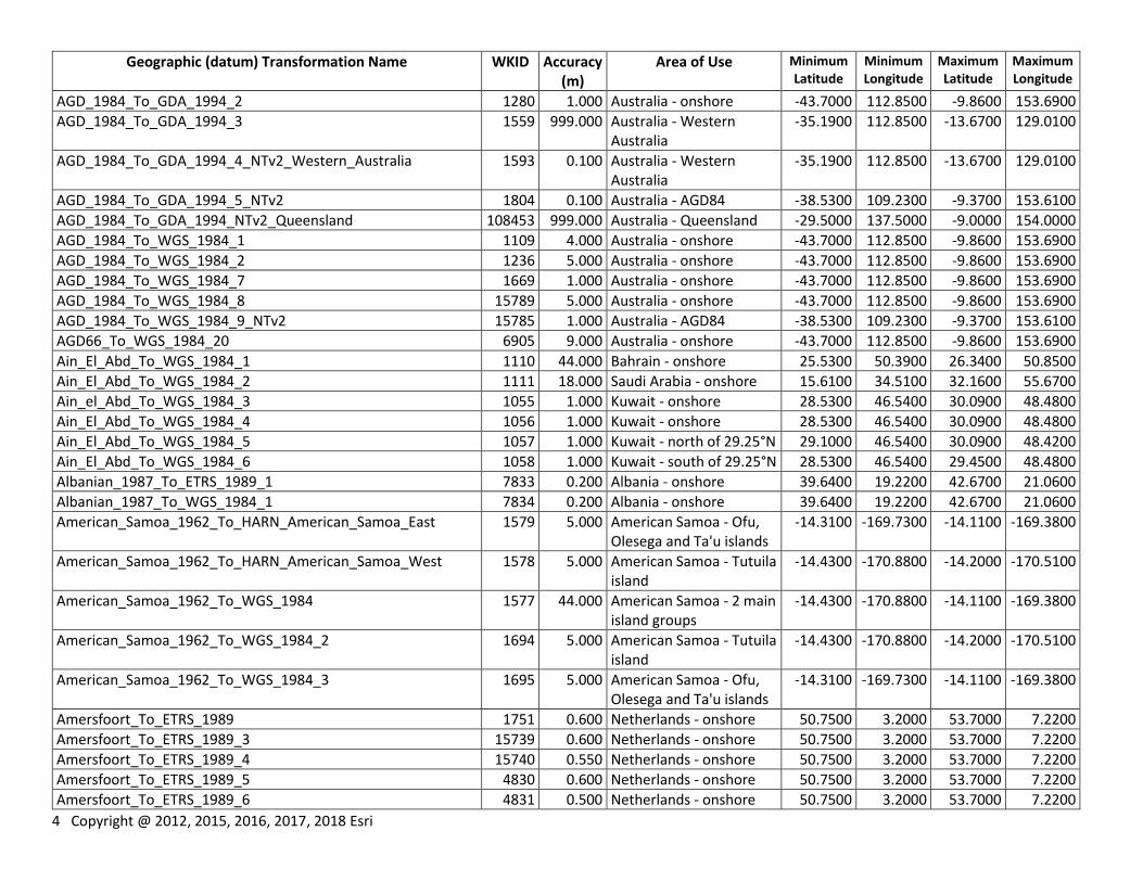
Geographic (datum) Transformation Name WKID Accuracy (m)
Area of Use Minimum Latitude
Minimum Longitude
Maximum Latitude
Maximum Longitude
AGD_1984_To_GDA_1994_2 1280 1.000 Australia - onshore -43.7000 112.8500 -9.8600 153.6900
AGD_1984_To_GDA_1994_3 1559 999.000 Australia - Western Australia
-35.1900 112.8500 -13.6700 129.0100
AGD_1984_To_GDA_1994_4_NTv2_Western_Australia 1593 0.100 Australia - Western Australia
-35.1900 112.8500 -13.6700 129.0100
AGD_1984_To_GDA_1994_5_NTv2 1804 0.100 Australia - AGD84 -38.5300 109.2300 -9.3700 153.6100
AGD_1984_To_GDA_1994_NTv2_Queensland 108453 999.000 Australia - Queensland -29.5000 137.5000 -9.0000 154.0000
AGD_1984_To_WGS_1984_1 1109 4.000 Australia - onshore -43.7000 112.8500 -9.8600 153.6900
AGD_1984_To_WGS_1984_2 1236 5.000 Australia - onshore -43.7000 112.8500 -9.8600 153.6900
AGD_1984_To_WGS_1984_7 1669 1.000 Australia - onshore -43.7000 112.8500 -9.8600 153.6900
AGD_1984_To_WGS_1984_8 15789 5.000 Australia - onshore -43.7000 112.8500 -9.8600 153.6900
AGD_1984_To_WGS_1984_9_NTv2 15785 1.000 Australia - AGD84 -38.5300 109.2300 -9.3700 153.6100
AGD66_To_WGS_1984_20 6905 9.000 Australia - onshore -43.7000 112.8500 -9.8600 153.6900
Ain_El_Abd_To_WGS_1984_1 1110 44.000 Bahrain - onshore 25.5300 50.3900 26.3400 50.8500
Ain_El_Abd_To_WGS_1984_2 1111 18.000 Saudi Arabia - onshore 15.6100 34.5100 32.1600 55.6700
Ain_el_Abd_To_WGS_1984_3 1055 1.000 Kuwait - onshore 28.5300 46.5400 30.0900 48.4800
Ain_El_Abd_To_WGS_1984_4 1056 1.000 Kuwait - onshore 28.5300 46.5400 30.0900 48.4800
Ain_El_Abd_To_WGS_1984_5 1057 1.000 Kuwait - north of 29.25°N 29.1000 46.5400 30.0900 48.4200
Ain_El_Abd_To_WGS_1984_6 1058 1.000 Kuwait - south of 29.25°N 28.5300 46.5400 29.4500 48.4800
Albanian_1987_To_ETRS_1989_1 7833 0.200 Albania - onshore 39.6400 19.2200 42.6700 21.0600
Albanian_1987_To_WGS_1984_1 7834 0.200 Albania - onshore 39.6400 19.2200 42.6700 21.0600
American_Samoa_1962_To_HARN_American_Samoa_East 1579 5.000 American Samoa - Ofu, Olesega and Ta'u islands
-14.3100 -169.7300 -14.1100 -169.3800
American_Samoa_1962_To_HARN_American_Samoa_West 1578 5.000 American Samoa - Tutuila island
-14.4300 -170.8800 -14.2000 -170.5100
American_Samoa_1962_To_WGS_1984 1577 44.000 American Samoa - 2 main island groups
-14.4300 -170.8800 -14.1100 -169.3800
American_Samoa_1962_To_WGS_1984_2 1694 5.000 American Samoa - Tutuila island
-14.4300 -170.8800 -14.2000 -170.5100
American_Samoa_1962_To_WGS_1984_3 1695 5.000 American Samoa - Ofu, Olesega and Ta'u islands
-14.3100 -169.7300 -14.1100 -169.3800
Amersfoort_To_ETRS_1989 1751 0.600 Netherlands - onshore 50.7500 3.2000 53.7000 7.2200
Amersfoort_To_ETRS_1989_3 15739 0.600 Netherlands - onshore 50.7500 3.2000 53.7000 7.2200
Amersfoort_To_ETRS_1989_4 15740 0.550 Netherlands - onshore 50.7500 3.2000 53.7000 7.2200
Amersfoort_To_ETRS_1989_5 4830 0.600 Netherlands - onshore 50.7500 3.2000 53.7000 7.2200
Amersfoort_To_ETRS_1989_6 4831 0.500 Netherlands - onshore 50.7500 3.2000 53.7000 7.2200
Copyright @ 2012, 2015, 2016, 2017, 2018 Esri 5
Geographic (datum) Transformation Name WKID Accuracy (m)
Area of Use Minimum Latitude
Minimum Longitude
Maximum Latitude
Maximum Longitude
Amersfoort_To_ETRS_1989_MB 1066 0.600 Netherlands - onshore 50.7500 3.2000 53.7000 7.2200
Amersfoort_To_ETRS_1989_NTv2 7000 0.100 Netherlands 50.7500 2.5300 55.7700 7.2200
Amersfoort_To_WGS_1984 1112 1.100 Netherlands - onshore 50.7500 3.2000 53.7000 7.2200
Amersfoort_To_WGS_1984_2 1672 1.100 Netherlands - onshore 50.7500 3.2000 53.7000 7.2200
Amersfoort_To_WGS_1984_2008_MB 108457 0.500 Netherlands - onshore 50.7500 3.2000 53.7000 7.2200
Amersfoort_To_WGS_1984_3 15934 1.050 Netherlands - onshore 50.7500 3.2000 53.7000 7.2200
Amersfoort_To_WGS_1984_4 4833 0.600 Netherlands - onshore 50.7500 3.2000 53.7000 7.2200
Amersfoort_To_WGS_1984_4X 108237 0.750 Netherlands - onshore 50.7500 3.2000 53.7000 7.2200
Amersfoort_To_WGS_1984_NTv2 108042 0.200 Netherlands 50.7500 2.5300 55.7700 7.2200
Ammassalik_1958_To_Greenland_1996_1 15900 1.000 Greenland - Ammassalik area
65.5200 -38.8600 65.9100 -36.8100
Ammassalik_1958_To_WGS_1984_1 1800 1.000 Greenland - Ammassalik area
65.5200 -38.8600 65.9100 -36.8100
Anguilla_1957_To_WGS_1984_1 1447 10.000 Anguilla - onshore 18.1100 -63.2200 18.3300 -62.9200
Anna_1_1965_To_WGS_1984 15794 44.000 Cocos (Keeling) Islands - onshore
-12.2700 96.7600 -11.7600 96.9900
Antigua_1943_To_WGS_1984 1441 10.000 Antigua - onshore 16.9400 -61.9500 17.2200 -61.6100
Antigua_1943_To_WGS_1984_NGA 15811 44.000 Antigua - onshore 16.9400 -61.9500 17.2200 -61.6100
Aratu_To_SIRGAS_2000_1 5050 0.500 Brazil - Santos and Pelotas
-35.7100 -53.3800 -22.6600 -40.2000
Aratu_To_SIRGAS_2000_2 5052 0.500 Brazil - Campos -25.9100 -42.0400 -20.4500 -37.1100
Aratu_To_SIRGAS_2000_3 5054 0.500 Brazil - Espirito Santo and Mucuri
-22.0400 -40.3700 -17.5900 -35.1800
Aratu_To_SIRGAS_2000_4 5056 0.500 Brazil - Cumuruxatiba, Jequitinhonha and Camamu-Almada
-17.7000 -39.2200 -13.0100 -34.6000
Aratu_To_SIRGAS_2000_5 5058 0.500 Brazil - Reconcavo and Jacuipe
-13.5700 -39.0900 -11.1800 -35.3100
Aratu_To_SIRGAS_2000_6 5060 0.500 Brazil - Tucano and Jatoba
-12.2700 -39.1400 -8.3900 -37.0900
Aratu_To_SIRGAS_2000_7 5062 0.500 Brazil - Sergipe and Alagoas
-13.5800 -37.3400 -8.7300 -32.0100
Aratu_To_SIRGAS_2000_8 5064 0.500 Brazil - Paraiba-Pernambuco
-10.1700 -35.1000 -4.6000 -29.1300
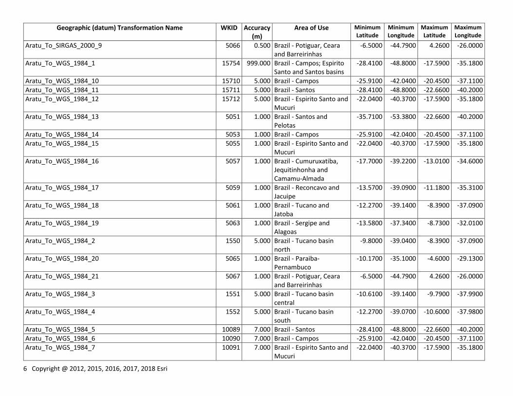
6 Copyright @ 2012, 2015, 2016, 2017, 2018 Esri
Geographic (datum) Transformation Name WKID Accuracy (m)
Area of Use Minimum Latitude
Minimum Longitude
Maximum Latitude
Maximum Longitude
Aratu_To_SIRGAS_2000_9 5066 0.500 Brazil - Potiguar, Ceara and Barreirinhas
-6.5000 -44.7900 4.2600 -26.0000
Aratu_To_WGS_1984_1 15754 999.000 Brazil - Campos; Espirito Santo and Santos basins
-28.4100 -48.8000 -17.5900 -35.1800
Aratu_To_WGS_1984_10 15710 5.000 Brazil - Campos -25.9100 -42.0400 -20.4500 -37.1100
Aratu_To_WGS_1984_11 15711 5.000 Brazil - Santos -28.4100 -48.8000 -22.6600 -40.2000
Aratu_To_WGS_1984_12 15712 5.000 Brazil - Espirito Santo and Mucuri
-22.0400 -40.3700 -17.5900 -35.1800
Aratu_To_WGS_1984_13 5051 1.000 Brazil - Santos and Pelotas
-35.7100 -53.3800 -22.6600 -40.2000
Aratu_To_WGS_1984_14 5053 1.000 Brazil - Campos -25.9100 -42.0400 -20.4500 -37.1100
Aratu_To_WGS_1984_15 5055 1.000 Brazil - Espirito Santo and Mucuri
-22.0400 -40.3700 -17.5900 -35.1800
Aratu_To_WGS_1984_16 5057 1.000 Brazil - Cumuruxatiba, Jequitinhonha and Camamu-Almada
-17.7000 -39.2200 -13.0100 -34.6000
Aratu_To_WGS_1984_17 5059 1.000 Brazil - Reconcavo and Jacuipe
-13.5700 -39.0900 -11.1800 -35.3100
Aratu_To_WGS_1984_18 5061 1.000 Brazil - Tucano and Jatoba
-12.2700 -39.1400 -8.3900 -37.0900
Aratu_To_WGS_1984_19 5063 1.000 Brazil - Sergipe and Alagoas
-13.5800 -37.3400 -8.7300 -32.0100
Aratu_To_WGS_1984_2 1550 5.000 Brazil - Tucano basin north
-9.8000 -39.0400 -8.3900 -37.0900
Aratu_To_WGS_1984_20 5065 1.000 Brazil - Paraiba-Pernambuco
-10.1700 -35.1000 -4.6000 -29.1300
Aratu_To_WGS_1984_21 5067 1.000 Brazil - Potiguar, Ceara and Barreirinhas
-6.5000 -44.7900 4.2600 -26.0000
Aratu_To_WGS_1984_3 1551 5.000 Brazil - Tucano basin central
-10.6100 -39.1400 -9.7900 -37.9900
Aratu_To_WGS_1984_4 1552 5.000 Brazil - Tucano basin south
-12.2700 -39.0700 -10.6000 -37.9800
Aratu_To_WGS_1984_5 10089 7.000 Brazil - Santos -28.4100 -48.8000 -22.6600 -40.2000
Aratu_To_WGS_1984_6 10090 7.000 Brazil - Campos -25.9100 -42.0400 -20.4500 -37.1100
Aratu_To_WGS_1984_7 10091 7.000 Brazil - Espirito Santo and Mucuri
-22.0400 -40.3700 -17.5900 -35.1800
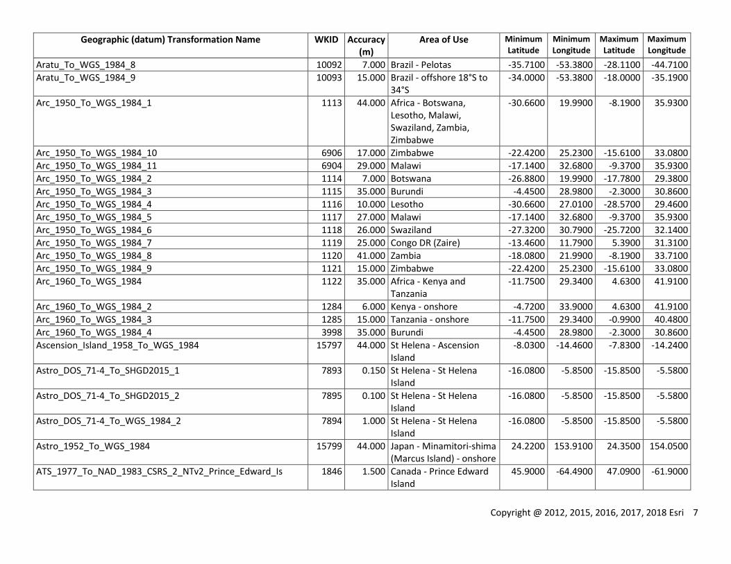
Copyright @ 2012, 2015, 2016, 2017, 2018 Esri 7
Geographic (datum) Transformation Name WKID Accuracy (m)
Area of Use Minimum Latitude
Minimum Longitude
Maximum Latitude
Maximum Longitude
Aratu_To_WGS_1984_8 10092 7.000 Brazil - Pelotas -35.7100 -53.3800 -28.1100 -44.7100
Aratu_To_WGS_1984_9 10093 15.000 Brazil - offshore 18°S to 34°S
-34.0000 -53.3800 -18.0000 -35.1900
Arc_1950_To_WGS_1984_1 1113 44.000 Africa - Botswana, Lesotho, Malawi, Swaziland, Zambia, Zimbabwe
-30.6600 19.9900 -8.1900 35.9300
Arc_1950_To_WGS_1984_10 6906 17.000 Zimbabwe -22.4200 25.2300 -15.6100 33.0800
Arc_1950_To_WGS_1984_11 6904 29.000 Malawi -17.1400 32.6800 -9.3700 35.9300
Arc_1950_To_WGS_1984_2 1114 7.000 Botswana -26.8800 19.9900 -17.7800 29.3800
Arc_1950_To_WGS_1984_3 1115 35.000 Burundi -4.4500 28.9800 -2.3000 30.8600
Arc_1950_To_WGS_1984_4 1116 10.000 Lesotho -30.6600 27.0100 -28.5700 29.4600
Arc_1950_To_WGS_1984_5 1117 27.000 Malawi -17.1400 32.6800 -9.3700 35.9300
Arc_1950_To_WGS_1984_6 1118 26.000 Swaziland -27.3200 30.7900 -25.7200 32.1400
Arc_1950_To_WGS_1984_7 1119 25.000 Congo DR (Zaire) -13.4600 11.7900 5.3900 31.3100
Arc_1950_To_WGS_1984_8 1120 41.000 Zambia -18.0800 21.9900 -8.1900 33.7100
Arc_1950_To_WGS_1984_9 1121 15.000 Zimbabwe -22.4200 25.2300 -15.6100 33.0800
Arc_1960_To_WGS_1984 1122 35.000 Africa - Kenya and Tanzania
-11.7500 29.3400 4.6300 41.9100
Arc_1960_To_WGS_1984_2 1284 6.000 Kenya - onshore -4.7200 33.9000 4.6300 41.9100
Arc_1960_To_WGS_1984_3 1285 15.000 Tanzania - onshore -11.7500 29.3400 -0.9900 40.4800
Arc_1960_To_WGS_1984_4 3998 35.000 Burundi -4.4500 28.9800 -2.3000 30.8600
Ascension_Island_1958_To_WGS_1984 15797 44.000 St Helena - Ascension Island
-8.0300 -14.4600 -7.8300 -14.2400
Astro_DOS_71-4_To_SHGD2015_1 7893 0.150 St Helena - St Helena Island
-16.0800 -5.8500 -15.8500 -5.5800
Astro_DOS_71-4_To_SHGD2015_2 7895 0.100 St Helena - St Helena Island
-16.0800 -5.8500 -15.8500 -5.5800
Astro_DOS_71-4_To_WGS_1984_2 7894 1.000 St Helena - St Helena Island
-16.0800 -5.8500 -15.8500 -5.5800
Astro_1952_To_WGS_1984 15799 44.000 Japan - Minamitori-shima (Marcus Island) - onshore
24.2200 153.9100 24.3500 154.0500
ATS_1977_To_NAD_1983_CSRS_2_NTv2_Prince_Edward_Is 1846 1.500 Canada - Prince Edward Island
45.9000 -64.4900 47.0900 -61.9000
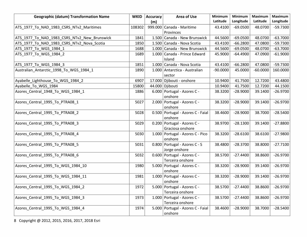
8 Copyright @ 2012, 2015, 2016, 2017, 2018 Esri
Geographic (datum) Transformation Name WKID Accuracy (m)
Area of Use Minimum Latitude
Minimum Longitude
Maximum Latitude
Maximum Longitude
ATS_1977_To_NAD_1983_CSRS_NTv2_Maritimes 108302 999.000 Canada - Maritime Provinces
43.4100 -69.0500 48.0700 -59.7300
ATS_1977_To_NAD_1983_CSRS_NTv2_New_Brunswick 1841 1.500 Canada - New Brunswick 44.5600 -69.0500 48.0700 -63.7000
ATS_1977_To_NAD_1983_CSRS_NTv2_Nova_Scotia 1850 1.500 Canada - Nova Scotia 43.4100 -66.2800 47.0800 -59.7300
ATS_1977_To_WGS_1984_1 1688 1.000 Canada - New Brunswick 44.5600 -69.0500 48.0700 -63.7000
ATS_1977_To_WGS_1984_2 1689 1.000 Canada - Prince Edward Island
45.9000 -64.4900 47.0900 -61.9000
ATS_1977_To_WGS_1984_3 1851 1.000 Canada - Nova Scotia 43.4100 -66.2800 47.0800 -59.7300
Australian_Antarctic_1998_To_WGS_1984_1 1890 1.000 Antarctica - Australian sector
-90.0000 45.0000 -60.0000 160.0000
Ayabelle_Lighthouse_To_WGS_1984_2 6907 17.000 Djibouti - onshore 10.9400 41.7500 12.7200 43.4800
Ayabelle_To_WGS_1984 15800 44.000 Djibouti 10.9400 41.7500 12.7200 44.1500
Azores_Central_1948_To_WGS_1984_1 1886 6.000 Portugal - Azores C - onshore
38.3200 -28.9000 39.1400 -26.9700
Azores_Central_1995_To_PTRA08_1 5027 2.000 Portugal - Azores C - onshore
38.3200 -28.9000 39.1400 -26.9700
Azores_Central_1995_To_PTRA08_2 5028 0.500 Portugal - Azores C - Faial onshore
38.4600 -28.9000 38.7000 -28.5400
Azores_Central_1995_To_PTRA08_3 5029 0.200 Portugal - Azores C - Graciosa onshore
38.9700 -28.1300 39.1400 -27.8800
Azores_Central_1995_To_PTRA08_4 5030 1.000 Portugal - Azores C - Pico onshore
38.3200 -28.6100 38.6100 -27.9800
Azores_Central_1995_To_PTRA08_5 5031 0.800 Portugal - Azores C - S Jorge onshore
38.4800 -28.3700 38.8000 -27.7100
Azores_Central_1995_To_PTRA08_6 5032 0.600 Portugal - Azores C - Terceira onshore
38.5700 -27.4400 38.8600 -26.9700
Azores_Central_1995_To_WGS_1984_10 1980 5.000 Portugal - Azores C - onshore
38.3200 -28.9000 39.1400 -26.9700
Azores_Central_1995_To_WGS_1984_11 1981 1.000 Portugal - Azores C - onshore
38.3200 -28.9000 39.1400 -26.9700
Azores_Central_1995_To_WGS_1984_2 1972 5.000 Portugal - Azores C - Terceira onshore
38.5700 -27.4400 38.8600 -26.9700
Azores_Central_1995_To_WGS_1984_3 1973 1.000 Portugal - Azores C - Terceira onshore
38.5700 -27.4400 38.8600 -26.9700
Azores_Central_1995_To_WGS_1984_4 1974 5.000 Portugal - Azores C - Faial onshore
38.4600 -28.9000 38.7000 -28.5400
Copyright @ 2012, 2015, 2016, 2017, 2018 Esri 9
Geographic (datum) Transformation Name WKID Accuracy (m)
Area of Use Minimum Latitude
Minimum Longitude
Maximum Latitude
Maximum Longitude
Azores_Central_1995_To_WGS_1984_5 1975 1.000 Portugal - Azores C - Faial onshore
38.4600 -28.9000 38.7000 -28.5400
Azores_Central_1995_To_WGS_1984_6 1976 5.000 Portugal - Azores C - Pico onshore
38.3200 -28.6100 38.6100 -27.9800
Azores_Central_1995_To_WGS_1984_7 1977 1.000 Portugal - Azores C - Pico onshore
38.3200 -28.6100 38.6100 -27.9800
Azores_Central_1995_To_WGS_1984_8 1978 5.000 Portugal - Azores C - S Jorge onshore
38.4800 -28.3700 38.8000 -27.7100
Azores_Central_1995_To_WGS_1984_9 1979 1.000 Portugal - Azores C - S Jorge onshore
38.4800 -28.3700 38.8000 -27.7100
Azores_Occidental_1939_To_PTRA08_1 5033 0.500 Portugal - Azores W - onshore
39.3000 -31.3400 39.7700 -31.0200
Azores_Occidental_1939_To_PTRA08_2 5034 0.200 Portugal - Azores W - Flores onshore
39.3000 -31.3400 39.5800 -31.0700
Azores_Occidental_1939_To_PTRA08_3 5035 0.300 Portugal - Azores W - Corvo onshore
39.6300 -31.1800 39.7700 -31.0200
Azores_Occidental_1939_To_WGS_1984_1 1887 35.000 Portugal - Azores W - onshore
39.3000 -31.3400 39.7700 -31.0200
Azores_Occidental_1939_To_WGS_1984_2 1982 5.000 Portugal - Azores W - onshore
39.3000 -31.3400 39.7700 -31.0200
Azores_Oriental_1940_To_WGS_1984_1 1885 44.000 Portugal - Azores E - onshore
36.8700 -25.9200 37.9600 -24.6200
Azores_Oriental_1995_To_PTRA08_1 5024 2.000 Portugal - Azores E - onshore
36.8700 -25.9200 37.9600 -24.6200
Azores_Oriental_1995_To_PTRA08_2 5025 0.300 Portugal - Azores E - S Miguel onshore
37.6500 -25.9200 37.9600 -25.0800
Azores_Oriental_1995_To_PTRA08_3 5026 0.100 Portugal - Azores E - Santa Maria onshore
36.8700 -25.2600 37.0800 -24.9600
Azores_Oriental_1995_To_WGS_1984_2 1968 5.000 Portugal - Azores E - S Miguel onshore
37.6500 -25.9200 37.9600 -25.0800
Azores_Oriental_1995_To_WGS_1984_3 1969 1.000 Portugal - Azores E - S Miguel onshore
37.6500 -25.9200 37.9600 -25.0800
Azores_Oriental_1995_To_WGS_1984_4 1970 5.000 Portugal - Azores E - onshore
36.8700 -25.9200 37.9600 -24.6200
10 Copyright @ 2012, 2015, 2016, 2017, 2018 Esri
Geographic (datum) Transformation Name WKID Accuracy (m)
Area of Use Minimum Latitude
Minimum Longitude
Maximum Latitude
Maximum Longitude
Azores_Oriental_1995_To_WGS_1984_5 1971 1.000 Portugal - Azores E - onshore
36.8700 -25.9200 37.9600 -24.6200
Bab_South_To_NAD_1983 108134 999.000 Palau 1.6400 129.4800 11.4500 136.9800
Barbados_1938_To_WGS_1984_1 15793 3.000 Barbados - onshore 13.0000 -59.7100 13.3900 -59.3700
Barbados_1938_To_WGS_1984_2X 108376 0.150 Barbados - onshore 13.0000 -59.7100 13.3900 -59.3700
Batavia_Jakarta_To_Batavia 1759 0.000 Indonesia - Java and Bali onshore
-8.9100 105.0600 -5.8300 115.7700
Batavia_Jakarta_To_WGS_1984 8178 6.000 Indonesia - Sumatra -5.9900 95.1600 5.9700 106.1300
Batavia_To_WGS_1984 1123 6.000 Indonesia - Sumatra -5.9900 95.1600 5.9700 106.1300
Batavia_To_WGS_1984_2 1813 5.000 Indonesia - Java Sea - offshore northwest Java
-6.8900 105.7700 -4.0700 110.0100
Batavia_To_WGS_1984_3 1814 5.000 Indonesia - Bali Sea west -8.4600 112.8000 -6.8000 117.0100
Beacon_E_1945_To_WGS_1984 15796 44.000 Japan - Iwo Jima 24.6700 141.2000 24.8900 141.4200
Beduaram_To_WGS_1972_BE_1 1839 15.000 Niger - southeast 12.8000 7.8100 16.7000 14.9000
Beduaram_To_WGS_1984_2 15849 15.000 Niger - southeast 12.8000 7.8100 16.7000 14.9000
Beijing_1954_To_WGS_1984_1 15918 1.000 China - Ordos - 108°E to 108.5°E and 37.75°N to 38.25°N
35.0000 107.0000 39.0000 110.0100
Beijing_1954_To_WGS_1984_2 15919 15.000 China - offshore - Yellow Sea
31.2300 119.2300 37.4000 125.0600
Beijing_1954_To_WGS_1984_3 15920 15.000 China - offshore - Pearl River basin
18.3100 110.1300 22.8900 116.7600
Beijing_1954_To_WGS_1984_4 15921 1.000 China - Tarim - 77.5°E to 88°E and 37°N to 42°N
37.0000 77.4500 41.9900 88.0000
Beijing_1954_To_WGS_1984_5 15935 10.000 China - offshore - Bei Bu 17.8100 107.1500 21.6900 110.1700
Beijing_1954_To_WGS_1984_6 15936 1.000 China - Ordos - 108°E to 108.5°E and 37.75°N to 38.25°N
35.0000 107.0000 39.0000 110.0100
Bekaa_Valley_1920_To_WGS_1984_1 6911 999.000 Lebanon - onshore 33.0600 35.0400 34.6500 36.6300
Belge_1950_Brussels_To_Belge_1950 1264 0.000 Belgium - onshore 49.5000 2.5000 51.5100 6.4000
Belge_1972_To_ETRS_1989_1 1652 1.000 Belgium - onshore 49.5000 2.5000 51.5100 6.4000
Belge_1972_To_ETRS_1989_2 15928 0.200 Belgium - onshore 49.5000 2.5000 51.5100 6.4000
Belge_1972_To_WGS_1984_1 1609 1.000 Belgium - onshore 49.5000 2.5000 51.5100 6.4000
Belge_1972_To_WGS_1984_2 1610 5.000 Belgium - onshore 49.5000 2.5000 51.5100 6.4000
Belge_1972_To_WGS_1984_3 15929 0.200 Belgium - onshore 49.5000 2.5000 51.5100 6.4000

Copyright @ 2012, 2015, 2016, 2017, 2018 Esri 11
Geographic (datum) Transformation Name WKID Accuracy (m)
Area of Use Minimum Latitude
Minimum Longitude
Maximum Latitude
Maximum Longitude
Bellevue_IGN_To_WGS_1984 15801 35.000 Vanuatu - southern islands
-20.3100 168.0900 -17.3700 169.9500
Bermuda_1957_To_Bermuda_2000_1 15969 1.000 Bermuda - onshore 32.2100 -64.8900 32.4300 -64.6100
Bermuda_1957_To_WGS_1984 1124 35.000 Bermuda - onshore 32.2100 -64.8900 32.4300 -64.6100
Bermuda_1957_To_WGS_1984_2 15970 1.000 Bermuda - onshore 32.2100 -64.8900 32.4300 -64.6100
Bermuda_2000_To_WGS_1984_1 15971 1.000 Bermuda 28.9100 -68.8300 35.7300 -60.7000
Bern_1898_Bern_To_CH1903 1765 0.000 Europe - Liechtenstein and Switzerland
45.8200 5.9600 47.8100 10.4900
Bioko_To_WGS_1984_1 6912 42.000 Equatorial Guinea - Bioko 3.1400 8.3700 3.8200 9.0200
Bissau_To_WGS_1984 1547 25.000 Guinea-Bissau - onshore 10.8700 -16.7700 12.6900 -13.6400
Bogota_Bogota_To_Bogota 1755 0.000 Colombia - mainland -4.2300 -79.1000 12.5200 -66.8700
Bogota_Bogota_To_WGS_1984 8174 10.000 Colombia - mainland -4.2300 -79.1000 12.5200 -66.8700
Bogota_To_MAGNA_Region_1_CF 15714 1.000 Colombia region 1 9.8000 -73.0000 12.5200 -71.0600
Bogota_To_MAGNA_Region_1_MB 15730 1.000 Colombia region 1 9.8000 -73.0000 12.5200 -71.0600
Bogota_To_MAGNA_Region_2_CF 15716 1.000 Colombia region 2 9.3900 -76.0800 11.5900 -73.0000
Bogota_To_MAGNA_Region_2_MB 15731 1.000 Colombia region 2 9.3900 -76.0800 11.5900 -73.0000
Bogota_To_MAGNA_Region_3_CF 15718 1.000 Colombia region 3 8.0000 -77.4800 9.4000 -74.3900
Bogota_To_MAGNA_Region_3_MB 15732 1.000 Colombia region 3 8.0000 -77.4800 9.4000 -74.3900
Bogota_To_MAGNA_Region_4_CF 15720 1.000 Colombia region 4 5.0000 -74.4000 9.4000 -71.9900
Bogota_To_MAGNA_Region_4_MB 15733 1.000 Colombia region 4 5.0000 -74.4000 9.4000 -71.9900
Bogota_To_MAGNA_Region_5_CF 15722 1.000 Colombia region 5 5.0000 -77.9200 8.0100 -74.3900
Bogota_To_MAGNA_Region_5_MB 15734 1.000 Colombia region 5 5.0000 -77.9200 8.0100 -74.3900
Bogota_To_MAGNA_Region_6_CF 15724 1.000 Colombia region 6 3.0000 -77.6800 5.0100 -74.3900
Bogota_To_MAGNA_Region_6_MB 15735 1.000 Colombia region 6 3.0000 -77.6800 5.0100 -74.3900
Bogota_To_MAGNA_Region_7_CF 15726 1.000 Colombia region 7 -1.1300 -79.1000 3.0100 -74.0000
Bogota_To_MAGNA_Region_7_MB 15736 1.000 Colombia region 7 -1.1300 -79.1000 3.0100 -74.0000
Bogota_To_MAGNA_Region_8_CF 15728 1.000 Colombia region 8 -4.2300 -74.4000 7.1000 -66.8700
Bogota_To_MAGNA_Region_8_MB 15737 1.000 Colombia region 8 -4.2300 -74.4000 7.1000 -66.8700
Bogota_To_WGS_1984 1125 10.000 Colombia - mainland and offshore Caribbean
-4.2300 -79.1000 13.6800 -66.8700
Bogota_To_WGS_1984_2 1597 0.200 Colombia - Cusiana 4.7500 -73.0000 5.6800 -72.2500
Bogota_To_WGS_1984_Region_1_CF 15715 1.000 Colombia region 1 9.8000 -73.0000 12.5200 -71.0600
Bogota_To_WGS_1984_Region_2_CF 15717 1.000 Colombia region 2 9.3900 -76.0800 11.5900 -73.0000
Bogota_To_WGS_1984_Region_3_CF 15719 1.000 Colombia region 3 8.0000 -77.4800 9.4000 -74.3900
12 Copyright @ 2012, 2015, 2016, 2017, 2018 Esri
Geographic (datum) Transformation Name WKID Accuracy (m)
Area of Use Minimum Latitude
Minimum Longitude
Maximum Latitude
Maximum Longitude
Bogota_To_WGS_1984_Region_4_CF 15721 1.000 Colombia region 4 5.0000 -74.4000 9.4000 -71.9900
Bogota_To_WGS_1984_Region_5_CF 15723 1.000 Colombia region 5 5.0000 -77.9200 8.0100 -74.3900
Bogota_To_WGS_1984_Region_6_CF 15725 1.000 Colombia region 6 3.0000 -77.6800 5.0100 -74.3900
Bogota_To_WGS_1984_Region_7_CF 15727 1.000 Colombia region 7 -1.1300 -79.1000 3.0100 -74.0000
Bogota_To_WGS_1984_Region_8_CF 15729 1.000 Colombia region 8 -4.2300 -74.4000 7.1000 -66.8700
Bukit_Rimpah_To_WGS_1984 1126 999.000 Indonesia - Banga & Belitung Islands
-3.3000 105.0700 -1.4400 108.3500
Cadastre_1997_To_RGM_2004_1 4478 0.100 Mayotte - onshore -13.0500 44.9800 -12.6100 45.3500
Cadastre_1997_To_WGS_1984_1 4290 1.000 Mayotte - onshore -13.0500 44.9800 -12.6100 45.3500
Camacupa_To_WGS_1972_BE_1 1317 10.000 Angola - Angola proper - offshore
-17.2600 8.2000 -6.0100 13.8600
Camacupa_To_WGS_1984_1 1318 10.000 Angola - offshore block 5 -8.5900 12.5800 -7.7500 13.4000
Camacupa_To_WGS_1984_10 1327 5.000 Angola - offshore blocks 2 3 17-18 and 31-33
-8.5900 10.4100 -6.0100 12.8400
Camacupa_To_WGS_1984_2 1319 25.000 Angola - offshore block 2 -7.0100 12.0800 -6.0100 12.8400
Camacupa_To_WGS_1984_3 1320 10.000 Angola - offshore blocks 1 and 16
-7.2600 11.0800 -6.0300 12.0900
Camacupa_To_WGS_1984_4 1321 10.000 Angola - offshore blocks 7 8 24 + WGC spec
-17.2600 8.2000 -6.0100 13.8600
Camacupa_To_WGS_1984_5 1322 3.000 Angola - offshore block 3 -7.3400 11.7400 -6.6600 12.5000
Camacupa_To_WGS_1984_6 1323 8.000 Angola - offshore block 7 -10.0900 12.6600 -9.4100 13.3900
Camacupa_To_WGS_1984_7 1324 3.000 Angola - offshore blocks 3 7 15 and 17
-10.0900 10.8300 -6.0300 13.3900
Camacupa_To_WGS_1984_8 1325 3.000 Angola - offshore block 2 -7.0100 12.0800 -6.0100 12.8400
Camacupa_To_WGS_1984_9 1326 10.000 Angola - offshore blocks 1 16 and 18
-8.3400 11.0800 -6.0300 12.7500
Camp_Area_To_WGS_1984 15802 999.000 Antarctica - Camp McMurdo area
-77.9400 165.7300 -77.1700 167.4300
Campo_Inchauspe_To_POSGAR_1994_1 15782 5.000 Argentina - mainland onshore
-52.4300 -73.5900 -21.7800 -53.6500
Campo_Inchauspe_To_POSGAR_2007_1 5350 5.000 Argentina -58.4100 -73.5900 -21.7800 -52.6300
Campo_Inchauspe_To_WGS_1984 1127 9.000 Argentina - mainland onshore and offshore TdF
-54.9300 -73.5900 -21.7800 -53.6500
Campo_Inchauspe_To_WGS_1984_2 1527 0.500 Argentina - Neuquen province Chos Malal area
-37.5000 -70.5000 -36.1400 -70.0300
Canton_1966_To_WGS_1984 15803 26.000 Kiribati - Phoenix Islands -4.7600 -174.6000 -2.6800 -170.6600
Copyright @ 2012, 2015, 2016, 2017, 2018 Esri 13
Geographic (datum) Transformation Name WKID Accuracy (m)
Area of Use Minimum Latitude
Minimum Longitude
Maximum Latitude
Maximum Longitude
Cape_Canaveral_To_WGS_1984 15804 6.000 North America - Bahamas and USA - Florida - onshore
20.8600 -82.3300 30.8300 -72.6800
Cape_To_Hartebeesthoek94 1504 15.000 South Africa - onshore -34.8800 16.4500 -22.1300 32.9500
Cape_To_WGS_1984_1 1128 9.000 South Africa - onshore -34.8800 16.4500 -22.1300 32.9500
Cape_To_WGS_1984_2 1129 15.000 South Africa - onshore -34.8800 16.4500 -22.1300 32.9500
Carthage_Grad_To_Carthage 108338 1.000 Tunisia - offshore 33.2200 7.8100 38.4100 13.6700
Carthage_Paris_To_Carthage 1881 0.000 Tunisia - onshore 30.2300 7.4900 37.4000 11.5900
Carthage_To_WGS_1984 1130 14.000 Tunisia 30.2300 7.4900 38.4100 13.6700
Carthage_To_WGS_1984_2 1538 1.000 Tunisia - offshore 33.2200 7.8100 38.4100 13.6700
CGRS_1993_To_ETRS_1989 108128 0.500 Cyprus - onshore 34.5900 32.2000 35.7400 34.6500
CGRS_1993_To_ETRS_1989_1 7720 0.100 Cyprus - onshore 34.5900 32.2000 35.7400 34.6500
CGRS_1993_To_WGS_1984 108129 1.000 Cyprus - onshore 34.5900 32.2000 35.7400 34.6500
CGRS_1993_To_WGS_1984_1 7721 1.000 Cyprus - onshore 34.5900 32.2000 35.7400 34.6500
CH1903+_To_CHTRF_1995 1509 0.100 Europe - Liechtenstein and Switzerland
45.8200 5.9600 47.8100 10.4900
CH1903+_To_ETRS_1989_1 1647 0.100 Europe - Liechtenstein and Switzerland
45.8200 5.9600 47.8100 10.4900
CH1903+_To_WGS_1984_1 1676 1.000 Europe - Liechtenstein and Switzerland
45.8200 5.9600 47.8100 10.4900
CH1903_To_CHTRF95_1_NTv2 7673 0.25 Europe - Liechtenstein and Switzerland
45.8200 5.9600 47.8100 10.4900
CH1903_To_CH1903+_1_NTv2 15486 0.200 Europe - Liechtenstein and Switzerland
45.8200 5.9600 47.8100 10.4900
CH1903_To_ETRS_1989_1 1646 1.500 Europe - Liechtenstein and Switzerland
45.8200 5.9600 47.8100 10.4900
CH1903_To_ETRS_1989_2_NTv2 7674 0.25 Europe - Liechtenstein and Switzerland
45.8200 5.9600 47.8100 10.4900
CH1903_To_WGS_1984_1 1753 1.000 Europe - Liechtenstein and Switzerland
45.8200 5.9600 47.8100 10.4900
CH1903_To_WGS_1984_2 1766 999.000 Europe - Liechtenstein and Switzerland
45.8200 5.9600 47.8100 10.4900
CH1903_To_WGS_1984_3_NTv2 7788 1.5 Europe - Liechtenstein and Switzerland
45.8200 5.9600 47.8100 10.4900
14 Copyright @ 2012, 2015, 2016, 2017, 2018 Esri
Geographic (datum) Transformation Name WKID Accuracy (m)
Area of Use Minimum Latitude
Minimum Longitude
Maximum Latitude
Maximum Longitude
Chatham_Island_1971_To_WGS_1984 1080 26.000 New Zealand - Chatham Islands group
-44.6400 -177.2500 -43.3000 -175.5400
Chatham_Islands_1979_To_NZGD_2000_1 1082 2.000 New Zealand - Chatham Islands group
-44.6400 -177.2500 -43.3000 -175.5400
Chatham_Islands_1979_To_WGS_1984_1 1081 2.000 New Zealand - Chatham Islands group
-44.6400 -177.2500 -43.3000 -175.5400
Chos_Malal_1914_To_Campo_Inchauspe 1528 10.000 Argentina - Neuquen province Chos Malal area
-37.5000 -70.5000 -36.1400 -70.0300
Chos_Malal_1914_To_WGS_1984 108096 10.500 Argentina - Neuquen province Chos Malal area
-37.5000 -70.5000 -36.1400 -70.0300
CHTRF_1995_To_WGS_1984 1511 1.000 Europe - Liechtenstein and Switzerland
45.8200 5.9600 47.8100 10.4900
Chua_To_SIRGAS_2000_1 4069 5.000 Brazil - Distrito Federal -15.9400 -48.1000 -15.3700 -47.1000
Chua_To_WGS_1984 1131 12.000 Paraguay - north of 22°S -22.0000 -62.5700 -19.2900 -57.8100
Chua_To_WGS_1984_2 3972 5.000 Brazil - Distrito Federal -15.9400 -48.1000 -15.3700 -47.1000
Chua_To_WGS_1984_3 4834 5.000 Brazil - Distrito Federal -15.9400 -48.1000 -15.3700 -47.1000
CIGD11_To_WGS_1984_1 6177 1.000 Cayman Islands 17.5800 -83.6000 20.6800 -78.7200
Combani_1950_To_RGM_2004_1 5888 0.300 Mayotte - onshore -13.0500 44.9800 -12.6100 45.3500
Combani_1950_To_WGS_1984_1 1916 10.000 Mayotte - onshore -13.0500 44.9800 -12.6100 45.3500
Conakry_1905_To_WGS_1984 1517 30.000 Guinea - onshore 7.1900 -15.1300 12.6800 -7.6500
Corrego_Alegre_1961_To_SIRGAS_2000_1 5525 2.000 Brazil - Corrego Alegre 1961
-27.5000 -58.1600 -14.9900 -38.8200
Corrego_Alegre_1961_To_WGS_1984_1 5540 2.000 Brazil - Corrego Alegre 1961
-27.5000 -58.1600 -14.9900 -38.8200
Corrego_Alegre_To_SAD_1969_1 6191 5.000 Brazil - Corrego Alegre 1970-1972
-33.7800 -58.1600 -2.6800 -34.7400
Corrego_Alegre_To_SIRGAS_2000_1 5526 2.000 Brazil - Corrego Alegre 1970-1972
-33.7800 -58.1600 -2.6800 -34.7400
Corrego_Alegre_To_SIRGAS_2000_2 6193 5.000 Brazil - Corrego Alegre 1970-1972
-33.7800 -58.1600 -2.6800 -34.7400
Corrego_Alegre_To_WGS_1984 1132 8.000 Brazil - Corrego Alegre 1970-1972
-33.7800 -58.1600 -2.6800 -34.7400
Corrego_Alegre_To_WGS_1984_2 5541 2.000 Brazil - Corrego Alegre 1970-1972
-33.7800 -58.1600 -2.6800 -34.7400
Corrego_Alegre_To_WGS_1984_3 6192 5.000 Brazil - Corrego Alegre 1970-1972
-33.7800 -58.1600 -2.6800 -34.7400
Copyright @ 2012, 2015, 2016, 2017, 2018 Esri 15
Geographic (datum) Transformation Name WKID Accuracy (m)
Area of Use Minimum Latitude
Minimum Longitude
Maximum Latitude
Maximum Longitude
Corrego_Alegre_To_WGS_1984_4 6194 5.000 Brazil - Corrego Alegre 1970-1972
-33.7800 -58.1600 -2.6800 -34.7400
CR05_To_Ocotepeque_1935_MB 108013 0.500 Costa Rica 2.1500 -90.4500 11.7700 -81.4300
CR05_To_WGS_1984_1 5376 1.000 Costa Rica 2.1500 -90.4500 11.7700 -81.4300
CSG_1967_To_RGFG_1995_1 1908 1.000 French Guiana - coastal area
3.4300 -54.4500 5.8100 -51.6100
CSG_1967_To_WGS_1984_1 1906 10.000 French Guiana - coastal area
3.4300 -54.4500 5.8100 -51.6100
D48_To_ETRS_1989 108276 1.000 Slovenia 45.4200 13.3800 46.8800 16.6100
D48_To_ETRS_1989_2007 108308 1.000 Slovenia 45.4200 13.3800 46.8800 16.6100
D48_To_ETRS_1989_Dolenjska 108322 0.300 Slovenia - Dolenjska 45.7000 14.4700 46.1200 15.7300
D48_To_ETRS_1989_Gorenjska 108318 0.300 Slovenia - Gorenjska and N Primorsko
46.0500 13.3800 46.5300 14.8200
D48_To_ETRS_1989_Jugovzhodna_Slovenia 108314 0.500 Slovenia - SE 45.4200 14.5500 46.2200 15.7300
D48_To_ETRS_1989_Juzna_Slovenia 108324 0.300 Slovenia - southeastern 45.4200 14.5300 45.7700 15.3600
D48_To_ETRS_1989_Osrednja_Slovenia 108320 0.300 Slovenia - central 45.9100 14.2100 46.3100 15.2800
D48_To_ETRS_1989_Pomurje 108328 0.300 Slovenia - Pomurje 46.4700 15.9600 46.8800 16.6100
D48_To_ETRS_1989_Primorska 108326 0.300 Slovenia - Primorska and Notranjska onshore
45.4400 13.4700 46.0800 14.5800
D48_To_ETRS_1989_Severovzhodna_Slovenia 108312 0.500 Slovenia - NE 46.1400 14.5400 46.8800 16.6100
D48_To_ETRS_1989_Stajerska 108316 0.300 Slovenia - Stajerska 46.1000 14.7400 46.7600 16.2700
D48_To_ETRS_1989_Zahodna_Slovenia 108310 0.500 Slovenia - west of 14°30'E onshore
45.4400 13.3800 46.5300 14.5800
D48_To_WGS_1984 108277 1.000 Slovenia 45.4200 13.3800 46.8800 16.6100
D48_To_WGS_1984_2007 108309 1.000 Slovenia 45.4200 13.3800 46.8800 16.6100
D48_To_WGS_1984_Dolenjska 108323 0.300 Slovenia - Dolenjska 45.7000 14.4700 46.1200 15.7300
D48_To_WGS_1984_Gorenjska 108319 0.300 Slovenia - Gorenjska and N Primorsko
46.0500 13.3800 46.5300 14.8200
D48_To_WGS_1984_Jugovzhodna_Slovenia 108315 0.500 Slovenia - SE 45.4200 14.5500 46.2200 15.7300
D48_To_WGS_1984_Juzna_Slovenia 108325 0.300 Slovenia - southeastern 45.4200 14.5300 45.7700 15.3600
D48_To_WGS_1984_Osrednja_Slovenia 108321 0.300 Slovenia - central 45.9100 14.2100 46.3100 15.2800
D48_To_WGS_1984_Pomurje 108329 0.300 Slovenia - Pomurje 46.4700 15.9600 46.8800 16.6100
D48_To_WGS_1984_Primorska 108327 0.300 Slovenia - Primorska and Notranjska onshore
45.4400 13.4700 46.0800 14.5800
D48_To_WGS_1984_Severovzhodna_Slovenia 108313 0.500 Slovenia - NE 46.1400 14.5400 46.8800 16.6100
16 Copyright @ 2012, 2015, 2016, 2017, 2018 Esri
Geographic (datum) Transformation Name WKID Accuracy (m)
Area of Use Minimum Latitude
Minimum Longitude
Maximum Latitude
Maximum Longitude
D48_To_WGS_1984_Stajerska 108317 0.300 Slovenia - Stajerska 46.1000 14.7400 46.7600 16.2700
D48_To_WGS_1984_Zahodna_Slovenia 108311 0.500 Slovenia - west of 14°30'E onshore
45.4400 13.3800 46.5300 14.5800
Dabola_To_WGS_1984 1518 25.000 Guinea - onshore 7.1900 -15.1300 12.6800 -7.6500
Datum_73_To_ETRS_1989_1 1657 2.000 Portugal - mainland - onshore
36.9500 -9.5600 42.1600 -6.1900
Datum_73_To_ETRS_1989_2009_3par 5036 0.900 Portugal - mainland - onshore
36.9500 -9.5600 42.1600 -6.1900
Datum_73_To_ETRS_1989_2009_7par 5037 0.400 Portugal - mainland - onshore
36.9500 -9.5600 42.1600 -6.1900
Datum_73_To_ETRS_1989_3 1992 1.000 Portugal - mainland - onshore
36.9500 -9.5600 42.1600 -6.1900
Datum_73_To_ETRS_1989_6 6189 0.100 Portugal - mainland - onshore
36.9500 -9.5600 42.1600 -6.1900
Datum_73_To_WGS_1984_1 108110 5.000 Portugal - mainland - onshore
36.9500 -9.5600 42.1600 -6.1900
Datum_73_To_WGS_1984_1_Prt2000 1658 2.000 Portugal - mainland - onshore
36.9500 -9.5600 42.1600 -6.1900
Datum_73_To_WGS_1984_2 108120 1.000 Portugal - mainland - onshore
36.9500 -9.5600 42.1600 -6.1900
Datum_73_To_WGS_1984_2009_3par 108155 0.900 Portugal - mainland - onshore
36.9500 -9.5600 42.1600 -6.1900
Datum_73_To_WGS_1984_2009_7par 108153 0.400 Portugal - mainland - onshore
36.9500 -9.5600 42.1600 -6.1900
Datum_73_To_WGS_1984_3 1983 5.000 Portugal - mainland - onshore
36.9500 -9.5600 42.1600 -6.1900
Datum_73_To_WGS_1984_4 1987 1.000 Portugal - mainland - onshore
36.9500 -9.5600 42.1600 -6.1900
Datum_73_To_WGS_1984_NTv2 108025 0.100 Portugal - mainland - onshore
36.9500 -9.5600 42.1600 -6.1900
Datum_Lisboa_Bessel_To_WGS_1984_1 108113 5.000 Portugal - mainland - onshore
36.9500 -9.5600 42.1600 -6.1900
Datum_Lisboa_Bessel_To_WGS_1984_2 108123 1.000 Portugal - mainland - onshore
36.9500 -9.5600 42.1600 -6.1900
Datum_Lisboa_Hayford_To_Datum_73_1 108222 5.000 Portugal - mainland - onshore
36.9500 -9.5600 42.1600 -6.1900
Copyright @ 2012, 2015, 2016, 2017, 2018 Esri 17
Geographic (datum) Transformation Name WKID Accuracy (m)
Area of Use Minimum Latitude
Minimum Longitude
Maximum Latitude
Maximum Longitude
Datum_Lisboa_Hayford_To_Datum_73_2 108223 5.000 Portugal - mainland - onshore
36.9500 -9.5600 42.1600 -6.1900
Datum_Lisboa_Hayford_To_Datum_Lisboa_Bessel_1 108224 5.000 Portugal - mainland - onshore
36.9500 -9.5600 42.1600 -6.1900
Datum_Lisboa_Hayford_To_Datum_Lisboa_Bessel_2 108225 5.000 Portugal - mainland - onshore
36.9500 -9.5600 42.1600 -6.1900
Datum_Lisboa_Hayford_To_ETRS_1989_2009_3par 108158 1.700 Portugal - mainland - onshore
36.9500 -9.5600 42.1600 -6.1900
Datum_Lisboa_Hayford_To_ETRS_1989_2009_7par 108156 1.500 Portugal - mainland - onshore
36.9500 -9.5600 42.1600 -6.1900
Datum_Lisboa_Hayford_To_ETRS_1989_NTv2 108024 0.100 Portugal - mainland - onshore
36.9500 -9.5600 42.1600 -6.1900
Datum_Lisboa_Hayford_To_WGS_1984_1 108114 5.000 Portugal - mainland - onshore
36.9500 -9.5600 42.1600 -6.1900
Datum_Lisboa_Hayford_To_WGS_1984_2 108124 2.000 Portugal - mainland - onshore
36.9500 -9.5600 42.1600 -6.1900
Datum_Lisboa_Hayford_To_WGS_1984_2009_3par 108159 1.700 Portugal - mainland - onshore
36.9500 -9.5600 42.1600 -6.1900
Datum_Lisboa_Hayford_To_WGS_1984_2009_7par 108157 1.500 Portugal - mainland - onshore
36.9500 -9.5600 42.1600 -6.1900
Datum_Lisboa_Hayford_To_WGS_1984_NTv2 108023 0.100 Portugal - mainland - onshore
36.9500 -9.5600 42.1600 -6.1900
DB_REF_To_ETRS_1989_1 5826 0.500 Germany - onshore 47.2700 5.8600 55.0900 15.0400
Dealul_Piscului_1933_To_WGS_1984_1 1995 10.000 Romania - onshore 43.6200 20.2600 48.2700 29.7400
Dealul_Piscului_1970_To_ETRS_1989_1X 108375 3.000 Romania 43.4400 20.2600 48.2700 31.4100
Dealul_Piscului_1970_To_WGS_1984_1 1996 10.000 Romania 43.4400 20.2600 48.2700 31.4100
Dealul_Piscului_1970_To_WGS_1984_2 1097 7.000 Romania 43.4400 20.2600 48.2700 31.4100
Dealul_Piscului_1970_To_WGS_1984_3X 108374 3.000 Romania 43.4400 20.2600 48.2700 31.4100
Deception_Island_To_WGS_1984 15812 35.000 Antarctica - Deception Island
-63.0800 -60.8900 -62.8200 -60.3500
Deir_ez_Zor_To_WGS_1972_BE 1584 5.000 Syria - Deir area 34.4900 39.3000 35.9000 40.8100
Deir_ez_Zor_To_WGS_1984_2 15741 5.000 Syria - Deir area 34.4900 39.3000 35.9000 40.8100
Deir_ez_Zor_To_WGS_1984_3 1586 999.000 Syria - Al Whaleed area 35.3300 39.1500 35.9000 40.4100
Deir_ez_Zor_To_WGS_1984_4 1587 1.000 Syria - Shaddadeh area 35.7900 40.5000 36.5000 41.3900
Deir_ez_Zor_To_WGS_1984_5 15742 5.000 Syria - onshore 32.3100 35.6100 37.3000 42.3800
18 Copyright @ 2012, 2015, 2016, 2017, 2018 Esri
Geographic (datum) Transformation Name WKID Accuracy (m)
Area of Use Minimum Latitude
Minimum Longitude
Maximum Latitude
Maximum Longitude
Deir_ez_Zor_To_WGS_1984_6 15743 0.500 Syria - Deir area 34.4900 39.3000 35.9000 40.8100
DGN_1995_To_WGS_1984_1 15912 1.000 Indonesia -13.9500 92.0100 7.7900 141.4600
DHDN_To_ETRF_1989 108192 5.000 Germany - West Germany all states
47.2700 5.8700 55.0900 13.8400
DHDN_To_ETRS_1989 1309 5.000 Germany - West Germany all states
47.2700 5.8700 55.0900 13.8400
DHDN_To_ETRS_1989_2 1776 3.000 Germany - West Germany all states
47.2700 5.8700 55.0900 13.8400
DHDN_To_ETRS_1989_3 1778 0.100 Germany - West Germany S
47.2700 6.1100 50.3400 13.8400
DHDN_To_ETRS_1989_4 1779 0.100 Germany - West Germany C
50.3300 5.8600 52.3400 12.0300
DHDN_To_ETRS_1989_5 1780 0.100 Germany - West Germany N
52.3300 6.5800 55.0900 11.5900
DHDN_To_ETRS_1989_6 1781 0.100 Germany - Thuringen 50.2000 9.9200 51.6400 12.5600
DHDN_To_ETRS_1989_7 1782 0.100 Germany - Saxony 50.2000 11.8900 51.6600 15.0400
DHDN_To_ETRS_1989_8_NTv2 15948 1.000 Germany - onshore 47.2700 5.8600 55.0900 15.0400
DHDN_To_WGS_1984_1 1673 5.000 Germany - West Germany all states
47.2700 5.8700 55.0900 13.8400
DHDN_To_WGS_1984_2 1777 3.000 Germany - West Germany all states
47.2700 5.8700 55.0900 13.8400
DHDN_To_WGS_1984_3 15869 2.000 Germany - East Germany all states
50.2000 9.9200 54.7400 15.0400
DHDN_To_WGS_1984_3x 108206 0.100 Germany - West Germany S
47.2700 6.1100 50.3400 13.8400
DHDN_To_WGS_1984_4_NTv2 15949 1.000 Germany - onshore 47.2700 5.8600 55.0900 15.0400
DHDN_To_WGS_1984_4x 108207 0.100 Germany - West Germany C
50.3300 5.8600 52.3400 12.0300
DHDN_To_WGS_1984_5x 108208 0.100 Germany - West Germany N
52.3300 6.5800 55.0900 11.5900
DHDN_To_WGS_1984_6x 108209 0.100 Germany - Thuringen 50.2000 9.9200 51.6400 12.5600
DHDN_To_WGS_1984_7x 108210 0.100 Germany - Saxony 50.2000 11.8900 51.6600 15.0400
Dominica_1945_To_WGS_1984 1442 10.000 Dominica - onshore 15.1400 -61.5500 15.6900 -61.2000
DOS_1968_To_WGS_1984 108259 44.000 Solomon Islands - New Georgia - Ghizo (Gizo)
-8.8600 156.4400 -7.5200 158.2000
Copyright @ 2012, 2015, 2016, 2017, 2018 Esri 19
Geographic (datum) Transformation Name WKID Accuracy (m)
Area of Use Minimum Latitude
Minimum Longitude
Maximum Latitude
Maximum Longitude
DOS_71_4_To_WGS_1984 15798 44.000 St Helena - St Helena Island
-16.0800 -5.8500 -15.8500 -5.5800
Douala_1948_To_WGS_1984_1 15873 10.000 Cameroon - coastal area 2.1600 8.4500 4.9900 10.4000
DRUKREF_03_To_WGS_1984_1 5267 1.000 Bhutan 26.7000 88.7400 28.3300 92.1300
Easter_Island_1967_To_WGS_1984 15806 44.000 Chile - Easter Island onshore
-27.2500 -109.5100 -27.0100 -109.1600
ED_1950_ED77_To_WGS_1984 1514 1.000 Iran 23.3400 44.0300 39.7800 63.3400
ED_1950_ED77_To_WGS_1984_2 1141 19.000 Iran 23.3400 44.0300 39.7800 63.3400
ED_1950_ED77_To_WGS_1984_3 1856 0.500 Iran - South Pars blocks 2 and 3
26.5800 52.0700 26.7100 52.2800
ED_1950_ED77_To_WGS_1984_4 1857 0.500 Iran - Lavan Island and Balal field
26.2100 52.4900 26.8700 53.4300
ED_1950_ED77_To_WGS_1984_5 1858 0.500 Iran - Kharg Island 29.1600 50.2200 29.3900 50.4200
ED_1950_ED77_To_WGS_1984_6 15745 0.200 Iran - South Pars block 11 26.4600 52.2200 26.6400 52.4100
ED_1950_To_ED_1987_2 1147 1.000 Norway - offshore north of 65°N; Svalbard
65.0000 -3.7000 84.1700 39.6500
ED_1950_To_ETRF_1989_1 108193 1.000 Norway - offshore north of 62°N; Svalbard
62.0000 -3.7000 84.1700 39.6500
ED_1950_To_ETRS_1989_1 1588 1.000 Norway - offshore north of 65°N; Svalbard
65.0000 -3.7000 84.1700 39.6500
ED_1950_To_ETRS_1989_10 1650 2.000 France 41.1500 -9.8600 51.5600 10.3800
ED_1950_To_ETRS_1989_12_NTv2_Spain_v2 15932 0.200 Spain - mainland and Balearic Islands onshore
35.2600 -9.3700 43.8200 4.3900
ED_1950_To_ETRS_1989_13 5040 5.000 Portugal - mainland - onshore
36.9500 -9.5600 42.1600 -6.1900
ED_1950_To_ETRS_1989_4 1626 1.000 Denmark - onshore 54.5100 8.0000 57.8000 15.2400
ED_1950_To_ETRS_1989_5 1628 1.000 Gibraltar 36.0000 -5.4200 36.1600 -4.8900
ED_1950_To_ETRS_1989_6 1630 1.500 Spain - Balearic Islands 38.5900 1.1400 40.1100 4.3900
ED_1950_To_ETRS_1989_7 1632 1.500 Spain - mainland except northwest
35.2600 -7.5400 43.5600 3.3900
ED_1950_To_ETRS_1989_8 1634 1.500 Spain - mainland northwest
41.5000 -9.3700 43.8200 -4.5000
ED_1950_To_ETRS_1989_9 1783 2.000 Turkey 34.4200 25.6200 43.4500 44.8300
ED_1950_To_ETRS_1989_NTv2_Baleares 108118 0.500 Spain - Balearic Islands - NTv2 grid
38.0000 0.8333 40.7917 4.6667
20 Copyright @ 2012, 2015, 2016, 2017, 2018 Esri
Geographic (datum) Transformation Name WKID Accuracy (m)
Area of Use Minimum Latitude
Minimum Longitude
Maximum Latitude
Maximum Longitude
ED_1950_To_ETRS_1989_NTv2_BALR2009 108067 0.200 Spain - Balearic Islands - NTv2 grid
38.0000 0.8333 40.7917 4.6667
ED_1950_To_ETRS_1989_NTv2_Catalonia 5661 0.050 Spain - Catalonia onshore 40.4900 0.1600 42.8600 3.3900
ED_1950_To_ETRS_1989_NTv2_Peninsula 108126 0.500 Spain - Peninsula - NTv2 grid
35.5556 -10.1833 44.4444 4.1500
ED_1950_To_ETRS_1989_NTv2_PENR2009 108066 0.100 Spain - Peninsula - NTv2 grid
35.5556 -10.1833 44.4444 4.1500
ED_1950_To_WGS_1984_1 1133 10.000 Europe - west (DMA ED50 mean)
34.8800 -9.5600 71.2100 31.5900
ED_1950_To_WGS_1984_10 1142 44.000 Italy - Sardinia onshore 38.8200 8.0800 41.3100 9.8900
ED_1950_To_WGS_1984_11 1143 35.000 Italy - Sicily onshore 36.5900 12.3600 38.3500 15.7100
ED_1950_To_WGS_1984_12 1144 44.000 Malta - onshore 35.7400 14.2700 36.0500 14.6300
ED_1950_To_WGS_1984_13 1145 9.000 Europe - Portugal and Spain
35.2600 -9.5600 43.8200 3.3900
ED_1950_To_WGS_1984_16 1245 44.000 Tunisia 30.2300 7.4900 38.4100 13.6700
ED_1950_To_WGS_1984_17 1275 2.000 France 41.1500 -9.8600 51.5600 10.3800
ED_1950_To_WGS_1984_18 1311 1.000 Europe - common offshore
47.4200 -16.1000 63.8900 10.8600
ED_1950_To_WGS_1984_19 1440 999.000 Greece - onshore 34.8800 19.5700 41.7500 28.3000
ED_1950_To_WGS_1984_2 1134 6.000 Europe - west central (by country)
42.3300 -4.8700 57.8000 17.1700
ED_1950_To_WGS_1984_23 1612 1.000 Norway - offshore north of 62°N; Svalbard
62.0000 -3.7000 84.1700 39.6500
ED_1950_To_WGS_1984_24 1613 1.000 Norway - North Sea - offshore south of 62°N
56.0800 1.3700 62.0000 11.1400
ED_1950_To_WGS_1984_25 1627 1.000 Denmark - onshore 54.5100 8.0000 57.8000 15.2400
ED_1950_To_WGS_1984_26 1629 1.000 Gibraltar 36.0000 -5.4200 36.1600 -4.8900
ED_1950_To_WGS_1984_27 1631 1.500 Spain - Balearic Islands 38.5900 1.1400 40.1100 4.3900
ED_1950_To_WGS_1984_28 1633 1.500 Spain - mainland except northwest
35.2600 -7.5400 43.5600 3.3900
ED_1950_To_WGS_1984_29 1635 1.500 Spain - mainland northwest
41.5000 -9.3700 43.8200 -4.5000
ED_1950_To_WGS_1984_3 1135 999.000 Asia - Middle East - Iraq; Israel; Jordan; Lebanon; Kuwait; Saudi Arabia; Syria
15.6100 34.1700 37.3900 55.6700
Copyright @ 2012, 2015, 2016, 2017, 2018 Esri 21
Geographic (datum) Transformation Name WKID Accuracy (m)
Area of Use Minimum Latitude
Minimum Longitude
Maximum Latitude
Maximum Longitude
ED_1950_To_WGS_1984_30 1784 2.000 Turkey 34.4200 25.6200 43.4500 44.8300
ED_1950_To_WGS_1984_31 1810 15.000 Egypt - Western Desert 25.7100 24.7000 31.6800 30.0000
ED_1950_To_WGS_1984_32 3904 5.000 Netherlands - offshore 51.4500 2.5300 55.7700 6.4100
ED_1950_To_WGS_1984_34 1989 1.000 Portugal - mainland - onshore
36.9500 -9.5600 42.1600 -6.1900
ED_1950_To_WGS_1984_36 1998 1.000 Germany - offshore North Sea
53.6000 3.3400 55.9200 8.8800
ED_1950_To_WGS_1984_37 1087 2.500 Jordan 29.1800 34.8800 33.3800 39.3100
ED_1950_To_WGS_1984_38 1075 10.000 Asia - Middle East - Israel, Palestine Territory, Turkey - offshore
31.3500 28.0300 43.4500 41.4700
ED_1950_To_WGS_1984_39 1853 5.000 Ireland - Corrib and Errigal
53.7500 -12.5000 55.7600 -9.4900
ED_1950_To_WGS_1984_4 1136 26.000 Cyprus 32.8800 29.9500 36.2100 35.2000
ED_1950_To_WGS_1984_41_NTv2_Spain_v2 15933 1.000 Spain - mainland and Balearic Islands onshore
35.2600 -9.3700 43.8200 4.3900
ED_1950_To_WGS_1984_42 15964 5.000 Portugal - mainland - offshore
34.9100 -13.8700 41.8800 -7.2400
ED_1950_To_WGS_1984_5 1137 13.000 Egypt - Western Desert 25.7100 24.7000 31.6800 30.0000
ED_1950_To_WGS_1984_6 1138 6.000 Europe - British Isles and Channel Islands onshore
49.1100 -10.5600 60.9000 1.8400
ED_1950_To_WGS_1984_7 1139 7.000 Europe - Finland and Norway - onshore
57.9300 4.6800 71.2100 31.5900
ED_1950_To_WGS_1984_8 1140 44.000 Greece - onshore 34.8800 19.5700 41.7500 28.3000
ED_1950_To_WGS_1984_9 108275 19.000 Iran 23.3400 44.0300 39.7800 63.3400
ED_1950_To_WGS_1984_NGA_7PAR 108335 10.000 Europe - west (DMA ED50 mean)
34.8800 -9.5600 71.2100 31.5900
ED_1950_To_WGS_1984_NTv2_Baleares 108119 1.000 Spain - Balearic Islands - NTv2 grid
38.0000 0.8333 40.7917 4.6667
ED_1950_To_WGS_1984_NTv2_BALR2009 108069 0.900 Spain - Balearic Islands - NTv2 grid
38.0000 0.8333 40.7917 4.6667
ED_1950_To_WGS_1984_NTv2_Catalonia 108359 0.050 Spain - Catalonia onshore 40.4900 0.1600 42.8600 3.3900
ED_1950_To_WGS_1984_NTv2_Peninsula 108136 1.000 Spain - Peninsula - NTv2 grid
35.5556 -10.1833 44.4444 4.1500
22 Copyright @ 2012, 2015, 2016, 2017, 2018 Esri
Geographic (datum) Transformation Name WKID Accuracy (m)
Area of Use Minimum Latitude
Minimum Longitude
Maximum Latitude
Maximum Longitude
ED_1950_To_WGS_1984_NTv2_PENR2009 108068 0.900 Spain - Peninsula - NTv2 grid
35.5556 -10.1833 44.4444 4.1500
ED_1950_To_WGS_1984_PT3 108111 999.000 Portugal 29.2400 -35.5800 43.0700 -6.1900
ED_1950_To_WGS_1984_PT7 108121 999.000 Portugal 29.2400 -35.5800 43.0700 -6.1900
ED_1987_To_ETRS_1989_1 4078 0.300 Europe - west 34.8800 -10.5600 71.2100 31.5900
ED_1987_To_WGS_1984_1 1146 0.800 Europe - North Sea 51.0300 -5.0500 62.0100 11.1400
ED_1987_To_WGS_1984_2 3905 1.000 Europe - west 34.8800 -10.5600 71.2100 31.5900
Egypt_1907_To_WGS_1972 1545 5.000 Egypt 21.8900 24.7000 33.8200 37.9100
Egypt_1907_To_WGS_1984 1148 11.000 Egypt 21.8900 24.7000 33.8200 37.9100
Egypt_1907_To_WGS_1984_2 108043 5.000 Egypt 21.8900 24.7000 33.8200 37.9100
Egypt_1907_To_WGS_1984_3 1546 30.000 Egypt - Gulf of Suez 27.1900 32.3400 30.0100 34.2700
Egypt_1907_To_WGS_1984_4 7697 1.200 Egypt 21.8900 24.7000 33.8200 37.9100
Egypt_Gulf_of_Suez_S-650_TL_To_WGS_1972_BE_1 15792 5.000 Egypt - Gulf of Suez 27.1900 32.3400 30.0100 34.2700
Egypt_Gulf_of_Suez_S-650_TL_To_WGS_1984_2 15846 5.000 Egypt - Gulf of Suez 27.1900 32.3400 30.0100 34.2700
ELD_1979_To_LGD2006_1 15924 5.000 Libya - onshore 19.4900 9.3100 33.2300 25.2100
ELD_1979_To_WGS_1984_1 1859 20.000 Libya - Murzuq and En Naga
27.3200 18.3700 27.6700 18.7200
ELD_1979_To_WGS_1984_2 1860 0.500 Libya - Murzuq and En Naga
27.3200 18.3700 27.6700 18.7200
ELD_1979_To_WGS_1984_3 1861 2.000 Libya - Mabruk 29.6100 17.1300 30.0700 17.5100
ELD_1979_To_WGS_1984_4 1862 0.500 Libya - Mabruk 29.6100 17.1300 30.0700 17.5100
ELD_1979_To_WGS_1984_5 1863 6.000 Libya - Mabruk 29.6100 17.1300 30.0700 17.5100
ELD_1979_To_WGS_1984_6 15707 10.000 Libya - Amal 29.1000 20.8000 29.8000 21.4000
ELD_1979_To_WGS_1984_7 15778 0.500 Libya - Sirte NC192 27.5000 21.2500 28.0700 21.5900
ELD_1979_To_WGS_1984_8 15909 5.000 Libya - onshore 19.4900 9.3100 33.2300 25.2100
ELD_1979_To_WGS_1984_9 15923 2.000 Libya - Cyrenaica 32.0000 22.4900 32.8000 23.0000
Estonia_1937_To_ETRS_1989 108272 0.100 Estonia 57.5200 20.3700 60.0000 28.2000
Estonia_1937_To_WGS_1984_NGA 108261 0.100 Estonia 57.5200 20.3700 60.0000 28.2000
Estonia_1992_To_ETRF_1989 108194 0.100 Estonia 57.5200 20.3700 60.0000 28.2000
Estonia_1992_To_ETRS_1989 1331 0.100 Estonia - onshore 57.5200 21.7400 59.7500 28.2000
Estonia_1992_To_WGS_1984 1333 0.500 Estonia - onshore 57.5200 21.7400 59.7500 28.2000
Estonia_1997_To_ETRS_1989_1 1648 0.000 Estonia 57.5200 20.3700 60.0000 28.2000
Estonia_1997_To_WGS_1984_1 1649 1.000 Estonia 57.5200 20.3700 60.0000 28.2000
ETRF_1989_To_WGS_1984 108195 1.000 Europe - ETRS89 32.8800 -16.1000 84.1700 40.1800
Copyright @ 2012, 2015, 2016, 2017, 2018 Esri 23
Geographic (datum) Transformation Name WKID Accuracy (m)
Area of Use Minimum Latitude
Minimum Longitude
Maximum Latitude
Maximum Longitude
ETRS_1989_To_NTF_3_NTv2 15959 1.000 France - onshore - mainland and Corsica
41.3100 -4.8700 51.1400 9.6300
ETRS_1989_To_OSGB_1936_OSTN15 108057 0.030 UK - Britain and UKCS 49~46'N to 61~01'N, 7~33'W to 3~33'E
49.75 -9.2000 61.1400 2.8800
ETRS_1989_To_WGS_1984 1149 1.000 Europe - ETRS89 32.8800 -16.1000 84.1700 40.1800
ETRS_1989_To_Xrail84_1 108050 0.500 UK - London 51.2000 -0.7000 51.8000 0.6000
EUREF_FIN_To_ETRS_1989 108226 1.000 Finland 58.8400 19.0800 70.0900 31.5900
EUREF_FIN_To_WGS_1984 108227 1.000 Finland 58.8400 19.0800 70.0900 31.5900
European_1950_To_WGS_1984_33 1985 5.000 Portugal - mainland - onshore
36.9500 -9.5600 42.1600 -6.1900
European_1979_To_WGS_1984 15752 6.000 Europe - west 34.8800 -10.5600 71.2100 31.5900
Fahud_To_WGS_1984 1256 10.000 Oman - mainland 16.5900 51.9900 26.4200 59.9100
Fahud_To_WGS_1984_2 1438 25.000 Oman - mainland 16.5900 51.9900 26.4200 59.9100
Fahud_To_WGS_1984_3 6908 7.000 Oman - mainland 16.5900 51.9900 26.4200 59.9100
Fatu_Iva_1972_To_RGPF_1 15760 2.000 French Polynesia - Marquesas Islands - Fatu Hiva
-10.6000 -138.7500 -10.3600 -138.5400
Fatu_Iva_1972_To_WGS_1984_1 15772 2.000 French Polynesia - Marquesas Islands - Fatu Hiva
-10.6000 -138.7500 -10.3600 -138.5400
FD_1954_To_ED_1950_1 15866 0.000 Faroe Islands - onshore 61.3300 -7.4900 62.4100 -6.3300
FD_1958_To_WGS_1984 1513 0.500 Iran - Kangan district 27.3000 51.8000 28.2000 53.0100
FD_1958_To_WGS_1984_2 1854 0.500 Iran - Lavan Island and Balal field
26.2100 52.4900 26.8700 53.4300
FD_1958_To_WGS_1984_3 1855 0.500 Iran - Kharg Island 29.1600 50.2200 29.3900 50.4200
FEH2010_To_WGS_1984_1 5599 1.000 Europe - Fehmarnbelt outer
54.3300 10.6600 54.8300 12.0100
Fiji_1956_To_WGS_1984_1 15875 7.000 Fiji - main islands -19.2200 176.8100 -16.1000 -179.7700
Fiji_1986_To_WGS_1984_1 15876 2.000 Fiji - onshore -20.8100 176.8100 -12.4200 -178.1500
Fiji_1986_To_WGS_1984_2 15877 40.000 Fiji - main islands -19.2200 176.8100 -16.1000 -179.7700
Fort_Desaix_To_RGAF09_1 5491 0.100 Martinique - onshore 14.3500 -61.2900 14.9300 -60.7600
Fort_Desaix_To_WGS_1984_1 1909 10.000 Martinique - onshore 14.3500 -61.2900 14.9300 -60.7600
Fort_Desaix_To_WGS_1984_2 1910 0.100 Martinique - onshore 14.3500 -61.2900 14.9300 -60.7600
24 Copyright @ 2012, 2015, 2016, 2017, 2018 Esri
Geographic (datum) Transformation Name WKID Accuracy (m)
Area of Use Minimum Latitude
Minimum Longitude
Maximum Latitude
Maximum Longitude
Fort_Marigot_To_RGAF09_1 5493 10.000 Guadeloupe - St Martin and St Barthelemy - onshore
17.8200 -63.2100 18.1700 -62.7300
Fort_Marigot_To_WGS_1984_1 1903 10.000 Guadeloupe - St Martin and St Barthelemy - onshore
17.8200 -63.2100 18.1700 -62.7300
Fort_Thomas_1955_To_WGS_1984 108262 44.000 St Kitts and Nevis 16.3400 -63.6300 17.6700 -62.2000
Gambia_To_WGS_1984_1 6913 43.000 Gambia - onshore 13.0500 -16.8800 13.8300 -13.7900
Gan_1970_To_WGS_1984_1 15713 44.000 Maldives - onshore -0.6900 72.8100 7.0800 73.6900
Garoua_To_WGS_1972_BE_1 1805 5.000 Cameroon - Garoua area 8.9200 12.9000 9.8700 14.1900
GDA_1994_To_GDA2020_1 108060 0.010 Australia - GDA -60.5600 93.4100 -8.4700 173.3500
GDA_1994_To_GDA2020_NTv2_2_Conformal_and_Distortion 108447 0.05 Australia - onshore -43.7000 112.8500 -9.8600 153.6900
GDA_1994_To_GDA2020_NTv2_3_Conformal 108446 0.05 Australia - onshore -43.7000 112.8500 -9.8600 153.6900
GDA_1994_To_WGS_1984 1150 1.000 Australia - onshore -43.7000 112.8500 -9.8600 153.6900
GDBD2009_To_WGS_1984_1 6701 1.000 Brunei 4.0100 112.3700 6.3100 115.3700
GGRS_1987_To_WGS_1984 1272 1.000 Greece - onshore 34.8800 19.5700 41.7500 28.3000
Graciosa_1948_To_PTRA08_1_3par 108240 0.190 Portugal - Azores C - onshore
38.3200 -28.9000 39.1400 -26.9700
Graciosa_1948_To_PTRA08_1_7par 108184 0.180 Portugal - Azores C - onshore
38.3200 -28.9000 39.1400 -26.9700
Graciosa_1948_To_PTRA08_2_3par 108241 0.068 Portugal - Azores C - Faial onshore
38.4600 -28.9000 38.7000 -28.5400
Graciosa_1948_To_PTRA08_2_7par 108185 0.005 Portugal - Azores C - Faial onshore
38.4600 -28.9000 38.7000 -28.5400
Graciosa_1948_To_PTRA08_3_3par 108242 0.064 Azores - Graciosa Island 39.0000 -28.1500 39.1500 -27.9000
Graciosa_1948_To_PTRA08_3_7par 108186 0.004 Azores - Graciosa Island 39.0000 -28.1500 39.1500 -27.9000
Graciosa_1948_To_PTRA08_4_3par 108243 0.100 Portugal - Azores C - Pico onshore
38.3200 -28.6100 38.6100 -27.9800
Graciosa_1948_To_PTRA08_4_7par 108187 0.400 Portugal - Azores C - Pico onshore
38.3200 -28.6100 38.6100 -27.9800
Graciosa_1948_To_PTRA08_5_3par 108244 0.700 Portugal - Azores C - S Jorge onshore
38.4800 -28.3700 38.8000 -27.7100
Graciosa_1948_To_PTRA08_5_7par 108188 0.007 Portugal - Azores C - S Jorge onshore
38.4800 -28.3700 38.8000 -27.7100
Graciosa_1948_To_PTRA08_6_3par 108245 0.070 Portugal - Azores C - Terceira onshore
38.5700 -27.4400 38.8600 -26.9700
Copyright @ 2012, 2015, 2016, 2017, 2018 Esri 25
Geographic (datum) Transformation Name WKID Accuracy (m)
Area of Use Minimum Latitude
Minimum Longitude
Maximum Latitude
Maximum Longitude
Graciosa_1948_To_PTRA08_6_7par 108189 0.005 Portugal - Azores C - Terceira onshore
38.5700 -27.4400 38.8600 -26.9700
Graciosa_1948_To_WGS_1984_1_3par 108292 0.300 Portugal - Azores C - onshore
38.3200 -28.9000 39.1400 -26.9700
Graciosa_1948_To_WGS_1984_1_7par 108246 0.500 Portugal - Azores C - onshore
38.3200 -28.9000 39.1400 -26.9700
Graciosa_1948_To_WGS_1984_2_3par 108293 0.200 Portugal - Azores C - Faial onshore
38.4600 -28.9000 38.7000 -28.5400
Graciosa_1948_To_WGS_1984_2_7par 108247 0.010 Portugal - Azores C - Faial onshore
38.4600 -28.9000 38.7000 -28.5400
Graciosa_1948_To_WGS_1984_3_3par 108294 0.100 Azores - Graciosa Island 39.0000 -28.1500 39.1500 -27.9000
Graciosa_1948_To_WGS_1984_3_7par 108248 0.010 Azores - Graciosa Island 39.0000 -28.1500 39.1500 -27.9000
Graciosa_1948_To_WGS_1984_4_3par 108295 0.300 Portugal - Azores C - Pico onshore
38.3200 -28.6100 38.6100 -27.9800
Graciosa_1948_To_WGS_1984_4_7par 108249 0.500 Portugal - Azores C - Pico onshore
38.3200 -28.6100 38.6100 -27.9800
Graciosa_1948_To_WGS_1984_5_3par 108296 0.900 Portugal - Azores C - S Jorge onshore
38.4800 -28.3700 38.8000 -27.7100
Graciosa_1948_To_WGS_1984_5_7par 108250 0.010 Portugal - Azores C - S Jorge onshore
38.4800 -28.3700 38.8000 -27.7100
Graciosa_1948_To_WGS_1984_6_3par 108297 0.200 Portugal - Azores C - Terceira onshore
38.5700 -27.4400 38.8600 -26.9700
Graciosa_1948_To_WGS_1984_6_7par 108251 0.010 Portugal - Azores C - Terceira onshore
38.5700 -27.4400 38.8600 -26.9700
Graciosa_Base_SW_1948_To_WGS_1984_1 108112 5.000 Portugal - Azores C - onshore
38.3200 -28.9000 39.1400 -26.9700
Graciosa_Base_SW_1948_To_WGS_1984_2 108122 1.000 Portugal - Azores C - onshore
38.3200 -28.9000 39.1400 -26.9700
Grand_Cayman_1959_To_CIGD11_1 6136 0.300 Cayman Islands - Grand Cayman
19.2100 -81.4600 19.4100 -81.0400
Grand_Cayman_1959_To_WGS_1984_1 15830 1.000 Cayman Islands - Grand Cayman
19.2100 -81.4600 19.4100 -81.0400
Grand_Cayman_1959_To_WGS_1984_2 6142 1.000 Cayman Islands - Grand Cayman
19.2100 -81.4600 19.4100 -81.0400

26 Copyright @ 2012, 2015, 2016, 2017, 2018 Esri
Geographic (datum) Transformation Name WKID Accuracy (m)
Area of Use Minimum Latitude
Minimum Longitude
Maximum Latitude
Maximum Longitude
Grand_Comoros_To_WGS_1984_1 5521 999.000 Comoros - Njazidja (Grande Comore)
-11.9900 43.1600 -11.3100 43.5500
Greek_Athens_To_Greek 1761 0.000 Greece - onshore 34.8800 19.5700 41.7500 28.3000
Greek_To_GGRS_1987 1891 5.000 Greece - onshore 34.8800 19.5700 41.7500 28.3000
Greenland_1996_To_WGS_1984_1 15879 1.000 Greenland 56.3800 -75.0000 87.0300 8.1200
Grenada_1953_To_WGS_1984 1443 10.000 Grenada - main island - onshore
11.9400 -61.8400 12.2900 -61.5400
Guam_1963_To_HARN_Guam 1068 5.000 Guam - onshore 13.1800 144.5800 13.7000 145.0100
Guam_1963_To_HARN_Marianas_Rota 108137 999.000 Northern Marianas - Rota 14.0000 145.0000 14.7500 146.0000
Guam_1963_To_HARN_Marianas_Saipan 108138 999.000 Northern Marianas - Saipan
14.7500 145.0000 15.5000 146.0000
Guam_1963_To_HARN_Marianas_Tinian_Aguijan 108139 999.000 Northern Marianas - Tinian and Aguijan
14.7500 145.5000 15.1333 145.7500
Guam_1963_To_NAD_1983_HARN_Rota 108305 999.000 Northern Marianas - Rota 14.0000 145.0000 14.7500 146.0000
Guam_1963_To_NAD_1983_HARN_Saipan 108304 999.000 Northern Marianas - Saipan
14.7500 145.0000 15.5000 146.0000
Guam_1963_To_WGS_1984_1 1070 6.000 Guam - onshore 13.1800 144.5800 13.7000 145.0100
Guam_1963_To_WGS_1984_2 1069 5.000 Guam - onshore 13.1800 144.5800 13.7000 145.0100
Guam_1963_To_WGS_1984_Saipan 108299 999.000 Northern Marianas - Saipan
14.7500 145.0000 15.5000 146.0000
Gulshan_303_To_WGS_1984_1 15779 1.000 Bangladesh 18.5600 88.0100 26.6400 92.6700
Gunung_Segara_Jakarta_To_Gunung_Segara 1883 0.000 Indonesia - Kalimantan E -4.2400 114.5500 4.2900 119.0600
Gunung_Segara_To_WGS_1984_1 1897 999.000 Indonesia - Kalimantan E -4.2400 114.5500 4.2900 119.0600
Gunung_Segara_To_WGS_1984_2 1898 5.000 Indonesia - Kalimantan SE
-4.2400 114.5500 0.0000 117.9900
Gunung_Segara_To_WGS_1984_3 1899 10.000 Indonesia - northeast Kalimantan
-0.0700 116.9600 4.2900 119.0600
Gunung_Segara_To_WGS_1984_4 1838 1.000 Indonesia - Kalimantan - Mahakam delta
-1.2400 116.7200 0.0000 117.9900
GUX_1_To_WGS_1984 108263 44.000 Solomon Islands - Guadalcanal Island
-9.9800 159.5500 -9.2000 160.8800
Hanoi_1972_To_WGS_1984 1544 5.000 Vietnam - onshore Vung Tau area
9.0200 105.4900 11.0300 107.5900
Hartebeesthoek94_To_WGS_1984 1505 1.000 South Africa -50.3200 13.3300 -22.1300 42.8500
HD1909_To_WGS_1984_1 3817 3.000 Hungary 45.7400 16.1100 48.5800 22.9000
Helle_1954_To_WGS_1984_1 1957 1.000 Jan Mayen - onshore 70.7500 -9.1700 71.2400 -7.8700
Copyright @ 2012, 2015, 2016, 2017, 2018 Esri 27
Geographic (datum) Transformation Name WKID Accuracy (m)
Area of Use Minimum Latitude
Minimum Longitude
Maximum Latitude
Maximum Longitude
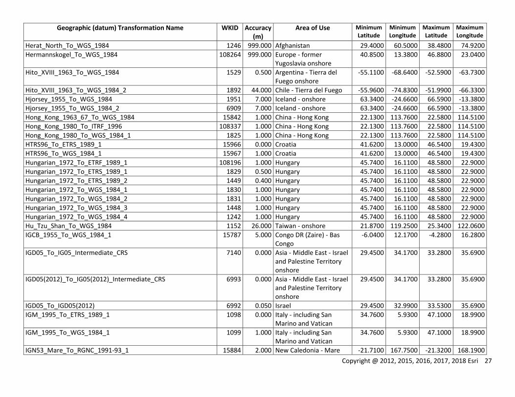
Herat_North_To_WGS_1984 1246 999.000 Afghanistan 29.4000 60.5000 38.4800 74.9200
Hermannskogel_To_WGS_1984 108264 999.000 Europe - former Yugoslavia onshore
40.8500 13.3800 46.8800 23.0400
Hito_XVIII_1963_To_WGS_1984 1529 0.500 Argentina - Tierra del Fuego onshore
-55.1100 -68.6400 -52.5900 -63.7300
Hito_XVIII_1963_To_WGS_1984_2 1892 44.000 Chile - Tierra del Fuego -55.9600 -74.8300 -51.9900 -66.3300
Hjorsey_1955_To_WGS_1984 1951 7.000 Iceland - onshore 63.3400 -24.6600 66.5900 -13.3800
Hjorsey_1955_To_WGS_1984_2 6909 7.000 Iceland - onshore 63.3400 -24.6600 66.5900 -13.3800
Hong_Kong_1963_67_To_WGS_1984 15842 1.000 China - Hong Kong 22.1300 113.7600 22.5800 114.5100
Hong_Kong_1980_To_ITRF_1996 108337 1.000 China - Hong Kong 22.1300 113.7600 22.5800 114.5100
Hong_Kong_1980_To_WGS_1984_1 1825 1.000 China - Hong Kong 22.1300 113.7600 22.5800 114.5100
HTRS96_To_ETRS_1989_1 15966 0.000 Croatia 41.6200 13.0000 46.5400 19.4300
HTRS96_To_WGS_1984_1 15967 1.000 Croatia 41.6200 13.0000 46.5400 19.4300
Hungarian_1972_To_ETRF_1989_1 108196 1.000 Hungary 45.7400 16.1100 48.5800 22.9000
Hungarian_1972_To_ETRS_1989_1 1829 0.500 Hungary 45.7400 16.1100 48.5800 22.9000
Hungarian_1972_To_ETRS_1989_2 1449 0.400 Hungary 45.7400 16.1100 48.5800 22.9000
Hungarian_1972_To_WGS_1984_1 1830 1.000 Hungary 45.7400 16.1100 48.5800 22.9000
Hungarian_1972_To_WGS_1984_2 1831 1.000 Hungary 45.7400 16.1100 48.5800 22.9000
Hungarian_1972_To_WGS_1984_3 1448 1.000 Hungary 45.7400 16.1100 48.5800 22.9000
Hungarian_1972_To_WGS_1984_4 1242 1.000 Hungary 45.7400 16.1100 48.5800 22.9000
Hu_Tzu_Shan_To_WGS_1984 1152 26.000 Taiwan - onshore 21.8700 119.2500 25.3400 122.0600
IGCB_1955_To_WGS_1984_1 15787 5.000 Congo DR (Zaire) - Bas Congo
-6.0400 12.1700 -4.2800 16.2800
IGD05_To_IG05_Intermediate_CRS 7140 0.000 Asia - Middle East - Israel and Palestine Territory onshore
29.4500 34.1700 33.2800 35.6900
IGD05(2012)_To_IG05(2012)_Intermediate_CRS 6993 0.000 Asia - Middle East - Israel and Palestine Territory onshore
29.4500 34.1700 33.2800 35.6900
IGD05_To_IGD05(2012) 6992 0.050 Israel 29.4500 32.9900 33.5300 35.6900
IGM_1995_To_ETRS_1989_1 1098 0.000 Italy - including San Marino and Vatican
34.7600 5.9300 47.1000 18.9900
IGM_1995_To_WGS_1984_1 1099 1.000 Italy - including San Marino and Vatican
34.7600 5.9300 47.1000 18.9900
IGN53_Mare_To_RGNC_1991-93_1 15884 2.000 New Caledonia - Mare -21.7100 167.7500 -21.3200 168.1900
28 Copyright @ 2012, 2015, 2016, 2017, 2018 Esri
Geographic (datum) Transformation Name WKID Accuracy (m)
Area of Use Minimum Latitude
Minimum Longitude
Maximum Latitude
Maximum Longitude
IGN53_Mare_To_RGNC_1991-93_2 15891 0.100 New Caledonia - Mare -21.7100 167.7500 -21.3200 168.1900
IGN53_Mare_To_WGS_1984_1 1928 1.000 New Caledonia - Mare -21.7100 167.7500 -21.3200 168.1900
IGN53_Mare_To_WGS_1984_2 15783 5.000 New Caledonia - Mare -21.7100 167.7500 -21.3200 168.1900
IGN53_Mare_To_WGS_1984_3 15901 2.000 New Caledonia - Mare -21.7100 167.7500 -21.3200 168.1900
IGN56_Lifou_To_RGNC_1991-93_1 15883 1.000 New Caledonia - Lifou -21.2400 166.9800 -20.6200 167.5200
IGN56_Lifou_To_RGNC_1991-93_2 15890 0.100 New Caledonia - Lifou -21.2400 166.9800 -20.6200 167.5200
IGN56_Lifou_To_WGS_1984_1 1917 10.000 New Caledonia - Lifou -21.2400 166.9800 -20.6200 167.5200
IGN56_Lifou_To_WGS_1984_2 1927 1.000 New Caledonia - Lifou -21.2400 166.9800 -20.6200 167.5200
IGN56_Lifou_To_WGS_1984_3 15902 1.000 New Caledonia - Lifou -21.2400 166.9800 -20.6200 167.5200
IGN63_Hiva_Oa_To_RGPF_1 15761 0.500 French Polynesia - Marquesas Islands - Hiva Oa
-9.8900 -139.2300 -9.6400 -138.7500
IGN63_Hiva_Oa_To_RGPF_2 15762 2.000 French Polynesia - Marquesas Islands - Tahuata
-10.0800 -139.1900 -9.8600 -138.9800
IGN63_Hiva_Oa_To_WGS_1984_1 15773 2.000 French Polynesia - Marquesas Islands - Hiva Oa
-9.8900 -139.2300 -9.6400 -138.7500
IGN63_Hiva_Oa_To_WGS_1984_2 15774 2.000 French Polynesia - Marquesas Islands - Tahuata
-10.0800 -139.1900 -9.8600 -138.9800
IGN72_Grande_Terre_To_RGNC_1991-93_1 15882 2.000 New Caledonia - Grande Terre
-22.4500 163.9200 -20.0300 167.0900
IGN72_Grande_Terre_To_RGNC_1991-93_2 15887 0.300 New Caledonia - Grande Terre
-22.4500 163.9200 -20.0300 167.0900
IGN72_Grande_Terre_To_RGNC_1991-93_3 15888 0.100 New Caledonia - Grande Terre - Noumea
-22.3700 166.3500 -22.1900 166.5400
IGN72_Grande_Terre_To_WGS_1984_1 1962 10.000 New Caledonia - Grande Terre
-22.4500 163.9200 -20.0300 167.0900
IGN72_Grande_Terre_To_WGS_1984_2 1963 1.000 New Caledonia - Grande Terre
-22.4500 163.9200 -20.0300 167.0900
IGN72_Grande_Terre_To_WGS_1984_3 15903 2.000 New Caledonia - Grande Terre
-22.4500 163.9200 -20.0300 167.0900
IGN72_Nuku_Hiva_To_RGPF_1 15763 0.500 French Polynesia - Marquesas Islands - Nuku Hiva
-9.0100 -140.3100 -8.7200 -139.9600
Copyright @ 2012, 2015, 2016, 2017, 2018 Esri 29
Geographic (datum) Transformation Name WKID Accuracy (m)
Area of Use Minimum Latitude
Minimum Longitude
Maximum Latitude
Maximum Longitude
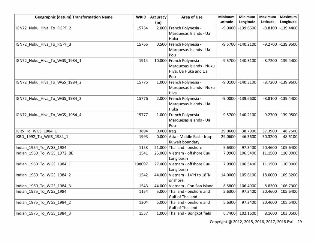
IGN72_Nuku_Hiva_To_RGPF_2 15764 2.000 French Polynesia - Marquesas Islands - Ua Huka
-9.0000 -139.6600 -8.8100 -139.4400
IGN72_Nuku_Hiva_To_RGPF_3 15765 0.500 French Polynesia - Marquesas Islands - Ua Pou
-9.5700 -140.2100 -9.2700 -139.9500
IGN72_Nuku_Hiva_To_WGS_1984_1 1914 10.000 French Polynesia - Marquesas Islands - Nuku Hiva, Ua Huka and Ua Pou
-9.5700 -140.3100 -8.7200 -139.4400
IGN72_Nuku_Hiva_To_WGS_1984_2 15775 1.000 French Polynesia - Marquesas Islands - Nuku Hiva
-9.0100 -140.3100 -8.7200 -139.9600
IGN72_Nuku_Hiva_To_WGS_1984_3 15776 2.000 French Polynesia - Marquesas Islands - Ua Huka
-9.0000 -139.6600 -8.8100 -139.4400
IGN72_Nuku_Hiva_To_WGS_1984_4 15777 1.000 French Polynesia - Marquesas Islands - Ua Pou
-9.5700 -140.2100 -9.2700 -139.9500
IGRS_To_WGS_1984_1 3894 0.000 Iraq 29.0600 38.7900 37.3900 48.7500
IKBD_1992_To_WGS_1984_1 1993 0.000 Asia - Middle East - Iraq-Kuwait boundary
29.0600 46.3600 30.3200 48.6100
Indian_1954_To_WGS_1984 1153 21.000 Thailand - onshore 5.6300 97.3400 20.4600 105.6400
Indian_1960_To_WGS_1972_BE 1541 25.000 Vietnam - offshore Cuu Long basin
7.9900 106.5400 11.1500 110.0000
Indian_1960_To_WGS_1984_1 108097 27.000 Vietnam - offshore Cuu Long basin
7.9900 106.5400 11.1500 110.0000
Indian_1960_To_WGS_1984_2 1542 44.000 Vietnam - 14°N to 18°N onshore
14.0000 105.6100 18.0000 109.3200
Indian_1960_To_WGS_1984_3 1543 44.000 Vietnam - Con Son Island 8.5800 106.4900 8.8300 106.7900
Indian_1975_To_WGS_1984 1154 5.000 Thailand - onshore and Gulf of Thailand
5.6300 97.3400 20.4600 105.6400
Indian_1975_To_WGS_1984_2 1304 5.000 Thailand - onshore and Gulf of Thailand
5.6300 97.3400 20.4600 105.6400
Indian_1975_To_WGS_1984_3 1537 1.000 Thailand - Bongkot field 6.7400 102.1600 8.1600 103.0500

30 Copyright @ 2012, 2015, 2016, 2017, 2018 Esri
Geographic (datum) Transformation Name WKID Accuracy (m)
Area of Use Minimum Latitude
Minimum Longitude
Maximum Latitude
Maximum Longitude
Indian_1975_To_WGS_1984_4 1812 3.000 Thailand - onshore 5.6300 97.3400 20.4600 105.6400
Indonesian_1974_To_DGN_1995_1 15911 3.000 Indonesia - onshore -10.9800 95.1600 5.9700 141.0100
Indonesian_1974_To_WGS_1984 1248 44.000 Indonesia - onshore -10.9800 95.1600 5.9700 141.0100
Indonesian_1974_To_WGS_1984_2 1832 25.000 Indonesia - onshore -10.9800 95.1600 5.9700 141.0100
Indonesian_1974_To_WGS_1984_3 1833 3.000 Indonesia - onshore -10.9800 95.1600 5.9700 141.0100
IRENET95_To_ETRF_1989 108197 0.000 Europe - Ireland (Republic and Ulster) - onshore
51.3900 -10.5600 55.4300 -5.3400
IRENET95_To_ETRS_1989 1611 0.000 Europe - Ireland (Republic and Ulster) - onshore
51.3900 -10.5600 55.4300 -5.3400
IRENET95_To_WGS_1984_1 1678 1.000 Europe - Ireland (Republic and Ulster) - onshore
51.3900 -10.5600 55.4300 -5.3400
ISN_1993_To_ISN_2004 108214 0.050 Iceland - NADCON 63.2700 -24.6500 66.6600 -13.2500
ISN_1993_To_WGS_1984_1 1952 1.000 Iceland 59.9600 -30.8700 69.5900 -5.5500
ISN_2004_To_ISN_1993 108216 0.050 Iceland - NADCON 63.2700 -24.6500 66.6600 -13.2500
ISN_2004_To_WGS_1984_1 5327 1.000 Iceland 59.9600 -30.8700 69.5900 -5.5500
Israel_To_WGS_1984 1073 2.000 Israel, Palestine Territory, and Jordan
29.1900 32.9900 33.5200 39.3000
ISTS_061_1968_To_WGS_1984 15813 44.000 South Georgia - onshore -54.9500 -38.0800 -53.9300 -35.7400
ISTS_073_1969_To_WGS_1984 15808 44.000 British Indian Ocean Territory - Diego Garcia
-7.4900 72.3000 -7.1800 72.5500
ITRF_1988_To_ITRF_2000_1 108034 0.010 World -90.0000 -180.0000 90.0000 180.0000
ITRF_1989_To_ITRF_2000_1 108033 0.010 World -90.0000 -180.0000 90.0000 180.0000
ITRF_1990_To_ITRF_2000_1 108032 0.010 World -90.0000 -180.0000 90.0000 180.0000
ITRF_1991_To_ITRF_2000_1 108031 0.010 World -90.0000 -180.0000 90.0000 180.0000
ITRF_1992_To_ITRF_2000_1 108030 0.010 World -90.0000 -180.0000 90.0000 180.0000
ITRF_1993_To_ITRF_2000_1 108029 0.010 World -90.0000 -180.0000 90.0000 180.0000
ITRF_1994_To_ITRF_2000_1 108028 0.010 World -90.0000 -180.0000 90.0000 180.0000
ITRF_1996_To_ITRF_2000_1 108027 0.010 World -90.0000 -180.0000 90.0000 180.0000
ITRF_1997_To_ITRF_2000_1 108026 0.010 World -90.0000 -180.0000 90.0000 180.0000
ITRF_2000_To_ITRF_2005_1 108036 0.010 World -90.0000 -180.0000 90.0000 180.0000
ITRF_2000_To_NAD_1983_2011 108353 0.100 USA - CONUS and Alaska; PRVI
14.9200 167.6500 74.7100 -63.8800
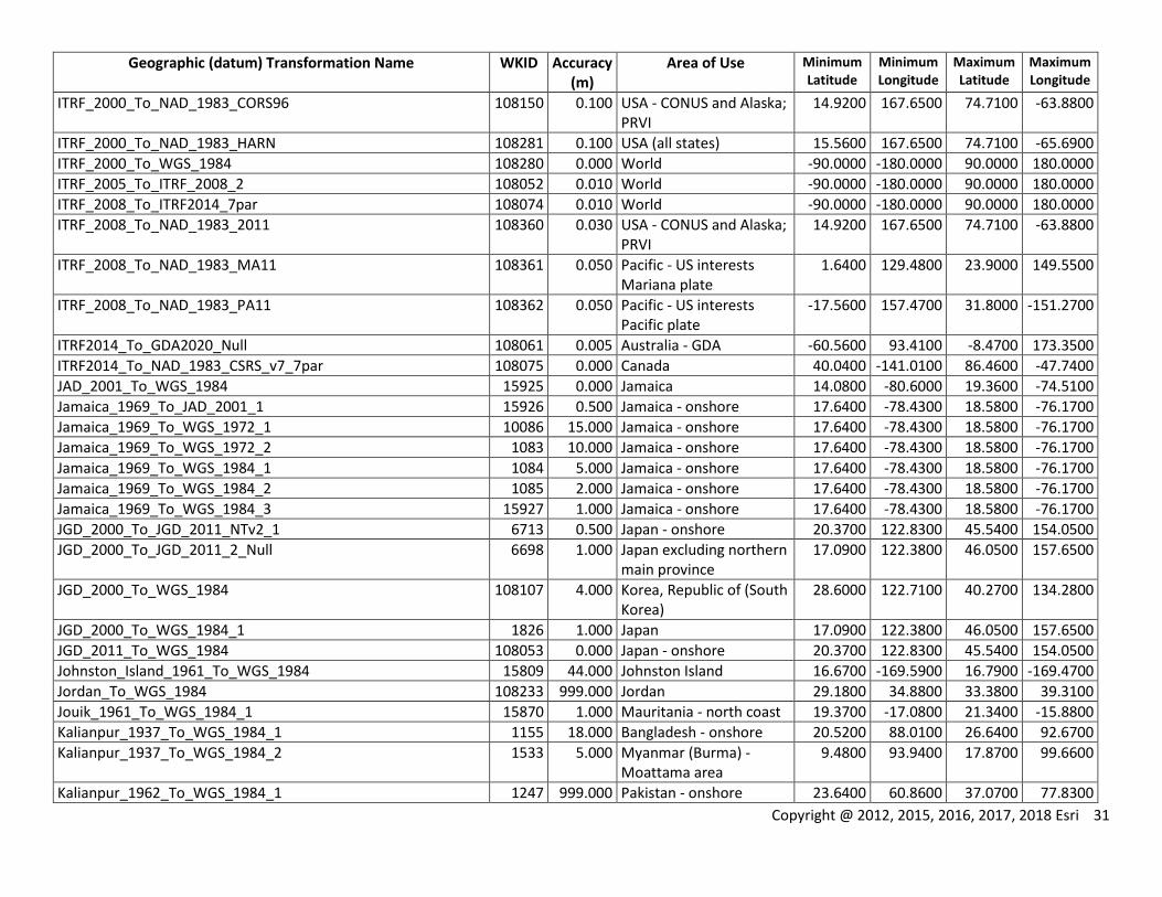
Copyright @ 2012, 2015, 2016, 2017, 2018 Esri 31
Geographic (datum) Transformation Name WKID Accuracy (m)
Area of Use Minimum Latitude
Minimum Longitude
Maximum Latitude
Maximum Longitude
ITRF_2000_To_NAD_1983_CORS96 108150 0.100 USA - CONUS and Alaska; PRVI
14.9200 167.6500 74.7100 -63.8800
ITRF_2000_To_NAD_1983_HARN 108281 0.100 USA (all states) 15.5600 167.6500 74.7100 -65.6900
ITRF_2000_To_WGS_1984 108280 0.000 World -90.0000 -180.0000 90.0000 180.0000
ITRF_2005_To_ITRF_2008_2 108052 0.010 World -90.0000 -180.0000 90.0000 180.0000
ITRF_2008_To_ITRF2014_7par 108074 0.010 World -90.0000 -180.0000 90.0000 180.0000
ITRF_2008_To_NAD_1983_2011 108360 0.030 USA - CONUS and Alaska; PRVI
14.9200 167.6500 74.7100 -63.8800
ITRF_2008_To_NAD_1983_MA11 108361 0.050 Pacific - US interests Mariana plate
1.6400 129.4800 23.9000 149.5500
ITRF_2008_To_NAD_1983_PA11 108362 0.050 Pacific - US interests Pacific plate
-17.5600 157.4700 31.8000 -151.2700
ITRF2014_To_GDA2020_Null 108061 0.005 Australia - GDA -60.5600 93.4100 -8.4700 173.3500
ITRF2014_To_NAD_1983_CSRS_v7_7par 108075 0.000 Canada 40.0400 -141.0100 86.4600 -47.7400
JAD_2001_To_WGS_1984 15925 0.000 Jamaica 14.0800 -80.6000 19.3600 -74.5100
Jamaica_1969_To_JAD_2001_1 15926 0.500 Jamaica - onshore 17.6400 -78.4300 18.5800 -76.1700
Jamaica_1969_To_WGS_1972_1 10086 15.000 Jamaica - onshore 17.6400 -78.4300 18.5800 -76.1700
Jamaica_1969_To_WGS_1972_2 1083 10.000 Jamaica - onshore 17.6400 -78.4300 18.5800 -76.1700
Jamaica_1969_To_WGS_1984_1 1084 5.000 Jamaica - onshore 17.6400 -78.4300 18.5800 -76.1700
Jamaica_1969_To_WGS_1984_2 1085 2.000 Jamaica - onshore 17.6400 -78.4300 18.5800 -76.1700
Jamaica_1969_To_WGS_1984_3 15927 1.000 Jamaica - onshore 17.6400 -78.4300 18.5800 -76.1700
JGD_2000_To_JGD_2011_NTv2_1 6713 0.500 Japan - onshore 20.3700 122.8300 45.5400 154.0500
JGD_2000_To_JGD_2011_2_Null 6698 1.000 Japan excluding northern main province
17.0900 122.3800 46.0500 157.6500
JGD_2000_To_WGS_1984 108107 4.000 Korea, Republic of (South Korea)
28.6000 122.7100 40.2700 134.2800
JGD_2000_To_WGS_1984_1 1826 1.000 Japan 17.0900 122.3800 46.0500 157.6500
JGD_2011_To_WGS_1984 108053 0.000 Japan - onshore 20.3700 122.8300 45.5400 154.0500
Johnston_Island_1961_To_WGS_1984 15809 44.000 Johnston Island 16.6700 -169.5900 16.7900 -169.4700
Jordan_To_WGS_1984 108233 999.000 Jordan 29.1800 34.8800 33.3800 39.3100
Jouik_1961_To_WGS_1984_1 15870 1.000 Mauritania - north coast 19.3700 -17.0800 21.3400 -15.8800
Kalianpur_1937_To_WGS_1984_1 1155 18.000 Bangladesh - onshore 20.5200 88.0100 26.6400 92.6700
Kalianpur_1937_To_WGS_1984_2 1533 5.000 Myanmar (Burma) - Moattama area
9.4800 93.9400 17.8700 99.6600
Kalianpur_1962_To_WGS_1984_1 1247 999.000 Pakistan - onshore 23.6400 60.8600 37.0700 77.8300

32 Copyright @ 2012, 2015, 2016, 2017, 2018 Esri
Geographic (datum) Transformation Name WKID Accuracy (m)
Area of Use Minimum Latitude
Minimum Longitude
Maximum Latitude
Maximum Longitude
Kalianpur_1962_To_WGS_1984_2 15701 1.000 Pakistan - offshore Indus 21.0500 64.0000 25.3900 68.2400
Kalianpur_1962_To_WGS_1984_3 15702 3.000 Pakistan - Badin and Mehran
24.0000 67.7400 25.6400 69.8700
Kalianpur_1962_To_WGS_1984_4 15703 3.000 Pakistan - Karachi 24.6900 66.8300 25.7600 68.0000
Kalianpur_1962_To_WGS_1984_5 15704 3.000 Pakistan - East Sind 24.1600 68.2700 28.6100 71.1400
Kalianpur_1962_To_WGS_1984_6 15494 3.000 Pakistan - Gambat 25.8800 68.2400 27.6700 69.3000
Kalianpur_1975_To_WGS_1984_1 1156 22.000 Asia - India mainland and Nepal
8.0200 68.1300 35.5100 97.4200
Kandawala_To_WGS_1984 1157 35.000 Sri Lanka - onshore 5.8600 79.6400 9.8800 81.9500
Karbala_1979_Polservice_To_IGRS_1 5077 0.300 Iraq - onshore 29.0600 38.7900 37.3900 48.6100
Karbala_1979_Polservice_To_WGS_1984_1 15872 5.000 Iraq - Basra area 29.8700 46.4600 31.0900 48.6100
Karbala_1979_Polservice_To_WGS_1984_2 5078 0.300 Iraq - onshore 29.0600 38.7900 37.3900 48.6100
Katanga_1955_To_RGRDC_2005_1 4065 1.500 Congo DR (Zaire) - Katanga - Lubumbashi area
-12.0100 26.3800 -11.1300 27.7500
Katanga_1955_To_RGRDC_2005_2 4067 0.500 Congo DR (Zaire) - Katanga - Lubumbashi area
-12.0100 26.3800 -11.1300 27.7500
Katanga_1955_To_WGS_1984_1 4066 1.500 Congo DR (Zaire) - Katanga - Lubumbashi area
-12.0100 26.3800 -11.1300 27.7500
Katanga_1955_To_WGS_1984_2 4068 1.000 Congo DR (Zaire) - Katanga - Lubumbashi area
-12.0100 26.3800 -11.1300 27.7500
Kerguelen_Island_1949_To_WGS_1984_1 15850 10.000 French Southern Territories - Kerguelen onshore
-49.7800 68.6900 -48.6000 70.6200
Kertau_RSO_To_Kertau_1 15896 0.000 Asia - Malaysia (west) and Singapore
1.1300 99.5900 6.7200 104.6000
Kertau_To_WGS_1984 1158 15.000 Asia - Malaysia (west including SCS) and Singapore
1.1300 99.5900 7.8100 105.8200
KKJ_To_ETRS_1989_1_Old 1638 1.500 Finland - onshore 59.7500 19.2400 70.0900 31.5900
KKJ_To_ETRS_1989_2 10098 0.500 Finland - onshore 59.7500 19.2400 70.0900 31.5900
KKJ_To_EUREF_FIN 108229 1.000 Finland 58.8400 19.0800 70.0900 31.5900
KKJ_To_WGS_1984_1_Old 1639 1.500 Finland - onshore 59.7500 19.2400 70.0900 31.5900
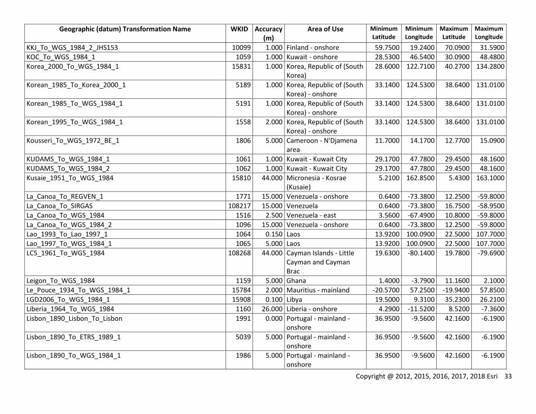
Copyright @ 2012, 2015, 2016, 2017, 2018 Esri 33
Geographic (datum) Transformation Name WKID Accuracy (m)
Area of Use Minimum Latitude
Minimum Longitude
Maximum Latitude
Maximum Longitude
KKJ_To_WGS_1984_2_JHS153 10099 1.000 Finland - onshore 59.7500 19.2400 70.0900 31.5900
KOC_To_WGS_1984_1 1059 1.000 Kuwait - onshore 28.5300 46.5400 30.0900 48.4800
Korea_2000_To_WGS_1984_1 15831 1.000 Korea, Republic of (South Korea)
28.6000 122.7100 40.2700 134.2800
Korean_1985_To_Korea_2000_1 5189 1.000 Korea, Republic of (South Korea) - onshore
33.1400 124.5300 38.6400 131.0100
Korean_1985_To_WGS_1984_1 5191 1.000 Korea, Republic of (South Korea) - onshore
33.1400 124.5300 38.6400 131.0100
Korean_1995_To_WGS_1984_1 1558 2.000 Korea, Republic of (South Korea) - onshore
33.1400 124.5300 38.6400 131.0100
Kousseri_To_WGS_1972_BE_1 1806 5.000 Cameroon - N'Djamena area
11.7000 14.1700 12.7700 15.0900
KUDAMS_To_WGS_1984_1 1061 1.000 Kuwait - Kuwait City 29.1700 47.7800 29.4500 48.1600
KUDAMS_To_WGS_1984_2 1062 1.000 Kuwait - Kuwait City 29.1700 47.7800 29.4500 48.1600
Kusaie_1951_To_WGS_1984 15810 44.000 Micronesia - Kosrae (Kusaie)
5.2100 162.8500 5.4300 163.1000
La_Canoa_To_REGVEN_1 1771 15.000 Venezuela - onshore 0.6400 -73.3800 12.2500 -59.8000
La_Canoa_To_SIRGAS 108217 15.000 Venezuela 0.6400 -73.3800 16.7500 -58.9500
La_Canoa_To_WGS_1984 1516 2.500 Venezuela - east 3.5600 -67.4900 10.8000 -59.8000
La_Canoa_To_WGS_1984_2 1096 15.000 Venezuela - onshore 0.6400 -73.3800 12.2500 -59.8000
Lao_1993_To_Lao_1997_1 1064 0.150 Laos 13.9200 100.0900 22.5000 107.7000
Lao_1997_To_WGS_1984_1 1065 5.000 Laos 13.9200 100.0900 22.5000 107.7000
LC5_1961_To_WGS_1984 108268 44.000 Cayman Islands - Little Cayman and Cayman Brac
19.6300 -80.1400 19.7800 -79.6900
Leigon_To_WGS_1984 1159 5.000 Ghana 1.4000 -3.7900 11.1600 2.1000
Le_Pouce_1934_To_WGS_1984_1 15784 2.000 Mauritius - mainland -20.5700 57.2500 -19.9400 57.8500
LGD2006_To_WGS_1984_1 15908 0.100 Libya 19.5000 9.3100 35.2300 26.2100
Liberia_1964_To_WGS_1984 1160 26.000 Liberia - onshore 4.2900 -11.5200 8.5200 -7.3600
Lisbon_1890_Lisbon_To_Lisbon 1991 0.000 Portugal - mainland - onshore
36.9500 -9.5600 42.1600 -6.1900
Lisbon_1890_To_ETRS_1989_1 5039 5.000 Portugal - mainland - onshore
36.9500 -9.5600 42.1600 -6.1900
Lisbon_1890_To_WGS_1984_1 1986 5.000 Portugal - mainland - onshore
36.9500 -9.5600 42.1600 -6.1900
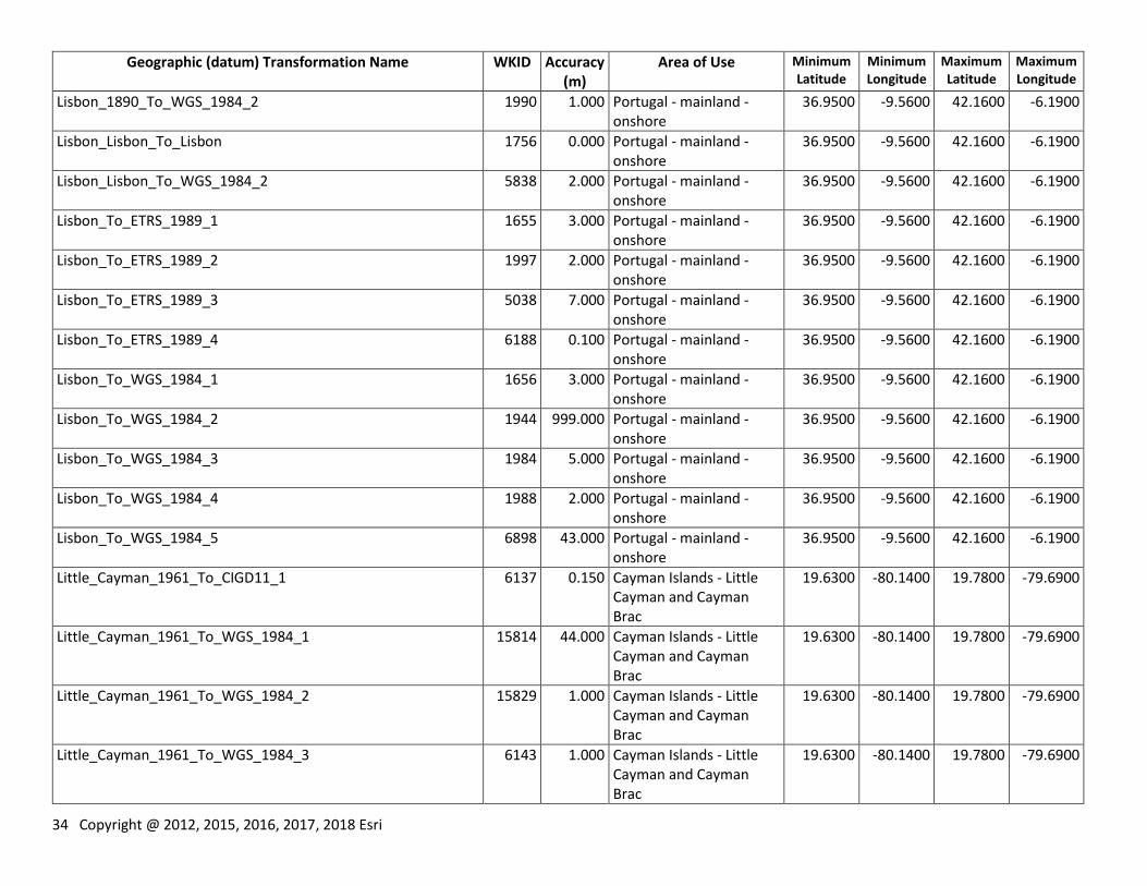
34 Copyright @ 2012, 2015, 2016, 2017, 2018 Esri
Geographic (datum) Transformation Name WKID Accuracy (m)
Area of Use Minimum Latitude
Minimum Longitude
Maximum Latitude
Maximum Longitude
Lisbon_1890_To_WGS_1984_2 1990 1.000 Portugal - mainland - onshore
36.9500 -9.5600 42.1600 -6.1900
Lisbon_Lisbon_To_Lisbon 1756 0.000 Portugal - mainland - onshore
36.9500 -9.5600 42.1600 -6.1900
Lisbon_Lisbon_To_WGS_1984_2 5838 2.000 Portugal - mainland - onshore
36.9500 -9.5600 42.1600 -6.1900
Lisbon_To_ETRS_1989_1 1655 3.000 Portugal - mainland - onshore
36.9500 -9.5600 42.1600 -6.1900
Lisbon_To_ETRS_1989_2 1997 2.000 Portugal - mainland - onshore
36.9500 -9.5600 42.1600 -6.1900
Lisbon_To_ETRS_1989_3 5038 7.000 Portugal - mainland - onshore
36.9500 -9.5600 42.1600 -6.1900
Lisbon_To_ETRS_1989_4 6188 0.100 Portugal - mainland - onshore
36.9500 -9.5600 42.1600 -6.1900
Lisbon_To_WGS_1984_1 1656 3.000 Portugal - mainland - onshore
36.9500 -9.5600 42.1600 -6.1900
Lisbon_To_WGS_1984_2 1944 999.000 Portugal - mainland - onshore
36.9500 -9.5600 42.1600 -6.1900
Lisbon_To_WGS_1984_3 1984 5.000 Portugal - mainland - onshore
36.9500 -9.5600 42.1600 -6.1900
Lisbon_To_WGS_1984_4 1988 2.000 Portugal - mainland - onshore
36.9500 -9.5600 42.1600 -6.1900
Lisbon_To_WGS_1984_5 6898 43.000 Portugal - mainland - onshore
36.9500 -9.5600 42.1600 -6.1900
Little_Cayman_1961_To_CIGD11_1 6137 0.150 Cayman Islands - Little Cayman and Cayman Brac
19.6300 -80.1400 19.7800 -79.6900
Little_Cayman_1961_To_WGS_1984_1 15814 44.000 Cayman Islands - Little Cayman and Cayman Brac
19.6300 -80.1400 19.7800 -79.6900
Little_Cayman_1961_To_WGS_1984_2 15829 1.000 Cayman Islands - Little Cayman and Cayman Brac
19.6300 -80.1400 19.7800 -79.6900
Little_Cayman_1961_To_WGS_1984_3 6143 1.000 Cayman Islands - Little Cayman and Cayman Brac
19.6300 -80.1400 19.7800 -79.6900
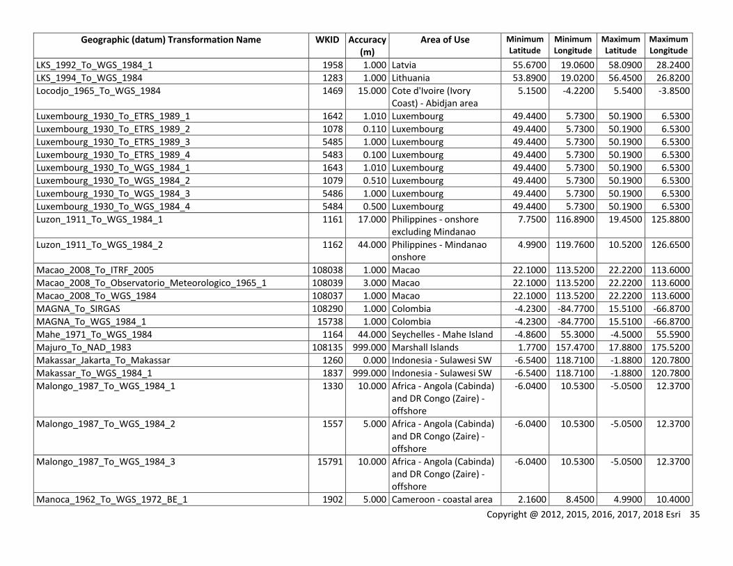
Copyright @ 2012, 2015, 2016, 2017, 2018 Esri 35
Geographic (datum) Transformation Name WKID Accuracy (m)
Area of Use Minimum Latitude
Minimum Longitude
Maximum Latitude
Maximum Longitude
LKS_1992_To_WGS_1984_1 1958 1.000 Latvia 55.6700 19.0600 58.0900 28.2400
LKS_1994_To_WGS_1984 1283 1.000 Lithuania 53.8900 19.0200 56.4500 26.8200
Locodjo_1965_To_WGS_1984 1469 15.000 Cote d'Ivoire (Ivory Coast) - Abidjan area
5.1500 -4.2200 5.5400 -3.8500
Luxembourg_1930_To_ETRS_1989_1 1642 1.010 Luxembourg 49.4400 5.7300 50.1900 6.5300
Luxembourg_1930_To_ETRS_1989_2 1078 0.110 Luxembourg 49.4400 5.7300 50.1900 6.5300
Luxembourg_1930_To_ETRS_1989_3 5485 1.000 Luxembourg 49.4400 5.7300 50.1900 6.5300
Luxembourg_1930_To_ETRS_1989_4 5483 0.100 Luxembourg 49.4400 5.7300 50.1900 6.5300
Luxembourg_1930_To_WGS_1984_1 1643 1.010 Luxembourg 49.4400 5.7300 50.1900 6.5300
Luxembourg_1930_To_WGS_1984_2 1079 0.510 Luxembourg 49.4400 5.7300 50.1900 6.5300
Luxembourg_1930_To_WGS_1984_3 5486 1.000 Luxembourg 49.4400 5.7300 50.1900 6.5300
Luxembourg_1930_To_WGS_1984_4 5484 0.500 Luxembourg 49.4400 5.7300 50.1900 6.5300
Luzon_1911_To_WGS_1984_1 1161 17.000 Philippines - onshore excluding Mindanao
7.7500 116.8900 19.4500 125.8800
Luzon_1911_To_WGS_1984_2 1162 44.000 Philippines - Mindanao onshore
4.9900 119.7600 10.5200 126.6500
Macao_2008_To_ITRF_2005 108038 1.000 Macao 22.1000 113.5200 22.2200 113.6000
Macao_2008_To_Observatorio_Meteorologico_1965_1 108039 3.000 Macao 22.1000 113.5200 22.2200 113.6000
Macao_2008_To_WGS_1984 108037 1.000 Macao 22.1000 113.5200 22.2200 113.6000
MAGNA_To_SIRGAS 108290 1.000 Colombia -4.2300 -84.7700 15.5100 -66.8700
MAGNA_To_WGS_1984_1 15738 1.000 Colombia -4.2300 -84.7700 15.5100 -66.8700
Mahe_1971_To_WGS_1984 1164 44.000 Seychelles - Mahe Island -4.8600 55.3000 -4.5000 55.5900
Majuro_To_NAD_1983 108135 999.000 Marshall Islands 1.7700 157.4700 17.8800 175.5200
Makassar_Jakarta_To_Makassar 1260 0.000 Indonesia - Sulawesi SW -6.5400 118.7100 -1.8800 120.7800
Makassar_To_WGS_1984_1 1837 999.000 Indonesia - Sulawesi SW -6.5400 118.7100 -1.8800 120.7800
Malongo_1987_To_WGS_1984_1 1330 10.000 Africa - Angola (Cabinda) and DR Congo (Zaire) - offshore
-6.0400 10.5300 -5.0500 12.3700
Malongo_1987_To_WGS_1984_2 1557 5.000 Africa - Angola (Cabinda) and DR Congo (Zaire) - offshore
-6.0400 10.5300 -5.0500 12.3700
Malongo_1987_To_WGS_1984_3 15791 10.000 Africa - Angola (Cabinda) and DR Congo (Zaire) - offshore
-6.0400 10.5300 -5.0500 12.3700
Manoca_1962_To_WGS_1972_BE_1 1902 5.000 Cameroon - coastal area 2.1600 8.4500 4.9900 10.4000
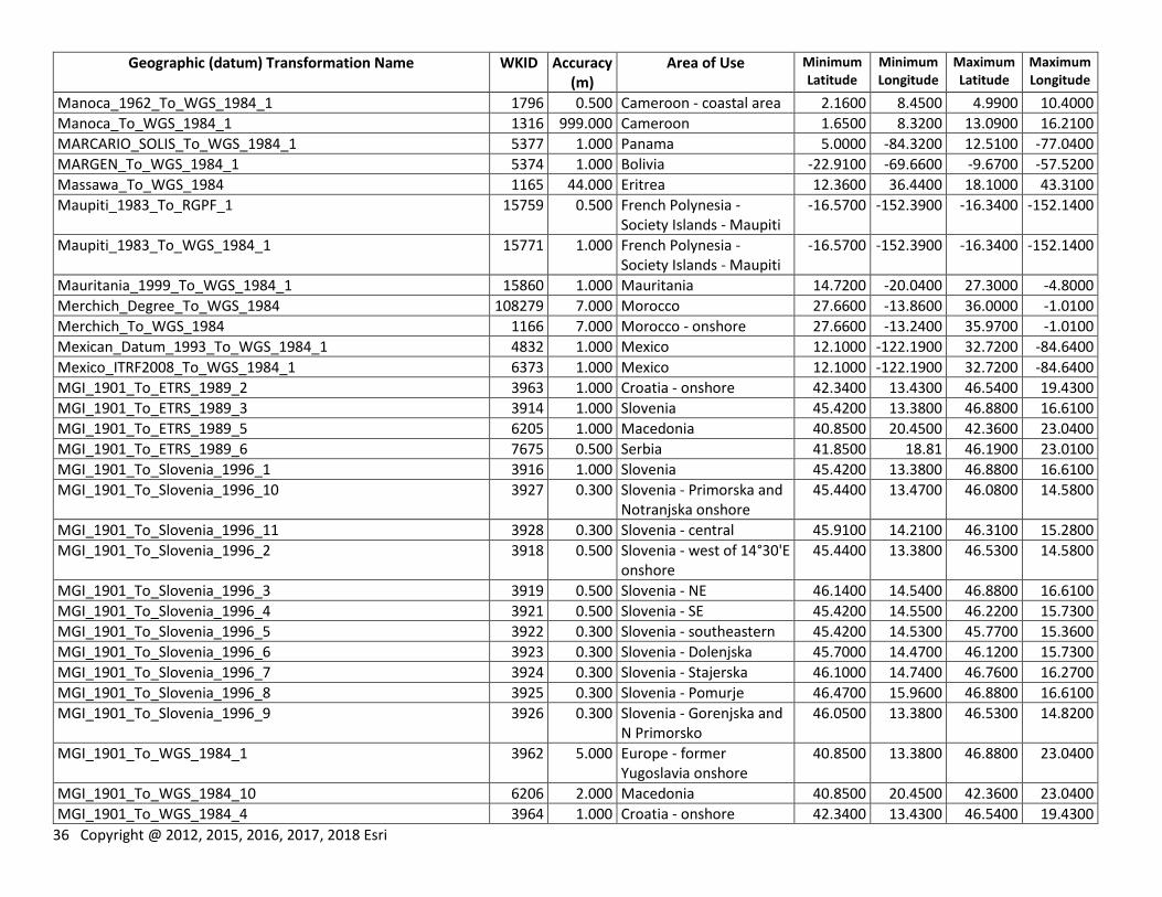
36 Copyright @ 2012, 2015, 2016, 2017, 2018 Esri
Geographic (datum) Transformation Name WKID Accuracy (m)
Area of Use Minimum Latitude
Minimum Longitude
Maximum Latitude
Maximum Longitude
Manoca_1962_To_WGS_1984_1 1796 0.500 Cameroon - coastal area 2.1600 8.4500 4.9900 10.4000
Manoca_To_WGS_1984_1 1316 999.000 Cameroon 1.6500 8.3200 13.0900 16.2100
MARCARIO_SOLIS_To_WGS_1984_1 5377 1.000 Panama 5.0000 -84.3200 12.5100 -77.0400
MARGEN_To_WGS_1984_1 5374 1.000 Bolivia -22.9100 -69.6600 -9.6700 -57.5200
Massawa_To_WGS_1984 1165 44.000 Eritrea 12.3600 36.4400 18.1000 43.3100
Maupiti_1983_To_RGPF_1 15759 0.500 French Polynesia - Society Islands - Maupiti
-16.5700 -152.3900 -16.3400 -152.1400
Maupiti_1983_To_WGS_1984_1 15771 1.000 French Polynesia - Society Islands - Maupiti
-16.5700 -152.3900 -16.3400 -152.1400
Mauritania_1999_To_WGS_1984_1 15860 1.000 Mauritania 14.7200 -20.0400 27.3000 -4.8000
Merchich_Degree_To_WGS_1984 108279 7.000 Morocco 27.6600 -13.8600 36.0000 -1.0100
Merchich_To_WGS_1984 1166 7.000 Morocco - onshore 27.6600 -13.2400 35.9700 -1.0100
Mexican_Datum_1993_To_WGS_1984_1 4832 1.000 Mexico 12.1000 -122.1900 32.7200 -84.6400
Mexico_ITRF2008_To_WGS_1984_1 6373 1.000 Mexico 12.1000 -122.1900 32.7200 -84.6400
MGI_1901_To_ETRS_1989_2 3963 1.000 Croatia - onshore 42.3400 13.4300 46.5400 19.4300
MGI_1901_To_ETRS_1989_3 3914 1.000 Slovenia 45.4200 13.3800 46.8800 16.6100
MGI_1901_To_ETRS_1989_5 6205 1.000 Macedonia 40.8500 20.4500 42.3600 23.0400
MGI_1901_To_ETRS_1989_6 7675 0.500 Serbia 41.8500 18.81 46.1900 23.0100
MGI_1901_To_Slovenia_1996_1 3916 1.000 Slovenia 45.4200 13.3800 46.8800 16.6100
MGI_1901_To_Slovenia_1996_10 3927 0.300 Slovenia - Primorska and Notranjska onshore
45.4400 13.4700 46.0800 14.5800
MGI_1901_To_Slovenia_1996_11 3928 0.300 Slovenia - central 45.9100 14.2100 46.3100 15.2800
MGI_1901_To_Slovenia_1996_2 3918 0.500 Slovenia - west of 14°30'E onshore
45.4400 13.3800 46.5300 14.5800
MGI_1901_To_Slovenia_1996_3 3919 0.500 Slovenia - NE 46.1400 14.5400 46.8800 16.6100
MGI_1901_To_Slovenia_1996_4 3921 0.500 Slovenia - SE 45.4200 14.5500 46.2200 15.7300
MGI_1901_To_Slovenia_1996_5 3922 0.300 Slovenia - southeastern 45.4200 14.5300 45.7700 15.3600
MGI_1901_To_Slovenia_1996_6 3923 0.300 Slovenia - Dolenjska 45.7000 14.4700 46.1200 15.7300
MGI_1901_To_Slovenia_1996_7 3924 0.300 Slovenia - Stajerska 46.1000 14.7400 46.7600 16.2700
MGI_1901_To_Slovenia_1996_8 3925 0.300 Slovenia - Pomurje 46.4700 15.9600 46.8800 16.6100
MGI_1901_To_Slovenia_1996_9 3926 0.300 Slovenia - Gorenjska and N Primorsko
46.0500 13.3800 46.5300 14.8200
MGI_1901_To_WGS_1984_1 3962 5.000 Europe - former Yugoslavia onshore
40.8500 13.3800 46.8800 23.0400
MGI_1901_To_WGS_1984_10 6206 2.000 Macedonia 40.8500 20.4500 42.3600 23.0400
MGI_1901_To_WGS_1984_4 3964 1.000 Croatia - onshore 42.3400 13.4300 46.5400 19.4300
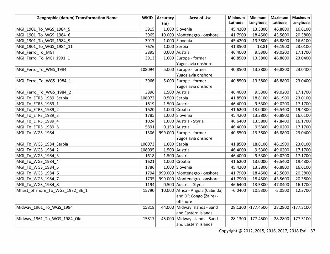
Copyright @ 2012, 2015, 2016, 2017, 2018 Esri 37
Geographic (datum) Transformation Name WKID Accuracy (m)
Area of Use Minimum Latitude
Minimum Longitude
Maximum Latitude
Maximum Longitude
MGI_1901_To_WGS_1984_5 3915 1.000 Slovenia 45.4200 13.3800 46.8800 16.6100
MGI_1901_To_WGS_1984_6 3965 10.000 Montenegro - onshore 41.7900 18.4500 43.5600 20.3800
MGI_1901_To_WGS_1984_9 3917 1.000 Slovenia 45.4200 13.3800 46.8800 16.6100
MGI_1901_To_WGS_1984_11 7676 1.000 Serbia 41.8500 18.81 46.1900 23.0100
MGI_Ferro_To_MGI 3895 0.000 Austria 46.4000 9.5300 49.0200 17.1700
MGI_Ferro_To_MGI_1901_1 3913 1.000 Europe - former Yugoslavia onshore
40.8500 13.3800 46.8800 23.0400
MGI_Ferro_To_WGS_1984 108094 5.000 Europe - former Yugoslavia onshore
40.8500 13.3800 46.8800 23.0400
MGI_Ferro_To_WGS_1984_1 3966 5.000 Europe - former Yugoslavia onshore
40.8500 13.3800 46.8800 23.0400
MGI_Ferro_To_WGS_1984_2 3896 1.500 Austria 46.4000 9.5300 49.0200 17.1700
MGI_To_ETRS_1989_Serbia 108072 0.500 Serbia 41.8500 18.8100 46.1900 23.0100
MGI_To_ETRS_1989_1 1619 1.500 Austria 46.4000 9.5300 49.0200 17.1700
MGI_To_ETRS_1989_2 1620 1.000 Croatia 41.6200 13.0000 46.5400 19.4300
MGI_To_ETRS_1989_3 1785 1.000 Slovenia 45.4200 13.3800 46.8800 16.6100
MGI_To_ETRS_1989_4 1024 1.000 Austria - Styria 46.6400 13.5800 47.8400 16.1700
MGI_To_ETRS_1989_5 5891 0.150 Austria 46.4000 9.5300 49.0200 17.1700
MGI_To_WGS_1984 1306 999.000 Europe - former Yugoslavia onshore
40.8500 13.3800 46.8800 23.0400
MGI_To_WGS_1984_Serbia 108073 1.000 Serbia 41.8500 18.8100 46.1900 23.0100
MGI_To_WGS_1984_2 108095 1.500 Austria 46.4000 9.5300 49.0200 17.1700
MGI_To_WGS_1984_3 1618 1.500 Austria 46.4000 9.5300 49.0200 17.1700
MGI_To_WGS_1984_4 1621 1.000 Croatia 41.6200 13.0000 46.5400 19.4300
MGI_To_WGS_1984_5 1786 1.000 Slovenia 45.4200 13.3800 46.8800 16.6100
MGI_To_WGS_1984_6 1794 999.000 Montenegro - onshore 41.7900 18.4500 43.5600 20.3800
MGI_To_WGS_1984_7 1795 999.000 Montenegro - onshore 41.7900 18.4500 43.5600 20.3800
MGI_To_WGS_1984_8 1194 0.500 Austria - Styria 46.6400 13.5800 47.8400 16.1700
Mhast_offshore_To_WGS_1972_BE_1 15790 10.000 Africa - Angola (Cabinda) and DR Congo (Zaire) - offshore
-6.0400 10.5300 -5.0500 12.3700
Midway_1961_To_WGS_1984 15818 44.000 Midway Islands - Sand and Eastern Islands
28.1300 -177.4500 28.2800 -177.3100
Midway_1961_To_WGS_1984_Old 15817 45.000 Midway Islands - Sand and Eastern Islands
28.1300 -177.4500 28.2800 -177.3100
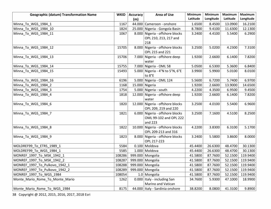
38 Copyright @ 2012, 2015, 2016, 2017, 2018 Esri
Geographic (datum) Transformation Name WKID Accuracy (m)
Area of Use Minimum Latitude
Minimum Longitude
Maximum Latitude
Maximum Longitude
Minna_To_WGS_1984_1 1167 44.000 Cameroon - onshore 1.6500 8.4500 13.0900 16.2100
Minna_To_WGS_1984_10 1824 25.000 Nigeria - Gongola Basin 8.7800 9.4100 11.6300 12.1300
Minna_To_WGS_1984_11 1067 8.000 Nigeria - offshore blocks OPL 210, 213, 217 and 218
3.2400 4.4100 5.5400 6.2900
Minna_To_WGS_1984_12 15705 8.000 Nigeria - offshore blocks OPL 215 and 221
3.2500 5.0200 4.2300 7.3100
Minna_To_WGS_1984_13 15706 7.000 Nigeria - offshore deep water
1.9200 2.6600 6.1400 7.8200
Minna_To_WGS_1984_14 15755 7.000 Nigeria - OML 58 5.0500 6.5300 5.3600 6.8400
Minna_To_WGS_1984_15 15493 5.000 Nigeria - 4°N to 5°N, 6°E to 8°E
3.9900 5.9900 5.0100 8.0100
Minna_To_WGS_1984_16 6196 5.000 Nigeria - OML 124 5.5600 6.7200 5.7400 6.9700
Minna_To_WGS_1984_2 1168 15.000 Nigeria 1.9200 2.6600 13.9000 14.6500
Minna_To_WGS_1984_3 1754 5.000 Nigeria - south 4.2200 4.3500 6.9500 9.4500
Minna_To_WGS_1984_4 1818 12.000 Nigeria - offshore deep water
1.9200 2.6600 6.1400 7.8200
Minna_To_WGS_1984_6 1820 12.000 Nigeria - offshore blocks OPL 209, 219 and 220
3.2500 4.0100 5.5400 6.9600
Minna_To_WGS_1984_7 1821 6.000 Nigeria - offshore blocks OML 99-102 and OPL 222 and 223
3.2500 7.1600 4.5100 8.2500
Minna_To_WGS_1984_8 1822 10.000 Nigeria - offshore blocks OPL 209-213 and 316
4.2200 3.8300 6.3100 5.1700
Minna_To_WGS_1984_9 1823 8.000 Nigeria - offshore blocks OPL 217-223
3.2400 5.5800 3.8600 8.0000
MOLDREF99_To_ETRS_1989_1 5584 0.100 Moldova 45.4400 26.6300 48.4700 30.1300
MOLDREF99_To_WGS_1984_1 5585 1.000 Moldova 45.4400 26.6300 48.4700 30.1300
MONREF_1997_To_MSK_1942_1 108286 999.000 Mongolia 41.5800 87.7600 52.1500 119.9400
MONREF_1997_To_MSK_1942_2 108287 999.000 Mongolia 41.5800 87.7600 52.1500 119.9400
MONREF_1997_To_Pulkovo_1942_1 108288 999.000 Mongolia 41.5800 87.7600 52.1500 119.9400
MONREF_1997_To_Pulkovo_1942_2 108289 999.000 Mongolia 41.5800 87.7600 52.1500 119.9400
MONREF_1997_To_WGS_1984 108054 1.0 Mongolia 41.5800 87.7600 52.1500 119.9400
Monte_Mario_Rome_To_Monte_Mario 1262 0.000 Italy - including San Marino and Vatican
34.7600 5.9300 47.1000 18.9900
Monte_Mario_Rome_To_WGS_1984 8175 44.000 Italy - Sardinia onshore 38.8200 8.0800 41.3100 9.8900
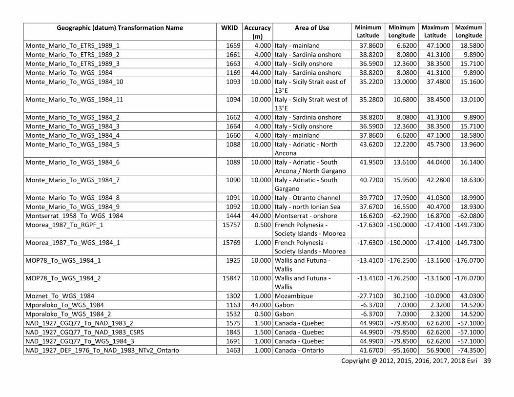
Copyright @ 2012, 2015, 2016, 2017, 2018 Esri 39
Geographic (datum) Transformation Name WKID Accuracy (m)
Area of Use Minimum Latitude
Minimum Longitude
Maximum Latitude
Maximum Longitude
Monte_Mario_To_ETRS_1989_1 1659 4.000 Italy - mainland 37.8600 6.6200 47.1000 18.5800
Monte_Mario_To_ETRS_1989_2 1661 4.000 Italy - Sardinia onshore 38.8200 8.0800 41.3100 9.8900
Monte_Mario_To_ETRS_1989_3 1663 4.000 Italy - Sicily onshore 36.5900 12.3600 38.3500 15.7100
Monte_Mario_To_WGS_1984 1169 44.000 Italy - Sardinia onshore 38.8200 8.0800 41.3100 9.8900
Monte_Mario_To_WGS_1984_10 1093 10.000 Italy - Sicily Strait east of 13°E
35.2200 13.0000 37.4800 15.1600
Monte_Mario_To_WGS_1984_11 1094 10.000 Italy - Sicily Strait west of 13°E
35.2800 10.6800 38.4500 13.0100
Monte_Mario_To_WGS_1984_2 1662 4.000 Italy - Sardinia onshore 38.8200 8.0800 41.3100 9.8900
Monte_Mario_To_WGS_1984_3 1664 4.000 Italy - Sicily onshore 36.5900 12.3600 38.3500 15.7100
Monte_Mario_To_WGS_1984_4 1660 4.000 Italy - mainland 37.8600 6.6200 47.1000 18.5800
Monte_Mario_To_WGS_1984_5 1088 10.000 Italy - Adriatic - North Ancona
43.6200 12.2200 45.7300 13.9600
Monte_Mario_To_WGS_1984_6 1089 10.000 Italy - Adriatic - South Ancona / North Gargano
41.9500 13.6100 44.0400 16.1400
Monte_Mario_To_WGS_1984_7 1090 10.000 Italy - Adriatic - South Gargano
40.7200 15.9500 42.2800 18.6300
Monte_Mario_To_WGS_1984_8 1091 10.000 Italy - Otranto channel 39.7700 17.9500 41.0300 18.9900
Monte_Mario_To_WGS_1984_9 1092 10.000 Italy - north Ionian Sea 37.6700 16.5500 40.4700 18.9300
Montserrat_1958_To_WGS_1984 1444 44.000 Montserrat - onshore 16.6200 -62.2900 16.8700 -62.0800
Moorea_1987_To_RGPF_1 15757 0.500 French Polynesia - Society Islands - Moorea
-17.6300 -150.0000 -17.4100 -149.7300
Moorea_1987_To_WGS_1984_1 15769 1.000 French Polynesia - Society Islands - Moorea
-17.6300 -150.0000 -17.4100 -149.7300
MOP78_To_WGS_1984_1 1925 10.000 Wallis and Futuna - Wallis
-13.4100 -176.2500 -13.1600 -176.0700
MOP78_To_WGS_1984_2 15847 10.000 Wallis and Futuna - Wallis
-13.4100 -176.2500 -13.1600 -176.0700
Moznet_To_WGS_1984 1302 1.000 Mozambique -27.7100 30.2100 -10.0900 43.0300
Mporaloko_To_WGS_1984 1163 44.000 Gabon -6.3700 7.0300 2.3200 14.5200
Mporaloko_To_WGS_1984_2 1532 0.500 Gabon -6.3700 7.0300 2.3200 14.5200
NAD_1927_CGQ77_To_NAD_1983_2 1575 1.500 Canada - Quebec 44.9900 -79.8500 62.6200 -57.1000
NAD_1927_CGQ77_To_NAD_1983_CSRS 1845 1.500 Canada - Quebec 44.9900 -79.8500 62.6200 -57.1000
NAD_1927_CGQ77_To_WGS_1984_3 1691 1.000 Canada - Quebec 44.9900 -79.8500 62.6200 -57.1000
NAD_1927_DEF_1976_To_NAD_1983_NTv2_Ontario 1463 1.000 Canada - Ontario 41.6700 -95.1600 56.9000 -74.3500
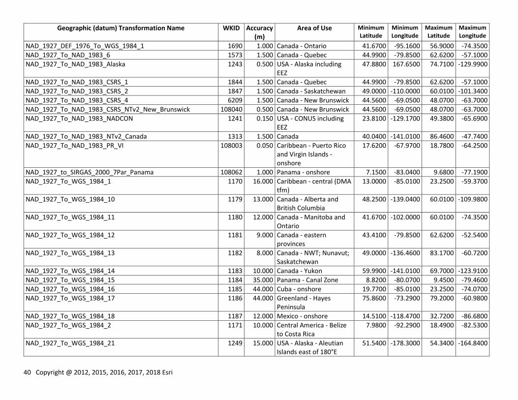
40 Copyright @ 2012, 2015, 2016, 2017, 2018 Esri
Geographic (datum) Transformation Name WKID Accuracy (m)
Area of Use Minimum Latitude
Minimum Longitude
Maximum Latitude
Maximum Longitude
NAD_1927_DEF_1976_To_WGS_1984_1 1690 1.000 Canada - Ontario 41.6700 -95.1600 56.9000 -74.3500
NAD_1927_To_NAD_1983_6 1573 1.500 Canada - Quebec 44.9900 -79.8500 62.6200 -57.1000
NAD_1927_To_NAD_1983_Alaska 1243 0.500 USA - Alaska including EEZ
47.8800 167.6500 74.7100 -129.9900
NAD_1927_To_NAD_1983_CSRS_1 1844 1.500 Canada - Quebec 44.9900 -79.8500 62.6200 -57.1000
NAD_1927_To_NAD_1983_CSRS_2 1847 1.500 Canada - Saskatchewan 49.0000 -110.0000 60.0100 -101.3400
NAD_1927_To_NAD_1983_CSRS_4 6209 1.500 Canada - New Brunswick 44.5600 -69.0500 48.0700 -63.7000
NAD_1927_To_NAD_1983_CSRS_NTv2_New_Brunswick 108040 0.500 Canada - New Brunswick 44.5600 -69.0500 48.0700 -63.7000
NAD_1927_To_NAD_1983_NADCON 1241 0.150 USA - CONUS including EEZ
23.8100 -129.1700 49.3800 -65.6900
NAD_1927_To_NAD_1983_NTv2_Canada 1313 1.500 Canada 40.0400 -141.0100 86.4600 -47.7400
NAD_1927_To_NAD_1983_PR_VI 108003 0.050 Caribbean - Puerto Rico and Virgin Islands - onshore
17.6200 -67.9700 18.7800 -64.2500
NAD_1927_to_SIRGAS_2000_7Par_Panama 108062 1.000 Panama - onshore 7.1500 -83.0400 9.6800 -77.1900
NAD_1927_To_WGS_1984_1 1170 16.000 Caribbean - central (DMA tfm)
13.0000 -85.0100 23.2500 -59.3700
NAD_1927_To_WGS_1984_10 1179 13.000 Canada - Alberta and British Columbia
48.2500 -139.0400 60.0100 -109.9800
NAD_1927_To_WGS_1984_11 1180 12.000 Canada - Manitoba and Ontario
41.6700 -102.0000 60.0100 -74.3500
NAD_1927_To_WGS_1984_12 1181 9.000 Canada - eastern provinces
43.4100 -79.8500 62.6200 -52.5400
NAD_1927_To_WGS_1984_13 1182 8.000 Canada - NWT; Nunavut; Saskatchewan
49.0000 -136.4600 83.1700 -60.7200
NAD_1927_To_WGS_1984_14 1183 10.000 Canada - Yukon 59.9900 -141.0100 69.7000 -123.9100
NAD_1927_To_WGS_1984_15 1184 35.000 Panama - Canal Zone 8.8200 -80.0700 9.4500 -79.4600
NAD_1927_To_WGS_1984_16 1185 44.000 Cuba - onshore 19.7700 -85.0100 23.2500 -74.0700
NAD_1927_To_WGS_1984_17 1186 44.000 Greenland - Hayes Peninsula
75.8600 -73.2900 79.2000 -60.9800
NAD_1927_To_WGS_1984_18 1187 12.000 Mexico - onshore 14.5100 -118.4700 32.7200 -86.6800
NAD_1927_To_WGS_1984_2 1171 10.000 Central America - Belize to Costa Rica
7.9800 -92.2900 18.4900 -82.5300
NAD_1927_To_WGS_1984_21 1249 15.000 USA - Alaska - Aleutian Islands east of 180°E
51.5400 -178.3000 54.3400 -164.8400
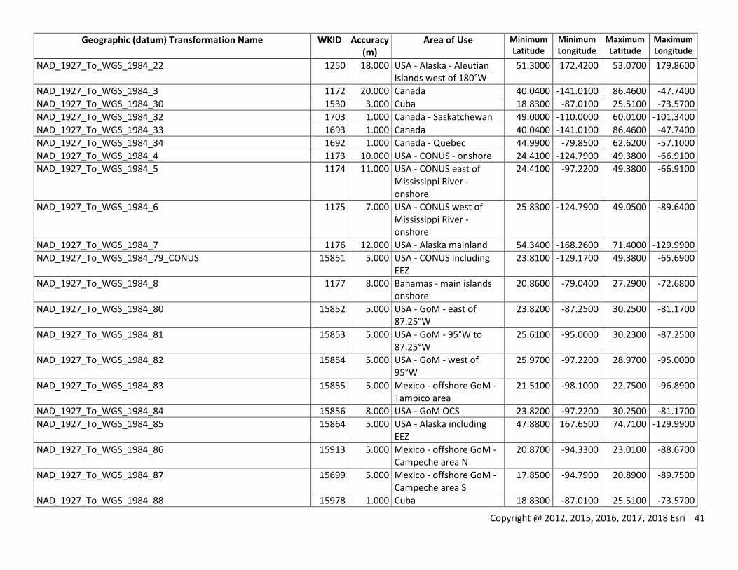
Copyright @ 2012, 2015, 2016, 2017, 2018 Esri 41
Geographic (datum) Transformation Name WKID Accuracy (m)
Area of Use Minimum Latitude
Minimum Longitude
Maximum Latitude
Maximum Longitude
NAD_1927_To_WGS_1984_22 1250 18.000 USA - Alaska - Aleutian Islands west of 180°W
51.3000 172.4200 53.0700 179.8600
NAD_1927_To_WGS_1984_3 1172 20.000 Canada 40.0400 -141.0100 86.4600 -47.7400
NAD_1927_To_WGS_1984_30 1530 3.000 Cuba 18.8300 -87.0100 25.5100 -73.5700
NAD_1927_To_WGS_1984_32 1703 1.000 Canada - Saskatchewan 49.0000 -110.0000 60.0100 -101.3400
NAD_1927_To_WGS_1984_33 1693 1.000 Canada 40.0400 -141.0100 86.4600 -47.7400
NAD_1927_To_WGS_1984_34 1692 1.000 Canada - Quebec 44.9900 -79.8500 62.6200 -57.1000
NAD_1927_To_WGS_1984_4 1173 10.000 USA - CONUS - onshore 24.4100 -124.7900 49.3800 -66.9100
NAD_1927_To_WGS_1984_5 1174 11.000 USA - CONUS east of Mississippi River - onshore
24.4100 -97.2200 49.3800 -66.9100
NAD_1927_To_WGS_1984_6 1175 7.000 USA - CONUS west of Mississippi River - onshore
25.8300 -124.7900 49.0500 -89.6400
NAD_1927_To_WGS_1984_7 1176 12.000 USA - Alaska mainland 54.3400 -168.2600 71.4000 -129.9900
NAD_1927_To_WGS_1984_79_CONUS 15851 5.000 USA - CONUS including EEZ
23.8100 -129.1700 49.3800 -65.6900
NAD_1927_To_WGS_1984_8 1177 8.000 Bahamas - main islands onshore
20.8600 -79.0400 27.2900 -72.6800
NAD_1927_To_WGS_1984_80 15852 5.000 USA - GoM - east of 87.25°W
23.8200 -87.2500 30.2500 -81.1700
NAD_1927_To_WGS_1984_81 15853 5.000 USA - GoM - 95°W to 87.25°W
25.6100 -95.0000 30.2300 -87.2500
NAD_1927_To_WGS_1984_82 15854 5.000 USA - GoM - west of 95°W
25.9700 -97.2200 28.9700 -95.0000
NAD_1927_To_WGS_1984_83 15855 5.000 Mexico - offshore GoM - Tampico area
21.5100 -98.1000 22.7500 -96.8900
NAD_1927_To_WGS_1984_84 15856 8.000 USA - GoM OCS 23.8200 -97.2200 30.2500 -81.1700
NAD_1927_To_WGS_1984_85 15864 5.000 USA - Alaska including EEZ
47.8800 167.6500 74.7100 -129.9900
NAD_1927_To_WGS_1984_86 15913 5.000 Mexico - offshore GoM - Campeche area N
20.8700 -94.3300 23.0100 -88.6700
NAD_1927_To_WGS_1984_87 15699 5.000 Mexico - offshore GoM - Campeche area S
17.8500 -94.7900 20.8900 -89.7500
NAD_1927_To_WGS_1984_88 15978 1.000 Cuba 18.8300 -87.0100 25.5100 -73.5700
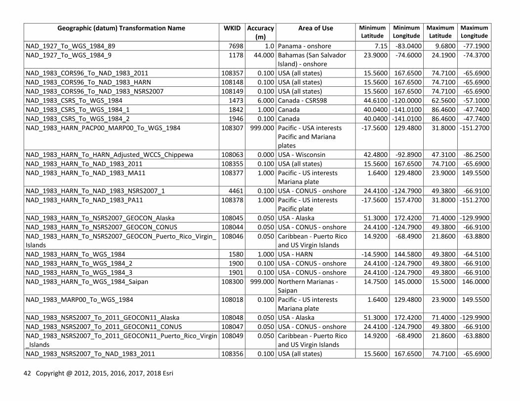
42 Copyright @ 2012, 2015, 2016, 2017, 2018 Esri
Geographic (datum) Transformation Name WKID Accuracy (m)
Area of Use Minimum Latitude
Minimum Longitude
Maximum Latitude
Maximum Longitude
NAD_1927_To_WGS_1984_89 7698 1.0 Panama - onshore 7.15 -83.0400 9.6800 -77.1900
NAD_1927_To_WGS_1984_9 1178 44.000 Bahamas (San Salvador Island) - onshore
23.9000 -74.6000 24.1900 -74.3700
NAD_1983_CORS96_To_NAD_1983_2011 108357 0.100 USA (all states) 15.5600 167.6500 74.7100 -65.6900
NAD_1983_CORS96_To_NAD_1983_HARN 108148 0.100 USA (all states) 15.5600 167.6500 74.7100 -65.6900
NAD_1983_CORS96_To_NAD_1983_NSRS2007 108149 0.100 USA (all states) 15.5600 167.6500 74.7100 -65.6900
NAD_1983_CSRS_To_WGS_1984 1473 6.000 Canada - CSRS98 44.6100 -120.0000 62.5600 -57.1000
NAD_1983_CSRS_To_WGS_1984_1 1842 1.000 Canada 40.0400 -141.0100 86.4600 -47.7400
NAD_1983_CSRS_To_WGS_1984_2 1946 0.100 Canada 40.0400 -141.0100 86.4600 -47.7400
NAD_1983_HARN_PACP00_MARP00_To_WGS_1984 108307 999.000 Pacific - USA interests Pacific and Mariana plates
-17.5600 129.4800 31.8000 -151.2700
NAD_1983_HARN_To_HARN_Adjusted_WCCS_Chippewa 108063 0.000 USA - Wisconsin 42.4800 -92.8900 47.3100 -86.2500
NAD_1983_HARN_To_NAD_1983_2011 108355 0.100 USA (all states) 15.5600 167.6500 74.7100 -65.6900
NAD_1983_HARN_To_NAD_1983_MA11 108377 1.000 Pacific - US interests Mariana plate
1.6400 129.4800 23.9000 149.5500
NAD_1983_HARN_To_NAD_1983_NSRS2007_1 4461 0.100 USA - CONUS - onshore 24.4100 -124.7900 49.3800 -66.9100
NAD_1983_HARN_To_NAD_1983_PA11 108378 1.000 Pacific - US interests Pacific plate
-17.5600 157.4700 31.8000 -151.2700
NAD_1983_HARN_To_NSRS2007_GEOCON_Alaska 108045 0.050 USA - Alaska 51.3000 172.4200 71.4000 -129.9900
NAD_1983_HARN_To_NSRS2007_GEOCON_CONUS 108044 0.050 USA - CONUS - onshore 24.4100 -124.7900 49.3800 -66.9100
NAD_1983_HARN_To_NSRS2007_GEOCON_Puerto_Rico_Virgin_Islands
108046 0.050 Caribbean - Puerto Rico and US Virgin Islands
14.9200 -68.4900 21.8600 -63.8800
NAD_1983_HARN_To_WGS_1984 1580 1.000 USA - HARN -14.5900 144.5800 49.3800 -64.5100
NAD_1983_HARN_To_WGS_1984_2 1900 0.100 USA - CONUS - onshore 24.4100 -124.7900 49.3800 -66.9100
NAD_1983_HARN_To_WGS_1984_3 1901 0.100 USA - CONUS - onshore 24.4100 -124.7900 49.3800 -66.9100
NAD_1983_HARN_To_WGS_1984_Saipan 108300 999.000 Northern Marianas - Saipan
14.7500 145.0000 15.5000 146.0000
NAD_1983_MARP00_To_WGS_1984 108018 0.100 Pacific - US interests Mariana plate
1.6400 129.4800 23.9000 149.5500
NAD_1983_NSRS2007_To_2011_GEOCON11_Alaska 108048 0.050 USA - Alaska 51.3000 172.4200 71.4000 -129.9900
NAD_1983_NSRS2007_To_2011_GEOCON11_CONUS 108047 0.050 USA - CONUS - onshore 24.4100 -124.7900 49.3800 -66.9100
NAD_1983_NSRS2007_To_2011_GEOCON11_Puerto_Rico_Virgin_Islands
108049 0.050 Caribbean - Puerto Rico and US Virgin Islands
14.9200 -68.4900 21.8600 -63.8800
NAD_1983_NSRS2007_To_NAD_1983_2011 108356 0.100 USA (all states) 15.5600 167.6500 74.7100 -65.6900
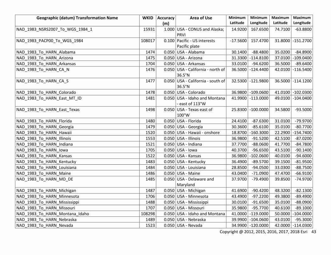
Copyright @ 2012, 2015, 2016, 2017, 2018 Esri 43
Geographic (datum) Transformation Name WKID Accuracy (m)
Area of Use Minimum Latitude
Minimum Longitude
Maximum Latitude
Maximum Longitude
NAD_1983_NSRS2007_To_WGS_1984_1 15931 1.000 USA - CONUS and Alaska; PRVI
14.9200 167.6500 74.7100 -63.8800
NAD_1983_PACP00_To_WGS_1984 108017 0.100 Pacific - US interests Pacific plate
-17.5600 157.4700 31.8000 -151.2700
NAD_1983_To_HARN_Alabama 1474 0.050 USA - Alabama 30.1400 -88.4800 35.0200 -84.8900
NAD_1983_To_HARN_Arizona 1475 0.050 USA - Arizona 31.3300 -114.8100 37.0100 -109.0400
NAD_1983_To_HARN_Arkansas 1704 0.050 USA - Arkansas 33.0100 -94.6200 36.5000 -89.6400
NAD_1983_To_HARN_CA_N 1476 0.050 USA - California - north of 36.5°N
36.5000 -124.4400 42.0100 -116.5400
NAD_1983_To_HARN_CA_S 1477 0.050 USA - California - south of 36.5°N
32.5300 -121.9800 36.5000 -114.1200
NAD_1983_To_HARN_Colorado 1478 0.050 USA - Colorado 36.9800 -109.0600 41.0100 -102.0300
NAD_1983_To_HARN_East_MT_ID 1481 0.050 USA - Idaho and Montana - east of 113°W
41.9900 -113.0000 49.0100 -104.0400
NAD_1983_To_HARN_East_Texas 1498 0.050 USA - Texas east of 100°W
25.8300 -100.0000 34.5800 -93.5000
NAD_1983_To_HARN_Florida 1480 0.050 USA - Florida 24.4100 -87.6300 31.0100 -79.9700
NAD_1983_To_HARN_Georgia 1479 0.050 USA - Georgia 30.3600 -85.6100 35.0100 -80.7700
NAD_1983_To_HARN_Hawaii 1520 0.050 USA - Hawaii - onshore 18.8700 -160.3000 22.2900 -154.7400
NAD_1983_To_HARN_Illinois 1553 0.050 USA - Illinois 36.9800 -91.5200 42.5100 -87.0200
NAD_1983_To_HARN_Indiana 1521 0.050 USA - Indiana 37.7700 -88.0600 41.7700 -84.7800
NAD_1983_To_HARN_Iowa 1705 0.050 USA - Iowa 40.3700 -96.6500 43.5100 -90.1400
NAD_1983_To_HARN_Kansas 1522 0.050 USA - Kansas 36.9800 -102.0600 40.0100 -94.6000
NAD_1983_To_HARN_Kentucky 1483 0.050 USA - Kentucky 36.4900 -89.5700 39.1500 -81.9500
NAD_1983_To_HARN_Louisiana 1484 0.050 USA - Louisiana 28.8500 -94.0500 33.0300 -88.7500
NAD_1983_To_HARN_Maine 1486 0.050 USA - Maine 43.0400 -71.0900 47.4700 -66.9100
NAD_1983_To_HARN_MD_DE 1485 0.050 USA - Delaware and Maryland
37.9700 -79.4900 39.8500 -74.9700
NAD_1983_To_HARN_Michigan 1487 0.050 USA - Michigan 41.6900 -90.4200 48.3200 -82.1300
NAD_1983_To_HARN_Minnesota 1706 0.050 USA - Minnesota 43.4900 -97.2200 49.3800 -89.4900
NAD_1983_To_HARN_Mississippi 1488 0.050 USA - Mississippi 30.0100 -91.6500 35.0100 -88.0900
NAD_1983_To_HARN_Missouri 1707 0.050 USA - Missouri 35.9800 -95.7700 40.6100 -89.1000
NAD_1983_To_HARN_Montana_Idaho 108298 0.050 USA - Idaho and Montana 41.0000 -119.0000 50.0000 -104.0000
NAD_1983_To_HARN_Nebraska 1489 0.050 USA - Nebraska 39.9900 -104.0600 43.0100 -95.3000
NAD_1983_To_HARN_Nevada 1523 0.050 USA - Nevada 34.9900 -120.0000 42.0000 -114.0300
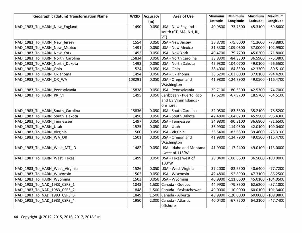
44 Copyright @ 2012, 2015, 2016, 2017, 2018 Esri
Geographic (datum) Transformation Name WKID Accuracy (m)
Area of Use Minimum Latitude
Minimum Longitude
Maximum Latitude
Maximum Longitude
NAD_1983_To_HARN_New_England 1490 0.050 USA - New England - south (CT, MA, NH, RI, VT)
40.9800 -73.7300 45.3100 -69.8600
NAD_1983_To_HARN_New_Jersey 1554 0.050 USA - New Jersey 38.8700 -75.6000 41.3600 -73.8800
NAD_1983_To_HARN_New_Mexico 1491 0.050 USA - New Mexico 31.3300 -109.0600 37.0000 -102.9900
NAD_1983_To_HARN_New_York 1492 0.050 USA - New York 40.4700 -79.7700 45.0200 -71.8000
NAD_1983_To_HARN_North_Carolina 15834 0.050 USA - North Carolina 33.8300 -84.3300 36.5900 -75.3800
NAD_1983_To_HARN_North_Dakota 1493 0.050 USA - North Dakota 45.9300 -104.0700 49.0100 -96.5500
NAD_1983_To_HARN_Ohio 1524 0.050 USA - Ohio 38.4000 -84.8300 42.3300 -80.5100
NAD_1983_To_HARN_Oklahoma 1494 0.050 USA - Oklahoma 33.6200 -103.0000 37.0100 -94.4200
NAD_1983_To_HARN_OR_WA 108291 0.050 USA - Oregon and Washington
41.9800 -124.7900 49.0500 -116.4700
NAD_1983_To_HARN_Pennsylvania 15838 0.050 USA - Pennsylvania 39.7100 -80.5300 42.5300 -74.7000
NAD_1983_To_HARN_PR_VI 1495 0.050 Caribbean - Puerto Rico and US Virgin Islands - onshore
17.6200 -67.9700 18.5700 -64.5100
NAD_1983_To_HARN_South_Carolina 15836 0.050 USA - South Carolina 32.0500 -83.3600 35.2100 -78.5200
NAD_1983_To_HARN_South_Dakota 1496 0.050 USA - South Dakota 42.4800 -104.0700 45.9500 -96.4300
NAD_1983_To_HARN_Tennessee 1497 0.050 USA - Tennessee 34.9800 -90.3100 36.6800 -81.6500
NAD_1983_To_HARN_Utah 1525 0.050 USA - Utah 36.9900 -114.0500 42.0100 -109.0400
NAD_1983_To_HARN_Virginia 1500 0.050 USA - Virginia 36.5400 -83.6800 39.4600 -75.3100
NAD_1983_To_HARN_WA_OR 1501 0.050 USA - Oregon and Washington
41.9800 -124.7900 49.0500 -116.4700
NAD_1983_To_HARN_West_MT_ID 1482 0.050 USA - Idaho and Montana - west of 113°W
41.9900 -117.2400 49.0100 -113.0000
NAD_1983_To_HARN_West_Texas 1499 0.050 USA - Texas west of 100°W
28.0400 -106.6600 36.5000 -100.0000
NAD_1983_To_HARN_West_Virginia 1526 0.050 USA - West Virginia 37.2000 -82.6500 40.6400 -77.7200
NAD_1983_To_HARN_Wisconsin 1502 0.050 USA - Wisconsin 42.4800 -92.8900 47.3100 -86.2500
NAD_1983_To_HARN_Wyoming 1503 0.050 USA - Wyoming 40.9900 -111.0600 45.0100 -104.0500
NAD_1983_To_NAD_1983_CSRS_1 1843 1.500 Canada - Quebec 44.9900 -79.8500 62.6200 -57.1000
NAD_1983_To_NAD_1983_CSRS_2 1848 1.500 Canada - Saskatchewan 49.0000 -110.0000 60.0100 -101.3400
NAD_1983_To_NAD_1983_CSRS_3 1849 1.500 Canada - Alberta 48.9900 -120.0000 60.0000 -109.9800
NAD_1983_To_NAD_1983_CSRS_4 1950 2.000 Canada - Atlantic offshore
40.0400 -67.7500 64.2100 -47.7400
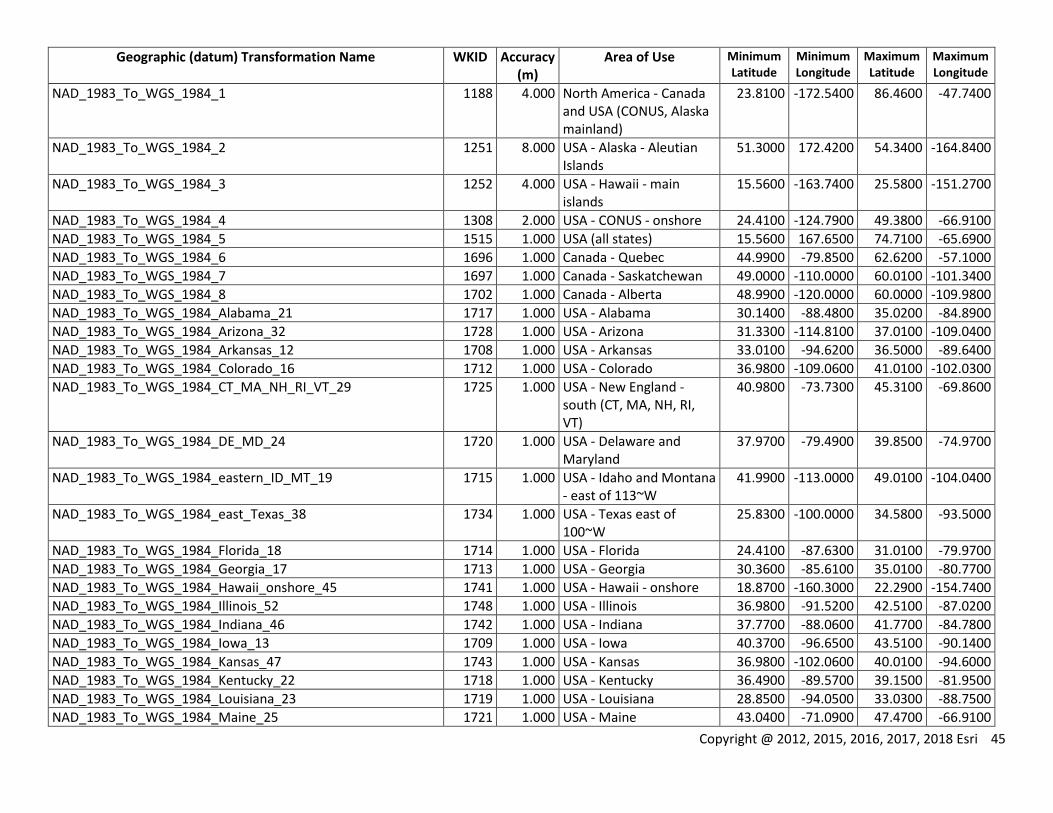
Copyright @ 2012, 2015, 2016, 2017, 2018 Esri 45
Geographic (datum) Transformation Name WKID Accuracy (m)
Area of Use Minimum Latitude
Minimum Longitude
Maximum Latitude
Maximum Longitude
NAD_1983_To_WGS_1984_1 1188 4.000 North America - Canada and USA (CONUS, Alaska mainland)
23.8100 -172.5400 86.4600 -47.7400
NAD_1983_To_WGS_1984_2 1251 8.000 USA - Alaska - Aleutian Islands
51.3000 172.4200 54.3400 -164.8400
NAD_1983_To_WGS_1984_3 1252 4.000 USA - Hawaii - main islands
15.5600 -163.7400 25.5800 -151.2700
NAD_1983_To_WGS_1984_4 1308 2.000 USA - CONUS - onshore 24.4100 -124.7900 49.3800 -66.9100
NAD_1983_To_WGS_1984_5 1515 1.000 USA (all states) 15.5600 167.6500 74.7100 -65.6900
NAD_1983_To_WGS_1984_6 1696 1.000 Canada - Quebec 44.9900 -79.8500 62.6200 -57.1000
NAD_1983_To_WGS_1984_7 1697 1.000 Canada - Saskatchewan 49.0000 -110.0000 60.0100 -101.3400
NAD_1983_To_WGS_1984_8 1702 1.000 Canada - Alberta 48.9900 -120.0000 60.0000 -109.9800
NAD_1983_To_WGS_1984_Alabama_21 1717 1.000 USA - Alabama 30.1400 -88.4800 35.0200 -84.8900
NAD_1983_To_WGS_1984_Arizona_32 1728 1.000 USA - Arizona 31.3300 -114.8100 37.0100 -109.0400
NAD_1983_To_WGS_1984_Arkansas_12 1708 1.000 USA - Arkansas 33.0100 -94.6200 36.5000 -89.6400
NAD_1983_To_WGS_1984_Colorado_16 1712 1.000 USA - Colorado 36.9800 -109.0600 41.0100 -102.0300
NAD_1983_To_WGS_1984_CT_MA_NH_RI_VT_29 1725 1.000 USA - New England - south (CT, MA, NH, RI, VT)
40.9800 -73.7300 45.3100 -69.8600
NAD_1983_To_WGS_1984_DE_MD_24 1720 1.000 USA - Delaware and Maryland
37.9700 -79.4900 39.8500 -74.9700
NAD_1983_To_WGS_1984_eastern_ID_MT_19 1715 1.000 USA - Idaho and Montana - east of 113~W
41.9900 -113.0000 49.0100 -104.0400
NAD_1983_To_WGS_1984_east_Texas_38 1734 1.000 USA - Texas east of 100~W
25.8300 -100.0000 34.5800 -93.5000
NAD_1983_To_WGS_1984_Florida_18 1714 1.000 USA - Florida 24.4100 -87.6300 31.0100 -79.9700
NAD_1983_To_WGS_1984_Georgia_17 1713 1.000 USA - Georgia 30.3600 -85.6100 35.0100 -80.7700
NAD_1983_To_WGS_1984_Hawaii_onshore_45 1741 1.000 USA - Hawaii - onshore 18.8700 -160.3000 22.2900 -154.7400
NAD_1983_To_WGS_1984_Illinois_52 1748 1.000 USA - Illinois 36.9800 -91.5200 42.5100 -87.0200
NAD_1983_To_WGS_1984_Indiana_46 1742 1.000 USA - Indiana 37.7700 -88.0600 41.7700 -84.7800
NAD_1983_To_WGS_1984_Iowa_13 1709 1.000 USA - Iowa 40.3700 -96.6500 43.5100 -90.1400
NAD_1983_To_WGS_1984_Kansas_47 1743 1.000 USA - Kansas 36.9800 -102.0600 40.0100 -94.6000
NAD_1983_To_WGS_1984_Kentucky_22 1718 1.000 USA - Kentucky 36.4900 -89.5700 39.1500 -81.9500
NAD_1983_To_WGS_1984_Louisiana_23 1719 1.000 USA - Louisiana 28.8500 -94.0500 33.0300 -88.7500
NAD_1983_To_WGS_1984_Maine_25 1721 1.000 USA - Maine 43.0400 -71.0900 47.4700 -66.9100

46 Copyright @ 2012, 2015, 2016, 2017, 2018 Esri
Geographic (datum) Transformation Name WKID Accuracy (m)
Area of Use Minimum Latitude
Minimum Longitude
Maximum Latitude
Maximum Longitude
NAD_1983_To_WGS_1984_Michigan_26 1722 1.000 USA - Michigan 41.6900 -90.4200 48.3200 -82.1300
NAD_1983_To_WGS_1984_Minnesota_14 1710 1.000 USA - Minnesota 43.4900 -97.2200 49.3800 -89.4900
NAD_1983_To_WGS_1984_Mississippi_27 1723 1.000 USA - Mississippi 30.0100 -91.6500 35.0100 -88.0900
NAD_1983_To_WGS_1984_Missouri_15 1711 1.000 USA - Missouri 35.9800 -95.7700 40.6100 -89.1000
NAD_1983_To_WGS_1984_Nebraska_28 1724 1.000 USA - Nebraska 39.9900 -104.0600 43.0100 -95.3000
NAD_1983_To_WGS_1984_Nevada_48 1744 1.000 USA - Nevada 34.9900 -120.0000 42.0000 -114.0300
NAD_1983_To_WGS_1984_New_Jersey_53 1749 1.000 USA - New Jersey 38.8700 -75.6000 41.3600 -73.8800
NAD_1983_To_WGS_1984_New_Mexico_30 1726 1.000 USA - New Mexico 31.3300 -109.0600 37.0000 -102.9900
NAD_1983_To_WGS_1984_New_York_31 1727 1.000 USA - New York 40.4700 -79.7700 45.0200 -71.8000
NAD_1983_To_WGS_1984_North_Carolina_55 15835 1.000 USA - North Carolina 33.8300 -84.3300 36.5900 -75.3800
NAD_1983_To_WGS_1984_North_Dakota_33 1729 1.000 USA - North Dakota 45.9300 -104.0700 49.0100 -96.5500
NAD_1983_To_WGS_1984_northern_California_43 1739 1.000 USA - California - north of 36.5~N
36.5000 -124.4400 42.0100 -116.5400
NAD_1983_To_WGS_1984_Ohio_49 1745 1.000 USA - Ohio 38.4000 -84.8300 42.3300 -80.5100
NAD_1983_To_WGS_1984_Oklahoma_34 1730 1.000 USA - Oklahoma 33.6200 -103.0000 37.0100 -94.4200
NAD_1983_To_WGS_1984_OR_WA_41 1737 1.000 USA - Oregon and Washington
41.9800 -124.7900 49.0500 -116.4700
NAD_1983_To_WGS_1984_Pennsylvania_57 15839 1.000 USA - Pennsylvania 39.7100 -80.5300 42.5300 -74.7000
NAD_1983_To_WGS_1984_PR_VI_onshore_35 1731 1.000 Caribbean - Puerto Rico and US Virgin Islands - onshore
17.6200 -67.9700 18.5700 -64.5100
NAD_1983_To_WGS_1984_South_Carolina_56 15837 1.000 USA - South Carolina 32.0500 -83.3600 35.2100 -78.5200
NAD_1983_To_WGS_1984_South_Dakota_36 1732 1.000 USA - South Dakota 42.4800 -104.0700 45.9500 -96.4300
NAD_1983_To_WGS_1984_southern_California_54 1750 1.000 USA - California - south of 36.5~N
32.5300 -121.9800 36.5000 -114.1200
NAD_1983_To_WGS_1984_Tennessee_37 1733 1.000 USA - Tennessee 34.9800 -90.3100 36.6800 -81.6500
NAD_1983_To_WGS_1984_Utah_50 1746 1.000 USA - Utah 36.9900 -114.0500 42.0100 -109.0400
NAD_1983_To_WGS_1984_Virginia_40 1736 1.000 USA - Virginia 36.5400 -83.6800 39.4600 -75.3100
NAD_1983_To_WGS_1984_western_ID_MT_20 1716 1.000 USA - Idaho and Montana - west of 113~W
41.9900 -117.2400 49.0100 -113.0000
NAD_1983_To_WGS_1984_west_Texas_39 1735 1.000 USA - Texas west of 100~W
28.0400 -106.6600 36.5000 -100.0000
NAD_1983_To_WGS_1984_West_Virginia_51 1747 1.000 USA - West Virginia 37.2000 -82.6500 40.6400 -77.7200
NAD_1983_To_WGS_1984_Wisconsin_42 1738 1.000 USA - Wisconsin 42.4800 -92.8900 47.3100 -86.2500
NAD_1983_To_WGS_1984_Wyoming_44 1740 1.000 USA - Wyoming 40.9900 -111.0600 45.0100 -104.0500
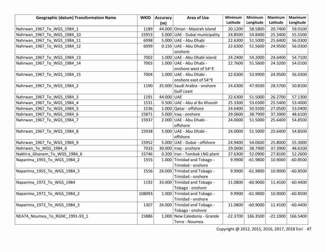
Copyright @ 2012, 2015, 2016, 2017, 2018 Esri 47
Geographic (datum) Transformation Name WKID Accuracy (m)
Area of Use Minimum Latitude
Minimum Longitude
Maximum Latitude
Maximum Longitude
Nahrwan_1967_To_WGS_1984_1 1189 44.000 Oman - Masirah Island 20.1200 58.5800 20.7400 59.0100
Nahrwan_1967_To_WGS_1984_10 15953 5.000 UAE - Dubai municipality 24.8500 54.8400 25.3400 55.5500
Nahrwan_1967_To_WGS_1984_11 6998 5.000 UAE - Abu Dhabi 22.6300 51.5000 25.6400 56.0300
Nahrwan_1967_To_WGS_1984_12 6999 0.150 UAE - Abu Dhabi - onshore
22.6300 51.5600 24.9500 56.0300
Nahrwan_1967_To_WGS_1984_13 7002 1.000 UAE - Abu Dhabi island 24.2400 54.2000 24.6400 54.7100
Nahrwan_1967_To_WGS_1984_14 7003 1.000 UAE - Abu Dhabi - onshore west of 54~E
22.7600 51.5600 24.3200 54.0100
Nahrwan_1967_To_WGS_1984_15 7004 1.000 UAE - Abu Dhabi - onshore east of 54~E
22.6300 53.9900 24.9500 56.0300
Nahrwan_1967_To_WGS_1984_2 1190 35.000 Saudi Arabia - onshore Gulf coast
24.6300 47.9500 28.5700 50.8100
Nahrwan_1967_To_WGS_1984_3 1191 44.000 UAE 22.6300 51.5000 26.2700 57.1300
Nahrwan_1967_To_WGS_1984_4 1531 0.500 UAE - Abu al Bu Khoosh 25.3300 53.0300 25.5400 53.4000
Nahrwan_1967_To_WGS_1984_5 1536 1.000 Qatar - offshore 24.6400 50.5500 27.0500 53.0400
Nahrwan_1967_To_WGS_1984_6 15871 5.000 Iraq - onshore 29.0600 38.7900 37.3900 48.6100
Nahrwan_1967_To_WGS_1984_7 15937 2.000 UAE - Abu Dhabi - offshore
24.0000 51.5000 25.6400 54.8500
Nahrwan_1967_To_WGS_1984_8 15938 5.000 UAE - Abu Dhabi - offshore
24.0000 51.5000 25.6400 54.8500
Nahrwan_1967_To_WGS_1984_9 15952 5.000 UAE - Dubai - offshore 24.9400 54.0600 25.8000 55.3000
Nahrwan_To_WGS_1984_6 7033 30.000 Iraq - onshore 29.0600 38.7900 37.3900 48.6100
Nakhl-e_Ghanem_To_WGS_1984_6 15746 0.200 Iran - Tombak LNG plant 27.6300 52.0900 27.8100 52.2600
Naparima_1955_To_WGS_1984_2 1555 1.000 Trinidad and Tobago - Trinidad - onshore
9.9900 -61.9800 10.9000 -60.8500
Naparima_1955_To_WGS_1984_3 1556 26.000 Trinidad and Tobago - Trinidad - onshore
9.9900 -61.9800 10.9000 -60.8500
Naparima_1972_To_WGS_1984 1192 33.000 Trinidad and Tobago - Tobago - onshore
11.0800 -60.9000 11.4100 -60.4400
Naparima_1972_To_WGS_1984_2 108093 1.000 Trinidad and Tobago - Trinidad - onshore
9.9900 -61.9800 10.9000 -60.8500
Naparima_1972_To_WGS_1984_3 1307 26.000 Trinidad and Tobago - Tobago - onshore
11.0800 -60.9000 11.4100 -60.4400
NEA74_Noumea_To_RGNC_1991-93_1 15886 1.000 New Caledonia - Grande Terre - Noumea
-22.3700 166.3500 -22.1900 166.5400
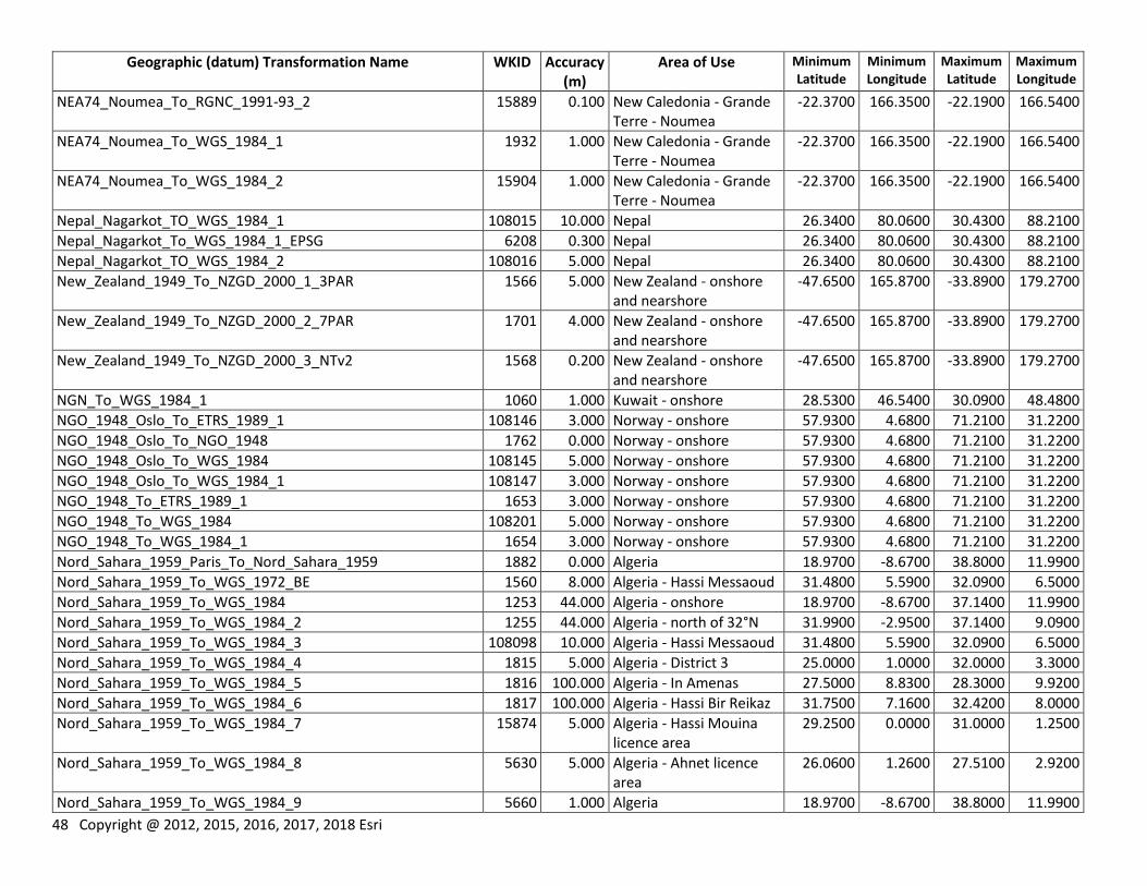
48 Copyright @ 2012, 2015, 2016, 2017, 2018 Esri
Geographic (datum) Transformation Name WKID Accuracy (m)
Area of Use Minimum Latitude
Minimum Longitude
Maximum Latitude
Maximum Longitude
NEA74_Noumea_To_RGNC_1991-93_2 15889 0.100 New Caledonia - Grande Terre - Noumea
-22.3700 166.3500 -22.1900 166.5400
NEA74_Noumea_To_WGS_1984_1 1932 1.000 New Caledonia - Grande Terre - Noumea
-22.3700 166.3500 -22.1900 166.5400
NEA74_Noumea_To_WGS_1984_2 15904 1.000 New Caledonia - Grande Terre - Noumea
-22.3700 166.3500 -22.1900 166.5400
Nepal_Nagarkot_TO_WGS_1984_1 108015 10.000 Nepal 26.3400 80.0600 30.4300 88.2100
Nepal_Nagarkot_To_WGS_1984_1_EPSG 6208 0.300 Nepal 26.3400 80.0600 30.4300 88.2100
Nepal_Nagarkot_TO_WGS_1984_2 108016 5.000 Nepal 26.3400 80.0600 30.4300 88.2100
New_Zealand_1949_To_NZGD_2000_1_3PAR 1566 5.000 New Zealand - onshore and nearshore
-47.6500 165.8700 -33.8900 179.2700
New_Zealand_1949_To_NZGD_2000_2_7PAR 1701 4.000 New Zealand - onshore and nearshore
-47.6500 165.8700 -33.8900 179.2700
New_Zealand_1949_To_NZGD_2000_3_NTv2 1568 0.200 New Zealand - onshore and nearshore
-47.6500 165.8700 -33.8900 179.2700
NGN_To_WGS_1984_1 1060 1.000 Kuwait - onshore 28.5300 46.5400 30.0900 48.4800
NGO_1948_Oslo_To_ETRS_1989_1 108146 3.000 Norway - onshore 57.9300 4.6800 71.2100 31.2200
NGO_1948_Oslo_To_NGO_1948 1762 0.000 Norway - onshore 57.9300 4.6800 71.2100 31.2200
NGO_1948_Oslo_To_WGS_1984 108145 5.000 Norway - onshore 57.9300 4.6800 71.2100 31.2200
NGO_1948_Oslo_To_WGS_1984_1 108147 3.000 Norway - onshore 57.9300 4.6800 71.2100 31.2200
NGO_1948_To_ETRS_1989_1 1653 3.000 Norway - onshore 57.9300 4.6800 71.2100 31.2200
NGO_1948_To_WGS_1984 108201 5.000 Norway - onshore 57.9300 4.6800 71.2100 31.2200
NGO_1948_To_WGS_1984_1 1654 3.000 Norway - onshore 57.9300 4.6800 71.2100 31.2200
Nord_Sahara_1959_Paris_To_Nord_Sahara_1959 1882 0.000 Algeria 18.9700 -8.6700 38.8000 11.9900
Nord_Sahara_1959_To_WGS_1972_BE 1560 8.000 Algeria - Hassi Messaoud 31.4800 5.5900 32.0900 6.5000
Nord_Sahara_1959_To_WGS_1984 1253 44.000 Algeria - onshore 18.9700 -8.6700 37.1400 11.9900
Nord_Sahara_1959_To_WGS_1984_2 1255 44.000 Algeria - north of 32°N 31.9900 -2.9500 37.1400 9.0900
Nord_Sahara_1959_To_WGS_1984_3 108098 10.000 Algeria - Hassi Messaoud 31.4800 5.5900 32.0900 6.5000
Nord_Sahara_1959_To_WGS_1984_4 1815 5.000 Algeria - District 3 25.0000 1.0000 32.0000 3.3000
Nord_Sahara_1959_To_WGS_1984_5 1816 100.000 Algeria - In Amenas 27.5000 8.8300 28.3000 9.9200
Nord_Sahara_1959_To_WGS_1984_6 1817 100.000 Algeria - Hassi Bir Reikaz 31.7500 7.1600 32.4200 8.0000
Nord_Sahara_1959_To_WGS_1984_7 15874 5.000 Algeria - Hassi Mouina licence area
29.2500 0.0000 31.0000 1.2500
Nord_Sahara_1959_To_WGS_1984_8 5630 5.000 Algeria - Ahnet licence area
26.0600 1.2600 27.5100 2.9200
Nord_Sahara_1959_To_WGS_1984_9 5660 1.000 Algeria 18.9700 -8.6700 38.8000 11.9900
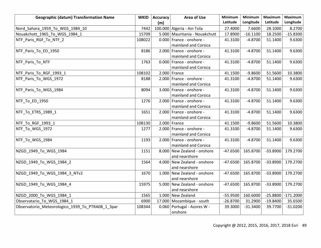
Copyright @ 2012, 2015, 2016, 2017, 2018 Esri 49
Geographic (datum) Transformation Name WKID Accuracy (m)
Area of Use Minimum Latitude
Minimum Longitude
Maximum Latitude
Maximum Longitude
Nord_Sahara_1959_To_WGS_1984_10 7442 100.000 Algeria - Ain Tsila 27.4000 7.6600 28.1000 8.2700
Nouakchott_1965_To_WGS_1984_1 15709 5.000 Mauritania - Nouakchutt 17.8900 -16.1100 18.2500 -15.8300
NTF_Paris_RGF_To_NTF_2 108022 0.000 France - onshore - mainland and Corsica
41.3100 -4.8700 51.1400 9.6300
NTF_Paris_To_ED_1950 8186 2.000 France - onshore - mainland and Corsica
41.3100 -4.8700 51.1400 9.6300
NTF_Paris_To_NTF 1763 0.000 France - onshore - mainland and Corsica
41.3100 -4.8700 51.1400 9.6300
NTF_Paris_To_RGF_1993_1 108102 2.000 France 41.1500 -9.8600 51.5600 10.3800
NTF_Paris_To_WGS_1972 8188 2.000 France - onshore - mainland and Corsica
41.3100 -4.8700 51.1400 9.6300
NTF_Paris_To_WGS_1984 8094 3.000 France - onshore - mainland and Corsica
41.3100 -4.8700 51.1400 9.6300
NTF_To_ED_1950 1276 2.000 France - onshore - mainland and Corsica
41.3100 -4.8700 51.1400 9.6300
NTF_To_ETRS_1989_1 1651 2.000 France - onshore - mainland and Corsica
41.3100 -4.8700 51.1400 9.6300
NTF_To_RGF_1993_1 108130 2.000 France 41.1500 -9.8600 51.5600 10.3800
NTF_To_WGS_1972 1277 2.000 France - onshore - mainland and Corsica
41.3100 -4.8700 51.1400 9.6300
NTF_To_WGS_1984 1193 2.000 France - onshore - mainland and Corsica
41.3100 -4.8700 51.1400 9.6300
NZGD_1949_To_WGS_1984 1151 8.000 New Zealand - onshore and nearshore
-47.6500 165.8700 -33.8900 179.2700
NZGD_1949_To_WGS_1984_2 1564 4.000 New Zealand - onshore and nearshore
-47.6500 165.8700 -33.8900 179.2700
NZGD_1949_To_WGS_1984_3_NTv2 1670 1.000 New Zealand - onshore and nearshore
-47.6500 165.8700 -33.8900 179.2700
NZGD_1949_To_WGS_1984_4 15975 5.000 New Zealand - onshore and nearshore
-47.6500 165.8700 -33.8900 179.2700
NZGD_2000_To_WGS_1984_1 1565 1.000 New Zealand -55.9500 160.6000 -25.8800 -171.2000
Observatario_To_WGS_1984_1 6900 17.000 Mozambique - south -26.8700 31.2900 -19.8400 35.6500
Observatorio_Meteorologico_1939_To_PTRA08_1_3par 108344 0.060 Portugal - Azores W - onshore
39.3000 -31.3400 39.7700 -31.0200
50 Copyright @ 2012, 2015, 2016, 2017, 2018 Esri
Geographic (datum) Transformation Name WKID Accuracy (m)
Area of Use Minimum Latitude
Minimum Longitude
Maximum Latitude
Maximum Longitude
Observatorio_Meteorologico_1939_To_PTRA08_1_7par 108341 0.030 Portugal - Azores W - onshore
39.3000 -31.3400 39.7700 -31.0200
Observatorio_Meteorologico_1939_To_PTRA08_2_3par 108345 0.056 Azores - Flores Island 39.3500 -31.3000 39.5000 -31.1000
Observatorio_Meteorologico_1939_To_PTRA08_2_7par 108342 0.020 Azores - Flores Island 39.3500 -31.3000 39.5000 -31.1000
Observatorio_Meteorologico_1939_To_PTRA08_3_3par 108346 0.064 Azores - Corvo Island 39.5000 -31.2000 39.7500 -31.0000
Observatorio_Meteorologico_1939_To_PTRA08_3_7par 108343 0.070 Azores - Corvo Island 39.5000 -31.2000 39.7500 -31.0000
Observatorio_Meteorologico_1939_To_WGS_1984_1 108116 5.000 Portugal - Azores W - onshore
39.3000 -31.3400 39.7700 -31.0200
Observatorio_Meteorologico_1939_To_WGS_1984_1_3par 108350 0.100 Portugal - Azores W - onshore
39.3000 -31.3400 39.7700 -31.0200
Observatorio_Meteorologico_1939_To_WGS_1984_1_7par 108347 0.060 Portugal - Azores W - onshore
39.3000 -31.3400 39.7700 -31.0200
Observatorio_Meteorologico_1939_To_WGS_1984_2_3par 108351 0.080 Azores - Flores Island 39.3500 -31.3000 39.5000 -31.1000
Observatorio_Meteorologico_1939_To_WGS_1984_2_7par 108348 0.050 Azores - Flores Island 39.3500 -31.3000 39.5000 -31.1000
Observatorio_Meteorologico_1939_To_WGS_1984_3_3par 108352 0.085 Azores - Corvo Island 39.5000 -31.2000 39.7500 -31.0000
Observatorio_Meteorologico_1939_To_WGS_1984_3_7par 108349 0.100 Azores - Corvo Island 39.5000 -31.2000 39.7500 -31.0000
Observatorio_Meteorologico_1965_To_WGS_1984_2 108234 999.000 China - Macao 22.0600 113.5200 22.2300 113.6800
Ocotepeque_1935_To_CR05 6890 1.000 Costa Rica 2.1500 -90.4500 11.7700 -81.4300
Ocotepeque_1935_To_NAD_1927_1 6888 9.000 Central America - Guatemala to Costa Rica
7.9800 -92.2900 17.8300 -82.5300
Ocotepeque_1935_To_WGS_1984_1 5470 8.000 Costa Rica - onshore 7.9800 -85.9700 11.2200 -82.5300
Ocotepeque_1935_To_WGS_1984_2 5473 5.000 Costa Rica - onshore 7.9800 -85.9700 11.2200 -82.5300
Ocotepeque_1935_To_WGS_1984_3PAR 6891 999.000 Costa Rica 2.1500 -90.4500 11.7700 -81.4300
Ocotepeque_1935_To_WGS_1984_RN 108283 999.000 Costa Rica 2.1500 -90.4500 11.7700 -81.4300
Old_Hawaiian_Intl_1924_To_WGS_1984_Hawaii 108331 44.000 USA - Hawaii - island of Hawaii - onshore
18.8700 -156.1000 20.3300 -154.7400
Old_Hawaiian_Intl_1924_To_WGS_1984_Kauai 108332 35.000 USA - Hawaii - Kauai - onshore
21.8100 -159.8500 22.2900 -159.2300
Old_Hawaiian_Intl_1924_To_WGS_1984_Maui 108333 44.000 USA - Hawaii - Maui; Kahoolawe; Lanai; Molokai - onshore
20.4500 -157.3600 21.2600 -155.9300
Old_Hawaiian_Intl_1924_To_WGS_1984_Mean 108330 38.000 USA - Hawaii - onshore 18.8700 -160.3000 22.2900 -154.7400
Old_Hawaiian_Intl_1924_To_WGS_1984_Oahu 108334 14.000 USA - Hawaii - Oahu - onshore
21.2000 -158.3300 21.7500 -157.6100
Old_Hawaiian_To_NAD_1983 1454 0.200 USA - Hawaii - onshore 18.8700 -160.3000 22.2900 -154.7400
Old_Hawaiian_To_NAD_1983_HARN_Hawaii 108306 0.050 USA - Hawaii - onshore 18.8700 -160.3000 22.2900 -154.7400
Copyright @ 2012, 2015, 2016, 2017, 2018 Esri 51
Geographic (datum) Transformation Name WKID Accuracy (m)
Area of Use Minimum Latitude
Minimum Longitude
Maximum Latitude
Maximum Longitude
Old_Hawaiian_To_WGS_1984_1 15824 38.000 USA - Hawaii - onshore 18.8700 -160.3000 22.2900 -154.7400
Old_Hawaiian_To_WGS_1984_2 15825 44.000 USA - Hawaii - island of Hawaii - onshore
18.8700 -156.1000 20.3300 -154.7400
Old_Hawaiian_To_WGS_1984_3 15826 35.000 USA - Hawaii - Kauai - onshore
21.8100 -159.8500 22.2900 -159.2300
Old_Hawaiian_To_WGS_1984_4 15827 44.000 USA - Hawaii - Maui; Kahoolawe; Lanai; Molokai - onshore
20.4500 -157.3600 21.2600 -155.9300
Old_Hawaiian_To_WGS_1984_5 15828 14.000 USA - Hawaii - Oahu - onshore
21.2000 -158.3300 21.7500 -157.6100
Old_Hawaiian_To_WGS_1984_8 15840 2.000 USA - Hawaii - onshore 18.8700 -160.3000 22.2900 -154.7400
ONGD14_To_WGS_1984_1 7377 0.100 Oman 14.3300 51.9900 26.7400 63.3800
ONGD14_To_WGS_1984_2 7433 2.000 Oman 14.3300 51.9900 26.7400 63.3800
OSGB_1936_To_ED_1950_UKOOA 1315 2.000 UK - Great Britain; Isle of Man
49.7900 -8.8200 60.9400 1.9200
OSGB_1936_To_ETRS_1989_1 5338 0.040 UK - Great Britain; Isle of Man
49.7900 -8.8200 60.9400 1.9200
OSGB_1936_To_WGS_1984_1 1195 21.000 UK - Great Britain; Isle of Man
49.7900 -8.8200 60.9400 1.9200
OSGB_1936_To_WGS_1984_2 1196 10.000 UK - England 49.8100 -6.5000 55.8500 1.8400
OSGB_1936_To_WGS_1984_3 1197 21.000 UK - England and Wales, Isle of Man
49.8100 -6.5000 55.8500 1.8400
OSGB_1936_To_WGS_1984_4 1198 18.000 UK - Scotland 54.5700 -8.7400 60.9000 -0.6500
OSGB_1936_To_WGS_1984_5 1199 35.000 UK - Wales 51.2800 -5.3400 53.4800 -2.6500
OSGB_1936_To_WGS_1984_7 5339 1.000 UK - Great Britain; Isle of Man
49.7900 -8.8200 60.9400 1.9200
OSGB_1936_To_WGS_1984_8 5622 3.000 UK - Wytch Farm 50.5300 -2.2000 50.8000 -1.6800
OSGB_1936_To_WGS_1984_NGA_7PAR 108336 21.000 UK - Great Britain; Isle of Man
49.7900 -8.8200 60.9400 1.9200
OSGB_1936_To_WGS_1984_Petroleum 1314 2.000 UK - Great Britain; Isle of Man
49.7900 -8.8200 60.9400 1.9200
OSGB_1936_To_Xrail84_NTv2 108059 0.500 UK - London 51.2000 -0.7000 51.8000 0.6000
OSNI_1952_To_WGS_1984_1 1955 1.000 UK - Northern Ireland - onshore
53.9600 -8.1800 55.3600 -5.3400
Padang_1884_Jakarta_To_Padang_1884 1758 0.000 Indonesia - Sumatra -5.9900 95.1600 5.9700 106.1300
52 Copyright @ 2012, 2015, 2016, 2017, 2018 Esri
Geographic (datum) Transformation Name WKID Accuracy (m)
Area of Use Minimum Latitude
Minimum Longitude
Maximum Latitude
Maximum Longitude
Palestine_1923_To_Israel_1 1071 1.500 Israel, Palestine Territory, and Jordan
29.1900 32.9900 33.5200 39.3000
Palestine_1923_To_WGS_1984_1 1074 2.000 Israel, Palestine Territory, and Jordan
29.1900 32.9900 33.5200 39.3000
Palestine_1923_To_WGS_1984_1X 108220 1.500 Israel 29.4500 32.9900 33.5300 35.6900
Palestine_1923_To_WGS_1984_2 108099 3.500 Asia - Middle East - Israel and Palestine Territory onshore
29.4500 34.1700 33.2800 35.6900
Palestine_1923_To_WGS_1984_2X 108232 999.000 Palestine Territory 31.2100 34.1700 32.5500 35.5800
Pampa_del_Castillo_To_WGS_1984_1 15845 25.000 Argentina - Comodoro Rivadavia
-46.7000 -69.5000 -45.1900 -67.1000
PD/83_To_ETRS_1989_1 15867 0.100 Germany - Thuringen 50.2000 9.9200 51.6400 12.5600
PD/83_To_WGS_1984_1_NTv2 15955 1.000 Germany - East Germany all states
50.2000 9.9200 54.7400 15.0400
PD/83_To_WGS_1984_7PAR 108070 0.500 Germany - Thuringen 50.2000 9.9200 51.6400 12.5600
PDO_1993_To_WGS_1972 1616 1.200 Oman - onshore 16.5900 51.9900 26.5800 59.9100
PDO_1993_To_WGS_1984 1439 0.500 Oman - onshore 16.5900 51.9900 26.5800 59.9100
PDO_1993_To_WGS_1984_3 1617 0.500 Oman - block 4 19.5800 56.5000 21.1700 59.0200
Perroud_1950_To_RGTAAF07_1 7083 0.500 Antarctica - Adelie Land - Petrels island
-66.7800 139.4400 -66.1000 141.5000
Peru96_To_WGS_1984_1 5378 1.000 Peru -21.0500 -84.6800 -0.0300 -68.6700
Petrels_1972_To_WGS_1984_1 1921 10.000 Antarctica - Adelie Land - Petrels island
-66.7800 139.4400 -66.1000 141.5000
Pico_de_Las_Nieves_To_WGS_1984 15815 44.000 Spain - Canary Islands onshore
27.5800 -18.2200 29.3000 -13.3700
Pitcairn_1967_To_WGS_1984 15819 44.000 Pitcairn - Pitcairn Island -25.1400 -130.1600 -25.0000 -130.0100
Pitcairn_2006_To_WGS_1984_1 15972 1.000 Pitcairn - Pitcairn Island -25.1400 -130.1600 -25.0000 -130.0100
PNG94_To_WGS_1984_1 5553 10.000 Papua New Guinea -14.7500 139.2000 2.5800 162.8100
Pohnpei_To_NAD_1983 108133 999.000 Micronesia -1.1900 135.2700 13.4300 165.6800
Pohnpei_To_WGS_1984 108303 999.000 Micronesia -1.1900 135.2700 13.4300 165.6800
Point58_To_WGS_1984_1 1880 44.000 Africa - Burkina Faso and SW Niger
11.8300 -4.6400 14.2300 4.0000
Pointe_Geologie_Perroud_1950_To_WGS_1984_1 1922 10.000 Antarctica - Adelie Land coastal area
-67.1300 136.0000 -65.6100 142.0000
Pointe_Noire_To_WGS_1984 1200 44.000 Congo -6.9100 8.8400 3.7200 18.6500
Copyright @ 2012, 2015, 2016, 2017, 2018 Esri 53
Geographic (datum) Transformation Name WKID Accuracy (m)
Area of Use Minimum Latitude
Minimum Longitude
Maximum Latitude
Maximum Longitude
Pointe_Noire_To_WGS_1984_2 1801 4.000 Congo - coastal area and offshore
-6.9100 8.8400 -3.5500 12.3400
Pointe_Noire_To_WGS_1984_3 1802 0.150 Congo - coastal area and offshore
-6.9100 8.8400 -3.5500 12.3400
Porto_Santo_1936_To_PTRA08_1_3par 108163 0.300 Portugal - Madeira archipelago onshore
32.3500 -17.3100 33.1500 -16.2300
Porto_Santo_1936_To_PTRA08_1_7par 108160 0.050 Portugal - Madeira archipelago onshore
32.3500 -17.3100 33.1500 -16.2300
Porto_Santo_1936_To_PTRA08_2_3par 108164 0.140 Madeira Archipelago - Madeira Island
32.5833 -17.3333 32.9167 -16.5833
Porto_Santo_1936_To_PTRA08_2_7par 108161 0.050 Madeira Archipelago - Madeira Island
32.5833 -17.3333 32.9167 -16.5833
Porto_Santo_1936_To_PTRA08_3_3par 108165 0.120 Madeira Archipelago - Porto Santo Island
32.9167 -16.4333 33.1667 -16.2500
Porto_Santo_1936_To_PTRA08_3_7par 108162 0.002 Madeira Archipelago - Porto Santo Island
32.9167 -16.4333 33.1667 -16.2500
Porto_Santo_1936_To_WGS_1984_1 1888 44.000 Portugal - Madeira archipelago onshore
32.3500 -17.3100 33.1500 -16.2300
Porto_Santo_1936_To_WGS_1984_1_3par 108169 0.500 Portugal - Madeira archipelago onshore
32.3500 -17.3100 33.1500 -16.2300
Porto_Santo_1936_To_WGS_1984_1_7par 108166 0.100 Portugal - Madeira archipelago onshore
32.3500 -17.3100 33.1500 -16.2300
Porto_Santo_1936_To_WGS_1984_1_IGP 108115 5.000 Portugal - Madeira and Porto Santo islands onshore
32.5800 -17.3100 33.1500 -16.2300
Porto_Santo_1936_To_WGS_1984_2 108125 1.000 Portugal - Madeira and Porto Santo islands onshore
32.5800 -17.3100 33.1500 -16.2300
Porto_Santo_1936_To_WGS_1984_2_3par 108170 0.300 Madeira Archipelago - Madeira Island
32.5833 -17.3333 32.9167 -16.5833
Porto_Santo_1936_To_WGS_1984_2_7par 108167 0.100 Madeira Archipelago - Madeira Island
32.5833 -17.3333 32.9167 -16.5833
Porto_Santo_1936_To_WGS_1984_3_3par 108171 0.300 Madeira Archipelago - Porto Santo Island
32.9167 -16.4333 33.1667 -16.2500
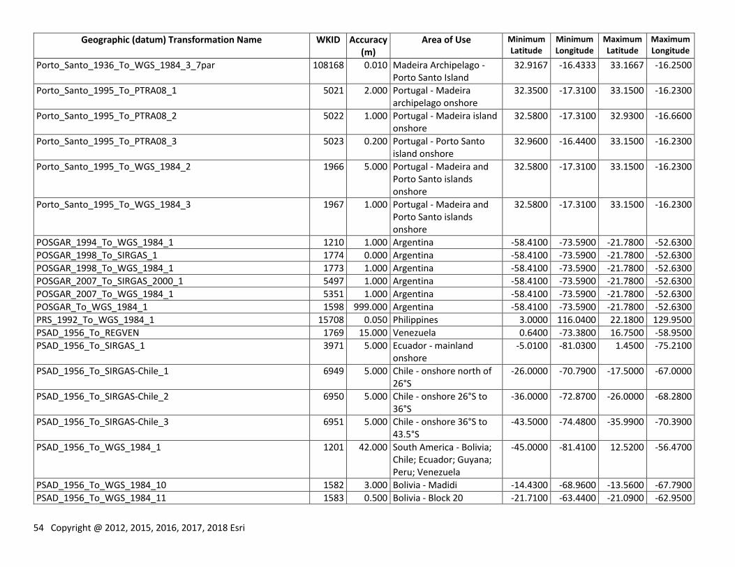
54 Copyright @ 2012, 2015, 2016, 2017, 2018 Esri
Geographic (datum) Transformation Name WKID Accuracy (m)
Area of Use Minimum Latitude
Minimum Longitude
Maximum Latitude
Maximum Longitude
Porto_Santo_1936_To_WGS_1984_3_7par 108168 0.010 Madeira Archipelago - Porto Santo Island
32.9167 -16.4333 33.1667 -16.2500
Porto_Santo_1995_To_PTRA08_1 5021 2.000 Portugal - Madeira archipelago onshore
32.3500 -17.3100 33.1500 -16.2300
Porto_Santo_1995_To_PTRA08_2 5022 1.000 Portugal - Madeira island onshore
32.5800 -17.3100 32.9300 -16.6600
Porto_Santo_1995_To_PTRA08_3 5023 0.200 Portugal - Porto Santo island onshore
32.9600 -16.4400 33.1500 -16.2300
Porto_Santo_1995_To_WGS_1984_2 1966 5.000 Portugal - Madeira and Porto Santo islands onshore
32.5800 -17.3100 33.1500 -16.2300
Porto_Santo_1995_To_WGS_1984_3 1967 1.000 Portugal - Madeira and Porto Santo islands onshore
32.5800 -17.3100 33.1500 -16.2300
POSGAR_1994_To_WGS_1984_1 1210 1.000 Argentina -58.4100 -73.5900 -21.7800 -52.6300
POSGAR_1998_To_SIRGAS_1 1774 0.000 Argentina -58.4100 -73.5900 -21.7800 -52.6300
POSGAR_1998_To_WGS_1984_1 1773 1.000 Argentina -58.4100 -73.5900 -21.7800 -52.6300
POSGAR_2007_To_SIRGAS_2000_1 5497 1.000 Argentina -58.4100 -73.5900 -21.7800 -52.6300
POSGAR_2007_To_WGS_1984_1 5351 1.000 Argentina -58.4100 -73.5900 -21.7800 -52.6300
POSGAR_To_WGS_1984_1 1598 999.000 Argentina -58.4100 -73.5900 -21.7800 -52.6300
PRS_1992_To_WGS_1984_1 15708 0.050 Philippines 3.0000 116.0400 22.1800 129.9500
PSAD_1956_To_REGVEN 1769 15.000 Venezuela 0.6400 -73.3800 16.7500 -58.9500
PSAD_1956_To_SIRGAS_1 3971 5.000 Ecuador - mainland onshore
-5.0100 -81.0300 1.4500 -75.2100
PSAD_1956_To_SIRGAS-Chile_1 6949 5.000 Chile - onshore north of 26°S
-26.0000 -70.7900 -17.5000 -67.0000
PSAD_1956_To_SIRGAS-Chile_2 6950 5.000 Chile - onshore 26°S to 36°S
-36.0000 -72.8700 -26.0000 -68.2800
PSAD_1956_To_SIRGAS-Chile_3 6951 5.000 Chile - onshore 36°S to 43.5°S
-43.5000 -74.4800 -35.9900 -70.3900
PSAD_1956_To_WGS_1984_1 1201 42.000 South America - Bolivia; Chile; Ecuador; Guyana; Peru; Venezuela
-45.0000 -81.4100 12.5200 -56.4700
PSAD_1956_To_WGS_1984_10 1582 3.000 Bolivia - Madidi -14.4300 -68.9600 -13.5600 -67.7900
PSAD_1956_To_WGS_1984_11 1583 0.500 Bolivia - Block 20 -21.7100 -63.4400 -21.0900 -62.9500
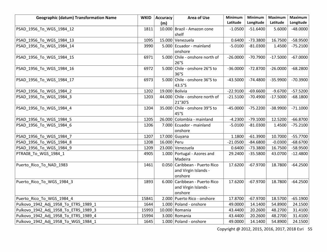
Copyright @ 2012, 2015, 2016, 2017, 2018 Esri 55
Geographic (datum) Transformation Name WKID Accuracy (m)
Area of Use Minimum Latitude
Minimum Longitude
Maximum Latitude
Maximum Longitude
PSAD_1956_To_WGS_1984_12 1811 10.000 Brazil - Amazon cone shelf
-1.0500 -51.6400 5.6000 -48.0000
PSAD_1956_To_WGS_1984_13 1095 15.000 Venezuela 0.6400 -73.3800 16.7500 -58.9500
PSAD_1956_To_WGS_1984_14 3990 5.000 Ecuador - mainland onshore
-5.0100 -81.0300 1.4500 -75.2100
PSAD_1956_To_WGS_1984_15 6971 5.000 Chile - onshore north of 26°S
-26.0000 -70.7900 -17.5000 -67.0000
PSAD_1956_To_WGS_1984_16 6972 5.000 Chile - onshore 26°S to 36°S
-36.0000 -72.8700 -26.0000 -68.2800
PSAD_1956_To_WGS_1984_17 6973 5.000 Chile - onshore 36°S to 43.5°S
-43.5000 -74.4800 -35.9900 -70.3900
PSAD_1956_To_WGS_1984_2 1202 19.000 Bolivia -22.9100 -69.6600 -9.6700 -57.5200
PSAD_1956_To_WGS_1984_3 1203 44.000 Chile - onshore north of 21°30'S
-21.5100 -70.4900 -17.5000 -68.1800
PSAD_1956_To_WGS_1984_4 1204 35.000 Chile - onshore 39°S to 45°S
-45.0000 -75.2200 -38.9900 -71.1000
PSAD_1956_To_WGS_1984_5 1205 26.000 Colombia - mainland -4.2300 -79.1000 12.5200 -66.8700
PSAD_1956_To_WGS_1984_6 1206 7.000 Ecuador - mainland onshore
-5.0100 -81.0300 1.4500 -75.2100
PSAD_1956_To_WGS_1984_7 1207 17.000 Guyana 1.1800 -61.3900 10.7000 -55.7700
PSAD_1956_To_WGS_1984_8 1208 16.000 Peru -21.0500 -84.6800 -0.0300 -68.6700
PSAD_1956_To_WGS_1984_9 1209 23.000 Venezuela 0.6400 -73.3800 16.7500 -58.9500
PTRA08_To_WGS_1984_1 4905 1.000 Portugal - Azores and Madeira
29.2400 -35.5800 43.0700 -12.4800
Puerto_Rico_To_NAD_1983 1461 0.050 Caribbean - Puerto Rico and Virgin Islands - onshore
17.6200 -67.9700 18.7800 -64.2500
Puerto_Rico_To_WGS_1984_3 1893 6.000 Caribbean - Puerto Rico and Virgin Islands - onshore
17.6200 -67.9700 18.7800 -64.2500
Puerto_Rico_To_WGS_1984_4 15841 2.000 Puerto Rico - onshore 17.8700 -67.9700 18.5700 -65.1900
Pulkovo_1942_Adj_1958_To_ETRS_1989_1 1644 1.000 Poland - onshore 49.0000 14.1400 54.8900 24.1500
Pulkovo_1942_Adj_1958_To_ETRS_1989_3 15993 10.000 Romania 43.4400 20.2600 48.2700 31.4100
Pulkovo_1942_Adj_1958_To_ETRS_1989_4 15994 3.000 Romania 43.4400 20.2600 48.2700 31.4100
Pulkovo_1942_Adj_1958_To_WGS_1984_1 1645 1.000 Poland - onshore 49.0000 14.1400 54.8900 24.1500
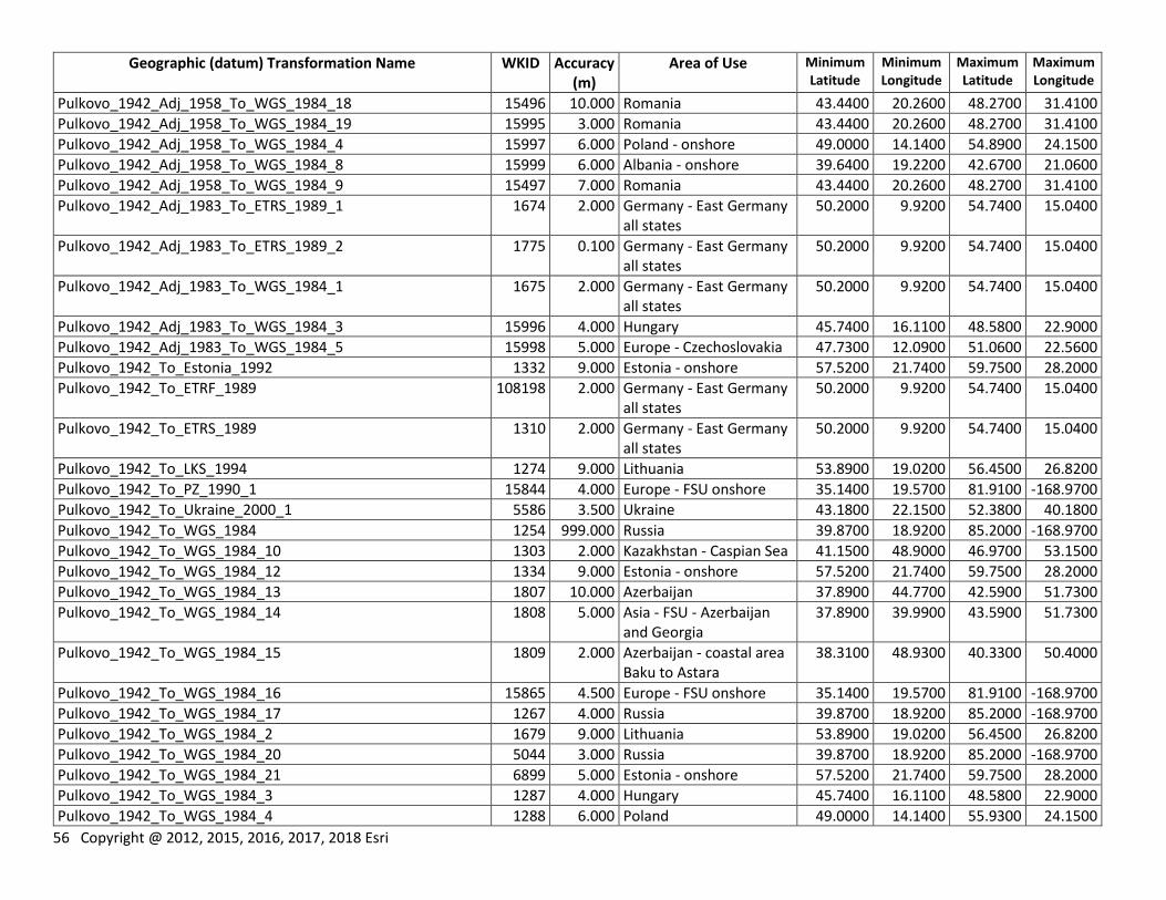
56 Copyright @ 2012, 2015, 2016, 2017, 2018 Esri
Geographic (datum) Transformation Name WKID Accuracy (m)
Area of Use Minimum Latitude
Minimum Longitude
Maximum Latitude
Maximum Longitude
Pulkovo_1942_Adj_1958_To_WGS_1984_18 15496 10.000 Romania 43.4400 20.2600 48.2700 31.4100
Pulkovo_1942_Adj_1958_To_WGS_1984_19 15995 3.000 Romania 43.4400 20.2600 48.2700 31.4100
Pulkovo_1942_Adj_1958_To_WGS_1984_4 15997 6.000 Poland - onshore 49.0000 14.1400 54.8900 24.1500
Pulkovo_1942_Adj_1958_To_WGS_1984_8 15999 6.000 Albania - onshore 39.6400 19.2200 42.6700 21.0600
Pulkovo_1942_Adj_1958_To_WGS_1984_9 15497 7.000 Romania 43.4400 20.2600 48.2700 31.4100
Pulkovo_1942_Adj_1983_To_ETRS_1989_1 1674 2.000 Germany - East Germany all states
50.2000 9.9200 54.7400 15.0400
Pulkovo_1942_Adj_1983_To_ETRS_1989_2 1775 0.100 Germany - East Germany all states
50.2000 9.9200 54.7400 15.0400
Pulkovo_1942_Adj_1983_To_WGS_1984_1 1675 2.000 Germany - East Germany all states
50.2000 9.9200 54.7400 15.0400
Pulkovo_1942_Adj_1983_To_WGS_1984_3 15996 4.000 Hungary 45.7400 16.1100 48.5800 22.9000
Pulkovo_1942_Adj_1983_To_WGS_1984_5 15998 5.000 Europe - Czechoslovakia 47.7300 12.0900 51.0600 22.5600
Pulkovo_1942_To_Estonia_1992 1332 9.000 Estonia - onshore 57.5200 21.7400 59.7500 28.2000
Pulkovo_1942_To_ETRF_1989 108198 2.000 Germany - East Germany all states
50.2000 9.9200 54.7400 15.0400
Pulkovo_1942_To_ETRS_1989 1310 2.000 Germany - East Germany all states
50.2000 9.9200 54.7400 15.0400
Pulkovo_1942_To_LKS_1994 1274 9.000 Lithuania 53.8900 19.0200 56.4500 26.8200
Pulkovo_1942_To_PZ_1990_1 15844 4.000 Europe - FSU onshore 35.1400 19.5700 81.9100 -168.9700
Pulkovo_1942_To_Ukraine_2000_1 5586 3.500 Ukraine 43.1800 22.1500 52.3800 40.1800
Pulkovo_1942_To_WGS_1984 1254 999.000 Russia 39.8700 18.9200 85.2000 -168.9700
Pulkovo_1942_To_WGS_1984_10 1303 2.000 Kazakhstan - Caspian Sea 41.1500 48.9000 46.9700 53.1500
Pulkovo_1942_To_WGS_1984_12 1334 9.000 Estonia - onshore 57.5200 21.7400 59.7500 28.2000
Pulkovo_1942_To_WGS_1984_13 1807 10.000 Azerbaijan 37.8900 44.7700 42.5900 51.7300
Pulkovo_1942_To_WGS_1984_14 1808 5.000 Asia - FSU - Azerbaijan and Georgia
37.8900 39.9900 43.5900 51.7300
Pulkovo_1942_To_WGS_1984_15 1809 2.000 Azerbaijan - coastal area Baku to Astara
38.3100 48.9300 40.3300 50.4000
Pulkovo_1942_To_WGS_1984_16 15865 4.500 Europe - FSU onshore 35.1400 19.5700 81.9100 -168.9700
Pulkovo_1942_To_WGS_1984_17 1267 4.000 Russia 39.8700 18.9200 85.2000 -168.9700
Pulkovo_1942_To_WGS_1984_2 1679 9.000 Lithuania 53.8900 19.0200 56.4500 26.8200
Pulkovo_1942_To_WGS_1984_20 5044 3.000 Russia 39.8700 18.9200 85.2000 -168.9700
Pulkovo_1942_To_WGS_1984_21 6899 5.000 Estonia - onshore 57.5200 21.7400 59.7500 28.2000
Pulkovo_1942_To_WGS_1984_3 1287 4.000 Hungary 45.7400 16.1100 48.5800 22.9000
Pulkovo_1942_To_WGS_1984_4 1288 6.000 Poland 49.0000 14.1400 55.9300 24.1500
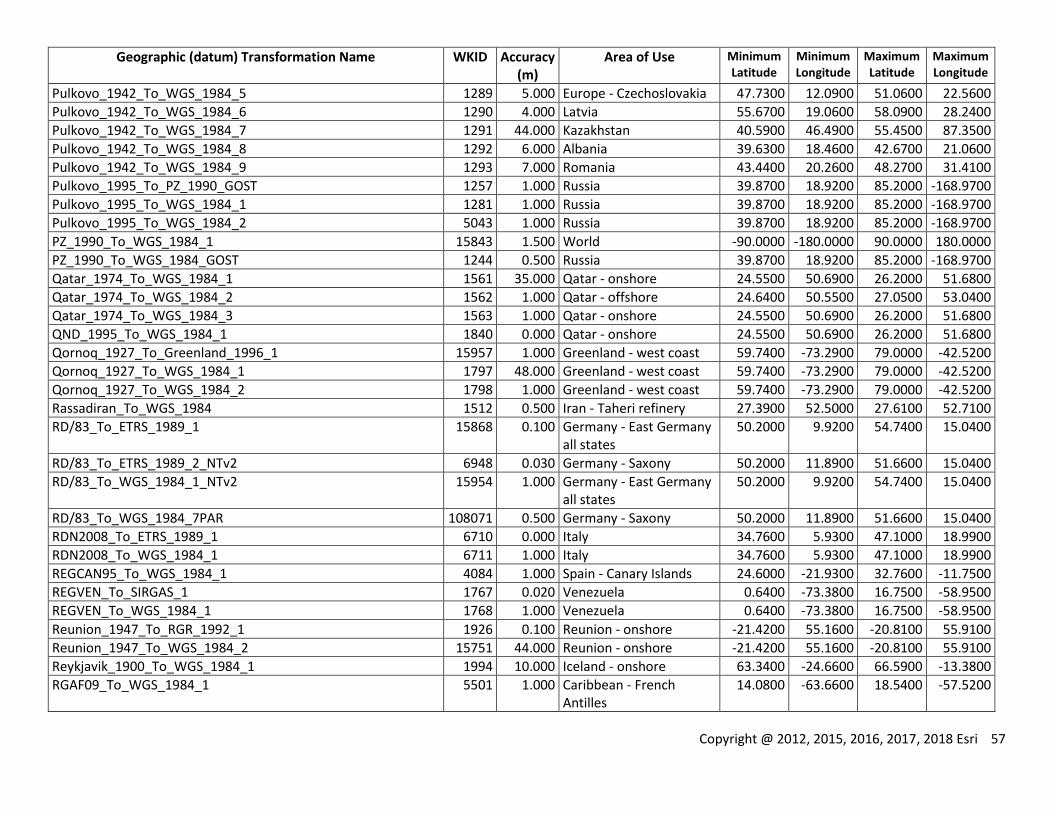
Copyright @ 2012, 2015, 2016, 2017, 2018 Esri 57
Geographic (datum) Transformation Name WKID Accuracy (m)
Area of Use Minimum Latitude
Minimum Longitude
Maximum Latitude
Maximum Longitude
Pulkovo_1942_To_WGS_1984_5 1289 5.000 Europe - Czechoslovakia 47.7300 12.0900 51.0600 22.5600
Pulkovo_1942_To_WGS_1984_6 1290 4.000 Latvia 55.6700 19.0600 58.0900 28.2400
Pulkovo_1942_To_WGS_1984_7 1291 44.000 Kazakhstan 40.5900 46.4900 55.4500 87.3500
Pulkovo_1942_To_WGS_1984_8 1292 6.000 Albania 39.6300 18.4600 42.6700 21.0600
Pulkovo_1942_To_WGS_1984_9 1293 7.000 Romania 43.4400 20.2600 48.2700 31.4100
Pulkovo_1995_To_PZ_1990_GOST 1257 1.000 Russia 39.8700 18.9200 85.2000 -168.9700
Pulkovo_1995_To_WGS_1984_1 1281 1.000 Russia 39.8700 18.9200 85.2000 -168.9700
Pulkovo_1995_To_WGS_1984_2 5043 1.000 Russia 39.8700 18.9200 85.2000 -168.9700
PZ_1990_To_WGS_1984_1 15843 1.500 World -90.0000 -180.0000 90.0000 180.0000
PZ_1990_To_WGS_1984_GOST 1244 0.500 Russia 39.8700 18.9200 85.2000 -168.9700
Qatar_1974_To_WGS_1984_1 1561 35.000 Qatar - onshore 24.5500 50.6900 26.2000 51.6800
Qatar_1974_To_WGS_1984_2 1562 1.000 Qatar - offshore 24.6400 50.5500 27.0500 53.0400
Qatar_1974_To_WGS_1984_3 1563 1.000 Qatar - onshore 24.5500 50.6900 26.2000 51.6800
QND_1995_To_WGS_1984_1 1840 0.000 Qatar - onshore 24.5500 50.6900 26.2000 51.6800
Qornoq_1927_To_Greenland_1996_1 15957 1.000 Greenland - west coast 59.7400 -73.2900 79.0000 -42.5200
Qornoq_1927_To_WGS_1984_1 1797 48.000 Greenland - west coast 59.7400 -73.2900 79.0000 -42.5200
Qornoq_1927_To_WGS_1984_2 1798 1.000 Greenland - west coast 59.7400 -73.2900 79.0000 -42.5200
Rassadiran_To_WGS_1984 1512 0.500 Iran - Taheri refinery 27.3900 52.5000 27.6100 52.7100
RD/83_To_ETRS_1989_1 15868 0.100 Germany - East Germany all states
50.2000 9.9200 54.7400 15.0400
RD/83_To_ETRS_1989_2_NTv2 6948 0.030 Germany - Saxony 50.2000 11.8900 51.6600 15.0400
RD/83_To_WGS_1984_1_NTv2 15954 1.000 Germany - East Germany all states
50.2000 9.9200 54.7400 15.0400
RD/83_To_WGS_1984_7PAR 108071 0.500 Germany - Saxony 50.2000 11.8900 51.6600 15.0400
RDN2008_To_ETRS_1989_1 6710 0.000 Italy 34.7600 5.9300 47.1000 18.9900
RDN2008_To_WGS_1984_1 6711 1.000 Italy 34.7600 5.9300 47.1000 18.9900
REGCAN95_To_WGS_1984_1 4084 1.000 Spain - Canary Islands 24.6000 -21.9300 32.7600 -11.7500
REGVEN_To_SIRGAS_1 1767 0.020 Venezuela 0.6400 -73.3800 16.7500 -58.9500
REGVEN_To_WGS_1984_1 1768 1.000 Venezuela 0.6400 -73.3800 16.7500 -58.9500
Reunion_1947_To_RGR_1992_1 1926 0.100 Reunion - onshore -21.4200 55.1600 -20.8100 55.9100
Reunion_1947_To_WGS_1984_2 15751 44.000 Reunion - onshore -21.4200 55.1600 -20.8100 55.9100
Reykjavik_1900_To_WGS_1984_1 1994 10.000 Iceland - onshore 63.3400 -24.6600 66.5900 -13.3800
RGAF09_To_WGS_1984_1 5501 1.000 Caribbean - French Antilles
14.0800 -63.6600 18.5400 -57.5200
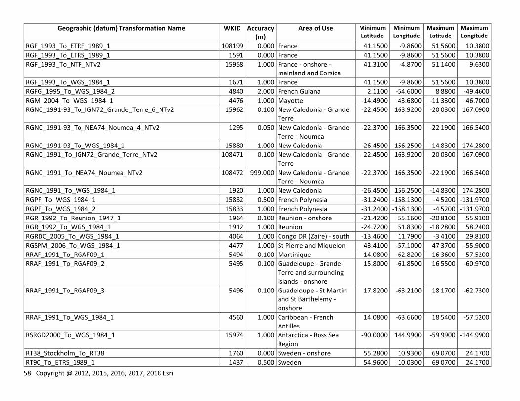
58 Copyright @ 2012, 2015, 2016, 2017, 2018 Esri
Geographic (datum) Transformation Name WKID Accuracy (m)
Area of Use Minimum Latitude
Minimum Longitude
Maximum Latitude
Maximum Longitude
RGF_1993_To_ETRF_1989_1 108199 0.000 France 41.1500 -9.8600 51.5600 10.3800
RGF_1993_To_ETRS_1989_1 1591 0.000 France 41.1500 -9.8600 51.5600 10.3800
RGF_1993_To_NTF_NTv2 15958 1.000 France - onshore - mainland and Corsica
41.3100 -4.8700 51.1400 9.6300
RGF_1993_To_WGS_1984_1 1671 1.000 France 41.1500 -9.8600 51.5600 10.3800
RGFG_1995_To_WGS_1984_2 4840 2.000 French Guiana 2.1100 -54.6000 8.8800 -49.4600
RGM_2004_To_WGS_1984_1 4476 1.000 Mayotte -14.4900 43.6800 -11.3300 46.7000
RGNC_1991-93_To_IGN72_Grande_Terre_6_NTv2 15962 0.100 New Caledonia - Grande Terre
-22.4500 163.9200 -20.0300 167.0900
RGNC_1991-93_To_NEA74_Noumea_4_NTv2 1295 0.050 New Caledonia - Grande Terre - Noumea
-22.3700 166.3500 -22.1900 166.5400
RGNC_1991-93_To_WGS_1984_1 15880 1.000 New Caledonia -26.4500 156.2500 -14.8300 174.2800
RGNC_1991_To_IGN72_Grande_Terre_NTv2 108471 0.100 New Caledonia - Grande Terre
-22.4500 163.9200 -20.0300 167.0900
RGNC_1991_To_NEA74_Noumea_NTv2 108472 999.000 New Caledonia - Grande Terre - Noumea
-22.3700 166.3500 -22.1900 166.5400
RGNC_1991_To_WGS_1984_1 1920 1.000 New Caledonia -26.4500 156.2500 -14.8300 174.2800
RGPF_To_WGS_1984_1 15832 0.500 French Polynesia -31.2400 -158.1300 -4.5200 -131.9700
RGPF_To_WGS_1984_2 15833 1.000 French Polynesia -31.2400 -158.1300 -4.5200 -131.9700
RGR_1992_To_Reunion_1947_1 1964 0.100 Reunion - onshore -21.4200 55.1600 -20.8100 55.9100
RGR_1992_To_WGS_1984_1 1912 1.000 Reunion -24.7200 51.8300 -18.2800 58.2400
RGRDC_2005_To_WGS_1984_1 4064 1.000 Congo DR (Zaire) - south -13.4600 11.7900 -3.4100 29.8100
RGSPM_2006_To_WGS_1984_1 4477 1.000 St Pierre and Miquelon 43.4100 -57.1000 47.3700 -55.9000
RRAF_1991_To_RGAF09_1 5494 0.100 Martinique 14.0800 -62.8200 16.3600 -57.5200
RRAF_1991_To_RGAF09_2 5495 0.100 Guadeloupe - Grande-Terre and surrounding islands - onshore
15.8000 -61.8500 16.5500 -60.9700
RRAF_1991_To_RGAF09_3 5496 0.100 Guadeloupe - St Martin and St Barthelemy - onshore
17.8200 -63.2100 18.1700 -62.7300
RRAF_1991_To_WGS_1984_1 4560 1.000 Caribbean - French Antilles
14.0800 -63.6600 18.5400 -57.5200
RSRGD2000_To_WGS_1984_1 15974 1.000 Antarctica - Ross Sea Region
-90.0000 144.9900 -59.9900 -144.9900
RT38_Stockholm_To_RT38 1760 0.000 Sweden - onshore 55.2800 10.9300 69.0700 24.1700
RT90_To_ETRS_1989_1 1437 0.500 Sweden 54.9600 10.0300 69.0700 24.1700
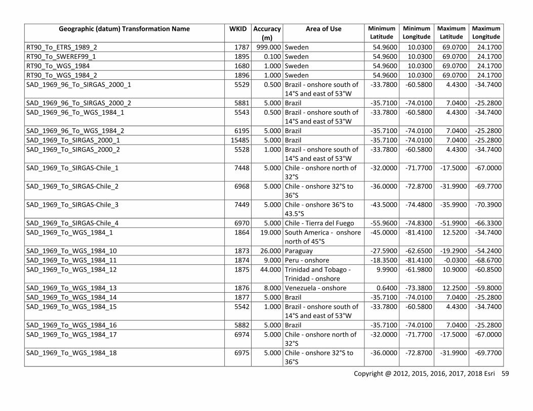
Copyright @ 2012, 2015, 2016, 2017, 2018 Esri 59
Geographic (datum) Transformation Name WKID Accuracy (m)
Area of Use Minimum Latitude
Minimum Longitude
Maximum Latitude
Maximum Longitude
RT90_To_ETRS_1989_2 1787 999.000 Sweden 54.9600 10.0300 69.0700 24.1700
RT90_To_SWEREF99_1 1895 0.100 Sweden 54.9600 10.0300 69.0700 24.1700
RT90_To_WGS_1984 1680 1.000 Sweden 54.9600 10.0300 69.0700 24.1700
RT90_To_WGS_1984_2 1896 1.000 Sweden 54.9600 10.0300 69.0700 24.1700
SAD_1969_96_To_SIRGAS_2000_1 5529 0.500 Brazil - onshore south of 14°S and east of 53°W
-33.7800 -60.5800 4.4300 -34.7400
SAD_1969_96_To_SIRGAS_2000_2 5881 5.000 Brazil -35.7100 -74.0100 7.0400 -25.2800
SAD_1969_96_To_WGS_1984_1 5543 0.500 Brazil - onshore south of 14°S and east of 53°W
-33.7800 -60.5800 4.4300 -34.7400
SAD_1969_96_To_WGS_1984_2 6195 5.000 Brazil -35.7100 -74.0100 7.0400 -25.2800
SAD_1969_To_SIRGAS_2000_1 15485 5.000 Brazil -35.7100 -74.0100 7.0400 -25.2800
SAD_1969_To_SIRGAS_2000_2 5528 1.000 Brazil - onshore south of 14°S and east of 53°W
-33.7800 -60.5800 4.4300 -34.7400
SAD_1969_To_SIRGAS-Chile_1 7448 5.000 Chile - onshore north of 32°S
-32.0000 -71.7700 -17.5000 -67.0000
SAD_1969_To_SIRGAS-Chile_2 6968 5.000 Chile - onshore 32°S to 36°S
-36.0000 -72.8700 -31.9900 -69.7700
SAD_1969_To_SIRGAS-Chile_3 7449 5.000 Chile - onshore 36°S to 43.5°S
-43.5000 -74.4800 -35.9900 -70.3900
SAD_1969_To_SIRGAS-Chile_4 6970 5.000 Chile - Tierra del Fuego -55.9600 -74.8300 -51.9900 -66.3300
SAD_1969_To_WGS_1984_1 1864 19.000 South America - onshore north of 45°S
-45.0000 -81.4100 12.5200 -34.7400
SAD_1969_To_WGS_1984_10 1873 26.000 Paraguay -27.5900 -62.6500 -19.2900 -54.2400
SAD_1969_To_WGS_1984_11 1874 9.000 Peru - onshore -18.3500 -81.4100 -0.0300 -68.6700
SAD_1969_To_WGS_1984_12 1875 44.000 Trinidad and Tobago - Trinidad - onshore
9.9900 -61.9800 10.9000 -60.8500
SAD_1969_To_WGS_1984_13 1876 8.000 Venezuela - onshore 0.6400 -73.3800 12.2500 -59.8000
SAD_1969_To_WGS_1984_14 1877 5.000 Brazil -35.7100 -74.0100 7.0400 -25.2800
SAD_1969_To_WGS_1984_15 5542 1.000 Brazil - onshore south of 14°S and east of 53°W
-33.7800 -60.5800 4.4300 -34.7400
SAD_1969_To_WGS_1984_16 5882 5.000 Brazil -35.7100 -74.0100 7.0400 -25.2800
SAD_1969_To_WGS_1984_17 6974 5.000 Chile - onshore north of 32°S
-32.0000 -71.7700 -17.5000 -67.0000
SAD_1969_To_WGS_1984_18 6975 5.000 Chile - onshore 32°S to 36°S
-36.0000 -72.8700 -31.9900 -69.7700
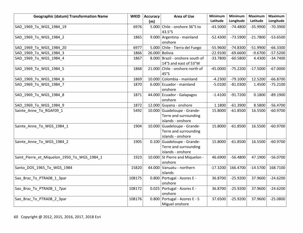
60 Copyright @ 2012, 2015, 2016, 2017, 2018 Esri
Geographic (datum) Transformation Name WKID Accuracy (m)
Area of Use Minimum Latitude
Minimum Longitude
Maximum Latitude
Maximum Longitude
SAD_1969_To_WGS_1984_19 6976 5.000 Chile - onshore 36°S to 43.5°S
-43.5000 -74.4800 -35.9900 -70.3900
SAD_1969_To_WGS_1984_2 1865 9.000 Argentina - mainland onshore
-52.4300 -73.5900 -21.7800 -53.6500
SAD_1969_To_WGS_1984_20 6977 5.000 Chile - Tierra del Fuego -55.9600 -74.8300 -51.9900 -66.3300
SAD_1969_To_WGS_1984_3 1866 26.000 Bolivia -22.9100 -69.6600 -9.6700 -57.5200
SAD_1969_To_WGS_1984_4 1867 8.000 Brazil - onshore south of 14°S and east of 53°W
-33.7800 -60.5800 4.4300 -34.7400
SAD_1969_To_WGS_1984_5 1868 21.000 Chile - onshore north of 45°S
-45.0000 -75.2200 -17.5000 -67.0000
SAD_1969_To_WGS_1984_6 1869 10.000 Colombia - mainland -4.2300 -79.1000 12.5200 -66.8700
SAD_1969_To_WGS_1984_7 1870 6.000 Ecuador - mainland onshore
-5.0100 -81.0300 1.4500 -75.2100
SAD_1969_To_WGS_1984_8 1871 44.000 Ecuador - Galapagos onshore
-1.4100 -91.7200 0.1800 -89.1900
SAD_1969_To_WGS_1984_9 1872 12.000 Guyana - onshore 1.1800 -61.3900 8.5800 -56.4700
Sainte_Anne_To_RGAF09_1 5492 10.000 Guadeloupe - Grande-Terre and surrounding islands - onshore
15.8000 -61.8500 16.5500 -60.9700
Sainte_Anne_To_WGS_1984_1 1904 10.000 Guadeloupe - Grande-Terre and surrounding islands - onshore
15.8000 -61.8500 16.5500 -60.9700
Sainte_Anne_To_WGS_1984_2 1905 0.100 Guadeloupe - Grande-Terre and surrounding islands - onshore
15.8000 -61.8500 16.5500 -60.9700
Saint_Pierre_et_Miquelon_1950_To_WGS_1984_1 1923 10.000 St Pierre and Miquelon - onshore
46.6900 -56.4800 47.1900 -56.0700
Santo_DOS_1965_To_WGS_1984 15820 44.000 Vanuatu - northern islands
-17.3200 166.4700 -14.5700 168.7100
Sao_Braz_To_PTRA08_1_3par 108175 0.800 Portugal - Azores E - onshore
36.8700 -25.9200 37.9600 -24.6200
Sao_Braz_To_PTRA08_1_7par 108172 0.025 Portugal - Azores E - onshore
36.8700 -25.9200 37.9600 -24.6200
Sao_Braz_To_PTRA08_2_3par 108176 0.800 Portugal - Azores E - S Miguel onshore
37.6500 -25.9200 37.9600 -25.0800
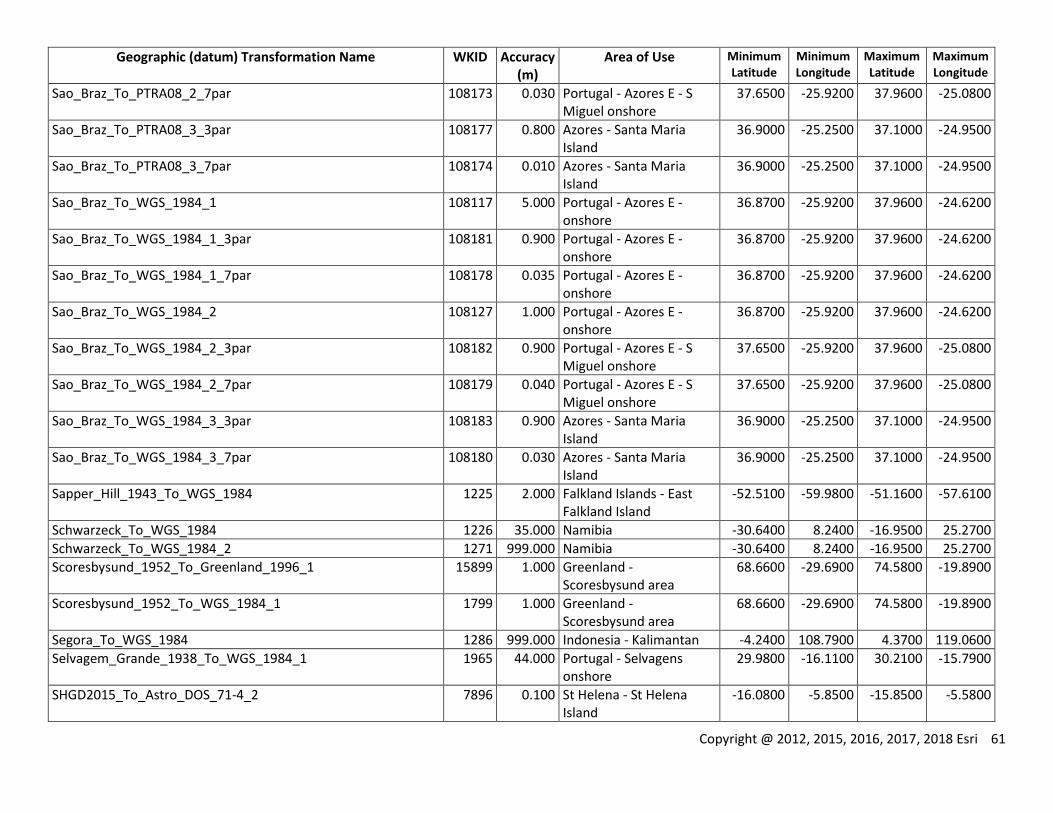
Copyright @ 2012, 2015, 2016, 2017, 2018 Esri 61
Geographic (datum) Transformation Name WKID Accuracy (m)
Area of Use Minimum Latitude
Minimum Longitude
Maximum Latitude
Maximum Longitude
Sao_Braz_To_PTRA08_2_7par 108173 0.030 Portugal - Azores E - S Miguel onshore
37.6500 -25.9200 37.9600 -25.0800
Sao_Braz_To_PTRA08_3_3par 108177 0.800 Azores - Santa Maria Island
36.9000 -25.2500 37.1000 -24.9500
Sao_Braz_To_PTRA08_3_7par 108174 0.010 Azores - Santa Maria Island
36.9000 -25.2500 37.1000 -24.9500
Sao_Braz_To_WGS_1984_1 108117 5.000 Portugal - Azores E - onshore
36.8700 -25.9200 37.9600 -24.6200
Sao_Braz_To_WGS_1984_1_3par 108181 0.900 Portugal - Azores E - onshore
36.8700 -25.9200 37.9600 -24.6200
Sao_Braz_To_WGS_1984_1_7par 108178 0.035 Portugal - Azores E - onshore
36.8700 -25.9200 37.9600 -24.6200
Sao_Braz_To_WGS_1984_2 108127 1.000 Portugal - Azores E - onshore
36.8700 -25.9200 37.9600 -24.6200
Sao_Braz_To_WGS_1984_2_3par 108182 0.900 Portugal - Azores E - S Miguel onshore
37.6500 -25.9200 37.9600 -25.0800
Sao_Braz_To_WGS_1984_2_7par 108179 0.040 Portugal - Azores E - S Miguel onshore
37.6500 -25.9200 37.9600 -25.0800
Sao_Braz_To_WGS_1984_3_3par 108183 0.900 Azores - Santa Maria Island
36.9000 -25.2500 37.1000 -24.9500
Sao_Braz_To_WGS_1984_3_7par 108180 0.030 Azores - Santa Maria Island
36.9000 -25.2500 37.1000 -24.9500
Sapper_Hill_1943_To_WGS_1984 1225 2.000 Falkland Islands - East Falkland Island
-52.5100 -59.9800 -51.1600 -57.6100
Schwarzeck_To_WGS_1984 1226 35.000 Namibia -30.6400 8.2400 -16.9500 25.2700
Schwarzeck_To_WGS_1984_2 1271 999.000 Namibia -30.6400 8.2400 -16.9500 25.2700
Scoresbysund_1952_To_Greenland_1996_1 15899 1.000 Greenland - Scoresbysund area
68.6600 -29.6900 74.5800 -19.8900
Scoresbysund_1952_To_WGS_1984_1 1799 1.000 Greenland - Scoresbysund area
68.6600 -29.6900 74.5800 -19.8900
Segora_To_WGS_1984 1286 999.000 Indonesia - Kalimantan -4.2400 108.7900 4.3700 119.0600
Selvagem_Grande_1938_To_WGS_1984_1 1965 44.000 Portugal - Selvagens onshore
29.9800 -16.1100 30.2100 -15.7900
SHGD2015_To_Astro_DOS_71-4_2 7896 0.100 St Helena - St Helena Island
-16.0800 -5.8500 -15.8500 -5.5800
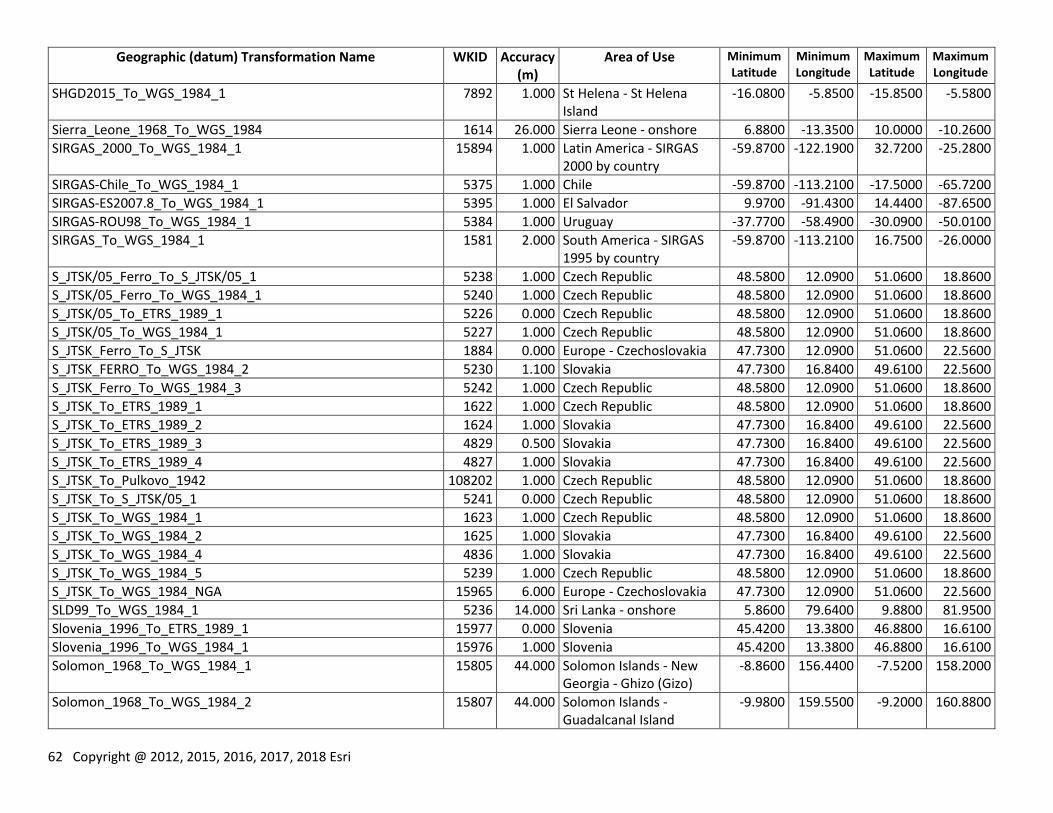
62 Copyright @ 2012, 2015, 2016, 2017, 2018 Esri
Geographic (datum) Transformation Name WKID Accuracy (m)
Area of Use Minimum Latitude
Minimum Longitude
Maximum Latitude
Maximum Longitude
SHGD2015_To_WGS_1984_1 7892 1.000 St Helena - St Helena Island
-16.0800 -5.8500 -15.8500 -5.5800
Sierra_Leone_1968_To_WGS_1984 1614 26.000 Sierra Leone - onshore 6.8800 -13.3500 10.0000 -10.2600
SIRGAS_2000_To_WGS_1984_1 15894 1.000 Latin America - SIRGAS 2000 by country
-59.8700 -122.1900 32.7200 -25.2800
SIRGAS-Chile_To_WGS_1984_1 5375 1.000 Chile -59.8700 -113.2100 -17.5000 -65.7200
SIRGAS-ES2007.8_To_WGS_1984_1 5395 1.000 El Salvador 9.9700 -91.4300 14.4400 -87.6500
SIRGAS-ROU98_To_WGS_1984_1 5384 1.000 Uruguay -37.7700 -58.4900 -30.0900 -50.0100
SIRGAS_To_WGS_1984_1 1581 2.000 South America - SIRGAS 1995 by country
-59.8700 -113.2100 16.7500 -26.0000
S_JTSK/05_Ferro_To_S_JTSK/05_1 5238 1.000 Czech Republic 48.5800 12.0900 51.0600 18.8600
S_JTSK/05_Ferro_To_WGS_1984_1 5240 1.000 Czech Republic 48.5800 12.0900 51.0600 18.8600
S_JTSK/05_To_ETRS_1989_1 5226 0.000 Czech Republic 48.5800 12.0900 51.0600 18.8600
S_JTSK/05_To_WGS_1984_1 5227 1.000 Czech Republic 48.5800 12.0900 51.0600 18.8600
S_JTSK_Ferro_To_S_JTSK 1884 0.000 Europe - Czechoslovakia 47.7300 12.0900 51.0600 22.5600
S_JTSK_FERRO_To_WGS_1984_2 5230 1.100 Slovakia 47.7300 16.8400 49.6100 22.5600
S_JTSK_Ferro_To_WGS_1984_3 5242 1.000 Czech Republic 48.5800 12.0900 51.0600 18.8600
S_JTSK_To_ETRS_1989_1 1622 1.000 Czech Republic 48.5800 12.0900 51.0600 18.8600
S_JTSK_To_ETRS_1989_2 1624 1.000 Slovakia 47.7300 16.8400 49.6100 22.5600
S_JTSK_To_ETRS_1989_3 4829 0.500 Slovakia 47.7300 16.8400 49.6100 22.5600
S_JTSK_To_ETRS_1989_4 4827 1.000 Slovakia 47.7300 16.8400 49.6100 22.5600
S_JTSK_To_Pulkovo_1942 108202 1.000 Czech Republic 48.5800 12.0900 51.0600 18.8600
S_JTSK_To_S_JTSK/05_1 5241 0.000 Czech Republic 48.5800 12.0900 51.0600 18.8600
S_JTSK_To_WGS_1984_1 1623 1.000 Czech Republic 48.5800 12.0900 51.0600 18.8600
S_JTSK_To_WGS_1984_2 1625 1.000 Slovakia 47.7300 16.8400 49.6100 22.5600
S_JTSK_To_WGS_1984_4 4836 1.000 Slovakia 47.7300 16.8400 49.6100 22.5600
S_JTSK_To_WGS_1984_5 5239 1.000 Czech Republic 48.5800 12.0900 51.0600 18.8600
S_JTSK_To_WGS_1984_NGA 15965 6.000 Europe - Czechoslovakia 47.7300 12.0900 51.0600 22.5600
SLD99_To_WGS_1984_1 5236 14.000 Sri Lanka - onshore 5.8600 79.6400 9.8800 81.9500
Slovenia_1996_To_ETRS_1989_1 15977 0.000 Slovenia 45.4200 13.3800 46.8800 16.6100
Slovenia_1996_To_WGS_1984_1 15976 1.000 Slovenia 45.4200 13.3800 46.8800 16.6100
Solomon_1968_To_WGS_1984_1 15805 44.000 Solomon Islands - New Georgia - Ghizo (Gizo)
-8.8600 156.4400 -7.5200 158.2000
Solomon_1968_To_WGS_1984_2 15807 44.000 Solomon Islands - Guadalcanal Island
-9.9800 159.5500 -9.2000 160.8800
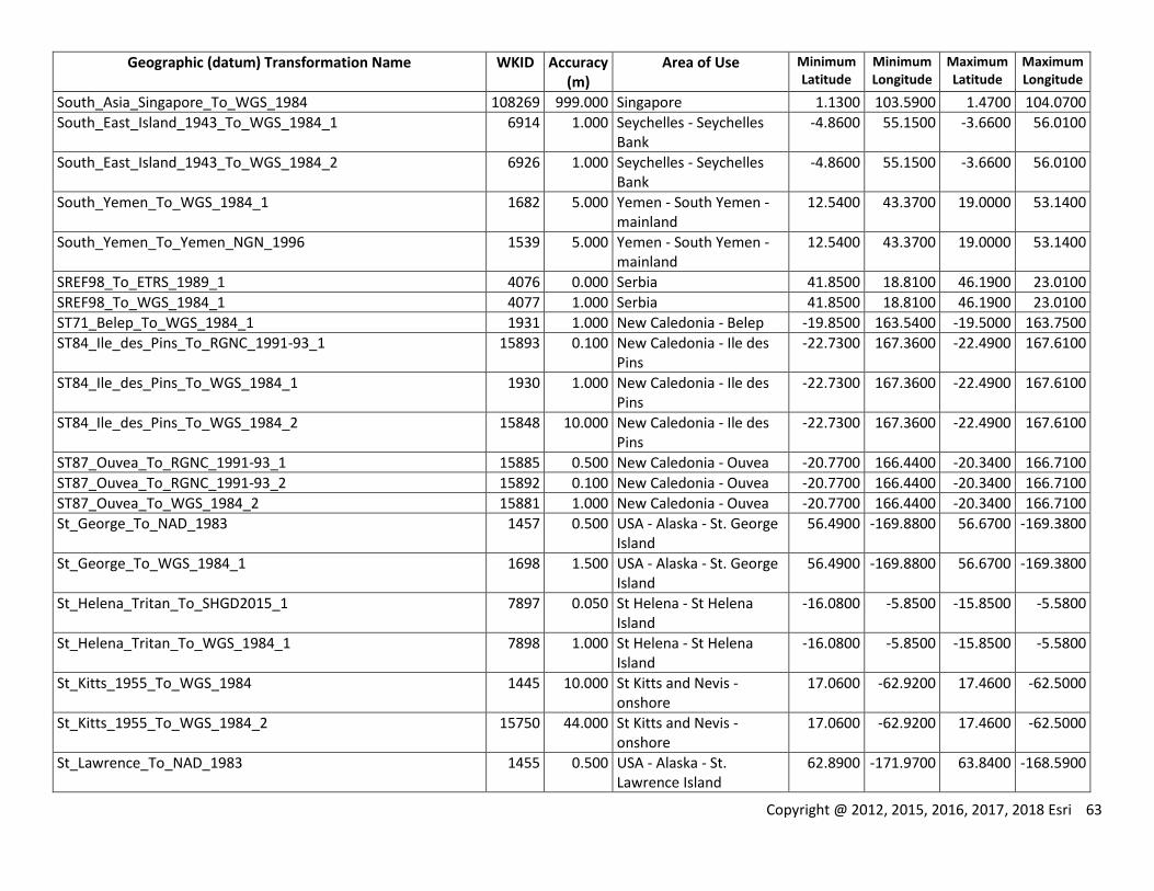
Copyright @ 2012, 2015, 2016, 2017, 2018 Esri 63
Geographic (datum) Transformation Name WKID Accuracy (m)
Area of Use Minimum Latitude
Minimum Longitude
Maximum Latitude
Maximum Longitude
South_Asia_Singapore_To_WGS_1984 108269 999.000 Singapore 1.1300 103.5900 1.4700 104.0700
South_East_Island_1943_To_WGS_1984_1 6914 1.000 Seychelles - Seychelles Bank
-4.8600 55.1500 -3.6600 56.0100
South_East_Island_1943_To_WGS_1984_2 6926 1.000 Seychelles - Seychelles Bank
-4.8600 55.1500 -3.6600 56.0100
South_Yemen_To_WGS_1984_1 1682 5.000 Yemen - South Yemen - mainland
12.5400 43.3700 19.0000 53.1400
South_Yemen_To_Yemen_NGN_1996 1539 5.000 Yemen - South Yemen - mainland
12.5400 43.3700 19.0000 53.1400
SREF98_To_ETRS_1989_1 4076 0.000 Serbia 41.8500 18.8100 46.1900 23.0100
SREF98_To_WGS_1984_1 4077 1.000 Serbia 41.8500 18.8100 46.1900 23.0100
ST71_Belep_To_WGS_1984_1 1931 1.000 New Caledonia - Belep -19.8500 163.5400 -19.5000 163.7500
ST84_Ile_des_Pins_To_RGNC_1991-93_1 15893 0.100 New Caledonia - Ile des Pins
-22.7300 167.3600 -22.4900 167.6100
ST84_Ile_des_Pins_To_WGS_1984_1 1930 1.000 New Caledonia - Ile des Pins
-22.7300 167.3600 -22.4900 167.6100
ST84_Ile_des_Pins_To_WGS_1984_2 15848 10.000 New Caledonia - Ile des Pins
-22.7300 167.3600 -22.4900 167.6100
ST87_Ouvea_To_RGNC_1991-93_1 15885 0.500 New Caledonia - Ouvea -20.7700 166.4400 -20.3400 166.7100
ST87_Ouvea_To_RGNC_1991-93_2 15892 0.100 New Caledonia - Ouvea -20.7700 166.4400 -20.3400 166.7100
ST87_Ouvea_To_WGS_1984_2 15881 1.000 New Caledonia - Ouvea -20.7700 166.4400 -20.3400 166.7100
St_George_To_NAD_1983 1457 0.500 USA - Alaska - St. George Island
56.4900 -169.8800 56.6700 -169.3800
St_George_To_WGS_1984_1 1698 1.500 USA - Alaska - St. George Island
56.4900 -169.8800 56.6700 -169.3800
St_Helena_Tritan_To_SHGD2015_1 7897 0.050 St Helena - St Helena Island
-16.0800 -5.8500 -15.8500 -5.5800
St_Helena_Tritan_To_WGS_1984_1 7898 1.000 St Helena - St Helena Island
-16.0800 -5.8500 -15.8500 -5.5800
St_Kitts_1955_To_WGS_1984 1445 10.000 St Kitts and Nevis - onshore
17.0600 -62.9200 17.4600 -62.5000
St_Kitts_1955_To_WGS_1984_2 15750 44.000 St Kitts and Nevis - onshore
17.0600 -62.9200 17.4600 -62.5000
St_Lawrence_To_NAD_1983 1455 0.500 USA - Alaska - St. Lawrence Island
62.8900 -171.9700 63.8400 -168.5900

64 Copyright @ 2012, 2015, 2016, 2017, 2018 Esri
Geographic (datum) Transformation Name WKID Accuracy (m)
Area of Use Minimum Latitude
Minimum Longitude
Maximum Latitude
Maximum Longitude
St_Lawrence_To_WGS_1984_1 1699 1.500 USA - Alaska - St. Lawrence Island
62.8900 -171.9700 63.8400 -168.5900
St_Lucia_1955_To_WGS_1984 1446 10.000 St Lucia - onshore 13.6600 -61.1300 14.1600 -60.8200
St_Lucia_1955_To_WGS_1984_2 6897 2.000 St Lucia - onshore 13.6600 -61.1300 14.1600 -60.8200
St_Paul_To_NAD_1983 1456 0.500 USA - Alaska - St. Paul Island
57.0600 -170.5100 57.2800 -170.0400
St_Paul_To_WGS_1984_1 1700 1.500 USA - Alaska - St. Paul Island
57.0600 -170.5100 57.2800 -170.0400
S_TUREF_To_ETRS_1989_1 5260 0.100 Turkey 34.4200 25.6200 43.4500 44.8300
St_Vincent_1945_To_WGS_1984_1 1959 1.000 St Vincent and the Grenadines - onshore
12.5400 -61.5200 13.4400 -61.0700
SWEREF99_To_ETRS_1989_1 1878 0.000 Sweden 54.9600 10.0300 69.0700 24.1700
SWEREF99_To_RT90 108212 999.000 Sweden 54.9600 10.0300 69.0700 24.1700
SWEREF99_To_WGS_1984_1 1879 1.000 Sweden 54.9600 10.0300 69.0700 24.1700
Tahaa_1954_To_RGPF_1 15758 0.500 French Polynesia - Society Islands - Bora Bora, Huahine, Raiatea, Tahaa
-16.9600 -151.9100 -16.1700 -150.8900
Tahaa_1954_To_WGS_1984_1 1913 10.000 French Polynesia - Society Islands - Bora Bora, Huahine, Raiatea, Tahaa
-16.9600 -151.9100 -16.1700 -150.8900
Tahaa_1954_To_WGS_1984_2 15770 1.000 French Polynesia - Society Islands - Bora Bora, Huahine, Raiatea, Tahaa
-16.9600 -151.9100 -16.1700 -150.8900
Tahiti_1952_To_WGS_1984_1 1924 10.000 French Polynesia - Society Islands - Moorea and Tahiti
-17.9300 -150.0000 -17.4100 -149.1100
Tahiti_1979_To_RGPF_1 15756 0.500 French Polynesia - Society Islands - Tahiti
-17.9300 -149.7000 -17.4400 -149.0900
Tahiti_1979_To_WGS_1984_1 4835 1.000 French Polynesia - Society Islands - Tahiti
-17.9300 -149.7000 -17.4400 -149.0900
Tananarive_1925_Paris_To_Tananarive_1925 1265 0.000 Madagascar - onshore -25.6400 43.1800 -11.8900 50.5600
Tananarive_1925_Paris_To_WGS_1984 8176 100.000 Madagascar - onshore -25.6400 43.1800 -11.8900 50.5600
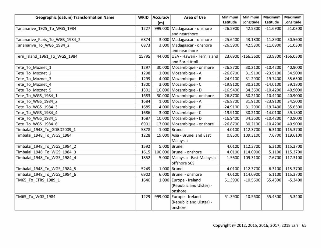
Copyright @ 2012, 2015, 2016, 2017, 2018 Esri 65
Geographic (datum) Transformation Name WKID Accuracy (m)
Area of Use Minimum Latitude
Minimum Longitude
Maximum Latitude
Maximum Longitude
Tananarive_1925_To_WGS_1984 1227 999.000 Madagascar - onshore and nearshore
-26.5900 42.5300 -11.6900 51.0300
Tananarive_Paris_To_WGS_1984_2 6874 3.000 Madagascar - onshore -25.6400 43.1800 -11.8900 50.5600
Tananarive_To_WGS_1984_2 6873 3.000 Madagascar - onshore and nearshore
-26.5900 42.5300 -11.6900 51.0300
Tern_Island_1961_To_WGS_1984 15795 44.000 USA - Hawaii - Tern Island and Sorel Atoll
23.6900 -166.3600 23.9300 -166.0300
Tete_To_Moznet_1 1297 30.000 Mozambique - onshore -26.8700 30.2100 -10.4200 40.9000
Tete_To_Moznet_2 1298 1.000 Mozambique - A -26.8700 31.9100 -23.9100 34.5000
Tete_To_Moznet_3 1299 4.000 Mozambique - B -24.9100 31.2900 -19.7400 35.6500
Tete_To_Moznet_4 1300 3.000 Mozambique - C -19.9100 30.2100 -14.0100 39.1800
Tete_To_Moznet_5 1301 10.000 Mozambique - D -16.9400 34.3600 -10.4200 40.9000
Tete_To_WGS_1984_1 1683 30.000 Mozambique - onshore -26.8700 30.2100 -10.4200 40.9000
Tete_To_WGS_1984_2 1684 1.000 Mozambique - A -26.8700 31.9100 -23.9100 34.5000
Tete_To_WGS_1984_3 1685 4.000 Mozambique - B -24.9100 31.2900 -19.7400 35.6500
Tete_To_WGS_1984_4 1686 3.000 Mozambique - C -19.9100 30.2100 -14.0100 39.1800
Tete_To_WGS_1984_5 1687 10.000 Mozambique - D -16.9400 34.3600 -10.4200 40.9000
Tete_To_WGS_1984_6 6901 17.000 Mozambique - onshore -26.8700 30.2100 -10.4200 40.9000
Timbalai_1948_To_GDBD2009_1 5878 1.000 Brunei 4.0100 112.3700 6.3100 115.3700
Timbalai_1948_To_WGS_1984 1228 19.000 Asia - Brunei and East Malaysia
0.8500 109.3100 7.6700 119.6100
Timbalai_1948_To_WGS_1984_2 1592 5.000 Brunei 4.0100 112.3700 6.3100 115.3700
Timbalai_1948_To_WGS_1984_3 1615 100.000 Brunei - onshore 4.0100 114.0900 5.1100 115.3700
Timbalai_1948_To_WGS_1984_4 1852 5.000 Malaysia - East Malaysia - offshore SCS
1.5600 109.3100 7.6700 117.3100
Timbalai_1948_To_WGS_1984_5 5249 1.000 Brunei 4.0100 112.3700 6.3100 115.3700
Timbalai_1948_To_WGS_1984_6 6902 6.000 Brunei - onshore 4.0100 114.0900 5.1100 115.3700
TM65_To_ETRS_1989_1 1640 1.000 Europe - Ireland (Republic and Ulster) - onshore
51.3900 -10.5600 55.4300 -5.3400
TM65_To_WGS_1984 1229 999.000 Europe - Ireland (Republic and Ulster) - onshore
51.3900 -10.5600 55.4300 -5.3400
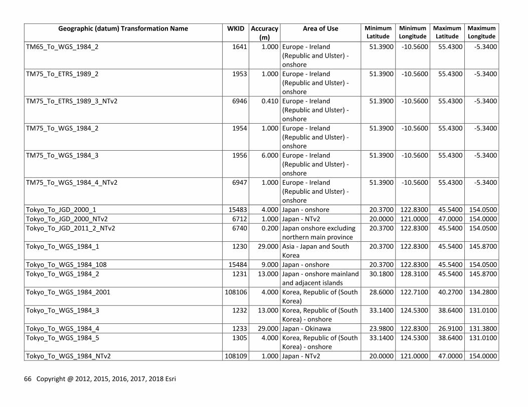
66 Copyright @ 2012, 2015, 2016, 2017, 2018 Esri
Geographic (datum) Transformation Name WKID Accuracy (m)
Area of Use Minimum Latitude
Minimum Longitude
Maximum Latitude
Maximum Longitude
TM65_To_WGS_1984_2 1641 1.000 Europe - Ireland (Republic and Ulster) - onshore
51.3900 -10.5600 55.4300 -5.3400
TM75_To_ETRS_1989_2 1953 1.000 Europe - Ireland (Republic and Ulster) - onshore
51.3900 -10.5600 55.4300 -5.3400
TM75_To_ETRS_1989_3_NTv2 6946 0.410 Europe - Ireland (Republic and Ulster) - onshore
51.3900 -10.5600 55.4300 -5.3400
TM75_To_WGS_1984_2 1954 1.000 Europe - Ireland (Republic and Ulster) - onshore
51.3900 -10.5600 55.4300 -5.3400
TM75_To_WGS_1984_3 1956 6.000 Europe - Ireland (Republic and Ulster) - onshore
51.3900 -10.5600 55.4300 -5.3400
TM75_To_WGS_1984_4_NTv2 6947 1.000 Europe - Ireland (Republic and Ulster) - onshore
51.3900 -10.5600 55.4300 -5.3400
Tokyo_To_JGD_2000_1 15483 4.000 Japan - onshore 20.3700 122.8300 45.5400 154.0500
Tokyo_To_JGD_2000_NTv2 6712 1.000 Japan - NTv2 20.0000 121.0000 47.0000 154.0000
Tokyo_To_JGD_2011_2_NTv2 6740 0.200 Japan onshore excluding northern main province
20.3700 122.8300 45.5400 154.0500
Tokyo_To_WGS_1984_1 1230 29.000 Asia - Japan and South Korea
20.3700 122.8300 45.5400 145.8700
Tokyo_To_WGS_1984_108 15484 9.000 Japan - onshore 20.3700 122.8300 45.5400 154.0500
Tokyo_To_WGS_1984_2 1231 13.000 Japan - onshore mainland and adjacent islands
30.1800 128.3100 45.5400 145.8700
Tokyo_To_WGS_1984_2001 108106 4.000 Korea, Republic of (South Korea)
28.6000 122.7100 40.2700 134.2800
Tokyo_To_WGS_1984_3 1232 13.000 Korea, Republic of (South Korea) - onshore
33.1400 124.5300 38.6400 131.0100
Tokyo_To_WGS_1984_4 1233 29.000 Japan - Okinawa 23.9800 122.8300 26.9100 131.3800
Tokyo_To_WGS_1984_5 1305 4.000 Korea, Republic of (South Korea) - onshore
33.1400 124.5300 38.6400 131.0100
Tokyo_To_WGS_1984_NTv2 108109 1.000 Japan - NTv2 20.0000 121.0000 47.0000 154.0000
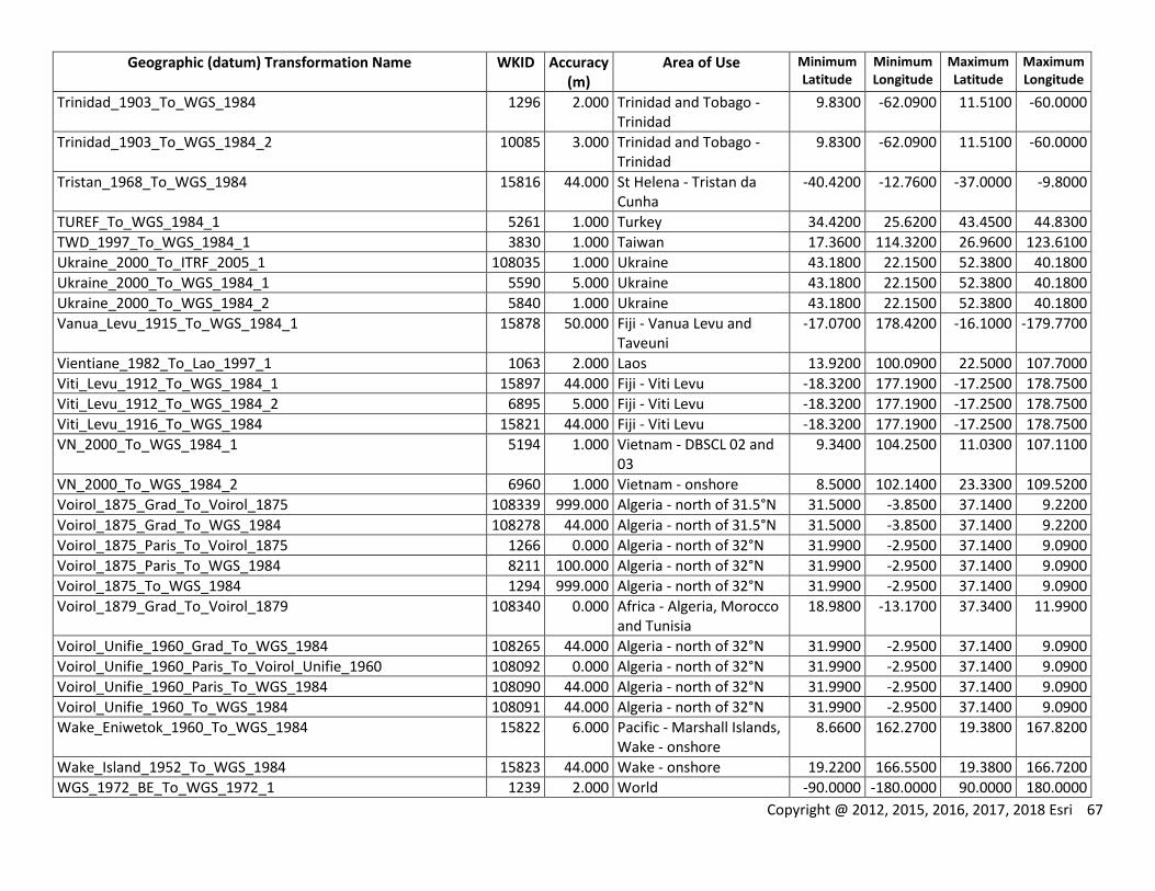
Copyright @ 2012, 2015, 2016, 2017, 2018 Esri 67
Geographic (datum) Transformation Name WKID Accuracy (m)
Area of Use Minimum Latitude
Minimum Longitude
Maximum Latitude
Maximum Longitude
Trinidad_1903_To_WGS_1984 1296 2.000 Trinidad and Tobago - Trinidad
9.8300 -62.0900 11.5100 -60.0000
Trinidad_1903_To_WGS_1984_2 10085 3.000 Trinidad and Tobago - Trinidad
9.8300 -62.0900 11.5100 -60.0000
Tristan_1968_To_WGS_1984 15816 44.000 St Helena - Tristan da Cunha
-40.4200 -12.7600 -37.0000 -9.8000
TUREF_To_WGS_1984_1 5261 1.000 Turkey 34.4200 25.6200 43.4500 44.8300
TWD_1997_To_WGS_1984_1 3830 1.000 Taiwan 17.3600 114.3200 26.9600 123.6100
Ukraine_2000_To_ITRF_2005_1 108035 1.000 Ukraine 43.1800 22.1500 52.3800 40.1800
Ukraine_2000_To_WGS_1984_1 5590 5.000 Ukraine 43.1800 22.1500 52.3800 40.1800
Ukraine_2000_To_WGS_1984_2 5840 1.000 Ukraine 43.1800 22.1500 52.3800 40.1800
Vanua_Levu_1915_To_WGS_1984_1 15878 50.000 Fiji - Vanua Levu and Taveuni
-17.0700 178.4200 -16.1000 -179.7700
Vientiane_1982_To_Lao_1997_1 1063 2.000 Laos 13.9200 100.0900 22.5000 107.7000
Viti_Levu_1912_To_WGS_1984_1 15897 44.000 Fiji - Viti Levu -18.3200 177.1900 -17.2500 178.7500
Viti_Levu_1912_To_WGS_1984_2 6895 5.000 Fiji - Viti Levu -18.3200 177.1900 -17.2500 178.7500
Viti_Levu_1916_To_WGS_1984 15821 44.000 Fiji - Viti Levu -18.3200 177.1900 -17.2500 178.7500
VN_2000_To_WGS_1984_1 5194 1.000 Vietnam - DBSCL 02 and 03
9.3400 104.2500 11.0300 107.1100
VN_2000_To_WGS_1984_2 6960 1.000 Vietnam - onshore 8.5000 102.1400 23.3300 109.5200
Voirol_1875_Grad_To_Voirol_1875 108339 999.000 Algeria - north of 31.5°N 31.5000 -3.8500 37.1400 9.2200
Voirol_1875_Grad_To_WGS_1984 108278 44.000 Algeria - north of 31.5°N 31.5000 -3.8500 37.1400 9.2200
Voirol_1875_Paris_To_Voirol_1875 1266 0.000 Algeria - north of 32°N 31.9900 -2.9500 37.1400 9.0900
Voirol_1875_Paris_To_WGS_1984 8211 100.000 Algeria - north of 32°N 31.9900 -2.9500 37.1400 9.0900
Voirol_1875_To_WGS_1984 1294 999.000 Algeria - north of 32°N 31.9900 -2.9500 37.1400 9.0900
Voirol_1879_Grad_To_Voirol_1879 108340 0.000 Africa - Algeria, Morocco and Tunisia
18.9800 -13.1700 37.3400 11.9900
Voirol_Unifie_1960_Grad_To_WGS_1984 108265 44.000 Algeria - north of 32°N 31.9900 -2.9500 37.1400 9.0900
Voirol_Unifie_1960_Paris_To_Voirol_Unifie_1960 108092 0.000 Algeria - north of 32°N 31.9900 -2.9500 37.1400 9.0900
Voirol_Unifie_1960_Paris_To_WGS_1984 108090 44.000 Algeria - north of 32°N 31.9900 -2.9500 37.1400 9.0900
Voirol_Unifie_1960_To_WGS_1984 108091 44.000 Algeria - north of 32°N 31.9900 -2.9500 37.1400 9.0900
Wake_Eniwetok_1960_To_WGS_1984 15822 6.000 Pacific - Marshall Islands, Wake - onshore
8.6600 162.2700 19.3800 167.8200
Wake_Island_1952_To_WGS_1984 15823 44.000 Wake - onshore 19.2200 166.5500 19.3800 166.7200
WGS_1972_BE_To_WGS_1972_1 1239 2.000 World -90.0000 -180.0000 90.0000 180.0000
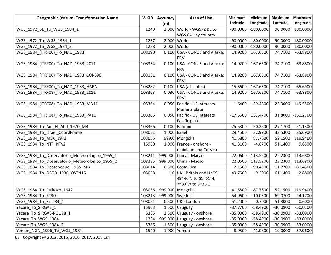
68 Copyright @ 2012, 2015, 2016, 2017, 2018 Esri
Geographic (datum) Transformation Name WKID Accuracy (m)
Area of Use Minimum Latitude
Minimum Longitude
Maximum Latitude
Maximum Longitude
WGS_1972_BE_To_WGS_1984_1 1240 2.000 World - WGS72 BE to WGS 84 - by country
-90.0000 -180.0000 90.0000 180.0000
WGS_1972_To_WGS_1984_1 1237 2.000 World -90.0000 -180.0000 90.0000 180.0000
WGS_1972_To_WGS_1984_2 1238 2.000 World -90.0000 -180.0000 90.0000 180.0000
WGS_1984_(ITRF00)_To_NAD_1983 108190 0.100 USA - CONUS and Alaska; PRVI
14.9200 167.6500 74.7100 -63.8800
WGS_1984_(ITRF00)_To_NAD_1983_2011 108354 0.100 USA - CONUS and Alaska; PRVI
14.9200 167.6500 74.7100 -63.8800
WGS_1984_(ITRF00)_To_NAD_1983_CORS96 108151 0.100 USA - CONUS and Alaska; PRVI
14.9200 167.6500 74.7100 -63.8800
WGS_1984_(ITRF00)_To_NAD_1983_HARN 108282 0.100 USA (all states) 15.5600 167.6500 74.7100 -65.6900
WGS_1984_(ITRF08)_To_NAD_1983_2011 108363 0.030 USA - CONUS and Alaska; PRVI
14.9200 167.6500 74.7100 -63.8800
WGS_1984_(ITRF08)_To_NAD_1983_MA11 108364 0.050 Pacific - US interests Mariana plate
1.6400 129.4800 23.9000 149.5500
WGS_1984_(ITRF08)_To_NAD_1983_PA11 108365 0.050 Pacific - US interests Pacific plate
-17.5600 157.4700 31.8000 -151.2700
WGS_1984_To_Ain_El_Abd_1970_MB 108366 0.100 Bahrain 25.5300 50.2600 27.1700 51.1300
WGS_1984_To_Israel_CoordFrame 108021 1.000 Israel 29.4500 32.9900 33.5300 35.6900
WGS_1984_To_MSK_1942 108055 999.0 Mongolia 41.5800 87.7600 52.1500 119.9400
WGS_1984_To_NTF_NTv2 15960 1.000 France - onshore - mainland and Corsica
41.3100 -4.8700 51.1400 9.6300
WGS_1984_To_Observatorio_Meteorologico_1965_1 108211 999.000 China - Macao 22.0600 113.5200 22.2300 113.6800
WGS_1984_To_Observatorio_Meteorologico_1965_2 108235 999.000 China - Macao 22.0600 113.5200 22.2300 113.6800
WGS_1984_To_Ocotepeque_1935_MB 108014 0.500 Costa Rica 2.1500 -90.4500 11.7700 -81.4300
WGS_1984_To_OSGB_1936_OSTN15 108058 1.0 UK - Britain and UKCS 49~46'N to 61~01'N, 7~33'W to 3~33'E
49.7500 -9.2000 61.1400 2.8800
WGS_1984_To_Pulkovo_1942 108056 999.000 Mongolia 41.5800 87.7600 52.1500 119.9400
WGS_1984_To_RT90 108213 999.000 Sweden 54.9600 10.0300 69.0700 24.1700
WGS_1984_To_Xrail84_1 108051 0.500 UK - London 51.2000 -0.7000 51.8000 0.6000
Yacare_To_SIRGAS_1 15963 1.500 Uruguay -37.7700 -58.4900 -30.0900 -50.0100
Yacare_To_SIRGAS-ROU98_1 5385 1.500 Uruguay - onshore -35.0000 -58.4900 -30.0900 -53.0900
Yacare_To_WGS_1984 1234 999.000 Uruguay - onshore -35.0000 -58.4900 -30.0900 -53.0900
Yacare_To_WGS_1984_2 5386 1.500 Uruguay - onshore -35.0000 -58.4900 -30.0900 -53.0900
Yemen_NGN_1996_To_WGS_1984 1540 1.000 Yemen 8.9500 41.0800 19.0000 57.9600
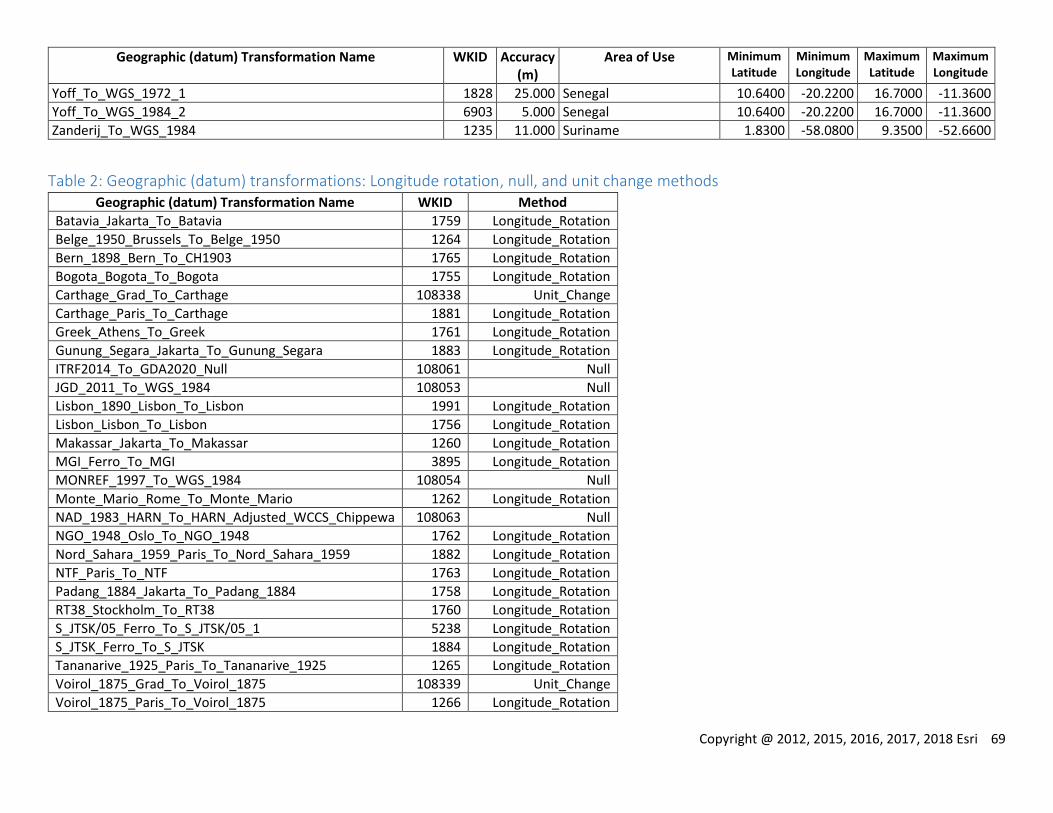
Copyright @ 2012, 2015, 2016, 2017, 2018 Esri 69
Geographic (datum) Transformation Name WKID Accuracy (m)
Area of Use Minimum Latitude
Minimum Longitude
Maximum Latitude
Maximum Longitude
Yoff_To_WGS_1972_1 1828 25.000 Senegal 10.6400 -20.2200 16.7000 -11.3600
Yoff_To_WGS_1984_2 6903 5.000 Senegal 10.6400 -20.2200 16.7000 -11.3600
Zanderij_To_WGS_1984 1235 11.000 Suriname 1.8300 -58.0800 9.3500 -52.6600
Table 2: Geographic (datum) transformations: Longitude rotation, null, and unit change methods Geographic (datum) Transformation Name WKID Method
Batavia_Jakarta_To_Batavia 1759 Longitude_Rotation
Belge_1950_Brussels_To_Belge_1950 1264 Longitude_Rotation
Bern_1898_Bern_To_CH1903 1765 Longitude_Rotation
Bogota_Bogota_To_Bogota 1755 Longitude_Rotation
Carthage_Grad_To_Carthage 108338 Unit_Change
Carthage_Paris_To_Carthage 1881 Longitude_Rotation
Greek_Athens_To_Greek 1761 Longitude_Rotation
Gunung_Segara_Jakarta_To_Gunung_Segara 1883 Longitude_Rotation
ITRF2014_To_GDA2020_Null 108061 Null
JGD_2011_To_WGS_1984 108053 Null
Lisbon_1890_Lisbon_To_Lisbon 1991 Longitude_Rotation
Lisbon_Lisbon_To_Lisbon 1756 Longitude_Rotation
Makassar_Jakarta_To_Makassar 1260 Longitude_Rotation
MGI_Ferro_To_MGI 3895 Longitude_Rotation
MONREF_1997_To_WGS_1984 108054 Null
Monte_Mario_Rome_To_Monte_Mario 1262 Longitude_Rotation
NAD_1983_HARN_To_HARN_Adjusted_WCCS_Chippewa 108063 Null
NGO_1948_Oslo_To_NGO_1948 1762 Longitude_Rotation
Nord_Sahara_1959_Paris_To_Nord_Sahara_1959 1882 Longitude_Rotation
NTF_Paris_To_NTF 1763 Longitude_Rotation
Padang_1884_Jakarta_To_Padang_1884 1758 Longitude_Rotation
RT38_Stockholm_To_RT38 1760 Longitude_Rotation
S_JTSK/05_Ferro_To_S_JTSK/05_1 5238 Longitude_Rotation
S_JTSK_Ferro_To_S_JTSK 1884 Longitude_Rotation
Tananarive_1925_Paris_To_Tananarive_1925 1265 Longitude_Rotation
Voirol_1875_Grad_To_Voirol_1875 108339 Unit_Change
Voirol_1875_Paris_To_Voirol_1875 1266 Longitude_Rotation
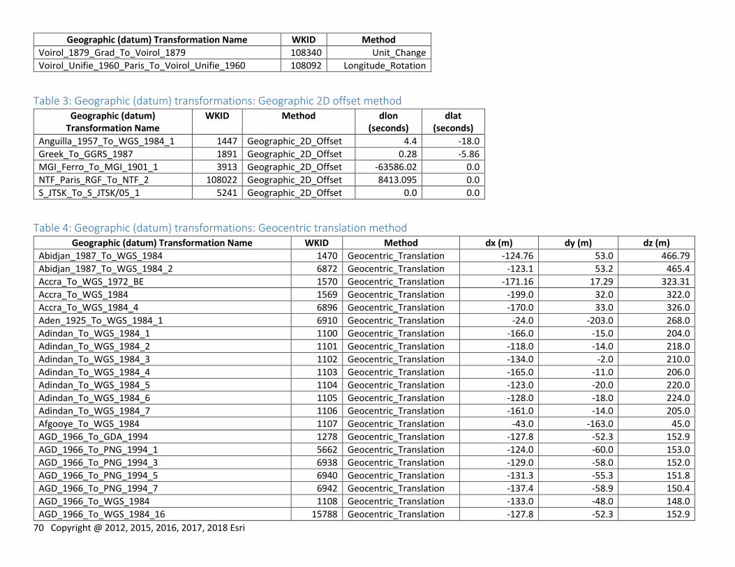
70 Copyright @ 2012, 2015, 2016, 2017, 2018 Esri
Geographic (datum) Transformation Name WKID Method
Voirol_1879_Grad_To_Voirol_1879 108340 Unit_Change
Voirol_Unifie_1960_Paris_To_Voirol_Unifie_1960 108092 Longitude_Rotation
Table 3: Geographic (datum) transformations: Geographic 2D offset method Geographic (datum)
Transformation Name WKID Method dlon
(seconds) dlat
(seconds)
Anguilla_1957_To_WGS_1984_1 1447 Geographic_2D_Offset 4.4 -18.0
Greek_To_GGRS_1987 1891 Geographic_2D_Offset 0.28 -5.86
MGI_Ferro_To_MGI_1901_1 3913 Geographic_2D_Offset -63586.02 0.0
NTF_Paris_RGF_To_NTF_2 108022 Geographic_2D_Offset 8413.095 0.0
S_JTSK_To_S_JTSK/05_1 5241 Geographic_2D_Offset 0.0 0.0
Table 4: Geographic (datum) transformations: Geocentric translation method Geographic (datum) Transformation Name WKID Method dx (m) dy (m) dz (m)
Abidjan_1987_To_WGS_1984 1470 Geocentric_Translation -124.76 53.0 466.79
Abidjan_1987_To_WGS_1984_2 6872 Geocentric_Translation -123.1 53.2 465.4
Accra_To_WGS_1972_BE 1570 Geocentric_Translation -171.16 17.29 323.31
Accra_To_WGS_1984 1569 Geocentric_Translation -199.0 32.0 322.0
Accra_To_WGS_1984_4 6896 Geocentric_Translation -170.0 33.0 326.0
Aden_1925_To_WGS_1984_1 6910 Geocentric_Translation -24.0 -203.0 268.0
Adindan_To_WGS_1984_1 1100 Geocentric_Translation -166.0 -15.0 204.0
Adindan_To_WGS_1984_2 1101 Geocentric_Translation -118.0 -14.0 218.0
Adindan_To_WGS_1984_3 1102 Geocentric_Translation -134.0 -2.0 210.0
Adindan_To_WGS_1984_4 1103 Geocentric_Translation -165.0 -11.0 206.0
Adindan_To_WGS_1984_5 1104 Geocentric_Translation -123.0 -20.0 220.0
Adindan_To_WGS_1984_6 1105 Geocentric_Translation -128.0 -18.0 224.0
Adindan_To_WGS_1984_7 1106 Geocentric_Translation -161.0 -14.0 205.0
Afgooye_To_WGS_1984 1107 Geocentric_Translation -43.0 -163.0 45.0
AGD_1966_To_GDA_1994 1278 Geocentric_Translation -127.8 -52.3 152.9
AGD_1966_To_PNG_1994_1 5662 Geocentric_Translation -124.0 -60.0 153.0
AGD_1966_To_PNG_1994_3 6938 Geocentric_Translation -129.0 -58.0 152.0
AGD_1966_To_PNG_1994_5 6940 Geocentric_Translation -131.3 -55.3 151.8
AGD_1966_To_PNG_1994_7 6942 Geocentric_Translation -137.4 -58.9 150.4
AGD_1966_To_WGS_1984 1108 Geocentric_Translation -133.0 -48.0 148.0
AGD_1966_To_WGS_1984_16 15788 Geocentric_Translation -127.8 -52.3 152.9
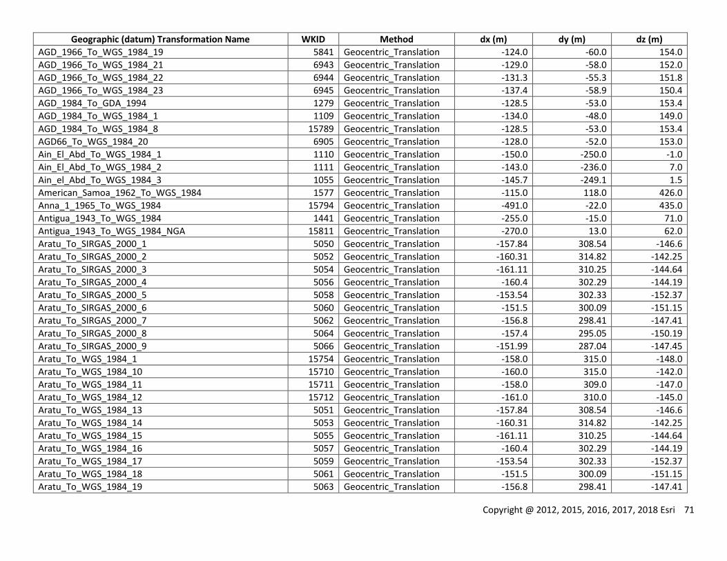
Copyright @ 2012, 2015, 2016, 2017, 2018 Esri 71
Geographic (datum) Transformation Name WKID Method dx (m) dy (m) dz (m)
AGD_1966_To_WGS_1984_19 5841 Geocentric_Translation -124.0 -60.0 154.0
AGD_1966_To_WGS_1984_21 6943 Geocentric_Translation -129.0 -58.0 152.0
AGD_1966_To_WGS_1984_22 6944 Geocentric_Translation -131.3 -55.3 151.8
AGD_1966_To_WGS_1984_23 6945 Geocentric_Translation -137.4 -58.9 150.4
AGD_1984_To_GDA_1994 1279 Geocentric_Translation -128.5 -53.0 153.4
AGD_1984_To_WGS_1984_1 1109 Geocentric_Translation -134.0 -48.0 149.0
AGD_1984_To_WGS_1984_8 15789 Geocentric_Translation -128.5 -53.0 153.4
AGD66_To_WGS_1984_20 6905 Geocentric_Translation -128.0 -52.0 153.0
Ain_El_Abd_To_WGS_1984_1 1110 Geocentric_Translation -150.0 -250.0 -1.0
Ain_El_Abd_To_WGS_1984_2 1111 Geocentric_Translation -143.0 -236.0 7.0
Ain_el_Abd_To_WGS_1984_3 1055 Geocentric_Translation -145.7 -249.1 1.5
American_Samoa_1962_To_WGS_1984 1577 Geocentric_Translation -115.0 118.0 426.0
Anna_1_1965_To_WGS_1984 15794 Geocentric_Translation -491.0 -22.0 435.0
Antigua_1943_To_WGS_1984 1441 Geocentric_Translation -255.0 -15.0 71.0
Antigua_1943_To_WGS_1984_NGA 15811 Geocentric_Translation -270.0 13.0 62.0
Aratu_To_SIRGAS_2000_1 5050 Geocentric_Translation -157.84 308.54 -146.6
Aratu_To_SIRGAS_2000_2 5052 Geocentric_Translation -160.31 314.82 -142.25
Aratu_To_SIRGAS_2000_3 5054 Geocentric_Translation -161.11 310.25 -144.64
Aratu_To_SIRGAS_2000_4 5056 Geocentric_Translation -160.4 302.29 -144.19
Aratu_To_SIRGAS_2000_5 5058 Geocentric_Translation -153.54 302.33 -152.37
Aratu_To_SIRGAS_2000_6 5060 Geocentric_Translation -151.5 300.09 -151.15
Aratu_To_SIRGAS_2000_7 5062 Geocentric_Translation -156.8 298.41 -147.41
Aratu_To_SIRGAS_2000_8 5064 Geocentric_Translation -157.4 295.05 -150.19
Aratu_To_SIRGAS_2000_9 5066 Geocentric_Translation -151.99 287.04 -147.45
Aratu_To_WGS_1984_1 15754 Geocentric_Translation -158.0 315.0 -148.0
Aratu_To_WGS_1984_10 15710 Geocentric_Translation -160.0 315.0 -142.0
Aratu_To_WGS_1984_11 15711 Geocentric_Translation -158.0 309.0 -147.0
Aratu_To_WGS_1984_12 15712 Geocentric_Translation -161.0 310.0 -145.0
Aratu_To_WGS_1984_13 5051 Geocentric_Translation -157.84 308.54 -146.6
Aratu_To_WGS_1984_14 5053 Geocentric_Translation -160.31 314.82 -142.25
Aratu_To_WGS_1984_15 5055 Geocentric_Translation -161.11 310.25 -144.64
Aratu_To_WGS_1984_16 5057 Geocentric_Translation -160.4 302.29 -144.19
Aratu_To_WGS_1984_17 5059 Geocentric_Translation -153.54 302.33 -152.37
Aratu_To_WGS_1984_18 5061 Geocentric_Translation -151.5 300.09 -151.15
Aratu_To_WGS_1984_19 5063 Geocentric_Translation -156.8 298.41 -147.41
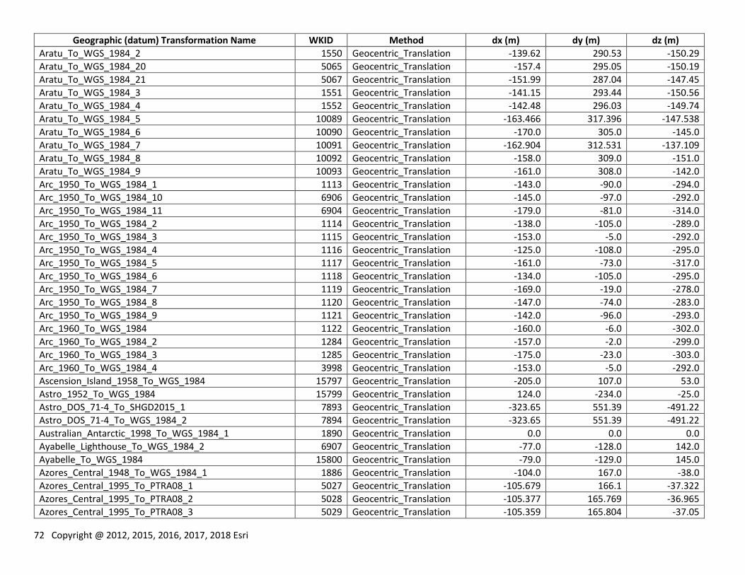
72 Copyright @ 2012, 2015, 2016, 2017, 2018 Esri
Geographic (datum) Transformation Name WKID Method dx (m) dy (m) dz (m)
Aratu_To_WGS_1984_2 1550 Geocentric_Translation -139.62 290.53 -150.29
Aratu_To_WGS_1984_20 5065 Geocentric_Translation -157.4 295.05 -150.19
Aratu_To_WGS_1984_21 5067 Geocentric_Translation -151.99 287.04 -147.45
Aratu_To_WGS_1984_3 1551 Geocentric_Translation -141.15 293.44 -150.56
Aratu_To_WGS_1984_4 1552 Geocentric_Translation -142.48 296.03 -149.74
Aratu_To_WGS_1984_5 10089 Geocentric_Translation -163.466 317.396 -147.538
Aratu_To_WGS_1984_6 10090 Geocentric_Translation -170.0 305.0 -145.0
Aratu_To_WGS_1984_7 10091 Geocentric_Translation -162.904 312.531 -137.109
Aratu_To_WGS_1984_8 10092 Geocentric_Translation -158.0 309.0 -151.0
Aratu_To_WGS_1984_9 10093 Geocentric_Translation -161.0 308.0 -142.0
Arc_1950_To_WGS_1984_1 1113 Geocentric_Translation -143.0 -90.0 -294.0
Arc_1950_To_WGS_1984_10 6906 Geocentric_Translation -145.0 -97.0 -292.0
Arc_1950_To_WGS_1984_11 6904 Geocentric_Translation -179.0 -81.0 -314.0
Arc_1950_To_WGS_1984_2 1114 Geocentric_Translation -138.0 -105.0 -289.0
Arc_1950_To_WGS_1984_3 1115 Geocentric_Translation -153.0 -5.0 -292.0
Arc_1950_To_WGS_1984_4 1116 Geocentric_Translation -125.0 -108.0 -295.0
Arc_1950_To_WGS_1984_5 1117 Geocentric_Translation -161.0 -73.0 -317.0
Arc_1950_To_WGS_1984_6 1118 Geocentric_Translation -134.0 -105.0 -295.0
Arc_1950_To_WGS_1984_7 1119 Geocentric_Translation -169.0 -19.0 -278.0
Arc_1950_To_WGS_1984_8 1120 Geocentric_Translation -147.0 -74.0 -283.0
Arc_1950_To_WGS_1984_9 1121 Geocentric_Translation -142.0 -96.0 -293.0
Arc_1960_To_WGS_1984 1122 Geocentric_Translation -160.0 -6.0 -302.0
Arc_1960_To_WGS_1984_2 1284 Geocentric_Translation -157.0 -2.0 -299.0
Arc_1960_To_WGS_1984_3 1285 Geocentric_Translation -175.0 -23.0 -303.0
Arc_1960_To_WGS_1984_4 3998 Geocentric_Translation -153.0 -5.0 -292.0
Ascension_Island_1958_To_WGS_1984 15797 Geocentric_Translation -205.0 107.0 53.0
Astro_1952_To_WGS_1984 15799 Geocentric_Translation 124.0 -234.0 -25.0
Astro_DOS_71-4_To_SHGD2015_1 7893 Geocentric_Translation -323.65 551.39 -491.22
Astro_DOS_71-4_To_WGS_1984_2 7894 Geocentric_Translation -323.65 551.39 -491.22
Australian_Antarctic_1998_To_WGS_1984_1 1890 Geocentric_Translation 0.0 0.0 0.0
Ayabelle_Lighthouse_To_WGS_1984_2 6907 Geocentric_Translation -77.0 -128.0 142.0
Ayabelle_To_WGS_1984 15800 Geocentric_Translation -79.0 -129.0 145.0
Azores_Central_1948_To_WGS_1984_1 1886 Geocentric_Translation -104.0 167.0 -38.0
Azores_Central_1995_To_PTRA08_1 5027 Geocentric_Translation -105.679 166.1 -37.322
Azores_Central_1995_To_PTRA08_2 5028 Geocentric_Translation -105.377 165.769 -36.965
Azores_Central_1995_To_PTRA08_3 5029 Geocentric_Translation -105.359 165.804 -37.05
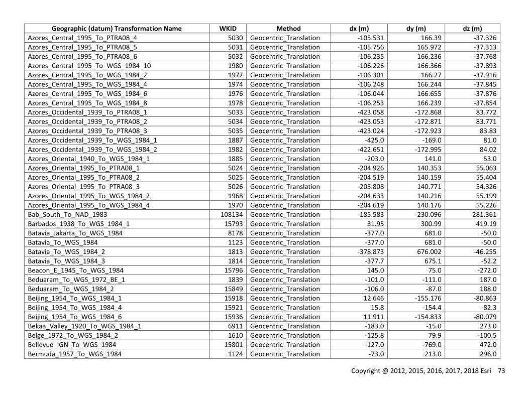
Copyright @ 2012, 2015, 2016, 2017, 2018 Esri 73
Geographic (datum) Transformation Name WKID Method dx (m) dy (m) dz (m)
Azores_Central_1995_To_PTRA08_4 5030 Geocentric_Translation -105.531 166.39 -37.326
Azores_Central_1995_To_PTRA08_5 5031 Geocentric_Translation -105.756 165.972 -37.313
Azores_Central_1995_To_PTRA08_6 5032 Geocentric_Translation -106.235 166.236 -37.768
Azores_Central_1995_To_WGS_1984_10 1980 Geocentric_Translation -106.226 166.366 -37.893
Azores_Central_1995_To_WGS_1984_2 1972 Geocentric_Translation -106.301 166.27 -37.916
Azores_Central_1995_To_WGS_1984_4 1974 Geocentric_Translation -106.248 166.244 -37.845
Azores_Central_1995_To_WGS_1984_6 1976 Geocentric_Translation -106.044 166.655 -37.876
Azores_Central_1995_To_WGS_1984_8 1978 Geocentric_Translation -106.253 166.239 -37.854
Azores_Occidental_1939_To_PTRA08_1 5033 Geocentric_Translation -423.058 -172.868 83.772
Azores_Occidental_1939_To_PTRA08_2 5034 Geocentric_Translation -423.053 -172.871 83.771
Azores_Occidental_1939_To_PTRA08_3 5035 Geocentric_Translation -423.024 -172.923 83.83
Azores_Occidental_1939_To_WGS_1984_1 1887 Geocentric_Translation -425.0 -169.0 81.0
Azores_Occidental_1939_To_WGS_1984_2 1982 Geocentric_Translation -422.651 -172.995 84.02
Azores_Oriental_1940_To_WGS_1984_1 1885 Geocentric_Translation -203.0 141.0 53.0
Azores_Oriental_1995_To_PTRA08_1 5024 Geocentric_Translation -204.926 140.353 55.063
Azores_Oriental_1995_To_PTRA08_2 5025 Geocentric_Translation -204.519 140.159 55.404
Azores_Oriental_1995_To_PTRA08_3 5026 Geocentric_Translation -205.808 140.771 54.326
Azores_Oriental_1995_To_WGS_1984_2 1968 Geocentric_Translation -204.633 140.216 55.199
Azores_Oriental_1995_To_WGS_1984_4 1970 Geocentric_Translation -204.619 140.176 55.226
Bab_South_To_NAD_1983 108134 Geocentric_Translation -185.583 -230.096 281.361
Barbados_1938_To_WGS_1984_1 15793 Geocentric_Translation 31.95 300.99 419.19
Batavia_Jakarta_To_WGS_1984 8178 Geocentric_Translation -377.0 681.0 -50.0
Batavia_To_WGS_1984 1123 Geocentric_Translation -377.0 681.0 -50.0
Batavia_To_WGS_1984_2 1813 Geocentric_Translation -378.873 676.002 -46.255
Batavia_To_WGS_1984_3 1814 Geocentric_Translation -377.7 675.1 -52.2
Beacon_E_1945_To_WGS_1984 15796 Geocentric_Translation 145.0 75.0 -272.0
Beduaram_To_WGS_1972_BE_1 1839 Geocentric_Translation -101.0 -111.0 187.0
Beduaram_To_WGS_1984_2 15849 Geocentric_Translation -106.0 -87.0 188.0
Beijing_1954_To_WGS_1984_1 15918 Geocentric_Translation 12.646 -155.176 -80.863
Beijing_1954_To_WGS_1984_4 15921 Geocentric_Translation 15.8 -154.4 -82.3
Beijing_1954_To_WGS_1984_6 15936 Geocentric_Translation 11.911 -154.833 -80.079
Bekaa_Valley_1920_To_WGS_1984_1 6911 Geocentric_Translation -183.0 -15.0 273.0
Belge_1972_To_WGS_1984_2 1610 Geocentric_Translation -125.8 79.9 -100.5
Bellevue_IGN_To_WGS_1984 15801 Geocentric_Translation -127.0 -769.0 472.0
Bermuda_1957_To_WGS_1984 1124 Geocentric_Translation -73.0 213.0 296.0
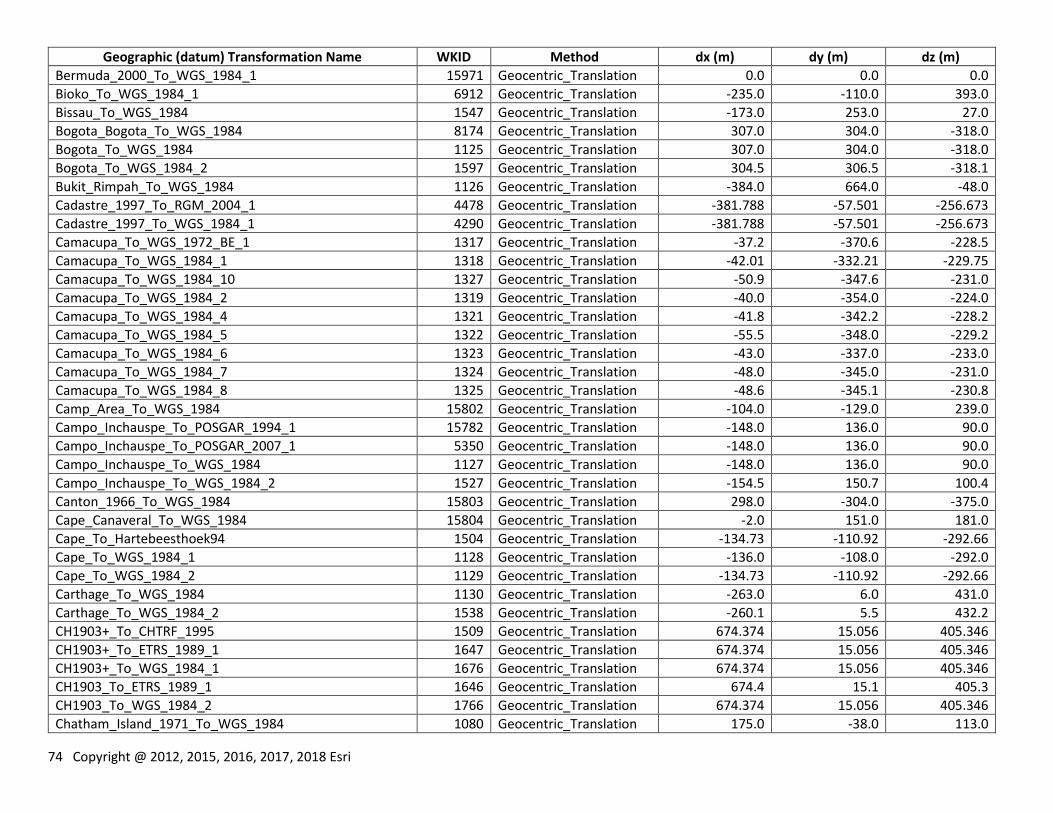
74 Copyright @ 2012, 2015, 2016, 2017, 2018 Esri
Geographic (datum) Transformation Name WKID Method dx (m) dy (m) dz (m)
Bermuda_2000_To_WGS_1984_1 15971 Geocentric_Translation 0.0 0.0 0.0
Bioko_To_WGS_1984_1 6912 Geocentric_Translation -235.0 -110.0 393.0
Bissau_To_WGS_1984 1547 Geocentric_Translation -173.0 253.0 27.0
Bogota_Bogota_To_WGS_1984 8174 Geocentric_Translation 307.0 304.0 -318.0
Bogota_To_WGS_1984 1125 Geocentric_Translation 307.0 304.0 -318.0
Bogota_To_WGS_1984_2 1597 Geocentric_Translation 304.5 306.5 -318.1
Bukit_Rimpah_To_WGS_1984 1126 Geocentric_Translation -384.0 664.0 -48.0
Cadastre_1997_To_RGM_2004_1 4478 Geocentric_Translation -381.788 -57.501 -256.673
Cadastre_1997_To_WGS_1984_1 4290 Geocentric_Translation -381.788 -57.501 -256.673
Camacupa_To_WGS_1972_BE_1 1317 Geocentric_Translation -37.2 -370.6 -228.5
Camacupa_To_WGS_1984_1 1318 Geocentric_Translation -42.01 -332.21 -229.75
Camacupa_To_WGS_1984_10 1327 Geocentric_Translation -50.9 -347.6 -231.0
Camacupa_To_WGS_1984_2 1319 Geocentric_Translation -40.0 -354.0 -224.0
Camacupa_To_WGS_1984_4 1321 Geocentric_Translation -41.8 -342.2 -228.2
Camacupa_To_WGS_1984_5 1322 Geocentric_Translation -55.5 -348.0 -229.2
Camacupa_To_WGS_1984_6 1323 Geocentric_Translation -43.0 -337.0 -233.0
Camacupa_To_WGS_1984_7 1324 Geocentric_Translation -48.0 -345.0 -231.0
Camacupa_To_WGS_1984_8 1325 Geocentric_Translation -48.6 -345.1 -230.8
Camp_Area_To_WGS_1984 15802 Geocentric_Translation -104.0 -129.0 239.0
Campo_Inchauspe_To_POSGAR_1994_1 15782 Geocentric_Translation -148.0 136.0 90.0
Campo_Inchauspe_To_POSGAR_2007_1 5350 Geocentric_Translation -148.0 136.0 90.0
Campo_Inchauspe_To_WGS_1984 1127 Geocentric_Translation -148.0 136.0 90.0
Campo_Inchauspe_To_WGS_1984_2 1527 Geocentric_Translation -154.5 150.7 100.4
Canton_1966_To_WGS_1984 15803 Geocentric_Translation 298.0 -304.0 -375.0
Cape_Canaveral_To_WGS_1984 15804 Geocentric_Translation -2.0 151.0 181.0
Cape_To_Hartebeesthoek94 1504 Geocentric_Translation -134.73 -110.92 -292.66
Cape_To_WGS_1984_1 1128 Geocentric_Translation -136.0 -108.0 -292.0
Cape_To_WGS_1984_2 1129 Geocentric_Translation -134.73 -110.92 -292.66
Carthage_To_WGS_1984 1130 Geocentric_Translation -263.0 6.0 431.0
Carthage_To_WGS_1984_2 1538 Geocentric_Translation -260.1 5.5 432.2
CH1903+_To_CHTRF_1995 1509 Geocentric_Translation 674.374 15.056 405.346
CH1903+_To_ETRS_1989_1 1647 Geocentric_Translation 674.374 15.056 405.346
CH1903+_To_WGS_1984_1 1676 Geocentric_Translation 674.374 15.056 405.346
CH1903_To_ETRS_1989_1 1646 Geocentric_Translation 674.4 15.1 405.3
CH1903_To_WGS_1984_2 1766 Geocentric_Translation 674.374 15.056 405.346
Chatham_Island_1971_To_WGS_1984 1080 Geocentric_Translation 175.0 -38.0 113.0
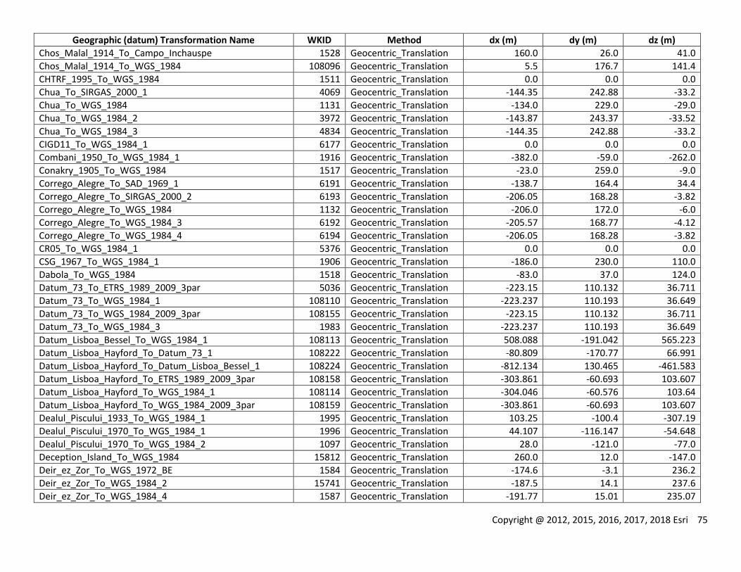
Copyright @ 2012, 2015, 2016, 2017, 2018 Esri 75
Geographic (datum) Transformation Name WKID Method dx (m) dy (m) dz (m)
Chos_Malal_1914_To_Campo_Inchauspe 1528 Geocentric_Translation 160.0 26.0 41.0
Chos_Malal_1914_To_WGS_1984 108096 Geocentric_Translation 5.5 176.7 141.4
CHTRF_1995_To_WGS_1984 1511 Geocentric_Translation 0.0 0.0 0.0
Chua_To_SIRGAS_2000_1 4069 Geocentric_Translation -144.35 242.88 -33.2
Chua_To_WGS_1984 1131 Geocentric_Translation -134.0 229.0 -29.0
Chua_To_WGS_1984_2 3972 Geocentric_Translation -143.87 243.37 -33.52
Chua_To_WGS_1984_3 4834 Geocentric_Translation -144.35 242.88 -33.2
CIGD11_To_WGS_1984_1 6177 Geocentric_Translation 0.0 0.0 0.0
Combani_1950_To_WGS_1984_1 1916 Geocentric_Translation -382.0 -59.0 -262.0
Conakry_1905_To_WGS_1984 1517 Geocentric_Translation -23.0 259.0 -9.0
Corrego_Alegre_To_SAD_1969_1 6191 Geocentric_Translation -138.7 164.4 34.4
Corrego_Alegre_To_SIRGAS_2000_2 6193 Geocentric_Translation -206.05 168.28 -3.82
Corrego_Alegre_To_WGS_1984 1132 Geocentric_Translation -206.0 172.0 -6.0
Corrego_Alegre_To_WGS_1984_3 6192 Geocentric_Translation -205.57 168.77 -4.12
Corrego_Alegre_To_WGS_1984_4 6194 Geocentric_Translation -206.05 168.28 -3.82
CR05_To_WGS_1984_1 5376 Geocentric_Translation 0.0 0.0 0.0
CSG_1967_To_WGS_1984_1 1906 Geocentric_Translation -186.0 230.0 110.0
Dabola_To_WGS_1984 1518 Geocentric_Translation -83.0 37.0 124.0
Datum_73_To_ETRS_1989_2009_3par 5036 Geocentric_Translation -223.15 110.132 36.711
Datum_73_To_WGS_1984_1 108110 Geocentric_Translation -223.237 110.193 36.649
Datum_73_To_WGS_1984_2009_3par 108155 Geocentric_Translation -223.15 110.132 36.711
Datum_73_To_WGS_1984_3 1983 Geocentric_Translation -223.237 110.193 36.649
Datum_Lisboa_Bessel_To_WGS_1984_1 108113 Geocentric_Translation 508.088 -191.042 565.223
Datum_Lisboa_Hayford_To_Datum_73_1 108222 Geocentric_Translation -80.809 -170.77 66.991
Datum_Lisboa_Hayford_To_Datum_Lisboa_Bessel_1 108224 Geocentric_Translation -812.134 130.465 -461.583
Datum_Lisboa_Hayford_To_ETRS_1989_2009_3par 108158 Geocentric_Translation -303.861 -60.693 103.607
Datum_Lisboa_Hayford_To_WGS_1984_1 108114 Geocentric_Translation -304.046 -60.576 103.64
Datum_Lisboa_Hayford_To_WGS_1984_2009_3par 108159 Geocentric_Translation -303.861 -60.693 103.607
Dealul_Piscului_1933_To_WGS_1984_1 1995 Geocentric_Translation 103.25 -100.4 -307.19
Dealul_Piscului_1970_To_WGS_1984_1 1996 Geocentric_Translation 44.107 -116.147 -54.648
Dealul_Piscului_1970_To_WGS_1984_2 1097 Geocentric_Translation 28.0 -121.0 -77.0
Deception_Island_To_WGS_1984 15812 Geocentric_Translation 260.0 12.0 -147.0
Deir_ez_Zor_To_WGS_1972_BE 1584 Geocentric_Translation -174.6 -3.1 236.2
Deir_ez_Zor_To_WGS_1984_2 15741 Geocentric_Translation -187.5 14.1 237.6
Deir_ez_Zor_To_WGS_1984_4 1587 Geocentric_Translation -191.77 15.01 235.07
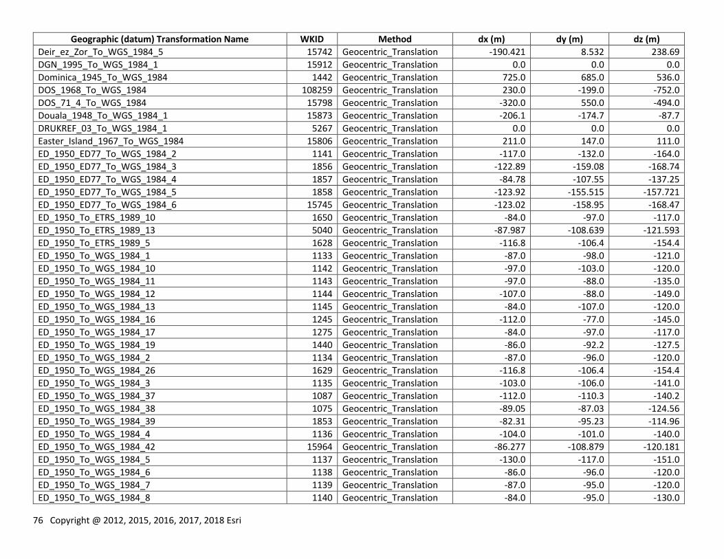
76 Copyright @ 2012, 2015, 2016, 2017, 2018 Esri
Geographic (datum) Transformation Name WKID Method dx (m) dy (m) dz (m)
Deir_ez_Zor_To_WGS_1984_5 15742 Geocentric_Translation -190.421 8.532 238.69
DGN_1995_To_WGS_1984_1 15912 Geocentric_Translation 0.0 0.0 0.0
Dominica_1945_To_WGS_1984 1442 Geocentric_Translation 725.0 685.0 536.0
DOS_1968_To_WGS_1984 108259 Geocentric_Translation 230.0 -199.0 -752.0
DOS_71_4_To_WGS_1984 15798 Geocentric_Translation -320.0 550.0 -494.0
Douala_1948_To_WGS_1984_1 15873 Geocentric_Translation -206.1 -174.7 -87.7
DRUKREF_03_To_WGS_1984_1 5267 Geocentric_Translation 0.0 0.0 0.0
Easter_Island_1967_To_WGS_1984 15806 Geocentric_Translation 211.0 147.0 111.0
ED_1950_ED77_To_WGS_1984_2 1141 Geocentric_Translation -117.0 -132.0 -164.0
ED_1950_ED77_To_WGS_1984_3 1856 Geocentric_Translation -122.89 -159.08 -168.74
ED_1950_ED77_To_WGS_1984_4 1857 Geocentric_Translation -84.78 -107.55 -137.25
ED_1950_ED77_To_WGS_1984_5 1858 Geocentric_Translation -123.92 -155.515 -157.721
ED_1950_ED77_To_WGS_1984_6 15745 Geocentric_Translation -123.02 -158.95 -168.47
ED_1950_To_ETRS_1989_10 1650 Geocentric_Translation -84.0 -97.0 -117.0
ED_1950_To_ETRS_1989_13 5040 Geocentric_Translation -87.987 -108.639 -121.593
ED_1950_To_ETRS_1989_5 1628 Geocentric_Translation -116.8 -106.4 -154.4
ED_1950_To_WGS_1984_1 1133 Geocentric_Translation -87.0 -98.0 -121.0
ED_1950_To_WGS_1984_10 1142 Geocentric_Translation -97.0 -103.0 -120.0
ED_1950_To_WGS_1984_11 1143 Geocentric_Translation -97.0 -88.0 -135.0
ED_1950_To_WGS_1984_12 1144 Geocentric_Translation -107.0 -88.0 -149.0
ED_1950_To_WGS_1984_13 1145 Geocentric_Translation -84.0 -107.0 -120.0
ED_1950_To_WGS_1984_16 1245 Geocentric_Translation -112.0 -77.0 -145.0
ED_1950_To_WGS_1984_17 1275 Geocentric_Translation -84.0 -97.0 -117.0
ED_1950_To_WGS_1984_19 1440 Geocentric_Translation -86.0 -92.2 -127.5
ED_1950_To_WGS_1984_2 1134 Geocentric_Translation -87.0 -96.0 -120.0
ED_1950_To_WGS_1984_26 1629 Geocentric_Translation -116.8 -106.4 -154.4
ED_1950_To_WGS_1984_3 1135 Geocentric_Translation -103.0 -106.0 -141.0
ED_1950_To_WGS_1984_37 1087 Geocentric_Translation -112.0 -110.3 -140.2
ED_1950_To_WGS_1984_38 1075 Geocentric_Translation -89.05 -87.03 -124.56
ED_1950_To_WGS_1984_39 1853 Geocentric_Translation -82.31 -95.23 -114.96
ED_1950_To_WGS_1984_4 1136 Geocentric_Translation -104.0 -101.0 -140.0
ED_1950_To_WGS_1984_42 15964 Geocentric_Translation -86.277 -108.879 -120.181
ED_1950_To_WGS_1984_5 1137 Geocentric_Translation -130.0 -117.0 -151.0
ED_1950_To_WGS_1984_6 1138 Geocentric_Translation -86.0 -96.0 -120.0
ED_1950_To_WGS_1984_7 1139 Geocentric_Translation -87.0 -95.0 -120.0
ED_1950_To_WGS_1984_8 1140 Geocentric_Translation -84.0 -95.0 -130.0
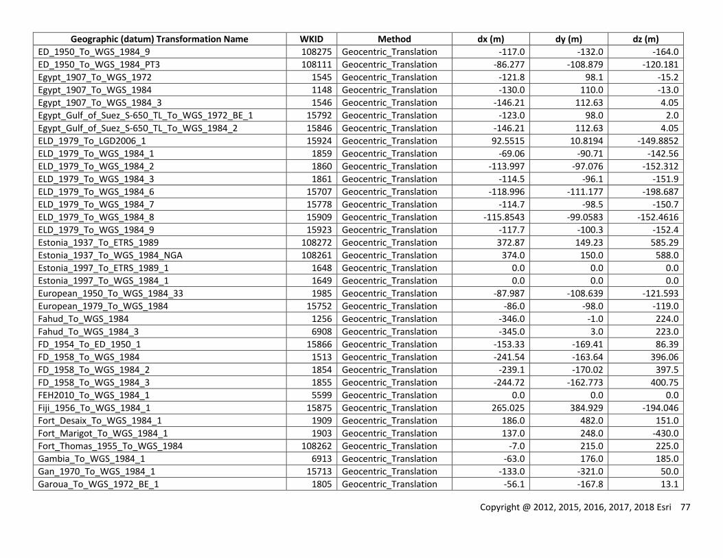
Copyright @ 2012, 2015, 2016, 2017, 2018 Esri 77
Geographic (datum) Transformation Name WKID Method dx (m) dy (m) dz (m)
ED_1950_To_WGS_1984_9 108275 Geocentric_Translation -117.0 -132.0 -164.0
ED_1950_To_WGS_1984_PT3 108111 Geocentric_Translation -86.277 -108.879 -120.181
Egypt_1907_To_WGS_1972 1545 Geocentric_Translation -121.8 98.1 -15.2
Egypt_1907_To_WGS_1984 1148 Geocentric_Translation -130.0 110.0 -13.0
Egypt_1907_To_WGS_1984_3 1546 Geocentric_Translation -146.21 112.63 4.05
Egypt_Gulf_of_Suez_S-650_TL_To_WGS_1972_BE_1 15792 Geocentric_Translation -123.0 98.0 2.0
Egypt_Gulf_of_Suez_S-650_TL_To_WGS_1984_2 15846 Geocentric_Translation -146.21 112.63 4.05
ELD_1979_To_LGD2006_1 15924 Geocentric_Translation 92.5515 10.8194 -149.8852
ELD_1979_To_WGS_1984_1 1859 Geocentric_Translation -69.06 -90.71 -142.56
ELD_1979_To_WGS_1984_2 1860 Geocentric_Translation -113.997 -97.076 -152.312
ELD_1979_To_WGS_1984_3 1861 Geocentric_Translation -114.5 -96.1 -151.9
ELD_1979_To_WGS_1984_6 15707 Geocentric_Translation -118.996 -111.177 -198.687
ELD_1979_To_WGS_1984_7 15778 Geocentric_Translation -114.7 -98.5 -150.7
ELD_1979_To_WGS_1984_8 15909 Geocentric_Translation -115.8543 -99.0583 -152.4616
ELD_1979_To_WGS_1984_9 15923 Geocentric_Translation -117.7 -100.3 -152.4
Estonia_1937_To_ETRS_1989 108272 Geocentric_Translation 372.87 149.23 585.29
Estonia_1937_To_WGS_1984_NGA 108261 Geocentric_Translation 374.0 150.0 588.0
Estonia_1997_To_ETRS_1989_1 1648 Geocentric_Translation 0.0 0.0 0.0
Estonia_1997_To_WGS_1984_1 1649 Geocentric_Translation 0.0 0.0 0.0
European_1950_To_WGS_1984_33 1985 Geocentric_Translation -87.987 -108.639 -121.593
European_1979_To_WGS_1984 15752 Geocentric_Translation -86.0 -98.0 -119.0
Fahud_To_WGS_1984 1256 Geocentric_Translation -346.0 -1.0 224.0
Fahud_To_WGS_1984_3 6908 Geocentric_Translation -345.0 3.0 223.0
FD_1954_To_ED_1950_1 15866 Geocentric_Translation -153.33 -169.41 86.39
FD_1958_To_WGS_1984 1513 Geocentric_Translation -241.54 -163.64 396.06
FD_1958_To_WGS_1984_2 1854 Geocentric_Translation -239.1 -170.02 397.5
FD_1958_To_WGS_1984_3 1855 Geocentric_Translation -244.72 -162.773 400.75
FEH2010_To_WGS_1984_1 5599 Geocentric_Translation 0.0 0.0 0.0
Fiji_1956_To_WGS_1984_1 15875 Geocentric_Translation 265.025 384.929 -194.046
Fort_Desaix_To_WGS_1984_1 1909 Geocentric_Translation 186.0 482.0 151.0
Fort_Marigot_To_WGS_1984_1 1903 Geocentric_Translation 137.0 248.0 -430.0
Fort_Thomas_1955_To_WGS_1984 108262 Geocentric_Translation -7.0 215.0 225.0
Gambia_To_WGS_1984_1 6913 Geocentric_Translation -63.0 176.0 185.0
Gan_1970_To_WGS_1984_1 15713 Geocentric_Translation -133.0 -321.0 50.0
Garoua_To_WGS_1972_BE_1 1805 Geocentric_Translation -56.1 -167.8 13.1
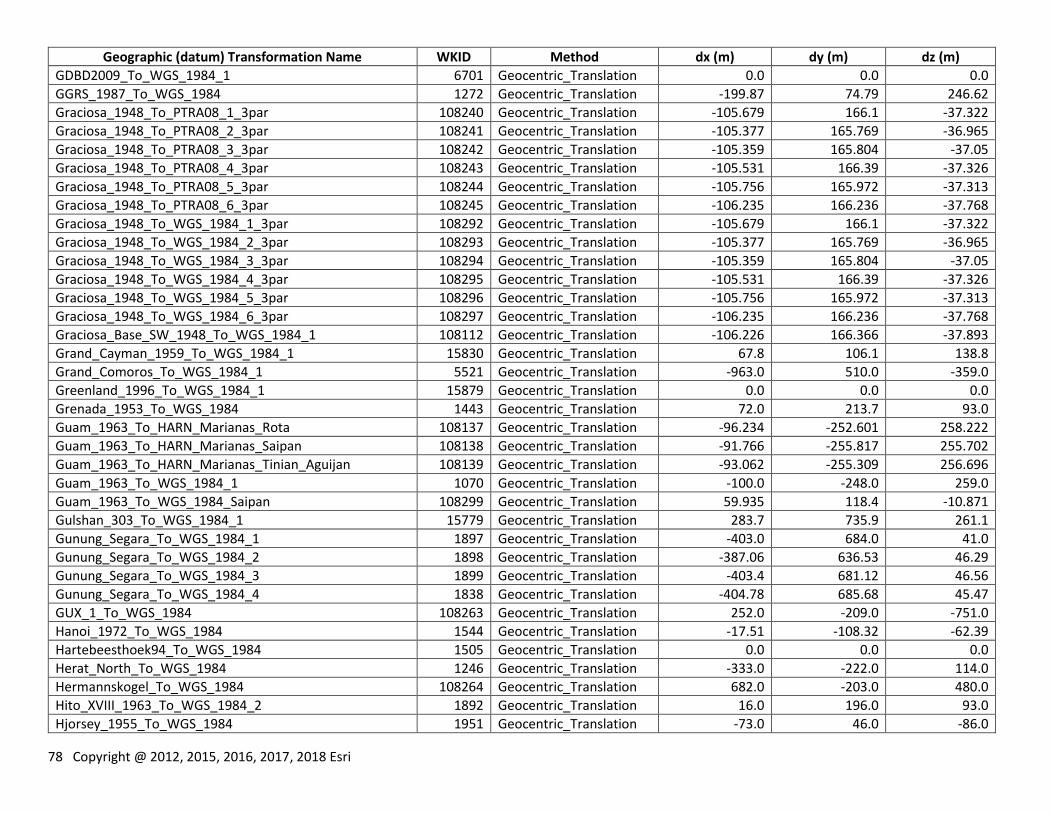
78 Copyright @ 2012, 2015, 2016, 2017, 2018 Esri
Geographic (datum) Transformation Name WKID Method dx (m) dy (m) dz (m)
GDBD2009_To_WGS_1984_1 6701 Geocentric_Translation 0.0 0.0 0.0
GGRS_1987_To_WGS_1984 1272 Geocentric_Translation -199.87 74.79 246.62
Graciosa_1948_To_PTRA08_1_3par 108240 Geocentric_Translation -105.679 166.1 -37.322
Graciosa_1948_To_PTRA08_2_3par 108241 Geocentric_Translation -105.377 165.769 -36.965
Graciosa_1948_To_PTRA08_3_3par 108242 Geocentric_Translation -105.359 165.804 -37.05
Graciosa_1948_To_PTRA08_4_3par 108243 Geocentric_Translation -105.531 166.39 -37.326
Graciosa_1948_To_PTRA08_5_3par 108244 Geocentric_Translation -105.756 165.972 -37.313
Graciosa_1948_To_PTRA08_6_3par 108245 Geocentric_Translation -106.235 166.236 -37.768
Graciosa_1948_To_WGS_1984_1_3par 108292 Geocentric_Translation -105.679 166.1 -37.322
Graciosa_1948_To_WGS_1984_2_3par 108293 Geocentric_Translation -105.377 165.769 -36.965
Graciosa_1948_To_WGS_1984_3_3par 108294 Geocentric_Translation -105.359 165.804 -37.05
Graciosa_1948_To_WGS_1984_4_3par 108295 Geocentric_Translation -105.531 166.39 -37.326
Graciosa_1948_To_WGS_1984_5_3par 108296 Geocentric_Translation -105.756 165.972 -37.313
Graciosa_1948_To_WGS_1984_6_3par 108297 Geocentric_Translation -106.235 166.236 -37.768
Graciosa_Base_SW_1948_To_WGS_1984_1 108112 Geocentric_Translation -106.226 166.366 -37.893
Grand_Cayman_1959_To_WGS_1984_1 15830 Geocentric_Translation 67.8 106.1 138.8
Grand_Comoros_To_WGS_1984_1 5521 Geocentric_Translation -963.0 510.0 -359.0
Greenland_1996_To_WGS_1984_1 15879 Geocentric_Translation 0.0 0.0 0.0
Grenada_1953_To_WGS_1984 1443 Geocentric_Translation 72.0 213.7 93.0
Guam_1963_To_HARN_Marianas_Rota 108137 Geocentric_Translation -96.234 -252.601 258.222
Guam_1963_To_HARN_Marianas_Saipan 108138 Geocentric_Translation -91.766 -255.817 255.702
Guam_1963_To_HARN_Marianas_Tinian_Aguijan 108139 Geocentric_Translation -93.062 -255.309 256.696
Guam_1963_To_WGS_1984_1 1070 Geocentric_Translation -100.0 -248.0 259.0
Guam_1963_To_WGS_1984_Saipan 108299 Geocentric_Translation 59.935 118.4 -10.871
Gulshan_303_To_WGS_1984_1 15779 Geocentric_Translation 283.7 735.9 261.1
Gunung_Segara_To_WGS_1984_1 1897 Geocentric_Translation -403.0 684.0 41.0
Gunung_Segara_To_WGS_1984_2 1898 Geocentric_Translation -387.06 636.53 46.29
Gunung_Segara_To_WGS_1984_3 1899 Geocentric_Translation -403.4 681.12 46.56
Gunung_Segara_To_WGS_1984_4 1838 Geocentric_Translation -404.78 685.68 45.47
GUX_1_To_WGS_1984 108263 Geocentric_Translation 252.0 -209.0 -751.0
Hanoi_1972_To_WGS_1984 1544 Geocentric_Translation -17.51 -108.32 -62.39
Hartebeesthoek94_To_WGS_1984 1505 Geocentric_Translation 0.0 0.0 0.0
Herat_North_To_WGS_1984 1246 Geocentric_Translation -333.0 -222.0 114.0
Hermannskogel_To_WGS_1984 108264 Geocentric_Translation 682.0 -203.0 480.0
Hito_XVIII_1963_To_WGS_1984_2 1892 Geocentric_Translation 16.0 196.0 93.0
Hjorsey_1955_To_WGS_1984 1951 Geocentric_Translation -73.0 46.0 -86.0
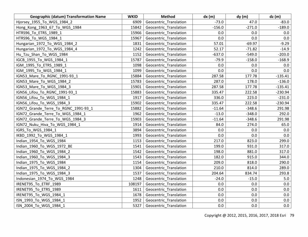
Copyright @ 2012, 2015, 2016, 2017, 2018 Esri 79
Geographic (datum) Transformation Name WKID Method dx (m) dy (m) dz (m)
Hjorsey_1955_To_WGS_1984_2 6909 Geocentric_Translation -73.0 47.0 -83.0
Hong_Kong_1963_67_To_WGS_1984 15842 Geocentric_Translation -156.0 -271.0 -189.0
HTRS96_To_ETRS_1989_1 15966 Geocentric_Translation 0.0 0.0 0.0
HTRS96_To_WGS_1984_1 15967 Geocentric_Translation 0.0 0.0 0.0
Hungarian_1972_To_WGS_1984_2 1831 Geocentric_Translation 57.01 -69.97 -9.29
Hungarian_1972_To_WGS_1984_4 1242 Geocentric_Translation 52.17 -71.82 -14.9
Hu_Tzu_Shan_To_WGS_1984 1152 Geocentric_Translation -637.0 -549.0 -203.0
IGCB_1955_To_WGS_1984_1 15787 Geocentric_Translation -79.9 -158.0 -168.9
IGM_1995_To_ETRS_1989_1 1098 Geocentric_Translation 0.0 0.0 0.0
IGM_1995_To_WGS_1984_1 1099 Geocentric_Translation 0.0 0.0 0.0
IGN53_Mare_To_RGNC_1991-93_1 15884 Geocentric_Translation 287.58 177.78 -135.41
IGN53_Mare_To_WGS_1984_2 15783 Geocentric_Translation 287.0 178.0 -136.0
IGN53_Mare_To_WGS_1984_3 15901 Geocentric_Translation 287.58 177.78 -135.41
IGN56_Lifou_To_RGNC_1991-93_1 15883 Geocentric_Translation 335.47 222.58 -230.94
IGN56_Lifou_To_WGS_1984_1 1917 Geocentric_Translation 336.0 223.0 -231.0
IGN56_Lifou_To_WGS_1984_3 15902 Geocentric_Translation 335.47 222.58 -230.94
IGN72_Grande_Terre_To_RGNC_1991-93_1 15882 Geocentric_Translation -11.64 -348.6 291.98
IGN72_Grande_Terre_To_WGS_1984_1 1962 Geocentric_Translation -13.0 -348.0 292.0
IGN72_Grande_Terre_To_WGS_1984_3 15903 Geocentric_Translation -11.64 -348.6 291.98
IGN72_Nuku_Hiva_To_WGS_1984_1 1914 Geocentric_Translation 84.0 274.0 65.0
IGRS_To_WGS_1984_1 3894 Geocentric_Translation 0.0 0.0 0.0
IKBD_1992_To_WGS_1984_1 1993 Geocentric_Translation 0.0 0.0 0.0
Indian_1954_To_WGS_1984 1153 Geocentric_Translation 217.0 823.0 299.0
Indian_1960_To_WGS_1972_BE 1541 Geocentric_Translation 199.0 931.0 317.0
Indian_1960_To_WGS_1984_2 1542 Geocentric_Translation 198.0 881.0 317.0
Indian_1960_To_WGS_1984_3 1543 Geocentric_Translation 182.0 915.0 344.0
Indian_1975_To_WGS_1984 1154 Geocentric_Translation 209.0 818.0 290.0
Indian_1975_To_WGS_1984_2 1304 Geocentric_Translation 210.0 814.0 289.0
Indian_1975_To_WGS_1984_3 1537 Geocentric_Translation 204.64 834.74 293.8
Indonesian_1974_To_WGS_1984 1248 Geocentric_Translation -24.0 -15.0 5.0
IRENET95_To_ETRF_1989 108197 Geocentric_Translation 0.0 0.0 0.0
IRENET95_To_ETRS_1989 1611 Geocentric_Translation 0.0 0.0 0.0
IRENET95_To_WGS_1984_1 1678 Geocentric_Translation 0.0 0.0 0.0
ISN_1993_To_WGS_1984_1 1952 Geocentric_Translation 0.0 0.0 0.0
ISN_2004_To_WGS_1984_1 5327 Geocentric_Translation 0.0 0.0 0.0
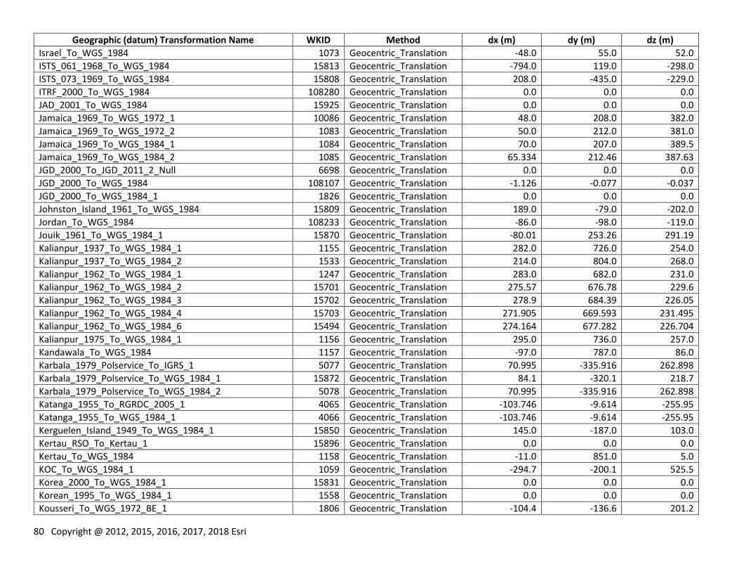
80 Copyright @ 2012, 2015, 2016, 2017, 2018 Esri
Geographic (datum) Transformation Name WKID Method dx (m) dy (m) dz (m)
Israel_To_WGS_1984 1073 Geocentric_Translation -48.0 55.0 52.0
ISTS_061_1968_To_WGS_1984 15813 Geocentric_Translation -794.0 119.0 -298.0
ISTS_073_1969_To_WGS_1984 15808 Geocentric_Translation 208.0 -435.0 -229.0
ITRF_2000_To_WGS_1984 108280 Geocentric_Translation 0.0 0.0 0.0
JAD_2001_To_WGS_1984 15925 Geocentric_Translation 0.0 0.0 0.0
Jamaica_1969_To_WGS_1972_1 10086 Geocentric_Translation 48.0 208.0 382.0
Jamaica_1969_To_WGS_1972_2 1083 Geocentric_Translation 50.0 212.0 381.0
Jamaica_1969_To_WGS_1984_1 1084 Geocentric_Translation 70.0 207.0 389.5
Jamaica_1969_To_WGS_1984_2 1085 Geocentric_Translation 65.334 212.46 387.63
JGD_2000_To_JGD_2011_2_Null 6698 Geocentric_Translation 0.0 0.0 0.0
JGD_2000_To_WGS_1984 108107 Geocentric_Translation -1.126 -0.077 -0.037
JGD_2000_To_WGS_1984_1 1826 Geocentric_Translation 0.0 0.0 0.0
Johnston_Island_1961_To_WGS_1984 15809 Geocentric_Translation 189.0 -79.0 -202.0
Jordan_To_WGS_1984 108233 Geocentric_Translation -86.0 -98.0 -119.0
Jouik_1961_To_WGS_1984_1 15870 Geocentric_Translation -80.01 253.26 291.19
Kalianpur_1937_To_WGS_1984_1 1155 Geocentric_Translation 282.0 726.0 254.0
Kalianpur_1937_To_WGS_1984_2 1533 Geocentric_Translation 214.0 804.0 268.0
Kalianpur_1962_To_WGS_1984_1 1247 Geocentric_Translation 283.0 682.0 231.0
Kalianpur_1962_To_WGS_1984_2 15701 Geocentric_Translation 275.57 676.78 229.6
Kalianpur_1962_To_WGS_1984_3 15702 Geocentric_Translation 278.9 684.39 226.05
Kalianpur_1962_To_WGS_1984_4 15703 Geocentric_Translation 271.905 669.593 231.495
Kalianpur_1962_To_WGS_1984_6 15494 Geocentric_Translation 274.164 677.282 226.704
Kalianpur_1975_To_WGS_1984_1 1156 Geocentric_Translation 295.0 736.0 257.0
Kandawala_To_WGS_1984 1157 Geocentric_Translation -97.0 787.0 86.0
Karbala_1979_Polservice_To_IGRS_1 5077 Geocentric_Translation 70.995 -335.916 262.898
Karbala_1979_Polservice_To_WGS_1984_1 15872 Geocentric_Translation 84.1 -320.1 218.7
Karbala_1979_Polservice_To_WGS_1984_2 5078 Geocentric_Translation 70.995 -335.916 262.898
Katanga_1955_To_RGRDC_2005_1 4065 Geocentric_Translation -103.746 -9.614 -255.95
Katanga_1955_To_WGS_1984_1 4066 Geocentric_Translation -103.746 -9.614 -255.95
Kerguelen_Island_1949_To_WGS_1984_1 15850 Geocentric_Translation 145.0 -187.0 103.0
Kertau_RSO_To_Kertau_1 15896 Geocentric_Translation 0.0 0.0 0.0
Kertau_To_WGS_1984 1158 Geocentric_Translation -11.0 851.0 5.0
KOC_To_WGS_1984_1 1059 Geocentric_Translation -294.7 -200.1 525.5
Korea_2000_To_WGS_1984_1 15831 Geocentric_Translation 0.0 0.0 0.0
Korean_1995_To_WGS_1984_1 1558 Geocentric_Translation 0.0 0.0 0.0
Kousseri_To_WGS_1972_BE_1 1806 Geocentric_Translation -104.4 -136.6 201.2
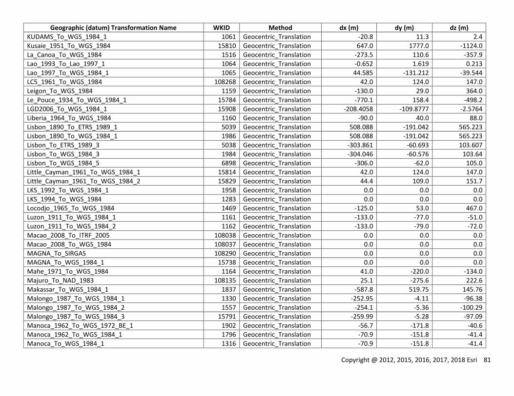
Copyright @ 2012, 2015, 2016, 2017, 2018 Esri 81
Geographic (datum) Transformation Name WKID Method dx (m) dy (m) dz (m)
KUDAMS_To_WGS_1984_1 1061 Geocentric_Translation -20.8 11.3 2.4
Kusaie_1951_To_WGS_1984 15810 Geocentric_Translation 647.0 1777.0 -1124.0
La_Canoa_To_WGS_1984 1516 Geocentric_Translation -273.5 110.6 -357.9
Lao_1993_To_Lao_1997_1 1064 Geocentric_Translation -0.652 1.619 0.213
Lao_1997_To_WGS_1984_1 1065 Geocentric_Translation 44.585 -131.212 -39.544
LC5_1961_To_WGS_1984 108268 Geocentric_Translation 42.0 124.0 147.0
Leigon_To_WGS_1984 1159 Geocentric_Translation -130.0 29.0 364.0
Le_Pouce_1934_To_WGS_1984_1 15784 Geocentric_Translation -770.1 158.4 -498.2
LGD2006_To_WGS_1984_1 15908 Geocentric_Translation -208.4058 -109.8777 -2.5764
Liberia_1964_To_WGS_1984 1160 Geocentric_Translation -90.0 40.0 88.0
Lisbon_1890_To_ETRS_1989_1 5039 Geocentric_Translation 508.088 -191.042 565.223
Lisbon_1890_To_WGS_1984_1 1986 Geocentric_Translation 508.088 -191.042 565.223
Lisbon_To_ETRS_1989_3 5038 Geocentric_Translation -303.861 -60.693 103.607
Lisbon_To_WGS_1984_3 1984 Geocentric_Translation -304.046 -60.576 103.64
Lisbon_To_WGS_1984_5 6898 Geocentric_Translation -306.0 -62.0 105.0
Little_Cayman_1961_To_WGS_1984_1 15814 Geocentric_Translation 42.0 124.0 147.0
Little_Cayman_1961_To_WGS_1984_2 15829 Geocentric_Translation 44.4 109.0 151.7
LKS_1992_To_WGS_1984_1 1958 Geocentric_Translation 0.0 0.0 0.0
LKS_1994_To_WGS_1984 1283 Geocentric_Translation 0.0 0.0 0.0
Locodjo_1965_To_WGS_1984 1469 Geocentric_Translation -125.0 53.0 467.0
Luzon_1911_To_WGS_1984_1 1161 Geocentric_Translation -133.0 -77.0 -51.0
Luzon_1911_To_WGS_1984_2 1162 Geocentric_Translation -133.0 -79.0 -72.0
Macao_2008_To_ITRF_2005 108038 Geocentric_Translation 0.0 0.0 0.0
Macao_2008_To_WGS_1984 108037 Geocentric_Translation 0.0 0.0 0.0
MAGNA_To_SIRGAS 108290 Geocentric_Translation 0.0 0.0 0.0
MAGNA_To_WGS_1984_1 15738 Geocentric_Translation 0.0 0.0 0.0
Mahe_1971_To_WGS_1984 1164 Geocentric_Translation 41.0 -220.0 -134.0
Majuro_To_NAD_1983 108135 Geocentric_Translation 25.1 -275.6 222.6
Makassar_To_WGS_1984_1 1837 Geocentric_Translation -587.8 519.75 145.76
Malongo_1987_To_WGS_1984_1 1330 Geocentric_Translation -252.95 -4.11 -96.38
Malongo_1987_To_WGS_1984_2 1557 Geocentric_Translation -254.1 -5.36 -100.29
Malongo_1987_To_WGS_1984_3 15791 Geocentric_Translation -259.99 -5.28 -97.09
Manoca_1962_To_WGS_1972_BE_1 1902 Geocentric_Translation -56.7 -171.8 -40.6
Manoca_1962_To_WGS_1984_1 1796 Geocentric_Translation -70.9 -151.8 -41.4
Manoca_To_WGS_1984_1 1316 Geocentric_Translation -70.9 -151.8 -41.4
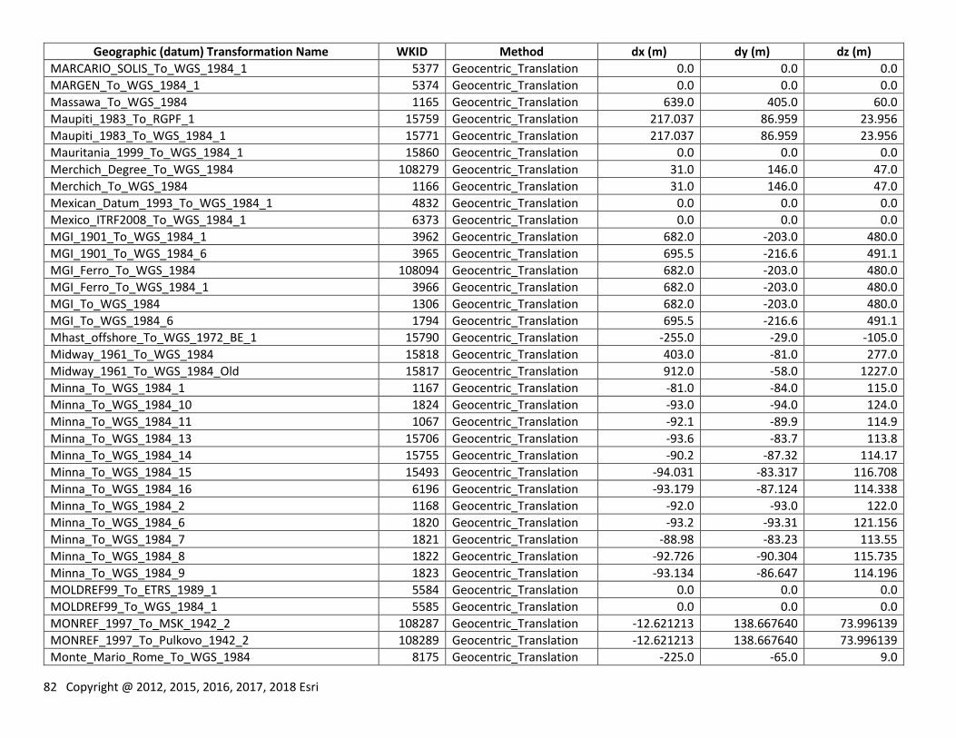
82 Copyright @ 2012, 2015, 2016, 2017, 2018 Esri
Geographic (datum) Transformation Name WKID Method dx (m) dy (m) dz (m)
MARCARIO_SOLIS_To_WGS_1984_1 5377 Geocentric_Translation 0.0 0.0 0.0
MARGEN_To_WGS_1984_1 5374 Geocentric_Translation 0.0 0.0 0.0
Massawa_To_WGS_1984 1165 Geocentric_Translation 639.0 405.0 60.0
Maupiti_1983_To_RGPF_1 15759 Geocentric_Translation 217.037 86.959 23.956
Maupiti_1983_To_WGS_1984_1 15771 Geocentric_Translation 217.037 86.959 23.956
Mauritania_1999_To_WGS_1984_1 15860 Geocentric_Translation 0.0 0.0 0.0
Merchich_Degree_To_WGS_1984 108279 Geocentric_Translation 31.0 146.0 47.0
Merchich_To_WGS_1984 1166 Geocentric_Translation 31.0 146.0 47.0
Mexican_Datum_1993_To_WGS_1984_1 4832 Geocentric_Translation 0.0 0.0 0.0
Mexico_ITRF2008_To_WGS_1984_1 6373 Geocentric_Translation 0.0 0.0 0.0
MGI_1901_To_WGS_1984_1 3962 Geocentric_Translation 682.0 -203.0 480.0
MGI_1901_To_WGS_1984_6 3965 Geocentric_Translation 695.5 -216.6 491.1
MGI_Ferro_To_WGS_1984 108094 Geocentric_Translation 682.0 -203.0 480.0
MGI_Ferro_To_WGS_1984_1 3966 Geocentric_Translation 682.0 -203.0 480.0
MGI_To_WGS_1984 1306 Geocentric_Translation 682.0 -203.0 480.0
MGI_To_WGS_1984_6 1794 Geocentric_Translation 695.5 -216.6 491.1
Mhast_offshore_To_WGS_1972_BE_1 15790 Geocentric_Translation -255.0 -29.0 -105.0
Midway_1961_To_WGS_1984 15818 Geocentric_Translation 403.0 -81.0 277.0
Midway_1961_To_WGS_1984_Old 15817 Geocentric_Translation 912.0 -58.0 1227.0
Minna_To_WGS_1984_1 1167 Geocentric_Translation -81.0 -84.0 115.0
Minna_To_WGS_1984_10 1824 Geocentric_Translation -93.0 -94.0 124.0
Minna_To_WGS_1984_11 1067 Geocentric_Translation -92.1 -89.9 114.9
Minna_To_WGS_1984_13 15706 Geocentric_Translation -93.6 -83.7 113.8
Minna_To_WGS_1984_14 15755 Geocentric_Translation -90.2 -87.32 114.17
Minna_To_WGS_1984_15 15493 Geocentric_Translation -94.031 -83.317 116.708
Minna_To_WGS_1984_16 6196 Geocentric_Translation -93.179 -87.124 114.338
Minna_To_WGS_1984_2 1168 Geocentric_Translation -92.0 -93.0 122.0
Minna_To_WGS_1984_6 1820 Geocentric_Translation -93.2 -93.31 121.156
Minna_To_WGS_1984_7 1821 Geocentric_Translation -88.98 -83.23 113.55
Minna_To_WGS_1984_8 1822 Geocentric_Translation -92.726 -90.304 115.735
Minna_To_WGS_1984_9 1823 Geocentric_Translation -93.134 -86.647 114.196
MOLDREF99_To_ETRS_1989_1 5584 Geocentric_Translation 0.0 0.0 0.0
MOLDREF99_To_WGS_1984_1 5585 Geocentric_Translation 0.0 0.0 0.0
MONREF_1997_To_MSK_1942_2 108287 Geocentric_Translation -12.621213 138.667640 73.996139
MONREF_1997_To_Pulkovo_1942_2 108289 Geocentric_Translation -12.621213 138.667640 73.996139
Monte_Mario_Rome_To_WGS_1984 8175 Geocentric_Translation -225.0 -65.0 9.0
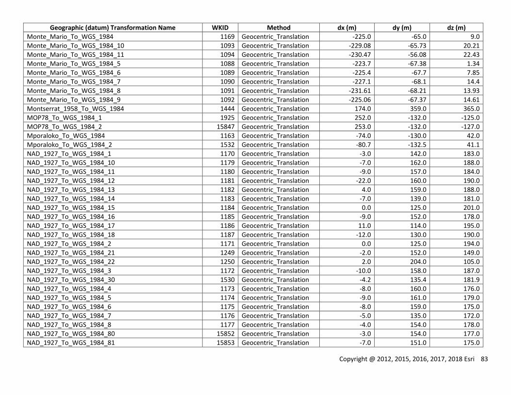
Copyright @ 2012, 2015, 2016, 2017, 2018 Esri 83
Geographic (datum) Transformation Name WKID Method dx (m) dy (m) dz (m)
Monte_Mario_To_WGS_1984 1169 Geocentric_Translation -225.0 -65.0 9.0
Monte_Mario_To_WGS_1984_10 1093 Geocentric_Translation -229.08 -65.73 20.21
Monte_Mario_To_WGS_1984_11 1094 Geocentric_Translation -230.47 -56.08 22.43
Monte_Mario_To_WGS_1984_5 1088 Geocentric_Translation -223.7 -67.38 1.34
Monte_Mario_To_WGS_1984_6 1089 Geocentric_Translation -225.4 -67.7 7.85
Monte_Mario_To_WGS_1984_7 1090 Geocentric_Translation -227.1 -68.1 14.4
Monte_Mario_To_WGS_1984_8 1091 Geocentric_Translation -231.61 -68.21 13.93
Monte_Mario_To_WGS_1984_9 1092 Geocentric_Translation -225.06 -67.37 14.61
Montserrat_1958_To_WGS_1984 1444 Geocentric_Translation 174.0 359.0 365.0
MOP78_To_WGS_1984_1 1925 Geocentric_Translation 252.0 -132.0 -125.0
MOP78_To_WGS_1984_2 15847 Geocentric_Translation 253.0 -132.0 -127.0
Mporaloko_To_WGS_1984 1163 Geocentric_Translation -74.0 -130.0 42.0
Mporaloko_To_WGS_1984_2 1532 Geocentric_Translation -80.7 -132.5 41.1
NAD_1927_To_WGS_1984_1 1170 Geocentric_Translation -3.0 142.0 183.0
NAD_1927_To_WGS_1984_10 1179 Geocentric_Translation -7.0 162.0 188.0
NAD_1927_To_WGS_1984_11 1180 Geocentric_Translation -9.0 157.0 184.0
NAD_1927_To_WGS_1984_12 1181 Geocentric_Translation -22.0 160.0 190.0
NAD_1927_To_WGS_1984_13 1182 Geocentric_Translation 4.0 159.0 188.0
NAD_1927_To_WGS_1984_14 1183 Geocentric_Translation -7.0 139.0 181.0
NAD_1927_To_WGS_1984_15 1184 Geocentric_Translation 0.0 125.0 201.0
NAD_1927_To_WGS_1984_16 1185 Geocentric_Translation -9.0 152.0 178.0
NAD_1927_To_WGS_1984_17 1186 Geocentric_Translation 11.0 114.0 195.0
NAD_1927_To_WGS_1984_18 1187 Geocentric_Translation -12.0 130.0 190.0
NAD_1927_To_WGS_1984_2 1171 Geocentric_Translation 0.0 125.0 194.0
NAD_1927_To_WGS_1984_21 1249 Geocentric_Translation -2.0 152.0 149.0
NAD_1927_To_WGS_1984_22 1250 Geocentric_Translation 2.0 204.0 105.0
NAD_1927_To_WGS_1984_3 1172 Geocentric_Translation -10.0 158.0 187.0
NAD_1927_To_WGS_1984_30 1530 Geocentric_Translation -4.2 135.4 181.9
NAD_1927_To_WGS_1984_4 1173 Geocentric_Translation -8.0 160.0 176.0
NAD_1927_To_WGS_1984_5 1174 Geocentric_Translation -9.0 161.0 179.0
NAD_1927_To_WGS_1984_6 1175 Geocentric_Translation -8.0 159.0 175.0
NAD_1927_To_WGS_1984_7 1176 Geocentric_Translation -5.0 135.0 172.0
NAD_1927_To_WGS_1984_8 1177 Geocentric_Translation -4.0 154.0 178.0
NAD_1927_To_WGS_1984_80 15852 Geocentric_Translation -3.0 154.0 177.0
NAD_1927_To_WGS_1984_81 15853 Geocentric_Translation -7.0 151.0 175.0
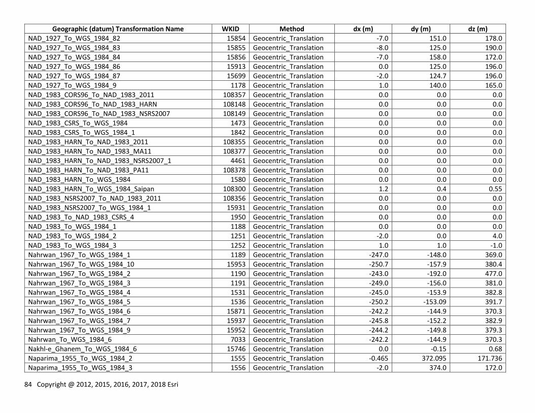
84 Copyright @ 2012, 2015, 2016, 2017, 2018 Esri
Geographic (datum) Transformation Name WKID Method dx (m) dy (m) dz (m)
NAD_1927_To_WGS_1984_82 15854 Geocentric_Translation -7.0 151.0 178.0
NAD_1927_To_WGS_1984_83 15855 Geocentric_Translation -8.0 125.0 190.0
NAD_1927_To_WGS_1984_84 15856 Geocentric_Translation -7.0 158.0 172.0
NAD_1927_To_WGS_1984_86 15913 Geocentric_Translation 0.0 125.0 196.0
NAD_1927_To_WGS_1984_87 15699 Geocentric_Translation -2.0 124.7 196.0
NAD_1927_To_WGS_1984_9 1178 Geocentric_Translation 1.0 140.0 165.0
NAD_1983_CORS96_To_NAD_1983_2011 108357 Geocentric_Translation 0.0 0.0 0.0
NAD_1983_CORS96_To_NAD_1983_HARN 108148 Geocentric_Translation 0.0 0.0 0.0
NAD_1983_CORS96_To_NAD_1983_NSRS2007 108149 Geocentric_Translation 0.0 0.0 0.0
NAD_1983_CSRS_To_WGS_1984 1473 Geocentric_Translation 0.0 0.0 0.0
NAD_1983_CSRS_To_WGS_1984_1 1842 Geocentric_Translation 0.0 0.0 0.0
NAD_1983_HARN_To_NAD_1983_2011 108355 Geocentric_Translation 0.0 0.0 0.0
NAD_1983_HARN_To_NAD_1983_MA11 108377 Geocentric_Translation 0.0 0.0 0.0
NAD_1983_HARN_To_NAD_1983_NSRS2007_1 4461 Geocentric_Translation 0.0 0.0 0.0
NAD_1983_HARN_To_NAD_1983_PA11 108378 Geocentric_Translation 0.0 0.0 0.0
NAD_1983_HARN_To_WGS_1984 1580 Geocentric_Translation 0.0 0.0 0.0
NAD_1983_HARN_To_WGS_1984_Saipan 108300 Geocentric_Translation 1.2 0.4 0.55
NAD_1983_NSRS2007_To_NAD_1983_2011 108356 Geocentric_Translation 0.0 0.0 0.0
NAD_1983_NSRS2007_To_WGS_1984_1 15931 Geocentric_Translation 0.0 0.0 0.0
NAD_1983_To_NAD_1983_CSRS_4 1950 Geocentric_Translation 0.0 0.0 0.0
NAD_1983_To_WGS_1984_1 1188 Geocentric_Translation 0.0 0.0 0.0
NAD_1983_To_WGS_1984_2 1251 Geocentric_Translation -2.0 0.0 4.0
NAD_1983_To_WGS_1984_3 1252 Geocentric_Translation 1.0 1.0 -1.0
Nahrwan_1967_To_WGS_1984_1 1189 Geocentric_Translation -247.0 -148.0 369.0
Nahrwan_1967_To_WGS_1984_10 15953 Geocentric_Translation -250.7 -157.9 380.4
Nahrwan_1967_To_WGS_1984_2 1190 Geocentric_Translation -243.0 -192.0 477.0
Nahrwan_1967_To_WGS_1984_3 1191 Geocentric_Translation -249.0 -156.0 381.0
Nahrwan_1967_To_WGS_1984_4 1531 Geocentric_Translation -245.0 -153.9 382.8
Nahrwan_1967_To_WGS_1984_5 1536 Geocentric_Translation -250.2 -153.09 391.7
Nahrwan_1967_To_WGS_1984_6 15871 Geocentric_Translation -242.2 -144.9 370.3
Nahrwan_1967_To_WGS_1984_7 15937 Geocentric_Translation -245.8 -152.2 382.9
Nahrwan_1967_To_WGS_1984_9 15952 Geocentric_Translation -244.2 -149.8 379.3
Nahrwan_To_WGS_1984_6 7033 Geocentric_Translation -242.2 -144.9 370.3
Nakhl-e_Ghanem_To_WGS_1984_6 15746 Geocentric_Translation 0.0 -0.15 0.68
Naparima_1955_To_WGS_1984_2 1555 Geocentric_Translation -0.465 372.095 171.736
Naparima_1955_To_WGS_1984_3 1556 Geocentric_Translation -2.0 374.0 172.0
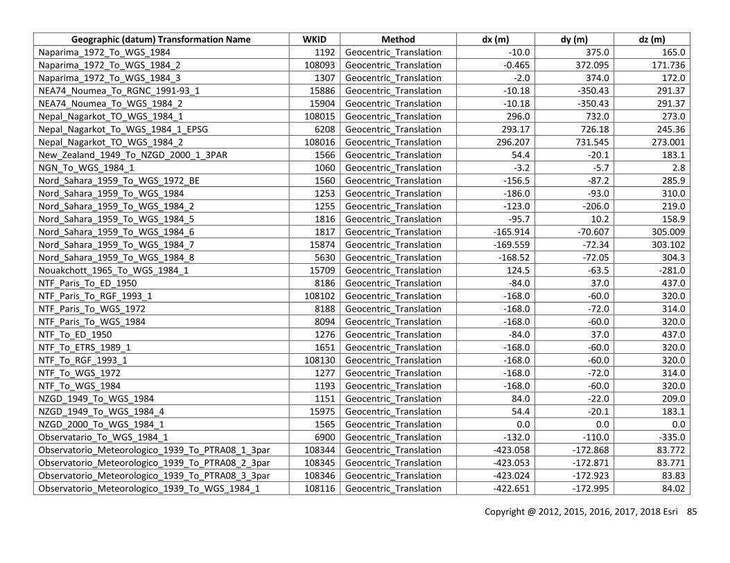
Copyright @ 2012, 2015, 2016, 2017, 2018 Esri 85
Geographic (datum) Transformation Name WKID Method dx (m) dy (m) dz (m)
Naparima_1972_To_WGS_1984 1192 Geocentric_Translation -10.0 375.0 165.0
Naparima_1972_To_WGS_1984_2 108093 Geocentric_Translation -0.465 372.095 171.736
Naparima_1972_To_WGS_1984_3 1307 Geocentric_Translation -2.0 374.0 172.0
NEA74_Noumea_To_RGNC_1991-93_1 15886 Geocentric_Translation -10.18 -350.43 291.37
NEA74_Noumea_To_WGS_1984_2 15904 Geocentric_Translation -10.18 -350.43 291.37
Nepal_Nagarkot_TO_WGS_1984_1 108015 Geocentric_Translation 296.0 732.0 273.0
Nepal_Nagarkot_To_WGS_1984_1_EPSG 6208 Geocentric_Translation 293.17 726.18 245.36
Nepal_Nagarkot_TO_WGS_1984_2 108016 Geocentric_Translation 296.207 731.545 273.001
New_Zealand_1949_To_NZGD_2000_1_3PAR 1566 Geocentric_Translation 54.4 -20.1 183.1
NGN_To_WGS_1984_1 1060 Geocentric_Translation -3.2 -5.7 2.8
Nord_Sahara_1959_To_WGS_1972_BE 1560 Geocentric_Translation -156.5 -87.2 285.9
Nord_Sahara_1959_To_WGS_1984 1253 Geocentric_Translation -186.0 -93.0 310.0
Nord_Sahara_1959_To_WGS_1984_2 1255 Geocentric_Translation -123.0 -206.0 219.0
Nord_Sahara_1959_To_WGS_1984_5 1816 Geocentric_Translation -95.7 10.2 158.9
Nord_Sahara_1959_To_WGS_1984_6 1817 Geocentric_Translation -165.914 -70.607 305.009
Nord_Sahara_1959_To_WGS_1984_7 15874 Geocentric_Translation -169.559 -72.34 303.102
Nord_Sahara_1959_To_WGS_1984_8 5630 Geocentric_Translation -168.52 -72.05 304.3
Nouakchott_1965_To_WGS_1984_1 15709 Geocentric_Translation 124.5 -63.5 -281.0
NTF_Paris_To_ED_1950 8186 Geocentric_Translation -84.0 37.0 437.0
NTF_Paris_To_RGF_1993_1 108102 Geocentric_Translation -168.0 -60.0 320.0
NTF_Paris_To_WGS_1972 8188 Geocentric_Translation -168.0 -72.0 314.0
NTF_Paris_To_WGS_1984 8094 Geocentric_Translation -168.0 -60.0 320.0
NTF_To_ED_1950 1276 Geocentric_Translation -84.0 37.0 437.0
NTF_To_ETRS_1989_1 1651 Geocentric_Translation -168.0 -60.0 320.0
NTF_To_RGF_1993_1 108130 Geocentric_Translation -168.0 -60.0 320.0
NTF_To_WGS_1972 1277 Geocentric_Translation -168.0 -72.0 314.0
NTF_To_WGS_1984 1193 Geocentric_Translation -168.0 -60.0 320.0
NZGD_1949_To_WGS_1984 1151 Geocentric_Translation 84.0 -22.0 209.0
NZGD_1949_To_WGS_1984_4 15975 Geocentric_Translation 54.4 -20.1 183.1
NZGD_2000_To_WGS_1984_1 1565 Geocentric_Translation 0.0 0.0 0.0
Observatario_To_WGS_1984_1 6900 Geocentric_Translation -132.0 -110.0 -335.0
Observatorio_Meteorologico_1939_To_PTRA08_1_3par 108344 Geocentric_Translation -423.058 -172.868 83.772
Observatorio_Meteorologico_1939_To_PTRA08_2_3par 108345 Geocentric_Translation -423.053 -172.871 83.771
Observatorio_Meteorologico_1939_To_PTRA08_3_3par 108346 Geocentric_Translation -423.024 -172.923 83.83
Observatorio_Meteorologico_1939_To_WGS_1984_1 108116 Geocentric_Translation -422.651 -172.995 84.02
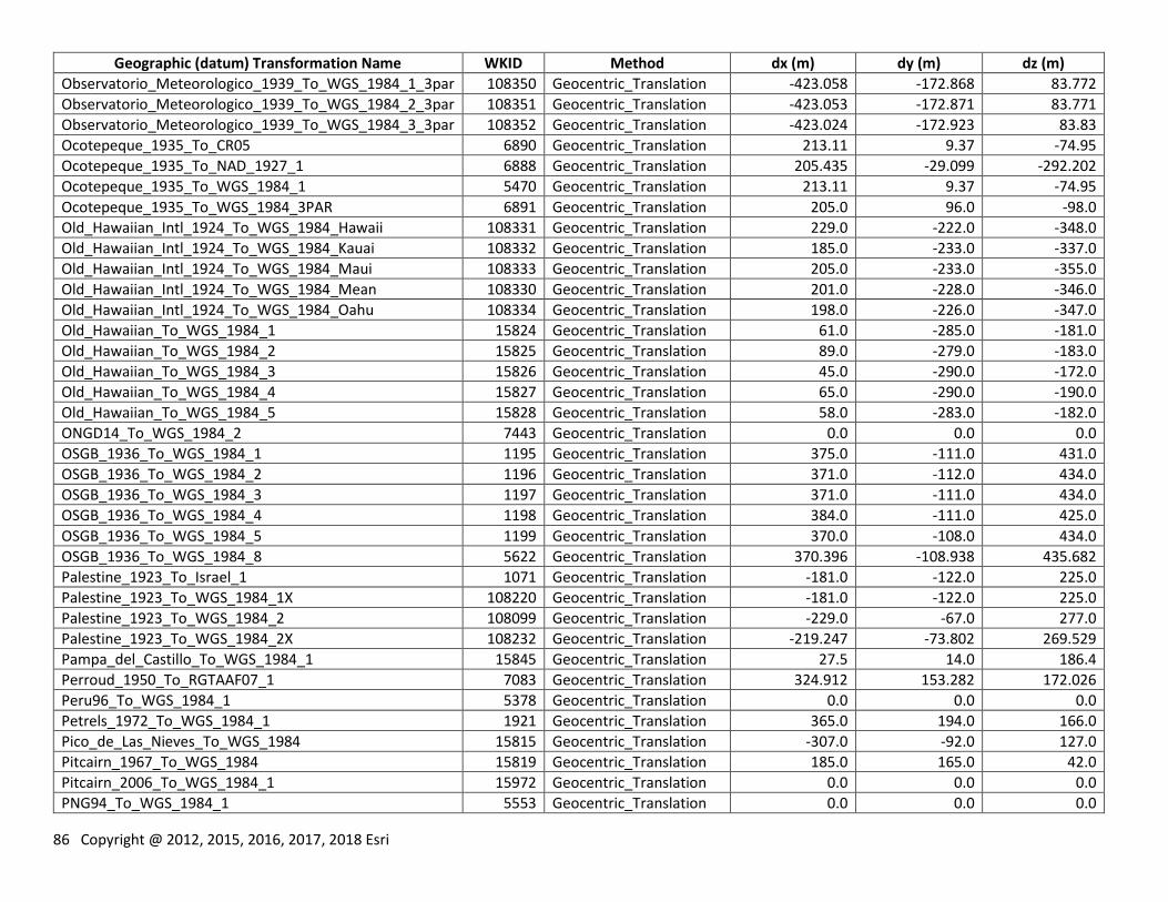
86 Copyright @ 2012, 2015, 2016, 2017, 2018 Esri
Geographic (datum) Transformation Name WKID Method dx (m) dy (m) dz (m)
Observatorio_Meteorologico_1939_To_WGS_1984_1_3par 108350 Geocentric_Translation -423.058 -172.868 83.772
Observatorio_Meteorologico_1939_To_WGS_1984_2_3par 108351 Geocentric_Translation -423.053 -172.871 83.771
Observatorio_Meteorologico_1939_To_WGS_1984_3_3par 108352 Geocentric_Translation -423.024 -172.923 83.83
Ocotepeque_1935_To_CR05 6890 Geocentric_Translation 213.11 9.37 -74.95
Ocotepeque_1935_To_NAD_1927_1 6888 Geocentric_Translation 205.435 -29.099 -292.202
Ocotepeque_1935_To_WGS_1984_1 5470 Geocentric_Translation 213.11 9.37 -74.95
Ocotepeque_1935_To_WGS_1984_3PAR 6891 Geocentric_Translation 205.0 96.0 -98.0
Old_Hawaiian_Intl_1924_To_WGS_1984_Hawaii 108331 Geocentric_Translation 229.0 -222.0 -348.0
Old_Hawaiian_Intl_1924_To_WGS_1984_Kauai 108332 Geocentric_Translation 185.0 -233.0 -337.0
Old_Hawaiian_Intl_1924_To_WGS_1984_Maui 108333 Geocentric_Translation 205.0 -233.0 -355.0
Old_Hawaiian_Intl_1924_To_WGS_1984_Mean 108330 Geocentric_Translation 201.0 -228.0 -346.0
Old_Hawaiian_Intl_1924_To_WGS_1984_Oahu 108334 Geocentric_Translation 198.0 -226.0 -347.0
Old_Hawaiian_To_WGS_1984_1 15824 Geocentric_Translation 61.0 -285.0 -181.0
Old_Hawaiian_To_WGS_1984_2 15825 Geocentric_Translation 89.0 -279.0 -183.0
Old_Hawaiian_To_WGS_1984_3 15826 Geocentric_Translation 45.0 -290.0 -172.0
Old_Hawaiian_To_WGS_1984_4 15827 Geocentric_Translation 65.0 -290.0 -190.0
Old_Hawaiian_To_WGS_1984_5 15828 Geocentric_Translation 58.0 -283.0 -182.0
ONGD14_To_WGS_1984_2 7443 Geocentric_Translation 0.0 0.0 0.0
OSGB_1936_To_WGS_1984_1 1195 Geocentric_Translation 375.0 -111.0 431.0
OSGB_1936_To_WGS_1984_2 1196 Geocentric_Translation 371.0 -112.0 434.0
OSGB_1936_To_WGS_1984_3 1197 Geocentric_Translation 371.0 -111.0 434.0
OSGB_1936_To_WGS_1984_4 1198 Geocentric_Translation 384.0 -111.0 425.0
OSGB_1936_To_WGS_1984_5 1199 Geocentric_Translation 370.0 -108.0 434.0
OSGB_1936_To_WGS_1984_8 5622 Geocentric_Translation 370.396 -108.938 435.682
Palestine_1923_To_Israel_1 1071 Geocentric_Translation -181.0 -122.0 225.0
Palestine_1923_To_WGS_1984_1X 108220 Geocentric_Translation -181.0 -122.0 225.0
Palestine_1923_To_WGS_1984_2 108099 Geocentric_Translation -229.0 -67.0 277.0
Palestine_1923_To_WGS_1984_2X 108232 Geocentric_Translation -219.247 -73.802 269.529
Pampa_del_Castillo_To_WGS_1984_1 15845 Geocentric_Translation 27.5 14.0 186.4
Perroud_1950_To_RGTAAF07_1 7083 Geocentric_Translation 324.912 153.282 172.026
Peru96_To_WGS_1984_1 5378 Geocentric_Translation 0.0 0.0 0.0
Petrels_1972_To_WGS_1984_1 1921 Geocentric_Translation 365.0 194.0 166.0
Pico_de_Las_Nieves_To_WGS_1984 15815 Geocentric_Translation -307.0 -92.0 127.0
Pitcairn_1967_To_WGS_1984 15819 Geocentric_Translation 185.0 165.0 42.0
Pitcairn_2006_To_WGS_1984_1 15972 Geocentric_Translation 0.0 0.0 0.0
PNG94_To_WGS_1984_1 5553 Geocentric_Translation 0.0 0.0 0.0
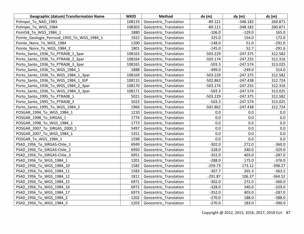
Copyright @ 2012, 2015, 2016, 2017, 2018 Esri 87
Geographic (datum) Transformation Name WKID Method dx (m) dy (m) dz (m)
Pohnpei_To_NAD_1983 108133 Geocentric_Translation -89.121 -348.182 260.871
Pohnpei_To_WGS_1984 108303 Geocentric_Translation -89.121 -348.182 260.871
Point58_To_WGS_1984_1 1880 Geocentric_Translation -106.0 -129.0 165.0
Pointe_Geologie_Perroud_1950_To_WGS_1984_1 1922 Geocentric_Translation 325.0 154.0 172.0
Pointe_Noire_To_WGS_1984 1200 Geocentric_Translation -148.0 51.0 -291.0
Pointe_Noire_To_WGS_1984_2 1801 Geocentric_Translation -145.0 52.7 -291.6
Porto_Santo_1936_To_PTRA08_1_3par 108163 Geocentric_Translation -503.229 -247.375 312.582
Porto_Santo_1936_To_PTRA08_2_3par 108164 Geocentric_Translation -503.174 -247.255 312.316
Porto_Santo_1936_To_PTRA08_3_3par 108165 Geocentric_Translation -503.3 -247.574 313.025
Porto_Santo_1936_To_WGS_1984_1 1888 Geocentric_Translation -499.0 -249.0 314.0
Porto_Santo_1936_To_WGS_1984_1_3par 108169 Geocentric_Translation -503.229 -247.375 312.582
Porto_Santo_1936_To_WGS_1984_1_IGP 108115 Geocentric_Translation -502.862 -247.438 312.724
Porto_Santo_1936_To_WGS_1984_2_3par 108170 Geocentric_Translation -503.174 -247.255 312.316
Porto_Santo_1936_To_WGS_1984_3_3par 108171 Geocentric_Translation -503.3 -247.574 313.025
Porto_Santo_1995_To_PTRA08_1 5021 Geocentric_Translation -503.229 -247.375 312.582
Porto_Santo_1995_To_PTRA08_3 5023 Geocentric_Translation -503.3 -247.574 313.025
Porto_Santo_1995_To_WGS_1984_2 1966 Geocentric_Translation -502.862 -247.438 312.724
POSGAR_1994_To_WGS_1984_1 1210 Geocentric_Translation 0.0 0.0 0.0
POSGAR_1998_To_SIRGAS_1 1774 Geocentric_Translation 0.0 0.0 0.0
POSGAR_1998_To_WGS_1984_1 1773 Geocentric_Translation 0.0 0.0 0.0
POSGAR_2007_To_SIRGAS_2000_1 5497 Geocentric_Translation 0.0 0.0 0.0
POSGAR_2007_To_WGS_1984_1 5351 Geocentric_Translation 0.0 0.0 0.0
POSGAR_To_WGS_1984_1 1598 Geocentric_Translation 0.0 0.0 0.0
PSAD_1956_To_SIRGAS-Chile_1 6949 Geocentric_Translation -302.0 272.0 -360.0
PSAD_1956_To_SIRGAS-Chile_2 6950 Geocentric_Translation -328.0 340.0 -329.0
PSAD_1956_To_SIRGAS-Chile_3 6951 Geocentric_Translation -352.0 403.0 -287.0
PSAD_1956_To_WGS_1984_1 1201 Geocentric_Translation -288.0 175.0 -376.0
PSAD_1956_To_WGS_1984_10 1582 Geocentric_Translation -259.73 173.12 -398.27
PSAD_1956_To_WGS_1984_11 1583 Geocentric_Translation -307.7 265.3 -363.5
PSAD_1956_To_WGS_1984_12 1811 Geocentric_Translation -291.87 106.37 -364.52
PSAD_1956_To_WGS_1984_15 6971 Geocentric_Translation -302.0 272.0 -360.0
PSAD_1956_To_WGS_1984_16 6972 Geocentric_Translation -328.0 340.0 -329.0
PSAD_1956_To_WGS_1984_17 6973 Geocentric_Translation -352.0 403.0 -287.0
PSAD_1956_To_WGS_1984_2 1202 Geocentric_Translation -270.0 188.0 -388.0
PSAD_1956_To_WGS_1984_3 1203 Geocentric_Translation -270.0 183.0 -390.0
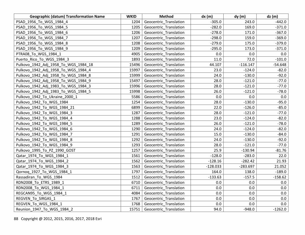
88 Copyright @ 2012, 2015, 2016, 2017, 2018 Esri
Geographic (datum) Transformation Name WKID Method dx (m) dy (m) dz (m)
PSAD_1956_To_WGS_1984_4 1204 Geocentric_Translation -305.0 243.0 -442.0
PSAD_1956_To_WGS_1984_5 1205 Geocentric_Translation -282.0 169.0 -371.0
PSAD_1956_To_WGS_1984_6 1206 Geocentric_Translation -278.0 171.0 -367.0
PSAD_1956_To_WGS_1984_7 1207 Geocentric_Translation -298.0 159.0 -369.0
PSAD_1956_To_WGS_1984_8 1208 Geocentric_Translation -279.0 175.0 -379.0
PSAD_1956_To_WGS_1984_9 1209 Geocentric_Translation -295.0 173.0 -371.0
PTRA08_To_WGS_1984_1 4905 Geocentric_Translation 0.0 0.0 0.0
Puerto_Rico_To_WGS_1984_3 1893 Geocentric_Translation 11.0 72.0 -101.0
Pulkovo_1942_Adj_1958_To_WGS_1984_18 15496 Geocentric_Translation 44.107 -116.147 -54.648
Pulkovo_1942_Adj_1958_To_WGS_1984_4 15997 Geocentric_Translation 23.0 -124.0 -82.0
Pulkovo_1942_Adj_1958_To_WGS_1984_8 15999 Geocentric_Translation 24.0 -130.0 -92.0
Pulkovo_1942_Adj_1958_To_WGS_1984_9 15497 Geocentric_Translation 28.0 -121.0 -77.0
Pulkovo_1942_Adj_1983_To_WGS_1984_3 15996 Geocentric_Translation 28.0 -121.0 -77.0
Pulkovo_1942_Adj_1983_To_WGS_1984_5 15998 Geocentric_Translation 26.0 -121.0 -78.0
Pulkovo_1942_To_Ukraine_2000_1 5586 Geocentric_Translation 0.0 0.0 0.0
Pulkovo_1942_To_WGS_1984 1254 Geocentric_Translation 28.0 -130.0 -95.0
Pulkovo_1942_To_WGS_1984_21 6899 Geocentric_Translation 22.0 -126.0 -85.0
Pulkovo_1942_To_WGS_1984_3 1287 Geocentric_Translation 28.0 -121.0 -77.0
Pulkovo_1942_To_WGS_1984_4 1288 Geocentric_Translation 23.0 -124.0 -82.0
Pulkovo_1942_To_WGS_1984_5 1289 Geocentric_Translation 26.0 -121.0 -78.0
Pulkovo_1942_To_WGS_1984_6 1290 Geocentric_Translation 24.0 -124.0 -82.0
Pulkovo_1942_To_WGS_1984_7 1291 Geocentric_Translation 15.0 -130.0 -84.0
Pulkovo_1942_To_WGS_1984_8 1292 Geocentric_Translation 24.0 -130.0 -92.0
Pulkovo_1942_To_WGS_1984_9 1293 Geocentric_Translation 28.0 -121.0 -77.0
Pulkovo_1995_To_PZ_1990_GOST 1257 Geocentric_Translation 25.9 -130.94 -81.76
Qatar_1974_To_WGS_1984_1 1561 Geocentric_Translation -128.0 -283.0 22.0
Qatar_1974_To_WGS_1984_2 1562 Geocentric_Translation -128.16 -282.42 21.93
Qatar_1974_To_WGS_1984_3 1563 Geocentric_Translation -128.033 -283.697 21.052
Qornoq_1927_To_WGS_1984_1 1797 Geocentric_Translation 164.0 138.0 -189.0
Rassadiran_To_WGS_1984 1512 Geocentric_Translation -133.63 -157.5 -158.62
RDN2008_To_ETRS_1989_1 6710 Geocentric_Translation 0.0 0.0 0.0
RDN2008_To_WGS_1984_1 6711 Geocentric_Translation 0.0 0.0 0.0
REGCAN95_To_WGS_1984_1 4084 Geocentric_Translation 0.0 0.0 0.0
REGVEN_To_SIRGAS_1 1767 Geocentric_Translation 0.0 0.0 0.0
REGVEN_To_WGS_1984_1 1768 Geocentric_Translation 0.0 0.0 0.0
Reunion_1947_To_WGS_1984_2 15751 Geocentric_Translation 94.0 -948.0 -1262.0
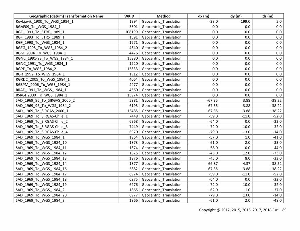
Copyright @ 2012, 2015, 2016, 2017, 2018 Esri 89
Geographic (datum) Transformation Name WKID Method dx (m) dy (m) dz (m)
Reykjavik_1900_To_WGS_1984_1 1994 Geocentric_Translation -28.0 199.0 5.0
RGAF09_To_WGS_1984_1 5501 Geocentric_Translation 0.0 0.0 0.0
RGF_1993_To_ETRF_1989_1 108199 Geocentric_Translation 0.0 0.0 0.0
RGF_1993_To_ETRS_1989_1 1591 Geocentric_Translation 0.0 0.0 0.0
RGF_1993_To_WGS_1984_1 1671 Geocentric_Translation 0.0 0.0 0.0
RGFG_1995_To_WGS_1984_2 4840 Geocentric_Translation 0.0 0.0 0.0
RGM_2004_To_WGS_1984_1 4476 Geocentric_Translation 0.0 0.0 0.0
RGNC_1991-93_To_WGS_1984_1 15880 Geocentric_Translation 0.0 0.0 0.0
RGNC_1991_To_WGS_1984_1 1920 Geocentric_Translation 0.0 0.0 0.0
RGPF_To_WGS_1984_2 15833 Geocentric_Translation 0.0 0.0 0.0
RGR_1992_To_WGS_1984_1 1912 Geocentric_Translation 0.0 0.0 0.0
RGRDC_2005_To_WGS_1984_1 4064 Geocentric_Translation 0.0 0.0 0.0
RGSPM_2006_To_WGS_1984_1 4477 Geocentric_Translation 0.0 0.0 0.0
RRAF_1991_To_WGS_1984_1 4560 Geocentric_Translation 0.0 0.0 0.0
RSRGD2000_To_WGS_1984_1 15974 Geocentric_Translation 0.0 0.0 0.0
SAD_1969_96_To_SIRGAS_2000_2 5881 Geocentric_Translation -67.35 3.88 -38.22
SAD_1969_96_To_WGS_1984_2 6195 Geocentric_Translation -67.35 3.88 -38.22
SAD_1969_To_SIRGAS_2000_1 15485 Geocentric_Translation -67.35 3.88 -38.22
SAD_1969_To_SIRGAS-Chile_1 7448 Geocentric_Translation -59.0 -11.0 -52.0
SAD_1969_To_SIRGAS-Chile_2 6968 Geocentric_Translation -64.0 0.0 -32.0
SAD_1969_To_SIRGAS-Chile_3 7449 Geocentric_Translation -72.0 10.0 -32.0
SAD_1969_To_SIRGAS-Chile_4 6970 Geocentric_Translation -79.0 13.0 -14.0
SAD_1969_To_WGS_1984_1 1864 Geocentric_Translation -57.0 1.0 -41.0
SAD_1969_To_WGS_1984_10 1873 Geocentric_Translation -61.0 2.0 -33.0
SAD_1969_To_WGS_1984_11 1874 Geocentric_Translation -58.0 0.0 -44.0
SAD_1969_To_WGS_1984_12 1875 Geocentric_Translation -45.0 12.0 -33.0
SAD_1969_To_WGS_1984_13 1876 Geocentric_Translation -45.0 8.0 -33.0
SAD_1969_To_WGS_1984_14 1877 Geocentric_Translation -66.87 4.37 -38.52
SAD_1969_To_WGS_1984_16 5882 Geocentric_Translation -67.35 3.88 -38.22
SAD_1969_To_WGS_1984_17 6974 Geocentric_Translation -59.0 -11.0 -52.0
SAD_1969_To_WGS_1984_18 6975 Geocentric_Translation -64.0 0.0 -32.0
SAD_1969_To_WGS_1984_19 6976 Geocentric_Translation -72.0 10.0 -32.0
SAD_1969_To_WGS_1984_2 1865 Geocentric_Translation -62.0 -1.0 -37.0
SAD_1969_To_WGS_1984_20 6977 Geocentric_Translation -79.0 13.0 -14.0
SAD_1969_To_WGS_1984_3 1866 Geocentric_Translation -61.0 2.0 -48.0
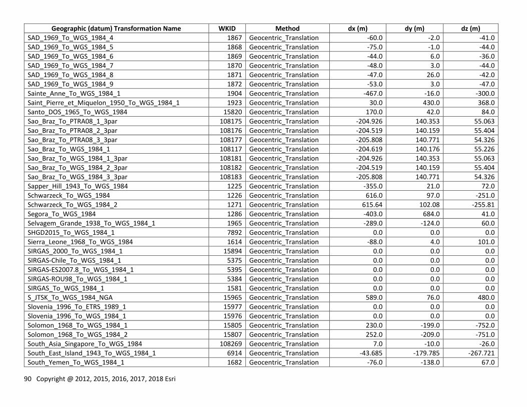
90 Copyright @ 2012, 2015, 2016, 2017, 2018 Esri
Geographic (datum) Transformation Name WKID Method dx (m) dy (m) dz (m)
SAD_1969_To_WGS_1984_4 1867 Geocentric_Translation -60.0 -2.0 -41.0
SAD_1969_To_WGS_1984_5 1868 Geocentric_Translation -75.0 -1.0 -44.0
SAD_1969_To_WGS_1984_6 1869 Geocentric_Translation -44.0 6.0 -36.0
SAD_1969_To_WGS_1984_7 1870 Geocentric_Translation -48.0 3.0 -44.0
SAD_1969_To_WGS_1984_8 1871 Geocentric_Translation -47.0 26.0 -42.0
SAD_1969_To_WGS_1984_9 1872 Geocentric_Translation -53.0 3.0 -47.0
Sainte_Anne_To_WGS_1984_1 1904 Geocentric_Translation -467.0 -16.0 -300.0
Saint_Pierre_et_Miquelon_1950_To_WGS_1984_1 1923 Geocentric_Translation 30.0 430.0 368.0
Santo_DOS_1965_To_WGS_1984 15820 Geocentric_Translation 170.0 42.0 84.0
Sao_Braz_To_PTRA08_1_3par 108175 Geocentric_Translation -204.926 140.353 55.063
Sao_Braz_To_PTRA08_2_3par 108176 Geocentric_Translation -204.519 140.159 55.404
Sao_Braz_To_PTRA08_3_3par 108177 Geocentric_Translation -205.808 140.771 54.326
Sao_Braz_To_WGS_1984_1 108117 Geocentric_Translation -204.619 140.176 55.226
Sao_Braz_To_WGS_1984_1_3par 108181 Geocentric_Translation -204.926 140.353 55.063
Sao_Braz_To_WGS_1984_2_3par 108182 Geocentric_Translation -204.519 140.159 55.404
Sao_Braz_To_WGS_1984_3_3par 108183 Geocentric_Translation -205.808 140.771 54.326
Sapper_Hill_1943_To_WGS_1984 1225 Geocentric_Translation -355.0 21.0 72.0
Schwarzeck_To_WGS_1984 1226 Geocentric_Translation 616.0 97.0 -251.0
Schwarzeck_To_WGS_1984_2 1271 Geocentric_Translation 615.64 102.08 -255.81
Segora_To_WGS_1984 1286 Geocentric_Translation -403.0 684.0 41.0
Selvagem_Grande_1938_To_WGS_1984_1 1965 Geocentric_Translation -289.0 -124.0 60.0
SHGD2015_To_WGS_1984_1 7892 Geocentric_Translation 0.0 0.0 0.0
Sierra_Leone_1968_To_WGS_1984 1614 Geocentric_Translation -88.0 4.0 101.0
SIRGAS_2000_To_WGS_1984_1 15894 Geocentric_Translation 0.0 0.0 0.0
SIRGAS-Chile_To_WGS_1984_1 5375 Geocentric_Translation 0.0 0.0 0.0
SIRGAS-ES2007.8_To_WGS_1984_1 5395 Geocentric_Translation 0.0 0.0 0.0
SIRGAS-ROU98_To_WGS_1984_1 5384 Geocentric_Translation 0.0 0.0 0.0
SIRGAS_To_WGS_1984_1 1581 Geocentric_Translation 0.0 0.0 0.0
S_JTSK_To_WGS_1984_NGA 15965 Geocentric_Translation 589.0 76.0 480.0
Slovenia_1996_To_ETRS_1989_1 15977 Geocentric_Translation 0.0 0.0 0.0
Slovenia_1996_To_WGS_1984_1 15976 Geocentric_Translation 0.0 0.0 0.0
Solomon_1968_To_WGS_1984_1 15805 Geocentric_Translation 230.0 -199.0 -752.0
Solomon_1968_To_WGS_1984_2 15807 Geocentric_Translation 252.0 -209.0 -751.0
South_Asia_Singapore_To_WGS_1984 108269 Geocentric_Translation 7.0 -10.0 -26.0
South_East_Island_1943_To_WGS_1984_1 6914 Geocentric_Translation -43.685 -179.785 -267.721
South_Yemen_To_WGS_1984_1 1682 Geocentric_Translation -76.0 -138.0 67.0
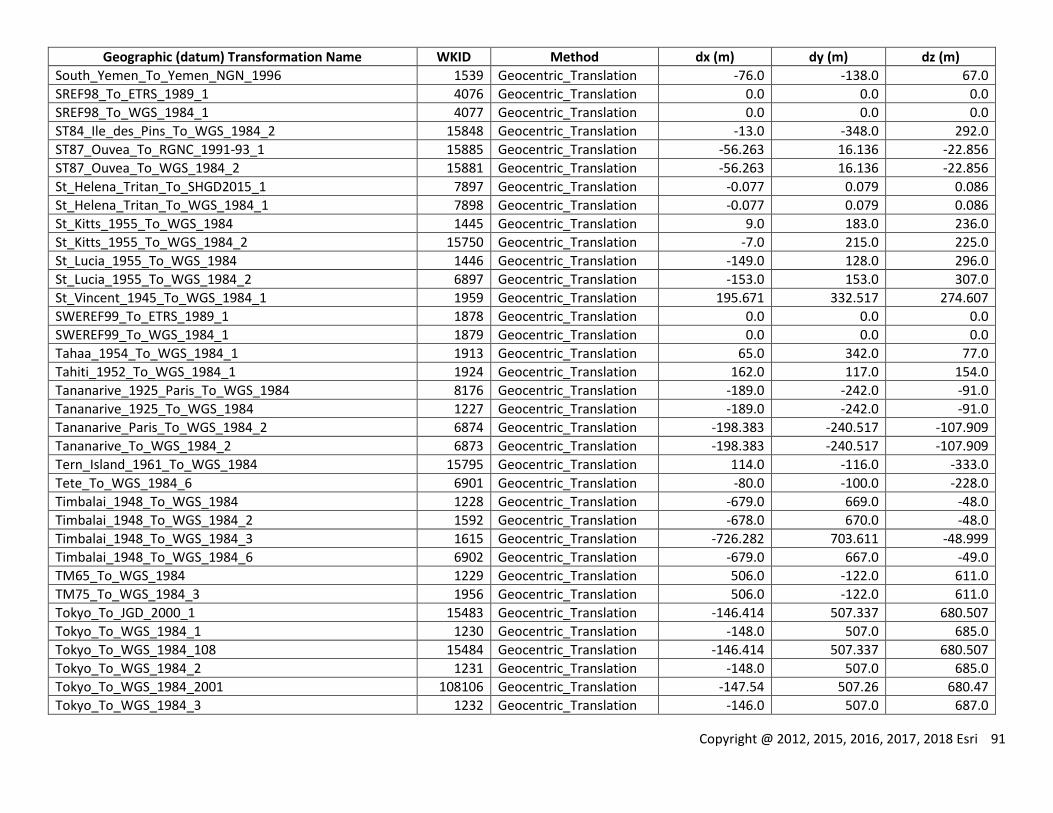
Copyright @ 2012, 2015, 2016, 2017, 2018 Esri 91
Geographic (datum) Transformation Name WKID Method dx (m) dy (m) dz (m)
South_Yemen_To_Yemen_NGN_1996 1539 Geocentric_Translation -76.0 -138.0 67.0
SREF98_To_ETRS_1989_1 4076 Geocentric_Translation 0.0 0.0 0.0
SREF98_To_WGS_1984_1 4077 Geocentric_Translation 0.0 0.0 0.0
ST84_Ile_des_Pins_To_WGS_1984_2 15848 Geocentric_Translation -13.0 -348.0 292.0
ST87_Ouvea_To_RGNC_1991-93_1 15885 Geocentric_Translation -56.263 16.136 -22.856
ST87_Ouvea_To_WGS_1984_2 15881 Geocentric_Translation -56.263 16.136 -22.856
St_Helena_Tritan_To_SHGD2015_1 7897 Geocentric_Translation -0.077 0.079 0.086
St_Helena_Tritan_To_WGS_1984_1 7898 Geocentric_Translation -0.077 0.079 0.086
St_Kitts_1955_To_WGS_1984 1445 Geocentric_Translation 9.0 183.0 236.0
St_Kitts_1955_To_WGS_1984_2 15750 Geocentric_Translation -7.0 215.0 225.0
St_Lucia_1955_To_WGS_1984 1446 Geocentric_Translation -149.0 128.0 296.0
St_Lucia_1955_To_WGS_1984_2 6897 Geocentric_Translation -153.0 153.0 307.0
St_Vincent_1945_To_WGS_1984_1 1959 Geocentric_Translation 195.671 332.517 274.607
SWEREF99_To_ETRS_1989_1 1878 Geocentric_Translation 0.0 0.0 0.0
SWEREF99_To_WGS_1984_1 1879 Geocentric_Translation 0.0 0.0 0.0
Tahaa_1954_To_WGS_1984_1 1913 Geocentric_Translation 65.0 342.0 77.0
Tahiti_1952_To_WGS_1984_1 1924 Geocentric_Translation 162.0 117.0 154.0
Tananarive_1925_Paris_To_WGS_1984 8176 Geocentric_Translation -189.0 -242.0 -91.0
Tananarive_1925_To_WGS_1984 1227 Geocentric_Translation -189.0 -242.0 -91.0
Tananarive_Paris_To_WGS_1984_2 6874 Geocentric_Translation -198.383 -240.517 -107.909
Tananarive_To_WGS_1984_2 6873 Geocentric_Translation -198.383 -240.517 -107.909
Tern_Island_1961_To_WGS_1984 15795 Geocentric_Translation 114.0 -116.0 -333.0
Tete_To_WGS_1984_6 6901 Geocentric_Translation -80.0 -100.0 -228.0
Timbalai_1948_To_WGS_1984 1228 Geocentric_Translation -679.0 669.0 -48.0
Timbalai_1948_To_WGS_1984_2 1592 Geocentric_Translation -678.0 670.0 -48.0
Timbalai_1948_To_WGS_1984_3 1615 Geocentric_Translation -726.282 703.611 -48.999
Timbalai_1948_To_WGS_1984_6 6902 Geocentric_Translation -679.0 667.0 -49.0
TM65_To_WGS_1984 1229 Geocentric_Translation 506.0 -122.0 611.0
TM75_To_WGS_1984_3 1956 Geocentric_Translation 506.0 -122.0 611.0
Tokyo_To_JGD_2000_1 15483 Geocentric_Translation -146.414 507.337 680.507
Tokyo_To_WGS_1984_1 1230 Geocentric_Translation -148.0 507.0 685.0
Tokyo_To_WGS_1984_108 15484 Geocentric_Translation -146.414 507.337 680.507
Tokyo_To_WGS_1984_2 1231 Geocentric_Translation -148.0 507.0 685.0
Tokyo_To_WGS_1984_2001 108106 Geocentric_Translation -147.54 507.26 680.47
Tokyo_To_WGS_1984_3 1232 Geocentric_Translation -146.0 507.0 687.0
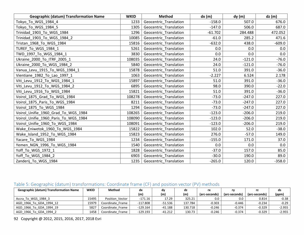
92 Copyright @ 2012, 2015, 2016, 2017, 2018 Esri
Geographic (datum) Transformation Name WKID Method dx (m) dy (m) dz (m)
Tokyo_To_WGS_1984_4 1233 Geocentric_Translation -158.0 507.0 676.0
Tokyo_To_WGS_1984_5 1305 Geocentric_Translation -147.0 506.0 687.0
Trinidad_1903_To_WGS_1984 1296 Geocentric_Translation -61.702 284.488 472.052
Trinidad_1903_To_WGS_1984_2 10085 Geocentric_Translation -61.0 285.2 471.6
Tristan_1968_To_WGS_1984 15816 Geocentric_Translation -632.0 438.0 -609.0
TUREF_To_WGS_1984_1 5261 Geocentric_Translation 0.0 0.0 0.0
TWD_1997_To_WGS_1984_1 3830 Geocentric_Translation 0.0 0.0 0.0
Ukraine_2000_To_ITRF_2005_1 108035 Geocentric_Translation 24.0 -121.0 -76.0
Ukraine_2000_To_WGS_1984_2 5840 Geocentric_Translation 24.0 -121.0 -76.0
Vanua_Levu_1915_To_WGS_1984_1 15878 Geocentric_Translation 51.0 391.0 -36.0
Vientiane_1982_To_Lao_1997_1 1063 Geocentric_Translation -2.227 6.524 2.178
Viti_Levu_1912_To_WGS_1984_1 15897 Geocentric_Translation 51.0 391.0 -36.0
Viti_Levu_1912_To_WGS_1984_2 6895 Geocentric_Translation 98.0 390.0 -22.0
Viti_Levu_1916_To_WGS_1984 15821 Geocentric_Translation 51.0 391.0 -36.0
Voirol_1875_Grad_To_WGS_1984 108278 Geocentric_Translation -73.0 -247.0 227.0
Voirol_1875_Paris_To_WGS_1984 8211 Geocentric_Translation -73.0 -247.0 227.0
Voirol_1875_To_WGS_1984 1294 Geocentric_Translation -73.0 -247.0 227.0
Voirol_Unifie_1960_Grad_To_WGS_1984 108265 Geocentric_Translation -123.0 -206.0 219.0
Voirol_Unifie_1960_Paris_To_WGS_1984 108090 Geocentric_Translation -123.0 -206.0 219.0
Voirol_Unifie_1960_To_WGS_1984 108091 Geocentric_Translation -123.0 -206.0 219.0
Wake_Eniwetok_1960_To_WGS_1984 15822 Geocentric_Translation 102.0 52.0 -38.0
Wake_Island_1952_To_WGS_1984 15823 Geocentric_Translation 276.0 -57.0 149.0
Yacare_To_WGS_1984 1234 Geocentric_Translation -155.0 171.0 37.0
Yemen_NGN_1996_To_WGS_1984 1540 Geocentric_Translation 0.0 0.0 0.0
Yoff_To_WGS_1972_1 1828 Geocentric_Translation -37.0 157.0 85.0
Yoff_To_WGS_1984_2 6903 Geocentric_Translation -30.0 190.0 89.0
Zanderij_To_WGS_1984 1235 Geocentric_Translation -265.0 120.0 -358.0
Table 5: Geographic (datum) transformations: Coordinate frame (CF) and position vector (PV) methods Geographic (datum) Transformation Name WKID Method dx
(m) dy (m)
dz (m)
rx (arc-seconds)
ry (arc-seconds)
rz (arc-seconds)
ds (ppm)
Accra_To_WGS_1984_3 15495 Position_Vector -171.16 17.29 325.21 0.0 0.0 0.814 -0.38
AGD_1966_To_GDA_1994_12 15979 Coordinate_Frame -117.808 -51.536 137.784 -0.303 -0.446 -0.234 -0.29
AGD_1966_To_GDA_1994_19 5827 Coordinate_Frame -129.164 -41.188 130.718 -0.246 -0.374 -0.329 -2.955
AGD_1966_To_GDA_1994_2 1458 Coordinate_Frame -129.193 -41.212 130.73 -0.246 -0.374 -0.329 -2.955
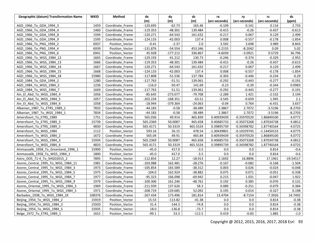
Copyright @ 2012, 2015, 2016, 2017, 2018 Esri 93
Geographic (datum) Transformation Name WKID Method dx (m)
dy (m)
dz (m)
rx (arc-seconds)
ry (arc-seconds)
rz (arc-seconds)
ds (ppm)
AGD_1966_To_GDA_1994_3 1459 Coordinate_Frame -120.695 -62.73 165.46 -0.109 0.141 0.116 2.733
AGD_1966_To_GDA_1994_4 1460 Coordinate_Frame -119.353 -48.301 139.484 -0.415 -0.26 -0.437 -0.613
AGD_1966_To_GDA_1994_8 1594 Coordinate_Frame -120.271 -64.543 161.632 -0.217 0.067 0.129 2.499
AGD_1966_To_GDA_1994_9 1595 Coordinate_Frame -124.133 -42.003 137.4 0.008 -0.557 -0.178 -1.854
AGD_1966_To_PNG_1994_2 6937 Position_Vector -0.41 -2.37 2.0 3.592 3.698 3.989 8.843
AGD_1966_To_PNG_1994_4 6939 Position_Vector -131.876 -54.554 453.346 -5.2155 -8.2042 0.09 5.02
AGD_1966_To_PNG_1994_6 6941 Position_Vector 45.928 -177.212 336.867 -4.6039 -3.0921 0.5729 36.796
AGD_1966_To_WGS_1984_12 1665 Coordinate_Frame -129.193 -41.212 130.73 -0.246 -0.374 -0.329 -2.955
AGD_1966_To_WGS_1984_13 1666 Coordinate_Frame -119.353 -48.301 139.484 -0.415 -0.26 -0.437 -0.613
AGD_1966_To_WGS_1984_14 1667 Coordinate_Frame -120.271 -64.543 161.632 -0.217 0.067 0.129 2.499
AGD_1966_To_WGS_1984_15 1668 Coordinate_Frame -124.133 -42.003 137.4 0.008 -0.557 -0.178 -1.854
AGD_1966_To_WGS_1984_18 15980 Coordinate_Frame -117.808 -51.536 137.784 -0.303 -0.446 -0.234 -0.29
AGD_1984_To_GDA_1994_2 1280 Coordinate_Frame -117.763 -51.51 139.061 -0.292 -0.443 -0.277 -0.191
AGD_1984_To_WGS_1984_2 1236 Coordinate_Frame -116.0 -50.47 141.69 -0.23 -0.39 -0.344 0.0983
AGD_1984_To_WGS_1984_7 1669 Coordinate_Frame -117.763 -51.51 139.061 -0.292 -0.443 -0.277 -0.191
Ain_El_Abd_To_WGS_1984_4 1056 Coordinate_Frame -85.645 -273.077 -79.708 -2.289 1.421 -2.532 3.194
Ain_El_Abd_To_WGS_1984_5 1057 Coordinate_Frame -202.234 -168.351 -63.51 -3.545 -0.659 1.945 2.1
Ain_El_Abd_To_WGS_1984_6 1058 Coordinate_Frame -18.944 -379.364 -24.063 -0.04 0.764 -6.431 3.657
Albanian_1987_To_ETRS_1989_1 7833 Coordinate_Frame -44.183 -0.58 -38.489 2.3867 2.7072 -3.5196 -8.2703
Albanian_1987_To_WGS_1984_1 7834 Coordinate_Frame -44.183 -0.58 -38.489 2.3867 2.7072 -3.5196 -8.2703
Amersfoort_To_ETRS_1989 1751 Coordinate_Frame 565.036 49.914 465.839 0.40939439 -0.35970520 1.86849100 4.0772
Amersfoort_To_ETRS_1989_3 15739 Coordinate_Frame 565.2369 50.0087 465.658 0.40685733 -0.35073268 1.87034738 4.0812
Amersfoort_To_ETRS_1989_5 4830 Coordinate_Frame 565.4171 50.3319 465.5524 0.39895739 -0.34398782 1.87740164 4.0725
Amersfoort_To_WGS_1984 1112 Position_Vector 593.16 26.15 478.54 -1.30439801 -0.10329745 -1.14450153 4.0775
Amersfoort_To_WGS_1984_2 1672 Coordinate_Frame 565.04 49.91 465.84 0.40939439 -0.35970520 1.86849100 4.0772
Amersfoort_To_WGS_1984_3 15934 Coordinate_Frame 565.2369 50.0087 465.658 0.40685733 -0.35073268 1.87034738 4.0812
Amersfoort_To_WGS_1984_4 4833 Coordinate_Frame 565.4171 50.3319 465.5524 0.39895739 -0.34398782 1.87740164 4.0725
Ammassalik_1958_To_Greenland_1996_1 15900 Position_Vector -45.0 417.0 -3.5 0.0 0.0 0.814 -0.6
Ammassalik_1958_To_WGS_1984_1 1800 Position_Vector -45.0 417.0 -3.5 0.0 0.0 0.814 -0.6
Astro_DOS_71-4_To_SHGD2015_2 7895 Position_Vector -112.854 12.27 -18.913 2.1692 16.8896 17.1961 -19.54517
Azores_Central_1995_To_WGS_1984_11 1981 Coordinate_Frame -103.088 162.481 -28.276 -0.167 -0.082 -0.168 -1.504
Azores_Central_1995_To_WGS_1984_3 1973 Coordinate_Frame -105.854 165.589 -38.312 0.003 0.026 -0.024 -0.048
Azores_Central_1995_To_WGS_1984_5 1975 Coordinate_Frame -104.0 162.924 -38.882 0.075 0.071 -0.051 -0.338
Azores_Central_1995_To_WGS_1984_7 1977 Coordinate_Frame -95.323 166.098 -69.942 0.215 1.031 -0.047 1.922
Azores_Central_1995_To_WGS_1984_9 1979 Coordinate_Frame -100.306 161.246 -48.761 0.192 0.385 -0.076 0.131
Azores_Oriental_1995_To_WGS_1984_3 1969 Coordinate_Frame -211.939 137.626 58.3 0.089 -0.251 -0.079 0.384
Azores_Oriental_1995_To_WGS_1984_5 1971 Coordinate_Frame -208.719 129.685 52.092 0.195 0.014 -0.327 0.198
Barbados_1938_To_WGS_1984_2X 108376 Coordinate_Frame -267.434 173.496 181.814 13.4704 -8.7154 -7.3926 14.7492
Beijing_1954_To_WGS_1984_2 15919 Position_Vector 15.53 -113.82 -41.38 0.0 0.0 0.814 -0.38
Beijing_1954_To_WGS_1984_3 15920 Position_Vector 31.4 -144.3 -74.8 0.0 0.0 0.814 -0.38
Beijing_1954_To_WGS_1984_5 15935 Position_Vector 18.0 -136.8 -73.7 0.0 0.0 0.814 -0.38
Belge_1972_To_ETRS_1989_1 1652 Position_Vector -99.1 53.3 -112.5 0.419 -0.83 1.885 -1.0
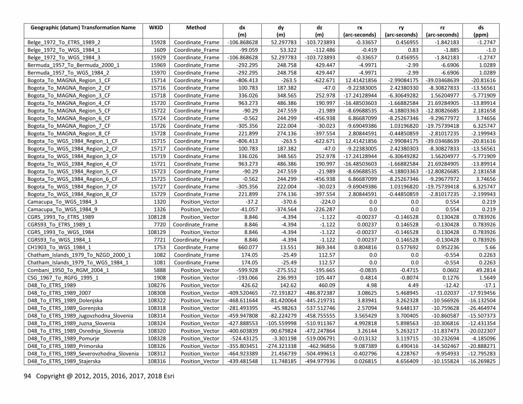
94 Copyright @ 2012, 2015, 2016, 2017, 2018 Esri
Geographic (datum) Transformation Name WKID Method dx (m)
dy (m)
dz (m)
rx (arc-seconds)
ry (arc-seconds)
rz (arc-seconds)
ds (ppm)
Belge_1972_To_ETRS_1989_2 15928 Coordinate_Frame -106.868628 52.297783 -103.723893 -0.33657 0.456955 -1.842183 -1.2747
Belge_1972_To_WGS_1984_1 1609 Coordinate_Frame -99.059 53.322 -112.486 -0.419 0.83 -1.885 -1.0
Belge_1972_To_WGS_1984_3 15929 Coordinate_Frame -106.868628 52.297783 -103.723893 -0.33657 0.456955 -1.842183 -1.2747
Bermuda_1957_To_Bermuda_2000_1 15969 Coordinate_Frame -292.295 248.758 429.447 -4.9971 -2.99 -6.6906 1.0289
Bermuda_1957_To_WGS_1984_2 15970 Coordinate_Frame -292.295 248.758 429.447 -4.9971 -2.99 -6.6906 1.0289
Bogota_To_MAGNA_Region_1_CF 15714 Coordinate_Frame -806.413 -263.5 -622.671 12.41421856 -2.99084175 -39.03468639 -20.81616
Bogota_To_MAGNA_Region_2_CF 15716 Coordinate_Frame 100.783 187.382 -47.0 -9.22383005 2.42380330 -8.30827833 -13.56561
Bogota_To_MAGNA_Region_3_CF 15718 Coordinate_Frame 336.026 348.565 252.978 -17.24128944 -6.30649282 1.56204977 -5.771909
Bogota_To_MAGNA_Region_4_CF 15720 Coordinate_Frame 963.273 486.386 190.997 -16.48503603 -1.66882584 21.69284905 -13.89914
Bogota_To_MAGNA_Region_5_CF 15722 Coordinate_Frame -90.29 247.559 -21.989 -8.69688535 -4.18803363 -12.80826685 2.181658
Bogota_To_MAGNA_Region_6_CF 15724 Coordinate_Frame -0.562 244.299 -456.938 6.86687099 -8.25267346 -9.29677972 3.74656
Bogota_To_MAGNA_Region_7_CF 15726 Coordinate_Frame -305.356 222.004 -30.023 -9.69049386 1.03196820 -19.75739418 6.325747
Bogota_To_MAGNA_Region_8_CF 15728 Coordinate_Frame 221.899 274.136 -397.554 2.80844591 -0.44850859 -2.81017235 -2.199943
Bogota_To_WGS_1984_Region_1_CF 15715 Coordinate_Frame -806.413 -263.5 -622.671 12.41421856 -2.99084175 -39.03468639 -20.81616
Bogota_To_WGS_1984_Region_2_CF 15717 Coordinate_Frame 100.783 187.382 -47.0 -9.22383005 2.42380303 -8.30827833 -13.56561
Bogota_To_WGS_1984_Region_3_CF 15719 Coordinate_Frame 336.026 348.565 252.978 -17.24128944 -6.30649282 1.56204977 -5.771909
Bogota_To_WGS_1984_Region_4_CF 15721 Coordinate_Frame 963.273 486.386 190.997 -16.48503603 -1.66882584 21.69284905 -13.89914
Bogota_To_WGS_1984_Region_5_CF 15723 Coordinate_Frame -90.29 247.559 -21.989 -8.69688535 -4.18803363 -12.80826685 2.181658
Bogota_To_WGS_1984_Region_6_CF 15725 Coordinate_Frame -0.562 244.299 -456.938 6.86687099 -8.25267346 -9.29677972 3.74656
Bogota_To_WGS_1984_Region_7_CF 15727 Coordinate_Frame -305.356 222.004 -30.023 -9.69049386 1.03196820 -19.75739418 6.325747
Bogota_To_WGS_1984_Region_8_CF 15729 Coordinate_Frame 221.899 274.136 -397.554 2.80844591 -0.44850859 -2.81017235 -2.199943
Camacupa_To_WGS_1984_3 1320 Position_Vector -37.2 -370.6 -224.0 0.0 0.0 0.554 0.219
Camacupa_To_WGS_1984_9 1326 Position_Vector -41.057 -374.564 -226.287 0.0 0.0 0.554 0.219
CGRS_1993_To_ETRS_1989 108128 Position_Vector 8.846 -4.394 -1.122 -0.00237 -0.146528 0.130428 0.783926
CGRS93_To_ETRS_1989_1 7720 Coordinate_Frame 8.846 -4.394 -1.122 0.00237 0.146528 -0.130428 0.783926
CGRS_1993_To_WGS_1984 108129 Position_Vector 8.846 -4.394 -1.122 -0.00237 -0.146528 0.130428 0.783926
CGRS93_To_WGS_1984_1 7721 Coordinate_Frame 8.846 -4.394 -1.122 0.00237 0.146528 -0.130428 0.783926
CH1903_To_WGS_1984_1 1753 Coordinate_Frame 660.077 13.551 369.344 0.804816 0.577692 0.952236 5.66
Chatham_Islands_1979_To_NZGD_2000_1 1082 Coordinate_Frame 174.05 -25.49 112.57 0.0 0.0 -0.554 0.2263
Chatham_Islands_1979_To_WGS_1984_1 1081 Coordinate_Frame 174.05 -25.49 112.57 0.0 0.0 -0.554 0.2263
Combani_1950_To_RGM_2004_1 5888 Position_Vector -599.928 -275.552 -195.665 -0.0835 -0.4715 0.0602 49.2814
CSG_1967_To_RGFG_1995_1 1908 Position_Vector -193.066 236.993 105.447 0.4814 -0.8074 0.1276 1.5649
D48_To_ETRS_1989 108276 Position_Vector 426.62 142.62 460.09 4.98 4.49 -12.42 -17.1
D48_To_ETRS_1989_2007 108308 Position_Vector -409.520465 -72.191827 -486.872387 3.08625 5.468945 -11.02037 -17.919456
D48_To_ETRS_1989_Dolenjska 108322 Position_Vector -468.611644 -81.420064 -445.219731 3.83941 3.262328 -10.566926 -16.132504
D48_To_ETRS_1989_Gorenjska 108318 Position_Vector -281.493395 -45.98263 -537.512746 2.57094 9.648137 -10.759628 -26.464974
D48_To_ETRS_1989_Jugovzhodna_Slovenia 108314 Position_Vector -459.947808 -82.224279 -458.755555 3.565429 3.700405 -10.860587 -15.507373
D48_To_ETRS_1989_Juzna_Slovenia 108324 Position_Vector -427.888553 -105.559998 -510.911367 4.992818 5.898563 -10.306816 -12.431354
D48_To_ETRS_1989_Osrednja_Slovenia 108320 Position_Vector -400.603839 -90.679824 -472.247864 3.26144 5.263217 -11.837473 -20.022307
D48_To_ETRS_1989_Pomurje 108328 Position_Vector -524.43125 -3.301198 -519.006791 -0.013132 3.119715 -10.232694 -4.185096
D48_To_ETRS_1989_Primorska 108326 Position_Vector -355.803451 -274.321338 -462.96856 9.087389 6.490416 -14.502467 -20.888271
D48_To_ETRS_1989_Severovzhodna_Slovenia 108312 Position_Vector -464.923389 21.456739 -504.499613 -0.402796 4.228767 -9.954933 -12.795283
D48_To_ETRS_1989_Stajerska 108316 Position_Vector -439.481548 11.748185 -494.977936 0.026815 4.656409 -10.155824 -16.269825

Copyright @ 2012, 2015, 2016, 2017, 2018 Esri 95
Geographic (datum) Transformation Name WKID Method dx (m)
dy (m)
dz (m)
rx (arc-seconds)
ry (arc-seconds)
rz (arc-seconds)
ds (ppm)
D48_To_ETRS_1989_Zahodna_Slovenia 108310 Position_Vector -315.352931 -186.253842 -499.603434 6.446475 8.131219 -13.208894 -23.448627
D48_To_WGS_1984 108277 Position_Vector 426.62 142.62 460.09 4.98 4.49 -12.42 -17.1
D48_To_WGS_1984_2007 108309 Position_Vector -409.520465 -72.191827 -486.872387 3.08625 5.468945 -11.02037 -17.919456
D48_To_WGS_1984_Dolenjska 108323 Position_Vector -468.611644 -81.420064 -445.219731 3.83941 3.262328 -10.566926 -16.132504
D48_To_WGS_1984_Gorenjska 108319 Position_Vector -281.493395 -45.98263 -537.512746 2.57094 9.648137 -10.759628 -26.464974
D48_To_WGS_1984_Jugovzhodna_Slovenia 108315 Position_Vector -459.947808 -82.224279 -458.755555 3.565429 3.700405 -10.860587 -15.507373
D48_To_WGS_1984_Juzna_Slovenia 108325 Position_Vector -427.888553 -105.559998 -510.911367 4.992818 5.898563 -10.306816 -12.431354
D48_To_WGS_1984_Osrednja_Slovenia 108321 Position_Vector -400.603839 -90.679824 -472.247864 3.26144 5.263217 -11.837473 -20.022307
D48_To_WGS_1984_Pomurje 108329 Position_Vector -524.43125 -3.301198 -519.006791 -0.013132 3.119715 -10.232694 -4.185096
D48_To_WGS_1984_Primorska 108327 Position_Vector -355.803451 -274.321338 -462.96856 9.087389 6.490416 -14.502467 -20.888271
D48_To_WGS_1984_Severovzhodna_Slovenia 108313 Position_Vector -464.923389 21.456739 -504.499613 -0.402796 4.228767 -9.954933 -12.795283
D48_To_WGS_1984_Stajerska 108317 Position_Vector -439.481548 11.748185 -494.977936 0.026815 4.656409 -10.155824 -16.269825
D48_To_WGS_1984_Zahodna_Slovenia 108311 Position_Vector -315.352931 -186.253842 -499.603434 6.446475 8.131219 -13.208894 -23.448627
Datum_73_To_ETRS_1989_1 1657 Position_Vector -238.2 85.2 29.9 0.166 0.046 1.248 2.03
Datum_73_To_ETRS_1989_2009_7par 5037 Position_Vector -230.994 102.591 25.199 0.633 -0.239 0.9 1.95
Datum_73_To_ETRS_1989_3 1992 Coordinate_Frame -231.034 102.615 26.836 -0.615 0.198 -0.881 1.786
Datum_73_To_WGS_1984_1_Prt2000 1658 Position_Vector -238.2 85.2 29.9 0.166 0.046 1.248 2.03
Datum_73_To_WGS_1984_2 108120 Coordinate_Frame -239.749 88.181 30.488 -0.26 -0.08 -1.21 2.23
Datum_73_To_WGS_1984_2009_7par 108153 Position_Vector -230.994 102.591 25.199 0.633 -0.239 0.9 1.95
Datum_73_To_WGS_1984_4 1987 Coordinate_Frame -239.749 88.181 30.488 -0.263 -0.082 -1.211 2.229
Datum_Lisboa_Bessel_To_WGS_1984_2 108123 Coordinate_Frame 631.392 -66.551 481.442 -1.09 4.445 4.487 -4.43
Datum_Lisboa_Hayford_To_Datum_73_2 108223 Coordinate_Frame -49.137 -179.924 95.757 1.955 -0.328 1.423 -6.827
Datum_Lisboa_Hayford_To_Datum_Lisboa_ Bessel_2
108225 Coordinate_Frame -920.281 -25.191 -355.2 2.781 -4.855 -4.276 -0.168
Datum_Lisboa_Hayford_To_ETRS_1989_2009_7par
108156 Position_Vector -283.088 -70.693 117.445 -1.157 0.059 -0.652 -4.058
Datum_Lisboa_Hayford_To_WGS_1984_2 108124 Coordinate_Frame -288.885 -91.744 126.244 1.69 -0.41 0.21 -4.6
Datum_Lisboa_Hayford_To_WGS_1984_2009_7par
108157 Position_Vector -283.088 -70.693 117.445 -1.157 0.059 -0.652 -4.058
DB_REF_To_ETRS_1989_1 5826 Coordinate_Frame 584.9636 107.7175 413.8067 -1.11552146 -0.28243399 3.13844906 7.992235
Dealul_Piscului_1970_To_ETRS_1989_1X 108375 Coordinate_Frame 2.3287 -147.0425 -92.0802 0.3092483 -0.32482185 -0.49729934 5.68906266
Dealul_Piscului_1970_To_WGS_1984_3X 108374 Coordinate_Frame 2.3287 -147.0425 -92.0802 0.3092483 -0.32482185 -0.49729934 5.68906266
Deir_ez_Zor_To_WGS_1984_3 1586 Position_Vector -175.09 1.218 238.831 -0.047 0.019 0.808 0.1698
Deir_ez_Zor_To_WGS_1984_6 15743 Position_Vector -83.58 -397.54 458.78 -17.595 -2.847 4.256 3.225
DHDN_To_ETRF_1989 108192 Coordinate_Frame 582.0 105.0 414.0 -1.04 -0.35 3.08 8.3
DHDN_To_ETRS_1989 1309 Coordinate_Frame 582.0 105.0 414.0 -1.04 -0.35 3.08 8.3
DHDN_To_ETRS_1989_2 1776 Position_Vector 598.1 73.7 418.2 0.202 0.045 -2.455 6.7
DHDN_To_ETRS_1989_3 1778 Position_Vector 597.1 71.4 412.1 0.894 0.068 -1.563 7.58
DHDN_To_ETRS_1989_4 1779 Position_Vector 584.8 67.0 400.3 0.105 0.013 -2.378 10.29
DHDN_To_ETRS_1989_5 1780 Position_Vector 590.5 69.5 411.6 -0.796 -0.052 -3.601 8.3
DHDN_To_ETRS_1989_6 1781 Position_Vector 599.4 72.4 419.2 -0.062 -0.022 -2.723 6.46
DHDN_To_ETRS_1989_7 1782 Position_Vector 612.4 77.0 440.2 -0.054 0.057 -2.797 2.55
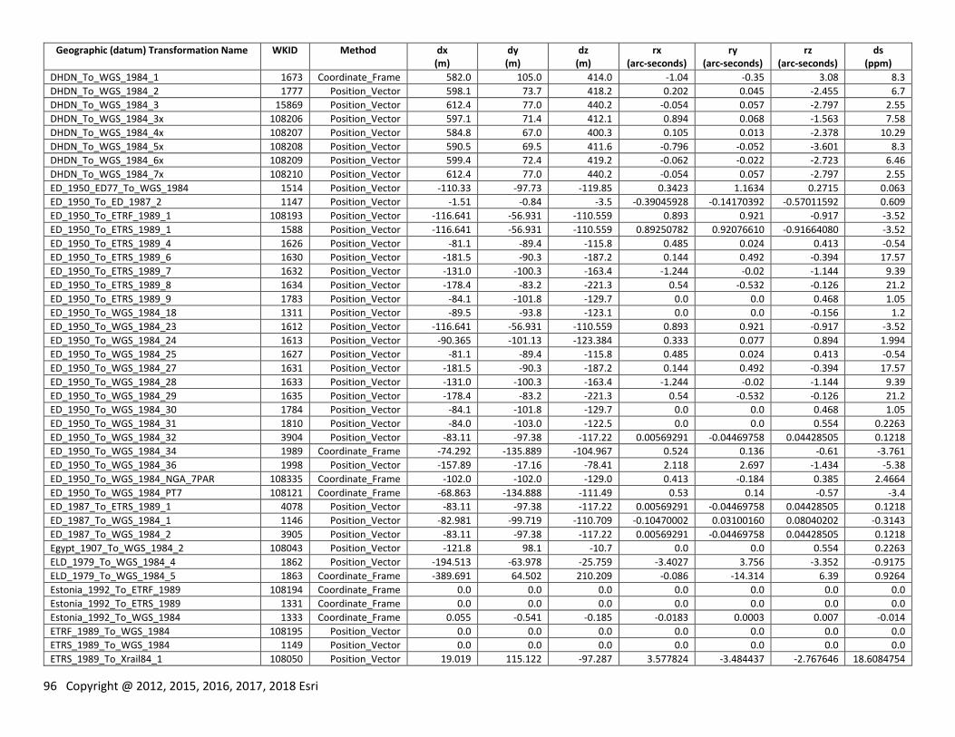
96 Copyright @ 2012, 2015, 2016, 2017, 2018 Esri
Geographic (datum) Transformation Name WKID Method dx (m)
dy (m)
dz (m)
rx (arc-seconds)
ry (arc-seconds)
rz (arc-seconds)
ds (ppm)
DHDN_To_WGS_1984_1 1673 Coordinate_Frame 582.0 105.0 414.0 -1.04 -0.35 3.08 8.3
DHDN_To_WGS_1984_2 1777 Position_Vector 598.1 73.7 418.2 0.202 0.045 -2.455 6.7
DHDN_To_WGS_1984_3 15869 Position_Vector 612.4 77.0 440.2 -0.054 0.057 -2.797 2.55
DHDN_To_WGS_1984_3x 108206 Position_Vector 597.1 71.4 412.1 0.894 0.068 -1.563 7.58
DHDN_To_WGS_1984_4x 108207 Position_Vector 584.8 67.0 400.3 0.105 0.013 -2.378 10.29
DHDN_To_WGS_1984_5x 108208 Position_Vector 590.5 69.5 411.6 -0.796 -0.052 -3.601 8.3
DHDN_To_WGS_1984_6x 108209 Position_Vector 599.4 72.4 419.2 -0.062 -0.022 -2.723 6.46
DHDN_To_WGS_1984_7x 108210 Position_Vector 612.4 77.0 440.2 -0.054 0.057 -2.797 2.55
ED_1950_ED77_To_WGS_1984 1514 Position_Vector -110.33 -97.73 -119.85 0.3423 1.1634 0.2715 0.063
ED_1950_To_ED_1987_2 1147 Position_Vector -1.51 -0.84 -3.5 -0.39045928 -0.14170392 -0.57011592 0.609
ED_1950_To_ETRF_1989_1 108193 Position_Vector -116.641 -56.931 -110.559 0.893 0.921 -0.917 -3.52
ED_1950_To_ETRS_1989_1 1588 Position_Vector -116.641 -56.931 -110.559 0.89250782 0.92076610 -0.91664080 -3.52
ED_1950_To_ETRS_1989_4 1626 Position_Vector -81.1 -89.4 -115.8 0.485 0.024 0.413 -0.54
ED_1950_To_ETRS_1989_6 1630 Position_Vector -181.5 -90.3 -187.2 0.144 0.492 -0.394 17.57
ED_1950_To_ETRS_1989_7 1632 Position_Vector -131.0 -100.3 -163.4 -1.244 -0.02 -1.144 9.39
ED_1950_To_ETRS_1989_8 1634 Position_Vector -178.4 -83.2 -221.3 0.54 -0.532 -0.126 21.2
ED_1950_To_ETRS_1989_9 1783 Position_Vector -84.1 -101.8 -129.7 0.0 0.0 0.468 1.05
ED_1950_To_WGS_1984_18 1311 Position_Vector -89.5 -93.8 -123.1 0.0 0.0 -0.156 1.2
ED_1950_To_WGS_1984_23 1612 Position_Vector -116.641 -56.931 -110.559 0.893 0.921 -0.917 -3.52
ED_1950_To_WGS_1984_24 1613 Position_Vector -90.365 -101.13 -123.384 0.333 0.077 0.894 1.994
ED_1950_To_WGS_1984_25 1627 Position_Vector -81.1 -89.4 -115.8 0.485 0.024 0.413 -0.54
ED_1950_To_WGS_1984_27 1631 Position_Vector -181.5 -90.3 -187.2 0.144 0.492 -0.394 17.57
ED_1950_To_WGS_1984_28 1633 Position_Vector -131.0 -100.3 -163.4 -1.244 -0.02 -1.144 9.39
ED_1950_To_WGS_1984_29 1635 Position_Vector -178.4 -83.2 -221.3 0.54 -0.532 -0.126 21.2
ED_1950_To_WGS_1984_30 1784 Position_Vector -84.1 -101.8 -129.7 0.0 0.0 0.468 1.05
ED_1950_To_WGS_1984_31 1810 Position_Vector -84.0 -103.0 -122.5 0.0 0.0 0.554 0.2263
ED_1950_To_WGS_1984_32 3904 Position_Vector -83.11 -97.38 -117.22 0.00569291 -0.04469758 0.04428505 0.1218
ED_1950_To_WGS_1984_34 1989 Coordinate_Frame -74.292 -135.889 -104.967 0.524 0.136 -0.61 -3.761
ED_1950_To_WGS_1984_36 1998 Position_Vector -157.89 -17.16 -78.41 2.118 2.697 -1.434 -5.38
ED_1950_To_WGS_1984_NGA_7PAR 108335 Coordinate_Frame -102.0 -102.0 -129.0 0.413 -0.184 0.385 2.4664
ED_1950_To_WGS_1984_PT7 108121 Coordinate_Frame -68.863 -134.888 -111.49 0.53 0.14 -0.57 -3.4
ED_1987_To_ETRS_1989_1 4078 Position_Vector -83.11 -97.38 -117.22 0.00569291 -0.04469758 0.04428505 0.1218
ED_1987_To_WGS_1984_1 1146 Position_Vector -82.981 -99.719 -110.709 -0.10470002 0.03100160 0.08040202 -0.3143
ED_1987_To_WGS_1984_2 3905 Position_Vector -83.11 -97.38 -117.22 0.00569291 -0.04469758 0.04428505 0.1218
Egypt_1907_To_WGS_1984_2 108043 Position_Vector -121.8 98.1 -10.7 0.0 0.0 0.554 0.2263
ELD_1979_To_WGS_1984_4 1862 Position_Vector -194.513 -63.978 -25.759 -3.4027 3.756 -3.352 -0.9175
ELD_1979_To_WGS_1984_5 1863 Coordinate_Frame -389.691 64.502 210.209 -0.086 -14.314 6.39 0.9264
Estonia_1992_To_ETRF_1989 108194 Coordinate_Frame 0.0 0.0 0.0 0.0 0.0 0.0 0.0
Estonia_1992_To_ETRS_1989 1331 Coordinate_Frame 0.0 0.0 0.0 0.0 0.0 0.0 0.0
Estonia_1992_To_WGS_1984 1333 Coordinate_Frame 0.055 -0.541 -0.185 -0.0183 0.0003 0.007 -0.014
ETRF_1989_To_WGS_1984 108195 Position_Vector 0.0 0.0 0.0 0.0 0.0 0.0 0.0
ETRS_1989_To_WGS_1984 1149 Position_Vector 0.0 0.0 0.0 0.0 0.0 0.0 0.0
ETRS_1989_To_Xrail84_1 108050 Position_Vector 19.019 115.122 -97.287 3.577824 -3.484437 -2.767646 18.6084754
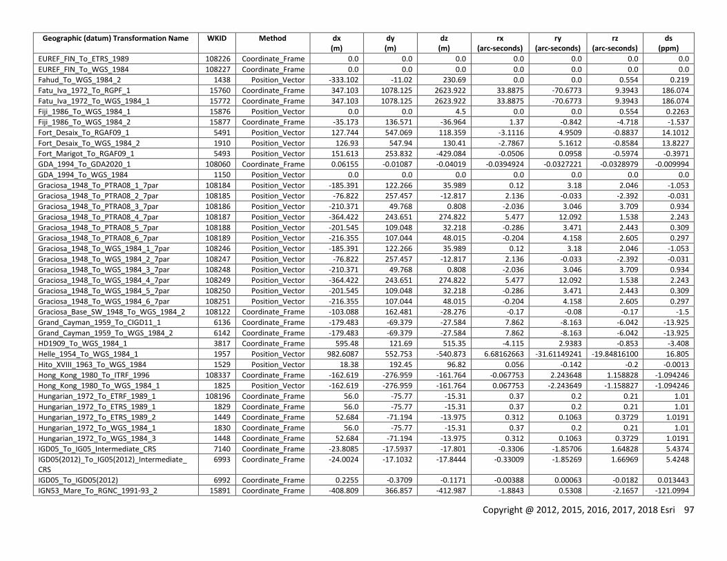
Copyright @ 2012, 2015, 2016, 2017, 2018 Esri 97
Geographic (datum) Transformation Name WKID Method dx (m)
dy (m)
dz (m)
rx (arc-seconds)
ry (arc-seconds)
rz (arc-seconds)
ds (ppm)
EUREF_FIN_To_ETRS_1989 108226 Coordinate_Frame 0.0 0.0 0.0 0.0 0.0 0.0 0.0
EUREF_FIN_To_WGS_1984 108227 Coordinate_Frame 0.0 0.0 0.0 0.0 0.0 0.0 0.0
Fahud_To_WGS_1984_2 1438 Position_Vector -333.102 -11.02 230.69 0.0 0.0 0.554 0.219
Fatu_Iva_1972_To_RGPF_1 15760 Coordinate_Frame 347.103 1078.125 2623.922 33.8875 -70.6773 9.3943 186.074
Fatu_Iva_1972_To_WGS_1984_1 15772 Coordinate_Frame 347.103 1078.125 2623.922 33.8875 -70.6773 9.3943 186.074
Fiji_1986_To_WGS_1984_1 15876 Position_Vector 0.0 0.0 4.5 0.0 0.0 0.554 0.2263
Fiji_1986_To_WGS_1984_2 15877 Coordinate_Frame -35.173 136.571 -36.964 1.37 -0.842 -4.718 -1.537
Fort_Desaix_To_RGAF09_1 5491 Position_Vector 127.744 547.069 118.359 -3.1116 4.9509 -0.8837 14.1012
Fort_Desaix_To_WGS_1984_2 1910 Position_Vector 126.93 547.94 130.41 -2.7867 5.1612 -0.8584 13.8227
Fort_Marigot_To_RGAF09_1 5493 Position_Vector 151.613 253.832 -429.084 -0.0506 0.0958 -0.5974 -0.3971
GDA_1994_To_GDA2020_1 108060 Coordinate_Frame 0.06155 -0.01087 -0.04019 -0.0394924 -0.0327221 -0.0328979 -0.009994
GDA_1994_To_WGS_1984 1150 Position_Vector 0.0 0.0 0.0 0.0 0.0 0.0 0.0
Graciosa_1948_To_PTRA08_1_7par 108184 Position_Vector -185.391 122.266 35.989 0.12 3.18 2.046 -1.053
Graciosa_1948_To_PTRA08_2_7par 108185 Position_Vector -76.822 257.457 -12.817 2.136 -0.033 -2.392 -0.031
Graciosa_1948_To_PTRA08_3_7par 108186 Position_Vector -210.371 49.768 0.808 -2.036 3.046 3.709 0.934
Graciosa_1948_To_PTRA08_4_7par 108187 Position_Vector -364.422 243.651 274.822 5.477 12.092 1.538 2.243
Graciosa_1948_To_PTRA08_5_7par 108188 Position_Vector -201.545 109.048 32.218 -0.286 3.471 2.443 0.309
Graciosa_1948_To_PTRA08_6_7par 108189 Position_Vector -216.355 107.044 48.015 -0.204 4.158 2.605 0.297
Graciosa_1948_To_WGS_1984_1_7par 108246 Position_Vector -185.391 122.266 35.989 0.12 3.18 2.046 -1.053
Graciosa_1948_To_WGS_1984_2_7par 108247 Position_Vector -76.822 257.457 -12.817 2.136 -0.033 -2.392 -0.031
Graciosa_1948_To_WGS_1984_3_7par 108248 Position_Vector -210.371 49.768 0.808 -2.036 3.046 3.709 0.934
Graciosa_1948_To_WGS_1984_4_7par 108249 Position_Vector -364.422 243.651 274.822 5.477 12.092 1.538 2.243
Graciosa_1948_To_WGS_1984_5_7par 108250 Position_Vector -201.545 109.048 32.218 -0.286 3.471 2.443 0.309
Graciosa_1948_To_WGS_1984_6_7par 108251 Position_Vector -216.355 107.044 48.015 -0.204 4.158 2.605 0.297
Graciosa_Base_SW_1948_To_WGS_1984_2 108122 Coordinate_Frame -103.088 162.481 -28.276 -0.17 -0.08 -0.17 -1.5
Grand_Cayman_1959_To_CIGD11_1 6136 Coordinate_Frame -179.483 -69.379 -27.584 7.862 -8.163 -6.042 -13.925
Grand_Cayman_1959_To_WGS_1984_2 6142 Coordinate_Frame -179.483 -69.379 -27.584 7.862 -8.163 -6.042 -13.925
HD1909_To_WGS_1984_1 3817 Coordinate_Frame 595.48 121.69 515.35 -4.115 2.9383 -0.853 -3.408
Helle_1954_To_WGS_1984_1 1957 Position_Vector 982.6087 552.753 -540.873 6.68162663 -31.61149241 -19.84816100 16.805
Hito_XVIII_1963_To_WGS_1984 1529 Position_Vector 18.38 192.45 96.82 0.056 -0.142 -0.2 -0.0013
Hong_Kong_1980_To_ITRF_1996 108337 Coordinate_Frame -162.619 -276.959 -161.764 -0.067753 2.243648 1.158828 -1.094246
Hong_Kong_1980_To_WGS_1984_1 1825 Position_Vector -162.619 -276.959 -161.764 0.067753 -2.243649 -1.158827 -1.094246
Hungarian_1972_To_ETRF_1989_1 108196 Coordinate_Frame 56.0 -75.77 -15.31 0.37 0.2 0.21 1.01
Hungarian_1972_To_ETRS_1989_1 1829 Coordinate_Frame 56.0 -75.77 -15.31 0.37 0.2 0.21 1.01
Hungarian_1972_To_ETRS_1989_2 1449 Coordinate_Frame 52.684 -71.194 -13.975 0.312 0.1063 0.3729 1.0191
Hungarian_1972_To_WGS_1984_1 1830 Coordinate_Frame 56.0 -75.77 -15.31 0.37 0.2 0.21 1.01
Hungarian_1972_To_WGS_1984_3 1448 Coordinate_Frame 52.684 -71.194 -13.975 0.312 0.1063 0.3729 1.0191
IGD05_To_IG05_Intermediate_CRS 7140 Coordinate_Frame -23.8085 -17.5937 -17.801 -0.3306 -1.85706 1.64828 5.4374
IGD05(2012)_To_IG05(2012)_Intermediate_ CRS
6993 Coordinate_Frame -24.0024 -17.1032 -17.8444 -0.33009 -1.85269 1.66969 5.4248
IGD05_To_IGD05(2012) 6992 Coordinate_Frame 0.2255 -0.3709 -0.1171 -0.00388 0.00063 -0.0182 0.013443
IGN53_Mare_To_RGNC_1991-93_2 15891 Coordinate_Frame -408.809 366.857 -412.987 -1.8843 0.5308 -2.1657 -121.0994
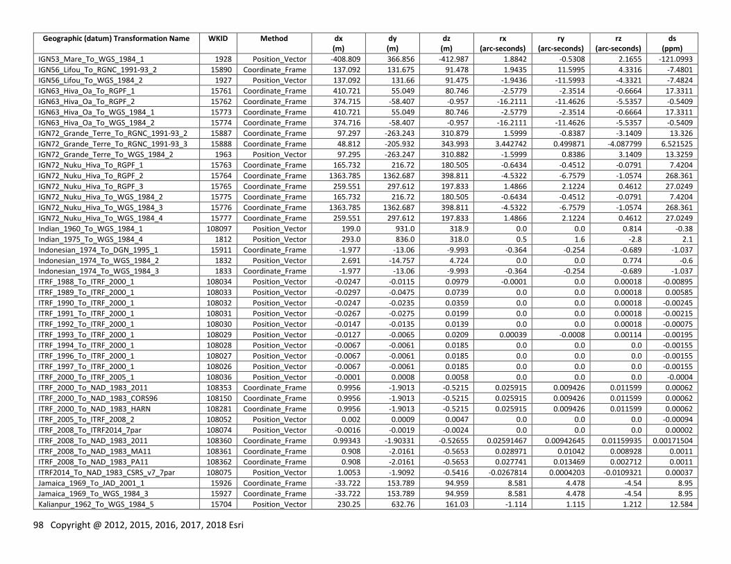
98 Copyright @ 2012, 2015, 2016, 2017, 2018 Esri
Geographic (datum) Transformation Name WKID Method dx (m)
dy (m)
dz (m)
rx (arc-seconds)
ry (arc-seconds)
rz (arc-seconds)
ds (ppm)
IGN53_Mare_To_WGS_1984_1 1928 Position_Vector -408.809 366.856 -412.987 1.8842 -0.5308 2.1655 -121.0993
IGN56_Lifou_To_RGNC_1991-93_2 15890 Coordinate_Frame 137.092 131.675 91.478 1.9435 11.5995 4.3316 -7.4801
IGN56_Lifou_To_WGS_1984_2 1927 Position_Vector 137.092 131.66 91.475 -1.9436 -11.5993 -4.3321 -7.4824
IGN63_Hiva_Oa_To_RGPF_1 15761 Coordinate_Frame 410.721 55.049 80.746 -2.5779 -2.3514 -0.6664 17.3311
IGN63_Hiva_Oa_To_RGPF_2 15762 Coordinate_Frame 374.715 -58.407 -0.957 -16.2111 -11.4626 -5.5357 -0.5409
IGN63_Hiva_Oa_To_WGS_1984_1 15773 Coordinate_Frame 410.721 55.049 80.746 -2.5779 -2.3514 -0.6664 17.3311
IGN63_Hiva_Oa_To_WGS_1984_2 15774 Coordinate_Frame 374.716 -58.407 -0.957 -16.2111 -11.4626 -5.5357 -0.5409
IGN72_Grande_Terre_To_RGNC_1991-93_2 15887 Coordinate_Frame 97.297 -263.243 310.879 1.5999 -0.8387 -3.1409 13.326
IGN72_Grande_Terre_To_RGNC_1991-93_3 15888 Coordinate_Frame 48.812 -205.932 343.993 3.442742 0.499871 -4.087799 6.521525
IGN72_Grande_Terre_To_WGS_1984_2 1963 Position_Vector 97.295 -263.247 310.882 -1.5999 0.8386 3.1409 13.3259
IGN72_Nuku_Hiva_To_RGPF_1 15763 Coordinate_Frame 165.732 216.72 180.505 -0.6434 -0.4512 -0.0791 7.4204
IGN72_Nuku_Hiva_To_RGPF_2 15764 Coordinate_Frame 1363.785 1362.687 398.811 -4.5322 -6.7579 -1.0574 268.361
IGN72_Nuku_Hiva_To_RGPF_3 15765 Coordinate_Frame 259.551 297.612 197.833 1.4866 2.1224 0.4612 27.0249
IGN72_Nuku_Hiva_To_WGS_1984_2 15775 Coordinate_Frame 165.732 216.72 180.505 -0.6434 -0.4512 -0.0791 7.4204
IGN72_Nuku_Hiva_To_WGS_1984_3 15776 Coordinate_Frame 1363.785 1362.687 398.811 -4.5322 -6.7579 -1.0574 268.361
IGN72_Nuku_Hiva_To_WGS_1984_4 15777 Coordinate_Frame 259.551 297.612 197.833 1.4866 2.1224 0.4612 27.0249
Indian_1960_To_WGS_1984_1 108097 Position_Vector 199.0 931.0 318.9 0.0 0.0 0.814 -0.38
Indian_1975_To_WGS_1984_4 1812 Position_Vector 293.0 836.0 318.0 0.5 1.6 -2.8 2.1
Indonesian_1974_To_DGN_1995_1 15911 Coordinate_Frame -1.977 -13.06 -9.993 -0.364 -0.254 -0.689 -1.037
Indonesian_1974_To_WGS_1984_2 1832 Position_Vector 2.691 -14.757 4.724 0.0 0.0 0.774 -0.6
Indonesian_1974_To_WGS_1984_3 1833 Coordinate_Frame -1.977 -13.06 -9.993 -0.364 -0.254 -0.689 -1.037
ITRF_1988_To_ITRF_2000_1 108034 Position_Vector -0.0247 -0.0115 0.0979 -0.0001 0.0 0.00018 -0.00895
ITRF_1989_To_ITRF_2000_1 108033 Position_Vector -0.0297 -0.0475 0.0739 0.0 0.0 0.00018 0.00585
ITRF_1990_To_ITRF_2000_1 108032 Position_Vector -0.0247 -0.0235 0.0359 0.0 0.0 0.00018 -0.00245
ITRF_1991_To_ITRF_2000_1 108031 Position_Vector -0.0267 -0.0275 0.0199 0.0 0.0 0.00018 -0.00215
ITRF_1992_To_ITRF_2000_1 108030 Position_Vector -0.0147 -0.0135 0.0139 0.0 0.0 0.00018 -0.00075
ITRF_1993_To_ITRF_2000_1 108029 Position_Vector -0.0127 -0.0065 0.0209 0.00039 -0.0008 0.00114 -0.00195
ITRF_1994_To_ITRF_2000_1 108028 Position_Vector -0.0067 -0.0061 0.0185 0.0 0.0 0.0 -0.00155
ITRF_1996_To_ITRF_2000_1 108027 Position_Vector -0.0067 -0.0061 0.0185 0.0 0.0 0.0 -0.00155
ITRF_1997_To_ITRF_2000_1 108026 Position_Vector -0.0067 -0.0061 0.0185 0.0 0.0 0.0 -0.00155
ITRF_2000_To_ITRF_2005_1 108036 Position_Vector -0.0001 0.0008 0.0058 0.0 0.0 0.0 -0.0004
ITRF_2000_To_NAD_1983_2011 108353 Coordinate_Frame 0.9956 -1.9013 -0.5215 0.025915 0.009426 0.011599 0.00062
ITRF_2000_To_NAD_1983_CORS96 108150 Coordinate_Frame 0.9956 -1.9013 -0.5215 0.025915 0.009426 0.011599 0.00062
ITRF_2000_To_NAD_1983_HARN 108281 Coordinate_Frame 0.9956 -1.9013 -0.5215 0.025915 0.009426 0.011599 0.00062
ITRF_2005_To_ITRF_2008_2 108052 Position_Vector 0.002 0.0009 0.0047 0.0 0.0 0.0 -0.00094
ITRF_2008_To_ITRF2014_7par 108074 Position_Vector -0.0016 -0.0019 -0.0024 0.0 0.0 0.0 0.00002
ITRF_2008_To_NAD_1983_2011 108360 Coordinate_Frame 0.99343 -1.90331 -0.52655 0.02591467 0.00942645 0.01159935 0.00171504
ITRF_2008_To_NAD_1983_MA11 108361 Coordinate_Frame 0.908 -2.0161 -0.5653 0.028971 0.01042 0.008928 0.0011
ITRF_2008_To_NAD_1983_PA11 108362 Coordinate_Frame 0.908 -2.0161 -0.5653 0.027741 0.013469 0.002712 0.0011
ITRF2014_To_NAD_1983_CSRS_v7_7par 108075 Position_Vector 1.0053 -1.9092 -0.5416 -0.0267814 0.0004203 -0.0109321 0.00037
Jamaica_1969_To_JAD_2001_1 15926 Coordinate_Frame -33.722 153.789 94.959 8.581 4.478 -4.54 8.95
Jamaica_1969_To_WGS_1984_3 15927 Coordinate_Frame -33.722 153.789 94.959 8.581 4.478 -4.54 8.95
Kalianpur_1962_To_WGS_1984_5 15704 Position_Vector 230.25 632.76 161.03 -1.114 1.115 1.212 12.584

Copyright @ 2012, 2015, 2016, 2017, 2018 Esri 99
Geographic (datum) Transformation Name WKID Method dx (m)
dy (m)
dz (m)
rx (arc-seconds)
ry (arc-seconds)
rz (arc-seconds)
ds (ppm)
KKJ_To_ETRS_1989_1_Old 1638 Position_Vector -90.7 -106.1 -119.2 4.09 0.218 -1.05 1.37
KKJ_To_ETRS_1989_2 10098 Coordinate_Frame -96.0617 -82.4278 -121.7535 -4.80107 -0.34543 1.37646 1.4964
KKJ_To_EUREF_FIN 108229 Coordinate_Frame -96.0617 -82.4278 -121.7535 -4.80107 -0.34543 1.37646 1.4964
KKJ_To_WGS_1984_1_Old 1639 Position_Vector -90.7 -106.1 -119.2 4.09 0.218 -1.05 1.37
KKJ_To_WGS_1984_2_JHS153 10099 Coordinate_Frame -96.0617 -82.4278 -121.7535 -4.80107 -0.34543 1.37646 1.4964
KUDAMS_To_WGS_1984_2 1062 Coordinate_Frame 226.702 -193.337 -35.371 2.229 4.391 -9.238 0.9798
Lisbon_1890_To_WGS_1984_2 1990 Coordinate_Frame 631.392 -66.551 481.442 -1.09 4.445 4.487 -4.43
Lisbon_Lisbon_To_WGS_1984_2 5838 Coordinate_Frame -288.885 -91.744 126.244 1.691 -0.41 0.211 -4.598
Lisbon_To_ETRS_1989_1 1655 Position_Vector -280.9 -89.8 130.2 -1.721 0.355 -0.371 -5.92
Lisbon_To_ETRS_1989_2 1997 Position_Vector -282.1 -72.2 120.0 -1.529 0.145 -0.89 -4.46
Lisbon_To_WGS_1984_1 1656 Position_Vector -280.9 -89.8 130.2 -1.721 0.355 -0.371 -5.92
Lisbon_To_WGS_1984_2 1944 Position_Vector -282.1 -72.2 120.0 -1.592 0.145 -0.89 -4.46
Lisbon_To_WGS_1984_4 1988 Coordinate_Frame -288.885 -91.744 126.244 1.691 -0.41 0.211 -4.598
Little_Cayman_1961_To_CIGD11_1 6137 Coordinate_Frame 8.853 -52.644 180.304 0.393 2.323 -2.96 -24.081
Little_Cayman_1961_To_WGS_1984_3 6143 Coordinate_Frame 8.853 -52.644 180.304 0.393 2.323 -2.96 -24.081
Luxembourg_1930_To_ETRS_1989_1 1642 Position_Vector -192.986 13.673 -39.309 -0.4099 -2.9332 2.6881 0.43
Luxembourg_1930_To_ETRS_1989_3 5485 Coordinate_Frame -189.6806 18.3463 -42.7695 0.33746 3.09264 -2.53861 0.4598
Luxembourg_1930_To_WGS_1984_1 1643 Position_Vector -192.986 13.673 -39.309 -0.4099 -2.9332 2.6881 0.43
Luxembourg_1930_To_WGS_1984_3 5486 Coordinate_Frame -189.6806 18.3463 -42.7695 0.33746 3.09264 -2.53861 0.4598
MGI_1901_To_ETRS_1989_2 3963 Position_Vector 551.7 162.9 467.9 6.04 1.96 -11.38 -4.82
MGI_1901_To_ETRS_1989_3 3914 Position_Vector 426.9 142.6 460.1 4.91 4.49 -12.42 17.1
MGI_1901_To_ETRS_1989_5 6205 Coordinate_Frame 517.4399 228.7318 579.7954 -4.045 -4.304 15.612 -8.312
MGI_1901_To_ETRS_1989_6 7675 Coordinate_Frame 577.88891 165.22205 391.18289 -4.9145 0.94729 13.05098 7.78664
MGI_1901_To_Slovenia_1996_1 3916 Coordinate_Frame 409.545 72.164 486.872 -3.085957 -5.46911 11.020289 17.919665
MGI_1901_To_Slovenia_1996_10 3927 Coordinate_Frame 355.845 274.282 462.979 -9.086933 -6.491055 14.502181 20.888647
MGI_1901_To_Slovenia_1996_11 3928 Coordinate_Frame 400.629 90.651 472.249 -3.261138 -5.263404 11.83739 20.022676
MGI_1901_To_Slovenia_1996_2 3918 Coordinate_Frame 315.393 186.223 499.609 -6.445954 -8.131631 13.208641 23.449046
MGI_1901_To_Slovenia_1996_3 3919 Coordinate_Frame 464.939 -21.478 504.497 0.403 -4.228747 9.954942 12.795378
MGI_1901_To_Slovenia_1996_4 3921 Coordinate_Frame 459.968 82.193 458.756 -3.565234 -3.700593 10.860523 15.507563
MGI_1901_To_Slovenia_1996_5 3922 Coordinate_Frame 427.914 105.528 510.908 -4.992523 -5.898813 10.306673 12.431493
MGI_1901_To_Slovenia_1996_6 3923 Coordinate_Frame 468.63 81.389 445.221 -3.839242 -3.262525 10.566866 16.132726
MGI_1901_To_Slovenia_1996_7 3924 Coordinate_Frame 439.5 -11.77 494.976 -0.026585 -4.65641 10.155824 16.270002
MGI_1901_To_Slovenia_1996_8 3925 Coordinate_Frame 524.442 3.275 519.002 0.013287 -3.119714 10.232693 4.184981
MGI_1901_To_Slovenia_1996_9 3926 Coordinate_Frame 281.529 45.963 537.515 -2.570437 -9.648271 10.759507 26.465548
MGI_1901_To_WGS_1984_10 6206 Coordinate_Frame 521.748 229.489 590.921 -4.029 -4.488 15.521 -9.78
MGI_1901_To_WGS_1984_11 7676 Coordinate_Frame 577.88891 165.22205 391.18289 -4.9145 0.94729 13.05098 7.78664
MGI_1901_To_WGS_1984_4 3964 Position_Vector 551.7 162.9 467.9 6.04 1.96 -11.38 -4.82
MGI_1901_To_WGS_1984_5 3915 Position_Vector 426.9 142.6 460.1 4.91 4.49 -12.42 17.1
MGI_1901_To_WGS_1984_9 3917 Coordinate_Frame 409.545 72.164 486.872 -3.085957 -5.46911 11.020289 17.919665
MGI_Ferro_To_WGS_1984_2 3896 Position_Vector 577.326 90.129 463.919 5.137 1.474 5.297 2.4232
MGI_To_ETRS_1989_Serbia 108072 Coordinate_Frame 577.88891 165.22205 391.18289 -4.9145 0.94729 13.05098 7.78664
MGI_To_ETRS_1989_1 1619 Position_Vector 577.326 90.129 463.919 5.137 1.474 5.297 2.4232
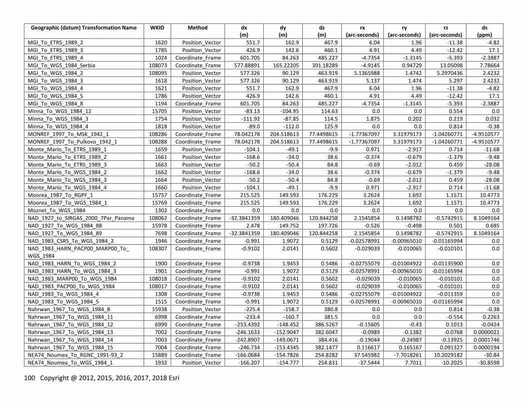
100 Copyright @ 2012, 2015, 2016, 2017, 2018 Esri
Geographic (datum) Transformation Name WKID Method dx (m)
dy (m)
dz (m)
rx (arc-seconds)
ry (arc-seconds)
rz (arc-seconds)
ds (ppm)
MGI_To_ETRS_1989_2 1620 Position_Vector 551.7 162.9 467.9 6.04 1.96 -11.38 -4.82
MGI_To_ETRS_1989_3 1785 Position_Vector 426.9 142.6 460.1 4.91 4.49 -12.42 17.1
MGI_To_ETRS_1989_4 1024 Coordinate_Frame 601.705 84.263 485.227 -4.7354 -1.3145 -5.393 -2.3887
MGI_To_WGS_1984_Serbia 108073 Coordinate_Frame 577.88891 165.22205 391.18289 -4.9145 0.94729 13.05098 7.78664
MGI_To_WGS_1984_2 108095 Position_Vector 577.326 90.129 463.919 5.1365988 1.4742 5.2970436 2.4232
MGI_To_WGS_1984_3 1618 Position_Vector 577.326 90.129 463.919 5.137 1.474 5.297 2.4232
MGI_To_WGS_1984_4 1621 Position_Vector 551.7 162.9 467.9 6.04 1.96 -11.38 -4.82
MGI_To_WGS_1984_5 1786 Position_Vector 426.9 142.6 460.1 4.91 4.49 -12.42 17.1
MGI_To_WGS_1984_8 1194 Coordinate_Frame 601.705 84.263 485.227 -4.7354 -1.3145 -5.393 -2.3887
Minna_To_WGS_1984_12 15705 Position_Vector -83.13 -104.95 114.63 0.0 0.0 0.554 0.0
Minna_To_WGS_1984_3 1754 Position_Vector -111.92 -87.85 114.5 1.875 0.202 0.219 0.032
Minna_To_WGS_1984_4 1818 Position_Vector -89.0 -112.0 125.9 0.0 0.0 0.814 -0.38
MONREF_1997_To_MSK_1942_1 108286 Coordinate_Frame 78.042178 204.518613 77.4498615 -1.77367097 3.31979173 -1.04260771 -4.9510577
MONREF_1997_To_Pulkovo_1942_1 108288 Coordinate_Frame 78.042178 204.518613 77.4498615 -1.77367097 3.31979173 -1.04260771 -4.9510577
Monte_Mario_To_ETRS_1989_1 1659 Position_Vector -104.1 -49.1 -9.9 0.971 -2.917 0.714 -11.68
Monte_Mario_To_ETRS_1989_2 1661 Position_Vector -168.6 -34.0 38.6 -0.374 -0.679 -1.379 -9.48
Monte_Mario_To_ETRS_1989_3 1663 Position_Vector -50.2 -50.4 84.8 -0.69 -2.012 0.459 -28.08
Monte_Mario_To_WGS_1984_2 1662 Position_Vector -168.6 -34.0 38.6 -0.374 -0.679 -1.379 -9.48
Monte_Mario_To_WGS_1984_3 1664 Position_Vector -50.2 -50.4 84.8 -0.69 -2.012 0.459 -28.08
Monte_Mario_To_WGS_1984_4 1660 Position_Vector -104.1 -49.1 -9.9 0.971 -2.917 0.714 -11.68
Moorea_1987_To_RGPF_1 15757 Coordinate_Frame 215.525 149.593 176.229 3.2624 1.692 1.1571 10.4773
Moorea_1987_To_WGS_1984_1 15769 Coordinate_Frame 215.525 149.593 176.229 3.2624 1.692 1.1571 10.4773
Moznet_To_WGS_1984 1302 Coordinate_Frame 0.0 0.0 0.0 0.0 0.0 0.0 0.0
NAD_1927_to_SIRGAS_2000_7Par_Panama 108062 Coordinate_Frame -32.3841359 180.409046 120.844258 2.1545854 0.1498782 -0.5742915 8.1049164
NAD_1927_To_WGS_1984_88 15978 Coordinate_Frame 2.478 149.752 197.726 -0.526 -0.498 0.501 0.685
NAD_1927_To_WGS_1984_89 7698 Coordinate_Frame -32.3841359 180.409046 120.844258 2.1545854 0.1498782 -0.5742915 8.1049164
NAD_1983_CSRS_To_WGS_1984_2 1946 Coordinate_Frame -0.991 1.9072 0.5129 -0.02578991 -0.00965010 -0.01165994 0.0
NAD_1983_HARN_PACP00_MARP00_To_ WGS_1984
108307 Coordinate_Frame -0.9102 2.0141 0.5602 -0.029039 -0.010065 -0.010101 0.0
NAD_1983_HARN_To_WGS_1984_2 1900 Coordinate_Frame -0.9738 1.9453 0.5486 -0.02755079 -0.01004922 -0.01135900 0.0
NAD_1983_HARN_To_WGS_1984_3 1901 Coordinate_Frame -0.991 1.9072 0.5129 -0.02578991 -0.00965010 -0.01165994 0.0
NAD_1983_MARP00_To_WGS_1984 108018 Coordinate_Frame -0.9102 2.0141 0.5602 -0.029039 -0.010065 -0.010101 0.0
NAD_1983_PACP00_To_WGS_1984 108017 Coordinate_Frame -0.9102 2.0141 0.5602 -0.029039 -0.010065 -0.010101 0.0
NAD_1983_To_WGS_1984_4 1308 Coordinate_Frame -0.9738 1.9453 0.5486 -0.02755079 -0.01004922 -0.011359 0.0
NAD_1983_To_WGS_1984_5 1515 Coordinate_Frame -0.991 1.9072 0.5129 -0.02578991 -0.00965010 -0.01165994 0.0
Nahrwan_1967_To_WGS_1984_8 15938 Position_Vector -225.4 -158.7 380.8 0.0 0.0 0.814 -0.38
Nahrwan_1967_To_WGS_1984_11 6998 Coordinate_Frame -233.4 -160.7 381.5 0.0 0.0 -0.554 0.2263
Nahrwan_1967_To_WGS_1984_12 6999 Coordinate_Frame -253.4392 -148.452 386.5267 -0.15605 -0.43 0.1013 -0.0424
Nahrwan_1967_To_WGS_1984_13 7002 Coordinate_Frame -246.1633 -152.9047 382.6047 -0.0989 -0.1382 -0.0768 0.0000021
Nahrwan_1967_To_WGS_1984_14 7003 Coordinate_Frame -242.8907 -149.0671 384.416 -0.19044 -0.24987 -0.13925 0.0001746
Nahrwan_1967_To_WGS_1984_15 7004 Coordinate_Frame -246.734 -153.4345 382.1477 0.116617 0.165167 0.091327 0.0000194
NEA74_Noumea_To_RGNC_1991-93_2 15889 Coordinate_Frame -166.0684 -154.7826 254.8282 37.545982 -7.7018261 10.2029182 -30.84
NEA74_Noumea_To_WGS_1984_1 1932 Position_Vector -166.207 -154.777 254.831 -37.5444 7.7011 -10.2025 -30.8598
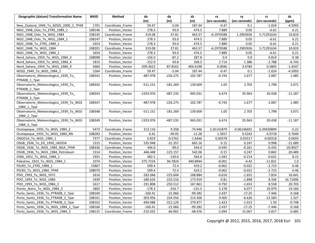
Copyright @ 2012, 2015, 2016, 2017, 2018 Esri 101
Geographic (datum) Transformation Name WKID Method dx (m)
dy (m)
dz (m)
rx (arc-seconds)
ry (arc-seconds)
rz (arc-seconds)
ds (ppm)
New_Zealand_1949_To_NZGD_2000_2_7PAR 1701 Coordinate_Frame 59.47 -5.04 187.44 -0.47 0.1 -1.024 -4.5993
NGO_1948_Oslo_To_ETRS_1989_1 108146 Position_Vector 278.3 93.0 474.5 7.889 0.05 -6.61 6.21
NGO_1948_Oslo_To_WGS_1984 108145 Coordinate_Frame 319.08 37.81 463.57 -6.2970588 1.2903926 5.71291634 10.819
NGO_1948_Oslo_To_WGS_1984_1 108147 Position_Vector 278.3 93.0 474.5 7.889 0.05 -6.61 6.21
NGO_1948_To_ETRS_1989_1 1653 Position_Vector 278.3 93.0 474.5 7.889 0.05 -6.61 6.21
NGO_1948_To_WGS_1984 108201 Coordinate_Frame 319.08 37.81 463.57 -6.2970588 1.2903926 5.71291634 10.819
NGO_1948_To_WGS_1984_1 1654 Position_Vector 278.3 93.0 474.5 7.889 0.05 -6.61 6.21
Nord_Sahara_1959_To_WGS_1984_3 108098 Position_Vector -156.0 -87.2 287.8 0.0 0.0 0.814 -0.38
Nord_Sahara_1959_To_WGS_1984_4 1815 Position_Vector -152.9 43.8 358.3 2.714 1.386 -2.788 -6.743
Nord_Sahara_1959_To_WGS_1984_9 5660 Position_Vector -209.3622 -87.8162 404.6198 0.0046 3.4784 0.5805 -1.4547
NZGD_1949_To_WGS_1984_2 1564 Coordinate_Frame 59.47 -5.04 187.44 -0.47 0.1 -1.024 -4.5993
Observatorio_Meteorologico_1939_To_ PTRA08_1_7par
108341 Position_Vector -487.978 -226.275 102.787 -0.743 1.677 2.087 1.485
Observatorio_Meteorologico_1939_To_ PTRA08_2_7par
108342 Position_Vector -511.151 -181.269 139.609 1.05 2.703 1.798 3.071
Observatorio_Meteorologico_1939_To_ PTRA08_3_7par
108343 Position_Vector -1333.976 -487.235 945.031 6.674 35.963 20.438 -11.187
Observatorio_Meteorologico_1939_To_WGS_1984_1_7par
108347 Position_Vector -487.978 -226.275 102.787 -0.743 1.677 2.087 1.485
Observatorio_Meteorologico_1939_To_WGS_1984_2_7par
108348 Position_Vector -511.151 -181.269 139.609 1.05 2.703 1.798 3.071
Observatorio_Meteorologico_1939_To_WGS_1984_3_7par
108349 Position_Vector -1333.976 -487.235 945.031 6.674 35.963 20.438 -11.187
Ocotepeque_1935_To_WGS_1984_2 5473 Coordinate_Frame 213.116 9.358 -74.946 2.35141879 -0.06146691 6.39420899 -5.22
Ocotepeque_1935_To_WGS_1984_RN 108283 Position_Vector 6.41 -49.05 -11.28 1.5657 0.5242 6.9718 -5.7649
ONGD14_To_WGS_1984_1 7377 Coordinate_Frame 0.819 -0.5762 -1.6446 0.00378 0.03317 -0.00318 0.0693
OSGB_1936_To_ED_1950_UKOOA 1315 Position_Vector 535.948 -31.357 665.16 0.15 0.247 0.998 -21.689
OSGB_1936_To_WGS_1984_NGA_7PAR 108336 Coordinate_Frame 446.0 -99.0 544.0 -0.945 -0.261 -0.435 -20.8927
OSGB_1936_To_WGS_1984_Petroleum 1314 Position_Vector 446.448 -125.157 542.06 0.15 0.247 0.842 -20.489
OSNI_1952_To_WGS_1984_1 1955 Position_Vector 482.5 -130.6 564.6 -1.042 -0.214 -0.631 8.15
Palestine_1923_To_WGS_1984_1 1074 Position_Vector -275.7224 94.7824 340.8944 -8.001 -4.42 -11.821 1.0
PD/83_To_ETRS_1989_1 15867 Position_Vector 599.4 72.4 419.2 -0.062 -0.022 -2.723 6.46
PD/83_To_WGS_1984_7PAR 108070 Position_Vector 599.4 72.4 419.2 -0.062 -0.022 -2.723 6.46
PDO_1993_To_WGS_1972 1616 Position_Vector -182.046 -225.604 168.884 -0.616 -1.655 7.824 16.641
PDO_1993_To_WGS_1984 1439 Position_Vector -180.624 -225.516 173.919 -0.81 -1.898 8.336 16.71006
PDO_1993_To_WGS_1984_3 1617 Position_Vector -191.808 -250.512 167.861 -0.792 -1.653 8.558 20.703
Pointe_Noire_To_WGS_1984_3 1802 Position_Vector -178.3 -316.7 -131.5 5.278 6.077 10.979 19.166
Porto_Santo_1936_To_PTRA08_1_7par 108160 Position_Vector -160.41 -21.066 -99.282 2.437 -17.25 -7.446 0.168
Porto_Santo_1936_To_PTRA08_2_7par 108161 Position_Vector -303.956 224.556 214.306 9.405 -6.626 -12.583 1.327
Porto_Santo_1936_To_PTRA08_3_7par 108162 Position_Vector -494.088 -312.129 279.877 -1.423 -1.013 1.59 -0.748
Porto_Santo_1936_To_WGS_1984_1_7par 108166 Position_Vector -160.41 -21.066 -99.282 2.437 -17.25 -7.446 0.168
Porto_Santo_1936_To_WGS_1984_2 108125 Coordinate_Frame -210.502 -66.902 -48.476 -2.094 15.067 5.817 0.485
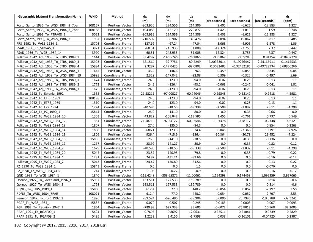
102 Copyright @ 2012, 2015, 2016, 2017, 2018 Esri
Geographic (datum) Transformation Name WKID Method dx (m)
dy (m)
dz (m)
rx (arc-seconds)
ry (arc-seconds)
rz (arc-seconds)
ds (ppm)
Porto_Santo_1936_To_WGS_1984_2_7par 108167 Position_Vector -303.956 224.556 214.306 9.405 -6.626 -12.583 1.327
Porto_Santo_1936_To_WGS_1984_3_7par 108168 Position_Vector -494.088 -312.129 279.877 -1.423 -1.013 1.59 -0.748
Porto_Santo_1995_To_PTRA08_2 5022 Position_Vector -303.956 224.556 214.306 9.405 -6.626 -12.583 1.327
Porto_Santo_1995_To_WGS_1984_3 1967 Coordinate_Frame -210.502 -66.902 -48.476 -2.094 15.067 5.817 0.485
PRS_1992_To_WGS_1984_1 15708 Coordinate_Frame -127.62 -67.24 -47.04 3.068 -4.903 -1.578 -1.06
PSAD_1956_To_SIRGAS_1 3971 Coordinate_Frame -60.31 245.935 31.008 -12.324 -3.755 7.37 0.447
PSAD_1956_To_WGS_1984_14 3990 Coordinate_Frame -60.31 245.935 31.008 -12.324 -3.755 7.37 0.447
Pulkovo_1942_Adj_1958_To_ETRS_1989_1 1644 Position_Vector 33.4297 -146.5746 -76.2865 -0.35867 -0.05283 0.84354 -0.8407728
Pulkovo_1942_Adj_1958_To_ETRS_1989_3 15993 Coordinate_Frame 68.1564 32.7756 80.2249 2.20333014 2.19256447 -2.54166911 -0.1415533
Pulkovo_1942_Adj_1958_To_ETRS_1989_4 15994 Coordinate_Frame 2.3287 -147.0425 -92.0802 0.3092483 -0.32482185 -0.49729934 5.68906266
Pulkovo_1942_Adj_1958_To_WGS_1984_1 1645 Position_Vector 33.4 -146.6 -76.3 -0.359 -0.053 0.844 -0.84
Pulkovo_1942_Adj_1958_To_WGS_1984_19 15995 Coordinate_Frame 2.329 -147.042 -92.08 0.309 -0.325 -0.497 5.69
Pulkovo_1942_Adj_1983_To_ETRS_1989_1 1674 Coordinate_Frame 24.0 -123.0 -94.0 -0.02 0.25 0.13 1.1
Pulkovo_1942_Adj_1983_To_ETRS_1989_2 1775 Position_Vector 24.9 -126.4 -93.2 -0.063 -0.247 -0.041 1.01
Pulkovo_1942_Adj_1983_To_WGS_1984_1 1675 Coordinate_Frame 24.0 -123.0 -94.0 -0.02 0.25 0.13 1.1
Pulkovo_1942_To_Estonia_1992 1332 Coordinate_Frame 21.53219 -97.00027 -60.74046 -0.99548 -0.58147 -0.2418 -4.5981
Pulkovo_1942_To_ETRF_1989 108198 Coordinate_Frame 24.0 -123.0 -94.0 -0.02 0.25 0.13 1.1
Pulkovo_1942_To_ETRS_1989 1310 Coordinate_Frame 24.0 -123.0 -94.0 -0.02 0.25 0.13 1.1
Pulkovo_1942_To_LKS_1994 1274 Coordinate_Frame -40.595 -18.55 -69.339 -2.508 -1.832 2.611 -4.299
Pulkovo_1942_To_PZ_1990_1 15844 Coordinate_Frame 25.0 -141.0 -80.0 0.0 -0.35 -0.66 0.0
Pulkovo_1942_To_WGS_1984_10 1303 Position_Vector 43.822 -108.842 -119.585 1.455 -0.761 0.737 0.549
Pulkovo_1942_To_WGS_1984_12 1334 Coordinate_Frame 21.58719 -97.54127 -60.92546 -1.01378 -0.58117 -0.2348 -4.6121
Pulkovo_1942_To_WGS_1984_13 1807 Position_Vector 27.0 -135.0 -84.5 0.0 0.0 0.554 0.2263
Pulkovo_1942_To_WGS_1984_14 1808 Position_Vector 686.1 -123.5 -574.4 8.045 -23.366 10.791 -2.926
Pulkovo_1942_To_WGS_1984_15 1809 Position_Vector 926.4 -715.9 -186.4 -10.364 -20.78 26.452 -7.224
Pulkovo_1942_To_WGS_1984_16 15865 Coordinate_Frame 25.0 -141.0 -78.5 0.0 -0.35 -0.736 0.0
Pulkovo_1942_To_WGS_1984_17 1267 Coordinate_Frame 23.92 -141.27 -80.9 0.0 -0.35 -0.82 -0.12
Pulkovo_1942_To_WGS_1984_2 1679 Coordinate_Frame -40.595 -18.55 -69.339 -2.508 -1.832 2.611 -4.299
Pulkovo_1942_To_WGS_1984_20 5044 Coordinate_Frame 23.57 -140.95 -79.8 0.0 -0.35 -0.79 -0.22
Pulkovo_1995_To_WGS_1984_1 1281 Coordinate_Frame 24.82 -131.21 -82.66 0.0 0.0 -0.16 -0.12
Pulkovo_1995_To_WGS_1984_2 5043 Coordinate_Frame 24.47 -130.89 -81.56 0.0 0.0 -0.13 -0.22
PZ_1990_To_WGS_1984_1 15843 Coordinate_Frame 0.0 0.0 1.5 0.0 0.0 -0.076 0.0
PZ_1990_To_WGS_1984_GOST 1244 Coordinate_Frame -1.08 -0.27 -0.9 0.0 0.0 -0.16 -0.12
QND_1995_To_WGS_1984_1 1840 Position_Vector -119.4248 -303.65872 -11.00061 1.164298 0.174458 1.096259 3.657065
Qornoq_1927_To_Greenland_1996_1 15957 Position_Vector 163.511 127.533 -159.789 0.0 0.0 0.814 -0.6
Qornoq_1927_To_WGS_1984_2 1798 Position_Vector 163.511 127.533 -159.789 0.0 0.0 0.814 -0.6
RD/83_To_ETRS_1989_1 15868 Position_Vector 612.4 77.0 440.2 -0.054 0.057 -2.797 2.55
RD/83_To_WGS_1984_7PAR 108071 Position_Vector 612.4 77.0 440.2 -0.054 0.057 -2.797 2.55
Reunion_1947_To_RGR_1992_1 1926 Position_Vector 789.524 -626.486 -89.904 0.6006 76.7946 -10.5788 -32.3241
RGPF_To_WGS_1984_1 15832 Coordinate_Frame 0.072 -0.507 -0.245 0.0183 -0.0003 0.007 -0.0093
RGR_1992_To_Reunion_1947_1 1964 Position_Vector -789.99 627.333 89.685 -0.6072 -76.8019 10.568 32.2083
RRAF_1991_To_RGAF09_1 5494 Position_Vector 0.7696 -0.8692 -12.0631 -0.32511 -0.21041 -0.0239 0.2829
RRAF_1991_To_RGAF09_2 5495 Position_Vector 1.2239 2.4156 -1.7598 0.038 -0.16101 -0.04925 0.2387
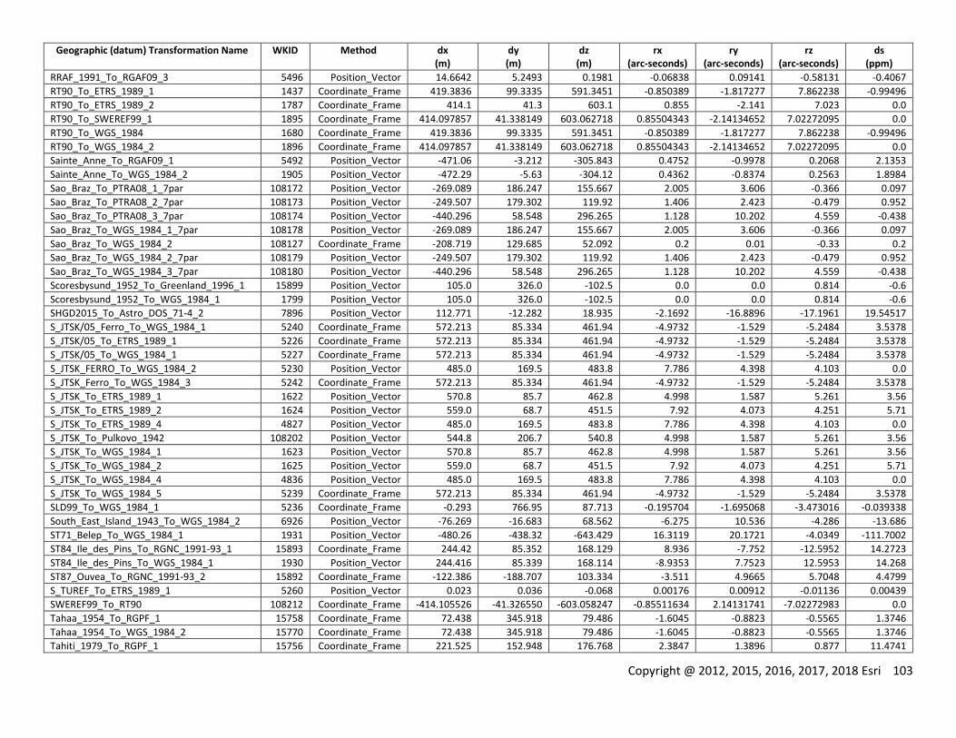
Copyright @ 2012, 2015, 2016, 2017, 2018 Esri 103
Geographic (datum) Transformation Name WKID Method dx (m)
dy (m)
dz (m)
rx (arc-seconds)
ry (arc-seconds)
rz (arc-seconds)
ds (ppm)
RRAF_1991_To_RGAF09_3 5496 Position_Vector 14.6642 5.2493 0.1981 -0.06838 0.09141 -0.58131 -0.4067
RT90_To_ETRS_1989_1 1437 Coordinate_Frame 419.3836 99.3335 591.3451 -0.850389 -1.817277 7.862238 -0.99496
RT90_To_ETRS_1989_2 1787 Coordinate_Frame 414.1 41.3 603.1 0.855 -2.141 7.023 0.0
RT90_To_SWEREF99_1 1895 Coordinate_Frame 414.097857 41.338149 603.062718 0.85504343 -2.14134652 7.02272095 0.0
RT90_To_WGS_1984 1680 Coordinate_Frame 419.3836 99.3335 591.3451 -0.850389 -1.817277 7.862238 -0.99496
RT90_To_WGS_1984_2 1896 Coordinate_Frame 414.097857 41.338149 603.062718 0.85504343 -2.14134652 7.02272095 0.0
Sainte_Anne_To_RGAF09_1 5492 Position_Vector -471.06 -3.212 -305.843 0.4752 -0.9978 0.2068 2.1353
Sainte_Anne_To_WGS_1984_2 1905 Position_Vector -472.29 -5.63 -304.12 0.4362 -0.8374 0.2563 1.8984
Sao_Braz_To_PTRA08_1_7par 108172 Position_Vector -269.089 186.247 155.667 2.005 3.606 -0.366 0.097
Sao_Braz_To_PTRA08_2_7par 108173 Position_Vector -249.507 179.302 119.92 1.406 2.423 -0.479 0.952
Sao_Braz_To_PTRA08_3_7par 108174 Position_Vector -440.296 58.548 296.265 1.128 10.202 4.559 -0.438
Sao_Braz_To_WGS_1984_1_7par 108178 Position_Vector -269.089 186.247 155.667 2.005 3.606 -0.366 0.097
Sao_Braz_To_WGS_1984_2 108127 Coordinate_Frame -208.719 129.685 52.092 0.2 0.01 -0.33 0.2
Sao_Braz_To_WGS_1984_2_7par 108179 Position_Vector -249.507 179.302 119.92 1.406 2.423 -0.479 0.952
Sao_Braz_To_WGS_1984_3_7par 108180 Position_Vector -440.296 58.548 296.265 1.128 10.202 4.559 -0.438
Scoresbysund_1952_To_Greenland_1996_1 15899 Position_Vector 105.0 326.0 -102.5 0.0 0.0 0.814 -0.6
Scoresbysund_1952_To_WGS_1984_1 1799 Position_Vector 105.0 326.0 -102.5 0.0 0.0 0.814 -0.6
SHGD2015_To_Astro_DOS_71-4_2 7896 Position_Vector 112.771 -12.282 18.935 -2.1692 -16.8896 -17.1961 19.54517
S_JTSK/05_Ferro_To_WGS_1984_1 5240 Coordinate_Frame 572.213 85.334 461.94 -4.9732 -1.529 -5.2484 3.5378
S_JTSK/05_To_ETRS_1989_1 5226 Coordinate_Frame 572.213 85.334 461.94 -4.9732 -1.529 -5.2484 3.5378
S_JTSK/05_To_WGS_1984_1 5227 Coordinate_Frame 572.213 85.334 461.94 -4.9732 -1.529 -5.2484 3.5378
S_JTSK_FERRO_To_WGS_1984_2 5230 Position_Vector 485.0 169.5 483.8 7.786 4.398 4.103 0.0
S_JTSK_Ferro_To_WGS_1984_3 5242 Coordinate_Frame 572.213 85.334 461.94 -4.9732 -1.529 -5.2484 3.5378
S_JTSK_To_ETRS_1989_1 1622 Position_Vector 570.8 85.7 462.8 4.998 1.587 5.261 3.56
S_JTSK_To_ETRS_1989_2 1624 Position_Vector 559.0 68.7 451.5 7.92 4.073 4.251 5.71
S_JTSK_To_ETRS_1989_4 4827 Position_Vector 485.0 169.5 483.8 7.786 4.398 4.103 0.0
S_JTSK_To_Pulkovo_1942 108202 Position_Vector 544.8 206.7 540.8 4.998 1.587 5.261 3.56
S_JTSK_To_WGS_1984_1 1623 Position_Vector 570.8 85.7 462.8 4.998 1.587 5.261 3.56
S_JTSK_To_WGS_1984_2 1625 Position_Vector 559.0 68.7 451.5 7.92 4.073 4.251 5.71
S_JTSK_To_WGS_1984_4 4836 Position_Vector 485.0 169.5 483.8 7.786 4.398 4.103 0.0
S_JTSK_To_WGS_1984_5 5239 Coordinate_Frame 572.213 85.334 461.94 -4.9732 -1.529 -5.2484 3.5378
SLD99_To_WGS_1984_1 5236 Coordinate_Frame -0.293 766.95 87.713 -0.195704 -1.695068 -3.473016 -0.039338
South_East_Island_1943_To_WGS_1984_2 6926 Position_Vector -76.269 -16.683 68.562 -6.275 10.536 -4.286 -13.686
ST71_Belep_To_WGS_1984_1 1931 Position_Vector -480.26 -438.32 -643.429 16.3119 20.1721 -4.0349 -111.7002
ST84_Ile_des_Pins_To_RGNC_1991-93_1 15893 Coordinate_Frame 244.42 85.352 168.129 8.936 -7.752 -12.5952 14.2723
ST84_Ile_des_Pins_To_WGS_1984_1 1930 Position_Vector 244.416 85.339 168.114 -8.9353 7.7523 12.5953 14.268
ST87_Ouvea_To_RGNC_1991-93_2 15892 Coordinate_Frame -122.386 -188.707 103.334 -3.511 4.9665 5.7048 4.4799
S_TUREF_To_ETRS_1989_1 5260 Position_Vector 0.023 0.036 -0.068 0.00176 0.00912 -0.01136 0.00439
SWEREF99_To_RT90 108212 Coordinate_Frame -414.105526 -41.326550 -603.058247 -0.85511634 2.14131741 -7.02272983 0.0
Tahaa_1954_To_RGPF_1 15758 Coordinate_Frame 72.438 345.918 79.486 -1.6045 -0.8823 -0.5565 1.3746
Tahaa_1954_To_WGS_1984_2 15770 Coordinate_Frame 72.438 345.918 79.486 -1.6045 -0.8823 -0.5565 1.3746
Tahiti_1979_To_RGPF_1 15756 Coordinate_Frame 221.525 152.948 176.768 2.3847 1.3896 0.877 11.4741

104 Copyright @ 2012, 2015, 2016, 2017, 2018 Esri
Geographic (datum) Transformation Name WKID Method dx (m)
dy (m)
dz (m)
rx (arc-seconds)
ry (arc-seconds)
rz (arc-seconds)
ds (ppm)
Tahiti_1979_To_WGS_1984_1 4835 Coordinate_Frame 221.525 152.948 176.768 2.3847 1.3896 0.877 11.4741
Tete_To_Moznet_1 1297 Coordinate_Frame -115.064 -87.39 -101.716 0.058 -4.001 2.062 9.366
Tete_To_Moznet_2 1298 Coordinate_Frame -82.875 -57.097 -156.768 2.158 -1.524 0.982 -0.359
Tete_To_Moznet_3 1299 Coordinate_Frame -138.527 -91.999 -114.591 0.14 -3.363 2.217 11.748
Tete_To_Moznet_4 1300 Coordinate_Frame -73.472 -51.66 -112.482 -0.953 -4.6 2.368 0.586
Tete_To_Moznet_5 1301 Coordinate_Frame 219.315 168.975 -166.145 -0.198 -5.926 2.356 -57.104
Tete_To_WGS_1984_1 1683 Coordinate_Frame -115.064 -87.39 -101.716 0.058 -4.001 2.062 9.366
Tete_To_WGS_1984_2 1684 Coordinate_Frame -82.875 -57.097 -156.768 2.158 -1.524 0.982 -0.359
Tete_To_WGS_1984_3 1685 Coordinate_Frame -138.527 -91.999 -114.591 0.14 -3.363 2.217 11.748
Tete_To_WGS_1984_4 1686 Coordinate_Frame -73.472 -51.66 -112.482 -0.953 -4.6 2.368 0.586
Tete_To_WGS_1984_5 1687 Coordinate_Frame 219.315 168.975 -166.145 -0.198 -5.926 2.356 -57.104
Timbalai_1948_To_GDBD2009_1 5878 Coordinate_Frame -689.5937 623.84046 -65.93566 0.02331 -1.17094 0.80054 5.88536
Timbalai_1948_To_WGS_1984_4 1852 Position_Vector -533.4 669.2 -52.5 0.0 0.0 4.28 9.4
Timbalai_1948_To_WGS_1984_5 5249 Coordinate_Frame -689.5937 623.84046 -65.93566 0.02331 -1.17094 0.80054 5.88536
TM65_To_ETRS_1989_1 1640 Position_Vector 482.53 -130.596 564.557 -1.042 -0.214 -0.631 8.15
TM65_To_WGS_1984_2 1641 Position_Vector 482.53 -130.596 564.557 -1.042 -0.214 -0.631 8.15
TM75_To_ETRS_1989_2 1953 Position_Vector 482.53 -130.596 564.557 -1.042 -0.214 -0.631 8.15
TM75_To_WGS_1984_2 1954 Position_Vector 482.53 -130.596 564.557 -1.042 -0.214 -0.631 8.15
Ukraine_2000_To_WGS_1984_1 5590 Coordinate_Frame 25.0 -141.0 -78.5 0.0 -0.35 -0.736 0.0
VN_2000_To_WGS_1984_1 5194 Coordinate_Frame -192.873 -39.382 -111.202 0.00205 0.0005 -0.00335 0.0188
VN_2000_To_WGS_1984_2 6960 Coordinate_Frame -191.904414 -39.303183 -111.450328 -0.00928836 0.01975479 -0.00427372 0.25290628
WGS_1972_BE_To_WGS_1972_1 1239 Position_Vector 0.0 0.0 -2.6 0.0 0.0 0.26 -0.6063
WGS_1972_BE_To_WGS_1984_1 1240 Position_Vector 0.0 0.0 1.9 0.0 0.0 0.814 -0.38
WGS_1972_To_WGS_1984_1 1237 Position_Vector 0.0 0.0 4.5 0.0 0.0 0.554 0.2263
WGS_1972_To_WGS_1984_2 1238 Position_Vector 0.0 0.0 4.5 0.0 0.0 0.554 0.219
WGS_1984_(ITRF00)_To_NAD_1983 108190 Coordinate_Frame 0.9956 -1.9013 -0.5215 0.025915 0.009426 0.011599 0.00062
WGS_1984_(ITRF00)_To_NAD_1983_2011 108354 Coordinate_Frame 0.9956 -1.9013 -0.5215 0.025915 0.009426 0.011599 0.00062
WGS_1984_(ITRF00)_To_NAD_1983_CORS96 108151 Coordinate_Frame 0.9956 -1.9013 -0.5215 0.025915 0.009426 0.011599 0.00062
WGS_1984_(ITRF00)_To_NAD_1983_HARN 108282 Coordinate_Frame 0.9956 -1.9013 -0.5215 0.025915 0.009426 0.011599 0.00062
WGS_1984_(ITRF08)_To_NAD_1983_2011 108363 Coordinate_Frame 0.99343 -1.90331 -0.52655 0.02591467 0.00942645 0.01159935 0.00171504
WGS_1984_(ITRF08)_To_NAD_1983_MA11 108364 Coordinate_Frame 0.908 -2.0161 -0.5653 0.028971 0.01042 0.008928 0.0011
WGS_1984_(ITRF08)_To_NAD_1983_PA11 108365 Coordinate_Frame 0.908 -2.0161 -0.5653 0.027741 0.013469 0.002712 0.0011
WGS_1984_To_Israel_CoordFrame 108021 Coordinate_Frame -24.0024 -17.1032 -17.8444 -0.33009 -1.85269 1.66969 5.4248
WGS_1984_To_MSK_1942 108055 Coordinate_Frame 78.0421780 204.518613 77.4498615 -1.773670970 3.319791732 -1.042607713 -4.9510577
WGS_1984_To_Observatorio_Meteorologico_1965_1
108211 Coordinate_Frame 148.635396 339.470115 157.265381 32.87685 -76.963371 -32.622853 -8.204889
WGS_1984_To_Pulkovo_1942 108056 Coordinate_Frame 78.0421780 204.518613 77.4498615 -1.773670970 3.319791732 -1.042607713 -4.9510577
WGS_1984_To_RT90 108213 Coordinate_Frame -414.097857 -41.338149 -603.062718 -0.85504343 2.14134652 -7.02272095 0.0
WGS_1984_To_Xrail84_1 108051 Position_Vector 19.019 115.122 -97.287 3.577824 -3.484437 -2.767646 18.6084754
Yacare_To_SIRGAS_1 15963 Position_Vector -124.45 183.74 44.64 -0.4384 0.5446 -0.9706 -2.1365
Yacare_To_SIRGAS-ROU98_1 5385 Position_Vector -124.45 183.74 44.64 -0.4384 0.5446 -0.9706 -2.1365
Yacare_To_WGS_1984_2 5386 Position_Vector -124.45 183.74 44.64 -0.4384 0.5446 -0.9706 -2.1365
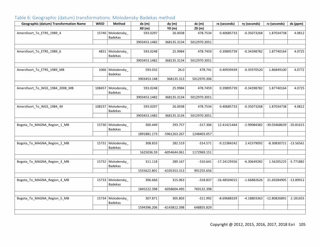
Copyright @ 2012, 2015, 2016, 2017, 2018 Esri 105
Table 6: Geographic (datum) transformations: Molodensky-Badekas method Geographic (datum) Transformation Name WKID Method dx (m) dy (m) dz (m) rx (seconds) ry (seconds) rz (seconds) ds (ppm)
X0 (m) Y0 (m) Z0 (m)
Amersfoort_To_ETRS_1989_4 15740 Molodensky_Badekas
593.0297 26.0038 478.7534 0.40685733 -0.35073268 1.87034738 4.0812
3903453.1482 368135.3134 5012970.3051
Amersfoort_To_ETRS_1989_6 4831 Molodensky_Badekas
593.0248 25.9984 478.7459 0.39895739 -0.34398782 1.87740164 4.0725
3903453.1482 368135.3134 5012970.3051
Amersfoort_To_ETRS_1989_MB 1066 Molodensky_Badekas
593.032 26.0 478.741 0.40939439 -0.35970520 1.86849100 4.0772
3903453.148 368135.313 5012970.306
Amersfoort_To_WGS_1984_2008_MB 108457 Molodensky_Badekas
593.0248 25.9984 478.7459 0.39895739 -0.34398782 1.87740164 4.0725
3903453.1482 368135.3134 5012970.3051
Amersfoort_To_WGS_1984_4X 108237 Molodensky_Badekas
593.0297 26.0038 478.7534 0.40685733 -0.35073268 1.87034738 4.0812
3903453.1482 368135.3134 5012970.3051
Bogota_To_MAGNA_Region_1_MB 15730 Molodensky_Badekas
300.449 293.757 -317.306 12.41421444 -2.99084382 -39.03468639 -20.81615
1891881.173 -5961263.267 1248403.057
Bogota_To_MAGNA_Region_2_MB 15731 Molodensky_Badekas
308.833 282.519 -314.571 -9.22384242 2.42379092 -8.30830721 -13.56561
1625036.59 -6054644.061 1172969.151
Bogota_To_MAGNA_Region_3_MB 15732 Molodensky_Badekas
311.118 289.167 -310.641 -17.24129356 -6.30649282 1.56205225 -5.771882
1555622.801 -6105353.313 991255.656
Bogota_To_MAGNA_Region_4_MB 15733 Molodensky_Badekas
306.666 315.063 -318.837 -16.48504015 -1.66882626 21.69284905 -13.89912
1845222.398 -6058604.495 769132.398
Bogota_To_MAGNA_Region_5_MB 15734 Molodensky_Badekas
307.871 305.803 -311.992 -8.69688329 -4.18803363 -12.80826891 2.181655
1594396.206 -6143812.398 648855.829
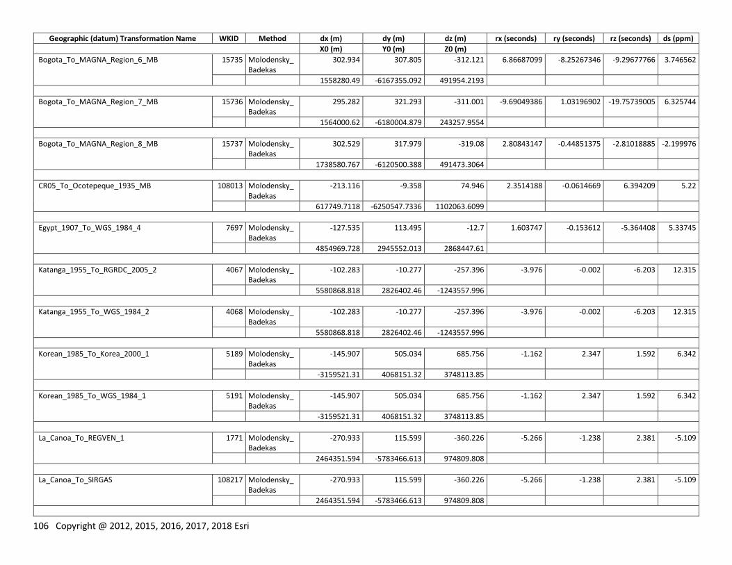
106 Copyright @ 2012, 2015, 2016, 2017, 2018 Esri
Geographic (datum) Transformation Name WKID Method dx (m) dy (m) dz (m) rx (seconds) ry (seconds) rz (seconds) ds (ppm)
X0 (m) Y0 (m) Z0 (m)
Bogota_To_MAGNA_Region_6_MB 15735 Molodensky_Badekas
302.934 307.805 -312.121 6.86687099 -8.25267346 -9.29677766 3.746562
1558280.49 -6167355.092 491954.2193
Bogota_To_MAGNA_Region_7_MB 15736 Molodensky_Badekas
295.282 321.293 -311.001 -9.69049386 1.03196902 -19.75739005 6.325744
1564000.62 -6180004.879 243257.9554
Bogota_To_MAGNA_Region_8_MB 15737 Molodensky_Badekas
302.529 317.979 -319.08 2.80843147 -0.44851375 -2.81018885 -2.199976
1738580.767 -6120500.388 491473.3064
CR05_To_Ocotepeque_1935_MB 108013 Molodensky_Badekas
-213.116 -9.358 74.946 2.3514188 -0.0614669 6.394209 5.22
617749.7118 -6250547.7336 1102063.6099
Egypt_1907_To_WGS_1984_4 7697 Molodensky_Badekas
-127.535 113.495 -12.7 1.603747 -0.153612 -5.364408 5.33745
4854969.728 2945552.013 2868447.61
Katanga_1955_To_RGRDC_2005_2 4067 Molodensky_Badekas
-102.283 -10.277 -257.396 -3.976 -0.002 -6.203 12.315
5580868.818 2826402.46 -1243557.996
Katanga_1955_To_WGS_1984_2 4068 Molodensky_Badekas
-102.283 -10.277 -257.396 -3.976 -0.002 -6.203 12.315
5580868.818 2826402.46 -1243557.996
Korean_1985_To_Korea_2000_1 5189 Molodensky_Badekas
-145.907 505.034 685.756 -1.162 2.347 1.592 6.342
-3159521.31 4068151.32 3748113.85
Korean_1985_To_WGS_1984_1 5191 Molodensky_Badekas
-145.907 505.034 685.756 -1.162 2.347 1.592 6.342
-3159521.31 4068151.32 3748113.85
La_Canoa_To_REGVEN_1 1771 Molodensky_Badekas
-270.933 115.599 -360.226 -5.266 -1.238 2.381 -5.109
2464351.594 -5783466.613 974809.808
La_Canoa_To_SIRGAS 108217 Molodensky_Badekas
-270.933 115.599 -360.226 -5.266 -1.238 2.381 -5.109
2464351.594 -5783466.613 974809.808
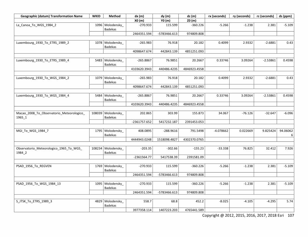
Copyright @ 2012, 2015, 2016, 2017, 2018 Esri 107
Geographic (datum) Transformation Name WKID Method dx (m) dy (m) dz (m) rx (seconds) ry (seconds) rz (seconds) ds (ppm)
X0 (m) Y0 (m) Z0 (m)
La_Canoa_To_WGS_1984_2 1096 Molodensky_Badekas
-270.933 115.599 -360.226 -5.266 -1.238 2.381 -5.109
2464351.594 -5783466.613 974809.808
Luxembourg_1930_To_ETRS_1989_2 1078 Molodensky_Badekas
-265.983 76.918 20.182 0.4099 2.9332 -2.6881 0.43
4098647.674 442843.139 4851251.093
Luxembourg_1930_To_ETRS_1989_4 5483 Molodensky_Badekas
-265.8867 76.9851 20.2667 0.33746 3.09264 -2.53861 0.4598
4103620.3943 440486.4235 4846923.4558
Luxembourg_1930_To_WGS_1984_2 1079 Molodensky_Badekas
-265.983 76.918 20.182 0.4099 2.9332 -2.6881 0.43
4098647.674 442843.139 4851251.093
Luxembourg_1930_To_WGS_1984_4 5484 Molodensky_Badekas
-265.8867 76.9851 20.2667 0.33746 3.09264 -2.53861 0.4598
4103620.3943 440486.4235 4846923.4558
Macao_2008_To_Observatorio_Meteorologico_ 1965_1
108039 Molodensky_Badekas
202.865 303.99 155.873 34.067 -76.126 -32.647 -6.096
-2361757.652 5417232.187 2391453.053
MGI_To_WGS_1984_7 1795 Molodensky_Badekas
408.0895 -288.9616 791.5498 -4.078662 0.022669 9.825424 94.060626
4444943.0248 1518098.4827 4302370.0765
Observatorio_Meteorologico_1965_To_WGS_ 1984_2
108234 Molodensky_Badekas
-203.35 -302.66 -155.23 -33.338 76.825 32.412 7.926
-2361564.77 5417538.39 2391581.09
PSAD_1956_To_REGVEN 1769 Molodensky_Badekas
-270.933 115.599 -360.226 -5.266 -1.238 2.381 -5.109
2464351.594 -5783466.613 974809.808
PSAD_1956_To_WGS_1984_13 1095 Molodensky_Badekas
-270.933 115.599 -360.226 -5.266 -1.238 2.381 -5.109
2464351.594 -5783466.613 974809.808
S_JTSK_To_ETRS_1989_3 4829 Molodensky_Badekas
558.7 68.8 452.2 -8.025 -4.105 -4.295 5.74
3977358.114 1407223.203 4765441.589
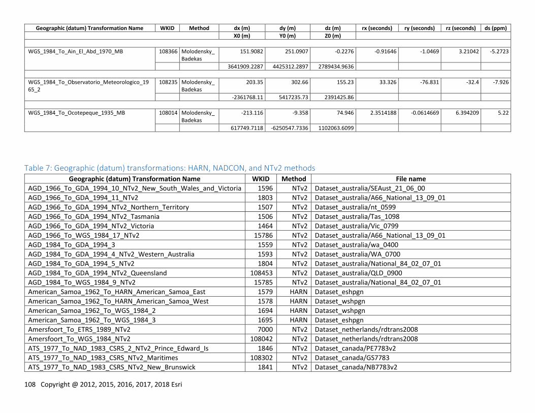
108 Copyright @ 2012, 2015, 2016, 2017, 2018 Esri
Geographic (datum) Transformation Name WKID Method dx (m) dy (m) dz (m) rx (seconds) ry (seconds) rz (seconds) ds (ppm)
X0 (m) Y0 (m) Z0 (m)
WGS_1984_To_Ain_El_Abd_1970_MB 108366 Molodensky_Badekas
151.9082 251.0907 -0.2276 -0.91646 -1.0469 3.21042 -5.2723
3641909.2287 4425312.2897 2789434.9636
WGS_1984_To_Observatorio_Meteorologico_1965_2
108235 Molodensky_Badekas
203.35 302.66 155.23 33.326 -76.831 -32.4 -7.926
-2361768.11 5417235.73 2391425.86
WGS_1984_To_Ocotepeque_1935_MB 108014 Molodensky_Badekas
-213.116 -9.358 74.946 2.3514188 -0.0614669 6.394209 5.22
617749.7118 -6250547.7336 1102063.6099
Table 7: Geographic (datum) transformations: HARN, NADCON, and NTv2 methods Geographic (datum) Transformation Name WKID Method File name
AGD_1966_To_GDA_1994_10_NTv2_New_South_Wales_and_Victoria 1596 NTv2 Dataset_australia/SEAust_21_06_00
AGD_1966_To_GDA_1994_11_NTv2 1803 NTv2 Dataset_australia/A66_National_13_09_01
AGD_1966_To_GDA_1994_NTv2_Northern_Territory 1507 NTv2 Dataset_australia/nt_0599
AGD_1966_To_GDA_1994_NTv2_Tasmania 1506 NTv2 Dataset_australia/Tas_1098
AGD_1966_To_GDA_1994_NTv2_Victoria 1464 NTv2 Dataset_australia/Vic_0799
AGD_1966_To_WGS_1984_17_NTv2 15786 NTv2 Dataset_australia/A66_National_13_09_01
AGD_1984_To_GDA_1994_3 1559 NTv2 Dataset_australia/wa_0400
AGD_1984_To_GDA_1994_4_NTv2_Western_Australia 1593 NTv2 Dataset_australia/WA_0700
AGD_1984_To_GDA_1994_5_NTv2 1804 NTv2 Dataset_australia/National_84_02_07_01
AGD_1984_To_GDA_1994_NTv2_Queensland 108453 NTv2 Dataset_australia/QLD_0900
AGD_1984_To_WGS_1984_9_NTv2 15785 NTv2 Dataset_australia/National_84_02_07_01
American_Samoa_1962_To_HARN_American_Samoa_East 1579 HARN Dataset_eshpgn
American_Samoa_1962_To_HARN_American_Samoa_West 1578 HARN Dataset_wshpgn
American_Samoa_1962_To_WGS_1984_2 1694 HARN Dataset_wshpgn
American_Samoa_1962_To_WGS_1984_3 1695 HARN Dataset_eshpgn
Amersfoort_To_ETRS_1989_NTv2 7000 NTv2 Dataset_netherlands/rdtrans2008
Amersfoort_To_WGS_1984_NTv2 108042 NTv2 Dataset_netherlands/rdtrans2008
ATS_1977_To_NAD_1983_CSRS_2_NTv2_Prince_Edward_Is 1846 NTv2 Dataset_canada/PE7783v2
ATS_1977_To_NAD_1983_CSRS_NTv2_Maritimes 108302 NTv2 Dataset_canada/GS7783
ATS_1977_To_NAD_1983_CSRS_NTv2_New_Brunswick 1841 NTv2 Dataset_canada/NB7783v2
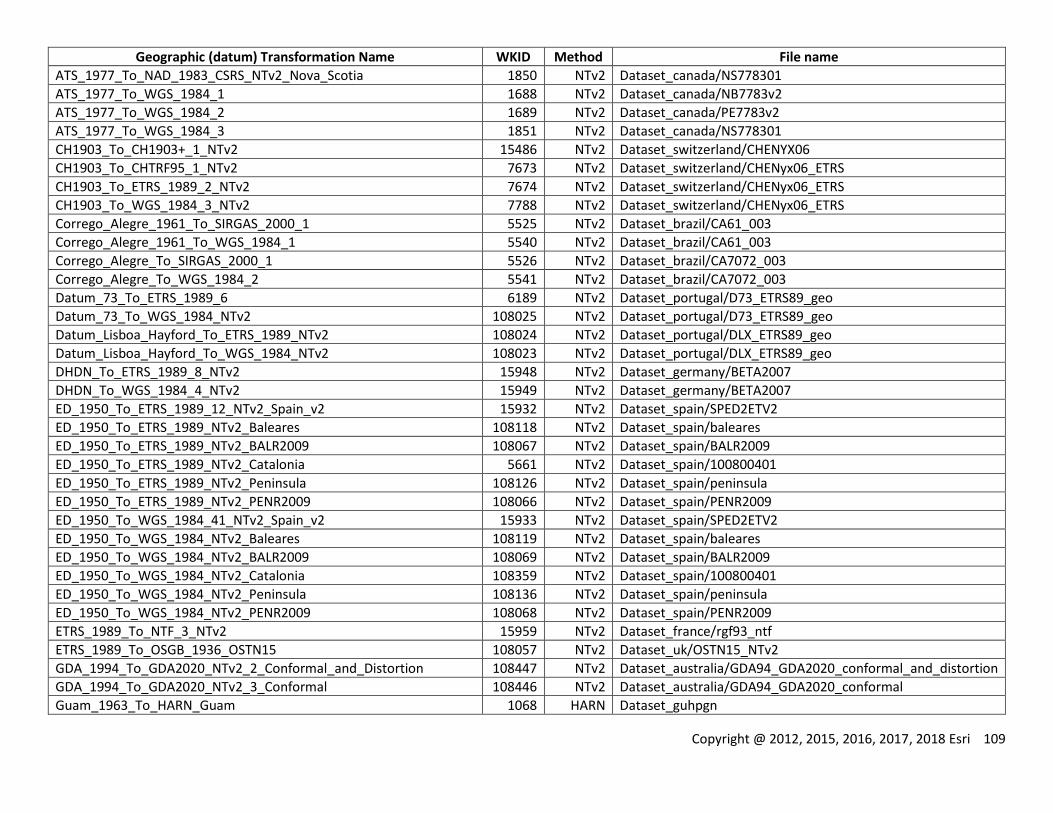
Copyright @ 2012, 2015, 2016, 2017, 2018 Esri 109
Geographic (datum) Transformation Name WKID Method File name
ATS_1977_To_NAD_1983_CSRS_NTv2_Nova_Scotia 1850 NTv2 Dataset_canada/NS778301
ATS_1977_To_WGS_1984_1 1688 NTv2 Dataset_canada/NB7783v2
ATS_1977_To_WGS_1984_2 1689 NTv2 Dataset_canada/PE7783v2
ATS_1977_To_WGS_1984_3 1851 NTv2 Dataset_canada/NS778301
CH1903_To_CH1903+_1_NTv2 15486 NTv2 Dataset_switzerland/CHENYX06
CH1903_To_CHTRF95_1_NTv2 7673 NTv2 Dataset_switzerland/CHENyx06_ETRS
CH1903_To_ETRS_1989_2_NTv2 7674 NTv2 Dataset_switzerland/CHENyx06_ETRS
CH1903_To_WGS_1984_3_NTv2 7788 NTv2 Dataset_switzerland/CHENyx06_ETRS
Corrego_Alegre_1961_To_SIRGAS_2000_1 5525 NTv2 Dataset_brazil/CA61_003
Corrego_Alegre_1961_To_WGS_1984_1 5540 NTv2 Dataset_brazil/CA61_003
Corrego_Alegre_To_SIRGAS_2000_1 5526 NTv2 Dataset_brazil/CA7072_003
Corrego_Alegre_To_WGS_1984_2 5541 NTv2 Dataset_brazil/CA7072_003
Datum_73_To_ETRS_1989_6 6189 NTv2 Dataset_portugal/D73_ETRS89_geo
Datum_73_To_WGS_1984_NTv2 108025 NTv2 Dataset_portugal/D73_ETRS89_geo
Datum_Lisboa_Hayford_To_ETRS_1989_NTv2 108024 NTv2 Dataset_portugal/DLX_ETRS89_geo
Datum_Lisboa_Hayford_To_WGS_1984_NTv2 108023 NTv2 Dataset_portugal/DLX_ETRS89_geo
DHDN_To_ETRS_1989_8_NTv2 15948 NTv2 Dataset_germany/BETA2007
DHDN_To_WGS_1984_4_NTv2 15949 NTv2 Dataset_germany/BETA2007
ED_1950_To_ETRS_1989_12_NTv2_Spain_v2 15932 NTv2 Dataset_spain/SPED2ETV2
ED_1950_To_ETRS_1989_NTv2_Baleares 108118 NTv2 Dataset_spain/baleares
ED_1950_To_ETRS_1989_NTv2_BALR2009 108067 NTv2 Dataset_spain/BALR2009
ED_1950_To_ETRS_1989_NTv2_Catalonia 5661 NTv2 Dataset_spain/100800401
ED_1950_To_ETRS_1989_NTv2_Peninsula 108126 NTv2 Dataset_spain/peninsula
ED_1950_To_ETRS_1989_NTv2_PENR2009 108066 NTv2 Dataset_spain/PENR2009
ED_1950_To_WGS_1984_41_NTv2_Spain_v2 15933 NTv2 Dataset_spain/SPED2ETV2
ED_1950_To_WGS_1984_NTv2_Baleares 108119 NTv2 Dataset_spain/baleares
ED_1950_To_WGS_1984_NTv2_BALR2009 108069 NTv2 Dataset_spain/BALR2009
ED_1950_To_WGS_1984_NTv2_Catalonia 108359 NTv2 Dataset_spain/100800401
ED_1950_To_WGS_1984_NTv2_Peninsula 108136 NTv2 Dataset_spain/peninsula
ED_1950_To_WGS_1984_NTv2_PENR2009 108068 NTv2 Dataset_spain/PENR2009
ETRS_1989_To_NTF_3_NTv2 15959 NTv2 Dataset_france/rgf93_ntf
ETRS_1989_To_OSGB_1936_OSTN15 108057 NTv2 Dataset_uk/OSTN15_NTv2
GDA_1994_To_GDA2020_NTv2_2_Conformal_and_Distortion 108447 NTv2 Dataset_australia/GDA94_GDA2020_conformal_and_distortion
GDA_1994_To_GDA2020_NTv2_3_Conformal 108446 NTv2 Dataset_australia/GDA94_GDA2020_conformal
Guam_1963_To_HARN_Guam 1068 HARN Dataset_guhpgn
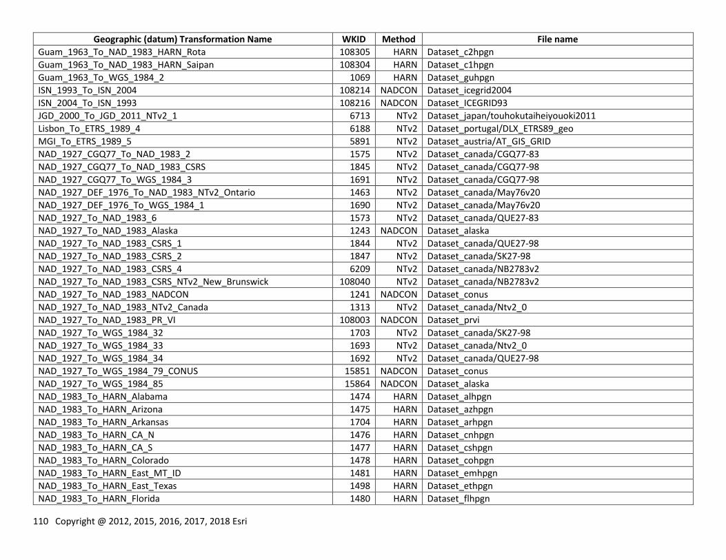
110 Copyright @ 2012, 2015, 2016, 2017, 2018 Esri
Geographic (datum) Transformation Name WKID Method File name
Guam_1963_To_NAD_1983_HARN_Rota 108305 HARN Dataset_c2hpgn
Guam_1963_To_NAD_1983_HARN_Saipan 108304 HARN Dataset_c1hpgn
Guam_1963_To_WGS_1984_2 1069 HARN Dataset_guhpgn
ISN_1993_To_ISN_2004 108214 NADCON Dataset_icegrid2004
ISN_2004_To_ISN_1993 108216 NADCON Dataset_ICEGRID93
JGD_2000_To_JGD_2011_NTv2_1 6713 NTv2 Dataset_japan/touhokutaiheiyouoki2011
Lisbon_To_ETRS_1989_4 6188 NTv2 Dataset_portugal/DLX_ETRS89_geo
MGI_To_ETRS_1989_5 5891 NTv2 Dataset_austria/AT_GIS_GRID
NAD_1927_CGQ77_To_NAD_1983_2 1575 NTv2 Dataset_canada/CGQ77-83
NAD_1927_CGQ77_To_NAD_1983_CSRS 1845 NTv2 Dataset_canada/CGQ77-98
NAD_1927_CGQ77_To_WGS_1984_3 1691 NTv2 Dataset_canada/CGQ77-98
NAD_1927_DEF_1976_To_NAD_1983_NTv2_Ontario 1463 NTv2 Dataset_canada/May76v20
NAD_1927_DEF_1976_To_WGS_1984_1 1690 NTv2 Dataset_canada/May76v20
NAD_1927_To_NAD_1983_6 1573 NTv2 Dataset_canada/QUE27-83
NAD_1927_To_NAD_1983_Alaska 1243 NADCON Dataset_alaska
NAD_1927_To_NAD_1983_CSRS_1 1844 NTv2 Dataset_canada/QUE27-98
NAD_1927_To_NAD_1983_CSRS_2 1847 NTv2 Dataset_canada/SK27-98
NAD_1927_To_NAD_1983_CSRS_4 6209 NTv2 Dataset_canada/NB2783v2
NAD_1927_To_NAD_1983_CSRS_NTv2_New_Brunswick 108040 NTv2 Dataset_canada/NB2783v2
NAD_1927_To_NAD_1983_NADCON 1241 NADCON Dataset_conus
NAD_1927_To_NAD_1983_NTv2_Canada 1313 NTv2 Dataset_canada/Ntv2_0
NAD_1927_To_NAD_1983_PR_VI 108003 NADCON Dataset_prvi
NAD_1927_To_WGS_1984_32 1703 NTv2 Dataset_canada/SK27-98
NAD_1927_To_WGS_1984_33 1693 NTv2 Dataset_canada/Ntv2_0
NAD_1927_To_WGS_1984_34 1692 NTv2 Dataset_canada/QUE27-98
NAD_1927_To_WGS_1984_79_CONUS 15851 NADCON Dataset_conus
NAD_1927_To_WGS_1984_85 15864 NADCON Dataset_alaska
NAD_1983_To_HARN_Alabama 1474 HARN Dataset_alhpgn
NAD_1983_To_HARN_Arizona 1475 HARN Dataset_azhpgn
NAD_1983_To_HARN_Arkansas 1704 HARN Dataset_arhpgn
NAD_1983_To_HARN_CA_N 1476 HARN Dataset_cnhpgn
NAD_1983_To_HARN_CA_S 1477 HARN Dataset_cshpgn
NAD_1983_To_HARN_Colorado 1478 HARN Dataset_cohpgn
NAD_1983_To_HARN_East_MT_ID 1481 HARN Dataset_emhpgn
NAD_1983_To_HARN_East_Texas 1498 HARN Dataset_ethpgn
NAD_1983_To_HARN_Florida 1480 HARN Dataset_flhpgn
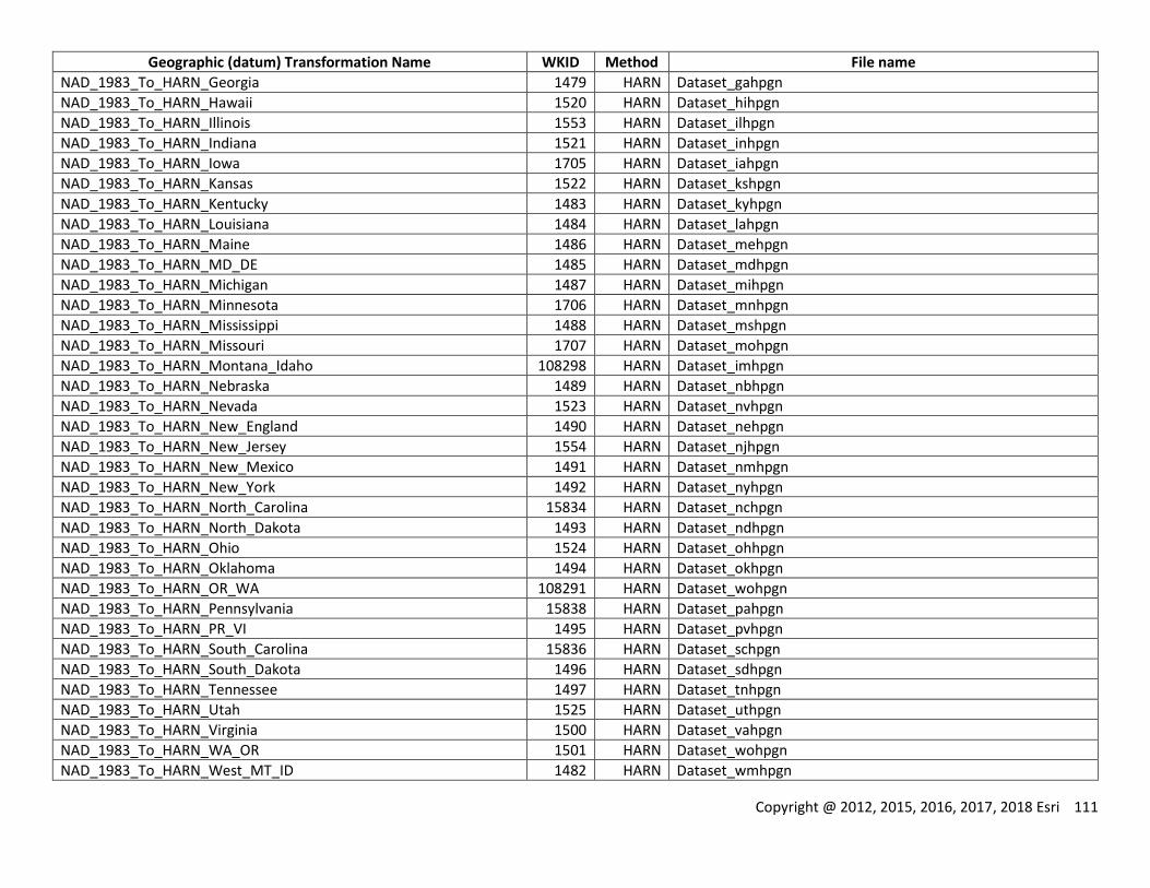
Copyright @ 2012, 2015, 2016, 2017, 2018 Esri 111
Geographic (datum) Transformation Name WKID Method File name
NAD_1983_To_HARN_Georgia 1479 HARN Dataset_gahpgn
NAD_1983_To_HARN_Hawaii 1520 HARN Dataset_hihpgn
NAD_1983_To_HARN_Illinois 1553 HARN Dataset_ilhpgn
NAD_1983_To_HARN_Indiana 1521 HARN Dataset_inhpgn
NAD_1983_To_HARN_Iowa 1705 HARN Dataset_iahpgn
NAD_1983_To_HARN_Kansas 1522 HARN Dataset_kshpgn
NAD_1983_To_HARN_Kentucky 1483 HARN Dataset_kyhpgn
NAD_1983_To_HARN_Louisiana 1484 HARN Dataset_lahpgn
NAD_1983_To_HARN_Maine 1486 HARN Dataset_mehpgn
NAD_1983_To_HARN_MD_DE 1485 HARN Dataset_mdhpgn
NAD_1983_To_HARN_Michigan 1487 HARN Dataset_mihpgn
NAD_1983_To_HARN_Minnesota 1706 HARN Dataset_mnhpgn
NAD_1983_To_HARN_Mississippi 1488 HARN Dataset_mshpgn
NAD_1983_To_HARN_Missouri 1707 HARN Dataset_mohpgn
NAD_1983_To_HARN_Montana_Idaho 108298 HARN Dataset_imhpgn
NAD_1983_To_HARN_Nebraska 1489 HARN Dataset_nbhpgn
NAD_1983_To_HARN_Nevada 1523 HARN Dataset_nvhpgn
NAD_1983_To_HARN_New_England 1490 HARN Dataset_nehpgn
NAD_1983_To_HARN_New_Jersey 1554 HARN Dataset_njhpgn
NAD_1983_To_HARN_New_Mexico 1491 HARN Dataset_nmhpgn
NAD_1983_To_HARN_New_York 1492 HARN Dataset_nyhpgn
NAD_1983_To_HARN_North_Carolina 15834 HARN Dataset_nchpgn
NAD_1983_To_HARN_North_Dakota 1493 HARN Dataset_ndhpgn
NAD_1983_To_HARN_Ohio 1524 HARN Dataset_ohhpgn
NAD_1983_To_HARN_Oklahoma 1494 HARN Dataset_okhpgn
NAD_1983_To_HARN_OR_WA 108291 HARN Dataset_wohpgn
NAD_1983_To_HARN_Pennsylvania 15838 HARN Dataset_pahpgn
NAD_1983_To_HARN_PR_VI 1495 HARN Dataset_pvhpgn
NAD_1983_To_HARN_South_Carolina 15836 HARN Dataset_schpgn
NAD_1983_To_HARN_South_Dakota 1496 HARN Dataset_sdhpgn
NAD_1983_To_HARN_Tennessee 1497 HARN Dataset_tnhpgn
NAD_1983_To_HARN_Utah 1525 HARN Dataset_uthpgn
NAD_1983_To_HARN_Virginia 1500 HARN Dataset_vahpgn
NAD_1983_To_HARN_WA_OR 1501 HARN Dataset_wohpgn
NAD_1983_To_HARN_West_MT_ID 1482 HARN Dataset_wmhpgn
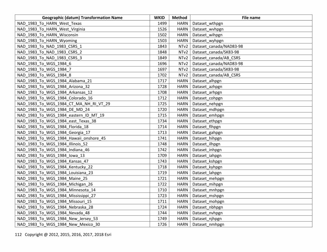
112 Copyright @ 2012, 2015, 2016, 2017, 2018 Esri
Geographic (datum) Transformation Name WKID Method File name
NAD_1983_To_HARN_West_Texas 1499 HARN Dataset_wthpgn
NAD_1983_To_HARN_West_Virginia 1526 HARN Dataset_wvhpgn
NAD_1983_To_HARN_Wisconsin 1502 HARN Dataset_wihpgn
NAD_1983_To_HARN_Wyoming 1503 HARN Dataset_wyhpgn
NAD_1983_To_NAD_1983_CSRS_1 1843 NTv2 Dataset_canada/NAD83-98
NAD_1983_To_NAD_1983_CSRS_2 1848 NTv2 Dataset_canada/SK83-98
NAD_1983_To_NAD_1983_CSRS_3 1849 NTv2 Dataset_canada/AB_CSRS
NAD_1983_To_WGS_1984_6 1696 NTv2 Dataset_canada/NAD83-98
NAD_1983_To_WGS_1984_7 1697 NTv2 Dataset_canada/SK83-98
NAD_1983_To_WGS_1984_8 1702 NTv2 Dataset_canada/AB_CSRS
NAD_1983_To_WGS_1984_Alabama_21 1717 HARN Dataset_alhpgn
NAD_1983_To_WGS_1984_Arizona_32 1728 HARN Dataset_azhpgn
NAD_1983_To_WGS_1984_Arkansas_12 1708 HARN Dataset_arhpgn
NAD_1983_To_WGS_1984_Colorado_16 1712 HARN Dataset_cohpgn
NAD_1983_To_WGS_1984_CT_MA_NH_RI_VT_29 1725 HARN Dataset_nehpgn
NAD_1983_To_WGS_1984_DE_MD_24 1720 HARN Dataset_mdhpgn
NAD_1983_To_WGS_1984_eastern_ID_MT_19 1715 HARN Dataset_emhpgn
NAD_1983_To_WGS_1984_east_Texas_38 1734 HARN Dataset_ethpgn
NAD_1983_To_WGS_1984_Florida_18 1714 HARN Dataset_flhpgn
NAD_1983_To_WGS_1984_Georgia_17 1713 HARN Dataset_gahpgn
NAD_1983_To_WGS_1984_Hawaii_onshore_45 1741 HARN Dataset_hihpgn
NAD_1983_To_WGS_1984_Illinois_52 1748 HARN Dataset_ilhpgn
NAD_1983_To_WGS_1984_Indiana_46 1742 HARN Dataset_inhpgn
NAD_1983_To_WGS_1984_Iowa_13 1709 HARN Dataset_iahpgn
NAD_1983_To_WGS_1984_Kansas_47 1743 HARN Dataset_kshpgn
NAD_1983_To_WGS_1984_Kentucky_22 1718 HARN Dataset_kyhpgn
NAD_1983_To_WGS_1984_Louisiana_23 1719 HARN Dataset_lahpgn
NAD_1983_To_WGS_1984_Maine_25 1721 HARN Dataset_mehpgn
NAD_1983_To_WGS_1984_Michigan_26 1722 HARN Dataset_mihpgn
NAD_1983_To_WGS_1984_Minnesota_14 1710 HARN Dataset_mnhpgn
NAD_1983_To_WGS_1984_Mississippi_27 1723 HARN Dataset_mshpgn
NAD_1983_To_WGS_1984_Missouri_15 1711 HARN Dataset_mohpgn
NAD_1983_To_WGS_1984_Nebraska_28 1724 HARN Dataset_nbhpgn
NAD_1983_To_WGS_1984_Nevada_48 1744 HARN Dataset_nvhpgn
NAD_1983_To_WGS_1984_New_Jersey_53 1749 HARN Dataset_njhpgn
NAD_1983_To_WGS_1984_New_Mexico_30 1726 HARN Dataset_nmhpgn
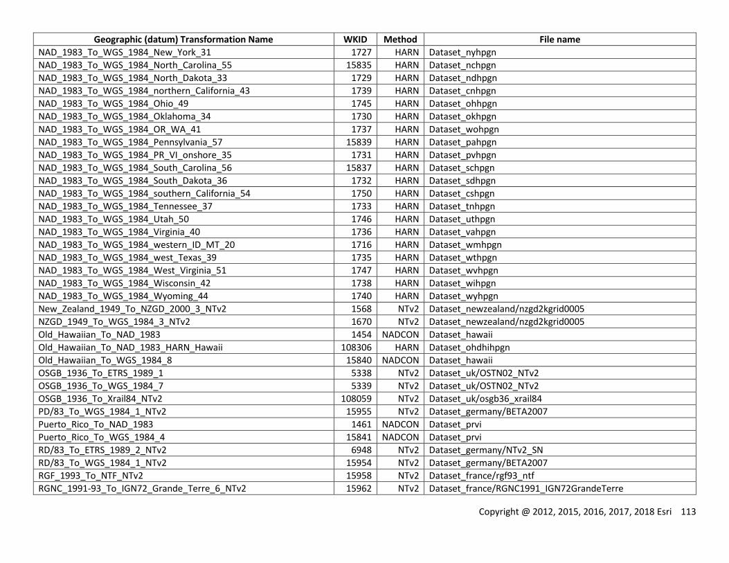
Copyright @ 2012, 2015, 2016, 2017, 2018 Esri 113
Geographic (datum) Transformation Name WKID Method File name
NAD_1983_To_WGS_1984_New_York_31 1727 HARN Dataset_nyhpgn
NAD_1983_To_WGS_1984_North_Carolina_55 15835 HARN Dataset_nchpgn
NAD_1983_To_WGS_1984_North_Dakota_33 1729 HARN Dataset_ndhpgn
NAD_1983_To_WGS_1984_northern_California_43 1739 HARN Dataset_cnhpgn
NAD_1983_To_WGS_1984_Ohio_49 1745 HARN Dataset_ohhpgn
NAD_1983_To_WGS_1984_Oklahoma_34 1730 HARN Dataset_okhpgn
NAD_1983_To_WGS_1984_OR_WA_41 1737 HARN Dataset_wohpgn
NAD_1983_To_WGS_1984_Pennsylvania_57 15839 HARN Dataset_pahpgn
NAD_1983_To_WGS_1984_PR_VI_onshore_35 1731 HARN Dataset_pvhpgn
NAD_1983_To_WGS_1984_South_Carolina_56 15837 HARN Dataset_schpgn
NAD_1983_To_WGS_1984_South_Dakota_36 1732 HARN Dataset_sdhpgn
NAD_1983_To_WGS_1984_southern_California_54 1750 HARN Dataset_cshpgn
NAD_1983_To_WGS_1984_Tennessee_37 1733 HARN Dataset_tnhpgn
NAD_1983_To_WGS_1984_Utah_50 1746 HARN Dataset_uthpgn
NAD_1983_To_WGS_1984_Virginia_40 1736 HARN Dataset_vahpgn
NAD_1983_To_WGS_1984_western_ID_MT_20 1716 HARN Dataset_wmhpgn
NAD_1983_To_WGS_1984_west_Texas_39 1735 HARN Dataset_wthpgn
NAD_1983_To_WGS_1984_West_Virginia_51 1747 HARN Dataset_wvhpgn
NAD_1983_To_WGS_1984_Wisconsin_42 1738 HARN Dataset_wihpgn
NAD_1983_To_WGS_1984_Wyoming_44 1740 HARN Dataset_wyhpgn
New_Zealand_1949_To_NZGD_2000_3_NTv2 1568 NTv2 Dataset_newzealand/nzgd2kgrid0005
NZGD_1949_To_WGS_1984_3_NTv2 1670 NTv2 Dataset_newzealand/nzgd2kgrid0005
Old_Hawaiian_To_NAD_1983 1454 NADCON Dataset_hawaii
Old_Hawaiian_To_NAD_1983_HARN_Hawaii 108306 HARN Dataset_ohdhihpgn
Old_Hawaiian_To_WGS_1984_8 15840 NADCON Dataset_hawaii
OSGB_1936_To_ETRS_1989_1 5338 NTv2 Dataset_uk/OSTN02_NTv2
OSGB_1936_To_WGS_1984_7 5339 NTv2 Dataset_uk/OSTN02_NTv2
OSGB_1936_To_Xrail84_NTv2 108059 NTv2 Dataset_uk/osgb36_xrail84
PD/83_To_WGS_1984_1_NTv2 15955 NTv2 Dataset_germany/BETA2007
Puerto_Rico_To_NAD_1983 1461 NADCON Dataset_prvi
Puerto_Rico_To_WGS_1984_4 15841 NADCON Dataset_prvi
RD/83_To_ETRS_1989_2_NTv2 6948 NTv2 Dataset_germany/NTv2_SN
RD/83_To_WGS_1984_1_NTv2 15954 NTv2 Dataset_germany/BETA2007
RGF_1993_To_NTF_NTv2 15958 NTv2 Dataset_france/rgf93_ntf
RGNC_1991-93_To_IGN72_Grande_Terre_6_NTv2 15962 NTv2 Dataset_france/RGNC1991_IGN72GrandeTerre
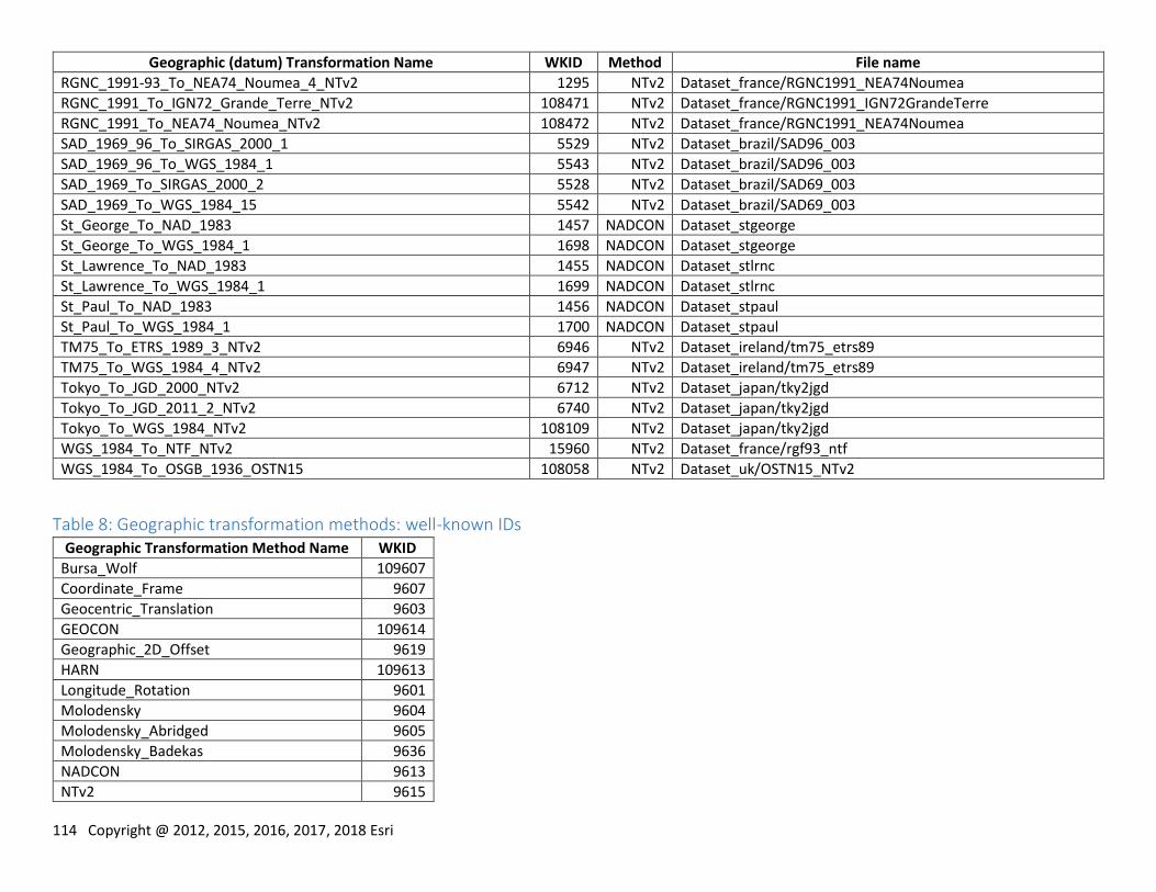
114 Copyright @ 2012, 2015, 2016, 2017, 2018 Esri
Geographic (datum) Transformation Name WKID Method File name
RGNC_1991-93_To_NEA74_Noumea_4_NTv2 1295 NTv2 Dataset_france/RGNC1991_NEA74Noumea
RGNC_1991_To_IGN72_Grande_Terre_NTv2 108471 NTv2 Dataset_france/RGNC1991_IGN72GrandeTerre
RGNC_1991_To_NEA74_Noumea_NTv2 108472 NTv2 Dataset_france/RGNC1991_NEA74Noumea
SAD_1969_96_To_SIRGAS_2000_1 5529 NTv2 Dataset_brazil/SAD96_003
SAD_1969_96_To_WGS_1984_1 5543 NTv2 Dataset_brazil/SAD96_003
SAD_1969_To_SIRGAS_2000_2 5528 NTv2 Dataset_brazil/SAD69_003
SAD_1969_To_WGS_1984_15 5542 NTv2 Dataset_brazil/SAD69_003
St_George_To_NAD_1983 1457 NADCON Dataset_stgeorge
St_George_To_WGS_1984_1 1698 NADCON Dataset_stgeorge
St_Lawrence_To_NAD_1983 1455 NADCON Dataset_stlrnc
St_Lawrence_To_WGS_1984_1 1699 NADCON Dataset_stlrnc
St_Paul_To_NAD_1983 1456 NADCON Dataset_stpaul
St_Paul_To_WGS_1984_1 1700 NADCON Dataset_stpaul
TM75_To_ETRS_1989_3_NTv2 6946 NTv2 Dataset_ireland/tm75_etrs89
TM75_To_WGS_1984_4_NTv2 6947 NTv2 Dataset_ireland/tm75_etrs89
Tokyo_To_JGD_2000_NTv2 6712 NTv2 Dataset_japan/tky2jgd
Tokyo_To_JGD_2011_2_NTv2 6740 NTv2 Dataset_japan/tky2jgd
Tokyo_To_WGS_1984_NTv2 108109 NTv2 Dataset_japan/tky2jgd
WGS_1984_To_NTF_NTv2 15960 NTv2 Dataset_france/rgf93_ntf
WGS_1984_To_OSGB_1936_OSTN15 108058 NTv2 Dataset_uk/OSTN15_NTv2
Table 8: Geographic transformation methods: well-known IDs Geographic Transformation Method Name WKID
Bursa_Wolf 109607
Coordinate_Frame 9607
Geocentric_Translation 9603
GEOCON 109614
Geographic_2D_Offset 9619
HARN 109613
Longitude_Rotation 9601
Molodensky 9604
Molodensky_Abridged 9605
Molodensky_Badekas 9636
NADCON 9613
NTv2 9615
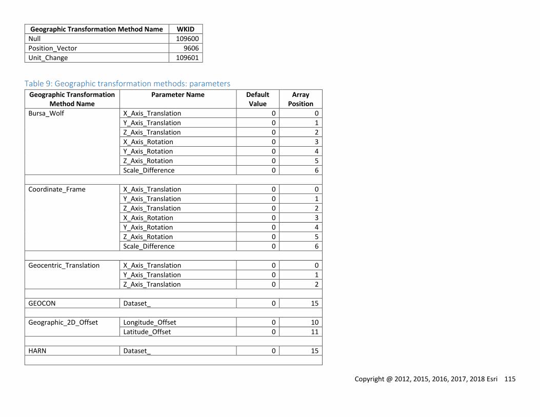
Copyright @ 2012, 2015, 2016, 2017, 2018 Esri 115
Geographic Transformation Method Name WKID
Null 109600
Position_Vector 9606
Unit_Change 109601
Table 9: Geographic transformation methods: parameters Geographic Transformation
Method Name Parameter Name Default
Value Array
Position
Bursa_Wolf X_Axis_Translation 0 0
Y_Axis_Translation 0 1
Z_Axis_Translation 0 2
X_Axis_Rotation 0 3
Y_Axis_Rotation 0 4
Z_Axis_Rotation 0 5
Scale_Difference 0 6
Coordinate_Frame X_Axis_Translation 0 0
Y_Axis_Translation 0 1
Z_Axis_Translation 0 2
X_Axis_Rotation 0 3
Y_Axis_Rotation 0 4
Z_Axis_Rotation 0 5
Scale_Difference 0 6
Geocentric_Translation X_Axis_Translation 0 0
Y_Axis_Translation 0 1
Z_Axis_Translation 0 2
GEOCON Dataset_ 0 15
Geographic_2D_Offset Longitude_Offset 0 10
Latitude_Offset 0 11
HARN Dataset_ 0 15
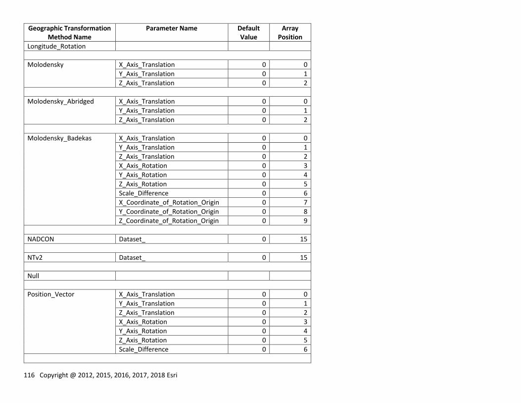
116 Copyright @ 2012, 2015, 2016, 2017, 2018 Esri
Geographic Transformation Method Name
Parameter Name Default Value
Array Position
Longitude_Rotation
Molodensky X_Axis_Translation 0 0
Y_Axis_Translation 0 1
Z_Axis_Translation 0 2
Molodensky_Abridged X_Axis_Translation 0 0
Y_Axis_Translation 0 1
Z_Axis_Translation 0 2
Molodensky_Badekas X_Axis_Translation 0 0
Y_Axis_Translation 0 1
Z_Axis_Translation 0 2
X_Axis_Rotation 0 3
Y_Axis_Rotation 0 4
Z_Axis_Rotation 0 5
Scale_Difference 0 6
X_Coordinate_of_Rotation_Origin 0 7
Y_Coordinate_of_Rotation_Origin 0 8
Z_Coordinate_of_Rotation_Origin 0 9
NADCON Dataset_ 0 15
NTv2 Dataset_ 0 15
Null
Position_Vector X_Axis_Translation 0 0
Y_Axis_Translation 0 1
Z_Axis_Translation 0 2
X_Axis_Rotation 0 3
Y_Axis_Rotation 0 4
Z_Axis_Rotation 0 5
Scale_Difference 0 6
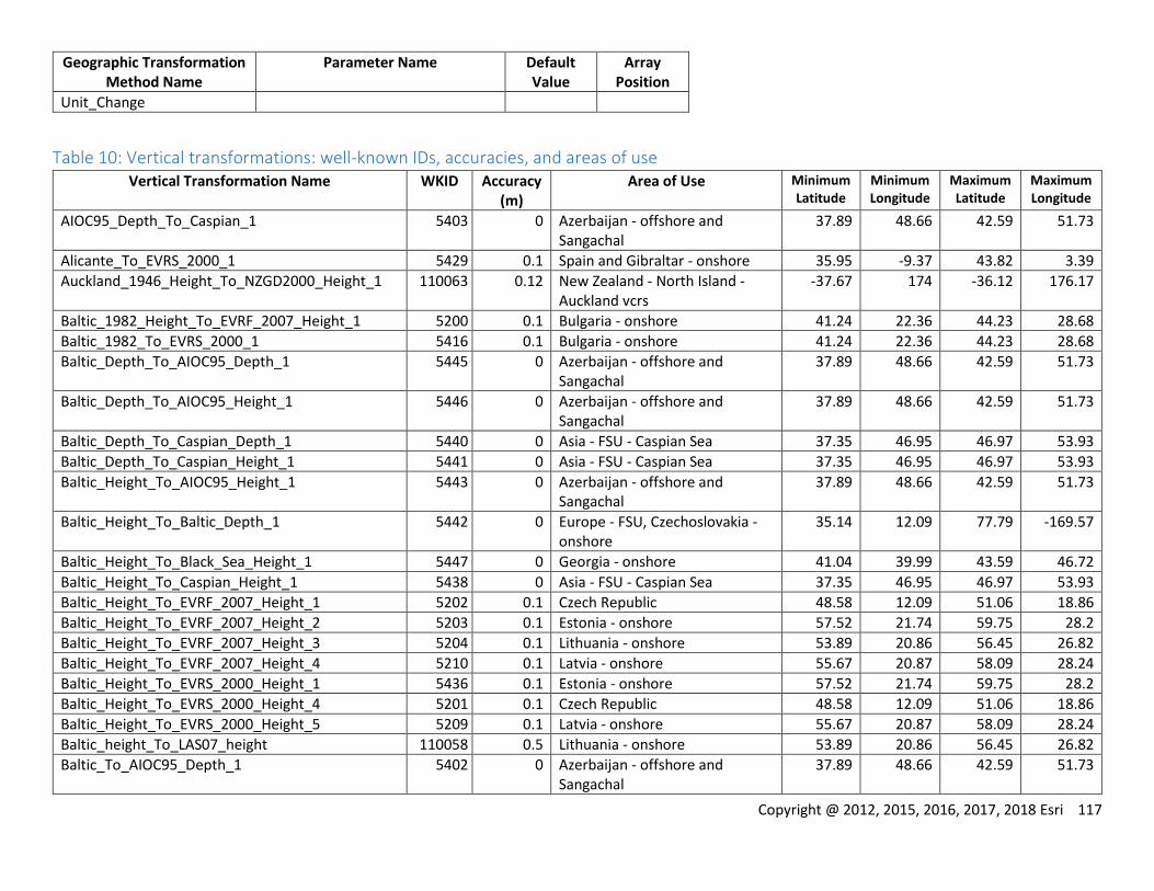
Copyright @ 2012, 2015, 2016, 2017, 2018 Esri 117
Geographic Transformation Method Name
Parameter Name Default Value
Array Position
Unit_Change
Table 10: Vertical transformations: well-known IDs, accuracies, and areas of use Vertical Transformation Name WKID Accuracy
(m) Area of Use Minimum
Latitude Minimum Longitude
Maximum Latitude
Maximum Longitude
AIOC95_Depth_To_Caspian_1 5403 0 Azerbaijan - offshore and Sangachal
37.89 48.66 42.59 51.73
Alicante_To_EVRS_2000_1 5429 0.1 Spain and Gibraltar - onshore 35.95 -9.37 43.82 3.39
Auckland_1946_Height_To_NZGD2000_Height_1 110063 0.12 New Zealand - North Island - Auckland vcrs
-37.67 174 -36.12 176.17
Baltic_1982_Height_To_EVRF_2007_Height_1 5200 0.1 Bulgaria - onshore 41.24 22.36 44.23 28.68
Baltic_1982_To_EVRS_2000_1 5416 0.1 Bulgaria - onshore 41.24 22.36 44.23 28.68
Baltic_Depth_To_AIOC95_Depth_1 5445 0 Azerbaijan - offshore and Sangachal
37.89 48.66 42.59 51.73
Baltic_Depth_To_AIOC95_Height_1 5446 0 Azerbaijan - offshore and Sangachal
37.89 48.66 42.59 51.73
Baltic_Depth_To_Caspian_Depth_1 5440 0 Asia - FSU - Caspian Sea 37.35 46.95 46.97 53.93
Baltic_Depth_To_Caspian_Height_1 5441 0 Asia - FSU - Caspian Sea 37.35 46.95 46.97 53.93
Baltic_Height_To_AIOC95_Height_1 5443 0 Azerbaijan - offshore and Sangachal
37.89 48.66 42.59 51.73
Baltic_Height_To_Baltic_Depth_1 5442 0 Europe - FSU, Czechoslovakia - onshore
35.14 12.09 77.79 -169.57
Baltic_Height_To_Black_Sea_Height_1 5447 0 Georgia - onshore 41.04 39.99 43.59 46.72
Baltic_Height_To_Caspian_Height_1 5438 0 Asia - FSU - Caspian Sea 37.35 46.95 46.97 53.93
Baltic_Height_To_EVRF_2007_Height_1 5202 0.1 Czech Republic 48.58 12.09 51.06 18.86
Baltic_Height_To_EVRF_2007_Height_2 5203 0.1 Estonia - onshore 57.52 21.74 59.75 28.2
Baltic_Height_To_EVRF_2007_Height_3 5204 0.1 Lithuania - onshore 53.89 20.86 56.45 26.82
Baltic_Height_To_EVRF_2007_Height_4 5210 0.1 Latvia - onshore 55.67 20.87 58.09 28.24
Baltic_Height_To_EVRS_2000_Height_1 5436 0.1 Estonia - onshore 57.52 21.74 59.75 28.2
Baltic_Height_To_EVRS_2000_Height_4 5201 0.1 Czech Republic 48.58 12.09 51.06 18.86
Baltic_Height_To_EVRS_2000_Height_5 5209 0.1 Latvia - onshore 55.67 20.87 58.09 28.24
Baltic_height_To_LAS07_height 110058 0.5 Lithuania - onshore 53.89 20.86 56.45 26.82
Baltic_To_AIOC95_Depth_1 5402 0 Azerbaijan - offshore and Sangachal
37.89 48.66 42.59 51.73
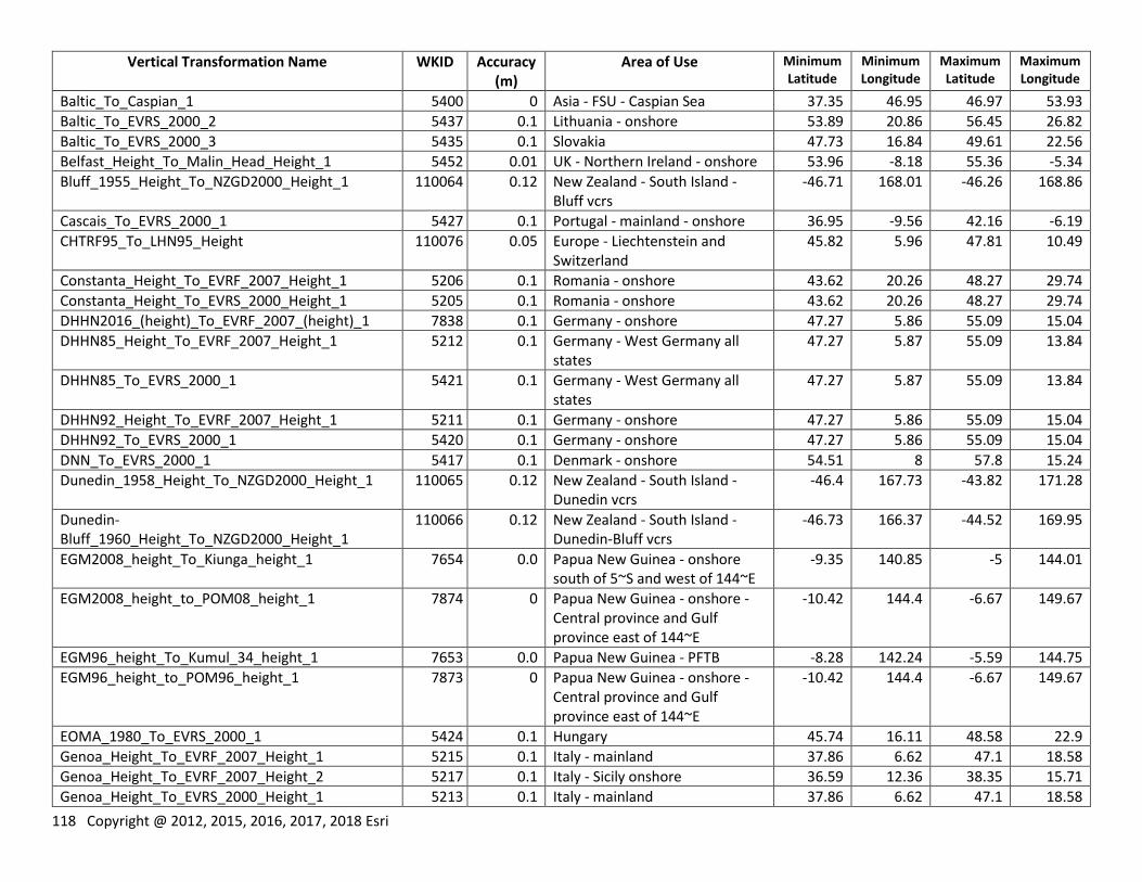
118 Copyright @ 2012, 2015, 2016, 2017, 2018 Esri
Vertical Transformation Name WKID Accuracy (m)
Area of Use Minimum Latitude
Minimum Longitude
Maximum Latitude
Maximum Longitude
Baltic_To_Caspian_1 5400 0 Asia - FSU - Caspian Sea 37.35 46.95 46.97 53.93
Baltic_To_EVRS_2000_2 5437 0.1 Lithuania - onshore 53.89 20.86 56.45 26.82
Baltic_To_EVRS_2000_3 5435 0.1 Slovakia 47.73 16.84 49.61 22.56
Belfast_Height_To_Malin_Head_Height_1 5452 0.01 UK - Northern Ireland - onshore 53.96 -8.18 55.36 -5.34
Bluff_1955_Height_To_NZGD2000_Height_1 110064 0.12 New Zealand - South Island - Bluff vcrs
-46.71 168.01 -46.26 168.86
Cascais_To_EVRS_2000_1 5427 0.1 Portugal - mainland - onshore 36.95 -9.56 42.16 -6.19
CHTRF95_To_LHN95_Height 110076 0.05 Europe - Liechtenstein and Switzerland
45.82 5.96 47.81 10.49
Constanta_Height_To_EVRF_2007_Height_1 5206 0.1 Romania - onshore 43.62 20.26 48.27 29.74
Constanta_Height_To_EVRS_2000_Height_1 5205 0.1 Romania - onshore 43.62 20.26 48.27 29.74
DHHN2016_(height)_To_EVRF_2007_(height)_1 7838 0.1 Germany - onshore 47.27 5.86 55.09 15.04
DHHN85_Height_To_EVRF_2007_Height_1 5212 0.1 Germany - West Germany all states
47.27 5.87 55.09 13.84
DHHN85_To_EVRS_2000_1 5421 0.1 Germany - West Germany all states
47.27 5.87 55.09 13.84
DHHN92_Height_To_EVRF_2007_Height_1 5211 0.1 Germany - onshore 47.27 5.86 55.09 15.04
DHHN92_To_EVRS_2000_1 5420 0.1 Germany - onshore 47.27 5.86 55.09 15.04
DNN_To_EVRS_2000_1 5417 0.1 Denmark - onshore 54.51 8 57.8 15.24
Dunedin_1958_Height_To_NZGD2000_Height_1 110065 0.12 New Zealand - South Island - Dunedin vcrs
-46.4 167.73 -43.82 171.28
Dunedin-Bluff_1960_Height_To_NZGD2000_Height_1
110066 0.12 New Zealand - South Island - Dunedin-Bluff vcrs
-46.73 166.37 -44.52 169.95
EGM2008_height_To_Kiunga_height_1 7654 0.0 Papua New Guinea - onshore south of 5~S and west of 144~E
-9.35 140.85 -5 144.01
EGM2008_height_to_POM08_height_1 7874 0 Papua New Guinea - onshore - Central province and Gulf province east of 144~E
-10.42 144.4 -6.67 149.67
EGM96_height_To_Kumul_34_height_1 7653 0.0 Papua New Guinea - PFTB -8.28 142.24 -5.59 144.75
EGM96_height_to_POM96_height_1 7873 0 Papua New Guinea - onshore - Central province and Gulf province east of 144~E
-10.42 144.4 -6.67 149.67
EOMA_1980_To_EVRS_2000_1 5424 0.1 Hungary 45.74 16.11 48.58 22.9
Genoa_Height_To_EVRF_2007_Height_1 5215 0.1 Italy - mainland 37.86 6.62 47.1 18.58
Genoa_Height_To_EVRF_2007_Height_2 5217 0.1 Italy - Sicily onshore 36.59 12.36 38.35 15.71
Genoa_Height_To_EVRS_2000_Height_1 5213 0.1 Italy - mainland 37.86 6.62 47.1 18.58
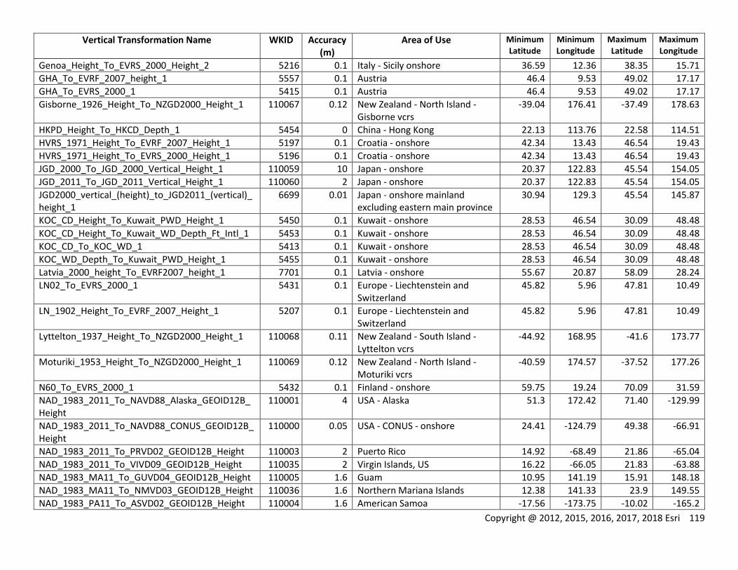
Copyright @ 2012, 2015, 2016, 2017, 2018 Esri 119
Vertical Transformation Name WKID Accuracy (m)
Area of Use Minimum Latitude
Minimum Longitude
Maximum Latitude
Maximum Longitude
Genoa_Height_To_EVRS_2000_Height_2 5216 0.1 Italy - Sicily onshore 36.59 12.36 38.35 15.71
GHA_To_EVRF_2007_height_1 5557 0.1 Austria 46.4 9.53 49.02 17.17
GHA_To_EVRS_2000_1 5415 0.1 Austria 46.4 9.53 49.02 17.17
Gisborne_1926_Height_To_NZGD2000_Height_1 110067 0.12 New Zealand - North Island - Gisborne vcrs
-39.04 176.41 -37.49 178.63
HKPD_Height_To_HKCD_Depth_1 5454 0 China - Hong Kong 22.13 113.76 22.58 114.51
HVRS_1971_Height_To_EVRF_2007_Height_1 5197 0.1 Croatia - onshore 42.34 13.43 46.54 19.43
HVRS_1971_Height_To_EVRS_2000_Height_1 5196 0.1 Croatia - onshore 42.34 13.43 46.54 19.43
JGD_2000_To_JGD_2000_Vertical_Height_1 110059 10 Japan - onshore 20.37 122.83 45.54 154.05
JGD_2011_To_JGD_2011_Vertical_Height_1 110060 2 Japan - onshore 20.37 122.83 45.54 154.05
JGD2000_vertical_(height)_to_JGD2011_(vertical)_height_1
6699 0.01 Japan - onshore mainland excluding eastern main province
30.94 129.3 45.54 145.87
KOC_CD_Height_To_Kuwait_PWD_Height_1 5450 0.1 Kuwait - onshore 28.53 46.54 30.09 48.48
KOC_CD_Height_To_Kuwait_WD_Depth_Ft_Intl_1 5453 0.1 Kuwait - onshore 28.53 46.54 30.09 48.48
KOC_CD_To_KOC_WD_1 5413 0.1 Kuwait - onshore 28.53 46.54 30.09 48.48
KOC_WD_Depth_To_Kuwait_PWD_Height_1 5455 0.1 Kuwait - onshore 28.53 46.54 30.09 48.48
Latvia_2000_height_To_EVRF2007_height_1 7701 0.1 Latvia - onshore 55.67 20.87 58.09 28.24
LN02_To_EVRS_2000_1 5431 0.1 Europe - Liechtenstein and Switzerland
45.82 5.96 47.81 10.49
LN_1902_Height_To_EVRF_2007_Height_1 5207 0.1 Europe - Liechtenstein and Switzerland
45.82 5.96 47.81 10.49
Lyttelton_1937_Height_To_NZGD2000_Height_1 110068 0.11 New Zealand - South Island - Lyttelton vcrs
-44.92 168.95 -41.6 173.77
Moturiki_1953_Height_To_NZGD2000_Height_1 110069 0.12 New Zealand - North Island - Moturiki vcrs
-40.59 174.57 -37.52 177.26
N60_To_EVRS_2000_1 5432 0.1 Finland - onshore 59.75 19.24 70.09 31.59
NAD_1983_2011_To_NAVD88_Alaska_GEOID12B_Height
110001 4 USA - Alaska 51.3 172.42 71.40 -129.99
NAD_1983_2011_To_NAVD88_CONUS_GEOID12B_Height
110000 0.05 USA - CONUS - onshore 24.41 -124.79 49.38 -66.91
NAD_1983_2011_To_PRVD02_GEOID12B_Height 110003 2 Puerto Rico 14.92 -68.49 21.86 -65.04
NAD_1983_2011_To_VIVD09_GEOID12B_Height 110035 2 Virgin Islands, US 16.22 -66.05 21.83 -63.88
NAD_1983_MA11_To_GUVD04_GEOID12B_Height 110005 1.6 Guam 10.95 141.19 15.91 148.18
NAD_1983_MA11_To_NMVD03_GEOID12B_Height 110036 1.6 Northern Mariana Islands 12.38 141.33 23.9 149.55
NAD_1983_PA11_To_ASVD02_GEOID12B_Height 110004 1.6 American Samoa -17.56 -173.75 -10.02 -165.2
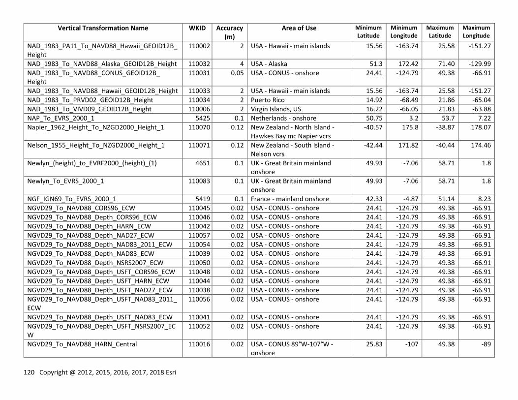
120 Copyright @ 2012, 2015, 2016, 2017, 2018 Esri
Vertical Transformation Name WKID Accuracy (m)
Area of Use Minimum Latitude
Minimum Longitude
Maximum Latitude
Maximum Longitude
NAD_1983_PA11_To_NAVD88_Hawaii_GEOID12B_Height
110002 2 USA - Hawaii - main islands 15.56 -163.74 25.58 -151.27
NAD_1983_To_NAVD88_Alaska_GEOID12B_Height 110032 4 USA - Alaska 51.3 172.42 71.40 -129.99
NAD_1983_To_NAVD88_CONUS_GEOID12B_ Height
110031 0.05 USA - CONUS - onshore 24.41 -124.79 49.38 -66.91
NAD_1983_To_NAVD88_Hawaii_GEOID12B_Height 110033 2 USA - Hawaii - main islands 15.56 -163.74 25.58 -151.27
NAD_1983_To_PRVD02_GEOID12B_Height 110034 2 Puerto Rico 14.92 -68.49 21.86 -65.04
NAD_1983_To_VIVD09_GEOID12B_Height 110006 2 Virgin Islands, US 16.22 -66.05 21.83 -63.88
NAP_To_EVRS_2000_1 5425 0.1 Netherlands - onshore 50.75 3.2 53.7 7.22
Napier_1962_Height_To_NZGD2000_Height_1 110070 0.12 New Zealand - North Island - Hawkes Bay mc Napier vcrs
-40.57 175.8 -38.87 178.07
Nelson_1955_Height_To_NZGD2000_Height_1 110071 0.12 New Zealand - South Island - Nelson vcrs
-42.44 171.82 -40.44 174.46
Newlyn_(height)_to_EVRF2000_(height)_(1) 4651 0.1 UK - Great Britain mainland onshore
49.93 -7.06 58.71 1.8
Newlyn_To_EVRS_2000_1 110083 0.1 UK - Great Britain mainland onshore
49.93 -7.06 58.71 1.8
NGF_IGN69_To_EVRS_2000_1 5419 0.1 France - mainland onshore 42.33 -4.87 51.14 8.23
NGVD29_To_NAVD88_CORS96_ECW 110045 0.02 USA - CONUS - onshore 24.41 -124.79 49.38 -66.91
NGVD29_To_NAVD88_Depth_CORS96_ECW 110046 0.02 USA - CONUS - onshore 24.41 -124.79 49.38 -66.91
NGVD29_To_NAVD88_Depth_HARN_ECW 110042 0.02 USA - CONUS - onshore 24.41 -124.79 49.38 -66.91
NGVD29_To_NAVD88_Depth_NAD27_ECW 110057 0.02 USA - CONUS - onshore 24.41 -124.79 49.38 -66.91
NGVD29_To_NAVD88_Depth_NAD83_2011_ECW 110054 0.02 USA - CONUS - onshore 24.41 -124.79 49.38 -66.91
NGVD29_To_NAVD88_Depth_NAD83_ECW 110039 0.02 USA - CONUS - onshore 24.41 -124.79 49.38 -66.91
NGVD29_To_NAVD88_Depth_NSRS2007_ECW 110050 0.02 USA - CONUS - onshore 24.41 -124.79 49.38 -66.91
NGVD29_To_NAVD88_Depth_USFT_CORS96_ECW 110048 0.02 USA - CONUS - onshore 24.41 -124.79 49.38 -66.91
NGVD29_To_NAVD88_Depth_USFT_HARN_ECW 110044 0.02 USA - CONUS - onshore 24.41 -124.79 49.38 -66.91
NGVD29_To_NAVD88_Depth_USFT_NAD27_ECW 110038 0.02 USA - CONUS - onshore 24.41 -124.79 49.38 -66.91
NGVD29_To_NAVD88_Depth_USFT_NAD83_2011_ECW
110056 0.02 USA - CONUS - onshore 24.41 -124.79 49.38 -66.91
NGVD29_To_NAVD88_Depth_USFT_NAD83_ECW 110041 0.02 USA - CONUS - onshore 24.41 -124.79 49.38 -66.91
NGVD29_To_NAVD88_Depth_USFT_NSRS2007_ECW
110052 0.02 USA - CONUS - onshore 24.41 -124.79 49.38 -66.91
NGVD29_To_NAVD88_HARN_Central 110016 0.02 USA - CONUS 89°W-107°W - onshore
25.83 -107 49.38 -89
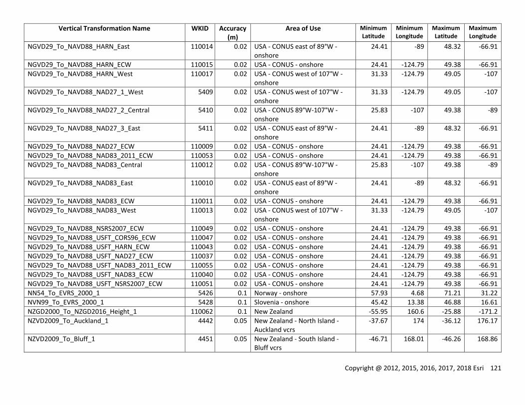
Copyright @ 2012, 2015, 2016, 2017, 2018 Esri 121
Vertical Transformation Name WKID Accuracy (m)
Area of Use Minimum Latitude
Minimum Longitude
Maximum Latitude
Maximum Longitude
NGVD29_To_NAVD88_HARN_East 110014 0.02 USA - CONUS east of 89°W - onshore
24.41 -89 48.32 -66.91
NGVD29_To_NAVD88_HARN_ECW 110015 0.02 USA - CONUS - onshore 24.41 -124.79 49.38 -66.91
NGVD29_To_NAVD88_HARN_West 110017 0.02 USA - CONUS west of 107°W - onshore
31.33 -124.79 49.05 -107
NGVD29_To_NAVD88_NAD27_1_West 5409 0.02 USA - CONUS west of 107°W - onshore
31.33 -124.79 49.05 -107
NGVD29_To_NAVD88_NAD27_2_Central 5410 0.02 USA - CONUS 89°W-107°W - onshore
25.83 -107 49.38 -89
NGVD29_To_NAVD88_NAD27_3_East 5411 0.02 USA - CONUS east of 89°W - onshore
24.41 -89 48.32 -66.91
NGVD29_To_NAVD88_NAD27_ECW 110009 0.02 USA - CONUS - onshore 24.41 -124.79 49.38 -66.91
NGVD29_To_NAVD88_NAD83_2011_ECW 110053 0.02 USA - CONUS - onshore 24.41 -124.79 49.38 -66.91
NGVD29_To_NAVD88_NAD83_Central 110012 0.02 USA - CONUS 89°W-107°W - onshore
25.83 -107 49.38 -89
NGVD29_To_NAVD88_NAD83_East 110010 0.02 USA - CONUS east of 89°W - onshore
24.41 -89 48.32 -66.91
NGVD29_To_NAVD88_NAD83_ECW 110011 0.02 USA - CONUS - onshore 24.41 -124.79 49.38 -66.91
NGVD29_To_NAVD88_NAD83_West 110013 0.02 USA - CONUS west of 107°W - onshore
31.33 -124.79 49.05 -107
NGVD29_To_NAVD88_NSRS2007_ECW 110049 0.02 USA - CONUS - onshore 24.41 -124.79 49.38 -66.91
NGVD29_To_NAVD88_USFT_CORS96_ECW 110047 0.02 USA - CONUS - onshore 24.41 -124.79 49.38 -66.91
NGVD29_To_NAVD88_USFT_HARN_ECW 110043 0.02 USA - CONUS - onshore 24.41 -124.79 49.38 -66.91
NGVD29_To_NAVD88_USFT_NAD27_ECW 110037 0.02 USA - CONUS - onshore 24.41 -124.79 49.38 -66.91
NGVD29_To_NAVD88_USFT_NAD83_2011_ECW 110055 0.02 USA - CONUS - onshore 24.41 -124.79 49.38 -66.91
NGVD29_To_NAVD88_USFT_NAD83_ECW 110040 0.02 USA - CONUS - onshore 24.41 -124.79 49.38 -66.91
NGVD29_To_NAVD88_USFT_NSRS2007_ECW 110051 0.02 USA - CONUS - onshore 24.41 -124.79 49.38 -66.91
NN54_To_EVRS_2000_1 5426 0.1 Norway - onshore 57.93 4.68 71.21 31.22
NVN99_To_EVRS_2000_1 5428 0.1 Slovenia - onshore 45.42 13.38 46.88 16.61
NZGD2000_To_NZGD2016_Height_1 110062 0.1 New Zealand -55.95 160.6 -25.88 -171.2
NZVD2009_To_Auckland_1 4442 0.05 New Zealand - North Island - Auckland vcrs
-37.67 174 -36.12 176.17
NZVD2009_To_Bluff_1 4451 0.05 New Zealand - South Island - Bluff vcrs
-46.71 168.01 -46.26 168.86
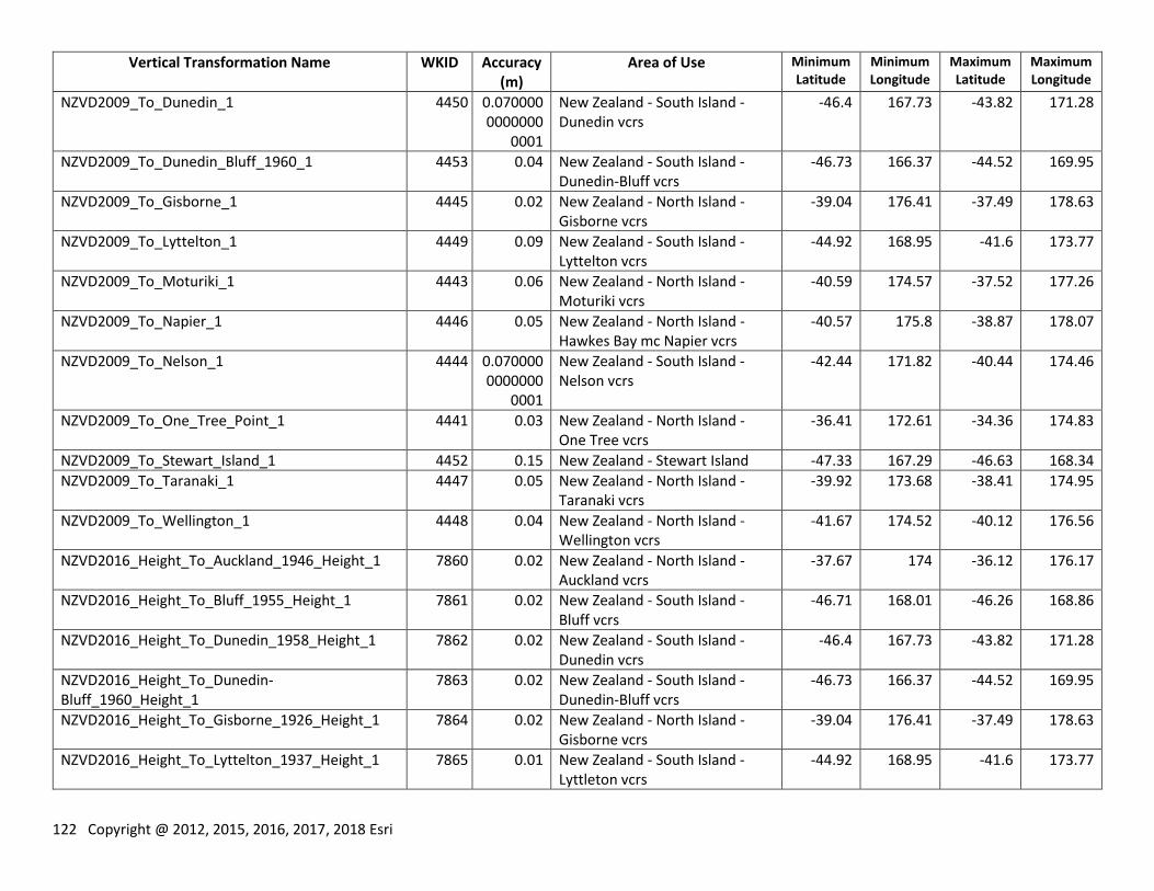
122 Copyright @ 2012, 2015, 2016, 2017, 2018 Esri
Vertical Transformation Name WKID Accuracy (m)
Area of Use Minimum Latitude
Minimum Longitude
Maximum Latitude
Maximum Longitude
NZVD2009_To_Dunedin_1 4450 0.0700000000000
0001
New Zealand - South Island - Dunedin vcrs
-46.4 167.73 -43.82 171.28
NZVD2009_To_Dunedin_Bluff_1960_1 4453 0.04 New Zealand - South Island - Dunedin-Bluff vcrs
-46.73 166.37 -44.52 169.95
NZVD2009_To_Gisborne_1 4445 0.02 New Zealand - North Island - Gisborne vcrs
-39.04 176.41 -37.49 178.63
NZVD2009_To_Lyttelton_1 4449 0.09 New Zealand - South Island - Lyttelton vcrs
-44.92 168.95 -41.6 173.77
NZVD2009_To_Moturiki_1 4443 0.06 New Zealand - North Island - Moturiki vcrs
-40.59 174.57 -37.52 177.26
NZVD2009_To_Napier_1 4446 0.05 New Zealand - North Island - Hawkes Bay mc Napier vcrs
-40.57 175.8 -38.87 178.07
NZVD2009_To_Nelson_1 4444 0.0700000000000
0001
New Zealand - South Island - Nelson vcrs
-42.44 171.82 -40.44 174.46
NZVD2009_To_One_Tree_Point_1 4441 0.03 New Zealand - North Island - One Tree vcrs
-36.41 172.61 -34.36 174.83
NZVD2009_To_Stewart_Island_1 4452 0.15 New Zealand - Stewart Island -47.33 167.29 -46.63 168.34
NZVD2009_To_Taranaki_1 4447 0.05 New Zealand - North Island - Taranaki vcrs
-39.92 173.68 -38.41 174.95
NZVD2009_To_Wellington_1 4448 0.04 New Zealand - North Island - Wellington vcrs
-41.67 174.52 -40.12 176.56
NZVD2016_Height_To_Auckland_1946_Height_1 7860 0.02 New Zealand - North Island - Auckland vcrs
-37.67 174 -36.12 176.17
NZVD2016_Height_To_Bluff_1955_Height_1 7861 0.02 New Zealand - South Island - Bluff vcrs
-46.71 168.01 -46.26 168.86
NZVD2016_Height_To_Dunedin_1958_Height_1 7862 0.02 New Zealand - South Island - Dunedin vcrs
-46.4 167.73 -43.82 171.28
NZVD2016_Height_To_Dunedin-Bluff_1960_Height_1
7863 0.02 New Zealand - South Island - Dunedin-Bluff vcrs
-46.73 166.37 -44.52 169.95
NZVD2016_Height_To_Gisborne_1926_Height_1 7864 0.02 New Zealand - North Island - Gisborne vcrs
-39.04 176.41 -37.49 178.63
NZVD2016_Height_To_Lyttelton_1937_Height_1 7865 0.01 New Zealand - South Island - Lyttleton vcrs
-44.92 168.95 -41.6 173.77
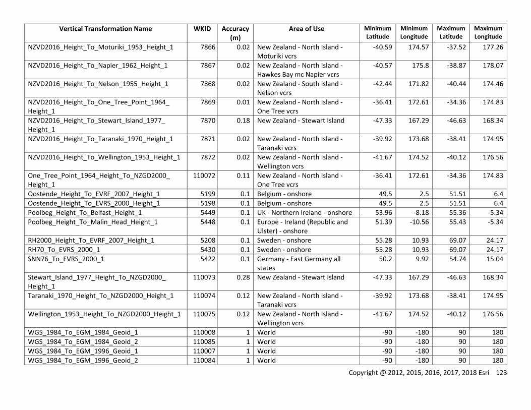
Copyright @ 2012, 2015, 2016, 2017, 2018 Esri 123
Vertical Transformation Name WKID Accuracy (m)
Area of Use Minimum Latitude
Minimum Longitude
Maximum Latitude
Maximum Longitude
NZVD2016_Height_To_Moturiki_1953_Height_1 7866 0.02 New Zealand - North Island - Moturiki vcrs
-40.59 174.57 -37.52 177.26
NZVD2016_Height_To_Napier_1962_Height_1 7867 0.02 New Zealand - North Island - Hawkes Bay mc Napier vcrs
-40.57 175.8 -38.87 178.07
NZVD2016_Height_To_Nelson_1955_Height_1 7868 0.02 New Zealand - South Island - Nelson vcrs
-42.44 171.82 -40.44 174.46
NZVD2016_Height_To_One_Tree_Point_1964_ Height_1
7869 0.01 New Zealand - North Island - One Tree vcrs
-36.41 172.61 -34.36 174.83
NZVD2016_Height_To_Stewart_Island_1977_ Height_1
7870 0.18 New Zealand - Stewart Island -47.33 167.29 -46.63 168.34
NZVD2016_Height_To_Taranaki_1970_Height_1 7871 0.02 New Zealand - North Island - Taranaki vcrs
-39.92 173.68 -38.41 174.95
NZVD2016_Height_To_Wellington_1953_Height_1 7872 0.02 New Zealand - North Island - Wellington vcrs
-41.67 174.52 -40.12 176.56
One_Tree_Point_1964_Height_To_NZGD2000_ Height_1
110072 0.11 New Zealand - North Island - One Tree vcrs
-36.41 172.61 -34.36 174.83
Oostende_Height_To_EVRF_2007_Height_1 5199 0.1 Belgium - onshore 49.5 2.5 51.51 6.4
Oostende_Height_To_EVRS_2000_Height_1 5198 0.1 Belgium - onshore 49.5 2.5 51.51 6.4
Poolbeg_Height_To_Belfast_Height_1 5449 0.1 UK - Northern Ireland - onshore 53.96 -8.18 55.36 -5.34
Poolbeg_Height_To_Malin_Head_Height_1 5448 0.1 Europe - Ireland (Republic and Ulster) - onshore
51.39 -10.56 55.43 -5.34
RH2000_Height_To_EVRF_2007_Height_1 5208 0.1 Sweden - onshore 55.28 10.93 69.07 24.17
RH70_To_EVRS_2000_1 5430 0.1 Sweden - onshore 55.28 10.93 69.07 24.17
SNN76_To_EVRS_2000_1 5422 0.1 Germany - East Germany all states
50.2 9.92 54.74 15.04
Stewart_Island_1977_Height_To_NZGD2000_ Height_1
110073 0.28 New Zealand - Stewart Island -47.33 167.29 -46.63 168.34
Taranaki_1970_Height_To_NZGD2000_Height_1 110074 0.12 New Zealand - North Island - Taranaki vcrs
-39.92 173.68 -38.41 174.95
Wellington_1953_Height_To_NZGD2000_Height_1 110075 0.12 New Zealand - North Island - Wellington vcrs
-41.67 174.52 -40.12 176.56
WGS_1984_To_EGM_1984_Geoid_1 110008 1 World -90 -180 90 180
WGS_1984_To_EGM_1984_Geoid_2 110085 1 World -90 -180 90 180
WGS_1984_To_EGM_1996_Geoid_1 110007 1 World -90 -180 90 180
WGS_1984_To_EGM_1996_Geoid_2 110084 1 World -90 -180 90 180
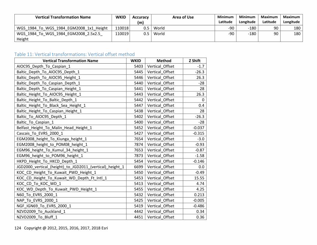
124 Copyright @ 2012, 2015, 2016, 2017, 2018 Esri
Vertical Transformation Name WKID Accuracy (m)
Area of Use Minimum Latitude
Minimum Longitude
Maximum Latitude
Maximum Longitude
WGS_1984_To_WGS_1984_EGM2008_1x1_Height 110018 0.5 World -90 -180 90 180
WGS_1984_To_WGS_1984_EGM2008_2.5x2.5_ Height
110019 0.5 World -90 -180 90 180
Table 11: Vertical transformations: Vertical offset method Vertical Transformation Name WKID Method Z Shift
AIOC95_Depth_To_Caspian_1 5403 Vertical_Offset -1.7
Baltic_Depth_To_AIOC95_Depth_1 5445 Vertical_Offset -26.3
Baltic_Depth_To_AIOC95_Height_1 5446 Vertical_Offset 26.3
Baltic_Depth_To_Caspian_Depth_1 5440 Vertical_Offset -28
Baltic_Depth_To_Caspian_Height_1 5441 Vertical_Offset 28
Baltic_Height_To_AIOC95_Height_1 5443 Vertical_Offset 26.3
Baltic_Height_To_Baltic_Depth_1 5442 Vertical_Offset 0
Baltic_Height_To_Black_Sea_Height_1 5447 Vertical_Offset 0.4
Baltic_Height_To_Caspian_Height_1 5438 Vertical_Offset 28
Baltic_To_AIOC95_Depth_1 5402 Vertical_Offset -26.3
Baltic_To_Caspian_1 5400 Vertical_Offset -28
Belfast_Height_To_Malin_Head_Height_1 5452 Vertical_Offset -0.037
Cascais_To_EVRS_2000_1 5427 Vertical_Offset -0.315
EGM2008_height_To_Kiunga_height_1 7654 Vertical_Offset -3.0
EGM2008_height_to_POM08_height_1 7874 Vertical_Offset -0.93
EGM96_height_To_Kumul_34_height_1 7653 Vertical_Offset -0.87
EGM96_height_to_POM96_height_1 7873 Vertical_Offset -1.58
HKPD_Height_To_HKCD_Depth_1 5454 Vertical_Offset -0.146
JGD2000_vertical_(height)_to_JGD2011_(vertical)_height_1 6699 Vertical_Offset 0.0
KOC_CD_Height_To_Kuwait_PWD_Height_1 5450 Vertical_Offset -0.49
KOC_CD_Height_To_Kuwait_WD_Depth_Ft_Intl_1 5453 Vertical_Offset 15.55
KOC_CD_To_KOC_WD_1 5413 Vertical_Offset 4.74
KOC_WD_Depth_To_Kuwait_PWD_Height_1 5455 Vertical_Offset 4.25
N60_To_EVRS_2000_1 5432 Vertical_Offset 0.213
NAP_To_EVRS_2000_1 5425 Vertical_Offset -0.005
NGF_IGN69_To_EVRS_2000_1 5419 Vertical_Offset -0.486
NZVD2009_To_Auckland_1 4442 Vertical_Offset 0.34
NZVD2009_To_Bluff_1 4451 Vertical_Offset 0.36
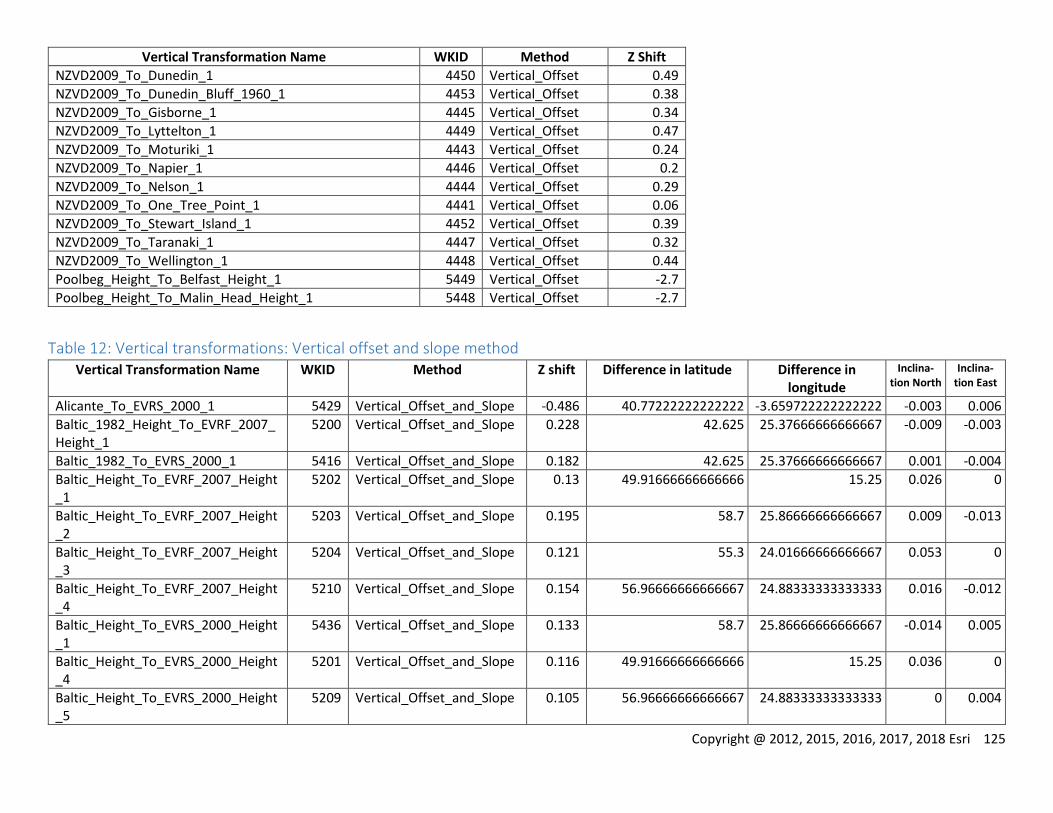
Copyright @ 2012, 2015, 2016, 2017, 2018 Esri 125
Vertical Transformation Name WKID Method Z Shift
NZVD2009_To_Dunedin_1 4450 Vertical_Offset 0.49
NZVD2009_To_Dunedin_Bluff_1960_1 4453 Vertical_Offset 0.38
NZVD2009_To_Gisborne_1 4445 Vertical_Offset 0.34
NZVD2009_To_Lyttelton_1 4449 Vertical_Offset 0.47
NZVD2009_To_Moturiki_1 4443 Vertical_Offset 0.24
NZVD2009_To_Napier_1 4446 Vertical_Offset 0.2
NZVD2009_To_Nelson_1 4444 Vertical_Offset 0.29
NZVD2009_To_One_Tree_Point_1 4441 Vertical_Offset 0.06
NZVD2009_To_Stewart_Island_1 4452 Vertical_Offset 0.39
NZVD2009_To_Taranaki_1 4447 Vertical_Offset 0.32
NZVD2009_To_Wellington_1 4448 Vertical_Offset 0.44
Poolbeg_Height_To_Belfast_Height_1 5449 Vertical_Offset -2.7
Poolbeg_Height_To_Malin_Head_Height_1 5448 Vertical_Offset -2.7
Table 12: Vertical transformations: Vertical offset and slope method Vertical Transformation Name WKID Method Z shift Difference in latitude Difference in
longitude
Inclina-tion North
Inclina-tion East
Alicante_To_EVRS_2000_1 5429 Vertical_Offset_and_Slope -0.486 40.77222222222222 -3.659722222222222 -0.003 0.006
Baltic_1982_Height_To_EVRF_2007_Height_1
5200 Vertical_Offset_and_Slope 0.228 42.625 25.37666666666667 -0.009 -0.003
Baltic_1982_To_EVRS_2000_1 5416 Vertical_Offset_and_Slope 0.182 42.625 25.37666666666667 0.001 -0.004
Baltic_Height_To_EVRF_2007_Height_1
5202 Vertical_Offset_and_Slope 0.13 49.91666666666666 15.25 0.026 0
Baltic_Height_To_EVRF_2007_Height_2
5203 Vertical_Offset_and_Slope 0.195 58.7 25.86666666666667 0.009 -0.013
Baltic_Height_To_EVRF_2007_Height_3
5204 Vertical_Offset_and_Slope 0.121 55.3 24.01666666666667 0.053 0
Baltic_Height_To_EVRF_2007_Height_4
5210 Vertical_Offset_and_Slope 0.154 56.96666666666667 24.88333333333333 0.016 -0.012
Baltic_Height_To_EVRS_2000_Height_1
5436 Vertical_Offset_and_Slope 0.133 58.7 25.86666666666667 -0.014 0.005
Baltic_Height_To_EVRS_2000_Height_4
5201 Vertical_Offset_and_Slope 0.116 49.91666666666666 15.25 0.036 0
Baltic_Height_To_EVRS_2000_Height_5
5209 Vertical_Offset_and_Slope 0.105 56.96666666666667 24.88333333333333 0 0.004
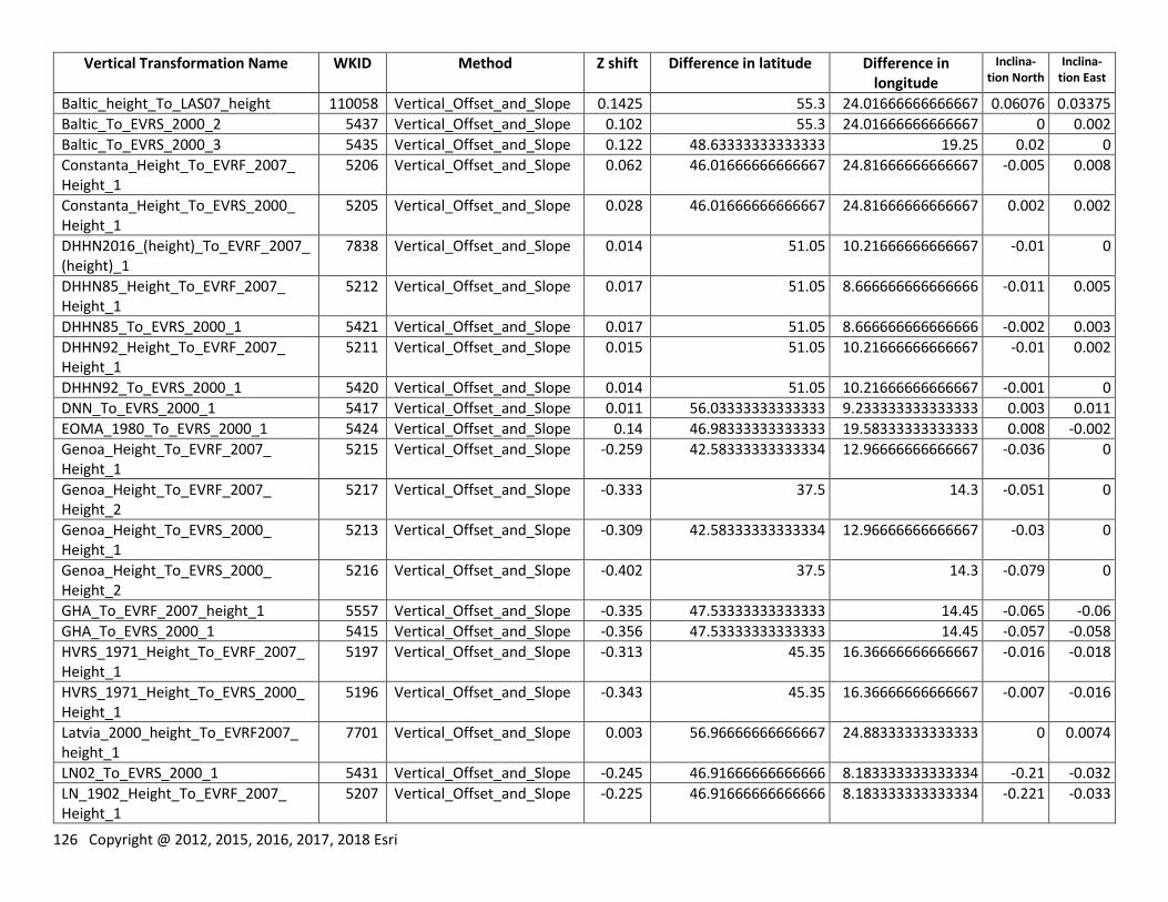
126 Copyright @ 2012, 2015, 2016, 2017, 2018 Esri
Vertical Transformation Name WKID Method Z shift Difference in latitude Difference in longitude
Inclina-tion North
Inclina-tion East
Baltic_height_To_LAS07_height 110058 Vertical_Offset_and_Slope 0.1425 55.3 24.01666666666667 0.06076 0.03375
Baltic_To_EVRS_2000_2 5437 Vertical_Offset_and_Slope 0.102 55.3 24.01666666666667 0 0.002
Baltic_To_EVRS_2000_3 5435 Vertical_Offset_and_Slope 0.122 48.63333333333333 19.25 0.02 0
Constanta_Height_To_EVRF_2007_ Height_1
5206 Vertical_Offset_and_Slope 0.062 46.01666666666667 24.81666666666667 -0.005 0.008
Constanta_Height_To_EVRS_2000_ Height_1
5205 Vertical_Offset_and_Slope 0.028 46.01666666666667 24.81666666666667 0.002 0.002
DHHN2016_(height)_To_EVRF_2007_(height)_1
7838 Vertical_Offset_and_Slope 0.014 51.05 10.21666666666667 -0.01 0
DHHN85_Height_To_EVRF_2007_ Height_1
5212 Vertical_Offset_and_Slope 0.017 51.05 8.666666666666666 -0.011 0.005
DHHN85_To_EVRS_2000_1 5421 Vertical_Offset_and_Slope 0.017 51.05 8.666666666666666 -0.002 0.003
DHHN92_Height_To_EVRF_2007_ Height_1
5211 Vertical_Offset_and_Slope 0.015 51.05 10.21666666666667 -0.01 0.002
DHHN92_To_EVRS_2000_1 5420 Vertical_Offset_and_Slope 0.014 51.05 10.21666666666667 -0.001 0
DNN_To_EVRS_2000_1 5417 Vertical_Offset_and_Slope 0.011 56.03333333333333 9.233333333333333 0.003 0.011
EOMA_1980_To_EVRS_2000_1 5424 Vertical_Offset_and_Slope 0.14 46.98333333333333 19.58333333333333 0.008 -0.002
Genoa_Height_To_EVRF_2007_ Height_1
5215 Vertical_Offset_and_Slope -0.259 42.58333333333334 12.96666666666667 -0.036 0
Genoa_Height_To_EVRF_2007_ Height_2
5217 Vertical_Offset_and_Slope -0.333 37.5 14.3 -0.051 0
Genoa_Height_To_EVRS_2000_ Height_1
5213 Vertical_Offset_and_Slope -0.309 42.58333333333334 12.96666666666667 -0.03 0
Genoa_Height_To_EVRS_2000_ Height_2
5216 Vertical_Offset_and_Slope -0.402 37.5 14.3 -0.079 0
GHA_To_EVRF_2007_height_1 5557 Vertical_Offset_and_Slope -0.335 47.53333333333333 14.45 -0.065 -0.06
GHA_To_EVRS_2000_1 5415 Vertical_Offset_and_Slope -0.356 47.53333333333333 14.45 -0.057 -0.058
HVRS_1971_Height_To_EVRF_2007_Height_1
5197 Vertical_Offset_and_Slope -0.313 45.35 16.36666666666667 -0.016 -0.018
HVRS_1971_Height_To_EVRS_2000_Height_1
5196 Vertical_Offset_and_Slope -0.343 45.35 16.36666666666667 -0.007 -0.016
Latvia_2000_height_To_EVRF2007_ height_1
7701 Vertical_Offset_and_Slope 0.003 56.96666666666667 24.88333333333333 0 0.0074
LN02_To_EVRS_2000_1 5431 Vertical_Offset_and_Slope -0.245 46.91666666666666 8.183333333333334 -0.21 -0.032
LN_1902_Height_To_EVRF_2007_ Height_1
5207 Vertical_Offset_and_Slope -0.225 46.91666666666666 8.183333333333334 -0.221 -0.033
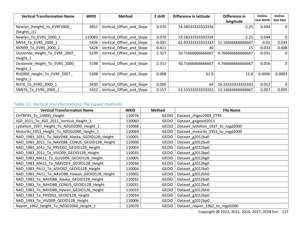
Copyright @ 2012, 2015, 2016, 2017, 2018 Esri 127
Vertical Transformation Name WKID Method Z shift Difference in latitude Difference in longitude
Inclina-tion North
Inclina-tion East
Newlyn_(height)_to_EVRF2000_ (height)_(1)
4651 Vertical_Offset_and_Slope 0.070 54.58333333333334 -2.25 0.044 0
Newlyn_To_EVRS_2000_1 110083 Vertical_Offset_and_Slope 0.070 54.58333333333334 -2.25 0.044 0
NN54_To_EVRS_2000_1 5426 Vertical_Offset_and_Slope -0.001 62.93333333333333 11.16666666666667 -0.01 0.034
NVN99_To_EVRS_2000_1 5428 Vertical_Offset_and_Slope -0.411 46 15 -0.033 0.008
Oostende_Height_To_EVRF_2007_ Height_1
5199 Vertical_Offset_and_Slope -2.317 50.71666666666667 4.766666666666667 -0.031 0
Oostende_Height_To_EVRS_2000_ Height_1
5198 Vertical_Offset_and_Slope -2.311 50.71666666666667 4.766666666666667 -0.016 0
RH2000_Height_To_EVRF_2007_ Height_1
5208 Vertical_Offset_and_Slope -0.008 61.9 15.8 -0.0006 -0.0003
RH70_To_EVRS_2000_1 5430 Vertical_Offset_and_Slope 0.005 64 16.23333333333333 -0.012 0
SNN76_To_EVRS_2000_1 5422 Vertical_Offset_and_Slope 0.157 52.53333333333333 13.16666666666667 0.007 0.005
Table 13: Vertical transformations: file-based methods Vertical Transformation Name WKID Method File Name
CHTRF95_To_LHN95_Height 110076 GEOID Dataset_chgeo2004_ETRS
JGD_2011_To_JGD_2011_Vertical_Height_1 110060 GEOID Dataset_gsigeoid2011
Lyttelton_1937_Height_To_NZGD2000_Height_1 110068 GEOID Dataset_lyttelton_1937_to_nzgd2000
Moturiki_1953_Height_To_NZGD2000_Height_1 110069 GEOID Dataset_moturiki_1953_to_nzgd2000
NAD_1983_2011_To_NAVD88_Alaska_GEOID12B_Height 110001 GEOID Dataset_g2012ba0
NAD_1983_2011_To_NAVD88_CONUS_GEOID12B_Height 110000 GEOID Dataset_g2012bu0
NAD_1983_2011_To_PRVD02_GEOID12B_Height 110003 GEOID Dataset_g2012bp0
NAD_1983_2011_To_VIVD09_GEOID12B_Height 110035 GEOID Dataset_g2012bp0
NAD_1983_MA11_To_GUVD04_GEOID12B_Height 110005 GEOID Dataset_g2012bg0
NAD_1983_MA11_To_NMVD03_GEOID12B_Height 110036 GEOID Dataset_g2012bg0
NAD_1983_PA11_To_ASVD02_GEOID12B_Height 110004 GEOID Dataset_g2012bs0
NAD_1983_PA11_To_NAVD88_Hawaii_GEOID12B_Height 110002 GEOID Dataset_g2012bh0
NAD_1983_To_NAVD88_Alaska_GEOID12B_Height 110032 GEOID Dataset_g2012ba0
NAD_1983_To_NAVD88_CONUS_GEOID12B_Height 110031 GEOID Dataset_g2012bu0
NAD_1983_To_NAVD88_Hawaii_GEOID12B_Height 110033 GEOID Dataset_g2012bh0
NAD_1983_To_PRVD02_GEOID12B_Height 110034 GEOID Dataset_g2012bp0
NAD_1983_To_VIVD09_GEOID12B_Height 110006 GEOID Dataset_g2012bp0
Napier_1962_Height_To_NZGD2000_Height_1 110070 GEOID Dataset_napier_1962_to_nzgd2000
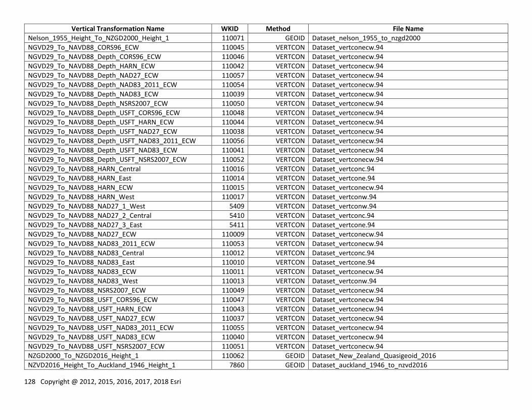
128 Copyright @ 2012, 2015, 2016, 2017, 2018 Esri
Vertical Transformation Name WKID Method File Name
Nelson_1955_Height_To_NZGD2000_Height_1 110071 GEOID Dataset_nelson_1955_to_nzgd2000
NGVD29_To_NAVD88_CORS96_ECW 110045 VERTCON Dataset_vertconecw.94
NGVD29_To_NAVD88_Depth_CORS96_ECW 110046 VERTCON Dataset_vertconecw.94
NGVD29_To_NAVD88_Depth_HARN_ECW 110042 VERTCON Dataset_vertconecw.94
NGVD29_To_NAVD88_Depth_NAD27_ECW 110057 VERTCON Dataset_vertconecw.94
NGVD29_To_NAVD88_Depth_NAD83_2011_ECW 110054 VERTCON Dataset_vertconecw.94
NGVD29_To_NAVD88_Depth_NAD83_ECW 110039 VERTCON Dataset_vertconecw.94
NGVD29_To_NAVD88_Depth_NSRS2007_ECW 110050 VERTCON Dataset_vertconecw.94
NGVD29_To_NAVD88_Depth_USFT_CORS96_ECW 110048 VERTCON Dataset_vertconecw.94
NGVD29_To_NAVD88_Depth_USFT_HARN_ECW 110044 VERTCON Dataset_vertconecw.94
NGVD29_To_NAVD88_Depth_USFT_NAD27_ECW 110038 VERTCON Dataset_vertconecw.94
NGVD29_To_NAVD88_Depth_USFT_NAD83_2011_ECW 110056 VERTCON Dataset_vertconecw.94
NGVD29_To_NAVD88_Depth_USFT_NAD83_ECW 110041 VERTCON Dataset_vertconecw.94
NGVD29_To_NAVD88_Depth_USFT_NSRS2007_ECW 110052 VERTCON Dataset_vertconecw.94
NGVD29_To_NAVD88_HARN_Central 110016 VERTCON Dataset_vertconc.94
NGVD29_To_NAVD88_HARN_East 110014 VERTCON Dataset_vertcone.94
NGVD29_To_NAVD88_HARN_ECW 110015 VERTCON Dataset_vertconecw.94
NGVD29_To_NAVD88_HARN_West 110017 VERTCON Dataset_vertconw.94
NGVD29_To_NAVD88_NAD27_1_West 5409 VERTCON Dataset_vertconw.94
NGVD29_To_NAVD88_NAD27_2_Central 5410 VERTCON Dataset_vertconc.94
NGVD29_To_NAVD88_NAD27_3_East 5411 VERTCON Dataset_vertcone.94
NGVD29_To_NAVD88_NAD27_ECW 110009 VERTCON Dataset_vertconecw.94
NGVD29_To_NAVD88_NAD83_2011_ECW 110053 VERTCON Dataset_vertconecw.94
NGVD29_To_NAVD88_NAD83_Central 110012 VERTCON Dataset_vertconc.94
NGVD29_To_NAVD88_NAD83_East 110010 VERTCON Dataset_vertcone.94
NGVD29_To_NAVD88_NAD83_ECW 110011 VERTCON Dataset_vertconecw.94
NGVD29_To_NAVD88_NAD83_West 110013 VERTCON Dataset_vertconw.94
NGVD29_To_NAVD88_NSRS2007_ECW 110049 VERTCON Dataset_vertconecw.94
NGVD29_To_NAVD88_USFT_CORS96_ECW 110047 VERTCON Dataset_vertconecw.94
NGVD29_To_NAVD88_USFT_HARN_ECW 110043 VERTCON Dataset_vertconecw.94
NGVD29_To_NAVD88_USFT_NAD27_ECW 110037 VERTCON Dataset_vertconecw.94
NGVD29_To_NAVD88_USFT_NAD83_2011_ECW 110055 VERTCON Dataset_vertconecw.94
NGVD29_To_NAVD88_USFT_NAD83_ECW 110040 VERTCON Dataset_vertconecw.94
NGVD29_To_NAVD88_USFT_NSRS2007_ECW 110051 VERTCON Dataset_vertconecw.94
NZGD2000_To_NZGD2016_Height_1 110062 GEOID Dataset_New_Zealand_Quasigeoid_2016
NZVD2016_Height_To_Auckland_1946_Height_1 7860 GEOID Dataset_auckland_1946_to_nzvd2016
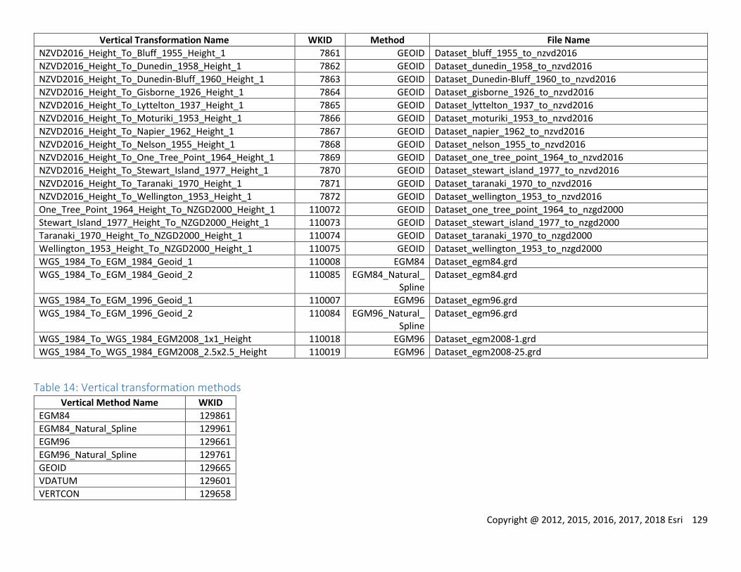
Copyright @ 2012, 2015, 2016, 2017, 2018 Esri 129
Vertical Transformation Name WKID Method File Name
NZVD2016_Height_To_Bluff_1955_Height_1 7861 GEOID Dataset_bluff_1955_to_nzvd2016
NZVD2016_Height_To_Dunedin_1958_Height_1 7862 GEOID Dataset_dunedin_1958_to_nzvd2016
NZVD2016_Height_To_Dunedin-Bluff_1960_Height_1 7863 GEOID Dataset_Dunedin-Bluff_1960_to_nzvd2016
NZVD2016_Height_To_Gisborne_1926_Height_1 7864 GEOID Dataset_gisborne_1926_to_nzvd2016
NZVD2016_Height_To_Lyttelton_1937_Height_1 7865 GEOID Dataset_lyttelton_1937_to_nzvd2016
NZVD2016_Height_To_Moturiki_1953_Height_1 7866 GEOID Dataset_moturiki_1953_to_nzvd2016
NZVD2016_Height_To_Napier_1962_Height_1 7867 GEOID Dataset_napier_1962_to_nzvd2016
NZVD2016_Height_To_Nelson_1955_Height_1 7868 GEOID Dataset_nelson_1955_to_nzvd2016
NZVD2016_Height_To_One_Tree_Point_1964_Height_1 7869 GEOID Dataset_one_tree_point_1964_to_nzvd2016
NZVD2016_Height_To_Stewart_Island_1977_Height_1 7870 GEOID Dataset_stewart_island_1977_to_nzvd2016
NZVD2016_Height_To_Taranaki_1970_Height_1 7871 GEOID Dataset_taranaki_1970_to_nzvd2016
NZVD2016_Height_To_Wellington_1953_Height_1 7872 GEOID Dataset_wellington_1953_to_nzvd2016
One_Tree_Point_1964_Height_To_NZGD2000_Height_1 110072 GEOID Dataset_one_tree_point_1964_to_nzgd2000
Stewart_Island_1977_Height_To_NZGD2000_Height_1 110073 GEOID Dataset_stewart_island_1977_to_nzgd2000
Taranaki_1970_Height_To_NZGD2000_Height_1 110074 GEOID Dataset_taranaki_1970_to_nzgd2000
Wellington_1953_Height_To_NZGD2000_Height_1 110075 GEOID Dataset_wellington_1953_to_nzgd2000
WGS_1984_To_EGM_1984_Geoid_1 110008 EGM84 Dataset_egm84.grd
WGS_1984_To_EGM_1984_Geoid_2 110085 EGM84_Natural_Spline
Dataset_egm84.grd
WGS_1984_To_EGM_1996_Geoid_1 110007 EGM96 Dataset_egm96.grd
WGS_1984_To_EGM_1996_Geoid_2 110084 EGM96_Natural_Spline
Dataset_egm96.grd
WGS_1984_To_WGS_1984_EGM2008_1x1_Height 110018 EGM96 Dataset_egm2008-1.grd
WGS_1984_To_WGS_1984_EGM2008_2.5x2.5_Height 110019 EGM96 Dataset_egm2008-25.grd
Table 14: Vertical transformation methods Vertical Method Name WKID
EGM84 129861
EGM84_Natural_Spline 129961
EGM96 129661
EGM96_Natural_Spline 129761
GEOID 129665
VDATUM 129601
VERTCON 129658
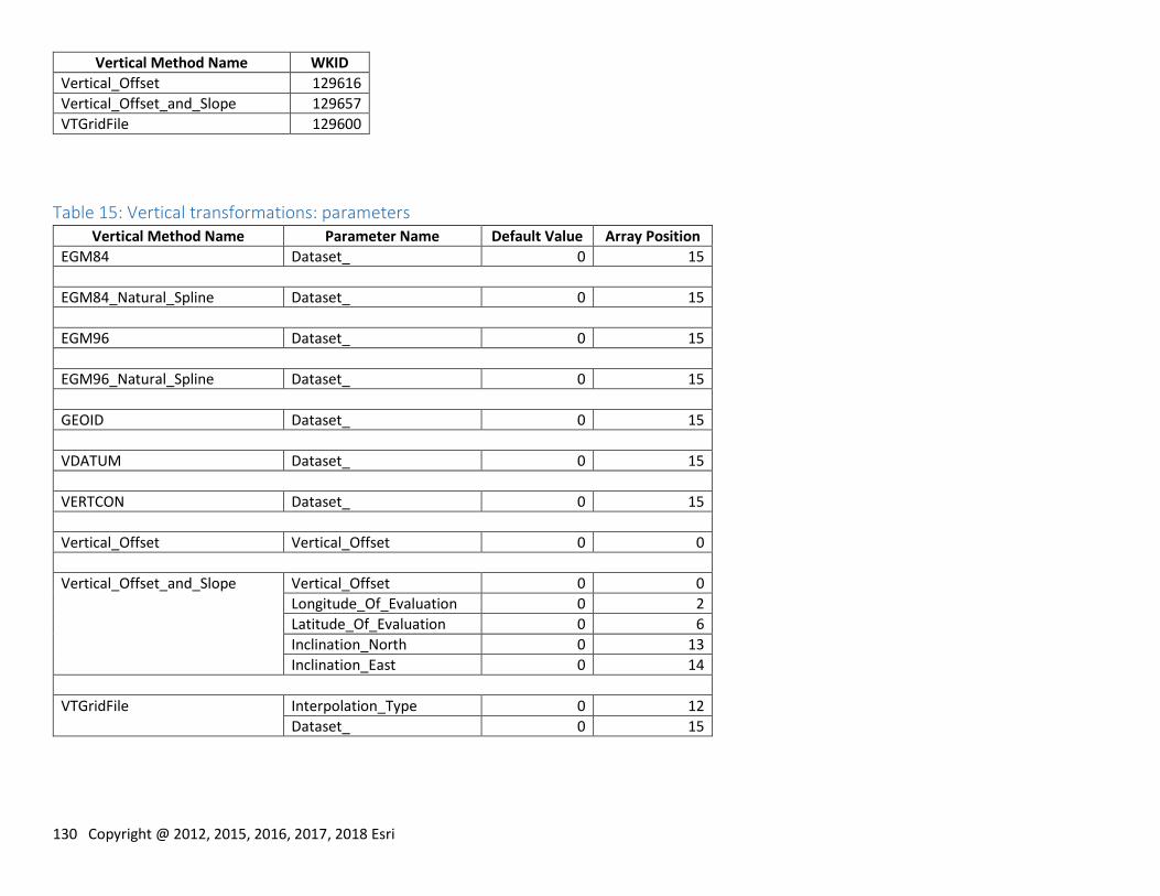
130 Copyright @ 2012, 2015, 2016, 2017, 2018 Esri
Vertical Method Name WKID
Vertical_Offset 129616
Vertical_Offset_and_Slope 129657
VTGridFile 129600
Table 15: Vertical transformations: parameters Vertical Method Name Parameter Name Default Value Array Position
EGM84 Dataset_ 0 15
EGM84_Natural_Spline Dataset_ 0 15
EGM96 Dataset_ 0 15
EGM96_Natural_Spline Dataset_ 0 15
GEOID Dataset_ 0 15
VDATUM Dataset_ 0 15
VERTCON Dataset_ 0 15
Vertical_Offset Vertical_Offset 0 0
Vertical_Offset_and_Slope Vertical_Offset 0 0
Longitude_Of_Evaluation 0 2
Latitude_Of_Evaluation 0 6
Inclination_North 0 13
Inclination_East 0 14
VTGridFile Interpolation_Type 0 12
Dataset_ 0 15