arc hydro as applied at the st. johns river water...
TRANSCRIPT
Arc Hydro as Applied at the St. Johns River Water Management DisArc Hydro as Applied at the St. Johns River Water Management District in NE Floridatrict in NE FloridaAisa Ceric, Sandra Fox, Dave Clapp, Chris Mundy, and Chun Chen, St. Johns River Water Management District, Palatka, FL
SUMMARY and FUTURE PLANS
INTRODUCTION
ABSTRACT
An Arc Hydro data model was created to address the needs of the Surface Water Quality Monitoring (SWQM) program at the St. Johns River Water Management District (SJRWMD), an agency created by the Florida legislature to protect and improve or restore water resources in northeast Florida. Primary data sources for the model were SJRWMD surface water catchments and the 100K National Hydrography Dataset, which was modified for the needs of the project. Hydrological and water-quality monitoring sites were also added. Three customized tools were developed to help query, retrieve, and summarize data from SJRWMD tabular and spatial databases: 1) a water quality tool for retrieving environmental data (water quality, sediment, biological, etc.), 2) a rainfall tool for retrieving and summarizing daily NEXRAD precipitation data, and 3) a spatial data characterization tool for summarizing spatial data (land use, soil, geology, population, etc.). The Arc Hydro framework was used to generate environmental summaries for a series of web-based “Fact Pages” to present information on SWQM monitoring sites. Arc Hydro allows water resource information to be more easily accessed, reduces the time spent finding data, and provides efficient and cost-effective data integration, presentation and management.
The SJRWMD was created in 1972 to protect and preserve the water resources of 12,000 square miles in northeast Florida (Figure 1). The SJRWMD’s population continues to grow rapidly and puts increasing pressure on its water resources, upon which much of the regional economy depends.
TOOLS and THEIR APPLICATIONS
METHODS
Beginning in 1983 the surface water quality monitoring (SWQM) program of the St. Johns River Water Management District has maintained an ambient surface water quality monitoring network of 73 stations located throughout the District. Data generated under the program are uploaded to the District Environmental Database (ED). The SWQM program supports modeling of surface water, sediment quality, and benthic community health, and produces a biennial District-wide surface water quality status and trends assessment.
In 2003, the SWQM program added Arc Hydro, a new ArcGIS data model, developed by the Center for Research in Water Resources (CRWR) and ESRI, to support District-wide water quality and quantity assessments. An Arc Hydro data model was created in order to define the drainage areas for 73 water quality monitoring sites for the SWQM program.
DATA SOURCES and DESIGN CRITERIAPrimary data sources for the SJRWMD Arc Hydro data model were:
Surface water drainage catchments (modified by SJRWMD)Modified National Hydrography Dataset (NHDinArc - 1:100,000 converted to geodatabase and modified by SJRWMD)
The following design criteria were applied:1. Assign HydroJunctions to all 73 SWQM program monitoring sites 2. Include all “major” streams and canals within the SJRWMD3. Include other information collection sites (HDS monitoring sites, NWIS sites, etc.) 4. Include engineering structures5. Identify catchments with two outlets that need additional field review6. Identify noncontributing catchments7. Update problem catchment boundaries (streams crossing the catchments boundaries) 8. Update missing HydroEdges not found in NHD (connectors through marshes)9. Establish a method to handle tidal issues10.Establish a method to handle mid-lake and tidal monitoring sites for Arc Hydro tool function
MODEL IMPLEMENTATIONThe SJRWMD Arc Hydro model implementation consisted of several iterations of the following steps: 1) data preparation, 2) geodatabase generation, 3) HydroJunction creation, 4) buildingHydroNetwork, 5) setting flow direction, and 6) application of the Arc Hydro schema with additional relationship class establishment.
RESULTS and DISCUSSION
ISSUES and SOLUTIONS
Issue 1: Network connectivitySolution: “Temporary” reaches (HydroEdges)
(To be replaced by QAQC’d 24k NHDinGEO, in preparation).
Issue 2: Tidal/non-dendritic system with multiple Atlantic Ocean inlets (sinks)
Solution: “Tidal Null Points” at artificial breaks in ICW HydroEdges.
Issue 3: Proper Arc Hydro tool function for tidal and lake monitoring sites
Solution: “Surrogate sites” for HydroJunctions.
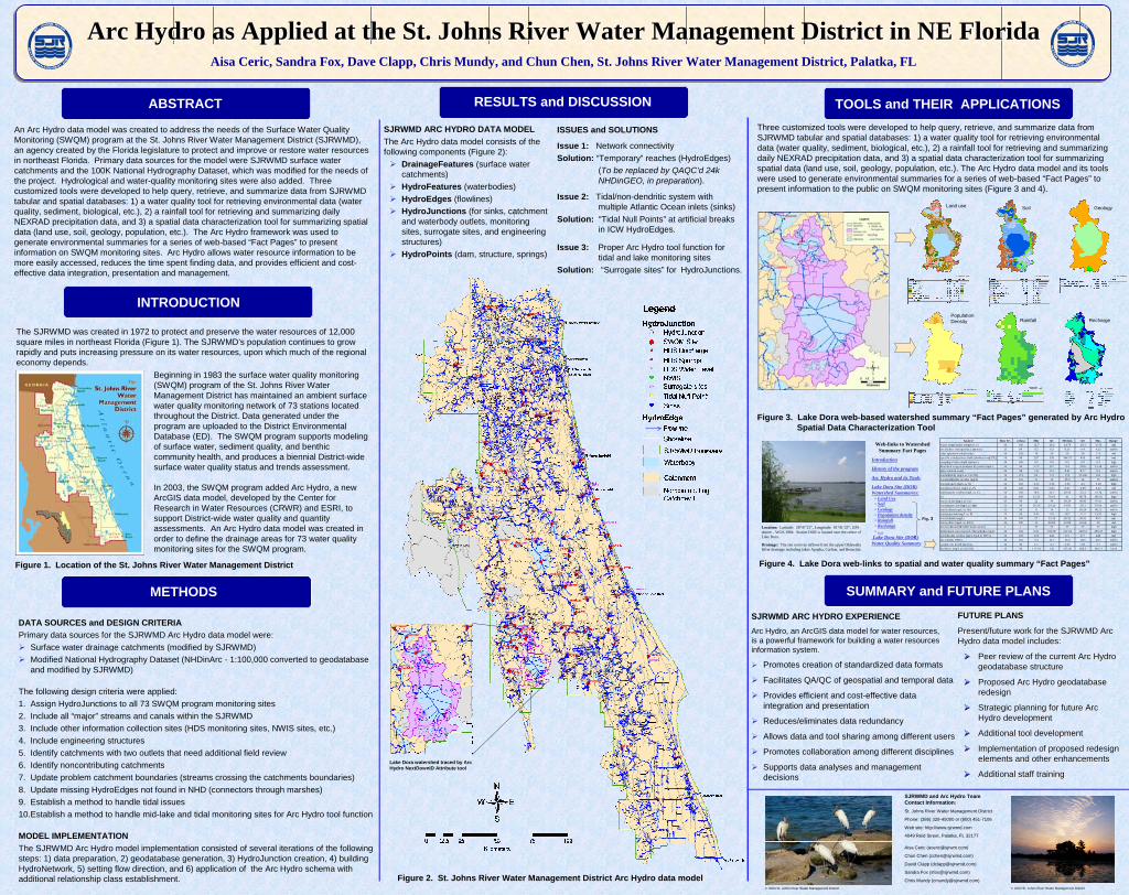
SJRWMD ARC HYDRO DATA MODELThe Arc Hydro data model consists of the following components (Figure 2):
DrainageFeatures (surface water catchments)HydroFeatures (waterbodies)HydroEdges (flowlines)HydroJunctions (for sinks, catchment and waterbody outlets, monitoring sites, surrogate sites, and engineering structures)HydroPoints (dam, structure, springs)
Three customized tools were developed to help query, retrieve, and summarize data from SJRWMD tabular and spatial databases: 1) a water quality tool for retrieving environmental data (water quality, sediment, biological, etc.), 2) a rainfall tool for retrieving and summarizing daily NEXRAD precipitation data, and 3) a spatial data characterization tool for summarizing spatial data (land use, soil, geology, population, etc.). The Arc Hydro data model and its tools were used to generate environmental summaries for a series of web-based “Fact Pages” to present information to the public on SWQM monitoring sites (Figure 3 and 4).
SJRWMD ARC HYDRO EXPERIENCE Arc Hydro, an ArcGIS data model for water resources, is a powerful framework for building a water resources information system.
Promotes creation of standardized data formats
Facilitates QA/QC of geospatial and temporal data
Provides efficient and cost-effective data integration and presentation
Reduces/eliminates data redundancy
Allows data and tool sharing among different users
Promotes collaboration among different disciplines
Supports data analyses and management decisions
Figure 2. St. Johns River Water Management District Arc Hydro data model
Figure 4. Lake Dora web-links to spatial and water quality summary “Fact Pages”Figure 1. Location of the St. Johns River Water Management District
FUTURE PLANSFUTURE PLANS
Present/future work for the SJRWMD Arc Present/future work for the SJRWMD Arc Hydro data model includes:Hydro data model includes:
Peer review of the current Arc Hydro Peer review of the current Arc Hydro geodatabase structuregeodatabase structure
Proposed Arc Hydro geodatabase Proposed Arc Hydro geodatabase redesignredesign
Strategic planning for future Arc Strategic planning for future Arc Hydro developmentHydro development
Additional tool development Additional tool development
Implementation of proposed redesign Implementation of proposed redesign elements and other enhancementselements and other enhancements
Additional staff training Additional staff training
Figure 3. Lake Dora web-based watershed summary “Fact Pages” generated by Arc Hydro Spatial Data Characterization Tool
SJRWMD and Arc Hydro Team Contact Information:
St. Johns River Water Management District
Phone: (386) 329-45000 or (800) 451-7106
Web site: http://www.sjrwmd.com
4049 Reid Street, Palatka, FL 32177
Aisa Ceric ([email protected])
Chun Chen ([email protected])
David Clapp ([email protected])
Sandra Fox ([email protected])
Chris Mundy ([email protected])
Rainfall
Soil
Population Density
Land use Geology
Recharge
Lake Dora watershed traced by Arc Hydro NextDownID Attribute tool
© 2004 St. Johns River Water Management District © 2004 St. Johns River Water Management District
Analyte Data Yrs n Data Min Q1 Me dian Q3 Max Rang ew ater tempera ture (degrees C) 16 100 12.5 20.2 24.76 29.3 32.59 mids ecchi dis c trans parency (me te rs ) 15 90 0.2 0.3 0.35 0.4 0.55 mid-locolor (pla tinum-coba lt units ) 16 102 10 30 30 50 175 mids pecific conductance field (uhmhos /cm@25C) 16 98 267 358 384.75 420 482 mids ampling s tation depth (meters ) 16 100 0.5 0.5 0.5 0.5 0.5 highdis s olved oxygen analys is by probe (mg/L) 15 96 5.73 8.1 9.4 10.6 15.58 mid-hipH (s tanda rd units ) 16 98 7.21 8.4 8.61 8.77 9.3 mid-hitota l alkalinity (mg/L as CaCO3) 16 101 64 112 119 124.86 162 hightota l nonfiltrable re s idue (mg/L) 16 101 11 19 25.5 34 79 mid-hitota l nitrogen (mg/L as N) 16 102 2.55 3.36 3.92 4.5 6.28 hightota l phos phorus (mg/L as P) 16 100 0.01 0.05 0.07 0.09 0.45 midtota l organic carbon (mg/L a s C) 16 102 18.5 24.7 28.56 32.4 41.74 mid-hits i 16 100 13.31 76.63 81 86.78 105.61 hightota l ca lcium (mg/L a s Ca) 15 90 22 34 38.24 40.95 47.63 mid-hitota l magnes ium (mg/L a s Mg) 15 90 10.24 14.12 14.93 16.3 19.66 mid-hitota l s odium (mg/L as Na ) 15 90 11 14 15 16.54 46.55 mid-lotota l pottas ium (mg/L a s K) 15 90 5.41 9.9 10.7 11.5 13.91 hightota l chloride (mg/L) 16 100 27 33.32 36.31 39.91 68.5 midtota l s ulfate (mg/L as SO4) 16 100 11 20.89 22.89 25.06 30 midfecal coliform (MF M-FC broth 44.5C) 1 1 77 77 77 77 77 hightrichroma tic uncorrected chlorophyll-a (ug/L) 16 102 0.01 100.86 132.04 160.51 288.27 hightota l filtrable re s idue (mg/L dried a t 180 C) 16 102 152 242 257 277 440 midlab turbidity (NTU) 16 101 5.4 12.7 16.4 19.5 30.1 mid-his ample s ite depth (meters ) 16 96 1.5 3.1 3.55 3.8 4.7 mid-hihardnes s (mg/L as CaCO3) 15 90 117.94 145 157.36 166.3 194.11 hardi
Web-links to Watershed Summary Fact Pages
Introduction
History of the program
Arc Hydro and its Tools
Lake Dora Site (DOR) Watershed Summaries:
• Land Use• Soil• Geology• Population density• Rainfall• Recharge• ….
Lake Dora Site (DOR) Water Quality Summary
Location: Latitude: 28°47’21”, Longitude: 81°41’23”, GPS datum – WGS-1984. Station DOR is located near the center of Lake Dora.
Drainage: The site receives inflows from the upper Oklawaha River drainage including lakes Apopka, Carlton, and Beauclair.
Fig. 3