aqua environmental associates
TRANSCRIPT

Review of Hydrologic & Geomorphic
Downstream Impacts of Site C
Prepared for: Athabasca Chipewyan First Nation
Industry Relations Corporation Fort McMurray, Alberta
Dene Tha’ First Nation Chief and Council
Chateh, Alberta
Mikisew Cree First Nation
Government and Industry Relations
Fort McMurray, Alberta
Prepared by:
Martin Carver, PhD, PEng/PGeo, PAg
December 2012
Aqua Environmental Associates

Review of Downstream Impacts from Site C - December 2012 2/45 Aqua Environmental Assoc.
Disclaimer
This report remains the sole property of the Athabasca Chipewyan First Nation (ACFN), the Mikisew Cree First Nation (MCFN), and the Dene Tha’ First Nation (DTFN). Citations,
quotations, reproductions, and usage of the information contained herein are permissible only with the explicit written consent of the Athabasca Chipewyan First Nation, the Mikisew Cree First Nation, and the Dene Tha’ First Nation.
While the author endeavoured to state factual and relevant information (within the scope of the study), nothing in this report should be constituted as a definitive list of concerns,
impacts, needs, rights, and uses nor should it be taken as a limitation on the uses or rights of any of the First Nations. The ACFN, MCFN, and the DTFN reserve the right to alter, amend, revise, or update any portion of this report to reflect their fluid and
emerging interests.

Review of Downstream Impacts from Site C - December 2012 3/45 Aqua Environmental Assoc.
Table of Contents
Executive Summary ................................................................................. 5
1.0 Introduction ................................................................................... 8
1.1 Objectives ...................................................................................................................................... 8
1.2 Approach ........................................................................................................................................ 8
2.0 The Site C Proposal in Context ........................................................ 9
2.1 Drivers of Change in the Peace-Athabasca System ......................................................................... 10 2.1.1 A Regulated Flow Regime ................................................................................................................................ 10 2.1.2 Flooding Mechanisms of the Peace-Athabasca Delta ...................................................................................... 11 2.1.3 Ice and the Role of Ice-Jams ............................................................................................................................ 13 2.1.4 Geomorphology and Sediment Transport ....................................................................................................... 14 2.1.5 Climate Change and Future Trajectories ......................................................................................................... 16
2.2 Assessed Potential Downstream Impacts of Site C ......................................................................... 18 2.2.1 Surface Water Regime ..................................................................................................................................... 18 2.2.2 Ice Regime ........................................................................................................................................................ 20 2.2.3 Geomorphology and Sediment Transport ....................................................................................................... 22 2.2.4 Valued Components ......................................................................................................................................... 23
2.3 Additional Perspectives on Assessment of Site C Impacts ............................................................... 24 2.3.1 Regulated Hydrograph ..................................................................................................................................... 24 2.3.2 Ice-Front Progression ....................................................................................................................................... 25 2.3.3 Generalised Impacts ........................................................................................................................................ 26 2.3.4 Integrated Assessment .................................................................................................................................... 27 2.3.5 Impacts to Valued Components ....................................................................................................................... 27 2.3.6 Impacts to the First Nations ............................................................................................................................. 28 2.3.7 Climate Change and Uncertainty ..................................................................................................................... 28 2.3.8 Mitigation and Creating Resilience .................................................................................................................. 29
3.0 Scientific Issues in Assessment Process ....................................... 31
3.1 Spatial and Temporal Scope of Environmental Assessment ............................................................ 31
3.2 Operating Regimes of Existing and Proposed Dams ........................................................................ 34
3.3 Cumulative Effects leading to Escalating Risk ................................................................................. 36
3.4 Scientific Uncertainty .................................................................................................................... 37
3.5 Subjectivity and Scientific Communication .................................................................................... 39
4.0 Conclusions and Recommendations .............................................. 41
4.1 Summary of Recommendations .................................................................................................... 42
5.0 References .................................................................................... 44
Review of Downstream Impacts from Site C - December 2012 4/45 Aqua Environmental Assoc.
List of Figures
Figure 1 – Monthly mean (unregulated) flows for Peace River locations from Hudson’s
Hope to Peace Point during a) 1960-1966 (BC Hydro 2012d) and b) 1992-2010 (BC Hydro (2012a). (Note different y-axis magnitudes.)............................. 19
Figure 2. Historic ice-front progression and retreat of the Peace River (from BC Hydro
2012a.) ................................................................................................ 21
Figure 3 – Monthly mean (both regulated and unregulated) flows during 1960-1966 and
1992-2010 for a) Hudson’s Hope, BC (lower sampling station) and b) Peace Point, AB (upper sampling station). ......................................................... 25
Figure 4. Maximum extent of upstream ice-front progression (km downstream of Peace
Canyon Dam) from 1973 through 2011 (from data provide by BC Hydro). .... 26
List of Tables
Table 1. Tributary, town, and site locations relative to Peace Canyon Dam. ................... 9
Table 2. Estimated maximum upstream ice-front progression (highly approximate) for
two sample years (i.e., actual measured climate) with and without Site C, and with simulated climate to 2050s and 2080s. ............................................. 26
Table 3. Subjectivity terms used in BC Hydro’s Potential Downstream Changes report. . 40
Review of Downstream Impacts from Site C - December 2012 5/45 Aqua Environmental Assoc.
EXECUTIVE SUMMARY
BC Hydro proposes to build a 900-MW dam on the Peace River, 23 km downstream of its Peace Canyon Dam. As part of the Environmental Assessment process, the Mikisew Cree First Nation, the Athabasca Cree First Nation, and the Dene Tha’ First Nation (the First
Nations) commissioned this study to review the hydrologic and geomorphic downstream impacts of this proposed Site C dam on the Peace River, based in part, on information
provided in BC Hydro’s May-2012 “Site C Clean Energy Project Potential Downstream Changes.” The review focuses on understanding the potential impacts of Site C on the hydrology and geomorphology of the territories of the First Nations which include reaches
of the Peace River below the Site C including, for DTFN, sections immediately below and far downstream of the dam and, for ACFN and MCFN, areas downstream to Peace Point
and into the Peace-Athabasca Delta (PAD). To consider these potential impacts, the review also places the considered impacts in context within the larger Peace-Athabasca system. The review objectives are to 1) assess the strength and communication
effectiveness of BC Hydro’s hydrologic and geomorphic science, 2) put the Site C proposal in context with other hydrologic and geomorphic changes evident and expected
in the Peace-Athabasca system, and 3) provide recommendations to assist the ACFN, DTFN, and MCFN in understanding the full scope of hydrologic and geomorphic impacts that may occur on their territories due to Site C.
The Site C proposal is set within a larger Peace-Athabasca system that is undergoing change due to a range of human impacts, notably flow regulation, anthropogenic climate
change, and water withdrawals. The existing dams have brought about direct changes which tend to be immediate and indirect changes some of which will continue to evolve for many years to come. Flow regulation has been in place since the 1960s and has
resulted in drastically reduced annual peak flows at distal and proximal locations along the Peace River including 40% reductions in mean freshet peak flow at Peace Point and a
mean freshet decline in flow at Hudson’s Hope. Flow regulation has also increased winter flows sharply along the length of the Peace River and this change has set the stage for the demise of the ice-jam mechanism in bringing about floods capable of inundating the
PAD perched basins. The perched basins rely on the high flood levels brought about by ice-jams on the Peace River, generally in the most-distal 50 km of the river and with a
flow rate of about 4000 m3/s. Climate change is tending to amplify some effects of flow regulation by a) reducing the size of tributary snowpacks thereby reducing the
magnitude of freshet flows capable of disrupting the elevated ice levels, and b) favouring thermal breakup over mechanical breakup. Fewer major ice-jam flooding events have occurred since regulation was initiated in the 1960s. The sediment regime and
geomorphology of the Peace River continue to adjust in various ways due to regulation as its downstream tributaries also continue to adjust their gradation
(degradation/aggradation) in the vicinity of their mouths. In 1996, an alternative operating regime was implemented successfully at the existing dams to inundate the PAD perched basins. Many researchers have called for this and other types of intervention to
address the consequences that have come about due to flow regulation and particularly because the perched basins may now be at a “crossroads” due to a new hydrologic
regime “unprecedented” in the past.
BC Hydro’s component assessments of potential downstream impacts from Site C have been reviewed and synthesized along with the factors that shape the hydrology of the
Peace-Athabasca Delta and in light of the peer-reviewed literature. Site C would shift the point of regulation 85 km downstream. The operating regime of the existing dams would

Review of Downstream Impacts from Site C - December 2012 6/45 Aqua Environmental Assoc.
be changed and yield modestly higher high flows and lower low flows in the proximal
reaches below the new dam. There may be seasonally greater differences however assessment of these differences remains unavailable. BC Hydro projects a (~40-km)
reduction in river length that will develop ice cover in addition to a delay in onset of ice formation and some reductions in ice thickness. Under future climates (2050s and
2080s), equivalent relative reductions are projected in river length that forms an ice cover. The reservoir reach will experience dramatic and permanent changes both within the Peace River and its tributaries. There will be a reduction in the sediment load
downstream as a result of the reservoir and this change will be superimposed upon a dynamic baseline of a channel continuing to adjust to the effects of the existing dams.
During construction, there will be potential effects on the flow regime, ice regime, and sediment regime. BC Hydro’s summary report entitled “Site C Clean Energy Project Potential Downstream Changes” does not provide an integrated assessment of the effects
of Site C. There are various downstream environmental values (eg, crossings, water intakes, the PAD perched basins) and it is not clear that the effects on these Valued
Components of the potential downstream changes have been adequately assessed.
Additional interpretations are provided in this review to complement those of BC Hydro. In general, (non-construction) impacts from Site C can be described in three groupings.
The first is associated with the reservoir and includes the conversion of 85 km of river to a vertically-dynamic water surface. The second concerns those sites proximal to the dam
site in which changes in flow regime, ice regime, and sediment transport will be readily and annually evident (including effects due to construction). The third group concerns those effects that were earlier put in place by the existing dams and which are
strengthened and enhanced through Site C and extend all the way into the Peace-Athabasca Delta. It is difficult to assess the significance of this final group of impacts
without considering them in light of the effects of the existing dams. Valued components will be affected to differing degrees and at different times, including some that will come about only decades out, given the dynamic baseline. It has been demonstrated that
operating regimes of the existing dams can be used to mitigate downstream effects, including effects from the dams on the PAD perched basins.
An important finding of this review is the gap in consideration of Site C’s role in strengthening at least one existing mechanism known to be detrimentally affecting the flooding regime of zones within the PAD and, to such an overall extent, that the
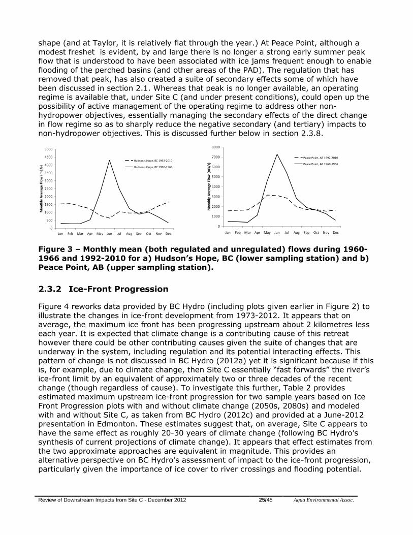
hydrologic viability of these areas is in question. The maximum upstream progression of the Peace River ice-front appears to have moved downstream at an average rate of
approximately 2 km/yr since the early 1970s and is projected to move similarly through the coming decades as climate changes. In this regard, Site C can be interpreted to have
an effect on ice-front progression that is equivalent to roughly 20-30 years of climate change. Other potential changes to the ice regime include a delay of ice onset and a reduction in ice thickness.
Ten recommendations are provided to help address shortcomings in the assessment information currently available in support of the Environmental Impact Statement.
Spatial and temporal scales that include a pre-industrial baseline and the Peace-Athabasca Delta will assist in understanding hydrologic and geomorphic effects of further regulation and in interpreting effects significance. Clarification of the proposed new
operating regimes would assist in understanding expected downstream impacts and the potential for mitigations by revising the approach to flow regulation. The cumulative
effects assessment should explicitly include assessment of the effects on the PAD

Review of Downstream Impacts from Site C - December 2012 7/45 Aqua Environmental Assoc.
perched basins. Greater attention to scientific communication of assessment results
would improve the understanding of the impacts by decision-makers and others interested in and affected by Site C. Uncertainty should be assessed through error
propagation and communicated appropriately to those receiving the scientific information. Subjective assessments including subjective significance determinations
should be accompanied by clearly defined terms to adequately interpret and convey change significance. Lastly, it is recommended that BC Hydro provide an addendum to its Potential Downstream Canges report that includes a discussion and assessment of the
aggregate significance to the ice-jam mechanism, and to its potential to contribute to flooding of the PAD perched basins. Further details on all of these recommendations are
provided in this review report.
Review of Downstream Impacts from Site C - December 2012 8/45 Aqua Environmental Assoc.
1.0 INTRODUCTION
The British Columbia Hydro Power and Authority (BC Hydro; the Proponent) proposes to build a 900-MW dam on the Peace River, 23 km downstream of the Peace Canyon Dam. As part of the Environmental Assessment (EA) process, BC Hydro consults with aboriginal
groups to solicit feedback on its proposal. The Mikisew Cree First Nation, the Athabasca Cree First Nation, and the Dene Tha’ First Nation (the First Nations) have retained Aqua
Environmental Associates (AEA) to carry out a review of the hydrologic and geomorphic downstream impacts of this proposed Site C dam on the Peace River.
1.1 Objectives
The review focuses on understanding the potential impacts of Site C on the hydrology
and geomorphology of the territories of the First Nations which, for the DTFN, includes reaches of the Peace River below Site C including sections immediately both below the dam and far downstream of the dam and, for the ACFN and MCFN, includes Peace Point
and the Peace-Athabasca Delta (PAD). To better understand these potential impacts, the review also places the assessed impacts in context within the larger Peace-Athabasca
system.
The review holds three objectives:
1) To review and assess the strength and communication effectiveness of BC Hydro’s
hydrologic and geomorphic science as provided in its downstream impacts report (BC Hydro 2012a) and in light of the EIS Guidelines (BC EAO 2012) and other
supplementary information.
2) To put the Site C proposal in context with other hydrologic and geomorphic changes evident and expected in the Peace-Athabasca system.
3) To provide recommendations that, if implemented, would assist the ACFN, DTFN, and MCFN in understanding the full scope of hydrologic and geomorphic impacts that may
occur on their territories due to Site C.
1.2 Approach
To complete this review, AEA has been asked to focus on BC Hydro (2012a) in light of the Canadian Environmental Assessment Agency’s (CEAA) and the Environmental
Assessment Office’s (EAO’s) Environmental Impact Statement (EIS) Guidelines (BC EAO 2012), bringing in additional related and supplementary information needed to understand the potential impacts, and with an overall focus on the peer-reviewed
scientific research literature. The review benefited from two meetings with BC Hydro. One was held in Edmonton in June 2012 at which a presentation was given by BC Hydro
on the BC Hydro (2012a) report. The second was held in October 2012 in Vancouver and was attended by the lead modelers involved in simulating hydrologic and geomorphic
changes associated with Site C. Technical Supplementation Information Requests (SIRs) were made to BC Hydro subsequent to each meeting; some of these requests were fulfilled and this information has been used in the review. Note that draft detailed
technical assessments in support of BC Hydro’s EIS were received when this report was being finalized; due to their draft nature and the time constraint, only a preliminary
review of sections of two of those assessments (BC Hydro 2012e and 2012f) is included.

Review of Downstream Impacts from Site C - December 2012 9/45 Aqua Environmental Assoc.
2.0 THE SITE C PROPOSAL IN CONTEXT
The Peace River is a northward flowing boreal river that converges with the Athabasca River in northern Alberta before continuing north as the Slave River and on to Great Slave Lake and the Mackenzie River. The Peace-Athabasca Delta (PAD) is one of the
world’s largest freshwater deltas and is formed by the convergence of the Peace and Athabasca Rivers, in addition to the Birch River (PADTS 1996). The PAD is a Ramsar
Wetland of international significance and a UNESCO world heritage site. It is home to some of the largest undisturbed grass and sedge meadows in North America, and provides habitat for large populations of waterfowl, muskrat, beaver and free-ranging
wood bison (Beltaos et al. 2006a.) Three large shallow lakes currently occupy a large proportion of the 3900-km2 PAD and are connected to Lake Athabasca and other small
basins by a network of active and inactive channels. Surrounding this main flow system are 1200 km2 of sedge meadows, grasslands, and shallow perched basins (PADTS 1996). Lake Athabasca and the other lakes and channels of the PAD are connected to the
northward-flowing Peace and Slave Rivers by three major channels, the Riviere des Rochers, the Revillon Coupe, and the Chenal des Quatre Forches. Although these three
channels normally flow northward, their discharge is proportional to the difference in water levels of the lake systems and the Peace River. Put another way, the Peace River can act as a hydrologic dam when it is very high, preventing drainage of the PAD.
The discussion in this section refers to river mouths and towns along the Peace River. Named sites are given in Table 1 as distance downstream of the Peace Canyon Dam,
provided to situate readers relative to locations described.
Table 1. Tributary, town, and site locations relative to Peace Canyon Dam.
Town or Site Tributary Mouth Downstream Position (km)1
Bennett Dam -23
Hudson’s Hope 7 (in proposed reservoir)
Halfway River 40 (in proposed reservoir)
Moberly River 75 (in proposed reservoir)
Site C Dam 85
Fort St John 90
Pine River 95
Taylor 105
Kiskatinaw River 140
Alces River 145
Dunvegan 275
Shaftesbury 350
Smoky River 360
Town of Peace River 375
Sunny Valley 480
Notikewin River 545
Carcajou 630
Tompkin’s Landing 675
Fort Vermillion 810
Vermilion Chutes 865
Peace Point 1115 1 Downstream location are river-length approximations given relative to the existing Peace Canyon Dam.

Review of Downstream Impacts from Site C - December 2012 10/45 Aqua Environmental Assoc.
2.1 Drivers of Change in the Peace-Athabasca System
Prior to the 1960s, the Peace River ran wild with a limited level of human impact to its
basic hydrology and overall geomorphology compared with today. In the 1960s, construction began of the W.A.C. Bennett Dam (Bennett dam) to create the Williston
Reservoir and the GM Shrum Generating Station. In December 1967, the dam was closed beginning several years of reservoir filling. The Williston Reservoir has a 74.3-km3 capacity making it the world’s seventh largest by volume. In 1980, a second dam was
closed on the Peace River, the Peace Canyon Dam, at a location 23 km downstream of the Bennett dam near the town of Hudson’s Hope and placing the Dinosaur Reservoir in
the path of the Peace River. Water spilled from the Bennett dam flows directly into the Dinosaur Reservoir. The Dinosaur Reservoir has a normal operating range of 3 m in stage, much smaller than Williston’s 30-m range in normal maximum and minimum
operating levels (BC Hydro 2012a) From Peace Canyon Dam, the river flows 1220 km to the Peace-Athabasca Delta.
As described in BC Hydro (2012a), flows downstream of these facilities vary within water license limits and additional safety, environmental, and operating constraints. The operation of these facilities is coordinated with the rest of the BC Hydro generation
assets to optimize electricity generation in relation to demand. Typically, flows are higher during the daytime (when demand for electricity is higher) and lower at night; similarly
flows may be higher in the wintertime and lower at other times of the year. This flow regulation is most noticeable directly downstream of the Peace Canyon Dam. Further downstream, these flow changes are dampened by the addition of water from tributaries
and by natural hydraulic attenuation. At the hydrometric station Peace River at Peace Point (Water Survey of Canada #07KC001), a far downstream location on the Peace
River, the regulated mean annual flood is 5770 m3/s (Church 2012a, in press), only 60% of its pre-regulation value.
Large dams are known for creating significant direct changes to river hydrology
(Magilligan and Nislow 2005) with consequent changes to river geomorphology and associated ecological effects (Graf 2005). The direct changes in the Peace River
hydrograph brought about through regulation have had consequences downstream at various spatial and temporal scales, with attendant ecological effects. In general terms, the geologic and hydrologic nature of the areas covered by the Peace River and its basin
are such that flow regulation has dramatically altered the flow distribution while causing little change in the sediment yield to the river relative to the magnitude of the changes in
the flow regime (Church 2012a, in press). To provide a context for understanding potential downstream impacts due to Site C, this section summarises relevant research looking at these direct and indirect impacts on downstream hydrology and
geomorphology.
2.1.1 A Regulated Flow Regime
Peters and Prowse (2001) have examined the changes in downstream hydrographs resulting from the regulation of the Peace River at the Bennett dam. They found that
even some 1100 km downstream, there have been significant changes to the hydrograph. To facilitate the comparison, a naturalized flow regime was generated using a combination of hydrologic and hydraulic flow models. Average winter flows were found
to be 250% higher and annual peaks 35-39% lower, with the overall drop in variability in

Review of Downstream Impacts from Site C - December 2012 11/45 Aqua Environmental Assoc.
daily flows. Because of the reduction in peaks and variability, the tributary inflows below
the point of regulation only begin to regain the shape and magnitude of the pre-regulation far-downstream Peace River hydrograph.
Church (2012a, in press) compares the regulated hydrology with the behaviour of the wild river. “Consequently, although pre-regulation floods are not likely to occur in the
upper river in the regulated regime, flood levels beyond the Smoky confluence simply become less common… For example, the former mean annual flood at TPR [Town of Peace River] is now a 20-year event, while the 1990 flood of record, reckoned to be a
100 year flood in the pre-regulation regime appears, in the regulated regime, to have a nominal recurrence interval of about 800 years at TPR.”
2.1.2 Flooding Mechanisms of the Peace-Athabasca Delta
The altered behaviour of the Peace River under flow regulation and observed declines in the frequency of hydrologic recharge of major sections of the PAD has spawned over two
decades of research to better understand flooding mechanisms and other hydrologic behaviour of the PAD. In the 1990s, a collection of authoritative assessments was carried
out under the Northern River Basins Study (NRBS, see Prowse and Conly 2002) and the Peace-Athabasca Delta Technical Studies (PADTS 1996). These studies demonstrate that
open-water floods from the Peace River are unlikely to flood the ecologically sensitive perched basins within the PAD. They showed that most large-scale overbank flooding has resulted from ice-jams formed during spring break-up. Increases in freeze-up ice levels
due to enhanced winter flows from the reservoir and a decrease in spring snowmelt runoff from downstream tributaries were determined to be responsible for a decline in
the frequency and severity of ice-jam floods. In one NRBS modelling study, Aitken and Sapach (1994) isolated components of the Peace River system and their effects on flooding in comparison with a naturalized river. Their results demonstrate that the
presence of flow regulation has caused water levels to be lower in the PAD than they would have been without regulation. The effect was shown to be greatest near the Peace
River but still significant at distal locations within other areas of the PAD. This and other studies from this period were followed by over a decade of research that has clarified these earlier findings.
The PAD can be zoned on the basis of the origin and type of floodwaters that reach it. Peters and Prowse (2006) recognize three distinct zones of floodwater origin within the
PAD on the basis of dominant hydrology and topography (using a Digital Elevation Model): 1) perimeter Peace delta, 2) perimeter Athabasca delta, and 3) central delta lakes. They found high-water to vary both spatially and seasonally within the delta
complex. Overbanking of channel water onto perimeter delta areas is most likely to occur during the ice break-up (ice-jam mechanism) and/or open-water periods (open-water
flooding mechanism) depending on location and with different durations. The expansion of the central delta lakes into contiguous wetlands is most probable during mid-summer. The perched basins rely on floodwater input to maintain ponded water. Other inflows are
unavailable in these areas (other than precipitation). And because drawdown of these perched basins occurs from only evaporation, higher evaporation rates imply the need for
more frequent floodwaters to keep them viable (Peters and Prowse 2006.)
Two events since 1974 (both in 1996) have produced floods sufficiently large to result in “extensive inland inundation” (Leconte et al 2001) in the PAD, able to recharge a number

Review of Downstream Impacts from Site C - December 2012 12/45 Aqua Environmental Assoc.
of the perched basins (Peters et al 2006). In the spring of 1996, enhanced release
through the Bennett and Peace Canyon Dams was carried out in a successful attempt to create a major ice-jam able to create extensive flooding within the PAD including perched
basins. Later in the summer of that same year (the wettest year on record), BC Hydro drew down the Williston reservoir for eight weeks because of concerns about a sinkhole.
LeConte et al. (2001) analysed that event and found the effect of the spill on the flow regime within the PAD to be approximately equivalent in magnitude to what would have resulted from those prevailing hydroclimatic conditions if the system had remained
unregulated. This finding highlights that the dam operation can be used to alter the hydrodynamic regime of the PAD to at least partially restore some natural conditions.
Other efforts have been directed at determining how to restore sufficient flooding to all the PAD lakes. A major component of the Peace-Athabasca Delta Technical Studies initiative (PADTS 1996) included the identification and testing of management
interventions to restore the impaired flooding mechanisms. Based on results from numerical modelling studies of ice jams, a flow augmentation strategy was designed to
aid the formation of ice-jams near the PAD (Beltaos 2003). Peters and Buttle (2009) examined changes in obstructions and flow reversals within the PAD following regulation and their correlation to summer lake levels. Their seasonal investigation found that
obstructions and flow reversals occurred less frequently and were smaller in magnitude, implying a lower potential for lateral lake expansion. “The regulated hydrology could
produce large stormflow and high lake levels, but only under extreme climatic events in areas below the dam and/or human-induced alterations to normal reservoir operation.” (Peters and Buttle 2009). These and related studies demonstrate the widespread
recognition that exists in the decline of PAD flooding and indicate the breadth of investigation and understanding that has been developed with respect to its causes and
available steps around its remediation.
Peters and Prowse (2006) examined the observed water levels by ice-jam versus open-water flooding inside the PAD, as well as the spatial influence of each flood type. (Causes
of ice-jams are discussed in the next section in more detail.) Both types were found to recharge perched basins in the Athabasca delta. Ice jamming is the most effective
mechanism for producing extremely high backwaters capable of recharging perched basins. The lateral expansion of the central delta lake into inland areas was found to be a notable mechanism for replenishing the low-to-medium elevation contiguous wetlands.
Their conclusion reconfirms that of Prowse and Lalonde (1996): ice-jamming is the most effective mechanism for recharging perched basins, in particular the elevated region of
the Peace delta where productive wetlands are found. In contrast, high open-water flow events generated by the Peace Basin are insufficient to cause greater than bankfull
conditions within the Peace delta, and are considered by their analysis to be unable to do so. Their simulations suggest that even without the influence of flow regulation, overflow of the lower Peace River would have been a rare occurrence during ice-free conditions. In
comparison, the unregulated Athabasca Basin has occasionally produced localized overland flow in the Athabasca Delta under both open-water and ice-jam conditions.
They recommend, that given the overwhelming importance of ice-jam flooding to the ecosystem health of the PAD, further changes to this mechanism due to climate change be assessed. Such assessments are discussed below following a more detailed
examination of the ice-jam mechanism.

Review of Downstream Impacts from Site C - December 2012 13/45 Aqua Environmental Assoc.
2.1.3 Ice and the Role of Ice-Jams
River environments with annual ice cover are shaped by the ice regime, particularly through ice jamming and water levels during freeze-up and break-up. According to
Uunila and Church (2012, in press), the wild Peace River carried an ice cover for roughly four (upper river) to five (lower river) months of the year. They explain:
“Because it is a northward flowing river, ice forms earlier and remains longer as one proceeds downstream. Typically, freeze-up progresses upstream while break-up proceeds downstream. As a result, there is a high likelihood for
floating ice to develop jams during both freeze-up and break-up periods. Ice jams, and the ice runs that occur when a jam breaks, create high water levels
and may pile ice up to several meters above the water surface. On the Peace River, ice-induced water stages may increase rapidly and may substantially exceed levels reached by open-water floods.”
Detailed observations of the ice regime on the river have been made only since 1972, in response to observations of the ice jams caused by sudden flow changes caused by dam
operations. According to Uunila and Church (2012, in press), comparisons with the former natural ice regime are thus limited to inferences made from morphological
evidence still available from the pre-1967 period and to partial records and anecdotal reports, largely from the Town of Peace River and Fort Vermilion. Traditional Ecological Knowledge provides additional understanding of the pre-1967 behaviour.
According to Uunila and Church (2012, in press), since regulation, the warmer reservoir releases have eliminated winter ice from most of the river in British Columbia. The mean
date of freeze-up is now later all along the river and by as much as five weeks at the Town of Peace River. Break up occurs about a week earlier, and this may be due in whole or in part by the warmer winters that have occurred during this period (see discussion
below). Below the Town of Peace River, decreasing channel gradient, sustained sinuosity, early Smoky River break-up, and the higher latitude combine to create characteristically
dynamic break-ups with major jams and ice runs. They point out that significant morphological effects and riparian damage may be expected in this reach.
“De Rham et al. (2008) report a systematic analysis of gauging stations in the Peace-
Mackenzie system to determine whether ice-induced stage or open water floods produce the highest water levels. They found that the highest water levels at all stations on the
mainstem river from TPR [Town of Peace River] down were caused by ice. While the Upper Peace River would formerly have been dominated by open-water floods, as are the southern and western tributaries that carry snowmelt runoff from the mountains, the
result of regulation is to have created a regime of mixed high water levels.” (reported in Uunila and Church 2012, in press).
Ice jams are known to cause much higher water levels than open water floods and are particularly effective in replenishing the higher elevation, perched basins of the PAD. Prowse et al. (1996) carried out a study under the NRBS. They examined the
hydrometeorological conditions controlling ice-jam and open-water floods associated with the Peace River and determined that the open-water floods are ineffective at flooding the
perched basins and that it is breakup backwater due to ice-jamming in the lower Peace River that is effective. They found the downstream tributaries to play a key role in leading to these ice jams however this effect has declined due to regulation (higher

Review of Downstream Impacts from Site C - December 2012 14/45 Aqua Environmental Assoc.
freeze-up levels) and climate change (reduced peak flows). Beltaos et al. (2006a)
identify three conditions for the occurrence of ice-jam flooding sufficient to inundate the perched basins. One, a mechanical (not thermal) ice break-up is required. Two, the river
flow should be at least 4000 m3/s (see also Beltaos 2003). Three, an ice jam should form within the last 50km of the Peace River. Regulation and climate change contribute and
interact in determining the likelihood that these conditions will be met. As climate change progresses and potentially accelerates (see section 2.1.5 below), it will become less likely that, under the present regime of regulation, appropriate ice-jams will occur to flood the
perched basins.
Prowse and Conly (1998) examined the influence of downstream tributaries in shaping
the occurrence of ice-jam floods (following up from the findings of Prowse and Lalonde 1996 and Prowse et al. 1996). They determined that the downstream tributaries, particularly the Smoky and the Wabasca Rivers, play an important role in determining
whether an ice-jam flood occurs because their low-elevation basins provide most of the meltwater during the critical period when breakup normally occurs. However, the
regulated flow regime has raised the level of the ice cover thus requiring higher tributary flows to precipitate the break up. Coincidentally, since the mid-1970s, there has been a warming during the period of ice cover, favouring thermal over dynamic break-ups,
further reducing the probability of severe ice-induced flooding. In addition, the warming has reduced the effectiveness of the spring freshets from these basins. Overall, they
identify that regulation in concert with reduced runoff has led to a decline in the frequency of the mid-sized floods, explaining why there has been a sharp decline in ice-jam events since regulation. Further, it can be concluded that regulation has led directly
to a decline in ice-jam floods and this decline has been exacerbated by the warming climate (see section 2.1.5).
2.1.4 Geomorphology and Sediment Transport
Above the point of current regulation, the headwaters of the Peace River lie in
dominantly limestone ranges of the northern Rocky Mountains and in the metamorphic Omineca Mountains. Sediment yield from these areas to the Williston Reservoir is generally low (Church 2012b, in press). East of the Rocky Mountains, the Peace River
flows in a valley cut several hundred metres into the Alberta Plateau (Church 1995). River erosion of weak bedrock and sediment banks has resulted in frequent landslides
along the river. Tributaries deliver sand, gravel, and cobbles to the mainstem river. At points further downstream, bed materials become finer and the confined width of the river course increases with increasing sinuosity. Beyond Carcajou, the river is a sand-bed
river with a significant gravel component all the way to the Vermilion Chutes.
Characteristic changes to river capacity and geometry occur downstream of reservoirs
associated with major dams (Gregory and Park 1974). The Peace River below the existing reservoirs has been described in some detail (e.g., Church 2012b in press, Church 1995, and Ayles 2001). The dam and reservoir do not yield direct substantial
changes to the sediment sources/supply to the river below the dam due to the nature of the change in geology with respect to inputs from locations upstream and downstream of
the dam. Instead, changes are happening indirectly due to the dramatic and abrupt revisions to the flow regime (ie, a new distribution of magnitude and frequency of peak discharge) that have changed the ability (“competence”) of the river to transport
material and bed elements of different sizes, ultimately leading also to a reorganization

Review of Downstream Impacts from Site C - December 2012 15/45 Aqua Environmental Assoc.
of the river’s main sediment sources. This process takes a long time hence the river-wide
changes in river behaviour and morphology brought about by flow regulation will continue to work themselves out in the sediment transport and geomorphology of the
river, probably over centuries and longer (Church 2012a, in press).
A main outcome of regulation then lies in understanding the role of the tributaries in
shaping the sediment load of the main river and in changes that begin locally at their confluences. In general, the tributaries have higher sediment concentrations than the Peace River itself and their concentrations in the Peace River become diluted by the large
clear water contributions from the reservoirs (Church 2012a, in press). At tributary mouths, fans develop that eventually push the mainstem to the distal bank, encouraging
new sediment supply through bank erosion. The Smoky and Pine Rivers, both with mountain headwaters, are the most important single tributaries shaping the sediment load and geomorphology of the Peace River.
Three examples of changes in Peace River geomorphology that have come to pass due to the flow regulation are mentioned here. First, the river is no longer able to move all the
sediment delivered to it by the tributaries and, as a result, a steepened reach is developing on the downstream side of tributary deposits (Church 1995). For example, there appears now to be no appreciable bedload movement upstream of the Pine River
(Church 2012b). Over a period of many decades, the Peace River is developing a stepped profile between successive tributary fans. Second, channel narrowing is occurring
particularly in the Alberta reaches of the river as side channels are abandoned and sand and gravel bars become colonized by vegetation (Church et al. 1997). Three, where adjustments have occurred, they have been achieved by riparian vegetation succession
onto abandoned bartops and into abandoned side channels. “Hence the adjustment process thus far has largely been passive and has depended in a significant way upon
riparian succession. The dominant pattern of riparian succession has been the establishment of scattered shrubs and grasses on the upstream gravel bar surfaces but, once sand becomes trapped on the bartop a continuous shrub cover develops.
Downstream, banded galleries of shrubs have established on bar surfaces surrounding old island cores. The changes are most extensive in areas with substantial island
development where the river always has been least stable.” (Church et al. 1997)
The tributaries themselves are also affected by the regulated flow regime, though this appears to be poorly studied in the Peace River. In general, steepening of tributary slope
near the mouth is expected, leading to upstream-progressing channel degradation. Ayles (2001) examined the major tributaries of the Peace River below Peace Canyon Dam. He
found degradation to have been the most common response of the proximal tributaries to regulation. It is especially well expressed in Lynx Creek, Farrell Creek and Halfway
River (all above the Pine River confluence). Farther downstream, the gradation response gets obscured by other factors such as tributary sediment supply, ice regime, and degree of flood synchronization between tributary and mainstem. Aggradation was observed to
be less evident in the distal tributaries though it is present in the lower Smoky River.
BC Hydro (2012a, p37) acknowledges the contribution of its flow regulation to these
changes observed in Peace River geomorphology: “channel erosion or deposition patterns downstream, which are either natural (i.e. valley wall erosion and landslides along the river), or are driven by the ongoing response of the river channel to upstream flow
regulation that started in 1967 (aggradation below tributary confluences, local bank

Review of Downstream Impacts from Site C - December 2012 16/45 Aqua Environmental Assoc.
erosion opposite from tributary confluences, vegetative encroachment onto gravel bars
and into secondary channels)” (emphasis added).
2.1.5 Climate Change and Future Trajectories
The significance of climate in determining, through flooding, the hydrologic fate of perched basins in the PAD has long been recognized (eg, NRBS discussion paper by
Cohen 1995). Prowse et al. (1996), discussed in the previous section, concluded by recommending a collection of analyses related to climate controls on ice-jam flooding. Temporal analysis of Prowse and Conly (1998) “detected a weak climate signal
suggesting that since approximately the mid-1970s the period of ice cover may have become slightly warmer and the pre-breakup melt period may have become more
intense and/or more protracted.” They also suspected that the climate factors may “favour the development of thermal over dynamic breakups and hence reduce the probability of severe ice-induced flooding.” They also identified climate’s role in reducing
snowpack size in downstream tributaries, notably the Smoky River, which are known to play an important role in “triggering” the development of ice-jam floods. A later study by
Prowse et al. (2006) reinforced these earlier conclusions and set the PAD flooding issue within the larger context of climate (and other) change within the Slave basin. Prowse et
al. (2006) stated: “Analysis showed that augmenting flow during the spring breakup period through an enhanced flow release substantially contributed to recharge flooding of the PAD in the spring of 1996. This raises further hope that similar strategies might be
used in the future to combat the negative effects of climate change on this aquatic system.” Clearly, concerted changes in the pattern of Peace River flow regulation offer an
opportunity to compensate for ongoing declines in ice-jam flooding contributed to by regulation and climate change.
Beltaos et al. (2006b) looked at the frequency of ice-jam floods in the 2080s (2070-
2099) in comparison with a 1961-1990 baseline and using outputs from Global Climate Models (GCMs). They estimated that the ice season will be reduced by 2-4 weeks caused
mainly by earlier breakup (1-3 weeks) and secondarily later freeze up (a few days). They also concluded that future ice cover will be slightly thinner than at present by up to 20%. They stress, however, that the most significant effect of climate change on the ice regime
is actually associated with a projected dramatic increase in the frequency, intensity, and duration of mid-winter thaws in the southern portion of the Peace River, “exacerbating
the PAD drying trend that is already in progress.” They suggest that “To alleviate associated ecological and socio-economic impacts, potential mitigation measures and adaptation strategies should be carefully considered.”
A trio of studies was published in 2006 examining the application of GCM data (to 2050s) to hydrologic and hydraulic models to ascertain the scope of impact of climate change to
the Peace and Athabasca catchment and delta. Application of the hydrologic model (Toth et al. 2006) demonstrated a shift toward an earlier melt season and elevated winter flows for both major rivers. They found that the higher elevations of the Peace River
system may experience increased evaporation which will compensate for higher precipitation resulting in only slightly increased streamflow. They also stress the
projection uncertainty associated with climate change. Leconte et al. (2006) found lake levels to vary with winter severity (open-water flooding) and involving an almost 10-cm drop below baseline, emphasizing the consequence of milder winters (under climate
change) to open-water flooding potential of major PAD lakes. Pietroniro et al. (2006)

Review of Downstream Impacts from Site C - December 2012 17/45 Aqua Environmental Assoc.
applied (2050s) GCM projections to a hydrologic and hydraulic model to evaluate
changes in hydrologic regimes of major PAD lakes and Peace and Athabasca Rivers. They found lake levels to peak 40-50 days earlier and spring freshets to occur 20-30 days
earlier. Peace River summer water levels showed declines averaging 0.5 m and suggested concern to them for navigation and other river uses that depend on adequate
river levels.
A recent assessment (Schnorbus et al. 2011) with funding from BC Hydro (through the Pacific Climate Impacts Consortium, PCIC) used 2050s GCM data and the Variable
Infiltration Capacity (VIC) hydrologic model to project changes to the hydrology of the Upper Peace River and its basin. The highest increases in temperature were associated
with the winter season which tends to exacerbate limitations to river ice formation. Precipitation is projected to increase in all GCMs used with the increases averaging over 10% from the 1961-1990 baseline. Monthly discharge for the Peace River shows a
consistent response of increases during fall and winter, an earlier onset of spring freshet, and reduced discharge during late summer and early fall. These changes, combined with
the companion declines in winter snowpack in the basins of the downstream tributaries, point to significant declines in the effectiveness and frequency of the ice-jam mechanism in causing flooding in the perched basins of the PAD. Their results were robust to
climate-change projection methodology suggesting confidence in the findings.
Hall et al. (2004) present the findings of a study commissioned by BC Hydro looking at
the past few hundred years of sediment cores and tree rings to assess “the relative roles of climatic variability and river regulation on the hydro-ecology of the major flow system of the PAD.” This study identifies “climatic oscillations”, “shifting atmospheric circulation
patterns”, and “climate variability”, and includes interpretations of the period during which it is accepted that anthropogenic climate change has been occurring (IPCC4 2007).
The climate is expected to become far out of equilibrium from the range of climates observed over the past centuries and beyond, and as the climate changes, so too does the surface hydrology change.
Wolfe et al. (2008a) used water-isotope tracers and multi-proxy paleolimnological records to characterize connectivity controls on water balances of floodplain lakes in the
Athabasca Delta within the context of its hydroecological evolution over the twentieth century. They conclude that the hydroecology of the Athabasca sector of the PAD is far more sensitive to changes in Athabasca River flow than the Peace sector which is resilient
to changes in Peace River flows. This perhaps simplified comparison appears to disregard the role of the ice-jam mechanism yielding elevated flooding levels. In fact, a complex of
factors affects the magnitude and frequency of this mechanism, one of which is the seasonal Peace River flow rates. Wolfe et al. (2008a) conclude that recent drying of some
PAD lakes in the Athabasca sector and the surrounding landscape may represent the leading edge of rapidly evolving hydroecological conditions in the Athabasca Delta. Implications include reduction in aquatic habitats, loss of navigation access, and
complete loss due to lake desiccation.
One of the four main conclusions of Hall et al.’s (2004) report to BC Hydro is a lack of
evidence to show a connection between Peace River regulation and the condition of the perched basins. Rather than not providing evidence that this connection exists, it may be preferable to ask whether there is evidence that this connection doesn’t exist because
there is strong science (dating back to the mid-1990s) and understood mechanisms identifying that the effect exists. The Hall et al. (2004) report does, however, put recent

Review of Downstream Impacts from Site C - December 2012 18/45 Aqua Environmental Assoc.
climate and hydrologic changes in the context of the climate of the past 300 years. Its
findings suggest that the drying of recent decades is not “unprecedented” in the past 300 years. However, what this report does not emphasise is what Wolfe et al. (2008b, p5)
do, with respect to Peace River and others systems draining the apex of North America: “…the hydrograph of the 21st century may be evolving towards conditions unprecedented
over the past ~1000 years” and “clearly underscores the need for stringent allocation of freshwater resources in these watersheds.” Wolfe et al. (2008b, p4) explain that a comparable return of elevated flood frequency and magnitude is unlikely…thus the
ecological integrity of the PAD may well be at a crossroads.”
Whereas the period of relative drying subsequent to 1974 can be put in a historic climate
context (e.g., Timoney et al., 1997), it is clear based on IPCC4 (2007) that atmospheric greenhouse gas levels may be rising so high that these systems may be entering an “unprecedented” period of climate warming that is increasingly likely to take the Peace-
Athabasca system into an altogether new state over the coming century. Further industrialization of the Peace River (e.g., Site C) along with water withdrawals in the
Athabasca River and other anthropogenic changes create uncertainty as to whether the PAD habitats and the navigability of its river systems (and therefore First Nations’ access to traditional harvesting areas in the PAD) will be sustained into the future, under the
current regimes of the existing dams.
2.2 Assessed Potential Downstream Impacts of Site C
The Site C dam is proposed to be built at a location 85 km downstream of the current Peace Canyon Dam, and about 5 km from the town of Fort St John. With a reservoir
operating range of 1.8 m, Site C is designed to be operated in the style of a run-of-the-river plant that will not constrain upstream operations. As explained in BC Hydro
(2012a), BC Hydro has an incentive to keep the reservoir levels high (ie, within the top 50cm) in order to maximize power generation, given that power generation is proportional to the vertical drop of the impounded water. BC Hydro (2012a) describes
the incremental changes that it has determined will occur as a result of this new dam and key elements are provided here.
BC Hydro (2012a) describes the downstream changes in hydrology and geomorphology that it projects will come about as a result of the Site C dam. Subsequent to that report’s completion in May 2012, the First Nations requested supplemental information to better
assess and interpret the findings. As mentioned in section 1.2, some of these SIRs have been fulfilled by BC Hydro and this supplemental information contributes to the
discussion in this section. In addition, draft technical assessments in support of BC Hydro’s EIS were received when this report was being finalized. A preliminary review of some sections of two of those assessments (BC Hydro 2012e and 2012f) has contributed
to the discussion below.
2.2.1 Surface Water Regime
The regulated Peace River flow is based largely on the needs of power generation. The wild (unregulated) flow was snowmelt-driven with a pronounced annual maximum
generally occurring in June. See Figure 1a. Downstream of the Peace Canyon dam under the regulated regime, the flow is attenuated as wild tributary inflows direct the main Peace River back to a semblance of its unregulated shape, increasing in effect at points

Review of Downstream Impacts from Site C - December 2012 19/45 Aqua Environmental Assoc.
further downstream. This is the case with the present Peace River as illustrated in Figure
1b (note the considerably reduced y-axis). Locations closer to the dam demonstrate open-water mean hydrographs more similar to the general shape of the regulated
hydrograph and the effect increases with downstream distance. With Site C in place, these relative changes in flow begin further downstream but attenuate downstream in
both cases (ie, with and without Site C). Exact differences in this attenuation are unavailable because BC Hydro has not made available the changes, with Site C, it intends to implement in the current operating regimes of the existing dams.
Figure 1 – Monthly mean (unregulated) flows for Peace River locations from Hudson’s Hope to Peace Point during a) 1960-1966 (BC Hydro 2012d) and b) 1992-2010 (BC Hydro (2012a). (Note different y-axis magnitudes.)
The addition of Site C on the Peace River shifts the point of flow regulation to a point 85 km downstream from Peace Canyon Dam. As is the case today downstream of Peace
Canyon Dam, changes in downstream flows and water levels would be most evident near the tailrace of the Site C dam, generally diminishing with distance downstream. BC Hydro (2012a, p19, Table 3) provides modeled estimates of the change in water levels at points
downstream from Site C. Not surprisingly, the effect is greatest close to the dam and declines downstream. The changes are more frequent at sites such as the tailrace,
Taylor, Alces and Dunvegan and, in BC Hydro’s view, will be “minimal” at the Town of Peace River and beyond. Changes downstream are expected primarily due to this shift in the point of regulation but also due to unspecified “expected operational differences and
changes in turbine characteristics” (BC Hydro 2012a, p i).
BC Hydro is planning to have a larger maximum discharge at Site C than is currently
occurring at Peace Canyon dam and indicates that the additional system capacity may lead BC Hydro to make different (unspecified) choices around power generation. BC Hydro (2012a) illustrates the differences in flow regimes with and without Site C using
flow duration curves based on a 10-year simulation. BC Hydro identifies that it is at the high end and low end of these curves where differences are evident. That is to say, at
the high end of these curves, higher flows will be experienced more often and at the low end of these curves, lower flows would be experienced more often. It is unclear how
these operational choices will modify the flow regime, however BC Hydro (2012a, p17) explains that, at Taylor (approximately 20 km downstream of Site C), the modelling suggests that with Site C there are periods in which flows and water levels would be
higher than present and other times when water levels would be lower than at present. The variability of water levels will increase at this location, as it is closer to the point of
0
1,000
2,000
3,000
4,000
5,000
6,000
7,000
8,000
Jan Feb Mar Apr May Jun Jul Aug Sep Oct Nov Dec
Mo
nth
ly A
vera
ge F
low
(cu
bic
me
tre
s/se
con
d) Peace Point, AB
Town of Peace River, AB
Taylor, B.C.
Hudson's Hope, B.C.
0
500
1,000
1,500
2,000
2,500
3,000
3,500
Jan Feb Mar Apr May Jun Jul Aug Sep Oct Nov DecM
on
thly
Ave
rage
Flo
w (
cub
ic m
etr
es/
seco
nd
) Peace Point, AB
Town of Peace River, AB
Taylor, B.C.
Hudson's Hope, B.C.
(a) (b)

Review of Downstream Impacts from Site C - December 2012 20/45 Aqua Environmental Assoc.
regulation. At points downstream, the effect diminishes due to natural attenuation and
dampening with tributary inflows. BC Hydro (2012a, p i) states the effect of Site C at Town of Peace River to be “minimal.” BC Hydro also indicates that the difference between
these curves (with and without Site C) is “barely visible” at the Town of Peace River, however they do not quantify this difference, choosing instead to describe it subjectively.
BC Hydro (2012a, p18) states: “It is possible that changes due to Site C could be more noticeable at particular times of the year. Additional studies are ongoing to characterize any seasonal changes that would be expected.” Information on these seasonal changes
appears to be unavailable.
Actual construction of Site C would require seven years to complete. During this time, BC
Hydro will alter the flows within the existing water license requirements due to the needs of critical construction windows and phases of the channelization and diversion phases. Once constructed, the water level in the reservoir would be increased to the normal
operating level over a period of about two months. During the filling period, BC Hydro projects that downstream flows would be reduced but would remain within the licensed
flow range of the Peace Canyon dam.
2.2.2 Ice Regime
BC Hydro projects changes in ice conditions of the Peace River due to Site C during construction and operations phases. During construction, it predicts only small and localized changes to ice conditions because it assumes that ice generated upstream will
continue to flow through the construction site during both phases of construction. BC Hydro (2012a) does not provide evidence to substantiate this expectation.
During operations, BC Hydro (2012a) describes two changes that will come about as a result of the new reservoir and that these changes will lead to a reduction in downstream ice. First, the reservoir itself will act as a physical barrier to the transport of ice
downstream thereby reducing the total volume of ice available to contribute to ice cover progression downstream. Second, in comparison with present temperatures at the Site C
location, thermal stratification in the reservoir will lead to outlet temperatures that are cooler in the spring and warmer in the fall which, in turn, would lead to a reduction in the period of downstream ice cover. BC Hydro (2012a, p28) states: “…the predicted average
delay in ice formation at the Town of Peace River is 3 days; it is not likely that this duration would lead to a noticeable change in ice thickness at this location. Further
upstream where the delay in ice cover formation may be greater, or where the ice cover no longer reaches with Site C, reductions in ice thickness would be expected.” This assessment of ice dynamics leaves many questions surrounding: the likelihood of the
delay projections, the meaning of “noticeable”, and the extent of ice thickness reductions that “would be expected.” In addition, BC Hydro (2012a, p28) states that any change in
the timing of ice formation downstream of Carcajou “is not expected” however it does not support this expectation with evidence.
Regardless of the above limitations of the assessment information provided, overall, and
based on BC Hydro’s presentation of its assessments, it appears that these changes will result in:
a reduction in the length of the river that develops an ice cover (a difference of between 22 and 64 km in river length ice cover, based on simulations using 1995-2001 climate data);

Review of Downstream Impacts from Site C - December 2012 21/45 Aqua Environmental Assoc.
a delay in the onset of ice cover (by three days at the Town of Peace River; longer
upstream and shorter downstream); and
a reduction in ice thickness at locations upstream of the Town of Peace River.
Because break-up timing is controlled by atmospheric conditions (rather than water temperatures), break-up timing should remain unaffected by Site C.
Additional interpretations can be made with respect to ice-front progression and retreat patterns with and without Site C. BC Hydro (2012a, p22) includes a plot showing the annual ice-front behaviour for 1995-2012, reproduced here as Figure 2. This figure
shows considerable variability in maximum annual ice-front progression presumably due to various factors including normal year-to-year variability in weather in addition to
trends associated with climate change and possibly ongoing adjustments in flow regulation. To better resolve the role of climate change versus that of Site C in changing the ice-front progression behaviour, and upon request by the First Nations, BC Hydro
provided ice-front progression plots for those same years with modeled 2050s and 2080s climate change. In addition, using two years of the historic record (1996-97 and 2002-
03), at a June-2012 meeting, BC Hydro illustrated numerical modelling results of effects of Site C on ice-front progression. Combining these two sources of data, it is evident that (on average) Site C reduces the ice-front progression by about 40 km both under today’s
(recent) climate and that of the 2050s and 2080s. Additional interpretations of these data are provided in section 2.3.2 below.
Figure 2. Historic ice-front progression and retreat of the Peace River (from BC Hydro 2012a.)

Review of Downstream Impacts from Site C - December 2012 22/45 Aqua Environmental Assoc.
2.2.3 Geomorphology and Sediment Transport
Site C will create dramatic and indefinite changes to the 85-km reach of the Peace River that will become a reservoir in addition to the downstream sections of tributaries to this
reach of the Peace River. According to BC Hydro (2012a), this reservoir will trap the sediment load that is currently delivered to the Peace River by the tributaries to the 85-
km reach below the Peace Canyon dam. The reservoir is also expected to increase the total sediment available to the Peace River due to “wave erosion on the valley slopes along the reservoir shorelines.” Regardless, BC Hydro’s early reservoir modelling
suggests that the net result will be a decline in the total sediment load carried by the river downstream of Site C.
BC Hydro’s modelling indicates a maximum reduction in suspended load of the river downstream of Site C of 1.4x10⁶ t/yr which represents the input loads from Halfway, Cache, and Moberly Rivers, in conjunction with a much smaller amount from Lynx and
Farrell Creeks (BC Hydro 2012a, p32, Table 6.) The Halfway and Moberly Rivers are estimated to provide the large majority of the suspended load that will be captured by
the reservoir (68% and 12% of the total, respectively).
As with the downstream attenuation of river flow, the effects of this reduction in
suspended sediment concentrations will decline downstream as major tributaries to the Peace River overwhelm these changes. Downstream of Site C, the Pine River enters the Peace River, followed by other tributaries and ultimately the Smoky River. At the Alberta
border, the proportion of the suspended sediment load associated with the lost tributary sediment is predicted to be 26% of the total load (BC Hydro 2012f). BC Hydro describes
the change as “a small proportion of the total suspended sediment load in the river downstream” and presumably, as a result, predicts “no changes to erosion and depositional patterns in the river” downstream of the proposed dam in comparison with
current conditions, except within the first few kilometres downstream of Site C. (Note that below the Slave River confluence, the proportion of the Peace River sediment load
that is trapped by existing dams reaches 3.7% according to Church 2012a, in press).
It is notable that BC Hydro describes the baseline for the geomorphology and sediment transport assessment as “dynamic” because the river is still working out the changes in
its geomorphology resulting from the Bennett dam (see section 2 for an overview of this dynamic situation). It is this dynamic baseline that BC Hydro states will be (essentially)
unaffected by Site C (other than at sites proximal to the new dam).
BC Hydro (2012a, p37) asserts that because the incremental flow changes associated with Site C are small, these changes will not influence the bedload transport capacity of
the river downstream and will have no “appreciable” influence on channel erosion and deposition patterns downstream beyond the baseline. This subjective inference is
reinforced in BC Hydro (2012e) with a followup ambiguous assertion: “Changes in river flows due to the Project are not expected to be such that they would influence the dynamic baseline patterns of channel erosion and deposition.” It appears that BC Hydro
is unable to maintain that Site C will have no effect on the dynamic baseline.
BC Hydro (2012a, p37) states that it will take measures to mitigate the potential adverse
sedimentation effects from construction, but does not give an indication of how severe the net resulting sediment releases will be during the seven-year construction period. Construction-derived fine sedimentation will be most relevant in the river sections

Review of Downstream Impacts from Site C - December 2012 23/45 Aqua Environmental Assoc.
immediately downstream of the dam, say within 10 km of the site, though this is difficult
to delimit. Changes during the construction period are still being worked out.
Overall, Site C is expected to enhance the effects discussed in section 2. That is, Site C
will enhance, not slow, the pace of creation of stepped morphology, general narrowing of the channel, upstream-progressing degradation of certain tributaries, and encroachment
of riparian forest. The rate of enhancement is not discussed explicitly in BC Hydro (2012a) except through the use of generalized subjective terms indicating little effect. It is also not evaluated based on the combined effect of altered flow regulation, an
additional reservoir, and climate change.
2.2.4 Valued Components
There is a variety of values (“Valued Components”) associated with the Peace River and some details on these are provided in BC Hydro’s assessment information.
According to BC Hydro:
“Alberta Transportation operates two crossings on the Peace River – one at Shaftesbury (25 km upstream of the Town of Peace River; 265 km downstream
of Site C) and one at Tomkins Landing (590 km downstream of Site C), including ice bridges in the winter and ferries in the open-water period. Also,
an ice bridge located in the PAD, 15 km upstream of the confluence of the Peace and Slave Rivers (1100 km downstream of Site C).”
According to BC Hydro (2012f, p9):
“There are two public river crossings on the Peace River upstream of Fort Vermilion - Shaftesbury Crossing at km 371 (25 km upstream of the Town of
Peace River), and Tompkin’s Landing crossing at km 694 (300 km downstream of the Town of Peace River). A ferry operates in the open water season and an ice bridge is constructed in the winter at both of these locations. The
Shaftesbury Crossing provides shorter access for the members of the rural community of Tangent to the Town of Peace River and Grimshaw. The
Tompkin’s Landing Crossing (also referred to as La Crete Ferry or Ice Bridge) provides an alternative transportation link to the community of La Crete.
An ice bridge is also constructed at a private crossing in the community of
Sunny Valley at km 486, about 90 km downstream of the Town of Peace River.
Additional crossings exist downstream of Tompkin’s Landing but results of this
study suggest that even the Tompkin’s Landing crossing is too far downstream to be influenced by the Project. As such, this study did not consider these additional crossings.”
In summary, and in terms of the chainage reference datum given in Table 1, there are active crossings at 350 km, 480 km, and 675 km in addition to crossings further
downstream at unspecified locations. Because BC Hydro believes that based on past climate, these three locations are beyond the reach of Site C’s influence, BC Hydro

Review of Downstream Impacts from Site C - December 2012 24/45 Aqua Environmental Assoc.
(2012f) concludes that Site C will have no effect on these crossings (and any additional
crossings that may be further downstream).
According to BC Hydro (2012f, p10):
“There are several municipal and industrial water supply intakes or wells on the Peace River. Listed from upstream to downstream these are Hudson’s
Hope, Fort St. John, District of Taylor, Spectra, Fairview, Town of Peace River, DMI (Daishowa-Marubeni International Ltd.), Shell, La Crete and Fort Vermilion. There is no ice formation at Hudson’s Hope due to its close
proximity to the Peace Canyon Dam. The District of Taylor has wells in a river gravel bar that can become submerged if ice cover forms in its vicinity. This is
not a problem for the intake themselves but it prevents access to the wells if maintenance is required. Therefore, potential changes in the annual probability of ice formation in the vicinity of the District of Taylor are important to
determine the potential for adverse ice conditions to develop as a result of the Project. The other intakes on the Peace River experience ice cover formation
every year with little or no complications associated with ice formation or frazil ice.”
In other words, there are water intakes in the Peace River used for municipal and
industrial purposes. Only one of these has documented concerns associated with past behaviour of ice formation. Although BC Hydro (2012f) indicates that the other intakes
have shown “little or no complications” with the ice behaviour, it does not appear that BC Hydro has assessed the potential for ice complications as a result of Site C and including changes in ice behaviour under climate change (2050s, 2080s).
River navigation and fish habitat are examples of other values which may also be of concern in the Peace River due to Site C, however inventory and assessment information
for these values are not available here.
2.3 Additional Perspectives on Assessment of Site C Impacts
The previous section identified a range of impacts essentially as presented within BC Hydro’s own assessment reporting and largely taken from BC Hydro (2012a). Those
presentations can be characterized as a relatively narrow treatment of individual areas of projected effect and a focus on direct changes. Many of the assessments model a period of the recent instrumented past with Site C and compare the outcome to monitoring
information (ie, without Site C). This approach has its strengths and limitations. This section provides some additional perspectives of and about the assessed impacts. The
changes as discussed here are also interpreted in relation to the original (“pre-industrial”) behaviour of the Peace-Athabasca system, including the flood dynamics discussed in section 2.1 above.
2.3.1 Regulated Hydrograph
The hydrograph of the Peace River today shows little resemblance to that of the historic
pre-development hydrograph. Figure 2 uses the data from Figures 1a and 1b to contrast the wild river’s hydrograph (1960-1966) at Hudson’s Hope and Peace Point with the
average regulated hydrograph based on 1992-2010 data. These figures tell the story of regulation more openly. At Hudson’s Hope the flow is slightly inverted from its natural
Review of Downstream Impacts from Site C - December 2012 25/45 Aqua Environmental Assoc.
shape (and at Taylor, it is relatively flat through the year.) At Peace Point, although a
modest freshet is evident, by and large there is no longer a strong early summer peak flow that is understood to have been associated with ice jams frequent enough to enable
flooding of the perched basins (and other areas of the PAD). The regulation that has removed that peak, has also created a suite of secondary effects some of which have
been discussed in section 2.1. Whereas that peak is no longer available, an operating regime is available that, under Site C (and under present conditions), could open up the possibility of active management of the operating regime to address other non-
hydropower objectives, essentially managing the secondary effects of the direct change in flow regime so as to sharply reduce the negative secondary (and tertiary) impacts to
non-hydropower objectives. This is discussed further below in section 2.3.8.
Figure 3 – Monthly mean (both regulated and unregulated) flows during 1960-
1966 and 1992-2010 for a) Hudson’s Hope, BC (lower sampling station) and b) Peace Point, AB (upper sampling station).
2.3.2 Ice-Front Progression
Figure 4 reworks data provided by BC Hydro (including plots given earlier in Figure 2) to
illustrate the changes in ice-front development from 1973-2012. It appears that on average, the maximum ice front has been progressing upstream about 2 kilometres less each year. It is expected that climate change is a contributing cause of this retreat
however there could be other contributing causes given the suite of changes that are underway in the system, including regulation and its potential interacting effects. This
pattern of change is not discussed in BC Hydro (2012a) yet it is significant because if this is, for example, due to climate change, then Site C essentially “fast forwards” the river’s ice-front limit by an equivalent of approximately two or three decades of the recent
change (though regardless of cause). To investigate this further, Table 2 provides estimated maximum upstream ice-front progression for two sample years based on Ice
Front Progression plots with and without climate change (2050s, 2080s) and modeled with and without Site C, as taken from BC Hydro (2012c) and provided at a June-2012 presentation in Edmonton. These estimates suggest that, on average, Site C appears to
have the same effect as roughly 20-30 years of climate change (following BC Hydro’s synthesis of current projections of climate change). It appears that effect estimates from
the two approximate approaches are equivalent in magnitude. This provides an alternative perspective on BC Hydro’s assessment of impact to the ice-front progression, particularly given the importance of ice cover to river crossings and flooding potential.
0
500
1000
1500
2000
2500
3000
3500
4000
4500
5000
Jan Feb Mar Apr May Jun Jul Aug Sep Oct Nov Dec
Mo
nth
ly A
vera
ge F
low
(m
3/s
)
Hudson's Hope, BC 1992-2010
Hudson's Hope, BC 1960-1966
0
1000
2000
3000
4000
5000
6000
7000
8000
Jan Feb Mar Apr May Jun Jul Aug Sep Oct Nov Dec
Mo
nth
ly A
vera
ge F
low
(m
3/s
)
Peace Point, AB 1992-2010
Peace Point, AB 1960-1966

Review of Downstream Impacts from Site C - December 2012 26/45 Aqua Environmental Assoc.
Figure 4. Maximum annual extent of upstream ice-front progression (km downstream of Peace Canyon Dam) from 1973 through 2011 (from data provide by BC Hydro).
Table 2. Estimated maximum upstream ice-front progression (highly approximate) for two sample years (i.e., actual measured climate) with and without Site C, and
with simulated climate to 2050s and 2080s.
Sample
Year
Maximum Upstream Ice-Front Progression1
(km downstream of Peace Canyon Dam)
Without Site C With Site C
Recorded Climate
2050s Projected
Climate
2080s Projected
Climate
Recorded Climate
2050s Projected
Climate
2080s Projected
Climate
1996-1997 120 170 190 175 210 235
2002-2003 225 295 330 270 325 360 1 Data are rough estimates extracted from available plots: systematic analysis recommended using original spreadsheet
data sets.
2.3.3 Generalised Impacts
The range of impacts that Site C may bring about can be generalized in three groupings. The first type is construction effects that are only briefly mentioned in BC Hydro (2012a) and largely involve effects on ice and sedimentation with potential to affect the river
within kilometres of the construction site: their magnitude would depend on the nature and success of site environmental controls that are implemented. The second (post-
construction) type is those changes that are new at a site and, in general, expected to occur immediately or shortly after dam closure. These include the reservoir issues, the average change in ice-front progression of about 40km, and the sharply different flow
regime that would be in place in the proximal reach below the Site C tailrace (distance of effect depending on the flow metric). The third type is the incremental strengthening of
0
50
100
150
200
250
300
350
400
1970 1975 1980 1985 1990 1995 2000 2005 2010 2015

Review of Downstream Impacts from Site C - December 2012 27/45 Aqua Environmental Assoc.
the many changes that are already underway as a result of the existing dams. These
have been summarized in section 2.1 and include diminished peak flows at downstream sites compared with the current dam regime, a decline in river length with ice cover, an
increase in fall stream temperature, and increased occurrence or pace of upstream-progressing tributary degradation. Changes in this third group may decline
asymptotically at different points downstream. Individually, although many of these changes (third group) are small, taken together however, they may not be insignificant in their effect on environmental values, particularly a) given the elevated risk levels in
place due to the existing dams, and b) in light of the dynamic baselines of this non-stationary system. It would be inadequate to subjectively dismiss individual effects as
“negligible” without first carrying out an integrated assessment to verify whether this is true.
2.3.4 Integrated Assessment
There is concern that BC Hydro’s assessments are inappropriately fragmented and, as a result, the assessed changes may not reflect the integration of all the factors that may
bring about change significant to VCs. BC Hydro (2012a) attempts to integrate some effects, however, it stops short of a comprehensive integration of the various interacting
controls affecting the behaviour of the water regime, the ice regime, and sediment transport and geomorphology. This approach can lead to the significance of selected aggregate effects being left unrecognized. A specific example of this concern is in the
baseline used in the assessment: the exclusion of a pre-industrial baseline means that the dynamics associated with the smaller incremental impacts of Site C (third group as
discussed in section 2.3.3) are not fully understood. And whereas the dynamic nature of the sediment regime baseline is explicitly recognized, the same explicit recognition appears to not be given elsewhere in the assessments to the dynamic climate baseline.
To facilitate this understanding, additional data on the pre-industrial (i.e., pre-Bennett-dam) condition needs to be assembled; this could include Traditional Ecological
Knowledge, anecdotal records, qualitative and photographic documentation, recording notes from Water Survey of Canada, etc. In summary, the incremental assessment of BC Hydro’s Peace River facilities creates a fragmented assessment process that can miss
important effects, some of which have been highlighted above. Although the CEA required as part of the EIS submission is intended to address these concerns, the CEA
may be inadequate in this regard if BC Hydro does not consider potential impacts of Site C in light of impacts due to previous regulation, (see section 3 for details).
2.3.5 Impacts to Valued Components
As introduced in section 2.2.4, river crossings, fish habitat, navigability, consumptive water intakes, and the perched basins are all examples of potential Valued Components
(VCs) present downstream of Site C which may be impacted by Site C. For each VC, the potential for impact from Site C can be evaluated. Given the dynamic baselines
associated with this assessment challenge, some VC impacts may not be present immediately upon construction and may take years or decades to come about. Consider river crossings. BC Hydro (2012f, p23) states:
“At Shaftesbury, there are a few weeks or even months in some years where neither the ferry can operate nor is an ice bridge crossing possible. Typically,
the ferry starts operating soon after the ice front recedes past the location,

Review of Downstream Impacts from Site C - December 2012 28/45 Aqua Environmental Assoc.
sometime in late March to mid-April. Ferry operations end in November or
December due to high concentrations of ice floes. Additional time is required for the ice front to arrive at Shaftesbury and for the ice cover to gain sufficient
strength for an ice bridge to be constructed. This could be as early as December in a cold year or as late as March in a warm winter. The ice bridge
remains in place until shortly before break-up of the ice cover.”
“At Tompkins Landing, ferry operation is normally terminated in November or December due to a high concentration of ice floes. An ice bridge is established
in December or January, within a few weeks of the formation of the ice cover. The ice bridge is typically shut down in April and the ferry is re-established in
April or May.”
BC Hydro (2012f) states that preliminary results suggest that Site C would not adversely affect the operation of identified ice bridges or ferry crossings. It appears from the earlier
discussion in this section that it may be inevitable that Site C will eventually affect some crossings relative to today’s baseline, as climate change progresses, because the
baseline is dynamic. And in this light, the above analysis suggests that Site C would make them be felt about 20-30 years earlier. The actual timing of these integrated impacts can be assessed and the implications evaluated and potentially mitigated.
2.3.6 Impacts to the First Nations
It is beyond the scope of this review to link the assessed changes from Site C to the
spatial pattern of traditional use of each of the DTFN, ACFN, and MCFN. Based solely on the territories of the First Nations, it appears that the DTFN will be most strongly affected
by potential construction effects, the downstream changes projected for the reaches proximal to the tailrace, and the asymptotic changes further downstream but within the river valley and its adjacent floodplain. The ACFN and MCFN would be potentially affected
by changes in the flooding regime of the PAD. The DTFN may also be affected by changes to the flooding regimes of the Peace River and the PAD.
2.3.7 Climate Change and Uncertainty
The pace of change of emissions of global greenhouse gases means that climate change
introduces large uncertainties into the assessment outcomes. Whereas BC Hydro (2012a) does not discuss these uncertainties, it is understood that the detailed studies will delve into this aspect further. A preliminary review of one of these detailed assessments
(2012f) suggests that the errors and uncertainties associated with climate change, nested models, and multiple dynamic baselines may not be adequately considered. For
example, as discussed in section 2.3.2, Site C will essentially accelerate the documented decline in the period and/or extent (depending on location) of ice cover on the Peace River yet BC Hydro (2012f) does not appear to discuss this rolling temporal risk and its
associated future uncertainty. Further discussion of uncertainty is provided in section 3.4 below. In addition, there is ambiguity associated with the changes that BC Hydro intends
to make to the operating regimes of its existing facilities on the Peace River (see section 3.2), and particularly in relation to future changes associated with climate change.

Review of Downstream Impacts from Site C - December 2012 29/45 Aqua Environmental Assoc.
2.3.8 Mitigation and Creating Resilience
Through the Water Use Planning Process, BC Hydro can undertake mitigation for its facilities. For example, BC Hydro is involved with the Task Force on Peace River Ice (BC
Hydro 2012f, p 23/24):
“BC Hydro, BC Ministry of Environment, and Alberta Environment and Water
formed the Joint Task Force in 1975. The objective of the Joint Task Force is to coordinate ice breakup observations and in particular to make recommendations with respect to managing the ice jam flooding hazard at the
Town of Peace River by modifying BC Hydro operations. After 1982 the Joint Task Force also started conducting observations and making recommendations
with respect to BC Hydro operations during freeze-up.”
Specifically, Alberta-British Columbia Joint Task Force on Peace River Ice (2010) states:
“During freeze-up, the operating plan consists of the selection of a “target discharge” desired at the Town of Peace River at the time of freeze-up. The
necessary flow release from Peace Canyon is then determined by subtracting predicted tributary inflows from this target discharge. The goal is to establish a
relatively constant flow regime at a medium-high value while the ice cover sets in at the Town of Peace River. This assists in stabilizing the water level while freeze-up occurs such that an acceptable level of freeboard is provided
between the ice cover and the top of the dikes which protect the town from flooding. A medium-high flow rate establishes a wider ice cover than would be
established under a lower flow rate. The ice cover fills the river from bank to bank and allows for water flow increases later (natural and regulated) without destabilizing the ice cover. These controlled operations at Peace Canyon last on
average three weeks but can be as long as two months. These controlled operations normally occur in January, they can start as early as mid-December
or as late as the end of February.
At break-up, air temperatures, water temperatures, snow melt, flow and water levels in the Peace River and tributaries are monitored so that advance
warning of potential break-up ice jamming at the Town of Peace River is provided. The Smoky River has the largest potential influence on the risk of
flooding at the Town of Peace River at break-up. Modifications to Peace Canyon outflows are considered to reduce the risk of flooding at the town. This typically occurs in the first three weeks of April.”
As part of Site C’s EA, mitigation of its effects are considered (BC EAO 2012). Given the complex nature of impacts from existing dams, the Site C proposal, and the uncertain
climate baseline, it is prudent to explore additional and temporally variable mitigation options in conjunction with the Site C EA. For example, given that the operating regimes of the existing dams have contributed to the impairment of hydrologic recharge of the
PAD perched basins, and that the perched basins will be in further jeopardy under progressive climate change, it is prudent to explore the option to substantially modify the
operating regime of the existing dams should Site C be approved. In any case, given the dynamic baselines into the future, the operating regimes will presumably need to be re-

Review of Downstream Impacts from Site C - December 2012 30/45 Aqua Environmental Assoc.
evaluated on an ongoing basis. These re-evaluations could include explicit ties to
achieving a required magnitude and frequency of spatial flooding of the PAD.
Put another way, ultimately, one could ask how the implementation of Site C could be
used as an opportunity to improve the condition of downstream areas that have been detrimentally affected by the existing dams. There is a growing need to develop
resilience1 in the face of deepening climate change. Resilience theory provides a way of looking at ecological (and social) systems that acknowledges their changing nature. A resilient system can bounce back and function after it is disturbed and, if necessary, can
evolve more successfully to a new state. Management can be chosen and tested to develop system characteristics that enhance resilience, not diminish it. As climate change
deepens and takes the Peace-Athabasca system across spatially and temporally diverse functional thresholds, its ecological health will be strongly dependent on today’s (and the past’s) management choices and their effectiveness in generating resilience throughout
the system. For example, which operating regimes of the existing dams generate resilience in system components such as the PAD perched basins? The absence of
adequate flooding in the PAD has knock-on effects for the ecosystem and the human communities that depend on an intact and healthy ecosystem. For example, it is suspected that the reduction in PAD flooding may be leading to a build-up of
contaminants in the PAD. These consequences highlight opportunities to build resilience into approval decisions, in light of climate change and other uncertainties. The existing
Water Use Planning process and the Site C approval process, among other mechanisms, offer opportunities to explore alternative dam operating regimes designed to strengthen system resilience, and to move away from a focus on electricity generation maintained at
the expense of ecological resilience.
1 www.resiliencealliance.org
Review of Downstream Impacts from Site C - December 2012 31/45 Aqua Environmental Assoc.
3.0 SCIENTIFIC ISSUES IN ASSESSMENT PROCESS
In light of the review and analysis of potential downstream impacts provided in section 2, this section identifies five specific issues within the assessment process that raise concerns for the adequate consideration of impacts to the First Nations’ Treaty and
aboriginal rights and traditional-use opportunities.
3.1 Spatial and Temporal Scope of Environmental Assessment
Issue
A foundation of an effective and accurate EA lies in the appropriate selection of spatial
and temporal boundaries of the assessment. The EIS Guidelines for the EA (BC EAO 2012) require that BC Hydro clearly justify its selection of spatial and temporal
boundaries in its EIS; this rationale should include explanation of how both direct and indirect impacts of Site C will be adequately assessed with the selected boundaries,
including consideration of complex and interacting effects of potential significance to the First Nations. It is of critical importance that the Proponent address these assessment-boundary issues in an appropriate way because, failing this, the limitations of the
temporal and spatial boundaries of the EA could result in legitimate environmental concerns being inadequately assessed with respect to affected parties downstream, and
particularly in reference to the PAD.
Discussion
BC EAO (2012, s8.4, p37) states:
“Upstream of Site C, the flow of the Peace River is regulated by the operation of two existing hydroelectric facilities, the WAC Bennett Dam and the Peace
Canyon Dam. An understanding of those facilities, of the environmental changes understood to have resulted from those facilities, and of the
mitigation measures employed may provide information that could be used to better assess the potential effects of the Project and the feasibility of proposed mitigation measures.
The EIS will include a narrative discussion of existing hydro-electric generation projects on the Peace River (W.A.C. Bennett Dam and the Peace Canyon Dam).
The narrative will include the description of any existing studies of changes to the environment resulting from those projects that are similar to potential changes resulting from the project, including any mitigation measures that
were implemented, and any long term monitoring or follow up program that were conducted. The effectiveness of those mitigation measures and key
results of monitoring or follow-up programs would be described. This narrative discussion should include historical data, where available and applicable, to assist interested parties to understand the potential effects of the Project and
how they may be addressed.”
Given that this requirement appears to recognise the significance of understanding the
environmental effects of the existing Peace River dams, it is essential that the Proponent

Review of Downstream Impacts from Site C - December 2012 32/45 Aqua Environmental Assoc.
undertake an integrated assessment and synthesis of current scientific research in this
area; otherwise, the Proponent may not present an adequate scope for describing the complexity of impacts, particularly under our non-stationary climate. Elsewhere the EIS
Guidelines indicate (p34) the importance of considering the effects of the Bennett dam: “Information contained in Section 9.1 Previous Developments may contribute to the
cumulative effects assessment.” The Proponent should not be permitted to limit its consideration of impacts to those that it considers to be “similar” to those of the existing dams.
BC EAO (2012) provides the requirements for specifying the spatial and temporal boundaries of the assessment. It states (p28): “Study boundaries must be defined taking
into account as applicable the appropriate scale and spatial extent of potential effects, and as available, community and Aboriginal traditional knowledge, current land and resource use by Aboriginal groups, ecological, technical and social considerations.” In a
similar manner, the exclusion of a pre-industrial (i.e., prior to the Bennett dam) baseline from the EA would pre-empt an examination and full understanding of the existing dams’
effects on flooding mechanisms, the extent to which these changes may be exacerbated by Site C, and the confounding effects and uncertainties associated with deepening climate change. BC EAO (2012, p35) states: “The Baseline Case will demonstrate the
current status of the VC. In doing so, it will reflect the effect of all projects and activities that have been carried out.” To adequately assess the current status of VCs, their
dynamic temporal condition must be assessed, in relation to the interactions of previous regulation, climate change, and other disturbances. To avoid compromising the ability of the EA to sufficiently describe the role of Site C within the suite of interacting changes
underway in the Peace-Athabasca system, this assessment requires a pre-industrial (pre-Bennett dam) baseline.
Together, these spatial and temporal elements of the EA are significant to the EA’s consideration of legitimate effects associated with Site C. It is notable that BC EAO (2012, p28) states that “the BCEAO and the Agency received many comments regarding
the spatial scope of the environmental assessment, including requests to include the Peace Athabasca Delta (PAD). The EIS shall include a scientific justification for the
selection of relevant spatial boundaries.” The Proponent will be required to provide a defensible justification for not including the PAD in the boundary. It is important that the EA equip the CEAA, the EAO and the First Nations to assess the merits of the technical
justification. As a result, the proponent should not be permitted to truncate key assessments. Similarly, if the baseline for the EA does not include a pre-industrial (pre-
Bennett-dam) scenario, issues arising from earlier development may not be adequately assessed and described by the Proponent so that they can be understood by the CEAA
and the EAO in light of proposed impacts and climate change.
The above-noted problem can be avoided by the Proponent including both a pre-industrial baseline and a PAD-encompassing spatial boundary. However, to date, it is
evident from BC Hydro (2012a) and from personal communications provided by BC Hydro staff during meetings that BC Hydro intends to exclude the PAD from the study
areas.
BC Hydro appears to base its (surface water) spatial boundary limit on the results of its assessments that indicate minor incremental changes far downstream (eg, at Peace
Point) in the Peace River hydrograph due to Site C. Inconsequential outcomes from Site C at different points downstream on the Peace River (location depending on the process

Review of Downstream Impacts from Site C - December 2012 33/45 Aqua Environmental Assoc.
under discussion) are indicated by BC Hydro (2012a) through the use of a variety of
minimizing subjective terms (see section 3.5 for details) overall indicating a “negligible” outcome to key hydrologic and geomorphic processes. At times, a defense is not
provided for these subjective significance determinations yet these appear to be BC Hydro’s basis for excluding the PAD from the study area. This generates concern that
subjective science may be unduly influencing assessment outcomes which may then, in turn, form the basis for excluding an important VC from the EA.
An additional example of this concern is associated with BC Hydro’s consideration of a
dam break and its potential consequences downstream. BC EAO (2012, p113) states: “The Proponent proposes to describe the effects of a dam break at Site C by tabulating
the expected flood arrival time and water surface elevation at downstream communities along the Peace River to Peace Point, Alberta until the estimated water surface is within the estimated 200 year flood level (the level used in British Columbia to delineate natural
flood hazard areas).” Given that BC hydro intends to limit its assessment to Peace Point, it is not clear that consequences downstream of Peace Point associated with a significant
flood (due to dam break) will be adequately considered in the EA. It is further unclear how the future flood frequency distribution will be determined for this analysis and whether it will include climate change and the potential for BC Hydro to respond by
modifying its operations upstream of Site C to mitigate flood damage, particularly in light of the changing nature of flood frequency distributions as the climate continues to
change. Again, an apparently subjective assessment of the appropriate spatial boundary may lead to a limitation in the determination of potential impacts from Site C.
BC EAO (p28) states: “In response to comments submitted during the draft EIS
guidelines review, the Proponent indicated that should a technically valid concern with respect to study area boundaries arise during the course of environmental assessment,
they would address it in the EIS.” Given the technical synthesis presented in section 2 of this report, it is concluded here that effects of the Project on the PAD constitute a “technically valid concern” with respect to the incremental impact of Site C on the Peace-
Athabasca Delta. This conclusion is based on the following:
Site C may accentuate the loss in effectiveness of the ice-jam mechanism in creating
major flooding events (loss of tens of river-kilometers of ice; unspecified changes to the current/baseline operating regime of present dams; small but non-zero changes in distal downstream hydrology).
Assessment needs to be undertaken of the influence of climate change in shaping a decline in tributary effectiveness in initiating major ice-jam flooding events. A decline
can be expected as the climate warms and winter snowpacks decline, hence it should form part of the change in baseline as defined by the EIS Guidelines.
Given the decline in ice expected in the coming decades of additional climate change (and relatively early in the life of Site C), it is important to assess this change in light of Site C so that the scope of potential mitigation that may be available to maintain
the PAD’s basic hydrologic functions can be adequately explored and described in the EA.
The issue has additional ramifications with respect to the scope of the First Nations consultation process and the potential circular nature of the assessment process. SIRs concerning potential direct and indirect impacts to the PAD were made to BC Hydro that

Review of Downstream Impacts from Site C - December 2012 34/45 Aqua Environmental Assoc.
BC Hydro declined to fulfill with the explanation that the requests were out of scope of
the EA. This reduction in the EA scope of consultation brings about additional concerns for scope reduction in other substantive aspects of the EA process, particularly in light of
subjective assessments indicating “negligible” effect (see section 3.5 below) and that CEAA and the BC EAO (s23.1, p113) require that the “Longer-term effects of climate
change must also be discussed.” The many changes underway, in addition to the further changes proposed with Site C, form part of an integrated system and it is difficult to comprehend that they can be adequately understood by limiting the spatial and temporal
scale of the EA in the manner that the Proponent proposes.
Recommendations
1) BC Hydro to integrate all current scientific research understanding (in comprehensively assessing impacts on PAD flooding) of the interactions of the Bennett dam, the Peace Canyon dam, and the proposed Site C dam on PAD flooding
processes, and in particular the ice-jam mechanism, and in light of scenarios of potential climate change through the coming decades.
2) BC Hydro to include the PAD within the EA (surface water) study area boundary.
3) BC Hydro to include a pre-industrial baseline (i.e., pre-Bennett dam) within the EA.
3.2 Operating Regimes of Existing and Proposed Dams
Issue
BC Hydro has indicated that to make the most efficient use of the potential hydroelectric resource, it will change the operation of its existing dams once Site C is in place (while
staying within existing limits of the water license). This constitutes a change in baseline conditions that may not be under assessment by BC Hydro and yet may result in incremental and compounded downstream impacts with respect to other EA assessments
and particularly in light of the potential spatial and temporal scope limitations proposed by BC Hydro as described in section 3.1 above.
Discussion
BC Hydro (2012a, p i) states: “Changes downstream are expected primarily due to this
shift in the point of regulation but also due to expected operational differences and changes in turbine characteristics” (see also section 2.2.1 above). It appears from this statement and from statements made in meetings with BC Hydro, that BC Hydro intends
to alter the existing operating regimes of its existing dams (see BC Hydro 2007) should Site C be constructed, presumably to optimize the availability and use of the
hydroelectric resource and in relation to the rest of its provincial system. The water licenses for the existing dams provide absolute limits on the release of water from the reservoirs (in addition to additional allowances for safety reasons and under extreme
conditions). The Water Use Plan (BC Hydro 2007) and the Alberta-BC Joint Task Force on Peace River Ice (2010) in turn provide additional limits and guidance on the maximum
and minimum flows for achieving additional non-hydropower objectives. Although the First Nations have attempted to elicit the details of the present operating regimes and how those regimes will be changed should Site C be constructed, BC Hydro has not

Review of Downstream Impacts from Site C - December 2012 35/45 Aqua Environmental Assoc.
provided this additional information, instead suggesting that this information need not be
provided because it maintains it is out of scope of the EA. It also remains unclear whether the addition of Site C will change the ability of BC Hydro to achieve certain non-
hydropower objectives in the future. Overall, the changes proposed under Site C offer both an assessment requirement and a management opportunity in relation to changes
in flood regimes, and in particular, vis-à-vis the PAD.
The Peace-Athabasca system is in a state of change due to incremental hydropower development and climate change, accompanied by and somewhat obscured by normal
year-to-year meteorological variability of this northern region. Given that based on the peer-reviewed research literature, hydropower development on the Peace River has
unequivocally played a role in modifying flood dynamics in this system, and given the linkages of these flood dynamics to the hydrologic recharge of important areas of the PAD (see section 2), there is a valid scientific justification to conduct an integrated
assessment of management changes should Site C be constructed. Although these management changes should form part of expected impacts to the baseline (within the
context of the EA process), they would also unfold with additional parallel changes to the regional climate. Various changes come about with climate change and some of these changes would be expected to cause knock-on changes to operating regimes. For
example, it is projected that extra runoff will be present at the Bennett dam as the climate warms (see Schnorbus et al. 2011) and it is unclear what changes in operating
regime BC Hydro will implement to move that additional water through the dams. There are various non-hydropower objectives that warrant attention and that are affected by these hydropower developments. Given the scientific review in section 2, the
development of Site C justifies a renewed examination of the integrated behaviour of this system. Such an assessment would provide the opportunity for the full suite of non-
hydropower concerns to be considered and their relative needs balanced in light of changes due to climate, management, and their interactions.
In conjunction with other changes, the Bennett dam has brought about changes in the
flood regime of the perched basins of the PAD that have reduced the frequency of inundation. It is also evident that BC Hydro plans to change the operating regime of the
existing dams to make full use of the hydroelectric potential of Site C. It is further clear that although the hydrologic changes from Site C are projected to be small far downstream, many are non-zero and reinforce the important and substantial changes
that have been brought about by the Bennett dam and later the Peace Canyon dam. Hence, it is reasonable to suggest that this ice-jam-driven decline in the likelihood of
widespread flooding in the Peace-Athabasca Delta, be accompanied by a strong effort to mitigate the effects to which it contributes, particularly given that BC Hydro intends to
modify the operating regimes of the existing dams from the baseline operating regimes currently in place (i.e., in place prior to Site C.)
Recommendations
4) BC Hydro to describe in detail the operating regimes for its two existing dams on the Peace River, how it will adjust these regimes with Site C in place, and any
downstream implications of this baseline adjustment, distinguishing them from the changes directly attributable to Site C.
5) BC Hydro to give consideration to developing operating regimes of the three dams (in
terms of scenarios) to serve as mitigation strategies to restore periodically-effective

Review of Downstream Impacts from Site C - December 2012 36/45 Aqua Environmental Assoc.
ice-jam and open-water flooding behaviour of the Peace River with respect to the
Peace-Athabasca Delta, and in light of projected changes in tributary flows (and of other processes) due to climate change. Should Site C be built, these potential
mitigations should be considered in conjunction with a renewed Water Use Planning process and in full consideration of other management objectives along the river
downstream of Site C and in areas that have historically flooded.
3.3 Cumulative Effects leading to Escalating Risk
Issue
The First Nations are concerned that Site C may deepen the impacts that have been
caused by the two dams already existing on the Peace River and may deepen impacts to the hydrologic behaviour of the PAD due to various causes. While the BC EAO (2012) requires that the EIS provide an assessment of cumulative effects (CEs), there is concern
that BC Hydro may limit the scope of the cumulative effects assessment (CEA) thereby excluding meaningful consideration of CEs on the PAD.
Discussion
As discussed in section 2, the changes in the Peace River’s hydrograph brought about by
the existing dams have had an effect on the flooding dynamics within the PAD, largely through changes in the ice-jam flooding mechanism. In the absence of active mitigation to counter the effects of regulation, the current dams impose a risk level on the recharge
of perched basins within the PAD. This level of risk is dynamic because other factors which shape flooding outcomes are also changing. Unfortunately, it is apparent that the
main controls are largely changing in a manner that threatens, not enhances, recharge potential of the higher elevation wetlands in the PAD. The diminished frequency of perched-basin recharge since the early 1970s suggests that there is a significant rising
level of risk in place and with no further development and no changes to existing routine dam operating regimes, it appears that this risk level will increase due to climate change
as temperatures warm. As a result, a relatively small increment in the regulation of the hydrograph of the Peace River (in this case, moving the point of regulation 85 km downstream) may be of more significance today than other equivalent increments of
regulation put in place at other times. Put another way, the sensitivity of the system to regulation is arguably higher now, given the status of the various controls and their
trajectory of change. It is important that the CEA undertaken in the EA reflect this situation of escalating risk and, in response, investigate how incremental hydropower
development and control may be exploited as a means to alleviate the escalating downstream risk.
BC EAO (2012) provides a description of the structure of the CEA methodology that BC
Hydro proposes to follow in its EA of Site C. The methodology involves identification of the VCs for which CEs will be assessed and subsequent assessment of CEs within the
proposed Regional Assessment Area (RAA) that the Proponent defines for each VC. The CEA should include the PAD’s perched basins as a VC and the corresponding RRA should include the PAD. Given the limits that BC Hydro may place on the spatial and temporal
scales associated with assessment of impacts to the PAD (see section 3.1), it is important that the RRA for this VC include the perched basins. The associated CEA must include a
detailed consideration of the interaction of regulation with scenarios of climate change.
Review of Downstream Impacts from Site C - December 2012 37/45 Aqua Environmental Assoc.
Recommendations
6) BC Hydro to carry out a cumulative effects assessment of Site C on the hydrologic recharge of the perched basins of the Peace-Athabasca Delta, a) recognizing the
changing risk significance of incremental regulation, b) considering scenarios of climate change explicitly in the assessment and c) incorporating an understanding of
the conditions associated with a pre-industrial (i.e., pre-Bennett dam) baseline.
3.4 Scientific Uncertainty
Issue
There is frequent unquantified and uncommunicated uncertainty in BC Hydro (2012a)
and in other assessment work provided by BC Hydro. The ambiguity that results puts decision-making in jeopardy because it is difficult for regulators, stakeholders, and others
affected by these decisions to understand the reliability of statements made and conclusions reached in technical assessments, yet this reliability should inform these resource-development decisions.
Discussion
Uncertainty can be defined as the inability to determine the true magnitude or form of
certain variables or characteristics of a system (adapted from Liu et al. 2008). Uncertainty in impact assessment, particularly if it involves consideration of impacts
decades out, presents challenges to scientists and decision makers. Uncertainty analysis involves propagating error throughout an entire assessment and facilitates an improved understanding of impacts (Geneletti et al. 2003). Scenario development can improve the
utility of EIA outputs (Duinker and Greig 2007) by allowing decision makers to explore a range of risks and sensitivities and has become a well accepted approach to explaining
uncertainty by focusing on characterising plausible types of future situations and their associated risk levels.
In contrast with the above “best practices” in describing uncertainty, BC Hydro (2012a)
does not generally indicate the reliability of its assessment outcomes. Instead, the expression “expected to” is used repeatedly (25 occurrences) in describing outcomes of
BC Hydro’s technical work. When asked the meaning of this vague expression, Amy Pryse-Phillips (personal communication, June-2012 meeting) indicated that it means that all of BC Hydro’s judgment and models predict the outcome, however there is no
probability attached to the outcome. In response to the First Nations’ request for more information as to the uncertainty of these model outcomes, BC Hydro (2012b) has
provided a summary of information about the simulation models used in the assessment of Site C’s downstream impacts. This summary is largely a description of the models (i.e., general description, the developer, year of development, etc) and does not provide
estimates of reliability of the model outcomes. It does indicate that for several of the models (HYSIM, GOM, SWAN), calibration and validation are not possible nor carried out.
(No alternative presentation of uncertainty was indicated for these.) For other models, a website was provided for further general information about the models but with no indication as to the uncertainty associated with the model outcomes provided in BC
Hydro (2012a). These SIR responses maintain a gap in BC Hydro’s presentation of uncertainty in its assessment outcomes. It is recognized here that BC Hydro (2012a) was

Review of Downstream Impacts from Site C - December 2012 38/45 Aqua Environmental Assoc.
perhaps written with a general audience in mind; however once scientific questions are
posed to clarify understanding, it is unclear why the key information is not explicitly provided in response. At a minimum, BC Hydro’s EIS should provide this more detailed
uncertainty assessment information.
It is notable that BC hydro has elsewhere used this same vague approach to
communicating uncertainty. In BC Hydro (2007, s7.0), the expression “expected to” is used 24 times. Also, BC Hydro (2007, p13) states: “BC Hydro will be responsible for meeting the operational parameters but not for achieving the expected outcomes.” This
type of ambiguity about future uncertainty coupled with a lack of responsibility for achieving outcomes leads to a difficult interpretation of the assessments and the
management regime. It is scientifically preferable to avoid repeated use of ambiguous terms like “expected to be” and instead give indication of the likelihood of the outcomes, and where this may be considered not possible, then pursue an alternative approach to
communicating the range of potential future outcomes. Masking uncertainty with repeated use of the term “expected to be” makes it difficult for those receiving and using
the outcomes of these assessments to understand their implications and threatens to degrade the strength and effectiveness of the First Nations consultation process.
Some specific suggestions to improve BC Hydro’s treatment of uncertainty include: a) be
quantitative, explicit, and upfront in expressing the confidence in assessment estimates, b) describe and rank the main sources of uncertainty in each assessment, c) quantify the
overall confidence in the outputs using error propagation (where feasible), and d) where qualitative (or subjective) descriptions of uncertainty are provided, define the terms used. It is also suggested that BC Hydro provide an integrated assessment of uncertainty
associated with its models including compounded and interacting errors resulting from its nested models.
In an October-2012 meeting with BC Hydro, modellers with BC Hydro indicated that, in general terms, the models themselves are well developed and accurate and that output uncertainty is largely controlled by the input uncertainty, and in particular the climate,
and hence by climate change. Given that climate change is likely a driver behind the uncertainty in assessment outcomes in the Site C EA, a clear presentation of the
methods used to determine the range of future potential climates is also important, as is a presentation of scenarios of model simulations in relation to the range in potential climate inputs. It is notable that climate and climate change are not mentioned in BC
Hydro (2012a) creating doubt about BC Hydro’s communication of uncertainty, given that its lead modelers, on whose work the findings of BC Hydro (2012a) are based, appear to
recognize climate change as an overall dominant source of assessment uncertainty.
It is suggested that the EIS should address the quantification and communication of
uncertainty in a more rigorous and transparent manner than is provided in BC Hydro (2012a). Such an approach would signal to decision makers and others affected by the proposal the degree to which a) resilience should be built into the mitigation strategies
and b) precaution should be embodied in the decision.
BCH has indicated that the examples it has provided in its downstream impacts report
are the most probable. However: 1) BC Hydro doesn’t indicate this fact to the reader, 2) BC Hydro doesn’t share the probability of the outcomes, and 3) BC Hydro doesn’t provide information on other plausible scenarios, particularly ones that might tell a contrasting
story or outcomes that are less favourable to those downstream.

Review of Downstream Impacts from Site C - December 2012 39/45 Aqua Environmental Assoc.
Recommendations
7) In the EIS, BC Hydro to assess the uncertainties associated with its Site C proposal by a) describing and ranking the key sources of uncertainty in its model outcomes, b)
quantifying (where possible) the uncertainties through techniques such as error propagation and explaining the implications of these uncertainties for the results of
the EIS, and c) where qualitative uncertainty estimates are provided, define terms used and clarify the implications of the uncertainty for the outcomes of the EIS.
8) BC Hydro to provide an addendum to its downstream impacts report (BC Hydro
2012a) to acknowledge quantitatively and qualitatively the extent of uncertainty in its assessment outcomes and their potential implications for estimating and interpreting
the future scope of downstream impacts.
3.5 Subjectivity and Scientific Communication
Issue
Significance determinations should portray to decision makers the scope of scientific
concern of the interpretations. The use of subjective terms to indicate “negligible” effect requires objective rationale put in context of ecosystem change because they signal to
decision makers that the proposal poses no significant concern to downstream values.
Discussion
Subjectivity in science can be defined as occurring when there is an emphasis on personal experience, opinions or beliefs. When present, it often draws on the assumptions, values or prejudices of those involved in the process. Subjectivity in
scientific work may lead to results that cannot be consistently replicated and universally accepted and thus may be unsuitable for EA decision-making (adapted from Mostert
1996 and Tennoy 2008). Of additional concern are instances of weak and inappropriate subjectivity forming a systematic trend leading to a preferred outcome, perhaps due to a string of beliefs and bad assumptions, rather than due to facts and other defensible
elements (adapted from Huessemann 2002, with Tennoy et al. 2006).
It is recognized that BC Hydro (2012a) is a generalized overview of potential downstream
impacts to enable a discussion and engagement with broad audiences of potential downstream impacts. However, use of minimizing subjective terms in conjunction with ambiguity in expressing uncertainty (see section 3.4) can lead to a loss in communication
effectiveness. It is suggested that BC Hydro avoid this style of communication in its EIS. See Table 2 for some examples excerpted from BC Hydro (2012a). Other examples are
available elsewhere in BC Hydro correspondence.
As an alternative to improve the communication of significance associated with its assessment outcomes and particularly of change projections, it is suggested that BC
Hydro provide an interpretation of the ecosystem significance of its estimates of change, with rationale, and including transparent presentation of the associated uncertainties and
potential interactions with other changes and impacts. These steps aid in communicating potential impacts to decision makers and others affected by the proposed development.

Review of Downstream Impacts from Site C - December 2012 40/45 Aqua Environmental Assoc.
Table 3. Subjectivity terms used in BC Hydro’s Potential Downstream Changes report.
Page Excerpt
i “expected to be minimal”
ii “small changes”
15 “Small increases”; “unnoticeable”
17 “little apparent change in flows”
18 “barely visible”; “Barely noticeable”
19 “expected to be minimal”
25 “somewhat different”; “small”
28 “not…noticeable”
31 “negligible”
Recommendations
9) In EIS interpretations of assessment outcomes, BC Hydro to use defined objective descriptors to interpret and convey change significance rather than undefined
subjective terms, particularly where outcomes of “negligible” effect (or its equivalent) are concluded and communicated.
10) BC Hydro to provide an addendum to its downstream impacts report (BC Hydro 2012a) to provide rationales for its various interpretations of negligible downstream hydrologic and geomorphic changes due to Site C, in light of cumulative effects
including climate change, and including thresholds beyond which assessed change is significant, i.e. not negligible. The addendum should also include a discussion and
assessment of the aggregate significance to the ice-jam mechanism, and to its potential to contribute to flooding of the PAD perched basins, of the many “small” downstream hydrologic changes, as assessed by BC Hydro and summarized in BC
Hydro (2012a); uncertainty in the interpretations should be expressed clearly in the discussion.

Review of Downstream Impacts from Site C - December 2012 41/45 Aqua Environmental Assoc.
4.0 CONCLUSIONS AND RECOMMENDATIONS
This review of BC Hydro’s assessment of the downstream impacts of its Site C proposal has set BC Hydro’s findings of potential change within the context of a Peace-Athabasca system that continues to adjust its hydrologic and geomorphic behaviour in response to
impacts from previous flow regulation, anthropogenic climate change, water withdrawals, and other factors. These and other drivers of change interact at a variety of spatial and
temporal scales to modify the condition of environmental values of importance to the First Nations. These various controls act individually and synergistically to yield a dynamic physical system with a moving baseline and spatially far-reaching consequences
for environmental values. Inappropriate restrictions on the spatial and temporal scope of the assessments and their interpretations risk a truncated understanding of the role of
Site C within this dynamic system.
BC Hydro’s assessments of potential downstream impacts from Site C have been reviewed and synthesized along with the factors that shape the hydrology of the Peace-
Athabasca Delta and in light of the peer-reviewed literature. The existing dams have brought about direct changes which tend to be immediate and indirect changes some of
which will continue to evolve for many years to come. Flow regulation has been in place since the 1960s and has resulted in drastically reduced annual peak flows at distal and proximal locations along the Peace River including 40% reductions in mean freshet peak
flow at Peace Point and a mean freshet decline in flow at Hudson’s Hope. Flow regulation has also increased winter flows sharply along the length of the Peace River and this
change has set the stage for the demise of the ice-jam mechanism in bringing about floods capable of inundating the PAD perched basins.
There is an important gap in BC Hydro’s assessments with respect to Site C’s role in
diminishing the frequency and/or magnitude of at least one existing mechanism (ice-jam flooding) known to be detrimentally affecting the flooding regime of zones within the
PAD, especially the higher-elevation perched basins, and to such an overall extent that the hydrologic viability of these areas is in question. Climate change acts synergistically to amplify impacts due to flow regulation to yield effect on the PAD. Tributaries play an
important role in adjusting the magnitude of the regulation effect. Flooding of the perched basins in the PAD is now uncommon due to the combined effects of flow
regulation and climate change.
Impacts from Site C are identified at diverse spatial and temporal scales but can be
lumped in three groupings. The first is associated with the reservoir and includes the conversion of 85 km of river to a dynamic water surface. The second concerns those sites proximal to the dam site in which changes in flow regime, ice regime, and sediment
transport will be readily and annually evident. The third group concerns those effects that were initially put in place by the existing dams and which are strengthened and enhanced
through Site C and extend all the way into the Peace-Athabasca Delta. Innovative operating regimes of the existing and proposed dams can be used to mitigate downstream effects from the dams including those related to the PAD perched basins.

Review of Downstream Impacts from Site C - December 2012 42/45 Aqua Environmental Assoc.
The review reaches a number of key conclusions:
It is important to set potential impacts due to Site C in context within the Peace-Athabasca system and to explicitly recognize all relevant spatial and temporal impact scales associated with existing development.
The analyses provided by BC Hydro in its Potential Downstream Changes report are fragmented and, as a result, do not adequately consider effect interactions, focusing instead on individual direct impacts. If not addressed through an integrated
assessment, this fragmentation may contribute to a gap in BC Hydro’s environmental assessment.
Key environmental values (“valued components”) are more vulnerable now than in
the time prior to the dams due to the escalating risk associated with existing development and overall trajectories of change.
Concern for the hydrologic recharge of the Peace-Athabasca Delta’s perched basins constitute a “technically valid concern” (BC EAO 2012) such that the PAD should be
included within the surface water spatial boundary of BC Hydro’s Environmental Impact Statement.
BC Hydro’s cumulative effects assessment will be rendered impotent if its spatial and temporal scales are inappropriate.
BC Hydro fails to indicate the level of uncertainty associated with many of the conclusions in its Potential Downstream Changes report.
BC Hydro’s scientific communication could be much stronger through clearer (and preferably quantitative) expression of uncertainty and less use of undefined subjective evaluations particularly when dismissing effect significance.
Mitigation strategies need to be developed that include designing dam operating
regimes with objectives much wider than power generation, and including the goal of improving the overall resilience of the Peace-Athabasca ecological system.
A collection of recommendations is provided below to help address the concerns
identified in this review.
4.1 Summary of Recommendations
Ten recommendations are identified in this review in relation to specific areas of scientific content and are summarized below.
Spatial and Temporal Scope of Environmental Assessment
1) BC Hydro to integrate all current scientific research understanding in comprehensively
assessing impacts on PAD flooding of the interactions of the Bennett dam, the Peace Canyon dam, and the proposed Site C dam on flooding processes, and in particular ice
and ice-jam processes, and in light of scenarios of potential climate change through the coming decades.
2) BC Hydro to include the PAD within the EA (surface water) study area boundary.
3) BC Hydro to include a pre-industrial baseline (i.e., pre-Bennett dam) within the EA.

Review of Downstream Impacts from Site C - December 2012 43/45 Aqua Environmental Assoc.
Operating Regimes of Existing and Proposed Dams
4) BC Hydro to describe in detail the operating regimes for its two existing dams on the
Peace River, how it will adjust these regimes with Site C in place, and any downstream implications of this baseline adjustment, distinguishing them from the
changes directly attributable to Site C.
5) BC Hydro to give consideration to developing operating regimes of the three dams (in
terms of scenarios) to serve as mitigation strategies to restore periodically-effective ice-jam and open-water flooding behaviour of the Peace River with respect to the
Peace-Athabasca Delta, and in light of projected changes in tributary flows (and of other processes) due to climate change. Should Site C be built, these potential mitigations should be considered in conjunction with a renewed Water Use Planning
process and in full consideration of other management objectives along the river downstream of Site C and in areas that have historically flooded.
Cumulative Effects leading to Escalating Risk
6) BC Hydro to carry out a cumulative effects assessment of Site C on the hydrologic
recharge of the perched basins of the Peace-Athabasca Delta, a) recognizing the changing risk significance of incremental regulation, b) considering scenarios of
climate change explicitly in the assessment and c) incorporating an understanding of the conditions associated with a pre-industrial (i.e., pre-Bennett dam) baseline.
Scientific Uncertainty
7) In the EIS, BC Hydro to assess the uncertainties associated with its Site C proposal by
a) describing and ranking the key sources of uncertainty in its model outcomes, b) quantifying (where possible) the uncertainties through techniques such as error
propagation and explaining the implications of these uncertainties for the results of the EIS, and c) where qualitative uncertainty estimates are provided, define terms used and clarify the implications of the uncertainty for the outcomes of the EIS.
8) BC Hydro to provide an addendum to its downstream impacts report (BC Hydro 2012a) to acknowledge quantitatively and/or qualitatively the extent of uncertainty in
its assessment outcomes and their potential implications for estimating and interpreting the future scope of downstream impacts.
Subjectivity and Scientific Communication
9) In EIS interpretations of assessment outcomes, BC Hydro to use defined objective
descriptors to interpret and convey change significance rather than undefined subjective terms, particularly where outcomes of “negligible” effect (or its equivalent)
are concluded and communicated.
10) BC Hydro to provide an addendum to its downstream impacts report (BC Hydro
2012a) to provide rationales for its various interpretations of negligible downstream hydrologic and geomorphic changes due to Site C, in light of cumulative effects
including climate change, and including thresholds beyond which assessed change is significant, i.e. not negligible. The addendum should also include a discussion and
assessment of the aggregate significance to the ice-jam mechanism, and to its potential to contribute to flooding of the PAD perched basins, of the many “small” downstream hydrologic changes, as assessed by BC Hydro and summarized in BC
Hydro (2012a); uncertainty in the interpretations should be expressed clearly in the discussion.

Review of Downstream Impacts from Site C - December 2012 44/45 Aqua Environmental Assoc.
5.0 REFERENCES Aitken B and R Sapach 1994. Hydraulic Modelling of the Peace-Athabasca Delta under Modified and Natural Flow
Conditions. Northern River Basins Study Report Number 43.
Alberta-British Columbia Joint Task Force on Peace River Ice 2010. Operating Procedures for Influencing the Freeze-Up and
Break-Up of the Peace River at the Town of Peace River, Fourth Edition, Version 1, November 2010, 12 plus three appendices.
Ayles CP 2001. Regulation-induced Channel Aggradation in the Peace River. Master of Science Thesis, University of British
Columbia, 182 p.
Beltaos S 2003. Numerical modelling of ice-jam flooding on the Peace-Athabasca delta. Hydrological Processes 17:3685-3702.
Beltaos S, TD Prowse and T Carter 2006a. Ice regime of the lower Peace River and ice-jam flooding of the Peace-
Athabasca Delta. Hydrological Processes 20:4009-4029.
Beltaos S, T Prowse, B Bonsal, R MacKay, L Romolo, A Pietroniro and B Toth 2006b. Climatic effects on ice-jam flooding of
the Peace-Athabasca Delta. Hydrological Processes 20:4031–4050.
BC Environmental Assessment Office (BC EAO) 2012. EIS Guidelines for the Site C Clean Energy Project, September 5,
2012, 122 p. Available at: http://www.ceaa-acee.gc.ca/050/documents/p63919/81197E.pdf.
BC Hydro 2012a. Site C Clean Energy Project – Potential Downstream Changes. May 2012, 38 p plus 5 appendices.
BC Hydro 2012b. Summary of Models Used in Site C Studies Related to Potential Downstream Changes, Supplemental
Information Request provided to the ACFN, MCFN, and DTFN on July 20, 2012, 2 p.
BC Hydro 2012c. Ice front Progression Plots with Climate Change (2050s, 2080s). Supplemental Information Request
provided to the ACFN, MCFN, and DTFN on July 20, 2012.
BC Hydro 2012d. Peace River Monthly Average Flows (1992-2010). Supplemental Information Request provided to the ACFN, MCFN, and DTFN on July 20, 2012.
BC Hydro 2012e. Fluvial Geomorphology and Sediment Transport Technical Data Report (Draft). Volume 2, Appendix I of
Site C Environment Impact Statement, BC Hydro, Revision No. VA103-337/1-1, 77 p.
BC Hydro 2012f. Downstream Ice Regime Technical Data Report (Draft). Volume 2, Appendix G of Site C Environment
Impact Statement, BC Hydro, November 30 2012, 88 p plus three appendices.
BC Hydro 2007. Peace Project Water Use Plan – August 21, 2007. 17 p plus three appendices.
Church M 2012a (in press). On Regulated Rivers. Chapter 1.
Church M 2012b (in press). The Regulation of Peace River. Chapter 2.
Church M 1995. Geomorphic response to river flow regulation: case studies and time scales, Regulated Rivers: Research
and Management, 11, 3-22.
Church M, J Xu, A Moy, L Uunila 1997. Changes in morphology and riparian vegetation following flow regulation, Peace River, 1968 and 1993, Northern River Basins Study, Project Report no. 102, Alberta Environmental Protection, Edmonton, Alberta, 91 p.
Cohen SJ 1995. The Potential Effects of Climate Change in the Peace, Athabasca and Slave River Basins: A Discussion
Paper. Northern River Basins Study Report No. 65.
De Rham LP, TD Prowse, S Beltaos and MP Lacroix 2008. Assessment of annual high-water events for the Mackenzie River
basin, Canada. Hydrological Processes 22:3864-3880, DOI: 10.1002/hyp.7016.
Duinker PN and LA Greig 2007. Scenario analysis in environmental impact assessment: Improving explorations of the future. Environmental Impact Assessment Review 27:206–219.
Geneletti D, E Beinat, CF Chung, AG Fabbri, HJ Scholten 2003. Accounting for uncertainty factors in biodiversity impact
assessment: lessons from a case study. Environmental Impact Assessment Review 23:471–487.
Graf WL 2006. Downstream hydrologic and geomorphic effects of large dams on American rivers. Geomorphology 79:336-
360.
Gregory KJ and C Park 1974. Adjustment of river channel capacity downstream from a reservoir. Water Resources
Research 10(4):870-873.
Hall R, B Wolfe and T Edwards 2004. A Multi-Century Flood, Climatic, and Ecological History of the Peace-Athabasca Delta, Northern Alberta, Canada. Report prepared for BC Hydro, 163 p.
Huesemann MH 2002. The inherent biases in environmental research and their effects on public policy. Futures 34:621–
633.

Review of Downstream Impacts from Site C - December 2012 45/45 Aqua Environmental Assoc.
LeConte R, Peters D, Pietroniro A and T Prowse 2006. Modelling climate change impacts in the Peace and Athabasca
catchment and delta: II— variations in flow and water levels with varying winter severity. Hydrological Processes 20:4215-4230.
LeConte R, A Pietroniro, DL Peters and T Prowse 2001. Effects of flow regulation on hydrologic patterns of a large, inland delta. Regulated Rivers Research and Management 17:51-65.
Liu Y, M Mahmoud, H Hartmann, S Stewart, and T Wagener 2008. Formal Scenario Development for Environmental Impact
Assessment Studies. USE EPA.
Magilligan FJ and KH Nislow 2005. Changes in hydrologic regime by dams. Geomorphology 71:61-78.
Mostert A 1996. Subjective environmental impact assessment: causes,, problems, solutions. Impact Assessment, 14(2):191-213.
Peace-Athabasca Delta Technical Studies (PADTS) 1996. Peace-Athabasca Delta Technical Studies Final Report. Peace-
Athabasca Delta Technical Studies, Communications: Fort Chipewyan, Canada, 107 p.
Peters DL and JM Buttle 2009. The effects of flow regulation and climatic variability on obstructed drainage and reverse
flow contribution in a northern river-lake-delta complex, Mackenzie Basin headwaters. River Research and Applications. DOI:10.1002/rra.1314.
Peters DL and TD Prowse 2006. Generation of streamflow to seasonal high waters in a freshwater delta, northwestern
Canada. Hydrological Processes 20: 4173-4196.
Peters DL, TD Prowse, P Marsh, PM LaFleur and JM Buttle 2006. Persistence of water within perched basins of the Peace-Athabasca Delta, Northern Canada. Wetlands Ecology and Management 14:221-243.
Peters DL and TD Prowse 2001. Regulation effects on the lower Peace River, Canada, Hydrological Processes, 15, 3181-
3194, doi 10.1002/hyp.321.
Pietroniro A, R Leconte, B Toth, DL Peters, N Kouwen, FM conly and T Prowse 2006. Modelling climate change impacts in
the Peace and Athabasca catchment and delta: III—integrated model assessment. Hydrological Processes 20:4231-4245.
Prowse TD, S Beltaos, JT Gardner, JJ Gibson, RJ Granger, R Leconte, DL Peters, A Pietroniro, LA Romolo, and B Toth 2006. Climate change, flow regulation, and land-use effects on the hydrology of the Peace-Athabasca-Slave system; findings from the Northern Rivers Ecosystem Initiative. Environmental Monitoring and Assessment 113:167-197.
Prowse TD and FM Conly 2002. A review of hydroecological results of the Northern River Basins Study, Canada. Part 2.
Peace-Athabasca Delta. River Research and Applications 18:447-460.
Prowse TD and FM Conly 1998. Effects of climatic variability and flow regulation on ice-jam flooding of a northern delta.
Hydrological Processes 12, 1589–1610.
Prowse TD and FM Conly 1996. Impact of flow regulation on the aquatic ecosystem of the Peace and Slave Rivers,
Northern River Basins Study, Synthesis Report 1. Alberta Environmental Protection, Edmonton.
Prowse TD, M Conly and V Lalonde 1996. Hydrometerological Conditions Controlling Ice-Jam Floods, Peace River near the Peace-Athabasca Delta. Northern River Basins Study Report No. 103.
Prowse TD and V Lalonde 1996. Open-water and ice-jam flooding of a northern delta. Nordic Hydrology 27:85-100.
Schnorbus MA, KE Bennett, AT Werner and AJ Berland 2011. Hydrologic Impacts of Climate Change in the Peace, Campbell
and Columbia Watersheds, British Columbia, Canada. Pacific Climate Impacts Consortium, University of Victoria, Victoria, BC, 157 p.
Tennøy A 2008. Consequences of EIA Prediction Uncertainty on Mitigation, Follow-Up and Post-Auditing. Standards and Thresholds for Impact Assessment. Edited by Michael Schmidt, John Glasson, Lars Emmelin and Hendrike Helbron. Springer-Verlag.
Tennøy A, J Kværner, and KI Gjerstad 2006. Uncertainty in environmental impact assessment predictions: the need for
better communication and more transparency. Impact Assessment and Project Appraisal 24(1):45-56, Beech Tree Publishing, 10 Watford Close, Guildford, Surrey GU1 2EP, UK.
Timoney K, G Peterson, P Fargey, M Peterson, S McCanny and R Wein 1997. Spring ice-jam flooding of the Peace-
Athabasca Delta: evidence of a climatic oscillation. Climatic Change 35:463-483.
Toth B, A Pietroniro, FM Conly and N Kouwen 2006. Modelling climate change impacts in the Peace and Athabasca
catchment and delta: I—hydrological model application. Hydrological Processes 20:4197–4214.
Uunila LS and M Church 2012 (in press). Ice on Peace River: Effects on Bank Morphology and Riparian Vegetation. Chapter 6.
Wolfe BB, RI Hall, TWD Edwards, SR Vardy, MD Falcone, CS Junneskog, F Sylvestre, S McGowan, PR Leavitt and P van
Driel 2008a. Hydroecological responses of the Athabasca Delta, Canada, to changes in river flow and climate during the 20th century. Ecohydrology 1: 131-148.
Wolfe BB, RI Hall, TWD Edwards, SR Jarvis, RN Sinnatamby, Y Yi and JW Johnson 2008b. Climate-driven shifts in quantity
and seasonality of river discharge over the past 1000 years from the hydrographic apex of North America. Geophysical Research Letters 35, L24402, doi:10.1029/2008GL036125, 5 p.