approved d.fllt . ••. .~)--!..i,,,-~..j'1,-,,1
TRANSCRIPT

Submitted by: Chair of the'Assembly atthe Request of the Mayor
Prepared by: Community DevelopmentDepartment, PlanningDivision
CLERK'S OFFICE For reading: January 11, 2011
APPROVED Anchorage, AlaskaD.fllt "._••._.~)"--...!..I,,,-~..J'1,-,,1 '-_',::::0-; AO 2011-5
1 AN ORDINANCE AMENDING THE ZONING MAP AND PROVIDING FOR THE2 REZONING OF APPROXIMATELY 568 ACRES, FROM PLI (PUBLIC LANDS3 AND INSTITUTIONS), W (WATERSHED), AND T (TRANSITION) DISTRICTS4 TO R-11 (TURNAGAIN ARM) DISTRICT, FOR US SURVEY 12192 LOCATED5 WITHIN SECTION 30, T9N, R3E, S.M., ALASKA; US SURVEY 115586 LOCATED WITHIN SECTION 29, T9N, R2E, S.M., ALASKA; US SURVEY 7012,7 LOT 2, LOCATED WITHIN SECTION 29, T9N, R3E, S.M., ALASKA; US8 SURVEY 7012, LOTS 14 & 20, LOCATED WITHIN SECTION 32, T9N, R3E,9 S.M., ALASKA; US SURVEY 7012, LOTS 12 & 12A, LOCATED WITHIN
10 SECTION 4, T8N, R3W, S.M., ALASKA; US SURVEY 7012, LOTS 32, 33 (PTN),11 33 (REM), LOCATED WITHIN SECTION 9, T8N, R3E, S.M., ALASKA; US12 SURVEY 7012, LOT 34, LOCATED WITHIN SECTION 8, T8N, R3E, S.M.,13 ALASKA; US SURVEY 3295 LOCATED WITHIN SECTION 21, T9N. R3E, S.M.,14 ALASKA, GENERALLY LOCATED IN THE VICINITY OF PORTAGE, ALASKA.1516 (Portage Valley Community Council) (Planning and Zoning Commission Case 2010-048)
1718 THE ANCHORAGE ASSEMBLY ORDAINS:1920 Section 10 The zoning map shall be amended by designating the following21 described property as R-11 (Turnagain Arm) District:2223 US Survey 12192 located within Section 30, T9N, R3E, S.M., Alaska; US24 Survey 11558 located within Section 29, T9N, R2E, S.M., Alaska; US25 Survey 7012, Lot 2, located within Section 29, T9N, R3E, S.M., Alaska;26 US Survey 7012, Lots 14 &20, located within Section 32, T9N, R3E, S.M.,27 Alaska; US Survey 7012, Lots 12 & 12A, located within Section 4, T8N,28 R3W, S.M., Alaska; US Survey 7012, Lots 32, 33 (Ptn), 33 (Rem), located29 within Section 9, T8N, R3E, S.M., Alaska; US Survey 7012, Lot 34,30 located within Section 8, T8N, R3E, S.M., Alaska; US Survey 3295 located31 within Section 21, T9N. R3E, S.M., Alaska, generally located in the vicinity32 of Portage, Alaska, containing approximately 568 acres, as shown on33 Exhibit A.3435 Section 2. This ordinance shall become effective immediately upon passage36 and approval. The Director of the Planning Department shall change the zoning37 map accordingly.

AO regarding Portage Valley Rezone Page 2 of 2
123456789
1011121314151617181920
PASSED AND APPROVED by the Anchorage Assembly this /,6day of ilWMf) 2011.
Chair
ATTEST:
(Tax Identification Numbers: 090-231-02, 090-211-02, 090-211-01, 090-181-01,090-181-02,090-161-03,090-161-04, 090-141-01, 090-121-02, 090-121-01,
090-111-01,090-191-01)

MUNICIPALITY OF ANCHORAGESummary of Economic Effects -- General Government
AO Number: 2011-5 Title: AN ORDINANCE AMENDING THE ZONING MAP AND PROVIDING FOR THEREZONING OF APPROXIMATELY 568 ACRES, FROM PLI (PUBLIC LANDS ANDINSTITUTIONS), W (WATERSHED), AND T (TRANSITION) DISTRICTS TO R-11(TURNAGAIN ARM) DISTRICT, FOR US SURVEY 12192 LOCATED WITHIN SECTION30, T9N, R3E, S.M., ALASKA; US SURVEY 11558 LOCATED WITHIN SECTION 29,T9N, R2E, S.M., ALASKA; US SURVEY 7012, LOT 2, LOCATED WITHIN SECTION 29,T9N, R3E, S.M.. ALASKA; US SURVEY 7012, LOTS 14 & 20, LOCATED WITHINSECTION 32, T9N, R3E, S.M., ALASKA; US SURVEY 7012, LOTS 12 & 12A,LOCATED WITHIN SECTION 4, T8N, R3W, S.M.. ALASKA; US SURVEY 7012, LOTS32,33 (PTN), 33 (REM), LOCATED WITHIN SECTION 9, T8N, R3ESM.. ALASKA; USSURVEY 7012, LOT 34, LOCATED WITHIN SECTION 8, T8N, R3E, S.M., ALASKA; USSURVEY 3295 LOCATED WITHIN SECTION 21, T9N. R3E, S.M., ALASKA,GENERALLY LOCATED IN THE VICINITY OF PORTAGE, ALASKA.(PZC Case No. 2010-048)
Sponsor:Preparing Agency:Others Impacted:
MayorCommunity Development Department/Planning Division
CHANGES IN EXPENDITURES AND REVENUES: (In Thousands of Dollars)
Operating Expenditures1000 Personal Services2000 Non-Labor3900 Contributions4000 Debt Service
TOTAL DIRECT COSTS:
Add: 6000 Charges from OthersLess: 7000 Charges to Others
FUNCTION COST:
REVENUES:
CAPITAL:
POSITIONS: FTIPT and Temp
$
$
FY11
$
$
FY12
$
$
FY13
$
$
FY14
$
$
FY15
PUBLIC SECTOR ECONOMIC EFFECTS:
Approval of this ordinance should have no significant overall impact on the public sector. The rezoneprovides landowners with more flexibility, which usually means less code enforcement.
PRIVATE SECTOR ECONOMIC EFFECTS:
Approval of this ordinance should have no significant overall Impact on the private sector. Therezone is an implementation action from the Turnagain Arm Comprehensive Plan. It is intended toprovide more landowner development flexibility and bring existlnq developments into consistencywith the proper zoning for the area. It is seen as a positive change for the area, relative to theprivate sector.
Prepared by: Thede Tobish Teiephone: 343-7918

MUNICIPALITY OF ANCHORAGEASSEMBLY MEMORANDUM
No. AM 27-2011
Meeting Date: January 11, 2011
1 From: MAYOR23 Subject: AN ORDINANCE AMENDING THE ZONING MAP AND4 PROVIDING FOR THE REZONING OF APPROXIMATELY 5685 ACRES, FROM PLI (PUBLIC LANDS AND INSTITUTIONS), W6 (WATERSHED), AND T (TRANSITION) DISTRICTS TO R-117 (TURNAGAIN ARM) DISTRICT, FOR US SURVEY 121928 LOCATED WITHIN SECTION 30, T9N, R3E, S.M., ALASKA; US9 SURVEY 11558 LOCATED WITHIN SECTION' 29, T9N, R2E,
10 S.M., ALASKA; US SURVEY 7012, LOT 2, LOCATED WITHIN11 SECTION 29, T9N, R3E, S.M., ALASKA; US SURVEY 7012,12 LOTS 14 & 20, LOCATED WITHIN SECTION 32, T9N, R3E, S.M.,13 ALASKA; US SURVEY 7012, LOTS 12 & 12A, LOCATED14 WITHIN SECTION 4, T8N, R3W, S.M., ALASKA; US SURVEY15 7012, LOTS 32, 33 (PTN), 33 (REM), LOCATED WITHIN16 SECTION 9, T8N, R3E, S.M., ALASKA; US SURVEY 7012, LOT17 34, LOCATED WITHIN SECTION 8, T8N, R3E, S.M., ALASKA;18 US SURVEY 3295 LOCATED WITHIN SECTION 21, T9N. R3E,19 S.M., ALASKA, GENERALLY LOCATED IN THE VICINITY OF20 PORTAGE, ALASKA.212223 Background2425 The Assembly is being asked to review and approve an areawide rezoning for a26 suite of parcels in the Portage area (Exhibit A, Map). This is a "housekeeping"27 request by the Municipality of Anchorage to rezone 12 parcels in the Portage28 area from PLI (Public Lands and Institutions), W (Watershed), and T (Transition)29 zoning to R-11 (Turnagain Arm). This action is necessary to make Portage area30 zoning consistent with land use designations in the Turnagain Arm31 Comprehensive Plan,3233 Action3435 The Assembly adopted a Turnagain Arm Comprehensive Plan revision on36 December 1, 2009, which included new land use designations for the Portage37 area, Because of unique and traditional land uses, the extreme rural nature of

AM Portage Areawide Rezoning Page 2
1 this section of Portage, and the intent of land owners to retain these conditions,2 the Assembly endorsed and approved these new land use designations. During3 the plan revision, it came to the attention of municipal staff that many Portage4 parcels retained their original zoning classifications, which meant that these5 traditional homestead and residential land uses did not conform to the area's6 zoning.78 R-11 is the zoning district for all Turnagain Arm area properties (outside9 Girdwood Valley) that are not owned by a government entity.' The majority of
10 government parcels, especially those of the U.S. Forest Service, are zoned PLI,11 and in some cases T. Other government land is zoned W (Watershed) if there12 are significant watershed issues on the property. Some of the private parcels in13 the Portage area were (incorrectly) zoned W.1415 The area was first zoned in 1969 as Unrestricted, when the Greater Anchorage16 Area Borough took over planning powers for Portage. In 1983, the Turnagain17 Arm area was zoned through an areawide rezoning (AO 83-213). It was at that18 time that the subject lots were zoned PLI, T and W, but not zoned R-11. This19 was due to the government ownership of the properties at that time and/or20 incomplete land ownership records. At some point after zoning, but prior to the21 1987 Turnagain Arm Comprehensive Plan designation of the majority of these22 parcels as residential, most of the properties were sold into private ownership.2324 The R-11 district (AMC 21.40.117) states that: "The permitted uses and25 densities are to generally conform to the policies, land use patterns and26 residential densities of the adopted Turnagain Arm Comprehensive Plan." This27 rezoning properly designates the SUbject lots as R-11 and brings the area into28 consistency with the way zoning is applied throughout Turnagain Arm. R-1129 properly reflects the Turnagain Arm Comprehensive Plan's historical intent for30 development fleXibility, be it commercial, residential, industrial, or institutional3132 The Planning and Zoning Commission held a public hearing on this areawide33 rezoning and recommended approval to the Assembly. (Attached are Exhibit B,34 Planning and Zoning Commission Resolution No. 2010-036, and Exhibit C, the35 staff packetfor Case No. 2010-048.)3637 Based on this public process and the findings of the Planning and Zoning38 Commission, staff recommends approval of this Portage rezoning.3940 THE ADMINISTRATION RECOMMENDS APPROVAL OF AN ORDINANCE41 AMENDING THE ZONING MAP AND PROVIDING FOR THE REZONING OF42 APPROXIMATELY 568 ACRES, FROM PLI (PUBLIC LANDS AND43 INSTITUTIONS), W (WATERSHED), AND T (TRANSITION) DISTRICTS TO44 R-11 (TURNAGAIN ARM) DISTRICT, FOR US SURVEY 12192 LOCATED

AM Portage Areawide Rezoning Page 3
Attachments: Exhibit A: Vicinity and ParcelsMapExhibit B: Planning and Zoning Commission Resolution No. 2010-036Exhibit C: Planning and Zoning Commission 9/13/10 Staff Packet
WITHIN SECTION 30, T9N, R3E, S.M., ALASKA; US SURVEY 11558LOCATED WITHIN SECTION 29, T9N, R2E, S.M., ALASKA; US SURVEY7012, LOT 2, LOCATED WITHIN SECTION 29, T9N, R3E, S.M., ALASKA; USSURVEY 7012, LOTS 14 & 20, LOCATED WITHIN SECTION 32, T9N, R3E,S.M., ALASKA; US SURVEY 7012, LOTS 12 & 12A, LOCATED WITHINSECTION 4, T8N, R3W, S.M., ALASKA; US SURVEY 7012, LOTS 32, 33(PTN), 33 (REM), LOCATED WITHIN SECTION 9, T8N, R3E, S.M., ALASKA;US SURVEY 7012, LOT 34, LOCATED WITHIN SECTION 8, T8N, R3E, S.M.,ALASKA; US SURVEY 3295 LOCATED WITHIN SECTION 21, T9N. R3E, S.M.,ALASKA, GENERALLY LOCATED IN THE VICINITY OF PORTAGE, ALASKA.
123456789
10111213141516171819202122
Prepared by:Approved by:
Concur:Concur:Respectfully submitted:
Thede Tobish, Senior Planner, Planning DivisionJerry 1. Weaver, Jr., DirectorCommunity Development DepartmentDennis A. Wheeler, Municipal AttorneyGeorge J. Vakalis, Municipal ManagerDaniel A. Sullivan, Mayor

2010-048 Exhibit A
PLI
PLI
Municipality of AnchoragePlanning Department
Date: July 8, 2010
Flood Limits~100Year
o 500 Year
DFloodway
PLI
o
w
Portage Valley
DCase Location
PLI
2,550
w
N
A

Exhibit B
MUNICIPALITY OF ANCHORAGEPLANNING AND ZONING COMMISSION RESOLUTION NO. 2010-036
A RESOLUTION RECOMMENDING APPROVAL OF A REQUEST TO REZONEAPPROXIMATELY 568 ACRES 02 PARCELS) IN THE PORTAGE AREA FROM PLI(PUBLIC LANDS AND INSTITUTIONS), T (TRANSITION DISTRICT), AND W(WATERSHED DISTRICT TO R-I I (TURNAGAIN ARM DISTRICT) FOR: PARCEL #1, USSURVEY 12192, T9N, R3E, SECTION 30; PARCEL #2, US SURVEY 11558, T9N, R2E,SECTION 29; PARCEL #3, US SURVEY 7012, LOT 2, T9N, R3E, SECTION 29; PARCELS#4 & #5, US SURVEY 7012, LOTS 14 & 20, T9N, R3E, SECTION 32; PARCELS #6 & #7, USSURVEY 7012, LOTS 12 & 12A, T8N, R3W, SECTION 4; PARCELS #8, #9, & #10, USSURVEY 7012, LOTS 32, 33 PTN & 33 REM, T8N, R3E, SECTION 9; PARCEL #11, USSURVEY 7012, LOT 34, T8N, R3E, SECTION 8; AND PARCEL #12, US SURVEY 3295,T9N, R3E, SECTION 21, ALL LOCATED IN S.M., ALASKA.
(Case 2010-048; Tax J.D, Nos. 090-231-02; 090-211-02; 090-211-01; 090-181-01; 090-181-02; 090-161-03; 090161-04; 090-141-01; 090-121-02; 090-121-01; 090-111-01; 090-191-01)
WHEREAS, a full revision of the Turnagain Arm Comprehensive Plan was adopted bythe Anchorage Assembly on December I, 2009; and
WHEREAS, the Turnagain Arm Comprehensive Plan assigned land use designations forseveral parcels in the Portage area that had not been given land use designations in previousversions of the Plan; and
WHEREAS, these new land use designations include Single-family Residential at Idwelling unit per 5 acres and at I dwelling unit per 2.5 acres, Turnagain Mixed Use, and RuralHomestead; and
WHEREAS, during the Turnagain Arm Comprehensive Plan revision, it came to lightthat several privately owned parcels in Portage retained PLI (Public Lands and Institution), T(Transition), and W (Watershed) zoning from a 1983 areawide rezoning, which meant that thearea's traditional homestead and rural land uses did not conform to the area'.s current zoning; and
WHEREAS, R-II is the zoning district for all Turnagain Arm parcels (outsideGirdwood) not in government ownership and land uses in the R-II district are governed by theTurnagain Arm Comprehensive Plan land use map; and
WHEREAS, the Planning Department is acting as the sponsor for this Portage arearezoning in order to properly designate these lots as R-II for conformance with the Plan's landuse designations and to provide the landowners with the flexibility afforded by this zoningdistrict; and
WHEREAS, the Turnagain Arm Comprehensive Plan identifies this rezoning as a directimplementation action for the reasons stated above and for the Plan's Goals 2 and 3 and theirpolicies; and
WHEREAS, Goal 2 is to balance economic development with community character andrural quality oflife; and

Planning and Zoning CommissionResolution No. 2010-036Page 20f3
WHEREAS, the Policy for Goal 2 is to ensure that zoning and platting decisions inTurnagain Arm are guided by the Plan-specifically its maps and the identified goals, policies,objectives, and strategies; and
WHEREAS, Goal 3 is to promote community growth that sustains' and supports diverseland uses consistent with community values; and
WHEREAS, the Policy for Goal 3 is to preserve existing large-lot rural residentialdevelopment; and
WHEREAS, a public hearing was held before the Planning and Zoning Commission onMay 3 and continued on June 7, at which time the Commission requested staff to schedule a thirdpublic hearing to include the acreage designated W (Watershed) at the back section of three (3)lots already in the original rezone; and
WHEREAS, the Planning Department restructured the rezone to include that acreagerather than split the rezone into two actions; and
WHEREAS, notices were posted and published, property owners were notified, and apublic hearing was held before the Planning and Zoning Commission on September 13, 20IO.
NOW, THEREFORE, BE IT RESOLVED by the Anchorage Planning and ZoningCommission that:
A. The Commission makes the following findings of fact:
I. The application received considerable interest and general supportfrom Portage area landowners.
2. The rezone is necessary to bring these parcels into consistencywith the new Turnagain Arm Comprehensive Plan, which directlyties the R-11 zoning to the Plan's land use designations.
3. The rezone provides the landowners with more flexibility andpermitted uses to develop their areas consistent with the traditionalhomestead nature of the area.
4. The rezone is consistent with historical rezoning actions inTurnagain Arm where the Turnagain Arm Comprehensive Plan isthe basis for the area's zoning.
5. The Commission recommended approval of the R-11 zoning by aunanimous vote of those present: 7-aye, O-nay.

Planning and Zoning CommissionResolution No. 2010-036Page 3 of3
B. The Commission recommends to the Anchorage Assembly that the subject parcelsbe rezoned to R-ll with the following condition:
The public record and Anchorage Assembly packet also includethe public testimony from the two earlier public hearings onMay 3, 2010 and June 7, 2010 regarding Planning and ZoningCase No. 2010-048.
PASSED AND APPROVED by the Anchorage Planning and Zoning Commission on thel3 tl
' day of September, 2010.
ADOPTED by the Anchorage Planning and Zoning Commission this 11th day of October,2010.
JerrN~~;.Secretary
(Case 2010-048)(090-231-02; 090-211-02; 090-211-01; 090-181-01; 090-181-02; 090-161-03; 090-161-04;
090-141-01; 090-121-02; 090-121-01; 090-111-01; 090-191-01)

Submitted by:
Prepared by:For reading:
Anchorage, AlaskaA02010-_
Chair of the Assembly atthe Request of the MayorPlanning Department
1 AN ORDINANCE AMENDING THE ZONING MAP AND PROVIDING FOR THE2 REZONING OF APPROXIMATELY 568 ACRES, FROM PLI (PUBLIC LANDS3 AND INSTITUTIONS), W (WATERSHED), AND T (TRANSITION) DISTRICTS4 TO R-11 (TURNAGAIN ARM) DISTRICT, FOR US SURVEY 12192 LOCATED5 WITHIN SECTION 30, T9N, R3E, S.M., ALASKA; US SURVEY 115586 LOCATED WITHIN SECTION 29, T9N, R2E, S.M., ALASKA; US SURVEY 7012,7 LOT 2, LOCATED WITHIN SECTION 29, T9N, R3E, S.M., ALASKA; US8 SURVEY 7012, LOTS 14 & 20, LOCATED WITHIN SECTION 32, T9N, R3E,9 S.M., ALASKA; US SURVEY 7012, LOTS 12 & 12A, LOCATED WITHIN
10 SECTION 4, T8N, R3W, S.M., ALASKA; US SURVEY 7012, LOTS 32, 33 (PTN),11 33 (REM), LOCATED WITHIN SECTION 9, T8N, R3E, S.M., ALASKA; US12 SURVEY 7012, LOT 34, LOCATED WITHIN SECTION 8, T8N, R3E, S.M.,13 ALASKA; US SURVEY 3295 LOCATED WITHIN SECTION 21, T9N. R3E, S.M.,14 ALASKA, GENERALLY LOCATED IN THE VICINITY OF PORTAGE, ALASKA.1516 (Portage Valley Community Council) (Planning and Zoning Commission Case 2010-048)
1718 THE ANCHORAGE ASSEMBLY ORDAINS:1920 Section 1. The zoning map shall be amended by designating the following21 described property as R-11 (Turnagain Arm) District:2223 US Survey 12192 located within Section 30, T9N, R3E, S.M., Alaska; US24 Survey 11558 located within Section 29, T9N, R2E, S.M., Alaska; US25 Survey 7012, Lot 2, located within Section 29, T9N, R3E, S.M., Alaska;26 US Survey 7012, Lots 14 & 20, located within Section 32, T9N, R3E, S.M.,27 Alaska; US Survey 7012, Lots 12 & 12A, located within Section 4, T8N,28 R3W, S.M., Alaska; US Survey 7012, Lots 32, 33 (Ptn), 33 (Rem), located29 within Section 9, T8N, R3E, S.M., Alaska; US Survey 7012, Lot 34,30 located within Section 8, T8N, R3E, S.M., Alaska; US Survey 3295 located31 within Section 21, T9N. R3E, S.M., Alaska, generally located in the vicinity32 of Portage, Alaska, containing approximately 568 acres, as shown on33 Exhibit A.3435 Section 2. This ordinance shall become effective immediately upon passage36 and approval. The Director of the Planning Department shall change the zoning37 map accordingly.

AO regarding Portage Valley Rezone Page 2 of 2
1 PASSED AND APPROVED by the Anchorage Assembly this _2 day of 2010.345678 Chair9
10 ATTEST:1112131415161718 (Tax Identification Numbers: 090-231-02, 090-211-02, 090-211-01, 090-181-01,19 090-181-02,090-161-03,090-161-04, 090-141-01, 090-121-02" 090-121-01,20 090-111-01,090-191-01)

PLI
PLI
2010-048
PLI
w
Exhibit A
Portage Valley
aCase Location
PLI
w
Municipality of AnchoragePlanning Department
Date: July 8, 2010
Flood Limits
j:s44:1r4iI100 Year
[2]SOOYear
c=J Floodway
o 2,550N
A

Exhibit C
PLANNING DEPARTMENTPLANNING STAFF ANALYSIS
REZONING
DATE:
CASE NO.:
APPLICANT:
REQUEST:
LOCATION:
SITE ADDRESS:
COMMUNITY COUNCIL:
TAX NUMBERS:
ATTACHMENTS:
September 13, 2010
2010-048
Municipality of Anchorage, Planning Department
A request to rezone approximately 568 acres (12 parcels) inthe Portage Valley area from PLI (Public Lands andInstitutions), W (Watershed), and T (Transition district) to R-11(Turnagain Arm district).
Twelve (12) parcels located in the Portage area.
Legal Descriptions: A request to rezone approximately 568acres (12 parcels) in the Portage Valley area from PLI (PublicLands and Institutions), T (Transition district), and W(Watershed district) to R-11 (Turnagain Arm district). LegalDescriptions: Parcel #1, US Survey 12192, T9N, R3E, Section30; Parcel #2, US Survey 11558, T9N, R2E, Section 29; Parcel#3, US Survey 7012, Lot 2, T9N, R3E, Section 29; Parcels #4& #5, US Survey 7012, Lots 14 & 20, T9N, R3E, Section 32;Parcels #6 & #7, US Survey 7012, Lots 12 & 12A, T8N, R3W,Section 4; Parcels #8, #9, & #10, US Survey 7012, Lots 32, 33PTN & 33 REM, T8N, R3E, Section 9; Parcel #11, US Survey7012, Lot 34, T8N, R3E, Section 8; and Parcel #12, US Survey3295, T9N, R3E, Section 21, all located in S.M., Alaska.
N/A
Portage Valley
090-231-02; 090-211-01 & 02; 090-181-01 & 02; 090-16103 & 04; 090-141-01; 090-121-01 & 02; 090-111-01; and090-191-01
1. Maps2. Application with Proposed Ordinance3. Comments Received4. Posting Affidavit5. Turnagain Arm Comprehensive Plan Information - Land Use Plan Maps
RECOMMENDATION SUMMARY: Approval.

Planning and Zoning CommissionCase 2010-048September 13, 2010Page 2 of 9
SITE:
Acres:
Vegetation:
Zoning:
Topography:
Existing Use:
Soils:
-568 Acres
Mostly natural vegetation
PLl/WIT
Varied, mostly flat, some steep slopes
Vacant land; some existing rental cabins as residential
Glacial tills and gravels; no public water or sewer available
COMPREHENSIVE PLAN:
Classification:
Density:
Turnagain Mixed Use, Residential & Rural Homestead (from 2010Turnagain Arm Comprehensive Plan)
Varies by parcel size; limited to one unit per parcel
APPLICABLE LAND USE REGULATIONS:
Current PLI Zoning Current T Zoning Proposed R·11 Zoning
Heiaht limitation: Unrestricted/FAA Unrestricted/FAA 35 feet
Minimum lot size: 15,000 SF/100 feet None 108,150 SF/100 feet
Lot coveraae: Unrestricted None 30%
Density/acre: Residential prohibited Residential 1 unit per parcelexcept housing for the prohibitedelderlv
Yards
Front 25 feet or that of the None 20 feetabutting district ifresidential, whicheveris areater
Side & Rear 25-foot side and 30- None 5-foot sidefoot rear, or that of the 10-foot rearabutting district ifresidential, whicheveris qreater
2

Planning and Zoning CommissionCase 2010-048September 13, 2010Page 3 of 9
Current PLI Zoning Current T Zoning Proposed R-11 Zoning
Landscaping
Visual Visual Enhancement Not addressed Minimize clearing orEnhancement shall be planted along retain vegetation in all
each lot line adjoining a areas not devoted toright of way designated buildings, structures,for collector or greater drives, walks, off-street
parking facilities, usableyard area or otherauthorized installations.
NOTE: Land use regulations for W (Watershed) District restrict uses to those that preserve and protect potable watersources.
SURROUNDING AREA:
North East South WestZoning: PLI and R-11 PLI and W PLI and W PLI and R-11
Land Use: Vacant, Single Vacant, BLM Vacant, BLM Seward Highway;Family, BLM ownership ownership Vacant, BLMownership ownership
SITE DESCRIPTION, HISTORY, AND PROPOSAL:
This is a housekeeping request by the Municipality of Anchorage to rezone 12 parcels in thePortage area from PLI (Public Lands and Institutions), W (Watershed), and T (Transition) zoningto R-11 (Turnagain Arm). This case follows on and updates an earlier request and publichearings on May 3 and June 7, 2010, with the same subject properties. The current requestincludes acreage at the back sections of three lots, which was originally zoned W (Watershed)and not included in the original rezone. At the June 7 continued public hearing for the originalcase 2010-048, the Commission agreed with a landowner that the sections of the three parcelswith W zoning should be included in the rezone action. Rather than split the rezone into twoactions and at the Commission's request, the Planning Department restructured this rezone toinclude that acreage.
The recently adopted Turnagain Arm Comprehensive Plan determined the land usedesignations for these areas. This rezone does not address land use. R-11 is the zoningdistrict for all Turnagain Arm area properties that are not owned by a government entity. Themajority of government parcels, especially those of the U,S. Forest Service, are zoned PLI, andin some cases T. Other government land is zoned W (Watershed) if there are significantwatershed issues on the property. Some of the private parcels in the Portage area were(incorrectly) zoned W.
The R-11 district (AMC 21.40.117) states that, "The permitted uses and densities are togenerally conform to the policies, land use patterns and residential densities of the adopted
3

Planning and Zoning CommissionCase 2010-048September 13, 2010Page 4 of 9
Turnagain Arm Comprehensive Plan." This relationship that ties zoning to the ComprehensivePlan's land use designations is unique in Title 21 and was intended to maximize flexibility toreflect changing patterns and private interests in Turnagain Arm. A Chapter 4, Goal 3 strategyin the new Turnagain Arm Comprehensive Plan, specifically states, "Use this Plan's policies andmaps to guide zoning and platting decisions." Language in the R-11 section further clarifies thisby explaining, "Flexible controls are required to deal with anticipated growth, since developmentpatterns and densities are uncertain. Community concern has centered upon the need toprovide flexibility in the design and planning of land uses while providing control over majordevelopmental activities and their impact." In a section of the Municipality that includes threedistinct communities with very different development styles, lot sizes, and uses, this flexibilityremains essential.
On December 1, 2009, the Assembly adopted the Turnagain Arm Comprehensive Plan revision.The Plan described and adopted new land use designations for the Portage area. Because ofunique and traditional land uses, the extreme rural nature of this section of Portage, and theintent of land owners to retain these conditions, the Assembly endorsed and approved thesenew land use designations. During the plan revision, it came to the attention of municipal staffthat many Portage parcels retained their original PLI zoning, which means that these traditionalhomestead and residential land uses do not conform to the area's zoning.
The area was first zoned in 1969 as Unrestricted, when the Greater Anchorage Area Boroughtook over planning powers for the area. In 1983, via AO 83-213, the Turnagain Arm area waszoned through an areawide rezoning. It was at that time that the subject lots were zoned PLI, Tand W, and not zoned R-11. This was due to the government ownership of some of theproperties at that time andlor incomplete land ownership records. At some point after zoning,but prior to the 1987 Turnagain Arm Comprehensive Plan designation of the majority of theseparcels as residential, most of the properties were sold into private ownership.
In 1979, the first Turnagain Arm Comprehensive Plan was adopted. This plan did not cover thepetition area or Portage at all. In 1987 a new Turnagain Arm Comprehensive Plan wasadopted, which included the petition area and subsequently designated many of the Portagearea parcels as single-family residential with a density of 1 dwelling unit per 5 acres. OtherPortage parcels were designated for commercial land use. However, this plan did not give landuse designations for all lots, and it did not depict several private parcels. Thus, in light of thehistory of land ownership and land use designations presented in the revisions to the TurnagainArm Comprehensive Plan, the Department is processing this areawide rezoning.
Three of the 12 lots are split-lot zoned as both R-11 and W. The south edges of these threelots include mountainside slopes, which may prove difficult to develop. The mountainside areasare important to the Portage watershed but because these areas are in private ownership, it isappropriate to include these areas in the rezone to R-11.
The Department is recommending a rezoning to R-11, which requires land uses to conform tothe designations in the Turnagain Arm Comprehensive Plan. Eight of the 12 parcels aredesignated Rural Homestead in the Comprehensive Plan, which permits traditional homesteadactivities including land clearing, agriculture-type uses, cultivation, and a single-family home.Future subdivision of these lands or deviations from the stated land uses would require aconditional use approval. Two of the lots are designated for single-family residential use at 1dwelling unit per 5 acres, similar to other parcels in the area. The two other lots that border theSeward Highway are designated as Turnagain Mixed Use. Residential and commercialdevelopments in the R-11 district require a land use permit, which would be routed to both Flood
4

Planning and Zoning CommissionCase 2010-048September 13, 2010Page 5 of 9
Piain and Storm Water Divisions for review. Municipal land use permit applications requireproof of legal access to a subject site.
This rezoning proposal is intended to properly designate the lots as R-11 for a uniform andcompatible iand use designation for the privately owned area. It brings the area intoconsistency with the way zoning is applied throughout Turnagain Arm. The Municipalityencourages R-11 zoning as the appropriate zoning district for ail privately owned parcels in theTurnagain Arm area (outside of Girdwood). R-11 properly reflects the Turnagain ArmComprehensive Plan's historical intent for development flexibility, be it commercial, residential,industrial, or institutional.
COMMUNITY COMMENTS:
Thirty-three (33) public hearing notices were maiied out for each of the two advertising actionsfor this case, which included property owners of 50 parcels within the area. As of the time thisstaff report was written, one comment was received from the mailout for this current action.Also, five review agencies responded with no objections to the rezoning.
Previous responses to the originai public notice for May 3's meeting are included in the packet.The foilowing summarizes the array of comments from the original hearing of the case.
One public hearing notice comment requested that the Planning Department consider allowingresidential densities of one unit per 2.5 acres instead of one unit per 5 acres, as so designatedfor Portage in the Comprehensive Plan. This rezoning action does not address residentialdensities. New residential development at a density that differs from the Comprehensive Plandesignation can be requested via a conditional use application.
The Alaska Railroad Corporation submitted comments reiterating its longstanding concernabout trespass issues across its right-of-way to these Portage area parceis. The only physicalaccess to some of these parcels is across Alaska Railroad land, and there are no permits. TheRailroad is concerned that the rezoning might increase the continued trespass use across therailroad corridor. While this very real concern remains a problem in Portage, the Municipalityalready requires proof of legal access to any new development that requires a land use permit.No iand use permit is issued by the Building Safety Division unless the applicant provides proofof legal access, whether it be from the State of Alaska for a Department of Transportation orTidelands permit, the Alaska Railroad for a crossing permit, or even the U.S. Forest Service.The Municipality agrees that access to private lots in the Portage area is a major issue, but thisrezoning action does not change the problem, nor does it offer a mechanism to address it. TheComprehensive Plan spoke to these access problems and the Municipality is committed tocontributing to the resolution of this issue.
On March 22, 2010, staff attended a Portage Vailey Community Council meeting to providebackground and explanations about the rezoning action. No written response has beenreceived to date from the Portage Vailey Community Council. In addition, prior to the publichearing notice mailout, separate letters with more specific information about the rezoning weremaiied to each owner of the 12 petition sites. Staff also fieided some teiephone calls about therezoning from landowners or nearby landowners.
5

Planning and Zoning CommissionCase 2010-048September 13, 2010Page 6 of 9
FINDINGS:
Map Amendments, and 21.05.080 Implementation - Anchorage Bowl ComprehensiveDevelopment Plan Maps
A. Conformance to the Comprehensive Plan.
The new Turnagain Arm Comprehensive Plan designates the petition lots as Residential,with a requirement of single family at a density of 1 dweliing unit per 5.0 acres, RuralHomestead, and Turnagain Mixed Use (formerly Commercial). The ComprehensivePlan includes the following definitions for these iater, new use categories:
Rural Homestead
"This category is assigned to eight mostiy large, unimproved tractsin Portage Valiey that have been in family ownerships and wereestabiished under the federal Homestead Act. The existing andcurrent long-term intent of these lands is maintenance oftraditional homestead uses, which included some level of landciearing, agriculture type uses, site improvements and aresidential home. Permitted land uses on these tracts include asingle family residential home and cultivation type activities.Prohibited uses are those that are noxious, injurious, orhazardous, as defined in Title 21 and any use or structure that isiikely to be otherwise incompatible with the goals and objectives ofthis Plan. All land uses outside of those identified herein aresubject to the Conditional Use approval process and otherrequirements in this Plan and Title 21. Future subdivision of thesehomesteads into other iand uses, including more traditionalresidential lots with roads and utilities requires a master plan, asrequired by this Plan and Title 21."
Turnagain Mixed Use
"This category provides for a range of land uses and activities aspermitted primary uses, including commercial activities that areseascnal and related to visitor services... TMU replaces thecommercial category used in the 1987 Plan ... The TMU categoryalso supports more traditional commercial uses similar to existinguses such as convenience stores and service stations." Singlefamiiy homes remain a permitted use in this district.
This request brings existing and future planned land uses into conformance with theTurnagain Arm Comprehensive Plan's new land use designations. New developmentproposals that conform to the land use designations would be permitted uses. Without therezoning, such development would not be permitted or would require conditional useapprovals.
B. A zoning map amendment may be approved only if it is in the best interest of the public,considering the following factors:
6

Planning and Zoning CommissionCase 2010-048September 13, 2010Page 70f9
1. The effect of development under the amendment and the cumulative effect ofsimilar development on the surrounding neighborhood, the general area and thecommunity: including but not limited to the environment transportation. publicservices and facilities, and land use patterns, and the degree to which speciallimitations will mitigate any adverse effects.
Environment
Noise: All uses, regardless of zoning are subject to AMC 15.70 NoiseOrdinance. The abutting land is mostly vacant
Air: All uses are subject to AMC 15.30 South Central Ciean Air Ordinance andAMC 15.35 South Central Clean Air Ordinance Regulations.
Wetlands/Soils: Some of these parcels are subject to U.S. Army Corps ofEngineers review for wetlands and a Coastal Zone Management Planconsistency determination for new development If issued, these permits wouldrequire assurances that the significant environmental and construction problemsassociated with the development of these iots can be resolved. This would berequired regardless of zoning.
Land Use Patterns
Land use is already established in the Comprehensive Plan. This rezone makesdevelopment on these parcels possible. The subject properties border PLIgovernment and/or Alaska Raiiroad lands in all directions. Some areas ofTurnagain Mixed Use areas zoned R-11 and/or Wand T are near several subjectparcels. This rezone is compatible with the surrounding area, as it provides anopportunity for limited residential development, highway-related commercialuses, or rural homestead activities, provided that U.S. Army Corps of Engineersand floodplain concerns can be resoived for wetlands, floodplains, and coastalzone issues. Some of the parcels will require access permission from the Stateof Alaska, the Alaska Railroad, and possibly the U.S. Forest Service.
Transportation/Drainage
Public access to all of these parcels remains an issue. The parcels currentlyhave limited or poorly improved known physical or iegai access. The nearestpublic road is the Seward Highway (owned by the State), which abuts some ofthe lots the petition area. Some lots have physical but not legal access acrossAlaska Railroad lands, while others have unimproved access across governmentlands from the state-owned Portage Road. In similar rezones in the past, theState Department of Transportation and Public Facilities (ADOT&PF) noted that ithas no objection to the rezoning, but has access concerns. ADOT&PF hasstated that individual driveway access could not be accommodated on theSeward Highway. They request there be an internal circulation plan to access alllots before accessing the Seward Highway, and that road access would requireADOT&PF approval. This recommendation was included in the new TurnagainArm Comprehensive Plan. The Alaska Railroad has similar outstandingconcerns that landowners of these lots trespass across the Railroad right-of-way.
7

Planning and Zoning CommissionCase 2010-048September 13, 2010Page 8 of 9
The Municipal Traffic Department had no comment on this request.
Public Services and Facilities
Roads: See above comments.
Utilities: Main power grid lines abut the Seward Highway parcels. It is not clear ifdistribution lines exist for electricity to the Portage Road lots.
Schools: There is no change in the impact to the affected schools as a result of achange in zoning to R-11 as the area has been relatively undeveloped and doneso in typically low rural densities. If all 12 parcels were to be developed, it wouldbe very low in density and only allow one single-family residence per lot.
Public Safety: The petition site is located outside the Police, Fire, Building Safety,Parks, and Anchorage Roads and Drainage service areas.
2. The supply of land in the economically relevant area that is in the use district tobe applied by the zoning reguest or in similar use districts, in relationship to thedemand for that land.
There is a significant amount of R-11 zoned property in the Turnagain Arm area,as essentially all privately owned lots are so designated. There are a few R-11zoned parcels to the north of the petition area. This rezoning is essential todesignate these privately owned lots to properly reflect the intent and land usedesignations of the Turnagain Arm Comprehensive Plan.
3. The time when development probably would occur under the amendment. giventhe availability of public services and facilities and the relationship of supply todemand found under paragraph 2 above.
No known development is planned for the parcels, although there is someinterest in initiating access for future development on one of the highway parcels.This site is intended for Turnagain Mixed Use development provided thatpermitting through the U.S. Army Corps of Engineers and floodplain issues canbe resolved. This individual is waiting for this rezone to begin the developmentprocess.
4. The effect of the amendment on the distribution of land uses and residentialdensities specified in the Comprehensive Plan, and whether the proposedamendment furthers the allocation of uses and residential densities inaccordance with the goals and policies of the Plan.
The proposed rezoning would clarify the intent of the use areas on the zoningmap, as intended by the recently updated Turnagain Arm Comprehensive Plan.It will bring all the lots into Plan conformity and allow for permitted uses instead ofconditional use approvals or outright prohibitions, as required by the current PLIzoning.
8

Planning and Zoning CommissionCase 2010-048September 13, 2010Page 9 of 9
DISCUSSION:
The petition lots did not receive land use designations in the 1979 or 1987 Turnagain ArmComprehensive Plans. The lots were never rezoned from PLI or W after adoption of the plan toachieve this effect. The rezoning is intended to bring the properties into conformance with theTurnagain Arm Comprehensive Plan. All sites would comply with land use designations in theComprehensive Plan. The two petition sites with a residential land use designation will berequired to comply with the Comprehensive Plan's density requirement of 1 dwelling unitmaximum per 5 acres. Any U.S. Army Corps of Engineers and Municipal floodplainrequirements apply regardless of zoning.
RECOMMENDATION:
The Department finds that the requested rezoning from PLI, W, and T to R-11 for the petitionsites meets with the standards of the Turnagain Arm Comprehensive Plan and recommendsAPPROVAL of the rezoning.
Reviewed by:
~ -:'- ~~t=Jerr 1. Weaver, Jr.Planning Director
Prepared by
Thede TobishSenior Planner
(Case 2010-048, Tax 10 090-231-02; 090-211-01 & 02; 090-181-01 & 02; 090-161-03 &04; 090-141-01; 090-121-01 & 02; 090-111-01; and 090-191-01)
9

This page intentionally left blank.
10

Maps
11

PLI
Parcel #1
PLI
2010-048
PLI
w
Portage Valley
DCase Location
PLI
w
Municipality of AnchoragePlanning Dapartmanl
Dale: July 8,2010
Flood Limitsc:=I ron Year
D 500 'rear
c=J Floodway
o 2,550

o rivate lotsPortage p. e rezoningthat requrr
13

This page intentionally left blank.
14

AQplication
15

Application for Zoning MapAmendment
Please fill in the information asked for below.
Municipality of AnchoragePlanning Department
PO Box 196650Anchorage, AK 99519-6650
PETITIONER-Name (last name first)
Munici alit of Anchora eMailing Address
PO Box 196650Anchora e AK 99519-6650
PETITIONER REPRESENTATIVE (IF ANY)Name (lastname first)
Mailing Address
Contact Phone: Day:907.343.7921 Night:
FAX: 907.343.4220
Contact Phone: Day:
FAX:
Night:
E-mail:[email protected] E-mail:
"Report additional petitioners or disclose otherco-owners on supplemental form. Failureto divulge other beneficial interest ownersmay delayprocessing of this application.
PROPERTY INFORMATIONPro ert Tax #(000-000-00-000): SEE BELOWSite Street Address: SEE ATTACHEDCurrent legal description: (use additional sheel if necessary)
SEE ATTACHED
IPROPOSED ZONING
I hereby certify that (I am)(1 have been authorized to act for) owner of the property described above and that I petitionto rezone it in conformance with Title 21 of the Anchorage Municipal, Code of Ordinances. I understand that paymentof the application fee is nonrefundable and is to cover the costs associated with processing this application, and that itdoes not assure approval of the rezoning. I also understand that assigned hearing dates are tentative and may haveto be postponed by Planning Department staff, the Planning and Zoning Commission or the Assembly foradministrative reasons.
Date Signature (Agents mustprovide written proofof authorization)
Accepted by:
20-002 (Rev, 03/09j*Front
Pester &Affidavit Fee Case Number
16

Page 2
COMPREHENSIVE PLAN INFORMATIONAnchora e 2020 Urban/Rural Services: DUrban D RuralAnchora e 2020 West Anchora e Plannin Area: D Inside - OutsideAnchorage 2020 Major Urban Elements: Site is within or abuts:D Major Employment Center D Redevelopment/Mixed Use AreaD Neighborhood Commercial Center D Industrial CenterD Transit - Supportive Development Corridor
D Town Center
Eagle River-Chugiak-Peters Creek Land Use Classification:D Commercial D Industrial D Parks/opens space D Public Land InstitutionsD Marginal land D Alpine/Slope Affected D Special StudyD Residential at dwellin units er acreGirdwood- Turnagain ArmD Commercial D Industrial D Parks/opens spaceD Marginal land - Alpine/Slope Affected _ Rural HomesteadD Residential at dwellin units er acre
- Public Land InstitutionsD Special Study_ Turna ain Mixed Use
ENVIRONMENTAL INFORMAnON (All or portion of site affected)
Wetland Classification: _ None D "C" D "B" D "A"Avalanche Zone: _ None D Blue Zone D Red ZoneFloodplain: D None D 100 year D 500 yearSeismic Zone Hardin /Lawson :D "1" D "2" D "3"
RECENT REGULATORY INFORMATION (Events that have occurred in last 5 years for all or portion of sile)
D Rezonin - Case Number:D Prelimina Plat D Final Plat - Case Number s :D Conditional Use - Case Number s :D Zonin variance - Case Number s :D Land Use Enforcement Action forD Buildin or Land Use Permit forD Wetland ermit: D Arm Cor of En
APPLICATION ATTACHMENTS
D Building elevationsD Site soils analysis
Optional:
Required: _ Area to be rezoned location map D Signatures of other petitioners (if any)(35 Sets) _ Narrative statement explaining need and justification for the rezoning; the
proposed land use and development; and the probable timeframe for development._ Draft Assembly ordinance to effect rezoning. - Original, signed applicationD Ownership and beneficial interest formD Building floor plans to scale D Site plans to scaleD Special limitations D Traffic impact analysisD Photo ra hs
APPLICATION CHECKLIST1, Zoning map amendments require a minimum of 1.75 acres of land excluding right-of-way or a
boundary common to the requested zone district.2. The petitioning property owner(s) must have ownership in at least 51% of property to be
rezoned.
20-002 (Rev, 03/09) 5 pages total 2 17

Page 3
STANDARDS FOR ZONING MAP AMENDMENTS
The petitioner must provide a written narrative which addresses the following standards. Zoningmap amendment applications which do not address these items will be considered invalid and willnot be accepted for public hearing by the Department of Community Planning and Development.(Use additional paper if necessary).
A. Conformance to Comprehensive Plan.
1. If the proposed zoning map amendment does not conform to the land use classification mapcontained in the applicable Comprehensive Plan, explain how the proposed rezoning meetsone or more of the following standards:
a. The proposed use is compatible because of the diversity of uses within the surroundingneighborhood or general area;
b. The proposed use may be made compatible with conforming uses by special limitations orconditions of approval concerning such matters as access, landscaping, screening, designstandards and site planning; or
c. The proposed use does not conflict with the applicable Comprehensive Development Plangoals and policies.
This request is necessary so that all the subject parcels conform to the Land Use Plan map of the
recently approved Turnagain Arm Comprehensive Plan.
2. If the proposed zoning map amendment does not conform to the generalized residentialintensity (density) of the applicable Comprehensive Plan map, explain how the proposedrezoning meets the following standards:
a. In cases where the proposed rezoning would result in a greater residential intensity(density), explain how the rezoning does not alter the plan for the surroundingneighborhood or general area, utilizing one of the following criteria:
i. The area is adjacent to a neighborhood shopping center, other major high density mode,or principal transit corridor.
ii. Development is governed by a Cluster Housing or Planned Unit Development site plan,
Current zoning does not permit residential or commercial development. The recently approved
Turnagain Arm Comprehensive Plan for this area calls for three specific land uses: Turnagain Mixed
Use; Rural Homestead; Single-family Residential Development at 1 dwelling unit per 5 acres and 1
dwelling unit per 2.5 acres. Many of the subject parcels are vacant while some are occupied with
residential structures and other accessory minor improvements. The rezoning does not alter the
area's development patterns. It facilitates the Comprehensive Plan's intended land use patterns.
20-002 (Rev. 03f09) 5 pagestotal 3 18

Page 4
b. In cases where the proposed rezoning would result in a lesser residential intensity(density), explain how the rezoning would provide a clear and overriding benefit to thesurrounding neighborhood.
NA
c. Explain how the proposed residential density conforms with the applicable ComprehensiveDevelopment Plan goals and policies pertaining to the surrounding neighborhood or thegeneral area.
The proposed residential densities and other specified land uses reflect those identified in the
Portage land use plan section of the Turnagain Arm Comprehensive Plan. These land uses are
specifically applied to the Portage area because of existing conditions and traditional land uses. For
Turnagain Arm, the land use plan designations implement the zoning standards.
B. A zoning map amendment may be approved only if it is in the best Interest of the public,considering the following standards:
1. Describe the effect of development under the amendment and the cumulative effect ofsimilar development on (a) the surrounding neighborhood, (b) the general area, and (c) thecommunity with respect to the following (The discussion should include the degree to whichproposed special limitations will mitigate any adverse effects.):
a. Environment:Some of these parcels contain intertidal and floodplain wetlands that require additional delineation
and possible permits prior to development. The MOA zoning and floodplain regulations and state
and federal permits, as well as Comprehensive Plan policies regulate development. Some steep
slopes exist at the uphill side of the three large Portage Valley homesteads.
b. Transportation:Few of these parcels include formal or legal public access and most will require State of Alaska
access permits of the Seward or Portage Highways.
c. Public Services and Facilities:No existing public services or facilities.
d. Land Use Patterns;
20-002 (Rev. 03/09) 5 pages total 4 19

Page 5
Surrounding area is mostly PLI or W. Most of the surrounding land is under federal or State of
Alaska ownership (National Forest; State Tidelands, Alaska Railroad, Dept of Transportation.
Note: Surrounding neighborhood 500-1000' radiusGeneral Area 1 Mile radiusCommunity Anchorage as a whole
2. Quantify the amount of undeveloped (vacant) land in the general area having the samezoning or similar zoning requested by this application. Explain why you feel the existingavailable land is not sufficient or is not adequate to meet the need for land in this zoningcategory?
Closest R-11 land is along the Seward Highway. Subject parcels are surrounded by Alaska Railroad
Land designated for Industrial/transportation uses and US Forest Service lands. Petitioner parcels
are privately owned and need to be rezoned from PLI and W to R-11 to reflect and conform to the
Turnagain Arm Comprehensive Plan land uses. Areas zoned W were incorrectly considered
public lands. The W district is generally not intended for private parcels.
3. When would development occur under the proposed zoning? Are public services (i.e., water,sewer, street, electric, gas, etc.) available to the petition site? If not, when do you expect thatit will be made available and how would this affect your development plans under thisrezoning?
No known development planned. Potential site preparation at one parcel is possible once the
rezoning action Is complete.
4. If the proposed rezoning alters the use of the property from that which is indicated in theapplicable Comprehensive Plan, explain how the loss of land from this use category (i.e.,residential, commercial, industrial) might be regained elsewhere in the community?
This action will properly zone the parcels to directly reflect the intent of the Portage land use plan
in the recently approved Turnagain Arm Comprehensive Plan.
ADDITIONAL INFORMATION:
This rezone request constitutes a resubmission of Case 2010-48, to include additional portions of three ofthe original subject parcels in Portage Valley that were originallyzoned Watershed (W) District. TheCommission requested that the Planning Department include these W areas in the areawide rezoning to R11 so that the entirety of all parcels conform to the Portage land use designations in the Turnagain ArmComprehensive Plan. The Commission did not take final action on the original Case 2010-48 request. Thisapplication replaces that original submission from the May 3, 2010 public hearing.
20-002 (Rev, 03/09) 5pages total 5 20

Submitted by:
Prepared by:
For reading:
Anchorage, AlaskaAO 2010-__
Chair of the Assembly atthe Request of the MayorPlanning Department
1 AN ORDINANCE AMENDING THE ZONING MAP AND PROVIDING FOR THE2 REZONING OF APPROXIMATELY 568 ACRES, FROM PLI (PUBLIC LANDS3 AND INSTITUTIONS), W (WATERSHED), AND T (TRANSITION) DISTRICTS4 TO R-11 (TURNAGAIN ARM) DISTRICT, FOR US SURVEY 12192 LOCATED5 WITHIN SECTION 30, T9N, R3E, S.M., ALASKA; US SURVEY 115586 LOCATED WITHIN SECTION 29, T9N, R2E, S.M., ALASKA; US SURVEY 7012,7 LOT 2 LOCATED WITHIN SECTION 29, T9N, R3E, S.M., ALASKA; US8 SURVEY 7012, LOTS 14 & 20, LOCATED WITHIN SECTION 32, T9N, R3E,9 S.M., ALASKA; US SURVEY 7012, LOTS 12 & 12A, LOCATED WITHIN
10 SECTION 4, T8N, R3W, S.M., ALASKA; US SURVEY 7012, LOTS 32, 33 (PTN),11 33 (REM), LOCATED WITHIN SECTION 9, T8N, R3E, S.M., ALASKA; US12 SURVEY 7012, LOT 34, LOCATED WITHIN SECTION 8, T8N, R3E, S.M.,13 ALASKA; US SURVEY 3295 LOCATED WITHIN SECTION 21, T9N. R3E, S.M.,14 ALASKA, GENERALLY LOCATED IN THE VICINITY OF PORTAGE, ALASKA.1516 (Portage Valley Community Council) (Planning and Zoning Commission Case 2010-048)
1718 THE ANCHORAGE ASSEMBLY ORDAINS:1920 Section 1. The zoning map shall be amended by designating the following21 described property as R-11 (Turnagain Arm) District:2223 US Survey 12192 Located Within Section 30, T9N, R3E, S.M., Alaska; US24 Survey 11558 Located within Section 29, T9N, R2E, S.M., Alaska; US25 Survey 7012, Lot 2 Located within Section 29, T9N, R3E, S.M., Alaska;26 US Survey 7012, Lots 14 & 20, Located within Section 32, T9N, R3E,27 S.M., Alaska; US Survey 7012, Lots 12 & 12A, Located within Section 4,28 T8N, R3W, S.M., Alaska; US Survey 7012, Lots 32, 33 (Ptn), 33 (Rem),29 Located within Section 9, T8N, R3E, S.M., Alaska; US Survey 7012, Lot30 34, Located within Section 8, T8N, R3E, S.M., Alaska; US Survey 329531 Located within Section 21, T9N. R3E, S.M., Alaska, Generally located in32 the vicinity of Portage, Alaska, containing approximately 568 acres, as33 shown on Exhibit A.3435 Section 2. This ordinance shall become effective immediately upon passage36 and approval. The Director of the Planning Department shall change the zoning37 map accordingly.
21

AO regarding Portage Valley RezonePage 2 of 2
1 PASSED AND APPROVED by the Anchorage Assembly this _2 day of 2010.345678 Chair9
10 ATTEST:1112131415161718 (Tax Identification Numbers: 090-231-02, 090-211-02, 090-211-01, 090-181-01,19 090-181-02,090-161-03,090-161-04, 090-141-01, 090-121-02, 090-121-01,20 090-111-01,090-191-01)
22

Comments Received
September 13, 2010 Packet Comments
June 7,2010 Meeting Comment
May 3, 2010 Packet Comments
23

Anchorage Metro Area Transportation Soluhons
MUNICIPALITY OF ANCHORAGETraffic Department
Transportation Planning DivisionPlanning 8: Development Center, 4700 Elmore Road
P.O. Box 196650, Anchorage, AK 99519·6650voice (907) 343·7994, facsimile (907) 343·7998
e-mail: [email protected]
RECEIVEDTO:FROM:DATE:RE:
Planning Department AUG 0 3 2010Teresa Brewer, Associate Planner ....,.. '. '. ' '.'3 August, 2010 lIC::IIilfljiliy 01 A1lUiQ:'~Rezoning from PLI 8: T to R-11 (567.92 acres),Ca~~~048, Agency review comments
1. Rezoning from PLI 8: T to R-11, Case No. 2010-048
A. No objection to the rezoning. Transportation Planning staffrecommends coordination with the Alaska Railroad and ADOT8:PFnotifying them of the nearby proposed rezoning.
Rezoning from PLI 8: T to R·11, Case No. 2010-048 24

From:Sent:To:Subject:
R.Thursday, August 05,201011:43 AMMcLaughlin, Francis D.; Stewart, Gloria I.; Gollihugh, Danielie S.Piatting and Zoning Comments
The Public Transportation Department has no comment on the foliowlng plats:
S11812S11820-1S11821-1S11822-1S11824-1S11825-1S11826-1S11827-1
The Public Transportation Department has no comment on the foliowing zoning cases:
2010 024
~(048)
-"087091094097099100101102103
Thank you for the opportunity to review.
Alton R. StaffPlanning ManagerPublic Transportation Department3600 Dr. Martin Luther King Jr. Ave.Anchorage,AK 99507907-343-8230
25

MUNICIPALITY OF ANCHORAGEDevelopment Services Department
Right of Way DivisionPhone: (907) 343-8240 Fax: (907) 343-8250
DATE:
TO:
THRU:
FROM:
August 14, 2010
Planning Department, Zoning and Platting Division
Jack L. Frost, Jr., Right of Way Supervisor -i..LynnMcGee, Senior Plan Reviewer 1L-
AUG 1 7 2010
SUBJ: Comments on Planning and Zoning Commission case(s) for September 13, 2010.
Right of Way Division has reviewed the following case(s) due August 16, 2010.
10-094
10-100
Vartous US Surveys in the Portage Valley Area, grids SE6525, 6526,6527,6726,6828, 7027, 7028, & 6625(Rezoning Request, PLI +T to R-ll Turnagain Arm District)Right of Way Division has no comments at this time.Review time IS minutes.
Sectiou 9, T12N R3W Lot 32, grid 2235(Rezoniug Request, R-l to PLI)Right of Way Division has no comments at this time.Review time IS minutes.
NACLA, Lots 2, 3A & 4A, grid 2232(Amending Master Plan PLI, Alaska Pacific University)Right of Way Division has no comments at this time.Review time 15 minutes.
26

MUNICIPALITY OF ANCHORAGETraffic Department
DATE: August 17, 2010
MEMORANDUMAUG 1 7 20\0
lJ;vflK,,,,!:;;~!~,,.ti ;.J~ ;'~)
TO: Angela Chambers, Acting Division Manager, Zo~ing arrtd;Pta'ttin'!f"Division
FROM: Leland R. Coop, Associate Traffic Engineer
SUBJECT: Traffic Engineering Comments for September 3, 2010 Planning andZoning Commission
2010-094 Rezone from R-1 to PLI, Fred and Janet Wolfley
The Traffic Department has no objection to the rezone; however if current useever changes, an analysis will be required to ensure there will be no impacts tothe surrounding road system by the new use.
2010-100 APU Master Plan Amendment and Parking Variance
Traffic has the following comments:
1. The maximum number of students which would be able to fill the existingfacilities should be included in the report. This will help determine if thereis room for growth with the existing facilities which may affect requirednumber of parking spaces required.
2. The report states there are currently 923 spaces available but the parkingvariance is for 867. The report should explain why the variance is not forthe 923 currently available.
3. Any new construction would require a case by case analysis of parking needsand may require additional parking to be provided.
4. While 1:450 parking spaces per square feet is used for current calculations,this ratio may be different for future needs and analysis.
7~'~~'''~' "<,~01 0-048/ Rezoning to R-11 Turnagain Arm District
~"-""_.'
Traffic has no comment.
Page I of IC:\Documents and Settings\pwdsg\Local Settings\Temporary Internet Files\OLKF8\Sep03201OPand Z.docm
27

Municipality Of AnchorageANCHORAGE WATER & WASTEWATER UTILITY
MEMORANDUM
AUG 1 H znm• _ .1 ..,L.L
DATE: August 16, 2010 v..,nv.;;!,<i";,,y c,: /-.l:Xtr-;i;:f';{':.!
TO: Jerry Weaver, Zoning Division Administrator, Planning Department
FROM: Paul Hatcher, Engineering Technician III, AVWJU ff<ltSUBJECT: Zoning Case Comments
Planning & Zoning Commission Hearing September 13, 2010Agency Comments due August 16, 2010
AVWJU has reviewed the materials and has the following comments.
·;7.;,..1.·.~.·. ',0..4;) 12 PRIVATELY OWNED PARCELS WITHIN POTTER VALLEY, RezoningC" to R-11 Turnagain Arm district, Grid SE6525, 6526, 6527, 6625, 6726,
6828, 7028, 7027
1. Parcels located outside AWVVU's service area.2. AWWU has no objection to this rezoning.
10-094 T12N, R3W, SEC 9 LT 32, Rezoning to PLI Public lands & institutionsdistrict, Grid SW2235
1. AVWJU water is available to this parcel.2. AVWJU sanitary sewer is available to this parcel.3. AVWJU has no objection to this variance.
10·100 ALASKA PACIFIC UNIVERSITY REVISED MASTER PLAN, Amending aMaster Plan PLI Public lands & institutions district, Grid SW1636, 1736
1. AVWJU water is available to these parcels.2. AVWJU sanitary sewer is available to these parcels.3. AWVVU has no objection to this Master Plan.
If you have any questions pertinent to public water and sanitary sewer, you may call meat 564-2721 or the AVWJU planning section at 564·2739, or [email protected].
G:IEngineeringIPlanningILand_Usel05_Zoning Reviews1201 0\10-048, 10-094, 10-1OO.doc 28

DEPARTMENT OFTRANSPORTATION AND PUBLIC FACILITIES
RECEIVED
AUG 1 8 2010
MUNICIPALlrY OF ANCHORAGEPLATTING DIVISION
CENTRAL REGION - PLANNING
August 16,2010
SEAN PARNELL., GOVERNOR
4111 AVIATION AVENUEPO. BOX 196900
ANCHORAGE. ALASKA 99519-6900(907) 269-0520 (FAX 269-0521)
(TrY 269-0473)
RE: MOA Zoning Review
Angela Chambers, AICPMunicipality of AnchorageP.O. Box 196650Anchorage, Alaska 99519-6650
Dear Ms. Chambers:
The Alaska Department of Transportation and Public Facilities, ADOT&PF, reviewed thefollowing applications and has no comments:
G~10:()48;Turnagain Arm Rezoning ofPLU201l)~094;Rezoning of Lot 32, Section 9, PLI2010-101; Downtown JC Penny Parking Structure Sign Variance2010-102; Variance for Encroachment - South of O'Malley Road
aJin7tf
;r~~~leeArea Planner
laj
"Providing/or the safe movement ofpeople and goods and the delivery ofstate services. "
29

Private DevelopmentPlanning & Development Services Dept.Development Services Division
MUNICIPALITY OF ANCHORAGE
--@--Comments to Miscellaneous Planning and Zoning Applications
DATE: August 23, 2010
TO: Angela Chambers, Manager, Zoning and Platting AUG 2 4 ;:010
FROM: Sharen Walsh, P.E.Private Development Plan Review Engineer
SUBJECT: Comments for Planning & Zoning Commission Public Hearing date:September 13, 2010
/~::---_ ..-- ..-.."(" (Case 2010:~18.JRezoning to R-11 Turnagain Arm District
.~_.--...-----"-Private Development has no objection to the proposed rezoning.
Case 2010.094-Rezoning to PLI Public Lands and Institutions District
Private Development has no objection to the proposed rezoning.
Case 2010-100- Amending a Master Plan PLI Public Lands and Institutions district
Section 2.3.4 - Parking - Private Development has an active subdivision agreement forimprovements to the sidewalk and lighting system along the south side of UniversityLake Drive. This includes a requirement to install a temporary paved turnaround justpast the entrance to the new hotel. The turnaround was constructed in 2009, though ithas not yet been accepted for maintenance by the Municipality. It's primary purpose isto accommodate emergency and maintenance vehicles. It is signed as a fire lane andis legally off-limits for parking. Unfortunately, drivers of vehicles accessing the off-leashdog park just beyond the turnaround continually park within it. This has proven to be achronic problem - preventing the intended use, jeopardizing emergency serviceresponse and limiting the ability of street maintenance crews to provide adequate snowremoval. The plan should recognize and discuss this problem.
G:\PJanning\zonylat\Oevelopment Services Dept\PM&E COMMENTS\2010\2010~048. 094 & 100 .doc
Page 1 of 3
30

Comment from June 7, 2010 Meeting
LAWRENCE V. ALBERTATTORNEY AT LAW
P. O. BOX 200934
ANCHORACE. ALASKA 99520
TELEPHONE (9071 243-2172
FAX 1907) Z43-5476
June 7,2010
Municipality of AnchoragePlanning & Zoning CommissionP. O. Box 196650Anchorage, Alaska 99519-6650
Re: Public Hearing on Rezoning Turnagain Arm Property-Planning & Zoning Commission Case 2010-048Property Owner: Joseph & Paul Malone (Lot 33, u.s Survey 7012)
Dear Commission Members:
This letter follows an earlier letter written on May 3, 2010, concerning the publichearing on Planning & Zoning Commission Case No. 2010-48. This case requests arezoning of 12 parcels in the Portage area following the Assembly's adoption of TurnagainArm Comprehensive Plan on December 1, 2010. The adopted plan was not available forpublic consideration at the Commission's hearing on May 3,2010.
Since the rezoning action purports to follow the adopted plan and the public lackedan opportunity to consider same, the Commission allowed the matter to be continued to
today's meeting. This letter addresses the single issue of Watershed Zoning classification torthe southern portion of the Malones property, which is Lot 33, U.S. Survey 7012. Thisproperty is identified as Parcel # 8 and lOin the map accompanying public notice of theproposed action.
The rezoning action does not affect the Watershed zoning for the Malones' propertybut instead the balance of the property. The Watershed zoning for the property wasauthorized in AO 83-213. In pertinent part, this ordinance states that all land withinTownships 8 through 11 North for which a use district had not been previously establishedon the Municipality's zoning maps "and which is owned by the United States, the State ofAlaska or the Municipality of Anchorage: 1 Above 500 feet in elevation is designated W(watershed District)."
The 1983 zoning action was followed by the Municipality's adoption of theTurnagain Arm Comprehensive Plan in 1987. That plan does not encompass the PortageValley nor the Malones property in particular. To the extent the plan addresses Portage it
1
31

Comment from June 7, 2010 Meeting
MOA PLANNING & ZONING COMMISSIONRe: Public Hearing on Portage Rezoning-Case 20 I0-048
concerns a few parcels on rhe seaward side of the Seward Highway at or near the intersectionwith the Portage Glacier Road, The 1987 plan does not review zoning classifications in the1983 ordinance nor is the Watershed District mentioned, The 1987 plan discusses land useclassifications adopted therein including "Environmental Reserves." Again, however, nosuch land use is attached to parcels in the Portage Valley because these were excluded fromthe plan.
The 2009 adopted plan adopts a land use category of "Rural Homestead" for thehomesteads in the Portage Valley. The plan text describing this category does not addressexisting zoning nor the Watershed District classification in particular. Also, the "PortageLand Use Plan Map" on page 70 does not show any watershed category for any of the largehomestead parcels; instead these are uniformly mapped as "Rural Homestead."
Based upon this record, the Malones contend the rezoning action is inconsistent withthe 2009 comprehensive plan. The Watershed District classification should be removed andthe entirety of the Malones property, along with other similarly situated property, should bezoned as R-11 under the existing zoning ordinance.' The historical antecedent for theWatershed District relates to public rather than private property. Clearly, the economic andother attributes attaching to private property are different from public property.
It is axiomatic in the planning process that implementing ordinances, regulations andother land use actions shall be consistent with the official comprehensive plan. SeeAS29.40.040(a). The Malones respectfully submit that the proposed rezoning action fails tomeet this requirement.
cc: Paul and Joe Malone
The Planning Department has held out that the existing R-11 district shall besuperceded by the new Turnagain Arm District, once the Title 21 land use regulationsbecome effective. However, this representation is not included in the Planning Staff Analysisfor Case 2010-048.
2
32

"K
,3
",", 0',- O!'....
0 0'Q".
,..'0
0
~.<'
I - t?......I .,.
I,CREEK I
I
,~
.",;
"oc.1 "
"I "-"'! ~
" '"...
'c
CRGC«
30.00
CREEK
S.89(;141"W.
SL()(J61/
32105.78
3,..~.'".C'
'-ro •"-.<'
<?CS'.s-
~.;"'",
"-:;i
."~~j;
.~-a
..... ';;' r;R£~1(
;:; :: as138.7€
~ ~
....is•c
!.to;s
",~Q~~~
~q.l·.ou,r: .~C"
"o0AD '''+C'''",
Ul'(l'lll'SH(O '°0CONCRETE q..BlOCIe ~
BUILDING
$L(N)(;H
SLOUriN
----
CURVELUOI£'·. LOT ~o
LIRIt lO-ll LOT 'II
L::.·:'·I\~2·Jo·r.,.1'1'1'
Excerpt from United States Survey No. 7012, Sheet 3 of4, filed Oct. 17, 1985by U.S. Bureau ofLand Management, Anchorage, Alaska
available at: http://plats.landrecords.info (last visited May 3, 2010)
SLOUGH
S.~9"59'W_ 84.26
••89.97
SLO/J6H
~~
SPIll_I- CUR""LINE 5-4 LOT 54L.!NE 2-3 LOT 5'
TEN CHORD SPIRA\.. CURVETOTALSPIRAL AIt_LE '-"S'.Z·
Ll!NCTK_'.:l78
3'IOB.80
\1 AIVABRAfltCN OF..... Pl.AC£R II/YER
;; CRC~1fCFrCEK
!REEk
RECK
e
;,.. <1•• '\~i\t~ 'P.<;~o>otOo I! 0
~
'"w1
.11""«
I a) e,...,;r<il (;REEK 1~ 2l~ 1
VJVJ

Comment from May 3. 2010 Meeting
LAWRENCE V. ALBERTATTORNEY AT LAW
P. O. BOX 200934
ANCHORAGE. ALASKA 99520
TELEPHONE (9071 24::3-2172
FAX [907} 243-5476
May 3,2010
Municipality ofAnchoragePlanning & Zoning CommissionP. O. Box 196650Anchorage, Alaska 99519-6650
Re: Public Hearing on Turnagain Arm Zoning DistrictProperty Owner: Joseph & Paul Malone (Lot 33, U.S Survey 7012)
Dear Commission Members:
This statement is submitted on behalf ofJoseph and Paul Malone, co-owners of ahomestead comprising 139 acres ofland lying on the south side of Portage Valley andabutting upon the Chugach National Forest (including forested slopes thereof). Thisproperty is legally described as Lot 33, U.S. Survey 7012. It consists of bottom land,wetland, and forested slope. I have known the Malones along with the original homesteader,Robert Skille, for almost 30 years.
The property presently has one cabin and is not permanently occupied. The PortageLand Use Plan Map in the Turnagain Arm Plan 2009--Public Hearing Draft ("Plan") depictsthis property as single family residential with a density of one dwelling per five acres. Thisland use classification was changed after public hearing on the draft Plan so that the finallyapproved Plan shows Rural Homestead as the allowed land use. I
The property has road access through an easement across the adjacent homestead tothe east (Lot 32, U.S. Survey 7012), a bridge crossing an unnamed tributary to PortageCreek and a right-of-way crossing USFS land connecting to the Portage Glacier Highway tothe north. Accordingly, the draft Plan is mistaken in describing the "three large homesteadparcels" as lacking road access.
The Assembly approved the final Plan in December 2009, however, thisdocument is not presently available for public reference. Personal communication withThede Tobish, MOA Senior Planner, May 3,2010.
1
34

Comment from May3, 2010 Meeting
MOA PLANNING & ZONING COMMISSIONRe: PublicHearingon Turnagain Arm ZoningDistrict
The Turnagain Arm Zoning District (Case No. 2010-048) proposes to implementthe Plan. The TA District includes permitted and conditional land uses. In the instance ofthe Malones' property (Parcels # 8, 10), the TA Disttict would permit residential use onlydue to the Plan's land use classification. However, the owners understand and the MunicipalPlanning Department has evidently held out, that TA zoning is intended to reflect the statusquo for the Portage Valley. The status quo for the Portage Valley is not strictly residential,but also commercial land use. The draft Plan recognizes the trend for Portage Valley istowards a mix of commercial with residential land use.
The Malones may be interested in either commercial gravel extraction and/or timberharvesting. Both of these resources are present on the property. Gravel has been historicallyextracted in the Portage Valley for the last 40 years, and continues to be extracted, byDOTPF among others. The Malones wish to verify with the Municipality that gravelextraction is a conditionally allowed use for the proposed TA Disttict. Commercial use isalready occurring on the homestead to the east (Lot 32, U.S. Survey 7012), including gravelextraction and an RV park.
The southern portion of the Malones' property is zoned W (Watershed District)according to the proposed zoning map accompanying Case 2010-048. The boundary forthis mapped classification presumably reflects the forested slope which comprises thesouthern portion of the Lot 33, U.S. Survey 2012. The Watershed Zoning District is setforth in AMC 21.40.230. The tenor of this classification is conservation use according to itsstatement of intent: "Agricultural, residential, commercial industrial or other urban uses areincompatible with the concept ofwatershed conservation."
The Watershed District establishes permitted uses, conditional uses and prohibiteduses. The conditional uses are not enumerated in AMC 21.40.230, but this ordinanceinstead referencesAMC Ch. 21.67 regarding conditional uses generally. The prohibited useprovision includes tree removal or clearing by mechanical means, which sounds like timberharvesting, unless a person obtains a permit issued by the Municipality. AMC21.40.230(£) (5).
The Malones express concern that zoning of portion of their property in theWatershed District amounts to a prohibition of any economic use absent conditional usepermission under AMC Ch. 21.67 and AMC 21.40.230. Further, the terms of theWatershed District ordinance appear to be arbitrary and capricious in prohibiting timberharvesting as an extractive use while expresslypermitting placer mining, which is also anextractive use of property.
2
35

Comment from May 3, 2010 Meeting
MOA PLANNING & ZONING COMMISSIONRe: Public Hearingon Turnagain Arm Zoning District
The Municipality is placed on notice that a prospective denial of a conditional usepermit for timber harvesting on that portion of the Malones' property pursuant to theWatershed zoning amounts to a taking or damage of their property under the AlaskaConstitution, and the Alaska Supreme Court has recognized that the damage provision in theAlaska Constitution is broader than the U.S. Constitution.
The Malones do not believe that a site specific master plan, as proposed in the draftPlan, is necessaty to effectuate plan policies but instead amounts to excessive regulationwhere the conditional use permit procedure should suffice. Similarly, a "coordinated,detailed master development plan for the Portage area" is unnecessaty absent a major, i.e.multi-million dollar development project. These statements are made in context of thezoning district's statement of purpose that the "permitted uses and densities within the TAdistrict are to conform to the land use plan map, policies ... of the adopted [plan]."
~J(:elY,
~n~~tAttorney at Law
cc: Joseph and Paul MaloneAssemblyman Chris Birch
3
36

Comments from May 3,2010 Meeting
RECEIVEDAPR:; I) 2810
PlANNING DEPARTMENT
Patrick Kelly, P.L.S.Real Estate OfficeTelephone: (907) 265·2411Fax Number: (907) 265-2450E-mail: [email protected]
Tuesday, April 13, 2010
Mr. Thede TobishMunicipality of AnchoragePlanning DepartmentP.O. Box 196650Anchorage. Alaska 99519-6650
Re: Case No. 2010-048 - Rezoning to R-11 Turnagain Arm district.
Dear Mr. Tobish;
The Alaska Railroad Corporation (ARRC) appreciates the opportunity to participate in this publicprocess and provide comments and concerns applicable to this proposed rezone. This reviewhas been coordinated internally and this will be the only response from the Alaska RailroadCorporation.
The ARRC is concerned that rezoning said lots will increase safety related incidents In therailroad corridor adjacent to the subject rezone. There is a long history of safety related problemswith access to private lands along the railroad corridor and in particular with trespass across theAlaska railroad corridor In this area. The only public access to some of the subject lots is by theTwentymile River. The remaining lots do not have either legal andlor physical access. A rezoneto R-11 will provide for increased opportunity to commercially develop these lots. The ARRCsupports commercial development only when Ihe required public access supports thedevelopment through the zoning process as intended.
The ARRC will look to the Municipality of Anchorage to be responsible for a crossing 10providethe required access. What is the planned access for these lots that will ensure safe accessacross the ARRC's corridor? Without any identified access, the Municipality, as rezone petitionerand approving agency, will increase the continued use of the railroad corridor by non-motorizedand motorized traffic, creating additional safety problems for the public and the state ownedrailroad.
We suggest the Municipality of Anchorage and the ARRC meet and develop a plan for accessprior to any rezone approval. Please contact me at 265-2411 if I may be of further assistance.
Respectfully submitted,
(;)~~Patrick KellyLand Services, Real E ate Office, ARRC
Cc: Karen Morrissey, Director, Real Estate, ARRCMicheal Fretwell, Manager, Land Service. ARRC
32] W.Ship CreekAvenueAnchorage, Alaska 99501
MAILING ADDREss
P.O. Box107500 Anchorage, Alaska, 99510-7500TEL 9°7.265.2300 FAX 9°7.265.2416AlaskaRailroad.com
37

Comments from May 3,2010 Meeting
Municipality of AnchorageP.O. 80x 196650Anchorage, Alaska 99519-6650(907) 343-7943
090-181-02-000TOMINGAS HENRYPO BOX 111321ANCHORAGE, AK 99511
RECElVEOAPR 19 2010
PLANNING DEPARTMENT
NOTICE OF PUBLlC;~RI~t -E;Gi 7 Monda}l.I_,O~~lPll"IIIII"iI"I,ll".M4,.h--;7'- <,
P!:inllin9 Dept Case Number: 2010·048 &5'~"Jlv~...·.'~ . [~)Wt \)W~ .. -£'K~ ••
The Municipality of Anchorage Planning and Zoning Commission will considerthe fol!Qw!~g;r ••O~ .'••.
~~~:ONER: ~~~~~~P~itYOfAnChOrage ttl:l~I(e 1lt1!e,,?'K~\'W~-1oVV\\ VlGflS !REQUEST: RezoningtoR-11 TurnagainArmdistricl tl({I"f. / ".' . - ':), n riO. J ... ~ )TOTAL AREA: 557.6 acres '. ..../.... 1i£115 t ta; 's n 6l .10,?v \ Z:7,..1SITE ADDRESS: NIA /' ''\'' . tv .'...•. _CURRENT ZONE: PLI (PUbli.C Lands &.f1n..ss.ttit.utionS) I.&.T (Transition w46 . n.. \.......... qcn 1.L\ z- '6.~\.) /COMCOUNCIL(S): 1---Portage V:II:~_~~'J.<. OJA ~ .j
.-..---_._.-'~. -- ,..-......:::::. -----~..~--_.. .." - -.-"
LEGAUDETAILS: g((eguest to rezone approximatel 510 acres (12 parcels) in the port~ge Valley area from PLI (PublicLands and Insbtubons) an ransition dislrict) to R-11 (Turnagain Arm district). Legal Descriptions:Parcel #1, US Survey 12192, T9N, R3E, Section 30; Parcel #2, US Survey 11558, T9N, R2E, Section29; Parcel #3, US Survey 7012, Lot 2, T9N, R3E, Secllo!'lg9;p~rcelsl(4& #5, US Survey 7012, Lots14 & 20, T9N, R3E, Section 32; Parcels #6 & #7, US SH'Yey7012, Lob! 12 & 12A, T8N, R3W,Section 4; Parcels #6, #9 & #10, US Survey 7012, Lots 32,33 PTN&$3:REM, T8N, R3E, Section 9;Parcel #11, US Survey 7012, Lot 34, T8N, R3E, Section 8; and Parcel #12, US Survey 3295, T9N,R3E, Section 21, all located in S.M. Alaska
The Planning and Zoning Commission will hold a pubtlc hearing on the above matter at 6:30 p.m., Monday, May 03, 2010in the Assembly Chambers of the Z. J. Loussac Library, 3600 Denali Street, Anchorage, Alaska.
The Zoning Ordinance requires that you be sent notice becauseyour property is within the vicinity of the petition area.This will be the only public hearing before the Commission and you are invited to aUend and present testimony, if you sodesire.
It you would like to comment on the petition this form may be used for your convenience. Mailing Address: Municipality ofAnchorage, Department of Planning, P.O. Box 196650, Anchorage, Alaska 99519-6650. For more information call
343-7943; FAX 343'792.7. Case in.f.ormation ma~ be vie",,,d at www.muni.or.9.•..b... y~e.,.).e...•. ,.. 9.t.i,.n9 D..... e.~rtm.e!l.ls/Planning/zo.nn"]linand Plattinq Cases. '~,,<!tf'_:- 0p/K"-t!.z!£,:fj!f~~.'''''hJ?~.~~#_ ~;L: Ik~.£J?/i}!Xkq;~ .:
il!yt,f(<iJ. U.~C(,- 4" >-<'4!71i2. ......L~".p....&e. "U!i<-"'~.<LC."C~{.~ ,/~<;ltc~ "'flA.~,,? k/'/." "'''!' d~->·~~.';!w.(J7~-..T_J<;,efPCl~
Name: j/t1//;>,V /t:'/lrLtf ?Fie , .;tM\rd ~-f/ "':".•M <110/,0;<,,,49'..£$,,,,,/41,1 kt/.6%,,:?" "-rvf'44-"';'-'-:4/;,Address: /2,;)V / ?2tJ Gtemu£C..tY, AfC--2;lS A '7 ~~4:'» /P/.9.. /'Leqal Description: ;/h-1.£d;:tt .:;-
•Comments: Ai?:£ ' ~.z ~ Ju_\
, ? 10 ad« 'II z;., t;7~"'1'H.~m&{;lJ.'b.~~~CiI!L~Ut.rdJ....&1jof,Li&~i4~
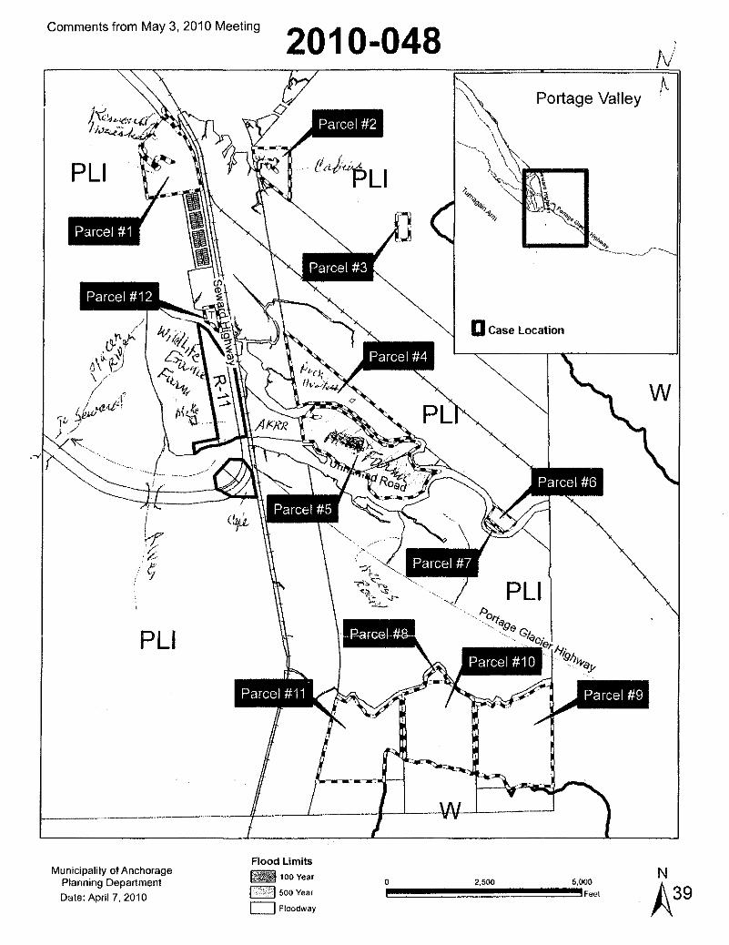
b..,
,v'
w
Portage Valley
PLI
DCase Location
PL
,-I---'----v-v--------
2010-048
,IT,/.,?
PLI
Comments from May 3, 2010 Meeting
I-- +_---L..__
Municipality of AnchoragePlanning Department
Date: April 7, 2010
Flood Limits00IfI100 Year
1<:':k-:~;l 500 Year
c=J Floodway
2.500

Comments from May 3, 2010 Meeting
Turnagain Arm Plan
From: W Redmond [[email protected]]
Sent: Saturday, April 17, 2010 6:07 AM
To: Turnagain Arm Plan
Subject: Case no. 2010-048. Rezoning in Portage Alaska.
MOA Planning & Zoning
RE: Case no. 2010-048. Rezoning in Portage Alaska.
4-15-10
I have wrote before objecting to the 5 acre per dwelling requirement in the Turnagain ArmComp Plan and I just want to reiterate my objection to that requirement. Its great that theMOA planning department wants to preserve the recreational quality of our area, but thereare a lot of us who have been down there for a long time that don't really consider ourarea just Anchorage's recreational play ground.
In talking to Thede Tobish, senior planner for the MOA, I asked him about this issue andhe said that if a person wanted to subdivide into lots smaller than 5 acres, they couldaddress that when they subdivided. The problem with that is once the requirement isestablished, any attempt to subdivide below 5 acres will be like pulling teeth. It will neverhappen. Just like in Indian and Bird it is pretty much set in stone now that you cannotsubdivide below 2.5 acres and it won't happen in Portage either.
Most people understand that there has to be a minimum lot size, but 5 acres per dwellingis completely unnecessary. 2.5 acres per dwelling similar to Indian and Birdcreek is plentybig enough for any kind of water well or sewer system separation, development, orprivacy issues. And its not going to affect the recreational quality of the area especiallysince there is very limited private property available in Portage or the entire MOA. And forthat matter the whole state in locked up into one big recreational area 1/5th the size of thewhole United States so I think that we ought not to get to anal about developing the onelittle corridor in this State that we humans are allowed to exist in.
Sincerely Bill Redmond
40

Comments from May 3, 2010 Meeting
MUNICIPALITY OF ANCHORAGEDevelopment Services Department
Right of Way DivisionPhone: (907) 343-8240 Fax: (907) 343-8250 11
,"0 ,,"'llt S~/.:..." I •.
,.;- ,r.~ ~ , ·•. ·r.
. cpanmcnl'
DATE:
TO:
THRU:
FROM:
SUBJ:
April 6, 2010
Planning Department, Zoning and Platting Division
Jack L. Frost, Jr., Right of Way Supervisor
Lynn MeGee, Senior Plan Reviewer
Comments on Planning and Zoning Commission ease(s) for May 3, 2010.
Right of Way Division has reviewed the following ease(s) due April S, 2010.
10-002 Section 32, T13N R3W, grid 1932(Site Plan Review, Large Retail/Commercial Establishment)Right of Way Division will have comments in the design plan review process.Review time 15 minutes.
,(Rezoning Request, PLI +T to R-11 Turnagain Arm District)Right of Way Division has no comments at this time.Review time 15 minutes.
10-049 East 32nd Avenue, East of Muldoon Road, grid 1641(Site Plan Review, Design Study Report for a Public Roadway.)Clarify why there is no dedicated right of way for the North Y, of East 32nd Avenue forthe section east of the Totem Subdivision parcelWe must determine how the road is allowed to encroach onto private property orwhether easements exist.Review time 30 minutes,
10-050 Amendment to the Hillside Wastewater Management Plan, grid 2434Right of Way Division has no comments at this time.Review time 15 minutes.
10-055 MEA, Lot 1, grid NW0252(Amending a Conditional Use for a Utility Substation)Right of Way Division has no comments at this time.Review time 15 minutes.
S-11143-3 The Terraces, Phase 3A, grid 2634(Time extension for Plat)
41

Comments from May 3, 2010 Meeting
Comments from Project Management & Engineering- Sharen Walsh
for May 3, 2010Planning and Zoning Commission
Page 2 of 2Outside of these comments, PM&E has no objection to this site plan. However, thepetitioner is alerted to the requirement to coordinate submission of a drainage analysisand calculations to PM&E under the land use permit process.
Case 2010-048 - Rezoning to R-11 Turnagain Arm District
PM&E has no objection to the proposed rezone.
Case 2010-058 - Amending a conditional use for a natural resource extraction
PM&E has no objection to the proposed amendment to the conditional use.
2010-048-PortageValleyRezone-PME-Walsh.doc
42

Comments from May 3, 2010 Meeting
SEAN PARNELL, GOVERNOR
DEPARTMENT OF TRANSPORTATION A}@PUBLICFACILITIES
CENTRAL REGION· PLANNING
4111 AVIATION AVENUEP. O. BOX 196900
ANCHORAGE, ALASKA 99519·6900(907) 269·0520 (FAX 269-0521)
(TrY 269·0473)
Jerry Weaver, Platting OfficerMunicipality of AnchorageP,O, Box 196650Anchorage, Alaska 99519-6650
Dear Mr. Weaver:
March 25, 2010RE: MOA Zoning Review
RECEIVEDAPR 0 6 2010
~)lotMchor.~DMsioo
The Alaska Department of Transportation and Public Facilities, ADOT&PF, reviewed thefollowing applications and has no comments:
~~OO'l; -Alaska Industrial Hardware Establishment - Revisedc..~~:O_:~~8iJ...urnagain Arm District Rezoning
;)7J//77'KL~
Area Planner
/aj
..flr(Jl'idln,!;j()J' the safe movement I~rpeople und goods and lhe delivery (!f'stafe services. "
43

Comments from May3, 2010 Meeting
FLOOD HAZARD REVIEW SHEET
Date: 04/02/2010
Case: 2010-048
Flood Hazard Zone: XlA
Map Number: 0761 D
C8J Portions of this lot are located in the floodplain as determined by the FederalEmergency Management Agency.
D Flood Hazard requests that the following be added as a condition of approval:
"Portions of this subdivision are situated within the flood hazard district as it existson the date hereof. The boundaries of the flood hazard district may be alteredfrom time to time in accordance with the provisions of Section 21.60.020(Anchorage Municipal Code). All construction activities and any land use withinthe flood hazard district shall conform to the requirements of Chapter 21.60(Anchorage Municipal Code)."
C8J A Flood Hazard permit is required for any construction in the floodplain.
C8J Other:. I have no objection to the re-zone request
D I have no comments on this case.
Reviewer: Jeffrey Urbanus, CFM
44

Comments from May 3, 2010 Meeting
Gollihugh, Danielle S.
From: Staff, Alton R.Sent: Friday, April 02, 2010 1:30 PMTo: McLaughlin, Francis D.; Gollihugh, Danielle 5.; Stewart, Gloria I.Subject: Platting and Zoning Comments
The Public Transportation Department has no comment on the following short plats:
511143-3511557-3511628-4511728-1511796-1511799-1511800-1511801-1511802-1511803-1511804-1511805-1511806-1
The Public Transportation Department has no comment on the following zoning cases:
Case No. 2010- 0020370471/1049050
Thank you for the opportunity to review.
Alton R. StaffPlanning ManagerPublic Transportation Department3600 Dr. Martin Luther King Jr. Ave.Anchorage, AK 99507907-343-8230
45

Comments from May3. 2010 Meeting
MUNICIPALITY OF ANCHORAGETraffic Department
DATE: March 24, 2010
MEMORANDUM MAR 3 0 2010
1iAu'1lic:III'ildy ofAnchor.Zonlfl1Y DMsioo
TO: Angela Chambers, Acting Division Manager, Zoning and PlattingDivision
FROM: Mada Angell, Assistant Traffic Engineer
SUBJECT: Traffic Engineering Comments for May 3, 2010 Planning &ZoningCommission
S-11143-3 The Terraces" Phase 3A; Southeast corner of Lake Otis Parkwayand East 112' Avenue
Traffic Engineering has no objection to a Time Extension.
2010-002 Portions of Section 32; Site Plan Review for Anchorage IndustrialHardware, corner of Seward Highway and 56th Avenue
• Free standing sign at the corner of Seward Highway and 56'h Avenue must beout of the AASHTO Sight distance Triangle. Place the AASHTO Sight DistanceTriangle on the drawing to accurately place sign.• Ingress/egress at Seward Highway should be moved 70-80 feet south. Adriveway to the south of center would allow for smoother vehicular access into theparking area. A centered driveway that directs traffic towards the main entranceof the building if more likely to create vehicle queuing and pedestrian conflicts.• If the ingress/egress at Seward Highway does not move south then barriercurb end-caps are required to be placed at the inside end of each center-west-sideparking aisles. End caps will maintain adequate queuing space from the SewardHighway into the parking area at the main entrance to the building.• Design and placement of the ingress/ egress at Seward Highway must beapproved by State DOT. Seward Highway is State owned right of way.
(/;~10-048-<, Portage Valley; Rezone from PLI & T to R-11 /Turnagain Arm
Traffic Engineering has no objection to a rezone.
Page 1 of!C\Documents and Settings\pwdsg\LocaJ Settings\Temporary Internet Files\OLKF8\may03 JOpzc.docm
46

Posting Affidavit
47

AFFIDAVIT OF POSTING
Case Number: &/0 -!fS'
I, ---rCu.J.e:l;;b~h ,hereby certify that I have posted a
Notice of Public Hearing as prescribed by Anchorage Municipal Code
21.15.005 on the property that I have petitioned for R~
The notice was posted on _19~( 020/ D which is at least 21 days
prior to the public hearing on this petition. I acknowledge this Notice(s)
must be posted in plain sight and displayed until all public hearings have
been completed.
Affirmed and signed this OZd day of -S:c;~Lr-- ,2010.v
Signature
LEGAL DESCRIPTION
Tract or Lot:Block:Subdivision:
Planning Department
MJ~.t--f.t" ~c0 /r?Less+Z> tIl- :7:<_3~, 3+-Q,,:> S\iIUt\j ffild.. T"'5N Js5t::, 5edirn ofl
48

AFFIDAVIT OF POSTING
Case Number: ~ID- t+1:
I, -rkLrtbt5h ,hereby certify that I have posted a
Notice of Public Hearing as prescribed by Anchorage Municipal Code
21.15.005 on the property that I have petitioned for Fe:h:t>C="-=
The notice was posted on \~ ~1 \lsI:- 3..Dlo which is at least 21 days
prior to the public hearing on this petition. I acknowledge this Notice(s)
must be posted in plain sight and displayed until al/ public hearings have
been completed.
Affirmed and signed this _if!of day of
Signature
LEGAL DESCRIPTION
Tract or Lot: AJ'f-"l.9aJ£l~",,-~-b=- _Block: 4Subdivision: liS SlJQ'4 10,V=\¢.. I ftW, R3E. 1Se~ 3D
Planning Department
49

AFFIDAVIT OF POSTING
Case Number: 00/0 -18:
I, ~=rcbl;;b ,hereby certify that I have posted a
Notice of Public Hearing as prescribed by Anchorage Municipal Code
21.15.005 on the property that I have petitioned for Re~
The notice was posted on -.Ij 4-ts QblO which is at least 21 days
prior to the public hearing on this ~etition. I acknowledge this Notice(s)
must be posted in plain sight and displayed until all public hearings have
been completed.
Affirmed and signed this ~ day of --=-'-f'-":.:.:.L:><=...:.._--' 2010.
Signature
LEGAL DESCRIPTION
Tract or Lot:Block:Subdivision:
Planning Department
50

,2010.
AFFIDAVIT OF POSTING
Case Number: dOLO - t/g
I, U--m6bh ,hereby certify that I have posted a
Notice of Public Hearing as prescribed by Anchorage Municipal Code
21.15.005 on the property that I have petitioned for f1:~
The notice was posted on (q~ BOLD which is at least 21 days
prior to the public hearing on this petition. I acknowledge this Notice(s)
must be posted in plain sight and displayed until all public hearings have
been completed.
Affirmed and signed this c2 d day of --=--Se--,-;f~---
~~Signature
LEGAL DESCRIPTION
Tract or Lot:Block:Subdivision:
Planning Department
51

AFFIDAVIT OF POSTING
Case Number: c2D/O -;fe
I, -r/tel/iJli'h ,hereby certify that I have posted a
Notice of Public Hearing as prescribed by Anchorage Municipal Code
21.15.005 on the property that I have petitioned for ife~
The notice was posted on (Cf ~ aD/o which is at least 21 days
prior to the public hearing on this petition. I acknowledge this Notice(s)
must be posted in plain sight and displayed until all public hearings have
been completed.
Affirmed and signed this
LEGAL DESCRIPTION
day of
Signature
Tract or Lot:Block:Subdivision:
Planning Department
52

Turnagain Arm
Comprehensive Plan
Information
1987 Land Use Plan Map
2010 Land Use Plan Map
53

1987 Turnagain Arm Comprehensive PlanMunicipality 0' AnchorageTurnagain Arm Compr.hemiVft PionApril, 1987
• It
\.
TU/Tlouo in
,IIIHi
-". '
Portage/Twenty Mile River
Land Use Plan
D Environmental Reserve
ResidentialIt~1 single family with 1 dwelling unit per 5.0 acres
D Commercial
-e
Prepored by: CortographiCiSecti04'l, CommunityPlanningDeportment.Municipality of Anchoroge.
Twc-n1y
\\
Mile
'.\
Map 3-4

Q.ea
:::EcCl)ea
Clean.t=CI)Omn.~
'Ccea...J
0.5
r-----l . . 1Dwelling UnHL-...J Smgle Family - per 5 Acres
o Single Fam~y _1 DwellingUnHper 2.5 Acres
_ Rural Homestead
_ Park and Natural Resource
_ Transportation Facility
_ Community Facility
_ Turnagain Mixed Use
_ Industrial
_ Special Study Area
Q:f;T/9Y
'<' e
$/'"(j "~'\=..
(5f '~-'"tff,:' \:,
ft/
o
}'.,}'
~I/f::).~
~~;/cff/y
j!''-------_.-_.._.--------------jL... _ .. _. .. _ .. _ .. . .. _ .. .. _ .. _.
CJ
I
*,••
ChugachNational Forest
<::::;Ow\2
cg
(11(11

A02011-5
Content ID: 009728Type: Ordinance - AO
AN ORDINANCE AMENDING THE ZONING MAP AND PROVIDiNG FOR THEREZONING OF APPROXIMATELY 568 ACRES, FROM PLI (PUBLIC LANDSAND INSTITUTIONS), W (WATERSHED), AND T (TRANSITION) DISTRICTSTO R-11 (TURNAGAIN ARM) DISTRICT, FOR US SURVEY 12192 LOCATEDWITHIN SECTION 30, T9N, R3E, S.M., ALASKA; US SURVEY 11558LOCATED WITHIN SECTION 29, T9N, R2E, S.M., ALASKA; US SURVEY 7012,LOT 2, LOCATED WITHIN SECTION 29, T9N, R3E, S.M., ALASKA; US
T'tl • SURVEY 7012, LOTS 14 & 20, LOCATED WITHIN SECTION 32, T9N, R3E,I e· S.M., ALASKA; US SURVEY 7012, LOTS 12 & 12A, LOCATED WITHIN
SECTION 4, T8N, R3W, S.M., ALASKA; US SURVEY 7012, LOTS 32, 33 (PTN),33 (REM), LOCATED WITHIN SECTION 9, T8N, R3E, S.M., ALASKA; USSURVEY 7012, LOT 34, LOCATED WITHIN SECTION 8, T8N, R3E, S.M.,ALASKA; US SURVEY 3295 LOCATED WITHIN SECTION 21, T9N. R3E, S.M.,ALASKA, GENERALLY LOCATED IN THE VICINITY OF PORTAGE, ALASKA(Portage Valley Community Council) (Planning and Zoning Commission Case2010-048)
Author: perrysu
Initiating PlanningDept:
Description: Portage Valley Rezone to R-11 for 12 parcelsKeywords: Portage Valley Rezone
Date 12/17/103:32 PMPrepared:
DirectorName: Jerry T. Weaver, Jr.
Assembly 1/11/11Meeting Date:
. Public 2/15/11Hearing Date:
'IvvorkflowName 'IA:on 'IAction Iluser 'Security: Content',~, I--'~ 1m,_._.____ . ___..__ ......................_.. .. .....•...-....... I
Clerk_Admin_SubWorkflow 12/29110'U Joy Public11009728
I10:28 I I Maglaqui I :PM: I 1 :
................ J .......... ...... ..I i !
MuniManager_SubWorkflow 12/29/10tProvel Joy . Public 11009728 ,10:28 i IMaglaqUiPM I I :
LegaLSubWorkflow , 12/28/101 Approve. Rhonda 1Public11009728 i111:50 i IWestover:
!AM I I. .Irinan~e_SubWorkflow 12/27/10!Approve] Lucinda. tUbiIC .. 11009728 .
. _w,u.,, ' 3:~5.p~1 ~_", ..u."_,,._._. __.l MahoneyI ... I I
OMB_SubWorkflow 12/23/101 Approve Marilyn Public I 009728 i11:14, •T. ,
I,
AM II 1Banzh"f!- --~.""-. __ ._._} -,,----------',-
Commun Dev SubWorkflow!12;~~~tprovej
Jerry tbliC11009728:- - i WeaverI Jr.,.,.••...__•____________ ·_·,, ___•____ ~M"_·,._ •••·..••..•.•___•__..___~
Planning_SubWorkflow ,12/171101 Approve]Jerry Public r09728
•.: 4:27 PM1 , Weaver I I.__. J. ....1 ........JJr. ......
_~_•._ _ ~_""_~_w~._'.m.·~'
.. __,___ "'__ ,', .. ,.J
1~II~rdinan::o:flo=. J~~1r~~llcheckinl Susan 'lpUbllC .11009728 ,Perry
CONSENT AGENDA - INTRODUCTION