appendix b region 6 country and regional profiles of...
TRANSCRIPT

This profile and the data therein should not be used in place of focussed assessments and information provided by local monitoring and research institutions.
Appendix B – Region 6
Country and regional profiles of volcanic hazard and risk:
Indonesia
S.K. Brown1, R.S.J. Sparks1, K. Mee2, C. Vye-Brown2, E.Ilyinskaya2, S.F. Jenkins1, S.C. Loughlin2*
1University of Bristol, UK; 2British Geological Survey, UK, * Full contributor list available in Appendix B Full Download
This download comprises the profiles for Region 6: Indonesia only. For the full report and all regions
see Appendix B Full Download. Page numbers reflect position in the full report. The following
countries are profiled here:
Region 6 Indonesia Pg.342
India 349
Indonesia 356
Malaysia 366
Brown, S.K., Sparks, R.S.J., Mee, K., Vye-Brown, C., Ilyinskaya, E., Jenkins, S.F., and Loughlin, S.C. (2015) Country and regional profiles of volcanic hazard and risk. In: S.C. Loughlin, R.S.J. Sparks, S.K. Brown, S.F. Jenkins & C. Vye-Brown (eds) Global Volcanic Hazards and Risk, Cambridge: Cambridge University Press.

This profile and the data therein should not be used in place of focussed assessments and information provided by local monitoring and research institutions.
Region 6: Indonesia
Figure 6.1 The distribution of Holocene volcanoes through the Melanesia and Australia region. The capital cities of the constituent countries are shown.
Description
Region 6, Indonesia, comprises volcanoes distributed throughout Indonesia itself, the Indian
Andaman Islands in the north of the Indonesian arc, and one volcano in Malaysia.
Country Number of volcanoes
India 2 + 1 from Region 3 Indonesia 142 Malaysia 1
Table 6.1 The countries represented in this region and the number of volcanoes. Volcanoes located on the borders between countries are included in the profiles of all countries involved. Note that countries may be represented in more than one region, as overseas territories may be widespread.
About 80% of this region’s volcanoes are situated in the Sunda Arc, stretching from north-west
Sumatra to the Banda Sea, east of Papua New Guinea. This arc results from the subduction of the
Indo-Australian Plate beneath the Eurasian Plate. The remaining volcanoes, on either end of this arc
result from more complex tectonic interactions. The Andaman Islands in the north result from short
spreading centres. The Banda Arc, at the southern end of the Sunda Arc and turning back towards
Borneo, results broadly from the subduction of the Pacific crust. Multiple subduction zones and

343
micro-plates north of this produce the Sulawesi-Sangihe volcanoes and Halmahera volcanoes in
roughly north-south lineaments on either side of the collision zone. About 79% of volcanoes in this
region are stratovolcanoes or other large-cone types, and 10% are calderas. This and the dominantly
andesitic composition of volcanism here are associated with explosive activity.
Records of large magnitude eruptions date back into the Pleistocene, with 8 volcanoes having
Pleistocene records of VEI ≥4 eruptions. The largest eruption recorded globally during the
Quaternary (the last 2.5 million years), is recorded in this region. The Younger Toba Tuff eruption of
Toba in Indonesia occurred 74,000 years ago. This was a magnitude 8.8 eruption which produced
extensive pyroclastic flows and voluminous ashfall.
Despite records of large events extending back millennia, most activity in this region is under-
recorded. 145 Holocene volcanoes are located in this region, with records of 1,277 confirmed
Holocene eruptions. However, of these, 1,203 eruptions (94%) are recorded in historical times,
illustrating that the eruptive activity prior to 1500 AD is relatively poorly known. Indeed, 96% of
eruptions in this region are recorded through historical observations. Whilst recent activity is very
well documented, the absence of comprehensive eruptive histories back in time makes assessment
of hazard and full understanding of activity difficult and associated with significant uncertainties.
There may be unrecognised volcanoes or volcanoes with long-recurrence periods of large activity
that pose particular hazards.
Activity ranges from small to extremely large explosive eruptions in this region. Small VEI 2 eruptions
dominant the record, however the history indicates that moderate to large explosive eruptions of
VEI ≥3 occur roughly every 15 years. A large number of historical eruptions (10%) have produced
pyroclastic flows and many have resulted in lahars.
This is a very populous region, dominated by the large population of Indonesia. Over 8.6 million
people live within 10 km of one or more Holocene volcano, the highest of any region. Direct hazards
such as lava flows and pyroclastic flows can commonly extend over this distance. Over 180 million
people live within 100 km of one or more volcano. About 31% of classified volcanoes (18) are
deemed at Risk Level III, due to the combination of high hazard and high local population. Largely
due to this high proximal population, a large number of eruptions have resulted in fatalities (roughly
10% of historical events). However comprehensive monitoring now undertaken in Indonesia has led
to a good record of evacuations prior to eruption. Regular monitoring is undertaken at many of the
regions volcanoes, with focussed dedicated monitoring at many of the volcanoes of highest risk.
Volcano Facts
Number of Holocene volcanoes 145
Number of Pleistocene volcanoes with M≥4 eruptions 8
Number of volcanoes generating pyroclastic flows 33 (153 eruptions)
Number of volcanoes generating lahars 31 (108 eruptions)
Number of volcanoes generating lava flows 39 (176 eruptions)
Number of eruptions with fatalities 125
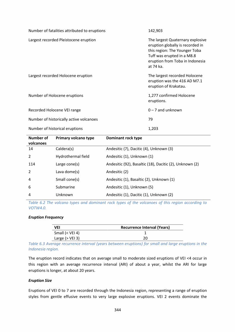
344
Number of fatalities attributed to eruptions 142,903
Largest recorded Pleistocene eruption The largest Quaternary explosive eruption globally is recorded in this region: The Younger Toba Tuff was erupted in a M8.8 eruption from Toba in Indonesia at 74 ka.
Largest recorded Holocene eruption The largest recorded Holocene eruption was the 416 AD M7.1 eruption of Krakatau.
Number of Holocene eruptions 1,277 confirmed Holocene eruptions.
Recorded Holocene VEI range 0 – 7 and unknown
Number of historically active volcanoes 79
Number of historical eruptions 1,203
Number of volcanoes
Primary volcano type Dominant rock type
14 Caldera(s) Andesitic (7), Dacitic (4), Unknown (3)
2 Hydrothermal field Andesitic (1), Unknown (1)
114 Large cone(s) Andesitic (92), Basaltic (18), Dacitic (2), Unknown (2)
2 Lava dome(s) Andesitic (2)
4 Small cone(s) Andesitic (1), Basaltic (2), Unknown (1)
6 Submarine Andesitic (1), Unknown (5)
4 Unknown Andesitic (1), Dacitic (1), Unknown (2)
Table 6.2 The volcano types and dominant rock types of the volcanoes of this region according to VOTW4.0.
Eruption Frequency
VEI Recurrence Interval (Years)
Small (< VEI 4) 1 Large (> VEI 3) 20
Table 6.3 Average recurrence interval (years between eruptions) for small and large eruptions in the Indonesia region.
The eruption record indicates that on average small to moderate sized eruptions of VEI <4 occur in
this region with an average recurrence interval (ARI) of about a year, whilst the ARI for large
eruptions is longer, at about 20 years.
Eruption Size
Eruptions of VEI 0 to 7 are recorded through the Indonesia region, representing a range of eruption
styles from gentle effusive events to very large explosive eruptions. VEI 2 events dominate the

345
record, with nearly 70% of all Holocene eruptions classed as such. Just under 3% of eruptions here
are explosive at VEI ≥4.
Figure 6.2 Percentage of eruptions in this region recorded at each VEI level; the number of eruptions is also shown. The percentage is of total eruptions with recorded VEI. A further 73 eruptions were recorded with unknown VEI.
Socio-Economic Facts
Total population (2011) 1,463,514,556
Gross Domestic Product (GDP) per capita (2005 PPP $) 3,203 – 13,672
(Mean 6,990)
Gross National Income (GNI) per capita (2005 PPP $) 3,285 – 13,676
(Mean 7,038)
Human Development Index (HDI) (2012) 0.554 – 0.769 (Medium to High, Mean 0.651 Medium)
Population Exposure
Number (percentage) of people living within 10 km of a Holocene volcano
8,631,561 (0.59 %)
Number (percentage) of people living within 30 km of a Holocene volcano
68,995,316 (4.71 %)
Number (percentage) of people living within 100 km of a Holocene volcano
180,040,137 (12.30 %)
346
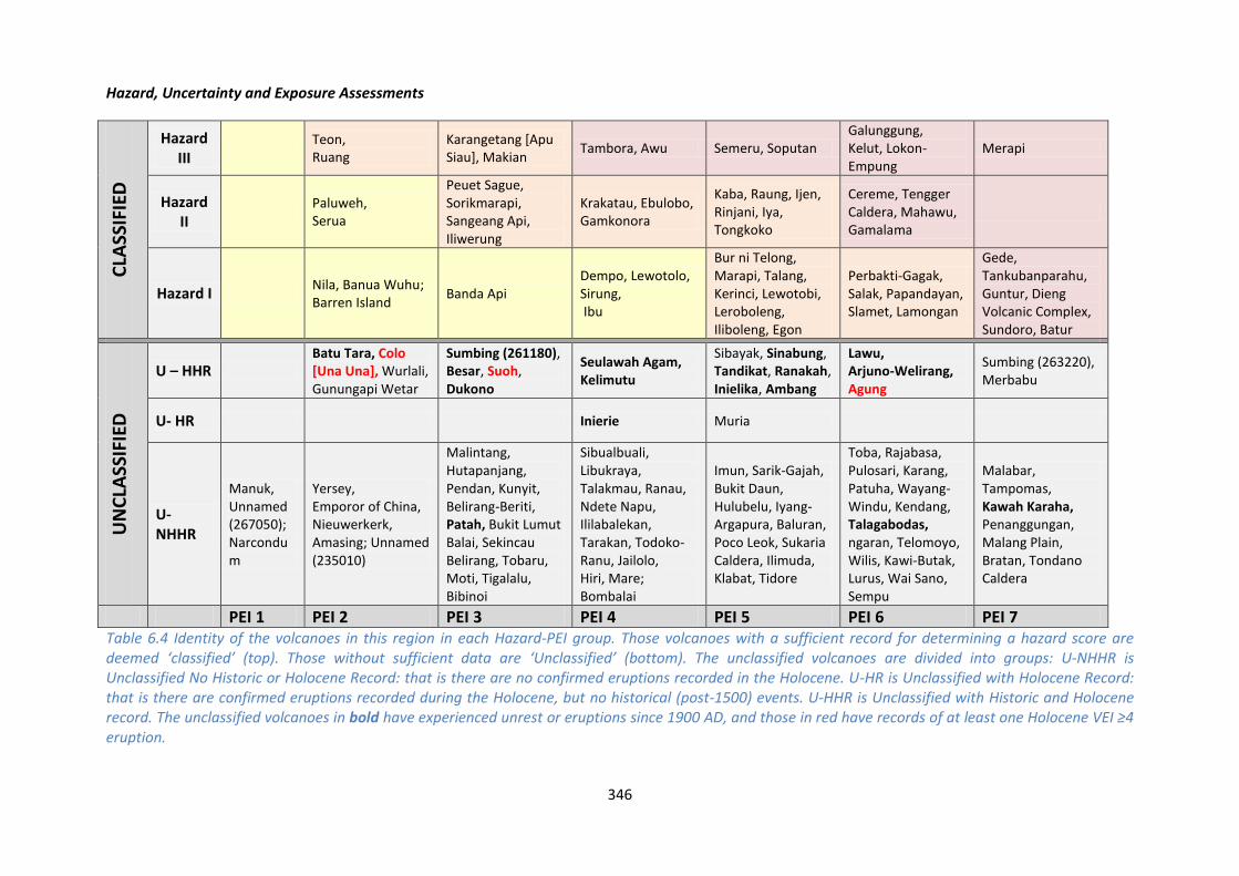
Hazard, Uncertainty and Exposure Assessments
CLA
SSIF
IED
Hazard
III
Teon, Ruang
Karangetang [Apu Siau], Makian
Tambora, Awu Semeru, Soputan Galunggung, Kelut, Lokon-Empung
Merapi
Hazard II
Paluweh, Serua
Peuet Sague, Sorikmarapi, Sangeang Api, Iliwerung
Krakatau, Ebulobo, Gamkonora
Kaba, Raung, Ijen, Rinjani, Iya, Tongkoko
Cereme, Tengger Caldera, Mahawu, Gamalama
Hazard I Nila, Banua Wuhu; Barren Island
Banda Api Dempo, Lewotolo, Sirung, Ibu
Bur ni Telong, Marapi, Talang, Kerinci, Lewotobi, Leroboleng, Iliboleng, Egon
Perbakti-Gagak, Salak, Papandayan, Slamet, Lamongan
Gede, Tankubanparahu, Guntur, Dieng Volcanic Complex, Sundoro, Batur
UN
CLA
SSIF
IED
U – HHR Batu Tara, Colo [Una Una], Wurlali, Gunungapi Wetar
Sumbing (261180), Besar, Suoh, Dukono
Seulawah Agam, Kelimutu
Sibayak, Sinabung, Tandikat, Ranakah, Inielika, Ambang
Lawu, Arjuno-Welirang, Agung
Sumbing (263220), Merbabu
U- HR Inierie Muria
U- NHHR
Manuk, Unnamed (267050); Narcondum
Yersey, Emporor of China, Nieuwerkerk, Amasing; Unnamed (235010)
Malintang, Hutapanjang, Pendan, Kunyit, Belirang-Beriti, Patah, Bukit Lumut Balai, Sekincau Belirang, Tobaru, Moti, Tigalalu, Bibinoi
Sibualbuali, Libukraya, Talakmau, Ranau, Ndete Napu, Ililabalekan, Tarakan, Todoko-Ranu, Jailolo, Hiri, Mare; Bombalai
Imun, Sarik-Gajah, Bukit Daun, Hulubelu, Iyang-Argapura, Baluran, Poco Leok, Sukaria Caldera, Ilimuda, Klabat, Tidore
Toba, Rajabasa, Pulosari, Karang, Patuha, Wayang-Windu, Kendang, Talagabodas, ngaran, Telomoyo, Wilis, Kawi-Butak, Lurus, Wai Sano, Sempu
Malabar, Tampomas, Kawah Karaha, Penanggungan, Malang Plain, Bratan, Tondano Caldera
PEI 1 PEI 2 PEI 3 PEI 4 PEI 5 PEI 6 PEI 7 Table 6.4 Identity of the volcanoes in this region in each Hazard-PEI group. Those volcanoes with a sufficient record for determining a hazard score are deemed ‘classified’ (top). Those without sufficient data are ‘Unclassified’ (bottom). The unclassified volcanoes are divided into groups: U-NHHR is Unclassified No Historic or Holocene Record: that is there are no confirmed eruptions recorded in the Holocene. U-HR is Unclassified with Holocene Record: that is there are confirmed eruptions recorded during the Holocene, but no historical (post-1500) events. U-HHR is Unclassified with Historic and Holocene record. The unclassified volcanoes in bold have experienced unrest or eruptions since 1900 AD, and those in red have records of at least one Holocene VEI ≥4 eruption.

347
Population Exposure Index
Number of volcanoes Population Exposure Index
16 7 30 6 34 5 24 4 23 3 15 2 3 1
Table 6.5 The number of volcanoes in the Indonesia region classed in each PEI category.
Risk Levels
Number of Volcanoes Risk Level
18 III 30 II 10 I 87 Unclassified
Table 6.6 The number of volcanoes in the Indonesia region classified at each Risk Level.
Figure 6.3 Distribution of the classified volcanoes of this region across Hazard and Population Exposure Index levels. The warming of the background colours illustrates increasing Risk levels from Risk Level I - III..

348
Regional Monitoring Capacity
Figure 6.4 The monitoring and risk levels of the historically active volcanoes in the Indonesia region. Monitoring Level 1 indicates no known dedicated ground-based monitoring; Monitoring Level 2 indicates that some ground-based monitoring systems are in place including ≤3 seismic stations; Monitoring Level 3 indicates the presence of a dedicated ground-based monitoring network, including ≥4 seismometers

This profile and the data therein should not be used in place of focussed assessments and information provided by local monitoring and research institutions.
India
Note that we include the Indian unnamed submarine volcano located east of Chennai here
(uncertain presence, see below), which is included in the Region 3 “Middle East and Indian Ocean”
description as defined in this region by the Global Volcanism Program.
Description
Figure 6.5 Location of India’s volcanoes, the capital and largest cities. A zone extending 200 km beyond the country's borders shows other volcanoes whose eruptions may directly affect India.
There are three Indian Holocene volcanoes listed in VOTW4.0. Barren Island and Narcondam
(Narcondum) are stratovolcanoes located in the Andaman Islands in the north of the volcanic arc
stretching through Sumatra. These two volcanoes are broadly related to the subduction of the Indian
Plate under the Eurasian Plate. An unnamed submarine volcano is recorded off the south-east coast
of India by the Pondicherry coast, however the existence of this volcano is uncertain. The presence
this volcano is indicated by a report from 1757 of phenomena suggestive of submarine volcanism,
however this is unconfirmed.
Of the three volcanoes, only Barren Island has confirmed activity recorded in the Holocene. The
unnamed volcano and Narcondam are suspected to have had Holocene activity. Barren Island has
been frequently active in historical times, with 11 eruptions from 1787 to 2010 of VEI 2. No

350
eruptions greater than VEI2 are recorded, suggesting dominantly effusive to moderately explosive
activity, however deposits are identified which suggest a history of large explosive eruptions
generating pyroclastic flows back into the Pleistocene. Large explosive eruptions often have long
recurrence intervals and may occur again in the future.
Both Barren Island and Narcundam form small, uninhabited islands of less than 5 km across. There is
no permanent infrastructure or population on these islands, with the exception of a permanent
police outpost on Narcondam manned by 10-20 personnel at any given time. Barren Island is classed
at Hazard Level I, based on its historical record. The population may increase in the future, as a
permanent field base is proposed for Barren Island to permit studies of the volcano and the
potential as a site for geotourism is considered in Sheth et al. (2010).
One GPS monitoring system and seismograph has been installed on Barren Island by the National
Geophysical Research Institute, though no other dedicated ground-based monitoring is in operation
at any other Holocene volcano in India. The Geological Survey of India are the responsible
organisation for providing information and monitoring in times of activity, and indeed have
responded to past eruptions sending field parties to investigate activity. The Indian Coast Guard
located at Port Blair in the Andaman Islands reports activity of Barren Island, but not regularly.
The Asian Disaster Reduction Center (ADRC) produced a report on the hazards in India in 2012, with
a further five such reports dating back to 1998. In this they do not consider volcanic hazards. They
describe how India has moved from a system of reactive relief efforts to proactive risk reduction,
particularly in relation to the seismic hazard. The ADRC discuss how a Disaster Mitigation Fund and
Disaster Response Fund are provided for following the enactment of the Disaster Management Act
2005 and provides for the establishment of Disaster Management Authorities on several levels –
National (NDMA), State (SDMA) and District (DDMA). For full details of the disaster management and
preparedness see the ADRC report.
See also:
Ray, J. S., Pande, K., and Awasthi, N. (2013) A minimum age for the active Barren Island volcano,
Andaman Sea. Current Science, 104:7.
Sheth, H.C., Ray, J.S., Bhutani, R., Kumar, A., and Awasthi, N. (2010) The latest (2008 - 09) eruption of
Barren Island volcano, and some thoughts on its hazards, logistics and geotourism aspects. Current
Science, 98:5.
Asian Disaster Reduction Center: India:
www.adrc.asia/nationinformation.php?NationCode=356&Lang=en&NationNum=02
Volcano Facts
Number of Holocene volcanoes 3
Number of Pleistocene volcanoes with M≥4 eruptions -
Number of volcanoes generating pyroclastic flows -

351
Number of volcanoes generating lahars -
Number of volcanoes generating lava flows 1
Number of fatalities caused by volcanic eruptions -
Tectonic setting The submarine volcano is located in an intra-plate setting whilst the large cones are in a subduction zone
Largest recorded Pleistocene eruption -
Largest recorded Holocene eruption There are 11 eruptions recorded at VEI 2 from Barren Island between 1787 and 2010 AD.
Number of Holocene eruptions 12 confirmed eruptions. 3 uncertain eruptions.
Recorded Holocene VEI range 2 and Unknown
Number of historically active volcanoes 1
Number of historical eruptions 11
Number of
volcanoes
Primary volcano type Dominant rock type
2 Large cone(s) Andesitic (1), Basaltic (1)
1 Submarine Unknown (1)
Table 6.7 The number of volcanoes in India, their volcano type classification and dominant rock type according to VOTW4.0.
Socio-Economic Facts
Total population (2012) 1,238,700,000
Gross Domestic Product (GDP) per capita (2005 PPP $) 3,203
Gross National Income (GNI) per capita (2005 PPP $) 3,285
Human Development Index (HDI) (2012) 0.554 (Medium)
Population Exposure
Capital city New Delhi
Distance from capital city to nearest Holocene volcano 811.6 km

352
Total population (2011) 1,189,172,906
Number (percentage) of people living within 10 km of a Holocene volcano
278 (<1%)
Number (percentage) of people living within 30 km of a Holocene volcano
278 (<1%)
Number (percentage) of people living within 100 km of a Holocene volcano
893,001 (<1%)
Largest cities, as measured by population and their population size:
Mumbai 12,691,836
Delhi 10,927,986
Bangalore 5,104,047
Kolkata 4,631,392
Chennai 4,328,063
Ahmadabad 3,719,710
Hyderabad 3,597,816
Pune 2,935,744
Kanpur 2,823,249
Jaipur 2,711,758
Infrastructure Exposure
The Indian volcanoes of Narcondam and Barren Island lie in the Andaman Islands. Both islands
measure less than 5 km across, therefore the entirety of these are exposed to volcanic hazards,
however no permanent settlements or infrastructure exist here. The 100 km radius of Barren Island
marginally encroaches on the much larger and inhabited Smith Island. An airport at Port Blair, the
capital of the Andaman and Nicobar Islands, is located about 135 km from Barren Island.
Number of airports within 100 km of a volcano 0
Number of ports within 100 km of a volcano 0
Total length of roads within 100 km of a volcano (km) 0
Total length of railroads within 100 km of a volcano (km) 0

353
Figure 6.6 The location of India’s volcanoes in the Andaman Islands and the extent of the 100 km zone surrounding them. Ports, airports and the major cities are just some of the infrastructure that may be exposed to volcanic hazards.
Hazard, Uncertainty and Exposure Assessments
Of the three Indian volcanoes, only Barren Island has a sufficiently detailed eruption record for
calculation of the hazard. This volcano is characterised by lava flow production and eruptions of VEI
2 and is classed at Hazard Level I.
Narcondam and an unnamed volcano are unclassified, as no confirmed eruptions are recorded
during the Holocene.
All volcanoes in India are classed at PEI 1 and 2, with only small populations within 100 km.
Narcondam has no permanent population living within this distance however there is a police
outpost with 10 to 20 personnel at any given time. The low PEI of Narcondam suggests low risk.
Barren Island is classified at Risk Level I.

354
CLA
SSIF
IED
Hazard III
Hazard II
Hazard I
Barren Island
UN
CLA
SSIF
IED
U – HHR
U- HR
U- NHHR
Narcondam Unnamed (235010)
PEI 1 PEI 2 PEI 3 PEI 4 PEI 5 PEI 6 PEI 7 Table 6.8 Identity of India’s volcanoes in each Hazard-PEI group. Those volcanoes with a sufficient record for determining a hazard score are deemed ‘Classified’ (top). Those without sufficient data are ‘Unclassified’ (bottom). The unclassified volcanoes are divided into groups: U-NHHR is Unclassified No Historic or Holocene Record: that is there are no confirmed eruptions recorded in the Holocene. U-HR is Unclassified with Holocene Record: that is there are confirmed eruptions recorded during the Holocene, but no historical (post-1500) events. U-HHR is Unclassified with Historic and Holocene record. The unclassified volcanoes in bold have experienced unrest or eruptions since 1900 AD, and those in red have records of at least one Holocene VEI ≥4 eruption.
Volcano Population Exposure Index Risk Level
Barren Island 2 I
Table 6.9 Classified volcanoes of India ordered by descending Population Exposure Index (PEI). Risk levels determined through the combination of the Hazard Level and PEI are given. Risk Level I – 1 volcano; Risk Level II – 0 volcanoes; Risk Level III – 0 volcanoes.

355
Figure 6.7 Distribution of India’s classified volcanoes across Hazard and Population Exposure Index levels. The warming of the background colours illustrates increasing Risk levels from Risk Level I - III.
National Capacity for Coping with Volcanic Risk
One GPS station and a seismograph have been installed on Barren Island, but with no real-time data
transmission. These have been installed and are operated by the National Geophysical Research
Institute.
Figure 6.8 The monitoring and risk levels of the historically active volcanoes in India. Monitoring Level 1 indicates no known dedicated ground-based monitoring; Monitoring Level 2 indicates that some ground-based monitoring systems are in place including ≤3 seismic stations; Monitoring Level 3 indicates the presence of a dedicated ground-based monitoring network, including ≥4 seismometers.

This profile and the data therein should not be used in place of focussed assessments and information provided by local monitoring and research institutions.
Indonesia
Description
Figure 6.9 Location of Indonesia’s volcanoes, the capital and largest cities. A zone extending 200 km beyond the country's borders shows other volcanoes whose eruptions may directly affect Indonesia.
The Smithsonian’s Volcanoes of the World 4.0 database records 142 Holocene volcanoes distributed
throughout much of Indonesia. Of these, 77 have a record of historical eruptions. Indonesia as a
country and volcanic region covers a vast area, formed of over 13,000 islands stretching 5,271 km
east-west and 2,210 km north-south. Volcanoes are spread across Java, Sumatra, Bali, Molluca, Nusa
Tenggara and are located in the Celebes seas. The majority of these volcanoes lie along the Sunda
Arc, caused by subduction of the Indo-Australia Plate below the Eurasian Plate. The Arc stretches
over 3,000 km from northwest Sumatra in the east to the Banda Sea in the west, and accounts for
108 (76%) of the country’s volcanoes. The tectonic setting north of the Sunda Arc is more complex,
with converging plate fragments west of the Pacific Plate which itself is subducting to the west,
creating multiple subduction zones that give rise to the volcanoes of Halmahera and Sulawesi-
Sangihe. A wide range of volcano types are present in Indonesia, however stratovolcanoes are the
dominant form with a dominantly andesitic composition.

357
The density of active volcanoes in Indonesia means that eruptions are frequent. 1,265 eruptions are
recorded through the Holocene in VOTW4.22.94% of these are recorded post-1500 AD, indicating
good historical records and severe under-recording with increasing age. Holocene eruptions of VEI 0
– 7 are recorded, indicating a range of activity styles from small, effusive events to catastrophic
explosive eruptions. These large explosive eruptions are recorded back into the Pleistocene, with 8
Indonesian volcanoes with records of M≥4 eruptions, including the largest eruption recorded in the
Pleistocene worldwide: the M8.8 Younger Toba Tuff eruption at Toba about 74,000 years ago. The
Tambora eruption of 1815 is the largest magnitude historical eruption worldwide.
The widespread distribution of volcanoes throughout Indonesia means that much of the country lies
within the 100 km radii of these Holocene volcanoes. Nearly 80% of the population live within these
radii and much of the critical infrastructure is exposed, with many of the largest cities, including the
capital, Jakarta, falling within this distance. Indeed, Jakarta lies within about 65 km of three
Holocene volcanoes, Gede, Salak and Perbakti-Gagak, all of which have had eruptions as recently as
the 1900s. Densely populated rural communities, particularly on Java, further increase population
exposure; 28 of Indonesia’s volcanoes have over 100,000 people living within 10 km of their
summits, with over 8.6 million living at this distance throughout Indonesia. Ninety-one volcanoes
have over 100,000 living within 30 km.
A range of hazards are posed by Indonesia’s volcanoes, with many volcanoes hosting explosive
eruptions. Thirty volcanoes have produced pyroclastic flows during 115 historical eruptions, and 31
have produced lahars during 102 historical eruptions. Hazard classifications range from Level I to III,
and nearly 60% of Indonesian volcanoes have considerable uncertainties associated with the
assignment of the hazard levels and are therefore unclassified here. Of the classified volcanoes in
Indonesia, 18 are classed as Risk Level III, due to the high hazard and high local populations.
Three events, at Tambora in 1815, Krakatau in 1883, and Kelut in 1919, stand out in terms of
devastating loss of life and these three events alone account for roughly a fifth of historic fatalities
from worldwide volcanism. The largest historical eruption, the VEI 7 eruption of Tambora in 1815,
caused approximately 60,000 deaths. Direct deaths resulted from tsunamis, bomb impacts, tephra
falls, and pyroclastic flows that reached all but the west coast, with roughly 50,000 indirect deaths
on Sumbawa and Lombok islands owing to starvation following the destruction of farmland. The
caldera collapse eruption of Krakatau, situated in the Sunda Strait between Java and Sumatra, in
1883 was the second largest during historical time in Indonesia (after that of Tambora). The VEI 6
eruption destroyed Krakatau island, triggering tsunamis that swept the coastlines of Sumatra and
Java and killed approximately 34,000; further deaths resulted from pyroclastic surges that travelled
40 km across the Sunda Strait to the coast of Sumatra. Kelut, a stratovolcano on west Java, highlights
the potential hazard posed by crater lakes. Kelut’s often short but violent eruptions have frequently
released volumes of water from the crater lake that generate devastating lahars; lahars following the
VEI 4 event in 1919 claimed 5,110 lives, and destroyed 9,000 homes and 104 villages. Tunnels
draining the crater lake have been engineered to decrease this hazard. The February 2014 VEI 4
eruption of Kelut resulted in lahars following heavy rainfall. The CVGHM (Center for Volcanology and
Geological Hazard Mitigation) monitors Kelut and from increases in seismicity, crater lake
temperature and inflation were able to raise the alert level and evacuate many from a 10 km radius
prior to this eruption.

358
An eruption of Merapi, beginning in October and November 2010, is one of Indonesia’s most recent
volcanic crises. The CVGHM raised the alert level to its highest possible on 25th October 2010, and
recommended immediate evacuation for communities within a 10 km radius of the volcano
(between 11,000 and 19,000 people). A day later, an explosive eruption generating pyroclastic flows
began; on 27th October, reports noted roughly twenty-five deaths and several more injured. The
eruption continued throughout November, with further pyroclastic flows and avalanches, and a
particularly violent explosion on 5th November; ash caused diversions and cancellations at Solo and
Yogyakarta airports. Activity began to decline in early December, with the CVGHM reducing the alert
level to 3 (on a scale of 1 to 4) on 4th December, and to 2 on 9th January 2011. The overall death toll
exceeded 380, over 400,000 people were temporarily evacuated, and financial losses were
estimated at Rp 7.1 trillion (approximately US$781 million). Lahars are an ongoing hazard.
The CVGHM was founded in 1920 to monitor the Indonesian volcanoes. CVGHM is part of the
Ministry of Energy and Mineral Resources and is funded by the Indonesian government. Of a staff of
over 220, about 70% have experience of responding to an eruption. The CVGHM has a number of
volcano observatories distributed throughout Indonesia, responsible for monitoring the volcanoes
and collecting data. Members of the public are encouraged to report unusual signs at volcanoes to
CVGHM. Monitoring is undertaken at 68 volcanoes, all with at least one seismic station. Many of the
high risk volcanoes have multiple seismic stations and other monitoring systems in place. Those
monitored have baseline seismic data available which permits observations of unusual activity. Not
all volcanoes in Indonesia are continuously monitored, however CVGHM has plans and some
resources available to respond to an increase in activity at currently unmonitored volcanoes.
The CVGHM categorise Indonesia’s volcanoes using a different classification system to that used in
this report. The CVGHM consider 127 volcanoes to be active. These are classified into three groups:
Type A volcanoes have had magmatic eruptions since 1600, Type B volcanoes had eruptions before
1600, and Type C volcanoes only exhibit fumarolic activity. The CVGHM focuses monitoring efforts at
the Type A volcanoes, with 68 out of 77 of these volcanoes have continuous monitoring with at least
one seismometer.
The CVGHM have a set protocol for responding to an increase in activity and they inform the local
government, the BNPB (the National Disaster Management Agency) and BPBD (the Local Disaster
Management Agency), local authorities and the population located in the hazard area. The CVGHM
also communicates observations and advice to multiple agencies including the Indonesian National
Armed Forces, National Police, Ministry of Transportation, Ministry of Health and Ministry of Social
Affairs. The CVGHM are responsible for providing risk assessments and declaring alerts, with regular
communication of the alert levels.
See also:
CVGHM: www.vsi.esdm.go.id/
Volcano Facts
Number of Holocene volcanoes 142

359
Number of Pleistocene volcanoes with M≥4 eruptions 8
Number of volcanoes generating pyroclastic flows 33
Number of volcanoes generating lahars 31
Number of volcanoes generating lava flows 38
Number of fatalities caused by volcanic eruptions ?>142,903
Tectonic setting 142 subduction zone
Largest recorded Pleistocene eruption The M8.8 eruption of the Younger Toba Tuff from Toba at 74 ka.
Largest recorded Holocene eruption The M7.1 eruption of Krakatau in 416 AD.
Number of Holocene eruptions 1265 confirmed eruptions. 121 uncertain eruptions.
Recorded Holocene VEI range 0 – 7 and unknown
Number of historically active volcanoes 77
Number of historical eruptions 1,192
Number of
volcanoes
Primary volcano type Dominant rock type
14 Caldera(s) Andesitic (7), Dacitic (4), Unknown (3)
2 Hydrothermal field Andesitic (1), Unknown (1)
112 Large cone(s) Andesitic (91), Basaltic (17), Dacitic (2), Unknown (2)
2 Lava dome(s) Andesitic (2)
3 Small cone(s) Andesitic (1), Basaltic (1), Unknown (1)
5 Submarine Andesitic (1), Unknown (4)
4 Unknown Andesitic (1), Dacitic (1), Unknown (2)
Table 6.10 The number of volcanoes in Indonesia, their volcano type classification and dominant rock type according to VOTW4.0.
Socio-Economic Facts
Total population (2012) 247,273,000
Gross Domestic Product (GDP) per capita (2005 PPP $) 4,094
Gross National Income (GNI) per capita (2005 PPP $) 4,154
Human Development Index HDI) (2012) 0.629 (Medium)

360
Population Exposure
Capital city Jakarta
Distance from capital city to nearest Holocene volcano 65.6 km
Total population (2011) 245,613,043
Number (percentage) of people living within 10 km of a Holocene volcano
8,631,283 (3.5%)
Number (percentage) of people living within 30 km of a Holocene volcano
68,995,038 (28.1%)
Number (percentage) of people living within 100 km of a Holocene volcano
179,107,855 (72.9%)
Ten largest cities, as measured by population and their population size:
Jakarta 8,540,121
Surabaja 2,374,658
Medan 1,750,971
Bandung 1,699,719
Palembang 1,441,500
Makassar 1,321,717
Semarang 1,288,084
Tanjungkarang-Telukbetung 800,348
Yogyakarta 636,660
Bandjermasin 572,837
Infrastructure Exposure
Number of airports within 100 km of a volcano 10
Number of ports within 100 km of a volcano 41
Total length of roads within 100 km of a volcano (km) 11,312
Total length of railroads within 100 km of a volcano (km) 3,178
The numerous Indonesian volcanoes are distributed throughout the country, placing much of the
country within 100 km of these volcanoes. This means that an extensive proportion of the
population and major cities, including the capital Jakarta, are exposed to volcanic hazards. Much of
the critical infrastructure lies within the 100 km radii, including numerous airports and international
airports, and over 40 ports. An extensive road and rail network is also exposed.

361
Figure 6.10 The location of Indonesia’s volcanoes and the extent of the 100 km zone surrounding them. Ports, airports and the major cities are just some of the infrastructure that may be exposed to volcanic hazards.
Hazard and Uncertainty Assessments
The volcanoes of Indonesia have varying levels of data available in the eruption record. Just over
40% of volcanoes have appropriate eruptive histories to define the hazard. Of these classified
volcanoes 54 are ‘active’ having had eruptions since 1900. Three classified volcanoes are ‘semi-
active’, with historical eruptions between 1500 and 1900 and unrest recorded above background
levels since 1900 (Guntur, Lamongan and Tongkoko). The classified volcanoes are classed at all three
hazard levels: 26 at Hazard Level I, 19 at Hazard Level II and 12 at Hazard Level III.
Of the unclassified volcanoes, 13 have experienced eruptions since 1900; a further 10 have had
Holocene age eruptions and 62 have had no confirmed Holocene eruptions. Thirty-six unclassified
volcanoes have fumarolic activity ongoing or recorded since 1900, however seven of these have
exhibited periods of unrest since 1900 in which fumarolic emissions, seismicity or other activity has
been above background levels.

362
Exposure Assessments
CLA
SSIF
IED
Hazard
III
Teon, Ruang
Karangetang [Apu Siau], Makian
Tambora, Awu Semeru, Soputan Galunggung, Kelut, Lokon-Empung
Merapi
Hazard II
Paluweh, Serua
Peuet Sague, Sorikmarapi, Sangeang Api, Iliwerung
Krakatau, Ebulobo, Gamkonora
Kaba, Raung, Ijen, Rinjani, Iya, Tongkoko
Cereme, Tengger Caldera, Mahawu, Gamalama
Hazard I Nila, Banua Wuhu Banda Api Dempo, Lewotolo, Sirung, Ibu
Bur ni Telong, Marapi, Talang, Kerinci, Lewotobi, Leroboleng, Iliboleng, Egon
Perbakti-Gagak, Salak, Papandayan, Slamet, Lamongan
Gede, Tankubanparahu, Guntur, Dieng Volcanic Complex, Sundoro, Batur
UN
CLA
SSIF
IED
U – HHR Batu Tara, Colo [Una Una], Wurlali, Gunungapi Wetar
Sumbing (261180), Besar, Suoh, Dukono
Seulawah Agam, Kelimutu
Sibayak, Sinabung, Tandikat, Ranakah, Inielika, Ambang
Lawu, Arjuno-Welirang, Agung
Sumbing (263220), Merbabu
U- HR Inierie Muria
U- NHHR
Manuk, Unnamed (267050)
Yersey, Emporor of China, Nieuwerkerk, Amasing
Malintang, Hutapanjang, Pendan, Kunyit, Belirang-Beriti, Patah, Bukit Lumut Balai, Sekincau Belirang, Tobaru, Moti, Tigalalu, Bibinoi
Sibualbuali, Libukraya, Talakmau, Ranau, Ndete Napu, Ililabalekan, Tarakan, Todoko-Ranu, Jailolo, Hiri, Mare
Imun, Sarik-Gajah, Bukit Daun, Hulubelu, Iyang-Argapura, Baluran, Poco Leok, Sukaria Caldera, Ilimuda, Klabat, Tidore
Toba, Rajabasa, Pulosari, Karang, Patuha, Wayang-Windu, Kendang, Talagabodas, ngaran, Telomoyo, Wilis, Kawi-Butak, Lurus, Wai Sano, Sempu
Malabar, Tampomas, Kawah Karaha, Penanggungan, Malang Plain, Bratan, Tondano Caldera
PEI 1 PEI 2 PEI 3 PEI 4 PEI 5 PEI 6 PEI 7 Table 6.11 Identity of Indonesia’s volcanoes in each Hazard-PEI group. Those volcanoes with a sufficient record for determining a hazard score are deemed ‘classified’ (top). Those without sufficient data are ‘Unclassified’ (bottom). The unclassified volcanoes are divided into groups: U-NHHR is Unclassified No Historic or Holocene Record: that is there are no confirmed eruptions recorded in the Holocene. U-HR is Unclassified with Holocene Record: that is there are confirmed eruptions recorded during the Holocene, but no historical (post-1500) events. U-HHR is Unclassified with Historic and Holocene record. The unclassified volcanoes in bold have experienced unrest or eruptions since 1900 AD, and those in red have records of at least one Holocene VEI ≥4 eruption.

363
Volcano Population Exposure Index Risk Level
Banua Wuhu 2 I
Nila 2 I
Paluweh 2 I
Ruang 2 II
Serua 2 I
Teon 2 II
Banda Api 3 I
Iliwerung 3 II
Karangetang [Api Siau] 3 II
Makian 3 II
Peuet Sague 3 II
Sangeang Api 3 II
Sorikmarapi 3 II
Awu 4 III
Dempo 4 I
Ebulobo 4 II
Gamkonora 4 II
Ibu 4 I
Krakatau 4 II
Lewotolo 4 I
Sirung 4 I
Tambora 4 III
Egon 5 II
Ijen 5 II
Iliboleng 5 II
Iya 5 II
Kaba 5 II
Kerinci 5 II
Leroboleng 5 II
Lewotobi 5 II
Marapi 5 II
Raung 5 II
Rinjani 5 II
Semeru 5 III
Soputan 5 III
Talang 5 II
Telong, Bur ni 5 II
Tongkoko 5 II
Cereme 6 III
Galunggung 6 III
Gamalama 6 III
Kelut 6 III
Lamongan 6 II
Lokon-Empung 6 III

364
Mahawu 6 III
Papandayan 6 II
Perbakti-Gagak 6 II
Salak 6 II
Slamet 6 II
Tengger Caldera 6 III
Batur 7 III
Dieng Volcanic Complex 7 III
Gede 7 III
Guntur 7 III
Merapi 7 III
Sundoro 7 III
Tangkubanparahu 7 III
Table 6.12 The classified volcanoes of Indonesia ordered by descending Population Exposure Index (PEI). Risk levels determined through the combination of the Hazard Level and PEI are given. Risk Level I – 9 volcanoes; Risk Level II – 30 volcanoes; Risk Level III – 18 volcanoes.
Figure 6.11 Distribution of Indonesia’s classified volcanoes across Hazard and Population Exposure Index levels. The warming of the background colours illustrates increasing Risk levels from Risk Level I - III.
The population of Indonesia is high and this is reflected in the PEI classifications, with only 16
volcanoes having a low PEI of 1 or 2, 46 with a moderate PEI of 3 or 4, and 80 with a high PEI ≥5. The
classified volcanoes are found across the risk levels, with 9 Risk Level I volcanoes, 30 Risk Level II
volcanoes and 18 Risk Level III volcanoes. Merapi, with the highest Hazard classification in Indonesia,
has a very large local population with over 185,000 living within 10 km and is hence classified at Risk
Level III.

365
National Capacity for Coping with Volcanic Risk
The Center for Volcanology and Geological Hazard Mitigation (CVGHM) is responsible for the
monitoring of the volcanoes in Indonesia. Multiple observatories are in place and at 68 volcanoes
have monitoring systems. The level of monitoring varies, with most volcanoes having fewer than
three seismic stations and about 20 having seismic networks or seismic networks and deformation
stations. All Risk Level III volcanoes are monitored to some degree, with 11 being designated
monitoring level 3.
Figure 6.12 The monitoring and risk levels of the historically active volcanoes in Indonesia. Monitoring Level 1 indicates no known dedicated ground-based monitoring; Monitoring Level 2 indicates that some ground-based monitoring systems are in place including ≤3 seismic stations; Monitoring Level 3 indicates the presence of a dedicated ground-based monitoring network, including ≥4 seismometers.

This profile and the data therein should not be used in place of focussed assessments and information provided by local monitoring and research institutions.
Malaysia
Description
Figure 6.13 Location of Malaysia’s volcanoes, the capital and largest cities. A zone extending 200 km beyond the country's borders shows other volcanoes whose eruptions may directly affect Malaysia.
One volcano with suspected Holocene age activity is identified in Malaysia. Mount Bombalai is
situated in north-eastern Borneo, on the border with Indonesia. Volcanism here is broadly related to
the subduction of the Philippine plate under the Eurasian plate.
Bombalai is a basaltic pyroclastic cone in a volcanic field. No confirmed eruptions are recorded in the
Holocene, however effusive activity is suspected. Further research is required to date lavas and
better constrain the eruptive history.
Less than 1% of Malaysia’s population live within 100 km of Bombalai, and indeed there is no
population within 30 km. The Hazard Level is poorly constrained due to the sparse eruptive history.
The 100 km exposure radius of Malaysia’s volcano extends beyond the border into Indonesia and
exposes some infrastructure here.
No information is available at the time of the writing of this report to indicate that regular ground-
based monitoring is undertaken at Bombalai.

367
The Asian Disaster Reduction Center (ADRC) produced a report on the hazards in Malaysia in 2011,
with a further six such reports dating back to 1998. In this they do not consider volcanic hazards,
describing Malaysia as being ‘generally free from ... volcanic eruption’. They describe how disaster
management in Malaysia operates on three levels – Federal, State and District. The Malaysian
Meteorological Department (MMD) are responsible for monitoring disaster risk and strengthening
disaster preparedness, specifically for meteorological, seismological and tsunami hazards. For full
details of the disaster management and preparedness see the ADRC report.
See also:
Asian Disaster Reduction Center: Malaysia:
www.adrc.asia/nationinformation.php?NationCode=458&Lang=en&NationNum=16
Volcano Facts
Number of Holocene volcanoes 1
Number of Pleistocene volcanoes with M≥4 eruptions -
Number of volcanoes generating pyroclastic flows -
Number of volcanoes generating lahars -
Number of volcanoes generating lava flows -
Number of fatalities caused by volcanic eruptions -
Tectonic setting Subduction zone
Largest recorded Pleistocene eruption -
Largest recorded Holocene eruption -
Number of Holocene eruptions -
Recorded Holocene VEI range -
Number of historically active volcanoes -
Number of historical eruptions -
Number of
volcanoes
Primary volcano type Dominant rock type
1 Small cone(s) Basaltic (1)
Table 6.13 The number of volcanoes in Malaysia, their volcano type classification and dominant rock type according to VOTW4.0.

368
Socio-Economic Facts
Total population (2012) 29,269,000
Gross Domestic Product (GDP) per capita (2005 PPP $) 13,672
Gross National Income (GNI) per capita (2005 PPP $) 13,676
Human Development Index (HDI) (2012) 0.769 (High)
Population Exposure
Capital city Kuala Lumpur
Distance from capital city to nearest Holocene volcano 325.6 km
Total population (2011) 28,728,607
Number (percentage) of people living within 10 km of a Holocene volcano
0 (0%)
Number (percentage) of people living within 30 km of a Holocene volcano
0 (0%)
Number (percentage) of people living within 100 km of a Holocene volcano
39,281 (<1%)
Ten largest cities, as measured by population and their population size:
Kuala Lumpur 1,453,975
Johor Baharu 802,489
Ipoh 673,318
Kuching 570,407
Shah Alam 481,654
Kota Kinabalu 457,326
Seremban 372,917
Kuantan New Port 366,229
Kuala Terengganu 285,065
Kota Baharu 279,316
Infrastructure Exposure
Number of airports within 100 km of a volcano 0
Number of ports within 100 km of a volcano 4
Total length of roads within 100 km of a volcano (km) 205
Total length of railroads within 100 km of a volcano (km) 0

369
The Malaysian volcano Bombalai is located in the far east of the country, on the border with East
Kalimantan, Indonesia. The 100 km radius around this volcano therefore affects Indonesia as well as
Malaysia. Being located near the coast, four ports are proximal to this volcano. Only a small road
network is within this radius, with the nearest airport being over 150 km away.
Figure 6.14 The location of Malaysia’s volcanoes and the extent of the 100 km zone surrounding them. Ports, airports and the major cities are just some of the infrastructure that may be exposed to volcanic hazards.
Hazard, Uncertainty and Exposure Assessments
The calculation of the hazard score cannot be undertaken for Bombalai due to the absence of an
extensive eruption record, with no confirmed Holocene eruptions here. Bombalai has a moderate
PEI of 4.

370
CLA
SSIF
IED
Hazard III
Hazard II
Hazard I
UN
CLA
SSIF
IED
U – HHR
U- HR
U- NHHR
Bombalai
PEI 1 PEI 2 PEI 3 PEI 4 PEI 5 PEI 6 PEI 7 Table 6.14 Identity of Malaysia’s volcanoes in each Hazard-PEI group. Those volcanoes with a sufficient record for determining a hazard score are deemed ‘Classified’ (top). Those without sufficient data are ‘Unclassified’ (bottom). The unclassified volcanoes are divided into groups: U-NHHR is Unclassified No Historic or Holocene Record: that is there are no confirmed eruptions recorded in the Holocene. U-HR is Unclassified with Holocene Record: that is there are confirmed eruptions recorded during the Holocene, but no historical (post-1500) events. U-HHR is Unclassified with Historic and Holocene record. The unclassified volcanoes in bold have experienced unrest or eruptions since 1900 AD, and those in red have records of at least one Holocene VEI ≥4 eruption.
National Capacity for Coping with Volcanic Risk
No volcanoes in Malaysia have recorded historical eruptions and no information is available at the
time of the writing of this report to indicate that regular ground-based monitoring is undertaken at
Bombalai.